cultural resources archeology technical · pdf file07.11.2002 · bay area to merced...
TRANSCRIPT

U.S. Departmentof TransportationFederal Railroad Administration
CALIFORNIA HIGH-SPEED TRAIN
Prepared for:
California High-Speed Rail Authority
U.S. Department of Transportation Federal Railroad Administration
Program Environmental Impact Report/Environmental Impact Statement
BAY AREA to MERCED
CULTURAL RESOURCES
ARCHEOLOGY
TECHNICAL EVALUATION
January 2004

Bay Area to Merced California High-Speed Train Program EIR/EIS Cultural Resources Archeology Technical Evaluation
January 2004
U.S. Departmentof TransportationFederal RailroadAdministration
CALIFORNIA HIGH-SPEED TRAIN PROGRAM EIR/EIS
BAY AREA to MERCED
Cultural Resources
Archeology
Technical Evaluation
Prepared by:
Far Western Anthropological Research Group, Inc.
January 2004

Bay Area to Merced California High-Speed Train Program EIR/EIS Cultural Resources Archeology Technical Evaluation
Page i January 2004
U.S. Departmentof TransportationFederal RailroadAdministration
TABLE OF CONTENTS 1.0 INTRODUCTION....................................................................................... 1
1.1 ALTERNATIVES .........................................................................................................................................2
1.1.1. NO-PROJECT ALTERNATIVE................................................................................................................2 1.1.2 MODAL ALTERNATIVE....................................................................................................................4 1.1.3 HIGH SPEED TRAIN ALTERNATIVE..................................................................................................7
2.0 BASELINE/AFFECTED ENVIRONMENT ................................................... 11
2.1 STUDY AREA (AREA OF POTENTIAL EFFECT) DEFINED .............................................................................11 2.2 BRIEF CULTURAL BACKGROUND OF REGION............................................................................................11 2.3 DATA SOURCES ......................................................................................................................................12 2.4 ARCHAEOLOGICAL SITES ........................................................................................................................12 2.5 STRUCTURES FROM THE HISTORIC PERIOD ............................................................................................13 2.6 TRADITIONAL CULTURAL PROPERTIES ....................................................................................................13
3.0 METHODS FOR CULTURAL RESOURCES ANALYSIS................................ 14
3.1 DATA COLLECTION .................................................................................................................................14 3.2 CEQA AND NHPA SIGNIFICANCE CRITERIA FOR CULTURAL RESOURCES ...................................................14 3.3 RANKING POTENTIAL IMPACTS TO CULTURAL RESOURCES BY ALTERNATIVE ...........................................15
4.0 CULTURAL IMPACTS .............................................................................. 16
4.1 NO-PROJECT ALTERNATIVE.....................................................................................................................17 4.2 MODAL ALTERNATIVE .............................................................................................................................17 4.3 HIGH SPEED TRAIN ALTERNATIVE...........................................................................................................18
5.0 REFERENCES.......................................................................................... 19 6.0 PREPARERS ........................................................................................... 19
Appendix
APPENDIX A. RECORDS SEARCH RESULTS.................................................................................................. A-19

Bay Area to Merced California High-Speed Train Program EIR/EIS Cultural Resources Archeology Technical Evaluation
Page i January 2004
U.S. Departmentof TransportationFederal RailroadAdministration
List of Figures Figure 1: No-Project Alternative – California Transportation System.......................................................................3 Figure 2: Modal Alternative – Bay Area-to-Merced Region ......................................................................................6 Figure 3a: High Speed Rail Alternative – Bay Area-to-Merced Region ......................................................................8 Figure 3b: High Speed Rail Alternative – Bay Area-to-Merced .................................................................................9
Bay Area to Merced California High-Speed Train Program EIR/EIS Cultural Resources Archeology Technical Evaluation
Page i January 2004
U.S. Departmentof TransportationFederal RailroadAdministration
List of Tables Table 1: Proposed Modal Alternative Highway Improvements Bay Area to Merced...................................................5 Table 2: Proposed Modal Alternative Airport Improvements – Year 2020 Bay Area to Merced .................................5 Table 3. Detailed Analysis/Comparison of Impacts to Cultural Resources ..............................................................18 Table 4: Detailed Analysis/Comparison Table/Impacts to Cultural Resources Bay Area to Merced Region................19

Bay Area to Merced California High-Speed Train Program EIR/EIS Cultural Resources Archeology Technical Evaluation
Page i January 2004
U.S. Departmentof TransportationFederal RailroadAdministration
Acronyms APE AREA OF POTENTIAL EFFECT AUTHORITY CALIFORNIA HIGH-SPEED RAIL AUTHORITY CEQA CALIFORNIA ENVIRONMENTAL QUALITY ACT CHRIS CALIFORNIA HISTORIC RESOURCES INFORMATION SYSTEM CRHR CALIFORNIA REGISTER OF HISTORICAL RESOURCES COG COUNCIL OF GOVERNMENTS EIR ENVIRONMENTAL IMPACT REPORT EIS ENVIRONMENTAL IMPACT STATEMENT EPA ENVIRONMENTAL PROTECTION AGENCY FAA FEDERAL AVIATION ADMINISTRATION FHWA FEDERAL HIGHWAY ADMINISTRATION FRA FEDERAL RAILROAD ADMINISTRATION FTA FEDERAL TRANSIT ADMINISTRATION MTA METROPOLITAN TRANSPORTATION AUTHORITY NHPA NATIONAL HISTORIC PRESERVATION ACT NRHP NATIONAL REGISTER OF HISTORIC PLACES RTP REGIONAL TRANSPORTATION PLAN SHPO STATE HISTORIC PRESERVATION OFFICER
Bay Area to Merced California High-Speed Train Program EIR/EIS Cultural Resources Archeology Technical Evaluation
Page 1 January 2004
U.S. Departmentof TransportationFederal RailroadAdministration
1.0 INTRODUCTION
The California High-Speed Rail Authority (Authority) was created by the Legislature in 1996 to develop a plan for the construction, operation, and financing of a statewide, intercity high-speed passenger train system.1 After completing a number of initial studies over the past six years to assess the feasibility of a high-speed train system in California and to evaluate the potential ridership for a variety of alternative corridors and station areas, the Authority recommended the evaluation of a proposed high-speed train system as the logical next step in the development of California’s transportation infrastructure. The Authority does not have responsibility for other intercity transportation systems or facilities, such as expanded highways, or improvements to airports or passenger rail or transit used for intercity trips.
The Authority adopted a Final Business Plan in June 2000, which reviewed the economic feasibility of a 1,127-kilometer-long (700-mile-long) high-speed train system. This system would be capable of speeds in excess of 321.8 kilometers per hour (200 miles per hour [mph]) on a dedicated, fully grade-separated track with state-of-the-art safety, signaling, and automated train control systems. The system described would connect and serve the major metropolitan areas of California, extending from Sacramento and the San Francisco Bay Area, through the Central Valley, to Los Angeles and San Diego. The high-speed train system is projected to carry a minimum of 42 million passengers annually (32 million intercity trips and 10 million commuter trips) by the year 2020.
Following the adoption of the Business Plan, the appropriate next step for the Authority to take in the pursuit of a high-speed train system is to satisfy the environmental review process required by federal and state laws which will in turn enable public agencies to select and approve a high speed rail system, define mitigation strategies, obtain necessary approvals, and obtain financial assistance necessary to implement a high speed rail system. For example, the Federal Railroad Administration (FRA) may be requested by the Authority to issue a Rule of Particular Applicability, which establishes safety standards for the high-speed train system for speeds over 200 mph, and for the potential shared use of rail corridors.
The Authority is both the project sponsor and the lead agency for purposes of the California Environmental Quality Act (CEQA) requirements. The Authority has determined that a Program Environmental Impact Report (EIR) is the appropriate CEQA document for the project at this conceptual stage of planning and decision-making, which would include selecting a preferred corridor and station locations for future right-of-way preservation and identifying potential phasing options. No permits are being sought for this phase of environmental review. Later stages of project development would include project-specific detailed environmental documents to assess the impacts of the alternative alignments and stations in those segments of the system that are ready for implementation.
The decisions of federal agencies, particularly the Federal Railroad Administration (FRA) related to high-speed train systems, would constitute major federal actions regarding environmental review under the National Environmental Policy Act (NEPA). NEPA requires federal agencies to prepare an Environmental Impact Statement (EIS) if the proposed action has the potential to cause significant environmental impacts. The proposed action in California warrants the preparation of a Tier 1 Program-level EIS under NEPA, due to the nature and scope of the comprehensive high-speed train system proposed by the Authority, the need to narrow the range of alternatives, and the need to protect/preserve right-of-way in the future. FRA is the federal lead agency for the preparation of the Program EIS, and the Federal Highway Administration (FHWA), the U.S. Environmental Protection Agency (EPA), the U.S. Corps of Engineers (USACE), the Federal Aviation Administration (FAA), the U.S. Fish and Wildlife Service (USFWS), and the Federal Transit Administration (FTA) are cooperating federal agencies for the EIS.
A combined Program EIR/EIS is to be prepared under the supervision and direction of the FRA and the Authority in conjunction with the federal cooperating agencies. It is intended that other federal, state, 1 Chapter 796 of the Statutes of 1996; SB 1420, Kopp and Costa.

Bay Area to Merced California High-Speed Train Program EIR/EIS Cultural Resources Archeology Technical Evaluation
Page 2 January 2004
U.S. Departmentof TransportationFederal RailroadAdministration
regional, and local agencies will use the Program EIR/EIS in reviewing the proposed program and developing feasible and practicable programmatic mitigation strategies and analysis expectations for the Tier 2 detailed environmental review process which would be expected to follow any approval of a high speed train system.
The statewide high-speed train system has been divided into five regions for study: Bay Area-Merced, Sacramento-Bakersfield, Bakersfield-Los Angeles, Los Angeles-San Diego via the Inland Empire, and Los Angeles-Orange County-San Diego. This Cultural Resources Technical Evaluation for the Bay Area – Merced Region is one of five such reports being prepared for each of the regions on the topic, and it is one of fifteen technical reports for this region. This report will be summarized in the Program EIR/EIS and it will be part of the administrative record supporting the environmental review of alternatives.
1.1 Alternatives
1.1.1. No-Project Alternative
The No-Project Alternative serves as the baseline for the comparison of Modal and High-Speed Train alternatives (Figure 1). The No-Project Alternative represents the state’s transportation system (highway, air, and conventional rail) as it existed in 1999-2000 and as it would be after implementation of programs or projects currently programmed for implementation and projects that are expected to be funded by 2020. The No-Project Alternative addresses the geographic area serving the same intercity travel market as the proposed high-speed train (generally from Sacramento and the San Francisco Bay Area, through the Central Valley, to Los Angeles and San Diego). The No-Project Alternative satisfies the statutory requirements under CEQA and NEPA for an alternative that does not include any new action or project beyond what is already committed.
The No-Project Alternative defines the existing and future statewide intercity transportation system based on programmed and funded (already in funded programs/financially constrained plans) improvements to the intercity transportation system through 2020, according to the following sources of information:
• State Transportation Improvement Program (STIP)
• Regional Transportation Plans (RTPs) for all modes of travel
• Airport plans
• Intercity passenger rail plans (California Rail Plan 2001-2010, Amtrak Five- and Twenty-year Plans)
As with all of the alternatives, the No-Project Alternative will be assessed against the purpose and need topics/objectives for congestion, safety, air pollution, reliability, and travel times.

Bay Area to Merced California High-Speed Train Program EIR/EIS Cultural Resources Archeology Technical Evaluation
Page 3 January 2004
U.S. Departmentof TransportationFederal RailroadAdministration
Figure 1:
No-Project Alternative – California Transportation System

Bay Area to Merced California High-Speed Train Program EIR/EIS Cultural Resources Archeology Technical Evaluation
Page 4 January 2004
U.S. Departmentof TransportationFederal RailroadAdministration
1.1.2 Modal Alternative
There are currently only three main options for intercity travel between the major urban areas of San Diego, Los Angeles, the Central Valley, San Jose, Oakland/San Francisco, and Sacramento: vehicles on the interstate highway system and state highways, commercial airlines serving airports between San Diego and Sacramento and the Bay Area, and conventional passenger trains (Amtrak) on freight and/or commuter rail tracks. The Modal/System Alternative consists of expansion of highways, airports, and intercity and commuter rail systems serving the markets identified for the High-Speed Train Alternative. Figure 2 shows the modal alternative for the Bay Area-to-Merced Corridor. The Modal Alternative uses the same inter-city travel demand (not capacity) assumed under the high-end sensitivity analysis completed for the high-speed train ridership in 2020. This same travel demand is assigned to the highways and airports and passenger rail described under the No-Project Alternative, and the additional improvements or expansion of facilities is assumed to meet the demand, regardless of funding potential and without high-speed train service as part of the system.
The additional improvements or expansion of facilities is assumed to meet the demand, regardless of funding potential and without high-speed train service as part of the system.
The Modal Alternative for the Bay Area-to-Merced region consists of two major sets of proposed improvements (see Figure 2):
• Improvements to Highways: Consisting of additional highway lanes to provide sufficient highway capacity and associated interchange reconfiguration, crossing bridge widening, ramp widening, cross street and intersection widening (Figure 1.1-2). Within the region, these improvements, therefore, would occur along proposed portions of Interstate (I) 5, I-880. I-580, I-80, and State Route (SR) 152. Table 1 lists the proposed highway improvements in the Bay Area-to-Merced region.
• Improvements to Airports: Primarily consisting of improvements to terminal gates and runways to provide sufficient landside and airside capacity and associated taxiways, ground access, parking, terminal and support facilities and airports that can serve the same geographic area and demand as the proposed High-Speed Train (HST) Alternative. Within the study area corridor, these proposed improvements would occur at San José International Airport and Oakland International Airport (Figure 1.1-3). Table 2 lists the airport improvements associated with the airports.

Bay Area to Merced California High-Speed Train Program EIR/EIS Cultural Resources Archeology Technical Evaluation
Page 5 January 2004
U.S. Departmentof TransportationFederal RailroadAdministration
Table 1: Proposed Modal Alternative Highway Improvements Bay Area to Merced
Highway Corridor
Segment (From – To)
No. of Additional Lanes1 (Total – Both Directions)
No. of Existing Lanes
(Total - Both Directions)
Type of Improvement
Segment 1: Merced to San José
SR 152 SR 99 to I-5 2 1-2 widening
SR 152 I-5 to US 101 2 1-2 widening
US 101 SR 152 to Gilroy 2 2-3 widening
US 101 Gilroy to I-880 2 2-5 widening
Segment 2: San José to San Francisco
US 101 I-880 to Redwood City 2 4-5 widening
US 101 Redwood City to SFO 2 4-5 widening
US 101 San Francisco International Airport (SFO) to San Francisco
2 4-6 widening
Segment 3: San José to Oakland
I-880 US 101 to Fremont/Newark 2 3-4 widening
I-880 Fremont/Newark to I-238 2 3-4 widening
I-880 I-238 to I-80 2 2-4 widening
Segment 4: I-580 to I-5 (via I-238)
I-580 I-880 to I-5 (via I-238) 2 4-6 widening
Segment 5: San Francisco to Sacramento
I-80 San Francisco to I-880 2 5-6 widening
I-80 I-880 to I-5 (Sacramento) 2 4-6 widening 1 Represents the number of through lanes in addition to the total number of existing lanes that approximate an equivalent level of capacity to serve the representative demand.
Table 2: Proposed Modal Alternative Airport Improvements – Year 2020 Bay Area to Merced
Airport Name Additional Gates Additional Runways
San José International Airport 14 one
Oakland International Airport 19 one
Source: Parsons Brinckerhoff, November 2002

Bay Area to Merced California High-Speed Train Program EIR/EIS Cultural Resources Archeology Technical Evaluation
Page 6 January 2004
U.S. Departmentof TransportationFederal RailroadAdministration
Figure 2: Modal Alternative – Bay Area-to-Merced Region

Bay Area to Merced California High-Speed Train Program EIR/EIS Cultural Resources Archeology Technical Evaluation
Page 7 January 2004
U.S. Departmentof TransportationFederal RailroadAdministration
1.1.3 High Speed Train Alternative
The Authority has defined a statewide high speed train (HST) system capable of speeds in excess of 200 miles per hour (mph) (320 kilometers per hour [km/h]) on dedicated, fully grade-separated tracks, with state-of-the-art safety, signaling, and automated train control systems. State of the art high speed steel-wheel-on-steel-rail technology is being considered for the system that would serve the major metropolitan centers of California, extending from Sacramento and the San Francisco Bay Area, through the Central Valley, to Los Angeles and San Diego. Figure 3 shows the High Speed Train Alternative for the Bay Area-to-Merced Corridor.
The High-Speed Train Alternative includes several corridor and station options. A steel-wheel on steel-rail, electrified train, primarily on exclusive right-of-way with small portions of the route on shared track with other rail is planned. Conventional “non-electric” improvements are also being considered along the existing LOSSAN rail corridor from Los Angeles to San Diego. The train track would be either at-grade, in an open trench or tunnel, or on an elevated guideway, depending on terrain and physical constraints.
For purposes of comparative analysis, the HST corridors will be described from station-to-station within each region, except where a by-pass option is considered when the point of departure from the corridor will define the end of the corridor segment.
The Bay Area-to-Merced corridor can be broadly divided into three regional segments. Each segment has several alternative alignments for all or a portion of the length of the segment. Each segment may be further subdivided for analyzing and reporting potential impacts. The various segment options, along with station locations, are described below.
1.1.3.1 Segment 1 – Merced to San José
In this segment, all alignments would be on an exclusive guideway with separate tracks for high-speed trains and would connect to the Sacramento-to-Bakersfield high-speed train corridor. Two separate corridors are being studied:
Corridor 1A. This corridor would run between Merced and San José, via Pacheco Pass and Gilroy. Two options for the alignment are being considered:
• Gilroy Option: This alignment would extend from Merced through the San Joaquin Valley and Pacheco Pass, through Gilroy, and then north along the Caltrain/Union Pacific Railroad (UPRR) rail corridor. Within this option, two suboptions are under consideration – the alignment of each is a reflection of the design speed.
Stations would include Los Baños (near I-5) in the San Joaquin Valley, Gilroy (near the existing Caltrain Station), and the existing San José (Diridon) Station.
• Gilroy Bypass Option: This alignment would extend from Merced through the San Joaquin Valley and Pacheco Pass and then north along the Caltrain/UPRR rail corridor.
Stations would include Los Baños (near I-5) in the San Joaquin Valley, Morgan Hill (near the existing Caltrain Station), and the existing San José (Diridon) Station.

Bay Area to Merced California High-Speed Train Program EIR/EIS Cultural Resources Archeology Technical Evaluation
Page 8 January 2004
U.S. Departmentof TransportationFederal RailroadAdministration
U.S. Departmentof TransportationFederal RailroadAdministration
Figure 3a: High Speed Rail Alternative – Bay Area-to-Merced Region

Bay Area to Merced California High-Speed Train Program EIR/EIS Cultural Resources Archeology Technical Evaluation
Page 9 January 2004
U.S. Departmentof TransportationFederal RailroadAdministration
U.S. Departmentof TransportationFederal RailroadAdministration
Figure 3b: High Speed Rail Alternative – Bay Area-to-Merced

Bay Area to Merced California High-Speed Train Program EIR/EIS Cultural Resources Archeology Technical Evaluation
Page 10 January 2004
U.S. Departmentof TransportationFederal RailroadAdministration
U.S. Departmentof TransportationFederal RailroadAdministration
Corridor 1B. This corridor would run between Merced and San José, via Atwater and across the Diablo Mountain Range and would include one station – at the existing San José (Diridon) Caltrain Station. Three options for the alignment are being considered:
• Northern Tunnel Option: This alignment would emanate from the BNSF rail corridor or the UPRR corridor near the town of Atwater, north of Merced. The alignment would extend west across the San Joaquin Valley passing north of the town of Newman. The tracks would cross the Diablo Mountain Range in a series of tunnels, passing north of Henry Coe State Park. The alignment then would connect with the Caltrain/UPRR rail corridor north of SR 85.
• Tunnel Under Park Option: This alignment is similar to the Northern Tunnel Option except that the segment through the Diablo Mountain Range would cross Henry W. Coe State Park primarily in tunnel. The alignment then would connect with the Caltrain/UPRR rail corridor north of SR 85.
• Minimize Tunnel Option: This alignment is similar to the Tunnel Under Park Option except that the segment through the Diablo Mountain Range would cross Henry W. Coe State Park primarily at-grade. The alignment then would connect with the Caltrain/UPRR rail corridor north of SR 85.
1.1.3.2 Segment 2 –San José to San Francisco
There is one alignment being considered in this segment; it would provide for high-speed trains sharing tracks with Caltrain commuter trains. The entire alignment would be grade-separated, and all Caltrain stations would have four tracks or by-pass tracks.
Stations would include an optional station at Santa Clara; a station in either Palo Alto or Redwood City; a station in Millbrae near the San Francisco International Airport; and in San Francisco, a station at Fourth and King streets and at the lower level of the proposed new Transbay Terminal.
1.1.3.3 Segment 3 –San José to Oakland
There are two options under consideration for the alignment in this segment.
• I-880 Option: From San José, this alignment would follow north along I-880 and then transition to UPRR’s Hayward rail line.
Stations would include the planned Warm Springs Bay Area Rapid Transit (BART) Station in Fremont or the Union City BART Station; the Oakland Airport/Coliseum BART Station; and either the West Oakland Station or the 12th Street/City Center Station in Oakland.
• Mulford Line Option: From San José, this alignment would travel north along UPRR’s Mulford rail line to the UPRR’s Niles Line and then onto UPRR’s Hayward line.
Stations would include the Auto Mall Parkway Station or the Union City BART Station; the Oakland Airport/Coliseum BART Station; and in Oakland, either the West Oakland Station or the 12th Street/City Center Station.

Bay Area to Merced California High-Speed Train Program EIR/EIS Cultural Resources Archeology Technical Evaluation
Page 11 January 2004
U.S. Departmentof TransportationFederal RailroadAdministration
2.0 BASELINE/AFFECTED ENVIRONMENT
2.1 STUDY AREA (AREA OF POTENTIAL EFFECT) DEFINED
The study area for cultural resources is the Area of Potential Effect (APE) that was defined in consultation with the SHPO. At this programmatic Tier 1 level of analysis, the APE is the area within which information about the locations of archaeological sites was obtained from the Information Centers of the California Historical Resources Information System (CHRIS). No APE was defined for structures from the historical period because individual structures from the historical period were not identified during this programmatic Tier 1 level of analysis. The APE for this undertaking is defined as 500 feet on each side of the centerline of proposed rail routes in non-urban areas and 100 feet from the centerline in urban areas. The APE for freeway routes and around airports is defined as 100 feet beyond the existing freeway right-of-way and 100 feet beyond the existing airport property boundary. The reason for using 100 feet for urban rail corridors, freeways, and airports is that very little additional right-of-way would be affected in these areas. The 500 feet on each side of the railroad centerline in non-urban areas provides information on wider corridors where additional right-of-way could be affected. Locations of easements and construction-related facilities, such as equipment staging areas, borrow and disposal areas, access roads, and utilities, have not yet been identified. Locations for these will be identified as part of the construction design program for the alternatives selected for more detailed analysis in the next phase of the project. Thus, these items are not considered in the program level Tier-1 analysis, but this information will be available for Tier-2 site-specific EIR/EISs. The APE will be modified to include these items as part of the Tier-2 analysis.
2.2 BRIEF CULTURAL BACKGROUND OF REGION
Archaeological evidence places prehistoric people in California as early as 8,000 to 12,000 years ago; however, the last 2,000 to 4,000 years are best documented. Given the environmental and ethnic variation found within California, no state-wide cultural sequence has been created. Instead regional chronological sequences have been developed, typically dividing human occupation into time periods (e.g., PaleoIndian, Early, Middle and Late Archaic, and Protohistoric). These regional sequences reflect changes in land use that were influenced by population growth (e.g., shift from small camps to village sites), technological change (e.g., shift from use of the atlatl to bow and arrow), and resource intensification (e.g., the intensive use of mortars and pestles and bedrock milling features). Change also resulted from population movements and displacements, and outside cultural influences (e.g., climate, sea-level rise, etc.). Prehistoric archaeological site types identified in the Bay Area to Merced region include shell mounds, lithic and ground stone scatters, bedrock milling stations, house pits, cemeteries, and middens (refer to Appendix A). Artifacts found at these sites often include projectile points, lithic and ground stone tools, milling equipment, steatite, shell ornaments, and chipping debris. The Bay Area to Merced region encompasses several ethnographic tribal territories. Ethnographically, the Bay Area is divided into lands east of the Carquinez Strait, ancestral to the Patwin, and those to the west, claimed by the Ohlones. The main political unit of the Patwin was the autonomous tribelet, which consisted of one primary and several satellite villages, all located within a well-defined territory. At the time of European contact, fishing, plant gathering, and hunting formed the basis of their economic system. Like other California groups, the primary staple was the acorn. The Ohlone, referred to by the

Bay Area to Merced California High-Speed Train Program EIR/EIS Cultural Resources Archeology Technical Evaluation
Page 12 January 2004
U.S. Departmentof TransportationFederal RailroadAdministration
Spanish as Costanoan, occupied the east and southwest shores of the San Francisco Bay, continuing south toward lower Carmel River and eastward into Santa Clara and Salinas valleys. Their basic political unit was the tribelet, which usually included one or more permanent villages. Permanent villages were established near the coast and river drainages, while temporary camps were located in prime resource collecting areas. Several large villages are known to exist along the valley-mountain interface, particularly where perennial sources of water were available. Temporary hunting and gathering camps were used to exploit available resources. Further east, land extending from the divide of the South Coast Range and including San Joaquin Valley was considered Yokuts territory. Most Yokuts settlements are said to have been situated on low mounds on or near the edges of large waterways. Like the Patwin and Ohlone, the basic political unit for the Yokuts was the tribelet. Subsistence was based on fishing, hunting, and intensive collecting.
2.3 DATA SOURCES
The cultural resources study began with a records search of the project’s APE at the CHRIS. As the project APE extends through a number of counties, it was necessary to compile data from the Northwest Information Center at Sonoma State University in Rohnert Park, the Central California Information Center at California State University - Stanislaus in Turlock, and the Southern San Joaquin Valley Information Center at California State University - Bakersfield. The records search included a review of topographic maps showing known sites, isolates, and surveys within the APE. The APE for the HST corridor was plotted on a series of 7.5’ topographic maps, based on the GIS-layer shape-file of the corridor’s centerline that Parsons Brinckerhoff provided to Far Western. Thomas Guide Maps (Bay Area Metro Version 2003 and California Guide 2002) were used as base maps for the Modal Alternative, since they are more accurate and complete than USGS topographic maps regarding highway routes. The location of all previously recorded sites and isolates within the APE was transferred from Information Center maps to project maps, relevant site records were photocopied, and the results were tabulated (refer to Appendix A) with reference to corridor segment or sub-segment, general location, and resource type. Subsequent to the records search, a team of four archaeologists well-versed in Bay Area and Central California archaeology (Dr. Wendy Nelson, Dr. William Hildebrandt, Mr. Jeff Rosenthal, and Ms. Amy Gilreath) reviewed APE maps and the records search results, to provide a subjective assessment of corridor segments’ sensitivity. A letter describing the project was sent to the Native American Heritage Commission in Sacramento. The letter provided project location information and requested a search of the Sacred Lands File to identify any traditional cultural properties that could be potentially impacted or affected by the project. In addition, lists of Native Americans to contact for the areas that could be affected by the project were requested. Letters were sent to the Native Americans on the contact lists provided by the NAHC. The letters provided information about the project and requested information about traditional cultural properties that the Native Americans believe could be affected by the project.
2.4 ARCHAEOLOGICAL SITES
Prehistoric archaeological sites in California are places where Native Americans lived or carried out activities during the prehistoric period before A.D. 1769. Prehistoric sites contain artifacts and subsistence remains, and may contain human burials. Artifacts are objects made by people and include tools (projectile points, scrapers, and grinding implements, for example), waste products from making flaked stone tools (debitage), and non-utilitarian artifacts (beads, ornaments, ceremonial items, and rock art).

Bay Area to Merced California High-Speed Train Program EIR/EIS Cultural Resources Archeology Technical Evaluation
Page 13 January 2004
U.S. Departmentof TransportationFederal RailroadAdministration
Subsistence remains include the non-edible portions of foods, such as animal bone and shell, and edible parts that were lost and not consumed, such as charred seeds. Historic archaeological sites in California are places where human activities were carried out during the historic period between and A.D. 1769 and 50 years ago. Some of these sites may be the result of Native American activities during the historic period, but most are the result of Spanish, Mexican, or Anglo-American activities. Most historic archaeological sites are places where houses formerly existed and contain ceramic, metal, and glass refuse resulting from the transport, preparation, and consumption of food. Such sites can also contain house foundations and structural remnants, such as window pane glass, lumber, and nails. Historical archaeological sites can also be non-residential, resulting from ranching, farming, industrial, and other activities. The records search of the project’s APE in the Bay Area to Merced region identified 109 archaeological sites: 95 prehistoric, 13 historic, and one site with prehistoric and historic archaeological components (Appendix A). Half of the prehistoric sites are habitation sites, variously referred to as shell mounds, shell middens, and large flaked and ground stone scatters with midden accumulations, but also including sites where house pits were noted. Many of these habitations sites (the shell mounds in particular) contain Native American burials. In fact, burials are noted on the site records for over 15% of the sites within the APE. Other types of sites identified within the APE from the records search include bedrock mortars, lithic scatters (e.g., sites containing general utility implements such as projectile points, bifaces, expedient flake tools, and debitage), ground stone scatters (e.g., sites containing milling equipment, including handstones, mortars, and pestles), and fire-affected rock scatters. The 13 historic archaeological sites identified within the APE include debris and features associated with 19th and early 20th century housing developments, farm complexes, and post-World War II trash dumps. The third location of the Mission Santa Clara de Asis, near the Santa Clara Train Station, corresponds to the one site where both prehistoric and historic components are present.
2.5 STRUCTURES FROM THE HISTORIC PERIOD
For Tier 1 analysis of historic period structures, see the Cultural Resources Technical Evaluation prepared by JRP Historical Consulting Services (March 2003).
2.6 TRADITIONAL CULTURAL PROPERTIES
Traditional cultural properties are places associated with the cultural practices or beliefs of a living community that are rooted in that community’s history and are important in maintaining the continuing cultural identity of the community. Examples include “a location associated with the traditional beliefs of a Native American group about its origins, its cultural history, or the nature of the world” and “a location where Native American religious practitioners have historically gone, and are known or thought to go today, to perform ceremonial activities in accordance with traditional cultural rules of practice” (National Park Service n.d.). Traditional cultural properties are identified by consulting with Native American groups that have a history of use of the project area. The Native American Heritage Commission did not identify any traditional cultural properties that could be affected by the project in this region’s APE. Native Americans contacted by letter have not yet identified traditional cultural properties that could be affected by the project in this region. However, consultations are on-going, and additional effort to identify potential traditional cultural properties will be appropriate as part of the subsequent Tier 2 studies.
Bay Area to Merced California High-Speed Train Program EIR/EIS Cultural Resources Archeology Technical Evaluation
Page 14 January 2004
U.S. Departmentof TransportationFederal RailroadAdministration
3.0 METHODS FOR CULTURAL RESOURCES ANALYSIS
The cultural resources analysis for this program-level EIR/EIS is focused on a broad comparison of potential impacts to cultural resources along corridors for each of the alternatives (high-speed train and modal alternatives) and around stations. The potential impacts for each of these alternatives are compared with the No-Project Alternative.
3.1 DATA COLLECTION
An APE or study area was defined for the project. As described above, the APE for archaeological sites was defined as 500 feet on each side of the centerline of proposed rail routes in non-urban areas and 100 feet from the centerline in urban areas. The APE for freeway routes and around airports was defined as 100 feet beyond the existing freeway right-of-way and 100 feet beyond the existing airport property boundary. Records searches were obtained from the appropriate Information Centers of CHRIS, as identified above. The records search identified locations for known archaeological sites within the APE. The number of archaeological sites within the APE for each alternative was tallied, providing a rough assessment of the potential impacts or effects for each alternative.
3.2 CEQA AND NHPA SIGNIFICANCE CRITERIA FOR CULTURAL RESOURCES
Under both state and federal guidelines for cultural resources, impacts are potentially significant only if the resource being impacted has been determined to be significant. Under federal guidelines (36 CFR 800.4) implementing Section 106 of the National Historic Preservation Act (NHPA), significant cultural resources are those that are eligible for the National Register of Historic Places (NRHP). The NRHP eligibility criteria (36 CFR 60.4) state that the quality of significance in American history, architecture, archaeology, and culture is present in districts, sites, buildings, structures, and objects of state and local importance that possess integrity of location, design, setting, materials, workmanship, feeling, association, and: (a) That are associated with events that have made a significant contribution to the
broad patterns of our history; or (b) That are associated with the lives of persons significant in our past; or (c) That embody the distinctive characteristics of a type, period, or method of
construction, or that represent the work of a master, or that possess high artistic values, or that represent a significant and distinguishable entity whose components may lack individual distinction; or
(d) That have yielded, or may be likely to yield, information important to prehistory
or history. In addition, the cultural resource must be over 50 years old unless it is exceptionally important. In CEQA, significant cultural resources are called “Historical Resources”. Historical resources are resources that are eligible for listing in the California Register of Historical Resources (CRHR) or that are listed in the historical register of a local jurisdiction (county or city). Generally, a resource shall be considered by a lead agency to be “historically significant” if the resource has integrity and meets the criteria for listing on the California Register of Historical Resources, as follows [Title 14, California Code of Regulations, Section 15064.5(a)(3)]:

Bay Area to Merced California High-Speed Train Program EIR/EIS Cultural Resources Archeology Technical Evaluation
Page 15 January 2004
U.S. Departmentof TransportationFederal RailroadAdministration
(A) Is associated with events that have made a significant contribution to the broad patterns
of California’s history and cultural heritage;
(B) Is associated with the lives of persons important in our past; (C) Embodies the distinctive characteristics of a type, period, region, or method of
construction, or represents the work of an important creative individual, or possesses high artistic values; or
(D) Has yielded, or may be likely to yield, information important in prehistory or history.
As can be seen, the NRHP and CRHR criteria are almost identical. Any resource determined eligible for the NRHP is also automatically eligible for the CRHR. However, the CEQA definition of an Historical Resource also includes resources listed on local historical registers. CEQA also contains a section addressing “unique” archeological resources and provides a definition of such resources (Public Resources Code, Section 21083.2). This section establishes limitations on the cost of mitigation and prohibits imposition of mitigation measures for impacts to archeological resources that are not unique. However, the CEQA Guidelines state that the limitations in this section do not apply when an archeological resource has already met the definition of a Historical Resource [Title 14, California Code of Regulations, Section 15064.5(c)(2)]. Impacts to NRHP eligible resources are adverse “when an undertaking may alter, directly, or indirectly, any of the characteristics of a historic property that qualify the property for inclusion in the National Register in a manner that would diminish the integrity of the property’s location, design, setting, materials, workmanship, feeling, or association” [36 CFR 800.5(1)]. Examples of adverse effects include physical destruction or damage to all or part of the property, alteration that is not consistent with the Secretary of the Interior’s standards for the treatment of historic properties, removal of the property from its historic location, change in the type of use or of the physical characteristics of the setting, introduction of visual, atmospheric, or audible elements that diminish the integrity of the property’s significant historic features, and neglect resulting in deterioration [36 CFR 800.5(2)]. Note that historic properties include prehistoric archaeological sites. Archaeological sites are usually adversely affected only by physical destruction or damage, whereas all of the examples can apply to historic buildings and structures. Impacts to CRHR eligible resources, or resources listed on local registers, constitute a significant effect on the environment (significant impacts that must be disclosed in a CEQA environmental document) if the project may cause a substantial adverse change in the significance of a historical resource. “Substantial adverse change in the significance of an historical resource means physical demolition, destruction, relocation, or alteration of the resource or its immediate surroundings such that the significance of an historical resource would be materially impaired” [Title 14, California Code of Regulations, Section 15064.5(b)(1)]. Materially impaired means that the historical resource will be demolished or the physical characteristics of the resource that made the resource eligible will be adversely altered such that the resource would no longer be eligible for the CRHR nor listed in a local historical register [Title 14, California Code of Regulations, Section 15064.5(b)(2)].
3.3 RANKING POTENTIAL IMPACTS TO CULTURAL RESOURCES BY ALTERNATIVE
At this Tier 1 programmatic level of analysis, individual archaeological sites were not evaluated for eligibility. Instead, the archaeological sites identified as a result of the records search are assumed to be potentially eligible and the number of archaeological sites identified in the APE for each alternative is used as one indicator of the relative degree of potential impacts on cultural resources for that alternative,

Bay Area to Merced California High-Speed Train Program EIR/EIS Cultural Resources Archeology Technical Evaluation
Page 16 January 2004
U.S. Departmentof TransportationFederal RailroadAdministration
should it be selected for construction. As a starting point, the presence of an archaeological site translated into a qualitative rank of high, and the absence translated into a rank of low. Then, the preparers’ knowledge of regional prehistory supplemented the records search results. If, for example, numerous sites have been recorded along a particular river drainage, but the records search did not yield any in the APE for a particular alternative route, the preparer increased the ranking for that route. In addition to the records search, the preparer’s knowledge of the environment and prehistory of the region played a significant role in determining the potential (i.e., sensitivity) for archaeological sites along the various alignments. Sensitivity rankings were derived by considering the number of previously recorded sites and the degree of prior survey in and near the corridor, the types of sites identified, and different environments’ potential for containing sites. For example, a portion of a particular alignment that crosses through an environmental setting with low potential for containing sites (e.g., marshy wetlands) or a portion that is well-surveyed and contains no sites in or near the APE received a low sensitivity ranking. A portion of a segment where no site has been previously noted that crosses through an environmental setting with attractant resources (e.g., streamside or bay shore settings) received a medium sensitivity ranking, irrespective of prior survey coverage. A portion containing previously identified sites within the APE received a high sensitivity ranking. If, however, the sites were few in number and of simple construct (e.g., a small flake scatter, an isolated tool), or they were already excavated or destroyed, that portion of the alternative was down-graded to medium sensitivity. Finally, if a portion had no sites identified within the APE but significant ones have been identified nearby, that portion was upgraded to high sensitivity. This was particularly appropriate for the West Bay (Caltrain) section, where shell mounds with burials exist near the corridor. In this fashion, all linear miles of the Modal and HST alternatives’ corridors were classified as high, medium, or low sensitivity in regard to archaeological resources. A set of project maps depicting this most high-resolution classification for all portions of the corridor alignments was provided to Parsons Brinckerhoff.
The single score and sensitivity classification summarized on Table 4 for each major segment of the alternatives were reached using the subsequent calculations. The total number of miles within a segment that were classified as high sensitivity was multiplied by a factor of three; the total number of miles classified as medium sensitivity was multiplied by two, and the total number of miles classified as low sensitivity was multiplied by a factor of one. These three weighted values were added and then divided by the total number of miles for each major segment. This resulted in a final score ranging between 1.0 and 3.0. In assigning the final sensitivity rank, a value below 1.50 was classified as low sensitivity, values between 1.50 and 2.49 as medium sensitivity, and values > or = 2.50 were considered high sensitivity.
By way of an example, the San Jose to Merced:Diablo Direct Rt. 130 alignment is 99.5 miles long, and originally 11.5 miles were classified as high sensitivity, 28.75 miles as medium sensitivity, and 59.25 miles as low sensitivity. Multiplied by their respective sensitivity factors, and added together, yields a total of 151.25. That value divided by the segment length of 99.5 miles produces a final score of 1.52 for the entire segment. That score falls within the range defined for medium sensitivity. Traditional cultural properties were assessed on a presence/absence basis for each alternative route. If a traditional cultural property is present, it resulted in a “High” ranking for traditional cultural properties for that alternative route.
4.0 CULTURAL IMPACTS
Table 4 reports the final ranking assigned to each major segment of the alternatives, as well as the score obtained. Three broad patterns are evident from the data compiled for this analysis. First, no major segment of any alternative or design option received an overall High sensitivity ranking, though every segment does contain one or more short stretch that is highly sensitive, where a prehistoric site with

Bay Area to Merced California High-Speed Train Program EIR/EIS Cultural Resources Archeology Technical Evaluation
Page 17 January 2004
U.S. Departmentof TransportationFederal RailroadAdministration
burials has been recorded in or near the corridor. These short stretches are depicted on the set of GIS maps. Second, the San Francisco/Oakland to San Jose segment of various alternatives (i.e., east and west Bay area) have overall higher archaeological sensitivity than the more southerly segments that extend from San Jose to Merced. Third, the five HST San Jose to Merced design options have nearly identical sensitivity scores, ranging narrowly from 1.41 to 1.58, a fair indication that each option traverses roughly comparable proportions of the same major environmental settings, the Santa Clara Valley, the Diablo Range, and the Central Valley.
4.1 NO-PROJECT ALTERNATIVE
Under the No-Project Alternative, future approved projects that would change the character of the existing conditions by 2020 would have the potential to impact cultural resources within or adjacent to the highways, rail corridors, and airports. It is generally the case that the location, magnitude of construction, and nature of impacts associated with projects subsumed by the No-Project Alternative equate with those of the Modal Alternative. For comparative purposes, the number of sites associated with the APEs of projects under the No-Project Alternative is an estimate based on the total number of known sites within the entirety of the Modal Alternative’s APE. In the same vein, the combined data for northern and southern segments of the Modal Alternative serve as proxy data for estimating the overall sensitivity ranking of the No-Project Alternative. This analytical method produced an overall sensitivity score of 1.50 for the No-Project Alternative, the bottom thresh-hold of the medium sensitivity rank.
4.2 MODAL ALTERNATIVE
Using San Jose as the dividing point, the Modal Alternative is separated into a northern and a southern segment (Table 3). The APE for the San Francisco/Oakland to San Jose segment has a combined total length in excess of 300 miles and includes lands surrounding two airports, which contain a total of 32 known archaeological resources (Table 2; Appendix A). It received an overall sensitivity ranking of medium, producing a score of 1.52. The various interstate and state routes which comprise this segment traverse the east and west sides of San Francisco Bay, and much of this segment has been previously inventoried as a result of other transportation corridor-related cultural resources studies. Burials have been documented at 15.6% of these sites. The APE for the San Jose to Merced segment covers nearly 150 miles, and contains a total of 15 known archaeological resources, four of which are known to contain burials. However, little significance should be ascribed to the high proportion of known sites with burials along this segment. In contrast to the northern segment, far less inventory coverage exists for the southern segment, and sampling bias results in sites with burials being over-represented. Large, rich, heavily occupied prehistoric sites have the highest visibility, and such sites often contain burials; the more frequent short-term, limited habitation sites, sparse flake scatters, and such, are less obvious, and so are greatly under-represented in non-systematic survey. The southern segment received an overall sensitivity score of 1.46, only slightly less than the northern segment’s score, but falling within the low rank.
No potential traditional cultural properties have yet been identified in the APE for the Modal Alternative.

Bay Area to Merced California High-Speed Train Program EIR/EIS Cultural Resources Archeology Technical Evaluation
Page 18 January 2004
U.S. Departmentof TransportationFederal RailroadAdministration
Table 3: Detailed Analysis/Comparison of Impacts to Cultural Resources
Bay Area to Merced Region
Number of Archaeological
Sites
Traditional Cultural
Properties (Yes/No)
Overall Ranking (High,
Medium, Low)
NO-PROJECT estimated as equivalent to Modal Alternative
47 no Medium (1.50)
MODAL San Francisco/Oakland to San Jose (approx. Diridon Station)
32 no Medium (1.52)
Modal Corridor includes U.S. 101 segments (SF to SFO, SFO to Redwood City, Redwood City to I-880), I-80 segments (SF to I-880, I-880 to I-5), I-880 segments (I-80 to I-238, I-238 to Fremont/Newark, Fremont/Newark to U.S. 101, U.S. 101 to San Jose [approximately Stockton Crossing]), and I-580 segments (I-880 to I-5 via I-238)
30 no
Modal Airports – San Jose and Oakland Airports 2 no San Jose to Merced 15 no Low
(1.46) Modal Corridor Includes U.S. 101 segments (San Jose to Gilroy, Gilroy to S.R. 152) and S.R. 152 segments (U.S. 101 to I-5, I-5 to S.R. 99)
15 no
Modal Airports = None 0 no HST CORRIDOR & STATION OPTIONS San Francisco/Oakland to San Jose (Existing Diridon Station)
23 to 22 no Medium (2.03 to 2.03)
Sub-option compares Oakland to San Jose via I-880 route to the Oakland to San Jose via Mulford route
23 to 22 no
San Jose to Merced:Diablo Range Direct Rt. 130 Alignment
7 no Medium (1.52)
San Jose to Merced:Diablo Range Direct Minimum Tunnel Alignment
21 no Medium (1.58)
San Jose to Merced:Diablo Range Direct Increased Tunnel Alignment
22 no Medium (1.54)
San Jose to Merced:Morgan Hill through Pacheco Pass
15 no Low (1.48)
San Jose to Merced:Gilroy through Pacheco Pass
13 no Low (1.41)
4.3 HIGH SPEED TRAIN ALTERNATIVE
The HST corridor and Station Options comparably divides into a northern and a southern segment.
The San Francisco/Oakland to San Jose segment encompasses approximately 180 miles, with 23 known archaeological resources located within its APE (Table 2; Appendix A). Between Oakland and San Jose, an I-880 route sub-option and a Niles Junction to Mulford route sub-option are under consideration.
While the latter sub-option would result in one less site within the APE than does the I-880 route sub-option, the two have a similar overall length, and produced an identical sensitivity score of 2.03, falling within the medium sensitivity rank.
Five options are being considered for the HST San Jose to Merced segment, ranging between approximately 100 and 125 miles in length. In spite of their roughly comparable lengths, the number of

Bay Area to Merced California High-Speed Train Program EIR/EIS Cultural Resources Archeology Technical Evaluation
Page 19 January 2004
U.S. Departmentof TransportationFederal RailroadAdministration
known archaeological resources within their respective APEs range from as few as seven to as many as 22 (refer to Table 3). Such variability largely relates to the different amount of land previously surveyed along the different options’ corridors. As summarized on Table 3, the sensitivity scores for the five options have a narrow span between 1.41 and 1.58. However, both options that cross through Pacheco Pass produced scores in the low sensitivity rank, while the three Diablo Range Direct options produced scores in the medium sensitivity rank. Of the two Pacheco Pass options, the actual score for the Morgan Hill route is 1.48, slightly higher than the 1.41 score achieved on the Gilroy option, suggesting that the latter is slightly less sensitive than the former. Of the three Diablo Range Direct options, the Minimum Tunnel option has a final score only slightly higher (1.58) than the Increased Tunnel option (1.54), which, in turn, is only slightly higher than the Rt. 130 option (1.52). As mentioned above, the similarity in the scores for the five options reflects the fact that the terrain traversed by one option is much like the terrain traversed by another option, and the archaeological sensitivity of the terrain is similar regardless of where one crosses the Diablo Range or the Central Valley. As such, no one of the five options for HST San Jose to Merced segments merits a preference.
Only one of the many stations has a known archaeological site within its surrounding APE. Site CA-SCL-30/H, the third location of the Mission Santa Clara de Asis, is near the Santa Clara Station. That site also extends into the Caltrain corridor.
No potential traditional cultural properties have yet been identified in the APE for the HST Alternative.
4.4 COMBINED CULTURAL RESOURCES TABLE
Table 4 shows the combined sensitivity rankings for all cultural resources including both architectural and archeological resources. See also “Draft Bay Area-to-Merced Region Cultural Resources: Historic Architecture, Technical Evaluation,” April 2003.
Table 4: Detailed Analysis/Comparison Table/Impacts to Cultural Resources Bay Area to Merced Region
Overall Ranking
(High, Medium, Low)** Number
of Arch. Sites
Percentage of Route Developed During Historic
Periods
Estimate of Known Historical
Resources in APE*
Historic Districts or Specific
High Sensitivity Resources
Traditional Cultural
Properties (Yes/No)
Hist. Arch.
NO-PROJECT Estimated as equivalent to Modal Alternative for historic architectural resources
47 See corridors listed under “Modal” alternative, below.
n/a n/a no Medium Medium (1.50)
MODAL Modal - San Francisco/Oakland to San Jose (approx. Diridon Station)
32 no Medium Medium (1.52)
Modal Corridor San Francisco/Oakland to San Jose includes: • US-101 segments (SF to SFO,
SFO to Redwood City, Redwood City to I-880)
13 To 1899: 12.43%
1900-29: 29.06%
1930-58: 70.04%
To 1899: 1
1900-29: 2
1930-58: 2
US Naval Air Station Sunnyvale Historic District (Moffett Field)
no
• I-80 segments (SF to I-880, I-880 to I-5)
8 To 1899: 4.70%
1900-29: 13.46%
1930-58: 20.69%
To 1899: 0
1900-29: 2
1930-58: 4
no
• I-880 segments (I-80 to I-238, I-238 to Fremont/Newark, Fremont/Newark to U.S. 101, U.S. 101 to San Jose
6 To 1899: 15.80%
1900-29: 20.07%
1930-58: 49.03%
To 1899: 2
1900-29: 2
1930-58: 3
no

Bay Area to Merced California High-Speed Train Program EIR/EIS Cultural Resources Archeology Technical Evaluation
Page 20 January 2004
U.S. Departmentof TransportationFederal RailroadAdministration
Overall Ranking (High, Medium, Low)**
Number of Arch.
Sites
Percentage of Route Developed During Historic
Periods
Estimate of Known Historical
Resources in APE*
Historic Districts or Specific
High Sensitivity Resources
Traditional Cultural
Properties (Yes/No)
Hist. Arch.
[approximately Stockton Crossing]),
• I-580 segments (I-880 to I-5 via I-238)
3 To 1899: 2.07%
1900-29: 4.32%
1930-58: 9.96%
To 1899: 1
1900-29: 2
1930-58: 3
no
Modal Corridor Bridges: San Francisco/Oakland to San Jose segment includes bridge structures (e.g. overpasses, interchanges, etc.) that date to the historic period. These 271 structures date to between 1900 and 1958.
0 n/a To 1899: 0
1900-29: 4
1930-58: 267
Carquinez Bridge and Oakland-SF Bay Bridge listed on NRHP***
Modal Airports –San Francisco/Oakland to San Jose includes: San Jose, Oakland, San Francisco, and Santa Rosa Airports. Mileage historically developed is based on approximate length of property developed by end of historic period – 1958.
2 Mileage historically developed (not %) San Jose: .41 mi Oakland: .27 mi San Francisco: .12 miSanta Rosa: .11 mi
San Jose: 0 Oakland: 0 San Francisco: 6 Santa Rosa: 0
no
Modal - San Jose to Merced
15 no Low Low (1.46)
Modal Corridor San Jose to Merced includes US-101 segments (San Jose to Gilroy, Gilroy to S.R. 152) and SR-152 segments (US 101 to I-5, I-5 to S-99)
15 To 1899: 3.96%
1900-29: 3.12%
1930-58: 9.41%
To 1899: 5
1900-29: 5
1930-58: 11
no
Modal Corridor Bridges: San Jose to Merced segment includes bridge structures (e.g. overpasses, interchanges, etc.) that date to the historic period. These 26 structures date to between 1900 and 1958.
0 n/a To 1899: 0
1900-29: 4
1930-58: 22
No NRHP or CRHR listed bridges in this segment
Modal Airports = None 0 no HST CORRIDOR & STATION OPTIONS San Francisco/Oakland to San Jose (to existing Diridon [Cahill] Station#)
23 to 22 SF to SJ To 1899: 35.53%
1900-29: 46.34%
1930-58: 99.55%
To 1899: 10
1900-29: 125
1930-58: 150
See below no High Medium (2.03)
Historic districts and specific high sensitivity resources, SF and
Oakland to San Jose:
Many NRHP/CRHR eligible resources in historic downtown areas between and including San Francisco and San Jose. Former Southern Pacific Railroad stations on San Francisco peninsula (including Cahill [Diridon] Station Historic District# and Santa Clara Station Historic District); Redwood City Historic District. Four tunnels on Caltrain alignment appear to be eligible for the NRHP.
Sub-options include Oakland to San Jose via I-880 route and Oakland to San Jose via Mulford route
23 to 22 Oak to SJ I-880 To 1899: 32.09%
1900-29: 37.66%
1930-58: 38.20% Oak to SJ Mulford To 1899: 34.52%
1900-29: 40.70%
Oak to SJ I-880 To 1899: 20
1900-29: 98
1930-58: 112 Oak to SJ Mulford To 1899: 30
Downtown Oakland Historic District; Oakland Waterfront Warehouse District; Cahill [Diridon] Station Historic
no High Medium (2.03)

Bay Area to Merced California High-Speed Train Program EIR/EIS Cultural Resources Archeology Technical Evaluation
Page 21 January 2004
U.S. Departmentof TransportationFederal RailroadAdministration
Overall Ranking (High, Medium, Low)**
Number of Arch.
Sites
Percentage of Route Developed During Historic
Periods
Estimate of Known Historical
Resources in APE*
Historic Districts or Specific
High Sensitivity Resources
Traditional Cultural
Properties (Yes/No)
Hist. Arch.
1930-58: 43.73%
1900-29: 102
1930-58: 117
District. Mulford route -- Alviso Historic District and Agnews Insane Asylum Historic District. #
San Jose to Merced: Diablo Range Direct Rt. 130 Alignment
7 To 1899: 2.83%
1900-29: 3.17%
1930-58: 3.01%
To 1899: 1
1900-29: 4
1930-58: 5
Cahill (Diridon) Station Historic District
no Low Medium (1.52)
San Jose to Merced: Diablo Range Direct Minimum Tunnel Alignment
21 To 1899: 2.65%
1900-29: 3.14%
1930-58: 2.99%
To 1899: 1
1900-29: 4
1930-58: 7
Cahill (Diridon) Station Historic District
no Low Medium (1.58)
San Jose to Merced: Diablo Range Direct Increased Tunnel Alignment
22 To 1899: 2.69%
1900-29: 3.22%
1930-58: 3.07%
To 1899: 1
1900-29: 4
1930-58: 7
Cahill (Diridon) Station Historic District
no Low Medium (1.54)
San Jose to Merced: Caltrain/Morgan Hill/ Pacheco Pass
15 To 1899: 3.14%
1900-29: 4.34%
1930-58: 5.70%
To 1899: 8
1900-29: 49
1930-58: 51
Historic resources in small towns of Santa Clara Valley, including Morgan Hill. #
no High Low (1.48)
San Jose to Merced: Caltrain/Gilroy/Pacheco Pass
13 To 1899: 4.07%
1900-29: 4.75%
1930-58: 6.38%
To 1899: 42
1900-29: 151
1930-58: 161
Historic resources in small towns of Santa Clara Valley, including Morgan Hill & Gilroy. #
no High
Low (1.41)
* The total number of historic resources that would require identification, evaluation, and effects analysis would depend greatly upon the final APE approved for the selected route. Once approved, the APE for historic architectural resources can reasonably be expected to be set to between 100 feet and 500 feet from centerline. This estimate assumes the possibility of the widest APE, or 500 feet from centerline for each alternative. ** The overall ranking was derived from the relative percentage of historic development for each alternative segment and consideration of the number of known historical resources, as well as the preparer’s knowledge of the area. The ranking methodology is described in further detail in Section 3.3. ***The Carquinez Bridge and Oakland-San Francisco Bay Bridge are both listed on the National Register and both structures were undergoing replacement or seismic retrofit projects at the time of this Tier 1 analysis (February 2003). # The Cahill (Diridon) Station Historic District is located with the APE for all HST alternative options.
5.0 REFERENCES
National Park Service. Guidelines for Evaluating and Documenting Traditional Cultural Properties. National Register Bulletin 38. U.S. Department of the Interior, National Park Service, Interagency Resources Division, Washington. Parsons-Brinckerhoff. Screening Report. Prepared for California High-Speed Rail Authority, April 2002. Parsons-Brinckerhoff. Plans and Profiles. Prepared for California High-Speed Rail Authority, November 2002. Parsons-Brinckerhoff. Final Draft Environmental Analysis Methodologies. Prepared for California High-Speed Rail Authority, November 7, 2002.

Bay Area to Merced California High-Speed Train Program EIR/EIS Cultural Resources Archeology Technical Evaluation
Page 22 January 2004
U.S. Departmentof TransportationFederal RailroadAdministration
6.0 PREPARERS
Name Wendy J. Nelson Title Senior Staff Archaeologist
Ph.D., Anthropology, University of California Davis. Thirteen years of experience in the field.
• Conducted record search, analyzed record search materials, and co-authored the report.
Name Amy J. Gilreath Title Principal
M.A., Anthropology, Washington State University Pullman. Twenty-two years of experience in the field.
• Co-authored the report.

Bay Area to Merced California High-Speed Train Program EIR/EIS Cultural Resources Archeology Technical Evaluation
Page 23 January 2004
U.S. Departmentof TransportationFederal RailroadAdministration
Appendix A
Bay Area to Merced California High-Speed Train Program EIR/EIS Cultural Resources Archeology Technical Evaluation
Appendix A – Page 1 January 2004
U.S. Departmentof TransportationFederal RailroadAdministration
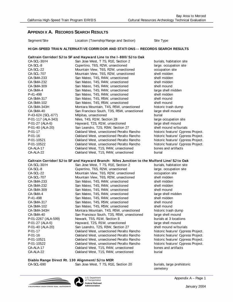
APPENDIX A. RECORDS SEARCH RESULTS
Segment/Site Location (Township/Range and Section) Site Type
HIGH-SPEED TRAIN ALTERNATIVE CORRIDOR AND STATIONS -- RECORDS SEARCH RESULTS
Caltrain Corridor/SJ to SF and Hayward Line to the I-880/SJ to Oak CA-SCL-30/H San Jose West, T 7S, R1E, Section 2 burials, habitation site CA-SCL-8 Cupertino, T6S, R2W, unsectioned large. occupation site CA-SCL-22 Mountain View, T6S, R2W, unsectioned occupation site CA-SCL-707 Mountain View, T6S, R2W, unsectioned shell midden CA-SMA-233 San Mateo, T4S, R4W, unsectioned shell midden CA-SMA-232 San Mateo, T4S, R4W, unsectioned shell midden CA-SMA-309 San Mateo, T4S, R4W, unsectioned shell mound CA-SMA-4 San Mateo, T4S, R4W, unsectioned large shell midden P-41-498 San Mateo, T4S, R4W, unsectioned shell midden CA-SMA-317 San Mateo, T4S, R5W, unsectioned shell mound CA-SMA-102 San Mateo, T4S, R5W, unsectioned shell mound CA-SMA-343H Montara Mountain, T4S, R5W, unsectioned historic trash dump CA-SMA-40 San Francisco South, T3S, R5W, unsectioned large shell mound P-43-624 (SCL-677) Milpitas, unsectioned burial P-01-117 (ALA-343) Niles, T4S, R1W, Section 28 large occupation site P-01-27 (ALA-6) Hayward, T2S, R1W, unsectioned large shell mound P-01-40 (ALA-20) San Leandro, T2S, R3W, Section 27 shell mound w/burials P-01-17 Oakland West, unsectioned Peralto Rancho historic feature/ Cypress Project. P-01-16 Oakland West, unsectioned Peralto Rancho historic feature/ Cypress Project. P-01-10521 Oakland West, unsectioned Peralto Rancho historic feature/ Cypress Project. P-01-10522 Oakland West, unsectioned Peralto Rancho historic feature/ Cypress Project. CA-ALA-17 Oakland West, T1S, R4W, unsectioned bones and artifacts CA-ALA-22 Oakland West, T1S, R4W, unsectioned burial
Caltrain Corridor/SJ to SF and Hayward Branch: Niles Junction to the Mulford Line/SJ to Oak CA-SCL-30/H San Jose West, T 7S, R1E, Section 2 burials, habitation site CA-SCL-8 Cupertino, T6S, R2W, unsectioned large. occupation site CA-SCL-22 Mountain View, T6S, R2W, unsectioned occupation site CA-SCL-707 Mountain View, T6S, R2W, unsectioned shell midden CA-SMA-233 San Mateo, T4S, R4W, unsectioned shell midden CA-SMA-232 San Mateo, T4S, R4W, unsectioned shell midden CA-SMA-309 San Mateo, T4S, R4W, unsectioned shell mound CA-SMA-4 San Mateo, T4S, R4W, unsectioned large shell midden P-41-498 San Mateo, T4S, R4W, unsectioned shell midden CA-SMA-317 San Mateo, T4S, R5W, unsectioned shell mound CA-SMA-102 San Mateo, T4S, R5W, unsectioned shell mound CA-SMA-343H Montara Mountain, T4S, R5W, unsectioned historic trash dump CA-SMA-40 San Francisco South, T3S, R5W, unsectioned large shell mound P-01-2267 (ALA-599) Newark, T5S, R1W, Section 8 burials at 3 locations P-01-27 (ALA-6) Hayward, T2S, R1W, unsectioned large shell mound P-01-40 (ALA-20) San Leandro, T2S, R3W, Section 27 shell mound w/burials P-01-17 Oakland West, unsectioned Peralto Rancho historic feature/ Cypress Project. P-01-16 Oakland West, unsectioned Peralto Rancho historic feature/ Cypress Project. P-01-10521 Oakland West, unsectioned Peralto Rancho historic feature/ Cypress Project. P-01-10522 Oakland West, unsectioned Peralto Rancho historic feature/ Cypress Project. CA-ALA-17 Oakland West, T1S, R4W, unsectioned bones and artifacts CA-ALA-22 Oakland West, T1S, R4W, unsectioned burial
Diablo Range Direct Rt. 130 Alignment/SJ to MER CA-SCL-690 San Jose West, T 7S, R1E, Section 20 burials, large prehistoric
cemetery
Bay Area to Merced California High-Speed Train Program EIR/EIS Cultural Resources Archeology Technical Evaluation
Appendix A – Page 2 January 2004
U.S. Departmentof TransportationFederal RailroadAdministration
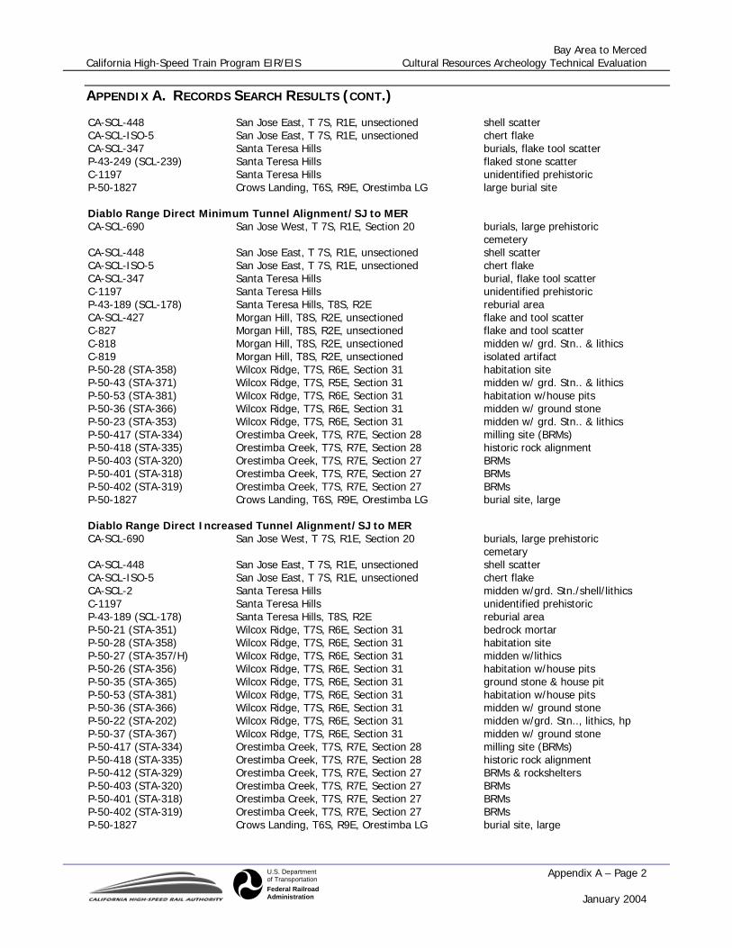
APPENDIX A. RECORDS SEARCH RESULTS (CONT.)
CA-SCL-448 San Jose East, T 7S, R1E, unsectioned shell scatter CA-SCL-ISO-5 San Jose East, T 7S, R1E, unsectioned chert flake CA-SCL-347 Santa Teresa Hills burials, flake tool scatter P-43-249 (SCL-239) Santa Teresa Hills flaked stone scatter C-1197 Santa Teresa Hills unidentified prehistoric P-50-1827 Crows Landing, T6S, R9E, Orestimba LG large burial site
Diablo Range Direct Minimum Tunnel Alignment/SJ to MER CA-SCL-690 San Jose West, T 7S, R1E, Section 20 burials, large prehistoric
cemetery CA-SCL-448 San Jose East, T 7S, R1E, unsectioned shell scatter CA-SCL-ISO-5 San Jose East, T 7S, R1E, unsectioned chert flake CA-SCL-347 Santa Teresa Hills burial, flake tool scatter C-1197 Santa Teresa Hills unidentified prehistoric P-43-189 (SCL-178) Santa Teresa Hills, T8S, R2E reburial area CA-SCL-427 Morgan Hill, T8S, R2E, unsectioned flake and tool scatter C-827 Morgan Hill, T8S, R2E, unsectioned flake and tool scatter C-818 Morgan Hill, T8S, R2E, unsectioned midden w/ grd. Stn.. & lithics C-819 Morgan Hill, T8S, R2E, unsectioned isolated artifact P-50-28 (STA-358) Wilcox Ridge, T7S, R6E, Section 31 habitation site P-50-43 (STA-371) Wilcox Ridge, T7S, R5E, Section 31 midden w/ grd. Stn.. & lithics P-50-53 (STA-381) Wilcox Ridge, T7S, R6E, Section 31 habitation w/house pits P-50-36 (STA-366) Wilcox Ridge, T7S, R6E, Section 31 midden w/ ground stone P-50-23 (STA-353) Wilcox Ridge, T7S, R6E, Section 31 midden w/ grd. Stn.. & lithics P-50-417 (STA-334) Orestimba Creek, T7S, R7E, Section 28 milling site (BRMs) P-50-418 (STA-335) Orestimba Creek, T7S, R7E, Section 28 historic rock alignment P-50-403 (STA-320) Orestimba Creek, T7S, R7E, Section 27 BRMs P-50-401 (STA-318) Orestimba Creek, T7S, R7E, Section 27 BRMs P-50-402 (STA-319) Orestimba Creek, T7S, R7E, Section 27 BRMs P-50-1827 Crows Landing, T6S, R9E, Orestimba LG burial site, large
Diablo Range Direct Increased Tunnel Alignment/SJ to MER CA-SCL-690 San Jose West, T 7S, R1E, Section 20 burials, large prehistoric
cemetary CA-SCL-448 San Jose East, T 7S, R1E, unsectioned shell scatter CA-SCL-ISO-5 San Jose East, T 7S, R1E, unsectioned chert flake CA-SCL-2 Santa Teresa Hills midden w/grd. Stn./shell/lithics C-1197 Santa Teresa Hills unidentified prehistoric P-43-189 (SCL-178) Santa Teresa Hills, T8S, R2E reburial area P-50-21 (STA-351) Wilcox Ridge, T7S, R6E, Section 31 bedrock mortar P-50-28 (STA-358) Wilcox Ridge, T7S, R6E, Section 31 habitation site P-50-27 (STA-357/H) Wilcox Ridge, T7S, R6E, Section 31 midden w/lithics P-50-26 (STA-356) Wilcox Ridge, T7S, R6E, Section 31 habitation w/house pits P-50-35 (STA-365) Wilcox Ridge, T7S, R6E, Section 31 ground stone & house pit P-50-53 (STA-381) Wilcox Ridge, T7S, R6E, Section 31 habitation w/house pits P-50-36 (STA-366) Wilcox Ridge, T7S, R6E, Section 31 midden w/ ground stone P-50-22 (STA-202) Wilcox Ridge, T7S, R6E, Section 31 midden w/grd. Stn.., lithics, hp P-50-37 (STA-367) Wilcox Ridge, T7S, R6E, Section 31 midden w/ ground stone P-50-417 (STA-334) Orestimba Creek, T7S, R7E, Section 28 milling site (BRMs) P-50-418 (STA-335) Orestimba Creek, T7S, R7E, Section 28 historic rock alignment P-50-412 (STA-329) Orestimba Creek, T7S, R7E, Section 27 BRMs & rockshelters P-50-403 (STA-320) Orestimba Creek, T7S, R7E, Section 27 BRMs P-50-401 (STA-318) Orestimba Creek, T7S, R7E, Section 27 BRMs P-50-402 (STA-319) Orestimba Creek, T7S, R7E, Section 27 BRMs P-50-1827 Crows Landing, T6S, R9E, Orestimba LG burial site, large

Bay Area to Merced California High-Speed Train Program EIR/EIS Cultural Resources Archeology Technical Evaluation
Appendix A – Page 3 January 2004
U.S. Departmentof TransportationFederal RailroadAdministration
APPENDIX A. RECORDS SEARCH RESULTS (CONT.)
Caltrain/Morgan Hill/Pacheco Pass Alignment/SJ to MER CA-SCL-690 San Jose West, T 7S, R1E, Section 20 burials, large prehistoric
cemetery CA-SCL-448 San Jose East, T 7S, R1E, unsectioned shell scatter CA-SCL-ISO-5 San Jose East, T 7S, R1E, unsectioned chert flake CA-SCL-2 Santa Teresa Hills midden w/grd. stn./shell/lithics CA-SCL-571 Morgan Hill, 8S, 2E, unsectioned fire-cracked rock scatter CA-SCL-587 Chittenden, T11S, R4E, unsectioned occupation site CA-SCL-119 San Felipe, T11S, R5E, Llano del Tequista L.G. residential site w/burials P-43-993 San Felipe, T11S, R5E, Ausayamas y SF L.G. isolated artifacts ISOL-4B San Felipe, T11S, R5E, Ausayamas y SF L.G. ground stone cache CA-SCL-121 San Felipe, T11S, R5E, Ausayamas y SF L.G. BRMs CA-SCL-117 Pacheco Peak, T10S, R6E, Ausayamas y SF midden w/lithic scatter CA-SCL-114 Pacheco Peak, T10S, R6E, Ausayamas y SF isolated mortar fragment CA-SCL-724 Pacheco Peak, T10S, R6E, Ausayamas y SF midden w/grd. stn.. & fcr P-43-1215 Pacheco Pass, T10S, R7E, San Luis Gonzaga midden w/grd. stn.. & fcr P-20-349 Chowchilla, T9S, R15E, Sections 26,25 large occupation site
Caltrain/Gilroy/Pacheco Pass Alignment/SJ to MER CA-SCL-690 San Jose West, T 7S, R1E, Section 20 burials, large prehistoric
cemetery CA-SCL-448 San Jose East, T 7S, R1E, unsectioned shell scatter CA-SCL-ISO-5 San Jose East, T 7S, R1E, unsectioned chert flake CA-SCL-2 Santa Teresa Hills midden w/grd. Stn./shell/lithics CA-SCL-571 Morgan Hill, 8S, 2E, unsectioned FCR scatter CA-SCL-699 Chittenden, T11S, R4E, Las Animas L.G. shell, lithics, grd. Stn.. scatter CA-SCL-203 Chittenden, T11S, R4E, Las Animas L.G. large occupation site P-43-1445 Chittenden, T11S, R4E, Las Animas L.G. iso pestle CA-SCL-117 Pacheco Peak, T10S, R6E, Ausayamas y SF midden w/lithic scatter CA-SCL-114 Pacheco Peak, T10S, R6E, Ausayamas y SF isolated mortar fragment CA-SCL-724 Pacheco Peak, T10S, R6E, Ausayamas y SF midden w/grd. Stn.. & fcr P-43-1215 Pacheco Pass, T10S, R7E, San Luis Gonzaga midden w/grd. Stn.. & fcr P-20-349 Chowchilla, T9S, R15E, Sections 26,25 large occupation site
HST STATIONS
Transbay Terminal none 4th and King none Millbrae none Redwood City none Palo Alto none Santa Clara CA-SCL-30/H San Jose West, T 7S, R1E, Section 2 habitation site w/burials West Oakland none 12th Street/City Center none Coliseum Bart Station none Union City none Fremont none San Jose (Diridon) none Morgan Hill none Gilroy none

Bay Area to Merced California High-Speed Train Program EIR/EIS Cultural Resources Archeology Technical Evaluation
Appendix A – Page 4 January 2004
U.S. Departmentof TransportationFederal RailroadAdministration
APPENDIX A. RECORDS SEARCH RESULTS (CONT.)
Highway Corridor/Site Location Site Type
MODAL ALTERNATIVE CORRIDOR AND AIRPORTS
U.S. 101/SF to SFO CA-SMA-40 San Francisco South, Canada de Guadalupe LG shell mound P-41-95 San Francisco South, Canada de Guadalupe LG shell midden
U.S. 101/SFO to Redwood City CA-SMA-321 San Mateo, T4S, R4W, Section 21 shell midden CA-SMA-314 San Mateo, Pulgas LG Hamilton Shell Mound C-134 San Mateo, Pulgas LG Hamilton Shell Mound C-759 San Mateo, Pulgas LG Hamilton Shell Mound C-760 San Mateo, Pulgas LG C-789 San Mateo, San Mateo LG Hamilton Shell Mound C-790 San Mateo, San Mateo LG Hamilton Shell Mound C-808 San Mateo, Pulgas LG Midden
U.S. 101/Redwood City to I-880 SCL-439 Mountain View, T6S, R2W, Rincon de San Frans. shell midden P-43-32 (SCL-12) Mountain View, T6S, R2W, Rincon de San Frans. burials P-1163 Milipitas, T6S, R1W, Section 26 shell midden, FAR
I-880/U.S. 101 to San Jose None
U.S. 101/San Jose to Gilroy CA-SCL-242 San Jose East, Yerba Buena Land Grant flaked stone tool/FAR scatter CA-SCL-241 San Jose East, Yerba Buena Land Grant flaked stone tool/FAR scatter CA-SCL-732/H Santa Teresa Hills, Santa Teresa Land Grant burials, habitation/hist. debris CA-SCL-732/H reburial Santa Teresa Hills, Santa Teresa Land Grant reburial site CA-SCL-411H Santa Teresa Hills, Santa Teresa Land Grant historic farm complex CA-SCL-178 reburial Santa Teresa Hills, Santa Teresa Land Grant reburial site CA-SCL-178 Morgan Hill, La Laguna Seca Land Grant burials, large habitation site
U.S. 101/Gilroy to S.R. 152 None
S.R. 152/U.S. 101 to I-5 CA-SCL-119/SSN-24H San Felipe, T11S, R5E, Llano del Tequisquita LG flake scatter, midden ISO-SCL-14 San Felipe, T11S, R5E, Ausaymas y San Felipe hammerstone? P-43-993 San Felipe, T11S R5E Ausaymas y San Felipe milling gear P-43-1214 San Felipe, T11S, R5E, Ausaymas y San Felipe isolated pestles CA-SCL-117 Pacheco Peak, Ausaymas y San Felipe LG flake Scatter, FAR CA-SCL-114 Pacheco Peak, Ausaymas y San Felipe LG isolated mortar fragment CA-SCL-31 Pacheco Pass, San Luis Conzaga LG bedrock mortars, midden
S.R. 152 I-5 to SR 99 P-24-350 Los Banos, T10S, R11E, Section 18 sparse lithic scatter, milling gear
I-80/SF to I-880 None

Bay Area to Merced California High-Speed Train Program EIR/EIS Cultural Resources Archeology Technical Evaluation
Appendix A – Page 5 January 2004
U.S. Departmentof TransportationFederal RailroadAdministration
APPENDIX A. RECORDS SEARCH RESULTS (CONT.)
I-80/I-880 to I-5 CA-ALA-310-313 Oakland West series of 4 shell mounds CA-ALA-307 Oakland West large shell mound P-01-83 (ALA-306) Richmond shell mound CA-ALA-305 Richmond, T3N, R4W shell midden CA-SOL-41 Fairfield North burial CA-SOL-30 Fairfield North flake scatter CA-SOL-362 Allendale historic debris (from structure) P-48-8 (SOL-363) Dixon midden w/burials
I-880/I-80 to I-238 P-01-1788 Oakland West, unsectioned Peralta Rancho historic features/Cypress Project P-01-243 Oakland West, unsectioned Peralta Rancho historic features/Cypress Project P-01-244 Oakland West, unsectioned Peralta Rancho historic features/Cypress Project P-01-258 Oakland West, unsectioned Peralta Rancho historic features/Cypress Project
I-580/I-880 to I-5 (via I-238) P-01-80 (ALA-60) Hayward, San Lorenzo (Castro) LG milling gear, cupules, mortars C-1396 Livermore FAR scatter P-01-2197 Livermore historic debris (from structures)
I-880/I-238 to Fremont/Newark P-01-2280 (ALA-600) Newark, T4S, R1W, Section 25 burials, habitation w/cemetery
I-880/FremontNewark to U.S. 101 P-43-624 Milipitas, Rincon de Los Esteros (white) LG burial
MODAL AIRPORTS
Oakland none San Jose Airport CA-SCL-430 San Jose West, T6S, R1W, Section 35 Old Mission site/lithic scatter CA-SCL-478 San Jose West, T6S, R1W, Section 36 FAR scatter, one mano