danbury raid and the forgotten...
TRANSCRIPT
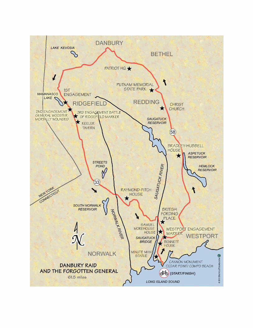
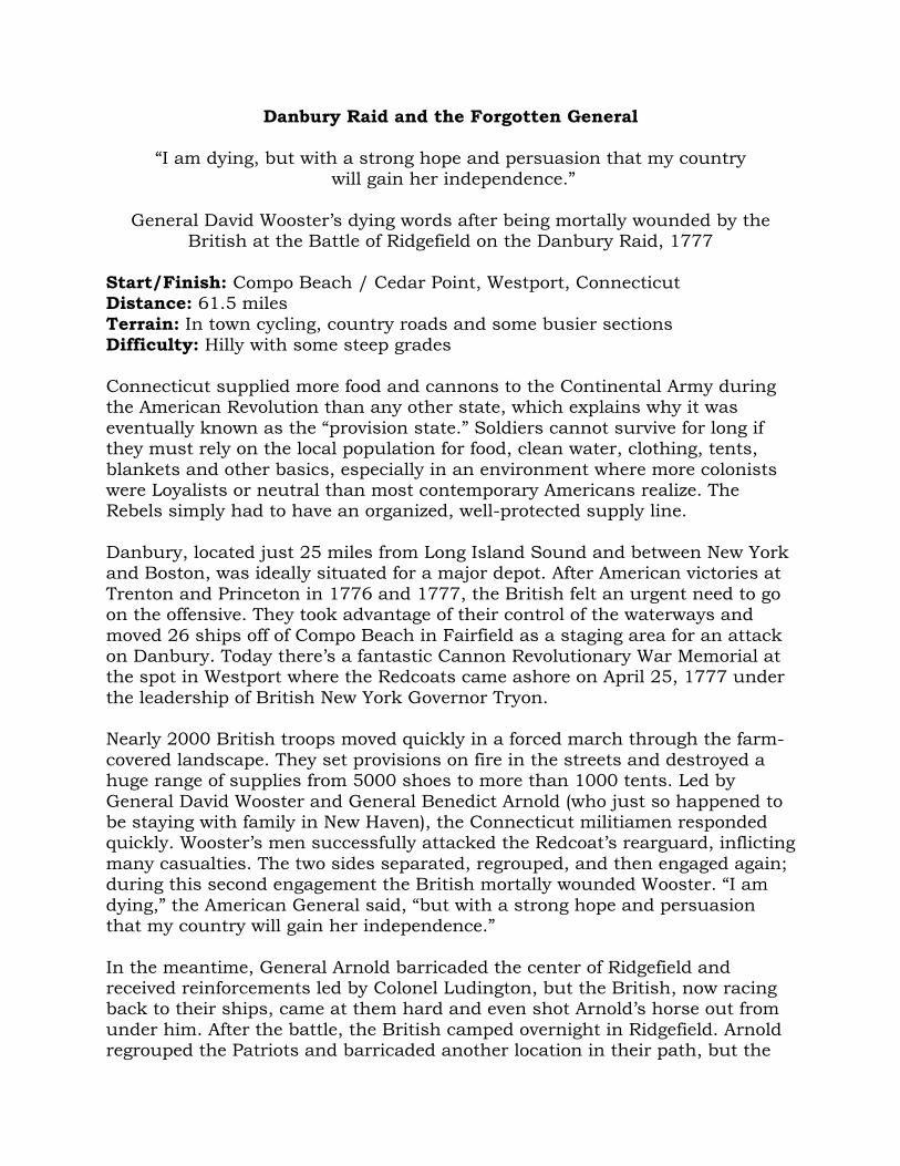
Danbury Raid and the Forgotten General
“I am dying, but with a strong hope and persuasion that my country will gain her independence.”
General David Wooster’s dying words after being mortally wounded by the
British at the Battle of Ridgefield on the Danbury Raid, 1777
Start/Finish: Compo Beach / Cedar Point, Westport, Connecticut Distance: 61.5 miles
Terrain: In town cycling, country roads and some busier sections Difficulty: Hilly with some steep grades
Connecticut supplied more food and cannons to the Continental Army during the American Revolution than any other state, which explains why it was
eventually known as the “provision state.” Soldiers cannot survive for long if they must rely on the local population for food, clean water, clothing, tents,
blankets and other basics, especially in an environment where more colonists were Loyalists or neutral than most contemporary Americans realize. The Rebels simply had to have an organized, well-protected supply line.
Danbury, located just 25 miles from Long Island Sound and between New York and Boston, was ideally situated for a major depot. After American victories at
Trenton and Princeton in 1776 and 1777, the British felt an urgent need to go on the offensive. They took advantage of their control of the waterways and
moved 26 ships off of Compo Beach in Fairfield as a staging area for an attack on Danbury. Today there’s a fantastic Cannon Revolutionary War Memorial at the spot in Westport where the Redcoats came ashore on April 25, 1777 under
the leadership of British New York Governor Tryon. Nearly 2000 British troops moved quickly in a forced march through the farm-
covered landscape. They set provisions on fire in the streets and destroyed a huge range of supplies from 5000 shoes to more than 1000 tents. Led by
General David Wooster and General Benedict Arnold (who just so happened to be staying with family in New Haven), the Connecticut militiamen responded quickly. Wooster’s men successfully attacked the Redcoat’s rearguard, inflicting
many casualties. The two sides separated, regrouped, and then engaged again; during this second engagement the British mortally wounded Wooster. “I am
dying,” the American General said, “but with a strong hope and persuasion that my country will gain her independence.”
In the meantime, General Arnold barricaded the center of Ridgefield and received reinforcements led by Colonel Ludington, but the British, now racing back to their ships, came at them hard and even shot Arnold’s horse out from
under him. After the battle, the British camped overnight in Ridgefield. Arnold regrouped the Patriots and barricaded another location in their path, but the
Redcoats had a number of Connecticut Loyalists on their side who helped them find an alternate route around the barricade.
The British made it back to their ships but at a high cost. They never
attempted a similar raid again. The attack upset many Connecticut residents who felt unnerved by the Redcoat’s aggressive move on Danbury—burning supplies in huge bonfires, killing soldiers and some local townspeople. Many
previously undecided residents now sided with the Patriots and joined the militia.
The way the Americans handled themselves during the British raid on Danbury showcases why they eventually won the war against a far better equipped and
experienced foe. They did not always win the battles, but they exacted a price again and again and showed a tenacity and willingness for sacrifice (such as General Wooster) that eventually wore the British down.
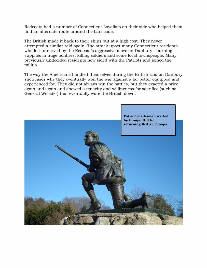
Patriot marksmen waited
by Compo Hill for
returning British Troops.

Route Notes
The tour follows the British march from Westport to Danbury and back. Start at the Cannon monument, which marks the location the British
landed at Cedar Point. The two 32 pound cannons overlook Long Island Sound.
0.0 From the Cannon Revolutionary War Memorial follow the driveway to exit Compo Beach.
0.2 Turn LEFT out of the Compo Beach exit onto Compo Beach Road.
0.7 Turn LEFT at the stop sign, T-intersection and Patriot Statue onto Compo Road South.
1.6 Continue STRAIGHT at the traffic light on Compo Road South after the two underpasses.
3.0 Turn RIGHT onto Route 1 / Post Road by the traffic light and Patriots Bank. Please be careful of traffic on this short section on the Post Road.
The Danbury Raid’s First Engagement occurred at this intersection, where the Patriots confronted Governor Tyron’s 1,800 British Troops.
3.8 TURN LEFT ONTO LONG LOTS ROAD BY THE DIVIDED ROAD SECTION AND PLEASE BE CAREFUL CROSSING THE STREET.
5.3 TURN LEFT ONTO BAYBERRY LANE (EASY TO MISS).
Two 32 pound cannon mark
the location at Cedar Point
in Westport where the British
landed to raid Danbury.
6.8 At the stop sign and T-intersection, turn RIGHT onto Cross Highway.
7.3 At the stop sign merge LEFT and continue on Cross Highway.
8.7 At the stop sign and T-intersection turn LEFT onto Redding Road (no sign).
11.2 Bear RIGHT at the fork and stay on Redding Road.
12.2 At the stop sign and T-intersection merge LEFT onto Black Rock Turnpike (no sign). Please be careful at this intersection.
18.3 At the stop sign continue STRAIGHT.
As the British marched to Danbury and the Patriots pursued on April 26, 1777, they passed Christ Church to the left. The fictional novel My
Brother Sam is Dead recounts events surrounding the Danbury Raid and
many Redding locations.
19.0 Turn RIGHT at the fork onto Sunset Hill Road.
20.2 TURN LEFT ONTO WOOD ROAD (EASY TO MISS). 21.0 At the stop sign and T-intersection turn LEFT onto Pocahontas Road
(no sign).
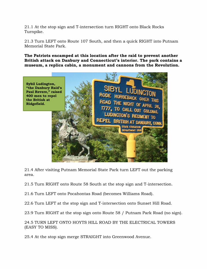
SYBIL LUDINGTON (1761 – 1839) “The Female Paul Revere”
Colonel Ludington is famous for reinforcing Benedict Arnold’s troops in Ridgefield as the Americans attacked the retreating British after they destroyed the Danbury depot, but the Colonel’s 16-year-old daughter, Sybil,
actually has a statue of her own. This “Female Paul Revere” rode her horse through Carmel, New York, just over the border from Danbury, to alert her
father’s militiamen about the Redcoats’ Connecticut raid. In the statue she carries a stick, which she used to pound on doors, and her father’s musket, which she allegedly used to shoot a Loyalist trying to halt her ride. Thanks in
part to her all-night ride in the rain, Sybil allowed Colonel Ludington to recruit 400 men to help Arnold drive the British out of Ridgefield.
If you want to extend your tour on the New York side, you can follow route markers for Sybil’s famous ride, and visit the father and daughter’s gravesites
in Patterson, New York.
21.1 At the stop sign and T-intersection turn RIGHT onto Black Rocks Turnpike.
21.3 Turn LEFT onto Route 107 South, and then a quick RIGHT into Putnam
Memorial State Park. The Patriots encamped at this location after the raid to prevent another
British attack on Danbury and Connecticut’s interior. The park contains a museum, a replica cabin, a monument and cannons from the Revolution.
21.4 After visiting Putnam Memorial State Park turn LEFT out the parking area.
21.5 Turn RIGHT onto Route 58 South at the stop sign and T-intersection.
21.6 Turn LEFT onto Pocahontas Road (becomes Williams Road). 22.6 Turn LEFT at the stop sign and T-intersection onto Sunset Hill Road.
23.9 Turn RIGHT at the stop sign onto Route 58 / Putnam Park Road (no sign).
24.5 TURN LEFT ONTO HOYTS HILL ROAD BY THE ELECTRICAL TOWERS (EASY TO MISS).
25.4 At the stop sign merge STRAIGHT into Greenwood Avenue.
Sybil Ludington, “the Danbury Raid’s
Paul Revere,” raised
400 men to repel
the British at
Ridgefield.
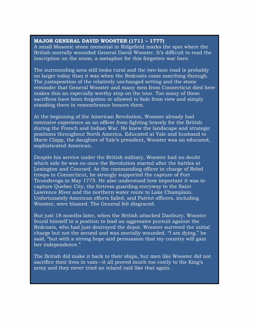
MAJOR GENERAL DAVID WOOSTER (1711 – 1777) A small Masonic stone memorial in Ridgefield marks the spot where the British mortally wounded General David Wooster. It’s difficult to read the
inscription on the stone, a metaphor for this forgotten war hero. The surrounding area still looks rural and the two-lane road is probably
no larger today than it was when the Redcoats came marching through. The juxtaposition of the relatively unchanged setting and the stone
reminder that General Wooster and many men from Connecticut died here makes this an especially worthy stop on the tour. Too many of these sacrifices have been forgotten or allowed to fade from view and simply
standing there in remembrance honors them.
At the beginning of the American Revolution, Wooster already had extensive experience as an officer from fighting bravely for the British during the French and Indian War. He knew the landscape and strategic
positions throughout North America. Educated at Yale and husband to Marie Clapp, the daughter of Yale’s president, Wooster was an educated, sophisticated American.
Despite his service under the British military, Wooster had no doubt
which side he was on once the Revolution started after the battles at Lexington and Concord. As the commanding officer in charge of Rebel troops in Connecticut, he strongly supported the capture of Fort
Ticonderoga in May 1775. He also understood how important it was to capture Quebec City, the fortress guarding entryway to the Saint Lawrence River and the northern water route to Lake Champlain.
Unfortunately American efforts failed, and Patriot officers, including Wooster, were blamed. The General felt disgraced.
But just 18 months later, when the British attacked Danbury, Wooster found himself in a position to lead an aggressive pursuit against the
Redcoats, who had just destroyed the depot. Wooster survived the initial charge but not the second and was mortally wounded. “I am dying,” he
said, “but with a strong hope and persuasion that my country will gain her independence.”
The British did make it back to their ships, but men like Wooster did not sacrifice their lives in vain—it all proved much too costly to the King’s army and they never tried an inland raid like that again.

26.7 Turn LEFT at the traffic light onto Fleetwood Avenue by the Mobil Station (becomes Coal Pit Hill Road).
28.0 Turn LEFT at the traffic light onto South Street (no sign).
The Redcoats raided the Patriots’ supply depot located along this stretch of road.
28.2 Turn RIGHT at the traffic light onto Main Street.
28.8 Turn LEFT at the traffic light onto West Street.
28.9 Turn LEFT at the traffic light onto Deer Hill Avenue.
In Ridgefield, the Redcoats fired a three pound cannonball at Keeler Tavern the Patriots’
Headquarters.
29.2 At the traffic light turn RIGHT onto West Wooster Street.
30.0 At the second stop sign bear LEFT at the fork onto Wooster Heights Road (becomes Miry Brook Road after the overpass).
32.2 Bear LEFT at the stop sign and continue on Miry Brook Road.
32.9 Bear LEFT at the fork after the bridge onto George Washington Highway. 34.1 At the stop sign turn LEFT onto Ridgebury Road (not sign) by the
Ridgebury Congregational Church. 35.8 Turn RIGHT at the stop sign stay on Ridgebury Road.

36.4 Bear RIGHT at the fork and stop sign. Stay on Ridgebury Road.
In 1781 General Rochambeau and French Troops camped in this field en route to Yorktown. A display marker describes this location and
Washington Rochambeau National Historical Trail. 36.9 Turn RIGHT at the T-intersection and stop sign onto North Salem Road
(not marked). 37.6 BEAR RIGHT AT THE FORK ONTO TACKORA TRAIL (EASY TO MISS).
The led by General Wooster, the Patriots first successfully attacked the
Redcoats rearguard at this location.
38.3 Turn LEFT at the T-intersection and stop sign and stay on Tackora Trail.
38.7 Merge RIGHT onto North Salem Road at the stop sign. When the Patriots attacked the British rearguard for a second time, the
Redcoats were ready and mortally wounded General Wooster.
BRITISH GOVERNOR WILLIAM TRYON (1729 – 1788) Fort Tryon Park in Northern Manhattan, which overlooks the Hudson and
East Rivers, is named for Governor William Tryon, a bit of a surprise since “Tryon the Tyrant” helped destroy Danbury in 1777 and raided coastal Connecticut a number of times during the American Revolution.
During the French and Indian War, Tryon operated along the Northern
French coast and was wounded twice at the Battle of St. Cast. While Governor of North Carolina (1765 – 1771), he increased taxes to pay for an opulent Governor’s Mansion for himself. Angry colonists rose to fight
the unfair tax, but Tryon’s British militia suppressed the “Regulators” at the Battle of Alamance. During his tenure as Governor of New York, he plotted to kidnap General George Washington and kill America’s top
officers.
By 1780 William Tryon’s treatment of the Americans was so harsh, that even British Commanding Officer General Henry Clinton stopped giving him significant assignments.
Northern Manhattan might consider renaming that park.
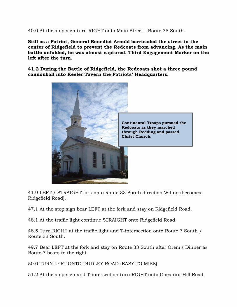
40.0 At the stop sign turn RIGHT onto Main Street - Route 35 South.
Still as a Patriot, General Benedict Arnold barricaded the street in the center of Ridgefield to prevent the Redcoats from advancing. As the main
battle unfolded, he was almost captured. Third Engagement Marker on the left after the turn.
41.2 During the Battle of Ridgefield, the Redcoats shot a three pound cannonball into Keeler Tavern the Patriots’ Headquarters.
41.9 LEFT / STRAIGHT fork onto Route 33 South direction Wilton (becomes
Ridgefield Road).
47.1 At the stop sign bear LEFT at the fork and stay on Ridgefield Road. 48.1 At the traffic light continue STRAIGHT onto Ridgefield Road.
48.5 Turn RIGHT at the traffic light and T-intersection onto Route 7 South / Route 33 South.
49.7 Bear LEFT at the fork and stay on Route 33 South after Orem’s Dinner as
Route 7 bears to the right. 50.0 TURN LEFT ONTO DUDLEY ROAD (EASY TO MISS).
51.2 At the stop sign and T-intersection turn RIGHT onto Chestnut Hill Road.
Continental Troops pursued the
Redcoats as they marched through Redding and passed Christ Church.
52.2 At the traffic light turn LEFT onto Route 33 South.
53.4 TURN LEFT ONTO RED COAT ROAD IMMEDIATELY BEFORE THE
OVERPASS FOR THE MERRITT PARKWAY (EASY TO MISS). Tory Loyalists guided the Redcoats around Arnold barricade at this point
then forded across the Saugatuck River. 53.8 At the stop sign bear RIGHT at the fork and stay on Red Coat Road.
54.2 Turn LEFT at the stop sign and T-intersection onto Cavalry Road.
54.8 At the stop sign turn RIGHT onto West Branch Road.
55.2 Turn LEFT at the stop sign onto West Branch Road.
55.3 Turn RIGHT at the stop sign and T-intersection onto Weston Road (no sign).
55.7 Turn RIGHT at the traffic light onto Ford Road after the bridge (becomes Clinton Avenue).
56.2 The Redcoats forded across the Saugatuck River at this location on their way back Cedar Point.
57.1 Continue STRAIGHT at the traffic light onto Compo Road North.
58.4 Continue STRAIGHT at the traffic light onto Comp Road South by Patriots Bank.
59.8 At the traffic light continue STRAIGHT and cross under two overpasses.
60.7 Turn RIGHT by the stop sign and Patriots Statue onto Compo Beach Road. The Redcoats positioned a small force on Compo Hill to guard Cedar Point and their fleet from a rebel attack.
61.3 Turn RIGHT into Compo Beach.
61.5 Finish by the Cannon Memorial.
Suggested Reading
Douglas, Damon Greenleaf, The Bridge Not Taken: Benedict Arnold Outwitted, Westport Historical Society, 2002