decision/direction note
TRANSCRIPT

City of St. John’s PO Box 908 St. John’s, NL Canada A1C 5M2 www.stjohns.ca
Title: Application to Rezone Land to the Commercial Neighbourhood
Zone for a Lounge and Eating Establishment (Pub and Eatery) MPA1800006 75 Airport Heights Drive
Date Prepared: August 20, 2019 Report To: His Worship the Mayor and Members of Council Councillor & Role: Councillor Maggie Burton, Planning and Development Lead Ward: 1 Decision/Direction Required: To consider a rezoning application for land at 75 Airport Heights Drive from the Commercial Local (CL) Zone to the Commercial Neighbourhood (CN) Zone to allow for a Lounge and Eating Establishment use. An amendment to the St. John’s Municipal Plan is required. Discussion – Background and Current Status: The City has received an application for a pub and eatery at 75 Airport Heights Drive. The property is currently zoned Commercial Local which does not allow a Lounge or Eating Establishment use. The applicant has requested to rezone the property to Commercial Neighbourhood in which Lounge and Eating Establishment are discretionary uses. The properties surrounding 75 Airport Heights Drive are zoned Residential Low Density (R1) and majority of the properties are dwellings apart from two vacant lots adjacent to the property on the western side. The property is designated Residential Low Density (RLD) under the City of St. John’s Municipal Plan and applies to those areas characterized by a predominance of single detached dwellings. The current Commercial Local Zone is permitted under the RLD District, however, a rezoning to the Commercial Neighbourhood (CN) Zone would require a Municipal Plan amendment to the Commercial General District as the CN Zone allows for more commercial uses than the CL Zone. The existing building at 75 Airport Heights Drive was built as a Daycare Centre and was rezoned in June 2018 to the CL Zone to accommodate commercial uses such as an office, take-out or hair salon. The same applicant is now asking to rezone the land to CN for a pub and eatery. The development will require 17 parking spaces. The applicants have proposed 10 parking spaces and have requested parking relief for 7 spaces. The applicant’s justification for parking relief is that the property is within walking distance to the adjacent residential neighbourhood and that there is on-street parking on the opposite side of the street from 40 Airport Heights Drive to Canso Place.
DECISION/DIRECTION NOTE

Decision/Direction Note Page 2 75 Airport Heights Drive The proposed rezoning was advertised on three occasions in The Telegram newspaper and was posted on the City’s website. Property owners within 150 metres of the application site were notified. The City has received a mixed reaction from the residents respecting the proposed restaurant and lounge. While there have been many residents who expressed concerns regarding the development, many others have given support for the proposal. Objections for the development include concerns regarding increased number of cars parked on the street, increased noise, a decrease in property value, increased vandalism and litter, ( including a concern about rodents) and that the proximity of the subject property to Roncalli Elementary School and the nearby seniors complex will create traffic problems. The applicants are proposing the business will operate from 11am to midnight on weekdays and from 11am to 1am on weekends. Further, they wish to have a family friendly restaurant during the evening and would be able to accommodate kids until 9pm. As a liquor license cannot be issued until the development approval stage, the Newfoundland and Labrador Liquor Corporation (NLC) may include additional conditions. Concerns regarding increased drinking and driving if the Lounge is approved have also been raised. While we appreciate the concern regarding public safety, drinking and driving is regulated by provincial and federal legislation. The NLC would also regulate if video lottery terminals (VLT) would be permitted on-site, dependant on the type of liquor license that is issued. With respect to noise, the applicants are proposing that bands would not be permitted, and musicians would be limited to one-man acoustic solos on weekends only. Please note, while they may propose this type of entertainment, the City would not regulate the type of musicians at their venue. The property would be subject to the City‘s Noise By-Law. There were no concerns raised by the City’s Traffic Engineering Division regarding the reduced off street parking spaces or the potential of increased traffic. With respect to residential properties adjacent to the proposed use, as per Section 8.5.1 of the Development Regulations, a 3 metre landscaped area or a screen at least 1.8 metre in height shall be provided where a Commercial Use adjoins a Residential Use. The applicants have proposed a 1.8m fence surrounding the subject property. Given the support for the application, it is recommended that the proposed amendments be adopted-in-principle. Should Council adopt the amendments, following provincial release, a Commissioner’s Public Hearing will be scheduled. The Public Hearing will give residents with objections another opportunity to state their concerns prior to final approval of Council.

Decision/Direction Note Page 3 75 Airport Heights Drive Key Considerations/Implications:
1. Budget/Financial Implications: Not applicable.
2. Partners or Other Stakeholders: Neighbouring residents and property owners.
3. Alignment with Strategic Directions/Adopted Plans:
A Sustainable City – Plan for land use and preserve and enhance the natural and built environment where we live.
4. Legal or Policy Implications: An amendment to the St. John’s Municipal Plan and Development Regulations is required.
5. Privacy Implications: Not applicable.
6. Engagement and Communications Considerations: Advertisement of the proposed amendment.
7. Human Resource Implications: Not applicable.
8. Procurement Implications: Not applicable.
9. Information Technology Implications: Not applicable.
10. Other Implications: Parking relief of 7 spaces is being considered.
Recommendation: That Council adopt-in-principle the resolutions for St. John’s Municipal Plan Amendment 153, 2019 and St. John’s Development Regulations Amendment 700, 2019. A map amendment to the Municipal Plan is also required to re-designate the property from the Residential Low Density District to the Commercial General District. As well, this would rezone 75 Airport Heights Drive from the Commercial Local (CL) Zone to the Commercial Neighbourhood (CN) Zone, to allow consideration of a Lounge and Eating Establishment. If the amendments are adopted-in-principle by Council, they will be sent to the Department of Municipal Affairs and Environment with a request for provincial release. Once the release is received, the amendments will be referred back to a future regular meeting of Council for consideration of l adoption and the appointment of a commissioner to conduct a public hearing, as required by the Urban and Rural Planning Act.

Decision/Direction Note Page 4 75 Airport Heights Drive Prepared by/Signature: Ann-Marie Cashin, MCIP – Planner III, Urban Design and Heritage Signature: Approved by/Date/Signature: Ken O’Brien, MCIP – Chief Municipal Planner Signature: AMC/dlm Attachments: Amendments Location Map Site Plan CN Zone Table Public Submissions
G:\Planning and Development\Planning\2019\Mayor & Council\Mayor - 75 Airport Heights Drive August 26 2019(amc).docx

RESOLUTION ST. JOHN’S MUNICIPAL PLAN
AMENDMENT NUMBER 153, 2019 WHEREAS the City of St. John’s wishes to allow a Lounge and Eating Establishment at 75 Airport Heights Drive. BE IT THEREFORE RESOLVED that the City of St. John’s hereby adopts the following map amendment to the St. John’s Municipal Plan in accordance with the provisions of the Urban and Rural Planning Act.
Redesignate land at 75 Airport Heights Drive [Parcel ID#46595 & 145223] from the Residential Low Density (RLD) Land Use District to the Commercial General (CG) Land Use District as shown on Map III-1A attached.
BE IT FURTHER RESOLVED that the City of St. John’s requests the Minister of Municipal Affairs and Environment to register the proposed amendment in accordance with the requirements of the Urban and Rural Planning Act, 2000. IN WITNESS THEREOF the Seal of the City of St. John’s has been hereunto affixed and this Resolution has been signed by the Mayor and the City Clerk on behalf of Council this ____ day of _________________, 2019. ______________________________ ______________________________ Mayor MCIP
I hereby certify that this Amendment has been prepared in accordance with the Urban and Rural Planning Act, 2000.
______________________________ City Clerk Council Adoption Provincial Registration

AIRPORT HEIGHTS DR
CRAMBRAE STARGUS P
L
RLD
RLD
RLD
CITY OF ST. JOHN'SMUNICIPAL PLANAmendment No. 153, 2019[Map III-1A]
AREA PROPOSED TO BE REDESIGNATED FROMRESIDENTIAL LOW DENSITY (RLD) LAND USE DISTRICTTO COMMERCIAL GENERAL (CG) LAND USE DISTRICT
2019 08 22 Scale: 1:750City of St. John'sDepartment of Planning, Development& Regulatory Services
I hereby certify that this amendmenthas been prepared in accordance with theUrban and Rural Planning Act.
Mayor
City Clerk
Council Adoption Provincial Registration
M.C.I.P. signature and seal
75 AIRPORT HEIGHTS DRIVEParcel ID 46595, 145223

RESOLUTION ST. JOHN’S DEVELOPMENT REGULATIONS
AMENDMENT NUMBER 700, 2019
WHEREAS the City of St. John’s wishes to allow a Lounge and Eating Establishment at 75 Airport Heights Drive. BE IT THEREFORE RESOLVED that the City of St. John’s hereby adopts the following map amendment to the St. John’s Development Regulations in accordance with the provisions of the Urban and Rural Planning Act, 2000.
Rezone land at 75 Airport Heights Drive [Parcel ID#46595 & 145223] from the Commercial Local (CL) Zone to the Commercial Neighbourhood (CN) Zone as shown on Map Z-1A attached.
BE IT FURTHER RESOLVED that the City of St. John’s requests the Minister of Municipal Affairs and Environment to register the proposed amendment in accordance with the requirements of the Urban and Rural Planning Act, 2000. IN WITNESS THEREOF the Seal of the City of St. John’s has been hereunto affixed and this Resolution has been signed by the Mayor and the City Clerk on behalf of Council this ____ day of ___________________, 2019. ________________________________ ________________________________ Mayor MCIP
I hereby certify that this Amendment has been prepared in accordance with the Urban and Rural Planning Act, 2000.
_________________________________ City Clerk ________________________________ ________________________________ Council Adoption Provincial Registration

R1
R1
CL
R1
R1
AIRPORT HEIGHTS DR
ARGUS PL
CRAMBRAE ST
CITY OF ST. JOHN'SDEVELOPMENT REGULATIONSAmendment No. 700, 2019[Map Z-1A]
AREA PROPOSED TO BE REZONED FROMCOMMERCIAL LOCAL (CL) LAND USE ZONE TOCOMMERCIAL NEIGHBOURHOOD (CN) LAND USE ZONE
75 AIRPORT HEIGHTS DRIVEParcel ID 46595, 145223
2019 08 22 Scale: 1:750City of St. John'sDepartment of Planning, Development& Regulatory Services
I hereby certify that this amendmenthas been prepared in accordance with theUrban and Rural Planning Act.
Provincial Registration
Mayor
City Clerk
Council Adoption
M.C.I.P. signature and seal

R1
R1
R1
R1
CL
R1
R13
7
5
8
97
4
1
5
9
9
7
6
8
8
6
73
65
79
7711
69
63
14
83
71
18
74
81
17
13
10
16
70 64
72
85
12
11
21
20
AIRPORT HEIGHTS DR
ARGUS PL
CRAMBRAE ST
TURN
BERR
Y ST
GAIRLO
CK ST
µ1:750
SUBJECT PROPERTY
DISCLAIMER: This map is based on current information at the date of production.W:\Engwork\Planw\applications 2018\mpa180006-75 airport heights drive.mxd

A
S
P
H
A
L
T
P
A
R
K
I
N
G
A
R
E
A
6.150
A
I
R
P
O
R
T
H
E
I
G
H
T
S
D
R
I
V
E
7
5
A
I
R
P
O
R
T
H
E
I
G
H
T
S
D
R
I
V
E
1
5
5
.
0
0
1
5
4
.
5
1
5
4
.
0
0
1
5
3
.
5
1
5
3
.
0
0
155.00
1
5
4
.
5
1
5
4
.
0
0
1
5
3
.
5
1
5
3
.
0
0
1
5
2
.
5
1
5
2
.5
1
5
3
.
0
0
1
5
2
.
5
7.641
6.516
2.600
2.000
5.790
2.740
X
X
X
X
X
X
X
X
X
X
X
X
X
ENTRANCE TO BE REMOVED.
NEW CONCRETE SIDEWALK,
CURB & GUTTER TO BE PLACED
AS PER CITY SPECIFICATIONS
NEW 150mm CURB TO BE PLACED
AND TIED INTO EXISTING CURB.
AREA TO BE LANDSCAPED
WITH TOPSOIL AND SOD.
EXISTING ENTRANCE TO BECOME
2 WAY TRAFFIC ENTRANCE/ EXIT
9 NEW PARKING STALLS
EXISTING CURB AND LANDSCAPING TO BE REMOVED.
ASPHALT PARKING AREA TO BE EXTENDED AND
MATCHED TO EXISTING STRUCTURE.
NEW CURB TO BE TIED INTO AND
MATCHED TO EXISTING CURB
ACCESSIBLE PARKING SIGN
ACCESSIBLE PARKING SPACE
WITH ACCESSIBLE AISLE
1.8m HIGH FENCE
Project No. Figure No.
Date
Reference Sheet
TitleClient/Project
2019.08.05 10:04:45 A
Mv:\01333\active\133348530\04_draw
ings\1_civil\sketch_files\133348530c_proposed_sp_r1
Notes
Revision
Tel:
www.stantec.com
Stantec Consulting Ltd.
141 Kelsey Drive
St. John's NL A1B 0L2
(709) 576-1458
RANDY PATEY
75 AIRPORT HEIGHTS DR.
133348530
PROPOSED SITE PLAN
1 - STAMPED 2019.08.05
CSK1
N
1:250
2.5 7.5 12.5m
1. AERIAL IMAGERY AND LIDAR INFORMATION PROVIDED
BY THE CITY OF ST. JOHN'S.
2. ALL WORK TO BE COMPLETED IN ACCORDANCE TO
CITY OF ST. JOHNS SPECIFICATIONS.
WARREN G. MARTIN
19.08.05
(Member-in-Responsible Charge)
Signature or Member Number
STANTEC CONSULTING LTD.
PERMIT J0291
PROVINCE OF NEWFOUNDLAND AND LABRADOR
ENGINEERING
pegnl
05371
St. John’s Development Regulations Section 10- Page | 42
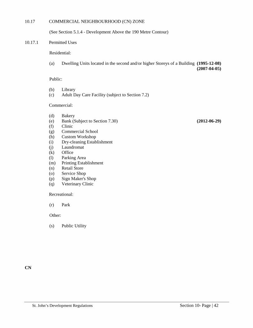
10.17 COMMERCIAL NEIGHBOURHOOD (CN) ZONE (See Section 5.1.4 - Development Above the 190 Metre Contour) 10.17.1 Permitted Uses Residential: (a) Dwelling Units located in the second and/or higher Storeys of a Building (1995-12-08) (2007-04-05) Public:
(b) Library (c) Adult Day Care Facility (subject to Section 7.2)
Commercial:
(d) Bakery (e) Bank (Subject to Section 7.30) (2012-06-29) (f) Clinic (g) Commercial School (h) Custom Workshop (i) Dry-cleaning Establishment (j) Laundromat (k) Office (l) Parking Area (m) Printing Establishment (n) Retail Store (o) Service Shop (p) Sign Maker's Shop (q) Veterinary Clinic
Recreational: (r) Park Other: (s) Public Utility CN

St. John’s Development Regulations Section 10- Page | 43
10.17.2 Discretionary Uses (subject to Section 5.8) (a) Car Washing Establishment (Subject to Section 7.30) (2012-06-29)
(b) Car Sales Lot (2007-09-07) (c) Church (1998-05-29) (d) Day Care Centre (subject to Section 7.6) (e) Eating Establishment (subject to Section 7.21)(Subject to 7.31) (1995-09-15) (2012-06-29) (f) Lounge (subject to Section 7.21) (2014-06-06) (g) Private Park (2007-10-05)
(h) Recycling Depot (provided the site is not located in a Residential Land Use District of the St. John's Municipal Plan) (1997-11-21)
(i) Rental Storage Use (subject to Section 7.23) (2008-07-18) (j) Service Station and Gas Bar (Subject to Section 7.30) (2012-06-29) (k) Small Scale Wind Turbine (2012-06-01) (l) Take-Out Food Service (Subject to Section 7.30) (2012-06-29) (m) Taxi Business
10.17.3 Zone Requirements
(1) The following requirements shall apply to all Commercial and Institutional Uses:
(a) Lot Area (minimum) 900 square metres (b) Lot Frontage (minimum) 30 m (c) Lot Coverage (maximum) 50% (d) Gross Floor Area used exclusively for a Commercial Use shall not exceed 9000 square metres (e) Floor Area Ratio maximum) 1.0 (f) Building Height (maximum) 3 Storeys (g) Building Line (minimum) 7 m (h) Side Yards (minimum) 1 m per Storey (i) Side Yard on Flanking Road (minimum) 6 m (j) Rear Yard (minimum) 6 m (k) Landscaping on Lot (minimum) Subject to Section 8.5
(2) All other uses: As determined by Council CN