department of environment and planning
TRANSCRIPT

DEPARTMENT OF ENVIRONMENT AND PLANNING
1
BIOLOGICAL SURVEY OF THECOOPER CREEK ENVIRONMENTAL
ASSOCIATION (8.4.4), NORTH EASTERNSOUTH AUSTRALIA
by
F.H. Mollenmans, J.R.W. Reid,M.B. Thompson, L. Alexander &
L.P. Pedler
December, 1984
RoFrdso
BIOLOGICAL SURVEY OF THE COOPER CREEK
ENVIRONMENTAL ASSOCIATION (8.4.4)
NORTH-EASTERN SOUTH AUSTRALIA
Prepared for the:
Survey and Research Section
National Parks and Wildlife Service Division
Department of Environment and Planning
South Australia
By:
Frans H. Mollemans Julian R.W. Reid Michael B. Thompson
Lynne Alexander Lynn P. Pedler
1984

PREFACE
This report is an early stage in the development of a systematic biological surveyof South Australia based on the environmental subdivisions of the State derived by
Laut et al (1977). The survey is built around a programme of standardised point
related sampling of the vegetation and vertebrate fauna together with the
compilation of all available biological inforamtion on the study area.
The Cooper Creek Environmental Association was chosen fore study because of the
areas great significance as one of Australia's major inland wetland regions. It is
sufficiently large and complex to act as a good test for the development of
techniques of data collection and analysis which will be equally applicable over
the remaining arid areas of South Australia.
Field work was carried out between September and November 1983 and this report
was submitted by the consultant team in December 1984. The survey to this point has
been completely supported by a National Estate Grant to the Survey and Research
Section, National Parks and Wildlife Service of South Australia.
Other pilot biological surveys in South Australia are being carried out in the
South Coast Environmental Region (field work completed April 1983). The Nullarbor
Plain Environmental Region (field work completed September 1984) and the Gawler
Uplands Environmental Region (field work to commence September 1985). From these
studies of four widely divergent parts of the state a series of standardised
approaches to data collection, storage and analysis will be developed leading to a
dramatic increase in the bilogical understanding of this State and providing a
solid foundation on which to base decisions on the best methods of conserving large
and truely representatative natural areas in South Australia.
The present report contains a large amount of raw data as it was the
consultants main task to gather information in a systematic way representing a
sample of the range of biological variation within the Cooper Creek Environmental
Association. More raw data such as the base maps used on the survey, and the
standard data sheets with information from the 27 sites surveyed are held by the
Survey and Research Section N.P.W.S. and are available for examination by anyone
interested in this information. .
In addition to carrying out a large proportion of the field survey the
consultants have produced the detailed land system classification of the Cooper
Creek Environmental Association embodied in this report. While this may not
necessarily be the final approach adopted for presentation of the results of the
Biological Survey of South Australia it is the first detailed attempt to continue
the heirachy proposed by Laut et al (1977) to the level of "habitats". Any comments
on this or any other aspect of the following consultancy report would be welcome
and should be addressed to:
Dr. A.C. RobinsonSenior Survey & Research OfficerSurvey & Research SectionNational Parks & Wildlife ServiceG.P.O. Box 1782ADELAIDE 5001

FRONTISPIECE
It Unfortunately the aspect of the country has been much changed sinceit has been taken up and stocked " (White, 1917b).
Cattle puddling 9 km north of Mundil. Bore.
AIM
The aim of this survey was to document the range of habitats and
associated fauna in the Cooper Creek Environmental Association, 8.4.4,
North-eastern South Australia.
ii
II I
I II
1

iii
CONTENTS PAGE
FRONTISPIECE . . . i
ii
CONTENTS . . . iii
INTRODUCTION . . . . 1
1.1 THE STUDY AREA . 1
1.2 THE BRIEF . . . . 2
1.3 PREVIOUS BIOLOGICAL STUDIES . 2
1.4 HABITATS . . 3
1.4.1 Vegetation . . 4
1.4.2 Dunefield . . . 4
1.4.3 Floodplain . 5
1.4.3.1 General . . . 5
1.4.3.2 Wetlands . . . 5
1.4.4 Gibber Plain . . . 5
1.5 FAUNA . . . . . 5
1.5.1 ' Mammals. . .. . 5
1.5.2 Birds . . . 6
1.5.3 Reptiles . . 6
1.5.4 Frogs . . 7
1.5.5 Fish . . . . 7
1.5.6 Aquatic Invertebrates . 7
1.6 GEOLOGY AND ECONOMIC GEOLOGY . 7
1.7 PASTORALISM . . . 8
1.8 TOURISM .8
PHYSIOGRAPHY AND BACKGROUND . . 9
2.1 'APPLICATION OF THE HIERARCHY OF LAUT ET AL. (1977) 9
2.1.1 *. Province.-8 . . 9
2.1.2 Environmental Region 8.4 . 9
2.1.3 Environmental Association 8.4.4 . 9
2.2 PRECISE LOCATIONS_ OF THE BOUNDARY OF 8.4.4 . 10
2.3 HIERARCHIAL CLASSIFICATION OF ENVIRONMENTALASSOCIATION 8.4.4 . . . 11
2.3.1 Environmental Divisions of 8.4.4 Based onLandform Criteria - Environmental Subassociations 11
2.3.2 The Environmental Subassociations of 8.4.4 11
2.3.3 Land Zones . . 12
2.3.3.1 Dunefields . . 13
2.3.3.2 Floodplains . . 13
2.3.3.3 Gibber Plains . . . 13
2.3.4 Land Systems . . 14
2.3.5 Environmental Units . . 15
2.3.6 Environmental Subunits . 16
2.3.7 Land Unit(s) - A Definition. . 17
2.4 SALT LAKES AND SALINITY 19
2.4.1 General . . 19
2.4.2 Fauna of Salt Lakes - General - . . 20
2.5 . CLIMATIC AND RELATED CONSIDERATIONS . 21
2.5.1 Climatic Considerations . . 21
2.5.1.1 Rainfall . . 21
2.5.1.2 Temperature and. Evaporation . 22
2.5.1.3 Winds . . . 22
2.5.1.4 Individual and Combined Effects ofClimatic Conditions . . 22
iv
CONTENTS PAGE
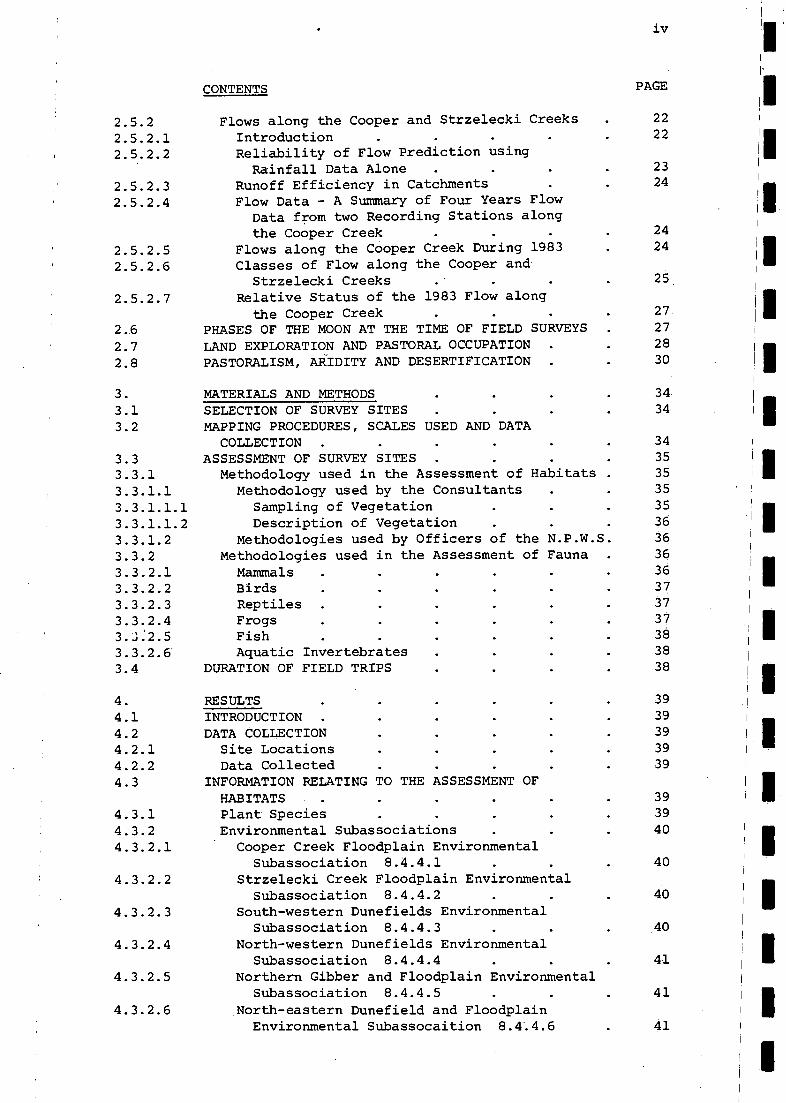
2.5.2 Flows along the Cooper and Strzelecki Creeks 22
2.5.2.1. Introduction . . . . 22
2.5..2.2 Reliability of Flow Prediction usingRainfall Data Alone . . 23
2.5.2.3 Runoff Efficiency in Catchments . 24
2.5.2.4 Flow Data - A Summary of Four Years FlowData from two Recording Stations alongthe Cooper Creek . . . . 24
2.5.2.5 Flows along the Cooper Creek During 1983 . 24
2.5.2.6 Classes of Flow along the Cooper andStrzelecki Creeks . . . 25.
2.5.2.7 Relative Status of the 1983 Flow alongthe Cooper Creek . . . 27.
2.6 PHASES OF THE MOON AT THE TIME OF FIELD SURVEYS . 27
2.7 LAND EXPLORATION AND PASTORAL OCCUPATION . . 28
2.8 PASTORALISM, ARIDITY AND DESERTIFICATION . 30
MATERIALS AND METHODS . 34.
3.1 SELECTION OF SURVEY SITES . . 34,
3.2 MAPPING PROCEDURES, SCALES USED AND DATACOLLECTION . . 34
3.3 ASSESSMENT OF SURVEY SITES . . . . 35
3.3.1 Methodology used in the Assessment of Habitats . 35
3.3.1.1 Methodology used by the Consultants . 35
3.3.1.1.1 Sampling of Vegetation . . 35
3.3.1.1.2 Description of Vegetation . . . 36
3.3.1.2 Methodologies used by Officers of the N.P.W.S. 36
3.3.2 Methodologies used in the Assessment of Fauna . 36
3.3.2.1 Mammals . . . . 36
3.3.2.2 Birds . . 37
3.3.2.3 Reptiles . . . 37
3.3.2.4 Frogs . . . 37
3.3:2.5 Fish . . . 38
3.3.2.6 Aquatic Invertebrates . . 38
3.4 DURATION OF FIELD TRIPS . . 38
RESULTS . . . 39
4.1 INTRODUCTION . . . 39
4.2 DATA COLLECTION . . 39I II4.2.1 Site Locations . . . 39
4.2.2 Data Collected . . . . 39
4.3 INFORMATION RELATING TO THE ASSESSMENT OFl' I
HABITATS . . . . 39 I II4.3.1 Plant Species . . . 39
4.3.2 Environmental Subassociations . . 40
4.3.2.1 Cooper Creek Floodplain Environmental IISubassociation 8.4.4.1 . . . 40
4.3.2.2 Strzelecki Creek Floodplain EnvironmentalSubassociation 8.4.4.2 . . 40
4.3.2.3 South-western Dunefields EnvironmentalSubassociation 8.4.4.3 . . 40
4.3.2.4 North-western Dunefields EnvironmentalSubassociation 8.4.4.4 . . . 41
4.3.2.5 Northern Gibber and Floodplain EnvironmentalSubassociation 8.4.4.5 . . . 41
4.3.2.6 .North-eastern Dunefield and FloodplainEnvironmental Subassocaition 8.4*.4.6 . 41
i

CONTENTS PAGE
4.3.2.7 Uncoordinated Drainage Dunefield EnvironmentalSubassociation 8.4.4.7 41
4.3.3 Land Zones . 414.3.4 Land Systems 414.3.4.1 Attempts at Vegetation - Land System Mapping
using Available Aerial Photography . 42
4.3.4.2 Land Systems Identified from Field Data 424.3.4.2.1 Land Systems of the Dunefields 42
4.3.4.2.2 Land Systems of the Floodplains 45
4.3.4.2.3 The Gibber Plain Land System . 494.3.5 Environmental Units 49
4.3.6 Environmental Subunits . 49
4.3.7 Habitats Identified on the Basis of PlantCommunities 50
4.4 FAUNA RESULTS . 87
4.4.1 Mammals . 87
4.4.2 Birds 884.4.3 Reptiles 884.4.4 Frogs . . 884.4.5 Fish 884.4.6 Aquatic Invertebrates . . 894.5 STATE OF THE COUNTRY AT THE TIME OF SAMPLING 89
4.5.1 General State of the Country . 89
4.5.2 Influences of Herbivores and Man . 90
5. DISCUSSION . 925.1 INTRODUCTION . . . . 925.2 INFORMATION RELATING TO THE ASSESSMENT OF HABITATS 925.2.1 Plant Species . 925.2.1.1 Introduction . . . . 92
5.2.1..2 Plant Collections This Suzvey 935.2.1.3 Rare or Threatened Australian Plants 94
5.2.1.4 Records of Significance for Other Reasons 955.2.1.5 Other Species . . . . 965.2.1.5.1 Terrestrial Species . 965.2.1.5.2 Aquatics and Semi-aquatics 1005.2.1.6 Naturalised Species 1015.2.1.7 Summary in Relation to Plant Species 1015.2.2 Plant Communities . . . 1015.2.2.1 Introduction . . . . 1015.2.2.2 The Plant Communities of Association 8.4.4 102
5.2.3 Environmental Subassociations 106
5.2.3.1 Introduction . . 1065.2.3.2 Environmental Subassociations and Survey Sites 1065.2.4 Land Zones . . 1085.2.5 Land Systems . . 1085.2.5.1 Vegetation - Land System Mapping 1085.2.5.2 Land Systems Identified from Field Data 1085.2.6 Environmental Units and Environmental Subunits 1095.2.7 Habitats . . . 1095.2.7.1 Habitat(s) - A Definition . 1095.2.7.2 Habitats vs Land Units . . . 1115.2.7.2.1 Habitats vs Land Units - The Effect . 1115.2.7.2.2 Habitats vs Land Units - The Result . . 1125.2.7.3 The Range of Habitats in Environmental
Association 8.4.4 1125.2.7.3.1 Habitats Recognised Prior to the Present
Survey 112

II
1111
I
ii II1 II
1
1
1
I II1
1
i I 11
1
I II1
IIII
1
_6 . 5 CONCLUSIONS .
7 ACKNOWLEDGEMENTS
F . REFERENCES
9 APPENDICES ordered in general according to useage in thetext, in separate volume
vi
CONTENTS PAGE:-
5.2.7.3.2 The Range of Habitats in the Cooper CreekEnvironmental Association 8.4.4 . 114
5.2.7.3.2.1 Introduction . . . . 1145.2.7.3.2.2 Inadequately Conserved Habitats . . 1155.2.7.3.2.3 Other Significant Habitats. . 1175.2.7.3.2.4 General Discussion of the Range of.Habitats
in Environmental Association 8.4.4 . . 1185.2.7.3.2.5 Summary in Relation to the Assessment
of the Range of habitats identifiedon the basis of Plant Communities . . 119
5.3 FAUNA . . . . 1195.3.1 Mammals . . . . . . 1205.3.1.1 Significant Collections . . . . 1205.3.1.2 General Comments about the Rodents . 1205.3.1.3 Notes on Other Native Mammals . . 1215.3.1.4 Introduced Species . . . . . . 1225.3.1.5 General Comments . . . . . . 1225.3.2 Birds . . . . . . . . 1235.3.2.1 Introduction . . . . . . . 1235.3.2.2 Significant Records . . . . . 1235.3.2.3 Other Species of Importance . . . 1255.3.2.4 Notes on Other Species of Importance
Not Recorded This Survey . . . . 1275.3.2.5 General Comments . . . . . . 1285.3.2.6 Effects of Flooding . . . . . 1305.3.2.7 Summary in Relation to Birds . . . . 1335.3.3 Reptiles . . . . . . . . 1335.3.4 Frogs . . . . . . . 1345.3.5 Fish . . . . . . 1346.3.6 Aquatic Invertebrates. . . . . . 1355.3.7 Summary in Relation to Fauna 1355.4 HABITATS, FLORA AND FAUNA . . . 1375.4.1 Introduction . . . . . . 1375.4.2.1 Wetland Habitats of Association 8.4.4 1395.4.2.1.1 Introduction . . 1395.4.2.1.2 Background to the Wetland Classification
of Association 8.4.4 . 1405.4.2.1.3 Requirements of the Brief in relation
1
to wetlands . . . . . . 1411
5.4.2.1.4 wetland Habitat(s) A discussion of the'
Applicability of the habitat definition 142 1
5.4.2.1.5 Wetland Habitat(s) A definition . 1425.4.2.1.6 Deepwater habitat(s) A definition . 1435.4.2.1.7 Wetland Habitats of Association 8.4.4
A classification . . 1435.5 CONCLUSIONS ON HABITATS, FLORA AND FAUNA 1546 VEGETATION CHANGE . 1546.1 INTRODUCTION 1546.2 PREHISTORIC INFLUENCES . . 1556.2.1 PreAboriginal Time . 1556.2.2 Aboriginal Time . 1566.3 NATURE OF PREEUROPEAN VEGETATION . 1576.4 VEGETATION CHANGE: THE ECOLOGICAL IMPACT
OF CATTLE AND RABBITS . . 158
1 Environmental Units of Environmental Association
8.4.4 . . . . . opposite 16
2 Analyses of VariousCompositions of Water and Salt
with Relevance to the Cooper Creek Environmental
Association (8.4.4) or For Comparison . opposite 20
3 Date, Level and Status of Flow at CallamurraWaterhole From 3 ii 83 to 10 vii 83 . 25
4 Phases of the Moon (August to December 1983) 27
5 Total Trapping Effort (Mammals) .87
6 Species of Mammal Recorded in the Survey FromEnvironmental Association 8.4.4 . . opposite 87
7 Methods by Which Mammal Species were Collected
in this Survey and Trapping Success Rate 87
8 Species of Bird Recorded During the Survey of
Association 8.4.4 . . . . opposite 88
9 Species of Reptiles Collected in Association 8.4.4
During the Survey . . . . opposite 89
10 Data Concerning Species of Frogs Collected During
the Survey of Association 8.4.4 . . . 89
11 Fish Species Collected at Each Site . . 89
12 Preliminary Identifications of Some of the Aquatic
Invertebrates Collected Along the Cooper
Creek . . . opposite 90
13 Adult Trichoptera Collected in Light Traps Along
the Cooper Creek . . . . opposite 90
14 Plant Communities Identified Within the CooperCreek Environmental Association 8.4.4, the
Habitats Within Which They Occur and the
Structural Position of Plant Communities
Within Stipulated Habitats . . 103
15 Species That are Typical of the Predominant Avian
Communities of 8.4.4 Which Were Not RecordedThis Survey . . . . . 123
16 Species of Bird Which Have Not Been Recorded in
8.4.4 Previously, But Possibly Occur Here asVagrants Judging by Records in Adjacent Regions 123
17 Species of Reptiles Previously Recorded FromAssociation 8.4.4 But Not Collected During
This Survey . . . . . opposite 133
18 Species of Reptiles Previously Recorded FromJust Outside Association 8.4.4 and Reasonably
Expected to Occur in This Area . . opposite 133
19 Species of Fish Previously Collected From
the Cooper Creek . . . 135
LIST OF FIGURES
Cooper Creek Environmental Association 8.4.4 opposite 2.
Regional Plans Showing 8.4.4 in Relation to
Other Environmental Areas .opposite 9
Environmental Subassociations opposite 12
vii
CONTENTS PAGE
LIST OF TABLES
1
2
3

4 Possible Subdivision of 8.4.4 According to SurfaceHydrology . . . . . opposite 13
5 Ground Water T.D.S. (mg/1) For the Cooper CreekEnvironmental Association 8.4.4 . . opposite 19
6 Peak Volume Days For All Months From October 1978 IIIto January '83 Inclusive, and One Record ForFebruary 1974 (For Comparison) - PeakVolume vs Gauge Height at Peak Volume . opposite 25
ill7 Survey Sites . . . . . opposite 34 i
8 Environmental Subassociations (Modified) . opposite 39I
9 Preliminary Vegetation - Land System Map of theRegion Around Site 1 . . . opposite 42
I I10 Preliminary Vegetation - Land System Map of the
1
Region Around Site 4 . . . opposite 43
. 11 Preliminary Vegetation - Land System Map of the1 II
Region Around Site 6 . . . opposite 44I
12 Preliminary Vegetation - Land System Map of theRegion Around Site 14 . . . opposite 45
I I13 Preliminary Vegetation - Land System Map of the
Region Around Site 23 . . . opposite 461
11 II14 Preliminary Vegetation - Land System Map of the
Region Around Site 25 . . . opposite 4715 Preliminary Vegetation - Land System Map of the -
Region Around Site 28 . . . opposite 48
I 4 D,s 1.'12 L,4 . o".. Z.;. 1 pr7 ..4 j 01.( 6.,..,C I (...... ,a,e C...1 ... ,,,,/ S II 0 5 / 142
i7
iff be ,,,e,-,4,...- 1-1- :....",A,+. r
LOCATION OF PHOTOS IN THE REPORT 1 II
I
Frontispiece i
. 52li
531
56
60 III 161
65 II
64
661
67
70 I
75II
i
I II. . . 82
1-23-45-67-89-1011-1213-1415-1617-1819-2021-2223-2425-2627-2829-3031-3233-3435-3637
38
CONTENTS PAGE
Y
8384
85

1
1
\r-
..) ,
:.
.
...... ;* ..-
1 ,,
,
. .
, . I
._..... .
11111 STUDY
AREA
\ f /
27'
\t/
4
..
. . ,,..." .., ..-........
/....... '. S. '. C. ... .',
.... ooPER ..-- , 0 f.,.
.- t , . , .
.., le°4.
.-
... \ .,.,,re
. ,...,ef ._. tu
. . .
.; .--'e' 9 . In na inincka
, - --- ---' ,..... /
,
i
,.........- r' iiik"
,1 c) pr 4 fr110
,--1
...: 4,..
.k- . t.. ..-'
, /
. .
i ,
e :1 f: 4' 4 /
fr
: ,
/ .
FIG-URE I - COOPER CReEK E IsIVIRolsi MENTAL
ASSOO AT ION
mn.. 0 25
KRA

I.
1. INTRODUCTION
1.1 THE STUDY AREA
Cooper Creek Environmental Association, 8.4.4 (see Fig. 1), is centred
on the Cooper Creek floodplain, lying west of Innamincka and east of the
Birdsville Track. Containing areas of floodplain, dune5ield and gibber plain,
the Environmental Association has an area of 27 050 km (Laut et al., 1977),
about half the size of Tasmania.
In 1977, Laut et al., using Landsat remote sensing techniques as an aid,
subdivided South Australia into various Environmental regions, associations
and units based on landform criteria. Environmental associations such as 8.4.4
represent the combination of a limited number of Environmental units and are
unique mapping areas (Laut et al., 1977).
Cooper Creek originates as the Barcoo and Thomson Rivers on the Great
Divide in central Queensland and drains into Lake Eyre in north-eastern South
Australia. Having a drainage area of 296 000 km2, it is the largest of the
seven river systems together which comprise the vast (1 170 000 km2) and end-
orheic Lake Eyre Drainage Basin (Australian Water Resources Council, 1976).
In South Australia the main channel of the creek carries water annually
between April and July to about as far as Cuttapirie Corner Waterhole on the
main channel and Coongie Lake on the North-West Branch. Its gradient averages
3-4 cm per kilometre to the east of Innamincka, but decreases to less than 0.5
cm per kilometre to the west in the broad floodout area of the Cooper Creekfloodplain (Wopfner, 1970). Its course, which in some places e.g. Malagarga (Qld)
spreads over a width of more than 50 km, consists of a wide expanse of braided,
leveed channels (Wopfner, 1970), and is marked generally by a string of isolated
waterholes. In times of extreme flow (a level 3 flood - see Section 2.4.2.6),
which occur rarely at irregular intervals (Wopfner, 1970), with examples in recent
times being in 1949/50 (Bonython, 1955) and 1974 (Douglas, 1980), the Cooper and
its iistributaries become inundated to a width of 30 km (Australian Water Resour-
ces Council, 1976) at which times large volumes of sediment are carried downstream
and over the land surface.
The waters of the Cooper Creek are generally described as fresh (Australian
Water Resources Council, 1976), but in some areas the channel passes through
areas of saline groundwater or rock strata containing connate salts (Johnson,1980); however, these sections have a negligible effect on the otherwise fresh-
water.
II_ The immediate area of the Cooper Creek Environmental Association was first
visited by white man during the Sturt Expedition of 1844-46 (Black, 1917), at
I -7-which-time the-first-specimen-of. the Night Parrot Geopsittacus occidentalis was
collected (by John McDouall Stuart near Lake Goyder on October 15 1845 - Forshaw,
1981). A.C.Gregory and the ill-fated Burke and Wills Expedition followed in 1858
and....1860,..respectively,'..while.one section of 8.4.4, the Strzelecki Track, wasIIfounded and became infamous when in 1871 Captain Starlight used it to bring stolen
-- cattle from Queensland to the Adelaide markets (S.A. Govt. Tourist Bureau, 1983).Prior to these. early European explorations, aboriginal man had occupied the area
II-for a considerably longer period; as evidenced by the presence of shell middens,artefacts and-extensive-stone arrangements in some parts. Four tribes are known-to have.joccupied-th-6area-(Tindale, 1974), and the Dieri and Jandruwanta tribesmen
-. :.-. - .'..- who-were-once plentiful along the Cooper-dectined-rapidly-afterTcontact-with-whiteIIman, until only a_handful.of_Jandruwanta people remained alive in 1930 (Elkin,
- ' --------I9-311 and-See-White4S-detcription-of-their-pitiful-state-in-1916-in:-White-,--19I7b)-.
1

2
Average annual rainfall of the study area is less than 150 mm (AustralianWater Resources Council, 1976), and has a reliability of less than 30 per cent
(Nix, 1981), while average annual evaporation at Birdsville is 3 958 mm (Bureau
of Meteorology, 1975) and it is thought to be of thit.,: order in Environmental111,
' Association 8.4.4. Hence surface waters, derived directly by rainfall (the study
,region lies within the northern Eremaean zone of. Burbidge (1960) in an area where
rapidly except for the deeper waterholes and lakes. At least one waterhole hassummer rainfall is the dominant influence) or indirectly by river flow, dry up
a known depth of 27 m (Johnson, 1980). The most frequent direction of wind, based
on records from Moomba, is north-west (SANTOS, 1981).. Temperature shows consider-
able diurnal and seasonal variation (Lgut et al., 1977) with mean daily tempera-
ttres . of the hottest week being 30-35 C and for the coldest week, 5-100C (Nix,
1981).Mean daily temperatures are 20-250C and mean daily solar radiation is 22-
24 MJ/cm2/day (Nix, 1981).II
Soils of. the study area are grey, self-mulching, cracking clays (Ug 5.24)on pans and floodplains, red siliceous sands. (Uc 1.23) and white siliceous sands
1 II(Uc 1.21) on dunes, and red massive earths (Gn 2.13) in the interdune lows (Lautet al., 1977). Those of gibber plains are crusty, red duplex soils (Dr 1.33) and
1 IIthe upper layer of salt lakes consists of salt of variable thickness.
1.2 THE BRIEF
!
The. brief for this study consisted of seven sections, which are summarisedbelow (a copy of the full brief appears in Appendix A).
Establishment of representative, permanently marked sites to provide baselinedata for assessment of ecological implications of flood events.
Collection of data in a form suitable for computer analysis.
Detailing of current and projected land-use within the, study area.
Consideration of the effect of grazing by feral animals and stock.
Classification of vntlands with regard to areal extent, permanence, depth andassociated flora and fauna.
,Production of an annotated bibliography relating to the ecology'of.the studyarea.
Confidential recommendations pertaining to conservation priorities.
In order to comply with the requirements of the brief, two field trips,each of 16 days duration, were undertaken by the consultants, with a group ofofficers from the National Parks and Wildlife Service in the field for from 7-10days at the time of the first of these.
Data in a form suitable for computer analysis (Section 2 of Brief) and theannotated bibliography relating to the ecology of the study area (Section 6 ofBrief) are not included with this report. These form the basis of separate comp-ilations, which have been submitted to the Survey and Research Section of theNational Parks and Wildlife Service Division. .
1.3 PREVIOUS BIOLOGICAL STUDIES
There have been few intensive studies of a biological nature in the CooperCreek Environmental Association (Environmental Research and Planning Group, 1980;Foale, 1982; Social and Ecological Assessment Pty. Ltd., 1982), and the largearea of the Association means that total coverage has been sparse. The focus hasgenerally been on the Cooper Creek and its distributary channels (e.g. Waite,

3
1917; Foale, 1982). In the following sections the habitat and fauna componentswill be introduced, along with the principal land-uses.
1. 4. HABITATS
Habitat has been defined, as the natural home or dwelling place of an organ-ism (Steen, 1971). The organisms (flora and fauna) of the study area may befound in one or more of...the six major habitat types, which can be identified on
the basis of. the Environmental unit concept (refer to the glossary; Appendix. B,
for the definition of all terms used in this report) of Laut et al. (1977) i.e.
claypans, salt lakes., floodplains, dunes, interdune lows and gibber plains,
although it is noted that Laut et al. (1977) did not identify salt lakes (as
distinct from (clay)pans) nor gibber plains in the. section of their treatise
relating to 8.4.4.
The major habitat types can be further subdivided into habitats, for example,dune crests and dune slopes as components of dunes. Habitats thus identified, canbe classified on the. basis of the dominant plant community type(s) within thathabitat. Plant communitytype is principally determined by the combined effectsof hydrological conditions, edaphic conditions, aspect, hence microclimate, andmacroclimatic conditions. Water is the major factor determining the distributionof vegetation in a large part of Environmental Association 8.4.4. However, inthe wider context of Australia, edaphic conditions are generally more important.
In Association 8.4.4 three broad.habitat zones, which are equivalent to theland zones of Dawson (1974); were identified by Laut et al. (1977) or from geolo-
gical maps viz. dunefield , floodplain and gibber plain, and they contain one or
more Environmental units.
Dawson and Boyland (1974), in their treatise on the Western Arid Region of
Queensland, have used an entirely different approach. They started with an area
greater than five times the size of the present study area about which relative-
ly little was known and, in the absence of a broad-scale survey of Queensland aswas carried out in South Australia by Laut et al. (1977), subdivided it as one
entity. It appears from their report that the area is extremely complex, becauseof the numerous habitat types into which they subdivided the area (see Land Sys-
tem Map). However, McGreevy and Searle (1974) say that the area may be divided
into just five habitat types viz. wetlands, open grassy plains, forested plains,
stony ridges and sand-dunes. Hence it can be seen that this larger, adjacent
region of Queensland is only slightly more complex than Association 8.4.4.
In the broad-scale survey of South Australia (Laut et al., l977'.prior to the present study, the region of 8.4.4 was classified according to
Environmental units , and it is now subdivided into smaller units to facilitatea greater understanding of the biology of the region.
Cost has been a limiting factor in the present study, yet every effort hasbeen made to ensure that this survey is compatible with other, similar surveys.The desirability of achieving the aims of integration and compatibility of surv-eys has been pointed out in the Workshop on Survey Methods for Nature Conservation
held in Adelaide in late August 1983. Because only South Australia has been divid-ed into Environmental areas in the manner of Laut et al. (1977), the integrationof surveys without a similar or compatible starting point is impeded, as is thecase with the Queensland survey of Dawson and Boyland (1974). However, the hier-
archial subdivision at the state level, as achieved by Laut et al. (9177), hasproven to be a very useful basis from which the present survey could be started.
It is unfortunate that similar broad-scale surveys will not be carried out in
other Australian States and Territories.

4
The land zone, land system, land unit subdivision of Dawson (1974), arenot directly compatible with the scheme of Laut et al. (1977), which by therequirements of the brief we are compelled to follow. However, in this reportan attempt has been made to integrate the land zone, land system, land unit
subdivisions into a hierarchy based on Laut et al.'s (1977) classification.
Further subdivision has also been required. The subdivisions of the Environmental
Association are Environmental Subassociation, Land Zone, Land System, Environment-
a1 unit, Environmental subunit and Habitat (.1: Land unit). These subdivisions fit
into a hierarchial framework and are defined in the glossary.
Vegetation, the components of the three broad habitat zones and wetlands
will now be considered.
. 1.4.1 Vegetation
General descriptions of the vegetation of Australia tend only to resemble
catalogues of plant groupings (Carnahan, 1976; Specht, 1981; Pipelines Authority,
of South Australia, 1981; Williams., 1982), and serve only to introduce regionalvegetations at a scale which in terms of'habitat assessment is inadequate. Aust-ralies. vegetation, which in geologically recent times at least, has had to
.withstand some extreme changes in climatic and (as a result) edaphic conditions(Crocker, 1959;. Wood, 1959; Bowler, 1982; Buckley, 1982), is in fact a mosaic of
plant communities made up of species with varying tolerances to environmental.change. Only detailed surveys can hope to elucidate the pattern of plant commun-ities, which have developed in response to such changes.
Some detailed studies. have been undertaken'in the Cooper Creek EnvironmentalAssociation and adjacent regions, and help to define the habitats of the region(e.g. Dawson and Boyland, 1974; Environmental Research and Planning Group,. 1980;Bolton and Specht, 1981). In the habitat component of this study, it was intendedto expand on the work of previous authors and detail the habitats of a smaller -
area (27 050 km2) than covered by most of these studies (e.g. Dawson and Royland,
1974 - 145 200 km2; Environmental Research and Planning Group, 1980 - 32 000 km2),
and in greater detail in most respects.
While vegetation of the arid zone has been reported to undergo naturalchange extremely slowly in a historical sense (Correl and Lange, 1966), changesin the study region and the wider arid zone may have been more rapid under theinfluence of present and past land-uses. The role of aboriginal man in vegetationchange, by his use of fire over the last 35 000 years or so, is now being discus-
sed widely (e.g. Kershaw, 1981; Nix, 1981; Roxby Management Services Pty. Ltd.,1982). Furthermore the decreased frequency and greater intensity of wildfiressince European settlement of the arid zone (Hodgkinson and Griffin, 1982; RoxbyManagement Services Pty. Ltd., 1982) may have resulted in change. Pastoralism,petroleum exploration and extraction, feral animals and to a lesser extent,tourism have also had an effect on the vegetation. Hence the vegetation of thestudy area and its borders may be somewhat different today than was seen byearlier workers (e.g Cleland, Black and Reese, 1925).
It is probable that changes in habitat have resulted in changes to faunalcomponents. Fauna will be looked at in Section 1.5.
1.4.2 Dunefield
The majority of. dunefields in the study area are the typical NNW trendingparallel dunes which characterise the Strzelecki and Simpson Deserts. They arepart of a regional system , and the source of their sediment supply and methodof formation has been recently documented by Twidale (1982).

5
Two other fairly distinct types of dunefield are found within the studyarea, along with areas more akin to sand plain.
The dunefields may contain claypans or salt lakes, the latter forming wherethe process of deflation has reached the water table.
1.4.3 Floodplain
1.4.3.1 General
Many of the landforms of the study area and the North-East in general are- present due to the work of rivers past and present, both directly and indirect-ly (Twidale, 1982). Floodplains of the study region are made up of channels,swamps, floodouts and terminal lakes; channels often follow a complex braidedpattern. Pans and large areas of the floodplains have comparatively smooth floors.In all major floodplain environments, pans generally have clay rather than saltbases.
1.4.. 1...2. Wetlands
Wetlands form a significant habitat component of the study area, particul-arly for birds, with numerous waterholes and also lakes that carry water forlong periods after rain or floods. They are generally classified on the basisof permanence of water, shape of basin, depth and quality of water, with finerclassification on the basis of vegetation (e.g. Corrick and Norman, 1980). Arecent treatise on wetland vegetation having particular relevance to the studyarea (Briggs, 1981) is useful in this latter regard. The need for management ofwetlands in general and including those of the NQrth-East has been dealt withrecently (Delroy, 1981). This need is certainly highlighted in the study areawhere a lot of wetlands .have been disturbed or modified by stock use and to alesser degree by activities relating to petroleum exploration and extraction.
1.4.4 Gibber Plain
Only small areas of gibber plain occur within the northern part of thestudy region. They are characterised by angular silcrete fragments with polish-ed coats of iron and manganese oxides (Twidale, 1982).
The gibber areas of Environmental Association 8.4.4 are not the typicalgibber plains that characterise the Cordillo Surface (seen as the extensiveplains north of Cordillo Downs - Ludbrook, 1980). In the study area they forma complex association with dune and floodplain elements, and therefore alsoform a relatively unique landform complex not common elsewhere in South Austra-lia.
1.5 FAUNA
The main aspects of the fauna studied during the survey were mammals,birds, reptiles, frogs and fish. Aquatic invertbrates are looked at in much lessdetail.
1.5.1 Mammals
There have been few surveys of an intensive nature of the mammals of Env-ironmental Association 8.4.4 (James, 1982) and the relatively large area of the

'study region means that total coverage of these surveys has been sparse, esp-
ecially considering that previous surveys of the North-East (e.g. Waite, 1917;Watts and Aslin, 1974; Forrest, 1982) have not been confined to 8.4.4. In add-
ition the collecting techniques of all surveys have varied, as has time allotted
to some techniques (Waite, 1917; James, 1982).
This survey was designed to sample, using standard techniques, the small
mammal fauna of all habitat types found in Environmental Association 8.4.4.
To this were added incidental collecting records so that the distribution and
habitat preferences of the mammals of the region could be determined.
1.5.2 Birds
Over the past ten years many ornithologists have visited the north-east
.portion of the State .(that part of South Sustralia lying to the north and east
of Lyndhurst) e.g. Cox and Pedler (1977) and Badman (1979), so the birdlist
that has been compiled (see Appendix S) is thought to be a virtually complete
checklist of the birds that regularly inhabit Association 8.4.4.
Species known to occur in. the North-East are now reasonably well documented,
although little has been written on their patterns , habitat preferences and
status (abundance, seasonality and "conservation status") within the region -
such an analysis is attempted in this report. A standard bird censusing technique
has been used, along with incidental observations and collections made during the
survey.
Much of the information drawn upon for .this analysis is as yet unpublished.
Two long term surveys of the birds of the upper and lower portions of the Cooper
are to be published shortly by Messrs. I.A. May and F.J. Badman, respectively.
The conclusions that these authors reach concerning the dynamics of the birds
of the Cooper Creek system will be the first to be drawn from a sound data base
i.e. year round periods of observation spanning several years. It is strongly
recommended that their papers (when published) be read in conjunction with this
document.
1.5.3 Reptiles
Although there has been some interest in some species of reptiles in theNorth-East of South Australia in recent years (e.g. Oxyuranus microlepidotus -Blood et al., 1979; Emydura spp. - Thompson, 1983), little comprehensive coll-ecting has been done. Some surveys have made limited collections (e.g. Waite,1917; Foale, 1982) in Environmental Association 8.4.4 and the S. A. Museum madea collection along the Cooper Creek to Coongie Lake in 1981.
Despite the few systematic surveys of reptiles of 8.4.4 most of the speciesknown fron the area have been collected and lodged with the S. A. Museum since
1980. However, these occasional collections, usually incidental to some other
activity, have not been published. Apart from texts and papers discussingvarious taxa of lizards over broad geographic areas, including 8.4.4 (e.g. Smy-th, 1972 - Morethia; Kluge, 1974 - Pygopodidae; Houston, 1978 - Agamidae andVaranidae) there is little published information on most species of reptile
within the study area..
The survey design for reptiles was essentially similar to that used formammals, except that more active collecting was done.
II
I
7
1.5.4 Frogs
Seven species of frog are known from the North-East of South Australia(Tyler, 1978; Brooks, 1980). There are two basic, ecological groups - thosespecies that are tied to permanent water such as occurs along the Cooper Creek,and those that are truely desert adapted. Desert adapted species usually emergefrom their subterranean retreats only after significant rainfall. There havebeen no thorough systematic surveys of frogs in Environmental Association 8.4.4.
Although a significant effort was made to locate frogs in this survey,most collections were fortuitous and the coverage of the study region patchy.
1.5.5 Fish
The fish fauna of the North-East has been extensively surveyed and is wellknown (Glover and Sim, 1978a,b; Glover, 1979). Sixteen species, some undescribed,have been recorded from the Cooper Creek system, none of which are restricted tothat waterway (Glover and Sim, 1978a; Glover, 1979). Extensive dispersal of fish-es occurs in central Australia during floods. This has resulted in the wide dist-ribution within the Lake Eyre drainage basin of the species found in the CooperCreek (Glover and Sim, 1978a).
Survey design involved the sampling of suitable wetlands with nets ofvarious types to identify the diversity of species present. A small but signific-ant amount of time was devoted to this activity.
1.5.6 Aquatic Invertebrates
The Engineering and Water Supply Department is preparing a checklist offreshwater invertebrates of South Australia and it is known that specimens arelacking from the Cooper Creek (Suter, pers. comm.).
Active collection by netting, and use of a light trap (for adults) wereemployed to sample aquatic invertebrates.
1.6 GEOLOGY AND ECONOMIC GEOLOGY
Surf icial geology of the study region is generally of Quaternary age, andconsists of a dunefield unit (Qrs), a floodplain unit (Qra), a claypan and saltlake unit (Qrl), and a broken gibber and boulder duricrust unit (Qrt) (Strzelecki,1:250 000 Geological Sheet G54-2, preliminary edition, 1970; Gason, 1:250 000Geological Sheet SG54-13, 1973; Kopperamanna, 1:250 000 Geological Sheet SH54-1,1974; Innamincka, 1:250 000 Geological Sheet SG54-14, 1975; Cordillo, 1:250 000Geological Sheet SG54-10, preliminary edition, 1977 - all by the S. A. Departmentof Mines and Energy and hereafter referred to as STRZELECKI, GASON, KOPPERAMANNA,INNAMINCKA and CORDILLO, respectively).
While heavy mineral sands have been reported from Lake Hope in the extremesouth-west of the study area (Wopfner and Townend, 1968), the petroleum resour-ces of the study region, which overlies the south-west half of the Cooper Basin,are its most economically significant asset. The majority of petroleum accumula-tions known in the Cooper Basin are gas in Permian Formations (of porous sand-stone layers approximately 2000-3000 m subsurface - SANTOS, 1981), whereas thoseknown in the overlying Eromanga Basin (the Cooper Basin is a deeper infrabasinof the Eromanga Basin - formerly Great Artesian Basin - SANTOS, 1981) are mainly

8
oil (SANTOS pamphlet). Most productive fields are in the central south-easternpart of the study area. The search for and extraction of petroleum constitutesone of the major land-uses in the study area.
1.7 PASTORALISM
The two main station properties in the study area! are Innamincka andGidgealpa. Smaller areas are occupied by the properties - Pandie Pandie,Cordillo DoWns, Clifton Hills, Kanowana, Waukatana, Lake Hope, Metty Merty andTinga Tingana (=White Catch) ( see Appendix H ). The remainder of the studyregion in the south-west consists of crown lands. All other things being equal,Innamincka Station , because it includes much of the Cooper Floodplain and inparticular the Coongie system, has the capacity to provide double the returnsof. the other stations -(Mr. G. Drewin, pers. comm.), and thus is one of the most.significant cattle properties in South Australia.
Since 1979 and until the end of 1983, most properties have been graduallydestocked in a programme to rid cattle herds of Brucellosis and Tuberculosis.This Brucellosis/Tuberculosis Eradication Programme (BTB Programme), organisedby the S.A.. Department of Agriculture, is aimed at improving the quality ofmeat sold on the export market, and the provision of new fences has been a signi-ficant consequence of the programme. Cattle have now been moved back onto Someproperties.
Pastoralists and their herds of cattle (and sheep in the past) have beenin the area for over 100 years, and the study region includes areas showing theeffects of obvious grazing pressure, particularly in the well watered portionof the Cooper Floodplain west of Innamincka (see LANDSAT image 104-79). However,cattle-are not the only component of the grazing pressure. Feral rabbits are atleast an equally significant contributor to the problem. Their individual andcombined effects will be dealt with in Chapter 6. It has been pointed out (Mr..'
G. Drewin, pers. comm.) that the subdivision of properties by fencing of paddocksduring the BTB Programme should allow for greater control over stocking pressure,as prior to the BTB Programme, properties were essentially managed on an open-range basis.
1.8 TOURISM
Tourism has a largely unknown effect on the study region. Records oftourist activity in the study area are unavailable, as excursions are largelyof a private nature or are occasionally made by pastoral property employees orSANTOS workers. At present no tourist operator includes the study area as.amain destination (Mr. W. King, pers. comm.), although Rex Ellis does conductone camel trip per year for 8-10 people from Cordillo Downs via Coongie toMkingeranie. It was reported in the News (26 June 1983) that 10 000 people visitthe area each year, but this cannot be substantiated. During 1982, SANTOS flew32 876 people in and out of Moomba for work on the Liquids Project (SANTOS, 19-83). This number increased to 66 000 in 1983 and is expected to be about 44 000in 1984 (Mr. M. Dodwell, pers. comm.), as stages of work on the current expans-ion of the Liquids Projectare completed. The component of these visitors thatcan be classed as tourists cannot be ascertained, as some will tour aroundduring breaks from work while others will not.

2. PHYSIOGRAPHY AND BACKGROUND
2.1 APPLICATION OF THE HIERARCHY OF LAUT ET AL. (1977)
2.1.1 Province 8
Within the context of South Australia the Cooper Creek EnvironmentalAssociation 8.4.4 lies within the Northern Arid Province (Province 8 - Fig. 2a),
a set of four contiguous environmental regions (Laut et al., 1977).
The Northern Arid Province (8), extends across northern South Australia
with its southern limits an irregular line from the northern margin of the
,Nullarbor Plain in the west and over the northern extreme of the FlindersRanges in the east.. The province contains dunefields, sandplains, silcrete plat-
eau's and associated gibber plains, and easterly striking Precambrian Ranges of
igneous intrusions and associated metamorphics. Soils are diverse - sands, barns,
cracking clays, earths, red duplex and salt lake classes predominate. For the
most part vegetation consists of shrubland and grassland - hummock grasses assoc-iated with dunes and tussock grasses associated with gibber plains, with woodland
associated only with the more frequently inundated drainage lines. Forblands and
herblands may be conspicuous in better seasons or in areas subject to flooding.
Province 8 has a very hot dry desert climate with short cool to cold winters and
extremely low and unreliable rainfall. Evaporation is high (Laut et al., 1977).
2.1.2 Environmental Region 8.4
The environmental region of interest in the Northern Arid Province (8) isthe Lake Eyre Environmental Region (Environmental Region 8.4 - Fig. 2b), a setof 11 environmental associations grouped on unifying geomorphic criteria (Laut
et al., 1977).
Lake Eyre Environmental Region (8.4), an area of 176 660 km2'occupies the
eastern part of the.Northern Arid Province (8). Geology, soils, vegetation andclimate are cnaracteristic of Province 8 (see description Above), except for theAbsence of Precambrian Ranges of igneous intrusions and associated -metamorphics.Unifying geomorphic criteria are based on the Diamantina and Cooper Creek drain-age systems, as part of the Lake Eyre drainage basin, the integral associationof these drainage systems with adjacent dunefields (the' drainage systems are thesource of supply for dunefield formation) and the relationship between silcrete
of the Cordillo Surface (see Ludbrook, 1980),. gibber and dunes.
2.1.3 Environmental Association 8.4.4
The environmental association of interest in the Lake Eyre EnvironmentalRegion (8.4), and the Subject of this study, is the Cooper Creek EnvironmentalAssociation (Environmental Association 8.4.4 - Fig. 1, 2c), a particular combin-ation of a limited number of environmental units, and a unique mapping area(Laut et al., 1977).
Cooper Creek Environmental Association (8.4.4), an area of 27 00 km2,
occupies the central north-eastern part of the Lake Eyre Environmental Region
8.4. Geology and vegetation are characteristic of Environmental Region 8.4,
except for the Absence of silcrete of the Cordillo Surface and associated veget-
ation. Dominant soils are a unique combination of deep well-drained sands and
deep poorly drained cracking clays. Macroclimate is characteristic of Province
8, although microclimate is somewhat different; imfluenced.by the presence of .
the Cooper Creek system. Environmental Association 8.4.4 is a unique mapping
area based on the landforms of the Cooper Creek drainage system and associated
9

9A
I
;12.U.MD-2Regional plans showing 8.4.4 in. relation to other environmental areas.
.
8.4.8
8.2
2b - Environmental regions of the Northern Arid Province 8,with LAKE EYRE ENVIRONMENTAL REGION 8.4 indicated.'
2a - Environmentalprovinces ofSouth Australia,with NORTHERNARID PROVINCE 8indicated.
8.4.8
8.4.2
NORTHERN ARID PROVINCE 8
2c - Environmental Associations: of the Lake EyreEnvironmental Region 8.4,with 8.4.4 indicated.
(after Laut et al., 1977)

dunefields (Laut et al., 1977).
2.2 PRECISE LOCATIONS OF THE BOUNDARY OF 8.4.4
The Cooper Creek Environmental Association, 8.4.4, as defined by Lautet al. (1977), and redefined below, lies in the North-East of South Australia.It is named after the major river system, the Cooper Creek, whose floodplainenvironment spreads out through its centre and then returns to a channelledcourse. in its flow to Lake Eyre. Also of importance are the Strzelecki Creekdistributary branch of the Cooper Creek, which flows to Lake Callabonna viaLake Blanche in the south, the extensive dunefields in the south-west andnorth, and the gibber, dune and floodplain complex in the north. A smallarea of uncoordinated. dunefield and sandplain in the north-east of the studyregion add,: a further aspect of diversity, which is in contrast to the morehomogeneous nature of adjacent Environmental Associations.
Due to the scale (1 : 1 000 000) at which the original divisions ofLaut et al: (1977) are mapped, it appears that they have arbitrarily placedthe boundary in some parts, such as in the north where the dunefields edgeonto the consolidated gibber duricrust of the Winton Formation on CORDILLOviz. the Cordillo Surface (see LudbrOok, 1980). A zone (or ecotone) ofloose gibber, dune and floodplain up to a maximum width of 25 km is foundbetween the gibber and dunefields proper, and the boundary of the Associationhas been placed about halfway through this system. On 1 : 250 000 normalcolour LANDSAT imagery of the region, the basis of Laut et al.'s work, it isdifficult to determine where the boundary may best be placed. However, thearea has been mapped geologically at least to a preliminary stage of publi-cation (CORDILLO), and on this map the true boundaries are clearly evident.Due to the homogeneous nature of adjacent associations and the "catch-all"nature of Association 8.4.4, it was decided to redefine this northern boundarybasedon the available information, so that the boundary lies at the interfacebetween the consolidated gibber and the dune/gibber/floodplain complex. ThusAssociation 8.4.4, which lies between 26° and 29°S and 139° and 141°E , is
defined below (and see Fig. 1). For this definition reference will be madeto the maps - STREZELECKI, GASON, KOPPERAMANNA, INNAMINCKA and CORDILLO. Aset of the above geology maps showing the precise location of the boundaryhas been submitted to the Survey and Research Section, National Parks andWildlife-.Service with this report.
The Cooper Creek Environmental Association 8.4.4 is bounded in the northby outcropping siltstones, sandstones and shales of the Cretaceous WintonFormation (Kuw and Qrt/Kuw - north-east corner of CORDILLO), Tertiary depositscovered by pebble and boulder conglomerate (Qrt/T - south-west corner ofCORDILLO), and a small area of sandstones and conglomerates of the Tertiary.Eyre Formation- (Tee -. CORDILLO : 26°45'S / 140°00'E), all relatively stableland areas in comparison with the strongly dunal nature of Association 8.4.4.These areas make up the consolidated "gibber" lands (more correctly referredto as silcrete or.duricrust)and form the Cordillo Surface, which can be seenin the area north of Cordillo Downs Homestead (Ludbrook, 1980); as distinctfrom the loose gibber. of the study area, which consists of the broken rem-nants of the duricrust (Ludbrook, 1980) thatj.isfound interspersed with sand-hills and floodplains This northern boundary, particularly in the easternpart of CORDILLO is strongly drainage defined.
The western boundary is placed to the west of the extensive floodplainand swamior:complex of the Cooper Creek, as can be seen in the north-west cor-ner of INNAMINCKA and the south-east corner of GASON.
In the east, the boundary of the Association lies along the western slopeof the extensive Tertiary gibber plains (Qrt/T) and silcretes (Tsi) outcrop-ping to the north-east and east around Innamincka town site on INNAMINCKA.
10

11
The boundary in this area ia also drainage defined. Strzelecki Creek defines'the rest of the eastern boundary of the Association down to Coque Waterhole
On STRZELECKI (28°47'S / 140°10'E).
The remainder of the boundary to the south and west of the Association on
STRZELECKI and KOPPERAMANNA is defined by a change in soil character from deep
well-drained sands on dimes in the study region to deep well-drained earths to
the south and west of it (see Laut eta].., 1977 - p.3, Fig. 4).
2.3 HIERARCHIAL CLASSIFICATION OF ENVIRONMENTAL ASSOCIATION 8.4.4
Subassociations, and land. zones .(after Dawson, 1974). In the hierarchiai classifL IIThe larger subdivisions of Environmental Association 8.4.4 are Environmental
ication-used here, Environmental Subassociations can be considered equivalent toland zone coMpleXes. These larger subdivisions are discussed below'.
112.3.1 Environmental Divisions of 8.4.4 Based on Landform Criteria -
Environmental Subassociations ILaut et al. identified four Environmental units - the lowest category in
their hierarchial classification of South Australian environments - within 8.4.4.These units, representing the four main habitat types in the Environmental IAssociation viz, pans, dunes, interdune lows and floodplains, are combinedtogether in various ways to comprise the extensive dunefields of the south-west 1
I IIand north, and the floodplain and dunefield complex in the central and south-eastern parts of the study area. II
1
In order to facilitate the best survey design for the effective study ofthe biology of the region, two additional Environmental units - salt lakes and
I IIgibber plains - were identified, based on geological information, and a new I
category - the Environmental Subassociation - was erected. 1i .1 II
Agglomeration of the Environmental units of Laut et al. (1977) intoI
Environmental Subassociations (as part of an hierarchial classification) hasI
enabled the division of the study area into a number of more-or-less homogeneous
1 IIregions, each having similar internal diversity of structure; the division is I
made solely on landform (geological), criteria. The Environmental Subassociationcategory has been of considerable value in selection of survey sites.
2.3.2 The Environmental Subassociations of 8.4.4
Prior to the first field trip Association 8.4.4 was divided into fiveEnvironmental Subassociations, which were thought to have been fairly homogen-eous. They were named according to their predominant feature(s) thus -:
8.4,4.1 Cooper Creek Floodplain Environmental Subassociation
8.4.4.2 - Strzelecki Creek Floodplain Environmental Subassociation
8:44.3 South-western Dunefields Environmental Subassociation
8.4.4.4 North-western Dunefields Environmental Subassociation
8.4.4.5 Northern and North-eastern Gibber and Floodplain EnvironmentalSubassociation,
and their boundaries are shown in Fig. 3. The dunefields of 8.4.4.3 have alreadybeen referred to as the south-western dunefields by Environmental Research andPlanning Group (1980 - see also SANTOS, 1981); the other Environmental Subassoc-iations are named for obvious reasons in similar vein.

11A
..,.. '".....
.
S.: ..,.'
., :
,
s
,
.,) ,f / .."
...
--- .....,,,
:.,
''',......
,....-.. ... COOPER r 8414-1
; i
.....
;
, ,
, . ,
Innem inck2
I-
A.
4&i1riIuar1uiI
( 1 , 1 V7r'Priff 1 I ,-/
.., :
4e . ..... . i..
. . .4.4.3 I
# ,-'
4.,
Eemee. 3 - E.,.,..........,4-oxi S... b c. Ss Ocica.+iovNS
Cooper- Creek Floe cipta;^ 8-4-4-2 Sfrikelecki Creek FtecrApl44;, 8.4.4-3 SeN14.WeSter-r% 04,Ne.(44.14S
41446-444r Nor4-wes4-ern DunefieldS ,
8.4-4..5 Nov-44.,ern and Noar+in- eaSter" CA-14242er 0r44 FlOocipl a i .",
5,_,
MN% ,Gfe
0 15
- 8445 is fur-441er subdivided later ',.. 4te +ext.
Km
. .

12
The boundaries of the Cooper Creek Floodplain Environmental Subassociation8.4.4.1 and Strzelecki Creek Floodplain Environmental Subassociation 8.4.4.2
are placed at the extremities of the major floodplain environments, with anarbitrary boundary between the two. -In times of extreme flood, this whole area
would be inundated and no boundary between the two would be evident. However,
in an average year there is a marked distinction between the two. In fact, the
entry of water into Strzelecki Creek (a distributary of the Cooper) as a result
of flooding of the Cooper is quite rare (Section 2.5.2.6) due to the presence
of a point-bar deposit at the junction of the two creeks.' Both Environmental
Subassociations contain some dunefields.
The remaining dunefields of the Strzelecki Desert in the south-west of the
study area constitute the South-western Dunefields Environmental Subassociation.
8.4.4.3. The close proximity of these dunefields to the sediment supply of the
Cooper and Strzelecki Creeks has contributed to the paler colour of the dunes
by addition of particles with a floodplain provenance, and which have not yet been
weathered to the typical orange-red colour (see Section 2.3.3.1). This southern
region is also drier than other parts of the study area, and so there is greater
mobility and thus mixing of particles.
The North-western Dunefields Environmental Subassociation 8.4.4.4 dividesthe Northern and North-eastern Gibber and Floodplain Environmental Subassociation8.4.4.5 from the Cooper Creek Floodplain Environmental Subassociation for a largepart of the boundary of the latter. Environmental Subassociation 8.4.4.5 alsocontains dunefields.
As a result of fieldwork, the Northern and North-eastern Gibber and Flood-plain Environmantal Subassociation 8.4.4.5 had to be divided into three separateEnvironmental SubasSociations. These further diviiions,the areas involved anddetailed physiographic descriptions of all Environmental Subassociationsrecognised, are;detailed in Section 4.3.2.
2.3.3 Land Zones
The Cooper Creek Environmental Association 8.4.4 is made up of three typesof land zone complexes viz. dunefield complexes, floodplain and dunefield comp-lexes, and gibber plain, dune, and floodplain complexes; these land zone complexesare termed 'Environmental Subassociations (as discussed above). Within the landzone complexes are the three land zones of'dunefield, floodPlain and gibber plain.
The concept of the land zone is derived from Dawson (1974), in which' it isdefined as a broad grouping of similar land'. systems (smaller units of morehomogeneous pattern - see Section 2.3.4) in which there is ..." similarity ofphysiography, soils, vegetation and geomorphic development. " For the purposesof this survey the concept of the land zone is applied more strictly than wasdone by Dawson (1974) to the three broad groupings evident in the study area -namely, dunefields, floodplains and gibber plains.
Dunefields and floodplains are the dominant land zones in 8.4.4. The gibberplain land zone is only developed in an extensive way in parts of the Northernand North-eastern Gibber and Floodplain Environmental Subassociation(those parts(, which form the basis of the Northern Gibber and Floodplain,Environmental Subassociation 8.4.4.5 - as detailed in Section 4.3.2; there is also
minor representation of gibber plains in the North-eastern Dunefield and Flood-plain'Environmental Subassociation 8:4.4.6-- also See Section 4.1.2).
The three land zones of dunefield, floodplain and gibber plain are nowdescribed. There precise locations can be determined by consulting the. geologic-al maps 'STRZELECKI, GASON, KOPPERAMANNA, INNAMINCKA and CORDILLO.
12A
Jim
Fioure 4 - PossibteSubc1,:fi'5lo,:. of 84'f
Acc0rcli;s0 Sur Face. Iiidrolo5iCooper Creak sethob-Nor#Ler., creeks sa.c-top- nu.
0 25

2.3.3.1 Dunefields
Twidale (1982)regards the North-East as part of the Central Australian
Desert and its dunefields as belonging to a large regional system that includes
the Strzelecki and Simpson Deserts. Most dunes are typically NNW-SSE trending
and of approximately parallel form, usually being steeper on the eastern side
and averaging 20 m in height (Williams, 1975; Twidale, 1982). Dune base is just
above sea level (Williams, 1975). Sediment is brought into the Lake Eyre drainage
basin by rivers such as the Cooper Creek and over time it is picked up by wind
and carried in a northerly direction. It is initially piled into lee-side mounds
that develop down wind into dune ridges (Twidale, 1982). The prominent wind
,direction in the region today is north-west (SANTOS, 1981). White and yellow'
,sands picked up from the lakes and floodplains colour many dunes of the study
area and distinguish the dunefield west of Strzelecki Creek from the orange-red
dunes to the east. These pale sands gradually become pink and then red as the
sands and associated clay particles are weathered during the drift northward
(Twidale, 1982). .
Other types of dunes in the study area include uncoordinated dunes of the
north-east, undulating dunes of the central and southern floodplains (similarforms along the lee shores of Lake: Eyre North are referred to as lunettes by
Duihunty, 1983) and very low dunes of the sand plains.
2.3.3.2 Floodplains
The floodplains of the Cooper and Strzelecki Creeks form a significantcomponent of the habitats of Association 8.4.4, particularly for birds, frogsand fish.The,Cooper:Floodplain usually receives water during annual periods offlow, while the Strzelecki Creek flows much. less often. Channels ate.a featureof both systems as are floodouts and associated terminal lakes which are wide-spread. Floodouts and terminal, lakes form as a consequence of excessive quant-ities of water breaching the normally confining limits of.channels (Twidale,1982). Swamps are also found within the Cooper Floodplain only.
A smaller series of floodplains is found in the north and east of thestudy region, associated with ephemeral streams which arise on the consolidatedgibber or duricrust of the Cordillo Surface.
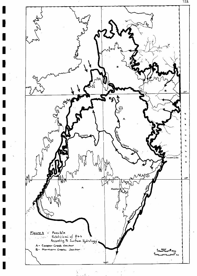
In fact, the study region. can be divided into two separate sections on thebasis of surface hydrology (which to a large degree is the major determinant ofhabitat type in 8.4.4) related to floodplains (Fig. 4). The Cooper Creek Sector(Fig. 4 A) is fed mainly by the Cooper Creek, 'while the Northern Creeks Sector(Fig. 4 B) is fed by all streams other than the Cooper. In times of extreme flowthere would be some input from A to B, but the reverse would be unusual. Divisionof the study _region on the basis of surface hydrology though 'is not_used in the.present hierarchYllbecause it is too broad for our purposes' and would add unnec-essary complication.
2.3.3.3 Gibber Plains
Gibber plains consist of flat to gently undulating plains covered withangular fragments and have red duplex soils. Within 8.4.4 they constitute, partof the broad ecotone that lies across the north of the study region betweenthe dunefields and: the consolidated duricrust or silcrete of the Cordillo Surf-ace to the north (see Ludbrook, 1980). The ecotone achieves a maximum width of
25 km near Lake Moorayepe (26021'S / 139°591E) on CORDILLO.
In effect, the recognition of land zones in 8.4.4 is only for the purposesof very broad assessment of the study area. It also provides a stepping stone
14
to what should be considered one of the more important levels of the hierarch-ial classification of 8.4.4 - the land system.
2.3.4 Land Systems
Christian and Stewart (1953, 1968-in Dawson, 1974), define a land system u:
as: " an area or group of areas throughout which there is a recurring pattern
of topography, soils and vegetation ". The concept of land system has been used
widely (e.g. Specht, 1972; Dawson, 19741 Roberts and Naqvi, 1978; Australian
National Parks and Wildlife Service, 1980; Environmental Research and PlanningGroup, 1980; Scott, in prep.). It has, however, been applied in a diverse way.
In fact, in the context of the. ' Vegetation of South Australia ' , Specht
(1972) uses the concept of the land system in its broadest sense and more often
than not talks of land systems , rather than a particular land system, and in
terms of broad generalisations.. Environmental Research and Planning Group (1980),
continue to use this broad-scale approach by considering Laut et al.'s (1977)
Environmental Associations to be ' total land systems ', consisting of vegetation
in conjunction with underlying soils/geology and topography. Currently in prepar-
ation is a similar treatment on the ' Land Systems and Land Regions of South
Australia ' (Scott, in prep.), which C. Margules (pers..comm.) says is a reassess-
ment of the 'Environments of South Australia ' of Laut et al. (1977), but it is
still a broad-scale approach and leaves the study area little changed (C. Margul-
es, pers. comm..).
The preceding, are broad-scale approaches, which Graetz et al. (1982) say
may be ecologically insensitive. But, Graetz et al. (1982) then propose a
scheme of ecological classification based on functioning hydrological units.
They cite. an example of a dunefield, which -.." has similar internal diversity
of structure and.grain "... , from their study area, ' the southern Simpson
Desert ". In the present study and that of Dawson (1974), however,the dunefield
is considered to be a land zone, broader still than the land system. So, in eff-
ect,- Graetz et al. (3982) are attempting to substitute one broad-scale approach
for another.
Social and Ecological Assessment. Pty. Ltd. (1982) use the concept of land
system rather loosely in accordance with environmental units and subunits and
also use terms such as environmental systems (not defined) interchangeably with
land systems.
Roberts and Naqvi.(1978). found difficulty in applying the concept of land
systems in their study area in Tasmania; their land systems were largely based
on topographic features. They found that vegetation, soils and topography were
not related' in the normal way - fire was the major determinant of vegetation
type, and soil type was fairly constant across the landscape under the influence
of a high reliable rainfall (Roberts and Naqvi, 1578).
Most of the workers above treated the land system as the basic level of
classification. Dawson (1974) however, states:"In past surveys the land system description has been the important
descriptive feature. When using reports of this type it is difficult to
obtain detailed descriptions of land units without consulting the various
component sections. As well, valuable site information may not be presented.
To alleviate such problems in this survey, the land system remains basically
.descriptive and shows the relationship between thelIand'units (individual
components of a land system). More. emphasis has been placed on the assessment
of the land units ".
In this study though it is intended to apply the definition of land systemin a precise way. Also, the land system will be treated as an end in itself

15
rather than, a means of identifying smaller units, because as stated by Austral--11
ian National Parks and wildlife Service (1980): " Land systems give,..., anoverall view of an area and ... can be helpful in developing management strat,-
gies ". Land systems occupy the central position in the hierarchial classific-
ation of 8.4.4.,
Although Australian National Parks and Wildlife Service (1980) consider
the land system classification used in the ' Plan of Management of Kakadu
National Park r. to be a broad-scale approach, it is this kind of application of
the definition of land system we wish to emulate in this survey. Australian
National Parks and Wildlife Service. (1980) also state: " Because land systems ..
... are the result Of subjective non-parametriC interpretation they are notnecessarily compatible from one survey to another ", and 7 Land classification.systems, Whilst reflecting natural features, are affected by the scale of mapp-
ing and *subjective judgement of individual team members ".
Two factors then, limit the use of the definition of land system in a wayWhich affects individual surveys and ,hence; compatibility of surveys *-.namely.,theSdaIe of mapping and the. subjective judgement, of survey personnel.
It should be .possible to account for the first limiting factor. Standardmapping scales are 1:250-000; 1:100 000 and 1:50 000. If the scale of 1:250 000is too small, then a larger scale of mapping should be used i.e. 1:100 000, andif that does not work a larger scale still should be used, assuming the budgetallows for this. Another possibility,if mapping is confounded by only small areasof the study region, is to focus in on these areas and map them at a largerscale. They can then be included in the smaller scale map as an 'inset'. mappingscale(s) will_obviously depend on'the nature of the land surface. And, if theland surface is'.continuously changing the aim of survey compatibility may only
be applicable-to-contigtOuS surveys..
Subjective judgement of survey personnel; the second limiting factor, isdifficult to account for as expertise varies from one person to another based onexperience and interests. Also available data on a particular area may be Small,whereas on other areas it may be large. Essentially this limiting factor relatesback to the purpose of the survey. If in the one survey, the purpose is to gainall information needed f6r building, say, a management plan, then subjectivejudgement may' be an important influence on results. However, if the purpose ofthe survey is to gain as much information as possible upon which future surveyscan build, then subjective judgement may not be such an important influence.
Reassessments may discover that one persons views were .a little misguided, andfor a certian reason.Realisation of this allows adjustments to be made - the oldadage of learning from ones' mistakes then applies. No one survey can satisfyeverybody's view of a particular area of land surface:
- Understanding the limitations related to useage of a land system categoryand with the dim of 'the present survey'in.mind, the purpose of using land systemsin a hierarchial classification of Environmental Association 8.4.4 is to enablesubdivision of the study area into smaller management areas with a more homogen-eous pattern of topography, soils and vegetation. It is recognised though thatthe land system is a broad class in a hierarchial classification so it containssmaller units; this is implicit in the definition of land system. The nature ofthese smaller units -,:namely, Environmental units (after' Laut et al., 1977),Environmental subunits and land units (e.g. Dawson, 1974), will now be discussed.
2.3.5 Environmental Units
Laut et al. (1977) identified four Environmental units - the basal or lowestcategory of their hierarchial classification of the ' Environments of South Aust-
ralia ' - within Environmental Association 8.4.4, which they describe in detail
11

1977)
15A
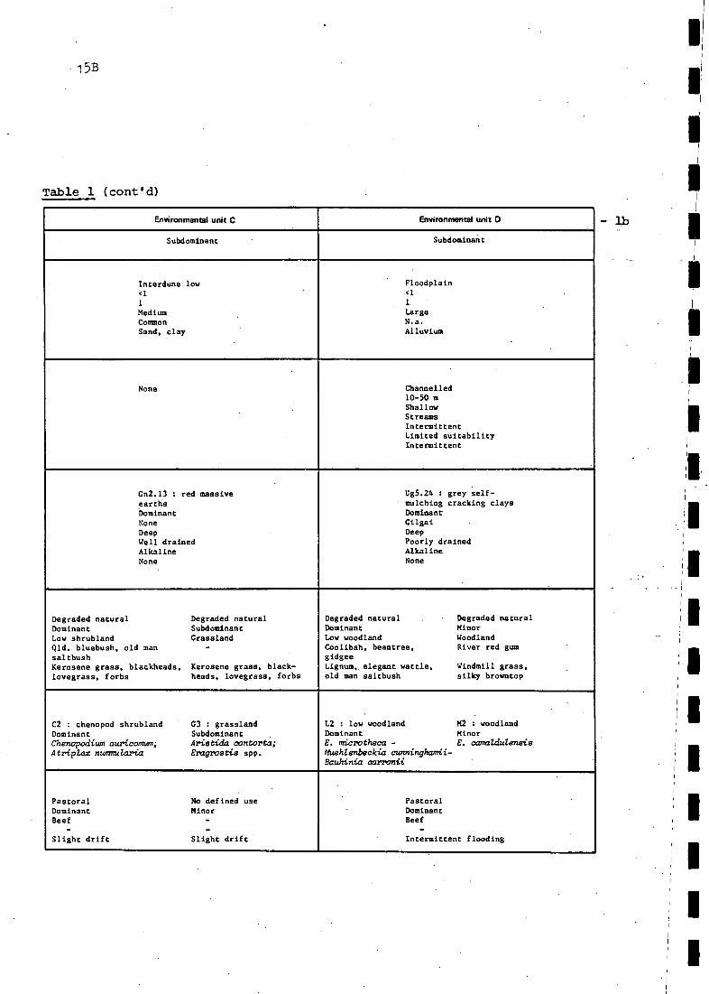
IITable 1 - Environmental units of Environmental Association 8.4.4 (after Laut et al.,
Environmental unit A Environmental unit 8
Co-dominant Co-dominant
Pan<1
1LargeCommonClay
Dune3-1017LongCommonSand
None
-
None
Ug5.24 : grey self-mulching cracking claysDominantCilgaiDeepPoorly drainedAlkaline '
None
Uc1.23 : red siliceoussandsCo-dominantNoneDeepWell drainedNeutralNone
Uc1.21 : whitishsiliceous sandsCo-dominantNoneDeepWell drainedNeutralNone
Degraded natural Degraded naturalDominant SubdominantLow shrubland . Low woodlandQld. bluebush, Coolibahold man saltbushCanegrass, forbs, Lignum, elegant wattle,lovegrass bindyi
Disturbed naturalDominantTall shrublandSandhill wattle,whitewood, needlebushKerosene grass, forbs
Disturbed naturalSubdominantHummock grasslandSandhill canegrass,hard spinifexKerosene grass
C2 : chenopod shrubland 1.2 : low woodlandDominant Subdominant '
Chenopodiumauricormen; E. microtheca -Atriplex nummularia ftehienbeckia cunninghamii
.
S2 : tall shrublandDominantAcacia liguLata;Atalaya hemiglauca;Hakea spp.
112 : hummock grasslandSubdominantZygochloa paradoxa -Triodia'basedowii
Pastoral No defined useDominant MinorBeef -
-Salinity Salinity
PastoralDominantBeef
-Moderate drift
No defined useMinor
--
Moderate drift
la
Relative area
Lmdform
TypeSlope class (%)Maximum slope (%)DimensionFrequencyRock type
Surface water
FormArea/widthDepthOrigin/purposePermanenceQualityLiability to flood
SodSymbol and name
Relative areaSurface roughnessDepthDrainageReaction trendStoniness
Vegetative cover
StateRelative areaTypeOverhead flora
Ground flora
Native vegetation
FormationRelative area
1Alliance
Land use
UtilizationRelative areaProductSpecial featuresLand limitations
I.
15B
Table 1 (cont'd)
1
Environmental unit C Environmental unit D
Subdominant Subdominant
Interdune low<1
1
MediumCommonSand, clay
' Floodplain<1
1.
LargeN.a.Alluvium
-
None Channelled10-50 mShallowStreamsIntermittentLimited suitabilityIntermittent
Gn2.13 : red massiveearthsDominantNoneDeepWell drainedAlkalineNone
13g5.24 : grey self-mulching cracking claysDominantGilgaiDeepPoorly drainedAlkalineNone
Degraded natural Degraded naturalDominant SubdominantLow shrubland GrasslandQld. bluebush, old man -
saltbushKerosene grass, blackheads, Kerosene grass, black-lovegrass, forbs heads, lovegrass, forbs
Degraded natural Degraded naturalDominant MinorLow woodland WoodlandCoolibah, beantree, River red gumgidgeeLignum, elegant wattle, Windmill grass,
.
old man saltbush silky browntop
C2 : chenopod shrubland G3 : grasslandDominant SubdominantChenopodium auricomum; Arietida contorta;Atripler nuesnularia Eragroetie app.
L2 : low woodland M2 : woodlandDominant MinorE. microtheca - E. camaZdulensisftehlenbeckia cunninghamii-Bauhinia carronii
.
Pastoral No defined useDominant MinorBeef -
- -
Slight drift Slight drift
PastoralDominantBeef
-Intermittent flooding

Table 1 (cont'd) - lc*
* lc Was compiled from other sections of Laut et al. (1977) in which salt
lakes and gibber plains are more prominent.
15C
Environmental unit E Environmental unit F
Relative area Minor Minor
Landform
TypeSlope class (%)Maximum slope (%)DimensionFrequencyRock type
Salt lake1
1
SmallN.a.Salt, alluvium
Gibber plain1
SmallN.a.Gibber/porcellanite
Surface water None None
Soil
Symbol and nameRelative areaSurface roughnessDepthDrainageReaction trendStoniness
None, salt. .
Dr1.32Y.crusty red .duplex soils
DominantStonesModerately deepWell drained .
NeutralNone
Vegetative cover
StateRelative areaTypeOverhead floraGround flora
None
.
Degraded naturalDominantTussock grassland-
Mitchell grass
Native vegetation
Formation
Relative areaAlliance
- G1 : very open (tussock)grasslandDominantAstrebla pectinata
Land use
UtilisationRelative areaProductSpecial featuresLand limitations
- PastoralDominantBeef-
Salinity

16
(Province 8 - pp. 210-211, and included here as Table la and b, for conven4-
ience). Environmental units are based on landforms (Laut et al., 1977)."Laut
et al. (1977) though failed to recognise salt lakes as distinct from claypans,
'and also did not recognise gibber plains. These two Environmental units were
recognised early in the present study from geological maps and although a minor
component of the study area, are none-the-less an important component. Salt
lakes and gibber plains are considered to be Environmental units E and F, res-
pectively. They are described in detail in Table lc, in the manner of Laut et
al. (1977). Six Environmental units are therefore recognised in EnvironmentalAssociation 8.4.4 - namely, Environmental unit A : claypan (renamed), Environ-
mental unit B : dune, Environmental unit C : interdune low, Environmental unit
, D : floodplain, Environmental unit E : salt lake and Environmental unit Fgibber plain. Claypans and dunes are co-dominant, interdune lows and floodplains
are subdominant, and salt lakes and gibber plains have minor status (Laut et al.,
1977).
Only the duriefield land zone contains more than one Environmental unit.
These are dunes, interdune lows, salt lakes and claypans. Floodplain and gibber
plain land zones contain floodplain and gibber plain Environmental units, res-pectively. Small clay lenses in gibber plains are considered distinct from clay-pans and.to.be a habitat component of gibber plains.
2.3.6 Environmental Subunits.
The Environmental subunit category has been used previously (Social andEcological Assessment Pty. Ltd., 1977). For the purposes of the present reportthough it will be used somewhat differently, as discussed below.
Within the floodplain Environmental unit of the study area are four compon-ents which are considered broader than the level of the land unit (see Section
2.3.7, below) - namely, floodout, channel, swamp and terminal lake components.In the present study these four components are ascribed to the level of Environ-
mental subunit (within a hierarchial classification of 8.4.4). No such compon-ents are found within. claypan, dune, interdune low, salt lake and gibber plainEnvironmental units, so Envi..,:onmental subunits of these five Environmental units
are the same i.e. claypan, dune, interdune low, salt lake and. gibber plain, res-
pectively. Nine Environmental subunits are therefore recognised, namely - clay-pans,. dunes, interdune lows, floodouts, channels, swamps, terminal lakes, salt
lakes and gibber plains. However, in order to ensure that there is no difficultyin allocating a particular feature of the landscape to one of these Environmentalsubunit categories, some clarification is required.
Firstly, because of their irregularity of inundation, terminal lakes mayin some instances be considered analogous to very large claypans. For the purposesof this report though, terminal lakes and claypans are considered distinct. Term-inal lakes have an obvious connection with floodplains e.g see the obviousconnection of Lake Marrakoonamooka with the Cooper Creek floodplain On INNAM1NCKA,whereas claypans have no such connection and are generally isolated within thedunefields. Laut et al. (1977) appear to have had a different perception of theconnection between claypans and floodplains, however. They say (Province s - p.
208) that the Cooper Creek Environmental Association 8.4.4 consists of:" A field of parallel dunes and an extensive system of interconnected claypansperiodically flooded by Cooper Creek ".
This obviously implies that the large areas of grey, self-mulching, cracking claysadjacent to the channel(s) of the Cooper Creek, which in this report are consider-ed to represent floodplains (consisting of floodout, channel, swamp and terminallake Environmental subunits), were perceived by Laut et al. (1977) to represent ....." an extensive system of interconnecting claypans "... In the present reportthe distinction between claypans and terminal lakes should be Clearly evident.

17
Secondly, in some lakes fitting into the terminal lake category, where.deflation processes have reached the water table resulting in the formation ofa salt crust, there maybe confusion as to whether these lakes also fall into
the salt .lake category.. These lakes are most prominent at. the extremities offloodplains and hence, are. subject to very infrequent cycles of inundation byfloodwaters e.g:. Lake Perigundi. At times other than periods of flooding theyassume the characteristics of salt lakes, but may during flood events havesalinity levels which approach.-leVels generally considered to .be characteristic
of freshwater. These terminal lakes should also be considered salt lakes);.-,
All 9.Environmental subunits are made up of smaller components e.g. dune:crests and dune slopes as components of dunes.These smaller components areconsidered. to .represent the basal category within a hierarchial classificationof Environmental Association 8.4.4. They are land units, which are consideredanalagouS to habitats. The analogy between land units and habitats isverified in Chapter 5. of this report and where appropriate, the habitat categorysupersedes the land. unit category.
2.3.7 Land Unit(s) - A Definition -
The definition of land units as;..., " the individual components-of a landsystem " (Dawson., 1974), should be intuitively obvious as this-is implicit inthe definition of land system (Section 2.3.4). Two other definitions of land unit.have been used, which may be usefully considered in order to arrive at a moreterse definition of land. unit. more consistent with the purposes of this study.
Howard. (1970, in Australian National Parks and Wildlife Service, 1980)defines a land unit as:
" a part of the land surface having a similar genesis and having major,inherent features of consequence to land use - namely, topography, soils,vegetation and climate
This definition does not imply land Use!
A more precise way of writing this definition, to avoid possible ambiguity,would be that a land unit is:
" a part.. of the land surface with the same genesis characterised by inherentfeatures of topography, soils, vegetation and climate, which are of consequenceto land.use ".
The useage of the word 'same' in place of the word 'similar' is intentional toindicate that a land unit is the smallest recogniseable unit of the land surface,apart from the individual elements of topography, soils and vegetation. Furthersubdivision. of a land unit.would.therefore be superfluous.
Hooper et al. (1973, in Australian National Parks and Wildlife. Service,1980) define a land unit as: .
" an area of land which exhibits uniform photo-pattern on aerial photographs.It contains similar soils, vegetation and topographic elements throughout.Minor variation in any of these is allowable as a unit may contain areas ofdifferent land units too small to map. The limitations to land use and theland use potential. of any land unit are usually but not necessarily similarthroughoUt.".
Like Howard's definition above, this definition is also not as precise as isdesirable. It contains too many aspects, which are open to diverse interpretation.Ahd;:soMe-of these aspects do not apply tO the study area. It order to improvethis definition, to make it more precise and to ensure that it applies to thestudy area, the following points should be considered.
FirstlY, the section on uniform photo-pattern on aerial photographs should
1 8
be excluded as the 1scale of aerial photographs available on 8.4.4 (average scale
is 1:88 000 see .Appendix N) is too small to allow resolution of all areas of
land which have the potential to show uniform photo-pattern - only the largerareas of Uniform pattern are' svident (particularly in the absence of significantground reconnaiSsance), while the smaller areas are often masked. by the grain ofaerial photographs. In fact, at the scale of aerial photographs available on8.4.4, land systems (groups of affiliated land units) are the only features con-sistently evident (see Section.4-3.3),. although in some parts these. also become
obscure e.g. floodplains.
Secondly, soils, vegetation and. topographic elements should be 'the same',
not " ", " throughout ". This modification is considered necessaryfar the same reason as' in the modification of Howard's definition ice. to indic-
ate that a land unit is the smallest recogniseable unit of the land surface,apart from the individual elements of soils, vegetation and topography...
Thirdly, " minor. variation ".should not be " allowable " and land unitsshould not contain "'areas of different land units too small to map ". If landunits are to represent the basic unit of land surface pattern, expressed in termsof soils, vegetation and toPOgraphic elements, then it would be hoped that thescale of mapping is sUah,that.all minor variation is eliminated. In. reality, I/elimination of all minor variation may be quite difficult to achieve but thisshould not prevent us from attempting to do so!
Fourthly, land use potential within a land unit should be considered 'the /1same throughout', not as stated by Hooper et al., " usually but not necessarilysimilar throughout ". In this way we continue to exclude minor variation andhence, the land unit remains at its basic level.
Fifthly, if land use potential is 'the same throughout', then limitations
lto land use potential will also be 'the same throughout'. This should be obvious,Il
so there is no need to.state. this explicitly.
Taking these five points into account. in.'modifying-Hooper et al.'s. definition1.-..-- ,
of land unit, we get the following:--
a land unit. is " an area of land containing the same soils, vegetation and 1
topographic elements throughout. Land use potential is the same throughout'.I I-
If the elements in common between the' two modified definitions of land unit(after Howard, 1970 and after Hooper et al., 1973 - both in Australian NationalParks and Wildlife Service, 1980) are combined, the two important points which,in essence, serve to define a land unit are identified viz.
A land unit is an area of land surface with consistent (in genesis andexpression). soils, vegetation and topographic elements, and:
A land unit has some (=Specified) potential for utilisation.
The only element not in common to both modified definitions is that of climate.(from Howard's definition). Climate is not an element of the land surface, rather,it is an effect which has played and continues to play an important part in theformative aspects of the elements (soils, vegetation and 2topography) of the landsurface. It is also an important determinant of land use potential and ultimatelyland use.
Caibining the above two points the following definition of land unit is
1This factor of scale applies equally well if not more-so to LANDSAT imagery,due to current levels of resolution available.2Topography and landform are correlative.

I:77)
1 8A
__...
1
, , ' :
.,.
i 27
iliviiit31.,
iiiic 2
re ,.
Cee..e.i.
\ite '
dri i
J In n a th+nfka S
Alk".. Aahr cedir A'
/LI% 28°
! I Fr . 4 lin .111110 ...:
44,, 7
, ,
sot 1114
4 10 1 I
PI% if
: < 1000 rvicil L
IS1 100o - 3000 wuj it
(....4a (4i) 40, It, Cooper C..&,e-a-k
fie
9. 4- A.C.S Oir-LR.111^
. 4-. L "AlL ,4 mks
0 15
(Se" r c0-- I . ftw44-.d.4.-. Wo-l.i.,,- .
RES au.tec.Q .1 Co--,c.; %
1 11 /'S )
140 .

attained viz. a .land unit is an area of land surface with consistent. (in genesisand expression) soils, vegetation and topographic elements and. some (unspecified)potential for utilisation... If the qualifiers are excluded from this definition,a land unit is simply an,area of land surface with consistent soils, vegetationand topographic elements and some potential for utilisation. The role of climate
is implicit-in-this definition.
2.4 SALT LAKES AND SALINITY
2.4.1 General
' ISalt lakes are a feature of the north-west central and far west regions of I II..
the Cooper. Creek Environmental Association 8.4.4, and are generally confined to1 .1
the extremities of the Cooper Creek floodplain (and to a lesser extent theflood-I
plain of the Strzelecki Creek), or they lie in the dunefields. Most of the lakes'salts are probably dominated by sodium chloride, which is the predominant Salt
I
Iin the majority of Australia's salt lakes (Johnson, 1980). No actual: field test-
' . ing was carried out in. this survey.
The formation of the salt lakes is by wind deflation of. alluvium until thewater: table is reached (King, 1960). They are thus able to receive, groundwaterseepage from salt impregnated alluvium about the lake - in annual cycles offilling with a consequent rise in water table, and then crystallisation that
leaves a crust, upon subsequent fall of the water table (Johnson, 1980). Ashallow .groundwater horizon has been found to be present in the North-East of-South Australia (Wopfner, 1961). Groundwater of the study area contains dissolv- II
,
ed salts at two levels i.e.. less than 1 000,mg per litre and between 1 000' and3-000 mg per litre (Fig. 5), of which sodium is a major component (Australian
, Water Resources Council,-1976).I I
I 60
In contrast to salt lakes, claypans are defation hollows, which have notreached the groudwater table; no groudwater seepage is received, and, so nosalt forms.. In some areas, adjacent. salt lakes and claypans are found.
The source of salts .in the alluvium around lakes is considered to beconnate salts (sea water salts entrapped in sediments from the time that thesediments.were deposited in a. marine environment) released during the erosionof marine sediments deposited when the North-East, along with a large part ofAustralia, was inundated by the sea in the Cretaceous (Johnson, 1980). Onlysome sediments contain reworked connate salts, while others are derived fromnon-marine strata. The reworked connate salts of the ancient marine rocks have "been partly redistributed by .wind or water motion tolbe retained to varyingdegrees by .a surficial cover.of alluvium, in the form of dunefields and flood-plains, which formed under the influence of low topographic relief and an. aridclimate. The salts that entered the closed system of the.dunefields have tendedto remain and Contribute to salt lake formation, while those in the floodplainof the Cooper have been flushed in times of flood towards Lake Eyre, the focusof the endorheic Lake Eyre. drainage basin (Johnson, 1980).
Some areas of saline alluvium or groundwater are passed through by theCooper Creek, which results.in instances of saline waterholes in a string ofotherwise dilute ones e.g. Callamurra Waterhole, east of the study area (seeTable 2C). The creek and freshwater lakes do contain some salts, of which sod-ium and bicarbonate ions predominate with chloride comprising a small part ofthe anion load. (Table 2B). These salts are generally at insufficient levels toleave crusts and the minor ones that do form are usually dissipated throughwind action. For instance, Coongie Lake, fed by the same creek that feeds Lake
-
1

IIIIII
MI
MI
NM
BIN
S M
IT
AB
LE 2
.-
/(11
4AV
ISE
S o
f VA
Rto
utC
orim
Poi
rrIo
Nf o
f t4A
mR
AN
0A
LT64
%-n
4R
EA
-eV
AN
LE. T
o T
HE
CO
OP
ER
c.ee
icE
,../ v
s R
oN m
EN
T-A
L.A
sSO
ciA
fl0f.L
tt-of
t.F
or..
coen
f'A
ir..ts
op4
.A
.
13.
RIV
ER
. AN
D F
AC
SH
W A
TE
R L
AK
E. W
AT
ER
. C.o
niP
oSiT
i ON
C.
SA
LIN
E W
AT
ER
(.0i
meo
si11
0N1
D.
RA
IN W
AT
ER
CO
MP
Os
Inca
%)
A -
6%
9.4
tC
-er
ce -
e- o
f--4
t-ol
o.o
rrc4
4.-
CA
41-1
-,
col
ay ..
as:J
-4-
..1-t
..1co
..Ht.l
ess
,fe
elE
C -
e le
/cu.
.ay
.° .
-14-
Nee
. *--
lajo
ra. '
onc
4,4A
1 a
4
LAK
EE
yikE
INA
TE
.R. A
ND
SA
LT c
.A.u
irC
or4P
0S 1
TIO
N
Wei
4.0.
E. C
K'
Nal
+C
a'i't
CI -
HC
O3
CO
;S
O41
7N
Oi
S102
eF
-6.
-4--
pcs1
Loc.
c.+
;or,
Dat
e.5,
...bs
t-co
m.e
..
Lca.
..e.
E..3
v-e.
N o
r -t
kM
ara.
IT*
Wa
4- e
...-
A am
u..
35 <0-
113
800
46'1
300
1-2.
92 0 T
.
2140
04-
8.3
Si-
0.1
na.
n.c.
4 .
1100
VS
n.a.
n. a
.0-
5n.
a.0.
18n.
a01 n.ia
.N
A-c
t ,c,
..- s
o.,
Lak
e.E
...j r
vi.S.
-4L
.38
Mor
a. 1
9Sa
H-
19/2
4 2
A 5n*
4 .
4- <01
1081
0
1-8
246
1'5
33 0-3
1651
1
411
30 <0.
1
n.a
.n.
a .
806
1.1-
n.a
n. 4
.3-
5n.
a.0.
09n.
4.0.
68n.
a.
No-
Ci
tie. I
n cm
as 4
sua
ilo...
.., a
( a-
v-L
i. O
.A
7.0
36is
*v.
3 -
3114
-6no
14.o
n. a
.9.
50.
030.
24-
c....
c....
ins.
.,,C
ra.4
-1,..
t 5 k
.... w
att
of-
X...
.."o.
......
:...o
.lco.
Mar
tin V
MS
W4
e.-
-C
34-5
5.1-
50.8
24.4
11.0
264
6*.S
.n.
a8.
9n.
a .
fl.A
.In
.a.
Na-
C I
H(.
03
Coo
...so
ya W
. II.
(ci
der,
a...
a...4
a.D
)-
A62
514
-.8
1-G
3.0
1.9
41-
265
3020
.6n.
a .
as0.
51N
a-a/
Ht0
//(04
1.4
-W.
a....
..C
oe to
e...
Cre
e....
k.C
1- 8
68.3
4216
.5"
18.6
La
6.0
n. a
.n.
a.M
An.
0..
K...
telr
4-c.
.We
W.I
4. (
a c
ia..p
,da
me)
NA
N'.
car
A. C
oope
v C
.-ac
/4.0
-4.
1., 1
998
Wa-
Fe..
-A c
4-50
101
1439 45
.018
.023
.810
123
.8M
S10
.519
136
fii
19.5
ifi.6
n. a
.n.
a.
2.0
n.4.
0.08
n.a.
0.40
n.a.
"" -
HC
A)3
419
Moo
.- I
ON
A ta
. a V
I (S
tVA
10,4
:040
0Ved
) I20
k.s
. ole
o 4
Cor
date
bc,
,,,,,,
s14
42.-
444.
1942
4W
att..
-A C
135'
8-2
16. 5
12..6
43.3
1.2 3 2.'8
.1*
1.8
11-6
126
2 8
45-5 51
.ct
n.a.
n81
3
I. 3
-
(LG
.rt
. a.
1-0
n. a
.0-
09-
n . a
.0.
1
n. a
..."
'1.
1(03
A31
.025
3iS
o1(
..211
1-38
15'
l51
.sn.
a.6.
00.
631.
o4-
C..
0--w
*e1.
...k.
e. (
st.a
110.
..a0.
411)
.),
11 a
rc-1
.191
8W
u+ 4
?-v
-!2
0H
a-C
l/WIW
IN
.W G
oer.
.C
s4e,
pai
rC
ar e
ak.
c5
841
- 3
5.4-
9 .6
35.1
51:2
6vl
. a.
fl. c
*.M
a.n.
a.
Is V
.
Nop
loo
I" "
...V
ie. t
^ i
In.
a.
Wat
er-
-A C
640
6-2
2.. 6
36 613
26.6
214
wi.6
14,2
.
152
'06
96 205
n. A
.n.
a.
260
8.8
1-0
11.4
.16
.5n.
a.0-
nn.
a .
0-59
n C
A.
i
No
-C1
C...
..1.1
......
......
w.m
.n.
Q.
wok
a-4,
--
A CIM
O,
14-
2-2.
116
606
34.0
22.1
i5-0
15.0
216
12:6
106
in. Q
.
11.0
.29
-21,
10 n. a
.12
..0
n..
0-I
rt. o
..0-
2.*
n. O
a .
No.
-C1
CD
oee
V.
Cir
eete
.at.
n. a
.w
,...4
e--
-A
530
1.-8
110
19.0
13.1
me
116
n. a
.26
.40
120
0.06
0- z
eft
ics
- ci
T--
---
......
i".C
.V...
c.&
AA
, at
C2-
13
61-6
134
16-2
69.6
23.6
n. 0
.6'
S*1
. a.
fl..
n. a
.n.
a .
1.0.
-aw
....t-
e....
..fr
....
d p4
4, 4
n. a
.B
ore_
_A
3100
105
514
'101
68-4
130
3/ 6
n. a
.21
610
.$68
-00*
(1-4
01-1
21 V
V.
Alr
I....
.1...
......
.. c.
tCa
Wca
ilav
C.
0-8
68-3
13-6
11--
I63
.219
.9i6
8 8
n. 4
.
40..,
44.
Apy
:t1go
.....
...10
.few
cr...
,k)
-A
1-2.
0-8
n cl
.19 31
-62-
855
304 13
-04-
516
430 68
-5n.
o.
n. o
.SS 15
-1
6.5
n. a
.n.
0.
A. c
am
a.rt
. a .
Ga
- hi
CO
3
13 .:
-...d
.$ v
itt e
.I
GO
cl i
{..o
. kiK
k.A
evil
1948
itcu:
n W
O e
4,.
(rc.
..k)
_A D
335
6.2.
n. a
.38 56
.514
.0
29.i
Si-
14-.
4.
SI 4$40
93 34 5
n. a
.n.
a.
26.8
IT'S
6.0
n.a.
n.a.
n.e.
a.n.
a.
n.c.
..A
.a.
rt .4
.N
a -U
/HC
O3
20
Eyre, has remained permanently fresh (ftpfner, 1970; Table 2B and refer to Table.
2A for comparison).
.The saline waters of Nappamerrie,east of the study area in Queensland (Tab-
le 2C),have been observedto cause normally turbid, milky waters of the Cooperto become clear in times of flood, when clay particles become floculated by thesalt. content (Mr. M. Steel in Johnson, 1980). However, the overall. contributionof such saline waterholes to the salt load of the creek downstream in the studyarea is considered to be negligible (Johnson, 1980)
Such saline areas in the Cooper Creek Environmental Association are uncomm-on . In Table ZB is 'shown results of analyses of water from several waterholesand lakes. within the study area, which can be seen to have generally negligiblesalt content. when compared with the figures for Lake Eyre (Table 2A). Even thesaline area around Innamincka (Table 2C) is relatively fresh in comparison.
The chemical composition. of rainfall can give an indication of the chemicalcharacter of soils of the local environment, as surface dust is carried in windsand subsequently washed down in rain. Where there is no dust and no salt, therain is nearly.as fresh as distilled water (as in the Mt. Kociusk6 district -Johnson, 1980). Of relevance is a recent study to determine the relationship
' between soil salt levels and solute levels in rainfall along the Moomba to.Sydney pipeline' (Johnson and Rice, 1978 in Johnson, 1980).. They found that salin-ity levels varied markedly, and that soils were of similar composition to rainwater from the same region in terms of salt. content. Soil leachate fell intotwo major groups - sodium bicarbonate and sodium chloride dominant - and twosmaller groups viz, calcium bicarbonate dominant and no dominance.
The following observations are worthy of note:-
-calcium carbonate is probably the dominant constituent of soil dust
.all soils contain some sodium chloride
gypsum (hydrated calcium sulphate) is the source of soil sulphate
The two rainfall analyses for Innamincka and Birdsville (Table 2D) indicate thelevels of particular ions about the study region and they suggest a predominanceof carbonate in soils. Around Innamincka, calcium is also prominent, while sod-ium chloride attains prominence near Birdsville. More saline lakes are found in
the Birdsville area. Similarly, analysis of rainfall from the region of thenorth-west duefields should also indicate a higher proportion of sodium chloride,due to-.the presence of salt lakes. there.
2.4.2 Fauna of Salt Lakes - General
While little is known about the fauna of salt lakes, the occurrence ofForaminif era has been noted (Ludbrook, 1965), and the incidence of spiders, withvertical burrows topped by silk, several hundred metres in from the margin hasbeen observed (Mollemans, unpubl. data). Numerous dead insects have also been
observed entrapped within and on the salt crust of lake floors. These have un-doubtedly been blown onto lakes by wind and perished.
Salt lakes may also form barriers to faunal migration, in particular, to the
ground dwelling faunal components. This will obviously occur while they carry
water, but may also be significant when the water has evaporated leaving only
salt crust. Salt lakes are a harsh environment.
During the study of Environmental Association 8.4.4 salt lakes were notsurveyed, although plant collections were made in the vicinity of some examplese.g. Lake Perigundi (Appendix R). They are however, an important component ofthe environment of Association 8.4.4 and as such warrant further attention.
1

2.5 CLIMATIC AND RELATED. CONSIDERATIONS
The Cooper Creek Environmental Association 8.4.4 is an arid, deserticregion within one of the largest inland drainage basins in the world, in whichlarge rivers, now reduced to intermittent creeks, once flowed (Price, 1955).In this section the more significant climatic influences, the nature of flowsalong Cooper and Strzelecki Creeks, and the phases of the moon are outlined.
2.5.1 Climatic Considerations
The climatic influences to be dealt with are rainfall, temperature andevaporation, and winds. Some'. concluding remarks will also be made on the generaleffects of climate on the biota of 8.4.4,
2.5.1.1 Rainfall
Rainfall of arid areaSOf Australia has been said to be extremely erratic.(Madigan, 1946), as well as seasonal and highly intermittent (Price, 1955). Thefollowing data for the study area. support these conCIusions,aithough it will beapparent that unseasonal rains-are also significant at times.
Graphs. of rainfall data for the.. period January 1979 to August 1983(Appendix .C1-5; and refer also to Appendix C6, which shows the combined rain-fall data for these five years) show well the variability of the rainfall inthe study area. In some months total rainfall exceeded 120 mm (Appendix Cl -January 1979), whereas the rainfall f6r some years does not even total 60 mm(Appendix C4 - 1982). The fact that rainfall records for Moomba and InnaminckaHomestead, which are separated by a distance of only 60 kin, can vary by as muchas 50 mm in some months (Appendix. C3 - January and July 1981) shows that rain-
fall across the study area can be extremely localised.'
Most rain falls on.only-a few days each month, mostly in summer..Therecent .(January 1984) flooding of the north of the State was caused by heavyrains over a few days, which were apparently very localised - Moomba recorded33 mm on January 13 and 99 mm on January 14, while Birdsville received 25 mmon January 12 and 22 mm on. January 13 (Bureau of Meteorology). Association 8.4.4is in the Eremaean zone of Burbidge (1960), in an area with a summer rainfallinfluence.
Annual totals, mean annual totals and mean monthly totals of rainfallrecorded at Birdsville, Cordillo Downs, Innamincka (which relate directly tothe. study area), Marree (for comparison) and Tambo, Queensland (on the upperreaches(. of the Barcoo.River - a source of the Cooper) are tabled in AppendixD. These datashow that rainfall for Birdsville-, Cordillo Downs and Innaminckais much more erratic than that for Marree or Tambo. Although Birdsville, CordilloDowns, Innamincka and Marree. have essentially the same.mean.annual totals, Mar-ree's annual totals show much less deviation from the annual mean. The minimum-annual rainfall for Tambp is 37.5 mm greater than the average of mean annualtotals for the other four stations.
Rainfall in Australia's arid regions has a reliability of less than 30 percent (Nix, 1981). The data in Appendix D support the conclusions of Madigan (19-46) and Price (1955) concerning the erratic and intermittent nature of the rain-fall, and because of this the amount of rainfall received at specific localitieswithin the study area cannot be estimated. General remarks only can be madeabout the likely level of rainfall received by the region as a whole over partic-ular periods of time.
21

22
2.5.1.2 Temperature and Evaporation
.Mean monthly maximum and minimum temperatures for Moomba and Birdsville,and monthly totals of evaporation for MooMba are shown in Appendix EMean monthly temperatures are highest in February and lowest. in July. Tempera-tures for Moomba are often 1-20C below those for Birdsville, about 250 km to
the NNE. Over the period January 1979 to August 1983, annual mean maxima forMoomba and.Birdsville, respectively, were 29.69C and 30.30C, and minima 15,10C
and 15.5°C.
Evaporation is generally at a minimum during June/July and at a maximum inDecember-. This means that evaporation is highest when the summer rains can beexpected and lowest when the Cooper Creek is generally flowing (see Section2.5.2). Because of the high evaporation rates experienced across the study areaas a whole, surface waters do not remain long, except in the deeper waterholes
and lakes.
2.5.1.3 Winds
Appendix. F(1, 2) shows .wind directions recorded at MOomba between 1977 and1979. The most frequent wind direction is north-west (SANTOS, 1981). The windsthat are experienced from November to March are often hot and drying (AppendixE1-6), and their effects are discussed below.
2.5.1.4 Individual and Combined Effects of Climatic Conditions
The temperature, evaporation and rainfall data show that Association 8.4.4.is truly arid. As a consequence, the organisms of the study area are subject toa high degree of. environmental stress (dessication caused by high temperaturesand lack of water) in the warmer months. Perennial plants have evolved variousadaptations enabling them to withstand such conditions (e.g. small leaves, in-voluted leaves, leaves with a stellate tomentum, leaf shedding and succulence)and refer to Symon (1982) for a description of the xeromorphic adaptationsexhibited. by Solanum oligacanthum. Animals, on the other hand, because of theirmobility, have evolved a range. of behavioural adaptations that enable them toevade (ta varying degrees) the extremes of summer e.g. by burrowing (Macrotislagotis), being crepuscular or nocturnal (most mammals and reptiles of the reg-ion), or by .emigrating (on alocal and regional scale - Macropus rufus and many
species of birds).
Hot, drying winds, that are experienced between November and March, haveseveral .significant effects. Evaporation rates increase dramatically with in-creasing wind, speed, leading to the rapid drying up of surface waters. They alsocontribute to the dessication of the biota by increasing transpiration (and per-spiration) rates. Another effect. is that of sand blasting.Apart fkowits-importanogeomorphologically as an eroding agent, this process can be particularly detrimen-tal to seedling plants. Winds .pick up surficial particles of sand and. carry themat abnormally high velocities over the land surface, wrenching newly establishedseedlings from the ground and severely abrading others. In a wider context, theproblems of soil drift and desertification in the Australian arid zone are wellknown - overgrazing by stock and rabbits has led to the greater mobility of theland surface since pastoral occupation. The general role that wind plays in thedispersal of many plants (by seed) is noted,
2.5.2 Flows along the Cooper and Strzelecki Creeks
2.5.2:1 Introduction
The main channel of the Cooper Creek carries water annually between April

23
and July (Wopfner, 1970), and.less frequently at other times in response toaseasonal rainfall within any part of the catchment. Very occasionally theCooper Creek system feeds considerable volumes of water from Queensland intothe east side of Lake Eyre North, while sometimes the Strzelecki Creek flows.into Lake Blanche, which if filled then feeds into Lake Callabonna (Price, 1955).Although the Strzelecki Creek is a distributary of the Cooper, it rarely flowsdue to discharge from the Cooper. Most flows-are.the:-result of local-runoff.alone.
Bonython (1955) considers that the Cooper Creek is the chief supplier(potentially atleast) of water to,Lake Eyre, but Mason (1955) believes thatthe Warburton. is more significant.. Mason. based his conclusions on rainfall dataand the existence of the Warburton groove (a deep channel within the lake), withno equivalent structure emanating from the mouth of the Cooper. Both riversmustflow.very.significantly to fill Lake Eyre (Bonython, 1955), and this only occursas a result of abnormal incidence, distribution and amount of rainfall (Mason,1955) as occurred- in 1949-50 and 1973-74. The 1974 water level in Lake Eyre issaid to have resulted from the greatest flooding event in the past 500 years(Dulhunty in Johnson, 1980). This.level has been exceeded at least three timesin the past 3 000 years (Dulhunty in Litchfield, 1983).
The pattern of flows along creeks running into Lake Eyre is dependent uponreinfall,.runoff efficiency in catchments, actual river levels and flow data(Mason, 1955). Mason (1955) analysed the pattern using rainfall data (districtaverages) alone with limited success.
For a more detailed determination, restricted to the Cooper and StrzeleckiCreek, much. of the necessary information is.readily available from government:authorities - rainfall statistics from the Bureau of Meteorology, and the riverlevel and flow data from the Water Resources Branches of the South-Australian.Engineering and .Water Supply Department (E&WS) and Queensland Water ResourcesCommission.(WRC). There are various recording stations along the Cooper Creekincluding Callamurra Waterhole (E&WS) east of Ihnamincka and Currareva, Qld(.WRC), near Windorah just below the junction of the Barcoo and Thompson Rivers
- data has been obtained from both these stations. Information pertaining- to
catchment runoff efficiency is sketchy, although the State's water resourcesauthorities can supply estimates relating to particular flow events.
2.5.2.2 Reliability of Flow Prediction using Rainfall Data Alone
The Strzelecki Creek has been reliably reported to have flowed 15 times inthe last 101 years. viz. 1882, 1906, 1936, 1949, 1950, 1951,- 1955, 1956, 1963,1971, 1973, 1974 (the largest), 1976, 1977 and 1979 (Mr. B. Nicholson, pers.comm.): That only three flows .have been (reliably) reported prior to 1949,indicates that the record is incomplete, although the Strzelecki Creek channelwas well silted for Oa. 30 years after the turn of the century, making substant-ial flow unlikely (Mr. G. B. Ragless, pers. comm.), at least during this period.Rainfall, data from Innamincka, which has been recorded since 1883, shows thatthree of the reported flows occurred in years when the rainfall was well belowaverage (1951, 1963 and 1977.- Appendix D), and probably a.fourth time in 1882
(based on the record'. Birdsville.in that year - Appendix D). This indicatesthat the rainfall, in these years fell (largely) in a single event. It is obvioustherefore, that the use of rainfall data alone 'isinsufficient to precict theliklihood,of flow unless individual rainfall events are included in the data.Thus Mason's (1955) attempt to use monthly district averages is not valid, norwould be the use of monthly.totals.from individual stations.
It is pointed out that nearly all flows along the Strzelecki result fromlocal runoff; only in the years 1950 and 1974 of the 15 years mentioned above,did overflow from the Cooper cause the Strzelecki to run, and in these two years

24
local runoff provided the initial impetus again.
2.5.2.3 Runoff Efficiency.in Catchments
Although no firm data are available on runoff efficiency in catchments,several pertinent comments can be made.
When the country dries up-, as during each summer or in the longer termdue to drought, the land surface becomes parched, and a large part of anyinitial:. shower will be taken up by the substrate prior to runoff occurring.No obvious flows will occur when showers are only sufficient to wet thecatchMent, and this is thought to be, the usual case with. showers in theregion.Therefore, for the Cooper and Strzelecki Creeks-to-flow,requires a heavy, in-tense shower-ora succession of smaller events to provide flow impetus. Onceflow has been initiated, barriers such as loess deposits in channels and overthe floodplain generally, which develop during longer drought periods (e.g, thesilting of the.. Strzelecki Creek channel for ca. 30 years after the turn of the
century (Mr. Ragless, pers. comm..), as mentioned previously), impede flowprogress. These barriers must be swept -away before significant flow can odour,and this can only be achieved by prolonged heavy rain.
One such event ocCurred during 1949-50. The catchment of the Cooper receiv-
ed heavy, sustained rainfall. in 12 of the 24 months, Local rainfall in the North-East in 1949 was important in clearing sandhilla which had developed across itscourse near Kopperamanna in the preceding drought, thus opening the way forfloodwaters to fill Lake Eyre. in 1950 (Mason, 1955).
With any break in wetting of the land surface (of frequent occurrence),the runoff efficiency is low. The efficiency increases with successive showersand increases. markedly when substantial flows clear any barriers that may haveformed during a.preceding dry period. Runoff efficiency in catchments then isdetermined by regularity and intensity of rainfall events in thecatchment. .
And substratenaturer-. is also of considerable importance.
2.5.2.4 Flow Data - A Summary of Four Years Flow Data from two RecordingStations along the. Cooper Creek
If large quantities of water are to reach the study area, significant fallsof rain must be experienced in the catchment areas of the Barcoo and ThompsonRivers. Appendix G(I-4) displays the flow data recorded at Callamurra Waterhole(27042'S / 140°52'E) and Currareva,.Q1d (25°20'S / 144°44'E).
During average years less than five per cent of the water recorded atCurrareva reaches. Callamurra Waterhole and passes into the Cooper floodplainwest of Innamincka (e.g. 1980, 2.04% - Appendix G2; 1982,.4.9% - Appendix G4).The remainder spreads out in the "Channel Country" in the Malagarga - DurhamDowns district. In periods of greater than average rainfall e.g. 1979, as muchas 20 per cent of the. water received at Currareva may reach Callamurra Waterholeand hence the Cooper floodplain (Appendix G1). The amount of water received atCallamurra fromCurrareva is probably significantly higher again in years ofexceptional flow as in 1974.
2.5.2.5 Flows along the Cooper Creek During 1983
Although no graphable records are yet available for the period afterFebruary 3 1983, initial flow charts for Callamurra Waterhole were observed.In addition, an officer of the E&WS was at Callamurra making field observationsat the time of peak flow on July 10. This information is summarised in Table 3.

1
1
1
1
1
1
1
1
1
IPolak
0.0 *ft
(3.4.-e. 6
Plto44 '44 um.vit.
(M 0( Ooo )
32*
32
Fl...es-ct IAA Mew+
iwestes
gins
4A4, 41
r SAK DA' 1 ro O. Au.. M0041-14S FR.o04 Oc.-co8Eg. 141'8 TO IAN LJA Ft CM'Ju.a.wE. A-No 0.4 co9..E.1213 Fa a. FECSRUAR'd (9 .14-( M:42. (.004P ^RIX° ?E.AK VOLume v.aAu6£
flE.1Gril1" Al- p EAK vol..uom AorlA rock CACI-A Muf-AA VV.
. Pte. +P.. E.. S6 W. C. A.)
564~"...Plous
O. Mk. O.
11D- MI 411- 00 0 Mt.
Abewe. Avevens..
Pao.k. G-us.ce a_ N 4...".ert..17 (poi)
* ... ..,.....e....1- ( ("mate ) 14 .64.1. s l 34.0 r... V
_ ...54 if
..- ite...0.4 a .1 vol.* 4 32.200o m 4 .1-.4,. pac.1, etc.....) ......
/17/ 2.12p.cf. .71
.... 04 de.....64...i
41,0 .;-..c44-wmiu.44 a ucc- i-apra.01 - e.s4.10:." 0.4(.4 1...n c....--ei ....i-, 6:-. t......4...AeeA.. r...% a erwas c 14. a C.a.....re.....1 0.3 0.... a N ...pea ...ie.-W._ I ge...1 Q.1.1 A vt 4 f-i.e..1 .1 alater-uogNes".c...
F. AOC fc.
3400 Mi._
tAV*
tst I... Ft 42....cs
161-4.1 '31
6.
4
INI 5000 mt.
2.
rilir-*--1141114/
I wc 2. 3 \ 3.041.,,, IF S
I
fa IS 12.
II 33:
II 39-

25-
Table 3 - Date, Level and Status of Flow at Callamurra Waterhole from3 ii 83 to 10.vii 83
Date Level (m) Status of Flow
3 iii 83 1.340 (= gauge height) start of recorded flow2 iv 83 1.78 peak4 iv 83 1.77 second peak
17 iv 83 1.523 low20 iv 83 2.13 peak15 v 83 1.7 low19 vi 83 2.1 small peak2 vii 83 2.045 peak (end of chart)
10 vii 83 3.04* peak for year
* equivalent to 2 m over Innamincka causeway.
In relation to Table 3, the following information is. relevant. Between the
peaks and lows, the rises and falls in water level tend to be gradual. Thisindicates the. presence of a spring in the region of the waterhole- (E&WS, unpubl.data). The spring may emanate from a shallow groudwater horizon, reported to bepresent in the North-East. of South Australia by Wopfner (1961). Some of thewater appears to be slightly saline (see Section 2.4.1). This horizon is
.apparently charged when the Cooper Creek flows, and it gradually discharges asthe water level drops. During a reconnaissance flight on August 14 1983, 35
days after peak flow, water was observed to be still flowing strongly over thecauseway at Innamincka. The floodwater front-had reached a point (27051'S./ 139028'E) near Lake Perigundi on September 17 1983. It took.68days.tO reach thispoint from the time peak flow was recorded at Callamurra Waterhole (it is assum-
ed that the peak in 'July of 3.04 m was needed for the 1983 flow to reach Lake
. Perigundi i.e. that the previous smaller peaks would not have provided sufficient
impetus alone). This was after a two year drought; and so the channels may havebeen partially blocked by loess deposits. During more exceptional flows, thechannels would be cleared more rapidly. There was a gap of 20 days between peaksat Currareva and Callamurra, although the slope of the land' is greater. between
these two stations than in. the Cooper floodplain in 8.4.4 (Wopfner, 1970).
If the monthly peak gauge heights are plotted against volume using datapresented in Appendix G(1-4), the resulting relationship (Fig. 6) can be usedto give an estimate of the volume of flow that passed into the study area inJuly 1983 during the peak flow period. An estimated volume of 8400 Ml/daypassed through Callamurra Waterhole at this time, and it is thought that there.may have been sufficient impetus for this flow to have barely reached Lak67Hopebefore stopping.
2.5.2.6 Classes of Flow along the Cooper and Strzelecki Creeks
Flows caused by rainfall in the catchment of the Cooper Creek upstreamfrom the study area can be divided into four main classes, while local rainscan. also initiate flow. The four classes of flow are described'below:-
Average Flows - generally occur annually between April and_July; water flowsto about as far as Cuttapirie Corner Waterhole on the main channel and CoongieLake on the North-West Branch; the location of last remnants of the northernriver red gum Eucalyptus camaldulensis var. obtusa indicates the outer limitsof influence of this flow event.
Flows Moderately Above Average (Level 1 Flood) - occur irregularly in responseto greater than average rainfall; water flows to Lake Goyder on the North-WestBranch and may reach Lake Hope on the main channel; thought to occur once

every three or four years on average.
Flows Well Above Average (Level 2 Flood) - occur rarely in response to muchgreater than average rainfall; water covers much of the Cooper Creek floodplainand fills Lake Hope to capacity (maximum depth of 10 m); floodwaters may reachLake Eyre; once every 6-10 years on average.
Extreme Flows (Level 3 Flood) - extremely rare events as a result of heavyrainfall over an extended period; floodwaters enter the Strzelecki Creek andflow along the Cooper to Lake Eyre in substantial quantities; such events mayoccur every 40 to 60 years on average.
As has. been stated previously, the amount and intensity of. rainfall eventsin the catchment are not the only determinants of .the.magnitude of flows alongthe Cooper Creek. Time .of year in which flow events occur is an importantconsideration, as in summer high. evaporation rates may significantly reduce thearea affected by floodwaters. Also, the main channel and parts of the floodplainmay be. blocked by wind blown sands. (see Section 2.5.2.3).. Only the more signifi-cant flow classes would have .sufficient velocity to clear the channels and openup the pathway to Lake. Eyre. Additional factors are the time between. flow eventsand the number of drought years between such events. Level 2 and 3 floods aregenerally, the result of successive peaks with short intervening periods derivedfrom more;:than one rainfall event. Channel floors and margins are saturated (andcleared) by the initial pulse, enabling subsequent pulses to travel faster andfurther before loss of impetus. occurs.
Different classes of flow have been recognised in the past in EnvironmentalAssociation 8.4.4 e.g. White (1917b) wrote of the Cooper: " A little furtherback, where the country is covered in big flood times, quite a forest of boxtrees grow " (box tree = coolibah). As White (1917b) has recognised, the patternof vegetation found on the Cooper floodplain is critically influenced by theintensity and frequency of flood events. In fact an ordered zonation of vegetat-ion occurs with increasing distance from the major channels, that can be correl-ated with the classes of flow distinguished above. It is thought that definablevegetation types can be correlated.with the specific frequency of inundationexperienced by various parts of the floodplain in the following manner - tallwoodland. near major channels that are annually filled by Average Flows; woodlandand tall shrubland in less frequently inundated areas (Level 1 Flood); tall tolow shrubland (with or without emergent stunted coolibah) in even less frequent-ly inundated, areas (Level 2 Flood); forbland/herbland in least frequently inun-dated areas (as influenced, although perhaps insignificantly, by Level 3 Floods).The first three classes of vegetation viz, tall riparian woodland, woodland/tallshrubland .and shrubland, are probably dependent upon the frequency of inundat-ion that they receive for their existence on the floodplain. In contrast, theephemeral herbland/forbland may be more dependent on local rainfall events forits periodic expression rather than the extremely infrequent occurrence of aLevel 3 Flood.
The description of the pattern and causes of the vegetation zonation onthe Cooper floodplain is an over-simplification. For instance, topographicalvariations on the floodplain will result in a complex distribution of vegetationtypes with plant associations typical of one class of inundation occurring with-in the zone of another. Similarly stock grazing may have significantly alteredthe zonation of vegetation on the floodplain.
The Strzelecki Creek experiences two classes of flow - one as a result ofextreme flows (Level 3 Floods) along the Cooper, when water spills over intothe Strzelecki system near Innamincka, and the other as a result of local runoff.In contrast with the Cooper, the latter is the usual class of flow. A similarzonation of vegetation is observed on the Strzelecki floodplain, correlated with
26

27
frequencies of inundation, as is described above for the Cooper floodplain,
although': the first class of_vegetation (tall riparian woodland) is not repres-ented on.the Strzeiecki floodpiain, because flows are not an annual event.
2.5.2.7 Relative Status of the 1983 Flow along the Cooper Creek.
-The relationship between peak flow and peak gauge height, as depicted inFig. 6, can be Used to indicate the status of any flow event, relative to otherflow events, in terms of the main classes of flow described abOVs.. In Fig 6
the limits selected for Separation of each main class of flow are fOr-themostpart arbitrary, as they are. based .on a limited period of records. A. more. Accurate
picture could be obtained by procuring longer term records and relating them to
records- from other recording stations. Such information could be used to -SpecuI--
ate on the intensity of flood events as a result of heavy rainfall'in:Queensland;hence field surveys could be timed to coincide with the incidence of flood peaks
(Or other. levels) in the particular area of interest.
Little confidence is attached to the limit set between Level 2. and Level 3Floods in Fig. 6. It is known, however, that a peak of 5.-36Au, recorded On.February 23 1979 (Appendix G1), was insufficient for. water to enter- the'8trzelecki
Creek and in the context of this' report, floods achieve Level 3: status only when:
flood Waters. enter the Strzelecki Creek from the Cooper: In.fact the Strielecki-..
Creek did flow in 1979, but this was between January 18 and 26 (Mr. B. Nicholson,Pers. comm.) a month. before peak'gauge height at Callamurra Waterhole, and so it
was almost.certainly due to local runoff. The actual level required before water
enters the Strzelecki Creek may be about 7.0 rn,. although no published information
is available..
For the- flow which peaked on July 10 1983 and which influenced the study
area during the field surveys, it can be gauged from the graph (Fig. 6), thatthis was a flow of moderately above average status (i.e. a Level 1 Flood).,
2.6 PHASES OF THE MOON AT THE TIME OF FIELD SURVEYS
The phases of the moon for the period August to December 1983 are shown inTable 4.
Table 4 - Phases of the Moon* (August to December 1983).
*(Source - Department of Marine and Harbours).
Notes:-
New moon rises with the sun at dawn.First moon rises at midday, and so is seen for the first half of the night.Full moon rises at dusk.Last moon rises at midnight, and so is seen for the last half of the night.Nocturnal animals thought to be most active soon after sunset, having beenwithout food all day. They are more easily caught in pitfall traps if thereis no moon for the early part of the night.
August September October November DeteMber
New 9 7 6 5 4First 16 14 14 13 12
Full 24 22 22 20 20
Last 31 30 29 27 27
2.7 LAND EXPLORATION AND PASTORAL OCCUPATION
Charles Sturt named the Cooper Creek in 1844 after the Chief Justice ofSouth Australia (Mincham in.Litchfieid, 1983). On August 14 1845 Sturt, on anexploration expedition in a NNW direction from Fort Grey Depot found and namedStrzelecki Creek in the vicinity, of Mudlalee Waterhole and later that year trav-ersed the. Cooper floodplain and central North-western dunefields on a journeyvia Mickiepooloo Hill and Lake Etamunbanie to a.point 23 km ESE of the presentlocation of Birdsville (Pearce, 1978). A.C. Gregory followed in 1858 when hecame along the .Cooper Creek from Queensland and followed the Strzelecki Creekdown to Lake Blanche and further south in search of traces of Ludwig Leichhardt'slost expedition (Pearce, 1978; Mincham in. Litchfield, 1983). Goyder had. namedLake- Blanche. in
In 1859, a very dry year, Samuel Stuckey travelled north between LakesGregory and Blanche:anddiscovered Lake Hope, one of the overflows of the lowerCooper Creek (Mincham':in, Litchfield, 1983). It is a large freshwater lake (Pearce,1978), which Samuel White' found completely inundated to a depth of 33 feet (10 10in an ornithological expedition to the vicinity of Lake Perigundi in 1863 (Parker,1980b)..
1860-61 were the ;years of the ill-fated Burke and Wills expedition to theGulf of Carpentaria (e.g. Pearce, 1978).. The Victorian search party led by AlfredW. Howitt reached the abandoned depot (65) near Nappamerrie (Qld) in September1861; they buried Burke and Wills and rescued King (Pearce, 1978). Alfred Mckin-iay led the South Australian search party later in 1861 and found the grave ofWills; Howitt returned for the remains of Burke and Wills in 1862 (Pearce, 1978).
In 1862. Lake Hope was established as a cattle run by Thomas Elder in part-nership with Stuckey .and his brother in the Dieri tribal lands, which extendedwell to the north of the Cooper (Pearce, 1978; Mincham in Litchfield, 1983).About 1 000 Dieri originally inhabited the lower Cooper (Pearce, 1978) andthousands of aborigines lived along the Cooper in the 1860's (White, 1917b.
In early 1860 a favourable season in the south led to pastoral expansion(Mincham in. Litchfield, 1983) with. sheep, angora goats, cattle and horses beingdepastured in the central-northern parts of the State. However, in 1860-61 theEuropean farmers experienced their first dry season, and the ensuing droughtlasted six years (Pearce in Parker, 1980b). In 1864 the "Great Drought" set in,devastatingthe,countrY beyond Goyder's Line. The great drought. broke in 1866,at which. time a major push northwards began - camels were introduced "to facili-tate transport to and from the outlying runs", and a police station was built atLake Hope due to conflict between aborigines and station hands (Mincham in Litch-field, 1983)-
In.1868 the Lake Hope aborigines attacked Mundowdna Station (Mincham inLithhfield, 1983) and in. retaliation all men,. women and children. were killednear Lake Massacre (White, 1917b) - only the dogs were spared!
In 1871 Captain Starlight brought stolen cattle down what is now the...Strzelecki Track.(S.A. Govt. Tourist Bureau, 1983), which was formally openedby Cdmrick of Nappamerrie later on (Mincham in Litchfield, 1983). The StrzeleckiTrack has been drought prone since Stocking began and was temporarily closed inthe 1880's (Mincham in Litchfield, 1983).
In 1874-75 J.W. Lewis was in the North-East at a particularly dry time ona journey in which he followed the Cooper upstream from Lake Eyre to six miles
28

Into Queensland (Lewis, 1875). Lewis's objectives were to map the country 'in
and around Lake pyre and to investigate the suitability of the land for pastoral
occupation (Sutton, 1927). The expedition's naturalist - the indefatiguableFrank W. Andrews - discovered the Eyrean Grasswren Amytornis goyderi, and.coll-
ected further specimens of the Night Parrot Geopsittacus occidentalis from along
the Cooper..
The initial 3 540 km2 of.InnaminckaStation was taken up in 1864 (Pearce,1978) and the separate selection of Coongie. was also made at about this time,although.there.is_some.confusion over the exact time (see Pearce, 1978. andVickery in. Litchfield, 1983. for .conflicting accounts). Coongie was the. scene of'large scale killings of the aborigines in the 1880's (Pearce, 1978). In 1904 the
drought affected Coongie and.Innamincka runs were bought by Kidman.for *34 000,
and Coongie became an outstation of Innamincka (Pearce, 1978). The editiOn ofKullamurrai.Nappa.Coongee. and_Merty Merty to the run gave it an area of about
27 500:km2 and it carried an average of about 12 000 head which at times increas-
ed to 25 000 (Vickery in Litchfield, 1983). The present Gidgealpa Station wasonce part of.Innamincka (Mr. J. Vickery, pers. comm.).
Clifton Hills was taken- up in June 1876 incorporating an area of 5 000 km2,
which carried 7 740 :cattle in 1882 (Pearce, 1978)'. It was subsequently expandedfor a time to include Kanowana. and. Lake Hope' in 1914 (see below).
Pandie Pandie as a run of 260 km2 was taken up in 1876 and expanded to theeast and west in the following year (Pearce, 1978).
In 1877 an area of 1 840 km2'known as Cadelgo Downs was taken-up and expand-.ed in the following year. It was combined. with Cordillo Downs by the. BeltanaPastoral Company in 1903. Cordillo Downs had been stocked with 600 cattle and10 000 sheep in 1878 .over an area. of 3 375 km2 (Pearce, 1978). Haddon Downs wasalso taken up in 1878 and became part of Cordillo Downs in 1905 (Pearce, 1978).In the 1880's.perhaps as many as 35 000Lsheep and 7 500 cattle were on HaddonDowns, but their numbers were substantially reduced by the end of a 10 yeardrought in 1906 (Pearce, 1978; Mincham in Litchfield, 1983). Cordillo Downs (theoriginal, property) had a 120 stand blade shearing shed and sheep numbers at onetime exceeded 80 000 but were down to (only) 20 000 in 1931 when it closed due"to drought and the .depression - it re-opened as a cattle station in 1940 (Pearce,1978).
Kanowana was taken up in 1883 and both Kanowana and Lake Hope were mergedwith Clifton Hills in 1914 by'the Beltana Pastoral Company after the Lake Hopehomestead -had been abandoned. for some time due to drought - Clifton Hills oncecovered 28-500 km2 but this was later reduced to about 21 000 km2 (Pearce, 1978).
Kullamurra near Innamincka, and Nappa Coongee, Murteree (=Merty Merty) andTinga Tingana along the Strzelecki Creek were taken up at about the same time- Birkett and Company had Tinga Tingana in 1883 (Litchfield; 1983; Vickery in
-Litchfield, 1983). They were all added to Innamincka for a time due to drought,(Vickery in:Litchfield, 1983)-
In 1884 the government announced it had abandoned plans for a rail linkbetween Farina and.Innamincka via the Strzelecki Track (Litchfield, 1983).
' The period of rapid,growth ran out in the 1890's, a time of prolongeddrought, widespread devastation wrought by rabbit plagues and overstocking, andthe marauding hordes of dingoes that had multiplied as a result of the rabbitexplosion - the previously held optimism .for the potential of the land was neverto return (Mincham in Litchfield, 1983). Several of the stations in the far west
of the study area were forced to close in 1901 due to the drought
years (Pearce, 1978; Mincham-in Litchfield, 1983).
Between 1862 and the early 1880's most of the land now occupied as. pastoralcountry was taken up, and has thus been stocked (almost.continuously) for a per-iod of a hundred years or more.. Sheep were grazed extensively on many of thestations in the North-East. up until the 1930's (Mr. G.B. Ragless, pers. comm.),but they have all been converted to cattle since.
The current pastoral leases are shown(in telation to 8.4.4)in Appendix H.
PASTORALISM, ARIDITY AND DESERTIFICATION
Madigan (1946) wrote of the "Dead Heart" : " The history of the.country ismade_ up of a series of long droughts broken by short periods of comparativelyheavy rain, which put the land in good heart for a year or two, from whichhappy state it slowly but inevitably falls away again until the next rain comes.",Two such:instances of drought breaking rains occurred in 1949/50 and 1973/74(Mincham.imLitchfield, 1983)..
In 1916 the renowned ornithologist. Capt. S.A. White visited the study areaduring one of the more favourable seasons in a long drought phase'. He gives the-impression, in his. writings, that he has lost faith in. his fellow men becauseof the disgusting :treatment meted out to the country and its former occupants,and he alludes (White, 1917b) to some apparent changes in the study area as foll-owa:. " The country has changed ... through stocking and rabbits and the numerousblacka have disappeared for ever, wiped out and exterminated by the White Man.".
Of particular species or groups of plants, he writes:-" Nature has placed a
wonderful. sand binder in much of the sandhills in. the canegrass (ZygoChloa para-
doxa), and 'here. again man has interfered and allowed stock to eat and trample
this rush, or grass, .down . . .Consequently the sand is drifting for Miles and
miles ", and,." Unfortunately stock and rabbits have reduced if not altogether
exterminated many of the native grasses ", also,"eremophilas are not as common
as in unstocked areas of the interior." Of the old man saltbush Atriplex nummu-.
laria, he writes, that it: " must have been plentiful before the country wasstocked, but has been killed out through Constant feeding anywhere near permanent
water.." He concludes by writing.: " The season (1916) was one of the finest on
record, but no end of good seasons will wipe the destruction caused by stock and
rabbits. Many species of native shrubs have been eradicated over vast areas, thus
allowing the sand to drift; and. in a normal season this is a howling desert. I
should have liked to have seen the country after such a splendid season as last
year (1916). only before the despoiling hand of white man took hold of it. There
is little doubt the flora and fauna were in a much better state. .Unfortunately
the aspect of the country has been much changed since it has been taken up and
stocked." _
Since the occupation.of the-pastoral lands of the study area and.the wider
arid zone, there have developed two central,. partly opposing schools of thought
on the causes of the deterioration of the arid lands. The pastoralist'holds the
view that anything eaten by stock. is ."feed" and that rabbits and other herbivores
(native and.feral) are.competitors for this feed and water as well. According to
the pastoralist, the 'major reasons for the deterioration of arid lands are rabbits
in particular, and the regular. occurrence of drought e.g. " By 1934,... the Strz-
elecki.Track had 'become so dry-andflandy OWing to the ravages of rabbits and
drought " (Vickery in Litchfield, 1983). The Opposing view is that uncontrolled
stocking of arid lands has also palyed a major part in its deterioration. This
latter View was obviously held by White (1917b).

31
Perhaps the 1934 example given above is a poor choice as " Dust storms in-tensifie&.following the long 1930's drought. Even the Cobbler sandhills of theStrzelecki Track were reasonably negotiable previously. Dust storms were a wayof life for 20 years " (Litchfield, 1983) and " By 1934 even camel teams wereunable to traverse the Strzelecki Route due to .the thirty years of intermittentdrought after the turn of the century " (Pearce, 1978), as obviously conditionswere particularly severe at this time. However, prior to pastoral occupation ofthe region, some 500 species of plant grew in the study area -(Appendix R) andmany of these grew along the Strzelecki Creek; some of them apparently frOmQueensland. (via Cooper Creek in times of extreme flow) e.g. " There is littledoubt that. the seeds of this tree (Queensland bean Lysiphyllum gilvum) have beencarried down. by floodwaters in. Cooper Creek far up in Queensland and then intothe Strzelecki " (White, 1917b). Even an orchid, the bluebeard caladenia Caladeniadeformis and the blue. bush Maireana sedifolia once grew.here (Tate, 1889), butthey have not been collected since last century and may now be locally extinct(see Appendix. R).
Returning to the pastoralist's view, rabbits and drought, have the effect(if the land. is subject to a heavy stocking rate) of reducing the potential feedfor stock, so. that eventually all feed will be eaten and then even less palatablespecies will be taken; finally the stock perish from lack of feed. Five herds ofcattle numbering as many as. 25 000 have perished "to a beast" on Innamincka alonein the past (Vickery in Litchfield, 1983). More than 20 000 head perished on Inna-mincka in the drought before. 1916 '(White, 1917b).. Doubtless, similar accountscould be found for 'other properties, when all feed had been consumed and watersevaporated. This is even, the case in the 1980's as Vickery (in Litchfield, 1983)writes: " At time of writing, it appears that the sixth herd is. also due toperish unless rains come." Apparently the thought of destocking in such timesdoes not occur.
Although it is believed by some that cattle only forage in the "better"'parts of the Cooper floodplain, such as the Coongie district, and never ventureto the extremities of the floodplain, and that the major damage in these areasis due to rabbits, it appears that a number of times in the past during droughtsthey have been forced by sheer weight of numbers to forage in outlying. areastill they perished. White (1917b) reported that as a result of dry conditions,dead cattle were extremely common .("more common than trees") along the Strzeleckiand Cooper Creeks and. near. Lake Perigundi. Marked changes has already occurredto the vegetation by this stage (White, 1917b). The margins of Lake Perigundiwere said to.be well timbered by McKinlay in.1861 (Pearce, 1978), but this isno longer the case.
It is apparent even today, that there is.little consideration shown for thefuture potential of the country as a feed source. For example, " When the riverfrontage and. Coongie Lakes are eaten out the cattle are put onto the bores southand north of the river, on the outside country of the run " and then, " If therains do not come before the area is eaten out, we must watch the cattle growweak and perish " (Vickery in Litchfield, 1983).
Is-there a "safe" carrying capacity where stock need not perish and thevegetation does not have to be. "eaten out" ? If there is, it has not beenconsidered important or practical in the past.
In. fact, warnings have been given,bUt ignored. Ratcliffe. (1936),a pamphlet on ' Soil Drift in the Arid Pastoral Areas of South Australia ',wrote: " The basis of stocking of the saltbush country is considered and it ispointed out that it is fundamentally unsuited to stocking at a constant level,unless that level is determined on a "poor season" basis. Periodic overstockingis otherwise inevitable." This pamphlet was published after a considerable
period of grazing and drought, so the lessons were learnt through difficulttimes. The comments of Ratcliffe (1936) apply equally well to other areas ofarid land.apartfrom the."saltbush country" mentioned by him, and since no majorchanges in grazing regimes have been implemented to this day, these comments arestill pertinent. Perhaps some thought should be given to a form of long-termrotational grazing. to stave off the effects of deterioration and allow for periodsof recovery and seedling establishment and development; just as agriculturallands are periodically rested from.cropping to allow for maintenance of soil.nutrient status.. Rabbit eradication at such times would also be advantageous,
Madigan. (1946) stated.the following: " It is obvious that a rainfall offive inches (127 mm.).. or under is practically useless. It is only the exceptionalrains that.bring any profit.to.the land, so that success must be the exceptionand not the.rule,.and that makes it a gambler's country. It is an exciting game,but can be played with success only by players with the necessary experience,and what is more important, with sufficient resources behind them to tide themover the lean years." Although the average rainfall of the study area is slightlyhigher (ca, 170.mm), the statement equally applies, and it can be added in admir-ation that the "players" need.to be tough as well as experienced, and to possese-sufficient personal esources.in addition to the more material ones-
The problem lies in. the nature of. the "game" of odds that the pastoralis-t.plays. As. a dry.spell of any duration progresses, the pastoralist simply waits.for the relieving rains, which in many. cases do come before significant stocklosses are incurred (the fodder. plants may well suffer in the process, however).If the rains.do.not come. that day, week or month, there is just as much chance.that they will come the next day (week or' month, as did happen previously - atleast on most occasions). Stock prices are rock bottom, and' sothere is noincentive for the:pastoralist to destock; why should he, when if he' cansee outthis dry spell, his stock.. will a very fine price once they are fattenedup on the. "green pick" that follows a good rain? It is his gamble,because he has
to bear the cost of the drought alone. However, he is gambling not only with his
(short term)-potential income, but also with the property of the general public,which he has leased in order. to earn his living. The same land has the potentialto feed countless generations and satisfy other needs of future societies over a
considerably longer period of.time. It is his responsibility, and that of therelevant authorities, to see that the land which is in his care is adequatelytreated.
A committment to the proper conservation of resources in the arid pastorallands has already been made by the community in the form of the Pastoral Board,that desires of the pastoralist that he properly manages the land. However, theeffectiveness of this body in adequately preserving the status of pastoral landsneeds review. The.stocking regimes today are certainly less intensive than at sometimes .in .the past.and therehas apparently been some recovery of the land (althoughit is pertinent to rememberthat extinct species can never be recovered no matterhow well their habitat may). Even with the paddock subdivision associated withthe Dept- of. Agriculture's Brucellosis and Tuberculosis Eradication Programme,many properties are still run on an open-range. basis. Innamincka Station willapparently be able to hold more' stockas a result of paddock development, but itshould provide for more control .over stocking pressure (Mr. G. Drewin, pers.comm.).
At present,in times of prolonged drought, the prevailing view of the past-oralist seems to be (see Vickery in Litchfield, 1983) to allow his herds toperish and concomitantly the country to be severely degraded as well. This maybe because no %osts", are incurred, whereas destocking may actually cost himmoney (mustering and trucking costs may be greater than market value during adrought) remembering that the rains may come next week thus avoiding the

33
enormous costs of restocking. If this state of affairs is allowed to continue,desertification may well become a greater problem than it is already.
The costs are seen as purely monetary. However,the long term costs may begreater (immeasurably so) than the potential dollar profit from any one run.
There is a'concern that many species of trees and shrubs in the study area and
.the wider- arid zone are not being replaced by adequate recruitment of seedlingstages. of the life, cycle - one of the prime reasons for the suggestion madepreviously .(in this subsection). of the possibility Of implementing a form oflong-term rotational .grazing in arid pastoral lands. Lack of adequate seedlingreCruitment has .been recognised as the main reason (under the influence of graz-ing) for thedecreasing prominence of Eucalyptus spp. in agricultural areas(Sullivan. and yenning, 1982), and of Acacia spp. in the southern arid zone. (e.g.Lange and Purdie, 1976; Crisp, 1978). Loss of habitat for native fauna will beone inevitable result of further decline, in the prominence of character plant
species .within the study area.
Suffice it to say that the minimum. requirement for the adequate protection
I 11of pastoral lands. is the institution of educational programmes and legislationto ensure that effective destocking does occur at certain times .e.g. that de-Stocking becomes mandatory after a.certain period of drought has elapsed. Natur,-
'ally-, the pastoralist's welfare is also of importance, and the costs incurredin meeting the demands of the community at large should be shared by the communityas a whole and not borne solely by the pastoralist. However, the conservation. of IIthe land, its resources and herita4e are of prime importance.
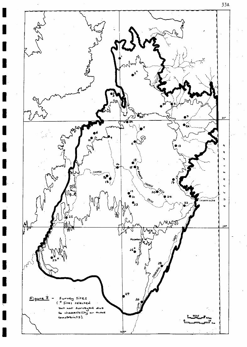
I.
33A
,,,....
i
....... .... .....
....,
''.
'..): ',5 )
....-
.
: I ....---'1)--,:- : \
:
.
....
g
,
, ( I ,'
--,
I2 .,.....
1 -----.
. --...---
---
, , t.
, ..."
'Innamtncka
iiiiii. )1 ,1P.4 I YINTTA.
..; 4,.. .., ,.. t.. .
/ / /
, ,
/
28 ,'" .-
, ,
,
Ej9ure. 7 s,...-vet s;te.s .
( *Sires se.tec1-e4
bAi- Kat- .A.4v-vesac.1 due 40 1.kaccesibillf er 1.1.A.e ,
co.stfrtalk+S). o c...6....icA=Fat Mks
0 2 5 =1===1=1==1==, KM
14

. 34
1 3-1; MATERIALS AND METHODS
3.1 SELECTION OF SURVEY SITES
Survey sites were initially selected on the basis of:-
inspection of aerial, photographs and maps (geological and topographical).
accessibility (use of tracks and potentially seismic lines).
literature search - trapping at sites trapped previously may shed light
on any changes that may have taken place through time at a particular
site and by inference other sites.
an aerial reconnaissance flight on August 14 1983 in an attempt to assessthe likely-importance.Of the flooding event and to provide a generaloverview of the study region-
The sites were selected to encompass all types of habitat identified inthe region at least once, -and ensuring that each (identified)" Environmental -
Subassociation,(Section 2-3.2) was surveyed. It was planned to spend approximate-ly four days at each site. Survey sites were planned to be confined to a singleland zone, and.the biota of individual habitats (up to four) were sampled bytrapping, for mammals, bird.censusing, trapping and active searching for herpeto-fauna, vegetation transecting and quadratting, and incidental, observations andcollections. All known habitat variation (at least the geomorphological cOmpon-ent) was identified. from 1:250 000 geological maps prior to the field. trips. Thishabitat variation included' dune crests, dune slopes, interduhe areas, claypanmargins and. floors, and salt lake margins and floors in dunefields; floodOutmargins and floors, channel edges, ephemeral channels, waterholes, swamp Margins
and floors, and terminal lake margins and floors in floodplains; the gibber plainproper and gibber plain clay lenses in gibber plains. Time constraints precludedthe detailed surveying of all other habitats that were identified in the field,but not evident from the geological maps. However, general observations on the
nature of these habitats were made. All sites surveyed were marked and tagged.
32 sites were selected (depicted in Fig. 7) for surveying. Due to time
constraints and problems of inaccessibility, only 27 sites (and not all of these
were as originally designated) were in fact surveyed. It is hoped that theremainder will be surveyed in the future along with other significantly differentareas that were identified during field trips, as they represent areas, about
which little is known, within the study region-
3.2 MAPPING PROCEDURES, SCALES USED AND DATA COLLECTION
It was intende& to use very recent LANDSAT thematic maps in addition toaerial photography in field surveys. This LANDSAT information proved to beunavailable at the time required, and so this aspect Of the study was severelycurtailed, except for the Provision.of a 1:250 000 Colour Image (Bands 4,5,7 -104-079) of the region by the Outback Management Branch, Dept. of Lands. Thisproved useful in the planning stages.and also enabled identification-of areasof obvious grazing Pressure - evident as distinct cross-fence contrast in
some parts of the study area.
Aerial photography, including stereo pair coverage of survey sites (average
scale 1:88 000 - Appendix N) and a complete set of 1:100 000 aerial photographmosaics, dated between 1979 and 1981 were also made available by the Outbeck

35
Management Branch.. The alteration of site locations, due to inaccessibility andtime constraints, meant'that workers at these altered sites had no aerial
photographs,but in the main survey crews were supplied with the relevant photo-.graphs. The date and scale of photographs were amenable to broad-scale landsystem and vegetation mapping, where this,was attempted.
Most of the results and analyses presented in 'this report relate directlyto published 1:.250.000' map sheets, due to unavailability of larger scale maps
and thematic LANDSAT images.
The absence. of better aerial photograph coverage did not hamper fieldoperations, due to the development of' a set of data gathering sheets for field
use by N.P.W.S. officers.and.conSultants, covering, site, vegetation and verte-brate details,respectively (copies. of these sheets are presented in Appendix I).Some deficiencies were found in the use of the data sheets, Such as lackaf-
space for specific, information relating to trapiines(i.e.. trapline no., trap
type, no. of traps used and spacing, and trap nights) or area surveyed,(e.g. 1
or 10 or 100 etc. ha), but they certainly helped maintain a consistencY'4'
format; these data being destined for computer manipulation.
An attempt has been made. to 'produce detailed: base maps for possiblfuturemapping .of habitats of the study area at a' scale of. 1:100 000, although this'
scale may. yet prove to be too.broad for adequate habitat representation. A
single, smaller scaled (1:125 000) map has also been compiled along, similar lines;
both the 1:100 000 maps and the 1:125 000 map are derived from enlargements of
other 1;250 000 map sheets. These maps have been lodged with the Survey andResearch Section, N.P.W.S.
3.3 ASSESSMENT OF SURVEY SITES
Assessment of survey sites involved checking the representativeness ofselected survey sites in the field and then sampling them using the followingmethodologies. A proposed methodology (Appendix J) was submitted to the Surveyand Research Section prior to the first field trip. The progress report (AppendixK) details modifications of the methodology that were considered necessary atthe completion of the first field trip.
3.3.1 Methodology used in the Assessment of Habitats
3.3.1.1 Methodology used by the Consultants
Methods used at the seven permanent sites surveyed by the consultantsconsisted of vegetation sampling and description.
3.3.1.1.1 Sampling of Vegetation
At each site selected to represent a major vegetation type, a permanentquadrat was established by locating permanent markers at each of the fourcorners. A photographic record was taken of the quadrats. Quadrat sizes werebased on species. vs area determination, and were generally in the order of15 m X 15 m. In addition to the permanent quadrat, a second quadrat was sampledin the vicinity'along with a one kilometre transect. The incidence of all plantspecies present in quadrats and within a five metre radius at intervals .(general-ly 50 m - depending on. the species richness of the association) along the .
transect was recorded. Unknown species were collected for later identification.Visual estimates of projected foliage cover, cover of litter and amount of bareground were also made. At each site, observable features, such as soil type,
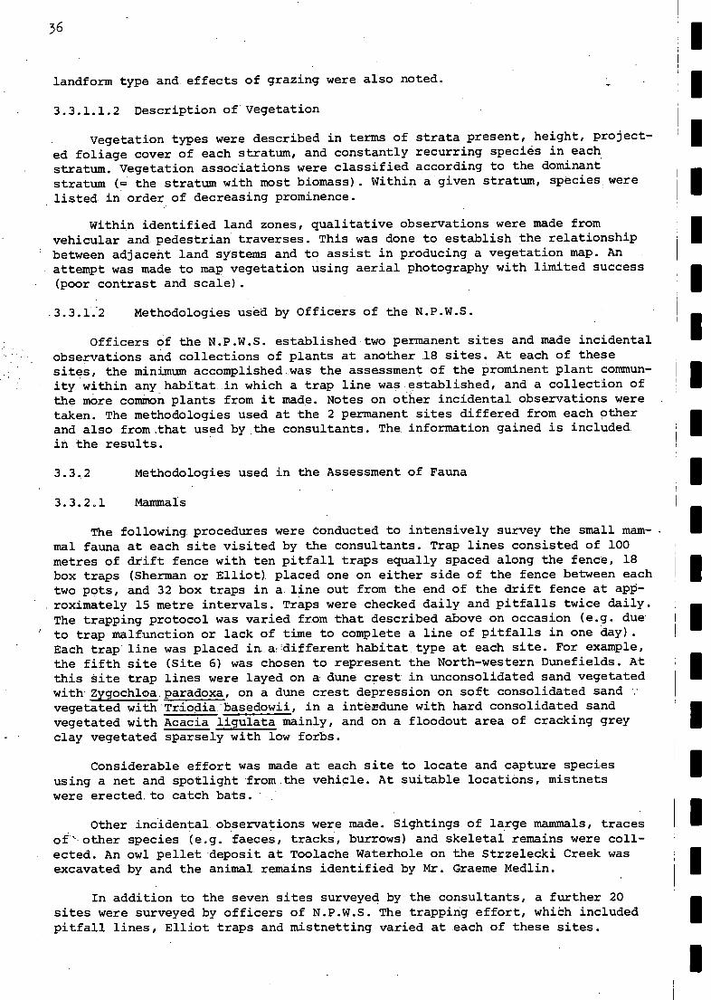
36
landform type and effects of grazing were also noted.
3.3.1.1.2 Description of Vegetation
'Vegetation types were described in terms of strata present, height, project-
ed foliage cover of each stratum, and constantly recurring species in each
stratum. Vegetation associations were classified according to the dominant
stratum (= the stratum with most biomass). Within a.given stratum, species were
.listed, in order of decreasing prominence.
Within identified land zones, qualitative observations were made fromvehicular and pedestrian traverses. This was done to establish the relationshipbetween adjacent land systems and to assist in .producing a vegetation map. Anattempt was made to map vegetation using aerial photography with limited success
(poor contrast and scale).
.3.3.1.2 Methodologies used by Officers of the N.P.W.S.
Officers of the N.P.W.S. established two permanent sites and made incidentalobservations and collections of plants at another 18 sites. At each of thesesites, the minimum accomplished_was the assessment of the prominent plant commun-ity within any.habitat_in which a trap line was established, and a collection ofthe more common plants from it made. Notes on other incidental observations weretaken. The methodologies used at the 2 permanent sites differed from each otherand also from .that used by the consultants. The information gained is included.in the results.
3.3,2 Methodologies used in the Assessment of Fauna
3.3.2.1 Mammals
The following, procedures were Conducted to intensively survey the small mam-mal fauna at each site visited by the consultants. Trap lines consisted of 100metres of drift fence with ten pitfall traps equally spaced along the fence, 18box traps (Sherman or Elliot)..placed one on either side of the fence between eachtwo pots, and 32 box. traps in a. line out from the end of the drift fence at apP-
.roximately 15 metre intervals. Traps were checked daily and pitfalls twice daily.The trapping protocol was varied from that described above on occasion (e.g. due
I to trap malfunction or lack of time to complete a line of pitfalls in one day).Each trap line was placed in.adifferent habitat.type at each site. For example,the fifth site (Site 6) was chosen to represent the North-western Dunefields. Atthis Site trap lines were layed on a. dune crest in unconsolidated sand vegetatedwith-Zygochloa.paradoxa, on a dune crest depression on soft consolidated sand yvegetated with*Triodia:basedowii, in a interdune with hard consolidated sandvegetated with Acacia ligulata mainly, and on a floodout area of cracking greyclay vegetated sparsely with low forbs.
Considerable effort was made at each site to locate and capture speciesusing a net and spotlight from the vehicle. At suitable locations, mistnetswere erected. to catch bats.
Other incidental, observations were made. Sightings of large mammals, tracesof' other species (e.g. faeces, tracks, burrows) and skeletal remains were coll-ected. An owl pellet 'deposit at Toolache Waterhole on the Strzelecki Creek wasexcavated by and the animal remains identified by Mr. Graeme Medlin.
In addition to the seven sites surveyed by the consultants, a further 20sites were surveyed by officers of N.P.W.S. The trapping effort, which includedpitfall lines, Elliot traps and mistnetting varied at each of these sites.
3.3.2.2 Birds
Each permanent site surveyed by the consultants was censused in the mornings
using a lstandardised "point-census technique", and the technique is briefly
outlined as follows:-
Observer moves to a point (chosen in a non-subjective manner) in the habitat
to be surveyed.
At this point, one minute is spent prior to the start of the five minute cens-
us period searching for all birds within 50 m of the observer, using visual
and audible cues.
During the five minute census period, the distance of birds within 50 m of
the observer is estimated at each of time 0, 60, 120, 180, 240, and 300 s.Other birds at greater distances are also noted at these times. An indication
is made whether the individual has been "scored" in a previous interval
between these times in the five minute period. The closest distance of birds
in flight is recorded.
A note is made for each observation as to whether it was by visual or audial
means, and if by visual whether it was first noticed by visual or audial cues.
The observer moves quickly 150 m to the next point to initiate the next censusperiod, recording species noticed en route.
Numerical densities of species within particular habitats can be determined
with appropriate analysis.
In addition to the point censuses, time was spent driving/walking shortdistances looking for different habitat types. All birds noticed while travellingand stopped were recorded in a log book. Cryptic species were specifically lookedfor in appropriate habitat. Birds seen while travelling between sites were alsologged.
At the permanent sites surveyed by the N.P.W.S., the bird census involvedgeneral observations or observations over a set period of time. Data sheets forthe remaining 18sites surveyed by the N.P.W.S. also contain bird notes, andsome officers made notes of observations between sites.
3.3.2.3 Reptiles
The majority of collections of reptiles were made in the same pitfall trapsas used to survey mammals. Occasionally reptiles were also caught in aluminiumbox traps set for mammals.
Active searching techniques were employed to collect reptiles during theday and night. During the day, rocks, logs and rubbish were turned and reptilesseen at large were pursued. Many burrows were also excavated. At night, spotlight-ing was conducted from a vehicle and on foot.
3.3.2.4 Frogs
Calls were detected and where possible, the calling animal collected. Thiswas usually done at twilight or with a spotlight after dark. The pitfall trapsalso proved useful for the capture of frogs at one site after heavy rainfall.N.P.W.S. made a collection of one species that was not collected by the consul-
37
1Standardised "point-census technique" recommended by Dr. H.F. Recher of theAustralian Museum (Dr. D.C. Paton, pers. comm.).

38
tants.
3.3.2.5 Fish
At representative waterholes and swamps along the Cooper, samples of
aquatic fauna were collected using a dip net of 300 ilm plankton mesh. At several
waterholes an eight metre seine net with 1.5 mm mesh size was also used and at
one site a 50 m gill net with mesh size 45 mm was set to catch fish.
Aquatic Invertebrates
Samples of aquatic invertebrates were taken at representative waterholes
and swamps along the Cooper Creekand in a puddle at the side of the Strzelecki
Track. They were collected using -a dip net of 300 film plankton mesh and with a,
seine net eight metres long, and having a mesh size of 1.5 mm: the sampling sites
included the first. 20 mm of the leading edge of the floodwaters which containeda high density of copepods..
A light trap was provided bY.MrsH Alice Wells of the University of Adelaide
to collect adult Trichoptera. Collections were made at two sites.
34 DURATION. OF FIELD TRIPS
The first field trip undertaken by the consultants was between September14 and October 2v while the second field trip was between October 26 andNovember 10. In addition, plant collections were made by one of the consultantsin the study area between October 17 and 19.
N.P.W.S. officers undertook their first trip between September 18 and 24.Four officers remained for an additional four days.

38A
ii8.
,
4-4.5 I\ I
'
, ,
27* -- ,....r... )
,..., ... 13."4-* 4
,
....
8.4.4-6 o
'x
, ..............
, : :
.
; \-..--,......
.__
n
..,
.,--.... : .,.,cooPER ..-- ',
,- ---"' (I
t
B.* 4 1 I.C°0Pe.,? ,
' --- ,...
r
V4 ,-- r
, et 7 " .... ' 44
. ( '''' 4-
.
. In na mincka
cr )
whin
)
28° II 4 Till ...:
.
4. , At. .
, , '
,-' ' .1 ..,
,- .ri 4*.i
..,
FiSmre. 8 - Erwtirow.me....tal , ,
, ,
S.Abassoc;cd-fortS
8.4..4..1 Ceara,. Creo..k. Floocielal...,
8-4-4.2, -S-t-r3e.le.,..ki Creol,c. P I acalri air., , , 9.4.4.3 So....41,-wes+erm Du.te.fiekis
134.44. Nortt..-I4e.sterr, 1),,,ef4e,14s No-rike,,-.. Grbber- an d Flooaliala.n . 0 t=1.pcIt=,=ef
1411ft 86 No tk-e,osier ri th.sonefie.14 ........t vio crap ta I.*. 02s 13.4-4,7 1.1.......-4.......4e4 ur...,..,....3e. D.......e.field
( .......Cficiel ÷...... Ft. 3 ). 14
39
4. RESULTS
4.1 INTRODUCTION
So far, habitat has been defined solely on landform criteria as used by
Laut et al. (1977; see Sections 1.4 and 3.1). In reality, a proper evaluation
of habitat. requires- consideration of both physical (especially landform and
soils) features and biotic characteristics. (in particular the dominant vegetation
types). Variation within habitats has been ignored, as, in the context of this
report, where habitats are the basal category (analogous to land units see
Section 2.3) in a hierarchial classification of 8.4.4, such intra-habitat varia-
tion is minimised, While inter-habitat variation is maximised. Interfaces between'
habitats have also been ignored.
In this section, it will become apparent that habitat as perceived by abotanist may be somewhat different to habitat as perceived by a zoologist. Thisdifference reflects the different needs of various groups of organisms,,and it 1
confounds the attempt to have a uniform assessment'of habitats within any region..This problem islooked at in Chapter 5.
4.2 . DATA COLLECTION
4.2.1 Site Localitions-
Information relating to principal survey site locations is presented inAppendix N (see also Fig. 7). More detailed information relating to habitats(up to four) sampled at each site is provided in data sheets and the'1:250 000geological maps held by the N.P.W,S. A gazetteer of all .locations mentioned in 1
the text is provided as Appendix V.
4.2.2 Data Collected
Well over 300 data sheets were completed during the survey at the 27 sitesand in intervening regions. There is a further body of information relating to 1
the study area in the form of trip logs, bird censusing Sheets and dtherA.naid-ental notes. The data have yet to be subjected to computer analysis, and socomments made in this report are based on a qualitative assessment of theinformation.
4.3 INFORMATION RELATING TO THE ASSESSMENT OF HABITATS
4.3.1 Plant species
A total of 1086 plant specimens (Appendix L) representing 49 families, 145 .
genera and 279 species (including 10 distinct subspecies and 17 distinct variet-ies - Appendix M) were collected. The habitat preferences of plant species (sub-species and varieties) is indicated in Appendix M, as is the status of each in I
the study area. 465 of the specimens were collected by the subconsultant botanist,mainly in the vicinity of the seven permanent sites surveyed by the consultantsand along the North-west Branch of the Cooper. The remaining specimens wereected at the other 20 sites (two permanent) surveyed by the N.P.W.S., and so itcan be seen that coverage of the study area was not even.
4.3.2 Environmental Subassociations
As a result of field surveys, one of the initial five Environmental Subass-
ociations (Northern and North-eastern Gibber and Floodplain, 8.4.4.5 - see
Section 2.3.2; Fig. 3) has been divided into three separate Environmental Sub-
associations (Fig. 8). This was due to recognition of its internal variation.
These three Environmental Subassociations viz.8.4.4.5, 8.4.4.6 and 8.4.4.7 are
much more homogeneous.
Seven Environmental Subassociations are thus recognised in the Cooper Creek
Environmental Subassociation 8.4.4, as shown in Fig. 8. These Environmental
SubaSsociations are:-
. Cooper Creek Floodplain Environmental Subassociation 8.4.4.1.
Strzelecki, Creek Floodplain Environmental Subassociation 8.4.4.2
South-western Dunefields Environmental Subassociation: 8.4.4.3
North-western Dunefields Environmental Subassociation 8.4.4.4
Northern Gibber and Floodplain Environmental Subassociation 8.4.4.5
North-eastern Dunefield and Floodplain Environmental Subassociation 8.4.4.6
. Uncoordinated Drainage Dunefield-Environmental Subassociation 8.4.4.7
Environmental Subassociations 8.4.4.5 and 8.4.4.6 are named according to theirmajor distinguishing features, while 8.4.4.7 is so-named because the drainagepattern is an uncoordinated combination of centripetal (to claypans or sandyinterdunes) and dendritic drainage patterns. Detailed physiographic descriptionsof all Environmental Subassociations recognised are given below.
4.3.2.1 Cooper CreekTioodplain_EtvirohMental SUbassociation, 8.4.4.1
8.4.4.1 occupies the central part of the Cooper Creek Environmental Assoc-iation 8.4.4. Landforms are dunes, interdunes, pans and floodplains, and smallareas of sand plain. Geology is predominantly represented by aeolian and fluvialdeposits. Soils are cracking clays, sands and earths. Vegetation consists ofshrublands, grasslands and fringing woodlands, with forblAnds/herblands conspic-ous in better seasons. Climate is characteristic of Province 8 (Section 2.1.1)',although micro-climatic variation is likely in regularly inundated areas orthose which hold water over several seasons. 8.4.4.1 is subject to flooding ofvarious intensity (see Section 2.5.2.6).
4.3.2.2 Strzelecki Creek Floodplain Environmental Subassociation, 8.4.4.2
8.4.4.2 occupies the south-eastern part of the Cooper Creek EnvironmentalAssociation 8.4.4. Landforms, geology, soils and vegetation are similar to8.4.4.1, although tall riparian woodland is absent from the Strzelecki Creek(Section 2,5.2.6). Climate is characteristic of Province 8 (Section 2.1.1),although micro-climatic variation is likely in the event of floodwaters of theCooper Creek entering the Strzelecki Creek. This occurs rarely (see Section2.5.2.6).
4.3.2.3 South-western Dunefields Environmental Subassociation, 8.4.4.3
8.4.4.3 occupies the south-western part of the Cooper Creek EnvironmentalAssociation 8.4.4. Landforms are dunes, interdunes and pans. Geology consistspredominantly of aeolian deposits. Soils are sands, earths and cracking clays.Vegetation consists of hummock grasslands, shrublands and forblands/herblands.Climate is characteristic of Province 8 (Section 2.1.1).
40

41
4.3.2.4 North-western Dunefields Environmental Subassociation, 8.4.4.4
8.4.4.4 occupies the north-western and'morthern parts of the Cooper CreekEnvironmental Association 8.4.4. Landforms, geology, soils and vegetation are.similar to 8.4.4.3, but salt pans are more prominent in this Subassociation and
hence,salt lake soils and associated vegetation. Climate is characteristic of
Province 8 (Section 2.1.1).
4.3-2.5 Northern Gibber and Floodplain Environmental Subassociation,8.4.4.5
8-4.4.5 occupies the extreme northern fringe of the Cooper Creek Environ-mental Assocation 8.4..4, between the extensive dtnefields within 8.4.4 andSilcretes. of the 'Cordillo Surface' to. the north: LandformS are dunes, interdunesl,
pans, floodplains, gibber plains and associated topographic features (e.g. gibberplain gutters). Geology .tonsists predominantly of aeolian and fluvial depositsand weathered duricrust (or silcrete).of the 'Cordillo Surface' - gibber.Soils are sands, earths, red duplex soil's and cracking clays: Vegetation consists
shrublands, hummoci"eand tussock grasslands, and fringing woodland, with forb-landS/herblands prominent:in better seasons. The diveristy of plant species ishighest here, associated'with-gibber plains; aided by the high nutrient statusof the gibber plain red duplex soils (Cleland et. al., 1925)-- plant growth ismost conspicuous in broken parts of the .gibber surface, where the underlyingsoil is exposed in the absence of a close surface cover of gibber fragments,Climate is characteristic-of Province 8 (Section 2.1.1).
4.3.2.6 North-eastern Dunefield and Floodplain Environmental Subassociation,8.4.4.6
8.4.4.6 occupies the central-north-eastern part of the Cooper Creek Environ-mental Association 8.4.4. Landforms are sand plains, low dunes and interdunes,floodplains, and small occurrences of gibber plain. Geology consists predominant-ly of aeolian and fluvial deposits, with small areas of gibber. Sand, cracking-dlay.,:-earth and red duplex soils. predominate. Vegetation, consists of hummock(and minor ttssock) grasslands, shrublands and forblands/herblands (in betterseasons). Climate is characteristic of Province 8 (Section 2.1.1).
4.3.2.7 Uncoordinated. Drainage Dunefield Environmental Subassociation, 8.4.4.7
8.4.4.7 occupies the north-eastern part of the Cooper Creek EnvironmentalAssociation 8.4.4. Landforms are circular or ovoid dunes, interdunes and pans, 1
and drainage lines with small areas of associated floodplain..Geology consistspredominantly of aeolian and fluvial deposits. Soils are sands, earths andcracking clays. Vegetation consists of hummock (and minor tussock) grasslands, 1
shrublands and forblands/herblands (in better seasons). Climate is characteristiaof Province 8 (Section 2.1.1)..
4.3.3 Land Zones
Survey site locations (Fig. 7; Appendix N) included examples of the threeland zones viz. dunefields, floodplains and gibber plains. Each land zone wassampled at one or more site(s).. Within the land zones, the following land sys-tems were recognised. '
4.3.4 Land Systems
During the survey of the Cooper Creek Environmental Association 8.4.4,vegetation - land system mapping was attempted using available aerial photogaphyand-data was collected to enable delineation of all land systems present.
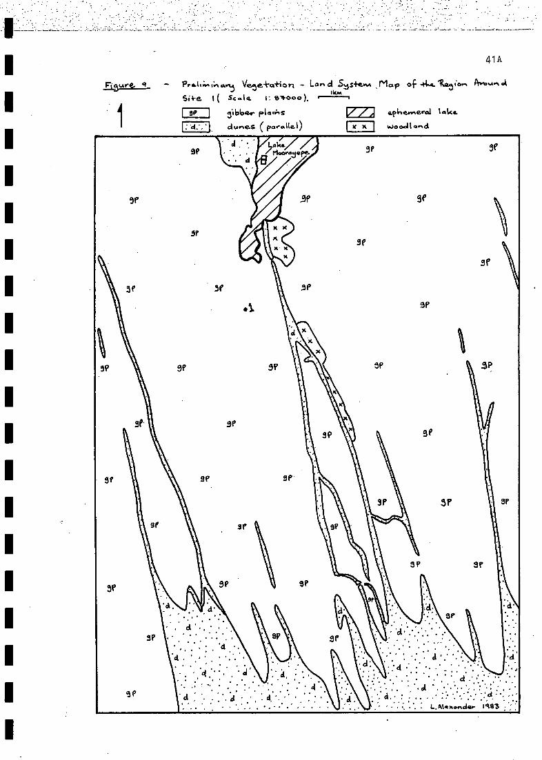
..ap.holtaiv-i..
Vrti
IItxl(raworodssuripsunalei .frawgqi6
woncoots?qr.'s
+cgp%Awl -04%)+20C2A Cue utt
-eclePw.owiA
7/97
)
as
4!S
ba ." r G,T. "/ r%Ana...4j
room
vial revvv.rauicia
%Aoio do

42
4.3.4.1 Attempts at Vegetation - Land System Mapping using AvailableAerial Photography
Vegetation - land system mapping was attempted in the vicinity of the.
seven permanent sites surveyed by the consultants viz. Sites 1, 4, 6, 14, 23,
25 and 28 (Fig.s 9-15; see also Fig. 7 for site locations in the study area).
The black and white aerial photograph scale(average 1:88 000 - Appendix N) and I
age (some were taken in 1979), didn't allow for a very satisfactory discriminationof finer elements within the broad dunefield (dune crests were clearly visible),
floodplain or gibber plain land zones e.g. Zygochloa paradoxa areas, Atriplexnummularia areas, Chenopodium spp. areas and certain grassland/herbfield areas.Vegetation.of.a more extensive nature, such as lignum Muehlenbeckia cunninghamii
in Embarka Swamp (Fig. 13) and some channel-edge woodland (FiT.s 12 and 15) how- I
ever, was clearly visible on photographs. In attempting to. map areas, where the
finer elements were not visible due to aerial photograph limitations, generaldescriptive terms such as floodplains, dunes and lignum swamp have been used. Thevegetation of finer elements (habitats) in these broader areas is described in
detail in. Section 4.3.7.
It can be seen from the preceding paragraph that the scale of aerial photo-graphy available on 8.4.4 is amenable to attempts at vegetation - land systemmapping (Fig.s 9-15) only in-so-far as such maps show the relationship betweenadjacent (broad) land system types and some of the vegetation components. Part-icularly, when such mapping is attempted with limited ground reconnaissance,which can only be the case with with current budgetary limitations (a trend thatis likely to continue). To enable more detailed land system mapping, larger scaldaerial photography i.e. probably 1:50 000 scale and/or detailed ground reconnais-sance is required. For adequate habitat representation, larger scale aerial photo-graphy again will likely be required.
4.3.4.2 Land Systems Identified from Field Data
Land systems of the study area can be identified initially according totheir presence in the land zones viz. dunefields (D), floodplains (F) and gibberplains (GP). Their characteristics can then be described in such a way as toconform to the definition of land system as: " an area or group of areasthroughout which there is a recurring pattern of topography, soils and vegeta-:tion " (see Section 2.3.4). This is accomplished in the following subsections.
4.3.4.2.1 Land Systems of the Dunefields
Dunefields are the dominant land zone of Environmental Association 8.4.4.Four distinctive types of dunefieid are recognised viz, parallel dunefields (pp- trending approximately north-south), uncoordinated drainage dunefields (Du),undulating dunefields (or lunettes - see Dulhunty, 1983) (Dlun) and sand plainswith very low dunes (Ds). The land systems within these dunefield types aredetailed below.
Land System ppl
Parallel, red sand dunes with Triodia basedowii hummock grassland dominant ondune slopes and in interdunes.. Zygochloa paradoxa hummock grassland is dominant ondune crests and upper slopes. Occurs as large expanses such as in the North-.western. Dunefields Environmental Subassociation 8.4.4.4 (e.g. Site 6 and 10; see/also Fig. ll)..
Land System Dp2
Parallel, red sand dimes with Acacia spp. tall open shrubland over ephemeralforbland dominant on dune slopes and in interdunes: Zygochloa paradoxa hummoCk

9?
AMP! NEM (.*vo t..,o)ec-S9.E parotid" -j.")-
C.1......nais
421
Bgure. 10 Pre I.:v. ar Vete.i-D.430;" Lariat S.t;440"/t4ip of lk 4,51e, Aws;,,,,,A
si*e. ( Scala. I: 84000).

43
grassland is dominant on dune crests and upper slopes. Occurs as relatively
large expanses as in parts of the Cooper Creek Floodplain Environmental Subass-ociation 8.4.4.1 (e.g. west of Site 14; see also Fig. 12).
Land System 21).3
Parallel, orange sand dunes with Acacia spp. - Cassia sm. - Eremophila spp.
mixed shrubland dominant on dune slopes and in interdunes. Zygochloa paradoxa
hummock grassland is dominant on dune crests and upper slopes. Occurs as
expanses (possibly large)in.-.th'at part of the study area around Mudcarnie Water-
hole (i.e. east (and probably west) of Site 4; see also Fig. 10).
Land System Dp4
Parallel, deep red sand dunes with Acacia ligulata low open woodland dominant
on dune slopes and in interdunes. Zygochloa paradoxa hummock grassland is
dominant on dune crests. Occurs as isolated expanses within the Cooper Creek
Floodplain Environmental Subassocaition 8.4.4.1 (e.g. near Site 23; see also
Fig. 12).
Land System Dp5
Parallel, deep red. sand dunes with Acacia spp. low open shrubland dominant on
dune slopes and in interdunes. Zygochloa paradoxa hummock grassland is dominant
on dune crests. Occurs as isolated and larger expanses in the south-west part
of the study area (e.g. near Site 25; see also Fig. 14).
Land System Dp6
Parallel, deep red sand dunes with Atalaya hemiglauca - Acacia spp. low, veryopen woodland dominant on dune slopes and in interdunes. Zygochloa paradoxahummock grassland is dominant on dune crests. In parts, these dunes may haveseveral parasitic dunes of the uncoordinated type or elements of uncoordinatedtype dunes on top - this is to be confirmed in a future. survey. Occurs asisolated expanses adjacent to gibber plains in the Northern Gibber and FloodplainEnvironmental Subassociation 8.4.4.5 (e.g. near Site 1; see also Fig. 9).
Land System
Parallel, deep red sand dunes with Acacia ligulata - Salsola kali ephemeral lowopen shrubland dominant throughout - characterised by a lower diversity of speciesthan .other deep red dunes. Occurs as isolated expanses within the Cooper CreekFloodplain Environmental Subassociation 8.4.4.1 (.e.g.near Site 14; see also Fig.12)
Land System Dp8
1Paler coloured dunes of more recent deposition with Acacia ligulata low openshrubland dominant on dune slopes and in interdunes. Cynanchum floribundum low,very open shrubland is dominant on dune crests. Occurs as isolated expanses inthe south-west part of the study area (e.g. the eastern South-western DunefieldsEnvironmental Subassociation 8.4.4.3; see also Fig. 15) - more open and mobiledunes; few perennial species to bind the soil.
Land System Dp9
1Paler coloured dunes of more recent deposition with Acacia ligulata low openshrubland dominant on dune slopes and in interdunes. Ephemeral composites andSalsola kali dominate on dune crests. Occurs as isolated expanses in theStrzelecki Creek Floodplain Environmental Subassociation 8.4.4.2 (e.g. due west I
of Toolache Waterhole, where the dunes are a very pale (whitish) colour; seealso Fig. 15).
Land System Dp10
'Paler coloured dunes of more recent deposition with ephemeral forbland dominant
DP7
1Paler colour indicates proximity to sand sources.

L - Prel;rottkans Veteriafs'oel - Lart44-es, of 44-0.-'Re5icors Arourial dawn Site. 6 ( Scala. I: es 00o).
Jur% (parallel) t2:2 floocIplasns' par% S
isrtmv*.
ci rain aeet 11.ri (LS
43A
44
on dune slopes and in interduneq. Sparse Zygochloa paradoxa occupies dune crests.
Occurs as isolated expanses within the Cooper Creek Floodplain Environmental
Subassociation 8.4.4.1 (e.g. Site 16).
Land System Dpll
'Paler coloured dunes of more recent deposition with ephemeral forbland/herbland I
dominant throughout.. Contains_.sCattere&Acacia ligulata and Cynanchum floribundum:
Occurs as isolated occurrences within the Cooper Creek Floodplain Environmental 1
Subassociation 8.4.4.1 (e.g. dunes bordering Coongie Lake).
Land System.I;y12
1Paler coloured dunes of more recent deposition with ephemeral forbland dominatedrby Salsola kali on dune slopes and in interdunes only. Occurs as isolated occur,
rences in the south-west part of the study area (e.g. near Site 25; see also Fig.
14).
Land System Dunc
Deep orange dune ridges around circular or ovoid interdunes, which are in parts
modified by typical drainage lines of the dendritic type. Zygochloa paradoxahummock grassland is dominant on dune crests and upper slopes, while Acacia spp.- Cassia spp. - Eremophila spp. mixed shrubland is dominant on lower dune slopes.
Plant communities in interdunes are of five different types, which identify thedifferent interdune habitats in this land system (see Section 4.3.7). Uncoordin-ated drainage dunefields are a localised apparently unique dunefield type mostlyrestricted to the area shown in Fig. 8 (e.g. near Site 4 and:at'Sites 7.and.7A;see also Fig. 10), and adjadent districts over the border in Queensland (refer
to Dawson and Boyland, 1974).
Land System Dlun
Areas of numerous small undulating dunes or sand fields of red clayey sandswith gentle slopes mostly abutting the northern and north-eastern margins ofsome floodouts and swamps (e.g. near Sites 23 and 28; see also Fig.s 13 and 15).
Acacia spp. - Cassia spp. mixed shrubland is dominant throughout. These undulat-ing dunes, sand fields or lunettes (Dulhunty, 19831 are generally located betweenfloodplains and adjacent parallel dunefields, and so the presence of both flood-
plains and parallel dunefields may be a prerequisite for their formation i.e.assuming they are of recent origin, as, they are present on the northern andnorth-eastern margins of floodplains, whereas the most frequent direction ofwind today is north-west (see Section 2.5.1.3); slope of the floodplain surfaceis also of significance (Dulhunty, 1983).
Land System Ds1
Sand plains of very low dunes with Cassia spp. - Acacia spp. mixed open shrub-land over Triodia basedowii hummock grassland dominant. Occurs as large expansesin the north-east part of the study area (i.e. Environmental Subassociation8.4.4.6; see Section_4.3:246)...
Land System Ds2
Sand plains of pale to yellow sandy loam over clay with Acacia spp. - Hakeaspp. mixed shrubland dominant. Occurs as isolated expanses in the study area(e.g. in the Cooper Creek Floodplain Environmental Subassociation 8.4.4.1 aroundSite 24).
'Paler colour indicates proximity to sand sources.
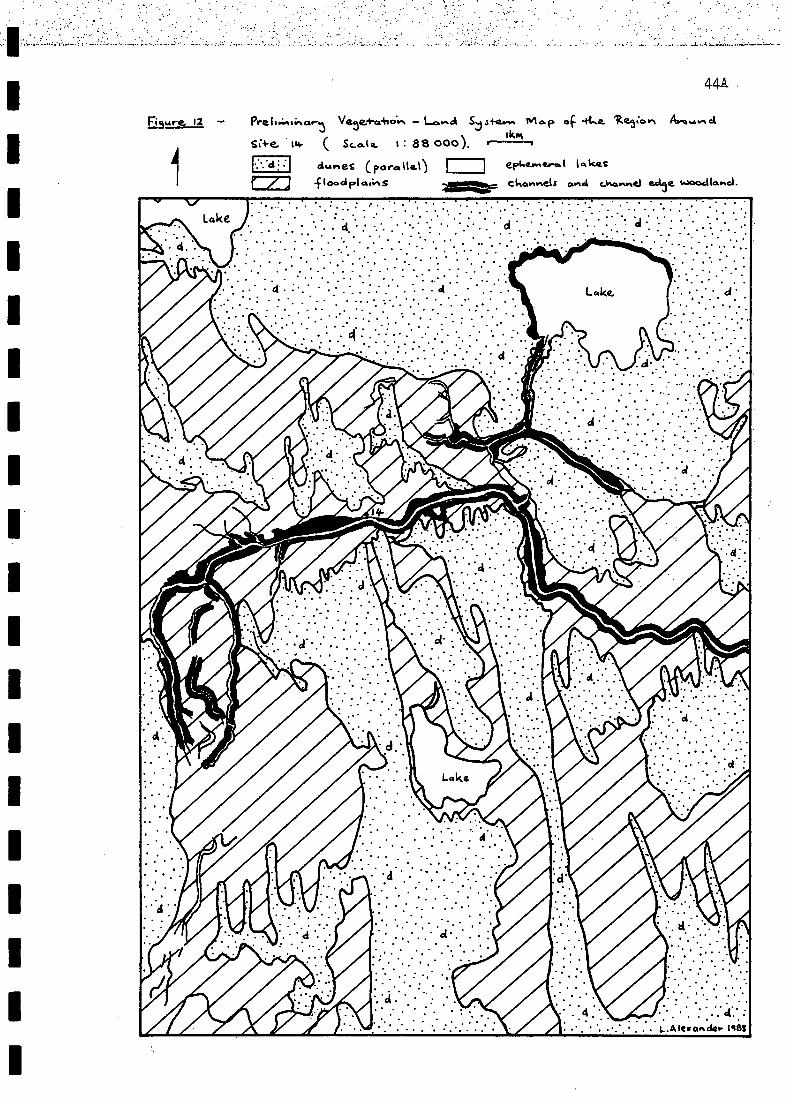
virt7
tpAV,04.i
*(000 88 :)411?-1-.15ken,
i°%"2.41r'"1".°M-1)4.2)A V."'"" 1 zki
rwetrootm'Ara P.,,,,,p.0spuj=1:1=t$rticipoo13-
0-011....0.1)EZ:1

45
Land System Ds3
Sand plains of pale grey .sands. with Acacia victoriae low open woodland dominant.
Occurs as isolated expanses in the study area (e.g. 14 km NW of Scrubby Camp
Waterhole, where is was slightly undulating in nature and described in field
notes as a dune slope/plain).
Land System Ds4
Sand plains of yellowgrey hard silty clays with low (<30 cm) open ephemeral
forbland dominant. Occurs as isolated expanses in the study area (e.g. west
of Site 28; see also Fig. 15).
4.3.4.2.2 Land Systems of the Floodplains
Floodplains are, the subdominant land zone of 8.4.4. Three major floOdplain
environments are recognised viz., the Cooper Creek floodplain (Fc), the Sltrzelecki
Creek floodplain (Fs) and other floodplains in 8.4.4 (Fo). The land systems with-
in these floodplapienvironments are detailed below.
Land System Fcl
Floodplain areas.pf.the Cooper Creek with Eubalyptus microtheca + Lysiphyllum 1
Eucalyp-Eus:*camaldulensis var. obtusa tall to low fringing woodland.dominant onvpale grey silty clay or cracking clay soils. Occurs in areas subject I
to most frequent inundation (e.g. Chillimookoo and Toonman Waterholes near Site14, Embarka Waterhole near Site 23 and Sites 13 and 15; see also Fig. 12).
Land System Fc2
Floodplain areas of the Cooper Creek with Eucalyptus microtheca - Acacia steno-phylla low fringing woodland dominant on grey silty clay soils. Occurs in areassubject to most frequent inundation (e.g. near Site 14; see also Fig. 12).
Land System Fc3_ .
Floodplain areas of the Cooper Creek with Eucalyptus microtheca - Acacia salicina
- A. stenophylla -Eremophila bignoniiflora low open fringing woodland dominant on
silty clay soils. Occurs in areas subject to frequent inundation (e.g. near Sites
18 and 25; see also Fig. 14). Vegetation of a much reduced areal extent and spec-
ies composition than most frequently inundated areas.
Land System Fc4
Floodplain areas of the Cooper Creek with Eucalyptus microtheca - Acacia steno-phylla low, very open fringing woodland dominant on silty clay soils. Occurs inareas subject to less frequent inundation (e.g. near Site 25; see also Fig. 14); I
1In defining the land systems of the Cooper Creek floodplain, reference is madeto levels of inundation as discussed in Section 2.5.2.6. Those areas affected by !
average flows and level 1, 2 and 3 floods of the Cooper and local runoff areconsidered most frequently inundated. Areas affected by level 1, 2 and 3 floods
of the Cooper and local runoff are considered frequently inundated. Less frequ-ently inundated areas are affected by level 2 and 3 floods of the Cooper andlocal runoff. And, least frequently inundated areas are affected by level 3 floodsof the Cooper and local runoff; local runoff is generally of greater significance1
due to the rarity of occurrence of level 3 flood events (see Section 2.5.2.6). Itis noted however, that correlation of vegetation types with levels of inundationlcan only be approximate. This is due to the tenuous nature of the subdivision of 1
flows along the Cooper into the four main classes, which is based on limited data(Section 2.5.2.5). Still, water is the major determinant of vegetation distribu- 1
tion (Section 1.4) and type in the study area.

riuutOsf) 44Al243.1X1/ 84 47.119.1
strar.ao4.1 rsup,'clvwx, rns!
e hart/o.. GO tIV CI w
v5-17
.7, roof.PM+4,04roarawevia14.1vidrotati
wiI(oo-h 88I
u0.4-`2-+Cratt
I:
--47-71ngig
)ets41S
sv..p NVA

46
Land System Fc5
Floodplain areas of the Cooper Creek with Eucalyptus microtheca low open woodland
dominant on pale sandy clay soils. Occurs in areas subject to less frequent inun-
dation (e.g. on the northern and north-western margins of Embarka Swamp; see also
Fig. 13).
Land System Fc6
Floodplain areas of the Cooper Creek with Eucalyptus microtheca low, very open
woodland over Halosarcia indica ssp. leiostachya low, very open shrubland domi-
nant on hard grey non-cracking clay soils of saline depressions. Occurs in areas
subject to less frequent inundation (e.g. near Site 6; see also Fig. 11).
Land System Fc7
Floodplain areas of the Cooper Creek with Muehlenbeckia.cunninghamii tall to low(2-3 m) shrubland dominant on grey cracking clay soils.. Occurs in areas subjectto most frequent inundation (e.g. near Site 23 - Embarka Swamp; see also Fig. 13).
Land System Fc8
Floodplain areas of the Cooper Creek with Muehlenbeckia cunninghamii tall openshrubland over ephemeral forbland dominant on grey cracking clay soils With siltysections. Occurs in areas subject to most frequent inundation (e.g. Site 13 -Tirrawarra Swamp).
Land System Fc9
Flbodplain areas of the Cooper Creek with Muehlenbeckia cunninghamii tall, veryopen shrubland over sparse ephemeral forbland dominant on grey clay soils. Occursin areas subject to frequent inundation (e.g. near Site 25; tee also Fig. 14).
Land System Fc10
Floodplain areas of the Cooper Creek with sparse MuehlenbeCkia cunninghamii tallshrubland patches over a generally absent or dead ground layer on grey clay soilsOccurs in areas subject to less frequent inundation (e.g. near Site 25 - appear-red not to have been inundated for some time; see also Fig. 14).
Land System Foil
Floodplain areas of the Cooper Creek with Muehlenbeckia cunninghamii low shrub-land to low open shrubland dominant on grey cracking clay soils. Occurs in areassubject to most frequent inundation (e.g. near Site 14; see also Fig. 12).
Land System Fc12
Floodplain areas of the Cooper Creek with Muehlenbeckia cunninghamii low openshrubland dominant on clay soils. Occurs in areas subject to frequent(/mostfrequent)inundation: (e.g. near Site 6; see also Fig. 11).
Land System Fc13
Floodplain areas of the Cooper Creek with Muehlenbeckia cunninghamii low, veryopen shrubland dominant on clay soils. Occurs in areas subject to most frequentinundation (e.g. Site 15).
Land System Fc14
Floodplain areas of the Cooper Creek with Acacia victoriae low .openshrublandover Halosarcia indica ssp. leiostachya with occasional Muehlenbeckia cunningham-ii dominant on sandy clay soils. Occurs in areas subject to most frequent inunda--7tion (e.g. Kudriemitchie Waterhole)..
Land System Fc15
Floodplain areas of the Cooper Creek with Atriplex.nummularia low shrubland tolow open shrubland dominant on grey cracking clay soils. Occurs in areas subjectito frequent inundation (e.g. near Site 14; see also Fig. 12).
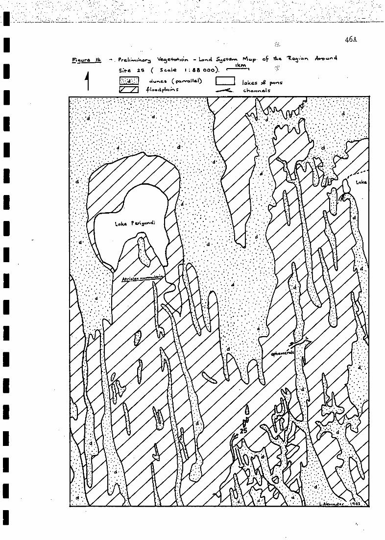
v9t
p wort 0.4V
*(000 29aiv's)sr %my2,11,50.4.2,4sCs pvcriC.a124.tvttra.s.4
as
-141eJnVtg
risAulow,S ...Mid peal*I/ fl st.ocl 84 sal DIcf
1OAJlad )IV. u

47
Land System Fc16
Floodplain areas of the Cooper Creek with Atriplex nummularia low open shrubland
dominant on clay soils. Occurs in areas subject to frequent inundation (e.g. near
Site 6; see also Fig. 11)
Land System Fc17
Floodplain areas of the Cooper Creek with Eragrostis australasica low open grass-
land dominant on grey cracking clay soils. Occurs in areas subject to less frequ-
ent inundation (e.g. near Site 23 - a component of Embarka Swamp; see also Fig.
13)
Land System Fc18
Floodplain areas of the Cooper Creek with Chenopodium nitrariaceum low openshrubland dominant on grey cracking clay soils. Occurs in areas subject to lessfrequent inundation (e.g. near Site 23 - a component of Embarka Swamp and FlyLake; see also Fig. 13).
Land System Fc19
Floodplain areas of the Cooper Creek with Halosarcia indica ssp. leiostachyalow open shrubland with sparse Meuhlenbeckia cunninghamii on sand/clay soils.Occurs in areas subject to less frequent inundation (e.g. margins of Coongie
Lake). May be indicative of atypical saline conditions.
Land System Fc20
Floodplain areas of the Cooper Creek with Halosarcia indica ssp. leiostachyalow open chenopod shrubland dominant on saline clay soils. Occurs in areassubject to less frequent inundation (e.g. near Site 25; see also Fig. 14).
Land System Fc21
Floodplain areas of the Cooper Creek with Atriplex spp. - Sclerolaena spp. low,very open chenopod shrubland dominant on clay soils. Occurs in areas subject toless frequent inundation (e.g. near Site 14; see also Fig. 12).
Land System Fc22
Floodplain areas of the Cooper Creek with ephemeral forbland dominant on greycracking clay soils. Occurs in areas subject to least frequent inundation (e.g.Lake Oolgoopiarie).
Land System Fc23
Floodplain areas of the Cooper Creek with ephemeral forbland dominant on hardgrey clay soils. Occurs in areas subject to least frequent inundation (e.g. nearSite 25; see also Fig. 14).
Land System Fc24
Floodplain areas of the Cooper Creek with low ephemeral forbland/herblanddominant on grey cracking clay soils. Occurs in areas subject to least frequentinundation (e.g. Lake Marrakoonamooka; see also Fig. 13).
Land System Fc25
Floodplain areas of the Cooper Creek with ephemeral herbland dominant on claysoils. Occurs in areas subject to least frequent inundation (e.g. Lake Apachirie).
Land System Fc26
Floodplain areas of the Cooper Creek with ephemeral herbland dominant on hard,grey, usually non-cracking clay soils. Occurs in areas subject to least frequentinundation (e.g. near Site 14; see also Fig. 12).

Fisur-e, 15
WIMP sand Firlat:-.5 lakes anci pan5
floecirl .ckarvnals .,g c,,kunnel ear weocIlaftd
47A
C;* e 2.8 88q50). Ve5e.4-0.4062.1 lo"ci Sys+erft rte.,. 4 4,4..eop, Avow.% d
1,km
Lacl-.1
dulnes (pa...3.116)
urv cikriaitunc, ahroier
48
Land System Fsl
Floodplain areas of the 1Strzelecki Creek with Eucalyptus microtheca - Lysiphyl-
lum gilvum - Acacia stenophylla low open woodland dominant on pale silty clay
soils (e.g. margins of the Strzelecki Creek-hear Site 28; see also Fig. 15).
Land System Fs2
Floodplain areas of the Strzelecki Creek with Muehlenbeckia cunninghamii - Chen-
opodium auricomum low open shrubland dominant on(generally) clay soils (e.g. near
Site 28; see also Fig. 15).
Land System Fs3
Floodplain areas of the Strzelecki Creek with Atriplex nummularia low open shrub-
land dominant on grey silty clay soils (e.g. near Site 28; see also Fig. 15).
Land System Fs4
Floodplain areas of the Strzelecki Creek with Eragrostis australasica low grass-
land dominant on (generally) clay soils (e.g. near Site 28 - generally restricted
to microdepressions; see also Fig. 15).
Land System Fs5
Floodplain areas of the Strzelecki Creek with low (<30 cm) open ephemeral forb-land dominant on yellow-grey silty clay soils (e.g. near Site 28; see also Fig.
15).
Land System Fol
Floodplain areas of 2other floodplains in 8.4.4 with Eucalyptus terminalis - E.microtheca + Acacia cyperophylla + Eremophila bignoniiflora + Grevillea striatalow open woodland dominant on silty clay soils (e.g. near Site 4; see also Fig.10)
Land System Fo2
Floodplain areas of other floodplains in 8.4.4 with Acacia cyperophylla - Eucalyp-
1In defining the land systems of the Strzelecki Creek, the following factorsare noted. Floodplain areas of the Strzelecki Creek are affected by level 3 floodsof the Cooper and local runoff; local runoff is generally of greater significanceldue to the rarity of occurrence of level 3 flood events (Section 2.5.2.6). Veget-ation, ranges from woodland through shrubland to forbland (with herblands conspic-uous in better seasons) depending, like the Cooper Creek floodplain, on frequencylof inundation. Frequency of inundation of areas of the Strzelecki Creek floodplairis dependent on elevation of the land surface and preferred areas of influence(if any) of local rainfall events. Presently available data does not allow forcorrelation of land systems of the Strzelecki Creek floodplain with specificfrequencies of inundation. Soils are generally grey clays, but sand mobility ondunes due to the drier, disturbed nature of this part of the study area leads tosome intermixing (evident as sandy clay soils in some parts).
2In defining the land systems of other floodplains in 8.4.4, the following factorEare noted. As with the Cooper and Strzelecki Creek floodplains, vegetation dist-ribution and type is dependent on frequency of inundation. In other floodplainareas of 8.4.4, inundation is due mainly to local runoff, which emanates fromelevated areas of the 'Cordillo Surface' 'outside the study region or in the NWoccurs rarely fromoverf lows of the Diamantina River. Frequency of inundationthough is presently indeterminate due to the absence of flow_data.for theseflcodplains. Vegetation ranges from_woodlandthroUgh shrubland to l'orb1and6..Soiisare-generdlly'clays-
49'
tus - Eucalyptus microtheca - Hakea eyreana low open fringing woodland dominant
on sandy clay soils (e.g. Candradecka Creek in Environmental Subassociation 8.4.
4.6).
Land System Fo3
Floodplain areas of other floodplains in 8.4.4 with Acacia victoriae - A. farne-siana + Santalum lanceolatum tall open shrubland dominant on(generally) clay
soils (e.g. near Site 4; see also Fig. 10).
Land System Fo4
Floodplain areas of other floodplains in 8.4.4 with Cassia phyllodinea - C. oligo-
phylla low shrubland dominant on (generally) clay soils.(e.g. near Site 4; see
also Fig. 10).
Land System Fo5
Floodplain areas of other floodplains in 8.4.4 with ephemeral forbland dominanton grey cracking clay soils (e.g. Lake Moorayepe, near Site 1; see also Fig. 9).
4.3.4.2.3 The Gibber Plain Land System
Gibber plains constitute a relatively minor land zone of EnvironmentalAssociation 8.4-4. The gibber plain land zone (GP) encompasses a single landsystem (GP1s). The characteristics of this land system are detailed below.
Land System GPls
1Gibber. plains of red-duplex soilsaargely covered -by. a_ close:-surface cover ofgibber fragments and dominated by Astrebla pectinata open grassland. It is notedthat the close surface cover of gibber fragments impedes establishment of plantsand hence, gibber plains are essentially bare. However, where vegetation isestablished on the gibber plain proper, it is generally dominated by Astreblapectinata open grassland (e.g. near Sites 1 and 4; see also Fig.s 9 and 10).
4.3.5 Environmental Units
Environmental units within 8.4.4 are claypans (A), dunes (B), interdunelows (C), floodplains (D), salt lakes (E) and gibber plains (F), which arecomponents of the land systems detailed above (Sections 2.3.4 and 2.3.5).
In the dunefield land systems, four component Environmental units occurviz. claypans (A), dunes (B), interdune lows (C) and salt lakes (E), while theEnvironmental units within floodplain and gibber plain land systems are flood-plains (D) and gibber plains (F), respectively. To identify Environmental unitswithin specific land systems it is necessary to use both the land system and theEnvironmental unit identifiers e.g. in land system Dpl (Section 4.3.4.2.1, p. 42)the specific Environmental units are (2potentially) Dpi (A) - claypans, Dpl (B)- dunes, Dpl (C) - interdune lows and Dpi (E) - .salt lakes. And, specific flood-plain and gibber plain Environmental units would be, for example, Fcl (D) andGPls (F) within land systems Fcl and GP1s, respectively. Recognising Environment-al units in this way is in keeping with the hierarchial classification of 8.4.4.
4.3.6 Environmental subunits
Environmental subunits within 8.4.4 are claypans, dunes, interdune lows,
1In the study area gibber plains are disseminated amongst dunefield and floodpl-ain land systems. This complex provides for a unique geomorphic environment, thehabitats of which encompass a diveristy of flora and fauna not parallelled else-where in the study area.
2Not all areas of dunefield contain salt lakes or claypans.

50
floodouts, channels, swamps, terminal .lakes, salt lakes and gibber plains
(Section 2.3.6). Five of these can be identified in the same way as Environmental
units, but using lower case letters i.e. claypans (a), dunes (b), interdune lows
(c), salt lakes (e) and gibber plains (f). The remainder are components of a
single Environmental unit (floodplains, D) so need further qualification. This
is accomplished by adding further lowercase letters to identify these floodplain
components, as follows: floodouts (df),- channels (dc),1swamps (ds) and ],terminal
lakes (dtl). Environmental subunits in 8.4.4, then, are claypans (a), dunes (b),'
interdune lows (c), floodouts (df), channels (dc), swamps (ds), terminal lakes
(dt1),.salt lakes (e) and gibber plains (f). To identify the Environmental sub-
units in specific land systems, it is necessary to use the land system, Environ-
mental unit and Environmental subunit identifiers e.g. in land system 2131,the
dune Environmental subunit would be Dpi (B) b.
The preceding information is used below to identify habitats in the study
area with particular assistance from identified plant components.
4.3.7 2Habitats Identified on the Basis of Plant Communities
In a previous subsection (4.3.4.2), as a result of vegetation survey, anumber of identified plant communities were grouped according to land systems.Plant communities also serve to distinguish habitats within particular land sys-
tems. And, interfaces between some land systems (and land zones). The range of
habitats identified on the basis of plant communities is detailed in this sub-
section. Habitats are located according to land systems, Environmental units
(E.u.) and Environmental subunits (E.s.), hence, landform and soils features are
also considered in their characterisation.
In this section, it will be noted (as in the section on land systems -Section 4.3.4.2) that examples often relate to sites surveyed by the consultants.This is due to the detailed nature of data available on these sites (1, 4, 6, 14,
23, 25 and 28) all of which were surveyed as permanent sites. Also in this sub-section, although often lengthy species lists are included for plant communities,these species will not all be found in the one area in the field. At sites surv-eyed,vegetation cover was frequently restricted to less than 30% of the groundsurface (refer to Data Sheets-in a separate volume), with the remainder bare orless frequently covered with leaf litter. Each species list provided thus coversa representative area occupied by the particular plant community in question.
Habitats 1-3 in land system ppl
Habitat 1: E.u. Dpl (B) - dune, E- ppl (B) b - dune.
Dune crests and upper slopes
-Zygochloa paradoxa hummoCk grassland
Associates: Crotalaria cunninghamii, C. eremaea subsp. eremaea, Ptilotusobovatus var. oboVatus, Myriocephalus stuartii, Trichodesma zeylanicumand Trachymene glaucifolia.
(e.g. see background of Photo. 1).
Habitat 2: E.u.'s ppl (B)/ Dpl (C) - dune/interdune low, E.s's ppl (B) b/ Dpl
(C) c - dune/interdune low.
1Swamp and terminal lake Environmental subunits are not components of all flood-plains in 8.4.4.
2This is not a complete list as salt lakes were barely surveyed (Section 2.4),and due to the size of the study area other habitats are likely to have beeninadvertently omitted.
1

51
Dune slopes and interdunes - Triodia basedowii hummock grassland.
Overstorey: Acacia spp. - Cassia spp. low or tall open shrubland.Associates: Acacia ligulata, A. murrayana, A. tetragonaphylla, Cassianemophila var. nemophila, C. nemophila var. zygophylla, Atalaya hemiglauca(groves) and Hakea leucoptera (solitary low trees).
Understorey: Triodia basedowii.
Ground cover: very open forb-herbland.Forbs and herbs: Myriocephalus stuartii, Gnephosis eriocarpa, Helipterumfloribundum, Phvllanthus fuernrohrii, Trachymene glaucifolia, Convulvuluserubescens, Salsola kali, Trichodesma zeylanicum, Portulaca intraterraneaand Atriplex spongiosa.
Grasses: Eragrostis setifolia and Aristida contorta.
(e.g. Photo 1).
Habitat 3: E.u's Dpl (A)/ Dpi (C) - clavpan/interdune low, E.s's Dpi (A) a/
Dpl (C) c - claypan/interdune low.
Clay flats and interdunes with red clayey sand soils - ephemeral forbland(dominated by chenopods).
Forbs: Salsola kali, Atriplex spongiosa, A. angulata, A. velutinella,Sclerolaena diacantha, S. bicornis, Maireana coronata, Euphorbia wheeleri,E. tannensis ssp. eremophila var. eremophila, Eragrostis setifolia,Convulvulus erubescens, Gnephosis foliata, Calocephalus platycephalusand Haloragis aspera.
Habitats 4-6 in land system Dp2.
Habitat 4: E.u. Dp2 (B) - dune, E.s. 2p2 CBI b - dune.
Dune crests and upper slopes - Zygochloa paradoxa hummock grassland.
Ephemeral associates: Trachymene glaucifolia, Crotalaria eremaea sm.eremaea and Tribulus hystrix.
(e.g. foreground of Photo 2).
Habitat 5: E.u's Dp2 (B)/ Dp2 (C) - dune/interdune low, E.s's Dp2 (B) b/ Dp2
(C) c - dune/interdune low.
Dune slopes and interdunes - Acacia spp. tall open shrubland.
Overstorey: species include Acacia ligulata, A. victoriae, A. oswaldii,A. tetragonaphylla, Cassia nemophila var. nemophila (lower slopes) andAtalaya hemiglauca (groves).
Also: Owenia acidula and Hakea leucoptera (common on western slopes).
Ground cover: ephemeral forbland.Most common ephemeral forbs (this survey): Myriocephalus stuartii, Helip-terum moschatum, Portulaca intraterranea, Atriplex velutinella, Convulvuluserubescens, Sida EEE. (? S. corrugata - see Appendix R), Abutilon otocarpum,Blennodia canescens, Trachymene glaucifolia and Salsola kali.
(e.g. Photo 2)
Habitat 6: E.u. Dp2 (C) - interdune low, E.s. Dp2 (C) c - interdune low.
Open interdune flats - ephemeral forbland.
Ground cover (only): same as for Habitat 5 (above).
(e.g. Photo 2).
Habitats 7-8 in land system 33.
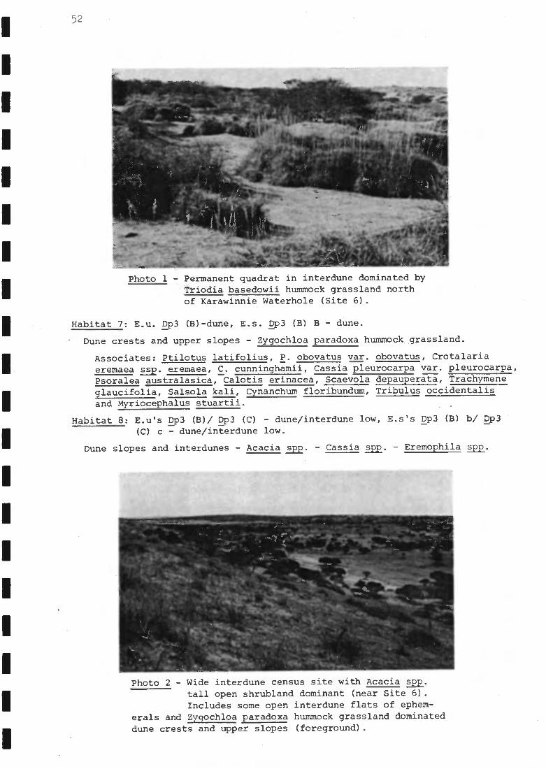
52
Photo 1 - Permanent quadrat in interdune dominated byTriodia basedowii hummock grassland northof Karawinnie Waterhole (Site 6).
Habitat 7: E.u. Dp3 (B)-dune, E.s. Dp3 (B) B - dune.
Dune crests and upper slopes - Zygochloa paradoxa hummock grassland.
Associates: Ptilotus latifolius, P. obovatus var. obovatus, Crotalariaeremaea ssp. eremaea, C. cunninghamii, Cassia pleurocarpa var. pleurocarpa,Psoralea australasica, Calotis erinacea, Scaevola depauperata, Trachymeneglaucifolia, Salsola kali, Cynanchum floribundum, Tribulus occidentalisand Myriocephalus stuartii.
Habitat 8: E.u's Dp3 (B)/ Dp3 (C) - dune/interdune low, E.s's Dp3 (B) b/ Dp3
(C) c - dune/interdune low.
Dune slopes and interdunes - Acacia spp. - Cassia spp. - Eremophila spp.
Photo 2 - Wide interdune census site with Acacia me.tall open shrubland dominant (near Site 6).Includes some open interdune flats of ephem-
erals and Zygochloa paradoxa hummock grassland dominateddune crests and upper slopes (foreground).
-
-
-
-
- - -
-
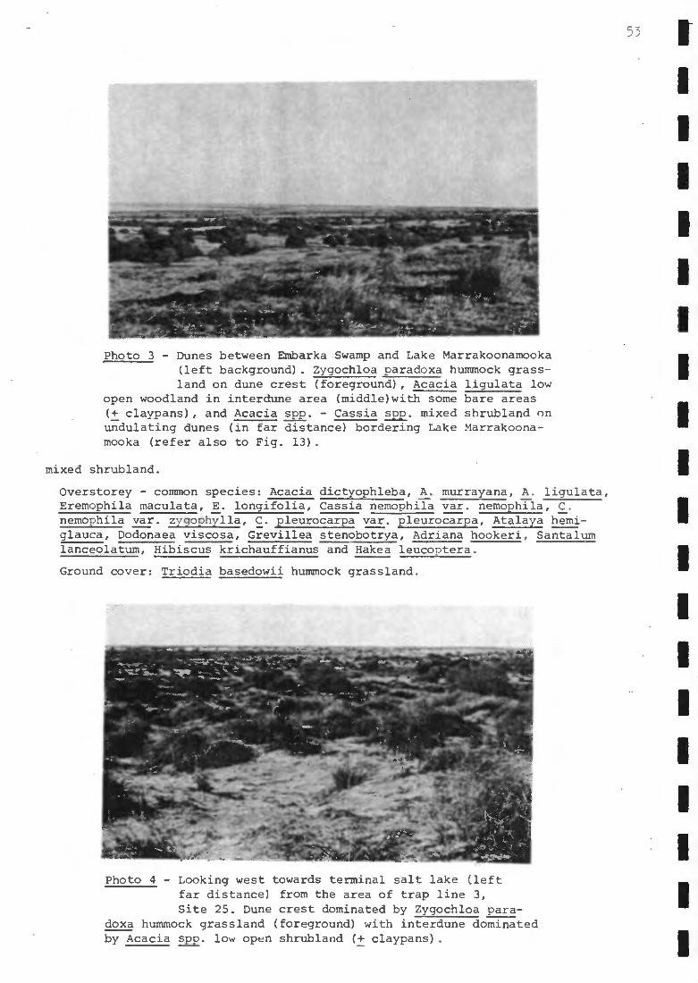
Photo 3 - Dunes between Embarka Swamp and Lake Marrakoonamooka(left background). Zygochloa paradoxa hummock grass-land on dune crest (foreground), Acacia ligulata low
open woodland in interdune area (middle)with some bare areas(+ claypans), and Acacia spp. - Cassia spp. mixed shrubland onundulating dunes (in far distance) bordering Lake Marrakoona-mooka (refer also to Fig. 13).
mixed shrubland.
Overstorey - common species: Acacia dictyophleba, A. murrayana, A. ligulata,Eremophila maculata, E. longifolia, Cassia nemophila var. nemophila, C.nemophila var. zygophylla, C. pleurocarpa var. pleurocarpa, Atalaya hemi-glauca, Dodonaea viscosa, Grevillea stenobotrya, Adriana hookeri, Santalumlanceolatum, Hibiscus krichauffianus and Hakea leucoptera.
Ground cover: Triodia basedowii hummock grassland.
,
or OW ...,..... ,
..4, '1.- , ":'.'' ' . 21144... ,grip -, , - m.. . .. , -- _......
-
drerMr.
":41111
.11104.w
_
Photo 4 - Looking west towards terminal salt lake (leftfar distance) from the area of trap line 3,Site 25. Dune crest dominated by Zygochloa para-
doxa hummock grassland (foreground) with interdune dominatedby Acacia spp. low open shrubland (+ claypans).
53
1
1
-
-
5 4
Associates: Myriocephalus stuartii, Aristida contorta, Ptilotus polystachusvar. polystachus, Abutilon spp. and Tephrosia sphaerospora.
Habitats 9-11 in land system 2p4.
Habitat 9: E.u. Dp4 (B) - dune, E.s. Dp4 (B) b - dune.
Dune crests - Zygochloa paradoxa hummock grassland.
Ephemerals between hummocks: Trichodesma zeylanicum, Tribulus ap.,Myriocephalus stuartii, Abutilon otocarpum and Senecio gregorii.
(e.g. Photo 3).
Habitat 10: E.u's Dp4 (B)/ 211o4 (C) - dune/interdune low, B.s's 2p4 (B) b/ Dp4
(C) c - dune/interdune low.
Dune slopes and interdunes - Acacia ligulata low open woodland.
Overstorey - other shrubs and small trees common are: Acacia murrayana,Cassia nemophila var. nemophila, Acacia tetragonaphylla, occasional Atalayahemiglauca (groves) or Hakea leucoptera (solitary, usually on western slopes).
Ground cover: low ephemeral forb-grassland.Ephemerals: Portulaca intraterranea, Trachvmene glaucifolia, Lechenaultiadivaricata, Enneapogon avenaceus, Convulvulus erubescens, Euphorbia tannen-sis sa. eremophila var. eremophila, Myriocephalus stuartii, Phyllanthusfuernrohrii and Salsola kali.
(e.g. Photo 3).
Habitat 11: E.u. Dp4 (A) - claypan, E.s. 2p4 (A) a - claypan.
Claypans in interdunes - low ephemeral forb-herbland or bare.
Ephemeral forbs: Atriplex spongiosa, Sclerolaena bicornis, S. diacantha,and S. intricatawMany ephemeral herbs include: Tephrosia sphaerospora and Calocephalus platy-cephalus.
(e.g. Photo 3).
Habitats 12-15 in land system Dp5.
Habitat 12: E.u. Dp5 (B) - dune, E.s. 20 (B) b - dune.
Dune crests - Zygochloa Daradoxa hummock grassland.
Occasional assocaite: Cynanchum floribundum.
(e.g. Photo 4).
Habitat 13: E.u's Dp5 (B)/ Dp5 (C) - dune/interdune low, E.s's Dp5 (B) b/
Dp5 (C) c - dune/interdune low.
Dune slopes and interdunes - Acacia spp. low open shrubland.
Overstorey - common associates: Acacia ligulata, A. murrayana, A. victoriae,A. oswaldii, Cassia nemophila var. nemophila and occasional Hakea leucopteratrees.
Occasional ground cover in interdunes: Triodia basedowii hummock grassland.
(e.g. Photo 4).
Habitat 14: E.u. Dp5 (A)-claypan, E.s. 20 (A) a - claypan.
'Claypans in interdunes - ephemeral forbland.
lAlthough in this instance, claypans are considered as one habitat, it may, incertain circumstances, be advantageous to consider the claypan fringe and flooras separate habitats e.g. where a species of fauna inhabits a samphire Halosar-cia indica sag. leiostachya fringe (see 15. 55), but is not known to frequent a
claypan floor.
55
Claypan fringe: Morgania floribunda and sometimes Halosarcia indica-22a. .
leiostachya.
Claypan floor: Atriplex spongiosa, A. leptocarpa, Salsola kali, Frankenia
cinerea and Babbagia acroptera.
; (e.g. Photo 4).
Habitat 15: E.u. Dp5 (E) - salt lake, E.s. 2p5 (E) e - salt lake.
'Salt lake componets of land system Elp5: not surveyed.
(e.g. Photo 4).
Habitats 16-17 in land system Dp6;
Habitat 16: E.t. Dp6- (B)- dune, E.s. Dp6 (B) b - dune.
'Dune crests - Zygochloa paradoxa hummock grassland.
Ephemerals commonly present: Tribulus hystrix, Crotalaria eremaea ssp.eremaea, C. cunninghamii, Cynanchum floribundum, Myriocephalus stuartii.and Ptilotus latifoliuS. -
(e.g. Photo
Habitat'17:. E:u's Dp6' (B)1. C) - dune/interdune low, E.s's Dp6 (B) b/ 21°6
(C) -- - dune/interdune low.
,Dune slopes and interdunes -
Overstorey: Atalaya hemiglauca - Acacia spp. low open woodland.Common acacia: A. murrayana and occasionally A. victoriae and A. ligulata.
Understorey: Hibiscus krichauffianus - Swainsona rigida - Sida ammophila -Scaevola ovalifolia - Lechenaultia divaricata - Enchylaena tomentosaPtilotus polystachus var. polystachus low open shrubland.
Ground cover: Triodia basedowii hummock grassland.
A diversity of other species include: Glycine canescens, Myriocephalusstuartii, Sclerolaena diacantha, Salsola kali, Psoralea spp., Aristidacontorta, Crotalaria cunninghamii, Tribulus hystrix, Trichodesma zeylan-icum and Abutilon spp.
,(e.g. Photo 6).
Habitats 18-19 in land system Dp7.
Habitat 18: E.u. Dp7 (B) - dune, E.s. Dp7 (B) b - dune.
Dunes
Overstorey: Acacia ligulata - Salsola kali ephemeral low open shrubland.
Ground cover: ephemeral herbland.Ephemerals: composites, Haloragis aspera and Nicotiana velutina.
Habitat 19: E.u. Dp7 (C) - interdune low, E.s. Dp7 (C) .c - interdune low.
Interdunes - vegetation the same as Habitat 18 (above).
(refer also to land system description - Dp7, p. 43).
Habitats 20-22 in land system Dp8.
Habitat 20: E.u. Dp8 (B) - dune, E.s. Dp8. (B) b - dune.
Dune crests - Cynanchum floribundum low, very open shrubland.
Assodiate colonisers and ephemerals: Salsola kali, Crotalaria cunninghamii,Senecio gregorii, Myriocephalus stuartii, Helipterum moschatum, Blennodiapterosperma and Portulaca intraterranea.

56
Photo 5 - Dune crest dominated by Zygochloa paradoxahummock grassland near Site 1. Gibber plainin left background.
Habitat 21: E.u's Dp8 (B)/ Dp8 (C) - dune/interdune low, E.s's Dp8 (B) b/ Dp8
(C) c - dune/interdune low.
Dune slopes and interdunes - Acacia ligulata low open shrubland.
Overstorey - shrub and small tree associates: Acacia victoriae, A. tetra-gonaphylla, A. oswaldii, Atalaya hemiglauca, Eremophila longifolia, Cassianemophila var. nemophila, C. nemophila var. zygophylla and Hakea leucoptera.
Ground cover: very open ephemeral forb-herbland.
Photo 6 - Red dune slope adjacent to a trap line ofSite 1, with Atalaya hemiglauca - Acaciaspp. low open woodland dominant. Zygochloa
paradoxa and Ptilotus latifolius (both in foreground)and gibber plain (in right background) also evident.
-
-
-
--

Photo 8 - Paler coloured (whitish) dunes borderingclaypan adjacent to clay flat 1 km SW ofPilalchilpna Waterhole (near Site 25),
carrying ephemeral forbland on dune slopes and in
interdunes only.
Mb.
4
aPhoto 7 - Paler coloured dunefield 5 km north of
Toolache Waterhole. Sparsely covered dunecrests with ephemeral composites and Salsola
kali dominant. Interdunes, and dune slopes with Acacialigulata low open shrubland dominant.
Ephemerals: Tetragonia tetragonioides, Atriplex spongiosa, Zygophyllumammophilum, Nicotiana velutina, Senecio gregorii, Portulaca intraterranea,Atriplex velutinella, Myriocephalus stuartii and Helipterum moschatum.
Habitat 22: E.u's Dp8 (A)/ Dp8 (C) - claypan/interdune low, E.s's Dp8 (A) a/
Dp8 (C) c - claypan/interdune low.
Clay flats in interdunes - bare or Atriplex nummularia low open shrubland
Associates: Sclerolaena intricata, S. lanicuspis, Babbagia acroptera,
57
-
-
-
-
-

Atriplex spongiosa, A. angulata, Haloragis aspera, Bulbine alata and
Senecio gregorii.
Habitats 23-25 in land system Dp9.
Habitat 23: E.u. Dp9 (B) - dune, E.s. Dp9 (B) b - dune.
Dune crests - ephemeral composites and Salsola kali.
(e.g. Photo 7).
Habitat 24: E.u's 2p9 (B)/ Dp9 (C) - dune/interdune low, E.s's 190 (B) b/
(C) c - dune/interdune low.
Dune slopes and interdunes - Acacia ligulata low open shrubland.
Overstorey - shrub and small tree associates: Acacia victoriae, A. tetra-" gonaphylla, A. oswaldii, Atalaya hemiglauca, Eremophila longifolia, Cassia
nemophila var. nemophila, C. nemophila var. zygophylla and Hakea leucoptera.
Ground cover: very open ephemeral forb-herbland.Ephemerals: Tetragonia tetragonioides, Atriplex spongiosa, Zygophyllumammophilum, Nicotiana velutina, Senecio gregorii, Portulaca intraterranea,Atriplex velutinella, Myriocephalus stuartii and Helipterum moschatum.
(e.g. Photo 7).
Habitat 25: E.u. Dp9 (A) - claypan, E.s. Dp9 (A) a - claypan.
Interdune claypans - hard red clay surfaces either bare or ephemeralherb field.
Composite colonisers and chenopod sub-shrubs: Senecio gregorii, Calotisporphyroglossa, Helipterum moschatum, Myriocephalus stuartii, Gnephosiseriocarpa, Tephrosia sphaerospora, Swainsona oroboides, Convulvulus eru-bescens, Phyllanthus lacunarius, Atriplex spongiosa, Sclerolaena bicornis,
and Crinum flaccidum.
(e.g. just evident in the interdune of Photo 7 - near left margin 3/4 up
photo).
Habitats 26-27 in land system Dp10
Habitat 26: E.u. Dp10 (B) - dune, E.s. Dp10 (B) b - dune.
Dune crests - sparse cover of Zygochloa paradoxa + ephemeral forbs.
Habitat 27: E.u's Dp10 (B)/ Dp10 (C) - dune/interdune low, E.s's Dp10 (B) b/
2p10 (C) c - dune/interdune low.
Dune slopes and interdunes - ephemeral forbland.
Dominant forb: Salsola kali.
Other ephemeral forbs may include: Phyllanthus fuernrohrii, Lechenaultia
divaricata, Tribulus occidentalis and Tephrosia sphaerospora.
Habitats 28-29 in land system Dpll
Habitat 28: E.u. Dpll (B) - dune, E.s. Dpll (B) b - dune.
Dunes - ephemeral forb-herbland.
Forbs and herbs: Nicotiana velutina, Portulaca intraterranea, Trichodesmazeylanicum, Salsola kali, Myriocephalus stuartii, Crotalaria cunninghamii,C. eremaea sm. eremaea, Ptilotus yolystachus var. polystachus, P. lati-folius, Abutilon otocarpum, Psoralea spp., Tephrosia sphaerospora andSwainsona rigida.
Scattered shrubs: Acacia iigulata and Cynanchum floribundum.
59
Habitat 29: E.u. Dpll (C) - interdune low, E.s. Dpll (C) c - interdune low.
Interdunes - vegetation the same as for dunes (see Habitat 28 and land
system description Dpll, p. 44).
Habitats 30-31 in land system 2p12
Habitat 30: E.u. Dp12 (B) - dune, E.s. Dp12 (B) b - dune.
, Dune crests - bare.
(e.g. Photo 8).
Habitat 31: E.u. Dp12 (B)/ 21,p12 (C) - dune/interdune low, E.s. 27'12 (B) b/
Dp12 (C) c - dune/interdune low.
Dune slopes and interdunes - ephemeral forbland.
Dominant forb: Salsola kali.
Other ephemeral forbs may include: Phyllanthus fuernrohrii, Lechenaultiadivaricata, Tribulus occidentalis and Tephrosia sphaerospora.
(e.g. Photo 8).
Habitats 32-38 in land system Dunc (e.g. Photo's 9-11).
Habitat 32: E.u. Dunc (B) - dune, E.s. Dunc (B) b - dune.
Dune crests and upper slopes - Zygochloa paradoxa hummock grassland.
Associates: Ptilotus latifolius, P. obovatus var. obovatus, Crotalariaeremaea 222. eremaea, C. cunninghamii, Cassia pleurocarpa var. pleurocarpa,Psoralea australasica, Calotis erinacea, Scaevola depauperata, Trachymeneglaucifolia, Salsola kali, Cynanchum floribundum, Tribulus occidentalisand Myriocephalus stuartii.
Habitat 33: E.u. Dunc (B) - dune, E.s. Dunc (B) b - dune.
Lower dune slopes - Acacia spp. - Cassia spp. - Eremophila spp. mixedshrubland.
Overstorey - common species: Acacia dictyophleba, A. murrayana, A. ligulata,Eremophila maculata, E. lonqifolia, Cassia nemophila var. nemophila, C.nemophila var. zygophylla, C. pleurocarpa var. pleurocarpa, Atalaya hemi-glauca, Dodonaea viscosa, Grevillea stenobotrya, Adriana hookeri, Santalumlanceolatum, Hibiscus krichauffianus and Hakea leucoptera.
Ground cover: Triodia basedowii hummock grassland.Associates: Myriocephalus stuartii, Aristida contorta, Ptilotus polystachusvar. polystachus, Abutilon spp. and Tephrosia sphaerospora.
)Habitats 34-38: E.u. Dunc (C) - interdune low, E.s. Dunc (C) c - interdune low.These are habitats characteristic of circular or ovoid interdunes within theuncoordinated drainage dunefields - land system Dunc, which are distinguishedaccording to predominating vegetation and in some cases soils characteristics.Habitats 34-38 are distinct habitat types.
'Habitat 34: Circular or ovoid interdune type 1 with Triodia basedowii dominant.
Overstorey: Acacia spp. - Cassia spp. low, very open shrubland.Principal species: Acacia dictyophleba, A. ligulata, A. murrayana, Cassia
1Claypans are thought to be a component of a number of interdunes encompassed'by habitats 34-38, while salt lakes are considered unlikely. Where they occur,claypans constitute additional habitats (particularly when they carry water).However, the lack of detail on claypans in presently available data does notjustify further habitat subdivision to include these.

60
sa
I-AAA
.46
. *..if; , .-
it A lt".""1"4:.,:`:: J,
1 1- l'''..
... *44',.. . 11
.
'a-- 476, la. .
- 71, 'NO.
ii
#.0
°
OrxtlArdAdwfir'
ft4 - ' _ 41' _
Photo 10 - Hakea eyreana low open woodland dominatedinterdune near Mudcarnie Waterhole (Site 4).
A.A.:I:Award&
iv'
Photo 9 - Triodia basedowii hummock grassland dominatedinterdune within the Uncoordinated DrainageDunefield Environmental Subassociation 8.4.4.6.
nemophila var. nemophila and C. oligophylla.
Ground cover: Triodia basedowii hummock grassland.
(e.g. Photo 9).
Habitat 35: Circular or ovoid interdune type 2.
Fringing overstorey: Hakea eyreana + Eucalyptus terminalis low open woodland.
Ground cover: open ephemeral herbland"beneath trees and at centre ofinterdune, with occasional Triodia basedowii associated with trees.Ephemerals: Swainsona oroboides, Atriplex spongiosa, Gnephosis foliata,Teucrium racemosum var. racemosum and Haloragis aspera.
(e.g. Photo 10).
a
-
-

Habitat 36: Circular or ovoid interdune
".
fe.4p qr
1.
a.
Photo 11 - Eremophila macdonnellii tall open shrublandin an interdune near Mudcarnie Waterhole(Site 4).
Photo 12 - Acacia victoriae low open woodland dominanton a dune slope/plain of pale grey sands14 km NW of Scrubby Camp Waterhole.
type 3 with ephemeral forbland onsoils with a higher clay fraction.
Principal ephemerals: Sclerolaena bicornis, S. diacantha, Atriplex spong-iosa, A. limbata, Gnephosis foliata, Astrebla pectinata, Eragrostis dielsii,Euphorbia australis, E. tannensis ssp. eremophila var. eremophila, Euphorbiaspp., Teucrium racemosum var. racemosum, Crinum flaccidum, Morgania glabraand Frankenia uncinata.
Habitat 37: Circular or ovoid interdune type 4.
Overstorey: Eremophila macdonnellii tall open shrubland.Other tall shrubs or low trees that may be present: Owenia acidula, Hakealeucoptera, Acacia victoriae and Dodonaea angustissima.
61
III
1
-
62
Understorey: Cassia 22E. low, very open shrubland.Common species: Cassia phvllodinea, C. nemophila var. nemophila, C. nem-
ophila var. zygophylla and Rhagodia spinescens.
Ground cover: ephemeral forbland.Ephemerals: Teucrium racemosum var. racemosum, Enchylaena tomentosa,
Salsola kali, Crinum flaccidum, Sclerolaena diacantha, Frankenia uncinata,
Morgania glabra, Ptilotus polystachus var. polystachus, Myriocephalus
stuartii and Gnephosis foliata.
Also present: very low Eremophila maculata.
(e.g. Photo 11).
Habitat 38: Circular or ovoid interdune type 5 in proximity to minor drainage
systems on grey silty clays.
Fringing overstorey: Eremophila bignoniiflora, Acacia stenophylla and
Morgania glabra.
Ground cover - dominant: 1Eragrostis australasica low shrubland.Common associates: Chenopodium auricomum and Eleocharis pallens.Interspersed ephemeral forbs and herbs include: Sclerolaena bicornis,S. intricata, S. muricata var. muricata, Maireana schistocarpa, Atriplexspongiosa, A. angulata, A. lobativalvis and A. limbata (chenopods), Calotishispidula, C. multicaulis, C. porphyroglossa and Calocephalus platycephalus(composites), Marsilea drummondii, Teucrium racemosum var. racemosum, Daucusglochidiatus, Tetragonia tetragonioides, Eriachne aristidea, Alternantheranodiflora and Frankenia uncinata.
Habitat 39 in land system Dlun
Habitat 39: E.u's Dlun (B)/ Dlun (C) - dune/interdune low, E.s's Dlun (B) b/
Dlun (C) c - dune-/interdune low
Habitat 39 in land system Dlun comprises a complex of dunes/interdune lowsof very low relief (in comparison to adjacent parallel dunes) resemblingnumerous small closely associated dunes, which may form extensive featuresof up to 30 km in length along the the northern and north-eastern marginsof some floodouts and swamps.
Overstorey: Acacia spp. - Cassia spp. mixed shrubland.Common species: Acacia liqulata, A. victoriae, A.oswaldii, A. murrayana,A. tetragonaphylla, Santalum lanceolatum, Atalaya hemiglauca, Cassia nem-ophila var. nemophila, C. nemophila var. zygophylla, Grevillea striata andDodonaea angustissima.
Understorey: Maireana aphylla low shrubland.
Ground cover: ephemeral forb-grassland.Ephemerals: Einadia nutans, Convulvulus erubescens, Tetragonia tetragoni-oides, Euphorbia tannensis ssp. eremophila var. eremophila, Helipterummoschatum, Aristida contorta, Enneapogon cylindricus, Triraphis mollis,Bulbine alata, Sclerolaena diacantha, Phyllanthus fuernrohrii, Salsola kali,Swainsona phacoides, Zygophyllum howittii, Blennodia pterosperma, Abutilonspp., Ptilotus polystachus var. polystachus, Myriocephalus stuartii, Gneph-osis eriocarpa, Eragrostis eriopoda, Haloragis aspera, Mukia maderaspatana,Sida spp. (? S. fibulif era - see Appendix R), Trachymene glaucifolia, Crinumflaccidum and Dentella pulvinata var. pulvinata.
(e.g. Photo 3, p. 53).
-IOccasionally, umbrelia.canegrass'Leptochloa digitatamay:be*dominant - -this:is known to be the case for an interdune near Site 7A (refer to Data Sheets -in a separate volume).

63
Habitats 40-43 in land systems Dsl-Ds4: Sand plains of very low dunes consist-ing of complexes of dunes/interdune lows of extremely low relief.
Habitat 40: E.u's Dsl (B)/ Dsl (C) - dune/interdune low, E.s's Dsl (B) b/ Dsl(C) c - dune/interdune low.
Cassia spp. - Acacia spp. mixed open shrubland.Common overstorey species: Cassia phyllodinea, C. oligophylla, Hakea eyr-eana, Cassia nemophila var. nemophila, C. nemophila var. zygophylla, Grey-illea stenobotrya, Atalaya hemiglauca, Eucalyptus terminalis, Eremophila.longifolia, Acacia tetragonaphylla and A. victoriae.
Ground cover: Triodia basedowii hummock grassland, with interspersedephemeral herbs and forbs - Swainsona spp. common.
Habitat 41: E.u's Ds2 (B)/ Ds2 (C) - dune/interdune low, E.s's Ds2 (B) b/ Ds2(C) c - dune/inerdune low.
Acacia spE. - Hakea spp. mixed shrubland.Overstorey dominants: Acacia ligulata, A. victoriae, Hakea leucoptera andH. eyreana.Others: Acacia oswaldii, A. tetragonaphylla, Cassia nemophila var. nemoph-ila, Owenia acidula, Atalaya hemiglauca and Dodonaea angustissima:
Understorey: mixed low open shrubland.Shrubs: Eremophila macdonnellii, Zygochloa paradoxa, Maireana aphylla,Enchylaena tomentosa and less commonly Pimelea trichostachya.
Ground cover: ephemeral forb-grass-herbland with Sclerolaena diacanthadominant.Other ephemerals: Teucrium racemosum var. racemosum, Dissocarpus paradoxavar. latifolius, Ptilotus polystachus var. polystachus, P. atriplicifoliusvar. atriplicifolius, Atriplex spongiosa, Einadia nutans, Eriachne aristidea,Swainsona phacoides, Eragrostis eriopoda, Sida ammophila, Abutilon otocarpum,Euphorbia tannensis ssp. eremophila var. eremophila, Triraphis mollis, Min-uria denticulata, Helipterum moschatum, Aristida anthoxanoides, Haloragisaspera and Salsola kali.
Habitat 42: E.u's Ds3 (B)/ Ds3 (C) - dune/interdune low, E.s's Ds3 (B) b/ Ds3(C) c dune/intEerdune low.
Acacia victoriae low open woodland.Overstorey - associates of Acacia victoriae: A. murrayana, Atalaya hemiglaucaCassia nemophila var. nemophila, C. nemophila var. zygophylla, Grevilleastriata, Eremophila longifolia and Hakea leucoptera.Also: Amyema preissii parasitising A. victoriae.
Understorey: Zygochloa paradoxa very open hummock grassland.
Ground cover: ephemeral herbland.Ephemerals: Salsola kali, Myriocephalus stuartii, Abutilon otocarpum,Euphorbia tannensis ssp. eremophila var. eremophila, Sida spp., Eragrostissetifolia, Ptilotus atriplicifolius var. atriplicifolius, and ?Paractaenumnovae-hollandiae (see Appendix R for reason for ?).
(e.g. Photo's 12 and 13).
Habitat 43: E.u4s Ds4 (B)/ Ds4 (CL - dune/interdune low, E.s's Ds4 (B) b/ Ds4(C) c - dune/interdune low.
Low (< 30 cm) open ephemeral forbland.Chenopod sub-shrubs: Atriplex spongiosa, A. angulata, A. lobativalvis,Sclerolaena bicornis, S. intricata, S. diacantha, Salsola kali, Babbagiaacroptera and Dissocarpus biflorus var. cephalocarpus.Also: Frankenia spp.Occasional species: Chenopodium nitrariaceum and Eragrostis australasica.

64
Photo 13 - Acacia .victoriae low open woodland withAtalaya. hemiglauca and Cassia spp. evidenton a dune slope/plain of pale grey sands
14 km NW of Scrubby Camp Waterhole.
Herbs: Calotis hispidula, Helipterum strictum, H. microglossum, Plantagovaria, Tetragonia tetragonioides, Goodenia lobata, Bulbine alata and Eu-
phorbia spp., and the grass: Eragrostis eriopoda.
Habitat 44 in land system Fcl.
Habitat 44: E.u. Fcl CD)- floodplain, E.s. Fcl (D) dc - channel (major).
Overstorey: Eucalyptus microtheca + Lysiphyllum gilvum + E. camaldulensis
var. obtusa tall to low fringing woodland.
The variety of low tree and shrub associates include: Acacia stenophylla,
A. salicina, Owenia acidula, Grevillea striata, Santalum lanceolatum,
k471KP. .
'11C4:1 ,-.. If , . . 0'.--4 .
t4h,PIK t S1 Y 4 A .
V ""'. a
.6. :,4 .14;A
.
N- i-
solo. ' A
...1:131, -.7 ' ...!' ' e 416i..-
-\(4. . I ,.'', 0 Aia
".
-04'Se,
Photo 14 - Eucalyptus microtheca tall to low fringingwoodland around Embarka Waterhole.
LT"""t;
nr 4...
,
-
-

Photo 15 - Eucalyptus microtheca - Acacia stenophyllalow fringing woodland of a minor channelsouth of Chillimookoo Waterhole. Still green
inside channel after recent floodoing.
Pittosporum phylliraeoides var. microcarpa, Eremophila bignoniiflora, E.longifolia, Atalaya hemiglauca and the mistletoes Diplatia grandibracteaand Amyema preissii.
Understorey - often present: Muehlenbeckia cunninghamii + Atriplex nummul-aria tall to low shrubland.Lower (4:1 m) associates: Enchylaena tomentosa and Senecio cunninghamii.
Ground cover: ephemeral forbland.Ephemerals: Lavatera plebeia, Alternanthera nodifiora, Tetragonia tatragon-ioides, Zygophyllum ammophilum, Marsilea drummondii, Haloragis aspera,
_l', .
71.Forl" F
If, 7
1r ?IP'.
'. , rt,et* Ir,- .r. ..i.-,,,,,
mil
,
:qt:' ;'
rra, ,;.
Photo 16 - Eucalyptus microtheca - Acacia salicina -A. stenophylla - Eremophila bignoniifloralow fringing woodland of the Cooper Creek
in the vicinity of Narrawalpinna Waterhole (near Site25). Near floodwater front on 19 ix 83.
;44.:4'
lr).;.
65
Ii
L
.10^
av:W.,
1.
- -
-
- - -
-

66
t-
Photo 1717 - Eucalyptus microtheca + Acacia salicina +A. stenophylla + Eremophila bignoniifloralow fringing woodland with understorey of
Muehlenbeckia cunninghamii low shrubland. In thevicinity of Pilalchilpna Waterhole, near Site 25.
Senecio lautus maritimus, Calotis porphyroglossa, Nicotiana velutina,Einadia nutans, Centipeda minima and Brassica tournefortii.
(e.g. Photo 14).
Habitat 45 in land system Fc2.
Habitat 45: E.u. Fc2 (D) - floodplain, E.s. Fc2 (D) dc - channel (minor).
Eucalyptus microtheca - Acacia stenophylla low fringing woodland.
Over: Enchylaena tomentosa and a variety of herbs as listed for Habitat 44.
(e.g. Photo 15).
If- V 6
Li* ..-..
L: Lb,.
I ijr.:n 'P'..'. la
6)
' . ..4, .."4..
1. - ,,,,,...A. A40. . 1 ],r 1,s !W.. 0
.. - 4
': 7+ ., .. " f11 . X.. I r
.-6,... ----"- ` ... - '^f.. ,°-..kt,:...../-,:. ' ' t :41NI.
, t, ., ' :,..
N." ......,
..., ..1
1
oz`
,
' t:3 .-
_ .
r me -
-
'---,"1Apivi.
t16
n 4
Photo 18 - Eucalyptus microtheca + Acacia stenophyllalow fringing woodland. Trap line 4 of Site 25.
-
ssp.
- -
-
-

-
Photo 19 - Muehlenbeckia cunninghamii tall to low(2-3 m) shrubland of Embarka Swamp.
Habitats 46-47 in land system Fc3.
Habitat 46: E.u. Fc3 (D) - floodplain, E.s. Fc3 (D) dc - channel (major, drier).
Overstorey: Eucalyptus microtheca - Acacia salicina - A. stenophylla -Eremophila bignoniiflora low fringing woodland.Diplatia grandibractea parasitises E. microtheca.
Understorey - relatively dense: Muehlenbeckia cunninghamii low shrubland.Lower (4=1 m) shrubs include: Enchylaena tomentosa and Senecio cunninghamii.
Ground cover: virtually absent apart from low forbland on silty banks andthe crass Sporobolus mitchellii with a large amount of litter.-Forbs: Phyllanthus lacunarius and Solanum oligacanthum.
(e.g. Photo 16).
"-"FO,
'mars *1/4.-
-
67
Afmmum
W."
Photo 20 - Muehlenbeckia cunninghamii tall, very openshrubland with scattered patches ofEucalyptus microtheca. Trap line 2, Site 25.
161:
- -
-
-
68
Habitat 47: E.u. Fc3 (D) - floodplain, E.s. Fc3 (D) df,- floodout.
Extension of channel edge woodland of Habitat 46 onto adjacent floodout.
Vegetation essentially as for Habitat 46 with tree layer becoming more
open at greater distances from the channel.
(e.g. Photo 17).
Habitats 48-49 in land system Fc4.
Habitat 48: E.u. Fc4 (D) - floodplain, E.s. Fc4 (D) dc - channel (minor, drier).
Eucalyptus microtheca - Acacia stenophylla low fringing woodland.Diplatia grandibractea parasitises E. microtheca.
(e.g. similar structure to Photo 18, which is of an adjacent floodout).
Habitat 49: E.u. Fc4 (D) - floodplain, E.s. Fc4 (D) df - floodout.
Eucalyptus microtheca + Acacia stenophylla low fringing woodland.Diplatia grandibractea parasitises E. microtheca.
(e.g. Photo 18).
Habitat 50 in land system Fc5.
Habitat 50: E.u. Fc5 (D) - floodplain, E.s. Fc5 (D) dc - channel (relict).
Small areas only of pale sandy clay rises which represent the collection ofwind blown sands and silts around senescent low coolibahs.
Overstorey: Eucalyptus microtheca low open woodland.
Understorey: Enchylaena tomentosa - Muehlenbeckia cunninghamii + Chenopod-ium nitrariaceum low shrubland.
Ground cover: very sparse - composites and Sclerolaena 22E. predominate.
(e.g. Fig. 13).
Habitat 51 in land system Fc6.
Habitat 51: E.u. Fc6 (D) - floodplain, E.s. Fc6 (D) df - floodout (in the vic-inity of saline depressions).
Overstorey: Eucalyptus microtheca low, very open woodland.
Ground cover: Halosarcia indica ssp. leiostachya low, very open shrubland.Associates: Enchylaena tomentosa, Atriplex leptocarpa, A. nummularia, A.spongiosa, A. velutinella, Chenopodium nitrariaceum, Sclerolaena intricata,S. diacantha, S. bicornis and numerous dead grass clumps.
Habitats 52-53 in land system Fc7.
Habitat 52: E.u. Fc7 (D) - floodplain, E.s. Fc7 (D) ds - swamp.
Regularly inundated swamps e.g. Embarka Swamp, the most regularly inundatedand persistent swamp, which is partly channelled. Such swamps form smallerpockets throughout the Cooper Creek floodplain and have deep cracking claysoils, which are spongy when dry.
Overstorey: Muehlenbeckia cunninghamii tall to low (2-3 m) shrubland.
Ground cover - when inundated: Eleocharis pallens, Marsilea drummondii andAzolla filiculoides - all found in water.
Ground cover - when swamp dries and water recedes: ephemeral herbland.Ephemeral herbs: Myrioceplialus stuartii, Helipterum moschatum, Senecio lautusssp. maritimus, Trigonella suavissima, Calocephalus platycephalus, Nicotianavelutina, Atriplex spongiosa, Calotis porphyroglossa, Haloragis aspera,
Tetragonia tetragonioides, Gnephosis eriocarpa, Ixiolaena brevicompta, Daucus

69
glochidiatus, Calotis hispidula, Gnaphalium indicum, Centipeda minima,
Epaltes australis and Marsilea drummondii.
(e.g. Photo 19).
Habitat 53: E.u. Fc7 (D) - floodplain, E.s. Fc7 (D) dc - channel (fine drainage
lines in swamps e.g. Embarka Swamp).
Overstorey: occasionally lined with Eucalyptus microtheca - Acacia steno-
phylla trees.
Understorey - dominant: Muehlenbeckia cunninghamii tall to low (2-3 m)
shrubland.
Ground cover - when inundated: Eleocharis pallens, Marsilea drummondii
and Azolla filiculoides - all found in water-.
Ground cover - when dry: ephemeral herbland on drying parts of swamp. I/Ephemeral herbs: same as for Habitat 52.
Habitat 54755in.1and,.system:Fca.
Habitat 54: E.u. Fc8 (D) - floodplain;. -d,LsawaMp(a flat plainwith braided channels -.moist, grey, .cracking clay soils withsilty sections e.g. Tirrawarra Swamp).
Overstorey: emergent Acacia stenophylla paraitised by-AMYema-miquellii.
Understorey: Muehlenbeckia cunninghamii tall open shrubland.Includes: Chenopodium auricomum.
Ground cover: ephemeral forbland.Ephemerals: Senecio lautus SSP. dissectifolius, Trigonella suavissima,
Lavatera plebeia, Marsilea drummondii, Portulaca intraterranea, ?Medicago
polymorpha (refer to Appendix R for reason for ?) and Eleocharis pallens
Habitat 55: E.u. Fc8 (D) - floodplain, E.s.Fc8 .(3)..dc.-7,*ohanfiel _(braided-channels
of the type found in Tirrawarra Swamp).
Vegetation as for Habitat 54 apart from the presence of fringing woodlandnear channels in which Eucalyptus microtheca is thought to be the dominant
tree - - More data:required.
Habitat'56.-in land system Fc9.
Habitat 56: E.u. Fc9 (D) - floodplain, E.s. Fc9 (D) ds - swamp (parts of flood-plains resembling swamps with grey clay soils).
Overstorev: areas of Muehlenbeckia cunninghamii tall, very open shrubland+ occasional patches of Eucalyptus microtheca.(emeigent).
Ground cover - generally absent or dead: 'Atriplex spongiosa, A. leptocarpaand Solanum oligacanthum. 11
(e.g. Photo 20).
Habitat 57 in land system Fc10.
.Habitat 57: E.u.. Fc10 (D) - floodplain, E.s. Fc10 (D) df - floodout .(grey claysoils - appeared not to have been inundated for some time).
Overstorey: areas of Muehlenbeckia cunninghamii tall shrubland.
Ground cover: generally absent or dead - the following species were ident-ified viz. Atriplex nummularia, A. angulata, A. leptocarpa and Soldnumoligacanthum.
.ffabitat 58 in land system Fcll.
Habitat 58: E.u. Fcll (D) - floodplain, E.s. Fcll (D) df - floodout (immediately 111beyond fringing woodland e.g. Habitats 44 and 45).
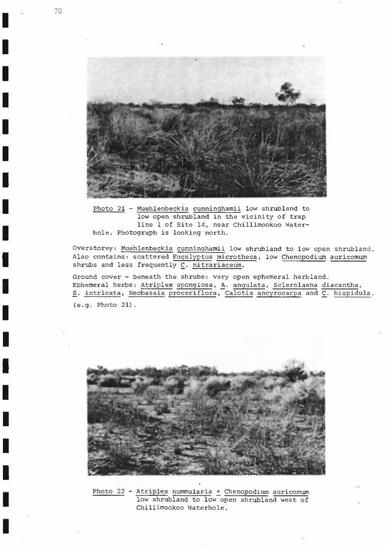
70
Photo 21 - Muehlenbeckia cunninghamii low shrubland tolow open shrubland in the vicinity of trapline 1 of Site 14, near Chillimookoo Water-
hole. Photograph is looking north.
Overstorey: Muehlenbeckia cunninghamii low shrubland to low open shrubland.Also contains: scattered Eucalyptus microtheca, low Chenopodium auricomumshrubs and less frequently C. nitrariaceum.
Ground cover - beneath the shrubs: very open ephemeral herbland.Ephemeral herbs: Atriplex spongiosa, A. angulata, Sclerolaena diacantha,S. intricata, Neobassia proceiiflora, Calotis ancyrocarpa and C. hispidula.
(e.g. Photo 21).
a '
9
Av.".*
-,",f0,4
Z.
`roa,.,a.
) .
-1.-,1"'"
Photo 22 - Atriplex nummularia + Chenopodium auricomumlow shrubland to low open shrubland west ofChillimookoo Waterhole.
r
t 0,
a
-

Ilk. Mkdalk _
c ° ;c, _
Photo 23 - Eragrostis australasica low open grasslandon grey cracking clay soils west ofEmbarka Swamp
Habitat 59 in land system Fc12.
Habitat 59: E.u. Fc12 (D) - floodplain, E.s. Fc12 (D) df - floodout (e.g. at theextremities of the Cooper Creek floodplain near Site 6).
Overstorey: scattered Eucalyptus microtheca.
Ground cover: Muehlenbeckia cunninghamii low open shrubland interspersedwith ephemerals e.g. Atriplex spongiosa, A. angulata, A. velutinella,Salsola kali and Sclerolaena spp.
Habitat 60 in land system Fc13.
Habitat 60: E.u. Fc13 (D) - floodplain, E.s. Fc13 (D) df - floodout.
-.Nog40014,Oft dr- n. Jr
A.°A
....c....
airab-- _ ....,, , - AM40
l......
A*
%AR
^ 411
Photo 24 - Halosarcia indica ssp. leiostachya low openchenopod shrubland with interspersed ephem-eral herbs and grasses 2 km NW of Eagle
Hawk Waterhole and south of Lake Perigundi.
71
-
- -
-

72
Overstorey: Muehlenbeckia cunninghamii low, very open shrubland.Also contains scattered: Eucalyptus microtheca, Acacia stenophylla, Atalayahemiglauca, Lysiphyllum gilvum and the shrub Enchylaena tomentosa.
Ground cover: very open ephemeral herbland.Ephemeral herbs: Atriplex spongiosa, Salsola kali, Asperula gemella,
Sclerolaena bicornis, Zygophyllum ammophilum and Tetragonia tetragonioides.
(e.g. Site 15).
Habitat 61 in land system Fc14.
Habitat 61: E.u. Fc14 (D) - floodplain, E.s. Fc14 (D) df - floodout (may be
indicative of slight saline conditions).
Overstorey: Acacia victoriae low open shrubland.
Understorey: Halosarcia indica ssp. leiostachya with occasional Muehlenbeckia
cunninghamii.Also sometimes present: Cassia nemophila var. zygophylla and Atriplex numm-
ularia.
Ground cover:very open ephemeral forb-herbland.Ephemerals: Wahlenbergia spp., Craspedia chrysantha, Phyllanthus lacunarius,Salsola kali, Solanum oligacanthum, Tetragonia tetragonioides and Atriplex
velutinella.
(e.g. area adjacent to Kudriemitchie Waterhole).
Habitat 62 in land system Fc15.
Habitat 62: E.u. Fc15 (D) - floodplain, E.s. Fc15 (D) df - floodout.
Overstorey: Atriplex nummularia low shrubland to low open shrubland.Also contains scattered: Muehlenbeckia cunninghamii and Chenopodium aurico-mum shrubs and Eucalyptus microtheca.
Ground cover - usually confined to micro-depressions: chenopod low (< 30 cm)
forb-herbland.Chenopods: Atriplex lindleyi, A. velutinella, A. spongiosa, A. angulata,Salsola kali, Maireana coronata and Sclerolaena intricata.Also the herbs: Portulaca intraterranea and Tetragonia tetragonioides.
(e.g. Photo 22).Habitats 63-64 in land system Fc16.
Habitat 63: E.u. Fc16 (D) - floodplain, E.s. Fc16 (D) df - floodout (e.g. atthe extremities of the Cooper Creek floodplain near Site 6).
Overstorey: Atriplex nummularia low open shrubland.Associates: Muehlenbeckia cunninghamii and Chenopodium auricomum.
Ground cover: chenopod low ephemeral forb-herbland simlar to Habitat 62.
Habitat 64: E.u. Fc16 (D) - floodplain, E.s. Fc16 (D) df - floodout (e.g. FlyLake 7 extensive habitat example).
Overstorey: Atriplex nummularia low open shrubland.
Ground cover: Atriplex spp. - Sclerolaena spp. ephemeral forbland.
Habitat 65 in land system Fc17.
Habitat 65: E.u. Fc17 (D) - floodplain, E.s. Fc17 (D) df - floodout (e.g. acomponent of Embarka Swamp - habitat of generally small arealextent).
Overstorey: Eragrostis australasica low open grassland.
Associates: Atriplex spongiosa, A. angulata, Sclerolaena intricata, Solanumoligacanthum, Salsola kali, Tetragonia tetragonioides and infrequently

73
Atriplex nummularia and Eucalyptus microtheca.
(e.g. Photo 23).
Habitat 66 in land system Fc18.
Habitat 66: E.u. Fc18 (D) - floodplain, E.s. Fc18 (D) df - floodout (e.g. acomponent of Embarka Swamp and Fly Lake - habitat of generallysmall areal extent).
Overstorey: Chenopodium nitrariaceum low open shrubland.
Ground cover: ephemeral forbland.Ephemerals: Salsola kali, Atriplex spongiosa, A. angulata, Plantago varia,Babbagia acroptera and occasional Solanum oligacanthum.
Habitat 67 in land system Fc19.
Habitat 67: E.u. Fc19 (D) - floodplain, E.s. Fc19 (D) dtl - terminal lake (e.g.Coongie Lake as an example of a lake which is more permanentlyinundated - this area was not surveyed in detail and information isonly available on part of its western margin).
Vegetation comprised a predominance of Halosarcia indica ssp. leiostachyawith occasional Muehlenbeckia cunninghamii shrubs.
N.B. - the open water of the lake and fringing woodland would likelyconstitute separate habitats but more data is required to enablesuch subdivision e.g. details of fringing vegetation zonation.
Habitat 68 in land system Fc20.
Habitat 68: E.u. Fc20 (D) - floodplain, E.s. Fc20 (D) df - floodout (at theextremities of floodplains - clay flats bordering salt lakes e.g.near Site 25 - in the vicinity of Lake Perigundi and salt lakes tothe south and west of it).
Halosarcia indica ssp. leiostachya low open chenopod shrubland.
Associates: Cyperus gymnocaulos, Enchylaena tomentosa, Sclerolaena intricataand S. diacantha.
Occasional associates: Muehlenbeckia cunninghamii and Eucalyptus microtheca.
Ephemeral herbs and grasses include: Convulvulus erubescens, Sauropus trachy-spermus and Sporobolus mitchellii.
(e.g. Photo 24).
Habitats 69-70 in land system Fc21.
Habitat 69: E.u. Fc21 (D) - floodDlain, E.s. Fc21 (D) df - floodout (at theextremities of floodplains - very open clay flats).
Atriplex spp. - Sclerolaena spp. low, very open chenopod shrubland.
Common species: Atriplex spongiosa, A. angulata, A. velutinella, Sclerolaenaintricata, S. bicornis, Salsola kali and Frankenia spp.Herbs also often present: Helipterum strictum, Phyllanthus lacunarius andSenecio cunninghamii.
Bordered occasionally with: Gunniopsis quadrifida, Halosarcia indica ssp.leiostachya, Blennodia pterosperma, Convulvulus erubescens and someChenopodium auricomum.
(e.g. Photo 25).
Habitat 70: E.u. Fc21 (D) - floodplain, E.s. Fc21 (D) dtl - terminal lake (e.g.ephemeral lakes near Site 14 - see Fig. 12).
Vegetation essentially the same as for Habitat 69.

74
^
Photo 26 - Ephemeral forbland on a floodout north ofKarawinnie Waterhole near a trap line of
Site 6.
.oee.'.odmau*
Photo 25 - Atriplex spp. - Sclerolaena spy. low, veryopen chenopod shrubland with occasionalChenopodium auricomum on the floodplain of
Christmas Creek north of Chillimookoo Waterhole.
Habitats 71-72 in land system Fc22.
Habitat 71: E.u. Fc22 (D) - floodplain, E.s. Fc22 (D) df - floodout (at the
extremities of the Cooper Creek floodplain e.g. near Site 6).
Overstorey: scattered Eucalyptus microtheca.
Ground cover: ephemeral forbland.Dominant forbs: Atriplex spongiosa, A. vesicaria, A. leptocarpa, A. angulata,
A. velutinella, Sclerolaena intricata, Salsola kali, Calotis hispidula,
Helipterum strictum, Mvriocephalus stuartii, Solanum oligacanthum, Convulvulus
erubescens, Sporobolus mitchellii and Eragrostis australasica.
H""--alrValrit4rttC:t1,4...
- -
-
-

. 4 :
^OP.
`Xkle:12.1'
"Now
a
N.1* ": 4 .4' 717! "
-=17.mi
Photo 28 - Hard grey clay flat between Pilalchilpna andYalcuma Waterholes dominated by open forbland
of Sclerolaena spp. and Atriplex spp.
75
Photo 27 - Dry lake Lake Oolgoopiarie with ephemeralforbland composed of Atriplex spp., otherforbs, occasional Eucalyptus microtheca
and Enchylaena tomentosa.
Very occasionally the shrubs: Maireana aphylla, M. pyramidata and Enchylaenatomentosa occur.
(e.g. Photo 26).
Habitat 72: E.u. Fc22 (D) - floodplain, E.s. Fc22 (D) dtl - terminal lake (atthe extremities of the Cooper Creek floodplain e.g. Lake Oolgoopiarie- see Photo 27).
Vegetation essentially as for Habitat 71 - ephemeral lakes are however, oftenbordered with Eucalyptus microtheca, Muehlenbeckia cunninghamii and Chenopod-ium spp
- -
-
-
-

76
Habitat 71 in land system Fc23.
Habitat 73: E.u. Fc23 (D) - floodplain, E.s. Fc23 (D) df - floodout (hard greyclay flats e.g. near Site 25 - hZitat of generally small arealextent).
Dominant: ephemeral forbland.Chenopod sub-shrubs: Atriplex 22. aff. eardleyae, A. leptocarpa, A. spong-iosa, Sclerolaena intricata and S. ventricosa.
Also occasionally: scattered Muehlenbeckia cunninghamii, Chenopodium nitrar-iaceum and low Eucalyptus microtheca.
Ground cover: very open forb-herbland.Forbs and herbs: Solanum oligacanthum, Calotis hispidula, Phyllanthuslacunarius, Teucrium racemosum var. racemosum, Cyperus gymnocaulos andDentella pulvinata var. pulvinata.
Sometimes on the borders of clay flats: Halosarcia indica ssp. leiostachyalow shrubland.
(e.g. Photo 28).
Habitat 74 in land system Fc24.
Habitat 74: E.u. Fc24 (D) - floodplain, E.s. Fc24 (D) dtl - terminal lake (e.g.Lake Marrakoonamooka - extensive lakes of the central Cooper Creekfloodplain).
Low ephemeral forb-herbland.Common ephemerals: Atriplex angulata, A. limbata, A. spongiosa, A. nummu-laria (occasionally on edges), Sclerolaena intricata, S. bicornis, S. ven-tricosa, Dissocarpus paradoxa var. latifolius and Salsola kali.Less common ephemerals: Plantago varia, Goodenia lobata, Calotis hispidula,C. erinacea, Daucus glochidiatus, Frankenia sEE., Aristida contorta,Psoralea Calocephalus platycephalus, Euphorbia australis, Eragrostissetifolia, Euphorbia tannensis ssp. eremophila var. eremophila, Sidaammophila and Swainsona phacoides.
(e.g. Photo 29).
Habitat 75-76 in land system Fc25.
Habitat 75: E.u. Fc25 (D) - floodplain, E.s. Fc25 (D) dc - channel (minorchannels leading into ephemeral freshwater lakes e.g. northern endof Lake Apachirie).
Ephemeral herbland akter channel recently moistened.Ephemeral herbs: Alternanthera nodiflora, Myriocephalus stuartii, Craspediachrysantha, Centipeda minima, Epaltes cunninghamii, Frankenia pseudo-flab-ellata, Heliotropium europaeum, Cucumis melo ssp. agrestis, Portulaca intra-terranea, Ludwigia peploides ssp. montevidensis and Gnephosis foliata.
Habitat 76: E.u. Fc25 (D) - floodplain, E.s. Fc25 (D) dtl - terminal lake (e.g.Lake Tpachirie near Site 11).
A; Areas which had received floodwaters recently - grey clay soils.
Closed ephemeral herbland.Ephemerals: Portulaca intraterranea, Senecio lautus 222. maritimus, Minuriadenticulata, Trigonella suavissima, Alternanthera.nodiflora, Centipeda min-ima, Atriplex velutinella, A. spongiosa, Frankenia,pseudo-flabellata, Epaltescunninghamii, Heliotropium europaeum, Craspedia chrysantha, Sporobolus mitch-ellii and Gnephosis foliata.
B. Areas which had not recently received floodwaters.
Very open ephemeral herbland.Ephemerals: same species as for A, but mostly dead.

77
Habitat 77 in land system Fc26.
Habitat 77: E.u. Fc26 (D) - floodplain, E.s. Fc26 (D) dtl - terminal lake (e.g.
near Site 14 - smaller ephemeral lakes carrying ephemeral herbland
and of a drier nature than Habitat 76).
Ephemeral herbland.Common ephemerals: Trigonella suavissima, Portulaca intraterranea, Tetra-
gonia tetragonioides, Atriplex spongiosa and a range of grasses.When dry contains only: Sclerolaena spp. and Atriplex
Habitat 78 in land system Fsl.
Habitat 78: E.u. Fs1 (D) - floodplain, E.s. Fsl (D) dc - channel (channels ofthe Strzelecki Creek floodplian - fewer species, narrower and less
-dense fringing woodland on the edge of the Strzelecki than alongthe Cooper, with much reduced (or totally lacking a) ground layer).
Overstorey: Eucalyptus microtheca-Lysiphyllum gilvum - Acacia stenophylla
low open woodland.Diplatia grandibractea parasitises E. microtheca.
Understorey - shrubland with common species: Enchylaena tomentosa, Atriplexnummularia, Muehlenbeckia cunninghamii, Chenopodium nitrariaceum andEremophila bignoniiflora.
Ground cover: very sparse ephemeral forb-herbland.Forb: Sclerolaena intricata.Herbs: Tetragonia tetragonioides and Lavatera plebeia.
(e.g. Photo 30).
Habitat 79 in land system Fs2.
Habitat 79: E.u. Fs2 (D) - floodplain, E.s. Fs2 (D) df - floodout (floodoutsections which are a very small component of the floodplain e.g.near Site 28).
Overstorey: occasional emergent Eremophila bignoniiflora or Eucalyptusmicrotheca.
Understorey dominant: Muehlenbeckia cunninghamii - Chenopodium auricomumlow open shrubland.
Ground cover - chenopod sub-shrubs: Atriplex spongiosa, Salsola kali,Sclerolaena intricata, S. diacantha, S. costata, Neobassia procerifloraand Babbagia dipterocarpa.Common herbs and grasses: Calotis hispidula, Zygophyllum howittii, Tetra-gonia tetragonioides, Helipterum strictum, Calotis porphyroglossa, Aristidacontorta and Enneapogon avenaceus.
Habitat 80 in land system Fs3.
Habitat 80: E.u. Fs3 (D) - floodplain, E.s. Fs3 (D) df - floodout (floodoutsections of an extensive nature on the Strzelecki Creek floodplain
1 e.g. near Toolache Waterhole - Site 28).
Overstorey which sometimes occurs: Eucalyptus microtheca + Eremophilabignoniiflora low, very open woodland.Contains: occasional Acacia victoriae.
Understorey - principal component of the Strzelecki Creek floodplain:Atriplex nummularia low open shrubland.Common associates: Chenopodium auricomum and Muehlenbeckia cunninghamii.Less frequent associates: Chenopodium nitrariaceum and Eragrostis austral-asica.
Ground cover: Atriplex spp. - Sclerolaena spp. chenopod low shrubland.
1
1
1
1
1
1
1
1
1
I
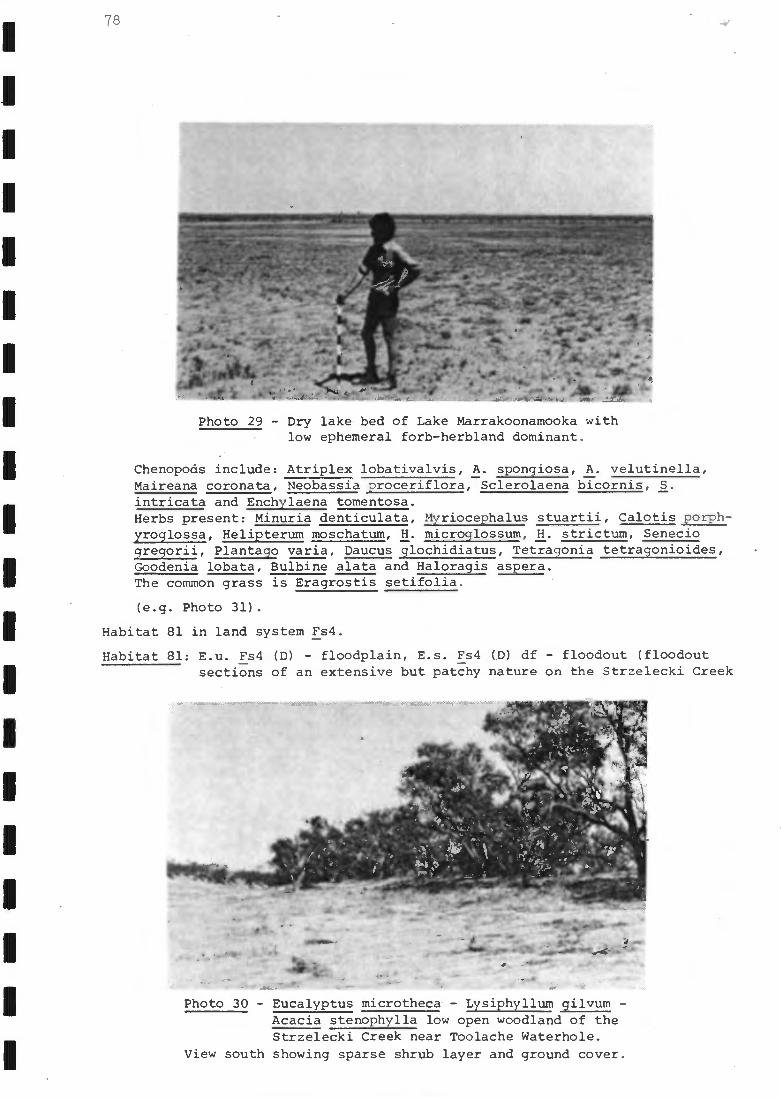
A. '
,'.: t,.. L
+44-
. , 41. r44. f' I
,
4 . ' 4P '' ir V171.41' ....t.'
. . ''.\ . 1I'
, -,:' '...,
4-11.; -. . - ,,.,,,0:,,,z__, . F.,. ."V.
TA.
Photo 30 - Eucalyptus microtheca. - Lysiphyllum gilvum -Acacia stenophylla low open woodland of theStrzelecki Creek near Toolache Waterhole.
View south showing sparse shrub layer and ground cover.
78
* ."- .040,./No
Photo 29 - Dry lake -bed of Lake Marrakoonamooka withlow ephemeral forb-herbland dominant.
Chenopods include: Atriplex lobativalvis, A. spongiosa, A. velutinella,Maireana coronata, Neobassia proceriflora, Sclerolaena bicornis, S.intricata and Enchylaena tomentosa.Herbs present: Minuria denticulata, Myriocephalus stuartii, Calotis porph-yroglossa, Helipterum moschatum, H. microglossum, H. strictum, Seneciogregorii, Plantago varia, Daucus glochidiatus, Tetragonia tetragonioides,Goodenia lobata, Bulbine alata and Haloragis aspera.The common grass is Eragrostis setifolia.
(e.g. Photo 31).
Habitat 81 in land system Fs4.
Habitat 81: E.u. Fs4 (D) - floodplain, E.s. Fs4 (D) df - floodout (floodoutsections of an extensive but patchy nature on the Strzelecki Creek
,,01,rttlieeiTt!-In
- -
- - -

°
Photo 31 - Atriplex nummularia low open shrubland nearToolache Waterhole, Strzelecki Creek.
floodplain - of a limited species diversity, the ephemerals ofwhich are concentrated in microdepressions).
Eragrostis australasica low grassland.
Chenopods: Atriplex spongiosa, Salsola kali and Sclerolaena intricata.Occasionally: Muehlenbeckia cunninghamii. stunted Atriplex nummularia,Chenopodium nitrariaceum and Enchylaena tomentosa occur.
Herbs: Calotis multicaulis and Tetragonia tetragonioides.
(e.g. Photo 32).
Habitats 82-83 in land system Fs5.
Habitat 82: E.u. Fs5 (D) - floodplain, E.s. Fs5 (D) df - floodout (floodout
Photo 32 - Eragrostis australasica low grassland 16 kmNNW of Toolache Waterhole (see Fig. 15 for
location)..
79
Ii
-
- -
-
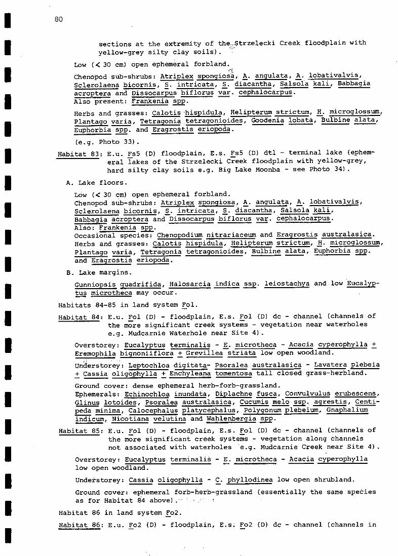
80
sections at the extremity of the:Strzelecki Creek floodplain withyellow-grey silty clay soils).
Low (< 30 cm) open ephemeral forbland.
Chenopod sub-shrubs: Atriplex spongios, A. angulata, A. lobativalvis,
Sclerolaena bicornis, S. intricata, S. diacantha, Salsola kali, Babbagiaacroptera and Dissocarpus biflorus var. cephalocarpus.Also present: Frankenia spp.
Herbs and grasses: Calotis-hispidula, Helipterum strictum, H. microglossum,
Plantago varia, Tetragonia tetragonioides, Goodenia lobata, Bulbine alata,Euphorbia spp. and Eragrostis eriopoda.
(e.g. Photo 33).
Habitat 83: E.u. Fs5 (D) floodplain, E.s. Fs5 (D) dtl - terminal lake (ephem-eral lakes of the Strzelecki Creek floodplain with yellow-grey,hard silty clay soils e.g. Big Lake Moonba - see Photo 34).
Lake floors.
Low (< 30 cm) open ephemeral forbland.Chenopod sub-shrubs: Atriplex spongiosa, A. angulata, A. lobativalvis,Sclerolaena bicornis, S. intricata, S. diacantha, Salsola kali,Babbagia acroptera and Dissocarpus biflorus var. cephalocarpus.Also: Frankenia spp.Occasional species: Chenopodium nitrariaceum and Eragrostis australasica.Herbs and grasses: Calotis hispidula, Helipterum strictum, H. microglossum,Plantago varia, Tetragonia tetragonioides, Bulbine alata, Euphorbia 2E2.and Eragrostis eriopoda.
Lake margins.
Gunniopsis quadrifida, Halosarcia indica ssp. leiostachya and low Eucalyp-
tus microtheca may occur.
Habitats 84-85 in land system Fol.
Habitat 84: E.u. Fol (D) - floodplain, E.s. Fol (D) dc - channel (channels of
the more significant creek systems - vegetation near waterholese.g. Mudcarnie Waterhole near Site 4).
Overstorey: Eucalyptus terminalis - E. microtheca - Acacia cyperophylla +Eremophila bignoniiflora + Grevillea striata low open woodland.
Understorey: Leptochloa digitata- Psoralea australasica - Lavatera plebeia+ Cassia oligophylla + Enchyleana tomentosa tall closed grass-herbland.
Ground cover: dense ephemeral herb-forb-grassland.Ephemerals: Echinochloa inundata, Diplachne fusca, Convulvulus erubescens,Glinus lotoides, Psoralea australasica, Cucumis melo 222. agrestis, Centi-peda minima, Calocephalus platycephalus, Polygonum plebeium, Gnaphaliumindicum, Nicotiana velutina and Wahlenbergia spp.
Habitat 85: E.u. Fol (D) - floodplain, E.s. Fol (D) dc - channel (channels ofthe more significant creek systems - vegetation along channelsnot associated with waterholes e.g. Mudcarnie Creek near Site 4).
Overstorey: Eucalyptus terminali - E. microtheca - Acacia cyperophyllalow open woodland.
Undekstorey: Cassia oligophylla - C. phyllodinea low open shrubland.
Ground cover: ephemeral forb-herb-grassland (essentially the same speoiesas for Habitat 84 above).
Habitat 86 in land system Fo2.
Habitat 86: E.u. Fo2 (D) - floodplain, E.s. Fo2 (D) dc - channel (channels in

81
more extensive sand plains e.g. Candradecka Creek).
Acacia cyperophylla - Eucalyptus miOrotheca - Hakea eyreana low open
fringing woodland.
Habitat 87 in land system Fo3.
Habitat 87: E.u. Fo3 (D) - floodplain, E.s. Fo3 (D) dc - channel (channels of
minor creek systems (type 1) - a small but important component of the
Uncoordinated Drainage Dunefield Environmental Subassociation 8.4.4:7)
Overstorey: Acacia victoriae - A. farnesiana + Santalum lanceolatum tall
,open shrubland.
Ground cover - very sparse cover of ephemerals: Crotalaria smithiana,Myriocephalus stuartii, Atriplex velutinella, Calocephalus platycephalus
: and Centaurium spicatum.
Habitat 88 in land system Fo4.
Habitat 88: E.u. Fo4 (D) - floodplain, E.s. Fo4 (D) dc - channel (channels ofminor creek systems (type 2) - a small but important component of theUncoordinated Drainage Dunefield Environmental Subassocaition 8.4.4.7)
Overstorey: Cassia phyllodinea - C. oligophylla low shrubland.
Ground cover: dense cover of ephemeral grasses and forbs.Species may include: Sclerolaena bicornis,S. diacantha, S.intricata,Atriplex spongiosa, A. angulata, A. limbata, A. lobativalvis, Gnephosisfoliata, Astrebla pectinata, Eragrostis dielsii, Euphorbia australis, E.tannensis ssp. eremophila var. eremophila, Euphorbia spp., Teucrium racem-osum var. racemosum, Crinum flaccidum, Morgania glabra, Centaurium spicatum,
Frankenia uncinata, Maireana microcarpa, Calotis hispidula, Marsilea drum-mondii, Calocephalus platycephalus, Calotis porphyroglossa, Daucus glochid-iatus, Tetragonia tetragonioides, Eriachne aristidea, Alternanthera nodifloraand Calotis multicaulis.
Habitats189-90 in land system Fo5.
Habitat 89: i.u..Fo5 (D) - floodplain, E.s. Fo5 (D) dtl - terminal lake.
Lake floors.
Ground cover: ephemeral forbland.Ephemerals: Atriplex angulata, A. limbata, A. spongiosa, Sclerolaenaintricata, S. bicornis, S. ventricosa, Dissocarpus paradoxa var. latifolius---and Salsola kali are likely to occur.Also likely to be present: Plantago varia, Calotis hispidula, C. erinacea,Daucus glochidiatus, Frankenia spp., Aristida contorta, Psoralea spp.,Calocephalus platycephalus, Euphorbia australis, E. tannensis ssp. eremophilavar. eremophila, Eragrostis setifolia, Sida ammophila and Swainsona phacoides.
(e.g. Lake Moorayepe).
Habitat 90: E.u. Fo5 (D) - floodplain, E.s. Fo5 (D) dtl - terminal lake.
Lake margins.
Overstorey: Eucalyptus microtheca low open fringing woodland.
Ground cover: ephemeral forbland.Ephemerals essentially similar to those of lake floors (Habitat 89) withoccasional Atriplex nummularia shrubs.
(e.g. Lake Moorayepe).
1Within this land system two habitats are recognised as the ephemeral lake(s)in question are distinct in having a definite presence of fringing woodland,which may not be the case for other ephemeral lakes in the study area - moredata is required on these.
Is

82
Photo 33 - Low (<30 cm) open ephemeral forblandof a floodout 30 km north of ToolacheWaterhole - Atriplex spp. and Sclero-
laena spp. predominate.
Habitats 91-94 in land system GP1s.
Habitat 91: E.u. GPls (F) - gibber plain, E.s. GPls (F) f - gibber plain.
Gibber plains proper - these contain vast areas of essentially bare groundwith a very close cover of gibber fragments over red duplex soils.
(e.g. Photo's 5, 6 and 35).
Habitat 92: E.u. GPls (F) - gibber plain, E.s GPls (F) f - gibber plain.
Gibber plain clay lenses - red duplex soils: this habitat incorporates a veryrich flora of ephemeral grasses and forbs, and exhibits a greater diversity
Photo 34 - Low (< 30 cm) open ephemeral forblandof ephemeral lake Big Lake Moonba, whichis WNW of Toolache Waterhole.
-
-
- -
-
-

Photo 35 - Areas of bare gibber, Astrebla pectinata opengrassland, very low (< 10 cm) ephemeral groundcover and chenopodiod - caesalpinoid low open
shrubland in the vicinity of Site 1. Cairns mark twocorners of a 15 m X 10 in quadrat - star stakes mark theother two corners.
than any other habitat within 8.4.4.
Astrebla pectinata open grassland.
Dominant grass: Astrebla pectinata.Others included: Dactyloctenium radulans, Enneapogon avenaceus, Eragrostisdielsii, Eriachne aristidea and Sporobolus actinocladus.
Chenopods are a very important (ephemeral) component as well.They included: Atriplex spongiosa, Atriplex sp. aff. eardleyae, A. angulata,
Photo 36 - Acacia victoriae tall open shrubland on palegrey sandy soil 14 km south of PilalchilpnaWaterhole.
83
-
-
a
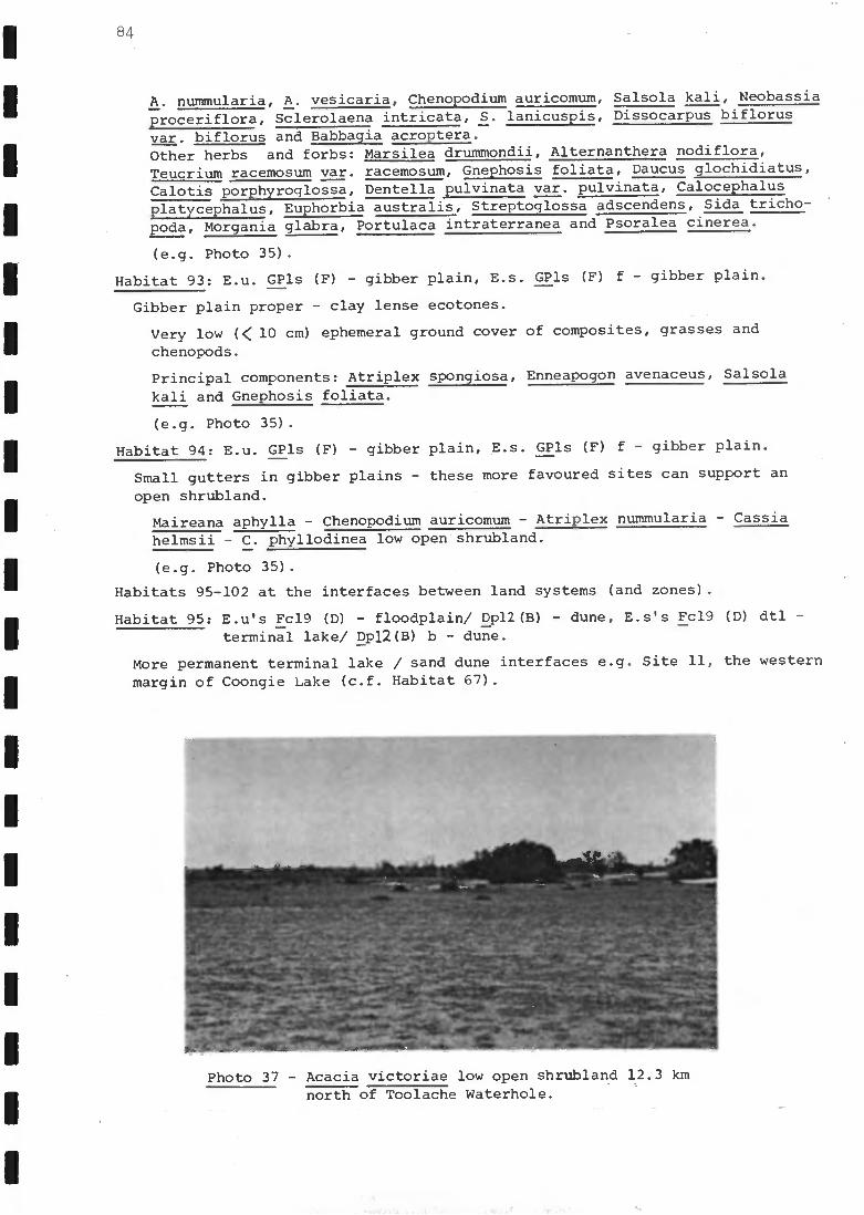
84
A. nummularia, A. vesicaria, Chenopodium auricomum, Salsola kali, Neobassia
proceriflora, Sclerolaena intricata, S. lanicuspis, Dissocarpus biflorus
var. biflorus and Babbagia acroptera.
Other herbs and forbs: Marsilea drummondii, Alternanthera nodiflora,
Teucrium racemosum var. racemosum, Gnephosis foliata, Daucus glochidiatus,
Calotis porphyroglossa, Dentella pulvinata var. pulvinata, Calocephalus
platycephalus, Euphorbia australis, Streptoglossa adscendens, Sida tricho-
poda, Morgania glabra, Portulaca intraterranea and Psoralea cinerea.
(e.g. Photo 35).
Habitat 93: E.u. GPls (F) - gibber plain, E.s. GPls (F) f - gibber plain.
Gibber plain proper - clay lense ecotones.
Very low (< 10 cm) ephemeral ground cover of composites, grasses and
chenopods.
Principal components: Atriplex spongiosa, Enneapogon avenaceus, Salsola
kali and Gnephosis foliata.
(e.g. Photo 35).
Habitat 94: E.u. GPls (F) - gibber plain, E.s. GPls (F) f - gibber plain.
Small gutters in gibber plains - these more favoured sites can support an
open shrubland.
Maireana aphylla - Chenopodium auricomum - Atriplex nummularia - Cassia
helmsii - C. phyllodinea low open shrubland.
(e.g. Photo 35).
Habitats 95-102 at the interfaces between land systems (and zones).
Habitat 95: E.u's Fc19 (D) - floodplain/ Dp12(B) - dune, E.s's Fc19 (D) dtl
terminal lake/ Dp12(B) b - dune.
More permanent terminal lake / sand dune interfaces e.g. Site 11, the western
margin of Coongie Lake (c.f. Habitat 67).
Photo 37 - Acacia victoriae low open shrubland 12.3 kmnorth of Toolache Waterhole.
-
- - -
-
- -
-
-

Predominance of Halosarcia indica ssp. leiostachya with occasional
Muehlenbeckia cunninghamii shrubs.
Habitat 96: E.u's 1Fc? (D) - floodplain/ Dp? (B) - dune, E.s's 1Fc? (D) df -
floodou'i/lDp? (B) b - dune.
Floodout / dune interfaces of pale grey sandy soils e.g. near Site 25.
Overstorey: Acacia victoriae tall open shrubland.
Understorey: Atriplex nummularia - A. leptocarpa - Muehlenbeckia cunninghamii
low shrubland.
Ground cover: Haloragis aspera - Nicotiana velutina - Phyllanthus lacunarius
very open herbland.
(e.g. Photo 36).
Habitat 97: E.u's 1Dp? (B) - dune/1Fs? (D) - floodplain, E.s's 1Dp? (B) b -
dune/3-Fs? (D)1d? -1? floodout or terminal lake.
Dune slope / floodplain interfaces - in some areas bordering floodplains, a
convergence of sand dune and floodplain associations was encountered e.g.
near Site 28.
Acacia victoriae low open shrubland.
Common associate: Eucalyptus microtheca.
Other shrubs present: Acacia tetragonaphylla, Atalaya hemiglauca and Cassia
nemophila var. nemophila.
Herbs present: Euphorbia tannensis ssp. eremophila var. eremophila, Blennod-
ia pterosperma and Crinum flaccidum.
(e.g. 'Photo 37).
Habitat 98: E.u's Ds4 (B)/ Ds4 (C) - dune/interdune low //1Fs?5 (D) - floodplain,
E.s's Ds- 4 (B) b/ Ds4 (C) c - dune/interdune low // 1Fs?5 (D)1d? -
1? floalout or term- inal lake.
Sand plain / floodplain interfaces in some areas bordering floodplains, a
'More data required.
Photo 38 - Acacia victoriae - Grevillea striata + Hakea
eyreana low open woodland south of Lake
Moorayepe (see Fig. 9).
85
1
1
1
1
1
-
- -
-
- -
4
86
convergence of sand plain and floodplain associations was encountered e.g.near Site 28.
Vegetation essentially as for Habitat 97.
Habitat 99: E.u's GPls (F) - gibber plain/ Dp6 (B) - dune, E.s's GPls (F) f -
gibber plain/ 2p6 (B) b - dune.
Gibber plain red duplex soil / sand dune base interfaces - small areas onlyoccurring as narrow bands along the dune margin e.g. near Site 1.
Overstorey: Eucalyptus microtheca low open woodland.
Understorey: Muehlenbeckia cunninghamii - Chenopodium auricomum - C.nitrariaceum - Santalum lanceolatum - Atriplex nummularia - Maireana aphylla- Enchylaena tomentosa low open shrubland.
Ground cover: ephemeral forb-herbland.Ephemerals: Einadia nutans, Alternanthera nodiflora, Atriplex spongiosa, A.velutinella, Portulaca intraterranea, Euphorbia Marsilea drummondii,Babbagia acroptera, Sclerolaena intricata, Eragrostis setifolia and Astrebla
pectinata-
Habitat 100: E.u's GPls (F) - gibber plain/ Dp6 (D) - dune, E.s's GPls (F) f
gibber plain/ Dp6 (B) b - dune.
Gibber plain deeper, red duplex soils / sand dune base interfaces - e.g.near Site 1.
Overstorey: Acacia victoriae - Grevillea striata + Hakea eyreana low openwoodland.
Understorey: Acacia vicoriae (low form = ssp. arida) - Cassia nemophilavar. nemophila - C. phyllodinea - Enchylaena tomentosa - Maireana aphyllalow open shrubland.
Ground cover: ephemeral forb-herbland.Ephemerals: Sclerolaena parallelicuspis, S. bicornis, S. lanicuspis,Salsola kali, Atriplex spongiosa, Euphorbia parvicaruncula, Gnephosisfoliata and Teucrium racemosum var. racemosum.
(e.g. Photo 38).
Habitat 101: E.u's GPls (F) - gibber plain/ Dunc (B) - dune, E.s's GPls (F) f -
gibber plain/ Dunc (B) b - dune.
Gibber plain [uncoordinated drainage dunefield interfaces e.g. near Site 4.
Astrebla yectinata open grassland over ephemeral herbs.
Associates: Atriplex spongiosa, A. angulata, Sclerolaena EER. and composites.Occasional associates: Cassia phyllodinea and C. oligophylla.
Habitat 102: E.u's GPls (F) - gibber plain // Ds4 (B)/ Ds4 (C) - dune/interdune
low, E.s's GPls (F) f - gibber plain // Ds4 (B) b/ Ds4 (C) c - dune/interdune low.
Gibber plain / sand plain interfaces - tongues of gibber plain in the sandplains of 8.4.4.6 north of Innamincka.
Astrebla pectinata open grassland over ephemeral herbs.
Occasional associates: Cassia phyllodinea and Acacia victoriae.
(Fauna Results..:8Th

rI2A2 vT2
re/rave-el)
pao'raVr2.9
rcvfavya.9
rurs:Aa.
r0 rfrvra
"!V'Ponce/ AyIr
try..401,4v
aviry4.-ra)-as
d.-arms /
rag 91:9 / -a IAN
rz1-12,a,Acr"'*1-9al-or-Ns-7 211rld
s
%,rVlr,cS -arlrwnoi
vraasvrati..111452/V1
vrazrvr-otlArradZ/111
vra-ax way...4)12ol.1'2 All
vrovfwadS2,4'1
s"-anArrads/9 1
rArilV1!yroby wavy vla GIS ?AI
wavy., rra ok s2/il
4T,013AI I
vv211.4 s-r2cotsI
)p-r-ix+rod ."-eraS
SO)yo 1-)(AS )
-rairad f(-ot-4.1
vra1I 'G5 wsir-rairaci IC0tA.
lwa wirra cis-am'
wavri-rac)-5.
si-awad roc, 4.1
Cf140
tralraciI r^(3
xistrad le-s° I''rarrlOC) 5*?AI
Vra 1,14adf1
C11.40
s-ra 11-04I c-'12
vra vs/ I lads 20/%N
S-42112IMO %II
"eavl 1122lI I
4-0 -4r259
SIVIIrw7 yin') fc.11:7.4....74-0
v)}.0.4"317r775
n!..vp amAnAr S Y1 17 vv. 03
=r+Wr-7-19. -Fcq
VIY119
rr --7--ryvi,i,4 srvi
fy-v Frg17zew TIA-011),rofr 7737
r y9+-0
-1:fitmtjzygTY1I1dcW5R71
"MYNA 71:1 01.
--5772717-rj,"
No.AYIOA, V NA
YlTI / SIZA
YiTdo4i%
sal C.-aroC7-,viT
723LJJfri s ar.loAriPTirl
.175zimy
Isr.iroIA S
Sing ;Loco VM.4-101
orciTv, :I AO sprar
sly?) 'Jr' t0-0N
TFWA .4-770rtow"-L2
"2."-act s
7K0 171-4 OCI
-aOr./Y13
.a.117'irabwIr)
.ax.r.)A08
2Dr.lArttil
WI) 12.1 %A Tr)
tv.tra
r)-0 dIT a, YTO..A.0.41
52.11tvwo
rpryeevN
V99
4).41.8kA"CS'S y
INNP5o-ntIf p-A on&re-9 2'19'1
-avrpAcni.riadvaA
20 rirOJCVODW
"ab r.LovrigS 'pa
'V)L4flWSÔtdS

87
4.4 FAUNA RESULTS
A preliminary list of fauna specimens (mostly derived from data sheetentries) is presented in Appendix 0. Invertebrates and fish are presentedseparately in the text. All species groups are treated in greater detail inthe following subsections.
4.4.1 Mammals
Trapping effort is difficult to standardise. However each of the sevensites studied by the consultants was surveyed by using approximately 100 pit-fall trap-nights and 500 box trap-nights. The spotlighting and mistnettingeffort varied considerably between sites. The total trapping effort is summar-ised (Table 5).
Table 5 - Total trapping effort.
Nineteen species of mammals were caught or seen within the survey areaand a further six were represented by skeletal material only (Table 6).Preferred habitats are indicated in Table 6.
Some species were caught by only one method, whereas others were caughtby more than one. Trapping success was characteristically low (Table 7).
Table 7 - Methods by which mammal species were collected in this survey andthe trapping success rate.
In addition four bats of two species (Nyctophilus geoffroyi, Nycticeus a.)were caught by one NPWS team.
Trap-nights Hours spent
Pitfall traps
713
Elliot
1799
Sherman
1479
Spotlighting
18.5
Mistnetting
19
SpeciesPitfalltraps Box traps Spotlighting
*Mistnetting
Nyctophilus geoffroyi 1
Sminthopsis crassicaudata 3 3
S. macroura 8
Pseudomys australis 1
P. hermannsburgensis 12 7
Leggadina forresti 2 1
Notomys cervinus 3
Mus musculus 3 25
Planigale gilesi 3
Dasyuroides byrnei_
1.
TOTALS 31 34
--
7 1
SUCCESS PER EFFORT 4.3% 1.0% 0.4 per hour -
87A
Table 8 Species of to,-..-As -44,is suevei of Ass.06cd-i0n
(oluv., s A : Abun...-ionce R = rare ; U
= unowvirvion rIC =
wiocla4eI coronnon C = coning on VC = Ver common N A9 04-1C - opeAn °ran wo.4e.v- ooGkes; CoUe.
s.Jci4e.p bodies 1...); It- e ve3al-a.416v, .1
circie
Wafer badtk.s
WoodMand - 1.4:001,Caok N/00atallftel
- el. c+ 1 1.5,14460., Aev10 te-X
van. Q. - 5e. (..,.......rovve.A4 4 Flooarlall"s
of *ese. toe.
: s
1
(.1 .
Ciobb ev- - includes 9.11,be...- pLascla.N, I *A.., ses al
ort-- be-44*A,- ve6e.4-10.4-42c1 pocic.e.1-s (- 5i
Seasonal - clesere.A
Goi#(ov ) tn cleA.,04 ect
C DefavAlew-e- ov. (.1>) v ctev 4. (T) F-ee Wo +es- 13 ocl C ? ol eAn 04-es uncee-4-12,1,0)
11 g eCOVjeip, 44,e N(0.-1+, - eas bu. nal- insi 13-4- 44- .
? ear-cl nic,i be. s
i4. NoIlemn 6e.v- of pico bircA connvv.unii-iei aSSocialea L.JIl +Le. pvecktftio."0"1
ovi 4.0.4a; 4-a+ s of .4. .e. von ro,,t
Pcus, I J 5 p ecce s I-1 a b ii-cat'S B
Prom alidoe promo liAs novaekol tan cli ae. U Cre.na.ral I Poolicipecticlat
Peli co...6 dae. Phalacrocoracidde
Poll o c..f.pl.walus pOIocapc*Ius R
R
U
12.
R
A9t4afic - open's cover
A9 ua+i c.
A94 041.C.- open Aclucrfic- open Aciuco-k.- open
I D I)
D
17
D
40 las.6412ap+us novae holland Ca a.
Fe 1 eca nu i cov.spioi 1 a+LI s Pkalacrocorax ca rbo
r me.ianotew.os
At- 4:kid:my
Pt atal &Jae
Arcku s p_s_41-ic-tas U
U
R
R P.
fk
U
A9u4lic - ecl5e.
Aquafic - 6443e
Aqua4-k - e4 e. Al uaii c - cover's edr-
A9mat-ic - el:15e
Aciwtfic - ea3e. A 9 CACI
ti C - eet.5e V
D
D
D
i) D
D
D
A. novae 1101 laruilae
Egt. 2,±1-c. al l_l_q_
Nictic..orax colic ctonicms flizaslif S.......ellus
ria+alea x_-e_gia.
z Slaypes
A V%
041ACt e. Da.ndrouon_st. stshbj. ik
R
R
U
A9turlic -cove.e.s ecije.
A9 AC:1+k ''' Op
Acluafic
A9 ugfik. - ofevt A cover ,/
D
I) D p
ii .5,4s .-4, Li. " ador"a +a ci ornoides
Am.:is super cAllOsa

1
87B
A nai-i elae Anas 0. bbe.ri -inns_ MC
P.
R
U
R
U
R
K
A9oa+ic -open 4 cover
Acitscs+ic
AT-wk. - open
Acricriic - open 4 COVer
Aquatfc. - open
AraWc. - ed5e,8 cov4r
AauCrFiC.
Acr...34-ec. - open
V
V
J
D
D
D
D.D
D
DD
* A ca sta n ea
A. rl___sy., nc.1,10+s
Molocoreckas rnevnl,ronactus.
Azillyst aus-trali S
C kenoneli0 ..S:Aloa+a
?..0 Ox.p.4rea a %Astral', S
Bfp..iura loberl-a '
Acciprtri doe Milvus ,... L_,, C
P.
U
U
MC.
U
12,
R
Ge"eroI (woodland)
Woodland
Woodland
Woodland
General
Crenera I
General
Agua+ti. - open's cover
.1
JV
%/
IIID
IIID
? Lopkoicilnia ilaraHa ....it i,or-l-ra Incianosternon
Hal': asiur IplierurusAA yjaa . a udax
KV-clad-us r_prphnoieles
+ Urcus a ss i'wt It's
c.. c,-,ei
Falcotni doe Fc4IcO sulorjegc U
R
R
MC
MC
Gen era I (seasoned)
Woodland
WoccIlancl
Creneral ( c.44..ne)
General ( June)4
II1II
E jtp.efri n is
4E acAeA col..1.._.
f1>er.;,59. _r-2_
F. cen Onrol cies
Roth dae.
Gruiclat
Poreana .{.1, RU
R
z?,
R
U
A9 uatic.- cover
A9 Wilk- -coverpg ect3e
Alum:K.
iq LICalk,- COVear
A cluafic. - open's cover
A9uatt.c.- e.cl e.
D
D
D
D
D
D
Gall inula veniral is
+ a: ten ebrosa
1221:thg frig, pl_A* r;o_pox:
F.Ali co a+raGrus rub; cuinc.1 u s
Characiriidat
Ke.c.uniirosinclae.
Scolopaaclat
Gl.peotickag.
Van ellu s miles U
R
RR
U
U
R
R
.ik
?..
MC.
A9 ucrtic, - eck5e.
Flood ?km:. (rnarg;n)
A9 LI 441.0 - ea.5e,
Aquatic - ett5e.A9,40-11.c. - edie.
Floodplatn /GibberAqua+Ii. - eateA9 u aft i.. - opehldreelje
ActUahl..- e45e.
Avail"(A9uccii c - eelge.
FloacIplal:, I Glot.e.-
i
4J4
N/
,,/
D
D
D
DD
IDDD
D
D
?7?
y. ty; color
frs6Lo3opms c 1;1 chas
C.koellru s r.L., f; capAlas_
C.. mei.' vl c:. ?s
Pol+4,39§.. au stralis141;navvfopus in ihAaniopaL
Recur vi mon, novael, ollo ..,a ate
Trignel,ularia* Goll;noy2 Vloniuvic.kii
* Cali dyis a c.u.tn al-a
5+11414 isal,ellci
Lor;dae. LarAg novae. ko It avsci iae 5 ACV AC- opal 43 ect5e.
oLe
(to.4.uol ) a
p t4 tiro om
(P"TrAliS /purroolv)A.1 rIcl roc) 1 3212p.k3v.).ilsn4
S.s...4.1eraitIn.4V imicid 1
.12n0 vrafoob7pApcj
II(Li
II
I(-aIr
P
f
IL.4IVIGItwnr )ro,ravra.9
reou(;,."Cr1,3) r1,ivi
r" 19"A 4 S )ragavra9
(,--Ireem)rdrawaot"-4°1P°°P1
(wArlp ) 1'0.42142.9
4-nop00)3/ -.racrit.9
) w
wn
D
)
..)1,4
n
-avrAoy? cl lam j
Tsto r.i I I 9 iLioW
zpviomy,..,!Iti
'?br.TY"21ki
!..vna ris'iCt, 1 vri
v...%vt.47+9.,/,..011..yavA01.410%.1111).A0)
.al,IrvmpaSVonOtA"'1+'V-F1.-Ar,
31.A.0--.),74Ti ox-x-3-.7j
wnu.A-a4storval vyaoviDA-a93
v.---)!(Aop.-7,f: 11--ipip
Ia i.
IIIIII
I
p
C
"oireom_(,,,,,onn.$) rm.-ay.-al)
p...ireom ,-,v, G r .ar""IPe°M -
(iPtA0Swar>ra.Aau-ah9
ro-oravra.k)
ruoiroom
ruotr°0/1v....iroom ,......g raa
(10.0s. was) ro-ravra -9
00,40s-b-as) iv..Eatfra.-
or+) 10%41719-A9s
pw...a
, w
t)14
')W.ti
n
1
7or!do.wait4
worr !mall v-avrrodv
?bp !l'alt.oCa v
avri.6..wpod
)1,12!CA6."44-5
79,1 Yon)
sno---.700-7..aR
124.-,....05..11-
I:9ottAA ct,A0C-lati
Sry)41-,T,In v +srtfu+s)A.D35-ra7.0%-vsapi.ogre19-6, 711-1-1-70
31 %Aviv)xcn9N
iTivs%=.9 xh-ymosAri)
113-7,-91.-4-sr--Jon
aaa
CI
aa'aa
cC
,,p
10-1-)p-vicrA4rrvvrinAlrir.owoom
ruoirOoll
rAvIrc" `'"4 ra)i(Ivuostras)ro..w.2.9
(',,,A.s.b73) 1,2421.9.9
(pup 'pooh%) roxPura 0
(,u°) rodrewaD
t)w) w
11
D
'')
0A
serpiralc+ola
-aveimtgico
112P!'14"))
n >1.Anollo1Ariniclo2N #
......-1-4-, 3rwg.4.,twer,,,virz,.1.41N
5,145,40.4pwraut1sr.i.. .98,7ti
4......m.....09S r, pa
nfarAn ST170* is doW,,,j
s n-2921.4111°4sro1dv41J
72710-,1aso..4vrtc6W1
aCI
lia([
P.0.19...9/..,orooys,And
117-Q1-42T
(II% )1"15nAtiSi r" I r°°M
Sg;-?1112frig
DA
0)%"aorciimr,1°)
vatoi o 1Sztorielo
12,11.A0!-45111schnij *
r4cratArY,livr,----8,or n)rado *
-1515'cluun 9 ii
aaa
vracio - ,!+b 116V
vrack, - 1.44, n 6v
xacrii..9b2,440-, Ii. n h by
111
WriM7GGEAdo"7:17c-A-
2112 !-Atrl
nruffR9tti ..r.'=it-T.--2m
t73?4o t.L4.4 orop.9

I.
87D
able 8 ( Lova-. a)
MLsckapi dae Colluricincla karmoniGa MC
U
R
VC
Woodland
Woodland ghrubland
.Red 3.o.... woodland General (woodland/
Skv-u6la"d)
J
J
I I
.
? 1
?I
0 reoi ca TA* u ro li s My Cag ro iii ce fa 14%
i pi Aura le.A.u.opkr55
.
OritAlnychidae.
TINA 01 iidae.
Sil vii Jae
PSO pho cle s cris1-a4us MC
MC
MC
ik
R
g R
Roodplat-A(thvublavui)
Cre.....w.ral (dune ,
5ibber)
Woo4londiSkr.61a.d
(-Fall)
Actuaiic - coVer Ai u ail-c - cove.v.
Woodland (text 3.ft.)
Cvass1 a vw:1
I I I
3)
D I I
CtilclosoPna, onna mom eum Pow. al-o.sl-onius 4cefs
ttc.rompil al u s s4-ew4oreus
Ple..34turus ea 3ya....,;-, Calcla rt., a...0i us puriketios;
C .
cruv-ol; s
Ma luvidae,
Ac.an4iitidae
Malunis I avvbeAri-i C
vc U
R
?.
U
R
&glens.' (dw,eithrublag.4
GeAero.qamneis6rublandi
id.3oc.Wo a .1:1/4,,, e Aryl:4 an d
Ft 00 GI pla .;,,
GeAlehial (S lina.171.n A)
Du.v.ef;eld (cLA....e)
v
I I I I I I I
M .
I em corferu S'
Amo.c., i soya er,i
* A ca.t4-kta urvoill'alis
4 A: ckrisorykoa A ptleiaceplidl
LAS leucolosi s
A.rit'yirkc.1-o.
ClIrnac.teAficlae.
MeLp6.3; (Jae
CID:naci-en's pt'(u.inus C
U
VC
MC.
VC
K e d 13un4 woocilavid
WoodlandAniblcuicl (WI)
- Woodland
Sk ',Aland ( ct.....,e.)
Woocil arNcl
?I I) D 1..)
D
Acart4.65e4., 4, 9ulavif
Ma nori.na liavt:9 a I a vt'rerce,As
L. p e ciII afa Aoti
Epll+l-ti anurtAae E. lvalionura +vi co I ot.- MC
U
U
Guieral (stasar,a1)
-cluvoz.
- Shv....b1 o.h,l/grussland
Ct vne,a.I ( se.. s an a )
- s v......6ta..iArta.s1 AA
4
Cri 66v,
D
D
i E nu vifronc
Askbil'a I ove-vtris
Di cae:1 clot
Pa rdolo+i4-iclae.
pl.C.CLetAtAn lomrlirici%kolce.t.4Wi R
C
Woacilaviel /A. vu6lancl (+all)
Wood lan d
?I
I Pa rdol ofus v-,Alrei (Aka S
PQ 55e r i doe Ploce.Mae.
44 Nasser cl on,ec.h......c R
VC
Dwell i ii.,
Ge...,ero.1 ( °L.,. e. ) 4
D
D ?oept:1 I a 5 .14-A-1-a
Gnalkincdae.
Arl-a..144e,
Gra 1141 a cyonoleucok C
C
C
Roo A plaii" (woocilaAcl)
WoociloaAcl
GeLlerol (seasonal) J
1)
D
?D
Ar+amus le..w.Drklvic.i,us
A. peesav.a -has

Table 8 ( corvcci)
Act.ipitricke E(0 scv44u s1L14-c. alba Itraces
fon ci of formee frese.,ce.
87E
Artarniclae 4Arfawius superciliosusVC
G-eneral
Gevieroi J
?D
IA. cikere,is
Craciii.. doe
Coy vici at
G t.. - + I,*TvIrtor tv.a I t CeAn C
VC
VC
GeAertd ( dune)WoodlandGe.ler-al (de)
/J../
!I1)
)CotrvuS CorOVI cha es
L. berme* i

88
4.4.2 Birds
During the course of the two field trips by the consultants and the N.P.W.S. training exercise, 121 species of bird were positively identified in8.4.4 (Table 8). As well, evidence of two species - Letter-winged Kite Elanusscriptus and Barn Owl Tyto alba - having been present in the past was gathered,while the records of Chestnut Teal Anas castanea, Blue-billed Duck Oxyura austrarlis, Rufous Whistler Pachycephala rufiventris (which have been positively record-ed .tm8.4.4 previously), Yellow-rumped Thornbill Acanthiza chrysorrhoa (of whichthere is a previous unconfirmed report in 8.4.4) and Square-tailed Kite Lophoic-tinia isura should be regarded as tentative and require confirmation by theobservers. Four species were recorded in the north-east'but not within 8.4.4during the survey.
The 132 species of bird recorded in the survey are listed in Table 8, andthose species found breeding are indicated as is the preferred habitats of allspecies observed. Species that are not memebers of the typical bird communitiesassociated with the predominant avian habitats of 8.4.4 are indicated - theseare vagrant and/or rare.
Bird censusing was conducted in the vicinity of the permanent peg at sevensites. Details of habitats censused and times when censuses were conducted aregiven in Appendix P. Numerical data generated by the eight sets of censusesconducted at the seven permanent sites surveyed by the consultants (Sites 1, 4,6, 14, 23 and 28 and two sets conducted at Site 25) are presented in the appen-dix, as are density estimates. These estimates are liven for the more commonspecies recorded while censusing, and the figures are directly comparable betweensites. In Appendix Q, a complete list of birds observed in the vicinity (approx-imately within 10 km of the permanent peg) is given for the nine permanent sitesand some other sites. A qualitative assessment of the abuhdance of speciesencountered at the seven sites surveyed by the consultants is also made.
4.4.3 Reptiles
Species in the five families of lizards that occur in Australia and speciesof snakes from two families were collected. In addition the N.P.W.S. reporteda specimen from a third family of snakes. One species of tortoise was recorded(Table 9).
It is indicated whetherceach species has been collected in the study areapreviously (Table 9) based on information in the card catalogue and register ofthe S.A. Museum and on published information. A one word description of themajor habitat type in which each species was collected during the survey isalso given.
Most species known from Association 8.4.4 were collected during the survey.
4.4.4 Frogs
Five species of frogs were collected in Association 8.4.4 (Table 10). Onlyone species was collected at more than one site, although two others were heardcalling at a second site. In addition, Litoria caerula was reported fromEmbarka Waterhole (Lawry O'toole, pers. comm.; see also Appendix 0).
4.4.5 Fish
Only four species of fish were ,collected during the survey (Table 11). Allwere collected in water bodies that either contain water permanently, or for

elr aenc-.2,44crvi4....1 TM() N vie.CI17-0+4066,-*.o 19 a-r.a no 1fp% "rads
h.tra'lolly 7 , r -...r.211,31C.1 r r..crreo-Ad-Icr`"Nt.Is..''°"/"vb-'dtk.4-Cry..0)0e.-r-alier, - 4 !ID a....0--c..9-.C"0N1>1nap,c.1,1:.5109v,ACntry-ois
r.r%r41-4s'5'1477 "o rrifrb-r"°11°')-6P:ide'A7,""dS
Vi3P
1,..rt,vp41.3 2, 'o.t ray)
1
I
-oxito,v,W,S
'-9757-eC--.3"a re, .+3-
%I.vi el
..t., o 1 A
st,61 .
r"r/-as, vlo
7)NA in cj
re.rarn...)Q.,ria...D
/-a req, r/ -rp4,-+ 0
.r...,..., / ..,... r.,,
r..,-.1. Paul vN0
V", a...Aoci.4,4
N
P4
fm
PA
M
1247y 4 -11- -.M t7,74t7g.
....?3:13 vror :I -c. taro12 riroA OW
TVP= eWawa -hl"11.1Tvr0124 c.a....en
s.s 1.1! scr,'"Fr...7-71
-4
m
M
ro...olizsyLivioprx+ s Mho! MI lio)VVV2443
4170VI.407.1=rrIMot, 3
7755117 7
TT Cra-5.-ex, al'-i
!) $-$1004/$1,442...-a-0
(.477501-4-7;174 74 .17:7-7.fdl W:041. 44
-o-rodvis
-am...NI
,,,......4
rlYraPer20 -19
.." I o 1 ci
,-...1.. 64
are r-. 3
--rawr1!z)_
r.,
im
N
M
ri
N
N
4-avr'')1)1-2 9
..4.40 v-v-4`T' %;'---1"r..=211--.......ichN
-.iv-raw -.... r-win IS O l'r1 1
r0 ." 1Ir-s-.0.--e+-atiIrcarip-o.o.
-fiej--laTs-3+71
77-71P`v'l'aiil1 ryt.4-0 0 v -)?el m-c-r;. li
T. -T-, 4,....--4.0.4.?,/ =4.(p7:5-4r-sr:TPim&x,...,r01 a.Ti
.......id-A
plxvr ocloGGJ
-NITM-r..1. Fgo %%Apo.*
r!..10.{..A.,,9 -77.7-1-. %Airs 0
ro.ren.i,aJo
ra.111,
'71° I cl
M
/NA
M
Pi
1
-alorrvvivCv
!lop awn 1 pAla.--79-41.1...0411Z
.--flal TrAC 'Tf
.1.r.W2. V771.r-:rnmJ.vis.1
ro.ra..re 0M'ally'? VI/loll/A 7rin4 ?Avid. Wic.rr.leni'lAvii2,V11%<1
Mavvota, 1:C*0.31.ra 4p. st%.11,0 1.1
" I ei
ro.raw-a39
m
Nt
Mwe tflaio la
....4rm,oi-rss
rw,A4vsoevra scc
3.1 rui ,,,-,-.,?..r...rd-b-...-4:3
Mzeo (1.u:A o ricla. 'aro ro.era onlci --151P.E
5 4-P-V150'1-1sy-ti-04.5s:yrra..451`.'"A

1
1
89
Table 10 - Data concerning species of frogs collected during the survey ofAssociation 8.4.4.
* Collected by the N.P.W.S. ; # collected outside the study area.
long periods of time following floods, or on floodplains adjacent to such sites.One species (Australian Smelt, Retropinna semoni) was collected at all sites.No fish were collected in Embarka Swamp or in the leading front of the flood-waters SSE of Lake Perigundi.
Table 11 - Fish species collected at each site.
4.4.6 Aquatic Invertebrates
A preliminary (and incomplete)list of invertebrate groups recorded in theCooper was prepared (Table 12). This has since been updated by the E. & W.S.(Appendix W). Some identifications of adult Trichoptera were also made byAlice Wells of the University of Adelaide (Table 13).
4.5 STATE OF THE COUNTRY AT THE TIME OF SAMPLING
4.5.1 General State of the Country
The southern parts of the study area in particular, in the vicinity of theStrzelecki Creek floodplain, had a depauperate vegetation in terms of speciescomposition, condition and density of vegetation. The area appeared to be extreme-ly dry and little ephemeral matter was present. Since the Strzelecki is an over-flow channel of the Cooper Creek system, which receives water in only the
Species Location Number Collected
Ranidella deserticola Chillimookoo Waterhole 1
Litoria latopalmata Chillimookoo Waterhole 1
Litoria caerula *Mundibarcooloo WaterholeToolache Waterhole
2
one heard calling
Cyclorana platycephalus 4 km south of Lake MoorayepeEmbarka Swamp
1
chorus
Neobatrachus centralis 4-5 km S of Lake Moorayepe#15 km west of Lake
Etamunbanie
28
1,
Site Species Collection Method
Innamincka Causeway Retropinna semoni (Australian Smelt) DipnetFound deadPlectroplites ambiguus (Yellowbelly)
Scrubby Camp W.H. Retropinna semoni (Australian Smelt) SeineGill netSeine
Nematalosa erebei (Bony Bream)Hypseleotris sp. (Carp gudgeon)
Tirrawarra W.H. Retropinna semoni (Australian Smelt) seineSeineHypseleotris sp. (Carp gudgeon)
Tirrawarra Swamp Retropinna semoni (Australian Smelt) DipnetDipnetDipnet
Nematalosa erebei (Bony Bream)Hypseleotris sp. (Carp gudgeon)
Chillimookoo W.H. Retropinna semoni (Australian Smelt) Seine

1
1
raw)dre.doe7-01.r,.41'9'r)Jaon"Itt_Arm,I'17-75r131
1-"4r)°V'rzt-r-blio")to.st4ied4~41,11-.oJ'v191la1"....."3/-3c1rra4,1Z 1tcr-o_L
!v68
...ti ci OV14-0)41elrUte7j.
VS'1 in rwovr)3
rvybrowNerbroThFrwa1 14-2^7 ao
VI-a-v,
7 e 14.1177.7rar -4"-el !41.
-arrern en"... 1l'1)
l'-"a5.01/4icJS.I.J. F."....0,7)
....W Cr'OWH's ..r.1r4-a id !j I,IroonV rw se 0) way) r,....4--TAT-1-.7.1,
I a, ',as"a415
vr o ct-acia)va -a ) .24 SrIA)
.er a d c1..avnr**.Cyocarl-0-1 ir 9TS prbrri
-r-i-) I. l'N-o Cr-ai
.wradol. wrati
r., r ..1.-"ba
12,12+.4 ocj
'ay ?Neiv aro." 3 vvo
\pi °don-4p/MI .11`1 '"°) Cticr47S
Crica., owca-ra.rati
)1-1 r.%-i-, 2. IA 1/ ON
. di
1(vv!"-ads -)
(--cronolool )
Wr7 r.*7 r H. Q,a
z ory.,0 %Act, i ID
a lo p.urt -arnoloN
z otr'7-k-Ta.A.,,j
-o-ro %no r 0
Nara4dos 10)
y"-deici.X)
ra...roztd ...Ara H
-,r, .4-, 7 2;(1
"7 r .4.4 yo9
NI, 1 rr.) tow
-arra s....1
VW )14 S'Ke)
vy,c.4.3-4ve-aryl ....rar. pi-ftwwar. n....... 1
4.77,,,,,r,..",-row
( wo (401 )
-atrenft4o..4 o....4 In
wt, r.%-e -avi co.4o iv
I
Nutsicio 2* leo
ta,rai cti 1 a
vadmi 44.1 wra ii
orokrid-"Avtx.rra Tvri
*ea res4 svu)
w fed cvdww.--.1
z.at, 10.1'7 .1:1+ R q
avr:""*"'":""10-ay. r.4.-) a v, ,teisi
1.34,040k7a1o)
la.rai J. iq
rtraisAywrati
w r ode cla)
writtAi.ratoisi
r,...rratvi
12 a) *xi pli.4)
v r *do-I att-hya rfreywo ocraloow.w I lint)
3, .rwa !ra,4+7 wo -Myrd
--.0.-r-P) ission_
J4.I S
90
IIheaviest. floods (Section 2.5.2) or from local runoff, the condition. of the
land would seem to be typically parched..
IIstate. They were sparsely vegetated in general - the odd dune carried a goodDunefields to the west of the Strzelecki Creek floodplain were in a similar
cover of sandhill canegrass Zygochloa paradoxa (4.30% cover). Much of the inter-
dune corridors was bare and very few interdunes carried groves of wattles Acacia
II222.. or other small trees.
Only the parts of the Cooper Creek floodplain, which received water as a
11result of the 1983 flows (Section 2.5.2), exhibited a dense ground cover of
ePhemerals. Most other vegetation affected by floodwaters had apparently benefit-
ed from this influence. The western part of the study area was typically parched,
except for the immediate vicinity of the flooded areas.
Heavy rainfall in the north-east part of the study area in May 1983 (Cord,-
comm.) ensured the presence of water in waterhOles, such as Mudcarnie Waterhole,illo Downs recorded 100-125 mm of rainfall at this time - Manager's Wife, pers.
which would normally have been dry. Rainfall also occurred during the second
field trip,which encompassed sites in the northern half of the study area. A
II .
relatively dense cover of ephemerals was thus encountered in some areas and the
perennial species exhibited apparent luxuriant growth as well. These conditions
also brought out the less often encountered species of fauna, which would other-
wise have occupied local or regional refugia.'
It was fortunate to have found parts of the study area under the influenceof later than normal flows of the Cooper Creek and unseasonal rainfall as wellduring the survey. In more typical years (Section 2.5.1) it would be expectedthat between September and mid-November (the time of the present survey) theentire study region would have been in a drying off state, so.flora-and faunawould have been less diverse.
4.5.2 Influences of Herbivores and Man
Apart from the obvious modifications to the land in relation to petroleumdevelopment, such as clearing and levelling and levee bank formation for access
Ito Embarka Swamp (Tirrawarra Field) or the widespread shotlines, which willeventually (and for the most part) return to the landscape, the most obviouseffects have been in. relation to man-controlled and feral herbivores.
Records. on data sheets (separate volume) and from other sources show thatthe area of Sites 7A, 8, 10, 11, 14, 16, 18, 20, 22, 23, 25, 28 and 30 weregenerally disturbed by moderate to heavy rabbit infestations in recent times.The dunefields near Site 7A were in a poor condition, while numerous warrens. orevidence of digging and grazing was recorded on data sheets for Sites 8, 10, 11,16, 18, 20, 22, some localities near Site 25 and in the area of Site 30. Sites25 and 28 were obviously affected by stock. also and several rabbits were encount-ered near Site 23.
11whole area surveyed, where visited, generally exhibited the effects of disturb-The effects of rabbits is more obvious in or near dunefields, however the
ance. This disturbance was either in the form of complete denudation due toforaging or trampling by herbivores (stock, horses, camels and rabbits) or
I/vegetation was generally of an open nature with the shrub and tree layer moreprominent, where a more prominent ground layer wasexpected. The amount of Openspace was often in the order of 70%, except where leaf litter was dense or whereephemeral growth had occurred due to rains or river flows.
It is difficult to assess the level of disturbance because there is no

91
lexample (benchmark) in existence with which to compare existing vegatationthat shows the country as it was prior to the land being taken up and stocked.
Because of periods of overstocking in the past (Section 2.8), it is probable
that no areas have escaped from the influence of herbivores. As reported by
workers such as Ratcliffe (1936) and Jessup (1951), the country cannot sustain
a regime of continuous grazing without at times being overstocked and hence,
'suffering the consequences.
Landsat image 104-079 shows some of the worst affected areas as a light
yellow-brown hue with some obvious cross-fence contrast in the area of
Innamincka.
Ii
I
I 92
1I5. DISCUSSION
1
I5.1 INTRODUCTION
IIn this section, habitat results will initially be discussedseparatelyfromfauna results. An attempt will then be made to unify the assessment'of
1the habitats of 8.4.4 in order to satisfy the perception of these by bOth the
Ibotanistand the zoologist.
1
I5.2 INFORMATION RELATING TO THE ASSESSMENT OF HABITATS
1 5.2.1 Plant Species
I5.2.1.1 Introduction
1IThe following conclusion of Jessop (1982), resulting from the 1975 N.C.S.S.A. survey of the far North-East of South Australia, seems an opportune place to
Istart this discussion on plant species of 8.4.4.
I
"The collection of nearly 800 specimens and 277 species has made an importantcontribution to the known distribution of at least 11 species listed in Specht
1
(Specht et al., 1974) as rare or endangered and useful additions for other
Ispecies.I
No evidence was found on the basis of the lists of species collected in var-ious areas to suggest that any particular area particularly needs protection.
I
However, there is a Long list of about 100 species which may be rare orthreatened and whose survival in the far north east has not been proved. Thepossibility that many of these species will not survive in the far north eastwithout deliberate protection cannot be ruled out ".
Specht et al.'s (1974) treatise is now largely dated by more recent works,such as that of Leigh et al. (1981). Hence some of the conclusions made byJessop (1982) are no longer valid. These have been further invalidated by morerecent collections, in particular from the present survey (as detailed in thefollowing subsections). However, some important information is worthy of note.
A total of 138 species of plant were recorded as rare or threatened in thefar North-East by Specht et al. (1974; see also Jessop, 1982). And, althoughmany of these are now not considered rare or threatened in an Australia widecontext (Leigh et al., 1981 - different criteria used and more information avail-able), the number indicates the extent to which plant species have declinedsince European occupation of this area of South Australia.
It is probable that few species (if any) have escaped without any inter-ference. Those species that are not consumed by grazing animals because of, forexample, inherent poisons (e.g. caustic weed Euphorbia drummondii) are likelyto be affected in other ways such as trampling of whole plants in the case ofsmaller species or trampling of root systems of larger species, resulting indeath. Mulga Acacia aneura may have been eradicated over large areas of 8.4.4because of ovegrazing and is now considered to be very rare here (Appendix R -p. R49).
68 families, 241 genera and 556 species, subspecies and varieties of planthave been recorded in the study area since the land was taken up last century(Appendix R). At least 50 of these are possibly misidentified so the true

93
number may be in the order of 500. An additional 125 species is included in
the species list for the far North-East (Jessop, 1982), that have not been
collected in 8.4.4. Hence the total number of species to have occupied the
far North-East may be in the order of 625, contradicting Jessop (1982) who
considered it unlikely that the total number would exceed 500.
Of the 556 species, subspecies and varieties, 39 have been determinedas very common, 1 very common or uncommon, 53 common, 75 fairly common, 1
fairly common or uncommon, 117 uncommon (4 are possibly misidentified), -S
uncommon or rare, 97 rare (13 are possibly misidentified), 3 rare or very rare,98 very rare (15 are possibly misidentified) and 66 very rare if not locallyextinct (18 are possibly misidentified), while the status of three others'remains uncertain (Appendix R). That 384 (69Vof) species, subspecies andvarieties of plant. have a status of uncommon or less,alludes to the extent towhioh the flora of 8.4.4 alone has been affected since European occupation, letalone the affects on the far North-East. The change in status of species in8.4.4 since European occupation is discussed in Chapter 6.
What has been stipulated by Jessop (1982) and has been confirmed bycollections made this survey is that our knowledge of many species is stillinadequate to make emphatic statements on conservation. Subsequent field tripsincrease this knowledge, often extending known ranges of species previouslyconsidered under threat. Comments made here are therefore subject to the natureof the available data, as in this survey, as with many others, coverage ofcollections was uneven being restricted to more accessible and interesting parts(Section 4.3.1).
Conclusions drawn must therefore be regarded as tentative!
5.2.1.2 Plant Collections This Survey
49 families, 145 genera and 279 species (including 10 distinct subspecies
r-
and 17 distinct varieties) of plant were collected in the study area duringthe present survey (Section 4.3.1; Appendix M).
Of the 49 families Chenopodiaceae (49 species), Asteraceae (37) and Poaceae(33) are most prominent in the collections. Papilionaceae (17) and Mimosaceae(10) are somewhat less prominent.
Atriplex (14), Sclerolaena (13), Acacia (10), Eragrostis (7), Cassia (6)and Sida (6) are the most prominent genera in collections. Only 9% of speciesbelong to the six typically Australian genera of Wood (1959) i.e. Eucalyptus(3 species), Acacia (10), Grevillea (2), Goodenia (3), Hakea (2) and Eremophila(5), indicating that the floristic composition of 8.4.4 is the result ofconsiderable admixing of Australasian floristic elements.
The 279 species of plant represents over half the total number recordedin the study area since the first collections were reported last century byProfessor R. Tate (Tate 1889;.Section 5.2.1.1; Appendix R). This number iscomparable with the number recorded in the 1975 N.C.S.S.A. far North-Eastsurvey report (Jessop, 1982 - 277 species), and attests to the range and diver-sity of habitats in 8.4.4. Only the true gibber lands of the "Cordillo Surface"(see Ludbrook, 1980; also Chapt. 2) are lacking in the study area.
The status of each of the plant species, subspecies and varieties collectedthis survey has been determined as has the habitat preferences of each (Appendix,M). And, as expected those species which are very common tend to be eurytopic(are found in many different habitats), while the less common ones tend to bestenotopic (are found in only one or a relatively small number of habitats), butthis is by no means universal.
94
5.2.1.3 Rare of Threatened Australian Plants
Four species, Goodenia lobata, Frankenia cinerea, Eryngium supinum andchannel millet Echinochloa inundata, which are considered threatened or rareby Leigh et al. (1981), were collected. In addition, a record of a fifth specieslisted by Leigh et al. (1981) i.e. Sclerolaena holtiana, which was recorded ona data sheet but not collected needs checking.
The collection of Goodenia lobata from the SE part of the study area ex-tends significantly the known range of the species, which Leigh et al. (1981)consider to be vulnerable in Australia. That the species, which is restrictedto South Australia, may also occur at other localities in 8.4.4 (Appendix R)is of considerable importance as confirmation of this will heighten its conserv-ation status in South Australia and Australia. G. lobata is considered uncommonin 8.4.4 (Appendix R).
A single collection of Frankenia cinerea from the western part of the studyarea extends the known range of this species, which is considered rare in Austra-lia by Leigh et al. (1981), for a considerable distance. The species, which isotherwise known from the southern and NE Gibson Desert parts of Western Australia'and the Nullarbor Plain, S.A. (Barnsley, 1982), is uncommon in 8.4.4 (Appendix R).
The specimen of Eryngium supinum is apparently the first from the studyarea for the State Herbarium (see Jessop, 1982; also Appendix R), althoughBlack (1943-57) considers the species to occur on flooded ground along CooperCreek. E. supinum, which is suspected of being threatened or rare by Leigh et al.(1981), is considered uncommon in 8.4.4 (Appendix R) but this may be the onlyState record of the species and hence, the locality of collection needs adequateprotection.
The re-discovery of channel millet Echinochloa inundata near Cordillo DownsHomestead and the discovery of a second population in the central part of thestudy area indicates that the species is more widespread than originally thoughtby Specht et al. (1974) and Jessop (1982), at least in South Australia. Thespecies,which Leigh et al. (1981) suspect of being threatened or rare in Aust-ralia,is considered fairly common in 8.4.4 (Appendix R).
Because of the above collections, the risk codes of Goodenia lobata andFrankenia cinerea will be modified in the forthcoming revision of Leigh et al.(1981), as follows:
Goodenia lobata Ising 2V/S/22 --> 3V/S/22, 25Frankenia cinerea DC. 3R/W,S/8, 9, 23 --> 3R/W,S/ 8, 9, 23, 25,
(Dr. J.D. Briggs, pers. comm.). In addition, it has been recommended toDr. J.D. Briggs, C.S.I.R.O. Division of Plant Industry, that the risk codesof Eryngium supinum and channel millet Echinochloa inundata be modified in theforthcoming revision of Leigh et al. (1981), as follows:
Eryngium supinum J. Black 3K/S,Q/25, 29, 36 ---> 3E/S,Q/25, 29, 36Echinochloa inundata Michael & Vickery
3K/S,Q,N/25, 46, 48, 49 --> 3V/S,Q,N/25, 136, 46, 48, 49,
subject to information available on the species in South Australia (Appendix R).However, it is noted that other information which may be held by the C.S.I.R.O.Division of Plant Industry regarding the distribution and status of Eryngiumsupinum and channel millet Echinochloa inundata, may not support these recommen-dations.
1Reference to this species found in a publication referring to region 36 asdepicted in Leigh et al. (1981) i.e. Dawson and Boyland (1974).
1
1

5.2.1.4 Records of Significance for Other Reasons
38 native plant species were recorded in the study area for the firsttime during the present survey i.e. Amaranthus grandiflorus, Rhyncharrhenalinearis, Ixiolaena brevicompta, bush minuria Minuria cunninghamii, Arabidellaprocumbens (probably), Atriplex eardleyae, A. lobativalvis, crested goosefootChenopodium cristatum, Dissocarpus biflorus var. biflorus, samphire Halosarciaindica ssp. leiostachya, Maireana microcarpa, soda-bush Neobassia proceriflora,Rhagodia. gaudichaudiana, red burr Sclerolaena calcarata, S. costata, S. muricatavar. muricata, S. parallelicuspis, S. ventricosa, Cyperuscunninghamii, tallflat-sedge C. exaltatus, Euphorbia australis, E. parvicaruncula, Frankenia am-ipetala, F. cinerea, F. uncinata, Goodenia lobata, Rhynchosia minima, curlymitchell grass Astrebla lappacea, brown-beetle grass DiplaChne'lusea,jointed nine-awn Enneapogon cylindricus,naked 'woollybutt Eragrostis eriopoda, handsome love-grass E. speciosa, reverse panic grass Paractaenum novae-hollandiae, round-leaved.parakeelya Calandkinia remota, Asperula gemella, Peplidium sp. D. (Fl. C. Aust.p. 331), Pimelea simplex ssp. continua and perennial clatrop Tribulus occident-alis. Frankenia angustipetala, which was listed as endangered in S.A. in 1977(Jessop, 1977), is uncommon in 8.4.4 (Appendix R).
In addition; although variable groundsel Senecio lautus has been recordedin 8.4.4 previously (Appendix R), the two subspecies, S. lautus ssp. dissecti-folius and S. lautus 222. maritimus, are also recorded for the first time. Thecollections which confirm the presence of S. lautus psp. maritimus in the NEare of some interest as it was initially thought to occur only in coastal areas(Mr. D.J.E. Whibley, pers. comm.). Two further species i.e. Sclerolaena holtianaand desert broombush Templetonia egena, which may be new to 8.4.4, remain indoubt due to problems of identification.
A further five species have not been collected in the study area for over95 years i.e. Calotis ancyrocarpa, desert sneezeweed Centipeda thespidioides,Atriplex lindleyi, Evolvulus alsinoides and Goodenia glauca. They were lastreported by Tate (1889).
A number of specimens that were collected show some affinity to presentlydescribed species, but also some significant differences and hence requiretaxonomic examination. They are so named i.e. Blennodia sp. aff. canescens,Atriplex sE. aff. eardleyae, Atriplex sp. aff. holocarpa, Sclerolaena aff.tatei, Cyperus sp. aff. cunninghamii (Fl. C. Aust. p. 508 - a new record forthe NE of South Australia), Phyllanthus sp. aff. lacunarius and Goodenia sp.aff. havilandii. All may be new to 8.4.4.
Of the above collections, that of Pimelea simplex ssp. continua is worthyof further discussion. Considered endangered by Specht et al. (1974), it wascollected to the west of the study area in 1975 - a collection which wasconsidered significant as the species was,..., " possibly not previously knownfrom further north than Leigh Creek " (Jessop, 1982). P. simplex ssp. continuawas encountered at two fairly widely spaced localities in the northern parts ofthe study area in this survey. It appeared to be associated with gibber areasand is uncommon in 8.4.4 (Appendix R).
All other records included here are in some way significant, particularlythat of samphire Halosarcia indica ssp. leiostachya. It seems peculiar that thisspecies, which is common in 8.4.4 (Appendix R), has not been collected in thisarea previously. Are saline areas of.so little interest or do samphires look somuch the same that they do not warrant collection? If nothing else, the lack ofprior collections of H. indica ssp. leiostachva in 8.4.4, attests to the uneven-ness of collections generally. And also, the degree of collector bias towardsmore interesting specimens. Furthermore, it indicates the fragmentary natureof our present knowledge on the distribution of some plant species.
95

96
5.2.1.5 Other Species
5.2.1.5.1 Terrestrial Species
An number of collections in the far North-East in 1975 were consideredsignificant by Jessop (1982), including those of the following species:beefwood Grevillea striata, mistletoe Diplatia grandibractea, Frankenia pseudo-flabellata and Pluchea tetranthera. All were collected during the present surveyand are discussed below in the light of present knowledge.
Of beefwood Grevillea striata, Boomsna (1981) considered that it was rarein the NE, but.Boomsma and Lewis (1980) .considered it to be frequently distrib-
uted. Collected sporadically in 8;4.4 since it was first reported from theCooper Creek last century (1Tate, 1889), the 1975 collection was apparently thefirst for the State Herbarium and so was considered significant (Jessop, 1982).During the present survey G.-attiata was frequently observed. .It was found tobe locally common in some parts of 8.4.4, where it formed a prominent part ofseveral plant communities (Appendix R; see also Habitat 44, p.64 and Habitat 100,p.86). The species, which has'a:distribution that encompasses W.A., N.T., S.A.,Qld and N.S.W..(Boomsma, 1981;.Jessop, 1981), was only considered to occupy theNW of South Australia in Central Australia. in 1981 (Jessop, 1981) and is now only
considered to occupy the NE of South Australia (Jessop, 1983) as part of itswider ditribution. It is common in .8.4.4 (Appendix R).
Mistletoe Diplatia grandibractea occurs in northern South Australia (Jessop,1981, 1983). Also reported from the Cooper Creek last century (1Tate, 1889), the
1975 collections in the Clifton Hills and Coongie areas were considered signif-icant as the species was not otherwise known from the far North-East (based oncollections held by the State Herbarium) apart from a 1960 collection from theClifton Hills area (Jessop, 1982). The species is common in 8.4.4, appears tobe restricted to the southern half of the study area and to be host specific to
coolibah Eucalyptus microtheca in this area (Appendix R). Its wider distributionincludes several other Australian States (Jessop, 1981).
Frankenia pseudo-flabellata, which was considered endangered in 1974 bySpecht et al. (1974), was collected in the Clifton Hills and Coongie areas in1975 - records which were considered significant by Jessop (1982). Its collec-f.
tion during the present survey confirms its presence in the Coongie area (Lake
Apachirie), where it was uncommon. It is uncommon overall in 8.4.4 (Appendix R).
Pluchea tetranthera, also considered endangered by Specht et al. 1974), was
collected in the Clifton Hills and Coongie areas in 1975 (records which wereconsidered significant) and the Innamincka area in 1959 (Jessop, 1982). It was
, collected at two widely spaced localities on the eastern side of the study areaduring this survey and is considered uncommon in 8.4.4 (Appendix R).
No endangered eucalypts occur in 8.4.4 (Pryor, 1981). The three species
which occur here, namely: northern river, red gum Eucalyptus camaldulensis var.
obtusa, coolibah E. microtheca and bloodwood E. terminalis, are all within their
ranges of distribution as mapped by Chippendale and Wolf (1981).
1The authors are curious about the present location(s) of many of the earlycollections reported by workers such as Tate (1889), which are no longer includ-ed in information bases with which the distribution and status of species isdetermined.A considerable portion are known to be included in the collectionsof the State Herbarium, but the fate of others e.g. Grevillea striata andDiplatia grandibractea, which were reported from the Cooper Creek by Tate (1889),
is uncertain.

97
In the study area E. camaldulensis var. obtusa is common on the edges of
deeper waterholes and lakes. Its distribution is thought to be restricted by
the furthest limits of average (annual) flows of the Cooper Creek (Section
2.5.2.6; Appendix R).
E. microtheca is very common and widespread in 8.4.4 (Appendix R), although
Boomsma (1981) considers it to be an infrequently distributed species. Coolibah
tends to Occur further back from waterhole edges and lake margins than northern
river red gum, where the latter species occurs, and its distribution indicates
that this species is much more tolerant to dessication. It is very common' on
floodplains and channel edges in 8.4.4 and is also found in the vicinity of
saline depressions and on the margins of salt lakes.
E. terminalis is on the southern limits of its distribution in the north-
east corner of the study area - it is generally distributed through northern
Australia .(Chippendale and Wolf, 1981). Bloodwood tends to favour more fertile
locations and is considered to be infrequently distributed in South Australia
(Boomsma, 1981). This species is fairly common in 8.4.4, commonly bordering
channels in the north-east part of the study area (Appendix R).
Many other species are of interest in some way and a proportion are discus-sed below. Details of all species encountered in 8.4.4 during the course ofEuropean occupation, including aquatics/semi-aquatics and naturalised specieswhioh are discussed in the following subsections, are included in Appendix R.
Golden billybuttons Craspedia chrysantha has been reported: from study areaover the years as an apparently common species (e.g. Black, 1917). It is nowconsidered uncommon in 8.4.4 (Appendix R). The very common billybuttons Caloceph-.alus platycephalus is sometimes misidentified as this species and this is onepossible reason for past misinterpretations of its status.
Twice collected this survey, Myriocephalus rudallii is considered uncommonin 8.4.4 (Appendix R). It does not appear to have ever been too common and nowappears to be locally distributed in the NE part of the study area.
Lepidium muelleriferdinandii is a species of arid Australia and its occurr-ence in the study area is within its range of distribution as mapped by Hewson
(1982b). It is uncommon in 8.4.4 and has only been collected here mice before(Appendix. R).
Silver cassia Cassia phyllodinea is fairly common in 8.4.4, being confinedto the northern half of the study area. Often associated with gibber it is-part ofa mixed open shrubland community on sand plains in the NE part of the study area
(Appendix R; Habitat 40, p.63).
Bean tree Lysiphyllum gilvum, which is very common in the central-easternCooper Creek floodplain and locally common along the Strzelecki Creek, is thoughtto have entered the study area via floodwaters of the Cooper Creek. White (1917b)gives an account of its possible means of entry.
Native orange Capparis mitchellii has been collected a number of times overthe years, but was collected only once during the present survey of 8.4.4 so isconsidered Uncommon (Appendix R). Considered to be infrequently distributed byBoomsma (1981), its21ocality of collection (this survey) is at the southern limitsof its range as mapped by Hewson (1982a). C. mitchellii may be under threat in8.4.4, because its habit and appearance would have made it more liable tocollection during this survey if it were more prevalent.
Cotton bush Maireana aphylla, which is widespread, patchy and common in 8.4.4
98
has only, been collected here a few times previously and only in recent times(Appendix R). Considered to increase in abundance with disturbance of saltbushvegetation (Ratcliffe, 1936), communities formed by this species are consideredinadequately conserved in South Australia (Davies, 1982). M. aphylla dominatesa community which is a component of Habitat 39 (p. 62).
Ulcardo melon Cucumis melo ssp. agrestis is a species of tropical and sub-tropical areas and is at the southern limits of Australia distribution (see mapin Telford, 1982) in 8.4.4. Uncommon in the study area it was found at two wide-ly spaced localities during the present survey (Appendix R).
Frankenia serpyllifolia is one of the more widespread species of this genusin arid Australia (see distribution map in Barnsley, 1982). In 8.4.4, where ithas beeh collected -a few times since first collected in 1916, it is presentlyconsidered to be uncommon (Appendix R).
Teucrium racemosuxn.var. tripartitum, the uncommon variety of grey germanderT. racemosum in 84.4, has been collected here only once previously, in 1916. Itslocality of collection this survey was near Scrubby Camp Waterhole, while the'previous collection was along Strzelecki Creek (Appendix R). This variety appearsnot to. have ever been common in the study area.
The two mistletoes Amyema preissii and Lysiana exocarpi ssp. exocarpi,which are considered.common.and very common in 8.4.4, respectively (Appendix R),are both within their ranges of distribution as mapped by Barlow (1984). Bothspecies occur on a variety of hosts with the more interesting examples beingCassia phyllodinea.as host to Amyema preissii and Muehlenbeckia cunninghamii ashost to Lysiana exocarpi ssp. exocarpi.(see Appendix R).
Hibiscus krichauffianus, a fairly common species in 8.4.4, has been encount-ered a number of times previously mostly on the eastern side of the study area(Appendix R). Its close velvety tomentum (Black, 1943-57;\Tessop, 1981) .is likelya drought adaptation.
Emu.apple Owenia acidula was first collected in 8.4.4 from sandhills in thearea of Cordillo Downs Homestead. in 1924(Cleland et al., 1925; Jessop, 1982) .andhas been collected in the study area a fed times since. It has been consideredrare (Specht et al., 1974), but in 8.4.4, at least, where it often occurs asgroves of trees, it is common (Appendix R).
Acacia dictyophleba is one of the more interesting wattles in the study areadue to the Viscid nature of it leaves and its relative rarity. Restricted to thenorthern part of the study area, it is uncommon here (Appendix R) and its'occurr-ence in 8.4.4 is in the SE part of its range as mapped by Maslin and Hopper (1982)
Sweet acacia A. farnesiana is another species of interest because of itsleaves and relative rarity. The species has characteristic bipinnate leaves andits occurrence in 8.4.4 is as a component of one of three scattered populationsin the North-East of .South Australia (see Whibley, 1980). It is uncommon in 8.4.4(Appendix R).
Wakimba Eremophila macdonnellii, whioh is fairly common in the study area,is one of the smaller members of this genus in arid Australia (Black, 1917, 1943-57; Appendix R). The species forms the dominant component of open shrubland comm-unity in the uncoordinated drainage dunefields of 8.4.4 (Habitat 37, p.61).
Crotalaria smithiana appears not to have ever been too common in 8.4.4. Itis now fairly common in the north-east part of the study area, but its past dist-ribution included Strzelecki Creek (Appendix R).

99
Yellow threeawn Aristida anthoxanoides, which was collected twice thissurvey, is considered fairly common in 8.4.4 and has been collected here onlyonce previously, in 1975 (Appendix R). That it is one of the more palatablespecies of Aristida (Black, 1943-57), may account for its lack of relativeabundance in comparison to other species of the genus in 8.4.4.
Pepper grass Panicum whitei has apparently declined in abundance in thestudy area since being first collected here in 1916 - collections from which itwas formally described (Black, 1917), probably because ..." stock seem to relishit "... (Black, 1917). It is considered uncommon in 8.4.4 (Appendix R).
Ray grass Sporobolus actinocladus, a species of gibber plains, is uncommonin 8.4.4 (Appendix R). It was collected in similar habitat in 1924 (Cleland etal., 1925), the only other prior collection of this species in the study area.
Purple heads Triraphis mollis, first collected in the study area in 1916(Black, 1917) and now considered common here (Appendix R), is sometimes confusedwith yellow threeawn Aristida anthoxanoides when the latter has shed its seed.
Hakea eyreana is considered frequent to rare in the extreme NE of SouthAustralia and to become rare to absent further south and west (Boomsma, 1981).It is fairly common in the study area where it was first collected in 1975 andin one part of 8.4.4 it forms a component of a mixed Acacia spp. - Hakea spp.community (Appendix R; Habitat 41, p.63).
Needle-bush Hakea leucoptera is considered rare by Boomsma (1981), but thismay be due to the common occurrence of this species as solitary low trees, ratherthan a true indication of its status. The species is common and reasonably wide-spread in 8.4.4, but may no longer occur in some areas from which it has beenpreviously reported e.g. Strzelecki Creek,possibly due to disturbance associatedwith overgrazing (Appendix R).
Dry. moss Dentella pulvinata var. pulvinata, which as the common name sugges-ts, exhibits a moss-like appearance, appears to be widespread in 8.4.4. This isreflected in past collections and those made during the present survey. It hasbeen determined, based on collections made this survey, to be fairly common inthe study area (Appendix R), however, this may be an understatement due tocollector bias as not all collectors will take moss (or moss-like) specimens.
Plumbush Santalum lanceolatum exhibits a widespread disjunct distribution,which encompasses tropical and eastern Australia and a scattered occurrence inthe central deserts (see details and map,2Hewson and George, 1984). It is commonin 8.4.4 and is often solitary, but sometimes occurs as groups of pendulous treesto 3.0 m (Appendix R).
The two closely related species of bluerod Morgania floribunda and M. glabra,are included with the genus Stemodia in Fl. C. Aust. p.328 (Jessop, 1981), asdistinction of Morgania ..." at the generic level is untenable " ... according toBarker (1982). Both species are fairly common in 8.4.4 and are located in some-what different habitats, M. floribunda preferring dunefields (in 3 out of 4 cases)while M. glabra appears to prefer clay soils (Appendix R).
Spiked riceflower Pimelea trichostachya, which is uncommon in 8.4.4, hasonly been collected in the study area twice previously (Appendix R). It appearsto have always been uncommon.
Zygophyllum iodocarpum, which was once considered to be ... " common overthe whole country " ... in the area of 8.4.4 (Black, 1917), is now uncommon here(Appendix R).

100
5.2.1.5.2 Aquatics and Semi-aquatics
A number of aquatic or semi-aquatic species of plant occur in the studyarea. Free 'floating plants of Azolla spp. and emergent plants of Aeschynomeneindica, Cyperus spp., Eleocharis sm.,Marsilea drummondii and Polygonum sm.are listed by Mitchell (1978) as aquatic weeds of Australian inland waters.Some of these species may form local infestations in the more permanent water-holes and lakes in 8.4.4, however, due to the erratic nature of more significantflows along, for example, the Cooper Creek (Section 2.5.2.6), it is unlikelythat major flow obstructions will occur. And, in the event of such occurrence(s)effects will be localised and of short duration, as the drying up of water bodieswill generally result in death of offending species.
Pacific azolla Az011a filiculoides is the only species of free floatingplant to be found in this survey of 8.4.4 and has been collected here previouslyin 1975 (Jessop, 1982). It iS considered =common in 8.4.4 (Appendix R). Theoccurrences of.A. filiculoides are generally associated with regularly inundatedswamps and more permanent waterholes and lakes (Appendix R). It is common inswamps and less-so in other wetlands.
Budda pea Aeschynomene indica, which grows in various situations (Oessop,1981), including its role as an emergent plant (Mitchell, 1978), has only beencollected in or near water in Association 8.4.4. The first and only other collec-tions of this species in the study area, apart from those made this survey, werein watercourses south of Cordillo Downs Homestead in 1924 (Cleland et al., 1925).Its collections this survey, from which its status has been determined as uncom-mon, were from adjacent to wetlands in the central part of the study area (Appen-dix R).
Cyperus spp. collected in this survey of 8.4.4 include C. cunninghamii, C.sp. aff. cunninghamii and tall flat-sedge C. exaltatus, which are recorded forthe first time this survey (Section 5.2.1.4), and spiny flat-sedge C. gymnocaul-os. The first three species are uncommon in the study area, while spiny flat-sedge is fairly common (Appendix R). Spin" flat-sedge was found to be locallycommon on floodouts, on lake margins and channel edges in some parts of Associa-'tion 8.4.4 and upon wetting by floodwaters of the Cooper Creek a rapid responsein the form of fresh green growing points was evident within a day or so.,
Two species of spike-rush Eleocharis spp-. were collected i.e. common spike-rush E. acuta'and pale spike-rush E. pallens. The former species appears to berestricted to the central part of the study area and is uncommon, while palespike-rush E. pallens is fairly common and more widespread, although it may nolonger occur along Strzelecki Creek (Appendix R).
Common nardoo Marsilea drummondii was encountered frequently in this surveyof 8.4.4 and so is considered very common here. M. drummondii appears to be mostcommon in swamps, but has declined in abundance during the course of Europeanoccupation. The species is now reduced to small locally common patches and mayno longer occur along Strzelecki Creek (Appendix R).
Polygonum plebeium also appears to have declined in abundance in 8.4.4,since it was first collected here last century (see Tate, 1889). It now appearsto be restricted to the NE part of the stUdy area, where it is fairly common(Appendix R). The collections this survey were in characteristic habitat for thespecies in Central Australia, which is damp places (Jessop, 1981).
A number - of other native aquatic and semi-aquatic species have been coll-ected in Association 8.4.4 in the past and these are included in Appendix R.
5.2.1.6 Naturalised Species
Although disturbance in the study area has, particularly in the betterwatered regions, been moderate to heavy due to the influence of herbivores andman (Section 4.5; see also Fig. 17, Chapt. 6), only 8 (3%) of the 279 speciesrecorded in this survey are naturalised (Appendix M). Four are recorded for the [
first time this survey i.e. rough (or prickly) sow thistle Sonchus asper, Helio-1tropium europaeum, turnip-weed Brassica tournefortii and ?burr medic Medicagopolymorpha, and are thought to have been introduced to the study area on vehiclesused for petroleum exploration and extraction.
Buckley (1982a) considers the ..." introduction and spread of weedsto be one of the secondary disturbances associated with ... " the extensive trackcutting required for geophysical survey and drilling programmes " (Buckley, 19827c); " removal of native vegetation and increased sand mobility " ... are theprimary disturbances (Buckley, 1982c). Within 8.4.4, naturalised species generally exhibit localised distributions in areas of such disturbance (Appendix R).
The practise of not cleaning exploration vehicles and drilling rigs beforeentering and leaving field localities is considered to be one of the majorreasons for the spread of naturalised species in Association 8.4.4. And, suchlack of foresight encourages weed contamination of formerly weed-free areas.
So far the spread of naturalised species has been minimal and there presencealready should not deter from the tightening of controls in the future: Buckley 1
(1982c) says that ..." the main requirement for 'environmental hygiene' in unin-habited arid dunefields is to monitor and eradicate weeds, as far as this ispossible," ... It would be better, in the first instance, to discourage thepractise of giving them a 'free-ride' into these 'uninhabited arid dunefields'by taking adequate preventative measures!
According to Buckley (1982c),the focus of raturalised plant species willtend to be floodplains as these may provide sufficient moisture in times ofdrought, while naturalised species in dunefields will generally not survive adrought. It is in the nature of naturalised species, at least a large proportion)however, to produce abundant seed and hence, in the long-term,their survival,even in dunefields,is assured i.e. once they have become established.
One of the naturalised species collected in this survey of 8.4.4 was waterprimrose Ludwigia peploides ssp. montevidensis. This species is aquatic (emergent)and has in some parts of Australia been considered a freshwater weed (Mitchell,1978). It is not presently considered a problem in the Association 8.4.4.
5.2.1.7 Summary in Relation to Plant Species
Based on floristic composition 8.4.4 can be considered a typically arid area,which is modified to a large degree by the presence and exotic nature of theCooper Creek. In addition, what is seen today is a legacy of over 100 years ofEuropean occupation during which time significant overgrazing has taken place(Section 2.7 and 2.8). It should be apparent therefore that Association 8.4.4 isfloristically disturbed. The state of this disturbance is between disturbednatural and degraded natural as defined by Laut et al. (1977).
5.2.2 Plant Communities
5.2.2.1 Introduction
According to Crocker and Wood (1947), the distribution of plant species
101

102
and communities in South Australia is 15rindipally due to edaphic factors withvegetation associations (final species aggregates) apparently relatively youngand individual floristic elements characteristically without identical tolerances.Within Environmental Association 8.4.4, however, at least in the vicinity of theCooper Creek, ,water is the major determinant of plant species incidence and hence,community composition. Edaphic factors are important but are more important, itappears, along with aspect in the dunefieids. Dessication is generally applicablein determining patterns of species and communites (Crocker and Wood, 1947), butis More important in relation to the wetland habitats in the study area than thedryland (predominantly dunefieid) habitats.
The majority of previous studies of the vegetation of the far North-Easthave generally defined only a few (up to 12) broad-scale types of vegetation(e.g. Specht, 1972; South Australian Pastoral Board, 1973; Lewis, 1982). Morerecent and more detailed studies have defined in greater detail the vegetationtypes of some parts of the far North-East which relate directly to parts of theCooper Creek Environmental Association 8.4.4 (Environmental Research and Plan-ning Group, 1980; Social and Ecological Assessment Pty. Ltd., 1982). One ofthese has resulted in a detailed vegetation map of delineated communities, butrelates to a small area only (Social and Ecological Assessment Pty. Ltd., 1982).All studies provide useful and more-or-less detailed accounts of plant communit-ies within the vicinity of 8.4.4 and are therefore necessary background to thepresent discussion.
Although delineation of broad-scale vegetation types provides a usefulsummary of vegetations in 8.4.4, they tend to mask the variety of communitieswithin the study area and hence, provide an extremely simplistic overview. Someaccounts even tend towards being erroneous, however, this is sometimes a productof attempts at broad generalisations regarding vegetation composition. Moredetailed treatments such as is accomplished here, are therefore useful indepicting the complexity of plant communities and also in allaying any miscon-ceptions that may have arisen from prior studies.
5.2.2.2 The Plant Communities of Association 8.4.4
With over 500 plant species present in Association 8.4.4 and an array ofhabitats, which in.relation to-the far North-East excludes only the true gibberlands of. the Cordillo Surface (Section 4.3.7 and 5.2.1), the potential numberof plant communities as aggregatesof plant species is limitless. The aggrega-.tion of plant species into recognisable groupings called communities or associa-tions is however, influenced by many factors. Broadly speaking these factorsinclude those. ofa'biotic nature inherent in individual species, such as degreeof habitat specificity. of _environmental tolerance, fecundity and ability toexclude or outcompete other species. In addition, environmental factors such as,soil nutrient status, salinity and moisture availability will also play a partin determining which species will be able to survive and attain. dominance.Consequently, the true number of plant species aggregates or communities isconstrained.by both biotic and environmental factors.
Within the context of 8.4.4, some 88 different plant communities or plantspecies aggregates were delineated during the present study on the basis ofvegetation survey (Table 14). Recognition of plant communities though dependsupon individual perceptions of the floritic composition and patterning of theland surface and so, this number could therefore be reduced or expanded toaccommodate personal perceptive differences. Delineation of plant communities,except where fixed boundaries are obvious, always presents problems. The inter-grading of one particular groupof plant species into another makes necessarythe use of arbitrary boundaries. And, if an aggregation of speCies is relativelysmall, it may be missed(by accident or design)by one plant geographer, while

103
Table 14 - Plant communities identified within the Cooper Creek EnvironmentalAssociation 8.4.4, the habitats within which they occur and thestructural position of plant communities within stipulated habitats.Habitats are according to Section 4.3.7 and structural levels areas follows: o - overstorey; u - understorey; gc - ground cover; all
- predominant cover.
Plant Community - 'Habitats and Levels
Eucalyptus microtheca + Lysiphyllum gilvum + E. camaldul- 44, o.
ensis var. obtusa tall to low fringing woodland
Eucalyptus microtheca - Acacia salicina - A. stenophylla 46, o; 47, o.
- Eremophila bignoniiflora low fringing woodland
Eucalyptus microtheca - A. stehophylla low fringing wood- 45, all;48, all.land_
E. microtheca ±A. stenophylla low fringing woodland- 49, all; + 53, o._E. microtheca - L. gilvum - A. stenophylla low open wood- 78, o.
land
E. terminalis - E. microtheca - A. cyperophylla ±E. big- 84, o.
noniiflora + Grevillea striat-low open woodland
E. terminalia - E. microtheca - A. cyperophylla low open- 85, o.
. woodland
A. cyperophylla - E. microtheca - Hakea eyreana low open 86, all.
fringing woodland
A. victoriae - G. striata + H. eyreana low open woodland 100, o.
Atalaya hemiglauca - Acacia spp. low open woodland 17, o.
H. eyreana +E. terminalis low open woodland-.
35, o.- -E. microtheca low open woodland 50, o; ?55, o; 90, 1-
99, o.
A. ligulata low open woodland 10, o._-
A. victoriae low open woodland_ 42, o.
E. microtheca low, very open woodland 51, o; *59, o; *70,o;*72, o.!
E. miorotheca ±A bignoniiflora low, very open woodland *79, o; 80, o.
Areas of Muehlenbeckia cunninghamii tall shrubland 57, o.
M. cunninghamii tall to low shrubland--
52, o; 53, o.
M. cunninghamii + Atriplex nummularia tall to low shrub- 44, u.-land
Acacia spp. tall open shrubland 5, o.
A. victoriae- A. farnesiana + Santalum lanceolatum tall 87, o.-open shrubland
M.;-cUnninghamii-tall open shrubland 54, u; 55, u.
A. victoriae tall open shrubland-- 96, o.
Eremophila macdonnellii tall open shrubland 37, o.
Acacia sm. - Cassia spp. tall to low open shrubland 2, o.
Areas of M. cunninghamii tall, very open shrubland- 56, o.

104
Acacia spp. - Cassia spp. - Eremophila ERR. mixed shrub- 8, o; 33, o.
land
Acacia ERR. - Cassia EEE. mixed shrubland 39, o.
Acacia ERR. - Hakea ERE. mixed.shrubland. 41, o.
Enchylaena tomentosa - A'.. nummularia - M. cunninghamii 78, U.- Chenopodium nitrariaceum - E. bignoniiflora mixed
shrubland
Cassia EEE. - Acacia EEE. mixed open shrUbland 40, o.
A. nummularia - Atriplex leptocarpa - M. cunninghamii 96, u.-low shrubland
E. tomentosa - M. cunninghamii + C. nitrariaceum low '50, u.
shrubland
Atriplex ERR. - Sclerolaena ERR. chenopod low shrubland 80, gc.
Cassia phyllodinea.- C. oligophylla low shrubland 88, o.
M. cunninghamii low shrubland. 46, u; 47, u.
Maireana.aphylla low shrubland 39, u.
M. cunninghamii low shrubland to low open shrubland 58, o.
A. nummularia low shrUbland to low open shrubland_ 62, o.
E. macdonnellii.- Zygochloa paradoxa - M. aphylla - E. 41, u.
tomentosa + Pimelea trichostachya mixed low openshrubland
M. cunninghamii - C. auricomum - C. nitrariaceum - S. 99, u.
lanceolatum - A. nummularia - M. aphylla - E. toment-osa low open shrubland Y .
M. aphylla - C. auricomum - A. nummularia - C. helMsii ' 94, all.
- C. phyllodinea low open shrubland
A. victoriae (low form = EEEL. arida) - C. nemophila var. 100, u..
nemophila - C. phyllodinea - E. tomentosa - M. aphyllalow open shrubland
Hibiscus krichauffianus - Swainsona rigida - Sida ammoph7. 17. u.ila - Scaevola oValifolia - Lechenaultia divaricata -E. tomentosa - Ptilotus polystachus var. polystachuslow open shrubland
Acacia spp. low open shrubland 13, o.
M. cunninghamii - C. auricomum low open shrubland 79, U.
C. oligophylla - C. phyllodinea low open shrubland 84, u.
A. ligulata - Salsola.kali ephemeral low open shrubland 18, o; 19, o.
M. cunninghamii low open shrubland 59, gc.
A. nummularia low open shrubland 22, all; 63, o;o; 80, u.
64,-
C. nitrariaceum low open shrubland 66, o.
Halosarcia indica ssp. leiostachya low open chenopod 68, *all.shrubland
A. ligulata low open shrubland 21, o; 24, o.
A. victoriae low open shrubland 61, 0; 97, all;all.
98,

105
e,
1
Acacia spp.. - Cassia spp. low, very open shrubland 34, o.
69, all; 70, all.
60, o.
37, u.
51, gc; 61, u; 67,all; 95, all.
20, all.
Atriplex spp. - ScIerolaena spp. low, very open chenopod
shrubland .
M. cunninghamii low, very open shrubland--
Cassia spp. low, very open shrubland
H. indica ssp. leiostachya low, very open shrubland_
Cynanchum floribundum low, very open shrubland
Zygochloa paradoxa hummock grassland 1, all; 4, all; 7,all; 9, all; 12, al:16, all; 32, all.
2, u; 8, gc; +13, gl17, gc; 33, gc; 34,gc; 40, gc.
42, u. '
26, all.
Triodia basedowii hummock grassland
Z. paradOxa very open hummock grassland-Areas of Z. paradoxa very open hummock grassland_.Astrebla pectinata open tussock grassland 92, all; 101, all;
102, all.
38, all; 81, all.
38 all - see footno.p. 62.
65, all.
Era.rostis australasica low tussock grassland
Leptochloa digitata low tussock grassland
Eragrostis australasica low open tussock grassland
Dense ephemeral herbland/forbland/grassland
Ephemeral forbland/grassland/herbland
84, gc; 85 gc.
41, gc.
Ephemeral forbland/grassland
Leptochloa digitata - Psoralea australasica - Lavatera
39, gc; 88, gc.
84, un.
plebeia + Cassia oligophylla + Enchylaena tomentosatall closed grassland/herbland
Atriplex spp. - Sclerolaena spp. ephemeral forbland 64, gc.
3, all; 73, all; 79gc; 89, all.
5, gc; 6, all; 14,
4-all; 23, all; 27,all; 31, all; 36, a:37, gc; 44, gc; 54,gc; 55, gc; +56, gc57, gc; 66, gc; 71,gc; 72, gc; 73, o;90, gc.
10, gc; 46, gc; 47,gc.
43, all; 82, all; 8:all.
93, all.
Ephemeral forbland (chenopod)
Ephemeral forbland
Low ephemeral forbland
Low (.( 30 cm) open ephemeral forbland
Very low (.< 10 cm) ephemeral forbland
Ephemeral forbland/herbland 28, all; 29, all; 9!gc; 100, gc.

106
Low ephemeral forbland/herbland
Low (<30 cm) ephemeral forbland/herbland (chenopod)
Very open ephemeral forbland/herbland
Very sparse ephemeral forbland/herbland
Closed ephemeral herbland
Ephemeral herbland
Open ephemeral herbland
Haloragis aspera - Nicotiana velutina - Phyllanthuslacunarius very open herbland
Very open ephemeral herbland
another more exacting worker may recognise and detail even small (and possiblyinsignificant)communities. In the context of this report, the number of plantcommunites in Table 14 is considered the necessary minimum to enable recognitionof the complexity of plant patterning within the Cooper Creek EnvironmentalAssociation 8.4.4.
It is a common practise in. identifying plant communities to identify themin terms of strict structural groupings i.e. woodlands, shrublands, grasslands,forblands and herblands. In this report though, some communities are classifiedaccording to more that one structural grouping e.g. low ephemeral forbland/herb-land. The purpose here is to signify that the community in question has approx-imately equal proportions of forbs and herb or forbs and grasses or herbs andgrasses or forbs and herbs and grasses. And, in so doing, it will be more easyto correlate faunal usage with these vegetations e.g. usage of grassland compon-ents by granivorous birds, when attempting to define a range of habitats whichaccommodate both the floristic and faunal elements of the biota.
5.2.3 Environmental Subassociations
5.2.3.1 Introduction
The Cooper Creek Environmental Association 8.4.4 is one of the most hetero-geneous Environmental Associations in the Lake Eyre Environmental Region 8.4.Delineation of the seven Environmental Subassociations (Section 4.3.2) hasproven to be a very satisfactory way of attempting to simplify this inherentcomplexity. These broad subdivisions have also formed a useful basis from whichto select representative survey sites.
5.2.3.2 Environmental Subassociations and Survey Sites
The Cooper Creek Floodplain Environmental Subassociation 8.4.4.1 was themost extensively surveyed regions of the study area. Seventeen sites were studiedin relative detail (often with several sub-sites per site), four of which wereestablished as permanent monitoring points for the Association (and Subassocia-tion - Fig. 7; Appendix N). Of the permanent sites (Sites 14, 15, 23 and 25),Sites 14 and 25 are on the main channel of the Cooper Creek near Chillimookoo
+ 11, all; 74, all.
62, gc; 63, gc.
2, gc; 21, gc; 24,gc; 61, gc; 73, gc.
50, gc; 78, gc; 87,gc.
76, A, all.
18, gc; 19, gc; 25,all; 42, gc; 45, gc;52, gc; 53, gc; 75,all; 77, all.
35, gc.
96, gc.
58, gc; 60, gc; 76,B, all.
107
and Pilalchilpna Waterholes, respectively. Site 15 (near Tirrawarra Waterhole)
is situated about half-way along the North-West Branch towards Coongie, and
Site 23 is situated on the southern margin of Embarka Swamp. These four preman-
ent sites are ideally suited to continued monitoring with a view to assessment
of the ecological implications of flood events along Cooper Creek (as per the
Brief - Section 1.2; Appendix A), due to their being located for the most part
in major arterial locations.
Two sites were surveyed in the Strzelecki Creek Floodplain Environmental
Subassociation 8.4.4.2 i.e. Sites 28 and 30, of which site 28 was established
as a permanent site (Fig. 7).
A permanent site was not established in the South-western DunefieldsEnvironmental Subassociation 8.4.4.3. Only one site was surveyed here i.e Site
29 (Fig. 7). Site 29 could be selected as a designated permanent site for
8.4.4.3, but there is a need for a more detailed survey in. its vicinity. Selec-
tion and surveying of a permanent site in the area of Wancoocha #1 Well Site
(a dry well) .would be a viable alternative to Site 29.. This area is likely to
be less disturbed and is known (from a 1:250 000 map held by Delhi Petroleum)
to contain an area of undulating dunes (Habitat 39, p.62) in what is thought
to be an atypical location. This isolated expanse of undulating dunes may have
developed over an extended period, being added to only when floodwaters of the
Cooper Creek have extended this far into the dunefields. On the other hand it
may indicate that direct association with floodplains is not a pre-requisite
for the formation of such undulating dunes (or lunettes - Dulhunty, 1983), as
a flood that extends this far into dunefields would be extreme indeed - more-so 1
than the 1973-4 floods (see LANDSAT image in Douglas, 1980). This area is
accessible via a track through the Daralingie Gas Field.
Two. sites were selected within the North-western Dunefields EnvironmentalSubassociation 8.4.4.4 i.e. Sites 6 and .10 (Fig. 7). Site 6 was established as
a permanent site.
Site 1, a permanent site, was the only site established entirely withinthe Northern Gibber and Floodplain Environmental Subassociation 8.4.4.5.Further information on 8.4.4.5 was also obtained while surveying Site 4 (Fig.7) .
The sand plains of the North-eastern Dunefield and Floodplain EnvironmentalSubassociation 8.4.4.6 are only known from a single vehicular traverse by theconsultants and the results are included in Chapter 4. A detailed survey needsto be conducted in 8.4.4.6.
Two sites were surveyed in the Uncoordinated Drainage Dunefield Environ-mental Subassociation 8.4.4.7. They were site 7, which was established as apermanent site, and 7A.
Apart from the need for further study. in Environmental Subassociations8.4.4.3 and 8.4.4.6,studies within other Environmental Subassociations provided'good detail on.habitats and associated fauna. It would be of considerable value,to include as potential future survey sites those sites selected previously
1
but not surveyed due to time constraints or inaccessibility i.e. Sites 2, 3, 5,12
26 and 27. All are considered viable monitoring points. In addition, studiesof Site 2, 3, 5 and 27.will provide necessary detail on little known parts of 1
the study area. Sites 2 and 5 are.of particular interest because of theirlocation near salt lakes which are not directly associated with the majorfloodplain environments of the study area. A comparison of results from dune-fields associated with salt lakes against dunefields associated with Predominant-ly freshwater habitats (as obtained this survey) would be of interest. Such a
108
comparison should indicate the degree to which some elements of the fauna, inparticular mammals and reptiles, are tied to water. These northern dunefieldsalso appear to be less disturbed than those of the south and this should beevident in the results from Sites 2 and 5.
5.2.4 Land Zones
The purpose of recognising land zones in Association 8.4.4 was primarily to
provide a very broad assessment of the study area in the context of a hierarch-
ial classification. Direct reference to published geological maps .see Section
1.6) will show the arrangement of land zones i.e. dunefields, floodplains and
gibber plains in the study area.
An interesting resultfurther recognition of theareas in which two or morebeing the case near 8.4.4where they are gradationalassociations of plants e.gcontinued survival of some
5.2.5 Land Systems
5.2.5.1 Vegetation - Land System Mapping
Mapping of vegetation and/or land systems is difficult without adequateresources. Social and Ecological Assessment Pty. Ltd. (1982) was able to produce
such a. map at a scale of approximately 1:20',000 scale over an area of 180 km2
covering Embarka Swamp and the adjacent dunefields - this was,Made possible dueto the provision of colour aerial photography at a scale of approximately1:20 000 and supporting LANDSAT imagery by SANTOS Ltd. Environmental Researchand Planning Group (1980) produced-two maps, relevant to Association 8.4.4 - oneof the South-western Dunefields and the other of the2 Cooper Creek Floodplain,each of 1:50 000 scale and covering an area of 64 km - again with speciallyflown aerial photography, but just prior to the ready availability of LANDSATimagery. Dawson (1974) also used 1:50 000 scale aerial photography in SW Qld,but didn't utilise his available resources to their fullest potential - heproduced only 1:250 000 and 1:500 000 scale maps and because delineation ofmapping units was mostly arbitrary it proved difficult to relate these maps tothe land surface when flying over his mapping area.
Presently available aerial photography on 8.4.4 (average scale 1:88 000. -see Appendix N) are amenable to broad vegetation - land.. system mapping (Section4.3.4.2,1; Fig.6.9-15) as long as perceptable boundaries are adhered to. Detail-ed vegetation - land system mapping requires as detailed aerial photography'.-.(colour if possible) as resources will allow including supporting LANDSAT imageryif the aim is to distinguish finer elements within the broad dunefield, flood-plain or gibber plain areas. If the. budjet is limiting large'scale aerial photo-graphy and/or LANDSAT imagery of a number of representative test areas shouldbe obtained and mapped with detailed ground reconnaissance. Extrapolation towider areas May .then be possible. This was not possible during the presentsurvey.
5.2.5.2 Land Systems Identified from Field Data
A total of 55 land systems, mostly flpodplain, were recognised in theCooper. Creek Environmental Association 8.4.4 during the present survey.Dawson (1974), recognised 53 land systems in the area adjacent to 8.4.4 in Qld,an area which is thought to be only slightly more complex than the present studyarea, (Section 1.4).
emanating from the present survey has been theapparent "attractiveness" to flora and fauna ofland zones coalesce; previously indicated as possibly(Reeves, 1982). These interface areas, particularand hence fairly extensive, provide, for unusual
. Habitat 100 (p. 86) and, may be necessary for thefauna species (see Reeves, 1982).
109
A general comparison of the land systems of both Association 8.4.4 andthe SW Qld study area of Dawson and Boyland (1974) indicates that floodplaim.land systems predominate within the Cooper Creek Environmental Association 8.4.411,followed by dunefields and with gibber plains being a veryAminor (although impor-tant) component. On the other hand, floodplain, gibber plain and dunefield land,systems have more-or-less similar degrees of prominence in SW Qld (see Dawson 1
and Boyland, 1974).
No attempt will be made here to correlate the land systems of the presentstudy area with those of Dawson and Boyland (1974). This must necessarily awaitHsuch time as Association 8.4.4 is mapped in detail.
5.2.6 Environmental Units and Environmental Subunits
Useage of both the Environmental unit and Environmental subunit categories;within the present study produces unnecessary complexity. It would be. most use-1ful to combine these two .categories as one,so that they have equal rank withinthe hierarchial classification of .8.4.4. Considering components of floodplainsas Environmental subunits, while components of dunefields are considered as -
Environmental units produces obvious problems' and emanates from the failure ofLaut et al. (1977) to recognise the internal complexity of floodplain environ-ments. Although we are compelled here to maintain useage of Laut et al.'s (1977),Categories, future. studies should avoid such complexity by considering componentsof dunefields and floodplains to have equal rank.
5.2.7 Habitats
5.2.7.1 Habitat(s) - A Definition
A habitat is a biophysical entity i.e. it is comprised of both biologicaland physical characteristics. The main biological characteristic is vegetation(and associated fauna - not normally considered part of a habitat as it is notfixed and so, can't be mapped), while the physical characteristics are soils/geology, landform/topography and climate. Climate is an assumed effect, whichlimits habitat utilisation. All habitats are by definition utilised.
Steen (1971) defines habitat as the:
"natural home or dwelling, place of an organism"
In its present form though, this definition is difficult to apply when attempt-ing to achieve the-aim of this study in a systematic way. This is because thedefinition of Steen (1971) is.distinctly broad in its application. It needs tobe made more specific and hence, needs modification.
Firstly, the reference to 'organism' is implicit in the word habitat sothere is no need to state this explicitly. Secondly, the term 'natural' limitsthe applicability of the definition to purely natural situations. It should beequally valid to call homes or dwelling places of man habitats, even thoughthey may not necessarily be considered natural - the operations of man do notalways conform to the laws of nature e.g. man's tendency to order his surround-ings, while in nature the tendency is towards disorder. The term natural istherefore best left out of the definition also.
Habitat then is a 'home or dwelling place' (modified after Steen, 1971).Clearly though, this definition needs some qualification as it is still toobroad for our purposes. It implies that there is "an area" and that this area"is being utilised".
"An area" can be any area of land surface in its application as the home

110
or dwelling place of a plant or animal. It may also be, for example, thelbloodwood apple in its role as the home or dwelling place of an insect. Forthe purposes of this study, however, interest is centred more on maintainingthe bloodwood's presence on 'an area of land surface'. In this way the blood-wood will in-turn provide a habitat for the insect of the bloodwood appleand all other species that rely on the bloodwood in some way.
In this study then, a 'home or dwelling place' is tan area of land surface'.In order to identify one area of land surface in itS application as the habitat
of a plant or animal, we need to add qualifiers to the modified definition of
habitat which characterise this area of land surface in a way that distinguishesit from other areas of land surface. This can be accomplished on the basis ofconsistent soils, vegetation and topographic elements i.e. a habitat is 'anarea of land surface with consistent soils, vegetation and topographic elements'.
A habitat is also (from above) an area 'which is being utilised'. If these twoparts are incorporated into one definition of habitat, the resultant definitionof habitat is an area of land surface with consistent soils, vegetation andtopographic elements, which is being utilised.
The definition above encompasses soils, vegetation and topographic elements.Hence, it enables both-biological and physical characterisation of an area ofland surface and therefore satisfies the concept of habitat as a biophysicalentity. This definition is also based on the assumption that plants and animals(the organisms of prime interest in this study) are utilising the land surfaceto its fullest extent under the prevailing climatic influences.
The use of only the biological characteristic of vegetation in the abovedefinition of habitat, does not nullify the definition's use in determining thehabitat of animals. As, according to this definition the grassland bird, forexample, has essentially the same habitat as the grassland plant. Both require .
the presence of the grassland, the plant for its genesis, while the bird may (ifa granivore) require its presence as a food source. The again, another elementof the fauna e.g. a scincid lizard may use the grassland for shelter from preda-tors. The grassland is in-turn dependent on the soils, topography and climate(the appropriate combination of these) to enable it to successfully compete forspace.
Some animals and plants may be wide ranging and occupy many habitats (maybe eurytopic), while others may be restricted in distribution and exhibit habitatspecificity (may be stenotopia. It is not possible to devise a definition ofhabitat apart from the broad definition of Steen (1971), which accommodates allelements of the flora and fauna. If, however, as we have succeeded in doing here,we devise. a_definition of habitat which enables identification (and mapping -potentially at least) of all habitats in use by organisms in terms of fixed (atleast in the short term) biophysical features, all we need then do is monitorthe use.of these habitats by the organism(s) of interest. In essence, we.havedeveloped a basic communicable framework with.which to identify and monitorhabitat useage by organisms.
In Chapter .2 (Section 2.3), a statement was made to the effect that habitatsare analogous to land units. This analogy is verified in the following subsec-tions. A related problem is also discussed.
A species of insect in causing an assumed 'irritation' of.the bloodwood Eucal-yptus terminalis causes the bloodwood to produce a localised growth or gall,the 'bloodwood apple', in which the female insect is entombed for her entire:adult life,.A small aperture, which-she can block with the end of her abdomento exclude, ante, is her. only contact with the outside world (Conservation-Comm-ission.of.the-Northern. Territory, pers. comrM.).
are compared.
The obvious parallel between these two definitions is in the consistencyof soils, vegetation and topographic elements, which are used to characterise 1
an area of land surface. A habitat is different from a land unit only in thematter of utilisation i.e. a habitat is utilised (it is assumed - Section 5.2.7.1)to its fullest extent under the prevailing climatic influences, while a land unit
, I
has some potential for utilisation (Section 2.3.7).
In fact, the definition.of.land unit used above contradicts the useage ofDawson (1974), who considers and describes land units in terms of landform, geol-
ogy, soils, vegetation and. land utilisation. Dawson's (1974) concept of land unitin recognising utilisation is essentially the same as the above concept of hab-itat. The definitions used in this report, however, retain the land unit as aconcept which is applied only in land use planning, while the concept of habitatis applied only where land is already in use by native flora and fauna.
Whether the land surface is classified according to land units Or habitatsl
therefore depends on the purpose of a particular project. If we are to plan forthe utilisation of the land surface then our interest is in its potential forutilisation and hence, it would be classified accordingly in terms of land units.If, on the other hand, the interest is in land under utilisation by particularelements of flora and fauna, then the land surface would be classified in termsof habitats, .
Furthermore, because both definitions subscribe to a consistency in soils,
vegetation and topographic elements, the areas of land surface dealt with shouldbe identical. And, this will be reflected in subsequent habitat and land unitmaps, which should also be identical.
It has been shown previously in this report (Section 4.3.4.1) that habitat'(and therefore land unit) mapping is not yet feasible in 8.4.4, because ofaerial., photograph limitations and budgetary limitations to the number and dura-tion of field trips. Australian National Parks and Wildlife Service (1980),say that land units in Kakadu National. Park were too small to map at the scales'used in previous C.S.I.R.O. studies of the area of Kakadu (i.e.A5y Christian andStewart, 1953; Story et al.', 1969; Story et_al., 1976). And, Graetz et al. (1982),say that fine.scale.habitats may be inappropriate as there are unlikely to be,enough resources to achieve these. Only the Forestry, Fisheries and Land Conserv-ation Branch of the Department of the Northern Territory appears to have success-fully produced land unit maps using standard map sheets at:a scale of li50 000(see Australian National Parks and Wildlife Service, 1980).
Certainly available aerial photograph scales, particularly of remote areasincluding Association 8.4.4, are too small to allow for production of habitator land unit maps. Also, there is insufficent monies available with which toadequately ground-truth such maps in the event that it is possible to reachthis stove in regard to 8.4.4, this would require specially flown aerial
5.2.7.2 Habitats vs Land Units
5.2.7.2.1 Habitats vs Land Units - The Effect
The analogy between habitats and land units can be verified if the twomodified definitions of:
habitat 1 - an area of land surface with consistent soils, vegetation and topo-graphic elements, which is being utilised, and
land unit - an area of land surface with consistent soils, vegetation and topo-graphic elements and some potential for utilisation

112
photography and detailed ground reconnaissance.
The aim in identifying habitats (or land units) is to properly manage ournatural resources. In order to do so, sufficient monies need to be made availablefor fine scale resource mapping that resolves the level of the plant and animal.Due to continued restrictions on monies for research (e.g. The Advertiser, Octo-ber 8th, .1984.- p. 24), there is a need to re-direct available resources towardsprojects with specific purposes in mind e.g. habitat mapping of a particular areafor the purpose of future mapping of that area. Projects such as the present oneare of little more than literary value if they are not adequately supportedthrough to completion.
5.2.7..2.2 Habitats vs Land Units - The Result
The realisation that one .area of land surface may be classified as habitator land unit.or both alludes.to a problem which has affected the country andits biota since the arrival-of European man - the problem of not realising thehabitat role of an area of land surface for which land Use is being planned,and therefore usurping this habitat role when the planned land-use is instigated.In opening up a new area, if we adhere to the assumption that the organisms areutilising this area to its fullest extent under the prevailing climatic influen-ces (Section .5.2.7.1), then any additional land-use must result in deteriorationin the land and displacement or extinction of the resident biota. Land-use con-flicts related to multiple use. of the same area of land surface must be takeninto account in any plan of land management.
Without adequate regard for the consequences of instigated land-use, theland and .its biota are brought into a state .of disequilibrium and so, the orig-inal habitat occupants suffer or the land surface suffers or less frequently,the 'new!. utiliser suffers. This depends on the resilience of each componentand the degree of disequilibrium. Within .Environmental Association 8.4.4, althou-gh it is.. an arid ecosystem with inherent high resilience (Social and EcologicalAssessment Pty. Ltd., 1982), the.extent to which change has been brought aboutby sustained and often haphazard land use practises is everywhere evident. Inthe past in 8.4.4, during exploration (Section 2.7) and settlement (Section 2.8),habitats have been virtually ignored due to the primary concern being utilisa-tion to gain areturn from the land. The deterioration of the habitat value ofthe land(as has occurred)was inevitable with such a doctrine in mind and hasresulted in the decline and probable extinction of some species of the flora andfauna, with very few (if any) floristic and faunal elements unaffected.
5.2.7.3 The Range*of.Habitats in Environmental Association 8.4.4
5.2.7.3.1 Habitats Recognised Prior to the Present Survey
The following ..." habitat description "... by Environmental Research andPlanning Group (1980), details the broad range of habitats identified in a studyarea which encompasseda large part of the present one:
" Six major and three minor habitats for vertebrate fauna were identified,based on vegetation mapping and field inspection. The separation of habitattypes is somewhat arbitrary since most integrate or overlap with each other.However, the following offer quite distinct environments and appear to cor-respond with preferred or exclusive habitat of certain indigenous species:-
(a) Sandridge and sandplain desert. The most extensive habitat coveringmost of the southern half and parts of the remainder of the study area.There is a good deal of variability within the desert dune system. Thepale dunes on the western half of the study area are dominated by
11 3
'Dune Canegrass (Zygochloa paradoxa). On the eastern side of the Strz-elecki Creek, the red dunes have a mixed assemblage of Whitewood (Ata-laya hemiglauca), Spinifex (Triodia basedowii) and other perennials and I
ephemerals of deep sands.
The inter-dune flats that are infrequently flooded have some clay alluv-ium added to the sand and support a covering of Old Man Saltbush (Atri-
plex nummularia). Further from watercourses, ephemeral saltbushes and I
grasslands are commoner than perennial shrublands on the flats.
Riparian woodland.,occUrs along the margins of the main channels of theCooper and.Strzelecki Creeks and their major waterholes. The principal
tree species are River Red Gum(Eucalyptus camaldulensis) and COolibah(E. mictothecal...Lignum is common in the understorey with many othergrass and herbaceous species.
Swamps with Lignum or Swamp Canegrass (Eragrostis australasica) occur-ring in patches throughout the study area on alluvial flats and inflood-outs between dunes.
Cracking clay flats ("crabhole" or gilgai soil similar to the Channel.
Country further north-east into Queensland). This habitat is verysparsely vegetated with low chenopod shrublands or acacia wooded and ispatchily distributed in the north-east of the study area along theCooper .floodplain anclpredominant in the Fly Lake-Coongie Lake' area in
the north-west sector of the study area.
Gibber plains or stony desert. Very sparsely vegetated with ephemerals,low shrubs and Mitchell Grass (.hstrebla pectinata) and dissected byeffluent stream channels lined with Minaritchie (Acacia cyperophylla)and Gidgee (A. cambagei)- This habitat occurs in patches amongst sand-plain ,desert in the south-eastern quarter of the study area and exten-sively in the tableland country of the north-east. Here it occurs.adjacent to
Rocky scree slopes, cliffs and caves of the mesas of the duricrustedtablelands (in the area north of Innamincka).
Minor. habitats
Artesian swamps, both natural and artificial, i.e. around bores.Extensive reedbeds of Typha sp. and sedges occur in isolated patchesthroughout the study area.
Temporary, shallow waters. Flooded claypans, accumulations of rainwater,in roadside borrow pits etc. are seasonally common and widespread inthe study area.
Artificial habitats. Certain species exploit the man-made microhabitatscreated by rubbish dumps, road works, buildings and other constructions:
1Environmental Research an Planning Group C1980) use capital letters at thebeginnings of common names of plant and animal species, however in this reportlower case- letters are used for plant species while for animal species capitalSare used. This is because common names for plant species frequently vary fromState to State, whereas common names for animals are generally the same fromState to State. Until such time as a standard list of common names for plantsis compiled, the use of lower case letters for common names of plants is considered appropriate.

114
Within Environmental Association 8.4.4.all habitats recognised by Environ-mental Research and Planning Group (1980) were encountered this survey, apart
.from the red dunes east of.Strzelecki.Creek (part of major habitat (a), whichis outside.of 8.4.4), major habitat (2) and minor habitat (g). Rocky screeslopes, cliffs and caves (of major habitat (f)) are largely outside the scopeof 8.4.4 within the bounds defined in Section 2.2, although small mesas withaccompanying rocky screeelopes.may be encountered west of the diaricrustedtablelands north of Innamincka. These small occurrences represent remnants of.a former widespread,. Tertiary, now much dissected plateau (Wopfner et al., 1974;
Laut et.al.,.1977). Artesian swamps (of minor habitat (g)) are not known tooccur within. 8.4.4 and. extensive reedbeds ofTypha sp. which characterise such
habitats have not been recorded in the present study area. Bores and associateddrains were encountered, but within the study area these did not form swampsand the charcateristic vegetation of these artificial habitats mostly comprisedephemeral herbs and forbs.
The study of the Cooper Basin area by Environmental Research and PlanningGroup (1980), is the only study to detail specific habitats within a largepart of the present study area (albeit a broad assessment). Dawson and Boyland's(1974)extensive-survey of South-west Queensland is a useful comparative work,which details land units (analagous to habitats - Section 5.2.7.2.1) adjacent to
8.4.4. The available resources of this survey by Dawson and Boyland (1974) could
have been better spent on land unit mapping rather than land sysytem mapping as
was accomplished.
Summarily, the broad assessment of Environmental Research and PlanningGroup (1980, alludes to the approximate equal divisions in 8.4.4 of wetlandand dryland habitats. Detailed assessments of these habitats is provided byDawson and Boyland (1974) for regions adjacent to 8.4.4 with habitats similarto 8.4.4. And, by the present survey. It should be evident from all studies,however; that in an average season a major part of the area covered by thepresent study and also in adjacent regions constitutes dryland habitat, exceptfor deeper. waterholes and lakes along the major watercourses. During periodsof rain or flood, this predominantly dryland region can be transformed intoextensive areas of wetland, which may persist for days, weeks or (very infrequ-ently) months, depending on the nature of the season, before again drying to agenerally parched state. The habitats in the region are not static but dynamicand so, habitat assessments must be flexible enough to account for this dynamic-ity. In the following detailed assessment of the range of habitats in 8.4.4 anattempt is made to account for this dynamicity.
5.2.7.3.2 The Range of Habitats in the Cooper Creek Environmental Association8.4.4
5.2.7.3.2.1, Introduction
As a result. of the present survey of the Cooper Creek Environmental Assoc-iation 8.4.4,. 102 habitats have .been identified within the bounds of the studyarea (Section 4.3,7) i.e. within the context of a hierarchial.classification.This humber:-excludde.artificiaLAman-made) habitats. Dawson and. Boyland (1974)describe 93 land units (+ habitats). for the area adjacent to 8.4.4.in Queensland.
In a-:nuMber of cases in the present study a problem has emerged which eman-ates from the attempt in this report to integrate the Environmental areas ofLaut et al..(1977) with the land subdivisions of Dawson (1974) i.e. in order toarrive at a hierarchial classification of 8.4.4, which is compatible with the'Western Arid Region' study of Dawson and Boyland (1974). This problem ariseswhen defining land systems and in the further subdivision of these into habitats.Habitats essentially become land system specific and although some may be very

115
similar to habitats within other land systems, they are recognised as .separate
*entities within a hierarchial classification of 8.4.4 e.g. Zygochloa paradoxa
hummock grassland dominated, dune crests and upper slopes.
Dawson and Boyland (1974) allay the problem by considering all duplicate
land units as the one land unit and hence, they recognise fewer land Units.
The problem with recognising single unifying habitats within the present hierartchial classification is that it leads to complex cross-linking within the r I
hierarchy and therefore, stifles the attempt at communicating its virtues.
Furthermore and moreimportantly, information may be lost during the procels
of simplification. In Zygochloa.paradoxa hummock grassland dominated dune crests
and upper .slopes, for example, not one habitat in which Zygochloa paradoxa hum-
mock grassland is dominant is totally identical. These habitats differ in exhib-
itingdifferent numbers and kinds of floristic associates, although they arestill unified by the presence of Zygochloa paradoxa as the dominant. If interest
is centred on a species that is specific to only one of these ZygochlOa paradoxa
habitats within .a particular land sysytem e.g. the occurrence of'Scaevola dep-6auperata (Habitat 32, p. 59 in land system Dunc), then simplification removesthe identity of this particularly important habitat. It may not be consideredappropriate to develop habitat classifications, which are dictated by the woesof individual species. However,when considering conservation measures' relatedspecies such as Scaevola depauperata,conserving Zygochloa paradoxa hummock gras-land habitat may not necessarily conserve Scaevola depauperata if this speciesis specific to only some areas of Zygochloa paradoxa dominated hummock. grassland.A similar case can be made for keeping the identity of such habitats if faunaspecies are also habitat specific.
Certainly, a simplified habitat classification also has its virtues andwould comprise a.list of plant communities (e.g. Table 14) with accompanyingdetail about the soils and topographic aspects on which particular habitats aredeveloped (see habitat definition - Section 5.2.7.1). All information for sucha simplified scheme can be found in this report (Sections: 4.3.4.2, 4.3.5, 4.3.6,4.3:7 and 5.2.2). Table 14, includes information on habitats which are duplicat-ed in any way..
In-the remainder of this report, however, the classification of habitatsas detailed in Section 4.3.7 will me maintained.
5.2.7.3.2.2 Inadequately Conserved Habitats
Further study within 8.4.4 should delineate few additional habitats otherthan those already indicated to be present (see footnotes - Section 4.3.7), butnot studied this survey, namely: additional claypan and salt lake habitats. Ofthe habitats already identified (Section 4.3.7) a number are considered inade-quately conserved inSouth Australia in the present National Parks and WildlifeService park system i.e. in accordance with their characteristic plant commun-ities as as detailed by Davies (1982).
Davies (1982) considers Eucalyptus microtheca low woodland, which in 8.4.4dominates-in floodout and channel habitats generally on grey cracking clay soils(Habitats 44, p. 64; 45, p. 66; 46, p. 67; 47, 48 & 49, p. 68; + 53, p. 69), tobe inadequately conserved in South Australia; Priority 14 - reasonably or excel-lently conserved interstate. Habitats dominated by E. microtheca low woodlandare widespread in the study area in wetland areas associated predominantly withthe major drainage systems.
Atriplex nummularia low shrubland dominated floodout'habitats of greycracking clay soils are also thought to be inadequately conserved in South Aust-

1 1 6
ralia (Priority 13: poorly conserved or not conserved interstate or only occursin South Australia - Davies, 1982). In 8.4.4 this habitat is represented byHabitat 62 (p. 72). Atriplex nummularia also predominates within particularstructural levels of Habitats 22 (p. 57), 63, 64 (p. 72) and 80 (p. 77) in theform of low open shrublands. In addition, the species is a codominant or sub-dominant component of particular structural levels within Habitats 44 (p. 64),78 (p. 77), 94 (p. 84),96 (p. 85) and 99 (p.86).in the form of either low shrub-land or low open shrubland on floodouts or in the case of Habitat 96, on a dune/floodout interface of pale grey sands.
Maireana aphylla low shrubland of. undulating dunes with red clayey sands(Habitat 39, p. 62), is also regarded as being inadequately conserved in SouthAustralia (Priority 13 - Davies, 1982). Apart from its presence in Habitat 39,M. aphylla is also a codominant component of particular structural levels ofcommunities on dune slope/interdune low (Habitat 41, p.63), gibber plain gutter(94, p. 86), gibber plain.red.duplex soils/sand dune base interfaces (99, p. 86)and gibber plain, deeper red duplex soils/ sand dune base interfaces (100, p. 86)habitats in 8.4.4. Ratcliffe (1936), however, considers M. aphylla to be at leasta. partial increaser species, replacing bladder Saltbush Atriplex vesicaria inareas south of 8.4.4 where the latter species has been overgrazed.. If similarreplacement occurs within, the present .study area with overgrazing (yet to beproved), then even though M. aphylla low shrubland dominated habitat is indequate-ly conserved, designation.of a reserve(s) to include habitats dominated by thisspecies would be superfluous.
Chenopodium auricomum low shrubland is considered to be inadequately con-served in South Australia (Priority 13 - Davies, 1982), but in 8.4.4 the speciesforms no distinct broadly definable habitats.as low shrubland. Particular struct-ural levels within Habitats 69 (p. 73), 79 (p. 77), 94 (p. 84) and 99 (p. 86),however, contain C.auricomum generally as the codominant component of low openshrubland communities on floodouts of the Cooper (Habitat 69 - floodout border)and-Strzelecki (79) Creeks; gibber plain gutters (94) and gibber plain red.duplexsoils/sand dune base interfaces (99). In some parts of the study area C. auri-comum may dominate in small areas within habitats dominated by other species,
but due to overgrazing, seemingly with a preference for this species. (.over someof its.associates),fits role in such habitats is less evident (e.g. see Photo22, p. 70 and Photo 25, p. 74 for examples of habitats with.severely degradedspecimens.of C. auricomum present).. Consequently, where areas of C. auricomum.shrubland predominate in. the study area, even though these areas are generallysmall, particular attention is warranted in regard to conservation measures.
Chenopodium nitrariaceum low shrubland, which is considered to'be inadequate-ly conserved in South Australia (Priority 13 - Davies, 1982), does not occur asa distinct habitat in 8.4..4. Only in. the understorey of Habitat 50 (relict chan-nels, p. 68) does it occasionally occur as the subdominant component of a lowshrubland.community: C- nitrariaceum.does form part of a mixed shrubland commun-ity in the understorey of Habitat 78 (p. 77), however otherwise occurs in thestudy area only in low open shrublanddominated habitats. Habitat 66 (p. 73),comprising areas of'Chenopodium:nitrariaceum low open shrubland as the dominantin the_overstoreyon.floOdouts:of-grey-cracking clays, appears,tooccur:only insmall parts of the study area. Habitat 99 (p. 86), in which C. nitrariaceum iscodominant in the understorey.of a low open shrubland community at a gibber plaihred duplex soils/sand dune base interface-is also not extensive.
Astrebla pectinata open tussock grassland of gibber plain clay lenses (Hab-itat 92, p. 82), gibber plain/ uncoordinated drainage dunefield interfaces (101,p. 86) and gibber plain/sand plain interfaces (102, p. 86) is also inadequatelyconserved in South Australia (Priority 13 - Davies, 1982). The diversity ofspecies encompassed within gibber plain clay lenses makes this habitat particul-

117
any noteworthy. South Australian National Parks and Wildlife Services' purchase
of the Dalhousie lease area and the subsequent designation of this area as a'
park 1Visual;Media, 1984) is of importance in considering the conservation status
of gibber plain habitat in South Australia. According to Laut et al. (1977 - see
the Bagot; Environmental Association 8.3:27) this area contains a large area of
gibber associated with. floodplaih, however the vegetation cover is somewhat
different.to that in 8.4.4 and so the particular types of gibber habitats within
the study. area may still warrant protection. This is likely to be the case as
the gibber areas of 8.4.4 form a complex association with dune and floodplain
elements in the study area i.e. a relatively unique landform complex not common'
elsewhere in South Australia (Section 1.4.4).
The occurrence of Eragrostis australasica-tussock grassland,which is com,.
iclered inadequately conserved in. South Australia (Priority 13 - Davies, 1982),
encompasses three habitats recognised in 8.4.4. Habitats 38,(p.'62) and 81 (p.
78) comprise E,.australasica low tussock grassland of, circular or ovoid inter-
dunes of. grey silty clay in the vicinity of minor drainage lines and grey crack
ing clay floodouts,-respectively, while Habitat 65 (p. 72) comprises similar
floodout habitat to that of Habitat 81, but with a more open. plant community asthe dominant i.e. E. australasica low open tussock grassland.
In addition to the Above habitats, a number of others are thought to beinadequately.conserved (see Priority 13 and 14 listings in Davies, 1982): These'
generally encompass low shrubland and .ephemeral (forbland and herbland) commun-ities on .clay to sandy clay soils of floodouta,and'interdunes in which Atriplexspp and Sclerolaena spp. are frequently an important component. However, othersignificant habitats .for which the dominating communities have not previouslybeen documented and consequently, for which conservation status has. not beendetermined comprise entirely non-chenopodioid components (e.g. Habitats 75 and
76, p. 76). These also warrant consideration when designating areas worthy ofconservation.
5.2.7.3.2.3 Other Significant Habitats
Only a small proportion of the communities within identified habitats ofEnvironmental Association 8.4.4 have been documented previously (Davies, 1982)1at least in the manner of the detailed subdivisions applied in this report (seeTable 14) Lignum Muehlenbeckia cunninghamii, for example, forms 8 distincttypes of shrubland habitat within 8,4.4 on the basis of subdivision according toheight and degree of open-ness i.e. from areas of M. cunninghamii tall shrubland
through low shrubland, low open .shrubland to low, very open shrubland (Table 14),
while in previous studies it has .been 'referred to as only M. cunninghamii shrubtland or dense swamp shrubland to 3m tall (Davies, 1982). In addition, of those;documented previously for other parts of South Australia some have not been in-cluded as occurring in the part of the North-East relevant to 8.4.4 (Davies,82).
Notable ommissions include Habitats 84 (p. 80 - channel edge) and 100 (p.86 - gibber/dune interface) in which Grevillea striata may be a prominent comp-onent. Also the Hakea eyreana dominated (as either dominant or codominant)habitats (35, p. 60; 40 & 41, p. 63; 86, p. 80; 100, p. 86) of dune or sand plain.Habitat 87 (p. 81 - channel edge) in which Acacia farnesiana is codominant, mayalso be relatively unique.
Eremophila macdonnellii dominated habitat- as is present in 8.4.4 (seeHabitat _37 - circular or ovoid interdune type 4), has not previously been doc-umented in the capacity of a distinct community. E. macdonnellii has been record-ed as an occasional codominant in tall open shrubland of dune slopes and creststo the NW of 8.4.4, where it occasionally forms groves (Lewis, 1982), however,

11 8
the lesser detail of the study by Lewis (1982) has resulted in none of thesegroves being accorded, the status of distinct communities. Some of these groveoccurrences may be analogous .to the occurrence of E. macdonnellii in Habitat 37,but further data is required to confirm this. If similar groves of sufficientextent occur in the study area, these would constitute an additional dune. crestand upper-slope habitat. E. macdonnellii is also .codominant in the understoreyof Habitat.41 (p. 63) of Association 8.4.4, which is pale to yellow sand plain.
The sand plains of Habitat 40 (p.63) carry an unusual combination-of specieswith Cassia. phyllodinea and C. oligophylla prominent. Distinct communities form-ed by these two species.have not, it appears, been documented previously either,and in 8.4.4. they are encompassed .by part or all of Habitats 88 (p. 81) and 84(p. 80). - both .habitats encompass particularly diverse and interesting communitiesin the vicinity of.channels. C. phyllodinea is also prominent in Habitats 94 (p.84),in which C. helmsii is also codobinant, and 100 (p. 86), in which Acaciavictoriae ssp. arida is codominant. Habitats 94 and 100 both encompass gibberplain areas. C. phyllodinea. is also somewhat prominent in the understorey ofHabitat 37.
Saline habitats encompassing Halosarcia. indica ssp. leiostachya as thedominant community have also not been documented previously within 8.4.4 or theNorth-East (see' Davies, 1982). This species occurs in 8.4.4 as either low. shrub-lands (Habitat 68, p. 73) or low,-very open shrublands (51, p.68; 61, p. 72; 67,p. 734 95, p. 84) in the capacity of ground cover, understorey or predominantcover (Table 14) and may also form fringing vegetation in other habitats (e.g.Habitat 14, p. 54). The habitats encompassed by this species generally comprisefloodouts and salt lakes, and less frequently claypans.
The habitats detailed above and the communities they encompass also warrantparticular attention when considering areas to be designated for the purposes ofconservation.
5.2.7.3.2.4 .General. Discussion of .the Range of Habitats in EnvironmentalAssociation 8.4_4
That Environmental Association 8.4.4 is one of the most heterogeneous inthe Lake Eyre Environmental Region 8.4,(Section 5.2.3.1) is borne out by therange of habitats identified.within_its bounds. The 102 habitats detailed inthis. report (Section 4.3.7) represent the range of habitats evident during aperiod in which the study area was being influenced by later than normal flowsof the Cooper. Creek and.unseasonal. rainfall as well (Sections 2.5.2 and 4.5).
Exceptional seasons,emanating from level 3. flood of.the Cooper...Creek (.Sec-and/ot. extended periods'of local rainfall, with their consequent
luxuriant growth enable the expression ofall available variability withinstructural levels of the vegetation. So, total habitat diversity is only reallyevident at such times and .for the period that the water 'persists after such events.This is of little value here though as such events generally occur with a period-icity of 40-.60 years in the case.Of level 3 floods of the Cooper (Section 2.5.2.6)and infrequently in regard to extended periods of local rainfall (Section 2.5.1.1).Summarily, it should be evident that habitat availability during exceptionalseasons may be far different from habitat availability during average seasons,although at particular times during such exceptional seasons fewer habitats maybe evident due to.the proportion.which are totally inundated.
For-the-most-part during average seasons, fewer communities would be evident,as at such times many of the ephemeral species are largely represented by driedremnants or seed and would therefore be indistinguishable with regard to communitycomposition - only the hardier Atriplex spp. and Sclerolaena spp. remain, whereas

119
during periods of rain or flood non-chenopodioid species will predominate insome areas while chenopods of Atriplex spp. and Sclerolaena spp. (generally)will predominate in others. Hence, the range of habitats identified on the basisof distinguishing plant communities can vary according to the nature of theseason, both locally and in the watershed of the Cooper Creek upstream in Queen-
sland. .
A vast proportion of the habitats identified on the basis of distinguishingplant communities are however, fixed. These include all the dryland and themajority of wetland habitats i.e. those habitats characterised by perennial veg-etations, which are evident during exceptional seasons and which also persist 1
through the driest periods. It is the habitats identified on the basis of predom-,mating ephemeral cover which vary in regard to number and type.
Concomitant with seasonal changes affecting the range of habitats is theaccompanying expansion or reduction in aerial extent of the fixed habitats.Dune, slopes adjacent to floodplains e.g. Habitat 24 (p.58), may be partly dnundated at times and so, the extent of the particular floodplain habitat will beexpanded, while the extent of .the adjacent dune slope will be reduced. Therefore,apart from water being the .major factor determining the distribution of vegeta-tion in a large part of Environmental Association 8.4.4 (Section 1.4), the ramieand areal extent of habitats evident at any one time is also primarily determin-ed by its availability.
The nature of many habitats is also due to a large extent to past disturbanceby stock and rabbits (Section 2.8) and so, they are not truely representative!of the potential of an area of land surface under prevailing climatic conditions(see Habitat definition - Section 5.2.7.1). Some habitats may be good examples!of the current state of the land,. but are far short of the ideal situation thatexisted prior to stocking. Few (if any) areas exist today which are truelyrepresentative of the pre-European state of the country. Hence, it is difficultto assess the quality of current habitats
SuMmary-in Relation to the Assessment of the Range of Habitats.
As with the floristic nature of Association. 8,4.4 (Section 5.2.17.7), thehabitats are also in a:disturbed natural state. However, that a large.number ofhabitaisin the study area are dynamic and so,. can be transformed. from parchedareas of.land surface,to luxuriant habitats within a short space of time shouldbe clearly evident. The inclusion of new ephemeral growthand the rapid responseof perennial vegetation to increased moisture availability changes habitatsremarkably.
The. range of habitats documented in this report ecompass fixed, accessible.areas. of land surface studied during a period of approximately five weeks fieldwork in .the latter half of 1983. This field work was accomplished during an aboveaverage season. Consequently the range of habitats documented. is, greater thanwould normally be expected.
Habitats have been assessed on the basis of predominating vegetation cover.Open water areas which are frequently of short duration and associated aquaticplant communities have been excluded from the previous discussion. However, theseare discussed in detail later in this report (see Section 5.4 and Chapter 8).
5.3 FAUNA
The fauna associated with the range of habitats in Association 8.4.4 arediscussed below.

120
5.3.1 Mammals
5.3.1.1 Significant Collections
All twenty-five species of mammals recorded in the study area are knownto occur in the region. Nevertheless some species have been collected very
rarely, if at all, in recent years. Two warrant particular mention. The PlainsMouse Pseudomys australis has been collected in South Australia on a number of
'Occasions but only at four localities since 1940 (Watts and Aslin, 1981). Noneof these collections were in Association 8.4.4 and, as far as is known, nocollections of the species have been made in South Australia since 1969. A sin-
gle male P. australis was collected in the middle of Lake Marrakoonamooka. P.
australis exhibits large increases in numbers following good seasons and is
reduced to very low numbers at other times (Finlayson, 1939; Watts and Aslin,
1981). The area in which this animal was collected was still drought stricken
and presumably represents a small isolated pocket of P. australis that would
act as a nucleus of expansion during a favourable season. Despite the drought
conditions, the floor of the lake contained large numbers of seeds and theanim&rin question was reproductively active
The second significant find was that of Byrne's Marsupial Mouse Dasyuroidesbyrnei about five kilometres south of Lake Moorayepe on Pandie Pandie Station.This species occurs commonly in south western Queensland but collections fromSouth Australia are rare in recent years (Watts and Aslin, 1974). A specimenwas taken by National Parks and Wildlife Service on Cordillo Downs Station inthe early 1970's (Watts, pers. comm.) but that is the only recent record. How-ever the habitat in which the specimen was collected is typical of that prefer-red by the species and the location is within the known range of the species(Strahan, 1973). Previously it has been collected as far south as Killalpaninnaon the Cooper Creek in South Australia (Wood Jones, 1923). Nevertheless it isreassuring to know that the species is still extant in Association 8.4.4. Onespecimen was caught in a trap and .a second located in a spotlight.
5.3.1.2 General Comments about the Rodents
Forrest's Mouse Leggadina forresti was collected at two widely separatedlocalities (Lake Marrakoonamooka and about four kilometers south of Lake Moor-ayepe). This species is not found in large numbers anywhere and has a widedistribution, including all of Association 8.4.4 (Watts and Aslin, 1981; Stra-han, 1983).
The Sandy or Desert Mouse Pseudomys hermannsburgensis appeared to be'undergoing an increase in numbers on Pandie Pandie and Cordillo Downs Stations.Unlike southern stations (e.g. Clifton Hills, Gidgealpa, Innamincka) these areashad received good rainfall in recent months as indicated by the growth of grassesand ephemeral herbs. Breeding in the species is triggered by good rainfall (Fin-layson, 1941; Watts and Aslin, 1981) and many of the females collected werepregnant or lactating. Some juvenile individuals were also caught. The absenceof collections south of these two Stations has probably resulted from reductionsin numbers due to drought. The suggestion that the species does not occur, oris rare, east of the Stuart Highway (Finalyson, 1961; Watts and Aslin,:1981) isnot supported by these collections.
Long-haired Rat Rattus villosissimus has been collected in Association8.4.4 on several occasions in recent years (Watts and Aslin, 1974, 1981) andits absence from collections this survey, although disappointing, probablymerely reflects a contraction in numbers with drought conditions (Finlayson,
. 1939; Watts and Aslin, 1981).
121
Water Rat Hydromys chrysogaster was not recorded on this survey. Howeverit has been reported from the Cooper within Association 8.4.4 on a number ofoccasions (e.g. Finlayson, 1939; Watts and Aslin, 1981) and was described asparticularly common along the Cooper near Coongie Lakes in 1975 (Watts andAslin, 1981; Forrest, 1982).
House Mouse Mus musculus was collected in many widely separated localitiesby the consultants and N.P.W.S. and can be assumed to be distributed throughout8.4.4. At present its numbers are moderately low but large increases have beenrecorded in the region in the past (Finlayson, 1933, 1939).
1
Fawn Hopping Mouse Notomys cervinus is well known and widespread in gibberplain and claypan areas of the north east of South Australia, including Associa-tion 8.4.4. Skulls of either Dusky Hopping Mouse N. fuscus or Desert Hopping I
Mouse N. alexis or both were found in owl pellets from Toolache Waterhole onthe Strzelecki Creek. Both species have been recorded in 8.4.4 (Aitken, 1968;.Watts and Aslih, 1981) although not commonly. Unfortunately -the age of the owlpellets is not known, except that they also contained the remains of House MouseMus musculus and Rabbit Oryctolagus cuniculus and must therefore have been de-posited in the last hundred years.
5.3.1.3 Notes on Other Native Mammals
Live specimens of four species of Dasyurid marsupial were collected. Byrne'sMarsupial Mouse DasyurOides byrnei. has been mentioned. The Sminthopsis specie(Fat-tailed Dunnart S. crassicaudata and Stripe-faced Dunnart S. macroura) arewell known and have been recently collected in Association 8.4.4 (Finlayson,1933; Watts.and Aslin, 1974; Forrest, 1982; James, 1982). Gile's PlanigalePlanigale gilesi is known from Association 8.4.4 (Strahan, 1983) although not'often collected. The.widespread localities in which it was collected within the .
study area reflect the use of pitfall traps, the only method.by which, it wascollected.. P. gilesi was originally collected from and thought to be confined'
to, sedges associated.with water (Aitken, 1972). However none of the specimenscollected in Association 8.4.4 was collected near sedges or water. The major 1
environmental feature associated with the specimens collected was cracking claysoil which 'supports the preferred habitat description of Strahan (1983). It isprobable that the species is common and widespread on grey cracking clay soil'sin the study area. The remains of Jerboa or Hopping Marsupial Mouse Antechinomyslaniger were found.in owl pellets at Toolache Waterhole but no live specimenSwere collected. Although not.common in the north east of South Australia (Wattsand Aslin, 1974) this 'species is often associated with Fawn Hopping Mouse Not-omys cervinus (Philpott and Smyth, 1967; Watts and Aslin, 1974) which was coll-ected in this survey. A. laniger has been collected near the study area recently(Forrest, 1982).
No kangaroos were seen during the survey but tracks and droppings werefound at .two sites and the partial skull of a Red Kangaroo Macropus rufus at oneof thesesites. M. rufus is the only species known in the area and has never!been common (Finlayson, 1936; James, 1982). Although the population was thoughtto have increased with the placement of watering points for domestic stock(Finlayson, 1961) no. evidence of this was seen in Association 8.4.4.
Although': 'only two species of bats were caught on the survey others areknown from Association 8.4.4 and species other than those collected were heardcalling. The species collected (Lesser Long-eared Bat Nyctophilus geoffroyi I
and Little Broad-nosed Bat Nycticeius greyi) are well known from the' 'region1(Reardon, 1983). Other species, recorded in or near to the study area (FinlaySon,1961; Environmental Research and Planning Group, 1980) include: Gould's WattledBat Chalinolobus gouldii, Pied Wattled Bat Chalinolobus 'mono, Little Brown

122
Bat Eptisicus 2E and White-striped Mastiff Bat Tadarida australis.
Brush-tailed Possum Trichosurus vulpecula was reported to be common on theCooper Creek in Association 8.4.4 (Finlayson, 1936) but no evidence of thisspeCies has been noted recently. Although little effort was made to search forpossums on this survey lack. of recent records place the status of the species
in the study area in question.
5.3.1.4 Introduced Species
Rabbits, or evidence of previous infestations, were noted at all sitesexcept the gibber on Pandie Pandie Station. However, the rabbit population now
appears to be low compared to the recent past, as evidenced by the large numberof unoccupied warrens and the line of faeces marking a previous high water markin some floodplain areas where rabbits are now absent (e.g. near Mudcarnie Water-hole). Concommitant with the small number of rabbits was low populations ofdingoes and .cats. Only three cats and not more than ten dingoes were seen on the
trip. The gut of one cat contained a lizard (Byrne's Gecko Heteronotia binoei).
No foxes were seen, but.a skull was found at Toolache Waterhole. Fox numbers
are probably always low in the study area.. 1983). The recent declinein the number of.rabbits.has.probably resulted in foxes being outcompeted and
preyed upon.by.dingoes.
Domestic cattle and horses .were seen throughout the area. Some stationshad no cattle, because of their recent removal in the Brucellosis and Tuberculo-sis Eradication Programme, but evidence of previous occupation (faeces and §kel-etons) was obvious. Feral horses were also seen in a number of places and acamel and donkeys were seen. Camel tracks were evident at almost all sites
visited.
The mandible of a pig vas found at Toolache Waterhole. As the StrzeleckiCreek is now dry, it is probable that pigs no longer occur there because of .
their dependence on free water (Strahan, 1983). However, pigs should be expectedto occur along the Cooper, although no evidence of them was seen.
5.3.1.5 General Comments
Many species of mammals .of central Australia are characterised by largefluctuations in population numbers. (Finlayson, 1939) reflecting fluctuations inthe weather (Watts and Aslin, 1981). The study area had undergone severe droughtconditions prior to the survey. The northern stations (Pandie Pandie and CordilloDowns) had experienced .rain with resultant luxuriant growth of grasses and ephem-eral herbs prior to. the survey. This was reflected in the results by the captureof more individuals of.Certain species at these places than further south (e.g.Pseudomys hermannsburgensie- 19 at Pandie Pandie and Cordillo Downs comparedto none further south in similar habitat). No inference about the condition ofthe land, other than that caused.by.drought, can be attributed to these resultsand increases .in these species in suitable habitats further south should beexpected after rainfall. The location of possibleremnant populations of somespecies (e.g. Pseudomys.australis)..in the drought affected area supports thisconclusion. The dasyurids appeared to be thinly but evenly distributed through-out the study area in suitable habitat, indicating that. they are less sensitive
to such environmental purtebations.
Some of the species collected in this survey have specific habitat require-ments, whereas others are found in many different habitats. The fidelity to onehabitat type of a species is important for considerations of conservation of
that species. Several species were confined to gibber habitats (Dasyuroides
byrnei, Notomys cervinus) and only one was confined to the Cooper floodplain.
Planigale gilesi is confined to grey cracking clay soils which occur on flood-
plains in the study area. When floodplains are inundated this species takes
refuge in nearby dunes, as evidenced by the capture of one specimen on the
dune flat adjacent to Embarka Swamp, which was full of water. Two species not
collected in this survey are restricted to the Cooper. They are Hydromys chry-I
sogaster which lives in and about the water and Trichosurus vulpecula which
inhabits the northern river red gums along the Creek.
5.3.2 Birds
5.3.2.1 Introduction
Including the results of the present survey, 185 species have been recorded,in Association 8.4.4 (Appendix s).. This number includes 12 species regarded astypical of the study area, but not recorded this survey (Table 15),
Table 15 - Species that are typical of the predominant avian habitats of 8.4.41,which were not recorded this survey.
*Refer to Table 8 for habitat details.
and the following six species, wh6se records require confirmation by the observ-ers: Square-tailed Kite Lophoictinia isura (which is recorded for the first timethis survey), Wandering Whistling-Duck Dendrocygna arcuata, White-browed BabblerPomatostomus superciliosus, Weebill Smicrornis brevirostris, Yellow-rumped ThOrn-bill Acanthiza chrysorrhoa and Grey Butcherbird Cracticus torquatus (Appendix S).In addition, 27 species that have not been recorded in 8.4.4.previously, posslibly
occur here as vagrants (Table 16).
Table 16 - Species of bird which have not been recorded in 8.4.4 previously, ;butpossibly occur here as vagrants judging by records in adjacent regions.
1
Family Speciesi
*Habitats I
I
Phalacrocoracidae S Phalacrocorax varius Aquatic - open,
Aquatic - openP. sulcirostris
Plataleidae Threskiornis aethiopica Aquatic - edge1
Aquatic - edgeT. spinicollis
Phasianidae Coturnix novaezelandiaei
Grassland
Turnicidae Turnix velox Grassland
Otidae Ardeotis australis Grassland
Recurvirostridae Cladorhynchus leucocephalus Aquatic - open & edge
Scolopacidae Calidris feruginea Aquatic - edge
Strigidae Ninox novaeseelandiae Red gum woodland
Muscicapidae Microeca leucophaea Red gum woodland
Pardalotidae Pardalotus striatus Red gum woodland
Family Species
Ardeidae Ardea picata Pied Heron (see Storr, 1980)
IArdeola ibis Cattle Egret
Phasianidae Coturnix australis Brown Quail
Pedionomidae Pedionomus torquatus Plains-Wanderer
123
1
1
1

124
Table 16 (Cont'd)
*1 - Parker et al. (1978); *2 - Cox (1982).
The number of species of bird recorded in this survey of Association 8.4.4(128 species - Section 4.4.2) is analogous to the number recorded in the 1975N.C.S.S.A. survey of the far North-East (131 species - Cox, 1982). Time-span ofthe observations and the number of personnel involved differed, however. Regard-less of this, the approximate proportions of wetland to dryland species -
is similar in both and, like the plant results (see Section 5.2.1), reflects thesimilar diversity of habitats within 8.4.4 and the wider North-East.
The total number of birds that have been reliably' recorded in Association8.4.4 (179 species - Appendix S) isralso similar to the total number recordedin the "southern and western Lake Eyre Drainage" region, that part of the North-East which is predominantly to the west of .8.4.4, apart from the Lower Cooper(173 species - Badman, 1979). The proportions of wetland to dryland species isagain similar to both areas.
Summarily, it would appear that the diversity of avifaunal habitats withinAssociation 8.4.4 are generally representative of the North-East, apart from thegeneral lack of extensive gibber habitat. This is reflected in the results whichare discussed in detail in the following subsections. It will be further apparent,however, that the diversity of species expected within such an array of hhbitatswas not realised.- a trend which has persisted in the North-East generally overthe last decade.
Rallidae,
Rallus philippensis Buff-banded Rail
Charadriidae. Charadrius mongolus Mongolian Plover
C. veredus Oriental Plover
Scolopacidae Tringa glareola. Wood Sandpiper (see Badman and May, 1983)
T. brevipes Grey-tailed Tattler_Calidris.canutus Red Knot
C. melanotos Pectoral Sandpiper_C. subminuta:-Long-toed Stint (see Badman and May, 1983).
Glariolidae Glareola maldivarum Oriental Pratincole
Laridae .ChlidoniasAeucoptera White-winged Tern
Columbidae .
Columbia livia Feral Pigeon
Cuculidae Chrysococcyx osculans Black-eared Cuckoo (see Cox,1982)
Tytonidae Tyto longimembkis Eastern Grass Owl (see Cox, 1976)
Coraciidae Eurystomus orientalis Dollarbird .
Maluridae Stipiturus.ruficeps Rufous-crowned Emu-wren (see *1)
Acanthizidae Acanthiza iredalei Slender-billed Thorhbill
Aphelocephala pectoralis Chestnut-breasted Whiteface (*2)
Meliphagidae Lichmera indistincta Brown Honeyeater (see Matheson,1981a,
Grantiella picta Painted Honeyeater (see Matheson, 1981b)
Certhionyx.niger Black Honeyeater (see Ford, 1978)... _._.
C. variegatus Pied Honeyeater (see White, 1917a)
Ephthianuridae Ephthianura crocea Yellow Chat (see Black et al., 1983)
Cracticidae Cracticus nigrogularis Pied Butcherbird (see Walford,1983)

125
5.3.2,2 Significant Records 1
The records of significance are detailed below. Records requiring confirm-1
ation are preceded by a (?).
Plumed Whistling-Duck Dendrocygna eytoni has been recorded in the study
area for some 120 years since first being recorded at Lake Hope in October,
1863 (Parker, 1980a). It is however, rarely reported in South Australia. Assoc-1
iation 8.4.4 is within a favoured part of its range (the North-East). D. eytoni
has been recorded previously from other localities along the Cooper and was seen
in large numbers along the Strzelecki in 1976 (Cupper, 1983). Small groups were
seen at Embarka. Swamp and Coongie Lake during the present survey.
(?) Blue-billed Duck Oxyura australis has been recorded three times previOus-
ly from the Cooper Creek in 8.4.4 (e.g. Badman, 1979), but is considered to be
a rare visitor here (Appendix S) and is uncommon overall in South Australia. The
record from Embarka Swamp during the present survey requires confirmation by the
observers-
(?) Square-tailed Kite Lophoictinia isura. The report of this extremely rare
species from Tirrawarra Waterhole is probably invalid. The species has not been
reliably recorded in the study area (or wider North-East) previously, although,
there has been the occasional claim. Association 8.4.4 is within the recorded,
range of distribution of the species as mapped by Pizzey (1980) and although, asstated by Pizzey (1980), these maps are of a general nature, such maps occasion-
ally lead to erroneous reports, where the observers do not have access to detail-
ed knowledge of the species or the region in question.
Grey Falcon Falco hypoleucos is a nomadic species that is rarely recorded
in South Australia, however, Assooiation 8.4.4 is within a favoured part of its
range (the. North-East). There are a handful of records from along both the Cooper
and Strzelecki Creeks in 8.4.4, with an indication of breeding along both creeks.
The species was recorded twice this survey along both the Cooper and Strzelecki
by Officers of the N.P.W.S.
Inland Dotterel Peltohyas australis is an intriguing arid adapted wader Withuncertain taxonomic relationships (e.g. MacLean, 1973) - a downy chick collectedthis survey (Specimen 1161, Appendix 0) is of significance. The occurrence of thespecies is largely tied to local rainfall (Badman and May, 1983). It is uncommonin 8.4.4 due to the paucity of gibber, its favoured habitat.
Latham's Snipe Gallinago hardwickii. The four birds seen at EMbarka Swampin this survey by L.P. Pedler is the only record of the species from Association8.4.4 and the second for the North-East (recorded in 1982 - Pedler, unpubl. data)
Flock.Bronzewing Phaps histriOnica is a species that has declined throughoutits central-northern Australian range.since European settlement. It was formerlyAbundant in 8.4.4 at times e.g. large numbers breeding at Lake Hope in 1863(Parker, 1980a)., but in recent times the records only include: 11 near Patcha-warra Bore (Cox and Pedler, 1977), a record from the Cooper (R.A.O.U. ATLAS) anda probable sighting near Lake Moorayepe (this survey). P. histrionica may ocCas-ionally irupt to become more widespread (Appendix S).
Bourke's Parrot Neophema bourkii is a rare visitor to the study area andthe wider North-East. The four previous records of the species in Association8.4.4 are supplemented by the records of several groups along and to the northof the Cooper this survey (Appendix S),
Fork-tailed Swift Apus pacificus was recorded in the study area (add North-
1 26
East) for the first time this survey. The 100 birds seen flying south near Lake
Moorayepe On October 31, 1983, in heavily overcast conditions and light rain(after 25 mm of rain in the previous 24 hours), were presumed to be on passage
(Appendix S).
Eyrean Grass-wren Amytornis goyderi. Only recently rediscovered, this spec .
ies' distribution and status is presently being documented. Several new locality
records were.made during the present survey (Appendix S - only two previousrecords in 8.4.4), and valuable study material was collected for the S.A.Museum,(Specimens 1162 8 and 1163 9 and 1180 - Appendix 0).. The species is widelydistributed throughout 8.4.4 wherever-there are dunes clad with Zygochloa paradoxa
(?) Yellow-rumped Thornbill.Acanthiza chrysorrhoa. The report of A. chryso-
rrhoa from the vicinity of Tirrawarra Waterhole during the present survey is
the second unconfirmed report of the species from the Upper Cooper in 8.4.4 (App-
endix S). It has been reliably reported from the north, south, east and west ofthe study area, but apparently not within in it. Its occurrence here in riparian
woodland would not be surprising.
5.3.2.3 Other Species of Importance
Pacific Heron Ardea pacifica is generally uncommon, although widespread onmost waters in Association 8.4.4 when conditions are favourable. During the wetperiod between 1973 and 1980 the species was often encountered,- but numberswere low during the drier period since. A. pacifica is known to breed at Coongie
(McGilp, 1931a).
Glossy Ibis Plegadis falcinellus, although often absent e.g. 1974, 1975, 1976and 1980 (when bird observers were in the region), occurs in large concentrationson the Cooper in some years e.g. 1973 (Rix, 1974), 1979 and 1982 (Pedler, unpubl.
data). Concentrations regularly occur at Coongie (Rix, 1974; Mr & Mrs L.P. Pedler,pers. comm.). The species bred to the NW of Association 8.4.4 in 1930 (Reese,
1930b), and is uncommon to rare overall in the study area (Appendix S).
Pink-eared Duck Malacorhynchus membranaceus is generally moderately commonto abundant in Association 8.4.4, but is occasionally absent. This highly nomadicspecies breeds regularly along the length of the Cooper (e.g. Glover, 1957; Rix,1974; this survey) and frequents all waters in the study area when they areavailable.
Hardhead Athya australis is generally uncommon on most waters in the studyarea, but becomes common at times along the Cooper (see Badman, 1979). Breedinghas been recorded at Coongie (Rix, 1974) and birds were preparing to breed atEmbarka Swamp in.1983 (this survey). This species has declined rapidly in partsof south-eastern Australia (Frith, 1979).
Black-breasted Buzzard Hamirostra melanosternon is an uncommon breedingresident of tree lined watercourses in Association 8.4.4. The study area is withinthe central part of the species' range (the North-East) in South Australia. H.melanosternon breeds along the lengths of the Cooper and Strzelecki Creeks (e.gCondon, 1969; Dr D.J. Baker-Gabb in litt.; this survey) and is probably mostcommon along the Upper Cooper in northern river red gum woodland.
Brolga Grus rubicundus is generally uncommon and relatively widespread inthe study area, occuring in along the Cooper and in the districts to the north,where it frequents bore drains, lakes, swamps, waterholes and their surrounds.A species, which is considered to be threatened in South Australia (S.A. NationalParks and Wildlife Act, 1972-81), its large size makes it an obvious target forhunters, one of the reasons for its general decline throughout the rest of its

127
South Australian range (Reid and Vincent, 1979).
Gull-billed Tern Gelochelidon nilotica is uncommon to rare in Association
8.4.4 and sometimes absent (e.g. 1975 - Cox, 1982; 1982 - Pedler, unpubl. data).
The species is regularly recorded on the Cooper, and has been recorded on the
Htrzelecki (White, 1917a) and the gibber near Site 1 (this survey). It has not
yet been observed to breed in the study area.
Mallee Ringneck Barnardius barnardi, Red-rumped Parrot Psephotus haematon8-
tus. and Bluebonnet Northiella haematogaster are also of importance. Distinctive
populations of these species are generally confined to the North-East of South;Australia (Environmental Research and Planning Group, 1980), with most records1from the Cooper and Strzelecki and lakes to the north in Association 8.4.4 (App-
endix S). The preferred habitat of these species is mostly riparian woodland cs
northern river red gum and coolibah. Barking Owl NinOx connivens is a species!
of the same habitat.. It regularly inhabits areas of red gum woodland along the
Upper Cooper (Parker, 1977).!
Banded Whiteface Aphelocephala nigricincta is generally uncommon and wide
spread within Association 8.4.4, with scattered records from along the Cooper 1
and Strzelecki and to the north (Appendix S). A. nigricincta prefers sandy habitats other than. the regular sandhill canegrass Zygochloa paradoxa hummock grass-land dominated dunefieids i.e. where shrubby Vegetation is prominent.
Gibberbird Ashbyia lovensis is uncommon in Association 8.4.4 due to the 1
paucity of gibber. However, the records of the species in the study area '(Appen-dix S) indicate a widespread occurrence here in low numbers. Apart from gibber,it is also encountered less frequently on bare flats within 8.4.4 and the widerNorth-East (Parker, 1980a),. This species is of considerable taxonomic and ecolog-ical significance (e.g. see Schodde, 1982).
5.3.2.4 Notes on Other Species of Importance Not Recorded This Survey
Darter Anhinga melanogaster is generally an irregular and apparently non-1breeding visitor to Association .8.4.4 (and the wider North-East), althoughpresent in large numbers in.some years e.g. 1975 (Cox, 1982). There was 100+ inthe Coongie district in August, 1979 (Reid, unpubl. data). The species is con-
fined to the Cooper, which is the only area in South Australia besides the Murrayand Lakes where the species can be encountered in good numbers. It is uncommonin 8.4.4.
Freckled Duck Stictonetta naevosa is uncommon in Association 8.4.4 (Append-
ix S) and is known to breed along the Cooper in South_ Australia (Mr S.A. Parker,'
pers. comm.), which is thought to represent part of the breeding stronghold ofthe species in Australia (Parker and Braithwaite, in prep.; contra Frith, 1979).The most recent and accurate population estimate numbers the Freckled Duck atabout 12 000 (Martindale, 1983 - R.A.O.U. Newsletter No. 56).
Australian Bustard Ardeotis australis is generally uncommon to rare in 1
Association 8.4.4, although.records are widespread. The species, which favour'swell grassed flats, has bred in 8.4.4 previously (R.A.O.U. ATLAS) and increasesin abundance in.good seasons to be moderately common. A. australis is a thre4ten-ed species which has declined in the North-East generally (contra EnvironmentalResearch and Planning Group, 1980), due to illegal hunting which is having al'marked effect on this (and other) species, particularly in the Coongie district,
Night Parrot Geopsittacus occidentalis is:a species whiah appears to havenever been abundant. The few collections and records within Association 8.4.4(Appendix S) attest to this. Most recently G. occidentalis was encountered in

128
the 'vicinity (east of) Lake Perigundi (4 seen in - June, 1979- Parker, 1980a)in lush samphire Halosarcia indica ssp. leiostachya and semi-succulent Sclero-laena intricata floodplain habitat (Reid and Vincent, 1979; Habitat 68, P. 73)
after it was presumed to be extinct (e.g. Environmental Research and PlanningGroup, 1980). Other habitat in which the species has been encountered in the past
includes Triodia basedowii hummock grassland dominated interdunes (EnvironmentalResearch and Planning Group, 1980; and see Section 4.3.7 for relevant habitats).
Listed as rare in South Australia (S.A. National Parks and Wildlife Act, 1972-81),
the main causes of its near extinction are attributed to predation by foxes and
feral cats and environmental degradation due to stock grazing. It is considered
to be very rare in Association 8.4.4 (Appendix S) and until essential researchis carried out to determine aspects of its life history for the purposes ofdeveloping management strategies, its position can only be described as precari-
ous.
Grey Grasswren Amytornia barbatus is an extremely localised species (seethe distribution map - Pizzey, 1980). The species, which was recOrded7 for thefirsts time in .1967 (see Cox, 1982), was recently recorded at Embarka Swamp byMr I.A. May .(Joseph, 1982), where its status needs to be ascertained. Previously
in 1975, six pairs were encountered to the NW of the study area (Cox, 1982) in
similar preferred habitat of lignum Muehlenbeckia cunninghamii swamp (c.f. Hab-
itat 52, p. 68).
5.3.2.5 General Comments
In contrast to the majority of other elements of the larger fauna of Assoc-iation 8.4.4 (Mammals - Scetion 5.3.1; Reptiles - Section 5.3.3), the birdlifeof the study area is much more dependent on the wetland than the dryland (predom-inantly dunefield) habitats.
Of the 179 species that are relaiably recorded in 8.4.4 (Appendix S), overone-third (66 = 37%) of the species are waterbirds. This is a very high proport-ion considering the location of the study area in a truly arid are, comprised oftwo extensive deserts (Sturt's Stony Desert and Strzelecki Desert) interspersedwith floodplain features emanating predominantly from the Cooper Creek.
By contrast, only 17 (=12.5%) of the 137 species recorded in the North-Westof the State (north of the Great Victoria Desert and west of the Stuart. Highway)by Close and.Jaensch (in press) and, 36 (=28%) of the 127 species recorded inthe vicinity of Roxby Downs (in a 3 700 km2 study area) by Reid (1982) are water-birds. These lower proportions of waterbirds are primarily due to the lowerdiversity of wetland habitats within these latter areas, particularly the North-West of South .Australia,
The higher proportion of waterbirds in Association 8.4.4 is evidence of theimportance of the study area's rich wetland habitats to the birdlife of the reg-ion. Most significant of these wetlands are largely confined to the Upper Cooper,where some of the water bodies are virtually permanent. Strzelecki Creek rarelyflows, and often floods along the Cooper are of insufficient strength to flowto its lower reaches (see Average Flows - Section 2.5.2.6), while the permanentbore streams are largely outside of 8.4.4.
The 125 species listed in Tables 8 (species not preceded by an +, and excl-uaing_any of.the Six_doubtfulrecords listed in Appendix S) and 15 comprise the"typical" avifauna of Association. 8.4.4. Most were recorded during the present
survey. And,r of the species not reliably recorded%some are waterbirds while-the'remainder are species that are thought to be winter visitors. Brown GoshawkAccipiter iasciatus, Australian Hobby Falco longipennis, Southern Boobook Ninoxnovaeseelandiae,. Red-capped Robin Petroica goodenovii, Rufous Whistler Pachyceph-'

1 29
ala rufiventris, Grey Fantail Rhipidura fuliginosa, Striated Pardalote Pardalotusstriatus and Mistletoebird Dicaeumlarundinaceum belong in the latter category.!Most of the other species not .listed in Tables 8 or 15, but known from 8.4.4 (seeAppendix S) are vagrants or rare visitors to the region when conditions are !
favourable i.e: generally after heavy local rainfall or following a major floodingevent along the Cooper.. .
Apart from a characteristic .and rich community of birds that are associatedwith the riparian woodland habitats (coolibah Eucalyptus microtheca dominatedwoodland along the Strzelecki'.and Lower Cooper, and northern river red gum E.camaldulensis var. obtusa andE. microtheca dominated woodland along the Upper!Cooper), the dryland bird fauna of Association 8.4.4 is lacking in diversity aridis slightly impoverished. . The Upper and Lower Cooper are therefore of dual import-ance in the study area in providing significant habitat for the large number ofwaterbirds (many of which breed here) and also in supporting a large variety ofdryland birds in the fringing woodland habitats. A number of species are largelyconfined to the _northern river red.gum woodland fringing the near-permanent wet-land habitats of the Upper Cooper e.g. liallee Ringneck Barnardius barnardi, Bark-ing Owl Ninox connivens, Jacky Winter Microeca leucophaea, Restless FlycatcheriMyiagra inquieta and Brown Treecreeper Climacteris picumnus. Species that aretypical of these woodlands generally are indicated in Tables:8 and 15.
Birds associated with four other dominant habitat types in Association 8.4.4are also listed in Tables 8 and 15. The woodland habitat is obviously much richerthan the other dtyland habitats.
A feature of the woodland bird communities generally is the dominance ofparrots and pigeons. (see Appendix S) i.e. granivorous birds which are assumedto regularly require water. A high population density of these birds can only bemaintained along the creeks, around waterholes and soaks, at least in dry condi-.tions. In addition, a number of species are restricted to these woodlands becaluseof nesting/roosting requirements i.e. all parrot species, Southern Boobook Ninoxnovaeseelandiae, Barking Owl N. connivens, Australian Owlet-nightjar Aegothelescristatus, Tree Martin.Cecropis.nigricans, Grey Shrike-thrush Colluricincla harm-onica, Crested Bellbird Oreoicaluttaralis and Striated Pardalote Pardalotus Str-iatus, which commonly nest in hollows, and Tawny Frogmouth Podargus strigoideS,Fairy Martin Cecropis ariel, White-breasted Woodswallow Artamus leucorhynchus;Black-faced Woodswallow A. cinereus,.Australian Magpie-lark Grallina cyanoleuda,Australian Raven Corvus coronoides and most of the raptores. Furthermore, Yellow-throated Miner Manorina flavigula, White-plumed Honeyeater Lichenostomus penibill-atus and the two species of pardalote (Pardalotus rubricatus and P. striatus)iareeucalypt foraging specialists and so are restricted to woodlands for this reason.
Most of the species commonly found in dune and gibber habitats are insectiv-orous and so are assumed to be free of the need to drink. Population densitieS inthese habitats are generally low; except following heavy rainfall when a largeinflux of non-resident species and sustained breeding of the local population1can markedly increase bird numbers.
There are several other habitat types with associated bird communities thatare not included in Tables 8 or 15. Bare (or substantially so) floodplains,.;u1ponwhich ephemeral communities predominate only after rains.or flooding, cover a,large part of. the Cooper (and probablyStrzelecki) floodplain(s).a0-iiipear,to.attract very few species of bird .when ephemeral communities are absent. Australian
.Pratincole Stilt/A isabella, Richard's Pipit Anthus novaeseelandiae, and Occasion-ally Cinnamon. Quailthrush Cinclosoma cinnamomeum and .Gibberbird Ashbyia lovensiswill Occur in this habitat. It is not known, however;-Wiiat proportion of thishabitat is natural and what proportion is a product. of past grazing regimes. Thishabitat may have been more diverse, both floriSticallye.and_in-an aVifaunal sense,.prior to European settlement.

130
Interdune corridors also occupy a large area in Association 8.4.4, but donot support a characteristic bird community. Generally, few birds are found inthe interdune areas apart from Richard's Pipit Anthus novaeseelandiae and Cinna-mon Quailthrush Cinclosoma cinnamomeum. Doubtless, birds of the dunes forage for
a time in the interdunes, but the presence of other species in interdune corridorsdepends on the character of the interdune. If the surface of the interdune issomewhat akin to gibber, species typical of gibber habitat may occur or if thereare clumps of low and tall shrubs (e.g. Acacia spp., Atalaya spp., Hakea spp.),species typical of shrubby habitats may occur. Horsefield's Bronze-Cuckoo Chryso-coccyx basalis,.White-winged Triller Lalage sueurii, Variegated Fairy-wren Malur-us lamberti, Singing Honeyeater Lichenostomus virescens, Crimson Chat Ephthianuratricolor.and Black-faced Woodswallow Artamus cinereus are typical of such shrubbyhabitats, which are scattered sparingly throughout 8.4.4 in interdune corridorson some dune slopes and on floodplains well back from channels.
A small group of opportunistic species inhabit the ephemeral grasslands(often as grassed areas within other habitats, such as on dunes) that occurfollowing heavy local rainfall. The species include Stubble Quail Coturnix novae-zelandiae, Little .Button-quail Turnix velox, Australian Bustard Ardeotis austra-lis, Bush Thick-knee Burhinus magnirostris, Richard's Pipit Anthus novaeseelandiaeand Brown Songlark Cinclorhamphus cruralis.
As stated earlier, the dryland. bird fauna of Association 8.4.4 is slightlyimpoverished. Perhaps the Weebill Smicrornis brevirostris is the most notableabsentee from the region. This species has a very wide distribution throughoutthe drier parts of Australia wherever eucalypts occur. Its-absence from thecoolibah Eucalyptus microtheca and northern river red gum E. camaldulensis var.obtusa woodland habitats is therefore surprising.
There are two characteristically Australian groups that are poorly repres-ented in Association 8.4..4 i.e. the Acanthizidae and Meliphagidae (after Condon,1969). The thornbills, Sericornis species (after Schodde, 1975) and Weebill Smic-rornis brevirostris belong to the former group, while the honeyeaters comprisethe second family.. Apart from the Yello-throated Miner Manorina flavigula, White-plumed Honeyeater Lichenostomus penicillatus and Singing Honeyeater L. virescens,which are common, and the surprisingly scarce Spiny-cheecked Honeyeater Acantho-genys rufogularis, no other species of honeyeater appears to regularly inhabitthe study area. The paucity of honeyeaters-probably reflects the lack of malleeeucalypts and the slower prominence of Eremophila species in the region sinceEuropean settlement (see White 1917b).
5.3.2.6 Effects of Flooding
Aside from the obvious effects of periods of readily available water on thefloristic biota and other elements of the fauna; flood events along the Cooperand Strzelecki (Section 2.5.2) and other watercourses in Association 8.4.4 arethought to have a profound effect on the population dynamics of the birdlife ofthe region. No systematic study of the phenomenon has ever been documented, how-ever. Only anecdotal remarks have been recorded in the literature. A long-termstudy covering the full cycle of a flood event along any of the watercourses inAssociation 8.4.4, but particularly of the Cooper Creek, would therefore be ofconsiderable benefit.
Waterbirds appear to react very quickly to flood events. During the-fourdays spent-at Site 25 in 1983 (this survey), the flood front of the Cooper (froma moderately above average flow i.e. Level 1 Flood - Section 2.5.2.7), wasobserved to slowly cover an extensive, bare floodout. On the first day as thefloodwaters were lapping at the edge of the plain, a single Pacific Heron Ardeapacifica was the only waterbird seen. Over the next three daysmany individuals

of 13 species were seen feeding on the floodout.
Perhaps these "early" species follow the floodwaters in from Queensland !
each year and then disperse widely with the spreading tide. There numbers and !
distribution is therefore directly dependent on the intensity of the flood event-(s), and they would therefore. represent the proportion of birds which exhibit arapid response to flooding. Their life-cycles may be largely tied to the regular
flooding .which occurs along the Cooper.
131
, : 1
Other more nomadic species would have to first locate the flooded areas. ,
Hence, the response time of nomads would be somewhat longer. The remainder of
species would largely represent the resident population.
In regard to how nomads locate flooded areas, little is known about theability of animals to sense iminent rain or flood or their ability to
"smell"water,except that it occurs. Braithwaite (1981) says:"'The floodplains of inland
rivers provide the singularly most important habitat for waterfowl in Austral-
ia. There tends to be flooding somewhere in Australia each year. Presumablyp
with the known ability of waterfowl to leave drought areas and to find habitat
elsewhere the effect of drought on their populations is thereby amelioratedi
though to what extent this may occur is not knwon. The occurrence of such 1
movements is known mostly from anecdote and there is only speculation as to'
how birds might find flood areas as they are created ". Carrick (1962) on
Ibis species says that they tend to avoid arid areas, however, vagaries isAustralian rainfall cause major shifts in distribution. Although Ibises are notregarded as nomadic (in a strict sense), they do exhibit major shifts in distrib-
ution (see Carrick, 1962) and hence,may provide a clue to the general shifts indistribution of all migrants including the nomads. Ibis species shifts may betied in with the regular cycles of the weather patterns (Carrick, 1962), and 1
other species may follow suite, however, till detailed studies are carried outthis still remains as speculation.
Perhaps the response lag by some species, particularly nomads, may be oneof the reasons for the lower than expected numbers of birds recorded in the lastdecade (e.g. Cox, 1982; Section 5.3.2.5), particularly as many surveys appearltohave been. during the months of Mali, July and August - August appears to be themonth when floodwaters from average flows along the Cooper reach their farthestlimits, so species exhibiting a response lag may not arrive until September.These species may also depart rapidly after most waters have dried up, which for
some shallow lakes appears to take just a few days (Mr L.W. Best, pers. comm.).Birds, particularly if they are non-breeding visitors, may be departing again,' inlate September-early October and so later surveys e.g. late OctoberearIy.. NoFem-ber (this survey) will also not record their presence. If a response lag does! infact occur with some species then there is a need for ornithologists to visit1 thearea at other times of the year.e.g..during'Septembei and in the Months after'summer rains, whichsappear to occur fairly regularly. ' I
The breeding cycles of many species are tied in to the ordered pattern Ofchanging water level associated .with the rise and fall of flood waters (e.g. seeFrith, 1977 for an analysis of the correlation between the timing of breeding induck species and changing water levels). During a period Of drought or after la
successionof dry years with small flows, the Cooper may become largely dry Alongits course in Association 8.4,4. Under such conditions, as occurred in 1981-82,waterbirds become .scarce and are concentrated on the few remaining water bodies,while the majority of species vacate the region. Concomitant with the next floodevent, a large influx of birds occurs the magnitude of which is dependent onconditions elsewhere in Australia and the intensity of the flood event locally.It has been speculated above that this influx occurs firstly from "early" speciesfollowing the floodwater front and from the regional resident population. Later,

132
the more- nomadic species, which appear to exhibit a response lag that may bedependent on individual species' abilities to find flood areas, add to the influx.The numbers are then further bolstered by in-situ breeding.
Only long-term monitoring will determine whether the -above speculation iscorrect. .'Bimilarly, it is unknown whether there is a continued interchange be-tween the wetlands of the Cooper Creek region and other watered regions in Aust-ralia or if individuals largely remain in the region until unfavourable conditionsagain force the majority.of.species to depart.
Not only are waterbirdafavourably.affected by a flOod.event. The drylandbird communities of riparian woodland and floodplain habitats must also benefitgreatly.. Firstly, the widespread availability of water means that water-dependentspecies (about one-half of arid, land birds - Schodde, 1982). can disperse widely.Secondly, the.flush.of.new growth following inundation results in flowering,fruiting and seeding of many species of plant, with an accompanying dramatic risein the invertebrate population. .Increased food is therefore available for nectar-ivores, granivores,insectivores and all birds in general. It is thought thatmany of the key plants of.the floodplains e.g northern river red gum Eucalyptuscamaldulensis var. obtuse, coolibah E. microtheca and lignum Muehlenbeckia cunn-inghamii, rely substantially on inundation for their regeneration, and so in thelong-term, the dryland birds are very dependent on flood events.
Therefore.after_a large.flood event, a. dramatic increase in the number ofdryland birds on those parts of the'floodplains that have received water can beexpected due to breeding and influxes from outside the region. The Channel-billedCuckoo Scythops novaehollandiae was referred to as the "flood bird" by-Samuel
White fl: the 19tly0entury due to its habit of arriving in districts generallyafter a flood. Reese (1924, 1927) made.similar observations of the species to the
NW of Association 8.4.4 this century. Brown Songlark Cinclorhamphus cruralis and
Orange Chat Ephthianura aurifrons,. two species which were recorded at EmbarkaSwamp during the present survey, would not be found. in dry lignum habitat.
The.degree to which.drylandAlirds.react to flooding events cannot be proper-
ly evaluated due to the lack of documentation. Approximately. 35% of speciesoccurring in Association 8.4.4 need to drink water regularly, and so'the numbersof-dryland birds would be expected .to increase if: .
water was a limiting resource beforehand,
species were capable of breeding at the time of the flood, and
if an influx of nomadic species is also possible. Schodde (1982) presents a
summary of data indicating that about 30% of desert inhabiting birds can breedopportunistically (at any time of the year) with the onset of favourable condit-ions;.other species are fairly seasonal in their breeding regimes (generallyexhibiting spring and often autumn .peaks), while he asserts that fed species will
breed in mid-winter. The time of a flood is therefore of likely importance indetermining_the,level of breeding that dryland birds undertake after a particularflood event. As most flows along the Cooper occur in.the autumn-winter period,it.would.appear.that birds capable of breeding in early spring would be mostadvantaged in a normal season. Aseasonal conditions would therefore advantageother species.
Local rainfall probably also has a marked effect on the population dynamics
and breeding cycles of dryland birds. The effect of local rainfall may be much
greater than that of flooding events, a subject that is seemingly of increasing
interest to arid zone ornithologists as formerly widely held beliefs are current-
ly being challenged and revised (see Schodde, 1982) . A great deal more research
is needed to investigate the interplay between flooding events and local rainfall
on breeding cycles in Australia's arid land birds.

PP-4O
cosi. 8ot v41-1 'r9.4Q1eyr-z, Isncnr,e,fa.
91
-a vp.......xg-v !I-gal I !g 7 ...wilk.`46°741cri
wer,........-0A sm.s.,..4-.....
War rA -c.r3C'I.
nfi 0............, aNo.3nn-v. Nnn'a a
Sa!--acms
We pr, ..1,-,5 .h......p.n-ov3 ryewal)ra.s.--7...sm7.-prd at-G-4-awyr ad eV c'd
I
"."" 1 di
I-.To ensworrAA 415/
Isiido..7411.44-Mrai.. 7.714,''.'-4A ;39:
s..=,1-.4tre.. 17.7r. yecd ....;9'rowarwax,A21,0 f .% al.. ra .11:"Trr.1.4vir:Ou-ratrd
r .......s-2ro rci 0.1.1.4 al
'
vLdrai or wya-.6-7pTcai:
-Iry 4: cr21-1I n...ra-15Say-vasC11'"°J
(1,9d41.5041a°)--alorca
ra-rlicr).4
-.6.vra_o%40tryT....if:rya-Ial, rt.*yc------37;j4MT:TMA 3vva

133
Flood events along the Cooper and Strzelecki and other watercourses inAssociation 8.4.4 can therefore.cause.a marked: change in the composition of thebirdlife of the region. Waterbirds in particular can react very quickly to thewidespread filling of wetland habitats.. -A considerable amount of breeding habitatis created (if only for a short period) as shallows lakes and swamps are.inundat-ed, and so breeding of a great number)6f. individuals of many species is facilita-ted. Dryland birds, vegetation and other species of fauna also benefit from floodevents.
5.3.2.7 Summary in Relation to Birds
Generally, the birdlife was not abundant or diverse. The effects of the -recent harsh.drought,(in which the Cooper dried almost completely) was probablythe major. contributing factor; the vegetation and landscape were observed to bein a poor state, despite the occurrence of several heavy falls of rain in partsof the study area during the months prior to the survey. Even in the parts ofthe Cooper holding water (after the recent flooding event - Section 2.5.2.7), thediversity of waterbirds was lower than expected.
5.3:1 Reptiles
Most species known from Association 8.4.4 were collected during the survey(Table 9)..However, some species known from the study aree-vere-not collected(Table 17) and others, though not collected in Association 8.4.4, may be reason-ably assumed to occur here because they have been collected in similar habitatsnearby-(Table 18).
Few of the species are restricted to the floodplain. Turtles of Emydurabeing aquatic, are restricted to the watercourses. and are probably concentratedin the permanent waterholes during droughts. The only South Australian record .ofthe.Centralian,WatelDragon:L'ophOgnathus gilberti was made from thee-CooPerInnamincka (Houston', 197.8), which is just outside the study area. Consideringthe habitat requirements of the species its distribution is likely to extend intoAssociation 8.4.4 and more extensive searches should be made to confirm itspresence along the Cooper Creek.
The Sand Goanna.Varanus gouldii.flavirufus was noted throughout the regionand was very abundant .in some areas. Elapid snakes were surprisingly rare. Theconsultants had the opportunity to follow the advance of the floodwaters acrossa large expanse of cracking clay floodout. The large numbers of predatory birdsfollowing the water (Section 5.3.2.6) presumably took small vertebrates as theywere. forced from their burrows. However large snakes should have been relativelyimmune from these predators, but.none were seen.
The Woma Aspidites ramsayi, was not collected by the consultants, but onewas reported by the N.P.W.S. Womas are well known from the area and possibletracks were noted at two sand dune sites.
A few species .not previously recorded in Association 8.4.4 were collected.However all were expected to occur in the region because they have been collectedin similar habitats nearby. The most significant record was the Centralian Blue-tongue Tiliqua multifasciata. This specimen represented the second collection ofthe species in South Australia and the first in Association 8.4.4. The collectionlocality (Mudcarnie Waterhole, Cordillo Downs Station - near Site 4) lies closeto the southern limit of the distribution of the species.
The Western Taipan Oxyuranus microlepidotus was not seen in the study areaand specimens collected previously are from outside the area. However, descrip-tions of large snakes given by SANTOS-Ltd. employees in the area include O., '

134
microlepidotus, which they easilty distinguished from the King Brown Snake
Pseudechis australis.
5.3.4 Frogs
Three .of the .five species collected (Table 10, p. 89) represent significant,apedimen.locality records for South Australia. Litoria latopalmata has only beencollected at Gidgealpa Waterhole in the mid 1970's (Tyler, 1978) and Green TreeiFrog Litoria aaerula at Gidgealpa Waterhole (Tyler, 1978) and Lake COOngie (Thoirt-
pson, unpubl. data). Ranidella deserticola is assumed to occur to the NW.ofAssociation 8.4.4 (in the Diamantina) in South Australia because it has been I
collected_within 10 km of the ,border in Queensland- It was first collected inSouth. Australia north Of the study area (Brooks, 1980) and was first taken in the
Cooper Creek system in_this.State at Coongie Lakes in April, 1981 (Thompson,unpubl. data). The locality at which L. latopalmata and R. deserticoia were coll-ected in _the .present .survey (Chillimookoo Waterhole - hear Site 14) is about 60,
km north-west of Gidgealpa Waterhole and 35 km south-west of Coongie Lakes. Therecords are significant because .they indicate that these species may occur throu-:.ghout the Cooper Creek system in South Australia in suitable habitat.
Green Tree Frog Litoria caerula has been reported from widely separatelocalities, in the north-east of South Australia but none of the records weresupported by specimens.(Tyler, 1966) until 1976 (Tyler, 1978). Specimens collect-ed at Mundibarcooloo Waterhole on the Strzelecki Creek about 125 km SSW of Inna-mincka and heard calling at Toolache Waterhole about 45 km morth of Mundibarcooltoconfirm the.reports of this species from the Strzeledki Creek. At Toolache thelwaterhole was dry and the animal was heard to call on two occasions only, from1inside a hollow.coolibah Eucalyptus microtheca branch About 45 am in diameter and
About two metres Above the ground. At Mundibarcooloo, where a small shallow poolof water remained, they were not heard to call but they emerged at night to feed
around the water.
While at the gibber site (Site 1) on Pandie Pandie Station 131 points (33mm) of rain was recorded at the nearby homestead. The gibber was flooded andWater-holding Frog Cyclorana platycephalus began to call. One was caught in apitfall set.in a clay lens (Habitat 92, p. 82) on the gibber plain proper. Thislocality is significantly north of the known range of the species (Tyler, 1978).
C. platycephalus was also heard calling on several nights at Embarka Swamp onI
Gidgealpa Station, The swamp had recently been flooded. Trilling Frog Neobatrachuscentralis also emerged with the rainfall on Pandie Pandie. They were commonlyicaught in pitfall traps set .on the dune and on the dune/gibber interface at thissite. It. appeared as though their refugia were in the dunes and they moved to thegibber, where pools of water had formed, after rains. No breeding aativity wasobserved and none of the N. centralis was heard to call. One specimen was foundsome distance.away (15 km west of Lake Etamunbanie - WNW of Association 8.4.4,'
and Site 1). also on gibber with dunes nearby..
The two species known to occur .in the region, but not collected during thepresent survey, Marbled Frog Limnodynastes tasmaniensis and Red Tree Frog LitOria
rubella, have been recently collected in Association 8.4.4 (Thompson, unpub1.1data) and failure to locate them during the present survey is not regarded as1
significant in terns of their conservation ststus.
5.3.5 Fish
Some effort was put into collecting fish, but it was less intense than '4hat
for other groups of vertebrates, and for aquatic invertebrates because, unlikethese groups the fish fauna is well known (Glover and Sim, 1978 ; Glover, 1979- sixteen species of fish are known from the Cooper Creek, Table 19). Added to

135
Table 19 - Species of fish previously collected from the Cooper Creek.(Modified from Glover and Sim 1978 ; Glover, 1979).
this was the recent (1983) flooding of the Cooper. Central Australian fish usefloods such as this for dispersal (Glover and Sim, 1978a) and are more thinlyspread. They also breed during floods and the number of Australian Smelt Retro-pinna semoni at each site suggests that this species had already expanded innumbers. It was the only species collected at Chillimookoo Waterhole, which wasdry only six months earlier.
A collection of dead Yellowbelly Plectroplites ambiguus was made just outsidethe study area.adjacent to .the causeway at Innamincka (included in Table 11, p.89). These specimens were juveniles and were found in, and had presumably beenkilled by, stagnating (?polluted) water. As well as juvenile P. ambiguus, youngBony Bream Nematalosa erebei, were also collected at two localities, indicatingthat both species had reproduced recently.
5.3.6 Aquatic Invertebrates
Preliminary analysis of samples of aquatic invertebrates taken from repres-entative.waterholes and swamps along the Cooper, the leading edge of floodwatersSSE of Lake .Perigundi and a puddle on the side of the Strzelecki Track (Tables 12and 13; Appendix W), indicate a typical freshwater invertebrate fauna. Furthercollection is required.to.ascertain the diversity of this fauna. Once the check-list of the freshwater invertebrates of South Australia being prepared by theE. & W.S. is available the ability to determine the diversity of this fauna shouldbe enhanced.
5.3.7 Summary in Relation to Fauna
It is only in the last decade that the more detailed and intensive surveysof the wide range of fauna have been undertaken in the region'of Association8.4.4 (i.e. 1975 - Foale, 1982;. 1980 - Environmental. Research and Planning Group,1980; 1983,_this survey). And, although intensive studies of individual speciesor groups have taken place throughout the years since the first collections weremade during the Sturt expedition of 1845 (e.g. Forshaw, 1981 - on the Night Parrot
Family Species Common Name
Clupeidae Nematolosa.erebei Bony Bream
Retropinnidae Retropinna semoni Australian Smelt
Plotosidae Neosilurus argenteus Central Australian CatfishHaytyl's CatfishNeosilurus hyrtlii
Neosilurus 22..
Poeciliidae Gambusia affinis Mosquito Fish
Melanotaeniidae Melanotaenia tatei MacDonnell Ranges Rainbow Fish
Atherinidae Craterocephalus eyresii Lake Eyre Hardy Head
Centropomidae Ambassis castelnaui Western Chanda Perch
Serranidae Plectroplites ambiguus Yellowbelly
Teraponidae Bidyanus bidyanus Silver PerchSpangled PerchWelch's Perch
Barcoo Perch
Terapon unicolorHephaestus welchiScortum hilliiScortum barcoo
Gobiidae Hypseleotris sk. Carp Gudgeon-
136
Geopsittacus occidentalis), the number of these studies has also increased in
recent years.
'Mammals and birds have been reasonably well documented, however, reptiles,frogs, fish and aquatic invertebrates have been-left:.VirtuallY untouchecLuntil-the 1970's. In the preceding subsections each group has been treated in more-or-1
less detail depending on the amOunt of previous work undeitaken:and'the additionaldata collected during the present survey.
Because of the. detail Of the preceding discussion it4s.only-necassaryreiterate the need for more detailed study of' the more inaccessible parts Of the
study area and, indicate some aspectsof the physical environment which are little
understood.. The dunefields.and their salt lakes to the north of the Cooper flood-
plain in 8..4_4.5 are hardly.known, and because of their general isolation theyare likely to carry some. of the more cryptic species and those in general that (
evade areas of human activity or stock grazing. Extensive areas of samphire arelikely so it may be that the Night .Parrot Geopsittacus occidentalis, if. it does'in fact favour habitat dominated by this species and semi-succulent bassias, willbe encountered here under favourable conditions such as after 'a heavy summer rain.
Mrs J.B. Paton (pers: comm.) on a camel expedition through this area in May, 1980,
made somevaluable ornithological records e.g. Singing BUshlark Mirafra javanidaand Grey Honeyeater Conopophila whitei. As mammals and reptiles have a preference,for the drier habitats, particularly the dunefields, they to should be found inmore abundance in this area.
Of the physical environment, it is possible that relationship between phasesof the moon.. (Section 2.6) and trapping times will prove of significance with thedetailed analysis of the data. At present it appears that the two significantmammal trappings of species which have been-very rarely collected in recent yearsi.e. P1ai1s7Mouse Pseudomys australis and-Byrne's Marsupial Mouse. Dasyuroidesbyrnet2,. were made.. during the .last phase of the moon (the moon is absent for thefirst half.of.the. night when animals are thought to be most active in theirsearch for food), indicating that these species may have the ability to evadetraps under normal moon light conditions. The .best times to trap for these speciesin particular may therefore.be'during. periods of the-last phase of the moon.
The effect of salinity although considered. to have a negligible effect onthe Cooper generally (Johnson, 1980 -Section .2.4) is still little understood.:Stagnating (?polluted) water Was evident in the eastern and western parts of the
study area, and near the Innamincka Causeway was thought to have been responsiblefor the death of a number. of juvenile Yellowbelly Retropinna semoni (Section 5.3.5), during the present survey. Innamincka area in particular is an area of higherthan normal salinity due the nature of the strata (marine) of tha§roudwaterhorizon and so, more detail is needed on salinity variation at particular localities and the effects of this on the aquatic fauna e.g. such areas may form albarrier to migration of fish species, which therefore could only migrate whenfloodwaters are_of sufficient strength to carry them through such areas.
On. aquatic species generally there.is a paucity of information on howparticular.species.or. groups survive 'through the drier periods, particularly ',inrelation to the invertebrate fauna. Hynes (1970) says that::" faunas of temporarystreams are comprised of six main groups.
Species which survive in pools despite high temperatures and low oxygen cOn-centrations....
Species which survive by burrowing down into the substratum....
Species with eggs that survive long Periods of drought....
Species which reinvade from elsewhere, usually downstream, as soon as thewater. returns....

137
Species which occupy pools or damp parts of the river bed only during the dryperiod or its early stages....
A few species which appear , to be highly specialised inhabitants of temporarywaters....".
It would be of interest to learn more about the nature of the Cooper system inregard to its inhabitant fauna .i.e. to know what proportion of the fauna fallsinto each group of Hynes (1970), and in what way the Cooper differs from theother watercourses in Association 8.4.4 that do not contain permanent waterholesor lakes.
Concomitant with the general decline in status of the flora of Association8.4.4 since*European settlement (Section 5.2.1.7) the fauna has also suffered.The combined effects of pastoralism, petroleum exploration/extraction and tourismhas resulted in a generally depleted fauna, with a number of formerly abundantspecies now extinct or nearly so in this part of South Australia.
5.4 HABITATS, FLORA AND FAUNA
5.4.1 Introduction
In the preceding discussion, habitats in relation to flora and habitats inrelation to fauna are treated somewhat differently. This is not to say that thereis any intrinsic difference between the habitats of particular elements of theflora and fauna in Association 8.4.4. Rather, the difference is in the perceptionof these habitats in the view of a botanist, as opposed to the view of a zoologist.Floristic elements and faunal elements both use the same land surface in fulfil-ling their habitat requirements, however, they use that land surface in differentways.
At any one time there may be particular species of plants and animal3 ona specific area of land surface, which can be recognised on the basis of consist-ent soils, _vegetation and topographic elements (see Habitat definition - Section5.2.1.1). If. these plants and animals frequent this area of land surface withsome degree of permanence (plants) or regularity (animals) then it may be consid-ered to constitute their habitat. Some animals and plants may frequent a rangeof these habitats, whilst others may only frequent one or a few. It is not thepurpose here to convey the individual habitat requirements of a particular spec-ies of plant or animal. What we purport to do, however, is to document the rangeof habitatsavailable to organisms based on a readily applicable definition ofhabitat. And, where possible, identify the incidence of particular species inthese habitats.
At this stage, due to the paucity of data on many species, it would bepragmatic to impose a strict set of habitats for use by both botanists and zool-ogists. The best we can hope to accomplish is to attempt to correlate the habitatrequirements of plants and animals, as they become known, with a uniform set ofdefined habitats and, continue to modify this habitat Set as deficiences arerecognised. Deficiencies may be recognised from either a botanical or a zoologicalstandpoint . As, the eventual aim is to produce an inventory of habitats avail-able to both plants and animals and, therefore:amenable to-utilisatioh.by bothbOtanists'and.,zoologists.
In order to achieve this aim, it would be advantageous to analyse thedifferent perceptions of habitats of flora and fauna evident during the presentsurvey. Appendix m indicates the habitats within which individual plant specieswere encountered i.e. the perception of habitats from a botanical standpoint,

138
whilst Table 6 (Mammals), Tables 8 and 15 and Appendix S (Birds), and Tables9 and 17 (Reptiles), indicate the habitats within which elements of the largerfauna were encountered i.e. the perception of habitats from a zoological stand-point. Frogs (apart from the Water-holding Frog Cyclorana platycephalus andTrilling Frog Neobatrachus centralis - Section 5.3.4), fish and aquatic invert-ebrates are largely confined to the wetlands of Association 8.4.4, but referto individual subsections pertinent to these groups for more details.
A comparative analysis of these different perceptions of habitat shouldenable the elucidation of the similarities and differences between the individuSiperceptions of habitat and also, the deficiencies within each or which are commonto both. Moreover, a similar comparison between the habitats identified duringthe present survey and those recognised previously should provide a sound basisfor the development of a uniformly acceptable habitat inventory.
5.4.2 The Habitat of Plants and Animals in Association 8.4.4
The habitats of Association 8.4.4 can be essentially divided into twodistinct groups i.e. dryland and wetland habitats. Dryland habitats are generallyfixed, although their areal extent may vary during exceptional seasons due topartial inundation (Section 5.2.7.3.2.4). Wetland habitats, however, have botha fixed :(perennial vegetation dominated) component and a variable (ephemeralvegetation dominated or aphytal) compOnent. In fact, most wetland habitats areextremely facile and only have temporary tenuous rigidity following rains orflooding when they become transformed into more-or-less luxuriant areas of landsurface (Section 5.2.7.3.2.4).
It is the nature of the season which determines the degree of expressionof habitat potential. And, this dynamicity in habitats of the study area which;makes complete habitat resolution impossible in the short-term. Hence, only long-term monitoring can elucidate the full range of habitats in Association 8.4.4.!
So far in this report wetlands have been largely ignored, except in refer-ring to the habitats of, for example, birds as 'aquatic' (open, cover and/oredge - Table 8, opp. p. 88) or similarly of reptiles as 'aquatic' (see Table=91,app. p. 89): Also, in delineating habitats identified on the basis of plantcommunities, emphasis has been on fixed, accessible areas of land surface studiedduring a period of approximately five weeks field work in the latter half of1983 (Section 5.2.7.3.2.5). So, open water habitats e.g. dominated by the freefloating hydrophyte Pacific azolla Azolla filiculoides, which are frequently ofshort duration have been excluded.
An attempt has been made previously in this report to separate wetlandhabitats in. broad terms (Section 4.3.4.2.2) using the assumption that definablevegetation types could be correlated with specific frequency of inundation. Thishas been indicated to be the case from available data, but the relationship ismuch more complex than originally thought (Section 2.5.2.6). In addition, the;lack of data on Most floodplains in Association 8.4.4 means that although somecorrelation may be possible between frequency of inundation and vegetation typesalong the Cooper.. Creek, it is not yet possible for the Strzelecki and other flood-
. iplains in the study area.
Before proceeding with the development of preliminary aspects of what is!hoped to be a uniformly acceptable habitat inventory, this would be an opportunepoint to discuss and classify wetland habitats of the study area based onAble information. It should then be possible to correlate the different perceptionof habitat with a baseline inventory of wetland and dryland habitats and tomodify this inventory if (or when)' the need arises. Classification of wetlandsof the Cooper Creek Environmental Association 8.4.4 is a requirement of Section(2) of the Brief for this project (Appendix A).
1

139
5.4.2.11&2'
Wetland Habitats of Association 8.4.4 - A Classification
5.4.2.1.1 Introduction
At its driest, following an extended drought (as occurred in 1982 - Section2.5.1), the Cooper Creek Environmental Association 8.4.4 may be totally devoidof surface water, except for waters derived or captured by artificial means i.e.
by dams and bores. This is after the annual flow along the Cooper Creek has
ceased and evaporated (or infiltrated) and which, in 1982, reputedly resulted
in the normally permanently inundated Coongie Lakes also becoming dry. The study
region at such times would comprise essentially dryland habitat.
At the other extreme, in the event of a Level 3 Flood of the Cooper, asoccurred in 1974 (Section 2.5.2), which is accompanied by well above averagelocal rainfall (also in 1974, when rainfall at Innamincka, for example., wasnearly six times average - Appendix D), the Cooper Creek Environmental Associat-
ion 8.4.4 may be.comprised.of up to.75% wetland habitat. This is when all flood-plains are inundated, along with salt:lakes and claypans within dunefields andgibber areas. Much of this wetland habitat maybe of short duration e.g. entire(shallow) lakes were seen to turn from various states of inundation, to totally
dry apart. from fresh ephemeral'. growth within the time span ofseveral daysfollowing the 1983 flow. of the Cooper Creek (Mr L.W. Best, pers. comm.). Other
areas of wetland habitat, due to their greater depth, may hold water for several
years after significant flooding and then may remain dry for decades unless re-
plenished by other flows or:locaL.rainfall.
A comparison of the two extremes above will show that wetlands are indeed
"... a rapidly changing, dynamic situation ..." (Cowling, 1978) in Association8.4.4. And, any pertinent attempt at their classification must take account ofthe extremes of variability of wetland habitats in the study area. Another factorto consider is how to properly define wetland habitats. The definition of habitat,
as. an area.of land surface with consistent soils, vegetation and topographicelements, which is being utilised (Section 5.2.7.1), is readily applicable whenconsidering generally dryland areas, however, there may. be some difficulty inin applying this definition to wetlands. This clearly needs some discussion.
Before proceeding with the development 6f a wetland classification and
1Two separate, additional attempts are.being made by officers of the Departmentof Environment and Planning to classify wetland habitats in the study area. Inone of these, LANDSAT imagery is being employed to classify.wetland habitat(Mostly on the basis of vegetation) in the Coongie Lakes (test) area, with thecapacity.to classify up to 24 units. This classification is then to be used inorder to monitor the changes in the amount of habitat available to waterfowl(by analysis of scenes to give' the type of Vegetation community on the floodoutareas of the creek and .lakes, and the area of each community inundated at thetime of each of four scenes - as near as possible to the dates: 15th April 1983,30th September 1983, Mid January 1984 .and Mid May 1984) and to relate thesechanges to stream flow in Coopers Creek as gauged at the Nappa Merrie station.In the second study, an attempt .is being made to classify wetland habitatsaccording to waterfowl usage' (on the basis of aerial waterfowl counts). On thecompletion of both studies an attempt will be made to determine whether thereis any correlation between them. Both studies are however restricted to theCooper, whereas the present classification applies to the whole of 8.4.4
2During the development ofany classification, there is a' need to. field testduring the developmental stages. This was not possible due to time constraintsduring the present survey and must "thereforeawait a future field trip(s).

140
discussing the applicability of the habitat definition to wetlands, a review
of relevant literature is in order.
5.4.2.1.2 Background to the Wetland Classification of Association 8.4.4
Wetlands fall into two major categories i.e. lotic environments (runningwaters) such as rivulets, streams or creeks and rivers, and lentic environments
(standing bodies of water) such as lakes, ponds and pools.(Bayly and Williams,
1973). Lotic.environments generally exhibit unidirectional flow (With-associated
biota adapted to such flow), considerable fluctuations in flow rate, relativelyunstable bottom areas and generally coherent shore regions (due to the presenceof riparian woodland'or other stabilising vegetation), linear morphology, relat-
ive shallowness and, as a rule, greater turbidity, 02 concentration and terres-
trial/aquatic interchange than lentic environments (Hynes, 1970; Bayly andWilliams, 1973). Lentic environments may or may not be a component of iotic' environments and hence, will either be open (have an outlet or give rise to alotic system). or closed (there is no outlet at any time), are usually relatively
stable, with a-concentric zonation of stabilising vegetation, concentric morph-ology and relatively low turbidity, 02 concentration and terrestrial/aquaticinterchange. The majority of lentic environments are relatively shallow due totheir being the focus of past or present cycles of sedimentation, but theirdepths depend on the nature of inundation. Pools within major channels willgenerally be flushed out during more significant flows, whereas those withinmore minor channels will (or may) not. The depth of claypans (and salt lakes)
will depend on.their susceptibility to wind action and their location relativeto sources-of sediment supply.
The main morphological parameters of streams and rivers (lotic systems)are maximum ind minimum depth, width of actual water surface, width at bank-fulldischarge, surface area, cross-sectional area, water volume, extent of shoreline,.mean (transverse) slope, shoal (shallow) area, longitudinal gradient, anddischarge (all self-explanatory terms - Bayly and Williams, 1973). Width, mean:depth and mean velocity vary as a power of discharge, so wetlands will be alteredby changes in flow regime (Hynes, 1970), and as a consequence the variabilityof wetlands, particularly flow dependent wetlands, will depend on the variabilityof flows. Wetland classification schemes in arid areas subject to flood mustconsider this factor.of variability (Hynes, 1970).
Hynes (1970), says: " It is quite possible that the concept of stream order(as part of. an analysis of drainage patterns) may prove to be of considerable:value in biological studies if only to serve as an objective way of classifyingwatercourses ". Such a classification depends on the amount of time water actua-lly flows Along channels (Hynes, 1970), which is an important consideration inthe present study.
Standing bodies of water (lentic systems) are made up of several parts.The open water areas of such lentic environments are termed the limnetic region,while'the bottom areas' are termed the benthic region. The benthic region of a,lake, pond or pool is comprised of littoral (near shore area) and profundal(bottom area) parts.
In classifying wetlands in general, the amount of time water actuallyremains in lotic or lentic systems is of prime importance. Evaporation rate in.relation to surface area and depth of a particular wetland habitat determinesthe duration of such a wetland i.e. once it has achieved its maximum water level
under the prevailing source of the water. The evaporation rate in Association8.4.4 (in the order of 3.958' mm - Section 1.1), results in the majority ofwetlands being short-lived apart from the deeper waterholes and lakes (Section

141
2.5.1.2).
When considering wetland habitats in their role as habitat for plants andanimals, there is no need to consider those wetlands which are so short-livedthat there is insufficient time for a biota to develop within their bounds. Onlybiologically applicable wetlands (see Hynes, 1970) are considered in this study.
" Several schemes of wetland.classification have been proposed ... and localsystems for_specific areas varying both in size and complexity have, been develop-ed ... . - Such -system § took account of combinations of water regime, salinity,plant species and their abundance7snd cover, and ratios of emergent vegetation toopen water... Most classifications recognise problems associated with the varietyof water .regimes, and physical and chemical factors which may occur. However,wetlands have usually been classified by the predominant plant community; eventhough small, less abundant communities may be more important to the ecology ofwaterbirds using the wetlands." (Corrick and Norman, 1980). Corrick and Norman(op. cit.) provide a succinct summary of previous wetland classifications albeitsomewhat biased in favour of their subject of interest which is waterbirds. They,in fact, assigned.wetlands .11 ... to categories, based on their water requirementsand salinity and subcategories were established using vegetational differences ".
In a more recent treatise, Cowardin (1982) used a hierarchial structure toclassify wetland. habitats, because of the " ... difficulty of defining such-att-ributes as salinity, permanence, and water depth ... " and the need forsupplemental data, such as bottom contour maps and sample data gathered over time
". Cowardin (op. cit.) started with ecosystems i.e. marine, estuarine, river-me, lacustrine and palustrine, divided these into subsystems " ... accordingto traditional hydrologic characteristics, such as subtidal, intertidal, orlittoral and limnetic.", and further divided subsytems into classes thatare defined .by life form of the vegetation, where it is present,orthe compositionof the substrate, where vegetation is absent ". Additional.corollary information,such as water regime (e.g. saturated, regularly flooded, seasonally flooded),water chemistry (e.::g; fresh-acid, oligosaIine, mixohaline), soil (organic vs min-eral) and dominance type (plant dominant(s).) is included when classifying anindividual wetland.
This latter classification scheme, although thorough, is lacking in thatthere are no singularly descriptive terms that summarise the classificatoryinformation. Corrick and Norman (1980) show the value of such terminology e.g.flooded river flats or herb-dominated shallow freshwater marshes, which areeasily understandable and therefore readily communicable.
A combination of both. schemes would be a viable proposition. It would thenbe up to the user whether he or she wishes to be purely descriptive (as'Corrickand Norman, 1980) or to use single defined terms (as:Cowakdin, 1982). Bothsystems.have.their merits and are reasonably compatible. In the present study,however, we are limited by the requirements of the Brief.
In conclusion and most importantly, " ... classifications label places,they do not produce information " (Freyer et al., 1978 in Cowardin, 1982), sothe success of a classification scheme is dependent on the availability of theappropriate data to fit the classification (Cowardin, 1982).
5.4.2.1.3 Requirements of the Brief in Relation to Wetlands
Section (2) of the Brief for this project (Appendix A) requires thefollowing in relation to wetlands:
" Classification of wetlands within the Cooper Creek Environmental Association

142
having regard for areal extent, permanence, depth and associated flora andfauna ".
At this point it is appropriate to discuss the applicability of the habitatdefinition. (Section 5.2.7.1) to wetlands. If it is found to be inappropriate amodified definition is likelynecessary. It should.then be possible to classify:
the wetlands of the study area as per the Brief.
5.4..2.1.4 Wetland Habitat(s) - A Discussion of the Applicability of theHabitat Definition
The definition of habitat, as an area of land surface with consistent soils,vegetation and topographic elements, which is being utilised (Section 5.2.7.1),11
should, if it is valid, apply equally well to wetland and dryland habitats. But;does it in fact do so?
Corrick and Norman (1980), recognise wetlands as simply " ... areas temporharily or permanently inundated.". Briggs (1981), carries this a little furtherby recognising a .depth aspect " Wetland:is an imprecise term that usually1describes, land.permanently or-temporarily covered by up to two metres of waterTaking these two definitions together, it should be evident that wetlands are 1
essentially. ,definable areas of land surface submerged to a depth of up to 2 mfor some part of their existence. This implies that wetlands have an areal extentlimitations to depth, and a comparable degree of permanence, all of which are 11
physical measurable attributes and of .prime importance in most wetland classific-ations; of secondary concern are the biotic attributes of associated flora andfauna of wetlands, with most. .consideration usually given to the former because,it is fixed.in the landscape (at least in the short-term).
Wetlands are definable areas of land surface. Definable in terms of soils;vegetation and topographic elements, and are utilised as recognised by thehabitat :definition.. The habitat definition though is lacking in that it doesnot account for the presence (temporary or otherwise) of water.
Cowardin (1982), for example, says that: " Wetland refers to a portion of:the continuum from terrestrial to aquatic sites ", which has traditionally "been defined in terms of hydrology, soils and vegetation ". Cowardin (op. cit.)goes on to. use a United StatesFish and Wildlife Service (FWS) definition i.e.1" Wetlands are lands transitional between terrestrial and aquatic systems, wherethe water table.is.usually at or .near the surface or the land is covered by 1
shallow water ", and, " ... must have. one or more of the following attributes::at least periodically the land supports hydrophytes ( ...those plants,
growing in water:or wet soil.(Sculthorp, 1967 in Cowardin, op. cit.) ... .
FWS is developing a national list of hydrophytes );
the substrate is predominantly undrained hydric soil ( ... those soils1wet enough.to support hydrophytic vegetation . ... the Soil ConservationService is developing a national list of hydric soils ... );
the substrate is.nonsoil and is saturated with water or covered by shallowwater at some time during the growing season of each year ". In addition, "permanently flooded .areas below, the limit of wetland are termed deepwater 1
habitats-.. " (Cowardin, op. cit.).
The habitat definition therefore requires modification to account for thepresence of water in wetland habitats.
5.4.2.1.5 Wetland Habitat(s) - A Definition
A deficiency has been recognised in the preceding subsection in relation tothe inability of the habitat definition (Section 5.2.7.1) to account for thel

143
presence of water in wetland habitats. According to Briggs (1981), wetlandsusually comprise lands.covered by shallow, non-tidal. water. A maximum depth of2 m is indicated by Briggs (op. cit.) to be the usual depth limit to wetlands.Including this depth .aspect, an& the aspect of temporary or permanent inundation(Corrick and. Norman, 1980; Briggs, 1981; Cowardin, 1982) a viable definition ofwetland habitat is an. area of land surface with consistent soils, vegetation andtopographic elements, which is being utilised,. and, which is temporarily orpermanently inundated by up to 2 m of water.
Having defined wetland habitats and accepted the habitat definition (Section5.2.7.1) as being generally applicable to dryland areas, there is still one areaof land surface not .accounted for.in either definition. This area is that cover-ed by waters deeper than 2 m.i.e. deepwater habitats.
5.4.2.1.6 Deepwater Habitat(s) - A Definition
Cowardin..(1982) considers "... permanently flooded areas below the limitof wetlands -.. " as.deepwater.habitats, but very few (if any) deepwater areasin the arid, zone .are permanently inundated. Most deepwater areas in the arid zonecarry water through a number of.seasons after significant rains or_flooding orare regularly.replenished.by.river flows, such as occurs along the Cooper. Others,however,, are only temporary. Deepwater.habitats are therefore temporarily orpermanently- inundated .by greater than 2 m of water. A revised definition ofdeepwater habitat as an. area of land surface with consistent soils, lvegetationand topographic elements, which is being utilised, and, which is temporarily orpermanently inundated by a greater than 2m of water, may therefore be an accept--Able definition for general application to Australian inland waters.
According to Cowardin. (1982), the " ... separation of wetlands from deep-water aquatic.. habitats wittLwhich they are frequently associated " does " notmake sense ,ecologically ". In support of Cowardin's (op. cit.) contention, itis noted that the term wetland has often been applied, as a collective term forwater bodies, which are (according'to, the definitions ahove) comprised of bothwetland habitat and deepwater habitat. Notwithstanding this, there appear to be.a number of .species of bird, for example, which actually prefer 'deeper waters',
such as Australian Grebe Tachybaptus.novaehollandiae, Hardhead.Athya australisand Musk. Duck Biziura lobata (Environmental Research and Planning Group, 1980;this survey), so there is some ecological sense in maintaining the separation ofwetlands from deepwater habitats (contra Cowardin, op. cit.). What may be warrant-ed, however, is a revision of the depth of water at which separation of wetlandhabitats from deepwater habitats is made. The 2 m depth division (see Briggs,1981) appears to.be an arbitrary. choice, and in maintaining its application inthis study we are merely conforming with what appears to be a generally acceptedcharacteristic used to define wetlands. Surely, rather than recognising a manda-tory depth separation of 2 m, it would be more appropriate to use a depth whichhas some ecological bearing e.g..the maximum depth at which rooted vegetationoccurs within a particular water body.
5.4.2.1.7 Wetland Habitats of Association 8.4.4 - A Classification
The wetlands of Association 8.4.4 are an integral part of the Lake EyreDrainage BaSin. They are predominantly ephemeral in nature, with more permanentlyinundated areas restricted to those parts of the Cooper Creek influenced byaverage annual flows (Section 2.5.2.6). Low annual rainfall, high rainfallvariability and high evaporation rate makes local 'runoff an irregular,'.short-lived, unpredictable, but important influence. Still, floods of various intensity
1Vegetation of deepwater habitats comprises free floating hydrophytes.

145A
R 9ui re. 16 - App.-ext.+, clis+rAoulion 0-f 2,12:$ Or' we..4.10..J 84+4.
- Coopeo- Se-AA-or - .ffe...ied by Aveo,o5a 4 tLCoorov-
Leoel I Fooat of it.o. Coop.".. L.o....tai 2 frooSs of Ito. Coopor Le...+41-1 2 fro* 4 IL& Csoriur
- WetL Cr-e.a.4cs
Cr; blea.. 44 sod rt .
I Duainc..PeAcis - s01+ ( Moclif,s4 ;nap.. Fig ilr)
MIAS
A
LIZAZFa Mies
0 25

144
along Cooper Creek are the prime determinant of wetland location, extent anddegree of permanence in a large part of the study area. Basinal shape and depthof wetlands is, however, only influenced by the more intense floods, which bringabout landscape change in the essentially soft rock environment.
Pending a detailed analysis of stream order as part:of an analysis of:drain-.age patterns, which may be useful for classification purposes.(Hynes, 1970),
initial broad subdivision of.. the area is only possible at this stage. (Fig.4, opp. p. 13). If. this is carried one step further to include the four classesof flow identified for the.Cooper.Creek (and its distributaries), the one class*for the Strzelecki.(SeCtion.2,5.2.6), and general information about other partsof the study area, it is possible .to delimit the approximate distribution ofmajor wetland environments In Association 8.4.4 (Fig. 16).
The wetlands generally are confined to intermittent or episodic streams andassociated floodplains, claypans and salt lakes within dunefields, clay lensesand gutters in gibber plains, ubiquitous temporary pools, and. artificial waters,such as dams and bore streams. These wetland areas apparently comprise all areasthat are inundated for any period, .however, the distinction has been made prev-iously (Section 5.4.2.1.6) between wetland habitats and deepwater habitats withwhich they are .frequently associated (Cowardin, 1982). A broad division of theland surface .can therefore be.made.in terms of dryland habitats, wetland habitatsand deepwater habitats. This division is made solely on the basis of depth ofwater i.e. the division between dryland and wetland habitats is the air/waterinterface, while the division between wetland And deepwater habitats is made ata water.. depth of 2
Depth is one of the three physical component parameters of the Brief forthis classification. The other two are areal extent and permanence. The classif-ication used here consists of a primary classification based on these threephysical attributes, with further subdivision based for the most part on associat-ed flora, which is the common trend in classifying wetlands (e.g. Corrick andNorman, 1980;. Cowardin, 1982), and additional input based on associated fauna(as per the Brief).
The three physical attributes of wetlands, namely: areal extent, permanenceand depth are somewhat related. Areal extent, which for the purposes of thisreport is defined as the maximum areal extent as determined by the normal confin-ing limits of a particular lwater body, is inversely related in a general way tothe physical attribute of permanence
permanence (p) 1 (1).
areal extent (a.e.)
In .real terms, with all other factors equal, this means that the larger, moreextensive water bodies (that have a greater surface area open to evaporation).tend to be.more short-lived (ephemeral) in a relative sense than smaller-waterbodies. Depth, on the other hand, which is defined as the maximum depth possiblewithin the normal'confing limits of a particular water body, is related directlyto permanence i.e.
permanence (p) depth (d) (2).
This means that the deeper water bodies tend to be more permanent.
It is not really feasible though to take these physical attributes inisolation, as it is the combined effects of areal extent and depth which deter-mines the permanence of a particular water body. If (1) and (2) are combined,the following Water Body Permanence Relationship is arrived at i.e.
1A water body comprises wetland habitat and, where it exists, adjacent deepwater
habitat.

145
permanence .(p) k . depth (d) (3),'1
areal extent (a.e.)
where k is.a constant for a particUlar water body. The constant k takes into
accOunt the shape of a particular water body e.g. channel (linear) vs lake
(concentric), and the nature of other factors which may influence its degree of
permanence, such as the presence of fringing vegetation which may impede wind
derived or evaporative water losses.
The essential features of the Water Body Permanence Relationship (3)
enable the prediction of permanence e.g. deeper, smaller water bodies will be
more permanent, while shallow, extensive water bodies will be less-so. This ' I
relationship only describes the duration of particular water bodies that have
received...sufficient water.to,ensure that they are filled to capacity. However, !
the water,in water bodies of Association 8.4.4 may be derived from either local
runoff only or from both local runoff and river flows. In addition, some water!
bodies are regularly inundated,/14hilStOthera:are only very infrequently inundat-
ed. Hence, the permanence of a particular water body will depend not only on
areal extent, depth and the factors taken into account in the constant k (above),
but also the nature and regularity:of receipt of water.
Water bodies in. Association 8.4.4, range in areal extent. from very small,/through small, medium and-large to-very large, in permanence from extremelyephemeral, through very ephemeral, ephemeral and semi-permanent to near-permanentand, in depth from very shallow, through shallow, moderately deep and deep tovery deep. As .there is little accurate quantitative data available on the studyarea in relation to areal extent, permanence . or depth, the attribute descriptorsused in the .preceding sentence will be employed as the basis for the primaryclassification of wetlands of Association 8.4.4. The attribute descriptors usedfor areal extent and depth are. viewed in a relative sense, whereas the attribUtedescriptors for permanence are defined as follows:
extremely ephemeral (*-least frequently inundated) - subject to inundation/from local runoff only.
very ephemeral.(*.least frequently inundated). - subject to inundation fromil
Level 3 Floods of the Cooper and local runoff only; or in the case of other. floodplains in the north of 8.4.4, subject to inundation from flows emanat-ing from elevated areas of the Cordillo Surface outside the study area Ormore rarely from overflows of the Diamantina River, and from local ,runoff.
ephemeral (4- less frequently inundated) - subject to inundation from allclasses of flow, except average annual. flows and Level 1 Floods. of'-.the!
Cooper and local runoff.
semi-permanent (* frequently inundated) - subject to inundation from allclasses of flow, except average annual flows, of the Cooper and localrunoff.
1
near-permanent (* most frequently inundated) - subject to inundation from allclasses of flow of the Cooper and local runoff.
Ilvaddition.to the above, other terms, such as linear or concentric in relationto areal.extent.may be applied..
Associated flora and fauna are:also included as part of the secondaryclassification. Briggs (1981) defines wetland vegetation as ".... vegetationin shallow, .non-tidal water and on land subjeCt to inundation ... ". Wetlandvegetation. therefore comprises a11.. found within the normal confininglimits of. water bodies. The nature of this vegetation is described in the class-ification as appropriate. In relation to associated fauna, such as birds "some wetlands receive more useage than others but most species use a variety! of
146
wetland types " (Corrick and Norman, 1980). The same is true for most of thewater dependent fauna,'so.only general Statements can be made abott-associated-fauna .unlese_specific data are available. These data are included where appropri-
ate.
Large areas of land surface in the study area have the potential to comprise
both wetland and dryland habitat and to a.lesser extent deepwater habitat. Where
this information is available it is included within'theclassification.
Taking' 'allthe preceding information into account, the wetlands habitats of
Association 8.4.4 are classified as follows:
Wetland Habitat 1: Dryland equivalent - Habitat 3 in land system 2p1; clay flats
in interdunes.
Small, extremely ephemeral, very shallow clay flats in interdunes.
Bare or with ephemeral forbs (see Habitat 3, p. 51); fauna includes birds,+ frogs and aquatic invertebrates.
Wetland Habitat 2: Dryland equivalent.- Habitat 11 in land system Dp4; claypansin interdunes-
Small - large, extremely ephemeral, shallow claypans in interdunes.
Ephemeral forbs and herbs (see Habitat 11, p. 54) or-Jpare; fauna includesbirds,+ frogs and aquatic invertebrates..
Wetland Habitat 3: Dryland equivalent - Habitat 14 in:land system 2p5; claypansin interdunes. -
Small, extremely ephemeral, shallow claypans in interdunes.
Sparse emergent and fringing shrubs (see Habitat 14, p. 54); fauna includesbirds, + frogs and aquatic invertebrates:
Wetland Habitat 4: Dryland equivalent - Habitat 15 in land system Dp5; lsalt
lakes in dunefields.
Small - large, extremely - very ephemeral, moderately deep salt lakes indune fields.
Not surveyed for vegetation, a although eamphire Halosarcia indica ssp. leio-stachya and Frankenia spp. are likely to be prominent; fauna includes speciesof bird that favour open saline lakes e.g. Red-capped Plover Charadrius rufi-capillus, and aquatic invertebrates.
Wetland Habitat 5: Dryland equivalent - Habitat 22 in land system 2p8; clay flatsin interdunes.
Small,* extremely ephemeral, very shallow clay flats in interdunes.
Bare or emergent old man'saltbush Atriplex nummularia shrubs; fauna includesbirds, + frogs.and aquatic invertebrates.
Wetland Habitat 6: Dryland equivalent - Habitat 25 in land system 2p9; interdtneclaypans - hard red clay surfaces.
Small, extremely ephemeral, very shallow clayPans in interdunes with hard redclay surfaces.
Bare or ephemeral herbs (see Habitat 25, p. 58); fauna includes birds, +
frogs'and aquatic invertebrates.
Wetland Habitat 7r11: Dryland equivalents - Habitats 34-38 in land system Dunc;
1Salt lakes by the nature of their formation (Section 2.4.1) are likely to bedeeper in general than claypans.

147
1ovoid interdune claypans.
Wetland Habitats 7-10 are' very small, concentric, extremely ephemeral, veryshallow claypans in ovoid interdunes; Wetland habitat 11 may also be inundatedby minor drainageA.ines (see Habitat 38, P. 62) and is therefore comprised ofvery small, concentria, extremely - very ephemeral, shallow claypans in ovoid
interduneS.
Wetland.Habitats 7,8 and 10 are likely to be bare, 9 is likely to be bareor to:contain ephemeral forbs, and 11 is likely to be bare or to contain 1
emergent.tall grasses .(swamp cane grass Eragrostis australasica or umbrellaCane grass 'Leptochloa digitata - see footnote, p. 62), pale spike-rush Elo'r-:c.haris pallens, Queensland bluebush Chenopodium auricomum, ephemeral forbs:and 'herbs; fauna is likely to include birds, + frogs and aquatic invertebra-tes.
Wetland Habitat 12: Dryland equivalent Habitat 44 in land system Fcl; major 1
channels (with pale grey silty clay or cracking clay soils).1.
Medium, linear, ephemeral - near-permanent, moderately deep - very deep majorchannels.
Aphytal or with mats of'ADacific azolla Azolla filiculoides (free-floatinghydrophyte) and/or emergent and overhanging fringing vegetation, (see Habitat44, p, 64); fauna includes mammals, birds, reptiles, frogs,: fish and aquaticinvertebrates.
Wetland Habitat 13: Dryland equivalent - Habitat 45 in land system.Fc2; 2minorchannels (with:grey silty clay soils).
Small, linear, ephemeral - near-permanent, shallow minor channels.
Overhanging fringing vegetation with emergent herbs e.g. nardoo,Marsileadrummondii; fauna may infrequently include mammals, birds, reptiles, frogs,fish and aquatic invertebrates.
Wetland Habitat 14: Dryland equivalent - Habitat 46 in land system Fc3; major:,
drier channels (with silty clay soils).
Medium, linear, ephemeral - semi-permanent, moderately deep - deep major, drier
channels.
Aphytal or with overhanging fringing vegetation of a much reduced arealextent and species composition than vegetation fringing, Wetland Habitat 112
(see Habitat 46, p. 67); fauna may at times include mammals, birds, rept4es,frogs, fish and aquatic invertebrates.
Wetland Habitat 15: Dryland equivalent 7 Habitat 47 in land system Fc3; floodout(with silty clay soils) .
Large, ephemeral - semi-permanent, very shallow - shallow floodout.
Emergent dense lignum Muehlenbeckia cunninghamii with an open coolibah Eucal-yptus microtheca overstorey; fauna includes birds, + frogs and aquatic invert-
ebrates.
Wetland Habitat 16; Dryland equivalent - Habitat 48 in land system Fc4;drier channels (with silty clay soils).
Small, linear, ephemeral, shallow minor channels.
Aphytal with open fringing woodland; fauna may at times include mammals,Ibirdsreptiles, frogs, fish and aquatic invertebrates.
1 I
Insufficient data to subdivide further (see Footnote, p. 59).1
2Ylinor channels (and drainage lines), are those which attain a maximum depth 'of
less than 2 m within their narmal.confining limits i.e. they don't contaih:' 1 .-
deepwater habitat. 1
1

148
Wetland Habitat 17: Dryland equivalent - Habitat 49 in land system Fc4; floodout(with silty clay soils).
Large, ephemeral, very shallow floodout..
Emergent coolibah E. microtheca and coobah Acacia.stenophylla trees; faunaincludes birds, + frogs and.aquatic.invertebrates.
Wetland Habitat la: Dryland equivalent - Habitat 50 in land system Fc5; relictchannels (with pale sandy clay soils).
Very small; linear, ephemeral, shallow relict channels.
Fringing woodland and shrubland with shrubs likely to be encroaching intothe channels -(see Habitat 50, p. 68); fauna is likely to include birds, +frogs and aquatic invertebrates.
Wetland Habitat 19: Dryland equivalent - Habitat 51 in land system Fc6; floodout(with hard grey non.,-cracking clays of saline depressions).
Small, concentric, ephemeral, shallow floodout in the vicinity of saline
depressions.
Emergent samphike and chenopod shrubland with a: very open coolibah overstorey(see Habitat 51, p. 68 for species of chenopods); fauna includes birds andaquatic invertebrates.,
Wetland Habitat 20: Dryland equivalent - Habitat 52 in land system Fc7; swampsthat are partly channelled with fine drainage lines (withgrey cracking clay soils).
Small - large, semi-permanent - near-permanent, very shallow - moderately deepswamps.
Emergent Muehlenbeckia.cunninghamii shrubs, with Eleocharis pallens, Marsileadrummondiii-and Azolla filiculoides growing in or on the water; this wetlandis most conspicuously used by numerous Species of bird,as nesting and feedinghabitat, while mammals,.frogs,-fishand aquatic invertebrates are likely also- fish and mammals were not recorded this survey.
Wetland Habitat 21: Dryland equivalent - Habitat 53 in land system Fc7; finddrainage lines or channels in swamps (with grey crackingclay soils).
linear, semi-permanent -.near-permanent, shallow fine drainage lines or
channels in-swamps.
Emergent M. cunninghamii shrubs and occasional E., microtheca and A. stenophy-lla trees on' channel fringes and mats-of Azolla'filiculoides floating inwater;.fauna is likely'to include mammals, birds, reptiles, frogs, fish andaquatic invertebrates at times.
Wetland Habitat 22: Dryland equivalent - Habitat 54 in land system Fc8; swamp -flat plain with braided channels (with grey cracking claysoils with silty sections
Medium, semi-permanent - near-permanent, shallow swamps with braided channels.
Emergent.M. cunninghamii and .Chenopodium auricomum shrubs and scattered treesof A. stenophylla; mammals, birds, reptiles, frogs, fish and aquatic inverte-brates are likely components of the fauna with birds probably most abundant.-
Wetland Habitat 23: Dryland equivalent - Habitat 55 in land system Fc8; braidedchannels (with grey cracking clay-soils with silty sections).
Small, linear, semi-permanent - near-permanent, shallow braided channels inswamps.
.Emergent fringing M. cunninghamii at channel edges, where Eucalyptus micro-

149 1
theca is thought to be the dominant overstorey tree in fringing woodland -1 Ichannels are probably mostly aphytal within their normal confining limits,;
but further data is required to confirm this; mammals, birds, reptiles,frogs, fish and aquatic invertebrates are likely components of the fauna. 1
IIWetland Habitat 24: Dryland equivalent - Habitat 56 in land system Fc9; parts Of
floodplains resembling swamps (with grey clay soils). i
Medium, ephemeral - semi-permanent, shallow parts of floodplains resembling ii
11swamps. ,
Emergent M. cunninghamii shrubs with occasional patches of E. microtheca;
fauna includes birds, + frogs and aquatic invertebrates. IIWetland Habitat 25: Dryland equivalent - Habitat 57 in land system Fc10; floodiout
II(with
grey clay soils).
Medium, ephemeral, very shallow - shallow floodout.
Emergent M. cunninghamii shrubs; birds, + frogs and aquatic invertebrates !
are probable components of the fauna.' II
Wetland Habitat 26: Dryland equivalent - Habitat 58 in land system Fcll; floodoutbeyond fringing woodland of Wetland Habitats 12 and13 (with
grey cracking clay soils). IISmall - medium, ephemeral - near-permanent, shallow floodout.
Emergent M. cunninghamii with scattered E. microtheca and Chenopodium spp.;11
1
fauna includes birds, ±. frogs, + fish and aquatic invertebrates..._ 1
,
Wetland Habitat 27: Dryland equivalent - Habitat 59 in land system Fc12; floodoutat the extremities of the Cooper Creek floodplain (with clay IIsoils). !
,
Medium, ephemeral - semi-permanent (- near-permanent), shallow floodouts at theextremities of the Cooper Creek floodplain. I IIEmergent M. cunninghamii shrubs and scattered E. microtheca; fauna includes
1 il
birds, + frogs and aquatic invertebrates. 1
Wetland Habitat 28: Dryland equivalent - Habitat 60 in land system Fc13; floodout
(with clay soils).
Small, semi-permanent - near-permanent, shallow floodout. IIEmergent M.cunninghamii shrubs with scattered E. microtheca, A. stenophylla,Atalaya hemiglauca and Lysiphyllum gilvum; fauna includes birds, + frogs andaquatic invertebrates. ' il
Wetland Habitat 29: Dryland equivalent - Habitat 61 in land system Fc14; slightly
saline floodout (with sandy clay soils). I
' IISmall, semi-permanent - near-permanent, moderately deep slightly saline flood-
out, I
Emergent Halosarcia indica ssp. leiostachya with A. victoriae, M. cunningham II1
ii, Cassia nemophila var. zygophylla and Atriplex nummularia also sometimes,
present, fauna includes birds, + frogs and aquatic invertebrates.1
Wetland Habitat 30: Dryland equivalent - Habitat 62 in land system Fc15; floodout 111
(with grey cracking clay soils).,
1
Medium, ephemeral - semi-permanent, shallow floodout. '
11Emergent Atriplex nummularia shrubs with scattered M. cunninghamii, C. auri-
comum and E. microtheca also present; fauna includes birds, + frogs and
aquatic invertebrates.1
Wetland Habitat 31: Dryland equivalent - Habitat 63 in. land system Fc16; flOodout_, 1

150
at the extremities of the Cooper Creek floodplain (with clay
Small, ephemeral.- semipermanent, shallow floodout at the extremities of the
Cooper Creek floodplain.
Emergent A. nummularia shrubs with M. cunninghamii and C. auricomum alsopresent; fauna includes birds,+.frogs and aquatic invertebrates.
Wetland Habitat 32:'Dryland equivalent - Habitat 64 in land system Fc16; floodout
(with.Olay.soils).
Very large, ephemeral - semi-permanent, shallow floodout,
Emergent A. nummularia shrubs; fauna includes birds, + frogs and aquatic
invertebrates.
Wetland Habitat 33: Dryland equivalent - Habitat 65 in land system Fc17; floodout
(with grey cracking clay soils).
Small, ephemeral, shallow floodOut.
Emergent Eragrostis australasica grass tussocks with infrequent occurrencesof A. nummularia and E. microtheca associates; fauna includes birds, +frogs and aquatic invertebrates.
Wetland Habitat 34: Dryland equivalent - Habitat 66 in land system Fc18; floodout(with grey cracking clay soils).
Small, ephemeral, shallow flOodout,
Emergent ChenopOdium nitrariaceum shrubs; fauna includes birds, + frogs andaquatic invertebrates.
Wetland Habitat 35: Dryland equivalent - Habitat 67 in land system Fc19; (morepermanently inundated) terminal lake margin (with sandy claysoils -.probably slightly saline).
Large, concentric, ephemeral, shallow near-permanent terminal lake margins.
Emergent Halosarcia indica ssp. leiostachya with occasional M. cunninghamii;fauna probably includes birds, + frogs,- + fish and aquatic invertebrates.
Wetland Habitat 36: .Dryland equivalent - Habitat 68 in land system Fc20; floodout:= clay flats within floodplains bordering slat lakes (withsaline clay soils).
Small - medium, ephemeral, very shallow clay flats within floodplains borderingsalt. lakes.
Emergent Halosarcia indica ssp. leiostachya, with Cyperus gymnocaulos, cheno-pods, +coolibah and other shrubs; fauna includes birds such as the Night ParrotGeopsittacus occidentalis (the last locality record of the species in 8.4.4in 1979 was in this habitat - see Section 5.3.2.4), + frogs and aquaticinvertebrates.
Wetland Habitat 37i Dryland equivalent - Habitat 69 in-land system Fc21; floodout- very open clay flats at the extremities of floodplains.
Small, ephemeral, very shallow, very Open clay flats at the extremities offloodplains.
Emergent_chenopods with fringing Gunniopsis quadrifida, H. indica ssp. leio--stachya and C. auricomum shrubs; fauna includes birds, + frogs and aquaticinvertebrates.
Wetland Habitat 38: Dryland equivalent - Habitat 70 in land system Fc21; terminallake = ephemeral lakes (with clay soils).
'Medium, ephemeral, shallow terminal lakes.
151
Vegetation essentially the same as Wetland Habitat 37 (see Habitats 69 andl
70, p. 73); fauna includes birds, + frogs and aquatic invertebrates.
Wetland Habitat 39: Dryland equivalent - Habitat 71 in land system Fc22; floodout
at the extremities of the Cooper Creek floodplain (with grey:
cracking clay soils).
Large - very large, very ephemeral, shallow floodout at the extremities of the
Cooper Creek floodplain.
Scattered emergent E. microtheca, with very occasional Maireana aphylla, M.
pyramidata and Enchylaena tomentosa shrubs; fauna includes birds, + frogs,
and aquatic invertebrates.
Wetland Habitat 40: .Dryland equivalent - Habitat 72 in land system Fc22; terminallakes at the extremities of the Cooper Creek floodplain (With
grey cracking clay, soils).Large - very large, very ephemeral, shallow (-:? moderately deep) .ephemeral!
lakes at the extremities of the Cooper Creek floodplain.
Vegetation essentially as for Wetland.Habitat 39 - ephemeral lakes are hOW-
ever, often bordered with E: microtheca, M. cunninghamii and Chenopodium epp.;fauna includes.birds (see Appendix S for birds recorded on Lake Oolgoopiarie
- frequently in large numbers), + frogs and aquatic invertebrates.
Wetland Habitat 41: Dryland equivalent - Habitat 73 in land system Fc23; floodout- hard grey-claY flats.
Small, very ephemeral, very shallow hard grey clay flats of floodout.
Occasional scattered emergent M. cunninghamii, C. nitrariaceum and low E.microtheca; fauna includes birds, +.frogs and aquatic invertebrates.
Wetland Habitat 42: Dryland equivalent - Habitat 74 in land system Fc24; terMinallake - extensive ephemeral lakes of the central Cooper Creekfloodplain (with grey cracking clay soils).
Very large, very ephemeral, shallow lakes-of-the central Cooper Creek flood-.:plain. .
Aphytal or with occasional A. nummularia on edges; fauna birds, + frogs andaquatic invertebrates.
Wetland Habitat 43: Dryland-equivalent - Habitat 75 in land system Fc25;. minorchannels leading into ephemeral lakes (with clay soils).
Very small, linear, very ephemeral - ephemeral, shallow minor channels leadinginto ephemeral lakes.
Aphytal apart from fringing vegetation which may partly encroach on channel
margins; fauna includes birds, + frogs and aquatic invertebrates.
Wetland Habitat 44: Dryland equivalent - Habitat 76 in land system Fc25; terMinallake (with clay soils).
Medium, very ephemeral - ephemeral, shallow ephemeral lakes.
Aphytal; fauna birds, + frogs and aquatic invertebrates.
Wetland Habitat 45: Dryland equivalent - Habitat 77 in land system Fc26; terminallake - smaller, drier ephemeral lakes than Wetland Habitat 44(with hard, grey, usually non-cracking clay soils).
Small - medium, very ephemeral, very shallow ephemeral lakes.
Aphytal or with occasional emergent forbs; fauna includes birds, + frogs andaquatic invertebrates.
Wetland Habitat 46: Dryland equivalent - Habitat 78 in land system Fs1;.charinels
152
of the Strzelecki Creek floodplain (with pale silty claysoils).
Medium, linear, very ephemeral, shallow - moderately deep channels of theStrzelecki Creek floodplain.
Aphytal or with emergent and overhanging fringing vegetation (see Habitat78, p. 77); fauna includes birds, frogs, + fish and aquatic invertebrates
Wetland Habitat 47: Dryland equivalent - Habitat 79 in land system Fs2; floodout(with generally clay soils).
Very small, very ephemeral, shallow floodout.
Emergent W. cunninghamii and C. auricomum shrubs, with occasional Eremophilabignoniiflora and E. microtheca; fauna includes birds, + frogs and aquaticinvertebrates.
Wetland Habitat 48: Dryland equivalent - Habitat 80 in land system Fs3; floodout(with grey silty clay soils).
Very large, very ephemeral, shallow floodout.
Emergent A. nummularia shrubs, with associated Chenopodium spp., M. cunning-hamii and E. australasica, and E. microtheca, Eremophila bignoniiflora andA. viatoriae trees also occasionally present; fauna includes birds, frogs,+ fish and aquatic invertebrates.
Wetland Habitat 49: Dryland equivalent - Habitat 81'.in land system Fs4; floodout(with generally clay soils).
Very large, but patchy, very ephemeral, shallow floodout.
Emergent E.. auStralasica grass tussocks, with associated chenopods, andoccasional M. cunninghamii, stunted A. nummularia, Chenopodium nitrariaceumand Enchylaena tomentOsa; fauna includes birds, + frogs and aquatic inverte-brates.
Wetland Habitat 50: Dryland equivalent - Habitat 82 in land system Fs5; floodoutsections at the extremities of the Strzelecki Creek floodplainIwith yellow-grey silty clay soils).
Medium -large, very ephemeral, shallow floodout sections at the extremities ofthe Strzelecki Creek floodplain.
Aphytal or with possible emergent Frankenia sm.; fauna includes birds, +frogs and aquatic invertebrates.
Wetland Habitat 51: Dryland equivalent - Habitat 83 in land system Fs5; terminallake - ephemeral lakes of the Strzelecki Creek floodplain(with yellow-grey, hard silty clay soils).
Medium - large,. very ephemeral, shallow ephemeral lakes of the Strzelecki Creekfloodplain.
Emergent occasional C. nitrariaceum and E. australasica, with fringing oroverhanging Gunniopsis quadrifida, H. indica ssp. leiostachya and E. micro-theca also recorded; fauna includes birds, + frogs and aquatic invertebrates.
Wetland Habitat 52: Dryland equivalent - Habitat 84 in land system Fol; moremajor channels near waterholes (with silty clay soils).
Small - _medium, linear, very ephemeral, moderately deep to deep channels ofthe more major creek systems (near waterholes).
Aphytal or with emergent and overhanging fringing vegetation (see Habitat 84,p. 80); fauna includes + mammals, birds, + reptiles, + frogs, (?)+ fish, andaquatic invertebrates.

153
Wetland Habitat 53: Dryland equivalent - Habitat 85 in land system FOl; more
major channels away from waterholes (soils are -silty clays).
Small - medium, linear, very ephemeral, shallow - moderately deep channels of
the more major creek systems (away'fromHwaterholes).
Aphytal or with emergent and overhanging fringing vegetation (see Habitat 85,
p. 80); fauna indludes'+ mammals, birds, + reptiles, + frogs, (?)+ fish, and
aquatic invertebrates.
Wetland Habitat 54: Dryland equivalent - Habitat 86 in land system Fo2; channells
in more extensive sand plains (with sandy clay soils).
Small - medium, linear, very ephemeral, shallow - moderately deep channels in
more extensive sancrplains.
Aphytal or with emergent of overhanging finging vegetation with Acacia cyi,er-
ophyllai:E. microtheca and Hakea eyreana prominent; fauna includes + mammals,
birds, + reptiles, + frogs, (?)± fish, and aquatic'inveriebratea.
'
Wetland Habitat 55: Dryland equivalent - Habitat 87 in land system Fo3; channelsof the minor creek systems (type 1) - soils are generally,'
clays.
Small, linear, very ephemeral, shallow channels of minor creek systems (type 1)
Aphytaror withemergent.or-overhanging.tall Acacia,victoriae,'A: farnesianaand occasionarSantaluml.anceolatum shrubs; fauna includes birds, + frogs!and. aquatic invertebrates.
Wetland Habitat 56: Dryland equivalent - Habitat 88 in land system Fo4; channelsof the minor creek systems (type 2) - soils are generallyclays.
Small, linear, very ephemeral, shallow channels of minor creek systems (type 2
Aphytal or with emergent or overhanging fringing vegetation with low shrubsof Cassia phyllodinea and C. oligophylla prominent; fauna includes birds,! +frogs and aquatic invertebrates.
Wetland Habitat 57: Dryland equivalent - Habitat 89 in land system Fo5; terminallake floors (with grey cracking clay soils).
Medium - large, very ephemeral, shallow ephemeral lakes.
Aphytal (with fringing emergent or overhanging vegetation of E. microthedatrees and occasional A. nummularia shrubs over ephemerals - see Habitat 90in land system Fo5, p. '81); fauna includes birds, + frogs and aquatic in4ert-
ebrates.
Wetland Habitat 58: Dryland equivalent - Habitat 92 in land system GP1s; gibberplain clay lenses (with red duplex soils).
Very small, concentric, extremely ephemeral, very shallow gibber plain clay
lenses.
Aphytal Or with emergent perennial and ephemeral grasses, chenopods and.other herbs and forbs (see Habitat 92, p. 82); fauna includes birds, frogs
and aquatic invertebrates.
Wetland Habitat' 59: Dryland equivalent - Habitat 94 in land system GP1s; small.
gutters in gibber plains (with red duplex soils).
Small, linear, extremely ephemeral, very shallow gutters in gibber plains.!
Aphytal or with emergent and overhanging fringing low Maireana aphylla, C.auricoMum, A. nummularia, Cassia helmsii and C.*phyllodinea shrubs; faunaincludes birds; + frogs and aquatic invertebrates.

154
Wetland Habitat 60: Temporary pools of the Cooper Creek Environmental Association8.4.4.
Very small, extremely ephemeral, very shallow temporary pools.
Aphytal or with a variety of emergent or fringing vegetation possible; faunaincludes birds, frogs and aquatic invertebrates.
5.5 CONCLUSIONS ON HABITATS FLORA AND FAUNA
The preceding detailed treatise is one possible interpretation of the complexity ofhabitat and associated fauna in the Cooper Creek Environment Association 8.4.4.Given the low level of sampling of the fauna compared with the recognition of alarge variety of habitats based on the vegetation, it has proved difficult tointegrate the faunal information into this habitat framework. There is a clear needfor additional vertebrate sampling in the area and the habitat types now recognisedwill provide an extremely valuable guide to selection of future sampling sites.
6 VEGETATION CHANGE: THE ECOLOGICAL IMPACT OF CATTLE AND RABBITS
6.1 INTRODUCTION
Although feral horses, camels and donkeys have had an impact, domestic stock andferal rabbits are considered by most to have caused large scale and possiblyirreversible changes to the vegetation of some pastoral areas of arid Australia dueto overgrazing (e.g. Reeves, 1982). Whether this overgrazing has been deliberate asin the case of cattle grazed by the pastoral industry, for which an 'acceptable'level of disturbance is still being sought (Ratcliffe, 1936; Jessop, 1951; Dawsonand Boyland, 1974; Gasteen, 1983), or accidental in the case of the introducedrabbit, the effect is still the same. The vegetation has suffered and continues tosuffer under stocking regimes which ignore, in their determination, the associatedinfluences of rabbits, and the fact that the same land also provides habitats fornative plant species, mammals, birds, reptiles, frogs, fish and invertebrates(Section 5.2.7.2 Habitats vs Land Units).
That these grazing regimes have mostly been maintained even through very poorseasons, till "... the country becomes eaten out ...", and that this practisecontinues to the present day (Vickery in Litchfield, 1983; Section 2.8), attests tothe level of consideration afforded to the land since European settlement. Gasteen(1983) says that: "... many complex problems relate to the maintenance of aneconomically viable and continuing pastoral industry in the arid zones ofAustralia, while at the same time maintaining an environmentally acceptable balancebetween soils, plants and animals ...". However, the issues involved seem to gomuch deeper than economics (refer to Section 2.8 for a discussion of opposing viewson the causes of deterioration of arid lands).
Rabbits are a major problem in the Australian arid zone, where warrencomplexes are easily established in the light soils (Roxby Management Services Pty.Ltd., 1982). Although their numbers are partially controlled by indigenous andintroduced predators, by Myxomatosis, and by the harsh climatic conditions, rabbitsbreed to plague proportions in times of abundant feed (e.g. Ratcliffe, 1936). Themain controlling factor then becomes lack of feed during times of drought, whichresults in major damage to established trees, shrubs and freshly germinated plants,before the rabbits themselves become weak and fall prey to cats, foxes and dingoesor perish for want of feed and to a lesser extent water (some rabbits may neverform the habit of drinking and survive droughts in deep burrows among the roots ofperennial vegetation e.g. Hakea leucoptera Ratcliffe, 1936). Usually a smallnucleus population remains from which numbers can again increase when conditionsbecome favourable.
155
The extent of vegetation change caused by grazing, whether it is attributed tothe effects of cattle and/or rabbits, has been marked and characteristically 1
severe. This is not to say that the land is now thoroughly barren and beyondrepair. Certainly, the study area, as an example, was seen to be widely denudedduring the present survey (Section 4.5.2 and 5.2.1.7), as a consequence of pastoralactivities, rabbits, an extended drought and other disturbances. But, despite 1
evident grazing pressure some areas of representative vegetation remain in goodcondition e.g. the channel edge woodland of Site 14, and so, are, potentially atleast, the source of propagules for the reestablishment of vegetation of the moredisturbed areas.
One of the problems faced in attempting to objectively assess vegetationchange is the dearth of knowlede on the nature of the vegetation prior to theimplementation of such change. Vegetation reconsruction, asitwere, has provendifficult in near settled areas e.g. the attempt at reconstruction of the pre-1European vegetation of the area of Roseworthy Agricultural College is known tolhavebeen fraught with difficulty due to the fragmentary nature of early records, and iseven moreso in remote arid lands, where relvant available records are very few innumber. In relation to Association 8.4.4, records, partially early publishedrecords, are scarce and generally take the form of dated species lists (e.g. Tte,1889) or are of an anecdotal nature.
Another important feature of such a reconstruction is the need for additionalcorollary information about other historical and prehistorical influences, whichhave accounted for change prior to the implementation of the European influenceunder consideration here. With this supporting information the pitfall ofattributing all change to the European influence is avoided.
6.2 PREHISTORIC INFLUENCES
6.2.1 PreAboriginal Time
In the wide context of Australia, the complexity of current plant communitiesand species are probably a response to the deteriorating climatic conditions duringa least the last 1.8 million years of earth history (Crocker, 1959) and part ofthis time span, severe and sudden aridity or aridities, possibly associated withthe periodcity of glacial and interglacial phases, profoundly affected thevegetation resulting in the extinction of some elements and retraction of others tomore favourable situations (Crocker, 1959). The Cooper Creek and its distributarychannels likely formed one such 'more favourable situation'.
For a considerable time prior to the arrival of the Aborigines the periodicaridities caused extinction or contractions of the vegetation to these more I
favourable situations. In the intervening periods between these aridities morefavourable conditions allowed for the expansion of the floristic 'survivors' fromtheir refugia in areas such as the Cooper Creek system to the adjacent count7.Therefore, for the time between the onset of deteriorating climatic conditions andthe arrival of Aboriginal man, the vegetation was evolving under a regime ofperiodic alteration from more arid to more mesic conditions.
Apart from these physical effects, biological factors likely also influencedthe vegetation. Herbivores, such as the larger herbivore Diprotodon, fossils Ofwhich have been found at Lake Callabonna (to the south of the study area), probablycaused changes in strategies for population persistence, including the developmentof spines to deter foraging. The spines, developed for and now characteristic; ofthe larger acanthaceous shrub species such as deadfinish Acacia tetragonaphyllaand elegant wattle Acacia victoriae may well be adaptations to deter, foraginglbylarger herbivores such as Diprotodon. Trampling of vegetation may also have been aproblem faced by vegetation in areas traversed by Diprotodon, which is thought tohave persisted to the late Pleistocene, before it to succumbed to the effectslof

156
deteriorating climatic conditions. Hope (1982) details the faunas which may haveaffected vegetation change in pre-historic times, but what changes occurred due tocharacter release when the supressive influences of these larger herbivores ceasedupon their extinction? Symon (1982) states that: "the legacy of the more recentlyextinct large herbivorous marsupials ... . ... in terms of vegetational responseremains largely unexplored".
It is obvious from the precending account that in a report such as this it isonly possible to begin to discuss possible vegetation changes and influencingfactors existing during pre-historic times. The same is true for the effectswrought on the vegetation upon the arrival and subsequent dispersal of Aboriginalman in Australia. Some influences on the vegetation during the period of Aboriginaloccupation are discussed in the following subsection.
6.2.2 Aboriginal Time
The arrival of Aboriginal man in Australia, which is thought by Tindale (1981)to have taken place about 60 000 years ago, was accompanied by further profoundeffects upon the already changing vegetation. One of the major influences wasprobably changed fire regimes.
Fire in pre-Aboriginal time was a purely natural phenomenon, occuring as aresult of lightning for the most part and so, was comprised of low frequency andhigh intensity events. Aboriginal man, however, is reported to have been carelessin his use of fire, employing it indiscriminately in relation to food gathering,ritual and communication (e.g. Martin, 1973). Hence, from a pre-Aboriginal regimeof low frequency and high intensity fires, the vegetation was gradually influenced,as the Aborigines became more adept in their use of fire under Australianconditions, by a regime of high frequency and low intensity fires imposed by theAborigines.
The altered fire regimes were likely imposed in the study area for aconsiderable part of the time between their arrival in Australia (about 60 000years ago) and the later 19th century, the major Period of Aboriginal occupation(see Section 2.7 for the numbers that existed along the Cooper on the coming ofEuropean man), although the exact time of their arrival in the study area isuncertain. This is apart from the periods of more intense aridity, such as occuredabout 18 000 years ago (e.g. Martin, 1973; Buckley, 1982b), when the tribes wouldhave probably moved to more favourable areas on occasions when their needs forsustenance were not supplied by their regular food sources along and away from theCooper. In the more severe arid phases, they may also have suffered populationdeclines as occurs in populations of native fauna with the onset of drought.
Apart from the physical effects of aridity and the fire regimes imposed by theAborigines, herbivores again may have caused change during Aboriginal time. Symon(1982) alludes to the relationship between prickliness in Solanum spp. andmarsupial herbivory, in particular by browsing herbivores i.e. smaller macropodssuch as wallabies. The prickliness of Solanum oligacanthum, for example, may wellhave been maintained by the browsing activities of species such as the Desert RatKangaroo Caloprymnus campestris, which was previously common in the vicinity ofAssociation 8.4.4 (Finlayson, 1932a), but may now be extinct (e.g. EnvironmentalResearch and Planning Group, 1980). Many other organisms may have effectedvegetation change in ways different and more significant than the development ofspinifery so, it can be seen that vegetation change is not only a result ofEuropean settlement, but is a naturally occurring phenomenon which appears to havebeen accelerated with the arrival in Australia and its subsequent colonisation byEuropean man.

157
Before looking in detail at the nature of the preEuropean vegetation it Foul(be useful to look at the response of vegetation to the factors accounting for itschange. It is feasible to assume that if the fire regimes imposed by the Aborigine:have been relatively constant since their arrival in Australia, after anperiod of dispersal, then the vegetation would have attained biotic equilibrium,where extinction and immigration rates of floristic elements would be equal.Looking solely at fire as the causal factor in vegetation change, however, totallyignores the other influences on the vegetation, such as the effect of herbivores.These new fire regimes though were peculiar to the Aborigines and hence, were asignificant contributary factor in the change affected by them. The otherinfluences upon the vegetation may well have operated even if the Aborigines hadchosen not to settle in Australia. What is evident from the recent literaturethat the element of fire has had an obvious and profound effect on the vegetation,so much so that the present Australian vegetation requires a continuation of thepreEuropean fire regimes for its maintenance (e.g. Hodgkinson and Griffin, 1982).
6.3 NATURE OF THE PREEUROPEAN VEGETATION'
1
"In the virgin condition almost the whole of the arid zone was covered byvegetation, there being no extensive areas of soils exposed to the elements. Somebare areas did exist, including some rock exposures on hills, the saltcovered.surfaces of dry lakes (playas and some sand dunes in the driest regions 1
(Beadle, 1981). Beadle's preceding comments summarily allude to the nature of pre-Europeanvegetation. Perennial trees and shrubs were prominent and, although" IAvery large number of annual plants occur in the drier region . beforelwhitesettlement they were mostly subsidiary, but nevertheless conspicuous because Oftheir bulk and spectacular colouration" (Beadle, 1981).
The above summary relates to the arid zone generally, but what of the preEuropean vegetation of Association 8.4.4 Available information on the plant specie:of the study area (summarised in Appendix R) indicates that a range of plant typeswithin the following lifeform classes were present i.e. phanerophytes,chamaeophytes, hemicryptophytes, cryptophytes and therophytes all the main lifeform classes (see Specht, 1972). The two former lifeform classes encompass thewoody plants, while the other three encompass herbaceous species. Within thecryptophyte class examples of three lifeZorm groupings within this class (Specht,1972) also occur in the study area i.e. geophytes such as Murray lily Crinuinflaccidum, helophytes such as Eleocharis spp. and hydrophytes such as the freefloating hydrophyte Pacific Azolla Azolla filiculoides.
With the range of habitats available in the study area (refer to Chapt. 5) avariety of communities of plants were possible, some of which may not be evidenttoday. Mulga Acacia aneura seems to be one of the major absentees from the regiontoday, which would have been conspicuous as a community dominant.
1
In relation to the vegetation of the dunefields it appears that they werelittle different from the present day and have, it appears, been fairly stable forat least some 18 000 years. The attempted reconstruction of Buckley (1982b) of sancridge vegetation in the vicinity of the study area indicates that sandhillcanegrass Zygochloa paradoxa, lobed spinifex Triodia basedowii, kahlo Crotalariaeremaea ssp. eremaea, desert chinese lantern Abutilon otocarpum and deadfinishAcacia tetragonaphylla occupied the dunes, while elegant wattle Acacia victoriae,fox brush Ptilotus polystachus, silver tails P. obovatus, Australian carrot Deucusglochidiatus and wild carrot Trachymene glaucifolia occupied the wider dunefields.Buckley's (1982b) reconstruction is for the period of an intense arid phase whichoccured about 18000 years ago, at which time the vegetation was subject to rainfalllevels which were half that received at present. The preEuropean dunefieldvegetation would therefore have been far more diverse in Association 8.4.4 than is

158
indicated by Buckley (1982b). Moreover, the proximity of many dunefields of thestudy area to regularly inundated floodplains (particularly of the Cooper) wouldhave further increased this diversity by the added input of annual species.
The floodplain vegetation would have been characteristically diverse and anylosses due to extinction would probably only have been temporary in most cases.Replacement would have been likely due to the exotic nature of the Cooper Creek;propagules would have been brought in the floodwaters from higher up in Queensland.This exotic input of species into a characteristically arid area has produced someunusual plant occurrences, one of the most notable of which is the previousoccurrence in the study area of an orchid i.e. bluebeard caladenia Caladeniadeformis, and the possible occurrence of another (Appendix R). It should beapparent from Appendix R that the diversity of species encompassed by the pre-European vegetation within all habitats in Association 8.4.4 was high indeed,albeit now much reduced.
One of the more important things to note about the pre-European vegetation ofAssociation 8.4.4 and the arid zone generally is that it was old. It was (and is)comprised of hydrophytes, mesophytes, xerophytes and halophytes and all specieshave either managed in a variety of ways to survive severe periods of aridity orhave such an efficient means of dispersal that they are rapidly replaced in theevent of loss. "Some elements of this flora ..." of the arid "... seem to derivefrom pre-existing scleophylls e.g. ... Hakea and Grevillea, and may have evolved insitu, thus being amonst the oldest components" (Martin, 1982). And, "Even thoughthe ..." mistletoes" ... are mesomorphic ..., association of mistletoes withefficient xerophyte hosts has probably allowed them to persist continuously in thearid zone, even through periods of maximum aridity" (Barlow, 1981). "The presentdistribution of Australian grass genera is a reflection of ..." the "...availability of suitable habitats, efficiency of dispersal mechanisms, relativecompetitive ability and the previous history of the area" (Clifford and Simon,1981)." ... radiation and rise to dominance..." of Eucalyptus "... seems to havebeen due to parallel evolution ... of features that enabled them to survive and tobecome established on newly available sites, under circumstances of some water-stress" (Pryor and Johnson, 1981). "the development of an arid-adapted vegetationin inland Australia was associated with the restriction of the more mesic elementsof the original floras to wetter coastal environments" -(Truswell and Hariis, 1982).
These few literary examples allude to the nature of the pre-Europeanvegetation of Association 8.4.4 as a highly specialised biota which has resultedfrom considerable admixing of Australasian floristic elements (Section 5.2.1.1)under sometimes extreme environmental influences. This specialised and for the mostpart arid-adapted vegetation has been described as resilient (Social and EcologicalAssessment Pty. Ltd., 1982), but the extent of change since European settlementindicates the contrary.
6.4 VEGETATION CHANGE: THE ECOLOGICAL IMPACT OF CATTLE AND RABBITS
The approximate area of the Cooper Creek Environmental Association considered to besignificantly affected by introduced grazing animals is shown in Figure 11. Theextent of the change, undoubtedly due to the combined effects of rabbits and cattleis enormous both in geographic extent and biological impact.
As far as can be determined the present de-stocking of north-eastern SouthAustralia due to the BTB Programme which began on most properties in 1979, is thefirst period since the country was taken up as pastoral runs that cattle have notoccupied the area. Hence there has been a sustained stocking pressure in allproperties in the study region for possibly a hundred years, apart from breaksduring the more severe droughts (Section 2.7, 2.8). Significant and permanent de-stocking is unlikely to occur in the short term. and subdivision of properties aspart of the BTB programme will provide more significant controls over stock numbers
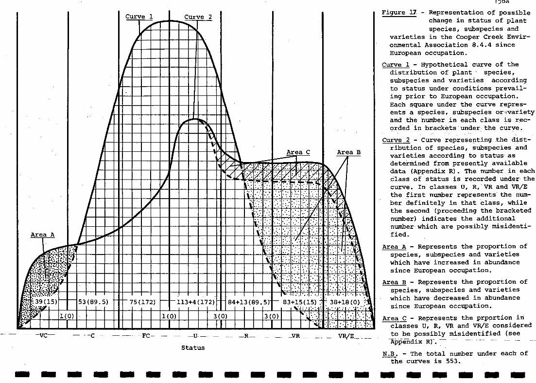
Status
1)011
Figure 17 - Representation of possiblechange in status of plant
species, subspecies andvarieties in the Cooper Creek Envir-onmental Association 8.4.4 sinceEuropean occupation.
Curve 1 - Hypothetical curve of thedistribution of plant species,subspecies and varieties accordingto status under conditions prevail-ing prior to European occupation.Each square under the curve repres-ents a species, subspecies orvvarietyand the number in each class is rec-orded in brackets-under:the curve.
Curve 2 - Curve representing the dist-ribution of species, subspecies andvarieties according to status asdetermined from presently availabledata (Appendix R). The number in eachClass of status is recorded under thecurve. In classes U, R,-VR and VR/Ethe first number represents the num-ber definitely in that class, whilethe second (proceeding the bracketednumber) indicates the additionalnumber whichare possibly. misidenti-fied.
Area A - Represents the proportion ofspecies, subspecies and varietieswhich have increased in abundancesince European occupation.
Area B - Represents the proportion ofspecies, subspecies and varietieswhich have decreased in abundancesince European occupation.
Area C - Represents the prportion inclasses U, R, VR and VR/E consideredto be possibly misidentified (seeAppendix R).-- -- --
N.B. - The total number under each ofthe curves is 553.
1111611111111111111MOINION1111111111111110111111111111111110111101111111111111111111
.
Area A
Curve 1 Curve 2
\
lip\ -
...-AdAgrarrAinorAFJOEFeu.
Area C Area B
,
_
4111111k
.
:
IIMINFAINIEffirdiE41,211.1111111MralligiNiiiiiiMetar
:.%-.... .
v..-...:..
,.::::
'...::.:31::*%:7.;:::::::
AliliIMMI .c:...:. :.:.AEI : :::
. .. .
::::. 4n.:;,-;
.-,J
at 39(15) 53(89.5) 75(172) ----113+4(172) 84+13(89.5) 83+15(15) 38+18(0) .:.'--
411 1(0) 1(0) 3(0) 3(0) . ' ':%.:'- :...:*. . . .. .
fr 1 I II 1
- -VC -R_-FC- _VR__

.v0+ 4.."...4r,t- 4.9r-1
4M1:i40-,s-apcb-
fAaH -I °-os sPewarlerG-04,04
rov..4s0vospulta-i1:44..vra2litai. .40 p4,*. 9 ",
irreciwea. 6 )40 LA" +1.2, vow rcoJeld viT73,4ri6171'

159
(Section 2.). The location of fencing and size of paddocks however has been left uTto lessees, :So that on some properties controls will be more effective than others.It is considered by the authors that the effects of this sustained stockingpressure on vegetation has been extreme. In times of drought rabbit numers tend tofall off as feed is reduced whereas under existing pastoral practise cattle areleft to fend for themselves till the next muster. In better watered regions such afthe Cooper Creek Flood Plain such practises can no longer be considered as viableif the habitats of breeding birds and other components of fauna are to bemaintained. It is considered that most components of the natural fauna and florahave adjusted to the regime of land use associated with cattle grazing and thereduced numbers of ground dwelling species of mammals and to a lesser extent birdsand reptiles tend to indicate this. Vegetation has changed significantly since theland was first settled.
Furthermore it is expected that in the future as the properties are restockedthe reviewed fencing associated with the BTB programme will force stock to useareas which in the past have been largely unutilized grazing areas. Further lchange
in habitat and adjustment of populations of organisms is likely to result from sueteffects.
It is not possible to attribute the changes in vegetation and loss or declineof species purely to the effects of overgrazing as bad seasons or changed watierregimes would have affected the ability of the vegetation to resist disturbance.The problem remaining is that these disturbances have been sustained through 'badseasons and without influence of changed water regimes. The problem is wellunderstood so there is no biological reason that it should be allowed to containue.
A graphical representation of possible changes in the status of floristicelements of 8.4.4. since European occupation is shown in Figure 17. It has severalshortcomings, one of which is the lack of distinction between annuals andperrenials in the assessment of the status of floristic elements. Collector biashas not been taken into account and this may also be a problem as most collectionshave been made in the Spring months. In spite of these possible problems the curveclearly demonstates the major changes in floristics that have occured sinceEuropean settlement.
Curve 1This is the hypothetical curve of plant species occuring in the area prior toEuropean settlement. The six classes of status represented under the curve indicatEthat the majority of species were uncommon (U) or fairly common (FC), a smal]Jer butsignificant proportion were common (C) or rare (R) while a few species were verycommon (VC), or very rare (VR). The dividing lines between each class of status arcarbitrarily placed as one possible representation of the preEuropean situation.
Cuve 2This represents the distribution of plant species now as determined from thepresently available data (see Appendix R).
Area AArea A reprsents the proportion of species, subspecies and varieties which haveincreased in abundance since European occupation. Examples of these "increaser"species include species which are unpalatable such as Sclerolaena or slightlypalatable such as Cottonbush (Maireana aphylla) which is also reported to replaceBladder Saltbush (Atriplex vesicaria where the latter is destroyed by overgrazing(Ratcliffe, 1936). Other species in area A include those which can compete
I
successfully in sites opened up by grazing such as Native Pear (Cynanchumfloribundum) Sandhill Wattle (Acacia ligulata) Green Birdf lower (Crotalariacunninghamii), Crotellaria ermeaea and Solanum oligacanthum. In addition Acadia

160
ligulata is considered by both Jessup (1951) and Dawson and Boyland (1974) to beunpalatable or at most slightly palatable and so is a prime candidate fordevelopment as an "increaser species".
Area BArea B represents the proportion of species, subspecies and varieties whih havedecreased in abundance since European occupation. These "decreaser species" havebeen markedly affected to the point where some may be on the verge of extinction.It should be noted that a considerable proportion of the flora was rare or veryrare to begin with and the European occupation has provided the impetus to pushthese species towards extinction much more rapidly than would have been the caseprior to European settlement.
There does not seem to be a direct correlation between palatability and theobserved decline of species but these palatability assessments were based on well-managed grazing systems and it is clear that at various times in the past in theCooper Creek Environmental Association stock and rabbit numbers have been such thatthey were c--ced to eat any available vegetation.
6.5 CONCLUSIONS
The lands comprising the Cooper Creek Environmental Association 8.4.4
are significant for a number of different reasons. They overlie the majority
of South Australia's productive oil and gas fields and also comprise some
of the best pastoral land in the State - two significant economic factors
that make them a focus of attention by the majority of South Australians.
Some people visit this area as tourists.
Another reason that Association 8.4.4 is significant is the diversity
of habitats encompassed within its bounds, and the diversity of its flora
and fauna. This area contains good representative examples of all major
habitat types present in the north-east of South Australia, apart from a
few which are unique or nearly so. These habitats provide niches for up to
500 or more species of plant, 185 species of bird, 25 mammals, 47 reptiles,
5 frogs, 16 fish and countless aquatic invertebrates species. There is apotential for the resident biota, which is currently under some degree of
threat, to increase in abundance. However, this will require the acceptance
by all land-users of a the need to accommodate all land-uses within this
area.
The key to the co-existence of all land-users is proper management
that also accounts for the presence and need for the diversity of land-uses
that are present. All land-users have a legitimate right to the land they
occupy, however, in some instances the needs of particular land-usershave application to the same area of land surface. This causes perplexing
problems related to attempts at weighing economic gains against ecological
losses and, these problems have no easy answers. It will be impossible to
set aside all of the land for the purposes of conservation and, in the same
way it will be impossible to have all available land set aside for use by the
pastoral industry. Because the petroleum exploration/extraction industries
interests are largely underground they are not specifically interested in
permanent rights to an area of land surface. Rather, they wish to ensure that
their economic interests are maintained, at least for the duration of a
particular field. The difficulty then is to accommodate these different
interests.
Conservation authorites should therefore assess very carefully the
available information before selecting an area of land that may comprise
1I/I suitably unique features that warrant its designation as a reserve. And, both
the pastoral and petroleum exploration/extraction industries should strive
to go beyond the surficial acceptance of conservation as it is in their long-
Iterminterest, to work together with conservation authorities for lasting and
mutual benefit.

161 -
11
7. ACKNOWLEDGEMENTS
The authors wish to thank the following people for assistance with this11project. Mr G. Medlin'and Mr R.G. Lesslie for voluntary field work in the
first and second field trips, respectively. Mr G. Drewin of the OutbackManagement Branch of the Department of Lands for the loan of aerial photo-
11graphs and maps, and valuable discussions regarding the pastoral lands ofthe study area. Mrs J.A. Pedler, Mr.S.A. Parker, Mrs J.B. Paton, Mt W.E.Matheson, Mr.Leo Joseph, Mr G.B. Ragless, Dr D. Baker-Gabb, May,,
Mr Frank Badman and Mr R.P. Jaensch for assistance with the ornithologicalaspects of the project. Mt B. Howith, Water Resources Branch, E. & W. S.,and Mr J. Hobbs, Queensland Water Resources Commission, for flow data fromCallamurra Waterhole and Currareva, respectively. Mr A. Halse and Mk P.Hambledon, Delhi Petroleum, for provision of seismic location paps andothbr maps pertinentr.to this study. Ms N. McLaren, Social and Ecological
-Assessment Pty. Ltd., for the loan of documents and other assistance.Mr Oleg Morozow, Risk Management Unit, SANTOS Ltd., for the loan of 11documents and pertinent discussions. Mr A.K. Turner for discussionsrelating to the project. Dr "Bill" Venables, Biometry Section, WAITE, Univ.Adelaide, also provided valueable advise regarding a number of aspectsrelating to the project. Mr G.B. Ragless for general assistance anddiscussions. Officers and staff of the State. Herbarium for botanical advise.
A lot of people did countless hours of work on this project withlittle expectation of returns. To all of these and any others whoassisted in any way, your assistance is gratefully acknowledged.
11
11
1

7. REFERENCES
A reference sheet used in the compilation of the annotated bibliography(Section (5) of the Brief) is included as Appendix U.
7.1 REFERENCES
Aitken, P.F., 1968. - Observations of Notomys fuscus (Wood Jones) (Muridae -Pseudomyinae) with notes on a new synonym ". S. Aust. Nat. 43:37-45.
Aitken, P.F., 1972. " Planigale gilesii (Marsupialia, Dasyuridae); a newspecies from the interior of south eastern Australia ".Rec. S. Aust. Mus. 16(10) : 1 - 14.
Andrews, F.W., 1883. " Notes on the Night Parrot Geopsittacus occidentalis ".
Trans. Roy. Soc. S. Aust. 6 : 29 - 30.
Australian National Parks and Wildlife Service, 1980. Kakadu National ParkPlan of Management. (Aust. N.P. & W.S.: Canberra).
Australian Water Resources Council,1975. Dept. Nat. Resources, Aust.
Badman, F.J., 1979. " Birds of theS. Aust. Ornith. 28 : 29 - 81.
Badman, F.J. and May, I.A., 1983. " Waders of northern South AustraliaS. Aust. Ornith. 29 : 29 - 39.
162
1976. Review of Australia's Water Resources,Water Resources Council. (A.G.P.S.: Canberra
southern and western Lake Eyre drainage ".
Baker-Gabb, D.J. and Pettigrew, J.D., 1982. " Non breeding diet of the letterwinged Kite in north-eastern South Australia ". Corella 6 : 19 - 20.
Barker, W.R., 1982. " Evolution, adaptation and biogeography in arid AustralianScrophulariaceae ". Paper 39. In: Barker, W.R. and Greenslade, P.J.M. (eds.),Evolution of the Flora and Fauna of Arid Australia, pp. 341 - 350. (Peacock:S. Aust.).
Barlow, B.A., 1984. " boranthaceae ". In: George, A.S. (ed.), Flora of Australia,Vol. 22, pp. 68 - 131. (A.G.P.S.: Canberra).
Barnsley, B., 1982. " Frankeniaceae ". In: George, A.S. (ed.), Flora of Austral-ia, Vol. 8, pp. 112 - 146. (A.G.P.S.: Canberra).
Black, A.B., Duggan, G., Pedler, J.A. and Pedler, L.P., 1983. " The Yellow ChatEphthianura crocea at Pandiburra Bore, North-eastern South Australia ".S. Aust. Ornith. 29 : 42 - 45.
Black, J.M., 1917. " Botany in Results of the South Australian Museum expeditionto Strzelecki and Cooper Creek, September and October, 1916 ".Trans. Roy. Soc. S. Aust. 41 : 405 - 658.
Black, J.M., 1943 57. Flora of South Australia. Parts II-IV, 2nd Ed., Part Irevised and edited by J.P. Jessop (3rd Ed.). (Govt. Printer: Adelaide).
Boles, W.E., 1979. " The relationships of Australo-Papuan flycatchers ".Emu 79 : 107 - 110.
Bolton, M.P. and Specht, R.L., 1981. A Network of Conservation Reserves forWestern Queensland. (Dept. Botany: Univ. Qld).
Bonython, C.W., 1955. Lake Eyre South Australia: The Great Flooding of 1949 - 50;Report of the Lake Eyre Committee. Roy. Geogr. Soc. Aust., S. Aust. Branch.(Griffin Press: Adelaide).
).
163
Bowler, J.M., 1982. " Aridity in the late Tertiary and Quaternary of Aust-ralia ". Paper 4. In: Barker, W.R. and Greenslade, P.J.M. (eds), Evolutionof the Flora and Fauna of Arid Australia. pp. 33 - 45. (Peacock: S. Aust.).
Braithwaite, L.W., 1981. " Some revised thoughts on requirements for water-fowl management in Australia ". In: Corbett, D.W.P. (ed.), Hunting, GameManagement and Conservation. Proc. Seminar By Dept. Continuing Education,Univ. Adel., N.C.S.S.A. inc., S.A.O.A. and S. Aust. Field and Game Assoc.inc. (Dept. Continuing Education, Univ. Adelaide Public. No. 82).
Briggs, S.V., 1981. " Freshwater wetlands ". Chapt. 15. In: Groves, R.H. (ed.),Australian Vegetation. pp. 335-360 (C.U.P.: Cambridge).
Brandon, T., 1951. " A trip to Kopperamanna in the far north of South Aust-ralia ". S. Aust. Ornith. 20 : 16 - 20.
Broad, A.J., Sutherland, S.K., Turner, C. and Covacevich, J., 1979." Electrophoretic, enzyme, and preliminary toxicity studies of the venomof the small scaled snake, Parademansia microlepidota (Serpentes, Elapidae),with additional data on its distribution ". Mem. Qld Mus. 19(3):319-329.
Brooks, J., 1980. " First record of the frog Ranidella deserticola, Liem& Ingram, from South Australia ". S. Aust. Nat. 54(3) : 45 - 46.
Buckley, R.C., 1982a. " Use and conservation of central Australian dune-fields ". Biol. Conserv. 22 : 197 - 205.
Buckley, R.C., 1982b. - Central Australian sand-ridge flora 18 000 yearsago: phytogeographic evidence ". Paper 10. In: Barker, W.R. and Green-slade, P.J.M. (eds), Evolution.of the Flora and Fauna of Arid Australia.pp. 107 - 117. (Peacock: S. Aust.).
Buckley, R.C., 1982c. " Environmental aspects of exploration in the EromangaBasin arid zone ". In: Moore, P.S. and Mount, T.J. (eds), Eromanga BasinSymposium. pp. 98 -99. (Geol. Soc. Aust. Abstr. No. 5).
Burbidge, N.T., 1960. " The phytogeography of the Australian regionAust. J. Bot. 8 : 75 - 212.
Bureau of Meteorology, 1975. Climatic Atlas of Australia;Map Set 3: Evaporation.(AG.P.S.: Canberra).
Carnahan, J.A., 1976. Atlas of Australian Resources Second Series: NaturalVegetation. (Geographic Section, Div. National Mapping: Canberra).
Carrick, J. and Chorney, K., 1976. " A review of Melaleuca L. (Myrtaceae)
in South Australia ". J. Adelaide Bot. Gard. 1 : 281 - 319.
Carrick, R., 1962. " Breeding, movements and conservation of ibises (Threskion-ithidae) in Australia ". C.S.I.R.O. Wildl. Res. 7 : 71 - 78.
Chenery, A., 1921Queensland ". S S. Aust. Ornith. 6(1):37-40;(11):61-64;(111):82-86
Chippendale, G.M. and Wolf, L., 1981. "The natural distribution of Eucalyptusin Australia ". Aust. Nat. Parks Wildl. Serv.: Spec. Public. No. 6.
Christian, C.S. and Stewart, G.A., 1953. " General report on survey ofKatherine-Darwin region, 1946 ". Ld. Res. Ser., C.S.I.R.O. Melb. No. 1.
. " Notes on birds met with during a visit to south=west
Boomsma, C ., 1981. Native Trees of South Australia. (2nd. Ed.). Bull. 19.
(S. Aust . Woods and Forests Dept.: Adelaide).
Boomsma, C . and Lewis, N., 1980. The Native Forest and Woodland Vegetationof South Australia. Bull. 25. (S. Aust. Woods and Forests Dept.: Adelaide )
Christian, C.S. and Stewart, G.A., 1968. " Methodology of integrated ,surveys ".In: Aerial Survey and Integrated Studies. pp. 233 - 280. (Proc. ToulouseConf. 1964: U.N.E.S.C.0.).

Cleland, J.B., 1925. " Birds seen between Beltana, Farina and Cordillo DownsStation ". S. Aust. Ornith. 8:50 - 60.
Cleland, J.B., Black, J.M. and Reese, L., 1925. " The flora of the North-eastcorner of South Australia, North of Cooper's Creek ".Trans. Roy. Soc. S. Aust. 49 : 103 - 120.
Close, D.H. and Jaensch, R.P., 1981. " Northern Shoveler at Coongie Lake ".S. Aust. Ornith. 28 : 178 - 179.
Close, D.H. and Jaensch, R.P., in press."Birds of the North-west of SouthAustralia ". S. Aust. Ornith.
Condon, H.T., 1969. A Handlist of the Birds of South Australia. (2nd Ed.)(S. Aust. Ornith. Assoc.: Adelaide).
Correl, R.L. and Lange, R.T., 1966. " Some aspects of the dynamics of vegetationin the Port Augusta - Iron Knob area, South Australia ".Trans. Roy. Soc. S. Aust. 90 : 41 - 43.
Corrick, A.H. and Norman, F.I., 1980. " Wetlands and waterbirds of the SnowyRiver and Gippsland Lakes catchment ". Proc. R. Soc. Vict. 91 : 1 - 15.
Cowardin, L.M., 1982. " Wetlands and deepwater habitats: A new classification ".J. Soil Water Cons. : 83 - 85.
Cox, J.B., 1976. " Grey Grasswrens and Grass Owl's at Goyder's Lagoon, SouthAustralia ". S. Aust. Ornith. 27 : 96 - 100.
Cox, J.B., 1982. " Ornithology of North-eastern South Australia ". In: Foale,M.R. (ed.), The Far North East of South Australia. A Biological SurveyConducted by the Nature Conservation Society of S. Aust. (Inc.) 2nd-30th August, 1975. pp. 49 - 63. (N.C.S.S.A. (inc.): Adelaide).
Cox, J.B. and Pedler, L.P., 1977. " Birds recorded during three visits to thefar North-East of South Australia ". S. Aust. Ornith. 27 : 231-250.
Crisp, M.D., 1978. " Demography, and survival under grazing of three Australiansemi-desert shrubs ". Oikos 30 : 520 - 528.
., 1959. " Past climatic fluctuations and their influence uponvegetation ". In: Keast, A. and others (eds), Biogeography andAustralia.pp. 283 - 290. (Den Haag, W. Junk). Monographie Biol-
. 8).
Crocker, R.LAustralianEcology inogicae Vol
Davies, R. J-P., 1982. The Conservation of Major Plant Associations in SouthAustralia. (Conserv, Council of S. Aust. Inc.: Adelaide).
Dawson, N.M., 1974. " Land systems ". In: Dawson, N.M. and Boyland, D.E. (eds),Western Arid Region Land Use Study - Part 1. Div. Ld. Utilisation, Dept. Prim.Ind. Qld Tech. Bull. 12.
Dawson, N.M. and Boyland, D.E. (eds), 1974. Western Arid Region Land Use Study- Part 1. Div. Ld. Utilisation, Dept. Prim Ind. Qld Tech. Bull. 12.
164
Crocker, R.L. and Wood, J.G., 1947. " Some historical influences on thedevelopment of South Australian vegetation communities and their bearing onconcepts and classification in ecology ". Trans. Roy. Soc. S. Aust. 71:91-136.
Cupper, L., 1983. " A breeding record and notes on other sight records of thePlumed Whistling-Duck in the far North-East of South Australia ".S. Aust. Ornith. 29 : 64.
Delroy, L.B., 1981. " Management of wetland for waterbirdsP. (ed.), Hunting, Game Management and Conservation. Proc.Continuing Education, Univ. Adelaide, N.C.S.S.A. inc., S.AField and Game Assoc. Inc. (Dept. of Continuing Education,Public. No. 82).
. In: Corbett, D.W.Seminar By Dept..0.A. and S. Aust.Univ. Adelaide,

165
Douglas, J.S., 1980.S. Aust. Inc.).
Dulhunty, J.A., 1983Trans. Roy. Soc. S
South Australia From Space. W.V. Macfarlane (ed.) (AnzaaS -
. " Lunettes of Lake Eyre North, South Australia "
. Aust. 107 : 219 - 222.
Elkin, A.P., 1931. " The social organisation of South Australian tribes ".Oceania 2 : 44 - 73.
E.R. & P. G. = Environmental Research and Planning Group, 1980. Vegetationand Fauna Studies: SANTOS liquids Project, Cooper Basin and RedcliffStudy Areas. (Environmental Research and Planning Group: Adelaide, June,1980).
Finlayson, H.H., 1933. " On mammals from the Lake Eyre Basin. Part I. TheDasyuridae ". Trans. Roy. Soc. S. Aust. 57 : 195 - 202.
Finlayson, H.H., 1936. " On mammals from the Lake Eyre Basin. Part III.Diprotodont marsupials and Ornithodelphia ".Trans. Roy. Soc. S. Aust. 60 : 57 - 161.
Finlayson, H.H., 1939. " On mammals fiom the lake Eyre Basin. Part V.General remarks on the increase of Murids and their population movementsin the Lake Eyre Basin during the years 1930 - 1936 ".Trans. Roy. Soc. S. Aust. 63 : 348 - 353.
Finlayson, H.H., 1941. " On central Australian mammals. Part II. The MuridaeTrans. Roy. Soc. S. Aust. 65 : 215 - 232.
Finlayson, H.H., 1961. " On central Australian mammals. Part IV. The distri-bution and status of central Australian species ".Rec. S. Aust. Mils. 14 : 141,- 191.
Foale, M.R. (ed.), 1982. The Far North East of South Australia. A BiologicalSurvey Conducted by the Nature Conservation Society of S. Aust. (Inc.) 2nd-30th August, 1975. Pp. 1 - 88. (N.C.S.S.A. (inc.): Adelaide).
Ford, H.A., 1978. " The Black Honeyeater: nomad or migrant? ".S. Aust. Ornith. 27 : 263 - 269.
Forrest, J.A., 1982. " Mammals of northeastern South Australia ". In: Foale,M.R. (ed.), The Far North East of South Australia. A Biological SurveyConducted by the Nature Conservation Society,;of S. Aust. (Inc.) 2nd-30thAugust, 1975. pp. 65 - 68. (N.C.S.S.A. (inc.): Adelaide).
Forshaw, J.M., 1981. Australian Parrots. (landsdowne : Melbourne).
Frith, H.J., 1977. Waterfowl in Australia. (A.H. & A.W. Reed: Sydney).
Frith, H.J., 1979. Wildlife Conservation. (Angus and Robertson: Sydney).
Frith, H.J., 1982. Pigeons and Doves of Australia. (Rigby: Adelaide).
Glover, B., 1957. " A journey to Cooper Creek". S. Aust. Ornith. 22:30-36.
Glover, C.J.M., 1979. " Studies on Central Australian fishes: furtherobservations and records, Part I". S. Aust. Nat. 53(4) : 48 - 52.
Glover, C.J.M. and Sim, T.C., 1978a. " Studies of Central Australian fishes:a progress report ". S. Aust. Nat. 52 : 35 - 45.
Glover, C.J.M. and Sim, T.C., 1978b. " A survey of Central Australian IchthyologyAust. Zool. 19(3) : 245 -256.
1
Graetz, R.D., Tongway, D.J. and Pech, R.P., 1982. " An ecological classificatilonof the lands comptising the southern Simpson Desert and its margins ".C.S.I.R.O. Rangelands Research Centre (Deniliquin) Tech. Memo. 82/2.
Hewson, H.J., 1982a. " Capparaceae ". In: George, A.S. (ed.), Flora of AustraliaVol. 8.pp. 207 - 231. (A.G.P.S.: Canberra).

Joseph, L., 1982. " A further population of the Grey Grasswren ".Sunbird 12 : 51 - 53.
Kershaw, A.P., 1981. " Quaternary vegetation and environments ". In: Keast, A.(ed.), Ecological Biogeography of Australia. pp. 81 - 101. (Dr W. Junk byPublishers: The Hague).
King, D., 1960. " The sand ridge deserts of South Australia and related aeolianlandforms of the Quaternary arid cycles ". Trans. Roy. Soc. S. Aust. 83:99-108.
Kluge, A.G., 1974. " A taxonomic revision of the lizard family Pygopodidae ".Misc. Publ. Mus. Zool. Michigan Uni. 147 : 1 - 221.
Lange, R.T. and Purdie, R., 1976. " Western Myall (Acacia sowdenii), itssurvival prospects and management needs ". Aust. Rangelands J. 1 : 64 - 69.
166
Hewson, H.J., 1982b. " Brassicaceae (Cruciferae) ". In: George, A.S. (ed.),Flora of Australia. Vol. 8. pp. 231 - 357. (A.G.P.S.: Canberra).
Hewson, H.J. and George, A.S., 1984. " Santalaceae ". In: George, A.S. (ed.),Flora of Australia. Vol. 22. pp. 29 - 67. (A.G.P.S.: Canberra).
Hodgkinson, K.C.and Griffin, G.F., 1982. " Adaptation of shrub species tofires in the arid zone ". Paper 15. In: Barker, W.R. and Greenslade, P.J.M.(eds), Evolution of the Flora and Fauna of Arid Australia. pp. 145 - 152.(Peacock: S. Aust.).
Hooper, P.T. et al., 1973. Ayers Rock - Mount Olga National Park EnvironmentalStudy, 1972. Ld. Conserv. ser. No. 2, Arid Zone Res. Inst., Dept. of theNorthern Territory.
Houston, T.F., 1978. The Dragon Lizards and Goannas of South Australia. Spec.Educational Bull. Ser., S. Aust. Museum. Pp. 1 - 84. (S. Aust. Museum:
Adelaide).
Howard, J.A., 1970. Aerial Photo-ecology. (Faber and Faber: London).
Hynes, H.B.N., 1970. The Ecology of Running Waters. (Liverpool UniversityPress: Liverpool).
James, C., 1982. " Earlier recordings of mammals in northeastern South Austr-alia ". In: Foale, M.R. (ed.), The Far North East of South Australia. ABiological Survey Conducted by the Nature Conservation Society of S. Aust.(Inc.) 2nd-3oth August, 1975. pp. 69- 73. (N.C.S.S.A. (inc.): Adelaide).
Jessop, J.P. (ed.), 1977. " Endangered species in the South Australian nativevascular flora ". J. Adelaide Bot. Gard. 1(2) : 135 - 139.
Jessop, J.P. (ed.), 1981. Flora of Central Australia. (A.H. & A.W. Reed:Sydney).
Jessop, J.P., 1982. " Vegetation of northeastern South Australia. Rare andendangered species ". In: Foale, M.R. (ed.), The Far North East of SouthAustralia. A Biological Survey Conducted by the Nature Conservation Societyof S. Aust. (Inc.) 2nd-30th August, 1975. pp. 27 - 48. (N.C.S.S.A (inc.):Adelaide).
Jessop, J.P.(ed.), 1983. A List of the Vascular Plants of South Australia.(1st Ed.). (Botanic Gardens, State Herbarium and Environmental SurveyBranch, Dept. Environment and Planning: Adelaide).
Jessup, R.W., 1951. " The soils, geology and vegetation of north westernSouth Australia ". Trans. Roy. Soc. S. Aust. 74 : 189 - 273.
Johnson, M., 1980. " The origin of Australia's salt lakes ".Rec. Geol. Surv. N.S.W. 19 : 221 - 266.
167
Laut, P., Keig, G., Lazarides, M., Loeffler, E., Margules, C., Scott, R.M.and Sullivan, M.E., 1977. Environments of South Australia. Province 8:Northern Arid. + Handbook. (Div. Ld Use Res., C.S.I.R.O.: Canberra).
Lawson, P.F. and Parker, S.A., 1976. " The occurrence of the Singing BushlarkMirafra javanica in north-eastern South Australia ". S. Aust. Ornith.27:143.
Leigh, J., Briggs, J. and Hartley, W., 1981. " Rare of threatened Australianplants ". Aust. Nat. Parks Wildl. Serv.: Spec. Public. No. 7.
Lewis, J.w., 1875. Report of the Lake Eyre Expedition. S. Aust. ParliamentaryPaper 114/1875. (S. Aust. Govt. Printer: Adelaide).
Lewis, /CM., 1982. " Vegetation of northeastern South Australia. Generalreport ". In: Foale, M.R. (ed.), The Far North East of South Australia. ABiological Survey Conducted by the Nature Conservation Society of S. Aust.(Inc.) 2nd-30th August, 1975. pp. 15 - 28. (N.C.S.S.A. (inc.): Adelaide).
Litchfield, L., 1983. Marree and the Tracks Beyond in Black and White - Com-memorating the Centenary of Marree 1883 - 1983. (Publ. by the Author, May,1983). -
Ludbrook, N.H., 1965. " Occurrence of Foraminifera in salt lakes "..Geol. Surv, S. Aust.: Quart. Geol Notes 14 : 6 - 7.
Ludbrook, N.H., 1980. A Guide to the Geology and Mineral Resources of SouthAustralia. (Govt. Printer: Adelaide).
MacLean, G.L., 1973. " A Review of the biology of the Australian desertwaders Stiltia and Peltohyas ". Emu'73 : 61 - 70.
Madigan, C.T., 1946. Crossing the Dead Heart. (Georgian House: Melbourne).
Maslin, B.R. and Hopper, S.D., 1982. " Phytogeography of Acacia (Leguminosae:Mimosoideae) in Central Australia ". Paper 34. In: Barker, W.R. and Green-slade, P.J.M. (eds), Evolution of the Flora and Fauna of Arid Australia.pp. 301 - 315. (Peacock: S. Aust.).
Mason, B., 1955. " Rainfall in the Lake Eyre catchment ". In: Lake Eyre,South Australia. The Great Flooding of 1949-50 - Report of the Lake EyreCommittee. (R. Geogr. Soc. A/asia, S. Aust. Branch, Griffin Press: Adel.).
Matheson, W.E., 1981a. " The Brown Honeyeater in South Australia ".S. Aust. Ornith. 28 : 180 - 184.
Matheson, W.E., 1981b. " Records of the Painted Honeyeater in South Australia"!S. Aust. Ornith. 28 : 184 - 185.
McGilp, J.N., 1931a. " Notes on some interior birds ". S. Aust. Ornith. 11:7-12
McGilp, J.N., 1931b. " Geopsittacus'occidentalis, Night Parrot ".S. Aust. Ornith. 11 : 68 - 70.
McGreevy, D.G. and Searle, A.K., 1974. " Preliminary fauna studies ". In:Dawson, N.M. and Boyland, D.E. (eds), Western Arid Region Land Use Study- Part 1. Div. Ld Utilisation, Dept. Prim. Ind. Qld Tech Bull. 12.
Menkhorst, P.W. and Isles, A.C., 1981. " The Night Parrot: evidence of itspresence in north-west Victoria during the 1950's ". Emu 81 : 239 - 240.
Mitchell, G.S., 1978. Aquatic Weeds in Australian Inland Waters. (A.G.P.S.:Canberra).
Nix, H.A., 1981. " The environments of Terra Australis ". In: Keast, A. (ed.) j
Ecological Biogeography of Australia. pp. 105 - 133. (Dr W. Junk by Publish_!ers: The Hague).
Parker, S.A., 1977. " Records of the Barking Owl from South Australia "S. Aust. Ornith. 27 : 204 - 206.

Parker, S.A., 1980a. " Birds and conservation parks in the north-east ofSouth Australia ". S. Aust. Parks and Cons. 3 : 11 - 18.
Parker, S.A., 1980b. " Samuel White's ornithological explorations in northernSouth Australia in1863 ". S. Aust. Ornith. 28 : 113 - 119.
Parker, S.A., Eckert, H.J., Ragless, G.B., Cox, J.B. and Reid, N.C.H., 1979.An Annotated Checklist of the Birds of South Australia. Part 1: Emus toSpoonbills. (S. Mist. Ornith. Assoc.: Adelaide).
Parler, S.A. and Braithwaite, L.W., in prep.
Parsons, F.E., 1921. " Notes on a motor trip from Adelaide to Western Queens-land ". S. Aust. Ornith. 6 : 12 - 23.
Paton, J.B., 1981. " The Grey Honeyeater: a review of distribution and variation".S. Aust. Ornith. 28 : 185 - 190.
Pearce, H., 1978. Homesteads of the Stony Desert. (Rigby: Adelaide).
Pedler, L. P. and Ragless, G.B., 1978. " Birds observed near Lakes Frome andCallabonna ". S. Aust. Ornith. 27 : 274 - 276.
Philpott, C.M. and Smyth, D.R., 1967. " A contribution to our knowledge ofsome mammals from inland Australia ". Trans. Roy. Soc. S. Aust. 91:115-134.
Pipelines Authority of South Australia, 1981. Moomba to Stony Point PipelineFacilities - Draft Environmental Impact Statement, July, 1981. (Bechtel -Kinhill Joint Venture).
Pizzey, G., 1980. A Field Guide to the Birds of Australia. (Collins: Sydney).
Price, A.G., 1955. " Introduction ". In: Lake Eyre, South Australia. The GreatFlooding of 1949-50 - Report of the Lake Eyre Committee. (R. Geogr. Soc.A/asia, S. Aust. Branch, Griffin Press: Adelaide).
Pryor, L.D., 1981. " Australian endangered species: eucalypts ".Aust. Nat. Parks Wildl. Serv.: Spec. Public. No. 5.
Ratcliffe, F.N., 1936. Soil Drift in the Arid Pastoral Areas of South Australia.C.S.I.R. Melbourne Pamphlet No. 64. (Govt. Printer: Melbourne).
168
Reardon, T., 1983.ed to members of
Reese, L.R., 1924.
1925
Bat Species of South Australia. Privately copied and circulat-Bat Club.
7 : 229 - 230.
8 : 61.
the F.N.S. Mammal
" Bird notes ".
Club and S. Aust.
S. Aust. Ornith.
1927a 11 II 9 : 69.
1927b II es II II IV 9 : 104.
11 1928a
1928b
II
II II
I, II
II
9 : 172 - 173.
9 : 251.
If 1930 et II II 10 : 279 - 280.
11 1931a 11 11 II uo 11 : 108.
11 1931b 11 11 II 1.1 11 : 229.
It 1933a
1933b
II
se
II
II
12 : 31 - 32.
12 : 103 - 104.
11 1935a II II il II .13 : 15 - 16.
1935b II II 13 : 124 - 125.
1936 13 : 241 - 242.

169
Reeves, P., 1982. " Summary and recommendations ". In: Foale, M.R. (ed.), The
Far North East of South Australia. A Biological Survey Conducted by the
Nature Conservation Society of S. Aust. (Inc.) 2nd-30th August, 1975. pp.
81- 88. (N.C.S.S.A. (inc.): Adelaide):
Reid, N.C.H., 1982. Avifauna Baseline Report, Olympic Dam Project. (RoxbyManagement Services Pty. Ltd.: Adelaide).
Reid, N. and Vincent, D.J., 1979. Report on the Ornithological Survey of SouthAustralian National, Conservation and Recreational Parks and Game Reserves, j
with Comments on the Adequacy of Bird Conservation in South Australia. (S.
Aust. Ornith. Assoc.: Adelaide, mimeographed).
Rix, C.E., 1974. " Bird notes ". Bird Talk 1.
Roberts, G.T. and Naqvi, I.H., 1978. Lower Gordon Scientific Survey: Geology,;Geomorphology and Land Systems. Pp. 1 - 45. (H.E.C.: Tasmania).
Roxby Management Services Pty. Ltd., 1982. Olympic Dam Project - Draft Environ-
mental Impact Statement. (Kinhill - Stearns Roger, Joint Venture: Adelaide)!
Schodde, R., 1975. Interim List of Australian Songbirds, Passerines. (RoyalAustralian Ornithologists Union: Melbourne).
Schodde, R., 1982. " Origin, adaptation and evolution of birds in aridAustralia ". Paper 22. In: Barker, W.R. and Greenslade, P.J.M. (eds),Evolution of the Flora and Fauna of Arid Australia. pp. 191 - 224. (Peacock:S. Aust.).
Scott, R.M., in prep. The Land Systems and Land Regions of South Australia.C.S.I.R.O. Div. Ld Use Res.
Slater, P., 1980. Rare and Vanishing Australian Birds. (Rigby: Adelaide).
Smyth, M., 1972. " Morethia (Lacertilia, Scincidae) South Australia, ".Rec. S. Aust. Mus. 16(12) : 1 - 14.
S.E.A. = Social and Ecological Assessment Pty. Ltd., 1982. Tirrawarra FieldEnvironmental Planning Map - Draft Report on Study Procedures for SANTOSLtd. (Social and Ecological Assessment Pty. Ltd.: Kent Town, S. Aust. -November, 1982).
S.A.(South Australian) Govt. (Government) Tourist Bureau, 1983. FlindersRanges and the Outback. South Australia. " Enjoy ". (S. Aust. Govt.Tourist Bureau: Adelaide).
SANTOS, 1981. Cooper Basin Liquids Project Environmental Review. (SANTOSLtd.: Adelaide).
SANTOS, 1983. Cooper Basin Environmental Review Volume 2, 1982/83. (SANTOSLtd.: Adelaide).
SANTOS, pamphlet. Pamphlet on oil search in the Cooper Basin.
South Australian Pastoral Board, 1973. The Vegetation of North-East SouthAustralia. (S. Aust. Past. Board: Adelaide).
Specht,R.L., 1972. The Vegetation of South Australia. (Govt. Printer: Adel.).
Specht, R.L., 1981. " Major vegetation formations in Australia ". In: Keast,A. (ed.), Ecological Biogeography Of Australia. pp. 163 - 297. (Dr W. Junkby Publishers: The Hague).
Specht, R.L., Roe, Ethel M. and Broughton, Valerie A., 1974. " Conservationof major plant communities in Australia and Papua New Guinea ".Aust. J. Bot.: Suppl. Series, Suppl. No. 7.
Steen, E.B., 1971. Dictionary of Biology. (Harper and Row: New York).

170
Storr, G.M., 1977. " Birds of the Northern Territory ". W.A. Museum Spec.Public. No. 7. (W.A. Museum: Perth).
Storr, R., 1980. " Pied Heron at Leigh Creek ". S. Aust. Ornith. 28 : 140.
Story, R., Williams, M.A.J., Hooper, A.D.L , O'Ferrall, R.E. and McAlpine,J.R., 1969. Lands of the Adelaide - Aligator Area, Northern Territory.
Ld Res. Ser. No. 25, C.S.I.R.O. Melb.
Story, A., Galloway, R.W., McAlpine, J.R., Aldrick, J.M. and Williams, M.A.J.,1976. Lands of the Alligator River Area, Northern Territory. Ld Res. Ser. No.
38, C.S.I.R.O. Melb.
Strahan, R. (ed.), 1983. Complete Book of Australian Mammals. Pp. 1 - 530.(Angus and Robertson: Sydney).
Sullivan, P.L. and yenning, J., 1982. The Extent and Severity of Tree Declinein the Agricultural Regions of South Australia. (Cons. Projects Branch, Cons.Programmes Div., Dept. Env. Planning: Adelaide, S. Aust., October, 1982).
Sutton, J., 1927. " Amytornis goyderi, Eyrean (formerly Goyder's) Grass-wren,etc. " . S. Aust. Ornith. 9 : 116 - 131.
Symon, D.E., 1982. " Solanum (Solanaceae) in arid Australia ". Paper 38. In:Barker, W.R. and Greenslade, P.J.M. (eds), Evolution of the Flora and Faunaof Arid Australia. pp. 335 - 339. (Peacock: S. Aust.).
Tate, R., 1889. " Plants of the Lake Eyre Basin ". Trans. Roy. Soc. S. Aust.11 : 85 - 100.
Telford, R., 1982. " Cucurbitaceae ". In: George, A.S. (ed.), Flora of Aust-ralia. Vol. 8, pp. 158 - 198. (A.G.P.S.: Canberra).
Thompson, M.B., 1983. " Populations of the Murray River tortoise, Emydura(Chelodina): the effect of egg predation by the red fox Vulpes vulpes ".Aust. Wildl. Res. 10 : 363 - 371.
Tindale, N.B., 1974. Aboriginal Tribes of Australia, Their Terrain, Environ-mental Controls, Distribution, Limits and Proper Names. (A.N.U. PressCanberra).
Twidale, C.R., 1982. " Landforms of northeastern South Australia ". In:Foale, M.R. (ed.), The Far North East of South Australia. A Biological Surveyby the Nature Conservation Society of S. Aust. (Inc.) 2nd-30th August, 1975.pp. 7 - 14. (N.C.S.S.A. (inc.): Adelaide).
Tyler, M.J., 1966. Frogs of South Australia. Pp. 1 - 40. (Govt. Printer: Adel.).
Tyler, M.J., 1978. Amphibians of South Australia. Pp 1 - 84. (Govt. Printer
Adelaide).
Waite, ER., 1917. " Mammals in Results of the South Australian Museum expeditionto Strz'elecki and Cooper Creeks, September and October, 1916 ".Trans. Roy. Soc. S. Aust. 41 : 405 - 658.
Walford, L., 1983. " Pied Butcherbirds at Leigh Creek ". S. Aust. Ornith. 29:74.
Watts, C.H.S. and Aslin, H.J., 1974. " Notes on the small mammals of north-east-ern South Australia and south-western Queensland ".Trans. Roy. Soc. S. Aust. 98 : 61 - 70.
Watts, C.H.S. and Aslin, H.J., 1981. The Rodents of Australia. Pp. 1 - 321.(Angus and Robertson: London).
Whibley, D.J.E., 1980. Acacias of South Australia. Pp. 1 - 240. (Govt. Printer:Adelaide).
White, S.A., 1917a. " Aves in Results of the South Australian Museum expedition

171
to Strzelecki and Cooper Creeks, September and October, 1916 ".
Trans. Roy. Soc. S. Aust. 41 : 405 - 658.
White, S.A., 1917b. In the Far North-East: A Scientific Expedition.
(Reprinted from the Register) (W.K. Thomas & Co.: Adelaide).
Williams, A.F. (compiler), 1975. GASON, South Australia Explanatory Notes,1:250 000 Geological Series, Sheet SG/54-13. (Geol. Surv. S. Aust., A.G.
P.S.: Canberra).
Williams, 0.B., 1982. " The vegetation of present-day arid Australia: abiotic appraisal ". Paper 1. In: Barker, W.R. and Greenslade, P.J.M. (eds),
Evolution of the Flora and Fauna of Arid Australia. pp. 3 - 14. (Peacock:
S. Aust.).
Wood, J.G., 1959. " The phytogeography of Australia (in relation to radia-tions of Euclayptus, Acacia, etc.)." In: Keast, A. and others (eds).Biogeography and Ecology in Australia. pp. 291 - 302. (W. Junk: Den Haag).
(Monographie Biologicae 8).
Wood Jones, F., 1923. The Mammals of South Australia. Parts I-III, 1923-1925, Pp. 1 - 458. (Govt. Printer: Adelaide).
Wopfner, H., 1961. " The occurrence of a shallow groundwater horizon andits natural outlets in north-eastern South Australia ".Trans. Roy. Soc. S. Aust. 85 : 13 - 18.
Wopfner, H., 1970. " Climbing ripple laminae from the Cooper Creek floodplain near Innamincka ". Geol. Surv. S. Aust.: Quart. Geol. Notes '34:5-10.
Wopfner, H., Callen, R. and Harris, W.K., 1974. " The Lower Tertiary EyreFormation of the southwestern Great Artesian Basin ".J. Geol. Soc. Aust. 21 : 17 - 51.
Wopfner, H. and Townend, R., 1968. " Heavy mineral sands from Lake Hope,Cooper's Creek Basin ". Geol. Surv. S. Aust.: Quart. Geol. Notes 26:7-11.
Wyndham, E., 1978. " Birds of the Milparinka district and Cooper CreekBasin ". Emu 78 : 179 - 187.

STATELIBRARYSouth Australia
Document. DeliveryNorth Terrace, AdelaideSouth AustraliaTelephone (08) 8207 7231Toll free 1800 182 013
This reference book is from theState Library of South AustraliaIt is to be used onlywithin your library
DEPARTMENT OF ENVIRONMENT AND PLANNING

Frans.. B.
APPENDICES
to
Biological Survey of the CooperCreek Environmental Association
(8.4.4) NorthEaStern SouthAustralia
.enmans, Ju1it R.W. Reid,.Ac.mpson, Lynne AlexanderLynn P. Pedler

pi um no um
um ow
we I=
we W
I No am
gm um
an um pop
popgni

7 APPENDICES
A The BriefGlossary of TermsRainfall, Moomba, InnaminckaRegional Rainfall FiguresTemperature & EvaporationWindsFlow in Cooper CreekCurrent Pastoral LeasesData SheetsPreliminary Methodology for SurveyProgress Report on Survey November 1983Plant Specimens collected during SurveyPlant species habitat preference & Status in Study areaPricipal Survey Site locations and Aerial Photo coverage
0 Preliminary list of fauna specimens collectedBird Census dataBird lists for permanent sample sitesAnnotated Plant List for Cooper Creek Environmental AssociationAnnotated list of birds in Cooper Creek Environmental AssociationPlant species palatabilitiesAquatic invertebrates
V CReference Sheetv./ heet-
mom
= ow
' umm
=7-1111am
omm
amasum
ws

I
1
1
1
Collection of data in a form suitable for integration into computer aata
bases currently being generated by the Survey and Research Section of the
National Parks and Wildlife Division of the Department of Environment and
Planning.
Classification of wetlands within the Cooper Creek Environmental
Association having regard for areal extent, permanence, depth ana
associated flora and fauna.
Establishment of representative, permanently marked sites which will
provide baseline data ayainst which ecological implications of flood
events within the region can be assessed.
Consideration of ecological impacts of grazing by both feral animals and
stock.
Production of an annotated bibliography of ail available information
relating to ecology ot the study area.
THE BRIEF
Al
APPENDIX A

A2
(6) Detailing 01 Current and projected land uses within the environmental
region.
II(7)
In addition to the full report which will concern matters related to the
above requirements the consultants are to produce a confidential report
IIwithinwhich recommendations pertaining to conservation priorities for the
area should be given. This confidential report shall include a map
delimiting areas of conservation v-lue ana discuss as tar as practicaule
the resolution of land use conflicts within the area.
1
1
MI M
illN
M O
M M
N N
M O
M M
O M
I11111111111111111111

APPENDIX B 1
GLOSSARY
--
Deepwater Habitat - An area of land surface with consistent soils, vegetation
IIand topographic elements, which is being utilised and which is temporarilyor permanently inundated by greater than 2 m of water.. (defined on P. 139).
Environmental Association - A particular combination of a limited number ofEnvironmental units, which are unique mapping areas..(defined by Laut et al.,1977 - P. 1).
Environmental Subassociations - Agglomerations of Environmental units withinEnvironmental Associations, which are more homogeneous mapping areas withinmore complex Environmental Associations like 8.4.4..(see Section 2.3.1, P.11).
Environmental subunits - Components of Environmental units that encompass anumber of habitats or land units..(see Section 2.3.6, P. 16).
Environmental units - Basic landform features..(Laut et al., 1977, P.1).
Habitat - An area of land surface with consistent soils, vegetation and topo-graphic elements, which is being utilised.. (defined on P. 110).
Land System - An area or group of areas throughout which there is a recurringpattern of topography, soils and vegetation..(see Section 2.3.4, P. 14).
Land unit - An area of land surface with consistent soils, vegetation andtopographic elements and some potential for utilisation..(defined on P. 19).
Land Zone - Broad groups of land systems, namely: the dunefields, the flood-plains and the gibber plains..(see Section 2.3.3, P. 12).
Physiography - Description of nature, of natural phenomena.
IIWetland
Habitat - An area of land surface with consitent soils, vegetation andtopographic elements, which is being utilised and Which is temporarily orpermanently inundated by up to 2 m of water.. (defined on P. 139).

mom
mum
j

Appendix C I MoNTHL`.4 RA IN FALL TorPLS FOR. fr1oo,MB A AN el IN NAmtnIcK.A( So e. 4 ).
P100.--112
MIN9 JUN UL Att4 gErtt OCT
MONT 14
I I I 71 1NOV DEc_
CI -1919
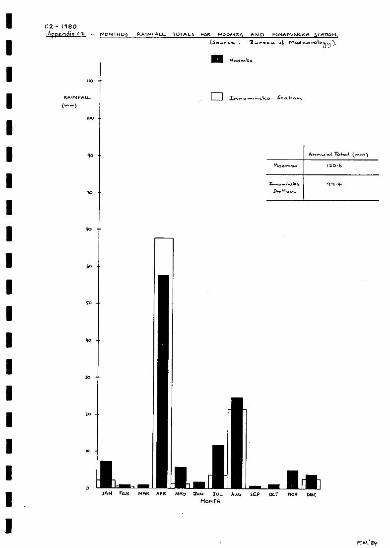
C2.- 1180Appendix G2 - MON TI4Ls-j R A INrALL. TOTALS Folk Moomo A ArO INI NA M. NICK tA Sr AT1 0 N
4 r0Moo rAbo
110
-
-
10 -
60
SO -
40 -
3o -
20 -
10
TAN FE13 MAR APR MA.4 1:DAN jUL A144
MONTH
Moor...00m
MEI 111SEP OCT NOV DEC
A
1204,
99.4-.S.Fro 4'; o
F704:84.
0 1111M1-1
RAINFALL Inn rsn. 14. G.
( yr, .1)
100

AfFendIX C3 - MONTH (.."-3 R_AINFAU- TOTALS FOR- moo me" ANC 1NNAMINCK t TFAllor4: of ( o 35).
RAINFALL.
110
100
TAN FM" MAR APR MA4 TUN T'UL.
MONTHsep OCT NOV DEC
C-181
Arr.-o..... I re (-.-1
2.33-
302-
El I in CA.C. 0. Si- ca+1.0

- 1982A prenctiX C4 - M T14 R.Ain.1 FALL TOTALS FOR mo or-is p, 1;) NN A miNcrc A SrATIon.1 .
IA 44 FALL
1 lo
100 -
80-
6°
60 -
4-0
30 -
C. tA a... cc- Me_ke-0.-063,-)).
Elt-c cko. S+/...1-t6us.
Po-%-,...1 1-04-A
Gk.%
F. Pl. 18(f-
10 ""
10
0APR, MA4 3uP1 TM. MAC% SEP OCT NOV DEC
MOOT H

Mini VA Lt.(rn )
loo
20
60
0
4.0
-V IN
17
To4-.A
5 1 4-1.
s z
C5 1 9 83
EM.' 9 4-
C5 MONTH LY RAINCAu_ 1t3TALS FOR. MooMVA ocNO INNAmiNcoc/{ SrAT(or4( : oF
1111 Moo."60.
AN FES MAR APR MAti TUN JUL AUG
MONTH
¶0
so
10
0
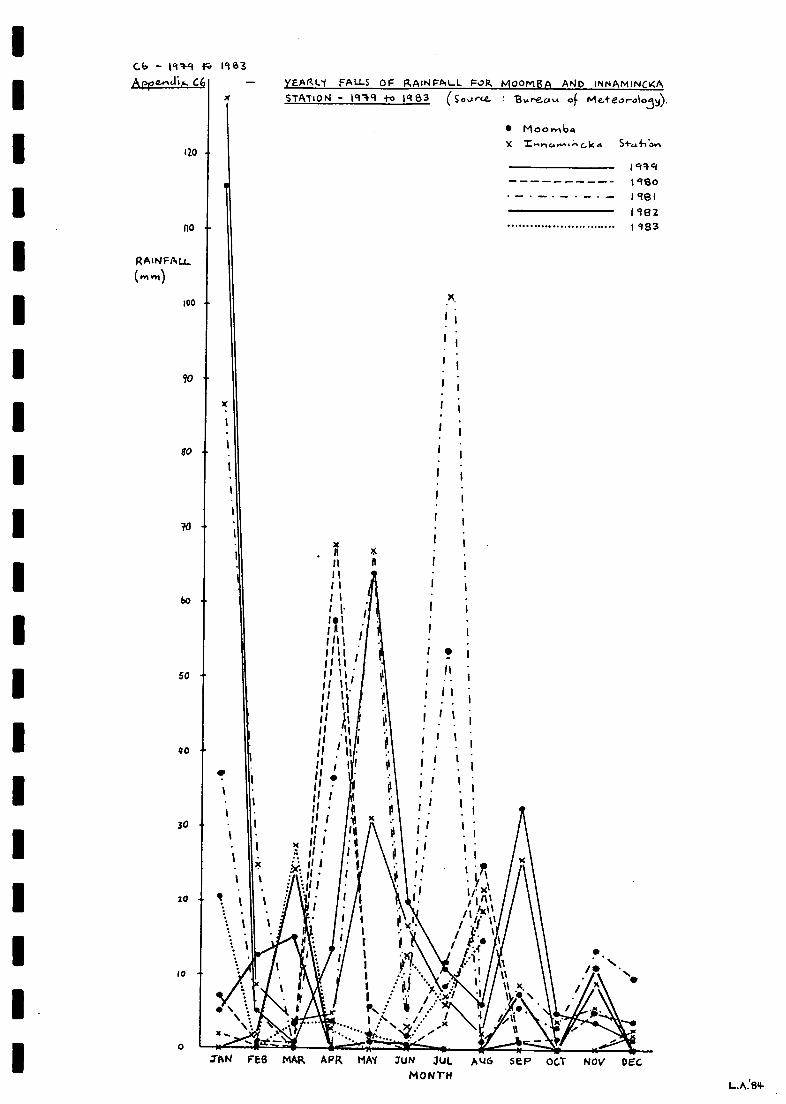
- 1949 1963Apeg....ZA. C4
1Z0
RAWFALL
110
100 -
90
80
6o -
SO -
40 -
30
10 41.
10
yEARL1 FALLS OF RAINFALL Fo MooMBA AND INNAMiNCKASTATION - 191.9 to 1,183 (Soorce- B,Areci,A of mereo,-0103y).
ELL--*TA.... ..1.:*.r_%
.......11m....:-....
MoombaX
x i. 11 g
1
II II IIII
II I I1%
I I' i I I11i A I 1
1
11111111 1 .111 i111111 1
11
' I11 11 '.. 1
111 111.1I I I
. ii I IIii il1I I I I
10 .11
II i II . 1
li . IIII 1 I 1 I I
Ii
1 II'1, I' I .. 1
li 1 I I1
. 1
1
Iii1 1
. 1
1x 111
1III
* M.':H
I 1I ' Y 1III I if x
v .11 Imit
/.5(0
.ii '1I
I / r.!i . f -
le-1.'
1 idi '.
.11-
4I ..I:' ,.. /....vi
, A
SI-LA.410 ri
JAN FEB MAR APR MM 3UN JULMONTH
NOV DECAk.16 se P OC.T
L.A:84-

MM
EN
=IM
IMM
OM
INN
MIM
IMO
IMM
INM
EN
IMM
UM
MIM

Apre.ncli.x D N/UAt_ RAINFALL. TDTPtsmeAN ANNUAL 'ToTALS ASO MEAN MONITHLV-TarALS o P.A1NFAu- Foe Poet-It-Alla-4 CE.r..1,12EC RELEVArv'T E
AREA-Crutri OR.. Fog. CooM PAR I4 0.11
DI
C0R.ott_LO HomErTEAD 26°es-2 S 14-0 '
cfWIe1-eo-c1o,)s-L-i
YEAR 0 I 2 3 `r3
1-43+-04 188_ - 1613 134 34-9 (99 24-4- 102 382.189- +06 221 159 34-8 154 232 130 139 14E1 86190_ 31 112 6$ 1+1 15 6i 213 211 22 5 49
M 91_ 315 167 164 210 /34- 45 296 /69 160 7-S1) 192_ 347 143 119 83 62 96 191 33 TB 19
193- 14-8 112 104- 64 118 41 l4-3 64- 94- 2()194-_ 59 158 I3S 40 /23 23/ 263 423ils_ 319 11-S 129 Ill 91 231 181 62 86 6
116_ 358 59 14* (20 /63 53 203 /16 /3/ q-/9._ ?(iO4,) 225 93 306 580 246 (/-li) 130 117 29?/98_ 7-7 290
Meo-P. to-.A (1 6 8 )M Mowa..a.,to...1s
TAN Fee MAR APR r-gA 3ut4 TuL AUG 4-EP Ocr Nen/ DEC9 I I I I21 26 2212. 12 I S
IKINAMINcKA 1-10mEs1E.A0 23-014-4: 14-0°4-6YE/4ft 0 1 2. 44- 5 6 49i 88_ - I 02. 42 503 144 189 +3 242I 99 _ 353 1/ 4- 262 226 (36 $28 13 14-8 iNc-/-
1 9 0_ 44 )03 14-2 24-3 70 $4 263 399 ..70,i) 74ITT 1 9 1_ 224. 2SS 13 1 93 88 205 190 140 121
1 9 2_ 2-51- 16G ? (AV) ? ?(I0) 143 4.3 64.1 9 3_ 24 173 53 4-8 68 97 22-7 36 45 34-2.I 9 4-_ 11/- 146 2./6- 63 182 '86 1o4- ?(cu) 95 1-171 15_ 33 96 114. 34- 183 34.s- 24o 13o 12.3 1 oiI 96 _ .266 52 2. SZ 4 2. g 1 S.- 6 a 1 83 2.4-2 187 46I 9 7_ 33 301 63 292 1 026 252 426 94- 243 2.2.9I 8_ 100 303 ?Oa-4
(144-)
TAN FE g MAR APR rttoN Tun) Auc. SEP oc.r N OV DEC30 3.2. 2.3 12.. 13 13 4- 4 II II 6
lick0sv ILLS S 139 °Asnr"Acal YEA1Z 0 1 2 89
S 1 8 - (03 13-6 !SS 123 So1 0 61 10L 2.93 314.- 53 165 4-15 aoy. eto1 9 1 204- 13- 10- 183 52 5+3 - - -192._ -4.4-2 22.2 89 190 33 t
1 co 3 _, (01 162 113 134 58 63 164- SS 109 269fYI
94_ 6S loo 12.7 57 31 24-0 24-1 33719S_ 390 54 193 166. 174 385' 301 $31 163 7-6196_. 15-1 33 168 89 189 68 3i 3 66 118 59I94_ P23 in So 234 4-15 329 208 2.4-2.'SS
8 _ 151 251.
Me Cot" ( I 6 8)Moo,- rAo...okb
xp, FE6 MAR. APR. NAV JuN 4-(AL. AuG SEr Oc.r NOV DEC2.9 29 se 9 $2. II o 4 11 12. 16

D2.
MAke.c--E
31:. 34- 29 2.8
21°39' 5 139009-*E-
19 20 34- 11-4-
16 11 14- 17_ 14- 14- 9 It 13 11
'TA(412.c. 2'1-°53'S 14-6° is, EYEAR 0 .1 3 6 --+I 89_ 359 63--0 -5fe 5.9F 865 55 3 4-8/ '1-'#1 31.9 2.801 9 0- 37-1 339 2.30 598 6ii 447- 3o 6/73 533 54819 _ 8.S- 149 36s- 52.1. 34.7 206 42.0 640 561 4,19
rn 192. _ 4-3-5 3-1+0 55* 337- 49-9 42.3 2.4-S" 55* 629 31t'N I93_ 9-31 532. 4.36 63-3 214- 3S13 svs- 326 388 4.3V i4_. 59-9 668 52.5 443 ,fss 3o0 521 391 699-
/95_ lost, 2.86 385 398 / 8Y-0 1039- 364 3 4cf 5-S1196 _ 6rs- 531 511. 137- 11-8*# zet q 3(Fet 32S 2.3)-197_ 519 361 4 11 5 I if 69.7. 5-05 43S 633 744 343i98_ - 603
Q. 04... A ....An C5-2_8)ri MI' 0 ..04.1n To 1-e...4_1*
TAN Fas MAR. APR MAb TUKI JUL Mgr SEA Oct NOV DEc_
YEAR 0 1 2_ 3 4- 5 6 918a_ - 206 161. 6( 228I8'... g34 14-6 116 194- 114 153 12.6 93 19-0 11telo_ 61 56 '53 1S* 130 234 1S6 165 124i 9 1_ 132. 19-9 126 156 219- 41 14-8 141 129 123i 92._ 24-7 1 S 93 42.2. 13 3 113 14-5 134 119-
IT'193_ 2).219 56
10* I'llf-3S1, 155
94-(s
9388
109 116 17-1
136 191 116
114
2.05290'41
19S._ 901 88 136 182. iSt 3Z 29-i 19-2- 266 so(1(D_ 7-2 112- 14-8 112- 8'7 122. tH 174 138191_ 12.1 131 Of 9 3 2S" 397 39-2. 31.1 1.9 2.07. 361199_ 182. let 0
Mg MIL. To (161o)tvi eo.... To t-5-13
TAN c5 MAR MP1 _Tur4 TUE_ AMC: seP Oc.r NOV DEC
ANNUAL RA rgrALL TOTALS, MEe.1.4 AN N U A L- TOTALS AND MEAN NIon171.1ToTAL S 04c tea. APLI. FoR Po Pis LA:no...4 ce,-...Priz.E P.LvA..jr114£ Aos-f AR.6.A. 0A. F0(7- cor-IPARiSonj ).
ecovcAS c....%0Amt e. ( .4 PA es-.2.0 )

ME
NE
M O
MM
EM
MO
MO
OM
MIIM
MO
IM O
MM
EM
O M
EM
O=
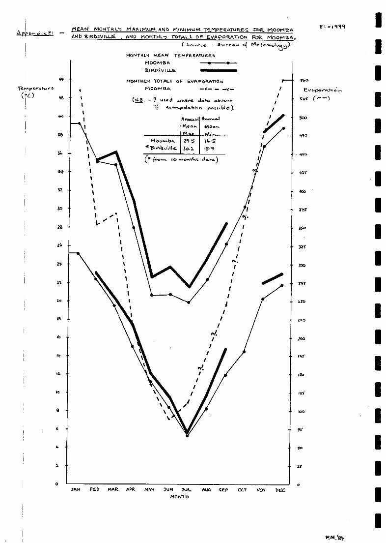
ApPe.,a,
TeAn.p.e.4,0,1-LAre.
(ac)
MEAN MONTH LA MArqfrIUM AND mum TEAPERATuR.ES R. AlOOP113AAND ESIRDsVIU-E. , AND MNT-L r0TAL oF EvAeoRATION Folk MOOMBA.
( so",,e .E.ea 4 )
4.
-
moNTAL.-1 me.AN rEmPERATuicesmoopmeak
sisosvit.Le
IIONTHVI TOTAL OF EVAPORAMONMO0oAtIq
(N.B. ute cl t.aLsore.If on.1-0-bioo1o.fibn postilole).
svo
0
E po c;
szT (v"`"")
5oo
atiS
Vs"
t+TO
shlS
rtS
- OD
32Y
300
rts
Lb
200
127b
PO
JAN FEB MAR APR mh4 ZUN TUL Au4 CEP oc.r NOV DECMOW-14
So
- 2r

El- VISOAree...-cf.x.EZ
(*(-)42-
6
2
34
MEAN MONTHLI MAXIMLim AND toliNiMuM TEmPERATLIRES FOR MOOMMAAND liRsviLLE, AND MoNTHL1 TOTALS OF ENAPORATioN cog. MOoN18A.
liSsa re...A 4 Nte_secva.my)
moNTHL1 MEAN TEmfERATuResmoomaABiRosv(u_e
MON THLY TOTALS OF EVAPORATIONM 00mr3A
0
55 0
o er2s (
500
41S
490
4.25
400
115
3 So
325
)30
111
2To
125.
200
115
co
121
100
Q.1
2S
IAN F ES NAR APR mA9 3104 SUL AUG S Ee O(T- Nov OEGMONTH

Ie p re
o
Is
10
MEAN MONTHLY MAYOMLIM ANC MINIMUM 'TEMPERATURES FOR MOOMBAAND 'I MOS V ILLE AND MON THL1 IOTALS of: EVAPORATIoN FOR MOOn4
( S 4MONTHL4 MEAN TEMPERATURES
M 00 NM
13 I RDSV I U-E
M 0 N TI-1 TOTALS OF EVA PO RATIMO of1413 A -x- -
( - ? UQc te, cla.4-o olase.A.1-
if !KM:poL*410.... pores kA
- 4,50
4.15
4co
-
ISO
- 32s
250
0JAN FEB MAR APR MAY IuN JUL AUCT SEP OCT NOV DEC_
MONTH
E3-198I
F.M.184.
- 50
2 -
A ree..c.11 E3
22.
- 300
2:4s"
-
-
-
2oo
11c
100
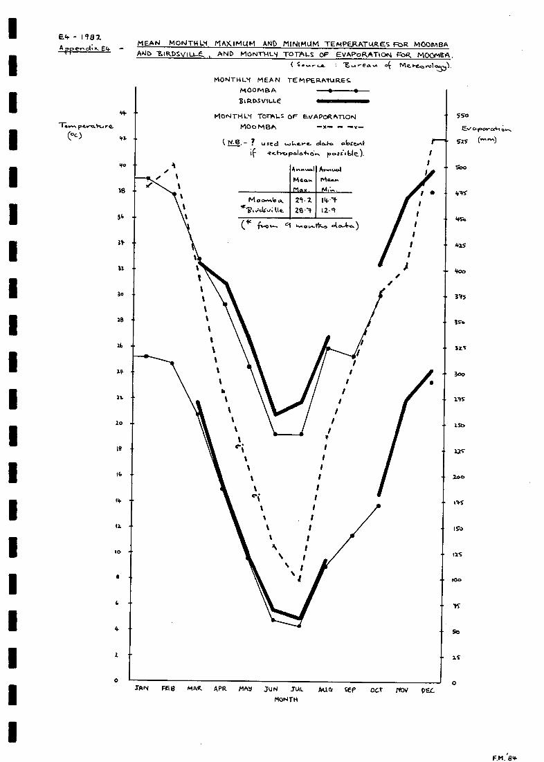
- 1 482A rre
MEAN MONTHL9 MAMMUM AND MINIMUM TEmPERATIARES FoR MOOmBAANC) SIRDSV1U-e_ , AND MoNri-ILy TOrALS OF EVAPoRATION FoR MOCreA.
e 4 .e. 6-Cne, ro I o35)
MONTI-U:1 MEAN TE M PERATURE S.MOONIR A
ZIROsoLLE
MONTHL4 TorAl_s OF EvAPcRATIONMO0MBA
? usecidc- ooe.Feg-hrtapola410.... poss.' ble_).
Wt.= w
/
1
TAN FEEt mAR. APR frilk JuN Jut. All Cr CE P ocr reov DEC.
MONTH
Soo
los*
LISo
ins
4co
34s
3 I
300
yrs
1st.
x2s"
200
1So
too
So
2
0
550
TAS
F.M.'84-
44-
41.

1
A ff.-N.14 E5
Te..1.-0.I earc.4-u.-e.(SC)
MEAN MONTH mAydmum ANb miNimum TEmPERAT,ARes. FoR moONEAAND EIRDSVILLE AND moNrFum TOTALS. OF EvAPosAnoN Fog. moomsA
-g
Moe4r1-1L.1 MEAN TEmPE RATLI RE S
M00/0113A
gi ROSv iLLE
MON TN TOTALS OF EVAPORATIONM00/.413A
( N. O. - ? used w cl....1-c& a. lose/4if e-x2f-voloolo.+1 poS/1614
1+4
..;.1.A.4 tle
A volcual
M exus
550
Eva porrAti
("AP")
560
41.5"
tiro
de.LS
400
ra-s"
31-o
325
300
2.1.S
LSO
12S
100
Ito
125
10o
25
0
E5.- 185
SAN FEB MAR. APR. IMA4 IUN UL M1 EP OCT NOV DEGMON TM
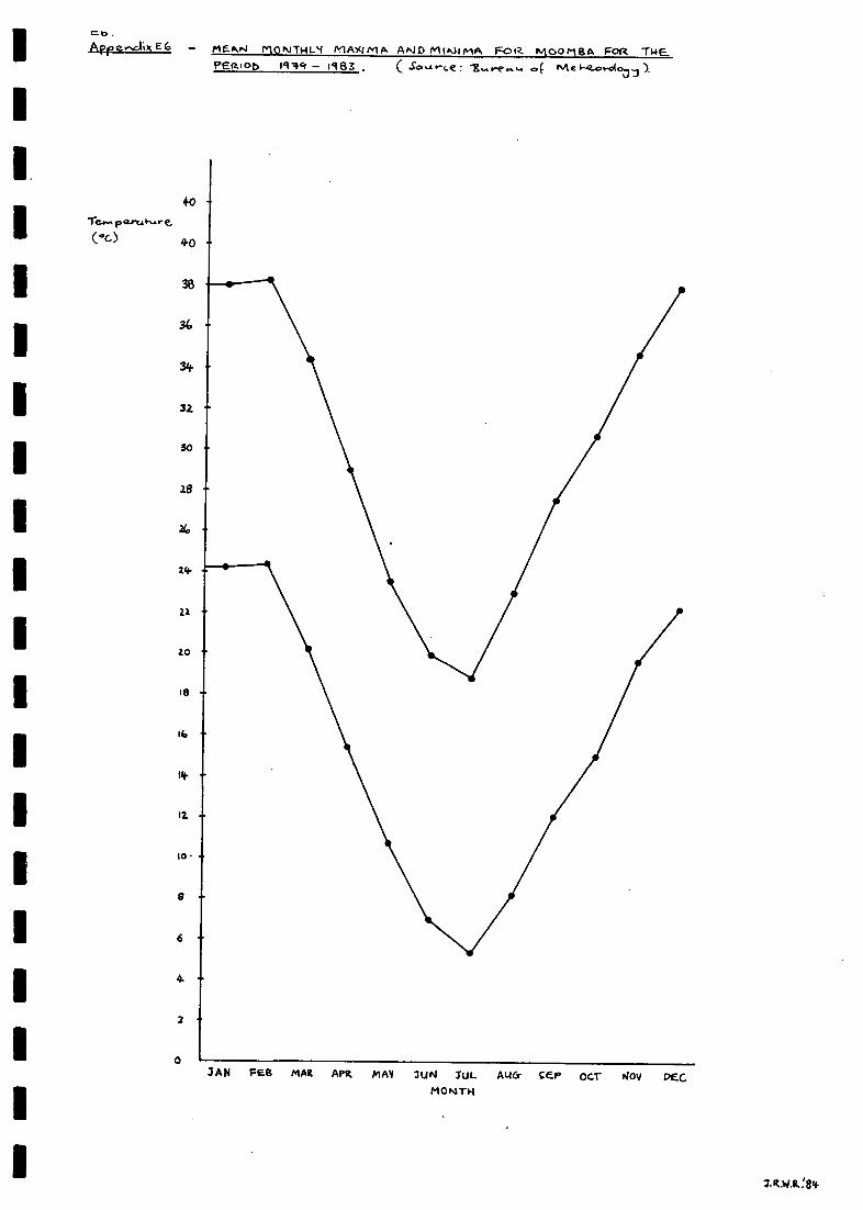
co.Apre.-sciix EG
(°C)
0
mes,04 MONTI-II-sr MAXIMA ANID MINJImA FOR.
+0
40
34
32
-
-
2
MOO MBA FOR THE..PEItiot, 191q - 1.983 . ca( Me S-4?...o.dool
IAN FEB MAR APR MAY 2UN JUL AU& CEP OCT NOV PEG

MI E
ll I=M
IM
EI
NM
I MO
IMP
=I

AUG
SEP
ocr
NOV
DEC
'$7
,6 6-12 I2SPEED ( KNOTS _.J
c4ftW'
FREOUENC ( 7.) = 502 CALM
0300 0E00 0900 1 200 1500 1800 2100 21/00
J'\
THREEHOURLY WIND ROSES FOR MOOMBA ce SANTOS vial)1979
Fl
APPENDIX F WINDS
2.
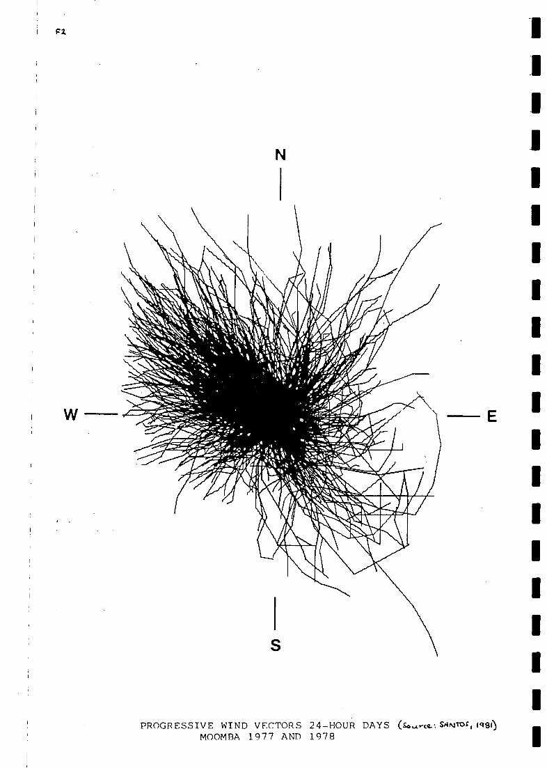
FZ
PROGRESSIVE WIND VECTORS 24-HOUR DAYS sAkill3f(MOOMBA 1977 AND 1978

MIN
IIIMIN
NIIM
IIIMM
INN
IIMIN
EIM
INN
IN111111=
1111=1111=
M cm,I+k 1.6
Volul
Me5a14res( m, $000)-
nA; t4cmIT1-0-4 "WM_ vot_utmes0/4 r-fe. COOPER C...-e-e-Ex"Ar CAUJAPALAILA
S.A. 0040 0.01.11141s.REA/Pr
19'99 OM mecwALtTILES).
G-1-1949
CpapeAr Gree,lea1Cat(ow1tAr6-0, W. . . 001931SoLArce E. LA. S. 'Peel-. ,SA.).
Cop e-1,- Gree-ic Curvilire.vo, , lc. SI-) 44L jho 4 1:1%.-coo'gA49.;s,G.. 003101G\
Q.u.eet.-41c..... a VI T..e.Sourte J
- area - ai+o cc). 2- (a. w.
F.M.134
Ca itervw.rrO, CU rr-c, MVO,
Ainvw.al Totalsciu.rot.(Mt)
41-100o 164494-3
RwAor 6.......)
Max. Wo.44Lv-
L.e0a4 (....)5.36 6-GS
Pe..k (-la-, 6r(Mt.) Vol..........e.
3 8 8 00 190106.2
reok ..c.t.,...1-r,.;.e. OC ' 0 . C14/
Z3 FE-13 2.5" Fes,
AN HAD, AM 3Um 31L AU4 see OCT NOV DEC
tsi on+L.

4-2- 1950Arr..ricUx *2- f101TL Turprt_ FLo v0LiAr,4
coarek ca-E.E,c Ac CALLArAua.A.AAND CUR...RAP-EVA
FOP. lel SO ( IP4 E-cxgto_rtP.E.S.
5140
530
450
200
50
60
40
20
0 I7777-A
Coore, Cree4c Callar..urvz, W. G.s. oo3s-o
C Sg.Ar-ce e. 9- S De40-.
MCo ore, Cps-eeic 0.1- 2..5* km.. SW 44L..11.....-.1-;0tA 4 11...au*. 130.,...00 'elk/04.(
00 3101 t,( V-40.44ab.- 12-cuo...xe
CA"'..' .20 t'N
Al3La-
3AN FES MI. APR. MAY 3UN 3UL MC/ Se OCT NOV DEC.
- 0..-¢0. fere. CoA rep, U. - 1.4-0 000 kJAA "L" (E.
(Alia wt,Arra CAAV'f CA re.," 0.
h+vnue.i To4-0-1
IN'saAvo-jo-(nik)1 GS00 12.11239
W.......noff (.........) 0.4-
MA)... 6J0.4e..-
Le_Je..1 (-.)2.2.21- 5
Pe.k ("to..., Dc.d
Vol.......e. (me.)11. 5" 0 -cl3ca:,-1-
Peco.,_ .tc,.....$
1-....e 4 Ne0-.-23 APP. 12 sA N

AtT G3 - p4 orerf-11....) TOT F 1.-04 Vat-AMES oni THE (.0012E12 ca-eic. A CAU-ArALtAft.A t.l M. G3-1981
S. A ., AN curca.9RevA ALD Fotz ruitt (J rAEGALMZES).
r4A4,VoLArAe.S
141
Mecrtares(x1%1000)
0
IIIcooper Creek. o.A- CallarAurro.W.4.1.- G. S.003501S000-ce. E. 9- w. beel-.1 S. A.) .
EaCooperC....reureva 1.5
Cv-I or ju.e.c_I-I-OG. 417.....ver:-s 0......4e.e.Ans10.1..t.A
- G. S. 00310tik,S414v-ce
h ).
-rfAaLe.
CCIIIGNAlAr.ra CA rv-oveva.A.,..,....1 Tal-t.1
D 1 s ii.-.0na(04 t)113 000 24-0S1-
12....... 4 (y......) 1.4- 0.1 . Q .
Max hfo.4-e.-{-e4a1 Q....)
2.-1.S9 5.3S"
PenkFlowt1/4.1Vol...6...e (Me)
5360 88643.2.
Peak to......
4k1,....-2.4 SIAL 12- IUN
IAN FEB' MAR A9k, Alt SUN SLUM AUG SE91" Ocr NOV DEC.
PIJA j cti.vii- area fo.- Ccal a I...IA.( - 4000
1
1
14-- 1982.
App. G4--DioNTH LI TOTAL L0 vo%_uv14 Es
ON THE Ccopea. C.42-eElc. AT cAts-AritAizRAAN 0 Cm MLA REA/A , au),
Fog 198.2- (INI HeC:ALITR.eS),
Git--1913 Z.
1111 Cooper Creek *V Coilawlurra W. g - Gg 003501( Sa.4-Arce E 3>z,pv. S. A.).
Cooeer Cre,ek Cuv-roreva 7.5*".ac ouscA "Bctir,-**1?-44.sers
OkuPeAnxtuv,4 - as. 003101A.( Sourcz QA,AeaLlrluv.c..k W *Av. RecourLe I
CoKw"niSSIOn ).
TASLE
fr- 4o....641 es - see N.B. x.
Ca 1 1a rn ux ra. nurrareArceA1.-(al 1-030.1
Discinne(m() 4j+ - -cio
10
-.A .366967
9........F (rot...) 0.2.1* ri. a .
Max..Wo.lerkeqe.1
(^,) 1.94 1.- 3.3 1
Peak +t ,44,411¢)1, 0 Vol,.
416 181.2.4-.4.D
Peak + 1 a...)......i. 4
25 APR 14 MAR
lotnt PF-8 Me APR. MA' ZAN 41.4..4 AUG SEP Ocr Nea DEC
N.B . - coy- LJt4. - 240 000 10..42 (8,".1.).C.)r4e4.-441r iv-0,,O u 82. +o id iii 40,6A-p epti .1-er Qs
.r4 hFres,p
tio.,+k II '6
e 5
Me.5a1;4-es
(c i000) 1020
44%0
14.0
120
100
80
6o
40
20
TAR
&I -1944
G-4zeic Cal( W . . ooE A. S- bet31' S41)
COCI,C2A, C4-eeic kSW .4+Le.jtot. 4 Q.-u3c,
"". Cr. s.. ooatoig.
;SS ).
tUt. - ca.+(..1-"AA ea..* -eo fa Call L.i4. - 240 coo (
F.M
CA ita inn u.rra. Cu rra re VO,
Avww.4 roh..1'Da clu.r. (m t )
4-1- r000 i 64-1 9 4- 3
It uonor (......) 20Kix. Wa-Le u& (.A )
5-36 6-GS
Pe..k (-10-, ur( M 0 Vol.....c.
3 8 8 00 190106'1
Peak. ft ..-.1Ta...e. a( ro....,
2.3 Fag 2. s- FEZ.
IAN M. Aft. mkt 3W.4 MI. AUc SW OCT NOV DEC
Mon+L.
4ONT1.4L-s4 TorAt_ Ft-ow VOL-UMESON me. COOPER. C.-e-e.E.< AT C ALLA mutt-AW64., 5.54 0c545:, Cuix.045, REVP. qt_o rpon, I9 ( 1K) M Gc L ITFLE ).
ez]
1040

az- 1980AmeaNdix 02.
M
M 0.1;tres(x moo)
r41or4T TorAt_ VoLurs4
04 The coot,e,P, az-EEK AT CAu_AsmurRA..134., S. A . AK) D Cur-RAP-Es/A ,LOF02. 19 8L, m EC-T/1%1_01,65 .
0
540
520
5.00
480
4.6o
200
50
6 o
zo
Coore..- C,ee-44. Calta....crr, Gr.S. 003S-01
C E. 9- S . DeV4". .5-A)p -k -S140c-4-41Cooper- Cpee
jt....--ti-;o1..., 4- Tow,00 T.:AlertOtIccA 6-. C. 00310(A,
3AN FES Mi. APR
N s. CQfCJ
A13 La.
fo-r-
r
AUCt SEP OCT NOV DEC.
1.a.14. (E.
r.m.
(Alio vw+t-Aerc. CLArrarevc.Pr..........1 Toty..1
Dsallolekv1t)`1GCoo 12112.39
R.....--off (IA.) 0.4- rl- A .
kW.. wc.4e.-t-e_4 el (....)
2..221. 5-
Pe..lc fte...41)....y
VoL.......e MO(11.50 39(1, 1-
Pea.k -tc.....
Th.....e .f. fee..-13 AP fl. 12. SA N

C- 0
6110
101.
Mk\
.\\\\%
\%\\V
W
0101
0010
1101
101M
MW
OIL
010,
16.1
0010
1061
0011
01M
IM
\N0
% 1
.\\\\%
\ b .3
0 I
I 01
.\\I
\1V
\\N
NW
I I
0 g
0 I
0 I
iN.\
0001
01~0
0~10
1011
0110
1010
1010
1010
1.11
01A
W01
0%\0
1101
0%.
M11
0100
1010
01.1
106.
1010
1011
0100
1.10
4101
1010
%.1
6,10
1M10
11.1
1.10
0
0M
al I
\\\\N
0 M
AW
Ohl
k4L
.II
NM
OO
MM
INN
IMI1
2100
06.1
1010
11~0
710
\WM
N
C0J
UJ 0 U
;-, 0
8
V >
z FL
0 t's(I
L, V
L
9 0 3 .11)
ZZ
3 in
fc
n (1
11-
,-,
(l3
' tS
" 0
q)-Z
0 15
C
qg
qco
o,±
.,19
rN.,
koo
8',.
.-N
'6
tA o
il.g-
GIO
V S
.p
.P.,
13ic
?.P
z`,
.t_
3.I
I- ,F,
,-,-
-; r
P1
ti1
6\Pc
;; s
?it,
R,
7 0
C--
,-
!,1
pf
r-:
..1'
.,o5
.,-.
-- G
>7
oS.
5N
--.i/
)_1
8.0 cc _
w V. o
am N
EI
am a
m o
w o
w o
w o
w I
=am
we
EN
ow
um
Ns
Ns
me
ow
< -
fs.1
.
31:
7°
2 P
tA
.S
P4
4-1
VI
A co
A t
-(1

Cz'i- 1982A. G4-1+10NTHLY TOT AL- ctot.0 VOL-LA "4 ES
ON THE COOPER GREEK AT C AU-A Mu RRAL4 , S. A . AND CAA RSLA R.E.UA
FOR 19'62. (IN MECRALITR.ES).
300
1)- cla....61+L-1 es - ._
F.M.
Callo.r.nu..ero,
44600 VI.
(luarrareVa.
.369(DS-AruNt44( rolma
Discl..c.zeOLt)
120.,.....F. (.....)
4ax...1,4,14...frLe4e1
(") 194 9- 3- 3 I
Peak +t 6 4.-4ME)To Yot.....z.418 181.24..4.D
Peak + ta-..)T....se 4 4eLLS,
25 APR tct MAR
IAN NAZ APR. 3LIN UL la (SEP OCr NeN DEC
NS .1 - Co-'-.-.llar... - 240 000 iciA42zlaa, - c uez +0 it es4-1.4. cut-et ag
4-too.i J.+ mar-vt.el"i et..0140
G4-1982.
IIIII Cooper- Creek at. Conamfaurra w. - Gg 003501( So.srce. E , S. A..).
Caocaev Crea.14. CtAreoreva skw.S 4'Eavc.0.7-tJer'l
- CtS. 0031 0 IA.
( .-ce QueesAsic....,A Wofe,.IkesoJ VLe
TABLE.
1
1

APPENDIX G5 - CHRONOLOGY OF KNOWN EVENTS FROM ALONG THE COOPER AND STREZLECKICREEKS AND OTHER AREAS THAT MAY INDICATE FLOODS OR FLOWS
Abbreviations of Source:
E.& W.S. - Personal communication by Mr. B. Nicholson, E. & W.S. Water ResourcesBranch
Lewis - Government Survey Expedition commanded by J.W. Lewis in 1874 to the areaaround Lake Eyre to the Macumba River, Warburton River, Lake Everard and the Cooperto 6 miles east of the South Australia/Queensland Border. ( Nappamerrie).
Sturt - Sturt (and Stuart) went up the Cooper in 1845 to as far as Innamincka.
Classes of flow: A - average 1 - level 1 flood 2 - level 2 flood3 - level 3 flood L - local rainfall
DATE OBSERVATION FLOW SOURCE
1845 Water in waterholes of the Strzelecki A & L(?) Sturt in PearceCreek (1973)
1860-61 Burke and Wills Expedition - water A e.g. White (1917b)in Waterholes along Cooper Creek- Strzelecki Creek dry 1861.
1874-75 Lake Eyre dry from 27th Oct. 1874 A Lewis in Mason (1955)to 12th July, 1875 and Lewis (1875)
1877 Heavy rain flooded the Cooper Creek 1 or 2 Pearce (1978)1877-78 Exceptionally good season in the Madigan (1946)
"Dead Heart"
1879 One of the best seasons (average 1 & L Madigan (1946)rainfall 254 mm) 2 or & L
Early Dry conditions prevailed A Litchfield (1993)1880's
1882 Strzelecki Creek flowed near Merty A & L E. & W.S.Merty
1885 One of the best seasons (ay. rainfall A Madigan (1946)254 mm)
1885 412 mm at Innamincka - one of the L Madigan (1946)best years
1885 Cooper May have reach Lake Eyre 1 or 2 Mason (1955)
1886-87 Cooper probably flowed into 2 or 3 Mason (1955)Lake Eyre
1887 Flow into Lake Eyre which may 2 Mason (1955)be comparable with that of 1949.

1
1889-90 Exceptionally good season 1 or 2 Madigan (1946)
1889-90 Cooper may have reached lake Eyre 2 Mason (1955)
1890 One of the best seasons - 406 mmat Cordillo Downs
2 Madigan (1946)
1890 Lake Killalpininna on the Cooper Creeknear Kopperamanna filled
2 Litchfield (1983)
1890-91 Rain records show it as a periodwhen a great flooding (of the 1949/50and 1973/74 type) was likely.
3 Mason (1955)
1891 Cooper Creek flowed to lake Eyreor in its lower course - accordingto "old timers".
2 or 3 Madigan (1946)
1891 Lake Killalpaninna on the Cooper Creeknear Kopperamanna again filled.
?2 Litchfield (1983)
1894 Cooper Creek probably flowed into 2 or 3 Mason (1955)Lake Eyre in an equivalent flow to 1949
.1898 Cooper Creek flowed to lake Eyreor in its lower coarse - accordingto "old times".
1 or 2 Madigan (1946)
1898 Lake Killalpaninna on the Cooper Creeknear Kopperamanna filled.
2 Litchfield (1983)
1898 to A very bad period in terms of A Madigan (1946)1902 drought
1900 General bad year (ave rainfall A Madigan (1946)63 mm)
1903 Cooper probably flowed to Lake Eyreor lower in its course
2 or 3 Mason (1955)
1906 Cooper probably flowed to Lake Eyreor lower in its course - 1949 flow
2 or 3 Madigan (1946) andMason (1955)
1906 Strzelecki Creek flowed near Merty L E. & W.S.Merty
1906-7 Heavy rains in Queensland resultedin a Cooper Creek flood at Innamincka
1 or 2 Mason (1955)
1907 413 mm at Innamincka - one of the bestyears
L Madigan (1946)
1907 Heavy floods of 1906 filled Lake Killalpaninnaon the Cooper Creek near Kopperamanna
2 Litchfield (1983)
1909-10 Exceptionally good season (studyarea averaged 248 mm in 1910)
L Madigan (1946)

1910-11 Exceptionally good season (studyarea averaged 219m in 1911)
L Madigan (1946)
1916 Strzelecki Waterholes carried waterin September - fine season
1 White (1917b)
Water flowed in the Cooper for 5 weeksto the 29 September 1916 only possiblefor camels to cross at the time White (1917b)
1916-17 Cooper probably flowed to Lake Eyrein a flow comparable to 1949
1 or 2 Mason (1955)
1917 Single good season particularly inthe Clifton Hilss and Kariowana areas
L Madigan (1946)
- western part of the study area(average rainfall 318 mm).
1918 Big flood of Cooper Creek reached L Madigan (1946)Lake Eyre from 1917 rains
1920 Cooper probably flowed to Lake Eyre Mason (1955)
1920 A single good season - the bestgeneral season (average rainfall 305 mm)
Madigan (1946)
1920-21 Cooper probably flowed to Lake Eyrein a flow equivalent to that of 1949.
Mason (1955)
1927-28 Very bad period of drought Madigan (1946);Pearce, (1978)
1929 Worst general season or droughtknown (average rainfall 46 mm) -
Madigan (1946)
Lake Eyre dry.
1932 Water reached Lake Hope eighteen timestimes in the preceeding 45 years (1887)
Madigan (1946)
- claim of an "old timer" -requires exceptionally heavy rains
1934 Strzelecki Track abandoned as toodry for stock or even camels
Mr. J. Vickery(pers. comm.)Pearce (1978).
1936 Strzelecki Creek flowed near Merty E. & W.S.Merty
1939 One of the best seasons (averagerainfall 254 mm)
Madigan (1946)
1939 Cooper Creek may have flowed to 2 Mason (1955)Lake Eyre
1939 One of the worst years on record A Madigan (1946)(average rainfall 51mm)

1
1941 Cooper Creek probably flowed (in aflow comparable to that of 1949) to
2 Mason (1955)
Lake Eyre.
1944 Cooper Creek may have flowedto Lake Eyre
1 or 2 Mason (1955)
1944 A bad local drought in west Litchfield (1983)
1949 Strzelecki Creek flowed near Merty L E. & W.S.Merty
1949 Flood waters reached Lake Eyre 2 Mason (1955)
1950 Strzelecki Creek flowed near Merty 3 E. & W.S.Merty
1951 Strzelecki Creek flowed near Merty L E. & W.S.Merty
1953 Water in Lake Eyre - minor flood Bonython Mason (1955)(1955)- 1922
1955 Strzelecki Creek flowed near Merty E. & W.S.Merty
1955 Water in Lake Eyre - Qld tributariesof Cooper Creek running at floodlevel
Mason (1955)
1956 Strzelecki Creek flowed near MertyMerty Litchfield (1983)
1956-63 Drought
1963 Strzelecki Creek flowed near Merty E. & W.S.Merty
1969 Etadunna flooded - local flood Litchfield (1983)
1971 Strzelecki Creek flowed near Merty E. & W.S.Merty
1973 Strzelecki Creek flowed near Merty E. & W.S.Merty
1974-75 Exceptional Seasons Litchfield (1983)-76
1974 Strzelecki Creek flowed near Merty 3 E. & W.S.Merty
1976 Strzelecki Creek flowed near Merty L E. & W.S.Merty

1977 Strzelecki Creek flowed near Merty L E. & W.S.Merty
1979 Strzelecki Creek flowed near Merty L E. & W.S.Merty
1984 Strzelecki Creek flowed near Merty L InferredMerty

1.1or
ow m
e I=m
ium
me N
E E
.

APPENDIX H
1CURRENT PASTORAL LEASES
Information from South Australian Department of Lands Pastoral Plans
SEE MAP OVER ON PAGE.. .H2
H1
'Prior to fencing associated with the Brucellosis/Tuberculosis (BTB) Programme,many lease boundaries existed only on paper. Hence, the new fences may belocated somewhat differently to what is shown on pastoral plans - this is inresponse to field conditions during fencing (Mr. G. Drewin, pers. comm.).
1
Property Pastoral Block No. Area (km2) Approx. Area
Lease No. in 8.4.4 (km2)
Cordillo Downs 2066 851 7874 1829
Pandie Pandie 2406 1193 66251238 11601239 420
4E8205 1098
Clifton Hills 2387 1178 3401
2421 1179 11221E4523 1050
Waukatana 2449 1168 2368 1100
Kanowana 2386 1177 6799 2526
Lake Hope 2447 1175 3791 1760
Innamincka 2405 757 13818 9630
Gidgealpa , 2425 1180 4909 4044
Merty Merty 2422 1181 4136 1536
Tinga Tingana 2452 1205 3626 167
not grazed - - - 2310
27050

I
1
1
1
1
1
1
I.

EN
ow E
N ow
gm=
I um w
e ow M
N I=

APPENDIX I DATA SHEETS
II
Site Sheet . 12-13
Vegetation Recording Sheets . 14-15
Vertebrate Field Sheet 16-I

s3IirE: E-31-1EEEETPROPERTY/PADDOCK / SITE:DDFFC Fc tez NI V' I FR CI NI I'l NI 'T A L_ A S CI C I A -I- I C3 IV
(8.4 4)
OBSERVERS: DATE:AUSTRALIAN MAP GRID EASTINGS: NORTHINGS:RESOLUTION CODE(i.e. accuracy of location)1=27m 2=270m 3=810m 4=1.6km 5=16.2km 6=48.6km 7=97.2kmDISTANCE AND DIRECTION FROM NEAREST NAMED PLACE(Straight Line):
DESCRIPTION OF SITE:(Landform, aspect, vegetation structure,etc.)
12
PHOTOGRAPHS(ROLL/FRAME):LANDFORM: El PLAIN El DUNE El INTERDUNE LOW El CLAYPAN(FRESHWATER)
ElSALT LAKE El FLOODOUT El TERMINAL LAKE El SWAMP El CHANNELC] OTHER
SUBSTRATE: (Insert numbers in order of prevalence)TYPE:(] CLAY El SILT El LOAM El SAND El GRANULE(2-4mm) El PEBBLE(4-64mm)
, El COBBLE(64-256mm) El BOULDER(>256mm)A(Dominant): B(Subdominant(s)):
COLOUR:[] BLACK El BROWN El RED El ORANGE El YELLOW El WHITE El OTHERWATER CHARACTERISTICS: El PRESENT El ABSENTEl FLOWING El STATIC El ENCLOSED El CHANNELED El PERRENNIALE3 EPHEMERALMAX. DEPTH:El 0-0.5m El 0.5-1m El 1-1.5m El >1.5mSECCHI DISC READING: centimetersVEGETATION:PERCENTAGE BARE GROUND: El <10 El 10-30 El 30-70 El >70DOMINANT SPECIES VOUCHER *HABIT HEIGHT ESTIMATED PROJ. COVER(X)
NO. (m) <10 10-30 30-70 >70
1
2
3
4
5*HABIT: (Terrestrial) T=tree; S=shrub; G=ground layer; (Aquatic) E=emergent;F=floating; U=underwater; (Marginal) R=reed/sedge.
FAUNA: DOMINANT SPECIES VOUCHER NO. COMMENT1
2
Additional Species of plants or animals should be listed on the back

BITE NI U MB:SPECIES VOUCHER HABIT HEIGHT COMMENT
NUMBER m

14
../ C3EE lr -r x ;NI 1F;: .C.:C.)FR ID I f%,117z3 E31-1E7EEir
lBSERVERS: DATE;MG GRID REFERENCE__ SITE NO.ESCRIIPTION:(size.locaion,c-iirection,eilc)
HOTOGRAPHS(ROLL/FRAME)PECIES VOUCHER NO. HABIT Estimated Projected Cover(7.
<10 10-30 30-70 I>7

Ell I Ni Li PI 1E4SPECIES VOUCHER HABIT HEIGHT COMMENT
NUMBER rn

Is
I EI I'J1JNtEcEF=SPECIES VOUCHER HABIT HEIGHT COMMENT
NUMBER ( m )

S I 'T la NJ LJ N1 Ec E =
,
SPECIES VOUCHER HABIT HEIGHT COMMENTNUMBER' ( m )
(

N.,E=FR17EFABFRACTEE FrIEEL_I) E3FlEEEEirSITE:
DATE:_WINDWPH):EASTINGS:NORTHINGS:
RESOLUTION CODE(i.e. accuraccy of location)1=27m 3-810m 4=1.6km 5=16.2km 6=40.6km 7=97.2kmDIRECTION AND DISTANCE TO NEAREST NAMED PLACE(Straight Line):
PROPERTY/PADDOCK NAME:OBSERVERS:TEMpERATURE: CLOUD COVER(%)AUSTRALIAN MAP GRID: 54
PHOTOGRAPHS(ROLL/FRAME):LANDFORM: El PLAIN El DUNE El INTERDUNE LOW El CLAYPAN(FRESHWATER)El SALT LAKE C] FLOODOUT El TERMINAL LAKE El SWAMP C] CHANNELClOTHER
SUBSTRATE: (Insert numbers in order of prevalence)TYPE:[] CLAY ElSILT El LOAM C] SAND C] GRANULE(2-4mm) El PEBBLE(4-64mm)
El COBBLE(64-256mm) El BOULDER(>256mm)A (Dominant) B (Subdominant(s):
COLOUR:[] BLACK El BROWN El RED El ORANGE El YELLOW El WHITE ElOTHERWATER CHARACTERISTICS: E] PRESENT El ABSENTEl FLOWING E] STATIC El ENCLOSED El CHANNELED El PERRENNIAL El EPHEMERAIMAX. DEPTH: [3 0-0.5m C] 0.5-1m El 1-1.5m El > 1.5mSECCHI DISC READING: centimeters
PERCENTAGE BARE GROUND: E3<10 []10-30 []:0-70 E3>70DOMINANT PLANT SPECIES HABIT HEIGHT COVER
(T/S/GC) (m) <10 10-30 30-70 >701)
SPECIES VOUCHER /SAM NUMBERNUMBER
1.6
COMMENT(MICROHABITAT,ETC)
AddiOonal Species should be listed on another page referenced to this site

rs41 P-1 Es 1E:SPECIES VOUCHER HABIT HEIGHT COMMENT
NUMBER ( m )

B I lr t\Jurirc :SPECIES VOUCHER HABIT HEIGHT COMMENT
NUMBER (in)

I
B I .. NIUMEcEP =SPECIES VOUCHER HAD I T HEIGHT COMMENT
NUMBER ( m )

Imim
mum
mm
umm
i

APPENDIX T
METHODOLOGY TO BE EMPLOYED IN THE SAMPLING OF FLORA AND FAUNA
IN THE COOPER CREEK ENVIRONMENTAL ASSOCIATION (8.4.4).
N.B. - The sampling methodology below is designed assuming three
major habitat types in each area sampled, e.g. dunefields
consisting of dunes,swales and clavpans.This methodology
may need revision after the first field trip.
FLORA
Prior to field work aerial photographs will be examined to
select representative sample sites. These will be rechecked in the field
to asssss representativeness. Different vegetation patterns will be
tentatively identified and mapped from aerial photograph interpretation.
Field methods will comprise vegetation description and sampling.
Sampling
At each site selected to represent a major vegetation type, a
permanent quadrat will be established by location of permanent markers
at each of the four corners. A photographic record of the quadrat will
be taken.
Several quadrats will be used at each permanent site. The quadrat
on the major feature of a landform complex, e.g. dune in a dunefield,
will be pegged as the Permanent site and the location of other quadrats
will be related to this by description on a data sheet. Due to time
constraints, a maximum of 6 (i.e. 2 on dunes, 2 on swales and 2 on clay-
pans in a dunefield) quadrats will be sampled. Depending on vehicle space
and peg availability, one corner peg may be placed on a selected corner
of each of these other quadrats.
Sizes of quadrats will be varied according to the species richness
of the vegetation type, determined by construction of a species/area
curve. Sizes are likely to be in the order of 25m2 the size often used in
arid zone vegetation sampling.
The incidence of all species present in each quadrat will be recorded.
In addition the projected foliage cover of each stratum will be estimated
by eye, as well as the cover of litter and the amount of bare gLound.
It may be that photography from the roof of a vehicle will be used to
determine ground cover, but the use of booms or similar equipment has
been found to be too time consuming.
Additional to the above, at each permanent sample point, a transect
will be taken through each vegetation type and species present in each
stratum will be recorded in 5-10m radius quadrats at intervals along the
Ji
J2
transect. Intervals will depend on the species richness of the vegetation.
This procedure will be repeated for each sub-unit of a vegetation.
type, e.g. dune,swale and claypan.
At each site descriptions of observable features: soil, topography,
grazing pressure will be recorded.
Specimens of the .range of plant species present at the time of the field
trip near. survey sites will be collected and later deposited in the
State Herbarium.
Description
Within the identified landform complexes qualitative observations
will be made from vehicular and pedestrian traverses to check areas
identified from aerial photograph-interpretation. This will assist in
producing a vegetation map and to establish the relationship between
adjacent land systems.
Vegetation types will be described in terms of strata present, height,
projected foliage cover of each stratum, and constantly recurring species
in each stratum. Associations will be assessed on the stratum which
contributes most to the biomass. Within a given stratum species will be
listed in order of decreasing prominence. Notes will be taken on observ-
able features: soil, landforms and grazing pressure, for example.
FAUNA
Mammals
A trapline will consist of 25 aluminium box traps. An attempt will be
made to place at least two traplines in each habitat type. The traps will
be laid on transects with approximately 15m between each trap. Assuming
three habitat types this requires 150 traps. A further 50 traps will be
placed in significant areas, e.g. concentrated around burrows, spoil heaps
and tracks, for example. In this way quantitative sampling of species
will be made (i.e. by use of selective concentrated trapping).
At this stage we do not know how many cage traps we will be able to
accomodate. The number is likely to be limited (may be about 10, but
probably less). They will be distributed amongst the habitat types along
the aluminium box trap transects.
Three sets of ten pitfall trap/drift fence systems will be used. One
will be placed completely within each of three major habitat types. It
may that within each habitat type the pitfall trap/drift fence systems
will be divided into two,so that there are actually two pitfall lines
in each habitat type consisting of 5 pitfalls and 50m of drift fence.
The availability of harp (bat) traps is still uncertain. Bats will
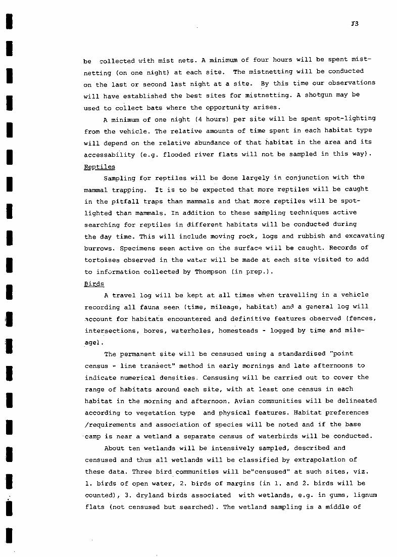
13
be collected with mist nets. A minimum of four hours will be spent mist-
netting (on one night) at each site. The mistnetting will be conducted
on the last or second last night at a site. By this time our observations
will have established the best sites for mistnetting. A shotgun may be
used to collect bats where the opportunity arises.
A minimum of one night (4 hours) per site will be spent spot-lighting
from the vehicle. The relative amounts of time spent in each habitat type
will depend on the relative abundance of that habitat in the area and its
accessability (e.g. flooded river flats will not be sampled in this way).
Reptiles
Sampling for reptiles will be done largely in conjunction with the
mammal trapping. It is to be expected that more reptiles will be caught
in the pitfall traps than mammals and that more reptiles will be spot-
lighted than mammals. In addition to these sampling techniques active
searching for reptiles in different habitats will be conducted during
the day time. This will include moving rock, logs and rubbish and excavating
burrows. Specimens seen active on the surface will be caught. Records of
tortoises observed in the water will be made at each site visited to add
to information collected by Thompson (in prep.).
Birds
A travel log will be kept at all times when travelling in a vehicle
recording all fauna seen (time, mileage, habitat) and a general log will
lccount for habitats encountered and definitive features observed (fences,
intersections, bores, waterholes, homesteads - logged by time and mile-
age).
The permanent site will be censused using a standardised "point
census - line tranSect" method in early mornings and late afternoons to
indicate numerical densities. Censusing will be carried out to cover the
range of habitats around each site, with at least one census in each
habitat in the morning and afternoon. Avian communities will be delineated
according to vegetation type and physical features. Habitat preferences
/requirements and association of species will be noted and if the base
camp is near a wetland a separate census of waterbirds will be conducted.
About ten wetlands will be intensively sampled, described and
censused and thus all wetlands will be classified by extrapolation of
these data. Three bird communities will be"censused" at such sites, viz.
1. birds of open water, 2. birds of margins (in 1. and 2. birds will be
counted), 3. dryland birds associated with wetlands, e.g. in gums, lignum
flats (not censused but searched). The wetland sampling is a middle of

J4
day/travelling activity. Representative specimens will be collected.
Also during the middle part of days, besides wetland sampling, time
will be spent on specific searching for cryptic, rare species in suitable
habitats. In addition a search will be made for birds in all unusual/
distinctive habitats encountered while driving/logging birdlife up to
50km from base camp and sampled wetlands. A second ornithologist will
travel with the botanist up to 100km from the permanent site.
At night, activities will include: spotlighting/listening for
nocturnal fauna: skinning, cataloguing, scanning and reviewing the day's
collected data.
Frogs
It is hoped that some frogs will be caught in pitfalls, but the
likelihood of this depends as much on the weather as the siting of the
traps. Active collecting, by rolling logs and removing bark from trees
will also be done. However, the main sampling of frogs will be done by
listening,and recording, calling frogs at night. By recording frogs,
identifications can be verified in Adelaide.
An attempt will be made to find and collect tadpoles.
Fish
Fish will be collected with seine and gill nets. Seine nets of 10mm
and lmm mesh size will be used and a gill net with a mesh size of not less
than 25mm will be set for varying periods. Three main types of water body
will be sampled: 1. riverine, 2. billabong/oxbow lake - type-backwaters,
3, shallow flood plains. Traps with funnel entrances may also be used.
Aquatic Invertebrates
A dip net of mesh size 300pm will be used to sample aquatic inverte-
brates in the three water bodies mentioned above. This method often results
in the capture of some fish that will augment the fish collected using
seine and gill nets.
Other Invertebrates
Other invertebrates caught in the pitfall traps will be collected. A
special effort will be made to collect some groups where a request has
been made, e.g. Ants : G. Browning, Dept. of Zoology; Scorpions : C.
Shanahan, Dept. of Genetics and by light trap - Caddis flies : A. Wells,
Dept. of Zoology; Dipterans : M. Kokkin, Dept. of Zoology.

HANDLING OF SPECIMENS COLLECTED IN THE FIELD
FLORA
All plant specimens collected during the field surveys will
initially be held for identification and reference. They will afterwards
be deposited in the State Herbarium.
FAUNA
Mammals and Reptiles
One specimen of each species (each sex if possible) of small reptile
and mammal will be taken at each site except where special requests have
been made. Such requests include:bats - livers for P. Baverstock and
testes for W. Breed (Scientific Permit 856), certain live rodents for
W. Breed (Scientific Permit 906), certain reptiles for T. Schwaner.
Specimens of reptiles will be kept alive if possible for T. Schwaner,
however some field preparation will be necessary. Tissue and blood
samples of reptiles and livers and testes of bats will be placed in liquid
N2 and the animal preserved in formalin. Large animals, e.g. dingoes,
rabbits, kangaroos and goannas will not be collected.
birds
Representative specimens of wetland and dryland birds will be
collected and gut contents stored for eventual examination.
Fish and Frogs
Series of specimens will be taken and preserved in formalin in the
field.
Invertebrates
The different groups will be preserved by appropriate methods in
the field or maintained live.
15
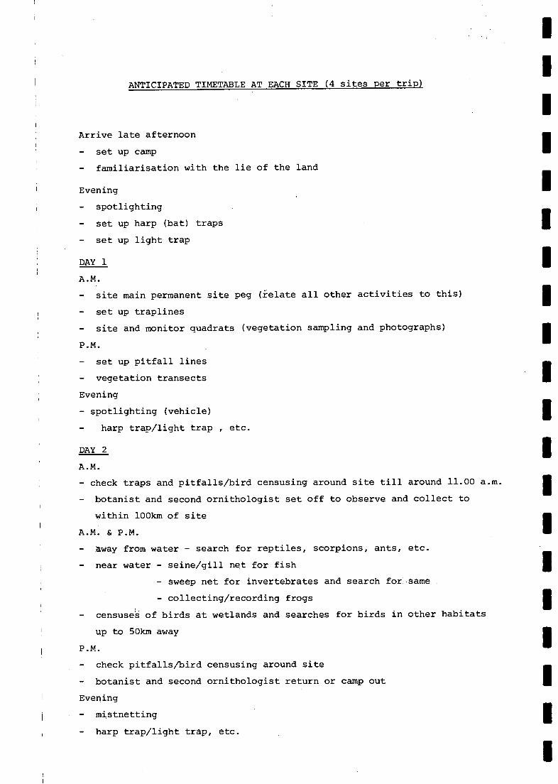
ANTICIPATED TIMETABLE AT EACH SITE (4 sites per trip)
Arrive late afternoon
set up camp
familiarisation with the lie of the land
Evening
spotlighting
set up harp (bat) traps
set up light trap
DAY 1
A.M.
site main permanent site peg (ielate all other activities to this)
set up traplines
site and monitor quadrats (vegetation sampling and photographs)
P.M.
set up pitfall lines
vegetation transects
Evening
spotlighting (vehicle)
harp trap/light trap , etc.
DAY 2
A.M.
check traps and pitfalls/bird censusing around site till around 11.00 a.m.
botanist and second ornithologist set off to observe and collect to
within 100km of site
A.M. & P.M.
away from water - search for reptiles, scorpions, ants, etc.
near water - seine/gill net for fish
sweep net for invertebrates and search for same
collecting/recording frogs
censuses of birds at wetlands and searches for birds in other habitats
up to 50km away
P.M.
check pitfalls/bird censusing around site
botanist and second ornithologist return or camp out
Evening
mistnetting
harp trap/light trap, etc.

DAY 3 - same as DAY 2
DAY 4
A.M.
pick up traps and pitfalls
Lunchtime
break camp
Afternoon
move to next site perhaps sampling a wetland en route

ON
ME
NN
IIIIIIIMIO
NN
IIIMM
IIINN
OIN
OIN
ION
IIMIN
IIIIIIMIN
OIN
OIN
NIM
ON
E

APPENDIX K
PROGRESS REPORT ON THE ENVIRONMENTAL CONSULTANCY RELATING TO THE
COOPER CREEK ENVIRONMENTAL ASSOCIATION (8.4.4)
This progress report outlines initial findings of the field
survey in the Cooper creek Environmental Association (8.4.4). It is
ordered according to the Schedule and indicates the progress of each
stage of the Schedule to-date.
(1) Collection of data in a form suitable for integration into computer
data bases currently being generated by the Survey and Research Section
of the National Parks and Wildlife Division of the Department of
Environment and Planning.
K1
Based on liaison between Consultants and staff of the Survey and
Research Section, a series of data sheets (site, vegetation and verte-
brate) have been developed to encourage a consistency in data format by
the various parties involved in data collection. As these sheets were in
a first trial stage during the Cooper Creek survey it was expected that
problems would be encountered by the various parties (with widely diverse
backgrounds) using them. Detailing of these problems should enable a
more efficient set of data sheets to be compiled for use in future surveys
of this type. During the survey of the Cooper Creek area, notebooks were
used to indicate anything of note and not catered for by data sheets.
These data are thus in a form suitable for integration into the computer
data bases being generated by the Survey and Research Section.
Classification of wetlands within the Cooper Creek Environmental
Association having regard for areal extent, permanence, depth and
associated flora and fauna.
A number of wetlands were visited to gather the data indicated above,
prior to development of a wetland classification scheme. These data have
yet to be analysed.
Establishment of representative, permanently marked sites which will
provide baseline data against which ecological implications of flood
events within the region can be assessed.
At this stage, six permanent sites have been established in localities
that are representative of environmental units within the study region.
Another four are planned.

K2
(3) Cont'd
The majority of these sites are in the Cooper Creek Floodplain
at various locations along the Cooper Creek. Monitoring of these sites
should enable assessment of ecological implications of flood events
using the baseline data gathered in this survey and data gathered in
future surveys. An outline of these data and alterations to the
previously prepared methodology are indicated below.
FLORA
So far over 100 species of plant have been identified from the
collection of over 800 plant specimens by Consultants, Rangers and other
staff of the Department of Environment and Planning.
At sample sites, quadrat sizes were based on species/area determin-
ations and were generally in the order of 15m X 15m. In addition, in the
vicinity of the permanent quadrat a further quadrat was sampled along
with a lkm transect. At intervals along the transect, all plants within
a 5m radius were recorded or collected for later identification.
Vegetation was described for later mapping and species collected at varying
distances from the permanent site peg as time allowed.
On the basis of this vegetation survey a number of vegetation
associations were determined. It is likely that these will be revised
and extended after the second field trip. These vegetation associations
may be divided in terms of broad environmental units as follows:- those
of the dunefields and those of the river channels and floodplains.
Dunefields
Zyciochloa paradoxa hummock grassland/ Acacia species low shrublands
of the SW dunefields.
Cynanchum floribundum/Acacia species low shrubland of the SW dunes.
Bare crests and Acacia species low shrubland in areas adjacent to
sand sources (principally to the SE adjacent to the Strzelecki Ck.).
Acacia species/Cassia species mixed low open shrublands on western
clay/sand slopes and dissected dune areas abutting lakes and flood-
plains.
Ephemeral herbfields occupying claypans, predominantly composed of
Atriplex spongiosa and Sclerolaena species.
River Channels and Floodplains
. Eucalyptus microtheca woodlands bordering river channels commonly
in associationwith Lysiphyllum gilvum, Acacia stenophylla and A.
salicina.
Muehlenbeckia cunninghamii shrublands on cracking clay semi-permanent

FAUNA
Fifteen species of mammals, 28 species of reptiles, 108 species of birds,3
species of frogs, 1 species of fish and numerous invertebrates were
observed and/or collected during field surveys. These numbers are tentative
only and at this stage are still subject to confirmation . Further species
are likely to be added during the second field trip.
In the mammal and reptile studies the following methodology was used:-
At each site trapping was conducted in each of four habitat types. The
trapping effort consisted of ten pitfalls, one hundred metres of drift
fence and fifty aluminium box traps. Box traps used were either Sherman
or Elliot traps. Eighteen traps were set along the drift fence, one on
each side between every two pitfalls, and thirty-two traps were set in
a line out from the fence at approximately 15m intervals. Traps were
checked daily and pitfalls twice daily. The trapping protocol was varied
from that described on occasions (e.g. due to trap malfunction or lack
of time to complete a line of pitfalls in one day) . Mistnetting for bats
was not successful while spotlighting yielded some results in other animal
groups. The trap effort was:-
Pitfall Nights Sherman Nights Elliot Nights
K3
swamps.
Chenopodium species/ Muehlenbeckia species low open shrubland on
less frequently inundated areas.
Atriplex nummularia open shrublands with sparse lignum, Chenopodium
species and low herbs.
Eragrostis australasica clay flats bordered with occasional lignum
or Chenopodium species.
Ephemeral herbfields of the epherreral lakes and claypans composed
of Atriplex species, Sclerolaena species and some Asteraceae and
Poaceae.
Limited samphire communities bordering saline ephemeral lakes,
e.g. Lake Perigundi.
409 829 999
Noteable records include Planigale gilesi and Pseudomys hermannsburgensis.
During studies of the avifauna of the region a "point-census" method
was used and not the "point-census line-transect" method as indicated in
the previously prepared methodology. Noteable records include Plumed Tree-
duck (very rare in S.A.), Black-breasted Buzzard, Red-rumped Parrot and

K4
Crested Bellbird.
Frogs were collected by active collection, while fishes and aquatic
invertebrates (still to be identified)were collected by Seine netting.
Invertebrates other than aquatics were collected in pitfalls, with light
traps or by other means.
GENERAL
There is a marked change in character of the land between the
Cooper Creek Environmental Association and those Environmental Associa-
tions adjoining it. An example, is the difference between the Cooper
Creek within the study region and the Cooper Creek to the SW of the
study region. Within the Cooper Creek Environmental Association the
Cooper Creek forms a well defined channel occupied by a good growth of
vegetation. To the SW of the study region, however, the channel of the
Cooper Creek is ill defined and sparsely covered with vegetation. Such
an example adds subjective weight to the environmental divisions
developed by Laut et al. (1977).
Some interesting observations on water flows to-date are as follows.
Since peak flows were experienced at Innamincka on July 15th, 1983, two
months had elapsed prior to the water front reaching the SW end of the
Cooper Creek Floodplain, SSE of Lake Perigundi, on September 17th, 1983.
Although these floodwaters were several metres above the causeway at
Innamincka on July 15th, 1983 the water level was still less than the
7m rise required for entry into the Strzelecki Creek. Consequently the
Strzelecki Creek section of the study region was found to be markedly
drier than the Cooper Creek section.
(4) Consideration of ecological impacts of grazing by both feral animals
and stock.
Although stock have been removed from the properties within the study
region due to the brucellosis programme, the combined affects of the
recent drought and grazing pressure by feral horses, camels and rabbits
still results in the country of the study region having a denuded
appearance. Occasional horses and camels and their tracks and traces were
seen, but the most marked influence appears to be due to rabbits. Burrows
and dung heaps were widespread,although numbers appeared to be low possibly
due to the drought. Some areas in particular were severely thrashed,with
signs that the rabbits had in fact stripped bark of shrubs and ascended
these where possible to get at the foliage. Stock are now gradually being
moved back into the area.

K5
Production of an annotated bibliography of all information relating
to the ecology of the study area.
Over 50 references have to-date been collected which contain
information relating to the ecology of the study area. Preparation of
the annotated bibliography is proceeding.
Detailing of current and projected land uses within the environ-
mental region.
The major land uses within the study region are pastoral activities
related to the cattle industry, oil and gas exploration and recreational
pursuits of the general public. Some 10000 people visit the study region
annually to carry out these land uses. All activities are expected to
increase in the future.
Recommendations pertaining to conservation priorities for the area.
Areas of conservation significance and their level of priority have
been noted during field surveys in the first field trip. Further obsrva-
tions will be made during the second field trip in order to carry out the
requirements of this section of the Schedule.

- - - - - - - - - - - - - - - - - - - -
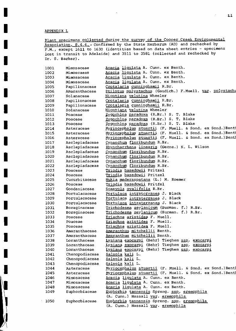
APPENDIX L
Plant specimens collected during the survey of the Cooper Creek EnvironmentalAssociation, 8.4.4.- Confirmed by the State Herbarum (AD) and rechecked byF.M., except 1611 to 1630 (identities based on data sheet entries - specimenslost in transit to Adelaide) and 3511 to 3581 (collected and rechecked byDr. S. Barker).
Li
Acacia liqulata A. Cunn. ex Benth.Acacia ligulata A. Cunn. ex Benth.Acacia liqulata A. Cunn. ex Benth.Acacia ligulata A. Cunn. ex Benth.Crotalaria cunninghamii R.Br.Ptilotus polystachus (Gaudich.) F.Muell. yar. polystacht
Nicotiana velutina WheelerCrotalaria cunninghamii R.Br.Crotalaria cunninghamii R.Br.Nicotiana velutina WheelerZygochloa paradoxa (R.Br.) S. T. Blakelygochloa paradoxa (R.Br.) S. T. BlakeZygochloa paradoxa (R.Br.) S. T. BlakeMyriocephalus stuartii (F. Muell. & Sond. ex Sond.)BentlMyriocephalus stuartii (F. Muell. & Sond. ex Sond.)BentlMyriocephalus stuartii (F. Muell. & Sond. ex Sond.)BentlCynanchum floribundum R.Br.Rhyncharrhena linearis (Decne.) K. L. WilsonCynanchum floribundum R.Br.Cynanchum floribundum R.Br.Cynanchum floribundum R.Br.Cynanchum floribundum R.Br.Triodia basedowii PritzelTriodia basedowii PritzelMukia maderaspatana (L.) M. RoemerTriodia basedowii Prit±elScaevola ovalifolia R.Br.Portulaca intraterranea J. BlackPortulaca intraterranea J. BlackPortulaca intraterranea J. BlackTrichodesma zeylanicum (Burman. f.) R.Br.Trichodesma mylanicum (Burman. f.) R.Br.Eriachne aristidea F. Muell.Eriachne aristidea F. Muell.Eriachne aristidea F. Muell.Amaranthus mitchellii Benth.Amaranthus mitchellii Benth.Lysiana exocarpi (Behr) Tieghem ssp, exocarpiLysiana exocarpi (Behr) Tieghem ssp exocarpiLysiana exocarpi (Behr) Tieghem ssp. exocarpiSalsola kali L.Salsola kali L.Salsola kali L.Myriocephalus stuartii (F. Muell. & Sond. ex Sond.)BentlMyriocephalus stuartii (F. Muell. & Sond. ex Sond.)BentlAcacia ligulata A. Cunn. ex Benth.Acacia ligulata A. Cunn. ex Benth.Acacia liqulata A. Cunn. ex Benth.Euphorbia tannensis Spreng. ssp. eremophila(A. Cunn.) Hassall var. eremophilaEuphorbia tannensis Sprang. ssp. eremophila(A. Cunn.) Hassall var. eremophila
1001 Mimosaceae1002 Mimoscaeae1003 Mimosaceae1004 Mimosaceae1005 Papilionaceae1006 Amaranthaceae1007 Solanaceae1008 Papilionaceae1009 Papilionaceae1010 Solanaceae1011 Poaceae1012 Poaceae1013 Poaceae1014 Asteraceae1015 Asteraceae1016 Asteraceae1017 Asclepiadaceae1018 Asclepiadaceae1019 Asclepiadaceae1020 Asclepiadaceae1021 Asclepiadaceae1022 Asclepiadaceae1023 Poaceae1024 Poaceae1025 Cucurbitaceae1026 Poaceae1027 Goodeniaceae1028 Portulacaceae1029 Portulacaceae1030 Portulacaceae1031 Boraginaceae1032 Boraginaceae1033 Poaceae1034 Poaceae1035 Poaceae1036 Amaranthaceae1037 Amaranthaceae1038 Loranthaceae1039 Loranthaceae1040 Loranthaceae1041 Chenopodiaceae1042 Chenopodiaceae1043 Chenopodiaceae1044 Asteraceae1045 Asteraceae1046 Mimosaceae1047 Mimosaceae1048 Mimosaceae1049 Euphorbiaceae
1050 Euphorbiaceae
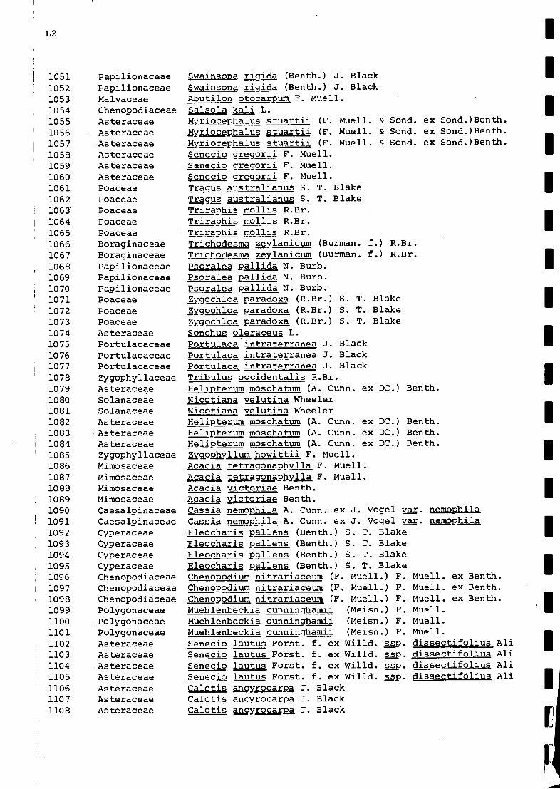
L2
1051105210531054105510561057105810591060106110621063'
10641065106610671068106910701071107210731074107510761077107810791080108110821083108410851086108710881089
1090109110921093109410951096109710981099110011011102110311041105110611071108
PapilionaceaePapilionaceaeMalvaceaeChenopodiaceaeAsteraceaeAsteraceaeAsteraceaeAsteraceaeAsteraceaeAsteraceaePoaceaePoaceaePoaceaePoaceaePoaceaeBoraginaceaeBoraginaceaePapilionaceaePapilionaceaePapilionaceaePoaceaePoaceaePoaceaeAsteraceaePortulacaceaePortulacaceaePortulacaceaeZygophyllaceaeAsteraceaeSolanaceaeSolanaceaeAsteraceaeAsteraceaeAsteraceaeZygophyllaceaeMimosaceaeMimosaceaeMimosaceaeMimosaceaeCaesalpinaceaeCaesalpinaceaeCyperaceaeCyperaceaeCyperaceaeCyperaceaeChenopodiaceaeChenopodiaceaeChenopodiaceaePolygonaceaePolygonaceaePolygonaceaeAsteraceaeAsteraceaeAsteraceaeAsteraceaeAsteraceaeAsteraceaeAsteraceae
5wainsona rigida (Benth.) J. BlackSwainsona rigida (Benth.) J. BlackAbutilon otocarpum F. Muell.Salsola kali L.Myriocephalus stuartii (F. Muell. & Sond. ex Sond.)Benth.Myriocephalus stuartii (F. Muell. & Sond. ex Sond.)Benth.Myriocephalus stuartii (F. Muell. & Sond. ex Sond.)Benth.Senecio gregorii F. Muell.Senecio gregorii F. Muell.Senecio gregorii F. Muell.Tragus australianus S. T. BlakeTragus australianus S. T. BlakeTriraphis mollis R.Br.Triraphis mollis R.Br.Triraphis mollis R.Br.Trichodesma zeylanicum (Burman. f.) R.Br.Trichodesma zeylanicum (Burman. f.) R.Br.Psoralea pallida N. Burb.Psoralea pallida N. Burb.Psoralea pallida N. Burb.Zygochloa paradoxa (R.Br.) S. T. BlakeZygochloa paradoxa (R.Br.) S. T. BlakeZygochloa paradoxa (R.Br.) S. T. BlakeSonchus oleraceus L.Portulaca intraterranea J. BlackPortulaca intraterranea J. BlackPortulaca intraterranea J. BlackTribulus occidentalis R.Br.Helipterum moschatum (A. Cunn. ex DC.) Benth.Nicotiana velutina WheelerNicotiana velutina WheelerHelipterum moschatum (A. Cunn. ex DC.) Benth.Helipterum moschatum (A. Cunn. ex DC.) Benth.Helipterum moschatum (A. Cunn. ex DC.) Benth.Zygppbyllum howittii F. Muell.Acacia tetragonaphylla F. Muell.Acacia tetragonaphylla F. Muell.Acacia victoriae Benth.Acacia victoriae Benth.Cassia nemophila A. Cunn. ex J. Vogel yar. nemophilaCassia nemophila A. Cunn. ex J. Vogel var. nemophila
Chenopodium nitrariaceum (F. Muell.) F. Muell. ex Benth.Chenopodium nitrariaceum (F. Muell.) F. Muell. ex Benth.Chenopodium nitrariaceum (F. Muell.) F. Muell. ex Benth.Muehlenbeckia cunninghamii (Meisn.) F. Muell.Muehlenbeckia cunninghamii (Meisn.) F. Muell.Muehlenbeckia cunninghamii (Meisn.) F. Muell.Senecio lautus Forst. f. ex Willd. ssp. dissectifolius AliSenecio lautus Forst. f. ex Willd. gap. dissectifolius AllSenecio lautus Forst. f. ex Willd. gap. dissectifolius AliSenecio lautus Forst. f. ex Willd. ggp. dissectifolius AliCalotis ancyrocarpa J. BlackCalotis ancyrocarpa J. BlackCalotis ancyrocarpa J. Black
Eleocharis pallens (Benth.) S. T. BlakeEleocharis pallens (Benth.) S. T. BlakeEleocharis pallens (Benth.) S. T. BlakeEleocharis pallens (Benth.) S. T. Blake

1109
1110
1111111211131114
1115111611171118111911201121112211231124112511261127112811291130
' 113111321133113411781179118011811182
11831184118511861187118811891190119111921193
AsteraceaeAsteraceaeMarsileaceaeMarsileaceaeAsteraceaeAsteraceaeAsteraceaeGeraniaceaeAsteraceaePapilionaceaePapilionaceaePapilionaceaeChenopodiaceaeChenopodiaceaeChenopodiaceaeChenopodiaceaeAsteraceaeAsteraceaeAsteraceaeAsteraceaeAsteraceaeMimosaceaeChenopodiaceaeChenopodiaceaeApiaceaeAsclepiadaceae?Polygonaceae?Polygonaceae?PolygonaceaeChenopodiaceaeChenopodiaceaeChenopodiaceaeChenopodiaceaeChenopodiaceaeChenopodiaceaePoaceaePoaceaePoaceaeMarsileaceaeMarsileaceaeMarsileaceaeMyrtaceae
L3
Calotis AagyrocarPa J. BlackCalotis ancyrocarpa J. BlackMarsilea drummondii A. BraunMarsilea drummondii A. BraunSenecio lautus Forst. f. ex Willd. ssp. maritimus AliSenecio lautus Forst. f. ex Willd. ssp. maritimus AliSenecio lautus Forst. f. ex Willd. ssp. maritimus AliErodium crinitum CarolinVittadinia sp.Trigonella suavissima LindleyTrigonella suavissima LindleyTrigonella suavissima LindleyAtriplex sp.Atriplex sp.Atriplex sp.Atriplex sp.Ca otis hispidula (F. Muell.) F. Muell.Calotis hispidula (F. Muell.) F. Muell.Calotis hispidula (F. Muell.) F. Muell.Calotis hispidula (F. Muell.) F. Muell.Calotis hispidula (F. Muell.) F. Muell.Acacia murrayana F. Muell. ex Benth.Atriplex nummularia LindleyChenopodium nitrariaceum (F. Muell.) F. Muell. ex Benth.Trachymene ?Cynangilum floribundum R.Br.Muehlenbeckia cunninghamii (Meisn.)F. Muell.Muehlenbeckia cunninghamii (Meisn.)F. Muell.Muehlenbeckia cunninghamii (Meisn.)F. Muell.Sclerolaena bicornis LindleySclerolaena bicornis LindleySclerolaena bicornis Lindley
riplex spongiosa F. Muell.Atriplex spongiosa F. Muell.Atriplex spongiosa F. Muell.Eragrostis australasicaEragrostis australasicaEragrostith australasicaMarsilea drummondii A.Marsilea drummondii A.Marsilea drummondii A.Eucaly=§ sp. (no buds or fruit) Probably E. microthecaF. Muell.Eucalyptus sp. (no buds or fruit) Probably E. microthecaF. Muell.Eucalyptus sp. (no buds or fruit) Probably E. microthecaF. Muell.Atriplex nummularia LindleyAtriplex nummularia LindleyAtriplex nummularia LindleyPortulaca intraterranea J. BlackPortulaca intraterranea J. BlackPortulaca intraterranea J. BlackSclerolaena intricata (R. Anderson) A. J. ScottSclerolaena intricata (R. Anderson) A. J. ScottSclerolaena intricata (R. Anderson) A. J. ScottHalosarcia indica (Willd.) Paul G. Wilson ssp..leiostachya (Benth.) Paul G. Wilson
(Steudel) C. E. Hubb.(Steudel) C. E. Hubb.(Steudel) C. E. Hubb.
BraunBraunBraun
1194 Myrtaceae
1195 Myrtaceae
1196 Chenopodiaceae1197 Chenopodiaceae1198 Chenopodiaceae1199 Portulacaceae1200 Portulacaceae1201 Portulacaceae1202 Chenopodiaceae1203 Chenopodiaceae1204 Chenopodiaceae1205 Chenopodiaceae

L4
1206 Chenopodiaceae Halosarcia indica (Willd.) Paul G. Wilson ssp.leiostachya (Benth.) Paul G. Wilson
1207 Chenopodiaceae Halosarcia indica (Willd.) Paul G. Wilson ssp.leiostachya (benth.) Paul G. Wilson
1208 Solanaceae Nicotiana velutina Wheeler1209 Solanaceae picotiana velutina Wheeler
1210 Solanaceae Nicotiana yelutina Wheeler1211 Chenopodiaceae Chenopodium auricomum Lindley1212 .Chenopodiaceae Chenopodium auricomum Lindley1213 Chenopodiaceae Chenopodium auricomum Lindley1214 Amaranthaceae Alternanthera nodiflora R.Br.
1215 Amaranthaceae Alternanthera nodiflora R.Br.1216 .Amaranthaceae Alternanthera nodiflora R.Br.1217 Chenopodiaceae Enchylaena tomentosa R.Br.1218 Chenopodiaceae Enchylaena tomentosa R.Br.1219 Chenopodiaceae Enchylaena tomentosa R.Br.1220 Chenopodiaceae Salsola kali L.
1221 Chenopodiaceae Salsola kali L.1222 Chenopodiaceae Salsola kali L.
1223 ?Pap ii. Templetonia egena (F. Muell.) Benth. Insufficient material
1224 ' Chenopodiaceae Salsola kali L.
1225 Solanaceae Nicotiana velutina Wheeler1226 Asteraceae Myriocephalus stuartii (F. Muell.& Sond. ex Sond.) Benth.
1227 Aizoaceae Zaleya galericulata (Melville) H. Eichler1228 Chenopodiaceae Atriplex angulata Benth.1229 Chenopodiaceae Halosarcia indica (Willd.) Paul G. Wilson fsp..
leiostachya (Benth.) Paul G. Wilson1230 Poaceae Eragrostis setifolia Nees1231 Poaceae Triodia sp. Probably T. basedowii Pritzel1232 Proteaceae Hakea leucoptera R.Br.1233 Poaceae Zygochloa paradoxa (R.Br.) S. T. Blake1234 Caesalpinaceae Cassia nemophila A. Cunn. ex J. Vogel var. nemophila1235 Mimosaceae Acacia ligulata A. Cunn. ex Benth.1236 Euphorbiaceae Phyllanthus fuernrohrii F. Muell.1237 Mimosaceae Acacia victoriae Benth.1238 Chenopodiaceae. Salsola kali L.1239 Portulacaceae Portulaca intraterranea J. Black1240 Mimosaceae Acacia oswaldii F. Muell.1241 Caesalpinaceae Cassia nemophila A. Cunn. ex J. Vogel var. zygophylla
(Benth.) Benth.1242 Lamiaceae Teucrium racemosum R.Br. var. racemosum1243 Chenopodiaceae Dissocarpus paradoxa (R.Br.) F. Muell. ex Ulbr. var.
latifolius (J. Black) Ulbr.1244 Amaranthaceae Ptilotus polystachus (Gaudich.) F. Muell. var. polystachus1245 Chenopodiaceae Atriplex spongiosa F. Muell.1246 Meliaceae Owenia acidula F. Muell.1247 Thyme laeaceae Pimelea trichostachya Lindley1248 Proteaceae Hakea eyreana(S. Moore) D. McGillivrayi1249 Chenopodiaceae Einadia nutans (R.Br.) A. J. Scott1250 Sapindaceae Atalaya hemiglauca (F. Muell.) F. Muell. ex Benth.1251 Poaceae Enneapogon avenaceus (Lindley) C. E. Hubb.1252 Papilionaceae 5wainsona phacoides Benth.1253 Poaceae Insufficient material for further identification.
1254 Poaceae Eragrostis setifolia Nees,1255 Poaceae Eragrostis eriopoda Benth.1256 Sapindaceae Dodonaea angustissima DC.1257 Malvaceae Sida ammophila F. Muell. ex J. H. Willis
1258. Lamiaceae Teucrium racemosum R.Br. var. racemosum
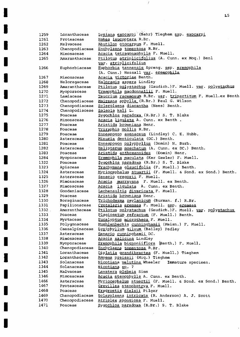
L5
Lysiana exocarpi (Eiehr) Tieghem ssp. exocarpiHakea leucoptera R.Br.Abutilon otocarpum F. Muell.Enchylaena tomentosa R.Br.Acacia tetragonaphylla F. Muell.Ptilotus atriplicifolius (A. Cunn. ex Moq.) Benimar. atriplicifoliusEuphorbia tannensis Spreng. asp. eremophila(A. Cunn.) Hassall var. eremophilaAcacia victoriae Benth.Haloragis asp era LindleyPtilotus polystachus (Gaudich.)F. Muell. var. polystachusEremophila macdonnellij, F. Muell.Teucrium racemosum R.Br. var. tripartitum F. Muell.ex BenthMaireana aphylla (R.Br.) Paul G. WilsonSclerolaena diacantha (Nees) Benth.Salsola kali L.Zygochloa paradoxa (R.Br.) S. T. BlakeAcacia ligulata A. Cunn. ex Benth .Aristida brownianaTriraphis mollis R.Br.Enneapogon avenaceus (Lindley) C. E. Hubb.Minuria denticulata (DC.) Benth.Enneapogon polyphyllus (Domin) N. Burb.Helipterum moschatum (A. Cunn. ex DC.) Benth.
2=g7.1:nMlaiMratde(Kert:1:)r)Hr.rMuell.Zygochloa paradoxa (R.Br.) S. T. BlakeTrachymene glaucifolia (F. Muell.) Benth.Myriocephalus stuartii (F. Muell. & Sond. ex Sond.) Benth.Senecio gregorii F. Muell.Acacia murrayana F. Muell. ex Benth.Acacia ligulata A. Cunn. ex Benth.Lechenaultia divaricata F. Muell.Aristida browniana Henr.Trichodesma zeylanicum (Burman. f.) R.Br.
(telidliC sh.71;. =7.!4var. polystachusPlagiosetum refractum (F. Muell.) Benth.Eucalyptus microtheca F. Muell.Muehlenbeckia cunninghamii (Meisn.) F. Muell.Lysiphyllum gilvum (Bailey) PedleySenecio cunninghamii DC.Acacia salicina Lindley
(711= bt!:::=11oll(Benth.) F. Muell.
Diplatia grandibractea (F. Muell.) TieghemAmyema preissii (Miq.) TieghemNicotiana velutina Wheeler Immature specimen.Nicotiana sp. ?Lavatera plebeia SimsAcacia stenophylla A. Cunn. ex Benth.Myriocephalus stuartii (F. Muell. & Sond. ex Sond.) Benth.Grevillea stenobotrya F. Muell.Eragrostis dielsii PilgerSclerolaena intricata (R. Anderson) A. J. ScottAtriplex sponcliosa F. Muell.Zygochloa paradoxa (R.Br.) S. T. Blake
1259 Loranthaceae1261 Proteaceae1262 Malvaceae1263 Chenopodiaceae1264 Mimosaceae1265 Amaranthaceae
1266 Euphorbiaceae
1267 Mimosaceae1268 Haloragaceae1269 Amaranthaceae1270 Myoporaceae1271 Lamiaceae1272 Chenopodiaceae1273 Chenopodiaceae1274 Chenopodiaceae1275 Poaceae1276 Mimosaceae1277 Poaceae1278 Poaceae1279 Poaceae1280 Asteraceae1281 Poaceae1282 Asteraceae1283 Poaceae1284 Myoporaceae1322 Poaceae1323 Apiaceae1324 Asteraceae1325 Asteraceae1326 Mimosaceae1327 Mimosaceae1328 Goodeniaceae1329 Poaceae1330 Boraginaceae1331 Papilionaceae1332 Amaranthaceae1333 Poaceae1334 Myrtaceae1335 Polygonaceae1336 Caesalpinaceae1337 Asteraceae1338 Mimosaceae1339 Myoporaceae1340 Chenopodiaceae1341 Loranthaceae1342 Loranthaceae1343 Solanaceae1344 Solanaceae1345 Malvaceae1346 Mimosaceae1466 Asteraceae1467 Proteaceae1468 Poaceae1469 Chenopodiaceae1470 Chenopodiaceae1471 Poaceae

L6
1472 Papilionaceae Crotalaria eremaea F. Muell. ssp. eremaea1473. Amaranthaceae Ptilotus latifolius R.Br.1474 Meliaceae Owenia acidula F. Muell.1475 Myoporaceae Eremophila longifolia (R.Br.) F. Muell.1476 Asteraceae Myriocephalus stuartii (F. Muell. & Sond. ex Sond.) Benth.1477 Mimosaceae Acacia murrayana F. Muell. ex Benth.1478 Apiaceae Trachymene glaucifolia (F. Muell.) Benth.1479 Boraginaceae Trichodesma zeylanicum (Burman. f.) R.Br.1480 Sap indaceae Atalaya hemiglauca (F. Muell.) F. Muell. ex Benth.1481 Chenopodiaceae Sclerolaena diacantha (Nees) Benth.1482 Chloanthaceae Dicrastylis costelloi Bailey1483 Poaceae Aristida browniana Henr.1484 Poaceae Triodia basedowii Pritzel1485 Chenopodiaceae Enchylaena tomentosa R.Br.1486 Podceae Aristida browniana Henr.1487 Frankeniaceae Frankenia angustipetala Summerh.1488 Asteraceae Calocephalus platycephalus (F. Muell.) Benth.1489 Chenopodiaceae Chenopodium auricomum Lindley1490 Proteaceae Hakea leucoptera R.Br.1491 Caesalpinaceae Cassia phyllodinea R.Br.1492 Amaranthaceae Ptilotus polystachus (Gaudich.) F. Muell. var. polystachus1493 Goodeniaceae Scaevola ovalifolia R.Br.1494 Campanulaceae Wahlenbergia sp1495 Caesalpinaceae Cassia nemophila A. Cunn. ex J. Vogel var. nemophila1496 Myoporaceae Eremophila bignoniiflora (Benth.) F. Muell.1498 Papilionaceae Crotalaria smithiana A. Lee1499 Asteraceae Gnephosis eriocarpa (F. Muell.) Benth.1500 Papilionaceae Psoralea australasica Schldl.1501 Asteraceae Senecio ggggorii F. Muell.1502 Sapindaceae Dodonaea angustissima DC.1503 Malvaceae Hibiscus krichauffianus F. Muell.1504 Malvaceae Sida ammophila F. Muell. ex J. H. Willis1505 Poaceae Aristida browniana Henr.1506 Euphorbiaceae Euphorbia tannensis Spreng. ssp. eremophila
(A. Cunn.) Hassall var. eremophila1507 Poaceae Leptochloa digitata (R.Br.) Domin1508 Asteraceae Gnaphalium luteoalbum L.1509 Brassiacaceae Lepidium muelleriferdinandii Thell.1510 Polygonaceae Rumex Qgystallinus Lange1511 Cyperaceae Cyperus sp. aff. cunninghamii (C. B. Clarke) C. Gardner1512 Amaranthaceae Alternanthera nodiflora R.Br.1513 Asteraceae Sonchus oleraceus L.1514 Santalaceae Santalum lanceolatum R.Br.1515 Loranthaceae Lysiana exocarpi (Behr) Tieghem ssp. exocarpi1516 Chenopodiaceae Rhagodia gaudichaudiana Moq.1517 Asteraceae Pterocaulonsphacelatum (Labill.) Benth.& Hook.f. ex F.Muell1518 Asteraceae Calocephalus platycephalus (F. Muell.) Benth.1519 Asteraceae Helipterum moschatum (A. Cunn. ex DC.) Benth.1520 Goodeniaceae Scaevola depauperata R.Br.1521 Euphorbiaceae Adriana hookeri (F. Muell.) Muell. - Arg.1522 Portulacaceae Calandrinia remota J. Black1530 Poaceae Aristida browniana Henr.1530' Asteraceae Myriocephalus rudallii (F. Muell.) Benth.1531 Asteraceae Helipterum floribundum DC.
1532 Asteraceae Centipeda cunninghamii (DC.) A. Br. & Aschers.1532' Chenopodiaceae Atriplex velutinella F. Muell.1533 Solanaceae Nicotiana velutina Wheeler1534 Papilionaceae Lotus cruentus Court
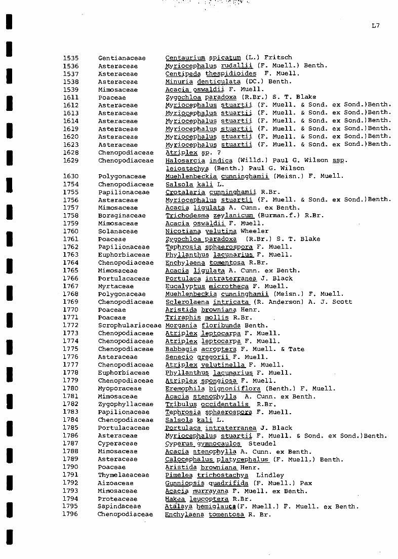
L7
1535 Gentianaceae Centaurium spicatum (L.) Fritsch
1536 Asteraceae Myriocephalus rudallii (F. Muell.) Benth.
1537 Asteraceae Centipeda thespidioides F. Muell.
1538 Asteraceae Minuria denticulata (DC.) Benth.1539 Mimosaceae Acacia oswaldii F. Muell.1611 Poaceae Zygochloa paradoxa (R.Br.) S. T. Blake1612 Asteraceae Myriocephalus stuartii (F. Muell. & Sond. ex Sond.)Benth.
1613 Asteraceae Myriocephalus stuartii (F. Muell. & Sond. ex Sond.)Benth.
1614 Asteraceae Myriocephalus stuartii (F. Muell. & Sond. ex Sond.)Benth.1619 Asteraceae Myriocephalus stuartii (F. Muell. & Sond. ex Sond.)Benth.1620 Asteraceae Myriocephalus stuartii (F. Muell. & Sond. ex Sond.)Benth.1623 Asteraceae Myriocephalus stuartii (F. Muell. & Sond. ex Sond.)Benth.1628 Chenopodiaceae Atriplex sp. ?1629 Chenopodiaceae Halosarcia indica (Willd.) Paul G. Wilson ssp.
leiostachya (Benth.) Paul G. Wilson1630 Polygonaceae Muehlenbeckia cunninghamii (Meisn.) F. Muell.1754 Chenopodiaceae Salsola kali L.1755 Papilionaceae Crotalaria cunninghamii R.Br.1756 Asteraceae Myriocephalus stuartii (F. Muell. & Sond. ex Sond.)Benth.1757 Mimosaceae Acacia ligulata A. Cunn. ex Benth.1758 Boraginaceae Trichodesma zeylanicum (Burman.f.) R.Br.1759 Mimosaceae Acacia oswaldii F. Muell.1760 Solanaceae Nicotiana velutina Wheeler1761 Poaceae Zygochloa paradoxa (R.Br.) S. T. Blake1762 Papilionaceae Tephrosia sphaerospora F. Muell.1763 Euphorbiaceae Phyllanthus lacunarius F. Muell.1764 Chenopodiaceae Enchylaena tomentosa R.Br.1765 Mimosaceae Acacia ligulata A. Cunn. ex Benth.1766 Portulacaceae Portulaca intraterranea J. Black1767 Myrtaceae Eucalyptus microtheca F. Muell.1768 Polygonaceae Muehlenbeckia cunninghamii (Meisn.) F. Muell.1769 Chenopodiaceae Sclerolaena intricata (R. Anderson) A. J. Scott1770 Poaceae Aristida browniana Henr.1771 Poaceae Triraphis mollis R.Br.1772 Scrophulariaceae Morgania floribunda Benth.1773 Chenopodiaceae Atriplex leptocarpa F. Muell.1774 Chenopodiaceae Atriplex leptocarpa F. Muell.1775 Chenopodiaceae Babbagia acroptera F. Muell. & Tate1776 Asteraceae Senecio gregorii F. Muell.1777 Chenopodiaceae Atriplex velutinella F. Muell.1778 Euphorbiaceae Phyllanthus lacunarius F. Muell.1779 Chenopodiaceae Atriplex spongiosa F. Muell.1780 Myoporaceae Eremophila bignoniiflora (Benth.) F. Muell.1781 Mimosaceae Acacia stenophylla A. Cunn. ex Benth.1782 Zygophyllaceae Tribulus occidentalis R.Br.1783 Papilionaceae Tephrosia sphaerospora F. Muell.1784 Chenopodiaceae Salsola kali L.1785 Portulacaceae Portulaca intraterranea J. Black1786 Asteraceae Myriocephalus stuartii F. Muell. & Sond. ex Sond.)Benth.1787 Cyperaceae Cyperus gymnocaulos Steudel1788 Mimosaceae Acacia stenophylla A. Cunn. ex Benth.1789 Asteraceae Calocephalus platycephalus (F. Muell.) Benth.1790 Poaceae Aristida browniana Henr.1791 Thymelaeaceae Pimelea trichostachya Lindley1792 Aizoaceae Gunniopsis quadrifida (F. Muell.) Pax1793 Mimosaceae Acacia murrayana F. Muell. ex Benth.1794 Proteaceae Hakaa leucoptera R.Br.1795 Sapindaceae Atlaya hemiglauca(F. Muell.) F. Muell. ex Benth.1796 Chenopodiaceae Enchylaena tomentosa R. Br.

LB
Eremophila longifolia (R.Br.) F. Muell.Acacia ligulata A. Cunn. ex Benth.Helipterum moschatum (A. Cunn. ex DC.) Benth.Dodonaea angustissima DC.Rtilotus obovatus (Gaudich.) F. Muell. var. obovatusPtilotus polystachus (Gaudich.)F. Muell. var. polystachusCassia nemophila A. Cunn. ex J. .Vogel var. nemophilaSida ammophila F. Muell. ex J. H. WillisByriocephalus stuartii (F. Muell. & Sond. ex Sond.)Benth.Aristida browniana Henr.Paractaenum novae-hollandiae P. Beauv.faggu australianus S. T. Blake
F4:11.PNicotiana velutina WheelerScaevola aemula R.Br.Triraphis mollis R.Br.Acacia murrayana F. Muell. ex Benth.Acacia victoriae Benth.Zygochloa paradoxa (R.Br.) S. T. BlakeTrichodesma zeylanicum (Burman. f.) R.Br.Salsola kali L.
!roren:li2127i7la-2uell.:B;;1;
ell.) Benth.Slanum ogacanthum F. M
Lysiana exocarpi (Behr) Tieghem asp. exocarpiAtriplex leptocarpa F. Muell.
112:1:7=:faulivIdnina(=IdS.1)1a;a7G7WvilrsTaWilsonleiostachya (Benth.) Paul G. WilsonAcacia murrayana F. Muell. ex Benth.Amyema preissii (Miq.) Tieghem
F. Muell.gynanchum floribundum R.Br.
Mukia maderaspatana (L.) M. RoemerAcacia oswaldii F. Muell.Zygochloa paradoxa (R.Br.) S. T. BlakeHakea leucoptera R.Br.Acacia ligulata A. cunn. ex Benth.Enchylaena tomentosa R.Br.Cassia gpa A. CLuinnnd.le:
th
x J. Vogel var. nemophilaChenopodium nitrariaceum (F. Muell.) F. Muell. ex Ben.
Phyllanthus fuernrohrii F. Muell.Diplatia qrandibractea (F. Muell.) TieghemTrioclia basedowii PritzelEnchylaena tomentosa R.Br.Eucalyptus sp.(no buds or fruit) Probably E.microthecaF. Muell.Eucalyptus microtheca F. Muell.gyperus gymnocaulos SteudelAcacia murrayana F. Muell. ex Benth.Muehlenbeckia cunninghamii (Meisn.) F. Muell.Sporobolus mitchellii (Trin.) C. E. Hubb.Acacia victoriae Benth.Atriplex eardlevae AellenAtriplex nummularia Lindley
1797 Myoporaceae1798 Mimosaceae1799 Asteraceae1800 Sapindaceae1801 Amaranthaceae1802 Amaranthaceae1803 Caesalpinaceae1804 Malvaceae1805 Asteraceae1806 Poaceae1807 Poaceae1808 Poaceae1809 Poaceae1810 Poaceae1811 Solanaceae1812 Goodeniaceae1813 Poaceae1814 Mimosaceae1815 Mimosaceae1816 Poaceae1817 Boraginaceae1818 Chenopodiaceae1819 Papilionaceae1820 Apiaceae2001 Solanaceae2002 Asteraceae2003 Loranthaceae2004 Chenopodiaceae2005 Rubiaceae2006 Chenopodiaceae
2007 Mimosaceae2008 Loranthaceae2009 Myoporaceae2010 Asclepiadaceae2011 Scrophulariaceae
' 2012 Cucurbitaceae2013 Mimosaceae2014 Poaceae2015 Proteaceae2016 Mimosaceae2017 Chenopodiaceae2018 Caesalpinaceae2019 Chenopodiaceae2020 Chenopodiaceae2021 Euphorbiaceae
1 2022 Loranthaceae2023 Poaceae2024 Chenopodiaceae2025 Myrtaceae
2025' Myrtaceae2026 Cyperaceae2027 Mimosaceae2028 Polygonaceae2029 Poaceae2030 Mimosaceae2031 Chenopodiaceae2032 Chenopodiaceae

1
L9
Nidotiana ve utina WheelerPhyllanthus sp. aff. lacunarius F. Muell.Sclerolaena intricata (R. Anderson) A. J. ScottAtriplex sp. aff. eardleyae AellenPhyllanthus fuernrohrii F. Muell.Tephrosia sphaerospora F. Muell.Atriplex leptocarpa F. Muell.Portulaca intraterranea J. BlackAtriplex leptocarpa F. Muell.Portulaca intraterranea J. BlackTrachymene glaucifolia (F. Muell.) Benth. Immature.Salsola kali L.Tribulus occidentalis R.Br.Lechenaultia divaricata F. Muell.Babbagia acroptera F. Muell. & TateMorgania floribunda Benth.Epaltes australis Less.Sclerolaena intricata (R. Anderson) A. J. ScottAtriplex lsptocarpa F. Muell.Atriplex spongiosa F. Muell.Frankenia cinerea A. DC.Sauropus trachyspermus (F. Muell.) Airy Shawcyperus gymnocaulos SteudelSenecio gregorii F. Muell.Erodium aureum CarolinEnchylaena tomentosa R.Br.Halosarcia indica (Willd.) Paul G. Wilson ssp,leiostachya (Benth.) Paul G. WilsonSclerolaena intricata (R. Anderson) A. J. ScottSclerolaena diacantha (Nees) Benth.Sporobolus mitchellii (Trin.) C. E. Hubb.Convulvulus erubescens SimsSenecio cunninghamii DC.Muehlenbeckia cunninghamii (Meisn.) F. Muell.Marsilea drummondii A. BraunSenecio lautus Forst. f. ex Willd. asp. maritimus AlTriqonella suavissimaLindleyiCalotis ancyrocarpa J. BlackAtriplex spL.
? Nicotiana sp.Immature - possibly N. velutina WheelerRanunculus sp. Insufficient material.Insufficient material for further identification.
aterial for identification.? CalotisEleocharis pallens (Benth.) S. T. BlakeHaloraqis sp. Insufficient material.Sonchus oleraceus L.Helipterum moschatum (A.Cunn. ex DC.) Benth.Myriocephalus stuartii (F. Muell. & Sond. ex Sond.)Benth.Salsola kali L.Brachycome ciliaris (Labill.) Less. var. lanuginosa(Steetz) Benth.Blennodia pterosperma (J. Black) J. BlackSenecio gregorii F. Muell.0yriocephalus stuartii (F. Muell. & Sond. ex Sond.)Benth.gygophyllum howittii F. Muell.Amaranthus mitchellii Benth.Amyema preissii (Miq.) TieghemOmphalolappula concava (F. Muell.) Brand
2033 Solanaceae2034 Euphorbiaceae2035 Chenopodiaceae2036 Chenopodiaceae2037 Euphorbiaceae2038 Papilionaceae2039 Chenopodiaceae2040 Portulacaceae2041 Chenopodiaceae2042 Portulacaceae2043 ?Apiaceae2044 Chenopodiaceae2045 Zygophyllaceae2046 Goodeniaceae2047 Chenopodiaceae2048 Scrophulariaceae2049 Asteraceae2050 Chenopodiaceae2051 Chenopodiaceae2052 Chenopodiaceae2053 Frankeniaceae2054 Euphorbiaceae2055 Cyperaceae2056 Asteraceae2057 Geraniaceae2058 Chenopodiaceae2059 Chenopodiaceae
2060 Chenopodiaceae2061 Chenopodiaceae2062 Poaceae2063 Convulvulaceae2064 Asteraceae2065 Polygonaceae2066 Marsileaceae2067 Asteraceae2068 Papilionaceae2069 Asteraceae2070 Chenopodiaceae2071 Solanaceae2072 ?Ranunculaceae2073 Poaceae2074 Not sufficient m2075 Asteraceae2076 Cyperaceae2077 ?Haloragaceae2078 Asteraceae2079 Asteraceae2080 Asteraceae2081 Chenopodiaceae2082 Asteraceae
2083 Brassicaceae2084 Asteraceae2085 Asteraceae2086 Zygophyllaceae2087 Amaranthaceae2088 Loranthaceae2089 Boraginaceae

L10
2090 Sapindaceae Atalaya hemiglauca (F. Muell.) F. Muell. ex Benth.
2091 Malvaceae Abutilon gp. ? fraseri (Hook.) Hook. ex Walp.2092 Zygophyllaceae Zygophyllum sp. ? terrestris L.
Acacia oswaldii F. Muell.2093 Mimosaceae2094 Poaceae Enneapogon avenaceus (Lindley) C. E. Hubb.2095 Zygophyllaceae Zyqophyllum howittii F. Muell.2096 Convulvulaceae Convulvulus erubescens Sims2097 Tetragoniaceae Tetragonia tetragonioides (Pallas) Kuntze2098 Euphorbiaceae Euphorbia tannensis Spreng. ssp. eremophila
(A. Cunn.) Hassall var. eremophila2099 Asteraceae gelipterum moschatum (A. Cunn. ex DC.) Benth.2100 Poaceae Aristida contorta F. Muell.2101 Poaceae gragrostis dielsii Pilger2102 Poaceae Enneapogon cylindricus N. Burb.2103 Poaceae Triraphis mollis R.Br.2104 Liliaceae Bulbine alata Baijnath2105 Caesalpinaceae Cassia nemophila A. Cunn. ex J. Vogel var. nemophila2106 Caesalpinaceae Cassia nemophila A. Cunn. ex J. Vogel var. zygophylla
(Benth.) Benth.2107 Chenopodiaceae Sclerolaena diacantha (Nees) Benth.2108 Malvaceae Sida gp.2109 Papilionaceae Swainsona phacoides Benth.2110 Chenopodiaceae Salsola kali L.2111 Brassicaceae Blennodia pterosperma (J. Black) J. Black2112 Asteraceae Ixiolaena brevicompta F. Muell.2113 Chenopodiaceae Atriplex sp. aff. holocarpa F. Muell.2114 Chenopodiaceae Chenopodium nitrariaceum (F. Muell.)F. Muell. ex Benth.2115 Mimosaceae Acacia tetraqonaphylla F. Muell.2116 Poaceae Aristida browniana Henr.
!2117 Euphorbiaceae Euphorbia tannensis Spreng. ssp. eremophila
(A. Cunn.) Hassall var. eremophila2118 Caesalpinaceae Cassia nemophila A. Cunn. ex J. Vogel var. nemophila2119 Boraginaceae Trichodesma zeylanicum (Burman. f.) R.Br.2120 Myoporaceae Eremophila longifolia (R.Br.) F. Muell.2121 Loranthaceae Lysiana exocarpi (Behr) Tieghem ssp. exocarpi2122 Loranthaceae Amyema preissii (Miq.) Tieghem2123 Caesalpinaceae Cassia nemophila A. Cunn. ex J. Vogel var. nemophila2124 Solanaceae Solanum oligacanthum F. Muell.2125 Poaceae Eragrostis australasica (Steudel) C. E. Hubb.2125a Malvaceae Lavatera plebeia Sims2126 Meliaceae Owenia acidula F. Muell.2127 Chenopodiaceae Einadia nutans (R.Br.) A. J. Scott2128 Chenopodiaceae Chenopodium auricomum Lindley2129 Chenopodiaceae Salsola kali L.2130 Mimosaceae Acacia stenophylla A. Cunn. ex Benth.2131 Haloragaceae Haloragis aspera Lindley
1 2132 Proteaceae Grevillea striata R.Br.2133 Papilionaceae Swainsona oroboides F. Muell. ex Benth.2134 Chenopodiaceae Atriplex angulata Benth.
, 2135 Lamiaceae Teucrium racemosum R.Br. var. racemosum, 2136 Chenopodiaceae Salsola kali L.
2137 Chenopodiaceae Maireana aphylla (R.Br.) Paul G. Wilson2138 Chenopodiaceae Sclerolaena bicornis Lindley2139 Chenopodiaceae Salsola kali L.2140 Goodeniaceae Lechenaultia divaricata F. Muell.2141 Chenopodiaceae Dissocarpus paradoxa (R.Br.) F. Muell. ex Ulbr. var.
latifolius (J. Black) Ulbr.2142 Poaceae. Aristida contorta F. Muell.

L11
2143 Plantaginaceae Plantago varia R.Br.
2144 Poaceae Enneapogon avenaceus (Lindley) C. E. Hubb.
2145 Malvaceae Sida sp. D (Fl. C. Aust. p.218) Brown-green specimen.2145' Malvaceae Sida ammophila F. Muell. ex J. H. Willis 2 grey-
leaved specimens.2146 Papilionaceae Swainsona phacoides Benth.2147 Tetragoniaceae Tetragonia tetragonioides (Pallas) Kuntze2148 Caesalpinaceae Lysiphyllum gilvum (Bailey) Pedley2149 Asteraceae Calotis erinacea Steetz2150 Asteraceae Minuria denticulata (DC.) Benth.2151 Chenopodiaceae Sclerolaena ventricosa (J. Black) A. J. Scott2152 Chenopodiaceae Atriplex limbata Benth.2153 Goodeniaceae Goodenia sp. aff. havilandii Maiden & Betche2154 Brassicaceae Brassica tournefortii Gouan2155 Brassicaceae Brass ica tournefortii Gouan
2156 Asteraceae Sonchus asper (L.) Hill2157 Polygonaceae Rumex sp. (Probably Rumex crystallinus Lange)2158 Malvaceae Lavatera plebeia Sims (Immature)2159 Asteraceae Gnaphalium indicum L.2160 Zygophyllaceae Zygophyllum ammophilum F. Muell.2161 Mimosaceae Acacia oswaldii F. Muell.2162 Myoporaceae Eremophila sp.2163 Santalaceae Santalum lanceolatum R.Br.2164 Haloragaceae Haloragis aspera Lindley2165 Myoporaceae Eremophila biqnoniiflora (Benth.) F. Muell.2166 Chenopodiaceae Neobassia proceriflora (F. Muell.) A. J. Scott2167 Chenopodiaceae Sclerolaena intricata (R. Anderson) A. J. Scott2168 Pittosporaceae Pittosporum phylliraeoides DC. var. microcarpa S.Moore2169 Asteraceae Sonchus oleraceus L.2170 Mimosaceae Acacia salicina Lindley2171 Asteraceae Calotis ancyrocarpa J. Black2172 Amaranthaceae Ptilotus polystachus (Gaudich.)F. Muell. var. polystachus2173 Rubiaceae Dentella pulvinata Airy Shaw var. pulvinata2174 Chenopodiaceae Atriplex sp.2175 Chenopodiaceae Einadia nutans (R.Br.) A. J. Scott2176 Haloragaceae Haloragis aspera Lindley2177 Apiaceae Trachymene qlaucifolia (F. Muell.) Benth.2178 Meliaceae Owenia acidula F. Muell.2179 Asteraceae Senecio cunninghamii DC.2180 loranthaceae Lysiana exocarpi (Behr) Tieghem ssp, exocarpi2181 Pittosporaceae Pittosporum phylliraeoides DC. var. microcarpa S.Moore2182 Malvaceae Sida sp. ? fibulifera Lindley (Insufficient material)2183 Asteraceae Gnephosis eriocarpa (F. Muell.) Benth.2184 Papilionaceae Swainsona phacoides Benth.2185 Poaceae Aristida contorta F. Muell.2186 Poaceae Eragrostis eriopoda Benth.2187 Santalaceae Santalum lanceolatum R.Br.2188 Chenopodiaceae Atriplex lindleyi Moq.2189 Chenopodiaceae Atriplex velutinella F. Muell.2190 Chenopodiaceae Salsola kali L.2191 Asteraceae Helipterum strictum (Lindley) Benth.2192 Sapindaceae Dodonaea angustissima DC.2193 Aizoaceae Gunniopsis quadrifida (F. Muell.) Pax2193' Poaceae Panicum whitei J. Black2194 Asteraceae Minuria rig ida J. Black2195 Malvaceae Abutilon otocarpum F. Muell.2196 Zygophyllaceae Tribulus hystrix R. Br.2197 Papilionaceae Crotalaria eremaea F. Muell. var. eremaea

L12
1
1
1
2198 Amaryllidaceae Crinum flaccidum Herb.2199 Aizoaceae Trianthema triquetra Willd.2200 Asteraceae Calotis hispidula (F. Muell.) F. Muell.
2200' Poaceae Sporobolus actinocladus (F. Muell.) F. Muell.2201 Poaceae Eriochloa pseudo-acrotricha (Stapf ex Thell.) J. Black
2202 Chenopodiaceae Chenopodium cristatum (F. Muell.) F. Muell.2203 Poaceae Eriochloa pseudo-acrotricha (Stapf ex Thell.) J. Black2204 Poaceae Dactyloctenium radulans (R.Br.) P. Beauv.2205 Marsileaceae Marsilea drummondii A. Braun2206 Meliaceae Owenia acidula F. Muell.2207 Brassicaceae Brassica tournefortii Gouan2208 Poaceae Eragrostis setifolia Nees2209 Goodeniaceae Goodenia lobata Ising2210 Apiaceae Daucus qlochidiatus (Labill.) Fischer, C. Meyer &
Ave Lall.2211 Asteraceae Helipterum microglossum (F. Muell.) Maiden & Betche2212 Zygophyllaceae Zygophyllum iodocarpum F. Muell.2213 Geraniaceae Erodium cygnorum Nees ss2. glandulosum Carolin2214 Liliaceae Bulbine alata Baijnath2215 Asteraceae Minuria denticulata (DC.) Benth.2216 Asteraceae Helipterum strictum (Lindley) Benth.2217 Myoporaceae Eremophila longifolia (R.Rr.) F. Muell.2218 Chenopodiaceae Maireana coronata (J. Black) Paul G. Wilson2219 Poaceae Astrebla lappacea (Lindley) Domin
2220 Brassicaceae Blennodia canescens R.Br.2221 Myoporaceae Eremophila longifolia (R.Br.) F. Muell.2221' Euphorbiaceae Euphorbia parvicaruncula Hassall2222 Caesalpinaceae Cassia nemophila A. Cunn. ex J. Vogel var. zygophylla
(Benth.) Benth.2223 Asteraceae Pluchea tetranthera F. Muell.2224 Poaceae Eragrostis eriopoda Benth.2225 Chenopodiaceae Dissocarpus biflorus (R.Br.) F. Muell. var. cephalocarpa
(F. Muell.) A. J. Scott2226 Chenopodiaceae Sclerolaena diacantha (Nees) Benth.2227 Chenopodiaceae Sclerolaena ventricosa (J. Black) A. J. Scott2228 Papilionaceae Psoralea australasica Schldl.2229 Frankeniaceae Frankenia angustipetala Summerh.2230 Chenopodiaceae Maireana qeorgei (Diels) Paul G. Wilson2231 Myoporaceae Eremophila maculata (Ker Gawler) F. Muell.2232 Poaceae Aristida anthoxanoides (Domin) Henr.2233 Poaceae Eragrostis leptocarpa Benth.2234 Poaceae Enneapogon avenaceus (Lindley) C. E. Hubb.2235 Chenopodiaceae Neobassia proceriflora (F. Muell.) A. J. Scott2236 Chenopodiaceae Sclerolaena costata (R. Anderson) A. J. Scott2237 Lamiaceae Teucrium racemosum R.Br. var. racemosum2238 Poaceae Aristida contorta F. Muell.2239 Chenopodiaceae Salsola kali L.2240 Chenopodiaceae Maireana aphvlla (R.Br.) Paul G. Wilson2241 Caesalpinaceae Cassia nemophila A. Cunn. ex J. Vogel var. zygophylla
(Benth.) Benth.2242 Papilionaceae Tephrosia sphaerospora F. Muell.2243 Myrtaceae Eucalyptus camaldulensis Dehnh. var. obtusa (Dehnh.)
Blakely2244 Brassicaceae Lepidium phlebopetalum (F. Muell.) F. Muell.2245 Chenopodiaceae Atriplex angulata Benth.
2246 Chenopodiaceae Sclerolaena calcarata (Ising) A. J. Scott
2247 Chenopodiaceae Atriplex velutinella F. Muell.
2248 Chenopodiaceae Atriplex spongiosa F. Muell.

2249 Goodeniaceae Scaevola ovalifolia R.Br.
2250 Chenopodiaceae Maireana pyramidata (Benth.) Paul G. Wilson
2251 Chenopodiaceae Halosarcia indica (Willd.) Paul G. Wilson ssID.-
leiostachya (Benth.) Paul G. Wilson2252 Chenopodiaceae Atriplex lindleyi Moq.2253 Verbenaceae Verbena officinalis L.2254 Asteraceae Calocephalus platycephalus (F. Muell.) Benth.
2255 ?Polygonaceae Rumex crystallinus Lange2256 Aizoaceae Glinus lotoides L.2257 Chenopodiaceae Atriplex velutinella F. Muell.
2258 Chenopodiaceae Atriplex velutinella F. Muell.
2259 Asteraceae Epaltes australis Less.
2260 Poaceae Eragrostis dielsii Pilger2261 Amaranthaceae Alternanthera nodiflora R.Br.2262 Mimosaceae Acacia stenophylla A. Cunn. ex Benth.2263 Lamiaceae Mentha sp. (Probably Mentha australis R.Br.)2264 Haloragaceae Haloragis asp era Lindley2265 Thymelaeaceae Pimelea continua J. Black2266 Chenopodiaceae Sclerolaena lanicuspis (F. Muell.) Benth.2267 Asteraceae Gnephosis foliata (Sonder) H. Eichler2268 Poaceae Eragrostis setifolia Nees2269 Chenopodiaceae Maireana coronata (J. Black) Paul G.Wilson2270 Chenopodiaceae Sclerolaena sp. (between S. bicornis Lindley & S.
tricuspis (F. Muell.) Ulbr.)2271 Haloragaceae Haloragis asp era Lindley2272 Chenopodiaceae Atriplex spongiosa F. Muell.2272' Chenopodiaceae Atriplex sp. aff. eardleyae Aellen2273 Poaceae Astrebla pectinata (Lindley) F. Muell.2274 Chenopodiaceae Sclerolaena lanicuspis (F. Muell.) Benth.2275 Chenopodiaceae Atriplex spongiosa F. Muell.2276 Asteraceae Calotis multicaulis (Turcz) Druce2277 Euphorbiaceae Euphorbia australis Boiss.2278 Malvaceae Sida trichopoda F. Muell. (Ovary densely pubescent;
carpels few).2279 Portulacaceae Portulaca intraterranea J. Black2280 Poaceae Enneapogon avenaceus (Lindley) C. E. Hubb.2281 Chenopodiaceae Maireana aphylla (R.Br.) Paul G. Wilson2282 Poaceae Enneapsgon avenaceus (Lindley) C. E. Hubb.2283 Asteraceae Streptoglossa adscendens (Benth.) Dunlop2284 Loranthaceae Amyema preissii (Miq.) Tieghem2285 Chenopodiaceae Atriplex vesicaria Heward ex Benth.2286 Chenopodiaceae Babbagia dipterocarpa F. Muell.2287 Chenopodiaceae Sclerolaena intricata (R. Anderson) A. J. Scott2288 Chenopodiaceae Dissocarpus biflorus (R.Br.) F. Muell. var. biflorus
(Abnormal fruits)2289 Poaceae Eragrostis dielsii Pilger2290 Caesalpinaceae Cassia helmsii Symon2291 Caesalpinaceae Cassia phyllodinea R.Br.2292 Chenopodiaceae Sclerolaena bicornis Lindley2293 Lamiaceae Teucrium racemosum R.Br. var. racemosum2294 Chenopodiaceae Sclerolaena andersonii (Ising) A. J. Scott2295 Scrophulariaceae Peplidium sn. D (Fl. C. Aust. p. 331)2296 Poaceae Enneapogon avenaceus (Lindley) C. E. Hubb.2297 Poaceae Astrebla pectinata (Lindley) F. Muell.2298 Poaceae Sporobolus actinocladus (F. Muell.) F. Muell.2299 Chenopodiaceae Atriplex angulata Benth.
2300 Papilionaceae Psoralea cinerea Lindley2301 Malvaceae Hibiscus krichauffianus F. Muell.
2302 Papilionaceae Glycine canescens F. J. Herm.
L13

L14
23032304230523062307230823092310.2311
23122313231423152316231723182319232023212322232323242325232623272328232923302331233223332334
2335233623372338233923402341234223432344234523462347
2348234923502351
235223532354235523562357
23582359
PapilionaceaeAmaranthaceae
; Papilionacede
MalvaceaeZygophyllaceaeGoodeniaceaePoaceaeRubiaceaeProteaceaeChenopodiaceaeFrankeniaceae
.MimosaceaeChenopodiaceae
'ChenopodiaceaeChenopodiaceaeSantalaceaeMimosaceaeProteaceaeChenopodiaceaeChenopodiaceaeAsteraceaePapilionaceaeAmaranthaceaeGentianaceae
'PoaceaeMimosaceaeGoodeniaceaeMyrtaceaeSap indaceae
MyoporaceaeEuphorbiaceaeProteaceae
LiliaceaeAmaranthaceaeChenopodiaceaeAsteraceaeChenopodiaceaeScrophulariaceaeMimosaceaeMimosaceaeMalvaceae:Caesalpinaceae'PapilionaceaeLoranthaceaeFrankeniaceaeThymelaeaceaeiSapindaceaePoaceae,AmaranthaceaePoaceae
'AsteraceaeChenopodiaceaePoaceaePoaceae
:AsteraceaePoaceaeAsteraceae
Crotalaria eremaea F. Muell. ssp. eremaeaPti otus latifolius R.Br.Swainsona rigida (Benth.) J. BlackSida ammophila F. Muell. ex J. H. WillisTribulus occidentalis R.Br.Scaevola ovalifolia R.Br.Eriachne aristidea F. Muell.Dentella pulvinata Airy Shaw var. pulvinataHakea eyreana (S. Moore) D. McGillivraySclerolaena lanicuspis (F. Muell.) Benth.Frankenia serpyllifolia LindleyAcacia victoriae Benth.Sclerolaena parallelicuspis (R. Anderson) A. J. ScottMaireana microcarpa (Benth.) Paul G. WilsonAtripigx lobativalvis F. Muell.Santalum lanceolatum R.Br.Acacia oswaldii F. Muell.Grevillea striata R.Br.Sclerolaena lanicusEis (F. Muell.) Benth.Einadia nutans (R.Br.) A. J. ScottMinuria cunninqhamii (DC.) Benth.Rhvnchosia minima (L.) DC.Alternanthera nodiflora R.Br.Centaurium spicatum (L.) FritschEchinochloa inundata Michael & VickeryAcacia dictypphleba F. Muell.Scaevola depauperata R.Br.Eucalyptus terminalis F. Muell. (Fruits immature)Dodonaea viscosa Jacq.Eremophila maculata (Ker Gawler) F. Muell.Adriana hookeri (F. Muell.) Muell. - Arg.Grevillea stenobotryg F. Muell. (Sterile leaf apexh3oked)Insufficient material for further identification.Ptilotus polystachus (Gaudich.)F. Muell. var. polystachusMaireana microcarpa (Benth.) Paul G. WilsonCalocephalus platycephalus (F. Muell.) Benth.Sclerolaena muricata (Moq.) Domin ygr. muricataMorgania glabra R.Br.Acacia farnesiana (L.) Willd.Acacia dictypphleba F. Muell.Sida ammophila F. Muell. ex J. H. WillisCassia pleurocarpa F. Muell. var. pleurocarpaCrotalaria smithiana A. LeeLysiana exocarpi (Behr) Tieghema§p.. exocarpiFrankenia uncinata Sprague & Summerh. ex Summerh.Pimelea trichostachyg LindleyDodonaea angustissima DC. (Leaves tending to broad)Eriachne aristidea F. Muell.Alternanthera nodiflora R.Br.Eragrostis australasica (Steudel) C. E. Hubb.Calotis multicaulis (Turcz.) DruceAtriplex lobativalvis F. Muell.Leptochloa digitata (R.Br.) DominDiplachne fusca (L.) P. Beauv.Centipeda cunninghamii (DC.) A. Br. & Aschers.Eragrostis dielsii PilgerCalocephalus platycfphalus (F. Muell.) Benth.
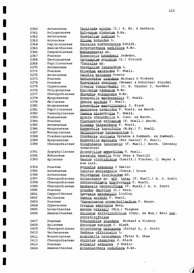
I.
L15
2360 Asteraceae Centipeda minima (L.) A. Br. & Aschers.2361 Polygonaceae Polygonum plebeium R.Br.2362 Asteraceae Gnaphalium indicum L.
2363 Aizoaceae Glinus lotoides L.2364 Papilionaceae Psoralea australasica Schldl.2365 Amaranthaceae Alternanthera nodiflora R.Br.
2366 Campanulaceae Wahlenbergia sp.2367 Poaceae Eragrostis basedowii Jedwabn.2368 Gentianaceae Centaurium spicatum (L.) Fritsch2369 Papilionaceae ?Psoralea sp.2370 Asteraceae Gnaphalium luteoalbum L.2371 Poaceae Eriachne aristidea F. Muell.2372 Asteraceae Calotis erinacea Steetz2373 Poaceae Echinochloa inundata Michael & Vickery2374 Poaceae Eragrostis speciosa (Roemer & Schultes) Steudel2375 Cyperaceae Cyperus cunninghamii (C. B. Clarke) C. Gardner2376 Polygonaceae Polygonum plebeium R.Br.2377 Chenopodiaceae Rhagodia spinescens R.Br.2378 Myoporaceae Eremophila macdonnellii F. Muell.2379 Meliaceae Owenia acidula F. Muell.2380 Myoporaceae Eremophila macgillivrayi J. Black2381 Papilionaceae Swainsona oroboides F. Muell. ex Benth.2382 Caesalpinaceae Cassia oliqopilylla F. Muell.2383 Mimosaceae Acacia stenophylla A. Cunn. ex Benth.2384 Poaceae Plagiosetum refractum (F. Muell.) Benth.2385 Asteraceae Pluchea tetranthera F. Muell.2386 Myoporaceae Eremophila lonqifolia (R.Br.) F. Muell.2387 Boraginaceae Heliotropium curassavicum L.2388 Frankeniaceae Frankenia uncinata Sprague & Summerh. ex Summerh.2389 Myoporaceae Eremophila maculata (Ker Gawler) F. Muell.2390 Chenopodiaceae Sclerolaena lanicuspis (F. Muell.) Benth. (Densely
tomentose)2391 Zygophyllaceae Zygophyllum ammophilum F. Muell.2392 Rubiaceae Asperula qemella Airy Shaw & Turrill2393 Apiaceae Daucus glochidiatus (Labill.) Fischer, C. Meyer &
Ave Lall.2394 Poaceae Agrostis avenacea J Gmelin2395 Asteraceae Calotis multicaulis (Turcz.) Druce2396 Asteraceae Helipterum floribundum DC.2397 Chenopodiaceae Sclerolaena sp. aff. tatei (F. Muell.) A. J. Scott2398 Chenopodiaceae Schlerochlamys brachyptera F. Muell.2399 Chenopodiaceae Neobassia proceriflora (F. Muell.) A. J. Scott2400 Poaceae gynodon dactylon (L.) Pers.2401 Capparidaceae Capparis mitchellii Lindley2402 Meliaceae Owenia acidula F. Muell.2403 Poaceae ?Paractaenum novae-hollandiae P. Beauv.2404 Cyperaceae Cyperus exaltatus Retz.2405 Loranthaceae Amyema preissii (Miq.) Tieghem2406 Amaranthaceae Ptilotus atriplicifolius (Cunn. ex Moq.) Ben' var.
atriplicifolius2407 Poaceae Echinochloa inundata Michael & Vickery2408 Apiaceae Eryngium supinum J. Black2409 Chenopodiaceae Sclerolaena calcarata (Ising) A, J. Scott2410 Verbenaceae Verbena officinalis L.2411 Brassicaceae Arabidella procumbens (Tate) E. Shaw2412 Chenopodiaceae Atriplex crassipes J. Black2413 Poaceae Agrostis avenacea J Gmelin2414 Amaranthaceae Alternanthera nodiflora R.Br.

Poaceae,PoaceaePolygonaceaeAsteraceaeAsteraceaeAsteraceaeAsteraceaePapilionaceaeAsteraceaeFrankeniaceaeBoraginaceaePoaceaePapilionaceaeCucurbitaceaeMalvaceae'PapilionaceaeAsteraceaePoaceaePoaceaeAsteraceaePoaceaeCaesalpinaceaeOnagraceae
GoodeniaceaeCyperaceaeAmaranthaceaeLoranthaceaeAzollaceaePapilionaceaePoaceaeAmaranthaceaePapilionaceae.ProteaceaePoaceaePapilionaceaeCampanulaceaePapilionaceaeAsteraceaePoaceae,AsteraceaePoaceaeChenopodiaceae
AsteraceaeAmaranthaceaeMimosaceaeCaesalpinaceae
AsteraceaeMimosaceaePoaceaeMyoporaceaeScrophulariaceaeMyoporaceaeMyoporaceaeMyoporaceaePoaceae
Panicum decompositum R.Br.Sporobolus mitchellii (Trin.) C. E. Hubb.Rumex crystallinus LangeMyriocephalus rudallii (F. Muell.) BenthCraspedia chrysantha (Schldl.) Benth.Brachycome sp. (Immature specimen)Centipeda thespidioides F. Muell.Psoralea australasica Schldl.Epaltes cunninghamii (Hook.) Benth.Frankenia pseudo-flabellata Summerh.Heliotropium europaeum L.Plaqiosetum refractum (F. Muell.) Benth.Crotalaria cunninghamii R.Br.Cucumis melo L. ssp. agrestis (Naudin) Grebensc.Abutilon otocarpum F. Muell.Tephrosia'sphaerospora F. Muell.Minuria integerrima (DC.) Benth.Panicum decompositum R.Br.Agrostis avenacea J. GmelinMinuria rigida J. BlackDiplachne fusca (L.) P. Beauv.Cassia nemophila A. Cunn. ex J. Vogel var. nemophilaLudwigia peploides (Kunth) Raven asp. montevidensis(Sprengel) RavenGoodenia glauca F. Muell.gyperus gymnocaulos SteudelPtilotus polystachus (Gaudich.)F. Muell. var. polystachusLysiana exocarpi (Behr) Tieghem exocarpiAzolla filiculoides Lam.
Trigonella suavissima LindleyPanicum decompositum R.Br.Ptilotus latifolius R.Br.Psoralea australasica Schldl.Hakea leucoptera R.Br.Plagiosetum refractum (F. Muell.) Benth.Swainsona rigida (Benth.) J. BlackWahlenbergia s2.Aeschynomene indica L.Craspedia chrysantha (Schldl.) Benth.Agrostis avenacea J. GmelinIxiolaena brevicompta F. Muell.Sporobolus mitchellii (Trin.) C. E. Hubb.Halosarcia indica (Willd.) Paul G. Wilson ssR?leiostachya (Benth.) Paul G.WilsonSenecio lautus Forst. f. ex Willd. ssp_. maritimus AllAmaranthus mitchellii Benth.Acacia victoriae Benth.Cassia nemophila A. Cunn. ex J. Vogel var. zygophylla(benth.) Benth.Gnephosis foliata (Sonder) H. EichlerAcacia murrayana F. Muell. ex Benth.Aristida browniana Henr.Eremophila longifolia (R.Br.) F. Muell.Morgania cflabra R.Br.Eremophila bignoniiflora (Benth.) F. Muell.Eremophila bignoniiflora (Benth.) F. Muell.Eremophila bignoniiflora (Benth.) F. Muell.Eriachne aristidea F. Muell.
L16
24152416241724182419242024212422242324242425242624272428242924302431243224332434243524362437
2438243924402441244224432444244524462447244824492450245124522453245424552456
2457245824592460
246.1
2462246324642465
35113512
35133514

1
35153516351735183519
35203521352235233524
.35253526352735293530353135323533
35343535353635373538353935403541
3542 Chenopodiaceae
35433544354535463547354835493550
35513552355335543555
355635573558
3559356035613562
356335643565
3566356735683569
3570
PapilionaceaeFrankeniaceaeCaesalpinaceaeCaesalpinaceaeCaesalpinaceaeMyoporaceaeMyoporaceaeMyoporaceaeCaesalpinaceaeCaesalpinaceaeCaesalpinaceaeConvulvulaceaeConvulvulaceaeGoodeniaceaeAmaranthaceaeAmaranthaceaeCaesalpinaceaeCaesalpinaceaeCaesalpinaceaeCaesalpinaceaeCaesalpinaceaePapilionaceaeSolanaceaeSolanaceaeSolanaceaeChenopodiaceae
AsclepiadaceaeAsclepiadaceaePolygonaceaePolygonaceaePolygonaceaeCaesalpinaceaeCaesalpinaceaeOnagraceae
PoaceaeMimosaceaeProteaceaeMimosaceaeMimosaceaeAizoaceaeAizoaceaeSantalaceaeSantalaceaeLoranthaceaeLoranthaceaeMimosaceaeMimosaceaeRubiaceaeMimosaceaeMimosaceaeMel iaceae
FrankeniaceaeMyoporaceaeMyoporaceae
L17
Psoralea pallida N. Burb.Frankenia angustipetala Summerh.Cassia pleurocarpa F. Muell.Cassia pleurocarpa F. Muell.Cassia pleurocarpa F. Muell.Eremophila maculata (Ker Gawler) F. Muell.Eremophila maculata (Ker Gawler) F. Muell.Eremophila maculata (Ker Gawler) F. Muell.Cassia nemophila A. Cunn. ex J. Vogel var. nemophilaCassia nemophila A. Cunn. ex J. Vogel var. nemophilaCassia nemophila A. Cunn. ex J. Vogel var. nemophilaEvolvulus alsinoides L. var. villosicalyx Ooststr.Evolvulus alsinoides L. var. villosicalyx Ooststr.Scaevola ovalifolia R.Br.Ptilotus polystachus (Gaudich.)F. Muell. var. polystachusPtilotus polystachus (Gaudich.)F. Muell. var. polystachusCassia oligophylla F. Muell.Cassia oligophylla F. Muell.Cassia helmsii SymonCassia helmsii SymonCassia helmsii SymonCrotalaria cunninghamii R.Br.Nicotiana velutina WheelerNicotiana velutina WheelerNicotiana velutina WheelerHalosarcia indica (Willd.) Paul G. Wilson ssp..leiostachya (Benth.) Paul G. WilsonHalosarcia indica (Willd.) Paul G. Wilson gspl_.leiostachya (Benth.) Paul G. WilsonCynanchum floribundum R.Br.Cynanchum floribundum R.Br.Muehlenbeckia cunninghamii (Meisn.) F. Muell.Muehlenbeckia cunninghamii (Meisn.) F. Muell.Muehlenbeckia cunninghamii (Meisn.) F. Muell.Lysiphyllum gilvum (Bailey) PedleyLysiphyllum silvum (Bailey) PedleyLudwigia peploides (Kunth) Raven ssp. montevidensis(Sprengel) RavenInsufficient material for further identification.Acacia murrayana F. Muell. ex Benth.Grevillea striata R.Br.Acacia murrayana F. Muell. ex Benth.Acacia murrayana F. Muell. ex Benth.Gunniopsis quadrifida (F. Muell.) PaxGunniopsis quadrifida (F. Muell.) PaxSantalum lanceolatum R.Br.Santalum lanceolatum R.Br.Lysiana exocarpi (Behr) Tieghem ssp. exocarpiLysiana exocarpi (Behr) Tieghem ssp. exocarpiAcacia oswaldii F. Muell.Acacia oswaldii F. Muell.Dentella pulvinata Airy Shaw var. pulvinataAcacia victoriae Benth.Acacia victoriae Benth.Owenia acidula F. Muell.Frankenia angustipetala Summerh.Eremophila bignoniiflora (Benth.) F. Muell.Eremophila bignoniiflora (Benth.) F. Muell.
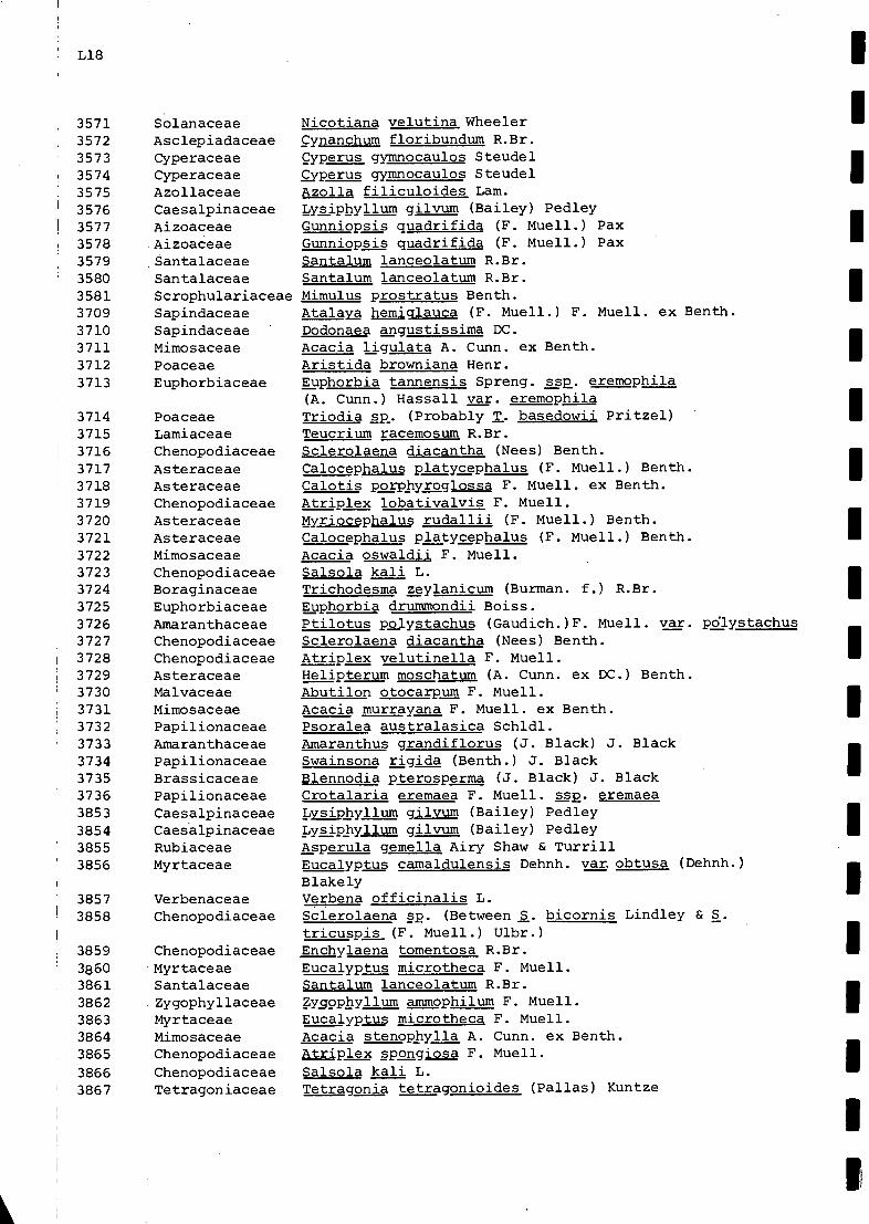
L18
35713572
35733574357535763577357835793580358137093710371137123713
37143715
1
3716371737183719372037213722372337243725372637273728372937303731373237333734373537363853385438553856
3857 VerbenaceaeI
3858 .Chenopodiaceae
3859
386038613862386338643865
38663867
SolanaceaeAsclepiadaceaeCyperaceaeCyperaceaeAzollaceaeCaesalpinaceaeAizoaceaeAizoaceaeSantalaceaeSantalaceaeScrophulariaceaeSapindaceaeSapindaceaeMimosaceaePoaceaeEuphorbiaceae
PoaceaeLamiaceaeChenopodiaceaeAsteraceaeAsteraceaeChenopodiaceaeAsteraceaeAsteraceaeMimosaceaeChenopodiaceaeBoraginaceaeEuphorbiaceaeAmaranthaceaeChenopodiaceaeChenopodiaceaeAsteraceaeMalvaceaeMimosaceaePapilionaceaeAmaranthaceaePapilionaceaeBrassicaceaePapilionaceaeCaesalpinaceaeCaesalpinaceaeRubiaceaeMyrtaceae
ChenopodiaceaeMyrtaceaeSantalaceaeZygophyllaceaeMyrtaceaeMimosaceaeChenopodiaceae
ChenopodiaceaeTetragoniaceae
Nicotiana velutina WheelerCynanchum floribundum R.Br.Cyperus gymnocaulos Steudelgyperus gymnocaulos SteudelAzolla filiculoides Lam.Lysiphyllum gilvum (Bailey) PedleyGunniopsis quadrifida (F. Muell.) PaxGunniopsis quadrifida (F. Muell.) PaxSantalum lanceolatum R.Br.Santalum lanceolatum R.Br.Mimulus prostratus Benth.Atalaig hemicrlauca (F. Muell.) F. Muell. ex Benth.Dodonaea angustissima DC.Acacia ligulata A. Cunn. ex Benth.Aristida browniana Henr.Euphorbia tannensis Spreng. ssa. eremophila(A. Cunn.) Hassall var. eremophilaTriodia sp. (Probably T. basedowii Pritzel)Teucrium racemosum R.Br.Sclerolaena diacantha (Nees) Benth.Calocephalus platycephalus (F. Muell.) Benth.Calotis porphyroglossa F. Muell. ex Benth.Atriplex lobativalvis F. Muell.Myriocephalus rudallii (F. Muell.) Benth.Calocephalus platycephalus (F. Muell.) Benth.Acacia oswaldii F. Muell.Salsola kali L.Trichodesma zeylanicum (Burman. f.) R.Br.Euphorbia drummondii Boiss.Ptilotus pojystachus (Gaudich.)F. Muell. var. pdlystachusSclerolaena diacantha (Nees) Benth.Atriplex velutinella F. Muell.Helipterum moschatum (A. Cunn. ex DC.) Benth.Abutilon otocarpum F. Muell.Acacia murrayana F. Muell. ex Benth.Psoralea australasica Schldl.Amaranthus grandiflorus (J. Black) J. BlackSwainsona
ri:::a
Blennodia pterosperma (J. Black) J. BlackCrotalaria eremaea F. Muell. ss2. eremaeaLysiphyllumLysiphyllum gilvum (Bailey) PedleyAsperula gemella Airy Shaw & TurrillEucalyptus camaldulensis Dehnh. var. obtusa (Dehnh.)BlakelyVerbena officinalis L.Sclerolaena sp. (Between S. bicornis Lindley & S.tricuspis (F. Muell.) Ulbr.)Enchylaena tomentosa R.Br.Eucalyptus microtheca F. Muell.Santalum lanceolatum R.Br._Zygophyllum ammophilum F. Muell.Eucalyptus microtheca F. Muell.Acacia stenophylla A. Cunn. ex Benth.Atriplex spolgiosa F. Muell.Salsola kali L.Tetragonia tetragonioides (Pallas) Kuntze
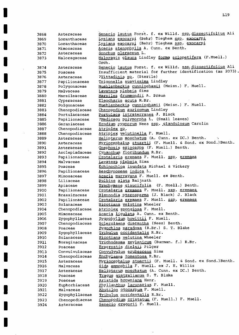
L19
3868 Asteraceae Senecio lautus Forst. f. ex Willd. sspdissectifolius All
3869 Loranthaceae Lysiana exocarpi (Behr) Tieghem sspt. exocarpiLysiana exocarpi (Behr) Tieghem ssp. exocarpi3870 Loranthaceae
3871 Mimosaceae Acacia stenophylla A. Cunn. ex Benth.
3872 Asteraceae Sonchus oleraceus L.
3873 Haloragaceae Haloragis glauca Lindley forma sclopetifera (F.Muell.)Orch.
3874 Asteraceae Senecio lautus Forst. f. ex Willd. ssp.dissectifolius Ali
3875 Poaceae Insufficient material for further identification (as 2073).
3876 Asteraceae ?Vittadinia sp. (Sterile)3877 Papilionaceae Trigonella suavissima Lindley3878 Polygonaceae Muehlenbeckia cunninghamii (Meisn.) F. Muell.
3879 Malvaceae Lavatera plebeia Sims3880 Marsileaceae Marsilea drummondii A. Braun3881 Cyperaceae Eleocharis acuta R.Br.
Muehlenbeckia cunninghamii (Meisn.) F. Muell.3882 Polgonaceae3883 Chenopodiaceae Chenopodium auricomum Lindley
3884 Portulacaceae Portulaca intraterranea J. Black
3885 Papilionaceae ?Medicago polymorpha L. (Small leaves)
3886 Geraniaceae Erodium cygnorum Nees ssp..glandulosum Carolin
3887 Chenopodiaceae Atriplex sp3888 Chenopodiaceae Atriplex velutinella F. Muell.
3889 Asteraceae Helipterum moschatum (A. Cunn. ex DC.) Benth.3890 Asteraceae Myriocephalus stuartii (F. Muell. & Sond. ex Sond.)Benth.3891 Asteraceae Gnephosis eriocarpa (F. Muell.) Benth.3892 Asclepiadaceae Cynanchum floribundum R.Br.3893 Papilionaceae Crotalaria eremaea F. Muell. ssp, eremaea3894 Malvaceae Lavatera plebeia Sims3895 Poaceae Echinochloa inundata Michael & Vickery3896 Papilionaceae Aeschynomene indica L.3897 Mimosaceae Acacia murrayana F. Muell. ex Benth.3898 Liliaceae Bulbine alata Baijnath3899 Apiaceae Trachymene glaucifolia (F. Muell.) Benth.
3900 Papilionaceae Crotalaria eremaea F. Muell. eremaea3901 Brassicaceae Blennodia pterosperma (J. Black) J. Black3902 Papilionaceae Crotalaria eremaea F. Muell. asp, eremaea3903 Solanaceae Nicotiana velutina Wheeler3904 Chenopodiaceae Atriplex spongiosa F. Muell.3905 Mimosaceae Acacia ligulata A. Cunn. ex Benth.3906 Zygophyllaceae Zygophyllum howittii F. Muell.3907 Chenopodiaceae Sclerolaena diacantha (Nees) Benth.3908 Poaceae Zygochloa paradoxa (R.Br.) S. T. Blake3909 Zygophyllaceae Tribulus occidentalis R.Br.
Nicotiana velutina Wheeler3910 Solanaceae3911 Boraginaceae Trichodesma zeylanicum (Burman. f.) R.Br.3912 Poaceae Eragrostis dielsii Pilger3913 Convulvulaceae Convulvulus erubescens Sims3914 Chenopodiaceae Enchylaena tomentosa R.Br.
3915 Asteraceae Myriocephalus stuartii (F. Muell. & Sond. ex Sond.)Benth.3916 Malvaceae Sida ammophila F. Muell. ex J. H. Willis3917 Asteraceae Helipterum moschatum (A. Cunn. ex DC.) Benth.3918 Poaceae Tragus australianus S. T. Blake
3919 Poaceae Aristida browniana Henr.3920 Euphorbiaceae Phyllanthus lacunarius F. Muell.3921 Malvaceae Abutilon otocarpum F. Muell.
3922 Zygophyllaceae Tribulus occidentalis R.Br.
3923 Chenopodiaceae ChenoPodium cristatum (F. Muell.) F. Muell.
3924 Asteraceae Senecio gregorii F. Muell.

L20
3925 Euphorbiaceae Euphorbia tannensis Spreng. ssp. eremophila(A. Cunn.) Hassall var. eremophila
3926 Papilionaceae Tephrosia sphaerospora F. Muell.3927 Liliaceae Bulbine alata Baijnath3928 Brass icaceae Blennodia sp. aff. canescens R.Br.3929 Zygophyllaceae Tribulus occidentalis R.Br.3930 Portulacaceae Portulaca intraterranea J. Black3931 Chenopodiaceae Salsola kali L.3932 Asteraceae Helipterum floribundum DC.3933 Mimosaceae Acacia murrayana F. Muell. ex Benth.3934 Apiaceae Trachymeneslaucifolia (F. Muell.) Benth3935 Poaceae Zygochloa paradoxa (R.Br.) S. T. Blake3936 Mimosaceae Acacia oswaldii F. Muell.3937 Mimosaceae Acacia tetragonaphylla F. Muell.3938 Loranthaceae Amyema preissii (Miq.) Tieghem3939 Mimosaceae Acacia ligulata A. Cun. ex Benth.3940 Mimosaceae Acacia oswaldii F. Muell.3941 Mimosaceae Acacia murrayana F. Muell. ex Benth.3942 Papilionaceae Tephrosia sphaerospora F. Muell.3943 Mimosaceae Acacia murravana F. Muell. ex Benth.3944 Chenopodiaceae Atriplex sp.3945 Asteraceae Myriocephalus stuartii (F. Muell. & Sond. ex Sond.)Benth.3946 Euphorbiaceae Phyllanthus lacunarius F. Muell.3947 Malvaceae Sida sp.3948 Chenopodiaceae Atriplex nummularia Lindley3949 Chenopodiaceae Atriplex spongiosa F. Muell.3950 Chenopodiaceae Sclerolaena intricata (R. Anderson) A. J. Scott3951 Haloragaceae Haloragis asp era Lindley3952 Chenopodiaceae Atriplex nummularia Lindley3953 Chenopodiaceae Babbagia acroptera F. Muell. & Tate
I 3954 Chenopodiaceae Sclerolaena diacantha (Nees) Benth.3955 Chenopodiaceae Atriplex angulata Benth.3956 Chenopodiaceae Sclerolaena intricata (R. Anderson) A. J. Scott3957 Liliaceae Bulbine alata Baijnath3958 Asteraceae Seneciostregorii F. Muell.

NM
NM
MI N
Mum
--

MI
APPENDIX M - Plants species (subspecies and varieties) collected within the
Cooper Creek Environmental Association 8.4.4 during the present
survey, with an indication of the habitat preferences and status
of each.
Column 1 - Families and species (subspecies and varieties) ofplants collected this survey.
2 - Habitat Preferences - habitats in which species(subspecies and varieties) were encountered duringthis survey (see also individual entries, Appendix R).
3 - Status - VC - very commonC - common
FC - fairly commonU - uncommon
(see title page of Appendix R for means used todetermine the status of species (subspecies andvarieties) of plants).

6241
AI ZOAC E AE
Glinus lotoicle 5 Chamne-I ecloie. ,,...,1 4Hoodou.4-
GunniopsIs cluadri-ficia cicuipass Gay i , Jo.11- 16,4 eri5e1 , I.:ter/LIG:......4 4onlle a.,..#../10. ,;..4....4.e.
U
Tri ant, ema tri co etra Channe,1 edge.
Zaleja a I e rs- _c!.Iloi-cl. Channel eclye
AMARANTHACEAEAl+ernanik era nodiflora Aal ocer i 4,, (.1eir , 400,,10.-s- 9- .;isbioer- CAmaron+hus gran dif torus D.p.e.. UA. mitchellii 11.4he ......1 cl.cw. ei FCPtilo-Fus atriplicifolfus var. atnelicifokis 50...61 1,10,;s1 FCP 6-1-ifoli us Dune. FCP obovafus var. o ovafus Dune.. FCfpolysfa chus licir. poly si-Qc.hu s DkAne., ,..,,, J 426. cw.4 s...,(1 pL VC
AMARYLLIDACEAECr ;nu rn flaccid urn CIay p 0-V1S i CA ckv...j onfercluvief m.61 4trii-crp%
A PI A CEAEDauc us 41ockicliatus
c...i...., el edit i.bbe.- ri.A.:. .04.1 oni- er-.1,....e. .......E- 44 .,..1.......4. - .1.1-1.,.......,...A6....4.11. eA 4 9- cl..c...po a 4,...,41 c..--,4
F c
Erynm3iu suipinum a...v..1 e aAe. --TrACkjrel ene glaucifolia De o.1 u.v.otJo-11;- c1.-.-4,e C
AS C LE PIA DA CEA E_Cj non chu en lo ilounclum D,..she. - cre 5 t 3 c...61 slopes
D.....le.Rhjelckarrhena i 1 6 ear-is
ASTERACEAE5rachycome ciliaris varlanulinosa ?D,.....)e. UCalocephal4s a.,4_,cduc_ ,sts,..,,..,....,........ii, ,.... ft oo am...1-s or i.:
Fi00J.,...-4- .....-a s...,,.........p.
yc
F CCal otis an cyLo car aC. erin. a cea PLAA,Ne .(ore o--a fi 0.1 0...4- FCC. Lspis,_g_lul g ( 00,1.044 -4...+4 ev ) A ........... o.- olA no.e-rt
sc,A1-6,-rt. ...0.--,...,....:, Fe', .:-+e,"-au-.-eso rV L
C. hiu1+;(..au lis Intercl,.....e cLcumne..1 erize. .2.....,) .600ci 0 %AI FCRea.,-.4. - so-410,...t L. o....et epLe.......e......1 ile...40_.6elAsiciAa.....fnel ease 1;..t.e.,4,.......e. ..........l
cIv LcIss._citForcl......4.-¢ c.1......up a.......
FC
entipe Q CUtlrilb3karvIll UC ha..., ...c..1 fa,: ki3
Cl-wAln el e45 ejoosios....r A.....d .A.../6.12C. minimaCikespiclioides ct,...,,d ....._,), ,;v62.-L,-,Ae- c-1.-31,...- FCCra s p edict ci,r_y san+ka Cl........,e1 ...I efl...,e4..A 10..k 1,..1,
Flo. J.,...4- .....61 (4....4.1e.U
FCE.pa It es ous+raiskCU P111111 karvIll C1,...te.1 c,...1 et,Le...At...4 1,.1(4- Led U
Ghopkolium inclic t-11 Floo.took - Sag 1-6441- ,
ckcao......ne.4 ecte . Fc1141-e0C1 I bU re) ( havivl e..I e.4. FC
G-nerhos 1 s erlocarpa Di.,..e, ......a,...10.4,-...3 J....se. , e.t............A ea 3e. 1ci.,.......e.t .......a et,...,. ..u.e...a.......je-PL.e.,____________,____ ___.-ra-kr,..,----cL 71.o i cl+Q ix.-t-/-11010-"."-1.010.24-* - el."- 1.-D--/e...04 "4',A LLb 4j d 4.1.-1 p r....". .._,, i e . r.-1-e...-cl a
M2 2.. 3

r13
Helip+erUrrl florilDu uD.....se ,ir,.le.a...-e 0.........elt.Ao..4,;Ny ol,.......ecAto-t...,..a0 e.e.k.je c,.......4.1 orto... 1 ilat,ea- cl1,44,..1- C
H tnIcrogossurn F10.1.+ UH. rnosckai urli 130.........e slope, ik+e,i........2., t....(1,,-.1c..2. c1. vcH strict-um 611,1,...- 0..r.e oa 6( -Rood 0,..-4- C1Xioloena 6revi compta Ert.,....2....1 1.4,..t. 154 a......4 cr,.../.0.b.p ...-3:-. UMinuri a cunnins hamii G-0.6e, pl.......z. et....1-04.. o4-ea.
Floodo.....* 1e.4.,AAe c.A....ipo.,,, eft...e.......e.
late bed O..--,), s.-...ek pt 0..,:-ndeiii-iculata11 inte3errimo EtaL.0-04 I 0.1.e.. 15...I,
Ert....-11.-I. twed o.,1 -1(00J0T....1-e-v.c.L.--e. cA,....-A pc...* ( c, km id )
U
FCU
M. rigidMyriocepha Iu s ruclolliiM. stuartii mo,i. ..fre.v........i- O.- c14..-E s G. 4.apt....,...:,
65. 43..y.k.g .1( 1-....1.11..1-, except- 41.61.e.4kir.v L'
pluchea fe-franik era ErLe......e.,,J10.1te kJ 5, lpm-e civt,.,, .4)0- U3.--0J enecio cunnih3kamii F,..a.,..4- ....AA c.t.....,......a...1 e.die i
CAse...-...o A t't ip. (...,0..................Z. -I' . F CS.._, rgLe...40Lii. D V...% Q. t1;1*.eAegt 41. Cloy, p OA.... , +1. 0 a ....a..41.
aLa-.*4-1 a J'lle *- epl-z4......t...,...1 a...4A VCS lau+US ssp . cliSsec+i-i-ollUS U
aaui-us f_s,. niari+imus 5,.......,r epliefr.,e-ral i clic 17 d FCSonch us osper
,
Swarylp US 01 eraceu S Dio,-Ine_l edne, ol,......e o... swo-vvy, FCStrepio3 loss cl . ocisce-"cle,-,s (itl.bo.... plo4k UViifacli.n.la 1g 50,...,1, U
AZOLLACEAEAzolla filiculoicles s',.....-ys, niore parrnane.....i- Lam . 1 0-1
lo..tc.er - ...... ...../....4-e-.-F C
BORAGINACEAE*14 elio+ropium cura ssovi cum
.
gore. (Ira ow-l-le.4- UH. eUr0f)QeUrY1 Loke ctEvArtt.i }- erke4+mwoi WO- Lel FC()Mph() loloppuICI C.OnC4VCk Ur% ch...lo.A,,, ...." e_ UTrickOCICSMQ 2/..glanicw-n (L.rle. VC
BRASSICAC EA EArabidella _procumbens ,...iu-vvio UBI ennocli a can escens D.-0... slope UB 5.R. aft. canescens Du.no- Ua-1-e.rp.osper- _ma Dune. FCBrassicg tournefortii Swo.vy, -fl 0.a .,..f.
Opt- c.t.d .. ..-1 '2.-
FCULepi di um muelleriferchnonclii
CAESALPINACEAEC ossio kelrhs.. (ii66e.- pl a.t;-. UL ng_m_042Lig,. vit. rleh._nopiI p......e , 1,,...-01 (...-el.....,e..,
s......a pl.a. 440otio...... y epkek,ke*T../ cA1 %/Cy
Cneboophila, var. 7,/clopky I I ci Ch...., cau4ke slope, t.:4-e...4.......e,.....1...I.X....50611.6e 501.4 pt.....:. .....-a 41.0.1.b-
c2L5.9 l_p_sk-,H p...,e. / (...1.....nA <IAA e
c-:66..., o.re.s-,,,:ce....4u-"e 5.- cl p,...4., Q.be.
FCFCpli3110dIneo
i P+erocau Ion srhacela+urn Ct. 4.1 e..t..&,. U

CCASGiO p eurocarp var. ple.urocarp 1),....,,.. FCLysiphillum 51lvurn Fl OucioL4 CLAM% p.e.,1 e..:1 VC
C AM PA NU L AC E A E
Wahlen bergi a 5.g. Nev Clantle- S 'flO0CleS F C
CAPPAR AC EA ECapparis mitch e I I ii F100,10,..4
CI-IENOPODIACEAEA-triplex an L1c i..4,i-cl Flooa.....t , erhewie....I Lice, ciso....nel etlit.,
14944 .......42 , t4.4-94.-J.....e. cl..ipt...a. a....4.1 .5.tLbe.-vc
A. crassipes S 6.1 b....to /c1.0-vw.e.-A U
A eardl esyae Flo.c.k.,,..t U
A sp. 4:f ea mlleicie Flo0c1 0,3- U/I a,. 41 I-I I. . 0.0Car . a St-Jo-004o UA. Lep-to co r p_a_ pl...04.1 0....4- , 41,.......e. cia.v -F4 41`"-`"" 41f Is,...,-..fei 44 eock 0,AI.. . C
I rna-Fa Ft...1.,...r UAlindleyi FloOJ at...t. 04Na epLeo..ehm..1 I *le_ UAlolDativolvis 1.14e.-,1 (Arne. , SW cu.., I* I clko.a.*..0.4Pac1/410)- Fc
A. muelleri .S.4........1., i)- 4-100 a CMAk . FCA. nu mmul aria Ft..a.......,.., ept..e....te.....A i ...Le , 01.e../
Sun.-4.90 9- (-14:s."" el Jje-c
Lsponcliosa Poerlo.A4-.1" a...A c.i......otAi .....54...-ckt....-a I i,4,ot t.4-9-9*-``.44-3 1 6,-1- 0...1.6.13;4-.4-1ex c .1......er
VC:
A velu-hilella VCxA. vesicaria
D. 4 , e. i , n ny0111. tr p .14&,1,e..-, 4400610.....)- 0.4.ci
c.I.,...j..... .A.1- e.r.L.-1,49 , aose............., Li..
cF CBa 6603ia_ acrop+era
B. dip+erocarp Gi6Lcv , cl.9....Che_no ocliurvI ouricomum 51.0a......,- , 0............e.t c Ale i 4....r...---re 5.6";
0....ci r...4e...44.4,4. 4.1.4.1 pcs.4...vc
Ccristui-um D...t.,,Z- cuA c.1 c...1..e.... " el e cling. U.CCrirFrariaceum F,.....1.......,- , FL...A...A 1...L.,... ,
p t ......-:- c...4....1 c.1....1 f I 0* .c
DissocarLis brilorus var. biflorus (1-%bioe4, .1 .c.
D. bifiarus var wholoca rRg_
0... ...V 0..elearl.Ert.........ev-0.A I o../c,e. 64-4 U
D. 43ora cloxa var. Ja-fifok4s Fl.t..,....4-er ic.....0, plc,.....:-.. . U/Fc
Eina di Q n u + a risci..u.......,LA ...A.y. 1 .....a..../...4,..4.1 .,..l..........q i
SCA..6,41 FAO.", . haral..113 45 ooloe.- corea FCEnctiy I a ena ionlentasa ch......I.A3,... c.--1 ft..A.,..... sune*Ialt7, al 1 o
ay,..... t %AA-cud...v.4Z. ta.t...3 tit...0.-it...44J 1 .14...4k VCH Glosarcia indica Esp. leiosfackya plc. .... , erl.e...teAnJ 14.1142. 04.4 .,ti _ad:
__-ccfC1
Sa-A1p644 9- 0.4-e-al f(oodplasi....Maireanci ork/lIct Crib6tv 1 floot .....4. t t.:1.2.064...,,nt. ,...40.41.14..44..
el..4...c., C...... Cl I ex4.-ci 01 OZ..C
CM. corona+a F/.. A ......4 ;.66.2.4.- c.......1 ci......e_S3e,ory.1 Ft 00 a CKAAG" / I ZN. i e..114 4.**V,e, 4,4 e...- fr, te
1).....e 6G-Le ...- a ik 4.47.V4
U
FCILni i Gro cormMpromic10+4_ b... b.,. .....- a fio. (tow-
11
kleo6assia proceri flora Fteek....... GU_ 0-4.,....0 v..d. 3e. , vi-J.e4,p,1 .:- ....; A ,..........1 .........3 e
cK ps_lia i.Aclickaucliana ct...........e.A eel e. _LI_
URsr?, e cc ent 1,4-2..-A.....e. 15,...-cteAf' ( oreZ 4)5alsala ka Ii p,..........e, , ........a.....1.-11.,,, et,.......e. , so...A
,Wi...e«,cwea Wet 0..4 -ft.. 41.,...tsV C

1
S clil erocklarny5 brackjpi-era CinAnnel C45e.
. ....
USclerolaena andersonii G*166e.-- plcuL o..... A ". eiol.se...,e3-0.1 I c.ice 6at U
S bICOrniG I oe oL.....r t cieux.v.r. e..1 e dye. i erkew,"*.la I mkt.,d ...if cu., e J. cf. , 4.4e4-41,...42_1 j. be.te VC
5. cal ca ra +a Dv,,,,.. c......c1 4,....reAAAp C.L.u.... r.e..1 ;.. 4-e e-{- U
S. CO S+a-f-cl F I *awl 0,-4. US. cii a carrl-ka Ft.....1...,..-t , arts*, 43..e.-i 1.-44 , ,-ko-Ja 1
cl.....rot .;.te...-ci......12 ,...1..J...0 .1...-.. 3,- 4.--...tjr
v
?5. kolfilana pi '-' ..C i.o.v.6,2...1 exlyt. US. i n-1- r i cgici Flop ci....t, eplso....e.-...t 1.-Ice , c,1,,........,4
A :-..4-e....-.1. .....4.4¢, ........... ........a V C
FCSloni CMS piS G. 12,2..... 0.4"ea. 1 , cis......e/Ft..J. p( ...........
S. rywrico+a Var. rnuricatctii..+....... fo.02... o...... d c..1.....-..st-t e dy4_...I....t-ecl.........0... U
S. paralieliCASpiS a- 0... d el...., 0- / -00041 6.1,... ,wraricue. U
aEx. gi. iktiej CV) 6.........1 e Asa. USsp. (60-vve.e..4 S. bicomis c}. S. trir....tstois) Fl.c),10,41- ,..... d °pet,- 3.1.1.e.4- .10,344. U
S. ve-ntri co s q Eloise...42-mA I c..4...e.. 1.4..d , ft.. a .....---1- 6.....rtGl............. 0_
U
CHLOANTHAC EAEDi cra sty li s coste.11oi .1,-,4,,,-.1,......... U
CON VULVULA CEA EConvuivulus eru6 escens
Fle.,.1....... _ .0..................1 1.,....,4+-e1ci f c.4.4........),:lam .1.......-1.,,f...;ev-ar, au..c...4 p cw44,....J.1 wk. .
?
C
UEVOIVULAS alSit"101CleS ia:. VillOSICCllyX
CUCURBITACEAECu cumi s me-6 lig; a3re-sfis G. 'IA.:. 0....,.). erke...A 16.16e ChuAL1 U
Mukia moderaspatana 1i...se. 61,....,../(1..J.0...A.,-,...7.3..e.4.-,.e o.....-4U..i. a ....2 i...A.....-.A J.......4,e. .
Fc
CYPERACEAECy p e.rui s cunnit;13 I-1 grnii Fl ooci awl^ /as o.4..../....12.1 in ie.." fa.t.e_ UC. Ep. sif. curly,511a,G Cho.v. on.4.1 e.c15.e. UC. ex a l+cd-us Bel-clein..6 ciw,"eil A .5w e.......p 21? flood 0,..k. U
3 rvoo cal osC. 3 u clip 0,10......1- a.ww.ot tr ovate." tki (..4,,,,c...,-. J. c-1-. c FC
El e_ockctri s ocuta_
5w- c........y. uEpallens 5,40.4.....40 Q....A ,..:1/4+ eA,r, .14,Q- FC
EUPHORBIACEAEAcirianu hooker D l0.1.42._ UEupkorbia austral is G66,24- UE. cb-urrio)onclii,_. b,.........2_ UEporvicaruncL4' lel Floot)-4.4-- c....1 ? 6...bk.2...- plc....L.. a ,..44¢..-
c....L... J. s. .. Jo...A- t ;a+ .?.... 0.....eU
Eanne.nci-s ug. eremorkl4 var. Du...A Pope-0 I t:.+9.....1 ...... a. ......1. ,...L.A"...iels........g. , S - plo....; , ..(4... cio...4- caw...4A VCerevnbpkila34 &v. 0....eo-, .
UE wheeleri o ,....... .3....u.... ci,.....t...1- .
Ph Ilan-thu fuev-nrokvii'..Z
.....ch...1 eXt. A ......e-b u.i.e. c.......c.\<D........,i , 1... .............3., - ...1....u- o. (.1...i pew,
CCElacunarius
P. se. aff. laciAnarius 5 ....... ok / 1....e 0.1.-/r.....m..,..Imi _ft,,,1.,,,,,4-caw--.3s p oitt. elt...%e.. Fc

MG
S a u r o pu s trackisperrnus Cl.-p........./.00.044.o.....4- o..-e a- inta.o..- c..-c.1-7)
FR ANKENIACEAEFranken'ta an L_31,spI-; etai_g_ .r.".4.ene-A ...-4. a. UFciilerep L44.,-c)....4.4. -. ci ir4..... rb e A Oc....j .-.......,-... are,
F pseudo-floilelio+ E Lt.-e.g....ea t Jur_ 6Q.a UF. serpilli-rolia Cia,toz-v- UFunctna+a 0 0-4j pa..., e...kye a.....ct relOtit- (...10..41 ',mita,-
o.F C
GE NTIANAC E AECeniaurium apica-ium ,.., .pn ik.4e....4,-,-e ,..1.e..-Gt.....se citr,,1 u
GE RANIACE AE*Erodium aureurn NI so.Aiil 10-4 U
E criniturn SuJavsn.p FCE c.sy3 norum pig g cinclulogurn 5-:---t%,,4 7:17,--*- IZ-2. U
GOODE N IA CE AEGooclenia lauca Ck....,Ne..1 e e. F Ca §p. A avi and!' Fle.A...-1- UG. 1060+0 Flo* ci o--t cx4....a!ert.erAev-al take Led ULechenau If I a cItiariarfQ D La DA-t.:, e (4.041.......r CS cci evol a aemulq L..... US de. 0 Lp_aprc_n_La D WIn.e. U
.Sovaliforiq D FC
HALORAGACEAEHalora3A. aspens; Flee 3......A-
H. 31 au ca forma sclopetifera 5.,-'r"-"--e-
LAMIACEAEMen+lia australis A cki at.e.....1- 4:C, c.L.0.4.....v.e..1 f UTeuc..riu rn race..mosuer, var. racernosurn 6',6tAirl4lool:---k.,...:1-eed........e si. 4.--_a.....yr0-4,- V C
I. racernosurn var. tripor-hturn S' 0..,..,1 pt GA.:, U
LILI AC EAEBulbike alata
Fie e A au...- -p .44.t.,.-1.-rS a .,, A. 1,..............10,,ia....1. 1,:s,K...... CO. 4,, di...-4^ 4- I1......A....i.....+..a a...se ad--d. c.t ..j4 i o-1.
LORANTHACEAEA_m_px_na rpe_rianif.
0," .......4,...L.........sep. CsCSIWS pr., 4t,...c....._4;:t. Spp.1
C.- 4de 1.11,j/34.47:1,6.7.4Dt .r.h,f...z.,Z..rtt.e.j.a
Dilatia 3randibraciea Cool ;12 cki 14,, '.....0 cl..........4.13 4.4..44.1 0 0 A 0....sets.
C
Lysiano oc_ar-pi ae. eAocorp O. s.....4,,a-- 46.4.1-i-,0.-'4..---;-, PN vc
F C
frt+1,1p......, 0......1 rtl...e i.,1 a...6e ac,c.... -4re 1,0++.1.
MALVACE A EAbui-i Ion freaseri D.---e. , ...I...Ai J........s..
A 0 OCQr urn p...........,, ,..........1....i....u;...3 d....L...e. , lcuAA s 1
ot...,...e../c40.40,-A- ,,;..r.e.-fo..e.
Du.v.e_
C
F CHibiscus ric au la n u
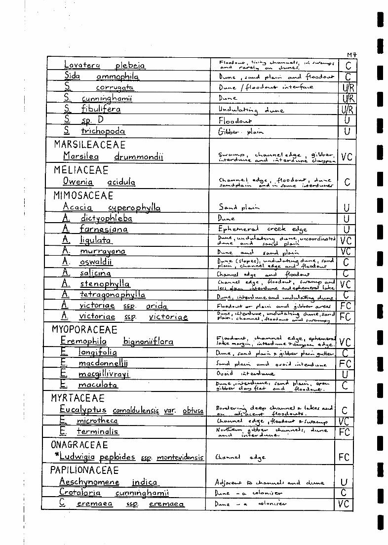
Lava +era flebe-ia Fto,1 IC., :-.. ,I.....c............4 f, ,..-: .1....,.........1, sG.-a r-or-e.41 ..., j.,......e.. 4-,
" .C
Sida ammophila_ b......,.. , .1 4.4".41. le i G.A.:- c.........11 0 a 0 ....11- C
S. C 0 rruyahi D.......,_ ip00,..t..,,,,- ,-,,,:+e-ft..,, UR1 cunnikamii, p......,e... UKS. fibulif era u In a .....10..1-i
,:,3 el ,..._,-.e_ U R,a 4. D Floocioi- U
S. trichopoclq Gibber- 1.10.t.... U
MARSILEACEAEMarsilea clrurnmonclii G .... o.....- p , c..L.cunAn e-I c ett4.- i 9..A.1.0-..-,
,.....4-4a.-4.....,..... 0.....4 ....7..+ ex - el ...p.c. c10,-ipc....\/ C
MELIACEAEOwenia aciciula o... 0............ i ackbe Moo do...A- , 0 1,--...c
span el FA fa..., c..... AI .11.......c 44+ e-d............,C
MIMOSACEAEAcacia c er_agapi_4_, 11a. S0......0\ pi ...e.:-.
L clictip_phieba D,........ UA. farnesiana ErLe..........-...A oreeAc. One. U
P
P VC
P I 9 -ft
Csteno.k U.
. ..,
era ....,1,... At.j csoi
MYOPORACEAIE
a""le .1
PI A P .1'-` C
PAPILIONACEAE
Croft:110 ri CI CUniltilgilOrn11, D,,,,,,e _ c, c...1. In C.1 e.4,- CCeremaea tsp. e.reniaea _ .,, GO ( Ort I f.C.A., VC
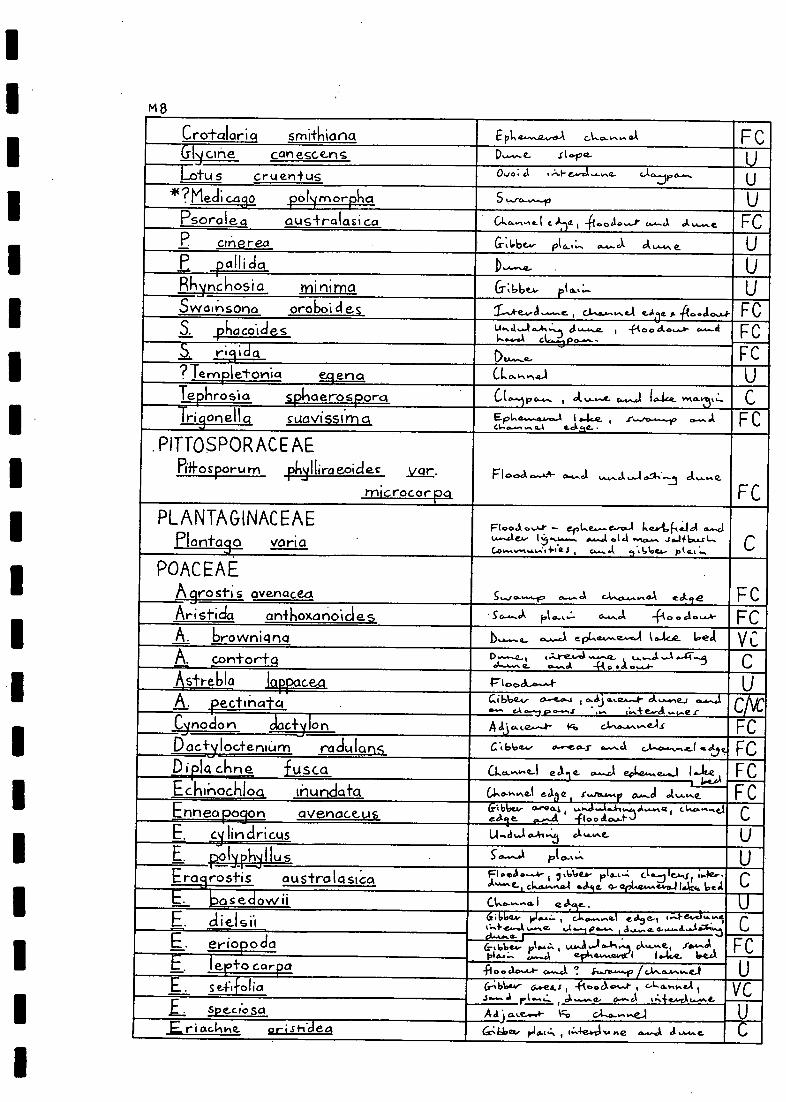
1
M5
Cro-tolaria smithiana E ',Le...we-we-A 01..c........... FCGljune can esce-n S D........0.- .c I...pa. U
ULotus cruentus Ovo ... (.1 ...:4- e.....r.i .........o_ r*?Mecli c.as_o_ poynorptla S l.....,4-4",f1 U
Psorale australasi ca C1.0..c.A.L I C ..12. , -ft...ca....Jr c.....-.J. d FCP cinerea G-;6be., pl c,.,.... A ck Up _i) a I I i cl a D
Filijnchosi a minima CTi66e.A. pi cs....- UFCSwal ;')sona oroboi des T---ske..--ci .--...e. , a-sew s... /-1 e-Aae A -A0..14.4.4-
S. pitacoldes t.t.-1,....1-1,-,..) d ........r_ t 44 a° a a '''-1- '''*411..........% c.L...3 po.......
FeS. 1,...L.i3LcLa
Clu.......e.. FC?Ternpletortia .e.nst Cl....,,,....1 U
.Tephrosio s_pliaerosporct CL--)pc.--- 1 A v-.--e- 4.4....1 to-tce_ v.v.- "... cTrigonellq SUOVISSI ma E pi. 4...............1 I 0-402. s .4,...."0-.,,..10
.............a.A &dye- FC
. P1TTOSPOR ACE AEPifFosporu m 131,311- i!roe° cies var. Flooct 0.--A-4- 0,4....c/ tow. J. ......10-4-.3 cl v....Q.
FCmicrocor pa
PLANTAGINACEAEPlonta3o vari a
FI ....J.. - er Lt.- e.---cLa I. eet. (-(....164 c.....ciLusa e..... 1 ................. .......,1 .14 ,,,,,,...., 6...." t-..C.o.....-",...... fie i , J. ..6be.- pt 0-t ...
POACEAEAgrosti s avenacect 6...1 0.......19 0.4.A C10,0.4.1 44 eGtie FCAristio6 antkoxonoicles pl-,...:- 0-......1 -fi c, c, cic.....A- FcAbrowniqna b....--Q... c--J e pl.4.......e......4 t ...Luz be 4 V L
Acontor-Fa D-a - , I, A.reArot ......-17- , tr....4 -A-.....43clA.A...". 02-.1. +le .1. ........,- C
Astrebla iappacext F I cm.d.....--.4 UA. ectirla c4 Gibloo...4, ata,c1
cA fa ..... ,i...i.e.wel ,...,,..e r
4,1,..le.....-k- }Cc, CM0.-.1/4,0?-,IS
C AC
FCCinociorl calonDactyloctenu:Arn radulans al bbe4., ,......e.4.3- c.......Ct c.A.,0-,%, AL ( 4e 4b FcDla ckr fuscc ec .1 ept,e........i 1.-It F C
FCGING.,,Ine-1 eh e .r..../e.--.41, 0...-cl A,.....e,GI 66e,, o-re 4s , ,.....1.....6-1-4,....e.,01...-A 4 , c k.c..-.,d
0 44.-1- s).......4c
, 1 Attstie r, &A... C ....-i C.Ais , 1....ler .
ot'-'-'-e-, cl...0.,...sa.1 *Jig. 4- epho.....e-1,EJ146. be.1(--L'_
a I e UEclielsii_.
i.1 0.........Q. eci,e-, ..."-ils}.e.c...k ...e 4,....- .4.-.....e.. a.......4.....104..i C
E Au...G-. eriopoda (r,.e4,.. , Jo..4-,..:si
E.,..-_,A ept,41.,e4el I .4..t. Waal
Ulexto car a -F100.10,...1- C.--,1 ! s.....ra....../2/ c.i...4_,......e...1 IE. S efifolia Crbbev- &awes,: , -fi,,,,V,.......e ., c...L.,,,,.,,,,,LA
4 .1 r!., A d. as. it...TA c.....t. VCL specie) So A .1 j ...,e.....4- sc, c.-1-.4-....e...1 UEric:id-tile. orish-clea 6L-Q2/201/ el 6.t.:, i o:-.4e.vri ... e 4...J d ....-4.. e. C
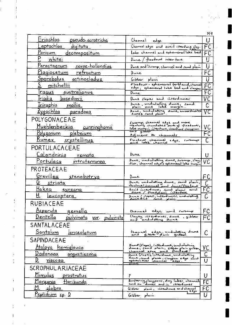
Eriockloo pseudo- acrotrichq Cka t ed.., .
Ue.tochloo dig ituto (1,0....hcl e,13e. G.."61 Os/ 0; c..I 1 Mie...44 %LK. ClaJ - FC
Panicurn decom posit u m Lace c...ko,...sne.1 A et.l.se-se.-0.4 laice loecl Fc
P wkitei 1)--,_. / -flool.s-4- -+u ke_ UParac+aertum novae-hollanclioe D.e. 0...,1 :11,...h.-10, c6connel ge...-41 so-.4 plo.,:, UPI a gios etum re-Frac-I-tarn D,........e. FCSporobolus actt nod l ad u s (7 ;b6c..- pto.t.:. USMitchel Ili....,_
.F10 0 a 0 V.*. epLe....e.v-o-A forbie...atcha..,eledle erLe.....e4.-...1 10.1e..e. imot ......-.4
pc*Iglus_ ausi-ral ia nu s Du...,._. FCTrioclio base clowii CL.......t. Si a I, 42.-1 .......1 ,......+0....-Ot ............r VCTrira .his motiis .....4,,D.....,.. ...--,,I....A0-.F:-.5 01,.........e. i
-L.:- o........4 1 *ICA. .0,061031 V% . C
Jg 'arc.oxo 1,-. , L. *At ..L4t ciwsei L.A.,'4.........e.9. .r.......d pl.x1A-)
V
g I....1 P....I', C.A..0...vt0-1 e.J.3 t. .........A ......c.-er.i.e.-A......ti d .....er ,
..- e t........t 8:4eAnriu.s...t 4.`*".-1.0-e, CA
v cV_
01 onu m plebe:11.Am A ci. a L er,lr- CRumex CryS+Cl Ili nus cio.a....u 0,..,........,-.1 a A.z.t. .....et.........r
a.- A I oACL c....Le........eiC
PORTULACACEAECal onclrinia remo-Fa DLehe_ U
POrflAICICCA I hira -1-er-1-c-oleo D 0-.......e., .........1,1'''''v
6...C......5 C'41.-Ir 1, Ciso........41-1 ea3e p tel., 4E4.1000 oltot e...3....
PROTEACEAEGrevi I fe,so steno boi-r-cyst D,....... FCG-. stri a-Fa 1).........e., ,........1.....14;....3 01,........e , so....-.1 IA 6.4,1% ,
41 0 14 0 ....41 4.1............,O.A J.......e./ Ao. 1....,,..4-,.....,..ri
C
Ho keci e r ea nu ,:a ,-..,.. e...4 .........t. % .r......--ci pko-a..--: c.--. 14-2_ / e{-10 del ...,:i.......: .
FcE ,..k2s_il.p _ser .t. __,.. ( jtoe ;.-4-e...4......ei , .......4.-.0,.-.8p..1) , 4
ek.--.,4-4.-- a 3......1. ..: -',AC
RUB IACENEAs e....-ul a ern el I ck c.i....-- 4-1 eal.3 e_. .........1,
Dente-114:k 421., I vinaio Kcir. .0 iri of, ' 5'6614-,(``41' ,.....":ti--.Le".;,t"a%%.A--"-a_e FCSANTA LA CE AE
San-1-Q LAM larICZOIcrfunl _ ......."!..CL......o/A e.d.50.. % a ...16:11. ..1.,...... A A,Idoeu- pa a.,:, 5
C
SAPINDACENED.......e (S lora-)
AiC110i0 II ern'll auca .1.-...., r..........e pt &AZ. ei .660.- r1.6.1-. 3,4 +10... v L0.......--.e...4 ../.3... ....._%.% fto. a C...41"
Dodos-1,1ex, c i,guS4-isSir0 IX.--a. .67.77..el, ;-4-e......l........e , to-J....1.A :,..j k,...
et..--.1- ,J,..........4 pl....4 , (.. is.....ip 0 ....... O. XVI- c........12 visco sa .t..........., ,..,...........4 . . Q .1 1
ki........
SCROPHULARIACEAEMimulus pros+rai-us ? UMorpnict -clori 6tAnclo 8.,144....3610........s , ,4-0 io-kes, J.-L....Lit
........t ..... AA. nit t s...c.i ..........Q..f,.... I
Fc
L. 4112/2.1aL Ci.bb 44- pl......: , ,:-I-e,..4.........e ea,, el elseu-111 FCPeptichUrA lg. .D I e it. UGi66e4. ple...:.

I. M 10
SOLANAC EA ENico-hana velutina
1)....ne. (slopes), .clooclo...1-, ckorre.1 eane ,
st..1,......e. .1,..e,......, ......1- ..-.15...Je-etotp.d 41 o ...-.40-44..4.4......... . VC
SOICMUV/I 01.13aCaritkUM Flo od.o....4- - ept.e.mero...1 Ie.rbfie. Id, (...1-4).4(4, l....re.) arcl c.korre.I e.1.5.-.
TETRAGONIACEAETe+ra3ormQ tetragon I 0.1G1 e6
Fl 00.406A- - Lana co- sal4644s 0...e..1 1.3in...... /C0066 ok co fie,1 GILD 42 pke....a..-al1.....-bc;eidc, c.t....-....el .....J t.A. CA Q. i eAt 42 ,ch.....e... , .....+erd*........o.. ........e. .......d....1.4.4.64.-......e.
VC
THYME LA EACEAEpirnelea .51y;iptey, ag.. continua Opt" 3. 11.1,esr acti .(40.4- s 'lobe.- pio.4". U_.P trid^lOSI-CiCh.ya
,
D....rs- , sar.ol pla:r.. U
VERBENACEAE*Verbe.r1 a officina iis
Floodo** - borrow pit , sworpiclsorrel.....÷....... a... 4 -fq ea! ....I-.Fc
ZYGOPHYLLACEAETr . bulus 113s-ft-ix / 44.04...-.- ;-+....-,i. UI occi clentalis Ds., e a"ci lake.roar '31.... CTterrestris...: Urtclulai-sk5 cit.Aneg U
Zygo phy hum arnrnophi turn p.n.. , ckan......1 edie a....ci -Poo.lo..-1- C
Z.kowi itii_ rh,-...e. , .......3 IAA 0.7-4,z c16......z. , .s....... d pl og ...:....4 -1-1...A 0,F c
Z. iocioccirpuryt.
.
Floodo.......t- U

APPENDIX N
1Principal Survey Site Locations, Major Vegetation
Types Sampled at the Nine Permanent Sites and
Details of Aerial Photographs Covering Survey Sites
Ni
1Principal survey site locations as depicted in Fig. 7. In the vicinity ofeach of these survey sites several (up to four) habitats were sampled. Fulldetails of locations of habitats sampled at each principal site can be foundin data sheets and geological maps held by the Survey and Research Section,N.P.W.S.
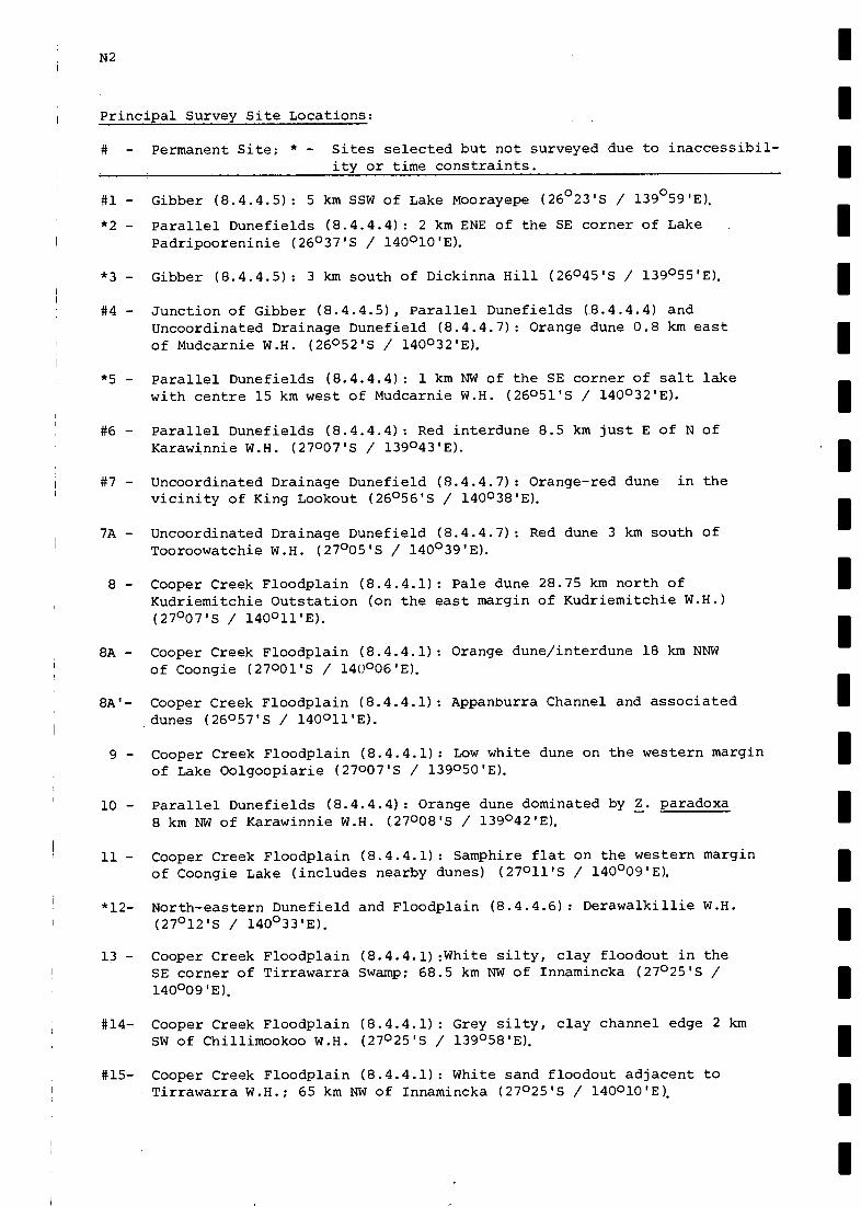
N2
Principal Survey Site Locations:
# - Permanent Site; * - Sites selected but not surveyed due to inaccessibil-ity or time constraints.
#1 - Gibber (8.4.4.5): 5 km SSW of Lake Moorayepe (26°23'S / 139°59'E).
*2 - Parallel Dunefields (8.4.4.4): 2 km ENE of the SE corner of LakePadripooreninie (26°37'S / 140°10'E).
*3 - Gibber (8.4.4.5): 3 km south of Dickinna Hill (26045'S / 139°55'E).
#4 - Junction of Gibber (8.4.4.5), Parallel Dunefields (8.4.4.4) andUncoordinated Drainage Dunefield (8.4.4.7): Orange dune 0.8 km eastof Mudcarnie W.H. (26052'S / 140°321E).
*5 - Parallel Dunefields (8.4.4.4): 1 km NW of the SE corner of salt lakewith centre 15 km west of Mudcarnie W.H. (26051'S / 140°32'E).
#6 - Parallel Dunefields (8.4.4.4): Red interdune 8.5 km just E of N ofKarawinnie W.H. (27007'S / 1390431E).
#7 - Uncoordinated Drainage Dunefield (8.4.4.7): Orange-red dune in thevicinity of King Lookout (26°56'S / 140°38'E).
7A - Uncoordinated Drainage Dunefield (8.4.4.7): Red dune 3 km south ofTooroowatchie W.H. (27°05'S / 140°39'E).
8 - Cooper Creek Floodplain (8.4.4.1): Pale dune 28.75 km north ofKudriemitchie Outstation (on the east margin of Kudriemitchie W.H.)(27°07'S / 140°11'E).
8A - Cooper Creek Floodplain (8.4.4.1): Orange dune/interdune 18 km NNWof Coongie (27001'S / 140°06'E).
8A'- Cooper Creek Floodplain (8.4.4.1): Appanburra Channel and associateddunes (26057'S / 140011'E).
9 - Cooper Creek Floodplain (8.4.4.1): Low white dune on the western marginof Lake Oolgoopiarie (27007'S / 139050'E).
10 - Parallel Dunefields (8.4.4.4): Orange dune dominated by Z. paradoxa8 km NW of Karawinnie W.H. (27008'S / 139°42'E).
11- Cooper Creek Floodplain (8.4.4.1): Samphire flat on the western marginof Coongie Lake (includes nearby dunes) (27011'S / 140°09'E).
*12- North-eastern Dunefield and Floodplain (8.4.4.6): Derawalkillie W.H.(27°12'S / 140°331E).
13 - Cooper Creek Floodplain (8.4.4.1):White silty, clay floodout in theSE corner of Tirrawarra Swamp; 68.5 km NW of Innamincka (27°25'S /l40°09 'E).
Cooper Creek Floodplain (8.4.4.1): Grey silty, clay channel edge 2 kmSW of Chillimookoo W.H. (27°25'S / 139°58'E).
Cooper Creek Floodplain (8.4.4.1): White sand floodout adjacent toTirrawarra W.H.; 65 km NW of Innamincka (27°25'S / 140010'E).

16 - Cooper Creek Floodplain (8.4.4.1): Consolidated deep white dunedominated by Z. paradoxa SE of Boggy Lake (27031'S / 139°50'E).
17 - Cooper Creek Floodplain (8.4.4.1): Sand dune adjacent to BookabourdieW.H. (27°33'S / 140°28'E).
18 - Cooper Creek Floodplain (8.4.4.1): Floodout bordering the channelbetween Darby's W.H. and Cuttapirie Corner W.H. (27034'S / 139°52'E).
19 - Cooper Creek Floodplain (8.4.4.1): Orange sand dune on the westernedge of Embarka Swamp (27°38'S / 140007'E).
20 - Cooper Creek Floodplain (8.4.4.1): Scrubby Camp W.H. (27040'S /l40°25 'E).
21 - Cooper Creek Floodplain (8.4.4.1): Orange sand dune 10 km west ofGidgealpa Homestead on the western edge of Embarka Swamp (27040'S /140007'E).
22 - Cooper Creek Floodplain (8.4.4.1): Gently sloping orange sand dunes15 km WSW of Innamincka near Minkie W.H. (27047'S / 140038'E).
#23- Cooper Creek Floodplain (8.4.4.1): Grey silty, clay swamp margin onthe southern edge of Embarka Swamp (27°43'S / 140°08'E).
24 - Cooper Creek Floodplain (8.4.4.1): Pale to yellow sand plain 6 kmESE of Scrubby Camp W.H. (north side of the Coongie Rd.) (27°41'S /140°27'E).
#25- Cooper Creek Floodplain (8.4.4.1): Edge of dry infrequently floodedchannel of the Cooper Creek 5 km NE of Pilalchilpna W.H. (SSE of LakePerigundi) (27053'S / 139027'E).
Parallel Dunefields (8.4.4.3): 12 km SSW of Moomba (28012'S / 140°09'E).
Parallel Dunefields (8.4.4.3): Dunes 8 km south of the centre of LakeWarrakalanna (28°17'S / 139°19'E).
#28- Strzelecki Creek Floodplain (8.4.4.2): Floodout 0.8 km west of ToolacheW.H. (28021'S / 1400251E).
29 - Parallel Dunefields (8.4.4.3): White sand dune 56 km SSW of Moomba GasPlant and 11 km SE of Wancoocha #1 Well (28037'S / 140003'E).
30 - Strzelecki Creek Floodplain (8.4.4.2): Orange dune east of MundibarcoolooW.H. (28°40'S / 140°13'E).
N3
(.cont'd...N4).

N4
Major Vegetation Types Sampled at the Nine Permanent Sites:
Site 1 - Astrebla pectinata open grassland
Site 4 - Triodia basedowii hummock grassland with a very open overstoreyof Grevillea stenobotrya and Acacia murrayana
Site 6 - Triodia basedowii hummock grassland with an overstorey of
Acacia ligulata low open shrubland
Site 7 - Zygochloa paradoxa hummock grassland
Site 14 - Eucalyptus microtheca - Acacia stenophylla - Lysiphyllum gilvum
- Eucalyptus camaldulensis open woodland
Site 15 - Eucalyptus microtheca + E. camaldulensis open woodlandand Muehlenbeckia cunninghamii shrubland
Site 23 - Muehlenbeckia cunninghamii low shrubland
Site 25 - Eucalyptus microtheca - Acacia stenophylla open woodland
Site 28 - Atriplex nummularia low open shrubland

1
Details of Aerial Photographs Covering Survey Sites:
N5
Site Survey Photo No. 1:250 000 Sheet Date Scale Altitude
1 2779 18 Cordillo 1 xii 81 1:87 000 7250 in
2 2779 62 Cordillo 1 xii 81 1:87 000 7250 in
3 2779 112 Cordillo 2 xii 81 1:87 000 7270 m
4 2779 98 Cordillo 2 xii 81 1:87 000 7270 in
5 2779 102 Cordillo 2 xii 81 1:87 000 7270 in
6 2451 44 Innamincka 28 viii 79 1:88 000 7530 m
7 2779 74 Cordillo 2 xii 81 1:87 000 7270 in
7A 2451 94 Innamincka 28 viii 79 1:88 000 7530 in
8 2451 104 Innamincka 28 viii 79 1:88 000 7530 m
8A & 8A' 2779 62 Cordillo 2 xii 81 1:87 000 7270 in
9 2451 48 Innamincka 28 viii 79 1:88 000 7530 in
10 2451 44 Innamincka 28 viii 79 1:88 000 7530 in
11 2451 56 Innamincka 28 viii 79 1:88 000 7530 m
12 2451 64 Innamincka 28 viii 79 1:88 000 7530 in
13 2451 72 Innamincka 28 viii 79 1:88 000 7530 m
14 2451 76 Innamincka 28 viii 79 1:88 000 7530 in
15 2451 72 Innamincka 28 viii 79 1:88 000 7530 in
16 2466 73 Innamincka 15 x 79 1:88 400 7560 in
17 2466 57 Innamincka 15 x 79 1:88 400 7560 in
18 2466 73 Innamincka 15 x 79 1:88 400 7560 in
19 2466 18 Innamincka 15 x 79 1:88 400 7560 in
20 2466 26 Innamincka 15 x 79 1:88 400 7560 in
21 2466 18 Innamincka 15 x 79 1:88 400 7560 in
22 2466 113 Innamincka 15 x 79 1:88 400 7560 in
23 2466 18 Innamincka 15 x 79 1:88 400 7560 in
24 2466 26 Innamincka 15 x 79 1:88 400 7560 in
25 2473 52 Gason 24 x 79 1:88 000 7530 in
26 2552 70 Strzelecki 1 iv 80 1:88 750 7590 in
27 2566 50 Kopperamanna 1 v 80 1:88 750 7590 m28 2548 66 Strzelecki 28 iii 80 1:88 750 7590 in
29 2548 30 Strzelecki 28 iii 80 1:88 750 7590 m30 2548 100 Strzelecki 27 iii 80 1:88 750 7590 in

- - - - - - - - - - - - - - - - - - - -
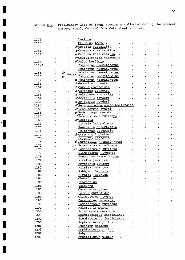
1
1
01
APPENDIX 0 - Preliminary list of fauna specimens collected during the presentsurvey; mostly derived from data sheet entries.
1113 Lerista .
1114 Ctenotus laeve .
1150 d'Oreoica quttaralis
1151 eCacatua roseicapilla1152 g Cacatua roseicapilla1153 d/Colluricincla harmonica1154 d'Falco berifora .
115-4 Psephotus haematonotus
115-5 Psephotus haematonotus1155 6? Pair{Psephotus
haematonotus
1156 * Psephotus haematonotus
1157 Psephotus haematonotus1158 Geopelia cuneata1159 Corvus coronoides1160 Ocyphaps lophotes1161 Peltohyas australis1162 eAmytornis goyderi1163 $Amytornis goyderi1164 d'Recurvirostra novae-hollandiae
1165 eDendrocygna eytoni1166 eHydroprogne caspia1167 d'Pomatostomus ruficeps1168 d)Geopelia1169 Litoria latopalmata1170 Ranidella deserticola1171 Peltohyas australis1172 *Ocyphaps lophotes1173 Ocyphaps lophotes1174 eNorthiella haematogaster1175 Pomatostomus ruficeps .
1176 juv.Pomatostomus ruficeps .
1177 Climacterus picumnus .
1178 Psephotus haematonotus1179 Mirafra 'avanica1180 Amytornis goyderi1181 Mirafra 'avanica1182 Ashbyia lovensis1183 Mirafra 'avanica1184 Charadrius1185 Charadrius1186 Tribonyx1187 Cacatua sanginea1188 Corvus coronoides1189 Climacterus picumus1190 Barnardius barnardii1191 Pomatostomus ruficeps1192 Malurus lamberti1200 Sminthopsis macroura1201 Eremiascincus fasciolatus1202 Eremiascincus fasciolatus1203 Amphibolurus pictus1204 Lucasium damaeum1205 Amphibolurus pictus1206 Gehyra .
1207 Amphibolurus pictus

02
1208 Skink (?Leiolopisma) .
1
1209 Morethia . . .
1210 Ctenotus schomburgkii
1211 Lerista1212 Lucasium damaeum
1213 Morethia boulengeri
1215 Lucasium damaeum .
1216 Varanus gouldii
1217 Ticks from 1216 .
1218 Eremiascincus fasciolatus .
1219 Lerista labialis . .
1220 Amphibolurus vitticeps .
1221 Menetia .
1222 Lucasium damaeum
1223 Rhynchoedura . .
1224 Nephrurus1225 Heteronotia
1226 Ctenotus .
1227 Gehyra .
1
1228 Rhynchoedura .
1229 . Planigale1230 Nephrurus .
1
1231 . Lucasium .
1232 Diplodactylus ciliaris1233 Mus musculus .
1234 Mus musculus .
1235 Mus musculus . .
1236 . ?Diplodactylus conspicillatus1237 ?Diplodactylus conspicillatus .
1238 Diplodactylus conspicillatus1239 Amphibolurus pictus .
1240 Skink .
1241 Skink .
1242 . Skink .
1243 Ctenotus . .
1244 Skink (?Ctenotus) .
1245 . Skink (?Leiolopisma) .
1246 Mus musculus . .
1247 Rhynchoedura .
1248 Rhynchoedura1249 Planigale
I 1250 . Morethia1251 Heteronotia1252 Morethia .
1253 Morethia1254 Gehyra . .
1255 Diplodactylus tessalatus .
1256 Lerista labialis1257 . Lerista labialis1258 Lerista labialis1259 . Lerista labialis1260 Heteronotia . .
1261 Sus scrofa (pig jaw) .
1262 Felis cattus (skull) .
1263 Amphibolurus vitticeps1264 . Amphibolurus vitticeps1264' Vulpes vulpes (fox skull)1265 Menetia .
1266 . Morethia adelaidensis

1267 Nephrurus
1268 Eremiascincus fasciolatus
1268' Canis familiaris (skull)
1269 ?Heteronotia .
1270 Heteronotia binoei1271 Gehyra .
127.2 Gehyra .
1273 Gehyra .
1274 Sminthopsis crassicaudata
1275 Heteronotia1276 Heteronotia1277 Diplodactylus tessalatus
1278 Diplodactylus tessalatus
1279 Heteronotia1280 Heteronotia
1281 Sminthopsis crassicaudata1282 Eremiascincus fasciolatus1283 Eremiascincus fasciolatus1285 Vulpes vulpes (lower jaw)1288 Varanus gouldii1289 Ctenotus1289' Ctenotus1290 Ctenotus1290' Diplodactylus tessalatus1291 Mus musculus1292 Phyllurus1293 Diplodactylus stenodactylus .
1294 Diplodactylus stenodactylus .
1300 Mus musculus .
1301 Eremiascincus fasciolatus1302 Eremiascincus fasciolatus1303 Diporiphora1304 Cryptoblephorus plagiocephalus1304' Ctenotus brooksii1306 Nephrurus laevis1307 Eremiascincus fasciolatus1308 Eremiascincus fasciolatus1309 Eptisecus sp. .
1310 Nyctophilus geoffreyi1311 Eptisecus sp. .
1312 Lucasium damaeum1313 Gehyra variegata1314 Heteronotia binoei1315 Rhamphotyphlops1331 Eremiascincus fasciolatus1332 Lucasium damaeum1333 Egernia inornata1334 Small dragon Diporiphora1335 Ctenotus1336 Diporiphora1337 Pseudomys hermannsburgensis .
1338 Gecko .
1339 Gecko .
1340 Owlet Nightjar (escape d)
1341 Peaceful Dove .
1341' Eremiascincus fasciola tus1342 Lichenostomus penicillatus1343 Little Brown Bat1344 Little Brown Bat
03

04
1345134713481349
13501351135213531354
1355
1356135713581359136013761377137813791381138213831384138513861387138813911392139313981399140014011402140314041405140614071408141114121413141414211422142314241425142614271428143014331433'
14341434'1434"1434"'
Legless Lizard / Snake Delina 22. ?tincta . IISphenomorphus (=Eremiascincus)Amphibolurus pictus . .
IILarge tadpole . .
Amphibolurus vitticepsGehyra .
Ctenotus ICtenotus . . .
Pseudomys hermannsburgensis . .
Amphibolurus pictus . . .
IIEremiascincus fasciolatus .
Pseudomys hermannsburgensis .
Pseudomys hermannsburgensis .
Pseudonaja sp. (juvenile snake)IIEremiascincus fasciolatus . .
Mus musculus . . . . . .
Sphenomorphus (=Eremiascincus)fasciolatus .
IICtenotus . .
Ctenotus .
Mus musculus . .
Rhynchoedura . .
IINephrurus laevisAmphibolurus pictusCtenotus brooksii
IICtenotus brooksiiMorethia sp. .
Nephrurus . .
Rat Skull (? Long Haired Rat) IIMyall Snake .
?Sminthopsis .
Gecko .
IIGecko . .
Skink ?Ctenotus . . .
Sandswimmer (=Eremiascincus fasciolatus)Sandswimmer . IGecko .
Gecko .
Gecko . .
Ctenotus sp. .II
Pseudomys hermannsburgensis .
Ctenotus 22.. .
Gecko . IIGecko . .
Sphenomorphus .
Gecko . .
IIGecko . .
Gecko .
Skink . .
Eremiascincus fasciolatus . IIGecko .
Gecko . .
Skink . . . IIAustralian Raven Corvus coronoides . .
Knob-tailed Gecko .
Gecko . . .
IIGecko . . . .
Lerista .
Skink #1 .
Skink #2 . . . IIGeckoes (2),

1435 Lucasium damaeum1436 Diplodactylus ?stenodactylus
II14371437'
Eremiascincus fasciolatus .
Pseudomys hermannsburgensis .
1438 Eremiascincus fasciolatus1440 Mus musculus . .
I 1441 Snake (lost) .
1442 Underwoodisaurus1444 Lerista . .
II14451446
Heteronotia binoei .
Leggadina forresti (to Bill Breed)1447 Sminthopsis crassicaudata (to Chris Watts)
II14481449
Amphibolurus nuchalisGehyra yariegata .
1450 Heteronotia binoei1451 Rhynchoedura .
II14521453
Heteronotia .
Lerista labialis .
1454 Eremiascincus fasciolatus
II1455 Lerista labialis1456 Rhynchoedura . . .
1483 . Pseudomys hermannsburgensis .
1483' Sminthopsis macroura .
II14841486
Leqqadina forresti . .
Pseudomys hermannsburgensis .
1487 Pseudomys hermannsburgensis .
II14881489
Pseudomys hermannsburgensis .
Pseudomys hermannsburgensis .
1491 Pseudomys hermannsburgensis .
1492 Sminthopsis macroura .
II14931494
Mus musculus .
Mus musculus .
.
1495 Mus musculus .
I 14961497
Mus musculus .
Leggadina forresti . .
1498 Pseudomys hermannsburgensis .
1499 VPseudomys hermannsburgensis .
l\i i
1500 Dasyuroides byrnei1501
.
Cyclorana platycephalus.
1502 Rhynchoedura ornata .
II15031504
CtenotusDiplodactylus .
1505 Diplodactylus . .
II1506 Diplodactylus1507
.
Ctenotus1508 Rhynchoedura ornata
.
1509 Neobatrachus .
II15101511 .
Gehyra variegataAmphibolurus nuchalis.
1512 Diporiphora . .
II1513
1515
Nephrurus laevis1514 Rhynchoedura ornata .
Eremiascincus fasciolatus1516 Eremiascincus fasciolatus
II15171518
Eremiascincus fasciolatusLerista labialis
1519 . Neobatrachus . .
II1519'1520
Lerista labialis .
Pseudomys hermannsburgensis .
II
05

06
1521 Pseudomys hermannsburgensis .
1522 Eremiascincus fasciolatus
1523 Diplodactylus ciliaris
1524 Typhlina . . .
1525 Pseudechis australis .
1526 Lerista labialis1527 Lerista labialis
1528 Menetia1529 Lialis bicitanis
1531 Ctenotus sp. . .
1532 Morethia1533 Skink . .
1534 Skink . .
1535 . Menetia . .
1536 . Ctenotus1537 Ctenotus .
1538 Sminthopsis crassicaudata
1539 . Sminthopsis crassicaudata1540 Eremiascincus fasciolatus
1541 Diplodactylus stenodactylus .
1542 . Eremiascincus fasciolatus .
1543 2Sminthopsis crassicaudata
Site 1 (No number - N.N.)N.N. Notomys cervinusN.N. Notomys cervinus
Site 21 (No number - N.N.)N.N. Eremiascincus fasciolatus
N.N. Eremiascincus fasciolatus
N.N. Eremiascincus fasciolatusN.N. Nephrurus laevis
Site 8A (No number - N.N.)
N.N. Ctenotus brooksii .
N.N. Ctenotus brooksii . . .
N.N. Ctenotus sp.?cf. piamiai
N.N. Eremiascincus fasciolatus .
N.N. Eremiascincus fasciolatusN.N. Ctenotus brooksii .
N.N. Diporiphora winneckeriN.N. Amphibolurus pictus .
1N.N. Eremiascincus fasciolatus .
N.N. Ctenotus brooksii . . . .
N.N. Ctenotus !E. (similar to C. robustus or C. saxatilis)
N.N. Ctenotussm. (similar to C. robustus of C. saxatilis)
Additional Note: Litoria caerulea in Embarka W.H. (Lawrie Ottoole,Pers. comm.).
Site 24 (No number - N.N.)N.N. CtenotusN.N. Gehyra .
N.N. RhynchoeduraN.N. Lerista
No number Pseudomys australis (to Bill Breed).

OMMONIMM MO
MOIMMIMENNEMIIMIMMEM=11=1=

PI.
Appendix P - Numerical Results (i.e. censusing data)
Censusing data on 79 species are presented in two tables for sites 1, 4,6, 14, 23, 25 (two landforms censused : 25 and 25') and 28.
In Table 1 the following information is presentedthe number of five minute counts that were conducted at each site.the number of species thathwere recorded while conducting the five minutecounts at each site.the number of species recorded while conducting the census, and the figureincludes observations made while travelling between five minute census-points at each site.the total number of individuals (summed for all species) that were recordedwithin 50 metres of the observer during five minute counts at each site.the total number of individuals that were recorded within 100 metres (thefirst unbracketed figure), and the total number of individuals recordedat any distance (the second bracketed figure) from the observer during fiveminute counts at each site. These two figures and the previous figure(number of individuals within 50 metres) have been standardised to offsetthe effect of different sampling effort at sites where a number other than20 five minute counts were made (i.e. sites 4, 14, 23, 25 and 25').
In Table 2 the 79 species are presented with the numerical data arrangedin five rows (a, b, c, d, e) per species for each site
a "V" in row a indicates that this species was recorded while conductinga census but only between five minute counts. If numbers appear in row athe first (unbracketed) number indicates the number of individuals of thatspecies which were recorded within 50 metres of the observer during thefive minute counts, while the bracketed number is the total number ofindividuals that were recorded within 100 metres of the observer (i.e.including the number seen within 50 metres as well) during the five minutecounts.in row b the total number of individuals of that species that were recorded(at any distance) during the five minute counts is presented.in row c the number of five minute counts in which that species was record-ed is indicated. This indicated how regularly the species was encounteredin the course of the census exercise.in row d a density estimate is given for all species that were recordedwithin 50 metres of the observer and based on figures for a 50 metre radiusaround the observer.in row e a density estimate based on the average of the row d estimate andthe 100 metre radius estimate is presented if the resulting estimate isgreater than or equal to 0.10 birds per hectare.

P2.
SITE 1 4 6 14 23 25 5 28N° of couni-s c,hckic-1-ecl 20 /8 20 17 15 26 /3" 20N°. of sfp. ch,in9 c.c.,ts 23 25 Iii- 34- 33 28 27 31N°. of .sp. clwf-Iri ay, sus pe.Y.ocl 23 32 16 39 33- 28 23- 31
1\/° of incitv;oiwkis witli;n co wIthes 10 112 34. 161 I41 38 4-7 (91
N°. irich.viditals IN.fli i rt 10 0 1,I (9' col el 1 41. an oe) 22 (213) IS/ (302) 69(103) 32046) 20(441) 20384 i356130 2'30025)
SPECIES S 1 7- . 4 6 14- 23 25 25' 28
Dr om ok.ms novce-hol land ice
i0
I (3)
P I crt-ctlea. -C IQ.; 1 pes LI-
zi-
I (0A h as s,krercikosci. 1
1
08
%/ 13 (13)
Anas .16be., -Peons 01531-10
69V
FA nas rhyrico-Hs o
5 (6)
McIlacorkinc-litAs mek4roricAceus .
10
9.1t2
0 ( 3)
C ke.novle.-H-o, 3,Aatct. 41-
4-

P3
1
'SPECIES S 1TE 4 6 14- 23 25 25'28
NI i 1 v,A S tv11.5ran
6(7W)
).16
25
0(3)66
OM103-
1 (2)
3305
1(6)93-
-06
Harn;r0S-1-rck rnelatiOsfernon
2(6)6it-
-12
HattaSter Spkermrikg2(5)55-
15-12
0(i)33
Aquaa cmdctx2(3)3a
- 1511
V
0
ON22
0I
I
Hiero.a.eh,s. morpkvoes0
I
1
0I
I
1(1)i
I
'06
Circ.t.kS ckertakcyno.suks
V
0
Falco bEri9orc1.2(2)333
.1 it
2())
3
oI
1
Falco ce_rIchroicle.s
022
01
I
0(1)I
1
0I
1
02.2
Porzara -Cluminea..7(22)22II
.595-3
at t In Lilo verytrolis(1)
I
I
12('H)
ci-
1-02.95
Porpii rio foorpk3riooto
1
I
Grus rtAbicuo,c1,As
03-3
0if2
Prustl,rno,Nys ohcius Li-
2-34--21

P4-
SPECIES - S IT E 1 4 6 14 23 25 25' 28
ChoradrilAS. rne_10nOpS
./
0
0(1f-)
Gallinclo I/arc:1.w ick. 4
1(2)
S-H1-1-Ick isabe_113. I
1344
-06 -34-21
0(1)
LW-us novaelnollandicte 33
3(3)Ckl i dorlas h4rida. 3
1
120
Gelockelidor, niotica 31
JHyciroprore corpict 0
0 1(6) Jit-(27)
Geopelia strtata 1
1
22/3
6619
0-3- .69.51
(3) 0 3(3) 0(1)
Geopalict_ c4neata li.
31
1
53
22
-15-10 to
0 0(3) 0(1) 2(s) 4(13) 43(0 4(11-) 14(31)
Ocypkaps lophotes SIt
33
I 1310
Iii-9
/2420
1109
24/3
15 -59 1-10 -5215 .1-/-4- 65
0 5(6) 1006) 2(3) 0 29(43)Cacatua ros6capi(la 45
9165
259
169
It-
249
35 1-5'3-5 .(0-23 -53 100(i) 2.C4) 3(3) 0 0 b(g)
CcicatkAa pastinator 73
208
31
2$-7-
11
3S1
-2-5- .38.14- .16 .26
1(1) 3(5) vs) o 5(5)Mel o p lit tactAs wiclulatus 30
10155111S 1
-06 -21 -50 -Lt'215 -32 .2.-
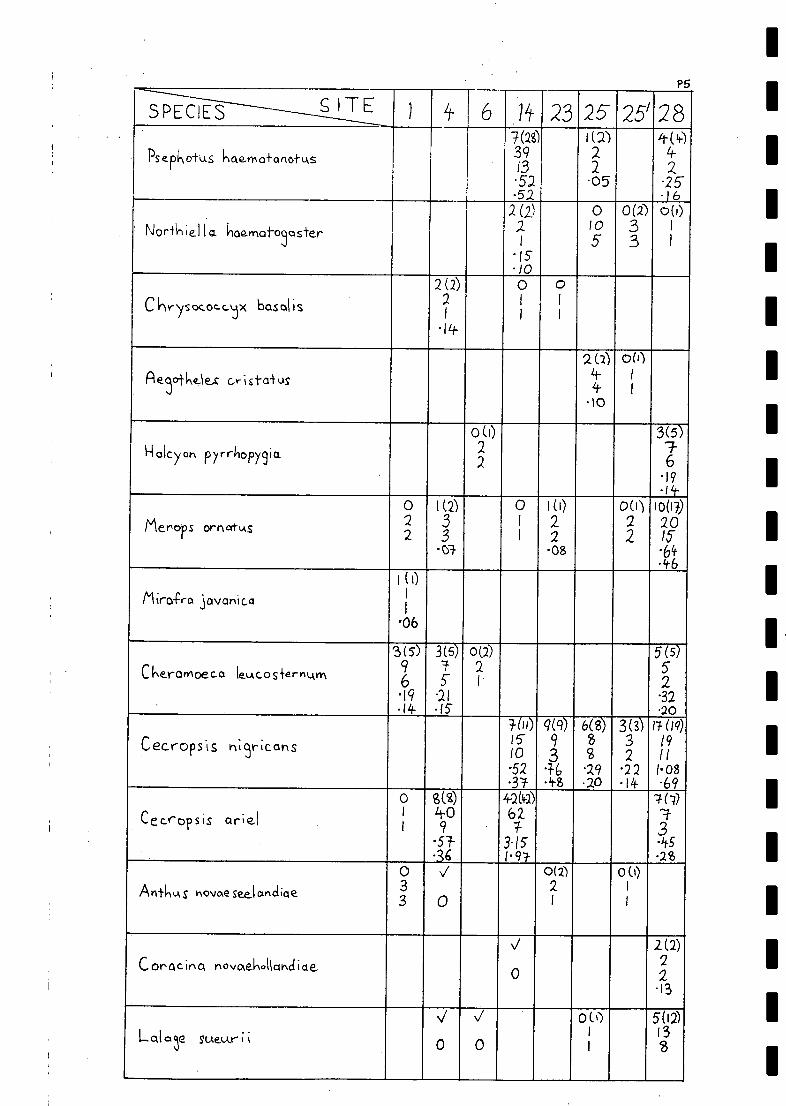
SPECIES S ITE ) 4_ 6 lit 23 25 25'28
Psepkotus hae-rno-lsonotu,s
7(28)391.3
-52
i (a)22.05
4-(4-)4-
225
-52 .1 62(2) 0 0(2') 00)
' Nor-1k lel 1 o. aamat-0 sterr 21
105
33
I
I
I510
2(2) 0 0C kr ysococcAix basal is 2
1
1
1
1
1
-14
2(2) 00)Rerke-1e-c c-ristai-us If
Li-
I
1
-10
0(1) 3(5)H alcy oh pyrrliopy9io. 2
27-6
-19-fil-
o 1(2) 0 1(0 DO) 10(1D
Mero s ornotv,s 22
33
I
1
2208
22
20IS.64.46
I (0Miro-fro jovanica 1
1
-06
Ckeromoeca lek.Acos-iernwn
3(5)96
3(5)
5-
0(2)2I
5(5)52
19 -21 -32-14 .15 .20
TOO 9(9) 6(8) 3(3) 17(19)
Cecrops'is rli9ricans 1510
93
8S
32
19/1
-52 -3-6 .29 -22 1-08-3.1- .20 -14 -69
o g(z) 42(4a)I 1t-.0 62 -1-Cecropsis ar;e1
1 9 * 33-15 -45
-36 1-97- .280 V 0(2) 0()
AntlikAs hovaesee.lanclicle 33 0
2I
I
I
J 2(2)C or' a c in a novaekollcmci i a e 0
22
13
J V 0(1) 5(12)
Lalar sueur 0 01
1
13'8

P6
SPECIES SITE 1 6 14- 23 25 25' 28
Colluricincla harmonica4(15)2616-3029
054
01
1
0 0Onemica rti-uralis .9
2 4
0(1)
iv\y iocra inikaieto 1
1
0(i) 1(4) 0(10) 0(9) 16.(26)
Rkipiciurci leucopkrys 1
1
2.
1-
2520
1912
2615
70} 1-02101(1) 0(3) 0(11) 2(3) 0(4)
Pso hocks crista-kks 33
138
2815
2312
66
-04 15- 11
0(2)C tyclos 01-Ack co-IngivIoneutyl 3
2.
3(3) 0 5(11)
PONI 0+0 StOMLAS ru-ficeps 42
44
12?
-15 32-10 25
4(R)Acroczpkal 4S StentareLAS 34
10-34-.35
3(15)
Me9Q1t-krus ramine_us 2915-
.25-190(i)
Cinciorkao-pkus cruralis 33
6(15) s(s) 1 4(6) 3(5) 3(6)Malurus lambert i 16
''82 0
63
52.
6442 -50 34. 15- '22.35 32 24 11 14.
0 3(6) 6(i) 5 (9) 4(5)Ma ILAr-Lks le..LAconotus
94
84-
-/-3
95
52.
-21 -38 -4-2 -30-(6 . as .20
0 V
Ayy,xfornis (3oyderi 32 0

Pq.
SPECIES ' SITE 4 6 14 23 525 23
' A cant-A iza LAropyoiolis11(1)
4-225'16
A F-.,0.1,0ce_rkolo 1...,..k.ops iS.
0(32)2i
Apkeiocepkala rNicyricinc-ta o,
11(19)
Chrrocteris picurnrius 2 1lit-8259
0 2(5) 0(3) 0(5) b(g)
flonotHrla Claye9-41g 7-
37-5 6
6167
98
15-12
'38-26
0(6)Aconthasenys nufo3ular is 6
II-
1 (I) 1(3)
Lichenos+ooltAs virescen sR2
107
01 .06
0 1(26) 31(82) 15(0 18(28)
Licke I icrtu. 2 39 113 94- ZSnothomus penic 1 S 2 14 23 1-7 15
-61-58
1.521-26
1.121-13 .80
2(2.) 5(6)EpkthomArq +r 'color 2
1
62
lit. .33-.2 1/-
Efhi41;colura 4k-Nr.%-er ons
6(9)1 0
5.
.35.0(')
A skbyla ovens is 1
1
0(t) 2(7) 0(i) 0 3(9)POrd lotusa rulzric crFuS 1 3- -4- 610
1 6 5 6 415 19-lip
1 ( I) 62(96) 0(4 2(2)12(1?) 3(3)Poephila (31/4.1.++A*C1
ii-38
10914-
11-3
2 171 8
33
.06 9-.39 0 -16" 1-02 19305 -13 .10 .69 12

I.
Pg
SPECIES ''S ITE4t
I
1 6 lit 23 25 25'23
Grallina cycanole.Aca062
032.
2(16)211415.22
1(1)1
1
08
01
1
2(3)86
13.i2
1(0 6(3) 3(8) 1 00
r sA ricnytu,s le.Aco 1, ekv, 22
86
86
13
915. dt5
.30 13 .3ao ./ 20(20)
Artamus persona+us 21 0
20I
1-50.94
0(3) 2C') 2(2) 3(5) 1(4.) 12(16)
Artcarus cine.reus 96
a4
iv2.
5if
13
19
1013 '15 15- Cr+ .1612 .10 11 'Si
0 J 0 0 0 0 0G-ymnorkkr.q fibicen 9
6 052
1
1
5'5
63
1
I
ON 0(6) 0(1) 00) 0 1())4 11 11. 14 2- 4.C. orvLA S coronoicles2. 9 1- 12 3 4
06
0(5) V /(9.) 0 0 0 3(3)Corvu s benneiii 105 0610 I
1
65'
5'
4-
55
.0612

Notes Relating to Appendix P
Details of habitat description and times when censuses were conductedat the seven permanent sites surveyed by the Consultants.
P9
Site 1 - Censusing was conducted on an area of gibber some four squarekilometres to the north of the permanent peg. Largely devoid of woody veget-ation, clay lenses and other small pockets carried up to 40% herbaceous cover,while most of the gibber was practically bare. Several counts were made along-side a large lone dune (Zygochloa and Triodia dominated).
1 XI 83 : 10 counts were made between 0800 and 0940*2 XI 83 : "
u u u u 0620 and 0750*
Site 4 - Mudcarnie Creek (irregularly arranged large dunes). Dunes were census-ed over an area of some five square kilometres to the east and south-west of thepermanent peg, and the principal plant species were Zygochloa and Triodia.Scattered emergent shrubs and tall shrubs included Grevillea stenebotrya, Atala-za hemiglauca, several species of wattle, Cassia nemophila and Owenia acidula.Between the dominant grasses, there was a moderate cover of senescent ephemeralspecies, e.g. Crotalaria 22E: and see Section 4.3.3..1.2.
5 XI 83 : 10 counts were made between 0700 and 0910*6 XI 83 : 8 0630 and 0820*
Site 6 - North-western Dunefields ( parallel lines of uniform dunes). Censusingwas conducted in the first three dunes to the east of camp between c 1.5 kmnorth and 1.0 km south of the camp. The dominant plant on the dunes wasZygochloa (.A 30% cover), and there were sparsely scattered wattles and a moderateamount of small ephemerals.
27 X 83 : 10 counts were made between 0630 and 081028 X 83 : "
u U u U 0630 and 0840
Site 14 - Chillimookoo W.H. L. Pedler conducted counts along the northernmargin of the Cooper (a full well defined waterhole) between the camp and c 2.0km to the ENE, where shotline MGJ '82 meets the Cooper. A discontinuous lineof River Red Gums grew along the bank with a dense strip of smaller coolibahover patches of lignum and wattles. Away from the bank, the open coolibah wood-land contained scattered Grevillea striata, Atalaya hemiglauca, Acacia salicinaand A. stenophylla.
26 IX 83 : 11 counts were made between 0700 and 085027 IX 83 : 6 0650 and 0750
Site 23 - Embarka Swamp. Counts were conducted around the permanent peg inflooded lignum on the south-western margin of the swamp. The habitat was fairlyuniform with water covering c one half the ground to a maximum depth of 50 cm.
23 IX 83 : 11 counts were made between 0740 and 102025 IX 83 : 4 0720 and 0800 (by L. P. Pedler)
Site 25 - SSE of Lake Perigundi. The censuses were conducted along the Cooperfrom the permanent peg to c 3.0 km south. the definition of the Cooper's channel(s:and associated vegetation varied considerably along this 3.0 km stretch, as istypical of the lower Cooper. Near the peg on the edge of a well defined W.H.,the Cooper consisted of a single well defined channel. Coolibahs lined the channel(up to 30% cover), with Acacia stenophylla and lignum also present. Further south,the Cooper lost its clear definition as it entered a floodout - a wide network ofsmall shallow channels. Coolibahs became scattered of formed isolated groves, theoccurrence of coolibah also became patchy and clumped, while lignum became the
dominant plant. There were some areas fairly devoid of vegetation.
central standard time

P10
18 IX 83 : 14 counts were made between 0700 and 090019 IX 83 : 12 0640 and 0820A second set of censuses was carried out in a north-south direction c 1.5
km west of the Cooper in floodplain habitat; there was generally less vegetation
and the coolibahs were more scattered.18 IX 83 : 10 counts were made between 0920 and 104519 IX 83 : 12 0700 and 0815
Site 28 - Toolache W.H. L. Pedler conducted counts along the northern edgeof Strzelecki Creek between the camp and c 2.0 km to the west. The habitat was
fairly uniform, consisting of open coolibah woodland 20% cover) with an open
shrub stratum of Atriplex nummularia 10% cover) and a small amount of low
herbage and litter.29 IX 83 : 14 counts were made between 0700 and 093030 IX 83 : 6 0700 and 0800
Notes on the Point-Census Technique
It is recorded on the census sheet whether individuals, that are recordedat 60s and subsequent minute intervals, have previously been recorded in thatfive minute census period. For birds, that fly straight through the sampledarea during the five minute period, their presence is recorded once at the
distance that they passed closest to the observer.All individuals noticed at any distance in each censusing period are re-
corded. As well, species of birds noticed while moving between census pointsare recorded on the census sheets.
Although the total number of individuals recorded within 50 m of the observerare standardised between sites, other figures are not directly comparable in their
current form (as some are based on a different number of counts performed persite).
Density estimates are given for the more common species recorded whilecensusing, and these figures are directly comparable between sites.
In hindsight, it is worth noting that the point censusing technique is notoptimally efficient for censusing bird populations in desert landscapes wherethe vegetation consists of low shrublands and grasslands - in such habitats, birdstend to retreat to distances greater than 50 m from the observer. Under suchconditions transect counts would be more effective, because birds are counted asthey are first encountered (often flushed, which does not occur with point census-ing), and more birds are encountered per unit time investment which is an advant-age in land systems that support a low density population. Nevertheless, thepoint census technique was satisfactory in woodland habitats , and the datagained for more open habitats (dunefield and gibber) are amenable to futurecomparisons. The analysis of the data shows that the bird communities censusedin different habitats are quite distinctive.

UM
MIM
IMN
IMM

al
IC) complete_ list af birds ob..cerve4 In tile vicin-fy (approximately v,./1+11:11 10 /cm)
0-c the- 9 perrnovient SJQS cAncl oniE ; S prv_se.nite_cl in
follow'n -fable . A vc,14--o-Five. c., sessmeot of +1-ie obiAndance of pec:Ies
Encowyte_red he sever, pex-Ivionent scrts veyed b -die Consul -
+ 'IC C;l50 rrIcIcle n,,(mbe-rs,
MOclercki-e rIt4vVlberS,
rnocieroi-e_1), hi91-1 nutn,bers,
lar9e. 11(.4rrhers.
-X- ole_hote_s a breed inu ,record,
? cley,Q+es ci cluVious or LAncertor, record,V.cle,o+u evicle_yice ale-tee-led af spec e__c v-rvIer pn2SerICe.
Rlso
S ITES 1 4- 6 4 il 190 12 1135 Ill'16/8 f3
202 IF 25 28 29 ,30
N° SPECIES PER Sr c 4-5- i-3 26 20 54- 2.9 24 47 61 29 $6 55 65 51 -i- 24
Emu
.-loory-1-leaded Grebe
Australasian Grebe
Rustrolian Pelican
Great Cormorant
Little Pied Cormorant
Pacific Heron
White-faced Heron
Great Ere
1 1.
1.
1. V
V
vvV
V i
V
1.
1.
1.
3.*
1.
1.
1.
1.
2.
1
1
i
1.
1.
1.
2.
1.
1.
,/
Rufous Ni51,t Heron
Glossy IbisKoval Spoonbill
Yellow-billed Spoonbill
Plumed Whistlin9-Duck
Black Sway\
Pacific Black Duck
Grey Teal
C hestnu.t Teal
Australasian Shoveler
1.
V
vv1
V
v
V
v
V
1*
v
V
v
V
1.
II1.
2.'
3*
,<ot
1.
1/4/
1.
1.
1.
2.
3.
Pink-eared Duck
Narclhead.
Maned Duck
Blue-bille_d Duck
Musk Duck
Letter-wi9ecl Kite
Block Kite
Square-tailed Kite
Black-breasted 8,2.7.ord
Wh;st1;n9 Kite
1.
1.
2.
1.
3. 3.
1.
1
v
1
V
ev.
V
PE
V
V
J*?
1
1.
1.
1.
3.
1.
2.
V
1
4.*
3.*
1.
?
1.
3.
\/
V
V
1.
1.
2.
3.
1.
1.
3.
1.*
1.
V 1

Q2.
1
S ITES if- 6 ?A 11
in /310 1x-
1/,rt
16
/8P;23
202ik 25 28 29 30
Wed9e-+ailecl Eo91e 1. 1 1 V 1. 1 v 2.
Little Eocle v i 1 1. v 1.
Spoi-ted l-ornierMarsh Harrier 1Nock Falcon .
---1----A k.. st r,o I i an Hobby
Grey Falcon
Brovvr, Folcon
V
V
V
1. ./ 2.
1
,
i
I
V V 1 1ALts-Fratian Kes+rel
Ausiralasior, Crake
2. 2. 1. V V 1.
, 41 2
Block-tailed Ncet;ve-hen 2. V V V 1. N/ 4. V
NA sky Moorhen tPLArple. Swqmpker V 2.
Eurasian Coot 1.
Brolga 1. 1. 1.
Masked Lor,,i,9 3.*
Banded Lapwir,9 2.
Red-kneed Doiterel 2.
Red-coppecl Plover a*Blook-froni.e.c1 Plover 1. V 2. ./Inland Doiterel 1. 1.
Black-winged Stil+ .
Red-necked A voce..+ 4.
Gre.enskonk 1
...L.g.ibsata's_Spil,e .
Australian Pratncole 3. 1. V vi . 2.Silver Gull 1 3.Wh;skerecl Tern 1
Gull -bil lec.1 Tern 1. 3. 2.
Caspian Tern V 1. 3. 1.
Peaceful Dove 1. V 1 4. V 2. 4..
Diamohd Dove 2. 3. V V V V . V 3. .Flock Bronzewin3Crested Peo 3. 2. 2. ,/ v\/\/,74?``,/it-. V+. 4% V VGalok 3. 3. 2. / i ,./ ,./ 1 ',I.!' 1 4. ,/ it-. 44.Q ,./
Lii-fle Corel la
Cockotiel4. V
vV i It.* V 3. V 'f-. 3. ./
e),489e.rs%,34,
Ploltee CZ inrecl:3. 3. 2. iv,/,/ 2. 2.
V 1.
V
V
2. 2. V
Reci-m4rhpe_cl Parrot V . V 3. 3. VBlue.bonnet
Bow-keis Parrot,/ // V 3. V 1.
vV 4-. 2.
Pallid Cuckoo t1-10.-efielcl's Bronze-Cuckoo 1. V 1. 2. 1 2. 1.
BArkinq Owl V V

SITES It- 6 ?A M' 10 1213is
*
14 is16119
3/3
,
2024 25
ev.
28 29 30
Barn OwlTawny Frogrnouth 1. 1. . VAustralian Owlet- n i9k-i jar 1. V V 1. v ' 1 1. .../ 3. 1.i6 VFork-4-04d Swift 2. 1 .
Red-6cicked KinscifiKher 1. 2. 1 1 1. v' J. v" .
Sacred Kin9fisher v VRainbow Be.e- eater 1. 2. V V \/ . %/ 2- V 2. 4 I/Sn-4in9 Bushlark 3. 2.White -backed Svoa I I ovv 3. 3. 2. V V V 1. 2. 2. 2. V
Tr e.e Mart in
Fairy Martin
1
1. 3.
V% V
V
V VV
it-.
'fr.
V
Jit,
3.
V
./3. 3.'`
3.
V
Richard's 1=1;0- 3. 2. 2. V V V 1. 3. i 2. 2.
Biack-faceci Cuckoo-skrike V V 1. ,/ V 1.*
White- win9e.cl Triller 1. 2. 1. V 1. . v 2. 3.: -.- . .ed Robin V
R dOLAS Wkiciders ?Grey Skr;ke-illr,ksh V ii-...* V V 3Cre.ste_ct Bellbird 1. V 3.Restless Flycatcher V 1.
Willie Wa5tai I 2. 1. V 1 \/* V V* 3. V 7 v 4. 4.
Ck;rrupin9 We..c13ebi I I V V V 3. V Jr. 3.
C innarvIon Qutail-tilrt.ksh 2. 2. 2. V 2. .2. 1. V
Cke_strmt -crowned Babbler 2. 1. V 3C lonioro,ts Real- Warbler
I ;±i-le Gra cs-kirci 4.
RkAfoqs S onslork V
Brown Sonslo,k 1. 2.
Vorie.53fed Foiry-wreY 2. 4. 3. V vi V 2. 4. i . 2. ,./
Wkal-win3ed Faify-uiren i-. 4. 3. / V 2. i V 4. V 4. 3. VEyreCtr GrgSsvoren 2. 2. 1. 2.
C hestii,t-r,Ampecl Thorhbill 2.
Yellow- r(Aniped Tkornbill
Sou,thern Whi-te-face. Z V 2.
Banded Whiteface.Brown Tree cree_pe.r V V it 1. V
Sp;ny-c.keecktcl Honeyeafers V .7 3. V V 2.Yellovv -throated Miner 2. 2. V V V V 3. V 2. V 4. 3.Sing..13 H oneyeater 1. 3. 3. 1 2. V 2.
White..-plumeci Honeyeater 3. I V i 2. V lt% 4:
Criminal Chat 3. 1. 1 i. 1. 2. 3.
Or a9e Chat 1. V V V 2. 1. VG ibberbird 2. 1.
M is-fletoe.bird 1.
Re.cl-browe_cl Pardalote 1. 1. V 3. 1. V 3. 3.
/_

1
1
SITES 1 4 6 11 190 1273
ig lit1618
1?
1/3zo24. 25 28 )9 30
Ak.Astralion Crla3pie-Irk 2. 2. V V V V 4. 2. V 2. 3. VAA-breasted' Woodswollow 2- . V V v/ 3. 1. V 3. .3:3' VMCI Sked Woodsvval low 3. 1. 1. V ? 2. 7. 2. 7.
Wkife,b,olved Voodswallow 1.
Black-faced Woodswallow 3 it- 3. V I v/ 1 3. 1 3'.' V i-. 4.-- VAtASfrol Ian 1109pie 1. 1. 2. V 1 2. 2. V 3. 2.
AkAstralian Raven 3. V V V 3. V 'F.' V II-. 3. v/ 1+I- C . , 2. 2. 2?. V V 2." V 4. 3E

IM111110111111111M
IIIIMM
IIIIIMM
IMIO
NIIIIM
INN
IIMIN
IIIIIIMIIIM
IMIN
IIIIIMIN

APPENDIX R - ANNOTATED LIST OF PLANT SPECIES ENCOUNTERED IN THECOOPER CREEK ENVIRONMENTAL ASSOCIATION (8.4.4)1PREVIOUSLY OR COLLECTED DURING THE PRESENT SURVEY.
Records go back to 1885, but time constraints preclude tracing the progressof all species through the hands of taxonomists since the specimens werecollected. Suffice it to say, a lesser degree of confidence should be heldin the records of those species collected prior to 1925, even though theyare related in published works by workers such as Messrs R. Tate, J.M. Blackand J.B. Cleland, except where these records are referred to in more recentworks,e,g. Jessop (1982). The older the records, the less confidence shouldbe held in them as many more species are known now than were known in thepast.
Jessop (1983) recommended that the recent list of vascular plants of S.A.not be used to update older lists. This list and others like it thoughprovide the only means for such updating apart from checking all originalspecimens, which would take a considerable time. Only where discrepancieswere found to exist have the original specimens been sought or if this has no
been possible, a statement that the species may possibly be misidentified isincluded in its appendix entry.
Time constraints preclude a complete search and documentation of speciesencountered in the study area since its occupation. Errors may exist in thisappendix, but synonyms are included so further checking can be done if theneed arises.
An assessment of each species probable present status is included inappendix entries. The following framework was used, viz, the status of aparticular species in the Cooper Creek Environmental Association (8.4.4)is assessed in this appendix in the following manner.
very common
common
fairly common
uncommonrare
very rare
(VC) - encountered at greater than 10 localitiesin this survey
(C) - encountered at 5-10localities in this survey;if at 5 localities, must have been found tohave been common in at least one of theselocalities (based on collection book entries)
(FC) - encountered at 2-5 localities in this survey;if at 2 localities, must have been found tobe common in at least one of these localities
(U) - encountered at 1 or 2 localities in this survel
(R) - not encountered this survey, but collectedsince 1924
(.m) - not encounteredsime1924, but encountered inthat year or previously
R1
'It is assumed in this appendix that specimens collected in the 1975 N.C.S.S.A. survey in the Clifton Hills area were encountered in the study area -this may not be the case ; there was insufficient time to check theserecords. Some of the records in E.R. & P.G. (1980), may also come fromoutside the study area ; it was not possible to check these.
very rare if notlocally extinct...(VR/E) - not encountered since last century

R2
ACANTHACEAE
Rostellularia pogonanthera. R. pogonanthera (syn. Justica procumbens) was
recorded in the study area from around Innamincka and along the Strzelecki
Creek last century (Tate, 1889) and near the edge of watercourses in thearea of Cordillo Downs Homestead in 1924 (Cleland ct al., 1925). It is not
otherwise known from the study area. Status uncertain - probably very rare.
ADIANTACEAE
Cheilanthes tenuifolia sensu Tate (1889). Rock fern. Recorded from thearea of Innamincka last century (Tate, 1889), Black (1943-57) considered
C. tenuifolia to occur all over the State, however Jessop (1981,1983)considers that C. tenuifolia does not occur in the NE. There are forms ofC. tenuifolia and C. sieberi, which are difficult to distinguish (Jessop,1981), so Tate's C. tenuifolia may be a misidentified form of C. sieberi,which occurs in the NE. Status uncertain - probably very rare if notlocally extinct.
C. vellea sensu Tate (1889). Recorded from around Innamincka last centuryby Tate (1889), yet Jessop (1981) considers that this species only occursin the NW of the State and Jessop (1983) is unsure of this. It was consid-ered endangered with only small colonies remaining under adverse conditionsin 1974 (Specht et al., 1974). Not recorded in the study area since lastcentury. Status uncertain - probably very rare if not locally extinct.
AIZOACEAE
Glinus lotoides. G. lotoides (syn. Mollugo glinus) was collected at Innam-incka, along the Strzelecki Creek and along the Cooper Creek last century(Tate, 1889). G. lotoides (syn. Mollugo hirta) was considered uncommonnear Innamincka in 1916 (Black, 1917). G. lotoides was collected in the
area of Cordillo Downs Homestead in 1924 (Cleland et al., 1925; Black,1943-
57). Specimens were collected in the Coongie and Clifton Hills area durinathe 1975 N.C.S.S.A. survey (Jessop, 1982). On clayish 'soils, oftenin tiver beds (Jessop, 1981), specimens were collected during this surveyfrom the edge of Mudcarnie W.H. (near Site 4)and from a floodout of theCooper Creek overflow west of Cartoonganie W.H. (west of Coongie). Statusuncommon.
G. orygioides. G. orygioides (syn. Mollugo orygioides)was reported fromalong the Cooper Creek last century (Tate, 1889). Considered endangeredwith only small colonies remaining under adverse conditions in 1974 (Spechtet al., 1974)and rare on clayish soils in depressions (Jessop, 1981), itonly occurs in the NE of S.A. (Jessop, 1981, 1983) and appears not to havebeen collected in the study area this century. Status uncertain - probablyvery rare if not locally extinct.
Gunniopsis quadrifida. G. Auadrifida (syn. Aizoon quadrifidum) was reportedfrom along the Strzelecki Creek last century (Tate, 1889) and the sandhillsbetween Cuttapirie Corner and Kanowana in 1916 (Black, 1917). Collected inthe Clifton Hills area in 1975 (Jessop, 1982) it is included in the CooperBasin list (E.R. & P.G., 1980). During the present survey it was collectedsouth of Coongie Lake) on a sand dune / floodout interface SSW of Chilli-mookoo W.H (north of Cuttapirie Corner) and observed on Big Lake Moonba SEof Moomba. Status uncommon.
Mollugo cerviana. Collected in the Clifton Hills area in 1975 (Jessop,1982),

R3
it is a species of sandy loams in river beds and was previously onlyencountered in the NW of the State (Jessop, 1981). Not collected this survey.Status rare.
Trianthema pilosa. A species of sand soils often on dunes(Jessop,1981), it wacollected in the study area from 25 miles south of Cordillo Downs Homesteadin 1924 (Cleland et al., 1925). Not collected here since. Status uncertain- probably very rare.
T. triquetra. Red spinach. T. triquetra (syn. T. crystallina) was collectednear Cordillo Downs Homestead and 25 miles south of it in 1924 (Cleland et
al., 1925). A widespread species, usually on sandy soils (Jessop, 1981) itwas collected in the Clifton Hills area in 1975 (Jessop, 1982). One speci-
men was collected from a channel edge SW of Chillimookoo W.H. (it waslocally common here - SW of Coongie) during the present survey. Statusuncommon.
Zaleiasalericulata. Hogweed. Z._galericulata (syn. Z. decandra) was re-corded from near the Cooper Creek to the east of the study area last cent-ury (Tate, 1889). Z. salericulata (syn. Trianthema decandra) was collectedin the area of Cordillo Downs Homestead and 25 miles south thereof in 1924(Cleland et al., 1925). It occurs in a wide range of habitats, but usuallyin sandy or gravelly soils in the NE and NW of S.A. (Jessop, 1981). Thespecies was collected during the present survey from the Apanburra Channel(north of Coongie). Status uncommon.
AMARANTHACEAE
Alternanthera nodiflora. Common joyweed. A. nodiflora (syn. A. triandra)was recorded from along the Strzelecki Creek last century (Tate, 1889). A.nodiflora was stated to be a common plant - found in or close to water -on the Strzelecki Creek near Innamincka in 1916 (Black, 1917) and may havebeen collected in the area of Cordillo Downs Homestead (Alternanthera sp..)in 1924 (Cleland et al., 1925). It was collected in the Clifton Hills andCoongie areas in 1975 (Jessop, 1982) and is included in the Cooper Basinlist (E.R. & P.G., 1980). The species occupies swamp, relict channel andundulating dune habitats in the vicinity of Embarka Swamp (S.E.A., 1982).During the present survey, it was collected or observed on a gibber plainand in gibber plain gutters SE of Lake Moorayepe, on the channel edges ofMudcarnie and Brady's W.H.s and an adjacent ovoid interdune, on a floodoutwest of Cartoonganie W.H., in the area of the Appanburra channel, in achannel and on the lake bed of Lake Apachirie, in the vicinity of a channelin Tirrawarra Swamp and in a floodout of the Strzelecki Creek SSW of MertyMerty Homestead (Site 30). Status common.
Amaranthus grandiflorus. Considered to be depleted with a population origin-ally widespread, but now reduced in area and needing constant monitoringin 1974 (Specht et al., 1974), it was thought to be present in the NE ofS.A. in Central Australia in 1981 (Jessop, 1981) and is now considered tobe much more widespread in S.A. (Jessop, 1983). A specimen was collectedduring the present survey from an orange parallel dune on the western edgeof Embarka Swamp (Site 19). Status uncommon.
A. mitchellii. Chick weed, boggabri. A. mitchellii (syn. Euxolus mitchellii)was recorded from along the Strzelecki Creek and in the area of Innaminckalast century (Tate, 1889). A species, which was considered to be depletedwith the population originally widespread, but now reduced in area andneeding constant monitoring in 1974 (Specht et al., 1974) it has not been
recorded in the study area again till the present survey. It was collected

R4
from a channel in the NE corner of Lake Apachirie, an orange dunefieldNNW of Coongie and a dune near Lake Hope (it was uncommon here). Statusfairly common.
Ptilotus atriplicifolius var. atriplicifolius. Silvertails. Recorded inthe Clifton Hills area in 1975 (Jessop, 1982) it is included in the CooperBasin list (E.R. & P.G.,1980). In the present survey it was collected onpale grey sand plains NW of Scrubby Camp W.H. (it was relatively commonhere) and on pale to yellow sand plains ESE of Scrubby Camp W.H. (Site 24).It is generally found throughout its range on red sand dunes, in loamysand near creeks and in coarse gravels and it is sometimes locally predom-inant (Jessop, 1981). Status patchy and fairly common.
P. latifolius. Tangled mulla mulla. Recorded from the Strzelecki Creek lastcentury (Tate, 1889) and reported to be generally distributed on stonytablelands in the area of the Cooper and Strzelecki Creeks in 1916 (Black,1917), it was collected in sandhills in the area of Cordillo Downs Home-stead in 1924 (Cleland et al., 1925).In 1975, it was collected in theClifton Hills area (Jessop, 1982). It is generally found on dunes and inswales (Jessop, 1981), as was the case for specimens found this survey, ona red dune SE of Lake Moorayepe (it was common here), an orange dune eastof Mudcarnie W.H. (Site 4), an orange-red dune near King Lookout (Site 7),a pale sand dune on the western edge of Coongie Lake and red dunes 10 kmwest of the lake. Status patchy and fairly common in the northern half ofthe study area - it may no longer occur along the Strzelecki Creek.
P. murrayi. Considered endangered with only small colonies remaining underadverse conditions in 1974 (Specht et al., 1974) it is known in the NEof S.A. from 5 collections in the Clifton Hills area -not recorded priorto 1930 or since 1960 (Jessop, 1982). Apparently extremely localised , in
red sandy loam, heavy clay and in shallow watercourse situations (Jessop,1981), it was not encountered during the present survey. Status uncertain- probably very rare.
P. obovatus var. obovatus. Smokebush, silver bush, silver tails, whitefoxtail. P. obovatus var. obovatus (syn. Trichinium obovatum) was collectedin the area of Cordillo Downs Homestead in 1924 (Cleland et al., 1925).Further collections were made during the 1975 N.C.S.S.A. survey in theClifton Hills and Innamincka areas (Jessop, 1982). During the present sur-vey, specimens were collected or the species was observed on a red dunenorth of Karawinnie W.H. (near Site 6), on a red dune 10 km west of CoongieLake and on an orange dune 15 km WSW of Innamincka (Site 22). Status patchyand fairly common.
P..polystachus var. polystachus. Fox brush, pussytails. There are two formsrecognised, viz. P._polystachus var. polystachus forma polystachus (Longtails, bottle washers, Prince of Wales feather) and P..polystachus var .
polystachus forma rubricatus (Red pussytail). P..polystachus (syn. P.alopecuroides) was first recorded in the study area from the area of Inna-mincka last century (Tate, 1889). P. polystachus (syn. Trichinium alopec-uroideum ) was found to be common in sandhills around Murteree (=MertyMerty) in 1916 (Black, 1917) and was encountered in the area of CordilloDowns Homestead in 1924 (Cleland et al., 1925). P. polystachus was collect-ed in the Clifton Hills and Innamincka areas in 1975 (Jessop, 1982) and isincluded in the Cooper Basin list (E.R. & P.G., 1980). It has recently beenfound to occupy dunes bordering Embarka Swamp (S.E.A., 1982). During thepresent survey, the species was collected or observed at 16 localities-_,onorange or red parallel dunes, undulating dunes and sand plains. It may notoccur in the SW of the study area and may no longer occur along the Strzelecl

R5
Creek. Both forms of the species were collected with the red pussytailP._polystachus var. polystachus forma rubricatus being represented byone specimen only from the Uncoordinated Drainage Dunefields of the NEpart of the study area. Status widespread and very common in most parts,but may have declined in abundance in some areas.
AMARYLLIDACEAE
Calostemma luteum. Wilcannia lily. C. luteum (syn. C. luteolum) was record-ed from the Cooper Creek last century (Tate, 1889) and has not been collect-ed in the study area since. It was considered rare with a population ofadequate size, but needing constant monitoring in 1974 (Specht et al., 1974).Status uncertain - probably very rare if not locally extinct.
Crinum flaccidum. Murray lily, Darling lily. First recorded in the studyarea from the Cooper and Strzelecki Creeks last century (Tate, 1889), itwas collected in the Clifton Hills area in 1975 (Jessop, 1982) and is in-cluded in the Cooper Basin list (E.R. & P.G., 1980). The species was con-sidered depleted with a population originally widespread, but now reducedin area and needing constant monitoring in 1974 (Specht et al., 1974). Inthis survey, it was collected from a dune/floodout interface 13 km SSW ofChillimookoo W.H. (it was common here ) and observed to be present on anorange dune (Site 4) and ovoid interdune near Mudcarnie W.H., a red duneslope 1 km north of Kernacoopina W.H., undulating dunes north of Chillimoo-koo W.H., and in interdune and claypan areas along the Strzelecki Creeknear Toolache W.H. Status patchy and common.
C. luteolum. C. luteolum (syn. C. pedunculatum) was encountered in the areaof Cordillo Downs Homestead in 1924 (Cleland et al., 1925 - say it wasprobably C. pedunculatum). Not collected in the study area since. Jessop(1981) excludes it from the NE, but Jessop (1983) is unsure whether itoccurs here. Status uncertain - probably very rare, but may have beenmisidentified.
APIACEAE(UMBELLIFERAE)
Daucus glochidiatus. Australian carrot. D._glochidiatus (syn. D. brachiatus)was first recorded in the study area from along the Strzelecki Creek lastcentury (Tate, 1889). It is included in the Cooper Basin list (E.R. & P.G.,1980) and occupies a range of habitats, such as swamps, lakes, relictchannels and channels,in the area of Embarka Swamp (S.E.A., 1982). During thEpresent survey, specimens were collected from the southern end of QueerbidieW.H. near Innamincka (it was common here) and from a floodout west ofToolache W.H., Strzelecki Creek (Site 28 - it was common here). The specieswas also observed to be present on a gibber plain south of Lake Moorayepe(Site 1) and in an ovoid interdune near Mudcarnie W.H. Status patchy andfairly common.
Eryngium plantagineum. Blue devil. First collected from the study region inthe area of Innamincka and along the Strzelecki Creek last century (Tate,1889), the State Herbarium holds one record from the Clifton Hills area,which was collected in 1930 (Jessop, 1982). It was considered rare with apopulation of adequate size, but needing constant monitoring in 1974 (Spechtet al., 1974). Not collected this survey,it is considered unlikely that thespecies is still present in the area of Innamincka or along the StrzeleckiCreek. Status uncertain - probably very rare.
E. supinum. Reported to occur on flooded ground along the Cooper Creek

R6
(Black, 1943-57), it was considered rare with a population of adequatesize, but needing constant monitoring in 1974 (Specht et al., 1974)andthere were no records in the State Herbarium (Jessop, 1982), it appears,till the present survey , although the species is included in recentlists for the NE (Jessop, 1981, 1983).0ne specimen was collected from achannel edge in Tirrawarra Swamp, where it was found to be common, in this
survey. Leigh et al. (1981), consider it to be a poorly known species,which was suspected of being threatened or rare and known to have a maximumgeographic range of over 100 km in 1981. Status locally common at onelocality, which may be its last stronghold in the State - needs adequateprotection - status in study area is uncommon overall.
Trachymene glaucifolia. Blue parsnip , wild carrot. T.slaucifolia (syn.Didiscus_glaucifolius) was first recorded in the study area from along theStrzelecki Creek last century (Tate, 1889). It was collected in damp sandin the Strzelecki Creek bed near Tinga Tingana early this century (Black,1917). Reported from the Clifton Hills and Innamincka areas in 1975 (Jessop,1982), it is included in the Cooper Basin list as a species of the south-western dunes (E.R. & P.G., 1980). During the survey it was observed orcollected on an orange dune (Site 4) and red dune crest near MudcarnieW.H., an orange-red dune near King Lookout (Site 7), a stable orange dunecrest (Site 10) and red interdune (Site 6) near Karawinnie W.H., a reddune slope 1 km north of Kernacoopina W.H., undulating dunes north ofChillimookoo W.H., a deep white dune SE of Boggy Lake (Site 16) and anorange dune 15 km WSW of Innamincka (Site 22).Status common.
ASCLEPIADACEAE
Cynanchum floribundum. Pear. This species was recorded in the study areafrom the Cooper Creek last century (Tate, 1889) and in sandhills in thearea of Cordillo Downs Homestead in 1924 (Cleland et al., 1925). Collectedin the Clifton Hills and Coongie areas in 1975 (Jessop, 1982), it isincluded in the Cooper Basin list (E.R. & P.G., 1980). The species wasconsidered rare with a population of adequate size, but needing constantmonitoring in 1974 (Specht et al., 1974). C. floribundum was observed orcollected at a number of localities during the present survey;alwaysassociated with dunes. Along the crest of pale mobile dunes west of theStrzelecki Creek and near Site 25, it formed the dominant component of alow open shrubland community. Possibly replaces Zygochloa paradoxa inheavily grazed areas. Status widespread and common - occupies dune areasof more recent deposition.
Rhyncharrhena linearis. The determination of this species from a collectionmade in parallel dunefields NW of Coongie (Site 8A) appears to be the firstrecord for the study area. It has previously been considered to occur inthe NE (Jessop, 1981), but has since been considered not to occur in theregion (Jessop, 1983). Status uncertain - probably uncommon.
Sarcostemma australe. Caustic vine, milk bush, tableland caustic bush.Included in the Cooper Basin list (E.R. & P.G., 1980), it was not collectedthis survey. Status uncertain - probably rare.
ASPLENIACEAE
Pleurosorus rutifolius. Blanket fern. P. rutifolius (syn. Grammitis rutae-folia) was reported from the area of Innamincka last century (Tate, 1889).No more recent collections are known from the study area. Status uncertain- probably very rare if not locally extinct.

ASTERACEAE
Brachycome campylocarpa. Large white brachycome. Considered rare witha population of adequate size, but needing constant monitoring in 1974
(Specht et al., 1974), it was collected in the Innamincka area in 1975(Jessop, 1982) and is included in the Cooper Basin list (E.R. & P.G., 1980).Status rare.
B. ciliaris. Variable daisy, daisy. First reported in the study area fromthe vicinity of Innamincka and along the Strzelecki Creek last century(Tate, 1889) it was collected in the Innamincka area in 1975 (Jessop, 1982).
Status rare.B. ciliaris var. lanuginosa was collected in the study area,from north ofLake Hope, during the present survey. Status uncommon.
B. lineariloba. Dwarf brachycome. B. lineariloba (syn. B._pachyptera) wasreported from the area of Innamincka last century (Tate, 1889). It has notbeen collected in the study area since. Status uncertain - probably veryrare if not locally extinct.
melanocarpa. Reported in the study area from the Strzelecki Creek lastcentury (rate, 1889; see also Black, 1943-57), it is not represented by aspecimen in the State Herbarium (Jessop, 1982). It was considered rarewith a population of adequate size, but needing constant monitoring in1974 (Specht et al., 1974) and has apparently not been collected in thestudy area since last century. Status uncertain - probably very rare ifnot locally extinct.
Calocephalus knappii. Collected in the Clifton Hills area in 1972 (Jessop,1982), it was considered rare with a population of adequate size, butneeding constant monitoring in 1974 (Specht et al., 1974). The species wasreported to be present on Embarka Swamp in 1982 (S.E.A., 1982), but thisrequires confirmation by the author. Status rare.
platycephalus. Billybuttons. Reported from along the Strzelecki Creeklast century (Tate, 1889), it was said to be a small bush 12-18 incheshigh, forming great masses over a wide area , on Kanowana early thiscentury (Black, 1917). C._platycephalus (syn. C. dittrichii) was collectedin the Clifton Hills area in 1975 (Jessop, 1982). During the present survey,the species was collected or observed at 11 localities in the study area,all from north of 2805 latitude; near channels, on floodouts or in interdunesStatus very common , but may no longer occur along the Strzelecki Creek.
ealotis ancyrocarpa. Known in the study region from the Innamincka area,based on a specimen in the State Herbarium collected last century (Black,1943-57; Jessop, 1982), it was considered rare with a population ofadequate size, but needing constant monitoring in 1974 (Specht et al.,1974) and is included in the Cooper Basin list (E.R. & P.G., 1980).Specimens were collected during the present from a floodout near Chillimoo-koo W.H. (it was locally common here), the western edge of Embarka Swamp(Site 21) and the southern edge of Embarka Swamp (Site 23). Status fairlycommon.
C. cymbacantha. Burr-daisy. This species was reported to be present in thearea of Innamincka and along the Strzelecki Creek last century (Tate, 1880It is not otherwise known from the study area. Status uncertain - probablyvery rare if not locally extinct.
C. erinacea. Tangled burr-daisy. Reported from the area of Innamincka last
R7

R8
century (Tate, 1889), it was reported this century,from Lake Perigundiand Kanowana in 1916 (Black, 1917), from the area of Cordillo Downs Home-stead in 1924 (Cleland et al., 1925) and the Clifton Hills area in 1975(Jessop, 1982). The two specimens collected during the present surveywere from a red dune slope near Mudcarnie W.H. and a floodout 10 km southof Gidgealpa Homestead. The species was common at both localities. Statusfairly common.
Calotis hispidula. Hairy burr-daisy, bogan-flea, bindyi. This species wasreported from the area of Innamincka last century (Tate, 1889). It is in-cluded in the Cooper Basin list (E.R. & P.G.,1980) and occupies swamp,lake and river habitats in the area of Embarka Swamp (S.E.A.,1982). Duringthe present survey it was generally encountered throughout the study area,mostly on floodouts or in interdunes. Status very common.
C. multicaulis. Daisy. C. multicaulis (syn. C. plumulifera) was reportedfrom the area of Innamincka and along the Strzelecki Creek last century(Tate, 1889), and to be growing in tufts (4-5 inches high) on floodedground at Murteree (=Merty Merty) early this century (Black, 1917). It wascollected in the Innamincka area in 1975 (Jessop, 1982) and is included inthe Cooper Basin list (E.R. & P.G., 1980). Specimens were collected duringthe present survey from an interdune 2 km NNW of Mudcarnie W.H. on swampcanegrass clayflats and from the southern end of Queerbidie W.H. and thespecies was reported on a data sheet from a swamp canegrass low shrubland16 km NNW of Toolache. Where collected it was common. Status fairly common.
C. porphyroglossa. First reported in the study region from the area ofInnamincka last century (Tate, 1889), its distribution includes theStrzelecki Creek (Black, 1943-57). It was collected in the Clifton Hillsarea in 1962 and the Innamincka area in 1968 and 1972 (Jessop, 1982) andwas considered rare with a population of adequate size, but needing constantmonitoring in 1974 (Specht et al., 1974). It is included in the Cooper Basinlist (E.R. & P.G., 1980). A survey of Embarka Swamp indicated its presencein 'swamp and river habitats (S.E.A., 1982).. During the present survey, itwas collected on a gibber plain south of Lake Moorayepe (Site 1 - it wascommon here) and was reported on data sheets to be present in an interduneNW of Mudcarnie W.H., an ovoid interdune claypan area 4.5 km south of Too-roowatchie W.H., on the channel edge of Kudriemitchie W.H., the southernend of Queerbidie W.H. and on a floodout north of Toolache W.H. Statuswidely spaced and common.
Centipeda cunninghamii. Common sneezeweed. First collected in the study areafrom along the Strzelecki Creek last century (Tate, 1889), it was reportedto be an unpleasant smelling plant in many waterholes near Innamincka in1916 (Black, 1917)and was collected in watercourses in the area of CordilloDowns Homestead and Tooroowatchie (=Toorawatchy) W.H. in 1924 (Cleland etal., 1925). The species was collected in the Clifton Hills area in 1975(Jessop, 1982). During the present survey it was collected from a channeledge adjacent to Mudcarnie W.H., where it was found to be common. Statusuncommon - may no longer occur around Innamincka and along the StrzeleckiCreek.
C. minima. Spreading sneezeweed. C. minima (syn. C. orbicularis) was collect-ed in the area of Innamincka last century (Tate, 1889) and in the CliftonHills area in 1975 (Jessop, 1982). During the present survey it was collecte6from the channel edge of Mudcarnie W.H. (it was common here) and observedto be present near a channel in Tirrawarra Swamp, at the southern end ofQueerbidie W.H. and on the southern edge of Embarka Swamp. Status fairlycommon.

R9
Centipeda thespidioides. Desert sneezeweed. First collected in the studyarea from along the Strzelecki Creek last century (Tate, 1889), it appearsnot to have been encountered in the study area again until the presentsurvey. Two specimens were collected, one from an interdune claypan 3.0km south of Tooroowatchie W.H. and the other from a channel leading intothe NE corner of Lake Apachirie (it was common here). Status fairly common.
Chrysocoryne_pusilla. C._pusilla (syn. Angianthus pusillus) was collectedin the area of Cordillo Downs Homestead in 1924 (Cleland et al., 1925) andis not otherwise known from the study area. Status uncertain - probablyvery rare.
Craspedia chrysantha. Golden billybuttons. C. chrysantha was first record-ed in the study region from the area of Innamincka last century (Tate, 1889),and was noted to grow thickly in places in the region of Cuttapirie Corneron the Cooper Creek early this century (Black, 1917). In 1975 it was collect-ed in the Clifton Hills area (Jessop, 1982) and it is included in the CooperBasin list (E.R. & P.G., 1980). In the vicinity of Embarka Swamp, it isthought to occupy lake habitats (S.E.A., 1982), but this requires confirm-ation by the author. During the present survey, two specimens were collect-ed , one from a channel leading into the NE corner of Lake Apachirie (itwas common here) and the other from the bed of the lake. Status uncommon.
C._pleiocephala. Soft billy-buttons. Recorded from the area of Innaminckalast century (Tate, 1889) and to grow very thickly in places as a carpetin the area of the Cooper and Strzelecki Creeks in 1916 (Black, 1917), itis included in the Cooper Basin list (E.R. & P.G., 1980). It is not other-wise known from the study area. Status uncertain - probably very rare.
Epaltes australis. Spreading nut-heads. First encountered in the study regionfrom the area of Innamincka last century (Tate, 1889), it was collected inthe Clifton Hills and Coongie areas in 1975 (Jessop, 1982). The specieswas considered rare with a population of adequate size, but needing constantmonitoring in 1974 (Specht et al., 1974). During the present survey, it wascollected from a floodout west fo Cartoonganie W.H., where it was found tobe common, and a clay interdune 1 km north of Yalcuma W.H., where it wasuncommon. Status fairly common.
E. cunninghamii. Tall nut-heads. Collected in the Clifton Hills and Coongieareas in 1975 (Jessop, 1982), it occupies swamp, relict channel and riverhabitats in the area of Embarka Swamp (S.E.A., 1982). The only collectionduring the present survey was from the bed of Lake Apachirie, where it wascommon; it also occupied a channel leading into the NE corner of the lake.Status uncommon overall, but locally common in parts.
Erodiophyllum elderi. Koonamore daisy. Reported from along the StrzeleckiCreek last century (Tate, 1889; see also Black, 1943-57), it does notappear to have been collected in the study area since and may not nowoccupy the NE (Jessop, 1981, 1983). Status uncertain - probably very rareif not locally extinct.
Gnaphalium indicum. Indian cudweed. Previously considered to occur beyondCooper's Creek (Black, 1943-57), it was collected this survey from thechannel edge of Mudcarnie W.H., where it was common, and a floodout of theCooper Creek near Gigealpa Homestead, where it was uncommon. Status fairly
common.
G. indutum. A specimen collected in a watercourse in the area of Cordillo
Downs Homestead in 1924 was attributed to this species,...," probably(very

R10
young) ",..., by Cleland et al. (1925). It is not otherwise known fromthe study area and is not now considered to occupy the NE (Jessop, 1983).Status uncertain - probably very rare if not misidentified.
Gnaphalium luteoalbum. Jersey cudweed. Reported from the area of Innaminckaand along the Strzelecki Creek last century (Tate, 1889), a specimen coll-ected in a watercourse in the area of Cordillo Downs Homestead in 1924 wasattributed to this species,...," probably (very young) ",..., by Clelandet al.(1925). It was collected in the Clifton Hills and Coongie areas in1975 (Jessop, 1982). In the vicinity of Embarka Swamp it is reported tooccupy swamp, relict channel and river habitats (S.E.A., 1982), but this
requires confirmation by the author. During the present survey it wascollected from the channel edge of Mudcarnie W.H., where it was common, andfrom the channel edge of Brady's W.H. (Site 7). Status fairly common.
Gnephosis eriocarpa. Reported from the area of Innamincka and along theStrzelecki Creek last century (Tate, 1889), it was reported to be growing ingreat quantities on flooded ground along the Cooper and Strzelecki Creeksearly this century (Black, 1917). Collected in the Clifton Hills and Inna-mincka areas in 1975 (Jessop, 1982), it is included in the Cooper Basin list(E.R. & P.G., 1980). In the region of Embarka Swamp it occupies swamp andlake habitats (S.E.A., 1982). It was observed or collected at 8 localitiesduring the present survey in dune, undulating dune, channel edge, ephemeralchannel and open gibber clay flat habitats. Where collected it was common.It was not encountered south of 28°S latitude and may no longer occur alongthe Strzelecki Creek. Status patchy and common.
foliata. G. foliata (syn. G. arachnoides) was reported to be presentalong the Strzelecki Creek last century (Tate, 1889). G. foliata (syn. G.cyathopappa) was said to be a common plant, mostly on land subject to flood-ing, around Innamincka early this century (Black, 1917). It was collectedin the Clifton Hills area in 1975 (Jessop, 1982). During the present surveythe species was observed or collected at 8 localities in the vicinity of4 sites (1, 4, 6 & 11) on claypan edges, interdunes, gibber plains, opengibber clay flats, dune/gibber and dune/floodout interfaces, lake channeland lake bed habitats. Status patchy and common - may no longer occur alongthe Strzelecki Creek or in the area of Innamincka.
Helichrysum ambiguum. This species was collected in sandhills in the areaof Cordillo Downs Homestead in 1924 (Cleland et al., 1925) and in theClifton Hills area in 1975 (Jessop, 1982). It was not collected in thestudy area during the present survey. Status rare.
apiculatum. Reported from the area of Innamincka last century (Tate,1889), it was collected in sandhills in the area of Cordillo Downs Home-stead in 1924 (Cleland et al., 1925). There are no other records relatingto the study area and it was not collected this survey. Status uncertain- probably very rare.
H. basedowii. Reported from the area of Innamincka last century (Tate, 1889),it was considered rare with a population of adequate size, but needingconstant monitoring in 1974 (Specht et al., 1974). There are no other recordsrelating to the study area and it was not collected this survey. Status un-certain - probably very rare if not locally extinct.
H._podolepidium. With a distribution, which in the past included the Strz-elecki Creek (Black, 1943-57), it was collected in the Clifton Hills areain 1975 (Jessop, 1982). Not otherwise known from the study area, it was not

R11
encountered during the present survey. Status rare.
Helichrysum semifertile. First recorded in the study region from the areaof Innamincka and along the Strzelecki Creek last century (Tate, 1889), itwas said to be found,on tablelands and flooded country alike, over a greatrange of country,along the Cooper Creek between Innamincka and Kanowanaearly this century (Black, 1917; see also Black, 1943-57). No other recordsare available relating to the study area. Status uncertain - probably veryrare.
Helipterum corymbiflorum. Small white paper daisy. Reported from the areaof Innamincka and along the Strzelecki Creek last century (Tate, 1889), itwas collected from sandhills 15 miles west of Innamincka early this century,occurs,..., " mostly in sandy country where it was very plentiful"(Black,1917). It is not otherwise known from the study area and was not collectedthis survey. Status uncertain - probably very rare.
H. demissum. H. demissum (syn. H. exiguum) was reported from along theStrzelecki Creek last century (Tate, 1889). It is now not considered tooccur in the NE (Jessop, 1981, 1983). Status uncertain - probably veryrare if not locally extinct, but possibly misidentified.
H. floribundum. Large white sunray, paper daisy. H. floribundum was report-ed to be widely distributed in the area of the Cooper and Strzelecki Creeksearly this century,...," mostly in sandhill country"(Black, 1917). It wascollected in the Clifton Hills and Coongie areas in 1975 (Jessop, 1982) andis included in the Cooper Basin list (E.R. & P.G., 1980). The speciesoccupies swamp, lake and dune habitats in the area of Embarka Swamp (S.E.A.,1982). It was collected or observed at 8 localities during the present surv-ey, all between 27 S and 28°S latitude, in undulating dune, dune, interdune,channel edge and open gibber clay flat habitat. Where collected it was commonStatus patchy and common.
H. hyalospermum. Reported from the area of Innamincka last century (Tate,1889), it is not otherwise known from the study area and was not collectedthis survey. It is not now considered to occupy the NE (Jessop, 1981, 1983).Status uncertain - probably very rare if not locally extinct, but may havebeen misidentified.
H. microglossum. Included in the Cooper Basin list (E.R. & P.G., 1980), itoccupies undulating dunes in the vicinity of Embarka Swamp (S.E.A., 1982).During the present survey one specimen was collected from a floodout 0.7km west of Toolache W.H. (Site 28), where it was found to be common. Statusuncommon overall, but locally common in parts.
H. moschatum. Musk sunray. First reported in the study region from the areaof Innamincka and along the Strzelecki Creek last century (Tate, 1889), itwas reported from Murteree (=Merty Merty), Innamincka and Kanowana, as awidely distributed plant, which was in many places thick and in large mass-es, early this century (Black, 1917). In 1975, it was collected in theClifton Hills and Innamincka areas (Jessop, 1982) and is included in theCooper Basin list (E.R. & P.G., 1980). It occupies lake and dune habitatsnear Embarka Swamp (S.E.A., 1982). During the present survey itwas collect-ed or observed at 18 localities, all except three between 270S and 28°Slatitude, in dune (most frequently), undulating dune, sand plain, channeland swamp margin habitats. Where collected it was common. Status very common
H. pterochaetum. Collected in the Clifton Hills area in 1975 (Jessop, 1982),it is not otherwise known from the study area. Status rare.
R12
Helipterum strictum. Reorted to occur between Stokes Range (Qld) and CooperCreek last century (Tate, 1889) and north of Coopers Creek this century(Black, 1943-57), it is included in the Cooper Basin list (E.R. & P.G.,1980). During the present survey it was collected or observed at 6 localitiesnear 4 sites (1, 6, 14 & 28), in gibber plain, gibber plain gutter and flood-
out habitats. It was common near Toolache W.H. Status widely dispersed and
common.
H. troedelii. This species was found in many places throughout the countryto form thick masses, including the area of Murteree (=Merty Merty) andalong the Strzelecki Creek, early this century (Black, 1917; see also Black,1943-57). It is not otherwise known from the study area and was not collect-ed this survey. Status uncertain - probably very rare.
uniflorum. Considered rare with a population of adequate size, but need-ing constant monitoring in 1974 (Specht et al., 1974), it is only known inthe study area from a collection made in the Innamincka area in 1968 (Jessop,1982). Status rare.
Ixiolaena brevicompta. Considered rare with a population of adequate size,but needing constant monitoring in 1974 (Specht et al, 1974), it appearsto have been collected from the study area for the first time during thissurvey. Two collections were made, one from the bed of Lake Apachirie andthe other from the SW margin of Embarka Swamp. Status uncommon.
leptolepis. Plover daisy, stalked ixiolaena. Recorded from the area ofInnamincka last century (Tate, 1889) and to be widely distributed in thearea of the Cooper and Strzelecki Creeks early this century (Black, 1917),it is not otherwise known from the study area and was not collected thissurvey. Status uncertain - probably very rare.
Leptorhychos tetrachaetus. L. tetrachaetus (syn. L. pulchellus) was report-ed from along the Strzelecki Creek last century (Tate, 1889). It is nolonger considered to occupy the NE (Jessop, 1981, 1983). Status uncertain- probably very rare if not locally extinct, but possibly misidentified.
Millotia greevesii. Reported in the study region from the area of Innaminckalast century (Tate, 1889), the State Herbarium holds no records from the farNE (Jessop, 1982), but its distribution includes the NE (Jessop, 1983). Itwas considered rare with a population of adequate size, but needing constantmonitoring in 1974 (Specht et al., 1974). Status uncertain - probably veryrare if not locally extinct.
Minuria cunninghamii. Bush minuria. Collected from the study area for thefirst time during the present survey, it was collected in open coolibahwoodland on moist red clays of a gibber plain run-on area 3.5 km SE ofLake Moorayepe. Status uncommon.
M. denticulata. Woolly minuria. This species was collected in a washout inthe area of Cordillo Downs Homestead in 1924 (Cleland et al., 1925) and inthe Clifton Hills and Innamincka areas in 1975 (Jessop, 1982). It is includ-ed in the Cooper Basin list (E.R. & P.G., 1980) and in the vicinity ofEmbarka Swamp it occupies swamp and lake habitats (S.E.A., 1982). Duringthe present survey it was collected or observed in an interdune claypan(ovoid) 3.0 km south of Tooroowatchie W.H. (Site 7A), on the bed of LakeApachirie, on a floodout 10 km south of Gidgealpa Homestead, on a sandplain 6.0 km ESE of Scrubby Camp W.H. (Site 24) and a floodout near Tool-
ache W.H. (Site 28). It was common at the latter locality. Status common.

R13
Minuria integerrima. Smooth minuria. Reported from the area of Innaminckalast century (Tate, 1889), from sandy creeks east of Mungeranie in 1916(Black, 1917) and from the area of Cordillo Downs Homestead in 1924 (Clel-and et al., 1925), M. integerrima was collected from the moist bed ofLake Apachirie during the present survey. It was common here. Status un-common overall, but locally common in parts.
M. leptophylla. Minnie daisy. This species was reported from the area ofInnamincka and along the Strzelecki Creek last century (Tate, 1889) andwas collected in the Clifton Hills area in 1975 (Jessop, 1982). It wasnot collected this survey. Status rare - may no longer occur along theStrzelecki Creek or in the area of Innamincka.
M. rigida. Collected in the Clifton Hills area in 1975 (Jessop, 1982), itwas collected during the present survey from the ephemeral lake bed of Lake
Apachirie,near Coongie, and from a floodout SW of Chillimookoo W.H. It wascommon at both localities. Status fairly common.
Myriocephalus rudallii. Reported to be present along the Strzelecki Creeklast century (Tate, 1889), it was collected in the Innamincka area in1934 (see Black, 1943-57; Jessop, 1982). It was considered rare with apopulation of adequate size, but needing constant monitoring in 1974 (Spechtet al., 1974) and was collected during the present survey from interduneclaypans 3.0 and 4.5 km south of Tooroowatchie W.H. (Site 7A). Data sheetentries for other parts of the study area are considered doubtful. Status
uncommon.
M. stuartii. Billy or batchelor button, poached egg, poached-egg plant.Reported from the area of Innamincka and along the Strzelecki Creek lastcentury (Tate, 1889) and to be flowering in abundance all over the sandycountry around Lake Perigundi in 1916 (Black, 1917), it was collected from25 miles south of Cordillo Downs Homestead in 1924 (Cleland et al., 1925).In 1975, it wao collected in the Clifton Hills area (Jessop, 1982) and thespecies is included in the Cooper Basin list (E.R. & P.G., 1980). It occup-ies swamp, dune and undulating dune habitats in the area of Embarka Swamp(S.E.A., 1982). During the present survey, the species was observed orcollected at over 40 localities on all habitat types,except gibber plains.Status very common.
Pluchea rubelliflora.P. rubelliflora (syn. P. eyrea) was reported to occurbetween sandhills along the Strzelecki Creek last century (Tate, 1889) andwas collected south of Cordillo Downs Homestead in 1924 (Cleland et al.,1925; see also Black, 1943-57). It was considered rare with a populationof adequate size, but needing constant monitoring in 1974 (Specht et al.,1974) and was collected in the Clifton Hills area in 1975 (Jessop, 1982).The species is included in the Cooper Basin list (E.R. & P.G., 1980), butwas not collected during the present survey. Status rare.
P. tetranthera. This species was considered endangered with only small
colonies remaining under adverse conditions in 1974 (Specht et al., 1974).
It was collected in the Clifton Hills and Coongie areas in 1975 and was
also collected in the Innamincka area in 1959 (Jessop, 1982). During the
present survey it was collected from Big Lake Moonba (SW of Moomba), where
it was uncommon, and from near a bore drain outlet of Mudcarnie Well. Status
uncommon.
Podolepis arachnoidea. P. arachnoidea (syn. P. rutidochlamys) was collected
on the Cooper Creek in 1884 (Jessop, 1981) from the area of Innamincka
(Tate, 1889) and it was apparently rare (Black, 1943-57). It is not other-
wise known from the study area and was considered endangered with only
small colonies remaining under adverse conditions in 1974 (Specht et al.

R14
1974). Status uncertain - probably very rare if not locally extinct.
Podolepis canescens. Grey podolepis. P. canescens was reported from thearea of Innamincka and along the Strzelecki Creek last century (Tate,1889). It is not otherwise known from the study area and was not collectedthis survey. Status uncertain - probably very rare if not locally extinct.
P. capillaris.Wiry podolepis. P. capillaris (syn. P. siemssenia) was record-ed from along the Strzelecki Creek last century (Tate, 1889). It is nototherwise known from the study area and was not collected this survey.Status uncertain - probably very rare if not locally extinct.
P. muelleri. Podolepis. P. muelleri (syn. P. lessonii) was said to be anuncommon species of flooded ground along the Strzelecki and Cooper Creeksin 1916 (Black, 1917). It is not otherwise known from the study area andwas not collected this survey. Status uncertain - probably very rare.
Pterocaulon serrulatum. P. serrulatum (syn. P. glandulosum)was consideredrare with a population of adequate size, but needing constant monitoringin 1974 (Specht et al., 1974) and was collected in the Clifton Hills areain 1975 - this record was considered significant (Jessop, 1982), becauseit added significantly to the known range of the species (Jessop, 1981,1983). It is not otherwise known from the study area. Status rare.
P. sphacelatum. Apple-bush. Reported in the study region from the area ofInnamincka last century (Tate, 1889), several large bushes were seen inone locality near Innamincka in 1916 (Black, 1917). It was collected in thearea of Cordillo Downs Homestead in 1924 (Cleland et al., 1925) and in theClifton Hills and Coongie areas in 1975 (Jessop, 1982). In the area ofEmbarka Swamp it is reported to occupy lake and undulating dune habitats(S.E.A., 1982), but this requires confirmation by the author. It was coll-ected during the present survey from the channel edge of Brady's W.H. Statusuncommon.
Rutidosis helichrysoides. Yellow top, grey wrinklewort. Recorded from thearea of Innamincka last century (Tate, 1889), it was found in many places,often to 3 feet high, along the Cooper and Strzelecki Creeks in 1916 (Black,1917) and was collected near a watercourse in the area of Cordillo DownsHomestead in 1924 (Cleland et al., 1925; see also Black, 1943-57). In 1975,the species was collected in the Clifton Hills, Coongie and Innaminckaareas (Jessop, 1982) and it is included in the Cooper Basin list (E.R. &P.G., 1980). It was not collected during the present survey. Status rare.
Senecio cunninghamii. Groundsel. First recorded in the study region fromthe area of Innamincka last century (Tate, 1889), a possible variety, i.e.S. sp. aff. cunninghamii (S. cunninghamii sensu Black, 1917 - between S.cunninghamii and S. odoratus), reaching a height of 18 inches to 2 feetwas common along the Strzelecki Creek in 1916 (Black, 1917). A denselytomentose form is recognised (Jessop, 1981). sp. aff. cunninghamiihas not been collected in the study area since 1916, as far as is known,so its status is uncertain - probably very rare. S. cunninghamii, howeverwas collected during the present survey from a floodout adjacent toChillimookoo W.H., where it was common, a floodout of the Cooper east ofBoggy Lake (Site 18) and a floodout 3.0 km south of Lake Perigundi, whereit was locally common. It was observed on channel edges of ChillimookooW.H., in Tirrawarra Swamp and near Site 25.Status common - may be restrict-ed to the central and south-western parts of the study area.
S. glossanthus. Slender groundsel. S._glossanthus (syn. S.brachyglossus)
R15
was reported from the area of Innamincka last century (Tate, 1889). Itis not otherwise known from the study area and was not collected thissurvey. Status uncertain - probably very rare if not locally extinct.
Senecio gregorii. Fleshy groundsel, annual yellow top. This species wasreported from the area of Innamincka and along the Strzelecki Creek lastcentury (Tate, 1889) and was collected in the area of Cordillo downs Home-stead in 1924 (Cleland et al., 1925). In 1975, it was collected in theClifton Hills area (Jessop, 1982) and it is included in the Cooper Basinlist (E.R. & P.G., 1980). It occupies swamp, lake and undulating dune habi-tats in the area of Embarka Swamp (S.E.A., 1982). During the present surveyS._gregorii was collected or observed at 18 localities in the vicinity of10 sites(7,8, 10,14,16, 21, 22, 23, 25 & 28). It was common at one site ofcollection, a dune near Lake Hope, and uncommon at another, a claypan/flood-out area on the edge of a salt lake. It was found on dune, floodout, chan-
nel edge, ephemeral channel and interdune claypan habitats in other partsof the study area. The claypan/floodout area was near Site 25. Status verycommon.
S. lautus. Variable groundsel, mustard. S. lautus was reported from the areaof Innamincka last century (Tate, 1889) and to be widely distributed (and4-12 inches high) in sandy country between Innamincka and Kanowana earlythis century (Black, 1917). It was collected in the Clifton Hills area in1975 (Jessop, 1982) and is included in the Cooper Basin list (E.R. & P.G.,1980). In the area of Embarka Swamp, it occupies swamp and river habitats(S.E.A., 1982). Two subspecies were collected during the present survey viz.S. lautus ssp. dissectifolius and S. lautus ssp. maritimus.- S. lautus ssp, dissectifolius was collected from lignum swami habitat
at the western edge of Embarka Swamp (Site 21). Status uncommon.S. lautus ssp. maritimus is a species of coastal areas and was collect-ed in the study area from lignum swamp habitat at the western and south-ern edges of Embarka Swamp (it was common at the southern edge of theswamp) and from the bed of Lake Apachirie,near Coongie. Status fairlycommon.
S. lautus may now be restricted to the central Cooper Creek Floodplain.
S. odoratus. Scented groundsel. Collected in the Coongie area in 1975 (JessoF1982), it is not otherwise known form the study area and was not collectedduring the present survey. Status rare. (Note : S. sp. aff. cunninghamiiexhibited some characteristics of this species - see above)
Sonchus asper. Naturalised: Rough (or prickly) sow-thistle. Collectedduring the present survey from the western edge of Embarka Swamp, it isnot otherwise known from the study area. Status uncommon.
S. mggalocarpus. Collected in the Clifton Hills area in 1975 (Jessop, 1982),it is not otherwise known from the study area. Status rare.
S. oleraceus. Naturalised: (Common) sow-thistle. This species was collectedin the area of Cordillo Downs Homestead in 1924 (Cleland et al., 1925) andin the Clifton Hills area in 1975 (Jessop, 1982). During the present survey,it was found to be uncommon on a bank edge adjacent to Chillimookoo W.H. (a
disturbed site), in dunes on the western edge of Embarka Swamp and in lignumswamp at the southern edge of Embarka Swamp. Status fairly common.
Streptoglossa adscendens. S. adscendens (syn. Pterigeron adscendens) wascollected in the area of Cordillo Downs Homestead in 1924 (Cleland et al.,1925) and in the Clifton Hills area in 1975 (Jessop, 1982). A species
mostly of cracking clay soils (Jessop, 1981), it was found during the present

R16
survey on red duplex soil of a gibber plain 3.5 km south of Lake Moorayepe,where it was uncommon, and in low open coolibah woodland on a gibber/duneinterface 3.0 km south of the lake. Status uncommon.
Vittadinia dissecta var. hirta. Fuzzweed. V. dissecta var. hirta (syn. V.triloba ) was collected in the Clifton Hills area in 1975 (Jessop, 1982).
It is not otherwise known from the study area and was not collected thissurvey. The species is not included in the 1983 list for the NE (Jessop,1983). Status rare.
V. pterochaeta. Reported to occupy lake habitat near Embarka Swamp (S.E.A.,1982). This requires confirmation by the author. It was considered rarewith a population of adequate size, but needing constant monitoring in1974 (Specht et al., 1974) and is not considered to occupy the NE (Jessop,1983). Status uncertain - probably rare if not misidentified.
Vittadinia sa. An unidentified species of Vittadinia was collected duringthe present survey from lignum swamp habitat on the western edge of EmbarkaSwamp (Site 21). Further collections for accurate determination need to bemade before a positive statement can be made about status - possibly un-common.
AZOLLACEAE
Azolla filiculoides. Pacific azolla. Collected in the Clifton Hills areain 1975 (Jessop, 1982), it was collected from water at the edge of CoongieLake, where it was common, and from NW of Innamincka during the presentsurvey. The species was also observed in water of Kudriemitchie W.H.(as a den.mat) , a channel in Tirrawarra Swamp, on the SW edge of Embarka Swamp andwithin Embarka Swamp. Status common - always in water and associated withregularly inundated swamps and more permanent waterholes and lakes.
BORAGINACEAE
Coldenia procumbens. Not redicovered since collected along the CooperCreek last century (Tate, 1889; Black, 1943-57). Thought to be extinct(probably) in 1974 (Specht et al., 1974). Status uncertain - probably veryrare if not locally extinct.
Cynoglossum australe var. drummondii. C. australe var. drummondii (syn. C.drummondii) was recorded from the area of Innamincka and along the StrzeleckiCreek last century (Tate, 1889; Black, 1943-57). It is not otherwise knownfrom the study area and was not collected this survey. Status uncertain -probably very rare if not locally extinct.
Heliotropium curassavicum. Naturalised: Smooth heliotrope. This species wascollected in the Coongie area in 1975 (Jessop, 1982) and was found to becommon on moist clays surrounding a bore drain outlet adjacent to MudcarnieWell during the present survey. Status uncommon overall, but locally commonin parts.
H. europaeum. Naturalised species. Found on the bed of Lake Apachirie, whereit was common, and in a channel leading into the NE corner of the lake inthe present survey. Status fairly common.
H. filaginoides. Collected along the Cooper Creek last century (Tate, 1889),it was considered rare with a population of adequate size, but needing con-stant monitoring in 1974 (Specht et al., 1974). It is not otherwise known

R17
from the study area and was not collected during the present survey. Statusuncertain - probably very rare if not locally extinct.
Heliotropium ovalifolium. Reported from near the Cooper Creek in the areaof Innamincka last century (Tate, 1889; Black, 1943-57), it was consideredto be extinct (probably) in S.A. in 1974 (Specht et al., 1974). It wasrecently considered not to occur in the NE (Jessop, 1981), but has sincebeen included in a list for the area (Jessop, 1983). Status uncertain -probably very rare if not locally extinct.
H. undulatum.Considered rare with a population of adequate size, but needingconstant monitoring in 1974 (Specht et al., 1974), it was collected in theInnamincka area in 1975 - a significant collection as it was previouslyonly known from further west (Jessop, 1982). It is included in the CooperBasin list (E.R. & P.G., 1980). In Central Australia, H. undulatum (syn. H.bacciferum) was considered to occur in the N.T. and possibly W.A. in 1981(Jessop, 1981), but is now also included in a list for the NE (Jessop, 1983).Status rare.
Omphalolappula concave. Reported to be present in the country between StokesRange (Qld) and Cooper Creek last century (Tate, 1889), it was found inquantity at high water mark on the edge of Lake Perigundi early this century(Black, 1917).. During the present survey, one specimen was collected inundulating dune habitat on the eastern edge of Lake Marrakoonamooka. Statusuncommon.
Trichodesma zeylanicum. Camel bush, cattle bush, water bush. T. zeylanicum(syn. Pollichia zeylanicum) was reported from along the Cooper and StrzeleckiCreeks last century (Tate, 1889). T. zeylanicum was an uncommon plant betweenInnamincka and Kanowana in 1916 (Black, 1917) and was collected in sandhillsin the area of Cordillo Downs Homestead and 25 miles south of here in 1924(Cleland et al., 1925). It was collected in the Clifton Hills and Coongieareas in 1975 (Jessop, 1982) and is includec:i in the Cooper Basin list as aspecies of the south-western and Strzelecki Desert dunes (E.R. & P.G.,1980).During the present survey, it was collected or observed at 19 localities inthe area of 16 sites (1, 4, 6, 7, 7A, 8, 8A, 10, 11, 13, 16, 17, 19, 21, 22& 23); generally in parallel dune habitat. Status very common.
BRASSICACEAE (CRUCIFERAE)
Alyssum linifolium. Naturalised: Flax-leaved alyssum. Collected 25 milessouth of Cordillo Downs Homestead in 1924(Cleland et al., 1925), it wasconsidered depleted (and presumably a native) with a population originallywidespread, but now reduced in area and needing constant monitoring in 1974(Specht et al., 1974). It is not otherwise known from the study area andwas not collected this survey. Status uncertain - probably very rare.
Arabidella eremigena. A. eremigena (syn. Blennodia eremigena) was collectedin the Innamincka area in 1924 (Cleland et al., 1925). A. eremigena wascollected in the same area in 1916, 1960, 1962 and 1968 and in the CliftonHills area in 1934, 1960 and 1975 (Jessop, 1982). Considered rare with apopulation of adequate size, but needing constant monitoring in 1974 (Spechtet al., 1974), it is included in the Cooper Basin list (E.R. & P.G., 1980).The species was not collected during the present survey. Status rare.
A. glaucescens. Collected in the Clifton Hills area in 1975 (Jessop, 1982),it is not otherwise known from the study area and was not collected thissurvey. Status rare.
R18
Arabidella procumbens. Considered rare with a population of adequate size,
but needing constant thonitoring in 1974 (Specht et al., 1974), a specimen
collected from lignum tall shrubland adjacent to a channel in Tirrawarra
Swamp, where it was common, was determined(probably)as this species. Status
locally common in part, but uncommon overall.
trisecta. A. trisecta (syn. Sisymbrium trisectum) was reported from along
the Cooper Creek last century (Tate, 1889). It is not otherwise known from
the study area and was not collected this survey. Status uncertain - prob-ably very rare if not locally extinct.
Blennodia canescens. B. canescens (syn. Erysimum blennodia) was reportedfrom the area of Innamincka and along the Strzelecki Creek last century(Tate, 1889). B. canescens was collected in the Clifton Hills area in 1975(Jessop, 1982). During the present survey it was collected in an Acacialigulata shrubland on a red dune slope 5 km north of Toolache W.H. Status
uncommon.
sq. aff. canescens. A specimen collected from a deep white dune SE ofBoggy Lake (Site 16), was given the above determination. Status uncommon.
B._pterosperma. Collected in the Clifton Hills area in 1975 (Jessop, 1982),it was found to be common on a grey-red dune near Brolga #2 well siteduring the present survey. It was also collected from an orange dune on thewestern edge of Embarka Swamp (Site 19) and a deep white dune SE of BoggyLake (Site 16). Status fairly common.
Brassica tournefortii. Naturalised: Turnip-weed. This species was collectedfrom the study area,during the present survey,from the western edge ofEmbarka W.H. and adjacent to Toolache W.H. It was common at both localities.Status fairly common.
Harmsiodoxa blennodioides. Hairy cress. H. blennodioides (syn. Erysimumlasiocarpum) was collected along the Strzelecki Creek last century (Tate,1889). H. blennodioides (syn. Blennodia lasiocarpa) was found at Murteree(=Merty Merty) and Tinga Tingana along the Strzelecki Creek and in sand-hills 15 miles west of Innamincka early this century,...," had a wide rangeand was met with allover the sandhill country" (Black, 1917). It is nototherwise known from the study area and was not collected this survey.Status uncertain - probably very rare.
H. brevipes var. brevipes. H. brevipes var. brevipes (syn. Erysimum brevipes)was collected along the Strzelecki Creek last century (Tate, 1889). It isnot otherwise known from the study area and may no longer occupy the NE(Jessop, 1983). Status uncertain - probably very rare if not locally extinct.
Lepidium muelleriferdinandii. Collected in the Clifton Hills area in 1975(Jessop, 1982), it was observed on an open gibber clay flat 8 km NW of Site6 (silicula only present) and collected from a channel edge of Brady's W.H.(Site 7) during the present survey. Status uncommon.
Lepidium papillosum. Collected from between Stokes Range (Qld) and CooperCreek last century (Tate, 1889), it was found in the area of Innaminckain 1916 and said to be widely distributed throughout the country, with muchsize variation (Black, 1917). It is not otherwise known from the study areaand is not now considered to occupy the NE (Jessop, 1983). Status uncertain- probably very rare , but may have been misidentified.
L. rotundum. Collected in the Innamincka area in 1975 (Jessop, 1982), it is

R19
otherwise only known in S.A. from Yorke Peninsula (Jessop,1983), but itdoes occur in adjacent areas of Qld (Dawson and Boyland, 1974). No otherrecords relate to the study area. Status rare.
Menkea crassa. Considered rare with a population of adequate size, butneeding constant monitoring in 1974 (Specht et al., 1974), it was collectedin the Clifton Hills area in 1975 and previously in the Clifton Hills areain 1939 and 1955 and in the Innamincka area in 1968 (Jessop, 1982). Thespecies is also included in the Cooper Basin list (E.R. & P.G., 1980), butwas not collected during the present survey. Status rare.
Pachymites cardaminoides. P. cardaminoides (syn. Sisymbrium cardaminoides)was reported from along the Strzelecki Creek and the area of Innaminckalast century (Tate, 1889). P. cardaminoides (syn. Blennodia cardaminoides)was said to be a common plant (eaten by stock) at Tinga Tingana and alongthe Strzeecki Creekearly this century Black, 1917). It has not been collect-ed in the study area since and is no longer considered to occupy the NE(Jessop, 1981, 1983). Status uncertain - probably very rare, but possiblymisidentified.
?Scambopus curvipes. A specimen collected from between Cordillo Downs Home-stead and Innamincka in 1924 was said to be near. S. curvipes (syn. Blennodiacurvipes),.., " too young",..., by Cleland et al. (1925). It is not other-wise known from the study area and is not now considered to occupy the NE(Jessop, 1983). Status uncertain - probably very rare, but possibly misident-ified.
Stenopetalum lineare. S. lineare (syn. S. croceum) was collected in thearea of Innamincka last century (Tate, 1889). S. lineare was also collectedin the Clifton Hills and Innamincka areas in 1975 (Jessop, 1982) and isincluded in the Cooper Basin list (E.R. & P.G., 1980). It was not collectedduring the present survey. Status rare.
S. nutans. Reported from between Stokes Range (Qld) and Cooper Creek lastcentury (Tate, 1889) and near Cooper's Creek (Black, 1943-57), it is nototherwise known from the study area and was not collected this survey. Thespecies was considered rare with a population of adequate size, but needingconstant monitoring in 1974 (Specht et al., 1974). Status uncertain - prob-ably very rare if not locally extinct.
S. velutinum. Exactly as for S. nutans, above.
CAESALPINACEAE
Cassia artemisioides. Silver cassia, dense cassia, puntee. Collected in thearea of Cordillo Downs Homestead in 1924 (Cleland et al., 1925), it is nototherwise known from the study area and was not collected this survey.Status uncertain - probably very rare.
Cassia desolata. Collected at the southern end of the Strzelecki Creeklast century (Tate, 1889) and from the area of Cordillo Downs Homestead and
between here and Innamincka in 1924 (Cleland et al., 1925), it is not other-
wise known from the study area and was not collected this survey. Status
uncertain - probably very rare.
C. desolata var. planipes. C. desolate var. planipes (syn. C. sturtii var.
planipes) was collected in the area of Cordillo Downs Homestead in 1924
(Cleland et al., 1925). It is not otherwise known from the study area and
was not collected this survey. Status uncertain - probably very rare.

R20
Cassia helmsii. Considered rare with a population of adequate size, butneeding constant monitoring in 1974 (Specht et al., 1974), it was collectedin the Innamincka area in 1975 (Jessop, 1982) and is included in the CooperBasin list (E.R. & P.G., 1980). It was collected from a gibber plain southof Lake Moorayepe (Site 1 - it was rare here) and from NW of Innaminckaduring the present survey. Status uncommon.
C. nemophila. C. nemophila (syn. C. eremophila = Turpentine bush) was saidto be a common shrub near Murteree (=Merty Merty) along the StrzeleckiCreek early this century (Black, 1917). Two of the recognised varieties areknown to be present in the study area, viz. C. nemophila var. nemophila andC. nemophila var. zygophylla.
C. nemophila var. nemophila. Desert cassia. Collected in the CliftonHills, Coongie and Innamincka areas in 1975 (Jessop, 1982), it is includedin the Cooper Basin list as a species of the south-western and StrzeleckiDesert dunes, gibber downs, river channels and floodplains (E.R. & P.G.,1980). Near Embarka Swamp, it occupies dune and undulating dune habitats(S.E.A., 1982). It was collected or observed at 20 localities in the areaof 13 sites(1, 4, 6, 7, 8A, 11, 14, 20, 22, 23, 24, 25, & 28) during thepresent survey, on dune (most frequently), undulating dune, sand plain,dune/floodout interface, ephemeral channel and hard interdune habitats.Where collected it was common. Status very common and widespread.C. nemophila var. zygophylla. C. nemophila var. zygophylla (syn. C. zygo-phylla) was collected in the Clifton Hills, Coongie and Innamincka areasin 1975 (Jessop, 1982). C. nemophila var. zygophylla is included in theCooper Basin list as a species of the south-western and Strzelecki Desertdunes, gibber downs, river channels and floodplains (E.R. & P.G., 1980).It occupies dune and undulating dune habitats near Embarka Swamp (S.E.A.,1982). Of the 8 collections or observations during the present survey, 3were in interdune habitats, 2 on dunes or slopes of dunes, and one eachwere on undulating dune, sand plain and floodout habitats. Where collectedit was common. Status common.
C. oligophylla. Considered rare with a population of adequate size, butneeding constant monitoring in 1974 (Specht et al., 1974), it was collectedin the Clifton Hills and Innamincka areas in 1975 (Jessop, 1982) and is in-cluded in the Cooper Basin list (E.R. & P.G., 1980). C. oligophylla was alsofound to occupy undulating dune habitat in the area of Embarka Swamp in1982 (S.E.A., 1982). In the present survey it was collected from a duneeast of Mudcarnie W.H. (Site 4), where it was found to be common, and ob-served at the channel edge of Mudcarnie W.H. It was also collected NW ofInnamincka. Status fairly common.
C. phyllodinea. Silver cassia. This species was collected in the area ofCordillo Downs Homestead in 1924 (Cleland et al., 1925) and in the CliftonHills area in 1975 (Jessop, 1982). During the present survey the species wasobserved or collected on a gibber plain, gibber plain clay lens and dune/floodout interface south of Lake Moorayepe (at and near Site 1)& on a clay-pan edge and interdune border near Mudcarnie W.H. Where collected it wascommon. Status fairly common in the northern part of the study area; oftenassociated with gibber.
C.sleurocarpa var._pleurocarpa. Stripe pod cassia, fire bush, native senna.Collected from sandhills in the area of Cordillo Downs Homestead in 1924(Cleland et al., 1925), it was collected in the Clifton Hills and Coongieareas in 1975 (Jessop, 1982). During the present survey the species wasobserved or collected on a dune near Mudcarnie W.H. (Site 4), a red dunecrest in the same area and NW of Innamincka. Where collected it was locallycommon at one locality. Status fairly common.

R21
Cassia pruinosa. White cassia. Found between Stokes Range (Qld) and CooperCreek last century (Tate, 1889), it was considered to be a species of geog-raphical importance with adisjunct or isolated distribution in 1974 (Specht
et al., 1974). It is not otherwise known from the study area and was notcollected this survey. Status uncertain - probably very rare if not locallyextinct.
C. sturtii. Bird's-eye cassia. Reported last century from along theStrzelecki Creek (Tate, 1889), it was found near Murteree (=Merty Merty)along the Strzelecki Creek in 1916,..., " many bushes were observed(Black, 1917), and in the area of Cordillo Downs Homestead in 1924 (Clelandet al., 1925). It is not otherwise known from the study area and was notcollected this survey. Status uncertain - probably very rare.
Lysiphyllum.gilvum. Queensland bean, bean tree, Strzelecki bean, bauhinia.L. gilvum (syn. Bauhinia carronii) was collected," towards Cooper Creek ",last century (Tate, 1889). It,..., " was met with along the StrzeleckiCreek for the first time at Birkett's Woolshed W.H., after which it wasplentiful all the way to the Cooper and for a considerable way down it ",..., in 1916 (Black, 1917) and was encountered in creeks from about 10miles below Tinga Tingana, on the Strzelecki Creek, and up to CordilloDowns Homestead in 1924 (Cleland et al., 1925). Considered rare with a pop-ulation of adequate size, but needing constant monitoring in 1974 (Spechtet al., 1974), it was collected in the Clifton Hills and Coongie areas in1975 (Jessop, 1982) and is included in the Cooper Basin list as a speciesof gibber downs, rivers and floodplains (E.R. & P.G., 1980). It occupiesriver habitats in the area of Embarka Swamp (S.E.A., 1982). In the presentsurvey it was collected or observed at 12 localities; always on floodoutsor channel, edges. Where collected it was common. Status very common in thecentral-eastern Cooper Creek floodplain and locally common along theStrzelecki Creek.
CALLITRICHACEAE
Callitriche stagnalis. Water starwort. C. stagnalis (syn. C. verna) wascollected from a damp bank of a drying watercourse in the area of CordilloDowns Homestead in 1924 (Cleland et al., 1925). It is now no longer consid-ered to occupy the NE (1983) and is not otherwise known from the study area.Status uncertain - probably very rare, but possibly misidentified (may be
C. sonderi).
CAMPANULACEAE
Isotoma petraea. I. petraea was found growing amongst rocks in the area ofInnamincka early this century (Black, 1917). It is not otherwise known fromthe study area and was not collected this survey. The species was previouslynot considered to occupy the NE (Jessop, 1981), but this is no longer thecase (Jessop, 1983). Status uncertain - probably very rare.
Pratia puberula. P. puberula (syn. Lobelia benthamii) was reported fromalong the Cooper Creek last century (Tate, 1889; Black, 1943-57). It wasconsidered endangered with only small colonies remaining under adverseconditions in 1974 (Specht et al., 1974) and may now not occur in the NE(Jessop, 1981, 1983). Status uncertain - probably very rare if not locallyextinct.
Wahlenbergia gracilis. Native bluebell. Reported from the area of Innaminckaand along the Strzelecki Creek last century (Tate,1889), it was collectedin the area of Cordillo Downs Homestead in 1924 (Cleland et al., 1925). It

R22
is not otherwise known from the study area. Status uncertain - possiblyvery rare.
Wahlenbergia sieberi. Native bluebell. This species was collected in theCoongie and Innamincka areas in 1975 (Jessop, 1982) and is included in theCooper Basin list (E.R. & P.G., 1980). It was recently not considered tooccupy the NE (Jessop, 1981), but has since been included in a list for thearea (Jessop, 1983). Status possibly rare.
Wahlenbergia sp. Three specimens and an observation of a specimen at afourth site were determined as Wahlenbergia sp. These were from a channeledge near Mudcarnie W.H., a small ephemeral channel near King Lookout, afloodout near Kudriemitchie W.H. and the southern end of Queerbidie W.H.Until the proper identity of these specimens can be determined nothingcan be said about their status in a positive way, although they can beprovisionally classed as fairly common because where collected they werecommon. Possibly include W. gracilis and W. sieberi.
CAPPARACEAE
Capparis mitchellii. Native orange, bumble. C. mitchellii was reported fromalong the Cooper Creek last century (Tate, 1889). Several trees were encoun-tered along the Cooper,..., " generally on the edge of sandy countryby Capt. S.A. White in 1916 (Black, 1917) and in 1924 it was found growingin the garden of Cordillo Downs Homestead and was said to also occur wildin this area (Cleland et al., 1925). The species was considered rare witha population of adequate size, but needing constant monitoring in 1974(Specht et al., 1974) and was collected in the Clifton Hills area in 1975(Jessop, 1982). A specimen was collected during the present survey fromadjacent to Scrubby Camp W.H. (Site 20), where it was locally common; anarea subject to intense grazing pressure in the past (Mr. J. Vickery, pers.comm.) and now a focus for recreational pursuits. Status uncommon.
Cleome viscosa. This species is here used in accordance with Jessop (1983),where it is placed in the family CLEOMACEAE, however in the FLORA OF AUST-RALIA (Vol. 8, 1982) it is included in the family CAPPARACEAE.
CARYOPHYLLACEAE
Polycarpaea arida. P. arida (syn. P. corymbosa- see Jessop, 1983)was collect-ed in the area of Cordillo Downs Homestead in 1924 (Cleland et al., 1925).It was considered rare with a population of adequate size, but needing con-stant monitoring in 1974 (Specht et al., 1974), collected in the CliftonHills area in 1975 and the Innamincka area in 1960 and 1968 (Jessop, 1982)and is included in the Cooper Basin list (E.R. & P.G., 1980). The specieswas not collected during the present survey. Status rare.
P. indica sensu Tate (1889). Reported from along the Strzelecki Creek lastcentury (rate, 1889), it may be synonymous with P. arida (syn. P. corymbosa)as Tate (1889) distinguishes P. spirostylis ssp..glabra (syn. P. synandrasensu Tate, 1889) from his P. indica. Until its identity is clarified, no-thing can be said about its status.
P. spirostylis ssp...glabra. P. spirostylis ssp. glabra (syn. P. synandra)was considered rare with a population of adequate size, but needing constantmonitoring in 1974 (Specht et al., 1974) and was collected in the Innaminckaarea in 1975 (Jessop, 1982). It is included in the Cooper Basin list (E.R. &
P.G., 1980), but wasn't encounterea during the present survey. Status rare.

CHENOPODIACEAE
Atriplex angulata. Fan saltbush. A. angulata (syn. A. angulatum) was collect-ed in the area of Cordillo Downs Homestead in 1924 (Cleland et al., 1925) andin the Clifton Hills area in 1975 (Jessop, 1982). Included in the CooperBasin list (E.R. & P.G., 1980), the species has been found to occupy lakehabitats in the area of Embarka Swamp (S.E.A., 1982). During the presentsurvey, it was collected or observed at 16 localities in the vicinity of 8sites (1, 4, 6, 8A, 14, 23, 25 & 28), in floodout, ephemeral lake, channeledge, interdune, interdune claypan, gibber plain, gibber plain clay lens andopen gibber clay flat habitats. Where collected it was common. Status verycommon.
A.crassipes. Collected in the Clifton Hills area in 1975 (Jessop, 1982), itwas collected during the present survey from adjacent to a channel in Tirra-warra Swamp. It is indicated to occupy swamp habitat of Embarka Swamp (S.E.A.1982), but this requires confirmation by the author. Status uncommon.
A. eardleyae. Collected from adjacent to yards at Pilalchilpna W.H., whereit was found to be uncommon during the present survey, it is not otherwise
known from the study area. Status uncommon.
A. sp, aff. eardleyae. Collected between Pilalchilpna and Yalcuma W.H.'sduring the present survey. Status uncommon.
A. holocarpa. Pop saltbush. A. holocarpa (syn. A. holocarpum) was collectedin the Clifton Hills and Coongie areas in 1975 (Jessop, 1982). It was notcollected this survey. Status rare.
A. sp, aff. holocarpa. Collected on the SW margin of Embarka Swamp during thepresent survey. Status uncommon.
A. incrassata. Indicated tc occupy swamp habitat of Embarka Swamp (S.E.A.,1982), but this record needs confirmation by the author. Also recorded ondata sheets for a dune/gibber plain interface SE of Lake Moorayepe and afloodout and clay flat south of Lake Perigundi (these records cannot beconfirmed due to lack of specimens) during the present survey. Statusfairly common, but possibly misidentified.
A. inflata. Included in the Cooper Basin list (E.R. & P.G., 1980), it is
indicated to occupy lake habitats near Embarka Swamp (S.E.A., 1982), butthis record requires confirmation by the author. Status rare if not misident-
ified.
A. leptocarpa. Slender-fruited saltbush. A. leptocarpa (syn A. leptocarpum)was collected just outside the study region in the area of Tinga Tinganain 1924 (Cleland et al., 1925) and in the Clifton Hills and Coongie areasin 1975 (Jessop, 1982). It was collected or observed during the presentsurvey on a floodout near Karawinnie W.H., a floodout south of Lake Oolgoo-
piarie, a low white aune/lake interface on the eastern edge of Lake Toontoo-waranie, clay flats, clay flat/dune interfaces and sand plain/swampy flood-out interfaces near Site 25 and from floodouts north of Toolache W.H. andeast of Moomba. Status patchy and common.
A. limbata. A. limbata (syn. A. limbatum) was found to be a common plantalong the Cooper Creek between Innamincka and Kanowana early this century(Black, 1917). A. limbata was collected in the Clifton Hills area in 1975(Jessop, 1982) and is included in the Cooper Basin list (E.R. & P.G.,1980).
It is indicated to occupy undulating dune habitat in the vicinity of Embarka
R23
R24
Swamp (S.E.A., 1982) and was found during the present survey to be commonon a floodout 10 km south of Gidgealpa Homestead, from which it was collecteStatus uncommon.
Atriplex lindleyi. A. lindleyi (syn. A. halimoides) was collected," towardsCooper Creek ", last century (Tate, 1889). Two specimens were collectedduring the present survey, one from the dry ephemeral lake bed of LakeOolgoopiarie and the other from a floodout west of Chillimookoo W.H (it wasuncommon here). Status uncommon.
A. lobativalvis. Considered endangered with only small colonies remainingunder adverse conditions in 1974 (Specht et al., 1974), it appears not tohave been collected in the study area prior to the present survey. Thespecies was observed or collected on the base of a red dune 6 km east of thesouthern tip of Lake Moorayepe (it was locally common here), in an interdunenearMudcarnie W.H., on an interdune claypan 4.5 km south of TooroowatchieW.H., a channel of Tirrawarra Swamp and a floodout north of Toolache W.H.Status fairly common.
A. muelleri. Annual saltbush. This species was collected from betweenCordillo Downs Homestead and Innamincka in 1924 (Cleland et al., 1925).A number of specimens identified in the field as this species were identifiecas Atriplex sp. by the State Herbarium due to absence of fruit.: The fieldidentifications are considered to be correct. Specimens were collected onthe edge of a floodout adjacent to Chillimookoo W.H., at the SE corner ofTirrawarra Swamp (Site 13), at the western edge of Embarka Swamp (Site 21)and from the south-western corner of Embarka Swamp. Status fairly common.
A. nummularia. Old man saltbush. A. nummularia was collected in the CliftonHills area in 1975 (Jessop, 1982) and is included in the Cooper Basin listas a species of river channels and floodplains (E.R. & P.G., 1980). Itoccupies lake habitats near Embarka Swamp (S.E.A., 1982). In the presentsurvey, the species was collected or observed on floodout and ephemeral lakehabitat most often, however it also occurred on dune/swamp interface, dune/gibber interface, gibber plain and channel edge habitat. Status very commonand fairly widespread - dominant in some parts.
A. rhagodioides. River saltbush, bluebush. Collected in the Coongie area in1975 (Jessoo, 1982), it is reported to occupy lake habitats in the area ofEmbarka Swamp (S.E.A., 1982), but this latter record requires confirmationby the author. It was not collected this survey. Status rare.
A. spongiosa. Pop saltbush, annual saltbush. A. spongiosa (syn. A. spongiosurwas found to grow abundantly after rain in the area of Innamincka in 1916 -good stock feed (Black, 1917) and reported to grow on gibber country in thearea of Cordillo Downs Homestead in 1924 (Cleland et al., 1925). It wascollected in the Clifton Hills and Innamincka areas in 1975 (Jessop, 1982)and is included in the Cooper Basin list as a species of gibber downs, riverchannels and floodplains (E.R. & P.G., 1980). In the vicinity of EmbarkaSwamp, it occupies swamp, lake and relict channel habitats (S.E.A., 1982).In the present survey, it was found to be very common and widespread in thestudy area in all habitats, except on dunes. Status very common.
A. velutinella. A. velutinella (syn. A. velutinellum) was said to consist oflarge bushes, with much new growth after rain, at Murteree (=Merty Merty)and along the Strzelecki Creek in 1916 (Black, 1917) and was found in the
area of Cordillo Downs Homestead, between here and Innamincka and in the area
of Tinga Tingana in 1924 (Cleland et al., 1925). It was collected in theClifton Hills and Coongie areas in 1975 (Jessop, 1982). During the present

R25
survey, it was collected or observed at 14 localities in the vicinity of 11sites (4, 6, 7A, 8, 11, 13, 14, 17, 23, 25 & 28), on dune, floodout, channeledge and interdune claypan habitat. Where collected it was common. Statusvery common.
Atriplex vesicaria. Bladder saltbush. Collected in the Clifton Hills area in1975 (Jessop, 1982), it was collected or observed during the present surveyon a gibber plain, dune/gibber plain interface and gibber plain clay lenssouth of Lake Moorayepe, on a floodout habitat near Site 6, on the ephemerallake bed of Lake Oolgoopiarie and on a floodout south thereof, on a dune/floodout interface 13 km SSW of Chillimookoo W.H. and on a floodout northof Toolache W.H. Where collected it was common to very common. Status common.
Babbagi.a. acroptera. Collected in the Clifton Hills area in 1975 (Jessop,1982), it is included in the Cooper Basin list as a species of river channelsand floodplains (E.R. & P.G., 1980). During the present survey, it was coll-ected or observed on a low white dune/lake margin interface on the easternborber of Lake Toontoowaranie (Site 8), on a disturbed clayey interdune 1 kmnorth of Yalcuma W.H. (it was uncommon here), on the ephemeral lake bed ofBig Lake Moonba and on a flat SE of the dune locality of Site 29. Statusfairly common.
dipterocarpa. Collected in the Clifton Hills area in 1975 (Jessop, 1982),it was collected during the present survey on a gibber plain south of LakeMoorayepe (Site 1) and observed on a sand dune north of Lake Hope. Wherecollected it was uncommon. Status uncommon.
Chenopodium auricomum. Queensland bluebush, golden goosefoot. Found growingin the dry bed of the Strzelecki Creek (to a height of 4 feet) near a soakagewell in 1916 (Black, 1917), it was collected on flats in the area of CordilloDowns Homestead in 1924 (Cleland et al., 1925; Jessop, 1982). The specieswas also collected in the Clifton Hills area in 1962 and 1975 and in the
Innamincka area in 1968 (Jessop, 1982). Considered rare with a population ofadequate size, but needing constant monitoring in 1974 (Specht et al., 1974),it is included in the Cooper Basin list (E.R. & P.G., 1980). During thepresent survey, it was collected or observed at 19 localities in the area of9 sites (1, 4, 7, 7A, 8A, 13, 14, 23 & 28), in floodout, interdune and inter-dune claypan, gibber plain, dune/gibber plain interface, gibber plain claylens, channel edge and swamp habitats. Where collected it was common. Statusvery common.
cristatum. Crested goosefoot. Collected from the study area, it appears,for the first time during the present survey, it was collected from a deepwhite dune SE of Boggy Lake and from moist grey clays on the edge of theCooper Creek at a point 6 km SW of Chillimookoo W.H. Status uncommon - appearto be localised in the central Cooper Creek Floodplain.
C. nitrariaceum. Nitre goosefoot. Collected from the area of Cuttapirie
Corner in 1916 and said to be,..., " a common plant, which attains a height
of 8 to 10 feet on the country over-which the Cooper overflows at times"
(Black, 1917), it was collected 25 miles south of Cordillo Downs Homestead
in 1924 (Cleland et al., 1925). It was found to occupy swamp and relict
channel habitat in the area of Embarka Swamp in 1982 (S.E.A., 1982). During
the present survey, it was collected or observed at 11 localities in the
area of 6 sites (1, 6, 23, 25, 28 & 30), in floodout,swamp, ephemeral lake,plain and clayflat habitats. Where collected it was uncommon. Status verycommon with a patchy distribution - more common in the southern part of the
study area.

R26
Dissocarpus biflorus. D. biflorus (syn. Bassia biflorus) was found atMurteree (=Merty Merty) in 1916,..., " a good deal of this plant was metwith near to Strzelecki Creek growing mostly on sandy country " (Black,
1917). Two varities area now known to occur in the study area, viz. D.biflorus var. biflorus and D. biflorus var. cephalocarpa.
D. biflorus var. biflorus. Uncommon and localised on saline clay orstony scree slopes (Jessop, 1981), this variety was collected during thepresent survey on a gibber plain dominated by Astrebla pectinata, 3.5 kmsouth of Lake Moorayepe, and was observed to be present in a swampy areain the same gibber plain. Where collected it was uncommon. Status un-common - possibly restricted to the northern part of the study area.D. biflorus var. cephalocarpa. Included in the Cooper Basin list (E.R. &P.G., 1980), it was found to occupy swamp, river and undulating dune hab-itat in the area of Embarka Swamp in 1982 (S.E.A., 1982). During thepresent survey, it was collected on the dry surface of the ephemeral lakebed of Big Lake Moonba, SE of Moomba, where it was common. Status uncommoroverall, but locally common in parts.
D. paradoxa. Cotton balls, curious saltbush. Two forms of D. paradoxa (syn.Bassia_paradoxa) were reported from the Cooper Creek study region early thiscentury (Black, 1917). It is stated by Black (1917), that D. paradoxa wasvery plentiful over most of the country at the time and was only eaten bycamels, at least when the spiny fruitingheads were formed. The two forms,now recognised as varieties (Jessop, 1983), are D._paradoxa var. paradoxa,which was found near Lake Perigundi in 1916, and a broad-leaf form D. parado)var. latifolius (see Black, 1943-57),which was found on the Strzelecki Creeknear Innamincka in the same year.
D._paradoxa var. latifolius. This variety was collected during the presentsurvey from a floodout 10 km south of Gidgealpa Homestead, where it wasuncommon, and froM a pale to yellow sand plain 6 km ESE of Scrubby CampW.H. (Site 24). Status uncommon.D. paradoxa var. _paradoxa. This variety is not otherwise known from thestudy area and was not collected during the present survey. Status un-certain - probably very rare.
Fruits were observed on a floodout west of Chillimookoo W.H. and on a flood-out well to the north of Toolache W.H. These may belong to either variety,but based on collections it is more likely that they belong to D. paradoxavar. latifolius. If this is the case then the status of this variety shouldbe considered as fairly common.
Dysphania myriocephala. Nettle-leaf goosefoot, red crumbweed. Collected inthe area of Cordillo Downs Homestead in 1924 and identified under theincorrect name of D. littoralis, a species of tropical coasts (Cleland et al.1925; Black, 1943-57; Jessop, 1981), it was considered rare with a populatiorof adequate size, but needing constant monitoring in 1974 (Specht et al.,1974). D. myriocephala is not otherwise known from the study area and wasnot collected this survey. Status uncertain - probably very rare.
Einadia nutans. Climbing saltbush. E. nutans (syn. Rhagodia nutans) wasreported from the area of Innamincka last century (Tate, 1889) and collected
in the area of Cordillo Downs Homestead in 1924 (Cleland et al., 1925). It
was collected in the Innamincka area in 1975 (Jessop, 1982) and is included
in the Cooper Basin list (E.R. & P.G., 1980). In the present survey, E. nu-tans was collected or observed in open coolibah woodland in a swampy areaon a gibber plain 3.5 km SE of Lake Moorayepe (it was uncommon here), onundulating dunes north of Chillimookoo W.H. in Acacia victoriae shrublandover ephemerals (it was uncommon here), in coolibah/bean tree woodland on
grey silty clays near Toonman W.H. (it was rare here) and on a pale toyellow sand plain 6 km ESE of Scrubby Camp W.H. (Site 24). Status fairly

common in the central and northern parts of the study area.
Enchylaena tomentosa. Ruby saltbush, currant bush. This species was foundalong the Strzelecki Creek last century (Tate, 1889) and was reported to bea rather common full-fruited species,whose berries provided food for birds,
in the region of Lake Perigundi in 1916 (Black, 1917). It was collected inthe area of Cordillo Downs Homestead in 1924 (Cleland et al., 1925) and inClifton Hills, Coongie and Innamincka areas in 1975 (Jessop, 1982). Thespecies is included in the Cooper Basin list as an occupant of gibber downs,river channels and floodplains (E.R. & P.G., 1980). In the vicinity ofEmbarka Swamp it occupies lake, relict channel and river habitats (S.E.A.,1982). During the present survey, it was collected or observed at some 38localities in the area of 16 sites (1, 4, 6, 7, 8, 8A, 13, 14, 15, 16, 18,20, 22, 23, 25 & 28), in floodout, channel edge, dune, undulating dune, sandplain, interdune, ephemeral lake and dune/floodout interface habitats. Statusvery common and widespread.
Halosarcia halocnemoides. Samphire. H. halocnemoides (syn. Arthrocnemum hal-ocnemoides) was considered depleted with a population originally widespread,but now reduced in area and needing constant monitoring in 1974 (Specht etal., 1974) and was collected in the Clifton Hills area in 1975 (Jessop, 1982)It is not otherwise known from the study area and was not collected duringthe present survey. Status rare.
H. indica sap, leiostachya. Samphire. H. indica ssp, leiostachya (syn. Sali-cornia leiostachya) was reported from the lower Barcoo River (Qld) and theLake Eyre Basin last century (Tate, 1889), but has not, it appears, beencollected in the study area prior to the present survey. The species wasconsidered depleted with a population originally widespread,but now reducedin area and needing constant monitoring in 1974 (Specht et al., 1974). Dur-ing the present survey, it was collected or observed at 9 localities inthe area of 5 sites (6, 8A, 11, 13 & 25), in floodout, clay flat, sandsheet/ swampy floodout interface and saline lake margin habitats. Where coll-ected it was common. Status common (locally) in the central-western andsouth-western parts of the study area. May occur in the vicinity of saltlakes in the wider North-western Dunefields, north of the central CooperCreek Floodplain, but this area wasn't surveyed, so its presence here cannotbe verified at present.
Maireana aphylla. Cotton bush, round-leaf toadf lax. This species was collect-ed in the Clifton Hills area in 1975 (Jessop, 1982) and is included in theCooper Basin list as a species of gibber downs (E.R. & P.G., 1980). Itoccupies lake and undulating dune habitats in the area of Embarka Swamp(S.E.A., 1982). During the present survey, it was collected or observed ona gibber plain, in gibber plain gutters, on a gibber plain clay lens andon a dune/floodout interface south of Lake Moorayepe, in a red interdune(it was rare here) and on a floodout near Site 6, on undulating dunes onthe eastern border of Lake Marrakoonamooka, on a sand plain 6 km ESE ofScrubby Camp W.H. (Site 24), on a floodout 4 km NW of Moomba and in a broadinterdune 62 km north of Toolache W.H. Where collected it was generallyuncommon. Status widespread, patchy and common.
M. astrotricha. Low bluebush. Collected in the Clifton Hills area in 1975(Jessop, 1982), it is included in the Cooper Basin list as a species ofgibber downs, river channels and floodplains (E.R. & P.G., 1980). It isnot otherwise known from the study area and was not collected during thepresent survey. Status rare.
M. ciliata. M. ciliata (syn. Kochia ciliata) was reported from along theStrzelecki Creek last century (Tate, 1889). It is not otherwise known from
R27

R28
the study area and was not collected this survey. Status uncertain - probab-ly very rare if not locally extinct along the Strzelecki Creek.
Maireana coronata. M. coronata (syn. Kochia coronata) was reported fromMurteree (=Merty Merty) and along the Strzelecki Creek in 1916, but wasfound mostly on tablelands (Black, 1917). It was collected or observed duringthe present survey on a gibber plain south of Lake Moorayepe, a red dunenear Site 6, an open gibber clay flat NW of Site 6 (it was common here), afloodout west of Chillimookoo W.H., a floodout 10 km east of Moomba (it wascommon here) and a floodout near Toolache W.H. Status widespread and commonwith a patchy distribution.
M. eriantha. A species of rocky plains and hills (Jessop, 1981), M. eriantha(syn. Kochia eriantha) was reported from between Stokes Range (Qld) andCooper Creek last century (Tate, 1889). It is not otherwise known from thestudy area and was not collected this survey. Status uncertain - possiblyvery rare if not locally extinct.
M._georgei. A species of rocky hills and loamy flats (Jessop, 1981), it wascollected in the Clifton Hills area in 1975 (Jessop, 1982). During thepresent survey, M._georgei was collected, 62 km north of Toolache W.H.,incoolibah/Cassia nemophila/Acacia victoriae open shrubland on a broad sandsheet adjoining a floodout. It was uncommon here. Status uncommon.
M. microcarpa. Not otherwise known from the study area, it was collectedduring the present survey from a red dune base 6 km east of the southern tipof Lake Moorayepe, in clays with Atriblex spp., and in swamp canegrasshummock grassland in an interdune 2 km NNW of Mudcarnie W.H. The species waslocally common at both localities, Status fairly common in the northern andnorth-east parts of the study area.
M. pyramidata. Black bluebush, shrubby saltbush. Collected in the CliftonHills area in 1975 (Jessop, 1982), it was collected during the presentsurvey from the lower slope/interdune interface of a red dune 15 km WNWof Lake Oolgoopiarie (Site 6) and observed on a floodout 2.2 km north ofKarawinnie W.H. Status uncommon in the central-western part of the studyarea.
M. sedifolia. Bluebush. M. sedifolia (syn. Kochia sedifolia) was reportedfrom the Strzelecki Creek last century (Tate, 1889). It is not otherwiseknown from the study area and was not collected during this survey. Statusuncertain - probably very rare if not locally extinct along the StrzeleckiCreek.
Malacocera tricornis. Soft horns, soft-horned saltbush. Collected in theClifton Hills area in 1975 (Jessop, 1982), it is not otherwise known fromthe study area and was not collected this survey. Status rare.
Neobassia_proceriflora. Soda-bush. N._proceriflora (syn. Threlkeldia procer-iflora) was considered rare with a population of adequate size, but needingconstant monitoring in 1974 (Soecht et al., 1974). It was not known from the
study area prior to the present survey. During this survey, it was observed
or collected on a gibber plain south of Lake Moorayepe, a floodout and und-
ulating dunes north of Chillimookoo W.H., the southern end of Queerbidie W.
H. (it was common here), a floodout adjacent to Toolache W.H. (Site 28) and
a floodout 12 km north of Toolache W.H. (it was common here). Status
common.
Rhagodia saudichaudiana. Not otherwise known from the study area, it was

R29
collected from the channel edge of Brady's W.H. (Site 7) during the presentsurvey. Status uncommon.
Rhagodia spinescens. Spiny saltbush. R. spinescens (syn. R. spinescens var.deltophylla) was collected in the area of Cordillo Downs Homestead in 1924(Cleland et al., 1925). The species was collected in the Clifton Hills areain 1975 (Jessop, 1982) and occupies undulating dune habitat in the area ofEmbarka Swamp (S.E.A., 1982). During the present survey, it was collectedfrom an ovoid interdune border, 2.5 km north of Brady's W.H., in Eremophilamacdonnellii open shrubland. It was uncommon here. Status uncommon with apatchy distribution.
Salsola kali. Soft roly-poly, roly-poly, buckbush, prickly saltwort. Report-ed from between Stokes Range (Qld) and Cooper Creek last century (Tate,1889), it was said to be growing in great masses in sandhills near TingaTingana and along the Strzelecki Creek in 1916,..., " young plants are deepgreen, dry off to brown, detach from sand and roll about for miles "(Black,1917). Two varieties have been reported from the study area, viz. S. kalivar. kali and S. kali var. strobilifera.
S. kali var. kali. It was collected in the Clifton Hills, Coongie andInnamincka areas in 1975 (Jessop, 1982) and is included in the CooperBasin list as a species of the south-western and Strzelecki Desert dunes(E.R. & P.G., 1980). It occupies lake habitat in the area of EmbarkaSwamp (S.E.A., 1982).During the present survey, it was found to be verycommon, occurring in the vicinity of a majority of survey sites.It most fnquently occupied parallel dune habitat, but was also encountered on und-ulating dunes, sand plains, ephemeral lake and floodout habitat. Statusvery common and widespread.S. kali var. strobilifera. Collected in the area of Cordillo Downs Home-stead in 1924 (Cleland et al., 1925), it is not otherwise known from thestudy area and was not collected this survey. Status uncertain - probablyvery rare.
Schlerochlamys brachyptera. Short winged saltbush. S. brachyptera (syn.Bassia brachyptera) was collected in the area of Cordillo Downs Homesteadin 1924 (Cleland et al., 1925) and in the Clifton Hills area in 1975 (Jessop,1982). During the present survey, this spreading subshrub was collected fromcoolibah/river red gum woodland at the southern end of Queerbidie W.H., whereit was found to be common. Status uncommon overall, but locally common inparts.
Sclerolaena andersonii. Considered rare with a population of adequate size,but needing constant monitoring in 1974 (Specht et al., 1974), it was coll-ected in the Clifton Hills area in 1975 and in the Innamincka area in 1924and 1968 (Jessop, 1982) and is included in the Cooper Basin list (E.R. & P.G., 1980). During the present survey, it was collected on a gibber plain3.5 km south of Lake Moorayepe, where it was found to be common. It may alsooccur on Big Lake Moonba. Status uncommon overall, but locally common inparts.
S. bicornis. Goat's head burr, goat head. S. bicornis (syn. Bassia bicornis)was reported from the Cooper Creek last century (Tate, 1889) and collectedin the area of Cordillo Downs Homestead and 25 miles south thereof in 1924(Cleland et al., 1925). S. bicornis was collected in the Clifton Hills,Coongie and Innamincka areas in 1975 (Jessop, 1982) and is included in theCooper Basin list as a species of gibber downs, river channels and floodplain(E.R. & P.G., 1980). It occupies lake, relict channel, river and undulatingdune habitat in the area of Embarka Swamp (S.E.A., 1982). During the presentsurvey, it was collected or observed at 17 localities in the area of 8 sites(1, 4, 6, 8A, 14, 15, 23 & 28), on gibber plain, gibber plain gutter, open
gibber clay flat, dune/floodout interface, channel edge, claypan edge, inter-
R30
dune, ephemeral lake and floOdout habitats. It occurred most frequently on
floodouts. Status very common.
Sclerolaena bicuspis. S. bicuspis (syn. Bassia bicuspis) was reported from
between Stokes Range (Qld) and Cooper Creek last century (Tate, 1889). Con-
sidered rare with a population of adequate size, but needing constant monit-
oring in 1974 (Specht et al., 1974), it was considered rare in Australia by
Leigh et al. (1981). It now may not occupy the NE (Jessop, 1981, 1983). Sta-
tus uncertain - probably very rare if not locally extinct.
S. calcarata. Red burr. Collected in the study area for the first time
during the present survey,S. calcarata was encountered in Zygochloa paradoxa
hummock grassland on a red dune near Site 6, where it was uncommon, and in
lignum tall shrubland adjacent to a channel in Tirrawarra Swamp, where itwas common. Status uncommon overall, but locally common in parts.
S. costata. This species was collected in the study area for the first time
during the present survey on a floodout 12 km north of Toolache W.H., whereit was locally common. Status uncommon overall, but locally common in parts- known only from the SE part of the study area.
S. diacantha. Grey copper burr. Collected in the Clifton Hills, Coongie and
Innamincka areas in 1975 (Jessop, 1982), it is included in the Cooper Basin
list (E.R. & P.G., 1980) and occupies lake and undulating dune habitat in
the vicinity of Embarka Swamp (S.E.A., 1982). During the present survey, it
was collected or observed at 21 localities in the vicinity of 14 sites (1,
4, 6, 7, 7A, 13, 14, 16, 17, 23, 24, 25, 28 & 29), in floodout, ephemerallake, channel edge, dune, interdune, undulating dune and aand plain habitat.
Where collected it ranged in abundance from uncommon to common. Statuswidespread and very common.
S. divaricata. Copper burr, munyeroo. Collected in the area of Tinga Tinganain 1924 (Cleland et al., 1925), it is included in the Cooper Basin list asa species of river channels and floodplains (E.R. & P.G., 1980). It is re-
ported to occupy lake and river habitat in the area of Embarka Swamp (S.E.A.,1982), but this requires confirmation by the author. It is not otherwiseknown from the study area and was not collected this survey. It is possiblethat the mostrecent record for the study area is misidentified. Statusuncertain - rare if not misidentified. May not occur in the study area.
?S. holtiana. Considered rare with a population of adequate size, but needingconstant monitoring in 1974 (Specht et al., 1974), S. holtiana (syn. Bassiaholtiana) was listed as endangered in S.A in 1977 (Jessop, 1977). In 1981,it was stated to have a maximum geographic range of less than 100 km andsuspected of being threatened or rare in region 22 of S.A. (Leigh et al.,1981). The species is recorded on a data sheet as having been observed atthe southern end of Queerbidie W.H., during the present survey. StatusUncommoif not misidentified - Queerbidie W.H. needs to be rechecked for the presencE
of this species as its presence here will add significantly to the knownrange of the species.
S. intricata. Collected in the Clifton Hills, Coongie and Innamincka areas
in 1975 (Jessop, 1982), it is included in the Cooper Basin list (E.R. & P.G.,1980) and occupies relict channel and river habitat in the area of EmbarkaSwamp (S.E.A., 1982). During the present survey, it was collected or observ-ed at 30 localities in the area of 11 sites (1, 6, 7, 8, 8A, 13, 14, 23, 25,
28 & 29), in ephemeral lake, floodout, channel edge, dune and interdunehabitat. Where collected it was common. Status very common and widespread.

R31
Sclerolaena lanicuspis. Spinach burr, woolly spinach burr. S. lanicuspis(syn. Bassia lanicuspis) was collected near Lake Perigundi in 1916 (Black,1917) and in the area of Cordillo Downs Homestead and between here andInnamincka in 1924,..., " grows in gibber country" (Cleland et al., 1925).It was collected in the Clifton Hills area in 1975 (Jessop, 1982). In thepresent survey, specimens were observed or collected on gibber plains anda dune/ floodplain interface south of Lake Moorayepe, on an open gibberclay flat NW of Site 6 and at the southern end of Queerbidie W.H. Wherecollected it was common. Status fairly common in the northern, north-westernand eastern parts of the study area.
S. muricata var. muricata. Not known in the study area prior to the presentsurvey, it was collected from an Eragrostis australasica hummock grasslandcommunity in an interdune 2km NNW of Mudcarnie W.H., where it was found tobe common. Status uncommon overall, but locally common in the NE part ofthe study area.
S._parallelicuspis. Collected in the study area for the first time duringthe present survey, it was found in an Acacia victoriae/Grevillea striatalow open woodland at a dune/floodplain interface 4.5 km south of Lake Moor-ayepe and observed on a red dune in the same area. Status uncommon in thenorthern part of the study area.
S. sp. aff. tatei. Collected at the southern end of Queerbidie W.H., whereit was found to be uncommon, and given the field name of S. parallelicuspis.Status uncommon.
Sclerolaena sp. (between S. bicornis and S. tricuspis). Collected duringthis survey from an open gibber clay flat NW of Site 6, where it was un-common, and from a floodout adjacent to Tirrawarra W.H. Status uncommon.
S. tricuspis. Bindyi, three-spined roly-poly. Included in the Cooper Basinlist as a species of river channels and floodplains (E.R. & P.G., 1980), itis not otherwise known from the study area and was not collected this survey.Status rare.
S. uniflora. Included in the Cooper Basin list (E.R. & P.G., 1980), it mayoccupy river habitats in the area of Embarka Swamp (S.E.A., 1982), but thislatter record requires confirmation by the author. Status rare.
S. ventricosa. Collected inthe study area for the first time during thepresent survey, it was encountered on the ephemeral lake bedof Big Lake Moon-ba and was found to be uncommon on a floodout 10 km south of Gidgealpa Home-stead. Collected from the above localities it was also observed on an orangedune adjacent to Mudcarnie W.H. (Site 4). Status fairly common.
Sclerostegia tenuis. Samphire. S. tenuis (syn. Pachycornia tenuis) wascollected in the area of Cordillo Downs Homestead in 1924 (Cleland et al.,1925) and in the Clifton Hills area in 1975 (Jessop, 1982). It is not other-wise known from the study area and was not collected this survey. Statusrare.
CHLOANTHACEAE
Dicrastylis costelloi. Reported as good sized bushes 18 inches to 2 feethigh, around Lake Perigundi in 1916 (Black, 1917:- in Black, 1943-57 as D.doranii), it appears not to have been collected in the study area againtill the present survey. Considered rare with a population of adequate size,but needing constant monitoring in 1974 (Specht et al., 1974), it was coil-

R32
ected in an interdune near King Lookout (Site 7). Status uncommon - may no
longer occur near Lake Perigundi.
Dicrastylis lewellinii. Considered rare with a population of adequate size,
but needing constant monitoring in 1974 (Specht et al., 1974), it was
collected in the lnnamincka area in 1975 -"a significant collection as it
is a rare species previously only known from the edge of the Nullarbor"(Jessop, 1982)and is included in the Cooper Basin list (E.R. & P.G., 1980).
It was not collected during the present survey. Status rare.
Newcastelia cephalantha. Collected in sandhills in the area of CordilloDowns Homestead in 1924 (Cleland et al., 1925; Jessop, 1982), it was collect-
ed in the Innamincka area in 1975 and the same area in 1922 (Jessop, 1982).It was considered rare with a population of adequate size, but needingconstant monitoring in 1974 (Specht et al, 1974). It was not collected this
survey. Status rare.
CLEOMACEAE
Cleome viscosa. Tick-weed. C. viscosa (syn. Polanisia viscosa) was collectednear dry watercourses in the area of Cordillo Downs Homestead in 1924 (Clel-
and et al., 1925). It is not otherwise known from the study area and wasnot collected this survey. Status uncertain - probably very rare. (in Fl.Australia, Vol. 8, Pp.224-225, this species is included in CAPPARACEAE)
CLUSIACEAE (GUTTIFERAE)
Hypericum gramineum. A specimen observed on a floodout adjacent to ToolacheW.H. (Site 15) may belong to this species. It was not collected, so thiscannot be confirmed. Status uncommon if not misidentified.
H. japonicum. Reported from along the Strzelecki Creek last century (Tate,1889), it is not considered to occupy the NE (Jessop, 1983). Status uncertain- probably very rare if not locally extinct, but possibly misidentified.
CONVULVULACEAE
Bonamia media. B. media (syn. Breweria media) was reported from the CooperCreek last century (Tate, 1889). It is no longer considered to occur in S.A.(Jessop, 1981, 1983), but occurs over the border in Qld (Dawson and Boyland,1974) and could possibly have been introduced to the study area during floodsof the Cooper. Status uncertain - probably very rare if not locally extinct.
Convulvulus erubescens. Common bindweed. Reported from the area of Innaminckalast century (Tate, 1889), it was found growing in the centre of bushes inthe area of the Cooper and Strzelecki Creeks in 1916,..., " otherwise itwould be exterminated by stock " (Black, 1917) and was collected in the areaof Cordillo Downs Homestead in 1924 (Cleland et al., 1925). Collected in theInnamincka area in 1975 (Jessop, 1982), it is included in the Cooper Basinlist (E.R. & P.G., 1980) and occupies lake habitat in the area of EmbarkaSwamp (S.E.A, 1982). During the present survey, it was collected or observedon the channel edge of Mudcarnie W.H., in dune,floodout and open gibber clayflat habitat near Site 6, on a dune/floodout interface 13 km SSW of Chilli-mookoo W.H., on a deep white dune SE of Boggy Lake (Site 16), on undulatingdunes on the eastern edge of Lake Marrakoonamooka, where it was found to becommon, on dunes 8 km south of White Lake, where it was uncommon,and on aclaypan west of Toolache W.H. Status common.
Cressa cretica. Collected in the Clifton Hills and Coongie areas in 1975(Jessop, 1982), it was not collected this survey. Status rare.

R33
Evolvulus alsinoides. E. alsinoides (syn. E. linifolius) was reported fromthe Cooper Creek last century (Tate, 1889). Considered rare with a populationof adequate size, but needing constant monitoring in 1974 (Specht et al.,1974), it is not otherwise known from the study area apart from collectionsduring the present survey of 2 specimens of E. alsinoides var. villosicalyxfrom NW of Innamincka. Status uncommon.
Ipomaea muelleri. Reported from north of Cooper's Creek (Black, 1943-57), itis not otherwise known from the study area and was not collected this survey.Status uncertain - probably very rare.
I. racemigera. Collected in the Innamincka area north of Cooper's Creek in1924 (Black, 1943-57; Jessop, 1982), it was considered rare with a populatiorof adequate size, but needing constant monitoring in 1974 (Specht et al.,1974). It is not otherwise known from the study area and was not collectedthis survey. Status uncertain - probably very rare.
Polymeria angustata sensu. Tate (1889). Reported from along the Cooper Creeklast century (Tate, 1889). Unsure of present identity. Status uncertain.
P. longifolia. Naturalised: Lesser bindweed. Reported from the Cooper Creeklast century (Tate, 1889), but P. longifolia (syn. Convulvulus arvensis) maynot have occurred in this State (Black, 1943-57). Status uncertain - probab-ly very rare if not locally extinct, but possibly misidentified.
CRASS ULACEAE
Crassula sieberiana. C. sieberiana ssp. sieberiana (syn. Tillaea verticill-aris) was reported from the area of Innamincka last century (Tate, 1889).This subspecies now only occurs in the southern Lofty region of S.A. (Jessop,1983). It is not otherwise known from the study area and was not collectedthis survey. Status uncertain - probably very rare if not locally extinct.
CUCuRBITACEAE
Cucumis melo ssp. agrestis. Ulcardo melon. C. melo ssp. agrestis (syn. C.trigonus) was collected from a waterhole 25 miles south of Cordillo DownsHomestead in 1924 (Cleland et al., 1925). During the present survey, itwas encountered on a gibber plain south of Lake Moorayepe and in a channelleading into the NE corner of Lake Apachirie, near Coongie. It was collectedat the latter site. Status uncommon.
Mukia maderaspatana. M. maderaspatana (syn. Melothria maderaspatana) wascollected along creek beds in the area of Cordillo Downs Homestead in 1924(Cleland et al., 1925) and in the Clifton Hills and Innamincka areas in1975 (Jessop, 1982). It is included in the Cooper Basin list (E.R. & P.G.,1980). During the present survey, it was collected or observed on paralleldunes 18 km NNW of Coongie (Site 8A), on a dune/floodout interface 13 kmSSW of Chillimookoo W.H., on undulating dunes 1 km north of ChillimookooW.H. and on a red parallel dune 1 km SW of Lake Perigundi. At the latterlocality, it was found to be locally common entwined on hummocks of Zygo-chloa paradoxa. Status fairly common - associated with dunes.
CYPERACEAE
Bulbostylis turbinata. B. turbinata (syn. B. capillaris) was collected in
a watercourse in the area of Cordillo Downs Homestead in 1924 (Cleland et al1925; Jessop, 1982). It may no longer occur in the NE (Jessop, 1981, 1983).
Status uncertain - probably very rare.

R34
Cyperus cunninghamii. Collected from the study area for the first time during
the present survey from adjacent to the bank of Mudcarnie W.H. The species
was previously only known from W.A. and N.T. and it was uncertain whether
it occurred in the NW of S.A. in Central Australia (Jessop, 1981). Statusuncommon.
C. sp. aff. cunninghamii. Collected from the study area for the first timeduring the present survey from the channel edge of Brady's W.H.(Site 7).It was previously considered to occur only in the NW of S.A. in CentralAustralia (Jessop, 1982). Status uncommon.
C. dactylotes. C. dactylotes (syn. C. clelandii) is known in the study areafrom only one collection, which was made in the area of Cordillo Downs Home-stead in 1924 (Cleland et al., 1925; Jessop, 1982). It was considered rarewith a population of adequate size, but needing constant monitoring in 1974(5pecht et al., 1974). Status uncertain - probably very rare.
C. difformis. Variable flat-sedge. The species was collected in the area ofCordillo Downs Homestead in 1924 (Cleland et al., 1925). It is not otherwiseknown from the study area and was not collected this survey. Status uncertair- probably very rare.
C. eragrostis sensu Tate (1889). Considered to be present along the Strzel-ecki Creek in 1885 (Tate, 1889), it is uncertain whether Tate was referringto the naturalised drain flat-sedge or umbrella sedge C. eragrostis Lam., asthis species is considered to occupy only the southern Lofty and South-eastregions of S.A. (Jessop, 1983). It is not otherwise known from the studyarea and was not collected this survey. Status uncertain - probably very rareif not locally extinct, but possibly misidentified.
C. exaltatus. Tall flat-sedge. Not previously recorded from the study area,it was collected during the present survey from lignum tall shrubland bord-ering a channel in Tirrawarra Swamp (it was locally common here) and mayalso occur in the vicinity of Scrubby Camp W.H. (Site 20). Status uncommonoverall, but locally common in parts.
C._gilesii. Collected in the area of Innamircka last century (Tate, 1889)and in the same area in 1960 (Jessop, 1982), it was considered rare with apopulation of adequate size, but needing constant monitoring in 1974 (Spechtet al., 1974) and is included in the Cooper Basin list (E.R. & P.G., 1980).It was not collected during the present survey. Status rare - there may bea localised population(s) in the area of Innamincka which persists or prop-agules may be periodically carried into the study area during floods of theCooper.
C. gymnocaulos. Spiny flat-sedge. Collected in the Coongie area in 1975(Jessop, 1982), it is included in the Cooper Basin list (E.R. & P.G., 1980).In the present survey, it was collected or observed on a low white dune/ lakEmargin interface at the eastern edge of Lake Toontoowaranie (Site 8), on thechannel edge of Kudriemitchie W.H., on the edge of a channel in TirrawarraSwamp, on a claypan in a floodout south of Lake Perigundi, where it waslocally common, and on a salty lake/floodout interface 8 km south of WhiteLake, where it was also locally common. It may also occur at the southernend of Queerbidie W.H., near Innamincka. Status fairly common - locallycommon in parts.
C. iria.collected in the area of Innamincka last century (Tate, 1889) andfrom watercourses in the area of Cordillo Downs Homestead and Tooroowatchie(=Toorawatchy) W.H. in 1924 (Cleland et al., 1925; Jessop, 1982), it was

R35
also collected in the Innamincka area in 1968 and in the Clifton Hillsarea " no date " (Jessop, 1982). It was considered rare with a population ofadequate size, but needing constant monitoring in 1974 (Specht et al., 1974)and was not collected during the present survey. Status rare.
Cyperus pygmaeus. Flat-sedge. This species was collected in the area ofTooroowatchie (=Toorawatchy) W.H. and from 40 miles north of Innamincka in1924 (Cleland et al., 1925; Jessop, 1982). Jessop (1982), also includes acollection from the Clifton Hills area "no date". The species was consideredrare with a population of adequate size, but needing constant monitoring in
1974 (Specht et al., 1974) and is included in the Cooper Basin list (E.R. &P.G., 1980). It was not collected this survey. Status uncertain - probablyvery rare (the last dated collection was in 1924).
C. rotundus ssp. retzii. Balsam grass, nut grass. C. rotundus ssp. retzii(as C. rotundus) was collected in the area of Cordillo Downs Homestead andTooroowatchie (=Toorawatchy) W.H. in 1924 (Clelandet al., 1925). It is nototherwise known from the study area and was not collected this survey. Statusuncertain - probably very rare.
C. squarrosus. Bearded flat-sedge. Collected in the Clifton Hills area pre-viously " no date " (Jessop, 1982), it is not otherwise known from the studyarea and was not collected this survey. The species was considered rare witha population of adequate size, but needing constant monitoring in 1974 (Spe-cht et al., 1974). Status uncertain - probably rare or very rare.
C. vaginatus. Flat-sedge. C. vaginatus (as C. vaginatus var. densiflorus)was collected from the Akalana Crossing along the Strzelecki Creek in 1924(Cleland et al., 1925). It is not otherwise known from the study area andwas not collected this survey. Status uncertain -*probably very rare; close-ly related to C. gymnocaulos (Jessop, 1981).
Eleocharis acuta. Common spike-rush, Collected in the Clifton Hills area in1975 (Jessop, 1982) it was collected from the SE corner of Tirrawarra Swamp(Site 13) during the present survey. Contrary to its common name, whichindicates that it is common, this appears to be erroneous at least for thestudy area. It appears to be uncommon(if not rare)in comparison to E. pallenE(see below). Status uncommon.
E._pallens. Pale spike-rush. E. pallens (syn. Heleocharis acuta) was genera-lly found growing close to watercourses or springs along the Strzelecki Creelin 1916 (Black, 1917; Jessop, 1982) and in watercourses in the area ofCordillo Downs Homestead in 1924 (Cleland et al., 1925; Jessop, 1982). Itwas also collected in the Innamincka area in 1968 (Jessop, 1982). Comsideredrare with a population of adequate size, but needing constant monitoring in1974 (Specht et al., 1974), it is included in the Cooper Basin list (E.R. &P.G., 1980) and occupies swamp habitat of Embarka Swamp (S.E.A., 1982).During the present survey, it was collected from the western edge of EmbarkaSwamp (Site 21) and from in the swamp at its south-western margin (in water).
It was observed in a swamp canegrass dominated interdune 2 km NW of Mudcar-nie W.H. Status fairly common - it may no longer occur along the Strzelecki
Creek.
Fimbristylis dichotoma. Eight day grass, common fringe-rush. F. dichotoma
(syn. F. diphylla) was collected from a water-course in the area of Cordillo
Downs Homestead in 1924 (Cleland et al., 1925; Jessop, 1982). The species
was considered rare with a population of adequate size, but needing constant
monitoring in 1974 (Specht et al., 1974). It is not otherwise known from
the study area and was not collected this survey. Status uncertain - probab-
ly very rare.

R36
Isolepis austaliensis. Club-rush. I. australiensis (syn. Scirpus australien-sis) was collected in the area of Innaminacka last century (Tate, 1889), inthe Clifton Hills area in 1934 and 1939 and the Innamincka area in 1968(Jessop, 1982). Considered rare with a population of adequate size, but need-ing constant monitoring in 1974 (Specht et al., 1974), it is included in theCooper Basin list (E,R, & P.G., 1980). It was not collected during the pres-ent survey. Status rare.
I. marginata. I. marginata (syn. Scirpus cartilaginous) was reported from thearea of Innamincka last century (Tate, 1889). It is not otherwise known fromthe study area and was not collected this survey. The species is now notconsidered to occupy the NE (Jessop, 1981, 1983). Status uncertain - probablyvery rare if not locally extinct, but possibly misidentified.
Schoenoplectus litoralis. S. litoralis (syn. Scirpus litoralis) was collec-ted in the Clifton Hills area in 1975 (Jessop, 1982). It was not collectedfrom the study area during the present survey. Status rare.
Scirpus maritimus. Sea club-rush. S. maritimus (now separated in the genusBulboschoenus,Jessop, 1983) was collected in the Clifton Hills area in 1975(Jessop, 1982). Itwas not collected during the present survey. Status rare.
EHRETIACEAE
Halgania cyanea. Rough halgania. H. cyanea was recorded from the area ofInnamincka last century (Tate, 1889) and was collected in the same area in1975 (Jessop, 1982). It apparently persists in this area. The species wasnot collected during the present survey. Status rare.
ELATINACEAE
Berqia ammannioides. B. ammannioides was reported from the area of Innaminckalast century (Tate, 1889) and the area of Cordillo Downs Homestead in 1924(Cleland et al., 1925; Jessop, 1982). The species may not occur in the NE(Jessop, 1983). It was not collected during the present survey. Status un-certain - probably very rare, but possibly misidentified.
B. trimera. Considered rare with a population of adequate size, but needingconstant monitoring in 1974 (Specht et al., 1974),it was collected in theClifton Hills area in 1975 (Jessop, 1982) and is included in the Cooper Basinlist (E.R. & P.G., 1980). It was not collected this survey. Status rare.
EUPHORBIACEAE
Adriana hookeri. Waterbush, mallee bitter-bush. A. hookeri (syn. A. glabrata)was collected in sandhills in the area of Cordillo Downs Homestead in 1924(Cleland et al., 1925). The species was collected in the Innamincka areain 1975 (Jessop, 1982) and is included in the Cooper Basin list(E.R. & P.G.,1980). It was collected during the present survey from an orange dune eastof Mudcarnie W.H. (Site 4) and an orange-brown dune near King Lookout (Site7). Status uncommon - may only occur in the NE and east of the study area.
Euphorbia australis. Not previously collected in the study area, it was coll-ected during thie survey on a gibber plain 3.5 km south of Lake Moorayepe,where it was common, and observed on a gibber plain 8 km south of the lake.Status uncommon overall, but locally common in parts - may only occur in thenorthern part of the study area.
E. boophthana. Gascoyne spurge, bottle-tree caustic. Collected in the Clift-on Hills area in 1975 (Jessop, 1982), it is not considered to occur in S.A.

R37
(Jessop, 1983), but it occurs in all areas around the perimeter of S.A. inCentral Australia (Jessop, 1981), so can reasonably be expected to occur
here. Status rare.
E. drummondii. Caustic weed, milk weed, mat spurge, buffalo bush, Currawinyaclover. Reported from the area of Innamincka and along the Strzelecki Creeklast century (Tate, 1889), it was said to be a poisonous plant growing flat
on the ground and in quantities on tablelands,in the area of the Cooper andStrzelecki Creeks,in 1916 (Black,1917). It was collected in the area ofCordillo Downs Homestead in 1924 (Cleland et al., 1925) and in the Clifton
Hills and Innamincka areas in 1975 (Jessop, 1982). Included in the CooperBasin list (E.R. & P.G., 1980), it occupies swamp and dune habitat in thearea of Embarka Swamp (S.E.A., 1982). In the present survey, it was collected
from a low orange dune adjacent to Bookabourdie W.H. (Site 17). Status
uncommon.
E. parvicaruncula. Not otherwise known from the study area it may have been
observed in the vicinity of gibber plain gutters and on a dune/floodoutinterface south of Lake Moorayepe and on a claypan edge near Mudcarnie W.H.
It was collected from a floodout 10 km east of Moomba (and given the field
name of E. stevenii), where it was uncommon. Status uncommon - if the observ-
ations are correct it should be considered fairly common.
E. stevenii. Bottle-tree caustic. Included in the Cooper Basin list (E.R. &
P.G., 1980), it is not otherwise known from the study area and was not
collected this survey. Status rare, but possibly misidentified.
E. tannensis ssp. eremophila var. eremophila. Caustic bush, flooded-groundcaustic, desert spurge. E. tannensis ssp. eremophila var. eremophila (syn.E. eremophila) was reported from the area of Innamincka last century (Tate,
1889) and collected on a sandhill 20 miles south of Cordillo Downs Homesteadin 1924 (Cleland et al., 1925). During the present survey, it was collectedor observed at 14 localities in the area of 11 sites (1, 6, 7, 7A, 11, 16,
20, 21, 23, 24 & 28), on dune/gibber interface, dune, interdune, undulating
dune, sand plain, floodout and open gibber clay flat habitat. It was commonat at least one locality from which it was collected. Status very common.
E. wheeleri. A species usually of crests and upper slopes of sandhills (Jes-
sop, 1981), it was reported from the area of Innamincka and between Stokes
Range (Q1d)and Cooper Creek last century (Tate, 1889). It was collected on
sandhills in the area of Cordillo Downs Homestead and 25 miles south of here
in 1924 (Cleland et al., 1925) and was collected in the Clifton Hills andCoongie areas in 1975 (Jessop, 1982). It was observed during the present
survey on an open gibber clay flat NW of Site 6, but was not collected.
Status uncommon.
Phyllanthus fuernrohrii. Sand spurge. Collected in the area of Tinga Tingana
in 1924 (Cleland et al., 1925) and in the Clifton Hills and Coongie areas
in 1975 (Jessop, 1982), it is included in the Cooper Basin list(E.R. & P.G.,
1980). During the present survey, the species was observed or collected onred dunes near Site 6, near the Appanburra Channel, on a pale sand dune just
west of Coongie Lake, on dunes at three localities near Site 25 and on und-
ulating dunes north of Chillimookoo W.H. and east of Lake Marrakoonamooka.Where collected the species was common. Status common.
P. lacunarius. Lagoon spurge, Caraweena clover. Collected along the upperStrzelecki Creek and in the area of Tinga Tingana in 1924 (Cleland et al.,1925), it was collected in the Clifton Hills and Coongie areas in 1975

R38
(Jessop, 1982). In the present survey, it was collected or observed at 10localities in the area of 8 sites (6, 8, 13, 14, 16, 25, 28 & 29), in dune,dune/floodout interface, low white dune/ephemeral lake margin interface,floodout and claypan habitat. Status common.
Phyllanthus sp. aff. lacunarius. Collected during the present survey on asand sheet/floodout (swampy) interface near Pilalchilpna W.H., where it waslocally common, and observed on a pale dune of recent deposition immediatelybordering the western edge of Coongie Lake. Status fairly common.
P. maderaspatensis var. angustifolius. Known from a collection in theInnamincka area in 1968 (Jessop, 1982), it was considered endangered withonly small colonies remaining under adverse conditions in 1974 (Specht etal., 1974) and is included in the Cooper Basin list (E.R. & P.G., 1980).It was not collected this survey. Status rare.
Sauropus trachyspermus. S. trachyspermus (syn. Phyllanthus rhytidospermus)was collected in the area of Cordillo Downs Homestead and south of here in1924 (Cleland et al., 1925). S. trachyspermus (syn. Glochidion rhytidosperm-um) was considered rare with a population of adequate size, but needingconstant monitoring in 1974 (Specht et al., 1974). During the present survey,a specimen was collected from a claypan/floodout area on the edge of a drysalty lake 8 km south of White Lake. It was common here. Status uncommonoverall, but locally common in parts.
FRANKENIACEAE
Frankenia angustipetala. Listed as endangered in S.A. in 1977 (Jessop, 1977),the species was collected during this survey from a broad interdune 62 kmnorth of Toolache turnoff on the Innamincka road (it was uncommon here) andfrom NW of Innamincka. Status uncommon.
F. cinerea. Considered rare with a population of adequate size, but needingconstant monitoring in 1974 (Specht et al., 1974), it was listed as endanger-ed in S.A. in 1977 (Jessop, 1977). In 1981, it was listed as rare with amaximum geographic range of over 100 km and was thought to occur in S.A.north of the Nullarbor region only (region 23) (Leigh et al., 1981). Duringthe present survey, F. cinerea was collected from a disturbed clayey run-onarea in an interdune 1 km north of Yalcuma W.H., where it was uncommon.Status uncommon in the western part of the study area. Due to the abovecollection,a revision of Leigh et al. (1981), will show the followingmodification, viz.Frankenia cinerea 3R/W,S/8, 9, 23 3R/W,S/8, 9, 23, 25 (Dr. J.D.Briggs,pers. comm.).
F. cordata. This species is reported to occupy lake habitats in the area ofEmbarka Swamp (S.E.A., 1982), but this record requires confirmation by theauthor. Status rare, but possibly misidentified.
F. cupularis. Collected in the Clifton Hills area in 1960 (Jessop, 1982), itwas considered rare with a population of adequate size, but needing constantmonitoring in 1974 (Specht et al., 1974) and was listed as endangered in S.A. by Jessop (1977). It was not collected this survey. In Jessop (1983), itis considered that the species only occurs in the Eastern region of S.A.Status rare.
F. foliosa. This species is reported to occupy lake habitat in the area ofEmbarka Swamp (S.E.A., 1982), but this record requires confirmation by theauthor. Status rare, but possibly misidentified.

R39
Frankenia gracilis. Collected in the Clifton Hills and Coongie areas in1975 (Jessop, 1982), it is not otherwise known from the study area and wasnot collected this survey. Status rare.
F. pseudo-flabellata. This species was considered endangered with only smallcolonies remaining under adverse conditions in 1974 (Specht et al., 1974).It was collected in the Clifton Hills and Coongie areas in 1975 (Jessop,1982) and listed as endangered in S.A. by Jessop (1977). During the presentsurvey, it was collected from the bed of Lake Apachirie, near Coongie (andgiven the field name of F. foliosa), where it was common. Status uncommonoverall, but locally common in parts.
F. serpyllifolia. Collected from Murteree (=Merty Merty) and the area ofInnamincka and said to be"often met withflin the area of the Cooper andStrzelecki Creeks in 1916 (Black, 1917), it was collected in the area ofCordillo Downs Homestead in 1914 (Cleland et al., 1925). In 1975, it wascollected in the Clifton Hills area (Jessop, 1982) and in the present surveyit was collected from a gibber plain 8 km south of Lake Moorayepe, where itwas uncommon. Other records for F. serpyllifolia on data sheets, but notcollected, are considered doubtful. Status uncommon.
F. uncinata. Not otherwise known from the study area it was collected duringthe present survey from moist clays adjacent to a bore overflow near Mud-
carnie Well and from a claypan edge 3 km north of Mudcarnie W.H. It wascommon at both localities. Status fairly common in the NE part of the studyarea
GENTIANACEAE
Centaurium spicatum. Australian centaury. C. spicatum (syn. Erythraea aust-ralis) was reported from the area of Innamincka and along the StrzeleckiCreek last century (Tate, 1889). The species was collected in the CliftonHills area in 1975 (Jessop, 1982) and is reported to occupy swamp habitatof Embarka Swamp (S.E.A., 1982). During the present survey, it was collectedfrom an Eragrostis australasica ephemeral swamp NW of Mudcarnie W.H. andan interdune claypan 3.0 km south of Tooroowatchie W.H. (Site 7A). Statusuncommon - may no longer occur along the Strzelecki Creek or in the area ofInnamincka.
GERANIACEAE
grodium aureum. Naturalised species. This species was collected during thepresent survey from the area of a dry salty lake south of White Lake, whereit was rare. Status uncommon.
E. crinitum. Native crowfoot, blue crowfoot. This species was collected fromthe western edge of Embarka Swamp (Site 21) during the present survey. Statusuncommon.
E. cygnorum ssp. cygnorum. Reported to occur in river habitat in the area ofEmbarka Swamp (S.E.A., 1982), but this record requires confirmation by theauthor. Status rare, but possibly misidentified.
E. cygnorum sap. glandulosum. Collected in the Innamincka area in 1975 (Jes-sop, 1982), it is included in the Cooper Basin list (E.R. & P.G., 1980). Itwas collected during the present survey from the SE corner of TirrawarraSwamp (Site 13) and from a floodout 0.7 km west of Toolache W.H. It wascommon at the latter locality. The species may also occur on Big Lake Moonbabut no collection was made so this can't be confirmed. Status fairly common,locally common in parts.

R40
GOODENIACEAE
Goodenia cycloptera. G. cycloptera was said to be fairly common in the areaof Tinga Tingana, but seen only once higher in the Strzelecki Creek in 1916(Black, 1917). G. cycloptera (includes the synonym G. mitchellii) was coll-
ected in the Clifton Hills area in 1960 and 1975 and in the Innamincka areain 1960 and 1968 (Jessop, 1982) and is included in the Cooper Basin list (E.R. & P.G., 1980). It was not collected this survey. Status rare.
G. fascicularis. Cowslip. G. fascicularis (syn. G. glauca var. sericea) wascollected in a creek bed in the area of Cordillo Downs Homestead in 1924(Cleland et al., 1925). It is not otherwise known from the study area andwas not collected this survey. Status uncertain - probably very rare.
G. glauca. Reported from along the Strzelecki Creek last century (Tate,1889),it was considered rare with a population of adequate size, but needing con-stant monitoring in 1974 (Specht et al., 1974). During the present survey,the species was collected from moist grey clays adjacent to a channel on thewestern side of Coongie Lake, where it was locally common, and from thechannel edge of Kudriemitchie W.H. Status fairly common, locally common in
parts.
G. sp. aff. havilandii. This species was collected on a floodout 10 km southof Gidgealpa Homestead, where it was found to be uncommon. Status uncommon.
G. heterochila. Considered rare with a population of adequate size, but need-ing constant monitoring in 1974 (Specht et al., 1974), it was collected inthe Clifton Hills area in 1975 (Jessop, 1982). It was not collected this
survey. Status rare.
G. lobata.Considered rare with a population of adequate size, but needingconstant monitoring in 1974 (Specht et al., 1974), it was considered vulner-able with a maximum geographic range of less that 100km and to occur onlyin region 22 of S.A. in 1981 (Leigh et al., 1981). During the present survey,a specimen was collected from a floodout adjacent to Toolache W.H., where itwas common, and the species observed to be present on a floodout 12 km northof Toolache W.H. and on the ephemeral lake bed of Lake Marrakoonamooka (theselatter identifications cannot be confirmed due to lack of specimens). Statusuncommon overall, but locally common at one locality. Due to the above coll-ection, a revision of Leigh et al. (1981) will show the following modifica-
tion, viz.Goodenia lobata 2V/S/22 3V/S/22, 25 (Dr. J.D. Briggs, pers. comm.).
G. lunata. Considered endangered with only small colonies remaining underadverse conditions in 1974 (Specht et al., 1974), the species was collectedin the Clifton Hills and Innamincka areas in 1975 (Jessop, 1982) and isincluded in the Cooper Basin list (E.R. & P.G., 1980). It wasn't collectedduring this survey. Status rare.
Lechenaultia divaricata. Reported from along the Cooper Creek last century(Tate, 1889), it was found growing in colonies in sandy soil in the area ofCordillo Downs Homestead and along the upper Strzelecki Creek in 1924 (Clel-and et al., 1925). The species was considered rare with a population ofadequate size, but needing constant monitoring in 1974 (Specht et al., 1974)
and was collected in the Clifton Hills and Coongie areas in 1975 and said tobe,...," not rare in the far NE " (Jessop, 1982). It occupies river and und-ulating dune habitat in the area of Embarka Swamp (S.E.A., 1982). During thepresent survey, the species was collected or observed on red dunes south of
Lake Moorayepe and near Site 6, on a stable orange dune crest (Site 10), on
R41
undulating dunes north of Chillimookoo W.H. and east of Lake Marrakoonamooka,on a floodout 4 km NW of Moomba (it was locally common here) and growing ina Zygochloa paradoxa hummock on a red dune 1 km north of Yalcuma W.H. (it
was uncommon here). Status common..
Scaevola aemula. S. aemula (syn. S. humilis) was reported from between Inna-mincka and Kanowana and considered to be a common plant along the StrzeleckiCreek in 1916 (Black, 1917). The species was collected in the Clifton Hillsand Coongie areas in 1975 (Jessop, 1982) and is included in the Cooper Basinlist(E.R. & P.G., 1980). It occupies lake habitat in the area of EmbarkaSwamp (S.E.A., 1982). During the present survey, it was collected from anorange dune 15 km WSW of Innamincka. In Jessop (1983), it is not considered
to occupy the NE. Status uncommon.
S. collaris. In 1916 a large 2 foot high bush of this species was reportedfrom the area of Lake Perigundi (Black, 1917). This is the only record andlocality for the species in the study area. Status uncertain - probably veryrare
S. depauperata. Reported from the Cooper Creek last century (Tate, 1889),it was collected from sandhills in the area of Cordillo Downs Homestead in1924 (Cleland et al., 1925; Jessop, 1982). Considered rare with a populationof adequate size, but needing constant monitoring in 1974 (Specht et al.,1974)the species was collected in the Clifton Hills and Innamincka areas in1975 and also in the Clifton Hills area in 1956 and the Innamincka area in1960 (Jessop, 1982). During the present survey, it was collected from anorange dune east of Mudcarnie W.H. (Site 4) and an orange-brown dune nearKing Lookout (Site 7). Status uncommon.
S. ovalifolia. Reported from the Strzelecki and Cooper Creeks last century(Tate, 1889), it was collected in the area of Cordillo Downs Homestead in1924 (Cleland et al., 1925) and in the Clifton Hills area in 1975 (Jessop,1982). It occupies river and undulating dune habitat in the area of EmbarkaSwamp (S.E.A., 1982). S. ovalifolia was collected or observed during thepresent survey on red dunes south of Lake Moorayepe and near Site 6, on anorange-brown dune near King Lookout (Site 7) and orange dunes 18 km NNW ofCoongie. Where collected it was common. Status fairly common. (It is not con-sidered to occupy the NE by Jessop (1983) ).
S. spinescens. Prickly fanflower. This species was collected in the area of
Innamincka and along the Strzelecki Creek last century (Tate, 1889) and inthe area of Cordillo Downs Homestead in 1924 (Cleland et al., 1925). Collect-ed in the Clifton Hills area in 1975 (Jessop, 1982), it is included in the
Cooper Basin list as a species of the south-western and Strzelecki Desertdunes (E.R. & P.G., 1980). It was not collected this survey. Status rare.
GYROSTEMONACEAE
Codonocarpus continifolius. Desert poplar, native poplar, western bell fruit.Considered depleted with a population originally widespread, but now reducedin area and needing constant monitoring in 1974 (Specht et al., 1974), itwas collected in the Innamincka area in 1975 (Jessop, 1982) and is included
in the Cooper Basin list (E.R. & P.G., 1980). It was not collected during
this survey. Status rare.
Gyrostemon ramulosus. Said to occur on sandhills and to be found on CordilloDowns Station in 1924 (Cleland et al., 1925), the species was considereddepleted with a population originally widespread, but now reduced in areaand needing constant monitoring in 1974 (Specht et al., 1974). It is not

R42
otherwise known from the study area and was not collected during the presentsurvey. The species is not now considered to occupy the NE (Jessop, 1981,
1983), but occurs in adjacent areas in Qld (Dawson and Boyland, 1974). It
may occupy the Triodia sand plains of the NE part of the study area, a pre-
ferred habitat of the species (Jessop, 1981), which were not studied duringthis survey.
HALORAGACEAE
Haloragis aspera. H. asp era (syn. H. heterophylla var. aspera) was reportedfrom Murteree (=Merty Merty) along the Strzelecki Creek and between Innamin-cka and Kanowana in 1916,..., It often met with along the Cooper " " 6
to 10 inches tall" (Black, 1917). It was collected in the Clifton Hills,Coongie and Innamincka areas in 1975 (Jessop, 1982) and is included in theCooper Basin list (E.R. & P.G., 1980). The species occupies swamp habitatof Embarka Swamp (S.E.A., 1982). During the present survey, it was collectedor observed at 15 localities in the area of 10 sites (4, 6, 7, 13, 14, 22,
23, 24, 28 & 29), in dune, interdune, undulating dune, sand plain, opengibber clay flat, channel, channel edge, swamp and floodout habitat. Wherecollected it was common. Status common.
H. glauca. Grey raspweed. Considered rare with a population of adequatesize, but needing constant monitoring in 1974 (Specht et al., 1974). it wascollected in the Clifton Hills area in 1934 (Jessop, 1982). H. _glauca formasclopetifera was collected in the study area from the SE corner of Tirra-warra Swamp (Site 13) during the present survey. Status uncommon.
H._gossei. Considered rare with a population of adequate size, but needingconstant monitoring in 1974 (Specht et al., 1974), it was collected in theInnamincka area in 1975 (Jessop, 1982) and is included in the Cooper Basinlist (E.R. & P.G., 1980). It was not collected this survey. Status rare.
Myriophyllum muelleri. Collected in a waterhole in the area of CordilloDowns Homestead in 1924 (Cleland et al., 1925), it is not otherwise knownfrom the study area and was not collected this survey. It is not consideredto occupy the NE by Jessop (1983). Status uncertain - probably very rare, butpossibly misidentified.
M. verrucosum. Collected from a waterhole in the area of Cordillo Downs Home-stead in 1924 (Cleland et al., 1925), it is not otherwise known from thestudy area and was not collected this survey. Status uncertain - probablyvery rare.
JUNCACEAE
Juncus planifolius. Broad-leaf rush. Reported from along the StrzeleckiCreek last century (Tate, 1889), it is not otherwise known from the studyarea and was not collected during the present survey. It is not consideredto occupy the NE by Jessop (1981, 1983). Status uncertain - probably veryrare if not locally extinct, but possibly misidentified.
JUNCAGINACEAE
Triglochin calcitrapum. Spurred arrow-grass. T. calcitrapum (syn. T. calci-trapa) was found on damp soil in a watercourse in the area of Cordillo DownsHomestead in 1924 (Cleland et al., 1925). There are no other records relatingto the study area. Status uncertain - probably very rare.

LAMIACEAE (LABIATAE)
Mentha australis. River mint. Collected from the area of Innamincka andalong the Strzelecki Creek last century (Tate, 1889), it was found growingin and near water in the area of Murteree (=Merty Merty) in 1916 (Black,1917) and in watercourses in the area of Cordillo Downs Homestead andTooroowatchie (=Toorawatchy) W.H. in 1924 (Cleland et al., 1925). The
species was collected in the Clifton Hills and Coongie areas in 1975 (Jessop,1982) and is indicated to occupy river habitat in the area of Embarka Swamp(S.E.A., 1982), but this record requires confirmation by the author. Aspecimen collected from a channel edge adjacent to Chillimookoo W.H., wasidentified as this species - probably. It was common at this locality atthe time of collection during the present survey. Status uncommon, butlocally common in parts.
Prostanthera striatiflora. Reported from " towards Cooper Creek last cent-ury (Tate, 1889),there are no other records relating to the study area.Status uncertain - probably very rare if not locally extinct.
Teucrium racemosum. Grey germander. Reported from the Cooper Creek last cent-ury (Tate, 1889), two varieties are known from the study area, viz. T.racemosum var. racemosum and T. racemosum var. tripartitum.- T. racemosum var. racemosum. Collected from Murteree (=Merty Merty) on
the Strzelecki Creek and Cuttapirie Corner on the Cooper Creek in 1916(Black, 1917), it was collected in the area of Cordillo Downs Homesteadand south of here in 1924 (Cleland et al., 1925). This variety was coll-ected in the Clifton Hills and Coongie areas in 1975 (Jessop, 1982) andis reported to occupy swamp and river habitat in the area of EmbarkaSwamp (S.E.A., 1982). In the present survey, it was collected or observedon a gibber plain, in gibber plain gutters and on a dune/floodplain inter-face south of Lake Moorayepe, in an interdune of parallel dunes, on aclaypan edge and in Eremophila macdonnellii dominated and Hakea eyreanafringed ovoid interdunes near Mudcarnie W.H., on a grey-brown dune base4.5 km south of Tooroowatchie W.H. (Site 7A), adjacent to Scrubby CampW.H. (Site 20), at the southern end of Queerbidie W.H., on a floodout10 km south of Gidgealpa Homestead, on a sand plain 6 km ESE of ScrubbyCamp W.H. and on a floodout 62 km north of Innamincka. Where collectedit was common. Status very common.T. racemosum var. tripartitum. Collected in the area of Tinga Tinganain 1916 - only at one site along the Strzelecki Creek (Black, 1917,1943-57), it was collected during the present survey from a pale toyellow sand plain, 6 km ESE of Scrubby Camp W.H. (Site 24). Status un-common.
LILIACEAE
Bulbine alata. A native leek. B. alata (syn. B. semibarbata) was reportedfrom the area of Innamincka last century (Tate, 1889). B. alata (syn. Bulbo-stylis semibarbata) was collected in the Innamincka area in 1975 (Jessop,1982) and is included in the Cooper Basin list (E.R. & P.G., 1980). Duringthe present survey, it was observed or collected on a deep white dune SE ofBoggy Lake (Site 16), on undulating dunes east of Lake Marrakoonamooka, on afloodout near Toonman W.H., adjacent to and 12 and 62 km north of ToolacheW.H. on floodouts, on a floodout 10 km east of Moomba and on a clayflatnear Site 29. Where collected it was common. Status common;appears to berestricted to the southern half of the study area.
Thysanotus exiliflorus. Reported from the area of Innamincka last century(Tate, 1889), the species was considered rare with a population of adequate
R43

R44
size, but needing constant monitoring in 1974 (Specht et al., 1974). Thereare no other records relating to the study area. It was recently omitted
from a list for the NE (Jessop, 1981), but its range is now thought toinclude the region (Jessop, 1983). Status uncertain - probably very rare if
not locally extinct.
Tricoryne elatior. Yellow autumn-lily, yellow rush-lily. Reported fromthe Cooper Creek last century (Tate, 1889), it is not otherwise known fromthe study area and was not collected this survey. It is not considered tooccupy the NE by Jessop (1981, 1983). Status uncertain - probably very rareif not locally extinct, but possibly misidentified.
LORANTHACEAE
Amyema maidenii. Mistletoe. A. maidenii (syn. Loranthus mitchellii) wascollected from red mulga Acacia cyperophylla in the area of Cordillo DownsHomestead in 1924 (Cleland et al., 1925) and was collected in the CliftonHills and Coongie areas in 1975 (Jessop, 1982). It was not collected thissurvey. Status rare.
A. preissii. Mistletoe. A. preissii (syn. Loranthus linifolius) was reportedfrom the Cooper Creek last century (Tate, 1889) and collected in the CliftonHills area in 1975 (Jessop, 1982). During the present survey, it was collect-ed or observed on a Cassia phyllodinea bush on a gibber plain south of LakeMoorayepe, on a Santalum lanceolatum shrub in an ephemeral creek line 1 kmnorth of Mudcarnie W.H., on a coolibah tree,Acacia victoriae shrub and A.stenophylla tree on floodout, undulating dune and channel edge habitat, res-pectively, in the vicinity of Chillimookoo W.H., on a floodout near a channelat Site 18, on a coolibah tree at Scrubby Camp W.H. (Site 20), on an Acaciavictoriae shrub on a sand plain NW of Scrubby Camp W.H.& on an Acacia sali-cina tree on a floodout 1 km SE of Lake Perigundi. Where collected it gener-ally was locally common. Status common.
A. nuandang. Mistletoe. A. quandang_ (syn. Loranthus quandang) was reportedfrom the Cooper Creek last century (Tate, 1889). There are no other recordsrelating to the study area. Status uncertain - probably very rare if notlocally extinct.
Diplatia grandibractea. Mistletoe. D. grandibractea (syn. Loranthus_grand-ibractea) was reported trom the Cooper Creek last century (Tate, 1889).Considered endangered with only small colonies remaining under adverse cond-itions in 1974 (Specht et al., 1974), it was collected in the Clifton Hillsarea in 1960 and in the Clifton Hills and Coongie areas in 1975 - consideredsignificant collections as the species was not otherwise known from the farNE at that time (Jessop, 1982). During the present survey, it was collectedor observed, always on coolibah, on a floodout near a channel at Site 18,at the southern end of Queerbidie W.H., on a floodout near Toolache W.H.(Site 28), on a channel edge near Site 25, on the edge of a dry W.H. 1.2km NE of Yalcuma W.H., on a floodout 3.0 km NE of Yalcuma W.H. and on afloodout 1.4 km SSW of Pilalchilpna W.H. Status common - appears to be res-tricted to the southern half of the study area and to be host specific tocoolibah Eucalyptus microtheca in this region.
Lysiana exocarpi ssp, exocarpi. Mistletoe. L.'exocarpi ssp. exocarpi (syn.Loranthus exocarpi) was reported from the Cooper Creek last century (Tate,1889). In 1924, two forms of L. exocarpi ssp. exocarpi (syn. Loranthusexocarpi) were recognised by Cleland et al. (1925), viz, a yellow formcollected in thP area of Cordillo Downs Homestead from Acacia farnesiana

R45
and a red form collected between Cordillo Downs Homestead and Innaminckafrom Atalaya hemiglauca, in the area of Innamincka from Eremophila freelingii
and E. dalyana and in the area of Tinga Tingana from Hakea leucoptera and
Atalaya hemiglauca. The species was collected in the Clifton Hills andInnamincka areas in 1975 (Jessop,1982) and is included in the Cooper Basinlist as a species of the south-western dunes (E.R. & P.G., 1980). During thepresent survey, it was collected or observed on an ephemeral stream margin3.0 km north of Mudcarnie W.H. from Santalum lanceolatum, on the channeledge of Brady's W.H. from Atalaya hemiglauca, Owenia acidula and Eucalyptusmicrotheca, on a sand dune 18 km NNW of Coongie from Acacia ligulata, on theSE corner of Tirrawarra Swamp (Site 13) from Acacia stenophylla, on undulat-ing dunes north of Chillimookoo W.H. from Pittosporum phylliraeoides var.microcarpa, on grey-red dunes near Brolga 42 well site from Acacia victoriae,on a sand plain 6 km ESE of Scrubby Camp W.H. (Site 24 - possibly parasitis-ing Hakea leucoptera) and on a floodout near Site 25 from Muehlenbeckiacunninqhamii. Where collected it ranged in abundance from uncommon to locallycommon. Status very common.
Lysiana linearifolia. Mistletoe. L. linearifolia (syn. Loranthus linearifoliawas collected from Acacia tetragonaphylla in the area of Cordillo Downs Home-stead in 1924,..., " probably " this species (Cleland et al., 1925). It isnot otherwise known from the study area and is not now considered to occupythe NE or S.A. (Jessop, 1983), but it occurs in adjacent areas of CentralAustralia in Qld (Dawson and Boyland, 1974; Jessop, 1981). Status uncertain- probably very rare.
LYTHRACEAE
Ammania multiflora. A. multiflora (syn. A. baccifera) was reported from theCooper Creek last century (Tate, 1889). It was collected in the area ofCordillo Downs Homestead in 1924 (Cleland et al., 1925). There are no other
records relating to the study area. Status uncertain - probably very rare.
Lythrum hyssopifolia. Lesser loosestrife. This species is reported to occupyswamp habitat of Embarka Swamp (S.E.A., 1982), but this record requires con-
firmation by the author. It is not otherwise reported from the study areaand there are no specimens from the area in the State Herbarium. Statusrare, but possibly misidentified.
MALVACEAE
Abutilon fraseri. Dwarf lantern flower, flannel-weed. Reported as"bushes to3 feet.., in,..," many places on high ground along creeks ", in the areaof the Cooper and Strzelecki Creeks, in 1916 (Black, 1917), a variety, A.fraseri var. parviflorum, was collected in the area of Cordillo Downs Home-stead in 1924 (Cleland et al., 1925). A fraseri was collected in the CliftonHills area in 1975 (Jessop, 1982). During th present survey, the species wasprobably encountered on a red dune south of Lake Moorayepe, on a red dunenorth of Karawinnie W.H. (adjacent to Site 6), on undulating dunes north ofChillimookoo W.H. and east of Lake Marrakoonamooka and on a deep white sanddune SE of Boggy Lake (Site 16). Only one specimen was collected, but themericarps were destroyed by insects prior to examination so positive ident-ification could not be made. Status fairly common.
A. halophilum. Reported from the area of Innamincka last century ,(Tate,1889),it is not otherwise known from the study area and was not collected thissurvey. Status uncertain - probably veryrare if not locally extinct.
A. leucopetalum. Lantern bush. This species was reported from the Cooper

R46
Creek last century (Tate, 1889). A. leucopetalum (syn. A. mitchellii) wasencountered by Capt. S.A. White in the area of the Cooper and Strzelecki
Creeks in 1916 (Black, 1917). A. leucopetalum was collected in the area of
Cordillo Downs Homestead in 1924 (Cleland et al., 1925). There are no otherrecords for the species relating to the study area. Status uncertain - prob-ably very rare.
Abutilon otocarpum. Desert chinese lantern, flannel weed. This species wascollected in the Coongie and Innamincka areas in 1975 (Jessop, 1982) and isincluded in the Cooper Basin list (E.R. & P.G., 1980). During the presentsurvey, it was observed or collected on a red dune slope 1 km north of Ker-nacoopina W.H., on a dune/floodout interface 13 km SSW of Chillimookoo W.H.,on a pale sand dune adjacent to Coongie Lake and a red dune 10 km west of
the lake, on a dune near Bookabourdie W.H. (Site 17), on sand plains 14 km
NW and 6 km ESE of Scrubby Camp W.H. (Sites 20 & 24), on undulating duneseast of Lake Marrakoonamooka and on orange dunes on the western edge ofEmbarka Swamp (Site 21). It was common at at least one locality from whichit was collected. Status common.
A. theophrasti. Naturalised species. A. theophrasti (syn. A. avicennae) wasreported from the Cooper Creek last century (Tate, 1889). It is not otherwiseknown from the study area and is not now considered to occupy the NE (Jessop,1983). Status uncertain - probably very rare if not locally extinct, butpossibly misidentified.
Alyogyne pinoniana. A. pinoniana (syn. Hibiscus pinonianus) is included inthe Cooper Basin list (E.R. & P.G., 1980). It is not otherwise known fromthe study area and is considered by Jessop (1981, 1983) to occur only in theNW of the State. Status rare, but possibly misidentified.
Hibiscus krichauffianus. This species was recorded from the Cooper Creeklast century (Tate, 1889). Collected from the Innamincka area in 1975 (Jes-5(3,), 1982) it is included in the Cooper Basin list (E.R. & P.G., 1980). Inthis survey, the species was collected or observed on a red dune slope 4km south of Lake Moorayepe, on an orange dune east of Mudcarnie W.H. (Site4) and on an orange-brown dune.near King Lookout (Site 7). It was common
at at least one of these loclities. Status fairly common in the northernand NE parts of the study area.
H. trionum var. vesicarius. Bladder ketmia. H. trionum var. vesicarius(syn. H. trinum) was reported from the Cooper Creek last century (Tate, 1889;Jessop, 1981). There are no other records relating to the study area and itmay not now occupy the NE (Jessop, 1981, 1983). Status uncertain - probablyvery rare if not locally extinct.
Lavatera plebeia. Australian hollyhock, native hollyhock, marsh-mallow.Reported from the Strzelecki Creek last century (Tate, 1889), it was collect-ed near Murteree (=Merty Merty) and said to grow luxuriantly (to a height of5-6 feet) on swampy ground near waterholes in the area of the Cooper andStrzelecki Creeks in 1916 (Black, 1917). White (1917b) said the species wasas common as lignum in the big swamp (Embarka Swamp) in 1916. L. plebeiawas collected in the area of Cordillo Downs Homestead in 1924 (Cleland etal., 1925) and in the Coongie and Clifton Hills areas in 1975 (Jessop,1982).Included in the Cooper Basin list (E.R. & P.G., 1980), it occupies swampand river habitat in the area of Embarka Swamp (S.E.A., 1982). In the presentsurvey, the species was collected or observed on the channel edge of Mudcar-nie W.H., near a channel in Tirrawarra Swamp and in swamp and dune habitatin the SE corner of the swamp (Site 13), on the channel edge of ChillimookooW.H. and on floodout adjacent to the W.H., on floodout near Site 18, on the

R47
wetsern edge of Embarka W.H., on the channel edge near Straw Bridge (=Now-re Crossing) 19 km NNW of Embarka W.H., on floodout adjacent to Toolache W.H. and on floodout adjacent to Scrubby Camp W.H. It was common near StrawBridge and uncommon near Embarka W.H. Status common - no longer grows inabundance in Embarka Swamp.
Lawrencia glomerata. L. glomerata (syn. Plagianthus glomeratus) was collectedat one locality in the area of Lake Perigundi in 1916, where it grew to 12-15 inches high (Black, 1917). There are no other records relating to thestudy area. Status uncertain - probably very rare.
Malvastrum americanum. Naturalised: Spiked malvastrum. Reported from along th.Strzelecki Creek last century (Tate, 1889), it was often met with along watercourses,in the area of the Cooper and Strzelecki Creeks,by Capt. S.A. Whitein 1916 (Black, 1917). The species was collected in the area of CordilloDowns Homestead and 25 miles south of here in 1924 (Cleland et al., 1925)and in the Clifton Hills and Innamincka areas in 1975 (Jessop, 1982). Includ-ed in the Cooper Basin list (E.R. & P.G., 1980), it was not collected in thepresent survey. Status rare.
Sida ammophila. Not previously recorded from the study area, it was collectedor observed during the present survey on red dunes 4 km south of Lake Moor-ayepe, 3 km north of Mudcarnie W.H. and near Site 6, on an orange-brown dunenear King Lookout (Site 7), on a deep white dune SE of Boggy Lake (Site 16),on- a red dune slope 1 km north of Kernacoopina W.H., on a floodout 10 kmsouth of Gidgealpa Homestead, on a sand plain 6 km ESE of Scrubby Camp W.H.(Site 24) and on an orange dune 15 km WSW of Innamincka (Site 22). Statuscommon.
S. corrugata. Corrugated sida. Reported from the area of Innamincka lastcentury (Tate, 1889), it was collected in the area of Murteree (=Merty Merty)in 1916 (Black, 1917) and in the Coongie area in 1975 (Jessop, 1982). Onespecimen was recorded on a data sheet during the present su/vey as havingbeen observed on a dune/floodout interface 13 km SSW of Chillimookoo W.H. Itwas not collected so its identity cannot be confirmed. Status uncommon orrare.
S. cunninclhamii. Collected in the Innamincka area in 1916 and 1924 (Jessop,1982), this species was considered rare with a population of adequate size,but needing constant monitoring in 1974 (Specht et al, 1974). It was collecte(in the Clifton Hills and Coongie areas in 1975 (Jessop, 1982) and is includedin the Cooper Basin list (E.R. & P.G., 1982). It is indicated to occupyundulating dune habitat in the area of Embarka Swamp (S.E.A., 1982), but thisrecord requires confirmation by the author. One specimen was recorded on adata sheet during the present survey froma red dune 10 km west of CoongieLake, but not collected, so its identity cannot be confirmed. Status uncommonor rare.
S. fibulif era. Silver sida. This species was collected in the Innamincka areain 1975 (Jessop, 1982) and is included in the Cooper Basin list (E.R. & P.G.,1980). A specimen was probably collected during the present survey from und-ulating dunes north of Chillimookoo W.H., however the quality of the specimendue to insect damage,precluded positive identification. It was uncommon atthe above locality. Status uncommon or rare.
S. intricata. This species was collected in the area of Cordillo Downs Home-stead in 1924 (Cleland et al., 1925) and in the Clifton Hills area in 1975(Jessop, 1982). It was not collected this survey. Status rare.
Sida sp. D (Fl. C. Aust. Pp. 218). S. silt. D (syn. S. virgata) was collectedalong watercourses in the area of Cordillo Downs Homestead in 1924 (Cleland e-
__

R48
al., 1925). During the present survey, it was collected from a floodout10 km south of Gidgealpa Homestead in association with S. ammophila. It wasuncommon at this locality. Status uncommon.
Sida trichopoda. High sida. S. trichopoda (syn. S. corrugata var.trichopoda)
was collected from between Innamincka and Kanowana and said to consist ofbushes,18 inches to 2 feet high, growing on flooded ground in 1916 (Black,19-
17). It was collected from south of Cordillo Downs Homestead in 1924 (Clel-and et al., 1925). During the present survey, the species was collectedfrom a gibber plain 3.5 km south of Lake Moorayepe, where it was common.Status uncommon, but locally common in the northern part of the study area.
MARSILEACEAE
Marsilea drummondii. Common nardoo, nardoo. M. drummondii (syn. M. quadrifidewas reported from the area of Innamincka and along the Strzelecki Creek lastcentury (Tate, 1889). The species was collected from between Innamincka andKanowana and said to be very plentiful along the Cooper and Strzelecki Creeksin 1916, where,..., " in some instances the leaves and fruit were very large"(Black, 1917). It was collected in the area of Cordillo Downs Homestead in1924 (Cleland et al., 1925) and in the Clifton Hills and Coongie areas in1975 (Jessop, 1982). It is reported to occupy swamp and river habitat in theare of Embarka Swamp (S.E.A., 1982). The species was collected or observedduring this survey, on a gibber plain, in gibber plain gutters and on agibber plain clay lens south of Lake Moorayepe, in an interdune near Mudcar-nie W.H., on an interdune claypan near King Lookout and in the same habitat4.5 km south of Tooroowatchie W.H., near the Appanburra Channel, on thechannel edge of Kudriemitchie W.H., in the SE corner of Tirrawarra Swamp(Site 13), on a channel edge 6 km SW of Chillimookoo W.H. and a floodout tothe west of the W.H., on the western edge of Embarka Swamp (Site 21), at thesouthern end of Embarka Swamp, in the swamp itself and at its margin (Site23) and at the southern end of Queerbidie W.H. Where collected it was common.Status very common - much more common in the past, but now reduced to smalllocally common patches and may no longer occur along the Strzelecki Creek.
M. hirsuta. Short-fruit nardoo. Collected in the area of Cordillo Downs Home-stead in 1924 (Cleland et al., 1925), it was considered endangered with onlysmall colonies remaining under adverse conditons in 1974 (Specht et al.,1974). Ther are no other records relating to the study area. Status uncertair- probably very rare.
M. mutica. Nardoo. M. mutica (syn. M. brownii) was collected on " Cooper'sCreek at Innamincka " in 1924 (Cleland et al., 1925). There are no otherrecords relating to the study area and the species is now not consideredto occupy the NE (Jessop, 1983). It may be a misidentified form of M. drum-mondii (see Black, 1943-57),due possibly to a larger than normal size undervery favourable conditions at the locality from which it was collected.Status uncertain - probably very rare, but possibly misidentified.
MELIACEAE
Owenia acidula. Emu apple, sour apple, gruie, colare, gooya. This specieswas collected in sandhills in the area of Cordillo Downs Homestead in 1924
(Cleland et al., 1925; Jessop, 1982). Considered rare with a population ofadequate size, but needing constant monitoring in 1974 (Specht et al., 1974),it was collected in the Coongie and Innamincka areas in 1975 and in theInnamincka area in 1962 (Jessop, 1982). The species was collected or observ-ed in this survey, on an orange dune and an ovoid interdune border (it wasrare here) near Mudcarnie W.H., on an orange-red dune near King Lookout (
Site 7), on a floodout adjacent to Chillimookoo W.H. (one tree only), on

R49
red dunes 1 km north of Kernacoopina W.H. (a grove of trees), on a floodoutadjacent to Scrubby Camp W.H. (locally common as a grove of trees), on achannel edge near Straw Bridge (=Nowrie Crossing) 19 km NNW of EmbarkaW.H., on a floodout near Toonman W.H. (it was rare here) and on a sand plain6 km ESE of Scrubby Camp W.H. (Site 24). Status common - often as groves.
MENYANTHACEAE
Nymphoides crenata. Wavy marshwort. N. crenata (syn. Limnanthemum crenatum)was collected from mud near a waterhole in the area of Cordillo Downs Home-stead in 1924 (Cleland et al., 1925). Considered depleted with a populationoriginally widespread, but now reduced in area and needing constant monitor-ing in 1974 (Specht et al., 1974),there are no other records relating to thestudy area. Status uncertain - probably very rare.
MIMOSACEAE
Acacia aneura. Mulga. Reported to be the most common species encounteredin a survey of the Cooper and Strzelecki Creeks in 1916, the species wasbadly affected by stock, to such an extent that it was killed off insome localities,at this time (Black, 1917). It is included in the CooperBasin list as a species of the south-western dunes, river channels and flood-plains (E.R. & P.G., 1980), but there are no other records relating to thestudy area. Status uncertain-probably very rare.
A. brachystachya. Umbrella mulga, turpentine mulga. Collected in the CliftonHills area in 1975 (Jessop, 1982), it is included in the Cooper Basin listas a species of the south-western and Strzelecki dunes (E.R. & P.G., 1980),but there are no other records relating to the study area. Status rare.
A. cambagei. Gidgee, gidgea, gidya, stinking wattle. Collected from nearwatercourses in the area of Cordillo Downs Homestead in 1924 (Cleland et al.1925), it is included in the Cooper Basin list as a species of gibber downs(E.R. & P.G., 1980). The species is reported to occupy swamp and river habi-tat in the area of Embarka Swamp (S.E.A., 1982), but these records requireconfirmation by the author as they are considered doubtful. There are noother records relating to the study area. Status uncertain - probably veryrare.
A. cyperophylla. Red mulga, mineritchie, minniritchi. Reported from theCooper Creek last century (Tate, 1889) and from 20 miles north of Innaminckato the area of Cordillo Downs Homestead in 1924 (Cleland et al., 1925), itwas collected in the Clifton Hills and Innamincka areas in 1975 (Jessop,1982). It is included in the Cooper Basin list as a species of gibber downs(E.R. & P.G., 1980). During the present survey, no specimens were collectedalthough the species was observed in ephemeral creek lines in the North-east-ern Dunefield and Floodplain Environmental Subassociation; often as the sub-
dominant in shrubland communities. Status uncommon overall, but more commonin areas of the north-eastern and eastern parts of the study area.
A. dictyophleba. Collected in sandhills in the area of Cordillo Downs Home-stead in 1924 (Cleland et al., 1925; Jessop, 1982), it was considered rarewith a population of adequate size, but needing constant monitoring in 1974(Specht et al., 1974). It was also collected in the Clifton Hills area in1975 (Jessop, 1982) and is included in the Cooper Basin list (E.R. & P.G.,1980). During the present survey, the species was encountered on an orangeparallel dune 800 m east of Mudcarnie W.H. (Site 4), from which site it wascollected. Status uncommon .

R50
Acacia farnesiana. Mimosa bush, sweet acacia, cassie. Reported from alongthe Cooper Creek last century (Tate, 1889), it was collected from,..., " on
the flats ",..., in the area of Cordillo Downs Homestead in 1924 (Clelandet al., 1925). The species was considered endangered with only small colonies-remaining under adverse conditions in 1974 (Specht et al., 1974). During the
present survey, the species was found to be locally commonon on the edge of a
ephemeral creek line 1 km north of Mudcarnie W.H. It formed the subdominant.component of a tall open shrubland community with Acacia victoriae (probablyssp. victoriae) at this locality. Status uncommon, but locally common in the
NE part of the study area.
A. ligulata.Dune wattle, sandhill wattle, umbrella bush, pitchuri willow,
small cooba. A. ligulata (syn. A. varians - also recognised around thistime as a variety of A. salicina) was widespread in the area of the Cooperand Strzelecki Creeks in 1916; "always a shrub (from 2-4 m high), whichpropogated from suckers " (Black, 1917) The species was collected in the areaof Cordillo Downs Homestead and Tinga Tingana in 1924 (Cleland et al., 1925).It was collected in the Clifton Hills and Coongie areas in 1975 (Jessop,1982) and is included in the Cooper Basin list as a species of the south-western and Strzelecki Desert dunes (E.R. & P.G., 1980). In the area of Embarka
Swamp, A. ligulata occupies dune and undulating dune habitat (S.E.A., 1982).
During the present survey, the species was collected or observed at 39localities in the area of 21 sites (1, 4, 6, 7, 7A, 8, 8A, 9, 10, 11, 14,16, 19, 21, 22, 23, 24, 25, 28, 29 & 30), on parallel dunes most frequently,but also on undulating dune, uncoordinated dune and sand plain habitat.Status very common and widespread.
A. murrayana. Murray's wattle, colony wattle. Reported from the Cooper Creek
last century (Tate, 1889), it was collected from sandhills in the area ofCordillo Downs Homestead in 1924 (Cleland et al., 1925). Collected also inthe Clifton Hills area in 1975 (Jessop, 1982), it is included in the CooperBasin list as a species of the south-western and 'Strzelecki Desert dunes
(E.R. & P.G., 1980). It occupies dune habita:t in the area of Embarka Swamp(S.E.A., 1982). The species was collected or observed at 17 localities inthe area of 13 sites (1, 4, 6, 7, 8, 10, 11, 16, 17, 20, 25, 29 & 30), inthe present survey, in parallel dune and sand plain habitats. Where collecteit was generally common. Status very common.
A. oswaldii. Umbrella wattle, umbrella bush, nelia, miljee. Reported from
the Cooper Creek last century (Tate, 1889), it was collected in the area of
Murteree (=Merty Merty), Cuttapirie Corner and Lake Perigundi in 1916,...,"a
low shrub, which was often on the banks of dry watercourses and weeping in
habit "(Black, 1917),and in the area of Cordillo Downs Homestead in 1924(Cleland et al., 1925). In 1975, the species was collected in the Coongiearea (Jessop, 1982) and it is included in the Cooper Basin list (E.R. & P.G.,1980). This species was collected or observed at 12 localities in the areaof 10 sites(1, 7A, 8, 14, 17, 23, 24, 25, 28 & 29), in the present survey,on dune, undulating dune, sand plain, channel edge and floodout habitat.
The species was uncommon where collected. Status widespread, common.
A. ramulosa. Horse mulga. Considered rare with a population of adequate size,but needing constant monitoring in 1974 (Specht et al., 1974), it was coll-ected in the Clifton Hills area in 1975 (Jessop, 1982). Since it has beenrecognied that A. ramulosa and A. linophylla are possibly synonymous (Whib-ley, 1977), A. ramulosa is probably not as rare as was thought in 1974 bySpecht et al. The species was not collected in the study area during this
survey. Status rare.
A. salicina. Native willow, Broughton willow, doolan, cooba, willow wattle.

R51
Collected in the area of Lake Perigundi in 1916,..., " a large tree 6-12 mhigh inhabiting moist situations especially the flats along running creeks
and rivers " (Black, 1917), it was collected in the Clifton Hills and Coon- .
gie areas in 1975 (Jessop, 1982) and is included in the Cooper Basin listas a species of river channels and floodplains (E.R. & P.G., l980)..salicina was collected or observed during this survey on the channel edgeof Kudriemitchie W.H., on a floodout near Chillimookoo W.H. and adjacent tothe channel edge of the W.H., on a floodout between Darby's W.H. and Cutta-pirie Corner W.H. (Site 18 - it was very common here),-on channel edges 1.8km SW and 2 km south of Pilalchilpna W.H. and near Site 25 and a floodoutnear Yalcuma W.H. Where collected it ranged in abundance from common to verycommon. Status common.
Acacia stenophylla. River cooba, coobah, bulgroo, belalie, eumong. Reportedfrom along the Cooper Creek last century (Tate, 1889), it was collected inthe area of Tooroowatchie (=Toorawatchy) W.H. in 1924 (Cleland et al., 1925).The species was considered to be of geographical importance with a disjunctor isolated distribution in 1974 (Specht et al., 1974). Collected in theClifton Hills area in 1975 (Jessop, 1982), it is included in the Cooper Basinlist as a species of river channels and floodplains (E.R. & P.G., 1980). Inthis survey, it was collected or observed at 26 localities in the area of12 sites (4, 8, 11, 13, 14, 15, 18, 20, 23, 25 & 28), on floodout, channeledge, swamp and less commonly interdune and ephemeral lake margin habitat.Status common near Site 25, Chillimookoo W.H. and Tirrawarra Swamp and tend-ing to be locally common in other parts.
A. tetragonaphylla. Dead-finish, kurara. Collected in the area of CordilloDowns Homestead in 1924 (Cleland et al., 1925), it was collected in theInnamincka area in 1975 (Jessop, 1982) and is included in the Cooper Basinlist as a species of the south-western and Strzelecki Desert dunes (E.R. &P.G., 1980). It occupies dune habitat near Embarka Swamp (S.E.A., 1982). A.tetragonaphylla was collected or observed during this survey on a red duneand in an interdune north of Karawinnie W.H. (Site 6), on a red dune 1 kmnorth of Kernacoopina W.H., on an orange dune on the western edge of EmbarkaSwamp (Site 21), on undulating dunes on the eastern edge of Lake Marrakoona-mooka, on a sand plain 6 km ESE of Scrubby Camp W.H. (Site 24), in a paleinterdune near Toolache W.H. and in dune habitat of Site 29. Where collectedit was uncommon. Status common.
A. victoriae. Elegant wattle, bramble wattle, prickly acacia, gunda-bluey.Two subspecies occur in the study area, viz. A. victoriae ssima arida and A.
victoriae ssioL. victoriae.- A. victoriae ssp. arida. A low form of the species, it was collected or
observed during the present survey on a gibber plain/sand dune base inter-face and a gibber plain/floodout/interdune interface south of Lake Mooray-epe and on a plain near Toolache W.H. It was locally common at at leastone of these localities. Status fairly common.A. victoriae ssR. victoriae. Elegant wattle. A fast growing species, whichrecovers quickly from disturbance (Jessup, 1951), A. victoriae ssp. vict-oriae (syn. A. sentis) was reported from the Strzelecki Creek last century(Tate, 1889) and was collected in the area of Cordillo Downs Homestead,Tinga Tingana and along the upper Strzelecki Creek in 1924 (Cleland et al.1925). Collected in the Clifton Hills and Coongie areas in 1975 (Jessop,1982), it is included in the Cooper Basin list as a species of the south-western dunes, river channels and floodplains (E.R. & P.G., 1980). Itoccupies dune and undulating dune habitat adjacent to Embarka Swamp (S.E.A., 1982) and was collected or observed at 23 localities in the area of12 sites (1, 4, 8A, 13, 14, 20, 21, 22, 23, 24, 25 & 28) during the pres-ent survey. The species was found to occupy parallel dune, interdune,interdune pan, undulating dune, sand plain, floodout, dune/floodout inter-face, sand sheet/swampy floodout interface, ephemeral channel and channel

R52
edge habitat. Where collected it was common. Status very common, but un-common to absent in some parts.
Acacia sp. An undescribed endemic species of Acacia, which is known fromonly one locality in the Clifton Hills area from which it has been twicecollected (Jessop, 1982), is not otherwise known from the study area. Statusrare.
Neptunia dimorphantha N. dimorphantha (syn. N. monosperma) was collectedin the area of Cordillo Downs Homestead in 1924 (Cleland et al., 1925).Considered endangered with only small colonies remaining under adverseconditions in 1974 (Specht et al., 1974), there are no other records relat-ing to the study area. Status uncertain - probably very rare.
MYOPORACEAE
Eremophila bignoniiflora. Gooranurra. E. bignoniiflora (syn. E. bignoniflora)was reported from along the Strzelecki Creek last century (Tate, 1889) andfrom the area of " Cordillo West " on Cordillo Downs Station in 1924 (Clel-and et al., 1925; Jessop, 1982). Considered rare with a population ofadequate size, but needing constant monitoring in 1974 (Specht et al., 1974),it was collected in the Clifton Hills and Coongie areas in 1975 and prev-iously in the Clifton Hills area in 1930, 1934, 1939 and 1971 (Jessop, 1982).It is included in the Cooper Basin list (E.R. & P.G., 1980). During thepresent survey, it was collected or observed at 15 localities in the area of10 sites (4, 7, 8, 13, 14, 18, 20, 23, 25 & 28), on channel edge, floodout,ephemeral lake margin, interdune and dune/claypan interface habitat. Wherecollected it was common. Status very common.
E. clarkei. E. clarkei (syn. E. goodwinii) was reported from between StokesRange (Qld) and Cooper Creek last century (Tate, 1889). There are no otherrecords relating to the study area and it is not now considered to occur inthe NE (Jessop, 1983). Status uncertain - probably very rare if not locallyextinct, but possibly misidentified.
E. dalyana. Reported from between Stokes Range (Qld) and Cooper Creek lastcentury (Tate, 1889), it was collected from amongst rocks on InnaminckaStation in 1924 (Cleland et al., 1925). The species was collected in theInnamincka area in 1962 (Jessop, 1982) and was considered rare with a popul-ation of adequate size, but needing constant monitoring in 1974 (Specht etal., 1974). It was not collected this survey. Status rare.
E. duttonii. Reported from the Cooper Creek last century (Tate, 1889). Thereare no other records relating to the study area. Status uncertain - probablyvery rare if not locally extinct.
E. freelinqii. Limestone fuchsia bush. Reported from the area of Innaminckaand along the Strzelecki Creek last century (Tate, 1889), bushes of thisspecies were found to be much broken down by stock in the area of the Cooperand Strzelecki Creeks in 1916 (Black, 1917). The species was collected in thearea of Cordillo Downs Homestead in 1924 (Cleland et al., 1925), in theInnamincka area in 1975 (Jessop, 1982) and is included in the Cooper Basinlist (E.R. & P.G., 1980). It was not collected this survey. Status rare.
E. !glabra. Black fuchsia, tar bush. E._glabra (syn. E. brownii) was reportedfrom the area of Innamincka last century (Tate, 1889). There are no otherrecords relating to the study area. Status uncertain - probably very rare ifnot locally extinct.
E. latrobei. Native fuchsia. Reported from the Cooper Creek last century
R53
(Tate, 1889), it was collected in the Clifton Hills area in 1975 (Jessop,1982). It was not collected this survey. Status rare.
Eremophila longifolia. Emu bush, native plum-tree, long-leaved Eremophila,berrigan. This species was collected in the area of Murteree (=Merty Merty)in 1916,..., " many of the shrubs were growing along the Strzelecki Creek,but were much broken down by stock "(Black, 1917), and in the area ofCordillo Downs Homestead in 1924 (Cleland et al., 1925). Collected in theClifton Hills, Coongie and Innamincka areas in 1975 (Jessop, 1982), it isincluded in the Cooper Basin list as a species of the south-western andStrzelecki Desert dunes (E.R. & P.G., 1980) and occupies dune habitat inthe area of Embarka Swamp (S.E.A., 1982). During the present survey, thespecies was observed or collected on a gibber plain gutter south of LakeMoorayepe, on a red dune crest near Mudcarnie W.H., on an orange-red dunenear King Lookout (Site 7), on a red dune 10 km west of Coongie Lake, on afloodout near Chillimookoo W.H., on a sand plain 14 km NW of Scrubby CampW.H., on an orange dune 15 km WSW of Innamincka (Site 22) and in dunes 5"kmnorth or Toolache W.H. Where collected it was common. Status common.
E. macdonnellii. Wakimba. Reported from along the Strzelecki Creek lastcentury (Tate, 1889), it was collected on Kanowana in 1916,..., " one of thesmallest species" ,..., " not common " " height of a few feet " (Black,
1917). The species was collected in the Clifton Hills and Coongie areas in1975 (Jessop, 1982). During the present survey, it was collected from anovoid interdune border 2.5 km north of Brady's W.H., where it formed thedominant component of an open shrubland community, and from a sand plain6 km ESE of Scrubby Camp W.H. (Site 24). Status fairly common.
E. macgillivrayi.Considered rare with a population of adequate size, butneeding constant monitoring in 1974 (Specht et al., 1974), it was collectedin the Clifton Hills area in 1975 and the Innamincka area in 1924, 1960 and1970 (Jessop, 1982). In this survey, it was collected from a sandy-clay ovoidinterdune 2.5 km north of Brady's W.H., where it was found to be very common.Status uncommon, but very common in the NE part of the study area.
E. maculata. Fuchsia bush, native fuchsia. Reported from along the StrzeleckiCreek and the area of Innamincka last century (Tate, 1889), it was collectedfrom the Strzelecki Creek SW of Innamincka and the area of Murteree (=MertyMerty) in 1916,..., " relished by stock " " bushes laden with ripefruit " (Black, 1917). It was collected from a flat a few miles south ofCordillo Downs Homestead in 1924 (Cleland et al., 1925). Collected in theClifton Hills and Innamincka areas in 1975 (Jessop, 1982), it is included inthe Cooper Basin list (E.R. & P.G., 1980). E. maculata was collected or ob-served during the present survey on an orange dune east of Mudcarnie W.H.(Site 4), in a red interdune 2.5 km north of Brady's W.H., on an open gibberclay flat NW of Karawinnie W.H., on a sand plain 6 km ESE of Scrubby CampW.H. (Site 24) and a floodout 62 km north of Toolache W.H. Where collectedit was generally locally common. Status common.
E. obovata. Collected in the Clifton Hills area in 1975 (Jessop, 1982), itis not otherwise known from the study area and was not collected this survey.Status rare.
Myoporum acuminatum. Boobialla, water bush, native myrtle. M. acuminatum(syn. M. cunninghamii) was reported from along the Strzelecki Creek lastcentury (Tate, 1889). There are no other records relating to the study area.Status uncertain - probably very rare if not locally extinct.

I I
1
1
1
1
1
1
1
1
1
R54
MYRTACEAE
Eucalyptus camaldulensis var. obtusa. Northern river red gum. E. camaldulen-sis var. obtusa (syn. E. rostrata) was reported from flooded watercoursesgenerally in the Lake Eyre basin last century (Tate, 1889) and was collectedin the area of Cordillo Downs Homestead and Innamincka in 1924,..., none
between Innamincka and 7 miles below Tinga(Tingana), but found from here tothe end of the Strzelecki Creek " (Cleland et al., 1925). The species wascollected in the Coongie and Innamincka areas in 1975 (Jessop, 1982) and isincluded in the Cooper Basin list as a species of river channels and flood-plains (E.R. & P.G., 1980). During the present survey, the species was ob-
served or collected on the channel edge of Kudrimitchie W.H., on a channeledge in Tirrawarra Swamp, on the channel edge of Chillimookoo W.H. and on afloodout adjacent to the W.H., on a floodout bordering Tirrawarra W.H. (Site15), adjacent to Scrubby Camp W.H. (Site 20), on an island in Minkie W.H.(Site 22) and at the southern end of Queerbidie W.H. Where collected it wasuncommon. The species is found at Cuttapirie Corner W.H. on the Cooper (Dr.S.A. Parker, pers. comm.). Status common - occurs along the Cooper to Cutta-pirie Corner on the main channel and to Coongie on the NW Branch.
E. microtheca. Coolibah, coolebah, swamp box. Reported from the Cooper Creeklast century (Tate, 1889), it was encountered at Cuttapirie Corner and alongthe Cooper Creek in 1916,..., " lining all creeks and growing on floodedground " (Black, 1917) and was found to occur between Cordillo Downs Home-stead and Murnpeowie in 1924 (Cleland et al., 1925). The species was collected in the Clifton Hills and Coongie areas in 1975 (Jessop, 1982) and is in-cluded in the Cooper Basin list as a species of river channels and floodplain(E.R. & P.G., 1980). It occupies relict channel and river habitats in thearea of Embarka Swamp (S.E.A., 1982). During the present survey, it wasobserved or collected at well over 50 localities in the area of 18 sites (1,4, 6, 7, 7A, 8, 8A, 9, 13, 14, 15, 17, 18, 20, 22, 23, 25 & 28), in floodout,channel edge and swamp habitat. Status very common and widespread.
E. terminalis. Bloodwood, long-fruited bloodwood. E. terminalis (syn. E.jApyrophora) was collected from the area of Cordillo Downs Homestead andfurther east in 1924 (Cleland et al., 1925). Collected in the Clifton Hillsarea in 1975 (Jessop, 1982), it is included in the Cooper Basin list as aspecies of the Strzelecki Desert dunes (E.R. & P.G., 1980). This latter recormay be considered doubtful. During the present survey, the species was ob-served or collected at the base of an orange dune east of Mudcarnie W.H.(Site 4), on the channel edge of Mudcarnie W.H. and in a Hakea eyreana fring-ed ovoid interdune 3 km NW of Mudcarnie W.H. The only specimen collected hadimmature fruits. Status fairly common.
Melaleuca glomerata. M. glomerata (syn. M. hakeoides) was reported from theCooper Creek last century (Tate, 1889), however Carrick and Chorney (1979),indicate that the species does not occur in the study area. If indeed it didoccur here last century, which is quite possible,its status should be consid-ered uncertain - probably very rare if not locally extinct. It may though bemisidentified.
M. lineariifolia var. trichostachya. A paper-bark tea-tree. M. lineariifoliavar. trichostachya (syn. M. trichostachya) was reported from the Cooper Creeklast century (Tate, 1889) and collected in the bed of the Cooper in the areaof Innamincka in 1924,..., " probably ",..., this species (Cleland et al.,1925 - a record confirmed by Jessop, 1982). Considered rare with a populationof adequate size, but needing constant monitoring in 1974 (Specht et al., 19-74), it is included in the Cooper Basin list (E.R. & P.G., 1980) and may occuin the study region between Innamincka and Ooranie Creek (see distributionmap in Carrick and Chorney, 1979). Status uncertain-- appears to be rare,

R55
but propagules may be carried into the study area from time to time in flowsof the Cooper - if this does occur the species has not been able to becomeestablished further west possibly due to grazing on seedlings by stock,rabbits and other feral herbivores.
NYCTAGINACEAE
Boerhavia diffusa. Tar-vine. Collected along the lower Stizelecki in 1924(Cleland et al., 1925), it was considered to be a species of geographicalimportance with a disjunct or isolated distribution in 1974 (Specht et al.,1974). There are no other records relating to the study area. Status uncertai- probably very rare.
Commicarpus chinensis. C. chinensis (syn. Boerhavia repanda) was collectedin the area of Cordillo Downs Homestead and Innamincka in 1924 (Cleland etal., 1925). There are no other records relating to the study area. Statusuncertain - probably very rare.
ONAGRACEAE
Ludwigia peploides ssp, montevidensis. Naturalised: Water primrose. Collectedin the Coongie area in 1975 (Jessop, 1982), it was collected or observed inthe present survey in a channel in the NE corner of Lake Apachirie, on thechannel edge of Kudriemitchie W.H. and NW of Innamincka. In KudriemitchieW.H. it formed thick mats at the channel edge. Status fairly common - locallycommon in parts in moist or recently moist situations.
ORCHIDACEAE
Caladenia aeformis. Bluebeard caladenia. Reported from along the StrzeleckiCreek last century (Tate, 1889), it is not otherwise known from the studyarea and is now not considered to occupy the NE (Jessop, 1983). Status uncertam n - probably very rare if not locally extinct.
gymbidium canaliculatum sensu Tate (1889). Reported from along the CooperCreek last century (Tate, 1889; Jessop, 1981), but Jessop (1981), considersthis record to be,..., " almost certainly an error " The presence ofCaladenia deformis along the Strzelecki Creek though makes the record ofanother orchid quite possible. What the present taxonomic identity of C.canaliculatum sensu Tate (1889) is, is not known. Status uncertain as is nototherwise known from the study area - probably very rare if not locallyextinct.
PAPILIONACEAE
Aeschynomene indica. Budda pea. Collected from along watercourses in the areaof Cordillo Downs Homestead and Tooroowatchie (=Toorawatchy) W.H. in 1924(Cleland et al., 1925), it was collected during the present survey from afloodout adjacent to Kudriemitchie W.H. and from a sand dune bordering theSE corner of Tirrawarra Swamp (Site 13). It was uncommon. Status uncommon.
Clianthus formosus. Sturt pea. A species of sandy situations, which quicklydisappears under the influence of grazing (Jessop, 1981), it was said tooccur on Cordillo Downs Station in 1924 (Cleland et al., 1925). There areno other records relating to the study area. Status uncertain - probablyvery rare.
Crotalaria cunninghamii. Green birdflower, birdflower, Stuart's pea, rattle-pod, parrot plant, parrot-pea, Hack's pea. C. cunninghamii (syn. C. cunning-hami) was reported from along the Strzelecki Creek last century (Tate, 1889).

R56
C. cunninghamii (syn. C. cunninghamii var.trifoliolata) was said to be presenin small patches, but not in great quantities along the Strzelecki Creek in1916 (Black, 1917). In 1924, the species was encountered in sand fromAkalana Crossing on the Strzelecki Creek to Cordillo Downs Homestead (Clelandet al., 1925). It was collected in the Clifton Hills and Coongie areas in1975 (Jessop, 1982) and is included in the Cooper Basinlist as a speciesof the Strzelecki Desert dunes (E.R. & P.G., 1980). In the present survey, C.cunninghamii was observed or collected on a red dune south of Lake Moorayepe,on an orange dune east of Mudcarnie W.H. (Site 4), on red dunes north ofKarawinnie W.H. (near Site 6), on a yellow/white dune north of Coongie andanother NNW of Coongie, on a pale sand dune on the western margin of CoongieLake and a red dune 10 km west of the lake, on an orange dune 15 km WSW ofInnamincka (Site 22) and pale dunes 6 km SW of Daralingie Well (dominated byCynanchum floribundum). Where collected it was common. Status common;in thecentral area of the study region.
C. eramaea Esia. eremaea. Kahlo. C. eremaea ssp. eremaea (syn. C. dissitiflorawas said to have a very general distribution in the Lake Eyre basin last century (Tate, 1889) and in 1924, it was encountered in sand from Lakes Crossingto the area of Cordillo Downs Homestead (Cleland et al., 1925). C. eremaeawas collected in the Clifton Hills, Coongie and Innamincka areas in 1975(Jessop, 1982) and is included in the Cooper Basin list (E.R. & P.G., 1980).It occupies dune and undulating dune habitat in the area of Embarka Swamp(S.E.A., 1982). It was found at all but one locality (pale dunes 6 km southof Daralingie Well) at which C. cunninghamii, above, was encountered in thissurvey. In addition, C. eremaea ssp. eremaea was collected or observed on anorange-red dune near King Lookout (Site 7), on a stable orange dune crest NWof Karawinnie W.H. (Site 10),on asand dune overlooking the SE corner ofTirrawarra Swamp (Site 13), on a dune/floodout interface 13 km SSW of Chilli-mookoo W.H., on a deep white dune SE of Boggy Lake (Site 16) and on an orangedune on the western edge of Embarka Swamp (Site 19). Where collected it wascommon. Status very common in the central-northern parts of the study area -may no longer occur in the more southerly part.
C. smithiana. C. smithiana (syn. C. mitchellii) was recorded from along theStrzelecki Creek last century (Tate, 1889) and was collected in the Innamin-cka area in 1926 (Jessop, 1982). It was considered rare with a population ofadequate size, but needing constant monitoring in 1974 (Specht et al., 1974)and is included in the Cooper Basin list (E.R. & P.G., 1980). During thepresent survey, the species was collected from within an ephemeral creekline 3 km north of Mudcarnie W.H., where it was locally common, and from asmall ephemeral channel near King Lookout (Site 7). Status fairly common inthe central-NE part of the study area.
Glycine canescens. Silky glycine. G. canescens (syn. G. sericea) was reportedfrom the area of Innamincka and from between Stokes Range (Qld) and CooperCreek last century (Tate, 1889). It was collected in the area of CordilloDowns Homestead in 1924 (Cleland et al., 1925) and in the Clifton Hills andInnamincka areas in 1975 (Jessop, 1982). It occupies swampand lake habitatin the area of Embarka Swamp (S.E.A., 1982) and during the present survey,was collected from a red sand dune slope,dominated by Atalaya hemiglaucalow open woodland, 4 km south of Lake Moorayepe,where it was uncommon. Statusuncommon.
G. falcata. A species of depressions in clay soil plains, which may possiblyincrease in abundance after fire (Jessop, 1981), it was reported to be pres-ent along the Cooper Creek last century by Tate (1889). The species wasconsidered endangered with only small colonies remaining under adverseconditions in 1974 (Specht et al., 1974). There are no other records ofG. falcata relating to the study area and the species may no longer

R57
occupy the NE (Jessop, 1981, 1983). Status uncertain - probably very rare
if not locally extinct.
Glycine tomentosa. Reported from along the Cooper Creek last century (Tate,1889; Black, 1943-57), it was considered endangered with only small coloniesremaining under adverse conditions in 1974 (Specht et al., 1974). The speciesis not now considered to occupy the NE of S.A. in central Australia (Jessop,1981) and may not now occur in S.A. (Jessop, 1983). There are no otherrecords relating to the study area. Status uncertain - probably very rare ifnot locally extinct.
Indigofera brevidens. Reported from along the Cooper Creek last century (
Tate, 1889), it was collected in the Clifton Hills area in 1975 (Jessop, 19-82). It is not otherwise known from the study area and it was not collectedthis survey. Status rare.
I. colutea. Sticky indigo. I. colutea (syn. I. viscosa) was considered endan-gered with only small colonies remaining under adverse conditions in 1974(Specht et al., 1974). It was collected in the Clifton Hills and Innaminckaareas in 1975 (Jessop, 1982) and is included in the Cooper Basin list (E.R.& P.G., 1980). It was not collected this survey. Status rare.
I. linnaei. I. linnaei (syn. I. enneaphylla) was collected in the area ofCordillo Downs Homestead in 1924 (Cleland et al., 1925).There are no otherrecords relating to the study area. Status uncertain - probably very rare.
Isotropis wheeleri. A species of Triodiasand plains (Jessop, 1981), it wasreported from between Stokes Range (Qld) and Cooper Creek last century (
Tate, 1889). Considered endangered with only small colonies remaining underadverse conditions in 1974 (Specht et al., 1974), it was collected in theClifton Hills and Innamincka areas in 1975 and previously in the CliftonHills area in 1960 and the Innamincka area in 1971 (Jessop, 1982). It isincluded in the Cooper Basin list (E.R. & P.C., 1980). It was not collnctedthis survey. Status rare.
Lotus cruentus. Red-flower lotus, poison pea. A species of moist situations,which is apparently salt tolerant (Jessop, 1981), L. crentus (syn.L. austra-lis) was reported from the area of Innamincka last century (Tate, 1889).
cruentus (syn. L. australis var. parviflorus) was found at Lake Blanchesouth of the study area and was said to be fairly plentiful on the lowerStrzelecki Creek,..., " growing in other bushes for protection from stock ",..., in 1916 (Black, 1917). It was collected in the Clifton Hills, Coongieand Innamincka areas in 1975 (Jessop, 1982) and is included in the CooperBasin list (E.R. & P.G., 1980). During this survey, the species was collect-
ed from a claypan, dominated by umbrella canegrass Leptochloa digitata, inan ovoid interdune 3.0 km south of Tooroowatchie W.H. Status uncommon.
?Medicago polymorpha. Naturalised: Burr medic. Not otherwise known from thestudy area, one specimen of a probable small-leaved form of this species wascollected from the SE corner of Tirrawarra Swamp (Site 13) during the presentsurvey. Status uncommon.
Psoralea australasica (see below)
P. cinerea. Annual verbine. Collected from 25 miles south of Cordillo DownsHomestead in 1924 (Cleland et al., 1925), it was collected in this surveyfrom a gibber plain 3.5 km south of Lake Moorayepe (near Site 1) and observedon a red dune north of Karawinnie W.H. Where collected it was uncommon.Status uncommon.

R58
Psoralea eriantha - P. patens (complex). A recent revision of this complexhas resulted in a division of the two formerly recognised and distinctspecies (see Jessop, 1983), so that some formerly recognised specimens ofP. eriantha are now considered to be P. patens (partly) and some formerlyrecognised specimens of P. _patens are now considered to be P. australasica(partly) and P._pallida (partly). P. eriantha is now reduced to a synonym.As it is not possible to determine the identity of species referred to inreports and papers in the past, in the absence of the particular specimensreferred to in these publications, the records for P. eriantha and P._patenswill be dealt with (as published) and then the probable present status of thespecies P. australasica and P..pallida, as presently recognised, will beassessed - P._patens,as now recognised,does not occur in the study area.
- P. eriantha sensu Black (1943-57). Bullamon lucerne. Reported as 2 foothigh bushes in sandhills between Innamincka and Kanowana in 1916 (Black,1917), it was collected in the area of Cordillo Downs Homestead in 1924(Cleland et al., 1925). P. eriantha was collected in the Clifton Hillsand Coongie areas in 1975 (Jessop, 1982) and is included in the CooperBasin list (E.R. & P.G., 1980). It occupies lake habitat in the area ofEmbarka Swamp (S.E.A., 1982). During the present survey, specimens froma pale sand dune on the western edge of Coongie Lake, a red dune 10 kmwest of the lake and a floodout 10 km south of Gidgealpa Homestead, wereidentified in the field as P. eriantha, but were not collected. Statusuncommon.
- P. patens. Native verbene. Collected in the area of Cordillo Downs Home-stead in 1924 (Cleland et al., 1925), it was collected also in the CliftonHills and Coongie areas in 1975 (Jessop, 1982). During the present survey,specimens from a red dune south of Lake Moorayepe, an orange dune east ofMudcarnie W.H. (Site 4) and a red dune crest north of Karawinnie W.H. wereidentified in the field as P. patens, but were not collected. Statusuncommon.
Species collected during this survey are:
P. australasica. During the present survey, this species was collected orobserved on the channel edge of Mudcarnie W.H., in a small ephemeral channelnear King Lookout (Site 7), on a red dune 10 km west of Coongie Lake, at thesouthern end of Queerbidie W.H. and on a floodout 62 km north of ToolacheW.H. It was common at two localities from which it was collected and uncommonat another. Status fairly common.
P. pallida. This species was collected from orange dunes on the western edgeof Embarka Swamp (Site 19 & 21). Status uncommon - known only from this partof the study area.
Rhynchosia minima. Considered endangered with only small colonies remainingunder adverse conditions in 1974 (Specht et al., 1974), it was collected frongutters in a gibber plain 3.5 km SE of Lake Moorayepe during the presentsurvey.There are no other records relating to the study area and it wasrecently not considered to occur in the NE (Jessop, 1983). Status uncommon.
Sesbania cannabina . Yellow pea, Sesbania pea. S. cannabina (syn. S. acule-ata) was reported from the Cooper Creek last century (Tate, 1889). S. canna-bina was collected in the Clifton Hills area in 1924 and 1927 (Jessop, 1982)and was considered rare with a population of adequate size, but needingconstant monitoring in 1974 (Specht et al., 1974). There are no other recordsrelating to the study area. Status uncertain - probably rare or very rare.
Swainsona campylantha. Reported as a species of crabholes and from the CoopelCreek last century (Tate, 1889), it was found as plants from a few inches tofive feet in height (height varied with soil nutrient status) along theStrzelecki Creek near Innamincka in 1916 (Black, 1917). There are no otherrecords relating to the study area. Status uncertain - probably very rare.

s, microphylla. Small-leaf Swainsona.with plants being encountered at onlyTingana along the Strzelecki Creek inknown from the study area and was not- probably very rare.
R59
Swainsona flavicarinata. Reported from along the Strzelecki Creek (Black,1943-57), it is not otherwise known from the study area and was not collected
this survey. Status rare.
S. lessertiifolia. Collected in the Innamincka area in 1975 (Jessop, 1982),it is included in the Cooper Basin list (E.R. & P.G., 1980). It is not other-wise known from the study area and is not considered to occupy the NE byJessop (1983). Status rare.
This species was said to be uncommona few places in sandhills near Tinga1916 (Black, 1917). It is not otherwisecollected this survey. Status uncertain
S. oligophylla. Reported from along the Cooper Creek last century (Tate, 18-
89), it was encountered as small clumps along the Strzelecki Creek SW ofInnamincka in 1916 (Black, 1917). It is included in the Cooper Basin list(E.R. & P.C., 1980), but' there are no other records relating to the study
area. Status uncertain - probably very rare and may no longer occur along
the Strzelecki Creek.
S. oroboides. Kneed Swainsona. Reported from the Cooper Creek last century(Tate, 1889), it was collected in the area of Cordillo Downs Homestead in1924 (Cleland et al., 1925). S. oroboides was collected or observed in thepresent survey in an interdune 3.0 km north of Mudcarnie W.H., on the channeledge of Kudriemitchie W.H., on a floodout 10 km south of Gidgealpa Homestead(it was common here) and on a claypan NW of Toolache W.H. Status fairlycommon.
S. _phacoides. Dwarf Swainsona. Reported from the area of Innamincka lastcentury (Tate, 1889), it was collected from between Innamincka and Kanowanain 1916 (Black, 1917) and :Ai the Clifton Hills and Innamincka areas in 1975(Jessop, 1982). Included in the Cooper Basin list (E.R. & P.G., 1980), itoccupies lake habitat in the area of Embarka Swamp (S.E.A., 1982). Duringthe present survey, it was collected or observed on undulating dunes northof Chillimookoo W.H. and on the eastern border of Lake Marrakoonamooka, ona floodout 10 km south of Gidgealpa Homestead and in the same habitat 4 kmNW of Moomba,and on a hard claypan 6 km ESE of Scrubby Camp W.H.(Site 24).It was common where collected in undulating dune habitat. Status fairlycommon in parts.
S. rigida. Considered rare with a population of adequate size, but needingconstant monitoring in 1974 (Specht et al., 1974), it was collected in theClifton Hills and Coongie areas in 1975 and in the Innamincka area in 1971(Jessop, 1982) and is included in the Cooper Basin list (E.R. & P.G., 1980).The species was collected from a red dune south of Lake Moorayepe (it waslocally common here), a pale sand dune on the western margin of Coongie Lake(it was uncommon here) and an orange dune on the western edge of EmbarkaSwamp (Sites 19 & 21), during the present survey. Status fairly common.
S. stipularis. S. stipularis (syn. S. phacifolia) was reported from along theStrzelecki Creek last century (Tate, 1889). There are no other records thatrelate to the study area. Status uncertain - probably very rare if not local-ly extinct.
?Templetonia egena. Desert broombush, broombush. A specimen collected fromthe area of the Appanburra Channel (Site 8A), resembled this species, howeverconsisted of only a small amount of material. Status uncertain - if identity
correct is probably uncommon.
R60
Tephrosia sphaerospora. T. sphaerospora was collected from between CordilloDowns Homestead and Innamincka in 1924 (Cleland et al., 1925) and wasconsidered rare with a population of adequate size, but needing constantmonitoring in 1974 (Specht et al., 1974). Collected in the Coongie area in1975 (Jessop, 1982), it was collected or observed during the present surveyon a yellow/white dune 28.75 km north of Kudriemitchie W.H. and a low whitedune bordering the eastern margin of Lake Toontoowaranie (Site 8), on a palesand dune on the western margin of Coongie Lake, on a deep white dune SE ofBoggy Lake (Site 16), on a dune 1.5 km north of Yalcuma W.H., on a dune/clay-pan interface 1 km SW of Pilalchilpna W.H., on a claypan NW of Toolache W.H.and on the dune of Site 29. Where collected it was common. Status common.
Trigonella suavissima. Cooper's clover, Cooper clover. Reported from theStrzelecki Creek last century (Tate, 1889), it was collected in the area ofMurteree (=Merty Merty) and between Innamincka and Kanowana in 1916,...,found growing in damp localities along the Creek and near waterholes(Black, 1917). The species was collected in the Clifton Hills and Coongieareas in 1975 (Jessop, 1982) and is included in the Cooper Basin list (E.R.& P.G., 1980). During the present survey, the species was collected or observed on Lake Apachirie near Coongie, in the SE corner of Tirrawarra Swamp (Site13), on the western edge of Embarka Swamp (Site 21), at the southern end ofQueerbidie W.H. and at the southern edge of Embarka Swamp (Site 23). Statusfairly common - now appears to be restricted to the more regularly inundatedparts of the Cooper and may no longer occur along the Strzelecki Creek.
Vigna lanceolata. Yam. This species was collected along a watercourse in thearea of Cordillo Downs Homestead in 1924 (Cleland et al., 1925). There areno other records relating to the study area. Status uncertain - probably veryrare.
PITTOSPORACEAE
Pittosporum phylliraeoides var. microcarpa. Weeping pittosporum, butterbush,meemeei, cattle bush. P._phylliraeoides var. microcarpa (syn. P.shillyroid-es) was reported from the Lake Eyre basin last century (Tate, 1889). P.shylliraeoides var. microcarpa (syn. P. phillyraeoides) was reported toconsist of small clumps to 20 feet high on tablelands east of Mungeranie in1916 (Black, 1917). P._phylliraeoides var. microcarpa (syn. P. phillyreoides)was collected in the area of Tooroowatchie (=Toorawatchy) W.H. in 1924 (Clel-and et al., 1925). In the present survey, the species was collected fromadjacent to Chillimookoo W.H., where it was uncommon, and from undulatingdunes 2 km north of Chillimookoo W.H., where it was locally common in assoc-iation with Grevillea striata. It was also observed to be present adjacentto Scrubby Camp W.H. (Site 20). Status fairly common.
PLANTAGINACEAE
Plantago turrifera. This species is reported to occupy swamp, lake and und-ulating dune habitat in the area of Embarka Swamp (S.E.A., 1982), but theserecords require confirmation by the author. Not otherwise reported from thestudy area, the species is considered to occupy the NE (Jessop, 1981, 1983),but there are no records in the State Herbarium to support this. Statusuncertain - if not misidentified, it is rare.
P. varia. Variable plantain. Reported from the area of Innamincka lastcentury (Tate, 1889), it is included in the Cooper Basin list (E.R. & P.G.,1980). It was omitted from a list for the NE of S.A. in Central Australiain 1981 (Jessop, 1981), but is now considered to occupy the region (Jessop,1983). During the present survey, the species was observed or collected ona gibber plain south of Lake Moorayepe (Site 1) and on floodouts near Chilli-mookoo W.H., 4 km NW of Moomba, 10 km south of Gidgealpa Homestead (at which
R61
locality it was collected), 10 km east of Moomba, 30 km north of Toolache W.
H. and 0.8 km west of Toolache W.H. (Site 28). Field determinations were asP. turrifera, based on Fl. C. Aust. Pp. 349. It was locally common near Tool-
ache W.H. Status common.
POACEAE (GRAMINEAE)
Agrostis avenaCea. Blown grass. A. avenacea (?syn. Calamagrostis aemula) wascollected from along the Strzelecki Creek in 1916, where it was often seengrowing in mass around claypans, which had recently held water - it was eatenby stock (Black, 1917). Collected in the Clifton Hills area in 1975 (Jessop,1982), it was collected during the present survey from the ephemeral lake bedof Lake Apachirie, near Coongie, from lignum tall shrubland adjacent to achannel in Tirrawarra Swamp and from coolibah/northern river red gum woodlandat the southern end of Queerbidie W.H. It was common at all three localities.Status fairly common - may no longer occur along the Strzelecki Creek.
Alopecurus geniculatus. Naturalised: Marsh fox-tail. This species was collect-ed along the Strzelecki Creek in 1916, where it was growing sparsely in verypoor country to a height of 6-8 inches (Black, 1917). There are no other
records relating to the study area. Status uncertain - probably very rare.
Aristida anthoxanoides. Yellow threeawn. Collected in the Clifton Hills areain 1975 (Jessop, 1982), it was collected from a sand plain 6 km ESE of Scrub-by Camp W.H. (Site 24) and a floodout 62 km north of Toolache W.H. duringthis survey. It was common at the latter locality. Status fairly common.
A. browniana. Erect kerosene grass, white grass. A. browniana (syn. A.stipoides) was reported from along the Strzelecki Creek last century (Tate,1889) and from amongst gibber stones between Innamincka and Kanowana in 1916(Black, 1917). A. browniana (syn. A. stipoides) was collected in sandhills25 miles south of Cordillo Downs Homestead in 1924 (Cleland et al., 1925).In the present survey, A. browniana was collected or observed at 11 localit-ies in the area of 9 sites (6, 7, 7A, 8, 10, 11, 16, 23 & 24), in dune habitaand in one instance on the ephemeral lake bed of Lake Marrakoonamooka. Wherecollected it was common. Status common in areas of the central part of thestudy region. Status overall very common.
A. contorta. Mulga grass, fly spear grass, kerosene grass, sand wire-grass,sand spear-grass, bunched kerosene grass, wind grass. A. contorta (syn. A.arenaria) was collected in the area of Cordillo Downs Homestead, Tooroowatchi.(=Toorawatchy) W.H. and Innamincka in 1924 (Cleland et al., 1925) and in theClifton Hills area in 1975 (Jessop, 1982). During the present survey, A. con-torta was collected or observed on a red dune south of Lake Moorayepe, on anorange dune east of Mudcarnie W.H.(Site 4), on a red dune crest and in aninterdune north of Karawinnie W.H. (Site 6), on undulating dunes north ofChillimookoo W.H. and east of Lake Marrakoonamooka, on a floodout 10 km southof Gidgealpa Homestead and on a floodout 12.3 km north of Toolache W.H. Itwas common at most localities from which it was collected. Status common andwidespread.
A.ramosa. Collected near watercourses in the area of Cordillo Downs Homestead
and 25 miles south of here in 1924 (Cleland et al., 1925), it is not other-
wise known from the study area andowas not collected this survey. The species
is now not considered to occupy the NE (Jessop, 1981, 1983). Status uncertain
- probably very rare, but possibly misidentified.
?A. strigosa. Rough threeawn. ?A. strigosa (syn. A. calycina) was collected
in the area of Cordillo Downs Homestead in 1924 (Cleland et al., 1925). There
are no other records relating to the study area. Status uncertain - probably
very rare.

R62
Astrebla lappacea. Curly mitchell grass, curly mitchell, wheat mitchell.This species was collected in the study area for the first time during thepresent survey from a floodout 12 km north of Toolache W.H., where it waslocally common. Status uncommon, but locally common in the SE part of the
study area.
A. pectinata. Mitchell grass, barley mitchell, barley mitchell grass.Collected in the area of Cordillo Downs Homestead in 1924 (Cleland et al.,1925), it was collected in the Clifton Hills area in 1975 (Jessop, 1982)and is included in the Cooper Basin list as a species of gibber downs, riverchannels and floodplains (E.R & P.G., 1980). The species was collected orobserved during the present survey on gibber plains, in gibber plain guttersand on gibber plain clay lenses south of Lake Moorayepe (Site 1), in ovoidinterdunes 3.5 km NW of Mudcarnie W.H. and 2.5 km north of Brady's W.H., onan open gibber clay flat and an adjacent dune NW of Karawinnie W.H. and ingibber areas and on interfaces with gibber in the North-eastern Dunefield andFloodplain Environmental Subassociation (8.4.4.6). Where collected it wascommon. Status common to very common in gibber or associated areas in thenorthern parts of the study area.
Bothriochloa bladhii. (Mountain or Forest) Blue-grass. B. bladhii (syn.Andropogon intermedius) was collected in the area of Tooroowatchie (=Toora-watchy) W.H. in 1924 (Cleland et al., 1925). Considered rare with a popula-tion of adequate size, but needing constant monitoring in 1974 (Specht et al.1974), it is not otherwise known from the study area and was not collectedthis survey. It is not considered to occupy the NE by Jessop (1983). Statusuncertain - probably very rare,but possibly misidentified.
Brachiaria notochthona. Naked armgrass. B. notochthona (syn. Panicumnotochthona) was collected from the garden of Cordillo Downs Homestead in1924 (Cleland et al., 1925). There are no other records relating to the studyarea. Status uncertain - probably very rare.
Brachyachne ciliaris. Hairy native couch. B. ciliaris (syn. Cynodon ciliaris)was collected on gibber plains in the area of Cordillo Downs Homestead in1924 (Cleland et al., 1925; Jessop, 1982). Considered rare with a populationof adequate size, but needing constant monitoring in 1974 (Specht et al.,1974), it is not otherwise known from the study area and was not collectedthis survey. Status uncertain - probably very rare.
Chloris pectinata. Comb chloris. C..pectinata (syn. C. divaricata var. minor)was collected from near watercourses in the area of Cordillo Downs Homesteadin 1924 (Cleland et al., 1925).There are no other records relating to thestudy area. Status uncertain - probably very rare.
C. scariosa. Large-flower chloris, winged chloris. Collected from watercoursein the area of Cordillo Downs Homestead in 1924 (Cleland et al., 1925), itwas considered rare with a population of adequate size, but needing constant
monitoring in 1974 (Specht et al., 1974) and is not otherwise known from thestudy area. It was not collected this survey. Status uncertain - probablyvery rare.
Chrysopogon fallax. Golden-beard grass. C. fallax (syn. Andropogon gryllus)was collected from a watercourse in the area of Cordillo Downs Homestead in1924, where it attained a height of 4-5 feet (Cleland et al., 1925). It wasalso collected in the Clifton Hills area in 1924 and 1935 (Jessop, 1982) andwas considered rare with a population of adequate size, but needing constantmonitoring in 1974 (Specht et al., 1974). There are no other records relatincto the study area. Status uncertain - probably rare or very rare.

R63
Cymboposop sp.. Collected in the Innamincka area in 1975 (Jessop, 1982), itis included in the Cooper Basin list (E.R. & P.G., 1980). In both records itis under the identity of Cymbopogon exaltatus,but the only two S.A. speciesof Cymbopogon are C. ambiguus and C. obtectus. There are no other recordsfor either of these species that relate to the study area. Status rare.
Cvnodon dactylon. Naturalised: Couch-grass, couch. C. dactylon was collectedin the area of Cordillo Downs Homestead in 1924 (Cleland et al., 1925) andin the Coongie area in 1975 (Jessop, 1982). During the present survey, thisspecies was collected from moist clays in coolibah/northern river red gumwoodland adjacent to Scrubby Camp W.H. (Site 20), where it was relativelycommon. It was also observed in similar habitat at the southern end ofQueerbidie W.H. Status fairly common.
Dactyloctenium radulans. Button grass, finger grass. D. radulans (syn. D.aegypticum) was collected in the area of Cordillo Downs Homestead and Tooroo-watchie (=Toorawatchy) W.H. in 1924 (Cleland et al., 1925). D. radulans, wasobserved or collected during the present survey on gibber plains 3.5 and 8.0km south of Lake Moorayepe and gutters in gibber plains in the same area;also on a channeledge 6 km SW of Chillimookoo W.H. It was common in thegibber areas, but uncommon SW of Chillimookoo W.H. Status fairly common, butlocally common on gibber plains in the extreme north of the study area.
Dichanthium 'affine. Dwarf bluegrass. D. affine (syn. Andropogon annulatus)
was collected in watercourses in the area of Cordillo Downs Homestead in1924 (Cleland et al., 1925) . D. affine was collected in the area of CordilloDowns in 1960 (Jessop, 1982) and was considered rare with a population ofadequate size, but needing constant monitoring in 1974 (Specht et al., 1974).Jessop (1982), considered it to be,..., " quite rare -. It was not collected
this survey. Status rare.
Digitaria ammophila. Spider grass, silky umbrella-grass. This species isreported to occupy undulating dune habitat in the area of Embarka Swamp(S.E.A., 1982), but this record_ requires confirmation by the author. Thereare no other records relating to the study area. Status ra/e, but possiblymisidentified.
brownii. Cotton grass, cotton panic grass, silver spike grass. D. brownii(syn. Panicum leucophroeum) was reported from the Cooper Creek last century(Tate, 1889). D. brownii (syn. Panicum leucophraeum) was found growingamongst stones on tablelands in the area of Innamincka in 1916 (Black, 1917)and D. brownii (syn. Panicum brownii) was collected in a watercourse in thearea of Cordillo Downs Homestead in 1924 (Cleland et al., 1925). The species
is not otherwise known from the study area and was not collected this survey.Status uncertain - probably very rare.
Diplachne fusca. Brown beetle-grass, water grass. Collected from the studyarea for the first time during the present survey on the channel edge of
Mudcarnie W.H. and the ephemeral lake bed of Lake Apachirie, near Coongie. Itwas common at both localities. Status fairly common.
Echinochloa crus-galli. Naturalised: Cockspur grass, barnyard grass, sorghum.crus-galli (syn. Panicum crus-galli) was collected in creeks in the area
of Cordillo Downs Homestead and Tooroowatchie (=Toorawatchy) W.H. in 1924(Cleland et al., 1925). There are no other records relating to the study areaStatus uncertain - probably very rare.(?May be E. inundata, see Below).
E. inundata. Channel millet. E. inundata (syn. E. turnerana) was collectedon " Cordillo Downs " in 1924 (Jessop, 1982). It was considered rare with a
population of adequate size, but needing constant monitoring in 1974 (Spechtet al., 1974). E. inundata has a maximum geographic range of over 100 km and

R64
was suspected of being either threatened or rare in 1981 (Leigh et al., 1981)
During the present survey, it was collected from adjacent to and on thechannel edge of Mudcarnie W.H., near a channel in Tirrawarra Swamp (it was
common here) and on a sand dune overlooking the SE corner of Tirrawarra
Swamp (Site 13). Status fairly common.
Enneapogon avenaceus. Bottle-washers, ridge grass. E. avenaceus (syn. Pappo-
phorum avenaceum) was collected in the area of Innamincka and on the Strzele-
cki Creek SW of Innamincka in 1916,..., " met in many localities - seems to b(
of dwarf nature " (Black, 1917) and in the area of Cordillo Downs Homestead1924 (Cleland et al., 1925). The species was collected in the Clifton Hillsarea in 1975 (Jessop, 1982). During the present survey, the species wascollected or observed on a gibber plain and in gibber plain gutters south ofLake Moorayepe, on undulating dunes east of Lake Marrakoonamooka, at thewestern edge of Embarka W.H. and on floodouts 10 km south of Gidgealpa Home-stead, 12 km north of Toolache W.H. and 0.8 km west of Toolache W.H. (Site28). Where collected it was common. Status common.
E. cylindricus. Jointed nineawn. Collected during the present survey for thefirst time from undulating dune habitat on the eastern edge of Lake Marra-koonamooka, where it was relatively common. Status uncommon.
E. nigricans. Niggerheads. E. nigricans (syn. Pappophorum nigricans) wascollected in the area of Cordillo Downs Homestead and Innamincka in 1924(Cleland et al., 1925). There are no other records relating to the study areaStatus uncertain - probably very rare.
E..polyphyllus. Leafy nineawn. Collected in the Clifton Hills area in 1975(Jessop, 1982), it was collected during the present survey from a sand plain6 km ESE of Scrubby Camp W.H. (Site 24). Status uncommon.
Enteropogon acicularis. Curly windmill grass, spider grass, umbrella grass.E. acicularis (syn. Chloris acicularis) was found growing around crab-holesin the area of Innamincka in 1916 (Black, 1917) and was collected in water-courses in the area of Cordillo Downs Homestead in 1924 (Cleland et al.,1925). There are no other records relating to the study area. Status uncert-ain - probably very rare.
Eragrostis australasica. Swamp cane grass, cane-grass, bamboo grass. E. aust-ralasica (syn. Glyceria ramigera) was collected in the area of CuttapirieCorner along the Cooper Creek in 1916 (Black, 1917) and on flats south ofCordillo Downs Homestead in 1924 (Cleland et al., 1925). E. australasica isincluded in the Cooper Basin list as a species of river channels and flood-plains (E.R. & P.G., 1980) and occupies swamp and lake habitat in the areaof Embarka Swamp (S.E.A., 1982). In this survey, the species was observed or
collected on a gibber plain clay lens south of Lake Moorayepe, in an inter-dune near Mudcarnie W.H., on an ovoid interdune claypan 4.5 km south of Too-roowatchie W.H. (Site 7A), near the Appanburra Channel (Site 8A), on LakeMarrakoonamooka and on a plain 16 km NNW of Toolache W.H.ftAt several localit-ies it formed the dominant component of a grassland community. Status common,but very common in some parts.
E. basedowii. E. basedowii (syn. E. concinna) was collected in the area ofCordillo Downs Homestead and Tooroowatchie (=Toorawatchy) W.H. in 1924 (Clel-and et al., 1925). Collected in the Innamincka area in 1968 (Jessop, 1982),it was considered rare with a population of adequate size, but needingconstant monitoring in 1974 (Specht et al., 1974) and is included in theCooper Basin list (E.R. & P.G., 1980). During the present survey, the specieswas collected from the channel edge of Mudcarnie W.H. Status uncommon.

R65
Eragrostis confertifolia. Spike love grass. E. confertifolia (syn. E. inter-rupta var. densi'flora) was collected in the area of Tooroowatchie (=Toorawat-
chy) W.H. in 1924 (Cleland et al., 1925; Jessop, 1982). Considered rare with
a population of adequate size, but needing constant monitoring in 1974 (Spech
et al., 1974), it is not otherwise known from the study area and was notcollected this survey. The 1924 collection may be the only state record(Jessop, 1982). Status uncertain - probably very rare.
E. dielsii. Mulka grass, mallee love grass. Collected in the area of Cordillo
Downs Homestead and south of here in 1924 (Cleland et'al., 1925), it was
collected in the Clifton Hills, Coongie and Innamincka areas in 1975 (Jessop,1982) and is included in the Cooper Basin list (E.R. & P.G., 1980). The spec-ies occupies swamp, lake and undulating dune habitat in the area of EmbarkaSwamp (S.E.A., 1982). During the present survey, it was collected or observedon a gibber plain 5 km SSW of Lake Moorayepe, on the channel edge of MudcarniW.H. and on an interdune border nearby, on a channel edge in an interdune andon an interdune claypan near King Lookout (Site 7), on a deep white dune SEof Boggy Lake (Site 16), on an orange dune 15 km WSW of Innamincka (Site 22)and on an undulating dune on the eastern edge of Lake Marrakoonamooka. Wherecollected it was common. Status common.
E. eriopoda. Naked woollybutt , woollybutt grass. Collected from the study
area for the first time during the present survey, it was encountered on a
gibber plain 5 km SSW of Lake Moorayepe (Site 1), on undulating dunes northof Chillimookoo W.H., on a sand plain 6 km ESE of Srubby Camp W.H. (Site 24)and on the ephemeral lake bed of Big Lake Moonba. Where collected it wascommon. Status fairly common.
E. falcata. Sickle lovegrass. Collected in the area of Murteree (=Merty Mertyand along the Strzelecki Creek in 1916, where it was found growing on floodedground and,..., " did not seem to be relished by stock "(Black, 1917), it isnot otherwise known from the study area and, was not collected in this survey.Status uncertain - probably very rare.
E. _japonica. Delicate lovegrass. E. _japonica (syn. E. interrupta var.tenuissima) was collected from creeks in the area of Cordillo Downs Homesteadand Tooroowatchie (=Toorawatchy) W.H. in 1924 (Cleland et al., 1925). Thereare no other records relating to the study area. Status uncertain - probably
very rare.
E. leptocarpa. Drooping lovegrass. Collected along creeks in the area ofCordillo Downs Homestead and south of here in 1924 (Cleland et al., 1925), itwas collected in the Clifton Hills area in 1975 (Jessop, 1982) and occupies
swamp and river habitat in the area of Embarka Swamp (S.E.A., 1982). It was
collected during the present survey on a floodout 62 km north 'of Toolache,where it was locally common. The species may have been observed in the areaof a channel in Tirrawarra Swamp, but no specimen was collected so thiscannot be confirmed. Status uncommon, but locally common in parts.
E..parviflora. Weeping lovegrass. E. parviflora (syn. E. pilosa) was collect-ed in the area of Tooroowatchie (=Toorawatchy) W.H. in 1924 (Cleland et al.,1925). There are no other records relating to the study area. Status uncertai- probably very rare.
E. setifolia. Narrow-leaf neverfail, bristly lovegrass. This species wascollected from the Strzelecki Creek SW of Innamincka in 1916 and was said tobe a common grass growing around claypans, waterholes and in the valleysbetween sandhills (Black, 1917). It was encountered in watercourses in thearea of Cordillo Downs Homestead, Tooroowatchie (=Toorawatchy) W.H. and
Innamincka in 1924 (Cleland et al., 1925). Collected in the Clifton Hillsarea in 1975 (Jessop, 1982), it was collected or observed during the present
R66
survey on gibber plains and in gibber plain gutters south of Lake Moorayepe
(Site 1), on an open gibber clay flat and adjacent dunes, a floodout and ared interdune (Site 6) north of Karawinnie W.H., on a floodout west of Cart-oonganie W.H., near the Appanburra Channel (Site 8A), on a sand plain 14 kmNW of Scrubby Camp W.H. (Site 20) and a sand plain 6 km ESE of Scrubby CampW.H. (Site 24), on a floodout 10 km south of Gidgealpa Homestead and on afloodout 0.8 km west of Toolache W.H. (Site 28). It was common at some local-ities from which it was collected. Status very common.
Eragrostis speciosa. Handsome lovegrass. Considered rare with a populationof adequate size, but needingconstant monitoring in 1974 (Specht et al.,1974 ), it was collected in the study area for the first time during thepresent survey from adjacent to the bank of Mudcarnie W.H. Status uncommon.
E. xerophila. Knotty-butt neverfail, knotty-butt neyerfail grass. Collectedin the Innamincka area in 1916 and 1924 (Jessop, 1982), it was consideredrare with a population of adequate size, but needing constant monitoring in1974 (Specht et al., 1974) and is included in the Cooper Basin list (E.R. &P.G., 1980). There are no other records relating to the study area. Statusuncertain - probably very rare.
Eriachne aristidea. Three-awned wanderrie. Collected in sandhills in the areaof Cordillo Downs Homestead and south of here in 1924 (Cleland et al., 1925),it is included in the Cooper Basin list (E.R. & P.G., 1980). During the pres-ent survey, it was collected on a gibber plain 3.4 km south of Lake Moorayepe(near Site 1), in an interdune 2 km NW of Mudcarnie W.H. and on an orangedune east of the W.H. (Site 4), on a sand dune 18 km NNW of Coongie and onan orange dune 15 km WSW of Innamincka (Site 22). Where collected it wasgenerally common. Status common.
E. ovata. Swamp wanderrie. E. ovata (syn. E. ovata var. pallida) was collect-ed in the area of Cordillo Downs Homestead in 1924 (Cleland et al., 1925).There are no other records relating to the study area. Status uncertain -probably very rare.
Eriochloa pseudo-acrotricha. Perennial cupgrass, early spring grass. E..pseu-do-acrotricha (syn. E. punctata/E. annulata var. acrotricha) was collectedfrom between Innamincka and Kanowana in 1916, where it was found around themargins of lakes, on flooded ground and in the dry sandy beds of creeks,...," in some instances growing very luxuriantly " (Black, 1917). E. pseudo-acro-tricha (syn. E._punctata var. acrotricha) was collected in a watercourse inthe area of Cordillo Downs Homestead in 1924 (Cleland et al., 1925). Duringthe present survey, the species was encountered growing on moist grey clayson a river edge, where water had receded, 6 km SW of Chillimookoo W.H. Itwas common here. Status uncommon, but common in parts.
Eulalia fulva. Sugar grass., silky brown top . E. fulva (syn. Pollinia fulva)was collected in a watercourse in the area of Cordillo Downs Homestead in1924 (Cleland et al., 1925), in the Innamincka area in 1975 (Jessop, 1982)and is included in the Cooper Basin list (E.R. & P.G., 1980). It was notcollected this survey. Status rare.
Iseilema membranaceum. Small Flinders-grass. I. membranaceum (syn. I. membranacea) was collected in watercourses in the area of Cordillo Downs Homesteadand Tooroowatchie (=Toorawatchy) W.H. in 1924 (Cleland et al., 1925). Thereare no other records relating to the study area. Status uncertain - probablyvery rare.
Leptochloa digitata. Umbrella cane-grass. This species was collected in thearea of Tooroowatchie (=Toorawatchy) W.H. in 1924 (Cleland et al., 1925; Jes-sop, 1982). It was considered rare with a population of adequate size, but

R67
needing constant monitoring in 1974 (Specht et al., 1974) and is included inthe Cooper Basin list (E.R. & P.G., 1980). During the present survey, thespecies was collected on the channel edge of Mudcarnie W.H., on the channeledge of Brady's W.H. (Site 7) and in an interdune claypan 3.0 km south ofTooroowatchie W.H. (Site 7A). It was common where collected and dominatedthe interdune claypan south of Tooroowatchie W.H. Status fairly common inareas of the NE part of the study area.
?Panicum austaliense. Bunch panic. ?P. australiense (syn. P. mitchellii) wasreported from the Cooper Creek last century (Tate, 1889). P. australiensewas considered rare with a population of adequate size, but needing constantmonitoring in 1974 (Specht et al., 1974). There are no other records relatingto the study area. It was recently notconsidered to occupy the NE (Jessop,1981), but has since been listed for the region (Jessop, 1983). Status'uncertain - probably very rare if not locally extinct,.but possibly misident-ified.
Panicum decompositum. Native millet, windmill grass, wild millet, peppergrass, popper grass. Reported from the Cooper Creek last century (Tate, 1889)it was collected from along watercourses in the area of Cordillo Downs Home-stead and Tooroowatchie (=Toorawatchy) W.H. in 1924 (Cleland et al., 1925).It was collected in the Clifton Hills area in 1975 (Jessop, 1982) and isincluded in the Cooper Basin list (E.R. & P.G., 1980). During the presentsurvey, the species was collected from a channel in the NE corner of LakeApachirie and from the ephemeral bed of the lake. It was common at bothlocalities. Status fairly common.
P. whitei. Pepper grass, pigeon grass. Collected from the Strzelecki CreekSW of Innamincka and the Cooper Creek at Cuttapirie Corner in 1916 and wasapparently common,..., " seen in many localities growing on ground latelyflooded by heavy rains; forms good sized clumps and stools out all around;stock seem to relish it; also forms a feed for seed eating birds " (Black, 1917). Collected in the Clifton Hills area in 1960, it was considered rarewith a population of adequate size, but needing constant monitoring in 1974(Specht et al., 1974). During the present survey, a specimen was collectedfrom a dune/floodout interface 13 km SSW of Chillimookoo W.H. Status uncommon- was more common in the past.
Paractaenum novae-hollandiae. Reflexed panic, reverse grass, reverse panicgrass. Encountered in the study area for the first time in this survey, itwas collected from an orange dune 15 km WSW of Innamincka (Site 22). It mayalso have been collected or observed in the area of a channel in TirrawarraSwamp, on a sand plain 14 km NW of Scrubby Camp W.H. and at Scrubby Camp W.H. (Site 20). The latter three collection/observations all relate to a singlecollection for which insufficient material was available for positive ident-ification. Status uncommon, but possibly fairly common if all listed recordsare correct.
Paspalidium gracile. P. _gracile (syn. Panicum gracile) was met with at onelocality only in the area of Innamincka in 1916 (Black, 1917). The specieswas also collected in the area of Tooroowatchie (=Toorawatchy) W.H. in 1924(Cleland et al., 1925). There are no other records relating to the studyarea and it is not now considered to occupy the NE (Jessop, 1981, 1983).Status uncertain - probably very rare, but possibly misidentified.
Perotis rara. Comet grass. This species was reported to occur"towards CooperCreek " last century (Tate, 1889). There are no other records that relate tothe study area and it is now considered to occur only in the NW of the State
(Jessop, 1981, 1983). Status uncertain - probably very rare if not locally

R68
extinct, but possibly misidentified.
Plagiosetum refractum. Brittle-brush grass. P.refractum (syn. Pennisetumrefractum) was reported from the Cooper Creek last century (Tate, 1889). P.refractum was collected 15 miles west of Innamincka in 1916,..., " this
grass was met with in sandhill country to the south of the Cooper; stock eatit; only seen once or twice " (Black, 1917) and was found in the sandhillsin the area of Cordillo Downs Homestead in 1924 (Cleland et al., 1925). Ithas not been encountered in the study area again till the present survey, inwhich it was collected from a deep red dune crest 3.5 km NW of Mudcarnie W.Han orange stable dune crest NW of Karawinnie W.H. (Site 10) and a red dunearea 10 km west of Coongie Lake. At the latter locality, it varied in abund-ance from uncommon to locally common in different sections of the dunes.Status fairly common in the central part of the study area, but locallycommon in some localities.
Sporobolus actinocladus. Ray grass, katoora. This species was collected ongibber plains in the area of Cordillo Downs Homestead in 1924 (Cleland et al1925). It was collected in the study area during the present survey fromgibber plain habitat south of Lake Moorayepe (Site 1), where it was common.Status uncommon, but fairly common on gibber plains in the northern part ofthe study area.
S. caroli. Fairy grass, yakka grass. S. caroli (syn. S. lindleyi) was collected in a watercourse in the area of Cordillo Downs Homestead in 1924 (Clelaret al., 1925) and was considered rare with a population of adequate size, byneeding constant monitoring in 1974 (Specht et al., 1974). There are no otherecords that relate to the study area. Status uncertain - probably very rare
S. mitchellii. Rat's tail couch, lake grass, swamp or short rat-tail grass.Considered rare with a population of adequate size, but needing constantmonitoring in 1974 (Specht et al., 1974), it was collected in the Coongiearea in 1975 (Jessop, 1982). During the present survey, S. mitchellii wascollected or observed on a floodout 2.2 km north of Karawinnie W.H., on theephemeral lake bed of Lake Apachirie (it was common here), on a channel edge2 km SW of Pilachilpna W.H. (it was uncommon here), on a claypan/floodout aron the edge of a dry salty lake 8.0 km south of White Lake (it was uncommonhere) and on a floodout adjacent to Toolache W.H. Status fairly common.
S. virginicus. Salt couch. Reported to occupy swamp habitat in the area ofEmbarka Swamp (S.E.A., 1982), however this record requires confirmation bythe author. There are no other records that relate to the study area. Statl.uncertain - probably rare if not misidentified.
Stina semibarbata. Fibrous spear-grass, barbed spear-grass. Reported fromthe Innamincka area last century (Tate, 1889), it is not otherwise known frcthe study area and was not collected this survey. It is not now consideredto occupy the NE (Jessop, 1983), but this was recently not the case (Jessop,1981). Status uncertain - probably very rare if not locally extinct, butpossibly misidentified.
Themeda australis. Kangaroo grass. T. australis (syn. T.triandra) wascollected in a watercourse in the area of Cordillo Downs Homestead in 1924
(CLeland et al., 1925). There are no other records that relate to the study
area. Status uncertain - probably very rare.
Tragus australianus. Burr grass, small burr-grass. T. australianus (syn. T.
racemosus) was collected on gibber plains in the area of Cordillo Downs HOME
stead in 1924 (Cleland et al., 1925). During the present survey, the specieswas collected from a deep white dune SE of Boggy Lake (Site 16), an orange

R69
dune on the western edge of Embarka Swamp (Site 21) and an orange dune 15km WSW of Innamincka (Site 22). Status fairly common.
Triodia basedowii. Porcupine grass, lobed spinifex, hard spinifex, spinifex.T. basedowii (syn. T._pungens) was collected in the area of Lake Perigundiin 1916 and said to be not in any quantity (Black, 1917). T. basedowii (syn.T..pungens - said to be probably T._pungens by the authors) was collectedin sandhills in the area of Cordillo Downs Homestead in 1924 (Cleland et al.,1925). Considered rare with a population of adequate size, but needingconstant monitoring in 1974 (Specht et al., 1974), it was collected in theClifton Hills and Innamincka areas in 1975 (Jessop, 1982) and is included inthe Cooper Basin list (E.R. & P.G., 1980). During the present survey, it wasobserved or collected at 15 localities in the area of 8 sites (1, 4, 6, 7,
7A, 8A, 11 & 25), in dune areas. Where collected it was common. The speciesalso appears to be common on the sand plains in the NE part of the study areaStatus very common in areas of the northern half of the study area, but hasa patchy distribution.
Tripogon loliiformis.Five-minute grass, rye beetle-grass, eight-day grass.T. loliiformis (syn. Diplachne loliiformis) was collected between Innaminckaand Kanowana in 1916 as dwarf specimens of 6-10 cm in height (Black, 1917).The species was also collected in the Innamincka area in 1961 and 1968 (Jes-sop, 1982) and was considered rare with a population of adequate size, butneeding constant monitoring in 1974 (Specht et al., 1974). It was not collected this survey. Status rare.
Triraphis mollis. Purple heads, purple-plume grass, needle grass. T. mollis(syn. T. mollis var.humilis) was found on flooded ground in the area ofInnamincka in 1916 (Black, 1917). T. mollis was collected in the Coongie areain 1975 (Jessop, 1982) and is included in the Cooper Basin list (E.R. & P.G.,1980). The species was collected or observed in this survey on a red dunenorth of Karawinnie W.H., on a low white dune/ ephemeral lake interface onthe eastern margin of Lake Toontoowaranie (Site 8), on orange dunes on thewestern edge of Embarka Swamp (Site 21) and 15 km WSW of Innamincka (Site 22)on undulating dunes on the eastern edge of Lake Marrakoonamooka and on a sandplain 6 km ESE of Scrubby Camp W.H. (Site 24). Where collected it wasrelatively common. Status common.
Zygochloa paradoxa. Sand-dune cane-grass, sandhill(s) canegrass. Z. paradoxa(syn. Spinifex_paradoxus) was reported from the Lake Eyre basin last century(Tate, 1889) and stated to be,..., " a great sand-binder covering hundredsof miles of sandhill country, and where it is not eaten by stock keeps thesand from drifting; grows in large bushes to 5 feet high " ,..., in the res-
ults of a survey of the Cooper and Strzelecki Creeks in 1916 (Black, 1917).Z.yaradoxa (syn. Spinifex yaradoxus) was collected,..., " in the sandhills,..., in the area of Cordillo Downs Homestead in 1924 (Cleland et al., 1925).Collected in the Clifton Hills and Coongie areas in 1975 (Jessop, 1982), itis included in the Cooper Basin list as a species of the south-western andStrzelecki Desert dunes (E.R. & P.G., 1980) and occupies dune and undulatingdune habitat in the area of Embarka Swamp (S.E.A., 1982). During the presentsurvey, it was collected or observed at over 30 localities in the area of 22sites (1, 4, 6, 7, 7A, 8, 8A, 9, 10, 11, 14, 16, 17, 19, 20, 21, 22, 23, 24,25, 29 & 30), in dune, undulating dune, uncoordinated dune and sand plainhabitat. Where absent, Cynanchum floribundum (? an increaser species) mayoccupy its niche. Status very common or dominant in dune and sand plain areasnot heavily grazed by herbivores.
POLYGONACEAE
Muehlenbeckia coccoloboides. Sandhills lignum. Collected in the .region of
R70
the lower Strzelecki Creek in 1924 (Cleland et al., 1925), it was collectedin the Innamincka area in 1960, 1968 and 1971 (Jessop, 1982) and is includedin the Cooper Basin list (E.R. & P.G., 1980). It was considered endangeredwith only small colonies remaining under adverse conditions in 1974 (Spechtet al., 1974). It was not collected this survey. Status rare.
Muehlenbeckia cunninghamii. Lignum. Reported from the area of Innaminckalast century (Tate, 1889), it was collected on flats in the area of CordilloDowns Homestead in 1924 (Cleland et al., 1925). The species was collected inthe Clifton Hills and Coongie areas in 1975 (Jessop, 1982) and is included inthe Cooper Basin list as a species of river channels and floodplains (E.R. &P.G., 1980). It occupies swamp and river habitat in the area of EmbarkaSwamp (S.E.A., 1982). During the present survey, the species was encounteredat over 35 localities in the area of 16 sites (1, 6, 7, 7A, 8, 8A, 11, 13,14, 18, 20, 21, 22, 23, 25 & 28), in floodout, swamp, channel edge, lakemargin, interdune, interdune claypan and gibber plain gutter habitat. Statusvery common in parts - probably replaced by Atriplex nummularia and swampcanegrass in least frequently inundated parts of floodplains.
Polygonum attenuatum. Reported from the area of Innamincka last century (Tate1889; Black, 1943-57), it was considered endangered with only small coloniesremaining under adverse conditions in 1974 (Specht et al., 1974). There areno other records that relate to the study area and the species may now notoccupy the NE (Jessop, 1981, 1983). Status uncertain - probably very rare ifnot locally extinct.
P..plebeium. P._plebeium (syn. P. plebejum) was reported from the area ofInnamincka and along the Strzelecki Creek last century (Tate, 1889) andwas collected in the Clifton Hills area in 1975 (Jessop, 1982), but wasrecently considered as not being present in the NE (Jessop, 1981, 1983). Twospecimens were collected in this survey from adjacent to Mudcarnie W.H., wherthe species was common in moist clays where water had receded. Status fairlycommon - may no longer occur near Innamincka-or along the Strzelecki Creek.
Rumex crystallinus. Shiny dock. Reported from along the Strzelecki Creek andin the area of Innamincka last century (Tate, 1889), it was collected in theClifton Hills area in 1975 (Jessop, 1982). During the present survey, it wasobserved or collected on a floodout west of Cartoonganie W.H., on the channeledge of Brady's W.H. (Site 7), in a channel in the NE corner of Lake Apachir-ie, near a channel in Tirrawarra Swamp, at the southern end of Queerbidie W.H. (Site 22), at the western edge of Embarka W.H. and on a floodout 18 kmsouth of Gidgealpa Homestead. Where collected it was generally common. Statuscommon.
PORTULACACEAE
Calandrinia balonensis. Parakilia, broad-leaf parakeelya. C. balonensis (syn.C. balonnensis) was reported from the area of Innamincka and along the Strze-lecki Creek last century (Tate, 1889) and was collected in the Kanowana areain 1916,at which time it was said,..., " this 'parakilia' was not nearly soplentiful as one would imagine it would be in that sandy country; no doubtdue to rabbits, overstocking and the drought " (Black, 1917). C. balonensiswas considered rare with a population of adequate size, but needing constantmonitoring in 1974 (Specht et al., 1974). There are no other records thatrelate to the study area. Status uncertain - probably very rare.
C. eremaea. Collected in the Innamincka area in 1975 (Jessop, 1982), it isincluded in the Cooper Basin list (E.R. & P.G., 1980). It was not collectedthis survey. Status rare.

R71
Calandrinia polyandra. Parakeelya. Collected in the Clifton Hills area in1975 (Jessop, 1982), it is not otherwise known from the study area and wasnot collected this survey. Status rare.
C. ptychosperma. Considered endangered with only small colonies remainingunder adverse conditions in 1974 (Specht et al., 1974), it was collected inthe Clifton Hills area in 1934, 1960 and 1975 and in the Innamincka area in1968 (Jessop, 1982) and is included in the Cooper Basin list (E.R. & P.G.,1980). It was not collected this survey. Status rare.
C. remota. Round-leaved parakeelya. Collected in the study region from thearea of King Lookout (Site 7) for the first time during the present survey.Status uncommon.
Portulaca intraterranea. Munyeroo. Collected in the Clifton Hills and Coongieareas in 1975 (Jessop, 1982), it was collected or observed during the present,survey at 26 localities in the area of 14 sites (1, 4, 6, 8, 8A, 11, 13, 14,16, 21, 22, 23, 25 & 28), in dune, undulating dune, swamp, channel edge,dune/clay flat and dune/ephemeral lake margin habitat. Where collected it wasgenerally common. Status very common and widespread generally, but uncommonor absent in some parts.
P. oleracea. Collected in the area of Cordillo Downs Homestead, from betweenCordillo Downs Homestead and Innamincka and along the lower Strzelecki Creekin 1924 (Cleland et al., 1925).There are no other records that relate to thestudy area. Status uncertain - probably very rare, but possibly misidentifiedmay in fact be P. intraterranea).
PROTEACEAE
Grevillea pterosperma. Reported from the Cooper Creek last century (Tate,1889). There are no other records relating to the study area. It is not nowconsidered to occupy the NE (Jessop, 1981, 1983). Status uncertain - probablyvery rare if not locally extinct, but possibly misidentified.
G. stenobotrya. Rattlepod. Collected in the area of Lake Perigundi and saidto be,..., " found in sandhill country, 15-20 feet high, flowers (Sept. -Oct.) with much honey, ground under bushes covered with a thick mass offallen leaves ",..., in the results of a survey of the Cooper and Strzelec-ki Creeks in 1916 (Black, 1917), it was collected in the area of Cordillowest on Cordillo Downs Station in 1924 (Cleland et al., 1925) and wasconsidered rare with a population of adequate size, but needing constantmonitoring in 1974 (Specht et al., 1974). It is included in the Cooper Basinlist as a species of the Strzelecki Desert dunes (E.R. & P.G., 1980). Duringthe present survey, G. stenobotrya was collected or observed on a red dune7 km south of Lake Moorayepe, on an orange dune east of Mudcarnie W.H. (Site4) and a red dune 3 km north of the W.H. and on an orange-red dune near KingLookout (Site 7). Status fairly common in the northern and NE parts of thestudy area.
G. striata. Beefwood. Reported from the Cooper Creek last century (Tate,1889) and from Cordillo west on Cordillo Downs Station (in any soil to 40feet high - eaten by stock in times of drought), the upper Strzelecki Creekand Tinga Tingana on the lower Strzelecki Creek in 1924 (Cleland et al.,1925) , the species was collected in the Innamincka area in 1975 - a signif-
icant collection as it was the first record for the State Herbarium from thefar NE (Jessop, 1982). It is included in the Cooper Basin list as a speciesof river channels and floodplains (E.R. & P.G., 1980). This species wascollected or observed during the present survey on a dune/floodplain inter-face 4.5 km south of Lake Moorayepe (where it was a common component of an

R72
Acacia victoriae-Grevillea striata low open woodland community),on an orangedune east of Mudcarnie W.H. (Site 4) and a red dune crest 3.5 km NW of theW.H., adjacent to Chillimookoo W.H. (where it was common),on undulating dunesnorth of Chillimookoo W.H., on a floodout adjacent to Scrubby Camp W.H. (Site20) and on a sand plain 14 km NW of Scrubby Camp W.H. Status common.
Hakea eyreana. collected in the Clifton Hills area in 1975 (Jessop, 1982), H.eyreana (syn. H. divaricata) is included in the Cooper Basin list as a spec-ies of the Strzelecki Desert dunes (E.R. & P.G., 1980) and occupies dune andundulating dune habitat in the area of Embarka Swamp (S.E.A., 1982). Thespecies was collected or observed during the present survey, on a dune/flood-plain interface 7.0 km south of Lake Moorayepe, where it was common, in anovoid interdune 3.5 km NW of Mudcarnie W.H., where it formed a fringingcommunity, and on a sand plain 6 km ESE of Scrubby Camp W.H. (Site 24), whereit was a component of a mixed Acacia spp.-Hakea app. community. Statusfairly common.
H. ivoryi. Corkwood. Collected in the area of Cordillo west on CordilloDowns Station in 1924, where it grew in sandy soil and was said to be eatenby camels (Cleland et al., 1925), it is not otherwise known from the studyarea and was not collected this survey. Status uncertain - probably very rare
H. leucoptera. Needle-bush,needlewood. Reported from along the Strzeleckiand Cooper Creeks last century (Tate, 1889), it was said to be,..., " sparse-
ly distributed all over the sandhill country " ,..., in the area of theCooper and Strzelecki Creeks in 1916 and of it the following was noted,...," 15-20 feet high; many ' needle-bushes ' in full flower (Sept.-Oct.) detect-ed at some distance by sweet odour " " doubt if anything will eat thisbush except as a last resource from starvation " (Black, 1917). It wasencountered in the area of Cordillo Downs Homestead on stony downs and alsoin sand along the banks of the Strzelecki Creek in 1924 (Cleland et al.,1925). The species was collected in the Clifton Hills area in 1975 (Jessop,1982). H. leucoptera was collected or observed in this 5,urvey at 12 localit-ies in the area of 11 sites (4, 6, 7A, 8A, 11, 14, 20, 22, 23, 24 & 25), indune, interdune, undulating dune and sand plain habitat. Where collected ittended to be relatively common in some parts on the western slopes of dunes.It was often encountered as solitary low trees. Status common and reasonablywidespread - may no longer occur along the Strzelecki Creek.
RUB IACEAE
Asperulasemella. Although recently considered to occupy the NE (Jessop,1981), there was some uncertainty about this in 1983 (Jessop, 1983). Thetwo specimens and one observation of this species from the study area duringthe present survey, confirm its presence in the NE. These collections and anobservation are the first for the study area. It was encountered in a twin-ing habit adjacent to a channel in Tirrawarra Swamp, on the margin ofTirrawarra W.H. (Site 15) and at the southern end of Queerbidie W.H. It wasuncommon where collected. Status fairly common.
Dentella pulvinata var._pulvinata. Dry moss. D._pulvinata var. pulvinata (syrDentella repens) was reported from between Stokes Range (Qld) and CooperCreek last century (Tate, 1889). It was said to form,..., " patches of densegreen carpet in the dry bed of the Strzelecki(Creek) between Innamincka andTinga (Tingana) and at Tinga (Tingana) in 1924 (Cleland et al., 1925), atwhich time it was collected (Jessop, 1982). Considered rare with a populatiorof adequate size, but needing constant monitoring in 1974 (Specht et al.,1974), it was also collected in the Clifton Hills area in 1975 and theInnamincka area in 1960, 1968 and 1971 (Jessop, 1982). It is included in theCooper Basin list (E.R. & P.G., 1980) and was collected during the presentsurvey from a gibber plain 3.5 km south of Lake Moorayepe, undulating dunes
R73
2.0 km north of Chillimookoo W.H., a clay flat SW of Lake Perigundi andfrom NW of Innamincka. It was locally common at the first two localitiesfrom which it was collected and uncommon at the third. Status fairly common,but may not now be so common along the Strzelecki Creek.
Synaptantha tillaeacea. S. tillaeacea (syn. Oldenlandia tillaeacea) wasreported from the area of Innamincka and along the Strzelecki Creek lastcentury (Tate, 1889). Considered rare with a population of adequate size,but needing constant monitoring in 1974 (Specht et al., 1974), it wascollected in the Clifton Hills and Innamincka areas in 1975 (Jessop, 1982)and is included in the Cooper Basin list (E.R & P.G., 1980). It was notcollected in this survey. Status rare.
SANTALACEAE
santalum lanceolatum Plumbush, plum, cherry, plumwood. Reported from theLake Eyre basin last century (Tate, 1889), it was collected in the area ofCordillo Downs Homestead and south of here in 1924 (Cleland et al., 1925).The species was collected in the Clifton Hills, Coongie and Innamincka areasin 1975 (Jessop, 1982) and is included in the Cooper Basin list (E.R. & P.G.,1980). It occupies undulating dune habitat in the area of Embarka Swamp(S.E.A., 1982). During the present survey, it was collected or observed inthe area of a gibber plain gutter south of Lake Moorayepe, near an ephemeralcresk line 1 km north of Mudcarnie W.H., at the edge of Coorambalapinna W.H.(26 53'25"S, 140 31'55"E) near Site 4, at the channel edge of Brady's W.H.(Site 7), at the channel edge of Chillimookoo W.H. and in undulating dunes2 km north of the W.H.,and NW of Innamincka. It was uncommon where collectedalthough at some localities it consisted of groups of pendulous trees to 3.0m in height. Status common.
SAPINDACEAE
Atalaya hemiglauca. Whitewood. Reported from the Strzelecki Creek last cent-ury (Tate, 1889), it was encountered on flats in the area of Cordillo DownsHomestead in 1924 (Cleland et al., 1925). It was considered rare with apopulation of adequate size, but needing constant monitoring in 1974 (Spechtet al., 1974) and was collected in the Clifton Hills and Coongie areas in-- --1975, and previously in the Clifton Hills area in 1958 and in the Innaminckaarea in 1964, 1968 and 1971 (Jessop, 1982). The species is included in theCooper Basin list as a species of the south-western and Strzelecki Desertdunes (E.R. & P.G., 1980). During the present survey, it was collected orobserved at 23 localities in the area of 12 sites (1, 4, 6, 7, 7A, 14, 15,20, 22, 23, 24 & 28), in dune, undulating dune, sand plain, gibber plaingutter, channel edge and floodout habitat. Where collected it was generallycommon in the form of groves of trees to 3-4 m in height. Status very commonand generally widespread - occurs as groves of trees at anumber of localities
Dodonaea angustissima. Hopbush. D. angustissima (syn. D. attenuata - said toProbably be this species by the authors) was collected in sand in the area ofCordillo Downs Homestead in 1924 (Cleland et al., 1925). Collected in theClifton Hills area in 1975 (Jessop, 1982), D. angustissima (syn. D. attenuatais included in the Cooper Basin list as a species of the Strzelecki Desert
dunes (E.R. & P.G., 1980). This species was collected or observed during thepresent survey on a claypan edge, in an interdune and on the edge of anephemeral creek line north of Mudcarnie W.H., on an orange-brown dune nearKing Lookout (Site 7), on a brown-grey dune base 4.5 km south of TooroowatchiW.H. (Site 7A), on undulating dunes 2 km north of Chillimookoo W.H., on anorange dune 15 km WSW of Innamincka (Site 22) and on a sand plain 6.0 km ESEof Scrubby Camp W.H. (Site 24). It was common north of Mudcarnie W.H. anduncommon north of Chillimookoo W.H. One specimen had broader than average

R74
leaves. Status common.
Dodonaea microzyga. Hopbush. Reported from the Strzelecki Creek last century(Tate, 1889), it is not otherwise known from the study area and was notcollected this survey. Status uncertain - probably very rare if not locally
extinct.
D. viscosa. Hopbush. Reported from the Strzelecki Creek last century (Tate,
1889) and the area of Innamincka in 1916 (Black, 1917), it was collected dur-ing the present survey from the base of an orange dune 800 m east of MudcarniW.H. (Site 4), where it was relatively common. Status uncommon.
Heterodendrum oleaefolium. Bullock bush, rosewood, boonaree. H. oleaefolium(syn. Heterodendron oleifolium) was reported from the Cooper Creek last cent-ury (Tate, 1889) and was collected in the area of Cordillo Downs Homestead
in 1924 (Cleland et al., 1925). There are no other records relating to thestudy area. Status uncertain - probably very rare.
SCROPHULARIACEAE
Glossostigma diandrum. G. diandrum (syn. G. spathulatum) was collected in adamp drying watercourse in the area of Cordillo Downs Homestead in 1924(Cleland et al., 1925; Black, 1943-57). It was considered rare with a popula-tion of adequate size, but needing constant monitoring in 1974 (Specht et al.1974). The species is not otherwise known from the study area and was notcollected this survey. Status uncertain - probably very rare.
Mimulus gracilis. Considered rare with a population of adequate size, butneeding constant monitoring in 1974 (Specht et al., 1974), it was collectedin the Clifton Hills area in 1975 and previously in the same area in 1930and 1934 (Jessop, 1982). There are no other records that relate to the studyarea. Status rare.
M. prostratus. Reported from the Strzelecki Creek last century (Tate, 1889),its distribution includes the,..., " country near Strzelecki and Cooper'sCreek " (Black, 1943-57). It was considered rare with a population of adequatsize, but needing constant monitoring in 1974 (Specht et al., 1974) and wascollected during the present survey from NW of Innamincka. Status uncommon.
Morgania floribunda. Bluerod. M. floribunda was collected in the area ofCordillo Downs Homestead and 25 miles south of here in 1924 (Cleland et al.,1925). During the present survey, it was collected or observed on a low whitedune/ephemeral lake margin interface on the eastern margin of Lake Toontoowa-ranie (Site 8), on a channel edge of Kudriemitchie W.H., on a red dune 1 kmSW of Lake Perigundi and on a clayey interdune 1 km north of Yalcuma W.H.Where collected it was uncommon. Status fairly common.
M._glabra. Bluerod, bluetop, blueflower. M. glabra was collected in the areaof Cordillo Downs Homestead in 1924 (Cleland et al., 1925). Collected in theClifton Hills, Coongie and Innamincka areas in 1975 (Jessop, 1982) it is in-
cluded in the Cooper Basin list as a species of river channels and floodplain
(E.R. & P.C., 1980). In the present survey, this species was encountered on a
gibber plain 8.0 km south of Lake Moorayepe, at the border of a swamp cane-
grass interdune 2.0 km NNW of Mudcarnie W.H., where it was common, and at the
southern end of Queerbidie W.H. Status fairly common.
Peplidium sp. D. (Fl. C. Aust. Pp. 331). Collected in the study area duringthe present survey for the first time from a gibber plain 3.5 km south of
Lake Moorayepe, where it was common. Status uncommon.

SOLANACEAE
Nicotiana excelsior. Native tobacco, giant tobacco. N. excelsior (syn. N.suaveolens) was collected in the area of Innamincka and along the StrzeleckiCreek last century (Tate, 1889) and was encountered as specimens, which were
" 6-10 cm high in many localities on flooded ground near creeks; a verystunted form " ,..., in a survey of the Cooper and Strzelecki Creeks in 1916(Black, 1917). It was collected in the area of Cordillo Downs Homestead in1924 (Cleland et al., 1925) and was considered rare with a population ofadequate size, but needing constant monitoring in 1974 (Specht et al., 1974).There are no other records that relate to the study area and the species maynot now occupy the NE (Jessop, 1983). Status uncertain - probably very rare,but possibly misidentified (may be N. velutina).
N. velutina. This species was collected in the Clifton Hills and Coongieareas in 1975 (Jessop, 1982). During the present survey, it was collectedor observed at 18 localities in the area of 13 sites (4, 6, 8, 8A, 11, 13,14, 16, 18, 21, 22, 23 & 25),113 floodout, channel edge, swamp, dune, inter-dune claypan and sand sheet/swampy floodout habitat. Where collected it wascommon. Status very common.
Solanum chenopodium. Reported from the Cooper Creek last century (Tate, 1889)it was considered rare with a population of adequate size, but needing cons-tant monitoring in 1974 (Specht et al., 1974). There are no other recordsrelating to the study area. Status uncertain - probably very rare if notlocally extinct.
S. ellipticum. Potato-bush, wild gooseberry. Reported from the area ofInnamincka last century (Tate, 1889), it was collected in sandhills in thearea of Cordillo Downs Homestead in 1924 (Cleland et al., 1925). It wascollected in the Clifton Hills and Innamincka areas in 1975 (Jessop, 1982)and is included in the Cooper Basin list as a species of the StrzeleckiDesert dunes (E.R. & P.G., 1980). The species was not collected this survey.Status rare.
S. esuriale. Tomato bush, tomato plant, quena. This species was collectedin the area of Cordillo Downs Homestead in 1924 (Cleland et al., 1925). Thereare no other records relating to the study area. Status uncertain - probablyvery rare.
S. oligacanthum. Collected in the area of Kanowana and Cuttapirie Corner in
1916,it consisted of,..., " many leaves with a single prickle on upper face;not in any quantity till well down the Cooper "(Black, 1917). It was collect-ed in the Clifton Hills and Coongie areas in 1975 (Jessop, 1982). Prior tothe 1975 collections it was considered rare with a population of adequatesize, but needing constant monitoring in 1974 (Specht et al., 1974). Duringthe present survey, the species was collected or observed on floodouts nearSite 6, kudriemitchie W.H. and in the Fly Lake area, and at five localitiesnear Site 25,it occupied floodout, clay flat or channel edge habitat. Statuscommon - appears to be more common in the SW part of the study area near Site25
S. sturtianum. Reported from the area of Innamincka last century (Tate, 1889)it is not otherwise known from the study area and was not collected thissurvey. Status uncertain - probably very rare if not locally extinct.
STERCULIACEAE
R75
Keraudrinia integrifolia. Considered rare with a population of adequate size,but needing constant monitoring in 1974 (Specht et al., 1974), it was collect

R76
ed in the Innamincka area in 1975 - considered a significant collection asthis was the second S.A. record for the State Herbarium (Jessop, 1982). It
is included in the Cooper Basin list (E.R. & P.G., 1980), but was not collect-
ed this survey. Status rare.
Melhania oblongifolia. M. oblongifolia (syn. M. incana) was considered rarewith a population of adequate size, but needing constant monitoring in 1974
(Specht et al., 1974) and was collected in the Clifton Hills area in 1975(Jessop, 1982). There are no other records that relate to the study area.
Status rare.
Rulingia loxophylla. Collected in the Innamincka area in 1975 (Jessop, 1982),it is included in the Cooper Basin list (E.R. & P.G., 1980). It is not other-wise known from the study area and was not collected this survey. Status rare
TETRAGONIACEAE
Tetragonia tetragonioides. New Zealand spinach, Warrigal cabbage. T. tetra-gonioides (syn. T. expansa) was reported from the area of Innamincka lastcentury (Tate, 1889) and from the area of Cordillo Downs Homestead (said tobe a young plant, which was probably this species by the authors) in 1924(Cleland et al., 1925). Collected in the Coongie area in 1975 (Jessop, 1982),it is included in the Cooper Basin list as a species of the south-westerndunes, river channels and floodplains (E.R. & P.G., 1980). The species wascollected or observed in the present survey at 18 localities in the area of7 sites (4, 13, 14, 15, 22, 23 & 28), in floodout (most frequently), channeland channel edge, dune, interdune and undulating dune habitat. Where collect-ed or observed it ranged in abundance from uncommon to locally common, beingapparently more prevalent along the Strzelecki Creek particularly nearToolache W.H. Status very common.
THYMELAEACEAE
Pimelea microcephala. Reported from the area of Innamincka and along theStrzelecki Creek last century (Tate, 1889), it was collected in the area ofTinga (Tingana) in 1924 (Cleland et al., 1925). There are no, other recordsrelating to the study area. Status uncertain - probably very rare.
P. simplex ssp. continua. P. simplex ssp. continua (syn. P. continua) wasconsidered endangered with only small colonies remaining under adverseconditions in 1974 (Specht et al., 1974). A 1975 collection well to thewest of the study area and listed in the far NE N.C.S.S.A. Survey report wasconsidered significant as the species was,..., " possibly not previouslyknown from further north than Leigh Creek " (Jessop, 1982). The one collect-ion during the present survey from an open gibberclay flat NNW of Site 6(where the species was uncommon) and an observation of the species on a gibbeplain 3.5 km south of Lake Moorayepe (which must be considered tentative dueto the lack of a specimen), therefore add significantly to the known rangeof the species. Status uncommon in the northern half of the study area -possibly associated with gibber areas.
P. simplex ssp. simplex. Collected on tableland country in a survey of the
Cooper and Strzelecki Creeks in 1916 (Black, 1917), it is included in theCooper Basin list (E.R. & P.G., 1980). There are no other records that relateto the study area. Status uncertain - probably very rare.
P. trichostachya. Spiked riceflower, poverty bush, broom bush. Reported fromthe area of Innamincka last century (Tate, 1889), it was collected in theClifton Hills area in 1975 (Jessop, 1982) and is included in the Cooper Basinlist (E.R. & P.G., 1980). During the present survey, it was collected from
R77
near Coongie (Site 8) and from a sand plain 6 km ESE of Scrubby Camp W.H.(Site 24). Status uncommon.
VERBENACEAE
Verbena bonariensis. Naturalised: Purpletop. Collected in the Clifton Hillsand Coongie areas in 1975 (Jessop, 1982), it is not otherwise known from thestudy area and was not collected this survey. Jessop (1983), considers it toonly occupy the Southern Lofty region of S.A. Status uncertain - probablyrare, but may be misidentified.
V. macrostachya sensu Tate (1889). ?Naturalised. Reported from the area ofInnamincka and along the Strzelecki Creek last century (Tate, 1889), itssynonomy is uncertain. Status uncertain.
V. officinalis. Naturalised: Common verbena. Collected from south of CordilloDowns Homestead and in the area of Innamincka in 1924 (Cleland et al., 1925),it is included in the Cooper Basin list (E.R. & P.G., 1980). It was collectedduring the present survey from clayey soil around a borrow pit 2.0 km westof Cartoonganie W.H., where it was locally common, from a channel in Tirra-warra Swamp, where it was uncommon, and from a floodout bordering TirrawarraW.H. (Site 15). Status fairly common.
VIOLACEAE
Hybanthus monopetalus. H. monopetalus (syn. H. tatei) was collected in thearea of Cordillo Downs Homestead in 1924 (Cleland et al., 1925). It wasconsidered depleted with a population originally widespread, but now reducedin area and needing constant monitoring in 1974 (Specht et al., 1974). Thespecies was recently considered to occupy the NE (Jessop, 1981), but has morerecently been omitted from a list for the area (Jessop, 1983). There are noother records that relate to the study area. Status uncertain - probably veryrare.
ZYGOPHYLLACEAE
Nitraria billardieri. Nitre-bush. N. billardieri (syn. N. schoberi) wascollected in the Clifton Hills area in 1975 (Jessop, 1982). It was notcollected this survey and is not otherwise known from the study area. Statusrare.
Tribulus hystrix. Caltrop, bull head, cat head. Reported from the area ofInnamincka last century (Tate, 1889), it was found as a bush 8-10 incheshigh and 2 feet across in sand at Tinga Tingana in 1916 (Black, 1917). Itwas collected in the area of Cordillo Downs Homestead in 1924 (Cleland et al.1925) and was considered rare with a population of adequate size, but needingconstant monitoring in 1974 (Specht et al., 1974). The species was collectedin the Clifton Hills area in 1962 and 1975 and in the Innamincka area in 1972and 1975 (Jessop, 1982) and is included in the Cooper Basin list as a speciesof the south-western and Strzelecki Desert dunes (E.R. & P.G., 1980). Duringthe present survey, T. hystrix was collected from a dune/floodout interface13 km SSW of Chillimookoo W.H., where it was locally common. Status uncommon,but locally common in parts.
T. occidentalis. Perennial caltrop. During the present survey, T. occidental-is was collected or observed on a red dune slope 4.0 km south of Lake Moora-yepe, where it was common, on an orange dune east of Mudcarnie W.H. (Site 4),on a low white dune/lake margin interface on the eastern margin of LakeToontoowaranie (site 8), on a deep white dune SE of Boggy Lake (Site 16), onan orange dune on the eastern edge of Embarka Swamp (Site 21) and on a red

R78
dune 1.5 km north of Yalcuma W.H., where it was common. Status common.
Tribulus terrestris. Naturalised: Caltrop. Collected on stony tablelands inthe area of the Cooper and Strzelecki Creeks in 1916 (Black, 1917), a specime(probably this species - insufficient material to be positive) was collectedon undulating dunes on the eastern edge of Lake Marrakoonamooka during thissurvey. It was common at this locality. Status uncommon overall, but locally
common in parts.
Zygophyllum ammophilum. Sand twinleaf. Reported from the area of Innaminckalast century (Tate, 1889), it was collected in the Clifton Hills and Innamin-cka areas in 1975 (Jessop, 1982) and is included in the Cooper Basin list (E.R. & P.G., 1980). It was collected or observed during the present survey on ared dune 10 km west of Coongie Lake, on the channel edge of Chillimookoo W.H.and a floodout adjacent to the W.H., on a dund/floodout interface 13 km SSWof Chillimookoo W.H., on a floodout bordering Tirrawarra W.H. (Site 15), atthe southern end of Queerbidie W.H., on a floodout adjacent to Toolache W.H.and on a red dune 5.0 km north of the W.H. and on a pale dune 6.0 km SW ofDaralingie Well. It was common at one locality from which it was collectedand uncommon at another. Status common.
Z. aurantiacum. Shrubby twinleaf. Z. aurantiacum (syn. Z. fruticulosum) wasreported from the area of Innamincka last century (Tate, 1889) and in thearea of Lake Perigundi, it,..., " formed large bushes on the shores of somesalt lakes ",..., in 1916 (Black, 1917). It was collected in the CliftonHills area in 1975 (Jessop, 1982), but was not collected this survey. Statusrare.
Z. billardieri. Reported from the area of Innamincka last century (Tate, 18-89), it is not otherwise known from the study area and was not collected thissurvey. It is now notconsidered to occupy the NE (Jessop, 1981, 1983). Statusuncertain - probably very rare if not locally extinct, but possibly misident-ified.
Z. crenatum. Z. crenatum (syn. Z. glaucescens) was reported from the Strzelecki Creek last century (Tate, 1889). There are no other records that relate tothe study area. Status uncertian - probably very rare if not locally extinct.
Z. howittii. Z. howittii was found growing in the dry sandy bed of theStrzelecki Creek in 1916 (Black, 1917). It was collected in the Clifton Hillsand Coongie areas in 1975 (Jessop, 1982). During this survey, it was collecteor observed on a deep white dune SE of Boggy Lake (Site 16), on an orangedune on the western edge of Embarka Swamp (Site 21), on undulating dunes onthe eastern edge of Lake Marrakoonamooka, on a sand dune north of Lake Hopeand on a floodout 12.3 km north of Toolache W.H. It was uncommon where it wascollected. Status fairly common.
Z. iodocarpum. Z. iodocarpum was found to be,..., " common over the wholecountry " ,..., in a survey of the Cooper and Strzelecki Creeks in 1916(Black, 1917). In this survey, it was collected on a floodout west of Toola-che N.H., where it was common. Status uncommon, but common in parts.
ADDENDUM: Rhagodia hastata and R. parabolica both included in E.R. & P.G.(1981) - see page 12 - and not included in their appendix on plants(Appendix 1) are considered doubtful, i.e. possibly misidentified.


DROMAIIDAE
Emu Dromaius novaehollandiae. Generally uncommon to.moderately common in 8.4.4
in all habitats although less common in dunefields away from water. E.R. & P.G.(1980) indicate a preference for grassy or chenopodioid plains in the CooperBasin. Occasionally large concentrations have been recorded in adjacent regionsto 8.4.4 in the North-East (e.g. Reese, 1935a), presumably attracted to waterin dry seasons or due to a build up in numbers in good seasons.
PODICIPEDIFORMES
PODICIPEDIDAE
Great Crested Grebe Podiceos cristatus. Rare non-breeding visitor with a few
records only in 8.4.4 from along the Cooper north to Coongie (e.g. May, 1980 -
Mr L. Joseph, pers. comm.).
Inadequately conserved (Reid and Vincent, 1979).
Hoary-headed Grebe Poliocephalus poliocephalus. Generally uncommon to rare in8.4.4, except after good flows along the Cooper when large concentrations canoccur at Coongie (e.g. August, 1979 - Reid, unpubl. data), and Embarka Swampwhere it was breeding in 1983 (this survey) - the northern extension of itsbreeding range (Parker et al., 1979). The species also occurs on lakes and damsaway from the Cooper.
Australasian Grebe Tachybaptus novaehollandiae. Less common than the precedingspecies in the study area, although as widespread, being found on bore drains,casual waters and the Cooper. There is a northern breeding record in 8.4.4 (R.A.
O.U. ATLAS).
PELICANIFORMES
Si
APPENDIX S - ANNOTATED LIST OF SPECIES OF BIRD ENCOUNTERED IN THE COOPERCREEK ENVIRONMENTAL ASSOCIATION 8.4.4 PREVIOUSLY OR DURINGTHE PRESENT SURVEY, WITH AN INDICATION OF STATUS IN THE STUDY
AREA.
Those species which are inadequately conserved in SouthAustralia are indicated.
Doubtful records are indicated by (?).
STRUTHIFORMES
PELICANIDAE
Australian Pelican Pelecanus conspicillatus. Generally uncommon to moderatelycommon in 8.4.4, although large breeding populations build up occasionally; thepopulation must crash to virtually zero in times of drought coincident with theCooper drying almost completely. It is mainly found along the Cooper, but alsoStrzelecki Creek and casual waters - there are breeding records from Lake Goyderand Coongie. The North-East is one of six "main centres of distribution" of thespecies in South Australia when conditions are appropriate (Parker et al., 1979).
ANHINGIDAE
Darter Anhinga melanogaster. Uncommon in 8.4.4. An irregular and apparently non-breeding visitor, although moderately common in some years e.g. 1975 (Cox, 1982),

S2
and 100+ at Coongie in August, 1979 (Reid, unpubl. data). The species is confinedto the Cooper and was not recorded this survey.
Inadequately conserved.
PHALACROCORACIDAE
Great Cormorant Phalacrocorax carbo. Generally uncommon in 8.4.4, although largeconcentrations may occur along the Cooper in favourable seasons. Breeding atCoongie in 1973-75 (Rix, 1974; Cox, 1982), there are few records away from theCooper.
Reid and Vincent (1979) are uncertain whether P. carbo is adequately conserved.
Pied cormorant P. varius. Generally uncommon to absent in 8.4.4, although occas-ionally larger numbers occur. The species is largely confined to the Cooper.and was breeding at Coongie between 1973-75 (Rix, 1974; Cox, 1982). P. variusis primarily .a coastal species.
Little Black Cormorant P. sulcirostris. Generally uncommon in 8.4.4, althoughoccasionally large concentrations occur. The species is confined to the Cooperincluding breeding at Coongie in September, 1973 (Rix, 1974).
Little Pied Cormorant P. melanoleucos. Uncommon in 8.4.4. Only recorded on theCooper including breeding at Coongie in September, 1973 (Rix, 1974).
ARDEIFORMES
ARDEIDAE
Pacific Heron Ardea pacifica. Generally uncommon, although widespread in 8.4.4.Occurs on small and casual sources of water as well as the Cooper and Strzeleckiand breeds occasionally as at Coongie (e.g. McGilp, 1931a). This species wasmoderately common in the recent wet period, 1973-80, but numbers crashed over thesubsequent dry period; only a few records this survey.
Uncommon and declining in South Australia (Parker et al., 1979). Inadequatelyconserved (Reid and Vincent, 1979).
White-faced Heron A. novaehollandiae. Generally uncommon to moderately common in8.4.4. Widespread in a variety of wetland habitats. Occurs throughout the studyarea when conditions are favourable, but is most common along the Cooper; onebreeding record (R.A.O.U. ATLAS) - northern (Parker et al., 1979).
Great Egret Egretta alba. Uncommon to absent in 8.4.4. Generally confined to theUpper Cooper, but there are also records from the Lower Cooper (e.g. Badman, 1979)
Little Egret E. garzetta. Rare; single birds at Coongie in August, 1979 (Reid,unpubl. data).
Intermediate Egret E. intermedia. Rare; at Coongie in August, 1979 (Reid, unpubl.data) and Innamincka in May, 1980 (Mrs J.B. Paton, pers. comm.).
Rufous Night Heron Nycticorax caledonicus. Generally uncommon to absent in 8.4.4.Largely restricted to the Cooper in the study area and reputed to breed here(R.A.O.U. ATLAS).
Reid and Vincent (1979) are uncertain whether it is adequately conserved.
PLATALEIDAE
Glossy Ibis Plegadis falcinellus. Uncommon to rare in 8.4.4. Often absent, but
I1
1
1
1
1
1
1
111
1
1
1
1
S3
in some years a few large concentrations occur on the Cooper e.g. 1973 (Rix,1974), 1979 and 1982 (Pedler, unpubl. data); not recorded in 1974, 1975, 1976and 1980 when bird observers were in the region. This species must be highlynomadic, although Badman (1979) regards it as the commonest of the three Ibisspecies in the (greater) Lake Eyre region. Bred NW of 8.4.4 in 1930 (Reese, 19-
30b)
Inadequately conserved (contra Reid and Vincent, 1979).
Sacred Ibis Threskiornis aethiopica. Uncommon. No early records, but regularlyrecorded along the Cooper since 1973 when Rix (1974) found it to be "common" atCoongie. Subsequent records are of low numbers, and the species was not seenduring this survey possibly due to the drier nature of the study area since 1980.
Reid and Vincent (1979) are uncertain whether it is adequately conserved.
Straw-necked Ibis T. spinicollis. Uncommon. Irregular visitor after heavy rainsand flood events (Parker et al., 1979), often in large numbers. Embarka andTirrawarra Swamps should provide suitable nesting habitat after flooding of theCooper. Frequents bore drains and casual waters as well as the major watercourses;not recorded in this survey of 8.4.4, but recorded previously on the Cooper Creekfloodplain at Coongie and in the south-western dunefields.
Inadequately conserved (Reid and Vincent, 1979).
Royal Spoonbill Platalea regia. Generally uncommon in the study area, althoughin some seasons common and widespread along the Cooper as in 1975 (Cox and Pedler,1977).
Doubtfully adequately conserved (contra Reid and Vincent, 1979).
Yellow-billed Spoonbill P. flavipes. Uncommon to moderately common; generallymore common and widespread than the previous species (although the situation isoccasionally reversed as in 1975); found on bore drains and casual waters as wellas the major watercourses. Previously has bred in the study area (R.A.O.U. ATLAS)and was breeding at Embarka Swamp in 1983 (this survey).
Inadequately conserved (Reid and Vincent, 1979).
ANSERIFORMES
ANATIDAE
Magpie Goose Anseranas semipalmata. Virtually extinct in South Australia. Recordsalong the North-West Branch of the Cooper Creek in the 1920's and reported tohave always been present at Coongie by Reese (1924). This species has suffered adrastic decline in Australia since European settlement (Frith, 1977). Once abreeding resident throughout south-eastern Australia, it is now almost entirelyrestricted to the northern sub-coastal plain. Extinct in the North-East, althoughvagrants will occasionally turn-up.
(?) Wandering Whistling-Duck Dendrocygna arcuata. Status uncertain. Condon (1969)refers to a specimen from Cooper Creek (in South Australia), and there are sightrecords from Innamincka (Rix, 1974) and Coongie (Bird Talk 1:5). However, itspresence is regarded as questionable, owing to possible confusion with the foll-owing species. D. arcuata is most unlikely to occur in South Australia, beingconfined to the far north of Australia (Frith, 1977).
Plumed Whistling-Duck D. eytoni. Generally uncommon and often absent from thestudy area, D. eytoni is occasionally common after' flood events along Cooper

S4
Creek. Records are from along the Cooper and large numbers were recorded alongthe Strzelecki in 1976 (Cupper, 1983). A few breeding records e.g. Lake Hopein October, 1863 (Parker, 1980b) and more recently (Cupper, 1983). Recorded atCoongie and Embarka Swamp during the present survey.
Inadequately conserved.
Black Swan Cygnus atratus. Generally uncommon in the study area. Found along thelength of the Cooper when in flood; breeding reported occasionally as at Coongiein 1930 (McGilp, 1931a).
Freckled Duck Stictonetta naevosa. Uncommon in 8.4.4 with only a handfull ofrecords of small numbers including a few from along the Cooper. The records arefrom Lake Goyder (Reese, 1927b), Lakes Hope and Appadare (Badman, 1979), Coongie
(August, 1979 and in 1982 - Pedler, unpubl. data) and near Moomba (in January,1983 - R.A.O.U. Newsletter No. 56). It is known to breed along Cooper Creek inSouth Australia (Mr S.A. Parker, pers. comm.). Despite the paucity of records,current opinion (Parker and Braithwaite, in prep.; Martindale, 1983 - R.A.O.U.Newsletter No. 56) holds that the Cooper system in South Australia may form partof the breeding stronghold of the species.
Threatened and requiring further protection.
Australian Shelduck Tadorna tadornoides. Uncommon to absent in 8.4.4 with occas-ionally large concentrations along the Cooper e.g. ca 600 at Coongie in August,1975 (Cox and Pedler, 1977). Confined to the Cooper in 8.4.4.
Pacific Black Duck Anas superciliosa. Widely distributed, generally moderatelycommon and occasionally abundant in the study area. Regularly breeds here whenconditions are favourable (e.g. Rix, 1974). Most abundant along the Cooper, butfrequents casual waters as well. Surprisingly uncommon in the study area duringthe present survey; in some years numbers are low e.g. not recorded along theStrzelecki and Cooper in October, 1916 (White, 1917a).
Grey Teal A. gibberifrons. Moderately common to abundant in the study area.Frequents most waters; many birds on Lake Goyder and lakes to the south in 1983,however, waterbirds were absent from nearby Lake Apanburra (Mr L.W. Best, pers.comm.) possibly due to adverse conditions related to salinity (see Section 2.4).A. gibberifrons regularly breeds here when conditions are favourable. Size ofthe population fluctuates greatly according to the season - a highly nomadic
species.
Chestnut Teal A. castanea. Rare vagrant in the study area, which was recordedat Coongie in August, 1979 (Reid, unpubl. data) and there were unconfirmedreports from the North-West Branch in 1983 (this survey).
Reid and Vincent (1979) are uncertain whether it is adequately conserved.
Australian Shoveler A. rhynchotis. Generally absent with occasionally smallnumbers along the Cooper, further north adjacent to the study region (Reese, 19-25 - Minnie Downs) and Cordillo Downs (Mrs J.B. Paton, pers. comm.). "Common"at Coongie in August, 1979 (Reid, unpubl. data).
Threatened, inadequately conserved and deserving total protection (Reid and Vin-cent, 1979).
Northern Shoveler A. clypeata. An extremely rare vagrant in South Australia.The sole South Australian record is from Coongie in August, 1979 (Close andJaensch, 1981).
Pink-eared Duck Malacorhynchus membranaceus. Generally moderately common toabundant, while occasionally uncommon. Highly nomadic, the species frequents
ACCIPITRIDAE
Black-shouldered Kite Elanus notatus. Generally absent in the study area, althou-gh moderately common in 1974 (Cox and Pedler, 1977), perhaps in response to amouse plague following the widespread rains in 1973 and 1974. No records north
of Moomba and Innamincka in 8.4.4 (Cox and Pedler, 1977; R.A.O.U. ATLAS).
Letter-winged Kite Elanus scriptus. Irregular breeding visitor to 8.4.4, oftenin large numbers (Parker, 1980a), and its occurrence is geared to periodic pop-ulation explosions of Rattus villosissimus. Reported to be breeding and commonalong the Cooper (e.g. Lake Hope) in 1863 by Samuel White (Parker, 1980b); anoth-er invasion occurred in 1924 (Reese, 1924), and there appears to have been three
since 1950 (Baker-Gabb and Pettigrew, 1982), while no doubt others have occurredprior to 1950. Large concentrations reported from 8.4.4 include ca 50 at Patcha-warra Bore in October, 1974 (Cox and Pedler, 1977), and Mr T. Fraser (this survey)found more than 100 nests ina disused colony at Lake Oolgoopiarie. After the mostrecent invasion in 1974-75, stragglers remained until at least 1980 (Baker-Gabband Pettigrew, 1982). E. scriptus appears to be expanding its foraging niche asit was recently reported (Baker-Gabb and Pettigrew, 1982) as preying on plaguingMus musculus. If breeding colonies can be sustained on a diet of Mus, perhapsappearances of this species will become more frequent. The species favours treelined watercourses in which to roost and breed,and breeds only in the Lake EyreDrainage in South Australia.
Inadequately conserved.
Black Kite Milvus migrans. Generally common, particularly around waterholes andcentres of human activity (e.g. dwellings, camps and towns), although numbersfluctuate widely. During dry spells, numbers are considerably reduced (Reese,
S5
all waters and regularly breeds along the length of the Cooper after floodevents e.g. at Innamincka, Embarka Swamp and Coongie.
Inadequately conserved and requiring further protection (Reid and Vincent, 1979).
Hardhead Athya australis. Generally uncommon and thinly scattered on the Cooperin 8.4.4, where it has been occasionally reported as common e.g. at Lakes Hopeand Appadare (Badman, 1979). It has been recorded breeding at Coongie (Rix, 1974)
and was breeding at Embarka Swamp in 1983 (this survey), and is also recorded
infrequently on dams and waterholes away from the Cooper.
Inadequately conserved and threatened (Reid and Vincent, 1979).
Maned Duck Chenonetta jubata. Moderately common to very common. Most abundant
along the Upper Cooper e.g. 3000 on Lake Oolgoopiarie and 2000 at Coongie in
August, 1979 (Cox and Pedler, 1977); found in small numbers on dams and casual
waters as well as the major watercourses. Breeding recorded alOng the Cooper
and possibly the Strzelecki (R.A.O.U. ATLAS).
Blue-billed Duck Oxyura australis. Rare visitor. Within 8.4.4 there are threerecords from along the length of the Cooper (e.g. Badman, 1979). There is also
an unconfirmed record from Embarka Swamp in 1983 (this survey). Prefers deeper
waters.
Inadequately conserved (Reid and Vincent, 1979).
Musk Duck Biziura lobata. Generally uncommon and sometimes absent in the study
area. Almost totally confined to the deeper pools of the Cooper Creek; no breed-
ing records.
ACCIPITRIFORMES
S6
1928a, 1935a - adjacent to 8.4.4; observations this survey), while in good seas-ons flocks of 500 and 2000 have been reported (Cox and Pedler, 1977).
(?) Square-tailed Kite Lophoictinia isura. Status uncertain. One unconfirmedreport from woodland habitat in the study area (this survey). No other recordsin 8.4.4 or the wider North-East.
Black-breasted Buzzard Hamirostra melanosternon. Uncommon breeding resident oftree-lined watercourses in 8.4.4. Probably most common along the Upper Cooperin areas of northern river red gum woodland e.g. three pairs were seen by Cox(1982) at Coongie, although assuredly breeds along the lengths of the Cooperand Strzelecki (e.g. Condon, 1969; Dr D.J. Baker-Gabb in litt.; observations thissurvey by L.P. Pedler and Mr T. Fraser). Regularly only occurs in the the LakeEyre Drainage in South Australia.
Inadequately conserved (Reid and Vincent, 1979).
Whistling Kite Haliastur sphenurus. Moderately common and widespread in 8.4.4,although fairly restricted to watered areas. It breeds along the watercourses(Reid, unpubl. data).
Brown Goshawk Accipiter fasciatus. Uncommon in 8.4.4 and perhaps a non-breedingvisitor in the main, although breeding adjacent to the study area in August,1979 (Reid, unpubl. data). It has only been reported from the Cooper Creek flood-plain within 8.4.4, where it is restricted to better wooded waterholes and water-courses.
Collared Sparrowhawk A. cirrhocephalus. Indeterminate status, although possiblyuncommon in 8.4.4. Probably not a resident judging by the paucity of records (12in the entire North-East). There are several records from Kudriemitchie to Coon-gie; one breeding report prior to 1950 (R.A.O.U. ATLAS).
Wedge-tailed Eagle Aquila audax. Moderately common to common in the study area.Recorded throughout. A breeding resident; breeding is probably largely restrictedto tree-lined watercourses.
Little Eagle Hieraaetus morphnoides. Moderately common in the study area. Occursalong the Cooper where it favours riparian woodland habitat. Also recorded alongthe Strzelecki and present on minor watercourses in the study area. e.g. breedingat Mudcarnie W.H. in 1983 (this survey).
Spotted Harrier Circus assimilis. Generally uncommon in 8.4.4, although occasion-ally widespread and common (Cox and Pedler, 1977; Cox, 1982). Forages over allhabitats and breeding is not confined to timbered watercourses e.g. 39 km southof Moomba (Reid, unpubl. data).
Marsh Harrier C. aeruginosus. Generally uncommon in 8.4.4, although may be encoun-tered on bore drains, swamps and lakes in some years (Cox, 1982; Mrs J.B. Paton,pers. comm.) - confined to such habitats. Old breeding records from Lake Hope in1863 (Parker, 1980b). A large population build-up occurred in 8.4.4 between 1975and 1980, when the Cooper and its lakes often contained large amounts of water.Few birds though were seen in 1982 (Pedler, unpubl. data) and 1983 (this survey).
Reid and Vincent (1979) are uncertain whether it is adequately conserved.
FALCONIDAE
Black Falcon Falco subniger. This highly nomadic species varies from uncommon to

S7
common in 8.4.4 and breeds along watercourses (Cox, 1982), but forages in a wide
range of habitats. Particularly common in 1974 and 1975 (Cox and Pedler, 1977)
and 1979 (Reid, unpubl. data). Widespread when common.
Peregrine Falcon Falco peregrinus. Uncommon vagrant in the study area. Reportedat Coongie (R.A.O.U. ATLAS) and a breeding record adjacent to 8.4.4 (Nappa Merrier
Qld - Chenery, 1921).
Inadequately conserved (Reid and Vincent, 1979).
Australian Hobby F. longipennis. Uncommon generally in the study area. Confinedto the Cooper where it is regularly encountered in wooded habitat. The species
is moderately common along the North-West Branch and was breeding at TirrawarraW.H. in August, 1982 (Pedler, unpubl. data). A winter influx of this species may
Occur.
Inadequately conserved in South Australia (Reid and Vincent, 1979).
Grey Falcon F. hypoleucos. Rare in the study area. A handfull of records alongthe Strzelecki and Cooper in 8.4.4, including (indications of) breeding alongboth creeks. Rare and nomadic throughout its central Australian range and rareoverall in Australia (Slater, 1980).
Inadequately conserved in South Australia (Reid and Vincent, 1979).
Brown Falcon F. berigora.Generally uncommon and widespread in the study area,where it breeds regularly (e.g. Parker, 1980b). Numbers vary.
Australian Kestrel F. cenchroides. Generally uncommon and widespread in allhabitats in 8.4.4.
GALLIFORME'S
PHASIANIDAE
Stubble Quail Coturnix novaezelandiae. Uncommon (?)visitor, with scattered recordsin 8.4.4. Favours grassland and other well grassed habitats, as are found afterheavy rains or floods. It has been reported to breed (Reese, 1936) and to be inlarge numbers in some years (Reese, 1933a) in the.vicinity of 8.4.4.
GRUIFORMES
TURNICIDAE
Little Button-quail Turnix velox. Same notes as for Stubble Quail.
BALLIDAE
Baillon's Crake Porzana pusilla. Rare. The sole record for 8.4.4 is of one atCoongie in August, 1975 (Cox, 1982).
Inadequately conserved (Reid and Vincent, 1979).
Australian Crake P. fluminea. Probably a regular and moderately common visitorto lignum swamps along the Cooper'in 8.4.4 after flooding; known from Coongieand Embarka Swamp, where common at both localities in 1979 (Reid, unpubl. data)and 1983 (this survey), respectively.
Spotless Crake P.tabuensis. Rare. Only recorded at Coongie in 8.4.4 (August, 1979- Reid, unpubl. data).
Inadequately conserved in South Australia (Reid and Vincent, 1979).
S8
Black-tailed Native-hen Gallinula ventralis. At least moderately common in 8.4.4,where favourable habitat is most often found along the Cooper. Huge numbers havebeen reported here after floods e.g. "thousands" at Coongie in late 1930 (McGilp,1931a),5 000 at Coongie and 10 000 at Lake Oolgoopiarie in August, 1975 (Cox,1982). The study area forms part of the breeding stronghold of the species inAustralia, and as the Cooper dries following flood events, massive declines inthe local population occur resulting in Australia wide irruptions (Parker, 1980a)
Inadequately conserved (Reid and Vincent, 1979).
Dusky Moorhen G. tenebrosa. Rare visitor in small numbers to the study area.First recorded in 8.4.4 at Coongie in August, 1975 (Cox, 1982 - also the firstrecord for the North-East). And, recorded at Embarka Swamp in 1983 (this survey).The species may be expanding its range northwards.
Purple Swamphen Porphyrio porphyrio. Generally uncommon in 8.4.4. There areseveral records from the Coongie district (e.g. Cox, 1982) and Embarka Swamp(this survey). It has been reported as moderately common at both localities, butnot breeding.
Eurasian Coot Fulica atra. Generally uncommon and sometimes absent in the studyarea, favouring open water of lakes, swamps and waterholes; all records are fromthe Cooper. Occasionally large concentrations occur along the Cooper e.g. in theCoongie district in August, 1979 (Reid, unpubl. data), and "thousands" on theLower Cooper in 1977 (Badman, 1979). The species was breeding at Coongie inSeptember, 1973 (Rix, 1974).
GRUIDAE
Brolga Grus rubicundus. Generally uncommon and relatively widespread in the studyarea. It has been recorded from the entire length of the Cooper and also thedistriCts to the north in 8.4.4, where it frequents bore drains, lakes, swamps,waterholes and their surrounds. 109 birds were observed on Lake Goyder in Febru-ary, 1924 (Reese, 1924) and breeding records in the vicinity of 8.4.4 were madein April, 1936 (Reese, 1936) and June, 1963. Observations this survey includeLake Marrakoonamooka.
Inadequately conserved (Reid and Vincent, 1979).
OTIDAE
Australian Bustard Ardeotis australis. Uncommon to rare in the study area. Recordsare widespread and it is known to breed here (R.A.O.U. ATLAS). Favours well grass-ed flats. Not recorded in this survey of 8.4.4. In the North-East generally itbecomes moderately common and widespread in good seasons after heavy rains and/orbig floods (Reese, 1925, 1930b, 1931b)as was the case in 1974 and 1980, however,it was not recorded in 1982-83 (Pedler, unpubl. data; this survey) so in averageseasons it is uncommon to rare. The species has declined in the North-East thiscentury (contra E.R. & P.G., 1980) - the "hundreds" that used to occur (Reese,1930b) are no longer reported.
Declining (extinct in parts of southern South Australia) and inadequately conserv-ed.
CHARADRIIFORMES
BURHINIDAE
Bush Thick-knee Burhinus magnirostris. Declining this century to be rare (Badmanand May, 1983), although uncommon at times along the Cooper in 8.4.4. Recordedtwice by White (1917a), once by Reese (1925), several times by Messrs Parker and
S9
May (in Badman and May, 1983), and there is at least one other record (R.A.O.U.ATLAS) - mostly from the Cooper. Apparently a rare visitor, favouring riparianwoodland and nearby grassy flats.
Rare and declining in mainland South Australia; urgently requiring study (Reid
and Vincent, 1979).
CHARADRIIDAE
Masked Lapwing Vanellus miles. Common and relatively widespread in 8.4.4, witha preference for bore drains, swamps, lakes and occasionally waterholes. The twosubspecies V. m. miles and V. m. nOvaehollandiae are regularly encountered.Breeds regularly (Badman and May, 1983).
Banded Lapwing V. tricolor. Uncommon but widespread in the study area, withoccasional irruptions (Badman and May, 1983). Recorded fairly regularly alongthe Cooper and Strzelecki including brreding. Favours open flats and short grass-lands near water.
Lesser Golden Plover Pluvialis dominica. Vagrant - one at Lake Goyder in August,1982 (Badman and May, 1983). Uncommon arctic' breeding migrant to South Australia.
Inadequately conserved (Reid and Vincent, 1979).
Red-kneed Dotterel Erythrogonys cinctus. An uncommon to locally common nomadic.It is only known from the Cooper Creek floodplain in 8.4.4, where it regularlyfrequents ephemeral swamps and less frequently other wetland habitats - alsobreeds regularly (e.g. Badman and May, 1983).
Inadequately conserved (Reid and Vincent, 1979).
Red-capped Plover Charadrius ruficapillus. Common. Recorded on fresh and saltlakes, less-so other water bodies and occasionally on gibber - large concentra-tions can occur at times e.g. 2000 at Lake Goyder and large numbers at Coongie,Lakes Toontoowaranie, Hope and Appadare (Badman and May, 1983). Generally infre-quently seen by other observers in 8.4.4 - along the Cooper,and once on theStrzelecki (Rix, 1974), although White (1917a) regarded it as widespread in Oct.,1916. Found breeding at Embarka Swamp in 1983 (this survey).
Black-fronted Plover C. melanops. Widespread and moderately common to common nearwater in 8.4.4, and regularly breeds here as at Coongie (Rix, 1974).
Inland Dotterel Peltohyas australis. Uncommon in 8.4.4 due to the paucity ofgibber, its favoured habitat. Badman and May (1983) have indicated that thisspecies' occurrence is largely tied to local rainfall, which is supported by along sequence of observations in the vicinity of 8.4.4 (Reese, 1927a, 1928a,1933a, 1935a, 1936). The species was not recorded by Pedler (unpubl. data) inAugust, 1982 (in the middle of a long drought), yet there was a number of recordsin the latter half of 1983 (Pedler, unpubl. data; this survey).
Not conserved in South Australia (Reid and Vincent, 1979).
RECURVIROSTRIDAE
Black-winged Stilt Himantopus himantopus. Generally uncommon in 8.4.4, althoughlarge concentrations may occur on the Lower Cooper when the lakes contain watere.g. 100+ on Lakes Hope and Appadare (Badman and May, 1983); otherwise onlyregularly recorded at Coongie (e.g. Cox, 1982). Breeds when conditions are suit-able (Badman and May, 1983).
Banded Stilt Cladorhynchus leucocephalus. Generally uncommon and sometimes absent,

S10
the species favours open saline lakes. There are two records in 8.4.4 - Coongie(Reese, 1931b) and ca 100 on Lake Appadare in November, 1979 (Badman and May,
1983).
Inadequately conserved (Reid and Vincent, 1979).
Red-necked Avocet Recurvirostra novaehollandiae. Generally uncommon in 8.4.4,although large concentrations are not infrequently recorded. Favours a widerange of habitats, but especially open shallow waters. Especially common on the
Lower Cooper during 1978, 1979 and 1980 as the lakes were drying up e.g. 10 000on Lake Appadare and 1 000 on Lake Hope (Badman and May, 1983). Similarly record-
ed on three drying lakes to the north of Coongie in May, 1980 (Mrs J.B. Paton,pers. comm.); otherwise few records from 8.4.4. Regularly recorded at Coongie
(e.g. McGilp, 1931a) and there was a breeding record at Embarka Swamp in 1983
(this survey).
SCOLOPACIDAE
Whimbrel Numenius phaeopus. Rare vagrant - sole 8.4.4 (and North-East) recordfrom Lake Apanburra in May, 1980 (Mrs J.B. Paton, pers. comm.).
Common Sandpiper Tringa hypoleucos. Occasional visitor. Few records along theCooper in 8.4.4 e.g. Tirrawarra W.H. in August, 1982 (Pedler, unpubl. data),perhaps on passage only (Badman and May, 1983).
Greenshank T. nebularia. Uncommon, occasional visitor. A number of recordsalong the length of the Cooper in 8.4.4. Occurs in a variety of wetland habitats
(see Badman and May, 1983).
Marsh Sandpiper T. stagnatilis. Rare. One record from 8.4.4 of 14 at Lake Appad-are in November, 1979 (Badman and May, 1983).
Latham's Snipe Gallinago hardwickii, Rare. Four birds on Embarka Swamp in 1983(Pedler, this survey) is the only record from 8.4.4.
Inadequately conserved (Reid and Vincent, 1979).
Black-tailed Godwit Limosa limosa. Rare, vagrant (Badman and May, 1983) - solerecord of 11 birds at Lake Toontoowaranie in August, 1979, presumably on passage.
Inadequately conserved (Reid and Vincent, 1979).
Sharp-tailed Sandpiper Calidris acuminata. Uncommon to moderately common within8.4.4. Large concentrations (up to 500) on Lakes Hope, Appadare and Goyder havebeen reported (Badman and May, 1983), but there are few other records - Coongie(e.g. Rix, 1974) and 39 km south of Moomba in August, 1979 (Reid, unpubl. data),while one was seen adjacent to 8.4.4 in 1983 (this survey). C. acuminata is themost common of the trans-equatorial migrant waders of the wider North-East, whereit frequents most waters (Badman and May, 1983).
Red-necked Stint C. ruficollis. Uncommon. The only records in 8.4.4 are from theLower Cooper, where large flocks have been seen on Lakes Hope and Appadare (Bad-man and May, 1983).
Curlew Sandpiper C. ferruginea. Uncommon. The only records in 8.4.4 are fromLakes Hope (hundreds) and Appadare (20+) by Badman and May (1983).
GLAREOLIDAE
Australian Pratincole Stiltia isabella. Generally uncommon in 8.4.4, being morecommon in areas of gibber that surrounds the study area; regularly recorded

Sll
around Coongie and scattered records throughout the remainder of the study area.
LARIDAE
Silver Gull Larus novaehollandiae. Uncommon to moderately common around lakes,beaches and along the Cooper. Scattered records through much of 8.4.4, but onlyregularly encountered on the Upper Cooper as at Coongie (McGilp, 1931a; Rix,1974; 1979 - Reid, unpubl. data).
Gull-billed Tern Gelochelidon nilotica. Uncommon to rare in 8.4.4 and sometimesabsent (not recorded in 1975 - Cox (1982) or 1982 - Pedler, unpubl. data) due tothe paucity of gibber, although regularly recorded along the Cooper (e.g. Badman,1979; Reid, this survey). Also recorded by White (1917a) along the Strzelecki,and on the gibber south of Lake Moorayepe (this survey). The species favourslakes and other waters in the vicinity of stony plains and occasionally becomeslocally common, probably after heavy rains. A highly nomadic species, its regularbreeding grounds (if any) are unknown. It has not yet been observed to breed in8.4.4, but has bred in the North-East (see Brandon, 1951).
Inadequately conserved (Reid and Vincent, 1979).
Whiskered Tern Chlidonias hybrida.Generally uncommon and sometimes absent, favour-ing lakes, but also large waterholes. The records in 8.4.4 are from Lakes Hope,Appadare (Badman, 1979), Apanburra, Warra Warreenie, Marroocoolcanie (Mrs J.B.Paton, pers. comm.) and Coongie (e.g. Rix, 1974), as well as a few other recordsfrom along the Upper Cooper. Three birds were also seen in 1983 on the gibbersouth of Lake Moorayepe after rain (this survey). Perhaps largely absent fromthe North-East until the massive rains in the 1970's - first record of 20 atCoongie in September, 1973 (Rix, 1974).
Caspian Tern Hydroprogne caspia. Uncommon, but regularly recorded along theCooper in 8.4.4 (e.g. White, 1917a; Rix, 1974; Badman, 1979; this survey), favour-ing lakes but also large waterholes such as Kudriemitchie (Reid, unpubl. data).
COLUMBIFORMES
COLUMBIDAE
Peaceful Dove Geopelia placida. Very common along the length of the Cooper in8.4.4; it prefers coolibah lined watercourses. Uncommon along the Strzeleckiand scattered records north of the Cooper as at Mudcarnie Creek (this survey).The species may be currently expanding its range. only two old records can betraced - breeding to the NW of 8.4.4 in 1932 (Reese, 1933a), and reportedas very common at Coongie (and also seen at Innamincka) in 1930 (McGilp, 1931a).Significantly the species was not recorded by White (1917a), Parsons (1921),Cleland (1925), nor by Cox (1982) who spent a month in the wider North-East in1975. Probably always present and common along the Upper Cooper in 8.4.4, butperiodic population dispersals and contractions may occur, according to the natureof the records.
Diamond Dove G. cuneata. Common and widespread in suitable habitat in 8.4.4,although less common than G. placida along the Cooper. Generally restricted towatercourse and floodplain habitat, but occupies scrubbier habitats as well ascoolibah and northern river red gum woodlands.
Common Bronzewing Phaps chalcoptera. Rare visitor. Only recorded at Coongie in8.4.4 (McGilp, 1931a; Cox, 1982).
Flock Bronzewing P. histrionica. Uncommon to moderately common in 8.4.4 due tothe paucity of suitable habitat (mixed gibber and floodout) - 11 near Patchawarra

S12
Bore (Cox and Pedler, 1977), a report from the Cooper (R.A.O.U. ATLAS) and aprobable sighting near Lake Moorayepe (this survey). Large numbers were breedingaround Lake Hope in 1863 (Parker, 1980b), while huge numbers have been recordedadjacent to 8.4.4 ("thousands" - Reese, 1931a). The species' distribution hasthis century been largely reduced to the Barkly Tableland and adjacent districtsaccompanying its drastic decline (Frith, 1982), and the effects of cattle grazingare thought to be largely responsible (Dr M. Fleming, pers. comm.; Frith, 1979).From the centre of distribution in the Barkly Tablelands region large populationsbuild-up and disperse widely across central-northern Australia in good seasons.Formerly abundant across its range and perhaps only a visitor to 8.4.4, the speci-es may be more widespread here during an irruption than is suggested by the few
recent records.
Nomadic, difficult to conserve (Reid and Vincent, 1979).
Crested Pigeon Ocyphaps lophotes. Common and widespread near water throughout8.4.4; most common along the Cooper. Less common to absent in the heart of thedunefields in dry seasons.
PSITTACIFORMES
CACATUIDAE
Red-tailed Black Cockatoo Calyptorhynchus magnificus. Reported regularly and bredon Pandie Pandie in the 1920's and 1930's (e.g. Reese, 1933a). An old recordfrom the Cooper in 8.4.4 (R.A.O.U. ATLAS). Possibly extinct here as not recordedrecently; declined for unknown reasons, although may never have been resident; itmay yet be found to still occur irregularly.
Inadequately conserved (Reid and Vincent, 1979).
Galah Cacatua roseicapilla. Very common near water and widespread in 8.4.4. Mostcommon in riparian woodland (breeding habitat) and associated floodplains.
Little Corella C. sanguinea. Very common near water and widespread in 8.4.4.Similar habitat preferences as the preceding species except that this species isless dispersed and more strictly confined to water, often gathering in largerflocks; no records from the southern dunefields.
Pink Cockatoo C. leadbeateri. Rare breeding visitor. Four records from 8.4.4breeding at Innamincka in October, 1916 (White, 1917a) and observed at Lake Goy-der in February, 1927 (Reese, 1927b), Cuttapirie Corner W.H. in April, 1931 (Reese1931a), and a recent record from Coongie in June, 1980 (Mr W.E. Matheson, pers.comm.).
Inadequately conserved (Reid and Vincent, 1979).
POLYTELITIDAE
Red-winged Parrot Aprosmictus erythropterus. Extremely rare vagrant. Formerly aregular breeding visitor to the extreme north-east of the State (see Reese, 1927a)but apparently declined in the 1930's - the last recorded observation by Reese(1927b) was of 40 at Lake Goyder in February, 1927. An extremely rare visitor ifat all nowadays (see Pedler and Ragless, 1978 for an unconfirmed sighting in thevicinity of 8.4.4 in 1967).
Cockatiel Nymphicus hollandicus. Generally uncommon breeding visitor; nomadicand at times plentiful. The few records in 8.4.4 are from the Upper Cooper e.g.Coongie (McGilp, 1931a), the Strzelecki and Patchawarra Bore (Cox and Pedler,1977). The species favours riparian woodland.

PLATYCERCIDAE
Night Parrot Geopsittacus occidentalis. Very rare. The first specimen of thisenigmatic bird was collected near Lake Goyder in October, 1845 by John McDouallStuart on Sturt's expedition (Forshaw, 1981). Andrews (1883) collected severalspecimens from along the Cooper (and around Lake Eyre) in 1875. The most recentrecord was of four seen near Lake Perigundi in June, 1979 by Mr S.A. Parker etal., and there is an additional record from near Innamincka (Parker, 1980a).Favoured habitat is succulent chenopod flats (i.e. samphire and semi-succulentSclerolaena intricata). The causes of this species' decline cannot be properlyevaluated. However, Mcgilp (1931b) quotes an early stockman as blaming feral catsand environmental degradation due to stock grazing. If the Night Parrot gives offa strong scent as indicated by Menkhorst and Isles (1981), predation by foxes andcats could well have been a significant factor. As stock grazing has been focusedon the Upper Cooper in 8.4.4, suitable habitat is probably far more prevalent nowon the Lower Cooper; an intensive survey is warranted; the species does not appearto have ever been common.
Budgerigah Melopsittacus undulatus. Generally moderately common but numbersfluctuate greatly depending on the season. Abundant along the Cooper in someyears e.g. 1930 (McGilp, 1931a) and 1973 (Rix, 1974), but generally scatteredthroughout 8.4.4 if water is available.
Mallee Ringneck Barnardius barnardi. Common. A distinctive population of a paleform, which is confined to 8.4.4 in South Australia (although also occurs in SWQld), inhabits northern river red gum woodland along the Upper Cooper betweenInnamincka and Chillimookoo W.H. (this survey) and the North-West Branch northto Coongie. Its precise taxonomic status has yet to be determined.
Red-rumped Parrot Psephotus haematonotus. Overall moderately common and widespreadThe pale subspecies P. h. caerulus is mostly confined to woodland of the Cooperand Strzelecki Creeks in 8.4.4. Parker (1980a) has displayed pictorially allrecords known to him and states that the population may have only establisheditself in South Australia since 1900. The species is known in 8.4.4 from betweenInnamincka (White, 1917a) on the Upper Cooper and Waukatana W.H. on the LowerCooper (Parker, 1980a), and was found to be moderately common between Yalcumaand Narrawalpinna W.H.'s on the Lower Cooper in 1983 (this survey). Localityrecords from along the Strzelecki include Merty Merty (=Murtee Murtee - Pedler,unpubl. data), Toolache W.H. and Mundibarcooloo W.H. - it was breeding at thelatter locality in 1983 (this survey) and see Parker (1980a). Mrs J.B. Paton(pers. comm.) made observations to the north of the Cooper in May, 1980 at LakesWillara, Deception and Apanburra. The species is therefore common on the UpperCooper, and less common but widespread on the Lower Cooper and Strzelecki.
Although the species is common and secure, Reid and Vincent (1979) .advise thata conservation park is warranted on the Cooper to protect the subspecies caerulus.
Bluebonnet Northiella haematogaster. Overall moderately common. The subspeciesN. h. pallescens is confined to the (Diamantina,) Cooper and Strzelecki floodpl-ains in South Australia (Parker, 1980a) primarily in riparian woedland. Commonon the Lower Cooper in 8.4.4 and less common on the Upper Cooper and Strzelecki,records augmenting those of Parker (1980a) include Toolache W.H., BookabourdieW.H., Scrubby Camp W.H. and Tirrawarra W.H. (this survey) and Lakes Apanburraand Warra Warreenie in May, 1980 (Mrs J.B. Paton, pers. comm.).
Bourke's Parrot Neophema bourkii. Rare visitor. Four records from or near theCooper in 8.4.4. - 15 km NW of Innamincka along a miniritchie lined creek inAugust, 1979 (Mr D. Robinson, pers. comm.), several flocks between Moonlight Flatand Karawinnie W.H. (Mr T. Fraser et al., this survey), two near Tirrawarra W.H.
S13

S14
(Mr K. Casperson et al., this survey), and another report from near the lastlocality (R.A.O.U. ATLAS).
Blue-winged Parrot Neophema chrysostoma. Uncommon, non-breeding visitor in avariety of habitats. Records along the Cooper in 8.4.4 include Lakes Lady Blancheand Warra Warreenie in May, 1980 (Mrs J.B. Paton, pers comm.), near CooramunchenaW.H. in May, 1980 (Mr L. Joseph, pers. comm.) and the North-West Branch (R.A.O.U.ATLAS). Also at Innamincka. More regularly observed to the south and south-westof 8.4.4 e.g. around Lake Eyre (Parker, 1980a).
Inadequately conserved (Reid and Vincent, 1979).
CUCULIFORMES
CUCULIDAE
Pallid Cuckoo Cuculus pallidus. Moderately common (at least seasonally) favouringall habitats in 8.4.4 and widespread e.g. recorded from at least 19 differentlocalities (R.A.O.U. ATLAS); a nomadic species that may be common or largelyabsent according to the season, but is probably thinly widespread most years.
Horsefield's Bronze-Cuckoo Chrysococcyx basalis. Uncommon to moderately common in8.4.4, where it frequents all habitats; very widespread and never abundant.
Channel-billed Cuckoo Scythops novaehollandiae. Presumed extinct in South Austra-lia. The earliest record from along the Cooper in 8.4.4 was made by Samuel Whitein 1863 (Parker, 1980b). Also reported from the Strzelecki in the 1920's (Cleland,1925). A regular breeding visitor to the NW of 8.4.4 in the 1920's and 1930's (
e.g. Reese, 1924, 1932) and referred to as the "flood bird"(Parker, 1980b) because
of its habit of arriving in districts generally only after a flood (e.g. seeReese, 1927b). No recent records in 8.4.4; may occur as a vagrant in the NE.
STRIGIFORMES
STRIGIDAE
Southern Boobook Ninox novaeseelandiae. Uncommon but scattered along the Cooperin 8.4.4; casual elsewhere in woodland. Most common along the Upper Cooper.Possibly a non-breeding visitor.
Barking Owl N. connivens. Moderatelyalong the Upper Cooper and scatteredInnamincka (Parker, 1977), and alongW.H. and Coongie (e.g. this survey).breeding records as yet.
Inadequately conserved.
TYTONIDAE
common in northern river red gum woodlandrecords downstream; recorded regularly atthe North-West Branch between TirrawarraThought to be a resident but there are no
Barn Owl Tyto alba. Generally uncommon to absent, although large numbers areoccasionally present e.g. 1974-75 (Cox and Pedler, 1977). Largely confined tothe Cooper, although likely to occur around other water bodies.
CAPRIMULGIFORMES
PODARGIDAE
Tawny Frogmouth Podargus strigoides. Moderately common in riparian woodland alongthe Cooper and Strzelecki in 8.4.4 (e.g. this survey), where it is a breedingresident.
AEGOTHELIDAE
Australian Owlet-nightjar Aegotheles cristatus. Common in riparian woodland alongthe Cooper and Strzelecki in 8.4.4, where it is a breeding resident.
CAPRIMULGIDAE
Spotted Nightjar Caprimulgus guttatus. Uncommon visitor, usually near water.Recorded at Coongie (Pedler, unpubl. data) and by White (1917a) at unknown local-ities in 8.4.4.
APODIFORMES
APODIDAE
Fork-tailed Swift Apus pacificus. Sole record for 8.4.4 (and the wider North-East)from near Lake Moorayepe (this survey) - up to 100 birds flying south on 31 Oct-ober, 1983, in heavily overcast conditions and light rain. Over 25 mm of of rainhad fallen in the previous 24 hours; the birds were presumed to be on passage.
CORACIIFORMES
ALCEDINIDAE
Red-backed Kingfisher Halcyon pyrrhopygia. Common and widespread in the study areaMost common along the Cooper and Strzelecki, but occurs on sand dunes and alongsmall watercourses in the north as well. Preference for watercourses and othertimbered habitats. This species breeds in the region and birds are present allyear; however individuals may not be resident.
Sacred Kingfisher H. sancta. Uncommon to moderately common in the study area. Asummer visitor that regularly occurs along the Upper Cooper - Innamincka to Coon-
gie along the North-West Branch in northern river red gum woodland and adjacentflats. There are a few, scattered records from elsewhere in 8.4.4.
MEROPIDAE
Rainbow Bee-eater Merops ornatus. Common, breeding, summer visitor along theCooper and Strzelecki floodplains, and around watercourses and drainage lines inthe north of 8.4.4. Favours lightly timbered watercourses and floodplain habitats(Badman, 1979); perhaps largely absent from core areas of gibber and dunefields.
PASSERIFORMES
ALAUDIDAE
Singing Bushlark Mirafra javanica. Generally uncommon nomadic, which may largelyvacate the area in dry seasons. A specimen record from the Cooper Creek in 8.4.4.(Lawson and Parker, 1976), seen in May, 1980 at Koodlanie Well west of CordilloDowns Homestead (Mrs J.B. Paton, pers. comm.), and found to be common in wellgrassed depressions in gibber in the north of the study area in 1983 (this survey)Favours grassy flats e.g. Astrebla.
HIRUNDINIDAE
White-backed Swallow Cheramoeca leucosternum. Common throughout 8.4.4, where italso breeds. Avoids gibber away from dunes.
Welcome Swallow Hirundo neoxena. Generally uncommon, but widespread in 8.4.4 and
S15

S16
there is a breeding record at Coongie (McGilp, 1931a). Favours human habitations,sheds, bore drains and occasionally other water bodies (Badman, 1979). Probablyan influx of birds occurs in winter.
Tree Martin Cecropis nigricans. Common along the Cooper and Strzelecki and lakesin the north of 8.4.4; less common elsewhere and avoids dunefields away fromwater. Birds present all year and breed regularly as at Coongie (e.g. McGilp,1931a). Prefer woodland and lightly timbered habitats.
Fairy Martin C. ariel. Common (?seasonally) and widespread in 8.4.4, althoughavoids dunefields away from water. Breeds in all habitats where present and unlikethe previous species, it will inhabit gibber provided culverts or similar struct-ures (as nesting sites) are present. Present all year, but numbers are probablygreatly swelled in spring-summer by birds from the north.
MOTACILLIDAE
Richard's Pipit Anthus novaeseelandiae. Common and widespread in open, flat hab-itats e.g. gibber, floodplain and interdune corridors, throughout 8.4.4.
CAMPEPHAGIDAE
Black-faced Cuckoo-shrike Coracina novaehollandiae. Moderately common in timberedhabitats. Regularly encountered along the Cooper and Strzelecki floodplains. Mostcommon along the Upper Cooper with scattered records throughout the remainder of8.4.4, although largely absent from dunefields. The species was breeding atToolache W.H. in 1983 (this survey).
Ground Cuckoo-shrike C. maxima. Uncommon visitor - records from near watercourses(major and minor) through stony plains, including 7 in miniritchie near Patcha-warra Bore (8.4.4.6) in 1930 (McGilp, 1931a). At least 5 other records from theCooper in 8.4.4 including breeding (R.A.O.U. ATLAS). Also a record from theextreme south of 8.4.4 near the Strzelecki. Favours watercourses through gibberand less often floodplain habitat.
Inadequately conserved (Reid and Vincent, 1979).
White-winged Triller Lalage sueurii. Moderately common to common and widespreadspring-summer breeding visitor to 8.4.4, favouring lightly timbered and scrubbyhabitats as occurs along smaller watercourses, on floodplain back from the majorchannels of larger watercourses, and in groves of tall shrubs (Acacia spp., Ata-laya spp. etc.) in dunefields.
*MUSCICAPIDAE
Red-capped Robin Petroica goodenovii. Moderately common on the Cooper and Strzele-cki floodplains and adjacent dunes in 8.4.4 at least in some winters with scatter-ed records throughout the remainder of the study area. Seen in lightly timberedand scrubby habitats. Unknown whether it inhabits dunefields generally, but thisis likely. An autumn-winter visitor, it has not yet been recorded to breed within8.4.4. Apparently some birds are in the region all year, but large winter influx-es occur; Wyndham (1978) reported a similar movement adjacent to the study area.
Hooded Robin Melanodryas cucullata. Rare (?winter) visitor with three recordsalong the Cooper in 8.4.4 (Cox, 1982; R.A.O.U. ATLAS) and a breeding record
*An artificial family not reflecting true affinities of and among Australianflycatchers (e.g. Boles, 1979).

S17
adjacent to the study area (Nappa Merrie, Qld - Chenery, 1921). Wyndham (1978)
regards this species as a winter visitor in SW Old.
Jacky Winter Microeca leucophaea. Status indeterminable, possibly rare. Confined
to the Upper Cooper in 8.4.4, frequenting northern river red gum woodland from
Innamincka (Cleland, 1925) to Coongie (Mr F.J.Badman, pers. comm.). Recorded by
White (1917a), and there is an additional record from along the North-West Branch
(R.A.O.U. ATLAS). Perhaps a rare resident(as indicated by Condon, 1969), although
more likely to be a casual visitor (? from the east), judging by the paucity of
records of this normally conspicuous species. It has been recorded breeding
adjacent to 8.4.4 (Nappa Merrie, Qld - Chenery, 1921).
Rufous Whistler Pachycephala rufiventris. An irregular, uncommon, non-breedingvisitor (largely winter) to woodland habitats in 8.4.4, with a few records from
along the Cooper. Birds may be seen year round. An unconfirmed report in 1983
(This survey).
Grey Shrike-thrush Colluricincla harmonica. A distinctive pale population is
common in riparian woodland along the length of the Cooper in 8.4.4 (e.g. this
survey). Additional records include Lakes Apanburra and Warra Warreenie (Mrs J.B.Paton, pers. comm.), and see the distribution map in Parker (1980a).
Crested Bellbird Oreoica guttaralis. Uncommon. Largely confined to the Cooper(10 locality records) and (a) record(s) from the Strzelecki e.g. Tinga Tingana,just outside of 8.4.4 (White, 1917a). Moderately common along the Lower Cooper(this survey), less common on the Upper Cooper and apparently scarce along theStrzelecki in 8.4.4. Also recorded adjacent to 8.4.4 in the wider North-East (1record - Reese, 1930b).
Restless Flycatcher Myiagra inquieta. Uncommon to moderately common. Largelyconfined to the Upper Cooper in 8.4.4 in northern river red gum woodland but alsoon the Lower Cooper e.g. Lake Appadare (Badman, 1979). Nomads wander widely oncoolibah lined watercourses as well. No breeding records yet (? perhaps largelya winter visitor).
Willie Wagtail Rhipidura leucophrys. Very common and widespread in 8.4.4, alth-ough absent from gibber and less common in dunefields. Most common in 8.4.4 onthe Cooper and Strzelecki Creek floodplains. Apparently a large winter influx ofbirds occurs from the south (e.g. Reese, 1924, 1928b) to the far north of S.A.and the N.T. (see Storr, 1977). Badman (1979) has many records in summer in theLake Eyre region and so presumably a large resident and breeding population exist!as well as the winter visitors.
Grey Fantail R. fuliginosa. Uncommon winter visitor, favouring woodland andscrubby thickets. Only recorded from the Cooper in 8.4.4 and largely confined tothe Upper Cooper; regularly recorded at Coongie (e.g. Cox, 1982).
ORTHONYCHIDAE
Chirruping Wedgebill Psophodes cristatus. Very common in lignum flats along theCooper in 8.4.4, and less common along the Stzrelecki and in the southern dune-fields. There are northern locality records from Karawinnie W.H. (Cox, 1982)and Lake Warra Warreenie (Mrs J.B. Paton, pers. comm.). The species also occursin some shrubby habitats.
Cinnamon Quailthrush Cinclosoma cinnamomeum. Moderately common and widespread in8.4.4, favouring gibber and dune habitats, although less common on the Cooperfloodplain and in the eastern portion of the study area. This species is thoughtto have benefited from overgrazing and the resulting desertification in areaswhere degradation has not been too severe (Parker, 1980a).

S18
TIMALIIDAE
(?) White-browed Babbler Pomatostomus superciliosus.Palpable evidence is lacking tsupport this species' presence in 8.4.4 - there are two erroneous reports fromthe Upper Cooper (R.A.O.U. ATLAS). Similarly, the record of a second species ofbabbler other than P. ruficeps at Coongie by Rix (1974 - possibly P. hilli) istreated with suspicion. Confined to the extreme south of the North-East, otherrecords (i.e. White, 1917a; Cleland, 1925) are also regarded as erroneous.
Chestnut-crowned Babbler P. ruficeps. Moderately common in shrubby thicketsassociated with riparian woodland along the Strzelecki and Cooper. Northern loc-ality records in 8.4.4 are from Karawinnie W.H. (Cox and Pedler, 1977), LakeApanburra (Mrs J.B. Paton, pers. comm.) and Patchawarra Bore (Rix, 1974). Mostcommon along the Lower Cooper in thickets of Acacia salicina and less commonalong the Upper Cooper and Strzelecki, although regarded as common along theStrzelecki Creek in October, 1916 (White, 1917a).
SYLVIIDAE
Clamorous Reed-Warbler Acrocephalus stentoreus. Uncommon to moderately common in8,4.4. Recorded at Coongie (regularly e.g. McGilp, 1931a; Cox, 1982) and EmbarkaSwamp (common, this survey). Also recorded at Innamincka in August, 1982 (Pedler,unpubl. data).
Little Grassbird Megalurus gramineus. Uncommon in 8.4.4. Only recorded at Coongie(e.g. McGilp, 1931a) and Embarka Swamp (this survey).
Rufous Songlark Cinclorhamphus mathewsi. Highly nomadic and varying from absentto common in riparian woodland; present in large numbers in good seasons e.g.1930 (McGilp, 1931a), 1973 (Rix, 1974) and in some bad seasons such as August,1982 (Pedler, unpubl. data). There are scattered records from along the Cooperand Strzelecki and it is most common along the Upper Cooper in 8.4.4. There aretwo breeding records adjacent to 8.4.4 (e.g. Reese, 1933a). Probably uncommon mostyears and there is some regularity in the species' movements (south in summer).
Brown Songlark C. cruralis. Generally uncommon to moderately common and widespreain 8.4.4 in well grassed habitats. Occurs along the Cooper and Strzelecki andgrassy pockets on gibber in the north of the study area. Frequents a wide rangeof habitats (unlike the preceding species) provided there is sufficient groundcover, although perhaps there are few birds in dunefields. The species is nomadic
and its numbers vary according to the season.
MALURIDAE
Variegated Fairy-wren Malurus lamberti. Common and widespread throughout 8.4.4.It is most regularly encountered in lignum flats and acacia thickets in dunefieldEbut avoids very open habitats. Favours most habitats with low vegetation cover,prefering slightly larger shrubs (and denser cover) than the following species.
White-winged Fairy-wren M. leucopterus. Very common throughout 8.4.4, where it ismore common than the preceding species overall. Occupies similar habitats to M.lamberti as well as more open habitats and those with a lower shrub stratum. It .
is the most common malurid in Zygochloa clad dunes.
Eyrean Grasswren Amytornis goyderi. Widespread and moderately common in dunefieldEin the Strzelecki Desert, and to the north of the Cooper in 8.4.4. Restricted toZygochloa habitats. Parker (1980a) has plotted the wider distribution of thisspecies (see his map 10). The two previous locality records in 8.4.4 are fromnear Lake Perigundi and 39 km south of Moomba. Observations this survey were made

S19
at Sites 1, 4, 6, 25 and ca 15 km south of Moomba. The record from Site 1 is ofsignificance because of the isolation of the dune on which several groups wereencountered - the nearest neighbouring dune being more than 5 km distant acrossgibber - indicating good dispersal ability.
Grey Grasswren A. barbatus. Recorded in South Australia for the first time inlignum swamp NW of 8.4.4 in 1975 (Cox, 1982), the species was recently recordedat Embarka Swamp by Mr I.A. May (Joseph, 1982). Its status needs to be determin-ed at Embarka - it was not recorded there in 1983 (this survey).
Requires urgent conservation (Reid and Vincent, 1979).
ACANTHIZIDAE
Redthroat Sericornis brunneus. "Scattered" according to White (1917a), but nototherwise known from the study area(or the wider North-East); this species favourschenopod shrubland (e.g. saltbush - Pizzey, 1980) in the north-eastern part ofits range i.e. Atriplex nummularia flats. Although White (1917a) did not specifyany localities, it is likely that he saw Redthroats in this habitat bordering theStrzelecki. Apparently the species has become locally extinct, probably as aresult of severe overgrazing that occurred in the early part of this century,causing degradation of the saltbush flats.
Reid and Vincent (1979) are uncertain whether this species is adequately conserv-ed.
(?) Weebill Smicrornis brevirostris. There is one questionable record of thisspecies from Scrubby Camp W.H. in August, 1979 (Dr D.H. Close, pers. comm.). Thisspecies has been recorded adjacent to 8.4.4 (Nappa Merrie, Qld, 20 km east ofInnamincka - Chenery, 1921). It may occasionally wander west along the Cooperfrom its regular haunts in SW Qld. Riparian woodland habitats dominated bynorthern river red gum woddland and coolibah along the Cooper and coolibah alongthe Strzelecki would seem to be ideally suited to this species habitat require-ments; yet strangely this species with a wide range in eucalypt woodland through-out the drier parts of Australia does not occur in the North-East.
Chestnut-rumped Thornbill Acanthiza uropygialis. Uncommon and perhaps a nomadicvisitor to 8.4.4 which lies on the north-eastern extremity of this species rangein Australia. It is confined to shrubby thickets in woodland along watercourses(largely the Cooper). Recorded at Karawinnie W.H. (Cox, 1982), and also Cooramun-chena W.H. (Mr L. Joseph, pers. comm.), Coongie (Reid, unpubl. data), ScrubbyCamp W.H. (Pedler, unpubl. data) and Toolache W.H. (this survey).
(?) Yellow-rumped Thornbill A. chrysorrhoa. Two unconfirmed reports from theUpper Cooper in 8.4.4 (R.A.O.U. ATLAS; Mr K. Casperson et al., this survey). Afemale Orange Chat could be mistaken for this species. Similarly with the Weebill(above), this species is found to the north, south, east and west of the studyarea but apparently not within it. Riparian woodland comprises suitable habitat.
Southern Whiteface Aphelocephala leucopsis. Uncommon but widespread and regularlyencountered in shrubland- along the floodplains of the major watercourses and onthe gibber in 8.4.4. Most common along the Cooper - many records from its entirelength but nowhere common and there are scattered records from along the Strzel-ecki and across the northen boundary of the study area (Cleland, 1925; Cox andPedler, 1977).
Banded Whiteface A. nigricincta. Generally uncommon and widespread, with scatter-ed records along the Cooper and Strzelecki in 8.4.4 (e.g. White, 1917a; thissurvey). There are also northern records from Providence Creek (Pedler, unpubl.data) and Site 4 (this survey). The species prefers shrubby dune habitats (not

S20
pure Zygochloa habitats).
Inadequately conserved (Reid and Vincent, 1979).
CLIMACTERIDAE
Brown Treecreeper Climacteris picumnus. Locally common in 8.4.4. Largely confinedto northern river red gum woodland along the Upper Cooper between Innamincka andChillimookoo W.H. and along the North-West Branch to Lakes Apanburra and WarraWarreenie (Mrs J.B. Paton, pers. comm.). There is one record from near MertyMerty (=Murtee Murtee) on Strzelecki Creek (Mr G.B. Ragless, pers. comm.).
MELIPHAGIDAE
Spiny-cheecked Honeyeater Acanthogenys rufogularis. Uncommon to moderately commonin woodland and scrubs along the length of the Cooper and along the Strzeleckinorth to Merty Merty (=Murtee Murtee) in 8.4.4. Perhaps largely a winter visitoras indicated by Wyndham(1978) for the adjacent region in Qld.
Yellow-throated Miner Manorina flavigula. Widespread and common in eucalypt wood-land along the Cooper and Strzelecki and less common on minor watercourses andfloodplains in the north of 8.4.4.
Singing Honeyeater Lichenostomus virescens. Moderately common to common and wide-spread in 8.4.4 in shrubland habitats; avoiding riparian woodlands and gibber.Most common in acacia thickets on dunes, in interdune corridors and on floodplains- by no means abundant in the study area.
White-plumed Honeyeater L. penicillatus. Abundant in eucalypt woodland along thechannels of major and minor watercourses and around lakes in 8.4.4. Perhapsslightly less widespread than the preceding species e.g. avoiding lightly timber-ed (coolibah) floodout habitat in the north of the study area.
Black-chinned Honeyeater Melithreptus gularis. Rare vagrant in S.A. The northernrace M. 2. laetior has been recorded recently by Mr S.Di. Parker (pers. comm.)from Cuttapirie Corner W.H. in 8.4.4.
White-fronted Honeyeater Phylidonyris albifrons. A highly nomadic species. Thereis one unconfirmed record from the south of 8.4.4 near the Strzelecki (R.A.O.U.ATLAS). A truly nectarivorous honeyeater, the scarcity of ornithophilous flow-ered shrubs (e.g. Eremophila spp. - see Appendix R for declines in Eremophilaspp. since European settlement; see also White, 1917b) may explain the species'general absence from the study area.
Grey Honeyeater Conopophila whitei. A very scarce Australian bird with few record-s in S.A. The sole record in 8.4.4 (and the North-East) of this rare mulga-inhab-iting honeyeater is of 2 seen by Paton (1981), 14 km WSW of Cordillo Downs Home-stead in May, 1980. The decline in mulga Acacia aneura in the study area sinceEuropean settlement (Appendix R) may account for this species' rarity here.
EPHTHIANURIDAE
Crimson Chat Ephthianura tricolor.Generally uncommon to moderately common in8.4.4; usually near water or widespread after rains. Most common along the Cooperfloodplain, but widespread in good seasons; may be absent in dry years. Nomadicand found in a variety of habitats e.g. dune, gibber shrublands, grassy habitatsand swamp margins.
Orange Chat E. aurifrons. Generally moderately common to common and widespreadin 8.4.4 - most common along Cooper Creek. More common than the preceding species
S21
but similarly a nomad, with similar habitat preferences and fairly tied to water,although avoids dune habitats and is more common in samphire and swamp habitats.In good seasons, is common in grassy gibber depressions.
Gibberbird Ashbyia lovensis. Uncommon in 8.4.4 due to the paucity of gibber.Records from Site 1, Chillimookoo W.H. (this survey)and several localities alongthe Cooper. Also just outside of 8.4.4 at Tinga Tingana .(McGilp, 1931a). Parker(1980a) speculates that this species may have benefited from limited desertific-ation brought about by overgrazing in the past, thus increasing the extent of its
favoured habitat.
Restricted to the greater Lake Eyre region in S.A. where it varies in abundancefrom uncommon to common according to the season. Inadequately conserved (Reid andVincent, 1979).
DICAEIDAE
Mistletoebird Dicaeum hirundinaceum. Uncommon to moderately common according tothe season. Moderately common along the length of the Cooper in some winters(e.g. 1980 - Mr L. Joseph, pers. comm., and Mrs J.B. Paton, pers. comm.); lesscommon along the Strzelecki and smaller watercourses in the north of 8.4.4.
Largely a winter visitor in varying numbers to scrub and woodland along major andminor watercourses. Probably visits mistletoe infested shrubs in the dunefieldsas well.
PARDALOTIDAE
Red-browed Pardalote Pardalotus rubricatus. Common in coolibah woodland of 8.4.4.Most common along the Cooper, but regularly encountered along the Strzelecki andin coolibah (and bloodwood) habitats in the north; avoids dunefields.
Inadequately conserved (Reid and Vincent, 1979).
Striated Pardalote P. striatus. Uncommon winter visitor to 8.4.4. Recorded infre-quently in riparian woodland along the length of the Cooper e.g. Waukatana W.H.(Badman, 1979), Cooramunchena W.H., Chillimookoo W.H. and near Gidgealpa Home-stead (Mr L. Joseph, pers. comm.); most common in northern river red gum woodlandof the Upper Cooper. Likely to occur sparingly along the Strzelecki and in thenorth of the study area, but as yet no records.
PASSERIDAE
House Sparrow Passer domesticus. A few records from along the Strzelecki andMoomba Tracks in 8.4.4 (R.A.O.U. ATLAS) presumably at Moomba, mining camps andhomesteads; rarely strays from human dwellings. Recorded at Moomba (and CordilloDowns Homestead this survey, but not at Innamincka).
PLOCEIDAE
Zebra Finch Poephila guttata. Generally common to abundant in 8.4.4 in a varietyof habitats, although largely confined to water.
STURNIDAE
Common Starling Sturnus vulgaris. Rare vagrant in 8.4.4. Recorded at Coongie(Pedler, unpubl. data) and near Moomba (R.A.O.U. ATLAS).
ORIOLIDAE
Olive-backed Oriole Oriolus sagittatus. Rare vagrant. One seen by Pedler (unpubl.

522
data) at Tirrawarra W.H. in August, 1982 is the only record in 8.4.4 (and theNorth-East) of this rare visitor to S.A.; presumably followed the Cooper downfrom its regular haunts in Qld.
Vagrant in S.A. and impossible to conserve (Reid and Vincent, 1979).
GRALLINIDAE
Australian Magpie-lark Grallina cyanoleuca. Widespread near water in 8.4.4;numbers fluctuate widely according to conditions. Most common along the Cooperand regularly encountered along the Strzelecki and in dry timbered country tothe north in good seasons. Avoids dunefields and dry gibber.
ARTAMIDAE
White-breasted Woodswallow Artamus leucorhynchus. Widespread and common (season-ally) in eucalypt woodland along watercourses in 8.4.4; largely restricted towater. Seasonally common along the length of the Cooper in 8.4.4, although thereare only small numbers in dry seasons - most common along the Upper Cooper;similarly less common along the Strzelecki when dry, and there are records fromwatercourses in the north of the study region. Perhaps a spring-summer influx ofbirds occurs when birds are found along the length of the Cooper and Strzelecki.
Inadequately conserved (Reid and Vincent, 1979).
Masked Woodswallow A. personatus. Generally uncommon to absent in 8.4.4, withrecords from most of the study area. A nomadic visitor (largely spring-summer)occupying a large range of habitats in dunefields and timbered country; may bewidespread and common in good seasons e.g. spring 1983 (this survey).
White-browed Woodswallow A. superciliosus. Uncommon to absent in 8.4.4. The fewrecords are from the Cooper and Strzelecki. Much less common than the precedingspecies with which it is always associated when recorded.
Black-faced Woodswallow A.cinereus. Very common and widespread in 8.4.4; occupy-ing all habitats; a true drought resistor.
CRACTICIDAE
(?) Grey Butcherbird Cracticus torquatus. Possibly a rare vagrant to the UpperCooper in 8.4.4, from which there is one unconfirmed report (R.A.O.U. ATLAS).
Australian Magpie Gymnorhina tibicen. Common and widespread in most habitats in8.4.4; avoids core areas of gibber (? and perhaps dunefields).
CORVIDAE
Australian Raven Corvus coronoides. Common and widespread along the Cooper andStrzelecki and watercourses carrying coolibah woodland in the north of 8.4.4;uncommon awayfrom timber e.g. not recorded at Site 1 (gibber) or at Site 4 (
dunefields) this survey. Occupies all habitats, but much more common in timberedcountry and most common along watercourses; a (largely) sedentary species.
Little Crow C. bennetti. Common and widespread favouring all habitats; nomadicand numbers vary according to the season. Breeds opportunistically in good seas-ons (in contrast to the regular spring-summer breeding of the preceding species- Mr G.B. Ragless, pers. comm.). Commonly nesting in Hakea leucoptera in dune-fields and floodplains back from the main channels in 1983 (this survey); alsonests in coolibah in open woodland habitats where Australian Raven is lesscommon.

mm
olImom
milm
amm
milm
mom
me111.11111101111111111111111

Si
APPENDIX S - A CHECKLIST OF BIRDS OF THE NE OF S.A., WITH ANNOTATIONS ONGENERAL STATUS AND ABUNDANCE AND COMMENTS ON OCCURRENCE OR THEPOSSIBILITY OF OCCURRENCE IN 8.4.4.
All available literature is summarised. The conservation requirements of eachspecies are indicated.
Several abbreviations were used for the names of authors or observers, asfollows:
LJ Mr Leo Joseph
JP Mrs J B Paton
LP Mr L P Pedler
R&V Reid and Vincent (1979)

S2
STRUTHIONIFORMES Dromaiidae
Emu Dromaius novaehollandiae generally uncommon to moderately common in
the Far NE in all habitats although less common in dunefields away from
water. Occasionally large concentrations occur (e.g. Reese, 1935a),
presumably attracted to water in dry seasons or due to a build up in num-
bers in good seasons.
Moderately common although declining in some southern districts of S.A.
(Parker et al., 1979). Adequately conserved at present.
PODICIPEDIFORMES Podicipedidae
Great Crested Grebe Podiceps cristatus rare non-breeding visitor to south-
ern portion of Far NE; few records in 8.4.4 only along the Cooper north to
Coongie (LJ, May 1980).
Uncommon on open waters in southern S.A. Inadequately conserved (R&V).
Hoary-headed Grebe Poliocephalus poliocephalus generally uncommon to rare
in 8.4.4, except after good flows along the Cooper when large concentra-
tions can occur as at Coongie (August 1979, pers. obs.) and Embarka Swamp
where it was breeding (this survey) - northern extension of breeding
range (Parker et al., 1979). Also occurs on lakes and dams away from the
Cooper.
Common and secure in wetlands of southern S.A.
Australasian Grebe Tachybaptus novaehollandiae less common than preceding
species in the Far NE, although as widespread, being found on bore drains,
casual waters and the Cooper. A northern breeding record in 8.4.4 (R.A.O.
U. ATLAS).
Common and secure in wetlands of southern S.A.
PELECANIFORMES Pelicanidae
Australian Pelican Pelecanus conspicillatus the Far NE is one of the six
"main centres of distribution" of this species in S.A. when conditions
are appropriate (Parker et al., 1979). Within 8.4.4 mainly found along
the Cooper, but also Strzelecki Ck and casual water - breeding records
from Lake Goyder and Coongie (and other areas in the Far NE e.g. Lake
Eyre and Goyder's Lagoon). Generally uncommon to moderately common, al-
though large breeding populations build up occasionally; the population
must crash to virtually zero in times of drought coincident with the Coo-
per drying completely.
Moderatly common in parts of southern S.A. Reasonably secure (R&V).

PELECANIFORMES Anhingidae
Darter Anhinga melanogaster an irregular and apparently non-breeding
visitor to the Far NE, although common in some years e.g. 1975 (Cox, 1982)
and 100+ at Coongie in August 1979 (pers. obs). Confined to the Cooper
in 8.4.4; not recorded this survey.
Uncommon with a restricted distribution in S.A. Inadequately conserved.
Phalacrocoracidae
Great Cormorant Phalacrocorax carbo generally uncommon in the Far NE, al-
though very large concentrations may occur along the Cooper in favourable
seasons. Breeding at Coongie 1973-1975 (Rix, 1974; Cox, 1982). Few rec-
ords away from the Cooper in 8.4.4.
Common in parts of southern S.A. Perhaps, adequately conserved (R&V).
Pied Cormorant P. varius generally uncommon to absent in the Far NE, al-
though occasionally larger numbers occur. Largely confined to the Cooper
in 8.4.4; breeding at Coongie 1973-1975 (Rix, 1974; Cox, 1982).
Basically coastal, common and secure in S.A.
Little Black Cormorant P. sulcirostris generally uncommon in the Far NE,
although large concentrations occasionally occur along the Cooper. Con-
fined to the Cooper in 8.4.4 including breeding at Coongie in September
1973 (Rix, 1974).
Common and secure in parts of southern S.A.
Little Pied Cormorant P. melanoleucos uncommon, scattered in the Far NE.
Only recorded on the Cooper in 8.4.4 including breeding at Coongie in
September 1973 (Rix, 1974).
Common and secure in southern wetlands and coasts of S.A.
ARDEIFORMES Ardeidae
Pacific Heron Ardea pacifica generally uncommon in the Far NE, al-
though widespread. Occurs on small and casual sources of water as well
as the Cooper and Strzelecki in 8.4.4; breeds occasionally as at Coongie
(McGilp, 1931). This species was moderately common in the recent wet
period, 1973-1980, but numbers crashed over the subsequent dry period;
only a few records this survey.
Uncommon and declining in S.A. (Parker et al., 1979). Inadequately con-
served (R&V).
S3

Great Egret Egretta alba uncommon to absent
confined to the Upper Cooper and Upper Diam
Lower Cooper in 8.4.4 (Badman 1979).
Uncommon but widespread in S.A. Secure.
Little Egret Egretta garzetta rare; single birds at Coongie in August
1979 (pers.obs) and Lake Killamperpunna in October and November 1977
(Badman, 1979).
Uncommon with a restricted distribution in southern S.A., but increasing.
Intermediate Egret E. intermedia rare; Coongie (August 1979, pers. obs)
and Innamincka (JP, May 1980).
Rare in southern S.A.
Rufous Night Heron Nycticorax caledonicus generally uncommon to absent in
the Far NE where largely restricted to the Cooper and Diamantina. Reputed
to breed in 8.4.4 (R.A.O.U. ATLAS).
Moderately common in a few southern regions of S.A., uncommon elsewhere.
Perhaps adequately conserved (R&V).
Plataleidae
Glossy Ibis Plegadis falcinellus often absent from the Far NE, but in some
years, a few large concentrations occur on the Cooper and Diamantina e.g.
1973 (Rix, 1974), 1979 and 1982 (LP); not recorded in 1974, 1975, 1976 and
1980 when bird observers visited the region. This species must be highly
nomadic, although Badman (1979) regards it as the commonest of the three
Ibis species in the Lake Eyre (greater) region. Bred in 1930 (Reese, 1930b).
Uncommon to rare and highly nomadic in S.A. Inadequately conserved
(contra R&V).
Sacred Ibis Threskiornis aethiopica no early records of this species in
the Far NE, but regularly recorded along the Cooper since 1973 when Rix
(1974) found it to be "common" at Coongie. Subsequent records are of
in the Far NE where generally
antina. Also records from the
S4
Ardeidae
White-faced Heron Ardea novaehollandiae generally uncommon to moderately
common in the Far NE. Widespread in a variety of 'wetland habitats.
Occurs throughout 8.4.4 when conditions are favourable, but most common
along the Cooper; one breeding record (R.A.O.U. ATLAS) 7 northern (Par-
ker et al., 1979).
Moderately common, widespread and secure in wetlands of southern S.A.

Plataleidae
small numbers, and the species was not seen in this survey (following
the drying up of the Cooper).
Common in the south and east of the State, casual elsewhere. Perhaps,
adequately conserved (R&V).
Straw-necked Ibis T. spinicollis irregular visitor to the Far NE after
heavy rains and flood events (Parker et al., 1979), often in large numbers.
Large breeding colony on the Diamantina in May 1930 (Reese, 1930b). Emb-
arka and Tirrawarra Swamps should provide suitable nesting habitat after
flooding of the Cooper. Frequents bore drains and casual waters as well
as the major watercourses; not recorded this survey.
Seasonally common in the south and east of the State. Inadequately
conserved (R&V).
Royal Spoonbill Platalea regia generally uncommon, although in some sea-
sons common and widespread along the Diamantina and Cooper as in 1975
(Cox and Pedler, 1977). Large breeding colony on the Diamantina in May
1930 (Reese, 1930b).
Moderately common in the Lakes district and Murray; generally uncommon
elsewhere. Doubtfully adequately conserved (contra R&V).
Yellow-billed Spoonbill P. flavipes uncommon to moderately common in the
Far NE; generally more common and widespread than the previous species
(although the situation is occasionally reversed as in 1975); found on
bore streams and casual water as well as the major watercourses. Suspec-ted to breed on Goyder's Lagoon in the 1930's, and a breeding record in
8.4.4 (R.A.O.U. ATLAS) as well as at Embarka Swamp (LP, this survey).
Widespread and moderately common in southern districts of S.A. Inadequately
conserved (R&V).
ANSERIFORMES Anatidae
Magpie Goose Anseranas semipalmata three records along the North-West Branch
and the Diamantina in the 1920's and reported to have always been present
at Coongie by Reese (1924). This species has suffered a drastic decline in
Australia since European settlement (Frith, 1977). Once a breeding resi-
dent throughout south-eastern Australia, it is now almost entirely restric-ted to the northern sub-coastal plains. Extinct in the Far NE, although
it is possible that vagrants will occasionally turn up.
Virtually extinct in S.A.
S5

S6
Anatidae
Wandering Whistling-Duck Dendrocygna arcuata its status is unclear in the
Far NE. Condon (1969) refers to a specimen from Cooper Ck (in S.A.), and
there are sight records from Innamincka (Rix, 1974) and Coongie (Bird
Talk 1:5). However its presence is regarded as questionable, owing to
possible confusion with the following species.
This species is most unlikely to occur in S.A., being largely confined to
the far north of Australia (Frith, 1977).
Plumed Whistling-Duck D. eytoni generally uncommon, often absent, occas-
ionally common after flood events along the Cooper and Diamantina e.g.
350+ at Kooncheri WH in July 1983 (LP). Records along the length of the
Cooper in 8.4.4 and large numbers along the Strzelecki in 1976 (Cupper,
1983). A few breeding records e.g. Lake Hope in October 1863 (Parker,
1980b) and more recently (Cupper, 1983). Recorded at Birdsville, Coongie
and Embarka Swamp in this survey.
Rare irregular visitor to S .A., except in the Far NE where moderately
common in some years. Inadequately conserved.
Black Swan Cygnus atratus generally uncommon in the Far NE. Found along
the length of the Cooper when in flood; breeding reported occasionally as
at Coongie in 1930 (McGilp, 1931).
Common in parts of the south and east of S.A., less common elsewhere.
Adequately conserved (R&V).
Freckled Duck Stictonetta naevosa uncommon in the Far NE with only a
handfull of records of small numbers along the Birdsville Track, Dia-
mantina and Cooper. Within 8.4.4 records from Lake Goyder (Reese, 1927b),
Lakes Hope and Appadare (Badman, 1979), Coongie (LP, August 1979 and
1982) and near Moomba (in January 1983, R.A.O.U. Newsletter No. 56). De-
spite this paucity of records, current opinion (Parker and Braithwaite, in
prep.; Martindale, 1983 R.A.O.U. Newsletter No. 56) holds that the Diaman-
tina and Cooper system in S.A. and south-western Qld may be the breeding
stronghold of the species. Known to breed along the Cooper in S.A. (Mr S.
A. Parker, pers. comm.).
Threatened and requiring further protection.
Australian Shelduck Tadorna tadornoides uncommon to absent in the Far NE,
with occasional large concentrations along the Diamantina and Cooper e.g.
ca 600 at Coongie in August 1975 (Cox and Pedler, 1977); also found on
bore streams. Confined to the Cooper in 8.4.4.
A common, southern species; rare (usually) in the north of S.A. Adequate-

Anatidae
ly conserved (R&V).
Pacific Black Duck Anas superciliosa widely distributed in the Far NE,
generally moderately common, occasionally abundant. Regularly breeds
when conditions favourable (e.g. Rix, 1974). Most common along the Coo-
per in 8.4.4, but frequents casual waters as well. Surprisingly uncommon
in this survey; in some years numbers are low e.g. not recorded along the
Strzelecki and Cooper in 1916 by White (1917).
Common and secure in wetlands of S.A. (R&V).
Grey Teal Anas gibberifrons moderately common to abundant in the Far NE.
Frequents all waters and regularly breeds when conditions favourable.
Size of population flutuates greatly according to the season.
A highly nomadic species, common to abundant in wetlands of S.A. Secure.
Chestnut Teal A. castanea rare vagrant in the Far NE, recorded at Koon-
cheri WH (Cox, 1982) and Coongie in August 1979 (pers. obs). The few re-
ports of this species along the North-West Branch by officers of D.E.P.
in this survey require confirmation.
Moderately common in parts of southern S.A., rare in the north. Perhaps
adequately conserved (R&V).
Australasian Shoveler A. rhynchotis generally absent in the Far NE, occas-
ionally small numbers along the Cooper, and further north at Minnie Downs
(Reese, 1925) and Cordillo Downs (JP). "Common" at Coongie in August 1979
(pers obs).
Uncommon and declining in southern S.A., rare in the north. Threatened,
inadequately conserved and deserving total protection (R&V).
Northern Shoveler A. clypeata the sole South Australian record is from
Coongie, August 1979 (Close and Jaensch, 1981).
An extremely rare vagrant in Australia.
Pink-eared Duck Malacorhynchus membranaceus generally moderately common to
abundant, while occasionally uncommon in the Far NE. Frequents all waters
and regularly breeds along the length of the Cooper after flood events e.g.
Innamincka, Embarka Swamp, Coongie and at the Birdsville Track.
Highly nomadic and generally common through much of S.A. Inadequately con-
served and requiring further protection (R&V).
Hardhead Aythya australis generally uncommon but thinly scattered along
lengths of Diamantina and Cooper in the Far NE. Occasionally reported as
S7

S8
Anatidae
common on the Cooper in 8.4.4 e.g. Lakes Hope and Appadare (Badman, 1979).
Breeding at Coongie (Rix, 1974) and Embarka Swamp (this survey). Also re-
corded infrequently on dams and waterholes away from Cooper.
Moderately common although declining in restricted parts of S.A. Inade-
quately conserved and threatened (R&V).
Maned Duck Chenonetta jubata moderately common to very common in the Far
NE. Most abundant along the Upper Cooper e.g. 3 000 on Lake Oolgoopiarie
and 2 000 at Coongie in August 1975 (Cox and Pedler, 1977); found in small
numbers on dams and casual waters as well as major watercourses. Breeding
reported along the Diamantina (Morgan, 1930), and the Cooper and possibly
the Strzelecki (R.A.O.U. ATLAS).
Common in S.A. and increasing in wetter pastured districts. Secure (R&V).
Blue-billed Duck Oxyura australis rare visitor to the Far NE. Within
8.4.4 there are three records along the length of the Cooper (e.g. Badman,
1979). The record from Embarka Swamp by officers of D.E.P. this survey
requires confirmation.
Uncommon on deeper waters of southern S.A. Inadequately conserved (R&V).
Musk Duck Biziura lobata generally uncommon in the Far NE, sometimes absent
Almost totally confined to deeper pools of the Cooper; no breeding records.
Common and secure in southern S.A. (R&V).
ACCIPITRIFORMES Accipitridae
Black-shouldered Kite Elanus notatus generally absent from the Far NE, al-.
though scattered records since 1950 (Brandon, 1951) and moderately common
in 1974 (Cox and Pedler, 1977), perhaps in response to a mouse plague fol-
lowing the widespread rains in 1973 and 1974. No records north of Moomba
and Innamincka in 8.4.4 (Cox and Pedler, 1977; R.A.O.U. ATLAS).
Moderately common in open habitats of southern S.A., although numbers
fluctuate greatly. Secure (R&V).
Letter-winged Kite E. scriptus irregular breeding visitor to the Far NE,
often in large numbers (Parker, 1980a), and its occurrence is geared to
periodic population explosions of Rattus villosissimus. Reported to be
breeding and common along the Cooper (e.g. Lake Hope) in 1863 by Samuel
White (Parker, 1980b); another invasion occured in 1924 (Reese, 1924), and
there appear to have been three since 1950 (Baker-Gabb and Pettigrew,
1982), while no doubt others occurred prior to 1950. Large concentrations
reported from 8.4.4 include ca 50 at Patchawarra Bore in October 1974 (Cox

S9
Accipitridae
and Pedler, 1977), and Mr T. Fraser found (this survey) more than 100
nests in a disused colony at Lake Oolgoopiarie. After the most recent
invasion in 1974 - 1975, stragglers remained until at least 1980, when
12 were seen on the Strzelecki near Montecollina Bore (Baker-Gabb and Pet-
tigrew, 1982) - a pair was breeding there in August 1979 (pers. obs).
The Letter-winged Kite appears to be expanding its foraging niche as it
has recently been reported (Baker-Gabb and Pettigrew, op. cit.) as prey-ing on plaguing Mus musculus . If breeding populations can be sustained
on a diet of Mus, perhaps appearances of this species will become more
frequent in the Far NE. Favours tree-lined watercourses in which to roost
and breed.
Breeds only in the Lake Eyre Drainage in S.A. Inadequately conserved.
Black Kite Milvus migrans generally common in the Far NE particularly a-
round waterholes and centres of human activity (e.g. dwellings, camps and
towns), although numbers fluctuate widely. During dry spells, numbers are
considerably reduced (Reese, 1928a and 1935a; observations this survey),
while in good seasons flocks of 500 and 2000 have been reported (Cox and
Pedler, 1977).
Common inland and increasing further south in S.A. Secure (R&V).
Black-breasted Buzzard Hamirostra melanosternon uncommon breeding resident
of tree lined watercourses in the Far NE. Probably most common along the
Upper Cooper in areas of red gum woodland e.g. three pairs were seen by
Cox (1982) at Coongie, although assuredly breeds along the lengths of the
Cooper and Strzelecki (e.g. Condon, 1969; Dr D.J. Baker-Gabb in litt.; ob-
servations this survey by LP and Mr T. Fraser).
Regularly only occurs in the Lake Eyre Drainage in S.A. Inadequately con-served (R&V).
Whistling Kite Haliaster sphenurus moderately common and widespread in the
Far NE, although fairly restricted to watered areas. Breeds along water-
courses (e.g. Brandon, 1951; pers. obs, August 1979).
Common and secure in S.A. (R&V).
Brown Goshawk Accipiter fasciatus uncommon in the Far NE and perhaps a
non-breeding visitor in the main, although breeding at Koonchera in August1979 (pers. obs). Restricted to better wooded watercourses, waterholesand bores. Only recorded from the Cooper floodplain in 8.4.4.
Moderately common and adequately conserved in woodlands of southern S.A.
(R&V).
S10
Accipitridae
Collared Sparrowhawk A. cirrhocephalus uncommon and of indeterminable
status in the Far NE, although probably not resident judging by the pauc-
ity of records (12) . Similar habitat preferences and easily confused
with preceding species. Within 8.4.4 there are several records from Kud-
riemitchie to Coongie; one breeding report prior to 1950 (R.A.O.U. ATLAS).
Moderately common and probably secure in drier woodland areas of S.A.
Wedge-tailed Eagle Aquila audax moderately common to common and widespread
breeding resident in the Far NE. Recorded throughout 8.4.4, although
breeding is probably largely restricted to tree lined watercourses.
Common and secure in S.A. (R&V).
Little Eagle Hieraaetus morphnoides widespread but generally uncommon in
Far NE, favouring riparian woodland. Moderately common along the Cooper
in 8.4.4; also present on minor watercouses e.g. breeding at Mudcarnie WH
(this survey).
Moderately common and secure in S.A. (R&V).
Spotted Harrier Circus assimilis generally uncommon in the Far NE, although
occasionally widespread and common (Morgan, 1930; Cox and Pedler, 1977;
Cox, 1982). Forages over all habitats and breeding not confined to tim-
bered watercourses (e.g. 39 km S Moomba, pers. obs).
Moderately common and secure in S.A. (R&V).
Marsh Harrier C. aeruginosus generally uncommon, although may be regularly
encountered at bore drains, swamps and lakes in the Far NE in some years
(Cox, 1982; JP) - confined to such habitats. Old breeding record from
Lake Hope in 1863 (Parker, 1980b). A large population buid-up occurred in
8.4.4 between 1975 and 1980, when the Cooper and its lakes often contained
large amounts of water. Few birds were seen in 1982 (LP) and 1983 (this
survey).
Moderately common in wetlands of southern S.A. Perhaps secure (R&V).
Falconidae
Black Falcon Falco subniger this highly nomadic species varies from uncom-
mon to common in the Far NE and breeds along watercourses (cox, 1982), but
forages in a wide range of habitats. Particularly common in 1974, 1975
(Cox and Pedler, 1977) and 1979 (pers. obs). Widespread when common.
Moderately common (nomadic) and secure in drier parts of S.A. (R&V).
Peregrine Falcon F. peregrinus vagrant in the Far NE; one at Lake Killal-

Falconidae
paninna (Badman, 1979) and reported at Coongie (R.A.O.U. ATLAS); a breed-
record just outside of 8.4.4 at Nappa Merri, Qld (Chenery, 1921).
Uncommon and with a restricted distribution (at least where regularly
seen) in S.A. Inadequately conserved (R&V).
Australian Hobby F. longipennis uncommon but regularly encountered along
wooded watercourses in the Far NE, usually near water. Confined to the
. Cooper in 8.4.4 and moderately common along the North-West Branch; breed-
ing at Tirrawarra WH in August 1982 (LP). A winter influx may occur.
Uncommon generally and inadequately conserved in S.A. (R&V).
Grey Falcon F. hypoleucos rare'in the Far NE. A handful of records along
the Strzelecki and Cooper in 8.4.4, including (indications of) breeding
along both creeks.
Rare and nomadic throughout its central Australian range. Inadequately
conserved in S.A. (R&V).
Brown Falcon F. berigora generally common and widespread in the Far NE.
Breeds regularly in 8.4.4 (e.g. Parker, 1980b). Numbers vary.
Common in open habitats and secure in S.A. (R&V).
Australian Kestrel F. cenchroides generally common and widespread in all
habitats in the Far NE and 8.4.4.
Common and secure in S.A. (R&V).
GALLIFORMES Phasianidae
Stubble Quail Coturnix novaezelandiae uncommon, breeding (Reese, 1936)
visitor (?) to the Far NE, although large numbers are recorded some years
(Morgan, 1930; Reese, 1933a). Favours grassland and other well grassed
habitats, as are found after heavy rains or flooding. Scattered records
throughout 8.4.4.
Common and secure in grasslands of S.A. (R&V).
GRUIFORMES Turnicidae
Little Button-quail Turnix velox generally uncommon, breeding (Reese,
1936) visitor to the Far NE, although large numbers recorded in some years
(Morgan, 1930). Favours grassed habitats with scattered records throughout8.4.4.
Common (seasonally) and secure in S.A. (R&V).
Sll

S12
GRUIFORMES Rallidae
Buff-banded Rail Rallus philippensis three records of this vagrant in the
Far NE, none within 8.4.4. Likely to occur in densely vegetated swamps
and bore drains in 8.4.4.
Uncommon, nomadic inhabitant of wetlands (usually) in S.A. Inadequately
conserved (R&V).
Baillon's Crake Porzana pusilla rare visitor to well vegetated bore drains
and margins of lakes and waterholes in the Far NE (five records). The sole
record for 8.4.4 is of one at Coongie in August 1975 (Cox, 1982).
Uncommon, (?) spring-summer migrant in wetlands of S.A. Inadequately
conserved (R&V).
Australian Crake P. fluminea perhaps a recently established resident in
bore drains of the Far NE, where perenially suitable rank vegetation (e.g.
Typha) exists. Probably a regular and moderately common visitor to lignum
swamps along the Cooper after flooding; known from Coongie and Embarka
Swamp in 8.4.4, where common at both localities in 1979 and 1983 respect-
ively (pers. obs).
Moderately common and secure for the present in suitable wetland habitat
in S.A.
Spotless Crake P. tabuensis rare in the Far NE; may be resident in thick
cover on some bore drains. Within 8.4.4 only recorded at Coongie (August
1979, pers. obs.).
Uncommon and inadequately conserved in S.A. (R&V).
Black-tailed Native-hen Gallinula ventralis Parker (1980a) stated that the
drainage system of south-west Qld and the Far NE is the main centre of dis-
tribution and the breeding stronghold of this species in Australia. Huge
numbers have been recorded along the Cooper after floods e.g. "thousands"
at Coongie in late 1930 (McGilp, 1931), 5 000 at Coongie and 10 000 at Lake
Oolgoopiarie in August 1975 (Cox, 1982). Raglass (1978, Bird Talk 1 : 64)
reported "hundreds" nesting near the Cooper crossing, Birdsville Track. As
the Cooper (and Diamantina) dry up following large flood events, massive
declines in the local population occur resulting in Australia wide irrup-
tions (Parker, 1980a; and see Matheson, 1975, 1978). This species is at
least moderately common in 8.4.4; favourable habitat most often is found
along the Cooper.
Of irregular occurrence in southern S.A., this species' stronghold is the
Far NE. Inadequately conserved (R&V).

Rallidae
Dusky Moorhen G. tenebrosa rare visitor to the Far NE in small numbers.
Records from Coongie (e.g. Cox, 1982) and Embarka Swamp (this survey) in
8.4.4. First recorded from the Far NE in August 1975 (Cox, 1982), this
species may be expanding its range northwards.
Common and secure in southern wetlands of S.A. (R&V).
Purple Swamphen Porphyrio porphyrio generally uncommon in swamps and bore
drains in the Far NE. Within 8.4.4 several records from the Coongie dis-
trict (e.g. Cox, 1982) and Embarka Swamp (this survey); it has been re-,
ported as moderately common at both these localities, but no breeding.
Common and probably secure in southern wetlands of S.A. (R&V).
Eurasian Coot Fulica atra generally uncommon and sometimes absent from the
Far NE, favouring open water of lakes, swamps and waterholes. Occasionally
large concentrations along the Cooper e.g. in the Coongie district (August
1979, pers. obs) and breeding there in September 1973 (Rix, 1974), and
"thousands" on the Lower Cooper in 1977 (Badman, 1979). All records in
8.4.4 are from the Cooper.
Common and secure in S.A. (R&V).
Gruidae
Brogla Grus rubicundus generally uncommon but widespread resident near
water in the Far NE; frequenting bore streams, lakes, swamps and water-
holes and their surrounds. Often recorded from entire length of Cooper;
also districts to the north in 8.4.4. 109 birds on Lake Goyder in Febru-
ary 1924 (Reese, 1924). Breeding records in April 1936 (Reese, 1936) and
June 1963.
Uncommon and declining in the South-East, better numbers in the Far NE.
Inadequately conserved (R&V).
Otidae
Australian Bustard Ardeotis australis moderately common and widespread in
good seasons after heavy rains and/or big floods (Reese, 1925, 1930b,
1931b) in the Far NE as was the case between 1974 and 1980; otherwise
uncommon to rare. Favours well grassed flats. Records widespread in
8.4.4 and known to breed (R.A.O.U. ATLAS). Not recorded in 1982 (LP) nor
1983 (LP; this survey). This species has declined in the Far NE this
century (contra Environmental Research and Planning Group, 1980) - the
"hundreds" that used to occur (Reese, 1930b) are no longer reported.
Declining (extinct in parts of southern S.A.) and inadequately conserved
in S.A.
S13

S14
CHARADRIIFORMES Burhinidae
Bush Thick-knee Burhinus magnirostris declined this century to be rare in
the Far NE (Badman and May, 1983), although uncommon at times along the
Cooper. Recorded twice by White (1917), once by Reese (1925), several
times by Messrs Parker and May (in Badman and May, 1983), and there is at
least one other record (R.A.O.U. ATLAS) - mostly from the Cooper in 8.4.4.
Apparently an irregular visitor favouring riparian woodland and nearby
grassy flats.
Rare and declining on mainland S.A., requiring urgent study (R&V).
Masked Lapwing Vanellus miles Charadriidae
Common and widespread around bore drains, swamps, lakes and occasionally
waterholes in the Far NE. The two subspecies V. m. miles and V. m. novae-
hollandiae as well as hybrid miles X novaehollandiae are regularly encount-
ered. Breeds regularly (Badman and May, 1983).
Common and secure in southern S.A. (R&V).
Banded Lapwing V. tricolor uncommon but widespread in the Far NE with oc-
casional irruptions (Badman and May, 1983). Recorded fairly regularly
along the Cooper and Strzelecki in 8.4.4 including breeding. Favours open
flats and short grasslands near water.
Common and secure in S.A. (R&V).
Lesser Golden Plover Pluvialis dominica vagrant - one at Lake Goyder in
August 1982 (Badman and May, 1983).
Uncommon arctic breeding migrant to (sub)coastar areas of S.A. Inadequate-
ly conserved (R&V).
Red-kneed Dotterel Erythrogonys cinctus regarded as common in the Far NE
(Badman and May, 1983) although nomadic. Regularly frequents ephemeral
swamps, bore drains and less often other wetland habitats (Badman and May,
1983). Only known from the Cooper floodplain in 8.4.4, where uncommon to
locally common may better describe this species' status judging by the few
records from other observers. Breeds regularly (Badman and May, 1983).
A moderately common, nomadic, inland species that is irregularly plentiful
in sub-coastal districts of S.A. (7 drought refuge). Inadequately conserved
(R&V).
Oriental Plover Charadrius veredus one at Andrewilla WH, Diamantina, is
the sole record from the Far NE. Likely to occur irregularly in 8.4.4.
Vagrant in S.A.; moderately common in the far north of Australia.

Charadriidae
Red-capped Plover C. ruficapillus regarded as common on fresh and salt
lakes, bore drains, and less so at other water bodies (and occasionally
gibber) in the Far NE (Badman and May, 1983). Large concentrations can
occur on some lakes e.g. 2 000 at Lake Goyder and large numbers at Coongie,
Lakes Toontoowaranie, Hope and Appadare (Badman and May, 1983). Generally
infrequently seen by other observers in 8.4.4 - along the Cooper, and once
on the Strzelecki (Rix, 1974), although White (1917) regarded it as wide-
spread in 1916. Breeding at Embarka Swamp (this survey).
Common and secure in S.A. (R&V).
Black-fronted Plover C. melanops common and widespread wherever water in
the Far NE (Badman and May, 1983). Widespread and moderately common to
common in 8.4.4, and regularly breeds as at Coongie (e.g. Rix, 1974).
Common and secure in S.A. (R&V).
Inland Dotterel Peltohyas australis common and widespread in good seasons,
virtually absent in dry seasons (Badman and May, 1983), but generally mod-
erately common on stony plains in the Far NE. Uncommon in 8.4.4 due to a
lack of gibber, its favoured habitat. Badman and May (1983) have indicated
that this species' occurrence is largely tied to local rainfall. A long
sequence of observations made by Reese (1927a, 1928a, 1933a, 1935a, 1936)
certainly supports this notion. The species was not recorded by LP while
on a two week long ornithological trip in the region in August 1982 (in
the middle of a long drought), yet there was a number of records in the
latter half of 1983 (LP; this survey) following the breaking of the drought
Widespread in the interior on stony plains; seasonally not uncommon in the
Far NE and Nullabor (Parker, 1980a). Not conserved in S.A. (R&V).
Recurvirostridae
Black-winged Stilt Himantopus himantopus common on most waters in the Far
NE and breeding when conditions suitable (Badman and May, 1983). Generally
uncommon in 8.4.4, although large concentrations may occur on the Lower
Cooper when the lakes contain water e.g. 100+ at Lakes Hope and Appadare
(Badman and May, 1983); otherwise only regularly recorded at Coongie (e.g.
Cox, 1982).
Common and secure in S.A. (R&V).
S15

S16
Recurvirostridae
Banded Stilt Cladorhynchus leucocephalus generally uncommon, sometimes ab-
sent from the Far NE. Favours open saline lakes. Two records in 8.4.4 -
Coongie (Reese, 1931b) and ca 100 on Lake Appadare in November 1979 (Badman
and May, 1983).
Common at times in S.A. Inadequately conserved (R&V).
Red-necked Avocet Recurvirostra novaehollandiae generally uncommon in the
Far NE, although large concentrations not infrequently recorded. Favours a
wide range of habitats but especially open shallow waters. Especially com-
mon on Lower Cooper during 1978, 1979 and 1980 as lakes were drying up
(Badman and May, 1983) e.g. 10 000 on Lake Appadare and 1 000 on Lake Hope.
Similarly recorded on three drying lakes to the north of Coongie in May
1980 (JP); otherwise few records from 8.4.4. Regularly recorded at Coongie
(e.g. McGilp, 1931) and a breeding record at Embarka Swamp (this survey).
Moderately common, widespread and nomadic in S.A. Conservation status
indeterminable (R&V), but probably secure for the present.
Scolopacidae
Whimbrel Numenius phaeopus sole vagrant record from Lake Appanburra in May
1980 (JP).
Rare in S.A.; coastal districts.
Wood Sandpiper Tringa glareola regular visitor in small numbers to bore
drains and occasionally other waters in the Far NE (Badman and May, 1983).
Not recorded as yet in 8.4.4, but nearby at Pandiburra Bore (LP) and at the
Cooper crossing, Birdsville Track (Badman and May, 1983).
Uncommon visitor to fresh water habitats in S.A. Inadequately conserved
(R&V).
Common Sandpiper T. hypoleucos occasional visitor to the Far NE, perhaps on
passage only (Badman and May, 1983). Few records along the Cooper in
8.4.4 e.g. Tirrawarra WH in August 1982 (LP)
Moderately common in a range of wetland habitats and secure in S.A. (R&V).
Greenshank T. nebtilaria moderately common visitor to the Far NE in a vari-
ety of wetland habitats (see Badman and May, 1983). A number of records a-
long the length of the Cooper in 8.4.4 but uncommon.
Widespread, moderately common and secure in S.A. (R&V).
Marsh Sandpiper T. stagnatilis uncommon, irregular visitor to the Far NE
usually on bore drains and lakes (Badman and May, 1983). One record from

S17
Scolopacidae
8.4.4 - 14 at Lake Appadare in November 1979 (Badman and May, 1983).
Widespread, uncommon but secure in S.A. (Reid and Vincent, 1979).
Latham's Snipe Gallinago hardwickii three previous records from the far
north of S.A. (Badman and May, 1983). Additionally, a male at Pandiburra
Bore in August 1982 (LP). and four birds on Embarka Swamp (LP, this survey)
is the only record from 8.4.4.
Uncommon and declining in swamps in southern S.A. Inadequately conserved
(R&V).
Black-tailed Godwit Limosa limosa vagrant (Badman and May, 1983) - sole
record of 11 birds at Lake Toontoowaranie in August 1979, presumably on
passage.
Uncommon and favouring freshwater swamps in southern S.A. Inadequately
conserved (R&V).
Sharp-tailed Sandpiper Calidris acuminata most common of the trans-equa-
torial migrant waders in the Far NE, frequenting most waters (Badman and
May, 1983). Within 8.4.4 large concentrations (up to 500) on Lakes Hope,
Appadare and Goyder (Badman and May, 1983), but few other records -
Coongie (e.g. Rix, 1974) and 39 km S Moomba in August 1979 (pers. obs),
'while one was seen on Caves Dam, Pandie Pandie (just outside of 8.4.4)
this survey.
Common and secure in S.A. (R&V).
Red-necked Stint C. ruficollis uncommon, regular visitor to the Far NE,
frequenting bore drains and lakes (Badman and May, 1983). Only records in
8.4.4 are from the Lower Cooper where large flocks seen on Lakes Hope and
Appadare (Badman and May, 1983),
Common and secure in S.A. (R&V).
Long-toed Stint C. subminuta vagrant; one at Cannuwaukaninna Bore in Dec-
ember 1980 (Badman and May, 1983). Odd bird likely in 8.4.4 on swamps.
Rare but regular visitor to southern S.A.
Curlew Sandpiper C. ferruginea uncommon, irregular visitor to the Far NE
(Badman and May, 1983). Only records in 8.4.4 from Lakes Hope (hundreds)
and Appadare (20+) by Badman and May (1983).
Common and secure in coastal districts of S.A. (R&V).

S18
CHARADRIIFORMES cGlareolidae
Oriental Pratincole Glareola maldivarum vagrant in S.A. One bird seen at
Andrewilla WH in August 1982 (LP) is first record in Far NE.
Australian Pratincole Stiltia isabella common, breeding spring-summer vis-
itor to the Far NE occupying a variety of habitats (Badman and May, 1983);
more abundant in good seasons. Generally uncommon in 8.4.4, being more
common in areas of gibber that surround the study area; regularly recorded
around Coongie and scattered records throughout.
Moderately common (seasonally) and probably secure in drier open habitats
of S.A. (R&V).
Laridae
Silver Gull Larus novaehollandiae uncommon to moderately common in the Far
NE around lakes, beaches and along the Cooper. Scattered records through
much of 8.4.4, but only regularly encounterd on the Upper Cooper as at
Coongie (McGilp, 1931; Rix, 1974; pers. obs, 1979).
Common and secure in coastal S.A. (R&V).
Gull-billed Tern Gelochelidon nilotica uncommon generally in the Far NE
and sometimes absent e.g. not recorded by Cox (1982) in 1975, nor in 1982
(LP); occasionally locally common, probably after heavy rains. Favour
lakes and other waters in the vicinity of stony plains (e.g. many records
along the Birdsville Track). Less common in 8.4.4 due to the lack of gibber
although recorded regularly along the Cooper (e.g. Badman, 1979; pers. obs,
this survey). Recorded by White (1917) along the Strzelecki, and on the
gibber at Moorayepe (this survey). Bred at Lake Harry in September 1950
(Brandon, 1951).
Highly nomadic, uncommon generally, occasionally common inland in S.A.;
regular breeding grounds (if any) unknown. Inadequately conserved (R&V).
Whiskered Tern Chlidonias hybrida generally uncommon and sometimes absent
from the Far NE. Occasionally extraordinary concentrations around Lake
Eyre (see Badman, 1979). Favours lakes, but also large waterholes.
Records from Lakes Hope, Appadare (Badman, 1979), Appanburra, Warra Warree-
nie, Marroocoolcannie (JP) and Coongie (e.g. Rix, 1974), as well as a few
records along the Upper Cooper in 8.4.4. Also three birds seen on the gib-
ber after rains at Moorayepe (this survey). Perhaps largely absent from
the Far NE until the massive rains in the 1970's - first record of 20 at
Coongie in September 1973 (Rix, 1974).
Widespread, generally common and probably secure in S.A. (R&V).

Laridae
Caspian Tern Hydroprogne caspia largely confined to Lake Eyre, the Diaman-
tina and especially the Cooper in the Far NE. Uncommon but regularly re-
corded along the Cooper in 8.4.4 (e.g. White, 1917; Rix, 1974; Badman,
1979; pers. obs, this survey), favouring lakes but also any large water-
hole such as Kudriemitchie (pers. dos., 1979).
Common and secure in coastal S.A. (R&V).
COLUMBIFORMES Columbidae
Feral Pigeon Columba livia previously only recorded at Marree in the Far
NE (Badman, 1979). Observations of feral birds at Birdsville and Cordillo
Downs this survey, adjacent to 8.4.4.
Exotic commensal of people; feral populations well established in southern
S.A.
Peaceful Dove Geopelia placida common along coolibah lined watercourses in
the eastern portion of the Far NE; scattered records to the west in similar
habitat. Very common along the length of the Cooper in 8.4.4, uncommon
further downstream. Uncommon along the Strzelecki and scattered records
north of the Cooper as at Mudcarnie Ck (this survey). The Far NE lies on
the western margin of this species' range at this latitude; it is thought
that this species may be currently expanding its range in this region.
Only two old records can be traced - a breeding record in 1932 at Minnie
Downs (Reese, 1933a), and reported as very common at Coongie (and also
seen at Innamincka) in 1930 (McGilp, 1931). Significantly the species was
not recorded by White (1917), Parsons (1921), Cleland (1925), nor by Cox
(1982) who spent a month in the region in 1975. Recorded along the Dia-
mantina several times in August 1982 (LP) and at Birdsville (this survey)
Badman (1979) lists a few records further to the west. To summarize, it
is likely that this species has always been present and common along the
Upper Cooper in 8.4.4, but that periodic population dispersals and con-
tractions may occur, accounting for the irregular pattern of records; ap-
parently increasing at present.
Moderately common in semi-mesic woodland habitats in eastern S.A. and
perhaps secure (R&V).
Diamond Dove G. cuneata more widespread than preceding species and through-
out the Far NE. Less common than Peaceful Dove along the Cooper in 8.4.4.
Generally restricted to watercourse and floodplain habitats but occupies
scrubbier habitats as well as coolabah and red gum woodland. Common and
widespread in suitable habitat in 8.4.4.
S19

S20
Columbidae
Common and secure in arid scrubs of S.A. (R&V).
Common Bronzewing Phaps chalcoptera rare visitor to the Far NE; only re-
corded at Coongie in 8.4.4 (McGilp, 1931; Cox, 1982). Very few records in
adjacent districts.
Common and secure through much of S.A. (R&V),
Flock Bronzewing P. histrionica this species' centre of distribution has
been reduced this century to the Barklay Tableland and adjacent districts
(Frith, 1982), although after good seasons large populations build up and
subsequently disperse widely across central-northern Australia. Formerly
abundant across much its range. Perhaps never was a resident in the Far
NE. Large numbers were breeding around Lake Hope in 1863 (Parker, 1980b),
while huge numbers ("thousands" - Reese, 1931a) used to flock into floodout
country of the Diamantina e.g. Goyder's Lagoon and similar habitat to the
north on Pandie Pandie (Reese, 1931a). Still moderately common at times al
ong the Birdsville Track north of and including Goyder's Lagoon (e.g. Wall,
1967; Cox and Pedler, 1977). Less common in 8.4.4 due to a lack of suit-
able habitat (mixed gibber and floodout) - 11 near Patchawarra Bore (Cox
and Pedler, 1977), a report from the Cooper (R.A.0 U. ATLAS) and a proba-
ble sighting at Moorayepe (this survey). Probably during an irruption
this species is more widespread than these few records would suggest.
Nomadic, difficult to conserve (R&V).
Crested Pigeon Ocyphaps lophotes common and widespread near water through-
out the Far NE and 8.4.4; less common to absent in the heart of dune-
fields in dry seasons. Most common along the Cooper in 8.4.4.
Common and secure in open woodland in S.A. (R&V).
PSITTACIFORMES Cacatuidae
Red-tailed Black Cockatoo Calyptorhynchus magnificus reported regularly and
bred on Pandie Pandie in the 1920's and 1930's (e.g. Reese, 1933a). An old
record from the Cooper in 8.4.4 (R.A.O.U. ATLAS). Possibly extinxt as not
recorded recently in the Far NE; declined for unknown reasons , although
may never have been resident; it may yet be found to still occur irregular-
ly.
Both restricted poulations (in the South-East and the Far North) have de-
clined. Inadequately conserved (R&V).
Galah Cacatua roseicapilla very common near water and widespread in the Far
NE and 8.4.4. Most common in riparian woodland (breeding habitat) and as-
sociated floodplains.

Cacatuidae
Common and secure in S.A. (R&V).
Little Corella C. sanguinea very common near water and widespread in the
Far NE and 8.4.4. Similar comments apply as for preceding species except
that this species is less dispersed and more strictly confined to water,
often gathering in larger flocks; no records from the southern dunefield.
Common and secure in S.A. (R&V).
Pink Cockatoo C. leadbeateri rare breeding visitor to the extreme north-
east of the State. Five records from 8.4.4 or adjacent viz. Lake Goyder
in February 1927 (Reese, 1927b), Cuttapirie Corner WH in April 1931 (Reese,
1931a), breeding at Innamincka in October 1916 (White, 1917) and Nappa Mer-
ri (Qld) in September 1920 (Chenery, 1921), and a recent record from Coon-
gie in June 1980 (Mr W.E. Matheson, pers. comm.).
Uncommon in southern arid woodlands of S.A. Inadequately conserved (R&V).
Polytelitidae
Red-winged Parrot Aprosmictus erythropterus formerly a regular breeding
visitor to the extreme north-east of the State (see Reese, 1927a), but ap-
parently declined in the 1930's - the last recorded observation made by
Reese (1927b) was 40 at Lake Goyder in February 1927. An extremely rare
visitor if at all to the Far NE nowadays (see Pedler and Raglass, 1978 for
an unconfirmed sighting in 1967).
Declined to vagrant status in the north-east of S.A.
Cockatiel Nymphicus hollandicus generally uncommon, breeding visitor to the
Far NE; nomadic and at times plentiful. Few records in 8.4.4 from the Up-
per Cooper e.g. Coongie (McGilp, 1931), the Strzelecki and Patchawarra
Bore (Cox and Pedler, 1977), favouring riparian woodland.
Common (seasonally) in drier parts of S.A. and probably secure (R&V).
Platycercidae
Night Parrot Geopsittacus occidentalis the first specimen of this enigmatic
bird was collected near Lake Goyder in October 1845 by John McDouall Stuart
on Sturt's expedition (Forshaw, 1981). Andrews (1883) collected several
specimens from along the Cooper and around Lake Eyre in 1875, although the
fate of these specimens has never been established (Forshaw et al., 1976).
The most recent record was of four seen near Lake Perigundi in June 1979 by
Mr S.A. Parker et al., and there is an additional record from near Innamin-
cka (Parker, 1980a). Favoured habitat is succulent chenopod flats (e.g.
samphire and succulent bassias). In addition Storr (1973) regards two rec-
S21

S22
Platycercidae
ords, from the Cooper in Qld but near the S.A. border, as acceptable.
The causes of this species' decline cannot be properly evaluated. McGilp
(1931b) quotes an early stockman as blaming predation by feral cats and
environmental degradation due to stock grazing. If the Night Parrot gives
off a strong scent as indicated by Menkhorst and Isles (1981), predation by
foxes and cats could well have been a significant factor. As stock grazing
has been focused on the Upper Cooper in 8.4.4, suitable habitat is probably
far more prevalent along the Lower Cooper; an intensive survey is warranted
Budgerigah Melopsittacus undulatus generally moderately common but numbers
fluctuate greatly depending on the season in the Far NE. Abundant along
the Cooper in some years e.g. 1930 (McGilp, 1931) and 1973 (Rix, 1974), but
generally scattered thrOghout 8.4.4 if water is available.X
Seasonally common in drier parts of S.A. and secure (R&V).
Mallee Ringneck Barnardius barnardi a distinctive, pale form that inhabits
red gum woodland along the Upper Cooper from Innamincka to the Chillimookoo
WH area (this survey) including the North-West Branch north to Coongie;
this population extends east into south-western Qld. Its precise taxonomic
. status is yet to be determined.
This distinctive population is confined to 8.4.4 in S.A. The species is
common and secure in drier woodlands of eastern S.A.
Red-rumped Parrot Psephotus haematonotus the pale subspecies P. h. caerul-
eus is confined to woodland of the Cooper and Strzelecki floodplains in
the Far NE. Parker (1980a) has displayed pictorially all records known to
him and states that the population may have only established itself in S.A.
since 1900. Parker had one record from the Strzelecki - recent records
from Murtee Murtee (LP), Toolache and Mundibarcooloo WH (this survey) and
breeding at the latter locality. White (1917) gives a record from Inna-
mincka, while a surprising early observation was made at the Cooper cross-
ing, Birdsville Track in 1920 (Parsons, 1921), a long way downstream from
the nearest locality record viz. near Waukatana WH (see map 6 in Parker,
1980a). Found to be moderately common between Yalcuma and Narrawalpinna
WH (this survey) on the Lower Cooper. Northern observations at Lakes Wil-
lata, Deception and Appanburra in May 1980 (JP). To summarize, this spec-
ies is common along the Upper Cooper and less common but widespread along
the Lower Cooper and Strzelecki. Parker's claim (1980a) that the population
is recently established is questionable.
The species is common and secure in woodland in eastern S.A., although
R&V advise that a conservation park is warranted on the Cooper to protect
Platycercidae
the subspecies caeruleus.
S23
Bluebonnet Northiella haematogaster the subspecies N. h. pallescens is
confined to the Diamantina, Cooper and Strzelecki floodplains in S.A. (Par-
ker, 1980a); effects riparian woodland. Common along the Lower Cooper in
8.4.4 and less common on the Upper Cooper and Strzelecki. Records aug-
menting those of Parker (1980a) include Toolache, Bookabourdie, Scrubby
Camp and Tirrawarra WH (this survey) and Lakes Appanburra and Warra Warree-
nie in May 1980 (JP).
Moderately common and secure in drier woodland habitats in parts of S.A.(R&V).
Bourke's Parrot Neophema bourkii rare visitor to the Far NE; all five rec-
ords from or near the Cooper - Birdsville Track (Cox, 1982), 15 km NW Inna-
mincka along a miniritchie lined creek in August 1979 (Mr D. Robinson,
pers. comm.), several flocks between Moonlight Flat and Karawinnie WH
(Mr T. Fraser et al., this survey), two near Tirrawarra WH (Mr K. Caspersonet al., this survey), and another report from near the last locality
(R.A.O.U. ATLAS).
Moderately common and widespread in tall shrublands (especially mulga) of
western S.A.; probably secure (R&V).
Blue-winged Parrot N. chrysostoma an uncommon, non-breeding visitor to theFar NE in a variety of habitats. Four records along the Cooper in 8.4.4
viz. Lakes Lady Blanche and Warra Warreenie in May 1980 (JP), near Coora-
munchena WH in May 1980 (LJ) and North-West Branch (R.A.O.U. ATLAS). A-
nother four records just outside of study area at Innamincka, Koonchera,
lower Strzelecki and west of Lake Perigundi. More regularly observed to
the south and south-east of 8.4.4 e.g. around Lake Eyre (Parker, 1980a).
Uncommon in stringybark woodland in the South-East; less common (seasonally
to the north in eastern S.A. Inadequately conserved (R&V).
CUCULIFORMES Cuculidae
Pallid Cuckoo Cuculus pallidus moderately common (at least seasonally) inthe Far NE. Favours all habitats in 8.4.4 and widespread e.g. recordedfrom at least 19 different localities in the R.A.O.U. Field ATLAS Scheme;a nomadic species that may be common or largely absent according to the
season, but probably thinly widespread most years.
Moderately common and secure in drier habitats throughout S.A. (R&V).
S24
Cuculidae
Black-eared Cuckoo Chrysococcyx osculans vagrant in the Far NE - two rec-
ords in 1975 (Cox, 1982); not recorded in 8.4.4 but a possible visitor.
Uncommon but widespread and secure in drier habitats in S.A. (R&V).
Horsefield's Bronze-Cuckoo C. basalis generally uncommon to moderately com-
mon in the Far NE and 8.4.4, frequenting all habitats; very widespread but
never abundant.
Common, widespread and secure in S.A. (R&V).
Channel-billed Cuckoo Scythrops novaehollandiae a regular breeding visitor
to Pandie Pandie and Minnie Downs in the 1920's and 1930's according to
Reese (e.g. 1924, 1932). Earlier record from along the Cooper in 1863
(Parker, 1980b). Referred to as the "flood bird" (Parker, 1980b) because
of its habit of arriving in districts generally only after a flood (e.g.
see Reese, 1927b). Also reputed to be on the Strzelecki in the 1920's
(Cleland, 1925). No recent records.
Presumed extinct in S.A.
STRIGIFORMES Strigidae
Southern Boobook Ninox novaeseelandiae uncommon but scattered along the
Diamantina and Cooper in the Far NE; casual elsewhere in woodland. More
common along the Upper Cooper in 8.4.4. Possibly a non-breeding visitor.
Common and secure in woodlands in S.A. (R&V).
Barking Owl N. connivens moderately common in red gum woodland along the
Upper Cooper and scattered records downstream; recorded regularly at Inna-
mincka (Parker, 1977b), and the North-West Branch between Tirrawarra and
Coongie (e.g. this survey). Thought to be resident but no breeding record.
Uncommon in red gum woodland in eastern S.A. - restricted to small pockets
of suitable habitat e.g. Cooper Ck and northern Flinders Rgs; rare else-
where. Inadequately conserved.
Tytonidae
Barn Owl Tyto alba generally uncommon to absent in the Far NE, although
large numbers present occasionally e.g. 1974-1975 (Cox and Pedler, 1977).
Largely confined to the Cooper in 8.4.4, although likely to occur around
other water bodies.
Nomadic but overall moderately common in lightly timbered country and se-
cure in S.A.(R&V).

S25
Tytonidae
Eastern Grass Owl T. longimembris first State record at Kooncheri in August
1975 (Cox, 1976). Birds still there (Pandiburra Bore) over a year later,
and 15 at Mirra Mitta Bore in November 1976 (Parker, 1977a). Their occur-
rence was linked with the plaguing of Rattus villosissimus (Parker, 1980a);
not recorded in 8.4.4 but a possibility in suitable habitat when rats are
plaguing (e.g. Embarka and Tirrawarra Swamps).
CAPRIMULGIFORMES Podargidae
Tawny Frogmouth Podargus strigoides moderately common in riparian woodland
along the Cooper and Strzelecki in 8.4.4 (this survey), where breeding res-
ident. Few records elsewhere in Far NE e.g. Cooper crossing, Birdsville
Track (Badman, 1979) and Diamantina, Clifton Hills (Cox, 1982).
Common and secure in woodlands in S.A. (R&V).
Aegothelidae
Australian Owlet-nightjar Aegotheles cristatus common in riparian woodland
in the Far NE, including along the Cooper and Strzelecki in 8.4.4. Breed-
ing resident.
Common and secure in woodland and forest habitats in S.A. (R&V).
Caprimulgidae
Spotted Nightjar Caprimulgus guttatus uncommon visitor to the Far NE, usu-
ally near water. Recorded at Coongie (LP) and by White (1917) at unknown
localities in 8.4.4. Two records from the Diamantina (e.g. Cox, 1982) and
one bird at Farina Ck. (Raglass, 1978, Bird Talk 1 : 64).
Widespread in drier woodlands in S.A.; common only in the Murray Mallee.
Probably adequately conserved (R&V). Northward movements may occur .
APODIFORMES Apodidae
Fork-tailed Swift Apus pacificus sole record for the Far NE at Moorayepe
(this survey) - up to a 100 birds flying south on 31 October 1983 in heav-
ily overcast conditions and light rain. Over 25 mm of rain had fallen in
the previous 24 hours; the birds were presumed to be on passage. A large
flock of swifts (presumably of this species) was seen at Mooloowatana in
February 1921 (McGilp, 1921).
Regular summer non-breeding migrant to southern Australia.

S26
CORACIIFORMES Alcedinidae
Red-backed Kingfisher Halcyon pyrrhopygia widespread and common along
watercourses and in other timbered habitats in the Far NE. Most common a-
long the Cooper and Strzelecki in 8.4.4, but occurs in sand dunes and along
small watercourses in the north as well. This species breeds in the region
and birds are present all year; however individuals may not be resident.
Moderately-common and secure in drier areas of S.A. (R&V).
Sacred Kingfisher H. sancta a summer visitor (probably breeding but no rec-
ords) to the Far NE, that regularly occurs only along the Upper Cooper -
Innamincka to Coongie along the North-West Branch in red gum woodland and
adjacent flats. Few, scattered records elsewhere in 8.4.4 and the Far NE
e.g. Cooper crossing, Birdsville Track (Cox and Pedler, 1977).
Meropidae
Rainbow Bee-eater Merops ornatus common, breeding, widespread summer visi-
tor to the Far NE. Favours lightly timbered watercourses and floodplain
habitats (Badman, 1979); perhaps largely absent from core areas of gibber
and dunefields. Common along the Cooper and Strzelecki flood plains, and
around watercourses and drainage lines in the north of 8.4.4.
Common (summer) and secure in drier sandy areas of S.A. (R&V).
PASSERIFORMES Alaudidae
Singing Bushlark Mirafra javanica few records in the Far NE, although un-
doubtedly moderately common in the far north of the region in suitable
habitat. Nomadic and perhaps the species largely vacates the region in
dry seasons. Regularly recorded in the Goyder's Lagoon district (e.g. Mor-
gan, 1930). A specimen record from the Cooper in 8.4.4 (Lawson and Parker,
1976), and found to be common in well grassed depressions in gibber in the
north of 8.4.4 (this survey, and seen in May 1980 at Koodlanie Well, west
of Cordillo Downs HS by JP) and further north to the State border (pers.
obs, August 1979 and this survey). Favours grassy flats e.g. Astrebla
Generally uncommon but secure in some grasslands of S.A. (R&V).
Hirundinidae
White-backed Swallow Cheramoeca leucosternum common and widespread in the
Far NE, although avoiding gibber away from dunes; common throughout 8.4.4
and breeding.
Moderately common and secure in drier sandy areas of S.A. (R&V).
Welcome Swallow Hirundo neoxena regularly seen and breeding, but generally

Hirundinidae
uncommon in the Far NE, favouring human habitations, sheds, bore drains
and occasionally other water bodies (Badman, 1979). Widespread in 8.4.4
and breeding at Coongie (McGilp, 1931). Probably an influx of birds in
winter.
Common and secure near water in S.A. (R&V).
Tree Martin Cecropis nigricans common in woodland and lightly timbered
habitats along watercourses or near water in the Far NE. Birds present all
year and breed regularly as at Coongie (e.g. McGilp, 1931). Common along
the Cooper and Strzelecki and lakes in the north of 8.4.4; less common
elsewhere and avoids the dunefields away from water.
Common and secure in eucalypt woodland in S.A. (R&V).
Fairy Martin C. ariel common (?seasonally) in all habitats where breeding
requirements are met in the Far NE. Similar preferences to preceding
species. Widespread in 8.4.4, although avoids dunefields away from water.
Unlike previous species, will inhabit gibber provided culverts or similar
structures are present (nesting sites). Present all year, but numbers
probably greatly swelled in spring-summer by birds from the north.
Moderately common (spring-summer) in parts of S.A. Probably secure.
Motacillidae
Richard's Pipit Anthus novaeseelandiae common and widespread in open, flat
habitats in the Far NE e.g. gibber, floodplain, interdune corridors.
Throughout 8.4.4.
Common and secure in open and grassy plains in S.A. (R&V).
Campephagidae
Black-faced Cuckoo-shrike Coracina novaehollandiae moderately common in
timbered habitats in the Far NE; regularly encountered along the Diamantina.
Cooper and Strzelecki floodplains. Most common along the Upper Cooper but
scattered records throughout 8.4.4, although largely absent from dunefields
Breeding at Toolache WH (LP, this survey).
Common and secure in wooded habitats in S.A. (R&V).
Ground Cuckoo-shrike C. maxima uncommon visitor to the Far NE - seven rec-
ords from near watercourses (major and minor) through stony plains, includ-
ing seven in miniritchie near Patchawarra Bore (8.4.4.6) in 1930 (McGilp,
1931) and two at the Cooper crossing, Birdsville Track in November 1977
(Badman, 1979). At least five other records from the Cooper in 8.4.4 in-
S27
S28
Campephagidae
cluding breeding, and one Lower Cooper record (R.A.O.U. ATLAS). Also a
record from the extreme south of 8.4.4 near the Strzelecki. Favours water-
courses through gibber and less often flood plain habitats.
Generally uncommon in open scrubland in drier parts of S.A. Inadequately
conserved (R&V).
White-winged Triller Lalage sueurii moderately common to common spring-sum-
mer breeding visitor to the Far NE, favouring lightly timbered and scrubby
habitats as along smaller watercourses, on floodplains back from the major
channels of larger watercourses, and in groves of tall shrubs (Acacia spp,
Atalaya etc.) in dunefields.. Widespread in 8.4.4 with annual numbers prob-
ably varying according to the season.
Common (seasonally) and secure in drier woodlands and scrubs of S.A.
Muscicapidae (an artificial family not re-
flecting true affinities of and among Australian flycatchers e.g. Boles, 1979)
Red-capped Robin Petroica goodenovii largely a non-breeding, autumn-winter
visitor to the Far NE, although breeding at Lake Letty (Morgan, 1930).
Seen in lightly timbered and scrubby habitats, often along the floodplains
of the Diamantina, Cooper and Strzelecki and in adjacent dunes. Moderately
common on Cooper and Strzelecki floodplains in 8.4.4 at least in some win-
ters and scattered records throughout 8.4.4. Unknown whether it inhabits
dunefields as well but likely. Apparently some birds in the region all yew
but large winter influxes occur; Wyndham (1978) reported a similar movement
in an adjacent region across the Qld border.
Common and widespread in drier woodlands and shrublands in S.A. Adequately
conserved (R&V).
Hooded Robin Melanodryas cucullata rare (?winter) visitor to the Far NE -
three records along the Cooper in 8.4.4 (Cox, 1982; R.A.O.U. ATLAS) and a
breeding record on the Cooper at Nappa Merri, Qld (Chenery, 1921). Wyndham
(1978) regards this species as a winter visitor to the south-western Qld
region adjacent to the Far NE,
Moderately common and secure in a variety of wooded and scrubby habitats in
drier parts of S.A. (R&V).
Jacky Winter Microeca leucophaea rare (status indeterminable), confined to
the Upper Cooper in the Far NE. Frequents red gum woodland from Innamincka
(Cleland, 1925) to Coongie (Mr F.J. Beaman, pers. comm.). Recorded by
White (1917), two at Calamurra and one at Bulloo Bulloo WH in August 1982
(LP), and an additional record along the North-West Branch (R.A.O.U. ATLAS).
Muscicapidae
Breeding at Nappa Merri, Qld (Chenery, 1921). Perhaps a rare resident (as
indicated by Condon, 1969), although more likely to be a casual visitor
(? from the east), judging by the paucity of records of this normally con-
spicuous species.
Common and secure in drier woodlands of S.A. (R&V).
Rufous Whistler Pachycephala rufiventris an irregular, uncommon, non-breed-
ing.visitor (largely winter) to woodland habitats in the Far NE; birds may
be seen year round. The few birds have been seen along the Diamantina and
Cooper, with a record in May 1980 from Cordillo Downs (JP).
Common in spring-summer in woodland habitats in southern S.A. Adequately
conserved (R&V).
Grey Shrike-thrush Colluricincla harmonica a distinctively pale population
inhabits riparian woodland of the Diamantina and Cooper in the Far NE.
Parker (1980a) displays its distribution - additional records include Lakes
Appanburra and Warra Warreenie (JP), Dickaree WE and Birdsville (LP; this
survey). Common alomg the length of Cooper in 8.4.4 (LP; this survey), but
no records further downstream.
Common and secure in southern S.A. (R&V).
Crested Bellbird Oreoica gutturalis uncommon in the southern portion of the
Far NE, with one northerly record from Minnie Downs (Reese, 1930b).
Largely confined to the Cooper (10 locality records) and (a) record(s) from
the Strzelecki e.g. Tinga Tingana (White, 1917). Moderately common along
the Lower Cooper (LP; this survey), less common on the Upper Cooper and ap-
parently scarce along the Strzelecki in 8.4.4.
Common and secure in (semi)arid woodland habitats and scrubs in S.A. (R&V).
Restless Flycatcher Myiagra inquieta largely confined to the Upper Cooper
in 8.4.4, where uncommon to moderately common; scattered records elsewhere
in the Far NE in riparian woodland e.g. Lake Appadare (Badman, 1979), Yan-
ingurie WH (LJ) and Cordillo Downs (JP). Favours red gum woodland in
8.4.4 where regularly if uncommonly encountered, but nomads wander widely
along coolabah lined watercourses as well. No breeding records as yet
(? perhaps largely a winter visitor).
Widespread and secure in woodland habitats in S.A. (R&V).
Willie Wagtail Rhipidura leucophrys very common and widespread in the Far
NE, although absent from gibber and less common in dunefields. Most common
on the Cooper and Strzelecki floodplains in 8.4.4. Apparently a large win-
S29

S30
Muscicapidae
ter influx of birds from the south occurs (e.g. Reese, 1924, 1928b) in the
Far North of S.A. and the N.T. (see Storr, 1977). Badman (1979) has many
records in summmer in the Lake Eyre region and so presumably a large resi-
dent and breeding population exists as well as the winter visitors.
Common and secure in S.A. (R&V).
Grey Fantail R. fuliginosa uncommon winter visitor to the Far NE, favouring
woodland and scrubby thickets along major and minor watercourses e.g. Dia-
mantina, Cooper, Clayton and Petermorra. Only recorded from the Cooper in
8.4.4 and largely confined to the Upper Cooper; regularly recorded at Coon-
gie (e.g. Cox, 1982)
Common and secure in woodland and forest habitats in southern S.A. (R&V).
Orthonychidae
Chirruping Wedgebill Psophodes cristatus common in lignum and some other
shrubby habitats in the Far NE, although uncommon in the far north. Very
common in lignum flats along the Cooper in 8.4.4, less common along Strze-
lecki and in southern dunefield; northern locality records from Karawinnie
(Cox, 1982), Cordillo Downs and Lake Warra Warreenie (JP) and outside of
8.4.4 at Koonchera (pers. (pips).
Common and secure in low shrublands in eastern interior of S.A.
Cinnamon Quailthrush Cinclosoma cinna momeum common and widespread in the
Far NE favouring gibber and dune habitats. Moderately common and wide-
spread in 8..4.4 although less common on Cooper floodplain and eastern por-
tion of study region. This species is thought to have benifited from
overgrazing and the resulting desertification in areas where the degrada-
tion has not been too severe (Parker, 1980a)
Widespread in open stony habitats with sparse vegetative cover in the in-
terior of S.A. Seemingly secure (R&V).
Timaliidae
White-browed Babbler Pomatostomus superciliosus confined to the extreme
south of the Far NE and the records from further north are regarded as er-
roneous. The records by Pedler and Raglass (1978) at Mooloowatana and near
Marree by Badman (1979) are acceptable. Likewise Brandon (1951) saw a
"few" between Marree and Kopperamanna (presumably at the Marree end of this
long stretch). White (1917) found this species in "the driest part of the
country" but no localities were mentioned, whereas he stated that the Chest
nut-crowned Babbler was common along the Strzelecki. White travelled with a

Timaliidae
S.A. Museum expedition by camel from near Lyndhurst to Innamincka via the
Strzelecki Ck and then followed the Cooper to the Birdsville Track and
then finished the journey at Marree. It is inferred that White regarded
the "driest country" as that part of his journey when his party was not
following the Strzelecki and Cooper Cks i.e. at the beginning and end of
the expedition. If this were the case, his records fall into the same pat-
tern as the others. Cleland (1925) recorded 95 individuals of this species
between Lyndhurst and Cordillo Downs. Almost surely Cleland mistook the
common Chestnut-crowned Babbler for this species (at least north of Lake
Blanche) despite him being positive of his identification at Tinga Tingana.
Palpable evidence is lacking to support this species' presence in 8.4.4 -
there are two erroneous reports (R.A.O.U. ATLAS) from the Upper Cooper.
Similarly the record of a second species of babbler other than P. ruficeps
at Coongie by Rix (1974 - possibly P. halli) is treated with suspicion.
Common and secure for the present in S.A. although it has disappeared from
localised parts of its large range.
Chestnut-crowned Babbler P. ruficeps moderately common in shrubby thickets
ass ociated with riparian woodland along the Strzelecki and Cooper; occas-
ionally along minor watercourses in the south of the Far NE. Also recorded
on the Diamantina at New Kalamurina and Andrewilla WH (Cox and Pedler,
1977). Northern locality records in 8.4.4 are Karawinnie WH (Cox and Ped-
ler, 1977), Lake Appanburra (JP) and Patchawarra Bore (Rix, 1974). Most
common along the Lower Cooper in thickets of Acacia salicina, less common
along the Upper Cooper and Strzelecki, although regarded as common by White
(1917) along the Strzelecki in 1916.
Moderately common and probably secure in drier woodland and shrubland habi-
tats in eastern S.A. (R&V).
Sylviidae
Clamorous Reed-Warbler Acrocephalus stentoreus moderately common in dense
reedbeds of bore drains in the Far NE; occasionally recorded in vegetated
swamp habitats along the major watercourses. Within 8.4.4-only recorded at
Coongie (regularly e.g. McGilp, 1931; Cox, 1982) and Embarka Swamp (common,
this survey). Also recorded at Innamincka in August 1982 (LP) and Birds-
ville (this survey).
Common and secure in wetlands in S.A. (R&V).
Little Grassbird Megalurus gramineus common in dense reedbeds of bore
drains in the Far NE; occasionally recorded in vegetated swamp habitats a-
S31
S32
Sylviidae
long the major watercourses. Within 8.4.4, only recorded at Coongie (e.g.
McGilp, 1931) and Embarka Swamp (this survey). Also along the Diamantina
at Goyder's Lagoon (morgan, 1930) and Birdsville (this survey).
Rufous Songlark Cinclorhamphus mathewsi highly nomadic and varying from ab-
sent to common in riparian woodland throughout the Far NE; present in large
numbers in good seasons e.g. 1930 (Morgan, 1930, McGilp, 1931), 1973 (Rix,
1974) and in some bad seasons such as August 1982 (LP). Scattered records
along the Cooper and Strzelecki and most common along the Upper Cooper in
8.4.4. Two breeding records at Minnie Downs (e.g. Reese, 1933a). Probably
uncommon most years ; some regularity in this species' movements (south in
summer).
Moderately common if irregular spring-summer migrant to drier woodland in
S.A. Secure (R&V).
Brown Songlark C. cruralis nomadic and numbers variable according to the'
season, but generally uncommon to moderately common in well grassed habi-
tats in the Far NE. Frequents a wide range of habitats (unlike preceding
species) provided there is sufficient ground cover, although perhaps there
are few birds in dunefields. Widespread in 8.4.4 along the Cooper and
Strzelecki and grassy pockets on gibber in the north.
Seasonally common and secure in grasslands throughout S.A. (R&V).
Maluridae
Variegated Fairy-wren Malurus lamberti common and widespread in the Far NE,
favouring most habitats with low vegetation cover, preferring slightly
larger shrubs (and denser cover) than the following species. Found
throughout 8.4.4; most regularly encountered in lignum flats and acacia
thickets in dunefields, avoiding very open habitats.
Common and secure in drier parts of S.A. (R&V).
White-winged Fairy-wren M. leucopterus very common throughout the Far NE
and 8.4.4, more abundant than preceding species overall. Occupies similar
habitats as M. lamberti as well as more open habitats and with a lower
shrub stratum. Most common malurid in Zygochloa clad dunes.
Common and secure in low (often chenopod) shrublands in drier parts of S.A.
Rufous-crowned Emu-wren Stipiturus ruficeps recently found to be moderately
common in the Simpson Desert (Parker et al., 1978) in the extreme north-
western portion of the Far NE. Frequents areas of Triodia, although May
(1977, S. Aust. Orn. 27 : 172) found the- species in a Zygochloa community

Maluridae
without Triodia in the Qld sector of the Simpson Desert. There is a chance
that this species is thinly distributed in the northern dunefields of
8.4.4 - there is certainly suitable Triodia habitat in 8.4.4.6 and .7,
The Diamantina floodplain may have been/be an effective barrier, preventing
the eastward spread of this species, although Schodde (1982b) concluded
that the barrier is ineffective in the case of the Eyrean Grasswren. Speci-
fic searches were carried out for this species at Sites 4 and 6 without
success during this survey.
Perhaps adequately conserved in S.A. (R&V).
Eyrean Grasswren Amytornis goyderi widespread and moderately common in
dunefields in the Simpson and Strzelecki Deserts, and to the north of the
Cooper and east of the Diamantina. Restricted to Zygochloa habitats.
Parker (1980a) has plotted the distribution of this species (see map 10).
The two previous locality records in 8.4.4 are from near Lake Perigundi
and 39 km S Moomba. Observation this survey were made at Sites 1, 4, 6,
25 and ca 15 km S Moomba. Recent records along the Birdsville Track and
Diamantina (LP) near Lake Callabonna by Mr I.A. May. The record from
Site 1 is of significance because of the isolation of the dune on which
several groups were encountered - the nearest neighbouring dune being more
than 5 km distant across gibber - perhaps indicating good dispersal ability
Grey Grasswren A. barbatus known from a few areas of lignum swamp in the
Far NE. Discovered at Kooncheri in 1975 by Cox (1976) and recently record-
ed at Embarka Swamp by Mr I.A. May (Joseph, 1982). Its status needs to be
determined at Embarka (not recorded there this survey).
Requires urgent conservation (R&V).
Thick-billed Grasswren A. textilis confined to stony plains in the south-
western portion of the Far NE, and no suitable habitat (chenopod steppe)
exists in 8.4.4.
Inadequately conserved (R&V) and uncommon in the central interior of S.A.
Acanthi zidae
Redthroat Sericornis brunneus "scattered" according to White (1917) but
recorded by no other observers in the Far NE; this species favours chenopod
shrubland (e.g. saltbush) in the north-eastern part of its range, and it
has been seen as far north as Winton, Qld in channel country occurring in
Atriplex nummularia flats (Readers Digest Complete Book of Australian Birds
1979). Although White (1917) did not specify any localities, it is likely
that he saw Redthroats in this habitat bordering the Strzelecki. Apparent-
S33
S34
Acanthi zidae
ly the species has become locally extinct, probably as a result of the
severe overgrazing that occurred in the early part of this century, caus-
ing degradation of the saltbush flats. Alternatively, White may have
seen this species only on the stony plains to the east of Lyndhurst around
the northern Flinders.
Widespread and uncommon in semi-arid shrublands in S.A. Perhaps adequately
conserved (R&V).
Calamanthus S. fuliginosus uncommon and localized in stony habitats with
scattered cover of small uhenopod shrubs in the Far NE. A few records from
along the Birdsville Track north to Mt Gason Bore (Cox, 1982) and Strze-
lecki Track west of Lake Blanche (pers.obs, 1979) comprise the north-east-
ern range limits of this species in Australia. Unlikely to occur in 8.4.4
due to lack of suitable habitat.
Common and secure in a variety of low shrublands in scattered parts of S.A.
Refer to Parker and Eckert (1983) for taxonomic changes in this species
complex.
Weebill Smicrornis brevirostris the one record in the Far NE is therefore
questionable. Dr D.H. Close (pers. comm.) recorded this species at Scrubby
Camp WE in August 1979, although it was not seen by eight competent bird
watchers in his company. This species has been recorded at Nappa Merri (20
km E Innamincka) by Chenery (1921), and so Close's priceless record cannot
be discounted. Perhaps the species occasionally wanders west along the Coo-
per from its regular haunts in south-western Qld. The riparian woodland
habitats dominated by red gum and coolabah along the Diamantina, Cooper and
Strzelecki would seem to be ideally suited to this species habitat require-
ments; yet strangely this species with a wide range in eucalypt woodland
throughout the drier parts of Australia does not occur in the Far NE.
Common and secure in drier eucalypt woodlands of S.A. (R&V).
Chestnut-rumped Thornbill Acanthiza uropygialis confined to shrubby thick-
ets in woodland along watercourses (largely the Cooper) in the Far NE. Rec-
ords from near the Cooper crossing, Birdsville Track (Cox, 1982), near
Cooramunchena WH (LJ), Coongie (pers. obs), Scrubby Camp WH (LP), Cordillo
Downs (JP) and Toolache WH (this survey). Uncommon and perhaps a nomadic
visitor to the region which lies on the north-eastern extremity of this
species range in Australia. Also recorded at Karawinnie WH (Cox, 1982).
Common and secure in drier woodlands of S.A. (R&V).

Acanthizidae
Yellow-rumped Thornbill A. chrysorrhoa
Upper Cooper in the Far NE (R.A.O.U.
survey). A female Orange Chat could
larly with the Weebill, this species
and west of 8.4.4 but apparently not
comprises suitable habitat.
Common and secure in open woodland over much of S.A. (R&V).
Southern Whiteface Aphelocephala leucopsis uncommon but widespread and
regularly encountered in shrubland - along the floodplains of the major
watercourses and on gibber. In 8.4.4, most common along the Cooper - many
records from its entire length but nowhere common, scattered along the
Strzelecki and across the northern boundary of the study region at Cordillo
Downs (Cleland, 1925) and 30 km SSE Koonchera (Cox and Pedler, 1977).
Scattered records along the Birdsville Track and Diamantina.
Moderately common and secure in open woodland and scrubs in the drier parts
of S.A. (R&V).
Chestnut-breasted Whiteface A. pectoralis four records of this rare inhab-
itant of sparsely vegetated (chenopods) gibber plains from the Far NE
(western gibber). Cox (1982) saw three birds 30 km SSE Koonchera in August
1975, just a few km outside of 8.4.4. Virtually nothing is known about
this species' habits, although it is assumed to wander widely on the gibb-
er plains in the Lake Eyre region according to the season.
Rare and not conserved.
Banded Whiteface A. nigricincta generally uncommon in shrubby dune habitats
(not in pure Zygochloa habitats), and occasionally straying into gibber
(e.g. Stewart, 1977) in the Far NE. Moderately common around and to the
north of Lake Eyre (Badman, 1979), and in the southern Strzelecki Desert.
Scattered records along the Cooper and Strzelecki in 8.4.4 (e.g. White,
1917; this survey). Northern records in the Far NE from Site 4 (this sur-
vey), Providence Ck and Lake Surprise Sandhill (LP).
Widespread and generally uncommon in the north of the State. Inadequately
conserved (R&V).
Climacteridae
Brown Treecreeper Climacteris picumnus largely confined to red gum wood-
land along the Upper Cooper between Innamincka and Chillimookoo WH and a-
long the North-West Branch to Lakes Appanburra and Warra Warreenie (JP),
where locally common; one record from near Murtee Murtee (Mr G.B. Raglass,
S35
two unconfirmed reports from the
ATLAS; Mr K.C. Casperson et al., this
be mistaken for this species. Simi-
is found to the north, south, east
within it. The riparian woodland
S36
Climacteridae
pers. comm.).
Common and secure in open woodland in eastern S.A. (R&V).
Meliphagidae
Spiny-cheecked Honeyeater Acanthogenys rufogularis generally uncommon in
woodland and scrubs along watercourses across the southern portion of the
Far NE. Uncommon to moderately common along the length of the Cooper in
8.4.4 and along the Strzelecki north to Murtee Murtee. Perhaps largely a
winter visitor as indicated by Wyndham (1978) for the adjacent region in
Qld.
Common and secure in a wide variety of habitats in S.A. (R&V).
Yellow-throated Miner Manorina flavigula common and widespread in the Far
NE in eucalypt woodland along major and minor watercourses and floodplains.
Common along the Cooper and Strzelecki and less common on minor water-
courses and floodplains in the north of 8.4.4.
Common and secure in drier woodlands in S.A. (R&V).
Singing Honeyeater Lichenostomus virescens moderately common to common and
widespread in shrubland habitats throughout the Far NE; avoiding riparian
woodland and gibber. Most common in acacia thickets on dunes, in interdune
corridors and floodplains of 8.4.4 - widespread and common but by no means
abundant.
Widespread, common and secure in shrubland throughout S.A. (R&V).
White-plumed Honeyeater L. penicillatus abundant in eucalypt woodland a-
long the channels of major and minor watercourses and around lakes in the
Far NE. Perhaps slightly less widespread than preceding species (e.g. a-
voiding lightly timbered (coolabah) floodout habitat in the north of 8.4.4.
Common and secure in gum woodland in eastern S.A. (R&V).
Black-chinned Honeyeater Melithreptus gularis the northern race M. g.
laetior has been recorded twice in the Far NE; the recent record by Mr
S.A. Parker (pers. comm.) was from Cuttipirie Corner WH. Rare vagrant in
the region and S.A.
Painted Honeyeater Grantiella picta the sole record from the Far NE was of
one bird 12.3 km S Murtee Murtee HS in June 1980 (Matheson, 1981)
Rare vagrant in S.A.
White-fronted Honeyeater Phylidonyris albifrons one unconfirmed record
(R.A.O.U. ATLAS)from the south of 8.4.4 near the Strzelecki is the only

Meliphagidae
record from the Far NE - its absence is surprising as it is found in ad-
jacent regions. A truly nectarivorous honeyeater, it favours shrublands
with ErQmophila and Hakea spp being favoured feed shrubs (Readers Digest
Complete Book of Australian Birds, 1979), and it is highly nomadic. Like-
ly to occur in 8.4.4 in good seasons although the scarcity of ornithophil-
ous flowered shrubs may explain the species' absence,
Moderately common although nomadic visitor to drier shrublands of S.A.
Probably secure.
Grey Honeyeater Conopophila whitei the sole record in the Far NE of this
rare mulga-inhabiting honeyeater is of two seen by Paton (1981), 14 km
WSW of Cordillo Downs HS in May 1980.
Very scarce Australian bird with few records in S.A.
Black Honeyeater Certhionyx niger recorded in the Far NE by Chenery in
1917 (Ford, 1978). This is the only record in the region although Chenery
(1921) found them breeding at Nappa Merri, Qld in 1920. Perhaps a rare,
nomadic visitor to the region.
An uncommon and irregular nomadic visitor to drier areas of S.A.; it oc-
casionally irrupts. Difficult to conserve.
Pied Honeyeater C. variegatus rare, nomadic visitor to,the Far NE - a few
records from near Lyndhurst and Marree (Rix, 1974; Mr G.B. Raglass, pers.
comm.). White (1917) found several groups breeding along the lower Strze-
lecki,north to Tinga Tingana, in 1916.
Similar comments apply as for preceding species.
Ephthianuridae
Crimson Chat Ephthianura tricolor generally uncommon to moderately common
in the Far NE; usually near water or widespread after rains. Nomadic and
found in a variety of habitats e.g. dune, gibber shrublands,grassy habitats
and swamp margins. Most common along the Cooper floodplain in 8.4.4, but
widespread in good seasons; may be absent in dry years.
Moderately common (seasonally) and perhaps secure in S.A.
Orange Chat E. aurifrons generally moderately common to common in the Far
NE; more common than preceding species but similarly a nomad, with similar
habitat preferences and fairly tied to water, although avoids dune habitats
and more common in samphire and swamp habitats. In good seasons, common in
grassy gibber depressions. Widespread in 8.4.4. most common along the
Cooper.
s37

S38
Ephthianuridae
Moderately common (seasonally) and perhaps secure in S.A.
Yellow Chat E. crocea first record in S.A. in August 1982 from Pandiburra
Bore (Black et al., 1983), where seen again in July 1983 (LP). Inhabits
reed beds in bore drains there and in south-western Qld (e.g. Lovell, 1978).
Not recorded in 8.4.4 and perhaps unlikely due to lack of habitat.
White-fronted Chat E. albifrons rare vagrant along the Birdsville Track in
the Far NE, north of this species' customary range. A northern record from
Mirra Mitta Bore (Morgan, 1930); none from 8.4.4 and unlikely to occur.
Common, widespread and secure in southern S.A. (R&V).
Gibberbird Ashbyia lovensis common in gibber in the Far NE; uncommon in
open stoneless habitats such as floodplain. Therefore uncommon in 8.4.4.
Records from site 1, Chillimookoo WH (this survey), Tinga Tingana (McGilo,
1931) and several localities along the Cooper. Parker (1980a) speculates
that this species may have benifited from limited desertification brought
about by overgrazing in the past, thus increasing the extent of favoured
habitat.
Restricted to the greater Lake Eyre region in S.A. where it varies from
uncommon to common according to the season. Inadequately conserved (R&V).
Dicaeidae
Mistletoebird Dicaeum hirundinaceum largely a winter visitor in varying
numbers to scrub and woodland along major and minor watercourses in the
Far NE; uncommon to moderately common according to the season. Moderately
common along the length of the Cooper in some winters (e.g. 1980, LJ, JP);
less couLmun along the Strzelecki and smaller watercourses in the north of
8.4.4. Probably visits mistletoe infested shrubs in the dunefields as well.
Common, nomadic and secure in woodland and scrubland of S.A. (R&V).
Pardalotidae
Red-browed Pardalote Pardalotus rubricatus common in coolibah woodland
throughout the Far NE. Most common along the Cooper in 8.4.4, but regu-
larly encountered along the Strzelecki and in coolibah (and bloodwood)
habitats in the north; avoids dunefields.
Common in woodland in the Far North of S.A. where inadequately conserved
(R&V).
Striated Pardalote P. striatus uncommon, winter visitor to the Far NE in
riparian woodland. Recorded infrequently along the length of the Cooper
e.g. Waukatana WH (Badman, 1979), Cooramunchena, Chillimookoo WH and near

Pardalotidae
Gidgealpa HS (LJ) in 8.4.4; most common in red gum of the Upper Cooper.
Likely to occur sparingly along the Strzelecki and in the north of the
study region, but as yet no records.
Common and secure in woodland and forest in southern S.A. (R&V).
Passeridae
House Sparrow Passer domesticus apparently established in all towns and mo
homesteads in the Far NE, rarely straying far from human dwellings. A few
records from along the Strzelecki and Moomba Tracks in 8.4.4 (R.A.O.U.
ATLAS) presumably at Moomba, mining camps and homesteads. Recorded at Moo-
mba and Cordillo Downs (this survey), but not at Innamincka.
Ploceidae
Zebra Finch Poephila guttata generally common to abundant in the Far NE,
in a variety of habitats although largely confined to water.
Common and secure in drier parts of S.A. and aviaries (R&V).
Sturnidae
Common Starling Sturnus vulgaris rare vagrant in the Far NE. Recorded at
Coongie (LP) and near Moomba (R.A.O.U. ATLAS) in 8.4.4.
Oriolidae
Olive-backed Oriole Oriolus sagittatus one seen by Mr L.P. Pedler at Tirra-
warra WH in August 1982 is the only record of this rare visitor to S.A.
from the Far NE; presumably followed the Cooper downstream from its
regular haunts in Qld.
Vagrant in S.A. and impossible to conserve (R&V).
Grallinidae
Australian Magpie-lark Grallina cyanoleuca widespread near water in the
Far NE; numbers fluctuate widely according to conditions. Most common along
the Cooper in 8.4.4 and regularly encountered along the Strzelecki and in
timbered country to the north in good seasons. Avoids dunefields and dry
gibber.
Common, widespread and secure in S.A. (R&V).
Artamidae
White-breasted Woodswallow Artamus leucorhynchus widespread and common
(seasonally) in eucalypt woodland along watercourses in the Far NE; largely
restricted to water. Seasonally common along the length of the Cooper in
S39

S40
Artamidae
8.4.4, although only small numbers in dry sections - most common on Upper
Cooper; similarly less common along Strzelecki when dry, and there are
records from watercourses in the north of the study region. Perhaps a
spring-summer influx of birds occurs when birds found along length of
Cooper and Strzelecki.
An irregular spring-summer migrant to interior eastern S.A. (near water);
only regularly encountered in the Far NE. Inadequately conserved (R&V).
Masked Woodswallow A. personatus generally uncommon, nomadic visitor
(largely spring-summer) to the Far NE, where it occupies a large range of
habitats in dunefields and timbered country; may be widespread and common
in good seasons e.g.spring 1983 (this survey). Records from most of 8.4.4
but generally uncommon to absent.
Seasonally if irregularly uncommon to common; widespread in S.A. and adequ-
ately conserved (R&V).
White-browed Woodswallow A. superciliosus much less common than preceding
species with which it is always associated when recorded in the Far NE.
Uncommon to absent and the few records are from the Cooper and Strzelecki
in 8.4.4.
As for preceding, species.
Black-faced Woodswallow A. cinereus very common and widespread in the Far
NE and 8.4.4; occupying all habitats; a true drought resistor.
Common and secure in dry open parts of S.A. (R&V).
Cracticidae
Grey Butcherbird Cracticus torquatus one unconfirmed report (R.A.O.U.
ATLAS) from the Upper Cooper in 8.4.4 in the Far NE, although additionally
recorded at Nappa Merri (Chenery, 1921). Possibly a rare vagrant to the
Upper Cooper in 8.4.4.
Common and secure in drier woodlands of S.A. (R&V).
Australian Magpie Gymnorhina tibicen common and widespread in a variety of
habitats in the Far NE; avoiding core areas of bare gibber (? and perhaps
dunefields). Common, widespread and seen in all habitats in 8.4.4.
Common and secure in S.A..(R&V).
Corvidae
Australian Raven Corvus coronoides common and widespread in the Far NE;
occupies all habitats, but much more common in timbered country and most
common along watercourses; sedentary (largely). Widespread and common a-
long the Cooper and Syrzelecki and watercourses carrying coolibah woodland
in the north of 8.4.4; uncommon away from timber e.g. not recorded at Sites
1 (gibber) and 4 (north-western dunefields) this survey.
Common and secure over much of S.A. (R&V).
Little Crow C. bennetti common and widespread in the Far NE, favouring all
habitats; nomadic and numbers vary according to the season. Breeds oppor-
tunistically in good seasons (cf. regular spring-summer breeding by preced-
ing species - Mr G.B. Raglass, pers. comm.). Commonly nesting in Hakea
leucoptera in dunefields and floodplain back from the main channels of the
Cooper and Strzelecki this survey; also nests in coolibah in open woodland
habitats where Australian Raven less common.
Common and secure in drier parts of'S.A. (R&V).
S41

OM
MI N
M M
I OM
MI
MN
OP
Ell
MI M
I ME
I NM
01111
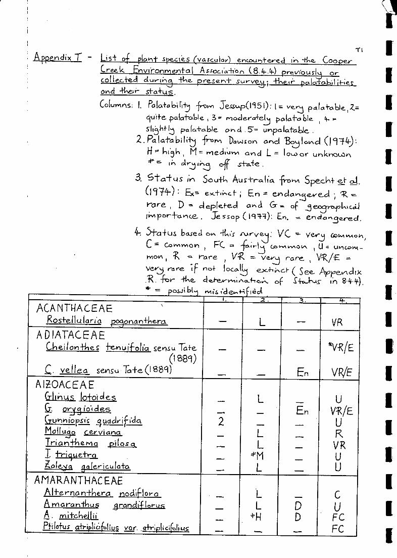
Appendix T Ls i- af fiont specs (vascular) eincou,-d-e-v-ed 4"2- CooperCreek Envfronnie.ni-al Associa-ifan (8.4-34-.) previous-1i orCollecteci duriti4 preszn+ sur-ved; pcilo-1-06li-l-ies.onel 4e sfa4us.
Coiumns: I. Palai-abirt -from Sessup(1951): I= ve....in4 p4ia4o.61e1Z=
9uife pa tat-0W e , 3' rnocie.ra+el oa(afa ble =sit6hf 1.3 pc, ic.+.bie. c 5 unpa Lai-able
2.Potlatabilt 0 Dawson and Bogotnc:i (1949:M= wiecli.uvv% ond L = Io orunknown
cArj(;-1.5 off
3. Stai-LAS iv 5ou4 Australl'a fro,A 0-1.
(197/) ex.-(; En = enclavle.ve.cirare, D Glepleked ce,ci _5eosymial,mcciiiimpor-l-ance..Jesop (199-3): E. --- endo,Berect.
4-. 5-1--a-fus basea ov.. 4Ls rurvej: VC ersj Clowi vv.°CComvvtoil PC. (5> vvN0 U in CO
hiOlA rare V race. ,
vvj rare (F no+ locabi.- ( Se Apre,,,d(x.-For he cie.i-eniina.-1-fo:.. of S-FrJ"%-tf in 8-44).
0b( -
Ii
I.1' .2. A. Li-
ACANTWACEAEN
Ros+el I u larl'a p4onan+kera, _ L VR
ADIATACEAE°lei/on-Hies fenuifolici sensu Tofe _
__
En VR/E
(1889)C. vellect seinsu To+e(1889)
AIZOACEAEGlIthus io+oides
2_
L
LL
L
_En
_
_
U
VVEURVRU
U
a or-15 io'r cies
C-rukinforsic 4uactriffclaMollujo cervianciTrian-l-kehia piloscl
i I -h-iluetraZole-sa 8 aiericuica+o,
' AMARANTHACEAE' Alfernon+hera nodiflora
___
LL
*H_
DD
C
UFCFC
A marardinus 3flancliflarusA. mitchelliiPfilofus a+riplic:ifolius var. cd-r;plicif.1.1,45

Pfilo-Fus le+ifolcusP rylurrciyiE obova+us var. obovai-usP poly StOChUS Var. po!iSteachus
AMAR'ILLIDACEAEColas-femme:A li..1±eumCrolum flacodumC. lu+eolum
APIACEAE (UMBELLIFERAE)caucus stock.idici+usErynglurn plan+agineurriE. supiiiurnTrachymene 51auc:Ifo1ia
ASCLEPIADACEAECinarichum floribundurnRh3charrherleSarcostem ma a us frale
ASPLENIACEAEPleurosorus rui-ifol(Ls
ASTERACEAEBrackycorne. campylocarpaB. ciliaris
ciliaris var. lanu3ino5aB. lineari loba
melanocarpeCalocept-lelu kriappii
platyce.pholusU.C_L_FIS nciro corpqC. cs vri bin Can-ft-1Q
C. erinaceaC. InispiciulaC. multi caulisC. porphyrog lassoC enti peda cunntin3karrliiC. mrnciC. +hespiclioidesChrysocoryne.aasilla_CraspeaCa ckrysmiti-laC. pleioce.phalaEp a Ites austr-cdis
5
4-
M/L
L_
EnFC
VRFC
VC
VR/E
PCVR
VR/E
VR/EVR/E
VCFC
VR/E.FCyeFC
FCFCVR
VRFC
3
5

13
Epaltes cunninshamiiErodiophyllurv, elderi6-nap1-10 hurn indict-DrG indutunnG-. luteoalburnGnephosis eriocarpaa folio+.Helickr.Nsunn ambi3uurn
apicula+urnR basedowiiH. podolepidCumH. semi-Fertile14 elip÷erurn corym 6i florumH. dem issumR f lori bundumH. t, I...r.osperm urn
rnicra3lossumH. moscha-furn
p+erochaetunnH. strici-u mH. +roe deliiH. unif forumI xiolaena brevi comp+a
lep+oierisLeptorhychos te+rackae+us
3reevesiiMinuria cunruh5hamii
dentic.L.dai-q
Ii... I ep+o pkyllariyida
Myriocephalus rudalliiM. stuartiiPluck ea rubelli floraP. fe+rantkeraPodolepis arcichnoidP canescens
cpiIIarisP rnuell eriPterocaulon serr-uIc1-uvyi
sphaceia-f-um
M
REnEn
VR/EFC
R
FC
VRVR/E
V R
V R*VR/E
*VR1E
VC
VR
V R
'WIVEVRIE
FC
VC
VRIEVRIE
VRIEV R
1
5
4-
4-
4-
5
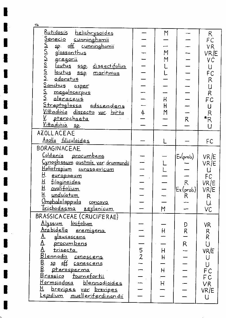
1"4-
Rutidosfs helichrysoidesSenecio cunnin8rrii
sp. /211 cunntnsharnifS. 3losson+husa gresoriiS. I autus ssp. di ss edifoliusS. !awl-, us ssp. morltirriusS. odorcri-usSonchus asper
me3alocarrusoleraceus
5+rep+09106sa adscen d en sYifacknia clissec.to yar.V. pi-erochae+aV iito
AMU ACE AEAzollo filiculoides
BORAGIN AC EAECoJci.i, procumbensCino3lo 5511m australe. var. drummonclii
eliotropium curassavicumH. europaeumH. fila9inoi desE. oval i.foliuH. undula+umOrnphQIoIappAIqcortcavaTri ckod es ma e,4lanicurn
BRASSICACEAE (CRUCIFE RAE)A IyssumAra bidella eremigenaA. sloticescerlsA. procum bensA. trisectaB I ennoclia canescens
12. 4 canesc enspi-erosperrna
Brassica fournefor-hiflormsiodoxa blenn odi oid e sH. brevipes var. brevipesLepiclium muelleriferdi man dii
4-
Ex(prob)
Ex (prob.)
FCV R
VRV C
FC
FC
R
FC
VRJEVRIE
FCVR/EVRIE
U.vc
VR
V R/E
FCF CVR
VR/E
52
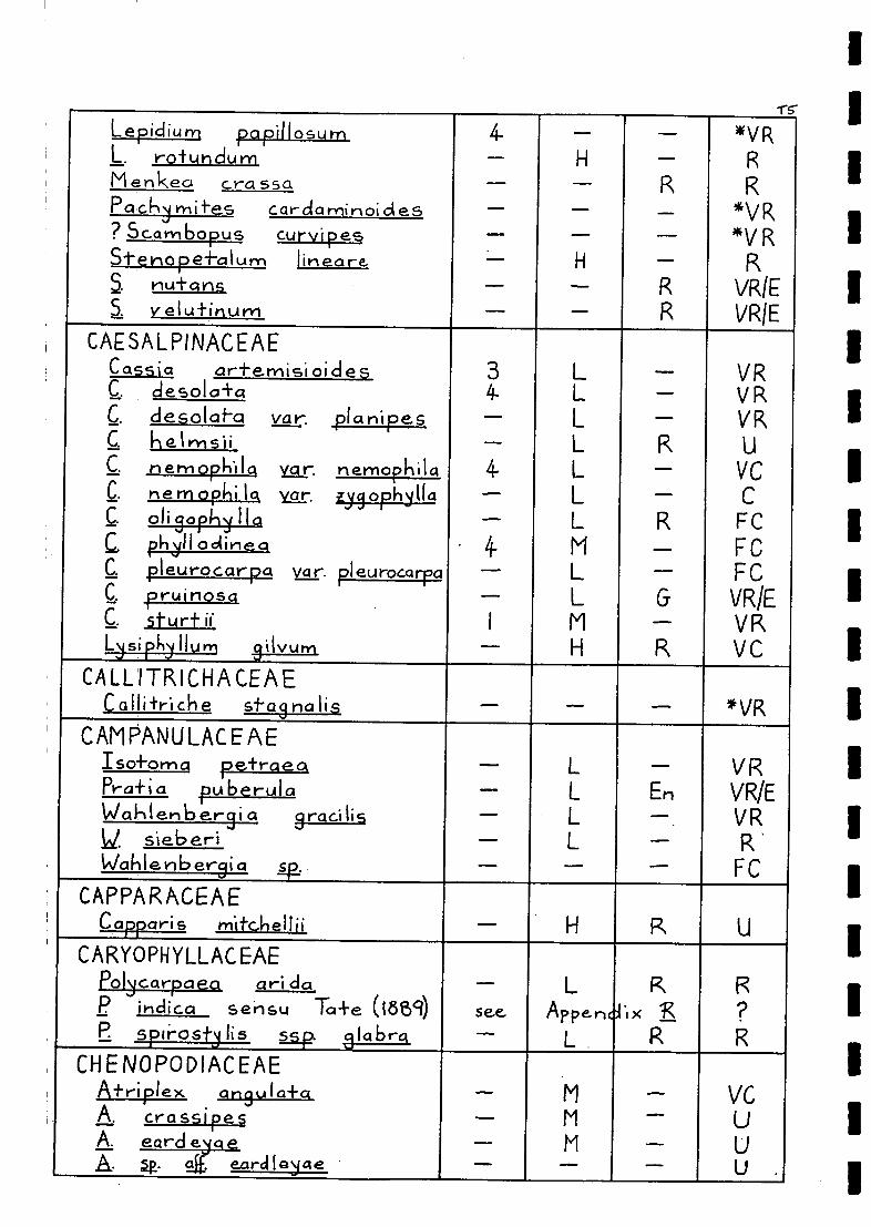
1
Lepidiurn papillosum 4-
_
*VRL. rotundurr H RMenkea Crass4 RPa chy n-lites cardarrirloicles *VR? Scambopus curvipes *V RStenopefolum Iiieore. H RS rlui___ _:ins_ R VRiES v elutinum _ _ R VRIE
CAESALPINACEAECassia ar+e-misi °ides 3 L VRC. clesola+a 4- L RC. clesolat-a var. planipes L - VRC hetrnsii L R LIC herylophila var. neniopkila 4. L VCC. r, e m o p I a icir. gnophylla L CC. olippllylla L R FCC, phyllociinea
. 4- M - FCC pleurocarpa pleurocarpa L FCC pruinosa L G VR/EC. stur+ ii I M VRLripkylluni 9ilvurn H R VC
CALLITRICHACEAECallitriche stag na lis *VR
CAMPANULACEAEIso+oma petraea L VRPra+i a puberula _ L En VR/EWakleribe.rsi a groc1li5 L VRid. sieberi L R 'WaIllenbergia sg _ FC
CAPPARACEAECapparis mitchellii H R U
CARYOPHYLLACEAEPolycarpa ea an i da _ L R Rp ihdica sensu To+e (i889) see, Appe.nclx
LR
R?RE spir.ostlis. sag lics_l_g)r.
CHENOPODIACEAEA+ri lex art ula+a M VGA crassipes M UA. eard e 11 _ U
u .A. .g. earclIGyae

1
Afr-i lex holocar a _
_____
M
LL
M
L
RU
*U*R
CUU
A sp. 4i holocaroaA. incrassa+a !
A. frif la-FaA. I ep+o car FaA. li hi b ataA, lindleyiA. loba+ivalvis _ _ En FCA. rnuelleri FCA numrnulari a _ H VCA. rho sodioi des 5 *R.6.. sponscoso 3/4 M VCA. vel u+inellq 5 VCA. vesicaria 2 M CBabbasia acropfera _ FCB. dip+-ero carpa 5 L UChanopodium auricornum _ *H R VCC crista-Eum 4
4M_
__ U
CC. 1-Iii-rari a ceumDissocarpus biflorus var. bifbrus _ _ UD bi-Florus var. cephal .ocarpa _ _ _ UD para adox var. lai-i-f-olius _ L _
UVFCD. pa radoxa var- pa radoxa 4 M _ VRDyspkania litoralis M R V R
inadia nu cans 3 M _ FCEnchikenct -i-onieri+os a 4 M _ VCHalosarcia halocrternoi des 5 Ivo_ D RIL iiiclica sap. Isiostackya 4 NVL D CMaireana aphil la 4- M CM ostrotricha R
vR/Eti. cilia+.II corortata _
11 _ CM. erianilia 2/1 _ VR/ELi georsei 2-4 M UM. en i crocarpo _ M ____ FC
py ra mi do-i-a.11 5 L _ UM. sedifolia 3/4- _ _ VR/EM alacoc.zra -i-ricornis L RN eobass Ca proceriflorQ _
M R Cgtiarclica saudickoudiana _ _ UE, splilescens 4- M U
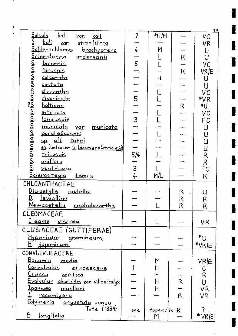
SaIsolck kali var. kalik al i Yar. 5-t-ro bi I f erck
Schlerochlam35 brachy pi-eraSclerolaeha andersoniia loicornis
bicuspi$Cal CCIrafa
S. COS+ CI fC1
di varica-Eckholti an aintr.! cal-aJanicuspismuricatay_gr. rfluriccataporallelicuspisp. ciff to+e.i
sp. (be+ween j c9-S.+ricusS.
pOi
triCUSpiSa unifloraS yen-1-r' co sctSclerostegia
S.
S.
tehuiCHLOANTHACEAE
cos+ellol2.Newca6+elia wkalac.arrfka
CLEOMACEAECleome viscose'
CLUSIACEAE (GUTTIFERAE)Hypericuni grarnirleum
jAporlicurn
CONVULVULACEAE13onami4 mediqCorwulvulus erubescensC ressci creticaEvolvulu alsiVioiclei var. villosi calyxIponiaea muelleriI.racemigerctPolymeria an3us1-afq sells u
Taie (1889)E 1ot-19i-folio
5
3
5/4-
3if-
+WM
H
L
L
Append
MIMMID
VC
VR
VC
VRIE
VCVR
*UVCF C
FC
VR
*u*VR1E
2
4-
5
VRIE
VRVR
*VRIE
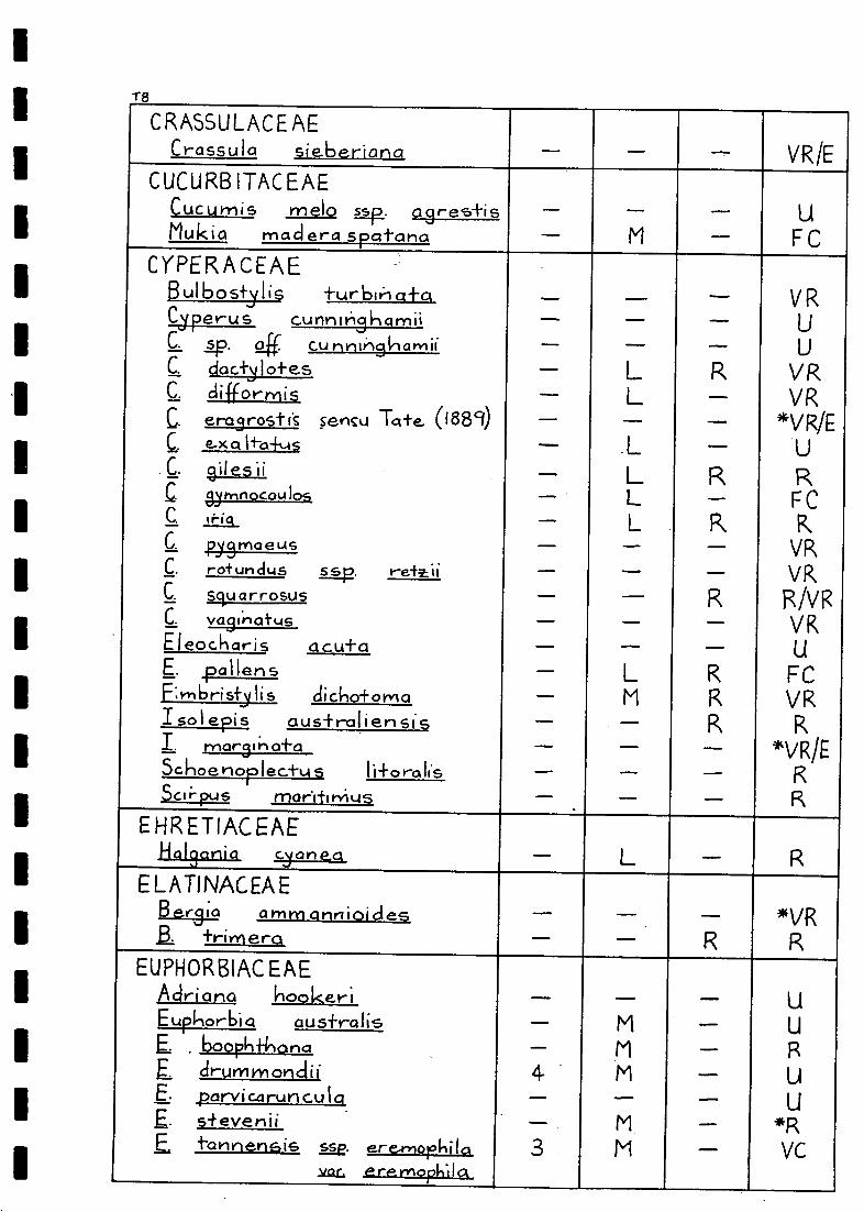
18
CRASSULACEAECrassula sieberiana
CUCURB ITACEAECucumis rnelo a9res+isMukia rnacl era spotana
C YPER A C EAEBulbostylisCjperus c.unnlyi3hamiiC. sp. g_ff. cuCC.
C.
e-x 1+-a-i-ui
C. gilesiiCsynnocou
trigC.
py3maeusIC. rotundqs ssp.
C. scluarrosusC. va9i.natusEleocharis acu-Fa
pollensF:mbristylis clicho+ornaI sol epis australiensisI. ry%ar3IrlaoSchoenorlectusScii-pus mar.1-firYius
EHRETIACEAEHalsartia cyanea
ELATINACEAEBe.r"ia amm annioidesa +rimer°
EUPHORBIAC EAEAdriatic, hooker;Eupkor-b1c aus-f-ralis
boopk+inanodrummonclii
E. parvicztrunculaE. s+evenii
tannensis ere,morkila212L, er8rnopkIck
VR/E
F C
V R
VsVR
*V IVE
FC
VRVRIVVRVR
FCVR
*VR/EIS
docty I oi-es
sensu (1889) .1111,11
difformiseragrost

Euphorbia vvlieeleri _55
_
M
M En
R
..UC
C
FCRU
Phyllantkus fuernrokrii.e lacunariUsF; se. saff. lacunortuspa maderacpafe.nsfs var. an3us+ifoliUs
at_5_ t ci-_m_As.FR ANKENIACEAE
Fronkev-tio angustii,e.+-alq En_ UE cCnereo _ RiEn. UE corda-fra _ *RE cupuior-iG R REcflisis_La *RE sraralia _ _ RE pseudo--la be Ilai-c4 _ En UF serpilli.foll'a 5 L UF uncina+a L FC
GE NTI ANACEAECentauriurn spico+urn
GERANIACE AEErodium aureut-n _ UE. crinitum H UE. cysnorLim 5Sp. cygnorurn 1
_ _ 4RE. L34 norum ssp glandulo$um I H PC
GOODENIACEAEGood en' a cyclop+erct 4 L RG fascicularis _ _ RG slauca R F CG. sp. gli havilancJii _ ua heterockila _ R RG lobata _ R UG lunat-ci En RLechenoultio " clivaricat.c; _ L R CScaevola aernula .
5: collar-is VRS. depaupercrha _ L R US. ova li-Foria _ L F CS. spt6escens L R
GYROSTEMONACEAECoclonocarpt:(s contInifolt *US 5 L D RGyrosternon . rarnulo sus L D VR
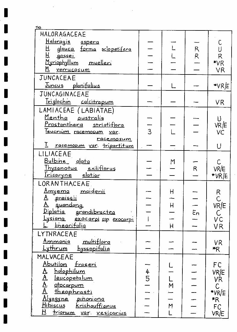
Tio
HALORAGACEAEH aloras is aspera
LL
_
RR
C
U
R*VRVR
El. sia.co forma sclopetiferali. e
Plyriophilluni muelleria verrucosum
TUNCACEAETuncus planifolius L *VRIE
TUN C AG IN AC EA E
Trislockin calcii-rapurn _ _ V R
LAMIACEAE ( LABIATAE)Menika oustralis _
_3 L
...._
_
_
UVR1E
VC
U
Pros ta ntk e ra stri ati-FloraTeucr Urn racemosurn vor.
raCe.relo su rv)T. race MOSum var. triparti+ U n1
LILIACEAEButbine alafa M_
__R
C
VR/E
VESIE
Thysano+us e.xiliflorusTricoryne ela-fior
LORAN THACEAE,Arnyema mai cleni.
I
H_H_
H
En
RC
VR1E
CVCVR
A preissii.A., luarician3Diplo+ia grandi bra c+eaLysiana exocarpi Lip exocarpiL. likeorifolia
; LYTHRACEAE, Ammar-tea mulfiflora _
__ VR
i*RLy+hrurri hyssopi-foli a
MALVACEAEAbuti Ion -Ira seri
45
_
L
LM
_M
L
_
FCVR/EVRC
*VR/EliR
FCVR/E
hi: halorkilumA Jeucope+alumA. ofocarpumA. +heophras-FiAlyo3yne. pinonianaHibiscus krichauffianus
, a 4-y-ionurncit_r. vesicariUs

Lavatera plebeici M
M
...
C
VRRC
Lawrencia 31or1 e nal-aMolvastrurn arneri 0:mum_Sicial .a mmophi la1 corrusa+a 4 M U/R5 cunntingliamii _ M R U/Ra. fiLulifera _ M U/RS. intri ca-ba 3
3RU, a §R. D
trichopocla 4 H U
MARSILI ACEAEMarsili a clrummonclii 214 M VCI . airsu+a 4 M En VRM. mutica *VR
MELIACEAEOwenie acidula H R
, MENYANTHACEAENy mpkoi cl es crena+a _ D VR
MIMOSACEAEAcacia aneura I H V RA. bracky stocky a I NI RA camba3ei L V RA. cyperophylk M UA dic-frphie 6a L R UA farnesianct _ H En UA. ligulia+a 5 L VCA. murrayana L VCL oswalcIii 3 M CA. ra mulos a . 4- M R RA: salicinn _
M CA.. stenopkylla _ M G VCA: +e.+ro3oncipt-vlia 4 H cA. vi utori at 14. arid 3 H FCA. vic.-foriae. 1sE. vicAbriae 3 H VC
RNep+unio din;lor-pkan+ka M En VR
I MYOPORACEAEi Erernophi la loignoniiflora H R VC
E clot- kei *VRIEE cict R R

I.
1
I.
1
112.
Eremophila dui+onli 4-
3I
3__4-
LLMM
H_LHLH
_
, -
VR1ER
VRIER
CF C
UCR
VRIE
E freellil3ii-1E1. glolDroE latrobeiL longifoliaE. mac clonnellii _
R__
E. rnoc3illivroyiE.. mac ulaf aE. obovoi-aNoporum ocumino-fum
MYRTACEAEEucCIlip-f-us comaidulensi.s var. okusa _
_
LM
L
L R
CVC
FC* VR/E
R
E micro+ilecoE. terrninolisM elo I euca glornercri-aM. Itheariifolio var. friclios-Facl-tycz
NYCTAGI NACEAEBoerliovia cliffusct _ H G VF
V RCommicorpu cklilensisONAGRACEAE
LucIwigi.o .p.__lsitilLes gp. mon-feviciertsis
__
_
__
F C
VRIE
VR/E
ORCHIDACEAEColo denia cleforrnisCyrnbicliurrt canoliculotum sv...nsu
Tcrte. ( fa8(1)
PAPILIONACEAEAesckynorYtene, ikclic _
I
4_
____4-
L/M
LH_
LL
LH
R
EnEn
En
En
U.V R
CVCFCU
VfRiE
VR/ERR
VRRUU
Cliani-kus -ForrnosusCrottilari a cunni.n31-1 a t-Ylii
C. eremoect ge. erervloeoC. smtilonoGlycl6e canescens
folco+oa tom en+osoIncli3ofero brevi aen sI. colu+eaI. linnoei
soi-ropis wkeeleriLo+u s crue_yrfus? Medicgs° poly I-nor-ply:1

I.
Psoralea austra las k.a _ _ _ F CP. cinerea MiL _ UP eriart+110 sensu To I -e (L881) -_ NIL -
_ UUE cL:La_p_I
P atens sensu Ta+-e (L889) _ MIL _ URkjchosi a rni'ni ma _ M En USes banjo canna bihct _ QM R ORSwcuilsona campy lan+ho. _
_ M___ VR
RS -F I avicarik cri-Q
S. lesser-Hi-folio R5_. rnicropkj I la _ M _ V R.a olisophy II a M V RS. or-oboi cies _ M _ F CS. pl-la cola es _ F Ca rigida _ R F CS. stivu la ris _ _ VRIE2Tepvtple+oni,a .2.3 en a 4- _ _ *LITephrosl'a sehaer-ospor-o.. _ _ R CTrirv-, e I I a suovi sc.' r;-, a I H F CVi3na I am eol crta H VS
PITTOSPORACEAEPiti-osporurn pkylli raeoid es 2 I-I/M 77' FCicK microca r pa
PLANTAGINACEAEP I an+a 3o turrifera _ _ *RP v aria _ _ C
POACEAEA 9 ro sti s avert ac ea _ _ F CA lopecurus se.Anic..Aia+us V RA risti (do a ni-l-toxo noicles 3 M _ FC
, EL br-owniana 4 M _V C
i L co rvi-ori-a 3 M CA. ramosa *VR?A, s+v-i5osA - - - VR
, A s-h- e-6I a I a ppc c.ect ....._ H _ UA. pechil a-fa 3 Ft C/VC___
Bo+kriochloa bloc! Iiii _ R *VRBrochiaria noi-bck-fhor,a _ _ _ VRBroollyackne. c;ili saris R VSCII I ori s pec+c, H R -

C loris scariosa
_LH
RR_
VRR/VR
R
Chrysopoyon {-cilia%
Cy nibopo3on 4.Cynocian claci,iloh H F CDactyloc+eniUrn radulans 2 H F CDichoti-ki urn affit:,e H R RDi p-ari a a m mophi la _ H _
'KR2 brown ii _ H _ VRDi Flack ri e -Fusca _ _ PCEckInockloa crus-3alii _ _ _ V RE 'nu r6±° _ H R F CEnneapo3on avenaceus 2/I H _ CE cylinciricus 3 _ _ U
E r-s3ri cans N _ V R5_. polypi-1.314-4s 2/1 M UE ni-eP-o po3on acicul a ri s H V REragrosfls austra 14 sicq 4- M _ C
_E. basedowli M R UE. confert.ifolio _ M R V RE clietsli I H _ C
. E. eriopoda 4- M _ R CE falcoto 3 V RE japonica -7 - V R.E leptoccirpq M U
cirv , .oraE p i-C-I_ M V R
E se-hfoli a 2 M _ VCE. speciosa - R UE xer-opkila _ H R VREria chhe arisi-idea _ M CE. ova-f-a ___ ___ - VREriochloa pseudo -acroi-ri cha H UEulatia fulva I H _ RIseletnia me.rnbranace.uhn 2 H _ V RLeptocIlloa diTria+a M R FC? PO ri L4 rrl aus-hlakerlse L R "VIVEE clecorvIpoi.14-upyl 3 M FCP whit-ei M R UParac-Faenurn novae- hollandia P. - L _ UPaspalidturn grac.Ale _ *VRPerot is rara _ L _ *VR/EPla9iasei-LiPn refro chin-, 3 H F C
1
1

TicSporo6otu5 CIC1-11.-10C1c1Clui6
S. coroliS
S. v91i-licusS+ipck serniborbataTkemecIct aus+r-alisTragus australianusTriodiabaseclowiiTripo3onTrirapkis mollisZyciochioa .parocioxq.
POLYGONACEAEMueklenbeckCa coccoloboicles
cunninghamiiPolysonum a-H-enuarfum
plebeiurnRumex _c_r4s+allinus
PORTULACACEAECalandrinia balonensisC. eremaectC_. polyanclraC. ptyckosperrnaC. remoi-aPortulacct livi-ra-ferraneae. ofertrace.ci
PR OTE A C.
Grevillea p+erospermaG steno boi-rytG striai-aH a kea eyrecing
or_jiH. leucoptera
RUBIACEAEAspe.rula 3emelloDen+elia pulviria+0 var. pulvtina+aSyriopfantha till-aeacea
SANTALACEAESan-folurn lanceolafung
SAPINDACEAEA-foie:43a Inenni3laucq
3
3
2.
En
En
Pt
MlIM
V R
FC*R
*VR/EVRFCVC
VC
VCVR/EFC
C.
VR
VC*VR
*VRiEFC
FCV R
FCFC
VC

Dodonaea ungustissimamicrolygaVISCO5C1
Heterociendrurn oleoefolfurn
SCROPHULAR IACEAEGlossosti3m4 clianclk-umM mulus gracifisti prosfratusklorgarlio floribundaIi 3106r0Peplicii6n, AR. D
SOLANACE AENi excelsiorN. yeu-fjnaSoIarium ckenopociiumS ellip+icurnS. esuria leS. oli3acani-kumS. sturti a hum
STERCULIACEAEKerou drinioMelkohl'a oblonsifolig
loxopky16
TETRAGONIACEAETetro3onio +e-frasoni oi des
THYM ELAEACEAERrilelea microce pho IQ
siMplex asp_. coni-tnuaPsimplex_ ssp. srñplex
+rickosi-achyo
VERBENACEAEVerbena bonariensisye mocroci-ack,ya sensu Tote (188q)V. officit;lal is
V1OLACEA E
ftjbanthus monop e+a I u s
ZYGOPHYLL ACEACNi+rari a bi Hardier;Tri6ulus kystrix
4-
1
A pre-nch.x
En
1111M
VRIE
VR
VR
FCFC
*VRVC
VR/E
V R
viVE
VC
VS
VP'
'AR
FC
V R

Tr. bulus occidentaliE ...._ L CT +errestrii 2 H UZygorkyll um ammopkilum 4- L CZ. purantiacum 4- RZ. }Di Ilardieri *VRIEZ. creno +um 4 VRIE
Z. 6owi-14ii L F CZ. iodocorpum 4- L U

Appendix V.
Preliminary identifications of theaquatic invertebrates collectedduring the survey of 8.4.4 - by
the Biology Laboratories of theE. & W.S.
W1

W2
LABORATOY WORK SHEET
FLki:/%1 ilj39
,
rI
,
,
,
I .
coopT./ .
Z.
3
4
S..
6.
7
a,
/ I')
Cter7K
Near
se ....k,
7; kitAW
SC s.c.4.3
r- PI
eh
P lo
T 1 menw4
a
LI
A
4.?
11 A P
0,0146
..
II . 639
CIL . ,
1(/ .il I.
w......-
Comb
Aof Wirrce
Carl,
A.1'
...
0 j/be I..
SheC.',v I
til Skeppnil.
.../ .f-r,....
L. eke
We i
0,
We i
so, fa fs,
Wake,.
i ol ri 0
chi,
ko I. Al. ..
S/N,i
t (çø.kenjewAot,
ev h oh.Spy
0 4. a
5/ IV
4..1-4
i fo.s...
S s.C. v4
P.
Si A/
"lei,.
'01/4 A if
rt,:La.+ 0 0-t...
At .
SY ni
r- .Se://1/
. 'W41
f v
y . K.- .
VA's'.
9.
4_1. i x.
1.-7. ;Ie.$1,.1)
27 . ; )(
30.1
i'v...i.)
P ?.
r ?
r ?
ir 1
t 7
Ve
.
hit CI.
I
I
I
I
II
I
I
I
I
111
i1
1
1
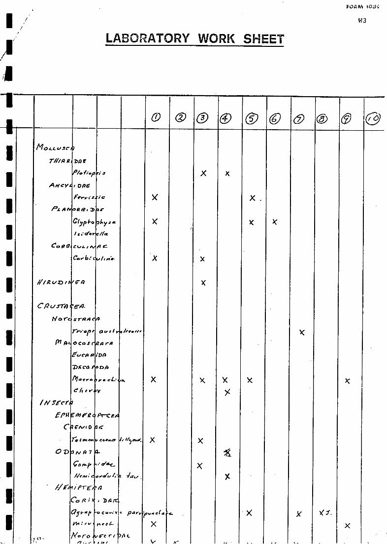
LABORATORY WORK SHEET
FØ2M ioac
W3
W C ) 4 C ) 0 0 0 0 0 0 0
I
II
I.
IIIDxca
MOLLUSC
rlito R
ANCY
P2.14
CoRO
Ill 02 C., DI
cpc./.rrA
Nor
1)7 A
/IV SECr
!P14
C
0 7)
Ile
? <1
DP r
':::: RIEi°P
Frey ; .1.4.:
-4263.2)
clypi-o
/ ci'ci.rv//cs
ccoLlivA
Cor.b: Ou
Ea
E.1.
x TRA 0/4
rreer"0 CoS rp
tuCia 12
P
MaCV0
C'Aebe
E'lv( D
ra:Man
A 7
con..?
Hem;
i errCO g ;
(21va I,
144:ev
No ro,7 . - .
6 jC
as-
24y, a
E.
I, to.a.
0 u , l
a rA
(DA
DA
per el:
v
g-
CedPHIO
.* olo-C-
res(u I.'
a
# DA
co.er
tiee4-
rerr141
iittNef,
/0 d'i4041.
c paev,,,,c(
)A 4...
..:,r_
X
le
.
. - .. -
)(
.

FORM 108I
LABORATORY WORK SHEET
I
0 0 0 0 .0 COO 0, ( 3s AD/Pre.gA.
CAM& MO ii. eb
akdai,-,h7,.ei,..co
AIC
,..... x.
X
x
I
Ir......1.0e.*Col
i
a
ClilgOIVOnfi MAEi
7131411-, AZI:IVI.
1 rml4ao-, " X 104 v 4. XCAI( g °We $4,1ve
fel, prd.D;cwo
h.s...
(to, 06.
X I10.0...../.., ..1-4..k,.c.,.. (?) I
C.Ifearo feed (4./:3)/4C .
CO LEO p-reg AI
1
1
Dy r i.re, a ic.. I33,, 4 ts . g X6.-el,,al,a;ro
4..4.4., .1
-,
eel,'
X+4 k
' .8E4
ii7
0/Gel
P
V VIC
ir e Gr
/parIS-Trrlio
Oct I X. ie ,..1 X
I

111111111011121111111111111111101111111101111111111111111011111111111141111111111111111111114

Vi'
APPENDIX V
GAZETTEER
Akalanna Crossing . . . 28°55'S, 140008'E
Apanburra Channel . . . 27002'S, 140005'E
Barcoo River, Qld . . . 24°18'S, 145°14'E
Barkly Tableland, NT . . 19027'S, 137°05'E
Big Lake Moonba . . . 28020'S, 140921'E
Birdsville, QId . . . . 25°54'S, 139°21'E
Birkett's Woolshed. W.H. (=Chilcarrie W.H.) . 28959'S, 140004'E
Boggy Lake . . . . 27°30'S, 139049'E
Bookabourdie W.H. . . 27033'S, 140929'E
Bradys W.H. . . 26053'S, 140°37'E
Brolga #2 Well Site . . 27036'S, 140°00'E
Cadelgo Downs . . . 26°05'S, 140024'E
Callamurra W.H. (=Kullamurra) . 27042'S, 140052'E
Candradecka Creek . . 27°10'S, 140047'E
Cartoonganie W.H. . . 27011'S, 139052'E
Chillimookoo W.H. . . . 27°24'S, 139°58'E
Christmas Creek . . 27o14'S, 1390.52'E
Clifton Hills . . . 27°01'S; 138°54'Eo
Cobbler Sandhills . . °00'S,. 2913945'Eo
Coongie (Ruin) . . . 27°11'S, 14009'E
Coongie Lake . °11'S, °10'E. 27140o
Coongie W.H. . . °11'S,2714009'ECooper Creek . . °15'E. 27o44'S, 140
Coorambalapinna W.H . 26°53'25"S, 140031'55"E
Cooramunchena W.H. . . 27°45'S, 139°32'E
Coque W.H. . - . . °10'E. 28o46'S, 140
Cordillo Downs': . . . 26°42'S, 140°37'E
Currareva, Q1d-- ,.°44'E. 25o20'S, 142
Cuttapirie Corner W.H.. . . 27°36'S, 139°54'E
Cuttapirie Field (petroleum) . . 27°141S, 140°22'Eo
Dalhousie, .. . . . . 26o28'S, 13529'EDaralingie Field (petroleum) . 28°22'S, 139°58'E
oDaralingie Well . . . 28o24'S, 14025'E
oDarbyi W.H. . . . 27o31'S, 13952'EDerawalkillie W.H. . . 27°14'S, 140°33'E.
Diamantina:River . . . . 26°111S, 139°24'E
Dickinna Hill . . . 26°43'S, 139°53'E
Durham Downs, Qld . . . . 27°05'S, 141°54'E
Eagle Hawk W.H. . . . 27°56'S, 139°24'Eo
Embarka' Swamp . . °09'E. 2738'S, 140Embarka W.H. . . . 27°41'S, 140°12'E
Farina (Ruin) . . . 30°04'S, 138°17'E
Fly Lake . . . . 27°35'S, 140°00'E
Fort Grey Depot . . . 29°05'S, 141°12'E
Gidgealpa . . . . 27°41'S, 140°12'E
Gidgealpa W.H. . . . 27°50'S, 140°09'Eo
Goyder Lagoon . . . 26o46'S, 13908'E
Haddon Downs . . . 26°21'S, 140°50'E0
Innamincka . . . . 27o44'S, 14046'Eo
Innamincka (Ruin) . . . . . 27o45'S, 14044'E
Kanowana . . . 27°51'S, 139°38'Eo
Karawinnie W.H. . . °42'E2712'S, 139
Kernacoopina W.H . . . . 27°20'S, 139°53'E
Killalpaninna . -. . 28°36'S, 138°33'E

V2
Nappa Merrie W.H., Qld 0=Nappa merrie W.H-, Qld, Nappa Merry W.H.Qld) . . . . 27o36'S, 141606'E
King Lookout . . 2e56'S,Koodlanie Well . . 26o44'S,
Koonchera Dune . . 2e44'S,eKopperamanna . . 24O'S,
146°38'E140326'E1e31'E13e 42'E
Kudiemitchie 0.S. . . 271°22'S, 14133111E
Kudriemitchie W.H. . 27°21'S, 14e1l.r.E
Kullamurra (see Callamurra)Lake Apachirie . . 27°11'S, 140°07'ELake Apanburra . . 27001'S, 140°04'ELake Appadare . . 28°13'S, 139°12'ELake Blanche . . 29°14'S, 139030'ELake Callabonna . . 30°03'S, 140°08'ELake Deception . . 26°54'S, 140°17'ELake Etamunbanie . . 26°16'S, 139°42'ELake Eyre (Sth) . . 29°20'S, 137°20'ELake Eyre (Nth) . . 29°02'S, 137°20'ELake Goyder . 27°00'S, 140°10'E
Lake Gregory . . 29°01'S, 139°02'ELake Hope or Pando . 28°23'S, 139°17'ELake Hope (Ruin) . . 28°23'S, 139°15'ELake Lady Blanche . . 27°02'S, 140°21'ELake Marrakoonamooka . 27°39'S 140°04'ELake Marroocoolcanie . 27°111S, 140°13'ELake Massacre . . 27°20'S, 140°06'ELake Moorayepe . . 26°21'S, 139°59'ELake Oolgoopiarie . . 27°08'S, 139°52'ELake Padriepooreninie . 26°38'S, 140°07'E
Lake Perigundi . . 27°47'S, 139°24'ELakes Crossing . . 29°30'S, 139°55'ELake Speckman . 27°38'S, 139°48'ELake Toontoowaranie . 27°06'S, 140°10'ELake Warrakalanna . . 28°12'S, 139°19'ELake Warra Warreenie . 27°03'S, 140r)171E
Lake Willara . 26°44'S, 140°06'ELeigh Creek . 30°29'S, 138°25'EMalagarga, Qld . . 26°22'S, 142°17'EMarianna W.H. . . 26°45'S, 140°52'EMarree . . . 29°39'S, 138°04'EMerty Merty (=Murtee Murtee, Murteree, Murta Murta) 28°36'S, 140°16'EMickiepooloo Hill . . 26°30'S, 139°58'EMinkie W.H. . . 27°47'S, 140°39'EMinnie Downs (?=Clifton Hills) . 27°01'S, 138°58'EMoomba . . . 28°07'S, 140°12'EMoonlight Flat . . 27°29'S, 139°47'EMudcarnie Creek . . 26°55'S, 140°31'EMudcarnie W.H. . . 26°51'S, 140°32'EMudcarnie Well . . 26°50'S, 140°34'EMudlalee W.H. . 28°17'S, 140°28'E
Mundibarcooloo W.H. . 28°24'S, 140°13'EMundil Bore . . 28030'S, 14050'EMundowdna . . . 29°44'E, 138°14'EMungeranie . . . 280011S, 138°40'EOoranie Creek . . . . . 27°47'S, 140°36'ENappa Coongee (- Nappa Coonie W.H., Nappaoonie W.H.) 27°41'S, 140°36'ENappa Merrie, Qld (=Nappamerrie, Qld, Nappa Merry, Qld)
. . . . . . 27°36'S, 141°06'E

V3
Narrawalpinna W.H. . . . . 27050'S, 139°29'ENorth West Branch (of Cooper Creek) . . 27°30'S, 140°09'ENowrie Crossing (see Straw Bridge)Nullarbor (Plain) . . . 31°06'S, 131°15'EPandie Pandie . . . 26°08'S, 139°23'EPatchawarra Bore . . . 27021'S, 140°41'EPitalchilpna W.H. . . 27056'S, 139026'EProvidence Creek . . . 26030'S, 140027'EQueerbidie W.H. . . . 27°45'S, 140°43'ERoxby Downs . . . 30°42'S, 13e°461EScrubby Camp W.H. . . . 29039'S, 14002315Simpson Desert . . . 24°52'S, 134°10'EStokes Range, Qld . . 28°40'S, 141°13'EStraw Bridge (=Nowrie Crossing, 19 km NNW of Embarka W.H.)
. . . 27°33'S, 140°06'EStrzelecki Creek . . 28°23'S, 140°23'ETambo, Qld . . . 24°53'S, 14e°15'EThomson River, Qld . 24°35'S, 143°11'E
Tinga Tingana (=White Catch) . 28°48'S, 140°10'ETirrawarra Field (petroleum) . 27°38'S, 140°09'E
Tirrawarra Swamp . . 27°24'S, 140°08'E
Tirrawarra W.H. . . 27°26'S, 140°09'EToolache W.H.7. . . 28°21'S, 140°25'EToonman W.H. . . . 27°25'S, 140°04'ETooroowatchie W.H. (= Toorawatchy W.H.) . 27°02'S, 140°39'EWancoocha #1 Well Site . 28°32'S, 139°58'E
Warburton Groove (Lake Eyre) 29°02'S, 137°20'EWaukatanna W.H. . . . 28°04'S, 139°16'EWhite Lake . . . 27°37'S, 139°21'EWindorah, Qld . . 25°25'S, 142°39'EYalcuma W.H. . . 27°57'S, 139°23'E

1111111.1
MIN
NM
11.111111
11.1IM
E I=
EM
I MB
OM
Mil
NIB
OM
11111an

1 ' 73,74 75 76 77 78REFERENCE NUMBER"COLUMN .7374:. lObépt.. EnNi.& Planning Library
:20. Barr-Smith Library
coLuriN. 75=78 Unique reference numberCOLUMN.79.AZI0EaCh,ki.ne must be numbered
YEAR,AUTHOR(S):
FtEF-EFCENICE SHEE -r
30 State Library-.40 Keith CasperSon
or NPWS Data Store!
'-' '
KEY WORDS: (SPECIES MNEMONICS) -Al.
HIGHLIGHT OTHER RELEVANT KEYWORDS4RON. THE FOLLOWING LIST ALTHOUGH MOST KEYWORDS ARE SELF EXPLANATORY THE FOLLOWINp..
REGIONAL CODING$ HAVE BEEN ADOPTED: AP - ADELAIDE PLAIN;. EP - EYRE PENINSULA; KT - KANGAROO ISLAND; LN -- LOWERAORTii;
M:.11 - MOUNT LOFTY REGION; MM - MURRAY MALLEEI.NE. - NORTH EAST; NW - NORTH ' WEST; SE - SOUTH EAST; YP - YORKE.PENINEULA; IIFR - FLINDERS RANGES; MO - MARINE OFFSHORE; 0 --OCEANIC; (AREAS ARE SHOWN ON MAP PRODUCED BY THE SOUTH AUSTRALIAN :
ORNITHOLOGICAL ASSOCIATION, IN: A- FIELD LIST OF BIRDS OF SOUTH AUSTRALIA, 1980.
II.:., _THESAURUSAS OF SEPT-1-82)
ABORIGINES AMPHIBIANS AP AUSTRALIA BATS BEHAVIOUR BIBLIOGRAPHY BIOGEOGRAPHY BIOLOGY BIRDS BOOK BREEDING. CONSERVATION
DISEASES DISTRIBUTION DOVES ECOLOGY ENDANGERED EP FALCONS FAUNA FERAL FIRE FLORA FOREST FROGS GEOLOGY GRAZING. HABITAT' -
HABITS HAWKS HONEYEATERS HUNTING. INSECTS ISLANDS KANGAROOS NI LIFE- HIETORY LIZARDS LN MAMMALS MANAGEMENT MARSUPIALS.
MLR MM MONOTREMEE MC NEW GUINEA NEW NE NSW NT NA OWLS 0 PARASITES PARKS PARROTS PESTICIDES PHYSIOLOGY PIGEONS PLANNING.
POPULATION OLD RAPTORS REGENERATION REPRODUCTION REPTILES RESERVES REvIEW RODENTS SA SE :37AM TAE TAXONCmY TECHNIEUES
TEMPERATUR THESES TOOTH VEGETATION VIC. WADERS wALLABIES WATERBIRDS WA WETLANDS WILDLIFE YP
NEW KEYWORDS) :
TITLE:111
PUBLICATION (CALL NO. ) :
ABSTRACT:


I 000307711
502.33(94285) 'Append. 'B'
MOLMOLLENMANS, F. H.Biological 'survey of the
_Cooper Creek environmentalassociation (8.4.4)., NorthEastern South Australia.Prep. for SA NPWS.
Th

110.11111210110