department of lands, planning and environment
TRANSCRIPT

Department of Lands, Planning and Environment

Foreword
Part 1 - Planning Concepts of Coomalie Planning Concepts and Land Use Objectives 2000 supportsthe Northern Territory Government’s vision for Coomalie for the next 20 to 25 years. The PlanningConcepts provide the direction and stimulus for public and private developers and the consentauthority. This should facilitate the development of Coomalie in a manner which preserves its ruralnature while recognising opportunities for continued development at a sustainable level.
Part 1 - Planning Concepts provides the background information to Part 2 - Land Use Objectives. TheBatchelor Division of the Northern Territory Planning Authority has been directed, and it is intendedthat any future Coomalie consent authority will be directed, to take the Planning Concepts into accountalong with those matters listed under the Planning Act 1993, when considering a developmentapplication.
Part 2 - Land Use Objectives of Coomalie Planning Concepts and Land Use Objectives 2000 containsthe land use objectives which have formal status by virtue of declaration under section 8(1) of the Act.Part 2 - Land Use Objectives establishes the framework for planning control within the Coomalie Sub-Region. To achieve this, land use objectives are provided under Key Objectives for the entireSub-Region and under Land Use Objectives for specific land uses. The general discussion of issuesassists in interpreting and implementing the objectives.
The Coomalie Planning Concepts and Land Use Objectives 2000 aim to provide a co-ordinated andstrategic approach to land use planning in Coomalie. In due course, the NT Planning Scheme Coomaliewill apply to the entire Coomalie Sub-Region and parts of this Scheme will translate the land useobjectives into planning practice.
As with any planning document, the Coomalie Planning Concepts and Land Use Objectives 2000 willbe subject to ongoing monitoring and review.
TIM BALDWINMinister for Lands, Planning and Environment

Coomalie Planning Concepts and Land Use Objectives i
Contents
BACKGROUND ________________________________________________ 1
Introduction 1
Purpose and Status 1
Public Consultation 2
PART 1 - PLANNING CONCEPTS__________________________________ 4
1.1 Context 41.1.1 Historical Background 41.1.2 Population Growth and Future Prospects 61.1.3 Existing Land Use Patterns 8
1.2 Evaluation of Planning Base 131.2.1 Water Resources 131.2.2 Land Resources/Capability 141.2.3 Biting Insects 151.2.4 Heritage 161.2.5 Land Tenure 161.2.6 Infrastructure and Services 17
1.3 Land Use Concepts 181.3.1 Batchelor 181.3.2 Adelaide River 191.3.3 Dam Catchments 201.3.4 Finniss Catchment 201.3.5 Adelaide River Catchment 21
Attachments 22Attachment 1 Reference List 23Attachment 2 Development Guidelines for Biting Insects 24

Coomalie Planning Concepts and Land Use Objectives ii
Figures 25Figure 1 The Coomalie Sub-RegionFigure 2 Water CatchmentsFigure 3 Ground Water Supply ProspectsFigure 4 Geology and Mineral PotentialFigure 5 1.0% AEP (1 in 100 year) Flood Event - Town of
Adelaide RiverFigure 6 1.0% AEP (1 in 100 year) Flood Event - Adelaide
River CatchmentFigure 7 Historical SitesFigure 8 Archaeological SitesFigure 9 Land TenureFigure 10 Sub-Region Locality PlanFigure 11 Land Use Structure PlanFigure 12a Town of Batchelor Concept Plan (Regional Area)Figure 12b Town of Batchelor Concept Plan (Town Insert)Figure 13 Town of Adelaide River Concept PlanFigure 14 Road Hierarchy
Coomalie Planning Concepts and Land Use Objectives iii
PART 2 - LAND USE OBJECTIVES _______________________________ 27
2.1 The Vision 27
2.2 Intended Outcomes 27
2.3 Key Objectives 27
2.4 Land Use Objectives 282.4.1 Tourism 282.4.2 Horticulture and Agriculture 282.4.3 Mining and Extractive Industry 292.4.4 Commercial 292.4.5 Industrial 292.4.6 Residential 302.4.7 Health and Community Facilities 302.4.8 Transport and Infrastructure 302.4.9 Water Resources 302.4.10 Conservation 312.4.11 Open Space and Recreation 31


Coomalie Planning Concepts and Land Use Objectives 1
BACKGROUNDIntroduction
The Darwin Regional Land Use Structure Plan 1990, published as planning anddevelopment objectives for the Territory, established the policy framework fordevelopment of the Darwin Region for a population of one million people. In thatdocument, Coomalie was recognised as a Sub-Region of considerable importance to theDarwin Region, particularly with respect to its valuable mineral and water resources. TheCoomalie Sub-Region includes all land within the Coomalie Community GovernmentCouncil boundary which covers an area of approximately 1,500 km2 and includes thetowns of Batchelor and Adelaide River. The boundary extends from Manton Dam in thenorth, to the town of Adelaide River in the south and east from the Adelaide River itself,to Litchfield National Park in the west. The location of Coomalie within the regionalcontext is shown in Figure 1.
In the last decade or so Coomalie has also become a significant contributor to the growthand development of the Top End in such areas as tourism, education andhorticultural/agricultural activities. The increased intensity of development within thearea is already showing signs of potential for land use conflict. In view of this, theNorthern Territory Government has recognised the need for an established planningframework for Coomalie from which greater control can be exercised to ensure effectiveland use planning. However, it should be noted that the objective of the planningframework will be to plan and control new development within the Sub-Region, but notto make any proposals to alter or remove any established land uses within Coomalie.
Purpose and StatusIt is intended that the planning framework of the NT Planning Scheme Coomalie willinclude the Coomalie Planning Concepts and Land Use Objectives 2000, developmentguidelines and a control plan. The development guidelines may be generic to coverstandard development control issues across the Darwin Region, such as guidelines forrural residential subdivision/development or may focus on particular issues withinCoomalie. Until now, land use control within Coomalie has been restricted to the areacovered by the Batchelor Town Plan 1981 and the Highways Control Plan 1984 andsubdivision of freehold land (which requires Ministerial consent). In March 1999, acontrol plan was made for Lake Bennett and a control plan was exhibited inNovember 1999 for an extension of the Lake Bennett area.
These Coomalie Planning Concepts and Land Use Objectives establish the legislativeframework for planning control within Coomalie. The second part of the document, Part2 - Land Use Objectives (LUOs), has been declared by the Minister for Lands, Planningand Environment as a land use objective, pursuant to section 8(1) of the PlanningAct 1993. The LUOs provide the framework for developing Coomalie in a manner whichpreserves its rural nature whilst recognising opportunities for continued development at asustainable level. The LUOs also focus on the important role that Coomalie will play inthe future development of the Darwin Region, due to natural resources, including mineraldeposits and water supply, and as a prime location for tourism, horticulture/agriculture,education and rural living. A control plan will be prepared to provide more specificcontrols in the use and development of land in Coomalie.

Coomalie Planning Concepts and Land Use Objectives 2
The first part of the document, Part 1 - Planning Concepts, provides the backgroundinformation to the land use objectives by identifying the major land use and developmentissues within Coomalie. Although Part 1 of the document will not have formal statusunder section 8 of the Planning Act, it is intended that the Minister will direct the currentand future consent authority to take the Planning Concepts into account in thedetermination of a development application. Until a control plan is introduced forCoomalie, the Northern Territory Planning Authority for Batchelor has been directed,pursuant to section 67(3) of the Planning Act, to take the Planning Concepts intoaccount, along with those listed under section 51 of the Act, when considering adevelopment application.
It is important to note that the planning issues and land use considerations for any areaare subject to change with the availability of new information and also due to thepressures associated with new development proposals. Therefore, it is envisaged that thisdocument will be subject to periodic review, as needs arise and resources permit.
Public ConsultationA Steering Committee was formed to assist in the preparation of the Coomalie PlanningConcepts and Land Use Objectives 2000. The Steering Committee included arepresentative of the Coomalie Community Government Council and representatives ofrelevant Government agencies.
The Proposed Coomalie Planning Concepts and Land Use Objectives 1998 wereexhibited pursuant to section 8(2)(b) of the Planning Act and all public submissionsreceived in response to the exhibition process were taken into account in finalising theland use objectives, for declaration by the Minister.
An Interim Development Control Order for the Coomalie Community GovernmentCouncil area came into effect on the date the Proposed Coomalie Planning Concepts andLand Use Objectives 1998 were publicly exhibited and lapsed on 9 September 1999. TheInterim Development Control Order listed specific development and land uses thatrequired the consent of the Minister.

Coomalie Planning Concepts and Land Use Objectives 3
PART 1 - PLANNING CONCEPTS

Coomalie Planning Concepts and Land Use Objectives 4
PART 1 - PLANNING CONCEPTS1.1 Context
1.1.1 Historical BackgroundThe following historical background of Coomalie has been documented by the NationalTrust (1998) for the Department of Lands, Planning & Environment (see reference list).
Aboriginal HistoryThe original inhabitants of Coomalie were the Aboriginal tribal groups of theKungarrakan and Awarai (Warai) people. The boundary of the traditional land of thesegroups passed through the existing town of Adelaide River and included the area of thepresent Wagait Aboriginal Reserve and north to the Finniss River. The Kungarrakanpeople were generally associated with the area from Mt Finniss east to the existing StuartHighway. The Awarai people were associated with the area from Stapleton to AdelaideRiver. A third group, the Maranunggu, were originally from the Daly River region butgravitated north over a number of years towards the Batchelor area. Many otherAboriginal groups have resided and in some cases still reside in the area, such as theMuluk-Muluk, Wadgigan, Brinkin and Djerait groups.
There is little information on the history of Aboriginal occupation of Coomalie and itwas not until an application was made under the Aboriginal Land Rights (NorthernTerritory) Act that the stories, origins of place names and associations were broughtforward with regard to areas which included Batchelor, Rum Jungle, Adelaide River and,more specifically, Meneling, Castlemaine Hill, Crater Lake and Snake Creek.
European HistoryThe first significant European activity in Coomalie is attributed to George Goyder whoseparty was responsible for surveying town and rural lands from Palmerston (later renamedDarwin) to Adelaide River.
In 1869 the Overland Telegraph Line commenced construction to link South Australia toPalmerston. Adelaide River became a depot for the telegraph line workers and it wasduring construction of that line in early 1872 that gold was discovered in the Pine Creekdistrict. The resultant rush led to the establishment of the township of Southport on theBlackmore River, as this was the nearest navigable point for ships which supplied theOverland Telegraph Line and the goldfields.
Adelaide River grew as a convenient resting place and river crossing and became thestop for the Haimes Royal Mail Coach which travelled from Southport to the goldfieldsin the early 1880s. The Adelaide River police station was erected at the river crossing in1879.
In 1886 a contract was signed to construct a railway line from Palmerston to Pine Creek.The railway was completed in 1889 and Adelaide River became a major station. Thesuccessful operation of the railway saw the demise of the Southport coach service.

Coomalie Planning Concepts and Land Use Objectives 5
Coomalie saw the growth of a number of agricultural enterprises from as early as 1881.However, the only real success came with the orchard and gardens at Rum Jungle whichoperated almost continuously from 1910 to the 1950s. In 1911, the CommonwealthGovernment selected three sites for demonstration farms, one of which was located atRum Jungle and named Batchelor after the Minister for External Affairs, E L Batchelor.
The mounting international crisis of the late 1930s increased the importance of theCoomalie area in a strategic sense. Adelaide River’s role in the war began in December1939 when the town and surrounding district was established as a farm and rest area forservice personnel based in Darwin. In 1940, the RAAF resumed the area surrounding theaerodrome at Batchelor which had been established on part of the former demonstrationfarm. A gravel runway was constructed shortly afterwards and it was from here that thefirst offensive mission was launched from Australia following the Japanese raids onPearl Harbour and American bases in the Pacific. Other airfields were also established inCoomalie; including Coomalie Airstrip, east of the Stuart Highway at its junction withBatchelor Road; Gould Airstrip, to the south of Batchelor; Pell Airstrip, north ofAdelaide River; and Mount Bundy, to the north-east of Adelaide River.
At Adelaide River an airstrip was utilised approximately 2 km east of the railway stationand an artillery and aerial firing range was established at what is now known as TortillaFlats, south of Coomalie Creek. After the Japanese air raids on Darwin in February 1942,the township became a vital military centre, being the tactical forward supply base for alarge number of Army, Navy and Air Force units located along the main north-south roadfrom Darwin and it also became a major communications base. In August 1942 theAdelaide River War Cemetery was established on the west bank of the river.
In 1945, with the end of the war, the military withdrew and evacuated residents graduallyreturned to Coomalie.
Following the war, attention in Coomalie turned to mineral exploration. The mineralmost in demand, strategically and for industrial purposes, was uranium which wasdiscovered at Rum Jungle in 1949. Mining began and continued in seven major depositsuntil 1971.
In order to accommodate and service the 600 strong mining work force, a township wasconstructed on the north-western corner of the old Batchelor demonstration farm sitewhich was close to the Rum Jungle mine. By 1959, the township included a range ofcommunity and recreational facilities.
By the early 1970s the relatively low grade of the ore, coupled with the discovery ofricher sources elsewhere led to the closure of the mining operation. However, theinfrastructure at Batchelor remained, pending a decision over what further projects mightkeep the town viable. In May 1971 the Atomic Energy Commission handed the townshipto the NT Administration which proposed that an education village be established and in1974 a vocational training centre was set up by the Aboriginal Teacher Education Centre.This was later renamed Batchelor College when it relocated to a new facility on the eastof the town.
In 1979 many of the Batchelor residents accepted the NT Government’s offer to purchasetheir homes. This established a permanent population base for the township’s growingcommercial and industrial enterprises, including the Meneling Meatworks, BatchelorCollege, a general aviation business and the tourist industry.
Coomalie Planning Concepts and Land Use Objectives 6
The post-war period saw Adelaide River’s role as a significant destination along theStuart Highway reinforced as mining activity around the area intensified and the towns ofKatherine and Darwin underwent periods of sustained growth. The town is now animportant service centre for the surrounding rural population andagricultural/horticultural industries. It also serves as a tourist centre and as a ‘rest stop’for Stuart Highway traffic.
1.1.2 Population Growth and Future ProspectsIn the context of the Darwin Region, the population of Coomalie is small. Whilstanomalies to the Collection District Census boundaries prior to 1991 restrict any accurateanalysis of growth patterns before that time, comparisons from the 1991 and 1996Census information (which includes tourists and visitors to Coomalie) show an increasein population from 1233 to 1411, a rise of some 14%.
The major population base of Coomalie is largely confined to the towns of Batchelor andAdelaide River which combined, account for more than 65% of the population. However,the population of the rural areas has nearly doubled between 1991 and 1996, reflectingthe trend towards rural living in the Sub-Region. Social characteristics of Coomalie,compared to the rest of the Darwin Region, are shown over the page in Table 1.
The population of the Coomalie Sub-Region is unlikely to grow significantly in the shortterm. The physical constraints imposed by the land resources, coupled with the need toprotect and preserve valuable water resources, means that continued population growthoutside of Batchelor and Adelaide River will continue to be rural in nature. Thisconclusion is supported by the Darwin Regional Land Use Structure Plan 1990, whichalso identified Coomalie as being most suited to rural, rather than urban, living.

Coomalie Planning Concepts and Land Use Objectives 7
Table 1 Key Socio-Economic Characteristics
COOMALIE DARWIN REGION*CHARACTERISTIC 1991 1996 1991 1996Population
BatchelorAdelaide RiverRural areas
1233(includes
350 visitors)
635356242
1411(includes
359 visitors)
645279487
90026(includes
11402 visitors)
101850(includes
14416 visitors)
Private Dwellings**BatchelorAdelaide River
237142
249111
n/an/a
n/an/a
Median Household Income $500-699pw $500-699pw $700-799pw $700-799pw
Median Individual Income $267-307pw $300-399pw $300-399pw $400-499pw
Unemployment Rate 5.68% 4.75% 6.68% 7.9%
OccupationWhite CollarBlue CollarClerk/Service Industry
202 (43.0%)181 (38.5%)87 (18.5%)
219 (45.5%)168 (34.9%)94 (19.5%)
14488 (37.7%)11434 (29.8%)12507 (32.6%)
18948 (40.9%)13221 (28.5%)14181 (30.6%)
Age Structure0 - 1415 - 2425 - 3940 - 5455 - 6970 +Median Age
313 (25%)140 (11%)359 (29%)261 (21%)136 (11%)38 (3%)31 years
377 (27%)141 (10%)355 (26%)287 (20%)200 (14%) 25 (2%)33 years
22213 (25%)15060 (17%)25697 (29%)17510 (19%) 7274 (8%) 2209 (2%)
29 years
23244 (23%)15257 (15%)28182 (28%)21503 (21%)8964 (9%)2772 (3%)30 years
Average Household Size 2.7 persons 2.8 persons
Single Parent Families 27 (8.8%) 42 (11.4%) 2500 (13.5%) 3748 (16.5%)
Home Ownership*** 156 (37%) 210 (39%) 12070 (47%) 15606 (52%)
Car Ownership/Household012 +
48 (12%)222 (57%)126 (31%)
52 (12%)240 (55%)142 (33%)
3082 (11%)12325 (45%)12044 (44%)
3135 (9%)13040 (39%)17047 (51%)
Aboriginal/TSI 250 (20.2%) 318 (22.5%) 7283 (8.1%) 8979 (8.8%)
* consists of Darwin Statistical Division and Darwin Rural Statistical Division** count includes private caravans in caravan parks, which may account for the fall in numbers of private dwellings in
Adelaide River between 1991 and 1996*** includes caravans and dwellings which are either owned or being purchasedSource: Australian Bureau of Statistics - Basic Community Profiles

Coomalie Planning Concepts and Land Use Objectives 8
1.1.3 Existing Land Use Patterns
ResidentialResidential development in Coomalie can be categorised as being either urban (withinthe towns of Batchelor or Adelaide River) or rural (representing the balance). At the1996 Census, approximately one third of the total population lived as rural residents,scattered predominantly over the western half of the Sub-Region.
The detached house is the most common and popular style of housing within Coomalie.Medium density developments are located almost exclusively within Batchelor andAdelaide River and in close proximity to local services and facilities. Caravan living isalso relatively common in the area.
The Coomalie Regional Economic Development and Urban Strategy Project (Network99, 1996) identified a lack of accommodation to meet the current needs of the workforce.The research concluded that this is resulting in a large number of employees livingoutside of Coomalie and commuting into the Sub-Region on a daily basis.
CommercialCommercial and retail activity is primarily focused within the towns of Batchelor andAdelaide River, with some additional services available along Litchfield Park Road(formerly Windmill Road). The Network 99 project (1996) concluded that Coomalie’spopulation usually travel to Darwin to purchase major retail items and undertakebusiness transactions. During these trips there is also a tendency to purchase othercommodities such as food and household goods.
There are currently three areas zoned for business use within the Batchelor Town Plan1981. These are located in the town centre (at the junction of Tarkarri Road andNurndina Street) and at two locations on the western and southern periphery of the townalong Litchfield Park Road and Batchelor Road respectively.
Batchelor’s position as the geographic centre of Coomalie ensures it a wider catchmentmarket than the town of Adelaide River. Batchelor also benefits in a commercial sensefrom the tourism trade generated by its proximity to Litchfield National Park.
Adelaide River serves as a local centre to both the residents of the town and surroundingrural areas. It also draws trade from passing traffic on the Stuart Highway and fromtourists visiting the town.
IndustrialThe main industrial precinct in Coomalie is located within Batchelor, immediately southof Batchelor Road and adjacent to the air strip. The nineteen lots (between 2500 m2 and5000 m2 in size) were created to cater for industrial, light industrial and servicecommercial land uses. The Coomalie Community Government Council’s municipaloffices and depot are currently located within this industrial precinct.
Some service commercial/light industrial activity has also been established in theSilverton Road area of Adelaide River. In addition, there are one or two industrial stylebusinesses operating within the town which are located immediately adjacent toresidential properties.

Coomalie Planning Concepts and Land Use Objectives 9
The conclusions of the Network 99 project (1996) cited several instances of light, serviceand rural industrial activity, including maintenance, electrical, painting, plumbing,vehicle repair and refrigeration services, occurring on residential blocks in rural areas.
Tourism UsesTourism is recognised as a major contributor to the Australian economy. On a nationallevel, tourism directly accounts for nearly 7% of total employment (McLennan, 1998).The NT is particularly reliant on the tourism industry and accommodates significantnumbers of overseas and interstate tourists. A range of visitor services is provided withinCoomalie, including accommodation, camping and caravan parks, fuel, general stores,mechanical workshops and health and information centres. A regional visitor informationcentre is located in Batchelor.
Coomalie receives a considerable share of the region’s tourist market, particularly byvirtue of its proximity to Litchfield National Park. Batchelor is commonly regarded asbeing the “gateway” to the Park and relies upon tourism as a significant part of itseconomic base. Adelaide River receives much of its tourist-related trade as a rest stopbetween destinations and the location of the Adelaide River War Cemetery within thetown. Tourist accommodation in Adelaide River is confined essentially to caravans andthe local hotel.
Lake Bennett is a holiday resort offering a restaurant, accommodation and recreationalfacilities, adjacent to a man-made lake.
The Top End Regional Tourism Development Plan (Northern Territory TouristCommission, 1997) identified the following tourism development strategies forCoomalie:
• Develop and install signage to provide a ‘sense of arrival’ to Coomalie, promotingand linking the attractions, visitor facilities and accommodation with aninterpretative map.
• Develop a regional museum to display WWII matters and the history of mining,farming and transportation in the area.
• Develop visitor facilities/tourist information centre in Batchelor and complete thesealing of the Darwin, Batchelor, Litchfield National Park loop road from WangiFalls to the Cox Peninsula Road.
Health and Community FacilitiesTerritory Health Services provides health centres at both Batchelor and Adelaide River,including a 24 hour emergency service (with a registered nurse on call), an infant healthclinic and palliative care. Coomalie has access to a doctor (part-time) and other servicesare available by appointment.
Coomalie does not have a regional cemetery. However, Lot 176 Town of Adelaide Riveradjoining the Adelaide River War Cemetery, has been identified as a possible site for afuture regional cemetery.
Coomalie is serviced by multi-use arrangements of library facilities at Batchelor Collegeand Adelaide River Primary School.

Coomalie Planning Concepts and Land Use Objectives 10
Coomalie Community Government Council has been granted funds by theNT Government to convert Adelaide River’s land fill site into a waste transfer station.All wet waste will then be transported to Batchelor or Humpty Doo land fill sites.However, all inert waste such as concrete, stone and building rubble will be placed in theexisting Adelaide River land fill site until alternative arrangements are made.
The relocation of Batchelor’s land fill site may also be considered in the future as it iscurrently located above the town’s domestic water supply aquifer.
EducationCoomalie has two primary schools, the Batchelor Area School and the Adelaide RiverPrimary School. Secondary education in the Sub-Region is provided at Batchelor butonly to Year 10 level. Students wishing to complete their secondary education musttravel outside of Coomalie either to Humpty Doo or Darwin, board away from home orleave the district when the Year 11 school age is reached. The only alternative availablefor secondary education at Years 11 and 12 in the Coomalie Sub-Region is the NorthernTerritory Open Education Centre in Batchelor.
The Batchelor Area School meets current demands for preschool to Year 10 education inthe town and any future expansion of the school would need to be based upon sustainableenrolment growth. The Batchelor Outdoor Education Unit, which is an annexe of theBatchelor Area School, is currently located within the central area of the town. TheOutdoor Education Unit is widely used by both Batchelor and Darwin schools.
The existing Adelaide River Pre-School and Primary School is considered to be anadequate facility for the foreseeable future if the town’s population remains stable andthe adjacent oval remains available for their use. Any future expansion of the schoolwould need to be supported by sustained enrolment growth. If this does occur, there issufficient land available within the existing boundaries and on adjacent land toaccommodate a reasonable level of expansion.
The Batchelor Institute of Indigenous Tertiary Education (formerly Batchelor College) isan autonomous tertiary learning institute that specialises in the provision of educationand training programs for Aboriginal and Torres Strait Islander people who come mainlyfrom remote and traditional communities in northern Australia. With a student body ofmore than 1300 (mostly of mature age) and staff of about 160, the input into the localeconomy is of great benefit to both the town and region.
Open Space and RecreationThe Coomalie Sub-Region, by virtue of its range of sports and leisure facilities andaccess to relatively untouched natural environment, provides good access to manyrecreational opportunities despite the constraints of its small population and catchment.Coomalie is well serviced by sporting and active leisure infrastructure, which is locatedgenerally within Batchelor and Adelaide River, and includes playgrounds, ovals, tenniscourts, basketball courts, bowling greens and swimming pools. The Batchelor Air Fieldis the base for the Northern Australia Gliding Club, the Top End Aerial Sports Academyand the Darwin Parachute Club. A grassed race track, the only one in the Territory, islocated at the Adelaide River Show Grounds and incorporates rodeo facilities.

Coomalie Planning Concepts and Land Use Objectives 11
Coomalie is very well serviced with regard to water-related sports and activities. MantonDam is used for water skiing and power boating and permits less intensive uses such asswimming, fishing and sailing. Lake Bennett, a private resort, includes a recreationallake suited for non-motorised water activities. Rum Jungle Lake, to the west ofBatchelor, is a less commonly utilised water body which is easily accessible, free ofcharge. There are also barbecue and picnic areas throughout the area.
Mining and Extractive IndustryMining broadly relates to the extraction of minerals which occur naturally as solids,liquids or gases. The Coomalie Sub-Region is recognised as being highly prospective andmineral rich and the mining and extraction industry is likely to remain as one ofCoomalie’s strongest sources of employment and economic growth.
Coomalie has a strong historic record of mining and extraction, most notably through thedevelopment of Rum Jungle Uranium Mine, which is located approximately 8 km northof Batchelor, on the East Finniss River. Between 1953 and 1962, the mining andextraction of uranium from a number of open cut mines led to the establishment of thetownship of Batchelor (Crick, 1987). At the time, this was the largest industrialundertaking in the Northern Territory. In addition to uranium, gold, silver, copper andlead have also been produced in the Rum Jungle area. Following its closure, the RumJungle mine became one of Australia’s most notorious pollution problems due to theoxidation of sulphides by bacteria and the consequent release of acid and metals into theEast Finniss River. An extensive and costly rehabilitation program of the mine area,funded by the Commonwealth Government, was undertaken throughout the 1980s.
The Rum Jungle (South) ore body, approximately 3 km north-west of Batchelor, wasdiscovered in 1960 and produced about 2000 tonnes of yellowcake by the time the mineclosed in 1971. Sundance Mine, located approximately 3 km east of Batchelor, wasmined for gold from two open cut mines between 1986 and 1987 producing about 114 kgand again in 1994 for a production of 79 kg. Investigations are currently under way forfurther gold mining prospects in the area. The Woodcutters Mine (NormandyWoodcutters Ltd), located adjacent to the Stuart Highway approximately 14 km by roadnorth-east of Batchelor, was the last mine to operate in Coomalie prior its closure inMarch 1999. The mine produced lead, zinc and silver for an export market. WoodcuttersMine provided a significant source of employment within the local area and is nowundergoing a rehabilitation program.
The proposed Browns Project (Compass Resources/Guardian Resources joint venture) islocated 6 km north of Batchelor on Rum Jungle Road. The Browns ore body comprises aworld class resource of cobalt with significant copper, lead, and nickel deposits. Aninitial feasibility study proposes to investigate a staged development establishing a 1 Mt(million tonnes) per year oxide leaching operation. This would be followed by a 1.25 Mtper year sulphide mining operation with the associated production of copper, cobalt,nickel and lead metal.

Coomalie Planning Concepts and Land Use Objectives 12
Horticulture and AgricultureHorticulture/Agriculture is considered to be one of the major and more sustainablecontributors to the local economy.
HorticultureThere is a strong and growing interest in horticulture within Coomalie with an increasingnumber of local land owners entering the industry. The main horticultural areas withinCoomalie are located within the areas of high ground water potential around Batchelorand on the fertile levee soils along the Adelaide River to the north of the town. The rangeof horticultural produce known to be produced in the area includes bananas, rambutans,squash, mangoes, rockmelons, tomatoes, cucumbers, pumpkin, zucchini, watermelon,capsicum, chilli, Chinese cabbage, lemons, grapefruit, avocados and other tropical fruits.
Crop GrowingCereal grains such as rice, maize and grain sorghum (used for stockfeed) are cultivatedmostly in the eastern half of Coomalie, with the northern climate allowing for two ricegrowing seasons. The majority of farms in Coomalie are mixed cropping with very littlevalue-adding processing occurring on site. The Agriculture and Veterinary ChemicalsControl Act 1995 will encourage appropriate practices with respect to handling, storage,use registration and disposal of farm chemicals. It is anticipated that such guidelines andlegislation, coupled with a land use plan, will ensure such problems are minimised asCoomalie’s population grows.
Animal HusbandryCattle raising occurs mainly in the south-eastern and south-western parts of Coomaliewith the main purpose of this activity being the production of stock on largelyunimproved pastures for slaughtering and live export. Cattle are also transported from theKimberley region, Barkly Tablelands and Queensland and held for short term agistmentwithin Coomalie prior to being transported to Darwin for live export. Given the expenseof transporting hay into the area, pastoralists are developing on-site supplies of feed inorder to improve the viability of agistment operations and there is a growing tendency inCoomalie for pastoral activity to be supported by mixed farming operations whichcombine agistment, live cattle depots, herd improvement, hay and crop production andhorticulture.
The increase in cattle transportation within Coomalie has a severe impact on local roadswith heavy vehicles damaging road infrastructure. Considerable damage can also becaused to horticultural produce as a direct result of poor road conditions.
Until recently, one of only two commercial abattoirs in north Australia operated withinCoomalie. Meneling abattoir, west of Batchelor, was a substantial provider of seasonalemployment in the area from July to September.

Coomalie Planning Concepts and Land Use Objectives 13
1.2 Evaluation of Planning Base
1.2.1 Water Resources
Surface WaterThe Coomalie Sub-Region provides the main source of potable water for the DarwinRegion (refer Figure 2). The closed catchment of the Darwin River Dam is located withinthe northern part of Coomalie and human activity and building/development is prohibitedwithin this area.
Manton Dam, located to the north-east of the Sub-Region, has not been used for potablewater use since 1971, although it continues to be the emergency back-up water supply forthe Darwin Region. The dam is currently used for water related recreation activities suchas water-skiing, sailing and swimming and permits adjacent land-based recreationactivities such as picnicking. Options for the future use of the dam may include theexpansion of the water body and segmentation of areas for potable water supply andincreased recreational uses.
It is proposed that Coomalie will also play an important role in Darwin’s future watersupply, with catchments of two proposed dams located within its boundary and oneadjacent to its boundary (refer Figure 2). While the timing of these dam sites is subject toperiodic review of the Darwin Water Supply Strategy, the following information iscurrently available:
Warrai Dam, situated on the Adelaide River, upstream of the town, is intended as aclosed catchment and proposes to be operational by the year 2020. Marrakai Dam,downstream of Adelaide River on the Marrakai Road crossing, is proposed for use byaround the year 2050. This future dam will flood land adjoining the Adelaide River in thesouth-eastern portion of Coomalie. Mount Bennett Dam, proposed west of Coomalie onthe Finniss River, has a catchment which extends into the western portion of the Sub-Region. There is no proposed date for the development and operation of this dam at thisstage.
Clearly, it is likely that the existing and future water supply catchments will placesignificant constraints over much of Coomalie. Catchment management principles,designed to maintain water quality, and utilising the framework of the Northern TerritoryWater Quality Management Strategy, implemented through the Water Act, will thereforebecome implicit in the future planning and development of the Sub-Region.
Ground WaterGround water is available within broad areas as illustrated in Figure 3. Good supplies ofground water (ie. more than 5.0 L/sec) are generally available in the central areas ofCoomalie, within the town of Batchelor, then stretching south and parallel to BatchelorRoad, north-east along the old railway alignment and immediately south of Batchelor toPerreau Road. There is also an arc of good ground water supplies in the northern part ofCoomalie, generally bordering the large granite outcrop as shown in Figures 3 and 4. Ingeneral terms these well supplied areas indicate potential for large scale horticultural,agricultural and centralised urban water supplies.

Coomalie Planning Concepts and Land Use Objectives 14
Elsewhere in Coomalie moderate ground water prospects (ie. up to 5.0 L/sec) occurpredominantly over the north-eastern half of Coomalie to include Koolpinyah Station,around Lake Bennett and in a south-western direction as far south as Ringwood Roadand centrally around the higher supply areas of Batchelor. Further opportunities for thismoderate supply are considered possible over the north-western quarter of Coomalie andin a radial pattern around the south-western quarter taking in the smaller lots at MilesRoad and along the length of Milton Road. This level of ground water may be sufficientfor domestic to small scale agricultural development.
1.2.2 Land Resources/CapabilityLand units, areas of relatively uniform landform, soils or vegetation, are used to providea guide as to the capability of land to support various land uses. Land units can begrouped and interpreted with other resource data to determine specific constraints andopportunities for development.
Formal land unit mapping information in the Coomalie Sub-Region has been undertakenfor the Batchelor township area (1976), the Adelaide River township area (1977), theUpper Adelaide River Experiment Station area (1995) and scattered land holdings to thenorth of Litchfield Park Road (1976). Interpretation of this data has been used in thepreparation of the Coomalie Land Use Structure Plan.
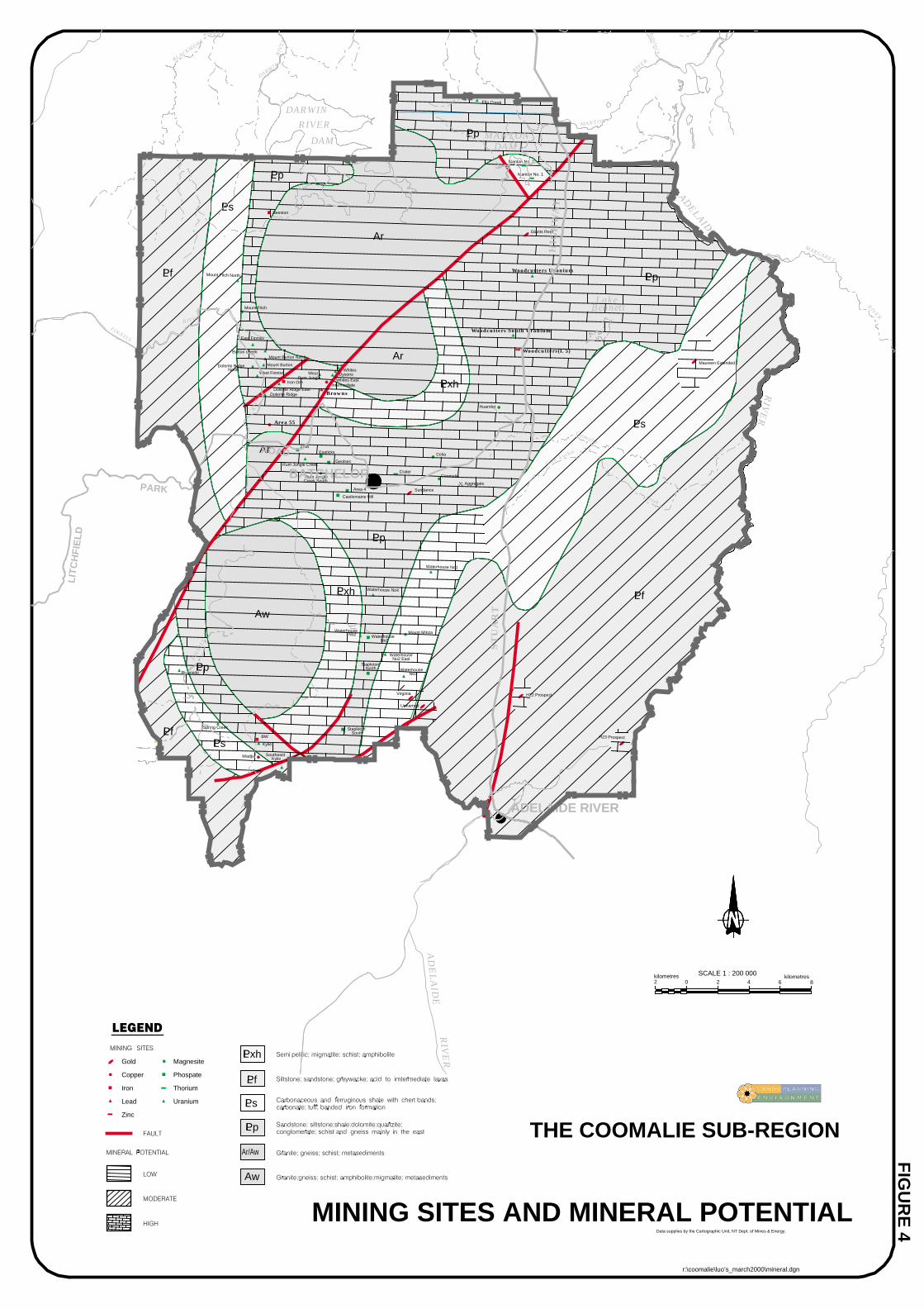
GeologyCoomalie is located in the north-western corner of the Palaeoproterozoic Pine CreekGeosyncline and contains several unique rock formations. The geosynclinal stratacomprise an alternating sequence of sandstones, carbonates, shales, siltstones,greywackes, tuffs and minor volcanics. The basement to this sequence are the Archaeanrocks which are exposed as two large domes immediately to the north (Rum Jungle) andsouth (Waterhouse) of Batchelor. Further geological details of the area are providedwithin Figure 4.
Geological sites within the Coomalie area have been documented by the GeologicalSociety of Australia and a reference for this material is provided in Attachment 1.
Mineral ResourcesThe mineral potential of Coomalie (refer Figure 4) has been divided into three categories:low, medium and high. The factors which determine mineral potential include intensityof presently known mineral occurrences and the presence of suitable host rock. Furtherdetailed evaluation for smaller selected areas would include other factors such asstructure, age and lithology.
Overall the mineral potential of Coomalie is considered to be moderate to high. Uraniumis the major commodity, with 29 recorded uranium occurrences, many of theseassociated with base metals such as copper. The Rum Jungle area contains most of theseoccurrences. There are 7 lead-zinc occurrences but only Browns and Area 55 (referFigure 4) are considered to have economic significance. Other commodities which havebeen identified in the area include gold, iron, phosphate, cobalt and magnesite.
The Compass Resource deposit in the Browns area of Rum Jungle is expected to havesignificant mining potential for at least ten years.

Coomalie Planning Concepts and Land Use Objectives 15
The activities of Mt Grace Mining NL through its subsidiary Savanna Mineral ResourcesPty Ltd east of Batchelor may result in the production of magnesium metal frommagnesite of the Coomalie Dolomite sequence.
Soil ErosionThe potential for soil erosion is created from any form of land disturbance, which mayresult from land clearing or development. Any land with steep slopes, shallow, stony orgravelly soils combined with drainage lines is highly susceptible to erosion. Erosion ofdrains can cause sediment discharge into natural waterways thereby degrading waterquality and impacting upon the stream hydrology.
In general, the topography and soils of the Coomalie area are regarded as being highlyerodible. It is therefore important that erosion is avoided where possible throughidentification of these areas, adherence to land clearance guidelines, implementation ofsoil conservation measures if land clearing is permissible and through sensitive roaddesign.
Flooding, Waterlogging and InundationAreas subject to inundation are characterised by vegetation and soils which are generallyhighly organic in composition and tend to be poorly drained. Much of the CoomalieSub-Region is subject to one form or other of wet season constraints. The black soilplains of the Adelaide River are subject to seasonal inundation and, throughout theundulating areas of the rest of Coomalie, drainage lines are subject to waterloggingand/or flooding over the wet season. Waterlogged areas are generally unsuitable for mostforms of agriculture other than low intensity uses such as seasonal grazing. Access overthe western half of Coomalie can be restricted during periods of flood.
The terminology used for flood levels is the Annual Exceedance Probability (AEP)which refers to the probability of a specified flood flow in a stream or river beingequalled or exceeded in any one year. In other words, there is a 1 in 100 chance of aflood reaching the 1.0% AEP flood level in any given year. Figures 5 and 6 show the1.0% AEP flood level for the town of Adelaide River and for the Adelaide Rivercatchment respectively. Development can occur within the 1.0% AEP line, althoughcertain building constraints may apply subject to the location of development. Thefloodway illustrated on Figure 5 for Adelaide River represents the flood channel whichwould be subject to particularly high water levels or water velocities during a 1.0% AEPflood and development is therefore prohibited in this area.
1.2.3 Biting InsectsThere is potential in Coomalie for large and uncontrollable mosquito and biting midgebreeding, which could present a significant nuisance and health risk for the existing andfuture population. The primary mosquito breeding sites are slow-flowing creeks andreedy swamp areas in the upper reaches of the Manton and Darwin River Dams, as wellas the flood plains of the Adelaide River.

Coomalie Planning Concepts and Land Use Objectives 16
The impact of mosquito breeding within Coomalie should be monitored and properlyconsidered prior to future development to protect the health of residents. Extractiveindustry, in particular, and other forms of human disturbance that impound water neardrainage lines and flood plains can create and add significantly to mosquito breedinghabitats. Similarly the design, construction and maintenance of sewage, waste water andstormwater facilities can create mosquito breeding sites. Any future subdivision willneed to be assessed to ensure that mosquito breeding sites are not being created oraggravated. Territory Health Services has specific guidelines (Attachment 2) forpreventing and minimising biting insect problems which need to be taken into account aspart of the development assessment process, to ensure compliance with the regulations ofthe Public Health Act.
1.2.4 HeritageWithin the terms of the Heritage Conservation Act two major types of heritage sites arerecognised. Those entered onto the Northern Territory Heritage register (declaredheritage places) and those prescribed as archaeological places and objects. There are nodeclared heritage places within Coomalie, although a number of historic sites andbuildings do exist (Figure 7). Many of these sites relate to the wartime occupation of thearea.
Prescribed archaeological places and objects include sites of Aboriginal or Macassanorigin from the prehistoric or protohistoric period. The Heritage Conservation Actprovides automatic protection for archaeological sites which can include stone artefactscatters, rock art sites, shell middens and prehistoric quarries. In addition, the SacredSites Act, which is administered by the Aboriginal Areas Protection Authority, protectsregistered and recorded sacred sites and natural features which are of traditionalsignificance to Aboriginal people.
Research into the location of Aboriginal archaeological sites within the CoomalieSub-Region has been undertaken by Daryl Guse (1998) (refer Attachment 1). Thedistribution of the known Aboriginal archaeological sites with Coomalie is presented inFigure 8. Sites of significance to the traditional owners of the land within Coomalie willcontinue to be identified and an assessment of potential sites will be required ofdevelopers, under the Sacred Sites Act, prior to any development.
1.2.5 Land TenureLand tenure in Coomalie is shown in Figure 9. A substantial proportion of the land is infreehold ownership, with the Northern Territory Land Corporation holding most of theremaining land to the west and north-west of the area as a Crown Lease Perpetual.In addition, a substantial and largely undeveloped parcel of land to the north-east,Section 1582, Hundred of Colton, forms part of the Koolpinyah Pastoral Lease,extending south from the adjoining Litchfield Shire.
There is limited vacant Crown land within Coomalie although some remains within thetown boundaries of Batchelor and Adelaide River. Sections 2950 and 2968, Hundred ofGoyder and Section 200, Hundred of Howard are also vacant Crown land.
The Finniss River Aboriginal Land Trust, with land holdings in excess of 200 km2, holdsmore than 13% of the total land area within Coomalie.

Coomalie Planning Concepts and Land Use Objectives 17
1.2.6 Infrastructure and Services
TransportationTransport can be defined in simple terms as the movement of goods or persons from anorigin to a destination. The quality of a transport network will have direct implications onthe social and economic well being of an area. Transportation to and within Coomalie ispresently served by a road network dominated by the Stuart Highway, which traversesthe length of the Sub-Region. Batchelor Road, a sub-arterial road, which provides animportant connection to Batchelor and Litchfield National Park, is the only other arterialroad within Coomalie.
Many of the connector roads which service rural living and pastoral land uses within theCoomalie Sub-Region are, for the most part, unsealed. The unsealed status of these roadscan create difficulties for users in terms of restricted access during times of heavy rain,the damaging impact they can have on fragile horticultural produce, in addition to othercosts such as vehicle deterioration, increased transit times and safety. There are also anumber of unmade gazetted roads within Coomalie which have been identified by theoriginal Goyder and later subdivision surveys.
Given that Coomalie is faced with the problem of requiring many kilometres of roads toadequately service a relatively small and widely spread population, a recognised roadhierarchy will provide an element of priority and certainty as to the future location andintensity of particular land uses.
It is anticipated that the proposed AustralAsia Railway, otherwise known as the Darwinto Alice Springs Railway, will be in place by early next century. The proposed route ofthe railway is immediately west of the general alignment of the Stuart Highway for mostof its passage through Coomalie.
Utility InfrastructureCoomalie is relatively well serviced by electricity. The main service line (132 kV) runsparallel to the Stuart Highway from Channel Island Power Station and south toKatherine. In addition, 22 kV lines branch from the Stuart Highway to Batchelor alongBatchelor Road and further west along Litchfield Park Road. In the vicinity of AdelaideRiver a 22 kV line services Strickland Road in the north and Haynes Road to the south.
The south-western portion of the region, specifically those rural areas serviced by FowlerRoad, Cheeney Road and Milton Road, are not connected to the electricity grid.
A reticulated sewerage system is provided to the towns of Batchelor and Adelaide River,although parts of Adelaide River remain unsewered. The rural areas of Coomalie areserviced by septic tanks or other on-site waste disposal methods. Likewise, onlyBatchelor and Adelaide River have access to reticulated water with the rural areas of theregion serviced by either bore water and/or rain water tanks.
The water supply of Batchelor is considered to be sufficient for the purposes ofsupplying future development for the next fifteen to twenty years. Within the townboundary a rising main is supplied by bores to the south-east of the town. A 3.7 MLground level tank and a new booster pump station have been installed on the easternboundary of the town.

Coomalie Planning Concepts and Land Use Objectives 18
Adelaide River’s water is supplied by several bores which are dispersed throughout thetown. Currently, there are three water tanks in the town including one elevated 45 kLtank and two ground level tanks of 450 kL and 390 kL capacity. The potable watersupply for Adelaide River is adequate for the foreseeable future. However, ground waterresources will constrain future economic developments requiring irrigated water. ThePower and Water Authority will continue to optimise the supply system to meet potablewater demand.
The Power and Water Authority is currently investigating options for the relocation ofthe sewage treatment ponds in Batchelor and Adelaide River as they overlie the groundwater aquifer. The Planning Concepts for Adelaide River, however, assume the retentionof the treatment ponds in their current location to the north-west of the town, as analternative site may not be identified within the planning horizon of the Land UseObjectives.
1.3 Land Use ConceptsLocalities within the Coomalie Sub-Region of particular significance in the preparationof this planning document are identified on the plan at Figure 10. The evaluation of theplanning base was used in the preparation of the Coomalie Sub-Region Land UseStructure Plan at Figure 11.
Structure plans for Batchelor are at Figures 12a and 12b and the structure plan forAdelaide River is at Figure 13. These structure plans are enlargements of the land usesshown on the Coomalie Sub-Region Land Use Structure Plan. The following planningconcepts provide interpretation regarding the type of development to be facilitated andencouraged. With the exception of the towns of Batchelor and Adelaide River, thelocality boundaries have been based on water catchment boundaries associated with theDarwin River, the Finniss River and the Adelaide River. The locality names are to assistin the identification of localities for the purposes of this document only and have nostatus for any other purpose.
1.3.1 BatchelorBatchelor will continue to be the commercial and civic centre of Coomalie.
Figure 12b identifies future residential, industrial and commercial land options andproposes that medium density residential development be confined to within proximity ofthe town centre. It is preferable for the Batchelor Institute to relocate its western campusfacilities to land on the eastern side of the existing campus to form a single consolidatedcampus and to allow for the future development of the western campus site forresidential and commercial purposes close to the town centre.
Any proposal to expand commercial activities in the centre of Batchelor may require therelocation of the Batchelor Outdoor Education Unit and land to accommodate this usehas been identified to the north of the Batchelor Area School.
The Coomalie Community Government Council should relocate from the Cameron Roadindustrial precinct to a more accessible and visible location within the town centre. TheCouncil should be located within a precinct type development which could offercomplementary community facilities.
Heritage themes could be promoted through the establishment of a regional museumlocated in Batchelor. The old railway corridor could be used as a heritage trail fortourism and recreational purposes.

Coomalie Planning Concepts and Land Use Objectives 19
Figure 12a identifies land for rural residential and rural living. Smaller sized ruralresidential allotments at a minimum of 0.5 ha are proposed on the periphery of Batchelorand may be serviced by town power, water and sewer. Subdivision of land for ruralresidential purposes will require also land capability assessment. Rural living lots of 8 haare shown further removed to the west of the town.
In recognition of the popularity of Litchfield Park and the sealing of the road north fromthe park to Berry Springs Road, options to divert ‘through traffic’ from the town’s roadnetwork by creating a link to the north are shown in Figure 12a. A tourist route throughthe town could be provided and extended by linking Meneling Road to Litchfield ParkRoad.
With the town’s reliance on groundwater, protection of the aquifer from contamination isparamount. Due to Batchelor’s position overlying the groundwater aquifer, all newdevelopment within 2 km of the town’s water supply bores shall be connected to areticulated sewerage system or served by an appropriate waste disposal system. This alsoapplies to future industrial development south of Batchelor Road. Industries whichproduce noxious or hazardous waste streams that may enter the groundwater systemsshould be located away from water collection areas.
1.3.2 Adelaide RiverThe Adelaide River Concept Plan (refer Figure 13) is based on the planning constraintsimposed on the town by the current 1.0% AEP flood levels and the current location of thesewage treatment ponds.
In the short term, the expansion of Adelaide River’s population can be accommodated bydevelopment of vacant allotments in the town and by an expansion of the existing streetsystem to connect Hatt and Swannel Streets.
Rural residential opportunities within Adelaide River have been identified on theperiphery of the town in the Silverton Road area. This area is currently used for a mix ofconflicting residential, service commercial and light industrial uses. All future servicecommercial/light industrial uses should be located in a separate precinct to the west ofthe town, on the western side of the Stuart Highway.
The recent subdivision of land immediately south of Coomalie, adjacent to the StuartHighway, known as Mount Bundey or Silkwood, represents a significant rural populationwhich is likely to draw primarily upon Adelaide River for goods and services. To thisend, consolidation and expansion of the existing commercial centre of Adelaide River isencouraged where practical and where the amenity of adjacent residential land is notcompromised.
Tourist attractions such as the Railway Station Museum, the War Cemetery, andrecreation opportunities such as walking and equestrian trails along Adelaide River,should be promoted and enhanced.
Adelaide River has the opportunity to develop a service commercial/light industrialprecinct in a new location to the west of the town, on the western side of the StuartHighway. Relevant waste management controls with regard to industrial developmentover the ground water aquifer should also apply.

Coomalie Planning Concepts and Land Use Objectives 20
1.3.3 Dam CatchmentsDevelopment within closed water catchments will be restricted to that which is directlyrelated to the management or operation of the water resource. Approved developmentwithin the catchments will only be allowed to proceed with the concurrence of the waterresource regulator and relevant management authority.
The land adjacent to Manton Dam, which is owned by the Power and Water Authoritycould be developed for tourism, recreation and residential uses. Future development atManton Dam will be subject to the protection of closed catchment areas to safeguardfuture water supply options. It is also important to maintain public access to MantonDam for recreational activities.
1.3.4 Finniss CatchmentTwo categories of rural living have been identified within the Coomalie Sub-RegionLand Use Structure Plan (refer Figure 11): Rural Living and Rural Living (Constrained).Rural Living is located on land which, due to constraints of slope or soil type, isunsuitable for horticulture or agricultural development, yet largely coincides with a goodground water supply. The minimum lot size for Rural Living is 8 ha.
Areas identified for Rural Living within the Finniss Catchment are (refer Figure 11):
• to the west of the Darwin River Dam catchment;
• to the north of Litchfield Park Road, adjacent to the Finniss River;
• to the south-west of Batchelor, adjacent to the Little Finniss River; and
• adjacent to Milton Road and Miles Road, south of Batchelor.
Rural Living (Constrained) applies to land significantly constrained by soil type andwater supply. The potential of land within these areas for residential development willrequire detailed assessment once a development application has been made. Theassessment will need to address issues such as land capability and availability of waterresources to determine whether residential development can be sustained on the land.Lots within the Rural Living (Constrained) should generally be greater than 8 ha to allowfor constraints on the land. The design of any subdivision in these areas must adequatelyidentify and address potential erosion and land degradation issues.
Areas identified for Rural Living (Constrained) (refer Figure 11) are:
• to the north-west of Batchelor, west and south-west of the Darwin River Damcatchment; and
• west of Batchelor, adjacent to the Little Finniss River.
Rural living can be developed in the Litchfield Park Road area where a good watersupply and on-site sewage disposal capacity can be demonstrated. In this area, theintegrity of the transport corridor to Litchfield Park shall not be compromised in terms ofvisual appearance and intensity of development.
The road hierarchy for the Coomalie Sub-Region is shown in Figure 14. The roadhierarchy is based on the following criteria:
• arterial roads being the principal routes for through traffic with no direct propertyaccess, but with access to recognised tourist and service centres;

Coomalie Planning Concepts and Land Use Objectives 21
• secondary road networks (ie. collector and distributor roads) distributing traffic fromarterial roads and carrying some through traffic and providing direct property access;and
• local roads having the prime function of providing direct property access;
In addition, collector roads and local roads across Coomalie which accesshorticultural/agricultural and residential areas can also be extended to improve the roadhierarchy.
Land with good potential for intensive horticulture development coincides largely withthe highest yields of ground water supply in the area, that is, central Coomalie west ofthe Stuart Highway and extending southwards in a “V” beyond Perreau Road and to thenorth-west adjacent the Finniss River.
However, some land within the area identified for horticulture and agriculture may beunsuitable for such uses due to soil type, water supply, drainage and slope, and thereforealternative use of the land may be considered following detailed assessment of landcapability and water availability at the development application stage. Road networksinvolved in the transportation of horticultural products should provide for all-weather,all-year access and be of a standard to minimise damage to the produce.
Some tourism related development could be located on Litchfield Park Road betweenBatchelor and Litchfield National Park, subject to access and signage restrictions.Commercial or ribbon development along the Stuart Highway, main roads and touristroutes, with the exception of the possible tourist facilities along Litchfield Park Road, isdiscouraged in the interests of safety and preserving the visual amenity and rural natureof the area.
Rum Jungle Lake could be utilised for more intensive public recreation such asnon-motorised water-based activities providing picnic, BBQ and walking trails. TheLittle Finniss River could be identified as an open space reserve for the purposes ofpassive recreation. The land to the north of the Finniss River could be protected for thepurposes of creating a green belt or wildlife corridor between Litchfield Park and theDarwin River Dam.
1.3.5 Adelaide River CatchmentFurther tourism development and associated facilities at Lake Bennett should be at ascale commensurate with the locality’s physical and environmental capabilities andwhich maintain the areas rural character and amenity. Future development at the marginsof Lake Bennett should not create or aggravate mosquito breeding sites.
Agriculture in the Tortilla Flats vicinity is encouraged, particularly practices which aresuited to seasonal flooding to take advantage of potential flood irrigation. Thesubdivision of land consisting of levee soils adjacent to the Adelaide River will berestricted in the interests of preserving this land for horticulture purposes.
Walking and equestrian trails along the Coomalie and Glenluckie Creek, Smokey Creekand Stapleton Creek tributaries could be developed.
Future subdivision and development within the Marrakai locality will be restricted toprotect a future source of potable water for the Darwin Region, in accordance with therecommendations of the Darwin Regional Water Supply Strategy.

Coomalie Planning Concepts and Land Use Objectives 22
Attachments

Coomalie Planning Concepts and Land Use Objectives 23
Attachment 1 Reference List
Crick I H, Rum Jungle Uranium Field, Northern Territory, Department of PrimaryIndustries & Energy, Bureau of Mineral Resources, Geology & Geophysics AustralianGovernment Publishing Service, Canberra 1987.
Fortowski D, Crick I & Lau G A, Geological Heritage of the Northern TerritoryGeological Society of Australia 1988.
Guse Daryl, Archaeological Site Patterns in the Coomalie Region, Northern Territory -A Report for the Department of Lands, Planning and Environment, April 1998.
McLennan W, 1998 Year Book Australia Australian Bureau of Statistics (CatalogueNo. 1301.0) Commonwealth of Australia 1998.
National Trust (NT), Historic Sites in the Coomalie Region of the Northern TerritoryReport for the Department of Lands, Planning and Environment, March 1998.
Network 99, Coomalie Regional Economic Development Strategy Report for CoomalieCommunity Government Council, July 1996.
Northern Territory Tourist Commission, Regional Tourism Development Plan 1996.
Northern Territory Department of Mines and Energy, Final Project Report: The RumJungle Rehabilitation Project, June 1986.
Troppo Architects, Batchelor Tropical Housing Precinct - An Architectural Assessment,Report for National Trust (NT), 1988.

Coomalie Planning Concepts and Land Use Objectives 24
Attachment 2 Development Guidelines for Biting InsectsSource: Territory Health Services (THS) Medical Entomology Branch 1998
Construction Practice near Tidal Areas NT - Guidelines to Prevent Mosquito Breeding(1988). THS Medical entomology Branch Publication prepared for the CoastalManagement Technical Advisory Group.
Guidelines for preventing biting insect problems for new rural residential developmentsor subdivisions in the Top End of the NT (1997). THS Medical Entomology Branchpublication.
Guidelines for preventing the creation of mosquito breeding sites in non-residential ruraldevelopments or subdivisions in the Top End of the NT (1996). THS MedicalEntomology Branch publication.
Guidelines for preventing biting insect problems for urban residential developments andsubdivisions in the Top End of the NT (1997). THS Medical Entomology Branchpublication.
Guidelines for mosquito breeding sites associated with mine sites (1997). THS MedicalEntomology Branch publication.
Drainage Considerations for Mosquito Control (1998). THS Medical EntomologyBranch publication prepared for the Mosquito Control Association of Australia Manual(in prep.).
Biting Midges - Residential Buffer Recommendations for the NT (1993). THS MedicalEntomology Branch publication.
Mosquitos and residential buffer recommendations NT (1993). THS MedicalEntomology Branch publication.
Mosquito breeding and sewage treatment in the NT (1998). ‘Water’ Vol.15. No. 5. Pp34-37.
Policy for the design of off site sewerage ponds and the disposal or reuse of seweragepond effluent (1997). THS Medical Environmental Health Directorate publication.
The prevention of mosquito breeding in sewage treatment facilities (1998). THS MedicalEntomology Branch publication prepared for the Mosquito Control Association ofAustralia Manual (in prep.).

Coomalie Planning Concepts and Land Use Objectives 25
Figures

Coomalie Planning Concepts and Land Use Objectives 26
PART 2 - LAND USE OBJECTIVES

Coomalie Planning Concepts and Land Use Objectives 27
PART 2 - LAND USE OBJECTIVES2.1 The Vision
Land Use Objectives are the Government’s land use policy statements, declared underthe Planning Act. These Coomalie Land Use Objectives provide the framework fordeveloping the Coomalie Sub-Region in a manner which preserves its rural nature andallows for continued development at a sustainable level. The Coomalie Sub-Region willcontinue to play a major role in the future development of the greater Darwin Region dueto its natural resources, including mineral deposits and water supply, and as a primelocation for tourism, horticulture/agriculture, industry, education and rural living.
2.2 Intended OutcomesThe Land Use Objectives are intended to achieve the following outcomes:
• A strategic, performance based approach to land use and development decisions.
• A strong economy based on sustainable tourism, agriculture, horticulture, miningand extractive industries.
• Expansion of the towns of Batchelor and Adelaide River to provide furtherresidential and commercial developments and supporting community services as thepopulation of the Sub-Region grows.
• A rural lifestyle compatible with the natural environment.
• Access to community and recreational facilities.
• An efficient and safe road network that provides for private and public transport andservice vehicles.
• Valued heritage places and objects being appropriately used.
2.3 Key ObjectivesKey objectives are land use objectives which relate to the entire Coomalie Sub-Region.
Key objectives for Coomalie are:
To protect land and water resources.
To promote and use the natural attributes of the region.
To provide an integrated transport network.
To protect human health.
To promote tourism development.
To promote development of mining and extractive industries.
To protect vegetation and prevent land degradation.
Coomalie Planning Concepts and Land Use Objectives 28
To protect sites with significant heritage status.
2.4 Land Use Objectives
The land use objectives are listed in boxes in the following sections and are related tospecific land uses. They are accompanied by interpretation statements which provideguidance for the implementation of the land use objective.
2.4.1 Tourism
To promote the development of the tourism industry.
Tourism development in accordance with the Northern Territory Tourist Commission’sRegional Tourism Development Plan 1996 is supported. Within Batchelor and AdelaideRiver there is potential for the development and expansion of short term touristaccommodation. Provision of ‘Bed and Breakfast’ style accommodation can be expandedto meet demand but will need to be strictly controlled and monitored.
To promote the provision of tourism infrastructure to increase tourist recreation activities.
Outdoor and water-based tourism opportunities such as bushwalking, boating andrecreational fishing will be enhanced by the provision of infrastructure at strategiclocations.
To develop a tourist resort development adjacent to Manton Dam.
There are opportunities for siting a significant resort development at Manton Dam onland owned by the Power and Water Authority. Development must protect possiblefuture water supply options.
To promote heritage sites for tourism purposes.
The region is particularly rich in WWII heritage sites and these can achieve a greaterprofile for tourism purposes.
2.4.2 Horticulture and Agriculture
To identify, protect and retain land suitable for horticulture and agriculture for thesepurposes.

Coomalie Planning Concepts and Land Use Objectives 29
The region supports a diversity of horticultural and agricultural land uses such asagistment, live export and fodder production and less intensive pastoral activities.Horticultural and agricultural land uses must consider land capabilities and the potentialimpact on the natural environment and existing rural living areas.
2.4.3 Mining and Extractive Industry
To protect mineral and extractive resources.
To provide mine access routes.
To establish appropriate land uses on mine sites, as part of the rehabilitation program, priorto mining lease surrender.
To minimise the impact of mining and extractive industries on human health.
For mining and extractive industry to remain as one of the region’s strongest sources ofemployment and economic growth, the industry must develop in an environmentallysensitive manner. Development on adjoining sites should not restrict mine access andextractive techniques. The Coomalie Sub-Region Land Use Structure Plan identifiesappropriate land uses on mine sites, to continue after rehabilitation.
2.4.4 Commercial
To promote Batchelor and Adelaide River as the Sub-Region’s commercial centres.
To identify land within Batchelor and Adelaide River which is suitable for commercial uses.
Commercial development should not create or exacerbate on street parking and accessproblems. Commercial zones can also incorporate community facilities.
2.4.5 Industrial
To promote general and light industry in Batchelor and Adelaide River.
Expansion of general and light industry in designated industrial or service/commercialareas in Batchelor and Adelaide River is supported. Industries producing noxious orhazardous waste streams must be located outside of ground water aquifer recharge areas.
All industry must comply with strict waste management procedures. All developmentwithin 2 km of town water supply bores in Batchelor and Adelaide River must beconnected to a reticulated sewerage system or sewered by an appropriate waste disposalsystem.

Coomalie Planning Concepts and Land Use Objectives 30
2.4.6 Residential
To provide an adequate supply of land for urban and rural residential use.
To provide a range of urban and rural living options, avoiding land which is suitable forhorticulture and agriculture.
As the region’s population increases, a greater range of housing choice and affordabilitycan be achieved. Development in urban and rural living areas must have regard toTerritory Health Services’ Guidelines for the prevention of biting insect problems andcomply with the Public Health Act Regulations.
2.4.7 Health and Community Facilities
To provide a range of community services and recreational facilities.
To locate health and community facilities within Batchelor and Adelaide River and promotetheir co-location.
2.4.8 Transport and Infrastructure
To develop an efficient transport network.
To promote the use of low energy transport modes.
The Coomalie Sub-Region Road Hierarchy provides a structure for the development of afuture transport network.
The AustralAsia Railway will ultimately impact on the development of the road network.
Use of low energy transport modes such as cycling, can be promoted through theprovision of incentives such as dedicated pathways, resting points and drinkingfountains. The former rail corridor presents a possibility for development as a cycleway.
2.4.9 Water Resources
To minimise the impact of development on water supply areas.
Development within closed water catchments must be restricted. Development must beconsistent with resource management strategies and any beneficial uses, qualitystandards, criteria, or objectives which are declared under the Water Act.

Coomalie Planning Concepts and Land Use Objectives 31
2.4.10 Conservation
To protect vegetation which has significant ecological or amenity value.
The removal of vegetation from land with a slope greater than 10% is discouraged. Theformulation of land clearing guidelines and land use controls will assist in the protectionof vegetation of land vulnerable to degradation.
2.4.11 Open Space and Recreation
To identify, promote and maintain public access to open space, waterways and scenicattractions.
Use of open space must minimise the impact on the natural environment.

SKEWES ROAD
DALY RIVER
ROAD
DO
RA
T
RO
AD
MARRAKAI
ROAD
VAN
BEAGLE GULF
DIEMEN
ADELAIDE
TURNBULLBAY
IDABAY
BYNOEHARBOUR
TAPABAY
COX PENINSULA
WO
OD
SIN
LET
WE
ST
ARM
DARWIN
MIDDLE
ARM
HOPEINLET
ADAM BAY
ADELAIDE
RIVE
R
Cape Hotham
SHOALBAY
HABOUR
RO
AD
POINT
ROAD
PARK
LITCHFIELD
BAY ROAD
ST
UA
RT
HIG
HW
AY
ROAD
PENINSULA
COX
ROAD
PENINSULA
GULF
DARWIN PALMERSTON
MANDORAH
GUNN
FINNISS
LITCHFIELD
WARRAI
ARNHEM
HIGHWAY
FOG
CO
X
THE COOMALIE SUB-REGION
DARWINRIVER
DARWINRIVER
BATCHELOR
Gas Pipeline
ADELAIDE RIVER
RIV
ER
DAMMANTONMANTON
DAM
HIG
HW
AY
DAMDAM
ST
UA
RT
FIGURE 1
0 15
SCALE 1 : 750 000 kilometres30
FIGURE 1
7.5kilometres7.5 22.5
r:\coomalie\luo’s_march2000\locality.dgn

WATER CATCHMENTS
MARRAKAI DAMCATCHMENT AREA
MOUNT BENNETT DAMCATCHMENT AREA
WARRAI DAMCATCHMENT AREA
THE COOMALIE SUB-REGION
MANTON DAM
CATCHMENTAREA
DARWIN RIVER DAM CATCHMENT
AREA
0 6 12 18
SCALE 1 : 600 000kilometres6
kilometres24
FIGURE 2
FIGURE 2
r:\coomalie\luo’s_march2000\catchments.dgn

0 2 4 6
SCALE 1 : 200 000kilometres2
kilometres8
GROUNDWATER SUPPLY PROSPECTS
FIG
UR
E 3
GEOLOGICAL BOUNDARY
: LOCAL VARIATIONS IN SUPPLY WILL OCCUR
PREPARED FEBRUARY 1998
FAULT
NOTE : THIS MAP SHOULD ONLY BE USED FORREGIONAL GROUNDWATER ASSESSMENT.
OF GROUNDWATER SUPPLY PROSPECTSON SPECIFIC SITES OR INDIVIDUAL BLOCKS.
: GEOLOGICAL BOUNDARIES ARE INFERRED ONLY
: DO NOT USE THIS MAP FOR ASSESSMENT
Yield more than 5.0 L/s
Yield 1.5 - 5.0 L/s
Yield 0.5 - 1.5 L/s
Yield less than 0.5 L/s
THE COOMALIE SUB-REGION
r:\coomalie\luo’s_march2000\waterpro.dgn
FINNISS
RIVER
BLACKMORE
RIVER
FIN
NIS
S
RIV
ER
DARWIN
RIV
ER
Acacia
Glen Luckie
Creek
MANTON
RIVER
Coomalie
Creek
MARGARET
RIVER
AD
EL
AID
E
ADELAIDE
RIV
ER
MANTONDAM
HIG
HW
AY
ST
UA
RT
DARWIN
RIVER
DAM
ADELAIDE RIVER
BATCHELORPARK
ROAD
LIT
CH
FIE
LD
RIV
ER
Ck
Lake Bennett
Coomalie
Waterhouse No4
Waterhouse No1
Mount Fitch North
H23 Prospect
Ella Creek
No2
LPp
LPp
LPp
L
LPs
LPs
LPs
LPf
LPf
LPf
Aw
Ar
Ar
Ar
West
L
L
LPp
H22 Prospect
StapletonSouth
StapletonNorth
Unnamed
Virginia
WaterhouseNo3
WaterhouseNo2 East
WaterhouseNo2
Mount MinzaWaterhouse
Wadjul SoutheastKylie
BW
Kylie
Spring Creek
Riverside
ZetaEasticks
GeolsecRum Jungle Creek
Rum JungleCreek South
Area 55
Area 4
Castlemaine Hill
Crater
Sundance
Celia
Aggregate
Huandot
Dolerite RidgeNorth
East Finniss
West Finniss
Burton CreekMount Burton North
Mount Burton
Dolerite Ridge EastDolerite Ridge
Iron OreRum Jungle
Intermediate
Browns
Whites EastDysons
Whites
Mount Fitch
Beeston
Manton No. 2
Manton No. 1
Giants Reef
Woodcutters Uranium
Woodcutters South Uranium
Woodcutters(L 5)
Maureen Extended
FIG
UR
E 4
0 2 4 6
SCALE 1 : 200 000kilometres2
kilometres8
Magnesite
Phospate
Thorium
Uranium
Gold
Copper
Iron
Lead
Zinc
Data supplies by the Cartographic Unit, NT Dept. of Mines & Energy.
MINING SITES AND MINERAL POTENTIAL
Pxh
Ar/Aw
Aw
Pp
Pxh
LPxh
LPf
LPs
LPp THE COOMALIE SUB-REGION
r:\coomalie\luo’s_march2000\mineral.dgn
FINNISS
RIVER
BLACKMORE
RIVER
FIN
NIS
S
RIV
ER
DARWIN
RIV
ER
Acacia
Glen Luckie
Creek
MANTON
RIVER
Coomalie
Creek
MARGARET
RIVER
AD
EL
AID
E
ADELAIDE
RIV
ER
MANTONDAM
HIG
HW
AY
ST
UA
RT
DARWIN
RIVER
DAM
ADELAIDE RIVER
BATCHELORPARK
ROAD
LIT
CH
FIE
LD
RIV
ER
Ck
Lake Bennett
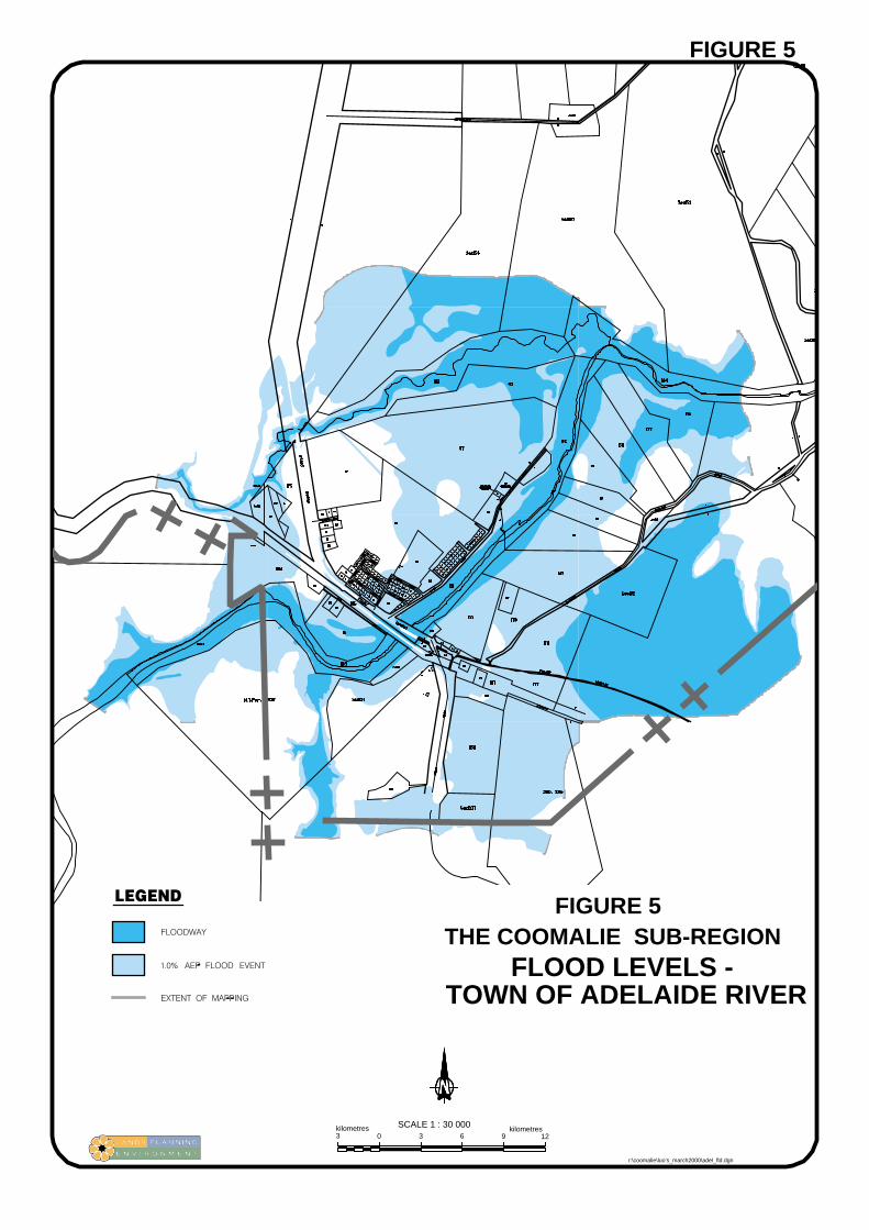
FLOOD LEVELS -TOWN OF ADELAIDE RIVER
THE COOMALIE SUB-REGIONFIGURE 5
FIGURE 5
0 3 6 9kilometres3
kilometres12
SCALE 1 : 30 000
r:\coomalie\luo’s_march2000\adel_fld.dgn

FLOOD LEVELS -TOWN OF ADELAIDE RIVER
THE COOMALIE SUB-REGIONFIGURE 5
FIGURE 5
0 3 6 9kilometres3
kilometres12
SCALE 1 : 30 000
r:\coomalie\luo’s_march2000\adel_fld.dgn
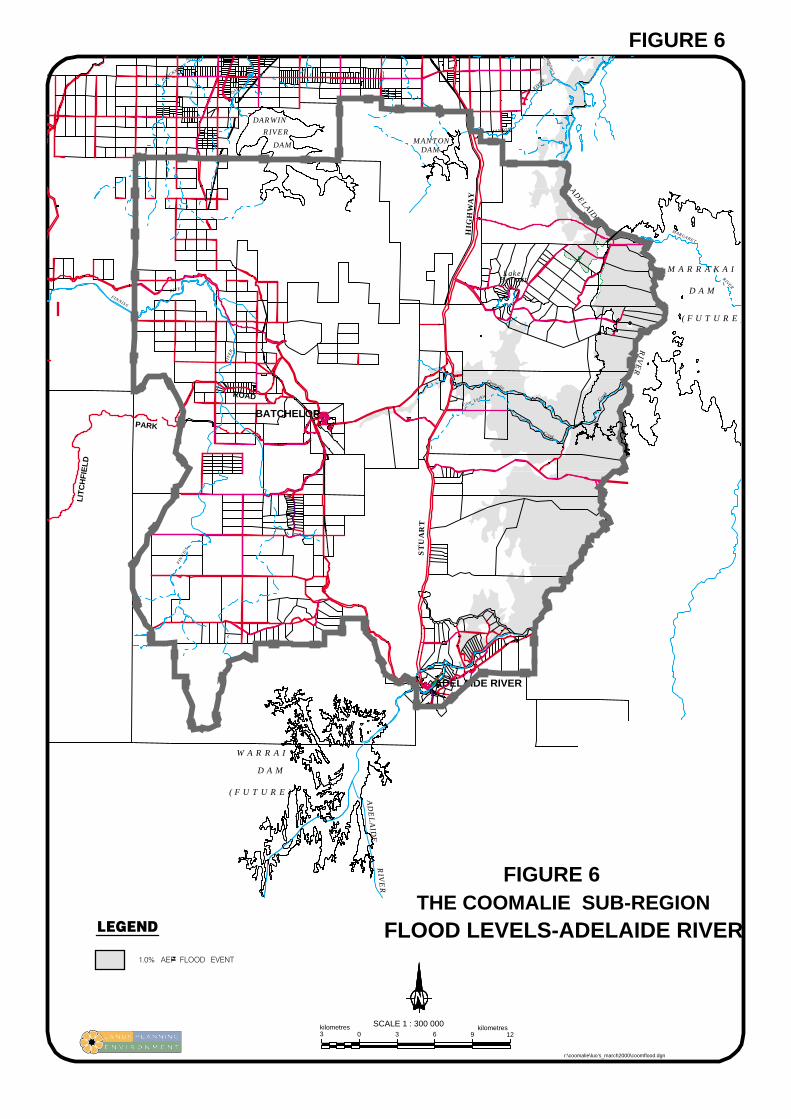
Level 24 - 1 in 100 flood limit area fill
Level 33 - limit of flood mapping or limit of available mapping
FLOOD LEVELS-ADELAIDE RIVERTHE COOMALIE SUB-REGION
FIGURE 6
FIGURE 6
0 3 6 9
SCALE 1 : 300 000kilometres3
kilometres12
r:\coomalie\luo’s_march2000\coomflood.dgn
FINNISS
RIVER
BLACKMORE
RIVER
FIN
NIS
S
RIV
ER
DARWIN
RIV
ER
Acacia
Glen Luckie
Creek
MANTON
RIVER
Coomalie
Creek
MARGARET
RIVER
AD
EL
AID
E
ADELAIDE
RIV
ER
MANTONDAM
HIG
HW
AY
ST
UA
RT
DARWIN
RIVER
DAM
ADELAIDE RIVER
BATCHELORPARK
ROAD
LIT
CH
FIE
LD
RIV
ER
Ck
W A R R A I
D A M
( F U T U R E )
( F U T U R E )
D A M
M A R R A K A ILake Bennett

FINNISS
RIVER
BLACKMORE
RIVER
FIN
NIS
S
RIV
ER
DARWIN
RIV
ER
ST
UA
RT
HIG
HW
AY
Acacia
Glen Luckie
Creek
MANTON
RIVER
Coomalie
Creek
MARGARET
RIVER
AD
EL
AID
E
ADELAIDE
RIV
ER
RIV
ER
Ck
FIG
UR
E 7
0 2 4 6
SCALE 1 : 200 000kilometres2
kilometres8
THE COOMALIE SUB-REGION
ADELAIDE RIVER
BATCHELOR
HISTORICAL SITES
r:\coomalie\luo’s_march2000\heritage.dgn

i
Figure 7 Historical Sites
Location Significance
1 Rum Jungle Railway Siding and Rum Jungle Hotel Sites. Artefactscatters at both sites with extensive scatter, building sites and kitchenfireplace at hotel site.
2 Flynn homestead and gardens site. Some remains of building foundationsand artefact scatters.
3 Castlemaine Hill - remains of bases to wartime water tanks and station.4 Wartime anti-aircraft position. Extensive remains of gun positions.
Interpreted as part of the 1992 War Service Memorial Year.5 Anti-aircraft site. Drums set in revetted positions.6 Batchelor railway siding. Remains of shed foundations . Artefact scatters
from 1912 to the 1970s.7 Batchelor Airfield, Gould Airfield and associated wartime and historic
sites associated with the Batchelor Demonstration Farm, Aboriginal sitesand development of the township. Extensive remains throughout ofwartime sites, taxiways, revetments, aircraft inserts and associatedartefact scatters.
7(a) Remains of wartime taxiway, stop butts and small arms range.8 Military camp sites along the ridge line overlooking Batchelor-Coomalie
Road. Extensive remains of building sites and access tracks.9 Site of the Australian Wireless Signals Group camp and intercept station
- building slabs, fireplaces, antennae guys . Extensive military dump siteadjacent to main road.
10 Coomalie Army Farm - remains of gardens and building foundation.11 RAAF No. 1 Medical Receiving Station - extensive building remain
slabs, tennis court. Interpreted as 1992 War Service Memorial Year.Sidney Williams huts erected post war remain to the south on CoomalieCreek.
12 Anti-aircraft (40mm Bofors) site on ridge overlooking airfield. Extensiveremains.
13 Coomalie Airfield - extensive remains of a wartime airfield with activerunway, camp sites, taxiways, technical areas, aircraft relics. Site isactively conserved by owner, Richard Luxton.
14 Remains of military camp site and slabs.15 Military camp site, building sites, technical areas, admin areas and cable
junction hut.16 Site of Australian Wireless Signals Group - slab, scatters.17 Crater Lake. Some remains of military occupation.18 Extensive military camp and workshops and RAAF units. Extensive
remains of domestic and technical sites.19 Military camp site – slab.20 Extensive military dump site.

ii
21 Crash site of bomber aircraft - remains of major structural componentsand personal items.
22 Pell Airfield district.23 Southern taxiway - slabs, artefact scatters.24 Western side of highway contains building sites, recreational facilities
and artefact scatters.25 Extant military building site.26 Military camp site remains - slab, scatters.27 Military camp site with bore stand, ablutions and domestic building sites
including mess and accommodation. Extensive artefact scatters.28 Site of Our House Hotel.29 Stapleton Railway Siding (69 mile) with remains of loop and line, yards,
foundations.30 Military camp sites.31 Snake Creek Armament Depot. Extensive sidings, explosives storage
facilities and domestic areas. Interpreted as part of the 1992 War ServiceMemorial Year and included on the NT Heritage Register.
32 Former north-south road alignment with bridge over and significantnatural values including a billabong.
33 Former North Australia Railway bridge to Snake Creek sidings.34 Explosives storage set into the sides of Mt. Carr. Tunnels and artefacts
recorded.35 Extant military site.36 Site of military stores and sidings.37 Site of military stores, bakery.38 Site of US Army Base Section One.39 Adelaide River Pioneer Cemetery. Interpreted as a Coomalie Community
Council/national Trust Project.40 Former post war Adelaide River Store.41 Former 1930s police station with cell block extant.42 Military camp site.43 Aboriginal camp area WWII.44 Military site with building foundation, fireplace and chimney.45 Pre war railway spur line.46 Adelaide River Railway Precinct including bridge. Included on NT
Heritage Register.47 Adelaide River Aerodrome. Runway remains and artefacts.48 US Navy Fleet Radio Station remains - extensive slabs, latrines,
technical areas and scatters.49 Former wartime strip with large hangar foundations.50 US Navy Communications site.51 Grave site of Harry Hardy of Mt Bundy Station.52 Site of Wartime No. 119 Australian General Hospital. Extensive
remains.

iii
53 Adelaide River War Cemetery.54 Poetts northern plantation.55 Artefact scatters of old Coach Road.56 Poetts southern plantation site.57 Rum Jungle Creek South mine site - some remaining plant and slabs58 Meneling Abattoir site.59 Abandoned mine site with slabs, mining equipment including a pump
and associated artefact scatters.60 Colletts Creek - remains of Travellers Rest Hotel.61 Extant railway bridge circa 1888 with rocky crossing and significant
natural values.62 Crash site of p-40 aircraft.63 Extant railway bridge circa 1888.64 Hyse’s agricultural venture.65 Approximate location of hand built stone crossing associated with
teamsters camp.66 46 Mile (Beetson) Siding - gangers hut and fettlers camp with associated
artefact scatters.67 Old Coach Road alignment - various artefacts along its length.68 Crash site of p-40 aircraft.69 Crash site of p-40 aircraft. Both aircraft in mid-air collision. Impact sites
and extensive remains.70 1940 dam with pump house and residence circa 1940 of Burnett design.71 Approximate location of two spitfire following mid-air crash.72 Areas of extensive military activities - large camps remains and
associated building sites and artefact scatters.73 Extended Rum Jungle Uranium Mine, artefact scatters and diggings.
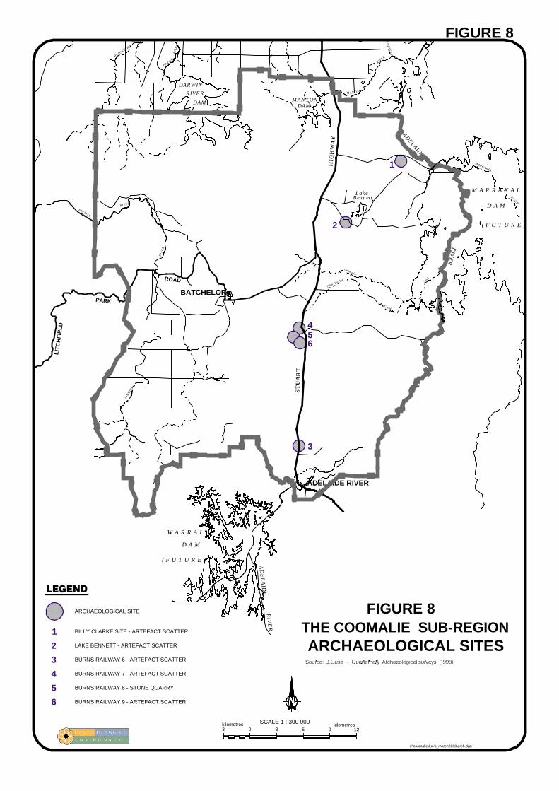
ARCHAEOLOGICAL SITESTHE COOMALIE SUB-REGION
ARCHAEOLOGICAL SITE
3
456
2
1
1
2
3
4
5
6
BURNS RAILWAY 8 - STONE QUARRY
BILLY CLARKE SITE - ARTEFACT SCATTER
LAKE BENNETT - ARTEFACT SCATTER
BURNS RAILWAY 6 - ARTEFACT SCATTER
BURNS RAILWAY 7 - ARTEFACT SCATTER
BURNS RAILWAY 9 - ARTEFACT SCATTER
FIGURE 8
0 3 6 9
SCALE 1 : 300 000kilometres3
kilometres12
FIGURE 8
r:\coomalie\luo’s_march2000\arch.dgn
FINNISS
RIVER
BLACKMORE
RIVER
FIN
NIS
S
RIV
ER
DARWIN
RIV
ER
Acacia
Glen Luckie
Creek
MANTON
RIVER
Coomalie
Creek
MARGARET
RIVER
AD
EL
AID
E
ADELAIDE
RIV
ER
MANTONDAM
HIG
HW
AY
ST
UA
RT
DARWIN
RIVER
DAM
ADELAIDE RIVER
BATCHELORPARK
ROAD
LIT
CH
FIE
LD
RIV
ER
Ck
W A R R A I
D A M
( F U T U R E )
( F U T U R E )
D A M
M A R R A K A ILake Bennett

FIG
UR
E 9
0 2 4 6
SCALE 1 : 200 000kilometres2
kilometres8
LAND TENURE
COOMALIE SUB-REGION
DARWIN
RIVER
DAM MANTONDAM
r:\coomalie\luo’s_march2000\coomten.dgn
AS AT 23 MARCH 2000
FINNISS
RIVER
BLACKMORE
RIVER
FIN
NIS
S
RIV
ER
DARWIN
RIV
ER
ST
UA
RT
HIG
HW
AY
Acacia
Glen Luckie
Creek
MANTON
RIVER
Coomalie
Creek
MARGARET
RIVER
AD
EL
AID
E
ADELAIDE
RIV
ER
RIV
ER
Ck

LOCALITY PLAN
12345
THE COOMALIE SUB-REGION
5
3
1
4
2
FIGURE 10
0 3 6 9
SCALE 1 : 300 000kilometres3
kilometres12
FIGURE 10
r:\coomalie\luo’s_march2000\distrcit.dgn
5
3
1
4
2
FINNISS
RIVER
BLACKMORE
RIVER
FIN
NIS
S
RIV
ER
DARWIN
RIV
ER
Acacia
Glen Luckie
Creek
MANTON
RIVER
Coomalie
Creek
MARGARET
RIVER
AD
EL
AID
E
ADELAIDE
RIV
ER
MANTONDAM
HIG
HW
AY
ST
UA
RT
DARWIN
RIVER
DAM
ADELAIDE RIVER
BATCHELORPARK
ROAD
LIT
CH
FIE
LD
RIV
ER
Ck
Lake Bennett

0 2 4 6kilometres2
kilometres8
COOMALIE SUB-REGION
PROPOSEDMARRAKAI DAM
FIG
UR
E 11
LAND USE STRUCTURE PLAN
r:\coomalie\luo’s_march2000\lusp.dgn
FINNISS
RIVER
BLACKMORE
RIVER
FIN
NIS
S
RIV
ER
DARWIN
RIV
ER
Acacia
Glen Luckie
Creek
MANTON
RIVER
Coomalie
Creek
MARGARET
RIVER
AD
EL
AID
E
ADELAIDE
RIV
ER
MANTONDAM
HIG
HW
AY
ST
UA
RT
DARWIN
RIVER
DAM
ADELAIDE RIVER
BATCHELORPARK
ROAD
LIT
CH
FIE
LD
RIV
ER
Ck
Lake Bennett

0 300 600 900metres300
metres1200
BATCHELORFIGURE 12a
REFER
FIGURE 12b
r:\coomalie\luo’s_march2000\batchlor.dgn

0 100 200 300metres100
metres400
BATCHELOR
FIG
UR
E 12b
r:\coomalie\luo’s_march2000\batchtn.dgn
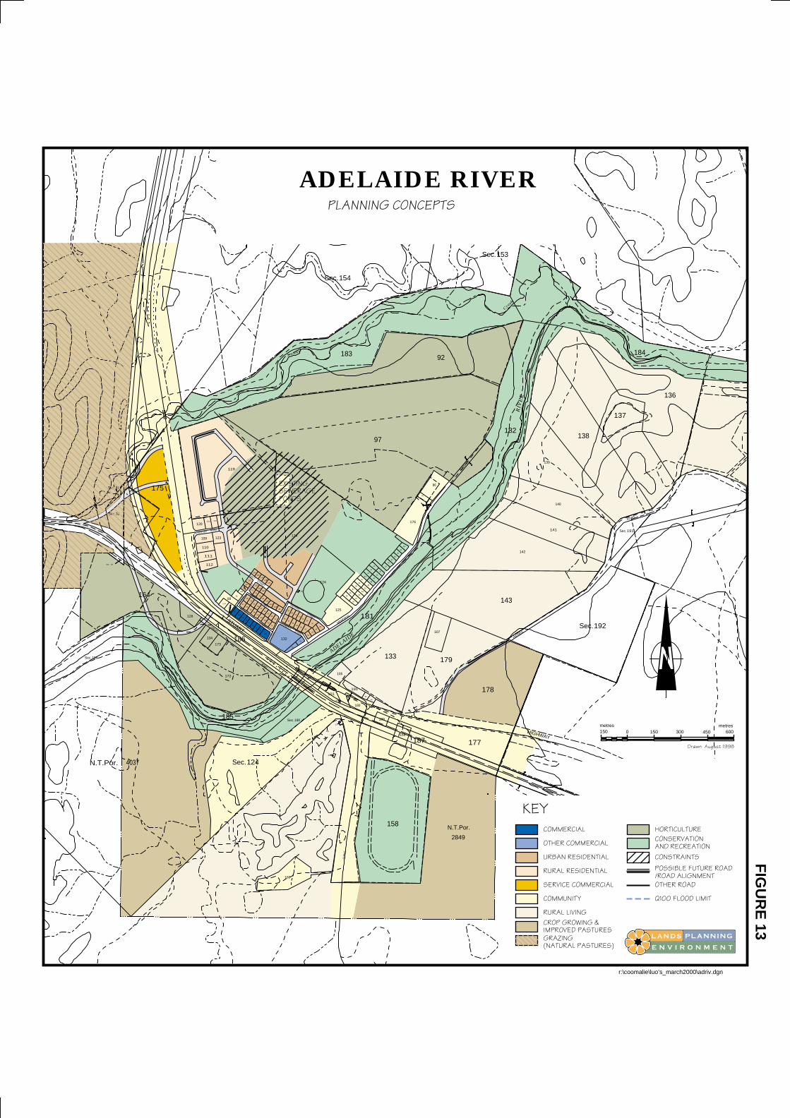
0metres150 150 300 450
metres600
ADELAIDE RIVER
FIG
UR
E 13
r:\coomalie\luo’s_march2000\adriv.dgn
SILVERTON ROAD
FINLAY
ROAD
BECK
ER
BECKER
STREET
STREE
T
HARDY
STREET
STREET
HATT
HOPE
WEL
L
DOGHERTYSTREET
STRE
ET
SWANNEL
STREET
Snake
Cre
ek
STUARTMEMORIAL
DORA
T
ROAD
TERRACE
ADELAIDE
RIV
ER
HAYNES
HIGHWAY
ROAD
N.T.Por.
2849
109Sec.
4037N.T.Por.
32Sec.
82Sec.
84
99Sec.
164
175
128
112
110
111
109
120121
134
173
114
123
122
185
172
186
127
2
113
89
76
88
17
156
155
119
124Sec.
3
188
4
56
13
7
12
16
18
15
19
14
2021
79
23
154
153
77
78
152
151
147
145146
144
11
25
10
26
9
27
80
24
116
117118
150
148
149
160
190Sec.
132
75
6867
66
70
65
8328
69
174
74
62
33
71
64
72
63
29
30
126
159
101
3231
124
161
157
100
105
125
35
36
183
180
191
93
181
54
53
37
38
39
52
40
51
50
41
42
189
94
49
48
47
43
44
46
45
55
97
158
168
133
56
57
58
59
60
154Sec.
187
61
176
92
107
85
87
86
179
177
178
143
142
182
153Sec.
141
140
139
192Sec.
138
191Sec.
137
184
136
r:\coomalie\

0 2 4 6
SCALE 1 : 300 000kilometres2
kilometres8
RINGWOD
ROAD
MARRAKAIROAD
OWENLAGOON
ROAD
CHINNER
ROAD
RU
MJU
NG
LE
ROAD
BATCHELOR
ROAD
RO
AD
MILTON
ROAD HIERARCHY
THE COOMALIE SUB-REGION
FIG
UR
E 14
r:\coomalie\luo’s_march2000\coomroad.dgn
AD
EL
AID
E
ADELAIDE
RIV
ER
MANTONDAM
HIG
HW
AY
ST
UA
RT
DARWIN
RIVER
DAM
ADELAIDE RIVER
BATCHELORPARK
ROAD
LIT
CH
FIE
LD
RIV
ER
Lake Bennett