department of the army -...
TRANSCRIPT

DEPARTMENT OF THE ARMY ALASKA DISTRICT, U.S. ARMY CORPS OF ENGINEERS
REGULATORY DIVISION P.O. BOX 6898
JBER, AK 99506-0898
November 10, 2015 Regulatory Division POA-1995-120 Dear Reader: Appendix J of the Donlin Draft EIS contains the current version of Donlin’s Section 10 Rivers and Harbors Act/Section 404 Clean Water Act application for a Department of the Army Permit for the proposed Donlin Gold Mine Project. Because the current application is a revised version of the original application and is expected to see additional changes, in ways as yet undetermined, prior to the U.S. Army Corps of Engineers (USACE) decision to issue or deny a permit, this letter and its references defines the status of the current application. Enclosed is the ENG 4345 application form with the references to the proposed project. Followed by Donlin’s October 5, 2015 memorandum to the USACE defining changes to the proposed project and therefore some of the information referenced in the application form and its references. The memorandum in Attachment A also contains updated tables of estimated acres of impact related to proposed impacts to wetlands, rivers and streams. Followed by an updated listing of the numbering of related figures. Therefore, to review the application in its current form the reader would start with the ENG 4345 application form. Then review Donlin’s October 5, 2015 memorandum that defines changes to that application form. Followed by reviewing the updated drawings for the mine site, pipeline corridor and transportation infrastructure found at www.donlingoldeis.com. Please note that due to the USACE’s requirement that Donlin modify the jurisdictional determination methodology they initially used, that the initial estimate of an impact to ~7000 acres of Water of the U.S. (WOUS) has been increased to slightly less than 10,000 acres of WOUS impact. Upon Donlin’s re-submission of their pending update to their jurisdictional determination information, the estimated acres of WOUS impact is expected to drop to ~7,000 acres.
Sincerely, Keith Gordon Project Manager


1
Memorandum ________________________________________________________________________
TO: Keith Gordon, U.S. Army Corps of Engineers
FROM: Nick Enos, Donlin Gold
CC: Patty McGrath, Donlin Gold
SUBJECT: Update to Preliminary Application for Department of the Army Permit –– Donlin Gold Project (POA-1995-120)
DATE: October 5, 2015
________________________________________________________________________ 1 Background
This memorandum transmits to the U.S. Army Corps of Engineers (Corps) updated information to the Preliminary Application for the Department of the Army (DOA) Permit POA-1995-120 (permit application) under the Clean Water Act (CWA) Section 404 and Rivers and Harbors Act (RHA) Section 10 for the proposed Donlin Gold Project. Donlin Gold submitted an initial permit application to the Corps in July 2012 (Donlin 2012), and a revision in December 2014 (Donlin 2014).
The main purpose of this update is to provide the Corps with an updated package of drawings and wetlands impact tables that depict the proposed project and wetlands impacts to support the Corps’ upcoming public notice (PN) of the DOA permit application and Draft Environmental Impact Statement (EIS). In addition, this update incorporates a change to the project description to include treatment and discharge of excess water through an Advanced Water Treatment (AWT) system and a change to the layout of the proposed Jungjuk Port. Lastly, some of the reference documents to the 2014 permit application have been updated. These updates are discussed below.
2 Project Description Update
This section describes several changes to the project description in the 2014 permit application.
2.1 Advanced Water Treatment (AWT)
The December 2014 Preliminary Application provided a summary of the proposed project and referred to project plans of operations for additional details. Since that time, Donlin Gold
Memorandum: Update to Preliminary Application for Department of the Army Permit – Donlin Gold Project (POA-1995-120)
October 5, 2015
2
completed a study of AWT as an option for allowing treatment and discharge of some of the water that would otherwise be stored in the Contact Water Dams (CWDs) and tailings storage facility (TSF) during project operations. Based on the results of the AWT study, Donlin Gold determined that the proposed project should be revised to incorporate AWT and discharge of additional water. This will form the basis of our Alaska Pollutant Discharge Elimination System (APDES) permit application to be submitted to the Alaska Department of Environmental Conservation. In parallel, these changes are being disclosed through the Draft EIS. The Corps was notified of these changes in a July 10, 2015 memorandum (Donlin 2015), which resulted in the Corps including these changes in the Proposed Action (Alternative 2) of the Draft EIS. With this memorandum, we are also incorporating these changes into the DOA permit application.
Water management associated with the original project description included treatment and discharge of only pit dewatering water collected from wells around and within the open pit. Under the previous project description, pit dewatering water would have been treated by a high density sludge (HDS) water treatment system. The treated water would be discharged to Crooked Creek under an APDES Permit. In order to treat water from other sources to meet Alaska water quality standards, the HDS treatment system would be replaced by an AWT system. The AWT system would consist of iron co-precipitation in a high rate clarifier (HRC), followed by greensand filtration, and reverse osmosis (RO). This system satisfies the goal of producing treated water that meets water quality standards, while treating pit dewatering water and water from the CWDs, TSF pond, and TSF Seepage Recovery System (SRS). The ability to treat and discharge water from these additional sources will enhance site water management and operational flexibility, as well as better control the accumulation of water in the TSF.
The AWT system would be located in the same area as the previous HDS water treatment plant. A description of the additional waters that would be treated and discharged and the AWT system can be found in the July 2015 memorandum and attachments.
2.2 Jungjuk Port
The previous design of the proposed Jungjuk port included a recessed berth/slipway for barges. Donlin Gold has since reevaluated that design and determined that this type of berth is impractical for barge maneuvers and safe operation at the port location. The recessed berth has therefore been removed from the port facility. This change is reflected in the revised drawings in Attachment B.
2.3 Construction Timeline
The 2014 permit application indicated that construction would start in 2016. Instead, construction would not be initiated until sometime after receipt of the DOA permit, currently estimated in the Corps schedule for the 4th quarter of 2017.

Memorandum: Update to Preliminary Application for Department of the Army Permit – Donlin Gold Project (POA-1995-120)
October 5, 2015
3
3 Wetlands Impact Tables
The wetlands impacts included in the 2014 permit application were based on the proposed project footprint and the Preliminary Jurisdictional Determination (2014 PJD) submitted to the Corps in May 2014 (3PPI 2014). In a May 20, 2015 letter, the Corps informed Donlin Gold that it was unable to verify the 2014 PJD due mainly to concerns related to the use of different wetlands delineation methodologies and the occurrence and characterization of wetland inclusions. These concerns, the rationale for the 2014 PJD, and the decision to provide revised wetland impact estimates for the Draft EIS and permit application are summarized below.
The Donlin Gold wetlands delineation was a multi-year project that began in 1996. Wetland data was collected using the methodology described in the Corps’ 1987 Wetland Delineation Manual (1987 Manual), which was the current methodology during much of the data collection period. In 2007 the Corps issued the Alaska Regional Supplement to the 1987 Manual (2007 ARS). After the 2007 ARS was issued, Donlin Gold collected wetland data using both the 1987 and 2007 methodology. Based on previous discussions with the Corps, Donlin Gold developed the 2014 PJD for the EIS study area based on the 1987 Manual with the intent that the PJD would be updated based on the final project footprint established near the conclusion of the NEPA process. The updated PJD for the final project footprint would be based on the 2007 ARS methodology and form the basis for the final DOA permit application.
The wetland inclusion approach followed in the 2014 PJD was meant as a conservative practical approach for mapping over 300,000 acres of land included in the EIS study area and was an approach used on other projects. However, in its May 2015 letter, the Corps expressed concerns with this approach and the extent to which it was used in the 2014 PJD. The Corps noted that each upland or wetland polygon delineated in the 2014 PJD contained a percentage of wetlands, and it would be impossible to preclude jurisdiction in any area that contained a percentage of waters of the U.S.
On May 28, 2015 Donlin Gold and the Corps met to discuss the 2014 PJD and the Corps May 2015 letter. During this and subsequent meetings the Corps determined, that for the purpose of the Draft EIS and the permit application PN, all wetland inclusions identified in the 2014 PJD would be assumed to be 100% wetlands. For the final permit application, additional data collection and analysis would occur following the 2007 ARS methodology and the PJD would be revised for the project footprint consistent with the 2007 ARS.
As a result, the 2014 permit application wetland impact estimates for the project were revised assuming that all inclusions including any wetlands are 100% wetlands. It is understood that this assumption results in estimates that are substantially overestimated for wetlands and
Memorandum: Update to Preliminary Application for Department of the Army Permit – Donlin Gold Project (POA-1995-120)
October 5, 2015
4
underestimated for uplands. It is reasonably expected that using the 2007 ARS for the PJD to support the final permit application will result in a reduction in affected wetland acreage primarily because the black spruce forest areas that are commonly found on south and west facing slopes within the proposed mine site would not be found jurisdictional under the 2007 ARS.
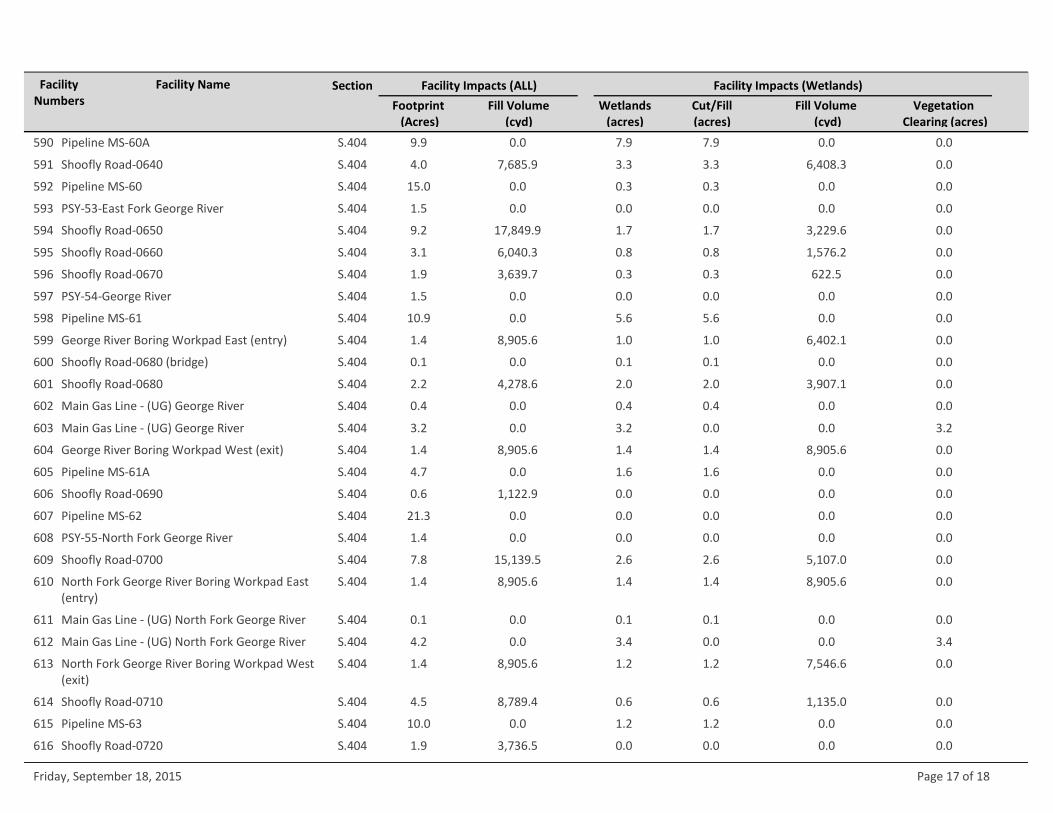
The revised wetland impact estimates are provided in the tables included in Attachment A. The tables provide wetland impacts due to cut and fills and vegetation clearing necessary to construct facilities associated with the proposed project. The tables in Attachment A replace the wetland impact tables provided in Sections 4 and 5 of the 2014 permit application as described in Table 1, below. The project construction descriptions in Sections 4 and 5 of the 2014 permit application have not changed, with exception of the Jungjuk Port as mentioned above.
Looking ahead to 2016, Donlin Gold will reduce the study area of the 2014 PJD to the proposed project described in the final permit application, and update the wetlands data within this study area to reflect the 2007 ARS. Additional field work will be required to complete this task, which will result in the submission of an updated PJD towards the 4th quarter of 2016. Subsequently, Donlin Gold will update the permit application to a final permit application.
4 Drawings
The 2014 permit application included 798 sheets that showed the proposed project plans and footprint overlain on mapped wetlands, as well as numerous typicals and cross sections. These drawings have been revised in response to several factors including: (1) request from the Corps to provide a concise set of drawings for the permit application PN; (2) the change in wetlands delineation (polygons including wetland inclusions assumed to be 100% wetlands); and (3) in response to Corps comments on the December 2014 permit application to standardize the drawings consistent with the Corps “Guidance Checklist for Completion of Drawings”.
The revised drawing set consists of 300 drawings that are provided in Attachment B. The drawings are organized in three groups:
• TA – transportation area (see Attachment B-2) • MA – mine area (see Attachment B-3) • PA – pipeline area (see Attachment B-4)
Within each group of maps, there are detailed facility map sets that include:
• A: plan view of wetlands overlaid with the proposed facilities • B: plan view of facilities highlighting engineering features • C: plan view same as B, but with aerial photography as a base map
Memorandum: Update to Preliminary Application for Department of the Army Permit – Donlin Gold Project (POA-1995-120)
October 5, 2015
5
• D: detail facility plan view and cross-sections • T: typicals
Attachment B also includes an index and notes page that lists the figures and describes the general notes that apply to the figures (Attachment B-1). Table A-4 in Attachment A identifies on which figure(s) the project facilities can be found.
5 Summary of Changes to the 2014 Permit Application
The following table provides a summary of the updates to the 2014 permit application based on the information provided in this memorandum, the revised drawings, and revised wetland impact estimates. In addition, the table notes that one of the 2014 reference documents has been updated (Reclamation and Closure Plan) and a document relevant to the application form (Conceptual Compensatory Mitigation Plan) has been submitted. The entire permit application was not revised since the vast majority of the detailed facility-specific project descriptions and construction descriptions and other parts of the application are still accurate (the exceptions are the changes noted in Section 1 for AWT and the Jungjuk Port). A stand-alone final permit application that includes relevant updates will be submitted following completion of the revised PJD.
Table 1. Summary of Updates to the 2014 Preliminary Application
2014 Preliminary Permit Application Summary of Changes
Chapter Section or Table Number
Entire document Figures and figure numbers have been revised. Therefore, all references to figure numbers in the 2014 permit application are no longer applicable.
Chapter 1 -Introduction
Section 1.3, Schedule Construction timeline would start with the DOA permit issuance instead of in November 2016.
Chapter 2 - Project Mitigation and Reclamation Plans
Section 2.2, Reclamation and Closure Planning
An updated Reclamation and Closure Plan (SRK 2015) has been submitted to the State of Alaska Department of Natural Resources and is available to the Corps.
Section 2.3, Compensatory Mitigation Plan Overview
Donlin Gold submitted a Conceptual Compensatory Mitigation Plan (Baker 2015) to the Corps on August 10, 2015.
Chapter 3 - Project Impact Summary
Tables 3.1A, 3.1B, 3.1C, 3.1 E, 3.1F, 3.1G, 3.1H, 3.2A – These tables summarize wetland impact in various ways (by facility, by impact type, by year).
These tables in Chapter 3 summarize wetlands impact information in Chapters 4 and 5. Since all the wetlands impact information has been updated these tables are no longer accurate. Instead tables in Attachment A of this memorandum should be utilized. Tables that summarize stream impacts are still accurate (Tables 3.2B and 3.2C).

Memorandum: Update to Preliminary Application for Department of the Army Permit – Donlin Gold Project (POA-1995-120)
October 5, 2015
6
2014 Preliminary Permit Application Summary of Changes
Chapter Section or Table Number
Chapter 4 – Impact Overview Facility Study Area (FSA)
Section 4.1.1, Jungjuk Port, Facilities 1 through 3
The Jungjuk port no longer includes a recessed berth for barges.
Tables 4.1A, 4.2A, 4.3A, 4.4A, 4.5A, 4.6A, 4.7A - Footprints by area and length of disturbance for the mine and transportation area facilities.
Length (time) of disturbance has not changed. Construction timeline should start with permit issuance instead of in 2016. Wetland disturbance acres should be based on Attachment A tables. Drawing references no longer apply.
Table 4.1B, 4.2B, 4.3B, 4.4B, 4.5B, 4.6B, 4.7B - Impact type by facility for the mine and transportation area facilities.
Replace with Attachment A tables.
Figure 4.6-1 - Detail of TSF Area – Closure Pond 2050
As a result of discharge of additional waters, the TSF closure pond will be smaller. Therefore this figure is no longer accurate and an updated figure will be supplied with the final permit application.
Chapter 5 – Impact Overview, Pipeline Study Area (PSA)
Tables 5.1, 5.2, 5.3, 5.5, and 5.6 – Pipeline typicals
Replace with the drawings in Attachment B.
Tables 5.7A, 5.8A, 5.9A, 5.10A, 5.11A, 5.12A, 5.13A, 5.14A - Footprints by area and length of disturbance for pipeline facilities and segments.
Length (time) of disturbance has not changed. Construction timeline should start with permit issuance instead of in 2016. Wetland disturbance acres should be based on Attachment A tables. Drawing references no longer apply.
Table 5.7B, 5.8B, 5.9B, 5.10B, 5.11B, 5.12B, 5.13B, 5.14B: Impact type by facility and segment for the pipeline.
Replace with Attachment A tables.
Appendix A, USACE Engineering Form 4345
Block 21, Type of material being discharged and amount of each type
Use updated fill volumes in Attachment A tables.
Block 22: Surface area of wetlands or other waters filled
Use updated acres in Attachment A tables.
Block 23: Description of Avoidance, Minimization, and Compensation
In addition to the references in this block, Donlin Gold submitted a Conceptual Compensatory Mitigation Plan (Baker 2015) to the Corps on August 10, 2015.
Table 22.1A, 22.1B – Expected material site impacts for FSA and PSA
Tables will be updated with final permit application.

Memorandum: Update to Preliminary Application for Department of the Army Permit – Donlin Gold Project (POA-1995-120)
October 5, 2015
7
2014 Preliminary Permit Application Summary of Changes
Chapter Section or Table Number
Table 22.3 – Maximum anticipated impacts to Wetland and Waters by Cowardian Classification
Table 22.3 – Maximum anticipated impacts to Wetland and Waters by HGM Type
Table 22.5 – Predominant Vegetation and Cover Types
Table 22.6 – Summary of Potential Project Impacts to Wetlands by Ecoregion and Watershed
These tables summarize wetlands impact information in Chapters 4 and 5 and also incorporate information from the Functional Assessment. Since all the wetlands impact information has been updated these tables are no longer accurate. Instead tables in Attachment A of this memorandum should be utilized. Revised summary tables relevant to the Functional Assessment will be developed following revision of the Functional Assessment.
Appendices C through J
Drawings and figures. Replace with Attachment B drawings.
References
Michael Baker International (Baker). 2015. Conceptual Compensatory Mitigation Plan, Donlin Gold Project. August 2015.
Donlin Gold (Donlin) 2015. “Approach for Incorporating Advanced Water Treatment in the EIS”, Memorandum to Keith Gordon (USACE) and Taylor Brelsford (AECOM) from Robert (Nick) Enos (Donlin Gold). July 10 2015.
Donlin Gold (Donlin) and 3 PPI 2014. Section 404 Clean Water Act and Section 10 Rivers and Harbors Act Preliminary Permit Application and Supplemental Information, Donlin Gold Project, prepared by Three Parameters Plus (3PPI). December 2014.
Donlin Gold (Donlin) and 3PPI 2012. Section 404 Clean Water Act and Section 10 Rivers and Harbors Act Preliminary Permit Application, Donlin Gold Project, prepared by Three Parameters Plus (3PPI). July 2012.
Three Parameters Plus (3PP1). 2014. Preliminary Jurisdictional Determination, Donlin Gold Project, Revision 1.0. April 2014.
SRK Consulting, Inc., (SRK) 2015. Plan of Operations - Reclamation and Closure Plan, Donlin Gold Project. June 2015.

Memorandum: Update to Preliminary Application for Department of the Army Permit – Donlin Gold Project (POA-1995-120)
October 5, 2015
8
Attachment A
Table A-1: Donlin Gold Project – Section 404 and 10 Impacts by Facility
Table A-2: Donlin Gold Project – Section 404 and 10 Summary of Impacts by Area
Table A-3: Donlin Gold Project – Section 404 and 10 Summary of Impacts
Table A-4: Facility and Figure Number Reference Table

Table A-1: Donlin Gold Project ‐ Section 404 and 10 Impacts by FacilityFacilityNumbers
Facility Name
Footprint (Acres)
Wetlands(acres)
Fill Volume(cyd)
Fill Volume (cyd)
Cut/Fill(acres)
Vegetation Clearing (acres)
Section Facility Impacts (Wetlands)Facility Impacts (ALL)
4,212,521.2 430.1 424.9 2,765,147.0 4.6859.4PROPOSED TRANSPORTATION AREA
S.10 2.3 2.350,000.0 50,000.0 0.01 Jungjuk Port 2.1
S.404 18.7 9.9235,315.2 122,015.9 0.01 Jungjuk Port 9.4
S.404 5.2 4.052,318.0 40,296.7 0.03 Jungjuk Port Growth Media Stockpile 4.0
S.404 197.8 105.61,914,510.4 1,021,847.0 0.04 Lower Jungjuk‐Donlin Road (Port to Hillcut) 105.6
S.404 0.0 0.00.0 0.0 0.05 Jungjuk‐Donlin Road ‐ Port to Hillcut ‐ Bridge 2.6 0.0
S.404 0.0 0.00.0 0.0 0.06 Jungjuk‐Donlin Road ‐ Port to Hillcut ‐ Bridge 3.3 0.0
S.404 0.0 0.00.0 0.0 0.07 Jungjuk‐Donlin Road ‐ Port to Hillcut ‐ Bridge 9.8 0.0
S.404 0.0 0.00.0 0.0 0.08 Jungjuk‐Donlin Road ‐ Port to Hillcut ‐ Bridge 10.2
0.0
S.404 0.0 0.00.0 0.0 0.09 Jungjuk‐Donlin Road ‐ Port to Hillcut ‐ Bridge 11.2
0.0
S.404 1.8 1.83,426.7 3,426.7 0.010 FSA Material Site 16 ‐ Access Road 1.8
S.404 27.6 24.40.0 0.0 0.011 FSA Material Site 16 24.4
S.404 10.3 1.50.0 0.0 0.012 FSA Material Site 13 1.5
S.404 14.2 0.00.0 0.0 0.013 FSA Material Site 12 0.0
S.404 208.3 99.00.0 0.0 0.014 FSA Material Site 10 99.0
S.404 4.7 0.00.0 0.0 0.015 FSA Material Site 09 0.0
S.404 3.9 3.97,627.8 7,627.8 0.016 FSA Material Site 08 ‐ Access Road 3.9
S.404 22.3 3.47,628.0 1,173.3 0.017 FSA Material Site 08 3.4
S.404 21.9 0.00.0 0.0 0.018 FSA Material Site 07 0.0
S.404 2.8 0.00.0 0.0 0.019 FSA Material Site 06 0.0
S.404 24.4 0.40.0 0.0 0.020 FSA Material Site 05 0.4
S.404 10.5 0.30.0 0.0 0.021 FSA Material Site 04 0.3
S.404 10.6 1.5170,368.0 23,505.5 0.022 Jungjuk‐Donlin Road Hillcut 1.5
S.404 6.1 1.558,854.4 14,135.0 0.023 Jungjuk‐Donlin Road (Hillcut to Airstrip Access Road)
1.5
Friday, September 18, 2015 Page 1 of 18

FacilityNumbers
Facility Name
Footprint (Acres)
Wetlands(acres)
Fill Volume(cyd)
Fill Volume (cyd)
Cut/Fill(acres)
Vegetation Clearing (acres)
Section Facility Impacts (Wetlands)Facility Impacts (ALL)
S.404 15.7 1.50.0 0.0 0.024 FSA Material Site 03 1.5
S.404 21.2 18.3102,462.8 88,728.5 0.025 Airstrip Access Road 18.3
S.404 88.9 73.9430,421.2 357,737.5 0.026 Airstrip (Runway and Apron) 73.9
S.404 9.3 9.3301,370.7 301,370.7 0.027 Airstrip (Northwest Clear Zone/Growth Media Stockpile)
9.3
S.404 11.8 11.8381,392.0 381,392.0 0.028 Airstrip (Southeast Clear Zone/Growth Media Stockpile)
11.8
S.404 46.4 36.0449,442.4 348,821.3 0.029 Upper Jungjuk‐Donlin Road from Airstrip Access Road to Crook
36.0
S.404 21.5 4.10.0 0.0 0.030 FSA Material Site 02 4.1
S.404 36.7 10.40.0 0.0 0.031 FSA Material Site 01 (excluding camp components)
10.4
S.404 9.8 0.647,383.6 3,069.0 0.032 FSA Material Site 01 Camp Components 0.6
S.404 4.7 4.60.0 0.0 4.633 Powerline (Project‐wide Impacts) 0.0
1,540,683,886.4 6,952.0 6,631.1 980,174,116.3 310.88,960.1PROPOSED MINE AREA
S.404 20.7 14.70.0 0.0 4.633 Powerline (Project‐wide Impacts) 0.0
S.404 0.1 0.10.0 0.0 0.034 Crooked Creek Bridge ‐ Clear Span (Impacts Above OHWM)
0.1
S.404 13.0 13.0125,468.9 125,468.9 0.035 Jungjuk‐Donlin Road, Crooked Creek Bridge to Pit Access Road
13.0
S.404 13.8 12.9133,293.6 125,067.9 0.036 Jungjuk‐Donlin Road, Pit Access Road to Mill/Plant Site
12.9
S.404 17.4 17.084,119.2 82,438.8 0.037 Crusher Facility Access Road ‐ A 17.0
S.404 15.9 15.976,956.0 76,956.0 0.038 Crusher Facility Access Road ‐ B 15.9
S.404 21.1 19.9102,220.8 96,126.8 0.039 Plant Site Crusher Facility Access Road & Parking 19.9
S.404 0.3 0.31,210.0 1,210.0 0.040 Fleet Service Access Road 0.3
S.404 164.5 133.97,961,800.0 6,481,329.7 0.041 Long Term Ore Stockpile (includes berm) 133.9
S.404 43.6 23.72,621,629.0 1,424,506.3 0.042 Primary Crusher Pad 23.7
S.404 12.3 9.117,921.0 13,271.1 0.043 TSF Construction Laydown Area 6 9.1
Friday, September 18, 2015 Page 2 of 18

FacilityNumbers
Facility Name
Footprint (Acres)
Wetlands(acres)
Fill Volume(cyd)
Fill Volume (cyd)
Cut/Fill(acres)
Vegetation Clearing (acres)
Section Facility Impacts (Wetlands)Facility Impacts (ALL)
S.404 22.7 22.71,098,680.0 1,098,680.0 0.044 Terrace Borrow Site 3/North TSF Overburden Stockpile & Wetla
22.7
S.404 3.4 3.421,747.7 21,747.7 0.045 Mine Fleet Assembly Area 3.4
S.404 9.8 7.654,622.0 42,195.1 0.046 Water Treatment Plant 7.6
S.404 1,007.8 700.40.0 0.0 0.047 Ultimate Pit ‐ Lake 700.4
S.404 494.4 256.50.0 0.0 0.048 Ultimate Pit ‐ Walls 256.5
S.404 8.4 7.10.0 0.0 7.149 Ultimate Pit ‐ Island 0.0
S.404 155.2 152.75,900,000.0 5,804,006.7 0.050 North Overburden Stockpile 2028 & Reclamation Area
152.7
S.404 73.1 70.90.0 0.0 70.951 North Overburden Stockpile 2028 Buffer 0.0
S.404 1.1 1.00.0 0.0 0.052 North Overburden Stockpile 2028 Drainage Ditch
1.0
S.404 8.4 4.316,339.8 8,401.1 0.053 FSA Material Site ‐ Snow Gulch Access Road 4.3
S.404 51.8 10.40.0 0.0 0.054 FSA Material Site ‐ Snow Gulch 10.4
S.404 5.4 2.810,415.7 5,344.3 0.055 Snow Gulch Pond Access Road 2.8
S.404 8.6 8.61,040,000.0 1,040,000.0 0.056 Snow Gulch Water Dam/Wetland Mitigation Site 8.6
S.404 71.8 68.70.0 0.0 0.057 Snow Gulch Freshwater Reservoir 68.7
S.404 1.0 1.06,453.0 6,453.0 0.058 Magazine Booster Area Pad 1.0
S.404 3.8 0.024,523.0 0.0 0.059 AN Storage Pad 0.0
S.404 0.1 0.0213.0 0.0 0.060 AN Storage Access Road 0.0
S.404 1.2 0.07,744.0 0.0 0.061 Emulsion Plant Pad 0.0
S.404 3.8 3.818,537.2 18,537.2 0.062 Terrace Borrow Sites Access Road/Wetland Mitigation Site
3.8
S.404 35.7 35.71,000,000.0 1,000,000.0 0.063 Terrace Borrow Site 4/Central TSF Overburden Stockpile and W
35.7
S.404 81.8 81.83,300,000.0 3,300,000.0 0.064 Terrace Borrow Site 4 & 5/South Overburden Stockpile 2019 an
81.8
S.404 35.4 35.42,211.0 2,211.0 0.065 Potable Water Well Pads 35.4
S.404 29.0 26.4140,263.2 127,788.3 0.066 Tailings Storage Facility Access Road ‐ A 26.4
S.404 11.6 11.556,192.4 55,616.6 0.067 Tailings Storage Facility Access Road ‐ B 11.5
Friday, September 18, 2015 Page 3 of 18

FacilityNumbers
Facility Name
Footprint (Acres)
Wetlands(acres)
Fill Volume(cyd)
Fill Volume (cyd)
Cut/Fill(acres)
Vegetation Clearing (acres)
Section Facility Impacts (Wetlands)Facility Impacts (ALL)
S.404 20.3 17.598,397.2 84,918.2 0.068 Tailings Storage Facility Access Road ‐ C 17.5
S.404 0.0 0.0145.2 145.2 0.069 Upper TSF Access Road ‐ A 0.0
S.404 1.7 1.28,324.8 5,682.2 0.070 Upper TSF Access Road ‐ B 1.2
S.404 121.4 120.84,100,000.0 4,080,983.6 0.071 Stockpile #1 (Growth Media)/Wetland Mitigation Area
120.8
S.404 111.9 111.92,100,000.0 2,100,000.0 0.072 Terrace Borrow 6/TSF Stockpile 2 and Wetland Mitigation Area
111.9
S.404 1.0 1.00.0 0.0 0.073 TSF Stockpile #2 ‐ Diversion Ditch (Stormwater Treatment)
1.0
S.404 46.6 46.65,500,000.0 5,500,000.0 0.074 Stockpile #3 (Growth Media)/Wetland Mitigation Area
46.6
S.404 76.2 73.0110,965.0 106,294.4 0.075 Construction Laydown Area 1 73.0
S.404 70.1 68.5102,194.0 99,867.1 0.076 Construction Laydown Area 2 68.5
S.404 28.9 27.642,064.0 40,250.1 0.077 Construction Laydown Area 3 27.6
S.404 88.7 43.5129,211.0 63,307.1 0.078 TSF Construction Laydown Area 4 43.5
S.404 2.0 0.24,643.0 395.7 0.079 Road Truckshop Pad 0.2
S.404 20.8 20.8100,430.0 100,430.0 0.080 South Overburden Stockpile 2033 Access Road 20.8
S.404 235.6 235.65,500,000.0 5,500,000.0 0.081 Terrace Borrow Site 7/South Overburden Stockpile 2033 and We
235.6
S.404 4.7 4.70.0 0.0 0.082 South Overburden Stockpile 2033 ‐ Drainage Ditch (Stormwater
4.7
S.404 355.3 346.92,045,061.4 1,996,950.9 0.083 TSF Starter Facility Liner Bedding ‐ A 346.9
S.404 5.4 2.030,851.1 11,259.5 0.084 TSF Starter Facility Liner Bedding ‐ B 2.0
S.404 4.9 4.9255,154.6 255,154.6 0.085 TSF North Freshwater Dam/Tailings 4.9
S.404 0.9 0.944,845.4 44,845.4 0.086 TSF North Freshwater Dam Spillway/Tailings 0.9
S.404 22.5 22.5124,961.0 124,961.0 0.087 TSF North Freshwater Pond/Tailings Liner Bedding
22.5
S.404 0.7 0.74,110.0 4,110.0 0.088 TSF South Fresh Water Dam Spillway/Tailings Liner Bedding
0.7
S.404 2.4 2.4140,000.0 140,000.0 0.089 TSF South Fresh Water Dam/Tailings Liner Bedding
2.4
Friday, September 18, 2015 Page 4 of 18

FacilityNumbers
Facility Name
Footprint (Acres)
Wetlands(acres)
Fill Volume(cyd)
Fill Volume (cyd)
Cut/Fill(acres)
Vegetation Clearing (acres)
Section Facility Impacts (Wetlands)Facility Impacts (ALL)
S.404 15.2 15.284,141.0 84,141.0 0.090 TSF South Freshwater Pond/Tailings Liner Bedding
15.2
S.404 13.1 11.93,686,124.0 3,352,425.9 0.091 TSF Dam ‐ Starter 11.9
S.404 12.5 9.93,500,694.0 2,785,237.0 0.092 TSF Dam ‐ Year 1 9.9
S.404 9.2 7.72,570,734.0 2,157,749.5 0.093 TSF Dam ‐ Year 5 7.7
S.404 8.8 7.72,486,448.0 2,177,888.4 0.094 TSF Dam ‐ Year 9 7.7
S.404 8.0 7.12,236,398.0 2,008,702.3 0.095 TSF Dam ‐ Year 13 7.1
S.404 8.8 8.12,480,829.0 2,264,938.8 0.096 TSF Dam ‐ Year 17 8.1
S.404 8.1 7.42,281,351.0 2,092,652.1 0.097 TSF Dam ‐ Year 21 7.4
S.404 60.1 54.516,876,940.0 15,320,732.4 0.098 TSF Dam ‐ Year 25 54.5
S.404 37.9 35.010,656,606.0 9,840,310.0 0.099 TSF Dam ‐ Year 27.5 35.0
S.404 449.6 434.92,497,227.0 2,415,161.4 0.0100 TSF Liner Bedding ‐ Year 1 434.9
S.404 328.1 311.01,822,158.0 1,727,207.7 0.0101 TSF Liner Bedding ‐ Year 5 311.0
S.404 281.2 264.81,561,906.0 1,470,722.1 0.0102 TSF Liner Bedding ‐ Year 9 264.8
S.404 217.7 204.91,208,959.0 1,138,180.2 0.0103 TSF Liner Bedding ‐ Year 13 204.9
S.404 226.4 213.91,257,555.0 1,187,707.9 0.0104 TSF Liner Bedding ‐ Year 17 213.9
S.404 174.3 165.0968,089.0 916,146.4 0.0105 TSF Liner Bedding ‐ Year 21 165.0
S.404 50.9 48.5282,690.0 269,128.7 0.0106 TSF Liner Bedding ‐ Year 25 48.5
S.404 90.4 90.4502,289.0 502,289.0 0.0107 TSF Liner Bedding/Closure Pond 2050 90.4
S.404 238.4 228.30.0 0.0 228.3108 TSF Buffer
S.404 1.5 1.1100,000.0 68,626.0 0.0109 TSF Closure Spillway 1.1
S.404 5.8 5.8121,081.1 121,081.1 0.0110 TSF Drainage/Stormwater Treatment ‐ A 5.8
S.404 0.9 0.918,918.9 18,918.9 0.0111 TSF Drainage/Stormwater Treatment ‐ B 0.9
S.404 1.5 1.510,000.0 9,993.0 0.0112 TSF Seepage Recovery System ‐ Berm & Pond Liner Bed
1.5
S.404 1.5 1.50.0 0.0 0.0113 TSF Seepage Recovery System ‐ Pond 1.5
S.404 123.5 68.9389,326.0 217,282.9 0.0114 Millsite/Plant Site Pad (also Construction Camp) 68.9
S.404 0.6 0.02,904.0 4.5 0.0115 Plant Site Waste Rock Facility Access Road 0.0
S.404 76.3 28.1145,319.0 53,503.5 0.0116 Fuel Farm Pad 28.1
Friday, September 18, 2015 Page 5 of 18

FacilityNumbers
Facility Name
Footprint (Acres)
Wetlands(acres)
Fill Volume(cyd)
Fill Volume (cyd)
Cut/Fill(acres)
Vegetation Clearing (acres)
Section Facility Impacts (Wetlands)Facility Impacts (ALL)
S.404 8.1 0.552,465.6 3,458.3 0.0117 Core Storage Yard 0.5
S.404 16.1 15.52,700,000.0 2,607,370.4 0.0118 American Creek Lower Contact Water Dam/Berm
15.5
S.404 155.3 151.50.0 0.0 0.0119 American Creek Lower Contact Pond/Reservoir 151.5
S.404 5.0 4.9400,000.0 389,256.5 0.0120 American Freshwater Diversion Dam/Waste Rock
4.9
S.404 33.6 31.01,626,240.0 1,499,344.4 0.0121 American Freshwater Diversion Pond/Waste Rock
31.0
S.404 0.6 0.04,001.1 183.6 0.0122 America Creek Upper Contact Dam Spillway 2018/Waste Rock
0.0
S.404 8.8 5.75,351,697.6 3,470,706.5 0.0123 American Creek Upper Contact Water Dam 2018/Waste Rock
5.7
S.404 42.4 24.025,784,345.2 14,603,784.7 0.0124 American Creek Upper Contact Water Pond 2018/Waste Rock
24.0
S.404 41.1 0.00.0 0.0 0.0125 FSA Material Site ‐ Upper American Creek 0.0
S.404 0.2 0.21,016.4 928.0 0.0126 Waste Rock Storage Area Access Road 0.2
S.404 38.0 37.9184,016.8 183,426.8 0.0127 Ramp to Waste Rock Storage Area 37.9
S.404 2,376.1 1,441.41,358,588,412.2 824,124,903.3 0.0128 Waste Rock Facility 1,441.4
S.404 2.5 2.51,509,921.5 1,509,921.5 0.0129 Waste Rock Facility Drainage System ‐ A 2.5
S.404 69.4 62.942,265,625.6 38,284,652.9 0.0130 Waste Rock Facility Drainage System ‐ B 62.9
S.404 31.8 13.0189,387.0 77,459.0 0.0131 Ultimate Pit ‐ Safety Berm 13.0
S.404 3.1 0.00.0 0.0 0.0132 FSA Material Site ‐ Upper American Ridge 0.0
S.404 7.3 0.614,152.2 1,078.2 0.0133 American Ridge Access Road 0.6
4,584,010.6 2,376.0 1,595.1 1,308,361.7 780.96,129.3PROPOSED PIPELINE AREA
S.404 27.7 17.20.0 0.0 17.2307 Power Transmission Line 0.0
S.404 13.3 5.00.0 0.0 0.0308 Pipeline MS‐00 5.0
S.404 3.2 0.420,779.7 2,479.8 0.0309 Laydown (Compressor Station) 0.4
S.404 14.7 2.00.0 0.0 0.0311 Pipeline MS‐01 2.0
S.404 1.5 0.30.0 0.0 0.3312 PSY‐01 0.0
S.404 1.3 1.30.0 0.0 1.3314 Water Extraction Site Access WES‐0031 0.0
Friday, September 18, 2015 Page 6 of 18

FacilityNumbers
Facility Name
Footprint (Acres)
Wetlands(acres)
Fill Volume(cyd)
Fill Volume (cyd)
Cut/Fill(acres)
Vegetation Clearing (acres)
Section Facility Impacts (Wetlands)Facility Impacts (ALL)
S.404 2.6 2.60.0 0.0 2.6315 Water Extraction Site Access WES‐0030 0.0
S.404 6.2 0.60.0 0.0 0.0316 Pipeline MS‐02 0.6
S.404 2.3 0.64,452.8 1,161.0 0.0317 Shoofly Road‐0010 0.6
S.404 1.5 1.50.0 0.0 1.5318 PSY‐02‐Susitna River‐Frontal Cook Inlet 0.0
S.404 2.5 1.34,898.1 2,529.8 0.0319 Shoofly Road‐0020 1.3
S.404 1.5 0.00.0 0.0 0.0320 PSY‐03‐Susitna River‐Frontal Cook Inlet 0.0
S.404 5.6 0.00.0 0.0 0.0321 Pipeline MS‐03 0.0
S.404 0.7 0.01,277.8 78.6 0.0322 Shoofly Road‐0030 0.0
S.404 3.5 0.46,814.7 737.5 0.0323 Shoofly Road‐0040 0.4
S.404 4.7 0.00.0 0.0 0.0324 Pipeline MS‐04 0.0
S.404 5.0 2.50.0 0.0 2.5325 Water Extraction Site Access WES‐0080 0.0
S.404 1.5 0.00.0 0.0 0.0326 PSY‐04‐Alexander Creek 0.0
S.404 2.8 0.50.0 0.0 0.5327 Water Extraction Site Access WES‐0085 0.0
S.404 233.3 64.30.0 0.0 64.3328 Main Gas Line ‐ MP 00.0 to 050.8 0.0
S.404 365.9 99.9160,934.4 43,952.6 0.0329 Main Gas Line ‐ MP 00.0 to 050.8 99.9
S.404 16.5 0.20.0 0.0 0.0330 Pipeline MS‐05 0.2
S.404 1.5 0.00.0 0.0 0.0331 PSY‐05‐Alexander Creek 0.0
S.404 1.5 0.00.0 0.0 0.0332 PSY‐06‐Alexander Creek 0.0
S.404 4.7 0.00.0 0.0 0.0333 Pipeline MS‐06 0.0
S.404 9.2 4.10.0 0.0 4.1334 Water Extraction Site Access WES‐0115 0.0
S.404 3.7 0.00.0 0.0 0.0335 Pipeline MS‐07 0.0
S.404 1.5 0.00.0 0.0 0.0336 PSY‐07‐Alexander Creek 0.0
S.404 5.2 2.10.0 0.0 2.1337 Water Extraction Site Access WES‐0140 0.0
S.404 8.1 0.039,058.8 0.0 0.0338 Deep Creek Camp 0.0
S.404 19.4 2.037,558.4 3,780.0 0.0339 Deep Creek Airstrip 2.0
S.404 1.5 0.00.0 0.0 0.0340 PSY‐08‐Alexander Creek 0.0
S.404 5.6 0.10.0 0.0 0.0341 Pipeline MS‐08 0.1
S.404 16.1 0.00.0 0.0 0.0342 Pipeline MS‐09 0.0
Friday, September 18, 2015 Page 7 of 18

FacilityNumbers
Facility Name
Footprint (Acres)
Wetlands(acres)
Fill Volume(cyd)
Fill Volume (cyd)
Cut/Fill(acres)
Vegetation Clearing (acres)
Section Facility Impacts (Wetlands)Facility Impacts (ALL)
S.404 1.5 0.50.0 0.0 0.5343 PSY‐09‐Lower Skwentna River 0.0
S.404 0.6 0.20.0 0.0 0.2344 Water Extraction Site Access WES‐0165 0.0
S.404 2.0 1.50.0 0.0 1.5345 Water Extraction Site Access WES‐0170 0.0
S.404 0.7 0.11,258.4 129.2 0.0346 Shoofly Road‐0070 0.1
S.404 1.9 0.83,601.0 1,463.5 0.0347 Shoofly Road‐0060 0.8
S.404 1.4 0.58,905.6 3,161.6 0.0348 Lower Skwentna River Boring Workpad East (entry)
0.5
S.404 1.5 1.50.0 0.0 0.0349 Main Gas Line ‐ (UG) Lower Skwentna River 1.5
S.404 1.9 0.50.0 0.0 0.5350 Main Gas Line ‐ (UG) Lower Skwentna River 0.0
S.404 15.7 0.80.0 0.0 0.0351 Pipeline MS‐10 0.8
S.404 1.4 0.48,905.6 2,289.5 0.0352 Lower Skwentna River Boring Workpad West (exit)
0.4
S.404 1.5 0.00.0 0.0 0.0353 PSY‐10‐Lower Skwentna River 0.0
S.404 2.0 0.13,910.7 240.4 0.0354 Shoofly Road‐0080 0.1
S.404 42.0 4.7203,473.6 22,748.8 0.0355 Skwentna River Camp (Shell) 4.7
S.404 0.6 0.10.0 0.0 0.1356 Water Extraction Site Access WES‐0190 0.0
S.404 1.5 0.00.0 0.0 0.0357 PSY‐11‐Lower Skwentna River 0.0
S.404 103.7 5.2200,724.5 10,009.1 0.0358 Skwentna River Camp Airstrip (Shell) 5.2
S.404 0.3 0.30.0 0.0 0.3359 Water Extraction Site Access WES‐0210 0.0
S.404 36.3 36.30.0 0.0 0.0360 Pipeline MS‐11 36.3
S.404 5.2 0.810,164.0 1,592.5 0.0361 Material Site Access: Pipeline MS‐11 0.8
S.404 1.9 1.10.0 0.0 1.1362 Water Extraction Site Access WES‐0220 0.0
S.404 0.5 0.3890.6 671.6 0.0363 Shoofly Road‐0090 0.3
S.404 1.5 0.80.0 0.0 0.8364 PSY‐12‐Lower Skwentna River 0.0
S.404 1.5 0.00.0 0.0 0.0365 PSY‐13‐Lower Skwentna River 0.0
S.404 0.4 0.20.0 0.0 0.2366 Water Extraction Site Access WES‐0245 0.0
S.404 0.3 0.0677.6 86.8 0.0367 Shoofly Road‐0100 0.0
S.404 3.6 0.00.0 0.0 0.0368 Pipeline MS‐12 0.0
S.404 1.5 0.00.0 0.0 0.0369 PSY‐14‐Lower Skwentna River 0.0
Friday, September 18, 2015 Page 8 of 18

FacilityNumbers
Facility Name
Footprint (Acres)
Wetlands(acres)
Fill Volume(cyd)
Fill Volume (cyd)
Cut/Fill(acres)
Vegetation Clearing (acres)
Section Facility Impacts (Wetlands)Facility Impacts (ALL)
S.404 0.3 0.1658.2 128.1 0.0370 Shoofly Road‐0110 0.1
S.404 1.5 0.00.0 0.0 0.0371 PSY‐15‐Lower Skwentna River 0.0
S.404 1.0 0.30.0 0.0 0.3372 Water Extraction Site Access WES‐0270 0.0
S.404 232.3 74.10.0 0.0 74.1373 Main Gas Line ‐ MP 050.8 to 101.8 0.0
S.404 380.3 113.3161,568.0 48,119.0 0.0374 Main Gas Line ‐ MP 050.8 to 101.8 113.3
S.404 1.5 0.12,845.9 186.7 0.0375 Shoofly Road‐0120 0.1
S.404 1.5 0.00.0 0.0 0.0376 PSY‐16‐Lower Skwentna River 0.0
S.404 1.5 1.40.0 0.0 1.4377 PSY‐17‐Johnson Creek 0.0
S.404 0.7 0.10.0 0.0 0.1378 Water Extraction Site Access WES‐0300 0.0
S.404 16.8 0.081,457.2 0.0 0.0379 Happy River Camp 0.0
S.404 86.7 0.0167,773.8 29.0 0.0380 Happy River Airstrip 0.0
S.404 15.9 0.00.0 0.0 0.0381 Pipeline MS‐13 0.0
S.404 1.4 0.08,905.6 0.0 0.0382 Middle Skwentna River Boring Workpad East (entry)
0.0
S.404 6.7 0.112,951.8 192.2 0.0383 Shoofly Road‐0130 0.1
S.404 0.9 0.90.0 0.0 0.0384 Shoofly Road‐0130 (ice road) 0.9
S.404 0.3 0.30.0 0.0 0.0385 Main Gas Line ‐ (UG) Middle Skwentna River 0.3
S.404 4.1 0.20.0 0.0 0.2386 Main Gas Line ‐ (UG) Middle Skwentna River 0.0
S.404 0.5 0.50.0 0.0 0.5387 Water Extraction Site Access WES‐0310 0.0
S.404 1.4 0.08,905.6 0.0 0.0388 Middle Skwentna River Boring Workpad West (exit)
0.0
S.404 1.5 0.00.0 0.0 0.0389 PSY‐18‐Middle Skwentna 0.0
S.404 3.4 0.56,524.3 1,015.5 0.0390 Shoofly Road‐0140 0.5
S.404 5.2 0.00.0 0.0 0.0391 Pipeline MS‐14 0.0
S.404 0.6 0.10.0 0.0 0.1392 Water Extraction Site Access WES‐0320 0.0
S.404 0.8 0.01,645.6 0.0 0.0393 Shoofly Road‐0150 0.0
S.404 0.8 0.10.0 0.0 0.0394 Water Extraction Site Access WES‐0330 0.1
S.404 1.5 0.00.0 0.0 0.0395 PSY‐19‐Middle Skwentna 0.0
S.404 1.5 1.50.0 0.0 1.5396 PSY‐20‐Pass Creek 0.0
Friday, September 18, 2015 Page 9 of 18

FacilityNumbers
Facility Name
Footprint (Acres)
Wetlands(acres)
Fill Volume(cyd)
Fill Volume (cyd)
Cut/Fill(acres)
Vegetation Clearing (acres)
Section Facility Impacts (Wetlands)Facility Impacts (ALL)
S.404 0.5 0.3871.2 595.2 0.0397 Shoofly Road‐0160 0.3
S.404 0.4 0.40.0 0.0 0.4398 Water Extraction Site Access WES‐0350 0.0
S.404 1.5 1.50.0 0.0 1.5399 PSY‐21 0.0
S.404 2.3 1.44,356.0 2,756.0 0.0400 Shoofly Road‐0170 1.4
S.404 9.1 0.00.0 0.0 0.0401 Pipeline MS‐16 0.0
S.404 45.9 28.90.0 0.0 28.9402 Main Gas Line ‐ MP 101.8 to 111.6 0.0
S.404 70.9 45.131,046.4 19,756.2 0.0403 Main Gas Line ‐ MP 101.8 to 111.6 45.1
S.404 1.6 1.60.0 0.0 1.6404 Water Extraction Site Access WES‐0380 0.0
S.404 1.5 1.50.0 0.0 1.5405 PSY‐22‐Pass Creek 0.0
S.404 1.8 1.03,542.9 1,891.7 0.0406 Shoofly Road‐0180 1.0
S.404 31.6 0.00.0 0.0 0.0407 Pipeline MS‐17A 0.0
S.404 2.2 0.44,317.3 781.1 0.0408 Material Site Access: Pipeline MS‐17A 0.4
S.404 59.6 0.5288,512.4 2,361.9 0.0409 Threemile Camp 0.5
S.404 27.9 10.254,033.8 19,713.4 0.0410 Threemile Airstrip 10.2
S.404 0.4 0.0697.0 43.4 0.0411 Water Extraction Site Access WES‐0418 0.0
S.404 28.3 9.40.0 0.0 0.0412 Pipeline MS‐17B 9.4
S.404 1.5 1.30.0 0.0 0.0413 PSY‐23 1.3
S.404 18.2 0.90.0 0.0 0.0414 Pipeline MS‐17C 0.9
S.404 1.5 0.02,865.3 0.0 0.0415 Material Site Access: Pipeline MS‐17C 0.0
S.404 1.5 0.00.0 0.0 0.0416 PSY‐24 0.0
S.404 4.3 0.08,344.2 81.9 0.0417 Shoofly Road‐0200 0.0
S.404 3.3 0.16,369.4 285.8 0.0418 Shoofly Road‐0210 0.1
S.404 67.4 14.60.0 0.0 14.6419 Main Gas Line ‐ MP 111.6 to 126.6 0.0
S.404 106.1 22.079,200.0 16,406.7 0.0420 Main Gas Line ‐ MP 111.6 to 126.6 22.0
S.404 1.4 0.02,768.5 0.0 0.0421 Shoofly Road‐0220 0.0
S.404 5.3 0.00.0 0.0 0.0422 Pipeline MS‐18A 0.0
S.404 1.7 0.03,291.2 2.3 0.0423 Shoofly Road‐0230 0.0
S.404 3.6 0.00.0 0.0 0.0424 Pipeline MS‐18B 0.0
Friday, September 18, 2015 Page 10 of 18

FacilityNumbers
Facility Name
Footprint (Acres)
Wetlands(acres)
Fill Volume(cyd)
Fill Volume (cyd)
Cut/Fill(acres)
Vegetation Clearing (acres)
Section Facility Impacts (Wetlands)Facility Impacts (ALL)
S.404 1.5 0.00.0 0.0 0.0425 PSY‐25 0.0
S.404 4.6 0.00.0 0.0 0.0426 Pipeline MS‐18C 0.0
S.404 1.8 1.80.0 0.0 0.0427 Pipeline MS‐19A 1.8
S.404 13.4 5.20.0 0.0 0.0428 Pipeline MS‐19B 5.2
S.404 2.0 0.23,794.6 465.5 0.0429 Shoofly Road‐0240 0.2
S.404 1.5 0.00.0 0.0 0.0430 PSY‐26 0.0
S.404 0.6 0.11,181.0 194.2 0.0431 Shoofly Road‐0250 0.1
S.404 2.0 0.23,794.6 459.6 0.0432 Shoofly Road‐0260 0.2
S.404 18.5 2.40.0 0.0 0.0433 Pipeline MS‐20 2.4
S.404 4.6 0.18,905.6 103.5 0.0434 Shoofly Road‐0270 0.1
S.404 2.0 0.13,775.2 220.2 0.0435 Shoofly Road‐0280 0.1
S.404 129.2 28.593,984.0 20,715.0 0.0436 Main Gas Line ‐ MP 126.6 to 144.4 28.5
S.404 81.9 18.60.0 0.0 18.6437 Main Gas Line ‐ MP 126.6 to 144.4 0.0
S.404 0.3 0.3522.7 522.7 0.0438 Water Extraction Site Access WES‐0460 0.3
S.404 26.5 4.00.0 0.0 0.0439 Pipeline MS‐21 4.0
S.404 0.2 0.0484.0 32.2 0.0440 Water Extraction Site Access WES‐0462 0.0
S.404 1.5 0.00.0 0.0 0.0441 PSY‐27 0.0
S.404 25.1 0.0121,484.0 0.0 0.0442 Bear Paw Camp 0.0
S.404 21.5 0.00.0 0.0 0.0443 Pipeline MS‐22 0.0
S.404 27.1 0.152,446.2 98.1 0.0444 Bear Paw Airstrip 0.1
S.404 0.6 0.01,219.7 49.3 0.0445 Shoofly Road‐0290 0.0
S.404 2.8 0.75,401.4 1,443.9 0.0446 Shoofly Road‐0300 0.7
S.404 1.5 0.00.0 0.0 0.0447 PSY‐28 0.0
S.404 14.6 14.10.0 0.0 0.0448 Pipeline MS‐23 14.1
S.404 4.8 0.29,196.0 369.8 0.0449 Shoofly Road‐0310 0.2
S.404 0.7 0.01,374.6 86.4 0.0450 Shoofly Road‐0320 0.0
S.404 0.5 0.1929.3 124.1 0.0451 Shoofly Road‐0330 0.1
S.404 1.5 0.30.0 0.0 0.3452 PSY‐29 0.0
Friday, September 18, 2015 Page 11 of 18

FacilityNumbers
Facility Name
Footprint (Acres)
Wetlands(acres)
Fill Volume(cyd)
Fill Volume (cyd)
Cut/Fill(acres)
Vegetation Clearing (acres)
Section Facility Impacts (Wetlands)Facility Impacts (ALL)
S.404 5.0 2.49,738.1 4,628.0 0.0453 Shoofly Road‐0340 2.4
S.404 20.6 20.60.0 0.0 0.0454 Pipeline MS‐24 20.6
S.404 30.4 29.5147,281.2 142,728.1 0.0455 Jones Camp 29.5
S.404 84.3 83.2163,146.7 161,002.6 0.0456 Jones Airstrip 83.2
S.404 2.1 2.10.0 0.0 2.1457 Water Extraction Site Access WES‐0490 0.0
S.404 42.9 23.50.0 0.0 0.0458 Pipeline MS‐25 23.5
S.404 1.5 1.50.0 0.0 1.5459 PSY‐30 0.0
S.404 5.5 3.935,235.2 25,450.9 0.0460 Main Gas Line ‐ Above Ground Fault Crossing ‐ Denali
3.9
S.404 1.6 0.13,097.6 134.9 0.0461 Shoofly Road‐0350 0.1
S.404 4.7 0.69,079.8 1,175.8 0.0462 Shoofly Road‐0360 0.6
S.404 44.1 8.80.0 0.0 0.0463 Pipeline MS‐26 8.8
S.404 1.5 1.50.0 0.0 1.5464 PSY‐31 0.0
S.404 0.5 0.42,968.5 2,512.3 0.0465 Midpoint PIG Launcher/Receiver Site 0.4
S.404 3.7 0.30.0 0.0 0.0466 Water Extraction Site Access WES‐0520 0.3
S.404 17.8 0.417,230.4 386.4 0.0467 Farewell Airstrip Access Road (existing) 0.4
S.404 11.0 0.00.0 0.0 0.0468 Pipeline MS‐27 0.0
S.404 1.5 0.50.0 0.0 0.5469 PSY‐32‐Farewell 0.0
S.404 3.3 0.20.0 0.0 0.0470 Pipeline MS‐27A 0.2
S.404 242.9 193.90.0 0.0 193.9471 Main Gas Line ‐ MP 144.4 to 196.6 0.0
S.404 387.4 306.0165,369.6 130,637.6 0.0472 Main Gas Line ‐ MP 144.4 to 196.6 306.0
S.404 7.4 0.00.0 0.0 0.0473 Pipeline MS‐28 0.0
S.404 8.9 8.90.0 0.0 0.0474 Pipeline MS‐28A 8.9
S.404 1.5 1.50.0 0.0 1.5475 PSY‐33‐Farewell 0.0
S.404 7.4 1.10.0 0.0 0.0476 Pipeline MS‐29 1.1
S.404 0.4 0.40.0 0.0 0.4477 Water Extraction Site Access WES‐0545 0.0
S.404 1.4 0.10.0 0.0 0.1478 PSY‐34‐Windy‐Middle Fork Kuskokwim River 0.0
S.404 0.6 0.41,142.2 800.3 0.0479 Shoofly Road‐0370 0.4
Friday, September 18, 2015 Page 12 of 18

FacilityNumbers
Facility Name
Footprint (Acres)
Wetlands(acres)
Fill Volume(cyd)
Fill Volume (cyd)
Cut/Fill(acres)
Vegetation Clearing (acres)
Section Facility Impacts (Wetlands)Facility Impacts (ALL)
S.404 14.0 14.00.0 0.0 0.0480 Pipeline MS‐30 14.0
S.404 2.6 2.15,091.7 4,050.2 0.0481 Shoofly Road‐0380 2.1
S.404 7.5 4.60.0 0.0 0.0482 Pipeline MS‐31 4.6
S.404 11.1 0.00.0 0.0 0.0483 Pipeline MS‐32 0.0
S.404 1.5 0.00.0 0.0 0.0484 PSY‐35‐Khuchaynik Creek 0.0
S.404 6.0 0.10.0 0.0 0.0485 Pipeline MS‐33 0.1
S.404 1.5 0.20.0 0.0 0.2486 PSY‐36‐Headwaters Middle Fork Kusko. R. 0.0
S.404 5.0 0.00.0 0.0 0.0487 Pipeline MS‐34 0.0
S.404 1.0 0.51,974.7 927.5 0.0488 Shoofly Road‐0390 0.5
S.404 13.4 13.40.0 0.0 0.0489 Pipeline MS‐35 13.4
S.404 1.1 1.12,187.7 2,071.2 0.0490 Shoofly Road‐0400 1.1
S.404 5.5 0.00.0 0.0 0.0491 Pipeline MS‐36 0.0
S.404 1.5 0.00.0 0.0 0.0492 PSY‐37 0.0
S.404 0.7 0.51,277.8 982.8 0.0493 Shoofly Road‐0410 0.5
S.404 1.1 1.10.0 0.0 1.1494 Water Extraction Site Access WES‐0615 0.0
S.404 0.9 0.90.0 0.0 0.9495 Water Extraction Site Access WES‐0620 0.0
S.404 0.6 0.60.0 0.0 0.6496 Water Extraction Site Access WES‐0625 0.0
S.404 5.2 5.20.0 0.0 0.0497 Pipeline MS‐38 5.2
S.404 62.3 62.3120,535.4 120,535.4 0.0498 Big River Camp Airstrip 62.3
S.404 12.4 8.259,822.4 39,535.1 0.0499 Big River Camp 8.2
S.404 7.4 4.80.0 0.0 0.0500 Pipeline MS‐39 4.8
S.404 1.5 0.00.0 0.0 0.0501 PSY‐38‐Middle Big River 0.0
S.404 1.6 1.23,020.2 2,398.5 0.0502 Shoofly Road‐0420 1.2
S.404 2.5 2.50.0 0.0 2.5503 Water Extraction Site Access WES‐0640 0.0
S.404 0.3 0.30.0 0.0 0.3504 Water Extraction Site Access WES‐0650 0.0
S.404 2.1 2.04,085.0 3,906.4 0.0505 Shoofly Road‐0430 2.0
S.404 1.4 1.30.0 0.0 1.3506 PSY‐39‐Headwaters Tatlawiksuk River 0.0
S.404 18.7 5.40.0 0.0 0.0507 Pipeline MS‐40 5.4
Friday, September 18, 2015 Page 13 of 18

FacilityNumbers
Facility Name
Footprint (Acres)
Wetlands(acres)
Fill Volume(cyd)
Fill Volume (cyd)
Cut/Fill(acres)
Vegetation Clearing (acres)
Section Facility Impacts (Wetlands)Facility Impacts (ALL)
S.404 1.8 1.50.0 0.0 1.5508 Water Extraction Site Access WES‐0660 0.0
S.404 1.5 1.52,865.3 2,865.3 0.0509 PSY‐40‐Headwaters Tatlawiksuk River 1.5
S.404 11.6 11.60.0 0.0 0.0510 Pipeline MS‐41 11.6
S.404 1.5 1.52,845.9 2,845.9 0.0511 PSY‐41‐Headwaters Tatlawiksuk River 1.5
S.404 39.5 0.70.0 0.0 0.0512 Pipeline MS‐42 0.7
S.404 1.4 0.82,768.5 1,467.3 0.0513 Material Site Access: Pipeline MS‐42 0.8
S.404 1.5 1.50.0 0.0 1.5514 PSY‐42‐Headwaters Tatlawiksuk River 0.0
S.404 7.8 2.60.0 0.0 0.0515 Pipeline MS‐43 2.6
S.404 348.2 282.8161,568.0 131,233.0 0.0516 Main Gas Line ‐ MP 196.6.to 247.6 282.8
S.404 232.2 190.50.0 0.0 190.5517 Main Gas Line ‐ MP 196.6.to 247.6 0.0
S.404 1.5 0.00.0 0.0 0.0518 PSY‐43‐Headwaters Tatlawiksuk River 0.0
S.404 2.8 2.85,498.2 5,498.2 0.0519 Material Site Access: Pipeline MS‐44 2.8
S.404 43.5 20.20.0 0.0 0.0520 Pipeline MS‐44 20.2
S.404 0.5 0.50.0 0.0 0.5521 Water Extraction Site Access WES‐0730 0.0
S.404 24.0 0.00.0 0.0 0.0522 Pipeline MS‐45 0.0
S.404 1.5 0.00.0 0.0 0.0523 PSY‐44‐Outlet Tatlawiksuk River 0.0
S.404 5.2 5.20.0 0.0 5.2524 Water Extraction Site Access WES‐0750 0.0
S.404 45.7 45.50.0 0.0 45.5525 Tatlawiksuk Construction Access Road ‐ 2 0.0
S.404 19.6 11.40.0 0.0 0.0526 Pipeline MS‐46 11.4
S.404 17.0 1.70.0 0.0 0.0527 Pipeline MS‐47 1.7
S.404 1.5 0.00.0 0.0 0.0528 PSY‐45 0.0
S.404 21.7 0.00.0 0.0 0.0529 East Kuskokwim Camp 0.0
S.404 40.0 0.00.0 0.0 0.0530 Pipeline MS‐48 0.0
S.404 6.4 0.212,467.8 352.8 0.0531 Shoofly Road‐0440 0.2
S.404 15.5 0.00.0 0.0 0.0532 Pipeline MS‐49 0.0
S.404 59.3 0.0287,060.4 0.0 0.0533 East Kuskokwim Camp Airstrip 0.0
S.404 12.1 9.223,386.9 17,820.8 0.0534 Shoofly Road‐0450 9.2
S.404 0.6 0.61,122.9 1,122.9 0.0535 Water Extraction Site Access WES‐0770 0.6
Friday, September 18, 2015 Page 14 of 18

FacilityNumbers
Facility Name
Footprint (Acres)
Wetlands(acres)
Fill Volume(cyd)
Fill Volume (cyd)
Cut/Fill(acres)
Vegetation Clearing (acres)
Section Facility Impacts (Wetlands)Facility Impacts (ALL)
S.404 25.6 4.40.0 0.0 0.0536 Pipeline MS‐50 4.4
S.404 0.4 0.4793.8 793.8 0.0537 Material Site Access: Pipeline MS‐50 0.4
S.404 1.5 0.12,865.3 97.1 0.0538 Nunivak Bar‐Kuskokwim Access Route 0.1
S.404 1.4 0.08,905.6 0.0 0.0539 Kuskokwim River Boring Work Pad East (entry) 0.0
S.404 32.9 12.8209,281.6 82,864.8 0.0540 East Kuskokwim River Barge Landing Work Pad North
12.8
S.404 13.7 1.50.0 0.0 1.5541 West Kuskokwim River Barge Landing Work Pad 0.0
S.404 2.0 1.90.0 0.0 0.0542 Main Gas Line ‐ (UG) Kuskokwim River 1.9
S.404 5.0 0.80.0 0.0 0.8543 Main Gas Line ‐ (UG) Kuskokwim River 0.0
S.404 0.4 0.30.0 0.0 0.3544 Water Extraction Site Access WES‐0790 0.0
S.404 48.6 6.00.0 0.0 0.0545 Pipeline MS‐52 6.0
S.404 1.4 1.48,905.6 8,802.1 0.0546 Kuskokwim River Boring Work Pad West (exit) 1.4
S.404 16.2 3.331,401.9 6,456.2 0.0547 Shoofly Road‐0460 3.3
S.404 23.5 0.00.0 0.0 0.0548 Pipeline MS‐53 0.0
S.404 0.6 0.60.0 0.0 0.6549 Water Extraction Site Access WES‐0810 0.0
S.404 63.0 0.0304,968.4 0.0 0.0550 West Kuskokwim Camp Airstrip 0.0
S.404 28.0 0.5135,471.6 0.0 0.5551 West Kuskokwim Camp Airstrip Work Pad 0.0
S.404 0.3 0.1580.8 285.6 0.0552 Shoofly Road‐0470 0.1
S.404 16.6 14.00.0 0.0 0.0553 Pipeline MS‐54 14.0
S.404 16.3 11.30.0 0.0 0.0554 West Kuskokwim Camp 11.3
S.404 6.2 1.512,100.0 2,871.7 0.0555 Shoofly Road‐0480 1.5
S.404 1.5 0.00.0 0.0 0.0556 PSY‐46‐Moose Creek 0.0
S.404 1.5 0.00.0 0.0 0.0557 PSY‐47‐Moose Creek 0.0
S.404 3.7 0.30.0 0.0 0.0558 Pipeline MS‐55 0.3
S.404 3.2 0.56,117.8 934.1 0.0559 Shoofly Road‐0490 0.5
S.404 3.3 0.00.0 0.0 0.0560 Pipeline MS‐56 0.0
S.404 7.1 0.113,823.0 269.7 0.0561 Shoofly Road‐0500 0.1
S.404 1.5 0.00.0 0.0 0.0562 PSY‐48‐Little South Fork 0.0
Friday, September 18, 2015 Page 15 of 18

FacilityNumbers
Facility Name
Footprint (Acres)
Wetlands(acres)
Fill Volume(cyd)
Fill Volume (cyd)
Cut/Fill(acres)
Vegetation Clearing (acres)
Section Facility Impacts (Wetlands)Facility Impacts (ALL)
S.404 5.2 0.710,125.3 1,360.8 0.0563 Shoofly Road‐0510 0.7
S.404 3.7 0.00.0 0.0 0.0564 Pipeline MS‐57 0.0
S.404 1.5 0.00.0 0.0 0.0565 PSY‐49‐Little South Fork 0.0
S.404 3.7 0.00.0 0.0 0.0566 Pipeline MS‐58 0.0
S.404 5.1 0.89,815.5 1,570.0 0.0567 Shoofly Road‐0520 0.8
S.404 5.0 0.39,738.1 503.9 0.0568 Shoofly Road‐0530 0.3
S.404 1.5 0.10.0 0.0 0.1569 PSY‐50‐East Fork George River 0.0
S.404 2.2 0.04,317.3 0.0 0.0570 Shoofly Road‐0540 0.0
S.404 2.0 0.03,910.7 0.0 0.0571 Shoofly Road‐0550 0.0
S.404 304.5 64.10.0 0.0 64.1572 Main Gas Line ‐ MP 247.6 to 315.2 0.0
S.404 472.1 99.4356,928.0 75,173.4 0.0573 Main Gas Line ‐ MP 247.6 to 315.2 99.4
S.404 1.1 0.02,110.2 0.0 0.0574 Shoofly Road‐0560 0.0
S.404 1.5 0.00.0 0.0 0.0575 PSY‐51‐East Fork George River 0.0
S.404 1.2 0.12,265.1 129.1 0.0576 Shoofly Road‐0570 0.1
S.404 0.8 0.01,606.9 33.7 0.0577 Shoofly Road‐0580 0.0
S.404 1.8 0.23,426.7 387.5 0.0578 Shoofly Road‐0590 0.2
S.404 1.0 0.71,955.4 1,373.0 0.0579 Shoofly Road‐0600 0.7
S.404 2.3 0.34,414.1 528.7 0.0580 Shoofly Road‐0610 0.3
S.404 11.5 0.00.0 0.0 0.0581 Pipeline MS‐59 0.0
S.404 1.5 0.00.0 0.0 0.0582 PSY‐52 0.0
S.404 2.2 1.14,317.3 2,148.2 0.0583 Shoofly Road‐0620 1.1
S.404 1.4 1.48,905.6 8,905.6 0.0584 East Fork George River Boring Workpad East (entry)
1.4
S.404 5.8 5.70.0 0.0 5.7585 Main Gas Line ‐ (UG) East Fork George River 0.0
S.404 0.3 0.30.0 0.0 0.0586 Main Gas Line ‐ (UG) East Fork George River 0.3
S.404 0.1 0.10.0 0.0 0.0587 Shoofly Road‐0630 (bridge) 0.1
S.404 2.1 1.94,026.9 3,759.0 0.0588 Shoofly Road‐0630 1.9
S.404 1.4 1.48,841.1 8,841.1 0.0589 East Fork George River Boring Workpad West (exit)
1.4
Friday, September 18, 2015 Page 16 of 18
FacilityNumbers
Facility Name
Footprint (Acres)
Wetlands(acres)
Fill Volume(cyd)
Fill Volume (cyd)
Cut/Fill(acres)
Vegetation Clearing (acres)
Section Facility Impacts (Wetlands)Facility Impacts (ALL)
S.404 9.9 7.90.0 0.0 0.0590 Pipeline MS‐60A 7.9
S.404 4.0 3.37,685.9 6,408.3 0.0591 Shoofly Road‐0640 3.3
S.404 15.0 0.30.0 0.0 0.0592 Pipeline MS‐60 0.3
S.404 1.5 0.00.0 0.0 0.0593 PSY‐53‐East Fork George River 0.0
S.404 9.2 1.717,849.9 3,229.6 0.0594 Shoofly Road‐0650 1.7
S.404 3.1 0.86,040.3 1,576.2 0.0595 Shoofly Road‐0660 0.8
S.404 1.9 0.33,639.7 622.5 0.0596 Shoofly Road‐0670 0.3
S.404 1.5 0.00.0 0.0 0.0597 PSY‐54‐George River 0.0
S.404 10.9 5.60.0 0.0 0.0598 Pipeline MS‐61 5.6
S.404 1.4 1.08,905.6 6,402.1 0.0599 George River Boring Workpad East (entry) 1.0
S.404 0.1 0.10.0 0.0 0.0600 Shoofly Road‐0680 (bridge) 0.1
S.404 2.2 2.04,278.6 3,907.1 0.0601 Shoofly Road‐0680 2.0
S.404 0.4 0.40.0 0.0 0.0602 Main Gas Line ‐ (UG) George River 0.4
S.404 3.2 3.20.0 0.0 3.2603 Main Gas Line ‐ (UG) George River 0.0
S.404 1.4 1.48,905.6 8,905.6 0.0604 George River Boring Workpad West (exit) 1.4
S.404 4.7 1.60.0 0.0 0.0605 Pipeline MS‐61A 1.6
S.404 0.6 0.01,122.9 0.0 0.0606 Shoofly Road‐0690 0.0
S.404 21.3 0.00.0 0.0 0.0607 Pipeline MS‐62 0.0
S.404 1.4 0.00.0 0.0 0.0608 PSY‐55‐North Fork George River 0.0
S.404 7.8 2.615,139.5 5,107.0 0.0609 Shoofly Road‐0700 2.6
S.404 1.4 1.48,905.6 8,905.6 0.0610 North Fork George River Boring Workpad East (entry)
1.4
S.404 0.1 0.10.0 0.0 0.0611 Main Gas Line ‐ (UG) North Fork George River 0.1
S.404 4.2 3.40.0 0.0 3.4612 Main Gas Line ‐ (UG) North Fork George River 0.0
S.404 1.4 1.28,905.6 7,546.6 0.0613 North Fork George River Boring Workpad West (exit)
1.2
S.404 4.5 0.68,789.4 1,135.0 0.0614 Shoofly Road‐0710 0.6
S.404 10.0 1.20.0 0.0 0.0615 Pipeline MS‐63 1.2
S.404 1.9 0.03,736.5 0.0 0.0616 Shoofly Road‐0720 0.0
Friday, September 18, 2015 Page 17 of 18

FacilityNumbers
Facility Name
Footprint (Acres)
Wetlands(acres)
Fill Volume(cyd)
Fill Volume (cyd)
Cut/Fill(acres)
Vegetation Clearing (acres)
Section Facility Impacts (Wetlands)Facility Impacts (ALL)
S.404 1.4 0.60.0 0.0 0.6617 PSY‐56‐North Fork George River 0.0
S.404 2.7 0.55,304.6 975.0 0.0618 Shoofly Road‐0730 0.5
S.404 1.5 0.30.0 0.0 0.3619 PSY‐57‐North Fork George River 0.0
S.404 0.2 0.21,484.3 1,217.1 0.0621 Delivery PIG Launcher/Receiver Site 0.2
S.404 0.2 0.00.0 0.0 0.0622 Metering Station 0.0
S.404 1.5 0.10.0 0.0 0.0623 Compressor Station 0.1
S.404 41.0 0.579,298.6 921.5 0.0624 East Kuskokwim River Barge Landing Work Pad South
0.5
S.404 0.1 0.10.0 0.0 0.0625 Shoofly Road‐0700 (bridge) 0.1
TOTAL ALL FACILITIES 1,549,480,418.3 9,758.1 8,651.1 984,247,625.0 1,096.315,948.8
Friday, September 18, 2015 Page 18 of 18

Table A-2: Donlin Gold Project ‐ Section 404 and 10 Summary of Impacts by AreaFacility Area
Footprint (Acres)
Wetlands(acres)
Fill Volume(cyd)
Fill Volume (cyd)
Cut/Fill(acres)
Vegetation Clearing (acres)
Section Facility Impacts (Wetlands)Facility Impacts (ALL)
15,946.6 1,549,430,418.3 9,755.8 8,648.9 984,197,625.0 1,096.3S.404TOTAL S.404 IMPACTS
4,162,521.2 427.8 422.8 2,715,147.0 4.6857.1Proposed Transportation AreaCentral Crooked Creek Area 1,941,695.1 173.6 169.0 1,518,759.4 4.6282.7S.404Lower Jungjuk Creek Area 2,220,826.1 254.3 253.8 1,196,387.5 0.0574.5S.404
1,540,683,886.4 6,952.0 6,631.1 980,174,116.3 310.88,960.1Proposed Mine AreaAmerican Creek Area 1,438,618,815.6 1,791.0 1,791.0 886,753,015.8 0.02,831.4S.404Anaconda Creek Area 60,446,136.1 2,614.9 2,386.6 54,781,470.4 228.32,850.6S.404Central Crooked Creek Area 258,762.5 40.6 25.9 250,536.8 4.647.5S.404Northern East Crooked Creek Terrace Area 17,940,905.7 1,442.0 1,364.1 15,142,468.2 77.92,051.0S.404Snow Gulch Area 1,105,688.5 95.8 95.8 1,060,198.4 0.0152.2S.404Southern East Crooked Creek Terrace Area 22,313,578.0 967.6 967.6 22,186,426.7 0.01,027.4S.404
4,584,010.6 2,376.0 1,595.1 1,308,361.7 780.96,129.3Proposed Pipeline AreaSpread 1 ‐ Section 3C ‐ Season S1.5 313,255.4 72.1 53.2 28,852.8 18.9372.3S.404Spread 1 ‐ Section 4 ‐ Season W2 738,461.1 812.3 605.7 635,329.7 206.61,102.3S.404Spread 1 ‐ Section 5 ‐ Season W1 1,286,142.0 661.0 411.2 267,333.8 249.81,326.4S.404Spread 1 ‐ Section 6 ‐ Season S0.5 579,438.9 222.6 145.3 164,727.1 77.31,001.2S.404Spread 2 ‐ Section 1 ‐ Season W1 298,445.3 215.8 116.7 61,763.2 99.1827.3S.404Spread 2 ‐ Section 2 ‐ Season W2 873,948.2 244.4 163.2 85,614.9 81.2974.2S.404Spread 2 ‐ Section 3A ‐ Season W1 43,262.6 81.3 47.9 25,185.1 33.4168.4S.404Spread 2 ‐ Section 3B ‐ Season S1.5 451,057.2 66.5 51.9 39,555.1 14.6357.3S.404
2.3 50,000.0 2.3 2.1 50,000.0 0.0S.10TOTAL S.10 IMPACTS
50,000.0 2.3 2.1 50,000.0 0.02.3Proposed Transportation AreaLower Jungjuk Creek Area 50,000.0 2.3 2.1 50,000.0 0.02.3S.10
15,948.8 1,096.3984,247,625.08,651.19,758.11,549,480,418.3TOTAL S.404 and S.10 IMPACTS
Wednesday, September 23, 2015 Page 1 of 1

Table A-3: Donlin Gold Project ‐ Section 404 and 10 Summary of Impacts by AreaFacility Area
Footprint (Acres)
Wetlands(acres)
Fill Volume(cyd)
Fill Volume (cyd)
Cut/Fill(acres)
Vegetation Clearing (acres)
Section Facility Impacts (Wetlands)Facility Impacts (ALL)
4,212,521.2 430.1 424.9 2,765,147.0 4.6859.4PROPOSED TRANSPORTATION AREA
857.1 4,162,521.2 427.8 422.8 2,715,147.0 4.6S.4042.3 50,000.0 2.3 2.1 50,000.0 0.0S.10
1,540,683,886.4 6,952.0 6,631.1 980,174,116.3 310.88,960.1PROPOSED MINE AREA
8,960.1 1,540,683,886.4 6,952.0 6,631.1 980,174,116.3 310.8S.404
4,584,010.6 2,376.0 1,595.1 1,308,361.7 780.96,129.3PROPOSED PIPELINE AREA
6,129.3 4,584,010.6 2,376.0 1,595.1 1,308,361.7 780.9S.404
TOTAL ALL FACILITIES 1,549,480,418.3 9,758.1 8,651.1 984,247,625.0 1,096.315,948.8
Friday, September 18, 2015 Page 1 of 1

DOA Permit Application Update Memo Attachment A October 5, 2015
1
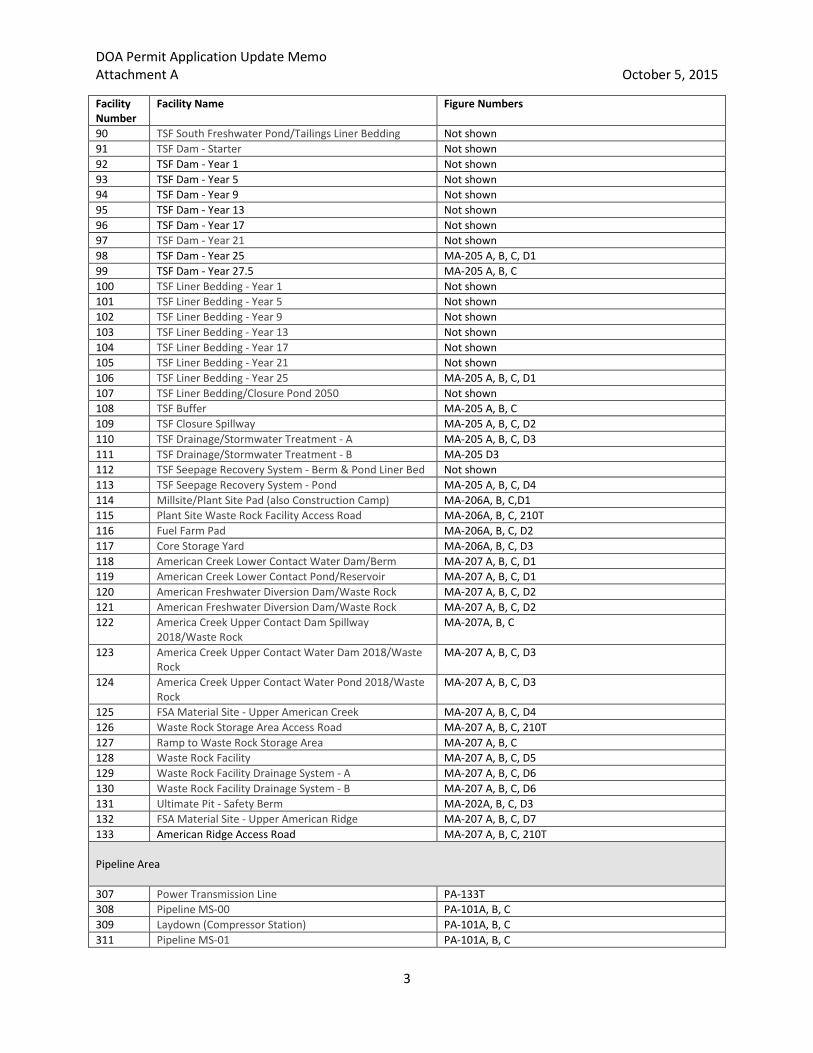
Table A-4: Facility Names and Figure Number Index
Facility Number
Facility Name Figure Numbers
Transportation Area 1 Jungjuk Port TA-301A, B, C, D1, D2, D3 3 Jungjuk Port Growth Media Stockpile TA-301A, B, C 4 Lower Jungjuk-Donlin Road (Port to Hillcut) TA-301A, B, C; TA-302A, B, C; TA-303 A, B, C; TA-304 A,
B, C; TA-305 A, B, C; TA-306 A, B, C; TA-307 A, B, C; TA-308 A, B, C; TA-309 A, B, C; TA-310 A, B, C
5 Jungjuk-Donlin Road - Port to Hillcut - Bridge 2.6 TA-302A, B, C 6 Jungjuk-Donlin Road - Port to Hillcut - Bridge 3.3 TA-302A, B, C 7 Jungjuk-Donlin Road - Port to Hillcut - Bridge 9.8 TA-304 A, B, C 8 Jungjuk-Donlin Road - Port to Hillcut - Bridge 10.2 TA-304 A, B, C 9 Jungjuk-Donlin Road - Port to Hillcut - Bridge 11.2 TA-304 A, B, C 10 FSA Material Site 16 - Access Road TA-301A, B, C, D4 11 FSA Material Site 16 TA-301A, B, C, D4 12 FSA Material Site 13 TA-302A, B, C, D 13 FSA Material Site 12 TA-303A, B, C, D 14 FSA Material Site 10 TA-304 A, B, C, D 15 FSA Material Site 9 TA-305 A, B, C, D 16 FSA Material Site 08 – Access Road TA-305 A, B, C, D 17 FSA Material Site 08 TA-305 A, B, C, D 18 FSA Material Site 07 TA-306 A, B, C, D 19 FSA Material Site 06 TA-306 A, B, C, D 20 FSA Material Site 05 TA-307 A, B, C, D 21 FSA Material Site 04 TA-307 A, B, C, D 22 Jungjuk-Donlin Road Hillcut TA-308 A, B, C, D2 23 Jungjuk-Donlin Road (Hillcut to Airstrip Access Road) TA-308 A, B, C 24 FSA Material Site 03 TA-308 A, B, C, D1 25 Airstrip Access Road TA-308 A, B, C; TA-311 A, B, C 26 Airstrip (Runway and Apron) TA-311 A, B, C, D 27 Airstrip (Northwest Clear Zone/Growth Media
Stockpile) TA-311 A, B, C
28 Airstrip (Southeast Clear Zone/Growth Media Stockpile) TA-311 A, B, C 29 Upper Jungjuk-Donlin Road from Airstrip Access Road
to Crooked Creek TA-310 A, B, C, D1
30 FSA Material Site 02 TA-309 A, B, C, D 31 FSA Material Site 01 (excluding camp components) TA-310 A, B, C, D2 32 FSA Material Site 01 Camp Components TA-310 A, B, C, D2 33 Powerline (Project-wide Impacts) TA-310 A, B, C; TA-313T Mine Area 34 Crooked Creek Bridge - Clear Span (Impacts above
OHW) TA-310A, B, C, D1
35 Jungjuk-Donlin Road, Crooked Creek Bridge to Pit Access Road
MA-201A, B, C, 210T
36 Jungjuk-Donlin Road, Pit Access Road to Mill/Plant Site MA-201A, B, C, 210T 37 Crusher Facility Access Road - A MA-201A, B, C, 211T 38 Crusher Facility Access Road - B MA-201A, B, C, 211T 39 Plant Site Crusher Facility Access Road & Parking MA-201A, B, C, 210T 40 Fleet Service Access Road MA-201A, B, C, 210T 41 Long Term Ore Stockpile (includes berm) MA-201A, B, C, D1

DOA Permit Application Update Memo Attachment A October 5, 2015
2
Facility Number
Facility Name Figure Numbers
42 Primary Crusher Pad MA-201A, B, C, D2 43 TSF Construction Laydown Area 6 MA-201A, B, C, D3 44 Terrace Borrow Site 3/North TSF Overburden Stockpile MA-201A, B, C, D4 45 Mine Fleet Assembly Area MA-201A, B, C, D5 46 Water Treatment Plant MA-201A, B, C 47 Ultimate Pit - Lake MA-202D 48 Ultimate Pit - Walls MA-202A, B, C, D1 49 Ultimate Pit - Island MA-202D 50 North Overburden Stockpile 2028 & Reclamation Area MA-202A, B, C, D2 51 North Overburden Stockpile 2028 Buffer MA-202A, B, C 52 North Overburden Stockpile 2028 Drainage Ditch MA-202A, B, C 53 FSA Material Site - Snow Gulch Access Road MA-203A, B, C, 211T 54 FSA Material Site - Snow Gulch MA-203A, B, C, D1 55 Snow Gulch Pond Access Road MA-203A, B, C, 210T 56 Snow Gulch Water Dam/Wetland Mitigation Site MA-203A, B, C, D2 57 Snow Gulch Freshwater Reservoir MA-203A, B, C, D2 58 Magazine Booster Area Pad MA-203A, B, C, D3 59 AN Storage Pad MA-203A, B, C, D4 60 AN Storage Pad Access Road MA-203A, B, C, 210T 61 Emulsion Plant Pad MA-203A, B, C, D5 62 Terrace Borrow Sites Access Road/Wetland Mitigation
Site MA-204A, B, C, 211T
63 Terrace Borrow Site 4/Central TSF Overburden Stockpile & Wetland Mitigation Site
MA-204A, B, C, D1
64 Terrace Borrow Site 4 & 5/South Overburden Stockpile 2019 and Wetland Mitigation Site
MA-204A, B, C, D2, D3
65 Potable Water Well Pads MA-204A, B, C, D4 66 Tailings Storage Facility Access Road - A MA-204A, B, C, 211T 67 Tailings Storage Facility Access Road - B MA-204A, B, C, 211T 68 Tailings Storage Facility Access Road - C MA-204A, B, C, 211T 69 Upper TSF Access Road - A MA-205 A, B, C, 210T 70 Upper TSF Access Road - B MA-205 A, B, C, 210T 71 Stockpile #1 (Growth Media)/Wetland Mitigation Area MA-204A, B, C, D5 72 Terrace Borrow 6/TSF Stockpile 2 and Wetland
Mitigation Area MA-204A, B, C, D6, D7
73 TSF Stockpile #2 - Diversion Ditch MA-204A, B, C, 74 Stockpile #3 (Growth Media)/Wetland Mitigation Area MA-204A, B, C 75 Construction Laydown Area 1 MA-204A, B, C, D8 76 Construction Laydown Area 2 MA-204A, B, C, D9 77 Construction Laydown Area 3 MA-204A, B, C, D10 78 TSF Construction Laydown Area 4 MA-204A, B, C, D11 79 Road Truckshop Pad MA-204A, B, C, D12 80 South Overburden Stockpile 2033 Access Road MA-204A, B, C, 211T 81 Terrace Borrow Site 7/South Overburden Stockpile
2033 & Wetland Mitigation Area MA-204A, B, C, D13, D14
82 South Overburden Stockpile 2033 - Drainage Ditch Not shown 83 TSF Starter Facility Liner Bedding - A Not shown 84 TSF Starter Facility Liner Bedding - B Not shown 85 TSF North Freshwater Dam/Tailings Not shown 86 TSF North Freshwater Dam Spillway/Tailings Not shown 87 TSF North Freshwater Pond/Tailings Liner Bedding Not shown 88 TSF South Fresh Water Dam Spillway/Tailings Liner
Bedding Not shown
89 TSF South Fresh Water Dam/Tailings Liner Bedding Not shown
DOA Permit Application Update Memo Attachment A October 5, 2015
3
Facility Number
Facility Name Figure Numbers
90 TSF South Freshwater Pond/Tailings Liner Bedding Not shown 91 TSF Dam - Starter Not shown 92 TSF Dam - Year 1 Not shown 93 TSF Dam - Year 5 Not shown 94 TSF Dam - Year 9 Not shown 95 TSF Dam - Year 13 Not shown 96 TSF Dam - Year 17 Not shown 97 TSF Dam - Year 21 Not shown 98 TSF Dam - Year 25 MA-205 A, B, C, D1 99 TSF Dam - Year 27.5 MA-205 A, B, C 100 TSF Liner Bedding - Year 1 Not shown 101 TSF Liner Bedding - Year 5 Not shown 102 TSF Liner Bedding - Year 9 Not shown 103 TSF Liner Bedding - Year 13 Not shown 104 TSF Liner Bedding - Year 17 Not shown 105 TSF Liner Bedding - Year 21 Not shown 106 TSF Liner Bedding - Year 25 MA-205 A, B, C, D1 107 TSF Liner Bedding/Closure Pond 2050 Not shown 108 TSF Buffer MA-205 A, B, C 109 TSF Closure Spillway MA-205 A, B, C, D2 110 TSF Drainage/Stormwater Treatment - A MA-205 A, B, C, D3 111 TSF Drainage/Stormwater Treatment - B MA-205 D3 112 TSF Seepage Recovery System - Berm & Pond Liner Bed Not shown 113 TSF Seepage Recovery System - Pond MA-205 A, B, C, D4 114 Millsite/Plant Site Pad (also Construction Camp) MA-206A, B, C,D1 115 Plant Site Waste Rock Facility Access Road MA-206A, B, C, 210T 116 Fuel Farm Pad MA-206A, B, C, D2 117 Core Storage Yard MA-206A, B, C, D3 118 American Creek Lower Contact Water Dam/Berm MA-207 A, B, C, D1 119 American Creek Lower Contact Pond/Reservoir MA-207 A, B, C, D1 120 American Freshwater Diversion Dam/Waste Rock MA-207 A, B, C, D2 121 American Freshwater Diversion Dam/Waste Rock MA-207 A, B, C, D2 122 America Creek Upper Contact Dam Spillway
2018/Waste Rock MA-207A, B, C
123 America Creek Upper Contact Water Dam 2018/Waste Rock
MA-207 A, B, C, D3
124 America Creek Upper Contact Water Pond 2018/Waste Rock
MA-207 A, B, C, D3
125 FSA Material Site - Upper American Creek MA-207 A, B, C, D4 126 Waste Rock Storage Area Access Road MA-207 A, B, C, 210T 127 Ramp to Waste Rock Storage Area MA-207 A, B, C 128 Waste Rock Facility MA-207 A, B, C, D5 129 Waste Rock Facility Drainage System - A MA-207 A, B, C, D6 130 Waste Rock Facility Drainage System - B MA-207 A, B, C, D6 131 Ultimate Pit - Safety Berm MA-202A, B, C, D3 132 FSA Material Site - Upper American Ridge MA-207 A, B, C, D7 133 American Ridge Access Road MA-207 A, B, C, 210T Pipeline Area 307 Power Transmission Line PA-133T 308 Pipeline MS-00 PA-101A, B, C 309 Laydown (Compressor Station) PA-101A, B, C 311 Pipeline MS-01 PA-101A, B, C

DOA Permit Application Update Memo Attachment A October 5, 2015
4
Facility Number
Facility Name Figure Numbers
312 PSY-01 PA-101A, B, C 314 Water Extraction Site Access WES-0031 PA-101A, B, C 315 Water Extraction Site Access WES-0030 PA-101A, B, C 316 Pipeline MS-02 PA-101A, B, C 317 Shoofly Road-0010 PA-101A, B, C 318 PSY-02-Susitna River-Frontal Cook Inlet PA-101A, B, C 319 Shoofly Road-0020 PA-101A, B, C 320 PSY-03-Susitna River-Frontal Cook Inlet PA-101A, B, C 321 Pipeline MS-03 PA-101A, B, C 322 Shoofly Road-0030 PA-101A, B, C 323 Shoofly Road-0040 PA-101A, B, C 324 Pipeline MS-04 PA-101A, B, C 325 Water Extraction Site Access WES-0080 PA-101A, B, C 326 PSY-04-Alexander Creek PA-101A, B, C 327 Water Extraction Site Access WES-0085 PA-101A, B, C 328 Main Gas Line - MP 00.0 to 050.8 PA-101A, B, C, PA-102A, B, C 329 Main Gas Line - MP 00.0 to 050.8 Not shown 330 Pipeline MS-05 PA-102A, B, C 331 PSY-05-Alexander Creek PA-102A, B, C 332 PSY-06-Alexander Creek PA-102A, B, C 333 Pipeline MS-06 PA-102A, B, C 334 Water Extraction Site Access WES-0115 PA-102A, B, C 335 Pipeline MS-07 PA-102A, B, C 336 PSY-07-Alexander Creek PA-102A, B, C 337 Water Extraction Site Access WES-0140 PA-102A, B, C 338 Deep Creek Camp PA-102A, B, C 339 Deep Creek Airstrip PA-102A, B, C 340 PSY-08-Alexander Creek PA-102A, B, C 341 Pipeline MS-08 PA-102A, B, C 342 Pipeline MS-09 PA-102A, B, C 343 PSY-09-Lower Skwentna River PA-102A, B, C 344 Water Extraction Site Access WES-0165 PA-102A, B, C 345 Water Extraction Site Access WES-0170 PA-102A, B, C 346 Shoofly Road-0070 PA-103A, B, C 347 Shoofly Road-0060 PA-103A, B, C 348 Lower Skwentna River Boring Workpad East (entry) PA-103A, B, C 349 Main Gas Line - (UG) Lower Skwentna River PA-137T, 138T 350 Main Gas Line - (UG) Lower Skwentna River PA-137T, 138T 351 Pipeline MS-10 PA-103A, B, C 352 Lower Skwentna River Boring Workpad West (exit) PA-103A, B, C 353 PSY-10-Lower Skwentna River PA-103A, B, C 354 Shoofly Road-0080 PA-103A, B, C 355 Skwentna River Camp (Shell) PA-103A, B, C 356 Water Extraction Site Access WES-0190 PA-103A, B, C 357 PSY-11-Lower Skwentna River PA-103A, B, C 358 Skwentna River Camp Airstrip (Shell) PA-103A, B, C 359 Water Extraction Site Access WES-0210 PA-103A, B, C 360 Pipeline MS-11 PA-103A, B, C 361 Material Site Access: Pipeline MS-11 PA-103A, B, C 362 Water Extraction Site Access WES-0220 PA-103A, B, C 363 Shoofly Road-0090 PA-103A, B, C 364 PSY-12-Lower Skwentna River PA-103A, B, C 365 PSY-13-Lower Skwentna River PA-103A, B, C 366 Water Extraction Site Access WES-0245 PA-103A, B, C

DOA Permit Application Update Memo Attachment A October 5, 2015
5
Facility Number
Facility Name Figure Numbers
367 Shoofly Road-0100 PA-103A, B, C 368 Pipeline MS-12 PA-103A, B, C 369 PSY-14-Lower Skwentna River PA-103A, B, C 370 Shoofly Road-0110 PA-103A, B, C 371 PSY-15-Lower Skwentna River PA-103A, B, C 372 Water Extraction Site Access WES-0270 PA-104A, B, C 373 Main Gas Line - MP 050.8 to 101.8 PA-103A, B, C, PA-104A, B, C 374 Main Gas Line - MP 050.8 to 101.8 PA-103A, B, C 375 Shoofly Road-0120 PA-104A, B, C 376 PSY-16-Lower Skwentna River PA-104A, B, C 377 PSY-17-Johnson Creek PA-104A, B, C 378 Water Extraction Site Access WES-0300 PA-104A, B, C 379 Happy River Camp PA-104A, B, C 380 Happy River Airstrip PA-104A, B, C 381 Pipeline MS-13 PA-104A, B, C 382 Middle Skwentna River Boring Workpad East (entry) PA-104A, B, C 383 Shoofly Road-0130 PA-104A, B, C 384 Shoofly Road-0130 (ice road) PA-104A, B, C 385 Main Gas Line - (UG) Middle Skwentna River PA-137T, 138T 386 Main Gas Line - (UG) Middle Skwentna River PA-137T, 138T 387 Water Extraction Site Access WES-0310 PA-104A, B, C 388 Middle Skwentna River Boring Workpad West (exit) PA-104A, B, C 389 PSY-18-Middle Skwentna PA-104A, B, C 390 Shoofly Road-0140 PA-104A, B, C 391 Pipeline MS-14 PA-104A, B, C 392 Water Extraction Site Access WES-0320 PA-104A, B, C 393 Shoofly Road-0150 PA-104A, B, C 394 Water Extraction Site Access WES-0330 PA-104A, B, C 395 PSY-19-Middle Skwentna PA-104A, B, C 396 PSY-20-Pass Creek PA-105A, B, C 397 Shoofly Road-0160 PA-105A, B, C 398 Water Extraction Site Access WES-0350 PA-105A, B, C 399 PSY-21 PA-105A, B, C 400 Shoofly Road-0170 PA-105A, B, C 401 Pipeline MS-16 PA-105A, B, C 402 Main Gas Line - MP 101.8 to 111.6 Not shown 403 Main Gas Line - MP 101.8 to 111.6 PA-105A, B, C 404 Water Extraction Site Access WES-0380 PA-105A, B, C 405 PSY-22-Pass Creek PA-105A, B, C 406 Shoofly Road-0180 PA-105A, B, C 407 Pipeline MS-17A PA-105A, B, C 408 Material Site Access: Pipeline MS-17A PA-105A, B, C 409 Threemile Camp PA-105A, B, C 410 Threemile Airstrip PA-105A, B, C 411 Water Extraction Site Access WES-0418 PA-105A, B, C 412 Pipeline MS-17B PA-105A, B, C 413 PSY-23 PA-105A, B, C 414 Pipeline MS-17C PA-105A, B, C 415 Material Site Access: Pipeline MS-17C PA-105A, B, C 416 PSY-24 PA-105A, B, C 417 Shoofly Road-0200 PA-105A, B, C 418 Shoofly Road-0210 PA-105A, B, C 419 Main Gas Line - MP 111.6 to 126.6 Not shown 420 Main Gas Line - MP 111.6 to 126.6 PA-105A, B, C

DOA Permit Application Update Memo Attachment A October 5, 2015
6
Facility Number
Facility Name Figure Numbers
421 Shoofly Road-0220 PA-105A, B, C 422 Pipeline MS-18A PA-105A, B, C 423 Shoofly Road-0230 PA-105A, B, C 424 Pipeline MS-18B PA-105A, B, C 425 PSY-25 PA-105A, B, C 426 Pipeline MS-18C PA-105A, B, C 427 Pipeline MS-19A PA-105A, B, C 428 Pipeline MS-19B PA-106A, B, C 429 Shoofly Road-0240 PA-106A, B, C 430 PSY-26 PA-106A, B, C 431 Shoofly Road-0250 PA-106A, B, C 432 Shoofly Road-0260 PA-106A, B, C 433 Pipeline MS-20 PA-106A, B, C 434 Shoofly Road-0270 PA-106A, B, C 435 Shoofly Road-0280 PA-106A, B, C 436 Main Gas Line - MP 126.6 to 144.4 Not shown 437 Main Gas Line - MP 126.6 to 144.4 PA-106A, B, C 438 Water Extraction Site Access WES-0460 PA-106A, B, C 439 Pipeline MS-21 PA-106A, B, C 440 Water Extraction Site Access WES-0462 PA-106A, B, C 441 PSY-27 PA-106A, B, C 442 Bear Paw Camp PA-106A, B, C 443 Pipeline MS-22 PA-106A, B, C 444 Bear Paw Airstrip PA-106A, B, C 445 Shoofly Road-0290 PA-106A, B, C 446 Shoofly Road-0300 PA-106A, B, C 447 PSY-28 PA-106A, B, C 448 Pipeline MS-23 PA-106A, B, C 449 Shoofly Road-0310 PA-106A, B, C 450 Shoofly Road-0320 PA-106A, B, C 451 Shoofly Road-0330 PA-106A, B, C 452 PSY-29 PA-106A, B, C 453 Shoofly Road-0340 PA-106A, B, C 454 Pipeline MS-24 PA-106A, B, C 455 Jones Camp PA-106A, B, C 456 Jones Airstrip PA-106A, B, C 457 Water Extraction Site Access WES-0490 PA-106A, B, C 458 Pipeline MS-25 PA-106A, B, C 459 PSY-30 PA-106A, B, C 460 Main Gas Line - Above Ground Fault Crossing - Denali PA-107A, B, C 461 Shoofly Road-0350 PA-107A, B, C 462 Shoofly Road-0360 PA-107A, B, C 463 Pipeline MS-26 PA-107A, B, C 464 PSY-31 PA-107A, B, C 465 Midpoint PIG Launcher/Receiver Site PA-107A, B, C 466 Water Extraction Site Access WES-0520 PA-107A, B, C 467 Farewell Airstrip Access Road (existing) PA-107A, B, C 468 Pipeline MS-27 PA-107A, B, C 469 PSY-32-Farewell PA-107A, B, C 470 Pipeline MS-27A PA-107A, B, C 471 Main Gas Line - MP 144.4 to 196.6 PA-108A, B, C 472 Main Gas Line - MP 144.4 to 196.6 PA-108A, B, C 473 Pipeline MS-28 PA-107A, B, C 474 Pipeline MS-28A PA-107A, B, C

DOA Permit Application Update Memo Attachment A October 5, 2015
7
Facility Number
Facility Name Figure Numbers
475 PSY-33-Farewell PA-107A, B, C 476 Pipeline MS-29 PA-107A, B, C 477 Water Extraction Site Access WES-0545 PA-107A, B, C 478 PSY-34-Windy-Middle Fork Kuskokwim River PA-107A, B, C 479 Shoofly Road-0370 PA-107A, B, C 480 Pipeline MS-30 PA-107A, B, C 481 Shoofly Road-0380 PA-107A, B, C 482 Pipeline MS-31 PA-107A, B, C 483 Pipeline MS-32 PA-108A, B, C 484 PSY-35-Khuchaynik Creek PA-108A, B, C 485 Pipeline MS-33 PA-108A, B, C 486 PSY-36-Headwaters Middle Fork Kusko. R. PA-108A, B, C 487 Pipeline MS-34 PA-108A, B, C 488 Shoofly Road-0390 PA-108A, B, C 489 Pipeline MS-35 PA-108A, B, C 490 Shoofly Road-0400 PA-108A, B, C 491 Pipeline MS-36 PA-108A, B, C 492 PSY-37 PA-108A, B, C 493 Shoofly Road-0410 PA-108A, B, C 494 Water Extraction Site Access WES-0615 PA-108A, B, C 495 Water Extraction Site Access WES-0620 PA-108A, B, C 496 Water Extraction Site Access WES-0625 PA-108A, B, C 497 Pipeline MS-38 PA-108A, B, C 498 Big River Camp Airstrip PA-108A, B, C 499 Big River Camp PA-108A, B, C 500 Pipeline MS-39 PA-108A, B, C 501 PSY-38-Middle Big River PA-108A, B, C 502 Shoofly Road-0420 PA-108A, B, C 503 Water Extraction Site Access WES-0640 PA-108A, B, C 504 Water Extraction Site Access WES-0650 PA-109A, B, C 505 Shoofly Road-0430 PA-109A, B, C 506 PSY-39-Headwaters Tatlawiksuk River PA-109A, B, C 507 Pipeline MS-40 PA-109A, B, C 508 Water Extraction Site Access WES-0660 PA-109A, B, C 509 PSY-40-Headwaters Tatlawiksuk River PA-109A, B, C 510 Pipeline MS-41 PA-109A, B, C 511 PSY-41-Headwaters Tatlawiksuk River PA-109A, B, C 512 Pipeline MS-42 PA-109A, B, C 513 Material Site Access: Pipeline MS-42 PA-109A, B, C 514 PSY-42-Headwaters Tatlawiksuk River PA-109A, B, C 515 Pipeline MS-43 PA-109A, B, C 516 Main Gas Line - MP 196.6.to 247.6 Not shown 517 Main Gas Line - MP 196.6.to 247.6 PA-109A, B, C 518 PSY-43-Headwaters Tatlawiksuk River PA-110A, B, C 519 Material Site Access: Pipeline MS-44 PA-110A, B, C 520 Pipeline MS-44 PA-110A, B, C 521 Water Extraction Site Access WES-0730 PA-110A, B, C 522 Pipeline MS-45 PA-110A, B, C 523 PSY-44-Outlet Tatlawiksuk River PA-110A, B, C 524 Water Extraction Site Access WES-0750 PA-110A, B, C 525 Tatlawiksuk Construction Access Road - 2 PA-110A, B, C 526 Pipeline MS-46 PA-110A, B, C 527 Pipeline MS-47 PA-110A, B, C 528 PSY-45 PA-110A, B, C

DOA Permit Application Update Memo Attachment A October 5, 2015
8
Facility Number
Facility Name Figure Numbers
529 East Kuskokwim Camp PA-110A, B, C 530 Pipeline MS-48 PA-110A, B, C 531 Shoofly Road-0440 PA-110A, B, C 532 Pipeline MS-49 PA-110A, B, C 533 East Kuskokwim Camp Airstrip PA-110A, B, C 534 Shoofly Road-0450 PA-110A, B, C 535 Water Extraction Site Access WES-0770 PA-110A, B, C 536 Pipeline MS-50 PA-110A, B, C 537 Material Site Access: Pipeline MS-50 PA-110A, B, C 538 Nunivak Bar-Kuskokwim Access Route PA-110A, B, C 539 Kuskokwim River Boring Work Pad East (entry) PA-110A, B, C 540 East Kuskokwim River Barge Landing Work Pad North PA-110A, B, C 541 West Kuskokwim River Barge Landing Work Pad PA-110A, B, C 542 Main Gas Line - (UG) Kuskokwim River PA-137T, 138T 543 Main Gas Line - (UG) Kuskokwim River PA-137T, 138T 544 Water Extraction Site Access WES-0790 PA-110A, B, C 545 Pipeline MS-52 PA-110A, B, C 546 Kuskokwim River Boring Work Pad West (exit) PA-110A, B, C 547 Shoofly Road-0460 PA-110A, B, C, PA-111A, B, C 548 Pipeline MS-53 PA-110A, B, C, PA-111A, B, C 549 Water Extraction Site Access WES-0810 PA-111A, B, C 550 West Kuskokwim Camp Airstrip PA-111A, B, C 551 West Kuskokwim Camp Airstrip Work Pad PA-111A, B, C 552 Shoofly Road-0470 PA-111A, B, C 553 Pipeline MS-54 PA-111A, B, C 554 West Kuskokwim Camp PA-111A, B, C 555 Shoofly Road-0480 PA-111A, B, C 556 PSY-46-Moose Creek PA-111A, B, C 557 PSY-47-Moose Creek PA-111A, B, C 558 Pipeline MS-55 PA-111A, B, C 559 Shoofly Road-0490 PA-111A, B, C 560 Pipeline MS-56 PA-111A, B, C 561 Shoofly Road-0500 PA-111A, B, C 562 PSY-48-Little South Fork PA-111A, B, C 563 Shoofly Road-0510 PA-111A, B, C 564 Pipeline MS-57 PA-111A, B, C 565 PSY-49-Little South Fork PA-111A, B, C 566 Pipeline MS-58 PA-111A, B, C, PA-112A, B, C 567 Shoofly Road-0520 PA-111A, B, C, PA-112A, B, C 568 Shoofly Road-0530 PA-112A, B, C 569 PSY-50-East Fork George River PA-112A, B, C 570 Shoofly Road-0540 PA-112A, B, C 571 Shoofly Road-0550 PA-112A, B, C 572 Main Gas Line - MP 247.6 to 315.2 PA-111A, B, C, PA-113A, B, C 573 Main Gas Line - MP 247.6 to 315.2 PA-111A, B, C 574 Shoofly Road-0560 PA-112A, B, C 575 PSY-51-East Fork George River PA-112A, B, C 576 Shoofly Road-0570 PA-112A, B, C 577 Shoofly Road-0580 PA-112A, B, C 578 Shoofly Road-0590 PA-112A, B, C 579 Shoofly Road-0600 PA-112A, B, C 580 Shoofly Road-0610 PA-112A, B, C 581 Pipeline MS-59 PA-112A, B, C 582 PSY-52 PA-112A, B, C

DOA Permit Application Update Memo Attachment A October 5, 2015
9
Facility Number
Facility Name Figure Numbers
583 Shoofly Road-0620 PA-112A, B, C 584 East Fork George River Boring Workpad East (entry) PA-112A, B, C 585 Main Gas Line - (UG) East Fork George River PA-137T, 138T 586 Main Gas Line - (UG) East Fork George River PA-137T, 138T 587 Shoofly Road-0630 (bridge) PA-112A, B, C 588 Shoofly Road-0630 PA-112A, B, C 589 East Fork George River Boring Workpad West (exit) PA-112A, B, C 590 Pipeline MS-60A PA-112A, B, C 591 Shoofly Road-0640 PA-112A, B, C 592 Pipeline MS-60 PA-112A, B, C 593 PSY-53-East Fork George River PA-112A, B, C 594 Shoofly Road-0650 PA-112A, B, C 595 Shoofly Road-0660 PA-112A, B, C 596 Shoofly Road-0670 PA-112A, B, C 597 PSY-54-George River PA-112A, B, C 598 Pipeline MS-61 PA-112A, B, C 599 George River Boring Workpad East (entry) PA-112A, B, C 600 Shoofly Road-0680 (bridge) PA-112A, B, C 601 Shoofly Road-0680 PA-112A, B, C 602 Main Gas Line - (UG) George River PA-137T, 138T 603 Main Gas Line - (UG) George River PA-137T, 138T 604 George River Boring Workpad West (exit) PA-112A, B, C 605 Pipeline MS-61A PA-112A, B, C 606 Shoofly Road-0690 PA-112A, B, C 607 Pipeline MS-62 PA-112A, B, C 608 PSY-55-North Fork George River PA-112A, B, C 609 Shoofly Road-0700 PA-113A, B, C 610 North Fork George River Boring Workpad East (entry) PA-113A, B, C 611 Main Gas Line - (UG) North Fork George River PA-137T, 138T 612 Main Gas Line - (UG) North Fork George River PA-137T, 138T 613 North Fork George River Boring Workpad West (exit) PA-113A, B, C 614 Shoofly Road-0710 PA-113A, B, C 615 Pipeline MS-63 PA-113A, B, C 616 Shoofly Road-0720 PA-113A, B, C 617 PSY-56-North Fork George River PA-113A, B, C 618 Shoofly Road-0730 PA-113A, B, C 619 PSY-57-North Fork George River PA-113A, B, C 621 Delivery PIG Launcher/Receiver Site PA-113A, B, C 622 Metering Station PA-101A, B, C 623 Compressor Station PA-101A, B, C 624 East Kuskokwim River Barge Landing Work Pad South PA-110A, B, C 625 Shoofly Road-0700 (bridge) PA-113A, B, C

Memorandum: Update to Preliminary Application for Department of the Army Permit Donlin Gold Project (POA-1995-120) October 5, 2015
Attachment B
Attachment B-1: General Notes and Index Sheet
Attachment B-2: Transportation Area Drawing Set
Attachment B-3: Mine Area Drawing Set
Attachment B-4: Pipeline Area Drawing Set