deploying a highly scalable web application in the...
TRANSCRIPT
Climate Change Institute - FY2012 Annual Report - 66 -
Deploying a Highly Scalable Web Applicationin the Cloud!
Erik Albert1,2 and Sudarshan S. Chawathe1,2
1. School of Computing and Information Science, University of Maine.
2. Climate Change Institute, University of Maine.
The 10Green Web application (10Green.org) integratesair quality data from diverse sources and provides anintuitive interface that summarizes this information ina manner accessible to scientists and non-scientistsalike. From a Computer Science perspective, this appli-cation presents interesting challenges in both the backend (e.g., data integration and analysis, maintainabil-ity) and the front end (e.g., Web-based visualization,interactive response times, and portability across verydiverse client architectures). Here, we focus on scala-bility and outline the implementation aspects that allowthe application to scale from a few hundred users tohundreds of thousands of concurrent users at low cost.
In a traditional Web application implementation usingone or a few servers, a large unanticipated increase inrequests is likely to make the site effectively unusable.For instance, the processor may get overloaded or thenetwork could become saturated with requests, result-ing in very long page-loading times or failure. To anextent, the above problems may be addressed, as of-ten done, by using a collection of servers, perhaps dis-tributed, and network resources that are designed forthe anticipated, larger loads. However, this strategy isimpracticable when the expected, or hoped, maximumload (at some later time) is several orders of magnitudelarger than current load and the expected average load(averaging temporally), as it entails a financially infea-sible initial hardware and software expenditure. In our10Green application, we are faced with exactly such asituation: As the application gains popularity, we hopeto support hundreds of thousands of concurrent usersbut our current user base, and budget, is much smaller.
Cloud computing is a term used for the on-demanddelivery of computing, network, and storage resourcesthat may be scaled up and down by large factors in amatter of minutes. In effect, this hardware and soft-ware architecture overcomes the above scaling prob-lem by allowing the application administrator to semi-automatically scale the computational resources in re-sponse to current usage and load. There are other ad-vantages as well, such as reliability and ease of ad-ministration. A well-known provider of cloud comput-ing services, and one we currently use for 10Green,is Amazon Web Services (AWS). In this environment,
!Work supported in part by U.S. National Science Foundationgrant EAR-1027960 and the University of Maine. Contributions fromthe entire 10Green team are gratefully acknowledged.
a deployment is charged only for services used, suchas computational instances, bandwidth used, persis-tent storage, and a load balancer. For example, a“small” computing instance can currently be purchasedfor $0.08 an hour, and during peak periods of utilization,additional instances can be added at this rate.
10Green
Server
10Green
Server
10Green
Server
Load Balancer
Page Requests
Responses
DB
Cache
DB
Cache
DB
Cache
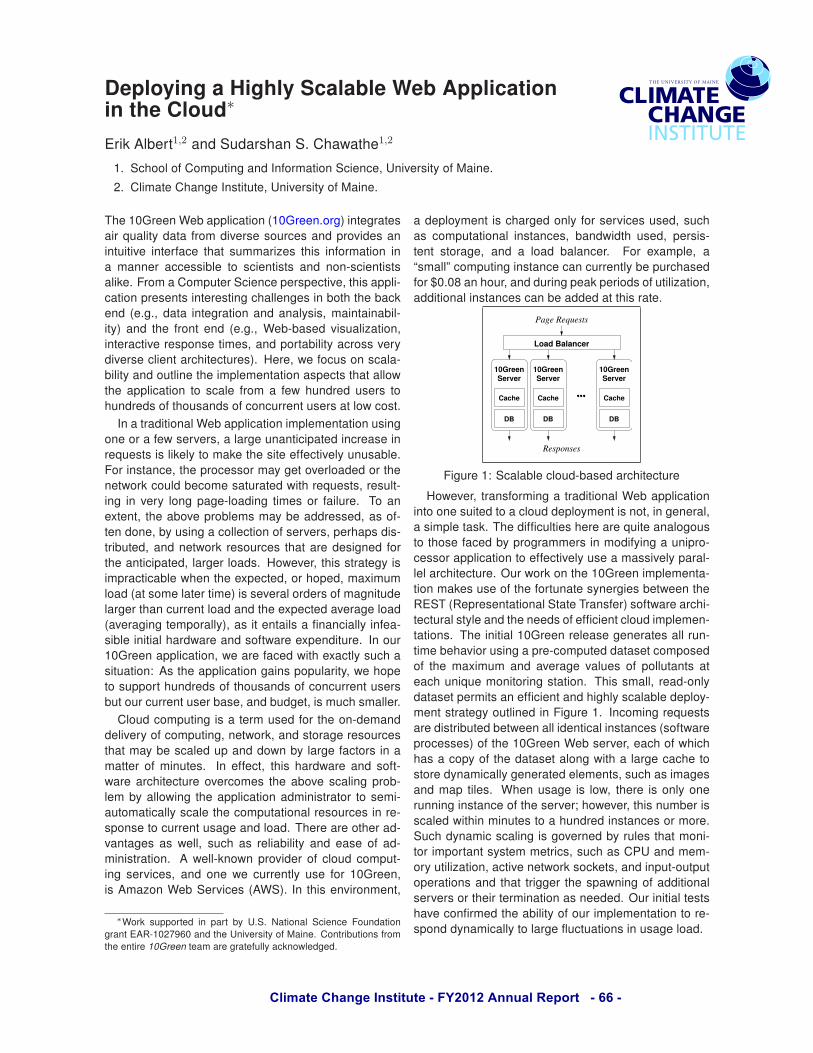
Figure 1: Scalable cloud-based architecture
However, transforming a traditional Web applicationinto one suited to a cloud deployment is not, in general,a simple task. The difficulties here are quite analogousto those faced by programmers in modifying a unipro-cessor application to effectively use a massively paral-lel architecture. Our work on the 10Green implementa-tion makes use of the fortunate synergies between theREST (Representational State Transfer) software archi-tectural style and the needs of efficient cloud implemen-tations. The initial 10Green release generates all run-time behavior using a pre-computed dataset composedof the maximum and average values of pollutants ateach unique monitoring station. This small, read-onlydataset permits an efficient and highly scalable deploy-ment strategy outlined in Figure 1. Incoming requestsare distributed between all identical instances (softwareprocesses) of the 10Green Web server, each of whichhas a copy of the dataset along with a large cache tostore dynamically generated elements, such as imagesand map tiles. When usage is low, there is only onerunning instance of the server; however, this number isscaled within minutes to a hundred instances or more.Such dynamic scaling is governed by rules that moni-tor important system metrics, such as CPU and mem-ory utilization, active network sockets, and input-outputoperations and that trigger the spawning of additionalservers or their termination as needed. Our initial testshave confirmed the ability of our implementation to re-spond dynamically to large fluctuations in usage load.

Climate Change Institute - FY2012 Annual Report - 67 -
Maya Obsidian of the Three Rivers Region, Belize: A Proposal
Walter I. Beckwith1.1. Climate Change Institute, Department of Anthropology, University of Maine.
Abstract: A sample of obsidian artifacts housed at the R.E.W Adams Research Facility situated in the Rio Bravo Conservation and Management Area (RBCMA), Belize, will be geochemically analyzed using portable x-ray fluorescence spectrometry (PXRF) to determine source material movement and distribution in the Maya Three Rivers region.
Non-destructive portable energy dispersive x-ray fluorescence spectrometry will be employed to collections of obsidian artifacts from Maya sites in the Three Rivers Region of northwestern Belize to discern the movement and distribution of these materials from their original sources in highland Guatemala and Central Mexico.
fig. 1 The Maya Three Rivers Region. (from Garrison & Dunning 2009).
The Maya Three Rivers adaptive region lies on the eastern margin of the Petén Karst Plateau and occupies the area that is now northwestern Belize, northeastern Guatemala and a small portion of the Mexican state of Quintana Roo (fig. 1). In Belize, this area is characterized by many Maya archeological sites including large centers, such as La Milpa, Dos Hombres and Ma’ax Na as well as smaller, surrounding hinterland sites. Years of excavations at these s i t e s b y t h e P r o g r a m m e f o r B e l i z e Archaeological project (PfBAP) has produced a
large assemblage of obsidian artifacts for analysis.
PXRF has shown to be a reliable and efficient method in archaeological provenance studies in the Maya lowlands (Nazaroff et al. 2010). Furthermore, Elemental analysis of materials such as obsidian has allowed for great insight into the social interactions of these past societies (i.e. Braswell 2010).
The artifacts housed at the PfBAP provide a unique opportunity to explore social, political and economic interaction at a variety of contextual, spatial and temporal scales. The conclusions drawn from this study have the potential to speak to larger questions concerning the Three Rivers Region’s integration into Maya society as a whole.
Acknowledgements: Dr. Bruce Kaiser, Bruker-AXS. Dr. Gregory Zaro. The Climate Change Institute & Department of Anthropology, University of Maine. Dr. Fred Valdez Jr., University of Texas Austin. Dr. Brett A, Houk, Texas Tech University.
Bibliography: Braswell, G.E. (2010) The Rise and Fall of Market Exchange: A Dynamic Approach to Ancient Maya Economy. In Archaeological approaches to Market Exchange in Pre-Capitalist Societies. C.P. Garraty, B.L. Stark, eds. Pp. 127-140. Salt Lake City: The University of Utah Press.
Garrison, T.G., Dunning, N.P. (2009) Settlement, Environment, and Politics in the San Bartolo-Xultun Territory, El Peten, Guatemala. Latin American Antiquity 20L525-552.
Nazaroff, A.J., Prufer, K.M., Drake, B.L. (2010) Assessing the applicability of portable X-ray Fluorescence spectrometry for obsidian provenance research in the Maya lowlands. Journal of Archaeological Science 37:885-895.
!
!"#$%&'(%)&*"
"#$ %&'()&('*$ !+$ ,-.*$ /")(0*#&*/$0(1&231*$ )"#4&'()&2"#$ 3,-4*4$ /-&2#5$ 6'"0$ &,*$7-&*$8'*)1-442)$3*'2"/$&,'"(5,$&,*$9*'02#-1$:1-442)$3*'2"/$;<"(=$-#/$%02&,$!>?>@A$
B25('*$?A$ C-3$"6$&,*$9,'**$D2.*'4$'*52"#$4,"E2#5$F"(#/-'2*4$F-4*/$"#$G-''24"#$-#/$H(##2#5$;!>>IJB25('*$!@A

Climate Change Institute - FY2012 Annual Report - 68 -
Ultra High Resolution Ice Core Analysis from Roosevelt Island, Antarctica
Thomas Beers1,2, Paul Andrew Mayewski1,2, Andrei Kurbatov1,2 , Sharon Sneed1,2
1. Climate Change Institute, University of Maine. 2. Department of Earth Sciences, University of Maine.
Abstract: The Roosevelt Island deep ice core is situated ideally to capture changes in climate impacting the Ross Ice Shelf, and the West Antarctic Ice Sheet. With the <4-micrometer precision that the Laser Ablation Inductively Coupled Plasma Mass Spectrometer allows, this record could potentially be examined on a storm event scale. Roosevelt Island Climate Evolution (RICE) is an international effort to obtain a 750 m deep ice core to bedrock to assess the stability of the
2011/2012 RICE field Team with the drill tent in the background. Photo by Dr. Sepp Kipfstuhl.
Ross Ice Shelf and the West Antarctic Ice Sheet in a warming world (see Fig. 1 for locations). During the 2011/2012 field season a 130 meter deep ice core was recovered that covers approximately the last 500 years. Daily surface snow samples were also collected, as well as a 1 cm resolution 3 m snowpit to record recent climate signals that will be compared with the ice core record.
Ice core processing will begin this August at Victoria University of Wellington and the Climate Change Institute will be processing a portion of the Inductively Coupled Plasma Mass Spectrometer (ICP-MS) samples. Changes in element concentrations in these samples will be used to reconstruct the impact of climate on the Ross Ice Shelf and the West Antarctic Ice Sheet by modeling changes in sea ice extent, the Amundsen Sea Low and the Southern Hemisphere Westerlies. In addition to ICP-MS samples, we will also be analyzing the core with the CCI Keck Laser Ice Facility LA-ICP-MS. This newly developed instrument allows for a <4-micrometer sample resolution, which is precise enough to capture storm signals even in deep ice cores with thin annual layers, signals that are too fine to be captured with standard melt sample processing for ICP-MS sampling.
Correlating these sub-seasonal signals recorded in the ice core with ERA-interim data could potentially provide proxies for sea ice extent, the Southern Annular Mode and the Amundsen Sea Low following calibration techniques set forth in Meeker and Mayewski, 2002.
Fig. 1. Locations of Roosevelt Island, West Antarctica, and the Ross Ice Shelf. The Amundsen Sea Low migrates throughout the Ross/ Amundsen Sea basins, while the SH Westerlies
circle north of the continent. Modified from Turner 2009.
Acknowledgements: Climate Change Institute and the Earth Sciences Department of the University of Maine, National Science Foundation, W. M. Keck Foundation, Dr. Nancy Bertler and Victoria University of Wellington, United States Antarctic Program, Office of Polar Programs USAP, GNS Science, Antarctic New Zealand Logistics Support, Raytheon Polar Services
Bibliography: Meeker L. & Mayewski P. A. (2002): A 1400-year high-resolution record of atmospheric circulation over the North Atlantic and Asia. The Holocene 12 (3): 257-266.
Turner J. et al. (2009): Antarctic Climate Change and the Environment. Scientific Committee on Antarctic Research: 2.
Climate Change Institute - FY2012 Annual Report - 69 -
Bedrock Control of the Central Maine Inner Shelf
Daniel F. Belknap1,2, and Joseph T. Kelley1, 2 1. Climate Change Institute, University of Maine. 2. Department of Earth Sciences, University of Maine.
Abstract: The ‘rock-bound coast of Maine” is more than just a slogan, the bedrock framework is the primary control on geomorphology, and has provided major influences on glacial erosion and deposition, sea-level change controlled littoral reworking, and modern processes of embayment and shoreline sedimentology. The bedrock structure can be followed offshore through geophysical surveys to reveal similar controls at lowstand about 60-65 m below present ca. 12.4 cal ybp. Interest in evolution of the coast in relation to climate and sea-levels changes must be informed by this fundamental structure in many coastal segments. Benthic oceanography, fisheries, and offshore wind power are other applications that need this knowledge.
Muscongus Bay – Monhegan Island
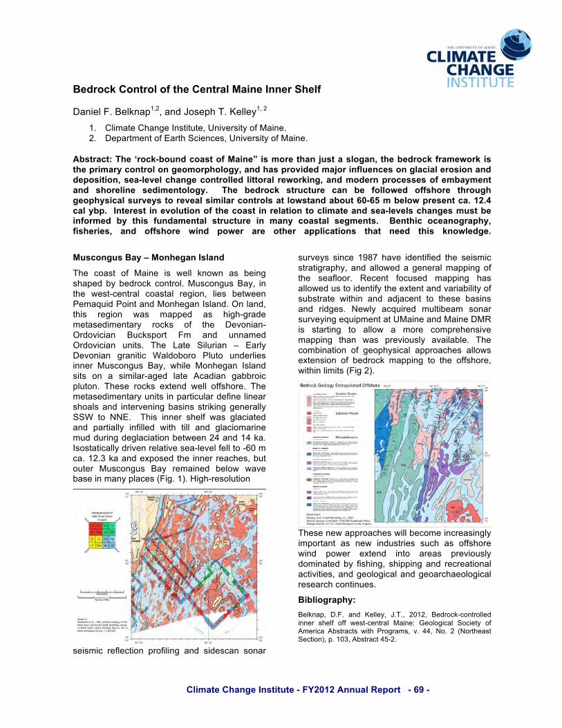
The coast of Maine is well known as being shaped by bedrock control. Muscongus Bay, in the west-central coastal region, lies between Pemaquid Point and Monhegan Island. On land, this region was mapped as high-grade metasedimentary rocks of the Devonian-Ordovician Bucksport Fm and unnamed Ordovician units. The Late Silurian – Early Devonian granitic Waldoboro Pluto underlies inner Muscongus Bay, while Monhegan Island sits on a similar-aged late Acadian gabbroic pluton. These rocks extend well offshore. The metasedimentary units in particular define linear shoals and intervening basins striking generally SSW to NNE. This inner shelf was glaciated and partially infilled with till and glaciomarine mud during deglaciation between 24 and 14 ka. Isostatically driven relative sea-level fell to -60 m ca. 12.3 ka and exposed the inner reaches, but outer Muscongus Bay remained below wave base in many places (Fig. 1). High-resolution
seismic reflection profiling and sidescan sonar
surveys since 1987 have identified the seismic stratigraphy, and allowed a general mapping of the seafloor. Recent focused mapping has allowed us to identify the extent and variability of substrate within and adjacent to these basins and ridges. Newly acquired multibeam sonar surveying equipment at UMaine and Maine DMR is starting to allow a more comprehensive mapping than was previously available. The combination of geophysical approaches allows extension of bedrock mapping to the offshore, within limits (Fig 2).
These new approaches will become increasingly important as new industries such as offshore wind power extend into areas previously dominated by fishing, shipping and recreational activities, and geological and geoarchaeological research continues.
Bibliography:
Belknap, D.F. and Kelley, J.T., 2012, Bedrock-controlled inner shelf off west-central Maine: Geological Society of America Abstracts with Programs, v. 44, No. 2 (Northeast Section), p. 103, Abstract 45-2.

Climate Change Institute - FY2012 Annual Report - 70 -
ClimReView: A Web-based Utility for Visualizing and Interrogating Climate Reanalysis Products
Sean D. Birkel1, Kirk A. Maasch1,2, Paul A. Mayewski1,2 1. Climate Change Institute, University of Maine. 2. Department of Earth Sciences, University of Maine.
Abstract: We are developing web-based visualization software that will allow rapid access to the NCEP CFSR and ERA-Interim climate reanalysis products. Integrated tools will enable the user to generate surface plots, animations, vertical cross sections, anomaly fields, and timeseries correlations.
Several state-of-the-art global climate reanalysis products are now available with higher resolution, and more robust physics than the original NCEP-NCAR model (NCEP-NCAR R1) (>200 km, 28 vertical levels) released in the mid 1990s (Kalnay et al., 1996). These new reanalyses include the NCEP CFSR (~38 km, 64 levels) (Saha et al., 2010) and ECMWF ERA-Interim (~76 km, 38 levels) (Dee et al., 2011), among others, each spanning 1979-present. Both CFSR and ERA-Interim will be useful to many members of the Climate Change Institute. However, existing online tools do not yet incorporate the plethora of analysis and statistical features that have long been available for NCEP-NCAR R1. We are therefore developing an in-house web-based visualization software for CFSR and ERA-Interim, called Climate Reanalysis Viewer (ClimReView), that will provide the ability to generate surface plots, animations, vertical cross sections, anomaly fields, and timeseries correlations.
ClimReView has an HTML/PHP front end that spawns NCAR Command Language (NCL) to generate graphics, and to perform statistical calculations. The current pre-release version of ClimReView supports only monthly grids for ERA-Interim. The program will be expanded to include 3-hourly and daily ERA-Interim data, and to have equivalent support for CFSR. Moreover, we will modify ClimReView to retrieve datasets in real-time over the Internet using the OPeNDAP protocol, which will eliminate the need for vast local storage (e.g., the complete ERA-Interim dataset is ~7 terrabytes).
We anticipate that ClimReView will be ready for use within CCI during Summer, 2012. With the help of undergraduate coders, the program should be operational and bug-tested by the Fall.
Acknowledgements:This project is funded in part by the Climate Change Institute, and by NSF grant OPP #5405279.
Bibliography: Dee, D.P. and co-authors, 2011. The ERA-Interim reanalysis: configuration and performance of the data assimilation system. Quart. J. R. Meteor. Soc., 137, 553-597.
Kalnay, E. and co-authors, 1996. The NCEP/NCAR 40-Year Reanalysis Project. Bull. Amer. Meteor. Soc., 77, 437-471.
Saha, and co-authors, 2010. The NCEP Climate Forecast System Reanalysis. Amer. Meteor. Soc., 91(8), 1015-1057.
Fig. 1. ClimReView image showing Sep-Oct-Nov temperature anomalies for the last decade compared to the 1980-2000 period using ERA-Interim.

Climate Change Institute - FY2012 Annual Report - 71 -
Understanding Common Loon (Gavia Immer) Biogeography and Viability in an Era of Climate Change
Allison J. Byrd1,2, Brian J. Olsen1,2,3 Dave Evers4
1. Climate Change Institute, University of Maine. 2. Ecology and Environmental Science, University of Maine. 3. School of Biology and Ecology, University of Maine. 4. BioDiversity Research Institute, Gorham, Maine.
Abstract: Common loons (Gavia immer) maintain territories during the breeding season and high quality habitat is often defended by the highest quality individuals within a population. We aim to quantify the expected shift in lake territory quality with respect to loon distribution and breeding success.
Climate change has the potential to shift and restrict ranges for a suite of species. The birds of the boreal ecosystem, like the Common Loon (Gavia immer; hereafter “loon”), may be particularly at risk given the changes predicted for this biome. Current range models for this iconic bird predict that large sections of the United States may lose this bird in the next 100 years (Matthews et al. 2004). The primary goal of our research is to understand the vulnerability of loons to climatic change. We used a recursive partitioning technique to analyze loon presence/absence in 452 lakes across the southern edge of their North American distribution using 110 abiotic and landscape-level factors (Fig 1). The resulting binary tree (“decision tree”) classifies lakes into groups based on the probability of loon presence, while maximizing homogeneity within the resultant two nodes. The most significant splits in the cross-validated tree used measures of mixed-forest cover in the watershed, lake water salinity, and lake area. We employed similar methods to compare models for loon presence/absence and loon seasonal fecundity at a smaller scale (New England) to elucidate potential demographic mechanisms of loon persistence. Results from twenty-two potential predictors suggest that similar processes to the continental model are driving loon presence/absence in New England (lake chloride levels, lake acid neutralization capacity, and lake area). Loon productivity was best partitioned using the size of both the lake and watershed. As few (if any) of the predictors of productivity in the best decision trees are likely to change dramatically with climate, these outcomes suggest that future range alteration in loons due to climate change is likely to be more sensitive to annual adult survival (which will
influence breeding ground settlement patterns) than extrinsic factors encountered on the breeding grounds.
Pruned Regression Tree
|PCT_MIXED_BSN< 9.05
NA.>=160
PCT_DECID_BSN< 11.65
ELEV_PT< 271.5
LAKEAREA< 0.3873
NA.>=38.84
0351/100
0325/47
0263/17
062/30
047/6
115/24
08/0
17/24
126/53
018/7
017/1
11/6
18/46
Fig 1. Classification tree of variables predicting loon presence/absence across their southern breeding range in the United States.
Acknowledgements:
1. Biodiversity Research Institute (BRI), Gorham, ME. 2. Climate Change Institute, University of Maine. 3. School of Biology and Ecology, University of Maine.
Bibliography:
Matthews, S. N.; O’Connor, R.J.; Iverson, L. R. and Prasad, A. M. 2004. Atlas of Climate Change Effects in 150 Bird Species of the Eastern United States. USDA General Technical Report NE-318.

Climate Change Institute - FY2012 Annual Report - 72 -
Strain Rate Estimates on Mount Hunter, Alaska: What Causes Crevassing at an Ice Divide?
Seth Campbell1,2,3, Sam Roy2, Erich Osterberg4, Steve Arcone3, Karl Kreutz1,2, Peter Koons1,2 1. Climate Change Institute, University of Maine. 2. Department of Earth Sciences, University of Maine. 3. U.S. Army CRREL. 4. Dartmouth College.
Abstract: We investigate crevasse formation at the ice divide of the Mt. Hunter plateau, Central Alaska Range, using GPS, GPR, ice core, and numerical model data. Prior research suggests that ice divides represent low strain rate environments which are generally crevasse free. However, our study site, which shows evidence of buried crevasses near the divide, contradicts this assumption making for a unique dynamical situation and interesting case study.
Fig. 1. Maximum velocities on Mt. Hunter (m/yr).
We used our field data to constrain the boundary conditions of first order numerical models for estimating strain rates on the surface and at depth. We then compared the model and field strain rates to determine the efficacy of our modeling. Lastly, we compared our results to other crevasse studies, and theorize about their dynamical causes. Our basic modeling consists of a steady state 2D incompressible Navier Stokes flow model developed with COMSOL Multi-Physics version 4.2. (Fig. 1). The model was represented as a cross section oriented perpendicular to the ice divide. The preliminary model dimensions were 1700 m wide across the ice divide and ranged between 150-250 m in depth. We used a cold ice viscosity (1e14) and the following depth-density equation from the ice core: Symposium following standards utilized by several European research centers.
Our field data indicates a maximum strain rate of 0.002 a^-1 which is close to the minimal published strain rate required for crevasse initiation (which ranges from 0.001 to 0.163 a^-1). However, our current numerical model suggests higher strain rates, well within the three orders of magnitude needed to generate crevasses. The model also indicates the locations of the highest strain rates being in regions of the observed crevassing. We suggest that the primary driving force to ice flow, surface slope, is enhanced by a frozen bed, which leads to a rotational moment of flow away from the divide. Secondly, the icefalls on either side of the divide appear to be approximately the height of the ice thickness measured with GPR. Therefore, we suggest that these cliffs create a situation of minimal resistance to flow (much like a glacier calving front), generating significant tensile stresses. However, the high tensile strength of the cold and dry ice likely allows this stress to propagate toward the center of the ice divide until a critical stress threshold is eventually reached causing fractures to occur. In other words, besides the frozen bed and tensile strength of the up-glacier ice and firn, there is no resisting force holding the ice up at the icefall edge. We suggest that the combined frozen bed and steep icefalls create an overall unique dynamical situation.
Acknowledgements: This research was funded by the National Science Foundation.

Climate Change Institute - FY2012 Annual Report - 73 -
Predicting Tidal Marsh Bird Populations via Remote Sensing: A potential tool for coastal conservation
Maureen D. Correll, Brian J. Olsen, Thomas P. Hodgman 1. Climate Change Institute, University of Maine. 2. Department of Ecology and Environmental Science, University of Maine. 3. Maine Department of Inland Fisheries and Wildlife.
Abstract: Tidal marshes are vulnerable to habitat loss due to impacts of climate change, particularly sea-level rise. We explored the relationship between bird survey data and vegetation index values in hopes of developing a cost-effective tool for use by managers in monitoring marsh-bird populations in the northeastern United States.
Tidal marshes are one of North America’s most productive and dynamic habitat types. Sea-level rise is an emerging threat to tidal marshes because of their placement on the terrestrial-marine interface. Obligate and near-obligate tidal marsh breeders such as the Saltmarsh Sparrow (Ammodramus caudacutus), Nelson’s Sparrow (A. nelsoni), and Willet (Tringa semipalmata), are especially at risk from the conversion of the high-marsh zone (above the mean high tide line) to low marsh or open water.
Collaborators with the Saltmarsh Habitat and Avian Research Program (SHARP) conducted avian and vegetation surveys (n=1660) in the summer of 2011 in selected tidal marshes between the Chesapeake Bay and the Canadian border to collect data on abundance and distribution of tidal marsh birds in the northeast. We then explored the relationship between these data and vegetation index values such as the Normalized Difference Vegetation Index (NDVI), the Normalized Difference Moisture Index (NDMI) and Thematic Mapper (TM) bands from Landsat images collected within the time frame of our surveys. NDVI measurements estimate overall productivity of vegetation; NDMI measurements estimate soil moisture and vegetation differences. Both primary productivity and soil moisture are potential gradients in which marsh zones can differ (Liu et al, 2010).
We ran nested Analysis of Variance (ANOVA) models, stratified by Landsat scene, to compare NDVI (Fig. 1) and NDMI values between cover classes of high-marsh zone. We found significantly different values between high marsh cover and NDMI values (p<.0001), and when bird survey data was paired with vegetation index measurements at the point the birds were detected, we found significant differences in
NDVI and NDMI values between survey points where Willets (Welch’s t-test, p=0.01 and p< 0.0001, respectively) and Sharp-tailed Sparrows (Welch’s t-test, p < 0.0001, p=0.004 respectively) were detected versus survey points where they were not.
Figure 1. Calculated NDVI values for Sandy Neck marsh, MA. Values were calculated using 30 X 30m resolution TM Landsat imagery from June - August 2011.
These results suggest it is possible to develop a cost-effective tool for remotely monitoring marsh-bird populations in the northeast using simple vegetation indices using publicly available Landsat imagery. The analyses and classifications outlined in this document will provide managers with an increased ability to understand and prioritize conservation of North America’s fragile coastal habitat.
Acknowledgements: Thank you to SWG and MDIFW for funding and Dr. Steve Sader and Kasey Legaard for remote sensing expertise.
Bibliography
Liu, C. Y., H.X. Jiang, et al. 2010. “Habitat Changes for Breeding Waterbirds in Yancheng National Nature Reserve, China: A Remote Sensing Study”. Wetlands 30: 879-888.

Climate Change Institute - FY2012 Annual Report - 74 -
!
LGM Ice Extent at Shackleton Glacier Elizabeth Dengler1,2
1. Climate Change Institute, University of Maine 2. Department of Earth Sciences, University of Maine.
The establishment of the Last Glacial Maximum (LGM) ice thickness and deglaciation history at Shackleton Glacier will improve the characterization of the Ross Sea ice sheet during the LGM, thereby helping to constrain possible Antarctic contributions to Holocene sea-level rise. As it is one of the largest tributaries from the East Antarctic Ice Sheet (EAIS), Shackleton Glacier (Fig. 1) is critical to improving our
understanding of the characterization and dynamics of the Ross Sea Ice Sheet at the LGM. There is some discrepancy regarding reconstructions of the thickness of the LGM ice sheet, as well as time of deglaciation, (Storey et al., 2010, Clark, 2011, Bentley, et al., 2010) which could be constrained better by mapping and dating past ice extents at Shackleton Glacier. Understanding past ice-sheet dynamics will help in interpretations of Antarctica’s contribution to Meltwater Pulse 1A (Clark, 2002, Bentley, 2010) and of potential implications on future sea-levels. At Shackleton Glacier, the identification and mapping of moraines and ice-lateral ponds that represent LGM and recessional grounding lines, as well as radiocarbon dates of algae samples collected from these sites, will delineate former ice elevations and rates of retreat. Freeze-dried algae found
under rocks on moraines and in former ice-marginal lakes, will be sent to NOSAMS Laboratory at Woods Hole Oceanographic Institution for radiocarbon dating. Previous studies, in conjunction with the mapped drift limits and algal dates at Shackleton Glacier, will help to delineate LGM ice elevations and rates of retreat, better characterizing the Ross Ice Sheet during and since the LGM. Acknowledgements: National Science Foundation Department of Earth Science and the Climate Change Institute, University of Maine Brenda Hall, John Stone, Howard Conway, Maurice Conway and Perry Spector United States Antarctic Program References: Bentley, Michael J., et.al., (2010) Deglacial history of the West Antarctic Ice Sheet in the Weddell Sea embayment: Constraints on past ice volume change, Geology 38 (5), 411-414. Clark, P.U., J.X. Mitrovica, G.A. Milne, M.E. Tamisiea, (2002) Sea-Level Fingerprinting as a Direct Test for the Source of Global Meltwater Pulse 1A, Science 295, 2438-2441. Clark, Peter (2011) Deglacial history of the West Antarctic Ice Sheet in the Weddell Sea embayment: Constraints on past ice volume change: COMMENT, Geology 39 (5), e239. Storey, B.C., et.al., (2010) Cosmogenic nuclide exposure age constraints on glacial history of the Lake Wellman area, Darwin Mountains, Antarctica, Antarctica Science 22(6), 603-618. USGS, LIMA Antarctic Research Atlas, (2012) U.S. Department of the Interior, http://lima.usgs.gov/index.php USGS, United States Antarctic Resource Center (USARC), Shackleton Glacier (AN00101) (2012), U.S. Department of the Interior, http://usarc.usgs.gov/usarcmp3TST2.shtmlv
Figure 1: Topographic map of field site, Shacklton Glacier (USGS, LIMA). Instert shows locale of Shackleton Glacier (USGS, USARC).

Climate Change Institute - FY2012 Annual Report - 75 -
Expanding Possibilities: ERA-Interim, WRF, and ndown
Daniel A. Dixon1, Paul A. Mayewski1,2, Sean Birkel1, and Kirk Maasch1,2 1. Climate Change Institute, University of Maine. 2. Department of Earth Sciences, University of Maine.
Abstract: ERA-interim data from the European Centre for Medium-Range Weather Forecasts (ECMWF) are providing new avenues of investigation into the last three decades of Earth’s climate history. We are using these data to conduct regional climate simulations with the Weather Research and Forecast Model (WRF). Normally, an extremely powerful computer such as the Cray XT5 supercomputer at Oak Ridge National Laboratory would be required to achieve very high resolution (e.g. convective-scale) model output via multiple nested grids. However, by using the “ndown” program we can achieve high-resolution model output with relatively modest computing power. The ndown program allows WRF to run one-way nested grids as often as is needed to achieve the required model resolution. We are using these powerful tools to calibrate our ice-core-based proxies of climate in Antarctica and elsewhere around the globe.
Figure 1. Sea-ice concentration anomalies calculated by subtracting the 1980-2000 annual average from 2001-2010.
ECMWF Re-Analysis-Interim (ERA-Interim) data is an 'interim' reanalysis of the period 1979-present in preparation for the next-generation extended reanalysis to replace ERA-40. The ERA-Interim configuration has a spectral T255 horizontal resolution corresponding to ~79 km grid spacing (compared to 125 km for ERA-40)
and the vertical resolution uses 60 model layers (1, 2, 3).
We know that significant sea-ice concentration (SIC) changes have occurred in both hemispheres, particularly in the last decade (Figure 1). Associations exist between sea-ice concentrations around Antarctica and the following major ion ice core chemistry: sodium, non-sea-salt sulfate, and methylsulfonate (4, 5). By running correlations between the ERA-Interim SIC and our Antarctic ice core chemistry datasets we will be able to pinpoint the exact location and timing of the associations. Subsequently, we will calibrate our ice core records in order to produce a SIC proxy going back at least 200 years. Our instrumentally-calibrated ice core proxies will be used to test WRF regional climate simulations. Ultimately, we will use the WRF regional model with nested grids to validate and improve our climate reconstruction of West Antarctica. Acknowledgements: This research is supported by US National Science Foundation (NSF) Office of Polar Programs grants to P.M. References: [1] Dee, D.P. et al. Q. J. R. Meteorol. Soc., 137, 553-597 (2011)
[2] Fiorino, M. ECMWF ERA-40 Project Report Series, 12, 22p (2004)
[3] Rayner, N.A. ECMWF ERA-40 Project Report Series, 3, 169-176 (2002)
[4] Dixon, D.A. et al. Ann. Glaciol., 41, 155-166 (2005)
[5] Sneed, S.B. et al. Ann. Glaciol., 52, 57, 347-354 (2011)

Climate Change Institute - FY2012 Annual Report - 76 -
~500-years of Regional Atmospheric Dust Variability Captured in High-Resolution Asian Ice Core Array Bjorn Grigholm1,2, Paul A. Mayewski1,2, Shichang Kang3, Vladimir Aizen4, Karl Kreutz1,2, Cameron Wake5, Elena Aizen4
1. Climate Change Institute, University of Maine. 2. Department of Earth Sciences, University of Maine. 3. Institute of Tibetan Plateau Research, Chinese Academy of Sciences, Beijing, China. 4. Department of Geography, University of Idaho. 5. Department of Earth Sciences, University of New Hampshire.
Abstract: High-resolution calcium records from AICA sites reveal the spatial and temporal variability of atmospheric dust concentrations over Asia for the last ~500 years and possible circulation controls. Atmospheric dust aerosols play a significant role in the global climate system influencing the Earth’s radiative budget by scattering and absorbing incoming shortwave radiation. Dust aerosols are also an important part in atmospheric chemical reactions, cloud condensation, and marine biological activities that are related to marine aerosol production and global carbon cycles. Ice core proxy records provide the most direct and detailed way to investigate pre-instrumental temporal variations of atmospheric dust and can provide context to modern climate. The Asian Ice Core Array (AICA) is an international effort focusing on glaciochemical ice core climate reconstructions throughout Asia. High-resolution glaciochemical calcium records from four AICA sites (Geladaindong, Everest [1], Belukha, and Inilchek) are examined here and reveal how atmospheric dust levels have spatially and temporally changed within Asia for the last ~500 years (Fig. 1.). AICA records were also compared to existing available Asian ice core records to better resolve regional variability. Spatial and temporal analysis revealed common declining trends among central Tibetan Plateau cores between ~1850-2000. Himalayan ice cores showed increases in dust over the same time period. Comparisons with NCEP/NCAR climate variables and the NOAA HYSPLIT Model suggest that the differences in regional dust proxy trends indicate circulation changes and/or varying dust source regions. Spatial interpolation of ice core dust proxy records suggests that the ~1850-1880 period had the highest dust concentrations over the last few hundred years, while the ~1970-2000 period
had the lowest. The late 20th Century reductions in dust proxy concentrations correspond with regional trends of reduced dust storm activity and circulation strength (e.g. cyclonic storms and zonal winds). Significant positive correlations between calcium and NCEP/NCAR zonal wind velocities on the Tibetan Plateau suggest that the Geladaindong calcium record may yield a proxy for the strength of the Westerlies. The low calcium concentration period between 1955-1981 may possibly suggest the weakest westerly wind strength in the past 500 years.
Fig. 1. Calcium Concentrations from AICA; brown shading indicates annual means; black lines indicates 5-year means. Acknowledgements: National Science Foundation (ATM-0754644) Bibliography: [1] Kaspari et al., Geophysical Research Letter, 34(L16701) (2007).
Climate Change Institute - FY2012 Annual Report - 77 -
!"#$"%&' ( &*+ * (
67#.(8&"3$'#9(:",0(;/0"#30$3"
!"#$"%&'()*+,"%-.&/.&01*23&4,1(#%56.&71$#"&8+"5129*:.&;155*<(&4<31*<=-.&/.&>"#(&?1*,@-.&A
-B C+*)(,1&C3(%21&D%5,*,9,1.&E%*F1#5*,G&"H&I(*%1B/B J1K(#,)1%,&"H&8(#,3&4<*1%<15.&E%*F1#5*,G&"H&I(*%1B6B J1K(#,)1%,&"H&!1"+"2G.&E%*F1#5*,G&"H&L(%5(5B:B I(#*%1&M1<3%"+"2G&E%*,.&4K(%*53&D%5,*,9,1&H"#&I(#*%1&4<*1%<15BAB J1K(#,)1%,&"H&73G5*<5.&E%*F1#5*,G&"H&I(*%1B&
;%,0#"305(<=0&'0(4&"3$'#(.7/">$3,('?'#0("/($>-*#0"/0(3*/0#*&(*/($3'(,1''0(>",,(%"&"/3'("/.(,'"(&'@'&A (;, (-"#0 (*) ( "/ ('))*#0 ( 0* (=/.'#,0"/. ( 01' (-17,$3"& ( 3*/0#*&, (*/ ( )&*+(,-''.(@"#$"%$&$079 (+' (.'-&*7'.("(8BC(/'0+*#D(*/(67#.(8&"3$'#A ( E/$0$"& ( #',=&0,(,1*+(01"0(4&"3$'# ()&*+(#',-*/.,(0*("(@"#$'07(*)()*#3$/4,9($/3&=.$/4(,=%4&"3$"&(&"D'(*=0%=#,0()&**.,(F#',-*/,'(.=#"0$*/(*/(01'(*#.'#(*)(>*/01,G("/.(*3'"/(0$.',(F#',-*/,'(.=#"0$*/(*/(01'(*#.'#(*)(1*=#,GA(H1','(*%,'#@"0$*/,(-#*@$.'($/,$410,($/0*(01'(-#*3',,',(3*/0#*&&$/4(*=0&'0(4&"3$'#()&*+A
NF1# & -.OOO.OOO & =)/& "H & ,31 &8(5, &P%,(#<,*< & D<1&4311, & *5 &$#(*%1$ &QG &RG#$ &!+(<*1#B &M31 &2+(<*1#&"<<9K*15 & ( & $11K & ,#"923 & ,3#"923 & ,31&M#(%5(%,(#<,*< & I"9%,(*%5 & S31#1 & H+"S & 5K11$5(<3&TOO&)UG#B&P,&,31&2#"9%$*%2&+*%1.&(Q"9,&/:&=)6UG#&"H&*<1&H+"S5&*%,"&,31&V"55&D<1&431+HB&!*F1%&*,5&5*@1.&(%G&595,(*%1$&<3(%21&*%&,31&H+"S&"H&RG#$&!+(<*1# & S*++ & 3(F1 & (% & *)K"#,(%, & *)K(<, & "% & ,31&)(55&Q(+(%<1&"H&8(5,&P%,(#<,*<(B
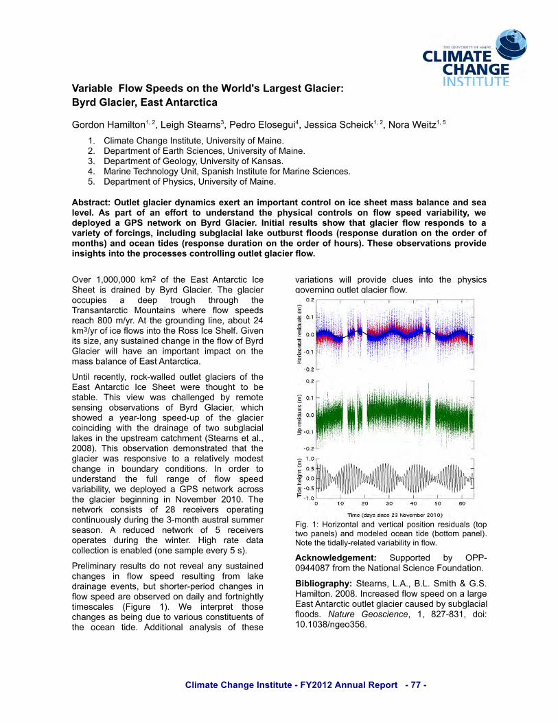
E%,*+ <1%,+G.&#"<=WS(++1$&"9,+1, &2+(<*1#5&"H&,31&8(5, &P%,(#<,*< & D<1 & 4311, & S1#1 & ,3"923, & ," & Q1&5,(Q+1B & M3*5 & F*1S & S(5 & <3(++1%21$ & QG & #1)",1&51%5*%2 & "Q51#F(,*"%5 & "H & RG#$ & !+(<*1#. & S3*<3&53"S1$ & ( & G1(#W+"%2 & 5K11$W9K & "H & ,31 & 2+(<*1#&<"*%<*$*%2 &S*,3 & ,31 &$#(*%(21 &"H & ,S" &59Q2+(<*(+&+(=15&*%&,31&9K5,#1()&<(,<3)1%,&X4,1(#%5&1,&(+B.&/OOTYB &M3*5 &"Q51#F(,*"% &$1)"%5,#(,1$& ,3(, & ,31&2+(<*1# &S(5 & #15K"%5*F1 & ," & ( & #1+(,*F1+G &)"$15,&<3(%21 & *% & Q"9%$(#G & <"%$*,*"%5B & D% & "#$1# & ,"&9%$1#5,(%$ & ,31 & H9++ & #(%21 & "H & H+"S & 5K11$&F(#*(Q*+*,G. &S1&$1K+"G1$&(&!74&%1,S"#=&(<#"55&,31 &2+(<*1# & Q12*%%*%2 & *% &>"F1)Q1# & /O-OB &M31&%1,S"#= & <"%5*5,5 & "H & /T & #1<1*F1#5 & "K1#(,*%2&<"%,*%9"95+G&$9#*%2&,31&6W)"%,3&(95,#(+&59))1#&51(5"%B & P & #1$9<1$ & %1,S"#= & "H & A & #1<1*F1#5&"K1#(,15 & $9#*%2 & ,31 & S*%,1#B & '*23 & #(,1 & $(,(&<"++1<,*"%&*5&1%(Q+1$&X"%1&5()K+1&1F1#G&A&5YB
7#1+*)*%(#GŸ+,5&$"&%",F1(+&(%G&595,(*%1$&<3(%215 & *% & H+"S & 5K11$ & #159+,*%2 & H#") & +(=1&$#(*%(21&1F1%,5. &Q9,&53"#,1#WK1#*"$&<3(%215&*%&H+"S&5K11$&(#1&"Q51#F1$&"%&$(*+G&(%$&H"#,%*23,+G&,*)15<(+15 & XZ*29#1 & -YB & ?1 & *%,1#K#1, & ,3"51&<3(%215&(5&Q1*%2&$91&,"&F(#*"95&<"%5,*,91%,5&"H&,31 & "<1(% & ,*$1B & P$$*,*"%(+ & (%(+G5*5 & "H & ,3151&
F(#*(,*"%5 & S*++ & K#"F*$1 & <+915 & *%," & ,31 & K3G5*<5&2"F1#%*%2&"9,+1,&2+(<*1#&H+"SB
Z*2B &-[&'"#*@"%,(+&(%$&F1#,*<(+&K"5*,*"%*$9(+5&X,"K&,S"&K(%1+5Y&(%$&)"$1+1$&"<1(%&,*$1&XQ",,")&K(%1+YB&>",1&,31&,*$(++GW#1+(,1$&F(#*(Q*+*,G&*%&H+"SB
;3D/*+&'.4'>'/05& 49KK"#,1$ & QG & N77WO\::OT]&H#")&,31&>(,*"%(+&4<*1%<1&Z"9%$(,*"%B
6$%&$*4#"-175 (4,1(#%5.&0BPB.&RB0B&4)*,3&^&!B4B&'()*+,"%B&/OOTB&D%<#1(51$&_"S&5K11$&"%&(&+(#21&8(5,&P%,(#<,*<&"9,+1,&2+(<*1#&<(951$&QG&59Q2+(<*(+&_""$5B &!"#$%& ' (&)*+,&-+&. & -. & T/]WT6-. & $"*[&-OB-O6TU%21"6A`B&
Climate Change Institute - FY2012 Annual Report - 78 -
Glacial History of Salmon Valley, Royal Society Range, Victoria Land, Antarctica
Margaret Jackson1
1. Climate Change Institute, University of Maine.
Abstract: I am reconstructing the glacial history of Salmon Valley, Royal Society Range, in order to understand better the history of the Antarctic Ice Sheet. These data will help us determine the Antarctic’s sensitivity to changing climate, as well as the continent’s past contribution to sea-level change.
The Antarctic Ice Sheet (AIS) plays a major role in the global climate system; it affects albedo and atmospheric and oceanic circulation. However, the sensitivity of the AIS to changes in climate remains enigmatic. Of particular importance is the question of AIS contribution to past sea-level change, which is crucial to anticipating future sea level. In order to understand the impact and timing of Antarctic deglaciation on sea level, we must first determine the amount of ice once stored in the Antarctic. During the Last Glacial Maximum (LGM), a grounded ice sheet filled the Ross Sea and intruded into the valleys of the Royal Society Range (Denton & Marchant, 2000). The ice dammed numerous proglacial lakes, which carried sediment further into the valleys via lake ice conveyors. Lake ice conveyors move sediment from the grounding line of an ice sheet and raft it along the ice surface. This process can deposit sediment kilometers beyond the grounding line and creates a suite of distinct landforms, all of which may today be seen the Royal Society Range valleys. Many of these deposits also contain lacustrine algae, which may be radiocarbon dated to provide the age of a given landform (Hall et. al., 2006).
Salmon Valley, the northernmost coastal valley in the range, contains an array of landforms and deposits that suggests the valley has experienced at least one period of Ross Sea Ice Sheet incursion.
The aim of this project is to develop a detailed record of the chronology and extent of glaciation in Salmon Valley during the last glacial cycle, as well as to assess the potential past contributions of the AIS to global sea level.
Fieldwork was conducted in January, 2012, and consisted of both geomorphic mapping, as well as collection of algae for radiocarbon dating. Together, these data will allow us to develop a chronology of glacial and lacustrine deposition within the valley. It will also help us determine the former extent and elevation of ice, as well as the rate of retreat of ice since the LGM.
Acknowledgements: NSF.
Bibliography: Denton, G.H. and Marchant, D.R., 2000. The geologic basis for a reconstruction of a grounded ice sheet in McMurdo Sound, Antarctica, at the last glacial maximum. Geografiska Annaler 82A (2-3): 167-211.
Hall, B.L., Hendy, C.H., Denton, G.H., 2006. Lake-ice conveyor deposits: Geomor- phology, sedimentology, and importance in reconstructing the glacial history of the Dry Valleys. Geomorphology 75: 143-156.
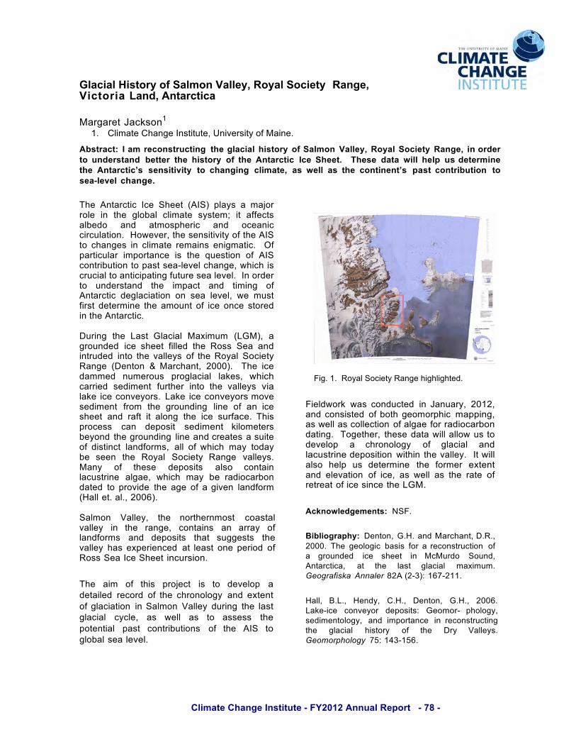
Fig. 1. Royal Society Range highlighted.!

Climate Change Institute - FY2012 Annual Report - 79 -
Changing Climate and Sea Level Alter Hg mobility at Lake Tulane, Florida USA G.L. Jacobson1,2, S.A. Norton1,3, E.C. Grimm4, T. Edgar5
1. Climate Change Institute, University of Maine. 2. School of Biology and Ecology, University of Maine. 3. Department of Earth Sciences, University of Maine. 4. Illinois, State Museum, Research and Collections Center, Springfield, IL. 5. U. S. Geological Survey, Tampa Bay, FL.
Lake Tulane lies on the Lake Wales Ridge on the Florida, USA peninsula at an elevation of 36 masl. Analyses of a 17 m-long radiocarbon-dated sediment core have previously revealed a continuous 60,000-year record of changing climate, vegetation, and hydrology. Building on that work, we here present data and interpretation from Hg analyses on the same core. The new results provide several useful and, in some cases, unexpected observations and interpretations related to deposition of Hg over the last 45,000 years.
1. Pre-Holocene accumulation rate for Hg
in Lake Tulane sediment was <2 !g m-2
y-1, compared with 53 !g Hg m-2 y-1 in the 1985-1990 period (Rood et al., 1995) of anthropogenic input.
2. The Tulane locality, underlain by quartz-rich sands and limestone, was susceptible to regional draw-down of the water table during the Wisconsinan glaciations, which lowered global sea level by nearly 130 m. Natural atmospheric deposition to the surrounding area would have resulted in long-term (on the order of 100,000 years) sequestration of this background atmospheric flux of Hg, primarily by adsorption in the oxic Al- and Fe-hydroxide rich subsoil.
3. Global sea level rise during deglaciation
led to a rising regional water table, flooding the oxidized soils surrounding Tulane. The lowered redox potential liberated both Fe and Hg, which were then transported by groundwater flow to the lake and ultimately to its sediments. This rising water table led to a sharp increase in the accumulation rate of Hg (and Fe) starting about 17,000 y BP.
This flux peaked (at about 30 !g Hg m-2
y-1) at ca. 6,000 y BP, and then declined.
4. The processes reconstructed here for
central Florida have the potential to occur in other regions of the world in the 21st century. Similar effects on Hg mobility can be pronounced wherever the element has accumulated in soils for a lengthy period. This is especially true where the groundwater table beneath these soils is influenced by regional sea level, which may rise by one or more meters by the end of the 21st century. Minor fluctuations in the accumulation rate of Hg in lakes may be induced by climate-driven groundwater table fluctuations.

Climate Change Institute - FY2012 Annual Report - 80 -
Modulation of North Atlantic Hurricane Frequency by Sahelian Dust: A Modicum of Predictability?
Shaleen Jain1, Bryan Pearce1, William Halteman2 1. Civil and Environmental Engineering, University of Maine. 2. Department of Mathematics, University of Maine.
Abstract: In this study, we take an empirical approach answer the following question: What is the impact of Sahelian dust on North Atlantic hurricane frequency? Based on historical data and carefully selected predictors, we provide an assessment of the “predictive signal”, attendant uncertainty, and the importance of model structure specification in studies of this variety.
Atlantic hurricanes are responsible for some of the worst weather-related disasters over the Caribbean and North American regions. Improved understanding of the nature and causes of hurricanes is likely to aid near-term prediction, long-term trend assessment and, elucidation of causal relationships.
In this study, we use Bayesian methodology to model and quantify the relationship between North Atlantic hurricane counts and three candidate predictors in the tropic ocean-atmosphere-land system. These are: two leading empirical orthogonal function of the tropical Pacific sea surface temperatures (canonical El Nino and the El Nino Modoki) and the Sahelian dust. Our modeling approach provides empirical estimates of the signficance of empirical relationships between dust and hurricane counts. We use multiple models to clarify the strength of dust-hurricane relationship. From a seasonal predictability and long-term climatic variability and change perspective, we propose that a careful characterization of Sahelian climate would be a prerequisite for the projections of North Atlantic hurricane activity and its regional impacts.

Climate Change Institute - FY2012 Annual Report - 81 -
Research on Transformational Adaptations: When Incremental Adaptations to Climate Change are Insufficient
Bob Kates1, Bill Travis2, Tom Wilbanks, 3 1. Climate Change Institute, University of Maine. 2. Center for Science and Technology Policy Research, University of Colorado. 3. Oak Ridge National Laboratory.
Abstract: We have been studying transformational adaptations to climate change for two years and will shortly publish an invited perspective in the PNAS. We continue to collect examples of current and planned anticipatory transformational adaptations.
Most adaptations to climate change are incremental, doing more of what is already being done to adapt to climate change and variation. But incremental adaptations will be insufficient as climate change grows, and will require transformational adaptation to climate change impacts. We have been studying transformational adaptations (TAs) over the last two years and have just completed an invited perspective for the PNAS. (Kates, Travis and Wilbanks, forthcoming).
In it we describe the situations that seem to require transformational adaptations: where vulnerability in certain regions, populations, or resource systems is currently high and/or if more severe climate change occurs beyond the likely range of current assessments. We then illustrate three types of transformational adaptations with examples drawn from Africa, Europe, and North America: those that are adopted at a much larger scale or intensity, that are truly new to a particular region or resource system, and that transform places and/or shift locations. While increasingly needed, (TAs) may be difficult to implement.
Considerable uncertainties exist both about climate change risks and adaptation benefits. Costs of transformational actions are perceived to be high and benefits may only appear in the future. Institutional and behavioral norms tend to maintain existing resource systems and policies. Thus, (TAs) require considerable effort to initiate them and then to sustain them over time. In initiating (TAs) dramatic focusing events help as well as linking them to co-benefits that address multiple stresses. Local leadership is very important. In sustaining these adaptations, key enabling factors are the availability of both acceptable options and resources for actions and institutionalizing these over time.. Early
steps would include incorporating transformation adaptation into risk management approaches and initiating research to expand the menu of innovative (TAs).
Besides authoring this perspective, we recently made a presentation in New York City, featuring the city’s risk management approach to adaptation. For our continuing research, we hope to draw upon the National Climate Assessment to assess (TAs) planned or implemented in the U.S.
Bibliography:
Kates RW, Travis WR, Wilbanks TJ (forthcoming) Transformational adaptation: When incremental adaptations to climate change are insufficient. Proc Natl Acad Sci

Climate Change Institute - FY2012 Annual Report - 82 -
Pre-Dam Removal Geomorphic Monitoring on the Penobscot River, Maine, USA
Alice R. Kelley1,2, Daniel Belknap1,2, Andrew Heller2, Charles Baeder3, Mathias Collins4
1. Climate Change Institute, University of Maine. 2. Department of Earth Sciences, University of Maine. 3. Penobscot River Restoration Trust, 3 Wade Street, Augusta, ME. 4. NOAA Restoration Center, 55 Great Republic Drive, Gloucester, MA.
Abstract: The Penobscot River Restoration Project is the largest river restoration effort underway on the North American east coast. Removal of two hydroelectric dams and state of the art fish passage at other dams will open a large portion of the Penobscot drainage to diadromous fish. Renovations to existing dams on the Stillwater River and Penobscot main stem will allow river restoration with no net loss of generating capacity.
The Penobscot Restoration River Restoration Project seeks to restore free-flowing conditions to a portion of the Penobscot River with the goal of re-establishing seasonal runs of 11 species of fish, including Atlantic salmon, short-nosed and Atlantic sturgeon, river herring (alewives), and American shad. Two dams on the lower Penobscot River (Veazie and Great Works) will be removed, a state of the art fish ladder and eel elevator installed at the Milford dam, and a bypass created around the decommissioned Howland Dam on the Piscataquis River.
Pre-dam removal geomorphic monitoring of the Penobscot River Restoration project area consisted of 15 reference cross sections. Established and monumented by the USGS, these cross sections were selected to represent the variety of environments within the affected portions of the river: impoundments, existing rapids, tributary stream mouths, and the areas immediately upstream and downstream from existing dams. Post dam removal monitoring at the same locations is planned.
Data collection included repeated, seasonal photographic surveys, detailed bathymetric/topographic surveys at each cross section location (including wetted and non-wetted portions of the channel), video-based channel sediment characterization, bank geomorphological studies that characterized vegetation and sediment grain size, and geophysical investigations of impoundment sediment thickness. Photographic surveys consisted of images taken directly across the channel, upstream, and downstream. Data are archived as individual images, photographic panoramas, and linked to individual locations on
Google Earth. Channel bathymetry/topography was completed using standard total-station surveying techniques and ADCP (Acoustic Doppler Current Profiler). Channel sediment size surveys were accomplished using still images extracted from video recordings made by towing a camera across the channel cross section. Seismic reflection profiling and ground-penetrating radar were used to evaluate impoundment sediment thickness.
Over the two-year monitoring period, few changes were noted in river bathymetry or bank characteristics. Channel sediment characterization revealed that, within the study area, the Penobscot and Piscataquis River channel in both free-flowing and impounded reaches is dominated by generally coarse sediment, ranging in size from gravel to boulders with a predominately sand matrix.
This finding contrasts with the fine-grained sediment storage found in many impoundments, and is interpreted to be an artifact of the region’s complex Late-Pleistocene and Holocene geological history, as well as the dam’s physical features and modes of operation.
Acknowledgements:
The authors acknowledge the assistance of the US Geological Survey, Augusta, ME for channel bathymetry and logistical support. We would also like to acknowledge NOAA Restoration funding through the American Recovery Act.

Climate Change Institute - FY2012 Annual Report - 83 -
Sea-level Change in the Irish Sea: A Seismic Reflection and Coring Expedition
Joseph T. Kelley1,2, Daniel F. Belknap,1,2 1. Climate Change Institute, University of Maine. 2. Department of Earth Sciences, University of Maine.
Abstract: We have completed year 1 of a three year project to document complex changes in sea level in the Irish Sea (Bantry Bay, Cardigan Bay, Isle of Man, Drogheda and Belfast). We gathered 2 weeks of seismic reflection profiles coupled to extensive multibeam bathymetric data. Seismic lines show sea level falling to – 80 m in the extreme southern Republic of Ireland to – 30 m in Northern Ireland. This summer we will core target sites to obtain dates for the observed sea level changes.
The British Isles is one of the most intensively studied regions on the planet for reconstructing patterns of past sea-level change. A combination of a relatively small British and Irish Ice Sheet, located adjacent to the much larger Fennoscandanavian Ice Sheet, means that the spatially complex RSL records observed at different locations in the UK and Ireland provide a rich database for resolving the processes that control global to local sea-level change. In particular, the sea-level database of Great Britain and Ireland is central to efforts to develop an understanding of earth rheology, ice-equivalent eustatic sea-level, the magnitude and timing of meltwater pulses (e.g. MWP1a), ice sheet history as well as 20th century trends in sea-level observed by tide gauge data (e.g. Lambeck, 1995,1996; Peltier et al., 2002; Shennan et al., 2006). Moreover, current rates of UK crustal motions, that reflect longer-term processes that track back to the last glacial cycle, provide key inputs to predictions of future sea-level rise and development of coastal adaptation strategies (Shennan et al., 2009, UKCP09).
Despite the importance of the UK sea-level database, we know remarkably little regarding the patterns of RSL change during the time period during and immediately after ice sheet retreat (see below). This means that models of RSL change during the critical few millennia that follow ice margin retreat are very poorly constrained; indeed most estimates of present-day crustal motions are based on earth and ice models that use RSL data from the Holocene only. This situation contrasts with that on other mid latitude continental margins, notably the In the western British Isles, Late Glacial RSL fell to one or more lowstands during the Late Glacial eastern US seaboard, where evidence for RSL changes during the Late Glacial, obtained from the continental shelf, demonstrates a complexity that remains unexplained (and indeed
cannot be reconciled with) state-of-the-art GIA models in the region (e.g. Kelley et al., 1995). before rising during much of the Holocene. Here too, the existing (limited) observations (Kelley et al., 2006, McCabe et al., 2007) are in conflict with existing GIA models that cannot capture the spatial and temporal complexity recorded (Brooks et al., 2008). similar looking documents in any text editor. We accept PDF or MS Word documents. Our goals are: 1. Identifying and dating the RSL lowstand in the Irish Sea and SW Ireland at sites between the ice limit at the Last Glacial Maximum (LGM) and the ice centre in Scotland. 2. Testing and improving existing models of glacio-isostatic rebound and associated RSL change.
3. Using these data to produce new palaeogeographic reconstructions of the Irish Sea Basin.
As shown in the figure of Waterford Harbor below, there are visible drowned river systems. At first glance, there appears to have been no Pleistocene landbridge.
This project is supported by NERC.
Tramore Waterford Harbour
(River Suir)
Palaeodelta?
Lowstand shoreline Lowstand shoreline

Climate Change Institute - FY2012 Annual Report - 84 -
Evaluating New Zealand as a Source of Dust to West Antarctica during the Last Glacial Maximum
Bess G. Koffman1, Steven L. Goldstein2, Michael R. Kaplan2, Gisela Winckler2, Natalie M. Mahowald3, Karl J. Kreutz1
1. Department of Earth Sciences and the Climate Change Institute, University of Maine. 2. Lamont-Doherty Earth Observatory of Columbia University. 3. Cornell University.
Abstract: The primary objective of the planned work described here is to evaluate the hypothesis that New Zealand was a significant source of dust to West Antarctica during the Last Glacial Maximum.
Despite ample evidence of increased dustiness during the last glacial period, there has been little effort to evaluate New Zealand (NZ) as a past dust source to Antarctica and the Southern Ocean. Its South Island is located in the westerlies belt, and it was covered by a large erosive ice mass during the Last Glacial Maximum (LGM). Thus, NZ was potentially a major source of (relatively) unweathered dust for the Southern Ocean. Because iron in unweathered dust is more soluble and biologically active than iron from weathered environments (such as Australia), a significant NZ dust input implies a greater role for glacial iron fertilization of the Southern Ocean’s Pacific sector than currently thought. Koffman has an NSF postdoctoral fellowship proposal pending to test the hypothesis that NZ was a significant source of dust to West Antarctica during the LGM. The study targets key potential dust source sites in NZ and ice core dust from unstudied sites in West Antarctica and Victoria Land. It will significantly increase the very limited dust provenance data available from NZ and West Antarctica. The research plan includes comprehensive chemical (major/trace elements) and isotopic (Sr-Nd-Pb-He) analyses at Lamont-Doherty Earth Observatory of fine-grained (<5!m) fractions of samples, and atmospheric transport modeling at Cornell. We will use a fully coupled global climate model to evaluate the likelihood of dust transport from NZ to different regions of Antarctica through time, and the relative climatic importance of NZ vs. Australia in terms of iron-fertilization potential of dust deposited in the Pacific sector of the Southern Ocean.
Figure 1. Polar projection map of Antarctica and the Southern Ocean showing hypothesized NZ LGM dust transport (red arrow) and ice core sites where previous dust provenance work has been done: Vostok (white star), EPICA Dome C (white X), Talos Dome (white circle), and proposed sampling sites: Allan Hills blue ice area (red square), Siple Dome (red circle) and Byrd (red star). WAIS Divide and Byrd sites are both within the red star. The Antarctic Polar Front is shown as a solid dark line.
Acknowledgements: This work is undergoing review by the NSF Office of Polar Programs. If funded, it will occur as part of a postdoctoral fellowship project for B. Koffman, under the mentorship of S. Goldstein, M. Kaplan, G. Winckler, and N. Mahowald.
!"#!"$
%&!"$
%'!" %&!"(
#!"(
!"#!"$
%&!"$
%'!" %&!"(
#!"(!
"#$%&'()*+(,-,.)&-&/01)$%/&

Climate Change Institute - FY2012 Annual Report - 85 -
Changes in Atmospheric Circulation during the Last Century as Recorded in East Antarctic Ice Cores
Elena Korotkikh1,2, Paul A. Mayewski1,2, Daniel Dixon1,2, Michael Handley1, Sharon Sneed1 1. Climate Change Institute, University of Maine. 2. Department of Earth Sciences, University of Maine.
Abstract: Chemical signals, including dust, seasalt and marine biogenic emissions, are investigated in three ice cores from East Antarctica covering the period 1550 to 2000 A.D.
The ice cores used in this study were collected during the US International Trans- Antarctic Expedition (ITASE) traverses of 2002 and 2003: 02-4 (-86.5°N, -107.98°E, 2586 m a.s.l.), South Pole (SP) (-89.93°N, 144.39°E, 2808 m a.s.l.) and 03-1 (-86.84°N, 95.31°E, 3124 m a.s.l.). The cores were sampled at high resolution (1.3-2.4 cm) using the University of Maine continuous melter system (Osterberg et al., 2006). Samples collected from South Pole and 03-1 ice cores were examined for major and trace element content using inductively-coupled plasma sector field mass spectrometry. Samples collected from 02-4 core were examined for soluble major-ion content using ion chromatography (Dixon et al., 2011). The 02-4 and South Pole ice cores were annually dated by matching seasonal peaks from major ions and trace element time series. The 03-1 ice core was dated using a firn-densification depth-age model (Dixon et al., 2011). This study is focused on changes in the Na, Ca and S (SO4
2- for 02-4 site) time series. The major source of Ca in polar ice is crustally-derived dust (Legrand & Mayewski, 1997). Marine biogenic source dominates the sulfur budget in the Antarctic region (Legrand and Mayewski, 1997; Minikin et al., 1998). Most Na is delivered from the open water sources. Seasalt and non-sea-salt components of Na, Ca and S (SO4
2-) were calculated using the technique described by O’Brien et al. (1995). Since ~1900 nssCa concentrations have increased in SP and 02-4 sites, indicating higher dust loading in Antarctica due to enhanced zonal wind strength (Dixon et. al, 2011). At the same time nssS and ssNa concentrations have decreased at the more inland SP and 03-1 sites. In contrast, site 02-4 shows slight increases in nssSO4
2- and ssNa concentrations during this period. Previous studies show increased
circumpolar westerly winds blocking the penetration of marine air masses into the interior of Antarctica (Abram et al., 2011). The intensification of the westerlies during the last century observed in our records most likely blocks the incursion of marine air masses into the more continental sites SP and 03-1.
Fig. 1. Background concentration values of nssCa, ssNa, nssS, nssCa2+, ssNa-, and nssSO4
2-, from 02-4, SP and 03-1 sites. Acknowledgements: NSF OPP Bibliography: [1] Abram, N.J., Mulvaney, R., Arrowsmith, C., Journal of Geophysical Research, 116, 1-15 (2011). [2] Dixon, D.A., P.A. Mayewski, I. Goodwin, G.J. Marshall, R. Freeman, K.A. Maasch, and S.B. Sneed., Int. J. Climatol. In press, (2011). [3] Legrand, M., and Mayewski, P., Reviews of Geophysics 35, 219-243, (1997). [4] Minikin, A., Legrand, M., Hall, J., Wagenbach, D., Kleefeld, C., Wolff, E., Pasteur, E. C., and Ducroz, F., Journal of Geophysical Research 103, 10,975-10,990, (1998). [5] O'Brien, S. R., Mayewski, P. A., Meeker, L. D., Meese, D. A., Twickler, M. S., and Whitlow, S. I., Science, 270, 1962-1964 (1995). [6] Osterberg, E. C., Handley, M. J., Sneed, S. B., Mayewski, P. A., and Kreutz, K. J., Environmental Science & Technology 40, 3355-3361, (2006).

Climate Change Institute - FY2012 Annual Report - 86 -
Developing K-5 and Public Outreach Products for the Gulf of Maine using the iOS Platform
Karl Kreutz1,2, Josh Plourde1,2, Seth Campbell1,2, Alan Wanamaker3, Doug Introne1,2, Noah Kreutz4, Betty Lee1, and Hal Borns1,2
1. Climate Change Institute, University of Maine. 2. Department of Earth Sciences, University of Maine. 3. Department of Geological and Atmospheric Sciences, Iowa State University. 4. Ms. Oldenberg’s 2nd Grade Class, Asa Adams Elementary School, Orono, Maine.
Abstract: The Apple iOS platform provides new and unique opportunities to develop interactive education products, and has a distribution scheme that is well suited to research efforts where frequent content updates are desirable. We describe here our recent efforts to exploit this technology with an ongoing Gulf of Maine paleoclimate project, utilizing classroom feedback and peer communication during app development.
The relationships among atmospheric chemistry, climate, glaciers, and sea level are arguably among the most important scientific issues facing society. Communicating the complexity inherent in various research approaches to these issues is challenging, particularly to groups with little or no direct experience with glaciology. The recent introduction of the iOS platform, and in particular its use in education, presents new opportunities for content delivery in highly interactive ways. Here we describe recent work designing software and content for iPad apps, centered around our work in the Gulf of Maine, initially with a focus group of grades K-5. Our goal at the Borns Symposium is to stimulate discussion with colleagues that can better inform our content collection efforts during the coming summer field season, and software development over the coming year.
Our initial effort with app development is centered around changes in the Gulf of Maine climate and oceanography during the last millennium, with a component of sea level included. The Holocene sea level history of the Gulf of Maine is dynamic, responding both to eustatic sea level rise and isostatic rebound. K-5 students in Maine most often do not recognize this, but
in fact are often surrounded by evidence of dramatically different sea level during the
last deglaciation and Holocene (e.g., marine deposits and fauna, glacial moraines and other deposits). Therefore, we are working on an iPad app that integrates components of the existing Maine Ice Age Trail (http://iceagetrail.umaine.edu/) with interactive maps and diagrams that can be manipulated to show the evolution of Holocene sea level and changes in the Maine landscape in a dynamic time sense. Research techniques involve schlerochronology, or the use of accretionary hard parts in organisms, to reconstruct past changes in ocean temperature, salinity, and circulation patterns. All of this will be geared for the K-5 level, tested in the classroom (Asa Adams Elementary, Orono, Maine), and of course ultimately be available to educators, students, and the general public through the App Store. Acknowledgements: This work is funded by the National Science Foundation.
Climate Change Institute - FY2012 Annual Report - 87 -
Combined Distribution of Climate Data and Processing Algorithms using R Package System
Andrei V. Kurbatov1, 2
1. Climate Change Institute, University of Maine. 2. Department of Earth Sciences, University of Maine.
A new initiative for the distribution of self contained, comprehensive, climate data sets combined with data processing algorithms is in development. I use data and packaging functions that are embedded into the design of R software. R scripting language was selected because it was developed for statistical data manipulation and analysis. R is very similar to S-Plus but is freely distributed (http://www.r-project.org) as Free Software under the terms of the Free Software Foundation's GNU General Public License. Available for all major computer systems, R has outstanding user support, an easy to comprehend help system, and excellent graphing capabilities. R also has numerous built-in or user contributed statistical functions (packages).
The project is focused on devising methods that will allow climate researchers to keep all original data and data manipulation algorithms together for dissemination among scientists or the general public using R language packaging. The ability to distribute data and data processing functions together is a very important aspect for communicating scientific results to the scientific community and public. Widely disseminated results of research allow independent scrutiny of data sets and processing algorithms and replicability of scientific results in different laboratories for any climate data products. Users can also contribute further by reusing or modifying the provided source code and data sets.
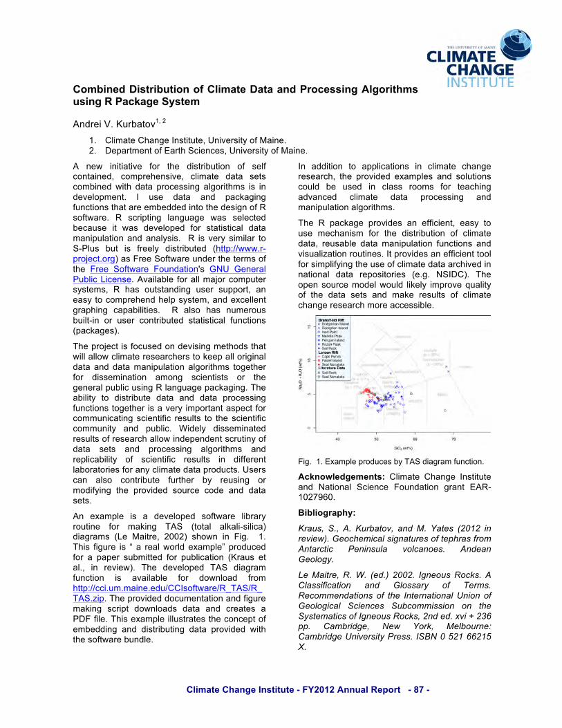
An example is a developed software library routine for making TAS (total alkali-silica) diagrams (Le Maitre, 2002) shown in Fig. 1. This figure is “ a real world example” produced for a paper submitted for publication (Kraus et al., in review). The developed TAS diagram function is available for download from http://cci.um.maine.edu/CCIsoftware/R_TAS/R_TAS.zip. The provided documentation and figure making script downloads data and creates a PDF file. This example illustrates the concept of embedding and distributing data provided with the software bundle.
In addition to applications in climate change research, the provided examples and solutions could be used in class rooms for teaching advanced climate data processing and manipulation algorithms.
The R package provides an efficient, easy to use mechanism for the distribution of climate data, reusable data manipulation functions and visualization routines. It provides an efficient tool for simplifying the use of climate data archived in national data repositories (e.g. NSIDC). The open source model would likely improve quality of the data sets and make results of climate change research more accessible.
Fig. 1. Example produces by TAS diagram function.
Acknowledgements: Climate Change Institute and National Science Foundation grant EAR-1027960.
Bibliography:
Kraus, S., A. Kurbatov, and M. Yates (2012 in review). Geochemical signatures of tephras from Antarctic Peninsula volcanoes. Andean Geology.
Le Maitre, R. W. (ed.) 2002. Igneous Rocks. A Classification and Glossary of Terms. Recommendations of the International Union of Geological Sciences Subcommission on the Systematics of Igneous Rocks, 2nd ed. xvi + 236 pp. Cambridge, New York, Melbourne: Cambridge University Press. ISBN 0 521 66215 X.

Climate Change Institute - FY2012 Annual Report - 88 -
The Huaca 20 Site in the Maranga Complex: Human-environment Interactions, Household Activities, and Funerary Practices in the Central Coast of Peru.
Cecilia Mauricio1 1. Climate Change Institute, University of Maine.
Abstract: The Huaca 20 site was the household of a fishermen population that was severely hit by a mega-El Niño event around 600 A.D. This phenomenon triggered a series of transformations in this site directed to cope with this time of environmental stress.
This research analyzes the human occupation of the Huaca 20 archaeological site, a Late Lima site located in the lower Rímac Valley, Central Coast of Peru. Huaca 20 was a domestic unit of the Maranga Complex (apparently the main settlement of the Late Lima society), between ca. 500 A.D.-700 A.D. Based on previous dating and ceramic styles, the use of Huaca 20 can be placed around 550 AD to 750 AD, at the end of the Early Intermediate Period (EIP). The domestic use of Huaca 20 coincided with a time of environmental stress, apparently caused by an unusually strong El Niño event around 600 AD.
Fig. 1. Flood channel in Huaca 20.
This research assesses the impact of the ca. 600 A.D. El Niño event by analyzing the development of social dynamics in Huaca 20 before, during, and after this phenomenon. This study is done from the perspective of a domestic fishing unit, a fact that makes it particularly sensitive to trace effects of El Niño on marine environments. The data show that severe rainfall and floods driven by El Niño destroyed an
important part of Huaca 20 site (Figure 1) and affected negatively the fishing activities of its inhabitants (Figure 2 and 3) . The severity of the impacts of this El Niño caused changes in the use of the site and its transformation into a cemetery. The results of this study indicate that El Niño of ca. 600 A.D. was an agent of important social changes but the Lima Culture implemented a series of strategies to cope with this time of environmental and social crisis.
Figure 2. Metal fishhooks found in Huaca 20.
Figure 3. Huaca 20 stone sinkers for different kinds of fishing.
Acknowledgements: Catholic University of Peru, Fulbright Commission, Churchill Exploration Fund, Graduate Student Government Grant.

Climate Change Institute - FY2012 Annual Report - 89 -
Evaluating The Effects of Wind Conditions on Songbird Migration Stopover Distribution: Using Current Data to Forecast Future Changes Under Predicted Climate Change Scenarios Jennifer McCabe1, 2 and Brian Olsen1, 2
1. Climate Change Institute, University of Maine. 2. Department of Ecology and Environmental Studies, University of Maine.
Abstract: Migration is a critical stage in many songbirds’ life-cycle, and the environmental factors that influence migration will directly affect individual success and population viability across the annual cycle. One such factor is wind and its effects on flight speed, flight times, and energy expenditures, thereby affecting survival. Despite considerable research focused on wind patterns as a controlling factor in birds’ migratory flight costs, the influence of local and regional wind patterns en route are still poorly understood.
Migrant birds are influenced by environmental factors in multiple locations: breeding, wintering, and en route. Because of the proposed effects of climate change, such as shifts in wind conditions, these birds may become more threatened with population declines. Migration routes are and will continue to be affected by climate change through alterations in the strength and direction of prevailing winds and the location and quality of stopover sites. Impacts of climate change on atmospheric and oceanic circulation patterns have been increasingly reported in recent literature, and these impacts have dramatic consequences for the patterns of regional weather systems. Understanding the current and future relationships between songbird migration and regional winds, therefore, will be invaluable for conserving North American birds in the face of climate change. We propose an extension of an existing paleoclimate, mesoscale weather predicting model called the Weather Research and Forecasting model (WRF) created by the National Center of Atmospheric Research and its partners to serve both operational forecasting and atmospheric research needs. We intend to use the relationships between wind speed, wind direction determined using the WRF model and bird capture data collected during three fall migration seasons in Acadia National Park (ANP) to forecast bird movements in conjunction with projected changes in wind patterns through climate change scenarios given in the International Panel on Climate Change’s (IPCC) 2007 synthesis report. The IPCC’s Special Report on Emissions Scenarios explores six scenarios in which the world’s population and economic growth rates and the pace of changes in economic structure all differ (Fig 1). Emission
scenarios will each create varying surface temperature increases and affect wind patterns differently. Established bird and wind relationships will be used to model future migrant timing and stopover use patterns in the greater ANP region under each modeling scenario. This model will allow ANP and other partners to predict areas of high concentrations of migrants as well as forecast changes in timing of migrants utilizing ANP’s habitats.
Fig 1. Six SRES scenarios (colored lines) (IPCC 2007).
Acknowledgements: Thank you to Brian Mitchell and Bruce Connery of the National Park Service for their support and to Peter Koons for all your anticipatory help with the wind modeling.
Bibliography: IPCC. 2007. An assessment of the International Panel on Climate Change: Synthesis Report.
Climate Change Institute - FY2012 Annual Report - 90 -
Developing State-of-the-Art Climate Layers that are Useful for Biological Predictions
Brian McGill1, George Cooper1, Benoit Parmentier2, Jim Regetz2, Robert Guralnick3
1. School of Biology and Ecology, University of Maine. 2. National Center for Ecological Analysis and Synthesis, California. 3. University of Colorado
Abstract: Hundreds of papers are published every year using the relationship between climate and biological distribution data to: a) improve interpolation of spatially sparse data and b) develop transfer models for predicting distributions under climate change. Biologists usually use standard climatological products that are coarse resolution and use long term means of temperature and annual precipitation. In fact organisms usually care much more about extreme events, biologically tuned measures like degree days and many applications need much higher spatial resolution. A group of scientists is working with NASA, NCEAS and iPlant to develop such data using novel analysis methods and synthesizing ground station and satellite data.
The Problem:
The paleontological record decisively documents that the main response of plants, vertebrates and other organisms to climate change in the paleontological past has been to move large distances (often >1,000 km) to track climate. It is clear that climate is an important driver of where species live.
Given the current human-caused climate change, it is likely that most species will be moving long distances in the near future to track this new climate change. Literally, you may not recognize the plants and animals outside your window 50 years from now.
The main way of trying to predict where organisms will live in the future is to develop statistical models of how organisms and climate are related today. This can then be applied to computer models predicting future climate to predict where a species will be living in the future.
Unfortunately the data about climate available to biologists today is not really designed for use by biologists. It tends to report things like a 30 year average of total precipitation per year. This is a human-oriented perspective on climate. To improve our projections of organismal response, we need to develop easily accessible climate data that has an organism-centered perspective. Such data would contain information on things like degree-days (similar to the cooling days used by humans to describe the total amount of heat in a summer) and extreme events (the coldest night in a 50 year period).
The Solution:
A group of 20 experts has met several times at NCEAS to identify what types of descriptions of climate are likely to be most useful in predicting the future distribution of organisms in response to climate change.
Now a smaller group of scientists is working to develop these biology-friendly representations of climate for use by biologists.
We are merging ground weather station data (good temporal resolution and absolute accuracy, but bad spatial coverage) with satellite data (good spatial resolution). We are then developing new statistical methods to merge the data and interpolate between ground stations.
We are also selecting among state of the art methods for calculating climatic layers. These layers will:
• cover the whole globe • be at a resolution of 1 km • be freely downloadable on the internet
And include • Extreme weather events • Agricultural variables (e.g. degree days) • Terrain variables (slope, aspect,
moisture indices) • Land cover
Acknowledgements: We thank NASA, NCEAS and iPlant for funding.

Climate Change Institute - FY2012 Annual Report - 91 -
Figure 2- Image of the master core from the two lakes, and our interpretation of sediment source.
Late Holocene Glacial History of Renland, East Greenland, Reconstructed from Lake Sediments Aaron Medford1, Brenda Hall1,2
1. Department of Earth Sciences, University of Maine. 2. Climate Change Institute, University of Maine.
Abstract: The Arctic’s climate is responding already to increases in greenhouse gases. In order to predict accurately future climate change in the region, we first must understand natural climate variability and place the present warming in context. To address this question, I will reconstruct past fluctuations of the Renland Ice Cap during the Holocene by studying multiple proxies in lake cores to constrain better the timing of climate events in Greenland.
The Arctic is showing significant response to anthropogenic climate change (ACIA, 2005). The forcing signal is strengthened due to feedbacks, or Arctic amplification (Serreze and Berry, 2011). Therefore the Arctic is an important region to study, because it is responding more quickly and to a larger degree than elsewhere. In order to predict accurately future climate change, we must know how the Arctic has responded to natural variations in the past. By looking at lake sediment, I will reconstruct a high-resolution, Holocene glacial record for the Renland Ice Cap. This record, in combination with other high-resolution records spanning the globe, will provide insight into the forces and feedbacks of the climate system.
Figure 1-Study Area Renland (Figure 1), part of the Scoresby Sund region, supports a small ice cap. I cored three lakes (two glacially fed, one non-glacial) in the region using a modified Bolivian coring system. I performed preliminary analysis at the Limnological Research Center and more detailed work at the University of Maine. The following procedures will be performed: visual stratigraphy, radiocarbon dating, magnetic susceptibility, loss-on-ignition, and grain size. Master cores (Fig. 2) of both Raven Lake (non-glacial), and Bunny Lake (glacially fed) show what appear to be sediments dating to the initial deglaciation following the last glacial maximum. Raven Lake is then finely
laminated with a high organic content through the rest of the core, whereas Bunny Lake has clay rich pulses thought to represent times of glacial expansion. By accurately dating glacial fluctuations of Renland, we can better address the drivers of Holocene climate variability.
Acknowledgements: Thank you to the following sources of funding: NSF Grant #0908081 and the GSG Grant at the University of Maine Bibliography: ACIA, 2005.Arctic Climate Impact Assessment. Cambridge University Press, 1042p. Serreze, M.C., Barry, R.G. 2011. Processes and Impacts of Arctic Amplification: A Research Synthesis. Global and Planetary Change. 77:85-96.

Climate Change Institute - FY2012 Annual Report - 92 -
But What Was Your Hypothesis? A Science Data Literacy Assessment for High School Students Highlights Difficulties in Connecting Data to Inquiry-based Research Questions
Sarah J. Nelson1, Medea Steinman2, Molly Schauffler3, Bill Zoellick2, Hannah M. Webber2 1. Sen. George Mitchell Center for Environmental and Watershed Research, University of Maine
Dept. of Plant, Soil, and Environmental Science.s 2. SERC Institute, Schoodic Education and Research Center, Winter Harbor, ME. 3. Climate Change Institute and Center for Research in STEM Education, University of Maine.
Two types of data analysis, comparing groups and investigating correlation, provide the foundation for high school students to analyze scientific data (Konold and Khalil, 2003). In the Acadia Learning project, which brings scientific inquiry-based research into classrooms through scientist-teacher-student partnerships, we noted students lacked the background and skills to use these two types of analyses. We designed an assessment and administered it to 220 students across four high schools in Maine. The instrument used a sample data set and research question for each of the two skill areas. Goals were to (1) characterize student difficulties in representing data, and (2) determine whether teacher professional development (PD) about data literacy improves student work. Results suggest that comparing groups is more difficult for students; >60% of respondents created a graph that did not sort data into groups, and <10% of students created a version of the ‘correct’ graph. For the correlation item, 36% of students created an unrelated graph, but 39% created the ideal graph, suggesting more practice or better understanding of correlation-type questions. When teachers who had participated in data literacy professional development presented lessons targeting these two topics, student scores improved significantly (Chi square analysis, p<0.05). This study has highlighted student misconceptions and aided science teacher understanding of the types of data literacy skills students need to practice. We also demonstrated that a focus on data literacy can lead to better student understanding of graphs as evidence in scientific inquiry. !"#"$%&'()*+,-./01."/+'1'2-34/((,"5"2/"6"#0+'#)1*#73.'2'",)'#5/+)0/0-0'1*#73$"++"$,)'#5/+)0/0-0'1*#73.)5$"-88,."/+'1'2-3

Climate Change Institute - FY2012 Annual Report - 93 -
Toxin Load Decreases the Capacity of Common Loons to Adapt to Climate Change
Brian J. Olsen1,2, David C. Evers3, Allison J. Byrd2,4, 1. School of Biology & Ecology, University of Maine. 2. Climate Change Institute, University of Maine. 3. BioDiversity Research Institute, Gorham, Maine. 4. Ecology & Environmental Sciences Program, University of Maine.
Abstract: A central question concerning climate change for biologists is how organisms adapt to climate changes and what factors might influence their capacity to adapt. We tested for differences in the adaptive capacity of common loons, Gavia immer, to maintain reproductive output under varying mercury body burdens and a variety of weather conditions. Individuals with high mercury loads were more influenced by changes in weather than those individuals with lower burdens, suggesting that anthropogenic toxins have the ability to limit adaptive capacity to climate in wild vertebrate populations.
In the face of environmental change, the viability of wildlife populations is continually challenged. Thus a central goal for conservation biologists and evolutionary ecologists is to determine the adaptive capacity of populations. Adaptive capacity is the ability of populations to evolve adaptations to new environmental conditions (genetic change), the ability of individuals to adjust phenotypes adaptively (plasticity), or the ability of populations to evolve plasticity (reaction norm evolution).
Slowly reproducing birds with long generation times should possess adaptive reaction norms to deal with historically common environmental variability, like interannual weather differences. The ability of individuals to exhibit these reaction norms, however, may be limited by new changes to the environment.
We examined reproductive success in the Common Loon, Gavia immer, under a wide variety of weather conditions for adults that experienced a blood mercury burden that was or was not above the Lowest Observed Adverse Effect Level (3.0 !g/g ww) for the species.
We used a repeated-measures, multinomial logistic regression to predict the number of offspring produced (0, 1, or 2 chicks) as a function of the Palmer Drought Index, controlling for the date of blood sampling and bird sex. Individuals were repeatedly measured across years.
For adult loons with low mercury burdens, reproductive success was not predicted (N = 128, X2 = 0.2, P = 0.66) by interannual variability in weather conditions (i.e. individuals were able to succeed equally across different environmental
conditions). For adult loons with high mercury burdens, however, interannual reproductive success was predicted by interannual weather variability (N = 40, X2 = 4.8, P = 0.03).
Birds carrying a biologically significant mercury load were unable to adjust their phenotype adaptively to maintain reproductive success in years with poor weather, although their reproductive success was similar to birds with low mercury burdens in good years. This interaction highlights an important additional impact of environmental toxins, mainly that they have the potential to limit the adaptive capacity of wildlife populations for changes in climate or other environmental characteristics.
Fig. 1. The average Palmer Drought Index for adult loons that produced zero, one, or two chicks (data points are offset for visibility). Adults possessed either blood Hg concentrations above (open circles) or below (filled circles) the Lowest Observed Adverse Effect Level (3.0 !g/g ww).

Climate Change Institute - FY2012 Annual Report - 94 -
Critical Transitions: Climate Change, Coastal Geomorphology and Human Cultures on the North Coast of Peru (7000-2800 cal BP) Elizabeth Olson1, 2
1. Climate Change Institute, University of Maine. 2. Department of Anthropology, University of Maine.
Abstract: The use of multiple proxies including sediment analysis, ground-penetrating radar data, radiocarbon dating, and archaeological site records allowed us to examine the paleoenvironment of the Salinas de Chao paleoembayment. A gradual change in climatic, geomorphic and local resources forced cultures to adapt and change the landscape themselves through architectural construction and resource use between 7000-2800 cal BP. During the mid-Holocene on the north coast of Peru, significant change in climatic regimes, sea-level stands, and the extent of ecological zones occurred as human societies became increasingly complex. The coastal plain had a very different appearance during this time period. In order to understand the seemingly rapid transition within the cultural chronology of this time period, from small mobile groups to large sedentary societies with monumental architecture, a wide lens is used to view the evolution of the landscape around the human populations. Rapid geomorphic agents, including deposition of alluvial fans and eolian sediment, littoral erosion during sea-level fluctuations, and variable El Niño event frequency have made interpretation of evolution of the coastal zone during this time period difficult. Likewise, the study of coastal inhabitants during this time-period has been complicated by alteration of the record by these agents of geomorphic change. Modern development on the landscape in conjunction with the previously mentioned obstacles has led some researchers to declare that the chronology of this time-period is unresolvable (Haas & Creamer, 2006).
The Salinas de Chao paleoembayment, however, is an area in which little human activity has occurred since its mid-Holocene occupation. This isolated region is centered around a mid-Holocene shoreline. A salinas (salt flat) stretches the ~4 km from this shoreline to the present coast and overlooking the salinas on a raised marine terrace are twenty-one Preceramic archaeological sites dating between ~7000-2800 cal BP (see Figure 1).
Figure 1: Map of Study Area, Salinas de Chao Paleoembayment, Chao, Peru.
Salinas deposits are very typical in the Holocene sequence of coastal lowlands along the Northern coast of Peru. Formation of these deposits is attributed to sea-level fluctuations, yet little research
has been done concerning these systems and their relation to sea-level history. Here paleoenvironmental reconstruction of the Salinas de Chao paleoembayment is done using archaeological and geologic data. These data are combined in order to analyze the settlement pattern throughout occupation. A new model for shoreline progradation of the Salinas de Chao paleoembayment is proposed in which a log-spiral beach form persisted throughout the infilling of the embayment. The initiation of infilling and progradation are correlated to the end of the El Niño hiatus ~5800 cal BP and sea-level stabilization ~6000 BP. Brackish wetlands within the sheltered paleoembayment are identified via remains from archaeological sites. Freshwater is rare on this landscape today, but the presence of human groups living in this area exploiting brackish wetlands indicates that the water table may have been higher and fracture springs in the surrounding coastal cordillera around the Salinas de Chao paleoembayment may have been active during the mid-Holocene. Following the mid-Holocene, evidence for brackish conditions disappears and most sites were abandoned. This work demonstrates how Preceramic populations responded to rapid shoreline progradation and increased aridity as local water tables fell. Evidence for these findings comes from a multidisciplinary approach including the use of ground-penetrating radar, sedimentary, archaeological, malacological, botanical, and radiocarbon data. In this way, the critical transitions in both the cultural and environmental history of this region were found and correlations between these histories are discussed.
Acknowledgements: I would like to thank my advisor Dr. Sandweiss and my committee Dr. Belknap, Dr. Keefer, Dr. Zaro, Dr. J. Kelley and Dr. A. Kelley for their support. This project would not have been possible without the financial support from the National Geographic Foundation, the Dan & Betty Churchill Fund, and the personal donation from Marshall P. Cloyd.
Bibliography:
Haas, J., & Creamer, W. (2006). Crucible of Andean civilization: The Peruvian coast from 3000 to 1800 BC. Current Anthropology, 47, 745–775.
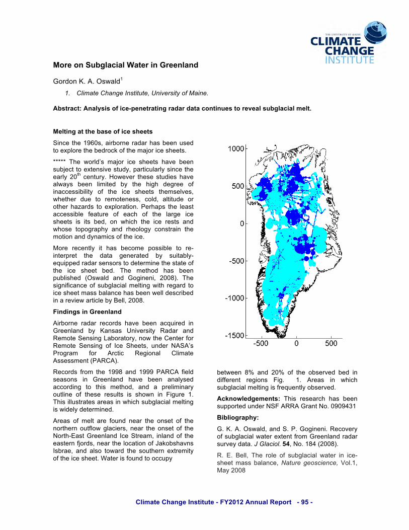
Climate Change Institute - FY2012 Annual Report - 95 -
More on Subglacial Water in Greenland
Gordon K. A. Oswald1 1. Climate Change Institute, University of Maine.
Abstract: Analysis of ice-penetrating radar data continues to reveal subglacial melt.
Melting at the base of ice sheets
Since the 1960s, airborne radar has been used to explore the bedrock of the major ice sheets.
***** The world’s major ice sheets have been subject to extensive study, particularly since the early 20th century. However these studies have always been limited by the high degree of inaccessibility of the ice sheets themselves, whether due to remoteness, cold, altitude or other hazards to exploration. Perhaps the least accessible feature of each of the large ice sheets is its bed, on which the ice rests and whose topography and rheology constrain the motion and dynamics of the ice.
More recently it has become possible to re-interpret the data generated by suitably-equipped radar sensors to determine the state of the ice sheet bed. The method has been published (Oswald and Gogineni, 2008). The significance of subglacial melting with regard to ice sheet mass balance has been well described in a review article by Bell, 2008.
Findings in Greenland
Airborne radar records have been acquired in Greenland by Kansas University Radar and Remote Sensing Laboratory, now the Center for Remote Sensing of Ice Sheets, under NASA’s Program for Arctic Regional Climate Assessment (PARCA).
Records from the 1998 and 1999 PARCA field seasons in Greenland have been analysed according to this method, and a preliminary outline of these results is shown in Figure 1. This illustrates areas in which subglacial melting is widely determined.
Areas of melt are found near the onset of the northern outflow glaciers, near the onset of the North-East Greenland Ice Stream, inland of the eastern fjords, near the location of Jakobshavns Isbrae, and also toward the southern extremity of the ice sheet. Water is found to occupy
between 8% and 20% of the observed bed in different regions Fig. 1. Areas in which subglacial melting is frequently observed.
Acknowledgements: This research has been supported under NSF ARRA Grant No. 0909431
Bibliography:
G. K. A. Oswald, and S. P. Gogineni. Recovery of subglacial water extent from Greenland radar survey data. J Glaciol. 54, No. 184 (2008).
R. E. Bell, The role of subglacial water in ice-sheet mass balance, Nature geoscience, Vol.1, May 2008

Climate Change Institute - FY2012 Annual Report - 96 -
A 27 year long Arsenic and Cesium Deposition Record from Detroit Plateau, Antarctic Peninsula
Mariusz Potocki1, 2, 3, Paul A. Mayewski1, 2, Andrei V. Kurbatov1, Jefferson C. Simões1, 4, Michael Handley1, Elena Korotkikh1, 2, Ricardo Jaña5
1. Climate Change Institute, University of Maine. 2. Department of Earth Sciences, University of Maine. 3. Department of Antarctic Biology, Polish Academy of Sciences. 4. Núcleo de Pesquisas Antárticas e Climáticas, Universidade Federal do Rio Grande do Sul. 5. Departamento Científico - Instituto Antártico Chileno.
Abstract: Arsenic and Cesium were measured in a series of annually dated ice core samples, covering the period 1980 to 2007, collected from a remote, high snow-accumulation site in Detroit Plateau, Antarctic Peninsula
Pronounced enhancements of elements like Arsenic (As), Cadmium (Cd) and Zinc (Zn) have been observed during the last few decades in Antarctic snow and ice. The enhancements have been attributed to the emissions of heavy metals into the atmosphere from human activities in Southern America, Southern Africa and Australia, especially from non-ferrous metal mining and smelting (Wolff et al., 1999; Planchon et al., 2002). Furthermore, increased concentrations of radioactive elements such as Uranium and Cesmium have also been observed (Barbante et al. 2001; Potocki et al., near review). Here we show results from high resolution ice core analysis of As and Cs deposition on the Detroit Plateau (DP), northern Antarctic Peninsula, covering the period from the end of 1980 to the end of 2007. We use seasonal peaks in hydrogen peroxide (maxima represent the summer-time onset of photochemical reactions in the Antarctic atmosphere) to date the 98m-long DP ice core. Chemical analysis demonstrates that the site has a high seasonal accumulation (average of ~2.4m H20 equiv./yr) providing potentially high-resolution records of atmospheric chemistry. Our analyses also reveal that As and Cs exhibit large seasonal variability, with a distinct single maximum and minimum concentration within years. Correlation calculations using the NCEP/NCAR Reanalysis indicate that the Atacama Desert (AD) can be a potential source of the As deposited on DP (Fig 1.). The correlation coefficient between zonal wind on AD and As concentration from DP in the period from 1981
to 2007 is 0.7 and reveals a statistically significant relationship (above 99%). An equally strong relationship is found between the zonal wind at the southern tip of South Africa and Cs concentration from DP. This relationship is statistically significant with a correlation coefficient of above 0.7 (above 99%). AD is one of the main sources in South America for arsenic. South Africa is a major region with Cs mining operations in Southern Hemisphere. These two regions, Atacama Desert and South Africa offer two different sources of As and Cs, natural and anthropogenic respectively.
Fig 1. Seasonal correlation for (DP) As concentration and 850mb Zonal Wind in Southern Hemisphere from 1981 to 2007
Acknowledgements: A grant from NOAA to PM; funds to JS UFRGS; logistics support provided by INACH.
Bibliography: [1] E. W. Wolff , et al., Atmos Environ 33(10), 1535–41 (1999). [2] F. A. M. Planchon, et al., Earth and Planetary Science Letters 200, 207-222 (2002). [3] C. Barbante, et al., Environ. Sci. Technol. 35, 4026-4030 (2001). [4] M. Potocki et al., near review.

Climate Change Institute - FY2012 Annual Report - 97 -
08/02
/10
08/16
/10
08/30
/10
09/13
/10
09/27
/10
10/11
/10
10/25
/10
0
20
40
60
80
100 West BearEast Bear(a)
06/01
/10
07/01
/10
08/01
/10
09/01
/10
10/01
/10
1.5
2.0
2.5
3.0
3.5
West BearEast Bear
(b)
Chemical and Morphological Phenology in Forests Subject to Whole-Watershed Chemical Manipulation
Erin Redding1, Ivan Fernandez1,2,3, Michael Day2, G Bruce Wiersma2 1. School of Forest Resources 2. Climate Change Institute, University of Maine. 3. Department of Plant, Soil and Environmental, University of Maine.
Abstract: Tree morphological and chemical phenology was studied at a long-term watershed manipulation site subject to acidification and nitrogen enrichment. There was no effect of watershed treatments on morphological phenology, but there was on chemical phenology expressed as seasonal patterns of foliar nitrogen concentration.
Annual developmental events in biological systems are dependent, in part, on environmental conditions and can be valuable bio-indicators of environmental change. Many studies have been done on the effects of temperature and photoperiod on phenophases (Menzel and Fabian 1999; Schwartz 2003), but fewer have explored the consequences of nutrient availability in terrestrial ecosystems on forest phenology. Here we examined phenological phenomena at a long-term experimental forested watershed subjected to decadal-scale ecosystem acidification and nitrogen enrichment (Fernandez and Norton 2010). Phenophases of Acer rubrum, Acer saccharum, and Picea rubens in both watersheds were observed throughout the 2010 growing season that included bud burst, flowering (A. rubrum), leaf or needle emergence and unfolding, leaf senescence (Acer spp.), and leaf fall (Acer spp) (Redding 2011). Clear species-specific phenological patterns were observed, but no treatment effects were evident
(e.g., Fig. 1a). Chemical phenology of canopy tree foliage was also examined on a monthly basis from May through October 2010. Nitrogen was the only element that was significantly higher in the treated watershed for all species, although not all months showed significant differences (e.g., Fig. 1b). Foliar nitrogen and phosphorus concentrations decreased in all species throughout the growing season, while foliar calcium, potassium, and aluminum concentrations increased or were constant. This study found clear species-specific patterns of morphological and chemical phenology with time, but did not show evidence for visible alterations in seasonal development as a result of ecosystem acidification and nitrogen enrichment. Further consideration is warranted of these coupled chemical-biological indicators of a changing chemical and physical climate.
Acknowledgements: This research is supported by the National Science Foundation Long-Term Research in Environmental Biology program (DEB-0210257).
Bibliography:
Fernandez, Ivan J. and Stephen A. Norton. 2010. The Bear Brook Watershed in Maine – The Second Decade. Preface. Environ. Monitor. Assess. 171: 1-2.
Menzel, A. and P. Fabian 1999. Growing Season Extended in Europe. Nature. 397:659.
Redding, Erin. 2011. Phenology at the Bear Brook Watershed in Maine: Foliar Chemistry and Morphology. M.S. Thesis, University of Maine. 68 pp.
Schwartz, M.D. 2003. Phenology: An Integrative Environmental Science. Kluwer Academic Publishers, Boston.
Fig. 1. Acer saccharum (a) % color change, and (b) % foliar N concentration at Bear Brook.
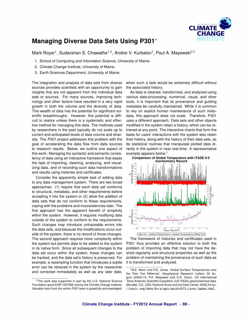
Climate Change Institute - FY2012 Annual Report - 98 -
Managing Diverse Data Sets Using P301!
Mark Royer1, Sudarshan S. Chawathe1,2, Andrei V. Kurbatov2, Paul A. Mayewski2,3
1. School of Computing and Information Science, University of Maine.
2. Climate Change Institute, University of Maine.
3. Earth Sciences Department, University of Maine.
The integration and analysis of data sets from diverse
sources provides scientists with an opportunity to gain
insights that are not apparent from the individual data
sets or sources. For many sources, improving tech-
nology and other factors have resulted in a very rapid
growth in both the volume and the diversity of data.
This wealth of data has the potential for significant sci-
entific breakthroughs. However, this potential is diffi-
cult to realize unless there is a systematic and effec-
tive method for managing this data. The methods used
by researchers in the past typically do not scale up to
current and anticipated levels of data volume and diver-
sity. The P301 project addresses this problem with the
goal of accelerating the data flow from data sources
to research results. Below, we outline one aspect of
this work: Managing the syntactic and semantic consis-
tency of data using an interactive framework that eases
the task of importing, cleaning, analyzing, and visual-
izing data, and of recording such data transformations
and results using histories and certificates.
Consider the apparently simple task of adding data
to any data management system. There are two broad
approaches: (1) require that each data set conforms
to structural, metadata, and other requirements before
accepting it into the system or (2) allow the addition of
data sets that do not conform to these requirements,
coping with the problems and inconsistencies later. The
first approach has the apparent benefit of simplicity
within the system. However, it requires modifying data
outside of the system to conform to the requirements.
Such changes may introduce untraceable errors into
the data sets, and because the modifications occur out-
side of the system, there is no record of those changes.
The second approach requires more complexity within
the system but permits data to be added to the system
in its native form. Since all subsequent changes to the
data set occur within the system, these changes can
be tracked, and the data set’s history is preserved. For
example, a resampling function that introduces a subtle
error can be retraced in the system by the researcher
and corrected immediately as well as any later date,
!This work was supported in part by the U.S. National ScienceFoundation grant EAR-1027960 and by the Climate Change Institute.Valuable input from the entire P301 team is gratefully acknowledged.
when such a task would be extremely difficult without
the associated history.
As data is cleaned, transformed, and analyzed using
various data-processing, numerical, visual, and other
tools, it is important that its provenance and guiding
metadata be carefully maintained. While it is common
to rely on explicit human maintenance of such meta-
data, this approach does not scale. Therefore, P301
uses a different approach: Data sets and other objects
modified in the system retain a history, which can be re-
trieved at any point. The interactive charts that form the
basis for users’ interactions with the system also retain
their history, along with the history of their data sets, as
do statistical routines that manipulate plotted data di-
rectly in the system in near real-time. A representative
example appears below.1
The framework of histories and certificates used in
P301 thus provides an effective solution to both the
problem of importing data that may not have the de-
sired regularity and structural properties as well as the
problem of maintaining the provenance of such data as
it is transformed and analyzed.
1M.E. Mann and P.D. Jones, ‘Global Surface Temperatures overthe Past Two Millennia’, Geophysical Research Letters, 30 Au-gust (2003):15; P.A. Mayewski and D.A. Dixon, US InternationalTrans Antarctic Scientific Expedition (US ITASE) glaciochemical data,(Boulder, CO, USA: National Snow and Ice Data Center, 2005)
.

Climate Change Institute - FY2012 Annual Report - 99 -
Testing for Stability in the Sharp-tailed Sparrow Hybrid Zone: 130 Years of Plumage Comparisons Katharine J. Ruskin1,2, Brian J. Olsen1,2
1. Climate Change Institute, University of Maine. 2. Ecology and Environmental Science, University of Maine.
Abstract: To test for changes in the sharp-tailed sparrow hybrid zone, we compared plumage characteristics of birds captured at the same site in southern Maine in 2011 and from 1882-1941. The populations were significantly different, indicating that mean phenotype at this site has changed over time and might suggest increased rates of hybridization.
Saltmarsh Sparrows (Ammodramus caudacutus, hereafter SALS) are a species of global conservation concern4. Projected climate change may further threaten SALS populations through habitat loss of tidal saltmarshes caused by sea level rise1. Range contraction of SALS breeding habitat could subsequently result in increased hybridization rates with its sister species, the Nelson’s Sparrow (Ammodramus nelsoni, hereafter NESP). Apparent sharp-tailed sparrow (SALS and NESP) hybrids have been observed for over a century5, and research conducted from 1997-2000 determined that the hybrid zone extended from midcoast Maine to northern Massachusetts based largely on plumage characteristics3. More recent genetic analysis found NESP alleles in SALS populations as far south as Long Island6, suggesting that the hybrid zone may be broader than initially described or has expanded. To understand the temporal dynamics of the hybrid zone over the past century, we measured the extent of hybridization during two time periods at a site in the center of the hybrid zone using a single, directly comparable metric.
A total of 19 research skins, collected in southern Maine during breeding season from 1882-1941, and 249 sparrows captured in 2011 at the same site were scored for 13 plumage characteristics that differ between SALS and NESP. Both the means of the summed plumage scores and the individual categories considered together for historical samples are significantly different from 2011 samples using a t-test (p=0.03) and MANOVA (p<0.01), respectively. Eleven out of 13 categories shifted toward the SALS end of the hybridization gradient through time. Results from this site indicate a change in mean phenotype within the center of the hybrid zone and dynamic but asymmetrical introgression. These patterns may result from
variation around a stable level of introgression or of temporal changes in the mean phenotype.
Acknowledgements: U.S. Fish & Wildlife Service, Saltmarsh Habitat & Avian Research Program collaborators, particularly Tom Hodgman and Greg Shriver, and the Olsen lab. Bibliography: 1.Greenberg, “Tidal Marshes: A Global Perspective on the Evolution and Conservation of their Terrestrial Vertebrates.” 675-685. 2.Greenlaw, “Saltmarsh Sparrow (Ammodramus caudacutus),” 3.Hodgman,”Redefining Range Overlap Between the Sharp-tailed Sparrows of Coastal New England,” 38-43. 4.“National Audubon Society WatchList.” 5.Shriver, “Concordance between Morphological and Molecular Markers in Assessing Hybridization between Sharp-Tailed Sparrows in New England,” 94-107. 6.Walsh, “Genetic Barcode RFLP Analysis of the Nelson’s and Saltmarsh Sparrow Hybrid Zone,” 316-322.
Figure 1. Comparison of mean plumage scores (1-5) for 13 categories that differ between SALS and NESP in 2011 and historic populations. Mean phenotype has shifted over time, and toward both ends of the hybrid spectrum.

Climate Change Institute - FY2012 Annual Report - 100 -
Deciphering the Effects of Extreme Hydrological Events on the Response of Northeastern Lakes to Reduced Sulfur Deposition
Jasmine E. Saros1, Kristin E.D. Strock1, Sean Birkel1 and Sarah J. Nelson2 1. Climate Change Institute, University of Maine. 2. George J. Mitchell Center, University of Maine.
Abstract: A potential confounding factor in evaluating the response of surface waters to declining sulfur deposition is variable weather, as suggested by trends during extreme hydrological events. To investigate this, we are coupling climate reanalysis models with a 30-year database of lake geochemistry data to evaluate the role of precipitation in these trends.
Lakewater chemistry monitoring across 400 lakes in the Northeast over the past three decades has been used to evaluate trends in surface water acidification and evidence for recovery in response to the Clean Air Act Amendments (Stoddard et al. 2003). Overall trends reveal sulfate (SO4) declines in many surface waters and increases in dissolved organic carbon (DOC), but responses vary in individual lakes (Fig. 1). A potential confounding factor in evaluation of these trends is variable weather, as suggested by trends in surface water geochemistry during extreme hydrological events (Fig. 1).
To quantify the role of variable precipitation in the observed patterns in lake geochemistry, the existing 30-year database of chemistry for each lake will be coupled with climate reanalysis models and land cover data. Geochemistry data from several long-term initiatives will be used: Regionalized Long-Term Monitoring (RLTM), High Elevation Lake Monitoring (HELM), and Temporally Integrated Monitoring of Ecosystems (TIME).
Preliminary analysis reveals that DOC trends are correlated with different variables by decade. The Palmer Drought Severity Index explains 80% of the variation in DOC during the 1980s, a period of moderate drought. From 1990 until 1999, a time in which notable amendments to the Clean Air Act were passed and more stable or slightly wetter weather patterns were observed, DOC was correlated only with sulfur deposition.
Acknowledgements: This project is funded by the Water Resources Research Institute. The long-term databases used in this project have been collected by numerous dedicated people over the past three decades, funded by US EPA-ORD and EPA-CAMD.
Fig. 1. Response of individual lakes during extreme events captured in the project database.
Bibliography: Stoddard, J.L., J.S. Kahl, F.A. Deviney, D.R. DeWalle, C.T. Driscoll, A.T. Herlihy, J.H. Kellogg, P.S. Murdoch, and J.R. Webb. 2003. Response of Surface Water Chemistry to the Clean Air Act Amendments of 1990. U.S. E.P.A. Office of Research and Development. EPA 620/R-03/001.
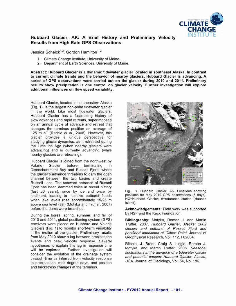
Climate Change Institute - FY2012 Annual Report - 101 -
Hubbard Glacier, AK: A Brief History and Preliminary Velocity Results from High Rate GPS Observations
Jessica Scheick1,2, Gordon Hamilton1, 2 1. Climate Change Institute, University of Maine. 2. Department of Earth Sciences, University of Maine.
Abstract: Hubbard Glacier is a dynamic tidewater glacier located in southeast Alaska. In contrast to current climate trends and the behavior of nearby glaciers, Hubbard Glacier is advancing. A series of GPS observations were carried out on the glacier during 2010 and 2011. Preliminary results show precipitation is one control on glacier velocity. Further investigation will explore additional influences on flow speed variability.
Hubbard Glacier, located in southeastern Alaska (Fig. 1), is the largest non-polar tidewater glacier in the world. Like most tidewater glaciers, Hubbard Glacier has a fascinating history of slow advances and rapid retreats, superimposed on an annual cycle of advance and retreat that changes the terminus position an average of 125 m a-1 (Ritchie et al., 2008). However, this glacier provides a unique perspective for studying glacial dynamics, as it retreated during the Little Ice Age (when nearby glaciers were advancing) and is currently advancing (while nearby glaciers are retreating).
Hubbard Glacier is joined from the northwest by Valarie Glacier before terminating in Disenchantment Bay and Russell Fjord, where the glacier’s advance threatens to dam the open channel between the two basins and create Russell Lake. The seaward entrance of Russell Fjord has been dammed twice in recent history (last 30 years), once by ice and once by sediment, leading to massive outburst floods when lake levels rose approximately 15-25 m above sea level (asl) (Motyka and Truffer, 2007) before the dams were breached.
During the boreal spring, summer, and fall of 2010 and 2011, global positioning system (GPS) receivers were placed on Hubbard and Valarie Glaciers (Fig. 1) to monitor short-term variability in the motion of the glacier. Preliminary results from May 2010 show a lag between precipitation events and peak velocity response. Several hypotheses to explain this lag in response time will be explored. Further investigation will consider the evolution of the drainage system through time as inferred from velocity response to precipitation, melt degree days, and position and backstress changes at the terminus.
Fig. 1. Hubbard Glacier, AK. Locations showing positions for May 2010 GPS observations (6 days). HG=Hubbard Glacier; rf=reference station (Haenke Island).
Acknowledgements: Field work was supported by NSF and the Keck Foundation.
Bibliography: Motyka, Roman J. and Martin Truffer, 2007. Hubbard Glacier, Alaska: 2002 closure and outburst of Russell Fjord and postflood conditions at Gilbert Point. Journal of Geophysical Research, Vol. 112, F02004.
Ritchie, J. Brent, Craig S. Lingle, Roman J. Motyka, and Martin Truffer, 2008. Seasonal fluctuations in the advance of a tidewater glacier and potential causes: Hubbard Glacier, Alaska, USA. Journal of Glaciology, Vol. 54, No. 186.

Climate Change Institute - FY2012 Annual Report - 102 -
!!
1750
1800
1850
1900
1950
2000
20 30 40 50
Albino R! = 0.4675 p < 0.0001
1750
1800
1850
1900
1950
2000
20 30 40 50
Year
210 P
b C
alcu
late
d
Jasper
0
5
10
15
20
25
30
35
40
45
50
55
60
65
70
Dep
th (c
m)
0 16 32 48 64 80
Asterionella formosa
0 5 10 15 20 25
Fragilaria sp.
0 16 32 48 64
Cyclotella stelligera
0 8 16 24 32
Tetracyclus glans
8 10 12 14
% Organic
Glaciers as Drivers of Alpine and Arctic Ecosystem Structure and Function: Effects on Lake Phytoplankton over the Last Millennium
Krista E.H. Slemmons1,2, Jasmine E. Saros1,2 1Climate Change Institute, University of Maine. 2Department of Biology and Ecology, University of Maine.
Abstract: Recent research has shown that glaciers are drivers of modern lake ecosystem structure and function. We investigated whether glaciers have been a chronic driver of biotic change in aquatic communities over the last 1000 years in alpine lakes of the Rocky Mountains and arctic lakes in Renland, Greenland.
Introduction: It has been established that glaciers serve as drivers of aquatic community structure and that this has been enhanced over the last 150 years with accelerated glacial melting.1,2 Consequently, the presence of glaciers on the landscape and the differential timing of glacial loss over the Holocene may have created heterogeneous aquatic communities both spatially and temporally within alpine and arctic ecosystems. Methods: To determine if glaciers have been a chronic driver of lake structure and function, we compared diatom species richness, community assemblages and pigment composition over time from lake sediment cores taken from two paired lakes systems fed by both glacial and snowpack meltwaters (GSF) and by snowpack alone (SF) in the central Rocky Mountains of North America and in the Renland area of East Greenland to better understand the influence that nitrogen rich glacial meltwater has on phytoplankton. Results: While results are preliminary, the alpine GSF lake shows greater variability in percent organic material, species richness, community composition and algal pigments with significant changes occurring post 1850 compared to the SF counterpart. Species richness and taxonomic evenness has declined in the GSF lake since 1850 showing an increase in dominance of diatom species within the 150 years such as Cyclotella stelligera and Asterionella formosa, the latter an indicator of nitrogen enrichment. Future work will compare these results with arctic lakes in East Greenland to identify if there are similar trends and determine if changes in functional algal groups are correlated with glacial mass balance fluctuations. Conclusions: We found key differences in the structure and function of GSF compared to SF lakes over the past 1000 years, however, these differences have been accentuated over the last 150 years following the termination of the Little Ice Age and the decline in alpine glaciers. These differences raise questions on the ecological trajectory of GSF lakes if glaciers disappear.
Acknowledgements: Funding for this research was provided by the Dan and Betty Churchill Fund, as well as an NPS George Melendez Wright Climate Fellowship, and NSF grant -DEB 0734277. Bibliography: 1Slemmons, K. E., and J.E. Saros. Under review. Limnology and Oceanography. !2 Saros, J. E., et al. 2010. Melting alpine glaciers enrich high elevation lakes with reactive nitrogen. Environ. Sci. Technol. 44: 4891-4896.
Fig. 1: Species richness in Jasper Lake, a glacially-fed lake and Albino Lake, a snow fed lake in the Rocky Mountains. Declines in species richness have occurred post 1750 in Jasper Lake.
Fig. 2: Diatom stratigraphy of Jasper Lake. Increase in dominance of species such as Asterionella formosa and Cyclotella stelligera since 1850. Black line indicates 1850.
Species richness ES300
Climate Change Institute - FY2012 Annual Report - 103 -
Mapping Meltwater Volume Changes on the Surface of the Greenland Ice Sheet
William A. Sneed 1. Climate Change Institute, University of Maine.
Abstract: A previously developed algorithm for calculating surface meltwater volume utilized satellite imagery from the ASTER sensor onboard the Terra satellite. Here the method is expanded to use images from the MODIS sensor on the same satellite. The derived volumes from the two sensors closely agree.
Why MODIS?
The Advanced Spaceborne Thermal Emission and Reflection Radiometer (ASTER) records data over a given region of Greenland once every sixteen days while the Moderate Resolution Imaging Radiometer (MODIS) records data over the same region at least twice daily. While ASTER has a greater spatial resolution (15 m) than MODIS (250 m), the greater temporal resolution provided by MODIS is more useful for mapping the changes in meltwater volume throughout the ablation season.
A ~265 km2 area of Kong Oscar Glacier in northwest Greenland was chosen as a test site to compared computed meltwater volumes from the two sensors. The test area is characterized by melt ponds ranging in size from ~325 m in diameter to a large elliptical pond, 1500 m long and 780 m wide. The ASTER and MODIS images are from 06 July 2003. Water depths and volumes were calculated both before and after atmospherically correcting the images.
The surface meltwater volume derived from ASTER was 1.8x10⁷ m3 and from MODIS was 1.7x10⁷ m3. The difference in the volumes between the atmospherically corrected and uncorrected images were too small to be meaningful. For example, the deepest part of one pond differed by only 0.1 m which is far smaller than the systemic errors of the depth-deriving algorithm.
There are a large number of data products created from MODIS and selecting the appropriate product is important. Originally the MOD09GQ product was chosen and the derived volumes were compared with those from
ASTER. The differences in volume were much too large to be attributed simply to the different spatial resolutions of the sensors. Further investigation (pers. comm, E. Vermote) revealed that the MOD09GQ product is a temporal and spatial mosaic of the best data from the various satellite passes in a given day. The depth-deriving algorithm depends on knowing the unique satellite viewing angle and solar illumination angles for each pixel in a scene thus making MOD09GQ images unsuitable. The MODIS MOD02 top-of-atmosphere reflectance product was used in this study and produced the results above.
Acknowledgements: The author is supported by a NASA Earth and Space Science Fellowship.
Climate Change Institute - FY2012 Annual Report - 104 -
Neandertals: New Lines of Evidence
Kristin Sobolik 1, Jeffrey Sommer 2, Richard Redding 3, Samuel Belknap III 1, Vaughn M. Bryant 4
1. Climate Change Institute, Department of Anthropology, University of Maine 2. Historical Society of Saginaw County, The Castle Museum, Saginaw, MI 3. Museum of Anthropology, University of Michigan 4. Department of Anthropology, Texas A&M University
Neandertals were originally found in 1856 in the Neander Valley of Germany, and analyses of the remains of these human ancestors have produced scientific theories suggesting they developed the concept of religion, buried their dead with flowers, conceptualized advanced artistic creativity, became extinct at the hands of modern humans, and perhaps interbred with humans leaving their genes in modern Eurasian populations. We summarize recent research on Neandertals and focus, specifically, on excavation, pollen, and faunal evidence from the Shanidar IV burials, excavated by Ralph Solecki in the 1950s, which then became the “type” specimens of Classic Neanderthals. We provide a reanalysis and reinterpretation of these famous remains. The Climate Change Institute (CCI) is an interdisciplinary research unit organized to conduct research and graduate education funded by public and private sources. It is a requirement for the CCI.
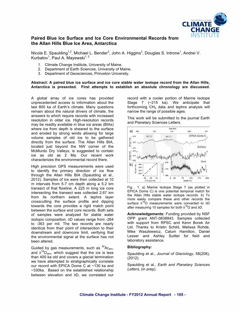
Climate Change Institute - FY2012 Annual Report - 105 -
Paired Blue Ice Surface and Ice Core Environmental Records from the Allan Hills Blue Ice Area, Antarctica
Nicole E. Spaulding1,2, Michael L. Bender3, John A. Higgins3, Douglas S. Introne1, Andrei V. Kurbatov1, Paul A. Mayewski1, 2
1. Climate Change Institute, University of Maine. 2. Department of Earth Sciences, University of Maine. 3. Department of Geosciences, Princeton University.
Abstract: A paired blue ice surface and ice core stable water isotope record from the Allan Hills, Antarctica is presented. First attempts to establish an absolute chronology are discussed.
A global array of ice cores has provided unprecedented access to information about the last 800 ka of Earth’s climate. Many questions remain about the natural drivers of climate, the answers to which require records with increased resolution in older ice. High-resolution records may be readily available in blue ice areas (BIAs) where ice from depth is sheared to the surface and eroded by strong winds allowing for large volume samples of old ice to be gathered directly from the surface. The Allan Hills BIA, located just beyond the NW corner of the McMurdo Dry Valleys, is suggested to contain ice as old as 2 Ma. Our recent work characterizes the environmental record there.
High precision GPS measurements were used to identify the primary direction of ice flow through the Allan Hills BIA (Spaulding et al., 2012). Samples of ice were then collected at 10 m intervals from 5-7 cm depth along a 5.2 km transect of that flowline. A 225 m long ice core intersecting the transect was collected 2.67 km from its northern extent. A tephra layer crosscutting the surface profile and dipping towards the core provides a rigid match point between the surface and core records. Both sets of samples were analyzed for stable water isotopic composition. !D values range from -264 to -363 per mil. The two records are nearly identical from their point of intersection to their downstream and downcore limit, verifying that the environmental signal at the surface has not been altered.
Guided by gas measurements, such as 40Aratm, and !18Oatm, which suggest that the ice is less than 400 ka old and covers a glacial termination we have attempted to stratigraphically correlate our record with EPICA Dome C at ~130 ka and ~330ka. Based on the established relationship between elevation and !D, we correlated our
record with a cooler portion of Marine Isotope Stage 7 (~215 ka). We anticipate that forthcoming CH4 data and tephra analysis will narrow the range of possible ages.
This work will be submitted to the journal Earth and Planetary Sciences Letters.
Fig. 1. a) Marine Isotope Stage 7 (as plotted in EPICA Dome C) is one potential temporal match for the Allan Hills stable water isotope records. b) To more easily compare these and other records the surface !18O measurements were converted to !D after measuring 10 samples for both !18O and !D.
Acknowledgements: Funding provided by NSF OPP grant ANT-0838843. Samples collected with support from RPSC and Kenn Borek Air Ltd. Thanks to Kristin Schild, Melissa Rohde, Mike Waszkiewicz, Calum Hamilton, Daniel Lesser and Ashley Suitter for field and laboratory assistance.
Bibliography:
Spaulding et al., Journal of Glaciology, 58(208), (2012).
Spaulding et al., Earth and Planetary Sciences Letters, (in prep).

Climate Change Institute - FY2012 Annual Report - 106 -
Exploring Climate-Induced Changes in West Greenland Lakes
Kristin E. Strock1, Jasmine E. Saros1 1. Climate Change Institute and School of Biology and Ecology, University of Maine.
Abstract: Across the Arctic, lake sediment records provide some of the few key archives documenting rates of ecosystem change in this region since the last ice age. In particular, striking changes in communities of diatoms have occurred over the last 150 years. We used experiments to provide key ecological information that will enhance interpretation of climate-induced changes from several existing diatom records from southwest Greenland.
Striking changes in communities of diatoms (a type of algae that responds rapidly to environmental change and leaves a fossil in lake sediments) have occurred over the last 150 years. Shifts in diatom community structure often occur rapidly in response to ecological perturbations to lakes. If ecological relationships between diatom community structure and environmental parameters are well understood, changes in diatom communities can provide key mechanistic information on how lake ecosystems are responding to environmental change.
In numerous lake sediment records from the high Arctic of Canada and Europe, diatom species generally associated with warmer conditions increased at unprecedented rates during the 20th century (Smol, 2005). Diatom communities in lake sediments from west Greenland are dramatically different from those in the rest of the Arctic- they are rich in these “warmer” water diatoms throughout the Holocene, not just the last century (Perren et al. 2009). This difference has raised questions about what we can use diatoms to infer in the Arctic, and suggests the need to clarify the ecological traits of key diatom taxa in order to advance our understanding of drivers of change.
We coupled comparative lake sampling with a microcosm experiment to provide key ecological information that will enhance interpretation of climate-induced ecological changes from several existing diatom records from southwest Greenland. Experiments manipulated both nutrient availability (nitrogen/phosphorus and no enrichment) and light (surface and deep where 10% photosynthetically active radiation remains). Preliminary results suggest that a “warmer” diatom taxon of interest (Cyclotella radiosa) responds to increased light availability but has limited response to nutrient enrichment (Fig. 1).
Fig. 1. Cyclotella radiosa experimental results
This is in opposition to previous findings in alpine landscapes where similar sized Cyclotella spp. have moderate to high nutrient requirements and prefer moderate mixing depths (>5m). This suggests that the ecology of Cyclotella spp. in this west Greenland lake is different than ecological requirements documented at lower latitudes. Understanding the ecology of these species will provide important tools to decipher the extent to which direct and indirect effects of climate are contributing to rapid ecological change. Ultimately, diatom records from arctic lakes may be providing much richer signals of the response of these lake ecosystems to climate change than previously thought.
Acknowledgements: Funding for this project was generously provided by the Dan and Betty Churchill Exploration Fund.
Bibliography: Perren, B.B. et al. (2009) Diatoms reveal complex spatial and temporal patterns of recent limnological change in West Greenland. J. Paleolimnol., 42: 233-247.
Smol, J.P. et al. (2005) Climate-Driven Regime Shifts in the Biological Communities of Arctic Lakes. P. Natl. Acad. Sci. USA.,102: 4397-4402.
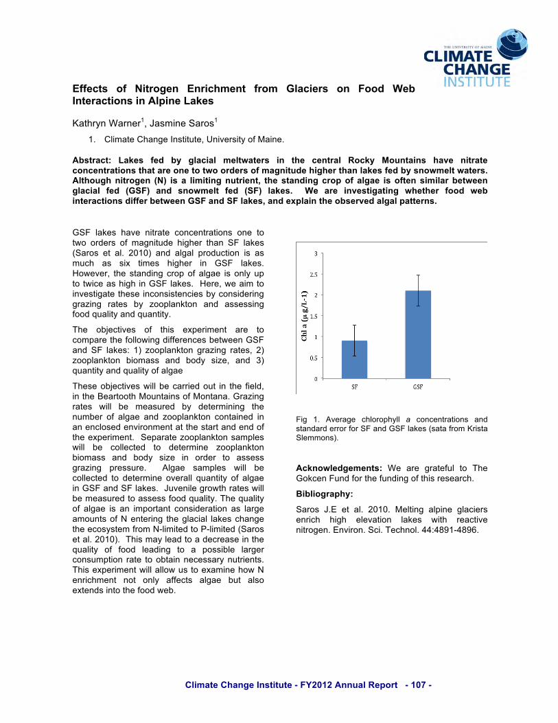
Climate Change Institute - FY2012 Annual Report - 107 -
Effects of Nitrogen Enrichment from Glaciers on Food Web Interactions in Alpine Lakes
Kathryn Warner1, Jasmine Saros1 1. Climate Change Institute, University of Maine.
Abstract: Lakes fed by glacial meltwaters in the central Rocky Mountains have nitrate concentrations that are one to two orders of magnitude higher than lakes fed by snowmelt waters. Although nitrogen (N) is a limiting nutrient, the standing crop of algae is often similar between glacial fed (GSF) and snowmelt fed (SF) lakes. We are investigating whether food web interactions differ between GSF and SF lakes, and explain the observed algal patterns.
GSF lakes have nitrate concentrations one to two orders of magnitude higher than SF lakes (Saros et al. 2010) and algal production is as much as six times higher in GSF lakes. However, the standing crop of algae is only up to twice as high in GSF lakes. Here, we aim to investigate these inconsistencies by considering grazing rates by zooplankton and assessing food quality and quantity.
The objectives of this experiment are to compare the following differences between GSF and SF lakes: 1) zooplankton grazing rates, 2) zooplankton biomass and body size, and 3) quantity and quality of algae
These objectives will be carried out in the field, in the Beartooth Mountains of Montana. Grazing rates will be measured by determining the number of algae and zooplankton contained in an enclosed environment at the start and end of the experiment. Separate zooplankton samples will be collected to determine zooplankton biomass and body size in order to assess grazing pressure. Algae samples will be collected to determine overall quantity of algae in GSF and SF lakes. Juvenile growth rates will be measured to assess food quality. The quality of algae is an important consideration as large amounts of N entering the glacial lakes change the ecosystem from N-limited to P-limited (Saros et al. 2010). This may lead to a decrease in the quality of food leading to a possible larger consumption rate to obtain necessary nutrients. This experiment will allow us to examine how N enrichment not only affects algae but also extends into the food web.
Fig 1. Average chlorophyll a concentrations and standard error for SF and GSF lakes (sata from Krista Slemmons).
Acknowledgements: We are grateful to The Gokcen Fund for the funding of this research.
Bibliography:
Saros J.E et al. 2010. Melting alpine glaciers enrich high elevation lakes with reactive nitrogen. Environ. Sci. Technol. 44:4891-4896.
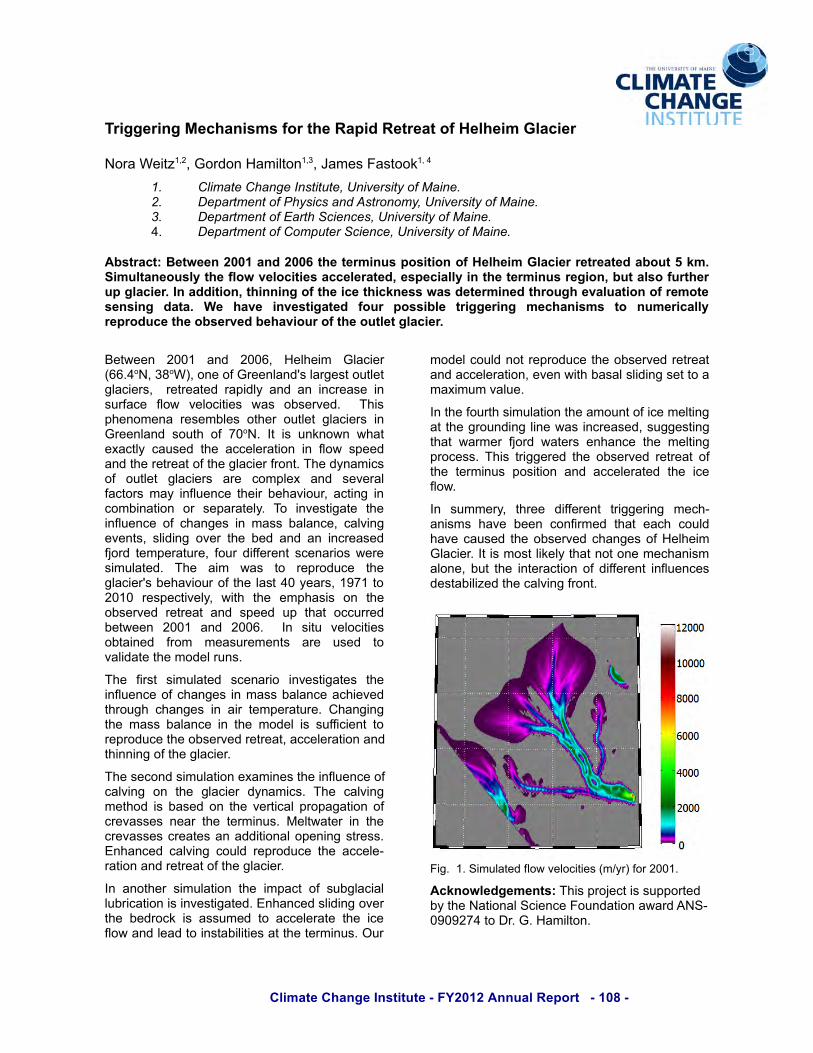
Climate Change Institute - FY2012 Annual Report - 108 -
!"#$$%"#&$' % ''
!"#$%&'()*+,-,%."#/"0%1$2(3)"0+,4,%5$2'6%7$6)""8+,%9
!" #$%&'()*#+',-)*.,/(%(0()1*2,%3)4/%(5*67*8'%,)"*9" :);'4(&),(*67*<+5/%=/*',>*?/(46,6&51*2,%3)4/%(5*67*8'%,)"*@" :);'4(&),(*67*A'4(+*B=%),=)/1*2,%3)4/%(5*67*8'%,)"*9: :);'4(&),(*67*#6&;0()4*B=%),=)1*2,%3)4/%(5*67*8'%,):
56,/"+)/7'8%/9%%&':;;<'+&1':;;='/*%'/%"(#&>,'0.,#/#.&'.-'2%3*%#('43+)#%"'"%/"%+/%1'+6.>/'?'@(A'B#(>3/+&%.>,3C'/*%'-3.9'D%3.)#/#%,'+))%3%"+/%1E'%,0%)#+33C'#&'/*%'/%"(#&>,'"%$#.&E'6>/'+3,.'->"/*%"'>0'$3+)#%"A'F&'+11#/#.&E'/*#&&#&$'.-'/*%'#)%'/*#)@&%,,'9+,'1%/%"(#&%1'/*".>$*'%D+3>+/#.&'.-'"%(./%',%&,#&$ ' 1+/+A ' G% ' *+D% ' #&D%,/#$+/%1 ' -.>" ' 0.,,#63% ' /"#$$%"#&$ ' (%)*+&#,(, ' /. ' &>(%"#)+33C'"%0".1>)%'/*%'.6,%"D%1'6%*+D#.>"'.-'/*%'.>/3%/'$3+)#%"A
;')<''0 % -==+ % $0/ % -==>, % 1'3?'(2 % .3$@('#%A>>:9"!,%4B"&C,%"0'%"D%.#''03$0/E6%3$#F'6)%"G)3')%F3$@('#6, % % #')#'$)'/% #$H(/3I %$0/%$0% (0@#'$6' % (0%6G#D$@' % D3"< % J'3"@()('6 % <$6 % "K6'#J'/: % % L?(6%H?'0"2'0$ % #'6'2K3'6 %")?'# % "G)3') % F3$@('#6 % (0%.#''03$0/ %6"G)? %"D % M="!: % N) % (6 %G080"<0 %<?$)%'O$@)3I %@$G6'/ % )?' %$@@'3'#$)("0 % (0 % D3"< %6H''/%$0/%)?'%#')#'$)%"D%)?'%F3$@('#%D#"0):%L?'%/I0$2(@6%"D % "G)3') % F3$@('#6 % $#' % @"2H3'O % $0/ % 6'J'#$3%D$@)"#6%2$I%(0D3G'0@'%)?'(#%K'?$J("G#,%$@)(0F%(0%@"2K(0$)("0 % "# % 6'H$#$)'3I: % L" % (0J'6)(F$)' % )?'%(0D3G'0@'%"D %@?$0F'6% (0%2$66%K$3$0@', %@$3J(0F%'J'0)6, %63(/(0F%"J'# % )?'%K'/%$0/%$0% (0@#'$6'/%DP"#/%)'2H'#$)G#',%D"G#%/(DD'#'0)%6@'0$#("6%<'#'%6(2G3$)'/: % L?' % $(2 % <$6 % )" % #'H#"/G@' % )?'%F3$@('#E6%K'?$J("G#%"D%)?'%3$6)%9=%I'$#6,%+QM+%)"%-=+= % #'6H'@)(J'3I, % <()? % )?' % '2H?$6(6 % "0 % )?'%"K6'#J'/ % #')#'$) % $0/ % 6H''/ % GH % )?$) % "@@G##'/%K')<''0 % -==+ % $0/ % -==>: % % N0 % 6()G % J'3"@()('6%"K)$(0'/ % D#"2 % 2'$6G#'2'0)6 % $#' % G6'/ % )"%J$3(/$)'%)?'%2"/'3%#G06:
L?' % D(#6) % 6(2G3$)'/ % 6@'0$#(" % (0J'6)(F$)'6 % )?'%(0D3G'0@'%"D%@?$0F'6%(0%2$66%K$3$0@'%$@?('J'/%)?#"GF?%@?$0F'6 % (0 %$(# % )'2H'#$)G#': %R?$0F(0F%)?'%2$66%K$3$0@'% (0 % )?'%2"/'3 % (6 %6GDD(@('0) % )"%#'H#"/G@'%)?'%"K6'#J'/%#')#'$),%$@@'3'#$)("0%$0/%)?(00(0F%"D%)?'%F3$@('#:
L?'%6'@"0/%6(2G3$)("0%'O$2(0'6%)?'%(0D3G'0@'%"D%@$3J(0F % "0 % )?' % F3$@('# % /I0$2(@6: % L?' % @$3J(0F%2')?"/%(6%K$6'/%"0%)?'%J'#)(@$3%H#"H$F$)("0%"D%@#'J$66'6 %0'$# % )?' % )'#2(0G6: %S'3)<$)'# % (0 % )?'%@#'J$66'6%@#'$)'6%$0%$//()("0$3%"H'0(0F%6)#'66:%T0?$0@'/%@$3J(0F%@"G3/ %#'H#"/G@'%)?'%$@@'3'U#$)("0%$0/%#')#'$)%"D%)?'%F3$@('#:
N0 %$0")?'# % 6(2G3$)("0 % )?' % (2H$@) % "D % 6GKF3$@($3%3GK#(@$)("0%(6%(0J'6)(F$)'/:%T0?$0@'/%63(/(0F%"J'#%)?' %K'/#"@8 % (6 %$66G2'/ % )" %$@@'3'#$)' % )?' % (@'%D3"<%$0/%3'$/%)"%(06)$K(3()('6%$)%)?'%)'#2(0G6:%VG#%
2"/'3%@"G3/%0")%#'H#"/G@'%)?'%"K6'#J'/%#')#'$)%$0/%$@@'3'#$)("0,%'J'0%<()?%K$6$3%63(/(0F%6')%)"%$%2$O(2G2%J$3G':
N0%)?'%D"G#)?%6(2G3$)("0%)?'%$2"G0)%"D%(@'%2'3)(0F%$)%)?'%F#"G0/(0F%3(0'%<$6%(0@#'$6'/,%6GFF'6)(0F%)?$) %<$#2'# % DP"#/ %<$)'#6 % '0?$0@' % )?' %2'3)(0F%H#"@'66: %L?(6%)#(FF'#'/%)?'%"K6'#J'/%#')#'$) %"D%)?' % )'#2(0G6 %H"6()("0 % $0/ %$@@'3'#$)'/ % )?' % (@'%D3"<:%
N0 % 6G22'#I, % )?#'' % /(DD'#'0) % )#(FF'#(0F % 2'@?U$0(626 %?$J' %K''0 % @"0D(#2'/ % )?$) % '$@? % @"G3/%?$J'%@$G6'/%)?'%"K6'#J'/%@?$0F'6%"D%1'3?'(2%.3$@('#:%N)%(6%2"6)%3(8'3I%)?$)%0")%"0'%2'@?$0(62%$3"0',%KG)%)?'%(0)'#$@)("0%"D%/(DD'#'0)%(0D3G'0@'6%/'6)$K(3(*'/%)?'%@$3J(0F%D#"0):
7(F:%%+:%W(2G3$)'/%D3"<%J'3"@()('6%A2XI#C%D"#%-==+:
5)@&.93%1$%(%&/,7'L?(6%H#"P'@)%(6%6GHH"#)'/%KI%)?'%!$)("0$3%W@('0@'%7"G0/$)("0%$<$#/%Y!WU%=Q=Q-M9%)"%Z#:%.:%1$2(3)"0:

Climate Change Institute - FY2012 Annual Report - 109 -
Connecting Past and Present: Zooarchaeology and Conservation Biology in the Gulf of Alaska
Catherine F. West1 1. Department of Anthropology and Climate Change Institute, University of Maine.
Abstract: This project addresses the utility of zooarchaeological data for addressing current environmental concerns in the Alaska Maritime National Wildlife Refuge and proposes a combination of archaeological and paleoenvironmental research to contribute to contemporary landscape management.
Small, maritime islands are commonly threatened by human activity, including the introduction of invasive animals that compete with endemic species and reduce biodiversity. Federal resource managers have eradicated invasive animals since the 1940s in Alaska’s Maritime National Wildlife Refuge (AMNWR) in an effort to return these islands to a “natural” state (Ebbert and Byrd 2002). However, this “natural” state is difficult to define because ecosystems in this region are not static: these systems have fluctuated for thousands of years, given human and climate activity.
The research proposed here is focused on the applicability of archaeological and paleoenvironmental datasets to contemporary conservation. Applied zooarchaeology, or the analysis of archaeological fauna, has the potential to provide long-term records about biodiversity and species distribution in island environments, as well as data on the effects of human activity and climate change on these environments over the long-term (Lyman and Cannon 2004).
Fig. 1. Map of the Gulf of Alaska, showing Chirikof
Island (Saltonstall and Steffian 2005).
This project proposes archaeological fieldwork to gather zooarchaeological and paleoenvironmental data to reconstruct the prehistoric environment on a series of Gulf of Alaska islands, including Chirikof, where the landscape has been severely damaged by invasive species since the nineteenth century (see Fig. 1).
Acknowledgements: The University of Maine and the Climate Change Institute, the U.S. Fish & Wildlife Service, and the Alutiiq Museum and Archaeological Repository.
Bibliography:
Ebbert, S.E. and G.V. Byrd. “Eradications of Invasive Species to Restore Natural Biological Diversity on Alaska Maritime National Wildlife Refuge.” In Turning the Tide: Eradication of Invasive Species, edited by C.R. Veitch and M.N. Clout, 102-109. Switzerland: Occasional Paper of the IUCN Species Survival Commission, No. 27.
Lyman, R.L. and K.P. Cannon. Zooarchaeology and Conservation Biology. Salt Lake City: University of Utah Press, 2004.
Saltonstall, P.G. and A.F. Steffian. Archaeological Sites of Chirikof Island, Kodiak Archipelago, Alaska. Anchorage: Report Prepared for the U.S. Fish & Wildlife Service, Alaska Office of Visitors Services and Communication, and the Alaska Maritime National Wildlife Refuge, 2005.

Climate Change Institute - FY2012 Annual Report - 110 -
Disparities in Diatom-inferred Drought Records across the Great Plains (USA): The Potential Role of Climate-induced Changes in Lake Habitat
Courtney R. Wigdahl1, Jasmine E. Saros1, Sherilyn C. Fritz2 1. Climate Change Institute, University of Maine. 2. University of Nebraska – Lincoln.
Abstract: Diatom-inferred salinity in prairie saline lakes is frequently used to identify past patterns of drought. However, diatom-based drought reconstructions from geographically-close sites in the Great Plains have yielded disparate results. Climate-induced physical changes in lake ecosystems may alter the accuracy of these salinity reconstructions, due to the influence of habitat changes on diatom community structure. .
Fossil diatoms preserved in sediments of prairie saline lakes are frequently used to reconstruct drought via chemical changes in lake water salinity. However, diatom-based drought reconstructions from geographically-close sites in the Great Plains have yielded disparate results. Here, we explore how physical changes in lake habitat caused by drought may affect the accuracy of salinity reconstructions.
We examined the ecological structure of the original diatom calibration set used to develop drought reconstructions in this region (Fritz et al. 1991). We then explored how relationships differed between drought, lake level change, and diatom community structure over the last century for three different saline lakes of the Great Plains (USA) with mismatched diatom-inferred drought records. At each site, we examined instrumental drought records and three-dimensional models of planktic:benthic habitat (P:B; open water: shallow water) relationships with lake level change, and compared these data with fossil diatom communities to understand how drought conditions are reflected in both diatom-inferred drought and P:B ratios of diatom species in lake sediment cores.
The original dataset used to reconstruct drought has an uneven distribution of planktic versus benthic species throughout the salinity range, with a high proportion of benthic species for salinity values between 5-10 g L-1 (Fig. 1). Differences in the accuracy of drought reconstructions appeared to be influenced by site-specific physical characteristics that altered relationships between lake level change and P:B habitat zonation within the lakes. In the case of Lake Cochrane, the simplest of the three basins with gently sloping sides, the P:B of fossil diatoms was a better proxy for drought than diatom-inferred salinity. Due to the habitat
preferences of diatom species used to reconstruct drought in this region, it is important to account for the effects of physical habitat changes in our interpretation of lake sediment records. The integration of contemporary ecological perspectives into interpretations of paleoclimate records, particularly for biologically-based reconstructions, is a key step in improving our understanding of site-specific responses to regional environmental changes.
Fig. 1. Percent planktic (open water) and benthic (shallow water) diatom species for different ranges of salinity optima, used to reconstruct salinity and drought in the Great Plains (Fritz et al. 1991).
Acknowledgements: We are grateful to the following UMaine funding sources: Provost Fellowship, Chase Distinguished Research Assistantship, Graduate Student Government, and the School of Biology and Ecology. We also thank Dr. Kathleen Laird for generously sharing her data.
Bibliography: Fritz et al. 1991. Reconstruction of past changes in salinity and climate using a diatom-based transfer function. Nature 22:706-708.

Climate Change Institute - FY2012 Annual Report - 111 -
Sensitivity of a Regional Weather Model to the Choice of Domain Size, Location, and Spatial Resolution
Yi Yang1, Kirk Allen Maasch1, 2 and Sean Birkel1 1. Climate Change Institute, University of Maine. 2. Department of Earth Sciences, University of Maine.
Abstract: Three experiments will be performed with the Weather Research and Forecasting model (WRF) to investigate how the choice of domain size and resolution impacts model performance. WRF will be run in each experiment for two months (January and July 2010) with lateral boundary conditions provided by a global weather reanalysis. The model’s performance will be assessed by a comparison with meteorological station data.
In this study we will perform three experiments using the WRF model (Skamarock et al. 2008) to dynamically downscale winter and summer weather from the a global reanalysis data set produced by the European Centre for Medium-Range Weather Forecasts (ERA-interim, Dee et al. 2011). The five limited area domains are summarized in Figure 1. Experiment 1 has a 12-km inner domain centered on Maine nested in a 36-km outer domain that covers most of North America and the North Pacific. Experiment 2 has the same 12-km inner domain nested in a 36-km outer domain covering only eastern North America. Experiment 3 has only the 12-km domain centered on Maine. The resolution of ERA-interim is about 80 km. These sensitivity experiments we are designed to test how efficiently we can downscale coarser resolution global weather to 12-km resolution Questions that we hope to answer include: (1) Do we need a continental scale outer domain that includes water vapor fluxes from the Pacific? (2) Do we need a smaller outer domain? Or (3) Can we use WRF to directly downscale to 12 km.
Acknowledgements: This project is funded by the Climate Change Institute.
Bibliography:
Dee, D.P. and co-authors, 2011. The ERA-Interim reanalysis: configuration and performance of the data assimilation system. Quart. J. R. Meteor. Soc., 137, 553-597.
Skamarock, W.C., Klemp, J.B., Dudhia, J., Gill, D.O., Barker, D.M., Duda, M.G., Huang, X-Y., Wang, W. and Powers, J.G. 2008. A Description of the Advanced Research WRF Version 3. NCAR Technical Note, NCAR/TN–475+STR, June 2008
Figure 1. Approximate location of the domains to be used in experiments 1 (top), 2 (middle), and 3 (bottom).

Climate Change Institute - FY2012 Annual Report - 112 -
The Growth and Decline of an Ancient Maya City
Gregory Zaro1, 2, Brett A. Houk3 1. Department of Anthropology, University of Maine. 2. Climate Change Institute, University of Maine. 3. Department of Sociology, Anthropology, and Social Work, Texas Tech University.
Abstract: We utilize an array of archaeological data to interpret the growth and decline of the ancient Maya city of La Milpa, Belize. Relative construction histories and artifact depositional patterns combine with absolute and relative dating mechanisms to reconstruct the historical trajectory of this ancient Maya built environment. These data help archaeologists to better identify variability in urban growth, fluorescence, and collapse in Classic Maya civilization.
Construction histories of ancient Maya monumental centers have long been used to interpret the growth and decline of Lowland Maya polities. While perhaps not an ideal proxy, construction histories among ancient Maya centers reflect labor appropriation and prosperity, and may serve indirectly as a measure of political clout, especially in the absence of carved monuments and other materials that display hieroglyphic texts. Importantly, changes in the built environment over time can point to periods of rapid growth, relative stasis, decline, and abandonment.
The results from recent excavations at La Milpa, Belize (Fig. 1), call for a re-assessment of the center’s historical trajectory (Houk and Zaro 2010). Our data indicate that La Milpa had a larger Late Preclassic foundation (ca. 250 BC-AD 250), likely grew much more incrementally through the Classic period (ca. AD 250-830), and persisted longer into the Terminal Classic period (AD 830-1000) than previously known.
Fig. 1. Location of La Milpa, Belize.
Our research in the southern portion of the city encountered multiple construction renovations
that began in the Late Preclassic and Early Classic periods, though the most pronounced expansion and renovation of the city occurred during the Late Classic period. Relative ceramic chronologies (Fig. 2) coupled with radiocarbon dates point to reduced construction and occupation in the Terminal Classic period, prior to abandonment sometime in late ninth or early tenth century AD.
Fig. 2. Terminal Classic Fine Orange ceramic ware. Illustration by Jennifer Bryan.
Beyond abandonment, radiometric dates associated with artifact depositional patterns suggest ancient Maya peoples continued to visit La Milpa on occasion as late as the thirteenth or fourteenth century. Acknowledgements: National Geographic Society. Texas Tech University. University of Maine.
Bibliography: Houk, Brett A. and Gregory Zaro (2010). Architectural history and ritual planning at La Milpa: a reconsideration. Research Reports in Belizean Archaeology 7:95-102.