developing cadastral web services with free and open source
TRANSCRIPT

Developing Cadastral Web Services with Free and Open Source
Geospatial Software
Cemre YILMAZ, Çetin CÖMERTKaradeniz Technical University, Geomatics EngineeringTrabzon,TURKEY
www.harita.ktu.edu.tr

Presentation Content
• Background • Aim• Case Study• Findings: Advantages and disadvantages of
FOSS• Conclusion and suggestions

Two major dynamics of the “World order”
1. Business Model – highly competitive
2. “Sustainable development” and “dynamic and competitive business model” brings the need of
» Fast» High level of accuracy» Economical
services/products/solutions…
Background

Instant Data Access Demand
• Emergency management• Environmental Impact Assessment (EIA)
production and evaluation• Services for public and local management,
cadastral extracts, application plans…• Data demand in universities• Data demand in private sector• …………
Background

Spatial Data Infrasturucture (SDI)
This demand brings the need of SDI
Background
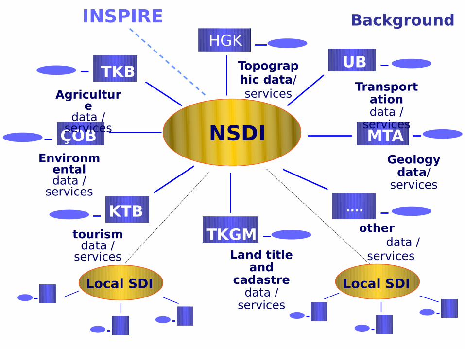
NSDI
HGK
TKB
ÇOB MTA
TKGM
....
UB
Environmentaldata /
services
KTB
Topographic data/ services
Transportationdata /
services
Agriculture
data / services
Land title and
cadastredata /
services
other data / services
Geologydata/
services
tourismdata /
services
Local SDI Local SDI
INSPIRE Background
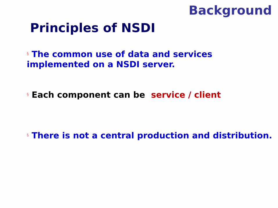
Principles of NSDI
§ The common use of data and services implemented on a NSDI server.
§ Each component can be service / client
§ There is not a central production and distribution.
Background

Background

Earlier work (2003)– designing web services for Trabzon Municipality
Map and Cadastre Office (MCO)
Data Processing Service
(DPS)
Expropriation
Service(ES)
Numerating
Service(NS)
Zoning Plan Application
Service (ZPAS)
Dimensional Drawing
Service (DDS)
ZP Drawing Service
(DS)
Building Control
Service(BCS)
ModificationService
(MS)
Building Permission Service(BP
S)
Building Usage
Service(BUS)
Zoning Plan Office (ZPO)
Background
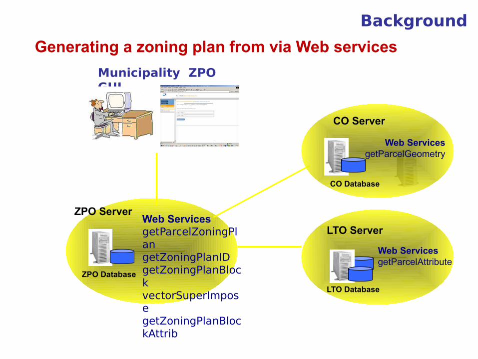
Generating a zoning plan from via Web services
LTO Server
LTO Database
Web ServicesgetParcelAttribute
CO Server
Web ServicesgetParcelGeometry
CO Database
Municipality ZPO GUI
ZPO ServerWeb ServicesgetParcelZoningPlangetZoningPlanIDgetZoningPlanBlockvectorSuperImposegetZoningPlanBlockAttrib
ZPO Database
Background
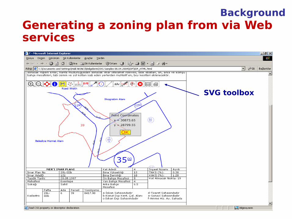
SVG toolbox
Generating a zoning plan from via Web services
Background

Land title and Cadastre Services External Developers
Generate Technical Document
GetParcel Corner Coordinates
Generate PlanExamp
le
Generate Applicatio
n Plan
GeneratePlan
Prepare BuildingPermi
tGetPlot Number
GetBlock Number
Calculate ParcelAre
a
GetParcel Geometry
Calculate
ParcelSide
GetParcel Number
Calculate PropertyTax
Generate Plan Change
Prepare ZoningStatus
Composed ServicesAtomic ServicesGeneral Services
“””Developing A Service Oriented Analysis And Design Methodology In The Example Of
Cadastral Web Services” Hasan Tahsin Bostancı Ph.D.Thesis, 2010
Background

Aim of Study
We try to find out
• Can spatial processes be executed without using any GIS (Geographic Information System)?
• Can spatial web services be developed with Free and Open Source Software (FOSS)

CASE STUDY
Why choose FOSS?
• Source code is open
• For time and financial efficiency
Case Study
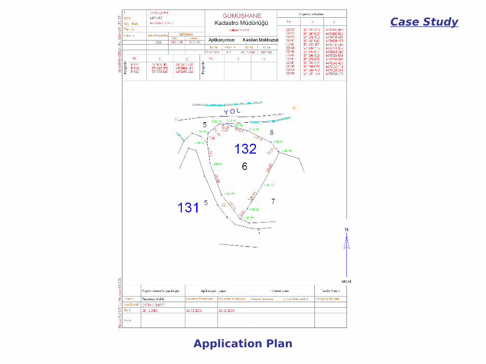
Application Plan

Steps
• Determine the needed web services,
• Determine the FOSS that will be used to develop web services,
• Deploy and run the web services on the web application server
Case Study

The needed web services * Hasan Tahsin Bostancı Ph.D.Thesis, 2010
Web Service Explanation Input Output
GetParcelGeometry Returns the geometry of
parcel (boundaries).
Parcel_ID Parcel Geometry
CalculateParcelArea Returns the calculated area
Parcel_ID Calculated area of parcel
GetBuildingGeometry Returns the geometry of
building/buildings if
necessary (boundaries)
Parcel_ID Building Geometry
GetParcelCornerCoordinates
Returns the corner
coordinates of parcel
Parcel_ID Corner coordinates of
parcel
GetBuildingCornerCoordinates
Return the corner coordinates of the parcel
if there are building/buildings on the
parcel
Parcel_ID Corner coordinates of
building
CalculateParcelSide Calculate the side lengths of the parcel
Parcel_ID Lengths of parcel side
GetPolygonCoordinates Returns the coordinates of polygons which are
inside the buffer area as a result of buffer analysis
to the parcel
Parcel_ID Polygons and polygon
coordinates
DrawNeighbourParcelBorder
Returns the border of neighbor parcels which are inside the buffer area as a
result of buffer analysis to the parcel
Parcel_ID Neighbor parcel boundaries
Case Study

Search for “getParcelGeometry” routine in FOSS
Case Study

Determining the FOSS That Will Be Used To Develop Web
Services Pre-Selection:
» Literature Review
» Research related projects
» Web search over avaliable FOSS
Final Selection
» Generate criteria
Case Study

Literature Review
Hall and Leahy, 2008
Case Study
No criteria to select a suitable FOSS
MapGuide

Ramsey, 2007Criteria:
Desktop FOSS
Programming language used in coding the software
Whether the software is an application or library
Web Projects Toolkits Frameworks Servers
Case Study
There are over thirty software

Steiniger, 2008
• Criteria:» Application Focus» User Level» Supported operating system» Development platform» Developed by» Software license
Case Study
Kosmo ILWIS

Related projects
GeOnAs (GeoBrain Online Analysis System)
GRASS Based Web Services
Vector and raster analysis
Case Study
User interface of GeOnAs

AWARE (A tool for monitoring and forecasting available water resource in mountain environments)
Case Study
Spatial web services in hydrology
Sextante, GeoTools, JFreeChart integrated on 52NWPS

Major Web Sites listing Geospatial Open Source Software only
http://www.osgeo.org/ http://www.freegis.org
http://www.maptools.org/ http://opensourcegis.org/
Major Web Sites listing General Open Source Software
http://directory.fsf.org http://sourceforge.net/
Case Study

WHICH SOFTWARE?Case Study

Final Selection:
• Functional content: How comprehensive is the FOSS? Does the FOSS contain “specific routines” (e.g. getParcelGeometry)?
• Operating System (OS): Is the FOSS compatible with the required OS which is Windows XP in our case.
• Code Maturity: Is the code mature enough? Less `bugs` in the source code.
• Licence: LGPL.
• Programming Language: Java.
Case Study

Software Researched in Scope of Case Study
Sextante ü “A set of free
geospatial analysis tools”*
ü Java based geospatial routine library.
ü Very high ‘Functional content’; offers many routines for raster and vector data.
ü Windows 32 systems compatible.
! Code maturity problems.
Case Study
* http://forge.osor.eu/plugins/wiki/index.php?id=13&type=g Sextante Toolbox

Test for “clip” routine of Sextante
Why?
• “clip” routine in Sextante could be used for the function of “getBuildingGeometry” web service.
• We integrate Sextante to gvSIG and try “clip” routine both in Sextante and gvSIG.
Case Study

Case Study
Parcel and building layers
1. Region 2. Region

Case Study Results of “clip” routine
Sextante “clip” result (1. region) Sextante “clip” result (2. region)
gvSIG “clip” result (1. region) gvSIG “clip” result (2. region)

GeOnAs GRASS Based Web Services
ü Geospatial web services in GeOnAs project are developed using GRASS functions
ü Programming language, axis web services
! Web services are only compatible with LINUX OS.
GeOnAs online web services user interface
Case Study
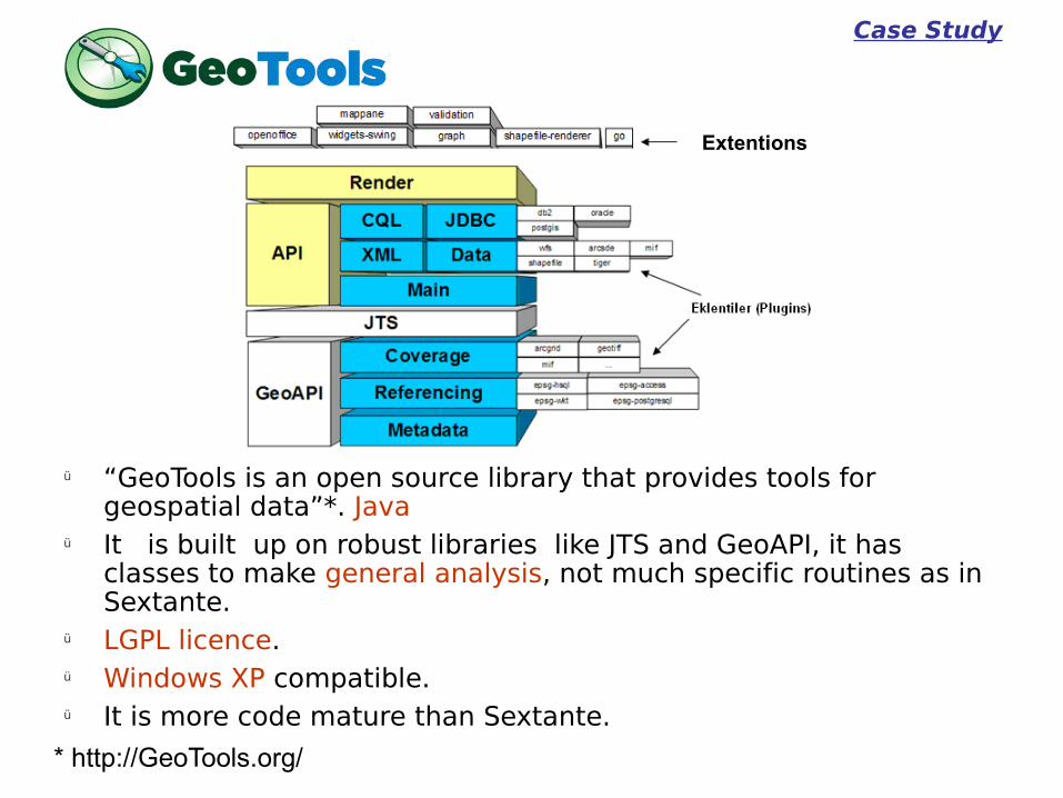
ü “GeoTools is an open source library that provides tools for geospatial data”*. Java
ü It is built up on robust libraries like JTS and GeoAPI, it has classes to make general analysis, not much specific routines as in Sextante.
ü LGPL licence.ü Windows XP compatible.ü It is more code mature than Sextante.
Case Study
* http://GeoTools.org/
Extentions

The final selection result
• GeoTools is the only one that satisfies the criteria.
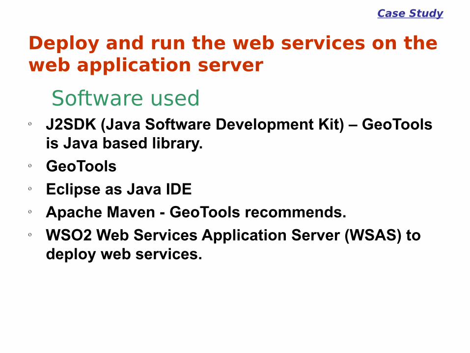
Deploy and run the web services on the web application server
Software usedo J2SDK (Java Software Development Kit) – GeoTools
is Java based library.o GeoToolso Eclipse as Java IDEo Apache Maven - GeoTools recommends.o WSO2 Web Services Application Server (WSAS) to
deploy web services.
Case Study

Eclipse Java IDE user interfaceCase Study

WSAS User InterfaceCase Study

Advantages and disadvantages of FOSS,
Our findings Advantagesü Being usually free of charge,
otherwise available for a small fee
ü Having active discussion forums for users and developers
ü Being Open Source
Disadvantagesü No implementation warranty
ü Published before being checked thoroughly enough for bugs; For instance, although “clip” routine in Sextante does not give correct results, it is published.
ü Insufficient documentation; GeoTools is a geospatial FOSS library which is often updated. The manuals are neither sufficient nor up-to-date.

Conclusion and Suggestion
• We find GeoTools library to be the most suitable geospatial software to be used in developing web services. GeoTools library is the only FOSS among the ones we researched that satisfies the criteria we determined.
• The part of the work with the most difficulties has been to see whether a web service routine is already implemented in any existing FOSS. Currently, we have to carefully examine all the source codes or research many manuals. Given the huge number of FOSS available, this is a highly impractical solution to the problem. Additionally, to make better use of FOSS being open source, there should be a syntactic or semantic search facility for routines.

Questions?