development & building process - city of albuquerque
TRANSCRIPT

1
The Huning Highland Railroad plan introduces a new, innovative approach to Huning HighlandRailroad development. This Plan creates an easy four-step approach to building in Huning HighlandRailroad Area.
STEP 1. DISTRICT MAP - locate your property and theDowntown district it’s in. (Color Coded)
STEP 2. DISTRICT USES MATRIX - identify which uses are permitted, regulated or prohibited in your district.(Color Coded)
STEP 3. BUILDING TYPES - identify the building types authorized for your district. (Color Coded)
STEP 4. BUILDING STANDARDS - apply the building standards applicable to your project.
Once you have gone through these four steps, you are ready to begin the expedited site developmentplan approval process.
The Huning Highland Railroad Map shall be used to guide Huning Highland Railroad development.The Map is color-coded to correspond to the District Building Types chart. By using this color-codingsystem, you are able to conveniently follow steps 1, 2, and 3.
The Huning Highland Railroad Map strategically locates and concentrates complementary land useswithin each district. The title designated is intended to be descriptive of the primary function(s) ofeach district. Other compatible uses are envisioned and encouraged. The Types Chart clearly spellsout permitted, regulated and prohibited uses in each district. Regulated uses must go through theenvironmental Planning Commission (EPC) process, which includes neighborhood notification.
The color-coded Building Types chart outlines the types of buildings to be built in the district. It isintended to provide predictability on how Huning Highland Railroad will develop as far as types, lay-out and scale of buildings. A key objective is to build quality urban pedestrian-friendly buildings thatwill stand the test of time and the multiple uses of buildings over time.
The Building Standards consolidates the more than 70 current standards and guidelines required fordevelopment into 21 simple building standards. The new standards are intended to be far more andto remove much of the subjectivity in the prior standards/guidelines. Each standard is graphicallyillustrated and reduced to the most basic form.
deve
lop
me
nt
& b
uil
din
g p
roc
ess
development & building process

2
The Site Development Plan Approval Process has been streamlined to accommodate Huning HighlandRailroad development. For quality projects, approval will be short on the process and long on theresults.
The Huning Highland Railroad Development and Building Process is adopted to ensure that build-ing development is predictable and real estate values are stable. This process puts the pedestrian firstin all new projects and ensures that developments are compatible with each other and with the exist-ing urban fabric. The Building Types and Building Standards set forth in this plan are mandatory,however, the Planning Director, and/or the Director’s designee, may approve minor changes or devia-tions from the Building Types and/or Building Standards pursuant to regulations and procedures tobe adopted by the City.
Notes: a) The Building Types and Building Standards are mandatory for all developments. Adherence to the types andstandards within each district are required to obtain a building permit.
deve
lop
me
nt
& b
uil
din
g p
roc
ess

3
Elm
Locu
st
Hig
h
Wal
ter
Arn
o
Uni
on S
quar
e St
.
John
St.
Central
Copper
Gold
Lead
Lead
Coal
Tijeras
Grand
Dr Martin Luther King Jr
ste
p o
ne
districtmap

4
downtowndistricts
Following is a general description of the Huning Highland Railroad district and the uses envisioned inthe district:
Mixed Use DistrictMixed use developments are allowed and strongly encouraged. No predominant or primary uses areprescribed for the Mixed Use District. This district is located on transit corridors. Compatible office,institutional, residential, retail, commercial, educational and other uses are encouraged within the dis-trict. These developments should be concentrated and of a density to encourage transit use alongthese principal corridors.
dow
nto
wn
dis
tric
ts

5
district usematrix
The Huning Highland Railroad Area is zoned SU-2-RR with uses allowed in the R-3 and C-2 zonesof the Comprehensive City Zoning Code (0-3 building types are excluded) as further governed bythese provisions Sector Development Plan related to the Huning Highland Railroad Area. All usesare encouraged, however the principal uses are: residential, arts, entertainment, office, cultural, hospi-tality, and specialty retail. The plan strongly encourages a mixture of compatible land uses (office/resi-dential, retail/office, arts/entertainment). Residential development is allowed and encouraged.
All types of land uses are encouraged, however certain uses are not appropriate in the district. Toassure that uses most conducive to achieving the plan’s objectives are developed in the appropriate dis-tricts, it is important to permit, prohibit, or regulate uses by district.
Following is a general color-coded District/Use Matrix to guide in determining if a use is appropriatein the Mixed Use District:
P = PermittedR = Review RequiredX = Prohibited
1. Home occupations are allowed as regulated by the R-1 zone.2. A purpose is to encourage neighborhood serving retail.3. A purpose is to allow ancillary office activity in the Housing District.4. A purpose is to allow manufacturing as regulated by the M-1 zone.
Additional Notes:
• Emergency Shelters proposed shall be Review Required.• Proposed developments in areas covered by a historic overlay zone shall be reviewed and
approved by the Landmarks and Urban Conservation Commission.
ste
p t
wo
RESIDENTIAL
Ground Floor
Above Ground Floor
RETAIL/SERVICES
OFFICE/INSTITUTIONAL
WAREHOUSE/WHOLESALE
MANUFACTURING
MIXEDUSE
1
PP
P
P
P
R
X

6
Prohibited Uses
Some uses are clearly prohibited or regulated. Following is a list of those uses:
• Drive-in/drive-through facilities are not allowed except that unenclosed outdoor seating is per-mitted. Existing drive-in/drive-through uses shall be legal, non-conforming uses.
• Adult amusement establishments, adult bookstores, adult photo studios, and adult theaters areallowed, provided:
a) the use is located at least 1,000 feet from any other adult amusement establishment, adultbookstore, adult photo studio, or adult theater, and
b) the use is located at least 500 feet from the nearest residential zone (surrounding neigh-borhoods), or from any church, pre-elementary, elementary, middle or secondary school.
• Commercial surface parking lots are not allowed. Existing commercial surface parking lotsshall be legal, non-conforming uses and must meet the landscaping, lighting, buffering andpaving requirements identified in the building standards section of the plan.
• Jails or correctional institutions are not allowed.
• Off-premise free-standing signs are not permitted.
ProhibitedUses

7
BuildingTypes
ste
p t
hre
e Mixed Use
TYPE ‘A’
TYPE ‘B’
TYPE ‘C’
TYPE ‘D’
TYPE ‘E ’
TYPE ‘F’
TYPE ‘M’
TYPE ‘G’
TYPE ‘N’
TYPE ‘P’
TYPE ‘O’
TYPE ‘Q’

8
URBAN REGULATIONS
PLACEMENT:1. Lot Width: 50’ minimum
PARKING:1. Rear yard garages2. Access: through alley
HEIGHT AND PROFILE:1. Height: 2 stories maximum
EXAMPLES:1. Residential and
Professional Office; StudioApartments; Guest Cottages
Bird’s Eye ViewSample Block Plan
TYPE DESCRIPTION
Free Standing, single unit housingwith rear yard garages and studioapartment.
A - SINGLE UNIT
Examples
Type ‘A’Single Unit

9
URBAN REGULATIONS
PLACEMENT:1. Lot Width: 50’ minimum
PARKING:1. Rear yard garages2. Access: through alley
HEIGHT AND PROFILE:1. Height: 2 stories maximum
EXAMPLES:1. Residential and
Professional Office; StudioApartments; Guest Cottages;Worshops above Garages
Bird’s Eye ViewSample Block Plan
TYPE DESCRIPTION
Free Standing, duplex unit housingwith rear yard garages and studioapartments.
B - DUPLEX
Examples
Type ‘B’Duplex

10
URBAN REGULATIONS
PLACEMENT:1. Lot Width: 20-50’�
PARKING:1. Rear yard garages2. Access: through alley
HEIGHT AND PROFILE:1. Height: 3 stories maximum
EXAMPLES:1. Residential and
Professional Office; StudioApartments; Guest Cottages;Worshops above Garages
Bird’s Eye ViewSample Block Plan
TYPE DESCRIPTION
“Zero” lot line townhouses withrear yard garages and studio apart-ments.
C - TOWNHOUSES
Examples
Type ‘C’Townhouses

11
URBAN REGULATIONS
PLACEMENT:1. Lot Width: 65’-75’
PARKING:1. Half-level underground
and surface
2. Access: through alley
HEIGHT AND PROFILE:1. Height: 3 stories maximum
with setback beginning at sec -ond story
EXAMPLES:1. Residential flats over two-
story Townhouses
Bird’s Eye ViewSample Block Plan
TYPE DESCRIPTION
Flats above two-story townhousesfacing sideyard courts.
D - SIDEYARD
Examples
Type ‘D’Sideyard

12
URBAN REGULATIONS
PLACEMENT:1. Lot Width: 100’ minimum
PARKING:1. Half-level underground2. Access: through alley
HEIGHT AND PROFILE:1. Height: 2 stories maximum
with setback beginning at second story
�
EXAMPLES:1. Residential flats over two-
story townhouses
Bird’s Eye ViewSample Block Plan
TYPE DESCRIPTION
Flats above two-story townhousesfacing interior courts.
E - COURTYARD
Examples
Type ‘E’Courtyard

13
URBAN REGULATIONS
PLACEMENT:1. Lot Width: 300’
PARKING:1. Half-level underground for
residential flats and garages ongrade for townhouses
2. Access: through alley
HEIGHT AND PROFILE:1. Height: 4 stories maximum
with setback beginning at thirdstory
EXAMPLES:1. Two-story residential flats
over two-story townhouses
Bird’s Eye ViewSample Block Plan
TYPE DESCRIPTION
Two-story flats over two-storytownhouses over partially sub -
merged parking garages.
F - TERRACE
Example
Type ‘F’Terrace

14
URBAN REGULATIONS
PLACEMENT:1. Lot Width: 300’ 2. Lot Depth: 142’ maximum
PARKING:1. Half-level underground
garage podium
2. Access: through alley
HEIGHT AND PROFILE:1. Height: 8 stories maximum
at corners and 4 stories maxi-mum at mid-block, both casessetback begins at third story
EXAMPLES:1. Commercial or Retail on
principal street frontage withdouble-loaded residential apartments above
Bird’s Eye ViewSample Block Plan
TYPE DESCRIPTION
Apartments on double-loaded corri-dors over storefront lofts over partially submerged parking garage.
G - MIDRISE PODIUM
G - MIDRISE PODIUM
Example
Type ‘G’Podium

15
URBAN REGULATIONS
WRAPPERBUILDING:
PLACEMENT:1. Lot Width: 300’
2. Street Frontage: 90% mini-mum articulated at 25’, 50’, or75’ increments
3. Lot Depth: 142’ to alley atmid-block
4. Building Depth: 20’ mini -mum, 40’ preferred
5. Recessed corners shall notexceed 10% of street frontage
PARKING:1. Types: Interior surface lot,
interior garage, or “park-once”garage
2. Access: through alley
HEIGHT AND PROFILE:1. Street Frontage Height: 3
stories at block centers and 5stories at street corners
2. Setback: 0’
EXAMPLES:1. Commercial or Retail on
street frontage with mixed-usehousing or office lofts above
INTERIORBUILDING:
HEIGHT AND PROFILE:1. Height: No restrictions
2. Setback: 20’ minimumwith 40’ preferred
EXAMPLES:1. Parking; Cinema; “Big-
Box” Retail; Office; Hotel;Residential
Bird’s Eye ViewSample Block Plan
TYPE DESCRIPTION
Large floor plate structure sur -rounded by low-scale “wrapper” or“liner” buildings at street frontagelocated on a full block.
M-1 FULL BLOCK LOW-RISE
M-2 FULL BLOCK MID-RISE(FRANCISCAN HOTEL TYPE)
M-3 FULL BLOCK HIGH-RISE(HYATT HOTEL TYPE)
Example
Type ‘M’Full Block

16
URBAN REGULATIONS
WRAPPER BUILDING:
PLACEMENT:1. Lot Width: 300’
2. Street Frontage: 90% mini-mum articulated at 25’, 50’, or75’ increments
3. Lot Depth: 142’ to alley atmid-block
4. Building Depth: 20’ mini -mum, 40’ preferred
5. Recessed corners shall notexceed 10% of street frontage
PARKING:1. Types: Interior surface lot,
interior garage, or “park-once”garage
2. Access: through alley
HEIGHT AND PROFILE:1. Street Frontage Height: 3
stories at block centers and 5stories at street corners
2. Setback: 0’
EXAMPLES:1. Commercial or Retail on
street frontage with mixed-usehousing or office lofts above
INTERIOR BUILDING:
HEIGHT AND PROFILE:1. Height: No restrictions
2. Setback: 20’ minimumwith 40’ preferred
EXAMPLES:1. Parking; Cinema; “Big-
Box” Retail; Office; Hotel;Residential
Bird’s Eye ViewSample Block Plan
TYPE DESCRIPTION
Large floor plate structure sur -rounded by low-scale “wrapper” or“liner” buildings at street frontagelocated on a half-block.
N-1 1/2 BLOCK LOW-RISE
N-2 1/2 BLOCK MID-RISE
N-3 1/2 BLOCK HIGH-RISEExample
Type ‘N’Half Block

17
URBAN REGULATIONS
WRAPPER BUILDING:
PLACEMENT:1. Lot Width: 150’
2. Street Frontage: 90% mini-mum articulated at 25’, 50’, or75’ increments
3. Lot Depth: 142’ to alley atmid-block
4. Building Depth: 20’ mini -mum, 40’ preferred
5. Recessed corners shall notexceed 10% of street frontage
PARKING:1. Types: Interior surface lot,
interior garage, or “park-once”garage
2. Access: through alley
HEIGHT AND PROFILE:1. Street Frontage Height: 3
stories at block centers and 5stories at street corners
2. Setback: 0’
EXAMPLES:1. Commercial or Retail on
street frontage with mixed-usehousing or office lofts above
INTERIORS BUILDING:
HEIGHT AND PROFILE:1. Height: No restrictions
2. Setback: 20’ minimumwith 40’ preferred
EXAMPLES:1. Parking; Cinema; “Big-
Box” Retail; Office; Hotel;Residential
Bird’s Eye ViewSample Block
TYPE DESCRIPTION
Large floor plate structure sur -rounded by low-scale “wrapper” or“liner” buildings at street frontagelocated on a quarter-block.
O-1 1/4 BLOCK LOW-RISE
O-2 1/4 BLOCK MID-RISE
O-3 1/4 BLOCK HIGH-RISE(LA POSADA HOTEL TYPE)Example
Type ‘O’Quarter Block

18
URBAN REGULATIONS
PLACEMENT:1. Lot Width: 25’, 50’ , or 75’
2. Street Frontage: 90% mini-mum
3. Lot Depth: 142’ maximum
PARKING:1. Convenience and service
parking alley also required at“Park-Once” garages
2. Access: through alley
HEIGHT AND PROFILE:1. Street Frontage Height: 3
stories maximum and 5 stories20’ from street frontage
2. Setback: 0’, 20’ at 3rdLevel and up
EXAMPLES:1. Commercial and Retail on
street frontage with mixed-usehousing or office lofts above
Bird’s Eye ViewSample Block Plan
TYPE DESCRIPTION
Infill buildings located on mid-blocks.
P - MID-BLOCK
Examples
(CENTRAL AVENUE TYPE)
Type ‘P’Half Block

19
URBAN REGULATIONS
PLACEMENT:1. Lot Width: 50’, 75’ or 100’
2. Street Frontage: 90% mini-mum
3. Lot Depth: 142’ maximum
PARKING:1. Convenience and service
parking at alley
2. Access: through alley
HEIGHT AND PROFILE:1. Street Frontage Height: 5
stories maximum
2. Setback: 0’
EXAMPLES:1. Commercial or Retail on
street frontage with mixed-usehousing or office lofts above
Bird’s Eye ViewSample Block Plan
TYPE DESCRIPTION
Infill buildings located on streetcorner lots.
Q -1 END BLOCK LOW-RISE(WOOLWORTH TYPE)
Q -2 END BLOCK MID-RISE(SUNSHINE BUILDING TYPE)
Examples
Type ‘Q’Quarter Block

20
StandardsContents
A. Building and Street RelationshipsStandard 1: AccessStandard 2: Building Entrances
B. Pedestrian Orientation and ParkingStandard 1: Blank WallsStandard 2: Architectural DetailsStandard 3: SidewalksStandard 4: Street TreesStandard 5: Surface ParkingStandard 6: Parking GaragesStandard 7: Combined Blocks
C. Plazas and CourtyardsStandard 1: Street-Level OrientationStandard 2: Security and Lighting
D. Building FacadesStandard 1: Open Building FrontageStandard 2: SetbacksStandard 3: Corner BuildingsStandard 4: Texture and Pattern on Building Facades
E. Lighting and SignageStandard 1: Exterior Lighting PlanStandard 2: Neon Lighting for Buildings
�Standard 3: Safety and VisibilityStandard 4: Marquee
F. Historic PreservationStandard 1: Preserving Facades
Street level designs of buildings should be visually interesting. All buildings shall have street level windows, window boxes, entrances, and architectural details.

21
INTENT
Provide unobstructed access from sidewalks to buildings used by the general public.
Example 1 Commercial Not Permitted Example 2 Residential Example 3 Commercial
STANDARD
Public Access to commercial and governmental buildings shall be provided atsidewalk grade. The primary floor of, and access to, residential structuresmay be elevated.
ELEVATIONPLAN DIAGRAM BIRD’S EYE VIEW
SIDEWALK
UP
A. Building and StreetRelationship
Standard 1: Access

22
INTENT
Provide safe and easy passage from the public realm into individual buildings.
Example 1 Not Permitted Example 2 Example 3
STANDARD
The front doors of all buildings shall be visible from the street. If located morethan 10 feet from the front building line, their location must be reinforcedwith additional graphics, lighting, marquees or canopies.
ELEVATIONPLAN DIAGRAM BIRD’S EYE VIEW
A. Building and StreetRelationship
Standard 2: Building Entrance

23
INTENT
Provide interest for the pedestrian at the ground level of buildings by limiting unembellished solid walls.
Example 1 Not Permitted Example 2 Example 3
STANDARD
Blank walls in excess of 25% or 10 continuous feet of the frontage of theproperty shall not be used at the street level. Blank walls must contain archi-tectural relief such as expressive details, blind windows, murals, etc.
ELEVATIONPLAN DIAGRAM BIRD’S EYE VIEW
25% MAX. 75% MIN.
B. PedestrianOrientation andParking
Standard 1: Blank Walls

24
INTENT
Provide interest for the pedestrian at the ground level of buildings throughdetailing at close view.
Example 1 Not Permitted Example 2 Example 3
STANDARD
All buildings shall provide scale-defining architectural elements or details atthe first two floor levels minimum, such as windows, spandrels, awnings, por -ticos, pediments, cornices, pilasters, columns and balconies.
ELEVATIONPLAN DIAGRAM BIRD’S EYE VIEW
B. PedestrianOrientation andParking
Standard 2: Architectural Details

25
INTENT
Allow sufficient room for pedestrian passage and additional use of sidewalksuch as cafe tables.
Example 1 Not Permitted Example 2 Example 3
STANDARD
Width of sidewalks shall be maximized within the available right-of-way. Aminimum of 48” of the sidewalk must be clear of any obstruction for theentire length of the property.
SECTIONPLAN DIAGRAM BIRD’S EYE VIEW
B. PedestrianOrientation andParking
Standard 3: Sidewalks

26
INTENT
Create shaded sidewalks and vertical landcape throughout the area.
Example 1 Not Permitted Example 2 Example 3
STANDARD
Street trees must be provided to the extent that the sidewalk widthpermits. Selection shall be from the approved list of street treesand shall be consistant with the established landscape palette.
SECTIONPLAN DIAGRAM BIRD’S EYE VIEW
B. PedestrianOrientation andParking
Standard 4: Street Trees

27
INTENT
Streets and sidewalks lined with buildings rather than parking lots.
Example 1 Not Permitted Example 2 Example 3
STANDARD
be screened from the street by a solid fence or wall at a minimum height of 48”. Parking between the building and the side lot line must
B. Shared parking is strongly encouraged.
C. At least 15% of the ground area of parking lots (including driveways) shall be devoted to landscaping along the street right-of-way.
SECTIONPLAN DIAGRAM BIRD’S EYE VIEW
A. Surface parking can not be between the building and the front property line.
B. PedestrianOrientation andParking
Standard 5: Surface Parking

28
INTENT
Parking garages that contribute to pedestrian life through ground level use,scale and detail.
Example 1 Not Permitted Example 2 Example 3
STANDARD
Parking garages must have a minimum of 50% of their sidewalk frontagealong the street (excluding the ingress and egress) designed as retail, com -mercial or office space. The entire first floor, floor to ceiling height, shall bedesigned to accommodate future retail, commercial or office uses. There isno minimum depth required for retail, commercial or office uses. Interimuses could include news stands, flower shops, ATM’s, display windows,telephone booths, payment boxes, etc.
SECTIONPLAN DIAGRAM BIRD’S EYE VIEW
RETAIL
RETAIL
B. PedestrianOrientation andParking
Standard 6: Parking Garages

29
INTENT
To keep a traditional grid of streets and alleys intact, for
maximum pedestrian choice and activity.
Example 1 Not Permitted Example 2 Example 3
STANDARD
If the traditional street grid is broken for development, pedestrian connec -tions shall be established to replace those vacated. These connections shallbe a continuation of the existing grid and allow for service access.
SECTIONPLAN DIAGRAM BIRD’S EYE VIEW
B. PedestrianOrientation andParking
Standard 7: Combined Blocks

30
INTENT
To make a seamless connection between the sidewalks at the street andcourtyards and plazas towards the interior of the block.
Example 1 Not Permitted Example 2 Example 3
STANDARD
Plazas designed to be accessible to the public shall be constructed at side -walk grade. Access to these plazas shall be highly visible, well developedand connected to the street system or to other planned or developed publicspaces.
SECTIONPLAN DIAGRAM BIRD’S EYE VIEW
COURTYARD
COURTYARD
Standard 1: Street Level Orientation
C. Plazas andCourtyards

31
INTENT
Provide a safe and welcoming connection between the sidewalks at thestreet and courtyards and plazas toward the interior of the block.
Example 1 Not Permitted Example 2 Example 3
STANDARD
Plaza and courtyard spaces, shall provide pedestrian connections to streetsand other planned or developed plazas and courtyards. These connectionsshall be safe secure through the use of adequate pedestrian lighting. Thislighting should accent the ground plane and the building facades.
SECTIONPLAN DIAGRAM BIRD’S EYE VIEW
COURTYARDCOURTYARD
Standard 2: Security and Lighting
C. Plazas andCourtyards
32
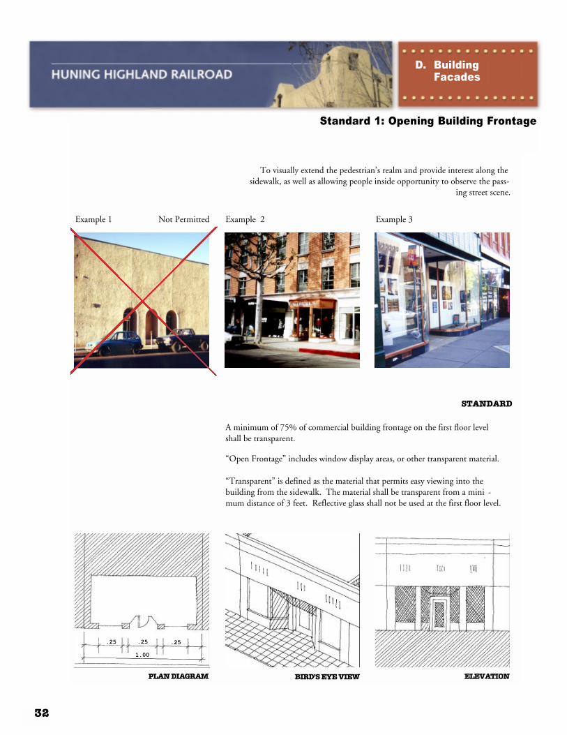
INTENT
To visually extend the pedestrian’s realm and provide interest along thesidewalk, as well as allowing people inside opportunity to observe the pass-
ing street scene.
Example 1 Not Permitted Example 2 Example 3
STANDARD
A minimum of 75% of commercial building frontage on the first floor levelshall be transparent.
“Open Frontage” includes window display areas, or other transparent material.
“Transparent” is defined as the material that permits easy viewing into thebuilding from the sidewalk. The material shall be transparent from a mini -mum distance of 3 feet. Reflective glass shall not be used at the first floor level.
ELEVATIONPLAN DIAGRAM BIRD’S EYE VIEW
.25
1.00
.25 .25
Standard 1: Opening Building Frontage
D. Building Facades

33
INTENT
The creation of a continuous street wall without significant breaks thatdefines the public space of the street.
Example 1 Not Permitted Example 2 Example 3
STANDARD
SECTIONPLAN DIAGRAM BIRD’S EYE VIEW
The street facade of buildings may be setback a maximum of 15 feet from the front lot line. In general, it is preferred to keep the street facade built to the property line, in alignment with adjacent buildings.
Standard 2: Setbacks
D. Building Facades

34
INTENT
Corner buildings shall relate to the activities of the intersection and encour -age activity through their design.
Example 1 Not Permitted Example 2 Example 3
STANDARD
Appropriate design of the corner shall include one of the following successful patterns:
1 Opening the space at ground level for people to walk around the corner with the building mass above redefining the corner
2 A recessed entry at the corner such as the familiar angled wall with an entry door.
3 A corner window with an important view into the building
ELEVATIONPLAN DIAGRAM BIRD’S EYE VIEW
Standard 3: Corner Buildings
D. Building Facades

35
INTENT
Create pedestrian interest by using materials that relate to the traditional context of the area.
Example 1 Not Permitted Example 2 Example 3
STANDARD
ELEVATIONPLAN DIAGRAM BIRD’S EYE VIEW
These elements should be based on materials and patterns that relate to the traditions of area buildings.
Standard 4: Texture and Pattern on Building Facades
D. Building Facades

36
INTENT
Provide a safe and appealing nightime environment for the Area.
Example 1 Not Permitted Example 2 Example 3
STANDARD
The design for a proposed facade must consider the appearance of the build -ing in the evening and develop an exterior lighting plan that includes dis -play window lighting, building lighting, and pedestrian-scaled lighting forboth buildings and pedestrian areas within the site. Lighting shall be warmin color, with control of glare for the pedestrian.
ELEVATIONPLAN DIAGRAM BIRD’S EYE VIEW
Sign
Standard 1: Exterior Lighting Plan
E. Lighting andSignage

37
INTENT
Provide an exciting nightime environment.
Example 1 Not Permitted Example 2 Example 3
STANDARD
Signage on marquees, blade signs, sign bands, outine of significant architec-tural details, and in window are all encouraged.
ELEVATIONPLAN DIAGRAM BIRD’S EYE VIEW
Standard 2: Neon Lighting
E. Lighting andSignage

38
INTENT
Provide sufficient lighting for safe pedestrian passage.
Example 1 Not Permitted Example 2 Example 3
STANDARD
Adequate lighting must be provided for safety and visibility at night.Project plans must include illumination levels and color rendition of exteriorbuilding lighting adjacent to sidewalks.
SECTIONPLAN DIAGRAM BIRD’S EYE VIEW
Standard 3: Safety and Visibility
E. Lighting andSignage

39
INTENT
Create identity for individual stores and buildings through projecting signs.
Example 1 Not Permitted Example 2 Example 3
STANDARD
Signs may project into the right of way a maximum of half the adjacentsidewalk width, and the bottom of the sign shall be a minimum of 12 feetabove the sidewalk.
(In addition to these standards, all zoning code regulations regarding signage will apply).
ELEVATIONPLAN DIAGRAM BIRD’S EYE VIEW
MAX.
CENTRAL
Standard 4: Signs
E. Lighting andSignage

40
INTENT
Maintain the existing fabric of historic building facades.
Example 1 Not Permitted Example 2 Example 3
STANDARD
Buildings shall incorporate elements of the original facade into the renova -tion scheme:
1. Do not cover existing original facade details by covering them with pan -els, signs, or by painting them out:
2. Do not alter the shape of existing original openings. If a window must beblocked, maintain its original shape.
3. Restore, where possible, the original facade by removing later additionsof materials.
ELEVATIONPLAN DIAGRAM BIRD’S EYE VIEW
REMOVE
RESTORE
Standard 1: Preserving Facades
F. HistoricPreservations

41
By adhering to the District’s Plan and Uses, and the Building Types and Standards, as well aspreparing complete project documents, a proposed development will be reviewed and approvedwithin 21 - 24 working days. Following is a chart which outlines the process to obtain a buildingpermit. It is mandatory that applicants present and discuss their project, in its entirety, with theappropriate departments at a Pre-Application meeting. It is also critical for the applicant tounderstand if their proposed project is a permitted, regulated, or prohibited use prior to startingthe approval process. Permitted uses will go through either a renovation or a new constructionprocess. “Review Required” uses must go through the Environmental Planning Commission(EPC) process. The applicant for the proposed use must demonstrate that the use will be com-patible with surrounding uses in the district and that it would not be injurious to surroundingproperties, adjacent neighborhoods or the community. The EPC may approve or disapprove theproposed use. The EPC’s decision is appealable to the City Council in accordance with Section14-16-4-4 of theZoning Code.
approvalprocess
ap
pro
va
l p
roc
ess
Required Pre-Application Meeting( Planning / Public Works / Other Departments)
Review Required Permitted Use
EnvironmentalPlanning
Commission
New Construction
Renovation
Project ReviewPlanning Director / Review Team
Development Review ApplicationDowntown Requirements Checklist
1 - 12*WorkingDays
10 - 12*WorkingDays
Building Permit
Building Permit
1. All new, freestanding structures.
2. Addition(s) to an existing structure that encloses more volume than the existing.
1. Remodeling or rehabili- tation of an existing structure, including ad- dition(s) of lesser volume than the existing.
2. Certified historic rehab- ilitation as defined and administered by the State Historic Preserva- tion Division and National Park Service (only applies to historic structures) .
* Estimated Review Process Time = Actual City review time in working days.