development brief for public open space and enabling
TRANSCRIPT

DEVELOPMENT BRIEF FOR PUBLIC OPEN SPACE AND ENABLING
DEVELOPMENT AT GAUCHHILL, KINTORE
Based on Ordnance Survey mapping. Crown copyright reserved. Aberdeenshire Council LA09022L 2004
Based on Ordnance Survey mapping. Crown copyright reserved. Aberdeenshire Council LA09022L 2004
Developers must have regard to the contents of this Brief in preparing their scheme. Where differences do occur, justification by the developer is required.
November 2006

1
1. Purpose
1.1 Type of development
This brief is for:
§ An area of open space that will allow for a variety of recreational
uses that will form a Town Park.
§ Associated woodland.
§ Housing development to enable the formation of the Town Park and
longterm management of the woodland.
1.2 Constraints and limitations
§ The site is designated as a project area for a ‘town park’ in
conjunction with ‘enabling development’ in the Aberdeenshire Local
Plan (ALP).
§ Kintore is a settlement that has seen substantial expansion in
recent years. There is a recognised need for a townscale park to
support the recreational needs of the expanding settlement and its
likely continued growth.
§ There is a need to retain the area of ecologically important habitats
known as Gauchhill Woodland for informal recreation and
biodiversity purposes.
§ At the time of writing educational facilities at both Primary and
Secondary level are either close to or over capacity.
§ To the south of the site, the realignment of the B994 is necessary to
ensure road safety and enable the development of a large portion
of the brief area.
§ The site contains many different ownership interests and in certain
areas, developers will be expected to work together to realise the
development of the Town Park. Some areas are not currently
subject to planning applications but should be considered due to
their location within the settlement boundary.

2
1.3 Relevant Development Plan Policies
§ NEST Policy 11 General Housing Considerations Policy 13 Developer Contributions Policy 14 Affordable and Special Needs Housing Policy 16 Sport and Recreation Facilities Policy 17 Countryside and Open Space Access Policy 19 Wildlife, Landscape and Land Resources Policy 21 Design Policy 22 Water Management Policy 31 Connecting Communities within the North East
§ ALP Env\3 Other Recognised Nature Conservation Sites Env\4 Biodiversity Env\7 Protected and Other Open Areas in Settlements Env\8 Trees and Woodlands Env\9 Forestry and Woodland Creation and Enhancement Env\22 Public Access Hou\8 Affordable Housing Hou\13 Public Open Space for Housing Inf\1 Roads and Access Inf\2 Parking, Servicing and Accessibility Inf\4a Foul Drainage Standards Inf\4b Additional Drainage Standards: Sustainable Urban Drainage
Systems (SUDS) Inf\5 Water Supply Inf\6a Waste Management Requirements for New Development Gen\1 Sustainability Principles Gen\2 The Layout, Siting & Design of New Development Gen\3 Developer Contributions Gen\4 Infill Development Gen\5 Landscaping Standards Gen\12 Project Areas
1.4 Maps and Appendices
The information displayed on the inserted maps is indicative and provided to help show the main site features and recommendations. Two Appendices are attached; Appendix 1 provides more details on renewable energy whilst Appendix 2 provides further, more in depth, details of Gauchhill Woodland and the areas for development.

3
2. Site Analysis
The following is not an exhaustive site description, but a list of the key
issues that lead to the site requirements in the next section.

4
2.1 Locations and Landscape Context
§ The site comprises a large area of land to the south west of Kintore
extending to a total of approximately 25.68 hectares (see Figure 1).
§ The site is made up of two distinct portions:
The northwestern area, extending to 10.6 hectares, consisting
mainly of semi natural woodland that carries the name ‘Gauch
Hill’. The site is bordered by the A96 to the west, the
B977/Gauchhill Road to the north and low density housing to
the northeast. Outside the site, to the north of the Woodland
Area lies a small area of Scots pine separated form the brief
area by a private track.
The central area of open fields, bounded by the Woodland Area,
the B994 to the south, B987 to the east and low density housing
to the north. Numerous houses line the B994 and B987 and
adjoin this central area that extends to 13.48 hectares. In
addition the site covers 1.6 hectares of fields to the south of the
B994 and east of the B987 and industrial estate. To the west
lies lowdensity housing and to the south the Tuach Burn.
§ There are some views from higher parts of the site, mainly looking
southeast.
§ The site slopes extremely gently from the north of Gauchhill
Woodland. It falls from around 70 metres at the northwest to 60
metres at the lowest point to the southeast. Much of the site
appears fairly level with some slight undulations in places.
§ The site is important as it contains the only substantial piece of
woodland within the designated settlement boundary of Kintore and
the opportunity for substantial complimentary public open space.
2.2 Climatic Considerations § The prevailing wind is from the southwest with the coldest winds
coming from the north and east.

5
§ The site is generally protected from winds from the north by
existing housing and from the north and west by the Woodland. To
the east, existing scattered housing and the more distant industrial
units afford some protection. The site is partially protected from the
south by further scattered housing development.
§ The majority of the site outwith the Woodland Area is fairly open to
the south. Development would benefit from the sun both during the
summer and winter. This aspect will afford the opportunity to
capitalise on maximum sun exposure.
§ Any development within the wider wooded area could be
overshadowed.
2.3 Potential Hazards
§ The site has no history of flooding.
§ There are no known contaminants affecting the area.
§ A small area on the northeastern perimeter of the Woodland Area
shows evidence of fly tipping.
§ The A96 dual carriageway lies on the eastern edge of the site and
some noise can generally be heard, especially close to the road.
§ 11kv power lines cross the site at several points (see Figure 1).
2.4 Ecological Considerations
§ In general, the fields that make up the central and southern areas
do not have great diversity and are not of outstanding ecological
interest. To the extreme south lies the Tuach Burn, a fairly minor
watercourse, but with potential for riparian improvement.
§ A Flora and Fauna Survey has been conducted on the Woodland
Area and its findings show that this area is of significant local
landscape, conservation & amenity value. The woodland area
consists of a mix of mainly Scots Pine and Birch with a good natural
understorey and is therefore a valuable ecological resource. It is
6
classified as Long Established Woodland of a seminatural origin.
Evidence of many animal species including red squirrels was found
on the site. Recently a Tree Preservation Order has been placed on
the woodland, which has the potential for a nature reserve and
community use.
§ Towards the northern boundary of the woodland lies a smaller,
more open area of improved grass, acid grass, heath, broom and
some exotic species. It provides an area of transition between the
adjacent housing development and birch and pine woodland but is
of lesser ecological importance. This abuts a rectangular field that
contains some improved grassland and is ringed by trees (see
Figure 1 and Appendix 2).
§ A glade of acid grassland and scattered trees provides an attractive
feature between the woodland and area containing broom and
functions as a complementary habitat to the woodland.
§ Dry stone dykes form some field boundaries with wire fences
making up the remainder. Some of the field boundaries also have
brash, gorse and other bushes along their boundaries. A large open
drain runs from east to west as indicated on Figure 1.
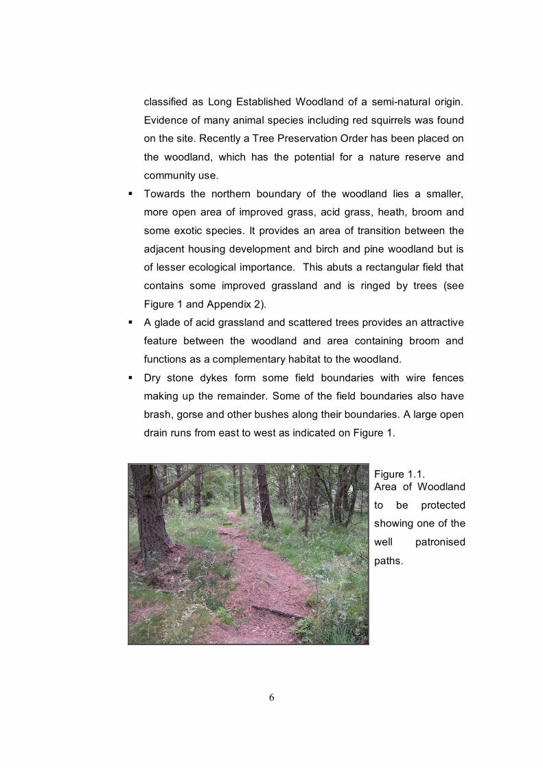
Figure 1.1. Area of Woodland
to be protected
showing one of the
well patronised
paths.

7
2.5 Urban Context § Kintore has developed rapidly over the last 50 years; prior to this
the settlement had developed as a linear village, following the old
A96 and minor roads to the northeast and southwest. Older,
vernacular housing can be found on these streets, especially close
to the existing ‘centre’ of Kintore located close to the Parish
Church. Since 1940 there have been stages of development and
infill between the linear patterns. The most rapid expansion of both
for residential and employment purposes has occurred over the last
decade and is evident to the west of the earlier development and
around Midmill Industrial Estate.
§ The southwestern edge of the settlement consists of modern, fairly
low density, bungalows and one and a half story housing. Several
houses of slightly older origin are to be found on the B994 and
B987.
§ Whilst the site does not contain any known recorded archaeological
sites, Kintore is noted as being of archaeological importance
boasting many sites on the Sites and Monuments Record. The
Woodland is considered to have high archaeological potential given
its relatively unchanged land use.
§ The open fields of the south and central areas, in combination with
the Woodland, have the potential to provide a large, town scale,
area of public open space that relates well with the south of the
settlement.
§ In the Woodland Area, ecological factors will heavily influence the
type and layout of any housing.
§ There are no Conservation Areas or Listed Buildings on or close to
the Site.
§ Numerous residential buildings are within, or border, the site. Many
of these have direct access to the fields. Developers will need to
consider residents amenity when developing the site.

8
2.6 Access § There are no established rights of way across the Site. However a
wellused link has been identified close to the south of the site, near
the Tuach Burn, and is considered a claimed Right of Way.
§ An informal network of paths runs through the Woodland, into the
fields to the east and from the fields into Melrose Place and
Sunnyside View. Further tracks and accesses can be seen at
various locations on the Site and are shown on Figure 1. Some of
these paths are evidently used on a regular basis and provide
residents with access to the open countryside.
§ There are no existing roads on the Sites apart from a small section
of gravel track at the northeastern edge of the Woodland (see
Figure 1).
§ The junction between the B994 and B987 is considered dangerous.
Additional housing would increase the problem and therefore a
requirement for any development is to realign the B994 road with
the existing roundabout on the B987.
§ The open fields abut the B987 for a short distance to the north east
of the site. Any vehicular access there would require coordination
with the numerous entrances along this stretch of the road.
§ A regular bus service runs along the B977 between Westhill and
Inverurie. Several bus services stop on the B987 including those to
Aberdeen and Inverurie.
2.7 Utilities and other services
§ Scottish Water will advise upon water supply and foul drainage.
Discharges from surface water and sewage systems will require the
consent of SEPA. Developers should contact SEPA to discuss
their requirements.

9
§ Broadband connection is available in Kintore.
§ It is not envisaged that there would be a problem with the provision
of power on this site.
§ The new Kintore Primary School, around 1km from the site, will
exceed its capacity shortly. This is due to a large number of
housing completions and a higher than average pupil per
household ratio and further housing in the short term will compound
these problems. However the present rolls are likely to decrease
over time, given a reduction in completions of new dwellings.
Secondary school provision is located at Kemnay around 5km to
the west. Kemnay Academy is already over capacity.
§ Kintore is currently considered a main service centre in ALP and
contains a limited range of shops including a general food store.
This lies just over a kilometre to the north of the brief area.
§ A retail development is proposed across the B977 from the site.
2.8 Other Considerations § ALP identifies the area around Gauchhill as, P2, a project area for a
town park in conjunction with enabling development. The Reporters
conclusions from the Local Plan Inquiry included that the only
realistic prospect of delivery of such a town park was through
associated enabling development and ‘that it is logical that a town
park should lie within the settlement boundary’. In accordance, this
recommendation was accepted and Finalised ALP was modified
accordingly to incorporate the areas of Gauchhill and Midmill.
§ The football pitches and cricket pitch currently coexist at a location
by the Primary School. An additional football pitch is being created
to the west of the combined cricket and football pitches but there is
little room for further expansion at the site and there is conflict
between cricket and football uses with the result that both uses are

10
coming under increasing pressure. Further housing development
will increase this demand.
§ It is likely that there will be a need for further sports provision in the
future. The Council is currently undertaking a Playing Pitch Audit
that will feed into a Playing Pitch Strategy. These documents are
intended to direct the development of existing and future sports
pitches.
§ Whilst Rollomire is an important informal area, there is little in the
way of semiformal amenity space in the settlement.
§ There are three current planning applications within the site and
various landowning interest:
1. Castleglen Properties Limited has an outline planning
application for 30 units on an area in the Woodland. This
land is owned by Keith Melville. The rectangular area of
improved grassland is owned separately.
2. The central fields, north of the B994 and west of the B987
are sought by Scotia Homes Limited for housing to enable a
recreational area. There is a current application on the
majority of the fields for 156 units. Interests in this area
include Scotia Homes, John Craig and Derek Ferguson.
Several smaller areas, which are presently used as
paddocks, are owned separately.
3. Tor Ecosse Limited have an interest in developing the area
to the south of the B994.
§ A suggestion has been made that development at this location
could use a highdensity model. Such an approach is to be
generally welcomed but must employ the principles of such
development in the context of an Aberdeenshire settlement. The
efficient use of land is an important planning aim. The merits of
such a scheme must be considered in terms of the requirements of
this Brief.

11
2.8 Conclusions § The main reason for development at this site is to enable the
development of a suitable, multi use, public open space including
the protection of the Woodland, for the current residents of Kintore
as well as for future generations.
§ Kintore has seen rapid expansion over the last few years and
provision of services and facilities has been seen to lag behind. A
large area of public open space that will serve the communities
growing needs is therefore required.
§ Problems with educational provision may mean consideration of
development over an extended period of time, significant developer
contributions, or a combination of both.
§ Some limited development of the Woodland Area would be required
to transfer the Woodland to Council ownership. There are benefits
of transfer of ownership in respect to long term management,
consideration of a local nature designation and educational
purposes. However public access is already assured within the
Woodland Area and development must not affect the integrity of
Woodland to the point where this would outweigh any potential
benefits. All aspects of this development would need to be of
excellent layout and design and complement the Woodland.
§ The Site can be divided into several different areas with differing
characteristics and, as such, the requirements will differ in each
area. However an appreciation of the whole Site should not be lost
and certain requirements should be respected across the Site.
Developers in the area of open fields will be required to work
together in planning the detailed layout for the whole area to avoid
sporadic development and ensure provision of a suitable area of
public open space. A Masterplan approach is deemed an

12
appropriate way to deliver coherent development in the areas of
multiple ownership.

13
3. Site Requirements
Requirements, problems and solutions will sometimes differ between the
Woodland Area and the remainder of the Site. Where differences do occur
these have been identified in each of the following sections.
3.1 General Approach
3.1.1 Index 21
• Development of the Site’s layout should reflect the approach set out by the 5 Indicators listed in “Index 21” *
*Note Index 21 is a method of assessment that essentially does two
things: it identifies a set of key issues that affect the “environment

14
friendliness” of housing layouts; and integrates them in a framework
that gives each element its proper status. It is based on the
assessment of five Indicators: climate, energy, resources, biodiversity
and social aspects. Crucially it has developed as a process by which
the quality of layouts can be assessed rather than as a prescriptive
guide to good and bad layouts. This development brief also identifies
aspects from Index 21 that will be crucial for this particular site. For
more detail see the website at www.index21.org.uk.
3.1.2 On Site Renewable Provision
Energy: A substantial amount of everyday energy use should be
derived from microrenewables. The Scottish Ministers have set a
target of generating 40% of Scotland’s electricity from renewable
sources by 2020 (SPP6: Consultation Draft). It is accepted that a like
split would be unrealistic in terms of the average household and
today’s sustainable options, but it is not as unrealistic as might be
supposed, given the continuing improvement in insulating materials
and building techniques. As of this moment, however, it remains
aspirational. A statement on renewable energy technologies
considered must be submitted with the proposals and justifiable
reasons given for any rejected. A series of flowcharts is attached to
aid this consideration (Appendix 1). The advice of ‘SCARF’ may also
be useful in this respect and any available grants can be discussed
with them.
The Councils Renewable Energy Strategy committed the Council to
producing additional guidance to the Finalised ALP policies Inf\7
(Renewable Energy Facilities – Wind farms) and Inf\8 (Other
Renewable Energy Sources). As a result of the Strategies Action Plan
three supplementary planning guidance notes have been produced
15
(Use of Wind Energy , Biomass , Microrenewables , in
Aberdeenshire) to add clarity to the use of these policies, and should
be referred to for more detailed information. This site has the potential
for various forms of renewable energy and the opportunities should be
taken to incorporate such sources as may be appropriate at an early
stage in the design and sitting of housing.
3.2 Layout 3.2.1 Response to Climate
§ Solar orientation – a large proportion of the Site is south facing or
more open to the south with the potential to capitalise on solar
radiation and maximize heating gain. The design and sitting of the
development should therefore ensure this potential is fully exploited
and avoid overshadowing south facing aspects. Design of any
housing within the Woodland Area should consider how best to
maximize solar gain within the framework of the Woodland.
§ Wind chill – the presence or absence of wind may have a greater
impact than solar gain in the heating of buildings, particularly during
colder months. The Site is fairly sheltered and limited structure
planting would be required. The retention of the existing trees in the
Woodland acts as the main windbreak. Strategic planting is shown
on Figure 2.
3.2.2 Energy Efficiency
§ The developments should incorporate energy conservation
features. See section 3.1.2.
3.2.3 Resource Efficiency
§ All surface water will be disposed of under appropriate Sustainable
Urban Drainage System (SUDS). SUDS should be used to

16
encourage biodiversity and create features from these systems.
SUDS can form attractive features in a development.
§ Drystone Dykes are an important part of our cultural heritage and
follow traditional field patterns; all such dykes should be maintained
and incorporated where this is possible.
§ Efficient use of land is an important planning aim. Highdensity
development can be achieved through good design without
overcrowding, congestion or loss of residential amenity and is to be
encouraged in the areas that are currently open fields. New roads
and parking will be required but should be minimised to what is
necessary.
§ In the area of open fields a single large open space would be
preferred as the Town Park. A single space can be more efficiently
maintained and gives the Council more flexibility in terms of
planning for the appropriate mix recreational uses.
3.2.4 Sense of Place
A “sense of place” can be generated by good urban design but also by the
utilising the best of local features and the character of the landscape
setting. The public open space will play a significant role in helping create
a sense of place.
Woodland Area
§ The Woodland Area already has a distinct sense of place. This will
need to be maintained through complementary and innovative
designs.
§ Although the main body of the Woodland is considered to have high
archaeological potential, the boundary of the developable area has
been drawn partly as to limit any damage to areas that may contain
important archaeological features. Therefore, for a development
within the specific area shown on Appendix 2 there would be no
need for a programme of archaeology.

17
Open fields
§ Outwith the Woodland Area, mixed density, mixeduse
developments in conjunction with the open space could lead to a
distinctive sense of place.
§ Kintore has some good examples of traditional design. The best of
local design features and models should be considered when
determining the layout and detailed design of any development.
§ New housing and roads should front the park where both areas
meet.
3.2.5 Open Space
Given the problems and needs outlined in the site assessment a large
area of public open space is required.
Woodland Area
§ Development will be conditional upon transfer of the ownership of
the Woodland outwith the developable area to the Council (see
Appendix 2). No further open space provision will be required in this
area.
Open Fields
§ A suitably large area will be required for the public open space
element of the development. The preferred location for the
recreational area is to the north of the existing fields (see figure 2).
This area shown on Figure 2 is approximately 4.5 hectares and is
substantial enough to allow for the development of sports pitches,
associated parking, a large play area, semiformal areas and a
pavilion. The area relates well in size to other parks in
Aberdeenshire settlements and allows for the expansion of sports
facilities that may be required in the future. The area shall be
transferred to Aberdeenshire Council’s ownership as part of any
planning permission.

18
§ The location shown is best related to the existing settlement, other
proposed developments and other areas of open space whilst
relating well with the Woodland. Aberdeenshire Council is
committed to promoting a wellconnected network of open space
within settlements in accordance with PAN 65 (Planning and Open
Space). The area has a clear boundary to the south formed by a
drystone wall and ditch.
§ Council ownership of this area will allow a planned but flexible and
longterm approach to be taken by the Council, and any partners, in
implementation of recreational provision.
§ It is recommended that a framework for the open space be
established in due course to ensure the delivery of a multiuse area
of open space. The sports provision and other elements should be
related to current need within the area the area and planned in
association with the community. The consideration outline in
paragraph two of 2.8 of the brief suggests that the relocation of the
cricket pitch to this area may prove a pragmatic solution and
therefore adequate space for such a development is required.
§ Once completed, Playing Pitch Audit and Sports Pitches Strategy
currently in production by Aberdeenshire Council will set the context
for any future provision.
§ A single comprehensive play area with a variety of play equipment
is required and should be located within the large area of open
space but in a suitably overlooked and accessible location. This
could be implemented by the developers or though a developer
contribution to the council.
§ Developers will be required to leave access for a car park to serve
the open space at a suitable location. Developers should be aware
that this would need to be capable of accommodating coaches.
§ Provision in an alternative location within the site boundaries would
be considered on its ability to provide a welllinked, accessible open

19
space that has the potential to meet the requirements outlined
above.
§ A network of green corridors and footpaths will be required through
the development connecting with the open space as shown
indicatively in figure 2.
3.2.6 Biodiversity, Landscaping and Planting Biodiversity should be protected and encouraged throughout the site.
Woodland Area
§ Within the undeveloped area of the woodland this is best done by
keeping the area as informal recreational space and employing a
strategy of minimum maintenance. The area outlined thought the
detailed site map and shown in Appendix 2 and shows the areas
that are considered suitable for sensitive development. The
boundary shown in Appendix 2 is drawn tightly where it abuts the
Figure 2.1 The photograph
shows the northern
area of open fields
considered most
suitable for the town
park provision outside
the woodland.

20
birch woodland although leaves some flexibility towards the area
identified as the glade. Appendix 2 provides more details on the
Woodland Area and the reasons for limiting development.
§ A Tree Preservation Order covers majority of the Woodland Area.
Although the area considered suitable for development has
restricted the need for extensive tree removal, removal of some
trees would still be likely. If trees are to be removed, a tree survey,
conducted to British Standards BS5837: 2005 would be required to
help ensure that trees were not removed unnecessarily and that
any development was planned around the existing woodland
structure.
§ Within the Woodland Area disruption should be minimised both
during and after construction. It is suggested a wire fence is erected
around the development area to prevent damage to the
surrounding woodland.
§ Across the Site any planting should be of native species found in
the locality.
§ Given the likelihood of red squirrels being present within the
woodland area, a red squirrel survey will be required. Mitigation
measures will be required for the development if this species is
present.
Open fields
§ To the southern edge of the Woodland there is a rapid transition to
open fields. Where construction of buildings is proposed it is
recommended that a small area of around 5 metres landscaping be
provided to act as a buffer between development and the woodland
and avoid potential damage to the existing woodland. This
corresponds with the Tree Protection Zone that extends into this
area.
§ On the southern boundary of the site at Tuach Burn a small band of
planting and landscaping which is complementary to the Burn

21
should be installed. This will enhance the burn and lessen any
impact of development from the south.
§ If development adjacent to the B987 does not front the road,
suitable landscaping/planting should be considered along the road.
§ More formal planting could be considered outside the Woodland
Area, although not where this borders the woodland area.
3.2.7 Residential and Mixed Use
Woodland Area § Within the development area shown, development should be
residential in nature and strictly limited to boundaries shown on
Appendix 2.
Open Fields
§ It is considered that the areas identified as open fields are suitable
for mainly residential use. However a mix of uses can contribute to
a sense of place, social sustainability and wider sustainable goals.
Uses such as starter employment units and a local convenience
shop would be seen as appropriate components to the
development.
§ A full range of house types and sizes should be provided consistent
with the Supplementary Planning Guidance entitled Housing Land
Release 2006/2010. This can be achieved even where higher
densities are envisaged. Densities of around 37 units per hectare
(16 units per acre) could be considered for some of this area. This
is the average density envisaged by the council’s series of Capacity
Studies that investigate the capacity for potential for longterm
sustainable growth of the main settlements.
§ In the event of employment uses being provided these should be
restricted to either Class 4 of the Use Classes Order (Business) or
small workshops in the form of workshop homes or starter units.

22
3.3 Access 3.3.1 Pedestrian Links
An assessment of pedestrian access indicates northern area of the fields
as the most appropriate and accessible area for nonvehicular access.
Developers will be required ensure the linking of footpaths through the
areas to be developed with the large area of open space and the
Woodland to ensure connectivity from within the developments and for the
wider community (the main access points are shown on Figure 2).
Woodland Area
§ Any improvement to the path network within the Woodland Area
and associated open space will be conducted once Aberdeenshire
Council are in ownership of this area. In any case due to the
sensitive nature of the site it is recommended formal links or
footpath improvements through the Woodland will be kept to a
minimum and connect with those in the adjoining development
area.
§ Pedestrian access from the field of improved grass to the northern
end of the open fields will be required as shown on Figure 2.
§ A possibility exists to link development within the Woodland to onto
a track to the north, this should be considered by a developer.
Open Fields
§ A footpath should be provided through the area to be developed in
the open fields to the south of the Woodland to connect with the
B994.
§ Pedestrian access to Sunnyside View and Melrose Place should be
ensured.
§ Where possible, links should be provided to the B987.
§ Highdensity models of development require consideration of
pedestrian access and linkages before vehicular access.

23
Developers must consider links within the new development as well
as links to developments in the wider area.
3.3.2 Road Access
Woodland Area
§ Vehicular access to development in the Woodland Area would be
required from the north at Gauchhill Road. This should be
positioned as to allow for the required visibility splay and within the
area shown as developable in Appendix 2.
Open Fields
§ There is a requirement for the B994 to be realigned with the new
roundabout on the B987. This will require negotiation between
those developers concerned to reach agreement on a satisfactory
solution.
§ Access will be required to the central area of the open fields at two
points on the realigned B994. The western most access will need
to take account of the pedestrian refuge island on this stretch of the
B994.
§ Access onto the B987 to the northeast would need to consider the
current layout of entrances on the B987. If a solution can be found
the point of access should be coordinated with proposed
developments to the northeast to avoid conflict. It would be
preferable that if this access proves possible it is used to provide
access for car parking for the area of open space.
§ Footways will be required on both the B987 and B994 to connect
the access roads to the centre of Kintore.
§ Transport Assessments will be required as requested by the
Councils Transportation and Infrastructure (Roads) Service.
§ Emergency access point\s will need to be considered.
3.3.3 Links to Undeveloped Land

24
§ Developers must ensure that accesses to the areas not currently
subject to a planning application with the potential for development,
within the area covered by the brief, are not unreasonably
compromised and satisfactory access to these areas is considered.
3.3.4 General Road Layouts § Within the Woodland Area any road layout should minimise the
impact on the environment. The developer must consider how any
access can be provided which is low impact both in construction
and layout and is formed around the existing woodland structure.
Developers should consider innovative solutions.
§ To promote sustainability, roads should be kept to the minimum
required.
3.3.5 Traffic Calming
§ Traffic calming will be employed as requested by the Roads
Authority for shared pedestrian and vehicular traffic access roads.
3.3.6 Public Transport Needs
§ Suitable bus stop locations with shelters and pedestrian crossing
islands are likely to be required on the B994 and B987.
3.3.7 Emergency & Service Access
§ All emergency and service accesses will be accommodated by the
internal access roads to be constructed in accordance with the
requirements of the Fire Officer and the Roads Authority.
§ Access for waste removal vehicles and maintenance vehicles will
require consideration.
3.3.8 Access for All

25
§ Access for those with disabilities should be considered when
designing all aspects of the development.
3.4 Infrastructure and Other Service Facilities 3.4.1 Drainage
§ Scottish Water will advise on the most appropriate location for
connection to foul sewers. All surface water drainage will be
designed in accordance with SUDS and to the approval of SEPA
and Scottish Water. Welldesigned SUDS can help promote
biodiversity and could be made a feature within the sites. The drain
that runs through the fields could be utilised for SUDS purposes.
Special care should be taken considering SUDS in the Woodland
Area.
§ Drainage Impact Assessments will be required for individual
proposals within the Site.
3.4.2 Supply & Distribution of Water
§ All water will be supplied from a public water main. Scottish Water
should be contacted for more information.
3.4.3 Supply & Distribution of Power/Heating
§ Electricity can be supplied onsite; the developer should contact the
service provider as to the prospect of rerouting or placing the
existing power lines underground. Every effort should be made to
avoid crossing or encroaching onto the proposed playing
field/public open space area as this could prove an obstacle to any
future pitch drainage scheme.
§ Potential exists for the use of district heating\combined heat and
power, ground source heat and other forms of renewable energy
provision. See section 3.1.2.

26
3.4.4 Education Facilities
§ Given the current capacity situation, especially at Kemnay
Academy, significant developer contributions from the new
development would be required to meet the shortfall. The
consideration of phased development over a longer period may be
necessary to limit the impact on these facilities. In any event a
satisfactory solution to the provision of education must be in place
before residential development can take place.
3.4.5 Community Facilities
§ The large area of public open space and Woodland Area will
hopefully provide a valuable community facility with potential to
encourage a range of facilities. Development of a multi purpose
area of public open space by Aberdeenshire Council will take a
number of years to implement and will require the input of the local
community. It is suggested that a framework should be produced to
ensure satisfactory development of the recreational facilities and
the longterm maintenance of the area.
3.4.6 Way leaves
§ Way leaves shall be to the satisfaction of the council.
3.4.7 Maintenance
§ It is anticipated that Aberdeenshire Council will adopt the woodland
and the large area for a town park. Agreement will be required with
the Council’s Landscape Services Section of the T&I Service for the
longterm maintenance of any paths, landscaped areas and open
spaces.
3.5 Design

27
3.5.1 Building Heights
§ As the site is located towards the edge of the settlement and
neighbouring properties are fairly low. In general, buildings of no
higher than two and a half stories would be suitable on the site.
3.5.2 Housing & Space Standards § In general the houses on the site should have regard to the latest
Council guidance on private space provision. Innovative solutions
to private space can often work well in highdensity developments.
§ A mix of housing types is required as to provide for a variety of
needs and circumstances. This includes considering terracing,
semi detached and detached housing in order to provide an
appropriate extension to the settlement of Kintore.
§ Development within the Woodland Area would require innovative
solutions to private space that would minimise negative effects on
the surrounding flora and fauna.
§ See also sections 3.2.5 and 3.2.7
3.5.3 Design Details
§ A variety of densities are expected across the site. Higher densities
than the average suburban densities are considered acceptable
providing a high quality of design; this can often be achieved by
incorporating the best of local design features into a scheme.
§ The use of similar and complementary materials across the open
fields area is to be encouraged. Without a consistent approach
development may appear incongruous. This is particularly
important where developments adjoin.
§ Affordable housing should be consistent with that of surrounding
housing and well distributed around the site. This will avoid
stigmatisation and improve social cohesion.

28
§ Within the area considered for development in the Woodland Area,
innovative and sustainable design will be required if any
development is to be acceptable in this sensitive area. Tools such
as the Building Research Environmental Assessment Method and
Index 21 can be helpful in ensuring such a development.
Development within the area identified that is considered to have
an unacceptable impact on the Woodland, due to its design, layout
or other such factors, will not be accepted.
3.6 Other Considerations 3.6.1 Enabling Development & Developer Contributions
§ Development in this area is being considered to enable the
provision of a townscale open space. The proviso of enabling
development is that a high proportion of income generated will be
focused towards providing the appropriate area of land, service or
facility. A level of profit will be realised by the developer for their
efforts.
§ Development within the Woodland Area, excluding the field of
improved grass, as identified, will be conditional on transfer of the
woodland to Council ownership. Further details are given in
Appendix 2.
§ Development on other land contained within the Site should
contribute through providing the required area for the
development of the public open space as identified and/or a
contribution to the cost of implementing the public open space. It
will be important to ring fence enabling development funds for
implementation of this open space.
§ Development of all areas within the Site will be subject to
developer contributions
§ A contribution to education will be required. See section 3.4.4.
§ A new road layout will be required on the B994. See section 3.3.2.

29
§ Affordable housing will be subject to an agreement. If affordable
housing is required it should be consistent with that of
surrounding housing and well distributed around the site.
§ It is not envisaged any other substantial additional contributions
would be required other than those illustrated in the Development
Brief. However any additional requirements could be in kind or
financial but will require to be agreed with the Local Authority prior
to the granting of planning permission.
3.6.2 Phasing
§ Some phasing will undoubtedly occur due to the multiple interests
involved and may be necessary to overcome educational
constraints. However developers will need to work with each other
to enable the desired open space provision, vehicular access and
other elements of the development. Phasing of development should
not unnecessarily prejudice the development of the public open
space.
4. Further Advice Developers are urged to contact the Planning Service of Aberdeenshire
Council at the earliest opportunity to discuss details of any submission
before a formal application for planning consent is lodged. Any
application will be dealt with primarily by the Garioch Area Development
Control Team, based at the following address:

30
Planning & Building Standards Gordon House, Blackhall Road, Inverurie, AB45 1AY Phone: 01467 620981 Fax: 01467 628469 Email: [email protected]
Other useful contacts:
Transportation & Infrastructure (Roads) 01467 620981 Environment Section (P&ES) 01467 628254 Scottish Water 01224 675237 SEPA 01224 424609 Environmental Assessment Consortium 01237 474952 (BREEAM) Index 21 www.index21.org.uk

31
Appendix 1. Renewable Energy Flowchart
6. These energy sources should then be discussed in a statement submitted as part of the proposal outlining which sources are to be incorporated in a development, or why they have been rejected.
INSTRUCTIONS: 1. The flowchart below has been designed to lead you through various types of renewable energy technologies. By answering these questions, potentially suitable sources of renewable energy will be identified. 2. Start at the top left corner ('START') and answer the questions as 'yes' or 'no' and follow the appropriate arrow. 3. The columns on the right should be used for your reference to highlight technologies that should be examined further. 4. The first page highlights energy sources that are relevant to houses, flats and other developments, such as retail or industrial and should always 5. The second page is split between domestic and nondomestic i.e. houses/flats and other developments. You may need to consider the charts more than once depending on your proposal (e.g. a mixeduse development of houses, flats and retail will need to consider the charts for each use
START
Is there an average windspeed of 4 m/s on
the site?
Is the site free from obstructions that may cause significant turbulence?
Is there sufficient land for the placement of turbines away from residential areas, or
may they be incorporated into the
buildings?
Is the site in/near a conservation area, area of historic interest or in
the green belt?
Site is suitable for WIND
Y N Early discussion with local authority advised WIND
Are or can buildings be oriented east to west (through south) facing or have flat roofs?
Could highquality photovoltaic cladding or
shingles be used?
Are or can roofs be free from overshadowing for
most of the day?
Are or can buildings southeast/southwest facing facades be free from overshadowing?
Is there year round demand for heat and possible communal heating system?
Site is suitable for PHOTOVOLTAICS
PHOTOVOLTAIC
Site is suitable for PHOTOVOLTAICS
Is there a (potential) local supply of biomass
fuel?
Is a reliable CHP repair and maintenance system available?
See next page
Site is suitable for BIOMASS CHP
Is ground free from rocks to depth of 13m?
Site is suitable for GROUNG SOURCE
HEATING
GROUND SOURCE HEATING
Is ground accessible for a vertical pipe system?
BIOMASS CHP
See next page
Could an open borehole system be used? (This would require a heat
exchanger)
Early discussion with local authority advised
Is or can development be designed to be free from large ground obstructions?
Can the heating/cooling requirement be
reduced?
Can an adequate extraction rate be applied to meet the
needs of the development?
Is ground drilling allowed? See next page
DOMESTIC AND NONDOMESTIC
Y Y Y N
Y N N N
N Y
N Y
Y
N
N Y
Y
Y
Y
N
N
N
Y
N
Y
N Y
N
N Y
N
N

32
FLAT HOUSE
Is there year round hot water
demand?
Is there year round hot water
demand?
Has or can the development have open aspect to
southeast/south west, or flat roof?
Has or can the development have open aspect to
southeast/southw est, or flat roof?
Has or can the development have open aspect to
southeast/southw est, or flat roof?
Early discussion with local
authority advised
Is the site within in a conservation
area?
Is the site within in a conservation
area?
Early discussion with local
authority advised
Is the site within in a conservation
area?
Early discussion with local
authority advised
Y N Site is suitable for SOLAR THERMAL
Site is suitable for SOLAR THERMAL
Site is suitable for SOLAR THERMAL
SOLAR THERMAL
FLAT HOUSE
Can a communal heating system be installed?
Is there a (potential) local
supply of biomass fuel?
Site is suitable for AIR SOURCE
HEATING
Is there a (potential) local
supply of biomass fuel?
Is there a (potential) local
supply of biomass fuel?
Site is suitable for AIR SOURCE
HEATING
Site is suitable for BIOMASS HEATING
Site is suitable for AIR SOURCE
HEATING
AIR SOURCE HEATING
Can the boiler be part of modular system to allow for shutdown / cleaning?
Site is suitable for BIOMASS HEATING
BIOMASS HEATING
DOMESTIC
Can the boiler be part of modular system to allow for shutdown / cleaning?
NONDOMESTIC
N
Y
N
Y
Y
N
N
Y
Y
N
Y
Y
N
N
N Y
N
Y
Y
N
N
Y
Y
N
N Y
Y N

33
Appendix 2: Development within the Woodland Area.
Detailed Site Map showing areas considered suitable for development.

34

35


37
Accompanying Statement: Development within the Woodland area.
§ The area highlighted has been selected as being suitable for development to allow enabling development to facilitate transfer of this site into public ownership.
§ The areas outlined in blue and brown on the Detailed Site Map and are under different ownership. These areas have been selected on the basis of a Flaura and Fauna survey as the areas of least biodiversity value and site visits. The minimum areas realistically required for a plausible development were also considered.
§ Much of the identified area identified by the blue boundary is improved grassland with a high proportion of ruderal species. Other areas have been tipped with rubble and grass cuttings over a period of time. An area of broom scrub does have some biodiversity value providing shelter and possible nesting sites. However, this habitat is fairly extensive locally and can be relatively easily recreated elsewhere. The limit of the developable boundary shown around the glade is indicative (as shown by crosshatching) as a definitive boundary is difficult to draw and will depend on the development proposed and its ability to compliment its surroundings.
§ The area for development identified as Improved Grass (outlined by brown dashed boundary) is of no special interest species is separately owned and has the potential for some limited development. Development on this area should not be prejudiced by development of adjacent area to the west. Development will still be required on the basis that it will contribute financially to the long term development and management of the open space and woodland and meet the overall requirement identified for development within the wider woodland area.
§ At the northern edge of the site where it meets Gauchhill Road a small area of birch trees are included within the selected area. This area of woodland has a much less diverse ground flora than other parts of the woodland being dominated by nettles in parts indicating disturbance and enrichment.
§ The remaining areas of the site should be protected as they contain seminatural habitats typical of this area. Longestablished pine woodland of plantation origin forms the core of the woodland area with a mosaic of acid grassland and scattered birch/rowan woodland and scrub around the margins. These are important associated habitats enabling the site to support a greater diversity of species.
§ Minimum intervention is usually preferable for such areas to avoid changing the character of the area. However sensitive longterm management of such woodland is important to ensure the sites integrity is not lost.

COMMITTEE RESPONSE – NOVEMBER 2006 11. DEVELOPMENT BRIEF FOR PUBLIC OPEN SPACE AND ENABLING DEVELOPMENT AT GAUCHHILL, KINTORE A report by the Head of Planning Policy and Environment was circulated to Members to present the Development Brief for Public Open Space and Enabling Development at Gauchhill, Kintore, for the Committee’s approval. Some Members indicated disappointment that the open space was so far from the centre of Kintore and raised concerns about whether it would be possible to deliver the proposals. Officers explained that the site had been indicated as a town park in the Local Plan and the development was to be sufficient to enable the park to be established. It was suggested that a dog exercising area should be built in to the proposals The Committee agreed to the content of the finalised Development Brief for Public Open Space and Enabling Development at Gauchhill, Kintore.