disabled placard/double parking data guide · 2019. 12. 19. · while parking sensors monitor...
TRANSCRIPT

Disabled Placard/Double Parking Data Guide
June 26, 2014

DISABLED PLACARD/ DOUBLE PARKING DATA GUIDE | 2
26 JUNE 2014
Table of Contents
1 Introduction ............................................................................................................................................ 3
1.1 Timeline ......................................................................................................................................... 4
1.2 Availability of Data ......................................................................................................................... 4
2 Overview ............................................................................................................................................... 4
2.1 Summary of Contents ................................................................................................................... 4
2.2 Data Dictionaries ........................................................................................................................... 7
2.3 Business Rules.............................................................................................................................. 9
3 Methodology ........................................................................................................................................ 11
3.1 Data Collection Areas ................................................................................................................. 11
4 Known Issues ...................................................................................................................................... 11
4.1 Partial Data .................................................................................................................................. 12
4.2 Parking Space Closures .............................................................................................................. 12
4.3 Types of Non-Fixable Issues and Solutions ................................................................................ 12
Appendix A: Surveyor training materials ..................................................................................................... 13
Appendix B: Area Maps .............................................................................................................................. 19

DISABLED PLACARD/ DOUBLE PARKING DATA GUIDE | 3
26 JUNE 2014
1 Introduction
Disabled placard usage and double parking both have an impact on the availability of on-street parking.
To help evaluate the impact of the SFpark pilot project, Nelson/Nygaard led the collection of double
parking and disabled placard data through a manual survey effort from 2010 through 2013, sampling
blocks in pilot and control areas.
As drivers with disabled placards are not required to pay at the meter in San Francisco, SFpark rate
adjustments are less effective on blocks with significant disabled placard use. This survey provides both a
count of disabled placards by block as well as length of stay data for each disabled placard vehicle on
surveyed blocks.
While parking sensors monitor occupancy of each SFpark metered space, they are not able to detect
double parked vehicles. To evaluate the impact of the SFpark pilot project on reducing congestion from
double parking, manual survey data was collected on a sample set of blocks in each pilot and control
area.
Occupancy data was also collected in this manual survey to provide a reference point for disabled placard
and double parking observations, to augment sensor calibration efforts, and to serve as a back-up census
of available parking supply.
Shown in Figure 1 below, surveyors followed a pre-determined route within the pilot and control areas for
this survey.
Figure 1 Disabled Placard/Double Parking Survey Routes

DISABLED PLACARD/ DOUBLE PARKING DATA GUIDE | 4
26 JUNE 2014
This document provides critical information regarding the availability and use of this dataset.
1.1 Timeline
SFpark staff worked with Nelson\Nygaard to collect data over four collection periods:
Fall 2010: “Before 1”
Spring 2011: “Before 2”
Spring 2012: “Midpoint”
Spring 2013: “After”
With the exception of the fall 2010 data collection period which was considered to be a test run, surveys
throughout each pilot and control area were conducted at the same time to minimize seasonal differences
in travel patterns.
1.2 Availability of Data
The complete double parking and disabled placard dataset is available as an Excel workbook and
includes all disabled placard, double parking, and manual survey occupancy data collected for evaluation
of the SFpark pilot project. A data dictionary defining key elements of the data is listed in section 2.2 of
this document and is included as a worksheet in the Excel file. For all data requests and related inquiries,
please contact [email protected] and put “SFpark evaluation data request” in the subject line.
The Disabled Placard/Double Parking file name, format and size are as follows:
o File name: SFpark_ ManualSurveyData_DPDP_20102013.xlsx
o File format: 2010 MS Office Excel workbook
o File size: 3.1 MB
2 Overview
This section provides information on the content of the dataset and business rules for the use of this
dataset.
2.1 Summary of Contents
The Excel Workbook
The Excel workbook includes several tabs ready for immediate use:
DPDP - Overview & Notes
Data Dictionary
DPDP-Occupancy
DPDP- Disabled Placard

DISABLED PLACARD/ DOUBLE PARKING DATA GUIDE | 5
26 JUNE 2014
DPDP- Double Parking
The DPDP-Occupancy tab includes occupancy and supply counts as well as counts of disabled placard
and double parked vehicles by type (e.g. personal, government).
The DPDP-Disabled Placard tab includes one row for each observed disabled placard, including the last
four digits of the license plate. The data is structured in this tab to allow for a length of stay analysis for
disabled placard vehicles.
The DPDP-Double Parking tab also includes one row for each observed double parked vehicle, and
identifies the type of vehicle and whether it was idling or not (I/NI in the “Motor” field).
Please note that an active filter is applied to all data tabs to suppress the Before 1 data collected in fall
2010. Use of fall 2010 data is not recommended, as it was discovered that the data collection methods
during this phase were not sufficient.
Temporal Attributes of the Data
The data was collected on two weekdays in fall 2010, spring 2011 and spring 2012. In spring 2013, data
was collected on three weekdays. All weekday samples were collected on Tuesday, Wednesday, or
Thursday to ensure that the data was reflective of a typical weekday.1 Data was collected over four time
periods: 8:00am to 10:00am, 12:00pm to 2:00pm, 4:00pm to 6:00pm and 8:00pm to 10:00pm. Where
meters were in operation during evening hours in 2013, data was also collected from 10:00pm to
12:00am. Surveyors completed the route twice in each of the two hour time periods, approximately once
per hour. Observations of disabled placard, double parking, and occupancy were recorded at the same
time for each blockface.
To sort by two hour time period, use the “Timeband” field. To sort by hour, use the “StartTime” field.
Geographic Attributes of the Data
For each survey run in the dataset, the name of the pilot or control area is identified in the “Area” field,
and the “Area Type” specifies whether it is a pilot or control area. Pilot and control areas consist of:
Pilot Areas
o Civic Center
o Downtown
o Fillmore
o Marina
o Mission
o South Embarcadero
1 Mondays and Fridays were excluded due to the atypical travel patterns on these days.

DISABLED PLACARD/ DOUBLE PARKING DATA GUIDE | 6
26 JUNE 2014
Control Areas
o Richmond
o Union
Data was not collected in Fisherman’s Wharf.
The “Blockface ID” and “Block ID” are identified for each survey run. These ID fields correspond to unique
ID fields in SFpark geospatial datasets for blockfaces and blocks as well as the SFpark hourly occupancy
by block dataset (SFpark_ParkingSensorData_HourlyOccupancy_20112013.xlsx). The corresponding
name of the street and two cross streets, as well as the side of street, is also identified in this data set.

DISABLED PLACARD/ DOUBLE PARKING DATA GUIDE | 7
26 JUNE 2014
2.2 Data Dictionaries
Disabled Placard/Double Parking Occupancy Data Dictionary
Field Name Description Example
Data Collection Period The data collection period Fall 2010
Date The day the data was collected 11/16/2010
DayOfWeek What day of the week the data was collected Tuesday
Day Type If it was weekday or a weekend Weekday
Area The name of the area the data was collected Civic Center
Area Type If the area is a control or pilot area Pilot
Surveyor_Shift1 The ID of the surveyor who did the data collection MB.
Surveyor_Shift2 The ID of the 2nd surveyor MB.
Street The name of the street that the data was collected on Hayes
Start_Street The name of the street that the the route started at Octavia
End_Street The name of the street that the route ended at Laguna
Street_Side The cardinal direction indicating the side of the street the data was collected on S
Blockface ID The unique block face identification number that can be spatially joined 464051
Block ID The unique identifier for this block, including both block faces 46405
StartTime The time of day the surveyor started data collection 800
Timeband The start time of the timeband 800
Count of Dis Placard The total number of disabled placards counted on the block 2
Count of Double Parking - Personal The total number of personal vehicles that were double parked
Count of Double Parking - CommercialThe total number of commercial vehicles (taxi's, delivery trucks, etc) that were double
parked on that block
Count of Double Parking - Government The total number of government vehicles that were double parked
Count of Double Parking - UnknownThe total number of vehicles surveyors weren't sure of the type that were double
parked
Count of Double Parking - Total The total number of vehicles double parked 0
Event If there was an event going on nearby, minor or major.* Minor
Partial Day
Days where there are not observations for every time period or some time periods have
no available parking due to scheduling, street sweep, surveyor error, events,
construction, etc…
Occupied How many legal spaces were occupied in that block 13
Available The number of legal parking spaces that were un occupied 0
Blocked The number of legal parking spaces that were unavailble due to construction, etc. 4
Total Parkable Total number of legally parkable spaces at the time (subtracting for blockages) 13
Total Spaces The total number of potentially legally available parking spaces counted in the survey 17
Blocked Space DetailsWhatever the surveyor noted to explain why specific spaces were blocked at a
particular time.construction
Space CharacteristicsInformation observed by surveyors about a blockface’s supply at the time of the
observation, such as “no parking,” street sweeping, meters missing tops, etc.
NotesAny other notes that do not fit the previous two categories, such as any activity on the
blockface at the time of observation.

DISABLED PLACARD/ DOUBLE PARKING DATA GUIDE | 8
26 JUNE 2014
Disabled Placard Data Dictionary
Field Name Description Example
Data Collection Period The data collection period Fall 2010
Date The day the data was collected 11/6/2010
DayOfWeek What day of the week the data was collected Tuesday
Day Type If it was weekday or a weekend Weekday
Area The name of the area the data was collected Civic Center
Area Type If the area is a control or pilot area Pilot
Surveyor_Shift1 The ID of the surveyor who did the data collection MB.
Surveyor_Shift2 The ID of the 2nd surveyor MB.
Street The name of the street that the data was collected on Hayes
Start_Street The name of the street that the the route started at Octavia
End_Street The name of the street that the route ended at Laguna
Street_Side The cardinal direction indicating the side of the street the data was collected on S
Blockface ID The unique block face identification number that can be spatially joined 464051
Block ID The unique identifier for this block, including both block faces 46405
Time The time of day the surveyor started data collection 8am
Timeband The time band this route was surveyed 800
Event If there was an event going on nearby, minor or major.* Minor
Partial DayDays where there are not observations for every time period or some time periods have no available
parking due to scheduling, street sweep, surveyor error, events, construction, etc…
Plate The last four digits of the license plate number 2345
NotesAny other notes that do not fit the previous two categories, such as any activity on the blockface at the
time of observation.

DISABLED PLACARD/ DOUBLE PARKING DATA GUIDE | 9
26 JUNE 2014
2.3 Business Rules
Counts of Double Parking and Disabled Placards
To analyze counts of double parked vehicles and disabled placards, users will want to use data from the
DPDP – Occupancy tab. A recommended approach for analyzing disabled placard and double parking
counts is to look at survey runs by:
Data Collection Period
StartTime
Area
Blockface ID
And conduct analysis using the following fields:
Double Parking Data Dictionary
Field Name Description Example
Data Collection Period The data collection period Fall 2010
Date The day the data was collected 11/6/2010
DayOfWeek What day of the week the data was collected Tuesday
Day Type If it was weekday or a weekend Weekday
Area The name of the area the data was collected Civic Center
Area Type If the area is a control or pilot area Pilot
Surveyor_Shift1 The ID of the surveyor who did the data collection MB.
Surveyor_Shift2 The ID of the 2nd surveyor MB.
Blockface ID The unique block face identification number that can be spatially joined 464051
Block ID The unique identifier for this block, including both block faces 46405
Street The name of the street the surveyed Octavia
Start_Street The name of the street the route started at Hayes
End_Street The name of the street that the route ended at Laguna
Street_Side The cardinal direction indicating the side of the street the data was collected on S
Time The time of day the surveyor started data collection 8am
Timeband The time band this route was surveyed 800
Event If there was an event going on nearby, minor or major.* Minor
Partial DayDays where there are not observations for every time period or some time periods have no available
parking due to scheduling, street sweep, surveyor error, events, construction, etc…
Vehicle Type The type of vehicle obersved (personal, commercial, government, etc) Personal
Motor If the motor was idling or not - NI= Not Idling, I= Idling. NI
NotesAny other notes that do not fit the previous two categories, such as any activity on the blockface at the
time of observation.
Notes2Any other notes that do not fit the previous two categories, such as any activity on the blockface at the
time of observation.

DISABLED PLACARD/ DOUBLE PARKING DATA GUIDE | 10
26 JUNE 2014
Count of Dis Placard
Count of Double Parking – Personal
Count of Double Parking – Total
Occupied
Total Parkable
The “Occupied” and/or “Total Parkable” fields can be used as a denominator to calculate a rate for
disabled placard or double parking, depending on the needs of the analyst.
Disabled Placard Length of Stay
To analyze length of stay for disabled placards, users will want to look at the data by:
o Area
o Plate
o Data Collection Period
o Date
o Start Time
A sample pivot table using these fields is shown on the right.

DISABLED PLACARD/ DOUBLE PARKING DATA GUIDE | 11
26 JUNE 2014
Double Parking - Idling and Vehicle Type
To analyze double parking by idling status and vehicle type, users will want to look at data in the DPDP-
Double Parking tab by:
Area
BlockfaceID
Data Collection Period
Motor
Vehicle Type
The DPDP- Double Parking tab only includes observed vehicles, and does not include observations for a
blockface where there were no observed double parked vehicles. As such, this tab should not be used to
analyze overall incidents of double parked vehicles.
This tab can be used to analyze the type of double parked vehicles and whether they were idling or not.
Fall 2010 Data Collection Period
Use of fall of 2010 survey runs is not recommended due to adjustments in data collection methodology
and deployment after fall 2010. An active filter has been applied to the “Data Collection Period” field to
exclude fall 2010 data. This filter can be removed.
3 Methodology
Surveyors were instructed to start a surveyor route at a specified point to record occupancy and
availability of legal metered parking spaces including a count of the supply and any obstructions on each
blockface. They also recorded counts of disabled placards and double parked vehicles including the type
of vehicle, commercial, personal, government and whether or not the vehicles were idling. For the
disabled placard counts, surveyors did not record vehicles parked in blue zones or spaces dedicated to
disabled parking only. They also made a note if the space was metered or not. For a more detailed
methodology including the instructions and survey instrument, see Appendix A.
3.1 Data Collection Areas
Data was collected in all of the pilot and control areas. The surveyors had specific routes with starting and
ending points indicated for consistency in the methodology. See detailed maps of collection routes in
Appendix B.
4 Known Issues
The following section notes potential data comparability issues to consider for use of the dataset.

DISABLED PLACARD/ DOUBLE PARKING DATA GUIDE | 12
26 JUNE 2014
4.1 Partial Data
This data set includes partial data. Partial data is data only collected for a portion of the day due to
construction, major events, survey errors, street cleaning, etc. As a result the partial data cannot be used
for disabled placard length of stay analysis. However it is still available for disabled placard and double
parking incidences.
4.2 Parking Space Closures
During data collection from time to time, 70% to 100% of a blockface’s parking supply was closed for
construction for all or part of a day or parking on a blockface was closed at a particular time(s) due to
street cleaning. To correct for this issue, in the cases where 100% of a blockface’s parking supply was
closed, we marked the data as “partial day.” Where less than 100% of a blockface’s supply was closed,
we noted this in the notes field.
4.3 Types of Non-Fixable Issues and Solutions
Issue: Contrary to their training, the surveyor recorded occupancy information at vanpool spaces.
Solution: These data were moved to the “unusable” tab.
Issue: The Civic Center route on 11/18/2010 in the AM has "unidentified" for the plate numbers in
‘disabled placards’ tab.
Solution: These data were left in the “usable” dataset but marked with “partial day” in the
occupancy and disabled placard tabs.
L:\Data Documentation\Data Guides\DPDP\SFpark_DataGuide_ManualSurveyData_DPDP.docx

DISABLED PLACARD/ DOUBLE PARKING DATA GUIDE | 13
26 JUNE 2014
Appendix A: Surveyor training materials

DISABLED PLACARD/ DOUBLE PARKING DATA GUIDE | 14
26 JUNE 2014

DISABLED PLACARD/ DOUBLE PARKING DATA GUIDE | 15
26 JUNE 2014
What to look for:
Counting total number of spaces
Count cars in marked spaces with parking meters. Count occupied space, only if car in space as you walk
past it. Blue car on right is not “parked” fully so you would count it as an “available” space.
Disabled Placards
Disabled/handicapped placards and license plates can look like this:
Sometimes the placard may be placed on the dashboard and not hung from the rearview mirror.
Record the last three digits of the license plate of the disabled placard and double parked license vehicles
:

DISABLED PLACARD/ DOUBLE PARKING DATA GUIDE | 16
26 JUNE 2014
Only count placards/plates at legal parking spaces
No red zones or hydrants
Do NOT count vehicles in blue zones. Do NOT count Vanpool spots.
No blue zones
To know if some spots are legal, you’ll have to pay attention to signage:
Yellow is illegal unless it is outside of posted hours.
White zones are illegal unless it is outside of the posted hours.
X X
X X
DISABLED PLACARD/ DOUBLE PARKING DATA GUIDE | 17
26 JUNE 2014
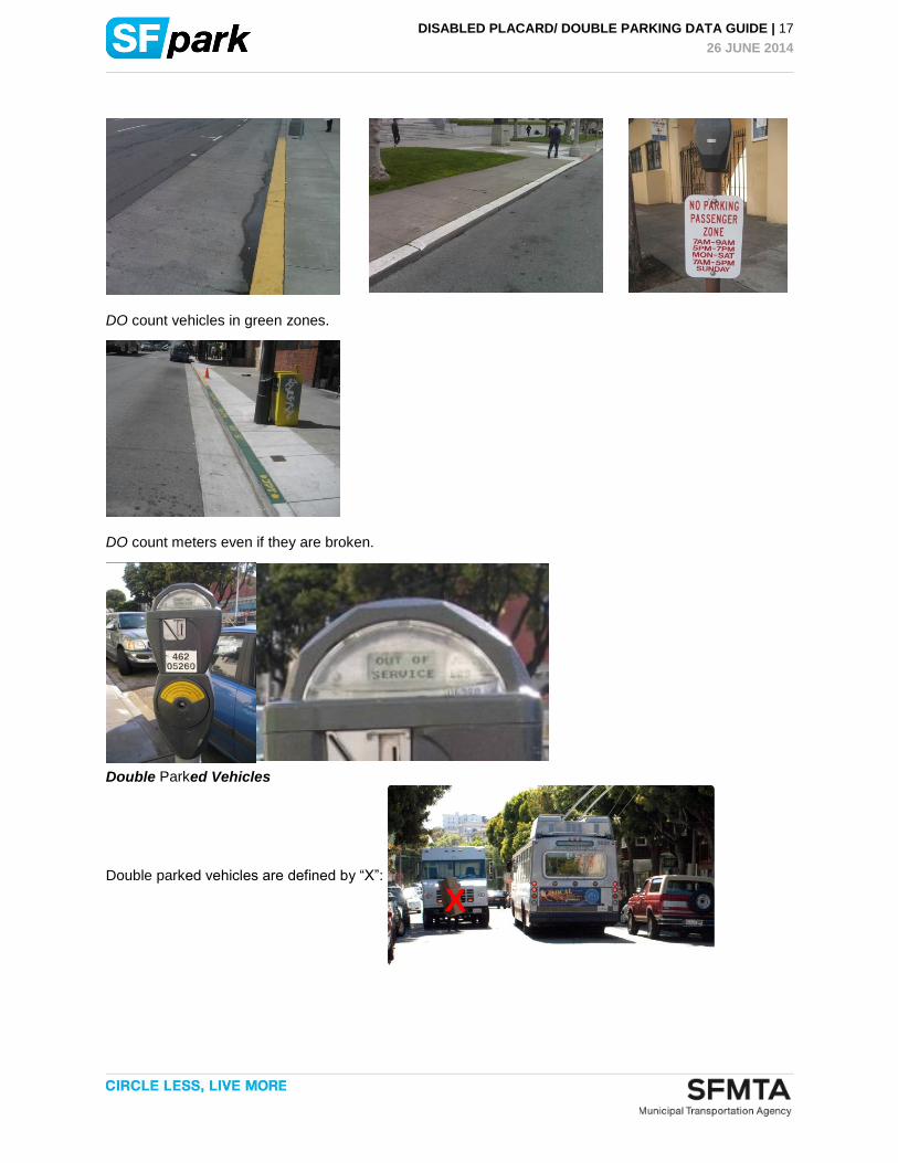
DO count vehicles in green zones.
DO count meters even if they are broken.
Double Parked Vehicles
Double parked vehicles are defined by “X”:
X

DISABLED PLACARD/ DOUBLE PARKING DATA GUIDE | 18
26 JUNE 2014
Survey Instrument

DISABLED PLACARD/ DOUBLE PARKING DATA GUIDE | 19
26 JUNE 2014
Appendix B: Area Maps

DISABLED PLACARD/ DOUBLE PARKING DATA GUIDE | 20
26 JUNE 2014

DISABLED PLACARD/ DOUBLE PARKING DATA GUIDE | 21
26 JUNE 2014

DISABLED PLACARD/ DOUBLE PARKING DATA GUIDE | 22
26 JUNE 2014

DISABLED PLACARD/ DOUBLE PARKING DATA GUIDE | 23
26 JUNE 2014

DISABLED PLACARD/ DOUBLE PARKING DATA GUIDE | 24
26 JUNE 2014

DISABLED PLACARD/ DOUBLE PARKING DATA GUIDE | 25
26 JUNE 2014

DISABLED PLACARD/ DOUBLE PARKING DATA GUIDE | 26
26 JUNE 2014