disaster management · opportunities for disaster management,safety, drones ... • create...
TRANSCRIPT

Opportunities for disaster management,safety, drones
Alina Hriscu, Carmen Aguilera
Workshop “Deployment of Galileo and EGNOS in Portugal”
21st September, Lisbon

Disaster management
GNSS/EO Synergies
Drone operations
2

E-GNSS for disaster management
3
What is the general role for E-GNSS when it comes to disaster management. This is not clear to me
Examples of projects for disaster management
4
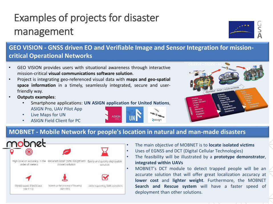
• The main objective of MOBNET is to locate isolated victims• Uses of EGNSS and DCT (Digital Cellular Technologies)• The feasibility will be illustrated by a prototype demonstrator,
integrated within UAVs• MOBNET’s DCT module to detect trapped people will be an
accurate solution that will offer great localization accuracy atlower cost and lighter weight. Furthermore, the MOBNETSearch and Rescue system will have a faster speed ofdeployment than other solutions.
MOBNET - Mobile Network for people's location in natural and man-made disasters
GEO VISION - GNSS driven EO and Verifiable Image and Sensor Integration for mission-critical Operational Networks
• GEO VISION provides users with situational awareness through interactivemission-critical visual communications software solution.
• Project is integrating geo-referenced visual data with maps and geo-spatialspace information in a timely, seamlessly integrated, secure and user-friendly way.
• Outputs examples:• Smartphone applications: UN ASIGN application for United Nations,
ASIGN Pro, UAV Pilot App• Live Maps for UN• ASIGN Field Client for PC

Disaster management
GNSS/EO Synergies
Drone operations
5
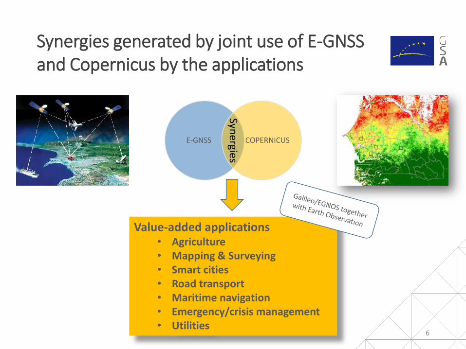
Synergies generated by joint use of E-GNSS and Copernicus by the applications
6
Value-added applications• Agriculture• Mapping & Surveying • Smart cities• Road transport • Maritime navigation• Emergency/crisis management• Utilities
E-GNSS COPERNICUS
Syne
rgies
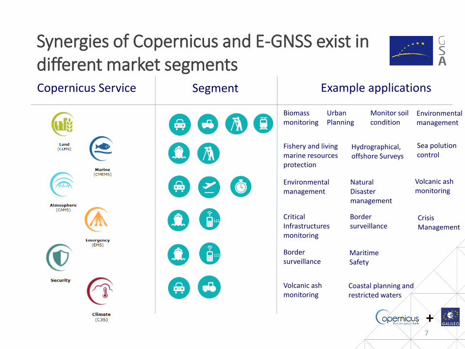
Synergies of Copernicus and E-GNSS exist in different market segments
7
Biomass monitoring
Monitor soil condition
Urban Planning
Environmental management
Fishery and living marine resources protection
Environmental management
Natural Disaster management
Critical Infrastructuresmonitoring
Border surveillance
Crisis Management
Border surveillance
MaritimeSafety
Volcanic ash monitoring
Hydrographical,offshore Surveys
Coastal planning and restricted waters
Copernicus Service Segment Example applications
Volcanic ash monitoring
Sea polution control
+
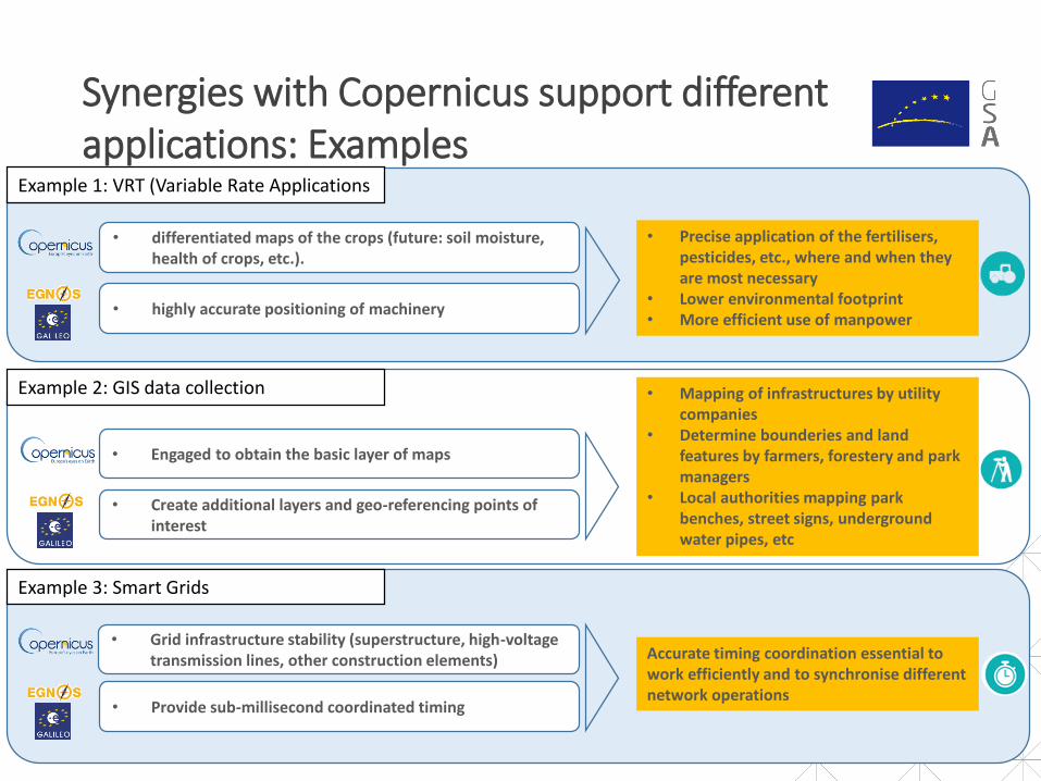
Synergies with Copernicus support different applications: Examples
• Precise application of the fertilisers, pesticides, etc., where and when they are most necessary
• Lower environmental footprint• More efficient use of manpower
• differentiated maps of the crops (future: soil moisture, health of crops, etc.).
• highly accurate positioning of machinery
• Grid infrastructure stability (superstructure, high-voltage transmission lines, other construction elements)
• Provide sub-millisecond coordinated timing
Accurate timing coordination essential to work efficiently and to synchronise different network operations
Example 1: VRT (Variable Rate Applications
Example 2: GIS data collection
Example 3: Smart Grids
• Engaged to obtain the basic layer of maps
• Create additional layers and geo-referencing points of interest
• Mapping of infrastructures by utility companies
• Determine bounderies and land features by farmers, forestery and park managers
• Local authorities mapping park benches, street signs, underground water pipes, etc

Disaster management
GNSS/EO Synergies
Drone operations
9
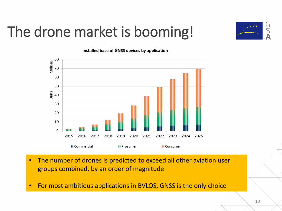
The drone market is booming!
10
• The number of drones is predicted to exceed all other aviation user groups combined, by an order of magnitude
• For most ambitious applications in BVLOS, GNSS is the only choice

E-GNSS benefits for RPAS and GSA activities
11
E-GNSS for RPAS:
• Increased accuracy, availability, integrity, and resilience against spoofing and jamming
• Authentication possibilities
• Geo-fencing applications
• Better time to first fix and acquisition sensitivity for TTFF
GSA activities:• Contribution to a roadmap of
harmonised implementation of drones in EU non-segregated airspace
• Participation in different working groups, and contribution to
• R&D support

RPAS Geofencing need robust navigation based on E-GNSS
12
- High accuracy (Horizontal + vertical)- Multi-Frequency Rx provide 2X availability, accuracy than GPS alone- Integrity data (EGNOS)- Worldwide availability (Galileo)- Galileo Authentication = valid GNSS source- Lightweight and integrated solutions available
Geo-Fencing: ‘Virtual barrier’ of a specific real-world geographic area or volume- Radius around a point or location- Predefined set of 2D/3D boundaries
Geo fencing for RPAS: Program airspaces/classes with suitable flight permissions Send alerts to pilot/operator when RPAS approaches the restricted area Program RPAS operation (e.g to automatically turn back) when approaching restricted areas
GeoFencing relies on GNSS: high accuracy and integrity is a must

EGNOS integrity = trust on the position source
13
Aircraft True positionUnknown to the pilot
Aircraft estimated positionObtained by the aircraft receiver EGNOS+GPS
Protection volume:computed by the aircraftwith EGNOS
Vertical Protection Level
Alarm volume:Depending on the flight procedure
Horizontal Protection Level

Geofencing test for aircraft inspection
Geofencing in field surveillance
Ongoing test prove EGNOS and Galileo benefits for robust navigation and geofencing
14
Precise take-off and landing on power substations
Railway inspection
1 2
3

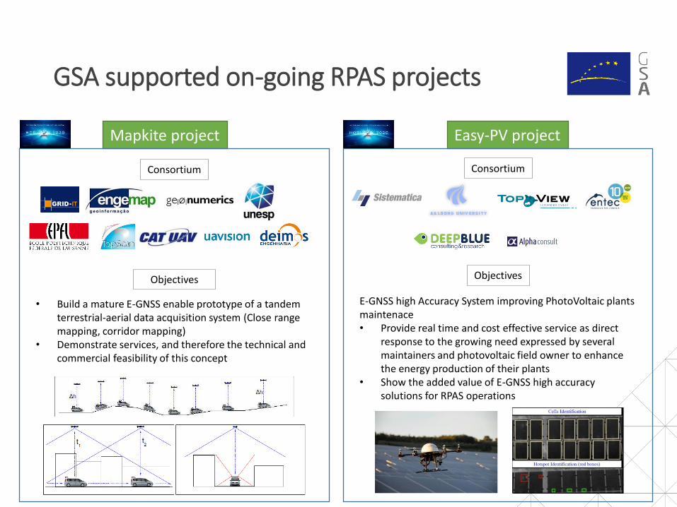
GSA supported on-going RPAS projects
14
Objectives
• Develop command and control link that usescommunication through multi-band satellite and radio
• Develop detect and avoid functions based on GNSS andother satellite communications
• Develop complete (and scalable) system to manage the fulloperational process:
• Starts with initial mission request by final customer• Ensures the RPAS management and ATM during all
phases of flight• Focus on VLL operations
• Demonstrate developed systems with flight tests through e-TOD and LiDAR
Contribution to the definition of a system that tackles safety,security and privacy issues arising with the operation of RPAS incivilian airspace. Final goal is for economical, efficient andbeneficial civilian applications made possible with UTM systemoperations.
Consortium
SkyOpener project REAL project
Consortium
• Develop and integrate a navigation and surveillance sensor(EGNOS + ADS-B) in 2 different RPAS
• Develop CONOPS with supporting safety assessment for theapproval of operations
• Take-off and landing in VLOS• En-route/operational fase of flight in BVLOS• All operations will happen within RLOS• Demonstration will firstly be done in segregated
airspace (Scenario 1) – if assessed positively trials innon segregated airspace (Scenario 2)
• DAA not part of the safety case• ADS-B for surveillance & EGNOS for navigation
• Perform flight tests validating the navigation andsurveillance functions
• Adapt existing flight procedure design criteria byconsidering RPAS specific performances
Objectives
GSA supported on-going RPAS projects
16
Objectives
Consortium
Mapkite project
• Build a mature E-GNSS enable prototype of a tandem terrestrial-aerial data acquisition system (Close range mapping, corridor mapping)
• Demonstrate services, and therefore the technical and commercial feasibility of this concept
Easy-PV project
Consortium
Objectives
E-GNSS high Accuracy System improving PhotoVoltaic plants maintenace• Provide real time and cost effective service as direct
response to the growing need expressed by several maintainers and photovoltaic field owner to enhance the energy production of their plants
• Show the added value of E-GNSS high accuracy solutions for RPAS operations

Linking space to user needs
17
www.GSA.europa.euGet in touch:
GSC-europa.euEGNOS-portal.eu UseGalileo.euG