dis/orienting 'middle east': a cart-rhetorical rhizomatic
TRANSCRIPT

Clemson UniversityTigerPrints
All Dissertations Dissertations
5-2018
Dis/Orienting 'Middle East': A Cart-RhetoricalRhizomatic MappingEda OzyesilpinarClemson University, [email protected]
Follow this and additional works at: https://tigerprints.clemson.edu/all_dissertations
This Dissertation is brought to you for free and open access by the Dissertations at TigerPrints. It has been accepted for inclusion in All Dissertations byan authorized administrator of TigerPrints. For more information, please contact [email protected].
Recommended CitationOzyesilpinar, Eda, "Dis/Orienting 'Middle East': A Cart-Rhetorical Rhizomatic Mapping" (2018). All Dissertations. 2117.https://tigerprints.clemson.edu/all_dissertations/2117

DIS/ORIENTING ‘MIDDLE EAST’: A CART-RHETORICAL RHIZOMATIC MAPPING
A Dissertation Presented to
the Graduate School of Clemson University
In Partial Fulfillment of the Requirements for the Degree
Doctor of Philosophy Rhetorics, Communication, and Information Design
by Eda Ozyesilpinar
May 2018
Accepted by: Dr. Cynthia Haynes, Committee Chair
Dr. Victor Vitanza Dr. James Spencer
Dr. Amit Bein

ii
ABSTRACT
This dissertation focuses on the association between the geopolitical region Middle East
and the unjust profiling of Islamic terrorism. I examine this connection from the lens of border-
politics and deconstruct Western cartographic discourses that constructed the current
misrepresentative and extensively totalizing identity of Middle East as the land of Muslim
terrorists. My conjecture is framed around Karen Culcasi’s argument on how Middle East was re-
invented in the discourse of Orientalism during the early twentieth century. To challenge the
region’s current misrepresentative and unjust socio-spatial identity, I map how the region’s
inherently othered identity under the European gaze of Orientalism has arrived to its current state
as a result of changing discourses of power and geopolitical relations throughout the twentieth
century. In this light, I investigate three central questions in this dissertation:
1) How the discourse of global war on terrorism has emerged from the haunting image of
the Oriental discourse and continues to respond and counter-respond to the great Middle Eastern
question: continuous reproductions of the region in the totalizing image of the Western tree-
system.
2) How this continual process of reproducing Middle East in the same problematic
rhetoric has mirrored itself into re-constructing the cartographic reality of the region both in its
Western perceptions and Middle/Eastern receptions: internalization of the Western tree-image
and finally arriving to the Islamic tree-system of a violent and fundamental ideology of terrorism.
3) How these cartographic reproductions have been suppressing the diverse identities in
the region while these socio-spatial formations have always already been disrupting various
systems of subordinations: how the internalized tree-system of the West and its tap-roots have
been cutting the lines and paths of the rhizomatic identities of the region.

iii
As I unpack these three questions, I approach the Western modern scientific knowledge
production and information design (dominant mode of production) as a form of alienating
rhetorical re-invention. I best understand the working structure of the Western rhetoric of
alienation through Walter Benjamin’s notion of ‘mechanical reproduction.’ I draw from
cartographic hermeneutics and cartographic deconstruction to unpack how the Western ground
logic of this machinic system has been re-inventing the socio-spatial consciousness of Middle
East. I argue that the unjust image of Middle East as the land of Muslim terrorists has been
another process for Western society to re-define its non-Western other.
I define the mapping of this project as a dis/orienting rhizomatic mapping which draws
from Deleuze and Guattari’s models of rhizome and tree-system. As I analyze the shifting
discourses to map the shifting borders, changing names, and transforming otherness of Middle
East, I approach the Western process of re-inventing and homogenizing Middle East as a tree-
system while I read the region’s organic heterogeneity and complex relations of meaning-making
as rhizomatic. In this light, I conduct a carto-rhetorical deconstruction on the cartographic
discourses (maps of dominant gaze) representing Middle East with a focus on the rhetorical and
narrative qualities of maps as technical documents. The central agenda is to dis/other the
geography of Middle East by mapping with its rhizomatic socio-spatial identities and to write an
anti-memory challenging the Islamic stereotypes and prejudices that have been produced in the
dominant vision and discourses of alienation, enemization, and victimization of the region

iv
DEDICATION
I dedicate this dissertation to all the amazing women who shaped me as the writer that I am today.
I share the degree with my mother who always supported me, with my sister who always believed
in me, and with my father who set an example for me.

v
ACKNOWLEDGEMENTS
Cynthia, thank you for believing in me; thank you for your kindness and support; thank
you for listening me with patience every time I lost hope in myself, in my writing. Thank you for
being one of the amazing women who always bring me to writing. Thank you for inspiring me
and always showing me the light.
Victor, thank you for your wisdom and constant support; thank you for seeing value in
my research and writing. Thank you for understanding and respecting my thinking and my voice.
Thank you for always encouraging me to do what I believe in and thank you for letting me be
brave and take risks in my work and writing.
James, thank you for expanding my vision, challenging my thinking, and supporting me
to improve my research. Thank you for our conversations and thank you for sharing your wisdom
and experience with me.
Amit, thank you for the invaluable insights you provided me in my research. Thank you
for respecting my vision and helping me to improve myself as a scholar and critical thinker.
Thank you for sharing your wisdom with me.
Susan, thank you for always believing in me and supporting me. Thank you for your
wisdom and friendship. Thank you for encouraging me to do the things that I would never think
that I was capable of. You are one of the reasons I am where I am today.
Data, Dina, and Firasat, thank you for being amazing friends and great role models for
me. Thank you for our great conversations. You make me believe that I can do anything. You
give me strength and hope. You are amazing women who bring me to writing.
Whitney, Charlotte, and Diane, thank for you being amazing friends. Thank you for being
there for me and listening me going on and on as I talked about my research. You are great
friends and amazing women who bring me to writing.

vi
Alison and Angela, thank you for your friendship, your smiling faces, and constant
support. You are amazing women who bring me to writing.
My cohort, Nathan Riggs, Joshua Wood, Samuel Fuller, Daniel Frank, and Firasat
Jabeen, thank you for always being there for me. Thank you for becoming and being my friends. I
could not imagine finishing this degree without all of you. I am honored to call you my friends
and my colleagues.
My two amazing research assistants, Zemin and Providence; thank you for time, hard
work, and more importantly your creative vision. Thank you for making sure to support me and
my vision in producing the story maps for my project.
My mother, Berna, and my sister, Ayca; thank you for believing in me, listening me, and
supporting me. Thank you for seeing strength in me and reminding me that I have what it takes.
Thank you for being amazing women who bring me to writing.
My aunt, Rana, and my cousin, Gulsah; thank you for your laughter and your love. Thank
you for being amazing women who bring me to writing.
My grandmother, Nevin; thank you for your prayers and your love. Thank you for being
one of the amazing woman who brings me to writing.
My father, Ercument; thank you for teaching me the value of hard work and showing me
that having an education is more than receiving a degree; it is about becoming and being a better
person. Thank you for raising me to be a strong woman.

vii
TABLE OF CONTENTS
TITLE PAGE ..................................................................................................................... i
ABSTRACT ....................................................................................................................... ii
DEDICATION.................................................................................................................. iv
ACKNOWLEDGEMENTS ............................................................................................. v
LIST OF FIGURES ......................................................................................................... ix
INTRODUCTION: HOME/SICK BORDERLANDS ................................................... 1 Home/Sick Identities ........................................................................................................................ 3 Call of the Home/Sick Middle East ................................................................................................. 8 Re/Inventions of Middle East: Global Other in the image of Islamic Terrorism ........................... 10 From Oriental Other to the Middle Eastern Other ......................................................................... 12 Rhizomatic Participatory Mapping: Using the Power Networks of the Global Map..................... 18
CHAPTER 1: HOW TO DIS/OTHER THE HOME/SICK MIDDLE EAST?......... 26 The Oppressive Vision of Modern Globalization and Our Cyborg Maps ..................................... 31 How to Dis/Other the Geopolitical Identity of Middle East: A Dis/Orienting Process of
Rhizomatic Mapping ...................................................................................................................... 33
CHAPTER 2: THE INVISIBLE SPACES OF THE BOAT PEOPLE ...................... 53 Dialectics/Trialectics of Spatial Productions and Impacts of Cartographic Interpretations .......... 59 Globalization and the Dead Gaze of Western Modernity .............................................................. 67 Western Modernity and Ground Logic of Global Space................................................................ 76
CHAPTER 3: THE MAKING OF THE ‘ORIENTAL OTHER’ .............................. 88 The Game of the Orient .................................................................................................................. 97 From a Western Utopia to a Global Heterotopia of Oriental Otherness ...................................... 101 Responding to the Oriental Other ................................................................................................ 104
CHAPTER 4: MAKING OF THE “MIDDLE EASTERN OTHER”...................... 119 Geopolitical Island Middle East in the Ground Logic of the Global Map ................................... 123 The Eastern Question, the Middle East, and the Oriental Despotism .......................................... 126 From Eastern Question to the Middle Eastern Question: Multipolar European Gaze in Making of
the Modern Middle East ............................................................................................................... 133 Anglo-French Domination and Re-Constructing Middle East in Post-WWI Period/Inter-War Era
...................................................................................................................................................... 146
CHAPTER 5: RE-WRITING THE MIDDLE EASTERN OTHER/THE MIDDLE
EAST WRITING HER/SELF ...................................................................................... 154 From the Inter-War Period to the Post-WWII Period .................................................................. 158 Decolonization of the Middle East and the Arab Homeland as Counter-Mapping ..................... 160 Bipolar Gaze of the Cold War Period and the Rise of the Palestine Question ............................ 166 Israel’s Socio-Spatial Constructions of Victim and Enemy Images: A Carto-Rhetorical
Deconstructive Reading ............................................................................................................... 170 From the Enemy-Victim Dichotomy to the Enemy-Heroine-Victim Triad: Israel-Palestine
Conflict in Middle East Today ..................................................................................................... 180

viii
CONCLUSION: HOW DID WE GET HERE? THE MIDDLE EAST AS THE
GLOBAL ENEMY........................................................................................................ 189 From the Multipolar European Gaze to Bipolar Cold War Gaze over Middle East .................... 191 From Middle East to Greater Middle East and Intensification of Enemization ........................... 192
Appendix ........................................................................................................................ 200
MAPS CITED................................................................................................................ 201
WORKS CITED............................................................................................................ 203

ix
LIST OF FIGURES
Fig. 1. Colton's illustrated and embellished steel plate map of the world on Mercator's projection 1
Fig. 2. Lefebvre’s Triad of Spatial Production............................................................................... 65
Fig. 3. L’Orient or The Indian Travelers: A Geographical Historical Game ............................... 99
Fig. 4. The Function of Mirror-In-Between: Actualization of Utopias to Heterotopias by Michel
Foucault in “Of Other Spaces: Utopias and Heterotopias.” .............................................. 102
Fig. 5. Alfred Mahan’s 1902 Middle East .................................................................................... 134
Fig. 6. Valentine Chirol’s 1903 Middle East ............................................................................... 135
Fig.7. 1905 German Map Persien, Afghanistan und Belutschistan ............................................. 137
Fig. 8. 1907 British Map Europe and Near East General Commercial Chart ............................ 138
Fig. 9. 1916 “Map of Sykes Picot Agreement” ............................................................................ 142
Fig. 10. 1922 British Map South-Western Asia ............................................................................ 148
Fig. 11. 1934 French Map Air France: Réseau Aérien Mondial ................................................. 150
Fig. 12. Text Page: Israel ............................................................................................................. 171
Fig. 13. Contents: Israel in Pictorial Maps .................................................................................. 173
Fig. 14. Safad ............................................................................................................................... 176
Fig. 15. Nahariya .......................................................................................................................... 176
Fig. 16. Tel Aviv .......................................................................................................................... 177
Fig. 18. Natanya ........................................................................................................................... 178
Fig. 17. Ashqelon ......................................................................................................................... 178
Fig. 19. Dis/Orienting The Middle East Project .......................................................................... 199

1
INTRODUCTION: HOME/SICK BORDERLANDS
“If we are truly concerned with the social consequences of what happens when we make a map, then
we might also decide that cartography is too important to be left entirely to cartographers.” Brian Harley, “Can
There Be a Cartographic Ethics?”, 203
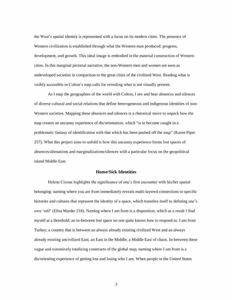
Fig. 1. Colton's illustrated and embellished steel plate map of the world on Mercator's projection
This is a mapping project about lost spaces and geographies of homesick identities. The
very act/ion of mapping is concerned with what a map is:
The usual answer to this question—that a map is a flat image of the earth or of one of its
regions—simply raises new questions. What is an image, and on what grounds can an
image represent the earth? The object eludes definition because the definition situates the

2
map in a generic category. The nature of the map can be specified only by referring in an
immediate way to what it represents—that is, to what it is not. (Christian Jacob 11)
Understanding the map object through the relation between what its cartographic
visualization does (what it is) and does not represent (what it is not) entails attending to the
dis/orienting spatial reality of the map image. The cartographic image of a map object “creates a
non-local representation of a particular space so that I can be somewhere and have a
representation that is independent of this location” (Patrice Maniglier 48). This independent
representation of space is detached from lived human experiences, cultures, hi/stories, and
identities. This separation functions as a form of re-inventing the space, which defines the
experience of dis/orientation. The map object (Fig. 1) produced by Colton is how this project
understands dis/orientation and the problematic case of identification. Colton’s map is the product
of a specific gaze and understanding of the world and its space. The mapmaker’s subjective
position reveals itself in the margins, through the decorative and pictorial representation of people
and cities. These visual images illustrate the cultural and social identities of the world regions. A
rhetorical reading of the marginal narrative that accompanies the world map at the center is a
reading and mapping from what is seen to what is not seen. A spatial reading that moves in-
between the West-East binary.
Deconstructing the ground logic of Colton’s visual-spatialization is a mapping of the old
West-East narrative line. The center of this binary informs the spatial reality of this map object by
reproducing the civilized West and uncivilized East dichotomy in the global context. What we see
in this map are the stereotypical and totalizing representations of non-Western identities.
Marginal representation introduces non-Western men and women as exotic and mystical. In
particular, the fragile and submissive depiction of non-Western women in a primitive geography
implements a strong sense of difference from the Western image. Rather than focusing on people,
3
the West’s spatial identity is represented with a focus on its modern cities. The presence of
Western civilization is established through what the Western man produced: progress,
development, and growth. This ideal image is embodied in the material construction of Western
cities. In this marginal pictorial narrative, the non-Western men and women are seen as
undeveloped societies in comparison to the great cities of the civilized West. Reading what is
visibly accessible in Colton’s map calls for revealing what is not visually present.
As I map the geographies of the world with Colton, I see and hear absences and silences
of diverse cultural and social relations that define heterogeneous and indigenous identities of non-
Western societies. Mapping these absences and silences is a rhetorical move to unpack how the
map creates an uncanny experience of dis/orientation, which “is to become caught in a
problematic fantasy of identification with that which has been pushed off the map” (Karen Piper
257). What this project aims to unfold is how this uncanny experience forms lost spaces of
absences/alienations and marginalizations/silences with a particular focus on the geopolitical
island Middle East.
Home/Sick Identities
Helene Cixous highlights the significance of one’s first encounter with his/her spatial
belonging: naming where you are from immediately reveals multi-layered connections to specific
histories and cultures that represent the identity of a space, which transfers itself to defining one’s
own ‘self’ (Elisa Marder 218). Naming where I am from is a disposition, which as a result I find
myself at a threshold; an in-between lost space no one quite knows how to respond to. I am from
Turkey; a country that is between an always already existing civilized West and an always
already existing uncivilized East; an East in the Middle; a Middle East of chaos. In-between these
vague and extensively totalizing constructs of the global map, naming where I am from is a
dis/orienting experience of getting lost and losing who I am. When people in the United States

4
first meet me, they ask me a series of questions about Turkey: where is it? Do we have beaches in
Turkey? Do we ride camels in Turkey? (because we probably should be living in the middle of a
desert). Do we have malls in Turkey? When did I stop covering my hair? When did I start
drinking? When did I start dressing up like a ‘modern’ female? Do my parents know that I am
drinking? Do they force me to get married? These are just a couple of questions out of many. But
the nature of these questions tells me something very important about the pre-conceptions the
people I have encountered have about Turkey. For them, Turkey, as an Eastern country that is
non-Western, is a reflection of the stereotypical representation of a Muslim country: a deserted
geography of un-civilization oppressing women. People ask me these questions either due to their
implicit/unconscious or explicit/conscious biases. In each context, what I have come to realize is
that the existing pre-assumptions about non-Western geographies shape the dominant image: a
distorted image of being the non-Western other.
These monolithic structures of Western and non-Western geographies are the products of
understanding space as a closed and immobile empty construct. The notion of closed space works
as a rhetorical form of justification that situates the cartographer and his/her subjective gaze into a
state of power that desires to re-invent the lifeless reality of closed space. This rhetorical re-
invention produces closed space with meaning that represents the reality and ideology of the
dominant gaze that orders the West and East binary. To deconstruct how the closed spaces of
West and East inflict violent alienations into cartographic visualizations, I map with Edward
Soja’s conceptualization of socio-spatial dialectic “that social and spatial relations are
dialectically inter-reactive, interdependent; that social relations of production are both space-
forming and space-contingent” (Postmodern Geographies 81). I use socio-spatial dialectic as a
counter-mapping, which understands space through Doreen Massey’s approach: space as an open
becoming of social and cultural relations and lived human experiences, which is the chance of

5
space. As a counter-movement to the ground logic of the closed space, open space flies over the
hardened borders that totalize monolithic images of West and East. Through this fluid movement,
space as an open becoming offers us an unexpected alternative that our Western maps fail to
recognize: alternatives—absences and silences—that are pushed off the global map.
On the closed space of a map-object, my fluid relation to open space, my individual
social and cultural connection with where I am from and who I am, is an absent alternative. My
unique understanding of who I am in conjunction with where I am from does not have a location
on the global map, because the space that I define myself with is a closed spatial representation of
the monolithic Eastern otherness. The absence of diverse socio-cultural spaces of Eastern
identities on the global map is the reason for this project to have a desire in its own writing and
language to map lost geographies of threshold spaces/places “in which the movement from one
place to another is effected. A threshold is the concrete interplace of an important transition…
[that serves] as the support for a rite of passage” (Edward Casey, “How to Get from Space to
Place” 39-40). According to Van Gennep, this rite of passage, door, functions as “the boundary
between the foreign and domestic worlds in the case of an ordinary dwelling, between the profane
and sacred world in the case of a temple. Therefore, to cross the threshold is to unite oneself with
a new world. It is thus an important act in marriage, adoption, ordination, and funeral
ceremonies.” (qtd. in Casey 40). I have come to terms with the fact that I belong to threshold
spaces, the borderlands the global map refuses to map. Instead, the global map covers, conceals,
and almost hides these threshold spaces of lost geographies. It creates absences and silences we
do not see by replacing open spaces of thresholds with constructed spaces of hardened borders.
Inflicting silences and absences in maps is a two-fold process of mapping: 1) emptying
and 2) re-inventing the meaning of empty space by displacing people, groups, communities, and
nations. Western cartography has not only mastered this dual process, but it also has been using it

6
as a rhetorical device to implement the West-East binary into the geographical construction of the
global world image. This great divide is a fixation on defining non-Western others as merely
different. I understand the violent implications of this monolithic duality in producing the
geographies of West and East as a cognitive product of the Western rhetorical tradition and
thinking: the model that always alienates me from you or you from me. Piper indicates that
“Western identity is formulated by pushing something off the map, then safely embracing the
map as the self” (17). I understand the history of Western cartography as the history of an
alienating rhetoric rooted in forming differentiating lines and borders between Western Self and
Eastern Other(s).
In this context, I map with a question of what happens when the system of this great
division fails. What happens when the reproduced categorical differences that define West
(civilized) and East (primitive) forget and silence voices that do not fit into these categories. I ask
these questions because not belonging to the categories of the Western maps is the dis/orienting
experience of homelessness that I have been suffering from. To be a Muslim female in the West, I
am expected to cover my hair, not to consume alcohol and pork products. To be a Muslim and a
proper Turkish female in Turkey, I am expected to find a husband, get married, and be, first, a
domestic housewife and, second, have a low-key career if I really want to. I am neither of these
things. For the Western man, I am not a good enough Muslim female because I do not need to be
liberated and rescued; for the Eastern man I am not a good enough Muslim female because I am
too educated and talk too much. I am always at a threshold in between. Each side of this threshold
tells me something different about who I am and who I should be to be understood, recognized,
and responded to. Each side of this threshold is a different world; yet for one world to have a
meaningful reality, the other space needs to exist.
7
The root of my homelessness stems from my unrecognized mobility that takes place in
the borderlands. I cross these borders because I do not belong to any center that holds the ground
of these binary definitions that form the global world order. On the spatial surface of our global
map, I remain as the uncategorized other like many ‘other’ men, women, and children who are
not uncivilized terrorists and deviants that need to be kept out while the only thing they do is
surviving due to the catastrophic consequences of war and chaos they neither caused nor asked
for. I respond to these monolithic binary constructions of the global map and the home/sick
condition of borderlands in-between through the model of rhizome because a rhizome “has no
beginning or end, interbeing, intermezzo…proceeding from the middle, through the middle,
coming and going rather than starting and finishing” (Gilles Deleuze and Felix Guattari 25). The
rhizomatic consciousness of this mapping project aims to unpack how a map shows what it does
not show by leaving things out, by altering meaning, and by producing distorted spatial
knowledge. I define this mapping as a rhizomatic mapping of the ‘white lies’ that maps tell us.1
These white lies tell us that we live in a world of the civilized West fighting against the chaos,
disorder, and terrorism of the non-Western East(s): the discourse of war on terror.
Instead of trying to find a way to escape from this dis/orienting vision, rhizomatic
mapping of this project embraces the very experience of dis/orientation and moves with “a desire
to evade the effects of ‘over-civilization’ and so to jump off the official map and into the margins
or blank spaces” (Piper 257). Jumping off the official map is how I understand rhizomatic
mapping because where I fall into is in the margins, the cracks in-between the borders and lines
on the official maps. In this sense, the rhizomatic mapping of this project is concerned with how
modern cartographic visualization processes and techniques of our global world produce spatial
stereotypes that construct misrepresentative identities of the global West and global East.
1Monmonier, Mark. How to Lie with Maps. The University of Chicago Press, 1996.

8
Mapping rhizomatically intends to unpack the metaphysical ground of the dichotomized global
map and the dominant discourse that constructs this map: the Western gaze. The purpose of
unpacking the map of this monolithic binary vision is to understand the logic of this dominant
language of power and how this language has been using alienation (logos), marginalization
(ethos), and differentiation (pathos) as its primary rhetorical persuasive tools. The rhetorical
movement of this rhizomatic mapping is, then, to understand the rhetorical context and to learn
the problematic language of the Western gaze as a path to explore alternative rhetorical strategies
and meanings in reading and engaging with the West-East dichotomy.
Call of the Home/Sick Middle East
Reading the West and East relation from a global trajectory through a rhizomatic
consciousness is my desire. This desire has been the result of a strong discomfort I have been
having with the collective social and cultural experiences of dis/orientation in the non-Western
geographies of the global East. As I have been moving from my personal dis/orientation to the
collective homelessness of global East, I found myself responding to a call from a particular
geopolitical entity: Middle East. In the ground logic of the global map that is centered in the
alienating rhetoricity of the Western gaze, the call of Middle East and its lost geography is a call
of “biophony, where the facts of life fall into a twilight zone between knowing and not knowing,
between rather crude ground of empiricist and mode diaphanous heights of speculation.” (Avital
Ronell, The Telephone Book 9). This is a call of absences and silences that are left out, suppressed
in-between the borders that fill the empty spaces in the legitimized papers2 of the official map-
2 In Paper Machine, Jacques Derrida addresses the notion of legitimacy in the body of paper: “Credit or
discredit, legitimation or delegitimation, have long been signified by the body of the paper. A guarantee is
worth what a signed piece of paper is worth” (44). Later in the book he addresses the impact of a password,
or an identification card on our identities, and brings the notion of the legitimacy of a signed paper, a paper
made it official, in relation to the notion of crossing, shibboleth and its experience which is “a passage:
crossing, voyage, breaking through, route, via rupta. The shibboleth confers the right to cross a frontier, it’s

9
object: forgotten identities and their stories. Spatial reality represented in our official maps rooted
in the logic of Western thought has been pushing these different identities off the map by
producing their consciousness as different and alienated others.
To me, the call of the Home/Sick Middle East has been a call coming from a placeless
unity of modern globalization in “where there has been little or no relation…A state casts a net of
connectedness around itself from which the deadly flower of unity can grow under the sun of
constant surveillance” (Ronell 8). Under the sun of this deadly surveillance of our global age’s
satellite data, this call that is reaching out from a placeless unity is a call from three years old
Aylan Kurdi whose body was found on the shores of Bodrum/Turkey last year. A call of a
memory I have of seeing the navy officers in my hometown getting dozens of refugees out of
their boats on the shores of my hometown. A call of a no-memory we have a tendency to forget
in-between the statistics of how many refugees have entered Europe so far. A forgetfulness that
taught me to “hang up and dial again” and “offered a certain untried access code to a terrorism
that, in the first place, is technologically constellated” (Ronell 8). A call of a terrorizing violent
rhetoric of the homelessness the lost geography of Middle East has been suffering from.
This homelessness, more importantly being home/sick, as Cynthia Haynes explains, “is
not about missing home, it is about the sickness called Homeland Security and our rhetorical task
of addressing it in an age of perpetual conflict… [an allegory of the Other that] speaks, but it does
not, nor never will, tell us why…We will never know the why when it comes to conflict and
unspeakable violence… [even though it] seduces us into believing there is an answer on the other
side of why” (2; 10-11). The call of the home/sick Middle East, then, is the call of Aylan, the call
the equivalent of a visa or passport. But it also has the differential, sometimes discriminatory, value of a
shared secret. It is the mark and sign of recognition of a ‘between oneself’ (community, nation, family,
language, etc.)” (156). I approach the official papers of maps as legitimized spaces of the hegemonic,
dominant vision of a culture and society since while maps offer pathways and routes to cross, they also
draw borders in where our passports and visas differentiate and immobilize us.

10
of every face, voice, story, and name that has been silenced, suppressed, and disposed into the
margins of the maps of our global age: forgotten and forgetful memories. This is a call of “a dead
gaze…the ghost of external vision” (Ronell 22). The call of this dead vision has been haunting
the rhizomatic inhabitants of this region since its invention in the modern imagination of the
enlightened Western man: the eternal image of the Orient.
Re/Inventions of Middle East: Global Other in the image of Islamic Terrorism
As a geopolitical monolithic entity, Middle East currently represents the spatial narrative
of violent Islam violence and terrorist Muslims as this narrative constructs itself in the popular
global representation. This particular dis/placement and representation of the region on the global
map immediately im/places the region to the margins wherein the non-Western Global East gives
itself into the Western stereotypes that are constructed in binary relations: civilized vs.
uncivilized, modern vs. primitive, democracy/peace vs. oppression/terror. These particular
stereotypes that visualize the monolithic reality of both West and Middle East on the global map
are rhetorical inventions of the discourse of the global war on terror, a narrative created by the
Bush administration’s response to the 9/11 terrorist attacks. The alienating rhetoric that forms the
ground logic of this discourse re-invented the global West-East binary around the notions of ‘us’
vs. ‘them.’ According to Heather Ashley Hayes, the rhetoric of the Bush doctrine that invented
the discourse of war on terror left “little room for interpretation of the enemy as anything but evil
and the USA as anything but heroic and good,” which rooted the context of war in religious
foundations while depicting the conflict between U.S. and Middle East “as an ongoing and
permanent problem that is not limited to the acts of al Qaeda and Afghanistan” (41-43).
As a result, as Mahmood Mamdani explains, the war on terrorism discourse called “for a
war to the finish…in the name of justice but understand justice as revenge… [and it] has
processed by dishing out collective punishment, with callous disregard for either ‘collateral

11
damage’ or legitimate grievances” (3244). Currently, the way the Trump administration has been
responding to Middle East is also a response narrated in the rhetorical context of the war on terror
discourse and aims at, Mamdani indicates, “nurturing the spirit of revenge” (3244). I suggest that
the Bush administration’s strict nationalist ideology found itself another voice in the Trump
administration’s populist nationalism. The ethical argument of maintaining global order, peace,
and ending terrorism in the ground logic of this populist nationalism has been functioning in the
dominant discourse as a form of geopolitical gatekeeping responding to the Middle East and
Muslim world as a problem to be fixed.
This problematic monolithic representation of Middle East did not occur overnight. The
Bush administration and the Trump administration’s aggressive political rhetoric can be
considered as two main points in the history of defining the Middle East. These rhetorical re-
inventions produced a distorted image of Middle East as a geography of violence and terror.
However, the historical roots of the region’s dis/orienting cartographic image is an indication of
how the Middle East has always been re-defined in the context of alienation and marginalization.
Mapping the ground logic of the modern Middle East in order to challenge its contemporary
discomforting reality necessitates this rhizomatic mapping to respond to Middle East “as an
emerging notion, the culmination of, rather than the starting point in, a process of conceptual
coalescence” (Daniel Foliard 63). I approach the current cartographic construction of Middle East
as a product of Western rhetorical re-inventions that culminated over time. Through these carto-
rhetorical re-productions, the Middle East arrived to its contemporary actualized reality. In this
sense, mapping Middle East rhizomatically means unpacking how the Western rhetorical re-
productions of the region have been working within the Western tree-system. Mapping the
ground logic of these mechanical reproductions is a pathway towards understanding why and how
the region always already suffers from dis/orientation and, as a result, home/sickness.

12
From Oriental Other to the Middle Eastern Other
Reading the monolithic reality of Middle East on the global map creates the necessity of
mapping the Western spatial reproductions of the region on the same global level. This rhetorical
reading understands the working structure of Western re-inventions of Middle East in relation to
the nature of the tree-image Deleuze and Guattari conceptualize. Engaging with the Western
rhetorical system of invention as a tree-system on a global level is a way to both understand and
unpack how the extensively totalizing image of Middle East has been re-narrated. I trace the roots
of the Western tree-image of the modern Middle East to the discourse of Orientalism and argue
that the European construction of the Oriental image has been haunting the geopolitical reality of
Middle East. The ghost of the Oriental picture has been functioning as the underlying
groundwork causing the modern Middle East to suffer from the dis/orienting symptoms of
homelessness.
With the fall of the Ottoman Empire during the early twentieth century, which defined
the modern Middle East as we know it today, the geospatial location and reality of this region had
been re-defined in the Western context. Middle East had been re-constructed as a space of non-
Western other to maintain the binary structure of the global world order. However, what we do
not see in this global map is the nomadic culture of Middle East; a nomadic culture we need to
write a nomadic history for. In the context of our global age, I have come to understand this
nomadic culture as the culture of forced migrations and movements, the culture of the
unspeakable places of refugee camps and unbearable experiences of running away from terrorism
and death. This culture requires us to “consider the departure from within, the dispossession that
demands immobility” (Judith Butler in Who Signs the Nation State? 18). The experience of
nomadic culture, then, became an experience of constantly arriving into a state of statelessness,

13
which is “the idea of passing from one bounded territory to another [that] requires a narrative line
in which arrival follows departure and where the dominant themes are assimilation and
estrangement” (17). This narrative line is the narrative line of violence and terrorism concealed
by the Homeland Security; the narrative line of enemization the Western modern globalization
has been using to keep the dangerous terrorists out at the expense of human rights, equality, and
justice. Yet, the rhetoric of this narrative line has already persuaded us into believing that there is
actually a response to why: the very discourse of global war on terrorism. With this ethical
justification, the narrative line we do not see or hear is the narrative line of a violently invented
nomadic culture created by unjust enemization and alienation, which is the silenced crisis of our
global age.
The existing scholarship has been responding to the problematic identity of Middle East
by tracing the historical transformations of the region via the application of socio-critical and
spatial theories and approaches. These works have been interrogating the emergence of the term
‘Middle East’ by highlighting the ambiguity of this artificial Western construction in addition to
how this Western construction has been internalized in the region.3 Furthermore, the growing
scholarship have been contributing to the growth of the interdisciplinary works in Middle Eastern
Studies by incorporating geographical, environmental, and critical socio-cultural and political
3 The histories/historiographies conducted on the Middle East primarily provide an account of the complex
and challenging issues of the region from an historical trajectory by covering subjects such as identity
politics, globalization, war, terrorism, religion, economics, orientalism, and socio-cultural injustices,
struggles and lives of the people in the region. Cleveland, William L. A History of The Modern Middle
East. Westview Press, 6th edition, 2016. Goldschmidt Jr, Arthur, and Aomar Boum. A Concise History of
the Middle East. 11th ed., Westview Press, 2015. Lee, Robert D. Religion and Politics in the Middle East:
Identity, Ideology, Institutions, and Attitudes. Westview Press, 2013. Lewis, Bernard. The Multiple
Identities of Middle East. Schocken Press, 2001. Sorenson, David. An Introduction to the Modern Middle
East: History, Religion, Political Economy, and Politics. 2nd ed., Westview Press, 2013. Sorenson, David
S. Ed. Interpreting the Middle East: Essential Themes. Westview Press, 2010. and Yambert, Karl, Eds. The
Contemporary Middle East: A Westview Reader. 3rd ed., Westview Press, 2012.

14
perspectives and applications into studying Middle East and its histories, cultures, and traditions.4
On one hand, this growing interdisciplinary activity in Middle East studies can be considered as a
response to Michael Bonine’s call of bringing geographical and environmental studies into
studying Middle East in “Where is The Geography of the Middle East?” One the other hand, it
can also be perceived as acknowledging the necessity of adopting a trans-regional approach such
as Rashid Khalidi addresses in “‘Middle East’ as a Framework of Analysis: Re-Mapping a
Region in the Era of Globalization.” On a broader level, the growth in producing interdisciplinary
work in Middle Eastern studies entails the need to address complex geographical and spatial
challenges and struggles of this transcending region. This urgent need that has been being
responded to can be considered as a reaction to the continuing domination of the nineteenth
century Western modernization’s scientific objectivity and abstraction of space in producing the
cartographic reality of Middle East.
It cannot be denied that the modern Middle East as we know it today is a Western
product due to how the cartographic visualizations of the region have been transformed according
to changing interests of Western colonization and imperial capitalism (Faik Bulut “The New Map
4 In addition to addressing the complex social, cultural, political, economical, and religious issues and
conflicts within the region due to both external and internal impacts, these works incorporate geographical
and socio-spatial approaches in examining the challenging past, present, and sometimes future state of the
region: Held, Colbert C. and John Thomas Cummings. Middle East Patterns: Places, Peoples, and Politics.
Westview Press, 2011. Lockman, Zachary. Contending Visions of the Middle East: The History and
Politics of Orientalism. 2nd ed., Cambridge University Press, 2010., Fuller, Graham, and Ian O. Lesser. A
Sense of Siege: The Geopolitics of Islam and the West. Westview Press, 1995. Owen, Roger. State, Power,
and Politics in the Making of the Modern Middle East. Routledge, 2004. Kemp, Geoffrey and Robert E.
Harkavy. Strategic Geography and the Changing Middle East. Brookings Institution Press, 1997. Stewart,
Dona J. The Middle East Today: Political, Geographical, and Cultural Perspectives. Routledge, 2013.
Anderson, Ewan William. The Middle East: Geography and Geopolitics. London and Routledge, 2000. and
Bonine, Michael, Abbas Amanat, and Michael Gasper editors. Is There a Middle East? Stanford University
Press, 2011.

15
of the Middle East”). However, staying in the same narrative line5 the West has re-composed to
serve its own interests only results in reproducing that narrative and arriving into the same
stateless space of home/sickness. Today, especially in discourse of popular media, while the
region’s enemy and alienated image continues be the dominant representation, I see growing
efforts in picturing an image of victimization for the region. The rhetorical move behind these
efforts is an attempt in producing a counter-narrative, which intends to turn the West-East binary
upside down by picturing the West as the enemy. However, any attempt to reverse the binary
system will only result in re-placing the Middle East as the object of subjugation. Creating an
image of victimization for Middle East as a counter-narrative is still re-producing the West-East
binary that Western rhetorical thinking had formed. Especially the current efforts in producing a
counter-victim image of Middle East fall into the danger and mistake of following the Western
narrative line due to simply defining this victim image in opposition to the enemy image the West
created for Middle East. This counter-production, unfortunately, fails to escape the already
existing monolithic representation of Middle East; instead it re-invents yet another totalizing
reality that paints all the inhabitants of the region as weak, primitive, incapable, and uncivilized.
Narrating a counter-image that is a mere opposition of the existing reality prevents us from
considering alternative ways of thinking of Middle East that do not fall into the twilight zones of
either the enemy or victim images (Jonathan Crush “Post-colonialism, De-colonization, and
Geography”). This not moving beyond the state of objectified victim has resulted in not
presenting a possible illustration of how a de-Westernized/de-Orientalized and dis-othered
geography of Middle East would look.
5 In “Can the Subaltern Speak?,” Gayatri Spivak indicates that following the same narrative line results in
the dramatization and romanticizing of the victim images, which I suggest also results in the extremization
and acceleration of enemy images.

16
In this context, my aim is not to escape modern globalization or try to propose ways to
break the various dichotomized power centers forming the hierarchical ordering of the world
regions because this machinic system is what operates the dominant networks of our global age.
In this machine of global capitalism and the imperialism of our post-information technology, we
as the consumer society actualized and internalized this consciousness of otherness and its enemy
and victim images. The purpose of this rhizomatic mapping project, then, is to understand the
discourse of the problematic Middle Eastern question and how this rhetorical context has
produced the monolithic spatial reality of the region on a global level. The need for developing a
rhetorical understanding of the Western discourses that invented Middle East is the primary
contribution this project is making to the field of Middle Eastern studies. Developing a rhetorical
approach to the Middle Eastern problem through a rhizomatic consciousness does not mean to
provide ‘answers’ to a highly problematic question since, I suggest, this attempt would only result
in forming highly problematic answers. Conducting a rhetorical spatial analysis on the Middle
Eastern question is, then, a rhizomatic path that aims to, first, deconstruct how the discourse of
Orientalism invented modern Middle East and second, how this re-invention had formed the
alienating ground logic of the dichotomized global map of West and Middle/East. Through this
rhetorical reading, my purpose is to find a way to ask a different question for Middle East that
would result in producing responses/solutions that hold the potential of dis-othering the
cartographic consciousness of Middle East.
Asking a question is actually a more difficult task than it sounds. This mapping project,
in the end, which is not an ending due to its rhizomatic consciousness, may not be able to reach to
what this question is. Yet, the possibility of asking a question that might challenge how the given
system of Western thinking produced the Middle East is the very reason for this map-maker to
take this difficult task and map with it. As Michel Foucault indicates, “no matter how terrifying a

17
given system may be, there always remain the possibilities of resistance, disobedience, and
oppositional groupings” (“Space, Knowledge, Power” 354). Within the ground logic of the global
map, there are already happening rhizomatic movements and these movements as forms of
resistances point at alternative forms of realities in engaging with Middle East. These alternative
realities that are always already being and becoming within the threshold spaces of the lost
geographies of Middle East are the possible paths to asking a better question.
The strong desire to open these concealed threshold spaces of rhizomatic movements
became a rhetorical move in writing an anti-memory for and of the Middle East. Ross King
explains that “the purpose of writing the anti-memory is to reveal to us what the past is doing
now…and what the myth of human progress is doing to us now, so that the present with its
oppressions and divisions (the moment of danger) can be accepted and confronted for what it is
and so that out of the present we can create some place (a new geography)” (162). As a result,
this mapping, by looking at the past, is forming connections to what is happening right now,
which is an attempt at writing an anti-memory of the Middle East. Mapping with the past and
present realities of this geopolitical island means mapping with a constantly changing the Middle
East. Currently, Qatar is left alone and Turkey, my country, is expected to be the mediator to
resolve the conflict. Palestine is still suffering from the violent vision of Israel; just this morning I
saw on the news that a group of Palestinians were forced to break their fast at one of the Israeli
watch points.6 The voice of Kurds and their struggle is still a problem for Turkey, Iran, Iraq, and
Syria in addition to the fact that these countries, like many others in the Middle East, are all
fighting against terrorist groups with many names and faces united and separated under the
6 The full story of how a group of Palestinian and international activists had iftar at Hebron checkpoint due
to Israeli forces denying their entry at MEMO: Middle East Monitor. "Denied Entry, Palestinians Have
Iftar at Hebron Checkpoint." MEMO: Middle East Monitor. N.p., 6 June 2017. Web.
<https://www.middleeastmonitor.com/20170606-denied-entry-palestinians-have-iftar-at-hebron-
checkpoint/>.

18
different ideologies of the fundamental Islam. As the dominant discourse of the global map
continues to maintain the eternal otherness and alienation of the Middle East as a monolithic
entity, the borderlands within the region, the in-between spaces the global map is incapable of
controlling, are always already providing a different, an alternative rhetorical reality for the
Middle East. The voices and images of the very people of this region is resisting and finally
saying that they do not want terrorism, they do not want corrupt governments (both external and
internal) to determine their faith. They are already writing an anti-memory; they are already
(re)dis/orienting their fixed positions; they refuse to be neither terrorist enemies nor victims to be
saved.7
Rhizomatic Participatory Mapping: Using the Power Networks of the Global Map
The initial vision and goal that I set for this mapping, the desire to map with the
rhizomatic movements of thresholds spaces in the Middle East, was focused on providing
opportune spaces of representations to these already happening rhizomatic movements within the
region. Mapping with a rhizomatic consciousness is a mapping I conduct as a participatory act.
The idea of developing a method for a participatory mapping of rhizomatic movements of the
Middle East was initially intended to use the existing global information networks due to their
rhizomatic nature of this system. According to John Pickles,
Geo-references databases give complete strangers more information about me in two
minutes than my friends and families will learn in thirty years. Map after map, layer after
layer, identity after identity, combining and recombining, crashing and compounding,
erasing and reconfiguring…sedimentations, striations, inscriptions, projections, gorings,
7 Syrian artist, Abdalla Al Omari, who was granted asylum in Belgium in 2012 after fleeing Syria, paints
the world leader as refugees in his latest exhibit. As an individual who experiences the violent
consequences of displacement, Abdalla presents his personal story within an alternative narrative, and anti-
memory, that disarms the oppressive power and the bodies this power is embodied in. See his story at
Painting World Leaders as Refugees. Al Jazeera English Facebook. Al Jazeera English, 16 June 2017.
Web. https://www.facebook.com/aljazeera/videos/10155650091368690/.

19
scalings…markings on the multi-subject that is walking through the garden to check the
mail. Codings and recodings producing subject and world along axes of difference, as
dwelling, access, flow, consumer, owner, borrower, neighbour; identities and codings that
multiply subjectivities in interesting and always unexpected overdetermined ways. We
are, in this sense, over-coded as multiple coded shifting, decentered identities. (180)
Considering we are always already rhizomatic within the tree-system of the global map,
my notion of participatory rhizomatic mapping aims to find a method to effectively use the
existing networks of the global map to open and create threshold spaces and voices of Middle
East in order to have a position and a location on the global map.
This inevitable desire to map rhizomatically for and with the rhizomatic socio-spatial
identity of the Middle East, first, attempted to create a digital space that is an open platform
providing open access for people who do not have neither a voice nor representation in the
dominant Western discourse of the global map. The idea was to create a wiki page as a mapping
space for individuals to post and share the dis/orienting experience of the threshold spaces of
Middle East as a way to write and map an anti-memory that resists and challenges the monolithic
reality imposed on the region. I described the central reasoning for using a rhizomatic wikipage as
follows:
The purpose is of this rhizomatic wiki page is to provide a hyper platform for a
participatory and collaborative mapping of spatio-temporal Middle East by welcoming
map and map-like spacings of the region.8 By opening this mapping project and its
spatio-temporal data set to external mappings, movements, and crossings, this project
forms multiple lines of connections unpacking more diverse and silenced experiences of
assimilations and estrangements the excluded others of the region have been arriving into
8 Project of Rhizomatic Mappings of Middle East: http://syllapsis.com/eda/index.php?title=Main_Page.
20
in the past and present re-formations of Middle East. Using the hyper-space of a wikipage
opens the connecting layers of global networks and lines of communications to form an
in-between state of transitions/transformations: a subversive space of rhizomatic
embodiment. Forming a rhizomatic wiki-page aims to let different and changing temporal
experiences of placelessness of stateless nations, ethnic groups, and tribal communities to
take passages of singular lines to fill the flat multiplicity of this hyper platform. I provide
an open access to this spatio-temporal rhizomatic platform to connect with the
experiences of Middle East taking place both within and beyond the borders of the region
to link the unique conditions of assimilations, marginalization, feelings of non-belonging,
fear, and anxiety.
By keeping the spatio-temporal space of this wikipage as a form of digital
collection open to public access and use/edition, this mapping intends to form a sense of
community in working with the various unique experiences and reflections/actions of
excluded others of Middle East: a form of taking action. I introduce rhizomatic wiki-page
as an anachronistic de-re-territorialization holding the potential of crossing the borders of
the great Middle/Eastern question and the Western image of Orientalism. Providing
access to the voices that need to be heard and seen forms the consciousness of this
rhizomatic space: being the cartographer and narrator of your own mappings and
experiences. In this consciousness, the voices of these rhizomes are going to be the voices
who have not been aware of being identified with these labels created from the privileged
gaze of a dominant culture: excluded identities mapping their own rhizomes. They will
also be the voices that have been working with the experiences of these oppressed
identities who are aware of the stereotypes yet consciously chose to challenge and not to
operate in the problematic language of these discourses: institutions, organizations, and
21
media groups raising awareness to the unspoken challenges without using the persuasive
rhetoric of victimization. Finally, forming a rhizomatic wiki-page will open up possible
pathways towards providing an image and idea of a dis/othered cartographic socio-spatial
consciousness of Middle East by dis-associating the region from the image of Islamic
terrorism the global war on terror discourse has been intensifying.
Overall, the idea of the rhizomatic wikipage was a way to disrupt the ground logic of the
global map. However, the idea of finding a digital space to use the networks of global map
against it by providing open access resulted in an unexpected hacking of this space. The thousand
pages attached to the rhizomatic wikipage of Middle East were all ads for an acne medicine, a
medicine providing hope for people to be comfortable in their own skins and be confident in who
they are; yet only thing I was able to think of was Aylan’s skin. I hoped that he felt comfort.
Learning the importance of being comfortable in one’s own skin from the attempt of
mapping with an open access wikipage resulted in this mapping entering the spaces of social
media, Facebook and Instagram9, wherein people felt the most comfortable in their own skins. I
hoped the hashtags supporting diversity and empowerment would respond to the threshold spaces
of Middle East. People of social media liked the rhizomatic movements of Middle East. Through
their emojis, they liked, they cried, they got angry, sometimes they even laughed. They wrote
responses in languages the social media translated in awkward forms, which created a barrier that
was difficult to overcome. But, they continued to like, to cry, to get angry, and to laugh. Yet,
people of social media were resistant to finding ways to open opportune paths for rhizomes of
Middle East to be shared, to navigate through the networks of global communication. I was told
that they knew the problem, yet they did not feel comfortable in their own skins to respond to this
problem in order to move away from it.
9 See https://www.facebook.com/rhizomeofmiddleeast/ and
https://www.instagram.com/rhizomesofmiddleast/
22
Coming to a realization that the Middle Eastern problem was apparent to many; however,
it was also almost impossible for the audience I was trying to reach to respond to the Middle East
not as a problem. The very process of attempting to make an opening for threshold spaces of
rhizomatic identities of Middle East was always already a failure due to our lack of knowledge,
proficiency, and competency over the rhetoricity of global maps’ ground logic. The scholarship
on Middle East provides extensive knowledge of how this discourse was produced and this region
constructed, and why the very socio-spatial and cartographic representations of the region are
problematic. Yet, among these studies, I have been observing a lack of rhetorical understanding
of the persuasive and manipulating impacts of the dominant discourses of power and how the
networks of these discourses inform the constructed spaces of West and East on the global map.
My attempts in forming a digital networked space were not effective because of the lack of
rhetorical understanding of the hardened West-East binary. These failed attempts became
rhetorical moves in this mapping project, which resulted in doing a rhetorical reading of the
Western constructions of Middle East. This rhetorical reading draws from the realms of border-
politics and identity representation as they are framed within the legitimized scienticity of
cartographic discourse. I argue that to engage with the unique and diverse patterns that form
diverse rhetorical meanings and identities of Middle East across the borders of global West and
East, learning the language of the Western ground logic is an effective rhetorical strategy. This
rhetorical move offers an access to not only understand how the global networks of the Western
gaze work, but it also offers an insight into how we can use these same networks to re-invent the
rhetorical meaning and function of Middle East and its spatial being in the global world.
Each chapter this mapping project unfolds is a form of rhizomatic mapping. The overall
process of this dis/orienting rhizomatic mapping is a three-fold framework based on Aristotle’s

23
fundamental triad of knowing, doing, and making.10 Chapters one and two function as the
‘knowing’ of this triad. Chapter one contextualizes the transcending theoretical framing that the
cartographer of this project calls carto-rhetorical deconstructive reading by unfolding the
rhizomatic lines of flight in the socio-spatiality of identity formation and in the context of the
ethics of otherness. Chapter two picks up from chapter one’s discussion of how the modern
cartographic techniques and visualizations methods are obsessed with not getting lost as a
pathway to map the roots of this obsession: the obsession of nineteenth century’s modernity with
time over space. As a first step of deconstruction, this chapter unpacks the internal working
system of modern scientific knowledge production and how this process was internalized in
spatial knowledge production as yet another pathway to illustrate the unseen and usually
concealed complexity of this dichotomized system. This unpacking leads the chapter to explain
how the modern vision of the West succeeded over non-Western forms of producing knowledge
by reading this relation through the metaphors of tree-image (West) and rhizome (East).
Chapters three, four, and five are the doing within the Aristotelian triad. Chapter three
maps with the West and East relation and provides a rhetorical understanding of how the
psychoanalytic roots of this relation—Self and Other—resulted in one of the most totalizing
discourses of otherness: Orientalism. Chapter four continues its mapping with the image of Orient
to explore how the modern Middle East was a form of re-invention in the haunting image of the
Orient through the construction of the great Middle/Eastern question and its geospatial
imagination. By analyzing the cartographic visualizations of Middle East from the early twentieth
century to the post-WWII period, Chapter four presents understanding of how the borders and
identities of modern Middle East were narrated in the European imagination around the images of
10 Aristotelian triad of knowing, doing, and making as a framework is contextualized primarily in
Nichomacean Ethics VI and Metaphysics VI.

24
the colonizer and the colonized. Chapter five realigns the trajectory of this rhizomatic mapping
with a focus on the Cold War period and deconstructs how the shift from the multipolar vision of
the European colonialization to the bipolar power tension between the United States and Soviet
Russia had started yet another cartographic reconstruction process of the region. The rest of the
chapter presents a case study that is considered the result of the bipolar vision of the Cold War
period: the Israel-Palestine conflict. This case study aims to conduct a carto-rhetorical
deconstructive reading of the selected maps to unpack how the bipolar gaze of the Cold War tree-
image was internalized within the region. This unpacking depicts how the external power tension
between the two new great powers of the post-WWII period was a mirror effect in the
internalized enemization of Palestinians in Israel’s socio-spatial narrative line of being the victim
and illustrates how the images of the colonizer and the colonized were re-invented in the ground
logic of the Cold War period.
The making of this rhizomatic mapping project takes place as the knowing and doing
work together in unpacking the ground logic of the global map with a focus on visualizing how
the subjective rhetoricity of the maps being analyzed re-invented Middle East. This visualization
aims to unfold the root-system of the overall global map that dis/orients Middle East as the
alienated other. As a method of working with the root-system of the Western global map, I use
information networks of Geographic Information System (GIS), which in itself uses the already
rhizomatic over-codings of the global map. In particular, the making aspect of this project is a
visualization of the rhetorical ground logic of the global map. For this visualization, I use ArcGIS
pro and a GIS application called Story Maps. While ArcGIS pro functions as a digital tool to
visualize the changing borders and the geographical names of the region as a spatial timeline,
Story Maps operates as a GIS application to visualize the spatial narrative of the re-makings and
re-constructions of Middle East throughout the twentieth century.

25
At this arbitrary beginning, this project already suffers from a “sense of disorientation, a
sort of cartographic anxiety or spatial perplexity that appears to be part of our fundamental being-
in-the-world” (Robert T. Tally 1). This is because beginning to write/map is always already
dis/orienting in itself considering it is an attempt to construct a space within borders. To cross
these borders I set for myself un/consciously, each chapter as a beginning is an entering to a
conversation in the middle. With this important awareness, this mapping project begins its
mapping/writing in the middle! And you choose where you want to enter.
Chapter1 Chapter 4 Chapter 2 Chapter 5 Chapter 3

26
CHAPTER 1: HOW TO DIS/OTHER THE HOME/SICK MIDDLE EAST?
“There is something truly terrifying, or at least rather frustrating, in being lost. Not to know where
one is, or perhaps, not to know where one is relative to where one would like to be, is a thoroughly unpleasant
feeling. In such a situation a sign, any sign, would help, but most useful would be a map.” Robert T. Tally,
Spatiality, 2
Rhizome 1-Mapping of Getting Lost: A Story of Dis/Orientation11 #rhizomap
“I made a map to talk of “a space of moments and discontinuities” (Walter Benjamin, “A
Berlin Chronicle” 316). I reproduced my experience(s) with space and my mapping became a
form of way-finding that dis/oriented my consciousness of ‘Here I am!’ I mapped as I walked and
now I hear the wind on my face from the open window of the car and the wind on my face as I fly
above the land that my eyes see and my mind imagines. My mother is driving the car through the
mountains, through the roads, and a bus passes by. As my mother is driving, the sound of the air
balloon, its fire, its heat, its floating movement become stronger. I think we are floating over one
of the underground cities we drove to yesterday; yet I cannot quite identify which one I am seeing
or hearing. I am walking through a tunnel right now; a pathway opening and leading me to my
mother, father, sister, and my brother in-law. I see the blue fairy-chimneys between the orange
sky and the green-brown trees and the ground. I am turning and my gaze through the lens of my
camera is upon the sky beyond the walls I am walking by. I hear the sound of us floating yet
seeing faces I do not remember. I am flying over Cappadocia and mapping my footsteps through
the underground cities, cities “entirely without roots” that are rhizomatic with their stem-canals
(Gilles Deleuze and Felix Guattari 15). I follow my mother as we walk through one of these stem-
canals, passing through another pathway connecting us to the sky we float over and the land we
drive through. The bus passes by again and I see the blue fairy-chimneys between the orange sky
11 A Video-Mapping project that I visualized through the practice of rhizomatic mapping. This description
presented is the first 1:20 minutes. https://youtu.be/9u88GVqLzWA

27
and the green-brown trees and the ground once again. A mapping back to the beginning, the very
space of middle, before I unfold more pathways to be walked.”
I find a great value in the notion of being lost, unlike the great obsession of the cyborg
maps12 of our global age; the great obsession with ‘never losing the sight of where you are!’
These cyborg maps, GPS/GIS, MapQuest, Google Maps, are being fed with the reliable and
scientifically processed undistorted satellite data that invent space as a closed construct. The
modern visualization techniques and technologies focus on producing ‘accurate’ spatial
knowledge of our geographies that are transparent representations of our physical world. This
emphasis on accuracy supports the notion of providing easy and reliable communication and
navigation that do not fail. They are designed and produced for us to always know our exact
locations, positions, and our being-in-the-world. Having the exact knowledge of our whereabouts
is a legitimized necessity so we have more time “to create, to think, to feel” without worrying
about being lost (Karen Piper 79). However, what shadows and limits our creativity, thinking, and
engagement with open spaces of movements is never worrying or actually thinking about how we
move in the world.
Getting lost is an important part of experiencing space and mentally processing the
knowledge of geographies of socio-cultural relations. Losing one’s way in a city, in a village, in-
between streets, alleys, gives an opportunity to walk with memories, stories, cultures, traditions,
and people of a space. The memory of this experience of moving within and through space is a
mapping practice that depicts a spatial image one will be remembering.13 However, since getting
12 Karen Piper uses the term ‘cyborg’ to refer to the map-products of cartographic visualization techniques
and methods of our global age in Cartographic Fictions. 13 And I forgot. I was looking at myself from the balcony of my little purple house on the top of a mountain
and started to listen to myself. I needed to talk to me in the middle of the dirty big street of the big city. I
smiled and I stopped walking. I cried, then I hear someone calling me. I cried a little more with laughter;
and I finally turned around; I looked around. That was the first time I stood on a crossroad. The very first
time I started crossing many gateways. I always get lost but then I remember to stop on a crossroad. The

28
lost is becoming a practice that we are forgetting, we are also becoming over dependent on the
global data and the communicated information of our cyborg maps. This overreliance makes us
spatially/geographically ignorant14 because we consume the received spatial knowledge without
being critical. This lack of critical encounters with digital spatial images of cyborg maps is due to
the ethical credibility of these systems, which is justified by scientific objectivity. Yet, this not
having the need to worry or think about how to get from point A to point B by having the exact
knowledge of ‘You Are Here!’ pin has rare occasions of failing.
Please take a detour and go back to the beginning with me; go back to the narrative form
of mapping I chose to enter into a conversation with you; to a space in where I (re)began in the
middle: Mapping of Getting Lost: A Story of Dis/Orientation. This narrative is a rhizomatic
mapping practice I have been performing for a while now: a mapping of my experiences of
getting lost in-between the roads, lines, and signs, and linguistic representations of iconographic
emblems and symbols. As you see and hear us driving, walking, and flying, there is a little story
in-between that I would like to tell you. Two summers ago on our way to Cappadocia to enjoy
our family trip, we spent two extra hours driving in circles to get to our hotel because our GPS
had a very difficult time in finding a road that was neither under construction nor closed for us. I
remember the frustration my sister had since she was driving right next to my father who was
getting really mad at “the stupid GPS in my stupid phone that he could not believe I paid that
center of a crossroad always moves, whirling around and I connect with many paths/roads that I have
forgotten a while ago, or I have never realized before. I always spend a little time at the center of a
crossroad and watch myself from the balcony of my little purple house on the top of a mountain. I
experience my ‘self’ in many forms and positions, then I enter into a door and then it is a journey every
time. Each crossroad is different, each doorway is different, each journey is different, and each ‘me’ is
different. But all of ‘me’ always waits for the next stop at a new crossroad at the balcony of my little purple
house on the top of a mountain. 14 Harvey, David. “Cartographic Identities: Geographical Knowledges Under Globalization.” Spaces of
Capital: Towards a Critical Geography. Routledge, 2001. And Jazeel, Tariq. “Postcolonialism:
Orientalism and the Geographical Imagination.” Geography, vol. 97, no. 1, 2012. 4-11.

29
much money more for!” My smartphone and its smart GPS failed us miserably in our account of
getting to our hotel without getting lost; and yes we were lost! What we did was still mapping to
find our way; a mapping that took place outside of the scientifically justified accurate space of
our GPS system because, as Piper explains, the cyborg map of our global age did push us off the
map; as a result, we were unable to find ourselves in the geographical space of our GPS (254-
257). We mapped our own way and our own location by using an alternative form of knowing, an
alternative, a primitive, a pre-cartographic form of wayfinding15: we stopped at the local studio of
pottery we had passed by at least ten times and asked the owner of the studio how to get to our
hotel because flying over the represented space of our GPS, a land rooted in an empty ground,
was not able to show us the fluid human relations that formed the spatial meaning and reality of
this space.16
15 In Spatiality, Robert Tally explains cognitive forms of wayfinding, a form of pre-cartographic, an
alternative form of producing spatial knowledge that lay outside of the scientific technicality of
cartography: an itinerary of images made sense through cognitive imageability (1248-1252). 16 “The power of a country road is different when one is walking along it from when one is flying over it by
airplane.” (Benjamin, “One Way Street” 50) Different meanings opening up through the tunnels; tunnels
as crossroads change with people; spaces have different meanings, functions, directions; now I walk the
same tunnels and enter the same rooms; I see neither a kitchen nor a dining room. I see abandoned empty
spaces; why live underground, hide, no sun; I hear the echoes from the tunnels “They are coming hide.”
The sounds from the walls of the empty rooms, underground, but so loud. Then I am flying over; what a
beautiful scenery, the country roads right below me; I am at a distance from the underground cities. I
cannot even see them, but I can hear them walking the tunnels. Now I can hear the kitchen working. Oh
now it is a cellar. Wait but now they keep animals here. I hear them all. Underground and I am flying over
them; they are all hidden. I am up above and down below at the same time. I have this feeling in my
stomach. I forgot something. I hear my sister, her fiancé, and my mom; they are saying things, but I am not
listening. I have this feeling in my stomach. I know I forgot something. Now everything moving too fast at
the crossroads; the center keeps whirling around and I cannot see the paths around me; I keep looking and
looking, but I feel dizzy, nauseous. Why is it too fast? Why am I in a hurry? I am nervous; I am scared. I am
taking pictures of my sister and his fiancé; I am taking pictures of my mom; I am still at the center; What
did I forget? I feel…I feel…I feel… Close your eyes; now I am at the balcony of my purple house on the top
of a mountain. I see myself. I look happy with my family on a balloon trip; the sun is rising, and the scenery
is amazing. I know what I forgot but it is okay now. I know everything will be fine. Juts listen, read
yourself, read a different story for yourself. A story you dream about but also remember it is okay to have
nightmares too. You will be fine.

30
I know this is not the exciting and shocking story you probably expected me to tell you.
Something fundamental that changed my, and maybe you hoped that would change your, entire
understanding and perception of space and mapping. I am sorry if I disappointed you with my
simple mapping story, but as Denis Cosgrove indicates, “mapping is [actually] a deceptively
simple activity. To map is one way or another to make measure of a world, and more than merely
take it, to figure the measure so taken in such a way that it may be communicated between
people, places or times” (“Introduction: Mapping Meaning” 2). In this deceptively simple practice
of trying to find our way, what we suffered from was the identity and representation crisis we
experienced because what we saw in our GPS was not the ‘exact’ space we were experiencing at
the moment. The socio-cultural identity of the space that was produced in the lived experiences of
the people of this land was distorted, alerted, and changed in our GPS. This uncanny experience
of being disoriented is the representation crisis of our global age, which is the disconnection
between the received knowledge of our constructed spaces and the socially and culturally
changing knowledges of our open spaces. In this dis/orienting symbiotic relationship
Not only is GIS being linked to improving human performance, but also mapping
programs are being sold for their ability to process vast amounts of global
information (or data), making it useful to the individual. Advertisements,
therefore, commonly depict mapping data as literally being ingested into the
body; satellite photos of the globe are often being carried, thrown, or even eaten.
(Piper 88)
The way that the mass satellite data and cyborg maps’ connection to our bodies are being
promoted with a focus on the betterment of our performances unveils an uncanny resemblance to
the consciousness of the enlightened modern Western man for me. I hear his “extravagant
expectation that the arts and sciences would promote not only the control of natural forces but

31
also understanding of the world and of the self, moral progress, the justice of institutions and even
the happiness of human beings” (Jürgen Habermas 9). This humanism in the modern vision is
evident in what the global modern cartographic methods and techniques are trying to promote
through the symbiotic relationship between our bodies and the mass data: “a body wed to the
map, improved and nourished by the consumption of data” (Piper 88; 95). Yet, as asking “whose
body is being linked to the map and who is given the power to consume and process data”
becomes an alarming question to respond to due to the salient oppressive relationship hidden in
this symbiotic alchemy that is justified with the ethical argument of humanism (Piper 97).
The Oppressive Vision of Modern Globalization and Our Cyborg Maps
The oppressive vision of modern globalization controls the global networks of cyborg
maps. As Piper explains, the first principle of GIS technologies is using the locations,
geographies, territories, and countries with less and worse data (100). This principle, at first, did
not register to me, especially considering the fundamental function of a map-object: using
undistorted data to provide accurate visualization that is transparent to reality for the most
effective experience of finding our way and exact location.17 However, this principle of
production of data from poorer countries unveils a meta-narrative: imperial subjugation and the
capitalist oppression of the ‘other’ by owning its space and knowledge. Brian Harley understands
“maps as an impersonal type of knowledge [that] tend to ‘desocialize’ the territory they represent.
They foster a notion of socially empty space” (“Maps, Knowledge, and Power” 80). Through re-
inventing the meaning of this empty space, maps inflict varying practices of power in political,
economic, social and cultural contexts. These configurations of power in maps produce realities
17 This technical and empirical definition of the functionality of cartographic visualization techniques and
methods is a definition I deduced from varying definition of maps problematizing this positivist approach
dominant in the field of cartography. A couple of important names to mention here are Brian Harley, David
Harvey, Christian Jacob, Denis Wood, Matthew Edney, Denis Cosgrove, Mark Monmonier, and Jeremy
Crampton.

32
and truths about people, nations, and countries that replace socially and culturally formed open
spaces. This notion of how constructed map knowledge replaces dialectical existence of space as
an open becoming of social and cultural human relations and how this replacement functions as a
system of subjugation becomes clearer when it is explained with the consciousness of global
vision: a vision that exercises subjugating power that produces West as the First-World and the
rest of the world pretty much as the Third-World. The incapability of third-world countries to
produce their own reliable data, and as a result not being able to produce the knowledge of their
spaces, provides the legitimate justification to the first-world countries in producing the
information and representation of these spaces as primitive margins in the global world order.
Piper considers this relationship as a highly oppressive one due to how “those who have the
information see themselves as empirically better able to make decisions than those who are
merely the ‘other’” (104).
I consider this oppressive relation as a form of rhetorical invention rooted in the relation
between power and knowledge that produces a discourse of alienating otherness. This alienating
rhetoric has been causing us to “live in less proximity to the other human beings, in their presence
and discourse, and more under the silent gaze of deceptive and obedient objects which
continuously repeat the same discourse, that our stupefied (medusée) power, of our potential
affluence and of our absence from one another” (Jean Baudrillard, “Consumer Society” 29).
Rhetorical alienation defines the history of Western cartography as “a history of coding the
enemy, making a ‘them’ and ‘us’ that can be defended with a clear border. It has been, above all,
a history of pushing “them” out of territory that is considered ours—denying their existence,
deleting their maps, drawing lines the in the sand” (Piper 39-40). Today, many countries are
suffering from the consequences of this history fixated on defining ‘others’ to keep them under
close surveillance and control so that they will not disrupt the stabilized hierarchy that has been

33
privileging the West over East. Mapping the other off from the cartographic vision of the unified
globe has always taken place in a discourse of otherness by imagining a land with an identity
narrated in the imagination of the Western Self. Today, in the context of the global refugee crisis,
terrorism, and war, the region named as Middle East is residing in this actualized geography of
otherness under the totalizing narrative of Islam as inherently violent. As this narrative writes
itself through the dominant networks of war on terror discourse, it produces the region’s
problematic identity, an identity that is the product of the mechanical reproduction system of the
imperial State and its modern Constitution.18
How to Dis/Other the Geopolitical Identity of Middle East: A Dis/Orienting Process
of Rhizomatic Mapping
The path to dis/othering the cartographic consciousness of Middle East starts with
uprooting the grounded and fixed binary relation between West and Middle/East on the
dialectical lines of connection between the tree and rhizome metaphors by Deleuze and Guattari.
The notion of ‘rhizome’ is the underlying un/ground that I up/root my proposed mixed
theoretical/methodological application. The reasoning in up/rooting a transcendant framework
with a rhizomatic consciousness is because of the non-centered, non-structured, and non-
hierarchical life of ‘rhizome’: an embodiment of linear lines of multiplicities (bodies without
organs) mapping connections through a process of de-re-territorialization. The consciousness of
rhizome as connection, heterogeneity, multiplicity, asignifying rupture, cartography, and
decalcomania, presents this mapping metaphor, unlike the tree-system, as “not the object of
reproduction: neither external reproduction as image-tree nor internal reproduction as tree-
structure…[rhizome] is an antigenealogy…a short-term memory or anti-memory.” (21) Having a
18 Latour, Bruno. We Have Never Been Modern. Harvard UP, 1993 and Bhabha, Homi Ed. Nation and
Narration. Routledge, 1990.
34
rhizomatic consciousness is a rhetorical performativity of moving with rhizomatic anti-memories
of Middle East: a performative and a participatory mapping project.
Rhizomatic mapping as a form of rhetorical performativity has a participatory nature in
itself. Through this participatory nature, I take different lines of thoughts and social and critical
pathways in disrupting both the old and newly invented socio-spatial realities of Middle East. In
this sense, mapping of this project consciously aims to disrupt the tree-image of Middle East. The
transcending framework of this mapping project conducts a rhetorical reading of the selected
maps of the region by unpacking their persuasive meanings and transformative and strategic
functions. This framework applies a carto-rhetorical deconstructive reading of the selected maps
of the region. Mapping with this performative practice also implements a heuristic
methodological approach in forming a spatio-temporal data set of cartographic artifacts of Middle
East. In addition to its heuristic approach, this mixed methodology uses cartographic
hermeneutics as a form of rhetorical invention in interpreting digital map collections with a
critical awareness of how the cartographic discourses of maps impact and shape the spatial
organization and information design of digital map-data. The non-structure of rhizome and its
fluid movement is the acentered force that pushes this mapping project not only to unpack closed
borders but also to cross fixed lines of categorizations in the presentation of knowledge both in
the closed spaces of maps and in the digital spaces in which they are presented and (re)produced.
Critical and Socio-Cultural Approach to Maps: Rhetoricity of Maps and Mapping as
Cartographic Texts
The carto-rhetorical deconstructive reading this mapping project applies understands
maps as texts that produce meaning by using a cartographic language in the socio-cultural context

35
of its cartographic discourse.19 This understanding unveils the diversity of map-meaning and its
functionality, which I find significant for three main reasons that I am currently critically aware
of: 1) understanding the strong connection between the notions of space and identity (a dialectical
relationship); 2) how different perceptions and subjective positions redefine this space-identity
connection; and 3) how these shifting positions impact how the knowledge and identity of the
spaces we are connected to being produced. In this context, maps as texts are extremely powerful
tools because, as Denis Wood indicates, “knowledge of the map is knowledge of the world from
which it emerges—as a casting from its mold, as a shoe from its last—isomorphic counter-image
to everything in society that conspires to produce it” (18). This strong power of and in maps stems
from the strong communicative functions of these cartographic images. Maps have been one of
the primary mediators “between an inner mental world and our physical world…[they] are
fundamental tools in helping the human mind making sense of its universe at various scales” by
being “one of the oldest forms of human communication” due to the always existing “mapping
impulse in human consciousness” (Harley, “The Map and the Development of the History of
Cartography” 1). Considering maps/mapping is one of the key forms of representing the
relationship between the mind and the world, it does not/nor shouldn’t come as a surprise that
maps are also being used as metaphors for alternative forms of knowing.20 We use maps and
mapping as metaphors to understand and represent how our thinking and thoughts reflect upon
19 Brian Harley, who is considered to be one of the leading names in critical cartography, introduces the
notions of cartographic discourses and cartographic language in his various discussions of deconstructing
the silent and un/intentional exercises of powers in maps as cultural texts. See his collection of essays The
New Nature of Maps: Essays in the History of Cartography, edited by Paul Laxton, The John Hopkins
University Press, 2001. 20 In the “Introduction” to Maps: Finding Our Way in the World, and edited collection by James Akerman
and Robert Karrow, Karrow indicates that “maps conjures up so many powerful images in the popular mind
that the world has long had figurative connotations far beyond those we consider…Administrators and
politicians ‘map strategy,’ teacher uses an ‘English curriculum map,’ and diplomats follow a ‘road map’
toward peace…If we can begin to see how some initially unfamiliar constructions can function in maplike
ways, perhaps we can also begin to see how culturally and historically conditioned our notions of
‘mapness’ are” (2).

36
the world we are for (intentional relationship/being for) and the world we are with (coexistence
relationship/being with); how the world shapes our perspectives that form a model and image of
our thoughts about the world; a dialectical relationship of defining and being defined by the very
knowledge of the world (Patrice Maniglier 37-43).
The wide-range use of metaphorical meanings and connotations of maps in representing
and communicating different forms of knowing is primarily because of how “spatial aspects of all
existence are fundamental. Before an awareness of time, there is an awareness of relations in
space, and space seems to be that aspect of existence to which most other things can be
analogized or with which they can be equated” (Arthur H. Robinson and Barbara Bartz Petchenik
qtd. in John Noble Wilford 14). This strong communicative function of maps that crosses the
borders of physical space and expands into the spatial realms of different ways of engaging with
the world is also the fundamental reason why cartography is considered as an interdisciplinary
field, or should be an interdisciplinary field, at the intersection of natural and social sciences and
humanities. As a result, the very act of mapping expects us to be explorers with an intention to
produce meaning/knowledge and effectively communicate this meaning. We map and
“contemplate a world; and as that world would not otherwise exist, we create it even as we
discover it” and “determine the best way to present it” (Peter Turchi 117; 147.) In the process of
mapping, then, we as writers/cartographers make many rhetorical decisions because mapping as
writing, as Harley indicates,21 is a highly rhetorical act of meaning-making. Every map, different
type and genre, has a subject, an author (cartographer/mapmaker), and a theme addressing a
specific audience (Wood 22). Mapping reveals itself as a form of writing, which Alan
MacEachren’s hermeneutic approach to cartographic visualization unveils as the discursive nature
of this writing: every map and mapping process visualize knowledge, which involves
21 See Brian Harley’s “Text and Contexts” (36-37) and “Deconstructing the Map” (163) in The New Nature
of Maps: Essays in the History of Cartography.

37
communicating this knowledge, and every map and mapping process communicate knowledge,
which involves applying a method and technique of visualization as a form of writing/composing
(qtd. in Elaine J. Hallisey 353).
However, each cartographer/mapmaker in the process of cartographic visualization and
communication apply a process of generalization, which can be a different mix of different
generalization techniques in the changing rhetorical contexts and subjective positions of the
mapmakers. According to Wilford, mapmakers in their process of generalization
must choose what to show and how to show it, and what not to show. They
deconstruct the world or a part of it, then reassemble selected components…The
most conscientious mapmaker perforce falls short of telling the whole truth,
because of limited knowledge, restrictions imposed by the particular map format,
and a strict devotion to the intended purpose of the work. Some things are left
out. (14-15)
Leaving things out as a result of cartographic generalization is justified through the claim
that maps are transparent realities to the world as it is (the scientific positivist approach). This is
the dominant vision my mapping project is challenging by adopting a multi-folded understanding
of maps and mapping that highlights the strong rhetoricity of maps.
Harley indicates that on one hand, this generalization process can result in conscious and
deliberate distortions, silences, and alterations in maps due to the mapmakers’ ideological
intentions serving the dominant vision’s political purposes; on the other hand, these very same
distortions and silences can also be unintentional because of “the hidden rules of cartographic

38
discourse” that are determined in the context of its cultural production: the concealed impact of
the dominant culture’s control in the established practices and laws of knowledge production.22
Carto-Rhetorical Deconstructive Reading
The things that are left out in the specific vision and socio-cultural context of
cartographic discourses is what drives this mapping project to unpack rhizomatic anti-memories
of Middle East that are already providing us possible dis/othered images of the region. To unpack
what’s left out, I conduct a carto-rhetorical deconstructive reading to investigate the cartographic
re-constructions of Middle East by considering the impacts of accelerating modernization and
globalization on the geopolitical relations and socio-spatial imaginations. This is a pathway I take
to disrupt the dominant Western tree-system and its image in addition to its contemporary
subjugating sub-unit, which is the Islamic root-system. I frame the setting of this rhetorical
examination as a mixed and transcending application in a borderland zone crossing lines with
socio-critical and rhetorical cartography, cartographic hermeneutics/semiosis, and visual-material
rhetorics. I apply this mixed framework to effectively respond to the three central issues that this
project is currently concerned with: 1) the almost impossible task of ‘knowing’ where Middle
East starts and ends and how this ambiguity came to dominate the cartographic reality of the
region; 2) how this cartographic ambiguity, rooted in changing geopolitical relations and
interests, has been creating internal tensions among the nation-states due to trying to define the
region under one ethnic and religious identity, the Arab Muslims; and 3) the social and spatial
injustice in identifying the heterogeneous socio-spatial identities of Middle East under the enemy
and victim images of the Islamic terrorism in the mainstream global networks of communication
and information design.
22 See Brian Harley “Maps, Knowledge, and Power” (79) and “Deconstructing the Map” (154) The New
Nature of Maps: Essays in the History of Cartography.

39
Harley introduces cartographic deconstruction in examining the concealed
meanings/messages embedded into the spaces of maps. I incorporate cartographic deconstruction
to interrogate the functions of maps in the exercises of power: 1) External power-political and
economic contexts and how political power is exerted on cartography: global empire building,
imperialism/colonialism and capitalist interests, nation-state preservations, juridical power and
territory; and 2) Internal power-map content in the transaction of power and how the external
power affects what cartographers do when they make a map: map distortions and silences
(unintentional/unconscious and intentional/conscious).23 Harley draws from Jacques Derrida’s
deconstruction and his approach to the historicity of all texts and Michel Foucault’s analysis of
discourse as a system of exercising power through knowledge (“Deconstructing the Map” 152-
153). As Harley explains,24 cartography as a discourse system mixes different elements of
generalizations due to the interconnected exercises of external and internal powers: selection,
omission, simplification, classification, creation of hierarchies, and symbolization. These
different elements of generalization as steps of map-making and producing spatial meaning are all
inherently rhetorical. The exercises of power in changing social and cultural contexts under the
subjugating control of a dominant vision impact these rhetorical elements of cartographic
knowledge production. In this context, I apply Harley’s cartographic deconstruction to unpack the
cartographic discourses and language of the maps of Middle East in relation to their rhetorical
contexts (socio-political relations and power dynamics) and the rhetorical exigency and agency
(the events, actors, and players determining the communicative visualization of map meaning and
information to be produced).
23 See Brian Harley “Deconstructing the Map” for external and internal power exercises (164-168) in
addition to “Silences and Secrecy” (84-107) and “Map, Knowledge, and Power” (62-69) for unintentional
and deliberate silences/distortions/alterations in maps in relation to the exercises of power in The New
Nature of Maps: Essays in the History of Cartography. 24 See Brian Harley “Deconstructing the Map” in The New Nature of Maps: Essays in the History of
Cartography.

40
This critical cartographic discourse analysis through the application of cartographic
deconstruction will be examining deliberate and unconscious distortions in addition to intentional
and unintentional silences in the shifting contexts of the maps of the region. How did the
exercises of internal and external power produce cartographic language(s) inventing socio-spatial
realities? How did the cartographic language(s) actualize distortions and silences to form a spatial
hierarchy through the use of cartographic ethics grounded in scientific legitimacy? To respond to
these questions, I also incorporate cartographic hermeneutics/semiosis to deconstruct the
cartographic language(s) used in the maps of Middle East. In “Cartographic Semiosis: Reality as
Representation,” Emanuela Casti explains that Harley’s critical cartographic approach has opened
a new arena for many socio-critical theorists and cartographers/geographers to work with.
According to Casti, Christian Jacob and Franco Farinelli are two significant names in critical and
cultural cartography who made essential contributions to the field in addition to Harley.
In The Sovereign Map: Theoretical Approaches in Cartography Throughout History,
Jacob’s focus is on the complex dialectical relations shaping the socially bounded knowledge and
meaning of the geographies of spaces represented in maps. Jacob considers the map as “not an
object but a function.” I understand this function through Edward Soja’s25 conceptualization of
socio-spatial dialectic: producing knowledge of space is not merely producing knowledge of
geographical territory or region, but rather it is a socially and culturally bounded process that
generates knowledge in its diverse connections to complex socio-cultural human relations. In this
context, maps as functions are strategic tools and instruments of discursive power and knowledge
25 In Postmodern Geographies: The Reassertion of Space in Critical Social Theory, Edward Soja, by
drawing from David Harvey and Henri Lefebvre on the organized space and its mode of production,
indicates that “the structure of organized space is not a separate structure with its own autonomous laws of
construction and transformation, nor is it simply an expression of the class structure emerging from social
(and thus aspatial) relations of production. It represents, instead, a dialectically defined component of the
general relations of production, relations which are simultaneously social and spatial” (78).

41
relations.26 As Casti explains, Jacob’s approach maintains that “the persuasive power of maps lies
not only in socio-political factors but also in the fact that maps satisfy a fundamental need of
individuals for tools to build a ‘poetics of space’ which show how the world might be” (142).
While Jacob introduces the diverse “individual and social uses, of symbolic and empirical
meanings” of maps, Farinelli27 returns to the ideology of maps by examining “how maps affect
geographical epistemology” and how the communicative function of maps is an indication that
the representations in maps are ideological products that require a critical, not merely a technical,
awareness (Casti 142-43). Casti expands on Harley, Jacob, and Farinelli to introduce cartographic
semiosis as a newly emerging sub-field. According to Casti, cartographic semiosis “effectively
shifts the emphasis from maps as a mediation of territory to maps as agents, whereupon the
actions to be carried out in territory are determined” (135).
Casti presents two concepts as part of cartographic semiosis: self-reference and
iconosiation. The self-referential nature of maps indicates that maps as systems of signs have a
life of their own and they communicate knowledge independently by impacting the perceptions
and interpretations of their observers. Iconisation comes into play to justify the self-referential
meaning-making of maps by presenting this meaning as a transparent truth to reality (Casti 151-
61). There is a dialectical relation between self-reference and iconisation in the cartographic
semiotic approach because Casti explains that “maps not only can convey complex information,
but that this information is always the product of iconisation; that it is connected with reality but
cannot simply be superimposed upon it…maps replace rather than represent territory” (162). In
26 In Sovereign Map, Jacob expands on maps as functions by indicating that map “is a technical prosthesis
that extends and redefines the field of sensorial perceptions, or rather, a place where ocular vision and the
‘mind’s eye’ coincide. As a mediation, an interface, it remains hidden” (11). I approach this functional
process as a process of producing spatial illusions imagining a world and as a result, through the technical
and scientific methods of map production, actualizing exercises of social, cultural, political, and ideological
power and knowledge relations by replacing territorial and regional representations in maps. 27 The reflection on Farinelli depends merely on Casti’s interpretation because the majority of Farinelli’s
works have not been translated into English as far I as I am aware of.

42
this process of semiotic replacement, naming plays a significant role. Jacob explains that the very
act of naming a title of a map has a fundamental impact on the meaning of the map because the
name of the title “progressively fashions the meaning of the organization of the forms, colors, and
lines that make the map” (195). Toponymy, the very act of naming in maps as part of the
cartographic language, is the act of “spatialization of knowledge” (Jacob 201). The carto-
linguistic sign system of maps present information and produce meaning through the use of
symbols, icons/facts, colors, decorations, paintings, marginal texts, in addition to the very act of
naming. The cartographic language of maps, then, through naming in various forms, plays a
significant role in how the semiotic consciousness of maps replace territories, because “the entire
language of maps…are key in [maps’] self-generating mechanism” (Casti 157). This is why a
cartographic hermeneutic approach will be essential in unpacking the rhetorical decisions made in
the system of cartographic discourse. This unpacking aims to explore how repetition of symbolic
realism has canonized spatial metaphors and transformed them into rooted and fixed stereotypes
defining Middle East with a highly problematic identity.
To form a more dynamic application, I combine the method of cartographic
deconstruction and cartographic hermeneutics/semiotics with Heather Ashley Hayes’s framing of
rhetorical cartography in Violent Subjects and Rhetorical Cartography in the Age of the Terror
Wars. Hayes frames rhetorical cartography as a method of inquiry that draws from rhetorical
studies and critical cartography and geography. She uses rhetorical cartography in locating spatio-
memories of violent experiences through the application of rhetoricoviolence as a new form of
rhetorical circulation: violence and rhetoric act together in imposing power. Through rhetorical
circulation, Hayes moves beyond the fixed context of a rhetorical situation and adopts a dynamic
approach to understanding the relations between speakers, audiences, and messages in their
dialectical multiplicities. The notion of movement and fluidity of rhetorical circulation “resituates
43
the rhetorical situation on a trajectory of becoming rather than being” (Barbara A. Biesecker qtd.
in Hayes 33). Catherine Chaput takes this shift one step further by considering Foucault’s notions
of bio-power and governmentality as the foundation which “takes us from the rhetorical situation
as a temporally and spatially fixed site of exigency, constraints, and discourse to rhetorical
circulation as a fluidity of everyday practices, effects, and uncertainties” (qtd. in Hayes 33). By
adopting the fluidity of rhetorical circulation, Hayes presents her notion of rhetoricoviolence to
unpack the relation between rhetoric and violence in the practices of power.
When it comes to understanding the very notion of power, Hayes refers to “Foucauldian
forms of power as productive” (34). According to Foucault, power “needs to be considered as a
productive network that runs through the whole social body” because power “doesn’t only weigh
on us as a force that says no; it also transverses and produces things, it induces pleasures, forms
knowledge, produces discourse” (“Truth and Power” 120). This productive nature of power has
an impact on us as subjects because “while human subject is placed in relation of production and
of signification, he is equally placed in power relations which are very complex” (“Subject and
Power” 327). The notion of rhetorical circulation and the productive nature of power allows
Hayes to frame rhetoricoviolence by forming a fluid relation between rhetoric and violence
because “rhetoric and violence participate in the act of inflicting power” (34). Her focus is not to
interrogate whether or not rhetoric is violent because she approaches violence as already a
rhetorical form and frames rhetoricoviolence “as a new category [which] works to define the
complex strategic situations in particular societies when the binding of rhetoric and violence
allows for the emergence, or destruction, of new subjectivities and rhetorical situations” (34-35).
With a focus on the rhetorical context of terror wars, Hayes uses rhetoricoviolence as part of her
rhetorical cartographic framework to unpack how rhetoric and violence works together in the
exercises of power.

44
Hayes’s focus on the context of war examining the impacts of varying degrees of power
stems from the fact that the nation-state structure and its juridical exercise of power is “no longer
the most useful concept in understanding power and violence” (41). This is why the notions of
rhetorical circulation and rhetoricoviolence form Hayes’s framing of rhetorical cartography of
terror wars. Hayes considers rhetorical cartography as a primary mode in her study to understand
rhetorical circulation “because of cartography’s unique access to understanding issues of
transnational circulation, as well as the possibilities this approach offers for making rhetoric a
clear lens through which to understand the conjecture of terror wars” (5). For an effective
application of rhetorical cartography in mapping the power-violence relations, Hayes addresses
the need in considering three elements of rhetorical circulation: bodies, spaces/places, and
technologies. These three notions of rhetorical circulation provide a strong theoretical grounding
in unpacking the suppressed and detached relations of social and spatial processes of human
knowledge production. Overall, Hayes’s rhetorical cartography is essential in examining “the
apparatus of power and the technologies of governance at work in the social, political, and legal
processes of mapping, whether the maps consist of spatial locations or of discursive bodies” (55-
56). Hayes’s framework of the rhetorical cartography of terror wars provides my mapping project
another pathway to examine: the discourse of war in producing silences and distortions in maps
by constructing images of enemies and victims.
The transcending framework of the carto-rhetorical deconstructive reading allows this
mapping project to deconstruct the exercises of power by unpacking the machinic systems
producing cartographic discourses: tree-systems of nation-states, supranational structures,
international communities, and political and economic ideologies of war and terrorism. As

45
Gayatri Spivak explains,28 we are in a state of globalization in which the various forms of nation-
state systems are collapsing all around us in the context of terror wars. This is why I understand
the impact of war in relation to power and violence while also considering how this circulating
relation is tied to the central automaton of the machinic system of the state apparatus. These
complex rhetorical relations among these varying systems of power result in this mapping project
taking yet another pathway. This pathway draws upon Amy Propen’s visual-material rhetorical
framework, which connects the lines of Foucault’s notion of heterotopia and Carole Blair’s
material rhetoric to one another and presents visual-material rhetorical theory to uncover various
ways material experiences connect spaces and places in socio-cultural contexts. Propen’s
framework will complement the proposed carto-rhetorical deconstructive reading by analyzing
the symbolic and iconographic language of the maps of Middle East in opening the closed links
between bodies, spaces/places, and cultures/technologies.
Rhizomatic Socio-Spatiality of Identity Formations: Ethics of Otherness in Cartographic
Visualizations
The transcending framework of carto-rhetorical deconstructive reading leads this
rhizomatic mapping project to also perform with the notion of ethics of otherness in relation to
the rhizomatic socio-spatiality of identity formations. This performance complements the carto-
rhetorical deconstructive reading by opening critical pathways to unfold how the ethical
justifications and arguments have been also functioning to create cartographic silences and
alterations and how these ethically legitimized rhetorical deceptions have been dis/placing the
28 In Who Signs the Nation-State?, Spivak considers this as a result of the project of globalization in
addition to considering the nation-state system already faulty from the beginning. The consequences of this
collapse in Middle East, as a reaction to the extensive totalizations of these systems in the broader
framework of modern globalization, is a central focus in chapters three and four. As I conduct carto-
rhetorical deconstructions of the selected maps of the region, I will be unpacking how these systems
planted the seeds of long-term and short-term conflicts that had and have been terrorizing and tearing the
region apart from within.

46
heterogeneous socio-spatial identities of Middle East into the placeless state of home/sickness. In
this light, I initiate an understanding of the ‘ethics of otherness’ by conducting a Levinasian29
reading of the relation between West/Self and Middle East/Other. Through this reading, I intend
to unfold a re-appearing pattern of ethical justification that the globalizing West has been using in
its intensified processes of ‘otherings.’: West as a path to salvation and civilization and West as
the protector of peace and democracy. As part of this pathway I re/up/root the relation between
the Western tree and the Eastern rhizome, in terms of the relation between the ‘Self/I’ and
‘Other,’ by examining the psychoanalytic roots of this engagement. I use Foucault’s notion of
‘mirror in-between’30 to understand how this complex relationship between the Self and Other has
been reproducing the cartographic reality and identity of Middle East. In this light, I pair
Foucault’s notion of utopia with Self’s unreal imagination of its spatial identity in relation to the
spatial identity of its Other and heterotopia with the actualizations of these imagined spatial
identities that exist across cultures.
The reasoning behind this pairing stems from the fact that the global world hierarchy is in
itself the product of this actualization: the notions of centers and peripheries, the frontiers
separating West from East not only in global but also local and regional scales exist across
cultures today. Middle East, as being one of the most critical Others hovering on the margins,
functions as a heterotopia: the spatial reality of the excluded Other/the heterotopia of spatial
Otherness. This spatial leveling, as a result of this mirror effect, has been functioning almost like
29 In contextualizing the ethics of otherness I draw from Levinas’s ouvre to have a strong understanding of
the face-to-face encounter between ‘Self’ and ‘Other’: Levinas, Emmanuel. Otherwise Than Being or
Beyond Essence. Kluwer Academic, 1991. Levinas, Emmanuel. Existence and Existents. Duquesne
University Press, 2001. Levinas, Emmanuel. Totality and Infinity: An Essay on Exteriority. Duquesne
University Press, 1969. In addition, I am also using lecture notes taken during Diane Davis’s Levinas
seminar as part of the European Graduate School’s graduate program’s July session of 2016. 30 Foucault, Michel. “Of Other Spaces: Utopias and Heterotopias.” Architecture /Mouvement/ Continuité,
Oct. 1984. 1–9. http://web.mit.edu/allanmc/www/foucault1.pdf.

47
a portal for the tree-system to expand its roots and it is always justified with the ethical
responsibility of the Self to its Other.
The ethics of otherness also raises the question Harley asks in his article “Can There Be a
Cartographic Ethics?” The ethical responsibility of a cartographer/mapmaker, as Harley indicates,
is grounded in the modern scientific positivity: “the so-called ‘ethic’ of being ‘precise, accurate,
and exact’” (199). The already existing undistorted data available to cartographers justifies the
ethicality of the cartographer in producing transparent realities to physical geography.31 This
notion of undistorted data and its ethical credibility forms the scientific and unbiased identity of a
cartographer, which is rooted in “the constitution of cartographic knowledge as an a priori, that is,
as beyond the reach of human conceptualization” (Jeremy Crampton 6). Yet, Mark Monmonier
argues that maps always tell us white lies because each cartographer makes subjective decisions
in the process of generalizing spatial knowledge. This undermined manipulative authority of the
ethical argument on the already existing undistorted data is what conceals and silences socio-
cultural and socio-spatial injustices the cartographic visualizations cause. For an ethically
informed cartography to exist, these socio-cultural and political consequences should be
acknowledged in terms of how they impact not only the map-object (its visualization) but also its
communicative meaning. As Harley indicates, “ethics cannot be divorced from questions of social
justice”; which is why for an ethical cartography to exist, even the white lies the maps tell us are
important to take into consideration with a social and critical awareness (“Can There Be a
Cartographic Ethics?” 205-07).
31 Perkins, Chris. “Cartography - Cultures of Mapping: Power in Practice.” Progress in Human Geography,
vol. 28, no. 3, 2004. 381-391.

48
To unpack the impacts of ethics of otherness in the cartographic visualizations of Middle
East, this mapping project also performs with post-colonial geographies32 to unfold how the very
post-colonial condition has been dis/im/placed into the stateless reality of home/sickness. In this
context, this mapping project also examines the consciousness of the post-colonial subject33 as
always already being and becoming a hybrid in-between the dichotomized global vision: a hybrid
always being reproduced in temporal narrative lines of homesickness. Today, Middle East as a
post-colonial subject is always in a temporal state of being in-transition yet never quite arriving to
a state of belonging. In this temporal state of being homeless, the experience and anxiety of being
home-sick became the temporal yet fixed spatial reality of the region. However, in this state of
not-belonging and in the fixed space of being and becoming home/sick, the rhizomatic
consciousness of the inhabitants of Middle East narrate their own temporal and performative acts.
These rhizomatic performances have been already disrupting the fixed spatial exigency of their
disposed post-colonial conditions; a performative act always already happening in the dialectical
relation of socio-spatiality: rhizomatic socio-spatiality of identity formations. Connecting the
lines of ethics of otherness and rhizomatic socio-spatiality of identity formation is a path towards
perceiving West and East not as the two ends (civilized and primitive) of the fixed binary set in
the discourse of power. This unpacking aims to explore how both West and East can respond to
one another in a space of embodiment rather than in a spaceless detachment.
Map Selection Methodology: Rhetorical Invention of a Spatio-Temporal Cartographic Data
Set
32 Sharp, Joanne P. Geographies of Postcolonialism: Spaces of Power and Representation. Los Angeles,
SAGE, 2009. 33 In understanding the consciousness and condition of the post-colonial subject, I primarily draw from the
works of Homi Bhabha, Gayatri Spivak, Judith Butler, Arif Dirlik, and of course in relation to Orientalism
and Middle East, I primarily use Edward Said and Rashid Khalidi.

49
I respond to the geography of Middle East as a rhizomatic spatio-temporal geospatial
consciousness. I define spatio-temporality in the context of space-time circulation, which Doreen
Massey contextualizes as “the mutual necessity of space and time. It is on both of them,
necessarily together, that rests the liveliness of the world” (56). Massey explains this notion
through the concept of spacing, which emphasizes horizontality of deconstruction, which Derrida
explains through the idea of spacing as textualization: instead of approaching textual
representation as spatialization, the spacing itself is textual representation. Massey indicates that
the notion of spacing as textualization is a reversed movement that stems from the proposition
‘the world is like a text.’ This proposition, as Massey continues, is “quite distinct from ‘texts are
just like the rest of the world’” (50). While the first proposition is the act of spacing, the latter is
representation as spatialisation. According to Massey, this change in the route to spatial thinking
through horizontality of deconstruction is “a turn towards spatiality and a spatiality, what’s more,
which is open and differentiated” (50-51). With horizontality of deconstruction, spacing brings
the momentary passing of horizontal openness and multiplicity of space together and unpacks the
movement of spacing as both spatial and temporal (51). As an alternative route to space, the
importance of spacing is “the integration within this of both space and time. The wrestling over
how the process of difference/heterogeneity is to be conceptualized” (53). And the very reality of
spacing leads us to conceive space not
as a static slice through time…as a closed system…[because] if time is to be
open to a future of the new then space cannot be equated with the closures and
horizontalities of representation. More generally, if time is to be open then space
must be open too. Conceptualising space as open, multiple and relational,
unfinished and always becoming, is a prerequisite for history to be open and thus
a prerequisite, too, for the possibility of politics. (59)

50
With this conceptualization of space by taking the route of spacing, I perceive the
geography of Middle East as spatio-temporal. This perception is yet another uprooting of the
proposition ‘the world is like a text’. And through this proposition, I approach rhizomatic socio-
spatiality of identity formations and the fluid movements/mobility of the region as an act of
spacing: Middle East textualizing/mapping its own temporal and open narrative lines. To be able
to perform with the spatio-temporal mobility of Middle East, as an act of spacing, then, this
mapping project frames a spatio-temporal data set with fluid borders. In this spacing, I apply a
mixed methodology (see Appendix) using cartographic hermeneutics as a form of rhetorical
(re)invention with a rhizomatic consciousness. Cartographic hermeneutics opens a path to take
into consideration how the cartographic language of maps impacts their spatial categorizations
and presentations in digital collections. This is why to form a spatio-temporal data set, it is crucial
to be aware of how these spatial categorizations could be limiting: how the cartographic namings
of maps determine their regional category and how this category leaves out certain spacings from
the spatio-temporal vision of a researcher in digital environments. In this light, it becomes
essential to make strategic crossings within the categorized borders of digital map collections to
integrate the spatial and temporal movements of the act of spacing into the data set being
retrieved from the digital collections.
This heuristic approach to framing a spatio-temporal data set has four main elements
assessing digital map collections: 1) Digital map artefacts in digital archives providing free access
and re-use; 2) Diversity in the digital archives in terms of providing map artefacts from different
perceptions and rhetorical situations in addition to providing different types and genre of maps; 3)
Easy navigation and simple search tools provided by the digital archives; and 4) Digital archives
providing enough amount content and context information for map artefacts, especially
information needed for maps composed in languages other than English. The primary purpose

51
was to locate a diverse sample that would enable this project to work with the spatio-temporal
geography of the region in a most time efficient and financially most reasonable manner.
As a result of this heuristic assessment process, this mapping project is currently
performing with two digital map archives as primary modes of rhetorical inventions of a spatio-
temporal data set: Library of Congress’s map collection (a public institution) and David Rumsey
Map Collection digitally made available by the Stanford University (a private map collection).
Currently this spatio-temporal data set consists of 200 maps of Middle East from 1900 to early
2000s. Deciding to use these two map collections as the two primary sources of map data was a
process of, first, determining the nature of the data set I envisioned for this project’s primary
conjecture, and second, reviewing different databases and map collections that hold maps of
Middle East that I came to be aware of after engaging with professionals who work with and/or
are responsible for organizing and categorizing maps of the region. Since my methodological
framing is a heuristic one, these two digital map collections were two cartographic archives that
met the four main elements I have described above.
The expected crossings in terms of making this spatio-temporal data set more diverse,
open, and heterogeneous, happens through internal crossings made by me the cartographer. These
crossings happen through the incorporation of examples and artefacts that are outside of the
borders of this data set. As Victor Vitanza once suggested, these crossings are extremely
important in terms of unpacking the rhizomatic consciousness of geographies of diverse cultures
and identities disposed into the placeless spaces of borderlands. The very act of crossing in itself
is a performance of deconstruction because crossing as a disruptive movement outside of the
control of the fixed borders, and grounded territories provides experiencing space as a socio-
spatial dialectical engagement. As our in-transit crossings produce the rhizomatic socio-spatiality
of borderlands, the rhizomatic consciousness of the borderlands produces our spatial identities

52
and, as a result, our spatial productions. This is why this mapping project crosses the borders of
its own cartographic data set as a form of deconstruction and de-re-territorialization of spatio-
temporality.
And again, I start in the middle; on a boat offshore; flying over the cruel empiricism of
the ground logic; with invisible memories, faces, and images of the boat people!
53
CHAPTER 2: THE INVISIBLE SPACES OF THE BOAT PEOPLE
“On the road map you won’t drive off the edge of your known world. In space as I want to imagine it,
you just might...the element of surprise, the unexpected, the other, is crucial to what space gives us.” Doreen
Massey, For Space, 111-112
“The Memory Machine consists of the backstage only-the spectacle takes place wholly outside of
it…As a ghost of humanism’s cosmic hubris, the Memory Machine seeks to disengage sites from the Earth in
order to return them to their original, destine locus: Joyce’s Dublin and Tatlin’s Moscow.” Daniel Libeskind,
The Space of Encounter, 181
Rhizome 2-Mapping of (Anti)Memory: A Story of Dis/Orientation34 #rhizomap
“My mom says “it’s like a labyrinth.” A labyrinth? Everything I see, hear, and feel; what
I remember is like a labyrinth to me right now. Once again, I see the blue fairy-chimneys between
the orange sky and the green-brown trees and the ground. And once again, I am dis/oriented
through my own mapping because of space and memory and how they always already whisper a
different story that I forget to tell. As I visualize my movement in-between the mountains, the sky,
and the ground, I map because space is unfinished; it is a short-term memory that “includes
forgetting as a process” (Gilles Deleuze and Felix Guattari 16). Space is a becoming; it is an
antimemory always already mapping new connections: a rhizome “and now remembrances from
small to smallest details, from the smallest to the infinitesimal, while that which it encounters in
these microcosms grows ever mightier” (Walter Benjamin, “A Berlin Chronicle” 296). Every
remembrance is a formation of a rhizome that opens and leads to a new route, a new pathway
that I walk through, fly above, and drive off. And this time, this acentered Memory Machine took
me to an unexpected destine locus; an unexpected surprise when I let the space to be open and
fluid. We waited for the sunrise and fell off the edge of the map. We fell into ‘here’ in the past
34 A Video-Mapping project that I visualized through the practice of rhizomatic mapping. This description
presented is a reflection on the mapping from 1:20-3:00 minutes. https://youtu.be/9u88GVqLzWA

54
which was then probably different than the ‘here’ I am at right now. A space between the
mountains, the sky, and ground again as far as I can remember; so familiar yet also different,
which will become a space I do not know in the future; yet, in the present ‘here,’ in the temporal
condition of me writing, I fell into a space in where I remember seeing men pushing the invisible
bodies in boats to the edges of the world; they were drowning without being able to say
goodbye.”
I watched the news about a little boy’s body washed up to the shores of Bodrum/Turkey.
Thinking that I was actually back home not too long ago, maybe a month or top month and a half,
made my stomach hurt. I talked about Aylan; remembering his body on the news, on every social
media page, over and over again it still hurts me, because his body, his tiny body on the shores of
Bodrum, wherein the mountains meet the sea through the ground in-between, resonated with me
through a recollection of other bodies that nobody saw, heard, or talked about. The invisible
bodies in the empty flammable boats; the bodies of the boat people who “end up frightened, cold,
and wet, huddled on a sinking boat…, while government argued over who would rescue them,
who would allow them entry, who would ‘process’ them—these people sans papier, living
without paper” (Cynthia Haynes 87). Have you ever seen one of those boats, empty and washed
up to a shore you walk on every day? Have you ever driven through a road and seen ‘illegal’
refugees caught by navy officers? You know Aylan was on one of those boats before they found
him on the ground that we, the modern human civilization of our global age, cannot get enough
of. Keeping our ground in the ground we strongly desire to territorialize and own was apparently
more important than Aylan. It was/is more important to protect the sovereignty of the ground and
keep Aylan out.
Brian Harley reminds us that “maps are preeminently a language of power, not of
protest” (“Maps, Knowledge, and Power” 79). The spaces this language of power represents,

55
then, are a field of power relations wherein social, cultural, ethnic, and racial differences are
produced. In this field of power relations, maps represent a reality that is a world of separations
and differences. Akhil Gupta and James Ferguson explain that in this world, the issue and
question of immigration is an “area where the politics of space and politics of otherness link up
very directly…[because] if we accept a world of originally separate and culturally distinct places,
then the question of immigration policy is just a question of how hard we should try to maintain
this original order” (17). Seeing how the navy officers forcefully grabbed the refugees from that
empty boat on the shore of my hometown, the shore that I touched, felt, and walked since I was a
little girl, changed the meaning of that space for me. Now, the shores of my childhood come with
a memory-image of desperation and degradation of human life and its value… the materialization
of suppressive power in its most disturbing form.
The language of power in maps depicts an image that hides this degradation. An image
that silences and erases the boat people from the flat surfaces of the official maps. A picture that
does not give away the faces, the stories, the lives of the displaced people. A story that is a cold-
fact of reality that eliminates the truth/knowledge of these non-places that are “marked by the
‘fleeting, the temporary and ephemeral’…un-rooted places marked by [in/voluntary] mobility”
(Tim Creswell 46). All the visual-memories of this placeless space are always in-transition
without an address that we can locate on a map. What we have is a placeless non-address that I
am trying to map in this project because this non-address is “the address that connects life to
death by dwelling” (Haynes 19). It is a ‘third’ address, “a multiplicity of real-and-imagined
places,” that nobody wants to put it on their GPS due to the fear of driving off the official map35
35 Every morning, I spend an hour in my patio. Having my coffee, smoking, and trying to wake up as I go
through series of thoughts about ‘how can I write this so that it makes sense?’ This is a trouble for me. I
know writing is not an easy task and it is messy; but there is an extra level of challenge for me, because as
a writer from a rhetorical and literacy background that is significantly ‘non-Western,’ my whole process of
writing is literally translating and transforming the writing that happens organically for me. It is a constant

56
(Edward Soja, Thirdspace 6). Mapping the non/address of the boat people, the placeless address
of the home/sick Middle East, means that I need to be able to speak this language of power. I
need to understand how the encrypted code of this language conceals and alters the ‘memory’ of
displaced Middle East. I need to break the code.
The code of this language has been causing us to internalize and to a certain extent
normalize the addressless, silent, and absent condition of these non-places. As Michel Foucault
explains in “Language of Space,” this is a language of making returns to the original order of
power and knowledge relation and how this relation designates the notion of self and identity in-
the-world. Writing with this language and its space in the West, Foucault continues, is a game of
multiple layers of retrospections that “is never neutral; it gives the impression of leaving things
there where they are; in fact, it ‘removes’ them, virtually detaching them from their depths and
layers, in order to enter them into the composition of a film [a narrative in a map] that is yet to
exist” (165; 166). Language of power occupies open space, removes its multiple and complex
socio-cultural and human relations to only re-invent this space with a new image, reality, and
story. The impact of this violent erasure and silencing of open space “becomes visible as one of
the main means through which the disempowered are kept away” (Gupta and Ferguson 17). I
need to break the code.
I pick up the call of homesick Middle East and I arrive to an address that pins the region
as the home of unwanted refugees, deviant terrorists, and oppressed/uncivilized people who
going back and forth between what I happen to do and what I should do to present an effective argument
and to communicate effectively with my primarily Western audience. This might be the reason, which might
be the case for many of us, beginning to write never takes place in the beginning for me. This
disorientation, at least in my case, is due to the very in-betweeness of my relation to the spaces of writing,
in a broader sense of my in-betweeness of the two worlds of imagining and engaging with the world
surrounding us: West and East. And this is the reason why I understand the space of my writing as a
thirdspace, wherein I try to open an alternative writing-space for my own language by losing my sense of
orientation; by becoming dis/oriented among many possible passages I can take to write, to become ‘me.’

57
threaten the Home/Land of the Western Man. I pick up the call and use my compass to find the
placeless address of forgotten, lost Middle East/s.
Boat people, Haynes calls them, are forcefully displaced and unfortunately cannot move
from this placeless state to a state of belonging, security, and inclusion. They are always in an in-
transit state, a non-place, wherein they “become effectively stateless [yet remain] still under the
control of state power. In this way, they are without a legal protection but in no way relegated to a
“bare life”: this is a life steeped in power” (Judith Butler in Who Signs the Nation State? 8-9).
Boat people, refugees, immigrants…displaced people who are either fleeing their homes or
becoming home/less without actually leaving what’s left of ‘home;’ people who become part of
another state as a result of constantly changing borders; these forced movements under the
terrorizing gaze of Western perception of political Islam is the in/visible image informing the
ground logic of the official map. The code of the language of power conceals how this image of
war, chaos, and terror works as the underlying mechanism that continuously pushes the Middle
East out, into the margins of the map. I need to break the code.
To break this code, I intend to learn “how to speak the language of boat people and
refugees (a language not ruled by the sovereignty of ground logic) and how to unbuild the logic
of containment, the camp” (Haynes 103). The logic of borders and what they keep in-between
and off the official map have become the unbearable place-memory36 of the ‘camp:’ the material
camp that once terrorized millions of people transformed and became the open air-camp that
replaced the geography of Middle East by designating this region as the container of eternal
enemies, the evil-doers, the deviants. This open air-camp is a closed prison guarded by the
borders, the frontiers that are programmed to keep everything in. The mechanical surveillance of
this prison is the network system the language of power works through to contain Middle East.
36 Edward Casey defines place-memory as “the ability of place to make the past come to life in the present
and thus contribute to the production and reproduction of social memory” (Tim Creswell 87).

58
Learning the language of power, then, is a move in finding ways to work within this tree-system.
I write/map to learn this language. My writing/mapping flows rhizomatically.37 I understand my
task as a writer/mapper through how Haynes describes “what an architecture of trajectories would
look like: a boat in an intensive zone” (87). As a cartographer of trajectories, I write/map on a
boat (my vessel) in and through intensive zones of unseen and concealed borderlands.
I understand the language of the home/sick Middle East as a language of the intensive
zone of the borderlands, the consciousness of Gloria Anzaldua’s mestiza that offers a third
address and language as a “product of the transfer of the cultural and spiritual values of one group
to another. Being [becoming] tricultural, monolingual, bilingual, or multilingual, speaking a
patois, and in a state of perpetual transition, the mestiza faces the dilemma of the mixed breed”
(78). To speak the language of the mestiza, the language of the boat people, the language of the
home/sick Middle East, I take up Haynes’s task of “unbuilding the ‘ground’ as reason” because
“the dissolution of ground metaphysics…effectively throws us all into the sea, or on the move, in
one fell swoop. We are all boat people” (88). To become boat people and learn the language of
otherness, I continue my writing/mapping by deconstructing the metaphysical ground of Western
37 Every morning, as I dwell in the homelessness of my writing and thinking, I attempt to take a step out
from my placeless state of writing wherein I feel my writing is lost, wherein I feel like my writing is out of
language, words. As I try to escape and fixate my position, the sound of the birds and the movement of the
river behind the big old trees right in front of my patio become stronger. And as I try harder to mute these
voices, to fixate these movements, I become more incapable of mapping my lines of thoughts. I feel that my
writing fails me because I cannot follow a clear path, a road that directs me to an address with specific
coordinates that are easy to locate. For me, getting more attuned to the ambient surrounding of my spaces
is inevitable as I move in-between the gaze of West and East. The reason for this inevitability, which is also
the cause of my dis/orientation, is because as much as I am of the geographies of East, I also become of the
geographies of the West. What happens when one becomes of a geography of culture and thinking is the
infinite layering of culture on top of another culture? As I try harder to divorce these diverse geographies
of cultures, I get lost in-between the borders. As if the only place my writing can take me is a dis/orienting
no-place: borderlands and contact zones. And in these transitioning fluid places, I write rhizomatically,
which I finally understand as a form of mapping. Now, I map to write, and embrace the lost geography of
my writing as a bridge, a cross-road in-between the gaze of the West and East. Spaces of my writing are
neither the first/West nor the second/East; it is a thirdspace of alternative acts of writings through
“different spatial scales: the body, the street, the city.” (Nedra Reynolds 3)

59
logos: the organized and constructed space of Western logical thinking. And, I start again, in the
middle, with the chance of space.
Dialectics/Trialectics of Spatial Productions and Impacts of Cartographic
Interpretations
I cannot help but not to return to my experience of getting lost which became almost how
I find my way and understand my relation to space; the very notion of being lost, becoming a lost
pin on the map pushes me away, off the map. As my mother said, it felt like we were in a
labyrinth. My father was the one who cracked the code of this labyrinth after driving in circles for
hours. What I found the most interesting was how my father’s place-memory, his strong
attachment to the city that he walked through its streets everyday more than twenty years ago,
helped him to unveil this city’s present spatiality. This unveiling, a form of unbuilding the ground
logic of our GPS, re/produced his place-memory. His interactions with the locals of Cappadocia
helped him to form a bridge between what he remembered and how the city had changed in time.
He was able to transfer this short-term place-memory he was constructing into our GPS by
deconstructing its stable ground image. In this sense, my father’s mapping was rhizomatic
because he responded to the chance of open space and mapped Cappadocia “within time-
space…[through] arrangement-in-relation-to-each-other that is the result of there being a
multiplicity of trajectories” (Doreen Massey 111). Mapping rhizomatically, he was able to see the
unexpected differences, disruption, and erasures; he was able to unpack the imperfections of the
ground logic.
Seeing and experiencing the imperfections of the ground logic makes me question the
feasibility of the great obsession of our global age: the obsession with not getting lost and always
knowing where we are, where we belong to, and where are going and how we are getting there. I
would like to argue that the imperfections of ground logic are the possible paths that will take us

60
to a different spatiality in which “different temporalities and different voices must work out
means of accommodation” (Massey 111). A form of wayfinding that responds to the chance of
space by challenging and questioning the hidden mistakes/errors the official maps offer us as
‘universal truth.’ I understand mapping with this other form of spatiality, which is a cognitive
process of mapping. Frederick Jameson defines this form of wayfinding as the narrower sense of
cognitive mapping that “involves practical reconquest of a sense of place and the construction and
reconstruction of an articulated ensemble which can be retained in memory and which the
individual subject can map and remap along the moments of mobile, alternative trajectories” (51).
This working definition stems from Kevin Lynch’s analysis in The Image of the City. However,
for Jameson this definition of cognitive mapping is too individualized and relies too much on the
subject’s relation with imageability and wayfinding (Robert T. Tally 72-74). It does not give the
connection to a broader, social global context that Jameson wants to contextualize cognitive
mapping in.
Jameson formulates a broader sense of cognitive mapping by synthesizing Lynch’s
analysis with an Althusserian definition of ideology and a Lacanian Symbolic: “an aesthetic of
cognitive mapping [that is] a pedagogical political culture which seeks to endow the individual
subject with some new heightened sense of its place in the global system…a global cognitive
mapping, on a social as well as spatial scale” (54). This conceptualization of cognitive mapping
moves from this personal relation with space to a collective experience of space (national and
global). Through this movement, cognitive mapping aims to overcome de-historicization and
detachment of space, place, and mapping from politics of social, cultural, and economic relations
of human production. This conceptualization and definition of cognitive mapping is Jameson’s
response to the postmodern representation crisis that came with the organized logic of late
capitalism, which resulted in a new depthlessness in and of space. Jean Baudrillard’s notion of

61
simulacrum explains this new depthlessness as an outcome of the fast production of empty
models and codes—maps—that replace reality for us: a gigantic world of simulacra that
neutralizes and normalizes the desire to consume and internalize the received knowledge the map
feeds to us and our bodies. What we have is a world of self-referentiality that is both a technique
and medium of mechanical re/production that “has no meaning: its social finality gets lost in
seriality. Simulacra surpass history” (“Symbolic Exchange and Death” 138). In this surpassing of
history/time
abstraction today is no longer that of the map, the double, the mirror or the concept.
Simulation is no longer that of a territory, a referential being or a substance. It is the
[re]generation by models of a real without origin or reality: a hyperreal. The territory no
longer precedes the map, nor survives it. Henceforth, it is the map that precedes the
territory. (Baudrillard, Simulations 1-2)
What map/space as a closed system of simulation does in postmodern ideology, then, is
taming history/time. This is Jameson’s main criticism of postmodernity’s hyperspaces and how
these depthless spaces cause the cartographic anxiety of our global age. Jameson writes that the
post-modern hyperspace and its “alarming disjunction point between the body and its built
environment…the incapacity of our minds…to map the great global multinational and decentered
communicational network in which we find ourselves caught as individual subjects” (44).
Jameson connects this representation crisis to George Lukacs’s “transcendental homelessness”
due to “the unresolvable…dilemma of the transfer of curved space to flat charts” (52). In this
cartographic anxiety, human beings try to overcome the emotional impacts of displacement, the
strong sense of homelessness, and not-belonging by trying to feel at home everywhere.
I share this desire to be at home, to re/turn home, which is why I respond to the chance of
space as Massey suggests. This response leads me to turn to Jameson’s call for a global cognitive

62
mapping that finds its vocality not only in space but also in social life that is not a cut from
history/time; a possible way to home; a possibility for a mapping that forms connections among
individual, collective, and socio-cultural historical relations on the spatial theatre of the global. As
I respond to the chance of space and map cognitively among multiple trajectories, I find myself
in-between various dualities of spatial relations and connections. This duality of the spatial is not
an oppositional conceptualization of a closed binary system like modernity vs. postmodernity. It
is rather a duality that I understand with Soja’s conceptualization of a socio-spatial dialectic and
historico-geographical materialism that moves towards a third interpretative geography, “one
which recognized spatiality as simultaneously…a social product (or outcome) and a shaping force
(or medium) in social life” (Postmodern Geographies 7).
Yet again, I return to my experience of getting lost with our GPS because every returning
to this moment opens another level of map-meaning and how this meaning impacts our spaces,
relations, and connections to open space. I started this chapter with this returning as a rhizomatic
mapping. I cannot escape from returning to the memory-image of Turkish navy officers on the
shores of the Aegean Sea, getting refugees from illegal boats that they were in. The boats that
became lifeless and sad images of lost hopes is the memory-image that haunts me. This
unexpected movement from my personal cognitive mapping of getting lost to yet another mental
mapping of a broader, a collective crisis of being lost, being forcefully displaced, is how I
understand my practice of rhizomatic mapping. It is a writing of how different experiences of
space, varying levels of spatial meanings and place-memories, shape “a map that is always
detachable, connectable, reversible, modifiable, and has multiple entryways and exists and its
own lines of flight” (Deleuze and Guattari 20-21).
Christian Jacob offers me a significant level of understanding of how “the map varies in
its identity and in its functions. It is not perceived nor does it circulate in society in the same way.

63
[When it comes to the map], a wide range of individual and social uses, of symbolic and
empirical meanings” are possible (51). The technological improvements in cartographic methods
of information design inform a variety of meanings, functions, and circulations of map-objects.
As new technologies enter into the field of cartography, the forms of interpreting the meaning of
space gain new perspectives. The scientific and technological developments are linked to the
changing conditions of politics, economics, and international relations. Changes in the global
world relations on these different fronts have an impact on social and cultural relations of human
needs and expectations. As we are told we need our smartphones and cyborg maps to always
know where we are and where we need to go, we are also marked, traced, and kept under close
surveillance. In this sense, I find it important to consider how the changes “in the political
organization of the state” impact the technological developments in the field of cartography
(Emanuela Casti 143; Denis Cosgrove, “Introduction: Map Meaning” 4). Unpacking the
connection between political state and cartographic information design also requires us to
consider the shifting social, cultural, and economic contexts of human relations. Examining this
complex chain of relations is yet another important step in deconstructing hidden subjective
positions and interpretations shaping the map-image.
In addition to these broader socio-political and economic and cultural factors, it is
equally important to remember how we as human beings are highly spatial animals with a strong
desire to map our spaces to imagine a world that might be. This more personal/individual level of
envisioning a map-image is also informed by our social, cultural, and political contexts and lived
experiences. In this complexity of cartographic visualization and spatial production, the notion of
interpretation, as Jacob explains,
is a movement…between the agency of authority (the normative power of the map) and
unique and individual itineraries—imaginary excursions, visual wandering, and

64
intellectual poaching—which cause each individual, in his or her own way, to appropriate
the geographical map, to become implicated in it and to circulate within it, to project his
or her memories and desires into it. It is a movement, finally, between the graphic paths
and the construction of a meaningful image. (271)
Approaching cartographic interpretation as a movement among varying degrees and
levels of experiencing and engaging with space and spatiality introduces us to the idea that map-
making is a way for people “to tell other people about the places or space they experienced”
(Harley, “The Map and the Development of the History of Cartography” 2). This desire to map
for me is a desperate need to help make sense out of experiencing space and understanding what
containing, controlling, and policing space does. This is why I have been writing about the place
of the boat people. Reading about them, seeing them on TV, hearing statistics, and how much
money is needed for them to be taken care of did not warn me about the silence, pain, and fear of
the boat people. That day, seeing that boat under the burning sun was beyond anything that I have
ever known about them. The spatially contained life of boat people is incomprehensible.
In Thirdspace, Soja’s notion of the third interpretative geography helps me to understand
the complex factors involved in interpreting and producing meanings of space. The complex
process of producing spatial knowledge tells me something very important about my journey in
finding the addressless Middle East: there might be more than one addresses to look for. To be
honest, I have never expected anything less than a challenge. Finding these addresses is breaking
the code of the language of power. This is why I am navigating through different cartographic
and spatial interpretation modes to unpack multiple paths to respond to Middle East.
This complexity in different cartographic/spatial interpretations, I suggest, is a reflection
of the complexity in the connection between the mind and the world. I read this relation as a
dialectical production of discursive exchanges; a circular movement between the individual and

65
collective production, between subjective
and objective perspectives of the world,
and between socio-cultural and political
relations. In this dialectical relation,
Henri Lefebvre offers a conceptual triad
unpacking the ways we experience and
also practice space: spatial practice,
representations of space, and
representational spaces (33). Each corner
of this triad is connected to three modes
of being and perceiving space: perceived,
conceived, and lived (Tally 118).
This diagram (Fig. 2) is a simplified mapping representing the relationship between the
three modes of spatial productions and three modes of being and comprehending social space that
Lefebvre presents. However, the relationship is more complex than what my simple diagram is
capable of presenting. Lefebvre explains that spatial practice is a “practice of a society’s secrets
that society’s space…in a dialectical interaction; it produced it slowly and surely as it masters and
appropriates it…the spatial practice of a society is revealed through the deciphering of its space”:
perceived space (38). Perceived space, then, is the space of everyday social life blending with the
common and popular perception and representation of a society’s space. Representations of
space, Lefebvre continues, is “conceptualized space, the space of scientists, planners, urbanists,
technocratic subdivides and social engineers…all of whom identify what is lived and what is
perceived with what is conceived…This is the dominant space in any society (or mode of
production)” (38-39). The space of scientists, transparent objectivity and universal truth, is the
Perceived
Conceived
Lived
Spatial Practice
Representationsof Space
RepresentationalSpace
Fig. 2. Lefebvre’s Triad of Spatial Production

66
closed space that dominates the ‘third’/open space in the triad. I perceive Lefebvre’s
conceptualization of representational spaces as another understanding of open/third space. For
Lefebvre, representational spaces are “directly lived through its associated images and symbols,
and hence the space of ‘inhabitants’ and ‘users’…This is the dominated—and hence passively
experienced—space which the imagination seeks to change and appropriate. It overlays physical
space…representational spaces…tend towards more or less coherent system of non-verbal
symbols and signs” (39). Third space, even though it is given a fixed position in the triad, is fluid;
it flows between the conceived and perceived space.
In Thirdspace, Soja explains this conceptual triad of Lefebvre as triple dialectics,
trialectics, which gives me the ability to illustrate Massey’s notion of the chance of space more
clearly and why responding to this chance is important in this project to respond to the home/sick
Middle East. Thirdspace is what the chance of space offers: the element of surprise, openness,
and alternative spatiality; it disrupts conceptual dialectics of oppositional binaries such as West
vs. Middle/East; in this sense, as Soja indicates, thirdspace
as a product of a “thirding” of the spatial imagination, the creation of another mode of
thinking about space that draws upon the material and mental spaces of the traditional
dualism but extends well beyond them in scope, substance, and meaning. Simultaneously
real and imagined and more (both and also…), the exploration of Thirdspace can be
described and inscribed in journey to “real-and-imaged” (or perhaps “realandimagined”?)
places. (Thirdspace 11)
The possibility, capability, and ability of thirding, thirdspace, is an alternative mode of
production that floats among the personal, collective, and global visions of space. Thirdspace is a
critical part of “the fundamental premise of the socio-spatial dialectics…[which is] that social and
spatial relations are dialectically inter-reactive, interdependent; that social relations of production

67
are both space-forming and space-contingent” (Soja, Postmodern Geographies 81). Thirding is a
mode of production with a strong chance of disrupting, challenging, and countering the closed
space of the homogenic global word order. However, the question remains: if spatial production
is a diverse and complex process of rhetorical meaning-making and engaging with the world, how
come we are dominated by one path to understanding our geographies of cultures and
geographies of space? How come, when we talk of a global space, we are fixed within the borders
of Western gaze and how has this gaze has been constructing this global space? Responding to
these questions is yet another pathway I take to understand and deconstruct the sovereign ground
logic that has been pushing the boat people off the official map.
Globalization and the Dead Gaze of Western Modernity
Let’s start again, in the middle, with the great obsession of our global age and its unifying
networks: time-space compression for easier and faster communication, mobility, and
transportation without ever worrying about getting lost or getting disconnected. David Harvey
indicates that what we have been going through recently is this strong phase of space-time
compression in which “the world suddenly feels much smaller, and the time-horizons over which
we can think about social action become much shorter” (123). This phase defines the current state
of globalization in which we suffer from a mass identity crisis due to how the space-time
compression supporting the capitalist mode of production of space “has shaken up our sense of
who and what we are” (Harvey 124). This representation crisis has emerged because of how the
“capitalist mode of production promotes the production of cheap and rapid forms of
communication and transportation in order that ‘the direct product can be realized in distant
markets in mass quantities’ at the same time as new ‘spheres of realization of labour driven by
capital’ can be opened up” (Harvey 244). This obsession with a faster production of commodified
spaces and environments for us to consume claims that the betterment of human beings, and the

68
nourishment of their bodies and minds is a priority. This argument reaches out to us as a call from
the past: the call of European modernity, the enlightened Western man and the “great obsession
of the nineteenth century…[which] was, as we know, history[/time]: with its themes of
development and of suspension, of crisis, and cycles, themes of the ever-accumulating past, with
its great preponderance of dead men and the menacing glaciation of the word” (Foucault, “Of
Other Spaces”). In the vision of modernity, space as an empty voice became a mode of producing
historical narrative and identities. How space is produced through multiple relations of social,
cultural, and individual relations lost its value because it did not serve the agenda of the imperial
and capitalist systems of production: dominating power forms/‘State’ (Foucault, “Questions on
Geography” 177 and Soja, Postmodern Geographies 14). Space needed to be emptied to be used
as a white canvas in re-inventing the new modern world order.
The industrial West and its rising capitalism has been mechanically reproducing the
knowledge of our spaces in a shorter amount of time to improve capital growth and to serve the
imperial power embodied in the top-down hierarchy of its modern State. This emphasis on mass
production changed the meaning and function of space, which resulted in how the knowledge of
space is produced, constructed, and organized. The visual-material object, the map, became the
container that holds the universal truth for the meaning of space, for the meaning of geographies
of cultures, social, economic, and politic relations. The map-object became one of the vessels of
the machinic system of capital production of the sovereign ground logic. Harvey informs us that
the production of space for capital growth stemmed from the desire for territorializing and
owning/having ownership over space:
In the imperialist era, the cartographic basis was laid for the imposition of capitalist
forms of territorial rights in areas of the world (Africa, the America, Australasia, and
much of Asia) that had previously lacked them. Cartographic definition of sovereignty

69
(state formation), aided state formation and the exercise of state powers. Cartography laid
the legal basis for class-based privileges of land-ownership and the right to the
appropriation of the fruits of both nature and labor within well-defined spaces. It also
opened up the possibility for the ‘rational’ organization of space for capital accumulation,
the partition of space for purposes of efficient administration or for the pursuit of
improvements in the health and welfare of populations (the Enlightenment dream
incorporated into rational planning for human welfare). (220)
I read the rhetorical situation of Western cartography with its heavy reliance on Cartesian
logic, its strong desire to de-re-territorialize geographies of spaces for capital growth, state power,
and ownership; it was, is, and will be a rhetoric of subjugation, alienation, and oppression. As
Piper indicates, as much as cartography has been producing the knowledge of the earth as the
object to be studied and understood, it also has been producing us. In this closed binary relation in
which the both space and men are produced in the discourse of power relations, I understand
cartography as “part of a colonial discourse [more broadly part of a discourse of subjugating
power relations and networks] invested in establishing ‘whiteness,’ or transparency, as a kind of
identity formation” (217-220).
Today, as Foucault predicted, we are in the epoch of space, “epoch of simultaneity: we
are in the epoch of juxtaposition, the epoch of near and far, of the side-by-side, of the dispersed.
We are at a moment…when our experience of the world is less that of a long life developing
through time than that of a network that connects points and intersects with its own skein” (“Of
Other Spaces”). Epoch as a metaphor for space is an intelligent rhetorical move to critique how
space became a commodity that is at the service of time. The discourse of capitalist and
imperialist state power values time “richness, fecundity, life, and dialectic” by devaluing space
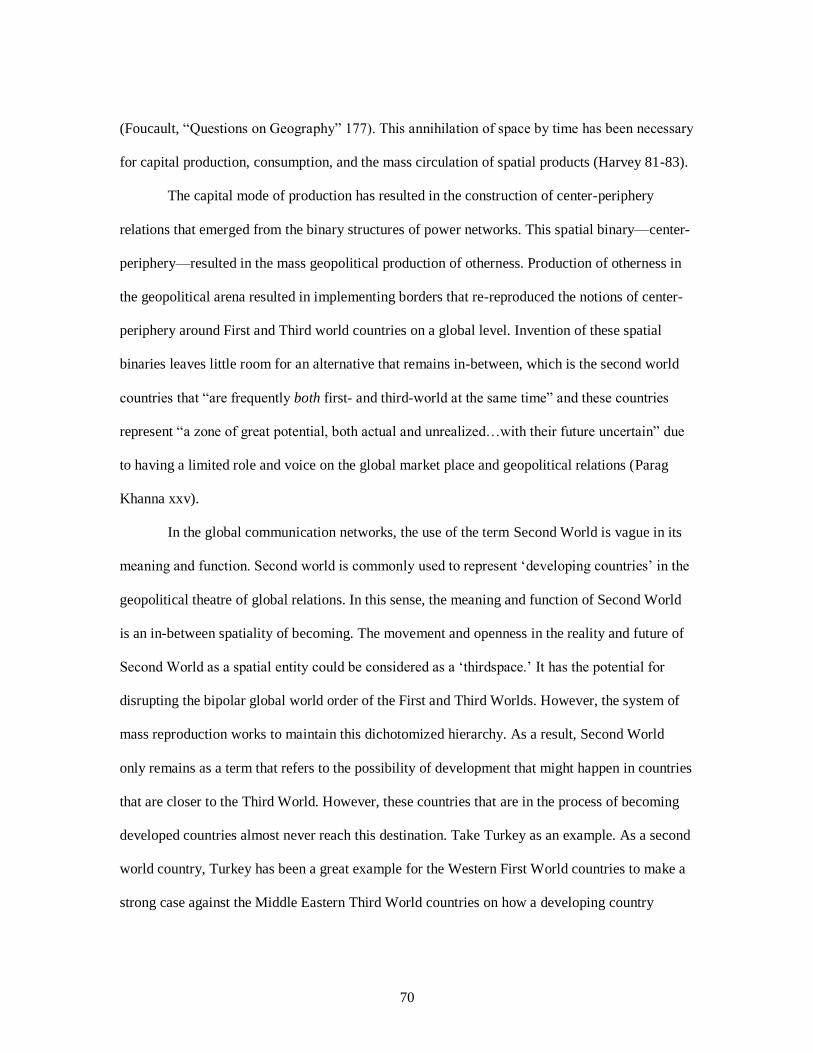
70
(Foucault, “Questions on Geography” 177). This annihilation of space by time has been necessary
for capital production, consumption, and the mass circulation of spatial products (Harvey 81-83).
The capital mode of production has resulted in the construction of center-periphery
relations that emerged from the binary structures of power networks. This spatial binary—center-
periphery—resulted in the mass geopolitical production of otherness. Production of otherness in
the geopolitical arena resulted in implementing borders that re-reproduced the notions of center-
periphery around First and Third world countries on a global level. Invention of these spatial
binaries leaves little room for an alternative that remains in-between, which is the second world
countries that “are frequently both first- and third-world at the same time” and these countries
represent “a zone of great potential, both actual and unrealized…with their future uncertain” due
to having a limited role and voice on the global market place and geopolitical relations (Parag
Khanna xxv).
In the global communication networks, the use of the term Second World is vague in its
meaning and function. Second world is commonly used to represent ‘developing countries’ in the
geopolitical theatre of global relations. In this sense, the meaning and function of Second World
is an in-between spatiality of becoming. The movement and openness in the reality and future of
Second World as a spatial entity could be considered as a ‘thirdspace.’ It has the potential for
disrupting the bipolar global world order of the First and Third Worlds. However, the system of
mass reproduction works to maintain this dichotomized hierarchy. As a result, Second World
only remains as a term that refers to the possibility of development that might happen in countries
that are closer to the Third World. However, these countries that are in the process of becoming
developed countries almost never reach this destination. Take Turkey as an example. As a second
world country, Turkey has been a great example for the Western First World countries to make a
strong case against the Middle Eastern Third World countries on how a developing country

71
should be. This has been Turkey’s spatial meaning and function in-between the West and Middle
East: always a developing country, always an example for underdeveloped Middle Eastern
countries, yet never accepted and considered as a developed country.
This fixed image and meaning of Second World illustrates that this in-between category
is in use to always stabilize the distinction and separation between the First and the Third World.
The meaning of Second World is determined by the reproduced binary of the First and Third
worlds; it represents the process of development yet never actually means that. Additionally, the
idea of second world, its address and geographical location are in reality closer to the Third
World. The use of the term functions as a barrier, as an undefined border that keeps the unwanted
others, whether second world or third world, out in the margins. The realities of these world
regions are determined by the dichotomized ground logic of the map-object. In other words, map-
object as the medium of representation becomes the meaning that we define our roles and
identities with in the global village we are connected to: today the medium/the map is the
message/meaning (Marshall McLuhan 26; 41; 157).
Massey indicates that “our notion of the root meaning of ‘map’, [the map medium as the
message of spatial truth] the term map in its most common current Western usage, has to do with
geography and space…Maps are about space; they are forms of representation, indeed iconic
forms…But a map of a geography is no more that geography—or that space—than a painting of a
pipe is a pipe” (106). Yet, this cognitive image of a representation of geographic and spatial
knowledge has become the universal truth that defines the dichotomized global world order we
have been living in: centers and peripheries, higher and lower spaces, First-World and Third-
World geographies—socio-spatial dialectical tensions between the dominant discourse of
scientific production of space and the social production of space.

72
The dominant vision of the Western cartography represents the hegemonic gaze of
globalization and its discourse of power-knowledge relation. As Foucault explains in “Two
Lectures,” “We are subjected to the production of truth through power and we cannot exercise
power except through the production of truth…In the end, we are judged, condemned, classified,
determined in our undertakings, destined to a certain mode of living or dying, as a function of the
true discourses which are the bearers of the specific effects of power” (93-94). In this discourse of
power, which operates as the underlying mechanism of globalization, “we ‘map things out’ to get
a feeling for their structure, call for ‘cognitive maps’…Maps as a representation of an essential
structure. The ordering representation” (Massey 106). This ordering is the product of the Western
cognitive mapping that represents the Western modern thinking system and its global image. As
much as this image represents the Western modernity’s violent colonial history and imperial
domination, it is important to be aware that this discourse has never accomplished a finalized
domination over the “alternative forms of territoriality, which continue to haunt the map.
Similarly, the progress of the map, itself, could be read as a kind of cognitive failure—a form of
mistaken identity” (Piper 220). How this cognitive failure, this mistaken identity, has succeeded
to establish its vision as the dominant mode of knowledge production is what I am interested in
investigating. Unpacking the dominant vision of this cognitive failure is a path to unbuilding the
ground logic’s mistaken identity.
I am at a crossroads wherein I am following the invisible footsteps of the boat people;
because the dis/orienting image of the boat people is at the heart of the representation crisis of our
global age. A representation crisis John Pickles explains as the Cartographic-Cartesian Anxiety
that stems from the dis/orienting tension between the modern/objective and post-
modern/subjective visions and “how implicit assumptions about objectivism and subjectivism
frame the understanding of error and distortion in cartography” (28). I consider this as anxiety’s
73
source as the dominant vision of contemporary globalization, which is “Western in its origins and
integrated into the process of modernization through which the very idea of ‘the West’ has been
differentiated on a single global surface” (Cosgrove, Apollo’s Eye x). The narrative line of this
vision is the narrative of the borderless and unified global world of social life and relations that
are beyond the separating borders of the nations; the narrative of a one-world picture in which the
divided territories are opened yet kept in a safe distance from one another. John Short explains
that “at the heart of globalization [and its vision] is an ambiguity…globalization is making places
both different and the same. It is bringing people closer apart and places further together” (9).
I suggest that the ambiguity in the meaning and function of globalization is due to the
subjectivity involved in determining including and excluding geographies of cultures according to
the power hierarchy that orders the image of the global map. David Sibley indicates that the
notion of exclusion, social and spatial, “is necessarily concerned with inclusion, with the ‘normal’
as much as the ‘deviant’, the ‘same’ as well as the ‘other’, and with credentials required to gain
entry to the dominant groups in society” (xv). In this light, determining what and where to include
and also how to include in the unifying image of globalization starts with a discussion on what
and where to exclude in addition to how to exclude. The subjective decisions being made in this
process of exclusion and inclusion creates the cartographic anxiety Pickles addresses: an anxiety
emerging from ambiguity, the arbitrary image of the map. I suggest that this complex connection
between inclusion and exclusion is at the core of the ambiguous meaning and function of
globalization. This desire to exclude what is considered and defined as different is strong, a will
embodied in the dead gaze of Western modernity and the ideology of Western modernization.
Short indicates that the consciousness of globalization was simply a replacement of the
consciousness of modernity. However, this replacement was not necessarily meant as an entire
change in the methods and theories of modernity in the discourse of globalization; it has never

74
been a paradigm shift in the sense of a reconstruction of the old view and methods of modernity;
rather this replacement has been “a cumulative process, one achieved by an articulation or
extension of the old paradigm” (Thomas S. Kuhn 85). Jürgen Habermas’s understanding of the
project of modernity as an incomplete one is a similar approach to what Shaw adopts, which
understands the project of globalization and the global state as also incomplete. Both projects are
incomplete, because the project of modernity continues its task in the larger scale of the project of
globalization. Habermas indicates that today the modern consciousness is dead, yet still dominant
because the consciousness of modernity is embedded into the vision of globalization (7). The
vision of Western modernization has been operating to prevent the unwanted change that comes
with the notion of globalization: “the foreign other, an incomprehensible force that is beyond
national, let alone individual, control” (Short 8). The unifying image of globalization has been
concealing the differentiating and alienating forces of the Western modern gaze and justifying the
problematic spatial ordering in the map-object. This is one of the most prominent ways the map
of globalization has been lying to us: presenting its visual meaning as it is not impacted or shaped
by the dominant world view of Western modernity.
The strong emphasis on objectivity to transparent truth and reality in Western modern
sciences, including cartography and geography, has a tendency to overlook the critical relation
between knowledge production and social and cultural contexts of different belief systems.
According to Short,
‘World-views’ are the material products of cultural projects such as nation-building,
colonial expansion or cultural hegemony. In each, maps (and other forms of
representation) have played their role. Systems of meaning are inscribed in maps through
the lines, boundaries and symbols that give meaning and reality to the world. These are

75
not mere representations of reality but come to represent objects whose existence is in
part conditioned and produced by their representations. (31-32)
I consider the world-view of globalization as the material product of the cultural project
of Western modernization. To clarify how the modern gaze continues to shape the spatial
representation of globalization, it is important to understand in which ways the global gaze is
different from the modern vision. According to Massey, globalization “calls up a vision of total
unfettered mobility…It is a mantra which evokes a powerful vision of an immense, unstructured,
free unbounded space and of a glorious, complex mixity…an imagination of the world’s
geography…which contrasts radically with the modernist one. In place of an imagination of a
world of bounded places we are now presented with a world of flows” (81). While globalization
seems to be already embracing the chance of open space, it actually annihilates the chance of
space with its borderless vision, which eliminates the need for movements and crossings.
There is a great value in being able to freely cross borders, which always challenges the
borders and the notion of exclusion through the very movement of crossing. In this sense, while
the spatial vision of globalization seems to be in contrast with the gaze of modernity, “the
structuring characteristics of the conceptualization of space” in both discourses focus on
controlling “spatial differences” either by keeping them out or by erasing them under the
temporality of extensive totalization (Massey 83). In both discourses of modernity and
globalization, “the real is not only what can be reproduced, that which is already produced” and
this is the paradox of representation that Pickles addresses it (31). This paradox of representation
is what Baudrillard means when he indicates that “the territory no longer preceded the map, nor
survives it. Henceforth, it is the map that precedes the territory-PRECESSION OF
SIMULACRA-it is the map that engenders the territory” (Simulations 1-2). The already produced
representation of the map-object becomes the reality defining space. Massey describes this

76
paradox as the “aspatial view of globalization… [in which] the essential multiplicities of spatial
are denied” (82). This denial, resistance to the chance of space, produces a dis/orienting spatial
unity that strategically divides the world map under the hierarchical vision of Western modernity.
There is one enormous geographical reality the aspatial vision mechanically re-produces:
a unified world with a hierarchical bipolar division. The “effects of this reality are political” and
these political effects makes the rules that decide which geographies are included in the civilized
and modern First World and which geographies are excluded. The ground logic of this exclusion
frames the idea of the West and the rest/non-Western dichotomy, which is the dead yet still
dominant gaze of Western modernity. Massey describes this particular form of globalization that
currently dominates our geographies as the capitalist globalization, which is “a discursive
manoeuvre which at a stroke obscures the possibility of seeing alternative forms” and the political
discourse of this vision which is beyond the reach of economic and technological considerations
“is an important component in the continuing legitimization of the view that there is one
particular model of ‘development,’ one path to one form of ‘modernisation’” (83; 84). This one
path to modernity, unfortunately, is a dangerous path for the boat people due to how this path is
already doomed to be a path of being denied and rejected. It is a path that represents the unwanted
change of globalization; a path wherein democracy, justice, and equality lost their way to
humanity: chance of space has gone missing.
Western Modernity and Ground Logic of Global Space
The spatial image the cartographic reality of capitalist aspatial globalization is a
terror/izing vision for me. A black hole from a sci-fi movie or an artificial intelligence taking over
the world; that’s what I think when I try to understand the global space that we are all connected
to. The model of the tree-system and its image, as Deleuze and Guattari explain, is the visual
metaphor that works for me to explain the unbearable political effects of this vision: the tree-

77
system’s hierarchy of reproduction translates “the map into an image…rhizome into roots and
radicles” (11). The map of capitalist globalization’s image is a Western cartographic construction,
which is “relatively fixed, rooted in space or holding to stable patterns distribution and
identity…used to actually accomplish spatial stability” (Cosgrove, “Introduction: Map Meaning”
5). This cartographic image is a reflection of the Western tree-system, which is rooted in the dead
gaze and consciousness of Western modern thinking.
The Consciousness of Modern Thought
The consciousness of modern thought is a binary system of thinking that separates itself
from a past that is considered as not-modern. According to Bruno Latour,
Modernity comes in as many versions as there are thinkers or journalists, yet all its
definitions point, in one way or another, to the passage of time. The adjective ‘modern’
designates a new regime, an acceleration, a rupture, a revolution in time. When the word
‘modern’, ‘modernization’, or ‘modernity’ appears, we are defining, by contrast, an
archaic and stable past. Furthermore, the word is always being thrown into the middle of
a fight, in a quarrel where there are winners and losers, Ancients and Moderns. (10)
Western modernity and its tree-system considers its reality “as the result of a transition
from the old to the new” which is a process “freeing itself from all specific historical ties”
(Habermas 3). I understand the consciousness of modernity as a form of rhetorical re-invention
that operates as a system that re-produces the modern vision of Western identity in the changing
contexts of social, cultural, economic, political, and technological shifts. While this process of
change seems as a progress moving with the irreversible arrow of time, a transition from old to
the new, it is also never a complete departure nor separation from the past, from the old realities,
structures, and forms of engaging with the world. It is a cumulative mechanical process of

78
reproduction that maintains the promise for a new world, for a better world in the identity of the
modern Western man.
Once again, the grand-narrative of Western modernity is the story line I am mapping in:
an excessive form of alienation and marginalization of differences that is justified by the grand
promise of the betterment of humanity in a unified world. What I am curiously trying to
understand better is how this marginalizing system and its totalizing alienating gaze has managed
to dominate alternative/non-Western modes of thinking and producing knowledge.
Western and non-Western Modes of Thinking
I have always been aware of how different it is for me to write in the Western rhetorical
context. The simplest act of presenting a thesis, the main argument, the conjecture at the
beginning of my writing is probably one of the most difficult things that I have to accomplish.
Because the way I learned to compose a meaningful argument requires a different relationship to
my audience; a relationship that seeks to work simultaneously with my reader. As you read, you
unpack the argument with me and we reach a central idea, a thesis, together. It is a mutual process
of writing/reading, which I understand as a circular one. Trying to transform this discursive and
collaborative process of meaning-making to effectively engage with my Western audience has
been a challenging task. Richard Nisbett explains that Asians think by paying “attention to wide a
range of things…[they] search for relationships between things” due to believing “you cannot
understand the part without understand the whole” (91). I find myself constantly nodding my
head and agreeing with these lines as I read them silently. Eastern, Asian, Tribal, Nomadic…non-
Western and non-mainstream forms of thinkings have a different relationship to the world. In
these cultures and traditions, thinking of the world is a thinking that forms an image of
relationships, connections, overlays, and crossings that seek knowledge and meaning in open
spaces. More importantly, these modes of thinking wait for space to let knowledge emerge to

79
produce a meaningful interpretation. This is the reason for many non-Westerners it is difficult to
adjust to the Westerners’ “deterministic world” due to how “they focus on salient objects or
people instead of the larger picture” (Nisbett 93). In Western thinking, waiting for space to tell
you its secrets means not having control, and Westerners “think they can control events because
they know the rules that govern the behavior of objects” (Nisbett 91). This logical reasoning,
which is the ground logic of the Western thinking, is what eliminates the chance of space, and it
is the reason for its succession over non-Western forms of knowing the world.
As Nisbett unpacks the main differences between Western and Asian thoughts, he also
cannot avoid making the kind of generalization I am making here. For example, he indicates
Westerners have a strong interest in categorization, which helps them to know what rules
to apply to the objects in question, and formal logic plays a role in problem solving. East
Asians, in contrast, attend to objects in their broad context. The world seems more
complex…understanding events always requires consideration of a host of factors that
operate in relation to one another in no simple, deterministic way. Formal logic plays
little role in problem solving. In fact, the person who is too concerned with logic may be
considered immature. (129)
This last sentence is where I find an essential connection to my own culture, which I can
simply call ‘the Turkish culture.’ But I am also aware that the long history that crosses many
borders and constitutes the thinking of my culture is more than one geography and one cultural
tradition. It is a mosaic of the great works of Persian literature and Arabic logos connected to the
multiple canals of Turkic cultures and myths that feed the heart and soul of the cultural and social
tradition I identify myself with. I am not talking about one indigenous culture and dominant
social system; I am trying to describe a connection of heterogeneous formations that form
alliances among different paths of thoughts to form yet another one. I describe this diverse

80
connectivity through the model of rhizome. Deleuze and Guattari describe one of the main traits
of rhizome through the principles of connections and heterogeneity: “any point of a rhizome can
be connected to anything other, and must be…A rhizome ceaselessly establishes connections
between semiotic chains, organizations of power, and circumstances relative to the arts, sciences,
and social struggles” (7). The rhizomatic consciousness is also evident in the language uses of
non-Western cultures. As Nisbett unfolds the cognitive differences between Westerners and
Easterners/Asians, he indicates that the differences among the language uses between these
different geographies of cultures tell us a lot about the different cognitive processes of these
thinking models. According to Nisbett,
The Western concern with categories is reflected in language. “Generic” noun phrases are
more common for English speakers than for Chinese speakers, perhaps because Western
languages mark in a more explicit way whether a generic interpretation of an utterance is
the correct one. In fact, in Chinese there is no way to tell the difference between the
sentence “squirrels eat nuts” and “this squirrel is eating the nut.” Only context can
provide this information. English speakers know from linguistic markers whether it is a
category or an individual that is being talked about. (156)
This will to categorize in Western thinking is rooted in the Platonic form of abstraction of
objects and their properties. Westerners, as Nisbett argues, “encourage making properties of
objects into real objects in their own right” and this level of abstraction actually has “a greater
reality than the properties of objects in the physical world” (156). At this point, unfortunately, it
makes a little more sense to me how the Western way to responding to the boat people can
actually deal with this crisis of displacement more logically; a logical approach that assesses the
situation with a focus on numbers and statistics (properties of human objects) and what these
numbers tell become the reality: numbers are too great for Europe/West to let all the refugees in,

81
numbers reveal a critical risk of a significant amount of possible terrorists to also come into
Europe/West, the numbers tell that we need to keep them out because that is the reality of
Western logos, a reality of the great divide between the West and East.
Yet, as Nisbett indicates, this kind of high level of abstraction and production of
truth/knowledge has never been a characteristic of Chinese language, which I extend to many of
the non-Western languages and their cultures and thinkings. I understand the geographies of
many non-Western languages as rhizomatic becomings that are “highly contextual. Words (or
phonemes) typically have multiple meanings, so to be understood [and to understand the world]
they require the context of sentences” within the social-cultural context of their meaning-making
(Nisbett 157). I find the model of rhizome highly effective in understanding the diverse rhetorical
meaning-makings in non-Western cultures across geographies. The rhizome metaphor allows me
to move from the Western rhetorical situation to a cross-cultural rhetorical circulation of diverse
modes of non-Western thinking. In this context, privileging one mode of rhetorical thinking,
which has been the Western rhetorical situation, fails us in our globalizing world today because
we cannot talk about one “ideal speaker-listener, any more than there is a homogenous linguistic
community…There is no mother tongue [nor one form of thinking that works for everyone], only
a power takeover by a dominant language within a political multiplicity” (Deleuze and Guattari
7). This power takeover is what terrorizes and paralyzes the boat people.
The linguistic tree of Western modernity has become the primary dominant language
with its multiple political systems of power arbitrarily during the beginning of the twentieth
century. As Deleuze and Guattari explain, this linguistic tree “plots a point, fixes an order” and as
in Chomsky’s model “begins at a point S [sign] and proceeds by dichotomy [signifier and
signified]” (7). The linguistic tree of Western modern thinking has been producing linguistic
universals to distinctly define and categorize similarities and differences among the cultures of

82
the West and East. These universal linguistic categories have determined the fate and reality of
the boat people for us. They belong to a symbolic reality of chaos, terror, disorder, homelessness,
and the inevitable fate of death. They suffer from epistemic violence of codification and they
cannot speak.38
Knowledge Production in the World Views of West and East
Through its binary logic and the epistemic violence of codification, the modern Western
thought system and its language take over the political power that creates silences and absences in
our spaces. The boat people are always offshore because they cannot speak.
I trace the roots of this epistemic violence of codification back to Plato and Aristotle. The
early thinking of ancient Greek rhetorics gave birth to the skeleton of the scientific knowledge
production that played an essential role in shaping the image of Western modernity. Plato
established the central division between nature and social/object and subject in his ‘Theory of
Forms’ by using the methods of division and subdivision through the continuous use of the ‘what
is?’ question.39 As George Kennedy explains, every “what is?” question in Plato’s dialogues aims
to create categories, divisions and subdivisions with a focus on the differences/counterparts of
‘arts’: true arts (based on knowledge/Platonic philosophy) in relation to arts of ‘flattery’ (based on
persuasion/pleasure/Sophistic rhetoric) (62-63). By continuously asking the ‘what is?’ question,
Plato has formed a system that creates fixed divisions and subdivisions to define nature and social
in a dual-oppositional binary structure: ‘what is?’ vs. ‘what is not?’ and/or ‘being’ vs. ‘not-being.’
As a student of Plato, Aristotle draws many ideas from his teacher; yet he differs from
Plato in terms of his pragmatic approach in creating a system of rhetoric. As George Kennedy
explains: “In many areas of study Aristotle may have begun with questions as Plato viewed them,
but he lacked Plato’s mystical side and was far more pragmatic than his master” (74- 75).
38 Gayatri, Spivak. “Can the Subaltern Speak?” 39 Primarily in his dialogues Phaedrus, Gorgias, and Sophists.

83
Aristotle’s pragmatic approach reveals itself within the method he used to create a system for
“rhetoric” as an art in his treatise On Rhetoric: system of definition determined by species—
genus—differentiae. Similar to Plato in Gorgias, Aristotle divides, categorizes, and groups parts
considering many possibilities and common spaces to reach the universal truth and to create an
ideal system that functions for all. Even though Plato and Aristotle had different approaches to
Nature, which was mirrored in their system of thinking, they both worked on developing “an all-
embracing system of thought...around certain novel theoretical conceptions, which could provide
a ‘logical skeleton’ for scientific explanation” (Stephen Toulmin and June Goodfield 74). The
emphasis on fixed and distinct divisions to define Nature and Social and all matters/forms in
Plato’s ‘Theory of Forms,’ and the pragmatic extension of Plato’s philosophy at the hands of
Aristotle with an emphasis on unity and reaching to universal truth gave birth to fixed binary
structures.
In comparison to the logical scienticity of Western thought, its high level of abstraction,
individualization, and objectification to grasp the knowledge of the world in a manner that is
applicable and true for everyone, Eastern thought in its diversity, in its heterogeneous fluidity, has
always understood and engaged with the world in its complexity and in its relations to parts and
pieces. Nisbett explains this essential difference between Western and Eastern thought systems by
examining Chinese thinking and its orientation toward the world. As Nisbett indicates, the
Chinese non-linear and non-deterministic orientation towards world reveals a great insight into
the Eastern orientation towards life: “The world is constantly changing and is full of
contradictions. To understand and appreciate one state of affairs requires the existence of its
opposite; what seems to be true now may be the opposite of what it seems to be” (12-13). The
notions of constant change and fluidity in Eastern world views in contrast to the stability and
grounded fixity in Western world views is at the heart of the current cartographic representation

84
crises we suffer from in our global space. While the dominant gaze of the Western global vision
constructs this global space “as being composed of discreet objects or separate atoms” of
differences, the alienated and outlasted alternative non-Western world views—Eastern—see “the
world as consisting of continuous substances” (Nisbett 80).
This middle way runs through the Eastern modes of knowledge production, which is
nonstable, always changing, and leads to multiple positions and forms of understanding and
engaging with the world. Instead of a binary logic preferring simplicity in organizing the
knowledge of the world—Western thinking—in Eastern cognitive processes there is “a part-
whole dichotomy” being used to make sense of the world (Nisbett 138). The rhizome model as a
meta-metaphor unfolds the complex orientation of the world in the Eastern vision: “the East
presents a different figure [in comparison to the West]: a relation to the steppe and garden (or in
some cases, the desert and the oasis), rather than forest and field; cultivation of tubers by
fragmentation of the individual” which is a rhizomatic openness, fluidity, and heterogeneity
(Deleuze and Guattari 18). As its binary logic and linear orientation to the world illustrate, “the
tree has dominated Western reality and all of Western thought…the root-foundation, Grund,
racine, fondement…a special relation to the forest, and deforestation; the fields carved from the
forest are populated with seed plant produced by cultivation based on species lineages of the
arborescent type” which is a simplistic system of categorization that limits knowledge (Deleuze
and Guattari 18). The tree-model in understanding the binary logic of the Western modern
thought is an image depicting how the “one-many, individual-class organization of knowledge [in
Western thinking] encourages induction from the single case” which makes it easier to eliminate
error and make generalizations in ordering knowledge (Nisbett 139).
This simplicity in Western binary logical reasoning made it easier to make the argument
against the complex thinking of the East in defining Western modern thought as the dominant

85
world view over primitive non-Western forms. As Nisbett also explains, “simple models are the
most useful ones—at least in science—because they’re easier to disprove and consequently to
improve upon” (134). The simplistic vision of Western modern thought impacted how knowledge
is organized and as a result became the foundation of the dominant mode of scientific knowledge
production of our global age and consequently how a unified geography of space is constructed
and ordered around simplified categories of social, cultural, economic, politic, and technological
differences: West/developed and East/Rest/underdeveloped/developing.
Mechanical Knowledge Production and Cartography
I use the tree metaphor in unpacking the dichotomized ground logic of Western thought
and its methodological application of knowledge production. But, I understand the working
mechanism of Western thinking with Walter Benjamin’s ‘mechanical reproduction’ in relation to
the work of art. The line of connection I am mapping between the system of the tree-image and
mechanical reproduction in unfolding the logic of modern scientific knowledge production is the
very notion of ‘reproduction’ itself. Benjamin notes that “a work of art has always been
reproducible. Man-made artifacts could always be imitated by men. Replicas were made by
pupils in practice of their craft, by masters for diffusing their works, and, finally by third parties
in the pursuit of gain” (218). The reproduction of a work of art, then, echoes the Western modes
of producing knowledge, which informs the cartographic process of visualization as a scientific
method of spatial knowledge production.
Marie-Anger Brayer explains that before the succession of scientific objectivity in
nineteenth century “the geographic map was understood as a parable of painting…Maps and
works of art allowed for the displacement of one’s point-of-view and multiple points-of-view,
even offering ‘several points-of-view’ simultaneously by favoring none, from whence comes an
iconic mobility” (57). The reproduction Benjamin refers to is a different kind of reproduction; a

86
reproduction that requires direct human engagement with the process without eliminating the
discovery of new representations and understandings of existing knowledge/art. However, with
the Renaissance and Enlightenment, which resulted in fundamental changes in Western society
and its thinking, a monocular perspective in representing space became the dominant vision
“assigning a fixed point-of-view on the world,” and during the nineteenth-century, “the century of
positivism and rationalization . . . an irremediable schism between painting and maps occurred,”
which resulted in map/mapping becoming a specific sub-discipline of the category of scientific
knowledge: cartography (Brayer 58). A switch occurred between the lines of engaging with the
world; a mechanical shift that altered re/production.
Benjamin explains mechanical reproduction as something different from reproduction
that “represents something new… the technique of [mechanical] reproduction detaches the
reproduced object from the domain of tradition. By making many reproductions it substitutes a
plurality of copies for a unique existence. And in permitting the reproduction to meet the beholder
or listener in his own particular situation, it reactivates the object reproduced” (218-221). Today,
the map object as a product of mechanical reproduction functions the same way for us. We carry
the plural copies of our world in our smart phones; we walk the streets we are told to; we drive
through roads we are directed to; we do not see or hear the silences and distortions these replicas
hide from us; we are blind to the consequences. As Jon Berger eloquently observes: “prophesy
now involves geographical rather than historical projection; it is space, not time, that hides
consequences from us” (qtd. in Soja, Postmodern Geographies 93).
The space that has been hiding the boat people, hiding Aylan, is the aspatial global space
that the binary logic of the gaze of Western modernity has been mechanically reproducing; a tree-
space with “a sad image of thought that is forever imitating the multiple on the basis of a centered
or segmented higher unity…[that] never get[s] beyond the One-Two, and fake multiplicities”

87
(Deleuze and Guattari 16). This sad image is the dominant discourse that narrates the hi/story of
the boat people, the reality of the non-Western other; the fate of home/sick Middle East. To me
this sad image embodies itself in those empty boats; the fear, the terror, the violence…and I am
trying to use words to understand…yet I fall into the language of power that has been keeping the
boat people off-shore. I am calling them the unwanted other, the feared so-called terrorists being
kept out, the deviants and threats to Western modern society. Their inherent otherness is
something I have also internalized within myself, because I am also the other that does not
belong. The ground logic of the aspatial global map keeps us at a distance, away, in an absent
space of silence. In this space of silence, I write with boat people…with Middle/East—wherever
middle of East is—because the language of people is an articulation and a performative act that
negates the language of sovereign ground logic.
It is a language that uses codes that the ground logic does not know how to speak. It
changes lines, uses a different sign/al. To make the switch, to change the code, I return to the call
of the home/sick Middle East. And again, I start in the middle, with the dead gaze of modernity
and its eternal Other…the Orient…the Middle East!

88
CHAPTER 3: THE MAKING OF THE ‘ORIENTAL OTHER’
“To see a camel train laden with the spices of Arabia and the rare fabrics of Persia come marching
through the narrow alleys of the bazaar among porters with their burdens, money changers, lamp-merchants,
Al-naschars in the glass-ware business, portly cross-legged Turks smoking the famous narghili, and the crowds
drifting to and fro in the fanciful costumes of the East, is a genuine revelation of the Orient. The picture lacks
nothing. It casts you back at once into your forgotten boyhood, and again you dream over the wonder of the
Arabian Nights; again your companions are princes, your lord is the Caliph Haroun Al Rachid, and your
servants are terrific giants and genii come with smoke and lighting and thunder, and go as a storm goes when
they depart.” Mark Twain, Innocents Abroad or The New Pilgrims Progress, 411
“The Orient was almost a European invention, and had been since antiquity a place of romance,
exotic beings, haunting memories and landscapes, remarkable experiences.” Edward Said, Orientalism, 1
Rhizome 3-Mapping of Zero Degree: A Story of Dis/Orientation40 #rhizomap
“I am walking, again, through the stem-canals of the underground cities. I see what my
eyes saw once and I look through that cave’s window to say hi to my sister and her husband. He
tells me he just met a family from Texas and said ‘hi’ to them with his Texan accent. As we are
looking for my dad in-between the corridors and the rooms that belonged to ‘other’ people from
an alien past, I am trying to remember what I thought. Who was I when I was there? Who were
all these people? Travelers! Yes, I hear the sound of another camera flash going. Travelers
recording everything. Travelers mapping the land through the lenses of their cameras. In a sense,
they are map-makers imagining what the people of this space once were and trying to capture the
essence of the cities that once belonged to these people. What’s left of them is all we have to re-
invent these people. And again, I see the blue fairy-chimneys between the orange sky and the
40 A Video-Mapping project that I visualized through the practice of rhizomatic mapping. This description
presented is a reflection on the mapping from 3:00-6:20 minutes. https://youtu.be/9u88GVqLzWA

89
green-brown trees and the ground through the window of the car my mom was driving, from the
edge of the flying hot air balloon I am in, and through the lens of my camera. My gaze is always
at a distance and I am there depicting a picture of the land with amazement by what’s left behind.
I am looking up to see the paintings on the church wall and I am immediately disoriented from
the shift in my gaze. Now I see the land below; all of it like a sheet covering what’s underneath:
zero level.41 As If I am looking at a postcard waiting to be polished. I hear Walter Benjamin: “If
one arrives from far away the town is suddenly as noiseless as if one had stepped through a door
into landscape. It does not give the impression that one could ever manage to come any closer.
But should one succeed, then one falls into its lap and cannot find oneself again for all the
humming of grills and children’s cries” (Walter Benjamin’s Archive 175). Seeing the land from a
gaze above is looking at an empty flat space expanding without borders and I have a strong
desire to move with what’s flowing underneath. I fall from the edge of the balloon into the land
and map the cities, houses, rooms, and the paintings made by an ‘other’ I have never met before.
Now, the blue sky is burning with the red flames of the sun. Now the ground below is deeper than
the sea, the ocean. I, once again, fell off the map and now I need to start again!”
I am afraid of the very word ‘other.’ The source of this fear for me is the experience of
anxiety that I keep coming back to; the anxiety stemming from not knowing where one belongs
and as a result not quite understanding one’s being-in-the-world. John Dixon and Kevin Durrheim
indicate that for “geographers and psychologists, questions of ‘who we are’ are often intimately
related questions of ‘where we are’” (27). My response to where I am causes me to first think of
41 Roland Barthes defines zero degree of writing “not [as] a total absence… [but as] a significant absence”
(Writing Degree Zero 77). I use this concept here to illustrate not only mapping as a form of writing in its
nature but also to show how mapping, like writing, testifies to the strong desire and need to re-invent
meaning of space through a system of signs. Approaching space and geography of a land, territory, region
as zero degree is a rhizomatic mapping practice that tries to break the code of any given sign system by
mapping with absence and exploring alternative signs to allow chance of space to unpack diverse meanings
and practices of space and spatiality.

90
where I am from, because where I am defines me according to where I am from: Turkey, a
country in-between the West and Middle East and always closer to the Middle in the East.
Emmanuel Levinas explains that “knowledge [la connaissance], the manifestation of what is, of
beings, to a conscious being, means as much representation of the data (individual or universal,
intuition and understanding) as it does a going beyond the data in the adventure and method of
research. In giving itself, a being offers certain traits and excludes others” (Alterity and
Transcendence 57). The knowledge of a map, the data the official maps visualize and present, is a
transcendent reality and undistorted truth, which is an embodiment of Western being. The identity
of Western geography excludes any non-Western traits from its spatial being in the official map.
The ground logic of the Western map defines my being as an extension of a lifeless Oriental
image. I am the exotic Muslim female liberated by the consciousness of Western modernity and
saved from Islamic oppression by Western man. This is the address of where I am in the Western
map because the address of where I am from is the address of an oppressed Muslim female. If I
do not look like the perceived image of an oppressed Muslim, then I must have been saved. The
two addresses of where I am and where I am from are the narratives the dominant discourse of
war on terror has been representing as reality. Yet, I am from neither of these addresses, nor do I
belong to either of them. I reside in an in-between land that is absent in the ground logic of the
Western map.
The ‘other’ has a hard time responding to the map-object in this sense. Looking at the
land represented in the flat surface of the map through that distanced gaze, through that vision
from above that already produced the meaning of that land is dis/orienting for the ‘other,’ because
the otherness of the ‘other’ is invented in the discourse of this gaze in which the dominant ‘self’
positions its spatially bounded identity in opposition to the alien identity of the ‘other.’ For the
Western Man, the ‘other’ of the exotic land is the ultimate stranger “evoking the forgotten aura of

91
what Hölderlin has called the “sacred alien.” (Avital Ronell, “The Disappearance and the Returns
of the Idiot” 200). The sacred alien all at once represents the nomadic culture, the primitive
natives, the exotic and the fragile women, the Arab on the camel, the Turk with narghili, the
Persian selling rugs, the pyramids of the Egyptians, the lights in the desert…the immortal foreign
Orient. The ‘other’ with its eternal image of being the Orient without a place is the ultimate
stereotype we are unable to escape. The addressless ‘other’ of the Oriental land is the source of
our fears because there is a chance of possibilities in the ‘other’ we can neither predict nor
control. We are doomed by our own fear of the ‘other.’
This illogical yet somehow always justified ‘fear’ in the Western discourse threw me off
the map on October 9th, 2017. It was a regular Monday morning for many of you. As you are
mapping with me, in your current space-time condition, you might not even remember this
specific Monday morning. But I, unfortunately, will always remember. I will remember because
of, again, fear and anxiety. The night before this Monday was a regular Sunday night when I felt
a strong force run through my body after one of my colleagues messaged me about the news that
appeared on Al Jazeera: “US suspends all non-immigrant visa services in Turkey.” Reading the
article, I slowly became paralyzed. I was worried, anxious, furious, and mad. My stomach kept
resisting as my brain was trying to function logically and come up with an alternative game plan.
A game plan for my parents, a game plan for my sister and her American husband, a game plan
for myself since I have been applying for jobs here in the States for a while now. When the rules
of the game always change, trying to remain in the game and continue to play is almost
impossible. I was doomed by the fear of the ‘other.’
That night I felt like I was out of the game and my core kept yelling ‘What Am I going to
DO?” The options that I had before reading that article were taken away from me. My freedom
to decide to stay in the U.S. was gone. Having a free will in choosing to go back to Turkey was

92
gone. There was no choice; only a forced decision imposed on me; I had to go back, even though
I neither do not want to nor am scared to do so. The main point was that I did not have the
freedom to decide for myself. Somebody made someone else upset and that someone else made a
decision that I did not have a say in it; a decision that has a significant impact on my life, on my
being, on my freedom.
That Monday morning, I woke up still feeling paralyzed. Mondays are already difficult,
wherever you are in the world. But that Monday morning I was dis/oriented. My living room, my
kitchen, my room…nothing made me feel like I belonged. One of my roommates’ attempt to have
a morning conversation with me was yet another trigger that caused me to feel even more
alienated: “Look at the eggs that I made,” he said, “I am the egg master.” In my lack of response
and silence, my stomach was whispering “Does anybody actually care? Will anybody ever do or
actually say more than just using a sad emoji face on Facebook when something like this
happens?” I am not blaming my roommate for his early morning pride about the eggs he cooked.
I know that it was his way of trying to communicate with me without responding to the ‘other’
issue that made me feel almost broken. He responded to me, the non-American other who was yet
in another familiar state of being pushed off the official map and its ground logic. He related,
with eggs, yet he did not directly respond to me, the other, due to another kind of fear. The fear of
guilt on his part. The guilt of ‘I am sorry this is happening to you, but I do not know what else to
do except share the eggs I cooked with you.’ He just did not know or understand that I was
describing what this was as a night terror that I used to experience frequently when I was a little
girl. I was that little girl being crushed under the giant and shapeless form of darkness without
even being able to scream. That Monday morning, I was placeless and lost in a night terror. I was
dis/im/placed into a stateless condition of uncontrolled movements and happenings. I was in the

93
pitch black open and in this open space I was in my most fragile being. I did not know that this
blinding openness was going to be a response to the chance of space.
It was 9:00 am, and I was in my seat ready for my dear mentor Cynthia Haynes to give
her talk, titled “Unalterable Rites: The Architecture of Mass Rhetoric.” Her deep sensibility and
sensitivity to ‘being’ and ‘becoming’ of one’s self always evokes a force, a desire in me to move,
to always become without letting myself be chained or grounded by the fixating ties and rules of
the game. She always already helps me to escape, to fall of the official map. And the moment she
asked “What does it mean to be in the open? Where are we in the open?” She made me remember
that when I had those night terrors as a little girl, there was always a moment that I started feeling
lighter. The heavy weight of that darkness always lifted off slowly. I always started to see the
light in the room as my parents were holding me. That morning, Cynthia got rid of that darkness
that was consuming the light from the open space I was in. I responded to the chance of this
space; I embraced the unknown, the anxiety, and the fear. The moment I responded to chance of
this open rather than resisting it, I was able to see multiple possibilities for myself. I slowly
started to feel that my stomach and my brain were becoming synchronized again. I felt that the
immobilizing force of this machinic architecture, the U.S. Embassy in Turkey, and its paralyzing
power over my being and my freedom of mobility was losing its control. As Cynthia said, in this
fragile openness, in this open space, what was inevitable is the twisting of the center, the
Heideggerian primal conflict between the world (open space) and earth (the ground logic).42 What
the game plan the US embassy in Turkey and the Turkish State did not take into consideration
was the instability of the center. Center as a movement, as a happening is never an organized,
42 Heidegger, Martin. “The Origin of the Work of Art.” In Martin Heidegger Basic Writings: From Being
and Time (1927) to The Task of Thinking (1964), David Farrell Krell, editor. 2nd ed., Harper San Francisco,
1993. 139–203.

94
structured, or fixed source of power. As Jacques Derrida indicates, the center is always
elsewhere43, and I think, the center is also nowhere; it is acenter; it is open space; it is rhizome.
I was, and still am, in a placeless open space wherein what is ordinary (freedom of
mobility) is not ordinary anymore; it is uncanny. And this uncanny happening in open space, for
me, welcomes the chance of space; it welcomes placelessness and dis/orientation as an opening
for a path that ungrounds the grounding force of bounded space. It is an invitation to deconstruct
and produce anti-memory as an antidote to the paralyzing control of the machinic ground the
architecture of power actualizes through its linguistic structure and its alienating rhetoric. I
respond to this invitation of open space, and I once again jump off the official map. I play the
game of the sovereign ground logic by using rhetorical theory and deconstruction to unpack how
the geopolitical region we know as Middle East today is a product of a cumulative process of
reinvention. While the fall of the Ottoman Empire as a result of WWI marked the invention of the
modern Middle East as a geopolitical region, the roots of this cartographic reality with its
home/sick address is traced back to the Oriental image and land. As Daniel Foliard indicates, “the
long-term cultural processes that presided over the invention of the “Middle East” as a
representational category have a chaotic history” (209). I argue that this chaotic history is a
history of the Western Self always re-inventing its non-Western Other in the mythicized image of
the exotic and deviant Orient. In this sense, I adopt Foliard’s approach to reading and
understanding the formation of the Middle East as a process of cumulative re-conceptualizations
in the rhetorical contexts of shifting discourses of power. Mapping this process is a way to learn
the language of power and how this language has been functioning in the contemporary war on
terror discourse that narrates Islam as inherently violent and Middle East as the land of Muslim
43 Derrida, Jacques. “Structure, Sign, and Play in the Discourse of the Human Sciences.” In Writing and
Difference, Alan Bass, editor., Routledge, 2009. 351–370.

95
terrorists. I draw from Michel Foucault’s conceptualization of discourse to unpack the logic of
this language in framing the rhetorical context of the war on terror discourse.
Instead of approaching discourse and its linguistic system as a totalizing field producing a
totalized history, as a pluralist, Foucault proposes “the historical construction of a subject through
a discourse understood as consisting of a set of strategies which are part of social practices”
(“Truth and Juridical Forms” 4). Foucault’s problem with the individualization of discourses, as
he unpacks it in “Politics and the Study of Discourse,” is what drives his motivation to explore
the alternative, ignored, and/or undermined criteria that play a role in the formation of discourses.
This is why he does not speak of discourse as a singular concept such as a discourse of politics,
economics, and/or power. According to Foucault, discourses undergo “constant change as new
utterances (énoncés) are added to it” (54). He describes three sets of criteria: formation,
transformation or threshold, and correlation.
These criteria make it possible to substitute differentiated analyses for the theme of
totalizing history (‘the progress of reason’, ‘the spirit of a century’). They make it
possible to describe, as the episteme of a period, not the sum of its knowledge, nor the
general style of its research, but the divergence, the distances, the oppositions, the
differences, the relations of its various scientific discourses: the episteme is not a sort of
grand underlying theory, it is a space of dispersion, it is an open and doubtless
indefinitely describable field of relationships. They make it possible furthermore to
describe not a universal history which sweeps along all the sciences in a single common
trajectory, but the kinds of history—that is to say, of remanences and transformation—
characteristics of different discourses…The episteme is not a general development stage
of reason, it is a complex relationship of successive displacements. (55)

96
To me, adopting this Foucauldian approach to discourse as a discursive plurality and
episteme of successive displacements speaks to the dis/orienting rhizomatic mapping I am
playing with in this chapter. As Foliard contends, the Middle East was, has been, and is a product
of a cumulative process of geographical imaginations in the episteme of Western discourses.
Western discourses of power re-invented the non-Western Eastern/Oriental other throughout the
twentieth century through a series of successive displacements. It divided up the vast and
arbitrary image of the Orient between Far, Near, and Middle East(s). Under the extensively
totalizing discourse of Orientalism, this cumulative process on the surface appears to be a single
common trajectory; yet, Middle East is a product of different Western discourses and multiple
trajectories. These multiple trajectories produced multiple definitions and formations of borders
within and across Middle East. I understand the mechanical reproductions of these multiple ways
of defining Middle East as a complex process of dis- and re-placements of the geographical and
spatial reality of the region and its inhabitants. In this complex process of displacements,
however, there has been and is always a dominant discourse that presents a single and reduced
image and history as the single universal reality in understanding the non-Western
Middle/Eastern other. Today, this dominant discourse is the war on terror discourse. In the
aspatial global world order, the language of power this discourse operates with forces us to
internalize a justified totalized history of the region with a violent and barbaric legacy that is
embodied in the image of political Islam. In this chapter, I will unpack how the Western discourse
of power produced the image of the Orient as a bridge to start deconstructing how the Middle
East was re-invented in this discourse and how this re-invention resulted in re-producing the
Middle East in changing discourses of power. Now I am playing a game of my own as I continue
to unbuild the ground logic of the West and non-West order of aspatial global world.

97
The Game of the Orient
In the image of the map, the non-Western ‘other’ does not belong; the ‘other’ is almost
never capable of positioning its ‘self’ due to being taken over by the image the Western man
narrated. According to Catalin-George Fedor, “otherness cannot be defined but by using with a
pair term, identity. This articulation is the result of the categorization process tributary to each
culture, in essence being the opposition between identical and different. The relation between
me—the other one can be illustrated through a series of antagonistic pairs, of which we mention
some: similar-different; local-foreign; close-far; friend-enemy; normal-deviant; majority-
minority” (Fedor 322). The reality/knowledge of the Orient, then, is invented in these centered
oppositional dichotomies that reproduce the identity of the Orient as the other. This reproduced
image actually defines the Western Self more than it defines the identity of the Oriental other.
The myth, the tradition, the culture, the reality of the Orient belongs to the Western
memory and the Western rhetorical invention. Edward Said explains that “the invention of
tradition is a method for using collective memory selectively by manipulating certain bits of the
national past, suppressing others, elevating still others in an entirely functional way. Thus
memory is not necessarily authentic, but rather useful” (“Invention, Memory, and Place” 179). In
the making of the Oriental other, the interplay between invention, memory, and place resulted in
the Orient being a dehumanized subject to be studied in the dominant European discourse of
power: colonialism. Said explains that if we take the first experience of modern Orientalism as
being enabled by the Napoleonic expedition to Egypt during the late eighteenth century, then “we
can consider its inaugural heroes…to be builders of the field, creators of a tradition, progenitors
of the Orientalist brotherhood… [they placed] Orientalism on a scientific and rational basis”
(Orientalism 122). I consider this scientific basis during the eighteenth and nineteenth century as
a reflection of the enlightened Europe’s modern identity. The consciousness of modernization and

98
modernity framed the European colonial gaze as the dominant projection in ordering the spatial
hierarchy of the global world around higher and lower spaces of European civilization and
Oriental primitivity.
In Geographical Imaginations, by drawing from Stoddart and Foucault, Derek Gregory
explains how the enlightened Europe’s modern scientific experience started the globalizing
project of natural history. This resulted in the formation of a totalized history that was defined
from the dominant trajectory of European colonialism and Orientalism, which ignored the other
discourses at play. Napoleonic expeditions to Egypt at the end of the eighteenth century enabled
the formation and experience of the modern vision of Orientalism and Oriental geography in the
context of a globalizing natural history. In this process, the distinction, the difference between
words and things, were in dissolution, which resulted in resemblance, similar links and
connections between words and things yielding to representation. What the words, images, and
signs represented was replacing the things in regional spaces. “And it was within that gap that the
discourse of natural history was constituted as part of a project to navigate the passage between
the two, or as Foucault puts it, ‘to bring language as close as possible to the observing gaze, and
the things observed as close as possible to words’” (Gregory 21). The dominant language of
European colonial power that formed the dominant discourse of the Orient set the rules of a game
of alienation, marginalization, and subjugation that we have been playing to this day. This game
has been constantly ordering a totalized system, a structure with a center rooted in the sovereign
ground logic of Western subjugation. In this play of structure, as Derrida explains,
…the center is, paradoxically, within the structure and outside it. The center is at the
center of totality, and yet, since the center does not belong to the totality (is not part of
the totality), the totality has its center elsewhere…The concept of centered structure is in
fact the concept of a play based on a fundamental ground, a play constituted on the basis
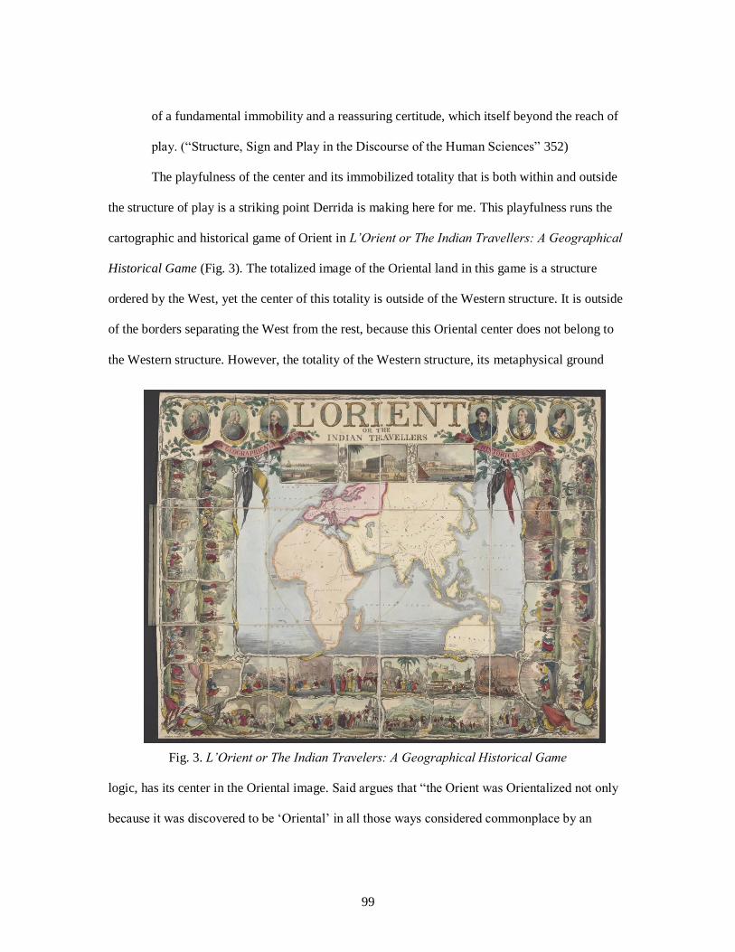
99
of a fundamental immobility and a reassuring certitude, which itself beyond the reach of
play. (“Structure, Sign and Play in the Discourse of the Human Sciences” 352)
The playfulness of the center and its immobilized totality that is both within and outside
the structure of play is a striking point Derrida is making here for me. This playfulness runs the
cartographic and historical game of Orient in L’Orient or The Indian Travellers: A Geographical
Historical Game (Fig. 3). The totalized image of the Oriental land in this game is a structure
ordered by the West, yet the center of this totality is outside of the Western structure. It is outside
of the borders separating the West from the rest, because this Oriental center does not belong to
the Western structure. However, the totality of the Western structure, its metaphysical ground
Fig. 3. L’Orient or The Indian Travelers: A Geographical Historical Game
logic, has its center in the Oriental image. Said argues that “the Orient was Orientalized not only
because it was discovered to be ‘Oriental’ in all those ways considered commonplace by an

100
average nineteenth-century European, but also because it could be—that is, submitted to being—
made Oriental” (Orientalism 6).
I argue that what made it possible for the Orient to be Orientalized, for the Orient to be
Orient with a real physical representation in the natural history of the Western global gaze, was
and has been the distance between the West/Europe and the Orient. This distance has been the
distance of identification that placed Europe as the powerful and civilized colonizer in the
deserted and powerful geography of the Orient. I define this distance of identification in the
ground logic of as the alienating structure of the L’Orient game: a game of representation
replacing the things/beings-in-the-world. The West and Orient structure has a playfulness in this
sense, a playfulness that emerges from a desire for a center coupled with a fear of the other. This
fear stems from an origin of desire within the Self for the Other: a desire to define the Other in
order to define Self, which brings forth the fear of being taken over by the Other in this process.
This desire that informs the ground logic of the game of L’Orient has been the same desire re-
producing the global game of the West and East through the same trajectory of distancing and
alienation: the dominant discourse of non-Western otherness.
The game of L’Orient is an actual board game made by James Richard Barfoot (1794-
1846) and published by David Ogilvy in London. L’Orient’s ground logic is constructed in the
dominant discourse of non-Western otherness, which appears as the discourse of Orientalism. In
the structure of this board game, the dominant gaze is the colonial trajectory of Britain. This
imperial trajectory displaced the totalized Oriental subject ‘as a game to be played’ and through
playing the game of the Oriental subject, the purpose was to teach the players/audience about
Britain’s most important Oriental colony: India. Educating the players/audience about India was a
strategic rhetorical move for the British Self to justify and legitimize the subjugated otherness of
the Orient. This persuasive justification effectively works in the ground logic of this cartographic

101
board game since the purpose of the game is to educate its players. The rhetorical purpose of
education through play/game immediately implements ethical credibility to the structure of the
game, because the purpose of the game is a noble one. This ethical justification is how the ground
logic of this map-game actualizes what was already made Oriental: actualizing the Oriental
Utopia.
From a Western Utopia to a Global Heterotopia of Oriental Otherness
In “Two Lectures,” Foucault explains the difference between the old form of power
(juridical) and the modern form of power to illustrate how the subjugating control of the
sovereign ground logic moved from possessing a direct power of the subjects of the sovereign
control (king, the throne, the sultan) to power as a system of subjugation producing the
knowledge of subjects (us the individuals) as certain kinds of beings (95-97). In the dominant
discourse of the modern form of power that produced the knowledge of non-Western otherness as
a single history, the subjects of otherness “are always in the position of simultaneously
undergoing and exercising this power…[they] are the vehicles of power, not its points of
application” (98). When two Muslim girls having iftar at a Mexican restaurant are verbally
attacked due to their beliefs, both their attacker and themselves become the vehicles of power that
strengthens the differentiating violent force of the war on terror discourse. These two Muslim
girls were displaced into the geographical address of unjust stereotypes defining them as threats
and possible terrorists, while the person who assaulted them displaced himself into the state of
internalizing the faulty knowledge the war on terror discourse justified.44 In another case, when a
Muslim couple is attacked by a white Western woman with a language charged with violence and
anger, as she blamed him for forcing his wife to cover herself,, both the couple and the woman
44 To see the full coverage of the incident, see Collman, Ashley. "'If You Don't like This Country, Leave':
Video Shows Muslim Girls Being Racially Abused at a Mexican Restaurant in Chicago." Daily Mail. Daily
Mail, 7 June 2017. Web. http://www.dailymail.co.uk/news/article-4580580/Video-Muslim-girls-harassed-
restaurant.html.

102
are vehicles of power that inform the war on terror discourse’s narrative line that Muslims are
terrorists.45 These cases show us how this dominant discourse has been truly producing
individuals, subjects as certain kinds of beings within the binary structure of the modern/Christian
West and barbaric/Muslim Middle East. We live within these actualized networks of power that
exist across cultures; networks that have been constantly re-inventing the game of the Orient.
This re-invention happens through the actualizing power of the mirror image in-between (see Fig.
4). As the modern form of power actualizes its vision of a perfect unified global image it
Fig. 4. The Function of Mirror-In-Between: Actualization of Utopias to Heterotopias by Michel
Foucault in “Of Other Spaces: Utopias and Heterotopias.”
integrates the essential elements of differentiation between the West and non-Western other into
the spatial representations in maps. John Agnew indicates that the Western experience of
actualizing a one-world picture of a unified globe has never been “a composition of equal and
pacific elements but a hierarchy of places, from known to unknown, from most friendly to most
45 To see the full coverage of the incident, see This Woman Completely Misses The Irony Of Her
Islamophobic Rant. Middle East Eye Facebook, 2 Aug. 2017. Web.
<https://www.facebook.com/MiddleEastEye/videos/1454634911268559/>.

103
dangerous. The best-known representation of this character is that of a dichotomous global West
and East, in which the former is seen as the total opposite and, hence, definitive standard for the
latter” (15-16).
This process of actualization has been narrating the totalized discourse of otherness that
defines the socio-spatial reality of geographies of exclusions. Through this process of
actualization, the excluded Orient is pushed into the margins of our aspatial global world.
However, the Orient as an actualized heterotopia is an Orient in the reality of the West; the Orient
is rarely Orient by definition that is produced and/or framed by the inhabitants of this vast
geography. In this sense, the alternative spatiality of the Orient in its own geographical reality as
it is produced through the social and cultural relations of its own people is an open space. This
alternative spatial reality holds the potential and possibilities to break the rules of the game and
cross the borders of its exclusion and dis/placement. I consider this potential as a form of
deconstruction that would disrupt and challenge the image of Oriental otherness. Ironically, this
disruption is possible through the notion of globalization because one of globalization’s purposes
is to bring differences together. While Western metaphysical practices bring differences together
to keep them at a safe distance, the open space of a non-Western Orient produces multiple
meanings and identities in relation to the complex engagements among diverse geographies of
cultures. The unwanted change that comes with globalization, then, is the possibility that comes
with open space, the chance of space. This makes the marginalized geography of the Orient “what
we might call heterotopias of deviation: those in which individuals whose behavior is deviant in
relation to the required mean or norm are placed” (Foucault, “Of Other Spaces”). For the modern
West, this possibility the Orient holds as an open space always requires this spatial heterogeneity
to be tamed and re-ordered. The roots of the West always already desiring to prevent unwanted
change of globalization by defining the Oriental other as a deviation stems from a strong fear of

104
the alien ‘Other’: a fear the ‘Self ‘experiences due to the imagined possibility of being taken over
by the Other.
Responding to the Oriental Other
I suggest that the fixed relationship between West and East and the desire to identify the
non-Western other in this closed engagement stems from a basic need in human nature: defining
one’s ‘I/Self’ through understanding ‘Other,’ an intimate yet also a violent relationship as Roland
Barthes perceives it.46 This relationship is a process that forms a meaningful existence for one’s
‘Self,’ which consequently determines the meaning of the Other’s being. Levinas47 examines this
process of identity formation in the context of ‘face-to-face encounter.’ For Levinas, the
relationship between ‘I/Self’ and ‘Other’ is the result of a lived immediacy which takes place
during the face to face engagement between ‘Self’ and ‘Other.’ In this violent yet also very
intimate relationship, the meaningful existence of ‘Self’ is formed through the (dis)recognition of
‘Other.’ The carto-historical game of L’Orient visually represents that modern Western Man
formed a meaningful existence for its sovereign ground logic by (dis)recognizing the Oriental
Other. The map of the game defines the visual-material existence of the Orient in the reality of
the Indian’s colonized consciousness. Through the Indian’s colonized image, the players of the
game engage with Britain’s colonizer consciousness under the ethical image of the modern White
Man: path to salvation and civilization.
Said indicates that discourse of Orientalism is an “enormously systematic discipline by
which European culture was able to manage—and even produce—the Orient politically,
46 Barthes, Roland. The Pleasure of the Text. Hill and Wang, 1975. 47 In contextualizing the ethics of otherness I draw from Levinas’s oeuvre to have a strong understanding of
the face-to-face encounter between ‘Self’ and ‘Other’: Levinas, Emmanuel. Otherwise Than Being or
Beyond Essence. Kluwer Academic, 1991. Levinas, Emmanuel. Existence and Existents. Duquesne
University Press, 2001. Levinas, Emmanuel. Totality and Infinity: An Essay on Exteriority. Duquesne
University Press, 1969. In addition, I am also using lecture notes taken during Diane Davis’s Levinas
seminar as part of the European Graduate School’s graduate program’s July session of 2016.

105
sociologically, militarily, ideologically, scientifically, and imaginatively” (Orientalism 3). The
imperial power system of the modern European states had produced the reality of an Oriental
Man and Oriental land through official government reports, narratives, stories, travel writing,
tourist guide books, letters, and most importantly maps. The Orient was produced not only as the
non-Western other, but it was also produced as the colonized other in the sovereign ground logic
of White Man. The consciousness of the colonized other functions to define the consciousness of
the colonizer. This dual relationship between the colonizer and the colonized in the ground logic
of the L’Orient game re-invents the cartographic reality of the non-Western geographies of the
Indian subcontinent. Re-inventing the land as the homeland of the colonized other happens first
by removing what was naturally within the land: bodies of other cultures, traditions, and social
lives. Karen Piper indicates that “removing something from the state of nature means establishing
sovereignty; and so ‘nature’ itself, as well as the indigenous peoples that resided within it, was
seen as an obstacle that must be overcome” (163). This notion of considering the actualized
reality of the Oriental other as an obstacle and a problem to solve has been at the center of how
the West responds to a non-Western, Oriental, Middle/Eastern Other in the dichotomized
hierarchy of the aspatial global world.
In Orientalism, Said’s research on the discourse of Orientalism, I suggest, reveals how
the historical documents produced by the “White Man” have been transformed into cartographic
monuments depicting an image of the Orient that is stable, closed, and fixed in time and space, in
addition to transforming the Oriental people into mere subjects to be studied and understood. In
studying the Orient as his main subject, according to Said, the West wrote the discourse of
Orientalism by creating one identity, land, and history for the Orient. The language of the
imperial power gave the ethical and political justification that made this discourse the dominant
form of producing the knowledge of the Orient in the context of ‘will-to-knowledge-to-power.’ In

106
the game of L’Orient, the Oriental Other is always already lost. Their reality, identity, and spatial
existence in the map of the game is narrated through the cartographic language of the European
colonizer. In Selections from the Prison Notebooks of Antonio Gramsci, Antonio Gramsci
indicates that the colonizer invents a discourse that justifies its oppression in the context of
normalizing the state of being oppressed as a necessity for the colonized other. Gramsci defines
this as ‘domination by consent,’ in which the colonized other internalizes the narrative the
colonizer framed. To maintain this subjugating control, the colonizer continuously restores its
hegemonic power by using a specific language forming a specific narrative for itself: the
colonizer becomes the salvation and the colonized other becomes the saved and liberated one. In
Nation and Narration, Homi Bhabha explains what happens as the colonized others reach the
point of not being capable of thinking and deciding for themselves outside the language of the
colonizer: the inevitability of not-escaping the narrative language of the colonizer.
The game of L’Orient actualizes the colonized consciousness of Oriental India in the
colonizer narrative of the sovereign Britain. The players of the game play in the reality of this
narrative and follow the rules this colonizing narrative dictates for them. In the cartographic
reality of the game, the players encounter historical
important events from the history of the British in India with each vignette framed in an
unusual twining vine border. Scenes of interest include the Black Hole of Calcutta (1756)
at the lower left corner, the burning fleet at the Battle of Yangon in the First Anglo-
Burmese War (1824) at the lower right, the wives of the Sikh Emperor Ranjit Singh
committing sati on his funeral pyre (1839) at the upper right corner. The latest date given
is 1846, on a battle scene from the Anglo-Sikh War at upper right. (Boston Rare Maps)
While the players move from one event to the next within the central map of the game,
they not only identify the events, they also identify the sovereign on the throne during the time of

107
the event. As the printing at the top of the game indicates, this is a “geographical and historical
game” that aims to educate its Western players on the Oriental subject that the Western sovereign
ground logic orders and defines. I perceive playing the game in the ground of L’Orient’s map-
frame as a process of further/alternative form of mapping. Players draw from the existing
information and record the map-object this game offers to them, and they continue to map as they
play. This unique movement between playing and mapping allows players to also re-invent the
colonized consciousness of the Oriental other due to how each act of playing is yet another
rhetorical situation re-narrating the reality of the Orient. As Denis Cosgrove indicates, “mapping
is the creative probing, the tactical reworking, the imaginative projection of a surface. Here,
mapping [playing/gaming] becomes the two-dimensional ‘staging’ of actuality or desire...
‘Perspective’ has a temporal as well as spatial meaning—looking forward, the sense of prospect.
Thus the map excites imagination and graphs desire, its projection is the foundation for and
stimulus to projects” (“Introduction: Mapping Meaning” 15). In the rhetorical situation of playing
the game of L’Orient, the different players/audience bring different perspectives as they engage
with the ground logic of the map that centers this game. Through these different engagements,
each act of playing the game mechanically reproduces the spatial meaning of the Orient in a
temporality that draws from the already existing received knowledge of the Orient.
Cosgrove explains that “All utopias require mapping, their social order depends upon and
generates a spatial order which reorganizes and improves upon existing models” (“Introduction:
Mapping Meaning” 16). In the ground logic of the L’Orient, the utopia of the Orient is actualized
through repetition: repeating the game, continuing to play the game. Each situation of
gaming/playing as a particular instance of mapping re-invents and re-organizes the colonized land
of the Orient under the subjugating gaze of the imperial sovereign. In the ground logic of this
mapping/playing, for the Utopia of modern Western civilization to have a reality across cultures,

108
the utopia of primitive Orient needed to first became a reality. The reality of the Orient was
established as “a style of thought based upon an ontological and epistemological distinction made
between ‘the Orient’ and (most of the time) ‘the Occident’” (Said, Orientalism 2). Through this
distinction, the Oriental Other is recognized as a problem due to how the colonizer consciousness
the players of the game adopt in responding to the Orient. I approach the nature of the response
that frames the sovereign ground logic of this game as a response that emerges from the fear of
the Oriental Other: the fear that continues to keep the home/sick Middle East in the margins.
Fear of the Other
The (dis)recognition of ‘Other,’ as the ‘Self’ forms a meaningful existence for its being,
takes place through the involuntary participation with ‘Other,’ which creates the condition of
horror. Involuntary participation of ‘Self’ with ‘Other’ is not an engagement that situates ‘Self’
and ‘Other’ in an oppositional binary relationship. In this context, the horror stems from how
‘Self’ cannot define its being by defining what it is not, which is perceived to be its other, because
‘Other’ is not what ‘Self’ is not. In this collapse of distinction, one identity gets lost in another: an
endless flow. The outcome of this depersonalization due to the fading lines of separation has
become an extreme level of fear: the fear of being taken over by ‘Other.’48
I see and feel this fear in the game of L’Orient. The map in this game empties the land of
the Orient for it to be re-invented by players in the rhetorical setting of each act of gaming.
Playing this game from the beginning in a temporal space-time condition is the very experience
of involuntarily participating with the Oriental other. The fear of the Other becomes vivid in the
visual-material experience of re-instating the sovereign power of imperial Britain through the
symbolic presence of the throne placed on top of the game. This symbolic presence is embodied
in the pictorial composites of the past monarchy: kings and queens of the British Empire. The
48 Diane Davis European Graduate School Levinas Seminar Notes, Summer 2016.

109
distance is maintained between the imperial monarchy and the land of the Orient in a top-down
spatial ordering. This spatial hierarchy gives control to the subjugating gaze of the imperial
ground logic over the Oriental subjects of the monarchy. When I play this game as a game
between the ‘Self’ and ‘Other,’ a game that happens in the open space of mirror image, I unpack
how not only the fear but also the desire to control and obtain the Other is the underlying drive in
making the rules of the game.
I understand this desire through Levinas’s description of the metaphysical desire that
“tends towards something else entirely, toward the absolutely other” (Totality and Infinity 33).
This is not a simple desire for what is merely different from one’s self. It is not a desire, for
example, that one man has for another man. It is a desire that is beyond one’s self; a desire to
understand what is absolutely other to protect the essential existence and being of self. As
Levinas continues in Totality and Infinity, this desire is neither for longing for a past that once
was nor a desire for what is lost or forgotten. “The metaphysical desire does not long to return,
for it is desire for a land not of our birth, for a land foreign to every nature, which has not been
our fatherland and to which we shall never betake ourselves. The metaphysical desire does not
rest upon any prior kinship. It is a desire that cannot be satisfied” (33-34). This un-satisfiable
desire for the Other that is beyond the consciousness of the Self is what produces the reality and
identity of the Western Self. According to Said,
The Orient is not only adjacent to Europe; it is also the place of Europe’s greatest and
richest and oldest colonies, the source of its civilizations and languages, its cultural
contestant, and one of its deepest and most recurring images of the Other. In addition, the
Orient has helped to define Europe (or the West) as its contrasting image, idea,
personality, experience. Yet none of this Orient is merely imaginative. The Orient is an
integral part of European material civilization and culture. Orientalism expressed and
110
represents that part culturally and even ideologically as a mode of discourse with
supporting institutions, vocabulary, scholarship, imagery doctrines, even colonial
bureaucracies and colonial styles. (Orientalism 1-2)
This determinant relationship between the West/Europe and Orient is a reflection of the
desire the Western Self has for its absolute, unnamed, and unknown alien Other. For the material
being of European civilization and culture to have a meaningful existence, it is essential for the
Oriental Other to belong to the spatial materiality of the European sovereignty. However, the
possibility this unnamed Other holds as an open becoming rather than bounded being, the threat
and danger of the Oriental Other to escape its subjugation, is the source of the fear the Western
Self has towards its non-Western Other.
The Desire for the Feared Oriental Other
The desire for the Other coupled with a fundamental fear of being taken over by the
Other becomes even more evident in the emptied land the central map of the game of L’Orient
visualizes for the players. The framing of this map has its focus on Great Britain’s sailing to its
most significant colony India. In the game, as the players use their markers/totems to move within
the ground of the game’s central map, they are educated about how the imperial gaze of Great
Britain scales and visualizes its center, its colonized other. Cosgrove indicates that “framing is a
territorializing, even imperializing process, the map is inescapably a classificatory device”
(“Introduction: Mapping Meaning” 10). This desire is what shapes the sovereign ground logic
that orders the map that determines the rules of this game. The center of this game, which is the
European map of the Oriental Other, functions to separate the geography of culture from the
geography of space by emptying the land the map territorializes as the sovereign ground. The
very act of ‘emptying’ the land of the absolute other plays a significant role in this game in
actualizing the mirror-image and the unreal memory of the Oriental utopia in the Western

111
consciousness. What the central map classifies in this game is the oppositional relation between
the ‘civilized British Man’ and the ‘barbaric Indians/Orients.’ The map accomplishes this through
its selection. Cosgrove explains that “the map differentiates itself from the territory precisely
through acts of selection: in James Corner’s terms, creating a field through processes of ‘de-
territorializing’ and ‘re-territorializing’” (“Introduction: Mapping Meaning” 11). As a result, the
map of L’Orient differentiates Europe from the non-Western geographies of the Orient, Africa
and Asia, by simply using color-coding as a form of iconographic language of power. The neutral
colors used in visualizing Asia and Africa—light yellow and orange—immediately creates the
feeling of emptiness; however, the more vivid color—pink—used for Europe implements a clear
distinction, a border, separating Europe from the Oriental land. The higher positioning of Europe
in the central map-frame of this game complements the cartographic meaning in the color-coding.
Europe as the higher civilization represents the path to salvation for the colonized Oriental Other
in the spatial territorialization of the map of L’Orient. The framing and the selection used in the
cartographic visualization of this map de-re-territorializes the geography of Oriental space:
emptied land re-gained its meaning as the colonized other in the sovereign ground.
Piper suggests that the notions of clearing space and emptying place to territorialize a less
organized land became primary vessels and ways to establish sovereignty. Territorializing space
in the ground logic of the metaphysical desire then “creates the idea of a socially [and culturally]
empty space…Thus, we have the notion of ‘virgin’ or ‘empty’ land that is waiting to be filled.
Sovereignty, in this sense, became linked to erasure, based on the notion of creating a territorial
blank slate on which one could construct colonial rule and authority” (Piper 148-150). The
centered map in the game of the L’Orient, I argue, is a territorialization that establishes and
strengthens Britain’s sovereign power over the absolutely Oriental other or the India travelers.
Filling the emptied space of the Orient to re-order its reality and meaning was a way to civilize

112
the land by turning the territorialized land into “an extension of the European’s body. The fear
was that those who had been cast out of the body/land, like demonic ghosts, would return” (Piper
163-66).
From Desire to Fear to Violence
The act of emptying the space as it is evident in the map of L’Orient inflicts power,
which is essential to the game of L’Orient. It is a game of power that has its source in the desire
for the absolutely other, which actualizes the Western experience of the colonized Orient. This
actualization that inflicts power is only a possibility due to the violence that is already inherent in
space. Henri Lefebvre writes that
The violence that is inherent in space enters into conflict with knowledge, which is
equally inherent in that space. Power- which is to say violence - divides, then keeps what
it has divided in a state of separation; inversely, it reunites- yet keeps whatever it wants in
a state of confusion. Thus knowledge reposes on the effects of power and treats them as
'real'; in other words, it endorses them exactly as they are. Nowhere is the confrontation
between knowledge and power, between understanding and violence, more direct than it
is in connection with intact space and space broken up. ln the dominated sphere,
constraints and violence are encountered at every turn: they are everywhere. As for
power, it too is omnipresent. (358)
The game of L’Orient uses this violence inherent in space to create this state of
confusion, which I connect with Bhabha’s notion of unhomeliness: “the condition of extra-
territorial and cross-cultural initiations” (Location of Culture 9). Bhabha indicates that in the
displaced condition of unhomeliness “the borders between home and world become confused;
and uncannily, the private and the public become part of each other, forcing upon us a vision that
is divided as it is disorienting” (9). In the game of L’Orient, the inhabitants of the Indian land are

113
forcefully re-invented and actualized in this condition of unhomeliness. The center of the game,
which is British India, literally the maps the desired Oriental subjects by whitening the space to
be occupied and territorialized. The rhetorical re-invention at play in the ground logic of this
game is Heather Ashley Hayes’s notion of rhetorico-violence. The violent act is whitening the
space of Indians by erasing their imprints and cultures from the map. Inflicting this violence into
the cartographic visualization in this map is actualizing what the sovereign British power desired:
owning the space of the absolute other to position the Self’s reality as superior to the feared
Other. In the cartographic context of this game’s rhetorical situation, both violence and rhetoric
work together to inflict power into the cartographic visualization of the European Self and
Oriental Other. However, this reinvention through emptying space and filling it with a new
meaning and reality that can be controlled and owned by Western Man still fails to satisfy the
desire the Self has for the absolutely Other. As Levinas explains, this is
a desire without satisfaction which, precisely, understands [entend] the remoteness, the
alterity, and the exteriority of the other. For Desire this alterity, non-adequate to the idea,
has a meaning. It is understood as the alterity of the Other and of the Most-High. The
very dimension of height is opened up by the metaphysical Desire. That this height is no
longer the heavens but the Invisible is the very elevation of height and its nobility. To die
for the invisible—this is metaphysics. (Totality and Infinity 34-35)
The moment the centered map empties the space of the Orients, there is an opening that
needs to be organized; an opening that needs to be tamed and controlled to prevent any unwanted
movements and crossings to happen. This taming of the open space is an opportune moment that
Western ground logic creates for its Self to respond to its desired and feared Other. In this sense,
taming the open space is yet another act of inflicting violence to maintain subjugating power over
the Oriental Other. In the game of L’Orient, taming the open space of the Orient expands from

114
the central map that empties space. The British ground logic uses this emptied space to implement
its sovereignty over Orient/colonized India at the top of the game by positioning the pictorial
signifiers that personify the sovereign throne. The title of the game positioned at the top draws the
attention to L’Orient and puts less emphasis on Indian Travellers. This emphasis on the Orient in
the title of the game illustrates how the British sovereign power already erased the unique and
open space of Indian identity and culture from the actualized geographical reality of the colonized
Orient/India. In this sense, India means Orient and Orient encompasses colonized India.
The desire for the absolute other has a strong presence in the cartographic discourse and
pictorial/iconographic language of this carto-historical game. The emphasis on Orient in the title
is a hermeneutic reinvention of the socio-spatial identity of colonized India as the exotic land of
the Orient. This actualization becomes a reality as the margins of this cartographic game fill the
whitened space of the central map. The reality invented in the margins is the knowledge of the
Orient that the enlightened white man of Europe defined within the binary structure of the
dichotomized image of the global world order: West vs. East. Piper maintains that
To be sovereign, then, involved taking land from those who were considered less
“organized.” It was based in the idea of invading a void, or an unoccupied space,
which—of course—existed nowhere but in the colonial imagination. Sovereignty became
a way to rhetorically clear space for invasion, and in this clearance, the concept of
whiteness—as transparency—could emerge. (143)
As the game of Orient takes the land away from the less organized and uncivilized
Oriental Indians, it justifies its desire for an invisible Other that passively waits for British
sovereignty to arrive. This desire for a passive and submissive Oriental other stems from the
ethical argument that the colonizer consciousness is creating a path to salvation for the colonized
Oriental other. Jacques Lévy highlights that “in politics, maps can give rise to illusions about
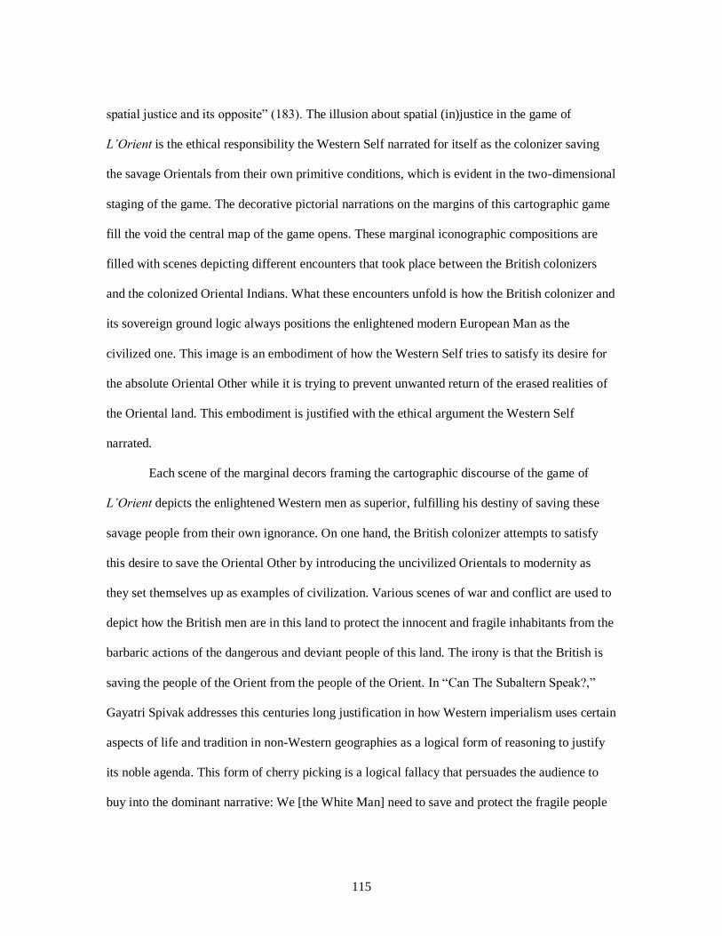
115
spatial justice and its opposite” (183). The illusion about spatial (in)justice in the game of
L’Orient is the ethical responsibility the Western Self narrated for itself as the colonizer saving
the savage Orientals from their own primitive conditions, which is evident in the two-dimensional
staging of the game. The decorative pictorial narrations on the margins of this cartographic game
fill the void the central map of the game opens. These marginal iconographic compositions are
filled with scenes depicting different encounters that took place between the British colonizers
and the colonized Oriental Indians. What these encounters unfold is how the British colonizer and
its sovereign ground logic always positions the enlightened modern European Man as the
civilized one. This image is an embodiment of how the Western Self tries to satisfy its desire for
the absolute Oriental Other while it is trying to prevent unwanted return of the erased realities of
the Oriental land. This embodiment is justified with the ethical argument the Western Self
narrated.
Each scene of the marginal decors framing the cartographic discourse of the game of
L’Orient depicts the enlightened Western men as superior, fulfilling his destiny of saving these
savage people from their own ignorance. On one hand, the British colonizer attempts to satisfy
this desire to save the Oriental Other by introducing the uncivilized Orientals to modernity as
they set themselves up as examples of civilization. Various scenes of war and conflict are used to
depict how the British men are in this land to protect the innocent and fragile inhabitants from the
barbaric actions of the dangerous and deviant people of this land. The irony is that the British is
saving the people of the Orient from the people of the Orient. In “Can The Subaltern Speak?,”
Gayatri Spivak addresses this centuries long justification in how Western imperialism uses certain
aspects of life and tradition in non-Western geographies as a logical form of reasoning to justify
its noble agenda. This form of cherry picking is a logical fallacy that persuades the audience to
buy into the dominant narrative: We [the White Man] need to save and protect the fragile people

116
(women) and land of the Orient from barbaric and violent people (man). Feminizing what and
who needs to be saved as the victim and masculinizing the enemy forms the noble image of the
White Man: sacrificing his own life for the primitive other. When Spivak writes “White men are
saving brown women from brown men” she uses the relationship between the brown and white
men/women to unpack the “relationship between the imperialist subject and the subject of
imperialism.” In the case of Oriental Other, the White Man as the imperialist subject is a
reflection of the Orient, which is the subject of imperialism (“Can the Subaltern Speak?” 92-93).
Saving the Orient from yet again the Orient is a way for the White Man to save its Self: to save its
meaningful existence.
This dominant narrative in the marginal decors of the L’Orient strengthens the noble
image of the White Man as he offers tokens from the modern enlightened Europe to the
uncivilized Oriental Indians. This cultural exchange is another image depicting how the Western
Self continues to satisfy its desire to liberate these people who are in need of being saved by
Western man. The gratitude depicted by the Oriental Indians immediately creates the notion of
gratefulness, which re-inscribes how they consider and perceive the White Man as their saviors.
This cartographic narrative in the margins unpacks how Gramsci’s notion of ‘domination by
consent’ was used to form the consciousness of the colonizer and the colonized. In the rhetorical
context of inventing the images of the colonizer and the colonized, once again, the White Man is
depicted as a path to salvation for the uncivilized Oriental Other. Internalizing the consciousness
of the colonized is how Gramsci defines domination by consent, which provides power to the
White Man to de-re-territorialize the geography of the colonized in order to establish sovereign
power and control.
In the structure of this carto-historical game of L’Orient, Western Man is always superior
and always already fighting for the betterment of the land and its people. In this sense, the

117
Western Self’s image of enlightenment and modernity gained for itself a meaningful existence
outside of the land and territory of the Western ground. It had found itself a home and meaning in
the actualized geography of Oriental subjects. However, while the desire for the absolute Oriental
Other im/places the center of the West in the Orient, the fear of being taken over by the Oriental
Other displaces the West. This fear is the reason why the West always escapes the Orient by
emptying its space, erasing its cultures, diverse identities, traditions, histories, and myths from the
official map. This fear is the reason for pushing the Oriental Other into the margins. In this
totality, then, there is always already a disruption that dis/orients both the image of the Orient and
the modern West. In this sense, the game of the West and East, more than being a game of
systematic reproduction, is a game of disruption that always already breaks the rules, crosses
borders, and responds to the chance of space without us seeing, hearing, and mapping these
invisible rhizomatic movements.
The disruption of the West-East totality is an unwritten rule that opens a path to an
alternative form of playing this game. This unwritten rule of disruption that informs the ground of
a centered structure comes with a certain cartographic anxiety, which “is invariably the result of a
certain mode of being implicated in the game, of being caught by the game, of being as it were at
stake in the game from the outset” (Derrida, “Structure, Sign and Play in the Discourse of the
Human Sciences” 352). The totality of otherness that I have to play with in this game is the
invention of the West, yet I am thrown into the land of the Orient as the central map in the game
situates me. As I play more, as I map rhizomatically through the power networks of this
cartographic game, I realize that more than it belongs to the East, the Oriental memory belongs to
the Western world and more than it belongs to the West, the European memory of modernity
belongs to the East/Orient. However, while the Western Self is capable of maintaining its being in
this spatial and material reality, the Oriental Other cannot have a spatial existence and being in

118
either the Western or in the Oriental space. This is why it is almost inevitable for the Oriental
Other to feel and experience the strong emotional impacts of dis/im/placement: “homesickness,
disorientation, depression, desolation” (Edward Casey, Getting Back into Place x). And today, in
the geographical ordering of aspatial global world, the Oriental other is always homeless because
the global space belongs to the Western memory. As a result, the heavy burden the Oriental other
has to carry as an outcast in any given territorialized space is a strong “sense of unbearable
emptiness” which is “most poignantly felt in the forced homelessness of the reluctant emigrant,
the displaced person, the involuntary exile” (Casey, Getting Back into Place x). The Oriental
other lives no/where, belongs to no/where, and is, unfortunately, going no/where.
I consider the Middle Eastern identity and the problem attached to it—Islamic
terrorism—as the product of the differentiating gaze of the Oriental Other. The Western
intellectual tradition has been using its ethical argument of saving the Orient from its own
damnation in forming the problematic image of the Orient. In the context of this ethical line of
argument, the problematic Middle Eastern identity has been constructed in the new discourse of
the global war on terrorism, which was one of the many replacements of the discourse of
Orientalism. This displacement of these discourses function within the machinic system of the
modern State and its Modern Constitution and only continue to re-invent the same problematic
line of narrative that always remains in the dichotomized vision of the aspatial global world
order: centers and peripheries. And unfortunately, this narrative line and its vision has only
continued to push the absolute Other of Western Self as its shadow into the margins of the official
map.
And I pick up the call of the home/sick Middle East, once again, and open yet another path to
jump off the official map!

119
CHAPTER 4: MAKING OF THE “MIDDLE EASTERN OTHER”
“In that Empire, the Art of Cartography attained such Perfection that the map of a single Province
occupied the entirety of a City, and the map of the Empire, the entirety of a Province. In time, those
Unconscionable Maps no longer satisfied, and the Cartographers Guilds struck a Map of the Empire whose
size was that of the Empire, and which coincided point for point with it. The following Generations, who were
not so fond of the Study of Cartography as their Forebears had been, saw that that vast Map was Useless, and
not without some Pitilessness was it, that they delivered it up to the Inclemencies of Sun and Winters. In the
Deserts of the West, still today, there are Tattered Ruins of that Map, inhabited by Animals and Beggars; in all
the Land there is no other Relic of the Disciplines of Geography. Suárez Miranda, Viajes de varones prudentes,
LibroIV,Cap. XLV, Lérida,165.” Jorge Luis Borges, “On Exactitude in Science” in Jorge Luis Borges: Collected
Fictions, 325
“The one truly transcendent law in the Middle East is that of unintended consequences.” Karl E.
Meyers and Shareen Blair Brysac, Kingmakers: The Invention of the Modern Middle East, 18
Rhizome 4-Un/Mapping the Ground Logic: A Story of Dis/Orientation49 #rhizomap
“I do not know where I stand. I am hovering above the ground/grund beneath me and I
feel a strong pull. The ground/grund draws me into a spectrum that gives me a monolithic vision
that makes everything feel the same and different all at once. The call of difference/differend is
reaching out to me from the ground/grund and it tries to show me what the monolithic gaze of the
ground/grund hides from me. I look through the glass eye of this monolithic view that totalizes
everything into the map of a global empire. I do not know where to stand in the global map that
this vision frames. I see the roots of the trees that hold this vision together. I see a window that
calls me. I look above the ground, beyond this window, that opens to a sky offshore. The root-
trees start to dissolute; the borders slowly loosen their fixed grasp. A country road in between the
trees opens a space wherein I am dis/oriented by the fluidity of borderlands. With everything
49 A Video-Mapping project that I visualized through the practice of rhizomatic mapping. This description
presented is a reflection on the mapping from 6:20-8:00 minutes. https://youtu.be/9u88GVqLzWA

120
slowing down, with everything turning into chaos and disorder, I look through the window of our
moving car and jump off the official map of the ground logic once again.”
I am at a crossroads again wherein I try to comprehend how the sovereign ground logic
of the Oriental image and its privileged, yet also very subjective language of power, gave birth to
the monolithic geospatial reality of Middle East within the global networks of the polarized world
order: West-East-North-South. Within the order of this dichotomized ground logic, these
monolithic geopolitical spatial entities construct the map of the global world order and its power
relations. In the ground of the global map, the West appears as the dominant monolithic space
that re-invents Middle/East as the non-Western Other that resides in the marginalized peripheries
of the global map. Within this monolithic vision, I return to the ground logic and its cartographic
language of power to explore how this language re-invented the Orient in the reality of the
Middle East in addition to investigating how this re-invention worked as a rhetorical tool to re-
gain sovereign control over the land of the different other.
The alienating rhetoric of the ground logic orders and constructs our spaces, which results
in defining who we are in relation to where we should belong. Seeing an empty flammable boat
washed up on the ground of the shore in my hometown two summers ago was when I accepted
the unfortunate reality of our current political climate: devaluing human life. That empty boat was
the fate of the displaced people, the refugees, for me. It is a fate that was already determined for
them even before they had a chance of to be rescued. This is the fate of being the eternal other,
the threat, and the enemy; the fate of being kept out, at a safe distance. It is a fate that costs the
lives of the boat people, refugees, immigrants, and all the displaced people: a fate of being
considered disposable.
This fate became more apparent to me during the 6th Rhetoric Society of Europe
conference at Norwich/U.K. that I attended in July 2017. The Syrian refugee crisis in the political

121
discourses of different nation-states was one of the strongest themes at the conference. It was both
disturbingly interesting and shocking for me how some European scholars reacted to the
problems, poor judgments, and ill treatments of Syrian refugees by indicating that ‘well, what
else would you do then? Do you think you would have done a better job? This is the best we
(West/Europe) can do.’
It was unfortunate to see that the growing populist nationalism has been spreading its
tentacles a lot faster and more strategically than I had imagined. These responses are the
responses of the West/Europe that has always desired to keep these non-Western others out in the
ground where they belong. Instead of letting them in, the West sends its armies, troops to bring
“civilization to [these] primitive or barbaric peoples” which brings back the image of the Orient
and its “disturbingly familiar ideas about flogging or death or extended punishment being
required when ‘they’ misbehaved or became rebellious, because ‘they’ mainly understood force
or violence best; ‘they’ were not like ‘us,’ and for that reason deserved to be ruled” (Edward Said,
Culture and Imperialism xi). The displaced people of the non-Western ground, the home/sick
people of the Middle East, share the fate of always already being the other, of being different. A
fate of home/sickness in which either death or the unbearable emptiness of displacement is the
permanent state of being.
In the ground logic of the global map of the Western gaze, the rhetorical re-inventions of
Middle East throughout the twentieth century have resulted in shifting power relations among the
Western and Middle Eastern countries.50 These complex inter- and intra-geopolitical relations
among the different nation-states of the West and Middle East hold great merit in the cartographic
50 Kemp, Geoffrey and Robert E. Harkavy. Strategic Geography and the Changing Middle East. Brookings
Institution Press, 1997. Owen, Roger. State, Power, and Politics in the Making of the Modern Middle East,
Routledge, 2004. Stewart, Dona J. The Middle East Today: Political, Geographical, and Cultural
Perspectives. Routledge, 2013. Sorenson, David S. Ed. Interpreting the Middle East: Essential Themes.
Westview Press, 2010.

122
re-constructions of the Middle East; however, unpacking the rhetorical and political role of each
of these carto-historical relations is beyond the limits of this mapping project. Considering the
cartographic trajectory of this project—the monolithic vision of the global map—I map the
geopolitical relations between the Western tree-structure and the Middle/Eastern rhizome. This
broader vision I adopt is a response to the alienating yet also unifying gaze of the Western
globalization world and how this gaze has been re-inventing the Middle East as the extensively
totalized non-Western Other on a global level.
I approach the networks of this global web image as root-structures forming the
monolithic gaze of the global map as a world centered in the ground logic of the West, which
immediately forms the monolithic yet also alienated image of the Middle East within the same
tree-system. In the ground logic of this tree-image, I approach the geopolitical island Middle East
as a rhizomatic formation that became part of the Western root-tree system. In other words, the
diverse rhizomatic patterns of Middle East have been cut and re-identified as root-structures.
Through these machinic cuttings, the Western tree has been able to re-invent its meaningful
existence in direct contrast to its non-Western other: the Middle East. These violent cuttings
reflect how the tree-structure works as a mechanical reproduction system, which was
programmed to maintain the dichotomized global world order around the West-East binary.
This rhizomatic mapping starts, again, in the middle, by unpacking the rhetoricity of the
ground logic of the global map that is centered in the multipolar European gaze during the first
half of the twentieth century. In this context, the focus of this chapter is to map the re-invention of
Middle East in the haunting image of the Oriental land. In this process of mechanical re-
production, the monolithic vision of the Western Self defined the Middle East, first, as a
question—the great Middle Eastern question—and then transformed this question into a problem
to be fixed: the problem of lack of democratic and self-governing nation-state structures in the

123
region. This monolithic image of the region was depicted in the problematic narrative of the
Orient, which depicted the Middle East as uncivilized and primitive in the dominant imaginary of
the West. This re-narration has become one of the central arguments in producing the problematic
reality of political Islam in the rhetorical context of the global war on terror discourse. Today, the
Middle East continues to be received as uncivilized and primitive and this perception is directly
associated with the dominant representation of political Islam: its non-democratic, violent, and
terrorist governing ideology. The question of Middle East became the problem of political Islam
as it is narrated in the dominant discourse.
In this chapter, I start from and with this central question highlighting the perception of
the Middle/East as a problem to be fixed both in its old (Oriental image) and new rhetorical
consciousness (Land of Islamic Terrorism) in the Western global imagery. As I map with this
question, I re-read the engagement between the Western Self and the Oriental Other through the
metaphors of tree and rhizome. This re-reading functions as a path to unfold how the Western
Self as a tree-system internalized the Otherness of the Orient in its monolithic geospatial identity.
This chapter will unpack how this internalization invented the modern Middle East as we know it
today as a root-structure that is grounded in the memory of Oriental Other and how this root-
structure shaped the region as a land of chaos and violence before the region came to be identified
with the terrorist image of political Islam as the dominant representation.
Geopolitical Island Middle East in the Ground Logic of the Global Map
As a world region, the geopolitical island Middle East has been a strategic geographical
location that holds a significant role in the inter- and intra-national geopolitical relations in the
stage of globalization. In Middle East Patterns: Places, People and Politics, Colbert Held
indicates that “the Middle East has served as a tricontinental hub for millennia. Peoples, armies,
merchants, and ideas have flowed to, from, and across the region. Political ideology and

124
processes in the flow were sometimes adapted and sometimes rejected but often influences the
internal evolution” of the sixteen states framing the geopolitical identity of the modern Middle
East today (215). On one hand, the region’s extreme geopolitical significance stems from its tri-
continental location as global crossroads, its access to crucial transportation and trading routes,
and its petroleum reserves (Ewan William Anderson, The Middle East: Geography and
Geopolitics x). On the other hand, the accelerating internal conflicts that have resulted in war,
violence, and terrorism are another layer that has been re-positioning the region as the focus of
global attention, primarily on the ground logic of the popular media representations:
The Middle East has featured prominently in the news almost daily through more than six
decades of warfare: five major Arab-Israeli wars plus several more limited conflicts; the
almost uninterrupted cycle of violence involving Arabs and Israelis; internecine fighting
in Lebanon in 1958 (ended by landing of U.S. forces) and from 1975 to 1991 (involving
U.S. forces on two occasions); Turkey’s invasion and partial occupation of Cyprus
beginning in 1974; Iraq’s war with Iran in the 1980s, its invasion of and consequent
expulsion from Kuwait in 1990-1991, the international sanctions imposed on it afterward,
and its occupation by the U.S.-led coalition from 2003 onward; U.S. operations in
Afghanistan after September 11, 2001; and civil wars and insurgencies in Yemen in the
1960s, 1994, and the late 2000s. Beyond open fighting, there has been an ongoing Arab-
Israeli “Peace Process” dating to Henry Kissinger’s “Shuttle Diplomacy” in the mid-
1970s, hostage taking in Lebanon in the 1970s and 1980s, the overthrow of the shah and
the American Embassy hostage crisis in Tehran in 1979-1980, terrorist attacks in most of
the countries in the region, Cold War crisis ranging from Iran and Turkey in the 1940s to
peripheral Afghanistan in the 1980s, and dozens of other headline-worthy events. (Held
3)

125
I define the canonized geopolitical identity of the Middle East as chaos, war, and
terrorism that the modern Western gaze and its global map have been using in constructing its
ethical argument, which is at the core of the rhetorical alienation of Middle East: the Western
man needs to save the people of the Middle East from terrorism and war in addition to protecting
important natural resources and trading routes. On one hand, this geopolitical identity of the
region has been placing the Middle East as the focus of global attention; on the other hand, I
argue, it has been used as a universal form of justification in continuously re-defining and re-
inventing the region as an excluded geography, as the Third World, in the margins of the ‘world
map’. I approach this geographical exclusion as a form of geopolitical gatekeeping rooted in the
ground logic of the global map.
Today, this geopolitical gatekeeping appears in the form of a strong desire to keep the
terrorist Muslims out in the margins, where they can be controlled at a safe distance. Until the
region arrived to its current geopolitical identity, its borders and socio-spatial consciousness have
constantly changed throughout the twentieth century. As Michael Bonine at.al. argue in their
collection, the new state of consciousness the region is currently in emerged from the ghost of the
old West/East dichotomy, which has been re-inventing itself as the geopolitical relations shift and
change (Is There a Middle East?). In this mechanical reproduction process, the region’s borders
were reformed, its central and peripheral countries were re-defined, and the geographic location
the very name of Middle East represents was re-imagined in a parallel relationship to the
expanding spatial framework of the Western globalization. As the image of the Orient and its
discourse gave birth to the Middle Eastern question during the early twentieth century, the
‘naming’ of the region had shifted among Far, Near, and Middle East/s in accordance to the
spatial position of the West.

126
The Eastern Question, the Middle East, and the Oriental Despotism
The first official use of the term ‘Middle East’ as a geographical entity is associated with
Alfred Thayer Mahan, an American naval officer that defined a vague route from Great Britain to
its colony India in 1902. However, according to Faik Bulut, the roots of ‘Middle East’ as a term
goes back to the seventeenth century (36). Bulut explains that Middle East as a term “was not
created by the people of the region. To the Semitic peoples, the present day Middle East was the
centre of the world…Europe and the Far East were peripheral” (36). The strong front of the
Ottoman Empire along with Persia was the image of the region today known as the Middle East
in the geopolitical theatre. In the ground logic of the West vs. East binary, the hierarchy of power
was a singular line from East to West. During the seventeenth century, Middle East as a
geographical term emerged “as a consequence of the colonialist mentality of Eurocentric
capitalists…the ‘white man’ divided the world into High and Low civilizations. The Europeans
saw it as their mission to civilize the backward people of the region. In this sense, the Middle East
is an invention of the Europeans” (Bulut 36). This invention took place in the rhetorical context
of the Eastern question. In “the Eastern Question and the Ottoman Empire,” Huseyin Yilmaz
examines the evolution of the scope and nature of Karl Max’s label of ‘the Eternal Eastern
question’:
at the beginning of the nineteenth century, the term “the Eastern Question” was
generically applied to almost all conflicts taking place in Eastern Europe …Toward the
late nineteenth century, however, within the context of a broader confrontation between
Europe and the Orient, the scope of the Eastern Question was extended to all of
Eurasia…Although the semantic range of the term “The Eastern Question” was extended
to include the whole scope of relations between the West and the Orient, unless specified
it commonly referred to the Euro-Ottoman context…It was this perception of the Eastern

127
question that gave rise to the notion of the Near Eastern Question by the late nineteenth
century, from which current conceptualizations of the Middle East originated. (11-12)
The shifts in the scope of these questions impacted the changes in the geographical
labels: from East to Far East, Near East to Nearer East to Middle East, which today arrived to
Greater Middle East in the context of the war on terror discourse.51 These changes made a
significant impact on the cartographic constructions of Middle East as a vaguely defined
geographical category.52 While these shifting eastern questions and geographical borders provide
complex networks of relations that constructed the Middle East, they were totalized under the
homogenic cartographic image of the Orient during the early stages of the Middle East’s
cartographic invention.
In “Constructing and Naturalizing the Middle East,” Karen Culcasi indicates that the
modern Middle East as a geopolitical entity as we know it today was re-invented in the discourse
of Orientalism (583-84). The dominant image and discourse that defined the non-Western Middle
East in the rhetorical contexts of the colonizer Europe was the ‘Oriental’ land and the ‘Oriental’
people. The term Orient and its extensively homogenized image, as Said indicates, was a
European invention. I approach the early usages of the term Middle East and its different
meanings in relation to Said’s manifest Orientalism, while the overall construction of the Middle
East in the memory of the Orient as latent Orientalism. As the ‘white man’ produced the
knowledge of an extensively totalized Middle East, he, in its different positions of power
(multiple interests of the different European powers), was also defining the region under
categories of distinct representations to gain strategic advantage and detailed information about
51 Stewart, Dona J. “The Greater Middle East and Reform in the Bush Administration's Ideological
Imagination.” Geographical Review, vol. 95, no. 3, 2005. 400-24. 52 In “The Eastern Question and the Ottoman Empire,” Huseyin Yilmaz offers more extensive reading of
how the change in the scope of eastern questions impacted the shifts in the geographical labels.

128
the region. In other words, as the overall knowledge of Middle East changed (latent Orientalism),
the manifestations of Middle East in different centers of power changed (manifest Orientalism).53
Middle East, as a result of these re-constructions in the context of imperialism,
colonization, and war, has never been a stable and clear geographical region due to its always
shifting borders. Especially since World War I and the fall of the Ottoman Empire, the region’s
constantly changing geographical borders and names in addition to the countries that constitute
the region have contributed to an intensifying image of chaos, conflict, terror, and violence. This
unstable reality of the region stems from how Middle East was cartographically re-constructed
according to the laws and rules of Western modernization and how these rules clashed with the
internal and organic laws of the inhabitants of the region. I consider this clash as the roots of the
contemporary terrorist image of Middle East that is embodied in the problematic narrative of
Islam as it constructs itself inherently violent in the popular representation, which depicts the
feared enemy image of the region. I map this feared enemy image back to the memory of the
Ottoman Empire and how the empire’s identity was re-invented in the image of Oriental
despotism on the ground logic of the European vision of the global map. In Contending Visions of
the Middle East, Zachary Lockman explains that
For an entire historic period, the Ottomans were the great bogeyman of Christian Europe:
they evoked considerable fear and in popular literature were often depicted as cruel,
violent and fanatical, in ways that drew on long-prevalent caricatures of Islam… But
some Europeans, while continuing to reject Islam and insist on the truth of Christianity,
were able to adopt a more objective attitude toward the Ottomans. In fact, in the sixteenth
century many educated European observers were awed by the immense power and wealth
53 In Orientalism, Said defines latent and manifest Orientalism by making a distinction, which “is an almost
unconscious (and certainly an untouchable) positivity, which I shall call latent Orientalism, and the various
stated views about Oriental society, languages, literatures, history, sociology, and so forth, which I shall
call manifest Orientalism.” (206).

129
of the Ottoman state – it was they who gave Sultan Suleiman the epithet “magnificent,”
not the Ottomans, who called him “the lawgiver” – and sought to grasp the secret of the
empire’s success, often contrasting Ottoman virtues with the defects of their own
societies. (42-43)
This relationship between Europe as the embodiment of Western civilization and the
emerging modern identity of the Western Self during the age of discoveries (late fifteenth and
sixteenth centuries), and the Ottoman Empire as the embodiment of the strong Eastern civilization
and the established identity of the East as the power center, mirrors the relationship between the
Self and Other. Reading this engagement between the Europe/West and the Ottoman Empire/East
first appears to position the identity of the Ottoman as the Self responding to Europe as the Other.
However, during this epoch of time, the Ottoman Empire as the face of a powerful East/Orient
did not actually define its identity by consciously defining its non-Eastern/non-Islamic Other. In
this un/conscious response to the call of the Other, Europe/West picked up the call of the
Ottoman Empire to define its identity as Western civilization, which was a way to determine how
to form the grand-narrative of the modern Western Self. Lockman indicates that as a result of the
age of discoveries, “the new European global empires and a new world economic order
increasingly dominated by Europeans were coming into being. Inevitably, emerging new
conceptions of what Europe and the West meant were profoundly influenced by the fact that
western European states were simultaneously moving toward a position of global hegemony,
exercising political and economic power over non-Western states and peoples” (56-57). This
emerging shift was not necessarily a change in the relation between the Self and Other; but it was
a power shift in how Self and Other are defined in the socio-economic and political context of the
changing world. For Europe to produce its Self as more powerful, the power networks of

130
European empires defined their Europe defects by defining Ottoman Empire’s strengths and
values in political, social, and cultural life.
I approach this emerging shift in the power balance of West and East dichotomy as the
early stages of forming the extensively totalized image of the Orient and its systematic discourse.
When Said opens his fundamental work Orientalism, he introduces his readers to several
meanings of Orientalism that are both intertwined and interdependent. The first meaning of
Orientalism is its study as an academic field, and the second one is Orientalism as a “style of
thought based upon an ontological and epistemological distinction made between ‘the Orient’ and
(most of the time) ‘the Occident’” (2). Said defines the third meaning of Orientalism as an
interchange between the first two meanings, which roughly started from the eighteenth century
and formed “the enormously systematic discipline by which European culture was able to
manage—and even produce—the Orient politically, sociologically, militarily, ideologically,
scientifically, and imaginatively during the post-Enlightenment period” (3). In this context, as the
shift in the global binary of West-East was forming the modern identity of Western man and its
grand narrative, it also started to produce the subjugating tree-system of the Western colonial
gaze that produced the Oriental Other as part of its machinic tree-structure. During the epoch of
the decline and fall of the Ottoman Empire, which also defines the golden ages of the Western
modernization during Renaissance and Industrialization, the image of the Ottoman Empire was
replaced with the image of
despotism, a state characterized by the concentration of arbitrary, lawless and absolute
power in the hands of the all-powerful sovereign (the sultan) and the reduction of all his
subjects to virtual slavery… The Ottomans thus became a prime example of what
European political thinkers came to call Oriental despotism, a concept which was most
fully developed by the great French writer and jurist Montesquieu (1689– 1755) … As

131
with earlier depictions of the Ottoman empire as tyrannical and profoundly alien,
Montesquieu’s denunciation of Ottoman despotism had more to do with anxieties and
debates within Europe itself than with Ottoman realities. The odious example of the
Ottomans gave Montesquieu and others a safe way to criticize and resist what they saw as
the despotic tendencies of European monarchs and to delineate, by means of a sharp
contrast, their emerging vision of a new kind of rational and moral political order. Not all
European political thinkers accepted Montesquieu’s assertions about Oriental
despotism…the concept would live on and flourish, in a variety of forms, through the
nineteenth and twentieth centuries. (Lockman 47-48)
Re-inventing the declining Ottoman Empire in the totalizing image of the Orient that
represented the primitive and uncivilized non-Western Other positioned the Western Self at the
center of modern civilization. I argue that this re-invention happened in the rhetorical context of
the Oriental despotism that European empires framed, which created the feared enemy image of
the Ottoman Empire. The Sick Man of Europe (the Ottoman Empire) during the nineteenth
century was being presented as the enemy to the Christian Western world in Europe and as the
enemy to the many ethnic groups under the reign of the Ottoman Empire, but primarily the Arabs.
This enemy image of the Ottoman Empire which was narrated in the rhetorical context of
Oriental despotism could be read as the implementation of the Western Self’s ethical argument in
justifying “why a socially, economically and culturally dynamic ‘West’ had come to dominate the
world, including many parts of Asia and Africa inhabited largely by Muslims, and why that
domination was necessary and good” (Lockman 57). Modern Europe used the weakness of the
falling of the Ottoman Empire—its lack of governmentality, declining military power, and
incapability of providing security for its subjects—as its primary rhetorical tool in forming its
ethical argument for saving the diverse ethnic groups who were under the long-term suppression

132
of the barbar Turks. This ethical argument justified the growing presence and control of European
nation-states in the region by positioning the inhabitants of the soon to be former Ottoman
Empire area as in need of support and help to properly govern their land and help people to adapt
to the new modern world order.
The rhetorical use of oriental despotism formed the ground logic of the global map
centered in the multipolar power gaze of modern Europe at the dawn of the failing Ottoman
Empire and the WWI. This ground logic of the newly emerging global map created internal
inconsistencies, discomfort, but most importantly resentment against the Ottoman Empire among
the many ethnic identities in the region that was soon to be defined Middle East. The growing
internal chaos was evident in internal resistant movements, uprisings, and insurgencies against the
Ottoman Sultan. These resistant movements were supported by the European power centers. In
particular, the British support for Arab guerilla movement against the Ottoman Sultan created the
necessary diversion and division of military forces as the Ottoman army was fighting in WWI
alongside with Germany (David Fromkin 5-6). While European powers made promises to many
ethnic groups in the region for independence—the most well-known case is the promise of the
independent Kurdish State—they also used these insurgencies as logical reasoning to justify the
necessary European control over these groups. European powers used these insurgencies to make
a logical case for how these ethnic groups were incapable of maintaining their existence as self-
governing independent nation-states. This rhetorical mood of chaos gave birth to the great
Middle/Eastern question and European powers made their ethical responsibility to resolve this
question.

133
From Eastern Question to the Middle Eastern Question: Multipolar European Gaze
in Making of the Modern Middle East
Middle East’s critical location was the primary interest of the European powers in the
region since the nineteenth century. As a world region, Middle East “forms the much trampled
passageway linking Asia and Europe to Africa” (Karl Ernest Meyer and Shareen Blair Brysac
17). In London and the Invention of Middle East, Roger Adelson writes that Mahan’s construction
of the term ‘Middle East’ and what this geographical positioning represented was used “to
describe the area north and west of India, and to distinguish it from Near East and the Far East”
(1). This vague cartographic construction of ‘Middle East’ aimed at securing the route to Great
Britain’s significant colony India.54 Pinar Bilgin explains that “throughout history, the driving
purpose behind the identification and naming of geographic sites has almost always been military
strategic interests” (2). Overall, Mahan devised the name of ‘Middle East’ as a geographical area
in the context of colonial and military interests of Great Britain.
In the years leading to WWI, the new relations that were being formed among Britain,
France, and Russia truly started the process of the making of the modern Middle East. Fromkin
explains that
Great Britain had propped up the Ottoman Empire for generations as a buffer against
Russian expansionism. Now, with Russia as Britain's shaky ally, once the war had been
won and the Ottomans overthrown, the Allies would be able to reshape the entire Middle
East. It would be one of those magic moments in history when fresh starts beckon and
dreams become realities. (4)
54 See Bonine, Michael. E. “Where Is the Geography of the Middle East?” Professional Geographer, vol.
28, no. 2, 1976. 190-195.; Kamrava, Mehran. The Modern Middle East: A Political History Since the First
World War. University of California Press, 2013.; and Khalidi, Rashid. “‘The Middle East’ as a Framework
of Analysis: Re-Mapping a Region in the Era of Globalization.” Comparative Studies of South Asia, Africa
and the Middle East, vol. 18, no. 1, 1998. 74-80.

134
In the early stages of cartographically constructing the Middle East, the colonizer gaze of
the British played a primary role in shaping the new socio-spatial consciousness and the borders
of the modern Middle East. As Fromkin indicates, “It was clear that the British needed to
maintain control over the Suez Canal, and all the rest of the route to their prized colonial
possession, India” (5). The colonizer gaze of the sovereign ground logic of the British resulted in
Mahan visualizing Middle East as an arbitrary path to India (see Fig. 5).55 In “Where Is the
Middle East?” Roderic H. Davison informs us of Mahan’s vision in framing the ‘Middle East’ as
a geographical term in relation to the necessity of gaining naval power for Great Britain in the
context of war: “Mahan considered the Anglo-Russian contest along with the new element of the
projected German Berlin-to-Baghdad railway with its probable terminus on the Persian Gulf.
Envisioning the desirability of the Anglo-German cooperation to keep the Russians out, he
affirmed the need for Britain to maintain a strong naval position, with bases, in the Persian Gulf”
(667). In “The Persian Gulf and International Relations,” Mahan writes that
The Middle East, if I may adopt
a term which I have not seen,
will some day need its Malta,
as well as its Gibraltar…The
British Navy should have the
facility to concentrate in force,
if occasion arises, about Aden,
India and the Gulf. (qtd. in
Davison 667)
55 I created this cartographic representation by using the data from “Where Is the Middle East?” by the
Carolina Center for the Study of the Middle East and Muslim Civilizations.
Fig. 5. Alfred Mahan’s 1902 Middle East

135
During the early years of the twentieth century, “the first priority of London’s
policymakers was to defend the Empire and India, a priority they saw as justifying British
protection of the Suez Canal and domination of the Persian Gulf. The second major concern was
to maintain the balance of power in Europe, and third to exploit the area’s copious resources of
oil, discovered near the Persian Gulf, to meet the needs of the British navy” (Adelson 2). The
ground logic of Mahan’s Middle East put its emphasis on gaining military advantage in addition
to securing the colonial control for the Britain, which resulted in this early cartographic
visualization of Middle East to be “an indeterminate area guarding a part of the sea from Suez to
Singapore” (Davison 667). The ground logic of Mahan’s first cartographic framing of the Middle
East in the discourse of colonialism and in the rhetorical context of war gave birth to the great
‘Middle Eastern Question.’
In “Is There a Middle East?” Nikki Keddie indicates that this geographical term has
become a decisive geopolitical misnomer.
In the context of the upcoming first world
war, the meaning and function of the
Middle East started to change. Middle
East became a strategic location to control
and secure to military advantage. In 1903,
Valentine Chirol reflected on this
rhetorical shift in the meaning of Middle
East in his book titled The Middle Eastern
Question, or Some Political Problems of Indian Defence. Chirol defines the Middle Eastern
question in the broader geopolitical context of Asia by considering the multiple political,
economic, and military interests of the European powers in Asia. In the context of political
Fig. 6. Valentine Chirol’s 1903 Middle East

136
discourse and the discourse of war, Chirol defines this question in the geographical and
cartographic construction of Mahan’s Middle East (see Fig. 6)56 and
in those regions of Asia which extend to the borders of India or command the approaches
to India, and which are consequently bound up with the problems of Indian political as
well as military defence. The Middle Eastern Question is itself only a part of a much
larger question upon which the future of Asia depends. It is not indeed a new question,
for it has occupied the minds of far-sighted statesmen for generations past. It is a
continuation of the same question with which we have long been familiar in the Near
East. It is closely connected with the more novel development of international rivalry in
the Far East. It is the outcome of that constant projection of European forces—moral,
commercial, and military—into Asia which is slowly but steadily transforming all the
conditions that enabled us to achieve, and so far to retain, as the masters of India, a
position of unparalleled ascendency in the Asiatic Continent. (5)
In between the Far and Near East within the broader geopolitical context of Asia, Middle
East’s strategic political and military significance was becoming a central focus and importance
to the European powers in the ground logic of the Eurocentric global map. Especially during the
early twentieth century, the tension between Britain and Germany due to establishing control over
the Middle East had a strong impact on the early cartographic constructions of the region.
Germany was a threat to the British empire and its colonial interests during the pre-WWI context.
Adelson explains that “Following Japan’s defeat of Russia in 1905, the old geopolitical bogey of
Russian armies rolling over the Indian subcontinent gave way to new fears of German railways
bringing troops to challenge British ascendancy” (2). With its Berlin to Baghdad railway
proposal, Germany as “a British rival for global power…established political along with military
56 I created this cartographic representation by using the data from “Where Is the Middle East?” by the
Carolina Center for the Study of the Middle East and Muslim Civilizations.

137
relations with Ottoman Turkey, this fueling fears in Britain about German regional aspirations”
(David Sorenson, An Introduction to the Modern Middle East 853). Germany was a strong threat
for the colonial power of Britain.
This pre-WWI German
threat to the colonial British
Empire appears within the ground
logic of the 1905 German map
titled “Persien, Afghanistan und
Belutschistan” (see Fig. 7). This
early twentieth century German
map, which is part of the Andrees
Handatlas, focuses on Middle East
as a region with a close trajectory to
Afghanistan, Iran (Persia), and Pakistan. The ground logic of this map aligns with Mahan’s
arbitrary definition of the Middle East with its cartographic focus on the critical location of the
Suez Canal and the Persian Gulf and the route to Pakistan/India (before the partition in the 1940s,
it was just India). The cartographic logic and visual focus of this German map illustrates the
threat the British Empire perceived especially considering how this map provides specific
information on the “settlements, telegraphy cables, railways, forts” (David Rumsey Historical
Map Collection, “Note: Persien, Afghanistan und Belutschistan”). The early German interests in
the Middle East were focused on mapping the knowledge of Middle East’s communication
systems and transportation paths. Adelson writes that
To counter German influence, Britain instigated a defensive diplomacy with France and
Russia. It traded recognition of France’s predominance in Morocco in return for French
Fig.7. 1905 German Map Persien, Afghanistan und
Belutschistan

138
acknowledgment of British dominance in Egypt. Meanwhile, Persia was divided into a
British southern sphere [one of the richest locations of oil resources], a Russian northern
sphere, with a neutral area in between. (2)
The 1907 British map (see Fig. 8), titled “Europe and Near East-General Commercial
Chart,” illustrates the British’s focus on securing and controlling the Suez Canal and the Persian
Gulf during the early years of the twentieth century. This commercial map not only traces the
trading routes that go through the Suez Canal, it also maps detailed information about “products,
imports, exports, commercial
conditions and economic
statistics of the countries of the
world” by using “descriptive
text and diagrams” (David
Rumsey Map Collection).
The emphasis given on
the Suez Canal in the ground
logic of this British Map aligns
with the primary interests of the
British policy during this time
period. The upper right corner of the map presents a smaller map that has a focused trajectory of
the Suez Canal. This window within the overall ground logic of this map reveals the importance
of Suez Canal to the British Empire. The publisher’s note to this map indicates that “[t]his is a
path breaking statistical atlas of world commerce, using imaginatively formatted maps and
diagrams to show the immense growth and pattern of international trade at the beginning of the
20th century” (David Rumsey Map Collection, “Pub Note: Europe and Near East General
Fig. 8. 1907 British Map Europe and Near East General
Commercial Chart

139
Commercial Chart”). The use of statistical information serves the primary British interests in the
Middle East: maintaining control over the Suez Canal. This is why the focused map of the Suez
Canal is accompanied by a diagram, titled “Diagram Showing Relative Amount of Shipping
Passing Through Suez Canal in 1905.” This information is designed around which country used
how many vehicles in addition to the net tonnage of their overall shipment. The countries listed in
this diagram, with the same order, are United Kingdom, Germany, France, Netherlands, Austria-
Hungary, Italy, and Other Nations. Considering the existing power balance among the European
countries during this time, the primary rivals to the British Empire was Germany and France in
establishing control over the Suez Canal in the Middle East. Britain turned its rivalry with France
to alliance in the context of WWI to fight against the threat Germany held against Britain’s
colonial, military, and economic interests.
The primarily political, colonial, economic, and military significance of Middle East was
doubled “with the initial discovery of its underground ocean of oil” (Meyer and Brysac 17). In the
context of war, the discovery of oil resources was extremely important for the European powers
due to the high costs of military defense and the need for oil to run the war machine. In this sense,
Britain, in rivalry with France and Germany, sought their advantage and secured “their first
significant oil production” in Persia (Daniel Foliard 3792). With the discovery of oil in Persia, as
Foliar unfolds, the Anglo-Persian Oil Company (APOC) was established under the colonial gaze
of the British Empire. By establishing a strong control and dominance over the region’s strategic
military locations, routes, and finally oil resources, Britain had a primary impact on the
cartographic construction of the borders in and of the Middle East during the first half of the
twentieth century. I approach this primary impact of the British gaze and its colonizer and the
colonized image in the ground logic of the global map as the first layer of the European tree-
system implementing its root-structure into the Middle East.

140
Following the ‘the Eternal Eastern Question,’ almost all “attempts to give a consistent
geographical or cultural definition to the term all followed major international development or
were made in anticipation of major geostrategic shifts, ultimately creating multiple ‘Middle East’
that were based on different sets of criteria” (Yilmaz 11). In the context of WWI, these
geostrategic shifts that served the interests of multiple European powers started to become even
more visible. The use of ‘Middle East’ as a geographical term was becoming more frequent in the
British context especially after the contextualization of the ‘Middle Eastern’ question. Chirol
played an essential role in helping to “popularize the term and the idea of the Middle East” by
addressing “British security issues as an ‘Asiatic Power’” (Culcasi, “Constructing and
Naturalizing the Middle East” 585). As Chirol popularized the term as a question to be addressed,
he focused on the expansive area Mahan identified as the ‘Middle East,’ and considered this
region as “the ‘cornerstone of the British Empire,’ and he believed that securing it was ‘most
urgent…from an Indian point of view” (Culcasi “Constructing and Naturalizing the Middle East”
585). However, before Mahan and Chirol
British General Thomas Edward Gordon had published an article in the journal The
Nineteenth Century entitled “The Problem of the Middle East” (1900). Gordon did not
specifically delimit or define the region, but his concern was with Afghanistan, Persia,
Russia, and British India. What is interesting in Gordon’s article is the casual usage of the
term “the Middle East,” which seemingly implies that it may have been commonplace in
British India, where he was stationed (Koppes 1976, 96; Drysdale and Blake 1985, 10).
Regardless of who was the first to use the term, it emerged at the beginning of the
twentieth century in reference to British geopolitics (C. G. Smith 1968, 4). (qtd. in
Culcasi, “Constructing and Naturalizing the Middle East” 585)
141
While the “British-centric term ‘the Middle East’” was cartographically re-invented in
the haunting image of the Orient to serve the colonial geopolitical interests of the British empire
during the early twentieth century, “not until after World War I and British military conquests in
the region did both the term and the idea of the Middle East become common in the United
Kingdom” (Culcasi, “Constructing and Naturalizing the Middle East” 585). In this period,
especially in the broader context of the European usages of the term ‘Middle East,’ there is a
vivid movement between the two geographical terms that were in use to refer to the expansive
region we know as ‘Middle East’ today: Near East and Middle East. This was primarily due to
how the broader scope and meaning of the Eastern Question was more prominent to the interests
of the many European power centers. Even in the British usages, “outside of government circles,
British interest groups and individual experts continued to use the term ‘Near East’ more often
than they used the term ‘Middle East,’ despite a Royal Geographical Society resolution in 1920
that prescribed that the ‘Near East’ should denote only the Balkans, whereas lands from the
Bosporus to the Indian frontiers should be named ‘Middle East’” (Adelson, “British and U.S. Use
and Misuse of the Term ‘Middle East’” 43). Yilmaz explains that the Eastern Question was
primarily about the colonial projects; yet this question created “more abstract and broader
confrontation[s] between the West and East” which produced “new series of ‘questions’”57 (27).
In the context of these shifting relations and interests, as Yilmaz continues,
In broad terms, the Eastern Question was about establishing a new world order. In other
words, it was European intellectuals’ self-proclaimed mission to accord the rest of the
world. Yet, more specifically, it was about envisioning Europe vis-à-vis the Ottoman
Empire, for it represented an alien civilization still surviving on the same continent these
57 In this context, as Yilmaz continues, “the China Question became the Far Eastern Question, the India
question and Persian Question became the Middle Eastern Question, and the Turkish (Ottoman) Question
became the Near Eastern Question” (27).

142
Europeans saw as the dispenser of modern civilization, uncompromised by inferior races
and cultures. The Eastern Question in this way became integral to the process of
purifying Europe from cultural contamination by enlightening out driving out its Asiatic
elements. (27)
This alien image of the Ottoman Empire as it is framed in the systematic discourse of
European imperialism and colonization echoes the discourse of Orientalism. The Ottoman Empire
represented the deviant other threatening the modern sovereign image of the European Empire
and it needed to be eliminated. In this context, I consider the Ottoman Empire the early image of
the enemy for the Euro-centric modern Western civilization and society. This early image later
was re-invented in the context of the Middle Eastern question by becoming one of the central
ethical reasonings in narrating the socio-spatial reality of the Middle East as a problem to be
fixed. In the context of WWI, the
problem of the Ottoman Empire
resulted in the partition of many
Ottoman territories among the
European powers with the 1916
Sykes-Picot Treaty (see Fig. 9).
While Britain already
formed an ally with France and
Russia against the Ottoman Empire,
Italy was aligning with Germany
and Austria, which allied with the
Ottoman Empire during WWI. In The Middle East: Geography and Geopolitics, Anderson writes
that to break Italy’s commitment to the triple alliance with Germany and Austria, the policy of
Fig. 9. 1916 “Map of Sykes Picot Agreement”

143
France and Britain was to offer the territories that Italy had already seized “during the Turkish-
Balkan wars of 1910-12”: the Dodecanse Islands, the coastlands of Tripolitania, and Cyrenaica.
To accomplish this policy, these territories were “offered [to Italy] in the Sykes-Picot Treaty
(1916) which delimited the future intended territorial allocations within the Middle East” (103).
Even though, the Sykes-Picot Treaty was never put in effect due to the fall of Tsarist Russia in
1917, how the Ottoman Empire territories was already divided among European powers had a
primary impact on the formation of the mandate states in Middle East after the fall of the empire.
The cartographic construction of the Sykes-Picot Treaty mainly focused on establishing
control and power over the Middle East with an emphasis on defeating the enemy, the Ottomans,
and keeping the deviant non-Western ‘Other’ out. Michael Heffernan explains the logic of the
treaty, which mirrored itself into the ground logic of the cartographic construction of the Middle
East before the fall of the Ottoman Empire:
Once the Turks were defeated, the Middle East was to be divided into Russian, Italian,
French, British, and international zones plus Italian, French, British ‘spheres of
influence.’ The coastal belt of the eastern Mediterranean and much of Mesopotamia were
to be shared between French, British and (in the case of Palestine) international control.
The ‘independent’ Arab lands lying between the Mediterranean strip and the Gulf were to
be further divided between British and French ‘spheres of influence.’ These desert lands
would be colonies in all but name and isolated from the sea other than through the
proposed British, French or international coastal zones. (518)
I read this ground logic rooted in the systematic discourse of European imperialism and
colonialism that visualized the geography of Middle East as an imagined land through the notions
of heartland and world-island to unpack the extreme geopolitical importance of the Middle East
since the early twentieth century. Held writes that

144
early geopolitical concepts of “Heartland” and “World-Island” [which] appeared in Sir
Halford J. Mackinder’s paper of 1904…Mackinder defined the Heartland bastion
basically as Siberia, which he conceived of as ringed by an Inner Crescent extending
from northwestern Europe through southern Asia to northeastern Asia. Beyond the Inner
Crescent he viewed an Outer Crescent—the Americas, southern Africa, and Australia. He
labeled tricontinental Europe, Asia, and Africa the “World-Island” and proposed in 1919
that: Who rules East Europe commands the Heartland; Who rules the Heartland
commands the World-Island; Who rules the World-Island commands the World.
Although the Mackinder dictum has received its just share of criticism, the idea of
World-Island emphasizes the links among three “inner continents.” Emphasizing those
links, it coincidentally spotlights the pivotal location of the Middle East in the World-
Island. (215)
In the context of the shifting international and geopolitical relations of WWI, the region
that was imagined to be the Middle East in the European gaze represents Mackinder’s world-
island considering the region’s critical location that connects Europe to Asia. For the European
powers, building transportation and telecommunication routes in the Middle East was a way to
have the advantage in having strategic control over the region. Knowing how to move and
communicate across the Middle East in the context of the changing geopolitical world order
meant receiving significant intelligence about the region, which was a necessity for each
European power to accomplish political advantage over one another.
Approaching the Middle East as a world island provides an explanation for why it
became essential for European powers to have a balanced control over the Middle East. On one
hand, each European power sought to gain dominant power and control over the region; on the
other hand, risking having shared control was too great of a danger for many European powers

145
especially considering the danger of one power center to accomplish maintaining hegemonic
power over the region. To prevent a hegemonic power controlling the Middle East, the the Sykes-
Picot Treaty was formed as an alliance against the central German and Ottoman Empire threat by
the British and French. However, while Great Britain was collaborating with France in
controlling the Middle East, the policy-makers of the British Empire made sure to have more
advantage and critical control over the region. Adelson explains that
The Sykes-Picot memo envisaged a ‘confederation of Arab States’, under the ‘suzerainty’
of an unnamed ‘Arabian prince’. Area A, along the Mediterranean coast of Syria and
Palestine, could come under direct French rule. Area B, from the head of the Persian Gulf
to Baghdad and beyond, would come under British control. In a Blue Area adjacent to A
and a Red Area next to B, France and Britain would respectively ‘establish such direct or
indirect administration or control as they desire’. Dividing the French A and Blue areas
from the British B and Red areas was a diagonal line running northeasterly from the port
of Haifa to Baghdad, along which the British could build a railway. Finally, a Brown
Area around Jerusalem was set aside for ‘an international administration’, in the light of
specific ‘requirements’. (125-126)
Even though the Sykes-Picot Treaty was never put in effect officially due to the fall of
Tsarist Russia in addition to how Turkey and Iran became independent nation-states, the
cartographic ground logic of this treaty still impacted how the Middle East was formed and
divided among the European powers with the creation of mandate states in the post-war period. In
The Middle East: Geography and Geopolitics, Anderson explains that “Following the Sykes-
Picot Treaty (1916) …and subsequent treaties, France and Britain redrew the political map,
delimiting new boundaries, which often cut across existing social and economic divisions as new

146
states were created” (267). This Anglo-French domination over the Middle East defined the post-
war context of the region.
Anglo-French Domination and Re-Constructing Middle East in Post-WWI
Period/Inter-War Era
During the post-WWI period, the European Powers’ imagined cartographic constructions
of the Middle East went through varying levels of transformations. The Paris Peace Conference
after the war was to determine the new borders and nations of the Middle East. The vision of the
conference reflected the “idealistic Wilsonian rhetoric…with its open covenants of peace, openly
arrived at” which was supposed to sweep away the old imperial and colonial “European secret
diplomacy” (Rashid Khalidi, Sowing Crisis 1175; 1179). However, the League of Nations’
continuing colonial vision aimed to “subordinate the Middle East to imperial interests and to
Europe. Allied peace treaties were concluded in 1919 with Germany, Austria-Hungary and
Bulgaria, and with the Turks in 1920” (Adelson 167). In particular, the “1920 Treaty of Sèvres,
which unsuccessfully proposed the partition of Turkey” was strong evidence for this continuing
post-war colonial and imperial control of Europe over Middle East (Khalidi, Sowing Crisis 1171-
3). The Wilsonian rhetoric of self-determination initially sought to move away from this old
problematic of Europe. However, the Wilsonian rhetoric ended up supporting the imperial and
colonial sovereign ground logic of the European “cold calculus power politics” (Khalidi, Sowing
Crisis 1179). This was primarily because of how the needs of the people of the Middle East were
never the main concern for the European Powers in the peace process. The main purpose was the
well-being and wealth of modern European society and the Middle East was just another strategic
source of prosperity for the people of the Europe.
Determining the fate of the Middle East and drawing its map was a process that was
shaped primarily under the colonial gaze of Great Britain; but French interests played a

147
significant role in this process as well. Foliard writes that “On March 12, 1919, the Middle
Eastern Political Section of the British delegation in Paris met at the Astoria Hotel to discuss the
‘territorial arrangements in Mesopotamia, Syria and Palestine, in the event of Syria being
assigned to France.’ The discussion focused on Clemenceau’s memorandum of February 5, 1919,
which recognized the transfer of Mosul to Mesopotamia in exchange for the establishment of a
French mandate over a large, unified Syria” (4483-87). The rhetoric of this memorandum shows
France’s efforts in establishing and maintaining colonial power in the Middle East as a way to
compete with the British government.58 For the European powers, the important agenda was to
serve their own interests rather than considering the interests of the indigenous inhabitants of
Middle East. Overall,
it was intended by the victorious Allied powers who constructed the new international
order symbolized by the Fourteen Points, the Versailles Peace Conference, and the
League of Nations, that this new order would deal differently with the Middle East than
had the old European system. The Middle East was adjudged by the victors of the Great
War to be deficient, among other things, in not having states organized along the national
principle. The victors proposed to remedy this deficiency by creating new nation-states
there, as they did in Central and Eastern Europe, regions judged to be similarly deficient.
They did not do so, of course, in accordance with the wishes of the peoples concerned.
(Khalidi, Sowing Crisis 1204-08)
The mandate states formed in the Middle East were a product of Europe’s imperial
agendas in the post-WWI context. This imperial discourse in re-inventing the region was justified
with the central line of ethical argument of the European modern vision that focused on the
primitivity of the people of the Middle East. The central image, which was at the heart of this
58 For the full text of the memorandum, please see Rashid Khalidi Sowing Crisis.

148
ethical argument, brings back the image of the Orient and re-invents the region in the context of
the new world order after the WWI. Under the gaze of the changing world, the Middle East
lacked proper political organizations with decent governing skills, which depicted the region as in
need of proper guidance and support to meet the expectations of the new modern world order.
This portrayal of the region legitimized the formation of the mandate states in the region.
On a broader level, these mandates states were formed under the gaze of the multipolar European
power centers. In particular, the Anglo-French domination over Middle East became the primary
imperial control that constructed the region in the post-WWI context. The 1922 British map, titled
“South-Western Asia,” is a color-coded map cartographically visualizing the European
protectorates of newly formed nation-states in the Middle East (see Fig. 10). In the ground logic
of this map, the dominant control of the Anglo-French gaze is strongly visible, along with
Russian intervention. Considering the WWI alliance between Britain, France, and Russia to keep
the German threat away, the continuing Russian presence in the Middle East in the post-war
context appears as a logical decision made by the British and French governments to avoid any
possible future conflicts
Russia might had caused.
The pink borders
representing the British
control aligns with the
interests of the British
government in continuing
to secure transportation
routes to India in addition
to gaining more power over oil Fig. 10. 1922 British Map South-Western Asia

149
resources in Persia. While the majority of Persia is marked by the yellow of Russian control, the
critical location of Britain’s pink border moving from Anglo-Egyptian Sudan, Libyan Desert,
Palestine, Syrian Desert to the borderline in-between Mesopotamia and the Persian Gulf is a
strategic line of control over some of the richest oil resources in the Middle East. The French
domination over Syria, marked by a light purple, in addition to the French presence in Western
Asia indicates how France was making sure Britain did not become the center of power
controlling all the critical locations in the Middle East. In particular, France’s intervention with
British presence in Afghanistan, Baluchistan, Punjab, and the surrounding territory of India, is a
strong indication for France’s rivalry with Britain in maintaining balanced power over the Middle
East.
While the ground logic of the post-war period’s re-construction of the Middle East was
shaped by political and strategic military and economic interests, the ugly face of the alien Orient
that was racially, ethnically, religiously, and socio-culturally the eternal non-Western Other
played an extremely significant role in the cartographic and socio-spatial construction of the
Middle East. It could be argued that beneath the geopolitical relations and arguments the
European powers used to justify their colonial presence and imperial control over the region after
the WWI was the problematic of the West-East binary opposition. The non-Western Other needed
be to kept out and distinctly separated from modern Europe. The maps I have worked with so far
were produced within the political discourse of the imperial gaze of Europe, and they do not
directly unveil the continuing impact of the racially, ethnically, and socio-culturally alienated and
differentiated Oriental other in constructing the Middle East. I suggest that the colonial gaze of
the European power centers used the old Oriental images by coupling them with the new realities
of the modern Middle East to justify their hidden agendas. I understand the visual absence of

150
these old Oriental images in these cartographic constructions as an effective rhetorical move.
According to Brian Harley,
the silences in maps act to legitimize and neutralize arbitrary actions in the consciousness
of their originators. In other words, the lack of qualitative differentiation in maps
structured by the scientific episteme serves to dehumanize the landscape. Such maps
convey knowledge where the subject is kept at bay. Space becomes more important than
place: if places look alike they can be treated alike. Thus, with the progress of scientific
mapping, space became all too easily a socially empty commodity, a geometrical
landscape of cold, non-human facts. (“Silences and Secrecy” 99)
This silenced image of the old rhetoric of Orient becomes visible within the discourse of
popular representations of the Middle East in the post-war context. The 1934 French map, titled
“Air France: Réseau Aérien Mondial,” which is a commercial map produced by Air France (see
Fig. 11), is a reflection of the haunting image of the Orient that also inflicted a violent absence
and created a silence in the new map of the modern Middle East.
Fig. 11. 1934 French Map Air France: Réseau Aérien Mondial
The absence in the ground logic of this commercial map is rooted in the same alienating
rhetoric devised by European powers in forming the mandate states in Middle East: ignoring the
151
needs, concerns, and realities of indigenous people of the Middle East that was coupled with a
lack of understanding about the diverse identities in the region. The implementation of the
European nation-state system in the Middle East, created for European powers to have a
legitimate reason to justify their presence, caused serious identity issues within the Middle East,
especially in the post-WWII context. Khalidi explains that “many of the states that exist today in
the Middle East—notably Iraq, Israel, Lebanon, Syria, and Jordan—were direct products of these
great-power interactions, and of the eventual implementation of the Wilsonian principle of self-
determination” (Sowing Crisis 1212). As Khalidi argues, “it is open to question whether these
existing states were constructed out of already existing “nations,” or whether new nations have
since grown up inside these states and others that were arbitrarily conceived by the Allied
powers.” in any case, the diverse identities in the region and the diverse needs of the people were
ignored in forming these nation-states (Sowing Crisis 1212-16). In the ground logic of the 1934
French map, what was ignored and not understood was, once again, the heterogeneous identities
of the Middle East. The extreme totalization comes with, first, the over-use of old Oriental images
to depict the social and cultural identity of the region; and second, how there is almost no
acknowledgment among the different socio-cultural patterns across the two continents this map
identifies the Middle East in: Africa and Asia. In other words, non-Western others, within their
totalized socio-spatial realities, are represented almost as the ‘same’ as long as their non-Western
stereotypical realities are clearly represented. This extreme homogenization in the ground logic of
this map, I suggest, is because of two main reasons: 1) The early focus of European superpowers
in the eighteenth and nineteenth centuries was on the extensively broad geography of Asia that
included Near, Middle, and Far East(s) and that became the image of the Orient, on which the
cartographic discourse of this map relies heavily; and 2) In the post-war context, the naming of
the region was still in-between the old Near- and new Middle-East, which might have created

152
confusion for the popular representation of the region and made it easier to present this area under
the old image of the Orient as part of the broader geography of Africa and Asia.
This extreme totalization in the map of 1934 is complemented by the cultural icons and
representations of people that are problematic, all of which reflects the haunting image of the
Orients as they were imagined by Europe. The focus on the pictorial images of the exotic animals
and pictorial representations of the Oriental people draw from the already existing “repertoire of
grand generalizations, tendentious ‘science’ from which there was no appeals, reductive
formulae” produced by the late nineteenth century projects of Orientalism (Said, Orientalism
234). As this map advertises Air France’s route to Africa and Asia, it unveils the internalized
stereotypical representations and images about the non-Western Otherness of the overly
generalized Eastern world that remained in-between the old rhetoric of the Orient and the new
rhetoric of the Middle East. The absence in this map is the presence, experience, and engagement
of the indigenous inhabitants of this region to the geography of their homeland. The silence of
these rhizomatic formations of the Middle East constitutes a very visual absence of the diverse
realities and identities of the Middle East. These silences and absences created in the sovereign
ground logic of European maps is one of the indicators for the “antihuman and [yet] persistent”
reality of Orientalism and Western rhetoric of otherness that continues to re-invent the image and
identity of the Middle East today (Said, Orientalism 44).
As the region’s borders continued to change under the shifting names from Near to
Middle East during the post-WWI context, Middle East was already about to enter another
process of re-invention that started to transform this region during the post-WWII era and the
Cold War period. The rhetorical alienation of the European powers and their colonial and
imperial ground logic that invented the modern Middle East found itself a new voice, image, and

153
agenda in the shifting power balance of the new global bipolar world order during the Cold-War
period: United States and Russia.
And I pick up the call of the home/sick Middle East, one more time, and start again in the
middle, from the middle of the East to the greater middle East, in the context of war and violence!

154
CHAPTER 5: RE-WRITING THE MIDDLE EASTERN OTHER/THE
MIDDLE EAST WRITING HER/SELF
“I shall speak about women’s writing: about what it will do. Woman must write her self: must write
about women and bring women to writing, from which they have been driven away as violently as from their
bodies—for the same reasons, by the same law, with the same fatal goal. Woman must put herself into the
text—as into the world and into history—by her own movement.” Hélène Cixous, “The Laugh of Medusa,”
875
“The Single story creates stereotypes and the problem with stereotypes is not that they aren’t true but
that they are incomplete; they make
one story become the only story.” Chimamanda Ngozi Adichie,
“The Danger of a Single Story”
Rhizome 5-Mapping the Other Writing Her/Self: A Story of Dis/Orientation59#rhizomap
“The roots of a tree covering the ground float through sky, the river, the valley, and the
country road. I hear the car passing and my dad’s voice reaches out to me from a distant
memory-place and I can only see a blurry image, a vision that I hear and feel in my body that
takes me to when I was a little girl and the first time it snowed in my hometown, at least it was the
first time for me, a rare occasion. I am looking through a steamy window and I keep falling too
short to exactly see through what’s outside the window, yet I somehow know that the earth is
changing and it is becoming something other than what it is/being and I desire to imagine
something other than my being who is already out there under the sun, walking the earth covered
with white ink which I want to touch, feel, squeeze, and jump in to see how it will change and I
draw/write myself on that steamy window without knowing that my writing was always going to
be drawing on a steamy window that is neither outside nor inside. And I am thrown back to
59 A Video-Mapping project that I visualized through the practice of rhizomatic mapping. This description
presented is a reflection on the mapping from 8:00-15:00 minutes. https://youtu.be/9u88GVqLzWA

155
mapping what floats in-between the ground, the sky, and the country road and I always imagine
the stem-canals underneath. The Desired Other in me writes her/self by mapping her imprint on
me. The Other I have never met is the accidental neighbor that offers me chance in space.”
When I was in middle school, I did something stupid. We had a new “Religious Studies
and Ethics” teacher transferred to our school. One morning during a class break, I saw her right
outside of the school entrance removing her head scarf. Back then, no one was allowed to enter
any government building with a religious outfit in Turkey, and the head scarf was on the top of
the list. I ran up to my classroom and told my friends that I saw her removing her head scarf and
told them “she is probably one of them.” Them, the radical Islamists, who hated our secular
country, civilized constitution, and the democracy Mustafa Kemal Ataturk implemented with the
new Republic of Turkey. Little did I know that my own perception was shaped by a one story line
that the external gaze of the Western civilization imprinted on us. If one does not look like a
Western woman, she must be one of them; she must be oppressed, submissive, and backwards.
My friends and I were afraid that she was going to try to brainwash us. Little did I know that we
bought into the one story line that the subjugating language of otherness the Western power
networks have been using to write us. We all agreed that our new teacher and women like her
were threatening our democracy; ‘they’ were the reason, the obstacle for Turkey, to not becoming
a member of the European Union (E.U.). We were sure that she was being forced to cover herself
up. The barbaric, violent, and ignorant Muslim man was oppressing her. Little did I know that the
dominant discourse in my own country perpetuated an ungrounded racial bias as a political
manoeuvre to buy his way into the privileged geopolitical position of the E.U. The worst is that I
was growing up to be tool, a puppet contributing to this story line.
We all gave into the Muslim women stereotype that continues to divide Turkey and many
other countries in Middle East today. My own bias was a product of the internal ideological

156
borders and frontiers that had physical outcomes; my teacher was not allowed to be who she
wanted to be, while many of my other teachers had the freedom to wear what they wanted as long
as it was not a head scarf. On a broader level, I knew that the majority of these ‘other’ Muslim
women were living outside of the central areas of the modern cities wherein we were free to walk
around by wearing what we wanted. The problem was that they were moving into our cities. They
were supposed to remain in the forgotten, ignored, and almost silenced regions within the
country: primarily the East and South-East sides of Turkey. We were already divided by invisible
frontiers the dominant ideological discourse drew. Little did I know that one day my own
unconscious racial bias would become an ethical force for me to write about these women and
that this writing would become a way to write myself as these women would bring me to writing.
I did not know what this writing would do, and I had no clue that my writing would be a mapping
in-between the lines of these divisive borders: a mapping within and across the borderlands of
Muslim women writing herself and writing her own space.
Mapping the Middle East in this project has become, on one level, an un/conscious
writing about the Muslim women of the Middle East. Today, the demonic stereotype that writes
Middle East is being challenged and resisted by these brave women. Women are taking back their
rights to their own bodies and voices. Muslim women, like myself and beyond myself, chose to
wear their head scarves because they want to; they chose to remove their head scarves because
they can. Brave women in Turkey taught me a lesson by telling me their stories, their right and
freedom to wear a head scarf not because they are forced to but because they chose to. The brave
women in Iran showed me that they have the courage to remove their head scarves as a reaction
to the oppressive regime in Iran that has been forcing them to be the proper ‘Muslim woman’ that
is written as a counter-image to the Western woman. These women stand up to be who they are;
they fight for their own being as Muslim women, and they refuse to be victims of the epistemic

157
violence of categorization that stabilizes and constitutes them as other.60 They are mothers,
sisters, cousins, and daughters whose fathers shed tears and write letters for them while they are
in prison, like sixteen-year old Palestinian Ahed Tamimi, because they are not scared to write
themselves and tell their stories.
The Middle East woman is writing herself and telling stories about the violation of
human rights and lack of democracy across the region from different perspectives. The women of
Middle East tell us that the chaos, disorder, and war in the region is not because of Islam; it is the
governments and their political ideologies that always seek an advantage to gain power in the
global arena of geopolitical relations. The governments of both West and Middle/East make
decisions at the expense of peoples’ lives and freedom. Middle East is writing herself and I am
writing with Middle East.
This chapter picks up her mapping from where chapter four left off, the inter-war period
(between WWI-WWII), and it maps the roots that prepared the ground work that contributed to
the formation of the current enemy image of the region in the popular representation of Islam as a
demonic political ideology. I present a close reading of the bipolar Cold War rivalry—United
States and Soviet Russia—and examine how this rivalry intensified the already rooted Arab-
Israeli conflict that continues to haunt the region today. By drawing from this close reading, the
mapping of this chapter conducts a carto-rhetorical discourse analysis of Israel’s 1957 national
atlas—Israel in Pictorial Maps— and compares the results of this analysis to the current state of
the Israel-Palestine conflict with a particular focus on the Ahed Tamimi case in media
representations.
60 Throughout the essay “Can the Subaltern Speak?” Spivak unpack the impacts of the epistemic violence
of codification that the legal power system of imperialism has been applying to “constitute the colonial
subject as Other” (76).

158
From the Inter-War Period to the Post-WWII Period
The inter-war and the post-WWII periods mark a particular epoch of time for the Middle
East: decolonization of Middle East and the pan-Arabism movement. The intertwined connection
of these two movements, in the context of post-WWII, necessitates that we reflect on their impact
on the Middle East in the same context of dialectical relations. There are different approaches to
historically marking the origins of pan-Arabism and Arab nationalism.
It is generally agreed that…[though] there were inklings of an Arab nationalist movement
among educated class prior to World War I, it was not until the 1916 Arab Revolt against
the Ottoman Empire that Arab nationalism materialized. The goal of the Arab revolt was
to create a sovereign Arab territory out of large portions of the Ottoman Empire… The
imposition of European control over territories that were promised to Arab leaders during
World War I fueled the burgeoning pan-Arab movement. Then in 1948, when the new
state of Israel was declared and Israeli territorial expansion was wreaking havoc among
Palestinian Arabs, the pan-Arab movement gained significant momentum and support.
(Karen Culcasi, “Cartographies of Supranationalism” 420)
In An Introduction to the Modern Middle East, David Sorenson explains that “at least
three factors fueled the rise of the Arab nationalism. The first was the intrusion of the Europeans,
the second the void in Islamic leadership created by the end of the Ottoman Empire, and the third
the communication technology that allowed the transnational expansion of Arabist ideas” (974-
79). These three factors that formed the Arab nationalism movement produced “three expressions
of identity—regionalism, Pan-Arab nationalism, and Islamic solidarity—…[and] the variety of
alternatives [of these three expressions of Arab national identity] circulated through the Arab
Middle East” during the inter-war period in the absence of the “Ottoman-Islamic order” (William
L. Cleveland and Martin Bunton 237). These three expressions shaped the Arab nationalism in
159
connection to using Islam as another tool to bring all the Muslim Arabs together in the Middle
East. In this context, pan-Arabism was coupled with the idea of pan-Islamism; however, there
was a distinction between the pan-Arabism and pan-Islamism both in terms of ideology and
territorial extent. Culcasi unpacks this difference:
The demise of pan-Arabism left a literal and figurative space for pan-Islamism to grow;
however, these two “isms” are remarkably different, particularly in that the pan-Arab
movement was expressly secular. Nevertheless, the central way in which territory
configures into both pan-Arabism and pan-Islamism is important to underscore. Within
strict or idealized interpretations of Islam, territory is divided between the sacred land of
Islam (dar al-Islam) and the land of infidels (dar al-harb, literally translated as “land of
war”) (Elden, 2009, p. 44e49). The idea or goal of a united Muslim nation in dar al-Islam,
know in Arabic as the ummah, successfully materialized as the Islamic Empires
(Caliphates), which ruled much of north Africa and southwest Asia from the death of
Muhammad in 632 till the fall of the Ottoman Empire in 1923. Though the histories and
motivations of the pan-Islamic and pan-Arab movements differ greatly, and the territorial
extent they claim also differs (dar al-Islam has a much larger territorial extent that
stretches to southeast Asia), both movements have used territory to mark lines of
inclusion and exclusion. Moreover, territory has a very literal or material importance in
connecting the Arab Homeland to Islam. (“Cartographies of Supranationalism” 420)
Connecting Pan-Arabism with pan-Islamism to unite “all Arab-speaking people who
were separated by European drawn territories” became stronger during the decolonization period
due to Israel becoming an independent state in 1948. In this context, I approach the formation of
the Arab nationalism movement as an internalization of the external Western-tree system because

160
this internal counter-movement was another level of extensive totalization that marginalized
diverse non-Arab and non-Muslim identities of the region.
Decolonization of the Middle East and the Arab Homeland as Counter-Mapping
In the context of post-WWII, the three core identity categories, particularly the Islamic
solidarity under the socio-spatial Arab unity, continued to define the region; yet the decolonized
nation-states of the Middle East gaining “the sovereignty that they had demanded since their
creation in 1919” resulted in creating more complex identity problems across the internal borders
and frontiers of the region (Cleveland and Bunton 273). The identity crisis in the context of
decolonization, as Mortensen explains, was similar to the post-WWI period in terms of how the
inhabitants of the region never had a clear distinction between their national, religious, ethnic,
and tribal identities. For example, Peder Mortensen continues, “Asking a man at the Meidan al-
Husein in Cairo about his identity might perhaps, after some confusion, lead him to identify
himself as a Muslim and an Arab, but he would not necessarily reveal his national identity—not
because he wanted to hide it, but because it would seem inferior to him compared to his ethnic
and religious status” (16). For the people of the Middle East, the ethnic, religious, and tribal
connections to the land were always more important than the national identities the European
mindset had imposed upon them.
In “Territorial Nationalism in the Middle East,” Amatzia Baram explains that after the
WWII, these nation-state structures the European powers had left as their legacy have created a
state of anxiety and fear in the Middle East. To form a unified national identity in the structure of
the European sovereign state system, these new independent nation-state formations in the
Middle East have started to assimilate ethically and culturally diverse groups. The source of this
newly emerging identity crisis was rooted in how the European nation-state structure and the
borders in which the Middle East was re-constructed were insufficient in responding to how the

161
people of the region were defining who they were in relation to their complex and diverse ethnic
and religious identities. In the process of narrating new national identities during the post-WWII
period, the Arab and non-Arab nation-states have started to go back to their pre-modern roots to
ground a specific national identity defining their reality within the territorial boundaries formed
by the previous European superpowers.
In addition, this transition period was the invention of another discourse of power that
resulted in the internalization of the Western tree-system and its nation-state structure within the
region. The internal discourse of power in the context of decolonization was forming a counter-
narrative that aimed at shifting the binary structure from West-East to East-West. In “Mapping
the Middle East from Within,” Culcasi defines this counter-narrative in the socio-spatial context
and meaning of the term ‘Middle East.’ The counter-narrative of Arab nationalism re-constructed
the cartographic reality of the region as the Arab Homeland that aimed to resist the Euro-centric
label ‘Middle East.’ According to Culcasi, “considering its direct imperialist roots, it is perhaps
unsurprising that from within ‘Middle East’ there is a strong hesitation to accept and use this
geographic category…The cartographic rejection of the ‘Middle East’ and the construction of a
specifically Arab geographical entity is a subtle but powerful form of counter mapping that
echoes the practice of a newly independent state removing its colonial place names and adopting
more internally meaningful ones (Cohen and Kliot 1992; Hagen 2003; Kadmon 2004;
Monmonier 1996:110; 2006:72–89; Ramaswamy 2004:209; Rundstrom 1991:9)” (“Mapping the
Middle East from Within” 1099-100). In the context of decolonization and producing a counter-
mapping of the Western ‘Middle East’ under the unifying socio-spatial territoriality of the Arab
Homeland, Culcasi argues that
the new states began to cultivate national identities within European drawn lines (Ajami,
1978; Anderson, 2001; Baram, 1990; Drysdale & Blake, 1985, p. 149e194; Muslih,

162
1991). Rashid Khalidi (2004, p. 67), a historian of the Middle East, observes that it was
remarkable that “over time the peoples of these new nation-states developed a strong
sense of national identity within their artificial, European drawn frontiers, and these states
eventually came to represent the aspirations of their peoples. Lebanese feel Lebanese,
Syrians feel Syrian, Iraqis feel Iraqi, and Kuwaitis feel Kuwaiti.” Yet, in the mid-
twentieth century as these new national identities were being imagined and constructed, a
wider supranational Arab movement was also becoming highly influential. Around this
time, pan-Arabism became a popular and powerful ideology across state borders, yet it
did not negate state-based nationalisms nor did it erase historic, religious, familial, or
sub-national identities. Instead, multiple identities were being created and embraced
simultaneously, creating an incredibly complex web of historic, cultural, and territorial
based identities (Anderson, 2001; Baram, 1990; Dawisha, 2003, p. 75e105; Gershoni &
Jankowski, 1997, p. xv; Goldschmidt, 2004; Luciani & Salame, 1988; Muslih, 1991).
(“Cartographies of Supranationalism” 420)
Baram indicates that these distinct national identities emerged from pre-modern cultural
and ethnic histories and were used by these new nation-states to memorialize the great ancient
civilizations in their national identities: ancient Mesopotamia with Iraqi nationality, ancient
Persian empire with Iranian nationality, the Greater Syria (the area of today’s Syria, Lebanon,
Jordan, and Israel where the great Mamluks and Umayyads had ruled) with Syrian nationality.61
According to Culcasi,
61 These pieces provide detailed and closer readings on the formation of individual national identities in the
region: Al-Tikriti, Nabil. “Was there an Iraq before there was an Iraq?,” International Journal of
Contemporary Iraqi Studies, Vol. 3 No. 2, 2009. 133-42. Batuman, Bulent. “The Shape of the Nation:
Visual Production of Nationalism Through Maps in Turkey.” Political Geography, vol. 29, 2010. 220-234.
Dahlman, Carl “The Political Geography of Kurdistan.” Eurasian Geography and Economics, vol. 43, no.
4, 2002. 271-299. Evered, Kyle T. "Regionalism in the Middle East and the Case of Turkey." Geographical
Review, vol. 95, no. 3, 2005. 463-477. Fildis, Ayse Tekdal. “The Troubles in Syria: Spawned by French

163
the growing strength of individual state nationalisms was a major factor that led to its
[pan-Arab movement] decline, but the swift Israeli victory over Arab forces (specifically
Egypt, Iraq, Jordan, Syria, Saudi Arabia, Kuwait, and Algeria) in the Six Day War of
1967 was another major cause (Dawisha 2003 251). The ease of Israel’s victory not only
resulted in the loss of significant Arab territories, including the Sinai Peninsula, the West
Bank, East Jerusalem, the Gaza Strip, and the Golan Heights, but it cast doubt on the
power and effectiveness of Arab unity and strength.” (“Cartographies of
Supranationalism” 420)
Baram claims that the growing strength of individual state nationalism negatively
impacted pan-Arabism for three main reasons: 1) these modern national identities did cross the
territorial borders the European superpowers have set due to being formed in the historical spatial
regions of the pre-modern identities: distinct national pasts that made unification difficult; 2) the
refusal of sharing economic resources among different nation-states; and 3) the reluctance of
ruling elites giving up on dominant power (445). The overall problem was the dis/alignment and
dis/orientation between the ancient homelands of these pre-modern identities, the totalizing
borders of the Arab Homeland and the Pan-Arabism movement, and the borders the European
superpowers set while forming the mandate states.
I read the re-construction of the Middle East in the context of post-WWII period through
the relation between the tree and rhizome. This reading provides a clarification of how and why
this internal counter-movement resulted in being an adaptation of the Western tree-structure.
While Gilles Deleuze and Felix Guattari present tree and rhizome as two different forms of
Divide and Rule,” Middle East Policy, Vol. 18, No. 4, 2011. 129-39. Kaplan, Robert D. “Syria: Identity
Crisis.” The Atlantic, 1993. Rooke, Tetz. “Tracing the Boundaries of Syria: From Colonial Dream to
National Propaganda.” State Frontiers: Borders and Boundaries in the Middle East, edited by Inga
Brandell, Tauris, 2006. 123-39. Atabaki, Touraj. Library of Modern Middle East Studie: State and the
Subaltern, The Authoritarian Modernisation in Turkey and Iran. I.B.Tauris, 2007. Tripp, Charles. The
Power and the People: Paths of Resistance in the Middle East. Cambridge University Press, 2013.

164
understanding Western and Eastern thinking systems, they do not present these models in the
context of an oppositional binary. They indicate that “the root-tree and canal-rhizome are not two
opposed models: the first operates as a transcendent model and tracing…the second operates as
an immanent process that overturns the model and outlines a map” (20). I claim that this relation
between the tree-system and rhizome mirrors the relation between ‘Self’ and ‘Other’: a violent
and yet an intimate one. In this intertwined dialectical relationship, Deleuze and Guattari write,
there are very diverse mapping-tracing, rhizome-root assemblages, with variable
coefficients of deterritorialization. There exist tree or root structures in rhizomes;
conversely, a tree-branch or root division may begin to burgeon into a rhizome. The
coordinates are determined not by theoretical analyses implying universals but by a
pragmatics composing multiplicities or aggregates of intensities. A new rhizome may
form in the heart of a tree, the hollow of a root, the crook of a branch. Or else it is a
microscopic element of the root-tree, a radicle, that gets rhizome production going. (15)
Considering this dialectical relationship between tree and rhizome, I read the counter-
movement of the decolonization process in Middle East as a rhizomatic movement of resistance
that failed because of how the pan-Arabism movement aimed at switching the West-East
dichotomy to an East-West binary: the very danger of Oriental determinism/Occidentalism. In the
state of post-colonialism, the nation-states of the Middle East re-invented the problematic
narrative line the European superpowers constructed in the first place. The gaze of decolonization
re-centered this narrative line by still positioning the Middle East in a state of needing to be
liberated and saved from the colonial and imperial subjugation of the ‘white man.’ While the
imperial interventions of the European powers in the region were the detrimental reasons for the
internal chaos and disorder the region was going through, the Arab nationalist movement and its
counter-cartographic construction of the Arab Homeland also contributed to the already existing

165
chaos in the region. This rhizomatic movement of resistance against the imperial gaze of the
Western tree was not able to avoid Occidentalism, which resulted in the Arab governments
remaining ignorant of the needs and expectations of the diverse ethnic groups across the region.
In the context of the Arab Homeland, restoring power in the region against imperial Europe
meant privileging the unifying Arab identity over others. As it is the case in any system of power
networks, the desire to be the dominant power center created an internal rivalry among the Arab
elites, which only intensified the subjugation and alienation of non-Arab and non-Muslim groups.
The formation of internal imperialism in the socio-spatial reality of the Arab Homeland created
internal resentment across the region. This internal resentment became a gateway to the second
stage of re-inventing the Middle East in the external gaze of the West during the Cold War
period.
In “Can the Subaltern Speak?,” Gayatri Spivak argues that this positioning and remaining
in the same problematic narrative line the external Western gaze constructed for its colonized
other is an act of romanticizing the decolonized identities in their state of post-colonialism.
Today, one of the reasons the Middle East continues to be a problem to be fixed is due to how
many of the scholars both from the Middle East and the West are studying the region by
remaining in the same narrative line and contributing to romanticizing the victimized state of the
Middle East in its colonized consciousness. In The Post Colonial Aura, Arif Dirlik explains that
postcolonial discourse fails to address the conditions and struggles of the diverse ethnic and
religious groups in post-colonial societies and nations/nation-states due to re-positioning the
colonized as a violently victimized object to resist against the colonizer West. This romanticizing
totalizes the different struggles and experiences of colonized others under one big narrative of
‘colonization’ and ‘hegemonic subjugation and assimilation.’

166
This narrative reduces the different experiences and struggles of diverse subordinated
groups in one big picture: the colonized other in a subordinated position with a distinct
consciousness of being the victim of Western imperialism. The central problem Spivak sees is
that this dramatization follows the narrative the Western Self has been writing. I argue that the
West has formulated this narrative by asking the great question of how to fix the Eastern problem
in its various spatial realities: Far, Near, Middle. Even though post-colonial responses to this
question have been formulated as a path to de-colonize and liberate the colonized other, they still
position the colonized in the subordinated reality the West invented. As the Middle East
attempted writing itself during this period, staying in this same narrative line only resulted in
providing the logical reasoning for external interventions to intensify during the Cold War period.
The Middle East’s failure to properly implement democratic nation-state structures contributed to
its already existing incompetent image of self-governance, which became a reason for the United
States and Soviet Russia to save the Middle East from herself.
Bipolar Gaze of the Cold War Period and the Rise of the Palestine Question
The seeds of inventing a Jewish State in Middle East in Palestine were planted with the
1917 Balfour Declaration. With the notion of Zionism, an early Jewish Immigration to the
imagined homeland of Israel had already started in the early twentieth century. The following
consequences of this was forming the Palestine question in 1947 as the British government sought
a solution from the United Nations due to the already occurring conflict between the Jewish
people and the Arab States.62 With Israel declaring its independence in 1948, the Palestine
question entered into the process of constantly being disposed into the stateless condition of
unhomeliness. Since then, the people of the Palestinian nation have been experiencing the violent
consequences of forced movements and accelerating dis/im/placements under the alienating
62 On the historical background of Israel-Palestine conflict, see James, Oliver. Middle East Realities: A
Guide to Understanding. 2nd ed., America Star Books, 2016.

167
vision of the State of Israel. The direct association of Palestine’s socio-spatial identity and its
problematic image as an enemy/the feared Other took place in the bipolar vision of the Cold War
period.
By the early 1950s, the Cold War rivalry between the two new great powers of the new
global world order, the United States (U.S.) and Soviet Russia (USSR), had already spread its
tentacles around the world. In Sowing Crisis, Khalidi explains that the power tension between the
U.S. and USSR during the Cold War “provoked a high degree of polarization, as states and
political parties aligned themselves with the two superpowers in virtually every region of the
world, exacerbating and aggravating pre-existing local conflicts or producing new ones, and
envenoming the political atmosphere in numerous countries” (1). This shift from the multipolar
European vision dominating the Middle East to the bipolar vision of the Cold War period resulted
in re-constructing the narrative line of the feared Other. Due to the violent impacts of WWII, the
image of the feared Other was situated in the image of the Holocaust: the global enemy of
humanity and the most feared enemy of the Jewish people. The great powers of the Cold War era
entitled themselves with the ethical responsibility of preventing another catastrophe like WWII
from ever happening again.
In this reconstruction, both the U.S. and USSR put their focus on preventing the return of
the violence of Nazi Germany. To prevent the return of this memory, both of these great powers
needed to define whom the new enemy was. Re-defining the face of the new enemy was re-
writing the ethical responsibility of the Self in opposition to an enemy image of the Other, which
resulted in producing the image of the victimized Other: the populations who are in need of being
saved by the powerful defenders of the global peace. The images of enemy and victim have
become central to the ethical arguments of both the U.S. and USSR throughout the Cold War era
and produced two similar yet also different discourses of enemization and victimization. The
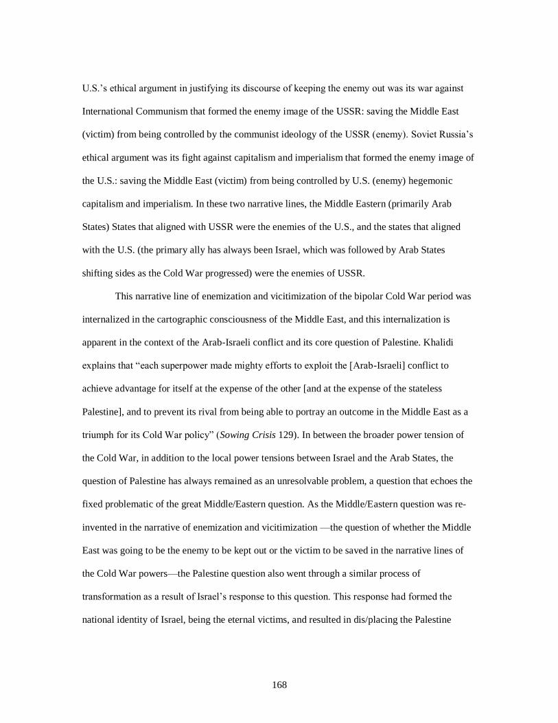
168
U.S.’s ethical argument in justifying its discourse of keeping the enemy out was its war against
International Communism that formed the enemy image of the USSR: saving the Middle East
(victim) from being controlled by the communist ideology of the USSR (enemy). Soviet Russia’s
ethical argument was its fight against capitalism and imperialism that formed the enemy image of
the U.S.: saving the Middle East (victim) from being controlled by U.S. (enemy) hegemonic
capitalism and imperialism. In these two narrative lines, the Middle Eastern (primarily Arab
States) States that aligned with USSR were the enemies of the U.S., and the states that aligned
with the U.S. (the primary ally has always been Israel, which was followed by Arab States
shifting sides as the Cold War progressed) were the enemies of USSR.
This narrative line of enemization and vicitimization of the bipolar Cold War period was
internalized in the cartographic consciousness of the Middle East, and this internalization is
apparent in the context of the Arab-Israeli conflict and its core question of Palestine. Khalidi
explains that “each superpower made mighty efforts to exploit the [Arab-Israeli] conflict to
achieve advantage for itself at the expense of the other [and at the expense of the stateless
Palestine], and to prevent its rival from being able to portray an outcome in the Middle East as a
triumph for its Cold War policy” (Sowing Crisis 129). In between the broader power tension of
the Cold War, in addition to the local power tensions between Israel and the Arab States, the
question of Palestine has always remained as an unresolvable problem, a question that echoes the
fixed problematic of the great Middle/Eastern question. As the Middle/Eastern question was re-
invented in the narrative of enemization and vicitimization —the question of whether the Middle
East was going to be the enemy to be kept out or the victim to be saved in the narrative lines of
the Cold War powers—the Palestine question also went through a similar process of
transformation as a result of Israel’s response to this question. This response had formed the
national identity of Israel, being the eternal victims, and resulted in dis/placing the Palestine

169
question into the placeless condition of being the enemy: yet another form of alienating rhetoric
using the productive networks of power.
Israel’s alienating rhetorical re-invention of its enemy image is a violent exercise of
power that disposed the Palestine nation into the spaceless memory of the Holocaust. Dag Jorund
Lonning indicates that “In the first decades of Israel’s existence, Palestinians were openly labeled
anti-Semites by Israeli leaders. For example, the symbol of the Holocaust—one of the greatest
evils of humanity—has been taken out of its historical context and repeatedly been projected at
the Palestinians who thus are presented as being capable of repeating what the Nazis did, if not
harshly prevented by Israel from so doing” (144-145). I approach this violent rhetorical re-
invention as an internalization of the bifurcated Cold War narrative of enemization and
victimization because I consider the tension in the Israel and Palestine conflict as the mirror
image of the broader Cold War tension between U.S. and USSR. The mirror function rooted the
enemy and victim images depicted by U.S. and USSR deeper into the region and resulted in the
still continuing violent relationship between Israel and Palestine.63 Through this mirror effect, the
narrative line of enemization and victimization became the core discourse defining the socio-
spatial identities of both Israel and Palestine.
I re-read the dichotomized equation of this narrative line through the metaphors of tree-
system and rhizome. Palestine is a rhizome constantly being cut in its joints by the roots of the
tree-system of Israel; yet for the tree-system of Israel to survive, the lines of the Palestinian
rhizome need to form new connections within and in-between the roots and radicles of Israel for
Israel’s tree to reproduce more roots from the rhizome of Palestine. I diagnose the rhizome of
Palestine with the disease of home/sickness due to how the people of Palestine have been under
63 This function of the mirror and the internalization of its enemy image becomes more apparent with the
full alignment of Israel with U.S. and as a result Soviet Russia’s escalated attempts of keeping Arab proxies
like Egypt and Syria on its side in the outcome of the1967 war: the alignment of the enemy and victim
images under the narrative lines of the bipolar Cold War vision. See Rashid Khalidi Sowing Crisis.

170
the close surveillance of Israel and its strong will to secure its promised safe Homeland at any
cost.
Israel’s Socio-Spatial Constructions of Victim and Enemy Images: A Carto-
Rhetorical Deconstructive Reading
Within the Middle East’s broader chaotic dynamic, the Israel-Palestine conflict has been
a continuing internal crisis within the region. This long-term conflict in the shadow of war,
violence, and terrorism, as Lonning explains, “has gradually become cultural…[and] symbolic” in
the socio-spatial identities of both nations. Especially during its early years, the State of Israel
was inventing a collective vision bringing European and Oriental Jewish people under one
umbrella against the common enemy: Palestine. To unpack how Israel has been producing the
enemy image of Palestine within the spatial territory that has been a home for the Israeli-Palestine
conflict, I present a carto-rhetorical deconstructive reading of the 1957 national atlas of Israel:
Israel in Pictorial Maps.64 The reason behind performing with maps stems from a consideration
of the very land itself at the core of this conflict. For Israel, establishing a strong national
ownership in its promised homeland was one of the central rhetorical moves in re-inventing its
national identity. I argue that Israel inflicted a form of cartographic silence in this national move
to “dehumanize the landscape” that presented an absent image of Palestinian people (Brian
Harley, “Silences and Secrecy” 99).
The cartographic narrative in Israel in Pictorial Maps presents an absent image of
Palestine that is presented beyond the borders in a land of nothingness, which is a way to erase
the social-cultural historical connections Palestinians have to the land over which Israel claimed
64 This Atlas is digitally available through the David Rumsey Map Collection Database. The home of the
physical map collection is the David Rumsey Map Center at Stanford University Library. To view this atlas
visit
http://www.davidrumsey.com/luna/servlet/view/search?q=publication_author=%22Department%20of%20S
urveys%2C%20Ministry%20of%20Labour%22&sort=Pub_List_No_InitialSort,Pub_Date,Pub_List_No,Se
ries_No

171
ownership. Lonning indicates that the State of Israel “was defined more or less before the nation
itself existed as an imagined community. The state was even defined before the nation was
physically present” (43). Benedict Anderson defines the notion of nation “as an imagined political
community—and imagined as both inherently limited and sovereign” (6). Israel actualized the
physical existence and presence of its national identity within the imagined borders of its national
homeland. A cartographic narrativity of this national atlas, then, works to establish the particular
cultural characteristics of the Israeli nation within the borders of its national space. The overall
pictorial story this atlas narrates for its audience is about “progress, homogeneity, cultural
organicism, the deep nation, the long past—that rationalize the authoritarian, normalizing
tendencies within cultures in the name of the national interest or the ethnic prerogative” (Homi
Bhabha, Nation and Narration 4): the modern and civilized image of Israeli nation. The rhetorical
context shaping the cartographic
visualization in this atlas
presents how Israel narrated its
national identity as a cultural
product of a Western modern
nation. In this sense, Israel made
a map and it made sure to erase
the existence of Palestine from
the socio-spatial reality
representing the national
identity of the Israeli Homeland.
This atlas opens its narrative structure with a map of Israel (see Fig. 12) complemented
by a written commentary that defines Israel’s historical, geographical, and physical characteristics
Fig. 12. Text Page: Israel

172
that form its overall cultural image as a great nation that had a “deep imprint of civilization.” The
geographical location in the map is distinctly divided under the categorizing lines of a territorial
chart, a chart that marks cities and regions in their exact spaces. The written commentary that
defines the meaning of the cartographic representation of Israel illustrates how eternal connection
and belonging to the Homeland is historicized and imagined in the cultural reality of the Jewish
people, which legitimizes the rightful claim to the territory:
Indication of the unbroken contact between the people and the land are to be found in
every part of the country and dating from every period. The Jewish People retained in dispersal
its memory of the land, and carried in its heart and soul the names of its mountains and valleys,
its towns and villages, and above all, the memory of Jerusalem, the Holy City.
This part from the commentary to this first map is an example of how the socio-spatial
identity of not only Israel and but also Palestine was re-written: by detaching the land from its
diverse geographies of cultures and by totalizing and homogenizing the land under so-called
indigenous ownership, almost like a birth right. This entitles the space of the geography to its
rightful owners and occupiers, the Israeli nation, and results in defining and also justifying getting
the alien invaders out, the Palestinian nation. This cartographic absence and erasure of Palestine
stems from the desire to keep the enemy out, away from the safe haven Israel embraces as its
national homeland.
What follows this first map is the content page (see Fig. 13) which unpacks the central
symbols that form Israel’s national identity, and which Loning describes as 1) fear, 2)
victimization, 3) security, 4) the soldier, and 5) collectivization and separation (144-51). The
content page provides an explanation of the symbols that form the overall cartographic language
of this atlas and the rest of the maps that this atlas uses. I suggest that this cartographic discourse,
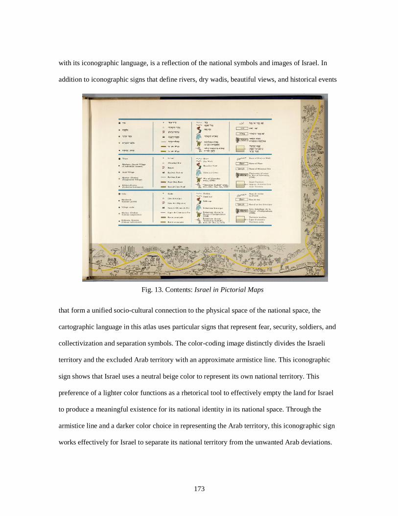
173
with its iconographic language, is a reflection of the national symbols and images of Israel. In
addition to iconographic signs that define rivers, dry wadis, beautiful views, and historical events
that form a unified socio-cultural connection to the physical space of the national space, the
cartographic language in this atlas uses particular signs that represent fear, security, soldiers, and
collectivization and separation symbols. The color-coding image distinctly divides the Israeli
territory and the excluded Arab territory with an approximate armistice line. This iconographic
sign shows that Israel uses a neutral beige color to represent its own national territory. This
preference of a lighter color functions as a rhetorical tool to effectively empty the land for Israel
to produce a meaningful existence for its national identity in its national space. Through the
armistice line and a darker color choice in representing the Arab territory, this iconographic sign
works effectively for Israel to separate its national territory from the unwanted Arab deviations.
Fig. 13. Contents: Israel in Pictorial Maps

174
Additionally, the armistice line that separates Israel from Arab territories implements the notion
of securing Israel from their enemies, and this desire to secure the land stems from the notion of
fear: the fear of losing the safe haven the eternal victims were promised.
The two soldier images in this cartographic glossary, on one hand, represent the two
important victories Israel had won in its efforts to establish ownership over its homeland: the War
of Liberation (1948) and Operation Kadesh (Oct. 29th-Nov. 5th, 1956). The War of Liberation
represents Israel’s independence, which is why the historical representation of this event with a
soldier image reveals the importance of the soldier as a national symbol for Israel. This military
victory for Israel’s independence is an event Palestine remembers as al-Nakba (the catastrophe).
In the context of keeping the enemy out of its national space, then, the soldier image for Israel
represents a memory of military victory, which resulted in establishing ownership over the land
by causing catastrophic consequences for the displaced Palestinian people. In this sense, the
soldier image is a symbol for securing Israel’s national homeland by pushing the enemy out
through the use of excessive violence due to the deep fear that continues to haunt the Israeli
nation today.
This soldier image immortalizes the place-memory of independence and the Palestinian
catastrophe in the consciousness of Israel’s national identity, which justifies the violent
displacements of Palestinian people: violence is a necessity to secure the national homeland. In
this place-memory of independence embodied in the soldier symbol, however, the Palestinian
experience is present through absence. This silent presence is a form of indirect representation of
the enemy image of the Palestine. The victory that brought Independence was a victory won
against the Palestinian enemy. This indirect representation is yet another rhetorical move in the
cartographic discourse of this atlas, which keeps any direct representation and/or presence of
Palestine experience and memory out of sight/site. The use of rhetorical cartography as a form of
175
rhetorical invention, then, serves Israel’s purpose of dehumanizing Palestine in an empty,
deserted space with a strong enemy image, which echoes the dehumanized reality of the Oriental
Other. Within the overall reality of the Middle East, which became another Oriental/Eastern
problem to be fixed for the modern West and its political power networks, Palestine became a
problem for Israel to overcome as well. Israel aimed to effectively resolve this problem by
pushing Palestine out and erasing its socio-cultural and historical presence in the land.
The iconographic language presented in this atlas’s content page frames the context of
rhetorical alienation and marginalization, which forms the cartographic narrative. The pictorial
maps in this atlas contribute to the overall narrative, which presents Israel as a rich land filled
with natural resources, beautiful views, and historical roots. It is the modern land of Israel
connected with railways, roads, schools, and resorts, a peaceful and nourished land that is
secured, protected and distinctly separated from the enemy: the cartographic image of Israel’s
safe haven. Each map is a cartographic pictorial visualization of individual cities in Israel, and
these cities are narrated through the repetitive use of this atlas’s cartographic language. The
repetition of central iconographic signs strengthens the core argument this atlas makes: the Jewish
people are finally safe in their promised homeland.
The emphasis on this central argument stems from how the national symbols of Israel
were formed in the catastrophic violent experience of WWII. As the victims and survivors of the
Holocaust, the people of Israel were already a nation with the imagined reality of a homeland
wherein they can finally be safe. The Palestinian territory was a promised land for Israel, which is
why “many of the Jewish emigrants arriving in Palestine were genuinely surprised to find a
settled population living there. Palestine had be characterized as, ‘A land with no people for a
people with no land’” (Oliver James 404). This characterization resulted in emptying the
geography of this space, which made it possible to re-write the socio-spatial consciousness of this

176
whitened space under a new identity and reality: finally, the suffering nation, the eternal victim,
was safe in its promised homeland. However, this came with a certain level of paranoia: who was
the enemy now? The response to this question, I argue, came with determining how to secure the
homeland against the unwanted others. The unwanted
other in this land, the Palestine nation, immediately
became a threat for Israel to actualize its safe haven.
As a result, securing the land defined Palestine as the
new enemy for Israel. The national symbols that
inform the cartographic language of this atlas have
“connotations to such horrible manifestations of
Jewish suffering, bridges internal differences by the
use of one central logic: We are all Jews, and we must stand
united in the face of our collective enemy. The most central symbol used to communicate Israeli
identity is not ‘what we are,’ but ‘what we are not’” (Lonning 144-45). The repetitive use of these
national symbols in the cartographic space of each pictorial map in this atlas serves to define what
Israel is not: not being subjected to violence/finally
being safe. Each map re-invents Israel at peace in its
homeland through the use of set borders, signs
pointing to where Israel is, and the illustration of
what is on the side of the borders as emptiness and
nothingness. For example, the maps of Safad and
Nahariya (see Fig. 14 and Fig. 15), the two cities in
between the borders to Lebanon and Syria, use the symbol of a
soldier to persuade their audience of the existing threat that is beyond the borders and how the
Fig. 14. Safad
Fig. 15. Nahariya

177
brave soldiers of Israel keep this threat out: the
feared enemy. According to Lonning, the
roots of Israeli fears “can be ascribed to
symbolic and ideological manipulation. These
fears are an important and essential part of
Israeli identity, and are frequently used by
individuals to communicate this
identity…While Palestinian fears are directed
at a particular collective political
manifestation of their enemy, Israeli fears are directed at an
almost meta-physical inherent property—some kind of a violent urge—of the individual
Palestinian” (147). This argument is being used to convince the public to understand and support
the decisions the Israeli government makes: their strategic policies in taking drastic measures and
violent precautions and actions. This is a way to bring the people of Israel under one goal, one
image, and one purpose: keeping the homeland safe, keeping the enemy out in order to be safe—
the narrative line of victimization rooted in the notion of fear.
The national symbol of security is strongly established in the pictorial maps in this atlas
through the use of the solider symbol. For example, in the pictorial map of Tel Aviv (see Fig. 16),
the notion of security and peace is evident pictorial representation of how Jewish people arrive to
their safe Homeland with boats, while the borders are closed and the land is protected. In this
pictorial narrative, what is outside of the borders is exactly what Israel is not: nothingness, a no-
man’s land, the excluded other echoing the image of the Orient; and the inside of the borders is
the safe and peaceful Israel welcoming Jewish people to their home. The strategic use of
cartographic language in presenting the space of Tel Aviv functions as a rhetorical tool that
Fig. 16. Tel Aviv

178
illustrates Israel in a rich land with a
rich history, culture, and modern
society. This pictorial spatial
representation is in perfect consonance
between what is present outside of the
borders: the silent absence of
Palestinian people.
The notion of security and the
important role of the soldier, as part of
Israel’s national identity, are generated
from the symbols of fear and
victimization: fearing the enemy on the other side of the border. These symbols also generate the
other national characteristics that I have discussed so far: collectivization and separation. In this
equation, the symbolic representation of
the soldier plays a significant role to
prevent the feared terrorist activities of
the Palestinians and other Arab nations
supporting the liberation of Palestine.
The soldier symbols in the pictorial maps
of Ashqelon and Natanya (see Fig. 17
and Fig. 18) are located either at the
borders separating Gaza from Israel or in
different parts of these cities. In these two
cartographic representations, the soldier symbols are watching over the safe land and its people.
Fig. 17. Ashqelon
Fig. 18. Natanya

179
The main purpose is keeping the enemy out at any cost: at the expense of Palestinian lives, at the
expense of their social and economic balance.
The cartographic narration of the Israeli homeland resulted in an imagined invisible
presence of the Palestinian people as the enemy beyond the borders, almost out of sight, with a
strong presence of being a threat to the Israeli nation. This fear of the enemy and the strong desire
to keep Israel safe with a strong soldier image that initiates Israel’s strong and masculine identity
is evident in how Israel has been responding to the Palestinian resistance to the occupation.
Lonning maintains that “when a terrorist activity occurs in Israel, boundaries are placed on the
Occupied Territories. Politicians employ the security concept as legitimization… Thus it is
impossible to argue that closing the Territories leads to a halt in terrorism. On the contrary, it
often leads to acts of revenge by Palestinian extremists. It has other effects, however. Firstly, it is
collective punishment, as the flow of capital into Palestine society is severely
damaged…Secondly, and more importantly, it is a temporary measure against fear; simple
reducing the Palestinian presence in Israeli streets” (148-149). This collective punishment is a
reflection of the collective identity of Israel: a totalization under one land and one national image
continuously reproducing its victimization and as a result its strong will to secure and protect its
Homeland under the closer surveillance of Homeland Security.
Today, the Israeli government continues to delete the existence of home/sick Palestine
from the map. The Israeli government’s effort to implement a de-facto annexation of Palestinian
land is an indication of how Israel continues to re-construct its national homeland in alignment
with its national identity: Israeli homeland for the Israeli Jewish State.65 These political efforts are
supported by physical actions aiming not only to keep Palestinians out but to also erase them
65 Aruri, Issam. "Israel's Greater Jerusalem Bill: Settlers In, Palestinians out." Middle East Eye. N.p., 3
Nov. 2017. Web.

180
from Israel’s national homeland.66 Especially following President Donald Trump’s recognition of
Jerusalem as the capital of Israel, the Israeli Government’s efforts in keeping Palestinians out
became a form of “ethnic cleansing.” Territorial ownership continues to be one of the primary
denominators in defining Israel as a State only for Jewish people. In this stateless in-transition
condition, Palestine has been a problem, a deviation that needed to be fixed and eliminated for
Israel.
From the Enemy-Victim Dichotomy to the Enemy-Heroine-Victim Triad: Israel-
Palestine Conflict in Middle East Today
Today, these enemy and victim images continue to shape and inform the long-term Israel-
Palestine conflict in the dominant networks of media outlets. However, in the rhetorical context
of this conflict, a new image, a counter-image has been emerging with the arrest of a blonde
haired Palestinian girl: Ahed Tamimi. Her inhumane, non-democratic, and violent treatment by
the Israeli government as a response to Tamimi slapping an Israeli soldier has attracted a growing
global respond to Israel and its long-lasting occupation of Palestine. In many global media
platforms, particularly reporting news from the Middle East such as Al-Jazeera67, Middle East
Monitor68, and Middle East Eye69, Tamimi became the new image and face of resistance and most
importantly the embodiment of the new heroine image as the real wonder woman70 that represents
the Palestinian freedom movement. The emergence of this new heroine image in the global media
representation had an impact on how the Israeli people have also been responding to Tamimi as a
66 Sneineh, Mustafa Abu. "'Pushing out Palestinians': Israel Installs Concrete Checkpoints at Old City
Gate." Middle East Eye. N.p., 13 Feb. 2018. Web. 67 Nafi, Tariq, Honaida Ghanim, Abir Kopty, Oren Persico, Assaf Harel, and Manal Tamimi. "Ahed
Tamimi: One Story, Multiple Narratives." Al Jazeera: The Listening Post. Al Jazeera, 4 Mar. 2018. Web. 68 Smith, Amelia. "Here Come the next Generation of Female, Middle East Activists." Middle East
Monitor. N.p., 8 Mar. 2018. Web. 69 Elia, Nada. "The Face of Palestinian Women's Defiance Is a 16-year-old Girl." Middle East Eye. N.p., 25
Dec. 2017. Web. 70 Is Ahed Tamimi the New Che Guevara? AJ+ Facebook, 15 Feb. 2018. Web.

181
heroine of the Palestinian resistance movement. The division around enemy, victim, and the new
heroine images in responding to Palestine and Tammi within Israel’s public discourse is evident
in the opinions pieces published in one of Israel’s well-read news media outlets, Haaretz.71 These
pieces reflect the public opinion about Tamimi in Israel and illustrate that even though this new
heroine image has been challenging Israel’s dominant discourse, the enemy and victim images
continue to be at the center of the Israeli-Palestinian conflict and shape how the Israeli
government and people respond to the Palestine question/problem.
In re-constructing the broader Middle Eastern problem as a result of the violent 9/11
terrorist attacks, the war on terror discourse established a zero tolerance policy against any
possible terrorist threats. While I do not support any violent action, and I do believe that terrorism
is an act that deserves a zero tolerance policy, the problem at hand is not necessarily about how to
deal with the violent and inhumane consequences of terrorism. The war on terror discourse
resulted in extensively totalizing the Middle East under the enemy image of terrorist Muslims as
the popular Western representation narrates it. Mahmood Mamdani indicates that the war on
terrorism discourse called “for a war to the finish… in the name of justice but understand justice
as revenge… [and it] has processed by dishing out collective punishment, with callous disregard
for either ‘collateral damage’ or legitimate grievances” (3244). The Palestine problem within the
current context of the Israeli-Palestinian conflict has been receiving a similar response from the
Israeli government. The zero tolerance for any terrorist activity and collectively punishing the
Palestinian people have been central to how the Israeli government has been dealing with the
Palestinian problem. This zero tolerance policy and the intensifying acts of displacing Palestinian
people have recently been receiving more attention in the global arena due to the actions of one
brave Palestinian girl: Ahed Tamimi.
71 Haaretz. https://www.haaretz.com. Web.
182
Since her arrest after slapping an Israeli soldier, Tamimi became the face of a heroine
image, which has been attracting global support for Ahed and the Palestine resistance movement
against the occupation.72 While her heroine image in the global networks of media outlets present
this new representation in clear contrast to the how the Israeli government continues to respond to
her action as a terrorist activity, Israeli public opinion is still primarily divided between the victim
and enemy images in responding to the Israeli-Palestine conflict. From December 20, 2017, to
February 07, 2018, Haaretz published ten opinion pieces responding to Tamimi and the
Palestinian occupation/resistance movement by different editorial contributors who are well-
established journalists, historians, professors, researchers, activists, including Ahed’s father
Bassem Tamimi with his letter for Ahed.73 The range of diverse voices these opinion pieces
present is effective in reflecting the division in Israel’s public opinion about Tamimi and
Palestine. Among the ten pieces, there is only one article that directly aligns with the ideology of
the alt-right Israeli government in responding to Tamimi: “Ahed Tamimi and Her Family Aren’t
the Palestinian Saints You Want Them to Be”74 by Petra Marquardt-Bigman.
The central argument Bigman makes in this piece is presented right at the beginning of
her opening statement: “Ahed Tamimi and her family aren’t fighting for peace, and they’re not
just fighting the occupation: They’re fighting to destroy Israel, and their fight is seasoned with
Jew-hatred.” The rhetorical use of an enemy image coupled with the notion of fear and
victimizing the Jewish people are the central elements forming Bigman’s argument. Her focus is
on how Tamimi, and consequently the Palestinian resistance movement, is out to get Israel,
72 “Free Ahed.” Free Ahed. Web. http://freeahed.org. 73 Tamimi, Bassem. "My Daughter, These Are Tears of Struggle." Haaretz. N.p., 31 Dec. 2017. Web.
https://www.haaretz.com/opinion/.premium-ahed-is-16-and-i-couldn-t-be-prouder-of-my-daughter-
1.5629934. 74 Bigman, Petra Marquardt. "Ahed Tamimi and Her Family Aren't the Palestinian Saints You Want Them
to Be." Haaretz. N.p., 5 Jan. 2018. Web. https://www.haaretz.com/opinion/.premium-the-reality-behind
the-tamimi-family-s-resistance-1.5630465.

183
waiting to ruin Israel. This fear has been at the core of Israel in forming its national identity
within the safe space of its homeland as the 1957 national atlas presented. To support her
argument, Bigman attacks Tamimi’s and her family’s character images with the purpose of
ruining their credibility. Bigman indicates that their fight for freedom is not a real fight for
freedom; it is a fight to destroy Israel. She uses her analysis of the multiple family members’
social media posts in addition to a previous bombing committed by Ahlam Tamimi in 2001 in
Jerusalem to illustrate how their actions are driven by their anti-Zionist ideology, intense Jew-
hatred, and enthusiastic support for terrorism. The evidence she provides is logically biased,
especially considering how Bigman remains one-sided in her selection of proof to support her
argument. She does not mention the violent crimes committed against Ahed and her family along
with the many Palestinians who have been suffering the catastrophic conditions of occupation for
decades now. Instead, she chooses to remain biased and closed-minded and says that the
“Tamimis never wanted a peace agreement. They have always wanted the elimination of the
world’s only Jewish State.”
I am neither denying nor refusing to believe that the Israeli people did not suffer by the
ugly face of occupation due to the Palestinian re/actions; however, if a comparison needs to be
made in the name of democracy and human rights, Israel is in a position to seriously consider the
everyday life of Palestine under occupation. This lack of consideration has been a central critique
among the rest of opinion pieces published in Haaretz. Gideon Levy75 explains why Tamimi has
been receiving such violent and inhumane treatment by the Israeli government and the military
court (she is still under arrest and not allowed to see her parents throughout the whole of her trial,
which is closed to the public). His main argument focuses on the fact that Tamimi insulted the
75 Levy, Gideon. "A Girls Chutzpah: Three Reasons a Palestinian Teenage Girl Is Driving Israel
Insane." Haaretz. N.p., 21 Dec. 2017. Web. https://www.haaretz.com/opinion/.premium-3-reasons-a-
palestinian-teen-girl-is-driving-israel-insane-1.5629214.

184
strong and masculine soldier image that is at the core of Israel’s national identity. As Levy
indicates, Tamimi slapped a soldier and the alt-right Israeli government and public reacted “How
dare she…She broke the rules. Slapping is only permitted by soldiers. She is the real provocation,
not the soldier who invaded her house” and severely wounded an “unarmed boy from Salfit” and
her cousin Mohammed Tamimi and definitely not the soldier who “killed Ibrahim Abu Thurya” a
couple of days before Ahed dared to slap an IDF soldier. Instead of slapping a soldier, as Levy
continues, Ahed “was supposed to fall in love with the soldier” who violated hers and many
Palestinians’ basic human rights; but instead “she rewarded him with a slap. It is all because of
the incitement. Otherwise she wouldn’t hate her conqueror.”
Levy’s insightful reading and analysis of the revengeful responses to Tamimi asking her
to spend the rest of her life in prison, or even worse asking for her death, reveal a crucial point:
the lack of understanding of the everyday reality of the Israeli occupation of Palestine due to how
the Israeli media outlets refuse to provide any space to represent the Palestinian experience.
However, with one slap Levy writes, Tamimi’s continuing appearance on the Israeli media outlets
“shattered several myths for Israelis. Worst of all, she dared to damage the Israeli myth of
masculinity.” Her actions damage the security that the strong Israeli soldier image has been
providing for the Israeli people, and fear took over the Israeli government. They needed to fix this
damage and save the reputation of their soldier image. As a result, Israel showed zero tolerance
for the terrorist Ahed. However, the image of the girl with the golden curls has already been
challenging the “demonization and dehumanization” of the Palestinian terrorist, the eternal
enemy. She challenges this image not only because she does not look like the dark and violent
image of the Palestinian enemy the Israeli public internalized, but also, as Levy indicates, because
she made the Israeli public question how a sixteen-year-old girl who slapped a soldier and who
did not have any weapons on her is able to represent a threat, a danger to the security of Israel.

185
Many other opinion pieces published in Haaretz support Levy’s point of view. Ahed has
never been a danger. Understanding what happened prior to her out-burst at an Israeli soldier
coupled with a life spent under occupation explains why Ahed did what she did. Who can blame
her? It is apparent that “Its Not a Fair Fight”76 as the Haaretz Editorial piece uses as its title. This
piece, while acknowledging the unfair arrest and treatment of Ahed, also claims that the soldier
Ahed slapped presented a noble behavior by not using force against Ahed. The video shared
widely in various news media outlets support this argument. It is true that the soldier remained
calm, he did not hurt Ahed while her cousin and mother were recording the entire incident. This
comes as an interesting yet also a common opinion among the other opinion pieces published in
Haaretz. The overall argument says that Ahed is not the one to blame, and the soldiers should not
be blamed either. It is the occupation, the Israeli government. Ahed is a brave young Palestinian
girl who rightfully wanted to provoke a response from an Israeli soldier due to how the
occupation severely hurt her cousin and many other Palestinian youth; yet soldiers are not to
blame. They are both victims of the occupation: noble victims who are also heroes/heroines due
to their noble actions. Apparently, this is the reality of occupation that both Palestinians and
Israeli soldiers experience on a daily basis. While these opinion pieces show support for Ahed
and ask for occupation to end as a solution to stop these violent crimes, the desire to save Israel’s
beloved soldier image functions as a rhetorical move to re-narrate Israel’s place in the story of
occupation: it is the government we must blame; not the Israeli people who are also the victims of
occupation.
Saving Israel’s noble and modern national identity in the global representation is a strong
force among these opinion pieces. Yes, the public supports Ahed and wants for occupation to
end; however, this emerging support for Ahed un/consciously works to tell the story of
76 Haaretz Editorial. “Its Not a Fair Fight.” Haaretz. N.p., 20 Dec. 2017. Web.
https://www.haaretz.com/opinion/editorial/its-not-a-fair-fight-1.5629145.

186
occupation and the Israel-Palestine conflict primarily in the Israeli experience to save Israel’s
national image. She is a heroine; she is the “Joan of Arc in a West Bank Village”77 as Uri Avnery
presents her in the title of his piece. This is actually a response to the poem posted on Instagram
by the “iconic Israeli poet Jonathan Geffen” who portrayed Ahed “as a victim of occupation” and
compared her to the historical—white—women heroines including Joan of Arc in addition to
Hannah Senesh and Anne Frank, as Fishman reports in “Once Israeli Pop Culture Icons Publicly
Criticized the Occupation. What Silences them?”78 According to Fishman, it is the outraged
responses from the Israeli public: “How dare Geffen compare ‘Palestinian criminal’ with Anne
Frank. Was Geffen comparing Jews to Nazis?” This rage to present her as a heroine, which is
becoming one of the central images of the Palestinian freedom movement, needed to stop her,
which resulted in the Israeli government arresting her and putting her behind bars. Avnery writes
that “abusing her in jail will only enhance her ability to impress others her age who are living
under occupation.” This stupidity of the Israeli government, the stupidity of occupation, will
bring Israel down according to Avnery. So, how can the Israeli public fix the outcomes of this
stupidity? How can they prevent this stupidity from ruining the Israeli image?
A piece by Avshalom Halutz, titled “Ahed Tamimi is The Palestinian Bar Rafaeli,”79
presents how the Israeli left has been responding to these concerns by not only embracing
Tamimi’s heroine image, but also narrating this image in the Israeli voice and experience. Halutz
also refers to Geffen’s comparison of Ahed to iconic historical female heroine figures in his
argument, yet he presents a different approach: “the repeated attempt to glorify Tamimi through
77 Avnery, Uri. "Joan of Arc in a West Bank Village." Haaretz. N.p., 2 Jan. 2018. Web.
https://www.haaretz.com/opinion/.premium-joan-of-arc-in-a-west-bank-village-1.5630101. 78 Fishman, Louis. "Once, Israeli Pop Culture Icons Publicly Criticized the Occupation. What Silenced
Them?" Haaretz. N.p., 7 Feb. 2018. Web. https://www.haaretz.com/opinion/.premium-what-happens-
when-an-israeli-poet-compares-ahed-tamimi-to-anne-frank-1.5791698. 79 Halutz, Avshalom. "Ahed Tamimi Is The Palestinian Bar Refaeli." Haaretz. N.p., 28 Jan. 2018. Web.
https://www.haaretz.com/opinion/.premium-the-palestinian-bar-refaeli-1.5768064.

187
comparisons with other, white, women exposed the Israeli left’s desire to take control of that gaze
that she triggers in us [Israeli public.] Rather than allowing the Palestinians to define their own
heroes, the left insists on creating its own narrative surrounding Tamimi, shaping her story
through simultaneous translation into Western imagery.” Halutz indicates that Ahed actually
looks less heroic for the Israeli public than she is, but there is a desire for her to be the heroine
that also reflects the Israeli image as part of the Palestinian movement. I claim that this desire is
for saving the Israeli nation’s image more than it is for saving the Palestinian people. Finally,
Halutz says that if we are going to glorify Tamimi as a heroine through Western metaphors, then
let’s do it right: “Tamimi is the Palestinian version of Israeli supermodel Bar Rafaeli. Like
Rafaeli, who paradoxically symbolizes the ultimate Israeli because she allows Israelis to maintain
the lie that they so much love regarding their ethnic and cultural identity, Tamimi also frees the
Palestinians from their actual reality, taking them in the Israeli eyes into the realms of
imagination and fantasy. The result is either adoration or loathing, depending on the observer’s
point of view.” I add to Halutz’s final statement in his piece only one thing: this adoration or
loathing in regards to Tamimi’s heroine image either victimizes due to how her bravery resulted
in her continuous suffering or enemizes her due to how her actions threatened the masculinity of
Israel’s soldier image.
While Tamimi’s heroine image has definitely started a change in Israel’s public opinion
of the Palestinian occupation, her actions, her fight for freedom, and especially any kind of
critique and support coming from Israel for her and Palestine, still continues to prioritize
protecting Israel’s national image in the global representation, international safety of Jewish
people, and the national peace. I read this outcome as a desire to protect the national symbols that
define Israel and its national homeland. While the Israeli public is divided between either seeing
Tamimi as the enemy or as the victim who did a heroic act, for the alt-right Israeli government,

188
the safe haven that the 1957 Israel in Pictorial Maps atlas depicts is still not open to any
negotiation. The dream of turning Israel into a state for only Jewish people, to the only Jewish
State in the world, continues to keep Tamimi and Palestinian people behind the in/visible bars,
borders, and check points of occupation, colonialism, and imperialism: the life of living in an
open prison.

189
CONCLUSION: HOW DID WE GET HERE? THE MIDDLE EAST AS
THE GLOBAL ENEMY
“Part of power is to be able to domesticate the unfamiliar, in other words, to create home in distant
and foreign places.” Joanne P. Sharp, Geographies of Postcolonialism, 66
I have been following Ahed’s trial since her arrest in December, 2017. It finally reached
an end. Not only Ahed, but also her mother, Nariman, are sentenced to eight months in prison.
For every day Ahed will spend in prison, she is also going to be paying 5,000 shekels ($1400) to
the Israeli government.80 Ahed’s cousin Janna Jihad Ayyad, whom I met as the youngest
journalist of Palestine while she was ten years old,81 told AJ+ that she was very proud of Ahed
because she saw the hope in her eyes; she said that she saw how strong Ahed was for trying to
protect her friends who were playing near her house.82 Ahed’s response to the Israeli court’s
decision shows why Janna saw hope and bravery in her: “There is not justice under the
occupation and this court is illegal,” Ahed said.83 Ahed, and many other young girls like her, are
fighting for the right not to fear being killed as they play in their homes, backyards; they are
raising their voices not to be afraid as they walk home from school; they are resisting the
occupation, the war, the violence so that they are not forced to leave the land they know as home;
they are writing their own stories so that they can save many other children who were condemned
80 For details about Ahed’s trial and sentence, see: Ashly, Jaclynn. "Ahed Tamimi Gets Eight Months in
Prison after Plea Deal." Al Jazeera. N.p., 22 Mar. 2018. Web.
https://www.aljazeera.com/news/2018/03/ahed-tamimi-months-prison-plea-deal-180321201412587.html.
and Al Jazeera. "Why Did Ahed Tamimi Accept a Plea Deal?" Al Jazeera. N.p., 23 Mar. 2018. Web.
https://www.aljazeera.com/news/2018/03/ahed-tamimi-accept-plea-deal-180323124553514.html. 81 Meet Janna through Al-Jazeera’s cover of her on April 28th, 2016: Sarkar, Urvashi. "Janna Jihad: Meet
Palestine's 10-year-old Journalist." Al Jazeera. N.p., 28 Apr. 2016. Web.
https://www.aljazeera.com/news/2016/04/janna-jihad-meet-palestine-10-year-journalist-
160426132139682.html. 82 Learn more on Ahed’s trial and hour cousin’s statement from: AJ+Facebook. “Ahed Tamimi
Sentenced.” AJ+ Facebook. AJ+, 21 Mar. 2018. Web.
https://www.facebook.com/ajplusenglish/videos/1165961490212023/. 83 To see her response to the Israeli court’s decision, see: Middle East Eye Facebook. “Ahed Tamimi to
Serve 8 Months in Prison.” Middle East Eye Facebook. Middle East Eye. Mar. 22. 2018. Wed.
https://www.facebook.com/MiddleEastEye/videos/1678858025512912/.

190
to be refugees and lost their lives on the shores far away from home like Aylan. They refused to
be the enemy or the victim, and they certainly do not let anyone domesticate them. They are
writing the Middle East and I am writing with them.
The current reality of the Middle East as a region of chaos, a land wherein people
experience violations of human rights on a daily basis, is rooted in the dominant storyline that has
been blaming Islam. Rashid Khalidi argues that
With little or no serious historical other scholarly underpinning, a plethora of
commentaries purport to ascribe the undemocratic nature of most current Middle Eastern
regimes to something inherent in Islam, the predominant religion in the region. These
ahistorical, essentialist, and occasionally borderline-racist theories…are belied by the
growth of democracy, albeit often in a troubled fashion, in large majority-Muslim
countries like Indonesia, Malaysia, and Nigeria. They are belied as well by the lengthy
history of struggles for democracy and constitutionalism in Middle Eastern countries
between the latter part of the nine-teenth century and the middle of the twentieth
century.” (Sowing Crisis 2388-92)
These complex struggles, as Khalidi continues, invented the Middle East as a region
lacking democracy; however, blaming Islam for the problems of the Middle East does not do
justice to the real issues that have been ruling the region. The reasons for lack of democracy in
Middle East, is due to “the well-known obstacles to democratic governance: much of the Middle
East is certainly affected by having powerful states with a tradition of strong rulers; elites loath to
give up their privileges or their control of the political system; high levels of poverty and
illiteracy in some sectors in certain countries; and weak political parties, unions, and professional
associations” (Khalidi, Sowing Crisis 2403). These well-known obstacles are indicators for how

191
Gramsci defines the notion of domination by consent.84 The Middle East has been dealing with
these obstacles due to internalizing Western power rivalries over the region throughout the
twentieth century.
From the Multipolar European Gaze to Bipolar Cold War Gaze over Middle East
In the post-WWII period—decolonization of Middle East—the independent nation-states
of Middle East adapted the European nation-state structure, which failed to represent the diverse
identities. During the bipolar Cold War rivalry between the United States and the Soviet Russia,
while USSR supported the secular pan-Arab movement, U.S. aligned with the conservative
political ideology of pan-Islamism to prevent USSR supported progressive Arab nationalist
movements to turn the Middle East into another communist entity (Khalidi, Sowing Crisis 381-
85). In this context, Khalidi continues, it might be hard to believe that considering the current
dominant American discourse on demonized Muslim, “Islam as an ideological tool thus proved
useful to the United States and its allies among the conservative forces in the Arab and Islamic
worlds, which…seemed largely on the defensive in the face of the Soviet-backed ‘progressive’
Arab regimes” (Sowing Crisis 385-89). According to Mahmood Mamdani, “as the battleground of
the Cold War shifted from southern Africa to Central America and central Asia in the late
seventies, America’s benign attitude toward political terror turned into a brazen embrace: both the
contras in Nicaragua and later al-Qaeda (and the Taliban) in Afghanistan were American allied
during the Cold War. Supporting them showed a determination to win the Cold War “by all
means necessary,” a phrase that could refer only to unjust means. The result of an alliance gone
sour, 9/11 needs to be understood first and foremost as the unfinished business of the Cold War”
(190-3).
84 Chapter 3 provides an explanation of Gramsci’s notion of domination by consent.

192
As the U.S grew stronger during the Cold War period and took all measures and
necessary means to win, the implementation of conservative Islamic regimes in the Middle East
widely succeeded over the secular nationalist movements. This second level of internalization of
the Western root-system only left the region with more excessive violent formations or
disseminations of more localized regions and territories and unfulfilled democracy, freedom, and
security promises. In particular, the growing expansion of the ideas of political Islam as a
movement of resistance against American imperialism was yet another form of seeking to return
the pre-modern political structure of Islam/the caliphate order: the days of power and glory of the
Islamic Empires. Shadi Hamid observes that “the Islamic State is only the latest but perhaps the
most frightening manifestation of this ongoing struggle” in the Middle East (12).
From Middle East to Greater Middle East and Intensification of Enemization
The way that the U.S. has been re-constructing the cartographic reality of the Middle East
since the Cold War period is closely tied to oil resources and strategic military locations in the
region.85 Gaining control over these resources and critical locations during the Cold War period
was a reflection of how the U.S. was moving away from its rhetoric of isolation and intention to
become the dominant center of power on a global level. Especially after the 9/11 terrorist attacks
and the invention of the discourse of war on terror, in the rhetorical context of zero tolerance for
terrorism that the Bush Doctrine produced as the dominant story line, the political ideology of
Islam as the reason for terror and no democracy in the Middle East became the center of the
ethical justification for keeping the Middle East under close political, economic, and military
surveillance for global peace and order. The post-9/11 era resulted in the formation of a Greater
Middle East (Dona Stewart “The Greater Middle East and Reform in the Bush Administration's
Ideological Imagination”). According to James Sidaway, the growing violent and terrorist
85 U.S. usages of Middle East since Cold War video.

193
activities within and from the region have transformed the Oriental image of the Middle East into
a more problematic stereotype, which emerged from the prejudice associating Islam with
terrorism due to the actions of Al-Qaeda. What has followed the 9/11 events has been the
continuous intensification of this image in the popular media, which is grounded in the discourse
of the global war on terrorism as a form of legitimization. Mamdani explains that “the events that
are 9/11 present the world with a particular difficult political challenge, even if this challenge
appears the most immediate for Muslims. Both the American establishment led by President Bush
and the militants of political Islam insist that Islam is a political, and not simply a religious or
cultural, identity. Both are determined to distinguish between ‘good Muslims’ and ‘bad Muslims,’
so as to cultivate and target the latter” (3573-77).
Distinguishing between who the good Muslims are from the bad Muslims is another form
of epistemic violence of codification that Gayatri Spivak explains in “Can the Subaltern Speak?”
These labels that were narrated in the discourse and language of the war on terror in the post-9/11
world are rooted on the political contexts of Islamic terrorism and the political response of the
U.S./West to the ideology of the political Islam. The function of these labels reflect the us-versus-
them binary under the continuing global gaze of the West-versus-East binary, which in political
Islam replaced the Eastern cultures and reduced the diverse societies of the East to a problematic
political context. In Covering Islam, Edward Said unpacks the complex meanings and function of
‘Islam’ and West’ by, first, explaining the how ‘Islam,’ “for most of the Middle Ages and during
the early part of the Renaissance in Europe, …was believed to be a demonic religion of apostasy,
blasphemy, and obscurity” (1073). The already existing negative and unpleasant historical roots
that defined ‘Islam’ as a primitive, violent, and demonic political structure in the
Western/European political context defined the modern culture and society of the West in direct
contrast to the politically charged Islamic culture and society. The political networks of both the

194
West and Islam surpassed the political cultural and social identities of both entities and reduced
these diverse socio-cultural formations to the dominant reality and discourse of the extreme
polarization of the global West-East dichotomy. Said writes that
To a Muslim who talks about ‘the West’ or to an American who talks about ‘Islam,’ these
enormous generalizations have behind them a whole history, enabling and disabling at
the same time. Ideological and shot through with powerful emotions, the labels have
survived many experiences and have been capable of adapting to new events,
information, and realities. At present, ‘Islam,’ and ‘the West’ have taken on a powerful
new urgency everywhere. And we must note immediately that it is always the West, and
not Christianity, that seems pitted against Islam. Why? Because the assumption is that
whereas ‘the West’ is greater than and has surpassed the sage of Christianity, its principal
religion, the world of Islam—its varied societies, histories, and languages
notwithstanding—is still mired in religion, primitivity, and backwardness. Therefore, the
West is modern, greater than the sum of its parts, full of enriching contradictions and yet
always ‘Western’ in its cultural identity; the world of Islam, on the other hand, is no more
than ‘Islam,’ reducible to a small number of unchanging characteristics despite the
appearance of contradictions and experiences of variety that seem on the surface to be as
plentiful as those of the West. (1157-74)
The historical roots of these labels continue to mirror the global West-East dichotomy
into the current discourse of war on terror that defines the Middle East under the extensive
totalization of political Islam as the terrorist enemy of modern Western civilization as the
dominant and popular representation continues to re-narrate the reality of these geopolitical
labels. In the context of the discourse of the war on terror constructed by the Bush administration,
re-construction of the spatial consciousness of Middle East as ‘Greater,’ on the surface level, is an

195
act of defining the vast and diverse regions and identities from Morocco to Pakistan as terrorist
others who are dangerous Muslims and threats to the global peace and unity: a new level of
extensive and unjust totalization. Both in the political climate of the pre- and post-9/11 context,
the politically charged and ethically justified reality of the war on terror discourse was the result
of the post-Cold War tension and conflict between the U.S. and once dominant face of political
Islam, Osama bin Laden and al-Qaeda. Mamdani writes that
Both Bush and bin Laden employ a religious language, the language of good and evil, the
language of no compromise: you are either with us or against us. Both deny the
possibility of a third response. For both, political loyalty comes before political
independence. The danger of bringing notions of good and evil into politics cannot be
underestimated. The consequences of bringing home—wherever home may be—the
language of the war on terror should be clear: it will create a license to demonize
adversaries as terrorist, clearing the ground for a fight to the finish, for with terrorists
there can be no compromise. The result will be to displace attention from issues to
loyalties, to criminalize dissent, and to invite domestic ruin. Worse still, if the struggle
against political enemies is defined as a struggle against evil, it will turn into a holy war.
And in holy war, there can be no compromise. Evil cannot be converted; it must be
eliminated. (3577-85)
The demonization of political Islam and militant fundamentalist Muslims as the terrorist
enemies in the popular conversation of the U.S. has been the most recent form of re-construction
and re-totalization of the diverse identities of the Middle East. Both Said and Mamdani clarify
why the popular reality of Islamic terrorism in the context of political Islam is an unjust
generalization by explaining how Islam as a political system does not represent the culturally and
socially diverse meanings, functions, and practices of Islam as a belief system. In this context,

196
understanding the current terrorist representation of the extensively totalized Islamic world
should happen with a focus on the fact that this narration is a reflection of the political conflict
that has been only intensifying since the end of the Cold War between the overly generalized
Western State under the hegemonic gaze of the U.S. and the overly generalized Middle East
under the hegemonic gaze of political Islam and the Islamic State of the Arab world.
Overall, throughout the twentieth century, the Middle East has been shaped by the
continuing external interventions of the Western powers and internal reactionary resistance
movements that totalized the region, which were “ideologically opposed to democracy in any
form, and all of which tended to undermine democratic regimes whenever these obstructed their
economic or strategic interests” (Khalidi, Sowing Crisis 2407). The ideological oppositions of
Western powers to any democratic regime in the Middle East constructed and fixed the region as
the unresolvable problem that the West—today the U.S.—always has to fix. The eternal question
of the Middle Eastern problem leaves almost no room for any alternative question, response,
and/or representations. However, the brave women of the Middle East are moving against this
one storyline.
Today, the Middle East is writing herself and I have been writing with her! Responding
to the cartographic realities that contributed to the current reality of the region throughout this
project revealed a cruel reality for me. Under all the layers of geopolitical, economic, and military
conflicts within and beyond the borders of the region, the root of the Middle East’s terrorist
image is the product of racial, ethnic, and religious discrimination, which was shaped as a
polarized differentiation under the global gaze of the West-East dichotomy. The political conflicts
and tensions among the nation-states of the West and the Middle East have been a reflection of
this dichotomy. The totalized states of power of the West and the Middle East have taken all the
measures to domesticate and alienate what they perceived to be the different other from their own

197
problematic positions. Unpacking this polarized power dynamic on a global level revealed how,
on one hand, the West had an undeniable role, through its colonial and imperial agendas, in
inflicting chaos and disorder into the Middle East; on the other hand, adopting this global lens
also showed how the Middle East, as a totalized entity of geo/political power system, also
imposed violence and terror throughout the region.
Both overly totalized systems of power re-produced the same problematic narrative of the
grand-myth from slightly different positions of the imperial gaze. The modern West targeted its
eternal non-Western Other as the deviant Oriental alien and re-memorialized the meta-narrative
of the Orient under the mere label of ‘Islam’ “either to explain or indiscriminately condemn
‘Islam’” as the demonized enemy of the modern West (Said, Covering Islam 139). The colonized
Middle East under the haunting memory of the domesticated Orient had a strong desire to reverse
this power dynamic by aiming to restore the glorified days of the hegemonic power of the Islamic
rule under the caliph as a political system; yet trying to re-invent the Islamic State as a political
form of Islamic power only resulted in centralizing Arab nationality as a unified force of
resistance against the modern West, and this centralization of power only resulted in
discriminating and subjugating non-Arab and non-Muslim ethnic identities within and across the
region. Today, the Middle East continues to be a problem in the global arena; yet this problem,
more than it is Islamic terrorism and/or Western imperialism, should be understood as a problem
of socio-cultural injustice, racial and religious discrimination, equality and freedom. It is a
problem of human rights, which is a daily reality that the inhabitants of the region have been
suffering the consequences of this crude violation of their being and existence.
Remaining in the binary structure of the West-East opposition on a global level might
come as a determinist and limited reading of the cartographic construction of the Middle East
throughout the twentieth century especially considering the complexity of the region. The Middle

198
Eastern question as a problem to be fixed, however, was a question that is a Euro-centric
contextualization within this limited global context. This question moved from the extensive
totalization of the Oriental Other to the Middle Eastern Other and was internally re-invented to
frame the problem of Western imperialism in the context of Occidentalism. The West-
East/Orient-Occident global binary has been the central mechanism of power that always re-
positioned both the West and the Middle East as overly generalized realities. These extreme
homogenic political systems came to be perceived as cultural identities that were justified as
universal truths about the people of these geopolitical constructs. On a global level, then, these
bifurcated socio-spatial closed constructs set in/visible borders that today continues to re-invent a
global world order within the same problematic conflict of the us-versus-them discourse. This
discourse has been producing the enemy and victim images, and these images within the
subjective geopolitical positions of the West and the Middle East have only been contributing to
re-narrating the Middle Eastern question as a problem to be fixed. This question remains either a
problem of primitivity in the Western context (the deviant Muslims terrorist threatening the
modern Western society) or a problem of Western imperialism in the Middle Eastern context (the
infidel Westerners threatening the values of the Islamic society).
In this context, adopting the West-East global perspective with a focus on the impacts of
Orientalism and Occidentalism revealed how the changing centers of power both in the West and
the Middle East remained in the same narrative line and intensified the polarization of the
political tension in the context of war and terror. In addition, this global lens provided an
understanding of how the internal movements of in the Middle East started as rhizomatic
movements of resistance and failed due to not being able to avoid the black hole of oriental
determinism, which uses the ethical argument of justification that the Euro-American colonial
domination over the region set forth as the sole reason for the lack of proper governmentality and

199
democracy in the Middle East.86 This global lens allowed me to respond to the spatial reality of
the maps of the Middle East I have analyzed in this project. This analysis showed that the Middle
East is a problem and it will be a problem, and the heart of this problem is what we are ashamed
of and scared to admit—racial, religious, and ethnic discrimination—in our global age in which
we should strive to foster racial and religious equality across the borders of the global
geographies of the West-East/the North-South. We should use discourses of Orientalism and the
global West-East dichotomy as critical lenses with an intellectual awareness and sensitivity about
the complexity and diversity of the issue at hand. We cannot continue to keep attacking the West
or the Middle/East for all the chaos and violence because what needs to matter should be the
lives, voices, needs, and rights of the people who are of and from these geographies of cultures.
The question of the Middle East should be a question of how to restore faith in humanity, and the
problem we need to deal with should be the problem of human rights, social justice, and equality.
Today, the Middle East is writing herself and I am writing with her! And I hope that you
will write with me, with the brave women of Middle East as part of this project: Dis/Orienting
Middle East.
86 In Culture and Imperialism, Covering Islam, and “Orientalism Reconsidered,” Said reflects on how this
deterministic approach of Orientalism has become a limited lens of studying and understanding the diverse
Oriental cultures and identities due to how, as a domain of study, Orientalism was used primarily attacking
the West rather than being applied critically to unpack the multiple layers of complex relations among the
Western and Eastern societies, cultures, and traditions.
Fig. 19. Dis/Orienting The Middle East Project

200
Appendix

201
MAPS CITED
Andree, Richard, and Albert Scobel. Persien, Afghanistan Und Belutschistan. Bielefeld, Leipzig:
Velhagen & Klasing, 1905. David Rumsey Map Collection: Cartography Associates.
Web.
https://www.davidrumsey.com/luna/servlet/detail/RUMSEY~8~1~239395~5511773:Pers
ien,-Afghanistan-und-
Belutschis?sort=Pub_List_No_InitialSort%2CPub_Date%2CPub_List_No%2CSeries_N
o&qvq=w4s:/when%2F1905;q:middle%2Beast;sort:Pub_List_No_InitialSort%2CPub_D
ate%2CPub_List_No%2CSeries_No;lc:RUMSEY~8~1&mi=1&trs=2.
Barfoot, James Richard. L'orient, Or, The Indian Travellers : A Geographical and Historical
Game. London: David Ogilvy, 1794-1846. Yale Center for Births Art, Department of
Rare Books and Manuscripts. Web. http://hdl.handle.net/10079/bibid/578948.
Bartholomew, J.G. Europe and Near East General Commercial Chart. London: George Newnes,
Limited, 1907. David Rumsey Map Collection: Cartography Associates. Web.
https://www.davidrumsey.com/luna/servlet/detail/RUMSEY~8~1~248984~5516379:Eur
ope-and-Near-East---General-
Comm?sort=Pub_List_No_InitialSort%2CPub_Date%2CPub_List_No%2CSeries_No&q
vq=w4s:/when%2F1907;q:middle%2Beast;sort:Pub_List_No_InitialSort%2CPub_Date%
2CPub_List_No%2CSeries_No;lc:RUMSEY~8~1&mi=0&trs=1.
---. South-Western Asia. London: Times, 1922. David Rumsey Map Collection: Cartography
Associates. Web.
https://www.davidrumsey.com/luna/servlet/detail/RUMSEY~8~1~3142~440044:South-
western-Asia
?sort=Pub_List_No_InitialSort%2CPub_Date%2CPub_List_No%2CSeries_No&qvq=w4

202
s:/when%2F1922;q:middle%2Beast;sort:Pub_List_No_InitialSort%2CPub_Date%2CPub
_List_No%2CSeries_No;lc:RUMSEY~8~1&mi=0&trs=4.
Boucher, Lucien. Air France: Réseau Aérien Mondial. Paris: Perceval, 1934. David Rumsey Map
Collection: Cartography Associates. Web.
https://www.davidrumsey.com/luna/servlet/detail/RUMSEY~8~1~266420~90040773:Air
-France-Reseau-Aerien-Mondial--
L?sort=Pub_List_No_InitialSort%2CPub_Date%2CPub_List_No%2CSeries_No&qvq=
w4s:/when%2F1934;q:middle%2Beast;sort:Pub_List_No_InitialSort%2CPub_Date%2C
Pub_List_No%2CSeries_No;lc:RUMSEY~8~1&mi=0&trs=3.
Colton. J.H “Colton's Illustrated and Embellished Steel Plate Map of the World on Mercator's
Projection: Compiled from the Latest and Most Authentic Sources Exhibiting the Recent
Arctic and Antarctic Discoveries and Explorations.” Library of Congress,
www.loc.gov/resource/g3200.ct002354/.
Royal Geographical Society. “Map of Sykes-Picot Agreement.” 1916. Wikipedia,
en.wikipedia.org/wiki/Sykes–Picot_Agreement#/media/File:MPK1-
426_Sykes_Picot_Agreement_Map_signed_8_May_1916.jpg.
Stern, Friedel, and Deaprtment of Surveys, Ministry of Labour. Israel in Pictorial Maps. Tel-
Aviv: Lion the Printer, 1957. David Rumsey Map Collection: Cartography Associates.
Web.
https://www.davidrumsey.com/luna/servlet/view/search?q=pub_list_no%3d%228422.000
%22&sort=Pub_List_No_InitialSort%2cPub_Date%2cPub_List_No%2cSeries_No&qvq
=q:israel%2Bin%2Bpictorial%2Bmaps;sort:Pub_List_No_InitialSort%2CPub_Date%2C
Pub_List_No%2CSeries_No;lc:RUMSEY~8~1&mi=2&trs=44.
203
WORKS CITED
Adelson, Roger. London and the Invention of the Middle East: Money, Power, and War, 1902-
1922, Yale University Press, 1995.
---. “British and U.S. Use and Misuse of the term ‘Middle East’.” Is There a Middle East? Eds.
Michael Bonine, Abbas Amanat, and Micahel E. Gasperd. Stanford University Press,
2011. 36-55.
Adichie, Chimamanda Ngozi. TEDTalks: Chimamanda Adichie--The Danger of a Single Story.
TED, 2009.
https://www.ted.com/talks/chimamanda_adichie_the_danger_of_a_single_story.
Agnew, John. Geopolitics: Re-visioning World Politics. Routledge, 1998.
AJ+Facebook. “Ahed Tamimi Sentenced.” AJ+ Facebook. AJ+, 21 Mar. 2018. Web.
https://www.facebook.com/ajplusenglish/videos/1165961490212023/.
Al-Tikriti, Nabil. “Was there an Iraq before there was an Iraq?,” International Journal of
Contemporary Iraqi Studies, Vol. 3 No. 2, 2009, pp. 133-42.
Al Jazeera. "Why Did Ahed Tamimi Accept a Plea Deal?" Al Jazeera. N.p., 23 Mar. 2018. Web.
https://www.aljazeera.com/news/2018/03/ahed-tamimi-accept-plea-deal-
180323124553514.html.
Anderson, Benedict. Imagined Communities: Reflections on the Origin and Spread of
Nationalism. London/New York: Verso, 2006. Print.
Anderson, Ewan William. The Middle East: Geography and Geopolitics. London and Routledge,
2000.
Anzaldua, Gloria. “La coincienca de la mestizo: Towards a New Consciousness.” Borderlands/La
Frontera: The New Mestiza. Aunt Lute, 1987. 77-91.

204
Aristotle. On Rhetoric: A Theory of Civic Discourse. Trans. George Kennedy. 2nd Edition,
Oxford UP, 2007.
---. Nicomachean Ethics VI. Perseus Digital Library. Ed. H. Rackham. Tufts University, n.d.
Web.
http://www.perseus.tufts.edu/hopper/text?doc=Perseus%3Atext%3A1999.01.0054%3Ab
ook%3D6%3Achapter%3D1%3Asection%3D1.
---. Metaphysics VI. Perseus Digital Library. Tufts University, n.d. Web.
http://www.perseus.tufts.edu/hopper/text?doc=Perseus%3Atext%3A1999.01.0052%3Ab
ook%3D6%3Asection%3D1025b.
Aruri, Issam. "Israel's Greater Jerusalem Bill: Settlers In, Palestinians out." Middle East Eye.
N.p., 3 Nov. 2017. Web.
Ashly, Jaclynn. "Ahed Tamimi Gets Eight Months in Prison after Plea Deal." Al Jazeera. N.p., 22
Mar. 2018. Web. https://www.aljazeera.com/news/2018/03/ahed-tamimi-months-prison-
plea-deal-180321201412587.html.
Atabaki, Touraj. Library of Modern Middle East Studie: State and the Subaltern, The
Authoritarian Modernisation in Turkey and Iran. I.B.Tauris, 2007.
Avnery, Uri. "Joan of Arc in a West Bank Village." Haaretz. N.p., 2 Jan. 2018. Web.
https://www.haaretz.com/opinion/.premium-joan-of-arc-in-a-west-bank-village-
1.5630101.
Baram, Amatzia. “Territorial Nationalism in the Middle East.” Middle Eastern Studies, vol. 26,
no. 4, 1990. 425-448.
Barthes, Roland. The Pleasure of the Text. Hill and Wang, 1975.
---. Writing Degree Zero. New York: Hill and Wang, 1977.

205
Batuman, Bulent. “The Shape of the Nation: Visual Production of Nationalism Through Maps in
Turkey.” Political Geography, vol. 29, 2010. 220-234.
Baudrillard, Jean. Simulations. Semiotext(e), 1983.
---. “Symbolic Exchange and Death.” Jean Baudrillard: Selected Writings. Ed. Mark Poster.
Polity Press, 1988. 119–148.
---. “Consumer Society.” Jean Baudrillard: Selected Writings. Ed. Mark Poster. Polity Press,
1988. 29–56.
Benjamin, Walter. “The Work of Art in the Age of Mechanical Reproduction.” Illuminations. Ed.
Hannah Arendt. Trans. Harry Zohn. Schocken Books, 1969. 217-253.
---. Walter Benjamin's Archive: Images, Texts, Signs. Eds. Ursula Marx, Esther Leslie, Michael
Schwarz, and Erdmut Wizisla. London: Verso, 2015.
---. "A Berlin Chronicle." One-way Street and Other Writings. Trans. Edmund
Jephcott and Kingsley Shorter. London: NLB, 1979. 293-346.
Bhabha, Homi Ed. Nation and Narration. Routledge, 1990.
---. Location of Culture. London and New York: Routledge, 2004.
Bigman, Petra Marquardt. "Ahed Tamimi and Her Family Aren't the Palestinian Saints You Want
Them to Be." Haaretz. N.p., 5 Jan. 2018. Web.
https://www.haaretz.com/opinion/.premium-the-reality-behind-the-tamimi-family-s-
resistance-1.5630465.
Bilgin, Pinar. “Whose Middle East? Geopolitical Inventions and Practices of Security.”
International Relations, vol. 18, no. 1, 2004. 17-33.
Bonine, Michael. E. “Where Is the Geography of the Middle East?” Professional Geographer
vol. 28, no. 2, 1976. 190-195.

206
Bonine, Michael, Abbas Amanat, and Michael Gasper. Is There a Middle East? Stanford
University Press, 2011.
Borges, Jorge Luis. “On the Exactitude in Science.” Jorge Luis Borges: Collected Fiction. Trans.
Andrew Hurley. New York: Penguin, 1999. 325-26.
Boston Rare Maps. “Cartographic Game Board Celebrating the British Empire in India.” Boston
Rare Maps. N.p., n.d. Web. 26 Mar. 2018.
Brayer, Marie-Anger. “The Cartography Dimension of Contemporary Art.” Cartographic Turn:
Mapping and the Spatial Challenge in Social Sciences. Ed. Jacques Levy. Lausanne:
EPFL, 2015. 57–77.
Bulut, Faik. “The New Map of the Middle East.” Contrasts and Solutions in the Middle East.
Eds. O.Høiris and S. M. Yürükel. Aarhus: Aarhus University Press, 1997. 36-60.
Butler, Judith and Gayatri Chakravorty Spivak. Who Sings the Nation-State?: Language, Politics,
Belonging. London: Seagull Books, 2007.
Carolina Center for the Study of the Middle East and Muslim Civilizations. "Where Is the Middle
East?" Carolina Center for the Study of the Middle East and Muslim Civilizations. The
University of North Carolina at Chapel Hill, n.d. Web. http://mideast.unc.edu/where/.
Casey, Edward. “How to Get From Space to Place in a Fairly Short Stretch of Time:
Phenomenological Prolegomena.” Feld, Steven and Keith H. Basso. Senses of Place.
Santa Fe, NM: School of American Research Press, 1996. 13-52.
---. Getting Back into Place: Toward a Renewed Understanding of the Place World.
Bloomington: Indiana University Press, 1993.
Casti, Emanuela. “Cartographic Semiosis: Reality as Representation.” Cartographic Turn:
Mapping and the Spatial Challenge in Social Sciences. Ed. Jacques Levy. Lausanne:
EPFL, 2015. 135–165.

207
Chirol, Valentine. The Middle Eastern Question or Some Political Problems of Indian Defence,
Murray, 1903.
Cixous, Hélène. “The Laugh of Medusa.” Trans. Keith Cohen and Paula Cohen. Signs 1.4, 1976.
875-93.
Cleveland, William L. and Martin Bunton. A History of The Modern Middle East. Westview
Press, 6th edition, 2016.
Collman, Ashley. "'If You Don't like This Country, Leave': Video Shows Muslim Girls Being
Racially Abused at a Mexican Restaurant in Chicago." Daily Mail. Daily Mail, 7 June
2017. Web. http://www.dailymail.co.uk/news/article-4580580/Video-Muslim-girls-
harassed-restaurant.html.
Cosgrove, Denis. “Introduction: Mapping Meaning.” Mappings. Ed. Denis Cosgrove. Reaktion,
1999. 1-23.
---. Apollo’s Eye: A Cartographic Genealogy of the Earth in the Western Imagination. The Johns
Hopkins University Press, 2001.
Crampton, Jeremy. “Thinking Philosophically in Cartography: Toward A Critical Politics of
Mapping.” Cartographic Perspectives, vol. 41, 2002. 4-23.
Creswell, Tim. Place: A Short Introduction. Blackwell Publishing, 2013.
Crush, Jonathan. “Post-colonialism, De-colonization, and Geography.” Geography and Empire,
Eds. Anne Godlweska and Neil Smith. London: Blackwell, 1994. 333-350.
Culcasi, Karen. "Constructing and Naturalizing the Middle East." The Geographical Review, vol.
100, no. 4, 2010. 583-597.
---. “Cartographies of Supranationalism: Creating and Silencing Territories in the ‘Arab
Homeland’,” Political Geography, vol. 30, 2011. 417-28.

208
---. “Mapping the Middle East from Within: (Counter)Cartographies of an Imperialist
Construction.” Antipode, vol. 44, no. 4, 2013. 1099-1118.
Dahlman, Carl “The Political Geography of Kurdistan.” Eurasian Geography and Economics,
vol. 43, no. 4, 2002. 271-299.
David Rumsey Historical Map Collection. "Note: Persien, Afghanistan Und
Belutschistan." David Rumsey Map Collection: Cartography Associates. N.p., n.d. Web.
https://www.davidrumsey.com/luna/servlet/detail/RUMSEY~8~1~239395~5511773:Pers
ien,-Afghanistan-und-
Belutschis?sort=Pub_List_No_InitialSort%2CPub_Date%2CPub_List_No%2CSeries_N
o&qvq=w4s:/when%2F1905;q:middle%2Beast;sort:Pub_List_No_InitialSort%2CPub_D
ate%2CPub_List_No%2CSeries_No;lc:RUMSEY~8~1&mi=1&trs=2.
David Rumsey Historical Map Collection. "Pub Note: Europe and Near East General
Commercial Chart." David Rumsey Map Collection: Cartography Associates. N.p., n.d.
Web.
https://www.davidrumsey.com/luna/servlet/detail/RUMSEY~8~1~248984~5516379:Eur
ope-and-Near-East---General-
Comm?sort=Pub_List_No_InitialSort%2CPub_Date%2CPub_List_No%2CSeries_No&q
vq=w4s:/when%2F1907;q:middle%2Beast;sort:Pub_List_No_InitialSort%2CPub_Date%
2CPub_List_No%2CSeries_No;lc:RUMSEY~8~1&mi=0&trs=1.
Davis, Diane. "Seminar on Levinas." European Graduate School's Seminar on Levinas.
Switzerland, Saas-Fee. June 2016. Lecture.
Davison, Roderic H. “Where is the Middle East?” Foreign Affairs, vol. 38, 1960. 665-675.
Deleuze, Gilles, and Félix Guattari. A Thousand Plateaus: Capitalism and Schizophrenia.
Minneapolis: U of Minnesota Press, 1987.

209
Derrida, Jacques. "Structure, Sign, and Play in the Discourse of the Human Sciences." Writing
and Difference. Trans. Alan Bass. London: Routledge & Kegan Paul, 1981. 351-70.
---. Paper Machine. Trans. Rachel Bowlby, Stanford UP, 2005.
Dirlik, Arif. The Postcolonial Aura: Third World Criticism in the Age of Global Capitalism.
Westview Press, 1997.
Dixon, John, and Kevin Durrheim. "Displacing Place-identity: A Discursive Approach to
Locating Self and Other." British Journal of Social Psychology 39, 2000. 27-44.
Edney, Matthew H. “The Irony of Imperial Mapping.” The Imperial Map: Cartography and the
Mastery of Empire. Eds. James R. Akerman, University of Chicago Press, 2009.
---. “Cartography without ‘Progress’: Reinterpreting the Nature and Historical Development of
Mapmaking and Progress and the Nature of ‘Cartography.’” Classics in Cartography:
Reflections on Influential Articles from Cartographica. Eds. Martin Dodge, Wiley-
Blackwell, 2011. 305-342.
Elia, Nada. "The Face of Palestinian Women's Defiance Is a 16-year-old Girl." Middle East Eye.
N.p., 25 Dec. 2017. Web. http://www.middleeasteye.net/columns/lioness-or-zioness-
1141889737.
Evered, Kyle T. "Regionalism in the Middle East and the Case of Turkey." Geographical Review,
vol. 95, no. 3, 2005. 463-477.
Fedor, Catalin-George. “Stereotypes and Prejudice in the Perception of the Other.” Procedia
Social and Behavioral Sciences 149, 2014. 321-326.
Fildis, Ayse Tekdal. “The Troubles in Syria: Spawned by French Divide and Rule,” Middle East
Policy, Vol. 18, No. 4, 2011. 129-39.
Fishman, Louis. "Once, Israeli Pop Culture Icons Publicly Criticized the Occupation. What
Silenced Them?" Haaretz. N.p., 7 Feb. 2018. Web.

210
https://www.haaretz.com/opinion/.premium-what-happens-when-an-israeli-poet-
compares-ahed-tamimi-to-anne-frank-1.5791698.
Foliard, Daniel. Dislocating the Orient: British Maps and the Making of the Middle East, 1854-
1921. Chicago: The University of Chicago Press, 2017.
Foucault, Michel. “Space, Knowledge, and Power.” The Essential Works of Michel
Foucault,1954-1984: Power. Ed. James D. Faubion. Trans. Paul Rabinow. New York:
The New Press, 1997. 349-64.
---. “The Subject and Power.” The Essential Works of Michel Foucault, 1954-1984: Power. Ed.
James D. Faubion. Trans. Paul Rabinow. New York: The New Press, 1997. 326-48.
---. “Truth and Juridical Forms.” The Essential Works of Michel Foucault, 1954-1984: Power.
Ed. James D. Faubion. Trans. Paul Rabinow. New York: The New Press, 1997. 1-89.
---. “Truth and Power” Power/Knowledge: Selected Interviews and Other Writings 1927-1977.
Ed. Colin Gordin. Trans. Colin Gordon, Leo Marshall, John Mepham, Kate Sope, and
Paul Rabinow. Pantheon Books, 1980. 109-134.
---. “Questions on Geography.” Power/Knowledge: Selected Interviews and Other
Writings,1972-1977. Ed. Colin Gordin. Trans. Colin Gordon, Leo Marshall, John
Mepham, and Kate Sope, Paul Rabinow. Pantheon Books, 1980. 63-78.
---. “Two Lectures.” Power/Knowledge: Selected Interviews and Other Writings 1927-1977. Ed.
Colin Gordin. Trans. Colin Gordon, Leo Marshall, John Mepham, and Kate Sope, Paul
Rabinow. Pantheon Books, 1980. 78-109.
---. “The Language of Space” Space, Knowledge and Power: Foucault and Geography. Eds.
Stuart Elden and Jeremy Crampton. Trans. Gerald Moore. Ashgate, 2012. 163-169.
---. "Politics and the Study of Discourse." The Foucault Effect: Studies in Governmentality. Ed.
Graham Burchell, Colin Gordon, and Peter Miller. Chicago: U of Chicago, 1991. 53-72.

211
---. “Of Other Spaces: Utopias and Heterotopias.” Architecture, Mouvement, Continuité 5, 1984.
"Free Ahed." Free Ahed. Web. http://freeahed.org.
Fromkin, David. “How the Modern Middle East Map Came to be Drawn.” Smithsonian, vol. 22,
no. 2, 1991. 132-148.
Fuller, Graham, and Ian O. Lesser. A Sense of Siege: The Geopolitics of Islam and the West.
Westview Press, 1995.
Goldschmidt Jr, Arthur, and Aomar Boum. A Concise History of the Middle East. 11th ed.,
Westview Press, 2015.
Gramsci, Antonio. Selections from the Prison Notebooks of Antonio Gramsci. Eds. Quintin Hoare
and Geoffrey Nowell Smith, International Publishers, 1972.
Gregory, Derek. Geographical Imaginations. Blackwell, 1994.
Gupta, Akhil, and James Ferguson. “Beyond ‘Culture’: Space, Identity, and the Politics of
Difference.” Cultural Anthropology, vol.7, no.1, 1992. 6-23.
Haaretz. https://www.haaretz.com. Web.
Haaretz Editorial. "It’s Not a Fair Fight." Haaretz. N.p., 20 Dec. 2017. Web.
https://www.haaretz.com/opinion/editorial/its-not-a-fair-fight-1.5629145.
Habermas, Jürgen. “Modernity--An Incomplete Project.” The Anti-Aesthetic: Essays on
Postmodern Culture. Ed. Hal Foster. Washington: Bay Press, Port Townsend, 1983. 3-15.
Hallisey, Elaine J. “Cartographic Visualization: An Assessment and Epistemological Review.”
Professional Geographer, nol. 57, no. 3, 2005. 350-364.
Halutz, Avshalom. “Ahed Tamimi Is The Palestinian Bar Refaeli.” Haaretz. N.p., 28 Jan. 2018.
Web. https://www.haaretz.com/opinion/.premium-the-palestinian-bar-refaeli-1.5768064.
Hamid, Shadi. Islamic Exceptionalism: How the Struggle over Islam Is Reshaping the World.
New York: Saint Martin's Griffin, 2017.

212
Harley, Brian J. “Can There Be a Cartographic Ethics?” The New Nature of Maps: Essays in the
History of Cartography. Ed. Paul Laxton. Baltimore: The John Hopkins University Press,
2001. 198-207.
---“Maps, Knowledge and Power.” The New Nature of Maps: Essays in the History of
Cartography. Ed. Paul Laxton. Baltimore: The John Hopkins University Press, 2001. 52-
81.
---. “Text and Contexts.” The New Nature of Maps: Essays in the History of Cartography. Ed.
Paul Laxton. Baltimore: The John Hopkins University Press, 2001. 33-49.
---. “Deconstructing the Map.” The New Nature of Maps: Essays in the History of Cartography.
Ed. Paul Laxton, The John Hopkins University Press, 2001. 49-169.
---. “Silences and Secrecy.” The New Nature of Maps: Essays in the History of Cartography. Ed.
by Paul Laxton. Baltimore: The John Hopkins University Press, 2001. 83-109.
---. “The Map and The Development of the History of Cartography.” The History of
Cartography: Cartography in Prehistoric, Ancient, and Medieval Europe and the
Mediterranean. Eds. Brian J. Harley and David Woodward. University of Chicago Press,
1987. 4-42.
Harvey, David. Spaces of Capital: Towards a Critical Geography. New York: Routledge, 2001.
Heffernan, Michael. “Geography, Cartography and Military Intelligence: The Royal Geographical
Society and the First World War.” Transactions of the Institute British Geographical
Society, vol. 21, 1996. 504-533.
Held, Colbert. Middle East Patterns: Places, People, and Politics. Westview Press, 6th edition,
2013.
Haynes, Cynthia. The Homesick Phone Book: Addressing Rhetorics in the Age of Perpetual
Conflict. Carbondale, IL: Southern Illinois University Press, 2016.

213
Hayes, Heather Ashley. Violent Subject and Rhetorical Cartography in the Age of the Terror
Wars. Plagrave Macmillan, 2016.
Heidegger, Martin. “The Origin of the Work of Art.” Martin Heidegger Basic Writings: From
Being and Time (1927) to The Task of Thinking (1964). Ed. David Farrell Krell. 2nd ed.,
Harper San Francisco, 1993. 139–203.
Is Ahed Tamimi the New Che Guevara? AJ+ Facebook, 15 Feb. 2018. Web.
Jacob, Christian. The Sovereign Map: Theoretical Approaches in Cartography throughout
History. Ed. Edward H. Dahl. Trans. Tom Conley. Chicago: University of Chicago Press,
2006.
Jameson, Frederick. Postmodernism, or, The Cultural Logic of Late Capitalism. Durham: Duke
University Press, 1991.
James, Oliver. Middle East Realities: A Guide to Understanding. 2nd ed., America Star Books,
2016.
Jazeel, Tariq. “Postcolonialism: Orientalism and the Geographical Imagination.” Geography, vol.
97, no. 1, 2012. 4-11.
Kamrava, Mehran. The Modern Middle East: A Political History Since the First World War.
University of California Press, 2013.
Kaplan, Robert D. “Syria: Identity Crisis.” The Atlantic, 1993.
Karrow, Robert W. “Introduction.” Maps: Finding Our Place in the World. Eds. James R.
Akerman and Robert W. Karrow. Chicago: U of Chicago, 2009. 1-18.
Keddie, Nikki R. “Is There a Middle East?” International Journal of Middle East Studies, vol. 42,
no. 3, 1973. 255-271.
Kemp, Geoffrey and Robert E. Harkavy. Strategic Geography and the Changing Middle East.
Brookings Institution Press, 1997.

214
Kennedy, George A. Classical Rhetoric and Its Christian and Secular Tradition from Ancient to
Modern Times. U of NC P, 1980.
Khalidi, Rashid. “‘The Middle East’ as a Framework of Analysis: Re-Mapping a Region in the
Era of Globalization.” Comparative Studies of South Asia, Africa and the Middle East
vol. 18, no. 1, 1998. 74-80.
---. Sowing Crisis: The Cold War and American Dominance in the Middle East. Boston: Beacon
Press, 2010.
Khanna, Parag. The Second World: Empires and Influence in the New Global World Order. New
York: Random House, 2008.
King, Ross. Emancipating Space: Geography, Architecture, and Urban Design. New
York: Guilford, 1996.
Kuhn, Thomas S. The Structure of Scientific Revolutions. Chicago: U of Chicago, 1970.
Latour, Bruno. We Have Never Been Modern. Harvard UP, 1993.
Lee, Robert D. Religion and Politics in the Middle East: Identity, Ideology, Institutions, and
Attitudes. Westview Press, 2013.
LeFebvre, Henri. The Production of Space. 1974.
Levinas, Emmanuel. Totality and Infinity: An Essay on Exteriority. Duquesne University Press,
1969.
---. Otherwise Than Being or Beyond Essence. Kluwer Academic, 1991.
---. Alterity and Transcendence. Trans. Michael B. Smith. London: Athlone,
1999.
---. Existence and Existents. Duquesne University Press, 2001.
Lévy, Jacques. “Space for Rason.” A Cartographic Turn. Eds. Elsa Chavinier and Jacques Levy.
London: Routledge, 2015. 113-133.

215
Levy, Gideon. "A Girls Chutzpah: Three Reasons a Palestinian Teenage Girl Is Driving Israel
Insane." Haaretz. N.p., 21 Dec. 2017. Web. https://www.haaretz.com/opinion/.premium-
3-reasons-a-palestinian-teen-girl-is-driving-israel-insane-1.5629214.
Lewis, Bernard. The Multiple Identities of Middle East. Schocken Press, 2001
Libeskind, Daniel. The Space of Encounter. Universe Pub, 2000.
Lockman, Zachary. Contending Visions of the Middle East: The History and Politics of
Orientalism. Cambridge University Press, 2nd edition, 2010.
Mamdani, Mahmood. Good Muslim, Bad Muslim: America, the Cold War, and the Roots of
Terror. New York: Harmony Books, 2005.
Maniglier, Patrice. “Maps in Perspective: What Can Philosophy Learn from Experimental Maps
in Contemporary Art?” A Cartographic Turn. Eds. Elsa Chavinier and Jacques Levy.
London: Routledge, 2015. 37–56.
Marder, Elissa. The Mother in the Age of Mechanical Reproduction: Psychoanalysis,
Photography, Deconstruction. New York: Fordham University Press, 2012.
Massey, Doreen. For Space. London: Sage Publications, 2005.
McLuhan, Marshall. The Medium Is the Massage. Gingko Press, 1996.
MEMO: Middle East Monitor. "Denied Entry, Palestinians Have Iftar at Hebron
Checkpoint." MEMO: Middle East Monitor. N.p., 6 June 2017. Web.
https://www.middleeastmonitor.com/20170606-denied-entry-palestinians-have-iftar-at-
hebron-checkpoint/.
Meyer, Karl Ernest., and Shareen Blair Brysac. Kingmakers: The Invention of the Modern Middle
East. New York; London: W. W. Norton, 2009.

216
Middle East Eye Facebook. “Ahed Tamimi to Serve 8 Months in Prison.” Middle East Eye
Facebook. Middle East Eye. Mar. 22. 2018. Wed.
https://www.facebook.com/MiddleEastEye/videos/1678858025512912/.
Monmonier, Mark. How to Lie with Maps. The University of Chicago Press, 1996.
Mortensen, Peder. “National or Religious Identification seen in a Local and Global Perspective.”
Contrasts and Solutions in the Middle East. Eds. O.Høiris and S. M. Yürükel. Aarhus:
Aarhus University Press, 1997. 14-17.
Nafi, Tariq, Honaida Ghanim, Abir Kopty, Oren Persico, Assaf Harel, and Manal Tamimi. “Ahed
Tamimi: One Story, Multiple Narratives.” Al Jazeera: The Listening Post. Al Jazeera, 4
Mar. 2018. Web. https://www.aljazeera.com/programmes/listeningpost/2018/03/ahed-
tamimi-story-multiple-narratives-180303101517310.html.
Nisbett, Richard E. The Geography of Thought: How Asians and Westerners Think Differently ...
and Why. The Free Press, 2003.
Owen, Roger. State, Power, and Politics in the Making of the Modern Middle East. Routledge,
2004.
Painting World Leaders as Refugees. Al Jazeera English Facebook. Al Jazeera English, 16 June
2017. Web. https://www.facebook.com/aljazeera/videos/10155650091368690/.
Perkins, Chris. “Cartography - Cultures of Mapping: Power in Practice.” Progress in Human
Geography, vol. 28, no. 3, 2004. 381-391.
Pickles, John. A History of Spaces: Cartographic Reason, Mapping and the Geo-Coded World.
New York: Routledge, 2004.
Piper, Karen. Cartographic Fictions: Maps, Race, and Identity. Camden, NJ: Rutgers University
Press, 2002.

217
Plato. Gorgias. The Internet Classics Archive. Trans. Jowett Benjamin. N.p., n.d. Web. 05 Oct.
2014.
Plato. Phaedrus. Perseus Digital Library. Tufts University, n.d. Web.
http://www.perseus.tufts.edu/hopper/text?doc=Perseus%3atext%3a1999.01.0174%3atext
%3dPhaedrus.
Plato. Sophists. Perseus Digital Library. Tufts University, n.d. Web.
http://www.perseus.tufts.edu/hopper/text?doc=Perseus%3atext%3a1999.01.0172%3atext
%3dSoph.
Propen, Amy D. Locating Visual-material Rhetorics: The Map, the Mill, and the GPS. Parlor
Press, 2012.
Reynolds, Nedra. Geographies of Writing: Inhabiting Places and Encountering Difference.
Carbondale: Southern Illinois U Press, 2007.
Rooke, Tetz. “Tracing the Boundaries of Syria: From Colonial Dream to National Propaganda.”
State Frontiers: Borders and Boundaries in the Middle East, edited by Inga Brandell,
Tauris, 2006. 123-39.
Ronell, Avital. The Telephone Book: Technology, Schizophrenia, Electric Speech. Lincoln, NE:
University of Nebraska Press, 1991.
---. “The Disappearance and Returns of the Idiot.” Stupidity. Urbana and Chicago: U of Illinois,
2002. 200-26.
Said, Edward. Orientalism. Vintage Books, 1994.
---. “Orientalism Reconsidered.” Cultural Critique 1, 1985. 89-107. JSTOR. Web.
http://www.jstor.org/stable/1354282.
---. Culture and Imperialism. Knopf: Distributed by Random House, 1993.
---. “Invention, Memory, and Place.” Critical Inquiry 26.2, 2000. 175-92.

218
---. Covering Islam How the Media and the Experts Determine How We See the Rest of the
World. London: Vintage, 2010.
Sarkar, Urvashi. “Janna Jihad: Meet Palestine's 10-year-old Journalist.” Al Jazeera. N.p., 28 Apr.
2016. Web. https://www.aljazeera.com/news/2016/04/janna-jihad-meet-palestine-10-
year-journalist-160426132139682.html.
Sharp, Joanne P. Geographies of Postcolonialism: Spaces of Power and Representation. Los
Angeles, SAGE, 2009.
Shaw, Martin. Theory of The Global State: Globality as Unfinished Revolution, Cambridge
University Press, 2000.
Short, John R. Global Dimensions: Space, Place, and The Contemporary World, Reaktion, 2001.
Sibley, David. Geographies of Exclusion. London and New York: Routledge, 1995.
Sidaway, James Derrick. “Geopolitics, Geography, and ‘Terrorism’ in The Middle East.”
Environment and Planning: Society and Space, vol.12, no. 3, 1994. 357-372.
Smith, Amelia. “Here Come the next Generation of Female, Middle East Activists.” Middle East
Monitor. N.p., 8 Mar. 2018. Web. https://www.middleeastmonitor.com/20180308-here-
come-the-next-generation-of-female-middle-east-activists/.
Sneineh, Mustafa Abu. “ ‘Pushing out Palestinians’: Israel Installs Concrete Checkpoints at Old
City Gate.” Middle East Eye. N.p., 13 Feb. 2018. Web.
http://www.middleeasteye.net/news/israel-building-three-checkpoints-damascus-gate-
41425737.
Soja, Edward W. Postmodern Geographies: The Reassertion of Space in Critical Social Theory.
New York: Verso Press, 1989.
---. Thirdspace: A Journey through Los Angeles and Other Real-and-Imagined Places. Blackwell,
1996.

219
Sorenson, David S. An Introduction to the Modern Middle East: History, Religion, Political
Economy, and Politics. Westview Press, 2013.
---. Ed. Interpreting the Middle East: Essential Themes. Westview Press, 2010.
Spivak, Gayatri C. “Can The Subaltern Speak?” Can the Subaltern Speak: Reflections on the
History of an Idea, edited by Rosalinda C. Morris, Columbia UP, 2010.
Stewart, Dona J. “The Greater Middle East and Reform in the Bush Administration's Ideological
Imagination.” Geographical Review, vol. 95, no. 3, 2005. 400-24.
---. The Middle East Today: Political, Geographical, and Cultural Perspectives. Routledge, 2013.
Tally, Robert T. Spatiality. London: Routledge, 2013.
Tamimi, Bassem. "My Daughter, These Are Tears of Struggle." Haaretz. N.p., 31 Dec. 2017.
Web. https://www.haaretz.com/opinion/.premium-ahed-is-16-and-i-couldn-t-be-prouder-
of-my-daughter-1.5629934.
This Woman Completely Misses The Irony Of Her Islamophobic Rant. Middle East Eye
Facebook, 2 Aug. 2017. Web.
https://www.facebook.com/MiddleEastEye/videos/1454634911268559/.
Toulmin, Stephen and June Goodfield. The Architecture of Matter. The University of Chicago
Press, 1962.
Tripp, Charles. The Power and the People: Paths of Resistance in the Middle East. Cambridge
University Press, 2013.
Turchi, Peter. Maps of the Imagination: The Writer as Cartographer. Trinity University Press,
2007.
Twain, Mark. Innocents Abroad: Or The New Pilgrims' Progress. The Floating Press, 2011.
ProQuest Ebook Central,
https://ebookcentral.proquest.com/lib/clemson/detail.action?docID=675598.

220
Wilford, John Noble. The Mapmakers. New York: Vintage Books, 2001.
Wood, Denis. The Power of Maps. The Guilford Press, 1992.
Yambert, Karl. Ed. The Contemporary Middle East: A Westview Reader. 3rd ed., Westview
Press, 2012.
Yilmaz, Huseyin. “The Eastern Question and the Ottoman Empire: The Genesis of the Near and
Middle East in the Nineteenth Century.” Is There a Middle East? Eds. Michael Bonine,
Abbas Amanat, and Micahel E. Gasperd. Stanford University Press, 2011. 11-35.