district state of environment report for kamwenge 2004
TRANSCRIPT

District State of Environment Report for Kamwenge 2004
1
LIST OF ACRONYMS
NEMA - National Environment Management Authority
DFO - District Fisheries Officer
DFO - District Forest Officer
ADRA - Adventist Relief Agency
WID - Wetland Inspection Division
KAFRED - Kibale Association for Rural Environment and Development
DSOER - District State Of Environment Report
KSCDP - Kibale-Semuliki Conservation Development project
DEO - District Environment Officer
ILM - Integrated Lake Management
BMU - Beach Management Unit
NGO - Non Government Organisation
CBO - Community Based Organisation
PA - Protected areas
UWA - Uganda Wild Life Authority
DDSP - District Development Support Programme
QEPA - Queen Elizabeth Park Area

District State of Environment Report for Kamwenge 2004
2
ACKNOWLEDGEMENT
Kamwenge District is proud to present the state of District environment report 2004.This report
is the first one of its kind. The report will contribute to development in the District as it
contributes information on status of environment and natural resources in general.
I would like to thank NEMA for financial contribution towards development of this report.
The inputs of the steering committee and technical staff are highly acknowledged. Special
thanks go to Michael William Olupot (DFO), Kajwara Fred (FO), Bakesigaki stephen (DFO)
and Onesmus Muhwezi (SNV) for their input into this report.
Finally any suggestion or comment towards improvement of this report is highly appreciated.
I wish you good reading.
Magara Nicholas
DISTRICT ENVIRONMENT OFFICER.
District State of Environment Report for Kamwenge 2004
3
FOREWORD
Kamwenge became a District of Uganda in November of 2000 after the division of Kabarole
District into Kabarole, Kamwenge and Kyenjojo Districts. This followed an act of Parliament
in September 2000. The region was part of the former Toro Kingdom; one of the many
interacustrine Kingdoms of Uganda, that survived up to 1966 when they were abolished by the
Central Government.
Kamwenge District is located in Western Uganda and can be accessed from Kampala the
Capital city of Uganda either through Mbarara Town Via Ibanda or Mubende- Fort Portal road
via Fort Portal. This is a distance of over 400km. Kasese in the west, Mbarara borders it in the
south-Southeast, Bushenyi in south and Kabarole in North west and Kyenjojo in the North and
North east. The district land area is approximately 2303.26 km2.
Kamwenge District is among the districts still experiencing immigrants, settlers and high
population growth rate (3.2/annum). 90 % of the people depend on exploitation of natural
Resources for survival and wellbeing.
The Parish Environment Action Plan of 2001 was participatory and most issues were raised
that includes land and soil degradation, deforestation, wetland destruction and bush burning.
However, little has been done in a bid to address these problems. It is until 2004 that
mainstreaming environmental concerns has been considered in the Sub County and District
Development Plans. Also the District is in the process of implementing the national
environment statute 1995 and its provisions.
The State of District Environment Report therefore comes at the right time and this is the first
one of its kind. The report highlights many cross-cutting issues affecting the environment in the
district and also puts clearly where we are, where we’re going, thereby calling for Sustainable
Development. More serious considerations of environment management will be called for, if
poverty and better living is to be achieved. Ensuing sustainable development will be a sum of
individual and collective responsibilities deliberate or spontaneous, consciously or by reflex.
The district environment office since its inception in 2001 has set pace and standard in
environment management and ensuring sustainable development in the district, which every
person in the district in whatever form of engagement should embrace and adhere to all the
times.
I would like to use this opportunity to thank partners in development like NEMA, KSCDP
(IUCN), ILM for the support rendered in the field of natural resources management.
Iam glad to present to Kamwenge District the State Of Environment Report (DSOER) 2004
This is a humble contribution towards pursuance of proper environment management. This
report will provide opportunities for more focused/strategic planning and also will aim at
solving challenges by decision-makers in the district.
I wish all of you a good reading and please kindly forward any comment that could improve on
this report to Kamwenge district local government.
Hon Beyunga Florence
SECRETARY FOR PRODUCTION AND ENVIRONMENT

District State of Environment Report for Kamwenge 2004
4
EXECUTIVE SUMMARY
Introduction
For the first time Kamwenge district is reporting on the District’s state of environment
(DSOE). It is a duty of the Local Government to produce the DSOER every year.
Format and Content The format used is almost the same as the state of the environment report for Uganda 2002.The
document has comprehensive and integrated contents, with policy relevant assessments and a
look into the future.
There is an introduction and five sections as described below. Identification of the themes of
key issues was carried out in a participatory manner.
Chapter I
This chapter shows environment and development in the district with emphasis on how poor
farming practises ignorance of environmental sanitation methods have impacted upon the
environment.
Agriculture is the backbone of the district’s economy and is seen as the main source for the
improvement of the standard of living and reducing poverty through use and management of
the natural resources sustainably.
The main challenges facing the environment are, garbage disposal, bush burning, deforestation
removal of vegetation cover, degradation of wetlands, pollution, poor agricultural methods and
poor fishing practises.
Kamwenge District was created in the year 2000, after the division of the greater Kabarole
District. The district is achieving economic growth and development, but there is doubt of
sustainability since achievement is at the expense of the environment and natural resources.
There is need for sustainable development to meet the needs of the present generation without
compromising the needs of the future generation. The district has a population of about
300,000 of which 95% is rural based. An average household has 6.4 persons, which is above
the national average of 4.7 persons. 80% of the district economy is agro-based with most
people relying on food crops, which are subject to diseases, weather vagaries, market price
fluctuations, poor facilities and poor technology.
There is also animal rearing in Kamwenge, the poor are among the agents and victims of
environmental degradation. Environmental degradation is a cause and a consequence of
poverty. The commonest causes of poverty are mainly due to poor land management, use of
traditional methods of production, poor health. The district has tried to address the problem
mainly by implementing programmes in PPA’s.

District State of Environment Report for Kamwenge 2004
5
Chapter 2 The most important key issues in this chapter include;
Land resource that has a high potential for agriculture and support 89% of the rural population.
The predominant economic activities at household level are subsistence agriculture. A total of
1200km2 is used mainly for subsistence farming. Currently there is unsustainable management
of the land resource. This is mainly due to poor agriculture practice and high population
pressure.
The district has tropical high forests, especially in the protected areas and public land. These
form habitats for a variety of both flora and fauna that form a very big tourist attraction e.g
Kibaale National Park.
In addition to Kibaale NP there are other tropical high forests like Kakasi forest reserve that
overlaps in neighbouring districts like Bushenyi and Mbarara.
Kibale forest is under the management of (UWA) while district forestry services manage local
forest reserves.
Deforestation has been rampant in private forests and woodlands, causing effects like soil
erosion, destruction of rare habitants, and loss of water catchment for some of the rivers.
Deforestation is mainly due to high demand for forest products by urban areas and land for
farming. Wetlands cover a substantial area of the district (75.2km2). There are two important
wetlands in the district, the ramsar site L.George primary system and the riverline wetland of
river Mpanga. These form the basis for domestic water for the local communities.
Wetlands provide several uses to mankind, which are economic and social cultural values and
services. The major threats to wetlands are due to man’s activities, reclamation and drainage
for agricultural purposes. This has to some extent distorted the hydrological cycle and loss of
goods and services.
There is pollution of some of the wetlands from run off because of agricultural activities,
deposition of wastewater in urban centres and construction of pit latrines.
Fisheries resources include L.George and river Mpanga and various wetlands. Fishing
activities have been going on by the local communities neighbouring the resources.
Kamwenge district has a wide range of biodiversity, this also has been altered by human
activity through agriculture. The ecosystems diversity, which mainly includes wetlands,
tropical forests woodlands and aquatic systems have been altered to some extent. The
livelihood of most of the population is dependent on natural resources hence altering
biodiversity negatively. Kamwenge district has a big tourism potential because of the varied
bioversity.
Urbanisation is increasing steadily and problems of waste management and pollution have
raised. Though the district produces a variety of foodstuffs, there is malnutrition causing infant
mortality (86/100) live births per year.

District State of Environment Report for Kamwenge 2004
6
Chapter 3 Environment policies and reform which addresses issues of different types of policy response
that are being used to address the environment issues and also tries to look at their successes or
failures as most policies are relatively new.
Also it looks at laws, institutional structures and reforms, economic instruments, district
environment management, financing of environmental action plans, public participation,
environmental education and information, and social policies.
Chapter 4 This section has a look into the future and present day actions and their consequences.
The chapter also looks at emerging issues and practices, and suggests the way forward to
address the issues.
Chapter 5 This covers outlook and recommendations.
Population growth in relationship with environment and Natural resources destruction is also
addressed. It as well raises emerging problems, achievements realised and recommendations
for action.
Challenges
Producing DSOER requires a lot of data, most of which is lacking. There is a serious data gap
perhaps because the district is new. No weather station with current weather data in the
district. The other data lacking include air pollution, state of fish stocks, forest quantity,
sufficient maps and records.
There is great need for accurate, harmonised data sets on a wide range of issues, with
appropriate resolution and spatial coverage, which can be turned into policy and relevant
information.
With improving working atmosphere, as the district stabilises, more data will be available and
the subsequent issues of SOE for Kamwenge will be able to reflect everything on ground.
Nkata B James
CHIEF ADMINISTRATIVE OFFICER

District State of Environment Report for Kamwenge 2004
7
CHAPTER ONE
ENVIRONMENT AND DEVELOPMENT
1.0 Background The District covers an area of 2,303.26 Km2. It comprises of 2 counties, 8 sub counties, 1Town
council, 51 parishes and 503 villages. It has a population of 267,364 people, and adding the
resettled 3,900 returnees from Tanzania, makes it estimated close to 300,000 people.
Agriculture is the backbone of the district’s economy and is seen as the main source for the
improvement of the standard of living and reducing poverty through using and managing the
natural resources sustainably.
The main challenges facing the environment are land degradation, poor health, sanitation,
waste and garbage disposal, bush burning, de-forestation and de-vegetation, degradation of the
wetlands, pollution, poor agricultural and fishing practices.
1.1 Economic growth and development in the District The year 2000 saw the creation of a new district of Kamwenge after the division of the greater
Kabarole district into Kamwenge, Kabarole and Kyenjojo. This was received with much joy
and high expectations about the benefits of the new District.
Economic growth bases on the environment and as such we cannot turn a blind eye on the
environmental issues to achieve economic growth and development. Environmental goals and
activities should match with economic considerations and thus Economic growth and
Development cannot/ should not be separated from environment concerns, but the two have to
be harmonised.
Kamwenge is achieving economic growth and development, however there is doubt of
sustainability as the achievement is at the expense of the environment and natural resources.
The economic growth and development is being achieved, but at the expense of future
generation, since the asset base is being used up at a faster rate with little or no
renewal/replacement. This is taking place at an increasing opportunity cost to the future
generation as seen in the extraction of wood and timber at which rate there will be no forest
capital in future.

District State of Environment Report for Kamwenge 2004
8

District State of Environment Report for Kamwenge 2004
9

District State of Environment Report for Kamwenge 2004
10
The economy being largely agriculture, with increasing population, the amount of per capita
arable land available is also decreasing. There is need in future to intensify agriculture to raise
productivity to satisfy the increasing demand for food and income.
Kamwenge community largely depends on natural resources (water, soil, forests and fish
stocks).
The main economic activities in Kamwenge include Agriculture, Tourism, Commerce and
Trade, Construction works, Fishing, Transport, Small scale industries, charcoal burning,
Lumbering and mining.
The main challenges facing environment in the struggle to achieve economic growth are land
degradation, poor sanitation, poor health, pollution, waste /garbage accumulation, destruction
of wetlands and fish stock depletion.
1.2 Development Development meets the needs of the people thus the qualitative and quantitative positive
change within a given time. However this has to be sustainable development to meet the needs
of the present generation without compromising the needs of the future generation, which
recognises:
1. Human-made or ‘fabricated’ capital (machines, factories, buildings and infrastructure)
2. Natural capital, the stock of environmentally provided assets (such as soil, minerals,
forests, atmosphere, water, wetlands)
3. Human capital (invests in education, health and nutrition of individuals)
4. Social capital (the institutional and cultural basis for society to function).
Table 1: Shows selected human development indicators for Kamwenge district over the period 2002.
Facility/Service Target
Total kilometres of feeder road 157.0
Total kilometres of main road (Trunk road) 45
No. of health centres 9
No. of district hospitals 0
No. of SDH 2
No. of primary schools 123 (Gov’t Aided)
No. of primary students 65,453
No. of doctors 3
Greatest distance to primary school 10
Greatest distance to health care 12
Total number of smallholders farmers 34,424
No. of potential Graduated taxpayers 60,000
Av. Actual G/ taxpayers in one year 40,000
Class: Pupil ratio 1:74
Teacher : Pupil ratio 1:70
Desk: Pupil ratio 1:7
Peer Capita Income 140,000 pa
Source: National housing and population census 2002.
Box 1
Minimum requirements for moving towards a sustainable development path
♦ Reduction of poverty
♦ A reduction in population growth
♦ More equitable distribution of resources
♦ Healthier, more educated and better trained people
♦ Decentralised, more participatory government
♦ More equitable, liberal trading systems within and among countries (Districts), including increased
production for local consumption
♦ Better understanding of the diversity of ecosystems, locally adapted solutions to environmental problems
and monitoring of the environment impact of development activities.
Source: State of the environment Report for Uganda 1996.

District State of Environment Report for Kamwenge 2004
11
The above box can be used as a basis to position Kamwenge district on the sustainable
development path.
1.3 Linkages between economic growth, development and the environment. The economic activities are largely based and dependent on the natural resources. This has
inflicted a negative impact and posed great danger of overexploitation of the resources and
degradation of the environment. The slash and burn cultivation in Bwizi and Nkoma sub
counties in order to increase people’s incomes has not only wasted valuable timber and wood
but also the Biodiversity and ecosystems.
To some extent, the shifting cultivation to fresh grounds has enabled succession and
resting/recovery of the exhausted soils.
Much of the economic actives are still manual with little or no mechanisation. Agriculture, is
still by the hand hoe, and, where it has been sophisticated, it is by oxplough. Little fertiliser and
herbicides except acaricides are used.
Development in Kamwenge town due to increase in services and recreational activities, has led
to creation of slums in Karitusi cell, garbage accumulation, setllement in cheap wetland areas
and prostitution. All these have implication on environment deterioration of the area,
The prevailing environment due to decreasing and deteriorating resources may, not sustainably
support the increasing population pressure. The need to conserve the environment will have an
impact on the economic activities as less of the resources will have to be exploited at a time.
Therefore economic growth/Development affects environment directly hence need for
emphasis on sustainable development.
Table 2 : Demographic Characteristics
SPECIAL GROUPS NUMBER
POPULATION DENSITY 116.1 Persons/Km2
Households 57,845
Total female 136,896
Total male 130,468
Crude birth rate (CBR) 55.4/1000
Crude death rate (CDR) 19.4/1000
Infant mortality rate (IMR) 86/1000(BHS)
Child mortality rate (CMR) 107/1000
Under five-mortality rate 228/100
Maternal mortality rate (MMR) 506/100,000 (BHS)
Average annual growth rate 3.2
Source: Kamwenge District development program.
1.4 Poverty and environment
Kamwenge district has a population slightly above the 2002 population census provisional
results figure of 267,364 people i.e. 136,896 females and 130,468 females.
The annual population growth rate from 1991-2002 stands at 3.3% per annum compared to the
National average of 3.4% p.a.
95% of the population is rural based, and 55% of this population are females.
An average Household in Kamwenge District has 6.4 persons, which is above the National
average of 4.7 persons.
District State of Environment Report for Kamwenge 2004
12
80% of the district economy is agro-based with most people relying on maize, beans, cassava,
and other crops all of which are subject to diseases, weather vagaries, market price fluctuations,
poor facilities and poor technology.
There is also animal rearing especially goats, cattle, sheep, pigs and poultry.
All these are marketed, but the incomes fetched are not enough to cater for domestic
expenditures such as medical treatment, payment of school fees, buying clothes, payment of
taxes, buying food, and meeting transport costs.
There are many categories of poor people in the District and the major ones include, Casual
labourers especially in Kamwenge Widows and widowers with children, the elderly, The
chronically sick especially due to HIV/AIDS
Returnees from Tanzania who settled in Kamwenge and Kahunge sub-
Counties-these number 3900,Displaced persons from Katonga Game reserve,
People living adjacent to Kibale National park especially in Kahunge and
Kamwenge sub counties, Queen Elizabeth National park in Mahyoro sub county, and Katonga
Game reserve Poverty may be a major cause and consequence of environmental degradation
and resource depletion. The very poor struggle for the day today survival and have limited
scope to plan ahead to make natural resource investment for positive returns. The natural
resource use is the entire resource for livelihood with little or no alternative source of survival.
In Kamwenge, the poor are among the agents and victims of environmental degradation. Many
people are subsistence farmers, yields continue to decrease on the land under cultivation and
the food insecurity worsens. As land deteriorates in quality, the poor become poorer.
Population pressure has forced people to cultivate on steeper slopes resulting in negative
consequences of soil erosion, mass wasting and land degradation e.g. Iryangabi and Kigoto
hills in kicheche sub county. Also the poor people encroach national parks and other fragile
areas for survival.
Environmental degradation is a cause and a consequence of poverty.
The change in environmental conditions leads to a decline in availability of environmental
services and resources, on which the poor depend, that further worsens the poverty situation.
The poor may have no alternative but to depend solely on the natural resources in a manner
that exceeds the rate of regeneration resulting in environment degradation.
Environmental degradation is a cause and a consequence of poverty. The change in
environmental conditions leads to a decline in availability of environmental services and
resources, on which the poor depend, that further worsens the poverty situation. The poor may
have no alternative but to depend solely on the natural resources in a manner that exceeds the
rate of regeneration resulting in environment degradation.
1.4.1 Causes of Poverty in the District
In the last stake holders consultative workshop on poverty held at Kamwenge catholic social
Hall, in Kamwenge town in the financial year 2003/4 and in a three days leaders conference
which was held between the 1st and 3rd of may, 2004 on the formulation of an Income master
plan for poverty eradication, the commonest causes of poverty were identified as:
Small scale production
Land fragmentation
Use of traditional methods of production
Production of low value products

District State of Environment Report for Kamwenge 2004
13
Poor health exacerbated by Limited access to health facilities, poor nutrition and food
insecurity, and inadequate water supplies. The District water coverage is still low at 46% in the
Financial year 2003/4 dropping from 50.1% in 2002/3 due to an increase in the population –
3900 Returnees from Tanzania to Kahunge and Kamwenge sub counties
Inaccessibility to markets for farmers produce i.e. poor road infrastructure
Lack of capital and lack of access to credit facilities
Lack of information and limited education, Excessive alcohol consumption especially among
men which leads to poor health, failure to provide for household needs, accumulation of debts,
sale of household property, disunity and hopelessness. Lack of skills.
Laziness and idleness related to unemployment and lack of financial opportunities.
All the above have caused a vicious cycle of poverty among the people characterised by low
levels of production which limits peoples incomes, savings, capital accumulation and
investments.
The last four years of the districts existence has seen interventions to address causes of poverty
which include:
♦ Construction of classroom blocks
♦ Provision of desks
♦ Provision of rainwater tanks
♦ 5-stance latrines in primary schools; all these have increased enrolment and retention of
school going children in schools.
♦ Supply of improved animal breeds and crops to farmers
♦ Intensification of community mobilisation campaigns for development
♦ Increasing length of motorable roads to increase access to markets and social infrastructure
♦ Construction of health infrastructure and increasing staffing levels in health units.
1.4.2 Strategies to eradicate poverty
Kamwenge District Local Government endeavours to reduce the levels of poverty among its
people and under all Programme Priority Areas (PPAs and planned activities target poverty
eradication among the community in line with the government poverty reduction strategy
(PEAP).
The Leaders conference of 1st-3rd may 2004 came up with recommendations for an income
master plan, which will form the basis for poverty eradication in the District.
The following recommendations were made: Strengthening Micro finance institutions for economic empowerment to the people
Modernisation of agriculture through zoning of production enterprises, proper land tenure
system which discourages land fragmentation and encourages land consolidation, formation of
common interest groups in production and marketing, Value addition through processing,
Provision of advisory and extension services, Provision of market information, change visits
and study tours.
Community mobilisation on environmental laws governing the use/exploitation of natural
resources, proper waste disposal, afforestation/tree-planting at all levels ordinances on
environment conservation, environmental conservation education through Drama shows and
wildlife clubs in schools.
Reviewing the education policy to promote education in the District
Community mobilisation against poverty through regular press briefings on
Local FM Radio stations through the office of the District Information
Officer.
Ensuring security of people and property

District State of Environment Report for Kamwenge 2004
14
Publicising/marketing the District through the existing Internet services to
attract investors to the District.
The annual population growth rate from 1991-2002 stands at 3.3% per annum compared to the
National average of 3.4% p.a.
95% of the population is rural based, and 55% of this population are females.
An average Household in Kamwenge District has 6.4 persons, which is above the National
average of 4.7 persons.

District State of Environment Report for Kamwenge 2004
15
CHAPTER 2:
STATE OF THE ENVIRONMENT
2.0 Land Resources
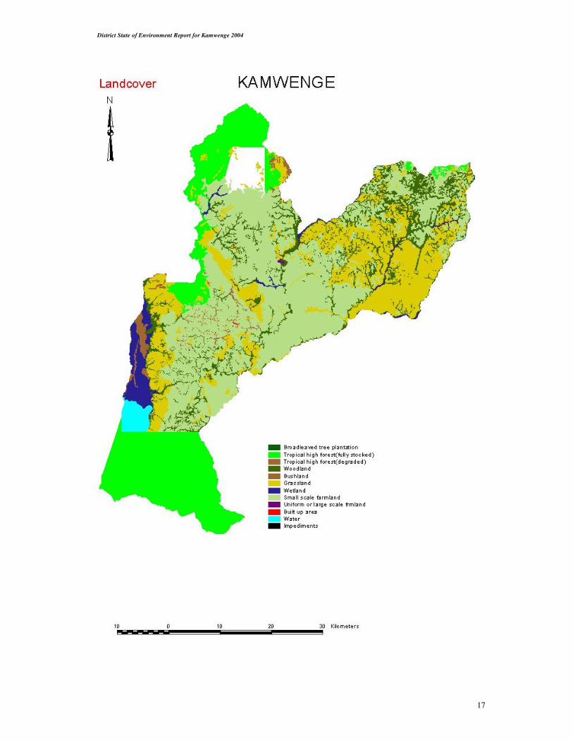
The district has a total land area of 2,439.4Km2 (National Biomas Study NFA Kampala). It is
composed of undulating terrain with occasional high hills and an average altitude range of
1300 – 3800 meters above sea level. It has a bimodal annual average rainfall of 1200mm. The
April – May rainfall is short while the August – November rains are much more reliable and
last longer.
The land resource in the district has a high potential for agricultural purposes and currently
supports 89% of the rural population living in the rural areas. About 90% of the economy is
derived from agriculture. A total of 1,200km2 are used mainly for subsistence farming.
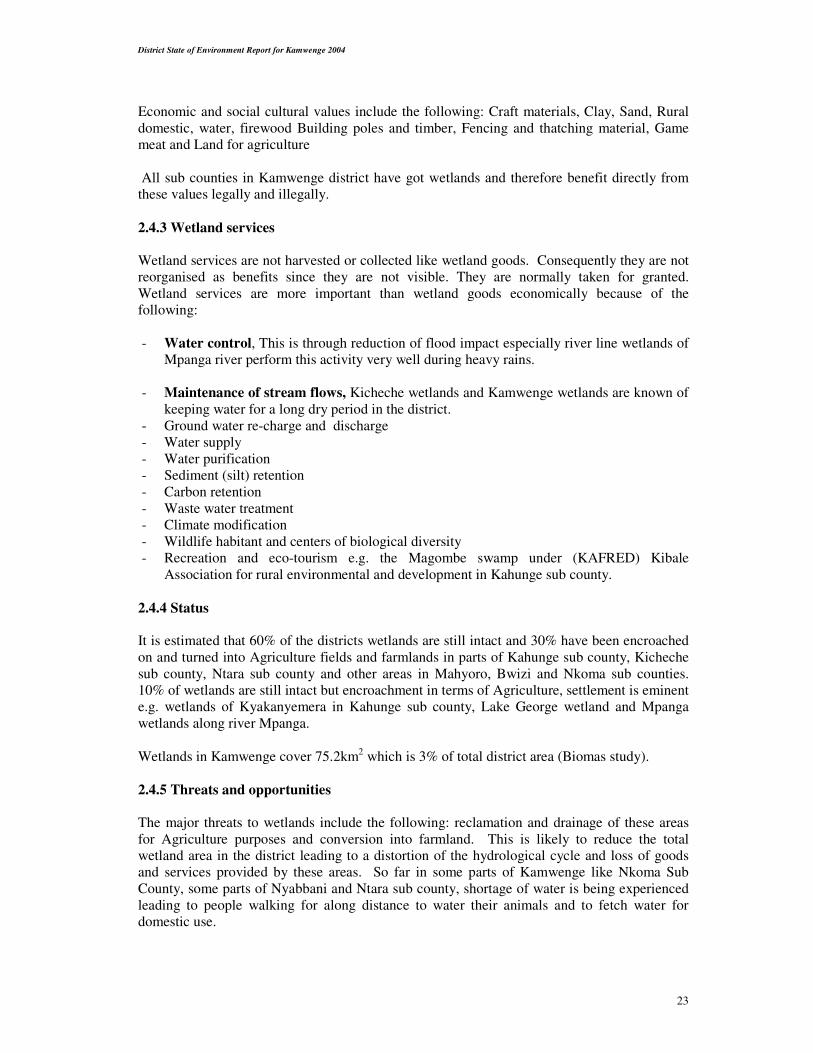
Table 3 shows Land use pattern in Kamwenge district
Type Area km2 % coverage
Farm land 1,200 49.19
Tropical high forests 254.5 10.43
Woodland 271.2 11.12
Bush 39.9 01.64
Grassland 533.7 21.88
Papyrus reeds/swamp 75.2 03.08
Built up area 0.7 00.03
Open water 64.1 02.63
Total 2439.3 100%

District State of Environment Report for Kamwenge 2004
16
FIG 1
2.1 Agricultural activities in the District
The predominant economic activities at house hold levels in the district are subsistence
agriculture. The major crop enterprises include among others growing Maize, Beans Tobacco,
Bananas, Cassava, up land rice, Finger millet, Sweet Potatoes, Irish Potatoes and Vegetables.
Cotton is an important cash crop in Mahyoro Sub County, which forms part of Kazinga
channel cotton belt, while Coffee is grown in various parts of the district. Nkoma, Bwizi and
Kamwenge sub counties fall within the cattle corridor well known for keeping of local cattle.
While Ntara and Kicheche sub counties are well known for improved Dairy cattle. Other
economic activities in the district include Capture fisheries on Lake George, Fish farming,
Apiary development and Tourism.
Land Use Pattern in Kamwenge District
0
10
20
30
40
50
60
Fa
rm la
nd
Tro
pic
al h
igh
fore
sts
Wo
od
lan
d
Bu
sh
Gra
ssla
nd
Pa
pyru
sre
ed
s/s
wa
mp
Bu
ilt u
p a
rea
Op
en
wa
ter
Land cover
Pe
rce
nta
ge
District State of Environment Report for Kamwenge 2004
17

District State of Environment Report for Kamwenge 2004
18
Table 4 shows Average Annual Agricultural Production for major Enterprises (source: Agriculture office)
Crop hectarage yield per Ha (Tones) Total expected yield
Banana 3,210 Ha 2.5 8025
Coffee 1,800 Ha 3.3 5,940
Maize 17,000 Ha 2 34,000
Beans 3,820 Ha 1.5 5730
G. Nuts 1,116 Ha 1.5 1674
Sweat potatoes 1,350 Ha 4 5400
Cassava 2,807 Ha 5 14035
Irish potatoes 2,455 Ha 3.5 8592.5
Upland rice 103 Ha 3 309
Pineapples 60 Ha 8 480
2.1.1 LIVESTOCK
According to the statistical data collected by field staff in January 2004 the Livestock
population was as follows;
Table 5 shows Livestock census in Kamwenge District (2004)
Sub county Cattle Goats Sheep Pigs Poultry Rabbits Donkeys
Kicheche 14,850 14,054 3307 2907 13,440 2225 -
Kamwenge
T/Council
1509 1706 173 412 2860 74 -
Bwizi 18280 7000 800 1000 1600 85 -
Nkoma 29320 11000 1070 3000 20000 100 -
Kamwenge 5344 5955 1821 3469 10607 159 -
Kahunge 6313 5736 1066 5228 15470 505 2
Nyabbani 4605 4532 1019 942 8277 124 3
Ntara 1500 2595 800 1300 4000 215 -
Mahyoro 1506 2696 315 498 1765 82 -
TOTAL 83233 55274 10371 18756 92419 2225 5
Table 6 shows Performance of Agricultural Enterprises (1st season – March – June 2004)
Enterprise Hectarage Normal yield/ha(Ton) Actual yield
Maize 8,500 2 5,100
Beans 1,910 1.5 1,576
Sweet potatoes 675 4 1,350
Irish potatoes 1,350 3.5 2,835
Cassava 2,807 5 7,018
G/nuts 558 1.5 251
Banana 3,210 2.5 4,013
Upland rice 52 3 47
Source: Agriculture department reports Kamwenge District (August 2004).
2.1.2 APIARY DEVELOPMENT
Bee keeping is steadily taking root in the district as an income generating activity. Below is a
table showing the distribution of the activity in terms of beehives in the eight sub counties of
the district:

District State of Environment Report for Kamwenge 2004
19
Table 7 shows apiary development statistics in Kamwenge District
Sub county Improved Local Kenya Top Bar hives Langstroth
Colonized Un colonized Colonized Un colonized Colonized Un colonized
Town council 214 54 56 5 - -
Kamwenge 168 62 119 38 4 3
Kahunge 2986 536 1104 14 - 8
Nkoma 799 216 142 27 - 2
Bwizi 249 273 183 34 1 2
Nyabbani 573 38 226 8 - 2
Ntara 292 29 217 36 2 1
Kicheche 381 34 273 23 - 3
Mahyoro 264 107 95 21 - 2
Total 5926 1349 2415 206 7 23
Agriculture is mainly carried out by the hand hoe and in a few cases ox plough. Slash and burn
is practised with little or no modern Agricultural practices.
The rapidly increasing population of the distinct and the immigration of people from the south-
western districts is currently creating a lot of pressure on the land resource.
There is currently unsustainable management of the land resource in the district due to land
fragmentation, poor agricultural practice, and high population pressure.
To curb the above mentioned there is need to sensitise communities in the use of energy saving
stoves, sustainable agriculture, improved resource harvesting techniques, avoid especially the
illegal use of power saws for round timber conversation and encourage the local communities
to adopt tree planting activities in their farms
2.2 Land degradation
This is caused by the rapidly increasing population, which increased pressure on the land
resources, land fragmentation, poor agriculture practices, topography of the area, increased dry
periods and the vulnerability of the soils to erosion.
2.3 Forests and woodlands
The forest resource that includes forests, trees and woodlands is a very important resource that
plays economic, ecological, social and culture roles.
The district has tropical high forests found in the protected areas and in the public land, they
are scattered unevenly mostly occurring in the valleys (riverline forests). These form the
habitant for both flora and fauna.
The unique animal species like the chimpanzee, bird species, the turaco and many tree and
butterfly species have been a very big attraction to tourists hence boosting eco-tourism
activities around the protected area specially Kibale National Park.
The district has a total area of 254.5km2 of tropical high forest cover representing 10% of the
area. However about 8% of this area falls in the protected area of Kibale National Park. The
Savannah woodland covers an area of 271.2km2 that is about 11% of the area of the district.
These woodlands unfortunately are disappearing at a very fast rate due to population increase
and expansion of land for agriculture purposes.

District State of Environment Report for Kamwenge 2004
20
The following gazetted protected areas are found in the district; Kibale protected area, which is
766km2 and has about 209 km2 in the north eastern part of the district. Kakasi forest reserve,
which has 800 hectares that, is found in Kicheche sub county. Kashoha – Kitomi tropical high
forest overlaps in two other neighbouring districts of Bushenyi and Mbarara. It has a total area
of 399km2.
It is composed of a medium altitude most semi deciduous forest rich in species diversity. It has
5 tree species 11 butterfly’s, a water bird species not found in any other Ugandan forest.
(Uganda Forestry Nature Conservation Master Plan 2002).
Other tropical forests constituting about 2% of the district area are found scattered in small
enclaves mostly in the valleys but are more dominant in the sub counties of Bwizi, Nkoma and
Kahunge.
There are small plantations of mainly eucalyptus constituting about 2 % of the total district area
that are more dominant in Kicheche and kahunge sub counties. The disease outbreak on
eucalyptus has reduced interest from farmers to plat this species.
2.3.1 Institutional Arrangements
Kibale forest is under the management of Uganda Wildlife Authority (UWA). Forestry
department has been divested as per the coming into force of the National Forestry and Tree
Planting Act 2003. The mandate to manage central forest reserve is now vested in the National
Forestry Authority, hence it will manage Kakasi forest reserve.
The district forestry services (DFS) will manage the local forest reserves, carry out forestry
extension services within the framework of the National Agricultural Advisory services
(NAADS) and collect local taxes on forestry produce.
Partnership with local NGO’s like Advertist Relief Agency (ADRA), and CBO’s that have
been engaged in forestry related activities.
The district council has also declared every 16% September annually as a tree planting day for
everybody in the district.
2.3.2 Deforestation
Deforestation has been (widespread) /rampant in the private forests, savanna woodlands,
bushlands save protected areas. This has caused impacts like soil erosion, loss of water
catchment for R. Mpanga and other water sources, destruction of habitant for both flora and
fauna, change in weather conditions. Manifested in long dry seasons and irregular rainfall
distribution.

District State of Environment Report for Kamwenge 2004
21
Figure 2. Forest clearing for crop growing (source Field work)
Deforestation will continue to be a major problem as 95% of the population
of the district live in the rural area. This population depends on agriculture, fuelwood, for
cooking, lighting and heating. They also use poles for constructing their houses.
The district has the highest urban growth rate in Uganda 21.1% (national population and house
census provisional results 2002) hence there is need for charcoal for cooking and heating.
Charcoal is mainly got from the Savannah woodland of Rwenshama and Ngoma in Nyabbani
sub county. An average of 200 tons of charcoal is transported to Kasese district every year
(source forest department data Kamwenge).
Additional 800 tons of charcoal is estimated to be consumed in the town and trading centres of
Kamwenge. A lot of deforestation has also occurred in Mpanga, Kyakanyemera areas in
Kahunge sub county where about 3,000 returnees from Tanzania have been resettled.
A lot of timber is pitsown from Bwizi and Nkoma and other sub counties to meet the rising
need for building construction work. In Bwizi Sub County, Nkoma sub counties deforestation
is done mainly for expansion of agriculture.

District State of Environment Report for Kamwenge 2004
22
2.4 Wetland Resources
The district is endowed with wetlands, which cover an area of 75.2km2 of 3.1% of the district
total area. There are two important wetlands in the district, the ramsar site (Lake George
primary system) which is the breeding ground of fish in Lake George, the 2nd one is the
riverline wetland of river Mpanga which crosses 6 sub counties in the district. These wetlands
form the basis for domestic water of the local communities.
2.4.1 Category of wetlands
On the basis of flooding patterns, we have two types of wetlands in the district that includes:
Permanently flooded wetlands and Seasonally flooded wetlands
Most of the wetlands according to plant type comprise the following. Papyrus swamps, Reed
Swamps sedge swamps, swamp forests, open water, Shrub land, wetlands and grass land
wetlands.
Fig 3 showing the permanently flooded wetland (Lake George Ramsar site)source Field work
The most dominant vegetation in the district wetlands includes phoenix, papyrus, phragmites
and sedges. Founa in these wetlands include colobus monkeys, vervet monkeys, edible rats
and baboons especially in wetlands near Kibale National Park.
2.4.2 Wetland use/functions
The uses of wetlands in the district are in two forms.
- Economic and social cultural values (direct use)
- wetlands services (indirect use)
District State of Environment Report for Kamwenge 2004
23
Economic and social cultural values include the following: Craft materials, Clay, Sand, Rural
domestic, water, firewood Building poles and timber, Fencing and thatching material, Game
meat and Land for agriculture
All sub counties in Kamwenge district have got wetlands and therefore benefit directly from
these values legally and illegally.
2.4.3 Wetland services
Wetland services are not harvested or collected like wetland goods. Consequently they are not
reorganised as benefits since they are not visible. They are normally taken for granted.
Wetland services are more important than wetland goods economically because of the
following:
- Water control, This is through reduction of flood impact especially river line wetlands of
Mpanga river perform this activity very well during heavy rains.
- Maintenance of stream flows, Kicheche wetlands and Kamwenge wetlands are known of
keeping water for a long dry period in the district.
- Ground water re-charge and discharge
- Water supply
- Water purification
- Sediment (silt) retention
- Carbon retention
- Waste water treatment
- Climate modification
- Wildlife habitant and centers of biological diversity
- Recreation and eco-tourism e.g. the Magombe swamp under (KAFRED) Kibale
Association for rural environmental and development in Kahunge sub county.
2.4.4 Status
It is estimated that 60% of the districts wetlands are still intact and 30% have been encroached
on and turned into Agriculture fields and farmlands in parts of Kahunge sub county, Kicheche
sub county, Ntara sub county and other areas in Mahyoro, Bwizi and Nkoma sub counties.
10% of wetlands are still intact but encroachment in terms of Agriculture, settlement is eminent
e.g. wetlands of Kyakanyemera in Kahunge sub county, Lake George wetland and Mpanga
wetlands along river Mpanga.
Wetlands in Kamwenge cover 75.2km2 which is 3% of total district area (Biomas study).
2.4.5 Threats and opportunities
The major threats to wetlands include the following: reclamation and drainage of these areas
for Agriculture purposes and conversion into farmland. This is likely to reduce the total
wetland area in the district leading to a distortion of the hydrological cycle and loss of goods
and services provided by these areas. So far in some parts of Kamwenge like Nkoma Sub
County, some parts of Nyabbani and Ntara sub county, shortage of water is being experienced
leading to people walking for along distance to water their animals and to fetch water for
domestic use.

District State of Environment Report for Kamwenge 2004
24
2.4.6 Opportunities
The presence of the district environment office, the production and Local environment
committees from the district level up to village level is the opportunity for us to have these
resources protected.
Also presence of laws governing protection of wetlands, riverbanks and Lake-shores is the
greatest opportunity to have our areas conserved.
Availability of land also offers the opportunity for the communities living near the wetlands to
shift to other non-fragile ecosystem areas. Presence of government programmes which support
protection of natural resources such LGDP which emphasis environment integration in all
development projects and PMA which has a complete pillar under natural resources
management.
Distribution:
Table8 below show distribution of wetlands in 8 sub counties by name and nature status.
Sub county
Wetland
Nature/status
Level of disturbances
Mahyoro Lake George (Ramsar site) Permanent Low
Kyentanda Buhindagi Permanent/seasonal
permanent
High
Low
Kahunge Kijanjara (Magombe) Permanent Low
Kentomi Seasonal High
Kanyabongo Seasonal High
Rwanyakaranga Seasonal High
Nyakabale Seasonal Low
Mutamba Seasonal High
Kabwesana Seasonal High
Kiyagara Seasonal Very high
Mpanga Permanent High
Mubiro Permanent High
Bibumba Permanent/seasonal Very high
Nsansa Permanent High
Kalere Permanent/seasonal Low
Bidegye Seasonal Low
Kyakanyemera Permanent/seasonal High
Bwizi
Mugwagi Permanent/seasonal Low
Bigaga – Rwakasirabo Permanent High
Nkoma Kakinga Permanent/seasonal High
Musarre Permanent/seasonal High
Rushango Permanent High
Nyandagara(along R. Rushango) Seasonal High
Katonga Permanent Low
Kabagi Permanent High
Rwebigemeko Seasonal High
Kamwenge Mpanga Permanent High
Kabuga Permanent/seasonal Low
Mbirizi Permanent/seasonal Low
Dura Permanent High
Kicheche Nyaruranga-(Kyebonekyera) Permanent High
Ruhagura Permanent Low
Kanuka Permanent High
Kikoyo Permanent/seasonal High
Nyakasenyi Permanent/seasonal High
Kantozi Permanent High
District State of Environment Report for Kamwenge 2004
25
Rwakabwizi Seasonal High
Kasurabo Permanent High
Ntara Rwentuha (Rwemizimu) Permanent/seasonal High
Kichwamba Permanent High
Nyabbani Mpanga Permanent High
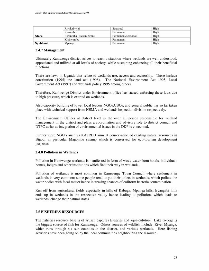
2.4.7 Management
Ultimately Kamwenge district strives to reach a situation where wetlands are well understood,
appreciated and utilized at all levels of society, while sustaining enhancing all their beneficial
functions.
There are laws in Uganda that relate to wetlands use, access and ownership. These include
constitution (1995) the land act (1998). The National Environment Act 1995, Local
Government Act (1997) and wetlands policy 1995 among others.
Therefore, Kamwenge District under Environment office has started enforcing these laws due
to high pressure, which is exerted on wetlands.
Also capacity building of lower local leaders NGOs,CBOs, and general public has so far taken
place with technical support from NEMA and wetlands inspection division respectively.
The Environment Officer at district level is the over all person responsible for wetland
management in the district and plays a coordination and advisory role to district council and
DTPC as far as integration of environmental issues in the DDP is concerned.
Further more NGO’s such as KAFRED aims at conservation of existing natural resources in
Bigodi in particular Magombe swamp which is conserved for eco-tourism development
purposes.
2.4.8 Pollution in Wetlands
Pollution in Kamwenge wetlands is manifested in form of waste water from hotels, individuals
homes, lodges and other institutions which find their way in wetlands.
Pollution of wetlands is most common in Kamwenge Town Council where settlement in
wetlands is very common; some people tend to put their toilets in wetlands, which pollute the
water bodies with fecal matter hence increasing chances of coliform bacteria contamination.
Run off from agricultural fields especially in hills of Kabuga, Mpanga hills, Iryangabi hills
ends up in wetlands in the respective valley hence leading to pollution, which leads to
wetlands, change their natural states.
2.5 FISHERIES RESOURCES
The fisheries resource base is of artisan captures fisheries and aqua-culuture. Lake George is
the biggest source of fish for Kamwenge. Others sources of wildfish include; River Mpanga,
which runs through six sub counties in the district, and various wetlands. Here fishing
activities have been going on by the local communities neighbouring the resource.
District State of Environment Report for Kamwenge 2004
26
The effect of increased population along the lakeshore has been over fishing on the lake to
support the dependant communities. Through the Integrated Lake Management Project the
district Local Government has been able to refocus its attention to reducing pressure on Lake
George.
The fish production and value could double if better methods are used and the fish is processed
before marketing. Fish processing can be very lucrative if correct investment is done in the
district. There is also big potential in exploiting the fish farming opportunities available in the
area. There are so many permanent streams and rivers in the district, which could be harnessed
without necessarily affecting the environment
In order to reduce the dependency of our people on fish from wild/capture fisheries, an attempt
has been made to encourage private ownership of fish sources like ponds and dams. Very
many farmers have been assisted with improved fish seed to stock their ponds and now fish is
ready for harvesting.
The major commercial species include Nile Tilapia (Oreochromis noltica) Claris goriepinuss
(African catfish), Bagrus docmac, and Protopterus.
2.5.1 Fish farming: The rearing of fish in ponds, tanks or natural water bodies by setting up
cages. Here fish is reared in ponds. However opportunities for cage farming are also available
and fish species being promoted here are Nile Tilapia and African catfish (Clarias gari) and
area under fishponds is 60,000 M2
2.5.2 Fish processing marketing
Fish is processed traditionally by smoking, salting frying and sun drying. The main source of
fuel for smoking fish is fuel wood.
2.5.3 Fish marketing
The Democratic Republic of Congo (Zaire) is the major market for the Lake George fish
catches especially sun dried and salted fish. Fresh and smoked fish is consumed locally in
various markets of Kamwenge, Kasese, Bushenyi and Mbarara districts.
2.5.4 Employment
In Kamwenge district, about 2000 people are employed in fisheries and related activities like
boat building and repairing, fish net repairing, fish processing, fish mongering and trading.
2.5.5 Fish Harvesting
Fish is harvested from Lake George using gill nets, the stretched meshes of which measure four
and half Inches or one hundred and fifteen millimetres. The long lines with hooks whose size
is nine and below are used also.
District State of Environment Report for Kamwenge 2004
27
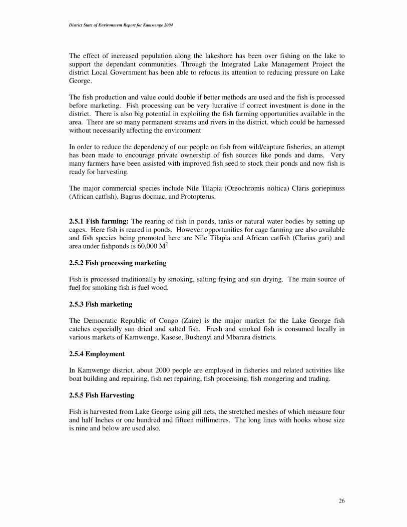
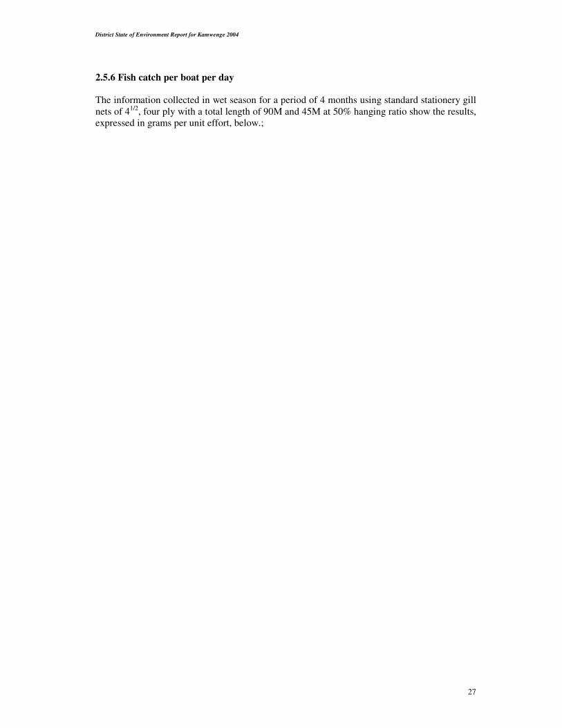
2.5.6 Fish catch per boat per day
The information collected in wet season for a period of 4 months using standard stationery gill
nets of 41/2, four ply with a total length of 90M and 45M at 50% hanging ratio show the results,
expressed in grams per unit effort, below.;
District State of Environment Report for Kamwenge 2004
28
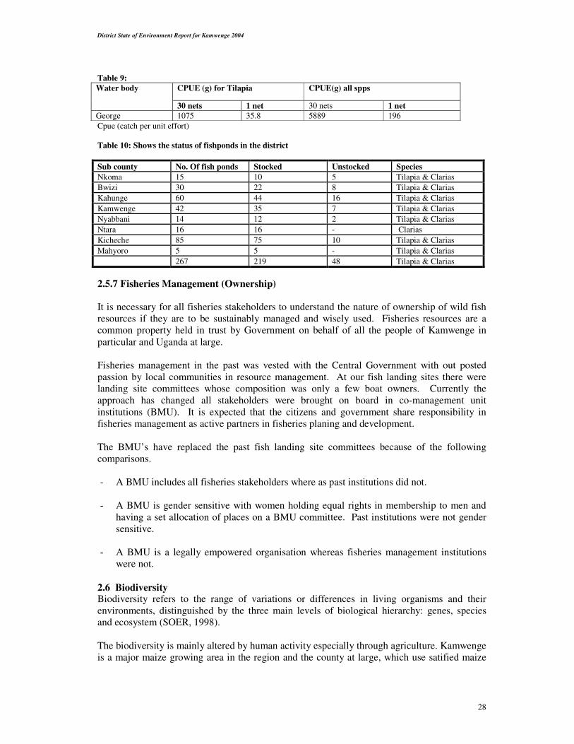
Table 9:
CPUE (g) for Tilapia CPUE(g) all spps Water body
30 nets 1 net 30 nets 1 net
George 1075 35.8 5889 196
Cpue (catch per unit effort)
Table 10: Shows the status of fishponds in the district
Sub county No. Of fish ponds Stocked Unstocked Species
Nkoma 15 10 5 Tilapia & Clarias
Bwizi 30 22 8 Tilapia & Clarias
Kahunge 60 44 16 Tilapia & Clarias
Kamwenge 42 35 7 Tilapia & Clarias
Nyabbani 14 12 2 Tilapia & Clarias
Ntara 16 16 - Clarias
Kicheche 85 75 10 Tilapia & Clarias
Mahyoro 5 5 - Tilapia & Clarias
267 219 48 Tilapia & Clarias
2.5.7 Fisheries Management (Ownership)
It is necessary for all fisheries stakeholders to understand the nature of ownership of wild fish
resources if they are to be sustainably managed and wisely used. Fisheries resources are a
common property held in trust by Government on behalf of all the people of Kamwenge in
particular and Uganda at large.
Fisheries management in the past was vested with the Central Government with out posted
passion by local communities in resource management. At our fish landing sites there were
landing site committees whose composition was only a few boat owners. Currently the
approach has changed all stakeholders were brought on board in co-management unit
institutions (BMU). It is expected that the citizens and government share responsibility in
fisheries management as active partners in fisheries planing and development.
The BMU’s have replaced the past fish landing site committees because of the following
comparisons.
- A BMU includes all fisheries stakeholders where as past institutions did not.
- A BMU is gender sensitive with women holding equal rights in membership to men and
having a set allocation of places on a BMU committee. Past institutions were not gender
sensitive.
- A BMU is a legally empowered organisation whereas fisheries management institutions
were not.
2.6 Biodiversity Biodiversity refers to the range of variations or differences in living organisms and their
environments, distinguished by the three main levels of biological hierarchy: genes, species
and ecosystem (SOER, 1998).
The biodiversity is mainly altered by human activity especially through agriculture. Kamwenge
is a major maize growing area in the region and the county at large, which use satified maize

District State of Environment Report for Kamwenge 2004
29
seeds from the Agriculture research Centers. Also in the district are bananas, beans,
groundnuts, Livestock (cattle and goats) that are mainly improved / or exotic breeds.
2.6.1 Ecosystems diversity: Kamwenge district shares the Albertine Rift Area of Regional Endemism. The district is
endowed with; numerous wetlands in almost all valleys, tropical forests of Kashoha- Kitomi,
Kibale and pockets of high tropical forests of Bwizi. Too are numerous woodlands, and aquatic
systems of Lake George and River Dura, the Protected Areas of Katonga-East, Kibale- North,
Queen Elizabeth National Park in the West and Kyambura Game Reserve Southwards.
Modified ecosystems have arisen out of the subsistence and agro-pastoral systems, Plots of
forest plantations, which may be exotic or indigenous, and the trading centers establishment in
most places.
The Biodiversity provide a wide range of benefits for subsistence income and employment.
2.6.2 Endangered/Rare/Threatened species: Until recently (1996), zebras are said to have been seen grazing along with cattle on Kabuga
hill. The last zebra is said to have been sighted during the training of the local militia, based at
Rukunyu, following the ADF invasion in 1997. (Source: Local leaders and Elders around
Kabuga hills). Since then nothing has ever been heard of zebras.
Before entering Lake George, River Mpanga as it ascends the Rift Valley escarpment, creates
falls forming a gorge. The gorge has a natural forest which falls in Kashoha /Kitomi block. The
combination of the falls, forest and inhabitant flora and fauna should have some elements of
Endemism and hotspot. With encroachment, bush burning and charcoal burning, the inhabiting
flora and fauna of especially unique and rare species as apes and herbal plants are endangered.
Most wetlands are being encroached, burnt and cleared for cultivation. The inhabiting flora and
fauna are destroyed, killed or migrate.
Wild animals have always been hunted down whenever they entered the lowlands of Mahyoro
Sub County. These include hippopotamuses, lions and buffaloes. Elephants occasionally use
the area as a corridor to link from Kyambura to Queen Elizabeth National Park and Kibale
National Park, in which course they destroy crops leading to conflicts with the locals.
2.6.3 Invasive species Lantana camara is dominating the natural vegetation affecting the local pastures at an alarming
rate. The shrub is one of the leading weeds in the district.
2.6.4 Exotic species: More exotic species are being introduced in the district in bid to improve production and
income. These range from Friesian cattle even in form of Artificial Insemination, Boer goats
from South Africa, Certified /hybrid seed (maize, beans, bananas) to Pine trees.
2.7 Protected areas in Kamwenge
For many people of Kamwenge biodiversity is a matter of survival their livelihoods depend on
free and open access to a great variety of biological resources for food, fuel, medicines,
housing materials and economic security. Because the protection of bioversit;y is necessary for
the maintenance of the biological resource base, biodiveristy is an integral element and
intricately linked in the day to day life activities of the people of Kamwenge district which are
placed within the context of the Albertine rift valley, the Kamwenge district is well endowed
with various species of biological diversity.
District State of Environment Report for Kamwenge 2004
30
These range from the wetlands of the Lake George Ramsar of Dura, the low altitude tropical
forests of Kibale and the savanna woodlands of hyparhenea and brachystegia/combret UM
associations of the Katonga game Reserve.
In these ecosystems, are found the Queen Elizabeth Conservation Area, the Kibale Forest
National Park, and the Katonga Wildlife Reserve, maintaining a healthy population of
Buffalo’s and Hippos and Uganda Cobs for QEPA. Chimpanzees and other primates for
Kibale Park and the rare statunga found in Katonga wildlife reserve. These form a base of
major visitor attractions.
2.7.1 Tourism
Many visitors have streamed to the PA’s of Queen Elizabeth National Park for big cats viewing
and for the rare, experience enriching jetty cruize along the Kazinga Channel
Tourism in Kibale has largely been nature walks and guided forest walks and chimpanzee
tracking.
Occasionally visitors come to Katonga wildlife reserve for statunga viewing. 20% of the
accrued revenues, is shared by Uganda Wildlife Authority to the local communities adjacent to
these protected areas to support community initiated projects (SCIP).
2.7.2 Administration
Uganda Wildlife Authority through its regional offices manages these protected areas. The
Heads, the Chief wardens and sector wardens of Katonga, Dura- QENP have linked with the
Kamwenge district Environment Officer over Environment and park/community relations. In
some instances, have collectively managed problem animals together to deter crop raids by the
animals.
District State of Environment Report for Kamwenge 2004
31
2.7.3Community Conservation
Involvement of local communities and all other stakeholders’ participation is the participatory
approach Uganda Wildlife Authority now adopts. Both in Kibale and Queen Elizabeth National
Park a number of community sensitization meetings

District State of Environment Report for Kamwenge 2004
32
were held at parish and cell levels. A number of SCIP projects have equally been supported
through the revenue sharing programmes.

District State of Environment Report for Kamwenge 2004
33
2.7.4 Management Challenges
A number of such challenges can be identified
- Increased poaching noticed in the PA’s, local communities have been arrested and
prosecuted, for illegal fishing in QEPA
- Cattle incursion and illegal grazing in PA’s have been observed. Several arrests were
made and livestock released upon payment and receipt of fines notably this is in Katonga
and Dura sector.
- Of late, uncontrolled bush fires have been sited in the Dura Swamps
- Coordinate with district Entomologist and chart out strategies to manage problem with
animals to minimize crop/property damage.
- Fully participate in institutional coordination and public relations to harmonize
environmental conservation’s programmes.
Conclusions
On a general perspective, the state of environment is state with health range sites. This is
evidenced by the healthy vegetation/habitats and range site conditions.
The protected areas have and will continue to play their initial role in the economy of
Kamwenge District. The several challenges enumerated above constitute urgent attention,
which demand collective effort as the wildlife are state resources and property.
However, UWA has tirelessly handled and managed these problems, as constitutionally
required of it. UWA looks forward to the full support of the peoples’ and Kamwenge District
Support
2.8 Urban Areas
Urbanisation is the change in the population of the population that lives in urban areas
(population census 2002 provisional results). Urbanisation is the continuous growth of towns
and trading centres. Urbanisation contributes to deforestation through increased demand for
charcoal, firewood and construction of timber.
2.8.1 Distribution
In Kamwenge district there are very few urban areas. Most of places have trading centers,
which are steadily growing up such as Kabujogera, Bigodi and Kahunge. These centers have
an increasing population steadily.
It is only Kamwenge town that is growing up into a serious urban area with a total population
of 13,876, hydroelectric power and some improved/modern structures in place. There has been
an increase in rural urban migration hence leading to high population influx in urban centers.
District State of Environment Report for Kamwenge 2004
34
2.9 Waste management
Wastes generated in Kamwenge towns include both liquid and solid wastes. The liquid waste
includes waste water from lodges, restaurants, and individuals homes which ends up in streams
and water bodies. This is because this water is just discharged openly to sock away pits, which
are some times full and even not constructed to required standards.
Solid waste mainly includes garbage, which is biodegradable and some non-biodegradable
substances like cavera, metals and other types of plastics are increasingly becoming common.
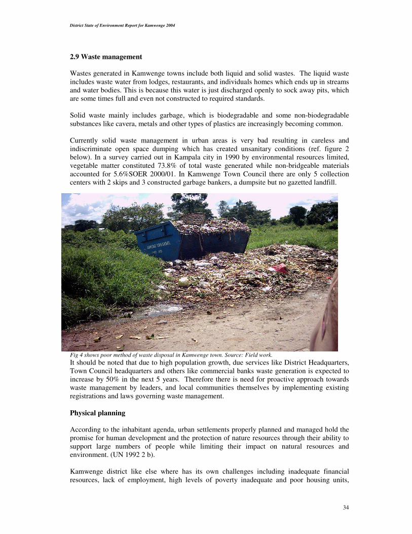
Currently solid waste management in urban areas is very bad resulting in careless and
indiscriminate open space dumping which has created unsanitary conditions (ref. figure 2
below). In a survey carried out in Kampala city in 1990 by environmental resources limited,
vegetable matter constituted 73.8% of total waste generated while non-bridgeable materials
accounted for 5.6%SOER 2000/01. In Kamwenge Town Council there are only 5 collection
centers with 2 skips and 3 constructed garbage bankers, a dumpsite but no gazetted landfill.
Fig 4 shows poor method of waste disposal in Kamwenge town. Source: Field work.
It should be noted that due to high population growth, due services like District Headquarters,
Town Council headquarters and others like commercial banks waste generation is expected to
increase by 50% in the next 5 years. Therefore there is need for proactive approach towards
waste management by leaders, and local communities themselves by implementing existing
registrations and laws governing waste management.
Physical planning
According to the inhabitant agenda, urban settlements properly planned and managed hold the
promise for human development and the protection of nature resources through their ability to
support large numbers of people while limiting their impact on natural resources and
environment. (UN 1992 2 b).
Kamwenge district like else where has its own challenges including inadequate financial
resources, lack of employment, high levels of poverty inadequate and poor housing units,

District State of Environment Report for Kamwenge 2004
35
improper land use, increasing pollution, lack of tree cover in the urban areas, inadequate water
supply, uncoordinated town developments and increasing vulnerability to disasters.
Most of the urban centres are linear type along the roads such as Kahunge, Mahyoro and even
Kamwenge Town Council. There is a mix up of people’s residents, small-scale industries
(maize mills, sawmills) and shops. This has tendered to increase pollution of different types
e.g. noise from nigh discos, dust from maize mills and uncollected wastes due to lack of access
roads to some of the settlements. This tends to highly affect the health conditions of the people
by suffering from diseases like dysentery and cholera.
2.11 Atmosphere Atmosphere forms a basis for agriculture and the health of the human population. Increased
wetland destruction and forest degradation for agriculture purposes is accounted the biggest
contributor of climate change in the district.99% of the population depend on climate pattern
for their agricultural activities.
Atmospheric pollution in Kamwenge is mainly due to widespread bush burning. Others may
include inefficient cook-stoves and fireplaces (in restaurants, cooking places and in homes)
brick baking/burning and charcoal burning.
2.12 Altitude and Temperatures
Because of its Tropical location and the relatively low, altitude ranging from 1,300 – 3,800
metres above the sea level, Kamwenge area has temperatures averaging between 20o-250C
(maximum) in all parts of the District. This climatic condition is quite favourable for crops,
pastures and water availability for livestock in the district.
Given the above climatic statistics it can be inferred that Kamwenge can sustain production of
two crop regimes with minimum water conservation.
There minor variations in the climatic characteristics of the entire region both at spatial and at
temporal levels. However, these variations are not significant. The implication is that the
regional temperatures can easily sustain the same climate - based activities save for other
endowments.
2.13 Social welfare and environment
2.13.1 Food and Nutrition
The major food found in Kamwenge district includes matoke, maize, sweet potatoes, cassava,
beans Irish potatoes, groundnuts, milk and meat. In Kibale County the staple food include
sweet potatoes, Irish potatoes and posho served with beans and in Kitagwenda matoke,
cassava, and posho is the most common foodstuffs in that place. Milk and meat is consumed in
both counties but in some rural areas it is consumed occasionally over the weekend or on big
holidays.
Malnutrition is one of the major cause of infant mortality rate in the district and currently infant
mortality rate stands at 86/1000 alive birth per year. (National housing and population census
2002).

District State of Environment Report for Kamwenge 2004
36
2.13.2 Health and Sanitation
Understanding environmental health is very important simply because it helps our people in
preventive measures, developing sound policies and strategies, the need to manage
environmental health and to understand the way in which environment influences health.
It is important to reorganise that exposure to pesticides, acaricides, and insecticides lead to
increased incidence of birth defects, radiation in small amounts causes cancer incidences and
that communal air pollution constitutes health hazard.
The study of the occurrence and distribution of diseases and other health-related conditions and
their determinants in-groups of people is referred to as epidemiology.
Environmental epidemiology is the use of epidemiology methods to assess diseases clusters
suspected to be caused by environmental pollution.
The incidence of death from a disease is called mortality. The population in Uganda and
Kamwenge in general have been largely affected by Toxic substances with acute LD 5o(lethal
dose) which they always use without knowing the dangers associated with them. This is
because such toxic substances cause damage to bodies after a long period of exposure at near
background levels of concentration. The effects of such toxic substances in our communities
include diseases like cancer, infection of central nervous system and irritation of the skin. Lethal dose is the oral or dermal dose of substance, in mg per kg body weight, causing death in 50% of the test
animals, under standard test conditions.
Table 11 Shows Acute LD50 (oral) for some agents (LD 50 means lethal dose)
Agent LD50 (Oral) mg/kg
EthyAlcohol 10,000
Toluene 5,000
Sodium Chloride 40,000
Asperine 1000
DDT 100
Parathion 2
Dioxine 0,001
Botulinum toxin 0,0001
2.13.3 Water and sanitation In Kamwenge district open water bodies cover 64.1Km2 and 61.6 % coverage under safe water
supply. Latrine coverage stands at 61%. This means that 39% of our population don’t access
safe water hence increased incidences of the people drinking highly contaminated water and
39% of the population don’t have latrines and this will lead to contamination of water bodies.

District State of Environment Report for Kamwenge 2004
37
Figure 5 shows sources of unsafe water in Kamwenge town council
2.13.4 Occupational health and hygiene
This can be referred to environmental risks originates in the work places that may cause
diseases, damage to health or well being of workers.
Most workers in the construction sectors, road works, petroleum products sellers, garbage
collectors and those employed in small scale industries are prone to dangers of noise pollution,
accidents due to lack of protective gears and other occupational related diseases like
hypertantion. There is urgent need for control of such occupational health problems especially
in the growing towns of Kamwenge, Mahyoro and Kabujogera.
Waste water from hotels, lodges and individual homes in Kamwenge town ends up in water
systems in near by wetlands like that at railway station, which is the source of water for
domestic use. Important to note is that in future developments, there is need for consideration
of sewage systems which can be treated to minimise pollution of water sources.
Sanitation conditions in the district are still low with poor waste disposal practices in both rural
and urban areas. Faecal matter is not handled very well and ends up in water systems hygiene
is not good and especially in landing sites of Mahyoro and Kayinja where traces of water born
diseases are eminent.
2.13.5 Education and Schools
Ignorance has repeatedly been stressed as one of the causes of environmental problems in
Kamwenge and also is a major contributory factor to poverty and unsustainable living.
Kamwenge has 12 Secondary schools and 128 primary schools with enrolment of 69886. The
Government of Uganda under the fourth pillar of PEAP is determined to support primary and
secondary education. The health situation in schools is relatively fair on average with all
schools having toilets and at least with desks in schools.
The desk child ratio: is 1:7 and teacher children ratio is 1:70.
The table 12 and 13 below shows achievements in school infrastructure for the financial year 2003/2005:
DCI Ireland
School Classrooms Desks Latrines
Kamwenge 4 72 1
Kyabenda 4 72 1
Rwengoro 4 72 1
Kyeganywa 4 72 1
Total 16 576 8
SFG/GOVERNMENT OF UGANDA 2003/2004
School Classrooms Desks Latrines Teacher’s
Houses
Karubuguma 2 36 1
Kiyagara 4 108 1
Buryansugwe 4 81 1
Muzira 4 72 2
Ihunga 4 72 1
Rwanjale 4 72 1

District State of Environment Report for Kamwenge 2004
38
Ntonwa 4 72 1
Rukunyu 2 36 1
Kinoni K 2 36 1 2
Nyabitusi 4 72 1
Rubona 54
Ganyenda 2 36 1
Kitaka 2 36 1
Ikamiro 2 36 1
Damasiko 2
Nyabubare 2 36 1
Rwamwanja 2 361
Galiaya 4 72 1
Kanimi 2 36
Kitonzi 72 2
Biguli 2 36 1
Kigoto 4 72 1
Dura 4 72 1
Kagazi 4 72 1
Kiceece 4 72 1
Kihumuro 4 72 1
Mahani 4 72 1 2
Lyakahungu 4 72 1
Karambi 4 72 1 2
Kyehemba 4 72 1
Kamwenge Railway 4 72 1
Rwengoro 4 72 1
Total 14 576
In general under LGDP 304 desks were received,692 Desks and 24 Latrines from irish aid.
2.13.5.1 FUNCTIONAL ADULT LITERACY
This is the Government programme aiming at education the old people in the district.
(FAL)Literacy classes and groups have been formed accessed both by men and women. Below
is current Status of the FAL program in the District. How ever this still leaves a lot more
people Illiterate levels are as 63%: -

District State of Environment Report for Kamwenge 2004
39
Table 14
FUNCTIONAL ADULT LITERACY (FAL) CLASSES DATA 2003
Number of classes 401
Number of FAL instructors 300
SUB COUNTY Enrolment Males Enrolment Females Total
Bwizi 159 408 567
Mahyoro 228 451 679
Kicheche 225 781 1006
Kahunge 304 1314 1618
Kamwenge 156 704 860
Nyabbani 190 606 796
Ntara 265 782 1047
Nkoma 601 1834 2435
Total 2128 6880 9008
2.13.6 Access to services and medical facilities in Kamwenge District
The population of Kamwenge is 284,749 from 2002 population census Ministry of Finance,
Planning and Economic Development and the anual population growth rate is 3.2% only 47%
of the population live within 5kms of the health facilities and the doctor population ration is
3:284,749. The number of health facilities is 24 and functional referral facilities Health Center
IV being 2. The district does not have a hospital.
The Top common causes of ill health and death in Kamwenge District.
Table 15: Shows Top Ten Diseases - [HMIS Reports (Jan 03 – Dec 03) All Diagnosis total = 254,621
Diagnosis 0-4 yrs 5 & above No. of Cases %age Rank
Malaria 40,075 71,192 111,267 44 1
ARI Not pneumonia - cold or cough 13,701 30,679 44,380 17 2
Intestinal worms 6,776 14,800 21,576 8 3
Pneumonia 4,630 1,959 6,589 3 4
Skin diseases 2,196 3,897 6,093 2 5
Diarrhoea - Not bloody 3,079 2,364 5,443 2 6
Eye infection 1,370 2,200 3,570 1 7
Epilepsy 200 3,174 3,374 1 8
Genital inf. - Vaginal discharge 14 3,246 3,260 1 9
Urinary Tract infections (not STI) 333 2,606 2,939 1 10
Source: Kamwenge health report October 2004
There has been marked increase in access to health services through increase in the number of health facilities:

District State of Environment Report for Kamwenge 2004
40
Table 16: Below shows the number of health units for the District
2000 2001 2002 2003
Number of Health units 13 16 18 24
Access within 5 Km 29% 33% 38% 47%
OPD Attendances 85,168 161,736 202,724 187,944
Table 17: Below shows the immunisation coverage for the District and Bwizi HC III:
Antigen 2002 2003
District Bwizi District Bwizi
BCG 104% 78% 85% 99%
DPT3 80.4% 54% 78% 81%
MEASLES 76% 60% 65% 77%
2.13.7 Water Supply
Water Supply in Kamwenge is under the department of water development. This department
plays a key role in improvement of people’s health through decreasing water-related diseases
that are most common in our communities. It is a key department and one of the national
priority areas in poverty alleviation.
The mission is to contribute to the social economic development of Kamwenge co-ordination
and support to accessibility of safe water, sanitation and management of water resources.
Open water stands at 64.1km2 which 2.6% of the total area. The main sources of water include
wetlands, rivers and hilly catchment areas. The major achievements of the department in
financial year 2003/2004 includes protection of 10 springs and 6 shallow wells, and completion
of Rukoko Gravity Flow Scheme with 18 taps and 2 ecosan toilets. The total water coverage in
the district stands at 61.6%.
The table18 below shows what the water Department under DDSP has been able to construct
No of bore holes Location Parish Sub-county
1. Kayombo P/S Ntara Ntara
2. Kichwamba P/S Kichwamba Ntara
3. Rutooma P/S Rwenjaza Nyabbani
4. Kahunge TC Rwenkuba Kahunge
5. Bwitankanja Bihanga Nkoma
6 Kabambiro T.C Kabambiro Nkoma
In addition to DDSP, water department receives funds from other sources like Water and
Sanitation Conditional Grant and NGOs, which have contributed to construction of water
facilities leading to attainment of 61.6 % water coverage. However, some sub counties like
Bwizi and Nkoma are water -stressed due to the dry nature of the area. This has made it
difficult to construct the affordable low- cost technology facilities. The most appropriate
technology is bore-hole - drilling which is very costly and yet there is limited funding. Other
Sub counties like Kicheche and Ntara have potential sources for development of Gravity Flow
Schemes but due to limited funding, some of these sources have not been developed hence a
hindrance to increased accessibility to safe water.

District State of Environment Report for Kamwenge 2004
41
However the department tends to improve this situation to 69% in the year 2005/2006 by
increasing the water coverage and supply in sub counties of Ntara, Nyabbani and Kamwenge
through implementation of Kabambiro integrated water and sanitation project.
2.13.8 Recreation
As earlier mentioned the district is endowed with a variety of natural resources and in
particular protected areas (PA) such Katonga game reserve, Kibale National Park and Queen
Elizabeth National Park. These PA form a basis for recreation in the district though shared
with neighbouring Districts e.g. 4 single and double story banders, 2 elevated viewing
platforms and 62km trail at Kanyawara Kibale National Park forms a basis for tourism and
recreational activities in the district.
Mantana luxury tented camp at Kibale forest camp approximately 7km past the Kanyacho
national park office after Bigodi. This is located in a forested area, which attracts host of
butterflies, birds and small primates. The camp is a luxurious retreat with an emphasis on
personal service and idyllic settings from the spacious, airy tents to the comfortably furnished
dining tents and well stocked bars where guests can unwind after the day’s activities.
There are other forms of recreation such as playgrounds, comfortable hotels like Kamwenge
Guest House and the up coming Andrew and Brothers recreational centre near Kibale National
Park with numerous recreational activities like swimming, Golf course, bird watching and
many more others.
However, it is important to recorganize that there are many other opportunities which are
untapped to enhance recreation activities and such areas include among others the magnificent
falls along river Mpanga in Rwenshama parish, the view of the Ramsar site of Lake George in
Kanara parish in Nyabbani sub county and the Gegiers and hot springs of Nyakera.
Figure 6: One of the potential site for recreation on Mpanga river in Nyabbani sub county (source Field work)
2.13.9 Culture The population of Kamwenge is a unique one with a multilingual culture ranging from Bakiga,
Batangwenda, Batoro, Bafumbira, Banyakore, Basoga, Baganda and Bagisu all of whom claim
to be natives of Kamwenge. Bagisu in Kalibani, Kabuga still maintain circumcision cultures.
Kamwenge is part of greater Tooro under King Oyo Kabamba Rukiidi IV.

District State of Environment Report for Kamwenge 2004
42
2,13.10 Environmental disasters Disaster is an occurrence of sudden or major misfortune, which disrupts the basic and normal
functioning of a society or community.
Fortunately the district has not experienced very severe disasters, however the following have
been experienced:
2.13.11 Droughts: The year 2004experienced very big changes in the rainfall pattern. The dry season set in early
May to the end of August affecting crop yields, livestock and fish production negatively. Lake
George water levels fell by over a meter leaving much of the lake bed dwellers isolated in
pockets of deeper parts of the lake and masses of sand of the original shore line.
2.13.12 Floods:
Deforestation and cultivation along river Mpanga and its catchment have led to floods of the
river. In 2001, Nyabbani- Kamwenge bridge on river Mpanga was washed away. The brown
color of the water was an indicator of soil wash off, which could have ended silting Lake
George and affecting the fisheries resources. The District Environment Office has carried out
awareness meetings along the river Mpanga areas of Kabuga, Rwenshama and neighboring
villages to ensure conservation of these areas.
2.13.13 HIV-AIDS: This is a global problem and the District has been affected inflicting suffering to the local
communities. Many widows and orphans have been left vulnerable, causing additional
expenses for their care. The labour force has been greatly affected, rendering some
homesteads/house holds unproductive. Interventions made by ACP (Aids control project)
include formation of CHAI’s, counseling services and treatment using low cost retroviral
drugs.
HIV/AIDS had serious effects on the economic performance of the district by depriving it of its
productive force. Results from VCT centers show a sero positively rate of 7.8% (HMIS report
July, 2002 – May, 2003). Out of 6,371 mothers tested under the PMTCT, 539 mothers were
positive for HIV/AIDS (7%).
2.13.14 Wars:
The ADF insurgency caused suffering to communities living in Kiziba, Kyabandara,
Rwenshama and Ngoma areas. Agricultural and forest Rehabilitation (by UWA- FACE project
in Kibale National Park) activities got disrupted as four workers of the project were killed by
the ADF and a number of them abducted. The locals in the affected areas were displaced,
leading to a big number of them selling off their lands to cattle keepers or resorting to charcoal
burning for survival, leading to the destruction of most catchment areas. The good news and
relief came as the war ended.
2.13.15 Earthquakes: These occur occasionally in areas around the Rift valley and The Rwenzoris generally. The
tremors affect and crack buildings. It has been reported from the Water Department that the
Mahyoro water project, which was in its final stages, halted after the water source was no
more, following earthquake tremors that, occurred at the time.

District State of Environment Report for Kamwenge 2004
43
2.13.16 Epidemics: Kamwenge district with a high urban growth rate has poor and unplanned construction of
houses; as there are no physical town plans in Kamwenge Town council and other
mushrooming towns. The poorly planned constructions, and poor waste management coupled
with lack of clean water often lead to prevalence of diseases like cholera, dysentery and
typhoid. There is need for physical plans of the town and centers, water supply and sewage and
garbage management.

District State of Environment Report for Kamwenge 2004
44
Chapter 3
Response to Environment Change 3.0 Environmental policies and reform.
Much as Kamwenge District has tried to make substantial improvement in environment
management, many challenges still exist. The Government of Uganda has put in place many
policies aiming at environment management; however, implementation of these is not yet up to
required standards.
This is due to lack of adequate funds for creation of awareness, mobilisation of the public and
enforcement of existing laws now being implemented in the district to guide development.
These include the following:
• The constitution of Uganda
• The PEAP
• The vision 2025
• The PMA
3.1 National policies
The following national policies and other sectoral policies that are available in the district for
implementation include;
1. National Environment statute 1995
2. The national policy for conservation and management of wetlands resources 1995
3. The water policy 1995
4. National fisheries policy 2003 and fisheries section strategic plan
5. Wildlife policy 1995
6. The forestry policy 2000
7. The national fisheries policy
8. The water Act Cap 152
These policies are aiming at sustainable management of natural resources. The district in line
with the above policies has also put in place its own policies towards environment conservation
such as the Kamwenge Tree Planting Day 16th September every year and Keep Kamwenge
clean which is done once a month.
Also the district council is in the process of formulating Kamwenge Environment Management
and production Ordinance.
3.2 Institutional structure
Kamwenge district created environment office and recruited the District Environment Officer
since its inception, also the department of Forestry, Fisheries and Agriculture are in place and
all these were under production sector up 2004.
However, in financial 2004/2005 Kamwenge has adopted under FDS Fiscal Decentralisation
strategy) the sector of environment and Natural resources which contains the department of
Forestry, Environment and lands under the management of Natural Resources co-ordination.

District State of Environment Report for Kamwenge 2004
45
The Environment Officer collaborates with NEMA, WID ( MWLE ), for national policy
guidance, Provision of guidelines, standards and technical advise on the management of
environment. The department works hand in hand with all the district departments and sub
counties to ensure environment integration in all development plans and projects as required by
law. The local production and Environment Committees are available at all levels of local
Government, however they are less functional except the Sub County and District level
committees.
3.3 Legal reforms for Environment Management in Kamwenge
The National Environment Act cap 153 forms the basis for sustainable environment
management in the district and other relevant guidelines made there under e.g
1. Environment impact assessment regulations 1998
2. Waste management regulations 1999
3. National effluent discharge regulations 1999
4. National environment wetlands, river banks and lake shores regulations 2000
5. National Environment hilly and mountainous areas management regulations 2000
There is no existing ordinance or bylaws in the district except district is in process of making
an ordinance and also the Town Council is the process of making the bylaw.
3.4 Extent of implementation of relevant national laws:
Enforcement is not a simple task as it involves a lot of financial requirements, which the local
government does not always provide. However efforts have been put in place to create
awareness to different actors on importance of national laws and even interpretation. This has
taken place especially to leaders at all levels.
Also enforcement has started taking place on river Mpanga banks, Bwizi forests, Ntara
wetlands and Lake George shores. The culprits have always been brought to police and later
released on police bond. However this has created impact, as they don’t go back to degrade
these fragile areas.
3.5 Economic Instruments
There is need to incorporate environmental costs in decisions of producers and consumers and
to reverse the tendency to treat environment as a “free good” and to pass these costs on to other
parts of society, other districts, other countries and future generations.
The economic instruments have a considerable advantage over other types of approaches like
command and control mechanisms in that they achieve the outcome at the least cost.
The incentive; is offered to encourage good practice in environment management.
Disincentive – is offered to discourage practices that are harmful to the environment.
In order to ensure sustainable resource use by individuals, groups, and business owners the use
of incentives and disincentives is very important.
Kamwenge District has put in place measures to protect environment by encouraging positive
externalities like conservation of protected areas at the expense of communities who would like
District State of Environment Report for Kamwenge 2004
46
to use such land for other economic purposes e.g. the people who were evicted from Katonga
Game Reserve. This is because the park will eventually supply them with rain, fresh air and
for tourism purposes.
However, the negative externalities like wetland cultivation are being discouraged as they are
likely to affect other members of the society by increasing the dry conditions, and lack of water
for domestic and animal consumption. Here the disincentives used include punishments
according to guidelines for protection of wetlands, riverbanks and lakeshores and National
Environmental Act cap 153.
General incentives offered in the District.
Most Natural Resources are on private lands or regarded as being on individuals’ lands,
therefore are priced law. Little or no incentives can be offered for their production (e.g. trees,
fish and wildlife). The economic instruments are not substitutes for, but rather complements of
other environmental management tools. As a district, Kamwenge has;
• Supplied/distributed free tree seedlings to interested groups such as Kabuga, Rubaba
farmers united group and other farmers in the hill
• School woodlots have been established in 10 schools.
• 20% of the revenue collected from park entrance is shared with parishes neighbouring
(QEPA) queen Elizabeth Park area. This is to encourage communities of these parishes
to own park resource collaboratively. Every parish is to get 3.5millions 2004/2005
• Changes in the fisheries sector management from the traditional management to the
Beach Management Units (BMU’s) so as to have sustainable exploitation of the
fisheries resource on Lake George.
• Media exposure and exchange visits (at least most local leaders have had several visits
and workshops) to share good experiences of conservation.
Carbon Trade
Kamwenge still has considerable number of forests and biomass resources. However this
resource is being heavily encroached on mainly for Agriculture timber harvesting and
settlements. National estimates of land being cleared in 1994 ranged from as low as 70,000 ha
(Ministry of Agriculture, World Bank) to 200,000 ha (Ministry of Finance economic
planning).
Deforestation is the largest source of carbon dioxide, when forests and shrubs are cleared for
Agriculture or development most of the carbon escapes to atmosphere causing the loss of
Ozone layer and increased global warming.
In a bid to solve this UWA FACE (forest absorb carbon dioxide Emissions) is trying to restore
degraded areas of Mponkya and Kanyabutagi in Kibale National park where encroaches were
evicted on October 1994.
Also efforts are being put in place where tree seedlings are being supplied to individual farmers
and schools under PMA and NEMA programs. Most of these are indigenous species.

District State of Environment Report for Kamwenge 2004
47
3.7 Domestic budget provisions to implementation of environmental programs.
These are in place although not enough. The Forestry and Environment departments are not yet
perceived very important and still gets the lowest budgets both at district and lower local
governments e.g. the headquarter budget for the year 2004/2005 is approximately 3 million
only for each department.
3.8 Local initiatives
Local initiative towards environment management is in place but some times not intentionally
done. Communities in Buisiriba parish Bigodi Sub County have got initiatives of tree planting
and mostly the indigenous. These species are common in area.
Also communities in Bigodi parish have initiated a conservation project called KAFRED
(Kibale Association for Rural Environment and Development), which deals with eco-tourism
where proceeds have been used to construct a community school called Bigodi secondary
school and employs locals of the area.
3.9 Community agreements/actions: Kabuga- Rubaba Farmers united group-signed agreement with Kamwenge District Local
Government to plant trees on Kabuga hill. The district was to provide seedling to the site, while
the group was to plant and take care of the trees to maturity.
3.10 Individual actions in favor of environmental management: Many households are planting trees/woodlots adjacent to their homes and gardens. This has
reduced pressure on demand for fuel wood and construction materials.
3.11 Citizens’ actions/enforcement: The people report cases of wetland degradation, bush burning and encroachment to the
relevant authorities.
3.12 Non-governmental and community based organization activities in the district:
-Environment sustainable agriculture program ESAP –helped people in Agro forestry and sustainable Agriculture in Ntara,Kicheche and
mahyoro.
-Integrated Lake Management /Lake George Basin Management Organization ILM/LAGBMO involved communities at the grassroots in sustainable fishing and general
management of the Lake George fishery.
-Kibale Association for rural Environment and development KAFRED based in Bigodi, Kahunge sub county, involved the local communities adjacent
Kibale forest/Protected, in tree planting, Eco-tourism, training in Environment management
programs.
-Kahunge Elders Development Association KEDA helps the elderly by identifying projects to sustain themselves at their old age and
encourages conservation.
-Adventist relief agency ADRA –mobilises on environment management and sustainable agriculture in Kahunge and
Kamwenge sub counties.

District State of Environment Report for Kamwenge 2004
48
3.13 Initiating actions to conserve sites: KAFRED (already on ground) and Nature Uganda (in its initial stage) have identified areas of
special interest for conservation. These areas have been identified around the protected areas of
kibale National Park and Kashoha kitomi forest reserve.
3.14 Public participation: Agenda 21 encourages public participation (SOER 2001). All programs now coming to
districts emphasise public participation. Bottom up planning is the main approach used from
the parishes to the district.
PEAP (parish environment action plan) was carried out in a participatory manner at Parish
level in 2001. Sub county environment action plans (SEAPS) will also be carried out in the
same manner if resources are identified.
Citizen action to protect the environment includes tree planting, attending mobilisation
meetings and campaigns of environment concern. Keep Kamwenge clean day is in place once a
month under the initiative of the local leaders and the community. The community members
together with their leaders participate in garbage collection, slashing and cleaning of streets and
their homes.
Special interest groups are involved through folk songs and drama. Some women’s group are
involved in handicrafts and other disadvantaged individuals in the homes, all of which depend
on natural materials from wetlands hence initiatives to encourage wise use.
3.15 Environmental planning
Parish Environment Action Plan was carried out under KSCDP (Kibale/Semliki Conservation
Development Project) in 2001 and since then there has been no deliberate participatory
environmental planning. The bottom up approach in planning is used where by consultations
are made at parish level, where environmental issues are some times included. However,
LGDP11 program has emphasised integration of environmental issues in all development
projects and plans at District sub county and parish levels. Environmental checklist has been
developed by MLG to help in the screening of the projects to identify positive and negative
impacts and suggest the mitigation measures.
3.16 Environmental information and education
The national Environment Management Authority NEMA and Wetlands inspection division
have developed a lot of educational materials and a number of guidelines. All these documents
are used to disseminate information to general public aiming at environment conservation and
such include the guidelines on the use of hills and wetlands, riverbanks, and lakeshore.
The information is disseminated using the different media e.g radio sectoral and council
meetings, workshops, seminars and home visits.
3.17 Environmental education
There is a lot of emphasis on environmental education in the district both formal and non-
formal. With introduction of FAL (Functional Adult Literacy) not only they study reading and
writing but also techniques towards better production and environment conservation are taught
to them.

District State of Environment Report for Kamwenge 2004
49
In formal education, environment management has been integrated in primary school syllabus
but this has not yielded a lot as expected in the district. There are few schools practising
environmentally friendly practices in their compounds Like Bigodi primary school.
Data collection, management storage’s, dissemination use in the district is done by way of
consultative meetings during planning cycle, where different Heads of Department go to the
parishes to generate planning data, such type of data is included in the development plans after
being analysed and information is disseminated back to the lower Local Governments. The
district does not have library, only data is accessed from notes boards and central registry,
which is located at the district headquarters.
3.18 Workshops and seminars
It is through workshops that environment management is intensified. Several workshops both
on wetlands and general environment management have been carried out to leaders at the
district and lower Local Government, NGO’s, and CBO’s.
These seminars/workshops include, the following among others EIA, Non formal environment
education, by law information and others concerning awareness on laws governing
environment management
3.19 Awareness programs
A variety of awareness programmes including radio programmes, public meetings, radio spots
and national gatherings have been used to disseminate environment information in the district.
Public meetings are the common method used where people of 1 parish are gathered and
addressed on specific environmental issue /effects, e.g. areas surrounding river Mpanga where
substantial degradation have been identified.
Also educational materials especially from NEMA, tree talk and wetlands inspection division
have been distributed to schools and to other members of the public through out the district.
3.20 Social policies Poverty has been and remains a major cause and consequence of environmental degradation
and resource depletion in Kamwenge. However, under LGDP II guidelines it is a requirement
that environment is integrated into all development plans and projects.
3.21 Trans boundary Environmental Management.
Kamwenge district boarders with Kabarole district, Kasese, Kyenjojo, Mbarara and Bushenyi
District. The transboundary environmental management is inform of inspection and
cordinational meetings between these districts to discuss issues effecting one or more districts.
Also the districts of Kasese, Bushenyi and Kamwenge have united and formed an organisation
called Lake George Basin Organisation (LAGBIMO) for sustainable use of natural resources
for the improved livelihoods of low-income communities within the basin by 2013. This was
informed and launched in April 2003 by these 3 districts riparian Districts of Lake George with
the following objectives:
1. Improving planning and information generation and management
2. Sustainable management of lake George Fishery
3. Improving infrastructure and services for post harvest activities
4. Improving the livelihood security of lake dependent committees.
5. Improving environmental management (including wetland management)
District State of Environment Report for Kamwenge 2004
50
6. Capacity building of stakeholders particularly community members
7. Increasing revenue from and investment in the lake
Source: Lake George basin management plan 2003/2004 – 2005/2006.
Also cord national meetings take place in Queen Elizabeth National Park at least once a year to
discuss and charter out way forward on management of QEPA.
These meetings involve RDC’s, DEO, DFO’s magistrates, CAO’s LC V Chairpersons DPC’s
of the districts neighbouring that protected area.
Another area of collaboration is through CPI interdistrict meetings where matters affecting the
districts boarding QEPA and Lake George environments are discussed and way forward
chartered out.

Chapter 4 the future
4.0 Trends of key environmental issues in the district.
What are the
issues (prob)
What is happening & why? What are we doing about it? (and how effective is it)
Issues State Pressures Impact Response
Deforestation Beginning 20th century
sustainable utilisation of forests
was brought about by increase
in population overtime
Need for more land for agriculture
e.g. in areas of Kicheche + Ntara
sub counties
� Most of the land has
been left bear hence leading to
increased soil erosion & effect
on micro climate e.g prolonged
drought in the district in 2004
� Formation of district forest services (DFS) will help to restore the
degraded areas
Increase in Pitsawing & power
saw others has led to
tremendous decrease in wood
resources especially in private
forests of Bwizi & Nkoma
S/C’s
High demand for construction
timber since the inception of
Kamwenge district
Break down of law & order in
1970 & early 1980’s led
prolification of pitsawyers in
forest reserves but with inception
of NFA Pitsayers tend to
concentrate in public forests
Enactment of forestry & tree planting Act 2003 will also help to restore the laws &
encourage pitsawyers to acquire licence before operation
Also wood fuel collection is the
greatest contributor of
deforestation
Mush rooming urban centers &
increasing Gov’t progrograms in
the district e.g SFG, LGDP,
DDSP, AAMP etc
� Need to cook
FACE-Forests absorb carbon dioxide emissions project in Kibale forest national park
established natural forest to restore deforestation Kibale National Park.
In year 2002 over 2500
returnees came from Tanzania
& resettled on 2 ha of land per
family & these people over used
fuel resources for survival in
terms of Agriculture and
charcoal burning leading to
immense deforestation
Increased urban station in
Kamwenge hence increased use
of charcoal
� Environment department under support of NEMA has established
plantations in individual farmers of about 35000 seedlings in kabuga hills.
� Tree planting in schools has been intensified under PMA
� Agro forestry encouraged
� Enforcement of existing laws like NES has helped to restore degraded
areas like Rwenshama falls where charcoal burning was rampant over 800 bags of
charcoal & numerous charcoal kilns were destroyed hence natural regeneration
Wetland
degradation
Wetlands in Kamwenge have
been put to a lot of pressure
with activities like, crop
growing, livestock farming,
especially in Kicheche S/C
where improved breeds of cattle
are reared. Hence leading to
increasing loss of wetlands.
� Lack of land for agriculture
e.g returnees from TZ were
settled on 2 ha of land per
family of 5-6 people.
� Need for quick yields as
fragile areas are fertile during
the fast seasons
� Fear of Government policies
� Loss of water as the
catchments is tempered with.
� Loss of fresh air
� Habitant loss
� Flooding especially of river
Mpanga as water just flows
directly to the river hence
destruction of crops & bridges
Awareness on the importance of wetlands still takes precedence in the District.
CBOs and NGOs initiatives to conserve sites eg KAFRED and KEDA conserve
magombe and nyakahama swamps respectively.

District State of Environment Report for Kamwenge 2004
52
Also settlement & other types
of development like peri urban
farming in Kamwenge T/C has
led to destruction of wetlands
& guidelines. Some people
want to use these fragile areas
before laws could reach them.
� Imitation of foreign culture
that good diary farms must be in
wetlands as those in
Netherlands etc
� Increasing climate change
e.g prolonged dry conditions in
the area hence loss of crops &
animals due to lack of water
Law enforcement has started e.g. farmers in Kakinga parish, and Rwentuha in Ntara
sub counties have been ordered to vacate the fragile areas.
Bush burning � Rampant bush burning
especially during the dry
seasons hence changing
vegetation compositions.
� Also burning is intended to
create fresh grass for
herbivores & mowers
� Hunters set illegal fires to
drive away animals in the
direction they are easily
accessible
� Cigarettes remains thrown by
passers by.
� Bush burning as adventure or
source of happiness
especially by Kids/children
in the villages (enjoyment)
� Loss of grass for animals
especially when the dry
season remains rampant
� Loss of biomass hence high
level of degradation leading
to soil erosion,
� Loss of micro-organisms &
loss of soil fertility leading
to reduced crop yields
� A number animals &
reptiles perish during fires
hence habitant loss
� Audience at the district level addresses issues of bush burning
� Awareness creation has been intensified to educate masses on dangers of
burning e.g Co2-Co2 carbondiodixide oxygen exchange deficit
� Environment & Agric. Offices are putting on laws governing bush burning.
Poor waste
management
� With high population
growth, accompanied by
high immigration from
rural to urban areas, the
increasing economic
activity in Kamwenge T/C
the wastes generated has
steadily increased.
However, efforts to deal
with increasing wastes are
not yielding much results
due to poor collecting &
disposal methods.
� Poor waste management
can be responsible among
other ground pollution,
land degradation & poor
general eathetic.
� Quality of the
surroundings. Cavera
accounts for 40% of waste
generated compared to
garbage 56% in
Kamwenge district
� The creation of Kamwenge
as a district in 2001 has led to
a number of activities in the
town hence increased
population in this urban area.
This increasing population is
responsible for high
generation of wastes.
� Culture of the people who
transfer their cultures from
villages to towns e.g. use of
banana leaves to cover food.
� Little or limited budget
towards waste management.
Waste management not yet
perceived a priority
compared to roads and other
developments.
� Pollution of water bodies &
land
� Offensive smell and orders
� Can be breeding ground for
diseases causing vectors
hence causing cholera +
dysentery
� Leads to clogging of water
channels hence encourages
flooding
� The council has put in place measures to reduce wastes e.g there are 4 garbage
skips in town & one casual labourer to collect buvera in middle of the town.
� The town council together with advise from environment office has located a
temporary place where to dump wastes. However sound environment
management practice designed are not fully followed.
� In Kamwenge district � � � The waste management plan for Kamwenge T/C is in place however

District State of Environment Report for Kamwenge 2004
53
there is one dumping site,
which is not up standard,
and waste collection from
the centre has been
tendered. Only 1 lorry &
5 labour force is used to
collect waste. Most of
these people don’t use any
protective gear. The
collection centre is located
at Karambi hill.
� Clinical waste in the
district do not have a
specific method of
disposal, apart from
placenta pits available at
some health units e.g.
Rukunyu H/U
implementation is still difficult due to lack of funds
� Awareness creation in public rallies & on local radios takes place & this is on
sound waste management like sorting, & re-use.
� Town Council is process of passing by laws on waste management & keep
kamwenge clean.
Poor land
management
� Amount of available land
for cultivation is fixed
while population continues
to increase. Of recent
people were resettled in
Kamwenge from Katonga
Game Reserve, Tanzania
& Queen Elizabeth
National park.
� Agricultural potential is
very high but needs to be
tapped for social economic
development while
ensuring environment
protection
� Production technologies
on farm level are still
rudimental
� � � There is encouragement of Agro forestry practices in the district & so far over
10,000 seedlings of Agro-forestry spices has been distributed to the farmers
especially those with small pieces of land in Kyanyemera & Mpanga areas in
Kahunge sub county.
� e.g slash & burn methods
which is widely used in
the district for production
of maize. Mostly this
method is used in 2 sub
counties Nkoma & Bwizi
where land is still virgin
� Agriculture is still viewed
� Increasing population put
high demand for food that
must be derived from land.
� Over cultivation of land is
rampant yet no soil & water
management interventions is
employed
� Land fragmentation is
� Per capital land available
has declined with increasing
population
� Soil erosion & land
degradation is taking
precedence
� The district is in process of developing income Master Plan where zoning of
Agriculture products will take place very soon.
� Awareness on soil & water conservation techniques is being carried out to
district farmers through Kamwenge district farms association. Donor projects
kike AMMP, DDSP, PMA has put a lot of emphasis on use of improved breeds
& provides materials to farmers.
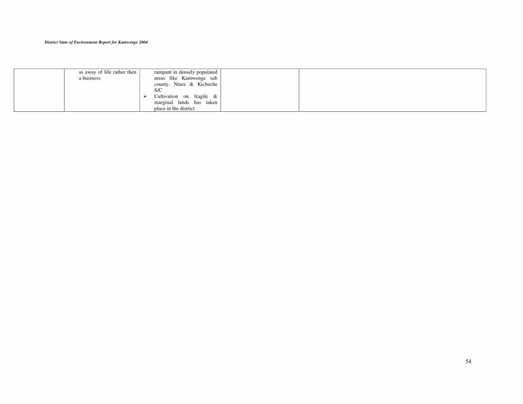
District State of Environment Report for Kamwenge 2004
54
as away of life rather then
a business
rampant in densely populated
areas like Kamwenge sub
county, Ntara & Kicheche
S/C
� Cultivation on fragile &
marginal lands has taken
place in the district


4.1 Emerging issues and practices.
An emerging environmental issue can be defined as (positive or negative) issue that is not yet
reorganised but which may have significant impact on human and ecosystem health. Some of
the emerging issues in the district include;
1. New practices in agriculture production
2. New techniques in timber harvesting
3. Diseases and pests
4. Migration
The new practices in agriculture production of course aims at raising peoples incomes and
reduce poverty however this is done on the expense of environmental hence putting pressure on
trees, such technologies include using slash and burn methods to clear a large expense of land
for maize production especially in Bwizi and Nkoma sub counties. There is a big worry that in
about 5 years time in future, there will be very few standing trees in those sub counties hence
leading to other problems like climate change and global warming.
Also with introduction of fast growing crops and animals in the district is still a precarious
situation as we are not yet sure whether this technology will do better than our indigenous one
of local crops and animals.
With decentralization and creation of the district there are accrued developments taking place
especially powerlised timber cutting. This act is new in the district and may cause severe
degradation and lack of timber in the near future, as there is indiscriminate harvesting of young
trees.
Pests and diseases in both wild animals and plants are up coming. Recently over 200 hippos
died from Queen Elizabeth National Park and the cause of death is not yet clear and there is a
fear that since hippos live in water, their death might affect fish hence causing problems to
human beings.
There is a new disease attacking eucalyptus plants in the district and this causes stunted growth
and eventually affects a bigger area. This has caused farmers loose moral for the plant.
Recently the District received over 3000 returnees from Tanzania who were allocated in two
hectares of land per family in Kahunge and Kamwenge sub counties. These people depend
entirely on natural resources in form of charcoal, fuel wood, and land for agriculture. This has
led to serious encroachment of riverbanks and wetlands in these areas.
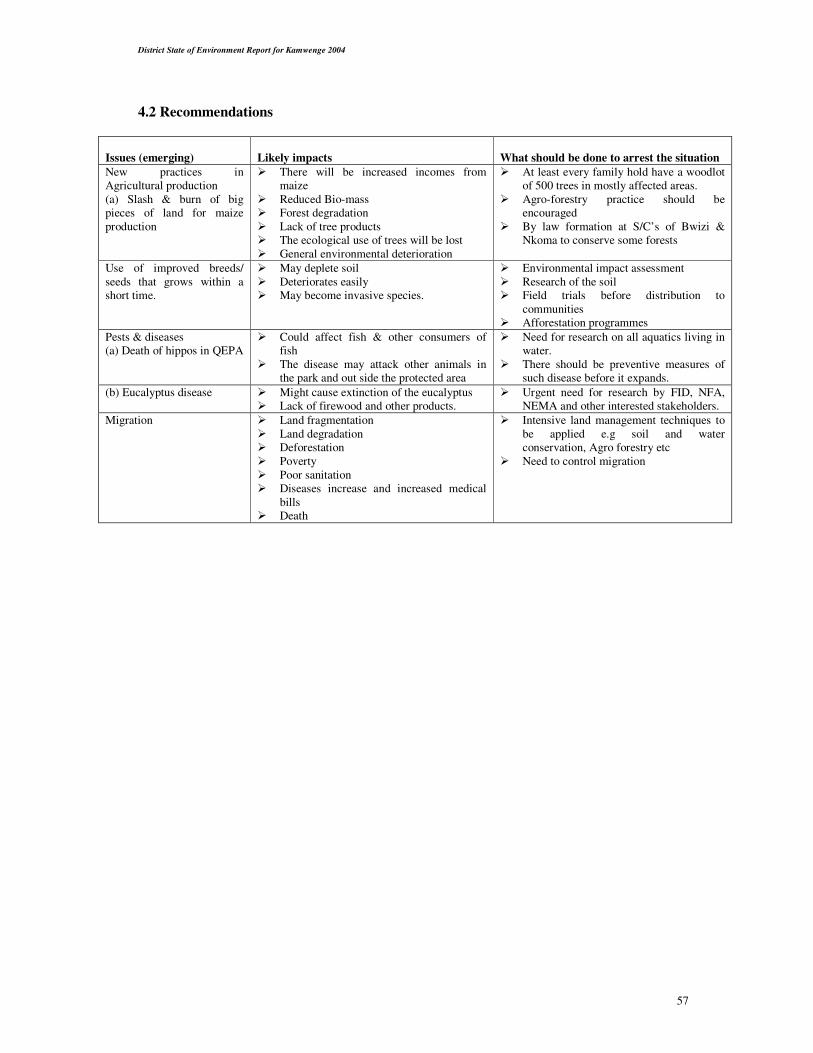
District State of Environment Report for Kamwenge 2004
57
4.2 Recommendations
Issues (emerging)
Likely impacts
What should be done to arrest the situation
New practices in
Agricultural production
(a) Slash & burn of big
pieces of land for maize
production
� There will be increased incomes from
maize
� Reduced Bio-mass
� Forest degradation
� Lack of tree products
� The ecological use of trees will be lost
� General environmental deterioration
� At least every family hold have a woodlot
of 500 trees in mostly affected areas.
� Agro-forestry practice should be
encouraged
� By law formation at S/C’s of Bwizi &
Nkoma to conserve some forests
Use of improved breeds/
seeds that grows within a
short time.
� May deplete soil
� Deteriorates easily
� May become invasive species.
� Environmental impact assessment
� Research of the soil
� Field trials before distribution to
communities
� Afforestation programmes
Pests & diseases
(a) Death of hippos in QEPA
� Could affect fish & other consumers of
fish
� The disease may attack other animals in
the park and out side the protected area
� Need for research on all aquatics living in
water.
� There should be preventive measures of
such disease before it expands.
(b) Eucalyptus disease � Might cause extinction of the eucalyptus
� Lack of firewood and other products.
� Urgent need for research by FID, NFA,
NEMA and other interested stakeholders.
Migration � Land fragmentation
� Land degradation
� Deforestation
� Poverty
� Poor sanitation
� Diseases increase and increased medical
bills
� Death
� Intensive land management techniques to
be applied e.g soil and water
conservation, Agro forestry etc
� Need to control migration

District State of Environment Report for Kamwenge 2004
58
References: Kamwenge District Development Plan (DDP) 2004-2007 (Draft.)
National Environment Management Authority State of Environment Report for Uganda 1998
advance Printing Company Pty Ltd, South Africa
National Environment Management Authority State of Environment Report for Uganda
2001/2002print dynamics South Africa.
National Environment Management Authority 2003: Guidelines for District State of
Environment Report (DSOER) preparation in Uganda (Final Draft)
National Wetlands Programme (2000) Kabarole District wetlands inventory.
Republic of Uganda (2000) The state of Uganda population report2003. Challenges on the path
to Quality Life
Uganda wild life Authority (2003) Kibale National Park, General management plan 2003-2013.