do relocated villages experience more forest cover change...
TRANSCRIPT

Environments 2015, 2, 250–279; doi:10.3390/environments2020250
environments ISSN 2076-3298
www.mdpi.com/journal/environments
Article
Do Relocated Villages Experience More Forest Cover Change?
Resettlements, Shifting Cultivation and Forests in the Lao PDR
Sébastien Boillat 1,2,*, Corinna Stich 1, Joan Bastide 1,3, Michael Epprecht 3,
Sithong Thongmanivong 4 and Andreas Heinimann 3
1 Department of Geography and Environment, University of Geneva, Uni Mail, 40 Bd du Pont-d’Arve,
CH-1211 Genève 4, Switzerland; E-Mails: [email protected] (C.S.);
[email protected] (J.B.) 2 Centro de Ciência do Sistema Terrestre, National Institute for Space Research (INPE), Av. dos
Astronautas, 1758, CEP 12201-027, São José dos Campos 12630-000, Brazil 3 Centre for Development and Environment & Institute of Geography, University of Bern,
Hallerstrasse 10, Bern CH-3012, Switzerland; E-Mails: [email protected] (M.E.);
[email protected] (A.H.) 4 Faculty of Forestry, National University of Laos, Dongdok, Xaythany District, Vientiane 7332,
Laos; E-Mail: [email protected]
* Author to whom correspondence should be addressed; E-Mail: [email protected];
Tel.: +41-22-379-83-32; Fax: +41-22-379-83-53.
Academic Editor: Yu-Pin Lin
Received: 30 December 2014 / Accepted: 5 June 2015 / Published: 12 June 2015
Abstract: This study explores the relationships between forest cover change and the
village resettlement and land planning policies implemented in Laos, which have led to the
relocation of remote and dispersed populations into clustered villages with easier access to
state services and market facilities. We used the Global Forest Cover Change (2000–2012)
and the most recent Lao Agricultural Census (2011) datasets to assess forest cover change
in resettled and non-resettled villages throughout the country. We also reviewed a set of
six case studies and performed an original case study in two villages of Luang Prabang
province with 55 households, inquiring about relocation, land losses and intensification
options. Our results show that resettled villages have greater baseline forest cover and total
forest loss than most villages in Laos but not significant forest loss relative to that baseline.
Resettled villages are consistently associated with forested areas, minority groups, and
intermediate accessibility. The case studies highlight that resettlement coupled with land
OPEN ACCESS
Environments 2015, 2 251
use planning does not necessarily lead to the abandonment of shifting cultivation or affect
forest loss but lead to a re-spatialization of land use. This includes clustering of forest
clearings, which might lead to fallow shortening and land degradation while limited
intensification options exist in the resettled villages. This study provides a contribution to
studying relationships between migration, forest cover change, livelihood strategies, land
governance and agricultural practices in tropical forest environments.
Keywords: resettlements; deforestation; rural development; ethnic minorities; Laos
1. Introduction
There is increasing recognition that land use and land cover change are affected by both economic
and institutional drivers [1]. This has led to increasing emphasis on the role of governance and
institutional factors in influencing land use and land cover change [1–3]. Public policies in the land
sector of developing countries often aim at promoting a more efficient and equitable use of land, but
might have unintended effects, including fostering conversion of forest into cropland [4]. This is
especially the case with policies which include land redistribution and encourage rural migration,
which are shown to be fundamental drivers of forest loss in the tropics [5]. Examining the outcomes
and impacts of these policies is of high importance given the fundamental contribution of tropical
forests to biological diversity, carbon storage and local livelihoods.
Throughout Southeast Asia, many countries have been enforcing policies—often backed by
international cooperation—aimed at halting deforestation and fostering rural development [6].
A pervasive view has been that the practice of shifting cultivation is simultaneously responsible for
deforestation and linked to the high poverty rates found among highland and ethnic minority
people [7,8]. This view has been and still is held by the government of the Lao People’s Democratic
Republic (hereafter: Laos) and some of their development partners, who have placed the reduction of
both shifting cultivation and rural poverty high on their agendas. To reach these aims, an important
strategy used by the Laotian authorities has been to resettle upland villages and communities to more
accessible sites and perform land use planning [7].
The outcomes of the Lao resettlement strategy aimed at the elimination of shifting cultivation and
the reduction of deforestation are, however, controversial. Some argue that the strategy has been
ineffective at curbing deforestation [8,9] and may have led to cultural trauma and unexpected further
migrations [10], or dispossession of farmers of their land [11]. Others, however, emphasize the
positive outcomes of resettlement processes, including livelihood improvements [12].
This paper addresses possible relationships between village resettlements and forest cover change in
Laos from a multi-scale perspective from the national to the local level. The national assessment builds
on the opportunity provided by the release of two important datasets. First, the Lao Census of
Agriculture 2010/11 provides a countrywide comprehensive survey on the location of villages that
were resettled between 2000 and 2011, as well as information on agricultural populations, living
conditions, and agricultural practices in these villages. Second, the Global Forest Change 2000–2012
dataset released by Hansen et al. [13] provides a worldwide, high-resolution account of forest loss and

Environments 2015, 2 252
gain between 2000 and 2012. The comparable timeframe of both datasets provides an opportunity to
assess the relationship between resettlements and forest cover change at a national scale. A review of
existing case studies as well as an original case study were then performed in order to refine the
interpretation of the national data.
2. Background: Shifting Cultivation, Resettlements and Land Policy in Laos
Laos is a landlocked country in mainland Southeast Asia. It has the lowest population density in
Southeast Asia, one of the lowest GDPs and development levels, and has one of the highest
proportions of rural population. A socialist economy until 1986, the country has witnessed substantial
changes since opening to a market-based economy and the expansion of trade with its neighbors,
particularly China, Vietnam and Thailand.
Laos also has the highest proportion of forested land in mainland Southeast Asia, and the highest
forest cover per capita in the region. With all of Southeast Asia labeled as a Biodiversity Hotspot [14],
the country’s forests make an important contribution to global biological diversity. Accounts of forest
cover change in the country vary according to the analysis scale and methods used [7]. According to
World Bank data, which classifies stands of trees of at least five meters tall as forest, but excludes
urban parks and agroforestry systems, 67.6% of the country’s land area was forested in 2012,
compared with 75% in 1990 [15]. According to FAO statistics, Laos is currently losing about 0.5% of
its forest each year, which lies within the regional average [16].
Finally, Laos is culturally an extremely diverse country, with around 50% of its population
belonging to more than 70 (49 officially recognized) ethnic minority groups. The rest of the population
is considered “ethnic Lao”, traditional paddy rice farmers settled in the Mekong plains that belong to
the Tai-Kadai linguistic family and are also dominant in Thailand. Minority groups include some small
groups from the same Tai-Kadai family, as well as from three main linguistic families. The
Mon-Khmer family, also called Austroasiatic, includes the Khmu, Katang, Makong and Lamet ethnic
groups, among others, who occupy significant but less populated areas. The Tibeto-Burman family,
which includes the Ahka, Kho, Lahu and other groups, came to Laos from the North (Myanmar and
China) between the 16th and 19th century, and currently live in the mountainous areas of the country’s
far North. The ethnic groups belonging to the Hmong-Mien family, most of whom are from the
Hmong group, migrated to Laos between 1810 and 1900 from China, and traditionally occupy
highland areas [17].
For centuries, many upland and ethnic minority communities have practiced traditional shifting
cultivation for subsistence. A prevailing view among government officials in Laos has been that this
practice is the primary cause of deforestation and is simultaneously a cause and a consequence of
poverty [7,8,18]. According to this view, shifting cultivators are trapped in a “poverty-resource
degradation spiral” in which poverty leads to pressure on resources such as forests, and causes land
degradation, declining yields and further poverty [7]. Population growth due to high fertility rates can
further exacerbate these problems, making shifting cultivation no longer viable and leading rural
societies to ecological and social collapse in the absence of external intervention. This discourse is in
line with many narratives found among government agencies, development actors and scholars since
the 1970s (e.g., [19–21]).

Environments 2015, 2 253
Based on these considerations, the Government of Laos established the objective of eradicating
shifting cultivation from the country by 2010 [22]. Recent studies on the extent and dynamic of
shifting cultivation have shown, however, that shifting cultivation is still a widespread practice in
Laos [3,23,24]. A spatial analysis of its extent and relation to socioeconomic parameters in Northern
Laos has shown that shifting cultivation is prevalent in remote areas, ethnic minority communities, and
at middle altitudes (the uplands) [24]. Nevertheless, in this area, a general trend of reductions in the
practice has been observed between 2000 and 2009; while core regions of shifting cultivation (Luang
Prabang, Oudomxay and Phongsaly provinces) experienced the greatest decreases, some new shifting
cultivation areas have also emerged (Luang Namtha, Bokeo and Xaignabouly provinces) [23].
The contribution of shifting cultivation to deforestation is a highly debated issue. According to
Ducourtieux [8], the loss of primary or old growth secondary forests to shifting cultivation is
significantly smaller than the loss caused by proximate drivers such as logging and frontier agriculture.
Furthermore, in many cases, logging precedes deforestation for agricultural expansion [7,22].
Shifting cultivation does not necessarily destroy forests and may even contribute to maintaining
multifunctional landscapes when fallow periods are long enough [25,26], but becomes problematic
when they are shortened [27,28]. Finally, farmers practicing shifting cultivation usually rely on forests
as an important food source. They collect non-timber forest products (NTFPs) that significantly
contribute to their diets, and supply medicinal plant products and additional market goods [29].
Other underlying drivers of forest cover change are also at work in Laos, like increasing demands
on cash crops, timber and hydropower projects [22]. Recent studies on land cover change in Northern
Laos have shown an increasing impact of rubber plantations, driven by Chinese demand, which appear
as forest clearings before taking the form of closed cover [30]. As in the rest of Southeast Asia,
eradication policies but also the expansion of intensive agriculture and cash crops might contribute to
the decline of shifting cultivation in Laos [31].
2.1. Resettlement Policy in the Lao PDR
Though there is no comprehensive account of contemporary population movements in Laos, the
Indochina and then, especially, the Vietnamese-American wars had already provoked massive
migrations in the country for decades. It is estimated that more than half of the total population of Laos
moved during the Vietnamese-American war and the related civil war in Laos [32]. At that time, large
parts of the whole population, including lowland and urban populations, were displaced [9]. During the
post-war years, the government focused on repopulating deserted regions, and controlling areas with
presence of rebels. After 1985, however, the focus shifted to the resettlement of upland communities to
regions closer to state services and markets, a process which continues up to now [9].
Though not an official policy until 1998, resettlement has long been seen as a strategy to reach
multiple objectives. The first is the eradication of poverty, to be reached by settling people in areas
with better access to services and markets. A parallel rationale was cultural assimilation and state
control of ethnic minorities, merging them into multiethnic villages where shared Laotian national
values were expected to emerge. An important further objective was the conservation and “rational
use” of forests, with Laotian authorities viewing land degradation in the uplands as a major threat to
natural resources, and traditional shifting cultivation as a primary cause of deforestation [7]. Given
Environments 2015, 2 254
their involvement in shifting cultivation, upland and ethnic minority communities are thus more likely
to be resettled.
In this study, we understand resettlements as the physical relocation of a village from one place to
another, or the relocation of dispersed settlements into a single village. Contemporary resettlements
have been carried out in the framework of the Village Relocation and Consolidation Strategy (VRCS),
established by the Laotian government in 1989, which advocated the merging of villages with less than
50 households [33]. In 1998, the resettlement strategy became an official policy, with the introduction
of the Focal Site approach, which consists of creating merged villages with the provision of services
such as agricultural extension, schools, health centers, electricity and sanitation [33]. Back then, the
government planned to relocate 12% of the whole rural population of the country into 1200 villages in
four years, and directing most development projects to these sites, with a large amount of public
investment stemming from foreign funds [9].
The question of whether resettlements were carried out with the consent of the involved populations
has been subject to debate. Many scholars point out that the distinction between “voluntary” and
“involuntary” resettlements makes no sense in the Laos context where most people would not openly
oppose the one-party government decisions for fear of repression [9,11,22,33]. Some, however,
also point out that villagers move in search of better livelihoods, a consideration which has played a
role in whether villagers accept resettlement [12]. This is particularly important considering that the
higher poverty rate in remote areas of both Laos and Vietnam exceeds that in better connected
areas [34,35].
Nearly all analysts agree, however, on the high impacts of resettlements on rural livelihoods, most
being negative short term economic, social and cultural consequences, especially in the first five years
after resettlement [9]. These include land shortages due to the concentration of populations and the
fact that the best cropland where they are resettled is usually already occupied by existing land
users [9,12,22], impoverishment through food insecurity [11,12], greater exposure to diseases like
malaria [9], loss of traditional ecological knowledge [33], and a lack of delivery of the services
promised by authorities [12].
Villagers have also developed passive strategies for resistance to resettlement. For example, villager
groups may use the networks created by their presence in several resettled areas to avoid land use
regulations [33]. Others try to return to their upland sites, sometimes clandestinely, or officially move
to new sites but keep their land and temporary dwellings in the old one [9]. The impacts of
resettlement and passive resistance strategies on forest cover are relatively unknown. Evrard and
Goudineau [9] mention an increase in shifting cultivation in Luang Namtha and Oudomxay provinces,
which they attribute to resettlements. Based on studies in Phongsaly province, Ducourtieux [8] also
found that resettlements did not completely curb the practice of shifting cultivation but contributed to
an increase in commercial agriculture and combined shifting and fixed agricultural practices in
villages. However, no study has specifically addressed the impact of resettlements on land use and land
cover at a national scale in Laos.

Environments 2015, 2 255
2.2. Land Policy: Allocation, Titling and Planning
The impact of resettlements cannot be understood without considering land planning policies that
were often carried out after resettlements in the framework of the VRCS. From the mid-1990s
onwards, the Lao authorities, backed by international donors—especially the World Bank—have been
implementing a land planning and titling programme called Land and Forest Allocation (LFA),
modelled after the Thai experience [22], and later also called Land Use Planning and Land Allocation
(LUPLA). The initial rationale of the programme was that enhancing tenure security by delineating
village boundaries and giving villagers collective titles would contribute to a more sustainable use of
resources [22].
However, the LFA also entails the demarcation of agricultural land. In this framework, areas
considered not suitable for agriculture have been labelled as “forest land”, which under the land planning
and titling program falls under the jurisdiction of state agencies, namely the Ministry of Forest and
Agriculture (MAF) [22]. The Prime Minister’s decree No. 169 in 1993, requested that all villages
implement a land zoning system; the 1996 Forestry Law gives further guidelines as to zoning by
standardizing the classification of forest into five categories emphasizing protection and conservation
functions, allowing agriculture only in degraded forests and banning shifting cultivation [7].
Concretely, the LFA (later LUPLA) took the form of agreements between village authorities, who
were allocated agricultural land, and local District Agriculture and Forest Offices (DAFOs), charged
with managing forests, with around 90% of village areas becoming classified as forests between 1995
and 2004 [7]. The actual land allocation process then concerned only the remaining agricultural land,
which was assigned to the village authorities with additional instructions that each household was
limited to three plots and would lose land fallowed for more than three years, thus making shifting
cultivation impossible [7]. Given these considerations, effectively implementing land use planning
should increase areas labelled as forest and put them under strict protection.
Land planning also places considerable pressure on villagers. Some authors argue that, even if the
LFA and LUPLA appear highly participatory and centered on collective rights, they have in some
places exacerbated the negative effects of resettlements, producing land shortages, degrading working
conditions and farm productivity, and leading to higher food insecurity and poverty [9,36,37].
The pressures generated could have counterproductive outcomes including poor implementation of
regulations and increases in illegal and uncontrolled land clearings.
Successful resettlement and land planning policies also depend on the development prospects at
new sites and on the allocation of land and resources. The Government of Laos and several
international organizations often mention agricultural intensification as a way to curb the problems
linked with resettlements and to increase agricultural productivity in general. Aside from the provision
of agricultural extension services in resettled villages [33], a key identified challenge has been the
expansion of irrigation, which could contribute to improving yields substantially [38,39].
Understanding to what extent resettlement and the LUPLA come along with effective processes of
agricultural intensification could give further insights into the impact of these land policies on forests.

Environments 2015, 2 256
2.3. Objectives and Research Questions
Three research questions arise from the considerations described above regarding the relationships
between resettlements, ethnic minorities, shifting cultivation and forest cover.
A first research question relates to the impact of resettlements on forest cover, which can take two
possible contradictory pathways. On the one hand (first hypothesis), resettled and consolidated villages
might experience less forest loss due to land planning implementation, and compensate for land losses
with the intensification of agriculture. On the other hand (alternative hypothesis), population
concentration, land shortages and livelihood stresses, coupled with a relative tolerance of banned
practices by local authorities, might lead to increased forest conversion in resettled villages. Whether
the resettled population has access to existing or developing irrigated land might be an important factor
enabling intensification.
The second research question addresses the socio-economic potential of resettled villages.
The hypothesis is that resettlements usually concern upland and ethnic minority villages that face
cultural and economic constraints to intensification. To what extent are resettled villages dominated by
ethnic minorities? Are there ethnic groups that are especially affected by recent resettlements? If yes,
is a higher forest cover loss observable in villages dominated by these groups?
The third research question addresses the new physical location of resettled villages and their
potential for agriculture intensification. The hypothesis is that recently resettled villages are located at
intermediate sites, considered relatively accessible and at the same time with available land and
resources, including a higher forest cover than in more densely populated areas. On the one hand,
resettled villages are expected to be located in areas with higher forest cover than average villages in
Laos, thus making resettlements particularly relevant to forest management. On the other hand, they
might occupy areas with steep slopes and poor soils less suitable for agricultural intensification.
In summary, this paper aims to examine the visible impacts of resettlements and accompanied land
policies on forest cover by comparing resettled and non-resettled villages at the national scale and
using case studies at finer scales, with a focus on the research questions mentioned above.
3. Study Area and Methods
We took a multi-scale approach to address the question of the relationship between resettlements
and forest cover change in Laos. Firstly, our research draws on two main datasets at the national scale
related to the location of resettled villages and land cover change. Secondly, we reviewed six published
case studies of resettlement, land planning and impacts on livelihoods and land use in Laos, covering a
total of 44 villages. Third, we performed a case study on resettlement history, land access, and land
cover change in two villages in Luang Prabang province, an area with high ethnic diversity and little
available land, and with many resettled villages.
National data on the location of resettled villages was obtained from the Lao Census of Agriculture
2010/11 (hereafter: LCA2011), the second agricultural census carried out in the country since the first
in 1998/99. Implemented by the Ministry of Agriculture and Forestry (MAF) with support from the
Lao Bureau of Statistics (LSB), the census included household questionnaires, which focused on basic
information on crop and livestock production at the household level, and village questionnaires, which

Environments 2015, 2 257
inquired about village organization, infrastructure and land use. The village questionnaires were
completed by village organizations including village leaders (Nai Ban) and councils. In this study, we
used the following questions from the village questionnaire: “Has this village been resettled since
2000” (question 40); “What is your assessment of the living conditions of people in the village
compared with two years ago? Improved/Stayed the same/Declined” (question 15), “Did any farmers
in the village use shifting cultivation in the last 12 months?” (question 30).
The LCA2011 data were spatialized using the GPS location (points) of each village, provided by
MAF, which was done subsequent to the census. To integrate forest cover into the analysis, a further
step was necessary to transform the points into polygons. This was performed using the “small area
estimation” method [3,24]. The calculation of village polygons was based on the assumption that
people reported to live around a point are more likely to interact with the resources located the shortest
travel time from that point. We used an accessibility model, developed by Messerli et al. [3], which
models travel time per each 90 m cell as a function of land cover, slope, and the roads and navigation
networks. The model was used to allocate to each village point an area within which travel time to that
point is the shortest. We obtained a total of 8643 village polygons for the whole country and integrated
them with the LCA2011 data.
The second national dataset used was a subset of the high-resolution global map of 21st century
forest cover change, produced by Hansen et al. [13], published in November 2013 and available online
under Creative Commons Attribution License since February 2014. The map provides global data on
tree cover extent (from 0 to 100%) at a spatial resolution of 30 m in year 2000, as well as forest loss
(with year of loss) and forest gain from 2000 to 2012. Trees were defined as any vegetation taller than
5 m, forest loss as a “stand-replacement disturbance” and disaggregated with reference to percent tree
cover and year of loss, and forest gain as non-forest to forest change with more than 50% tree cover.
The global map was based on the analysis of more than 650,000 Landsat 7 Thematic Mapper Plus
(ETM+) scenes and a binary High/Low biomass classification of Landsat imagery, which has been
proven to be very robust [23]. The images were pre-processed through a series of automated
algorithms and then classified using time-series spectral metrics derived from training areas. The scene
classification at a global level was performed using Google Earth Engine (© Google) [13].
The Hansen et al. [13] dataset represents the only multi-temporal dataset on forest cover change
after 2000 available at this resolution and at no charge. A particularity of this dataset is that it is
exclusively based on land cover, thus avoiding mixing up land use and land cover concepts in the raw
data production. This constitutes an advantage, since no interpretation of actual land use is provided,
allowing different possible interpretations according to forest cover change patterns in time and space,
but also a limitation in the sense that natural forest cover change cannot be distinguished from
human-induced change.
For our analysis, we defined forest loss as a loss of tree cover below the threshold of 50%.
Therefore, we calculated forest cover in 2000 per village area using the tree cover extent of 50 to 100%
provided by Hansen et al. [13], areas with reported forest losses which had 50% or more of tree cover
in 2000, and areas of forest gain, which were combined with the loss areas to calculate areas with both
forest loss and gain between 2000 and 2012. The raster datasets produced were used to calculate forest
cover in 2000; areas of forest loss, of forest gain, and of forest loss and gain for each village polygon.
Forest loss in relation with forest cover in 2000 was then also calculated, as well as forest gain and

Environments 2015, 2 258
loss/gain relative to the whole village area. Using ArcGIS software (© ESRI), we also calculated the
mean altitude of villages on the basis of the Shuttle Radar Topography Mission (SRTM) digital
elevation model of the U.S. National Aeronautics and Space Administration (NASA), as well as the
mean travel time to district capital using the accessibility model [3]. These variables were tested for
statistically significant differences (p < 0.05) between resettled and non-resettled villages, performing
the non-parametric Mann-Whitney tests. Forest cover in 2000 and forest cover change from 2000 to
2012 was also tested for statistical significance in the difference between villages dominated by
different aggregated ethnolinguistic families. The merging of information on ethnic groups into
aggregated ethnolinguistic families was performed according to the list provided by Engwall [40].
Additional to data at the national scale, case studies were examined. We first reviewed six published
case studies on land use and land cover change in Laos, in which references to resettlement and/or land
use planning are mentioned. Then, a new case study was performed to understand the resettlement
patterns at the village level, and their relationship with the availability, access, quality and distribution
of land and (marginally) of water resources among households [41]. Fieldwork was performed during
February and March 2013 in two villages of Phonexay district (Luang Prabang province) by a research
team including Lao and Swiss researchers as well as the Phonexay DAFO staff. Fifty-five households
(about one third of all households in the villages) were surveyed on their history of settling into the
village, whether they had access to highly productive, irrigated land, and whether they had lost land
after the LUPLA process. The households were randomly sampled within three income groups.
Information was then complemented with semi-structured interviews with the Nai Bans (village heads)
and a group of farmers.
Since fieldwork was carefully monitored by the local DAFO representatives, who were also in
charge of controlling LUPLA enforcement, it was not possible to ask households about forest clearings
and the practice of shifting cultivation as they are considered illegal. However, we could observe forest
clearings in the villages using data on forest loss year from the Hansen et al. [13] dataset, and the
boundaries of the villages defined by the LUPLA process, obtained from The Agrobiodiversity Initiative
Project (TABI).
The choice of Luang Prabang province as the case study site was based on the characteristics of the
province, which represents a “mature” stage of rural development and implementation of resettlement
and LUPLA policies. Luang Prabang has for decades been a hotspot of development and research
interventions backed by international organizations, as well as one of the pilot areas for the
implementation of LFA and LUPLA [37]. Luang Prabang is described by anonymous experts to have
better infrastructure and more educated district staff than is typical throughout Laos [41]. On the other
hand, it is also a very mountainous area with limited arable land, and is ethnically diverse with many
areas dominated by minority groups.
The two surveyed villages are located in the Phonexay district, situated within a travel distance of
approximately 63 km of the city of Luang Prabang (Figure 1; Table 1). The district is 80%
mountainous with few paddy field areas and a prevalence of rain-fed cultivation on sloping land, and
has a poverty incidence of 55% [41]. The first village studied, Sopchia, located approximately 11 km
from the district capital, is an ethnically mixed village. It was originally founded in 1914 by ethnic Lao
from Xiengkhouang province [42], to which Khmu households immigrated due—among other
reasons—to resettlements in nearby villages. It has access to both permanent and upland agriculture

Environments 2015, 2 259
areas. The second village, Houay Si Nhoua, is located a little further from the district capital, about
4 km from Sopchia. With more difficult access to markets than Sopchia and a lack of flat areas suitable
for paddy, the village is dominated by Khmu ethnic minority households. Originally founded in 1975,
the village was resettled in 2003 to a new site (closer to Sopchia) grouping its original population with
households coming from two neighboring villages.
Table 1. Main characteristics of the villages studied.
Sopchia Houay Si Nhoua
Location 1 Approximately 11 km
from district capital
Approximately 15 km from
district capital
Altitude (village center) 1 470 m 515 m
Population 1 413 people, 86 households 672 people, 93 households
Ethnic groups 1 Lao, Khmu Khmu
Resettled 2 No Yes
Living conditions 2 Improved Declined
Shifting cultivation practices 2 No No
Data sources: 1 C.Stich [41]; 2 Derived from LCA2011.
Figure 1. Locations of the case study areas.

Environments 2015, 2 260
4. Results and Discussion
4.1. Geographical Characteristics of Resettled Villages in Laos
Among a total of 8643 villages in Laos, the LCA2011 reported 872 villages to have been resettled
between 2000 and 2011. This represents 11.2% of all villages in Laos. On average, new sites of
resettled villages are still located at higher altitudes and further away from district centers than
non-resettled villages (Table 2). One can also observe that resettled villages have a greater forest cover
than the national village average. Finally, the location of resettled villages (Figure 2) shows a general
concentration of resettled villages in mountainous and forested areas. Since high forest cover and
higher altitudes are also characteristics of shifting cultivation villages, these observations suggest a
clear link between resettlements, upland settlements, and shifting cultivation. Table 2 also shows that
the total forest loss per village (in ha) between 2000 and 2012 is higher in resettled than in
non-resettled villages, though this must be related to resettled villages having larger areas and higher
baseline forest cover. When considered relative to baseline forest cover, forest loss is lower in resettled
than in non-resettled villages.
Table 2. Characteristics of resettled vs. non-resettled villages in Laos.
Villages Non-Resettled Resettled (2000–2011) No Information
Number of villages 7752 872 19
Altitude (mean) 524 785 402
Travel time to district capital (hours, mean) 3.9 6.6 4.1
Area (ha, mean) 2560 3547 2534
Forested area in 2000 (ha, mean) 1980 3222 1816
Forest cover in % (2000) 56.9 82.7 55.5
Forest loss 2000–2012 (ha, mean) 122 207 133
Forest loss in % of 2000 cover (mean) 11.1 9.9 9.3
There are differences in the proportion of resettled villages by province. Please note that the list and
map of Lao provinces corresponds to the situation in December 2012, and thus does not include the
province of Xaisombum, created December 2013. Most provinces along the lower Mekong (Vientiane,
Savannakhet, and Champasak provinces) have experienced fewer resettlements. On the other hand,
resettlements appear to be especially relevant in the whole Northern region of the country, as well as in
the far South-East. In two provinces of each of these two regions, more than 20% of all villages were
resettled between 2000 and 2011.
Table 3 examines the relationships between resettled villages and reported change in living
conditions as assessed by the LCA2011. Though most villages report better living conditions, the
proportion of villages reporting no change or a decline in living conditions is slightly higher (10% for
each category) in resettled villages than in non-resettled villages (7%). On the other hand, the
proportion of villages reporting the existence of shifting cultivation is also higher (27%) in resettled
villages than in non-resettled villages (15%).

Environments 2015, 2 261
Figure 2. New site location of resettled villages between 2000 and 2011 in Laos.
Table 3. Living conditions and presence of shifting cultivation practices in resettled and
non-resettled villages.
Living Conditions Shifting Cultivation Practiced
Improved Stayed Same Declined No answer No Yes No Answer
Resettled villages 80% 10% 10% 0% 73% 27% 0%
Not resettled villages 85% 7% 7% 0.2% 84% 15% 1%
Figure 3 shows the distribution of resettled villages as well as villages reported to practice shifting
cultivation and to have experienced a decline in living conditions, in relation to the aggregated four
ethnolinguistic families. Resettled villages exist among the four main ethnolinguistic families.
However, minorities (non-Tai-Kadai) are indeed clearly overrepresented in resettled villages.

Environments 2015, 2 262
About 50% of resettled villages but only 30% of all villages have populations dominated by
Mon-Khmer ethnic groups. Inversely, only 20% of resettled villages but more than 50% of all villages
are dominated by Tai-Kadai groups.
Villages where shifting cultivation still exists are also mostly predominantly populated with ethnic
minorities in about 75% of the cases. There, Mon-Khmer and Hmong-Mien have a larger contribution
to the total number of villages with shifting cultivation than in most villages, but this is not the case for
Tibeto-Burman groups.
Decline in living conditions is not a characteristic of villages dominated by ethnic minorities only,
with 40% of villages reporting declining living conditions dominated by Tai-Kadai groups. However,
Mon-Khmer groups are also relatively overrepresented in villages with declining living conditions.
Hmong-Mien and Tibeto-Burman show the inverse trend, with a lower proportion of villages
experiencing declining living conditions as compared to all villages overall.
Figure 3. Distribution of resettled villages and their characteristics in relation with
aggregated ethnolinguistic families.
4.2. Forest Cover Change in Laos
According to our analysis of the Hansen et al. [13] dataset, 79.15% of the whole territory of Laos
exhibited tree cover of 50% or more by 2000. Between 2000 and 2012, 1.13 Million hectares of these
areas lost their forest cover, which represents an annual forest cover loss rate of 0.52%. Meanwhile,

Environments 2015, 2 263
there were 0.3 Million hectares of observed gained forest, and 0.15 Million hectares with both gain and
loss of forests from 2000 to 2012.
Figure 4 shows forest cover, loss and gain by province, derived from the Hansen et al. [13] dataset.
Many Northern provinces still have significant forest cover. The largest amount of lost forest can be
found in the provinces of Houaphan, Bolikhamxai, Vientiane, Luang Prabang and Luang Namtha.
On the other hand, Houaphan and Luang Prabang show the largest amount of forest regrowth.
In general, Northern provinces show both high forest loss and forest gain.
When related to the dominant aggregated ethnolinguistic families by village (Table 4), forest cover
in 2000 appears to be clearly higher in villages dominated by ethnic minorities, with statistically
significant (p < 0.05) differences between Tai-Kadai as well as Tibeto-Burman villages and all other
groups. Mon-Khmer and Hmong-Mien dominated villages show similar forest covers, while the
highest forest cover occurs in Tibeto-Burman dominated villages. Forest cover loss occurs in all
categories of villages by ethnolinguistic families. However, the overall difference in total forest loss
with relation to ethnolinguistic families was not significant at p < 0.05 level, suggesting that the
variability in forest cover change is higher within ethnolinguistic families than among them. Though
variable at the village level, the average forest loss rate appears to be higher in villages dominated by
Tai-Kadai groups, with 13% forest loss between 2000 and 2012, taking into account that these villages
also had lower forest cover in 2000. In general, Tai-Kadai dominated villages have higher population
densities. Unfortunately, since only one category—the “main” ethnicity by village—was listed in the
LCA2011 database, we have no information on ethnic representation within the villages.
Figure 4. Forest cover change by province in Laos.
Environments 2015, 2 264
Table 4. Aggregated ethnolinguistic families and forest cover change.
4a. Average Forest Area and Loss of Villages by Main Ethnolinguistic Family
Proportion of Forested
area in 2000 (%, Mean)
Forest Loss
(% 2000–2012, Mean) Number of Villages
Tai-Kadai 43 13 4601
Mon-Khmer 77 9 2726
Tibeto-Burman 87 10 450
Hmong-Mien 78 10 824
4b. Significance Matrix of Differences in Proportion of Forested Area according to Ethnolinguistic Families
Tai-Kadai Mon-Khmer Tibeto-Burman Hmong-Mien
Tai-Kadai 0.00 0.00 0.00
Mon-Khmer 0.00 0.00 0.554
Tibeto-Burman 0.00 0.00 0.00
Hmong-Mien 0.00 0.554 0.00
4c. Significance Matrix of Differences in Relative Forest Loss according to Ethnolinguistic Families
Tai-Kadai Mon-Khmer Tibeto-Burman Hmong-Mien
Tai-Kadai 0.231 0.684 0.421
Mon-Khmer 0.231 0.259 0.915
Tibeto-Burman 0.684 0.259 0.309
Hmong-Mien 0.421 0.915 0.309
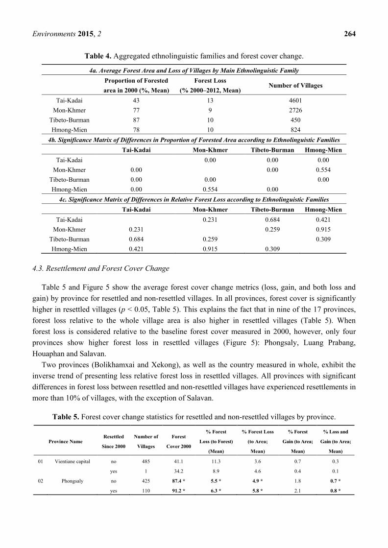
4.3. Resettlement and Forest Cover Change
Table 5 and Figure 5 show the average forest cover change metrics (loss, gain, and both loss and
gain) by province for resettled and non-resettled villages. In all provinces, forest cover is significantly
higher in resettled villages (p < 0.05, Table 5). This explains the fact that in nine of the 17 provinces,
forest loss relative to the whole village area is also higher in resettled villages (Table 5). When
forest loss is considered relative to the baseline forest cover measured in 2000, however, only four
provinces show higher forest loss in resettled villages (Figure 5): Phongsaly, Luang Prabang,
Houaphan and Salavan.
Two provinces (Bolikhamxai and Xekong), as well as the country measured in whole, exhibit the
inverse trend of presenting less relative forest loss in resettled villages. All provinces with significant
differences in forest loss between resettled and non-resettled villages have experienced resettlements in
more than 10% of villages, with the exception of Salavan.
Table 5. Forest cover change statistics for resettled and non-resettled villages by province.
Province Name Resettled
Since 2000
Number of
Villages
Forest
Cover 2000
% Forest
Loss (to Forest)
(Mean)
% Forest Loss
(to Area;
Mean)
% Forest
Gain (to Area;
Mean)
% Loss and
Gain (to Area;
Mean)
01 Vientiane capital no 485 41.1 11.3 3.6 0.7 0.3
yes 1 34.2 8.9 4.6 0.4 0.1
02 Phongsaly no 425 87.4 * 5.5 * 4.9 * 1.8 0.7 *
yes 110 91.2 * 6.3 * 5.8 * 2.1 0.8 *

Environments 2015, 2 265
Table 5. Cont.
Province Name Resettled
Since 2000
Number of
Villages
Forest
Cover 2000
% Forest
Loss (to Forest)
(Mean)
% Forest Loss
(to Area;
Mean)
% Forest
Gain (to Area;
Mean)
% Loss and
Gain (to Area;
Mean)
03 Luang Namtha no 297 74.7 * 17.6 11.6 2.4 1.2
yes 57 89.9 * 15.0 11.4 2.7 1.4
04 Oudomxai no 348 78.7 * 7.9 6.1 2.0 0.8 *
yes 122 88.0 * 7.5 6.5 2.1 0.9 *
05 Bokeo no 256 68.9 * 16.4 8.1 * 1.3 * 0.6 *
yes 26 79.7 * 19.8 11.3 * 1.9 * 0.9 *
06 Luang Prabang no 676 74.1 * 5.7 * 4.4 * 1.8 * 0.7 *
yes 103 87.1 * 7.0 * 6.2 * 2.3 * 1.1 *
07 Houaphan no 615 80.0 * 10.9 * 8.4 * 3.1 * 1.4 *
yes 103 86.1 * 13.5 * 11.5 * 4.4 * 2.2 *
08 Xaignabouly no 421 61.0 * 6.9 4.5 * 0.8 * 0.2 *
yes 23 78.4 * 8.8 7.1 * 1.3 * 0.5 *
09 Xiengkhouang no 450 63.5 * 9.6 5.4 * 1.5 * 0.6 *
yes 61 79.1 * 7.3 6.2 * 1.9 * 0.7 *
10 Vientiane no 472 57.7 * 11.8 5.3 1.7 0.6
yes 33 79.3 * 8.0 5.5 1.5 0.6
11 Bolikhamxai no 291 66.5 * 20.7 * 12.2 2.3 1.4
yes 32 84.6 * 15.0 * 10.8 2.1 1.3
12 Khammouan no 547 54.1 * 9.9 6.0 1.9 1.2
yes 38 70.4 * 10.4 7.2 1.5 0.8
13 Savannakhet no 967 37.0 * 12.2 4.8 * 1.5 * 0.6 *
yes 42 53.6 * 12.8 7.6 * 1.8 * 0.8 *
14 Salavan no 564 43.5 * 6.3 * 3.1 * 0.9 * 0.3 *
yes 37 67.9 * 10.2 * 8.1 * 2.0 * 0.9 *
15 Xekong no 186 75.6 * 14.0 * 9.4 2.2 1.2
yes 47 89.9 * 8.2 * 7.4 2.2 1.1
16 Champasak no 628 31.3 * 10.0 3.3 * 0.5 * 0.2 *
yes 12 57.4 * 6.8 4.6 * 0.8 * 0.3 *
17 Attapeu no 124 58.2 * 16.3 9.9 2.1 * 1.1 *
yes 25 81.4 * 14.7 12.0 3.8 * 2.1 *
All villages no 7752 56.9 * 11.7 * 5.8 * 1.6 * 0.7 *
yes 872 82.7 * 9.9 * 7.9 * 2.4 * 1.1 *
* = significant difference between resettled and non-resettled villages at p < 0.05 (Non-parametric Mann-Whitney test).
In ten provinces, forest gain (relative to the village area) appears to be higher in resettled villages, and
for areas with both forest loss and gain, which is the case in 12 provinces out of 17. These trends are also
visible for the whole country. The difference in forest gain and both forest loss and gain between
resettled and non-resettled villages is particularly high in the provinces that experienced more forest loss
in resettled villages, namely: Phongsaly, Luang Prabang, Houaphan and Salavan. Inversely, the two
provinces with less forest loss in resettled villages (Bolikhamxai and Xekong) show no significant
differences in forest gain or forest loss and gain between resettled and non-resettled villages.

Environments 2015, 2 266
Figure 5. Comparison of forest loss in resettled and non-resettled villages by province.
4.4. Summary of Findings from National Assessment
We found out that, for the whole of Laos, there is a trend of resettled villages being located at
higher altitudes, in less accessible and more forested areas. Many resettled villages are located in the
North and the far South-East of the country. Resettled villages also experienced a slightly higher
proportion of decline in living conditions and persistent engagement in shifting cultivation.
Furthermore, ethnic minorities are overrepresented in resettled villages, especially the Mon-Khmer
family, which is also overrepresented in villages with lowered living conditions.

Environments 2015, 2 267
Northern provinces on average have more forest cover, which is also true for villages dominated by
ethnic minorities. In the country as a whole, the average absolute forest loss per village is higher in
resettled villages, but not relative to the baseline forest cover. However, we observed higher relative
forest loss in four provinces, among them three Northern provinces, and the inverse trend in two
provinces. Furthermore, forest gain occurs more in resettled villages than in non-resettled villages in
10 out of 17 provinces, and patches that experienced both gain and loss also occur more in resettled
villages in 12 out of 17 provinces.
These results show that there is a relationship between resettlements, high forest cover and ethnic
minorities, but also that forest losses vary in relation to resettlements. The considered case studies
enable a finer analysis of how resettlements can contribute to forest cover change.
4.5. Case Studies Review
Table 6 shows the observations made by different case studies. Because these studies had different
objectives, the relations between resettlements and land use change can only be addressed
qualitatively. Different changes were observed, including land shortages and fallow shortening, but
also agricultural intensification with more paddy cultivation and other commercial crops, and
regeneration of forest in abandoned areas. Among cases of resettled villages, three non-exclusive
trends are observed. The persistence of shifting cultivation, the shortening of fallows, and forest
regeneration in abandoned areas. Fallow shortening goes along with continuing shifting cultivation
when land availability is reduced, especially if land planning has been performed. Conversely, fallow
period shortening was not mentioned as significant, and was thus not a prominent observed impact in
the case of resettled villages without land planning [29]. Intensification has been observed in villages
with land planning but no recent resettlement. Nevertheless, most of these studies provide little
information on direct impacts of resettlement and land planning on land use, with the exception of the
study by Castella et al [28].
Table 6. Case studies of resettlement, land planning and impacts in Laos.
Publication Study Period Provinces Villages Resettlements LFA/LUPLA Observed Land Tenure, Use and Cover
Changes
Castella et al.
2013 [28] 1973–2009
Luang
Prabang 14 Yes (2009) Yes
- Pursuit of shifting cultivation with shortened
fallow periods led to disappearance of secondary
forest and degradation around villages
- Forest regeneration in abandoned area
Linquist et al.
2007 [39] 1962–2002
Luang
Prabang,
Oudomxay
9 No Yes
- Development of paddy rice in valley bottoms
and terraced slopes
- Physical (suitable land, water) and
socio-economic (initial investment)
limitations to this development
- Mon-Khmer groups only recently engaged
into montane paddy cultivation
Watanabe et al.
2004 [43] 1999–2000
Luang
Prabang 3 Yes (1972, 1991) Yes (1996)
- Land shortage, fallow shortening, soil
degradation and decrease in crop yields
- No information on forest cover change

Environments 2015, 2 268
Table 6. Cont.
Publication Study Period Provinces Villages Resettlements LFA/LUPLA Observed Land Tenure, Use and Cover
Changes
Seidenberg et al.
2003 [44] 1989–1997 Huaphan 3 No info. No info.
- Land shortage, reduction of fallow periods,
deforestation of secondary forests mainly
- Increase of paddy, orchards, and livestock
Thongmanivong
et al. 2005 [45] 1952–2000 Vientiane 1 No Yes (2000)
- Forest area nationalized and village access
rights removed
- Dense forest converted to degraded forest and
shrub through shifting cultivation and logging
(1952–1981)
- After 1981, intensification,
abandonment of shifting cultivation and
shrub-to-forest regeneration
Yokoyama
2004 [29] 2001
Luang
Prabang 14 Yes No
- Persistence of shifting cultivation coupled
with NTFP recollection, especially by
Mon-Khmer groups
4.6. Resettlements and Land Distribution in Two Resettled Villages: A Case Study in Luang Prabang
This section is based on the case study performed by Stich (2013; [41]). The two surveyed villages,
Sopchia and Houay Si Nhoua, are intimately linked by the resettlement process. In 1999, land use
planning was performed in Sopchia, and villagers were given land use certificates and the village
boundaries were fixed [42]. In 2003, three villages (Houay Si Nhoua, Houaypot and Moklaharn) were
“clustered” into a new administrative unit, the khum baan, or village group. Next, 93 households from
these villages were relocated to a new site called “new” Houay Si Nhoua, in the framework of the
VRCS, which stipulates that villages with less than 50 households must be merged into larger
villages [42]. The new dwelling site was located near the paddy fields of Sopchia, in an area which the
Sopchia villagers considered part of their territory. The state did not grant newcomers any access to
land, since Sopchia villagers already held titles stemming from the LFA performed in 1999. This
situation led to land conflicts and some villagers moved back to their former production areas
(in Thadthong) that had been occupied in the meantime by another resettlement event. LUPLA in
Houay Si Nhoua was performed in 2008 [42]. In 2009, the Phonexay DAFO authorities allowed part of
the Houay Si Nhoua villagers together with the other village’s population to move back to their old
sites [42]. In 2011, a more participatory process of land use planning updates, Participatory Land Use
Planning (PLUP), was performed in both villages with the help of The Agro-Biodiversity Initiative
(TABI) project, supported by the Swiss Agency for Development and Cooperation (SDC). This
process defined areas of fallow rotation (4 in Sopchia and 6 in Houay Si Nhoua), where shifting
cultivation is now allowed. A revision of the PLUP was done in Houay Si Nhoua in 2012 as the first
PLUP was only partially implemented because agricultural land was not included [41].
As a result of these changes, the newcomers from the three villages resettled at the new Houay Si
Nhoua site near Sopchia were considered migrants, and the village of Sopchia was not registered as
resettled. Inversely, the people who moved back to the Houay Si Nhoua old site (originally from three
villages) were registered as “clustered” into a resettled village. “Clustered” is a term used in Laos

Environments 2015, 2 269
when people move from neighboring villages and are grouped together with the destination village into
a khum baan (cluster). This means that though only three households per village were labelled
“resettled”, most people labelled as “clustered households” or reporting to have undergone migration
were indeed relocated due to the resettlement policy (Figure 6). This means that by 2013, 69% and
58% of people residing in Sopchia and Houay Si Nhoua respectively were newcomers that were not
born in the village [41].
By 2013, around half of the 55 surveyed households from Sopchia and Houay Si Nhoua had lived
for less than 15 years in the two villages, while nearly the other half were living there for more than
30 years (Figure 7). The household survey found land access to be highly unequal between original
settlers and newcomers, especially regarding access to highly productive paddy rice land in the case of
Sopchia: 64% of the households who had access to paddy rice land had been living for more than 20
years in the village, 18% between 10 and 20 years, and only 18% had resided there for less than 10
years. This shows that newcomers are unlikely to get access to highly productive, irrigated land [41].
In Sopchia, 24% of the surveyed households reported having experienced land losses, and 35% in
Houay Si Nhoua [41]. In Sopchia, the main reasons mentioned for land loss were the LUPLA process
(29%), and land left to other households (29%). The latter indicates that land was redistributed to
another household by DAFO authorities, or sold to another household to avoid redistribution. Fallow is
mentioned in 14% percent of the cases. Fallow has to be linked to LUPLA, since after the LUPLA
process, land owners with fallow left for more than three years lose their land rights to that plot.
In Houay Si Nhoua, the reasons for land loss are more diverse. A total of 50% of land loss is directly
or indirectly linked with the LUPLA process, with households mentioning LUPLA, the establishment
of a conservation area, the allocation of land to another household or land loss for not paying taxes the
most prominent explanation for drivers of land loss. Reasons linked with the resettlement process
(meaning here “moved to another village” or migration) account for a total of 40% of the land loss
cases [41].
Figure 6. Origin of households in Sopchia and Houay Si Nhoua (Source: Stich [41]).

Environments 2015, 2 270
Figure 7. Settlement duration of households in Sopchia and Houay Si Nhoua (Source: Stich [41]).
As stated in the methods section, it was not possible to get direct information on forest cleared by
surveyed villagers. An observation of forest losses in the village areas by year of loss (Figure 8) using
the Hansen et al. [13] data shows that in Sopchia, little forest loss has occurred between 2000 and
2012. However, in the case of Houay Si Nhoua, important forest clearings are visible along track roads
from 2005 to 2007. A total of 97.8 hectares were cleared during that time, accounting for 46% of all
forest clearings from 2000 to 2012. This also partially covers the period between the resettlement and
LUP (2008) and PLUP (2011) processes. Other areas of cleared forest appear in 2009 and 2010 in
more remote sites, just after the conclusion of the LUPLA process and the return of some villagers to
their initial areas, totaling 66 hectares (31% of forest clearings). One can also observe that the most
densely forested areas (North-West of Houay Si Nhoua area), were left untouched.
Considering the yearly forest loss since 2001 of both villages, as well as in the neighboring villages
of Houychia, Houmeung and Tadthong (see also Figure 1), we observe a similar pattern, except for
Sopchia, which performed LUP in 1999 (Figure 9). The villages of Tadthong and Houychia have also
been resettled, but not Houmeung. Though we do not have information on when LUPLA was
performed in all villages, the village of Tadthong shows the same timing for peaks of forest loss as
Houay Si Nhoua, which corresponds to a period after which villagers returned to their original homes.

Environments 2015, 2 271
Figure 8. Forest cover change in Sopchia and Houay Si Nhoua by year of forest loss.
Forest cover and years of loss after Hansen et al. [13].
Figure 9. Yearly forest cover loss [ha] in five villages from the case study area.

Environments 2015, 2 272
4.7. Discussion
Despite a common desired effect of resettlements on development and conservation, resettlement
policies have had different impacts across the country on the local landscape. At the national scale, we
found that forest loss is occurring in resettled villages, with important differences observed throughout
the country. In four provinces (Luang Prabang, Phongsaly, Houaphan and Salavan), the relative forest
loss rates are higher in resettled villages. Three of these provinces are located in Northern Laos, which
has few flat areas, difficult access, high poverty and a significant proportion of ethnic minority groups.
On the other hand, there are provinces (Bolikhamxai and Xekong) where relative forest loss is lower in
resettled than in non-resettled areas.
Possible explanations of these observations must be linked with the different drivers of forest cover
change in Laos. In the Northern provinces, where cultivation is mostly performed by smallholders,
resettlements might have a comparatively larger effect than other drivers of forest loss. This might be
confirmed by the observation that resettled villages in these areas also experience more forest gain than
non-resettled ones, suggesting that forms of shifting cultivation might still take place there. In other
cases, however, forest loss can be linked to the expansion of cash crops, like clearings to establish
rubber plantations in Luang Namtha, or sugarcane and bananas in Oudomxay [30]. Some areas have
experienced significant clearing of forests in agricultural development concessions given to foreign
companies. For example, in the province of Attapeu, about 5000 hectares of forest were cleared
between 2007 and 2009 for a Vietnamese company to establish rubber plantations [46]. Finally, in the
central provinces of Bolikhamxay and Khammouane, large dams on the Nam Theun and Nam
Ngouang rivers have been at the origin of most recent resettlements, and these might have a different
dynamic than in the Northern provinces.
Considering villages in the provinces with higher forest loss in resettled villages to be
predominantly inhabited by smallholders would support the hypothesis that changes linked with
resettlements contribute to forest cover change. In other regions, however, this contribution appears
masked by other forest cover changes linked with the expansion of large- or middle-scale cash crops
and other development initiatives like hydropower.
Unfortunately, the LCA2011 does not provide information on the former locations of resettled
villages and their actual used areas. The village polygons used in the national assessment of this study
are extrapolated areas and delineate likely areas of influence of villages, dividing up all space and
allocating it to each village. This implies on the one hand that observed land use might not necessarily
be related to the villages’ populations. On the other hand, areas of former village locations, which are
now likely to be left fallow, are counted in one or the other village. These areas can show forest gain,
or forest loss, depending on the resettlement time. Thus, the actual impact of resettlements on forest
cover change is masked by the merging of resettled and abandoned areas. A clearer figure could be
obtained by using actual used areas of villages before and after resettlement at the scale of a district or
province where these are available.
Existing case studies also show different outcomes of resettlements, and a close relationship
between those outcomes and land planning processes. Especially in the study by Castella et al., [28]
resettlement and LUP led to a segregation of landscapes between regenerating forests and areas with

Environments 2015, 2 273
fallow shortening and degradation. Fallow shortening would especially occur after land planning,
which leads to the enforcement of regulations on land use.
The case study performed in Luang Prabang highlights further the issue of land access before and
after resettlement. Though migrants recently settled in Sopchia, no important forest losses could be
observed within the village boundaries during this time. Two reasons could explain this: First, migrants
kept access to their former lands or returned to their initial villages, and second, the population already
established in Sopchia had sufficient access to intensive, permanent agriculture areas. In this case, the
resettled population had no access to land with intensification potential and returned to their formerly
used areas.
Can the observed forest losses in Houay Si Nhoua be attributed to the persistence of shifting
cultivation? If this were the case, a more or less regular pattern of forest clearing that characterizes
shifting cultivation would be visible each year. Instead, we found two forest loss peaks, one shortly
after resettlement and the other just after villagers returned to their former fields. Both peaks were also
found just before the LUP and PLUP processes. These observations suggest that both resettlement
and LUP policies have a direct impact on forest cover: After resettlement, villagers’ strategy would be
to clear more forest to establish new fields, but before the LUP process which, once concluded,
does not allow them to clear forest any more. Land shortages after completion of a resettlement and
LUP cycle would then lead people either to clear forest in more remote areas where they are not likely
to be caught and fined by DAFO authorities, or negotiate for permission to return to their initial
cultivation areas.
Furthermore, resettlement alone does not imply abandonment of used areas, as our case suggests.
Reporting villages as resettled implies their physical relocation, but in some cases can mean
administrative merging with no changes in settlement configurations. Given these considerations,
determining whether resettlement is curbing shifting cultivation or not is dependent on the definition of
resettlement as reported in the LCA2011 (physical relocation or administrative merging), as well as
what exactly was reported as shifting cultivation (especially whether long or short fallow periods are
included as determinants). This makes the observation that only 27% of resettled villages were
reported to practice shifting cultivation difficult to interpret.
Rather than an abandonment of shifting cultivation, resettlements are likely to contribute to
“respatializing” shifting cultivation by clustering forest clearing years together due to relocation and
the land allocation process. This might lead to fallow shortening by disrupting the regular shifting
system. While forest losses near resettled villages might be offset by gains in abandoned areas to some
extent, other areas experience fallow shortening and degradation, which in turn has an impact on
yields and livelihoods. The considered case studies suggest two pathways of change occurring shortly
after resettlement and LUP: (1) separation of land into abandoned and overused and degraded
areas [28], and (2) persistence of use in the areas supposed to be abandoned with modified patterns of
shifting cultivation.
Did intensification take place in resettled and planned villages? No such processes were observed in
our case since resettled villages had no access to land with intensification potential. In the six case
studies reviewed from the literature, resettlement and LUP never corresponded with agricultural
intensification, but intensification processes did occur where only planning had been performed. There
are three possible explanations to this lack of intensification: (1) intensification is a middle-term

Environments 2015, 2 274
process which cannot occur shortly after resettlement and planning when land access is still insecure,
(2) the involved households were unable to perform the initial investments needed for intensification
and lacked support to do so, and (3) recent resettlements have occurred in areas with little physical
potential for intensification.
Can examining the geography of resettled villages provide answers or differentiate between these
possible explanations? We observed an overrepresentation of ethnic minority groups in resettled
villages. Among them, groups belonging to the Mon-Khmer ethnolinguistic family are by far the most
heavily involved in resettlements. Also called “middle-Lao”, these groups traditionally occupy middle
altitudes and high slope areas, and are linked with shifting cultivation [24]. Being on average poorer
than other groups, Mon-Khmer minorities might be particularly vulnerable to resettlements and their
impacts, and face more socio-economic limitations to intensification. However, as stated by
Lestrelin [33], they also develop resistance strategies which, as was observed in our case study, could
lead villagers to return to their areas of origin and engage in modified shifting cultivations systems
with possibly shorter fallow periods.
Our third hypothesis, that resettled villages are not necessarily located in the most accessible areas,
is confirmed by the observation that resettled villages are still more remote, located at higher altitudes
and have higher forest cover than other villages. Because farmers are likely to settle where land is
available, this suggests the presence of voluntary, traditional resettlement, rather than “forced”
resettlement. The case of Sopchia and Houay Si Nhoua demonstrates this: While local authorities
intended to resettle people to Sopchia, which is more accessible and is more suitable to intensive
agriculture, land resources were already occupied by its original population. On the one hand, this
confirms the observation by Vandergeest [22], who showed that paddy land owners—mostly ethnic
Lao—have been the main beneficiaries of LUPLA processes and land titling up to now. On the other
hand, this situation forces the resettled farmers to occupy “intermediary” sites, with better access to
markets and services than their old sites but not necessarily bearing the potential for intensification.
As a consequence, villagers are either pushed to migrate elsewhere (as observed by Baird et al. [11]),
or clear forest at sites less suitable for cultivation and more prone to erosion and degradation. This
means that recently resettled villages are also less likely to engage in intensification in the short term.
5. Conclusions
Throughout the developing world, land policies might have unexpected effects and contradict other
policies such as conservation. In the case of Laos, such policies are intended to curb both poverty and
forest loss by accelerating forest transition through development, which leads paradoxically to forest
loss in specific areas.
To fulfill development and poverty eradication objectives, the resettlement of villages to more
accessible and more clustered areas should be accompanied by land planning and agricultural
intensification processes. An optimal combination of the three is, however, seldom observed. In
practice, villagers cannot be relocated to the most productive areas, as they are already occupied by
farmers who went through the land allocation process and have strong land tenure rights. Thus,
resettled villagers—often with socio-economic limitations—end up relocated into “intermediary sites”,
where intensification potential is also limited. As a consequence, few livelihood improvements are

Environments 2015, 2 275
seen, as in the case of Houay Si Nhoua. These effects cannot be attributed to a mere continuation of
shifting cultivation but to its transformation into an intermediary land use system in which villages
appear caught between the impossibility of maintaining their traditional practices considered
undesirable, and the impossibility of getting fully engaged in intensification.
Notwithstanding these observations, resettlements might well be successful in some cases.
As a matter of fact, no unusual forest loss could be observed in Sopchia, despite the arrival of
immigrants. This is largely because these migrants continued to use land at their area of origin.
Therefore, the choice of the resettled site, the land tenure rights of the population already there as well
as the provision of development services and their continuity, appear crucial for the success or failure
of a resettlement in terms of both livelihood improvement and forest conservation.
How do resettlements along with land use planning contribute to the transformation of shifting
cultivation systems and ultimately impact forest cover? Understanding the relationships between these
processes is crucial. Logically, resettlement should precede planning, but planning can itself lead to
further resettlement and migrations. As we observed in the case of Houay Si Nhoua, trial-and-error in
LUP can lead to further migrations and the need for additional resettlement/LUP cycles, each one
taking its toll on forest cover with people clearing forest to secure their land access and livelihoods. In
this case, shifting cultivation switches from a regular pattern of forest losses and gains to a pattern of
local forest loss peaks, linked with villagers’ strategies to cope with resettlements and land use
regulations. This does not necessarily lead to more forest loss, but its concentration in specific areas
might lead to land degradation. On the other hand, losses are likely to occur mainly in secondary
forests. This “respatialization” also highlights somewhat of a paradox: Is the periodical clearing of
small land patches an indicator of the persistence of shifting cultivation, or is it the outcome of several
cycles of resettlement and LUP processes? The respective impacts of shifting cultivation and of
resettlements appear somewhat blurred in this case.
These considerations show that some spatial as well as temporal configurations appear to be
particularly critical in terms of land governance in the context of resettlements. Spatially,
“intermediary” sites with middle access and altitude but average or poor intensification potential are
likely to be chosen as resettlement sites. Temporally, the delay between resettlement and LUP may
lead to forest loss peaks. Controlling land and people puts pressure on social-ecological systems and an
excessive burden on local populations which, even if temporary, can lead to leakage effects that
contradict the policy’s objectives. When these spatial and temporal configurations persist due to an
initiated but unachieved development policy, they might lead to “failed development traps” which
have more negative impacts than either non-development or successful development. An important
question for future research to answer would be to know whether these configurations persist in time
or are parts of a necessary pathway to development in a longer term.
Our multi-scale approach provided some insights into the relations between resettlement policy and
forest cover change in Laos. Still, many questions remain unanswered. Patterns of forest cover change
could be examined in a larger number of villages with known boundaries and detailed information on
resettlement stories and LUP processes, and include cross-analysis of the impact of resettlements, LUP
and the combination of both on forests. Furthermore, other drivers of forest loss could be identified,
especially in relation with land concessions that were granted by the Laotian authorities to industrial
companies [47].

Environments 2015, 2 276
In tropical forest environments, the importance of internal, rural–rural migration has often been
overlooked [5]. While cases from other regions like Latin America show migration of people from one
region (often non-forested) to another (often forested), the case of Laos highlights the importance of
small-scale, village-to-village migration for forest cover change, more relevant to the Southeast Asian
context. Small-scale migrations, forest cover changes, livelihood strategies, land governance and
agricultural practices are still often addressed by different academic disciplines and managed by
different administrative sectors, and relationships between them need to be understood better.
Though livelihood approaches are increasingly integrative in terms of economic and social capital,
migration and land use practices, a further level of integration in terms of both scale and sector is
required to understand the interplay between land policies, small-scale migration, forest cover and
agricultural intensification.
Acknowledgments
The presented research results were part of the research project “A multi-scale approach to land
governance in complex cultural, environmental and institutional contexts; development of a
comparative GIS methodology linking land use, land cover and land tenure from the cases of Bolivia
and the Lao PDR”, financed by the Swiss Network for International Studies, and coordinated by
Frédéric Giraut (University of Geneva). Fieldwork in Phonexay was supported by the Ernst and Lucie
Schmidheiny Foundation and academically supervised by Maria-Isabel Haroon-Perez at the University
of Geneva. In Laos, we are especially thankful to the villagers of Sopchia and Houay Si Nhoua, who
kindly provided their time to conduct the surveys. The Faculty of Forestry at the National University of
Laos (NUOL), including Houngphet Chanthavong (dean) and Khamla Phanvilay (vice-dean) also
provided support for fieldwork. Beside the mentioned authors, the field team in Phonexay district
included NUOL students Kongkeo Soukanya and Phonekham Siphommachanh, with the latter acting
as a translator of interviews and household surveys. Mr. Go from Phonexay DAFO office collaborated
for fieldwork, and Choy Chiem from TABI project provided data on the villages. Data from the Lao
Agricultural Census 2011 was kindly provided by the Decide Info platform (www.decide.la) of the
Government of the Lao PDR, supported by the Swiss Agency for Development and Cooperation in
Vientiane. We also thank Yu-Pin Lin from the National Taiwan University, the editor of the current
special issue and main organizer of the 2014 Global Land Project Asia Conference. Finally, we are
also grateful to Juliet Lu for English editing, as well as to our four anonymous reviewers for their
valuable comments to the manuscript.
Author Contributions
Corinna Stich and Sithong Thongmanivong performed fieldwork in Phonexay district. Joan Bastide
and Michael Epprecht prepared the LCA2011 data for analysis. Sébastien Boillat analyzed the data in
relation with forest cover and wrote the paper. Andreas Heinimann contributed to the introduction and
the discussion.

Environments 2015, 2 277
Conflicts of Interest
The authors declare no conflict of interest.
References
1. Lambin, E.F.; Turner, B.L.; Geist, H.J.; Agbola, S.B.; Angelsen, A.; Bruce, J.W.; Coomes, O.T.;
Dirzo, R.; Fischer, G.; Folke, C.; et al. The causes of land-use and land-cover change: Moving
beyond the myths. Glob. Environ. Change 2001, 11, 261–269.
2. Turner, B.L.; Lambin, E.F.; Reenberg, A. The emergence of land change science for global
environmental change and sustainability. Proc. Natl. Acad. Sci. 2007, 104, 20666–20671.
3. Messerli, P.; Heinimann, A.; Epprecht, M. Finding homogeneity in heterogeneity—A new
approach to quantifying landscape mosaics developed for the Lao PDR. Hum. Ecol. 2009, 37,
291–304.
4. Redo, D.; Millington, A.C.; Hindery, D. Deforestation dynamics and policy changes in Bolivia’s
post-neoliberal era. Land Use Policy 2011, 28, 227–241.
5. Carr, D. Population and deforestation: Why rural migration matters. Prog. Hum. Geogr. 2009, 33,
355–378.
6. Mertz, O.; Padoch, C.; Fox, J.; Cramb, R.A.; Leisz, S.; Lam, N.; Vien, T. Swidden change in
Southeast Asia: Understanding causes and consequences. Hum. Ecol. 2009, 37, 259–264.
7. Lestrelin, G. Land degradation in the Lao PDR: Discourses and policy. For. Transit. Wind Power
Plan. Landsc. Publics 2010, 27, 424–439.
8. Ducourtieux, O. Du riz et des Arbres. L’interdiction de L’agriculture D’abattis-brûlis, une
Constante Politique au Laos; IRD-Karthala: Marseille, France, 2009.
9. Baird, I.G.; Barney, K.; Vandergeest, P.; Shoemaker, B. Reading too much into aspirations: More
explorations of the space between coerced and voluntary resettlement in Laos. Crit. Asian Stud.
2009, 41, 605–620.
10. Evrard, O.; Goudineau, Y. Planned resettlement, unexpected migrations and cultural trauma in
Laos. Dev. Change 2004, 35, 937–962.
11. Lund, C. Fragmented sovereignty: Land reform and dispossession in Laos. J. Peasant Stud. 2011,
38, 885–905.
12. High, H. The implications of aspirations: Reconsidering resettlement in Laos. Crit. Asian Stud.
2008, 40, 531–550.
13. Hansen, M.C.; Potapov, P.V.; Moore, R.; Hancher, M.; Turubanova, S.A.; Tyukavina, A.; Thau, D.;
Stehman, S.V.; Goetz, S.J.; Loveland, T.R.; et al. High-resolution global maps of 21st-century
forest cover change. Science 2013, 342, 850–853.
14. Myers, N.; Mittermeier, R.A.; Mittermeier, C.G.; da Fonseca, G.A.B.; Kent, J. Biodiversity
hotspots for conservation priorities. Nature 2000, 403, 853–858.
15. The World Bank. World Development Indicators 2012; The World Bank: Washington, DC,
USA, 2013.
16. Food and Agriculture Organization of the United Nations (FAO). State of the World’s Forests;
FAO: Rome, Italy, 2011.

Environments 2015, 2 278
17. Chazée, L. The Peoples of Laos. Rural and Ethnic Diversities; White Lotus: Bangkok,
Thailand, 2002.
18. Ireson, C.J.; Ireson, W.R. Ethnicity and development in Laos. Asian Surv. 1991, 31, 920–937.
19. Eckholm, E.P. Losing Ground: Environmental Stress and World Food Prospects; Norton:
New York, NY, USA, 1976.
20. Mink, S.D. Poverty, Population, and the Environment; World Bank Discussion Papers; The
World Bank: Washington, DC, USA, 1993.
21. Scherr, S.J. A downward spiral? Research evidence on the relationship between poverty and
natural resource degradation. Food Policy 2000, 25, 479–498.
22. Vandergeest, P. Land to some tillers: Development-induced displacement in Laos *. Int. Soc. Sci.
J. 2003, 55, 47–56.
23. Hurni, K.; Hett, C.; Heinimann, A.; Messerli, P.; Wiesmann, U. Dynamics of shifting cultivation
landscapes in northern Lao PDR between 2000 and 2009 based on an analysis of MODIS time
series and landsat images. Hum. Ecol. 2013, 41, 21–36.
24. Heinimann, A.; Hett, C.; Hurni, K.; Messerli, P.; Epprecht, M.; Jørgensen, L.; Breu, T.
Socio-economic perspectives on shifting cultivation landscapes in northern Laos. Hum. Ecol.
2013, 41, 51–62.
25. Fox, J. How blaming “slash and burn” Farmers is deforesting mainland Southeast Asia. Asia Pac.
Issues 2000, 47, 1–8.
26. Fox, J.; Truong, D.M.; Rambo, A.T.; Tuyen, N.P.; Cuc, L.T.; Leisz, S. Shifting cultivation: A new
old paradigm for managing tropical forests. BioScience 2000, 50, 521–528.
27. Fujisaka, S. A diagnostic survey of shifting cultivation in northern Laos: Targeting research to
improve sustainability and productivity. Agrofor. Syst. 1991, 13, 95–109.
28. Castella, J.-C.; Lestrelin, G.; Hett, C.; Bourgoin, J.; Fitriana, Y.; Heinimann, A.; Pfund, J.-L.
Effects of landscape segregation on livelihood vulnerability: Moving from extensive shifting
cultivation to rotational agriculture and natural forests in northern Laos. Hum. Ecol. 2013, 41,
63–76.
29. Yokoyama, S. Forest, ethnicity and settlement in the mountainous area of northern Laos.
Southeast Asian Stud. 2004, 42, 132–156.
30. Thongmanivong, S.; Fujita, Y.; Phanvilay, K.; Vongvisouk, T. Agrarian land use transformations
in northern Laos: From Swidden to Rubber. Southeast Asian Stud. 2009, 47, 330–347.
31. Thongmanivong, S.; Fujita, Y. Recent land use and livelihood transitions in northern Laos. Mt.
Res. Dev. 2006, 26, 237–244.
32. Goudineau, Y. Ethnicité et déterritorialisation dans la péninsule indochinoise: Considération à
partir du Laos. Autrepart 2000, 14, 17–31.
33. Lestrelin, G. Rethinking state-ethnic minority relations in Laos: Internal resettlement, land reform
and counter-territorialization. Polit. Geogr. 2011, 30, 311–319.
34. Epprecht, M.; Müller, D.; Minot, N. How remote are Vietnam’s ethnic minorities? An analysis of
spatial patterns of poverty and inequality. Ann. Reg. Sci. 2011, 46, 349–368.

Environments 2015, 2 279
35. Messerli, P.; Heinimann, A.; Epprecht, M.; Souksavath, P.; Chanthalanouvong, T.; Minot, N.
Socio-Economic Atlas of the Lao PDR—An Analysis based on the 2005 Population and Housing
Census; Swiss National Center of Competence in Research (NCCR) North-South: Bern,
Switzerland, 2008.
36. Ducourtieux, O.; Laffort, J.-R.; Sacklokham, S. Land policy and farming practices in Laos.
Dev. Change 2005, 36, 499–526.
37. Lestrelin, G.; Giordano, M. Upland development policy, livelihood change and land degradation:
Interactions from a Laotian village. Land Degrad. Dev. 2007, 18, 55–76.
38. Johnston, R.; Hoanh, C.T.; Lacombe, G.; Lefroy, R.; Pavelic, P.; Fry, C. Managing Water in
Rainfed Agriculture in the Greater Mekong Subregion; International Water Management Institute
(IWMI); Swedish International Development Cooperation Agency (Sida): Colombo, Sri
Lanka, 2012.
39. Linquist, B.; Trösch, K.; Pandey, S.; Phouynyavong, K.; Guenat, D. Montane paddy rice:
Development and effects on food security and livelihood activities of highland Lao farmers. Mt.
Res. Dev. 2007, 27, 40–47.
40. Engvall, A. Ethnic Minorities and Rural Poverty in Lao Pdr; The European Institute of Japanese
Studies: Stockholm, Sweden, 2007.
41. Stich, C. Dynamics of Resettlement, Land Tenure, Water Resource Use and Irrigation Governance
in Nam Khan Watershed, Lao PDR. Master’s Thesis, Université de Genève, Geneva,
Switzerland, 2013.
42. Bouahom, B. The Impacts of Land Policy on Livelihood. Case study: Phonexay district,
Luangphabang province, Lao PDR. Master’s Thesis, Graduate Institute of International and
Development Studies, Geneva, Switzerland, 2010.
43. Watanabe, E.; Sakurai, K.; Okabayashi, Y.; Noutanthasing, L.; Chanphengxay, A. Soil fertility
and farming systems in a slash and burn cultivation area of Northern Laos. Southeast Asian Stud.
2004, 41, 519–537.
44. Seidenberg, C.; Mertz, O.; Kias, M.B. Fallow, labour and livelihood in shifting cultivation:
Implications for deforestation in northern Lao PDR. Geogr. Tidsskr. Dan. J. Geogr. 2003, 103, 71–80.
45. Thongmanivong, S.; Fujita, Y.; Fox, J. Resource use dynamics and land-cover change in Ang
Nhai village and Phou Phanang National Reserve Forest, Lao PDR. Environ. Manag. 2005, 36,
382–393.
46. Kenney-Lazar, M. Land Concessions, Land Tenure, and Livelihood Change: Plantation
Development in Attapeu Province, Southern Laos; Faculty of Forestry, National University of
Laos: Vientiane, Laos, 2010.
47. Schönweger, O.; Heinimann, A.; Epprecht, M.; Lu, J.; Thalongsengchanh, P. Concessions and
Leases in the Lao PDR. Taking Stock of Land Investments; Centre for Development and
Environment (CDE), University of Bern: Bern, Switzerland, 2012.
© 2015 by the authors; licensee MDPI, Basel, Switzerland. This article is an open access article
distributed under the terms and conditions of the Creative Commons Attribution license
(http://creativecommons.org/licenses/by/4.0/).