docketed - californiadocketpublic.energy.ca.gov/publicdocuments/09-afc-07c/tn202488... ·...
TRANSCRIPT

DOCKETED
Docket Number: 09-AFC-07C
Project Title: Palen Solar Power Project - Compliance
TN #: 202488
Document Title: Ex.1140 - DeTect Testimony on Deterrent Method
Description: N/A
Filer: Marie Fleming
Organization: Galati | Blek LLP
Submitter Role: Applicant Representative
Submission Date: 6/23/2014 2:37:02 PM
Docketed Date: 6/23/2014

DeTect Radar TechnologiesREPRESENTATIVE PROJECTS
• US national birdstrike warning network• Aircraft Birdstrike Avoidance Radars
E i t l i d t
REPRESENTATIVE PROJECTS
MERLIN SCADA • Environmental avian radar systems• Automated bird control radars
MERLIN SCADA Bird Mortality Risk Mitigation Radar System, C-Power Wind Park, Belgium
Rocket launch marine & airspace surveillance radar, Kodiak Alaska USA
• Air surveillance radars• Marine surveillance radars• Visual Warning Systems• Virtual Air Traffic Control systems
• Radar wind profilersVertical weather/cloud radars
449 MHz Radar Wind Profiler, US Marine Corps, Kuwait
915 MHz mobile radar wind profiler system, San
Diego USA• Vertical weather/cloud radars Diego USA
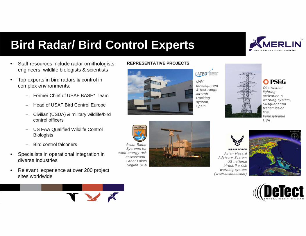
Bird Radar/ Bird Control Experts• Staff resources include radar ornithologists,
engineers, wildlife biologists & scientists
• Top experts in bird radars & control in complex environments:
REPRESENTATIVE PROJECTS
UAV development & test range Obstruction
– Former Chief of USAF BASH* Team
– Head of USAF Bird Control Europe
– Civilian (USDA) & military wildlife/bird
& test range aircraft tracking system, Spain
lighting activation & warning system, Susquehanna transmission line, Pennsylvania
control officers
– US FAA Qualified Wildlife Control Biologists
– Bird control falconers Avian Radar
USA
• Specialists in operational integration in diverse industries
• Relevant experience at over 200 project sites worldwide
Systems for wind energy risk
assessment, Great Lakes Region USA
Avian Hazard Advisory System
US national birdstrike risk
warning system (www.usahas.com) sites worldwide ( )

MERLIN – Development & Evolution• Technology originally developed for US Air Force for
bird-aircraft strike (birdstrikes) prevention
– Bird-aircraft strikes cost USAF over $500 million & i l i i $2 billi llcommercial aviation over $2 billion annually
• MERLIN developed to provide real time, tactical bird detection & tracking out to 6 miles USAF Bagram Airbase (2010)
– Essentially an ‘Air Traffic Control Radar’ for birds
– Dual radar configuration provides both horizontal & vertical detection & real-time bird numeration
– Uses proprietary MERLIN radar data processing & operating software with automatic birdstrike warning
– Radar hardware & software developed specifically to detect and track the unique characteristics of birds
Riga International Airport, Latvia (2011)
detect and track the unique characteristics of birds

How MERLIN Works …Raw (unprocessed) radar imagery• Virtually any radar can detect birds
• Bird targets in conventional radar are occluded by ground clutter, weather & other interference
• Requires highly trained, full-time radar ornithologist to monitor radar & provide warning of hazardous bird activity
• Labor intensive & expensive• Labor intensive & expensive
• Physically impossible to interpret, track & react to all birds in a “target rich” environment
• All birds cannot be "seen” due to ground clutter
• Not operationally usable

How MERLIN Works …Raw radar imageryMERLIN Signal
Processing
• Bird targets in ti l d
MERLIN radar imagery
conventional radar are occluded by ground clutter, weather & other interference
• Signal Processing removes clutter, increases resolution and allows for betterand allows for better detection of targets
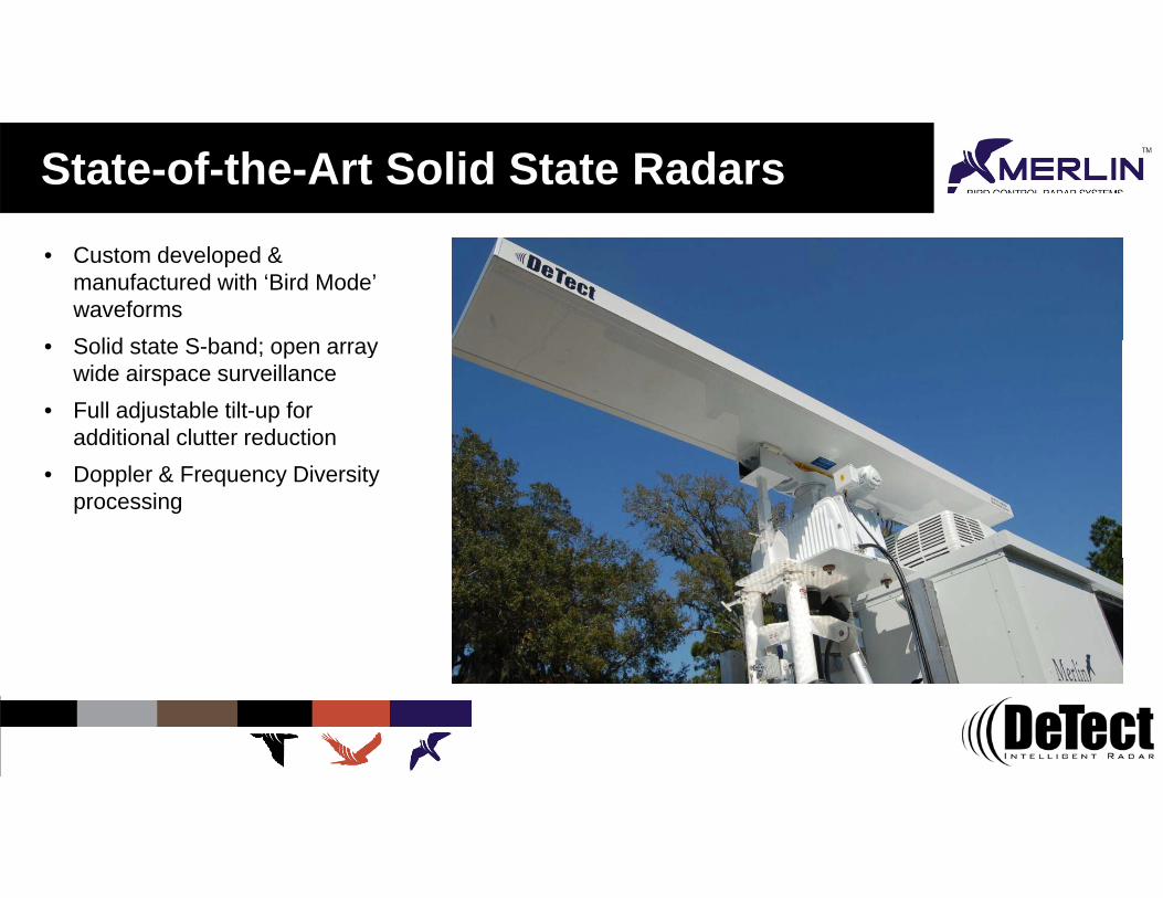
State-of-the-Art Solid State Radars• Custom developed &
manufactured with ‘Bird Mode’ waveformsS lid t t S b d• Solid state S-band; open array wide airspace surveillance
• Full adjustable tilt-up for additional clutter reduction
• Doppler & Frequency Diversity processing
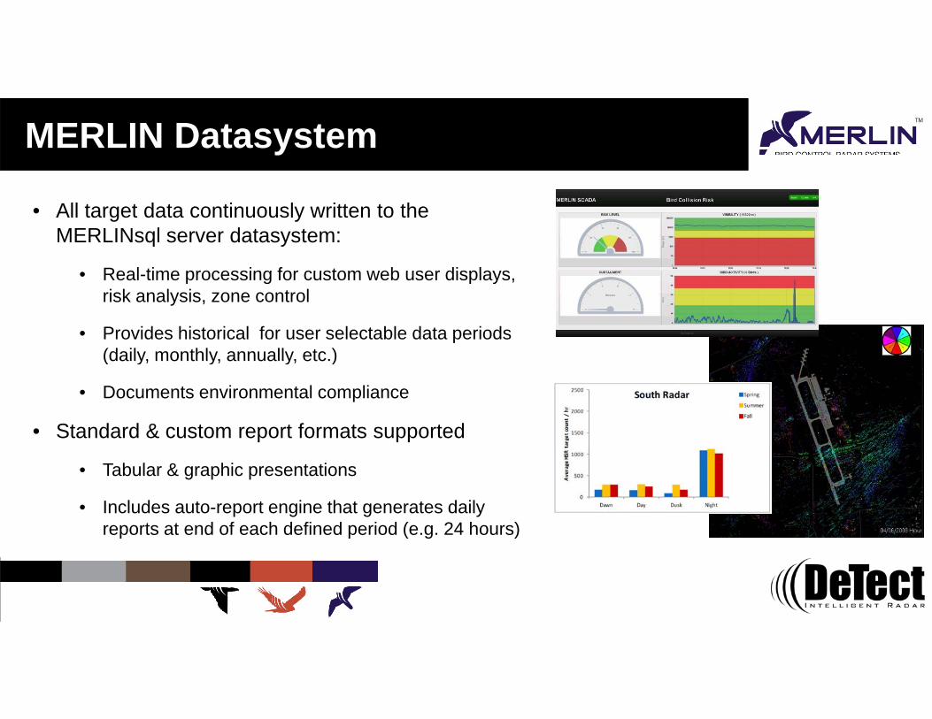
MERLIN Datasystem
• All target data continuously written to the MERLINsql server datasystem:
• Real time processing for custom web user displays• Real-time processing for custom web user displays, risk analysis, zone control
• Provides historical for user selectable data periods (daily, monthly, annually, etc.)(daily, monthly, annually, etc.)
• Documents environmental compliance
• Standard & custom report formats supported
• Tabular & graphic presentations
• Includes auto-report engine that generates daily reports at end of each defined period (e.g. 24 hours)reports at end of each defined period (e.g. 24 hours)

Environmental Applications Siting & Mortality Risk Assessment:
• Automated, 24-7 pre-construction survey• Develop continuous site usage data • Quantitative risk modelingQuantitative risk modeling
Site Monitoring & Risk Mitigation:• Advance detection of bird movements with automatic response
actions• Supports complex condition- & level-based models • Unattended & automated environmental protection• Automated bird & wildlife control
Applications:Applications:• Wind & solar energy• Oil & Gas• Utilities• Hazardous waste sites

Bird Control ApplicationsBi d D t t/H i D i & M th dPassive • Habitat management
Bird Deterrent/Hazing Devices & Methods:
• Exclusion • Operational controls
Bird spikes
NettingBird balls
Habitat management
Active Deterrents • Pyrotechnics• Propane (gas) cannons
Bi ti• Bioacoustics• Strobes & lasers• Effigies• Dogs & falconry
Falconry
Gas cannons
Effi i
Omni-directional acoustics
L Dogs & falconryEffigiesLasers

MERLIN Bird Control Radar Systems• Based on military & NASA technology
• Modular design with co-located deterrents simplifies O&M
• Scalable, expandable & reconfigurable to support facility & operational changesoperational changes
• Networked, modular design for large, complex area coverage
• User definable, unlimited number of control zones
f• Interfaces with most bird deterrent devices• Variable deterrent application lowers habituation risk
• Incorporates advanced deterrent devices including directed acoustics & programmable lasers p g
• Data system documents activity & efficacy for regulatory compliance
• More effective control for large areas & volumes at lower l t tlong-term cost

Advanced Deterrent TechnologiesLong Range Bioacoustic Unit (LRBU)• DeTect pioneering use of military directed acoustics for bird
control in 2006F d b ti d t t d i f bi d & ildlif• Focused beam acoustic deterrent device for bird & wildlife control
– 80+ dB with narrow beam width
– 1+ kilometer effective rangeg
– Plays recorded bird distress calls, sirens & other formats (.wav, mp3, etc.)
– Most powerful & effective directed bioacoustic units available
I t di t d d• Intense, directed sound – Focused high-pressure sound & wave reduces habituation risk
• Allows effective shore-based coverage of large areas & airspace volumesairspace volumes

Advanced Deterrent TechnologiesComputer-controlled Laser Deterrent Units (LDUs)• Scanning eye-safe green or blue programmable laser unit
manufactured by DeTect
• Birds ‘see’ beam as a physical barrier/object
• Effective in low light & visibility conditions
• Outdoor, waterproof NEMA 4 housing, p g
• Programmable to produce effective, safe hazing pattern
• Offers wide-range of responses for bird hazing (patterns, grids, etc.)
• Can be used to ‘sweep’ surfaces (ponds, runways)
• More effective than conventional bird scaring lasers
• Multiple units create horizontal & vertical gridsMultiple units create horizontal & vertical grids

Secondary Deterrents
• MERLIN can also integrated with & control a wide range of conventional & new deterrent devices:
• Propane cannonsPropane cannons
• Omni-directional speakers
• Pop-up effigies (custom manufacture)
• Robotic birds
• Underwater speakers
• Used with MERLIN as secondary deterrents asUsed with MERLIN as secondary deterrents as needed for each specific project
• Can be added to existing systems as an upgrade or to address specific issues

MERLIN detect & deter Site DesignEach MERLIN detect & deter implementation is unique & requires specific needs assessment:• Species of interest & regulatory drivers
• Birds and/or other wildlife (e.g. deer, bears, etc.)
• Area / airspace volume & layout of area to be covered • Single or multiple zones, single or multiple sensors, etc.
E i l i fi d / bil d bl d i• Equipment co-location, fixed / mobile, expandable design• Terrain & ground / moving clutter issues• Environmental
• Nuisance noise, chemical exposure, adverse weather, etc.
• Safety• RF, LEL, site personnel exposure, etc.
Deterrent selection• Deterrent selection

Modular System Design
Master Control MERLIN unit
• Main radar sensor & control unit
• Self contained trailer or skid mounted systems• Self-contained trailer or skid mounted systems– Environmentally-controlled equipment cabin/NEMA
enclosure & shock dampered, rack mounted electronics
– Houses main radar processing, data storage, network & deterrent controllers (master system controller)
• S- or X-band solid-state radar & tower – Wide area, long range coverage minimizes number of
radars needed
– S-band provides improved detection over terrain & in weather over X-band radars

Modular System Design
Primary Deterrent Unit (PDU)• Skid or trailer mounted units
• Environmentally-controlled equipmentEnvironmentally controlled equipment enclosure (NEMA-4 outdoor rated) with shock dampered, rack mounted electronics
– Houses satellite deterrent electronics & network
– Co-location reduces the number of ‘modules’ for maintenance
• Tower mounted LRBU & laser units
• Integrated self-contained power system
• Connects to Master Control MERLIN unit & remote display/control stations via facility or wireless networkwireless network

Modular System Design
Secondary Deterrent Unit (SDU)
• Remote, radar-controlled multi-deterrent secondary unitsy
• Propane cannon, omni-directional bioacoustic & effigy deterrents
• Optional robotic-falcon effigies availableOptional robotic falcon effigies available
• Solar/wind powered units
• Used as a secondary‘gap’ filler deterrent
• Trailered or skid mount unit
• Float designs available for very large ponds
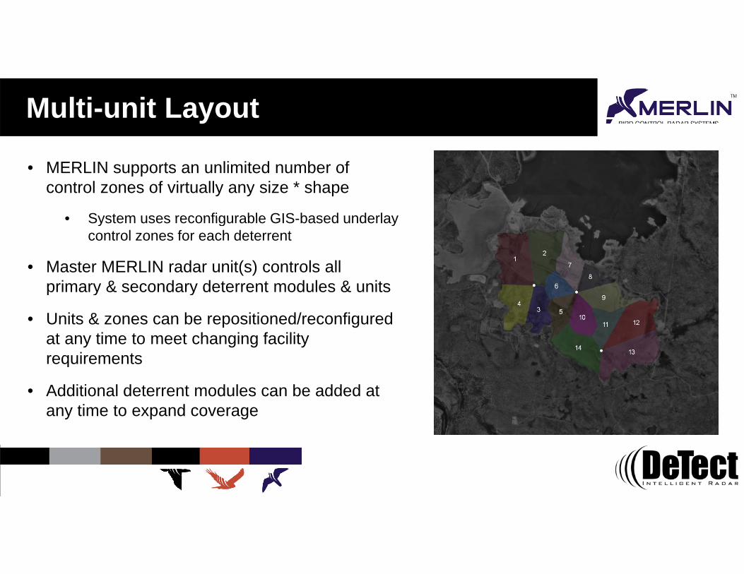
Multi-unit Layout
• MERLIN supports an unlimited number of control zones of virtually any size * shape
• System uses reconfigurable GIS based underlay• System uses reconfigurable GIS-based underlay control zones for each deterrent
• Master MERLIN radar unit(s) controls all primary & secondary deterrent modules & unitsprimary & secondary deterrent modules & units
• Units & zones can be repositioned/reconfigured at any time to meet changing facility requirementsrequirements
• Additional deterrent modules can be added at any time to expand coverage

System Operational Concept
System is designed to deter birds BEFORE they enter the controlled area
MERLIN radar video showing a flock of birdsMERLIN radar video showing a flock of birds emerging from the shore (lower left) moving out over the pond and making a 180 degree turn as deterrents are activated

Small Pond - Gas Compressor Station
• Migratory bird control at gas processing station g y g p gin Colorado with complex terrain
• Single, skid-mounted single package unit
– 200 watt solid-state S-band radar for detection in terrain & weather
– Single fixed LRBU-EX 500
– Integrated LEL sensor with automatic safety shutdown
• No mortality events reported since system installedy p y

Mid-Sized Ponds - Power Plant
• Migratory & resident bird control at scrubber blowdown pond at power plant in Nevada
• Single skid system design• Single skid system design
– Galvanized components for corrosion resistance
– Three LRAD & 2 laser zones
– NEMA enclosure for equipment
• No mortality events reported

Large Ponds - Oil Sands Complex
• First large-scale deployment of technology (2009)
• Migratory & resident bird control• 10 x 5 kilometers tailings pond & waste landfill
• Expansion modules added in 2010 2011 2012 & 2013• Expansion modules added in 2010, 2011, 2012 & 2013
• 54 total fixed LRBU 1000-X zones & 30 laser zones
• Significant reduction in bird mortality • Year 1 - mortality <40 birds
• Year 2 - no bird mortality reported
• Received CAPP Environmental Award in 2012• Received CAPP Environmental Award in 2012

Large Facility – Potash Mine
• Migratory & resident bird control at salt• Migratory & resident bird control at salt product evaporation ponds
• Reconfigurable design
• One master radar unit & two satellite deterrent units
• 14 total fixed LRBU 1000-X zones
• 6 laser zones
• 97% deterrence rate
• No mortality events reported• No mortality events reported

Solar Plant Applications• To deter birds from entering the area of concentrated solar
flux around collector towers• Deter birds in flight before they enter the exclusion zone
• Size of the exclusion zone can be refined
• LRBUs located around base & aimed upwards for control zone
• Multiple, tower-mounted radar sensors likely required
• On-site radar testing to assess clutter impacts from the mirrors & define/optimize number of radars & locationsmirrors & define/optimize number of radars & locations
• Mobile units to support adaptive management strategies

Questions?
United States Europe InternationalCanada
DeTect, Inc.1022 West 23rd Ave, Ste 620Panama City, Florida 32405USA
DeTect EUAfon House Worthing Road Horsham, West Sussex RH12 1TL EnglandT 44 (0) 1403 788 315
DeTect International5801 Lee Highway Arlington, Virginia 22207 USA
DeTect Canada2600 Rue Saint-Jacques Montréal, Quebec H3J T24 Canada
T 850.763.7200 F 850.763.0920E [email protected]
F 850.763.7200E [email protected]
T 703-533-8555 ext 588F 703.533.3190E [email protected]
T 438.401.0471F 850.763.7200E [email protected]
www.detect-inc.com

1022 West 23rd Street, Suite 620, Panama City, Florida 32405 USA Tel 850.763.7200 117 South Sunset, Longmont Colorado 80501 USA Tel 303.848.8090
Afon House Worthing Rd, Horsham, West Sussex RH12 1TL England Tel 44(0)1403.788.315 Web www.detect-inc.com
Page 1 of 8 The information contained and/or attached to this document is for the intended recipient only and may not be distributed to third parties in any form without the express written consent of the DeTect, Inc. This communication contains confidential, proprietary and/or privileged information that is protected by U.S., U.K. and International law and, the recipient hereby agrees to treat it as such. If you have received this in error, immediately and permanently destroy or delete this document and all enclosures or attachments.
Aircraft Birdstrike Avoidance Radars – Wind Energy Avian Radar Systems – Security Radar Systems – Radar Wind Profilers EXECUTIVE SUMMARY
DeTect is a fully integrated radar company headquartered in Panama City, Florida, USA with company- owned manufacturing facilities in Florida and Colorado and additional offices in Arlington, Virginia (Washington, D.C. area); Montreal, Canada; and, London, England. The company additionally has technical support staff based throughout the US, Canada and Europe and representative offices in over 80 countries to support its customers and installations worldwide. The company is the world leader in advanced bird radar technologies for real-time aircraft birdstrike avoidance, wind energy bird and bat mortality risk mitigation, and industrial bird control with over 120 of its MERLIN bird radars installed in the US, Canada, Europe, Africa and Asia. The Company's RAPTOR Radar Wind Profiler is the most advanced wind measurement radar available and and was selected by the US National Weather Service for upgrade of the US Next Generation National Profiler Network. DeTect additionally in 2012 deployed the first radar-activated windfarm turbine obstruction lighting system in the US - a HARRIER Visual Warning System - that provides automated activation of wind turbine obstruction lights when aircraft are detected within ten miles of the wind farm.
Product applications:
o Industrial bird control & protection o Bird & bat survey & risk mitigation o Bird-aircraft strike risk assessment & alerting o Radar data products & networks o Airspace, marine & ground security & surveillance o Aircraft & ultralight intrusion detection o Border surveillance & security o Radar coverage gap filler o Automatic obstruction lighting activation o Boundary layer, stratospheric, tropospheric & mesospheric wind
measurement o Specialized weather radar systems
Resources:
DeTect's professional staff resources include experienced engineers, scientists, aviation safety specialists, meteorologists and technicians that are experts in remote sensing, radar engineering, system integration, operation and environmental management. Specialized expertise includes BASH (Bird
Figure 1: DeTect corporate headquarters and Florida radar manufacturing facility in Panama City, Florida USA.

Page 2 of 8 The information contained and/or attached to this document is for the intended recipient only and may not be distributed to third parties in any form without the express written consent of the DeTect, Inc. This communication contains confidential, proprietary and/or privileged information that is protected by U.S., U.K. and International law and, the recipient hereby agrees to treat it as such. If you have received this in error, immediately and permanently destroy or delete this document and all enclosures or attachments.
Aircraft Strike Hazard) and wind energy avian risk assessment and management with unique application support from leading radar engineers, software developers, ornithologists, biologists and scientists that provide DeTect clients with the most experienced team of experts in remote sensing of birds and bats in the world.
Company facilities include over 30,000 square feet of office, laboratory and manufacturing space in Florida and Colorado to support design, development, assembly, testing and support of advanced radar systems. Research resources include radar airport test sites for systems, components and software development, testing and calibration. DeTect radar systems are built to industrial and military (MILSPEC), European Union (EU CE Mark) and other international standards and incorporate commercial-off-the shelf (COTS) components where possible in order to provide our customers with high performance, competitive cost of acquisition, low O&M, and ongoing technology insertion and upgrade opportunities over the life of the system.
Experience:
DeTect radar systems are in use at facilities and projects worldwide with a proven record of exceptional performance, reliability and operability and over five million hours of successful operating experience on systems operating since 2003. The US Air Force has purchased seven MERLIN systems to date based on a documented record of improved aircrew safety, reducing aircraft-birdstrike damage and increasing mission readiness. NASA, after evaluation and on-site testing of various bird radar technologies, selected DeTect's MERLIN system to support space launch safety for the $2 billion space shuttle for 21 launches from 2006 to the
end of the program in 2011 with 100% system uptime.
As a fully integrated company DeTect provides more than a radar system, comprehensive application support with each system includes full concept-of-operations (CONOPS) development, human factors design, system operational integration, site-specific operation user training and long-term 24-7 support. Each system is supported by DeTect's team of application specialists who have extensive backgrounds and experience in radar systems design, manufacture, siting and, most importantly, integration and use of the technology in the real-world environment with effective user interfaces to meet each customer's specific business operational requirement.

Page 3 of 8 The information contained and/or attached to this document is for the intended recipient only and may not be distributed to third parties in any form without the express written consent of the DeTect, Inc. This communication contains confidential, proprietary and/or privileged information that is protected by U.S., U.K. and International law and, the recipient hereby agrees to treat it as such. If you have received this in error, immediately and permanently destroy or delete this document and all enclosures or attachments.
MERLIN INTRODUCTION
DeTect’s MERLIN™ Avian Radar (MERLIN) today is installed worldwide in the US, Canada, Europe, Africa and New Zealand. MERLIN has been tested and validated for operational use by the USAF (7 systems including a unit at Bagram Airfield, Afghanistan), NASA (2 systems certified for space shuttle launch safety), commercial airports (certified real-time operational birdstrike risk alerting), and at wind farms and industrial plants for environmental management (protection of endangered species and migratory birds wherein the system will automatically idle turbines or activate deterrent devices when birds are detected approaching under preprogrammed risk conditions). In developing MERLIN, DeTect took a unique approach to solving the problem of being able to detect and track low, variable RCS, irregularly moving, low altitude targets: MERLIN is not a modified aircraft or ship tracking system and all detection and tracking algorithms were specifically developed and programmed to ‘look’ for and follow targets with these characteristics. MERLIN additionally includes specialized, automated clutter suppression routines, Doppler processing and modified state-of-the-art solid state COTS radar sensors that have been optimized for bird detection.
The result is that MERLIN is a highly sensitive sensor system that can reliably detect and track very small Radar Cross Section (RCS) targets. In addition to superior clear air detection of small RCS targets, MERLIN with its automated clutter suppression and Doppler processing is capable of detecting low signal ratio targets at low altitudes near ground level and in high, complex clutter environments. The tracking algorithms in MERLIN additionally were designed to correlate irregularly moving birds as they traverse the landscape making the system highly applicable to tracking of evasive targets.
1. BIRD & BAT MONITORING & MITIGATION SYSTEMS FOR SOLAR FACILITIES
DeTect specializes in delivery, integration and support of advanced, proven avian radar technologies for project developers, owners, operators and environmental consultants for bird and bat survey, mortality risk assessment, operational monitoring and real-time risk mitigation for wind energy and industrial sites worldwide. The application of this technology to solar thermal tower facilities is an extension of these existing programs and the approach is outlined in this document. Additional details on the specific technologies are provided in the attached document MERLIN Bird Control Radar Systems.
DeTect is the developer and manufacturer of the MERLIN Avian Radar System, a bird & bat radar system available for avian survey, risk assessment, monitoring and real-time risk mitigation with over 100 systems operating worldwide. The MERLIN technology was originally developed for the US Air Force and NASA as a precision bird detection radar system to provide real-time information to controllers, pilots and managers to reduce bird-aircraft strike risk.
The MERLIN technology is highly automated providing unattended 24-7 collection of high quality data on bird activity at ranges of 3-4 miles around project sites that can be used to develop detailed pre-construction risk projections and for operational mitigation. With the MERLIN HAZE risk mitigation feature, the MERLIN system can be used at operating solar facilities to function as an "early warning" system providing advance detection of bird & bat activity that presents mortality risk, automatically engaging response mitigation actions until the risk passes. DeTect provides full operational and technical support that includes system deployment, operation, user training, and data processing, analysis, reporting and QA/QC. Staff specialists include highly knowledgeable radar ornithologists, avian biologists, engineers and statisticians that comprise the top team of experts in remote sensing of birds and bats in the world -

Page 4 of 8 The information contained and/or attached to this document is for the intended recipient only and may not be distributed to third parties in any form without the express written consent of the DeTect, Inc. This communication contains confidential, proprietary and/or privileged information that is protected by U.S., U.K. and International law and, the recipient hereby agrees to treat it as such. If you have received this in error, immediately and permanently destroy or delete this document and all enclosures or attachments.
with specific expertise in design, construction and operation of bird/wildlife detection systems for real-time aviation safety and environmental management.
1.1. Detection Equipment: MERLIN Avian Radar System
All current model units include solid-state Doppler radar technology with custom bird mode waveforms that were developed specifically for detection and tracking of birds and bats. Using state-of-the-art radar and computer techniques developed specifically for detecting and tracking the unique behavioral characteristics of birds and bats, MERLIN collects data continuously and automatically under a variety of conditions generating highly accurate, detailed datasets for analysis and for use in project decision-making and permitting.
MERLIN processes the radar signal in real-time with high update rates typically around 1-2 seconds providing live displays of bird activity location, flight paths, altitudes, sizes and other information to project biologists and plant operators. Multiple users can view the information display simultaneously as well as remotely control the system via LAN, satellite and WWAN (cellular) datalinks. All system operational settings are accessible through password protected on-screen Graphical User Interfaces (GUIs) and changes can be made in real time during system operation. All system functions are remotely controllable including system shutdown and cold system restart.
MERLIN is fully automated for 24-7 unattended operation and includes an internal Health & Safety System (HSM) that continually runs diagnostics and provides audible, visual, text message and email alerts in the event of system issues such as loss of power or component failure. Data is also automatically archived to the internal MERLIN SQL server datasystem providing a permanent record for each project and to support detailed analysis, modeling and quantitative mortality risk assessment. MERLIN SQL has a built-in Data Reporter with a wide range of standard information and analyses such as passage rates, flight patterns and activity in
pre-defined zones. MERLIN Reporter includes two unique routines - MERLIN TrackPlot and MERLINChart that automate user analysis of activity by area and period. The system also supports custom user-developed queries and analysis in GIS and other third-party software. The datasystem storage capacity will retain several years of 24-7 data and can be easily expanded by addition of commercially available, low cost plug-and-play hard drives.
The MERLIN system is the most advanced technology for industrial projects and offers significant benefits over conventional visual and manual radar ornithology avian survey techniques:
o Larger datasets
o Highly accurate passage rates
o All data recorded to SQL system
o Detailed height & count data for activity zones

Page 5 of 8 The information contained and/or attached to this document is for the intended recipient only and may not be distributed to third parties in any form without the express written consent of the DeTect, Inc. This communication contains confidential, proprietary and/or privileged information that is protected by U.S., U.K. and International law and, the recipient hereby agrees to treat it as such. If you have received this in error, immediately and permanently destroy or delete this document and all enclosures or attachments.
o Defines flight patterns across the resource area
o Quantitative determination of mortality risk
o Highly defensible, statistically-reliable data
o Supports real-time, automated mortality risk mitigation
The MERLIN Avian Radar System is a powerful tool and generates high quality, detailed datasets that can be used to accurately determine the numbers of bird and bats transiting a project site under day, night and low visibility conditions. DeTect’s proprietary Data Reports program generates detailed datasets in both tabular and graphical formats quantifying the numbers of birds passing through the project areas allowing precise calculation and determination of bird and bat mortality risk and enabling an effective real time risk mitigation system.
1.2. Deterrence equipment
DeTect’s radar-based detection system interfaces with most bird deterrent devices and any device that has or can be adapted to an electronic trigger mechanism. The systems in use today incorporate advanced deterrent devices including directed acoustics & programmable lasers as well as well as more conventional systems of propane cannons and omni-directional speakers. Pop-up effigies (a custom manufacture), robotic birds and other visual deterrents and predator mimics as well as chemincal deterrents can also play a role in mitigation efforts. Variable deterrent application lowers habituation risk and increases the variety of bird species that can be addressed with the mitigation systems.
DeTect pioneered the use of focused beam, extended range acoustic units for bird control which have proven very effective for bird control on landfills, airports and at industrial sites. These Extended Range Bioacoustic Units (XBU) are powerful, robust, low maintenance, military-grade focused beam acoustic systems that can direct deterrent sounds in a narrow beam (15-30 degrees) at variable intensity (up to 120 dB) at ranges effective for bird control far beyond those of traditional non-directional propane cannons and omnidirectional speakers with minimal nuisance noise spillover to non-control areas. The devices can transmit digital recordings (.wav or mp3 formats) and can be used in manual or automatic, radar-directed modes. There are additional functions available to control the volume and sound files for each speaker, for individual zones and by time of day. With the MERLIN detect & deter system, DeTect can also incorporate a DeTect manufactured, programmable, expanded beam, sweeping bird control Laser Deterrent Unit or LDU. The DeTect LDU is a green laser for low visibility conditions that is elevated for local worker safety and works in concert with the XBU units as a secondary and low light/fog condition deterrent. The LDUs are integrated and controlled by the master MERLIN unit to deter birds primarily during night and low light conditions and can be operated as a sweeping laser to prevent birds from landing on roost sites within the control boundaries. The laser systems manufactured by DeTect are robust, designed for adverse environments and all operating components are enclosed in weatherproof enclosures with no external moving parts

Page 6 of 8 The information contained and/or attached to this document is for the intended recipient only and may not be distributed to third parties in any form without the express written consent of the DeTect, Inc. This communication contains confidential, proprietary and/or privileged information that is protected by U.S., U.K. and International law and, the recipient hereby agrees to treat it as such. If you have received this in error, immediately and permanently destroy or delete this document and all enclosures or attachments.
exposed. The systems are additionally eye-safe and are positioned to reduce exposure risk to area workers.
As supplemental deterrents and to fill coverage ‘gaps, particularly along irregular coverage areas, DeTect manufactures a Secondary Deterrent Unit (SDU) that is incorporated into the MERLIN BCRS. The SDU includes the remotely controlled, solar/wind powered propane cannon/omni-directional bioacoustic package with a DeTect manufactured ‘pop-up’ effigy on a compact ATV-type trailer to support quick repositioning as needed. An optional robotic articulated Falcon effigy deterrent is also available. The SDUs at industrial sites are used for specific area control due to limited range of effectiveness, and can directly controlled and activated by the MERLIN unit or as standalone units. The SDUs also include portable manually operated controllers to allow manual firing or firing via preprogrammed, randomized schedules. Methyl anthranilate (MA) is a chemical, non-lethal bird repellant that is particularly effective against flying songbirds and roosting birds. Large areas of bird movement can be addressed with no impacts on other wildlife. With traditional fogging systems for dispersal of MA the accumulation on the mirrors is a concern at solar facilities but newer, dry-haze systems could be an effective use without any impact on the facility structures.
1.3. Adaptability of the system
Radar locations: DeTect's bird and bat radar systems are available as fully- mobile and skid-mounted, self-contained systems with on-board control cabin, power system, and include all hardware and software for bird and bat tracking, clutter suppression, and data recording. Custom configurations, including fully remote controlled installations, can also be provided that incorporate additional sensors such as thermal cameras, bat detectors, insect detectors and vertical profilers. Systems are available for short-term rental, long-term lease, lease-purchase, or for sale from DeTect, both with and without DeTect operators and DeTect provides complete technical support from survey through data analysis and a complete parts and labor warranty.
The optimal layout of radars is specific to each facility and the skid mount and trailer mounted radars allow for maximum flexibility in how those radar are arranged, including independent placement of the vertical and horizontal radars to best minimize the clutter environment for each sensor. The radars can also be relocated if the data collected indicates that a particular area is of concern or as species compostion on site or habitat use changes over time. Radars at multiple locations with overlapping ranges maximize the probability of detection by minimizing the impacts from ground clutter for the composite image of the site from multiple angles and directions.
Deterrents: An array of deterrents is available for deployment with the radar-based detection system and modification of those deterrents, in both type and application, is highly valuable to adaptive management strategies. The composition of species that will need to be deterred can change seasonally and over time as the birds adjust to the new structures and as bird movement patterns change. The composition of the deterrents can be changed, the locations can be altered to optimize responses and the content of the acoustic deterrents managed to address the specific concerns. For the acoustic hazing component any sound that is recorded to an audio file can be incorporated into the system and the files can be updated, the priority of certain sounds can be changed as can the volume of the sound files played in response to changing conditions and concerns on site.

Page 7 of 8 The information contained and/or attached to this document is for the intended recipient only and may not be distributed to third parties in any form without the express written consent of the DeTect, Inc. This communication contains confidential, proprietary and/or privileged information that is protected by U.S., U.K. and International law and, the recipient hereby agrees to treat it as such. If you have received this in error, immediately and permanently destroy or delete this document and all enclosures or attachments.
The control of the deterrents is managed by DeTect’s software application MERLIN Haze. When and how a response is triggered depends on the settings in place, the layout of the deterrents and the appropriate response to thresholds for bird movement data from the radar based detection system. As in all wildlife control programs the appropriate response to a situation has to take into account the behavior of the animals at risk and the expected response to the available deterrents. Wildlife control techniques that allow for escalation are more effective and less prone to issues of habituation and our system incorporates this approach with three levels of response: primary, secondary and tertiary deterrents. By starting out with more simple but generally effective deterrence methods and increasing the level of harassment if the needed response is not achieved, the system minimizes the opportunity for habituation of the targets to the deterrence. The presentation of sounds in the acoustic deterrence system is randomized to avoid habituation to any particular sound file. The progressive escalation of multiple types of deterrence as well as the ability to move the location of those deterrents all works to prevent habituation to the system as a whole.
In addition to the active management of wildlife issues at a site, one of the key benefits of the MERLIN Bird Control Radar System is the high quality data generated on animal use of the location. Analysis of the radar tracks, timing of activity, concentration of bird activity as well as direction of flight allows for detailed knowledge of how wildlife use the site, what areas are attractants and what areas are low use and thus low risk. DeTect has developed algorithms for use in data analysis that can statistically assess if birds are attracted to a location, actively avoiding something on site or if their movements are completely independent of the facility structures. Identifying attractants on site or sources of wildlife originating from off site allows for customization of deterrents but also can pinpoint areas for application of passive wildlife control techniques such as removal of a problematic attraction or exclusion. As conditions change over time at a location the data generated and output by the MERLIN system can identify risky conditions as they arise and identify sources and solutions when new patterns of bird activity and potential for high risk are recorded on site. This results in a quicker response to changing conditions and minimization of risk for fatalities when environmental conditions shift in support of adaptive management strategies.
2. Applications and Results: Example installations and documented results
Representative projects: Canadian Natural Resources Ltd., Horizon Mine, Ft. McMurray, Alberta, Canada
MERLIN S200 large scale, redundant, multi-radar and deterrent trailered system for large tailings pond at oil tar sands processing facility with radar activated Long Range Bioacoustic Units and programmable laser deterrent devices for bird protection. This project was the first large-scale automated bird deterrent system and in 2012, the Canadian Association of Petroleum Producers (CAPP) presented CNRL with a Responsible Canadian Energy Award for its successful use of the technology to prevent bird mortality noting that the system had a documented 97.% effective rate with no bird mortality in 2010 and 2011. See the attached paper: Radar-based automated bird control system at CNRL Horizon’s tailing pond – Technology overview and efficacy, 2010.
Imperial Oil-Esso Kearl Oil Sands Plant, Ft. McMurray, Alberta, Canada MERLIN S200 large scale, multi-radar and deterrent platform system for a new oil sands processing facility. The system includes two state-of-the-art solid state Doppler radar sensors with four radar-controlled satellite units equipped with Long Range Acoustic Devices and programmable laser deterrent devices and supplemental Secondary Deterrent Units (SDUs)with
Page 8 of 8 The information contained and/or attached to this document is for the intended recipient only and may not be distributed to third parties in any form without the express written consent of the DeTect, Inc. This communication contains confidential, proprietary and/or privileged information that is protected by U.S., U.K. and International law and, the recipient hereby agrees to treat it as such. If you have received this in error, immediately and permanently destroy or delete this document and all enclosures or attachments.
radar-controlled solar/wind powered propane cannon - bioacoustic - pop-up effigies. All equipment is trailered to support system reconfiguration and expansion over the life of the facility.
Mosaic Potash, Carlsbad, New Mexico USA MERLIN S200 large scale, radar and deterrent platform system for bird exclusion at potash mine salt evaporation lakes. The system includes a state-of-the-art solid state radar sensor master unit with three, repositionable bird control trailer units to support changing salt drying lake layouts.
Encana Oil & Gas, Parachute, Colorado USA
MERLIN S200 detect & deter Bird Control skid-mounted system consisting of a solid state 200 watt bird radar sensor with an integrated LRAD 1000X radar-directed bioacoustic bird hazing unit. The system detects and tracks migratory and resident bird activity as it approaches the site along the valley and automatically activates the bioacoustic deterrent to prevent bird from landing on the petrochemical waste pond.
3. Limitations and Future Development:
Limitations: Radar does not identify the targets it tracks by species. This is not a limiting concern in terms of the application to solar facilities and the application of deterrents as any bird identified in the risk zone would be hazed. The deterrents employed and the sequence of deployment of those deterrents can be modified based on expectations for seasonal movements or based on observations from the site. Habituation is a key concern with wildlife control programs and can be a particular concern with automated systems. As described in the sections above DeTect takes multiple approaches to prevent habituation by randomization of stimulus and providing the framework for a scaled response. Management of wildlife is also best applied in relation to the species and context of their presence on site. Some species of birds are easier to scare than others, some respond to one stimuli and not another. Birds in a hostile environment, especially with natural predators, are easier to elicit a response than others with unlimited food and few threats. Therefore habitat and resource management (water for example) are as much a part of the program as harassment. It is much harder to deter a bird when the presence of some resource, food, water, nest or roost, is acting as an attractant. As stated above, the system is designed to minimize habituation and identify sources and concentrations of activity. The radar data and reporting allows detailed analysis of site use by wildlife and application of deterrents can be easily modified or augmented to address concerns as they arise.
Future research and advances in the technology: DeTect has a strong research and development program and remains alert to any advances in radar technology and development of new tools for bird hazing. DeTect was the first company to identify the potential of directed acoustic devices and applications to wildlife control, first to develop and use Solid State radar for bird detection opening up the use of radar in complicated environments where more traditional marine radarsfor bird detection fail. DeTect has pursued ongoing refinement of the application of lasers in an automated hazing system as well as other visual and acoustic deterrents. We have the ability to integrate acoustic sensors and infared cameras into our detection systems and have developed our own infrared beam break counter product for monitoring cave roosting bats. The DeTect Bird Control Radar System is built to be flexible in its ability to incorporate any detection technology that adds functionality to the project and any deterrent system that can be triggered electronically that increases the deterrence of target species.
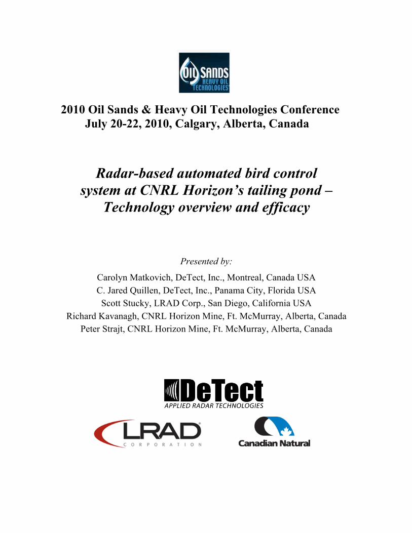
2010 Oil Sands & Heavy Oil Technologies Conference July 20-22, 2010, Calgary, Alberta, Canada
Radar-based automated bird control system at CNRL Horizon’s tailing pond –
Technology overview and efficacy
Presented by:
Carolyn Matkovich, DeTect, Inc., Montreal, Canada USA C. Jared Quillen, DeTect, Inc., Panama City, Florida USA Scott Stucky, LRAD Corp., San Diego, California USA
Richard Kavanagh, CNRL Horizon Mine, Ft. McMurray, Alberta, Canada Peter Strajt, CNRL Horizon Mine, Ft. McMurray, Alberta, Canada

Radar-based automated bird control system at CNRL Horizon’s tailing pond – Technology overview and efficacy Presented at the 2010 Oil Sands & Heavy Oil Technologies Conference July 20-22, 2010, Calgary, Alberta, Canada
2
Executive Summary This paper describes the capabilities and specifications of MERLIN® detect & deter Bird
Control Radar System (MELRIN or the system), an automated, on-demand bird detection and
deterrent system, as well as data demonstrating the system effectiveness during the initial
deployment phase at Canadian Natural Resources Limited’s (CNRL) Horizon Oil Sands Project
at Fort McMurray, Alberta in spring 2009. The MERLIN detect & deter system was developed
and is manufactured by DeTect, Inc. (www.detect-inc.com) in Panama City, Florida USA, and
uses a combination of horizontal bird radars, Long Range Acoustic Devices (LRAD,
www.LRADX.com), and lasers to automatically and simultaneously detect and deter bird
activity at CNRL’s main tailings pond. The MERLIN system installed at the Horizon Mine in
2009 was the first large scale use of radar-based, automatic bird radar technology for protection
of migratory and resident birds at an industrial facility.
The effectiveness of the system was tested on 24 mornings between May 5 and 31, 2009.
Data collected included birds visually observed over the tailing pond, whether the LRAD was
activated, and whether the birds landed or were deterred. Details on bird species or species
group, bird behavior, site conditions and weather were also gathered.
A total of 490 valid observations were made during the effectiveness study. Overall, of
the 278 observations having a known result (land or did not land, unknowns removed), 215
(77.3%) of the observed birds did not land and 63 (22.7%) landed. The LRAD did not activate
during 7 (2.5%) of the 278 observations, and it was not known if the LRAD activated during
another 17 (6.1%) observations. If these observations are removed, then 76.0% of the birds did
not land, and 24.0% landed.
Gulls were the most commonly observed group (32.1%) followed by shorebirds (27.7%)
and ducks (15.7%). With the exception of herons, all groups had 40% or more of their
observations containing 2 or more birds. Shorebirds were the most commonly observed in
groups of 2 or more (95.7%), while geese and terns posted observations of over 100 individuals
in a single observation.

Radar-based automated bird control system at CNRL Horizon’s tailing pond – Technology overview and efficacy Presented at the 2010 Oil Sands & Heavy Oil Technologies Conference July 20-22, 2010, Calgary, Alberta, Canada
3
Among the 254 observations with known results (land or did not land) and confirmed
LRAD activation, shorebirds, loons, and gulls had greater percentages of birds that did not land,
while the miscellaneous group, geese, ducks and herons had lower percentages than when all
observations were grouped together; percentage of terns that did not land were similar to that of
all observations. Of these same 254 observations, 65.7% were observations with 2 of more
individuals. Single-bird observations landed 16% of the time, whereas small groups of 2-5 birds
landed more than twice as often (35%). However, large groups of greater than 20 birds never
landed.
1.0 INTRODUCTION DeTect was contracted by CNRL in early 2009 to design, supply, install, and support a system
capable of detecting and deterring birds from its main tailings pond at the Horizon Oil Sands
Project in Fort McMurray, Alberta. The MERLIN detect & deter Bird Control Radar System
uses a combination of horizontal bird detection and tracking radars, Long Range Acoustic
Devices (LRAD), and lasers to automatically and simultaneously detect and deter bird activity.
This report presents the specifications of the system as well as data demonstrating its capabilities
and effectiveness in detecting, tracking, and deterring bird activity.
2.0 STUDY AREA
The CNRL Horizon Oil Sands Project is located 75 kilometres (km) northwest of Fort
McMurray, near Fort McKay, Alberta in Canada. The tailings pond from which birds are being
deterred is approximately 6 km long by 2 km wide. It is projected to grow in width until 2017
and additional MELRIN system components will be added in order to maintain coverage.
3.0 MERLIN DETECT & DETER SYSTEM DESCRIPTION
The MERLIN detect & deter system uses advanced solid-state avian radar hardware and
software to detect and track birds at ranges out to 4-6 nautical miles (~6-10 km), monitor user-
defined control zones, and automatically activate bird deterrent devices (e.g. directed
bioacoustics, lasers, propane cannons, omni-directional acoustics, pop-up effigies) to deter and
harass birds from entering restricted and/or contaminated areas. The user programmable system

Radar-based automated bird control system at CNRL Horizon’s tailing pond – Technology overview and efficacy Presented at the 2010 Oil Sands & Heavy Oil Technologies Conference July 20-22, 2010, Calgary, Alberta, Canada
4
provides automatic activation of acoustic and/or visual bird deterrents based on defined risk
thresholds set for each site to humanely harass birds and prevent landing in restricted zones such
as waste ponds and landfills. The system is software driven, highly customizable for each site,
modular, scalable and expandable, and can be interfaced with a wide variety of bird deterrent
devices to provide hazing responses specific to each user’s operational requirements, site
characteristics and environmental management needs. This flexibility in design and performance
was particularly critical to deployment of a successful solution for the CNRL tailings pond due
to its size and the ongoing expansion that will occur over the life of the project.
3.1 Radar Equipment and Data Collection
3.1.1 MERLIN Avian Radar
The MERLIN detect & deter system uses a horizontally-scanning radar system (MERLIN Avian
Radar) to provide continuous monitoring and detection of birds over large areas. MERLIN
Avian Radar Systems were originally developed specifically for bird detection and tracking for
the US Air Force, and are manufactured as complete self-contained, mobile trailer- or skid-
mounted ornithological radar systems (Figure 1), and include all ancillary components such as
on-board generators and support equipment for a fully “plug-and-play” system that is operable at
delivery. A wireless network connection allows remote system monitoring through the internet
(remote data viewing in real time), access to recorded data, and system administration.
The MERLIN Avian Radar system precisely tracks targets within avian size ranges, and
displays the data in real-time (at the radar and remotely via the Internet and/or local network) and
records all data on targets, tracks, and system parameters to an internal SQL datasystem. For
environmental applications, these recorded databases can be queried and used to develop
statistical data as well as to analyze and model bird movements in the study area.
Prior to delivery and installation of the radar, DeTect conducted radar beam modeling
using geographical information system (GIS) analysis of the proposed radar location to identify
any beam blockage issues at the radar installation sites. Appropriate beam coverage at the
proposed location was verified, and once on site, the MERLIN system was positioned to
minimize ground clutter.
Radar-based automated bird control system at CNRL Horizon’s tailing pond – Technology overview and efficacy Presented at the 2010 Oil Sands & Heavy Oil Technologies Conference July 20-22, 2010, Calgary, Alberta, Canada
5
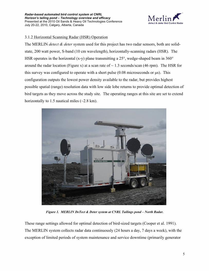
3.1.2 Horizontal Scanning Radar (HSR) Operation
The MERLIN detect & deter system used for this project has two radar sensors, both are solid-
state, 200 watt power, S-band (10 cm wavelength), horizontally-scanning radars (HSR). The
HSR operates in the horizontal (x-y) plane transmitting a 25°, wedge-shaped beam in 360°
around the radar location (Figure x) at a scan rate of ~ 1.3 seconds/scan (46 rpm). The HSR for
this survey was configured to operate with a short pulse (0.08 microseconds or µs). This
configuration outputs the lowest power density available to the radar, but provides highest
possible spatial (range) resolution data with low side lobe returns to provide optimal detection of
bird targets as they move across the study site. The operating ranges at this site are set to extend
horizontally to 1.5 nautical miles (~2.8 km).
Figure 1. MERLIN DeTect & Deter system at CNRL Tailings pond – North Radar.
These range settings allowed for optimal detection of bird-sized targets (Cooper et al. 1991).
The MERLIN system collects radar data continuously (24 hours a day, 7 days a week), with the
exception of limited periods of system maintenance and service downtime (primarily generator
Radar-based automated bird control system at CNRL Horizon’s tailing pond – Technology overview and efficacy Presented at the 2010 Oil Sands & Heavy Oil Technologies Conference July 20-22, 2010, Calgary, Alberta, Canada
6
servicing and refueling). The S-band has the advantage over other frequencies (e.g. X-band) of
greater detection range and less signal attenuation (interference) from surrounding vegetation
(ground clutter) and weather than other radars, and is not limited by precipitation events. It is
also less sensitive to insect contamination. Ground clutter interference is additionally reduced by
applying the MERLIN software clutter suppression algorithms that improve detection of small
(bird size) targets in high clutter environments such as the tailings pond site.
3.1.3 Radar Data Collection, Processing and Analysis
The MERLIN system uses radar signal processing technology to collect, process, and store 12-
bit digitized radar data from the HSR. Target data from the radar is processed in real-time by the
MERLIN software at the radar with all data recorded to compact, internal system databases for
target and track processing, analysis, and reporting. “Raw” or unprocessed data from each radar
can also be recorded in full resolution for detailed, off-site analysis, playback, and reprocessing.
All HSR target data and system metadata is written to internal system databases, and all radar
data was processed at the radar in real-time by MERLIN system software.
3.1.4 MERLIN Avian Radar Processing Software
The MERLIN system processing software uses automated clutter suppression in conjunction
with biological target detection, tracking, and data recording to identify and track bird targets in
the survey area. The software also identifies noise (undesired signals such as ground clutter and
interference) within a given radar environment and applies a statistical approach to suppressing
the noise while still allowing targets within the noise to be detected, tracked, and recorded. This
maximizes the probability of detecting moving targets in high clutter environments (such as over
vegetation).
The software allows the user to select settings specific to the conditions and objectives of
each project. These settings include minimum and maximum target size (based on target pixel
area), minimum and maximum target speed, and minimum reflectivity (a measure of target
intensity). By using techniques common in image processing, the MERLIN software also
extracts values other than the area or number of pixels. As an example, the length and width,
roundness and elongation of a target are extracted and recorded and considered for the analysis

Radar-based automated bird control system at CNRL Horizon’s tailing pond – Technology overview and efficacy Presented at the 2010 Oil Sands & Heavy Oil Technologies Conference July 20-22, 2010, Calgary, Alberta, Canada
7
in differentiating bird targets from insects. These are the same parameters an expert observer of
a radar display would use to separate a fast moving aircraft from a large skein of geese. In this
way parameters are available to classify targets in the same manner a human radar ornithologist
applies when interpreting the screen data, but with the MERLIN software this is accomplished
with the precision and consistency of a computer program.
The detection and tracking algorithms in the MERLIN software locate sequences of
biological targets in the raw radar data that fit together into a linear sequence over time as the
radar scans (each radar scan updates approximately every 1.3 seconds). When a target meeting
the target definition of a bird is tracked for a minimum of three out of four sequential scans, it is
verified as a bird/bat target by the system, enumerated, and recorded to the system database. The
system can also detect and track other types of biological targets such as insects, but through
optimization of the operational settings in the software, visual ground-truthing, and application
of custom database queries, the inclusion of non-bird/bat targets are minimized from the survey
counts.
It must also be noted that an individual radar echo does not necessarily represent an
individual bird or bat, as individuals moving in and out of the radar beam (e.g. circling) would be
“counted” by the radar system multiple times. Similarly, a target that is tracked but drops out of
the radar line-of-sight (e.g. drops below a tree or brush line) is recorded as a “new” target once it
“reappears” and is tracked again. Therefore, an individual radar echo is referred to as a biological
“target” in this study, and when counted together, they represent an index of bird/bat activity or
exposure level for any given period of time, and not necessarily a count of individuals.

Radar-based automated bird control system at CNRL Horizon’s tailing pond – Technology overview and efficacy Presented at the 2010 Oil Sands & Heavy Oil Technologies Conference July 20-22, 2010, Calgary, Alberta, Canada
8
3.1.5 MERLIN Haze Software
MERLIN Haze is the software engine that runs the MERLIN detect & deter Bird Control Radar
System (Figure 2). It is an extension of the MERLIN software designed to detect radar targets in
the radar coverage area and decide which methods of hazing (i.e. sounds, lasers, etc.) to apply to
those in a designated guard zone. For the CNRL project, the system supports 16 programmable
guard zones and includes advanced algorithms to minimize habituation risk.
MERLIN Haze Operational Rules
MELRIN Haze is programmed with a series of rules determining how and when a hazing event
occurs. Many of the parameters in these rules are user definable.
Rule 1 - A target (red circle in Fig. 2) entering a guard zone will cause a hazing event to occur if
a) A hazing event is not under way already
b) The zone is not already in the waiting period after a hazing event has already occurred
c) The target is forming a high quality track
Rule 2 - When a target location is in a guard zone then the software will initiate a response, the wav file to be played or hazing event will be from one of three selections.
a) Primary stimuli, the most effective noises and visual stimuli to haze birds with to cause them to take flight.
b) Secondary stimuli, sounds that provoke a response in birds, and may include distress or alarm calls of species found in that area, but may provoke curiosity with birds flying towards the source rather than a flight response away from the source.
c) Tertiary stimuli, simple sound effects that when played loudly elicit a flight response from birds.
Rule 3 - Each hazing event will occur for a period of time defined in the software setup. For acoustic events different play durations can occur for primary, secondary and tertiary stimuli and are user defined variables.

Radar-based automated bird control system at CNRL Horizon’s tailing pond – Technology overview and efficacy Presented at the 2010 Oil Sands & Heavy Oil Technologies Conference July 20-22, 2010, Calgary, Alberta, Canada
9
Figure 2. MERLIN Haze showing six guard zones. The red circle denotes a target in one zone that would result
in LRAD and/or laser activation.
Rule 4 - The software will loop from tertiary sound file to secondary to primary stimulus and then return to the tertiary sound file. This provides for a steady escalation of hazing if a bird decides to stay in the guard zone. In this way a tertiary sound file is played to condition local birds that danger is present. After a short period if a target is still in the guard zone an alarm or distress event occurs to confirm the presence of imminent danger. After a further short period if a target is still in the guard zone a significant hazing action can take place to cause the bird to take flight and depart the area. By reverting back to the tertiary sound file if a bird persists in the guard zone the primary hazing actions are not compromised.

Radar-based automated bird control system at CNRL Horizon’s tailing pond – Technology overview and efficacy Presented at the 2010 Oil Sands & Heavy Oil Technologies Conference July 20-22, 2010, Calgary, Alberta, Canada
10
Rule 5 - A period of five minutes with no activity causes the loop (Rule 4) to be reset to tertiary sound file. This is to prevent habituation to the primary hazing stimuli and cause the less effective tertiary sound files to be associated with something bad happening (conditioning of behavioral responses).
Rule 6 - The stimuli are picked at random from all the stimuli available in each category (primary, secondary and tertiary). Random selection is used to stop habituation of the birds to anyone stimuli. If we select stimuli in a loop local birds may recognize the pattern and habituate. Random selection means that the stimulus could occur on two successive occasions when looping through a category, but it will always be interspersed by stimuli from the other two categories.
3.2 Deterrent Devices
A combination of LRAD and lasers were selected as deterrent devices for this project.
Additional deterrent devices, such as gas (propane) cannons and effigies, can be integrated into
the system as well.
3.2.1 LRAD (Long Range Acoustic Devices)
The primary deterrent device component used for the tailing pond and landfill is the Long Range
Acoustic Device (LRAD) 1000X unit (Figure 3) manufactured by LRAD Corp. The LRAD is a
powerfully focused beam system that can direct deterrent sound in narrow beams (~30°) towards
bird targets in multiple control zones as they are detected and tracked by the MERLIN Avian
Radar. The LRAD was originally developed for and is currently used by the US military for
non-lethal force protection, public address and crowd control. The LRAD unit is a compact,
focused planar speaker array that can project a variable intensity (up to 152 dB at 1 meter) at
ranges out to 2 km with a highly focused beam with minimal spillover to non-control areas.
LRAD inputs support verbal commands as well as digital recordings and can be used in manual
or automatic, radar-directed modes. DeTect has pioneered the use of the LRAD technology for
bird control as both a manually directed control device and auto-actuated with MERLIN detect &
deter.

Radar-based automated bird control system at CNRL Horizon’s tailing pond – Technology overview and efficacy Presented at the 2010 Oil Sands & Heavy Oil Technologies Conference July 20-22, 2010, Calgary, Alberta, Canada
11
3.2.2 Lasers
In addition to the LRAD technology, DeTect incorporated eye-safe (Class 3) green lasers (Figure
3) as a secondary deterrent device that is effective at deterring birds in low visibility conditions
such as fog or mist over the pond. Multiple deterrent components are generally advisable to
deliver an effective bird control system, prevent habituation, and to ensure interspecies response.
The laser units are integrated into and controlled by the MERLIN system to direct
responses in the appropriate direction when the radar detects birds entering the guard zones. As
they are only effective in low light conditions, they are only turned on between sunset and
sunrise, when a target is within a particular guard zone. The laser components used by DeTect
are enclosed in sealed, aluminum enclosures and no external moving parts are exposed.
Figure 3. LRAD 1000X unit (left) and laser (right).
Radar-based automated bird control system at CNRL Horizon’s tailing pond – Technology overview and efficacy Presented at the 2010 Oil Sands & Heavy Oil Technologies Conference July 20-22, 2010, Calgary, Alberta, Canada
12
3.3 CNRL On-site System Configuration
The CNRL MERLIN detect & deter system consists of 4 separate trailer mounted systems
containing a total of 16 LRADs and 8 lasers (Figure 4). Two of the trailers contain the radars
and software (north radar and south radar in Figure 4); the other two trailers are satellite units
that are controlled by the main units via a wireless network. Operationally, the MERLIN detect
& deter system will function with the main radar unit providing advance detection of birds as
they approach the controlled areas perimeters, automatically activating the LRAD zone in when
bird(s) enter or traverse the zone(s). Specifics on each trailer are below.
3.3.1 MERLIN S200 detect & deter main radar units
Trailer-mounted, main detect & deter master bird detection radar and system control unit.
System includes trailer platform, technician console/equipment cabin, master control computers,
network interfaces, power system, extended run fuel tanks, and ancillary components. The north
radar consists of three LRADS and two lasers (Figure 1). The south radar contains five LRADS
and two lasers.
3.3.2 LRAD-EX Deterrent Satellite units Each unit includes a trailer platform, equipment enclosure (NEMA outdoor rated), network
interfaces, power system, extended run fuel tanks and ancillary components. The north satellite
unit controls five LRADs and two lasers. The south satellite unit controls 3 LRADs and two
lasers.
4.0 EFFICACY STUDY
To assess the efficacy of the system, visual bird surveys were conducted during spring. Bird
surveys took place on 24 mornings of May 2009 (May 5-11, 13, and 15-31); surveys were
skipped on the morning of the 12th due to visibility (snow) and were not conducted on the 14th.
These surveys were designed to visually determine bird detection and deterrence by observing
whether birds flying over the pond activated the LRAD, and whether they landed or did not land.
As visual confirmation was needed, all surveys were conducted during daylight, therefore lasers,
a night-only deterrent, were not tested during this survey. Surveys begin at sunrise and were

Radar-based automated bird control system at CNRL Horizon’s tailing pond – Technology overview and efficacy Presented at the 2010 Oil Sands & Heavy Oil Technologies Conference July 20-22, 2010, Calgary, Alberta, Canada
13
Figure 4. MERLIN detect and deter trailer, LRAD and laser configuration.
North radar
South radar
North satellite
South satellite

Radar-based automated bird control system at CNRL Horizon’s tailing pond – Technology overview and efficacy Presented at the 2010 Oil Sands & Heavy Oil Technologies Conference July 20-22, 2010, Calgary, Alberta, Canada
14
conducted from three stations (survey points 1, 2, and 3) along the tailing pond (Figure 5). Each
location was surveyed for 30 minutes and then repeated two times per morning for a total of 60
minutes of survey time at each of three stations and three hours per morning. Information
collected during the surveys is listed in Table 1. A limitation to this design was that we were not
able to use a portion of the tailing pond as a control as bitumen production was in process.
Table 1. Data collected during efficiency surveys.
SURVEY LOCATION: 1 (between radar1 & satellite); 2 (pimple); 3 (south of radar 2)
OBSERVER: Observer
DATE: Date of survey
BIRDTIME: time bird was detected (MST)
GROUP: duck, shorebird, goose, swan, gull, tern, misc, waterfowl (to include loons,
grebes, cranes, herons, cormorants and coots)
SPECIES: 4 letter alpha code (PASS=unknown passerine; UNKN=unknown)
NUMBER: # of birds
BEARING: bearing of bird in relation to observer (N, S, SW, W, NW)
HEADING: heading of observed bird (N, NE, E, SE, S, SW, W, NW)
ZONE: road, water, shore, beyond, zone at start (primary) and end (secondary) of observation were also noted if different
HEIGHT: above tree, below tree, given in meters
RESPONSE: land, not land, or unknown
SOUND: yes, no, or unknown
COMMENTS: Any notes on equipment or site conditions, or additional notes of bird behavior

Radar-based automated bird control system at CNRL Horizon’s tailing pond – Technology overview and efficacy Presented at the 2010 Oil Sands & Heavy Oil Technologies Conference July 20-22, 2010, Calgary, Alberta, Canada
15
5.0 RESULTS
5.1 Overall Efficacy Results
A total of 650 observations were made during the effectiveness survey. Of these, 141 were of
ravens and 7 of moose. The raven observations were removed as this species was locally
common, often observed flying over the site, but never landed; the moose observations were also
removed. The remaining 502 observations are summarized in Table 2, and of these an additional
12 observations were removed because the LRAD was either off (n=3) or because construction
in the area made it difficult to determine if the observed bird, or the nearby construction,
activated the LRAD (n=9).
Overall, of the 278 observations having a known result (land or did not land, unknowns
removed), 215 (77.3%) of the observed birds did not land and 63 (22.7%) landed. The LRAD
did not activate during 7 (2.5%) of the 278 observations, and it was not known if the LRAD
activated during another 17 (6.1%) observations. If these observations are removed, then 76.0%
of the birds did not land, and 24.0% landed. If the unknown activations are included back in, the
percentage of birds that did not land could range from 71.2% (if all unknowns were not
activations) to 77.5% (if all unknowns were activations). On a similar note, if the 212
observations of unknown landings were included, whether birds landed could range from 43.9%
(if all unknowns were landings) to 87.1% (if all unknowns were not landings).
Table 2. Summary of effectiveness survey indicating if the LRAD activated and if birds landed.
Response LRAD activated
LRAD did not activate
LRAD activation unknown Total
Bird(s) landed 61 1 1 63
Bird(s) did not land 193 6 16 215
Unknown if bird(s) landed 204 5 3 212
Total 458 12 20 490
* numbers in parentheses indicate original number of observations before removal of invalid observations.
5.2 LRAD Activation

Radar-based automated bird control system at CNRL Horizon’s tailing pond – Technology overview and efficacy Presented at the 2010 Oil Sands & Heavy Oil Technologies Conference July 20-22, 2010, Calgary, Alberta, Canada
16
Of the valid 490 observations, 458 (93.5%) birds observed activated the LRAD unit, 12 (2.4%)
did not, and 20 (4.1%) were unknown. Of the 12 observations when the LRAD did not activate,
one bird landed, six did not land, and it was unknown whether the remaining five birds landed.
A surveyor noted that during one of the 12 observations, a gull was flying too low to set off the
LRAD. Half of the 12 observations were of birds 10 meters or lower, while the other six
observations were between 10 and 60 meters. Seven of the observations were of gulls, two were
of passerines, one was of a duck, and the remaining two were not identified. Most of the
observations were of a single bird (n=9) but three observations were of 2, 3, and 7 birds in a
group. Weather conditions during these observations were not extraordinary; no precipitation
was recorded, visibility was at least 10 kilometers, wind speeds ranged from 0 (calm) up to 21
knots (fresh breeze), and winds were from a variety of directions (north, northeast, northwest,
west, southwest, south).
5.3 Trends in Effectiveness Survey
Of the 502 observations (ravens and moose removed, observations when LRAD not working or
falsely triggered left in), nine groups of birds were observed in addition to an unknown group
(Table 3). Gulls were the most commonly observed (32.1%) followed by shorebirds (27.7%)
and ducks (15.7%). With the exception of herons, all groups had 40% or more of their
observations containing 2 or more birds. Shorebirds were the most commonly observed in
groups of 2 or more (95.7%), while geese and terns posted observations of over 100 individuals
in a single observation. All loons and herons and most geese were identified to species, while
very few gulls, shorebirds, ducks, and terns could be identified to species.
Of the 458 observations when the LRAD activated, 42.1% of the birds did not land,
13.3% landed, and 44.5% were unknown if they landed (Table 4). Within the bird groups that
had more than ten observations, shorebirds were the most difficult to determine if they landed
(68.1%) followed by the miscellaneous group (52.2%) while gulls, ducks, geese, and loons were
more often identified as either landing or not landed (62.7-80.0%). Much of the miscellaneous
group included a combination of passerines (46%) and raptors (37%).

Radar-based automated bird control system at CNRL Horizon’s tailing pond – Technology overview and efficacy Presented at the 2010 Oil Sands & Heavy Oil Technologies Conference July 20-22, 2010, Calgary, Alberta, Canada
17
Figure 5. Locations of three surveys points (1, 2, and 3 from top to bottom) are noted with hollow circles.

Radar-based automated bird control system at CNRL Horizon’s tailing pond – Technology overview and efficacy Presented at the 2010 Oil Sands & Heavy Oil Technologies Conference July 20-22, 2010, Calgary, Alberta, Canada
18
Table 3. Groups and species of birds observed during effectiveness study.
Group #
Observations
% in group of 2 or more
Max # in group
# observations
identified Species identified
Gull 161 54.0% 40 2 Ring-billed Gull
Shorebird 139 95.7% 40 1 American Avocet
Duck 79 70.9% 8 12
Bufflehead, Mallard, Northern Shoveler
Misc.
60 45.0% 30 53
American Kestrel, MERLIN, Northern Harrier, Red-tailed Hawk, Snow Bunting, Hawk, Swallow, Passerine
Goose 30 76.7% 150 23
Canada Goose, Greater White-fronted Goose
Loon 15 40.0% 4 15 Common Loon
Unknown 9 44.4% 20+ 0
Tern 6 50.0% 100+ 1 Common Tern
Heron 3 0.0% 1 3 Great Blue Heron
Total 502 67.5% 150 110
Among the 254 observations with known results (land or did not land) and confirmed
LRAD activation, shorebirds, loons, and gulls had greater percentages of birds that did not land,
while the miscellaneous group, geese, ducks and herons had lower percentages than when all
observations were grouped together; percentage of terns that did not land were similar to that of
all observations (Table 5).
Of the 254 observations of known results (land or did not land) and verified LRAD
activation, 65.7% were observations with 2 of more individuals. Single-bird observations landed
16% of the time, whereas small groups of 2-5 birds landed more than twice as often (35%).
However, large groups of greater than 20 birds never landed (Figure 6).

Radar-based automated bird control system at CNRL Horizon’s tailing pond – Technology overview and efficacy Presented at the 2010 Oil Sands & Heavy Oil Technologies Conference July 20-22, 2010, Calgary, Alberta, Canada
19
Table 4. Numbers and percentages of observations with birds that landed, did not land, or were unknown if they landed.
Group #
Observations #
Landed %
Landed # Did not
land % Did not
land #
Unknown %
Unknown
Gull 141 19 13.5% 80 56.7% 42 29.8%
Shorebird 138 0 0.0% 44 31.9% 94 68.1%
Duck 75 23 30.7% 24 32.0% 28 37.3%
Misc. 46 7 15.2% 15 32.6% 24 52.2%
Goose 26 8 30.8% 11 42.3% 7 26.9%
Loon 15 1 6.7% 11 73.3% 3 20.0%
Unknown 8 1 12.5% 4 50.0% 3 37.5%
Tern 6 1 16.7% 3 50.0% 2 33.3%
Heron 3 1 33.3% 1 33.3% 1 33.3%
Total 458 61 13.3% 193 42.1% 204 44.5%
Table 5. Percentages of observations by group that either landed or did not land when LRAD activation was
confirmed.
Group # Observations % Did not land % Landed
Shorebird 44 100.0% 0.0%
Loon 12 91.7% 8.3%
Gull 99 80.8% 19.2%
Unknown 5 80.0% 20.0%
Tern 4 75.0% 25.0%
Misc. 22 68.2% 31.8%
Goose 19 57.9% 42.1%
Duck 47 51.1% 48.9%
Heron 2 50.0% 50.0%
Total 254 76.0% 24.0%

Radar-based automated bird control system at CNRL Horizon’s tailing pond – Technology overview and efficacy Presented at the 2010 Oil Sands & Heavy Oil Technologies Conference July 20-22, 2010, Calgary, Alberta, Canada
20
Figure 6. Percentage of observations of known results (land or did not land) and verified LRAD activation that
landed or did not land on the tailings pond.
6.0 DISCUSSION
Overall, the LRAD deterrents were successfully activated by the tracking system 95.5% of the
time which, after removing unknown landing results, deterred 76% of birds from landing on the
pond. Unknown landing results made up 44.5% of observations and were due to the large extent
of the pond (6km long by 2 km wide). Observers frequently could not see if a bird landed or not
as they would fly outside their field of view. In addition, birds often flew to the extreme west
side of the pond where vegetation along the edge of the pond obscured observations.
Shorebirds, loons and gulls were deterred from landing over 80% of the time (Table 5).
Herons, terns and unknowns ranged from 50% to 80% effectiveness but these bird groups had
such small sample sizes that these results are not conclusive. On the other hand, geese and ducks
appear to be deterred from landing only about 50% of the time. However, these results do not tell
the entire story as all of the geese or ducks that were observed to land did so on the extreme
western side of the pond within or beyond the vegetation. The LRAD deterrents were effective in
dispersing the geese or ducks from the pond but tended to push the birds away from the sound.
0%
20%
40%
60%
80%
100%
1 2-5 6-10 11-15 16-20 21-25 26-50 50+ Total
# individual birds in observation
% o
bser
vatio
ns% Did not land% Landed

Radar-based automated bird control system at CNRL Horizon’s tailing pond – Technology overview and efficacy Presented at the 2010 Oil Sands & Heavy Oil Technologies Conference July 20-22, 2010, Calgary, Alberta, Canada
21
As the birds flew away from the LRADs, the sound level decreased and was not enough to deter
them completely from the area. Since this study was completed, we have learned that sounding a
deterrent for at least 45 seconds elicits the best flight response from geese (S. Stuckey, pers.
comm.). The MERLIN Haze software was set to fire for 15 seconds during the course of this
study.
In conclusion, the MERLIN detect & deter Bird Control Radar System proved effective
for deterring birds from CNRL’s tailing pond 76% of the time. Although it should not entirely
replace a comprehensive bird control program, it is ideal for large scale operations; particularly
as it is expandable and upgradeable to meet changing needs. Additionally the chance of
habituation from the birds is lessened as the system only activates when a target is tracked in the
control zones. Future work will incorporate other on-demand activated deterrents such as human
effigies and repositioning of components to increase effectiveness.
7.0 LITERATURE CITED
Cooper, B. A., R. H. Day, R. J. Ritchie, and C. L. Cranor. 1991. An improved marine radar system for studies of bird migration. Journal of Field Ornithology 62: 367-377.
Ronconi R.A. and C.C. St. Clair. 2006. Efficacy of a radar-activated on-demand system for deterring waterfowl from oil sands tailings ponds. Journal of Applied Ecology 43: 111-9

Page 1 of 3 The information contained and/or attached to this document is for the intended recipient only and may not be distributed to third parties in any form without the express written consent of the DeTect, Inc. This communication contains confidential, proprietary and/or privileged information that is protected by U.S., U.K. and International law and, the recipient hereby agrees to treat it as such. If you have received this in error, immediately and permanently destroy or delete this document and all enclosures or attachments.
SUMMARY OF QUALIFICATIONS: Bird Control and Radar Ornithology Karen M. Voltura, PhD Qualification Highlights:
• Technical and management oversight for wind energy and other environmental applications for DeTect avian radar technologies and projects
• Over twenty (20) years of related biology experience working in avian behavior and ecology, migratory behavior and physiological ecology
• Over seven (7) years of experience in theory and operational use of advanced avian radar systems, specifically DeTect’s MERLIN Avian Radar System and related technologies including avian radar survey, mortality risk assessment, operational risk mitigation and avian data analysis
• Presentations at national and international meetings on avian behavior and ecology and the application of radar at airports, wind parks and industrial sites and project overviews and technical briefings to military and industry
• Over ten (10) years of experience at civil aviation and Department of Defense facilities performing work related to bird and wildlife risk assessments, control, mitigation of wetland issues, and, coordination with local and federal agencies, local business interests and private property owners.
• Developed and managed Bird and Wildlife Management programs for US Air Force facilities under DoD’s BASH (Bird/Wildlife Aircraft Strike Hazard) program; familiar with aviation safety procedures; completed all requirements for a Certified Wildlife Damage Management Biologist listed in the FAA regulation §139.337(f) for the Certification of Airports
• Over twenty (20) years of teaching experience in biology and ecology
Education: Ph.D. in Zoology, University of Oklahoma, Norman, Oklahoma, USA, July 1998
• Dissertation: Parental Investment Patterns and Offspring Sex Ratio in House Sparrows, Passer domesticus, and Cattle Egrets, Bubulcus ibis
• Major Professor: P.L. Schwagmeyer, Professor of Zoology, University of Oklahoma
Bachelor of Science in Biology. University of Notre Dame, Notre Dame, Indiana, USA, May 1991
ATTACHMENT C

SUMMARY OF QUALIFICATIONS: Bird Control and Radar Ornithology Karen M. Voltura, PhD
Page 2 of 3 The information contained and/or attached to this document is for the intended recipient only and may not be distributed to third parties in any form without the express written consent of the DeTect, Inc. This communication contains confidential, proprietary and/or privileged information that is protected by U.S., U.K. and International law and, the recipient hereby agrees to treat it as such. If you have received this in error, immediately and permanently destroy or delete this document and all enclosures or attachments.
Professional Experience: July 2011 to present - Director, Wind Energy and Environmental Systems, DeTect, Inc, Panama City, Florida, USA
• Responsibilities: Oversee wind energy and environmental avian radar applications for DeTect, Inc.; coordinate workshops and training for consultants, developers and environmental regulators
October 2002 to April 2011 - Senior Wildlife Biologist, Chief of Airport Operations- Flyaway Wildlife Management, Reidsville, North Carolina, USA
• Responsibilities: In charge of all DoD bird and wildlife control, ecological studies, and operation and data utilization of a MERLIN Avian Radar System for Bird-aircraft strike avoidance at the USAF Air Mobility Command airfield in Dover, Delaware, USA
May 2002 to September 2001 - Research Technician III, The University of Buffalo, Department of Biochemistry, Buffalo, New York, USA
• Research support for Dr. Michael D. Garrick, Professor of Biochemistry and Research Associate Professor, University of Buffalo
August 2000 to August 2001 - Visiting Assistant Professor, Department of Biology, Hamilton College, Clinton, New York, USA
• Taught credit courses in general Biology, Conservation Biology and Animal Behavior
July 1999 to July 2000 - Post-doctoral researcher, Biology Department, University of Mississippi, Mississippi, USA
• Research behavioral and physiological differences in migratory strategies of a long-distance migrant, the blackpoll warbler, and a facultative short-distance migrant, the yellow-rumped warbler
January 1999 to May 1999 – Instructor, Department of Zoology, University of Oklahoma, Norman, Oklahoma, USA
• Taught courses in General Zoology and Comparative Anatomy Lab
August to December 1998 – Instructor, Department of Biology, Oklahoma City Community College, Oklahoma City, Oklahoma, USA
• Taught courses in General Zoology (lecture and lab)
August 1995 to July 1998 - Graduate Teaching Assistant, Department of Zoology, University of Oklahoma, Norman, Oklahoma, USA
• Taught courses in Introductory Zoology Lab, Comparative Anatomy Lab, Animal Development Lab, Animal Behavior Lab
ATTACHMENT C

SUMMARY OF QUALIFICATIONS: Bird Control and Radar Ornithology Karen M. Voltura, PhD
Page 3 of 3 The information contained and/or attached to this document is for the intended recipient only and may not be distributed to third parties in any form without the express written consent of the DeTect, Inc. This communication contains confidential, proprietary and/or privileged information that is protected by U.S., U.K. and International law and, the recipient hereby agrees to treat it as such. If you have received this in error, immediately and permanently destroy or delete this document and all enclosures or attachments.
Representative Presentations and Publications: DeTect's Visual Warning System (VWS) for Automatic Activation of Obstruction, Lighting at Wind Farms, European Wind Energy Association EWEA), Vienna, Austria, February 2013
A Roadmap for Mitigating Raptor Risk at Windfarms - Application of Advanced Avian Radar Technology, National Wind Coordinating Collaborative , Denver, Colorado, USA, 2012
Advances in Avian Radars for Assessing Bird Activity at Offshore Wind Sites, American Wind Energy Association Offshore Wind 2012, Atlantic City, New Jersey, USA
Advances in Avian Radars for Protecting Birds at Challenging Wind Energy Sites, American Wind Energy Association WINDPOWER 2012, Atlanta, Georgia, USA
Airfield construction projects: how to predict and manage the impact on wildlife hazards. Birdstrike USA/Canada 2009. Victoria, British Columbia, Canada
Strategies for mitigating birdstrike risk from vulture populations at MacDill AFB, John Gilbert and Karen Voltura, Birdstrike USA/Canada 2008, Orlando, Florida, USA
Integration of a Birdstrike Avoidance Radar System at Dover Air Force Base, Birdstrike USA/Canada 2007, Kingston, Ontario, Canada
Identifying and Managing Birdstrike Risks Originating from Off-Airfield Sources, Birdstrike USA/Canada 2005, Vancouver, British Columbia, Canada
Snow Goose Management and Dover AFB BASH, Birdstrike USA/Canada 2004, Baltimore, Maryland, USA
Parental investment in house sparrows (Passer domesticus): an experimental manipulation of brood sex ratio, Animal Behavior Society, July 1998, Carbondale, Illinois, USA
Parental investment in house sparrows (Passer domesticus): an experimental manipulation of brood sex ratio, Southwestern Association of Naturalists, April 1998, Albuquerque, New Mexico, USA – received Wilks’ Award for best student paper
Brood sex ratios in relation to male badge size in house sparrows, Passer domesticus, Animal Behavior Society, June 1997, College Park, Maryland, USA
Do house sparrows (Passer domesticus) vary brood sex ratio during the breeding season? American Ornithologist's Union, August 1996, Boise, Idaho, USA
Do house sparrows (Passer domesticus) vary brood sex ratio during the breeding season? Animal Behavior Society, August 1996, Flagstaff, Arizona, USA
Nestling sex ratios as related to hatch order in cattle egrets, Bubulcus ibis, Animal Behavior Society, July 1995, Lincoln, Nebraska, USA
Nestling sex ratios as related to hatch order in cattle egrets, Bubulcus ibis, American Ornithologists Union, August 1995, Cincinnati, Ohio, USA
ATTACHMENT C