
COUNTY: HARDING
LEGAL LOCATION: SWSW 24-19N-4E
API NO: 40 063 20542.01
PERMIT NO: 1780
WELL NAME: 13-24R PRICE
OPERATOR: SPYGLASS CEDAR CREEK
LP
PERMIT ISSUED: 06/09/2006
PERMIT CLOSED: 01/17/2019
FILE LOCATION: 19N-4E-24 SWSW
TARGET CODES:
WELL HISTORY / CHECKLIST
PERMIT TO DRILL / INTENT TO DRILL
WELL INSPECTION / SCOUT REPORTS
OPERATOR’S TECHNICAL REPORTS / MAPS
ADMINISTRATIVE / SUNDRY REPORTS
CORRESPONDENCE
MISCELLANEOUS

WELL HISTORY / CHECKLIST

PEP F and BOND RELEASE CHEC ,IST
WELL NAME: Spyglass — 13-24R Price
PERMIT NO: (7 to
FORMS RfiCEIVED plication (Form 2)
Permit Fee of $100.00 1 & Gas Leasing Agreement
Permission to Inspect Form & P Bond
LOCATION: T19N, R4E, Section 24 SWSW Harding County, South Dakota
API NO: Lid 06) 0 .of
!/Pat Map Organization Report (Form 1) if not on file certificate of Negotiation (Form 9)
✓ Certification of Applicant
Ourface Restore Bond
NOTIFICATION OF PENDING 4PPLICATION: / / State Archaeologist t/ SD Dept. of Game, Fish Parks Harding County Zoning Adm.
Fax 605-375-3318 REVIEW OF PERMIT APPLICATION:
Surface casing program: ,/through Fox Hills _adequate as stated Spacing requirements: meets statewide spacing _exception granted (Case #
conforms to Field spacing
REVIEW OF PIT LINER VARIANCE: ( NA-Plans and specifications sent to Staff Engineer
iMVApproved _Disapproved _Variance granted Variance denied
PERMIT APPROVED: Transmit check to Treasurer's Office with copy to our accounting personnel
✓ Type Permit #, API # and date on Application for Permit, have supervisor sign two forms.
1315-epare conditions to permit (O:\O&G\Reports\Apd\Conditions\ .doc)
Mail cover notice (O:\O&G\Reports\Misc Letters & Notices\OperPermitNote.doc), operator application, conditions, fee receipt, and pit liner application - if applicable ax application copies to Harding Co. 605-375-3318
Add to New Permits List (010&G/New Permits/NewPermit.doc) dd to API and Permit No. Lists (010&G/Permits/API & Permit No.s/)
— dd to Bond Lists (O:\O&G\Reports\Bonds\Bondbalance.xls & BondList.doc) / Add to database and Web site repare file folder following established labeling and order of material. File.
PL UGGIN6 AND PERFORMANCE BOND RELEASE Well Logs (c. ell Geologist's Repbrt
_DST Chart and Reports )J. Results of coring and core analyses
_Set of 10-foot sample cuttings-Vermillion VCompletion/Recompletion Report _Plugging Report
SURFACE RESTORATION BOND RELEASE _Approved Scout Report Approved letter from Surface Owner
BOND RELEASE NOTIFICATION _Letter to bond carrier to release liability with copy to operator (0:\O&G\Reports\Bonds
\BondRelease.doc) _Enter information in Bond Lists (0:10&G\Reports\Bonds\BondList.doc and Bondbalance.xls) and data base.

IIIIKI of INIIINI /'17121Q at IIIAIllad

DE of ENVIRONMENT and NATURAL RESOIA—S FORM 2 als & Minin rogram - Oil & Gas Section
050 West Main, Suite 1, Rapid City, SD 57702-2493 RECEIVEb Telephone: 605-394-22 , FAX: 605-394-5317
MAY 15 2006 DEPT OF ENVIRONMENT & NATURAL
RESOURCES - RCRO APPLICATION OR PERMIT TO DRILL
T e of work: -v Li Drill NevsekagA
, \ ' \ r'' ,„\IC-{ T e of well:
13.€4n1E \*cll ❑Dri irec 'onal Well Oil Well Gas Well ❑Injection
Cft-°‘" 1.'D ° ° \1 R\'‘ Other ❑ 0 t1-611.-sr 4
Name and ess of Operator: Telephone
rt4Se-1 Spyglass Cedar Creek LP 353 Mill St. , New runsf1,4 es, TX 78130 (830)
Name and Address of Surface Owner: 6 2 6- 7 4 4 ! Life Estate of Clarice M. Price HC59 Box 17, Camp Crook, SD 57724
Name and Address of Drilling Contractor and Rig Number:
Patterson Drilling, 1512 Larimer St. Denver, CO 80202 Rig #464
Surface Location of well: Qtr-Qtr, Sec, Twp, Rge, County, feet from nearest lines of section, and latitude and longitude (if available):
SW SW Sec 24 T19N R4E 660"FSL 660" FWL Sec 24 Harding Co, SD
If Directional, top of pay and bottom hole location from nearest lines of section:
(r-4 5—'6)4 . 2i " Acres in Spacing (Drilling) Unit (v L °' 5 c ' 0/ pl " Description of Spacing Unit
1 60 SW 1/4 Sec 24 T19N R4E
Well Name and Number
13-24R Price
Elevation
2896 GL
- Field and Pool, or Wildcat
Wildcat
Proposed Depth and Formation
5700 Minnelusa
Size of Hole
l ) 1 2 1 /4 2) 3) 4)
Size of Casing
9 5 / 8
Weight per Foot
36# Depth
1495
Cementing Program (amount, type, additives) Depth
240 Sacks + 2% CaC12
Describe Proposed Operations (Clearly State all Pertinent Details, and Give Pertinent Dates, Including Estimated Date of Starting any Proposed Work). Use additional page(s) if appropriate.
Plan to re-enter above wll and test Minnelusa @ 5700 Approx. date June 5, 2006
I hereby certify that the foregoing as to any . ork or operation performed is a true and correct report of such work or operation.
-111110151115> ---_,===-12i.%Atra■ Duan_e_Estelle___ Partner 5/12/06 .....—r---...mir
Signature Name (Print) Title Date
Appro By:
Permit No. 1780
Conditions, if any, on attached page.
Title: Oil and Gas Supervisor
API No. 40 063 20542 .01 Date Issued: June 9, 2006
OR OFFICE USE ONLY

REATFACES.GREATPLACES. ©
DEPARTMENT of ENVIRONMENT and NATURAL RESOURCES
Minerals & Mining Program Oil & Gas Office
2050 West Main, Suite #1 Rapid City, SD 57702-2493 Telephone: 605-394-2229 FAX Number 605-394-5317
PERMIT CONDITIONS
Spyglass 13-24R Price Permit #1780 19N-4E-24 SWSW, Harding County API: 40 063 20542.01
Approval has been granted to drill this location as detailed on the attached Application for Permit to Drill (Form #2) with the following additional provisions:
1. A 12-mil, woven, reinforced, high-density polyethylene liner will be used. 2. Surface runoff will be diverted around the drill site. 3. The surface hole will be drilled with fresh water. 4. Cement will be circulated to the ground surface on the surface casing. 5. If horizontally drilled:
A. The coordinates of the production casing shoe and the well terminus will be filed with the department.
B. The azimuth of the horizontal segment of the well will be filed with the department along with the results of periodic down hole surveys.
6. If production casing (long string) is set: A. Sufficient cement will be circulated on the long string to cover any fresh water aquifer not covered
by the surface casing. B. A cement bond log will be run and filed with the department.
7. If abandoned: A. With long string, sufficient cement will be circulated to install:
1. A 100-foot cement plug immediately above the KOP; if horizontally drilled. 2. A 100-foot cement plug, half in and half out of the top of the casing stub after the retrievable
part of the production casing has been removed. 3. A 100-foot cement plug, half in and half out of the top of any fresh water aquifer between the
top of the casing stub and the base of the surface casing. 4. A 100-foot plug, half in and half out of the base of the surface casing. 5. A 25-foot cement plug at the top of the surface casing.
B. Without long string, sufficient cement will be circulated to set: 1. A 100-foot cement plug immediately above the KOP; if horizontally drilled. 2. 100-foot cement plugs, half in and half out of the top of the following formations: Red River,
Interlake, Madison, Minnelusa and Fall River. 3. A 100-foot cement plug, half in and half out of the base of the surface casing. 4. A 25-foot cement plug at the top of the surface casing.
C. Heavy, mud-laden fluid will be used between all plugs. 8. A washed set of sample cuttings (or cores, if cut) is to be shipped to the state free of charge. 9. Please notify this office prior to plugging so that a witness can be on location. After hours, call
Fred V. Steece at 605-343-8617 or Mack McGillivray at 605-341-0207.

NOTICE
Please notify this office with the SPUD DATE of the well as soon as possible. We can be contacted during office hours at the above telephone number. After hour telephone numbers are:
Fred V. Steece - 605-343-8617
Gerald (Mack) McGillivray - 605-341-0207

SCALE 1" = 1000'
STONE
WELL LOCATION PLAT SPYGLASS, LP.
SPYGLASS PRICE 13-24R SECTION 24, T19N, R4E HARDING COUNTY; S.D. 660 FSL & 660 FEL
-1-
1
STONE
z1.-
N.1
(O I(s•I
- H - - - - SPYGLASS PRICE 13-24R ELEVATION 2895.4' MT. = 45' 35' 26.28"
o LONG. = 103' 35' 01.87"
40___
660'
S 89' 57' 31" E STONE
5283.17'
I CERTIFY THAT THIS PMT CORRECTLY REPRESENTS WORK PERFORMED BY ME OR UNDER MY RESPONSIBLE CHARGE, AND IS TRUE AND CORRECT TO THE BEST OF MY KNOWLEDGE AND BELIEF
PERSON AUTHORIZING SURVEY; KAREN CHRISTENSEN
EXPLANATION AREA: NAD83(1996)
BASIS OF BEARING: ROTATED STATE PLANE JOHN PAULSON R.L.S. 5014
RECEIVED MAY 15 2006
DEPT OF ENVIRONMENT & NATURN RFSOURCES - FICR0
DATE STAKED: 4-27-2006
BASIS OF VERTICAL DATUM: NAVD 1988
BROSZ ENCINEFRINO INC BOX 357
BOWMAN, N.D. 58623 PHONE: 701-523-3340
FAX: 701-523-5243 PROJECT NO. 06-82

LAS YSPY PRICE I3-24R
1 25
294:Q
II
289/
4
SPYGLASS, LP.
RECEIVED MAY 15 2006
DEPT OF ENVIRONMENT & NATURAL RESOURCES - ROB°
SPYGLASS PRICE 13-24R SECTION 24, T19N, R4E
HARDING CO,, SOUTH DAKOTA
WELL LOCATION

7 - T
PRICE S1/2SW1/4 SECTION 24 H 957.1' OR 58.01 RODS
1 – 2 S89' 19' 46" E 174.3' 2 – 3 S28' 47' 07" E 234.8' 3– 4 S 33' 30' 30" E 515.5' 4 – 5 S 25' 08' 04" E 32.5'
C 3 1
SPYGLASS STATE 13-24-
SCALE 1" = 1000'
ROAD LOCATION PLAT SPYGLASS, LP.
SPYGLASS STATE 13-24R SECTIONS 24 & 25, T19N, R4E
HARDING COUNTY, S.D.
E1/2NW1/4 SECTION 25 3014.2' OR 182.68 RODS
5 – 6 S 25' 18' 04" E 226.3'
I6– 7 S 22' 01' 57" E 220.6' 7– 8 S 31' 27' 45" E 222.5' 8– 9 S 26' 48' 53" E 181.5' I
11 _:9 – 10 S 76' 53' 15" E 230.9' I 21' 37' 19" 466.9' – 11 S E
15 15
10 • 12 11 O 13 12
13 14 14
– 12 – 13 – 14 – 15 – 16
S 24' S 03' S 11' S 36' S 20'
59' 50' 53' 42' 20'
42" E 50" W 25" W 29" E 28" E
297.0) 189.31 313.1'1 594.4', 71.7'
6 7
4.■ 8
9
10
EXISTING TRAIL
111
EX. APPROACH
HI HWA Y 20 16
- _
I CERTIFY THAT THIS PLAT CORRECTLY REPRESENTS WORK PERFORMED BY ME OR UNDER MY RESPONSIBLE CHARGE, AND IS TRUE AND CORRECT TO THE BEST OF MY KNOWLEDGE AND BELIEF
JOHN PAULSON R.L.S. 5014
RECERIED MAY 15 2006
JEPT OF ENVIRONMENT & NATURAt RESOURCES - ROF10
DATE STAKED: 5-1-2006
IIROSZ ENGINEERING BOX 357
BOWMAN, N.D. 58623 PHONE: 701-523-3340
FAX: 701-523-5243 PROJECT NO. 06-82
PERSON AUTHORIZING SURVEY; KAREN CHRISTENSEN
BASIS OF BEARING:
ASSUMED

rEATFACES.CREATPLACES. ©
Name of company, organization or individual : Spyglass Cedar Creek, LP
Address : P.O. Box 2250 Red Lodge, MT 59068
Telephone number: (406) 446-2113
Fax Number: (406) 446-0327
Signature
Title Date
State of
17)0A-fah
County of r.)001) Subscribed and s to before me this /al day of
Notary Public My Commission expire V Aaoi
DO NOT WRITE BELOW THIS LINE
Approved: Signature
Title
Date
DEPARTMENT of ENVIRONMENT and NATURAL RESOURCES Minerals & Mining Program - Oil & Gas Section
2050 West Main, Suite #1, Rapid City, SD 57702-2493 Telephone: 605-394-2229, FAX: 605-394-5317
ORGANIZATION REPORT
FORM 1
RECEWED NAY 15 2006
DEPT OF ENVIRONMENT & NATURAL RESOURCES - RCRO
COMPANY
ORGANIZATION
If re-organization, list previous name:
Type of organization: Limited Partnership State of incorporation: Texas
Date of registration with Secretary of State to do business in South Dakota: 03/14/2006
Name/Address of Registered South Dakota Agent: Jack Oberlitner, 2208 Lockwood, Rapid City, SD 57702
OFFICERS/PARTNERS/DIRECTORS (Use extra sheet if necessary)
Name Title
Address
SEE ATTACHED
SIGNATURE

ATTACHMENT TO FORM 1
Officers/Partners/Directors
Duane Estelle Special Limited Partner P.O. Box 2250 Red Lodge, MT 59068
Greg Mohl Special Limited Partner P.O. Box 2250 Red Lodge, MT 59068
Karen Christensen Managing Limited Partner 1447 Crestline Dr. Santa Barbara, CA 93105
Kevin Sellers Managing Limited Partner 353 E. Mill St. New Braunfels, TX 78130

02-550
Pro. 2001 2" Rev
RE._ 2IVED MAY 15 2006
EPT OF ENVIRONMEMAAND GAS LEASE RESOURCES - RCRO
101
Book o&G page 455
THIS AGREEMENT is made and entered into as of June 1, 2002, by and between Bruce E. Price, a married person and Terry Dahl, a married person, as Co-Trustees of the Life Estate of Clarice M. Price, a single person, 342 East Federal, Spearfish, SD 57783, hereinafter called Lessor, and Zier & Associates, Ltd., a Montana corporation, POB 1834, Billings, MT 59103-1834, hereinafter called Lessee.
1. Lessor, for and in consideration of Ten and More Dollars , the receipt of which is hereby acknowledged, and covenants and agreements herein contained, does grant, demise, lease and let exclusively unto Lessee, for the purpose and with exclusive right of exploring by geophysical and other methods, drilling and operating for and producing therefrom, oil, liquid hydrocarbons, all gases and their respective constituent products, with rights of way and easements for laying pipe lines, power lines, building tanks, power stations, ponds, roadways and structures thereon for producing, saving, treating and
caring for such products and any and all other rights and privileges necessary or incident thereto, all that certain land and lands riparian thereto situated in the County of Harding, State of South Dakota, described as follows (herein called "said land"), to-wit:
SEE EXHIBIT "A" ATTACHED HERETO AND MADE A PART HEREOF
For the purpose of determining the amount of any money payment hereunder, said land shall be considered to contain 2,120.00 acres.
2. Subject to the other provisions herein contained, this lease shall be for a term of Five (5) years from this date (herein called "primary term") and as long thereafter as oil or gas is produced from
said land or as long thereafter as Lessee is engaged in actual drilling or reworking operations on said land. 3. As royalties, Lessee covenants and agrees as follows: (a) To deliver to the credit of Lessor free of cost, on the lease or into any pipeline to which Lessee may connect its wells, the equal one-eighth part of
all oil produced and saved from said land, or at the Lessee's option may pay to the Lessor for such royalty the market price for oil of like grade and gravity prevailing in the same field or area on the day such oil is run into the pipeline or the storage tanks. (b) To pay to Lessor for gas of whatsoever nature or kind produced and sold from said land or used for the manufacture of gasoline or any other products, one-eighth of the proceeds from the sale of such gas at the mouth of the well.
If a well capable of producing gas or gas and gas-condensate in paying quantities located on said land, or on acreage pooled or unitized therewith, is at any time shut-in and no gas or gas-condensate therefrom is sold or used off the premises or for the manufacture of gasoline or other products, nevertheless such shut-in well shall be deemed to be a well on said land producing gas in paying quantities and this lease will continue in force during all of the time or times while such well is no shut-in, whether before or after the expiration of the primary term hereof. Lessee shall use reasonable diligence to market gas or gas and gas-condensate capable of being produced from such shut-in well but shall be under no obligation to market such products under terms, conditions or circumstances which, in Lessee's judgment exercised in good faith, are unsatisfactory. Lessee shall be obligated to pay or tender to Lessor and all other royalty owners as their interests in royalty under the well shall appear, on or before the anniversary of the date of this lease following the shutting-in of such well, and annually thereafter, while such well is so shut-in, as royalty, an amount equal to the annual delay rental herein provided for under the terms of this lease, or, if this lease does not provide for any delay rental, the sum of $100 per well. Lessor's portion of such payment may be made or tendered to Lessor or to Lessor's credit by check or draft mailed or delivered to the depository bank designated herein. Portions of such payment payable to others may be made or tendered by check or draft, mailed or delivered, to such owners' credit in Lessor's depository bank. Royalty ownership as of the last day of each such annual period as shown by Lessee's records shall determine the amounts and the party or parties entitled to receive such payment, "Shutting-in" of a well shall be the date on which production casing in such well is perforated and a gas flow test shall disclose that the well is capable of production in paying quantities. Until such casing shall have been run and the gas flow tested, no well shall be considered "shut-in".
4. If operations for the drilling of a well for oil or gas are not commenced on said land on or before one year from the date hereof, this lease shall terminate, unless the Lessee shall on or before that date pay or
tender to the Lessor or the Lessor's credit in the PAY DIRECT TO LESSOR AT ADDRESS RECITED HEREIN bank or its successors,
which Bank and its successors are the Lessor's agent and shall continue as the depository of any and all sums payable under this lease regardless of changes of ownership in said land or in the oil and gas or in the
rentals to accrue hereunder, the sum of ***Two Thousand One Hundred Twenty and No/100 *** Dollars, which shall operate as a rental and cover the
privilege of deferring the commencement of operations for drilling for a period of one year. In like manner and upon like payments or tenders, the commencement of operations for drilling may further be deferred for like periods successively. All payments or tenders may be made by check or draft of Lessee or any assignee thereof, mailed or delivered on or before the rental date, either direct to Lessor or assigns or to said depository bank, and it is understood and agreed that the consideration first recited herein covers not only the privilege granted to the date when said first rental is payable as aforesaid, but also the Lessee's option of extending that period as aforesaid and any and all other rights conferred. Notwithstanding the death of the Lessor or his successor in interest, the payment or tender of rentals in the manner provided herein shall be binding on the heirs, devisees, executors, and administrators of such persons. 5. If Lessor owns a less interest in said land than the entire and undivided fee simple estate therein then the royalties and rentals herein provided for shall be paid Lessor only in the proportion which his interest bears to the whole and undivided fee. 6. If at any time prior to the discovery of oil or gas on said land and during the term of this lease, the Lessee shall drill a dry hole, or holes on said land, this lease shall not terminate, provided operations for the drilling of a further well shall be commenced within 12 months from the expiration of the last rental period for which rental has been paid or provided the Lessee, on or before the expiration of said 12 months begins or resumes the payment of rentals in the manner and amount hereinabove provided; and in this event the preceding section hereof governing the payment of rentals and the manner and effect thereof shall continue in force. 7. If within the primary term of this lease, production on said land shall cease from any cause, this lease shall not terminate provided operations for the drilling of a well shall be commenced on said land on or before the next ensuing rental paying date; or, provided Lessee begins or resumes the payment of rentals in the manner and amount hereinbefore provided. If, after the expiration of the primary term of this lease, production on said land shall cease from any cause, this lease shall not terminate provided Lessee resumes operation for drilling or reworking a well within sixty days from such cessation, and this lease shall remain in force during the prosecution of such operations and, if production results therefrom, then as long thereafter as production continues. 8. The Lessee shall have the right to use, free of cost, gas, oil and water found on said land for its operations thereon, except water from the wells, springs and reservoirs of the Lessor. When required by Lessor, the Lessee shall bury its pipelines below plow depth. Lessee shall pay for damage caused by its operations on said land. No well shall be drilled nearer than 200 feet to the house or barn now on said land without written consent of the Lessor. Lessee shall have the right at any time during, or within 180 days after the expiration of this lease, to remove all machinery, fixtures, buildings and other structures placed by Lessee on said land, including the right to draw and remove all casing, but thereafter such equipment shall become the property of Lessor, unless Lessor on or before such date shall, by written request, require Lessee to remove such material and restore said land as nearly as possible to its original condition. 9. Lessee is hereby granted the right and power to pool or combine said land, or any portion thereof, with other land, lease or leases in the vicinity thereof at any time and from time to time, whether before or after production, when in Lessee's judgment it is necessary or advisable to do no for the prevention of waste and the conservation and greatest ultimate recovery of oil or gas. Such pooling shall be into a unit or units not exceeding in area the acreage prescribed or required in any Federal or State law, order, rule or regulation for the drilling or operation of one well, or for obtaining the maximum allowable production from one well. Such pooling shall be accomplished or terminated by filing of record in the proper county a declaration of pooling or declaration of termination of pooling, a copy of which may be mailed or tendered to Lessor. The production of pooled substances and development and operation on any portion of a unit so pooled, including the commencement, drilling, completion and operation of a well thereon, shall be considered and construed, and shall have the same effect, except for the payment of royalty, as production, development and operation on said land under the terms of this lease. The royalties herein provided shall accrue and be paid to Lessor on pooled substances produced from any unit in the proportion, but only in the proportion, that Lessor's acreage interest in the land covered hereby and placed in the unit bears to the total acreage placed in such unit. 10. If the estate of either party hereto is assigned, and the privilege of assigning in whole or in part is expressly allowed, the covenants hereof shall extend to the heirs, devisees, executors, administrators, successors, and assigns, but no change of ownership in the land or in the rentals or royalties or any sum due under this lease shall be binding on the Lessee until 30 days after Lessee has been furnished with either the original recorded instrument of conveyance or a duly certified copy thereof and all advance payments or rentals made hereunder before receipt of said documents shall be binding on any direct or indirect assignee, grantee, devisee, administrator, executor, or heir of Lessor. An assignment of this lease, in whole or in part, shall as to the extent of such assignment relieve and discharge the lessee of all obligations hereunder. 11. Lessee may at any time surrender this lease in whole or in part by placing such release of record in the proper county. If said lease is surrendered as to only a portion of the acreage covered thereby, then all payments and liabilities thereafter accruing under the terms of said lease as to the portion surrendered shall cease and terminate; and any rentals thereafter paid may be apportioned on an acreage basis, but as to the portion of the acreage not released the terms and provisions of this lease shall continue and remain in full force and effect for all purposes. It is hereby agreed that in the event this lease shall be assigned as to a part or as to parts of said land and the holder or owner of any such part or parts shall make default in the payment of the money due from him or them, such default shall not operate to defeat or affect this lease insofar as it covers the part of said land upon which the Lessee or any assignee hereof shall make proper payment of any money due hereunder. 12. Lessor hereby warrants and agrees to defend the title to the land herein described and agrees that the Lessee, at its option, may pay and discharge in whole or in part any taxes, mortgage, or other liens, existing, levied, or assessed on or against said land and, in the event it exercises such option, it shall be subrogated to the rights of any holder or holders thereof and may reimburse itself by applying to the discharge of any such mortgage, tax or other lien, any royalty or rentals accruing hereunder. Lessor further agrees that any interest or title to said land acquired by Lessor after the date hereof shall be subject to this lease to the same extent as if said interest or title had been held by Lessor at the date hereof. In such event the amount of rental payable hereunder shall be appropriately adjusted at the next ensuing rental date after Lessee has been fumished evidence of such after acquired title. 13. All express or implied covenants of this lease shall be subject to all Federal and State laws, executive orders, rules and regulations. This lease shall not be terminated in whole or in part, nor Lessee held liable in damages for failure to comply with its terms, if compliance is prevented or if the failure to comply is the result of any such law, order, rule or regulation. This lease, shall not be terminated in whole or in part, nor Lessee held liable in damages, because of a temporary cessation of production or of drilling operations due to breakdown of equipment or due to the repairing of a well or wells, or because of failure to comply with any of the provisions of this lease if the failure is the result of the exercise of governmental authority, lack of market, act of God, strike, fire, explosion, flood or any other cause reasonably beyond the control of Lessee. If from any such cause Lessee is prevented from conducting drilling or reworking operations on, or producing oil or gas from the leased premises, the time which Lessee is no prevented shall not be counted against Lessee, and this lease shall be extended for a period of time equal to that during which such Lessee is prevented from conducting drilling or reworking operations on, or producing oil or gas from such leased premises, notwithstanding any other provision hereof; provided, that the provisions of this paragraph are not to be construed to relieving Lessee from the payment of delay rentals for the maintenance of this lease during the primary term or any extended term as herein provided. 14. This lease shall be binding upon all who execute it, whether they are named in the granting clause and whether all parties named in the granting clause execute this lease. All provisions of this lease shall inure to the benefit of and be binding upon the heirs, executors, administrators, successors and assigns of Lessor and Lessees. Lessor hereby waives and releases all rights of dower and homestead in said lands insofar as the rights granted under this lease might be affected thereby.
IN WITNESS WHEREOF, this instrument is executed as of the date first above written.
Bruce E. Price - Co-Trustee (Clarice M. Price SS#:

No ary Publi Residing at
and for the State of So Dakota
101 Booko&G Page 456 ra
ACKNOWLEDGMENT
STATE OF SOUTH DAKOTA
COUNTY OF LAWRENCE
fore me, the undersigned, a Notary Public, in and for said County and State, on the — day of Alt , 2002, personally appeared Bruce E. Price, as Co-Trustee of the Life Estate of Clarice M. ice, to me known to be the person described in and who executed the within and foregoing instrument and ack owledged to me that he duly executed the same as his free will and deed for the uses and purposes therein set forth.
IN WITNESS WHEREOF, I have hereunto set my hand and affixed my notarial seal the day and year last above written.
My COrrnilis4sien( Ex ires: 0— 04620 / .
....... ,
STATE OF SOUTH DAKOTA
COUNTY OF HARDING
k 4- Bel re me, the undersigned, a Notary Public, in and for said County and State, on the 3 — day
of , 2002, personally appeared Terry Dahl, as Co-Trustee of the Life Estate of Clarice M. Price, tome known to be the person described in and who executed the within and foregoing instrument and acknowledged to me that she duly executed the same as her free will and deed for the uses and purposes therein set forth.
IN WITSESS.WHEIREOE, I have hereunto set my hand and affixed my notarial seal the day and year last above written.
C.: 0
CI) •
° 2:1 Notary Publ Residing at
I •
My Commission Expires: 3-ak czoc-I
---. -400,

„l'isarfKMM2"Re,
101 Book 06,G Page 457
Exhibit "A”
Attached to and made a part of that certain Oil and Gas Lease made and entered into under date of June 1, 2002, by and between Bruce E. Price, a married person and Terry Dahl, a married person, as Co-Trustees
of the Life Estate of Clarice M. Price, a single person, as Lessor(s), and Zier & Associates, Ltd., as Lessee.
Township 19 North-Range 4 East, Black Hills Meridian Section 14: SW4SW4 Section 22: S2NE4SE4 P," '-`5 2 -
✓Section 23: NE4, N2SE4, SW4SE4; SW4NW4, W2SW4, SE4SW4 Section 24: S2
,-Section 26: N2NE4, SW4NE4, NW4, N2S2, S2SW4 Section 27: N2NE4, SE4SE4 Section 34: NE4NE4, S2NE4, SE4NW4, NE4SW4 Section 35: W2NW4, SE4NW4, N2SW4, SE4SW4
Containing 2,120.00 acres, more or less
15. It is agreed that should Lessee exercise its option to pool or combine any protion of the land covered hereby with other lands, lease or leases as hereinhefore provided, then such operations and production on and in any such pooled unit as herein provided, shall continue this lease in force and effect idler the primary term hereof as to that portion of the lands covered by this lease, included in such unit or units as hereinabove provided, but not as to such portion of said lands covered by this lease and not included in such unit. This lease may he kept in force and effect as to such remainder in any manner elsewhere provided in this lease not inconsistent with this paragraph.
Signed for identification:
Bruce E. Price - Co-Trustee
ahl Co-Trustee z--"Recorcie,) ,--Compared --Grantor v Grantee
Numerical
No, 02-550
Record 7/23/02 3:00 P.M.
Book Page 455-457 cr,
Register of DeOs Harding County
FEE: $28.00 pd-ck
Terry
prepared by: Thomas Boyd CPL
}-1 08 3144, Casper, WY 82602 1-307-265-3344

DEPARTMENT of ENVIRONMENT and NATURAL RESOURCES irMinerals & Mining Program - Oil & Gas Section
0 West Main, Suite #1, Rapid City, SD 57702-2493 ephone: 605-394-2229, FAX: 605-394-5317
EAT FACES. GREAT PEACES.
ignature Title Da
cYrNRIAL
SENeal)
C0
FORM 9
RECENED MAY 1 5 2006
DEPT OF ENVIRONMENT & NATURAL RESOURCES - RCRO
CERTIFICATE OF NEGOTIATION WITH SURFACE OWNER/LESSEE
Surface owner/lessees Life Estate of Clarice M. Price
Well Name 13-24R Price
19N 4E 24 Township Range Section County Harding
In accordance with SDCL 45-5A, I hereby certify that to the best of my knowledge and belief, an agreement regarding compensation for damages to livestock and surface land resulting from drilling operations on the described property has been or is being negotiated with the surface landowners or lessees, as listed above.
Operator Name: Spyglass Cedar Creek LP
State of W60-\--CL_
County of Ca{ b61\
Subscribed and sworn to before me this Y-C)'. day of On(),(E_
Notary Public My Commission expires
OD9

DEPARTMENT of ENVIRONMENT and NATURAL RESOURCES Minerals & Mining Program - Oil & Gas Section
2050 West Main, Suite #1, Rapid City, SD 57702-2493 Telephone: 605-394-2229, FAX: 605-394-5317
FORM 8
RECEIVED MAY 1 5 2006
DEPT OF ENVIRONMENT & NATURAL RESOURCES - RCRO
PERMISSION TO INSPECT
Well Name 13-24R Price
Township 1 9N Range 4E Section 24 County Harding
In compliance with ARSD 74:10:11:05 and SDCL 45-9, I do hereby grant the Secretary of the Department of Environment and Natural Resources, or his designated agent, permission to inspect all facilities, upon notification, at any time during the life of the permit or project.
Operator Name: Spyglass Cedar Creek LP
State of M .0 trieth ok— )
County of C2t Ai-LI'? )
Duane Estelle Partner 5/12/06
Name (print) Title Date
(Seal)
day of , 204 Subscribed and sworn to before me this
Notary Public My Commission expires jtort .12 7/ 2004/

SD EForm - 1747 V1
DEPARTMENT of ENVIRONMENT and NATURAL RESOURCES Minerals & Mining Program - Oil & Gas Section 2050 West Main, Suite #1, Rapid City, SD 57702-2493 Telephone: 605-394-2229, FAX: 605-394-5317
STATE OF SOUTH DAKOTA BEFORE THE SECRETARY OF
THE DEPARTMENT OF ENVIRONMENT AND NATURAL RESOURCES
IN THE MATTER OF THE
CERTIFICATION OF APPLICATION OF Spyglass Cedar Creek. L)) APPLICANT
STATE OF
Montana ) SS
COUNTY OF Carbon
1, Spyglass Cedar Creek, LP, the applicant in the above matter after being duly sworn upon oath hereby certify the following information in regard to this application:
South Dakota Codified Laws Section 1-40-27 provides:
"The secretary may reject an application for any permit .filed pursuant to Titles 34A or 45, including any application by any concentrated swine feeding operation for authorization to operate under a general permit, upon making a specific finding that:
(1) The applicant is unsuited or unqualified to perform the obligations of a permit holder based upon a finding that the applicant, any officer, director, partner, or resident general manager of the facility for which application has been made:
(a) Has intentionally misrepresented a material fact in applying, for a permit,.
(b) Has been convicted of a felony or other crime of moral turpitude;
(c) Has habitually and intentionally violated environmental laws of any state or the United States which have caused significant and material environmental damage;
(d) Has had any permit revoked under the environmental laws of any state or the United States;
(e) Has otherwise demonstrated through clear and convincing evidence of previous actions that the applicant lacks the necessary good character and competency to reliably carry out the obligations imposed by law upon the permit holder; or
FORM 13
RECEIVED MAY 15 2006
DEPT OF ENVIRONMENT & NATURAL RESOURCES - RCRO

Subscribed and sworn before me this 1.5 day of ■ 0 .
otary Public
My commission expires:
CERTIFICATE OF APPLICATE - FORM 13 PAGE 2
(2) The application substantially duplicates an application by the same applicant denied within the past five years which denial has not been reversed by a court of competent jurisdiction. Nothing in this subdivision may be construed to prohibit an applicant from submitting a new application for a permit previously denied, if the new application represents a good faith attempt by the applicant to correct the deficiencies that served as the basis for the denial in the original application.
All applications filed pursuant to Titles 34A and 45 shall include a certification, sworn to under oath and signed by the applicant, that he is not disqualified by reason of this section from obtaining a permit. In the absence of evidence to the contrary, that certification shall constitute a prima . facie showing of the suitability and qualification of the applicant. If at any point in the application review recommendation, or hearing process, the secretary finds the applicant has intentionally made any material misrepresentation of fact in regard to this certification, consideration of the application may be suspended and the application may be rejected as provided for under this section.
Applications rejected pursuant to this section constitute final agency action upon that application and may be appealed to circuit court as provided, for under chapter 1-26."
Pursuant to SDCL 1-40-27, I certify that I have read the forgoing provision of state law, and that I am not disqualified by reason of that provision from obtaining the permit for which application has been made.
Dated this 3 day of „-----1c7:;---e G 200C .
Applican
SE ATTACH SHEET DISCLOSING ALL FACTS PERTAINING TO SDCL 1-40-27 (1)(a) THROUGH (e).
OF ALL VIOLATIONS MUST BE DISCLOSED, BUT WILL NOT AUTOMATICALLY RESULT IN THE REJECTION OF AN APPLICATION.

IflODS / MEAN

South Dakota DANRMinerals and Mining Program523 East CapitolPierre, SD 57501Phone: (605) 773-4201
PLG4559
Oil and Gas Plugging Report
Well Name: 13-24R Price
API Number: 40 063 20542 01
Permit Number : 1780
Location Description: SWSW Sec 24 Twp 019N Rng 04E
County: Harding
Operator: Spyglass Cedar Creek LP
Date Inspection: 05/19/2021 Arrival Time: 6:30 AM Departure Time: 5/20 @ 3:20 P
Date Plugging Plan Approved: 09/18/2020 Date Pre-Plug MIT Wittnessed : NA
Contractors on Site: Liquid Gold Well ServiceD&M Solutions
Date/Time Plugging Began: 5/19 @ 2:00 PM Date/Time Plugging Complete: 5/20 @ 3:00 PM
Density of Cement: 15.8 lb/gal
Density of Mud Between Plugs in Open Hole: 9.0 lb/gal
Cement Type: Class G
Measured Depth to perfs KOP: NA
Tools Left In Hole and MD:
CICR @ 1352'
Length of Casing Removed: NA Abandoned Well Marker Place at Site: Yes
Plugging Descriptions:(Enter the Measured Depth, Thickness, Number of Sacks of Cement for Each Plug, and Any Other Additional Comments)
Well was orphanced and the permit revoked. Well was plugged by DANR under RFP #2042. DANR contracted Liquid Gold Well Services to plug and abandon this well.
5/19/2021:Well was previously plugged back and then reentered by Spyglass. Liquid Gold tagged the existing plug and it was tagged at 5638'.Filled hole with packer fluid. Pumped 20 sx balanced plug at 5314'-5141' for Pine Salt.Pumped 20 sx balanced plug at 4175'-4003' for Inyan Kara.
5/20/2021:Ripped casing with casing ripper at 1545' - attempted to establish injection rate but casing pressured to 800 psi with little fall off. I instructed them to rip casing at 1440' - was able to inject through this perforation at 5 bbls/min. Set CICR at 1352' and pumped 40 sx through CICR and dumped 10 sx on top of CICR. Ripped casing at 60' and circulated cement to surface. After an hour the cement dropped ~10 feet below the surface. The marker plate was welded on and buried. The four deadman anchors were dug up and removed. Gravel pile was left on site and the gravel on location was left as most of the site has been well established with vegetation.
IInspected By: Jeff Klenner Dated 06/07/2021
Signed
Well Plugged In Accordance With Approved Plan? Yes

13-24R Price
40 063 20542 0105/19/2021 4559
40 063 20542 0105/19/2021 4559

API Number: 40 063 20542 01
Permit Number: 1780 Operator: Spyglass Cedar Creek LP
Well Name: 13-24R Price Location Description: SWSW Sec 24 Twp 019N Rng 04E
South Dakota DENRMinerals and Mining Program523 East CapitolPierre, SD 57501Phone: (605) 773-4201 Oil and Gas Well Inspection Report
County: Harding
Arrival Time: 12:23 PM MT Departure Time: 12:27 PM MT
Accompanied By: Lucy Blocker
Equipment On Site: well head
Routine-Oil Well
Routine-Gas Well
New Drill
MIT (Mechanical Integrity Test)
Final
Compliance
Landuse
Pass MIT
Fail MIT
Inspected By: Jeff Klenner
Comments
Well head is the only equipment on site - with gates around it. Scoria pile is on site. Pit liner is starting to surface. There are some weeds on site. The sign is laying on the ground. The well head has no pressure gauges.
Dated 07/18/2019
Inspection Type
Mechanical Integrity Test
Time(Minutes)
Pressure inProduction Casing
Pressure inTubing
Pressure inSurface Casing
0
5
10
15
Production Casing Maintains 90%of Initial Pressure after 15 minutes?
Adequate Sign In Place? No
Tanks Adequately Bermed? NA
Evidence of Spill? No
Evidence of Improper Waste Disposal? No
Weed Problem at Site? Yes
Erosion or Settling Problems? Yes
Other Problems? Yes
Routine Inspection Items
Area Adequately Reshaped and Sloped? NA
Top Soil Replaced? NA
Adequate Vegetation Present? NA
Protects Ground/Surface Water? NA
Reclamation
Drill Pit Adequately Lined? NA
Blowout Preventer Used? NA
Terrain Suitable/Protects Surface Water? NA
New Drill
Signed
Inspection Date: 06/25/2019
4556
Other

13-24R Price
40 063 20542 0106/25/2019 4556
40 063 20542 0106/25/2019 4556

40 063 20542 01
Pit liner at the surface.
06/25/2019 4556

API Number: 40 063 20542 01
Permit Number: 1780 Operator: Spyglass Cedar Creek LP
Well Name: 13-24R Price Location Description: SWSW Sec 24 Twp 019N Rng 04E
South Dakota DENRMinerals and Mining Program523 East CapitolPierre, SD 57501Phone: (605) 773-4201 Oil and Gas Well Inspection Report
County: Harding
Arrival Time: 1:08 PM MDT Departure Time: 1:11 PM MDT
Accompanied By: Jeff Klenner (DENR)
Equipment On site: Well head
Routine-Oil Well
Routine-Gas Well
New Drill
MIT (Mechanical Integrity Test)
Final
Compliance
Landuse
Pass MIT
Fail MIT
Inspected By: Lucy Dahl
Comments
Well is shut-in and needs to be plugged or MIT'd. Scoria pile still on site. No sign or gauges present.
Dated 07/05/2018
Inspection Type
Mechanical Integrity Test
Time(Minutes)
Pressure inProduction Casing
Pressure inTubing
Pressure inSurface Casing
0
5
10
15
Production Casing Maintains 90%of Initial Pressure after 15 minutes?
Adequate Sign In Place? No
Tanks Adequately Bermed? NA
Evidence of Spill? No
Evidence of Improper Waste Disposal? No
Weed Problem at Site? No
Erosion or Settling Problems? No
Other Problems? Yes
Routine Inspection Items
Area Adequately Reshaped and Sloped? NA
Top Soil Replaced? NA
Adequate Vegetation Present? NA
Protects Ground/Surface Water? NA
Reclamation
Drill Pit Adequately Lined? NA
Blowout Preventer Used? NA
Terrain Suitable/Protects Surface Water? NA
New Drill
Signed
Inspection Date: 06/27/2018
4312
Other

13-24R Price
40 063 20542 0106/27/2018 4312
40 063 20542 01
Scoria pile can be seen in background.
06/27/2018 4312

Well: Location:
API #: Permit #: Operator:
Type of Inspection:
OtherMIT
Final
Routine Oil Well Routine Gas Well
Date:
Comments
New Drill
Inspection Date: Time In: Time Out:
Accompanied by:
Equipment on Site:
Adequate Sign in Place?
Tanks Adequately Bermed?
Evidence of Spills?
Evidence of Improper Waste Disposal?
Weed Problems at Site?
Drill Pit Adequately Lined?
Blowout Preventer Used?
Erosion or Settling Problems?
Reclamation
Terrain Suitable/Protects Surface Water?
New Drill
Other Problems?
Top Soil Replaced?
Adequate Vegetation Present?
Protects Ground/Surface Water?
Routine Inspection Items
South Dakota DENR Minerals & Mining Program 523 East Capitol Pierre, SD 57501 Phone: 605-773-4201 Oil & Gas Well Inspection Report
Inspector:
Mechanical Integrity TestTime
(Minutes)
0
5
10
15
Pressure in Production Casing
Pressure in Tubing
Pressure in Surface Casing
Pass MIT
Production Casing Maintains 90% of Initial Pressure after 15 minutes?
Fail MIT
Yes No NA
Yes No NA
Yes No NA
Yes No NA
Yes No NA
Yes No NA
Yes No NA
Yes No NA
Yes No NA
Yes No NA
Yes No NA
Yes No NA
Yes No NA
Area Adequately Reshaped & Sloped Yes No NA
Landuse:
Signature:
13-24R Price SWSW 24-19N-4E, Harding County
40 063 20542.01 1780 Spyglass Cedar Creek LP
Well house fenced in with cattle panel. Scoria pile still on site. Sign has fallen. No gauges present. Well needs working pressure gauges on both tubing and casing in accordance with ARSD 74:12:02:16. Pieces of pit liner are exposed at the surface.
Jul 25, 2017
07/18/2017 1:41 PM MDT 1:44 PM MDT
Jeff Klenner (DENR)
Wellhead, Well house
Lucy Dahl

Oil & Gas Well Inspection Report Photo—13-24R Price, Page 1 of 1
Photo 1. 13-24R Price wellsite.

Well: Location:
API #: Permit #: Operator:
Type of Inspection:
OtherMIT
Final
Routine Oil Well Routine Gas Well
Date:
Comments
New Drill
Inspection Date: Time In: Time Out:
Accompanied by:
Equipment on Site:
Adequate Sign in Place?
Tanks Adequately Bermed?
Evidence of Spills?
Evidence of Improper Waste Disposal?
Weed Problems at Site?
Drill Pit Adequately Lined?
Blowout Preventer Used?
Erosion or Settling Problems?
Reclamation
Terrain Suitable/Protects Surface Water?
New Drill
Other Problems?
Top Soil Replaced?
Adequate Vegetation Present?
Protects Ground/Surface Water?
Routine Inspection Items
South Dakota DENR Minerals & Mining Program 523 East Capitol Pierre, SD 57501 Phone: 605-773-4201 Oil & Gas Well Inspection Report
Inspector:
Mechanical Integrity TestTime
(Minutes)
0
5
10
15
Pressure in Production Casing
Pressure in Tubing
Pressure in Surface Casing
Pass MIT
Production Casing Maintains 90% of Initial Pressure after 15 minutes?
Fail MIT
Yes No NA
Yes No NA
Yes No NA
Yes No NA
Yes No NA
Yes No NA
Yes No NA
Yes No NA
Yes No NA
Yes No NA
Yes No NA
Yes No NA
Yes No NA
Area Adequately Reshaped & Sloped Yes No NA
Landuse:
Signature:
13-24R Price SWSW 24-19N-4E, Harding County
40 063 20542.01 1780 Spyglass Cedar Creek LP
Well house fenced in with cattle panel. Scoria pile still on site. Sign has fallen. No gauges present. Well needs working pressure gauges on both tubing and casing in accordance with ARSD 74:12:02:16.
Jul 5, 2016
06/29/2016 11:24 AM MDT 11:27 AM MDT
Jeff Klenner (DENR)
Wellhead, Well house
Lucy Dahl

Oil & Gas Well Inspection Report Photo—13-24R Price, Page 1 of 1
Photo 1. 13-24R Price wellsite.

Well: Location:
API #: Permit #: Operator:
Type of Inspection:
OtherMIT
Final
Routine Oil Well Routine Gas Well
Date:
Comments
New Drill
Inspection Date: Time In: Time Out:
Accompanied by:
Equipment on Site:
Adequate Sign in Place?
Tanks Adequately Bermed?
Evidence of Spills?
Evidence of Improper Waste Disposal?
Weed Problems at Site?
Drill Pit Adequately Lined?
Blowout Preventer Used?
Erosion or Settling Problems?
Reclamation Bond Release
Terrain Suitable/Protects Surface Water?
New Drill
Other Problems?
Top Soil Replaced?
Adequate Vegetation Present?
Protects Ground/Surface Water?
Routine Inspection Items
South Dakota DENR Minerals & Mining Program 523 East Capitol Pierre, SD 57501 Phone: 605-773-4201 Oil & Gas Well Inspection Report
Inspector:
Mechanical Integrity TestTime
(Minutes)
0
5
10
15
Pressure in Production Casing
Pressure in Tubing
Pressure in Surface Casing
Pass MIT
Production Casing Maintains 90% of Initial Pressure after 15 minutes?
Fail MIT
Yes No NA
Yes No NA
Yes No NA
Yes No NA
Yes No NA
Yes No NA
Yes No NA
Yes No NA
Yes No NA
Yes No NA
Yes No NA
Yes No NA
Yes No NA
Area Adequately Reshaped & Sloped Yes No NA
Landuse:
Signature:
13-24R Price SWSW 24-19N-4E, Harding County
40 063 20542.01 1780 Spyglass Cedar Creek LP
Sign has fallen (propped up for inspection photo). Scoria pile should be removed. Well needs pressure gauges on both tubing and casing in accordance with ARSD 74:12:02:16.
Jul 21, 2015
07/15/2015 5:47 PM MDT 5:55 PM MDT
Tristan Farel (New Frontier Energy)
Gated wellhead, scoria pile
Lucy Dahl

Oil & Gas Well Inspection Report Photos—Spyglass 13-24R Price, Page 1 of
Photo 1. 13-24R Price State well site.
Photo 2. Scoria pile northwest of wellhead.

SdVW / SIII0da2I IVDINIHDII
S 4110IVIlad0

GEOLOGIC WELLSITE REPORT
Spyglass Cedar Creek, L.P.
Spyglass Price #13-24R
SW SW Sec. 24 T19N R4E Harding County, South Dakota
Charles Cook & Pablo Torres Geologist & Mud Logger
Entrada GeoSciences, LLC 11 Inverness Way South
Englewood Co 80112

RECEIVED JUL 2 0 2009
WELL SUMMARY DEPT OF ENVIRONMENT & NATURAL
RESOURCES - RAPID CITY
The Spyglass Price 13-24R well was a re-entry of a Red River test drilled in 1997 by Summit Resources. The primary target of the re-entry was the Pennsylvanian Minnelusa with secondary targets in the Cretaceous Eagle, Niobrara, Muddy and Fall River.
The Spyglass Price re-entry spudded on July 29, 2006 with an 8 3/4 inch bit which was run in the existing 9 inch surface pipe set at 1495 feet. Plug #1, the surface plug was not found. Plug #2 across the bottom of the surface casing was tagged at 1468 feet. Cement was drilled from 1468 feet to 1568 feet. Mud gas increased gradually from a background of 10 units at the top of the plug to 100 units at the base and built to 900 units immediately below the plug.
At the top of the Eagle at 1585 feet a gas kick required shutting in the Hydrill. A surface pressure of 60 psi was recorded and was bled off in approximately 25 minutes. Through the Eagle, gas readings in excess of 9000 units were logged from 1756 feet to 2000 feet and then gradually declined to 1000 units through 2500 feet. The Niobrara was reached at a depth of 2540 feet at which point the background gas was reading approximately 400 units. The maximum gas reading in the Niobrara was 900 units from 2608 feet to 2623 feet. Due to extensive sloughing of shale from the Eagle Formation the possum belly on the shale shaker continued to fill with cuttings. This resulted in numerous occasions where the mud gas agitator plugged causing a lower than normal gas readings on the mud log. This plugging occurred frequently from the Niobrara through the Skull Creek.
Gas readings of 800 to 1200 units were continued through the Greenhorn at 3090 feet, the Muddy at 3730 feet, and the Skull Creek at 3867 feet. The mud gas declined gradually to 200 to 300 units at the top of cement plug #3 at 4069 feet and continued to decline through the top of the Fall River Sand at 4092, and the base of the plug at 4168 feet. The hole cleaned up dramatically after drilling plug #3 and there was much less sloughing shale through the remainder of the wash down. Gas continued to decline to a back ground of approximately 15 units at a depth of 5300 feet. The top of plug #4 was tagged at a depth of 5602 feet and the top of the Minnelusa Sand was found at 5642 feet. There was no significant gas increase in the Minnelusa however there was some light staining and cutting, considered significant, on the unconsolidated grains recovered in the samples
The wash down was completed on August 1, 2006 in the Minnelusa at a depth of 5950 feet. Entrada GeoSciences personnel were released on August 1, 2006. On August 2, 2006 Schlumberger Neutron/Density, Dipole Sonic, and Resistivity logs were run. On August 3, 2006, 5 V2 inch production casing was run and set at 5827 feet.
--.

2
WELL SUMMARY
The Spyglass Price 13-24R well was a re-entry of a Red River test drilled in 1997 by Summit Resources. The primary target of the re-entry was the Pennsylvanian Minnelusa with secondary targets in the Cretaceous Eagle, Niobrara, Muddy and Fall River.
The Spyglass Price re-entry spudded on July 29, 2006 with an 8 ¾ inch bit which
was run in the existing 9 inch surface pipe set at 1495 feet. Plug #1, the surface plug was not found. Plug #2 across the bottom of the surface casing was tagged at 1468 feet. Cement was drilled from 1468 feet to 1568 feet. Mud gas increased gradually from a background of 10 units at the top of the plug to 100 units at the base and built to 900 units immediately below the plug.
At the top of the Eagle at 1585 feet a gas kick required shutting in the Hydrill. A
surface pressure of 60 psi was recorded and was bled off in approximately 25 minutes. Through the Eagle, gas readings in excess of 9000 units were logged from 1756 feet to 2000 feet and then gradually declined to 1000 units through 2500 feet. The Niobrara was reached at a depth of 2540 feet at which point the background gas was reading approximately 400 units. The maximum gas reading in the Niobrara was 900 units from 2608 feet to 2623 feet. Due to extensive sloughing of shale from the Eagle Formation the possum belly on the shale shaker continued to fill with cuttings. This resulted in numerous occasions where the mud gas agitator plugged causing a lower than normal gas readings on the mud log. This plugging occurred frequently from the Niobrara through the Skull Creek.
Gas readings of 800 to 1200 units were continued through the Greenhorn at 3090
feet, the Muddy at 3730 feet, and the Skull Creek at 3867 feet. The mud gas declined gradually to 200 to 300 units at the top of cement plug #3 at 4069 feet and continued to decline through the top of the Fall River Sand at 4092, and the base of the plug at 4168 feet. The hole cleaned up dramatically after drilling plug #3 and there was much less sloughing shale through the remainder of the wash down. Gas continued to decline to a back ground of approximately 15 units at a depth of 5300 feet. The top of plug #4 was tagged at a depth of 5602 feet and the top of the Minnelusa Sand was found at 5642 feet. There was no significant gas increase in the Minnelusa however there was some light staining and cutting, considered significant, on the unconsolidated grains recovered in the samples
The wash down was completed on August 1, 2006 in the Minnelusa at a depth of
5950 feet. Entrada GeoSciences personnel were released on August 1, 2006. On August 2, 2006 Schlumberger Neutron/Density, Dipole Sonic, and Resistivity logs were run. On August 3, 2006, 5 ½ inch production casing was run and set at 5827 feet.

3
GEOLOGICAL SUMMARY
The Eagle in the vicinity of the Spyglass Price 13-24R consist of thinly
interbedded silts and shales with the Siltstones some times grading to a very fine grained silty Sandstone. The cuttings recovered in the reentry were predominantly silty shales and argillaceous silts with very rare fragments of very fine silty sandstone.
The chalk does not appear to be well developed in the Niobrara at this location
though limey or marly shale is common. No solid limestone was seen in the Greenhorn samples, however, abundant marly
shale with limey stringers and inclusions was observed. There was very little sand observed in the cuttings collected through the Muddy
section. A trace of very fine grained sandstone with fair to good porosity with no show was seen.
Electric logs indicate a well developed porous channel sand in the Fall River at this
location; however, the cuttings recovered from the re-entry did not have any good sand in them. Some silt to very fine grained argillaceous sand was observed but it did not appear representative of the sand seen on the electric logs.
The dune sands typical of the Minnelusa are well developed in this well and good
samples of unconsolidated very fine to medium grained sand with some light oil staining were observed.
The good gas shows through the Eagle, Niobrara and Greenhorn indicate the
Spyglass Price 13-24R should be a productive addition to the gas reserves of Spyglass Cedar Creek and their partners and the oil shows in the Minnelusa suggest that it could be a significant addition to their oil holdings

4
WELL DATA
WELL NAME: Spyglass Price #13-24R
COMPANY REPRESENTATIVE: Duane Estelle
LOCATION: SW SW Sec. 24, T. 19 N, R. 4 E, Harding Co, SD
API NUMBER: 40-063-20542.01
FIELD: Wildcat
ELEVATION: 2895’ GL, 2909’ KB
SPUD DATE: 7/26/2006
DATE TD REACHED: 8/1/2006
CONTRACTOR: Western Star
TOOLPUSHER: Myron Sather
DRILLERS: Garry Sather, Jay Schaan, Kevin Nelson
PUMPS: #1, EMSCO DB-550, 6” liner, 16” stroke, #2, EMSCO D-375, 5.5” liner, 14” stroke
HOLE SIZE: 8.75" 1495' to 5950'
CASING: 9 5/8” STC 36# J-55 set to 1495'
MUD COMPANY: Halliburton/Baroid
ENGINEER: George Brackett
PROGRAM: Salt Mud to TD @ 5950'
WELLSITE GEOLOGY: Entrada GeoSciences
GEOLOGIST, MUDLOGGER Charley Cook, Pablo Torres
LOGGING COMPANY: Schlumberger
ENGINEERS: A. Walkingshaw, D. Sukstorf
PROGRAM: Neutron-Density, Sonic, Laterolog array
TOTAL DEPTH: Driller, wash down to 5950' logger 6094
BOTTOM HOLE FORMATION: Minnelusa
SAMPLE PROGRAM: Samples collected from 1430' - 5950', sample interval varied from 10' to 100' depending on penetration rate and formation sampled.
WELL STATUS: Ran 51/2" production casing

5
DAILY CHRONOLOGY
Date Midnight Depth 24 hr Footage Activity
7/25/2006 0 0 Mobilize to site, C. Cook arrived on location 1800, well not ready to spud. P. Torres arrived 21:30.
7/26/2006 0 0 N. Waechter arrive on location at 1100. Rigged up in afternoon., start in hole at 21:52 Test BOP, (no surface plug)
7/27/2006 0 0 BOP test failed, begin removal and replacement, Totco replaced server
7/28/2006 1517 1517 Replace BOP, RIH, kelly up @ 1454’, find top of plug#2 @ 1468’, drill plug,
7/29/2006 3210 1693 Drill plug, find base of plug @ 1468’, wash to 3210’
7/30/2006 4208 998 Washed to top plug#3 @ 4069’, short trip to surface casing, drill plug, base @ 4168’, continue washing to 4208’
7/31/2006 5505 1297 Wash 4208’ - 5505’
8/1/2006 5950 445 Wash to top plug #4 @5602’, short trip 8 stands, drill cement, circulate for samples @ 5650’ & 5656’, drill to base of plug @ 5702’, continue washing to TD of 5950’, TOH for bit check, TIH to condition hole for logging, TOH stand back for logs
8/2/2006 5950 0 Run 145 jts 51/2” casing, set @ 5827’

6
BIT RECORD
# MAKE TYPE SIZE DEPTH OUT
FOOTAGE HOURS RUN
REMARKS
1New
Tooth M44NG8 3/4 5950
5950 65 wash down
MUD RECORD
DATE DEPTH WT VIS WL SOL% Ph Chlorides7/29/2006 1855 8.8 27 0.1 7.5 48000.07/30/2006 3767 9.9 48 10.0 5.1 11.0 55000.07/31/2006 4510 9.7 49 8.0 5.6 10.0 65000.08/1/2006 5712 10.2 49 6.8 6.8 10.0 115000.08/2/2006 5950 10.2 49 7.0 6.8 10.0 115000.0
DEVIATION SURVEYS
Depth Angle1680 0.52120 0.52709 0.83230 1.04165 0.5

7
FORMATION TOPS
Measured from KB elevation: 2909 2915
FORMATIONSample Top
MD (ft) Sub sea Elog top Comments
Eagle 1579 1330 1585 Actual KB elevation is 2909
Niobrara 2538 371 2544 Schlumberger used KB of 2915
Greenhorn 3104 -195 3110 E log 6’ deep to actual top
Muddy 3738 -829 3744
Skull Creek 3866 -957 3872
Fall River 4095 -1186 4101
Sun Dance 4298 -1389 4304
Piper 4914 -2005 4920
Pine Salt 5258 -2349 5264
Base Pine Salt 5316 -2407 5322
Minnekota 5500 -2591 5506
Opeche 5540 -2631 5546
Minnelusa 5640 -2731 5646
TD 5950 -3041 6094 Washed to 5950, log to 6094
8
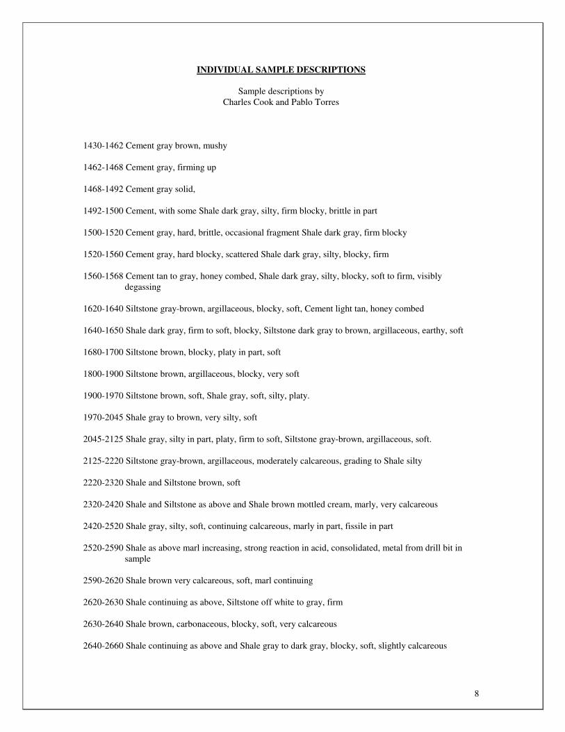
INDIVIDUAL SAMPLE DESCRIPTIONS
Sample descriptions by
Charles Cook and Pablo Torres
1430-1462 Cement gray brown, mushy
1462-1468 Cement gray, firming up
1468-1492 Cement gray solid,
1492-1500 Cement, with some Shale dark gray, silty, firm blocky, brittle in part
1500-1520 Cement gray, hard, brittle, occasional fragment Shale dark gray, firm blocky
1520-1560 Cement gray, hard blocky, scattered Shale dark gray, silty, blocky, firm
1560-1568 Cement tan to gray, honey combed, Shale dark gray, silty, blocky, soft to firm, visibly degassing
1620-1640 Siltstone gray-brown, argillaceous, blocky, soft, Cement light tan, honey combed
1640-1650 Shale dark gray, firm to soft, blocky, Siltstone dark gray to brown, argillaceous, earthy, soft
1680-1700 Siltstone brown, blocky, platy in part, soft
1800-1900 Siltstone brown, argillaceous, blocky, very soft
1900-1970 Siltstone brown, soft, Shale gray, soft, silty, platy.
1970-2045 Shale gray to brown, very silty, soft
2045-2125 Shale gray, silty in part, platy, firm to soft, Siltstone gray-brown, argillaceous, soft.
2125-2220 Siltstone gray-brown, argillaceous, moderately calcareous, grading to Shale silty
2220-2320 Shale and Siltstone brown, soft
2320-2420 Shale and Siltstone as above and Shale brown mottled cream, marly, very calcareous
2420-2520 Shale gray, silty, soft, continuing calcareous, marly in part, fissile in part
2520-2590 Shale as above marl increasing, strong reaction in acid, consolidated, metal from drill bit in sample
2590-2620 Shale brown very calcareous, soft, marl continuing
2620-2630 Shale continuing as above, Siltstone off white to gray, firm
2630-2640 Shale brown, carbonaceous, blocky, soft, very calcareous
2640-2660 Shale continuing as above and Shale gray to dark gray, blocky, soft, slightly calcareous

9
2660-2680 Shale gray, carbonaceous in part, calcareous, slightly fissile in part, platy, Shale, gray mottled brown, calcareous blocky, Siltstone tan, gray, grading to Claystone gray
2680-2710 Shale continuing as above
2710-2730 Shale gray-brown, silty, sub platy to sub blocky, moderately calcareous, carbonaceous in part, soft
2730-2750 Shale gray, silty, sub platy, moderately calcareous, soft
2750-2780 Siltstone gray, silty, sub blocky, slightly calcareous, carbonaceous in part, soft
2780-2810 Siltstone gray, sub blocky, slightly calcareous, soft
2810-2840 Siltstone gray, sub blocky, calcareous, soft
2840-2870 Shale, gray, silty, sub blocky, calcareous, soft
2870-2910 Shale, gray, Siltstone, gray, sub blocky to platy in part, slightly calcareous, soft
2910-2940 Siltstone, gray, sub blocky to platy in part, calcareous, very soft
2940-2970, Siltstone gray to light tan, some with very fine grained sand, non calcareous, Shale gray, very silty, platy, soft, non calcareous
2970-3000 Shale gray, soft, sub blocky to sub platy, silty in part, Siltstone gray-brown, sub blocky, very soft, occasional pyrite
3000-3060 Shale light gray, sub waxy, sub platy, soft, some Shale silty as above
3060-3110 Shale gray, sub waxy and Shale gray, silty as above, Shale gray, carbonaceous in part, some very calcareous with occasional limey stringers
3110-3150 Shale gray to gray-brown, silty in part, calcareous in part, Shale gray-brown, carbonaceous in part, very calcareous, marly with some limey stringers
3150-3180 Shale as above limey stringers increasing 3180-3210 Shale as above, marly Shale with lime stringers common.
3210-3260 Shale brown, silty, soft, sub blocky, Shale gray-brown, carbonaceous in part, platy, lime
decreasing
3260-3300 Shale brown, sub blocky, sub platy, earthy, silty in part, firm to soft,
3300-3360 Shale continuing as above non calcareous
3360-3420 Shale gray sub platy, earthy soft, Shale gray-brown carbonaceous in part, platy, soft to firm, hard and brittle
3420-3480 Shale as above and Sandstone light brown, silt to very fine grained, calcareous, very soft, no visible porosity
3480-3550 Shale gray-brown, silty platy, firm, splintery, Siltstone light brown, soft, very argillaceous, calcareous in part

10
3550-3610 Shale dark gray-brown, carbonaceous, firm to hard and splintery, scattered Siltstone brown
3610-3670 Shale dark gray-brown, silty, with carbonaceous laminations, blocky and platy, firm to hard and splintery, Siltstone brown, firm, slightly calcareous, sub platy to sub blocky
3670-3730 Shale dark gray, carbonaceous, platy, firm to hard and splintery, Siltstone brown, argillaceous, soft, occasional chert gray, Siltstone gray brown, Siltstone red, firm
3760-3810 Shale dark gray brown, silty in part, carbonaceous in part, blocky, hard, Siltstone brown and gray, soft and firm
3810-3820 Shale and Siltstone as above, trace Sandstone mottled brown, very fine to fine grained, sub round, well sorted, soft and friable, fair to good porosity, no stain, fluorescence or cut and trace Sandstone clear, very fine to fine grained, well sorted, firm, friable, porosity fair, no stain, fluorescence or cut
3810-3885 Shale, gray, platy, firm, splintery, fissile in part
3885-3935 Shale dark gray, platy, firm, splintery
3935-3960 Shale, dark gray, platy, splintery, waxy in part, earthy in part, carbonaceous, some Shale green to brown, silty, sub blocky, firm
3960-4020 Shale dark gray to black, earthy, platy, fissile in part, firm
4020-4060 Shale dark gray to black, earthy, platy, fissile in part, firm
4070-4080 Cement
4080-4160 Cement
4160-4200 Cement, Shale dark gray to brown, platy, silty, soft to firm and splintery, Siltstone gray and brown, soft, blocky
4200-4210 Shale and Cement, some fragments Cement appear stained, with steaming white cut, unstained fragments slow milky white cut, one fragment Sandstone very fine grained, brown stain, steaming greenish white cut
4210-4230 Shale dark gray to gray, platy splintery, Cement, Siltstone gray and brown, blocky, firm to hard, grading to Sandstone silt to very fine grained , trace Sandstone tan, silt to very fine grained, very argillaceous no stain, fluorescence or cut
4230-4260 Shale and Cement as above, Siltstone gray, brown, blocky, soft to firm, trace Sandstone tan as above
4260-4290 Shale and Siltstone continuing as above, Cement diminishing, Siltstone/Mudstone red brown, soft, mushy, possible bit flower, occasional Sandstone silt to very fine grained, hard, very argillaceous
4290-4320 Shale and Siltstone and Siltstone/Mudstone, (bit flower) as above
4320-4380 Shale varicolored, predominantly mauve, firm to brittle
4380-4430 Shale varicolored, predominantly purple, blocky, hard, brittle
4430-4490 Shale varicolored continuing, scattered Shale dark gray to black, platy, fissile in part, occasional fragment Sandstone off white to light tan, silt to very fine grained, sub angular to sub

11
round, grains virtually floating in clay matrix, no visible porosity, no stain, fluorescence or cut
4490-4550 Shale varicolored continuing, platy, firm, calcareous in part
4550-4650 Shale varicolored continuing, firm, platy in part, calcareous in part, Shale gray to dark gray, platy, firm to hard and splintery
4650-4750 Shale gray to dark gray, platy, firm to hard and splintery, occasional Shale varicolored
4750-4850 Shale as above continuing, occasional Siltstone gray, sub platy, soft
4850-4930 Shale gray, Siltstone gray-brown, trace Sandstone off white, very fine grained, sub angular to sub round, some clay infill, porosity fair, no stain, fluorescence or cut, Sandstone gray-brown, silt to very fine grained, argillaceous cement, no visible porosity, no stain, fluorescence or cut
4930-4950 Sandstone clear, unconsolidated, very fine to fine grained, sub angular to sub round, no stain, fluorescence or cut, abundant Limestone white, crypto crystalline, entire sample ground to small fraction
4950-4960 Sandstone as above fine to medium grained, Limestone white, tan, crypto crystalline,
5000-5020 Shale gray and brown, firm to soft, platy, fissile in part, silty to very silty, abundant unconsolidated sand grains fine to medium grained, sub round, Limestone as above common
5020-5100 Shale dark gray, gray-brown, platy, splintery, silty in part and Shale varicolored, occasional Sandstone dirty brown, silt to very fine grained, Limestone common
5100-5160 Shale, gray and red, platy, earthy, firm to hard, splintery, occasional Limestone off-white, dirty, argillaceous
5160-5220 Shale, varicolored, predominantly mauve, scattered Sandstone, white, fine grained, soft, friable, clay infill
5220-5280 Shale varicolored, predominantly red, earthy, firm to soft, Shale gray, firm to hard, scattered Sandstone clear, very fine grained, predominantly unconsolidated
5280-5340 Shale varicolored, predominantly red, platy, firm, Shale, gray
5340-5460 Shale varicolored, predominantly red, firm, Shale gray
5460-5520 Shale varicolored, predominantly red,
5602 (circ 35") Cement
5602-5620 Cement, Shale red and Shale dark gray
5620-5630 Cement, Shale red, with some calcareous inclusions, occasional anhydrite
5643(circulate 50minutes) predominantly Cement, scattered Sandstone clear, very fine to fine grained, sub round, unconsolidated, trace Sandstone dirty, very fine grained, light brown stain, slow milky cut
5650-5656 (circulate 75 minutes at 5650 and 60 minutes at 5656) Sandstone unconsolidated, clear, amber, rose, very fine to medium grained, few grains and clusters pale yellow ring
5656-5666 Cement and Shale red, Sandstone unconsolidated as above continuing
12
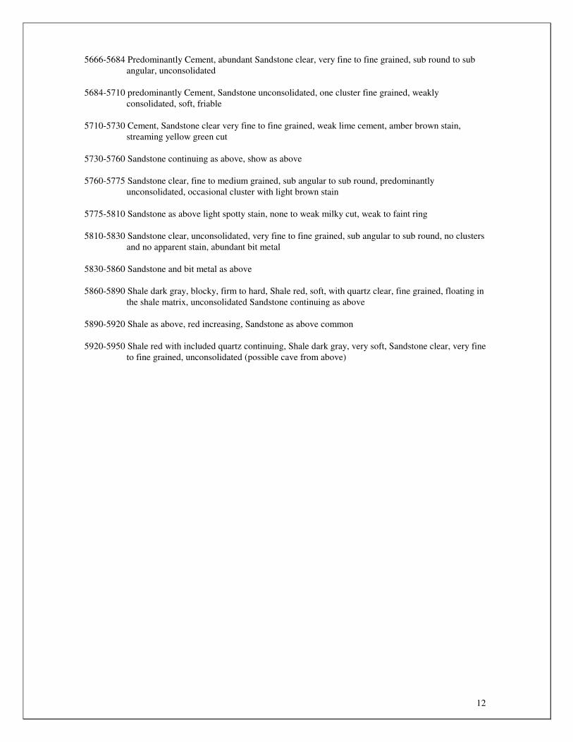
5666-5684 Predominantly Cement, abundant Sandstone clear, very fine to fine grained, sub round to sub angular, unconsolidated
5684-5710 predominantly Cement, Sandstone unconsolidated, one cluster fine grained, weakly consolidated, soft, friable
5710-5730 Cement, Sandstone clear very fine to fine grained, weak lime cement, amber brown stain, streaming yellow green cut
5730-5760 Sandstone continuing as above, show as above
5760-5775 Sandstone clear, fine to medium grained, sub angular to sub round, predominantly unconsolidated, occasional cluster with light brown stain
5775-5810 Sandstone as above light spotty stain, none to weak milky cut, weak to faint ring
5810-5830 Sandstone clear, unconsolidated, very fine to fine grained, sub angular to sub round, no clusters and no apparent stain, abundant bit metal
5830-5860 Sandstone and bit metal as above
5860-5890 Shale dark gray, blocky, firm to hard, Shale red, soft, with quartz clear, fine grained, floating in the shale matrix, unconsolidated Sandstone continuing as above
5890-5920 Shale as above, red increasing, Sandstone as above common
5920-5950 Shale red with included quartz continuing, Shale dark gray, very soft, Sandstone clear, very fine to fine grained, unconsolidated (possible cave from above)

SIII0da2l AlIGNAS / IAIIVIIISINIIIA141V

Spyglass Cedar Creek, LP
110 Broadway, Suite 215
San Antonio, TX 78205
RECEIVED MAR 2 8 2097
DEPT OF ENVIRONMENT & NATURAL RESOURCES - RAPID CITY
March 27, 2017
SUBJECT: Issues Identified During 2016 Well Inspections and Plans to Remedy Issues
Lucy Dahl
Environmental Scientist II, Minerals and Mining Program
523 East Capitol Avenue
Pierre, SD 57501
Dear Ms. Dahl-
Per our previous conversations, the other associated parties on our call/ communication chain are aware; there are still conflicted legal positions with Spyglass Cedar Creek, LP and New Frontier Energy/ Samyak Verra/ Tristan Farel et-al, and whose operational responsibility it is to provide remedies to all of the well/ field issues that have been identified in your December 14, 2015 inspection report. In spite of the legal questions, it is as discussed Spyglass' goal to bring the 40 wells into compliance, rehabilitate the field and bring the project back on-line as soon as is feasible. Understanding that we feel there are legal question regarding New Frontier; In order to try and move forward we intend to try and do the following in response to your assessment of issues:
1. Gilbert 1-2H: address well status, provide cement bond log, fix sign, replace fence around wellhead, fix reclaim pit, remove all unused equipment.
2. Price 13-24R: address well status, fix sign. 3. State 4-16: provide cement bond log, address well status, fix sign, rebury or remove pit liner at
surface, remove debris. 4. Gold Point State 32-1: address well status, provide cement bond log, fix sign, rebury or remove
pit liner at surface, re-set gates around wellhead. 5. State 10-27: address well status, provide cement bond log. 6. Peterson 6-5: address well status, install working gauges, remove all unused equipment. 7. !lett 8-24: address well status, install working gauges, fix sign. 8. State JO 6-27: address well status. 9. State 14-36: address well status, install working gauges, provide cement bond log, fence
wellhead, fix sign, remove unused equipment. 10. State 10-35: address well status, install working gauges. 11. State 13-23: address well status, install working gauges, provide cement bond log, correct
erosion issues. 12. State 11-30: address well status, install working gauges, provide cement bond log, fix sign. 13. Spyglass State 7-35: address well status, install working gauges, provide cement bond log. 14. State 2-27: address well status, install working gauges, provide cement bond log. 15. State 12-4: address well status, install working gauges, provide cement bond log. 16. Heairet-Henderson 10-15: address well status, install working gauges, provide cement bond log,
fix sign. 17. Gilbert 12-16: address well status, install working gauges. 18. Gilbert 13-10: address well status, install working gauges, provide cement bond log. 19. Gilbert 1-34: address well status, install working gauges, provide cement bond log, file
completion report. 20. Gilbert-State 3-16: address well status, install working gauges, rebury or remove pit liner at
surface. 21. State 16-22: address well status, install working gauges, correct erosion issues. 22. State 3-30: address well status, install working gauges, provide cement bond log, remove
unused equipment and refuse, berm tanks, repair building. 23. State 4-35: address well status, install working gauges, rebury or remove pit liner at surface.

24. Spyglass 16-24 Hett: address well status, install working gauges. 25. Gilbert 10-9: address well status, install working gauges, fix sign. 26. Gilbert 5-26: address well status, install working gauges. 27. State 16-8: address well status, install working gauges. 28. Gilbert 10-9: address well status, install working gauges, fix sign. 29. Gilbert 5-26: address well status, install working gauges. 30. State 16-8: address well status, install working gauges. 31. State 10-16: address well status, install working gauges, provide cement bond log. 32. State 8-8: address well status, install working gauges. 33. Gilbert 13-15: address well status, install working gauges. 34. Gilbert 5-15: address well status, install working gauges, provide cement bond log, rebury or
remove pit liner at surface. 35. Questar 9-27: address well status, provide cement bond log. 36. Peterson 10-5: address well status, install working gauges. 37. Gilbert 7-9: address well status, install working gauges. 38. State 1-21: address well status, provide cement bond log, rebury or remove pit liner at surface,
enable access to well house. 39. Fox 6-22: address well status, install working gauges, provide cement bond log, remove unused
equipment. 40. Gilbert 12-9: address well status, install working gauges, provide cement bond log. 41. State 2-16: address well status, install working gauges. 42. Heairet-Henderson 2-22: address well status, provide cement bond log, rebury or remove pit
liner at surface, correct erosion issues. 43. Acton 11-22: address well status, install working gauges, provide cement bond log, rebury or
remove pit liner at surface, correct erosion issues.
Understanding that this is the beginning of the wet season and not looking to cause further road or surface site damage; it is our intention to have the majority of this completed by early June.
Additionally, Spyglass Cedar Creek is currently in discussion with a well-financed, experienced operator to potentially bring in as a partner to get the project rehabilitated, bring the wells into compliance and get the field back on-line. They are in the due-diligence portion of the potential partnership and once the partnership is formed, they/we will move quickly to start rebuilding the project and start to again develop and produce the minerals. Concurrently, we will continue to try and clear up the legal issues with New Frontier Exploration, who has caused so many legal and financial issues for us, the land owners and the State.
We expect this partnership to be made in the next 30 days or so and then our work will begin. As soon as we memorialize our agreements I would like to schedule a meeting to see how we can work together to get this project back on track.
Although mostly created by groups/ people not under our control I do sincerely regret that this situation has caused so much trouble for everyone. I look forward to trying to rebuild this project and having a long-lasting, good relationship with you, and the State of South Dakota.
Manager
Xanthus Capital LLC
(General Partner to)
Spyglass, Cedar Creek, LP


Well Name API Location
Date of last
production
Necessary
Compliance
Actions
Gilbert 1-2H 40-063-20715 NENE-02-17N-01E
Never
Produced
Address well
status1; provide
cement bond
log; fix sign;
fence wellhead;
reclaim pit;
remove unused
equipment
Price 13-24R 40-063-20542.01 SWSW-24-19N-04E
Never
Produced
Address well
status1; fix sign
State 4-16 40-063-20605 NWNW-16-19N-04E
Never
Produced
Provide cement
bond log;
address well
status1; fix sign;
rebury or
remove pit liner
at surface;
remove debris
Gold Point State 32-1 40-063-20604 NWNW-32-19N-02E
Never
Produced
Address well
status1; provide
cement bond
log; fix sign;
rebury or
remove pit liner
at surface; re-set
gates around
wellhead
10-27 State 40-063-20609 NWSE-27-19N-04E
Never
Produced
Address well
status1; provide
cement bond log
Peterson 6-5 40-063-20621 SENW-05-17N-04E March 2010
Address well
status1; install
working
gauges2; remove
unused
equipment
Hett 8-24 40-063-20644 SENE-24-18N-03E
Never
Produced
Address well
status1; install
working
gauges2; fix sign
State JO 6-27 40-063-20657 SENW-27-17N-04E
Never
Produced
Address well
status1

State 14-36 40-063-20658 SESW-36-18N-01E
Never
Produced
Address well
status1; install
working
gauges2; provide
cement bond
log; fence
wellhead; fix
sign; remove
unused
equipment
State 10-35 40-063-20640 NWSE 35-18N-04E June 2012
Address well
status1; install
working gauges2
State 13-23 40-063-20659 SWSW 23-18N-04E
September
2011
Address well
status1; install
working
gauges2; provide
cement bond
log; correct
erosion issues
State 11-30 40-063-20692 NESE 30-18N-04E
Never
Produced
Address well
status1; install
working
gauges2; provide
cement bond
log; fix sign
Spyglass State 7-35 40-063-20693 SWNE 35-18N-04E June 2012
Address well
status1; install
working
gauges2; provide
cement bond log
State 2-27 40-063-20694 NWNE 27-18N-04E
December
2011
Address well
status1;
install
working
gauges2; provide
cement bond log
State 12-4 40-063-20701 NWSW 04-17N-04E May 2011
Address well
status1; install
working
gauges2; provide
cement bond log
Heairet-Henderson
10-15 40-063-20703 NWSE 15-17N-04E June 2012
Address well
status1; provide
cement bond
log; fix sign

Gilbert 12-16 40-063-20705 NWSW 16-17N-04E June 2012
Address well
status1;
install
working gauges2
Gilbert 13-10 40-063-20711 SWSW 10-17N-04E
September
2010
Address well
status1; install
working
gauges2; provide
cement bond log
Gilbert 1-34 40-063-20714 NENE 34-18N-04E July 2012
Address well
status1; install
working
gauges2; provide
cement bond
log; file
completion
report
Gilbert-State 3-16 40-063-20623 CNW 16-17N-04E July 2012
Address well
status1; install
working
gauges2; rebury
or remove pit
liner at surface
State 16-22 40-063-20660 SESE 22-18N-04E January 2012
Address well
status1; install
working
gauges2; correct
erosion issues
3-30 State 40-063-20611 NENW 30-18N-04E July 2012
Address well
status1; install
working
gauges2; provide
cement bond
log; remove
unused
equipment &
refuse; berm
tanks; repair
building
State 4-35 40-063-20614 NWNW 35-18N-04E July 2012
Address well
status1; install
working
gauges2; rebury
or remove pit
liner at surface

Spyglass 16-24 Hett 40-063-20620 SESE 24-18N-03E July 2012
Address well
status1; install
working gauges2
Gilbert 10-9 40-063-20622 NWSE 09-17N-04E July 2012
Address well
status1; install
working
gauges2; fix sign
Gilbert 5-26 40-063-20624 SWNW 26-18N-04E July 2012
Address well
status1;
install
working gauges2
State 16-8 40-063-20638 SESE 08-17N-04E June 2012
Address well
status1; install
working gauges2
State 10-16 40-063-20639 NWSE 16-17N-04E July 2012
Address well
status1; install
working
gauges2; provide
cement bond log
State 8-8 40-063-20641 SENE 08-17N-04E July 2012
Address well
status1; install
working gauges2
Gilbert 13-15 40-063-20642 SWSW 15-17N-04E July 2012
Address well
status1; install
working gauges2
Gilbert 5-15 40-063-20643 SWNW 15-17N-04E July 2012
Address well
status1; install
working
gauges2; provide
cement bond
log; rebury or
remove pit liner
at surface
Questar 9-27 40-063-20650 NESE 27-18N-04E July 2012
Address well
status1; provide
cement bond log
Peterson 10-5 40-063-20651 NWSE 05-17N-04E June 2012
Address well
status1; install
working gauges2
Gilbert 7-9 40-063-20662 SWNE 09-17N-04E July 2012
Address well
status1; install
working gauges2

State 1-21 40-063-20698 NENE 21-17N-04E July 2012
Address well
status1; provide
cement bond
log; rebury or
remove pit liner
at surface;
enable access to
well house
Fox 6-22 40-063-20699 SENW 22-17N-04E July 2012
Address well
status1; install
working
gauges2; provide
cement bond
log; remove
unused
equipment
Gilbert 12-9 40-063-20702 NWSW 09-17N-04E July 2012
Address well
status1; install
working
gauges2; provide
cement bond log
State 2-16 40-063-20704 NWNE 16-17N-04E July 2012
Address well
status1; install
working gauges2
Heairet-Henderson 2-
22 40-063-20706 NWNE 22-17N-04E July 2012
Address well
status1; provide
cement bond
log; rebury or
remove pit liner
at surface;
correct erosion
issues
Acton 11-22 40-063-20708 NESW 22-17N-04E July 2012
Address well
status1; install
working
gauges2; provide
cement bond
log; rebury or
remove pit liner
at surface;
correct erosion
issues
1: Well statuses should be addressed by: requesting temporary abandonment status from the
DENR based on the performance of a successful mechanical integrity test, returning the well to

production, or plugging and abandoning the well in accordance with Administrative Rules of
South Dakota requirements.
2: Valves and gauges must be installed and maintained in good working order to permit pressure
readings to be obtained on both casing and tubing.

December 14, 2015
March Kimmel
Spyglass Cedar Creek, LP
110 Broadway, Ste. 215
San Antonio, TX 78205
Dear Mr. Kimmel:
It has come to our attention that Spyglass Cedar Creek, LP (Spyglass) is addressing Bureau of
Land Management compliance issues concerning eight wells in Harding County, South Dakota,
that produce federal minerals. We want to remind you that Spyglass is the operator of record of
32 additional gas wells in South Dakota in addition to those eight that produce federal minerals.
As such, Spyglass is responsible for maintaining all 40 wells and ensuring they are in compliance
with South Dakota requirements. As we have advised you, or attempted to, on numerous
occasions over the past three years, all 40 wells are out of compliance and have been for quite
some time (see attached table).
We have been more than patient waiting for Spyglass to come to some kind of resolution on
these issues. However, our patience is worn thin and we now need to see some action on your
part. Failure to bring all 40 of Spyglass Cedar Creek’s Harding County wells into compliance
will force us to seriously consider enforcement. Possible enforcement actions include, but are not
necessarily limited to: requiring Spyglass Cedar Creek to permanently plug and abandon all
wells; revoking drilling/operating permits pursuant to SDCL 45-9-73; requiring additional bonds
sufficient to plug and reclaim each well site (which could amount to one million dollars or
more); levying monetary penalties up to $500 per day per violation (potentially tens of millions
of dollars); filing a lien against Spyglass Cedar Creek for costs associated with well plugging,
removal of equipment, and surface restoration; shutting down and sealing property by the
Secretary pursuant to 45-9-70; and requesting the Board of Minerals and Environment to act on
Spyglass’ bonds. To avoid enforcement we are requesting that you respond by January 31, 2016
with a plan outlining how and when you intend to bring wells into compliance.
If you have any questions or concerns you would like to discuss, please feel free to contact me at
605.773.4201.
Sincerely,
Lucy Dahl
Environmental Scientist II
Minerals and Mining Program

1
Well Name API Number Location
Date of last
production
Necessary
Compliance
Actions
State 1-2H 40-063-20715 NENE-02-17N-01E
Never
Produced
Fence wellhead;
reclaim pit;
remove unused
equipment;
provide cement
bond log;
address well
status1
Price 13-24R 40-063-20542.01 SWSW-24-19N-04E
Never
Produced
Address well
status1
State 4-16 40-063-20605 NWNW-16-19N-04E
Never
Produced
Provide cement
bond log;
address well
status1
Gold Point State 32-1 40-063-20604 NWNW-32-19N-02E
Never
Produced
Provide cement
bond log;
address well
status1
State 10-27 40-063-20609 NWSE-27-19N-04E
Never
Produced
Provide cement
bond log;
address well
status1
Peterson 6-5 40-063-20621 SENW-05-17N-04E March 2010
Install working
gauges2; weeds;
remove unused
equipment;
address well
status1
Hett 8-24 40-063-20644 SENE-24-18N-03E
Never
Produced
Install working
gauges2; repair
small leak at
wellhead;
address well
status1
State Jo 6-27 40-063-20657 SENW-27-17N-04E
Never
Produced
Address well
status1
State 14-36 40-063-20658 SESW-36-18N-01E
Never
Produced
Install working
gauges2; fence
wellhead;
remove unused
equipment;
provide cement
bond log;

2
address well
status1
State 10-35 40-063-20640 NWSE 35-18N-04E October 2011
Install working
gauges2; remove
weeds; repair
small leak at
wellhead;
address well
status1
State 13-23 40-063-20659 SWSW 23-18N-04E
September
2011
Install working
gauges2; correct
erosion issues;
provide cement
bond log;
address well
status1
State 11-30 40-063-20692 NESE 30-18N-04E
Never
Produced
Install working
gauges2; provide
cement bond
log; address well
status1
State 7-35 40-063-20693 SWNE 35-18N-04E October 2011
Install working
gauges2; remove
weeds; provide
cement bond
log; address well
status1
State 2-27 40-063-20694 NWNE 27-18N-04E
December
2011
Install working
gauges2; provide
cement bond
log; address well
status1
State 12-4 40-063-20701 NWSW 04-17N-04E May 2011
Install working
gauges2; remove
weeds; provide
cement bond
log; address well
status1
Heairet-Henderson
10-15 40-063-20703 NWSE 15-17N-04E April 2011
Provide cement
bond log;
address well
status1
State 12-16 40-063-20705 NWSW 16-17N-04E
November
2011
Install working
gauges2; address
well status1

3
Gilbert 13-10 40-063-20711 SWSW 10-17N-04E
September
2011
Install working
gauges2; provide
cement bond
log; address well
status1
Gilbert 1-34 40-063-20714 NENE 34-18N-04E October 2011
Install working
gauges2; remove
weeds; file
completion
report; provide
cement bond
log; address well
status1
Gilbert-State 3-16 40-063-20623 CNW 16-17N-04E
November
2011
Install working
gauges2; remove
weeds; address
well status1
State 16-22 40-063-20660 SESE 22-18N-04E January 2012
Install working
gauges2; address
well status1
State 3-30 40-063-20611 NENW 30-18N-04E July 2012
Install working
gauges2; remove
unused
equipment &
refuse; repair
small leak at
wellhead; berm
tanks; repair
building;
provide cement
bond log;
address well
status1
State 4-35 40-063-20614 NWNW 35-18N-04E July 2012
Install working
gauges2; remove
weeds; repair
small leak at
wellhead;
address well
status1
Hett 16-24 40-063-20620 SESE 24-18N-03E July 2012
Install working
gauges2; address
well status1

4
Gilbert 10-9 40-063-20622 NWSE 09-17N-04E July 2012
Install working
gauges2; remove
weeds; address
well status1
Gilbert 5-26 40-063-20624 SWNW 26-18N-04E July 2012
Gauges; repair
small leak at
wellhead;
address well
status1
State 16-8 40-063-20638 SESE 08-17N-04E June 2012
Install working
gauges2; remove
weeds; address
well status1
State 10-16 40-063-20639 NWSE 16-17N-04E July 2012
Install working
gauges2; repair
small leak at
wellhead
provide cement
bond log;
address well
status1
State 8-8 40-063-20641 SENE 08-17N-04E July 2012
Install working
gauges2; remove
weeds; address
well status1
Gilbert 13-15 40-063-20642 SWSW 15-17N-04E July 2012
Install working
gauges2; remove
weeds; address
well status1
Gilbert 5-15 40-063-20643 SWNW 15-17N-04E July 2012
Install working
gauges2; repair
small leak at
wellhead;
provide cement
bond log;
address well
status1
Questar 9-27 40-063-20650 NESE 27-18N-04E July 2012
Remove weeds;
provide cement
bond log;
address well
status1
Peterson 10-5 40-063-20651 NWSE 05-17N-04E June 2012
Install working
gauges2; remove
weeds; address
well status1

5
Gilbert 7-9 40-063-20662 SWNE 09-17N-04E July 2012
Install working
gauges2; remove
weeds; address
well status1
State 1-21 40-063-20698 NENE 21-17N-04E July 2012
Enable access to
well house;
provide cement
bond log;
address well
status1
Fox 6-22 40-063-20699 SENW 22-17N-04E July 2012
Install working
gauges2; reseed
site; remove
unused
equipment;
provide cement
bond log;
address well
status1
Gilbert 12-9 40-063-20702 NWSW 09-17N-04E July 2012
Install working
gauges2; provide
cement bond
log; address well
status1
State 2-16 40-063-20704 NWNE 16-17N-04E July 2012
Install working
gauges2; remove
weeds; address
well status1
Heairet-Henderson 2-
22 40-063-20706 NWNE 22-17N-04E July 2012
Provide cement
bond log;
address well
status1
Acton 11-22 40-063-20708 NESW 22-17N-04E July 2012
Install working
gauges2; provide
cement bond
log; address well
status1
1: Well status should be addressed by: requesting temporary abandonment from the DENR based
on the performance of a successful mechanical integrity test, returning the well to production, or
plugging and abandoning the well in accordance with Administrative Rules of South Dakota
requirements.
2: Valves and gauges must be installed and maintained in good working order to permit pressure
readings to be obtained on both casing and tubing.

Enclosures
cc via email: Rich Williams, Assistant Attorney General
Ryan Brunner, Deputy Commissioner, Office of School and Public Lands
Donald Herauf, Bureau of Land Management
Shari Mills, Spyglass Cedar Creek
Kelsey Newling, Ground Water Quality Program


March 19, 2014
March Kimmel
Spyglass Cedar Creek, LP
1919 NW Loop 410, Suite 200
San Antonio, TX 78213
Dear Mr. Kimmel:
Spyglass Cedar Creek, LP is the operator of record of forty (40) wells in South Dakota and as such, is responsible
for the maintenance of the wells and ensuring they are in compliance with the Administrative Rules of South Dakota
(ARSD 74:12). All forty wells are out of compliance. We have made several unsuccessful attempts to contact you in
regard to these issues over the past two years and were forced to recover your surface restoration bond from the
Texas unclaimed properties department.
On February 16 and August 23, 2012, I sent you letters warning Spyglass Cedar Creek to bring certain of its Harding
County wells into compliance by temporarily abandoning the wells. On June 6, 2012, I sent you a letter outlining
well site problems documented during routine inspections. In September, 2013, department inspectors documented
weed control and equipment cleanup problems at 14 Spyglass well sites.
The 40 wells listed in the table below have not produced since July, 2012. Therefore, Spyglass must either
temporarily abandon (TA) the wells, return the wells to production, or permanently plug and abandon the wells.
ARSD 74:12:03:03 requires operators to obtain written approval from the secretary for the temporary abandonment
of a well. A successful mechanical integrity test (MIT) must be conducted before temporary abandonment status will
be approved for any Spyglass well. Notify us in advance of any MIT’s so we can have an inspector on site to verify
results. If you intend to temporarily abandon these wells, you must file a sundry notice including a request for such
status and information on the current condition of each well. If you intend to plug any of these wells, a plugging plan
must be submitted for approval.
On March 13, 2014 a follow up inspection was performed on the 5-26 Gilbert, to confirm a leak from this well had
been properly fixed. Pursuant to ARSD 74:12:04:11 a written follow-up report is required and must include any
procedures used to remedy the situation. A very small leak still exists on this well and should be monitored.
The well site problems identified in 2012-2014 are listed in the table below. See South Dakota’s Oil and Gas Map-
Based Data Source at http://www.sdgs.usd.edu/sdoil/oilgas_app.html to access inspection reports for details
regarding how these well sites fail to comply with the interim reclamation requirements of ARSD 74:12:03:07.

Well Name API Location
Date of last
production
Well Site Compliance
Issues
State 1-2H 40-063-20715 NENE-02-17N-01E Never Produced
13-24R Price 40-063-20542.01 SWSW-24-19N-04E Never Produced
State 4-16 40-063-20605 NWNW-16-19N-04E Never Produced
Gold Point State
32-1 40-063-20604 NWNW-32-19N-02E Never Produced
10-27 State 40-063-20609 NWSE-27-19N-04E Never Produced
6-5 Peterson 40-063-20621 SENW-05-17N-04E March 2010
Unused equipment on
ground, weeds
Hett 8-24 40-063-20644 SENE-24-18N-03E Never Produced
State Jo 6-27 40-063-20657 SENW-27-17N-04E Never Produced
State 14-36 40-063-20658 SESW-36-18N-01E Never Produced
State 10-35 40-063-20640 NWSE 35-18N-04E October 2011 Weeds
State 13-23 40-063-20659 SWSW 23-18N-04E September 2011 No well sign
State 11-30 40-063-20692 NESE 30-18N-04E Never Produced
State 7-35 40-063-20693 SWNE 35-18N-04E October 2011 No lease information on sign
State 2-27 40-063-20694 NWNE 27-18N-04E December 2011
State 12-4 40-063-20701 NWSW 04-17N-04E May 2011 Unused equipment on site
Heairet-
Henderson 10-15 40-063-20703 NWSE 15-17N-04E April 2011
State 12-16 40-063-20705 NWSW 16-17N-04E November 2011
Well sign obscured by
vegetation
Gilbert 13-10 40-063-20711 SWSW 10-17N-04E September 2011
Gilbert 1-34 40-063-20714 NENE 34-18N-04E October 2011 Weeds
3-16 Gilbert-
State 40-063-20623 CNW 16-17N-04E November 2011
Weeds
State 16-22 40-063-20660 SESE 22-18N-04E January 2012
3-30 State 40-063-20611 NENW 30-18N-04E July 2012
Unused equipment & refuse
on site
4-35 State 40-063-20614 NWNW 35-18N-04E July 2012
Weeds, no lease information
on sign
16-24 Hett 40-063-20620 SESE 24-18N-03E July 2012
10-9 Gilbert 40-063-20622 NWSE 09-17N-04E July 2012 Weeds
5-26 Gilbert 40-063-20624 SWNW 26-18N-04E July 2012
Well has a very small leak at
wellhead
State 16-8 40-063-20638 SESE 08-17N-04E June 2012 Weeds, debris at well site
State 10-16 40-063-20639 NWSE 16-17N-04E July 2012
State 8-8 40-063-20641 SENE 08-17N-04E July 2012 Weeds
Gilbert 13-15 40-063-20642 SWSW 15-17N-04E July 2012 Weeds
Gilbert 5-15 40-063-20643 SWNW 15-17N-04E July 2012
Questar 9-27 40-063-20650 NESE 27-18N-04E July 2012
Peterson 10-5 40-063-20651 NWSE 05-17N-04E June 2012
Weeds, unused equipment on
site
Gilbert 7-9 40-063-20662 SWNE 09-17N-04E July 2012 Weeds
State 1-21 40-063-20698 NENE 21-17N-04E July 2012
Fox 6-22 40-063-20699 SENW 22-17N-04E July 2012
Ground needs to be reseeded,
unused equipment on site

Gilbert 12-9 40-063-20702 NWSW 09-17N-04E July 2012
Weeds, sign has fallen and is
obscured
State 2-16 40-063-20704 NWNE 16-17N-04E July 2012 Weeds
Heairet-
Henderson 2-22 40-063-20706 NWNE 22-17N-04E July 2012
Acton 11-22 40-063-20708 NESW 22-17N-04E July 2012
Failure to bring all 40 of Spyglass Cedar Creek’s Harding County wells into compliance by requesting temporary
abandonment (TA) of the wells and addressing well site reclamation problems may result in enforcement action.
Possible enforcement actions the DENR may pursue include requiring Spyglass Cedar Creek to permanently plug
and abandon all wells, permit revocation pursuant to SDCL 45-9-73, monetary penalties up to $500 per day per
violation, and/or filing a claim against Spyglass Cedar Creek for costs associated with plugging, removal of
equipment, and surface restoration. You must respond by April 21, 2014 with a plan outlining how and when you
intend to bring wells into compliance with ARSD 74:12 in order to avoid possible enforcement action.
It has also come to our attention that Max Main is no longer your attorney or resident agent. Spyglass must designate
a new resident agent through the South Dakota Secretary of State’s office.
If you have any questions or concerns you would like to discuss, please feel free to contact me at 605.773.4201.
Thank you for your attention to these issues.
Sincerely,
Lucy Dahl
Oil and Gas Geologist
Minerals and Mining Program
cc via email: Roxanne Giedd, Deputy Attorney General
Ryan Brunner, Deputy Commissioner, Office of School and Public Lands
Donald Herauf, Bureau of Land Management
Shari Mills, Spyglass Cedar Creek
Tristan Farel, New Frontier Energy

August 23, 2012 March Kimmel Spyglass Cedar Creek, LP 110 Broadway, Ste. 215 San Antonio, TX 78205 Dear Mr. Kimmel: On February 16, 2012, I sent you a letter concerning the status of wells operated by Spyglass Cedar Creek, LP. that are located in Harding County, South Dakota. The wells listed in the table below have not produced for six months or more and must have their status addressed. There is no file documentation indicating that temporary abandonment was requested or approved. By ARSD 74:12:03:03, wells cannot be temporarily abandoned without approval. Assuming there are no mechanical integrity issues with the well, temporary abandonment will be approved for a period of one year unless a successful mechanical integrity test (MIT) is completed. Upon completion of a successful MIT, temporary abandonment will be granted for five years. If you intend to temporarily abandon these wells, please file a sundry notice including a request for such status and information on the current condition of each well. The alternatives are to return a well to production or plug and abandon the well. If you intend to plug any of these wells, a plugging plan should be submitted for approval. Well Name API Location Date of last production State 1-2H 40-063-20715 NENE-02-17N-01E Never Produced 13-24R Price 40-063-20542.01 SWSW-24-19N-04E Never Produced State 4-16 40-063-20605 NWNW-16-19N-04E Never Produced Gold Point State 32-1 40-063-20604 NWNW-32-19N-02E Never Produced 10-27 State 40-063-20609 NWSE-27-19N-04E Never Produced 6-5 Peterson 40-063-20621 SENW-05-17N-04E March 2010 Hett 8-24 40-063-20644 SENE-24-18N-03E Never Produced State Jo 6-27 40-063-20657 SENW-27-17N-04E Never Produced State 14-36 40-063-20658 SESW-36-18N-01E Never Produced State 10-35 40-063-20640 NWSE 35-18N-04E October 2011 State 13-23 40-063-20659 SWSW 23-18N-04E September 2011 State 11-30 40-063-20692 NESE 30-18N-04E Never Produced State 7-35 40-063-20693 SWNE 35-18N-04E October 2011 State 2-27 40-063-20694 NWNE 27-18N-04E December 2011 State 12-4 40-063-20701 NWSW 04-17N-04E May 2011 Heairet-Henderson 10-15 40-063-20703 NWSE 15-17N-04E April 2011 State 12-16 40-063-20705 NWSW 16-17N-04E November 2011

March Kimmel Page Two August 23, 2012 Gilbert 13-10 40-063-20711 SWSW 10-17N-04E September 2011 Gilbert 1-34 40-063-20714 NENE 34-18N-04E October 2011 3-16 Gilbert-State 40-063-20623 CNW 16-17N-04E November 2011
If you have any questions or concerns you would like to discuss, please feel free to contact me. Thank you for your attention to these issues. Sincerely,
Lucy Dahl Oil and Gas Geologist Minerals and Mining Program

February 16, 2012
Shari Mills
Spyglass Cedar Creek, LP
110 Broadway, Ste. 215
San Antonio, TX 78205
Dear Ms. Mills:
The Minerals and Mining Program is in the process of updating file information on wells operated by
Spyglass Cedar Creek, LP. that are located in Harding County, South Dakota. The wells listed in the
table below have not produced for six months or more. There is no file documentation indicating that
temporary abandonment was requested or approved. By ARSD 74:10:04:03, wells cannot be temporarily
abandoned without approval. Once approved, temporary abandonment may be extended beyond six
months, although a mechanical integrity test may be required. If you do not intend to plug these wells in
the near future, please file a sundry notice including a request for temporary abandonment status and
information on the current condition of each well. If you do intend to plug any of these wells, a plugging
plan should be submitted for approval.
Well Name API Location Date of last production
State 1-2H 40-063-20715 NENE-02-17N-01E Never Produced
13-24R Price 40-063-20542.01 SWSW-24-19N-04E Never Produced
State 4-16 40-063-20605 NWNW-16-19N-04E Never Produced
Gold Point State 32-1 40-063-20604 NWNW-32-19N-02E Never Produced
10-27 State 40-063-20609 NWSE-27-19N-04E Never Produced
6-5 Peterson 40-063-20621 SENW-05-17N-04E March 2010
Hett 8-24 40-063-20644 SENE-24-18N-03E Never Produced
State Jo 6-27 40-063-20657 SENW-27-17N-04E Never Produced
State 14-36 40-063-20658 SESW-36-18N-01E Never Produced
If you have any questions or concerns you would like to discuss, please feel free to contact me.
Thank you for your attention to these issues.
Sincerely,
Lucy Dahl
Oil and Gas Geologist
Minerals and Mining Program

DEPARTMENT of ENVIRONMENT and NATURAL RESOURCES
Minerals & Mining Program Oil & Gas Office
2050 West Main Street, Suite #1 Rapid City, SD 57702-2493
Telephone: 605-394-2229 Fax: 605-394-5317
ow"
GRAifACES.GR ),T
September 2, 2010
Kevin Sellers Spyglass Cedar Creek, LP 595 S. CasteII Avenue New Braunfels, TX 78130
Dear Kevin:
This letter is in regard to the four wells listed below that were drilled by your company, but have not been active for several years. If these wells are to be kept for some useful purpose, you will be required to perform a mechanical integrity test (MIT) of the casings to show that the wells are not causing contamination of subsurface drinking water resources in Harding County. The test will consist of pressuring up on the production casing to 1,000 pounds per square inch for 15 minutes with no more than 10 percent pressure fall off. A successful MIT is good for five years, unless circumstances change that would require a new test.
The wells are: 18N-1E 4-36 State, Section 36 SESW
19N-4E 4-16 State, Section 16 NWNW 13-24 Price, Section 24 SWSW 10-27 State, Section 27 NWSE
If you decide not to pressure test the above wells and classify them as Temporarily Abandoned, you will be required to properly plug and abandon them under the supervision of this office.
Please let me know what your intentions are for the future of these wells. Thank you for your cooperation.
Si cerely,
0# /
Fred V. Steece Oil and Gas Supervisor
cc: March Kimmel, 9210 Autumn Leaf, San Antonio, TX 78217 Karen Christensen, 1447 Crestline, Santa Barbara, CA 93105

SD EForm - 0439 V1
<EAT FACES. GREAT PLACES.
FAVEIVED JUL 2 0 2009
DEPT OF ENVIRONMENT &NATURAL RESOURCES - RAPID CITY
,.....PARTMENT of ENVIRONMENT and NATURAL RESOurtCES Minerals & Mining Program - Oil & Gas Section 2050 West Main, Suite #1, Rapid City, SD 57702-2493
eb Telephone: 605-394-2229, FAX: 605-394-5317
WELL COMPLETION OR RECOMPLETION REPORT Type of Completion:
Oil Well ,/ Gas Well Injection
Name and Address of Operator:
Spyglass Cedar Creek, LP 595
Name and Address of Drilling Contractor and
Western Star E-25 P.O.
Surface Location of well: Qtr-Qtr, Sec, Twp,
SW SW Sec 24 T19N R4E, Harding
If Directional, top of pay and bottom hole location
Deepen Plug Back
Ave., New Braunfels, TX 78130
Williston, ND 58802-1504
feet from nearest lines of section,
660'FWL
lines of section:
Workover Other
S. Castell
Rig No:
Box 1504,
Rge, County,
Cnty, 660'FSL
from nearest
Telephone
(830) 626-7100
ai.d latitude and longitude (if available):
Well Name and No.
Price 13-24R
Field and Pool, or Wildcat
Wildcat
Permit No.
1780
API No.
4006320542.01
Date Issued
5/12/2006
Spud Date
7/27/2006
TD Date
814/20( 6
Compl Date Elevation
2895
Total Depth (MD & TVD)
5.950
Plug Back TD (MD & TVD)
5,781
Producing Interval(s). this Completion, Top, Bottom, Name (MD & TVD)
Not Producing, shut in to evaluate, Minnelusa produced water
No. of DST's Run
(see page 2) FA No EYes
Was Well cored?
List Intervals:
I ype Electric and Other Logs Run:
HRLT Laterolog, CNL/FDC, Dipole Sonic, CBL
Date Directional Survey Submitted
CASING RECORD Re ort all strings set in well Hole Size Casing Size Weight (lb/ft) Depth Set Amount Pulled Sacks a.fd Type of Cement Top of Cement
9 5/8" 36# 1495' none 240 sks Class G surface 8 3/4" 5 1/2" 15.5 & 17 5827' none 400 lite, 285 Class G 2740
TUBING RECORD
LINER RECORD
Size Weight (1b/ft) Depth Set Packer Type & Depth Size Depth Interval Sacks and Type of Cement
PERFORATION RECORD interval/Depth Holes Per Ft. Formation
Isolated Amount and Type of Cement uPx1 (indicate if squeeze cemented). Amount and Type of Acid and/or Sand used. Use additional page(s) if needed.
5716' - 5720' Minnelusa Plug back plug 5950 - 5850 5676' - 5680' Minnelusa CIBP @ 5707 w/ 2 sx
CIBP @ 5660 w/ 10sx
Continued on Next Page —>
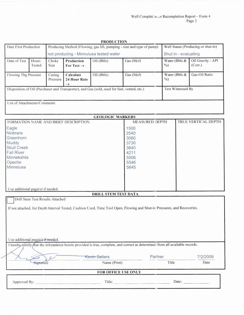
I hereb ertify at the inforpation herein provided is true, complete, and correct as determined from all available records.
Kevin-Sellers Partner 7/2/2009
Name (Print) Title Date re
Drill Stem Test Results Attached
If not attached, list Depth Interval Tested, Cushion Used, Time Tool Open, Flowing and Shut-in Pressures, and Recoveries.
Use additiongl pagels.)-if-neecled.
FOR OFFICE USE ONLY
Approved By: Title: Date:
Well Completion Recompletion Report — Form 4 Page 2
PRODUCTION Date First Production Producing Method (Flowing, gas lift, pumping - size and type of pump)
not producing - Minnelusa tested water
Well Status (Producing or shut-in)
Shut in - evaluating
Date of Test Hours Tested
Choke Size
Production For Test —>
Oil (Bbls) Gas (Mcf) Water (Bbls & %)
Oil Gravity - API (Corr.)
Flowing Tbg Pressure Casing Pressure
Calculate 24 Hour Rate —>
Oil (Bbls) Gas (Mcf) Water (Bbls & %)
Gas-Oil Ratio
Disposition of Oil (Purchaser and Transporter), and Gas (sold, used for fuel, vented, etc.) Test Witnessed By
List of Attachments/Comments
GEOLOGIC MARKERS FORMATION NAME, AND BRIEF DESCRIPTION MEASURED DEPTH I RUE VERTICAL DEPTH
Eagle 1500 Niobrara 2540 Greenhorn 3080 Muddy 3730 Skull Creek 3840 Fall River 4211 Minnekahta 5506 Opeche 5546 Minnelusa 5645
Use additional page(s) if needed. DRILL STEM TEST DATA

Spyglass Cedar Creek LP
Well: Price #13-24R Field: Wildcat
Location: SW SW Sec. 24, T19N-R4E 660 FWL, 660 FSL
County, State: Harding County, South Dakota
RECEIVED JUL 2 0 2009
DEPT OF ENVIRONMENT & NATURAL RESOURCES - RAPID CITY
GL: 2895' KB: 2909'
1495' API#: 40-063-20542.01
SD permit#: 1780
acct#: 100
First sales: NA
Spud (reentry): 7/27/2006 RREL: 8/4/2006
8-3/4" bit Surface casing: 9-5/8" 36# SA 1495' Cemented to surface w/ 240 sx Class G, 2% CaCl2
;.15827' k
Production casing: 5-1/2" 15.5 & 17# K-55 & P-110 SA 5827' Cement w/ 400 sx Lite, tailed w/ 285 sx Class G
TOC: 2740' (CBL - 9/13/06)
Completion: Shut in - evaluating
CIBP @ 5660' w/ 10 sx on top
Perfs: 5676' - 5680'
CIBP @ 5707' w/ 2 sx on top
Perfs: 5716' - 5720' pert gun left in hole
PBTD: 5781' (CBL)
Plug back plug set 5950' - 5850'
TD: LTD 6083', DTD (wash down) 5950'

FOR OFFICE USE ONLY
Tit Approved/by:
Conditions, if any:
FasteiduuEs ®
DEPARTMENT of ENVIRONMENT and NATURAL RESOURCES FORM 6 inera' Mining Program - Oil & Gas Section
2050 Wt. ,rlain, Suite #1, Rapid City, SD 57702-2493 RECEIVED Telephone: 605-394-2229, FAX: 605-394-5317
MAY 7 2007 APT OF ENVIRONMENT & NATURAL
RESOURCES - RCRO
SUNDRY NOTICE AND REPORT ON WELLS • Operator Name Telephone
Spyglass Cedar Creek, LP (830) 626-7445 Address
595 South CasteII Ave., New Braunfells, TX 78130
Permit # API No. Well Name and Number Location (Qtr-Qtr, Sec, Twp, Rge, County)
1780 400632054201 SW SW S21/ T19N R4E 1 iigebhu 1 _ _ . ,........t._ _
Price 13-24R ....=;1.--.1,_,-----,c,.. ._..- - --- ..-- .-----.4*- ,,,-_--,--,-,-
Notice
I FA ❑ ❑ ❑ ❑
of Intention To: Subsequent
Temporarily Abandon Plug and Abandon Pull, Alter, or Test Casing Perforate Acidize Fracture Treatment Squeeze Cement Other
FA ❑
❑
Report of : Request
Drilling Progress BOP Pressure Test/Program Gas/Oil Ratio Work-Over (Perf, Frac, Acidize) Shut-In Pressure Spill Mechanical Integrity Test Other
for change of:
Location Elevation Producing Method Producing Formation Injection Pressure Injection Volume Injection Fluid Other
Describe Proposed or Completed Operations (clearly state all pertinent details, and give pertinent dates, including estimated date of starting any proposed work). Use additional page(s) if appropriate.
Well Status as of May 2, 2007 Surface Casing 9 5/8", 36 #/ft, J-55 Set @ 1495 'KB Production Casing 5 1/2", 15.5 #/ft, J-55 Set @ 5850'KB PBTD 5850 top of fish @ 5413 'KB Perf Interval: 5716 to 5720 4 SPF Minnelusa Formation Initial Production: 0 mcfd Zone is wet CIBP set @ 5707 with 2 sks cmt PBTD @ 5697 'KB Perf Interval: 5676 to 5680 4 SPF Minnelusa Formation Initial Production: 0 mcfd Zone is wet (Flowing) CIBP set @ 5660 with 10 sks cmt Shut in waiting on orders
I hereby certify that the foregoing as to any work or operation performed is a true and correct report of such work or operation.
Brian Hohn Agent for Spyglass 5/2/2007 Signature Name (Print) Title Date

CORRESPONDENCE


GREAT FACES. GREAT PLACES. ©
May 22, 2006
Sincerely,
7U, Fred Fred V. Steece Oil and Gas Supervisor
DEPARTMENT of ENVIRONMENT and NATURAL RESOURCES
Minerals & Mining Program Oil & Gas Office
2050 West Main, Suite #1 Rapid City, SD 57702-2493 Telephone 605-394-2229 FAX Number 605-394-5317
Kathy Clines Harding County Zoning Director P. 0. Box 26 Buffalo, South Dakota 57720
Dear Ms. Clines:
The Department of Environment and Natural Resources has received an application from Spyglass Cedar Creek LP to reenter an existing oil well in Harding County. The legal description for the well is as follows:
SWSW Section 24, Township 19 North, Range 4 East
Please direct your regulatory requirements directly to the operator as follows:
Spyglass Cedar Creek LP 353 Mill Street New Braunfels, Texas 78130
I plan to issue the permit after June 1, 2006.

-rely,
DEPARTMENT of ENVIRONMENT and NATURAL RESOURCES
Minerals & Mining Program Oil & Gas Office
2050 West Main, Suite #1 Rapid City, SD 57702-2493 Telephone 605-394-2229 FAX Number 605-394-5317
REAT FACES. GREAT PLACES. ®
May 22, 2006
Stan Michals South Dakoa Department of Game, Fish and Parks 3305 West South Street Rapid City, South Dakota 57702
Dear Mr. Michals:
The Department of Environment and Natural Resources has received an application from Spyglass Cedar Creek LP to reenter an existing oil well in Harding County. The legal description for the well is as follows:
SWSW Section 24, Township 19 North, Range 4 East
Please direct your regulatory requirements directly to the operator as follows:
Spyglass Cedar Creek LP 353 Mill Street New Braunfels, Texas 78130
1 plan to issue the permit after June 1, 2006.
r0
Fred V. Steece Oil and Gas Supervisor

BEAT FACES. GREAT PLACES.
May 22, 2006
DEPARTMENT of ENVIRONMENT and NATURAL RESOURCES
Minerals & Mining Program Oil & Gas Office
2050 West Main, Suite #1 Rapid City, SD 57702-2493 Telephone 605-394-2229 FAX Number 605-394-5317
Michael Fosha Archaeological Research Center P. O. Box 1257 Rapid City, South Dakota 57709
Dear Mr. Fosha:
The Department of Environment and Natural Resources has received an application from Spyglass Cedar Creek LP to reenter an existing oil well in I larding County. The legal description for the well is as follows:
SWSW Section 24, Township 19 North, Range 4 East
Please direct your regulatory requirements directly to the operator as follows:
Spyglass Cedar Creek LP 353 Mill Street New Braunfels, Texas 78130
I plan to issue the permit after June 1, 2006.
r Fred V. Steece Oil and Gas Supervisor

MISCELLANEOUS

NO MISCELLANEOUS INFORMATION FOR THIS WELL
AS OF 8/5/2011


