
United States Department of Agriculture
Forest Service
Southwestern Region
Environmental Assessment for
Hondo Fuels Reduction Project
Sandia Ranger District/Cibola National Forest
For information contact: Cid H. Morgan
11776 Hwy. 337
Tijeras, NM 87059
(505) 281-3304

Table of Contents
CHAPTER 1 – PURPOSE AND NEED 1
Document Structure………………………………………………………………… 1
Background…………………………………………………………………………. 1
Purpose and Need for Action……………………………………………………….. 2
Proposed Action…………………………………………………………………… .. 2
Decision Framework……………………………………………………………….. 2
Public Involvement………………………………………………………………… 2
Issues……………………………………………………………………………….. 3
CHAPTER 2 – ALTERNATIVES 4
Alternative A – No Action…………………………………………………………. 4
Alternative B – The Proposed Action……………………………………………… 4
Alternative C – Modified Proposed Action………………………………………... 7
Mitigation Measures Common to Action Alternatives…………………………….. 8
NM Forest Restoration Principles………………………………………………….. 10
Comparison of Alternatives………………………………………………………... 15
CHAPTER 3 – ENVIRONMENTAL CONSEQUENCES 21
Fuels and Fire Behavior……………………………………………………………. 21
Wildlife…………………………………………………………………………….. 29
Vegetation………………………………………………………………………….. 40
Soils and Water Resources…………………………………………………………. 52
Air Resources……………………………………………………………………… .. 64
Recreation…………………………………………………………………………... 66
Scenic Resources…………………………………………………………………… 69
Other Resources…………………………………………………………………….. 75
CHAPTER 4 – CONSULTATION AND COORDINATION 76
APPENDIX 78
Response to Comments Received…………………………………………………. 78
LIST OF TABLES
Table 1 – Comparison of Alternatives…………………………………………….. 15
Table 2 – Fire Regimes and Existing Condition Class……………………………. 23
Table 3 – Statistical Human and Lighting Caused Fires in Proximity of the
Project Area……………………………………………………………………… 25
Table 4 – Seasonal Fire Behavior............................................................................. 25
Table 5 – BehavePlus Outputs for FM5. Current Condition Model…………….... 25
Table 6 – BehavePlus Outputs for FMTUI (161). Post Treatment Model
Alternative B……………………………………………………………………… 27
Table 7 – BehavePlus Outputs for FM11. Post Treatment Model Alternative C…. 28
Table 8 – Habitat Types, Associated MIS, and Forest-wide Habitat and
Population Trends………………………………………………………………… 30
Table 9 – Potential Threatened, Endangered, Proposed or Sensitive
Wildlife Species………………………………………………………………………. 31
Table 10 – Migratory Bird Species Evaluated in the Vegetation Types in the
Analysis Area……………………………………………………………………….. 32
Table 11 – Summary of No Action Effects for MIS…………………………………. 33
Table 12 – Summary of Effects for MIS – Alternatives B and C……………………. 34
Table 13 – Summary of Effects to TES Species by Alternative……………………... 35
Table 14 – Summary of Effects to Migratory Birds………………………………….. 38
Table 15 – Existing Canopy Bulk Density and Crowning Index…………………….. 42

Table 16 – Old Growth Allocation Within the Sandia Ecosystem Management Area… 43
Table 17 – Old Growth Allocation Within the Combined Sandia Ecosystem
Management Area And Sandia Wilderness………………………………………….. 43
Table 18 – Old Growth Allocation Within the Hondo Analysis Area………………… 44
Table 19 – Distribution by VSS Class and Forest Type for Forested Areas Within
the Sandia Ecosystem Management Area……………………………………………. 44
Table 20 – Distribution by VSS Class and Forest Type for Forested Areas
Within the Hondo Analysis Area…………………………………………………….. 44
Table 21 – Stand Density Index Distribution by VSS Diameter Groups (site)
Within the Hondo Analysis Area……………………………………………………… 45
Table 22 – Average Tree Densities (sq feet of basal area per acre) by Forest
Type at the Different Scales…………………………………………………………… 45
Table 23 – Average Number of Snags (standing dead trees) Per Acre at the
Different Scales………………………………………………………………………... 45
Table 24 – Average Number of Downed Logs 12‖+ Midpoint Per Acre at the
Different Scales………………………………………………………………………… 46
Table 25 – Average Canopy Cover Per Acre At the Different Scales…………………. 46
Table 26 – Changes in Canopy Bulk Density and Crowning Index Under
Alternative A (No Treatment)………………………………………………………… 48
Table 27 – Changes in Canopy Bulk Density and Crowning Index Under
Alternatives B and C (Proposed Action and Modified Proposed Action)……………. 49
Table 28 – TES Soils Within the Hondo Project Area………………………………… 53
Table 29 – Summary of Soil Condition in the Hondo Project Area…………………… 54
Table 30 – Watershed Condition Class By Alternative……………………………….. 60
Table 31 – Percent of Watersheds Treated by Alternative……………………………. 61
LIST OF FIGURES
Figure 1 – Illustration of Desired Spatial Arrangement of Leave Groups……………. 5
Figure 2 – TES Map Units Within Hondo Project Area……………………………… 53
Figure 3 – Soil Condition In the Hondo Project Area………………………………... 55
Figure 4 – San Antonio Arroyo Watershed, Smaller Watersheds, Springs,
and Drainage Network………………………………………………………………. 57
MAPS
Alternative A
Alternative B
Alternative C

The U.S. Department of Agriculture (USDA) prohibits discrimination in all its programs and
activities on the basis of race, color, national origin, sex, religion, age, disability, political beliefs,
sexual orientation, or marital or family status. (Not all prohibited bases apply to all programs.)
Persons with disabilities who require alternative means for communication of program
information (Braille, large print, audiotape, etc.) should contact USDA's TARGET Center at (202)
720-2600 (voice and TTY).
To file a complaint of discrimination, write USDA, Director, Office of Civil Rights, Room 326-
W, Whitten Building, 1400 Independence Avenue, SW, Washington, DC 20250-9410 or call (202)
720-5964 (voice and TTY). USDA is an equal opportunity provider and employer.

1
Chapter 1 – Purpose and Need
Document Structure
The Forest Service has prepared this Environmental Assessment in compliance with the National
Environmental Policy Act (NEPA) and other relevant federal and state laws and regulations. This
Environmental Assessment discloses the direct, indirect, and cumulative environmental impacts
that would result from the proposed action and alternatives. The document is organized into four
parts:
Introduction: The section includes information on the history of the project proposal,
the purpose of and need for the project, and the agency’s proposal for achieving that
purpose and need. This section also details how the Forest Service informed the
public of the proposal and how the public responded.
Alternatives, including the Proposed Action: This section provides a more detailed
description of the agency’s proposed action as well as alternative methods for
achieving the stated purpose. These alternatives were developed based on significant
issues raised by the public and other agencies. This discussion also includes possible
mitigation measures. Finally, this section provides a summary table of the
environmental consequences associated with each alternative.
Environmental Consequences: This section describes the environmental effects of
implementing the proposed action and other alternatives. This analysis is organized
by resource area. Within each section, the affected environment is described first,
followed by the effects of the alternatives.
Agencies and Persons Consulted: This section provides a list of preparers and
agencies consulted during the development of the environmental assessment.
Additional documentation, including more detailed analyses of project-area resources, may be
found in the project planning record located at the Sandia Ranger District Office in Tijeras, New
Mexico.
Background
The Hondo Fuels Reduction Project area encompasses 406 acres of forested landscape consisting
of pinyon-juniper woodland, ponderosa pine and mixed conifer.
The project area is bordered on the west boundary by the Sandia Mountain Wilderness, south
boundary by Cuito De San Antonio Open Space, east boundary by Cedar Crest and Forest Park
communities, and north boundary by National Forest land. Private homes lie immediately to the
east of the project area. Fuels conditions have built up through the years due to fire suppression
and lack of management activity. This has led to a concern for firefighter and public safety as
well as adverse effects to resources on private property and National Forest should a wildfire
start.
The project area lies within Management Area 2 as defined by the 1985 Cibola National Forest
Land and Resource Management Plan (The Plan, page 84).

2
Purpose and Need for Action
The Forest Service proposes to create a stand structure, within the Hondo Fuels Reduction Project
area on the Sandia Ranger District, Cibola National Forest, which would reduce the potential for
crown fire. This would help provide for firefighter and public safety and reduce the potential for
adverse effects to private property and National Forest resources.
This project responds to the Cibola National Forest Land and Resource Management Plan (The
Plan) standards and guidelines that govern the protection of soil and water (pp. 67-1 through 68-
2), wildlife and fish (pp. 68-3 through 71-9), old growth forest (pp. 65-66), recreation (pp. 58
through 61-2), and heritage resources (pp. 61-3 through 63-7); all are hereby incorporated by
reference. Since these resources would be damaged or lost in a high-severity wildfire, this project
would better protect them by reducing the chance that such damage or loss would occur. This
project also conforms to the area specific direction for Management Area 2 (pages 84 through
94).
This project complies with Federal, State, and local laws or requirements for the protection of the
environment.
The project would be implemented in late 2010 or early-mid 2011.
Proposed Action
The proposed action would create a ¼ mile wide fuel break between the Sandia Mountain
Wilderness boundary and the private land boundary by thinning trees, creating temporary
openings and prescribed burning or pile burning. For a complete description of the Proposed
Action, see Chapter 2.
This project was reviewed as part of the 2002 Programmatic Biological Opinion for Wildland
Urban Interface Fuels Reduction Projects and mitigation measures prescribed by the BO were
incorporated into the project design.
Decision Framework
Given the purpose and need, the deciding official reviews the environmental consequences of the
proposed action and the other alternatives in order to make the following decisions:
Whether to implement the proposed action
Whether to implement an alternative to the proposed action
Whether to take no action
Public Involvement
The proposal was first listed in the Schedule of Proposed Actions on October 1, 2006. The
proposal was provided to the public and other agencies for comment during scoping between the
dates of July 17, 2008 to August 19, 2008. Comments received during scoping were used to
develop a list of issues and these issues helped guide the development of alternatives. A modified

3
proposal was provided to the public and other agencies for comment between the dates of
November 16, 2009 to December 15, 2009. This served as the official 30-day comment period
for this project. The responses to comments received during the comment period can be found in
the Appendix.
The Cibola National Forest routinely consults with fourteen American Indian tribes that may have
used or may continue to use the Sandia Ranger District lands for traditional cultural or religious
activities, and that might attach religious or cultural significance to properties within the Sandia
Mountains. The tribes have been consulted regarding the proposed project. A scoping letter was
sent to the tribes in July 2008. The Forest Service received a phone call from the Pueblo of Jemez
indicating that it has no concerns about the project. The Forest Service received a written
response in late August from the Pueblo of Isleta, stating that the project would not have an
impact upon their religious or cultural sites. The Navajo Nation Traditional Culture Program
responded in writing in late July and stated that the proposed undertaking would not impact
Navajo traditional cultural properties or historic properties.
Tribal consultation pursuant to Section 106 of the National Historic Preservation Act was initiated
in August 2008. The project was included in the Forest’s annual consultation letter, highlighting
projects proposed for planning or implementation on the Forest. Follow up consultation meetings
to discuss projects were held in the fall of 2008 with the Pueblos of Jemez, Sandia, Isleta, Acoma,
and the Navajo Nation. During these meetings, the Pueblo of Jemez and Isleta made no additional
comments about the project. The Pueblo of Acoma and the Navajo Nation both indicated that they
have no concerns. The Pueblo of Sandia indicated that it supports the Forest’s efforts to thin
vegetation, and stated that it would contact the Forest Service if there were any concerns about
potential impacts to traditional cultural properties. No additional information was provided to the
Forest Service.
Issues
The Forest Service separated the issues into two groups: significant and non-significant issues.
Significant issues were defined as those directly or indirectly caused by implementing the
proposed action. Non-significant issues were identified as those: 1) outside the scope of the
proposed action; 2) already decided by law, regulation, Forest Plan, or other higher level decision;
3) irrelevant to the decision to be made; or 4) conjectural and not supported by scientific or
factual evidence. The Council for Environmental Quality (CEQ) NEPA regulations require this
delineation in Sec. 1501.7, ―…identify and eliminate from detailed study the issues which are not
significant or which have been covered by prior environmental review (Sec. 1506.3)…‖ A list of
non-significant issues and reasons regarding their categorization as non-significant may be found
in the project record.
The Forest Service identified three issues raised during scoping.
Smoke from prescribed fire could affect residents with respiratory illnesses.
Creating a fuel break could affect visual quality from the private residences.
The impacts of tree cutting could affect potential Pinyon Ips populations and activity.

4
Chapter 2 - Alternatives
This chapter describes and compares the alternatives considered for the Hondo Fuels Reduction
project. It includes a description of each alternative considered. This section also presents the
alternatives in comparative form, sharply defining the differences between each alternative and
providing a clear basis for choice among options by the decision maker and the public.
Alternative A - No Action
Under the No Action alternative, the current level of management would continue to guide
management of the project area. No treatments would be implemented to address existing
vegetation or fuels concerns. Suppression of wildfire would continue.
Existing forest conditions, in all forest types, are described by:
High tree densities ranging from basal areas (the cross-sectional area of a single stem,
including the bark, measured at 4.5 feet above the ground or at the base, depending on
species – expressed either on an individual tree or per acre basis) of 111 to 291 square
feet per acre;
Continuous tree canopies and lack of openings;
Condition Class (a classification of the amount of departure from the natural fire regime)
of 3 which is characterized as ―a significant departure from the natural range of
variability and predisposed to a high risk of loss of key ecosystem components‖ (Hann
and Bunnell 2001);
Low crowning index (the wind speed in miles per hour necessary for a fire that reaches
the forest canopy to continue as a crown fire) values meaning a crown fire would remain
active even at relatively low wind speeds.
The No Action alternative would fail to address these existing conditions which favor
uncharacteristic wildfire.
Alternative B - The Proposed Action
The proposed action would create a ¼ mile wide fuel break between the Sandia Mountain
Wilderness boundary and the private land boundary by thinning trees, creating temporary
openings and treating slash through broadcast burning, piling and burning, chipping, masticating
or lopping/scattering.
Desired vegetation conditions for northern goshawk (Cibola National Forest Land and Resource
Management Plan, ―The Plan‖. 1985, page 71-5; Management Recommendations for the
Northern Goshawk in the Southwestern United States, General Technical Report RM-217. 1992)
would guide treatments while meeting fuels reduction objectives. These desired conditions
include
managing for uneven-age stand conditions for live trees to include tree groups and
openings;
retaining live reserve trees, snags, downed logs, and woody debris levels throughout
woodland, ponderosa pine, mixed conifer and spruce-fir forest cover types;

5
Group 1 Group 2
Leave group area, typically
should range 1/4 to 3/4 acre,
and may range from a few
trees up to 2 acres
Group boundary,
(drip line of outermost
leave tree)
Group 3
Rooting zone spacing 40 to
80 feet between drip line of
outermost leave tree
managing for old age trees such that as much old forest structure as possible is sustained
over time across the landscape;
sustaining a mosaic of vegetation densities, age classes and species composition across
the landscape;
maintaining a range of Vegetation Structural Stages (―VSS‖, or growth stages of living
trees) - Treatments would strive to achieve, over time, a VSS distribution of 10% VSS 1
(grasses, forbs, and shrubs); 10% VSS 2 (seedlings and saplings); 20% VSS 3 (young
forest); 20% VSS 4 (mid-aged forest); 20% VSS 5 (mature forest); and 20% VSS 6 (old
forest) across the landscape.
providing food and cover for goshawk prey
Groups of trees, typically 0.25 to 0.75 acres in size but ranging from a few trees to 2
acres, with interlocking crowns would be left as well as selected individual trees between
groups in the ponderosa pine and pinyon-juniper forest types. See Figure 1. Residual
spacing between groups would be irregular and would range from 40-80 feet with few, if
any, trees in this ―rooting zone‖. Temporary openings, for regeneration purposes, up to
four acres in the pinyon-juniper woodland and in the ponderosa pine with a maximum
width of 200 feet would be created on approximately 10% of the area of each of those
forest types. Three to five reserve trees per acre would be maintained in these openings.
Two large snags and three large logs per acre would also be retained.
Thinning from below to a 9‖ diameter breast height and group selection treatments would
occur in the mixed conifer forest type.
Figure 1 displays the arrangement of leave groups and rooting zones that would remain
after treatment. Not shown are the temporary openings created for regeneration purposes.
Figure 1: Illustration of Desired Spatial Arrangement of Leave Groups

6
Treatments within each vegetation type listed below are proposed as follows:
Pinyon-Juniper – Pinyon juniper woodlands would be thinned, from below (the removal of trees
from the lower crown classes to favor those in the upper crown classes), to a residual basal area
of 30 to 50 sq. ft. per acre on approximately 271 acres. Groups of trees, typically 0.25 to 0.75
acres in size but ranging from a few trees to 2 acres in size with interlocking crowns as well as
individual trees between groups would be retained. Ponderosa pine, white fir and Douglas fir
occurring in the woodland would be maintained as groups or stringers as appropriate to meet
fuels reduction objectives. Residual spacing of groups would be irregular and would range from
40-80 feet between groups with few, if any, residual trees in this ―rooting zone‖. Groups would
maintain species diversity within so that all native species remain within the fuelbreak.
Temporary openings between groups would be a maximum size of up to 4 acres with a maximum
width of 200 feet. Three to five large diameter reserve trees per acre would remain in temporary
openings greater than one acre in size. At least two snags and about 3 tons of down woody debris
per acre would be retained. Pinyon and juniper species 16‖ diameter root collar and larger would
be retained.
Ponderosa pine – Ponderosa pine would be thinned from below to a residual basal area of 40 to
60 sq. ft. per acre on approximately 105 acres. Groups of trees, typically 0.25 to 0.75 acres in
size but ranging from a few trees to 2 acres, with interlocking crowns as well as individual trees
between groups would be retained. Residual spacing of groups would be irregular and would
range from 40-80 feet between groups with few trees, if any, in this ―rooting zone‖. Groups
would maintain species diversity within so that all species remain within the fuelbreak.
Temporary openings between groups would be a maximum size of up to 4 acres with a maximum
width of 200 feet. Three to five large diameter reserve trees per acre would remain in openings
greater than one acre in size. At least two snags and 5-7 tons of downed woody debris per acre
would be retained. Ponderosa pine, Douglas and white fir 16‖ diameter breast height and larger
would be retained.
Mixed Conifer- Mixed conifer would be treated to meet Mexican Spotted Owl (MSO) guidelines
as defined in the 1985 Cibola National Forest Land and Resource Management Plan, pages 71
through 71-5. This would occur through a combination of thinning from below up to a 9‖
diameter to reduce ladder fuels and tree densities as well as group selection to create temporary
openings in the continuous canopy. Residual basal areas would range from 40 to 120 square feet
per acre on approximately 23-30 acres. Trees greater than 18 inches in diameter would be
retained. Snags 18 inches in diameter and larger and downed logs over 12 inches midpoint
diameter would be retained to the extent that treatment objectives are met. Down woody debris
levels of 5-7 tons per acre would be retained.
Hardwoods (Oak/Mountain Mahogany/Box Elder, etc) - Native deciduous species 10‖ diameter
root collar and larger would be retained. Species less than 10‖ diameter root collar would be
retained within groups where retention would not compromise treatment objectives.
Treatments Occurring on Specific Areas - Areas requiring special treatment within the Hondo
Fuels Reduction Project include Cole Springs picnic area, Mud Springs, Paradise Springs and
Casa Loma Recreation Residence Tract. Treatments in these areas would maintain or enhance
scenic quality, meet Forest Plan standards (Forest Plan, 1985. pages 67-1 through 68-1) related to
riparian/wetland habitat and retain a variety of age classes in addition to fuels treatments. Cole
Springs, Mud Springs and ―Paradise Spring‖ (approximately ¼ mile south of Mud Springs)
would be protected by a designated buffer zone where treatment would not occur except for the

7
removal of non-riparian vegetation and hazard tree removal in the Cole Spring area. Hazard tree
and non-riparian vegetation would be removed using hand methods or other suitable low impact
methods. The buffer zone for Cole Springs is the area around the spring as shown on the
Alternative B and C maps. The buffer zones for Mud and Paradise Springs would extend at least
50 feet beyond the first break in slope to either side of these features or at least 200 feet
whichever is bigger, 300 feet upstream, and 150 feet downstream since these springs are located
within the stream channel. To limit impacts of treatment activities to these springs and the
spring/associated water development on private property on the North end of the project area,
slash would be lopped and scattered, rather than piled and burned, within the buffer zones of
these areas. The intent of this mitigation is to limit erosion in the area and help trap any eroded
sediment before it reaches the springs.
Within a five-acre buffer around the Cole Springs picnic area, vegetation treatment would be
limited to mitigation of trees deemed hazardous to people or property. Stump height of cut trees
would be 6‖ or less above ground level.
Fuelwood would be removed in the Casa Loma area as well as adjacent to private land along the
Forest Service/private land boundary. Fuelwood made available to the public, through permits,
would be centralized at collection points along existing roads. Cross country travel to collect
fuelwood would not be allowed.
Treatments near the Casa Loma Recreation Residence area would be coordinated with the cabin
permittees to protect structures and maintain scenic quality.
Treatments Occurring on All Areas
No new construction or re-construction of Forest system roads would occur. Maintenance of
existing Forest system roads 189A and 299, as needed, would occur to facilitate safe operations.
Selected trees would be cut with chainsaws, masticated or treated using other mechanical
methods by Forest Service crews, supervised personnel from the New Mexico State Forestry
Inmate work camp, and contract crews. Woody material, not removed through fuelwood permits,
would be lopped and scattered, chipped, piled and burned, or broadcast burned. Hand piles
would average 10 feet in diameter and have an average height of 5 feet. Piles would be placed
away from remaining trees to minimize scorch damage and outside of drainages. Piles would be
burned one to two years after the initial treatment. Along drainage edges, scattered slash would
be used to promote grass production, provide soil stability, and minimize erosion. Three slash
piles per acre would be retained within the fuelbreak to provide wildlife cover.
Only Forest Service ―system‖ trails (trails actively being maintained by the Forest Service) or
trails under permit would receive mitigating treatments.
The fuelbreak would be maintained over time using all methods described above when
monitoring results indicate treatment is needed to maintain the effectiveness of the fuelbreak.
Alternative C - Modified Proposed Action
This alternative provides for the treatment of the same area as the proposed action but is modified
as follows:

8
Fuel treatment would be ―feathered‖ for 150 feet west from the private land boundary and 150
feet east from the Sandia Wilderness boundary. ―Feathering‖ would be accomplished by leaving
an ―irregularly spaced, grouped‖ residual forest condition across the landscape with slightly
higher tree densities (an additional 10-20 basal area or 18-37 trees per acre) near the two
boundaries.
There would be no pile or broadcast burning. Disposal of slash would be limited to
chipping/mastication and fuelwood gathering where access allows. Remaining slash would be
lopped and scattered.
Mitigation Measures Common to Action Alternatives
Mitigation measures were developed to ease some of the potential impacts the various
alternatives may cause. The mitigation measures may be applied to any of the action alternatives.
Monitoring would be conducted for all resources to ensure that mitigation measures are effective.
Soils/watershed
Utilize Best Management Practices (BMP’s) outlined in the Forest Service Soil and
Water Conservation Practices Handbook (FSH 2509.22) and further described in the
BMP appendix to the Soil and Watershed specialist report to limit impacts on watershed,
soil, and riparian resources.
Do not allow pile placement or jackpot burning (igniting concentrations of fuels on the
forest floor, whether they are natural fuels or fuels resulting from treatment) in
ephemeral, intermittent, or perennial channels. Soils/watershed specialists will determine
appropriate buffers for these actions outside the stream channel.
Water barring and other practices as needed would be used on the roads after completion
to improve drainage and address related effects such as erosion.
Down woody material would be retained or returned to the sites after proposed activities
to ensure appropriate levels to maintain soil quality are present.
The areas where soil condition is less than satisfactory or where erosion hazard is severe
would not be open to public fuelwood collecting to limit the amount of soil disturbance.
Recreation/scenic resources
To meet visual quality objectives within the immediate foreground areas (up to 300 feet)
adjacent to area system (trails actively managed by the Forest Service) trails and
residential areas, slash treatments would be as follows:
- Stumps would be cut to a maximum 6-inch height above ground level/obstacles and
the face cut of stumps would be directed away from the trail, where possible.
- Approximately 70% or more of the activity generated slash smaller than three inches
in diameter would be hand piled and burned, to meet visual quality objectives.
- Piles created would be burned to achieve 95% or more consumption, and following
burning, unconsumed slash would be scattered and the ground would be seeded with
the approved seed mixture for this area. Piles created between June and September

9
would be burned in September-November of the same year unless fuel or weather
conditions are not conducive to attainment of the 95% consumption objective. These
piles would be burned the following spring as soon as conditions permit. Piles
created during a winter harvest operation would not be burned until the following
September-November period.
- Residual slash would be scattered to reduce visual impacts.
Minimize temporary closures to trails used by the Sandia Mountain Natural History
Center by coordinating implementation and avoiding treatment during peak use periods
such as March through May and mid-August through mid-December.
Provide for public health and safety by coordinating activities with adjacent land owners
and placing warning signs along official system trails and other access points to the
National Forest.
Burning/air quality
Coordinate with and obtain required burn permits from Bernalillo County.
Burn on days with a ventilation category that would facilitate good smoke dispersion.
Monitor the fuel moisture of the piles and burn when the moistures are conducive to
having good consumption.
Break the overall unit into smaller subunits and burn these when appropriate.
Adjust the ignition pattern within the unit in order to draw the smoke away from the
private residences and notify the affected public prior to any ignitions occurring.
Wildlife
Avoid cutting from April 1 to July 31 to reduce unintentional take of migratory birds.
Maintain two Abert’s squirrel sites per 100 acres except where basal area of trees over
eight inches d.b.h. is between 150 and 200 square feet per acre then maintain one Abert’s
squirrel site per 100 acres. Abert’s squirrel sites consist of at least six trees 11 to 16
inches d.b.h. in a 1/20 acre group, with interlocking crowns.
Seed skid trails, landings and other intensely disturbed areas with native grass/forb/shrub
seed mix.
Retain large, downed woody materials (12‖ diameter midpoint and greater) and snags
within riparian areas.
Vegetation
Ips Beetles
Create activity slash only between July through December unless woody material 3‖+ in
diameter can be removed within 30 days of being created; or unless the potential for Ips
infestation is determined to be low. Avoid creating activity slash in the same area
multiple years. Remove as much woody material 3‖+ in diameter from the site as
possible. Promptly treat slash through lop/scatter, chipping, hand pile burning or
prescribed burning. Accomplish chipping or masticating in the fall (after August) and
early winter when beetles are not actively flying. Don’t allow concentrations of

10
chipped/masticated material to accumulate over 3‖ in depth or lie immediately adjacent to
live standing trees. Distribute chipped/masticated materials on slopes where they would
dry quickly. Don’t consider burning of woody material to be an effective treatment for
Pinyon Ips unless accomplished before beetles emerge from the woody material. Avoid
mechanical damage to residual trees and their root systems to reduce risk of attracting
bark beetles. Monitor slash during and after treatment for Ips beetle infestation. If found,
contact District Silviculturist.
Noxious Weeds
Monitor potential sources of introduction of noxious weeds into the project area; included
are rehabilitation of trails, roads etc through grass establishment. Minimize introduction
of and control new infestation of weeds discovered in project area. Require inspection
and cleaning of equipment and vehicles involved in implementation of the project.
NM Forest Restoration Principles
The Hondo Fuels Reduction Project analysis considered all of the guidelines associated with the
New Mexico Forest Restoration Principles.
1. Collaborate. Landscape scale assessment, and project design, analysis, implementation and
monitoring should be carried out collaboratively by actively engaging a balanced and diverse
group of stakeholders. Collaboration has occurred during all phases of the analysis and
continues with a varied group of stake holders including known interested individuals and
organizations, environmental and tribal groups, and governmental agencies at local, state
and federal levels (EA, Chapter 4; Process Record).
2. Reduce the threat of unnatural crown fire. A key restoration priority must be moving stands
toward a more natural restored condition and the reduction of the risk of unnatural crown
fires both within stands and across landscapes. Specific restoration strategies should vary
based upon forest vegetation type, fire regime, local conditions, and local management
objectives. Forests and woodlands characterized by infrequent and mixed-severity fire should
be managed toward a stand structure consistent with their historical ranges of variation—
including, in some cases, high-density, continuous stands. Discontinuous stand structure may
be appropriate to meet community protection objectives in areas such as the wildland urban
interface for these forest and woodland types. Reducing the threat of unnatural crown fire is
the Purpose and Need of this analysis (EA, page 2).
3. Prioritize and strategically target treatment areas. Key considerations for prioritizing
restoration treatment areas are: degree of unnatural crown fire risk, proximity to human
developments and important watersheds, protection of old-growth forests and habitats of
federally threatened, endangered, or listed sensitive species, and strategic positioning to break
up landscape-scale continuity of hazardous fuels. Treatments should be done at a landscape
scale to decrease forest vulnerability to unnatural stand-replacing fire. This priority-setting
should take place during fire management planning, land management planning, and
community wildfire protection planning. See discussion in Background and Purpose and
Need sections (EA, pages 2, 4-7; Fire/fuels report, pages 21-29)
4. Develop site-specific reference conditions. Site-specific historical ecological data can provide
information on the natural range of variability for key forest attributes, such as tree age

11
structure and fire regimes that furnish local ―reference conditions‖ for restoration design. A
variety of constraints, however, prevent the development of historical information on every
hectare of land needing restoration. General goals should be to restore ecological integrity
and function. The varied specialist reports and analyses are based on site specific inventory
information (vegetation data dated 2001 and 2006) and were used as a basis to restore
ecological integrity and function.(EA, Chapter 3)
5. Use low-impact techniques. Restoration treatments should strive to use the least disruptive
techniques, and balance intensity and extensiveness of treatments. In many areas,
conservative initial treatments would be the minimum necessary to adequately reduce the
threat of unnatural crown fire. Wildland fire use or management ignited fires may be
sufficient to reestablish natural conditions in many locations. In the extensive areas where fire
alone cannot safely reduce tree densities and hazardous ladder fuels, mechanical thinning of
trees may be needed before the introduction of prescribed fire. Patient, effective treatments
would provide more options for the future than aggressive attempts to restore 120 years of
change at once. In certain areas, however, such as some urban-wildland interfaces, trade-offs
with imminent crown fire risks require considerations of rapid, heavy thinning of mostly
small diameter trees. A variety of tools, ranging from mechanical to prescribed fire, and
mitigations would be used to meet treatment objectives. (EA, Chapter 2)
6. Utilize existing forest structure. Restoration efforts should incorporate and build upon
valuable existing forest structures, such as large trees, and groups of trees of any size with
interlocking crowns excluding aspen. These features are important for some wildlife species,
such as Abert’s squirrels and goshawks, and should not be removed completely just to
recreate specific historical tree locations. Since evidence of long-term stability of precise tree
locations is lacking, especially for pinyon and juniper, the selection of ―leave‖ trees and tree
clusters in restoration treatments can be based on the contemporary spatial distribution of
trees, rather than pre-1900 tree positions. Maximizing use of existing forest structure can
restore historical forest structure conditions more quickly. Leaving some relatively dense
within-stand patches of trees need not compromise efforts to reduce landscape-scale crown
fire risk. The underlying successional processes of natural tree regeneration and mortality
should be incorporated into restoration design. Southwestern conifer regeneration occurs in
episodic, often region-wide pulses, linked to wet-warm climate conditions and reduced fire
occurrence. Periods with major regeneration pulses in the Southwest occurred in the 1910s–
1920 and in 1978–1998. Some of this regeneration would have survived under natural
conditions. Restoration efforts should retain a proportion of these cohorts. Working with and
retaining, to the extent possible commensurate with project objectives, existing forest
structure (including large trees) is an integral part of the design of this project. (EA,
Proposed Action, pages 4-7)
7. Restore ecosystem composition. Missing or diminished compositional elements, such as
herbaceous understories, or extirpated species also require restoration attention. The forest
understory, including shrubs, grasses, forbs, snags, and down logs, is an important ecosystem
component that directly affects tree regeneration patterns, fire behavior, watershed
functioning, wildlife habitat, and overall patterns of biodiversity. Similarly, soil organisms,
such as mycorrhizal fungi, are vital elements that can influence community composition and
dynamics. A robust understory provides a restraint on tree regeneration and is essential for
carrying surface fires. The establishment and maintenance of more natural patterns of
understory vegetation diversity and abundance are integral to ecological restoration.
Restoration planning should include the conservation of habitats for diminished or extirpated

12
wildlife species. Comprehensive forest ecosystem restoration requires balancing fire risk
reduction with retention of forest structures necessary for canopy dependent species.
Recovery plans and conservation plans for threatened, endangered, and sensitive species
should be incorporated to the fullest extent possible in planning for comprehensive forest
restoration. (EA, Chapters 2 and 3)
8. Protect and maintain watershed and soil integrity. Low impact treatments would minimize
sedimentation, disruption of surface runoff, and other detrimental ecosystem effects.
Equipment and techniques should be managed according to soil and water conservation ―best
management practices‖ applicable to site-specific soil types, physiography and hydrological
functions.
Reconstruction, maintenance, or decommissioning of existing roads to correct for poor
hydrologic alignment and drainage condition can greatly reduce soil loss and sedimentation
rates. Projects should strive for no net increase in road density.
Managing forest density and fuels to avoid uncharacteristically intense wildfire events would
reduce the likelihood of catastrophic post-fire soil erosion and nutrient depletion from
forested landscapes. Soil productivity should be protected and maintained by avoiding soil
loss and compaction, and managing for on-site nutrient retention. Avoid repeated whole tree
biomass removal from the forest to maximize nutrient retention. Whenever feasible, green
foliage should be recycled by scattering on site followed by prescribed burning to release
stored nutrients. (EA, pages 8, 52-64)
9. Preserve old or large trees while maintaining structural diversity and resilience. Large
and old trees, especially those established before ecosystem disruption by Euro-American
settlement, are important forest components and critical to functionality of ecosystem
processes. Their size and structural complexity provide critical wildlife habitat by broadly
contributing crown cover, influencing understory vegetation patterns, and providing future
snags. Ecological restoration should manage to ensure the continuing presence of large and
old trees, both at the stand and landscape levels. This includes preserving the largest and
oldest trees from cutting and crown fires, focusing treatments on excess numbers of small
young trees.
Develop ―desired‖ forest condition objectives that favor the presence of both abundant large
diameter trees and an appropriate distribution of age classes on the landscape, with a wide
distribution of older trees. It is generally advisable to maintain ponderosa pines larger than 41
cm (16 inches) diameter at breast height (dbh) and other trees with old-growth morphology
regardless of size (e.g. yellow-barked ponderosa pine or any species with large drooping
limbs, twisted trunks or flattened tops).
Treatments should also focus on achievement of spatial forest diversity by managing for
variable densities. Overall, forest densities should be managed to maintain tree vigor and
stand resiliency to natural disturbances. Disease conditions are managed to retain some
presence of native forest pathogens on the landscape, but constrained so that forest
sustainability is not jeopardized. Guidelines must provide opportunities to apply differing
site-specific management strategies to work towards attainment of these goals, and recognize
that achievement may sometimes require more than one entry.
Stand level even-aged management may be appropriate for some objectives, including
disease management, post wildfire tree regeneration, accelerating development of old growth

13
characteristics, or for, forest types for which even-aged stands are characteristic, such as
spruce or aspen. Treatments should be identified through collaboration with key stakeholders.
Some ponderosa pine forests contain extremely old trees and dead wood remnants that may
be small but are important because they contain unique and rare scientific information in their
growth rings. Such trees have become increasingly rare in the late 20th
century, and the initial
reintroduction of fire often consumes these tree-ring resources. Restoration programs should
preserve them where possible. (EA, pages 4-7, 40-51)
10. Manage to restore historic tree species composition. Forest density levels and the presence
of fire in the ecosystem are key regulators of tree species composition. Where fire
suppression has allowed fire-sensitive trees like junipers or shade-tolerant white fir or spruce
to become abundant in historical ponderosa pine forests, treatments should restore dominance
of more fire-resistant ponderosa pines. However, fire intolerant species sometimes make up
the only remaining large tree component in a stand. Retention of these large trees is important
to canopy dependent wildlife species. In mixed conifer forests, landscapes should be
managed for composition and structure that approximates the natural range of variability.
(EA, pages 4-7, 40-51)
11. Integrate process and structure. Ecological sustainability requires the restoration of process
as well as structure. Natural disturbance processes, including fire, insect outbreaks, and
droughts, are irreplaceable shapers of the forest. In particular, fire regimes and stand
structures interact and must be restored in an integrated way; mechanical thinning alone
would not reestablish necessary natural disturbance regimes. At the same time, fire alone may
be too imprecise or unsafe in many settings, so a combination of treatments may often be the
safest and most certain restoration approach.
The single best indicator of whether a proposed approach should be considered as ―ecological
restoration‖ is to evaluate if the treatment would help successfully restore the fire regime that
is natural for that forest type. Approaches that do not restore natural fire regimes will not
achieve full ecological restoration. (EA, pages 4-7 Chapter 3)
12. Control and avoid using exotic species. Seeding of exotic grasses and forbs should be
prohibited as ecologically incompatible with good restoration. Once established, exotic
species can be extremely difficult or impossible to remove. Seeding should be conducted with
certified or weed free seeds to reduce the risk of contamination by non-native species or
varieties. In general, it is ecologically desirable to allow native herbaceous vegetation to
recover incrementally unless there is potential for serious soil erosion or the potential for
establishment of non-native invasive plants. If enhancement of herbaceous vegetation is
needed, especially for road closures and recovery, using locally sourced native seeds or
transplanting individuals from nearby areas into treatments is ecologically desirable.
Restoration treatments should also routinely incorporate early actions to control the
establishment and spread of aggressive exotics that can be expected from restoration-related
site disturbance. (EA, pages 10, 40-51)
13. Foster regional heterogeneity. Biological communities vary at local, landscape, and regional
scales, and so should restoration efforts. Ecological restoration should also incorporate the
natural variability of disturbance regimes across heterogeneous landscapes. Heterogeneity
should be fostered in planning and implementing ecological restoration and all spatial scales,
including within and between stands, and across landscape and regional scales. (EA, Chapter
3)

14
14. Protect sensitive communities. Certain ecological communities embedded within ponderosa
pine or other types of forests and some riparian areas, could be adversely affected by on-site
prescribed burning or mechanical thinning. Restoration efforts should protect these and other
rare or sensitive habitats, which are often hotspots of biological diversity, particularly those
that are declining in abundance and quality in the region. (EA, pages 29-40, 40-51)
15. Plan for restoration using a landscape perspective that recognizes cumulative effects.
Forest restoration projects should be linked to landscape assessments that identify historical
range of variation (reference condition), current condition, restoration targets, and cumulative
effects of management. Ecosystems are hierarchical; changing conditions at one level arise
from processes occurring at lower levels, and are constrained, in turn, by higher levels. The
landscape perspective captures these complex relationships by linking resources and
processes to the larger forest ecosystem. Forest restoration projects should incorporate plans
for long-term maintenance of ecological processes. (EA, pages 4-7, Chapter 3)
16. Manage grazing. Grass, forbs, and shrub understories are essential to plant and animal
diversity and soil stability. Robust understories are also necessary to restore natural fire
regimes and to limit excessive tree seedling establishment. Where possible, defer livestock
grazing after treatment until the herbaceous layer has established its current potential
structure, composition, and function. (No livestock grazing occurs within the project area)
17. Establish monitoring and research programs and implement adaptive management.
Well-designed monitoring, research, and documentation are essential to evaluate and adapt
ongoing restoration efforts. Monitoring programs must be in place prior to treatment, and
must evaluate responses of key ecosystem components and processes at multiple scales. Use
research and monitoring results from a variety of sources to adjust and develop future
restoration treatments. When possible, restoration projects should be set up as experiments
with replicates and controls to test alternative hypotheses. The locations and prescriptions for
all restoration treatments should be archived in a geographic information system, so that land
managers and researchers have access to site-specific records of restoration treatments.
Monitoring would occur during all phases of project implementation (EA, page 8)
18. Exercise caution and use site-specific knowledge in restoring or managing pinyon-
juniper ecosystems and other woodlands and savannas. These systems are diverse and
complex. Knowledge of local reference structure, composition, processes and disturbance
regimes is lacking or uncertain for many pinyon–juniper ecosystem types. Given the
diversity, variability, and complexity of pinyon–juniper systems, identification of local
reference conditions is critical to the development of restoration objectives. Exercise caution
and use best available science and site-specific knowledge in planning and implementing
ecological restoration projects. Active management may be appropriate to mitigate soil
erosion, community wildland fire hazard, or degraded hydrologic function in cases where
historical ecological dynamics are insufficiently understood to justify ecological restoration.
Pinyon–juniper sites may be particularly susceptible to ecological damage from treatments,
for example, soil erosion and invasion by non-native plants. The varied specialist reports and
analyses are based on site specific inventory information and were used as a basis to restore
ecological integrity and function. Forest inventory information collected in 2001 and 2006
was use. (EA, Chapter 3)

15
Comparison of Alternatives
Table 1 serves as an executive summary of the effects of implementing each alternative and
references the detailed information included in Chapters 1, 2 and 3. Information in the table is
focused on the main resources that would be affected by project activities.
Table 1 – Comparison of Alternatives
Topic Alternative A (No Action) Alternative B (Proposed
Action)
Alternative C (Modified
Proposed Action)
Stand structure
modified to
reduce crown fire
potential
Conditions which support
crown fires (high tree
densities, ―ladder fuels‖,
homogeneous
vertical/horizontal stand
structures) would continue.
The crowning index, the
potential for a fire that
reaches the canopy to
continue as a crown fire
would remain low, meaning
crown fires would be
sustained at relatively low
wind speeds. The potential
for large and
uncharacteristic fire growth
would still exist.
Tree densities and ―ladder‖
fuels would be reduced and
continuity of fuels across
the project area broken up –
all would reduce the
potential for crown fire.
The crowning index would
be improved as higher wind
speeds would be needed to
sustain a crown fire. The
open stand structure would
result in a much lower
canopy bulk density due to
the increase in canopy
spacing and lowering in
trees per acre. Crown fires
entering the Hondo Fuels
Reduction Project area
could potentially go back to
a ground fire giving
emergency personnel
opportunities to safely
contain the fire. The
potential for fine fuels such
as grasses increases
providing for faster fire
spread on the ground but
such fires would show low
to moderate fire behavior
with low resistance to
control. Maintenance would
effectively maintain the
integrity and effectiveness
of the fuelbreak.
Fire spread would decrease
in this action allowing for
an increase in suppression
effectiveness. The
crowning index would be
improved as higher wind
speeds would be needed to
sustain a crown fire. Fire
suppression abilities would
be improved from that of
the No Action alternative,
but not as effective as the
Proposed Action
alternative. While fire
spread decreases, fire
intensity would increase as
a result of surface fuels.
This alternative would
compromise the
effectiveness of the
treatment further by
increasing the residual
burn time leading to
damaged roots and
potentially changing the
soil structure to a primary
succession (Certini 2003).
Because of the limited
access due to private land
and terrain it would be
difficult to reduce the
amount of residual fuels
with chipping, mastication,
and fuelwood gathering.
Therefore, without further
fuels treatment using fire,
a more continuous bed of
slash type fuels could be
created defeating the
purpose of a fuels
reduction fuel break.

16
Firefighter/public
safety and
private property
Areas to safely control fire
with emergency response
would remain extremely
limited and a defensive
tactical approach may
become necessary. Flame
lengths, even during normal
conditions, would preclude
direct attack with ground
forces. This would greatly
increase the resistance to
control. Areas to safely
control fire with emergency
response would remain
extremely limited. This
could result in delayed
tactical implementation and
the potential for larger fire
growth with high resistance
to control.
Fine fuels (grasses) could
create an environment
where ground fire moves
faster, but fires would show
low to moderate fire
behavior with low
resistance to control.
Wildfires within the Hondo
Fuels Reduction Project
area are more likely to be
contained before they enter
either private land or
wilderness. Crown fires
entering the Hondo Fuels
Reduction Project Area
from either private land or
wilderness could potentially
go back to a surface fire
giving emergency personnel
a chance to safely contain
the fire.
Fire suppression abilities
would be improved from
that of the No Action
alternative, but not as
improved as the Proposed
Action alternative due to
the presence of surface
fuels.
Effects to
Resources – Air
Quality
Potential exists for wildfire
to spread beyond the
analysis area resulting in
increased emissions from
wildfire and impaired air
quality.
Creation of fine particulate
matter from prescribed and
pile burning would occur.
This would be mitigated by
following mitigations
described in the Fire/Fuels
report, public notification
and Bernalillo County
requirements for air quality
management.
Increased potential for
wildfire to spread beyond
or within the analysis area
due to increased loading of
slash generated by
vegetative treatments and
the lack of options to
reduce it. However, this
risk is less than alternative
1 (no action) since
potential for crown fire
would be reduced.
Effects to
Resources –
Scenic Resources
Little perceived change.
Uncharacteristic wildfire
potential remains a greater
risk; if this occurs, views of
a fire altered landscape may
dominate.
Reduced vegetation density,
arrangement and temporary
openings (overall, a more
open forest appearance)
would be visible from
Highway 14 and area
subdivisions. The
difference between treated
(project area) and untreated
(Wilderness/private lands)
would provide a linear
contrast between those
areas. Stumps slash and
ground disturbance would
dominate the view in the
immediate foreground of
area trails. A decrease in
the sense of solitude and
diminished scenic quality
would occur in those same
areas. The landscape would
Feathering and varying the
density and treatment of
the project areas would
reduce the degree of
change as viewed from
residential areas and the
Wilderness and would
reduce the appearance of a
managed forest.
Feathering the treatment
edges would improve the
visual quality of the
project area compared to
the proposed action as
viewed from NM 14 and
area residences. The
project boundary is less
likely to be noticeable
from these viewer
locations.
Adverse visual effects

17
exhibit a managed
appearance at least in the
short term (up to 10 years).
Visual impacts from
prescribed and pile burning
would be apparent for many
years.
from prescribed/pile
burning would not occur;
however, activity slash
would dominate
immediate foreground
views from areas trails for
up to 10 years as it slowly
decomposes.
Effects to
Resources –
Vegetation
Forest vegetation would
continue to grow but at
reduced rates due to high
tree densities,
overcrowding and
competition for limited
nutrients, water and
sunlight. Trees, both on an
individual and landscape
basis, would continue to be
stressed and more
susceptible to drought and
insect/disease attack.
Higher rates of mortality
resulting from these causes
could be expected. Vertical
and horizontal stand
structure would remain
homogeneous. Recruitment
and enhancement of old
growth conditions would
occur at a slower pace. No
perceptible changes in
existing Vegetative
Structural Class distribution
would occur in the near
term unless caused by
natural events (wildfire,
etc).
The forest would move
towards a more sustainable
condition through reduction
in tree densities, improved
vertical and horizontal
structure and overall more
open growing conditions.
Tree growth/vigor would be
improved. Recruitment of
understory grasses, forbs
and shrubs would be
enhanced. Desired
Vegetative Structural Stand
(VSS) class distribution
would be enhanced through
the recruitment of seedlings
and saplings over
approximately 10% of the
pinyon-juniper and
ponderosa forest types; and
further development of the
mature and old forest
classes in all forest types.
The potential for
insect/disease outbreaks
would be reduced. Stand
structure would move
towards uneven-aged
conditions and away from
homogenous, even-aged
conditions.
Similar to those described
for Alternative B with
some differences:
Retention of slash would
initially limit recruitment
of grasses, forbs and
shrubs in the understory.
However, once needles
have fallen from the
woody material,
recruitment of grasses and
herbaceous species would
be enhanced by 1) physical
protection from browsers;
and 2) an enhanced
microclimate that would
favor establishment and
growth of these species.
Also, limiting treatment of
activity created slash in
non-accessible areas could
pose a threat to residual
vegetation through
increased fuel loadings and
subsequent wildfire threat.

18
Effects to
Resources -
Wildlife
Management Indicator
Species – No reduction in
tree densities; density and
canopy cover would
continue to increase.
Existing small openings
and forb/ shrub/grass areas
would continue to decrease
in size.
Habitat for MIS species
would decline.
Threatened/Endangered
and Sensitive Species Continuation of fuels build-
up could lead to potential
crown fire. Forest densities
and canopy would continue
to increase. Existing small
openings
(forbs/shrubs/grasses)
would continue to decrease
in size. Wildfire would
potentially threaten habitat.
High Priority Migratory
Birds No change in habitat
condition. Potential crown
fire would substantially
reduce nesting/foraging
habitat.
Management Indicator
Species – In general there
would be no change in the
population or habitat trend
of MIS species at the Forest
level. Implementation of
the proposed action would
result in short-term
displacement due to
treatment activity (noise and
human presence). Snags
used by cavity nesting MIS
birds would be retained. In
the long term, forage
condition and availability
would improve for all
species due to reduced
canopy cover and retention
of oaks and other shrubs.
The risk of stand replacing
wildfire would be reduced.
Threatened/Endangered
and Sensitive Species In
general the proposed action
provides reduced potential
of stand replacing wildfire
since fuels would be
reduced throughout the
area. The proposed action
incorporates designs to
lessen effects to threatened,
endangered and sensitive
species. Implementation of
the proposed actions would
provide essential habitat
components such as snags,
downed logs, residual basal
area, and canopy cover
necessary for potential
occupancy of TES species.
High Priority Migratory
Birds Short term – Slight
decreases to habitat
condition.
Management Indicator
Species - In general there
would be no change in the
population or habitat trend
of MIS species at the
Forest level.
Implementation of
alternative C would result
in short-term displacement
due to treatment activity
(noise and human
presence). Snags used by
cavity nesting MIS birds
would be retained. In the
long term, forage
condition and availability
would improve for all
species due to reduced
canopy cover and retention
of oaks and other shrubs.
The risk of stand replacing
wildfire would be
somewhat reduced.
Threatened/Endangered
and Sensitive Species In
general alternative C
provides reduced potential
of stand replacing wildfire
since fuels would be
reduced throughout the
area. Alternative C
incorporates designs to
lessen effects to
threatened, endangered
and sensitive species.
Implementation of
alternative C would
provide essential habitat
components such as snags,
downed logs, residual
basal area, and canopy
cover necessary for
potential occupancy of
TES species.
19
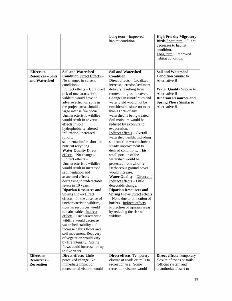
Long term – Improved
habitat condition.
High Priority Migratory
Birds Short term – Slight
decreases to habitat
condition.
Long term – Improved
habitat condition.
Effects to
Resources – Soils
and Watershed
Soil and Watershed
Condition Direct Effects –
No changes in current
conditions.
Indirect effects – Continued
risk of uncharacteristic
wildfire would have an
adverse effect on soils in
the project area, should a
large intense fire occur.
Uncharacteristic wildfire
would result in adverse
effects in soil
hydrophobicity, altered
infiltration, increased
runoff,
sedimentation/erosion and
nutrient recycling.
Water Quality Direct
effects – No changes.
Indirect effects –
Uncharacteristic wildfire
would result in increased
sedimentation and
associated effects
decreasing to undetectable
levels in 10 years.
Riparian Resources and
Spring Flows Direct
effects – In the absence of
uncharacteristic wildfire,
riparian resources would
remain stable. Indirect
effects – Uncharacteristic
wildfire would decrease
watershed stability and
increase debris flows and
soil movement. Recovery
of vegetation would vary
by fire intensity. Spring
flows could increase for up
to five years.
Soil and Watershed
Condition
Direct effects – Localized
increased erosion/sediment
delivery resulting from
removal of ground cover.
Changes in runoff rates and
water yield would not be
considerable since no more
than 11.9% of any
watershed is being treated.
Soil moisture would be
reduced by exposure to
evaporation.
Indirect effects – Overall
watershed health, including
soil function would show a
steady improvement to
desired conditions. This
small portion of the
watershed would be
protected from wildfire.
Herbaceous ground cover
would increase.
Water Quality – Direct and
Indirect effects – Little
detectable change.
Riparian Resources and
Spring Flows Direct effects
– None due to utilization of
buffers. Indirect effects –
Protection of riparian areas
by reducing the risk of
wildfire.
Soil and Watershed
Condition Similar to
Alternative B
Water Quality Similar to
Alternative B
Riparian Resources and
Spring Flows Similar to
Alternative B
Effects to
Resources –
Recreation
Direct effects Little
perceived change. No
immediate impact on
recreational visitors would
Direct effects Temporary
closure of roads or trails to
recreation use. Some
recreation visitors would
Direct effects Temporary
closure of roads or trails
(official system and
unauthorized/user) to

20
be noticed.
Indirect effects Uncharacteristic wildfire is
a greater risk in the no
action alternative. A
wildland fire in the area
would displace users,
possibly for many years.
Wildland fire poses a risk
to the Recreational Cabins
and Cole Springs picnic
area facilities. Without fire
or treatment, fuel loads
would likely increase,
increasing the risk of
wildfire.
shift their use to trail and
recreation site locations
outside the project
boundary. Some unofficial
trails would be eliminated
due to slash debris. People
using Faulty Trail and Barts
Trail, and other nearby
Wilderness trails near the
project boundary would
likely hear chainsaws
running, and may encounter
other noise, dust and smoke
related to treatments. This
may decrease the quality of
their hiking experience for
the duration of the project.
Trails used for student
programs by the Sandia
Mountain Natural History
Center would likely be
closed temporarily.
Residents on adjacent lands
are likely to hear chainsaws,
and may observe noise, dust
and smoke during project
treatments. This could be a
concern to area residences.
Indirect effects include
displacement of recreational
visitors because of noise,
dust, slash and other harvest
related effects in the
vicinity of recreation sites
and trails. Short term
reduction in visitation may
also result from publicity
through local and regional
media about project area
issues and actions. Some
recreational visitors would
shift their use to trail and
recreation site locations
outside the project
boundary. Increased tread
width and additional user
trails are possible.
recreation use displacing
individuals for the duration
of the closure. Some
unofficial trails would be
eliminated due to slash
debris. Feathering‖ would
reduce impacts from noise
and dust to Wilderness
users and private land
owners.
Indirect effects include
displacement of
recreational visitors
because of noise, dust,
slash and other harvest
related effects in the
vicinity of recreation sites
and trails just as
Alternative B would create
displacement. Short term
reductions and shifting of
recreational use is likely to
replicate that of
Alternative B. Impacts of
noise and dust on adjacent
landowners may be
reduced under this
alternative as the
―feathering‖ may buffer or
filter the noise and dust.
Existing tread width would
be easier to hold in the
feathered areas where
vegetation density is
greater.

21
Chapter 3 - Environmental Consequences
This section summarizes the physical, biological, social and economic environments of the
affected project area and the potential changes to those environments due to implementation of
the alternatives. Complete specialist reports are available in the Process Record
Fuels and Fire Behavior Matt Rau, Assistant Fire Management Officer, Sandia RD
Introduction
Management activities such as fire suppression, timber harvesting, and grazing programs have all
had significant affects on vegetation and fire regimes within the project area. Historically, natural
fire burned throughout the project area relatively frequently, usually within a six year mean fire
return interval (Baisan, 1997). High frequency and low intensity fires served to minimize
regeneration of tree and shrub species, leaving a mosaic pattern of tree densities in the pinion /
juniper woodlands while in the ponderosa stands an open grassy park-like landscape with large
fire resistant trees.
Fire Regime
Fire regime is a description of the role fire plays in an ecosystem without the presence of modern
human mechanical intervention, but including the influence of aboriginal burning (Agee,1993).
Five primary fire regime groups have been developed by Hardy et al. (2001) and Schmidt et al.
(2002). These are coarse scale and simplified categories that help in understanding the ecological
fundamentals of the biotic systems that occur on this landscape, and its previous relationship with
fire as a process which acted on them at different frequencies and resulting severities for
thousands of years.
Fire Regime I This system includes the lower and mid-elevation forested plant associations such as, Ponderosa
Pine, and Douglas-Fir. These regimes historically had a high fire return interval ( 0-35 years)
preventing high fuel loadings. The net result was more frequent and less severe fire occurrence.
Fire Regime II This system is also in the lower to mid elevation range, however it includes grassland plant
associations. These regimes have a high fire return interval (0-35 years) with a mix of low and
high severity fires. This system includes pinion / juniper, mountain mahogany, and other dry
mountain shrub species.
Fire Regime III This system consists of forest plant associations located at mid elevation. Species found there are
consistent with higher moisture availability such as Douglas fir, higher elevation bunch type
grasses and forbs. The fire return interval is 35 to 100+ years with a mix in fire severity. Stand
replacement fire may occur but are usually rare events. This regime is typically a heterogeneous
landscape.

22
Fire Regime IV This system is characterized by forested species at mid to high elevation. Spruce, and sub-alpine
fir plant associations are included within this group. This regime is generally
considered as having a fire free period of 100+ years. This usually results in a stand replacement,
high intensity fire occurrence.
Fire Regime V This is a high elevation system, and the plant associations depend upon high local moisture
availability. Due to the very long fire return interval in excess of 200 years, this regime is
generally considered fire free. Rock, lack of fuels and other combinations of the physiographic
setting typically inhibit propagation of fire.
Condition Class
Potential vegetation groups have been mapped for the Cibola National Forest and are closely
associated with fire regimes. The Dry Mixed Conifer Forest group including ponderosa pine sites
and lower elevation conifer is most closely represented by Fire Regime I. Fire Regime II is tied to
the Hot Dry Shrub-lands and Woodlands including juniper / pinion. The mid elevation Mixed
Conifer group is best represented by Fire Regime III. The mid to high elevation spruce-fir
vegetative group is represented by Fire Regime IV. Finally, the high elevation shrub group
including Gambel oak is represented by Fire Regime 5.
Condition Class 1 areas are generally within or near the historical range and do not predispose the
system to risk of loss of key ecosystem components. Vegetation groups are intact and functioning
within the natural range of variability.
Condition Class 2 areas develop as one or more fire return intervals miss resulting in continued
growth of under-story and species reproduction. Vegetation composition and structure have
moderate departure from the natural range of variability and are predisposed to risk or loss of key
ecosystem components. Fires would burn with greater intensity making them difficult to suppress
and would result in changes in biodiversity, soil productivity, and water quality.
Condition Class 3 can be described as significant departure from the natural range of variability
and predispose the system to a high risk of loss of key ecosystem components. Large scale insect
damage and disease are usually present, and may become uncharacteristic while increasing
available fuels. Extreme fire behavior is typical with this departure state, and usually would result
in a complete stand replacement occurrence.
Existing Condition
Introduction
The impact of human population on the landscape has varied over time as cultural patterns,
resource needs, population densities, and land-use practices have changed.
The development of a heterogeneous landscape pattern of the Sandias was interrupted by intense
sheep, goat, and cattle grazing by the late 16th century (Wozniak, 1995). Grazing pressure on the
local forest resources grew to a high of two million head by 1779. After the end of the American

23
Civil War substantial economic activity again increased the demand for Forest products in the
project area, as timber harvesting in 1880 fueled the railroad expansion in the Southwest. During
this use and occupation, fire was suppressed and not allowed to naturally regulate the system.
Continued population expansion since 1804 has resulted in increased for recreational use in the
Sandia Ranger District as a whole. The adjacent lands in the vicinity of the project are now
dominated by large urban communities. Due to the resultant extreme high fuel loadings and high
values at risk, fire suppression continues to be a standard course of action.
Conditions
Due to the late-seral closed state of the existing vegetation, increased fuel loadings, and grossly
overdue fire return interval, the majority of the area is at risk of loss of key ecosystem
components. A significant and long duration departure from the natural regime has occurred
across the project area. In Period II (1681-1784) the fire return interval doubled from 6 years to
11.2 years. Period III (1785-1905) reflects a continued departure with fire completely absent in
fire regime III. Period IV (1906-1992) reflects a complete absence of landscape natural fire
indicating a strong potential for uncharacteristic stand replacement wildland fire, decreased
recreational value, widespread disease and insect damage. With the increase in fuel availability
and loading, it can be deduced that the inherent probability of an ignition of wildland fires also
increases.
Table 2 displays the fire regimes and existing condition class within the Hondo Fuels Reduction
Project Area.
Table 2. Fire Regimes and Existing Condition Class
Fire Regime Group
Historic Fire Return Interval
Condition Class
Approx. Percentage
within project area
I 0 - 35 years 2 0 %
I 0 – 35 years 3 5 %
II 0 - 35 years 3 55 %
III 35 - 100+ years 3 40 %
IV 35 - 100+ years 3 0 %
V >200 years 3 0 %
Crown Base Height & Canopy Bulk Density
Crown base height (CBH) and canopy bulk density (CBD) influence fire behavior, and can be
directly managed by thinning or similar forest treatments (Graham and others 1999). Crown base
height is the measurement in feet from the ground to the base of the crown. The lower the crown
base height the more likely the surface fire would reach the crowns and torch individual trees and
initiate a crown fire. Thinning from below and prescribed burning often results in higher crown
base heights thus lessening the potential for crown fire initiation. Currently over 70% of the area
has a CBH of 10 feet or less. CBH ranges from 3 to 35 feet in the proposed project area with the
majority (75%) of the crown being less than 10 feet from the ground.

24
Ladder fuels are vegetation arrangements that allow fire to climb up vegetation into the crowns of
the over story. Often thinning from below and prescribed burning eliminates some of the ladder
fuels. CBH is directly related to ladder fuels. When an abundance of ladder fuels exist the average
height to the crown ratio is lowered and a lower surface fire flame length is needed to initiate
torching and crowning of over story species. The Hondo Fuels Reduction Project area has
numerous pole size trees and areas with abundant regeneration that contributes to heavy
concentrations of ladder fuels, thus the risk of a crown fire is high.
Canopy Bulk Density is the primary controlling factor of crown fire behavior, and it depends on
both species composition and stand density (Graham and others 1999). CBD is measured in
kilograms per meter cubed and is the amount of mass in the canopy of a stand. CBD is an
indicator of the incidence of interlocking crowns which can tells us how a crown fire can spread.
In general, the lower the CBD, the higher the wind speed has to be to sustain a crown fire. CBD’s
of 0.08 kg/mˆ3 and above are considered high. Present average CBD of all stands in the analysis
area is 0.057 kg/mˆ3, ranging from 0.021 kg/mˆ3 to 0.186 kg/mˆ3. 22% of the area currently has
a CBD over 0.08 kg/mˆ3, and 35 % of the area has a CBD over 0.057 kg/mˆ3 resulting in
increased chances of crown fire activity.
Stand Density Index
Stand density index (SDI) is defined as a comparison of stand density in relation to tree size.
This measurement better reflects stand characteristics rather than looking at trees per acre or basal
area alone. SDI is a measure that is used to compare density of the forest. At 35% of maximum
SDI, trees fully occupy the site. At higher densities competition among trees either results in
reduced growth and vigor on individual trees, or may result in competitive stress and tree
mortality (Page 2006). Present average SDI for the project area is 68.7%, ranging from 18 to
99%. 95% of the Hondo Fuels Reduction Project analysis area currently has a SDI greater than
35%. In terms of fire behavior this condition greatly contributes to crown fire potential. See
Silviculturist Report for more information on current SDI.
Risk
Fire hazard most commonly refers to the difficulty of controlling wildfire events. Characteristics
of fire behavior such as intensity, rate of spread, and resistance to control are generally utilized to
determine and describe the hazard. As Brown et al (2003) indicated fire severity is considered an
element of fire hazard. More importantly related to this report, is fire risk. Fire risk is the chance
of a fire start from an ignition source and is determined by utilizing the frequency of historical
fire starts. A current four year fire history is utilized to most closely reflect the actual potential
expressed as an existing condition.
Fire statistics for the Hondo Fuels Reduction Project area between the years 2004-2008 are
recorded in Table 1.2. Human caused fires account for the majority of the statistical fires within
and directly outside the project area. Lightning, considered a natural cause, accounts for the
remaining fires. Table 3 reflects statistical human and lightning caused fires in proximity to
current project area.

25
Table 3. Statistical Human and Lightning Caused Fires in Proximity to the Project Area
Use Human Lightning Roads 1
Trails 1
Trailheads 1
Recreation Site 8
Dispersed 3
Proximity values are based on distance (2 miles) from the feature.
Table 4 displays historical weather conditions across a range of conditions (normal through
extreme). Source – Remote Automated Weather Stations (RAWS)
Table 4: Seasonal Fire Behavior
Attribute
50th
Percentile
Normal Conditions
90th
Percentile
Severe Conditions
97th
Percentile
Extreme Conditions
1-hour fuel moisture % 5 3 2 10-hour fuel moisture % 8 3 2
100-hour fuel moisture % 13 6 4 1000-hour fuel moisture % 14 7 6
Herbaceous fuel moisture % 48 4 3 Live Woody fuel moisture % 75 60 60
20-foot wind speed (mph) 5 8 12 *Mid-flame wind speed
(mph) 1.5 2.4 3.6
Temperature-max (degrees) 78 87 92
Fuel Model (FM) 5 out of the 13 described in ―Aids to Determining Fuel Models for Estimating
Fire Behavior‖ (Anderson 1982) best characterized the existing fuel model within the project
stands. TU1 (161) was also modeled to simulate surface fire behavior post treatment. Complete
BehavePlus input and output modeling data is located in Appendix D. Table 5 shows results of
BehavePlus calculations for FM 5 (Current project stands fire behavior predictions) and TU1
(161) (Post treatment project stands fire behavior predictions).
Table 5: BehavePlus Outputs for FM 5. Current Condition Model.
Attribute 50th
Percentile
Normal Conditions
90th
Percentile
Severe Conditions
97th
Percentile
Extrm Conditions Rate of Spread ch/hr 13.9 24.4 37.1 Heat per Unit Area BTU/ft2 708 773 809 Fire line Intensity Btu/fts 180 346 551 Flame Length ft 4.9 6.6 8.2

26
BehavePlus Outputs
In FM 5 (see Table 4), fires burn with greater intensity in the surface and ground fuels. FM 5
reflects higher concentrations of fuel than FM TU1 (161). Crowning and torching of trees is more
frequent in this model, leading to potential fire control problems. In FM TU1 (161) (see Table 5)
fire intensity and flame lengths are both lower in which generally allows for direct attack or is
―manageable‖ by ground based suppression forces.
Treatment vs. Non Treatment
Further analysis was done using an excel spread sheet to chart the difference between treatment
and non treatment. The inputs that were used for the calculations best match Alternative B. Fuel
model of TU1 (161) was used which is a low load dry climate timber-grass-shrub model. TU
(161) is the best representative of the project area. Inputs for untreated are as follows: CBH 3
meters, CBD 0.008 Kg/m^3, SDI 68.7, live herb 30%, live woody 60%, foliar moisture 100%.
Inputs for treated are as follows: CBH 6 meters, CBD 0.004 Kg/m^3, SDI 68.7, live herb 30%,
live woody 60%, foliar moisture 100%. Original untreated inputs where taken from FVS runs
while treated where derived from managers desired results. In all of the figures in Appendix A
there is a decrease in intensity, flame length, and rate of spread.
Environmental Consequences
Introduction
It is important to note that fire is boundary-less by nature. There are many elements, some of
them discussed within this report, that drive fire growth and spread potential. It is therefore
understood that cumulative effects, on site-land management practices, and off-site land
management practices are all co-related and overall risk is shared.
Direct and Indirect Effects
Alternative A (No Action)
Under this alternative fire risk would continue to increase exponentially in a manner consistent
with increased population, public use, and fuel loading. Conditions which support crown fires
would likely continue. Potential for larger fire growth would still exist. Areas that safely control
fire with emergency response would remain extremely limited and a defensive tactical approach
may become necessary. This could result in delayed tactical implementation and result in
potential for larger fire growth with high resistance to control. Potentially, the wildfire could not
be contained within the Forest boundary resulting in threats to public safety and property. The
potential for adverse effects to public safety or property would continue to be high.

27
Alternative B (Proposed Action)
Alternative B would create a stand structure reducing the potential for crown fire although the
potential for fine fuels such as grasses increases. The tree removal prescription would create an
open stand structure with a much lower stand density index (25-35% of maximum SDI). This
open stand structure would also create a much lower canopy bulk density due to the increase in
canopy spacing and lowering in trees per acre. In the open thinned areas the trees would also be
limbed up to remove the ladder fuels resulting in a much higher crown base height. This type of
canopy spacing and limbing would result in an environment much less likely to support crown
fire initiation or sustainment of a crown fire burning into the area. Part of the treatment calls for
the retention of groups of trees randomly spaced throughout the unit for wildlife habitat. In these
grouped areas group torching of trees would be possible, but would not affect the overall integrity
of the fuel breaks effectiveness. Fine fuels could create an environment where ground fire moves
faster, but fires would show low to moderate fire behavior with low resistance to control.
Wildfires within the Hondo Fuels Reduction Project area would be more likely to be contained
before they enter either private land or wilderness. Crown fires entering the Hondo Fuels
Reduction Project area from either private land or wilderness could potentially go back to a
ground fire giving emergency personnel a chance to safely contain the fire. This would be a direct
result from the reduction in canopy bulk density, increase in canopy base height, and an overall
lowering of the stand density index. Maintenance of the Hondo Fuels Reduction Project area
through selected removal of understory and low intensity prescribed fire would help ensure the
effectiveness of this fuel break.
Table 6: BehavePlus Outputs for FM TU1 (161). Post Treatment Model Alternative B.
Attribute 50th
Percentile
Normal Conditions
90th
Percentile
Severe Conditions
97th
Percentile
Extrm Conditions Rate of Spread ch/hr 1.7 3.0 4.6 Heat per Unit Area BTU/ft2 411 460 487 Fire line Intensity Btu/fts 13 26 41 Flame Length ft 1.5 2.0 2.5
Alternative C (Modified Proposed Action)
Fire suppression abilities would be improved from that of the No Action alternative, but not as
effective as the Proposed Action alternative. While fire spread decreases intensity increases
dramatically leading to a higher potential for crown fire (table7). This alternative would
compound the effectiveness of the treatment further by increasing the residual burn time leading
to damaged roots and potentially changing the soil structure to a primary succession (Certini
2003).
Because of the limited access due to private land and terrain it would be difficult to reduce the
amount of residual fuels with chipping, mastication, and fuelwood gathering. Therefore, without
prescribed fire, a more continuous bed of slash type fuels could be created defeating the purpose
of a fuels reduction fuel break. This condition would lead to more intense ground fires with
moderate to high fire behavior and increased resistance to control and containment.

28
Table 7:BehavePlus Outputs for FM 11. Post Treatment Model Alternative C.
Attribute 50th
Percentile
Normal Conditions
90th
Percentile Severe
Conditions
97th
Percentile Extrm
Conditions Rate of Spread ch/hr 5.6 10.1 16.4 Heat per Unit Area BTU/ft2 2226 2668 2955 Fire line Intensity Btu/fts 227 496 890 Flame Length ft 5.5 7.8 10.2
Effects Common to All Alternatives
It is understood that the project area holds a high recreational value, due primarily to the
proximity to a large urban community, hiking trails, and developed recreation sites. With the
population increase anticipated to continue, it can be expected that the use of the project area
would increase at an equal rate. Consideration of increased risk could be managed under the
Cibola Fire Management Plan which would restrict or close these areas under extreme fire
conditions. Public access into areas currently prohibited or limited under previous decisions
would continue as designated.
Riparian areas such as Cole and Mud Springs would probably exceed the range of historical
levels of fuels in 10-20 years leaving these areas susceptible to higher fire severity.
Effects Common to All Action Alternatives
Managed roads and trails could also be effectively utilized for fire-line construction during an
emergency or during fuels treatment projects. During fuels treatments, there is increased human
activity and equipment that could start fires. However, that can be mitigated by starting the
project during favorable weather conditions and limiting it to certain times in the year. An
increase of fine fuels (grass) 0-2 tons per acre, can be expected. As stated earlier in this report,
grass would reduce the fire behavior with low resistance to control.
Cumulative Effects
For this project, the cumulative affects area was considered to be the project area and ongoing or
reasonably foreseeable actions that could affect fire and fuels. These actions include the planning
of the Sulphur Project Area that shares the northern most boundary of the Hondo Fuels Reduction
Project area, private land fuels treatments, and hazard tree removal along trails and developed
recreation sites.
A fuels reduction/forest health project is planned on the northern boundary of the Hondo Fuels
Reduction Project area. Implementation is still 2-5 years from happening. The potential for
future high fire severity affects would be reduced over a larger landscape and would continue to
strengthen the Hondo Fuels Reduction Project area resiliency.
Fuel treatment on private lands, specifically the New Mexico Museum of Natural History and
Science, has reduced the fuel loading on adjacent lands bordering the east boundary of the Hondo

29
Fuels Reduction Project area. These treatments would improve suppression capabilities on that
land should a fire occur.
Hazard tree removal would slightly reduce fuels within the areas that are being treated. This
reduction would not be enough to affect fire behavior except on a limited basis if there are
enough trees removed due to them being a hazard.
Implementation of fuels reduction projects need to consider the intended recreation usage of the
area. A symbiotic relationship exists regarding road and trails. One of the unintended results of
fire-line construction or creation of fuel-breaks often result in increased traffic and user created
routes that require mitigation or obliteration. An example is NFRS 9 which was simply an access
route created by fuel wood permit holders during the Heatherland Hills Fuels Reduction &
Wildlife Habitat / Forest Health Improvement project. It quickly became a high use area and
because of the recreational value is now designated as a system route.
Conversely, valued and managed recreational routes are usually located geographically and
topographically so that they allow easy compartmentalization of areas without having to construct
new fire-line. An example of this is the implementation of the David Canyon Forest Health
Project (1998) in which entire trail systems made up the compartments for implementation of
landscape prescribed fire. After the fuels reduction project was completed the trail was improved
with erosion barriers, minor re-routing, and thus became more ecologically sustainable.
Currently in assessment, the Hondo Fuels Reduction and Sulphur project areas would utilize
several existing system trails. Focused primarily on reduction of the Condition Class, these
projects would also offer increased recreational value by increasing the system bio-diversity,
available habitat for Flora and Fauna species, and better overall Forest health.
Wildlife Beverly DeGruyter, Wildlife Biologist, Cibola NF
Affected Environment
Wildlife habitat in the Hondo Fuels Reduction Project area includes: pinyon-juniper-271 acres;
ponderosa pine-105 acres; and mixed conifer-23 to 30 acres. The Cibola National Forest GIS
general vegetation layer used to analyze habitat types in the project area shows 18 acres of
riparian; but true riparian (wetland vegetation such as willows, sedges, cottonwoods) occurs at
only three small sites in the project area (Cole Spring, Mud Spring and Paradise Spring). Wildlife
analyzed in this report include Management Indicator Species (MIS), threatened/endangered or
sensitive species and high-priority migratory birds.
There is a direct connection between vegetation types and wildlife use of sites in the project area.
Reduction of natural processes such as low fire intervals in the pinyon/juniper type have resulted
in a tightly closed woodland canopy, and a reduced grass, shrub, and forb understory. Wildlife
species dependent on diverse habitat within the woodland system are limited due to lack of
understory vegetation. Portions of this habitat type are in the urban interface zone which limits
wildlife use due to human presence.

30
Some ponderosa pine stands lack the understory vegetation necessary for wildlife species
diversity. Management of habitat for the northern goshawk is an important consideration in this
habitat type. In the mixed conifer forest, much of the habitat in the project area is former
ponderosa pine habitat that, due to lack of fire, is being invaded by white fir. Most of the mixed
conifer occurs on more moist sites in scattered drainages. Due to fire suppression, a gradual yet
continual buildup of coniferous trees has increased tree density of all species in the project area,
resulting in high potential for ladder fuels (smaller, dense stands of trees that allow wildfires to
reach the canopy) to accumulate. This dense accumulation also shades the understory, reducing
grass/forb and shrub components essential as wildlife forage and cover.
Management Indicator Species
Based on the habitat types that exist in the analysis area the following management indicator
species (MIS) were selected for analysis: elk, mule deer, juniper titmouse, black bear, pygmy
nuthatch, hairy woodpecker, and Merriam’s turkey. Only those MIS likely to occur in the project
area were analyzed. Table 2 describes the habitat type, habitat trends, management indicator
species, and MIS population trends. Refer to the Forest wide and project level MIS reports in the
project record for a complete description of MIS species and their habitat associations.
Table 8. Habitat Types, Associated MIS, and Forest-wide Habitat and Population Trends
Habitat
Type
Acres in
Project
Area
Existing
Forest wide
Habitat Trend
Management Indicator
Species
Existing Forest wide
Population Trend
Pinyon
juniper
woodland
271
Stable Mule deer Downward
Juniper titmouse Downward
Ponderosa
Pine
105
Stable Pygmy nuthatch Stable
Merriam’s turkey Upward
Mixed
conifer
23-30
Up Hairy woodpecker Downward
Black bear Stable
Elk Upward
MIS habitats and existing condition in the project area are described below:
Pinyon -juniper woodlands are important to wildlife because they provide nuts and berries that
are readily available forage for many wildlife species, critical winter range for game mammals
and birds, travel corridors, thermal cover, dead and down woody material, snags for cavity
nesting species, and human created water sources.
Ponderosa pine forests provide forage and cover for many species of wildlife. Habitat features
common in ponderosa pine forest include roost and nest trees, snags and large downed logs,
abundant needle litter, thermal cover, travel corridors, grassy forest openings, fawning areas for
deer, and natural and human created water sources. In some ponderosa pine stands on the Hondo
Fuels Reduction Project, understory vegetation necessary for wildlife species diversity is lacking.
Management of habitat for the northern goshawk is an important consideration in this habitat type
(see the Biological Assessment and Evaluation for the Hondo Fuels Reduction Project).
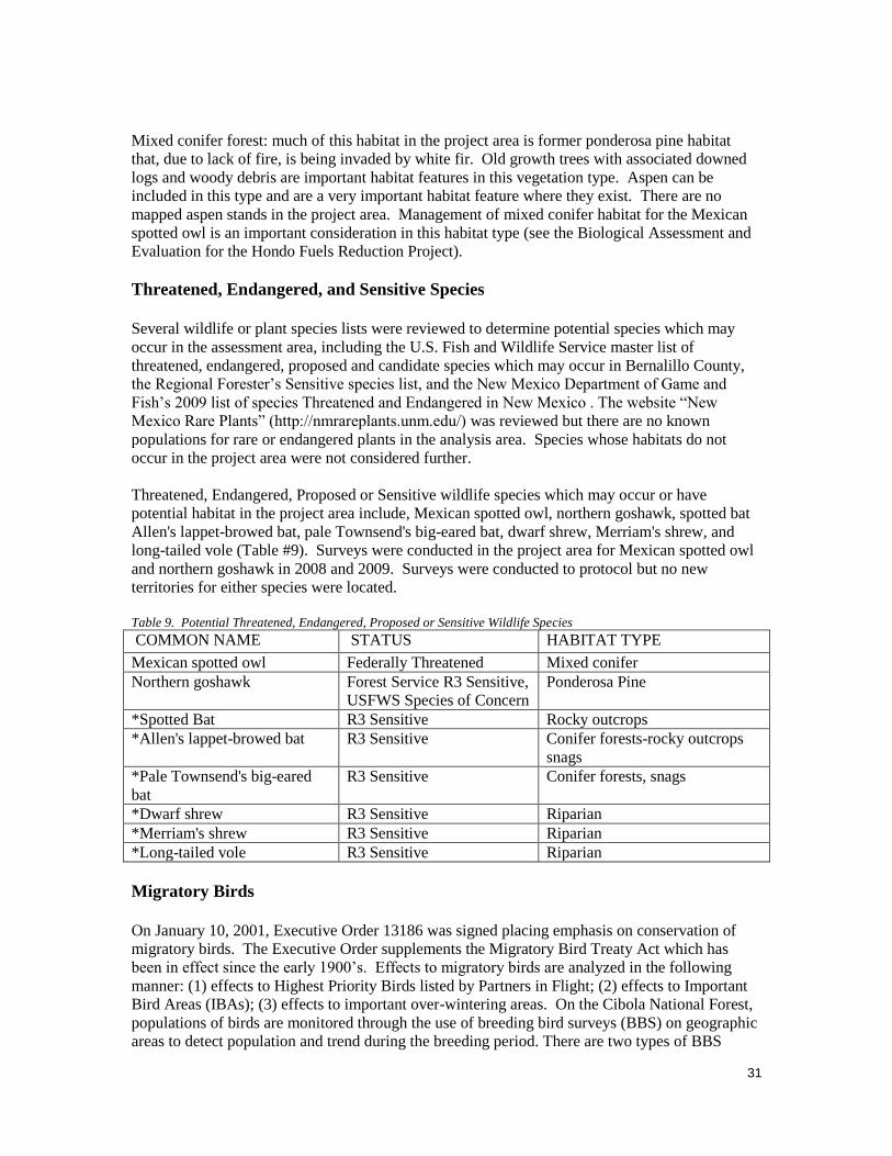
31
Mixed conifer forest: much of this habitat in the project area is former ponderosa pine habitat
that, due to lack of fire, is being invaded by white fir. Old growth trees with associated downed
logs and woody debris are important habitat features in this vegetation type. Aspen can be
included in this type and are a very important habitat feature where they exist. There are no
mapped aspen stands in the project area. Management of mixed conifer habitat for the Mexican
spotted owl is an important consideration in this habitat type (see the Biological Assessment and
Evaluation for the Hondo Fuels Reduction Project).
Threatened, Endangered, and Sensitive Species
Several wildlife or plant species lists were reviewed to determine potential species which may
occur in the assessment area, including the U.S. Fish and Wildlife Service master list of
threatened, endangered, proposed and candidate species which may occur in Bernalillo County,
the Regional Forester’s Sensitive species list, and the New Mexico Department of Game and
Fish’s 2009 list of species Threatened and Endangered in New Mexico . The website ―New
Mexico Rare Plants‖ (http://nmrareplants.unm.edu/) was reviewed but there are no known
populations for rare or endangered plants in the analysis area. Species whose habitats do not
occur in the project area were not considered further.
Threatened, Endangered, Proposed or Sensitive wildlife species which may occur or have
potential habitat in the project area include, Mexican spotted owl, northern goshawk, spotted bat
Allen's lappet-browed bat, pale Townsend's big-eared bat, dwarf shrew, Merriam's shrew, and
long-tailed vole (Table #9). Surveys were conducted in the project area for Mexican spotted owl
and northern goshawk in 2008 and 2009. Surveys were conducted to protocol but no new
territories for either species were located.
Table 9. Potential Threatened, Endangered, Proposed or Sensitive Wildlife Species
COMMON NAME STATUS HABITAT TYPE
Mexican spotted owl Federally Threatened Mixed conifer
Northern goshawk Forest Service R3 Sensitive,
USFWS Species of Concern
Ponderosa Pine
*Spotted Bat R3 Sensitive Rocky outcrops
*Allen's lappet-browed bat R3 Sensitive Conifer forests-rocky outcrops
snags
*Pale Townsend's big-eared
bat
R3 Sensitive Conifer forests, snags
*Dwarf shrew R3 Sensitive Riparian
*Merriam's shrew R3 Sensitive Riparian
*Long-tailed vole R3 Sensitive Riparian
Migratory Birds
On January 10, 2001, Executive Order 13186 was signed placing emphasis on conservation of
migratory birds. The Executive Order supplements the Migratory Bird Treaty Act which has
been in effect since the early 1900’s. Effects to migratory birds are analyzed in the following
manner: (1) effects to Highest Priority Birds listed by Partners in Flight; (2) effects to Important
Bird Areas (IBAs); (3) effects to important over-wintering areas. On the Cibola National Forest,
populations of birds are monitored through the use of breeding bird surveys (BBS) on geographic
areas to detect population and trend during the breeding period. There are two types of BBS

32
survey done on the Cibola National Forest: The U.S. Geological Survey monitoring routes, which
are 24.5 miles in length, and Cibola NF BBS routes. These latter surveys are from one to two
miles in length with either six to eleven points, respectively. Each point is surveyed for 10
minutes. The nearest Cibola NF BBS route at Armijo Canyon is located approximately .55 miles
from the northern boundary of the project. The Armijo Canyon route is in similar habitat and
elevation (except it has much less pinyon-juniper). The Cienega Canyon route is approximately
1.5 miles from the projects’ northern boundary; it is also similar in elevation, however it is
confined to a deeper, cooler canyon than is representative of the project area.
Priority Birds identified for the Southern Rockies/Colorado Plateau Conservation Region were
reviewed for potential occurrence in the project area. Priority bird habitat in the project area is:
pinyon-juniper, ponderosa pine, and mixed conifer. Cole Spring (developed) is immediately
below the former Cole Spring Picnic Area provides some riparian habitat. Two other small
seeps/springs contain some riparian vegetation as well. Drainages in the general vegetation layer
are defaulted (typed) as riparian even if no riparian vegetation is present. All drainages in the
project area are ephemeral (flowing only in response to precipitation). Different vegetation types
provide habitat for a variety of migratory birds. There is no link or project level association with
the nearest IBA which is located about 2.6 miles away on the south side of the Sandia Mountains.
There are no over-wintering areas identified in the project area.
Table 10 Migratory Bird Species Evaluated In The Vegetation Types In The Analysis Area.
Vegetation
type Species General Trend Comments
Pinyon-juniper
Pinyon jay Unknown This species was not located along
breeding bird surveys in the area
but the species may use the area as
foraging habitat.
Virginia’s warbler Stable to slightly
increasing
The species is common when
Gamble oak understory is available
Black-throated gray
warbler
Unknown The location of this species is
generally in elevations lower than
the project area
Ponderosa Pine
Flammulated owl No trend data is
available
This species occurs commonly
where large, old ponderosa pine
trees exist.
Red-naped
sapsucker
Stable The area is in marginal habitat
where the species may briefly
occur as a migrant.
Grace’s warbler Upward The area contains suitable habitat,
although the patches of ponderosa
habitat are not contiguous.
Mixed Conifer
Band-tailed pigeon Unknown The species is probably not
common within the project area.
Broad-tailed
hummingbird
Stable to slightly
increasing
There is suitable habitat that occurs
from about 7,000 feet upwards for
this species.

33
Environmental Consequences:
Management Indicator Species
Alternative A – No Action
The No Action Alternative would not reduce the tree densities in the Hondo Fuels Reduction
Project area; density and canopy cover of all timber types would continue to increase throughout
the project area. Existing small openings and forb/shrub/grassland areas would continue to
decrease in size.
Table 11. Summary of No Action Affects for MIS
Management
Indicator
Species
Direct Affect-Alternative A (No
Action)
Affect to Forest wide
Population/Habitat Trend
Elk Reduces habitat quality due to
continued dense canopy growth
reducing understory forage
N
Mule deer Reduces habitat quality due to
continued dense canopy growth
reducing understory forage
N
Juniper
titmouse
Reduces habitat quality due to
continued dense canopy growth
reducing insects and other food sources
N
Black bear Reduces habitat quality due to
continued dense canopy growth
reducing understory forage
N
Pygmy
nuthatch
Unlikely to impact N
Merriam’s
turkey
Minimal Impact N
Hairy
woodpecker
Unlikely to impact N
N=Negligible impacts to populations or habitat (Forest-wide);
Summary –Action Alternatives Affects to MIS
In general there would be no change in the population or habitat trend of MIS species at the
Forest level. Implementation of the proposed action or alternative C would result in short term
displacement due to treatment activity (noise and human presence). Snags used by cavity nesting
MIS birds would be retained. In the long term, forage condition and availability would improve
for all species due to reduced canopy cover and retention of oaks and other shrubs. The risk of
stand replacing wildfire would be somewhat reduced.

34
Table 12. Summary of Effects for MIS Species- Alternatives B and C
Management
Indicator
Species
Direct Affect-Proposed
Action
& Alternative C
(species)-
short term
(project level)
Affect-Proposed Action
and Alternative C-long term
habitat impacts (project)
Affect to
Forest wide
Population
Trend
Elk Short-term displacement
due to human activity
unlikely.
IC-improves foraging habitat- no
change in habitat quantity
N
Mule deer Short term displacement
due to human activity
likely.
IC- improves browse forage
availability and quality- no
change in habitat quantity
N
Juniper
titmouse
Short term displacement
due to human activity
likely affecting foraging
habitat.
IC- improves foraging habitat-
treatment occurs outside of the
nesting season, retains snags- no
change in habitat quantity
N
Black bear Short term displacement
due to human activity
likely.
IC- improves mast forage
availability-retains oaks - no
change in habitat quantity
N
Pygmy
nuthatch
Short term displacement
due to human activity
likely affecting foraging
habitat.
NC- activity would occur outside
the nesting season- snags would
be retained. Large diameter trees
would be retained.
N
Merriam’s
turkey
Short term displacement
due to human activity
NC-Treatment activity occurs
outside the nesting season-
openings would provide
improved forage conditions for
poults.
N
Hairy
woodpecker
Short term displacement
due to human activity
likely
NC-Treatment activity would
occur outside of the nesting
season-snags would be retained.
N
IC= improves habitat condition; DH=decreases habitat condition; NC=no change in habitat
condition. N=No change in population trend at the Forest level.
Threatened/Endangered and Sensitive Species
Alternative A (No Action)
The No Action Alternative would not reduce the tree densities in the Hondo Fuels Reduction
Project area; density and canopy cover of all timber types would continue to increase throughout
the project area. Existing small openings and forb/shrub/grassland areas would continue to
decrease in size. Fuels build-up would continue, leading to a crown fire if wildfire occurs in the
area.

35
Alternatives B and C (Proposed and Modified Proposed)
In general the proposed action and Alternative C provide reduced potential of stand replacing
wildfire since fuels would be reduced throughout the area. The proposed action and alternatives
incorporate designs to lessen effects to threatened, endangered and sensitive species.
Implementation of the proposed actions or alternative C would provide essential habitat
components such as snags, downed logs, residual basal area, and canopy cover necessary for
potential occupancy of TES species.
Table 13. Summary of Effects to TES Species by Alternative
Threatened/Endangered
or Sensitive Species
Alternative A- No Action
Determination of Effect
Alternative B-Proposed Action
and Alternative C
Determination of Effect
Mexican spotted owl Continuation of fuels build-
up, leading to a potential
crown fire if wildfire occurs
in the area.
No effect in the short term
These alternatives would reduce
ladder fuels, maintain snags,
downed logs and residual basal
area for potential MSO
occupancy.
May affect species not likely to
adversely affect species or its
habitat
Northern Goshawk This alternative would allow
fuels to build-up, leading to
a potential crown fire if a
wildfire occurs in the area
No impact to the species in
the short term
Alternatives would treat the
dense, overstocked stands of
ponderosa pine in the project
boundary to the standards set
forth in the Management
Recommendations for the
Northern Goshawk.
Implementation of these
alternatives would improve
habitat conditions for both the
goshawk and its prey species.
May impact individuals, but is
not likely to result in a trend
toward federal listing or loss of
viability
Spotted Bat Continuation of fuels build-
up could lead to a potential
crown fire if wildfire occurs
in the area
There would be slight direct
impact to the species but large
trees would remain and riparian
areas would be maintained.
May impact individuals, but is

36
Dwarf Shrew Continuation of fuels build-
up could lead to a potential
crown fire if wildfire occurs
in the area thus reducing
hiding cover of the species
and its prey species
No impact on the species in
the short term
The species has the potential to
occur in the area. The tree removal
may have a minor impact to the
species, as this would remove the
tree understory cover of
seedlings/saplings/pole sized trees.
May impact individuals, but is not
likely to result in a trend toward
federal listing or loss of viability
Merriam’s Shrew Continuation of fuels build-
up could lead to a potential
crown fire if wildfire occurs
in the area thus reducing
hiding cover of the species
and its prey species
No impact on the species in
the short term
The species has the potential to
occur in the area. Tree removal
may have a minimal impact on the
species.
May impact individuals, but is not
likely to result in a trend toward
federal listing or loss of viability
Long-tailed vole Continuation of fuels build-
up could lead to a potential
crown fire if wildfire occurs
in the area thus reducing
Project activities would be
minimized adjacent to permanent
water sources. Consequently, the
likelihood of impacts to this
No impact on the species in
the short term
not likely to result in a trend
toward federal listing or loss of
viability
Allen’s lappet-browed bat Continuation of fuels build-
up could lead to a potential
crown fire if wildfire occurs
in the area thus reducing the
species’ prey population
No impact on the species in
the short term
Overall impacts would be
minimal since snags and larger
diameter trees would be retained
improving roosting habitat.
May impact individuals, but is
not likely to result in a trend
toward federal listing or loss of
viability
Pale Townsend’s big-eared
bat
Continuation of fuels build-
up could lead to a potential
crown fire if wildfire occurs
in the area thus reducing the
species’ prey population
No impact on the species in
the short term
Snags and larger diameter trees
would be retained improving
roosting habitat somewhat, but
overall impacts (if any) are
expected to be insignificant.
May impact individuals, but is
not likely to result in a trend
toward federal listing or loss of
viability

37
hiding cover of the species
and its prey species
No impact on the species in
the short term
species is expected to be slight and
discountable.
May impact individuals, but is not
likely to result in a trend toward
federal listing or loss of viability
High Priority Migratory Birds
Alternative A (No Action)
Under the No Action alternative, fuels build-up would continue, leading to a crown fire if a
wildfire occurs in the area. This would substantially reduce nesting and foraging habitat.
Woodpeckers can benefit in the short term for wildfire, as the dead and dying trees provide insect
habitat; sapsuckers (like the two species below) prefer live trees for their excavations.
Alternatives B and C (Proposed and Modified Proposed)
Thinning activity would occur outside the nesting season (April 1 to July 31), so bird species
would not be directly affected during this critical time period. Displacement of species that are
permanent residents of the project area (pinyon jay and flammulated owl), would occur as a
result of project implementation activities. Large trees would be retained and a more natural
spacing (similar to what occurs in fire-adapted ecosystems where small trees and overly dense
stands are usually removed by natural fire) would result. The short term impacts would be a
reduction in both vertical and horizontal diversity within stands. Since trees would be removed to
create groups and openings and to reduce the ―ladder fuels‖ (trees that allow a fire to easily reach
the canopy or ―crowns‖) this would increase the lower understory layers and eventually result in
increased diversity within the stands. Most bird species do not utilize these smaller diameter trees
as nesting substrate; however, trees in the 9‖ class (particularly in pinyon-juniper stands) may
occasionally be used as nesting substrates. The vertical stand diversity (due to the removal of
smaller, understory trees) would be the component most affected by the action. Horizontal tree
diversity (looking at the stand from directly above) would be impacted as trees between groups
would be removed except for one or two of the larger diameter trees that are retained between
groups. For the most part, areas with extent small diameter trees (where a larger overstory does
not occur) may be removed, thus creating openings in the canopy where none existed. Some
slight impacts could be expected in the short term to nesting habitat; but as noted, these small
trees are generally not the preferred nest substrates. Since trees would not be cut during the
primary breeding season, unintentional take of migratory birds is unlikely to occur. Populations
of migratory birds dependent on pinyon-juniper, ponderosa pine and mixed conifer forests would
be maintained as a result of implementation of both action alternatives.
Alternative C would be largely similar in overall impacts, since the feathered areas on each side
are relatively small compared to the overall project width. These ―feathered areas‖ would retain
their existing density, and any species that nested in the smaller diameter trees would not be
impacted within these areas.

38
In the long term, after the thinning occurs and the stands retain a more natural spacing,
populations of birds of conservation concern are expected to show slight to moderate increase, as
opening the understory to increase light to the forest floor would allow for an increased shrub and
forb component, potentially increasing species utilized as food by granivorous birds (seed and
berry eaters), as well as creating a greater mix of understory plant species utilized by insects,
which are preyed upon by insectivorous bird species. Retaining the larger trees, as well as dead
and dying trees with cavities present, would retain the important nesting substrates used by most
of the species. Cavity trees may be reduced somewhat over time since removing the smaller trees
would ―release‖ larger trees (removing root competition allows the remaining trees to increase in
size); thus, trees that may have succumbed earlier due to the dense stocking rates would probably
not be as prevalent.
Table 14 summarizes the impacts (both short and long-term) of No Action, the proposed action,
and Alternative C:
Table 14. Summary of Effects to Migratory Birds
Priority
Bird Species
Habitat Effect-
Alternative
A
(No Action)
Effect-
Proposed
Action-and
Alternative
C -short
term
Effect-
Proposed
Action-and
Alternative
C-long term
Band-tailed
pigeon
Pinyon-juniper to
spruce fir depending
on food availability
(fruits and nuts- esp.
acorns and pine nuts).
NC DH (slightly) IC
Black-chinned
hummingbird
Below 7000 feet, in
canyons with
deciduous trees.
NC DH (slightly) IC
Gray flycatcher Pinyon-juniper (p/j) NC DH (slightly) IC
Flammulated owl Ponderosa pine NC DH (slightly) IC
Williamson’s
sapsucker
Ponderosa/mixed
conifer
NC DH (slightly) IC
Red-naped
sapsucker
Ponderosa/high
elevation riparian,
mixed conifer
NC DH (slightly) IC
Olive-sided
flycatcher
Ponderosa pine, mixed
conifer
NC DH (slightly) IC
Pinyon jay Pinyon-juniper
woodlands
NC DH (slightly) IC
Virginia’s
warbler
Pinyon-juniper,
ponderosa, mixed
NC DH (slightly) IC

39
conifer
Black-throated
gray warbler
Pinyon-juniper NC DH (slightly) IC
Grace’s warbler Ponderosa pine NC DH (slightly) IC
IC= improves habitat condition; DH=decreases habitat condition; NC=no change in habitat
condition
Important Bird Areas (IBAs)
There are no designated IBAs affected by the project. The nearest IBA is the Sandia HawkWatch
site, approximately 2.6 miles away on the south side of the Sandia Mountains.
Overwintering Areas
Important over wintering areas have not yet been recognized on the Forest, thus, none would be
impacted by project implementation.
Wildlife Cumulative Effects
The cumulative effect analysis area for wildlife includes habitat types similar to the project area
(pinyon-juniper woodlands, ponderosa pine and mixed conifer in drainages) along the urban
interface boundary (about 1/4 mile wide) on the east side of the Sandia Mountains. Past activities
in the analysis area that have led to current conditions and include livestock grazing in the early
to mid 1900’s, subsequent removal of livestock from the Forest, exclusion of unplanned fires,
human settlement, and recreational development and use of trails and trailheads. More recent
activities considered as cumulative effects include Forest Service and private lands fuels
reduction treatments in the vicinity of the Hondo Fuels Reduction Project analysis area and along
the urban interface zone. Some of those treatments have occurred in the past 30 years and trees
are becoming reestablished reducing the effectiveness of the treatments. New fuels reduction and
forest health restoration projects on Forest Service managed lands are being proposed along the
urban interface north of the project area. Fuel hazard reduction treatments presently occurring on
private lands are also likely to continue.
Cumulative effects under the No Action Alternative would result in a continuation of existing
habitat conditions for wildlife in the urban interface area since much of this zone has not yet been
treated for fuels reduction. Wildlife species composition and populations on National Forest
system lands would continue to be similar to what is there now. Fuel hazard reduction presently
occurring on private lands is likely to continue and may result in heavier treatments with less
emphasis on leaving untreated patches, snags, downed woody debris and providing for stand
diversity. Existing development and expansion of subdivisions along the urban interface would
continue to fragment and isolate woodland and forested habitats in this area reducing its habitat
value for wildlife on Forest Service managed lands.

40
Cumulative effects related to Alternative B and C would result in the continued treatment of the
urban interface zone resulting in some reduction in the threat of stand replacing wildfire.
Considering that about 3600 acres of wildlife habitat is within ¼ mile of the Forest boundary, the
Hondo Fuels Reduction Project represents about 10 percent of the urban interface zone. Without
reducing the danger from wildfire by some combination of thinning or burning along the entire
urban interface zone and beyond, fuels treatments in the Hondo Fuels Reduction Project area are
likely to reduce the fire severity only within or near the project boundaries. Past, present and
future treatments on Forest Service lands would provide for more sustainable conditions to
maintain vegetation structural and compositional diversity. Expected improvement of forage
habitat on National Forest system lands would tend to reduce wildlife use of housing areas in the
urban interface. The cumulative effects of past and future fuels reduction to wildlife species
dependent on these woodland and forest habitats would be overall beneficial, although the value
of these areas to wildlife is minor due to their proximity to human settlement.
Vegetation Paul Tidwell, Silviculturist, Sandia RD
Affected Environment
Pinyon-Juniper Woodland
Approximately 67% (271 acres) of the analysis area consists of the Pinyon-Juniper Woodland
forest type. This forest type is typically a mix of pinyon pine and one-seed juniper with scattered
ponderosa pine, alligator juniper, wavyleaf oak and gambel oak; the grass/forb/shrub component
is lacking.
Basal areas range from 111 to 291 square feet/acre. Vegetative structural stages are typically
mature/old forests and can be either single or multiple storied. Current Vegetative Structural
Stage (VSS) distribution is primarily (98%) in the VSS 4 and 5 classes (actual breakdown is 2%
VSS 3, 74% VSS 4, and 24% VSS 5).
Percent of maximum Stand Density Index (or ―SDI‖, relative stand density, or crowding, in terms
of the relationship of the number of trees to their average diameter. Reineke, 1933) values tell the
comprehensive story. The weighted average for this forest type is 81% indicating that tree
growth has reached a ―plateau‖ where tree-to-tree competition is intense. Overall vegetation
vigor and health are at a low point making the vegetation susceptible to replacement through
insect and disease activity and/or wildfire. Mortality of pinyon pine and juniper is occurring due
to competition.
There is much within-stand species diversity that isn’t adequately addressed within the overall
forest type classification. Ponderosa pine and white-fir are commonly scattered, though at low
densities, throughout the pinyon-juniper woodland.
Easterly/southeasterly drainages support localized ponderosa pine (with a lesser component of
white fir) ―stringers‖ which provide additional species and structural diversity to the pinyon-
juniper woodlands.
The age (mature/old forest) of these stands indicates the absence of fire for a long period of time.

41
Ponderosa Pine Forest Type
Approximately 26% (105 acres) of the analysis area consists of the Ponderosa pine forest type.
Typically this is the ―dry‖ end of the ponderosa pine type and has scattered pinyon pine and one-
seed/alligator juniper as well as gambel/wavyleaf oak. In moist sites (drainages, etc) oaks tend to
be large and long lived. Also, in the drainages and north slopes, Douglas-fir and white-fir may be
intermixed with the ponderosa pine and may be actually increasing due to lack of fire in the pine
ecosystem. For the same reason, ―ladder fuels‖ are more common in this area and can facilitate
ground fires moving into the tree crowns.
Current Vegetative Structural Stage (VSS) distribution is 62% VSS 3, 14% VSS 4, and 24% VSS
5.
Basal areas per acre range from 137 to 215 square feet per acre. Vegetative structural stages are
typically mid-aged and can be either single or multiple storied.
The grass/forb/shrub component lacks diversity, abundance and vigor.
Again, percent of maximum SDI values tell the comprehensive story. The weighted average for
this forest type is 86% indicating that the forest type also has reached a ―plateau‖ where tree-to-
tree competition is extremely intense. Mortality is occurring and overall vegetation vigor and/
health are at a low point making the vegetation susceptible to replacement through insect/disease
activity and/or wildfire.
There is much within-stand species diversity that isn’t addressed within the overall forest type
classification. Pinyon-juniper and white/Douglas-fir are commonly scattered, though at low
densities, throughout the ponderosa pine forest type.
Pockets of mixed conifer (white and Douglas-fir), up to 5 acres, in size may be found within this
forest type. Easterly/southeasterly drainages support localized white fir (with a lesser component
of ponderosa pine) ―stringers‖ which provide additional species and structural diversity to the
ponderosa pine forest type.
Mixed Conifer Forest Type
Approximately 7% (23-30 acres) of the analysis area consists of the mixed conifer (dominated by
Douglas-fir and white fir) forest type. Typically, these sites are located in moist micro sites such
as incised drainages. This forest type has seen relatively little change, over time, as compared to
the pinyon-juniper woodland and ponderosa pine forest types.
Current Vegetative Structural Stage distribution is 52% VSS 4 and 48% VSS 5.
Basal area/acre range from 215 to 234 square feet per acre. Stand structure is multiple storied
and with a closed canopy. Multi-storied conditions plus live branches near the ground provide a
ready avenue for ground fires to move into the tree crown.
The percent of maximum SDI value is 90% indicating that the stand also has reached that
―plateau‖ where tree-to-tree competition is extremely intense. Mortality is occurring and overall
vegetation vigor and/ health are at a low point making the vegetation susceptible to replacement
through insect/disease activity and/or wildfire.

42
No mapped aspen occurs within the analysis area.
Riparian Forest
Riparian forest conditions (characterized by wetland vegetation such as willows, sedges,
cottonwoods, etc) do occur within the analysis area but in very limited amounts and localized
settings.
Noxious Weeds
―Noxious weeds‖, or invasive plant species, such as spotted knapweed, Canada thistle, salt cedar
and cheat grass already occur on the Sandia Ranger District and can be spread through human
activities (vehicles, etc). (Sandia Ranger District Geographic Area Assessment, page 29. 1999)
Crowning Index and Canopy Bulk Density
Crowning index (the wind speed necessary for a fire that reaches the canopy to continue as a
crown fire) is a key variable used to analyze crown fire potential. Crowning index is primarily
determined by canopy bulk density (the mass per unit volume of canopy biomass that would
burn in a crown fire, primarily foliage and twigs less than 3 mm in diameter), which is the density
of 1-hr fuels (i.e., <¼-in twigs and needles). Forest structures with low crowning indexes require
relatively low wind speeds to maintain spreading crown fires, whereas structures with high
crowning indexes are relatively resistant to crown fires.
Canopy Bulk Density is the primary controlling factor of crown fire behavior, and it depends on
both species composition and stand density (Graham and others 1999). CBD is measured in
kilograms per meter cubed and is the amount of mass in the canopy of a stand. CBD is an
indicator of the incidence of interlocking crowns which can tells us how a crown fire can spread.
In general, the lower the CBD, the higher the wind speed has to be to sustain a crown fire. CBD’s
of 0.08 kg/mˆ3 and above are considered high.
Representative stands for each of the included forest types (pinyon-juniper woodland, ponderosa
pine and mixed conifer) were modeled using the Forest Vegetation Simulator (FVS) to determine
existing canopy bulk density and crowning index values. The crowning index values in Table 15
indicate that relatively low wind speeds would currently sustain a crown fire in all three forest
types.
Table 15. Existing Canopy Bulk Density and Crowning Index
Forest Type Canopy Bulk Density (kg/m3) Crowning Index (mi/hr)
Pinyon-juniper woodland 0.091 25
Ponderosa pine 0.118 21
Mixed Conifer 0.304 10
Old Growth
Old growth resources were analyzed at multiple scales, the first being the midscale ―Sandia
ecosystem management area‖ which includes National Forest lands north of Interstate 40 and
outside the Sandia Wilderness; one scale above, which includes the Sandia ecosystem

43
management area plus the Sandia Wilderness; and, at one scale below, at the Hondo Fuels
Reduction Project level. GIS analysis was used to incorporate a variety of resource information including forest inventory
data, soils data, local knowledge and a review of past disturbances relating to management,
insect/disease and fire activity.
Midscale - The Sandia ecosystem management area is characterized by historical, but
relatively localized disturbance, mostly from wood harvesting at the lower elevation ponderosa
pine and pinyon-juniper woodland forest types over the last 300-400 years. Lack of access to the
higher elevation ponderosa pine and mixed species forests has minimized impacts to those areas.
Fire activity, with the exception of the late 1990-1991 Cooper fire (approximately 175 acres) on
the northern portion of the area, has been minimal.
Allocation of at least 20%, by forested ecosystem management area, of old growth has
been completed (The Plan, page 65). Table 16 shows the gross acreage and the allocated areas
for old growth management for each included forest type. Included are ―de facto‖ old growth
areas (The Plan, page 55) such as the Bernalillo Watershed Research Natural Area and goshawk
nesting areas.
Table 16 – Old Growth Allocation Within the Sandia Ecosystem Management Area
Forest Type Gross Acres Old Growth Allocation (acres)
Pinyon-juniper woodland 16,416 3,330
Ponderosa pine 1,083 456
Mixed species 8,125 1,625
Engelmann spruce-fir 555 555
One scale above - The Sandia Wilderness area supplements the Sandia ecosystem
management area described above to comprise a scale above that initial area. Historic
disturbance within the Wilderness area is even more limited than in the Sandia ecosystem area
due to lack of access, legislative withdrawal of the area as a Wilderness, and lack of historic fire
activity.
All forested areas within the Sandia Wilderness are considered ―de facto‖ old growth
(The Plan, page 65).
Table 17 displays the combined old growth allocated acres by forest type for both the
Sandia ecosystem management area and the Sandia Wilderness.
Table 17 – Old growth Allocation Within the Combined Sandia Ecosystem Management Area and Sandia
Wilderness
Forest Type Gross Acres Old Growth Allocation (acres)
Pinyon-juniper woodland 28,465 15,349
Ponderosa pine 1,277 650
Mixed species 25,963 19,463
Engelmann spruce-fir 874 874
One scale below - The Hondo Fuels Reduction Project area comprises the scale below the
initially described Sandia ecosystem management area. This 400 project area represents that
lower elevation portion of the Sandia ecosystem management area that was typically most
accessible for wood harvest resulting in disturbance related changes to stand structure over time.
No areas that meet the ―Minimum Criteria for the Structural Attributes Used to Determine Old-
Growth‖ were found. At least 20% (The Plan, page 65) of each forest type, representing those

44
stands most closely meeting the minimum criteria for old growth structural attributes, has been
set aside for management designed to achieve old growth status. Table 18 shows those selected
areas by forest type.
Table 18 – Old Growth Allocation Within the Hondo Analysis Area
Forest Type Gross Acres Old Growth Allocation (acres)*
Pinyon-juniper woodland 1/ 271 69 2/
Ponderosa pine 2/ 105 23 1 /
Mixed species 3/ 22-30 acres 23 3/
1/ Included compartment/stands – 005036/21
2/ Included compartment/stands – 005036/16, 18, 31, 37, 39, 49
3/ Included compartment/stands – 005036/27, 32
Northern Goshawk Habitat Structures
Distribution of habitat structures (Forest Plan, page 71-7.1985) for Goshawk are analyzed at the
Sandia ecosystem area scale, the Hondo Fuels Reduction Project scale and site (stand) scale.
Note: Data supporting this analysis is from 2000/2006 forest inventories; also, existing GIS
coverage involving insect/disease activity, past management and fire activity and vegetation.
Vegetation Structural Stage (VSS)
Sandia ecosystem management area scale – Distribution, by forest type and VSS class, is
shown in Table 19. Notably absent are seedlings and saplings found in VSS classes 1
and 2.
Table 19 – Distribution by VSS Class and Forest Type for Forested Areas Within the Sandia Ecosystem Area
Forest Type
VSS 1
VSS 2
VSS 3
VSS 4
VSS 5
VSS 6
Pinyon-Juniper
Woodland
<1%
<1%
14%
18%
35%
31%
Ponderosa pine <1% <2% 57% 21% 11% 8%
Mixed species <1% <1% 8% 16% 31% 43%
Engelmann
spruce-fir
<1%
<1%
4%
11%
34%
49%
Hondo project scale – Distribution, by forest type and VSS class, is shown in Table 20.
VSS classes at the project scale are lacking in the VSS 1, 2 and 6 categories.
Table 20 – Distribution by VSS Class and Forest Type for Forested Areas Within the Hondo Analysis Area
Forest Type
VSS 1
VSS 2
VSS 3
VSS 4
VSS 5
VSS 6
Pinyon-Juniper
Woodland
<1%
<1%
2%
74%
24%
<1%
Ponderosa pine <1% <1% 62% 14% 24% <1%
Mixed species <1% <1% <1% 52% 48% <1%
Site (stand) scale. Stand density index distribution by VSS diameter groups is an
indicator of within-stand variation and is shown in Table 21.

45
Table 21 – Stand Density Index Distribution by VSS Diameter Groups (By Site) Within the Hondo Analysis
Area
Forest Type
VSS 1/2
VSS 3
VSS 4
VSS 5
VSS 6
Pinyon-Juniper
Woodland
15%
56%
21%
7%
<1%
Ponderosa pine 15% 58% 20% 6% <1%
Mixed species 26% 51% 17% 5% <1%
Tree densities
Average tree densities (square feet of basal area per acre) by forest type at the different
scales are shown in Table 22. Relatively high, and consistent, tree densities at all scales
reflect the lack of disturbance, either natural or through management, over time.
Table 22 - Average Tree Densities (sq feet of basal area per acre) by Forest Type at the Different Scales.
Forest Type Sandia Ecosystem
Mgt Area
Hondo Project Area Site
Pinyon-Juniper
Woodland 238 201 Range from 111-291
Ponderosa pine 184 176 Range from 137-215
Mixed species 240 224 Range from 215-234
Snags (standing dead trees)
Snag deficits in the pinyon-juniper and ponderosa pine forest types at the site and Hondo
Fuels Reduction Project area levels reflect historical use and limited management
(prescribed fire, etc) due to better accessibility (Table 23). Higher snag levels, at all
scales, in the mixed species type reflect lack of disturbance (again due to limited
accessibility) and insect/disease related mortality over the years.
Table 23 - Average Number of Snags (standing dead trees) Per Acre at the Different Scales.
Forest Type Sandia Ecosystem
Mgt Area
Hondo Project Area Site
Pinyon-Juniper
Woodland
1-3 <2 <2
Ponderosa pine 4-6 <2 <2
Mixed species 10+ 5-7 5-7

46
Downed logs
Relatively low downed log levels in the pinyon-juniper and ponderosa pine forest types at
the site and Hondo Fuels Reduction Project area levels reflect historical use and limited
management (prescribed fire, etc) due to better accessibility. Downed logs at these scales
are typically at higher stages of decay.
In the mixed species forest type, downed logs occur at higher levels and reflect the full
spectrum of decay. Higher levels in this forest type also reflect lack of disturbance (again
due to limited accessibility) and insect/disease related mortality over the years.
Table 24 displays downed log distribution at all scales.
Table 24 - Average Number of Downed Logs 12”+ Midpoint per Acre at the Different Scales.
Forest Type Sandia Ecosystem
Mgt Area
Hondo Project Area Site
Pinyon-Juniper
Woodland
1-3 1-2 <1
Ponderosa pine 1-3 1-2 <1
Mixed species 8-10 3-5 3-5
Canopy cover
Canopy cover, for all forest types, tends to be consistently high at the Sandia ecosystem
management area scale due to lack of disturbance and typically dense canopies in the
mature spruce and fir forest types. This remains mostly true at the Hondo Fuels
Reduction Project area and site scales although somewhat reduced in the ponderosa pine
and pinyon-juniper forest types.
Table 25 displays canopy cover at different scales.
Table 25 - Average Canopy Cover per Acre at the Different Scales.
Forest Type Sandia Ecosystem
Mgt Area
Hondo Project Area Site
Pinyon-Juniper
Woodland
50-60+% 45-60+% Range from 40-60+%
Ponderosa pine 50-60+% 40-60+% Range from 44-60+%
Mixed species 60+% 60+% 60+%

47
Green House Gases
Green House Gases (GHG) emissions and carbon sequestration are a consideration in any
vegetation manipulation project. Forests play a major role in the carbon cycle. The carbon
stored in live biomass, dead plant material, and soil represents the balance between CO2
absorbed from the atmosphere and its release through respiration, decomposition, and
burning.
Environmental Consequences
Alternative A (No Action)
Selection of Alternative A would result in no treatment of the existing unhealthy forest
vegetation. The forest ecosystem would remain susceptible to the adverse effects of
uncharacteristic wildfire and insect/disease outbreaks.
Forest vegetation would continue to grow but at reduced rates due to high tree densities,
overcrowding and competition for limited nutrients, water and sunlight. Trees, both on an
individual and landscape basis, would continue to be stressed and more susceptible to drought
and insect and disease attack. Higher rates of mortality resulting from these causes could be
expected.
Stand structure (the horizontal and vertical distribution of forest components including the height,
diameter, crown layers, and stems of trees, shrubs, snags and down woody debris) would remain
homogeneous or uniform.
Current conditions regarding the relatively low vegetation vigor and growth would continue.
These poor health and vigor conditions would contribute to long term adverse forest health
conditions across the broader landscape.
Recruitment and enhancement of old growth at all scales would continue to occur, although at the
current, slower pace; in addition, such areas would be susceptible to uncharacteristic wildfire
and/or insect/disease outbreaks.
No perceptible changes in distribution of goshawk habitat structures (Vegetation structural stages,
tree densities, snag and downed log distribution, canopy cover) would occur, at all scales, in the
near term unless caused by natural events (wildfire, insect/disease infestation, etc).
Invasive plant species would continue to be identified/ and mapped through random surveys in
the area. Appropriate treatment strategies would continue to be developed based on these random
findings.
Canopy bulk density and crowning index under this alternative are shown for year 0 (existing
conditions) as well as 10 and 20 years into the future in Table 26. Under Alternative A, the
potential for crown fire to actively move through the canopy at relatively low wind speeds shows
little change over the next two decades.

48
Table 26. Changes in Canopy Bulk Density and Crowning Index under Alternative A (No Treatment)
Forest Type
Canopy
Bulk
Density
(kg/m3) –
year 0
Crowning
Index
(mi/hr) –
year 0
Canopy
Bulk
Density
(kg/m3) –
year 10
Crowning
Index
(mi/hr) –
year 10
Canopy
Bulk
Density
(kg/m3) –
year 20
Crowning
Index
(mi/hr) –
year 20
Pinyon-
Juniper
woodland
0.091
25
0.085
26
0.073
29
Ponderosa
pine
0.118
21
0.115
21
0.118
21
Mixed
conifer
0.304
10
0.316
10
0.284
11
The overall percentage of canopy cover would remain unchanged at all three scales.
Carbon would continue to be stored in live and dead plant material within the project area
and released only through decomposition or in the event of wildfire.
Alternative B (Proposed Action)
Alternative B effectively treats vegetation density, composition and horizontal and vertical
structure in the project area and in a manner that restores the forest types to a more sustainable
condition (reduced tree densities, improved vertical and horizontal structure and desired species
composition). From a larger scale, this alternative treats only a minor portion of the total
landscape in need of treatment but does help address wildfire coming off of the Forest into the
Cedar Crest and Forest Park urban interface areas. From a smaller scale, effective vegetation
treatments would be implemented that meet Forest Plan goals on a site specific (localized) basis.
Forest health is improved by reducing tree densities which improves vigor both on a landscape
and individual tree scale.
Project objectives can be met by retaining all pinyon-juniper 16‖+ diameter root collar and
ponderosa pine /Douglas-fir/white fir 16‖+ diameter breast height in the pinyon pine-juniper
woodland and ponderosa pine forest types (NM Forest Restoration Principle #9).
Tree densities within the pinyon-juniper forest type would be reduced to 30-50 square feet basal
area per acre (approximately 55-92 trees per acre). Percent of maximum Stand Density Index
levels would be decreased to 35-45 percent providing for more open forest conditions, increased
tree growth/vigor and recruitment of understory grasses, forbs and shrubs. Desired Vegetative
Structural Stand (VSS) class distribution would be enhanced through the recruitment of VSS
classes 1 and 2 over approximately 10% of the forest type and further development of the mature
and old forest classes through reduced competition and increased tree vigor. The potential for
insect/disease outbreaks would be reduced. Stand structure would move towards uneven-aged
management. Retaining a mix of native species would further strengthen forest health. Canopy
cover would be reduced across the analysis area as a whole; however, within groups canopy cover
would be maintained. Outside the analysis area, canopy cover levels would remain at current
levels and increase over time.

49
Densities within the ponderosa pine forest type would be reduced to 40-60 square feet basal area
(approximately 51-76 trees per acre). Effects within this forest type would be similar to those
described for the pinyon-juniper woodland. Canopy cover would be reduced across the analysis
area as a whole; however, within groups canopy cover would be maintained and enhanced over
time. Outside the analysis area, canopy cover levels would remain at current levels and increase
over time.
Densities within the mixed conifer forest type would be reduced to 40-120 square feet of basal
area per acre (approximately 37-112 trees per acre) but would overall stay towards the higher
range of those densities due to thinning from below to a 9‖ diameter breast height and limited
group selection treatments (maximum 17.9‖ cut tree diameter). Approximately 10% of this forest
type would be converted to temporary openings resulting in recruitment of the VSS 1 and 2
structural stages. Canopy cover within this forest type would remain intact except for the
temporary openings.
Percentage of canopy cover would be retained at the 45-60% level within the multiple tree groups
spread across the project area in the pinyon-juniper and ponderosa pine forest types and closed
within 90% of the mixed conifer forest type; outside the project area, at the larger scales, no
changes would occur in the percentage of canopy closure unless caused by wildfire or
insect/disease outbreak.
The distribution of goshawk habitat structures (vegetation structural stages, tree densities,
snag and downed log recruitment) would be enhanced, at the Hondo Fuels Reduction Project
scale, through the application of goshawk treatments. Deficit vegetative structural stages
would be recruited and horizontal/vertical diversity structure would be improved. Outside
the project scale, no perceptible changes would occur unless caused by wildfire or
insect/disease outbreak.
Canopy bulk density and crowning index under this alternative are shown for year 0 (both pre and
post treatment) as well as 10 and 20 years into the future in Table 27.
Table 27. Changes in Canopy Bulk Density and Crowning Index under Alternatives B and C (Proposed Action and
Modified Proposed Action)
Forest
Type
Canopy
Bulk
Density
(kg/m3) –
pre
treatment
(year 0)
Crowning
Index
(mi/hr) –
pre
treatment
(year 0)
Canopy
Bulk
Density
(kg/m3) –
post
treatment
(Year 0)
Crowning
Index
(mi/hr) –
post
treatment
(year 0)
Canopy
Bulk
Density
(kg/m3)
– year
10
Crowning
Index
(mi/hr) –
year 10
Canopy
Bulk
Density
(kg/m3)
– year
20
Crowning
Index
(mi/hr) –
year 20
Pinyon
Juniper
Woodland
0.091
25
0.011
109
0.010
121
0.009
127
Ponderosa
pine
0.118
21
0.037
48
0.035
49
0.035
49
Mixed
conifer
0.304
10
0.242
12
0.222
13
0.179
15

50
Under Alternative B, the crowning index values for both the pinyon-juniper woodland
and ponderosa pine forest types would increase post treatment and remain at high values for the
next two decades indicating a reduction in potential crown fire activity. The crowning index for
the mixed conifer forest type would show relatively little change as the tree canopy would be
little affected by the thin from below and group selection strategies. Thus, the potential for crown
fire in the mixed conifer forest type would still be relatively high.
The use of a 9‖ diameter ―cap‖ in mixed conifer thinning and group selection areas (maximum
cut tree diameter of 17.9‖ dbh) within the white-fir/ponderosa pine ―stringers‖ and pockets would
maintain the species composition/structural diversity that these unique features currently provide
within the analysis area.
Old growth recruitment at the Hondo Fuels Reduction Project scale would be enhanced through
reduction of tree densities and resultant improvement in tree vigor and growth as well as the
retention of the larger trees in each of the included forest types. Old growth recruitment at the
two higher scales would remain unchanged.
The proposal to burn natural and activity created woody material, either through prescribed or
pile burning, on 400 acres within the project area would directly release CO2 during the burning
operations. This would contribute to increasing the atmospheric greenhouse gas concentration.
However, restoration (or maintenance) of the desired conditions would result in a lower risk of
uncharacteristically severe wildfire for those treated acres. This reduced risk has a two-fold effect
on GHG emissions or the carbon cycle:
1) There is a direct beneficial effect on climate change of decreased GHG emissions from
these acres because the risk of acres being burned by uncharacteristically severe wildfires would
be reduced, and
2) There is an indirect beneficial effect by treating these acres because live stands of trees
would retain higher capacity to sequester carbon dioxide compared to stands killed by
uncharacteristically severe wildfires, especially if not immediately reforested.
It would be difficult to determine the significance of effects of one project on greenhouse gases
directly, and therefore climate change indirectly, as there are currently no Federal statutes,
regulatory standards, or policy direction on the significance of such effects. Until meaningful,
accepted thresholds are adopted against which to weigh any project-related GHG emissions, it
would not be possible to determine whether a specific project would have a significant effect
under this factor (EA, pg 23).
Alternative C (Modified Proposed Action)
The effects of implementing Alternative C are similar to those described for Alternative B with
the following differences:
Retention of slash would initially limit recruitment of grasses, forbs and shrubs in the understory.
However, once needles have fallen from the woody material recruitment of grasses and
herbaceous species would be enhanced by 1) physical protection from browsers; and 2) an
enhanced microclimate that would favor establishment and growth of these species.
51
Limiting treatment of activity created slash in non-accessible areas could pose a threat to residual
vegetation through increased fuel loadings and subsequent wildfire threat.
Tree vigor within the analysis area is enhanced. However, in the absence of other landscape scale
vegetation manipulation, effects across the overall management area are limited.
Percentage of canopy cover, while decreasing at the analysis area scale, would be retained at the
45-60% level within the multiple tree groups spread across the analysis area in the pinyon-juniper
and ponderosa pine forest types and closed within 90% of the mixed conifer forest type; outside
the analysis area, at the Geographical Area scale, no changes would occur in the percentage of
canopy closure.
Activity created fuels would be treated through non-burning methods. As a result, carbon release
would occur through decomposition of such materials as they lie on the forest floor or in the
event of uncharacteristic wildfire.
Cumulative Effects
Current vegetation conditions (the affected environment) are a reflection of past and present
treatments.
Past activities – Intensive grazing occurred in the mid 1800’s to early 1900’s which,
together with fire suppression, altered the natural fire regime. Intensified tree harvest did
coincide with the arrival of the Atchison, Topeka and Santa Fe railroad in the late 1800’s;
however, tree harvest has been limited in the project area due to limited access. The Cole Springs
picnic area was built in the 1930’s; however, it is currently abandoned and not maintained.
Current activities – No current vegetation manipulation activities occur in the area.
Reasonably foreseeable activities – The only potential project in the analysis area is the
1,700 acre Sulphur fuels treatment project which is scheduled for NEPA analysis in Fiscal Year
2010 and 2011 with possible implementation in 2011. Implementation of the Sulphur fuels
treatment project, which lies immediately north and east of the Hondo Fuels Reduction Project,
would result in a contiguous area (approximately 2,100 acres when combined with the Hondo
Fuels Reduction Project) of landscape which meets Forest Plan objectives for forest health,
wildlife habitat and fuels conditions (Forest Plan, pages 64 through 71-9. 1985). It is anticipated
that similar treatments would occur on both the Hondo Fuels Reduction and Sulphur projects.
Global climate change may affect human health, that there is uncertainty and unknown risks
associated with global climate change, and that the ultimate effects on climate change are indeed
the results of incremental cumulative effects of many actions, most of which are outside the
Agency’s control. We cannot discern significant climate change effects of the Hondo Fuels
Reduction project, given the context of projects and plans and the lack of effects that can be
meaningfully evaluated under current science, modeling, and policies.
In summary, no adverse cumulative effects on vegetation resources would be sustained from past,
present, or reasonably foreseeable future actions in combination with the effects of the proposed
action. Positive cumulative effects, both to forest health and reduction of the potential for
uncharacteristic wildfire, would be realized through implementation of the Hondo Fuels
Reduction Project and the proposed Sulphur project.

52
Soil and Water Resources Livia Crowley, Soils and Hydrology, Cibola NF
Existing Conditions
Soil Condition
The analysis area for soil quality is the project area boundary. This is because it is the soils
within the project area have the potential to be directly and indirectly affected by the proposed
activities.
Soil conditions in the project area were assessed using the Cibola Terrestrial Ecological Unit
Inventory (TEUI) (Strenger et al. 2007). The survey consisted of mapping and interpreting
ecosystems through a systematic examination, description, classification and integration (gradient
analysis) of the primary ecosystem components (soil/vegetation/climate). Terrestrial Ecological
Unit Inventory information provided the initial ecological base for developing ecosystem
management plans at the Forest or project level. Terrestrial Ecological Unit Inventory
information was used to evaluate and adjust land uses to the limitations and potentials of natural
resources. Soil resources including mineral nutrients, organic matter, water, and soil biota are
basis for ecosystem structure and function within the analysis area. Due to low rates of
weathering and pedogenic processes in dryland environments, the rocks are important in
determining soil properties.
The condition of the soils in the analysis area varies widely according to geology, vegetation,
slope, and disturbance history. The ecological legacies of past climatic events, centuries of
historic grazing management, changes in vegetation communities, and fire history are still
observable throughout much of the analysis area. The causes of impaired soils within the analysis
area generally stem from physical surface alterations or from a transition from grassland to a
woody dominated state. Both transitions can lead to an altered ecosystem state that has increased
erosion/redistribution of soil (including organic matter and nutrients) by wind or water, lower
cover/vigor of herbaceous vegetation, lower stability and protection of soil, and lower site
resistance/resilience to extreme drought. All of the above mentioned effects can be found within
the analysis area and have culminated into the present condition.
Soil loss through erosion within the project area has been influenced by a loss of protective
surface vegetation, as well as the disturbance of soil surfaces within the project area. Loss of
surface vegetation has exposed soil surfaces to the forces of rainfall and wind. Erosion is
typically greatest during high intensity rainfall that occurs during the summer monsoon. The
greatest physical impacts to the soils occur in the woody dominated vegetation types since there
is a limited amount of understory vegetation.
TES Maps Units in the Project Area
Table 28 summarizes TES map units in the Hondo Fuels Reduction Project area and their related
soil condition . Figure 1 is a map of the TES map units in the project area.

53
Table 28. TES Soils within the Hondo Project Area
Map Unit
Number
Soil
condition Acres
Percent
of
Project
Area
Erosion
potential
24 Satisfactory 1 .2 Slight
87 Satisfactory 13 3.3 Slight
177 Unsatisfactory 18 4.5 Moderate
191 Satisfactory 9 2.3 Moderate
192 Satisfactory 7 1.7 Moderate
194 Impaired 50 12.5 Moderate
269 Impaired 23 5.7 Moderate
270 Satisfactory 114 28.5 Severe
271 Satisfactory 68 17.0 Severe
282 Satisfactory 26 6.5 Moderate
284 Satisfactory 62 15.5 Severe
288 Satisfactory 9 2.3 Slight
Figure 2. TES Map Units within Hondo Project Area.

54
Soil condition ratings for this project area were determined using guidelines found in Forest
Service Handbook (FSH) 2509.18-99-1 Soil Management Handbook R3 Supplement. Soil
condition is an evaluation of soil quality based on the interrelationship between soil hydrology,
soil stability, and nutrient cycling. Soil condition categories reflect soil disturbances resulting
from both planned and unplanned events. In many cases, soil quality impairment is the result of
vegetation conversion from grasses to woody species due to the exclusion of fire over many
decades.
Soil Condition ratings are tied to a given soil type found within the Terrestrial Ecological Units
(Strenger, et. al. 2007)). Table 2 summarizes soil condition within the project area. Figure 2 is a
map of soil condition classes within the project area. Soils were classified into three condition
groups; Satisfactory, Impaired, and Unsatisfactory. The definition of each category is given
below.
Satisfactory – Soil function is being maintained and is operating as expected.
Impaired – Ability of the soil to function properly has been limited or it has less
resistance to the forces of degradation. Changes in management or mitigation measures
may be appropriate.
Unsatisfactory – Loss or degradation of vital soil functions have occurred resulting in
the inability to maintain resource values, sustain outputs and recover from impacts. Soils
rated in this category are candidates for improved management or active restoration
designed to recover soil functions.
Table 29. Summary of Soil Condition in the Hondo Project Area
Soil condition Acres % of Project
Area
Satisfactory 309 77
Impaired 73 18
Unsatisfactory 18 5

55
Figure 3. Soil Condition in the Hondo Project Area
Watershed Condition
The analysis area for watershed condition is the San Antonio Arroyo watershed which
encompasses the proposed project area. This area is used because at this scale, this watershed has
the potential to be affected by the proposed activities. Watershed condition was assessed using
the current direction found in Forest Service Manual (FSM) 2521, Watershed Condition, revised
2004. Watershed condition is the state of a watershed based upon physical and biological
characteristics affecting hydrologic and soil functions. It is determined through the synthesis of
information including vegetation types and condition, streambank conditions, range conditions
and trend, soil conditions and erosion potential and remotely sensed and field observations.

56
Three condition classes are described in the current FSM 2521. These are:
Class I Condition – Watersheds exhibit high geomorphic, hydrologic, and biotic integrity
relative to their natural potential condition. The drainage network is generally stable.
Physical, chemical, and biological conditions suggest that soil, aquatic, and riparian systems
are predominately functional in terms of supporting beneficial uses.
Class II Condition – Watersheds exhibit moderate geomorphic, hydrologic, and biotic
integrity relative to their natural potential condition. Portions of the watershed may exhibit an
unstable drainage network. Physical, chemical, and biological conditions suggest that soil,
aquatic, and riparian systems are at risk in being able to support beneficial uses.
Class III Condition - Watersheds exhibit low geomorphic, hydrologic, and biotic integrity
relative to their natural potential condition. A majority of the drainage network may be
unstable. Physical, chemical, and biological conditions suggest that soil, aquatic, and riparian
systems do not support beneficial uses.
Forest wide, watershed condition was assessed at the 6th hydrologic unit code level. The project is
located within the 6th hydrologic unit code level (HUC-130202030201) watershed, Upper Tijeras
Arroyo (38047 acres). At that time, this larger watershed was assessed to be in Class II
condition. For the purposes of this project, watershed condition was assessed in the smaller
watersheds within the within the San Antonio Arroyo watershed (7518 acres) which is a smaller
watershed within 6th code Upper Tijeras Arroyo watershed as shown in figure 1. The highest part
of the San Antonio Arroyo watershed is to the west along the ridge of the escarpment of the
Sandia Mountain. San Antonio Arroyo drains the east slope of the Sandias. In the project area,
there are five smaller watersheds that drain to San Antonio Arroyo (see figure 1). The streams in
these watersheds are mostly ephemeral and flow only in direct response to snowmelt or rainfall
events. The topography that is generally steep and relatively rugged, although not as steep as the
west side of the Sandia Mountains. Elevations in the San Antonio Arroyo watershed range from
9782 feet at South Sandia Peak on the southeast part of the analysis area to approximately 7560
feet on the west side of the project area. The vegetation changes with rising elevation from
pinyon-juniper woodland to Ponderosa pine forest to northern coniferous fir forest in the higher,
moister parts of the analysis area. Surface water is scarce. There are springs in the analysis areas
that provide water to local residents and wildlife.
No park lands, prime farmlands, wetlands, wild and scenic rivers, or ecologically critical areas
occur in the area.
The San Antonio Arroyo was assessed as being in Class II Condition. This is based on indicators
such as high fire risk, evidence of thin soils and down cutting channels, and poor road conditions.
Total wildfire suppression became the Forest Service policy near the turn of the 20th century. As
a result, the frequency of low intensity small fires decreased and the number of large fires began
to increase. Small, low intensity fires are beneficial to maintaining grass cover and removing
woody species encroachment. Combined with the effects of over utilization of forage vegetation,
fire suppression may have favored the establishment of woody species and reduced the amount of
grass cover. The current condition probably has less ground cover, more unprotected soils,
higher runoff, less infiltration, and high erosion rates. Due to this, San Antonio Arroyo was
determined to be in Class II Condition.

57
Figure 4. San Antonio Arroyo Watershed, Smaller Watersheds, Springs, and Drainage Network
Water Quality
The analysis area for direct and indirect effects water quality is the smaller watersheds that San
Antonio Arroyo has been divided into as shown on figure 3. These include Cañoncito, Tow
Springs, Lorenzo Canyon, Casa Loma, and South End watershed. Except for three springs, all
surface water in these watersheds is largely ephemeral with small areas of intermittent flow. Two
springs are within the project boundary. One is in the Cole Springs area and another, Mud Spring,
originates on NFS lands, just within the project boundary, diverted for use on private land. There
is another spring just outside of the project boundary on the north side of the project area as well.
This spring is within the Cañoncito watershed but is located uphill of the proposed activities so no
direct or indirect effects to this spring would be expected. There is a small impoundment in Two
Springs watershed downstream from the project area. From aerial photographs this appears to be
muddy and shallow with little canopy cover.
There is little water quality data available for the temporary ephemeral and intermittent waters in
the any of the smaller watersheds. During a field visit on September 15, 2009, the pH of Cole
Spring was measured at 7.5 with a temperature of 51.3oF. Deposits of calcium (travertine) were

58
noted at the outflow of the spring which indicates the water is saturated with calcium carbonate,
due to its passage through limestone bedrock in the area. On June 21, 1962, flow was measured
at this spring using an unspecified method at 6 gallons per minute, temperature was 48 oF, and the
specific conductance was 564 micro siemens (White and Kues, 1992).
Water quality criteria for ephemeral and intermittent waters in New Mexico are linked to the
designated uses of livestock watering, wildlife habitat, aquatic life and secondary contact.
Criteria for secondary contact in these waters are limited to an E.coli bacteria standard. It is
unknown whether or not this standard is met in ephemeral and intermittent water in the analysis
area. It is likely that on Forest Service lands, this criterion is met due to limited sources of
bacteria in the watershed since there are no livestock grazing or septic systems. Recreation use
does have the potential to increase these levels locally and for short periods of time when high
use and rainfall events occur on trails and popular camping areas such as Cole Springs.
Spring flows
The analysis area for spring flow is the groundwater watersheds above the springs in the project
area. There are two springs, Cole and Mud, which are down gradient and/or within the project
area. Another unnamed spring in the vicinity provides water to a series of cascades along a
travertine deposits in Canoncito. This spring could also be related to a spring located on private
land further downstream. These springs are located outside of the project area but are located
within one of the smaller watershed where project activities are proposed. Flow data is not
available for these springs except for one measurement at Cole Springs from 1962 of 6 gallons
per minute. Mud Spring is a less productive spring than Cole Spring. The unnamed spring
uphill of the project area in Cañoncito provides water to a household.
Moisture Regime
The analysis area for moisture regime is the project area. This is because proposed thinning and
tree removal in these areas can affect moisture, shade, and soil temperatures in these areas by
removing canopy. There is no data on existing moisture levels or temperatures within the project
area.
Riparian Areas
Evaluations of riparian and aquatic ecosystem components were based on field observations
collected within the project area. The collection and interpretation of the data was guided by the
document titled, ―Riparian Area Management-A Users Guide to Assessing Proper Functioning
Condition and the Supporting Science for Lotic Areas (USDI-BLM 1998). Riparian areas are
geographically delineable areas with distinctive resource values and characteristics that are
comprised of the aquatic and riparian ecosystems (Forest Service Manual 2526). Riparian
Ecosystems are a transition area between the aquatic ecosystem and the adjacent terrestrial
ecosystem; identified by soil characteristics or distinctive vegetation communities that require
free or unbound water.
The drainages in the project area are classified as intermittent or ephemeral and do not meet the
Forest Service definition of riparian. The riparian areas within the project area are associated with
the springs. The spring within the Cañoncito watershed is located uphill of the proposed

59
activities. Spring flow also emerges on private land immediately adjacent to the north end of the
project area.
Riparian areas are properly functioning but at some risk due to impacts to ground cover related to
recreational use.
EFFECTS OF ALTERNATIVES
The discussion of effects of the alternative will be grouped into 3 categories, 1. Soil and
Watershed Condition – which would include a discussion of moisture regime, 2. Water Quality,
and 3. Riparian Areas and Spring flows.
Alternative A – No Action
Under the No Action Alternative none of the proposed activities would occur. As discussed in the
Fuels Report, under this alternative fire risk would continue to increase in a manner consistent
with increased population, public use, and fuel loading. Conditions which support crown fires
would likely continue. Potential for larger fire growth would still exist.
Soil and Watershed Condition
In the analysis area, the direct effects on soil resources from the No Action alternative would
remain unchanged. Locations where erosion is occurring such as roads and trails, both designated
and user-created, would continue to contribute to soil loss. Other areas where soil condition is
less than satisfactory would continue in this condition.
However, the indirect effect of the continued risk of uncharacteristic wildfire would have an
adverse effect on soils in the project area, should a large intense fire occur. Fire related effects
include soil hydrophobicity (having little or no affinity for water molecules), altered infiltration,
increased runoff, sedimentation and erosion. Nutrient cycling is also changed by heating of both
organic and inorganic compounds. The effect would be dependent on burn severity, but soils
may become heated changing the physical and biotic characteristics of the soil. With high burn
severity, soils may become water repellent which increases runoff during storm events because
water is not able to infiltrate.
There would be no direct effects on the moisture regime from the No Action Alternative. The
moisture regime within the soil and trees would remain the same. The risk of a large wildfire
would have effects on moisture regime in the short and intermediate time frames. Immediately
after the fire, soil moisture would be decreased to due removal of protective vegetative cover. As
revegetation occurs, soil moisture levels would recover.
The direct effect on watershed condition as a result from no action would remain unchanged.
Continuation of the current state within the project area would result in a steady increase in
coniferous species. Herbaceous vigor would continue to decline due the high percentage of
canopy closure. Ground cover would remain high in forested areas due to a continued increase in
litter deposition. Canopy cover and stand densities would remain high in the project areas with
most of rainfall intercepted, reducing short-term accelerated soil loss.

60
The indirect effect of an uncharacteristic wildfire would have an adverse effect on watershed
condition. If the area experienced high or moderate burn severity, the vegetation is consumed and
the ground cover is effectively consumed. The result is accelerated erosion and sediment and ash
delivery to areas downstream. Following a fire, flows can result in flash flooding that is often
caused by high-intensity, short duration monsoonal rainfall events that commonly occur in New
Mexico from July to August, and occasionally in September.
This alternative provides the least direct impact to upland soil and water resources, but provides
the greatest potential indirect effects due to risk to wildfire and potential loss of property, soil
productivity, and reduced water quality if an uncharacteristic wildfire were to occur. As a result,
the no action alternative has the potential to move the watershed condition to Class III, should a
wildfire occur.
Table 30. Watershed Condition Class by Alternative
Watershed Alternative
1
Alternative
2
Alternative
3
Cañoncito III II II
Two Springs III II II
Lorenzo Canyon III II II
Casa Loma III II II
South End III II II
Water Quality
There would be no direct effects on water quality from the No Action Alternative. Ephemeral,
intermittent and spring waters would remain as described in the affected environment section.
Indirect effects from wildfire would increase sedimentation, resulting in short term increases in
turbidity and changes in some chemical parameters depending on the severity and extent of the
fire. These effects would decrease to undetectable levels within 10 years.
Riparian Resources and Springs Flows
There would be no direct effects on riparian resources from the No Action alternative. With
continuation of the current condition riparian areas remain stable.
If a wildfire were to occur within the project area it could have adverse effects on the riparian
areas. A wildfire affects riparian areas both directly and indirectly. The direct effects consist
mainly of consumption (removal) of the vegetation that intercepts precipitation, and the partial
consumption of the underlying litter layer. The indirect effect to riparian areas it decreases
watershed stability, and in steep erodible topography, debris flows along with dry ravel and small
landslides off hill slopes are common. (USDA, 2005). However, depending on the severity,
recovery of vegetation can be rapid within a couple years to prefire conditions in some
environments; it is dependent on the combined disturbance of both the fire and the flooding.
Indirect effects from a wildfire have to potential to increase spring flows for up to five years
should a large percentage of the watershed be burned as the result of decreased evapotranspiration
(the conversion of water within plants, by transpiration, into water vapor that is released to the

61
atmosphere) similar to what is currently observed in the area of the Trigo Fire on the Mountain
Air District.
Alternative B – Proposed Action
The effects of this Alternative would be minimized using best management practices outlined in
Chapter 30 of the FSH 2509.22 Soil and Water Conservation Practices Handbook which are
intended to reduce detrimental effects from activities in the watershed.
Soil and Watershed Condition
Direct and indirect effects to soil and watershed resources under Alternative B would include
localized short-term impacts such as erosion and sediment delivery resulting from removal of
ground cover. Changes in runoff rates and water yield from area disturbance and vegetation
removal in project area and near stream channel bottoms are not expected to be considerable
since no more than 11.9% of any watershed is proposed for treatment as shown in table 4 below.
Research has shown that removal of 20% of the basal area of a watershed is usually necessary to
result in a detectable change in flow (Elliot and Audin, 2007). In the areas where thinning is
proposed, soil moisture would be reduced by exposure to evaporation in the short term until
revegetation occurs.
Table 31. Percent of Watersheds Treated by Alternative
Watershed Alternative
1
Alternative
2
Alternative
3
Cañoncito 0 5.3 5.3
Two Springs 0 11.9 11.9
Lorenzo Canyon 0 4.9 4.9
Casa Loma 0 5.3 5.3
South End 0 5.5 5.5
Overall watershed health, including the function of soils would show a steady improvement
toward the desired condition with road condition being improved and improvement in vegetative
conditions. However, watershed condition class would remain at Class II (table 3) due to the
factors described in the existing condition which would not be improved by the proposed actions
and because only a small portion of each watershed would be treated, table 4. An indirect effect
of alternative B would be to protect this portion of the watershed from wildfire, however since it
is only a small portion of the watershed and designed to protect the private land below, it is still
possible that the upper watershed could experience a wildfire.
Under this alternative, the direct effects on soil resources include changes in soil infiltration rates
from area disturbance and vegetation removal. As new openings are created, there would be an
increase soil exposure to rain drop impact which may accelerate soil erosion rates, increase soil
temperatures, and reduce soil moisture. However, cut material would be piled and/or lopped and
scattered to assist in capturing sediment. Soil losses due to vegetation removal are not estimated
to have any long-term adverse effects on soil loss or an increase in soil loss in the watershed since
mobilized soil is often stored elsewhere in the watershed. In addition, other indirect effects
would be an increase in herbaceous ground cover which improves soils stability.

62
Some compaction is still expected due to increased activity within the project area during
implementation since the existing road system would be utilized, with no new roads planned. As
part of the best management practices prescribed for this area, water barring and other practices
as needed would be used on the roads after completion to improve drainage and related effects
such as erosion. Down woody material would be retained or returned to the sites after proposed
activities to ensure appropriate levels to maintain soil quality are present. Where soil condition is
less than satisfactory or where erosion hazard is severe, the areas would not be open to public
fuelwood collecting to limit the amount of soil disturbance. In this way, soil condition would be
maintained within the project area should alternative B be implemented.
Water Quality
There would be little direct or indirect effects on water quality from the Alternative B.
Ephemeral, intermittent and spring waters would largely remain as described in the affected
environment section. There may be some increased sedimentation during runoff events from soil
disturbance within the project area. However, since runoff waters often include sediment it is not
likely to be detectable or impacting beneficial uses in or downstream of the project area. In
addition, small portions of the watersheds (table 4) where the proposed activities would be
affected and BMPs (described in BMP appendix to this report) would be used to limit the amount
of soil mobilized by project activities. The areas around springs would not be treated; these
buffer zones would prevent sediment from entering these areas thereby protecting their water
quality.
Riparian Resources
There would be no direct effects to riparian resources associated with the springs since there is no
treatment proposed in the vicinity of the springs. A buffer would be applied to both Cole and
Mud Springs. Buffers are recognized as being effective methods to reduce sediment, disperse
overland flows, and maintain temperatures. An indirect effect of the proposed action would be to
protect the riparian areas associated with the springs from wildfire by reducing the risk of
wildfire.
Alternative C – Modified Proposed Action
Soil and Watershed Condition
Impacts on watershed, soil, and riparian resources under Alternative C would be similar to the
proposed action (B). Effects would include localized short-term impacts such as erosion and
sediment delivery resulting from removal of ground cover. However, because less activity would
occur under this alternative the effects to watershed and soil condition would be minimized
further. Under this alternative, the effects on soil and watershed resources would be similar to the
proposed action.
Overall watershed health, including the function of soils would show a steady improvement
toward the desired condition with road condition being improved and improvement in vegetative
conditions. However, watershed condition class would remain at Class II (table 3) due to the
factors described in the existing condition which would not be improved by the proposed actions
and because only a small portion of each watershed would be treated, table 4. An indirect effect
of alternative C would also be to protect this portion of the watershed from wildfire, however

63
since it is only a small portion of the watershed and designed to protect the private land below, it
is still possible that the upper watershed could experience a wildfire.
Water Quality
There would be little direct or indirect effects on water quality from the Alternative C for the
same reasons as described in alternative B. There would be a lesser degree of effects due to no
prescribed fire and reduced vegetative treatment at the edges of groups. Ephemeral, intermittent
and spring waters would largely remain as described in the affected environment section. There
may be some increased sedimentation during runoff events from soil disturbance within the
project area. However, since runoff waters often include sediment it is not likely to be detectable
or impacting beneficial uses in or downstream of the project area. In addition, small portions of
the watersheds (table 4) where the proposed activities would be affected and BMPs (described in
BMP appendix to this report) would be used to limit the amount of soil mobilized by project
activities. The areas around springs would not be treated; these buffer zones would prevent
sediment from entering these areas thereby protecting their water quality.
Riparian Resources
There would be no direct effects to riparian resources associated with the springs since there is no
treatment proposed in the vicinity of the springs. A buffer would be applied to both Cole and
Mud Springs. Buffers are recognized as being effective methods to reduce sediment, disperse
overland flows, and maintain temperatures. An indirect effect of the proposed action would be to
protect the riparian areas associated with the springs from wildfire by reducing the risk of
wildfire.
CUMULATIVE EFFECTS
Cumulative effects generally refer to impacts that are additive or interactive (synergistic) in
nature and result from multiple activities over time, including the project being assessed. The US
Council on Environmental Quality defines cumulative effects as "the impacts on the environment
that result from the incremental impact of the action when added to other past, present, and
reasonably foreseeable future actions regardless of what agency (federal or nonfederal) or person
undertakes such other actions."
The cumulative effects boundary for this project will be the San Antonio Arroyo watershed.
Beyond this scale, any effects of the proposed action would become indistinguishable from
background levels. Cumulative effects would be bound temporally 10 years in the past to 10 year
in the future or approximately from 1998 to 2018.
Actions occurring within the Cibola National Forest that could potentially combine with the
effects of the proposed action and result in significant environmental impacts include vegetation
treatment, thinning, prescribed fires, and wildlife habitat improvements.
Past actions in the area have included recreation and livestock grazing. The areas surrounding the
project area were settled nearly two hundred years ago.
Road maintenance has a beneficial effect on watershed and soil condition as it improved road
drainage and reduces erosion and sedimentation in the long-term. The effects from increased

64
recreation activity in the Sandias Mountains have been considerable on watershed, soil condition,
and riparian condition. New development is ongoing on private land.
In summary, no significant cumulative effects on watershed, soils, or riparian resources would
sustained from past, present, or reasonably foreseeable future actions in combination with the
effects of the proposed action.
Air Resources Livia Crowley, Soils and Watershed, Cibola NF
Affected Environment
The proposed Hondo Fuels Reduction Project is located within the Upper Rio Grande air basin.
At the more localized scale it located on the east side of the Sandia Mountains. Winds usually
moderate but strong winds can be associated with thunderstorms and with weather fronts. Spring
is the windy season. Winds are generally from the southeast in the summer and from the west in
the winter. Local winds are dominated by mountain valley dynamics interacting with large-scale
atmospheric movements.
In the Cibola National Forest, there are no Class I air quality areas (as defined by the Clean Air
Act, include national parks greater than 6,000 acres, wilderness areas and national memorial
parks greater than 5,000 acres, and international parks that existed as of August 1977). The
nearest Class I air quality areas are Bandelier National Monument (~50 miles) and the Pecos
Wilderness (~ 60 miles). These areas are north and northeast of the project area, respectively.
There are six major federally regulated air pollutants called National Ambient Air Quality
Standards (NAAQS). They are ozone, carbon monoxide, nitrogen dioxide, particulate matter,
sulfur dioxide, and lead. The project area is not located in a nonattainment area (Nonattainment
areas are locations where air pollution levels persistently exceed the national ambient air quality
standards) for any of the NAAQS.
Existing conditions as indicated by the Air Quality Index (AQI) show that in 2009, in Bernalillo
County, based on 275 days of AQI data, the AQI was good for 138 days, 135 days were moderate,
and 2 days were unhealthy for sensitive groups. The main pollutants were ozone and particulate
matter. Emissions can be area, biogenic, on-road mobile, non-road mobile, or point sources
(WRAP, EDMS Data, 2002, version 4). Carbon monoxide (CO) from on-road motorized
vehicles accounts for a large portion of the pollutants. Smoke and dust account for large
proportion of the particulate matter.
Other emissions in the air from outside the county include sources such as coal burning power
plants and other regional and industrial sources. Local sources such as vehicle emissions and dust
from roads are a small source of emissions. Fire, including wood stoves, contributes particulates
and carbon monoxide to the air. Automobile emissions are associated with carbon monoxide,
hydrocarbons, nitrogen dioxide, and lead. While in the presence of sunlight, some of these
pollutants combine to form ozone. None of these air pollutants currently exceed New Mexico or
federal ambient air quality standards.
65
Direct/Indirect Effects on Air Resources
Concern:
Smoke from fires could impact air quality and human health.
The direct/indirect effects airshed is the east side of the Sandias. This airshed was selected
because the potential effects to air quality generated by the proposed activities have the potential
to affect this area. Outside this area, air emissions enter the larger air mass and are diluted. The
Sandia Mountains to the west side of this airshed form a boundary to local air pollution effects by
blocking movement of pollutants combined with air flow patterns and keeping the emissions on
the east side.
Alternative A – No Action
No activities are proposed and no additional emissions are expected to take place in the project
area, beyond what occurs now. Forest Service classified roads would continue to receive their
scheduled level of maintenance. Vehicle use would continue in the project area. These existing
emissions are currently contributing to the air quality condition described in the affected
environment as well as the larger scale air quality issues discussed in the cumulative effects
section of this report. There is the potential for a wildfire to spread beyond the treatment area as
described in the Fire/Fuels report. The increased emissions from wildfire would be large and
could extend further resulting in impaired air quality for the duration of the wildfire.
Alternative B – Proposed Action
The primary source of concern for air quality from the proposed project is the prescribed burn and
pile burning proposed for all areas (~400 acres) after vegetative treatment occurs. The major
pollutant of concern in smoke from fire is fine particulate matter, both PM10 (particulate matter
less than 10 microns in diameter) and PM2.5 (particulate matter less than 2.5 microns in
diameter); (USFS, 2002). Carbon monoxide (CO) concentrations also increase as a result of
smoke emissions (USEPA, 2001).
To mitigate these emissions, burn permits would be obtained from Bernalillo County and
mitigations as described in the Fire/Fuels report would be used. This would reduce these effects
and include public notification prior to burning activities.
Alternative C – Modified Proposed Action
No prescribed fire or pile burning is proposed. As a result, no additional emissions related to the
implementation of Alternative C would occur. Forest Service classified roads would continue to
receive their scheduled level of maintenance. Vehicle use would continue in the project area.
These existing emissions are currently contributing to the air quality condition described in the
affected environment as well as the larger scale air quality discussed in the cumulative effects
section of this report. There is still a potential for a wildfire and related emissions to spread
beyond the treatment area as described in the Fire/Fuels report due to the increased loading from

66
slash generated by vegetative treatments and the lack of options to reduce it. However, this risk is
less than alternative 1 (no action) since the potential for crown fire would be reduced.
Cumulative Effects on Air Resources
The cumulative effects area (CEA) for air quality is the larger Upper Rio Grande and the northern
end of the Closed Basins airshed, depending on wind patterns at the time of fire activities. This
area was selected because at this scale the effects of multiple uses within the airsheds could
become additive and result in cumulative effects. The time frame analyzed is seasons after the
proposed activities occur. This time frame was selected in order to include any existing
emissions, because the air mass over the airsheds would move away in this time frame.
Regional haze is the cumulative effect which is caused by fine particles that settle very slowly out
of the air. There are existing regional haze levels in the airsheds that come from regional sources
such as coal burning power plants upwind of the project area. Emissions related to wildfire and
smoke from prescribed and pile burning could add to this effect.
Cumulative effects from regional, industrial, and local sources would continue to occur with the
same trends although efforts are underway to reduce regional haze as a result of the Clean Air Act
and the Regional Haze Rule. Wildfire could add to the regional haze and effects would be greatest
under Alternative A since wildfire would have the potential to spread the furthest under this
alternative. Alternative B would reduce the potential for wildfire spread while adding emissions
related to prescribed and pile burning on ~400 acres. Emissions related to prescribed fire and pile
burning are less than those that would occur should a high intensity wildfire occur on these same
acres. Alternative C, while it reduces the risk of crown fire, still is associated with an increased
risk of wildfire on the treatment acres, which could result in emissions greater than those
produced from Alternative B, but less than Alternative A where wildfire potential is not mitigated.
Recreation Susan Johnson, Recreation, Sandia Ranger District
Affected Environment
The Hondo Fuels Reduction Project Area includes portions of the third highest recreation use area
on the Sandia Ranger District (USDA Forest Service 1999). The Cole Springs picnic area and the
Casa Loma Recreation Residence Tract are located within the project boundary. Cole Springs
picnic area has been closed for use for many years due to lack of right-of-way on the access road.
Approximately 6 miles of National Forest system trails (NFST) and ―user‖ trails exist within the
project area. Also, there are system trails in the Sandia Mountain Wilderness located within 1/8
of a mile of the western project boundary. Faulty Trail (NFST 195) and Canoncito Trail (NFST
150) forms the northern boundary of the project area. Barts Trail (NFST 225) and Casa Loma
(NFST 223) cross through the project area before entering the Wilderness. Barts Trail is near the
northern project boundary, Casa Loma is near the southern project boundary (a trail map is
available in the project record). Mud Spring (formerly NFST 221) a former system trail also

67
crosses through the project area. It has been dropped as a system trail as legal access is not
available.
The Sandia Mountain Natural History Center (SMNHC) borders National Forest System Lands
along the project boundary. This center is managed by NM Museum of Natural History for
Albuquerque Public Schools. The SMNHC is visited by approximately 12,500 students annually
(Paul Mauernann, personal communications 2008). Approximately 2 miles of non system trails
in the project area are routinely used for student educational programs. A proposal to authorize
Sandia Mountain Natural History Center to use and maintain these non system trails is being
considered separately from this project. As the Forest Service is in the process of renewing the
agreement with SMNHC, these trails would be treated as if they are system trails in the analysis
of this project.
Primary use at the Sandia Mountain Natural History Center (SMNHC) occurs early March
through late May and mid-August through mid-December with an average of 100-125 students
per school day, with the highest use from April through mid-May (Paul Mauernann, personal
communications).
Many adjacent private land owners; including residents of Cedar Crest, Forest Park and
Canoncito; have also established non system ―user‖ trails within the project boundary. These
trails are often used on a daily basis, and individuals from surrounding communities use them to
access Sandia Mountain Wilderness trails.
Through personal observation, I have noted trail tread width tends to increase in more open areas
and with the high numbers (over 2 million per year) of visitors to the Sandias, trail impacts are
greater than less visited areas.
Recreation Opportunity Spectrum (ROS) Classification
The Hondo Fuels Reduction Project Area falls within the Rural Recreation Opportunity Spectrum
class as classified in the 1985 Cibola Forest Plan (Forest Plan, pages 58-59). The Rural
classification was given because this area is within ¼ mile of residential areas adjacent to the
forest boundary and influences the character of the national forest. In the Rural ROS class, the
natural setting has been culturally modified so that the modification is dominant in the landscape.
The sights and sound of human activity are readily evident. Structures are apparent and the
interaction between other users is high. The frequency of contact with other users is moderate to
high within developed sites and moderate away from developed sites.
Cumulative Effects Area
Sulphur, a similar vegetation treatment project, is planned north of the Hondo Fuels Reduction
Project. This project may impact Faulty Trail, Canoncito Trail and Cienega Trail that access the
Sandia Mountain Wilderness. Mud Spring Loop and Rocky Ridge user trails used by the Sandia
Mountain Natural History Center may be authorized under a separate agreement with the
Education Center. The cumulative effects area includes the Sulphur planning area, and these
trails near the project boundaries.

68
Environmental Consequences
Alternative A - No Action
No action would result in little perceived change. No immediate impact on recreational visitors
would be noticed. Uncharacteristic wildfire is a greater risk in the no action alternative. A
wildland fire in the area would displace users, possibly for many years. Wildland fire poses a risk
to the Recreational Cabins and Cole Springs picnic area facilities. Without fire or treatment, fuel
loads would likely increase, increasing the risk of wildfire.
Current levels of recreation use would continue. Recreation visitors would be susceptible to
increased hazards and risk of injury from uncharacteristic wildfire.
Alternative B – Proposed Action
Temporary closures of roads or trails (system and user/non-system) to recreation use are planned,
displacing individuals for the duration of the closure. Some recreation visitors would shift their
use to trail and recreation site locations outside the project boundary. It is anticipated that users
would begin using the trails again once closures have ended. Slash debris on user/non-system
trails would keep some users from returning. People using Faulty Trail, Barts Trail, and other
Wilderness trails near the project boundary would likely hear chainsaws, and may encounter other
noise, dust and smoke related to treatments. This may decrease the quality of their hiking
experience for the duration of the project.
Trails used for student programs by the Sandia Mountain Natural History Center would likely be
closed temporarily. Once re-opened, the reduction in vegetative cover may result in increased
tread width and establishment of additional user trails.
Residents on adjacent lands are likely to hear chainsaws, and may observe noise, dust and smoke
during project treatments. This could be a concern to area residences.
Temporary closure of roads or trails to recreation use would occur. Also, some unofficial trails
would be closed using activity slash.
Recreational visitors would be displaced because of noise, dust, slash and other harvest related
effects in the vicinity of recreation sites and trails. Short term reduction in visitation may also
result from publicity through local and regional media about project area issues and actions.
Some recreational visitors would shift their use to trail and recreation site locations outside the
project boundary. Increased tread width and additional user trails are possible where users
deviate from the original trails.
Alternative C – Modified Proposed Action
Impacts of noise and dust on adjacent landowners, including Sandia Mountain Natural History
Center would be reduced under this alternative due to the ―feathering‖ (irregular pattern with
increased vegetation density for approximately 150 feet) of treatment along the Forest and Non-
Forest Land boundary. There would be less treatment activity immediately adjacent to private
lands.

69
Temporary closure of roads or trails (official system and unauthorized/user) to recreation use
would occur displacing individuals for the duration of the closure. Elimination of unauthorized
trails from resulting slash debris would occur.
Recreational visitors would be displaced because of noise, dust, slash and other harvest related
effects in the vicinity of recreation sites and trails just as Alternative B would create
displacement. Short term reductions and shifting of recreational use is likely to replicate that of
Alternative B. Existing tread width would be easier to hold in the feathered areas where
vegetation density is greater.
Cumulative Effects
The planned Sulphur project is likely to have similar treatments to the Hondo Fuels Reduction
Project. Implementation should be separated by several years, so implementation of the Sulphur
project should not have cumulative impacts. The timeline for generating and implementing
agreements with Sandia Mountain Natural History Center is unknown although likely within the
next five years. The overall experience for trail users would change within the cumulative effects
area. For some it would be positive, for some it would be negative. The biggest challenge is
likely to be holding the trail width to design standard(s) and holding back user created trails.
Scenic Resources Nancy Brunswick, Forest Landscape Architect
Affected Environment
The Sandia Mountains are highly valued for their scenic quality. NM 536 (the Crest Highway)
has been designated a National Scenic Byway in conjunction with the Turquoise Trail by the
Federal Highway Administration, and as a State of New Mexico and US Forest Service scenic
byway. The highest use recreation site is the scenic overlook development at the top of the Sandia
Crest. The Hondo Fuels Reduction Project area can be seen from the Turquoise Trail (NM 14.)
The Sandias are characterized by the variety of landscape types encountered. This variety is
captured in the description ―the range…contains mixtures of the lush and the arid, the wild and
the developed.‖ (Greene 2006) The Sandias are located in the Mexican Highland section of the
Basin and Range physiographic province. (USDA Forest Service 1999)
The east face of the Sandias (including the Hondo Fuels Reduction Project area) is a broad gently
sloping plane. The views change with the elevations. Lower elevations are open grasslands,
transitioning to Pinyon and juniper forests. The Ponderosa pine forests are found at the higher
elevations, eventually mixing with the spruce-fir which is primarily tall stately spruce, Douglas
and white firs with patches of aspen providing color in the fall. The forested areas tend to be
fairly dense, with continuous canopy cover, especially where Ponderosa pine and mixed conifer
dominate. Visitors are attracted to area streams such as Cole Spring. The President's Commission
on Americans Outdoors identified natural beauty as the most cited reason for choosing an outdoor
recreation site (Rosenberger and Smith 1998).
The landscape is predominantly natural appearing. Recreation developments are evident in the
Cole Spring Picnic Area. Although Cole Spring Picnic Area is currently closed due to access
issues across private land, all of the recreation facilities are in relatively good condition. Along

70
the eastern boundary of the project area, nearby residential developments and the Sandia
Mountain Natural History Center define the views. The Casa Loma summer homes tract is within
the project area. In contrast, the western boundary abuts the Sandia Mountain Wilderness. The
Hondo Fuels Reduction Project area is viewed from adjacent residences, the history center, the
Cole Spring Road, and both system and non system trails through the project area.
The visual quality of the Hondo Fuels Reduction Project analysis area is important to many
people for its scenic qualities. Residents along the eastern project boundary have often selected to
purchase homes in the area in part because of the scenic quality. In a quality of life survey
completed for the 2006 East Mountain Area Plan, 77% of residents indicated that they have
selected to live in the East Mountains for open space and scenic appeal. One of the primary
community vision statements included ―A nature-dominated landscape. Instead of artificial
structures, natural flora and fauna dominate; rurality has and values its abundant unspoiled
scenery, wildlife, wildflowers, birds, coyotes, woods, trees, undeveloped meadows — a place
where residents can follow seasonal change in a predominantly natural landscape.‖ When asked
about the recreation facilities that they use, 76% stated that they use Forest Service trails and
Wilderness, the most common recreation facility used by East Mountain residents. (Bernalillio
County 2006)
There are a number of system and non system hiking trails that cross through and near the project
area, including the Faulty Trail near the western edge of the project area in the Sandia Mountain
Wilderness. A number of trails connect area subdivisions to the Faulty Trail, including Forest
Park, the Casa Loma summer homes tract, and the Sandia Mountain Natural History Center. Most
of these are not included in the forest trail system database. However, they are constructed trails
that have been signed with forest service signs, so they appear to be system trails to area residents
and are frequently used.
Cumulative Effects Area
The cumulative effects area for Scenic Resources includes NM 14 (through the San Antonio and
Cedar Crest area), and the area between the project boundary and NM 14, including Casa Loma
summer homes tract, residential areas, the Sandia Mountain Natural History Center, and the
eastern edge of the Sandia Mountain Wilderness. The project area can be viewed from these
locations. Viewers in these locations often have high concern for scenic quality. NM 14 is a
designated National and State Scenic Byway (the Turquoise Trail Scenic Byway.)
NM 14 is a busy route. Not only is it the primary transportation route for the east mountain
communities, but recreationists use NM 14 to access developed recreation on the Sandia Ranger
District, and the highway is often used as a scenic backway between Albuquerque and Santa Fe.
The project area is viewed as middleground from the highway. Because of the high concentration
of visitors to the project area, the visual resources of the project area are important to their
experience and perceptions.

71
Environmental Consequences
Direct and Indirect Effects Common To Both Action Alternatives
Studies have shown that there are generalizations that can be applied to predict the perception of
scenic beauty and anticipate how changes to the landscape would impact visual quality. A stand
composition that is made up of a variety of tree species has a strong, positive effect on perceived
scenic beauty. Stand age also has a positive effect on perceived scenic beauty. Study participants
have indicated that large trees have a positive effect on scenic beauty, and dense, small trees
(saplings and young poles) have a negative effect. A high density of saplings has a negative
effect, while increased tree density in large trees has positive effect in general. Understory and
diversity of the understory, and vegetative groundcover (grasses, forbs, and seedlings) has been
determined to improve the scenic beauty of Western forests (Rosenberger and Smith 1998).
Visual Impacts of Fuel Reduction Treatments
The following discussion will describe expected visual changes to the landscape in the short term
(1-5 years), and in the long term (6+ years). Visual impacts of treatments are determined by the
type and magnitude of treatments being implemented. The primary goal is reducing density and
removing the ladder fuels. The impact is most evident in the immediate foreground, where details
such as stumps and slash are discernible. In distant foreground and middle ground views, the
change is most evident during winter months, when the contrast with the snow makes the density
reduction more apparent. Treatments would maintain greater irregularity in canopy levels,
maintaining textural variety in the short and long term, especially as viewed from NM 14.
When total basal area is reduced to below 80 square feet per acre, the disturbance becomes
visually dominant in the immediate foreground and foreground views, opening the stand to more
light, longer views and less sense of enclosure. In immediate foreground views, stumps are
evident, ground disturbance is increased, and slash begins to dominate the view. In foreground to
middle ground views the openings created are apparent, but do not dominate the view.
Slash has been shown to have a high negative impact on visual quality (Rosenberger and Smith
1998). During harvest operations, where slash debris and ground disturbance is evident, visitors
would likely feel that visual quality has been reduced. Following mitigation practices, many
visitors may prefer the immediate foreground views after harvest activities where there have been
less than 50% removal to pre harvest immediate foreground views, especially where there has
been clearing of small diameter understory vegetation (McCool and Benson, 1989).
Viewers may perceive loss of scenic beauty in middle ground views. The angle that the harvested
area is viewed, and the amount removed correlates with the perception of reduction of scenic
quality. It was found that the greater the amount removed, the more negative the preference
ratings (McCool, Benson and Ashor, 1989). Orland, Daniel, Paschke, and Hetherington (1993)
found that the foreground and middle ground views of treatments were preferred to the No Action
alternative because of the accelerated forest recovery when decreasing density.

72
Fuelwood Removal. Where vehicles would be used to access the harvested trees for fuelwood
there may be some ground disturbance. In the immediate foreground this appears as disrupted
forest litter (fallen needles, leaves and other natural debris) and exposed soil, which is often
lighter in appearance to the surrounding area. During the period where trees are being cut and
removed, residual slash would be visible. This would give a coarse textural quality to the ground,
until ground cover has been established. It is anticipated that within five years, the color contrast
created by the ground disturbance would be reduced as normal forest litter is deposited and
ground cover has been established.
Alternative A - No Action - Direct and Indirect Effects
No action would result in little perceived change. Uncharacteristic wildfire is a greater risk in the
no action alternative. If a large fire or series of fires occur, views of a fire altered landscape may
begin to dominate.
No Action - Cumulative Effects
The impacts to the cumulative effects area are similar to the direct effects from the project. No
action would result in little perceived change. Uncharacteristic wildfire is a greater risk in the no
action alternative. If a large fire or series of fires occur, views of a fire altered landscape may
begin to dominate.
Alternative B Proposed Action - Direct And Indirect Effects
The openings created by reducing the vegetation density would be visible from Highway 14 and
area subdivisions. The line created in the forest canopy cover by treating to the project boundary
would likely be visible from some locations along Highway 14, since greater than 50% of the
stand would be removed. This would provide a linear contrast from the adjacent forest cover in
the Wilderness and the residential areas.
In the Pinyon and Juniper forested areas, the basal area would be reduced from 111 – 291 basal
area per acre to 30 – 50 basal area per acre. There would be approximately 45% to 87 %
reduction in the tree cover per acre. This would result in a much more open forest appearance,
especially since groups would be maintained. The grouped nature of the treatment would be more
natural, but would leave large open areas between groups. Most people who are familiar with the
area from the residential areas or area trails would perceive a substantial change from the
continuous canopy in the existing condition.
In the Ponderosa forest areas, the basal area would be reduced from 137 -215 basal area per acre
to 40 – 60 basal area per acre. There would be approximately a 47% to 82 % reduction in the tree
cover per acre. As with the Pinyon Juniper forested area, this would result in a much more open
appearance with open expanses between the groups. The mixed conifer, representing 7% of the
project area, would also have a much more open appearance with a mix of species being
maintained that would provide visual interest.

73
Stumps slash and ground disturbance would be mitigated in the immediate foreground of area
trails where they cross through treatment areas. This proposed action would change the
undeveloped character until stumps have aged and the slash has been treated or has diminished
over time. A decrease in the sense of solitude and diminished scenic quality would likely occur
while traveling area trails. Viewers may perceive diminished scenic quality in this area until slash
has been removed or decomposed and the ground cover has reestablished in the treatment area.
Mitigation would not be applied to the non system trails. Since many of these are frequently used
by local residents, they are likely to perceive diminished quality. These trails may not be usable
upon completion of the project. For anyone who uses these trails frequently to access the Faulty
Trail, this project is likely to displace the users of these trails.
The existing landscape character is predominantly natural appearing to natural evolving away
from residential and recreation developments. Near residential areas, the landscape is influenced
by the rural development character within view of the homes. The landscape character would
change from natural evolving and natural appearing to an altered landscape with a managed
appearance, at least in the short term for up to 10 years. The foreground and middle ground views
throughout the project area are Class B scenic attractiveness. The scenic attractiveness rating is
not expected to change as a result of this project; however for people who prefer the appearance
of an unmanaged landscape this would decrease the scenic quality.
Along the northern half of the eastern boundary, NFST 195 Faulty Trail is located within view of
the project boundary. NFST 225 Bart’s Trail crosses through the project area. The Faulty Trail is
located within the Wilderness boundary. Trail users in this area would likely see the treatment
activities and the visual impacts during and after completion. Mitigations would be applied along
the NFST 225 Bart’s Trail. Viewing thinned areas, including slash and downed trees, burned
slash piles, and hearing chain saws during activities would likely reduce their Wilderness
experience and sense of solitude. The scenic quality would be reduced for many trail users along
those trails.
Prescribed burns have been found to negatively impact scenic beauty in the short term, but with
ground vegetation recovery, can enhance scenic beauty within five years (Rosenberger and Smith
1998). Prescribed fire causes short and long term visual impacts, and may begin to dominate the
view as the size of the area burned increases. Where prescribed fire is limited to slash reduction,
there are isolated areas of burned piles evident. Once these piles have been scattered there may be
some short term evidence of darkened litter and soil that would be reduced within five years and
generally only be noticeable within the immediate foreground. Where broadcast burning is used
to reduce slash visual impacts include charred bark of standing trees and down logs, and a
blackened appearance to the ground plane and burned understory plants. The visual impacts
would be reduced within two years, with the regeneration of ground cover plants and the
deposition of forest litter over the burned sites. Charred bark, limbs and other features may be
visible for many years.

74
Fire effects are seen as a natural phenomenon by most visitors, expressing strong support for
prescribed natural fire policies. While fire was considered to have diminished scenic values, the
presence of fire did not adversely affect visitor satisfaction. (Love and Watson 1992). Light
prescribed fires are perceived to enhance scenic quality for up to five years. (Taylor and Daniel
1984).
The visual quality objectives are expected to be met upon completion of the project.
Proposed Action - Cumulative Effects
There may be perceived as diminished scenic quality for residents and travelers who are familiar
with the area. For the casual observer, they would likely not notice the changes as viewed from a
distance.
Alternative C Modified Proposed Action- Direct and Indirect Effects
Alternative C is designed to respond to Issues #1 and #2, concern about the use of fire and
impacts to the scenic quality as the project area is viewed from the area residential developments
and the Sandia Mountain Wilderness. The primary changes relate to the feathering of the project
area edges, varying the density and treatment at the project area edges. This would reduce the
degree of change as viewed from residential areas and the Wilderness and would reduce the
appearance of a managed forest. This would likely be preferred by people who prefer the
appearance of a naturally evolving landscape (compared to a natural appearing of more managed
vegetation structure.) Along the residential areas and the Wilderness more of the forest cover
would remain. While there would be evidence of vegetation treatments, the impact would be
reduced compared to Alternative B. The impacts to the experience of hikers along the Faulty Trail
in the Wilderness would be reduced near the project area. There would be less contrast compared
to the Wilderness setting when viewed from the trail. Also, since the treatments are less
extensive, there would be reduced exposure to treatment activities.
Fire would not be used to reduce the slash in this alternative. This would extend the length of
time that slash would dominate immediate foreground views from area trails, possibly by five or
ten years. The slash would decompose more slowly and be visually evident for a longer period of
time. The visual quality in the retention areas may not be met where the slash dominates the
immediate foreground near trails.
Alternative C - Cumulative Effects
Feathering the treatment edges would improve the visual quality of the project area compared to
the proposed action as viewed from NM 14 and area residences. The project boundary is less
likely to be noticeable from these viewer locations.

75
Other Resources
Transportation Phillip Gauna, Transportation Engineer, Cibola NF
Affected Environment
The Hondo Fuels Reduction Project planning area contains 3.27 miles of non paved system roads.
There are currently two roads that access the project site, the Casa Loma road (NFR 189A) and
the Cañoncito road. The Casa Loma road gives access to the south part of the project area. It is a
National Forest road that leads to some Forest Service summer residences as well as some private
residences. The Cañoncito road is a private road to the Forest Boundary. It accesses the north part
of the project area and the Cole Springs picnic area. Coordination and approval from the private
land owners on this road is needed for ingress and egress. The private land owners maintain the
road.
Environmental Consequences
Alternative A – No Action
Casa Loma Road would continue to deteriorate due to lack of maintenance. The road is currently
not a viable access route for fire suppression vehicles because of the roadway width and the
roadway prism of the road. On the Cañoncito Road the Forest Service currently doesn’t have an
easement access agreement with the private landowners in place.
Alternatives B (Proposed Action) and C (Modified Proposed Action)
Proposed actions would allow for roadway maintenance on both roads would create a safe and
stable road for the present project, and long term use.
Cumulative Effects
No new system roads would be constructed. Only existing roads would be used and no
temporary roads would be needed. There would be no cumulative effects to the road system.
Heritage Resources Erin Hudson, Archaeologist, Sandia Ranger District
Cultural Resources Clearance Report 2007-03-029B (NMCRIS No. 116077) has been completed
for the Hondo Fuels Reduction Project and is included in the Project Record
Contemporary American Indian Uses Cynthia Benedict, Archaeologist,
Cibola NF
The Cibola National Forest routinely consults with fourteen American Indian tribes that may have
used or may continue to use the Sandia Ranger District lands for traditional cultural or religious
activities, and that might attach religious or cultural significance to properties within the Sandia
Mountains. The tribes have been consulted regarding the proposed project. A scoping letter was
sent to the tribes in July 2008. The Forest Service received a phone call from the Pueblo of Jemez

76
indicating that it has no concerns about the project. The Forest Service received a written
response in late August from the Pueblo of Isleta, stating that the project would not have an
impact upon their religious or cultural sites. The Navajo Nation Traditional Culture Program
responded in writing in late July and stated that the proposed undertaking would not impact
Navajo traditional cultural properties or historic properties.
Tribal consultation pursuant to Section 106 of the National Historic Preservation Act was
initiated in August 2008. The project was included in the Forest’s annual consultation letter,
highlighting projects proposed for planning or implementation on the Forest. Follow up
consultation meetings to discuss projects were held in the fall of 2008 with the Pueblos of Jemez,
Sandia, Isleta, Acoma, and the Navajo Nation. During these meetings, the Pueblo of Jemez and
Isleta made no additional comments about the project. The Pueblo of Acoma and the Navajo
Nation both indicated that they have no concerns. The Pueblo of Sandia indicated that it supports
the Forest’s efforts to thin vegetation, and stated that it would contact the Forest Service if there
were any concerns about potential impacts to traditional cultural properties. No additional
information was provided to the Forest Service.
Chapter 4 - Consultation and Coordination
The Forest Service consulted the following individuals, Federal, state and local agencies, tribes
and non-Forest Service persons during the development of this environmental assessment:
Interdisciplinary Team Members
Cid Morgan; Sandia District Ranger
Paul Tidwell; Vegetation
Matt Rau/Sunbear Vierra; Fire and Fuels Management
Beverly deGruyter/Ramon Borrego; Wildlife
Cynthia Benedict; Tribal and Cultural Resources
Erin Hudson; Heritage Resources
Livia Crowley/Anna Jaramillo; Soil and Water Resources
Nancy Brunswick; Scenic Resources
Susan Johnson; Recreation Resources
Philip Gauna; Transportation
Federal, State and Local Agencies
Ciudad Soil and Water Conservation District
New Mexico Museum of Natural History and Science

77
Tribes
Jicarilla Apache Nation, Navajo Nation, Jicarilla Apache Nation; Pueblos of Jemez, Isleta,
Sandia, Acoma, Laguna, Zuni and Acoma
Others
Utah State University, Sandia Mountain Natural History Center

78
Appendix
Response to Comments Received
Commenter Comment Forest Service Response
Atma Jyoti Ashram
Monastery
88 Snowline Rd.
Cedar Crest NM 11/23/09
Approves project – ―a
significant and vital step
towards protecting
residents/forests of the East
Mtns‖
Comment received – thank
you.
Dr. Gerard and Ms. Regina
Sleefe
#12 Fawn Ct. Cedar Crest NM
Lot 10-A-1 11/29/09
Dr. Gerard and Ms. Regina
Sleefe
#1 Snowcap Ct. Cedar Crest
NM
Lot 10-A-2 11/29/09
Dr. Gerard and Ms. Regina
Sleefe
#5 Snowcap Ct. Cedar Crest
NM
Lot 10-A-2 11/29/09
#1, Protest the proposal and
request selection of Alt A; #2,
project would result in
significant environmental
impact to the Forest and
adjoining properties due to
irreparable damage to adjacent
(untreated) pinyon pine stands
by Ips bark beetles;
#3, Loss of significant critical
habitat of the already-
declining Juniper Titmouse
species.
#4, Loss of significant
protective habitat for the Black
Bear species resulting in
increased human-bear
interaction at the urban
interface and likely further
decline of said species.
#5, Suggests mitigations to Alt
C to include ―feathered‖
treatments adjacent to both
private land and Wilderness
boundaries;
#6, Eliminating all cut material
3‖+ diameter in remaining
project area; limited controlled
#1, Comment received – thank
you. #2 The Vegetation
report provides timing, slash
treatment and monitoring
mitigations that would prevent
Ips population increases
resulting from project
activities.
#3, The MIS report described
existing habitat and population
condition for the juniper
titmouse. The report describes
the project area as being
transitional habitat for the
titmouse. Effects to the
titmouse as a result of project
implementation are described
on page 34 (EA). A
determination was made that
the project would improve
habitat for the titmouse by
improving prey foraging
habitat and mitigation protects
snags used as nesting sites for
the titmouse. In addition, no
tree cutting would occur
during the breeding or nesting
season, further protecting the
juniper titmouse. The project
would improve habitat at the
local level and result in no
change to the Forest wide
population trend.
79
burning of remaining slash
piles with no more than 3 slash
piles per acre remaining.
#4, The MIS report described
existing habitat and population
condition for the black bear on
page. The report describes the
project area as providing
habitat for the black bear and
potential use of the urban
interface by bears. The report
describes effects to cover and
private land. Effects to
population and habitat are
described on page 34 (EA).
#5.―Feathered‖ treatment
would be applied to both the
Wilderness and private
boundaries under Alternative
C.
#6, Woody material 3‖+
diameter would be removed
from the area to the maximum
extent possible; the remaining
material would be treated
through various methods
including lop/scatter, chipping,
mastication and prescribed
burning.
James Hickerson
PO Box 947
Cedar Crest NM 11/30/09
―Strongly supports the
proposed action, Alternative
B; my second choice is
Alternative C‖…appreciates
your commitment to this
activity and especially plans to
conduct this work without
construction of permanent
roads or trails‖
Comment received – thank
you.
Paul Mauermann, Manager
Sandia Mountain Natural
History Center 11/30/09
#1, ―the proposed Hondo Fuels
Reduction Project is supported
by the SMNHC…‖. Previous
concerns about appearance of
project area were allayed by
District Ranger on 09/10/08.
#2, Current concerns are
implementation of project
during high student use (mid-
August to mid-December;
#1 Comment received – thank
you.
#2/#3, The Forest
Service would coordinate with
adjacent landowners for access
across their properties and
would work with them to the
extent possible regarding
concerns of timing and access
involving prison labor crews.
Other resource related timing

80
also, March through May) –
this could be mitigated by
doing portion by SMNHC
during the summer months.
#3, Has concerns about the
presence of prison labor
during student activities.
#4, Final concern regards
potential damage to trails used
by SMNHC which are on
Forest Service property.
#5, Asks for special protection
of Cole/Mud Springs; also
another unmapped spring
(called ―Paradise Spring‖ by
SMNHC staff) about ¼ mile
south of Mud Spring. High
wildlife use area.
restrictions would also need to
be considered in this
coordination.
#4, Approximately 2 miles of
non system trails in the area
are routinely used for student
educational programs. A
proposal to authorize Sandia
Mountain Natural History
Center to use and maintain
these non system trails is being
considered separately from
this project. As the Forest
Service is in the process of
renewing the agreement with
SMNHC, these trails would be
treated as if they are system
trails in the analysis of this
project.
#5, New information – thank
you.
Mr. Mauermann also provided
lat/long coordinates and spring
is confirmed to be on National
Forest lands. Paradise spring
would be treated the same as
the other springs with
mitigations (pages 6, 7 EA).
This spring will be located on-
the-ground prior to project
activities to confirm buffer and
determine other migrations
should an action alternative be
selected.
Jay Lininger
Center for Biological Diversity
10/10/09
#1, Overall, the Center regards
the project as a potentially
beneficial management
activity where it is located
adjacent to private lands and in
strategic locations where
vegetation treatments can
facilitate landscape-scale
restoration of naturally
adapted fire disturbances.
#2, The Center strongly
encourages the Cibola
#1 Comment Received – thank
you.
#2 Analyses of tree data
indicates that project
objectives can be met by
retaining pinyon-juniper 16‖
diameter root collar and larger;
ponderosa pine, Douglas and
white fir 16‖ diameter breast
height and larger; and native
deciduous species 10‖

81
National Forest to forego
logging any trees
larger than 16‖ in diameter at
breast height outside of a well-
defined WUI zone (i.e., 0.25
miles from private property) in
the Hondo Fuels Reduction
Project. We suggest a 16‖
diameter breast height cap on
tree cutting and removal
because stems larger than that
are extremely rare at a
landscape scale.
#3, The November 13, 2009,
scoping notice indicates that
the Hondo Fuels Reduction
Project EA will propose an
action alternative that would
implement mechanical logging
in conifer forest vegetation but
forego prescribed burning.
Such an alternative would not
be ―reasonable,‖ because it is
counter to the purpose and
need for action. Therefore,
effective fire hazard reduction
is temporally dependent on the
rate at which
land managers treat
mechanical logging slash and
pre-existing surface fuels with
prescribed fire.
Failure to apply prescribed fire
in the Hondo Fuels Reduction
Project would leave pre-
existing surface fuels (e.g.,
litter and duff) untreated and
perpetuate hazardous
accumulations resulting from
fire exclusion.
#4, A distinguishing feature of
fire-resilient conifer forests in
the American Southwest is a
prevalence of large trees that
possess autecological
characteristics (e.g., thick bark
and tall canopies) that
predispose them to resist heat
injury (Arno 2000)… Removal
of large woody structure can
diminish ecosystem resiliency
diameter root collar and larger.
Safety considerations are the
only exception to these
diameter limits. In the mixed
conifer, an upper diameter
limit of 9‖ already exists
where thinning from below;
within group selection
openings, trees up to 17.9‖
may be removed.
#3 Alternative C was
developed in response to
public concerns regarding the
need to evaluate potential
adverse effects from smoke on
air quality. It does partially
meet the stated Purpose and
Need in that the potential for
crown fires is reduced by
manipulating vegetation
structure and densities; this in
turn at least partially provides
for increased firefighter and
public safety. For these
reasons, the Forest Service
does consider it a reasonable
alternative to be carried
forward for analysis.
#4 See response #2 above. In
addition, a strategy of
―thinning from below‖ and
leaving a diverse
horizontal/vertical structure
would be used.

82
to fire disturbance (Brown et
al.
2004, Noss et al. 2006,
Martinson and Omi 2003).
Other research suggests that
removal of overly abundant
small-diameter trees is more
effective at reducing the
likelihood of crown fire than
large tree removal (Scott 1998,
Graham et
al. 1999, Arno and Fiedler
2005, Hunter et al. 2007)…
Forest Service research in
New Mexico
indicates no short-term
difference in fire hazard upon
comparison of
―comprehensive‖ forest
thinning treatments that cut
and remove trees in all size
classes with similar treatments
that apply
a 16-inch upper diameter limit
(Fiedler and Keegan 2002).
Indeed, the diameter-limited
treatment was more effective
at reducing long-term fire
hazard (Fiedler and Keegan
2002).
#5, We encourage the Forest
Service to demonstrate with
spatial analysis in the Hondo
Fuels Reduction Project EA
that action alternatives propose
fuel treatments distributed
with patterns of fire spread in
mind. Landscape features that
are currently fire resilient, as
well as proposed fuel
treatment areas, should be
spatially mapped by the Forest
Service in its analysis of the
proposed action. The Forest
Service should prioritize fuel
management where relatively
little investment
may create fire resilient
conditions, such as low-
productivity sites with little
encroachment of
small trees (e.g., dry southerly
aspects) and open areas that
#5 The Forest Vegetation
Simulator (FVS) along with
the Fire and Fuels Extension
(FFE) was used to model the
alternatives spatially and
temporally due to its many
applications for fire and stand
dynamics. FVS along with
the FFE were used to model
treatments such as thinning,
removal of created slash, pile
burning and effects of
wildfires under specific
parameters. Data used to
generate the models was site
specific and broken into
individual stands
encompassing the entire
project area. The stand data
shows existing fuel type,
densities, tree heights, etc.
FFE estimates fire effects
based on tree, stand and site
characteristics, and expresses
fire effects in terms of
crowning index, torching
index, flame length, tree
mortality, fire type, potential
smoke production, and other
terms that help evaluate
actions. There are many
areas within the project unit
that would require less work
to meet the desired
objectives. These areas
include natural openings,
stands previously logged, and
overall low productivity sites
as examples. These areas
would obviously need less

83
are currently dominated by
large conifers.
#6, The Hondo Fuels
Reduction Project EA should
explain how the proposed
action and alternatives would
implement standards and
guidelines for northern
goshawk and its habitat, and
quantify changes in canopy
cover that would result from
proposed treatments at
multiple spatial scales. It also
should explain if ―natural
openings‖ factor into
landscape- and project-scale
calculations of VSS 1
distribution, or if VSS 1 is
assumed to consist only of
created openings.
#7, Goshawk occupancy and
use of ponderosa pine forest
habitat in the project area is a
separate and potentially
significant issue for NEPA
analysis. The Biological
assessment and Evaluation
(―BA&E‖) states that surveys
conducted in 2009 failed to
detect goshawk in the
Hondo Fuels Reduction
Project area. The only prior
surveys that covered the area
occurred in 1991-1994.
Although the most recent
surveys may have been
conducted ―to protocol,‖ the
BA&E does not
indicate which survey
protocols or objectives that
were applied to the effort.
Multiple protocols
and objectives can affect
survey outcomes, and each is
subject to limitations and
uncertainty.
Woodbridge and Hargis
(2006) caution that 20 to 80
percent of goshawk territories
in a given year
can be missed by surveys due
attention than areas with fuel
conditions further from the
desired state. All models and
evaluations were made using
the best available science.
The results of the FVS runs
are available in the project
folder.
#6/#7 The BAE states that
goshawk surveys would be
conducted to protocol and
references (Woodbridge and
Hargis, 2006) on page 9. If a
goshawk nest is found in the
treatment area, a PFA (post-
fledging family area) would be
established and the area would
be managed under the Forest
Plan goshawk guidelines
(Forest Plan, pages 71-5
through 71-8). Under the
current fuels reduction
prescription, the area is
managed under the goshawk
guidelines except for
providing for timing
restrictions. Timing
restrictions for Ips beetle
would cover much of the
breeding season. The BAE
also states how the project
meets the goshawk guidelines
in the Analysis of Effects
section (page 10-11).
Changes in canopy cover are
discussed in the Vegetation
section of Chapter 3.
Natural (non forest) openings
are not considered in the VSS
calculations.

84
to nonbreeding or failed
reproduction. Therefore,
multiple years of surveys are
required to mitigate the high
risk of Type-II (false negative)
error. We strongly urge the
Forest Service to undertake, at
a minimum, one additional
year of breeding season
surveys in the Hondo Fuels
Reduction Project area.
Additional surveys appear to
us prudent given the BA&E
disclosure of two
―known‖ goshawk territories
in close proximity to the
project area, including one
located a mere 0.5 miles north
of the area boundary.
Mark Servilla
2 Fawn Road
Cedar Crest 12/14/09
―We are fully supporting of
the ―proposed action‖ plan for
fuel reduction and forest
management as outlined in the
Hondo Fuels Reduction
Project‖. ―The state of forest
condition is even apparent to
lay persons not trained in
forest and fire management‖.
Has worked on defensible
space on his own property.
―The revised and/or final
Comment received – thank
you.

85
proposed treatment plan is
both sound and pragmatic‖.
FS has addressed concerns
raised during the first
scoping…specifically,
precautions against attracting
the Ips beetle. ―We again,
offer project access through
our property (2 Fawn Rd,
Forest Park Estates) and
suggest initial thinning along
the Public Service Company
of NM power-line easement‖.
Lindsey Kirchhevel
1 Fawn Road
Cedar Crest 12/14/09
―I would like to state my
support for the project and
express how important I
believe it is for fuel reduction
in the Sandia Mountains‖.
―Thinning will not only
improve the health of the flora
and fauna but would also help
protect the homes in the area‖.
―I respectively ask that the
proposed action plan be
approved and that the fuel
reduction process begin as
soon as possible‖.
Comment received – thank
you.


