draft ea topock marsh water infrastructure … draft ea...draft environmental assessment for the...
TRANSCRIPT

DRAFT Environmental Assessment for the Topock Marsh Water Infrastructure Improvement Project on the Havasu National Wildlife Refuge, Arizona Lead Agency: U.S. Department of the Interior
Fish and Wildlife Service Havasu National Wildlife Refuge
Cooperating Agency: U.S. Department of the Interior
Bureau of Reclamation Lower Colorado Region
November 2009

DEA for the Topock Marsh Water Infrastructure Improvement:
TABLE OF CONTENTS:
1.0 PURPOSE OF AND NEED FOR PROPOSED ACTION ............................................................................................... 1 1.1 Introduction: ...................................................................................................................................................... 1
1.2 Location: ............................................................................................................................................................ 1
1.3 Background: ....................................................................................................................................................... 1
1.4 Purpose: ............................................................................................................................................................. 2
1.5 Need for Proposed Action: ................................................................................................................................ 2
1.6 Decision to be made: ......................................................................................................................................... 3
1.7 Regulatory Compliance: ..................................................................................................................................... 3
1.8 Scoping/Public Participation and Issues Raised During Initial Project Planning: ............................................... 3
Figure 1—Havasu NWR and Topock Marsh Vicinity ........................................................................................... 4
2.0 ALTERNATIVES INCLUDING THE PROPOSED ACTION ............................................................................................ 5
2.1 Alternative A--No Action: ................................................................................................................................... 5
2.2 Alternative B--Proposed Action: ........................................................................................................................ 5
2.3 Alternative C –Improving the Topock Inlet Canal: ............................................................................................. 6
Figure 2—Map of Topock Marsh Water Infrastructure Improvement Project .................................................. 7
2.4 Alternatives considered but not analyzed: ........................................................................................................ 8
TABLE 1: Estimate of Proposed Action’s Construction Footprint ....................................................................... 9
3.0 AFFECTED ENVIRONMENT .................................................................................................................................. 10 3.1 Physical Environment:...................................................................................................................................... 10
3.1.1 Water Resources: ..................................................................................................................................... 10
3.1.2 Soils / Landforms / Geology: .................................................................................................................... 10
3.1.3 Air Resources: .......................................................................................................................................... 11
3.2 Biological Resources/Environment: ................................................................................................................. 11
3.2.1 Vegetative Communities: ......................................................................................................................... 11
3.2.2 Wildlife: .................................................................................................................................................... 11
3.2.3 Threatened & Endangered Species: ......................................................................................................... 11
3.3 Socioeconomic Considerations: ....................................................................................................................... 12
3.3.1 Cultural Resources/Environment: ............................................................................................................ 12
3.3.2 Economic/ Public Use/Recreation: .......................................................................................................... 12
3.3.3 Visual Resources: ..................................................................................................................................... 12
Figure 3—Map of T&E Habitat in the Area of the Proposed Topock Marsh Water Improvement Proj. .......... 13
3.4 Specific Project Sites: ....................................................................................................................................... 14
3.4.1 Topock Inlet Canal: ................................................................................................................................... 14
3.4.2 Farm Ditch: ............................................................................................................................................... 14
3.4.3 Fire Break: ................................................................................................................................................ 15
4.0 ENVIRONMENTAL CONSEQUENCES FROM ALTERNATIVES ................................................................................ 15
4.1 Effects to Physical Environment: ..................................................................................................................... 15
4.1.1 Water Resources--Discussion of Direct and Indirect Effects: .................................................................. 15
4.1.2 Soil \ Landforms \ Geology -- Discussion of Direct and Indirect Effects: ................................................. 17
4.1.3 Air Resources--Discussion of Direct and Indirect Effects: ........................................................................ 18
4.2 Biological Resources/Environment: ................................................................................................................. 19
4.2.1 Vegetative Communities--Discussion of Direct and Indirect Effects: ...................................................... 19
4.2.2 Wildlife--Discussion of Direct and Indirect Effects: ................................................................................. 20
4.2.3 Threatened and Endangered Species--Discussion of Direct and Indirect Effects: ................................... 21
TABLE TWO: Acres of Potential Impacts to SWFL & YCR—As a Consequence of the Proposed Action ........... 22
4.3 Socioeconomic Effects: .................................................................................................................................... 23
4.3.1 Cultural Resources/Environment--Discussion of Direct and Indirect Effects: ......................................... 23
4.3.2 Economic/Public Use/Recreation--Discussion of Direct and Indirect Effects: ......................................... 23
4.3.3 Visual Resources--Discussion of Direct and Indirect Effects: ................................................................... 24
Figure 4—Map of Area of Impact of Proposed Fire Break Canal on SWFL and YCR Habitat ............................ 25
4.4 Summary of Environmental Consequences by Alternative: TABLE THREE ..................................................... 26
4.5 Assessment of Cumulative Effects by Alternative: .......................................................................................... 27
5.0 ENVIRONMENTAL JUSTICE .................................................................................................................................. 28 6.0 CONSULTATION, COORDINATION AND DOCUMENT PREPARATION .................................................................. 29
6.1 Agencies and individuals consulted for the preparation of this document: ................................................... 29
6.2 Document Preparation: ................................................................................................................................... 29
APPENDIX A--Wildlife Species Mentioned in Draft EA: ............................................................................................. 30 TABLE A-1: Representative Species* of Wildlife Referenced in the DEA: ……………………………..……………...... 30
PURPOSE OF AND NEED FOR PROPOSED ACTION
1.1 Introduction: The United States Fish and Wildlife Service (Service) has prepared this Draft Environmental Assessment (DEA) to evaluate the effects associated with replacing and rehabilitating the Havasu National Wildlife Refuge’s (Havasu NWR; Refuge) main water delivery system for the Topock Marsh unit of the Refuge. The U.S. Bureau of Reclamation is acting as a cooperating agency for this project. This DEA complies with the National Environmental Policy Act (NEPA) in accordance with Council on Environmental Quality regulations (40 CFR 1500-1509) and Department of the Interior (516 DM 8) and Service (550 FW 3) policies (see Section 1.7 for a list of additional regulations that this DEA complies with).
The activities described within this document are associated with the first phase of what is expected to be a multi-phase series of improvements to the Refuge’s ability to control the diversion and distribution of water, and its subsequent management of its water-dependent habitat. It is expected that the construction projects associated with this first phase of improvements will form in large part the foundation upon which future improvements and other actions will be based. In that context, as an aid to the reader reviewing this document, it is important to note that while any future management actions will likely be contingent on the results of this current phase, future actions will have their own fully independent set of analyses and decisions (an independence that’s especially important to note in the context of NEPA compliance).
1.2 Location: The Proposed Action would occur in Mohave County, Arizona, within the historic flood plain of the Colorado River, located between River Miles (RM) 241 and 245 (see Figure 1).
1.3 Background: President Franklin Roosevelt established Havasu NWR in 1941 (Executive Order 8647). At the time of establishment, the entirety of Lake Havasu, Topock Gorge and Topock Marsh were within the Refuge. Since then, the area comprising the Refuge has changed to exclude most of Lake Havasu, but additions of other (mostly upland) areas have kept the overall size near the established acreage of 37,000. Refuge lands along the Colorado River within Topock Gorge have been designated Wilderness.
According to Executive Order 8647, Havasu NWR was established “…as a refuge and breeding ground for migratory birds and other wildlife.” Service management goals for the Refuge have been refined over time as a result of further management planning, improved scientific understanding, and administrative priorities. As a function of its enabling legislation, the Refuge’s general and conceptual mission is focused on restoring and managing its lands, to the extent feasible, for their historic functional value as wildlife habitat. To accomplish this, the Refuge uses its water entitlement, water delivery infrastructure, and other management capabilities (e.g., mechanical treatment, prescribed fire, public use regulation) to mimic environmental conditions prevalent prior to the development of the Colorado River.
Historically, the Colorado River was dynamic and unregulated. The biotic community within the river ecosystem was adapted to the conditions created by the river’s annual hydrologic cycle. This cycle, or flow regime, can be typified as late spring / early summer flooding, followed by gradual flow and water surface elevation reductions
Page 1 of 31
throughout the remainder of the year. By current standards, the river’s historic flooding was severe and highly variable. Early successional habitats predominated.
Throughout the 20th century, the river was regulated through a series of dams and a widespread levee system. These controls and contemporary management schemes have reduced flooding severity, favoring plant and animal communities better adapted to less disturbed, late successional environments. As a result, pioneer ecosystems and the wildlife adapted to them are in decline. In fact, many fish and wildlife species adapted to unregulated river conditions are Threatened, Endangered, or of special concern to Federal and State resource management agencies.
1.4 Purpose: The overall purpose of the action being considered is to enhance Havasu NWR’s water management capabilities, in facilitation of the Refuge meeting its establishing purpose and mission.
More specifically, this DEA analyzes options associated with replacing and rehabilitating the Refuge’s current dilapidated main water delivery infrastructure associated with Topock Marsh, considered to be the largest body of water in the lower Colorado River (LCR) managed primarily for environmental purposes. While the construction projects that comprise the Proposed Action only directly deal with the marsh portion of the Refuge, an additional purpose of this process is to help inform, and be compatible with, future water-infrastructure projects (likely to be designed to allow distribution of water to a wider portion of the Refuge beyond the marsh proper) and other habitat-management projects.
1.5 Need for Proposed Action: Historically, the Refuge’s habitats were created and maintained by the dynamics of the Colorado River. Thus, the ability to manage water to restore and manage the current functional values of the Refuge’s wildlife habitats is requisite to furthering Havasu NWR’s mission. The existing water management infrastructure for Topock Marsh was designed and built in the early 1960’s. During the intervening years, not only have the facilities aged, but the physical characteristics and overall management of the river have changed. For example, floods in the 1980’s downcut the river bottom, effectively lowering the river’s water surface elevation and associated groundwater levels. This river downcutting has exacerbated the Refuge’s inefficiencies in making water diversion and delivery. Furthering the challenge, the Refuge also must contend with the river’s current flow regime, one that is significantly departed from historic flow patterns. Modifications to the river have largely been done to achieve societal objectives, including: water withdrawals to support various beneficial uses, flood control from the extensive levee system and hydro power-generation (which has resulted in highly altered daily hydrographs).
Furthermore, the Refuge’s limited water rights severely restrict its ability to manage effectively for its water-dependent habitats. In the last decade, the Refuge has frequently neared or exceeded its annual entitlement for diversion of water from the Colorado River. A significant percentage of the Refuge’s workload is spent working within its water rights, and avoiding any overruns (which carry severe payback penalties). A more efficient water delivery system would help address this issue as there would be a reduction in the costly transmission losses associated with the (earthen) Topock Inlet Canal.
All these factors combine and interact to make the Refuge’s current water infrastructure for Topock Marsh inadequate to the Refuge’s need.
Page 2 of 31
1.6 Decision to be made: This DEA will include an evaluation of the environmental effects of the action alternatives and provide information to help the Service fully consider environmental impacts. Using the analysis in this DEA, the Service will decide whether there would be any significant effects associated with the alternatives that would require the preparation of an environmental impact statement or whether the Proposed Action should be adopted.
1.7 Regulatory Compliance: This DEA was prepared by the Service, in coordination with the U.S. Bureau of Reclamation, and represents compliance with applicable Federal statutes, regulations, Executive Orders, and other compliance documents, including the following:
American Indian Religious Freedom Act of 1978 (42 U.S.C. 1996). Archaeological Resources Protection Act of 1979 (16 U.S.C. 470). Clean Air Act of 1972, as amended (42 U.S.C. 7401 et seq.). Clean Water Act of 1972, as amended (33 U.S.C. 1251 et seq.). Endangered Species Act of 1973, (ESA) as amended (16 U.S.C. 1531 et seq.). Executive Order 12898, Federal Action Alternatives to Address Environmental Justice in Minority
Populations and Low Income Populations, 1994. Fish and Wildlife Coordination Act of 1958, as amended (16 U.S.C. 661 et seq.). Floodplain Management (Executive Order 11988). National Environmental Policy Act (NEPA) of 1969, as amended (42 U.S.C. 4321 et seq.). Regulations for Implementing the Procedural Provisions of NEPA (40 CFR 1500 et seq.). National Historic Preservation Act of 1966, as amended (16 U.S.C. 470 et seq.). Native American Graves Protection and Repatriation Act of 1990 (25 U.S.C. 3001 et seq.). Protection and Enhancement of the Cultural Environment (Executive Order 11593). Protection of Wetlands (Executive Order 11990). National Pollutant Discharge Elimination System, as amended (33 U.S.C. 1251 et seq.). The approved 1994 Comprehensive Management Plan for the Lower Colorado River National Wildlife
Refuges (1994-2014) as required by 43 CFR 1610.5.
Further, this DEA reflects compliance with applicable State of Arizona and local regulations, statutes, policies, and standards for conserving the environment and environmental resources such as water and air quality, endangered plants and animals, and cultural resources.
1.8 Scoping/Public Participation and Issues Raised During Initial Project Planning: As part of public scoping for this project, the Service released a Public Notice on June 19, 2009, requesting expressions of interest and concern from the public as well as from private and governmental entities. Additionally, the Service has requested individual consultations with the following Native American nations: Fort Mojave Indian Tribe, Colorado River Indian Tribes, Chemehuevi Indian Tribe and the Hualapai Tribe. Beyond these initial consultation efforts, the best opportunity for the Service to gauge the public’s reaction to the Proposed Action will come from solicitation of public comments as a consequence of releasing this DEA.
During the Service’s initial outreach efforts and scoping for this proposed action, the Service has not received any comments of concern associated with the development of this DEA. Upon release of this document, there will be a 30-day public comment period during which Havasu NWR will solicit and receive public input to the Proposed Action.
Page 3 of 31
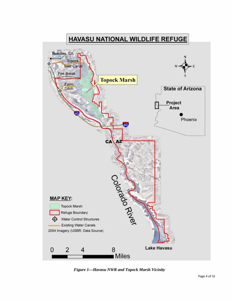
Figure 1—Havasu NWR and Topock Marsh Vicinity Page 4 of 31
2.0 ALTERNATIVES INCLUDING THE PROPOSED ACTION
2.1 Alternative A--No Action:
In the absence of a project that effectively improves the Refuge’s ability to manage its water resources, the Refuge would continue to make use of the existing water delivery infrastructure for management of Topock Marsh. This infrastructure is largely comprised of long earthen ditches that suffer from significant transmission losses before water is delivered to the Topock Marsh Unit, a condition that severely challenges the Refuge’s efforts to manage within its limited water right entitlements. Further, the existing infrastructure includes dilapidated water diversion structures that were built in the 1960’s, a time at which the bed of the Colorado River, along this reach, was approximately 10 feet higher than its current position. As all of the Refuge’s water control structures were designed for the typical river elevations at the time of construction, this change in the modern river’s water level makes the structures much less efficient, and furthers reduces the effectiveness of the infrastructure. Reliance upon the current infrastructure would force the Refuge to continue sub-optimal management of its water-dependent habitat, some of which support several endangered species. It is anticipated that the quality of the Refuge’s water-dependent habitats is likely to continue to decline over time as the water delivery infrastructure further degrades. The Service’s concern is heightened by the possibility that the river will encounter more channel-deepening events in the future, and that flows will depart further from a natural flow regime due to changes in release patterns. This would negatively affect the environmental benefits of Topock Marsh, which as the largest body of water in the LCR region managed primarily for environmental purposes, carries a high degree of importance in the context of restoration efforts within the river system, including the prominent Lower Colorado River Multispecies Conservation Program (LCR MSCP). Therefore, taking no action would lead to the increasing inability of the Refuge to fulfill its purpose as a “refuge and breeding area for migratory birds and other wildlife…”. In addition, there are anticipated economic and societal benefits associated with the Proposed Action moving forward that would not occur under this No Action alternative.
2.2 Alternative B--Proposed Action:
The proposed construction components listed below capture the scope of the project’s Proposed Action, which includes a new main delivery canal and multiple water control structures (see Figure 2). The construction of the project components would represent a significant and long-lasting improvement to the Refuge’s ability to achieve its congressionally-mandated purpose. This project would improve the Refuge’s capacity to control delivery of water to the Topock Marsh Unit, accruing environmental benefits to at least 4,000 acres of refuge land. Further, these improvements would minimize the level of transmission losses currently charged against the Refuge’s water right entitlement, thus making for a more effective delivery of diverted water to the marsh. The total foot-print of the Proposed Action’s construction activities is estimated to be less than 63.3 acres (see Table 1, and further detailed in Section 4.0: Environmental Consequences)
• Fire Break Canal: This is the largest component of the proposed improvements, entailing construction of a 2.6
mile long concrete-lined canal. This canal would provide direct delivery of water to Topock Marsh and would entail breaching the Colorado River levee. The construction footprint for the canal is estimated have a length of 2.6 miles, and a width of 160 feet; resulting in a maximum affected area of approximately 50 acres (see Table 1). There will be large water control structures at both ends of the canal, as well as no fewer than three water turnouts along its length (which will allow future expansion of water delivery capacity to refuge land to the south of the canal). The impact area for the turnouts is considered negligible, as the turnouts fit wholly within the canal’s construction footprint.
Page 5 of 31
• Fire Break Canal Water Diversion Structure: This component would be at the proposed Fire Break Canal’s western extreme and will comprise the Refuge’s primary means of diversion of water from the Colorado River. This hybrid structure will have the capacity to divert water both by way of gravity flow and through use of river pumps. The construction footprint for this structure is estimated at 5.7 acres (see Table 1).
• Fire Break Canal Terminus Water Control Structure: This component would be at the proposed Fire Break Canal’s eastern extreme, and would represent the canal’s terminus. The structure will be designed to provide delivery of water directly to the marsh, and to deliver water both to the north and the south of the canal (in association with future actions related to expansion of the Refuge’s capacity to delivery water to refuge land beyond the marsh proper). The construction foot print for this structure is estimated at 0.5 acres (see Table 1).
• Farm Ditch Water Diversion Structure: This structure would replace the Farm Ditch’s existing dilapidated water control structure, and make use of an existing pipe that passes through the river levee. The Proposed Action only entails replacement of the ditch’s diversion structure; the remainder of the Farm Ditch would be left unchanged. The construction foot print for this structure is estimated at 2.1 acres (see Table 1). The Proposed Action is designed to have the Farm Ditch continue to be used as the Refuge’s secondary source of water for the marsh.
• Topock Inlet Canal--Internal Water Control Structure: This structure would be constructed just east of the Mohave Valley Irrigation District and Fort Mohave Indian Tribe’s diversions in the Topock Inlet Canal (proximate to the first occurrence of federally owned land). The primary purpose of this structure would be to provide the Service the option of occasional use of the Topock Inlet Canal, such as when the new Fire Break Canal needs to be maintained or repaired. The construction footprint associated with this structure is estimated to be 0.5 acres.
2.3 Alternative C –Improving the Topock Inlet Canal: This alternative involves making significant improvements to the Topock Marsh Inlet Canal, which currently represents the Refuge’s primary means of delivering water from the Colorado River to Topock Marsh. Improvements that have been considered include: lining the length of the 4.1 mile long earthen canal, replacing or rehabilitating both the water diversion structure on the canal’s western extreme and the existing water control structures on the canal’s (marsh side) eastern extreme. Finally, in common with the Proposed Action alternative, this alternative would entail the installation of a water check structure just east of the location of where the Fort Mohave Indian Tribe (FMIT) and Mohave Valley Irrigation District (MVID) withdraw water out of the canal (on the first occurrence of federal land). Implementing this alternative would be complicated by the fact that there is mixed land ownership along the Topock Inlet Canal. The land along the course of this canal is owned by no less than four entities, while Service ownership doesn’t begin until the canal intersects the Refuge’s boundary at the canal’s eastern terminus. [blank]
Page 6 of 31
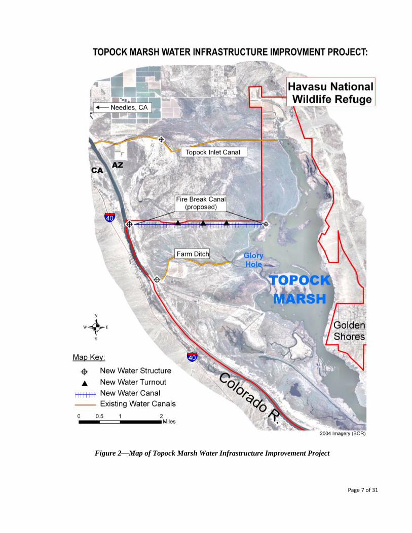
Figure 2—Map of Topock Marsh Water Infrastructure Improvement Project
Page 7 of 31
2.4 Alternatives considered but not analyzed: Various other project alternatives were considered at a preliminary level. A variety of different water delivery options were evaluated, including use of a pipeline-system to distribute water from the river to the marsh and other parts of the Refuge. This alternative was deemed problematic both from a cost perspective (piping is considered to be over three times as expensive as lining ditches) and from concerns associated with the invasive quagga mussel (Dreissena rostriformis bugensis) that have recently been documented within this reach of the LCR. It was concluded that since the current state of knowledge associated with the quagga mussel indicates that pipes are highly susceptible to infestations, and that there is no currently identified means to effectively control or remediate such infestations, the risk was too great to consider large scale use of pipes at this time. Another option reviewed was making substantive improvements to the existing 2-mile long Farm Ditch, to a level that would improve the ditch’s capacity so it could serve as the Refuge’s primary means of diverting river water. Improvements considered for the Farm Ditch included: expanding and lining the 2-mile long canal, rehabilitating the existing water control structure at the point of diversion off of the river, and installing a pump station at this structure. Use of piping was also considered (but rejected for the reasons outlined in the prior paragraph). Based on our initial review, we selected to not further analyze making the scale of improvements to the Farm Ditch. This was due to several factors, including recognition that the Farm Ditch is positioned at a lower elevation than the proposed Fire Break Canal, so water levels at the northern end of the marsh would be that much more difficult to maintain, likely requiring more pumping (as compared to the Proposed Action). An additional benefit associated with the Proposed Action is that the Farm Ditch would still be used as the second primary source of water for the marsh (as mentioned in Section 2.2). This redundancy would provide the Refuge with greater security than relying solely upon the Fire Break Canal as the primary source of water for the marsh, and could be effectuated with only relatively moderate improvements being made to the Farm Ditch (e.g., replacement of its water diversion structure, a component in the Proposed Action). Another alternative that was considered, but not selected for in-depth analysis, entailed the development of a set of high-yield irrigation wells distributed through the Refuge. While this alternative could provide the Refuge with a high degree of control over its water diversions, it was deemed to be overly costly. Costs associated with this alternative include: the drilling of the wells, development of access roads and associated clearance of dense vegetation, purchase and deployment of pumps to pull water out of the wells, installation of a distribution system to deliver water pumped from the wells to the intended use area, and finally, re-occurring costs related to the operation and maintenance of the wells, pumps, distribution system and access roads. An additional drawback to this approach related to concerns that pumped water from wells would not produce water of sufficient quantity for effective management of Topock Marsh, which likely would necessitate at least partial reliance upon a gravity-based type of diversion. That said, wells could be a very appropriate approach for delivery of water to limited areas of the Refuge, perhaps as part of a future phase of improvements.
Page 8 of 31
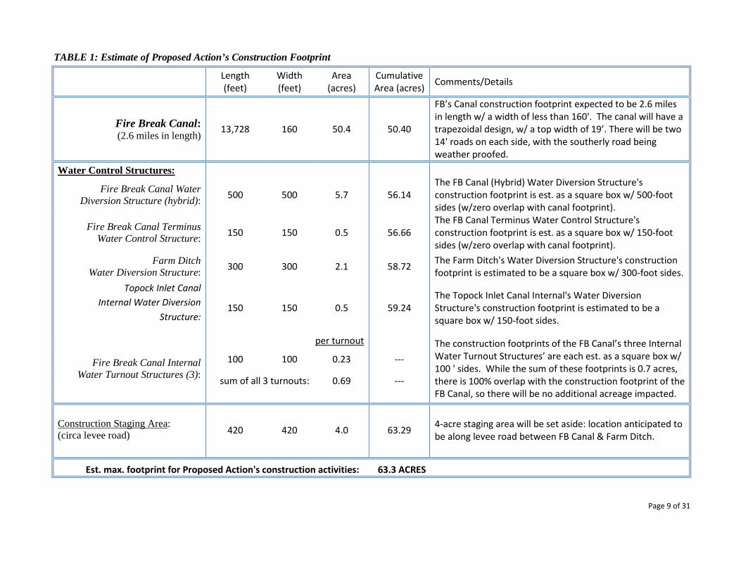
TABLE 1: Estimate of Proposed Action’s Construction Footprint
Length (feet)
Width (feet)
Area (acres)
Cumulative Area (acres)
Comments/Details
Fire Break Canal: (2.6 miles in length) 13,728 160 50.4 50.40
FB’s Canal construction footprint expected to be 2.6 miles in length w/ a width of less than 160'. The canal will have a trapezoidal design, w/ a top width of 19’. There will be two 14' roads on each side, with the southerly road being weather proofed.
Water Control Structures:
Fire Break Canal Water Diversion Structure (hybrid): 500 500 5.7 56.14
The FB Canal (Hybrid) Water Diversion Structure's construction footprint is est. as a square box w/ 500-foot sides (w/zero overlap with canal footprint).
Fire Break Canal Terminus Water Control Structure: 150 150 0.5 56.66
The FB Canal Terminus Water Control Structure's construction footprint is est. as a square box w/ 150-foot sides (w/zero overlap with canal footprint).
Farm Ditch Water Diversion Structure: 300 300 2.1 58.72
The Farm Ditch's Water Diversion Structure's construction footprint is estimated to be a square box w/ 300-foot sides.
Topock Inlet Canal Internal Water Diversion
Structure: 150 150 0.5 59.24
The Topock Inlet Canal Internal's Water Diversion Structure's construction footprint is estimated to be a square box w/ 150-foot sides.
per turnout The construction footprints of the FB Canal’s three Internal
Water Turnout Structures’ are each est. as a square box w/ 100 ' sides. While the sum of these footprints is 0.7 acres, there is 100% overlap with the construction footprint of the FB Canal, so there will be no additional acreage impacted.
Fire Break Canal Internal Water Turnout Structures (3):
100 100 0.23 ---
sum of all 3 turnouts: 0.69 ---
Construction Staging Area: (circa levee road) 420 420 4.0 63.29
4-acre staging area will be set aside: location anticipated to be along levee road between FB Canal & Farm Ditch.
Est. max. footprint for Proposed Action's construction activities: 63.3 ACRES
Page 9 of 31
3.0 AFFECTED ENVIRONMENT This section provides a description of the affected resources to be considered when evaluating the Proposed Action and other alternatives, including the No Action alternative. Havasu NWR encompasses 37,515 acres adjacent to the Colorado River between Needles, CA and Lake Havasu City, AZ. Topock Marsh, Topock Gorge, and the Havasu Wilderness comprise the three major units of the Refuge (see Figure 1). The habitat varies from thick cattail/bulrush stands and mixed riparian vegetation found along the Colorado River and Topock Marsh, to steep cactus-strewn cliffs and mountains found along Topock Gorge and Havasu Wilderness to the open waters of upper Lake Havasu. All three specific project sites are located in Arizona on the Colorado River floodplain within, or adjacent to, Havasu NWR’s Topock Marsh unit (see Figure 2).
3.1 Physical Environment: Within the project area, the topography is generally flat, with slight slopes toward the south and east. Along the Arizona shore, the river is contained by the Colorado River levee. Topock Marsh forms the eastern edge of the project area, while the eastern shore of the Colorado River forms the western edge of the project area.
3.1.1 Water Resources: The entirety of the project area is located within the 100-year floodplain of the Colorado River Valley. The Colorado River is the primary source of water for the Refuge, both in terms of surface water and groundwater resources. The Refuge diverts surface waters from the Colorado River through a series of earthen ditches and several groundwater wells, with typical depths to groundwater ranging from essentially zero to 10 feet (distance from the ground surface).
The Refuge’s water rights were established through the 1964 Arizona v. California Supreme Court Decree. The decree language is as follows: “Havasu Lake National Wildlife Refuge in annual quantities reasonable to fulfill purposes of the Refuge, not to exceed (i) 41,839 acre-feet of water diverted from mainstream, or (ii) 37,339 acre-feet of consumptive use of mainstream water, whichever of (i) or (ii) is less, with a priority date of 1/22/41, for lands reserved by Executive Order of said date of 2/11/49, for land reserved by the Public Land Order of said date (No.559)”. These rights are administered by the U.S. Bureau of Reclamation, as the duly authorized representative of the Secretary of the Interior.
Water quality conditions within the project area are characterized by moderately saline water that has a history of observed high levels of turbidity when winds mobilize fine soils in the shallows of the marsh. Dissolved oxygen levels within the marsh are variable, with observations occasionally being below the 5.0 mg/L level (considered a lower threshold for healthy biological processes).
3.1.2 Soils / Landforms / Geology: Refuge soils consist primarily of coarse alluvium (sand and sandy loam) deposited by the river prior to construction of the river’s extensive levee system. Finer texture soils (silts and clays) occur to a lesser extent, mostly in association with low areas and sloughs. The close proximity of the Colorado River and the generally coarse soil textures result in a strong correlation between groundwater depths and river elevation. The project area overlies the geological feature loosely referred to as the “river aquifer”, which is composed of largely saturated deposits of sand, silt and clay, laid down by the late prehistoric and historic Colorado River. The area is typified
Page 10 of 31

by the presence of several former river meanders and by multiple sand dunes created by river channeling and dredging.
3.1.3 Air Resources: The project area has excellent air quality, due to the rural land uses in most of the surrounding area. It lies within the U.S. Environmental Protection Agency’s Clark-Mohave Intrastate Air Quality Control Region 13, which is an attainment area for National Ambient Air Quality Standards.
3.2 Biological Resources/Environment: (Note: Appendix A contains information on species found on the Refuge, including the species’ common and scientific names, and their legal protection status)
3.2.1 Vegetative Communities: The project area's three main physical environments are typified as dry, relatively higher elevation sand dunes (depth to groundwater greater than five feet), seasonally moist flats and sloughs (depth to groundwater less than five feet), and predominately wet emergent marsh (depth to groundwater approximately zero). Saltcedar and arrowweed dominate the higher and drier areas. Saltcedar, with occasional mesquite, willow, and cottonwood form thick stands in the moist low areas. Cattail and bulrush are the most common (macrophytic) vegetation in the marsh proper and along its perimeter.
3.2.2 Wildlife: Wildlife present in the project area is typical of the LCR ecosystem (see Appendix A for a representative list of species found on the Refuge). Common birds include egrets, herons, flycatchers, and seasonal raptors, waterfowl, passerines, and shorebirds. The Refuge provides important habitat for a wide variety of migrating birds and marsh birds. Higher elevation areas contain habitat elements for various terrestrial mammals and reptiles. Common species of small mammals that are likely to occur in or adjacent to the project area include pocket mice, cottontail rabbits, and packrats. Coyotes, bobcats, and feral pigs are common larger mammals. Reptiles that inhabit the upland areas include whiptail lizards, rattlesnakes, and kingsnakes. Beavers and muskrats frequent the canal, ditch, and marsh. The most widespread fish are common carp, largemouth bass, bluegill, and catfish.
Species of special interest found on the Refuge include: California leaf-nosed bat, cave myotis, Clark’s grebe, peregrine falcon, bald eagle and desert tortoise and flannelmouth sucker.
3.2.3 Threatened & Endangered Species: Special status species found within the project area that are listed as being either threatened (T), endangered (E) or as candidates (C) for being listed include: brown pelican (E), southwestern willow flycatcher (E), western yellow-billed cuckoo (C), Yuma clapper rail (E) and razorback sucker (E) and bonytail (E). See Figure 3 for a plot of habitat associated with the southwestern willow flycatcher and Yuma clapper rail (two species that figure pre-imminently in the Refuge’s management concerns).
Page 11 of 31
3.3 Socioeconomic Considerations:
3.3.1 Cultural Resources/Environment: Given that the project area is within the 100-year flood plain of the Colorado River, much of the ground surface has historically been flooded and reworked, making the location of archeological sites an infrequent occurrence. This is especially true in terms of long-term habitation/village sites, which would normally be expected in an area with a record of continuous occupation of at least a thousand years (as is true of the Colorado River Valley). Indeed, perhaps more than any other region of the Southwest, the native tradition of the lower Colorado River is defined almost entirely through modern ethnography and historic accounts rather than by evidence of prehistoric archeology.
In broad terms, conventional measures of archeological significance typically do not apply here. The significance of the archeology does not stem from the material richness or depositional complexity of the sites themselves. More relevant in defining the value of the cultural resources within the Colorado River Valley is the recognition that a cultural continuum exists between the prehistoric and modern Native American presence on the river. Although the millennia-old systems of subsistence and settlement no longer exist, it is important to note that many traditional practices survived quite late into the historic era, and that Native American communities on the river continue to regard national wildlife refuge lands with a profound reverence for religious and ancestral values.
3.3.2 Economic/ Public Use/Recreation: The Refuge is tied to the local economy largely through the public’s use of the Refuge for recreational opportunities. These opportunities typically come in the form of fishing, hunting, wildlife viewing and sightseeing. While minimal recreation occurs within the proposed construction area itself, the easternmost points of the existing Inlet Canal and Farm Ditch are popular fishing sites. Limited beach recreation occurs along the Colorado River. The Refuge also plays a role in the local economy as relates to the fact that Refuge employees typically live in the community, own property and support local businesses through their routine purchases.
3.3.3 Visual Resources: While the Colorado River and river valley are the most notable natural features and by themselves provide a visual resource, natural views are limited within the project area. Within the general vicinity, there exists an Interstate, two state highways, a two-rail rail line, three communities as well as numerous water development infrastructure components and energy transmission facilities. Pristine natural views within the proposed project area’s construction footprint are not considered to exist, as significant man-made developments exists at each of the three project sites (e.g., water infrastructure components and an actively maintained fire break).
Page 12 of 31

Figure 3—Map of T& E Habitat in the Area of the Proposed Topock Marsh Water Improvement Project
Page 13 of 31
3.4 Specific Project Sites:
3.4.1 Topock Inlet Canal: The Topock Inlet Canal is an earthen ditch that was constructed in 1965-66 by the U.S. Bureau of Reclamation. It has a design capacity of 100 cubic feet per second. This 4.1-mile long canal extends eastward from a point on the Colorado River across from Needles, CA (River Mile 244.5) to the upper end of Topock Marsh. Only on its extreme eastern end is the canal on refuge land; along most of its length, the canal traverses land belonging to a variety of non-Service agencies and individuals. No records exist identifying how authorizations were obtained to construct and operate the canal.
The canal is excavated in pre-dominantly sandy soil with side slopes of 2 to 1, has a nominal bottom width of 14 feet, a designed depth of 4.0 feet, and a gradient of .000095 (0.5 feet of fall per mile). Water in the canal is gravity fed into Topock Marsh. Unmaintained roads run parallel to the canal on its north and south sides. An intake structure consisting of three metal pipes and six gates controls water diversion from the Colorado River into the canal. Within the first mile, there are two privately- and one tribally-owned lift pumps that divert water from the Topock Inlet Canal for agricultural purposes. As stated above, Refuge land begins at the eastern terminus of the Topock Inlet Canal. Within a few hundred yards of Topock Marsh, the Refuge has one platform-mounted pump that diverts water from the canal for wildlife management purposes (e.g., irrigating the Pin-Tail Slough unit, which lies north of the canal). The remainder of the canal’s flow enters the marsh proper (or is lost to seepage to the river aquifer as discussed above).
Vegetation along the canal is predominately saltcedar and arrowweed. As the canal nears Topock Marsh, honey and screwbean mesquite occur along its margins. Seepage from the canal may support more robust communities of vegetation than what would occur without this conveyance structure carrying water; this support may extend some distance from the canal. Isolated stands of cattail and bulrush grow within the canal. If the Proposed Action is implemented, flows through the canal would likely be curtailed. This would especially be the case for the canal’s eastern three miles (i.e., east of the proposed water control structure’s location, see Figure 2), whereas flows in the canal’s first mile would continue, dictated primarily by the irrigation needs of the private and tribal land owners. The ground cover surrounding the location of the proposed Topock Marsh Inlet Canal Internal Water Control Structure is largely arrowweed and salt-cedar, with barren ground as a significant component
3.4.2 Farm Ditch: The Farm Ditch is an earthen ditch excavated in 1968 by the Bureau of Reclamation and traverses primarily sandy soils. The Farm Ditch’s Water Diversion Structure is located at RM 241.0. Water in the Farm Ditch flows through refuge lands in an approximate west-to-east direction, and provides Colorado River water to the Topock Marsh near the Glory Hole (see Figure 2). Colorado River water enters the ditch by way of a culvert and screw gate intake structure located on the river’s eastern bank. The ditch is approximately two miles long with a rough10-foot bottom width. There is a well maintained road on the ditch’s south side. Coyote willow is abundant along the Farm Ditch; otherwise the vegetative communities along the margins of the ditch are similar to those along the Topock Inlet Topock Canal. The Proposed Action would only deal with replacement of the ditch’s water diversion structure. The area surrounding the Farm Ditch’s Water Diversion Structure is largely barren, dominated by rip-rap, road and levee materials.
Page 14 of 31

3.4.3 Fire Break: The Fire Break is a fire line constructed between the Colorado River levee at RM 242.5 and the Refuge’s Interior Road/Topock Marsh. The break runs east for over 2 ½ miles and parallels, and lies south of, the Refuge’s northern property boundary. The width of the Fire Break's cleared area varies between 100 and 200 feet. At its eastern edge, the break narrows to less than 10 feet and no longer serves as an effective fire protection measure. Vegetation within the Fire Break consists almost entirely of arrowweed. When growth becomes dense enough to provide contiguous fuels, the break is cleared with mechanical treatments. Vegetation along the Fire Break's margins consists mostly of saltcedar and arrowweed with some mesquite, willow, and Baccharis spp. near Topock Marsh. In similarity to the Topock Inlet Canal and the Farm Ditch, the soils over the majority of the Fire Break’s length are classified as being sandy soils, with a small remainder being composed of clay/loam or clay soils.
As described in Section 2 above, it is estimated that the construction footprint of the proposed Fire Break Canal is 160 feet wide, by 2.6 miles in length, with an impact area of approximately 50 acres. The Proposed Action also entails the construction of two major water control structures. The western (diversion) structure is situated between the eastern banks of the Colorado River and the river’s eastern levee, and has an estimated construction footprint of 5.7 acres. The surrounding ground cover is xeric and sparse, with the surface area being dominated by rip-rap, road and levee materials. In contrast, the ground cover surrounding the water control structure at the proposed canal’s eastern extreme is situated in soggy and wet ground, with either standing water or marsh vegetation within the 0.52 acre construction footprint (see Table1).
4.0 ENVIRONMENTAL CONSEQUENCES FROM ALTERNATIVES This section reviews and documents the potential direct, indirect, and cumulative effects that implementation of each of the three alternatives described in Section 2.0 of this DEA would likely have upon the physical, biological, and social aspects of the human environment (as described in Section 3.0 of this document).
Direct effects are considered to be impacts that would be caused by the alternative at the same time and place as the action, whereas indirect effects are impacts that occur later in time or at a distance from the triggering action. Cumulative effects are incremental impacts that result from other past, present, and reasonably foreseeable future actions, including those taken by federal and non-federal government agencies, as well as those undertaken by private groups and individuals. Cumulative impacts may result from singularly minor but collectively significant actions taking place over a period of time.
4.1 Effects to Physical Environment:
4.1.1 Water Resources--Discussion of Direct and Indirect Effects:
Alternative A--No Action:
Under this alternative, there will be a continuation of existing conditions and trends, which is anticipated to entail further degradation of the Refuge’s water-dependent wildlife resources. An indirect effect of the No Action alternative is anticipated to be the Refuge’s inability to fill the marsh to the desired water levels in a timely fashion, or in such a manner to meet its habitat objectives. This No Action alternative would also indirectly result in a continuation of the Refuge’s chronic challenge to not exceed its entitlements for diverting water from the Colorado
Page 15 of 31
River. While the No Action alternative is not anticipated to have any direct short-term impacts, it is anticipated that water quality trends will continue to degrade through time, with likely rises in salinity levels and lowering of dissolved oxygen levels, both of which can translate into adverse biological conditions. Alternative B--Proposed Action: It is anticipated that the Proposed Action will have both direct and indirect effects upon the project area’s water resources. As the Proposed Action entails replacing a long earthen ditch that has high associated transmission losses, to a shorter concrete-lined canal, there will be a direct and significant gain in water delivery efficiencies (i.e., improving the ratio of water-diverted-from-the-river to water-delivered-to-the-marsh). One indirect result of this improved efficiency will be an enhanced ability for the Refuge to manage the marsh through a range of water levels, as dictated by management considerations. It is important to note that any changes in water level management associated with the Proposed Action’s improved water infrastructure mandates serious analysis and further collection of information, which are future activities and are not directly associated with this proposed action. In a water-rights context, since the Proposed Action will improve water delivery efficiencies, there will be an enhanced ability for the Refuge to operate within the constraints of its entitlements to divert and consume Colorado River water. It is anticipated that this indirect consequence will be manifested without any changes to existing management. Similar to the above discussion, while management changes are expected, they will be part of an independent analysis not directly associated with this action. Other indirect effects upon water resources resulting from the Proposed Alternative are anticipated to be minimal in number and magnitude. In the event that the Refuge decides at a future date to manage the marsh at a higher elevation than previously, there might be a marginal increase in evapotranspiration due to a minor expansion in the marsh’s surface area during periods of high water level management. However, as it is anticipated that the Proposed Action will provide the Refuge with more capacity, and security, in managing the marsh through a full range of water levels, the resulting net-effect to the water balance is expected to be negligible.
In terms of water quality, it is expected that there will be a long-term beneficial impact from implementing the Proposed Action, as the Refuge will be able to deliver a higher percentage of its diverted water directly to the marsh. This increase in water-delivery efficiency is anticipated to have an indirect freshening effect upon water quality parameters such as salinity and dissolved oxygen throughout much of the marsh. It is expected, however, that there might be a minimal long-term indirect negative impact to the marsh’s northern extremes, as the Fire Break Canal enters the marsh about two-miles south, and about ½-foot lower in elevation than the point where the Topock Inlet Canal enters the marsh. As a result, a small reduction in rates of water movement through this northern portion of the marsh is expected. Similar concerns do not exist as regards water delivery to the northern portions of the marsh, as much of the actively managed refuge land in the northernmost portion of the Refuge is currently provided water by pumping out of the marsh, as is the case with the Pin-Tail Slough unit (see Figure 2). It is expected that the ½-foot elevation difference will have a marginal impact upon the continued pumping of water into this unit, as the marsh’s depth in this area is typically in the 5-10 foot range (and the pump’s fixed intakes are less than five feet above the marsh’s bottom).
Page 16 of 31
Further, it is expected that there would be possible short-term direct impacts to water quality in the project area during the construction phase and for a short period of time afterwards (on the order of weeks or several months). This potential adverse impact would come from soils that are disturbed and mobilized from construction activities and may be washed into the marsh, thus increasing suspended sediment levels for a short period of time. Alternative C--Improving the Topock Inlet Canal:
It is anticipated that this alternative would carry similar direct and indirect effects to water resources as are associated with the Proposed Action. As Alternative C would involve lining a 4.1 mile canal, there would be a proportional increase in required maintenance, including work to keep the canal clear of dirt and vegetation (as compared to the 2.6 mile long canal distance in the proposed alternative). Additionally, as there are multiple land owners and water users associated with the Topock Inlet Canal, it is anticipated that the operation and management of this canal, as the Refuge’s primary source of water delivery to the marsh, would be more complicated when compared to the proposed alternative (which would be built exclusively on Refuge land, and would be used solely for Refuge purposes). As the Topock Inlet Canal enters the marsh at the marsh’s northern extreme, there is anticipated to be a moderately positive indirect impact associated with the canal’s freshening effect on the northern portion of the marsh’s water quality conditions. Further, because the Topock Inlet Canal diverts water from the Colorado River some two miles north (upstream) of the location of the Proposed Action’s Fire Break Canal’s point of diversion, it is anticipated that water surface elevations associated with Alternative C would be approximately ½-foot higher than those related to the Alternative B. While it is anticipated that this indirect impact might represent a small degree of reduced pumping costs, it is anticipated to be marginal in its impact and magnitude (as discussed above).
4.1.2 Soil \ Landforms \ Geology -- Discussion of Direct and Indirect Effects:
Alternative A--No Action:
There are no expected short-term direct or indirect impacts to soils, landforms or geology associated with this alternative. It is anticipated that over the long-term, there would be indirect moderately negative consequences, as trends of salinization of the floodplain as expected to continue, a process that could be addressed to some degree with the expanded water management capacity associated with the Proposed Action. Alternative B--Proposed Action:
The primary direct impact to the soil resources of the project area will be associated with the construction of a new 2.6 mile long water delivery canal. This will entail excavation of soil, at a depth of multiple feet, for the installation of the lined canal. There would also be direct and negative impact to soils associated with the construction of the water control structure at the proposed canal’s terminus. As the soils in this location are associated with wetland habitat, this impact is discussed below in Section 4.2.1. More generally, regarding impacts to the overall floodplain soils, the Proposed Action would provide enhanced water management capacity to address the trend of increased soil salinization. However, it is important to re-
Page 17 of 31
iterate that any changes in water management would not be part of this action, and would be part of future analyses that would have their own assessments of environmental impacts.
Otherwise, given the scope and scale of this project, it is not anticipated for there to be either direct or indirect effects to the project area’s landforms and geological resources.
Alternative C--Improving the Topock Inlet Canal:
Consequences would be similar to Alternative B, as along with the long-term benefit of enhanced water delivery efficiency there would also be an increased likelihood of short-term adverse impacts to the soil and wetland resources, in association with the water delivery/distribution infrastructure related construction activities. In so far as this alternative involves improving an existing canal, it is anticipated that there would be less soil disturbance than associated with the proposed new Fire Break Canal (although the longer canal distance in Alternative C (4.1 mile) versus Alternative B’s 2.6 miles would mitigate some of the difference between the two alternatives). If this alternative were to necessitate construction of a water control structure on the Topock Inlet Canal’s eastern extreme, there would also be direct and permanent negative impact to wetland soils (discussed below in Section 4.2.1.). Otherwise, it is not anticipated for there to be either direct or indirect effects to the project area’s landforms and geological resources, given the scope and scale of this alternative.
4.1.3 Air Resources--Discussion of Direct and Indirect Effects: Alternative A--No Action:
There are no expected direct or indirect impacts associated with this alternative. Alternative B--Proposed Action: It is anticipated that during the construction phase of the Proposed Action, there will be an adverse short-term direct impact to the immediate area’s air quality as a function of exhaust emissions from machinery being used to build the project’s various components. Similarly, it is anticipated that there will be an increase in blowing dust and sand during the construction phase. Implementing best management practices (BMP) for dust abatement would be expected to minimize this impact. Moreover, it is anticipated this impact will cease shortly after the completion of construction activity. There are no indirect effects anticipated from the Proposed Action relative to air resources. Alternative C--Improving the Topock Inlet Canal: Consequences to the local area’s air resources would be similar to Alternative B, although as this alternative would be associated with more limited construction activities, it is anticipated there would be a proportional reduction in short-term adverse impacts upon air quality resources for the reasons outlined above.
Page 18 of 31
4.2 Biological Resources/Environment:
4.2.1 Vegetative Communities--Discussion of Direct and Indirect Effects: Alternative A--No Action:
Under the No Action alternative, saltcedar and arrowweed would continue to dominate the higher elevation areas. The lower, moist areas typified by saltcedar, cottonwood, willow, and occasional mesquite trees would remain essentially the same for the immediate future. Across the Topock Marsh unit, loss of cottonwood and willow communities may occur over the long term if the river downgrades, the water table lowers and floodplain salinization continues. Cattails and bulrushes in Topock Marsh would increase in overall area as water levels drop, which would likely alter the distribution and diversity of water-dependent habitats. All of these impacts would be considered indirect in nature.
Alternative B--Proposed Action:
Primarily saltcedar and arrowweed would be affected during construction at the three major project sites (i.e., the Fire Break Canal, Farm Ditch, and the Topock Inlet Canal). These two species will return where disturbed except for the area occupied by the proposed (lined) Fire Break Canal and the associated roads and water control structures. If water flows along the eastern reaches of the east side of the Topock Inlet Canal are curtailed, an indirect consequence would be expected in that some saltcedar, arrowweed, and mesquite trees may be negatively affected as the seepage from this portion of the earthen canal would be reduced.
Across the Topock Marsh unit, there will be an enhanced capacity to manage for native cottonwood, willow, and mesquite trees, as the project increases the ability to have better control over water quantities and distribution. As areas of native tree communities increase, more diverse native understory plants such as baccharis and wildflowers would likely develop. The total area of invasive saltcedar trees would likely decrease. Conversely, construction of the new Fire Break Canal would result in permanent loss of desirable vegetation, especially at the canal’s eastern terminus where it reaches the marsh. This direct and negative impact is anticipated to be minor.
There is anticipated to be adverse impacts to wetlands located in the project area, especially close to the new canal’s eastern terminus. This direct impact would be associated with construction activities, and would largely be permanent in nature. In contrast, there is expected to be a long-term indirect beneficial impact to the productivity of the Refuge’s wetlands from the Proposed Action, as relates to the Refuge having significantly improved water management capacity. The Service is in the process of conducting a wetland delineation to quantify the level of impact to wetlands within the project area and assist with ensuring compliance under the Clean Water Act. Pending the results of this delineation, the Service conservatively estimates that the project will permanently remove 0.5 acres of wetland habitat (see Tables 1 and 2).
Alternative C--Improving the Topock Inlet Canal: The consequences of Alternative C to the area’s vegetative communities are expected to be similar to Alternative B, although in reduced magnitude as Alternative C represents less overall enhanced water management capacity than deemed likely to come as a result of the full implementation of Alternative B. As the Topock Inlet Canal is 4.1 miles in length, and the expected final canal (with service roads) is expected to entail a permanently denuded width of 50-feet, the total permanent loss of vegetative cover would be approximately 25 acres.
Page 19 of 31

4.2.2 Wildlife--Discussion of Direct and Indirect Effects: Alternative A--No Action: If the No Action alternative is taken, an adverse and indirect impact is expected as less water will be able to reach Topock Marsh and adjacent areas resulting in continued degradation and salinization of the marsh, thereby decreasing the abundance and quality of wildlife habitat. Alternative B--Proposed Action:
As a direct consequence of this action, small mammals, birds, and associated wildlife likely will be temporarily displaced during construction of the water infrastructure improvements. Since similar habitat is abundant in the general area, impact to wildlife is expected to be minimal and short lived, as wildlife is expected to return to much of project area upon completion of construction activities.
Another direct consequence of this action moving forward would be expected for the portion of the project area where vegetation would be permanently removed (e.g., water control structures, the concrete-lined canal and adjacent roads), as there would be a permanent loss of habitat, and associated loss of common terrestrial wildlife in the final footprint of the new canal. However, it is anticipated that in the area adjacent to the proposed Fire Break Canal, this impact will be offset somewhat as the abundance and diversity of wildlife species will increase with the availability of new water. Similarly, with the installation of the new water control structure at the Farm Ditch intake it is expected that water birds, fish, and associated wildlife will benefit from the increased presence of water in the ditch as a consequence of this project’s implementation.
Conversely, in the area of the Topock Inlet Canal east of the proposed water control structure, some species of wildlife will likely decline in abundance and diversity as vegetation that relies on seepage from a flowing canal is likely to be adversely (al beit indirectly) affected. The possible decline in wildlife numbers is not expected to be enough to affect the area’s overall wildlife populations and is expected to be outweighed by the expected wildlife benefits associated with enhancement of native habitat (which will largely be based on future actions, but that will be strongly facilitated by this proposed action). Therefore, it is anticipated that the net effect of the Proposed Action on wildlife will be positive since the increased ability to control and distribute water will allow the Refuge to manage for increased acreages and productivity of native vegetative communities (that provide habitat for many species of native wildlife such as neotropical migrants that nest on the Refuge or use the Refuge as a stopover on their migratory route).
Alternative C—Improving the Topock Inlet Canal:
The environmental consequences of this alternative would be similar to Alternative B, with similar trade-offs between project benefits represented by improved water delivery capabilities and short term losses of habitat during construction activities, and permanent losses of wildlife habitat where currently vegetated areas would be covered with concrete or roaded surfaces. In additional commonality with Alternative B, there would be a reduction in vegetative cover that relies upon seepage from the (currently) earthen canal, although the loss of seepage from Alternative C would result from lining the Topock Inlet Canal, while the Proposed Action would reduce seepage because the water control structure would reduce flows in the (still unlined) canal. The loss of vegetation associated with Alternative C is expected to entail a minimally negative condition for wildlife species.
Page 20 of 31

Both alternatives would entail a reduction in the rate of the canal’s transmission losses, a clear benefit from a water accounting perspective. Further, as this alternative’s actions only involve improving the efficiency of water delivery from the river into the marsh, and does not address subsequent management actions that would be facilitated by such an increase in water delivery efficiency, much of the wildlife benefits would be acquired through subsequent (and independent) actions not directly related to this alternative.
4.2.3 Threatened and Endangered Species--Discussion of Direct and Indirect Effects: Alternative A--No Action: Under the No Action alternative, less water will be available to restore native cottonwood/willow communities. This would lessen the Refuge’s ability to create or improve nesting habitat for the endangered southwestern willow flycatcher and the yellow-billed cuckoo, a candidate species for Federal listing under the Endangered Species Act. If the Refuge’s inability to maintain desired water levels in the marsh persists, it is expected there might be short-term indirect effects from this alternative that would translate in a greater proportion of cattail-bulrush habitat. This would likely bring indirect benefits to marsh bird species like the Yuma clapper rail, but potentially degrade habitat for riparian bird species like the southwestern willow flycatcher and the yellow-billed cuckoo. Alternative B--Proposed Action: It is anticipated that there would be a minor and short-term adverse direct impact to threatened and endangered species as a result of this project’s construction activities. It is expected that this impact would be addressed to a large degree by not conducting project construction during the time of year when the migratory southwestern willow flycatcher is present (the bird typically arrives in the area by late April and departs for its wintering grounds in the south by the end of September).
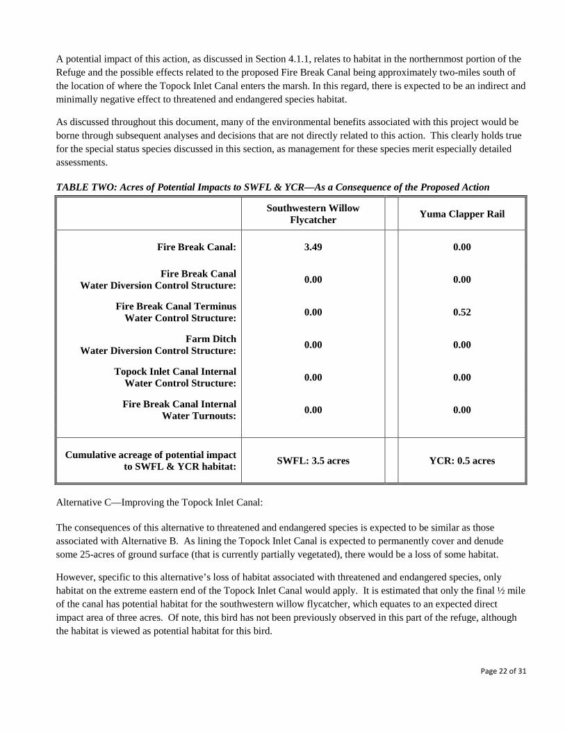
As a direct consequence of the Proposed Action, it is estimated that there will be a permanent loss of habitat associated with the southwestern willow flycatcher. This loss is expected to be less than four acres (as displayed in Figure 4 and delineated in Table 2), and will be replaced in the future by the creation and maintenance of habitat that will be facilitated by the project and subsequent actions made possible by the project.
As regards impacts to the Yuma Clapper rail, this project is estimated to entail a permanent loss of approximately 0.5 acres of habitat (see Table 2), as a consequence of loss of wetlands at the eastern extreme of the Fire Break Canal (see Figure 4). While this bird typically does not migrate, timing of construction to occur outside of its nesting season (March through June) will reduce disturbance to the species.
On the whole, the project is expected to have a beneficial effect on the endangered southwestern willow flycatcher, the occasional endangered brown pelican that visits Topock Marsh, and the threatened bald eagle; contributing to the overall recovery of these species. With improved water deliveries through the Fire Break Canal and the Farm Ditch, it will be easier to regulate water levels in Topock Marsh and thereby beneficially influence land areas adjacent to the marsh that are used by southwestern willow flycatchers during their nesting season. Similarly, through more efficient fresh water deliveries to the marsh, with a greater degree of control, it is expected that the Refuge would have improved capacity to manage and maintain habitat that is currently used by nesting endangered Yuma clapper rails.
Page 21 of 31
A potential impact of this action, as discussed in Section 4.1.1, relates to habitat in the northernmost portion of the Refuge and the possible effects related to the proposed Fire Break Canal being approximately two-miles south of the location of where the Topock Inlet Canal enters the marsh. In this regard, there is expected to be an indirect and minimally negative effect to threatened and endangered species habitat.
As discussed throughout this document, many of the environmental benefits associated with this project would be borne through subsequent analyses and decisions that are not directly related to this action. This clearly holds true for the special status species discussed in this section, as management for these species merit especially detailed assessments.
TABLE TWO: Acres of Potential Impacts to SWFL & YCR—As a Consequence of the Proposed Action
Southwestern Willow
Flycatcher Yuma Clapper Rail
Fire Break Canal: 3.49 0.00
Fire Break Canal Water Diversion Control Structure: 0.00 0.00
Fire Break Canal Terminus Water Control Structure: 0.00 0.52
Farm Ditch Water Diversion Control Structure: 0.00 0.00
Topock Inlet Canal Internal Water Control Structure: 0.00 0.00
Fire Break Canal Internal Water Turnouts: 0.00 0.00
Cumulative acreage of potential impact to SWFL & YCR habitat: SWFL: 3.5 acres
YCR: 0.5 acres
Alternative C—Improving the Topock Inlet Canal:
The consequences of this alternative to threatened and endangered species is expected to be similar as those associated with Alternative B. As lining the Topock Inlet Canal is expected to permanently cover and denude some 25-acres of ground surface (that is currently partially vegetated), there would be a loss of some habitat.
However, specific to this alternative’s loss of habitat associated with threatened and endangered species, only habitat on the extreme eastern end of the Topock Inlet Canal would apply. It is estimated that only the final ½ mile of the canal has potential habitat for the southwestern willow flycatcher, which equates to an expected direct impact area of three acres. Of note, this bird has not been previously observed in this part of the refuge, although the habitat is viewed as potential habitat for this bird.
Page 22 of 31

Similarly, no Yuma Clapper rails have been observed in this area of the marsh, but the portion of the canal that directly abuts the marsh has some cattail and bulrush of a sort that could be utilized by this bird. In this regard, the directly affected area that would be associated with this alternative is estimated to be less than one-half acre.
More generally, this alternative would improve the Refuge’s capacity to effectively control water deliveries, which would facilitate the Refuge’s capacity to manage for higher overall numbers of threatened and endangered species, especially the southwestern willow flycatcher.
4.3 Socioeconomic Effects:
4.3.1 Cultural Resources/Environment--Discussion of Direct and Indirect Effects: Alternative A--No Action:
Under this alternative, there are no anticipated direct or indirect impacts to the cultural environment, as current conditions would be maintained, and no soil disturbance would occur.
Alternative B--Proposed Action:
Under the Proposed Action, there may be impacts to cultural resources, if any archeological sites are found within the project area associated with construction and soil disturbance. While this is a possibility, past experience and knowledge of the area indicates that this is unlikely. The Service is in the process of conducting a cultural resources survey of the project area to better define any potential impacts to these important resources. Further, the Service will encourage and support whatever level of tribal participation is desired on the part of the tribes (for instance, if one of the tribal governments is interested in monitoring the construction activities). Alternative C--Combination of Proposed Action with Additional Distribution Options:
As this alternative would likely involve a slightly reduced degree of soil disturbance than that associated with the Proposed Action, the likelihood is lower that there would be an impact to cultural resources.
4.3.2 Economic/Public Use/Recreation--Discussion of Direct and Indirect Effects:
Alternative A--No Action:
The current economic role that the Refuge plays in the local economy would continue. There would be no immediate changes expected regarding fishing and wildlife viewing opportunities. The No Action alternative would be expected to have no direct impacts in the short-term. There is anticipated to be a moderate and long-term adverse indirect impact associated with this alternative, owing to the Refuge’s reduced ability to manage its lands in a way that promotes healthy environmental conditions. For instance, if the trend towards further ecosystem modification continues, with less and less native species-dominated areas, there is the possibility that public use will decrease, as some of the public comes to the Refuge to encounter native wildlife. In a similar vein, if the Refuge is unable to address problems associated with its deteriorating water infrastructure, there would likely be an indirect and moderately detrimental impact upon the
Page 23 of 31
Refuge’s long-term ability to manage its resources for the benefit of waterfowl hunters and those in the public interested in fishing opportunities.
Alternative B--Proposed Action:
As the Proposed Action is anticipated to improve the conditions for fish and wildlife, it is expected to lead to an increase in recreational opportunities for fishermen, waterfowl hunters and other members of the public interested in the range of outdoor experiences offered by the Refuge. Overall, this could result in a positive economic impact to the local area from increased visitation to the Refuge by the public. However, the outlet of the Topock Inlet Canal and the adjacent North Dike are popular fishing areas for game fish at certain times of the year. Stopping water from coming out of the inlet canal would likely decrease the fishing success at this location. In a similar light, water flowing out of the outlet at the proposed Fire Break Canal would likely improve fishing success at this location. However, this site, while readily available to boaters, is not as readily accessible to the general public. In addition, the proposed Fire Break Canal outlet will be closed to the public during the waterfowl season that generally runs for the third week of October to the first week of February. Alternative C—Improving the Topock Inlet Canal: It is expected that the consequences of this alternative would be similar to those of Alternative B. However, this alternative would likely carry a proportional decrease in the anticipated economic and public use benefits as the water infrastructure improvements would be more limited than those associated with the Proposed Action.
4.3.3 Visual Resources--Discussion of Direct and Indirect Effects: Alternative A--No Action:
In the short-term, there would be no impact on visual resources. As described in the section above, the No Action alternative might carry moderate and long-term adverse impacts if habitat degradation, and its visual resource implications, becomes a factor that reduces public visitation.
Alternative B--Proposed Action:
The proposed action is expected to have a moderately beneficial long-term effect upon visual resources, as relates to improvement in conditions for fish and wildlife, which will to a limited degree enhance the visual esthetic within the project area. It is anticipated that there will be a short-term minor adverse effect to visual resources, owing to disruptions associated with construction activities. Additionally, there is potential minor and long-term adverse indirect impact as relates to the proposed action establishing more man-made features on the landscape (especially regarding the proposed Fire Break Canal), which could be viewed as a visual resource impairment.
Alternative C—Improving the Topock Inlet Canal: It is anticipated that the consequences of this alternative would be similar to those of Alternative B, although in reduced scale and scope as a function of this alternative’s reduced level of infrastructure improvement.
Page 24 of 31

Figure 4—Map of Area of Impact of Proposed Fire Break Canal on SWFL and YCR Habitat
Page 25 of 31

4.4 Summary of Environmental Consequences by Alternative: TABLE THREE
Environmental Resource Alternative A:
No Action Alternative
Alternative B:
Proposed Action
Alternative C: Improving the Topock
Inlet Canal
Water Resources: Water management/water rights
Long-term moderate negative impact
Long-term beneficial impact
Long-term beneficial impact
Water Resources: Water quality
Long-term moderate negative impact
Long term impacts, both minimally negative and
beneficial impacts
Long-term beneficial impact
Soils/Landforms/Geology No short-term impact;
Minimal long-term negative impact
Minor short-term negative & long-term beneficial
impact
Minor short-term negative & long-term beneficial
impact
Wetlands No short-term impact; long-term moderately
negative impact
Minor long-term negative & moderate long-term
beneficial impacts
Minor short-term negative impact; long-term beneficial impact
Air Quality No impact Minor short-term negative impact
Minor short-term negative impact
Biological Resources: Vegetation and nonnative
species
Continuing trend of ecosystem modification;
long-term negative impacts
Short-term minor negative & long-term moderate beneficial
impacts
Short-term minor negative & long-term moderate
beneficial impacts
Biological Resources: Wildlife and fish
Moderate long-term negative impacts
Moderate short-term negative & beneficial
long-term impacts
Moderate short-term negative & beneficial
long-term impacts
Biological Resources: Special status species
Moderate long-term negative impacts
Moderate short-term negative &beneficial
long-term impacts
Moderate short-term negative & beneficial
long-term impacts
Cultural and Historic Resources
No impact Moderate short-term negative impacts;
Moderate short-term negative impacts;
Economic/Public Use/Recreation/Visual
Resources
Moderate long-term negative impacts
Both moderate negative & positive impacts (short-
and long-term)
Both moderate negative & positive impacts (short-
and long-term)
Page 26 of 31
4.5 Assessment of Cumulative Effects by Alternative: A cumulative impact is defined as an impact on the environment that results from the incremental impact of a [proposed] action when added to other past, present, and reasonably foreseeable future actions regardless of what agency (federal or nonfederal) or person undertakes such other actions. Cumulative impacts can result from individually minor but collectively significant actions taking place over a period of time (40 CFR 1508.7). Cumulative impacts are the overall, net effects on a resource that arise from multiple actions. Impacts can “accumulate” spatially, when different actions affect different areas of the same resource. They can also accumulate over the course of time, from actions in the past, the present, and the future. Occasionally, different actions counterbalance one another, partially cancelling out each other’s effects on a resource. But more typically, multiple effects add up, with each additional action contributing an incremental impact on the resource. Alternative A--No Action: As detailed in the preceding analysis, it is anticipated that maintaining the current condition through the No Action alternative would involve a continuation and deepening of many of the challenges the Refuge faces in its management of its water-dependent natural resources. The No Action alternative would be expected to contribute to further degradation of the Refuge’s habitat and water resources and likely increase the rate of floodplain salinization and encroachment of non-desirable vegetation like saltcedar. Further, this alternative would not address the Refuge’s water-right challenges, which largely stem from water delivery inefficiencies associated with aged infrastructure and transmission losses across a long earthen canal. In addition, other conservation activities in the vicinity of Topock Marsh are considered unlikely to offset the expected negative trend associated with the environmental attributes of this refuge unit (that is unique in being the largest body of water in the LCR managed primarily for ecological purposes). Moreover, if flows in the Colorado River are reduced in the future, as many have predicted as a consequence of climate change, drought or higher levels of water use upstream from the project area, general environmental stressors will likely increase significantly. These factors sum to make the No Action alternative one that would reduce the cumulative benefit that the Refuge’s Topock Marsh unit represents to the LCR.
Alternative B--Proposed Action: Conversely, it is expected that implementation of the Proposed Action would effectively address many of the environmental management challenges faced by the Refuge (regarding Topock Marsh). The Proposed Action is expected to relieve the Refuge’s challenge of not exceeding its water entitlements while better meeting the water needs of its water-dependent habitat. In turn, as implementation of the Proposed Action is expected to improve the conditions for fish and wildlife, its benefits will be additive to other conservation work occurring along the LCR. As much of the conservation activities on the LCR are being done under the auspices of the Lower Colorado River Multi-Species Conservation Program, it is expected that this project will contribute to the achievement of many of this Program’s environmental goals and objectives. Similarly, in a cumulative context of what the Proposed Action alternative represents, it is anticipated that other governmental and private entities, and the public at large, will be supportive of the purpose of this project and the
Page 27 of 31
rationale for its implementation. This is expected as the project addresses shared concerns related to arresting the degrading trends of environmental conditions in the LCR that have been documented over the last several decades. In that light, the Proposed Alternative significantly improves the Refuge’s ability to respond to systemic conditions such as reduced river flows as a result of climate change-induced drought, or increased upstream withdrawals. Additionally, the Proposed Alternative is expected to lead to an increase in recreational opportunities for both fishermen, water fowl hunters and other members of the public interested in the outdoor experiences offered by the Refuge. This could result in a positive economic impact to the local area from increased visitation to the Refuge by the public. An additional ancillary benefit of the Proposed Action would be a marked improvement in the effective fire control function served by the Refuge’s fire break with the construction of the Fire Break Canal. The presence of hardened and unvegetated surfaces associated with the canal and adjacent roads combine with a canal that not only could be filled with water in times of needs, but also serve as a source of water to draw from in support of fire control activities, makes this feature of the Proposed Action an important (although secondary) benefit. Alternative C—Improving the Topock Inlet Canal: The cumulative consequences of this alternative would be similar to Alternative B (as described above). However, because this alternative’s water infrastructure improvements would be more limited in scope than the Proposed Action, less subsequent habitat improvement projects or actions that require water could be implemented. It is expected this would result in lower overall benefits to wildlife, including for the Refuge’s threatened and endangered and threatened species, and would be less additive to cumulative progress towards the achievement of conservation goals associated with the LCR.
5.0 ENVIRONMENTAL JUSTICE Executive Order 12898 (Federal Actions to Address Environmental Justice in Minority and Low-Income Populations; February 11, 1994) was designed to focus the attention of Federal Agencies on the human health and environmental conditions of minority and low-income communities.
While the proposed project is not anticipated to directly impact any low-income or minority populations, the implementation of the project could serve as a nexus for the Service to expand environmental education and interpretation efforts for the local community which includes the neighboring Fort Mohave Indian Reservation. This outreach opportunity could emphasize the outdoor recreation and educational opportunities, as well as the possible careers in wildlife management that are associated with the operation of a refuge. By restoring native habitat and conditions, there may be an enhancement in the linkage between present-day Native American populations and their traditional culture by the creation and maintenance of areas that are more similar to what was typical for their ancestors (e.g., more stands of cottonwood-willow and mesquite vegetation).
Page 28 of 31

6.0 CONSULTATION, COORDINATION AND DOCUMENT PREPARATION
6.1 Agencies and individuals consulted for the preparation of this document:
Thomas Harvey, Refuge Supervisor (NM and AZ) United States Fish and Wildlife Service Regional Office, National Wildlife Refuge System Albuquerque, New Mexico Lesley Fitzpatrick, Biologist United States Fish and Wildlife Service Arizona Ecological Services Office Phoenix, Arizona Carol Torrez, NEPA Coordinator United States Fish and Wildlife Service Regional Office, National Wildlife Refuge System Albuquerque, New Mexico David Siegel, Archeologist United States Fish and Wildlife Service Regional Office, National Wildlife Refuge System Albuquerque, New Mexico Terrence Murphy, Group Manager United States Bureau of Reclamation LC Region—LCR-MSCP: Restoration Group Boulder City, Nevada
Marjorie Blaine, Senior Project Manager/Biologist U.S. Army Corps of Engineers Tucson Project Office, Regulatory Division Tucson, Arizona Eldred Enas, Chairman Colorado River Indian Tribes Parker, Arizona Timothy Williams, Chairman Fort Mojave Indian Tribe Needles, California Charles Wood, Chairman Chemehuevi Indian Tribe Havasu Lake, California Wilfred Whatoname, Sr., Chairman Hualapai Tribe Peach Springs, Arizona Jo Anne Medley, Compliance Specialist/Archaeologist State Historic Preservation Office (SHPO-Arizona) Arizona State Parks Phoenix, Arizona
6.2 Document Preparation: Document prepared by U.S. Fish and Wildlife Service’s Havasu National Wildlife Refuge staff, Needles, CA and by Regional Office National Wildlife Refuge System-Division of Water Resources staff, Albuquerque, NM (the U.S. Bureau of Reclamation has served as a cooperating agency for this project). Technical preparers of the document included:
• Andrew Hautzinger, Regional Hydrologist, Southwest Region, USFWS • John Earle, Refuge Manager (former), Havasu NWR, USFWS • Jack Allen, Biologist, Havasu NWR Refuge, USFWS • Ashlee Rudolph, Project Manager, Lower Colorado Region, USBR
Page 29 of 31

APPENDIX A--Wildlife Species Mentioned in Draft EA:
TABLE A-1: Representative Species* of Wildlife Referenced in the DEA Common Name Scientific Name Listing Status Typical Habitat
Egrets: Great egret
Snowy egret
Ardea alba
Egretta thula
Federal: Not listed
Arizona: WSC
Wetlands
Great blue heron Ardea Herodias Federal: Not listed Arizona: Not listed
Wetlands
Waterfowl: Mallard Gadwall
Green-winged teal Northern Shoveler
Anas platyrhynchos
Anas strepera Anas crecca
Anas clypeata
Federal: Not listed Arizona: Not listed
Wetlands, open water
Raptors: Northern harrier Cooper’s hawk
Red-tailed hawk
Circus cyaneus
Accipiter cooperii Buteo jamaicensis
Federal: Not listed Arizona: Not listed
Wetlands, forested, open
uplands
Shorebirds: Black-necked stilt American avocet
Long-billed dowitchers
Himantopus mexicanus
Recurvirostra Americana Limnodromus scolopaceus
Federal: Not listed Arizona: Not listed
Wetlands, shorelines, open water
Flycatchers: Black phoebe Say’s phoebe
Western kingbird
Sayornis nigricans
Sayornis saya Tyrannus verticalis
Federal: Not listed Arizona: Not listed
Riparian areas, agricultural areas
Passerines: Orange-crowned warbler
Lucy’s warbler Common yellowthroat
Vermivora celata Vermivora luciae Geothlypis trichas
Federal: Not listed Arizona: Not listed
Woodlands
Desert pocket mouse Perognathus pencillatus Federal: Not listed Arizona: Not listed
Sandy deserts, among cactus or mesquite
White-throated woodrat Neotoma albigula Federal: Not listed Arizona: Not listed
Brushlands of southwestern deserts
Desert cottontail Sylvilagus audubonii Federal: Not listed Arizona: Not listed
Grassland to creosote bush and deserts
Coyote Canis latrans Federal: Not listed Arizona: Not listed
Desert, open plains, river bottoms
Bobcat Felis rufus Federal: Not listed Arizona: Not listed
Deserts, woodland, brushlands
Page 30 of 31
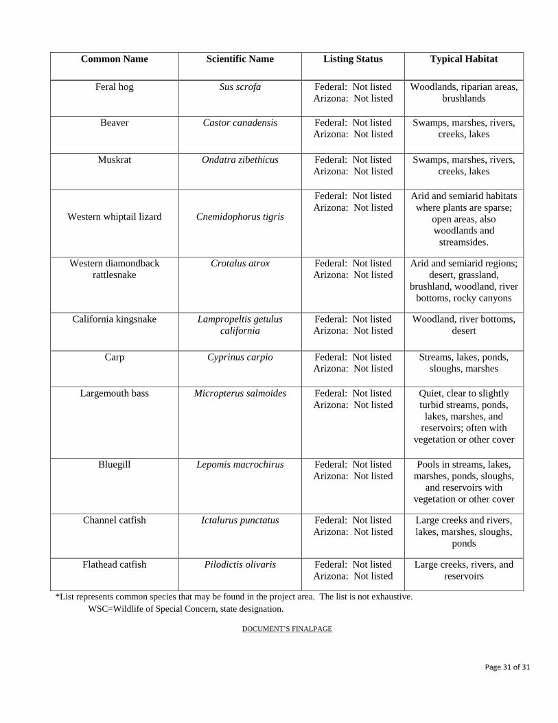
Common Name Scientific Name Listing Status Typical Habitat
Feral hog Sus scrofa Federal: Not listed Arizona: Not listed
Woodlands, riparian areas, brushlands
Beaver Castor canadensis Federal: Not listed Arizona: Not listed
Swamps, marshes, rivers, creeks, lakes
Muskrat Ondatra zibethicus Federal: Not listed Arizona: Not listed
Swamps, marshes, rivers, creeks, lakes
Western whiptail lizard
Cnemidophorus tigris
Federal: Not listed Arizona: Not listed
Arid and semiarid habitats where plants are sparse;
open areas, also woodlands and
streamsides.
Western diamondback rattlesnake
Crotalus atrox Federal: Not listed Arizona: Not listed
Arid and semiarid regions; desert, grassland,
brushland, woodland, river bottoms, rocky canyons
California kingsnake Lampropeltis getulus california
Federal: Not listed Arizona: Not listed
Woodland, river bottoms, desert
Carp Cyprinus carpio Federal: Not listed Arizona: Not listed
Streams, lakes, ponds, sloughs, marshes
Largemouth bass Micropterus salmoides Federal: Not listed Arizona: Not listed
Quiet, clear to slightly turbid streams, ponds,
lakes, marshes, and reservoirs; often with
vegetation or other cover
Bluegill Lepomis macrochirus Federal: Not listed Arizona: Not listed
Pools in streams, lakes, marshes, ponds, sloughs,
and reservoirs with vegetation or other cover
Channel catfish Ictalurus punctatus Federal: Not listed Arizona: Not listed
Large creeks and rivers, lakes, marshes, sloughs,
ponds
Flathead catfish Pilodictis olivaris Federal: Not listed Arizona: Not listed
Large creeks, rivers, and reservoirs
*List represents common species that may be found in the project area. The list is not exhaustive. WSC=Wildlife of Special Concern, state designation.
DOCUMENT’S FINALPAGE
Page 31 of 31