draft environmental assessment for lake cumberland marina
TRANSCRIPT

Environmental Assessment U.S. Army Corps of Engineers Lake Cumberland Marina, Proposed Expansion Lake Cumberland, Kentucky
i
DRAFT ENVIRONMENTAL ASSESSMENT Proposed Expansion of Lake Cumberland Marina Wolf Creek Dam and Lake Cumberland Project
Russell County, Kentucky
April 13, 2020 For Further Information
Contact:
Travis Wiley, Biologist U.S Army Corps of Engineers, Nashville District
Project Planning Branch
m US Army Corps of Engineers ®
Nashville District

Environmental Assessment U.S. Army Corps of Engineers Lake Cumberland Marina, Proposed Expansion Lake Cumberland, Kentucky
ii
TABLE OF CONTENTS 1 PURPOSE AND NEED FOR ACTION ..................................................................... 1
1.1 Authorization ...................................................................................................... 1
1.2 Background ........................................................................................................ 1
1.3 Current Proposal ................................................................................................ 7
1.4 Purpose and Need ............................................................................................. 8
1.5 Issues and Opportunities ................................................................................... 9
2 ALTERNATIVES CONSIDERED ............................................................................. 9
2.1 Alternative 1 – No Action Alternative .................................................................. 9
2.2 Alternative 2 – Applicant’s Preferred Alternative (Water Extension to Russell County Park) .............................................................................................................. 10
2.3 Alternative 3 – Southward Extension of Lease Area ........................................ 11
2.4 Alternatives Eliminated From Further Consideration ........................................ 13
3 AFFECTED ENVIRONMENT AND ENVIRONMENTAL CONSEQUENCES ......... 13
3.1 Introduction ...................................................................................................... 13
3.2 Physiography and Topography ........................................................................ 13
3.3 Aquatic Resources ........................................................................................... 14
3.3.1 Wetlands .................................................................................................... 14
3.3.2 Streams ..................................................................................................... 14
3.3.3 Lake Cumberland ...................................................................................... 14
3.4 Water Quality ................................................................................................... 15
3.5 Terrestrial Resources ....................................................................................... 18
3.5.1 Terrestrial Flora ......................................................................................... 18
3.5.2 Terrestrial Fauna ....................................................................................... 19
3.6 Archaeological and Historic Resources ............................................................ 19
3.7 Threatened and Endangered Species .............................................................. 20
3.8 Hazardous, Toxic, and Radioactive Waste (HTRW) ........................................ 21
3.9 Health and Safety ............................................................................................. 22
3.10 Recreation .................................................................................................... 29
3.11 Socioeconomics ............................................................................................ 32

Environmental Assessment U.S. Army Corps of Engineers Lake Cumberland Marina, Proposed Expansion Lake Cumberland, Kentucky
iii
3.12 Air Quality ..................................................................................................... 33
3.13 Aesthetics ..................................................................................................... 33
4 CUMULATIVE IMPACTS ....................................................................................... 34
4.1 Past and Present Actions ................................................................................. 34
4.2 Reasonably Foreseeable Future Actions ......................................................... 35
4.3 Combined Cumulative Effects .......................................................................... 36
5 ENVIRONMENTAL COMPLIANCE ........................................................................ 36
5.1 Executive Order 11990-Wetlands .................................................................... 36
5.2 Farmland Policy Protection Act ........................................................................ 37
5.3 Executive Order 11988-Floodplain Management ............................................. 37
5.4 Clean Water Act / Section 10 of the Rivers and Harbors Act ........................... 37
5.5 National Pollutant Discharge Elimination System (NPDES) ............................. 37
5.6 Endangered Species Act .................................................................................. 38
5.7 Fish and Wildlife Coordination Act ................................................................... 38
5.8 National Historic Preservation Act .................................................................... 38
5.9 Executive Order 13514 – Environmental Justice.............................................. 39
5.10 Clean Air Act ................................................................................................. 39
5.11 Comprehensive Environmental Response, Compensation, and Liability Act 39
5.12 Resource Conservation and Recovery Act (RCRA) ...................................... 40
6 PUBLIC AND AGENCY COORDINATION ............................................................. 40
6.1 Public and Agency Involvement ....................................................................... 40
6.1.1 Public Meeting ........................................................................................... 40
6.1.2 Public Comments ...................................................................................... 40
6.2 Notice of Availability (NOA) .............................................................................. 46
7 CONCLUSION ....................................................................................................... 46
8 REFERENCES....................................................................................................... 48

Environmental Assessment U.S. Army Corps of Engineers Lake Cumberland Marina, Proposed Expansion Lake Cumberland, Kentucky
iv
FIGURES
Figure 1. Lake Cumberland Vicinity Map ......................................................................... 2 Figure 2. LCM Lease Area Prior to June, 2018 Amendment .......................................... 4 Figure 3. LCM Lease Area After June, 2018 Amendment .............................................. 4 Figure 4. Initial Proposal for Expansion of Alligator II Lease (November 15, 2017) ........ 5 Figure 5. Second Proposal for LCM Expansion (February 26, 2018) .............................. 6 Figure 6. Alternative 2 (Applicant's Preferred Alternative) ............................................ 10 Figure 7. Alternative 3, Southward Extension of Lease Area (Conceptual Configuration
Drafted by USACE; was not Submitted by the Applicant) ............................. 11 Figure 8. Normal Pool Operating Levels on Lake Cumberland ..................................... 24 Figure 9. Alternative 2 Configuration in Relation to 680’ elevation ............................... 26 Figure 10. Potential Dock Locations under Alternative 3; Relative to 680’ Elevation ... 28
TABLES
Table 1. Impaired Waters in the Lake Cumberland Watershed (HUC-8 05130103) ...... 17 Table 2. Federally Listed Threatened and Endangered Species Potentially Present in Project Area (USFWS 2019) ......................................................................................... 21 Table 3. Annual Visitation Data for Lake Cumberland Facilities, reported via VERS (Visitation Estimation and Reporting System) ............................................................... 29 Table 4. Travel times Associated with Alternatives 1, 2 and 3 ..................................... 31 Table 5. Occupancy Lists at Marinas on Lake Cumberland .......................................... 36
APPENDICES
APPENDIX A. Maps, Plans, and Project Description from the Project Application (July
24, 2019) APPENDIX B. USACE Correspondence (September 20, 2019)
Lewis, Brisbois, Bisgaard and Smith Response (December 17, 2019) APPENDIX C. Cultural Resources Coordination

Environmental Assessment U.S. Army Corps of Engineers Lake Cumberland Marina, Proposed Expansion Lake Cumberland, Kentucky
1
1 PURPOSE AND NEED FOR ACTION
The U.S. Army Corps of Engineers, Nashville District (USACE) is evaluating the impacts of a proposed expansion of Lake Cumberland Marina (LCM) through the preparation of an Environmental Assessment (EA). LCM is a commercial marina at the Wolf Creek Dam and Lake Cumberland Project, Russell County, Kentucky. Project coordinates are N. 36.987689, W. -84.926617. 1.1 Authorization
This EA is being conducted under Operation and Maintenance authority for Wolf Creek Dam and Lake Cumberland. Wolf Creek Dam and Lake Cumberland was authorized by the River and Harbor Act of July 24, 1946 (Public Law 396, 82nd Congress, 2nd Session). This EA is being prepared pursuant to the National Environmental Policy Act (NEPA) (42 U.S.C. §§ 4321-4370h), Council for Environmental Quality (CEQ) regulations (40 CFR 1500-1508), and USACE Regulation Engineer Regulation (ER) 200-2-2, titled Policies and Procedures for Implementing NEPA. 1.2 Background
Wolf Creek Dam is a large, high head dam located near Jamestown, Kentucky at Cumberland River Mile (CRM) 460.9. It controls runoff from a drainage area of approximately 5,789 square miles. Construction began in August 1941, and was delayed for three years by World War II. The dam was completed for full use in August 1952 and has provided important benefits of flood control, hydropower, recreation, water supply, water quality, and fish and wildlife habitat since construction (USACE 2007). Under normal operations, the maximum power pool elevation, generally referred to as the “normal summer pool” elevation, is 723’ above mean sea level (msl). In winter months, specifically January and February, power pool elevations range between 700’ msl and 683’ msl although pools can rise above or fall below those elevations depending on several factors (See Figure 8; Section 3.9). The Lake Cumberland flood control reaches a maximum elevation of 760’ msl. On February 26, 2019, Lake Cumberland reached a maximum pool elevation of 756.52’ msl. For many years, seepage problems through the karst limestone foundation required diligent monitoring, subsurface investigations and grouting. Foundation conditions deteriorated because clay-filled joints in the rock within the rims and dam foundation eroded. A report titled Wolf Creek Dam, Jamestown, Kentucky, Seepage Control Major Rehabilitation Evaluation Final Report (July 11, 2005) evaluated seepage problems and provided justification for a major rehabilitation project at Wolf Creek Dam (USACE 2007). The repair work was completed in 2014 and normal pool levels resumed at Lake Cumberland thereafter.
Environmental Assessment U.S. Army Corps of Engineers Lake Cumberland Marina, Proposed Expansion Lake Cumberland, Kentucky
2
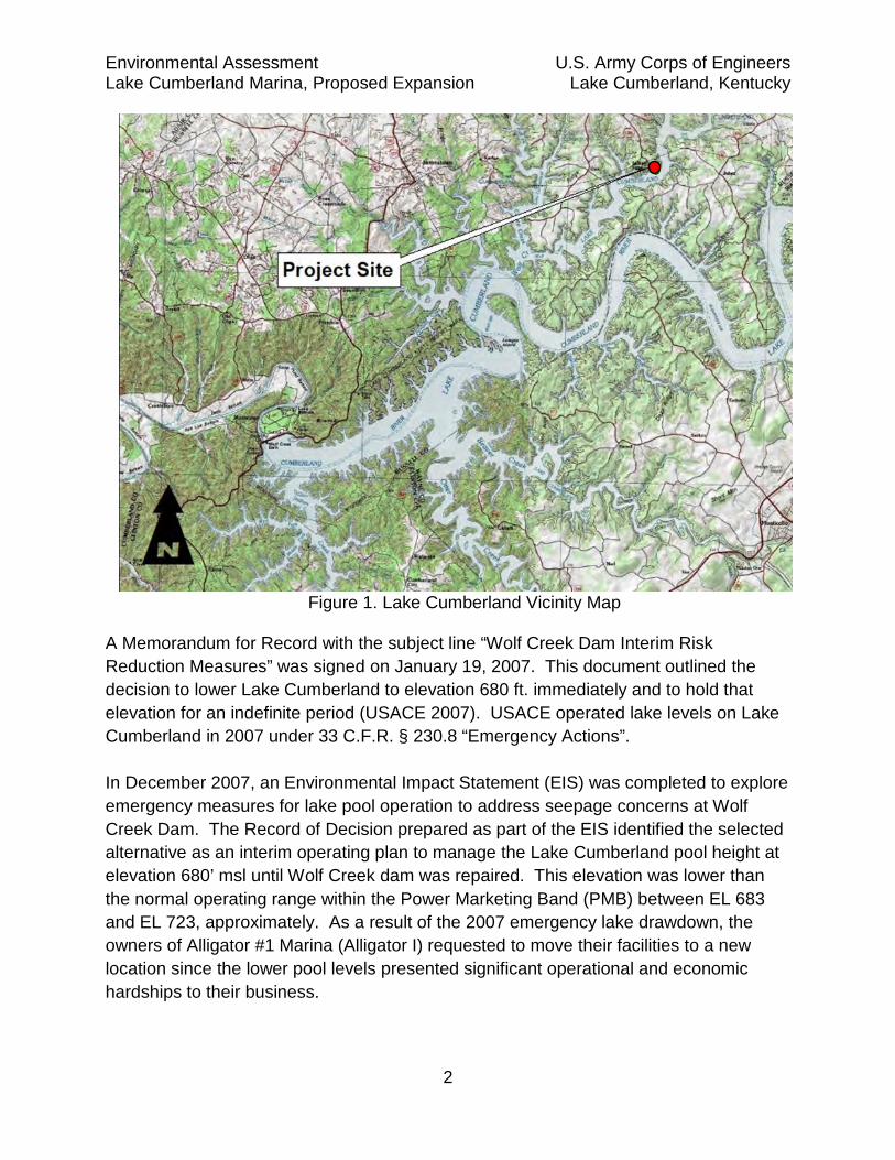
Figure 1. Lake Cumberland Vicinity Map
A Memorandum for Record with the subject line “Wolf Creek Dam Interim Risk Reduction Measures” was signed on January 19, 2007. This document outlined the decision to lower Lake Cumberland to elevation 680 ft. immediately and to hold that elevation for an indefinite period (USACE 2007). USACE operated lake levels on Lake Cumberland in 2007 under 33 C.F.R. § 230.8 “Emergency Actions”. In December 2007, an Environmental Impact Statement (EIS) was completed to explore emergency measures for lake pool operation to address seepage concerns at Wolf Creek Dam. The Record of Decision prepared as part of the EIS identified the selected alternative as an interim operating plan to manage the Lake Cumberland pool height at elevation 680’ msl until Wolf Creek dam was repaired. This elevation was lower than the normal operating range within the Power Marketing Band (PMB) between EL 683 and EL 723, approximately. As a result of the 2007 emergency lake drawdown, the owners of Alligator #1 Marina (Alligator I) requested to move their facilities to a new location since the lower pool levels presented significant operational and economic hardships to their business.

Environmental Assessment U.S. Army Corps of Engineers Lake Cumberland Marina, Proposed Expansion Lake Cumberland, Kentucky
3
Alligator I resided on the right descending bank (RDB) of Wolf Creek, directly downstream of its confluence with Alligator Creek. After an Environmental Assessment concluded there would be no significant impacts caused by the relocation, and a Finding of No Significant Impact was signed in February 2008, the marina facilities were moved to a location known as the Cave Springs Recreation Area on the left descending bank (LDB) of Wolf Creek (mile 2.7) where the marina continues operations as Wolf Creek Marina. The parking and ramp facilities associated with the former Alligator I marina site are currently under public park and recreation lease to Russell County Fiscal Court (approximately 46.86 acres of land), along with a reduced water lease area of approximately 18.31 acres.
Records from the Lake Cumberland Resource Manager’s Office (RMO) indicate that there have been contemporaneously outgranted marinas at the site of both Alligator I and the current site of LCM, previously known as Alligator II Marina. There was also a USACE recreation area named Wolf Creek Recreation Area in place at the Alligator II/LCM site from the mid-1960’s to the mid-1990’s, which included campground and day use facilities. Those structures were incorporated into the Alligator II lease in the mid-1990’s. Aerial imagery from 1972 and 1973 appear to show only a small floating structure at the Alligator I site and no floating structures in the Alligator II (LCM) area. An aerial photograph from 1975 indicates a small floating structure located at the Alligator II site. The build-up of the floating marinas at both sites appears to have occurred mostly in the 1990’s and early 2000’s. LCM is located nine miles southeast of Russell Springs, Kentucky, off Kentucky Highway 1383 on the right bank of Wolf Creek. LCM currently has 450 boat rental slips (Sirk and Co. 2019). The facilities also include a snack bar, packaged food and vending services, public restrooms, service dock, repair shop, equipment sales/ rental, fish cleaning station, paved roads, parking lots, as well as swimming, picnicking and camping facilities. There are 16 rental cabin units in the portion of the lease area previously known as Wolf Creek Recreation Area, including two handicap- accessible units located on adjacent private property (USACE 2011). Between approximately 1996 and 2003, dock structures extended outside the LCM water lease after the marina was given permission by RMO personnel to build the structures. However, the lease was not expanded in the USACE administrative record until June 2018, when the water lease area was amended from 90.80 acres (land/water acreage) to approximately 110.06 acres (an increase of approximately 19.26 water acres) to incorporate the existing dock structures. The lease area before expansion is shown in Figure 2 and the current lease area is shown in Figure 3.

Environmental Assessment U.S. Army Corps of Engineers Lake Cumberland Marina, Proposed Expansion Lake Cumberland, Kentucky
4
Figure 2. LCM Lease Area Prior to June, 2018 Amendment
Figure 3. LCM Lease Area After June, 2018 Amendment
Requests for Expansion: The initial formal application for lease expansion was sent to USACE on November 15, 2017 by an attorney representing Mr. J.D. Hamilton (applicant). Mr. Hamilton requested that the lease, which was at that time approximately 90.80 acres (see previous paragraph) be expanded to include approximately 1,796 combined acres of land and water, an area that would encompass impounded reaches on Alligator Creek and Wolf Creek above the existing marina lease (See Figure 4). The request included the lease area of Russell County Park.

Environmental Assessment U.S. Army Corps of Engineers Lake Cumberland Marina, Proposed Expansion Lake Cumberland, Kentucky
5
Figure 4. Initial Proposal for Expansion of Alligator II Lease (November 15, 2017)
On February 26, 2018, the applicant submitted a new request with a reduced expansion area of approximately 213 acres. The new request included land/water acreage in the historic lease area of Alligator I Marina and water acreage between the Alligator I Marina site (now Russell County Park) and the LCM lease. The new request also included a 1.26 mile walkway (16 feet wide) positioned in the channel of Wolf Creek between the northern end of the LCM lease and the Russell County Park lease with 68 slips at the at the northern (upstream) end of the expansion. This proposal excluded land and water acreage associated with the existing Russell County Park lease (See Figure 5).
Proposed Lease Expansion (Yellow
Russell Co. Park Lease
LCM Lease (before 2018 expansion)

Environmental Assessment U.S. Army Corps of Engineers Lake Cumberland Marina, Proposed Expansion Lake Cumberland, Kentucky
6
Figure 5. Second Proposal for LCM Expansion (February 26, 2018)
On April 6, 2018, the USACE RMO sent a letter to Mr. Hamilton responding to the second proposal (Figure 5). The letter stated that after an evaluation of the proposal under Engineering Regulation (ER) 1130-2-550, the RMO would not recommend approval of the proposal because placement of the floating walkway in the middle of the channel would constrict safe passage of vessels and impact other recreational users of the lake, and the Lake Cumberland Master Plan did not envision a new marina development at former Alligator I (USACE 2018). Notably, the 2011 Master Plan did not remove the subject area from the Master Plan as a high density recreation area and it remains available for high density recreation.
Environmental Assessment U.S. Army Corps of Engineers Lake Cumberland Marina, Proposed Expansion Lake Cumberland, Kentucky
7
In December 2018, the applicant discussed modification of his request to include the aforementioned 1.26 mile walkway (16 feet wide) with 68 slips at the northern (upstream) end of the expansion, and mapped a proposed, reduced lease expansion of approximately 44 acres to only include a narrow water lease, approximately 150’ on either side of the proposed walkway. This tentative proposal was eventually superseded with a new submittal (LBBS 2019). On March 3, 2019 the applicant modified his lease expansion request to include 181.25 acres of water and 232 parallel moorage slips which would accommodate houseboats, floating cabins or other vessels. The proposed expansion also included a 1.26 mile slipway/walkway, 28 floating cabins and water acreage on Wolf Creek from bank-to-bank between the LCM lease and Russell County Park. Additional information was submitted by Mr. Hamilton on April 12 and 17, 2019 to supplement the project application. After a review of the project application, the RMO declined the proposal on May 1, 2019, citing burdens to public recreation (navigation), public safety concerns associated with emergency access, and lack of public land to support electric facilities. The letter suggested that there were “agreeable alternatives in expanding recreational facilities, potentially in the wider portion of Lake Cumberland to the south of the marina and a smaller floating facility to the northeast of the marina” (USACE 2019b). The possibility of a new marina at Alligator I was also briefly reviewed but not pursued. Any proposal for a new, additional marina located at the Russell County footprint would require either that Russell County terminate its public park lease to permit full and open competition of the site, or that Russell County operate a commercial concessionaire sublease after competition. Russell County affirmed that neither option was acceptable and has further requested a term lease extension through 2060, so any alternative involving a new marina site was not advanced for further consideration. So long as Russell County Park remains at the site, no new commercial concessionaire developments will be permitted in the lease space. 1.3 Current Proposal
The current proposal was submitted to USACE on July 24, 2019 for review, with modifications made to specifically address the concerns raised in denials of the prior iterations of the application as well as comments raised during public meetings. Based on those modifications, and contingent upon concurrence from Russell County, the RMO recommended that waters be made available for the expansion (ROA 2019). Russell County Fiscal Court passed a resolution in support of the application and

Environmental Assessment U.S. Army Corps of Engineers Lake Cumberland Marina, Proposed Expansion Lake Cumberland, Kentucky
8
entered into a Memorandum of Agreement memorializing their support for the project (MOA 2019). The application requested the same lease expansion area (181.25 acres of water) to include 227 parallel boat slips (slips are approximately 50’ wide according to submitted plans) and 26 floating cabins. To alleviate USACE concerns regarding public navigation and safety, the previous plans were revised to include two “slip through” bridges along the 1.26 mile walkway/slipway to allow boats to move through the structure and construction of a 530 x 16 ft. floating courtesy dock, which would extend from Russell County Park to the end of the Russell County lease area and provide emergency services access and connection with the northern end of a 1.26 mile walkway/boat slip structure extending from LCM. The courtesy dock is part of a separate application submitted by Russell County, seeking both a lease term extension through 2060 and permission to construct the floating dock within the public park and recreation space. That request is being evaluated by USACE as a separate real estate action. An application to construct an improvement or extend a term within an existing public park lease is normally considered categorically excluded from NEPA, because it does not individually or cumulatively have a significant effect on the human environment to compel drafting of an environmental assessment. Given that the applicant’s preferred alternative involves construction of the floating courtesy dock, however, impacts to the human environment caused by the construction of the dock within Russell County Park will be considered in this EA as a connected action to the LCM marina expansion. This is the current proposal shown in Section 2 as Alternative 2. 1.4 Purpose and Need
A market and feasibility study was prepared by Chad Sirk (Sirk Appraisal) on behalf of the applicant on February 21, 2018 (amended June 19, 2018 and November 15, 2019). The report addressed the inventory of existing boat slips on Lake Cumberland, supply and future demand analyses for slips in the vicinity of LCM (Alligator Creek and area formerly known as Alligator 1), and a macroeconomic analysis of the boating industry in the market area, which included the states of Kentucky, Ohio, Illinois, Indiana and Michigan. The study made several conclusions which demonstrated a need for the addition of boat slips in the vicinity of LCM and on Lake Cumberland overall (Sirk and Co. 2019):
1) Demand exists over the next five years for approximately 1,500 slips on Lake Cumberland overall;

Environmental Assessment U.S. Army Corps of Engineers Lake Cumberland Marina, Proposed Expansion Lake Cumberland, Kentucky
9
2) Demand existed in the vicinity of LCM and the vacant Alligator I Marina site to support approximately 300 slips;
3) Boat slips at LCM (still identified as Alligator II in the study) were 80% occupied. The purpose of the project was identified in the current project application to USACE as “expansion of existing commercial marina concession lease to include adjacent additional water acreage, specifically for construction of 530 ft. x 16 ft. floating courtesy dock and 227 additional boat slips to meet public demand for recreational access on an underserved portion of Lake Cumberland” (LCM 2019b). 1.5 Issues and Opportunities
The applicant’s market and feasibility study, as amended, indicated that there was an opportunity to serve an ongoing and forecast public demand for boating slips on Lake Cumberland in the vicinity of the existing LCM site. Section 2 of this EA identifies alternatives considered to accomplish the project purpose as well as the No Action Alternative. Effects to the human environment will be assessed in Section 3 for the alternatives carried forward for consideration. 2 ALTERNATIVES CONSIDERED
2.1 Alternative 1 – No Action Alternative
Evaluation of the no action alternative is required by Engineer Regulation 200-2-2 and NEPA. The no action alternative provides an environmental baseline to compare the impacts of the proposed action and alternatives. Under Alternative 1, the existing facilities would remain in place and there would be no expansion of the existing LCM lease area. No new boat slips would be added to LCM facilities and any proposed benefits to the local economy and improvements to Russell County Park would not be realized.

Environmental Assessment U.S. Army Corps of Engineers Lake Cumberland Marina, Proposed Expansion Lake Cumberland, Kentucky
10
2.2 Alternative 2 – Applicant’s Preferred Alternative (Water Extension to Russell County Park)
Figure 6. Alternative 2 (Applicant's Preferred Alternative)
As described in Section 1.2, Alternative 2 would result in a lease expansion area (181.25 acres of water) to include a 1.26 mile walkway/boat slip structure extending from LCM to Russell County Park’s lease boundary line. Additional features would include 227 boat slips, 26 floating cabins, two “slip through” bridges to allow boats to move through the walkway/slip structure, and a 530 x 16 ft. floating community dock, which would extend from Russell County Park to connect with the northern end of a 1.26 mile walkway/boat slip structure. Slips would be 50’ wide (parallel with walkway) and approximately 32’ deep (extending out from walkway).
Proposed Lease Expansion (Approximate)
Courtesy Float
and Boat Slips
Slip-Through Areas

Environmental Assessment U.S. Army Corps of Engineers Lake Cumberland Marina, Proposed Expansion Lake Cumberland, Kentucky
11
2.3 Alternative 3 – Southward Extension of Lease Area
Figure 7. Alternative 3, Southward Extension of Lease Area (Conceptual
Configuration Drafted by USACE; not Submitted by the Applicant) Though not submitted by the applicant, Alternative 3 has been evaluated because it would meet the applicant’s stated project purpose of “expansion of existing commercial marina concession lease to include adjacent additional water acreage, specifically for construction of 530 ft. x 16 ft. floating courtesy dock and 227 additional boat slips to meet public demand for recreational access on an underserved portion of Lake Cumberland” (LCM 2019b). Under this alternative, LCM would expand southward on the downstream end of the current lease boundary. Floating dock slips could then be constructed west of the existing dock infrastructure in a similar configuration to the facilities currently in place, as depicted in Figure 7. A floating courtesy dock could further be constructed at multiple locations within the expanded lease boundary, and as such was not depicted in Figure 7. This geographically proximate expansion could be anticipated to offer comparable access, slip supply, and socioeconomic benefits as a northward expansion. Under this alternative, however, Russell County Park would lose the direct benefit of a courtesy dock built within its lease space, as well as additional public access for recreation and no cost security surveillance of the parking lot. It should be noted that

Environmental Assessment U.S. Army Corps of Engineers Lake Cumberland Marina, Proposed Expansion Lake Cumberland, Kentucky
12
the conceptual configuration shown in Figure 7 was drafted by USACE for purposes of this EA, it was not designed or submitted by the applicant. The applicant objects that he has no interest in further development in the area formerly known as Alligator II and that Alternative 3 would result in overbuilding this specific area of the lake as demand for additional slips in the former Alligator II area has been met.
The existing slips at LCM vary in size and require boats to be moored perpendicular to the walkway. However, for purposes of this EA, Alternative 3 will assume the same slip dimensions that were submitted in the plans for Alternative 2, which are 50’ wide (parallel with walkway) and approximately 32’ deep (extending out from walkway). This alternative could also accommodate multiple configurations with varying length depending on logistical preferences, size of boats to be moored, and other considerations. For example, it is likely that components of the existing marina could be reconfigured (gas pumps, extension of main access, etc.) to accommodate this alternative. However, for purposes of ingress/egress of boats for 227 slips and construction of 26 floating cabins, it is assumed that a two-finger walkway and slip design could be utilized in a manner that would leave a similar space between the two fingers than the slip configuration currently in place on the northeastern portion of the marina. It is further assumed that costs of construction for the conceptual expansion could be comparable or somewhat less to a 1.26 mile linear expansion, because it would build on existing infrastructure.
The size of the lease area expansion shown in Figure 7 is also merely a conceptual estimate by USACE and could be adjusted. It estimates that the structures would extend approximately 0.60 miles downstream, which would also require the no-wake zone on the downstream end of the lease area to be extended approximately 0.60 miles downstream from the current configuration. Parking for the additional slips would be contained in the lots used for day-to-day operations at LCM currently, including overflow parking located at a nearby KOA campground.
The applicant opposes expansion south of the LCM marina area in Tracts S-1912 and S-1911, citing failure to meet project purpose, accessibility issues, safety concerns with the road that leads to LCM (KY 1383), and the current and future demand for boat slips to be located at and accessed from the north, via the connection to Russell County Park (LBBS 2019; Sirk & Co. 2019). The applicant’s input has been considered in evaluating the impacts of Alternative 3.

Environmental Assessment U.S. Army Corps of Engineers Lake Cumberland Marina, Proposed Expansion Lake Cumberland, Kentucky
13
2.4 Alternatives Eliminated From Further Consideration
Section 1.2 (Background) describes a number of options that were considered by the applicant and USACE between November 2017 and May 2019. For purposes of this EA, those proposals will not be carried forward for consideration for reasons described in Section 1.2. Alternatives 1-3 described in this section will all be carried forward for consideration. 3 AFFECTED ENVIRONMENT AND ENVIRONMENTAL CONSEQUENCES
3.1 Introduction
LCM was identified in the Lake Cumberland Master Plan (2011) as a recreation area located nine miles southeast of Russell Springs, Kentucky, off Kentucky Highway 1383 on the right bank of Wolf Creek. 3.2 Physiography and Topography
The proposed project site is located within the Eastern Highland Rim which is generally described in the following paragraph. Eastern Highland Rim (71g) The Eastern Highland Rim has level terrain, with landforms characterized as tablelands of moderate relief and irregular plains. Mississippian-age limestone, chert, shale and dolomite predominate, and karst terrain sinkholes and depressions are especially noticeable in some areas. Numerous springs and spring associated fish fauna also typify the region. Natural vegetation for the region is transitional between the oak-hickory type to the west and the mixed mesophytic forests of the Appalachian ecoregions to the east. Barrens and former prairie areas are now mostly oak (Quercus spp.) thickets or pasture and cropland (USEPA 2020). The land lease area at LCM is located along a relatively steep slope (25%-35% slope throughout most of the area) with gentler contours along stream bottoms and existing campsites near the edge of Lake Cumberland. A site inspection on September 3, 2019 indicated the majority of the lease area is dominated by hardwood forest (see Section 3.5.1). None of the alternatives would affect the physiography, topography or climate at Lake Cumberland (Wolf Creek tributary) or Russell County, Kentucky.

Environmental Assessment U.S. Army Corps of Engineers Lake Cumberland Marina, Proposed Expansion Lake Cumberland, Kentucky
14
3.3 Aquatic Resources
The expansion would consist of the addition of floating structures entirely within the normal summer (hydropower) pool elevation of Lake Cumberland. 3.3.1 Wetlands
No wetlands would be affected by any of the alternatives. 3.3.2 Streams
Although a site visit on September 3, 2019 revealed that streams are present in the LCM land lease area, they would not be affected by any of the alternatives as both Alternatives 2 and 3 would consist of floating dock structures on normal operating pools of Lake Cumberland. 3.3.3 Lake Cumberland
Lake Cumberland is 101 river miles in length and has 1,255 miles of shoreline, providing a total storage capacity of 6,089,000 acre-feet (1 acre-foot = 1 acre, 1 foot deep or 325,850 gallons). Depths at the lake project can reach approximately 180 feet (Navionics 2019). The upper levels of the reservoir, containing 2,094,000 acre-feet of area, are used to hold floodwaters which could otherwise cause flooding downstream. None of the alternatives would result in the discharge of fill material below the flood control, hydropower or conservation pools at Lake Cumberland. The floating structures would not affect the physical characteristics, flood control or hydropower characteristics of the lake. Lake Cumberland has steeply sloping shorelines and very limited areas of shallow water to support aquatic vegetation as compared to more shallow reservoirs in the region. None of the alternatives would affect aquatic flora in Wolf Creek or Lake Cumberland. Prior to impoundment, the Cumberland River supported highly diverse assemblages of fish and aquatic life. Although the tailwater changed to a coldwater fishery after impoundment, the lake itself remains a warm water fishery and is popular among recreational fisherman. Common species include: bass (Micropterus spp.); walleye (Stizostedion vitreum); crappie (Pomoxis spp.); catfish (Ictalurus spp.); and bluegill (Lepomis machrochirusu) (USACE 2007). Alternative 1 – No Action Alternative would have no effect on aquatic flora within the proposed project footprint.

Environmental Assessment U.S. Army Corps of Engineers Lake Cumberland Marina, Proposed Expansion Lake Cumberland, Kentucky
15
Alternatives 2 and 3– Expansion of Lease Area and Addition of Boat Slips (Both Configurations). The construction of 227 additional boat slips in the vicinity of LCM and a floating courtesy dock in Russell County Park under Alternative 2, or the construction only of the additional boat slips under Alternative 3, could result in a minor, permanent, detrimental effect to aquatic wildlife. Construction of the floating dock facilities associated with either action alternative would provide some structure for fish in the reservoir. However, the benefits associated with dock construction would be offset by decreases in available areas for fishing due to installation of dock facilities in the expanded lease areas. Though the application does not state whether recreational fishing would be permitted within the expanded lease area, the applicant has represented at public meetings that he would not restrict public access to fishing in the expanded lease area and that fishing would be permitted consistent with standard practice at other marinas on Lake Cumberland. As with any substantial marina expansion, the addition of vessels into a concentrated area of water would result in increased risk for leak of pollution sources associated with boating recreation including, but not limited to: litter, fuel leakage, and wastewater from houseboats or floating cabin facilities. However, conditions in commercial marina leases in LRN generally include a condition that all sanitation facilities on boats moored at the Lessee’s facilities, including rental boats, to be sealed against any discharge into the lake. Lease requirements also generally require services for waste disposal, include sewage pump-out of watercraft, to be provided by the Lessee and prohibit the discharge waste or effluent from the premises in a manner that would contaminate streams or other bodies of water or otherwise become a public nuisance. These restrictions help to mitigate the potential impact of vessel-based pollutants. 3.4 Water Quality
Lake Cumberland is a deep and relatively clear manmade impoundment. Lake depths exceeding 100 feet are common, with the maximum depth in the main channel just above the dam approximately 180 feet in depth (Navionics 2019). The surface water temperature during the summer months range from 78 to 83 degrees Fahrenheit and 40-50 degrees Fahrenheit during the winter. The lake undergoes strong thermal stratification beginning in mid-spring and intensifying through the summer before slowly destratifying during the late summer and fall. Main channel areas of the impoundment tend to be oligotrophic to mesotrophic (low to moderately enriched). Embayments tend to be more mesotrophic, with some localized areas trending toward being eutrophic (highly enriched). During stratification dissolved oxygen (DO) concentrations in deeper layers gradually deplete, and occasionally under extreme conditions DO levels approach zero below the warm upper layer (epilimnion) of the lake. DO levels in other layers (the metalimnion and hypolimnion) generally become too low to support most fish
Environmental Assessment U.S. Army Corps of Engineers Lake Cumberland Marina, Proposed Expansion Lake Cumberland, Kentucky
16
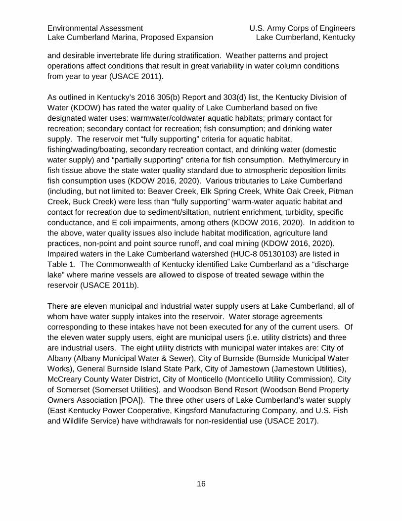
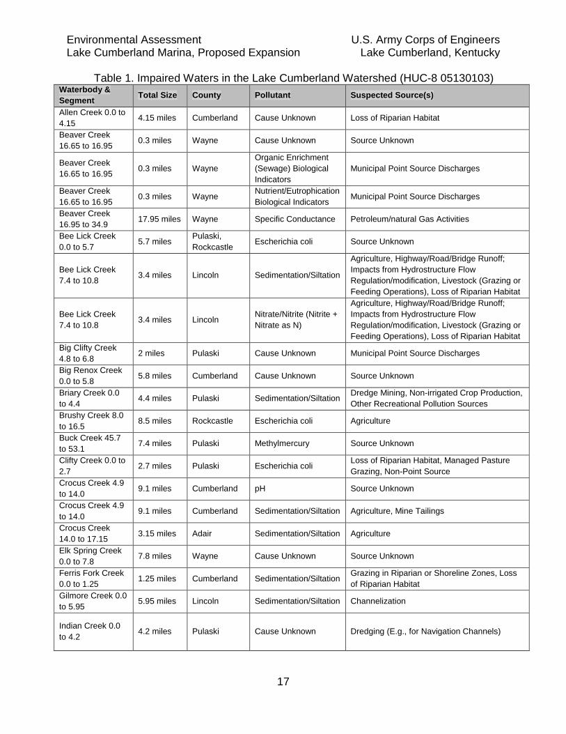
and desirable invertebrate life during stratification. Weather patterns and project operations affect conditions that result in great variability in water column conditions from year to year (USACE 2011). As outlined in Kentucky’s 2016 305(b) Report and 303(d) list, the Kentucky Division of Water (KDOW) has rated the water quality of Lake Cumberland based on five designated water uses: warmwater/coldwater aquatic habitats; primary contact for recreation; secondary contact for recreation; fish consumption; and drinking water supply. The reservoir met “fully supporting” criteria for aquatic habitat, fishing/wading/boating, secondary recreation contact, and drinking water (domestic water supply) and “partially supporting” criteria for fish consumption. Methylmercury in fish tissue above the state water quality standard due to atmospheric deposition limits fish consumption uses (KDOW 2016, 2020). Various tributaries to Lake Cumberland (including, but not limited to: Beaver Creek, Elk Spring Creek, White Oak Creek, Pitman Creek, Buck Creek) were less than “fully supporting” warm-water aquatic habitat and contact for recreation due to sediment/siltation, nutrient enrichment, turbidity, specific conductance, and E coli impairments, among others (KDOW 2016, 2020). In addition to the above, water quality issues also include habitat modification, agriculture land practices, non-point and point source runoff, and coal mining (KDOW 2016, 2020). Impaired waters in the Lake Cumberland watershed (HUC-8 05130103) are listed in Table 1. The Commonwealth of Kentucky identified Lake Cumberland as a “discharge lake” where marine vessels are allowed to dispose of treated sewage within the reservoir (USACE 2011b). There are eleven municipal and industrial water supply users at Lake Cumberland, all of whom have water supply intakes into the reservoir. Water storage agreements corresponding to these intakes have not been executed for any of the current users. Of the eleven water supply users, eight are municipal users (i.e. utility districts) and three are industrial users. The eight utility districts with municipal water intakes are: City of Albany (Albany Municipal Water & Sewer), City of Burnside (Burnside Municipal Water Works), General Burnside Island State Park, City of Jamestown (Jamestown Utilities), McCreary County Water District, City of Monticello (Monticello Utility Commission), City of Somerset (Somerset Utilities), and Woodson Bend Resort (Woodson Bend Property Owners Association [POA]). The three other users of Lake Cumberland’s water supply (East Kentucky Power Cooperative, Kingsford Manufacturing Company, and U.S. Fish and Wildlife Service) have withdrawals for non-residential use (USACE 2017).
Environmental Assessment U.S. Army Corps of Engineers Lake Cumberland Marina, Proposed Expansion Lake Cumberland, Kentucky
17
Table 1. Impaired Waters in the Lake Cumberland Watershed (HUC-8 05130103) Waterbody & Segment Total Size County Pollutant Suspected Source(s)
Allen Creek 0.0 to 4.15 4.15 miles Cumberland Cause Unknown Loss of Riparian Habitat
Beaver Creek 16.65 to 16.95 0.3 miles Wayne Cause Unknown Source Unknown
Beaver Creek 16.65 to 16.95 0.3 miles Wayne
Organic Enrichment (Sewage) Biological Indicators
Municipal Point Source Discharges
Beaver Creek 16.65 to 16.95 0.3 miles Wayne Nutrient/Eutrophication
Biological Indicators Municipal Point Source Discharges
Beaver Creek 16.95 to 34.9 17.95 miles Wayne Specific Conductance Petroleum/natural Gas Activities
Bee Lick Creek 0.0 to 5.7 5.7 miles Pulaski,
Rockcastle Escherichia coli Source Unknown
Bee Lick Creek 7.4 to 10.8 3.4 miles Lincoln Sedimentation/Siltation
Agriculture, Highway/Road/Bridge Runoff; Impacts from Hydrostructure Flow Regulation/modification, Livestock (Grazing or Feeding Operations), Loss of Riparian Habitat
Bee Lick Creek 7.4 to 10.8 3.4 miles Lincoln Nitrate/Nitrite (Nitrite +
Nitrate as N)
Agriculture, Highway/Road/Bridge Runoff; Impacts from Hydrostructure Flow Regulation/modification, Livestock (Grazing or Feeding Operations), Loss of Riparian Habitat
Big Clifty Creek 4.8 to 6.8 2 miles Pulaski Cause Unknown Municipal Point Source Discharges
Big Renox Creek 0.0 to 5.8 5.8 miles Cumberland Cause Unknown Source Unknown
Briary Creek 0.0 to 4.4 4.4 miles Pulaski Sedimentation/Siltation Dredge Mining, Non-irrigated Crop Production,
Other Recreational Pollution Sources Brushy Creek 8.0 to 16.5 8.5 miles Rockcastle Escherichia coli Agriculture
Buck Creek 45.7 to 53.1 7.4 miles Pulaski Methylmercury Source Unknown
Clifty Creek 0.0 to 2.7 2.7 miles Pulaski Escherichia coli Loss of Riparian Habitat, Managed Pasture
Grazing, Non-Point Source Crocus Creek 4.9 to 14.0 9.1 miles Cumberland pH Source Unknown
Crocus Creek 4.9 to 14.0 9.1 miles Cumberland Sedimentation/Siltation Agriculture, Mine Tailings
Crocus Creek 14.0 to 17.15 3.15 miles Adair Sedimentation/Siltation Agriculture
Elk Spring Creek 0.0 to 7.8 7.8 miles Wayne Cause Unknown Source Unknown
Ferris Fork Creek 0.0 to 1.25 1.25 miles Cumberland Sedimentation/Siltation Grazing in Riparian or Shoreline Zones, Loss
of Riparian Habitat Gilmore Creek 0.0 to 5.95 5.95 miles Lincoln Sedimentation/Siltation Channelization
Indian Creek 0.0 to 4.2 4.2 miles Pulaski Cause Unknown Dredging (E.g., for Navigation Channels)

Environmental Assessment U.S. Army Corps of Engineers Lake Cumberland Marina, Proposed Expansion Lake Cumberland, Kentucky
18
Waterbody & Segment Total Size County Pollutant Suspected Source(s)
Lake Cumberland 50250 acres
Pulaski, Russell, Wayne
Methylmercury Atmospheric Deposition — Toxics
Lewis Creek 0.0 to 3.6 3.6 miles Cumberland Nutrient/Eutrophication
Biological Indicators Loss of Riparian Habitat, Municipal (Urbanized High Density Area)
Lewis Creek 0.0 to 3.6 3.6 miles Cumberland
Organic Enrichment (Sewage) Biological Indicators
Loss of Riparian Habitat, Municipal (Urbanized High Density Area)
Lewis Creek 0.0 to 3.6 3.6 miles Cumberland Sedimentation/Siltation Loss of Riparian Habitat, Municipal (Urbanized
High Density Area) Marrowbone Creek 0.0 to 2.8 2.8 miles Cumberland Cause Unknown Source Unknown
Marrowbone Creek 0.0 to 2.8 2.8 miles Cumberland Escherichia coli Non-Point Source
Middle Fork 0.0 to 2.2 2.2 miles McCreary Sedimentation/Siltation Impacts from Abandoned Mine Lands
(Inactive) Alternative 1 – No Action Alternative would have no effect on water quality within the proposed project area. Alternative 2 and 3 – Expansion of Lease Area and Addition of Boat Slips (All Configurations): The action alternatives would, similar to any substantial marina expansion, carry long-term, minor risks of adverse impacts to water quality within Wolf Creek and Lake Cumberland by facilitating mooring of 227 additional vessels and 26 floating cabins that could contribute to leakage of pollutants such as litter, fuel/oil and wastewater. These effects would be mitigated by LRN lease requirements described in Section 3.3. The construction of a courtesy floating dock also is not anticipated to have any impact on water quality. 3.5 Terrestrial Resources
3.5.1 Terrestrial Flora
A site visit to the LCM upland lease area on September 3, 2019 revealed that site was primarily covered by hardwood forest with small portions (playground area, perimeter of cabins, etc.) consisting of manicured grassy vegetation. Tree species present within the lease area are: Eastern red cedar (Juniperus virginiana), Northern red oak (Quercus rubra), Post oak (Quercus stellata), white oak (Quercus alba), green ash (Fraxinus pennsylvanica), pignut hickory (Carya glabra), shagbark hickory (Carya ovata), common persimmon (Diospyros virginiana), American beech (Fagus grandifolia), sugar maple (Acer saccharum), tulip popular (Liriodendron tulipifera), sweet gum (Liquidambar styraciflua) and basswood (Tilia americana).

Environmental Assessment U.S. Army Corps of Engineers Lake Cumberland Marina, Proposed Expansion Lake Cumberland, Kentucky
19
3.5.2 Terrestrial Fauna
Given the large tracts of hardwood forest and diversity of trees, many species of wildlife would be found in the area. Common fauna include: whitetail deer (Odocoileus virginianus), turkey (Meleagris gallopavo), rabbit (Sylvilagus floridanus), squirrel (Sciurus spp), raccoon (Procyon lotor), skunk (Mephitis mephitis), opossum (Didelphis virginiana), coyote (Canis latrans), and numerous species of songbirds, raptors, and waterfowl, reptiles, amphibians, and small mammals. (USACE, 2011b). None of the alternatives would affect terrestrial flora or fauna species since the work would consist of floating structures on the water surface of Lake Cumberland. Any proposed electric lines to support the dock structures would run on top of the ground and are not anticipated to require tree clearing. Thus, there would be no effect to terrestrial flora or fauna. 3.6 Archaeological and Historic Resources
Kentucky Archaeological Survey (KAS) places Russell County within the Lake Cumberland Section of the Upper Cumberland Management Area and within the Eastern Section of the Pennyrile Cultural Landscape (KAS 2008). KAS describes the Eastern Pennyrile and the historic development as “having been settled somewhat early, this area remains relatively undeveloped due to its poor transportation facilities…The rural landscape primarily consists of small, often marginal farms (KAS 2008: 21).” Kentucky’s cultural history is generally divided into two broad periods, Pre-contact (c. 9,500 B.C. – A.D. 1650) and Historic (A.D. 1650 – present). Open habitation sites and rockshelters form the vast majority of previously recorded archaeological sites within the Upper Cumberland Management Area. The Cumberland River and tributaries formed important transportation corridors and several large Pre-contact settlements are located along the Cumberland River and in Russell County. The Cherokee laid claim to the area and ceded land in the Henderson Purchase. The Shawnee and Chickasaw are also associated with Cumberland River occupation and land use during the contact period. Historic farm sites are abundant in the Upper Cumberland Management Area for the historic period. Euro-American exploration of the area began in earnest after 1749 when Dr. Thomas Walker entered Kentucky through the Cumberland Gap. While the Cumberland River served as a major transportation route through Kentucky and Tennessee in the late 18th and early 19th centuries, Russell County would not become a county until 1825.

Environmental Assessment U.S. Army Corps of Engineers Lake Cumberland Marina, Proposed Expansion Lake Cumberland, Kentucky
20
Early economic development in the region focused on the livestock and agriculture through most of the 1800s. By mid-century, timber harvesting and coal extraction increased and laid the foundation of the Postbellum economy of the region. The need to transport timber and coal down the Cumberland River influenced the U.S. Army Corps of Engineers’ construction of Lock 21 in Wayne County, Kentucky. The timber industry began to fade following World War I, but coal production increased as the lead up to World War II. Land denuded by the extraction industries have been restored through the federal land purchases and management by the Daniel Boone National Forests. The construction of Wolf Creek Dam and the creation of Lake Cumberland altered the economy, allowing recreation to become a dominant factor in the economy. Lake Cumberland and the surrounding area contains numerous cultural resources and historic properties that reflect the region’s history. Historic properties are buildings, structures, objects, sites, and districts listed in or eligible for the National Register of Historic Places and require consideration of a project’s effects under Section 106 of the National Historic Preservation Act (54 U.S.C. § 306108). Historic properties in and near the Lake Cumberland Marina project area include the Russell County Masonic Lodge #284, Mills Springs Mill National Battlefield, Mill Springs Mill, Monticello Historic Commercial District, Burnside National Historic District, and several additional buildings. The Wolf Creek Dam has also been determined eligible for inclusion in the National Register of Historic Places. The Corps’ cultural resource files indicate that 419 archaeological sites have been recorded for Lake Cumberland and two sites have been determined eligible for the NRHP, although the vast majority are unevaluated. Appendix C lists describes the Corps effort to identify cultural resources that could be affected by the alternatives. Additionally, it summarizes the consultation completed to comply with the National Historic Preservation Act. A review of the cultural resources reveals that there are no cultural resources or historic properties within the proposed project area. None of the alternatives would result in any alteration or disturbances to cultural resources or historic properties. 3.7 Threatened and Endangered Species
A review of the U.S. Fish and Wildlife Service (USFWS) iPac website on September 19, 2019 indicated that the following species have the potential to occur within the proposed project vicinity.

Environmental Assessment U.S. Army Corps of Engineers Lake Cumberland Marina, Proposed Expansion Lake Cumberland, Kentucky
21
Table 2. Federally Listed Threatened and Endangered Species Potentially Present in Project Area (USFWS 2019)
Group Species Common Name Mammals Myotis sodalis Indiana bat Myotis grisescens Gray bat Myotis septentrionalis Northern long-eared bat Mussels Villosa trabalis Cumberland bean Epioblasma brevidens Cumberlandian combshell Ptychobranchus subtentum Fluted kidneyshell Pegius fabula Littlewing pearlymussel Epioblasma florentina walkeri Tan riffleshell
Although five mussel species were listed in the report, it is estimated that these species were present before impoundment of Lake Cumberland and have been extirpated since Wolf Creek was turned into a lentic aquatic resource with seasonal fluctuations. There would be no disturbance of substrate on Lake Cumberland except for a small number of anchors with steel cables that would be placed on the lake bed to hold the floating facilities in place. Given the lack of habitat for aquatic species (mussels) at the project site, combined with the negligible disturbance of substrate and the fact that no terrestrial disturbance would occur, none of the alternatives would effect federally listed threatened or endangered species. Any proposed electric lines to support the dock structures would run on top of the ground and are not anticipated to require tree clearing. Thus, there would be no effect to the Indiana bat or northern long-eared bat. 3.8 Hazardous, Toxic, and Radioactive Waste (HTRW)
A Phase I Environmental Site Assessment (ESA) was completed in October 2019. The ESA assessed the alternative lease areas discussed in this EA and vicinity for any HTRW recognizable environmental conditions (RECs) that would interfere with leasing federal property. The ESA concluded that there are no known HTRW RECs at the lease alternatives and vicinity, and there are no RECs that would interfere with a lease action. No further ESAs are recommended. Alternative 1 – No Action Alternative would have no effect on HTRW or the potential for HTRW conditions within the Wolf Creek sub-drainage area. Alternatives 2 and 3 — Expansion of Lease Area and Addition of Boat Slips (All Configurations): Neither alternatives’ proposed floating walkways and docks are expected to have HTRW RECs associated with them, so the alternatives would have no effect on HTRW or the potential for HTRW conditions within the Wolf Creek sub-drainage area.

Environmental Assessment U.S. Army Corps of Engineers Lake Cumberland Marina, Proposed Expansion Lake Cumberland, Kentucky
22
3.9 Health and Safety
The proposed project area is accessible by the public by land and boat. This section will analyze public health and safety risks among the alternatives associated with road traffic, navigation and emergency services. Alternative 1 – No Action Alternative Road Traffic: The LCM site is at the end of KY 1383, a two-lane, divided, rural highway approximately 20 feet in width with very narrow-to-no shoulders. The road is somewhat sinuous on the final 0.35 mile descent to LCM from a higher elevation, and would require a lower speed for those vehicles towing a boat trailer, ranging from speed advisories of 10 mph to 35 mph. On May 17, 2019, Kentucky Transportation Cabinet (Cabinet) provided information to the applicant regarding the safety rating of KY 1383 and KY 76 in the vicinity of LCM and Russell County Park. The data indicated that there had been five traffic accidents on the 2.467 miles of KY 1383 between KY 76 and LCM in the past five years. The traffic accidents consisted of one sideswipe incident, one vehicle running off the road, one roadway/mid-block collision and two parking lot collisions. The construction of the KY 910 and Cumberland Parkway interchange can further be anticipated to offer enhanced public access to both sides of the lake, though access to Russell County Park will benefit most from the construction. No changes to baseline traffic patterns would occur under the no action alternative. Navigation: No alterations to boat traffic would result from the no action alternative. Boaters would continue to navigate freely through the deepest portions of Wolf Creek with the only obstacle being the existing LCM dock structures. Security: LCM and Russell County Park would continue to maintain present levels of independent security. Emergency Services: Emergency service representatives (emergency medical personnel) would have the ability to access and launch boats at Russell County Park and would continue to have launching access to LCM as they do under current conditions. Alternative 2 (Water Extension to Russell Co. Park): Road Traffic: The reach of KY 76 between its junction with KY 1383 and Russell County Park, KY 76 is a two-lane, divided, rural highway approximately 20 feet in width with very narrow-to-no shoulders and speed advisory signs of 30 mph. KTC data provided to the applicant on May 17, 2019 indicated that there had been three traffic accidents on

Environmental Assessment U.S. Army Corps of Engineers Lake Cumberland Marina, Proposed Expansion Lake Cumberland, Kentucky
23
the 1.227 miles of KY 76 between its terminus at Russell County Park and its junction with 1383 in the past five years. The traffic accidents consisted of one sideswipe incident, one collision on the road shoulder, and one parking lot collision. Recreational boaters would still use Russell County Park to launch and visitors to the existing LCM facilities on KY 1383 would still likely use the same route to access the marina, regardless whether they were visiting the restaurant, camping/day use facilities or travelling to access their boats moored on floating slips. Visitors with boat slips on the northern portion of the proposed structure, near Russell County Park, would most likely drive to access the facilities on KY 76 (assuming parking spaces would be available after combining marina customers with non-customers that currently use the area) but the roads are both shown to be “very safe” based on KTC data, compared to similar roads. Moreover, it is anticipated that providing two land access points, from both Russell County Park and the current LCM lease, will alleviate the anticipated growth in traffic congestion due to increases in visitors and vehicles in the area. Security: As memorialized in a Memorandum of Agreement with Russell County Fiscal Court, the applicant has proposed to provide 24-hour security at no cost within Russell County Park in order to prevent vandalism or any other illegal activity that might occur in the parking area and adjacent courtesy float. Currently, the County does not have adequate resources to address vandalism and security issues at the County Park. Alternative 2 would address vandalism and security issues through applicant-provided security. Floating Dock: LCM would construct a 530’ by 16’ public floating courtesy dock within Russell County Park, solely at LCM’s cost, connected to the north end of the 1.26 mile walkway/slipway. The floating dock would expand recreational access and mooring opportunities to the public within Russell County Park. Navigation: Under Alternative 2, a 1.26 mile walkway/parallel slipway and 227 boat slips would be constructed in the deepest portion of the Wolf Creek navigation channel from LCM to Russell County Park. The structure would require boaters to navigate shallower parts of the channel on the right or left of the structure, which implicates safety considerations for boaters and potential property damage associated with boat engines or hulls colliding with shallow areas or other vessels. Particularly in winter months, when normal power generation pools range between 700’ msl and 683’ msl, a narrower space will be available for navigation than the “normal summer pool” elevation of 723’ msl. It is anticipated, however, that there will be less boat traffic during the lower pool months. These proposed fairway distances, moreover, remain sufficient for safe navigation and are greater than fairway distances at other marinas on Lake Cumberland.

Environmental Assessment U.S. Army Corps of Engineers Lake Cumberland Marina, Proposed Expansion Lake Cumberland, Kentucky
24
The current project application indicates that the nearest that the edge of the dock structure would be, approximately, 203 feet away from the nearest bank (Station 1+00) at elevation 680 msl, approximately 2 feet below normal winter pool (LCM 2019b). There are other locations of similar narrow passage such as Station 15+00 which is 224 feet from the LDB and 237 feet from RDB at elevation 680 msl. The distance would be diminished slightly as a boat would need to stay a certain distance from the bank to find deep enough water for passage. The distances could also be diminished depending on the type of vessel that would be moored within the slips. For example, nearby Wolf Creek Marina offers houseboat moorage slips up to one hundred feet in length (WCM 2019), and aerial imagery from Google Earth dated June 6, 2018 indicated boats on the southeastern and southwestern corners of LCM extended approximately 100’ from the walkway.
Figure 8. Normal Pool Operating Levels on Lake Cumberland
Boats exceed the slip length on the southeastern corner of the same imagery by up to 40’. Figure 9 shows Alternative 2 configuration in relation to the 680’ msl elevation, which is denoted as a red line. The digital plans submitted to USACE as part of the project application were overlaid on aerial photography from Google Earth (October 9, 2013). The pool elevation ranged between 693.8’ and 694.1’ msl on that date according to hydrologic data from USACE. The area would be impacted by additional boat traffic navigating in the area, though most boat traffic would be expected to be in the summer when the lake is at summer
Wolf Creek Guide Curve and Pool Elevations 760
--Top of Flood Control --Top of Power Pool
750 - - SEPA Bands -- Inactive Pool .. - -BottomofSEPABand
740
f r ..
690
680
I / ~ ..... J I .,, .,, --.,, -..... .,, .,, .......... .,, .,, ..,,,.-------- .................... _ ,,.. --.,,/ .,, -- ---.,, / -................................. ---.,, /
l ---___ .,,,,
/ --/ ..... .....
/ ..... / -.....
/
I ..... ..... .,, -.,, ..... .....
-- --- --I I
670
Jan Feb Mar Apr May Jun Jul Aug Sep Oct Nov Dec
Day of Vear

Environmental Assessment U.S. Army Corps of Engineers Lake Cumberland Marina, Proposed Expansion Lake Cumberland, Kentucky
25
pool, giving boaters a wider channel to navigate. The applicant has proposed to designate a no wake zone around the proposed dock structures and install navigation buoys to identify shallow areas in order to alleviate safety concerns for recreational boaters. To alleviate USACE concerns regarding public navigation and safety, the applicant further revised his plans to include two “slip through” bridges to allow boats to move through the walkway/slip structure, which would provide multiple relief points for recreational boaters and fishermen seeking to traverse the waterway or avoid congestion at narrow points. In addition to a developed safety plan for marking hazards, such measures would ameliorate both dangers and congestion for recreational boaters in the expanded lease area. The construction of the courtesy dock within Russell County Park is not anticipated to have any impact on safe navigation.

Environmental Assessment U.S. Army Corps of Engineers Lake Cumberland Marina, Proposed Expansion Lake Cumberland, Kentucky
26
Figure 9. Alternative 2 Configuration in Relation to 680’ elevation
680’ Elevation Contour
Russell Co. Park Lease
LCM Lease
Dock Structure
Courtesy Float
eEarth

Environmental Assessment U.S. Army Corps of Engineers Lake Cumberland Marina, Proposed Expansion Lake Cumberland, Kentucky
27
Emergency Services: The project application (LCM 2019c) indicated that Alternative 2 would improve access for emergency vehicles to the marina because the floating courtesy dock constructed in Russell County Park would give personnel access to the facilities by traveling down KY 76, a straighter and shorter (1.2 miles vs 2.4 miles) route than KY 1383 which ends at LCM. The walkway extending to Russell County Park would also be constructed to be 16’ wide, giving sufficient room for either golf carts or fire carts to quickly travel to all slips within the expansion from either land access point. The use of carts to travel up/down the corridor helps to mitigate safety concerns initially expressed by USACE (USACE 2018, 2019a). The courtesy dock would further provide moorage and a staging area for law enforcement and emergency personnel, if needed, and the project application additionally indicated that access to the Russell County Park facilities would provide LCM access to a helicopter landing area (LCM 2019b). Alternative 3 (Southward Extension of Lease Area): Road Traffic: Alternative 3 would have an adverse effect to safety related to road traffic due to increased traffic congestion associated with expanded facilities solely at the terminus of KY 1383. Recreational boaters would still travel on KY 76 to use Russell County Park for boat launching and visitors to the existing LCM facilities on KY 1383 would still likely use the same route to access the marina. Both roads are both shown to be very safe based on KTC data, though it is reasonable to conclude that the increased pressures to KY 1383 under Alternative 3 would be more noticeable to visitors than a divided traffic increase under Alternative 2. Navigation: Alternative 3 would result in construction of boat slips to the west of existing dock structures at LCM on the right descending bank (RDB) of Wolf Creek. The channel is partially restricted by the existing marina structures, particularly at the far northern extent of the marina. At elevation 680’ msl, the distance between the edge of the outside dock structure and the LDB navigation channel in the conceptual design shown in Figure 10 for purposes of this EA could vary based on the final configuration of dock structures. However, as stated in Alternative 2, the navigation width would be slightly diminished when considering that boats would have to keep a certain distance from the shore and allowing for the possibility that boats could extend up to 40-50’ past the slip. While the LDB of Wolf Creek provides a wider navigation channel for recreational boaters than the passages identified in Alternative 2, waters as low as 680’ msl elevation would leave a narrow corridor on the RDB (inside bank) near the existing marina that would also need to be marked with buoys and considered during design to mitigate safety concerns. Figure 10 illustrates potential dock locations in relation to elevation 680’ msl.

Environmental Assessment U.S. Army Corps of Engineers Lake Cumberland Marina, Proposed Expansion Lake Cumberland, Kentucky
28
Figure 10. Potential Dock Locations under Alternative 3; Relative to 680’ Elevation
Security: LCM and Russell County Park would continue to maintain present levels of independent security. As discussed in Alternative 2, Russell County does not currently have adequate resources to address vandalism and other illegal activity. Under this action alternative, the County would not receive the benefits of additional security provided by Alternative 2. Floating Dock: LCM would not pay to construct a floating courtesy dock within Russell County Park under this alternative. While there would be no permitting impediment to constructing the dock, it is unclear if Russell County would pursue the action independently without funding from LCM and the public could lose the benefit of
Alternative 3: Potential Dock Configuration in Relation to USACE Bathymetric Data
Overlayed on imagery from GoogleEarth captured 10/09/2013
680 ft. 693 ft. 715 ft.
Environmental Assessment U.S. Army Corps of Engineers Lake Cumberland Marina, Proposed Expansion Lake Cumberland, Kentucky
29
recreational access provided by the dock. The applicant has further stated he would not build a courtesy floating dock in the current LCM lease area, as there is no need for one in that area of the lake. Emergency Services: Emergency Services would access LCM in the same manner that they currently would if required. It is unclear how victims requiring air transport would be transported to Russell County Park, or another helicopter landing area, from LCM in the event of severe injury. It is anticipated that the protocols for airlift from LCM under Alternative 3 would be similar to those currently in place, which are limited due to power lines in the LCM air space and somewhat inferior to the additional access proposed in Alternative 2. 3.10 Recreation
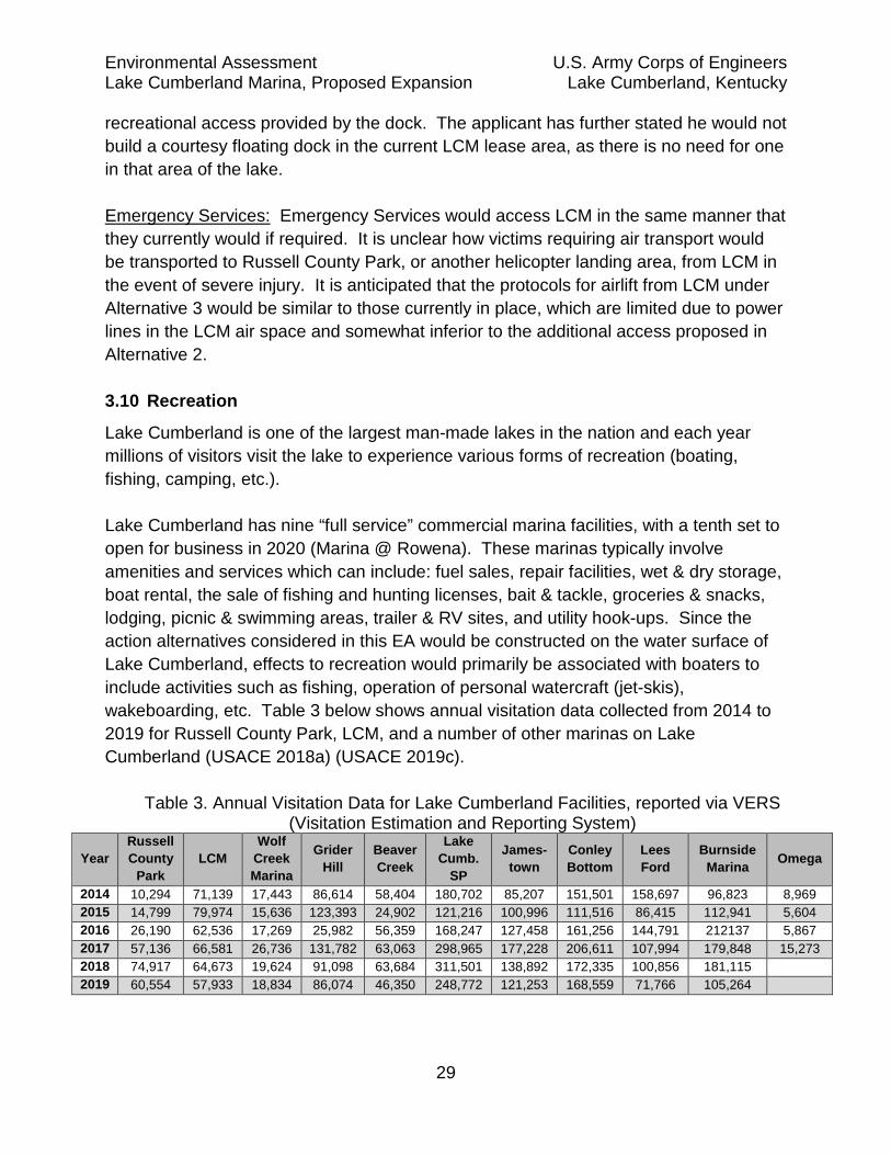
Lake Cumberland is one of the largest man-made lakes in the nation and each year millions of visitors visit the lake to experience various forms of recreation (boating, fishing, camping, etc.). Lake Cumberland has nine “full service” commercial marina facilities, with a tenth set to open for business in 2020 (Marina @ Rowena). These marinas typically involve amenities and services which can include: fuel sales, repair facilities, wet & dry storage, boat rental, the sale of fishing and hunting licenses, bait & tackle, groceries & snacks, lodging, picnic & swimming areas, trailer & RV sites, and utility hook-ups. Since the action alternatives considered in this EA would be constructed on the water surface of Lake Cumberland, effects to recreation would primarily be associated with boaters to include activities such as fishing, operation of personal watercraft (jet-skis), wakeboarding, etc. Table 3 below shows annual visitation data collected from 2014 to 2019 for Russell County Park, LCM, and a number of other marinas on Lake Cumberland (USACE 2018a) (USACE 2019c).
Table 3. Annual Visitation Data for Lake Cumberland Facilities, reported via VERS (Visitation Estimation and Reporting System)
Year Russell County
Park LCM
Wolf Creek Marina
Grider Hill
Beaver Creek
Lake Cumb.
SP
James-town
Conley Bottom
Lees Ford
Burnside Marina Omega
2014 10,294 71,139 17,443 86,614 58,404 180,702 85,207 151,501 158,697 96,823 8,969 2015 14,799 79,974 15,636 123,393 24,902 121,216 100,996 111,516 86,415 112,941 5,604 2016 26,190 62,536 17,269 25,982 56,359 168,247 127,458 161,256 144,791 212137 5,867 2017 57,136 66,581 26,736 131,782 63,063 298,965 177,228 206,611 107,994 179,848 15,273 2018 74,917 64,673 19,624 91,098 63,684 311,501 138,892 172,335 100,856 181,115 2019 60,554 57,933 18,834 86,074 46,350 248,772 121,253 168,559 71,766 105,264

Environmental Assessment U.S. Army Corps of Engineers Lake Cumberland Marina, Proposed Expansion Lake Cumberland, Kentucky
30
Alternative 1 – No Action Alternative would have no effect to recreation at the project site. Recreational patterns (i.e., boating and fishing) would continue as they currently exist, as would the aesthetic nature of the LCM and Russell County Park areas. Kentucky law defines idle speed as the “slowest speed possible to maintain maneuverability” of a boat. Generally speaking for a properly adjusted boat, this is the speed when a boat is put into gear without advancing the throttle (KDFWR 2020). To estimate speed of boats traveling through no wake areas, several governmental agencies such as Minnesota Department of Natural Resources (MNDNR 2020), State of Washington (SOW 2020) and Idaho Parks and Recreation (IPR 2020) list no wake speeds as “no greater than 5 mph”, “maximum 5 mph” and “slow to 5 mph” respectively, implying that 5 mph is at the top of a range of acceptable idle speeds. Depending on the engine and hull specifications of various recreational boats, however, the “slowest speed possible to maintain maneuverability” is expected be lower than 5 mph for many boats. For purposes of this analysis, therefore, the no wake speed is estimated at 4.5 mph, to reflect an average maximum expected travel time. Recreational boaters traveling at 5 mph, therefore, would be able to anticipate slightly shorter travel times to traverse the no wake zone. An estimate of the time it would take a boater going from Russell County Park through the downstream end of the existing no wake zone at LCM and then 0.6 miles downstream (expanded no wake zone under Alternative 3) was estimated for each alternative. The results are shown in Table 4. Under the No Action Alternative, a boat launching at Russell County Park, idling through the no wake zone at the launching ramp (approximately 0.1 mile at 4.5 mph), travelling “on plane” (estimated at 40 mph) downstream for 0.95 miles would take approximately 2 minutes and 45 seconds to reach the northern (upstream) end of the no wake zone at the current LCM lease. The current no wake zone at LCM is approximately 0.87 miles long. A boat travelling at idle speed (4.5 mph) would take approximately 11 minutes and 36 seconds to travel through the existing LCM no wake zone and 1 minute and 20 seconds on-plane (40 mph) for the .6 miles past LCM. In sum, the total time to traverse from launch at Russell County to 0.6 mile downstream of the current LCM no wake zone, under the No Action Alternative, is 15 minutes and 16 seconds. Alternative 2 (Water Extension to Russell Co. Park): In regards to fishing and recreational boating, marina leases in LRN generally have conditions that prevent lessees from forbidding the full use by the public of the premises and of the water areas of the project. The lessee is generally given authority and responsibility to manage the premises and provide safety and security to the visiting public which could prevent

Environmental Assessment U.S. Army Corps of Engineers Lake Cumberland Marina, Proposed Expansion Lake Cumberland, Kentucky
31
certain activities, such as fishing, swimming, etc. in the immediate vicinity of slips and moored boats. The applicant has publicly represented that he would not impose restrictions on recreational fishing within the expanded lease area inconsistent with standard practice at other marinas on Lake Cumberland. Further, the construction of the courtesy floating dock in Russell County Park can reasonably be anticipated to expand the public’s opportunities to fish and provide additional mooring opportunities on the lake. Alternative 2 would result in an approximate addition of 0.95 miles of no wake zone from Russell County Park southward to the upstream limit of the current LCM no wake area. Under Alternative 2, a boat travelling from Russell County Park would take approximately 26 minutes and 30 seconds to travel 0.6 miles downstream of the LCM no wake zone, an increase of approximately 11 minutes and 14 seconds from No Action. Alternative 3 (Southward Extension of Lease Area): Fishing on the RDB of Wolf Creek, within the expansion area, could be affected as described under Alternative 2. Alternative 3 would not result in an upstream expansion of the current no wake zone toward Russell County Park but would likely add approximately 0.60 miles no wake zone to the west (downstream) of the existing water lease. Under this alternative, a boat would take approximately 22 minutes and 22 seconds to travel from Russell County Park to 0.6 miles downstream of the existing LCM no wake zone (an increase of 7 minutes and 6 seconds from No Action).
Table 4. Travel times Associated with Alternatives 1, 2 and 3 Alternatives Reach 1
Russell Co. No Wake
Reach 2 0.95 mile between Russell Co. and Existing LCM No Wake
Reach 3 Existing LCM No Wake
Reach 4 Modified No Wake under Alt. 3 (0.6 miles downstream of existing LCM no wake)
Total Travel Time (From RCP launch to 0.6 miles downstream of existing LCM no wake)
No Action 1 min. and 20 sec.
1 min. and 26 sec.
11 min and 36 sec.
54 seconds 15 minutes and 16 seconds
Alternative 2 1 min. and 20 sec.
12 min. and 40 sec.
11 min and 36 sec.
54 seconds 26 minutes and 30 seconds
Alternative 3 1 min. and 20 sec.
1 min and 26 sec.
11 min and 36 sec.
8 minutes and 0 seconds
22 minutes and 22 seconds

Environmental Assessment U.S. Army Corps of Engineers Lake Cumberland Marina, Proposed Expansion Lake Cumberland, Kentucky
32
3.11 Socioeconomics
According to the U.S. Census Bureau (USCB) in 2018, the population in Russell County, Kentucky was 17,821, an increase of approximately 1.45% percent from 17,565 people in 2010. Median household income (in 2018 value dollars) in Russell County for census data on July 1, 2019, was $36,159 when compared with $48,392 for the State of Kentucky. The percentage of people in Russell County below the poverty level in data listed on July 1, 2019 was 21.6 percent when compared to 16.9% for the State of Kentucky (USCB 2019). Alternative 1 — No Action Alternative: Socioeconomic benefits would not be realized since the project would not be undertaken and any additional economic benefits cited by the applicant would be lost (LCM 2019b). Alternative 2 — Water Extension to Russell Co. Park: Alternative 2 would be anticipated to provide positive socioeconomic benefits to the local economy by providing additional income to Russell County. The applicant estimated in a letter to USACE that the annual tax revenue for Russell County government would increase from $40,000 to $178,000 annually and listed a separate anticipated benefit of $713,040 in increased property taxes for Russell County. The applicant further estimated the project would produce a payroll impact of $19.5 million dollars including the manufacturing of floating cabins (LCM 2019b). Income generated at LCM would provide tax benefits to local citizens as 75% of taxes associated with the additional slips would be received by Russell County and 25% of taxes would be received by the United States Treasury. Finally, the applicant would construct a floating courtesy dock for public use and provide security within Russell County Park without any cost to the County. Alternative 3 — Southward Extension of Lease Area: Alternative 3 could be expected to provide comparable socioeconomic benefits to the local economy as revenue would be generated from slip rentals and associated expenditures regardless of configuration, excepting that no floating courtesy dock would be constructed and no security provided within Russell County Park for public use at no cost to the county. The applicant notes that the completed construction of 68 additional slips to the LCM lease recapitulates some of the demand identified in the market study. The market study addressed the current and projected need for an additional 227 slips and 26 floating cabins in a geographic area already served by those additional 68 slips (Sirk &Co. 2019). However, the selection of Alternative 3 could result in a reduced expansion to avoid overbuilding in the current LCM footprint, which would commensurately reduce the overall anticipated economic and tourism benefits of the expansion under this action

Environmental Assessment U.S. Army Corps of Engineers Lake Cumberland Marina, Proposed Expansion Lake Cumberland, Kentucky
33
alternative. If the expansion area under Alternative 3 were reduced it could also reduce impacts associated with travel times for recreational boats described in Section 3.10. 3.12 Air Quality
The LCM site is in an attainment area with regard to the National Ambient Air Quality Standard (NAAQS). The No Action Alternative would have no effects on air quality levels. Under Alternatives 2 and 3 there could be minor air quality impacts from increased automobile and boat traffic entering the area to utilize the additional dock facilities. However, these impacts would be seasonal and minimal. The proposed project does meet the Conformity Rule under the Clean Air Act and poses no risk to NAAQS. (EPA 2019). 3.13 Aesthetics
The affected area of Lake Cumberland would be the upper portions of Wolf Creek and lower portions of Alligator Creek. The impoundment in this reach ranges from approximately 0.25 miles wide just below Russell County Park to roughly 0.4 miles wide several hundred feet downstream of LCM. The lake in this area is surrounded by high forested hillsides relatively undisturbed by development with a few primitive boat ramps (Jabez, Beech Grove and Dudley Hill Rd.) in the vicinity. The nearest commercial marina (Wolf Creek Marina) is approximately four miles downstream of LCM by water. Alternative 1 - No Action Alternative: This alternative would have no effect to aesthetics at the project site. The upper portion of Wolf Creek in the vicinity of LCM and Russell County Park would continue to look the same from water and land for the foreseeable future. Alternative 2 - Water Extension to Russell Co. Park: Aesthetic effects from the construction of a linear dock structure and moored boats, on a reach of the impoundment that is currently open water, and the floating courtesy dock within Russell County Park would be visible into lower portions of Alligator Creek as well as the upper portions of Wolf Creek. The courtesy dock within Russell County Park could also, however, be anticipated to provide additional opportunities for recreating members of the public to view the lake. Alternative 3 - Southward Extension of Lease Area: The addition of docks west of the existing LCM marina structure would not be visible from the upper portions of Wolf Creek and/or Alligator Creek. Aesthetic effects to the lake would thus be limited to the portion of Wolf Creek approximately 1.5 miles

Environmental Assessment U.S. Army Corps of Engineers Lake Cumberland Marina, Proposed Expansion Lake Cumberland, Kentucky
34
downstream of LCM, to include the downstream view of Wolf Creek from the restaurant at LCM. 4 CUMULATIVE IMPACTS
Cumulative impacts are defined as “the impact on the environment which results from the incremental impact of the (proposed) action when added to other past, present, and reasonably foreseeable future actions regardless of what agency or person undertakes such other actions (40 CFR 1508.7).” This cumulative effects analysis will focus on recreational boating as it is the aspect of the human environment most affected by the proposed actions. Geographical boundary considered for this discussion of cumulative impacts is the Lake Cumberland Project. The temporal boundary established spans from Lake Cumberland impoundment (1946) to twenty (20) years’ future projection. 4.1 Past and Present Actions
Wolf Creek Dam is a high head dam located near Jamestown, Kentucky at Cumberland River Mile (CRM) 460.9. It intercepts runoff from a drainage area of 5,789 square miles. The dam is a combination earth fill and concrete structure 5,736 feet long and 258 feet high, with a powerhouse and gated spillway structure. The dam was fully completed in August 1952. The currently authorized purposes for the operation of Wolf Creek Dam are flood damage reduction, hydropower generation, recreation, fish and wildlife management, and water quality. The Lake Cumberland pool extends approximately 100 miles upstream of the dam and is heavily used for recreational purposes including: swimming, fishing, boating, hiking, horseback riding, picnicking, camping, sightseeing, and hunting. However, the primarily recreational uses remain fishing and pleasure boating. Lake Cumberland supports 52 recreation areas, 48 improved boat launching ramps, 390 picnic sites, 18 playgrounds, 4 swimming areas, 24 trail miles, two fishing docks, 48 boat ramps, 10 marinas, 4,301 marina slips, two state parks, one county park, and six US Forest Service Areas (USACE 2011). Lake Cumberland generally ranks fourth in the Nashville District (Cumberland River system) reservoirs in overall visitation behind Old Hickory Lake, J. Percy Priest Lake and Lake Barkley. In 2019, Lake Cumberland was estimated to have 2,619,636 total visitors (USACE 2019c). As a result of the emergency lake drawdown in 2007, the owners of Alligator I Marina requested to move their facilities to a new location since the lower pool levels presented significant operational and economic hardships to their business. The marina facilities were moved to a location known as the Cave Springs Recreation Area on the left descending bank of Wolf Creek, approximately 5.6 river miles downstream of Alligator I, where the marina is currently operated under the name of Wolf Creek Marina.

Environmental Assessment U.S. Army Corps of Engineers Lake Cumberland Marina, Proposed Expansion Lake Cumberland, Kentucky
35
Based on information submitted in the current project application, Alligator I had approximately 400 slips at the time it moved downstream in 2008 (LCM 2019b). The relocated marina (Wolf Creek Marina) has 385 boat slips, an active no wake zone and still resides in the Wolf Creek tributary of Lake Cumberland, approximately four miles downstream of LCM. Around the time of Alligator I’s relocation, LCM/Alligator II Marina had 291 slips (USACE 2011). It now has approximately 450 slips (Section 1.2). The Wolf Creek portion of Lake Cumberland, therefore, had approximately 691 publicly usable boat slips shortly before Alligator I was relocated and currently has 835 public slips, an increase of 20.8%. The proposed action alternatives would increase the total slips in the Wolf Creek portion of Lake Cumberland to 1,062 slips, a total increase of 53.7% of available slips from the time when Alligator I and Alligator II operated concurrently. Therefore, boat traffic would be expected to show similar increases in this portion of the lake, without taking into account traffic from areas such as Jabez, Beech Grove and Dudley Hill Road, ramps with no public usage information through the same time period. It should be noted that Wolf Creek Marina is approximately 34.5 miles away from LCM by road and, therefore, its 385 slips do not infringe on parking or add to traffic congestion in the vicinity of LCM or Russell County Park. The slips in the immediate vicinity are, in fact, 34.9% lower (450 vs. 691 slips) than the period when Alligator I Marina was in place and would continue to be 2.0% lower (677 vs. 691) slips even after expansion under either Alternatives 2 or 3. In regards to the no wake zone, according to the project application, the no wake zone that existed in 2008 (before relocation of Alligator I) closely resembled the no wake area currently proposed under Alternative 2. The application states that the combined 2008 no wake zone was only 188’ shorter than the Alternative 2 proposal. USACE has been unable to independently verify how many years the combined no wake zone existed at that length, however, the Kentucky Department of Fish and Wildlife Resources (KDFWR) stated in a letter to USACE that the expanded no-wake zone essentially mirrors a previous zone in place for decades (KDFWR 2019).
4.2 Reasonably Foreseeable Future Actions
The most recent market feasibility study submitted to USACE by the applicant estimated increased demand from boaters would necessitate the construction of 1,500 slips across the 10 marinas on Lake Cumberland over the next five years (Sirk and Co. 2019). Demand for boat slips is somewhat dependent on economic conditions within the market area (described in the feasibility study as portions of Kentucky, Ohio, Illinois, Indiana and Michigan). The report further indicated that the majority of marinas

Environmental Assessment U.S. Army Corps of Engineers Lake Cumberland Marina, Proposed Expansion Lake Cumberland, Kentucky
36
currently existing on Lake Cumberland were not filled to capacity, as shown in Table 5, though several marinas have unavailable slips (Sirk and Co. 2019).
Table 5. Occupancy Lists at Marinas on Lake Cumberland (Sirk and Co. 2019)
Marina Current Occupancy
LCM 80% Beaver Creek 90% Burnside 90% Wolf Creek 92% Conley Bottom 93% Grider Hill 100% Jamestown 98% State Park Dock 90% Lee’s Ford 100%; waiting list
There are currently no pending requests from any other marinas on Lake Cumberland to add boat slips, nor are any new marina proposals pending. It is unclear how the demand for more boating slips will rise or fall during the next 20 years 4.3 Combined Cumulative Effects
When combined with the reasonably foreseeable future actions and past actions, impacts to boat traffic would occur from construction associated with Alternatives 2 or 3. However, either action alternative would be expected to both provide considerable benefits to the local economy and meet future market need for marina development. Of those alternatives, only Alternative 2 would provide the additional benefit of security and construction of a floating courtesy dock within Russell County Park at no cost to the County. Regardless of action alternative selected, as discuss in section 1.2, no new, additional marina would be located at the Russell County site. Therefore, the only opportunity for development to meet the projected market demand in the LCM vicinity would be development under one of the action alternatives. 5 ENVIRONMENTAL COMPLIANCE
5.1 Executive Order 11990-Wetlands
None of the alternatives would require work in wetlands.
Environmental Assessment U.S. Army Corps of Engineers Lake Cumberland Marina, Proposed Expansion Lake Cumberland, Kentucky
37
5.2 Farmland Policy Protection Act
No private agricultural lands or prime and unique farmlands are located in the proposed lease area for LCM. The installation of floating dock slips would have no effect to prime farmlands 5.3 Executive Order 11988-Floodplain Management
Portions of the proposed project is located within the 100-year floodplain and falls under the purview of Executive Order 11988, Floodplain Management. This executive order requires federal agencies to evaluate and minimize to the extent possible, impacts and modifications to the floodplain. Construction of the additional boat slips would be conducted on the Lake Cumberland impoundment, however there would be no fill in the 100-year floodplain. None of the considered alternatives would increase the risk of a “base flood”. 5.4 Clean Water Act / Section 10 of the Rivers and Harbors Act
No discharge of fill into waters of the United States is proposed in any of the alternatives so there would be no authorization required under the Clean Water Act. The proposed construction in Lake Cumberland consists mostly of floating structures. Structures and work proposed in navigable waters of the United States, such as Lake Cumberland, are subject to regulation under Section 10 of the Rivers and Harbors Act of 1899. Under the USACE's Section 10 regulations, 33 CFR 322.5, floating structures for recreational boats in USACE-controlled, federally-owned lakes are not authorized by a DA Permit but, instead, by a Shoreline Use Permit issued under 36 CFR 327.30. A Shoreline Use Permit is not required for activities covered by a Real Estate instrument, as stated in 36 C.F.R. § 327.30(f)(3). Thus a floating dock, proposed by a marina operator, holding a commercial concession lease, would not need any additional authorization: no DA Permit under 33 C.F.R. § 322.5 and no Shoreline Use Permit under 36 C.F.R. § 327.30. Non-floating aspects of the proposed work, such as the installation of an electric line from the shore to the proposed dock facilities under Alternatives 2 or 3, could require authorization under Section 10 of the Rivers and Harbors Act (33 C.F.R. § 322.3). A Department of the Army (DA) permit application for the applicant’s preferred alternative (Alternative 2) was submitted on July 24, 2019. That application is still pending. 5.5 National Pollutant Discharge Elimination System (NPDES)
Construction projects disturbing over 1 acre of land require a storm water permit. None of the alternatives would result in earth disturbance so a NPDES permit is not required. If plans were modified to include over an acre of disturbance (e.g. for construction of additional parking or amenities, or a utilities corridor in an alternative location)
Environmental Assessment U.S. Army Corps of Engineers Lake Cumberland Marina, Proposed Expansion Lake Cumberland, Kentucky
38
coordination with KDOW would occur and the permit would be obtained prior to construction. 5.6 Endangered Species Act
The Endangered Species Act (ESA) (16 U.S.C. §§ 1531 et seq.) requires the determination of potential effects to federally-listed endangered or threatened species or degradation of their habitat critical. USACE determined that none of the alternatives would affect federally listed species or critical habitat (Section 3.7). 5.7 Fish and Wildlife Coordination Act
USACE is required to coordinate with the USFWS and KDFWR under the Fish and Wildlife Coordination Act (FWCA) (48 Stat. 401, as amended; 16 U.S.C. 661 et seq.). KDFWR sent a letter to USACE on March 27, 2019, stating that they had received a request to permit an expansion of a no-wake zone in Wolf Creek associated with Alternative 2 (KDFWR 2019). KDFWR stated that the expanded no-wake zone essentially mirrors a previous zone in place for decades and further stated that there was broad community support for the project and interest from anglers in the impact that the project would have on fishing areas. KDFWR indicated in the letter that Wolf Creek was a very popular destination for anglers, boaters and the broader outdoor community. Both the USFWS and Kentucky Department of Fish and Wildlife will receive a copy of the Draft EA for this action. Their comments will be considered before the EA is finalized. 5.8 National Historic Preservation Act
The National Historic Preservation Act (54 U.S.C. § 300101 et seq.) compels federal agencies to manage cultural resources under their control (Section 110) and to take into consideration of effects of their undertakings on historic properties (Section 106). Section 106 of the National Historic Preservation Act (54 U.S.C. § 306108) requires federal agencies to consider the effects of their undertakings on historic properties and afford the Advisory Council on Historic Preservation and opportunity to comment. 36 C.F.R. § 800 promulgates the process for federal agencies to meet their obligations under Section 106. Appendix C presents an overview of Section 106 and a summary of the project Section 106 consultation. Consultation concluded with a no historic properties affected determination. Given the lack of resource within the Area of Potential Effects, the Corps would not have additional management responsibilities under Section 110 (54 U.S.C. § 306105) of the NHPA.

Environmental Assessment U.S. Army Corps of Engineers Lake Cumberland Marina, Proposed Expansion Lake Cumberland, Kentucky
39
5.9 Executive Order 13514 – Environmental Justice
The 1994 Executive Order 12898: “Federal Actions to address Environmental Justice in Minority Populations and Low Income Populations” was signed by President Clinton on February 11, 1994, to focus Federal attention on the environmental and human health conditions of minority and low-income populations, with the goal of achieving environmental protection for all communities. As defined by the document, “Environmental Justice, Guidance Under the National Environmental Policy Act” (CEQ 1997), a minority population exists where the percentage of minorities in an affected area either exceeds 50% or is significantly greater than in the general population. Based on census data from July, 2019, minority populations (all ethnicities identified as other than “white, alone”) total approximately 3.2% of the population in Russell County and 12.4% of the population in Kentucky, overall. 21.6% of the population in Russell County are considered “persons in poverty” compared with 16.9% of the population of Kentucky (USCB 2019). Since the proposal would be constructed on USACE property, none of the alternatives described in this environmental assessment would disproportionately place any adverse environmental, economic, social, or health impacts on minority and low-income populations. Although Alternative 2 would have a minor, adverse effect to recreational boating for any local citizens who are not customers of LCM (described in Section 3.10), expansion of the marina to include 227 slips (Action Alternatives 2 and 3) would provide significant tax benefits to local citizens as 75% of taxes associated with the additional slips would be received by Russell County and 25% of taxes would be received by the United States Treasury. 5.10 Clean Air Act
Alternatives 2 and 3 could both result in minor increases in vehicle and boat motor emissions due to the additional boat traffic that would result from the addition of 227 boat slips to Wolf Creek in the vicinity of LCM (Section 3.12). However, additional increases in vehicle and boat emissions would not cause NAAQS to be exceeded (EPA 2019). 5.11 Comprehensive Environmental Response, Compensation, and Liability Act
The U.S. Environmental Protection Administration Superfund Enterprise Management System database was reviewed for Comprehensive Environmental Response, Compensation, and Liability Act (CERCLA) sites at and within 0.5-miles of the lease alternatives. No CERLCA sites were identified at the lease alternatives or within 0.5-

Environmental Assessment U.S. Army Corps of Engineers Lake Cumberland Marina, Proposed Expansion Lake Cumberland, Kentucky
40
miles radius. All of the lease alternative areas do not have CERCLA sites, and thus are in compliance with CERCLA. 5.12 Resource Conservation and Recovery Act (RCRA)
The U.S. Environmental Protection Administration Resource Conservation and Recovery Act (RCRA) Information database was reviewed for RCRA sites at and within 0.5-miles of the lease alternatives. No RCRA sites were identified at the lease alternatives or within 0.5-miles radius. None of the lease alternative areas have RCRA sites, and thus all are in compliance with RCRA. 6 PUBLIC AND AGENCY COORDINATION
6.1 Public and Agency Involvement
6.1.1 Public Meeting
On June 17, 2019, USACE hosted a public meeting at Salem Elementary School (adjacent to the intersection of KY-76 and KY-910 near the Eli, Kentucky community) to solicit input from local citizens, Russell County (KY) officials and the applicant concerning proposed work described in Alternative 2. The meeting was announced by USACE five days earlier in a news release on June 12, 2019. A summary of the comments received as a result of the public meeting on June 17, 2019 is included in the section below. 6.1.2 Public Comments
Approximately 175 comments were collected at the meeting and in the days following the public meeting (for a time period between June 17-June 26, 2019) as recorded by representatives from the Lake Cumberland Resource Manager’s Office. The comments are a combination of those voiced verbally (26 comments), comment cards submitted during and after the meeting (58 comments) and emails submitted to USACE (91 comments). The responses were categorized between those expressing concerns about the proposed expansion (150 comments; 86% of commenters) and those expressing support for the project (25 comments; 14% of commenters).
6.1.2.1 Project Concerns from Citizens: Many of those expressing concerns cited multiple topics of concern, which are categorized below in order of most commonly to least commonly cited:
Loss of Parking: Public comments expressed concern that the proposal would result in loss of available public parking at the Russell County Park site due to LCM customers.

Environmental Assessment U.S. Army Corps of Engineers Lake Cumberland Marina, Proposed Expansion Lake Cumberland, Kentucky
41
USACE Response: The 284 parking spaces at the Russell County Park site (LCM, 2019b) would still be available on a first-come/first-served basis to all members of the public and that there can be no exclusive use parking arrangements for marina customers under the applicant’s preferred alternative. While it is unclear how many spots would be occupied by marina customers as opposed to members of the public (non-customers) using the site for boating access, the applicant indicated in a project application to USACE on July 24, 2019 (Item 1e) that sufficient parking already exists at LCM to accommodate the additional slips proposed under Alternative 2. Expanded No Wake Area: Public comments expressed concern that the proposal would result in an expanded no wake zone. USACE Response: Public impacts associated with expansion of a no wake zone for Alternatives 2 and 3 are discussed in Section 3.10. Loss of Access: Public comments expressed concern that the proposed action (Alternative 2) would result in a loss of public access to ramps at the Russell County Park site and that boaters would not be able to access public property between the Russell County Park site and LCM (i.e. fishing along banks). USACE Response: Impacts to public recreation are addressed more thoroughly in Section 3.10. The project application stated that the public would be able to freely access Russell County Park ramps and fish off of the proposed courtesy float, and the applicant has represented that he would not restrict public citizens’ ability to fish freely within the lease area within the limits of normal outgrant restrictions. The normal practice is to limit fishing near floating structures for safety and security reasons. Safety: Public comments expressed concern that the applicant’s proposed alternative (Alternative 2) would compromise public safety by occupying the deepest part of the Wolf Creek navigation channel and forcing boaters to shallower portions of the channel. Concerns were also listed that the proposed configuration would be unsafe in the event of a medical emergency in one of the slips or in the event of a fire. USACE Response: Impacts to public safety are addressed in Section 3.9.
Environmental Assessment U.S. Army Corps of Engineers Lake Cumberland Marina, Proposed Expansion Lake Cumberland, Kentucky
42
Empty Slips/Compliance: Several citizens voiced concerns that the proposal was not necessary due to the number of empty slips at LCM and other marinas on Lake Cumberland. USACE Response: The appraisal and market feasibility study prepared in November 2019 indicated that LCM had an occupancy rate of 80% as of July 2019, which would mean 90 slips were unoccupied when the report was prepared (See Table 5). The recent addition of 68 slips at LCM was cited as a factor in the unoccupied slips, as occupancy had previously been 100% (compare Sirk and Co. 2018 with Sirk and Co. 2019). The nearest Marina (Wolf Creek Marina) is listed in the study as having an occupancy rate of 92% for 385 slips, which would mean 31 slips were unoccupied when the report was prepared (Sirk and Co. 2019). Wolf Creek Marina is approximately four miles downstream of LCM by water and approximately 34.5 miles away by road.
Transparency of Proposal: Several citizens expressed concern that the proposal and USACE review was not transparent. USACE Response: In addition to a public meeting held by USACE on June 17, 2019 to discuss the proposal, this Draft EA will be advertised for review and public comment for 30 days. Public comments will be considered in the Final EA and will help to inform the final USACE decision. Environmental Impacts: Several commenters expressed concerns about environmental impacts resulting from the proposed lease expansion and associated dock infrastructure. USACE Response: Effects to the human environment that would result from Alternatives 1-3 are addressed in Section 3. Infrastructure: Several comments were received that expressed concerns about effects of the project to existing infrastructure in the vicinity of the project. USACE Response: Effects to the human environment that would result from Alternatives 1-3 are addressed in Section 3. None of the alternatives would have more than negligible effects to local road infrastructure.
Environmental Assessment U.S. Army Corps of Engineers Lake Cumberland Marina, Proposed Expansion Lake Cumberland, Kentucky
43
In addition to those comments collected as part of the June 17, 2019 public meeting, a letter and attached petition was sent to USACE, by a private citizen, dated July 9, 2019 containing approximately 781 signatures in opposition to Alternative 2, citing the following reasons: expanded no wake zone, restriction of public parking at Russell County Park, navigation concerns at winter pool, lack of demand for additional slips, environmental concerns associated with floating cabins. A letter stated that during collection of signatures on the dates of July 3-4, 2019, eight to nine people expressed support for the project.
6.1.2.2 Public Support for Lease Expansion: Several citizens expressing support for Alternative 2 cited project benefits, which are centered on increased recreational benefits, tourism and the associated jobs and tax revenue that were projected to be generated by lease expansion in the project application and market feasibility study dated June 19, 2018. The comments are listed as they were categorized after the public meeting on June 17, 2019 (for a time period between June 17-June 26).
Benefits to Local Economy: Several citizens expressed support for the project based on projected employment opportunities and increases to local tax revenue associated with the marina expansion. USACE Response: The proposed effects to local employment associated with the Alternatives 1-3 are discussed in Section 3.11 (Socioeconomics). Either action alternative would add on to an existing infrastructure at LCM and could be expected to have a long-term beneficial effect upon socioeconomics by presenting recreational boaters with additional mooring spots and generating the need for additional jobs. The applicant estimated that the annual tax revenue for Russell County government would increase from $40,000 to $178,000 annually and listed a separate anticipated benefit of $713,040 in increased property taxes for Russell County. The applicant further estimated the project would produce a payroll impact of $19.5 million dollars including the manufacturing of floating cabins (LCM 2019b).
Tourism: Several citizens expressed support for Alternative 2 based on projected increase in tourism to the local area associated with the proposal.

Environmental Assessment U.S. Army Corps of Engineers Lake Cumberland Marina, Proposed Expansion Lake Cumberland, Kentucky
44
USACE Response: The proposed effects to tourism associated with the Alternatives 1-3 are discussed in Section 3.10 (Recreation and Scenic Resources). Alternatives 2 and 3 would be expected to have a beneficial effect to tourism as the addition of boat slips would be present additional infrastructure on Lake Cumberland to serve recreational boaters. Recreational Demand: Several citizens expressed support for Alternative 2 by stating that the additional slips would satisfy recreational demand on the lake. USACE Response: The proposed effects to recreation associated with the Alternatives 1-3 are discussed in Section 3.10 (Recreation and Scenic Resources). Alternatives 2 and 3 would be expected to partially satisfy the demand for additional boat slips as identified in the Market Feasibility Study submitted on June 19, 2018.
Tax Revenue: Several citizens expressed support for Alternative 2 based on the projected increase in tax revenue to Russell County, Kentucky associated with income generated by construction of additional slips. USACE Response: The proposed increases to tax revenue associated with the Alternatives 1-3 are discussed in Section 3.11 (Socioeconomics). Either action alternative would add on to an existing infrastructure at LCM and could be expected to have a long-term beneficial effect upon local socioeconomics by adding to the additional tax base in Russell County, Kentucky. For Alternative 2, the applicant estimated that the annual tax revenue for Russell County government would increase from $40,000 to $178,000 annually and listed a separate anticipated benefit of $713,040 in increased property taxes for Russell County. The applicant further estimated the project would produce a payroll impact of $19.5 million dollars including the manufacturing of floating cabins (LCM 2019b). The estimated benefits for Alternative 3 could be expected to be comparable or somewhat less. General Support: Two citizens expressed general support for Alternative 2 without citing a specific benefit. USACE Response: General support comments are noted.

Environmental Assessment U.S. Army Corps of Engineers Lake Cumberland Marina, Proposed Expansion Lake Cumberland, Kentucky
45
In addition to the comments from the public meeting, the applicant cited an online petition in a letter to USACE on June 21, 2019 that garnered approximately 2,257 signatures as of March 24, 2019. The petition cited an increase of jobs (unspecified number) and tax revenue for Russell County as discussed in Section 3.11 and safety benefits discussed in Section 3.9 (LCM 2019b).
6.1.2.3 Comments from Local Government Representatives/Entities: Comments from
local representatives and entities are listed below in support of Alternative 2:
• The Somerset-Pulaski County Convention and Visitors Bureau/Lake Cumberland Tourism submitted a letter dated June 21, 2019 supporting the proposed marina expansion due to projected economic benefits generated from tourism;
• The Lake Cumberland Tourism Commission submitted a letter dated June 19, 2019 supporting the proposed marina expansion, citing expected enhancements to recreation, jobs, the local economy and tourism;
• The Kentucky Travel Industry Association submitted a letter dated June 19, 2019 supporting the proposal on the basis of projected benefits to tourism, local economy and employment;
• The Russell County Industrial Development Authority submitted a letter dated June 19, 2019 supporting the proposal due to projected benefits to tourism, employment and economic grounds;
• The Burnside Tourism Commission submitted a letter dated June 1, 2019 in support of the proposed marina expansion based on projected benefits associated with recreation, economics and tourism;
• The Russell County Chamber of Commerce submitted a letter dated May 16, 2019 in support of the proposed expansion due to recreation benefits, expected increases in tourism and associated benefits to the local economy;
• Russell County Fiscal Court submitted a resolution dated February 11, 2019 to the President of the United States of America, the Governor of Kentucky, the Majority Leader of the United States Senate, Senator Rand Paul, Congressman Hal Rogers, Congressman James Comer, and “all Kentucky state officials” in support of a favorable review and decision regarding the proposed marina expansion and further executed a Memorandum of Agreement memorializing that enthusiastic support on August 12, 2019.
Environmental Assessment U.S. Army Corps of Engineers Lake Cumberland Marina, Proposed Expansion Lake Cumberland, Kentucky
46
USACE Response: Local Government support comments are noted. Benefits associated with recreation, employment, economic benefits, tourism and tax revenue are considered in Sections 3.10 and 3.11 of this document.
6.1.2.4 Comments from State Government/Representatives: The State of Kentucky
House of Representatives (House Resolution 231) and Senate (Senate Resolution 197) both introduced resolutions on March 28, 2019, to urge the Secretary of the Army and the Assistant Secretary of the Army for USACE Civil Works to direct Nashville District USACE (LRN) to expedite its review of the development of enhanced public access and public recreation facilities at Lake Cumberland. The proposed LCM expansion is referenced in lines 13-18 on Page 2 of both bills.
USACE Response: Comments from the State of Kentucky are noted. The proposal is evaluated in this EA in accordance with NEPA regulations listed in Section 1.1.
6.2 Notice of Availability (NOA)
A NOA including draft EA and unsigned FONSI will be released to the public, including federal, state and local government representatives and public news/information outlets, including radio, television and newspaper outlets. The public will have an opportunity to review the draft EA and unsigned FONSI for 30 days and submit comments to USACE for consideration. 7 CONCLUSION
Three alternatives were considered in detail throughout this EA: Alternative 1 — No Action Alternative; Alternative 2 – Water extension to Russell County Park (Applicant’s Preferred Alternative) and Alternative 3 – Southward Expansion of the Lease Area. Alternative 1 would not meet the stated project purpose and would result in current conditions continuing into the future with no significant impact to the human environment. Either action alternative would accomplish a marina lease expansion and associated construction of boat slips, meeting the stated project purpose of “expansion of existing commercial marina concession lease to include adjacent additional water acreage, specifically for construction of 530 ft. x 16 ft. floating courtesy dock and 227 additional boat slips to meet public demand for recreational access on an underserved portion of Lake Cumberland.” Both alternatives would involve the construction of more mooring

Environmental Assessment U.S. Army Corps of Engineers Lake Cumberland Marina, Proposed Expansion Lake Cumberland, Kentucky
47
slips for vessels on Lake Cumberland and provide direct and indirect socioeconomic benefits to local citizens through employment opportunities and tax revenue, although the socioeconomic benefits would be expected to be somewhat lower under Alternative 3, as summarized below. Alternative 2 would result in placement of a floating courtesy dock and provide security within Russell County Park, providing additional benefits to the recreating public at no cost to the County, would involve construction of a 1.26 mile linear walkway / parallel slipway through the center of the Wolf Creek navigation channel, and would extend the no wake zone of LCM by 0.95 miles. Alternative 3 would result in construction of the same number of boat slips along two ~0.60 mile walkways west of the current dock structures in the existing LCM lease area and extend the no wake zone of LCM approximately 0.60 miles, but would not involve the construction of a floating courtesy dock or provision of security within Russell County Park. Neither action alternative would result in a significant impact to the human environment. All work associated with the construction of Alternative 2 or Alternative 3 would be done in accordance with all federal, state, and local laws.

Environmental Assessment U.S. Army Corps of Engineers Lake Cumberland Marina, Proposed Expansion Lake Cumberland, Kentucky
48
8 REFERENCES
Bennett, Karen C. (2019) Lewis, Brisbois, Bisgaard and Smith, LLP. Letter to USACE
in Response to Request for Information.
Council on Environmental Quality (CEQ). (1997) Environmental Justice, Guidance Under the National Environmental Policy Act.
Environmental Protection Agency (EPA). National Ambient Air Quality Standards (NAAQS) Website. Clean Air Act. https://www3.epa.gov/airquality/greenbook/popexp.html. Accessed October 2, 2019.
Idaho Parks and Recreation (IPR). (2020) Boating in Idaho Frequently Asked Questions. https://parksandrecreation.idaho.gov/boating-idaho-faqs. Accessed March 25, 2020.
Kentucky Archaeological Survey (KAS). (2008) The Archaeology of Kentucky: An Update Edited by David Pollack. Kentucky Heritage Council State Historic Preservation Comprehensive Plan Report No. 3.
Kentucky Transportation Center (KTC). (2019) About KTC. http://ktc.uky.edu/about-ktc-4/. Accessed October 8, 2019.
Kentucky Department of Fish and Wildlife Resources (KDFWR). (2020) Online Boating Guide. https://fw.ky.gov/FishBoatGuide/Pages/Boating.aspx. Accessed March 25, 2019.
Kentucky Division of Water (KDOW). (2016) Integrated Report to Congress on the Condition of Water Resources in Kentucky, https://eec.ky.gov/Environmental-Protection/Water/Monitor/Pages/IntegratedReportDownload.aspx. Accessed March 25, 2020.
Kentucky Division of Water. Water Health Portal Website. (2020) https://watermaps.ky.gov/WaterHealthPortal/. Accessed March 24, 2020.
Lake Cumberland Marina (LCM). (2019a) Change.org. https://www.change.org/p/tell-the-army-corps-of-engineers-please-approve-awesome-expansion-of-lake-cumberland-marina-to-benefit-russell-county-lake-cumberland-huge-public-benefit. Accessed on March 23, 2020.
Lake Cumberland Marina (LCM). Request for Expansion of Lease, July 24, 2019. (2019b).
Russell County Fiscal Court. (2019) Memorandum of Agreement (MOA).
Minnesota Department of Natural Resource (KDFWR). (2020) Boat and Water Safety. https://www.dnr.state.mn.us/safety/boatwater/nowake/index.html. Accessed March 25, 2019.

Environmental Assessment U.S. Army Corps of Engineers Lake Cumberland Marina, Proposed Expansion Lake Cumberland, Kentucky
49
Navionics Two-Dimensional Navigation Charts. (2019) https://webapp.navionics.com/. Accessed September 2, 2019.
National Register of Historic Place. (2020) https://www.nps.gov/subjects/nationalregister/database-research.htm. Accessed 3/18/2020.
O’Bannon, Patrick. (2005) Wolf Creek Dam and Powerhouse: Historic Property Survey and Inventory, Russell County, Kentucky.
Polglase, Chris, Alvin Banguilan, Justin Bedard, Tracy Formica, Kristen Heasley, Robert Pauline, Jagadish M. Prakash, Suzanne Loadholt. (2011) An Archaeological Reconnaissance and Assessment of Selected Drawdown Areas within the Wolf Creek Dam/Lake Cumberland Shoreline.
Project Resource Management Office. (2019) Project Recommendation of Availability (ROA).
Sirk and Company. (2018) Market Analysis and Feasibility Study; Alligator I & II Marina Slip Expansion. Tracts S-1912, S-1915, S-1916, S-123,. S-1927B, S-1928,.S-1930, S-1931, S-1935, S-1936; Total of 296+/- Acres, Russell County, KY; 2108 State Highway 1383, Russell Springs, KY 42642; 1.26 Miles of Connector Walkway to Dockage; Proposed Addition of 68 Covered Marina Slips, 70 Uncovered in Year 1, 81 Additional Uncovered Slips Year 2, 80 Additional Uncovered Slips in Year 3.
Sirk and Company. (2019) Real Property Appraisal Report - Cumberland Lake Marina, LLC. 2108 Kentucky State Highway1383, Russell Springs, KY 42642; 450 slip full service marina, restaurant, 16 rental cabins, mechanic shop, camping area with bathhouse, and laundry, proposed expansion to 677 slips situated on a total of 296 acres of leased and fee simple land; Tracts S-1912, S-1915, S-1916, S-123, S-1927B, S-1928, S-1930, S-1931, S-1935, S-1936;7 parcels located in Russell County, KY identified as PVA map #071-00-00-042.00, 071-90-10-010.00_01, 071-90-10-010.00_02, 071-90-10-010.00_03, 071-90-16-001.01,071-00-00-028.00, 071-00-00-019.00;Deed 335 Page 719, Deed Book 335 Page 730, Deed Book 335 Page 734, LB 45/54 (lease) Census Tract 9604 Block Group 3 Block 3058
State of Washington (SOW). (2020) Washington State Boating Regulations. http://www.boaterexam.com/usa/washington/. Accessed March 25, 2020.
U.S. Census Bureau. Russell County Kentucky QuickFacts. (2019) http://www.census.gov/quickfacts/table/PST045216/21207,21,00. Accessed March 25, 2020.
U.S. Army Corps of Engineers, Nashville District (USACE). (2004) Operational Management Plan, Lake Cumberland. Part I-Natural Resources Management.

Environmental Assessment U.S. Army Corps of Engineers Lake Cumberland Marina, Proposed Expansion Lake Cumberland, Kentucky
50
U.S. Army Corps of Engineers, Nashville District (USACE). (2007) Wolf Creek Dam/Lake Cumberland Emergency Measures in Response to Seepage, Final Environmental Impact Statement.
U.S. Army Corps of Engineers, Nashville District (USACE). (2010) Record of Decision Associated with Wolf Creek Dam/Lake Cumberland Emergency Measures in Response to Seepage, Final Environmental Impact Statement. Signed November 5, 2010.
U.S. Army Corps of Engineers, Nashville District (USACE). (2011a). Lake Cumberland Master Plan Update.
U.S. Army Corps of Engineers, Nashville District. (2011b). Environmental Assessment. Lake Cumberland Master Plan Update.
U.S. Army Corps of Engineers, Nashville District (USACE). (2017). DRAFT Water Supply Storage Reallocation Report and Integrated Environmental Assessment .
U.S. Army Corps of Engineers (USACE) (2018a) The Operations and Maintenance Business Information Link. U.S. Army Corps of Engineers Visitation Data. 2017-2018
U.S. Army Corps of Engineers, Nashville District (USACE) (2018b). Decision Letter from Lake Cumberland Resource Manager’s Office to J.D. Hamilton. April 6, 2018.
U.S. Army Corps of Engineers, Nashville District (USACE) (2019a). Decision Letter from Lake Cumberland Resource Manager’s Office to J.D. Hamilton. May 1, 2019. (2019 a)
U.S. Army Corps of Engineers, Nashville District (USACE) (2019b). Request for Information Letter. Sent to Applicant September 20, 2019.
U.S. Army Corps of Engineers (USACE) (2019c) The Visitation Estimation & Reporting System Link. U.S. Army Corps of Engineers Visitation Data. 2017-2018
U.S. Environmental Protection Agency (US-EPA). Ecoregions of Tennessee. ftp://ftp.epa.gov/wed/ecoregions/tn/tn_eco_lg.pdf. Accessed April 17, 2019.
Visitation Estimation and Reporting System (VERS), https://gateway.erdc.dren.mil/nrm/vers/final.cfm?Step=1. Accessed April 6, 2020.
Wolf Creek Marina (WCM). (2019) Wolf Creek Annual Slips https://wolfcreekmarina.com/slips/. Accessed October 9, 2019.

Environmental Assessment U.S. Army Corps of Engineers Lake Cumberland Marina, Proposed Expansion Lake Cumberland, Kentucky
51
APPENDIX A
Maps, Plans, and Project Description from the Project Application (July 24, 2019)

a. <C :E z 0 -~ 0 0 ..J
ct! C
: ·;::
~
-._ 0 ..... ct! . !2' <I:
@ z 0 ~
(.) 0 ....J
z 0 :E
Cl)
o I ..J
w ..... Q
) ._ :::,
..... ct! Q
) L
L
C:;-: _,..
._ .$ C
: Q
) (.)
~
c.. c..
C'\I
:::, C
l) Q
) ._
II) :::,
N
C:
..... Q
) t
ct! .0
Q
) ct! ~
LL """)
JJ •
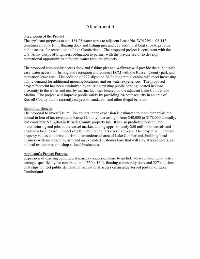
Attachment 3
Description of the Project The applicant proposes to add 181.25 water acres to adjacent Lease No. W912P5-1-08-113, construct a 530 x 16 ft. floating dock and fishing pier and 227 additional boat slips to provide public access for recreation on Lake Cumberland. The proposed project is consistent with the U.S. Army Corps of Engineers obligation to partner with the private sector to develop recreational opportunities at federal water resource projects. The proposed community access dock and fishing pier and walkway will provide the public with easy water access for fishing and recreation and connect LCM with the Russell County park and recreation lease area. The addition of 227 slips and 28 floating rental cabins will meet increasing public demand for additional mooring locations, and on-water experiences. The proposed project footprint has been minimized by utilizing existing public parking located in close proximity to the water and nearby marina facilities located on the adjacent Lake Cumberland Marina. The project will improve public safety by providing 24-hour security in an area of Russell County that is currently subject to vandalism and other illegal behavior. Economic Benefit The proposal to invest $10 million dollars in the expansion is estimated to more than triple the annual in lieu of tax revenue to Russell County, increasing it from $40,000 to $178,000 annually, and contribute $713,040 in Russell County property tax. It is also predicted to stimulate manufacturing and jobs in the vessel market, adding approximately $50 million in vessels and produce a local payroll impact of $19.5 million dollars over five years. The project will increase property values and drive tourism to an underused area of Lake Cumberland, building local business with increased tourism and an expanded customer base that will stay at local hotels, eat at local restaurants, and shop at local businesses.
Project Purpose Expansion of existing commercial marina concession lease to include adjacent additional water acreage, specifically for construction of 530 x 16 ft. floating community dock and 227 additional boat slips to meet public demand for recreational access on an underserved portion of Lake Cumberland.
Applicant's

CURRENT COUNTY LAND AND WATER LEASE
64.50 AC
SURVEY CONTROL KENTUCKY STATE PLANE SOUTH ZONE
DATUM : NAD83 GEOID 12A
y
>~~ ---=~
LEASE EXPANSION AREA SUMMARY
TOT AL NEW LEASE AREA ( WATER ONLY) REQUESTED BY LAKE CUMBERLAND MARINA = 181.25 ACRES O 723 MSL
EXISTING LAKE CUMBERLAND MAR1NA LEASE ARE
._..TEIITll'OMAl'llltSlfflET ALLIU.Tlllllllol-ALLIU.lllllll.t ~-•-SN~fl
GRAPHIC SCALE
1 230 460
111111 1 1 1 1" = 230 FEET
920
-i'if
\ __ ........ - .
'601f-'IIFIWI·-•
,'ti ro--1111&eooor NEW LCM LEASE NORTH BOUNO
f i t rt R
AAY
jl.__
®
TABLE
DISTANCE FROM EDGE OF PARALLEL
SLIP TO 680 MSL CONTOUR
LEFT BANK RIGHT BANk FT STATION FT
255 0+00 370 203 1+00 427 234 ?->-nn 852 265 , _(\(\ 850+ 289 4+00 850 293 5+00 360 369 6+00 286 360 7+00 328 355 8+00 406 398 9+00 260 386 10+00 276 374 11+00 248 364 12+00 270 316 13+00 256 231 14+00 256 224 15+00 ?37 238 16+00 ---;,i;7
346 17-,_nn ?QQ 347 18+00 309 - 345 10-,_nn 359 438 --;;;c;--;c;,:; 455 379 21+00 "-'" 333 ~~ (\(\ "'' 332 ?3+00 448 327 24+00 412
""" 25+00 "-1'i ,<;(\ 26+00 453 612 27+00 480
"'"" 28+00 448 351 -,a_._nn 340 314 30+00 355 288 31+00 373 324 32+00 406
'"'" =:;:;;:. A1A
329 <A ' r,r, "-'"-332 35+00 412 329 36+00 387 328 37+00 326 323 38+00 293 330 39+00 292 342 40+00 269 363 41+00 "95 355 42+00 333 367 43+00 ,,;7
399 44+00 "'"" 390 45+00 281 511 46+00 306 581 47+00 306 415 48+00 340 325 "' "" 341 293 50+00 438
LEGEND 278 51+00 A<sa
288 =-;c;,:; 467 - 680 CONTOUR - f,lSC<»llOUR 314 "'. ,..,,.., 535
324 54+00 580 372 55+00 <;<;7
418 =-;c;,:; 512 421 57+00 598
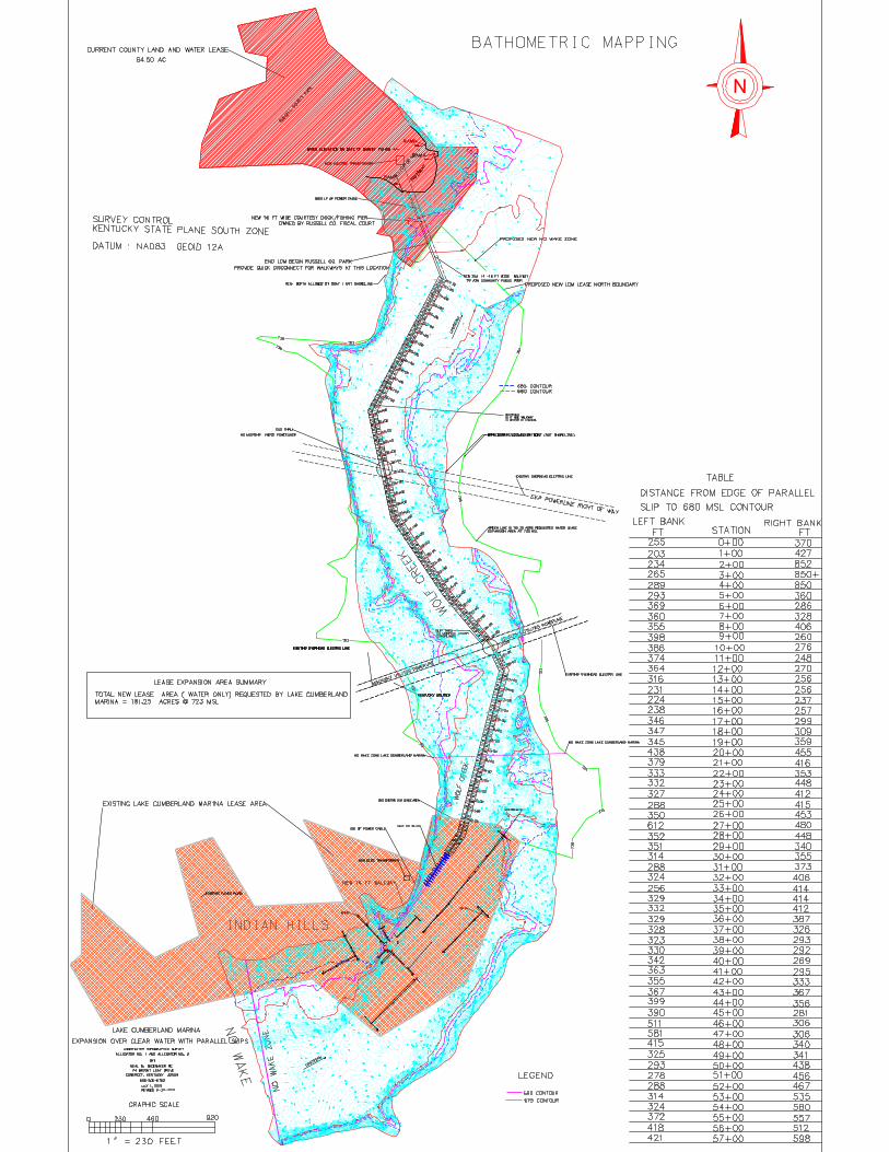
CURRENT COUNTY LAND AND WATER LEASE
64.50 AC
SURVEY CONTROL KENTUCKY STATE PLANE SOUTH ZONE
DATUM : NAD83 GEOID 12A
LEASE EXPANSION AREA SUMMARY
TOT AL NEW LEASE AREA ( WATER ONLY) REQUESTED BY LAKE CUMBERLAND MARINA = 181.25 ACRES O 723 MSL
EXISTING LAKE CUMBERLAND MAR1NA LEASE ARE
._..TEIITll'OMAl'llltSlfflET ALLIU.Tlllllllol-ALLIU.lllllll.t ~-•-SN~fl
GRAPHIC SCALE
1 230 460
111111 1 1 1 1" = 230 FEET
920
BATHOMETRIC MAP PING jl.__
®
AAY
TABLE
DISTANCE FROM EDGE OF PARALLEL
SLIP TO 680 MSL CONTOUR
LEFT BANK RIGHT BANk FT STATION FT
255 0+00 370 203 1+00 427 234 ?->-nn 852 265 , _(\(\ 850+ 289 4+00 850 293 5+00 360 369 6+00 286 360 7+00 328 355 8+00 406 398 9+00 260 386 10+00 276 374 11+00 248 364 12+00 270 316 13+00 256 231 14+00 256 224 15+00 ?37 238 16+00 ---;,i;7
346 17-,_nn ?QQ 347 18+00 309 - 345 10-,_nn 359 438 --;;;c;--;c;,:; 455 379 21+00 "-'" 333 ~~ (\(\ "'' 332 ?3+00 448 327 24+00 412
""" 25+00 "-1'i ,<;(\ 26+00 453 612 27+00 480
"'"" 28+00 448 351 -,a_._nn 340 314 30+00 355 288 31+00 373 324 32+00 406
'"'" =:;:;;:. A1A
329 <A ' r,r, "-'"-332 35+00 412 329 36+00 387 328 37+00 326 323 38+00 293 330 39+00 292 342 40+00 269 363 41+00 "95 355 42+00 333 367 43+00 ,,;7
399 44+00 "'"" 390 45+00 281 511 46+00 306 581 47+00 306 415 48+00 340 325 "' "" 341 293 50+00 438
LEGEND 278 51+00 A<sa
288 =-;c;,:; 467 - 680 CONTOUR -- 675 C<»llOUR 314 "'. ,..,,.., 535
324 54+00 580 372 55+00 <;<;7
418 =-;c;,:; 512 421 57+00 598

;:~~ua -tl(p-PQ--
............. _~uNER,GH __ ,_,,_ __ ...

END LCM MAIN DOCK
NOTES:
ENGINEER STAMPED PLANS FOR THE DOCK WILL BE PROVIDED BY THE COMPANY THAT PROVIDES THE PRE ENGINEERED DOCK SYSTEM.
16 FT WIDE MAIN DOCK TIE TO NEW 68 COVERED SLIP DOCK
AT LAKE CUMBERLAND MARINA
227 PARALLEL SLIPS FOR HARBOR COTTAGES
1------------------------h120'-00" NEW EXPANSION OUTSIDE CURRENT LCM LEAS1--------------------1----o TOTAL LENGTH OF 16 FT MAIN DOCK= 6146 LF ( LAKE CUMBERLAND MARINA) TOTAL LENGTH OF 16 FT PUBLIC COURTESY DOCK= 520 ( OWNED BY RUSSELL COUNTY FISCAL COURT)
TO RUSSELL Cf)UNTY PARK PARKING LOT
;='I=
" 8 a. :::; </)
□ w
"' ~ ()
ill z 13 w a,
"""" 227 - 32' X 50' MAX PARALLEL SLIPS I ,,,,-,oocK DISCONNECT PIN LOCATION
: f:0~ : ~EW16FTWIDEM~ INDOCK : : ~ \EGIN 16 FT WIDE PUBLIC COURTSEY DOCK TO
UPSTREAM '
TO BE LOCATED AT JUCTION OF LCM AND RUSSELL COUNTY PARK LEASE BOUNDARYS
WINCHES AND PRE ENGINEERED STEEL WINCH HOUSE WILL BE LOCATED AS NEEDED
CROSS SECTION N.T.S.
TREATEOLUMBERORCONCRETEPANELSURFA~ 6'-00" MAIN DOCK
I ENCASED FOAM
4' X8' X2'
INEERED EL
ENCASED FOAM
4' X8' X2'
"8TSYSTEM
ENCASED I FOAM
4' X 8' X2'
TYP 32' X 50'
HARBOR COTTAGE F"""'
~ ~ ::;; □
~ ffi a, ::;; :::, ()
~ " z ~ 1.l
■ • ~~ ::C::s;i:
:l<:Cl.:~ ~\,:)~
~~~ ~~l..i
~t;::~ ~:-;:s;i: t:P.c" ~'-I~"-. N'-Ji,:
~:....~ ~~l..i Cl::~" ~~ ~~ '-lll;
~
j!>c ~ i ::i i5"' :0
I ;P >i ~~I ~ :p
07-30-2111~ SCII.E: NTS
01 DOCK PLAN


> G
)
-G)
00
...... (0
00
0 0 N
~
..... I (0

~ Google Maps X + (51 X
f- ➔ C i https://www.google.com/maps/@37.047 4404, -84.6720775,904m/data= !3m 1 ! 1 e3 0. * II e
Search Google Maps a_ ~
v See travel times, traffic and nearby places
Kentucky
37.050655, -84.675454 ♦

~ Google Maps X + [ii X
f- ➔ C 0 https://www.google.com/maps/@36.9292836, -85 .0470167,889m/data = !3m 1 ! 1 e3 0. * a e
Search Google Maps Q_ ~
v See travel times, traffic and nearby places

~ Google Maps X + f- ➔ C i https://www.google.com/maps/@37.0095529, -84.9273378,242m/data = !3m 1 ! 1 e3
Search Google Maps Q_ ~
v See travel times, traffic and nearby places
[ii
0. * II ·• ,c
X

Environmental Assessment U.S. Army Corps of Engineers Lake Cumberland Marina, Proposed Expansion Lake Cumberland, Kentucky
52
APPENDIX B USACE Correspondence (September 20, 2019)
Lewis, Brisbois, Bisgaard and Smith Response (December 17, 2019)

DEPARTMENT OF THE ARMY U.S. ARMY CORPS OF ENGINEERS, NASHVILLE DISTRICT
110 9TH AVENUE SOUTH, ROOM A-405 NASHVILLE, TN 37203-3817
Karen C. Bennett 2112 Pennsylvania Avenue NW, Suite 640 Washington, DC 20037 Re: Lake Cumberland Marina (LCM) Lease Expansion Application Ms. Bennett,
As you may recall, we are currently in the technical review stage of processing the operative LCM lease expansion application. That review includes National Environmental Policy Act (NEPA), cultural resources, and financial review. It is the expectation of the District that actively engaging your help with these matters will enable our review team to move to the next stage of review. 1. Cultural Resources Review
On the cultural resources end, the District currently has enough information to initiate consultation with consulting parties. Letters are expected to go out before the end of next week. 2. Hazardous, Toxic, and Radioactive Wastes (HTRW) Review No further information from the applicant is needed at this stage. 3. Market Analysis and Feasibility Study Review
As to the market analysis and feasibility study, as you were made aware some months ago, further work is needed to keep the process moving forward. After an administrative review, our team has identified three key points of information as essential to accomplish the required technical review.
Firstly, the date of the study has been provided as both 23 February and 19 June 2018, with the cover page stating the earlier date and letter of transmittal referring to the later date. Regardless, the report is at least 15 months old. While ER 405-1-04 (the Real Estate Appraisal regulations for USACE) does not explicitly set forth a requirement for contemporaneousness of such reports, acquisition appraisal reports over 12 months typically necessitate a new appraisal and even reports up to 12 months old can be updated. The District recognizes that this submitted report is not technically an appraisal report, but as an appraisal product

must rely on more current data. The District anticipates that an updated report will provide firmer data to support any recommendation.
Secondly, the revised report must include actual rental rates for both the subject marina and the marinas in the market. This data is essential to complete any market analysis and feasibility study of this property type. Moreover, the data requires a level of analysis and review above simple inclusion in the revised report. Your appraiser should be prepared to analyze it and draw conclusions from it, with the aim to ensure the slip fees of the subject marinas are in line with what is typical in the market. Fees above or below what is typical in the market would be anticipated to have an impact on occupancy, either positively or negatively.
The revised report needs to include current occupancy rates and occupancy rates over time for both the subject marinas and the marinas in the market, to identify any seasonal and fluctuating occupancy trends. Again, it is not enough to merely recite data. Your appraiser must analyze it and draw conclusions from it, to reach a determination regarding demand in the market (i.e., any seasonal aspect to the marinas in the market and increased/decreased trending in market occupancy). The revised report finally needs to include analyses of income and expenses for both the subject marinas and the marinas in the market, which is essential for determining current and anticipated profitability upon completion of the proposed project. To the extent comparable marinas may be less than forthcoming with their own data, the diligent attempt to obtain comparable data must be both made and documented. The appraiser must, in the absence of actual income and expense data from competing marinas, survey the local market to gain an understanding of what the market expense ratios are for the marinas in the market. The appraiser must analyze and draw conclusions from the data to reach a conclusion about current and anticipated profitability, to support the appraiser’s financial feasibility conclusions.
Third, our in-house reviewing appraiser has offered his services to work directly with your appraiser to ensure he or she is submitting a report that has all the necessary data and analysis to achieve a thorough, completed technical review. A viable market analysis and feasibility study, after all, is in the best interests of all parties to ensure a complete, defensible administrative record.
4. National Environmental Policy Act (NEPA) Review
To briefly provide some background, the NEPA and agency implementing regulations require the Corps to prepare an Environmental Assessment (EA) to determine the effects of a proposed action, to include the environmental and social effects of the project. At the conclusion of the EA, the District Commander could come to a Finding of No Significant Impact (FONSI) or, if the project were determined to have potential to have significant impacts to the human
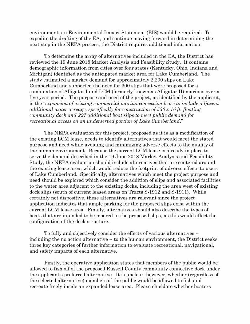
environment, an Environmental Impact Statement (EIS) would be required. To expedite the drafting of the EA, and continue moving forward in determining the next step in the NEPA process, the District requires additional information.
To determine the array of alternatives included in the EA, the District has reviewed the 19 June 2018 Market Analysis and Feasibility Study. It contains demographic information from cities over four states (Kentucky, Ohio, Indiana and Michigan) identified as the anticipated market area for Lake Cumberland. The study estimated a market demand for approximately 2,200 slips on Lake Cumberland and supported the need for 300 slips that were proposed for a combination of Alligator I and LCM (formerly known as Alligator II) marinas over a five year period. The purpose and need of the project, as identified by the applicant, is the “expansion of existing commercial marina concession lease to include adjacent additional water acreage, specifically for construction of 530 x 16 ft. floating community dock and 227 additional boat slips to meet public demand for recreational access on an underserved portion of Lake Cumberland.”
The NEPA evaluation for this project, proposed as it is as a modification of the existing LCM lease, needs to identify alternatives that would meet the stated purpose and need while avoiding and minimizing adverse effects to the quality of the human environment. Because the current LCM lease is already in place to serve the demand described in the 19 June 2018 Market Analysis and Feasibility Study, the NEPA evaluation should include alternatives that are centered around the existing lease area, which would reduce the footprint of adverse effects to users of Lake Cumberland. Specifically, alternatives which meet the project purpose and need should be explored which consider the addition of slips and associated facilities to the water area adjacent to the existing docks, including the area west of existing dock slips (south of current leased areas on Tracts S-1912 and S-1911). While certainly not dispositive, these alternatives are relevant since the project application indicates that ample parking for the proposed slips exist within the current LCM lease area. Finally, alternatives should also describe the types of boats that are intended to be moored in the proposed slips, as this would affect the configuration of the dock structure.
To fully and objectively consider the effects of various alternatives -- including the no action alternative -- to the human environment, the District seeks three key categories of further information to evaluate recreational, navigational, and safety impacts of each alternative. Firstly, the operative application states that members of the public would be allowed to fish off of the proposed Russell County community connective dock under the applicant’s preferred alternative. It is unclear, however, whether (regardless of the selected alternative) members of the public would be allowed to fish and recreate freely inside an expanded lease area. Please elucidate whether boaters

would be allowed free and undisturbed access to both banks of Wolf Creek for fishing and other recreational boating activities under your proposal. If boaters would be permitted such access, please further explain the need for the proposed lease operating area to extend throughout the entire width of the cove.
Secondly, the operative application indicates that boat traffic navigating Wolf Creek would not be able to utilize the deepest portions of the channel. A safety action plan for each alternative must be evaluated to ensure that shallow areas and other obstacles on the outside portions of the channel are adequately marked to ensure boater safety, especially at winter pool elevations. Any data you have already amassed or plans you have already formulated regarding the marking and navigation of the shallows would be extremely useful in this analysis. Your aid in this endeavor is essential to creating a complete, defensible alternatives array.
Thirdly, the District welcomes any submission providing a rationale (and any supporting information) describing the feasibility of each alternative and explaining why the alternatives would or would not meet the purpose and need for the project. That includes any design considerations that might mitigate effects to users of Lake Cumberland (e.g., breakwater structures that might limit or reduce the need for no wake designations). As with the Market Analysis and Feasibility Study, our NEPA team stands ready to work directly with your team to ensure that the information being evaluated is complete, thorough, and has all the necessary data and analysis to draft a thorough, defensible EA.
We in the Office of Counsel look forward to supporting our technical review
team in processing the operative LCM application. Thank you in advance for helping us expeditiously process your application in accordance with our statutory, regulatory, and policy mandates.
9/20/2019
XKirsten S. RønholtAssistant District CounselSigned by: RONHOLT.KIRSTEN.S.1558832980

4823-7742-1487.1
Karen C. Bennett
2112 Pennsylvania Avenue NW, Suite 640
Washington, DC 20037
Direct: 202.558.0658
December 17, 2019
ARIZONA • CALIFORNIA • COLORADO • CONNECTICUT • FLORIDA • GEORGIA • ILLINOIS • INDIANA • KANSAS • KENTUCKY
LOUISIANA • MARYLAND • MASSACHUSETTS • MINNESOTA • MISSOURI • NEVADA • NEW JERSEY • NEW MEXICO • NEW YORK
NORTH CAROLINA • OHIO • OREGON • PENNSYLVANIA • RHODE ISLAND • TEXAS • UTAH • VIRGINIA • WASHINGTON • WEST VIRGINIA
Kirsten S. Ronholt Assistant District Counsel U.S. Army Corps of Engineers, Nashville District 110 9th Avenue South, Room A-405 Nashville, TN 37203-3817
Re: Lake Cumberland Marina Lease Expansion Application
Dear Ms. Ronholt,
This letter responds to your September 20, 2019 request for information associated with the U.S. Army Corps of Engineers’ (Corps) preparation of an Environmental Assessment (EA) under the National Environmental Policy Act (NEPA) for the proposed Lake Cumberland Marina (LCM) expansion proposal. Five alternatives, including the “No Action” and the “Preferred Action” alternatives, have been evaluated and discussed with the Corps throughout the administrative process that has been ongoing for over two years. These alternatives, including impacts, feasibility, and ability to meet LCM’s project purpose are described more fully below.
As we discussed previously with the Corps, in drafting an EA, the Corps need only analyze the preferred action and the no action alternatives.1 Courts have determined that an agency “has fewer reasons to consider alternatives when it prepares an environmental assessment as opposed to when it prepares an environmental impact statement.”2 Furthermore, evaluating only the preferred alternative and no action alternative in an EA has been found acceptable when, throughout the administrative process, the preferred alternative has been significantly modified to respond to the Corps’ concerns and public comments regarding the original project design.3 In this case, courts
1 For purposes of an Environmental Assessment, the Corps typically limits its alternatives analysis to include two alternatives, the No Action Alternative and the Preferred Alternative, See examples, Prizer Point Marina and Resort Expansion, June 16, 2017; Mitchell Creek Marina Road Widening and Parking Expansion, October 13, 2015; and Four Corners Yacht Club, March 13, 2017.
2 Save our Cumberland Mts. v. Kempthorne, 453 F.3d 334, 342 (6th Cir. 2006).
3 Greater Yellowstone Coalition v. Flowers, 359 F.3d 1257, 1278 (10th Cir. 2004) (finding an EA that only considered the preferred alternative and the no action alternative appropriate because the record indicated the Corps had considered various alternatives and the preferred alternative was a redesign that was the result of input from the Corps and public and was also the only alternative that would meet the project’s purpose); Save our Cumberland Mts. v. Kempthorne, 453 F.3d 334, 347 (6th Cir. 2006) (finding an EA appropriate when, although the agency did not evaluate additional alternatives, the agency clearly considered alternatives during the administrative
(footnote continued)
i> LEWIS (IJ BRISBOIS LEWIS BRISBOIS BISGAARD & SMITH LLP

Kirsten S. Ronholt December 17, 2019 Page 2
4823-7742-1487.1
LEWIS BRISBOIS BISGAARD & SMITH LLP
www.lewisbrisbois.com
have found that the range of reasonable alternatives that could satisfy the purpose and need for the project required by NEPA4 can be met through the administrative process. This is exactly what occurred in the case of LCM’s proposed lease expansion project.
In September 2017, LCM initiated discussions with the Lake Cumberland Resource Manager regarding a request for a lease transfer and expansion to facilitate construction of additional boat slips to meet immediate and projected slippage demand in an area of the Lake determined to be underserved. Over the course of more than two years, the original proposal was significantly minimized and reconfigured to address Corps and public concerns. On July 23, 2019, LCM submitted a revised proposal responding to Corps comments and requests throughout the administrative process. Therefore, since LCM’s July 2019 proposal represents a substantially modified version of the original proposal and responds to all Corps concerns, including public comments, there is no need for further consideration of additional alternatives. For purposes of the EA, it is appropriate for the Corps to limit its evaluation to include the July 2019 proposed and the no action alternatives.
The following provides a summary of the alternatives that have already been evaluated by the Corps throughout the administrative process. Among other things, impacts on navigation, safety, and recreational users were addressed. Of these, LCM’s proposed action meets the project purpose and is in the public interest. The proposal is consistent with the Corps’ mandate to foster public-private partnerships to provide recreational opportunities on Lake Cumberland at no cost to the Corps. In addition, Russell County fully supports the project as a cost effective means of providing public recreational access while generating significant additional tax revenue. Furthermore, LCM’s proposal to utilize the best access roads and existing parking and rights of way results in the least amount of impacts on the environment and public health and safety.
Alternative One – Original Project Proposal
Alternative One is the original project proposal submitted by LCM on November 15, 2017.5 The original project proposal would expand the Alligator No. 2 lease area to incorporate Tract Nos. S-1908, S-1910, S-1911, S-1917, S-1918, S-1919, S-1920, S-1921, S-1922, S-1924, S-1925, S-1926, S-1927, S-1928, S-1929, S-1932, S-1933, S-1934, S-1935, S-1937, S-1944, S-1945, S-1946, S-1949, S-1973, and S-1975. This expansion would increase the size of the Alligator No. 2 lease area from 92 acres to approximately 1,796 acres of land and water area.
process because the applicant was required to modify the project to mitigate impacts and respond to comments and concerns received by the agency during the review process); See also Citizens against Burlington, Inc. v. Busey, 938 F.2d 190, 195 (D.C. Cir. 1991) (supporting the Federal Aviation Administration’s decision to evaluate only the preferred and the no action alternative in an EIS because the agency considered Congress’ statutory mandate to the agency and the need for the project).
4 40 CFR 1502.14.
5 Letter from Karen C. Bennett to Nashville District Corps of Engineers (Nov. 15, 2017).

Kirsten S. Ronholt December 17, 2019 Page 3
4823-7742-1487.1
LEWIS BRISBOIS BISGAARD & SMITH LLP
www.lewisbrisbois.com
The Corps considered this a “new recreation development” and requested additional information on the project proposal.6 In order to submit the requested information to the Corps, LCM commissioned a market study/ feasibility study, comprehensive mapping and compilation of significant amounts of information resulting in an exponential increase in the cost of the overall project.
This alternative meets the stated project purpose; however, the Corps rejected the alternative out of hand.
Alternative Two – Expand Alligator No. 2 Lease to include Land and Water Tracts from former Alligator No. 1 Marina Concession Area, excluding the Russell County Park Lease Area and Water Surface of Tract S-1927-B
LCM revised the original project proposal, reducing the project footprint by approximately 213 acres. This revision substantially minimized the footprint of the original proposal. Alternative Two proposes to include the land and water formerly known as the Alligator No. 1 marina and exclude the current lease area of Russell County Park and the surface water area of tract S-1927-B. 68 additional slips would be constructed in the expanded lease area and a 1.26 mile long floating walkway would connect the new slips to the existing marina infrastructure at Alligator No. 2 and allow for construction of additional slippage in response to demand.
The Corps rejected this scaled-down proposal for multiple reasons. While concluding the project was in the public interest economically, the Corps believed the project impacted safety, navigation, and recreation in ways contrary to the public interest.
First, the Corps believed boater and recreational safety would be compromised by the floating walkway during low pool levels due to the addition of a proposed no wake zone.7 The Corps also believed safety could be impacted because the floating walkway would isolate visitors from the shore which could prevent a timely evacuation in the event of an emergency.8 There were also concerns the proposed 1.26 floating walkway would cause unnecessary impacts to other users of the lake.9
Alternative Two, providing an additional 68 slips falls short of meeting the project purpose of serving public demand at an underserved portion of Lake Cumberland.
Alternative Three – Addition of Slips West of Existing Dock Slips
6 Letter from Michael E. Boles, Natural Resource Program Manager, to JD Hamilton (December 19, 2017).
7 Letter from Gregg Nivens, Natural Resource Program Manager (Acting), to JD Hamilton (April 6, 2018).
8 Letter from Gregg Nivens, Natural Resource Program Manager (Acting), to JD Hamilton (April 6, 2018).
9 Letter from Gregg Nivens, Natural Resource Program Manager (Acting), to JD Hamilton (April 6, 2018).

Kirsten S. Ronholt December 17, 2019 Page 4
4823-7742-1487.1
LEWIS BRISBOIS BISGAARD & SMITH LLP
www.lewisbrisbois.com
Alternative Three is the addition of slips and associated infrastructure in the area west of existing dock slips, south of the LCM current marina area in tracts S-1912 and S-1911.
Under this alternative, a project constructed west of the existing dock slips poses accessibility challenges. Inadequate and unsafe roadways limit access for tourists seeking boating and recreation opportunities on Lake Cumberland. Kentucky Highway 1383, which provides access to the area south of the existing LCM lease area, is a 2.4 mile curved road that presents hazards to drivers. On the contrary, access to the area in the preferred alternative via Kentucky Highway 76 is a short straight road only 1.2 miles from the intersections. Access via Kentucky Highway 76 is much more conducive to boater access, emergency services, and driver safety. Kentucky Highway 1383 increases safety risks to the driving public and emergency services and discourages tourism.
Alternative Three would not meet the project purpose which is to deliver much needed recreational and slippage services in an area of Lake Cumberland that has been underserved since 2010.10
Specifically, the project was developed to respond to increased recreation and tourism that was predicted to result from road and highway improvements.11 For example, a 2018 Market Study found an immediate need for an additional 400 boat slips in this area and an additional 1,500 additional slips over 5 years. According to the study, immediate demand results from the relocation of Alligator No. 1 marina and predicted future demand is the result of road and highway improvements making this particular location ideal for the proposed project.12
For these reasons, Alternative Three does not meet the project purpose.
Alternative Four - Preferred Alternative
Alternative Four would add 181.25 water acres to Lease No. W912P5-1-08-113 (the former Alligator No. 1 lease area), construct a 530 x 16 ft. floating dock and fishing pier, and 227 additional boat slips to provide public access for recreation on a particularly underserved area of Lake Cumberland.
The proposed community access dock, fishing pier, and walkway will provide the public with safe, easy water access for fishing and recreation while providing access to existing marina services located at LCM. Project impacts are minimized by utilizing existing parking and utility through partnership with Russell County. The project does not interfere with public access to areas under
10 The Alligator Creek portion of Lake Cumberland is the target of LCM’s proposal. Prior to 2010, an additional approximate 400 slips were contained in the area. These slips have never returned to this portion of the Lake and at present only approximately 740 slips are available for rental in an area which was once served by more than 1,100, a 32.8% decrease. LCM’s proposal represents only 30% of what was previously available in this area. See, Real Property Appraisal Report Prepared by Chad L. Sirk for JD Hamilton, October 11, 2020.
11 Id. at 65 (noting critical importance of location, representing the closest point with immediate access from a state controlled highway (KY SR 76) and serves an area proximate to Somerset, KY, the areas largest municipality).
12 Id. at 54.

Kirsten S. Ronholt December 17, 2019 Page 5
4823-7742-1487.1
LEWIS BRISBOIS BISGAARD & SMITH LLP
www.lewisbrisbois.com
lease to Russell County. To mitigate concerns over the project burdening public recreation, the County has entered into a partnership with LCM to provide the courtesy dock for free public recreational use by the fishing and boating public.13
Additionally, the County has provided an easement for utility access on the County’s lease. This mitigates concerns regarding the need for additional public land to support electric utilities required for the facility.14 Environmental impacts are minimized by placing utility lines through a previously existing easement.
Alternative Four has minimized the size and configuration of new no-wake zones to mitigate impacts to boaters. The proposed no-wake zone is approximately 1.1 miles total and will take an additional 26 seconds to pass through when compared to the no-wake zone that existed for many years in this area of the lake. This minimized no-wake zone will not impact boater safety or navigation even at an extreme low water of 680 feet.
The expansion has been specifically designed so that the safety of boaters or the recreational public will not be compromised. Public and emergency access to the site benefits from its location off of Kentucky Highway 76, a 1.2 mile long short, straight road, as opposed to an alternative route, Kentucky Highway 1383, which is a 2.4 mile long winding road. An 875 x 16 foot community dock will enhance public safety by providing a place for paramedics to transfer injured boaters, as well as provide a staging area for emergency services. A golf-cart accessible walkway allows emergency personnel to travel in both directions quickly. The facility will have an on-site fire boat, and on-water parking will provide access for emergency and law enforcement services.
The preferred alternative minimizes impacts to recreational navigation between the right and left banks of the channel. A two vessel slip-through area will accommodate 12 ft. x 12 ft. vessels through the southern route and vessels up to 32 ft. wide through the northern route.
The addition of 227 slips and 28 floating rental cabins will meet increasing public demand for additional mooring locations, and on-water experiences. The environmental footprint has been minimized by utilizing existing public parking located in close proximity to the water and close to marina facilities located on the adjacent Lake Cumberland. Impacts to parking have been mitigated because the existing public parking lot previously served 400 boat slips until 2010 when the Alligator No. 1 marina relocated. Alternative Four has 227 slips, and ample public parking will remain available.
13 Letter from Michael Lapina, Operations Manager, to JD Hamilton (May 1, 2019).
14 Letter from Michael Lapina, Operations Manager, to JD Hamilton (May 1, 2019).
Kirsten S. Ronholt December 17, 2019 Page 6
4823-7742-1487.1
LEWIS BRISBOIS BISGAARD & SMITH LLP
www.lewisbrisbois.com
This alternative is responsive to the Corps concerns regarding navigation, safety, and impacts to users. It mitigates impacts to recreational lake users, and accommodates all the Corps’ navigation and safety concerns.
The proposed project is consistent with the Corps’ obligation to partner with the private sector to develop recreational opportunities at federal water resource projects. It also meets the stated purpose of the project.
Alternative Five - No Action
Under the No Action Alternative no additional slips would be added, there would be no additional opportunities for public recreation, and there would be no economic benefit to the area. No jobs would be created. There would continue to be a growing demand for additional slips at Lake Cumberland but the lack of slips would leave that demand unfulfilled and potential associated revenue would not be realized.
Under Alternative Five, the underserved area of the lake would continue to go unutilized, contrary to the Corps statutory mandate to provide opportunities for public recreation.15
This alternative does not meet the stated project purpose.
Conclusion
While an EA that evaluates only the No Action and the Preferred Alternative is legally defensible and statutorily appropriate, for purposes of responding to the Corps September 20, 2019 letter, information on five alternatives has been provided. Of the five alternatives discussed, three meet the stated purpose of the project of expanding a commercial concession marina lease and providing recreational opportunities in an underserved portion of Lake Cumberland. In accordance with legal precedent, the Corps has the discretion to reasonably limit evaluation of alternatives, particularly when additional alternatives have been evaluated throughout the administrative process and the preferred alternative responds to public and agency comments raised throughout the review process. The preferred alternative for the LCM expansion project is a revised project proposal that responds to years of comments and concerns raised by the Corps and the public and meets the stated purpose of the project.
15 36 CFR § 327.1(a); 16 U.S.C. §460(d). See U.S. Army Corps of Engineers, Recreation Operations and Maintenance Policies, ER 1130-2-550, Chapter 2-2(b), Nov. 16, 1996.

Kirsten S. Ronholt December 17, 2019 Page 7
4823-7742-1487.1
LEWIS BRISBOIS BISGAARD & SMITH LLP
www.lewisbrisbois.com
Thank you for inviting us to submit additional information on alternatives to the LCM expansion proposal. Please contact me should you need additional information.
Very truly yours,
Karen C. Bennett of
LEWIS BRISBOIS BISGAARD & SMITH LLP

Environmental Assessment U.S. Army Corps of Engineers Lake Cumberland Marina, Proposed Expansion Lake Cumberland, Kentucky
53
APPENDIX C Cultural Resources Coordination

Environmental Assessment U.S. Army Corps of Engineers Lake Cumberland Marina, Proposed Expansion Lake Cumberland, Kentucky
54
Introduction Several laws and regulations require the U.S. Army Corps of Engineers to consider cultural resources during plan formulation and prior to implementing a project. Engineering Regulation 1105-2-100, Appendix C provides guidance for compliance with Corps Civil Works policy and for complying with applicable laws. In general, cultural resources are manmade objects or features that form the past and present built environment. The National Historic Preservation Act (NHPA) provides guidelines for institutional significance by defining characteristics and significance for buildings, structures, objects, archaeological sites, districts, or landscapes for inclusion in the National Register of Historic Places (NRHP).
Section 904 of the Water Resources Development Act of 1986 instructs the Corps to take into the consideration of the preservation of cultural and historical values in the formulation and alternative plans. Information on cultural resources is typically collected through compliance with the National Environmental Policy Act and the NHPA. Both laws incorporate consultation with key stakeholders and the public.
Section 106 (54 U.S.C. 306108) of the NHPA is the major piece of legislation that drives consideration of cultural resources in plan formulation. Section 106 requires federal agencies to consider the effects of their undertakings on historic properties and notify the Advisory Council on Historic Preservation. In 2014, the text of the National Historic Preservation Act was moved from 16 USC 470f to 54 USC 300101. This shift caused Section 106 to change legal section reference, but given the established use the reference to 106 continues. 36 C.F.R. 800 directs a four-step process for federal agencies to follow to meet the intent of Section 106 process. Historic properties are institutionally established resources defined as properties eligible for listing on or listed on the NRHP.
The Section 106 process follows:
Step 1 – Establish the Undertaking, identify appropriate State Historic Preservation Officer (SHPO) and other consulting parties,
Step 2 – Determine the Scope of the Efforts, Identify Historic properties, Evaluate significance.
If area of potential effects lacks historic properties, and consulting parties agree, then the Section 106 process is complete.
Step 3 – Determine the presence of historic properties.

Environmental Assessment U.S. Army Corps of Engineers Lake Cumberland Marina, Proposed Expansion Lake Cumberland, Kentucky
55
If historic properties are present, then the federal agency evaluates the effects of the undertaking on the historic properties. If after consultation, all agree that there is no adverse effect to the historic properties, then the Section 106 process is complete
Step 4 – Resolve effects on historic properties.
If evaluation of the historic property concludes with an adverse effect to historic properties, then the federal agency must notify and invite the Advisory Council on Historic Preservation to consultation, and resolve the adverse effects through a Memorandum of Agreement.
The Areas of Potential Effects (APE) for Alternatives 2 and 3 included the footprint of the proposed marina expansions and the associated viewshed. This APE was created based on the potential to directly or indirectly alter the characteristics of historic properties. No ground disturbance would occur, therefore, no archaeological resources would be affected. The existing docks were determined not to meet the age criteria requiring consideration. All other potential impacts were determined to be indirect that would be caused to the viewshed.
Historic property identification included a review of the National Register of Historic Places, historic topographical maps, and the Nashville Districts cultural resource files for Lake Cumberland. The Corps mailed letters to consulting parties on September 23, 2019 documenting the absence of historic properties within the defined APEs. Table 1 of this Appendix presents a list of the consulting parties and their responses. Given the lack of resources and no objection to the plans, the Corps concluded Section 106 consultation for Alternative 2 and 3 with “no historic properties affected” determination.

Environmental Assessment U.S. Army Corps of Engineers Lake Cumberland Marina, Proposed Expansion Lake Cumberland, Kentucky
56
Table 1. Consulting Parties and Responses
Consulting Party Response
Response Kentucky State Historic Preservation Officer/Kentucky Heritage Council
October 23, 2019
“…our office concurs with the Corps’ official determination of No Historic Properties Affected.”
Absentee-Shawnee Tribe of Oklahoma
October 25, 2019
Concurrence assumed pursuant to 36 CFR 800.3(c)(4).
Cherokee Nation October 23, 2019
“The Nation requested cultural resource reports associated with the Area of Potential Effects”
Corps response: Reports provided to the Cherokee Nation on October 23, 2019.
November 27, 2019
Concurrence assumed pursuant to 36 CFR 800.3(c)(4).
Chickasaw Nation September 30, 2019
“This project is outside of our area of interest at this time.”
Eastern Band of Cherokee Indians
October 25, 2019
Concurrence assumed pursuant to 36 CFR 800.3(c)(4).
Eastern Shawnee Tribe of Oklahoma
October 25, 2019
Concurrence assumed pursuant to 36 CFR 800.3(c)(4).
Shawnee Tribe October 25, 2019
Concurrence assumed pursuant to 36 CFR 800.3(c)(4).
United Keetoowah Band of Cherokee Indians
October 25, 2019
Concurrence assumed pursuant to 36 CFR 800.3(c)(4).
Mr. JD Hamilton October 25, 2019
Concurrence assumed pursuant to 36 CFR 800.3(c)(4).