draft golden gate area master plan...
TRANSCRIPT

DRAFT
Golden Gate Area Master Plan Restudy
Prepared by the Growth Management Department, Community Planning Section Staff
September 21, 2017

Golden Gate Area Master Plan Restudy
Table of Contents
Page Section 1: Introduction…………………………………………………………………………………………1
Section 2: Background………………………………………………………………………………………….3
Section 3: Public Outreach, Data and Analysis………………………………………………………8
Section 4: List of Initial Recommendations……………………………………………………….…59
Appendix A: Public Outreach………………………………………………………………………………63
List of Figures Page
Figure 1: Golden Gate Master Plan Update 3 Areas………………………………………….…..2
Figure 2: Golden Gate Area South Blocks………………………………………………….…………..4
Figure 3: Golden Gate Eastern Estates Developed/Vacant Parcels………………….……..5
Figure 4: Golden Gate Western Estates Developed/Vacant Parcels……………………….6
Figure 5: Golden Gate City Aerial…………………………………………………………………………..7
Figure 6: Golden Gate City Future Land Use Designations……………………………………..9
Figure 7: Golden Gate City Planned Transportation Improvements………….………….13
Figure 8: Golden Gate Eastern Estates Distribution of Residential Development…17
Figure 9: Golden Gate Western Estates Distribution of Residential Development..17
Figure 10: Golden Gate Eastern Estates Neighborhood Centers…………………………..20
Page
Figure 11: Neighborhood Center at Wilson and Golden Gate Boulevard……….…….21
Figure 12: Immokalee Road and Oakes Boulevard Interface………………………………..22
Figure 13: Area 1 Conditional Uses, Commercial and Potential Areas for Conditional Uses…………………………………………………………………………………………………….23
Figure 14: Area 2 Conditional Uses, Commercial and Potential Areas for Conditional Uses………….…………………………………………………………………………………………24
Figure 15: Area 3 Conditional Uses, Commercial and Potential Areas for Conditional Uses………….…………………………………………………………………………………………24
Figure 16: Long Range Transportation Plan Highway Cost Feasible Plan………………31
Figure 17: Long Range Transportation Plan Needs Assessment…………………………...32
Figure 18: Long Range Transportation Plan New Bridges..……………………………………34
Figure 19: North Golden Gate Estates Flowway Restoration Project……………………40
Figure 20: Belle Meade Area RESTORE Project Area…………………………………………….41
Figure 21: Golden Gate Eastern Estates Non-Conforming Lots…………………………….42
Figure 22: Golden Gate Western Estates Non-Conforming Lots…………….……………..43
List of Tables
Page
Table 1: Watershed Management Plan Initiatives……………………………………………….46

1
Section 1: Introduction This White Paper provides a conceptual framework to address elements of the Golden Gate Area Master Plan (GGAMP) restudy. The GGAMP is a separate element within the County’s Comprehensive Plan. This framework serves as a vehicle to further vet and inform staff, community leaders and the public in advance of the specific language that will be incorporated into the transmittal documents for Growth Management Plan amendment, and the public hearing process. The GGAMP is the second of four restudies focused on eastern Collier County, as directed by the Board of County Commissioners (Board) on February 10, 2015. Focus areas of all four restudies include complementary land uses and economic vitality, including housing affordability, transportation and mobility, and environmental stewardship. As the staggered restudies unfold, relationships and synergies between the study areas are identified and maximized. The Community Planning staff in the Zoning Division of the Growth Management Department provide this document to describe the history and status the GGAMP (Section 2), the planning process, outreach, data and analysis (Section 3) and the list of Initial recommendations (Section 4). Appendix A includes the full documentation of the public outreach process and results. The Golden Gate area includes three diverse geographic areas: the eastern or rural Estates (east of County Road 951), the western or urban Estates (West of County Road 951) and Golden Gate City, an unincorporated area. With these differences in mind, public outreach was designed and pursued along these three geographic lines. However, this report will generally follow a format that separates Golden Gate City from both Estates areas. As understood from public outreach, the eastern and western estates have a great deal in common. Where differences exist, they are described in Section 3. Golden Gate City is fundamentally different than either of the Estates areas. The basic structure of the current GGAMP is divided into two main parts: The Goals, Objectives and Policies (GOPs) section and the Land Use Designation Description section. The former section sets forth vision, values, requirements and aspirations; the latter describes specific subdistricts and their land uses within the GGAMP. Both sections guide the Code of Ordinances and Land Development Code in enactment and updated amendments. As a non-substantive consideration, staff proposes that the GOPs and Land Use Descriptions remain as the organizational framework, but within two parts. One part will be the Golden Gate Estates, the other will be Golden Gate City. In this way, the GOPs pertaining to these very different areas will lend more geographic clarity. As with all restudy efforts, the fundamental premise is that any proposal for amendment to the existing Plan must reflect the goals and vision of residents and stakeholders. Residents responded well to outreach efforts and provided a foundation built on community vision and individual preferences. Non-resident stakeholders include interests that extend beyond the boundaries of

2
the Golden Gate. For example, public water utilities in Collier County and City of Naples draw potable water from beneath the Golden Gate Estates area. The issues and potentials involved in water must be considered, along with other shared policy matters. Note on terminology in this White Paper: As shown on Figure 1, the Estates area east of Collier Blvd. (C.R. 951) will be alternatively described as the eastern Estates or the rural Estates; the Estates area west of Collier Blvd. will be alternatively described as the western Estates or the urban Estates.

3
Section 2: Background History of the Golden Gate Area Master Plan
The Golden Gate area was first conceived, platted and developed by the Gulf American Land Corp.
Development began in the late 1950’s and the subdivision was approved by the Board of County
Commissioners in 1960. By 1965, 90% of the land was platted and marketing was well underway.
The Estates portion of Golden Gate comprised 163 square miles (111,000 acres), nearly 8% of the
County’s total land area, and was believed to be the world’s largest subdivision. It included 813
miles of roadway (mostly lime rock) and 183 miles of canal to drain the area for habitability. Prior
to development, the area was regularly inundated by several feet of water during the wet season.
The Estates subdivision included mostly 1.25, 2.5 and 5 acre parcels. It was intended to include
single family, multi-family and commercial land uses, but was rezoned into low-density single
family residential uses in 1974. By 1982, the minimum (legal conforming) lot size for all areas of
the Estates became one unit per 2.25 acres.
In 1983, the County entered into a settlement agreement with Avatar Corp., the successor to the
defunct Gulf American Land Corp. By that time, leaders recognized that additional acreage and
funds would be needed to provide needed public services. The agreement included the provision
of 1,062 acres under County ownership to be managed for the purposes of recreation, utilities,
community services and essential services. The land was also provided as a source of funds to
construct the facilities.
Prior to 1991, the Golden Gate area was governed by the County’s Future Land Use Element
(FLUE), part of the Growth Management Plan (GMP) first adopted in 1989. As mandated by the
first GMP, the unique characteristics of the area were recognized in 1991 by the adoption of the
Golden Gate Area Master Plan (GGAMP), a separate element in the Collier County Growth
Management Plan. Citizens and County leaders recognized the unique quality of the area, and gave
special consideration to natural resources, land use, water management and public facilities, as
identified by a Citizen’s Steering Committee.
In doing so, former Objective 1, Policies 1.1 and 1.3 and Future Land Use Maps for Golden Gate
were superseded. Nevertheless, other Goals, Objectives and Policies in the FLUE remain applicable
to the Golden Gate area.
In 1996, the Board adopted the Evaluation and Appraisal Report (EAR) for Collier County. As a
result of that effort, the original Master Plan was replaced by a new GGAMP, pursuant to
Ordinance 97-64.
In 2001, the Board directed a restudy of the GGAMP, undertaken by the Golden Gate Area Master
Plan Restudy Committee. The Committee met on more than twenty occasions between June, 2001
and June, 2003 and proposed amendments to the Board for consideration in two phases. The
4
stated goal of this restudy was to guide future decision making in a manner that balances the
residents’ need for basic services with natural resource and preservation concerns.
Importantly, many of the topics heading todays restudy were closely reviewed by the Committee:
commercial uses, conditional uses, rural character and transportation. Subsequently, amendments
to the GGAMP were adopted in 2003 and 2004, reflecting community vision for the future of the
area.
Since the 1990’s, the
State of Florida had
been purchasing parcels
in the South Golden
Gate Estates/NRPA area.
Under the Florida
Forever and Save our
Everglades programs,
Picayune Strand State
Park was envisioned and
pursued, along with
significant restoration
activity. The acquisition
process was completed
around 2006. Since
then, miles of roadway
and canals have been
recontoured, with the
aim of rehydration to
restore natural
sheetflow for the
benefit of wetlands,
aquifers and estuaries,
under the direction of
South Florida Water
Management District
and the Army Corps of
Engineers. Accordingly,
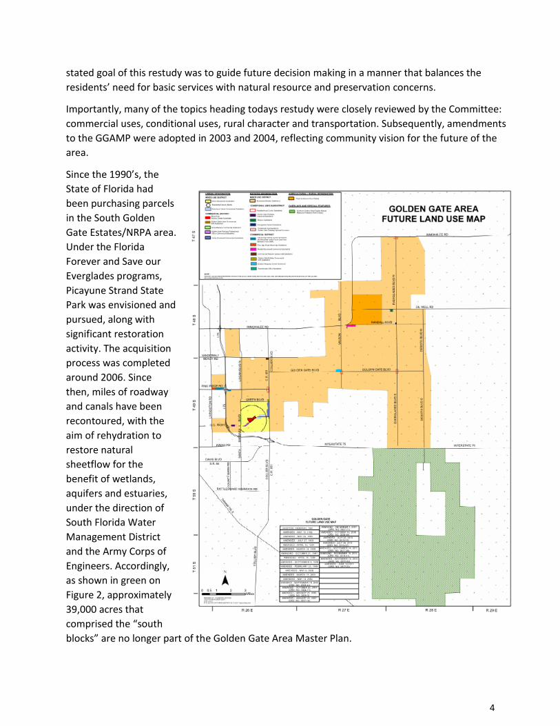
as shown in green on
Figure 2, approximately
39,000 acres that
comprised the “south
blocks” are no longer part of the Golden Gate Area Master Plan.
5
Current Conditions
Following the completion of the purchase and assemblage of Southern Golden Gate Estates by the
State of Florida, the remaining area of the rural Golden Gate Estates remains at approximately
58,000 acres. The urban Estates comprise about 8,300 acres and Golden Gate City approximately
2,500 acres. The characteristics of these areas vary greatly.
The rural Estates retains the most “rural” character of the three areas, given its size and residential
distribution. Because of the development pattern and changes in condition over the past 5
decades, flooding, wildfire and wildlife conditions play a more important role in eastern Estates
residents’ lives as compared to the urban area.
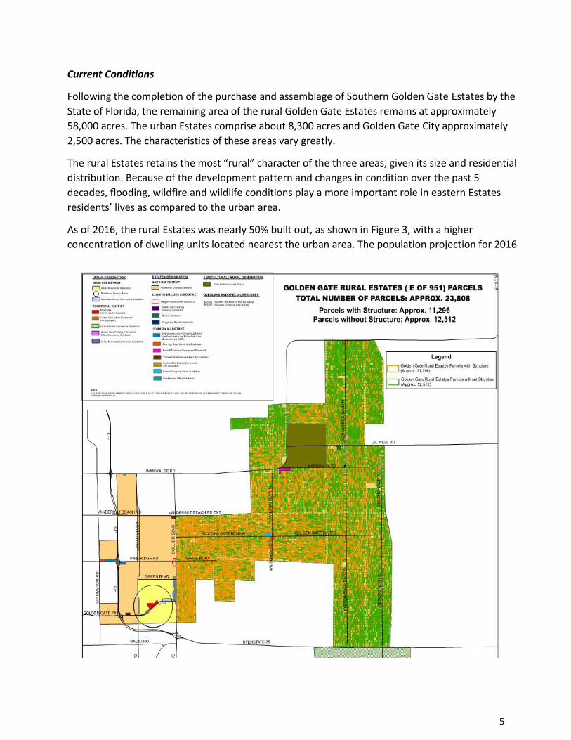
As of 2016, the rural Estates was nearly 50% built out, as shown in Figure 3, with a higher
concentration of dwelling units located nearest the urban area. The population projection for 2016
6
was approximately 32,000 persons. For several decades, this area has been described as a de facto
“affordable” housing area, given the land costs in comparison to urban locations. Though its
developers built canals to “drain” and lower the water table, remnant wetlands remain on a
significant portion of the eastern Estates, including areas within the Horsepen Strand flowway.
Meanwhile, the pace of development remains high in the eastern Estates. In fact, building permits
issued in this area increased from 273 to 408 year to year, as measured second quarter, 2016 to
2017.
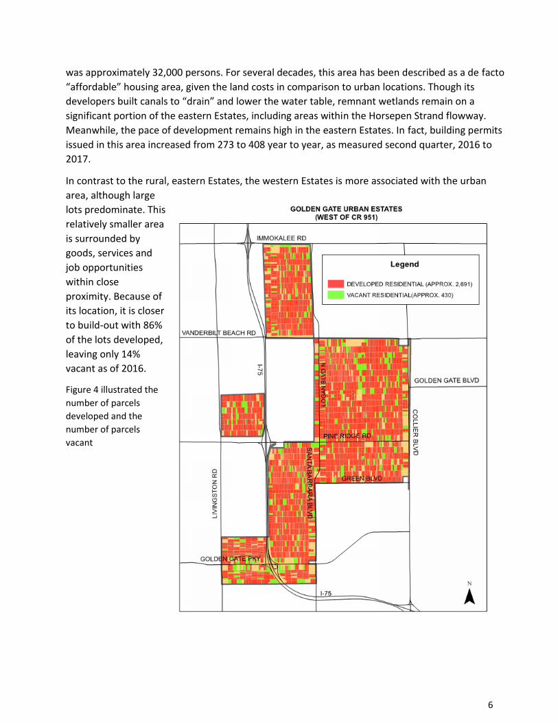
In contrast to the rural, eastern Estates, the western Estates is more associated with the urban
area, although large
lots predominate. This
relatively smaller area
is surrounded by
goods, services and
job opportunities
within close
proximity. Because of
its location, it is closer
to build-out with 86%
of the lots developed,
leaving only 14%
vacant as of 2016.
Figure 4 illustrated the
number of parcels
developed and the
number of parcels
vacant

7
Golden Gate City is at the heart of the GGAMP, as shown on Figure 5, the City comprises a denser
population along with commercial and mixed-use sub-districts for goods and services. The
projected 2016 population of Golden Gate City was 24,000, a figure very close to its build-out
population. Many of the residential and business structures date back to the 1960’s,
foreshadowing future redevelopment.
Golden Gate City has a unique demographic. The average age of its residents is 30, compared to 47
county-wide. There are 42% more persons per household and 65% less household income as
compared to Collier County as a whole, and almost 50% of dwelling units are rented.
The geography of Golden Gate City is also remarkable. Although some canals create impediments,
the City is walkable and bikeable by its residents and school-aged children, creating opportunities
for mobility that other areas of the County do not enjoy. Moreover, essential services are centrally
located for the convenience of its residents.

8
Section 3: Public Outreach, Data and Analysis
The Golden Gate area includes three diverse geographic areas: the eastern or rural Estates (east of County Road 951), the western or urban Estates (West of County Road 951) and Golden Gate City, an unincorporated area. With these differences in mind, the restudy effort included public outreach and planning analysis along these three geographic lines. This Section provides information reflective of the unique conditions of Golden Gate City and the Estates. As understood from public outreach, the eastern and western estates have a great deal in common and are discussed in this Section under the same Golden Gate Estates heading. Where differences exist, they are described. The focus areas of complementary land uses and economic vitality, transportation and mobility, and environmental stewardship are addressed under both Golden Gate City and Golden Gate Estates. The Golden Gate Area Master Plan restudy public outreach process included extensive public
engagement. Residents and stakeholders were encouraged to provide input through multiple
platforms including eight public workshops, staff presentations to both the Golden Gate City Civic
Association and the Golden Gate Estates Civic Association, a user-friendly website with surveys,
and communications through email distribution lists with approximately 330 stakeholders. Please
see appendices for meeting summaries, polling and survey results, and other communications
from stakeholders.
The public workshops for both Golden Gate City and the western and eastern Estates kicked-off
with a visioning process. The intent was to determine if any of the community values had changed.
The visioning process lead to each community developing their own vision statements. These
community-defined vision statements should provide guidance for implementing planning goals,
objectives and policies. These are provided as a preface to the Golden Gate City and Golden Gate
Estates sections below.
Golden Gate City
Golden Gate City Vision Statement
“Golden Gate City is a safe, diverse, family-oriented community that offers easy access to education, parks, shopping and services within a vibrant, walkable community.”
Land Use and Economic Vitality
Within Golden Gate City there are numerous future land use designations ranging from single
family residential use to heavy commercial use. Golden Gate City is a true mixed-use community.

9
Within Golden Gate City’s four-square-miles, residents are in close proximity to schools, parks,
goods and services.
While the majority of Golden Gate City is designated as residential, commercial designations are
found along the major arterials including Golden Gate Parkway, Santa Barbara Boulevard and
Collier Boulevard. The Golden Gate Area Future Land Use Map provides six different commercial
designations, each with different allowed uses, intensities and development standards. Figure 6
below shows the Golden Gate City areas designated residential in yellow; the other six
designations are commercial (or mixed-use).
While the Golden Gate Master Plan offers a full range of commercial uses, many commercial areas
remain under-developed. Some of the largest stores, including K-Mart, have recently closed.
During the public workshops, the majority of participants felt there isn’t a need for additional
commercial areas, but recognized a need and opportunity for redevelopment of the existing areas
to spur economic development in Golden Gate City.

10
In addition to the community public workshops, Collier County Community Planning staff also
organized a workshop specifically for all property owners within a commercial land use
designation. The purpose of the workshop was to identify opportunities and constraints to
developing commercial uses within the designated areas. In addition to noting desires to unify and
simplify the design standards and processes throughout the commercial designations, there was
strong sentiment supporting the evaluation of a Community Redevelopment Agency (CRA) for
Golden Gate City.
During the general public workshops, residents expressed a clear desire to participate in the
planning focus and guidelines for their community. When asked, “would you be willing to
participate in community-based planning program?”, the majority of workshop participants were
willing to engage in such a program. This type of planning program has been included in the
Golden Gate Area Master Plan, but has yet to be implemented by Collier County.
This idea of community planning is distinguished from the efforts and accomplishments of the
Golden Gate Civic Association (GGCA) and the Golden Gate MSTU. These groups have been active
for many years, providing cohesion to the community in many important ways.
Supporting Golden Gate City Redevelopment
There is a clear desire among Golden Gate City residents to support the success and vibrancy of
the community. With a focus on land use, two tools to accomplish this objective are 1) to evaluate
the creation of a Community Redevelopment Agency (CRA) for Golden Gate City, and 2) implement
the long-standing policies for the creation of a community-planning program.
Related Existing Provision in the GGAMP:
Goal 4:
To preserve and enhance a mix of residential and commercial land uses within Golden Gate City
that provides for the basic needs of both the local residents and the residents of the surrounding
area.
Objective 4.1:
Provide for residential and commercial land uses that meet the needs of the surrounding area in
the development and redevelopment within Golden Gate City.
Policy 4.0.1:
Development and redevelopment with Golden Gate City shall be guided by the residential and
commercial needs of the surrounding area.
Policy 4.1.1
Collier County shall develop an implementation schedule for the creation of a community-planning
program for Golden Gate City…
Policy 4.1.2

11
Collier County shall begin to examine, by holding community meetings, the feasibility of
establishing neighborhood-based planning programs within Golden Gate City that focus on the
unique or distinct features of the different portions of the community. While focusing on distinct
areas within the community, such neighborhood planning efforts as may be established shall not
neglect Golden Gate City as a whole.
Policy 4.1.3:
Collier County shall examine the feasibility of crafting land development regulations specific to the
Colden Gate City community. Such regulations shall focus on the unique circumstances of this
community.
Land Use Designations (synopsis)
Urban-Mixed Use District
This district is intended to accommodate a variety of residential and commercial land uses
including single-family, multi-family, duplex, and mixed-use.
High Density Residential Subdistrict
To encourage higher density residential and promote mixed-uses in close proximity to Activitiy
Centers, those residential zoned properties permitting up to 12 dwelling units per acre.
Downtown Center Commercial Subdistrict:
The primary purpose of the Downtown Center Commercial Subdistrict is to encourage
redevelopment along Golden Gate Parkway in order to improve the physical appearance of the
area and create a viable downtown district for the residents of Golden Gate City and Golden Gate
Estates.
Mixed-use Activity Center Subdistrict
The Activity Center designated of the Future Land Use Map is intended to accommodate
commercial zoning within the Urban Designated Area. Activity Centers are intended to be mixed-
use in character.
Golden Gate Urban Commercial In-fill Subdistrict
This Subdistrict is located at the southwest quadrant of C.R. 951 and Golden Gate Parkway.
Commercial uses are limited to low intensity and intermediate commercial uses similar to C-1, C-2,
or C-3 zoning.
Santa Barbara Commercial Subdistrict
The intent of the Santa Barbara Commercial Subdistrict is to provide Golden Gate City with an area
that is primarily commercial, with an allowance for certain conditional uses. Thy types of uses
permitted within this Subdistrict are low intensity retail, offices, personal services and institutional.
Golden Gate Parkway Professional Office Commercial Subdistrict
The provisions of this Subdistrict are intended to provide Golden Gate City with a viable
professional office district with associated small-scale retail.

12
Collier Boulevard Commercial Subdistrict
The primary purpose of the Collier Boulevard Commercial Subdistrict is to encourage
redevelopment along Collier Boulevard in order to improve the physical appearance of the area.
This Subdistrict is intended to allow a mix of uses, including heavy commercial within those areas
presently zoned C-5.
Recommended Policy Provisions:
• Maintain existing policy provisions, except as they may conflict with the following
recommendations
• Modify the existing commercial designations along Golden Gate Parkway to create
consistency between each of the subdistricts allowed land uses and development standards
to support mixed-use development including retail, office and residential uses.
• Evaluate the establishment of a CRA within the boundaries of Golden Gate City.
• Evaluate, through a CRA or County Staff, the need for and effectiveness of zoning overlays
within the commercial or mixed-use subdistricts to foster redevelopment.
13
Golden Gate City Transportation and Mobility
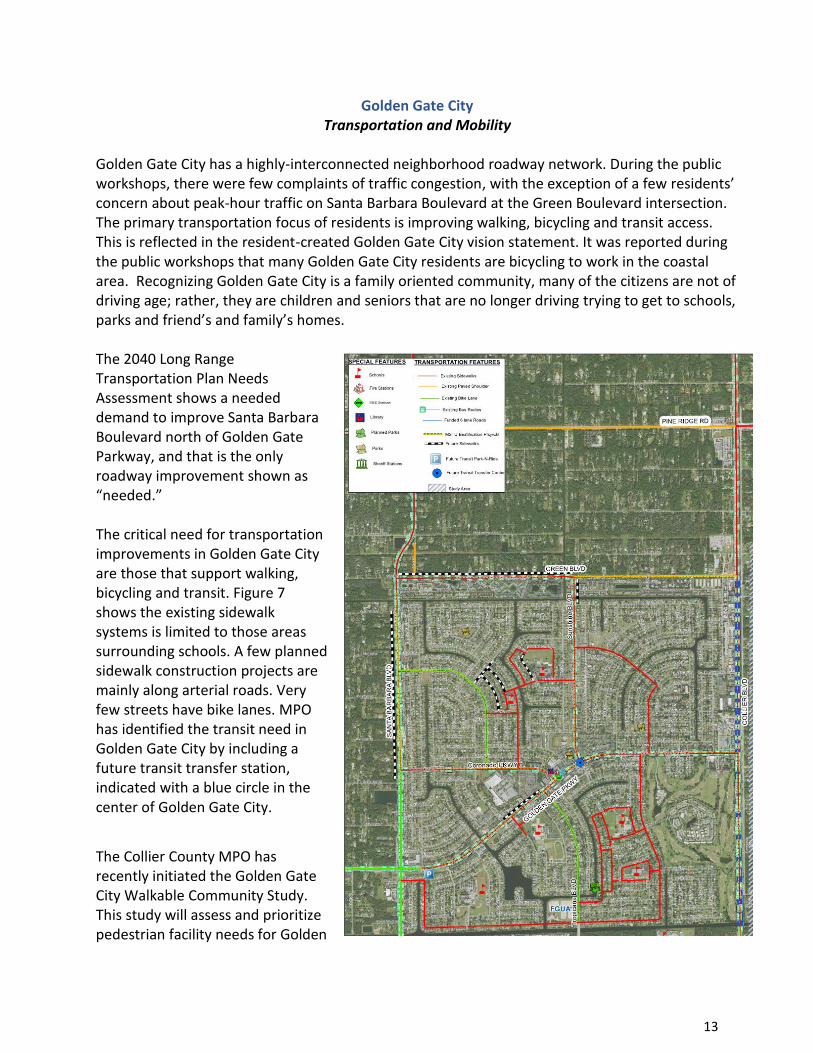
Golden Gate City has a highly-interconnected neighborhood roadway network. During the public workshops, there were few complaints of traffic congestion, with the exception of a few residents’ concern about peak-hour traffic on Santa Barbara Boulevard at the Green Boulevard intersection. The primary transportation focus of residents is improving walking, bicycling and transit access. This is reflected in the resident-created Golden Gate City vision statement. It was reported during the public workshops that many Golden Gate City residents are bicycling to work in the coastal area. Recognizing Golden Gate City is a family oriented community, many of the citizens are not of driving age; rather, they are children and seniors that are no longer driving trying to get to schools, parks and friend’s and family’s homes. The 2040 Long Range Transportation Plan Needs Assessment shows a needed demand to improve Santa Barbara Boulevard north of Golden Gate Parkway, and that is the only roadway improvement shown as “needed.” The critical need for transportation improvements in Golden Gate City are those that support walking, bicycling and transit. Figure 7 shows the existing sidewalk systems is limited to those areas surrounding schools. A few planned sidewalk construction projects are mainly along arterial roads. Very few streets have bike lanes. MPO has identified the transit need in Golden Gate City by including a future transit transfer station, indicated with a blue circle in the center of Golden Gate City.
The Collier County MPO has recently initiated the Golden Gate City Walkable Community Study. This study will assess and prioritize pedestrian facility needs for Golden

14
Gate City based on quantitative and qualitative factors. Following the completion of the study and presentation to the Collier MPO, the approved study recommendations may be incorporated into the Golden Gate Area Master Plan. Related existing provision in the GGAMP:
Policy 6.2.3:
Sidewalks and bike lanes shall provide access to government facilities, schools, commercial areas
and the planned County greenway network.
Objective 6.3:
Coordinate with local emergency services officials in planning and constructing road improvements
within Golden Gate Estates and Golden Gate City to ensure that the access needs of fire
department, police and emergency management personnel and vehicles are met.
Objective 7.3
Develop strategies through the County Growth Management Division – Planning and Regulation
for the enhancement of roadway interconnection within Golden Gate City and the Estates Area
including interim measures to assure interconnection.
Recommended Policy Provisions:
Update Policy 6.2.3. to include reference to the approved recommendations within the Golden
Gate City Walkable Community Study.

15
Golden Gate City
Environmental Stewardship
The primary concern for potential environmental degradation in Golden Gate City is associated
with the many private wells and septic tanks. As reported by Collier County Utilities Department,
residences so near one another pose a significant risk of contamination to individual water wells or
supply-sources for the entire region. Private water wells and septic tanks age over time, have a
limited lifecycle, and have a wide disparity in the level of maintenance by various property owners,
affecting the life and functionality of the tanks.
Currently, only one complete quadrant of four within Golden Gate City has access to a treated
potable water supply from a private utility, Florida Governmental Utility Authority (FGUA). At their
June 27, 2017 meeting, the Board of County Commissioners provided direction to County staff to
initiate a due diligence process and negotiate terms of acquisition of FGUA. Integrating the Golden
Gate City system into the Collier County Public Utilities system and expanding utility services to
homes and businesses within Golden Gate City provides a long-term stratgey to address potential
environmental impacts and system reliability.
Related existing provision in the GGAMP:
Objective 1.2:
Ensure public facilities are provided at an acceptable level of service.
Policy 1.2.3:
Consistent with Chapter 89-169, Florida Administrative Code, the Florida Governmental Utilities
Authority, or its successor, shall provide updated water and sewer service data to the Collier
County Water and Wastewater Authority on an annual basis.
Policy 1.2.4:
Due to the continued use of individual septic systems and private wells within a densely platted
urban area, the Florida Governmental Utilities Authority, or its successor, is encouraged to expand
their sewer and water service area to include all of that area known as Golden Gate City at the
earliest possible time.
Recommended Policy Provisions:
• The Policies referencing the Florida Governmental Utilities Authority will be updated to
reference Collier County Public Utilities.
• Policy 1.2.4 as it notes expansion of service will be updated to reference the Collier County
Public Utilities integration and implementation plan.

16
Golden Gate Estates
Golden Gate Eastern Estate Vision Statement
“The Golden Gate Eastern Estates is an interconnected, low-density residential community with limited goods and services in neighborhood centers, defined by a rural character with an appreciation for nature and quiet surroundings.”
Golden Gate Western Estate Vision Statement
“Golden Gate Western Estates is a low-density, large-lot residential neighborhood in a natural setting with convenient access to the coastal area.”
Land Use and Economic Vitality Within the GGAMP, there are Goals, Objectives and Policies (GOPs) as well as a Land Use Description Section that pertain specifically to Estates land uses. This section describes the status, review and community recommendations pertaining to GOPs and Estates land use descriptions, both east (rural) and west (urban) of CR 951. Generally, the land uses can be divided into these categories: Residential, Commercial and Conditional. Additionally, policies related to public facilities, adjacent land uses and notice provisions are considered. Residential Land Uses Golden Gate Estates is an area primarily intended for residential uses. Of the 66,,000 acres that make up today’s Golden Gate Estates, over 95% is reserved for residential use under the current plan. This is consistent with Goal 5 of the GGAMP that balances the preservation of rural character, wooded lots, the keeping of livestock, the ability to grow crops. wildlife activity and low density residential with limited commercial and conditional uses. As of 2016, the rural Estates residential lots total almost 24,000 in number. Approximately half have been developed. Absent future changes in conservation of parcels for environmental or recreational purposes, the current population of 31,100 can be expected to double by build-out. Figure 8 shows the existing distribution of developed residential areas within the rural Estates:

17
By contrast, Figure 9 shows the development of urban Estates lots is much closer to build-out. In this area, 86% of the parcels have been developed, leaving only 430 vacant parcels in this much smaller portion of Golden Gate Estates.

18
An analysis of building activity in Golden Gate Estates suggests that development is currently accelerating. When comparing annual totals as of second quarter, 2017 to second quarter, 2016, permit applications rose from 273 to 408, an increase of almost 50%. Taken together, 681 housing starts over this 2-year period suggests economic vigor in a post- high foreclosure market. During public outreach, residents and stakeholders did not advocate any major changes in residential land use. Most individuals polled preferred to maintain a low density residential environment with few changes. In fact, the Golden Gate Estates Area Civic Association (GGEACA) voiced the preference for a “low density overlay” to protect its character well into the future. The minimum lot size would remain unchanged, with the possibility of recombining some legal non-conforming (smaller) lots. No new designations of residential areas to Neighborhood Centers were suggested. The sole conversion of residential areas endorsed by the public was for office type commercial along a short length of Immokalee Road in the Urban Estates and the possibility of non-residential land uses near the Randal Rd. curve on Immokalee Rd. Residents were polled about some specific aspects of Residential land use. Polling questions included allowing group homes as a permitted use and changing the rules surrounding home-based businesses. Public sentiment was against any change in either topic area. When asked about the desirability of allowing rental of guest houses, polls found mixed results. At a public workshop held in November, 2016, 56% of respondents were in favor. In contrast, only 26% responded favorably at a February, 2017 public workshop. Currently, there are approximately 700 guest homes in the Estates area. Based on the strong environmental preferences in response to other issues, staff does not recommend guest house rentals, as it would tend to weaken the desire to retain a lower density, lower impact community. It should be noted, however, that guest house rentals have been embraced by other communities in the U.S. to address shortages in housing availability for young professionals and the elderly. Some requested changes, as described in the environmental portion below, relate the desire to recombine legal non-conforming lots and to require or incentivize on-site stormwater retention and other water-related initiatives to maximize water quality, percolation and floodplain protection. Also, noted in the environmental section, are recommendations for strengthening wildfire prevention and lighting standards. These provisions cross several land uses, including residential land use. Public Notice Although the concept of strengthening various notice provisions was not queried or mentioned in public outreach workshops, staff has observed one notice issue in the context of public petitions. Currently, mailed notices are required in advance of Neighborhood Information Meetings (NIMs) as well as certain public hearings. Where required, it would be beneficial for all involved to provide notices along the entire length of dead-end Estates avenues or streets where a project makes direct impact, if the length is greater than the required linear distance of 1,000 feet. (See Non-Residential Uses/Notice provisions, below.)

19
Specific Property Re-designations From time to time staff was queried about specific properties and whether there would be any specific land use changes recommended. Staff understood its Restudy scope as one essentially limited to universal principles- either in land use or other GOPs. However, it is always possible that, during the Public Hearing process, public officials will endorse land use changes in a parcel specific manner. For example, parcels owned by the County may be the subject of Board action to effect affordable or senior housing needs, or to accommodate other public uses such as park and ride locations, or other appropriate land use. One specific location that gained attention following public outreach is the area in the vicinity of the Immokalee Rd. curve near Randall Blvd. This is a location where significant transportation planning is underway, and the area may be suitable for non-residential uses such as an activity center or other designation. The recommendations below include this area as a future study area to determine appropriateness of re-designation. Related Existing Provisions in GGAMP: Designation Description/Residential Estates Subdistrict: Single family residential development is allowed within this Subdistrict at a maximum density of one unit per 2.25 gross acres, or one unit per legal non-conforming lot of record, exclusive of guest houses. Objective 5.3: Provide for the protection of the rural character of Golden Gate Estates. Policy 5.3.0.1: Rural character protection provisions shall provide for the preservation of such rural amenities as, but not limited to, wooded lots, the keeping of livestock, the ability to grow crops, wildlife activity, and low-density residential development. Policy 5.3.2: The Land Development Code shall continue to allow and further encourage the preservation of native vegetation and wildlife indigenous to the Estates area. Objective 1.4: Provide a living environment within the Golden Gate area, which is aesthetically acceptable and protects the quality of life. Policy 1.4.0.1 Collier County shall provide a living environment that is aesthetically acceptable and protects the quality of life through the enforcement of applicable codes and laws. Policy 1.4.1: The County’s Code Enforcement Board shall strictly enforce the Land Development Code and other applicable codes and laws to control the illegal storage of machinery, vehicles and junk, and the illegal operation of commercial activities within the Golden Gate area. Recommended Policy Provisions:
• (see Non-residential Land Uses and Environmental Recommendations)

20
Neighborhood Centers and Non-residential Uses
Presently, there are three (3) Neighborhood Center designations in the Rural Estates and one (1) on the eastern edge of the urban Estates. In addition to Neighborhood Centers, there are four (4) mixed-use or commercial Sub-districts in the rural Estates and six (6) within the urban Estates. The locations can be seen below in Figure 10.
During the public outreach meetings in the rural Estates and in the urban Estates, no new Neighborhood Centers were suggested or desired. Rather, there was strong sentiment to increase the availability of commercial uses in adjoining RFMUD and RLSA areas. In this way, the predominant rural, residential character of the Estates could be maintained. Importantly, by placing office, commercial, business and industrial parks in these adjoining Districts, shopping,

21
employment and entertainment opportunities would emerge in closer proximity to the Estates, and within easier drive times. As noted in the Master Mobility Plan (2012), reverse trips and shorter trips (fewer vehicle miles travelled) yield benefits to infrastructure demand, local economy, quality of life, environmental protection and public safety. Resizing the Neighborhood Centers Although no new Neighborhood Centers were desired by the public, there was a clear desire by those within the rural Estates that the three Neighborhood Centers should be “right-sized”, to function appropriately within a rural context. For example, Figure 11 shows the three quadrants within the Wilson Boulevard and Golden Gate Boulevard Center contains development areas of 8.45, 7.15 and 4.86 acres, as seen in the figure below. As stated by the Golden Gate Estates Area Civic Association (GGEACA), these Centers should be allowed “sufficient (increased) area for road development, septic/wastewater treatment, and water retention.” Additional rationale would include parking and effective buffering from residential uses.
The GGEACA recommended an 80-acre maximum node for each of the three rural Neighborhood Centers. This equates to a maximum of 20 acres per quadrant- an important measure because at least 2 of the 3 rural Neighborhood Centers will not develop all 4 quadrants. In most instances 20 acres will not be required to build an efficient development area, but can serve as a maximum under the Master Plan. Upsizing of any Neighborhood Center would require a rezoning of the property. In all, there are 10 commercial or mixed-use subdistricts in Golden Gate Estates. For the most part, these subdistricts emerged over the past 20 years through private plan amendment applications and Board approvals. As noted, the scope of this Restudy does not include additional site-specific recommendations. Further, stakeholders do not presently support additional site-specific commercial designations.

22
Immokalee Rd./Oaks Blvd. Interface There is one location within the urban Estates best described as a potential corridor re-designation. This is an area along the Immokalee Road/Oaks Estates interface as shown in Figure 12. Currently zoned uses among the 16 parcels located in this corridor include 2 commercial (C-1), 8 conditional uses and 6 residential. One of the residential uses is entitled to a transitional conditional use application. Another is a County-owned parcel for water retention. Thus, five parcels could retain existing residential zoning or apply for a CU or rezone to C-1, under the recommendation below.
When asked about additional conditional uses in the western Estates, a slight majority felt that additional locations were not needed. However, when asked whether the Immokalee Road/Oaks interface should have future land uses to include office and conditional uses, over 75% were in favor. The public understood that a more unified planning approach to this corridor could result in better outcomes, including access points and continuity. For this reason, the recommendation below suggests a FLUE designation that allows rezone applications for C-1 uses as well as conditional uses in this corridor. Conditional Uses Conditional use opportunities in Golden Gate Estates include churches, social and fraternal organizations, child care and adult day care centers, private schools, group care facilities (such as nursing homes and assisted living facilities) and model homes. As conditional uses, they are generally appropriate if compatible with neighboring uses, and should be limited as to location and number. A GGAMP allowance for conditional use provides a right to seek approval, not a right for the use at any location. Typically, if granted, conditional uses are subject to numerous conditions of development and operation.
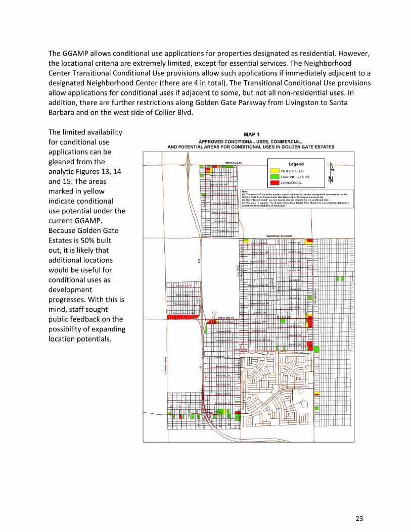
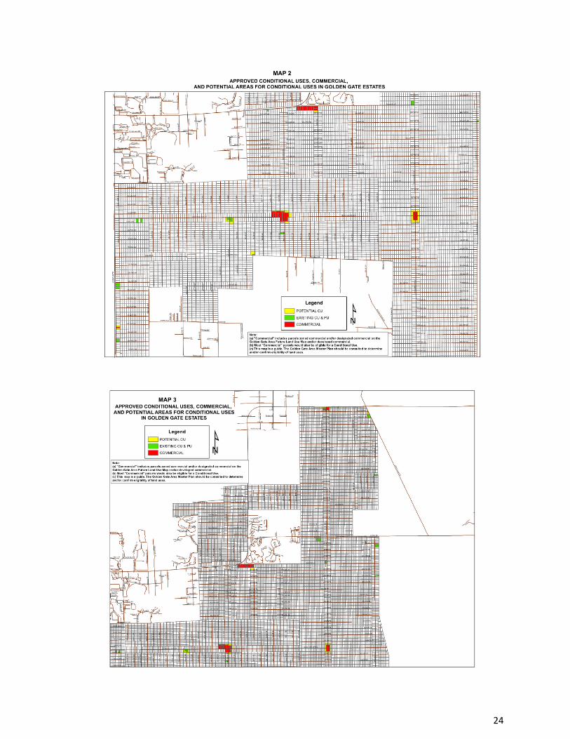
23
The GGAMP allows conditional use applications for properties designated as residential. However, the locational criteria are extremely limited, except for essential services. The Neighborhood Center Transitional Conditional Use provisions allow such applications if immediately adjacent to a designated Neighborhood Center (there are 4 in total). The Transitional Conditional Use provisions allow applications for conditional uses if adjacent to some, but not all non-residential uses. In addition, there are further restrictions along Golden Gate Parkway from Livingston to Santa Barbara and on the west side of Collier Blvd. The limited availability for conditional use applications can be gleaned from the analytic Figures 13, 14 and 15. The areas marked in yellow indicate conditional use potential under the current GGAMP. Because Golden Gate Estates is 50% built out, it is likely that additional locations would be useful for conditional uses as development progresses. With this is mind, staff sought public feedback on the possibility of expanding location potentials.
24

25
Arterial Intersections Surveys in the rural Estates indicated a preference to allow some additional potential CU locations if limited as to location and type. A majority stated that additional CUs should be allowed at more locations, and specifically allowed at arterial intersections (described as 4 or more lane roads intersected by 4 or more lane roads). Slightly less than half of those surveyed in the urban Estates thought that CUs should be considered at major intersections (45% v. 50%). A compilation of the intersections that would qualify as described above include: Rural Estates
• Everglades Blvd. and Oil Well Rd.
• Golden Gate Blvd. and Collier Blvd. (east quadrants)
• Vanderbilt Beach Rd. and Wilson Blvd. (future)
• Everglades Blvd. and Randall Rd. (future)
• Wilson Blvd. and Immokalee Rd. (future, south quadrants)
Urban Estates
• Logan Blvd. and Pine Ridge Rd.
• Golden Gate Pkwy. and Santa Barbara Blvd. (west quadrants)
• Logan Blvd. and Vanderbilt Beach Rd. (future, SW quadrant only) (Note: “future” designation derived from 2040 LRTP) Based on this recommendation, a total of 6 quadrants in the rural Estates could qualify for CU application, not considering current land uses at those locations. An additional 10 quadrants could theoretically support conditional use applications in the rural Estates, if future road improvements are built as planned. In the urban Estates, a total of 6 quadrants could qualify for CU application not considering current uses. An additional quadrant could theoretically qualify based on planned road improvements. Staff’s recommendation, below, is the addition of the major arterial intersections (as defined) as a locational criterion for CU applications; plan language should allow parcel assemblage where minimum ingress/egress requirements dictate. A maximum of 10 acres per quadrant (individual CU) is suggested, compared to the maximum of 20 acres per quadrant for Neighborhood Centers. Golden Gate Parkway and Collier Blvd. Special Provisions As noted in the Related Existing Provisions section, below, there are special provisions related to Golden Gate Parkway and Collier Blvd. frontages. As described above, the only change to the Golden Gate Parkway provisions would be a change allowing CU applications for properties located at the corner of Golden Gate Parkway and Santa Barbara Blvd. The two quadrants at that location are currently zoned PUD or CU.

26
With respect to the Collier Blvd. Special provisions, the GGAMP currently requires adjoining conditional uses on two sides, rather than the transitional conditional use provision requiring certain non-residential uses on one side only. Staff observes that, during a public hearing for a zoning change request at 13th Ave SW and Collier Blvd, a conditional use was not available under the GMP due to this provision. However, the property in question was located next to an industrial type (PUD) use, which could make a CU a suitable transition to adjoining residential. For this reason, the recommendation below would remove the Collier Blvd. Special Provision. We also note that this specific recommendation was not vetted during public outreach workshops. Accordingly, this fact should be noted during the Transmittal process. Communication Towers Communication towers are listed conditional uses in Golden Gate Estates. As such, they are limited to the locational criteria found in the Designation Description section. The available locations for cell towers are extremely limited, as these are not “essential services” as defined in the Land Development Code. As technologies quickly advance, the applications for communication transmission devices may look considerable different in just a few years than they do today. Individual consideration of proposed installations should be reviewed in each instance. A solid majority of residents surveyed, both in the rural Estates and the urban Estates, indicated dissatisfaction with existing cell service. Over 75% of the rural estates residents surveyed believed that communication towers should be conditional uses, available at any location in the Estates. The recommendation below retains this land use as a conditional use, requiring application, notice and public hearing, but available for application at any suitable location in the Estates. Conditional Use Acreage At present, conditional uses are generally limited to 5 acres. Although not specifically queried in public outreach, staff sees the 5-acre limitation as creating problems similar to the acreage limitations within currently approved Neighborhood Centers. The issues noted there are adequacy of stormwater retention, buffering, parking, roadway needs and septic provisions. In some cases, the current 5-acre standard may prove sufficient. However, applicants may wish to request a greater acreage. This request would remain subject to the public hearing requirements of the Conditional Use, but the provision for greater acreage in the GGAMP would relieve the applicants from amending the GMP to creating otherwise unnecessary sub-districts. Rather than suggesting 20 acres as recommended by the GGEACA for Neighborhood Centers, a more modest 10-acre maximum is recommended. If embraced, staff also supports enhanced buffering requirements similar to those required for the neighborhood Centers. Public Facilities In addition to the growing transportation network in and near the Estates, numerous public facilities serve Estates residents. The eastern Estates is served by: two high schools, several

27
elementary and middle schools; three fire stations; 2 EMS stations; Sheriffs stations; a library; community parks and a regional park under design. Additional public facilities are planned to accommodate the growth in population, as monitored by the County’s Annual Appraisal and Inventory Report (AUIR) and coordinated through the Growth Management Department and associated County departments, including the Collier County School District and independent agencies. With regard to public facilities as a land use, members of the public stressed compatibility within a predominantly residential area. Specifically, there is interest in developing rural architectural standards for public buildings as well as other non-residential structures. A unified architectural standard can provide a greater sense of identity to the Estates District. In addition, there is interest in updating development standards such as setbacks and buffers, particularly as public uses intensify at existing or future locations. Park and Ride Park and ride facilities are essentially parking areas that can serve several purposes. As many rural estates residents commute to the urban area for daily work, or for occasional shopping and entertainment, a park and ride area can support voluntary ride sharing to and from proximate urban locations. Ride sharing applications for mobile devices have emerged as a helpful tool for commuters. At an appropriate time, bus/transit service could also serve these locations. The importance of park and ride and ride sharing for community-wide benefits was underscored by the Master Mobility Plan (accepted by Board, 2012) and by ULI in their review of housing affordability (2017). Additionally, as part of the initiative to support natural disaster prevention and response programs, portions of these facilities could be used for staging equipment, vehicles and operations. Nearly 40% of the citizens polled reported that they would consider using such facilities. It is suggested that the County consider appropriate locations for these facilities, with locational criteria including direct access to arterial roadways and buffering, and apply for Board approval through the Conditional Use public hearing process. Adjacent Future Land Use Districts The eastern Estates is bounded by The Rural Fringe Mixed Use District (RFMUD) on 2 sides and the Rural Lands Stewardship Area (RLSA) on another. There are two essential parameters of interest to eastern estates residents. First, residents are very enthusiastic about the possibility of more robust economic development in the RFMUD and RLSA. Residents desire more proximate commercial areas for shopping and services, and want employment opportunities. For these reasons, residents were highly supportive of RFMUD Village centers, RLSA towns, and freestanding business and industrial park locations in these Districts. The potential for eastern Estates residents to shop and work within shorter distances and outside of the urban area is a great benefit to them, and this advantage redounds to

28
County taxpayers through reduced miles travelled, lower capital and maintenance costs for roads, and a reduced carbon footprint. Second, eastern Estates residents desire compatibility of uses where adjoining Districts develop adjacent to the Estates. Enhanced buffers and setbacks are suggested at the interface of these Districts. These development standards will be specified by LDC review and amendment, and reflected in the Policies of the GGAMP. Notice Provisions Although not discussed in the Restudy outreach workshops, staff has observed past private petitions that involved Estates re-designation and rezoning. In the Estates, written notice provisions related to Neighborhood Information Meetings (NIMs) and public hearings extend 1,000 feet from the property lines of the project (compared to 500 feet in the urban area). In reality, affected Estates residential uses may extend the length of a dead-end street. A typical dead-end street in the Estates is approximately one mile. Accordingly, many affected residents are not provided with written notice. The recommendation associated with this topic would require written notice beyond 1,000 feet, where traffic impacts can be reasonably anticipated, as a result of the land use change, on a dead- end street or avenue in the Estates. In such a case, notice should be provided along the entire length of the affected street or avenue. Related Existing Provisions in the GGAMP: Objective 5.3: Provide for the protection of the rural character of Golden Gate Estates. Objective 1.2 Ensure public facilities are provided at an acceptable level of service Goal 3: To provide for basic commercial services for purposes of serviing the rural needs of golden gate estates residents, shortening vehicular trips, and preserving rural character. Neighborhood Center Subdistrict: Recognizing the need to provide basic goods, services and amenities to Estates residents, Neighborhood centers have been designated on the Golden Gate Area Future land use map. The Neighborhood Center designation does not guarantee that commercial zoning will be granted. The designation only provides the opportunity to request commercial zoning. Conditional Uses Subdistrict: Various types of conditional uses are permitted in the estates zoning district within the Golden Gate estates area. In order to control the location and spacing of new conditional uses, one of the following four sets of criteria shall be met:

29
a) Essential Services Conditional Use Provisions: … b) Golden Gate Parkway and Collier Blvd. Special Provisions: … c) Neighborhood Center Transitional Conditional Uses Provisions: … d) Transitional Conditional uses: …
Recommended Policy Provisions:
• Allow applications for rezoning for the purpose of upsizing existing Neighborhood Centers to accommodate ingress and egress, parking, buffering, water management and well, septic or package plant siting, not to exceed 20 acres per quadrant. This provision does not guarantee that upsizing will be granted, but provides an opportunity to request commercial rezoning.
• Allow conditional use or C-1 rezone applications for the Immokalee Rd. corridor (Oaks area). This provision does not guarantee approval, but allows application without amendment to the GMP (5 parcels affected).
• Add an additional locational criterion for conditional uses to include major roadway intersections, defined as the intersection of a 4-lane roadway (or greater) with a 4-lane roadway (or greater), as identified in the LRTP, and limited to 10 acres per quadrant.
• Allow a maximum of 10 acres for Transitional Conditional Uses, with enhanced buffers.
• Adjust the Golden Gate Parkway Special Provisions to allow conditional use applications for properties at the intersection of Golden Gate Pkwy. and Santa Barbara Blvd.
• Adjust the Collier Blvd. Special Provisions to allow the same locational criteria as currently allowed at other locations in Golden Gate Estates.
• Allow conditional use applications at any location in Golden Gate Estates for the erection of communication towers, without need to also amend the GGAMP.
• Develop architectural standards in the Land Development Code that apply to commercial, conditional and public facility uses in the rural Estates to create coherence and area identity that reflect the rural character of the area.
• Seek public acquisition of appropriate parcels, with conditional use approval, for “park and ride” uses, to serve private carpooling, public transit and emergency prevention and response program activities.
• In its review and adoption of GMP amendments to the RFMUD and the RLSA, the County should reflect the need for appropriate buffers and setbacks from adjoining Golden Gate Estates properties, with specific development standards in the LDC.
• Where GMP Amendments or Rezoning actions require written notice to homeowners within a given distance of the subject parcel, notice requirements shall also be extended the length of any dead-end street or avenue where a direct transportation or aesthetic impact can be reasonably anticipated.
• During the next Evaluation and Appraisal Report cycle (2021), the GMD shall provide analysis and recommendations to the Board for non-residential land uses in the vicinity of the intersection of Immokalee Rd. and Randall Blvd.

30
Golden Gate Estates Transportation and Mobility
Estates residents expressed their views on several transportation-related topics. Among other issues, peak hour conditions capture the attention of residents who face congestion on a recurring basis. Beyond immediate concerns, the public expressed preferences for long term considerations. These include bridge priorities, I-75 access, lime rock roads, route alternatives, greenways and pathways, road design and park and ride facilities. Many transportation projects are expressed in existing Plan language. Augmentation of these provisions are suggested to convey preference and direction for future consideration. At the heart of the transportation discussion is the Long Range Transportation Plan (LRTP), recently adopted by the Collier County Metropolitan Planning Organization (MPO). Of note, as shown on Figure 16, within the road network are planned improvements to Wilson Blvd. North and South, as well as the extension of Vanderbilt Beach Rd. to 8th Ave, NE. The Collier MPO is a federally mandated and federally funded transportation policy-making organization and is made up of representatives of local governing bodies. The MPO has the authority to plan, prioritize, and select transportation projects for federal funding appropriated by the US Congress through the US Department of Transportation, Federal Highway Administration and Federal Transit Administration. In addition to Estates residents, Collier County citizens, taxpayers and visitors are also stakeholders in the transportation and mobility concepts involving Golden Gate Estates. The synergy expected between the surrounding Rural Fringe Mixed-Use District and Rural Land Stewardship Area village and town development with the largely residential Estates area is a prime example. Retail, service and job opportunities in and around future towns and villages will result in shorter trip lengths for current and future Estates residents, when compared with trip lengths today. In addition to shorter trip lengths, north-south and reverse direction trips, particularly at peak hours, will be a positive factor in road infrastructure demand and resulting levels of service. This synergy was also highlighted in recommendations in the County’s Master Mobility Plan (MMP), accepted by the Board in 2012. Recommendation #3 in the MMP calls for incentivized goods, services and jobs in Neighborhood Centers, the RFMUD Villages and the Orangetree Settlement area to reduce the vehicle miles travelled by estates residents. Mobility related to the Estates is also addressed by Recommendation #9, enhanced localized connectivity through bridges and other connectors, and by Recommendation #13, development of park and ride lots. These concepts are further discussed below.

31

32

33
As noted on the 2040 LRTP cost feasible plan, the MPO has designated additional study areas in and around the Estates. The Randall Rd./Oil Well Rd. study is currently underway. The North Belle Meade study area is not yet funded. Staff recommends funding for route alternatives study of the North Belle Meade east/west corridors within a 5 year timeframe in order to accommodate area planning efforts in the North Belle Meade Receiving area and to provide linkage for Estates residents travelling to south Collier County and the urban area. Bridge Connectivity within GG Estates Existing GGAMP objectives stress the importance of increasing linkages within the local road system to reduce traffic on arterial roadways, shorten trips and increase overall road capacity. In addition, coordination with emergency services officials is mandated for County staff and MPO. In August, 2008, the Collier County Transportation Services Division produced the East of 951 Horizon Study for Bridges. The study included stakeholder input from Emergency service providers, environmental groups and other County Divisions. The study considered emergency service response times, evacuation needs, public service efficiencies, general mobility improvements and public sentiment. Design and cost considerations were components of the study, but costs have increased significantly since that study was completed. The outcome of the study prioritized eleven bridge construction projects in eastern Golden Gate Estates. Subsequently, three (3) bridges have been programmed:
• 8th St. NE at Cypress canal (fully funded)
• 16th St. NE at Cypress Canal (partially funded0
• 47th Ave NE at Golden Gate Canal (partially funded Staff is currently seeking full funding via gas tax revenue funding for the 16th St. NE and 47th Ave. NE bridges. Each bridge costs approximately $8m to $9m (2016 figures) to construct. During public outreach, the GGEACA urgently requested consideration for a fourth high priority bridge, located at 10th Ave. SE at the Faka Union canal. This request was based on public safety concerns, in the contexts of emergency response and emergency evacuation. The recommendation was endorsed by North Collier Fire and Rescue. For this reason, the initial recommendation below calls for an update to the bridge study within the next 2 years. As of this writing, County staff has begun planning for the public outreach associated with the updated study. A provision currently in the GGAMP specifically calls for the construction of a north-south bridge on 23d St., SW, as one of three alternatives to address emergency evacuation. As emergency services and evacuation concepts will be foremost in the bridge evaluation and update, this provision is recommended for removal from the GGAMP. Concerns were raised about the cost components of sidewalks and bike lanes on and leading to all bridges, both with respect to right-of-way acquisition and construction. Therefore, the updated

34
study should include prioritization, design alternatives and cost components. The requirement for sidewalks and bike lanes leading to new bridges should be reviewed in the context of the individual bridge location. Eight of the initial eleven bridges are depicted on Figure 18. Additional locations will be studied as part of the Bridge Study Update.

35
I-75 Interchange The GGAMP currently calls for coordination between the County and FDOT to implement a study of a potential interchange “in the vicinity of I-75 and Everglades Blvd.” In 2012, the County petitioned FDOT to consider an interchange through the submission of an Interchange Justification report (IJR). At that time, FDOT concluded that it could not recommend forwarding the IJR to the federal Highway Administration. Subsequently, the Board approved a course of action that would request emergency access to I-75, consider an updated IJR between 2020 and 2025, and to “continue to work with FDOT, other permitting agencies and NGOs to complete an environmental impact assessment and mitigation plan”. Accordingly, the current GGAMP language should be updated to include the IJR submission in the period from 2020 to 2025, and continuation of environmental assessments in coordination with all stakeholders, if feasible from a cost/benefit standpoint. It should be noted that emergency (limited) access to I-75 was granted subsequent to the 2012 IJR submission. In addition to I-75 access, concerns were raised by residents and by the GGEACA regarding traffic conditions on Everglades Blvd. The residents and association would like to protect against the possibility of expanding Everglades Blvd. beyond 4 lanes. For this reason, a recommendation appears below to limit expansion of Everglades Blvd. to no more than 4 lanes, as shown on the 2040 LRTP Needs Assessment. Lime Rock Roads The GGAMP calls upon the Transportation Department to explore alternative financing methods to accelerate paving of lime rock roads in the Estates. As of 2016, there were 29 miles of unpaved roads remaining in the Estates. At the current rate of nearly 3 miles per year, all lime rock roads would be paved in approximately 10 years. Residents have commented that an acceleration of paving may be more cost-efficient. Lime rock roads require maintenance costs that may be somewhat higher than paved roads. Additionally, the added ad valorem revenue potential from home values that appreciate due to improved road access may also influence the cost/benefit assessment. Staff recommends that the County update the study the relative costs and benefits of paving lime rock roads on an accelerated basis, and provide the study result to the Board with 2 years of adoption. Greenways The GGAMP calls for a public network of greenway corridors that connect public lands and permanently protected green space, emphasizing use by non-motorized vehicles and using the existing or future public rights-of-way. The Collier MPO 2012 “Comprehensive Pathways Plan” provides the vision for a Greenways and Trails Program as a separate network from the overall Pathways Program. It notes that the provision of off-road facilities addresses safety and comfort

36
concerns of pedestrians and bicyclists. This would allow a more focused approach to greenways and the identified entity to secure funding and expertise. As noted in the public outreach surveys, a majority of citizens favor the retention of this concept to create a greenways program. The GGAMP policy should be updated, however, to encourage coordination between the County Parks and Recreation Division, the County Transportation Planning Section, and the MPO to identify areas of responsibility in planning, funding and implementation of a greenway plan. Road Design Eastern Estates residents commented on various aspects of road design for both new and expanded roadways. As communicated through the GGEACA, preferences include a rural road design without curbs and gutters, Florida Friendly medians to the extent landscaping would be employed, and a preference for eminent domain on one side of an existing local street rather than partial takings on both sides. While these preferences are noted here, the MPO and the County Transportation Division design with specific site requirements that vary from one location to another. Moreover, these elements are best suited for review and public comment under the statutory public vetting requirements of those agencies. As such, the GGAMP should remain silent on these design preferences. Park and Ride Lots (see Land Use/Non-residential Uses) Related Existing Provisions in the GGAMP: GOAL 6:
To provide for a safe and efficient county and local roadway network, while at the same time seeking to preserve the rural character of golden gate estates in future transportation improvements within the golden gate area. OBJECTIVE 6.1:
Increase the number of route alternatives for traffic moving through the Golden Gate Area in both east-west and north-south directions, consistent with neighborhood traffic safety considerations, and consistent with the preservation of the area’s rural character. Policy 6.1.1: In planning to increase the number of route alternatives through the Estates Area, the Collier County Transportation Division will prioritize the following routes over other alternatives:
a. The extension of Vanderbilt Beach Road from its current terminus to DeSoto Boulevard.

37
b. The development of a north-south connection from the eastern terminus of White Boulevard to Golden Gate Boulevard.
c. The development of a new east-west roadway crossing the Estates Area south of Golden Gate Boulevard.
Policy 6.1.2:
Collier County shall continue to coordinate with the Florida Department of Transportation to implement a study of a potential interchange in the vicinity of I-75 and Everglades Boulevard. OBJECTIVE 6.2: Increase linkages within the local road system for the purposes of limiting traffic on arterials and major collectors within Golden Gate Estates, shortening vehicular trips, and increasing overall road system capacity. Policy 6.2.1:
The County shall continue to explore alternative financing methods to facilitate both east- west and north-south bridging of canals within Golden Gate Estates. Policy 6.2.2:
Planning and right-of-way acquisition for bridges within the Estates Area local road system shall make adequate provision for sidewalks and bike lanes. Policy 6.2.3:
Sidewalks and bike lanes shall provide access to government facilities, schools, commercial areas and the planned County greenway network. OBJECTIVE 6.3:
Coordinate with local emergency services officials in planning and constructing road improvements within Golden Gate Estates and Golden Gate City to ensure that the access needs of fire department, police and emergency management personnel and vehicles are met. Policy 6.3.1:
The Collier County Transportation Planning Section shall hold at least one annual public meeting with Golden Gate Area emergency services providers and the local civic association in order to ensure that emergency needs are addressed during the acquisition of right-of-way for design and construction of road improvements.

38
Policy 6.3.2:
The Collier County Transportation Planning Section shall continue to coordinate with Golden Gate Area emergency services providers to prioritize necessary road improvements related to emergency evacuation needs.
GOAL 7:
To protect the lives and property of the residents of the greater golden gate area, as well as the health of the natural environment, through the provision of emergency services that prepare for, mitigate, and respond to, natural and manmade disasters.
OBJECTIVE 7.2:
Ensure that the needs of all applicable emergency services providers are included and coordinated in the overall public project design for capital improvement projects within the Golden Gate Area. Policy 7.2.1:
Preparation of Collier County’s annual Schedule of Capital Improvements for projects within the Golden Gate Area shall be coordinated with planners, or the agents or representatives with planning responsibilities, from the Fire Districts, public and private utilities, Emergency Medical Services Department and the Collier County Sheriff’s Department to ensure that public project designs are consistent with the needs of these agencies. Policy 7.2.2:
Planners, or the agents or representatives with planning responsibilities, from the Golden Gate Fire Control and Rescue District, Collier County Emergency Medical Services Department and the Collier County Sheriff’s Department will receive copies of pre-construction plans for capital improvement projects in the Golden Gate Area and will be invited to review and comment on plans for the public projects.
OBJECTIVE 7.3:
Develop strategies through the County Growth Management Division – Planning and Regulation for the enhancement of roadway interconnection within Golden Gate City and the Estates Area, including interim measures to assure interconnection.
Policy 7.3.1:
The Collier County Bureau of Emergency Services, the Collier County Transportation Division, Golden Gate Fire Control and Rescue District, and other appropriate Federal, State or local agencies, shall begin establishing one or more of the following routes for emergency evacuation purposes:

39
a. An I-75 Interchange in the vicinity of Everglades Boulevard.
b. Improved emergency access from Everglades Boulevard to I-75.
c. Construction of a north-south bridge on 23rd Street, SW, between White Boulevard and Golden Gate Boulevard.
Policy 7.3.2:
All new residential structures shall comply with NFPA (National Fire Protection Association, Incorporated) 299 Standard for Protection of Life and Property from Wildfire, 1997 Edition, as adopted by reference in the Florida Fire Code or the most recent edition. Policy 7.3.3:
Modified portions of existing structures shall meet NFPA Standards through the adoption of appropriate regulations in the County Building Codes. Policy 7.3.4:
County-owned property within Golden Gate Estates shall be subject to an active, on-going management plan to reduce the damage caused by wildfires originating from County-owned properties. Recommended Policy Provisions
• The County Transportation Planning Section shall provide an update to the 2008 East of CR 951 Bridge Study with recommendations based on emergency response, evacuation times, cost components and other considerations to the Board within 2 years of adoption of this policy.
• Everglades Blvd. between Golden gate Blvd. and I-75 shall not be expanded beyond 4 lanes.
• The County shall coordinate with FDOT to submit a revised Interchange Justification Report in the time period 2020 to 2025 for an interchange at I-75 in the vicinity of Everglades Blvd.
• The County will update and report on the timing of the paving of lime rock roads, including a cost/benefit analysis for accelerated programming, within 2 years of adoption of this policy.
• Planning, funding and implementation of potential greenway trails shall be coordinated among the County’s Parks and recreation Division, the Transportation Planning Section and the MPO.
• Seek public acquisition of appropriate parcels, with conditional use approval, for “park and ride” uses, to serve private carpooling, public transit and emergency prevention and response program activities.

40
Golden Gate Estates Environmental Stewardship
Watershed and Related Water Resource Topics In 2011, the Board accepted the Watershed Management Plan (WMP), which was developed over several years by staff and consultants. The WMP covered the major basins within Collier County, including the Golden Gate/Naples Bay Watershed. The underlying study included an evaluation of the surface water and groundwater, wetlands and related environmental resources, and the performance of the current water management facilities in providing the desired levels of services for flood control, water supply, water quality and environmental protection. It recommended initiatives that would serve as a guide for staff in developing policies, programs, ordinances and regulations for further consideration by the Board. The major water resource concerns identified for the GGAMP region include:
• Excessive fresh water discharges from canals into Naples Bay
• Lack of appropriate levels of flood protection
• Pollutant loading associated with development and land use activities
• Aquifer impacts due to reduced recharge and increased withdrawals
Notably, among the WMP ranking of projects for benefit to cost ratio, the Golden Gate Estates Flowway Restoration project scored highest.

41
Accordingly, the North Golden Gate Estates (NGGE) Flowway Restoration Project ensued. Its purpose was to reconnect the primary wetland flowways in the Estates area, particularly the major wetlands of Horsepen Strand and Winchester Head for eventual restoration of the flowway connection from NGGE to the historic Henderson Creek/Belle Meade watershed as shown on Figure 19. The Study was completed in 2013, funded in part by FDEP and SFWMD. The study area is shown below. As a result of the Study, flowway connections were identified and a plan was recommended. As a first phase of its implementation, 42 new culverts were installed in selected sections of NGGE and the project was completed in August, 2014. The study also yielded a conceptual design for diversion of stormwater into North Belle Meade. In 2016, as part of an application for BP settlement “RESTORE” funds, the Collier County Comprehensive Watershed Improvement Plan was developed and accepted by the Board. This plan, co-sponsored by Rookery Bay National Estuarine Research Reserve, outlines a rehydration effort designed to provide greater balance between the Rookery Bay and Naples Bay estuaries, through diversion of a portion of Golden Gate Canal flows to the Belle Meade area. The RESTORE funds are intended to aid in design and implementation of the project. A depiction of the area in relation to watersheds appears in Figure 20. In 2017, as part of the implementation of a non-structural WMP recommendation, the Board adopted newly revised surface water maximum allowable discharge rates, now applied to development in 16 additional County basins, including the main Golden Gate Canal Basin. The reduced allowable discharge rates convey County-wide benefits, but it should be noted that they do not apply to single family parcels, such as those previously platted in Golden Gate Estates.

42
Additionally, the Board amended stormwater standards in 2017, directly impacting Estates lot development. The amendment requires a stormwater plan for all lots and provides a new threshold for engineered plans based on percentage of impervious lot coverage. This addresses site specific issues but does not address area-wide stormwater concerns. The aquifers beneath the Estates provide potable water supplies to residents of the Estates, and also to customers of the two major public water utilities serving City of Naples and County residents. In meetings with Golden Gate Estates residents and with the GGEACA, a strong preference emerged regarding conservation principles related to the protection of water resources. Ideas and support for those ideas included wetland preservation initiatives and aquifer health. Residents and community leaders value the relationships among components of water policy: floodplain management (dispersion and diversion), water quantity and quality, aquifer recharge, salt water intrusion and estuary health. The following subsections reflect ideas and comments presented by residents and considered by County staff. Necessarily, most of these ideas will require additional study and debate, and therefore appear as aspirational recommendations. Lot Combinations Most of Golden Gate Estates was platted into 5 acre tracts by Gulf American Land Corporation (GAC), the developer of the Estates, although many larger and smaller lots were also platted. The Land Development Code currently allows lot splits into parcels no smaller than 2.25 acres with frontage of at least 150 feet. However, that was not always the case. Smaller lot splits were allowed in the past: prior to Oct. 14, 1974 in the former “Coastal Area Planning District” and prior to Jan. 5, 1982 in the former “Immokalee Area Planning District”.

43
These legal non-conforming lots (sometimes referred to as “band-aid lots”) abound in the Estates, both in the western area, Figure 21, and in the eastern area, Figure 22. Of the 27,250 total parcels in the Estates, 7,275 are non-conforming. Of those, 3,397 (nearly half) are not yet developed. Citizens and representatives of the GGEACA suggested that these lots might be re-combined, if possible, through an incentive-based system. The rationale behind recombining these smaller lots relates to water benefits- watershed, floodplain, aquifer and estuary related. It has been said by a former District 5 Commissioner, that protection of this low-density area translates to a “County DRGR (density reduction, groundwater recharge) area without cost to the County.” It follows that further density reduction in the Estates can enhance these benefits. Larger lot sizes with relatively less impervious area generate less run-off per lot, and contribute to surface water attenuation, water quality benefits, floodplain storage capacity, aquifer recharge and less flow or “pulse” to canals and estuaries.
44
Ideas to incentivize small lot recombination have included tax incentives, impact fee reduction and credits for stormwater stewardship, if a stormwater utility is created. Not all potential solutions will suit every situation. For example, it would be possible to recombine vacant parcels to create a larger parcel with any of the above suggestions. On the other hand, combining a vacant 1.14 acre parcel with another developed lot takes impact fee credits out of the equation. Moreover, the legal and fiscal basis for implementing incentives requires further study and Board direction. Ad valorem tax abatement would require a referendum before County voters. Impact fee credits may necessarily require a study to keep overall impact fees in a neutral revenue position. The costs and benefits of all incentives needs further study to determine fiscal impact and quantifiable benefits. For these reasons, the recommendation related to this initiative supports further study within a defined time period to implement any incentives for recombination. Following the study, if the Board directs implementation, its provisions would be contained in the Land Development Code or Code of Ordinances. TDR credits in the Estates Community Planning staff attended numerous Comprehensive Watershed Improvement Plan Ad Hoc Technical Advisory Board (CWIP) meetings, exchanging concepts related to the existing TDR program (RFMUD) and potential Golden Gate Estates initiatives. One idea that gained attention was the potential issuance of TDR credits as part of a sale or donation proposal for parcels within current or future acquisition areas. The examples of two specific wetland sites, Red Maple Swamp and Winchester Head within the Conservation Collier acquisition areas were discussed and studied. The CWIP committee understood its role as a technical advisory committee, and not a policy advisory committee. Accordingly, by motion at its March 7, 2017 meeting, CWIP recommended the concept of using TDRs for acquisition of select wetland parcels as “consistent with CWIP goals in improving the floodplain, surface hydrology, aquifer recharge and connectivity of the watershed”. In the Committee’s view, a recommendation beyond consistency would have exceeded their scope. In the meantime, the Board considered the idea of external (outside of RFMUD Sending lands) sources of TDR credits at its RFMUD Workshops in January, May and June of 2017. Staff had recommended a modest allowance of TDR credits as part of an acquisition program in Golden Gate Estates, if the number of credits would have a nominal effect on overall TDR supply and price. Staff also noted that implementation could be difficult within the same RFMUD currency or domain, because property values are much different in the Estates as compared to RFMUD Sending Lands. The Board did not reach any consensus on this issue, but held it open for later discussion. Given the complexity of the evaluation and completion of the RFMUD Restudy, staff is now of the opinion that acquisition of Estates lots for stormwater benefits using RFMUD TDR credits should

45
not be pursued. As stated by some RFMUD stakeholders, a closed system, at least on the supply side, should be more predictable while avoiding the dilution of currency to Sending Land owners. One alternative is the further study of a second credit system, (Transfer of Development Units or TDUs), which could direct Estates density values to urban development. This could be considered in the context of County (or other agency) ownership of quality wetland or high habitat value locations. The related recommendation, below, suggests an evaluation in a timeframe directed by the Board. Dispersed Water Management The Golden Gate Estates Area Civic Association has also been in favor of the concept of dispersed water management (DWM) as a means of attenuating stormwater to the benefit of residents. The typical Estate lot is 660 feet deep, encouraging the owner to construct a home and accompanying impervious areas (driveways, parking, etc.) close to the roadway. This leads to stormwater run-off to roadside swales with eventual conveyance to the nearest primary or secondary canals. Several recent studies (including the Watershed Management Plan (2011), have indicated that the present system of conveyance and treatment of stormwater run-off in the Estates is deficient in providing the desired levels of service for flood protection, water quality improvement, groundwater recharge, fire protection and restoration of historic flowways. Protection of water resources in this area is critical to the health of the public water supply, including wellfields for Collier County and the City of Naples. The road and drainage infrastructures have virtually eliminated some of the historic wetland flowways, leading to exotic infestation, draw-down of the water table and severity of wildfires. As the extent of impervious area continues to grow, the antiquated canals and swales cannot fully accommodate runoff, leading to frequent nuisance flooding. Major structural modifications to the current conveyance system does not appear feasible, either environmentally, economically, or socially (if private property rights are encroached). DWM is a means to reduce the full impact of single family development on water resources and management. To the extent that homeowners can attenuate stormwater runoff in quantity and quality before it reaches swales and canals, the better County water goals may be achieved. To be sure, DWM is not a “one size fits all” solution. Parcels with very little wetlands on or nearby may be able to detain some water toward the back of the lot, so long as detention is very temporary, its elevation is sufficiently above the wet season water table and does not interfere with septic systems. Properties with high percentages of wetland areas might require an engineered solution and/or an incentive-based approach to convey drainage easements to the County at relevant locations. The best proposal for DWM on single family Estates lots will be simple to understand and apply. Consideration should be given to regulatory approaches (required detention or limited fill quantity) and incentive-based approaches and whether to apply various rules to developed and undeveloped properties. Among other ideas, abatement of stormwater utility billing can be

46
considered. Study and public input on a regulatory approach for new home construction should be included. The Restudy recommends a formal study of solutions that will be equitable, reasonable in cost, and understandable to land owners. Results of the study should be provided to the Board within 2 years for consideration. Potential of the C-1 Canal and other Golden Gate Canal Relievers The GGEACA spoke in favor of further improvements to the connector C-1 canal. The C-1 connector provides a 1.7 mile east-west link from the Golden Gate Main Canal to the Miller Canal. Due in part to numerous crossings that have constrained its effectiveness, the C-1 has historically played a minor role, serving as an equalizer depending on the head differential between the Golden Gate and Miller Canals. In view of its strategic location, improvements to the canal’s capacity could add operational flexibility and allow Golden Gate Main outflows to be moved south by the Miller Canal. In addition, this initiative would also require design and placement of an in-line gate structure to control flow exchanges, and ensure that desired flow directions are achieved. The concept of Aquifer Storage and Recovery systems was also encouraged by the GGEACA to divert wet season flows from the Golden Gate Canal. This is another capital-intensive initiative, and the County should continue to study costs, feasibility and possible implementation as a long-term initiative. Educational Components Many of the concepts noted above or measures currently in place should be augmented by public education efforts where possible. Residents, potential buyers and builders of single family homes in the Estates would be well served by a better understanding of water-related issues and programs, and how these serve their self-interests. Wetland maintenance, aquifer recharge, floodplain protection and firewise concepts should be stressed. As an example, builders and land owners should become aware of the benefits of adding “freeboard” to building plans, which will provide even greater flood prevention beyond current base flood elevations (BFE) standards, as well as providing National Flood Insurance Program (NFIP) discounts in premium. Other Watershed Management Plan Initiatives The projects listed in the table below, structural (S) and non-structural (NS), were derived during the development of the County’s Watershed Management Plan. These projects have the potential to benefit the Golden Gate Estates community by addressing flood control, water supply, water quality, and environmental protection and restoration. These are included here for information and reference, not as recommendations for GGAMP amendment.

47
Project Name Watershed Project Description Comments/Status (S) North Golden Gate Estates Flowway Restoration Project (Winchester Head and Horsepen Strand)
Golden Gate Canal, Naples Bay and Henderson Creek – Belle Meade
Reestablish habitat and hydrologic connectivity along two wetland strands for eventual restoration of the historic flowway to the Rookery Bay Watershed
* Two feasibility and modeling studies have been completed; and, a network of 42 culverts was installed in project’s first phase. *Funding and evaluation of other project segments are needed
(NS) North Golden Gate Estates Land Acquisition for Winchester Head Wetlands Preservation
Golden Gate Canal, Naples Bay & Faka Union Canal
Multi-parcel (60 ) acquisition within the Winchester Head area
*Land donations are accepted through the offsite preservation provision of the LDC *Funding for acquisition and/or additional land donations is needed
(S) Corkscrew Regional Ecosystem Watershed/East Bird Rookery Swamp Hydrologic Restoration Enhancement
Golden Gate Canal & Cocohatchee
Hydrologic restoration by berm removal, vegetation control, ditch blocks and flowway redirection
*Project scope has been defined *Funding is needed
(S) Northern GGE, Unit 53 Acquisition and Restoration
Golden Gate Canal & Cocohatchee
Wetland restoration in the area of Shady Hollow Rd. Ext.and 38th Ave. N.W. Ext. by berm removal and exotic vegetation control
*Project scope has been defined *Funding for land acquisition and restoration is needed
(S) Golden Gate Canal Water Quality Improvements
Golden Gate Canal & Naples Bay
Six Tracts conveyed by GAC to Collier County totaling 33 acres, with 3,646 ft. of frontage along the GG canal system, to be used for isolated water quality treatment
*Funding for feasibility study needed
(NS) Stormwater Retrofit Project
All Watersheds Restoration and protection of existing natural systems by establishing retrofit programs to address existing developments, public facilities and other areas that lack treatment
*Retrofit options such as sewer inlet protection, debris collectors, and bio-swales have been identified by staff *Pond inventory and SOPs established for county owned facilities *County staff, in cooperation with the Water Symposium, to monitor county stormwater ponds and establish Best Management Practices. *Ongoing efforts to establish new programs to meet project objectives
Project Name Watershed Project Description Comments/Status (NS) Water Quality Monitoring Program
All Watersheds Define water quality conditions in estuaries and
*Ongoing program that is periodically reevaluated and

48
along canal networks to achieve greater distribution in the groundwater monitoring network
adaptively managed by the County’s Pollution Control staff. (Specific recommendations for monitoring completed in 2014)
(NS) Verification of No Floodplain Impact
All Watersheds Implement requirement for development to verify no impact upstream and downstream for the 100 yr./72-hr. design storm event
*Modeling was used to evaluate future development alternatives on DFIRM base flood elevations (BFE) in GGE. The analysis of future build-out shows an increase of BFEs in the range of 0.25 – 0.5 feet assuming current development practices (fill placement for SF homes). This is well below the NFIP threshold of 1 ft. increase. *Consider implementation
(NS) Flood Protection Levels of Service
All Watersheds Propose a standard 25-yr design storm for drainage on arterial roads and 10-yr. design storm for collector and neighborhood roads to increase flood protection levels of service
* SFWMD is modeling the primary canal system *County to follow with modeling of the secondary system *Staff to continue to refine concept for inclusion within the planning process for the CIP
(NS) Low Impact Development (LID) Program
All Watersheds Implementation of a LID program that would apply to all new development countywide
*The Pollution Control Section is developing a LID manual to be used as a technical working document by the community
Related Existing Provisions in the GGAMP OBJECTIVE 1.3:
Protect and preserve the valuable natural resources within the Golden Gate area.
Policy 1.3.0.1:
The County shall protect and preserve natural resources within the Golden Gate area in accordance
with the Objectives and Policies contained within Goals 6 and 7 of the Collier County Conservation
and Coastal Management Element.
Policy 1.3.1:
The Collier County Environmental Services Department shall coordinate its planning and permitting activities within the Golden Gate Area with all other applicable environmental planning, permitting and regulatory agencies to ensure that all Federal, State and local natural resource protection regulations are being enforced.

49
Policy 5.3.2: The Land Development Code shall continue to allow and further encourage the preservation of
native vegetation and wildlife indigenous to the Estates Area.
Policy 7.1.4: The Golden Gate Fire Control and Rescue District and the Collier County Bureau of Emergency Services shall hold one or more annual “open house” presentations in the Golden Gate Area emphasizing issues related to wildfires, flooding, emergency access and general emergency management. Generally:
Conservation and Coastal Management Element Capital Improvement Element Stormwater Management Sub-element
Recommended Policies The County will encourage the combination of parcels less than 2.25 acres in size with adjacent parcels, to preserve the low-density advantages within Golden Gate Estates. Within 2 years, GMD staff will recommend to the Board potential incentives to apply to developed and undeveloped lots. The County will evaluate the potential for a second transfer of development units/rights program (TDU) to transfer density from Estates lots to the urban area, and will consider transfer of ownership options, in a timeframe directed by the Board. The County will commence a formal study, within one year, on the feasibility of dispersed water management (DWM) for single-family Estates lots, and determine whether a DWM initiative should be voluntary or mandatory and the extent to which the program should apply to developed and undeveloped properties. The County will continue to identify and implement educational opportunities related to water resources for use by parcel owners, home owners, builders, real estate professionals and the public to aid in understanding and addressing the owner’s financial and personal interests as well as area-wide impacts. Wildfire Preparedness: According to the Florida Forestry Service, Fire has always been a natural occurrence in South Florida. Sparked by lightning, wildfires cleared old brush and other fuels within forested areas. Biologists know the value of these periodic burns, as habitat and other natural values become refreshed. However, as population has moved further into the “wildlands” and development has

50
dried the landscape, wildfires emerge as a very serious threat to people and property. Golden Gate Estates is situated within this urban/wildland interface. Community leaders have been aware of this threat for many years. The “Firewise” standards created for development in the Rural Fringe have been a part of the Land Development Code for well over 10 years. Policy provisions within the GGAMP are numerous, and have been part of the Master Plan for many years (see existing provisions, below). Concurrent with the GGAMP Restudy, the Board directed the Bureau of Emergency Services (BES) to provide an overview and recommendations related to wildfire risks, responsibilities and funding. In early 2017, current mitigation practices were outlined with recommendations for improvement. It was noted that brush fire calls per year have reached an average of 130. Springtime, 2017 came with hundreds of wildfires across the state, following a “dry season” that resulted in area-wide and state-wide drought. Collier County was particularly hard hit. A March wildfire burned over 7,000 acres in Picayune Strand State Forest. In April, the “3d Avenue Fire”, stoked by high winds, tore across the North Belle Meade area and narrowly missed more developed portions of Golden Gate Estates. Thousands of acres burned, thousands were evacuated, and seven homes were lost. At the Board’s direction, a multi-agency technical working group was formed under the existing structure of the Emergency Management Advisory Group. This working group was tasked with making recommendations to the Board by September, 2017, to address priorities for bolstering the County’s defenses against wildfires. It was noted that educational programs continue to provide excellent resources for self-help in mitigating individual property risks. Likewise, the Florida Forestry Service and the Independent Fire Districts, supported by mutual aid, were roundly applauded and appreciated for the excellent work performed in response to these events. While this working group has not reported its findings at time of this writing, funding issues in support of landscape scale mitigation activities will be at the center of attention. Funding for fire

51
break creation and maintenance and for prescribed burn activities needs augmentation. Several alternatives have been suggested to supply the Forest Service and Independent Districts with the tools and resources for a higher level of safety. Also under review will be Land Development Code standards and Collier County Water Sewer District raw water access issues. Improvements to LDC language or permitting procedures are under review. A number of strategically located raw water wells have already been retrofitted for Fire Department use. As stated by Mr. Dan Summers, Division Director, BES, a community-wide effort to improve wildfire mitigation “is a marathon, not a sprint”. In other words, this is a hazard that must stay on the County’s radar for continual opportunities to enhance and support wildfire mitigation for many years to come. Continual opportunities should consider:
• Effective and fair funding options
• Resource readiness
• Clear legal and procedural boundaries
• Notifications and alerts
• Mutual aid agreements and Interlocal Agreements
• Educational components
• Land planning opportunities Related Existing Provisions in the GGAMP: GOAL 7:
To protect the lives and property of the residents of the greater golden gate area, as well as the health of the natural environment, through the provision of emergency services that prepare for, mitigate, and respond to, natural and manmade disasters.
OBJECTIVE 7.1:
Maintain and implement public information programs through the Collier County Bureau of
Emergency Services, Collier County Sheriff’s Department, Golden Gate Fire Control and Rescue
District, and other appropriate agencies, to inform residents and visitors of the Greater Golden Gate
Area regarding the means to prevent, prepare for, and cope with, disaster situations.
Policy 7.1.1:
The County, fire districts that serve the Golden Gate area, and other appropriate agencies, shall embark on an education program to assist residents in knowing and understanding the value and need for prescribed burning on public lands in high risk fire areas.

52
Policy 7.1.2:
The Golden Gate Fire Control and Rescue District and Collier County Bureau of Emergency Services shall actively promote the Firewise Communities Program through public education in Golden Gate Estates.
Policy 7.1.3:
The Collier County Land Development Services Department of the Growth Management Division shall evaluate the Land Development Code for Golden Gate Estates and shall eliminate any requirements that are found to be inconsistent with acceptable fire prevention standards. This evaluation process shall be coordinated with the Golden Gate Fire Control and Rescue District and the Collier County Bureau of Emergency Services.
Policy 7.1.4:
The Golden Gate Fire Control and Rescue District and the Collier County Bureau of Emergency Services shall hold one or more annual “open house” presentations in the Golden Gate Area emphasizing issues related to wildfires, flooding, emergency access and general emergency management.
OBJECTIVE 7.2:
Ensure that the needs of all applicable emergency services providers are included and coordinated in the overall public project design for capital improvement projects within the Golden Gate Area.
Policy 7.2.1:
Preparation of Collier County’s annual Schedule of Capital Improvements for projects within the Golden Gate Area shall be coordinated with planners, or the agents or representatives with planning responsibilities, from the Fire Districts, public and private utilities, Emergency Medical Services Department and the Collier County Sheriff’s Department to ensure that public project designs are consistent with the needs of these agencies.
Policy 7.2.2:
Planners, or the agents or representatives with planning responsibilities, from the Golden Gate Fire Control and Rescue District, Collier County Emergency Medical Services Department and the Collier County Sheriff’s Department will receive copies of pre-construction plans for capital improvement projects in the Golden Gate Area and will be invited to review and comment on plans for the public projects.

53
OBJECTIVE 7.3:
Develop strategies through the County Growth Management Division – Planning and Regulation for the enhancement of roadway interconnection within Golden Gate City and the Estates Area, including interim measures to assure interconnection. Policy 7.3.1: The Collier County Bureau of Emergency Services, the Collier County Transportation Division, Golden Gate Fire Control and Rescue District, and other appropriate Federal, State or local agencies, shall begin establishing one or more of the following routes for emergency evacuation purposes:
d. An I-75 Interchange in the vicinity of Everglades Boulevard.
e. Improved emergency access from Everglades Boulevard to I-75.
f. Construction of a north-south bridge on 23rd Street, SW, between White Boulevard and Golden Gate Boulevard.
Policy 7.3.2:
All new residential structures shall comply with NFPA (National Fire Protection Association, Incorporated) 299 Standard for Protection of Life and Property from Wildfire, 1997 Edition, as adopted by reference in the Florida Fire Code or the most recent edition.
Policy 7.3.3:
Modified portions of existing structures shall meet NFPA Standards through the adoption of appropriate regulations in the County Building Codes.
Policy 7.3.4:
County-owned property within Golden Gate Estates shall be subject to an active, on-going management plan to reduce the damage caused by wildfires originating from County-owned properties. Recommended Policies:
• The County shall explore options for funding of wildfire prevention measures, including funding support for the Florida Forestry Service and Independent Fire Districts.
• The County will review and update as necessary all interlocal agreements and mutual aid agreements to assure coordination of legal, procedural and educational components of Wildfire prevention.
• Update references to Independent Fire Districts.

54
Lighting Standards A recent policy guide created at the request of the Board, entitled “Collier County Lighting Standards”, describes the importance of proper lighting for the health and welfare of County residents: “Well coordinated and designed lighting systems are an effective way to enhance the feeling of security and comfort throughout the County.” This policy guide became effective in 2017, and is intended to be updated periodically as standards and conditions change. It applies to County facilities such as roads, parks, public facilities and utility sites and will be incorporated into new and retrofitted lighting at all such locations. Consistency, economy and best management practices (BMP’s) are underscored. This policy guide mirrors a longstanding desire of Golden Gate Estates residents to protect their rural environment from light pollution. It is important to Estates residents for environmental reasons- both natural and human environments. Safety, aesthetics and the natural environment are fostered by best management practices lighting standards.
Currently, the GGAMP provides specific guidance for street, parking and recreational lighting including appropriate fixture types such as “low pressure sodium” lamps. Appropriate shielding is also called out. These standards are well intentioned but in some cases limiting in that lighting technology changes more frequently than the Master Plan. The desire for “dark sky” lighting standards in the Estates was strong- 90% of the public polled supported “dark sky” lighting standards. The public was not polled as to a voluntary or a regulatory approach. Given the County’s leadership role in researching and updating standards for its own facilities, this research can greatly benefit the Estates residents, both directly as public spaces are improved, and as a template for broader application moving forward. As the County transitions its lighting at new and renovated locations, more feedback and best practices can be discovered. In addition, a study of commercial lighting county-wide is planned.
55
Given these advances, the recommended lighting policies for the Master Plan should reflect a flexible and updated approach. Broad language may be most suitable. More specific provisions will be incorporated into the LDC or referenced therein. Related Existing provisions in the GGAMP: Objective 5.1: Provide for new commercial development within Neighborhood Centers. Policy 5.1.1: Consistent with public safety requirements, street, recreational and structure lighting within Golden Gate Estates shall be placed, constructed and maintained in such a manner as to prevent or reduce light pollution. In implementing this Policy, the County shall apply the following standards:
a. If a streetlight or an area light is required, it shall be of the type specified to protect neighboring properties from direct glare. Area lighting shall be shielded such that direct rays do not pass property lines. Low-pressure sodium lamps are encouraged while halogen type lamps are discouraged. 1. Where required, the street lamp shall be of the high pressure sodium type and have
a “cobra head with flat bottom” style or be fully shielded so that light is directed only downward. Street lamps shall be mounted on a wood pole at a height and wattage recommended by the appropriate electric utility and as appropriate for a rural area.
2. Parking lot lamps shall be low-pressure sodium type lamps and shall be mounted so that they point downward without direct rays extending past the parking lot, building entrance, walkway or other area intended to be illuminated.
b. Where lighting of recreational areas is required, such lighting shall be mounted so as to
focus illumination on the areas intended to be illuminated, and to limit the amount of light that extends outside of the intended area.
c. This Policy shall not apply to Tract 124 and the north 150 feet of tract 126, Unit 12,
Golden gate Estates, located in the southwest quadrant of the Wilson and Golden Gate Boulevards Neighborhood Center.
Objective 5.3: Provide for the protection of the rural character of Golden Gate Estates.
Recommended Policies:
• Eliminate the specificity found in Policy 5.1.1; consider standards for the LDC.
56
• County owned facilities shall comply with the Collier County Lighting Standards.
• The County shall continue to coordinate with FDOT and FPL to provide guidance and reach agreement on roadway standards and security lights.
• The County will consider lighting standards for commercial and other non-residential uses, and may provide specific Land Development Code standards for such uses within Golden Gate Estates consistent with its rural character and specific lighting zone classifications within.
• The County will consider lighting standards for residential locations within Golden Gate Estates within the Land Development Code, and determine whether such standards will be encouraged or mandatory and the extent to which they apply to new or existing residential development.
Septic Tank Service Golden Gate Estates is a very low density subdivision, where maximum allowed density is 1 unit per 2.25 acres. Given the cost and infeasibility of supplying centralized water and wastewater service, residential development relies on well and septic systems. Centralized service was considered during the “East of 951 Services and Infrastructure Horizon Study” (2006). However, the estimated cost per parcel for water and wastewater ($112,000) far exceeded the benefit. Maintenance of septic systems in the Estates requires periodic pumping and removal of septage, among other maintenance costs. Residents expressed the concern over cost of service and legal disposal during the public outreach meetings, suggesting that the County should provide a processing facility within Collier County to keep costs and compliance within check. In addition, the transport of this material outside the County typically involves more road miles travelled compared to in-County disposal. In a broader initiative, Collier County has embarked on an initiative to create a “Bio-solids Management Facility” (BMF). The BMF would ideally result through solicitation for a build, design and operate entity selected by the Board, providing efficient and compliant processing of bio-solids, oils, grease, septage and similar by-products. The likely location for this facility would be the Resource Recovery Business Park located near the landfill. The outcome of the BMF initiative is expected to result in cost effective and environmentally sustainable treatment of these waste streams, producing energy and high quality fertilizer by-products. The BMF solicitation is currently in Step 2 of the solicitation, having narrowed the search to three qualified forms. Step 2 proposals are due in 2017, and an award of contract is anticipated in early 2018. The selected entity will operate the facility for a minimum of 25 years, and design the facility so that it is expandable for future needs. Septage collection and treatment is part of the RFP; its efficacy is yet to be demonstrated.
57
Related existing provisions in the GGAMP: Objective 1.2: Ensure public facilities are provided at an acceptable level of service. Objective 1.3 Protect and preserve the valuable natural resources within the Golden Gate area. Objective 5.2 Balance the provision of public infrastructure with the need to preserve the rural character of Golden Gate Estates. Recommended Policy:
• The County will continue to pursue a best management practices approach to making septage treatment available within Collier County, as a component of bio-solid processing, either directly or through a public private partnership.
Preserve Exemption Currently the GMP and LDC require a portion of the native vegetative present on property to be
set aside as preserve when property is developed. Exceptions to this requirement include single-
family home sites situated on individual lots or parcels, single lot splits or where property is used
for agricultural purposes. Subdivision of land into three or more lots or parcels requires approval of
a subdivision plat, which in turn triggers the requirement for a preserve, among other
requirements. As the platting of the Golden Gate Estates predated this requirement, no preserves
were required as part of its establishment.
There are a limited number of lots within the Golden Gate Estates subdivision (depicted as the
Estates Designation on the County’s Future Land Use Map (FLUM)) which could be divided into
three or more lots, each a minimum of 2 ¼ acres size. Analysis by staff shows a total of 75 lots
remaining in the Estates Designation, north of I-75, which could be subdivided as such (6.75 acres
or more). These lots range from 6.78 acres to 12.97 acres, with all but two of these lots less than
ten acres in size. Locations of the 75 lots are depicted below.
Lot splits allow 2 parcels from a single tract, and because a re-plat is not required, lot splits fall
squarely within the exemption to a required “preserve” area. Environmental staff believes it
excessive to require small preserves for the remaining few lots that could be subdivided into three
or more 2.25 acre single family lots. If subdivided as such, preserve requirements for all but two of
these would be less than 1.33 acres, assuming they were entirely covered with native vegetation.
Long term viability of these preserves is also a concern given their small size and location within a
large single-family subdivision, with no other preserves or greenways to provide connection.

58
Moreover, preserve exemptions for a limited number of 3 way splits would be consistent with the
requirements of all other (12,000+) undeveloped Estates parcels.
Related existing provisions in the GGAMP:
Conservation and Coastal Management Element (CCME) Policy 6.1.1: “…native vegetation shall be
preserved through the application of the following minimum preservation and vegetation
retention standards and criteria…except for single family dwelling units situated on individual
parcels…”
Note; As interpreted by the LDC, “the single-family exception is not to be used as an exception
from any calculations regarding total preserve area for a development containing single family
lots” (Sec. 3.05.07 B).
Recommended Policy:
• The subdivision of tracts 13 acres or less in size within Golden Gate Estates shall not trigger preserve requirements under CCME Policy 6.1.1.

59
Section 4: List of Initial Recommendations
A. Golden Gate City
1. Land Use and Economic Vitality
• Maintain existing policy provisions, except as they may conflict with the following
• Modify the existing commercial designations along Golden Gate Parkway to create
consistency between each of the subdistrict’s allowed land uses and development
standards to support mixed-use development including retail, office and residential
uses.
• Evaluate the establishment of a CRA within the boundaries of Golden Gate City.
• Evaluate, through a CRA or County Staff, the need for and effectiveness of zoning
overlays within the commercial or mixed-use subdistricts to foster redevelopment.
2. Transportation and Mobility:
• Update Policy 6.2.3. to include reference to the approved recommendations within the Golden Gate City Walkable Community Study.
3. Environmental Stewardship:
• The Policies referencing the Florida Governmental Utilities Authority will be
updated to reference Collier County Public Utilities.
• Policy 1.2.4 as it notes expansion of service will be updated to reference the Collier
County Public Utilities integration and implementation plan.
B. Golden Gate Estates
1. Land Use and Economic Vitality:
• Allow applications for rezoning for the purpose of upsizing existing Neighborhood Centers to accommodate ingress and egress, parking, buffering, water management and well, septic or package plant siting, not to exceed 20 acres per quadrant. This provision does not guarantee that upsizing will be granted, but provides an opportunity to request commercial rezoning.
• Allow conditional use or C-1 rezone applications for the Immokalee Rd. corridor (Oaks area). This provision does not guarantee approval, but allows application without amendment to the GMP (5 parcels affected).
• Add an additional locational criterion for conditional uses to include major roadway intersections, defined as the intersection of a 4-lane roadway (or greater) with a 4-lane roadway (or greater), as identified in the LRTP, and limited to 10 acres per quadrant.
• Allow a maximum of 10 acres for Transitional Conditional Uses, with enhanced buffers.
60
• Adjust the Golden Gate Parkway Special Provisions to allow conditional use applications for properties at the intersection of Golden Gate Pkwy. and Santa Barbara Blvd.
• Adjust the Collier Blvd. Special Provisions to allow the same conditional use locational criteria as currently allowed at other locations in Golden Gate Estates.
• Allow conditional use applications at any location in Golden Gate Estates for the erection of communication towers, without need to also amend the GGAMP.
• Develop architectural standards in the Land Development Code that apply to commercial, conditional and public facility uses in the rural Estates to create coherence and area identity that reflect the rural character of the area.
• Seek public acquisition of appropriate parcels, with conditional use approval, for “park and ride” uses, to serve private carpooling, public transit and emergency prevention and response program activities.
• In its review and adoption of GMP amendments to the RFMUD and the RLSA, the County should reflect the need for appropriate buffers and setbacks from adjoining Golden Gate Estates properties, with specific development standards in the LDC.
• Where GMP Amendments or Rezoning actions require written notice to homeowners within a given distance of the subject parcel, notice requirements shall also be extended the length of any dead-end street or avenue where a direct transportation or aesthetic impact can be reasonably anticipated.
• During the next Evaluation and Appraisal Report cycle (2021), the GMD shall provide analysis and recommendations to the Board for non-residential land uses in the vicinity of the intersection of Immokalee Rd. and Randall Blvd.
2. Transportation and Mobility:
• The County Transportation Planning Section shall provide an update to the 2008 East of CR 951 Bridge Study with recommendations based on emergency response, evacuation times, cost components and other considerations to the Board within 2 years of adoption of this policy.
• Everglades Blvd. between Golden Gate Blvd. and I-75 shall not be expanded beyond 4 lanes.
• The County shall coordinate with FDOT to submit a revised Interchange Justification Report in the time period 2020 to 2025 for an interchange at I-75 in the vicinity of Everglades Blvd.
• The County will update and report on the timing of the paving of lime rock roads, including a cost/benefit analysis, within 2 years of adoption of this policy.
• Planning, funding and implementation of potential greenway trails shall be coordinated among the County’s Parks and Recreation Division, the Transportation Planning Section and the MPO.
• The County will consider public acquisition of appropriate parcels, with conditional use approval, for “park and ride” uses, to serve private carpooling, public transit and emergency prevention and response program activities.
61
3. Environmental Stewardship:
Water resources
• The County will encourage the combination of parcels less than 2.25 acres in size with adjacent parcels, to preserve the low-density advantages within Golden Gate Estates. Within 2 years, GMD staff will recommend to the Board potential incentives to apply to developed and undeveloped lots.
• The County will evaluate the potential for a second transfer of development units/rights program (TDU) to transfer density from Estates lots to the urban area, and will consider transfer of ownership options, in a timeframe directed by the Board.
• The County will commence a formal study, within one year, on the feasibility of dispersed water management (DWM) for single-family Estates lots, and determine whether a DWM initiative should be voluntary or mandatory and the extent to which the program should apply to developed and undeveloped properties.
• The County will continue to identify and implement educational opportunities related to water resources for use by parcel owners, home owners, builders, real estate professionals and the public to aid in understanding and addressing the owner’s financial and personal interests as well as area-wide impacts.
Fire Control
• The County shall explore options for funding wildfire prevention measures, including funding support for the Florida Forestry Service and Independent Fire Districts.
• The County will review and update as necessary all interlocal agreements and mutual aid agreements to assure coordination of legal, procedural and educational components of Wildfire prevention.
• Update references to Independent Fire Districts. Lighting
• Eliminate the specificity found in Policy 5.1.1; consider standards for the LDC.
• County owned facilities shall comply with the Collier County Lighting Standards.

62
• The County shall continue to coordinate with FDOT and FPL to provide guidance and reach agreement on roadway standards and security lights.
• The County will consider lighting standards for commercial and other non-residential uses, and may provide specific Land Development Code standards for such uses within Golden Gate Estates according to its overall rural character and specific lighting zone classifications within.
• The County will consider lighting standards for residential locations within Golden Gate Estates within the Land Development Code, and determine whether such standards will be encouraged or mandatory and the extent to which they apply to new or existing residential development.
Other
• The County will continue to pursue a best management practices approach to making septage treatment available within Collier County, as a component of bio-solid processing, either directly or through a public private partnership.
• The subdivision of tracts 13 acres or less in size within Golden Gate Estates shall not trigger preserve requirements under CCME Policy 6.1.1.

63
Appendix A
Golden Gate Area Master Plan Restudy
Public Outreach
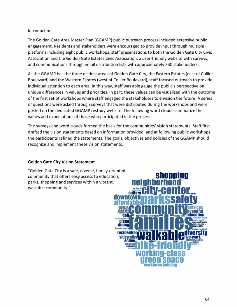
64
Introduction
The Golden Gate Area Master Plan (GGAMP) public outreach process included extensive public
engagement. Residents and stakeholders were encouraged to provide input through multiple
platforms including eight public workshops, staff presentations to both the Golden Gate City Civic
Association and the Golden Gate Estates Civic Association, a user-friendly website with surveys,
and communications through email distribution lists with approximately 330 stakeholders.
As the GGAMP has the three distinct areas of Golden Gate City, the Eastern Estates (east of Collier
Boulevard) and the Western Estates (west of Collier Boulevard), staff focused outreach to provide
individual attention to each area. In this way, staff was able gauge the public’s perspective on
unique differences in values and priorities. In part, these values can be visualized with the outcome
of the first set of workshops where staff engaged the stakeholders to envision the future. A series
of questions were asked through surveys that were distributed during the workshops and were
posted on the dedicated GGAMP restudy website. The following word clouds summarize the
values and expectations of those who participated in the process.
The surveys and word clouds formed the basis for the communities’ vision statements. Staff first
drafted the vision statements based on information provided, and at following public workshops
the participants refined the statements. The goals, objectives and policies of the GGAMP should
recognize and implement these vision statements.
Golden Gate City Vision Statement
“Golden Gate City is a safe, diverse, family-oriented community that offers easy access to education, parks, shopping and services within a vibrant, walkable community.”

65
Golden Gate Eastern Estate Vision Statement
“The Golden Gate Eastern Estates is an
interconnected, low-density residential community
with limited goods and services in neighborhood
centers, defined by a rural character with an
appreciation for nature and quiet
surroundings.”
Golden Gate Western Estate Vision Statement
“Golden Gate Western Estates is a low-density,
large-lot residential neighborhood in a
natural setting with convenient access to
the coastal area.”

66
Golden Gate Area Master Plan
Eastern Estates - Introduction
Public Workshop, April 20, 2016
As guests of the Golden Gate Estates Area
Civic Association
Introduction:
At the invitation of the Golden Gate Estates Area Civic Association (GGEACA), Collier County
planning staff provided an introduction to the Golden Gate Area Master Plan (GGAMP) restudy
which will result in an update to the GGAMP. The purpose of the staff presentation was to identify
the major components of the GGAMP, and particularly as it pertains to the Eastern Estates (east of
CR 951) area. Emphasis was placed on major themes and the idea that visioning for the future
should consider many factors as they contribute to the well-being of the next generation.
Meeting Summary:
Michael Ramsey, President of the Golden Gate Estates Area Civic Association opened the meeting.
He greeted elected and appointed County and District officials, as well as various candidates for
County Commission Districts 5 and 3. Approximately 125 community members or stakeholders
were in attendance at the meeting.
Mr. Ramsey described the purpose of the meeting as an introduction of the Golden Gate Area
Master Plan update process, and asked residents to not get sidetracked with other specific topics
that are not a part of the GGAMP. As an example, the issue of fracking should not be discussed, as
it is not a Master Plan concept.
Commissioner Tim Nance provided an overview of GGAMP in the context of other Planning
Restudies and the importance to the Golden Gate area residents. He reminded the group of the
relevance of the “green map”, in that 0ver 75% of the County’s area is already in conservation
status, and that the Rural Fringe Receiving Areas are among the last development areas left in the
County; they can complement the Estates if carefully planned. He indicated that all four Restudy
areas would consider the same important elements in order to help achieve consistency between
Restudies: land use; transportation/mobility; water; environment; and economic vitality. He
reported that an Oversight Committee has been appointed to help direct public involvement,
consistency, sustainability and economic vitality, and introduced Jeff Curl, the Oversight
Committee member representing the Golden Gate area.
Community Planning Manager Kris Van Lengen provided a PowerPoint presentation, and stated
that this would be the first of several GGAMP meetings, and that this first meeting is in the nature
of an introduction. Content includes an update of relevant issues in the Rural Fringe Mixed-Use

67
District Restudy, concepts currently embedded in the GGAMP, and finally a high level visioning
exercise for the future of the Eastern Estates.
Consistent among all Restudies is the planning wheel- a process matrix that describes present
plans, public outreach, staff data and analysis, development of alternatives, republication,
ultimately with recommendations that reflect stakeholder consensus, and finally re-initiation of
public outreach. The process may include several turns if the “wheel” prior to formal public
hearings.
A reflection of the current
progress of the Rural Fringe
Restudy included the fact
that there was broad
support among stakeholders
to incentivize uses that are
not presently adopted- most
particularly free standing
employment centers and
sports venues. GGEACA and
attendees were encouraged
to attend future Rural Fringe
meetings- as close neighbors with commercial and mobility issues; they are true stakeholders in
that process. The nexus among three Restudy areas, all within 3 miles of North Golden Gate
Estates, was also noted, highlighting the total commercial activity in the area that would benefit
the Estates while adding no further Golden Gate Estates Neighborhood Centers. A balance is
needed among all commercial centers and activities.
The discussion on current GGAMP provisions began with an overview of currently scheduled
meetings, which will be rotational among Eastern Estates, Western Estates and Golden Gate City. A
brief history described the major Restudy between 2001 and 2003 as well as the several private
Growth Management Plan amendments that followed. Key features of the current GGAMP, as
pertain to the Eastern Estates, were listed under the matrix described by Commissioner Nance.
Interpreting the current goals of the Golden Gate Area Master Plan as it relates to the Estates, an
“existing vision” was derived and described as a low density residential community with rural
character, limited commercial services, safe and efficient roadways, and emergency services
coordination.
Principal Planner Anita Jenkins provided an interactive visioning session. She began by describing
the nature and purpose of a community vision: what the community should look and feel like after
implementation, as envisioned by residents. After discussing the purpose, Ms. Jenkins challenged
the audience to complete brief answers or descriptions to a number of visioning questions: How
does the Eastern Estates complement the County as a whole, what is it the best location for, what

68
would you like to read in the newspaper about the area, 10 years from now, what things would
you suggest to improve the area?
Individual slips were distributed throughout, and attendees wrote their visions in answer to these
questions. A total of 45 full sets of questionnaires were returned. A summary of the written
comments can be found here. It was announced that the questions would be available on the web
site as a survey questionnaire for those that wished to provide input in that manner.
Following the exercise, participants were encouraged to share their ideas. Various themes
emerged, particularly the preservation of the rural character of the Eastern Golden Gate area.
Some spoke in support of a sense of place, including renaming/rebranding the Eastern Estates and
the streets, creating institutional and commercial architectural standards that are more suitable
for the rural character. Other areas of importance were protecting important watershed areas, and
creating greenways.
Residents also wanted to discuss the Rural Lands West project, the Habitat Conservation Plan and
noted fracking was a concern. Commissioner Nance addressed these topics and noted other
venues and agencies will be covering these issues more thoroughly.
The Community Planning agenda item on Golden Gate Area Master Plan introduction, concluded
at 8:40; the GGEACA meeting agenda items resumed at this time.

69
Golden Gate Area Master Plan
Western Estates - Introduction
Public Workshop, May 11, 2016, 6:30 PM
Golden Gate Community Center
Introduction:
Collier County planning staff provided an introduction to the Golden Gate Area Master Plan
(GGAMP) restudy which will result in an update to the GGAMP. The purpose of the staff
presentation was to identify the major components of the GGAMP, particularly as it pertains to the
Western Estates (west of CR 951) area. Emphasis was placed on major themes and the idea that
visioning for the future should consider many factors as they contribute to the well-being of the
next generation. Approximately 60 people attended.
Meeting Summary:
Greg Ault, Principal, AECOM, as consultant for public outreach, began by discussing his role in the
process and the importance of area-wide planning as we think about future generations. He
introduced his staff and County staff, and described his favorable impressions of the area from the
point of view of a non-resident.
Community Planning Manager Kris Van Lengen provided a PowerPoint presentation, and stated
that this would be the first of several GGAMP meetings, and that this first meeting is in the nature
of an introduction. Content includes an update of relevant issues in the four area Restudies,
concepts currently embedded in the GGAMP, and finally a high level visioning exercise for the
future of the Western Estates.
Consistent among all Restudies is the planning process- one that looks at current provisions and
conditions, asks what can be improved, alternatives for improvement, and ultimate decision-
making by the Board of County Commissioners. Important focal points include permitted land
uses, transportation issues, environment, and economic vitality. Citizens were encouraged to use
on-line resources to supplement their understanding and provide input when surveys become
available.
Mr. Van Lengen presented the idea to study GGAMP in three separate segments: Eastern Estates,
Western Estates and Golden Gate City. There were no objections raised to this approach.
The history of the GGAMP was discussed, including the fact that ten amendments to the plan have
occurred since the last major restudy was completed in 2003. After describing the organization of
the GGAMP document, it was noted that the major provisions related to Goals, Objectives and
Policies were identical to those of the Eastern Estates; low density, rural character, infrastructure
and emergency services needs. Residents might consider whether they wish to emphasize a

70
unique vision and goals. Unlike the Eastern Estates (approximately 50% built out), the Western
Estates is 88% built out.
With respect to Land uses, permitted uses and conditional uses were described. Also noted was
the special language in the GMP
describing the limitation on
additional conditional uses along
the Golden Gate Parkway.
The vast majority of the citizens
who attended appeared to live
within close proximity to Golden
Gate Parkway. Accordingly, there
was significant comment from the
attendees related to the fact that
they do not wish to change any of
the current land use restrictions
related to Golden Gate Parkway. Mr. Greg Ault asked for a show of hands in favor of no change to
the land uses on the Parkway. There
was nearly unanimous agreement,
as shown in the photos below and
by virtue of the responses received
in the visioning session.
Principal Planner Anita Jenkins
provided an interactive visioning
session. She began by describing
the nature and purpose of a
community vision: what the
community should look and feel like
after implementation, as envisioned by residents. After discussing the purpose, Ms. Jenkins
challenged the audience to complete brief answers or descriptions to a number of visioning
questions: How does the Western Estates complement the County as a whole, what is it the best
location for, what would you like to read in the newspaper about the area, 10 years from now,
what things would you suggest to improve the area?
Individual slips were distributed throughout, and attendees wrote their visions in answer to these
questions. A total of 45 full sets of questionnaires were returned. A summary of the written
comments is shown below. It was announced that the questions would be available on the web
site as a survey questionnaire for those who wished to provide input in that manner.

71
Attendees expressed a strong desire to maintain the low-density residential character of
their neighborhood with no commercial uses. Below is a summary of questionnaire
responses:
I. The Western Estates will be Distinctive for:
Large lots near town with quiet, open and peaceful character
Rural beauty with traditional neighborhoods consisting of dead-end streets where
neighbors know one another No commercial uses or special uses, maintaining uncluttered thoroughfares Natural habitat with areas for wildlife and environmental protection
Single-family living for local working families
Agriculturally and livestock friendly per allowances
II. The Western Estates will be a premier location for:
Peaceful living with private single-family homes
Beautiful gateway to the City of Naples
Quiet estates residential living
Family and neighborly atmosphere safe for children
Low traffic
Small town feel
Wildlife and agriculture
A remote animal services substation to support domestic animals found in the area
Accessible to services while maintaining a rural character
Well maintained infrastructure
A predominantly residential community with supporting uses including senior
housing along arterials. Maintain distinction from Golden Gate City
III. How does the Western Estates area complement Collier County?
Untouched and quiet nature maintains the charm of Naples area
A respite from commercial blight
Peaceful living close to town
Provides a non-gated, peaceful, estates-living neighborhood between the City of
Naples and Golden Gate City
Serves as the gateway to Naples
Gives long-term residents a place to raise generations
Maintains the value of environmentally friendly neighborhood with little commercial uses
Unit 29 should be its own neighborhood, rather than part of Western

72
Estates
Clean, crime-free area
Maintains true to the existing master plan
Provides affordable living for year-round residents
High value residential housing with limited commercial and special uses
Desire to be the “Pine Ridge Estates” of the area
IV. What is the full potential for your community?
Safe, cohesive neighborhood for families
Desire to maintain privacy
Maintain the existing character, no need for further enhancements or intrusions
For the area of Unit 29 to be sub divided into its own area similar to Pine Ridge Estates
Commercial and additional uses will only destroy the potential
Country living close to town
Enhance the “Gateway to Naples”
Most desired residential acreage in Collier County
Ability for growth of environmental protection services
Addition of public services including parks and libraries with small,
neighborhood commercial development to support local neighborhood
V. Reading the newspaper in 10 years, what would the headline say about the Western Estates?
“One of the best places to retire with friendly people”
“Unique and faithful community that supports the integrity and charm of Naples”
“A great and convenient place to live”
“We are not a part of Golden Gate City”
“Local homeowners rejoice over being left alone”
“A pearl of beauty that truly complements Collier County”
“A wonderful residential community to live in”
“Commissioners gave in to their supporters and turned it into another Pine Ridge Road”
“This community stayed the same”
“Premier Estates living 3 miles from the beach”
“Beautiful corridor to the City of Naples”
“Excellent quiet location close to town provides solitude from busy work life”
Depends on how much “commercial” money changes hands with commissioners
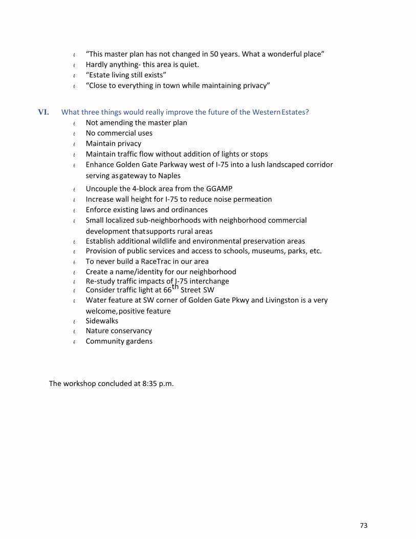
73
“This master plan has not changed in 50 years. What a wonderful place”
Hardly anything- this area is quiet.
“Estate living still exists”
“Close to everything in town while maintaining privacy”
VI. What three things would really improve the future of the Western Estates?
Not amending the master plan
No commercial uses
Maintain privacy
Maintain traffic flow without addition of lights or stops
Enhance Golden Gate Parkway west of I-75 into a lush landscaped corridor
serving as gateway to Naples
Uncouple the 4-block area from the GGAMP
Increase wall height for I-75 to reduce noise permeation
Enforce existing laws and ordinances
Small localized sub-neighborhoods with neighborhood commercial
development that supports rural areas Establish additional wildlife and environmental preservation areas Provision of public services and access to schools, museums, parks, etc.
To never build a RaceTrac in our area
Create a name/identity for our neighborhood Re-study traffic impacts of I-75 interchange Consider traffic light at 66th Street SW Water feature at SW corner of Golden Gate Pkwy and Livingston is a very
welcome, positive feature Sidewalks Nature conservancy
Community gardens
The workshop concluded at 8:35 p.m.

74
Golden Gate Area Master Plan
Golden Gate City - Introduction
Public Workshop, June 8, 2016
Golden Gate Community Center
Introduction:
The Collier County Community Planning staff provided an introduction to the Golden Gate Area
Master Plan (GGAMP) restudy, which will result in an update to the GGAMP. The purpose of the
staff presentation was to identify the major components of the GGAMP, particularly as it pertains
to Golden Gate City and environs. Emphasis was placed on major themes and the idea that
visioning for the future should consider many factors as they contribute to the well-being of the
next generation. The meeting was noticed and 3 electronic signboards were placed in collector
roadways in the City for a period of three days. Approximately 25 people attended.
Meeting Summary:
Community Planning Manager Kris Van Lengen provided a PowerPoint presentation, and stated
that this would be the first of several GGAMP meetings, and that this first meeting is in the nature
of an introduction. Content included an overview of all area restudies, concepts currently
embedded in the GGAMP, and finally a high level visioning exercise for the future of Golden Gate
City.
The presentation
explained the
interrelationships between
studies and the timing of
each. Discussion also
included the process,
identifying current plan
provisions of importance
to the community,
identifying opportunities
for improvement and incorporating the community’s vision and values to bring forward to the
Board for its consideration. The role of the Growth Management Oversight Committee was also
covered.
The discussion on current GGAMP provisions began with an emphasis on website content and
various opportunities for interaction and input and an overview of currently scheduled meetings,
which will be rotational among Eastern Estates, Western Estates and Golden Gate City.

75
A brief history described the major Restudy between 2001 and 2003 as well as the several private
Growth Management Plan amendments that followed. Key features of the current GGAMP, as
pertain to Golden Gate City, were described under the 2 major portions of the GMP: Goals,
Objectives and Policies, and Land Use Designations. Interpreting the current goals of the Golden
Gate Area Master Plan as it relates to the Golden Gate City, an “existing vision” was derived and
described as a recognition of distinct neighborhood areas within the City, the value of sub-area
plans along with City-wide plans, consideration of a GG City Land Development Code, the
importance of connections to the greater Naples area, and a reference to utility expansion.
Various Land Use categories were described and discussed, most notably the Mixed-Use Activity
Center, the Downtown Center Commercial Subdistrict and the Santa Barbara Commercial
Subdistrict. The Golden Gate Parkway entryway into the City was also discussed. Questions and
comments related to GMP and zoning overlays followed.
Of note were comments related to the desire for a focal point within the Activity Center or nearby,
roadway concerns and beautification.
Principal Planner Anita Jenkins provided an interactive visioning session. She began by describing
the nature and purpose of a community vision: what the community should look and feel like after
implementation, as envisioned by residents. Key subject areas are land use, transportation,
environment, economic and social activity and identity.
After discussing the purpose, Ms. Jenkins challenged the audience to complete brief answers or
descriptions to a number of visioning questions: How does Golden Gate City complement the
County as a whole, what is it the best location for, what would you like to read in the newspaper
about the area 10 years from now, what things would you suggest to improve the area?
Consultants from AECOM also provided examples of streetscapes, walkability and City entryway
features to stimulate imaginations. Overall, citizens seemed most interested in enhanced
community facilities, infrastructure, and expression of art and culture native to the area.
Specifically, a recommendation was made to extend the private utilities water to greater portions
of the City (not wastewater), small business incubation, international food and arts locations, and
the use of existing canals for recreation such as kayak and paddleboard.
Individual slips were distributed throughout, and attendees wrote their visions in answer to these
questions. A total of 35 questionnaires were returned. Below is a summary of questionnaire
responses:
I. Golden Gate City will be known for:
Cleanliness
Affordability
New Growth and Development
Celebrated Diversity
Safety
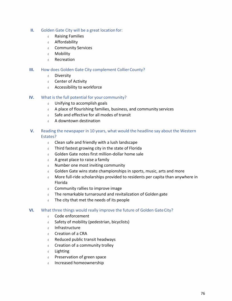
76
II. Golden Gate City will be a great location for:
Raising Families
Affordability
Community Services
Mobility
Recreation
III. How does Golden Gate City complement Collier County?
Diversity
Center of Activity
Accessibility to workforce
IV. What is the full potential for your community?
Unifying to accomplish goals
A place of flourishing families, business, and community services
Safe and effective for all modes of transit
A downtown destination
V. Reading the newspaper in 10 years, what would the headline say about the Western Estates?
Clean safe and friendly with a lush landscape
Third fastest growing city in the state of Florida
Golden Gate notes first million-dollar home sale A great place to raise a family Number one most inviting community
Golden Gate wins state championships in sports, music, arts and more
More full-ride scholarships provided to residents per capita than anywhere in Florida
Community rallies to improve image
The remarkable turnaround and revitalization of Golden gate
The city that met the needs of its people
VI. What three things would really improve the future of Golden Gate City?
Code enforcement
Safety of mobility (pedestrian, bicyclists)
Infrastructure
Creation of a CRA
Reduced public transit headways
Creation of a community trolley
Lighting
Preservation of green space
Increased homeownership
77
Golden Gate Area Master Plan
Golden Gate City
Public Workshop, October 13, 2016
Golden Gate Community Center
Introduction:
The GGAMP Restudy- Golden Gate City Public Workshop was attended by several Golden
Gate residents, county staff members, and local elected officials. The client team introduced
the current GGAMP and presented a draft vision statement derived from the results of
resident visioning questionnaires and surveys. Finally, an audience polling session was
conducted to obtain attendee feedback.
Meeting Summary:
Attendees revised the draft vision statement to read:
“Golden Gate City is a safe , diverse, family-oriented community that offers easy
access to education, parks, shopping and services within a vibrant, walkable
community.”
Audience polling was conducted to obtain additional feedback in a manner that did not require
attendees to self-identify with their answers or opinions in a group setting. Results of the
audience polling are attached.
Dialogue included:
• active code enforcement day and night as opposed to the current complaint-driven
code enforcement model • safety for all dimensions of Golden Gate City • additional lighting • limits to additional density • concern for the limited service area of potable water infrastructure and high costs
associated with water infrastructure within existing service area o representatives of FGUA cited need to maintain and repair existing aging
infrastructure prior to expanding service areas
o understanding the importance of this discussion, the Golden Gate Civic Association
offered to invite FGUA to a future civic association meeting where they could focus
on the infrastructure concerns specifically
• desire for additional distribution of commercial in the north area of Golden Gate City
(Green Boulevard)
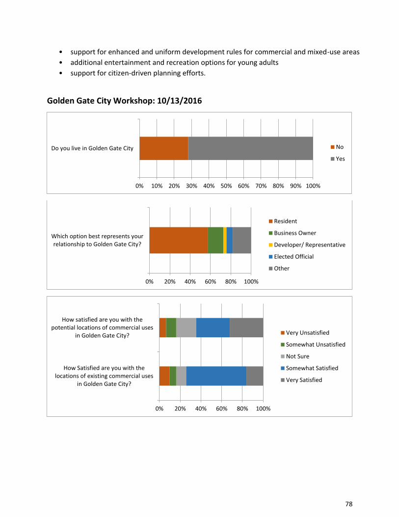
78
• support for enhanced and uniform development rules for commercial and mixed-use areas • additional entertainment and recreation options for young adults • support for citizen-driven planning efforts.
Golden Gate City Workshop: 10/13/2016
0% 10% 20% 30% 40% 50% 60% 70% 80% 90% 100%
Do you live in Golden Gate City No
Yes
0% 20% 40% 60% 80% 100%
Which option best represents yourrelationship to Golden Gate City?
Resident
Business Owner
Developer/ Representative
Elected Official
Other
0% 20% 40% 60% 80% 100%
How Satisfied are you with thelocations of existing commercial uses
in Golden Gate City?
How satisfied are you with thepotential locations of commercial uses
in Golden Gate City? Very Unsatisfied
Somewhat Unsatisfied
Not Sure
Somewhat Satisfied
Very Satisfied

79
0% 20% 40% 60% 80% 100%
Do you support a more uniform set ofdevelopment rules for commercial or mixed-
use areas?
Do you agree with existing policies aboutcitizen-driven planning efforts?
Would you volunteer one evening per monthto serve on a planning committee?
Do you have adequate health care resourcesin Golden Gate City?
Do you think Golden Gate City should haveits own unique standards for architecture or
landscaping?
No
Not Sure
Yes
0% 20% 40% 60% 80% 100%
What type of commercial use is mostneeded in Golden Gate City?
Retail
Personal Services
Dining
Offices
Other
0% 20% 40% 60% 80% 100%
What type of institution is mostneeded in Golden Gate City?
Government Services
Places of Worship
Adult and Child Care Centers
Other

80
0% 20% 40% 60% 80% 100%
Should home-based businesses change inany way in Golden Gate City?
Expanded
Reduced
Stay the Same
Not Sure
0% 20% 40% 60% 80% 100%
How often do you walk to get somewhere inGolden Gate City?
Never
Monthly
Weekly
Daily
0% 20% 40% 60% 80% 100%
Do you have school-aged children thatwalk or ride bikes to school?
No
Yes
I don't have children
0% 20% 40% 60% 80% 100%
Of the following options, what is yourtop priority for improvement in Golden
Gate City?
Street Lighting
Traffic Calming
Sidewalks
Bike Routes/ Lanes
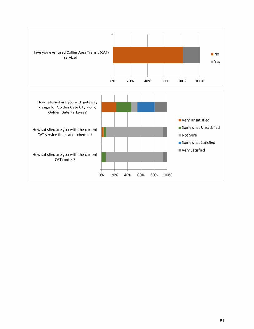
81
0% 20% 40% 60% 80% 100%
Have you ever used Collier Area Transit (CAT)service?
No
Yes
0% 20% 40% 60% 80% 100%
How satisfied are you with the currentCAT routes?
How satisfied are you with the currentCAT service times and schedule?
How satisfied are you with gatewaydesign for Golden Gate City along
Golden Gate Parkway?
Very Unsatisfied
Somewhat Unsatisfied
Not Sure
Somewhat Satisfied
Very Satisfied

82
Golden Gate Area Master Plan
Golden Gate Western Estates
Public Workshop, October 20, 2016
Golden Gate Community Center
Introduction:
The GGAMP Restudy-Golden Gate Western Estates Public Workshop was attended by several
Western Estates residents, county staff members, local elected officials, as well as developers and
their representatives. The client team introduced the current GGAMP. Greg Ault presented a draft
vision statement derived from the results of resident visioning questionnaires and surveys. Finally,
an audience polling session was conducted to obtain attendee feedback.
Meeting Summary:
Kris Van Lengen, Planning Manager, provided an overview of the Western Estates in the context of
the entire GGAMP and the urban area of Collier County. He noted the Western estates is a little
more than 10% of the area and population or the Eastern Estates, but is 86% developed compared
to 47% in the East. Also discussed was the structure and content of the Master Plan.
Permitted and conditional uses were reviewed, and the locational restrictions for conditional uses
were presented. Attendees agree that the corridor along the south side of Immokalee Rd. should
be unified under a designation allowing C-1 uses. The concept of additional CU locations at major
intersections was presented, along with incentive-based lot combinations.
Attendees revised the draft vision statement to include the terms “natural”, “large-lot/estate-lot”,
“limited-commercial/non-commercial” to read:
“Golden Gate Western Estates is a low-density large-lot residential neighborhood in a
natural setting with convenient access to the coastal area.”
Audience polling was conducted to obtain additional feedback in a manner that did not require
attendees to self-identify with their answers or opinions in a group setting. Results of the audience
polling are attached.
Dialogue included:
• requests for transparency in notifications of conditional uses • requests for information regarding future plans for county-owned parcel at Vanderbilt and
Collier Blvd • outlook and vision for attendees with properties fronting major arterials as well as the
I-75 interchange is very different than others

83
o higher noise levels
o higher traffic
o less desirable to residential buyers o the word “commercial” is undesirable, but residents need the services that
commercial brings with it
• desire to incorporate pedestrian/bike trails/passive recreation using creative thinking with
limited R.O.W. • lack of traffic lights along Golden Gate Parkway makes left turns difficult during rush hours • existing Parks & Recreation facilities’ programming is at maximum capacity and unable
to accommodate all desired users • call to resist external pressure to change or develop further • desire for more inclusive dialogue relating to areas outside of the Golden Gate Parkway
corridor • strong opposition to any commercial uses • concern for poor or lack of cellular reception in the Western Estates • mixed support to allow rental of guest homes • strong support for incentivized voluntary small-lot combination program • desire for the recognition of smaller “sub-areas” that comprise Western Estates
Golden Gate Western Estates Workshop: 10/20/2016
0% 20% 40% 60% 80% 100%
Do you live in Golden Gate Western Estates? No
Yes

84
0% 20% 40% 60% 80% 100%
How long have you lived in GoldenGate Western Estates?
Less than 1 Year
1>5 Years
5>10 Years
10>20 Years
Over 20 Years
I don't live in GG City
0% 20% 40% 60% 80% 100%
Which option best represents yourrelationship to Golden Gate
Western Estates?
Resident
Business Owner
Developer/ Representative
Elected Official
Other
0% 20% 40% 60% 80% 100%
What type of commercial use is mostneeded in the Western Estates?
Retail
Personal Services
Dining
Offices
Other
0% 20% 40% 60% 80% 100%
Should home-based businesses change inany way in the Western Estates?
Reduced
Stay the Same
Not Sure
Expanded

85
0% 20% 40% 60% 80% 100%
How satisfied are you with thelocations of existing commercial uses
in or near the Western Estates?
How satisfied are you with theavailability and locations of social
organizations in or near the WesternEstates?
How satisfied are you with theavailability and locations of child care
and adult day care in or near theWestern Estates?
How satisfied are you with theavailability and locations of religiousinstitutions in or near the Western
Estates?
How satisfied are you with cellularreception/service in or near the
Western Estates?
How satisfied are you with theavailability and locations of group
housing options for seniors or personswith special needs in or near the
Western Estates?
How satisfied are you with theavailability and locations of assistedliving facilities and nursing homes in
or near the Western Estates?
How satisfied are you with theneighborhood identity for the
Western Estates?
Very Unsatisfied
Somewhat Unsatisfied
Not Sure
Somewhat Satisfied
Very Satisfied

86
0% 20% 40% 60% 80% 100%
Do you support office uses at majorintersections?
Do you support conditional uses at majorintersections?
Do you support conditional uses at any otherlocations not currently allowed?
Would you support office or conditional usesalong Immokalee Road?
Would you support an Interchange ActivityCenter at the intersection of Golden Gate
Parkway and I-75?
Should there be a change to allow rental ofyour guest house?
Should there be a change to allow rental ofyour guest house? (Do-over)
Would you be in favor of a voluntary "smalllot combination" incentive program?
Would you volunteer one evening per monthto serve on a planning committee for the
Golden Gate Area?
Do you agree that raising livestock and cropsshould be allowed in the Urban Estates?
Do you have adequate access toneighborhood parks in or near the Western
Estates?
Do you have adequate access to publicspaces in or near the Western Estates?
Do you have adequate access to ped/biketrail system in or near the Western Estates?
No
Not Sure
Yes
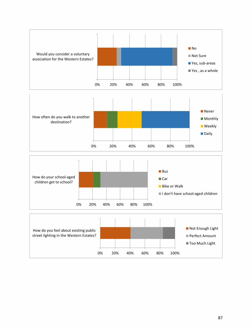
87
0% 20% 40% 60% 80% 100%
Would you consider a voluntaryassociation for the Western Estates?
No
Not Sure
Yes, sub-areas
Yes , as a whole
0% 20% 40% 60% 80% 100%
How often do you walk to anotherdestination?
Never
Monthly
Weekly
Daily
0% 20% 40% 60% 80% 100%
How do your school-agedchildren get to school?
Bus
Car
Bike or Walk
I don't have school-aged children
0% 20% 40% 60% 80% 100%
How do you feel about existing publicstreet lighting in the Western Estates?
Not Enough Light
Perfect Amount
Too Much Light

88
0% 20% 40% 60% 80% 100%
Of the following options, what is yourtop priority for improvement in the
Western Estates?
Street Lighting
Traffic Calming
Sidewalks
Bike/Ped Trail System

89
Golden Gate Area Master Plan
Golden Gate Eastern Estates
Public Workshop, November 3, 2016
UIFAS Center
Introduction:
The GGAMP Restudy-Golden Gate Eastern Estates Public Workshop was well-attended by
approximately 130 Eastern Estates residents, stakeholders, and county staff members. The client
team introduced the current GGAMP and presented a draft vision statement that was produced
as a result of resident visioning questionnaires and surveys. An audience polling session was then
conducted to obtain additional feedback.
Meeting Summary:
Kris Van Lengen, Planning Manager, provided an overview on the Master Planning process,
demographics of the area, existing public facilities, existing approved GMP locations for
Neighborhood Centers
and conditional uses, and
coordination with the
RFMUD restudy in
providing nearby
opportunities for retail,
service and jobs for
Estates residents.
Transportation study areas
were discussed as were
watershed and other
environmental topics.
The following draft vision statement was presented to workshop attendees:
“The Golden Gate Eastern Estates is an interconnected, low-density residential community
with limited goods and services in neighborhood centers, defined by a rural character with
an appreciation for nature and quiet surroundings.” Upon presenting the draft vision statement, attendees were asked to provide feedback and
potential revisions. Responses included the following terms and subject areas: • No interference • Nature/natural/environment/park/recreation

90
• Family-oriented • Health and safety • Code enforcement • Rural/country-living • Protection of natural character • Desire for services including: postal, medical, governmental, community and recreation • Access to retail goods and personal services • Desire to change the wording “limited” presented within the draft • Acknowledgment of watershed/sheetflow • Sidewalks, bus stops, and refuge for school-aged children Audience polling was conducted to obtain additional feedback in a manner that did not require
attendees to self-identify with their answers or opinions in a group setting. Results of the audience
polling session are attached.
Additionally, attendees were encouraged to provide additional comments and feedback using
written comment cards. Dialogue and comments received during and after the polling session
included:
• desire to preserve foliage on properties and only clearing necessary areas for wildfire protection
• concern for the high volume of heavy equipment operating within and traveling through the
Eastern Estates
• mixed support for additional conditional uses including churches and assisted living facilities
general satisfaction with availability/locations of social organizations
mixed satisfaction with availability/locations of child care/adult day care,
religious institutions, group housing options, assisted living facilities,
general dissatisfaction with cellular reception/service
• desire for roadway expansion and additional connectivity to the west
• mixed support for additional commercial land designations, with general support for small
shopping centers as opposed to large centers
• call for effective code enforcement
• desire for equestrian and other recreational trail networks

91
• request to prohibit fireworks and pyrotechnics in an effort to protect wildlife and prevent wildfires
• requests for improved drainage
• strong support for an I-75 interchange in the vicinity of Everglades Boulevard
• general support for industrial areas or business parks to provide jobs and support trade near
to the Eastern Estates
• strong support for non-residential architectural standards specific to the Eastern Estates
• support to allow rental of guest houses
• overwhelming support for an incentivized small-lot combination program
• general support for an incentivized transfer of ownership program
Golden Gate Eastern Estates Workshop: Instant Polling Results, 11/03/2016
0% 20% 40% 60% 80% 100%
Do you live in Golden Gate Eastern Estates? No
Yes
0% 20% 40% 60% 80% 100%
How long have you lived in GoldenGate Eastern Estates?
Less than 1 Year
1>5 Years
5>10 Years
10>20 Years
Over 20 Years
I don't live in GG City

92
(This space intentionally left blank.)
80% 85% 90% 95% 100%
Which option best represents yourrelationship to Golden Gate Eastern
Estates?
Resident
Business Owner
Developer/ Representative
Elected Official
Other

93
0% 20% 40% 60% 80% 100%
How satisfied are you with thelocations of existing commercial uses
in or near the Eastern Estates?
How satisfied are you with thepotential locations of commercial uses
in or near the Eastern Estates?
How satisfied are you with theavailability and locations of social
organizations in or near the EasternEstates?
How satisfied are you with theavailability and locations of child care
and adult day care in or near theEastern Estates?
How satisfied are you with theavailability and locations of religious
institutions in or near the EasternEstates?
How satisfied are you with cellularreception/service in or near the
Eastern Estates?
How satisfied are you with theavailability and locations of group
housing options for seniors or personswith special needs in or near the
Eastern Estates?
How satisfied are you with theavailability and locations of assistedliving facilities and nursing homes in
or near the Eastern Estates?
Very Unsatisfied
Somewhat Unsatisfied
Not Sure
Somewhat Satisfied
Very Satisfied

94
(This space intentionally left blank.)
0% 20% 40% 60% 80% 100%
What type of commercial use is mostneeded in the Eastern Estates?
Retail
Personal Services
Dining
Offices
Other
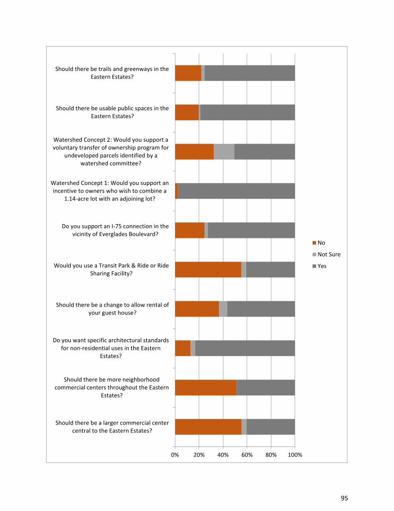
95
0% 20% 40% 60% 80% 100%
Should there be a larger commercial centercentral to the Eastern Estates?
Should there be more neighborhoodcommercial centers throughout the Eastern
Estates?
Do you want specific architectural standardsfor non-residential uses in the Eastern
Estates?
Should there be a change to allow rental ofyour guest house?
Would you use a Transit Park & Ride or RideSharing Facility?
Do you support an I-75 connection in thevicinity of Everglades Boulevard?
Watershed Concept 1: Would you support anincentive to owners who wish to combine a
1.14-acre lot with an adjoining lot?
Watershed Concept 2: Would you support avoluntary transfer of ownership program for
undeveloped parcels identified by awatershed committee?
Should there be usable public spaces in theEastern Estates?
Should there be trails and greenways in theEastern Estates?
No
Not Sure
Yes

96
0% 20% 40% 60% 80% 100%
Is there a need for an industrial area orbusiness park to provide jobs and
support trade in or near the EasternEstates?
No
Not Sure
Yes, nearby- not in
Yes, in the Estates
0% 20% 40% 60% 80% 100%
Should home-based businesses change inany way in the Eastern Estates?
Reduced
Stay the same
Not Sure
Expanded
0% 20% 40% 60% 80% 100%
Should potential Conditional Useapplications change in any way in
the Eastern Estates?
Allow everywhere
Allow along arterials
Only at select locations
Only certain kinds at additionallocations
They should not change
Not Sure

97
Golden Gate Area Master Plan
Commercial Property Owners Meeting
February 16, 2017
2800 N. Horseshoe Drive
Introduction:
To better understand the Golden Gate City commercial properties opportunities and
constraints, a public workshop was scheduled specifically for these property owners. Staff
mailed a meeting notice to all owners of record with property designated existing or future
commercial use. The meeting was well-attended by approximately 60 property owners,
various county department staff members, the Chamber of Commerce, Economic
Development staff, and County Commissioner Burt Saunders.
Meeting Summary:
Kris Van Lengen, Planning Manager, provided an overview of the Master Plan restudy process.
Anita Jenkins, Principle Planner, discussed the previous Golden Gate City public workshops and
specifically the vision statement the Golden Gate residents drafted for their community.
Staff described the different
commercial land use districts
within Golden Gate City and
how it these districts applied to
their property. To invite
discussion related to
improvements that could be
made to the Master Plan, staff
asked questions related to
future plans for commercial
properties, and what obstacles
in redevelopment had been
identified. Property owner’s
provided the following comments:
▪ Wants to redevelopment within the next five years (Santa Barbara district) to do
medical.
o Problem is traffic safety concerns along Santa Barbara,

98
o LDC requires project minimum of 1 acre rather than 1 parcel.
o It would be helpful if the rezoning to commercial happened because properties
are being advertised as residential rather than commercial.
o Would like to build more duplex or triplex; city water is not available but would
like it to be.
o Thinks septic is a good optional because of the cost to install central sewage
• Development standard and setbacks need to be amended to accommodate change from
residential to commercial.
• Plan for affordable housing in the in the residential area in the Golden Gate City.
o When rezoning property it was discussed how to capture pass by traffic to be
viable commercial. What happens to the displaced people when switching from
residential to commercial?
o Vertical mixed-use was discussed and identified as an option to maintain
residences within commercial properties.
• Golden gate parkway discussion that nobody is required to redevelopment the property.
Can it be kept as residential if the owner does not live in it? Big concern so that owners
can keep property regardless of who lives there.
• Concerns about too many parcels changing from residential to commercial which will
entail to pushing out those who want to stay residential.
• If a CRA what percent would go into the pool?
o It varies as the property values increase. Sliding scale based on the value of the
property.
• How many properties would have to agree to transfer from residential to commercial in
Golden Gate section.
o Mike Bosi, Zoning Director, discussed possible restrictions for creating a PUD.
Parcel number would vary based on the LDC codes such as parking and square
footage.
• Traffic control to protect residents if conversation rate increased.
• Would like more cafés and restaurants in Golden Gate City.

99
• Realtor participating in the meeting provided perspective that if a community is more
mixed-use the property values will increase
• Promote remodeling without putting restrictions, better to let the owner based their
remodels based off of being grandfathers in rather than having to meet current LDC
codes.
• Discussion how the Greater Naples Chamber of Commerce can help Golden Gate City by promoting pad ready sites on their website.
• Commissioner Saunder’s provided concluding remarks encouraging redevelopment of
the Golden Gate City commercial areas and mentioned the potential for utility
conversion and state funding to help off-set costs.

100
Golden Gate Area Master Plan
Golden Gate Eastern Estates
Public Workshop, February 22, 2017
UIFAS Center
Introduction:
The GGAMP Restudy-Golden Gate Eastern Estates Initial Recommendations Public Workshop
was attended by approximately 31 Eastern Estates stakeholders, and county staff members.
The client team introduced the current GGAMP and presented a revised vision statement that
was produced as a result of resident visioning questionnaires and surveys. An audience polling
session was then conducted to obtain level of support for existing and newly recommended
GGAMP policies specific to the Eastern Estates.
Meeting Summary:
Kris Van Lengen, Planning Manager, presented information on the status of the restudy, prior
meetings, area demographics and key topic areas. Anita Jenkins, Principal Planner, presented
results of visioning from prior meetings, including the community’s consensus on its distinctive
qualities.
Audience polling was conducted to obtain level of support for potential new policies and existing
policies in a manner that did not require attendees to self-identify with their answers or opinions
in a group setting. Results of the audience polling session are attached.
Additionally, stakeholders were encouraged to provide comments and feedback through written
comment cards and group dialogue. Dialogue and comments received during and after the
polling session included:
• Conditional Uses at arterial intersections
o Desire to preserve arterial intersections for potential future commercial as opposed to
conditional uses since they are the most desirable to commercial property developers.
o Need for larger conditional use parcels to be compatible with the surrounding community.
• Transportation and mobility
o Desire for an increased rate of road paving.
o Concern for increased congestion on Everglades Blvd with a potential I-75 interchange.
o Increased need for designated refuge/waiting areas for students waiting for school buses.

101
o Desire for the interchange to be aligned with RFMUD receiving areas due to future
increased population densities.
o Concern for the future character of streets adjacent to a potential interchange.
o Desire to limit access to or from the interchange. • Desire for larger buffers and setbacks for non-residential uses. • Need for appropriate lighting at rural intersections, without over-lighting entire corridors. • Need for reflective street signage and way finding
o Strong concern for an increase of built guest homes and the overall effects on the
community and population density if a policy were changed to allow for the lease of
guest homes as well as adverse impacts on infrastructure, watershed, and code
enforcement. o Desire to make senior centers and wellness centers a conditional use.
Golden Gate Eastern Estates Workshop – Instant Polling Results: 02/22/2017
0% 20% 40% 60% 80% 100%
Which option best represents yourrelationship to Golden Gate Eastern
Estates?
Resident
Business Owner
Developer/ Representative
Elected Official
Other
0% 20% 40% 60% 80% 100%
Do you live in Golden Gate Eastern Estates? No
Yes

102
(This space intentionally left blank.)
0% 20% 40% 60% 80% 100%
How long have you lived in GoldenGate Eastern Estates?
How long have you lived in GoldenGate Eastern Estates? (do-over)
Less than 1 Year
1>5 Years
5>10 Years
10>20 Years
Over 20 Years
I don't live in GG City

103
0% 20% 40% 60% 80% 100%
Retain existing policy allowing forlivestock and crops.
Retain existing policy to preserve therural character of the Eastern Estates.
Add new provision to allow ConditionalUses at arterial intersections.
Add new provision to allow ConditionalUses at arterial intersections. (do-over)
Add new provision to allow GroupHomes (7-14 people).
Add new provision to allowcommunications towers.
Accommodate growing demand foremployment, goods, services, and
entertainment with provisions adjacentto the Estates.
Neighborhood centers may beincreased in size to accommodate
stormwater, septic and bufferrequirements.
The County will develop ruralarchitectural standards for commercial
and institutional development in theEstates.
Retain existing policy to pave lime rockroads.
Strongly Disagree
Somewhat Disagree
Not Sure
Somewhat Agree
Strongly Agree

104
0% 20% 40% 60% 80% 100%
Retain existing policy to schedule (orupdate) and fund bridge improvements.
Retain existing policy to create agreenway plan.
Retain existing policy to increase north-south and east-west route alternatives.
Retain existing policy to coordinate afuture I-75 interchange in the vicinity of
Everglades Boulevard.
The County will update setback andbuffer standards for non-residential uses
in the Estates and for adjoining uses inthe RFMUD and RLSA.
Retain existing policy to conduct wildfiremitigation education and prevention
programs.
Retain existing policy that the Countywill consider incentives for wetland
preservation.
Retain existing policy that the Countywill encourage "dark sky" lighting
standards.
The County will promote thecombination of 1.14-acre or similar
"small lots" into adjoining lots throughincentives
The County will consider a TDR programfor natural resource protection.
Strongly Disagree
Somewhat Disagree
Not Sure
Somewhat Agree
Strongly Agree

105
0% 20% 40% 60% 80% 100%
The County will consider dispersedwater storage and watershed
connectivity to, through, and from theEstates.
The County will continue efforts tosupport independent fire districts and
Florida Forestry Service in publiceducation, planning, and resourcingrelated to wildfire prevention and
response.
The County shall continue to worktoward the goal of providing a septic
disposal facility located in CollierCounty.
The County will create new lightingstandards within the LDC.
Do you support the ability of owners torent/lease their guest homes.
Strongly Disagree
Somewhat Disagree
Not Sure
Somewhat Agree
Strongly Agree

106
Golden Gate Area Master Plan
Golden Gate City
Public Workshop, April 26, 2017
Golden Gate Community Center
Introduction:
The GGAMP Restudy Golden Gate City Initial Recommendations Public Workshop was attended by approximately 10 Golden Gate City stakeholders, and county staff members. The county staff introduced the current GGAMP and public outreach to-date. An audience polling session was then conducted by the client team to obtain level of support for existing and newly recommended GGAMP policies specific to Golden Gate City. Areas of focus included complementary land uses, economic vitality, transportation and mobility, and environment.
Meeting Summary
Audience polling was conducted to obtain consensus for potential new policies and existing policies in a manner that did not require attendees to self-identify with their answers or opinions in a group setting. Additionally, stakeholders were encouraged to provide comments and feedback through group dialogue. Dialogue during and after the polling session included:
• Code Enforcement
─ While discussing the information on page 10 of the PowerPoint, some of the attendees recommended that code enforcement be added as an additional “focus” idea. Some of the attendees were concerned with the way that environmental code – such as the removal of invasive trees – is enforced.
• Architectural Review
─ Some of the attendees voiced that they would like to establish a review board to oversee architectural standards.
• Stormwater improvements.
─ After the conclusion of the meeting, there was discussion of opportunities in future construction for stormwater systems improvements.

107
Golden Gate City Workshop – Initial Recommendations: 04/26/2017
0% 10% 20% 30% 40% 50% 60% 70% 80% 90% 100%
Do you live in Golden Gate City? No
Yes
0% 20% 40% 60% 80% 100%
How long have you lived in GoldenGate City?
Less than 1 Year
1>5 Years
5>10 Years
10>20 Years
Over 20 Years
I don't live in GG City
0% 20% 40% 60% 80% 100%
Which option best represents yourrelationship to Golden Gate City?
Resident
Business Owner
Developer/ Representative
Elected Official
Other

108
0% 20% 40% 60% 80% 100%
Commercial sub-districts should be simplerand more cohesive, emphasizing mixed-use
and supporting redevelopmentopportunities. (do-over)
Mixed-use provisions and LandDevelopment Code standards should strive
for uniformity
The County should consider one or morezoning overlay(s) to reduce the cost and
complexity of individual rezone petitions.
Consider provision in zoning overlay toallow property improvements even if not
to some of today's development standards(ex: parking, landscape, setback, etc.)
Downtown Center Commercial Subdistrict:Remove prohibition on rental housing.
Downtown Center Commercial Subdistrict:Promote mixed-use standards, including
vertical mixed-use.
Santa Barbara Commercial Subdistrict:Remove prohibition on rental housing.
Santa Barbara Commercial Subdistrict:Promote mixed-use standards, including
vertical mixed-use.
Santa Barbara Commercial Subdistrict:Remove 1-acre rezone requirement.
Golden Gate Professional OfficeSubdistrict: Promote mixed-use standards,
including vertical mixed-use.
Disagree
No Opinion
Agree

109
0% 20% 40% 60% 80% 100%
Golden Gate Professional OfficeSubdistrict: Expand uses to C-3(commercial) and residential.
Golden Gate Professional OfficeSubdistrict: Increase height to allow 3
stories adjacent to Golden Gate Parkway.
Mixed Use Activity Center Subdistrict:Should the boundaries of the Subdistrict be
expanded?
Collier Boulevard Commercial Sub-District:Do you agree with the uses within this
Subdistrict?
Collier Boulevard Commercial Sub-District:Should certain light industrial uses be
allowed if adding jobs to GG City?
Enhance community participation in areaand sub-area planning through a county-
fostered initiative with the ultimate goal ofself-sustained community planning.
Enhance community cultural assets,international focus, and community
identity.
Adopt appropriate tools for businessenhancement, such as incubators or
accelorators.
Explore feasibility of CRA, BusinessImprovement District (BID), or Innovation
Zone within Golden Gate City.
Downtown Center Commercial Subdistrict:Retain Plan language related to pedestrian
connectivity and alternative modes oftransportation.
Disagree
No Opinion
Agree

110
0% 20% 40% 60% 80% 100%
Identify and prioritize traffic-calminglocations.
Express need to conduct a pedestrianbridge connectivity study over canals.
Study potential for utility serviceconversion from Florida Government Utility
Authority to Collier County Water SewerDistrict.
Continue canal/outfall water monitoringfor surface and groundwater
contamination as it relates to septic.
Seek appropriate grant fundingopportunities for conversion of septic to
sewer service.
Continue stormwater outfall andconnectivity improvements for flood
control.
Develop a program requiring removal of allexotic vegetation using Golden Gate City as
a pilot.
Disagree
No Opinion
Agree

111
0% 20% 40% 60% 80% 100%
Mixed Use Activity Center Subdistrict:Should the Uses include "light industrial" if
compatible with neighborhood?
No
No Opinion
Yes