draft indus water treaty and managing shared water ...cmsdata.iucn.org/downloads/pk_ulr_d1_2.pdf ·...
TRANSCRIPT

Indus Water Treaty and Managing Shared Water Resources for the Benefit of Basin States – Policy Issues and Options
BALOCHISTAN PARTNERSHIPS FOR SUSTAINABLE DEVELOPMENT
DRAFT

The designation of geographical entities in this paper, and the presentation of the material, do not imply the expression of any opinion whatsoever on the part of IUCN and Embassy of the Kingdom of the Netherlands concerning the legal status of any country, territory, or area, or of its authorities, or concerning the delimitation of its frontiers or boundaries. The views expressed in this publication do not necessarily reflect those of IUCN and Embassy of the Kingdom of the Netherlands. Published by: IUCN Pakistan.
Copyright:
©2010, International Union for Conservation of Nature and Natural Resources. Reproduction of this paper for educational and other non-commercial purposes is authorized without prior permission from the copyright holders, providing the source is fully acknowledged. Reproduction of the publication for resale or for other commercial purposes is prohibited without prior written permission from the copyright holders. Citation:
IUCN, 2010. Indus Water Treaty and Managing Shared Water Resources for the Benefit of Basin States – Policy Issues and Options. IUCN Pakistan, Karachi. 13 pp. Prepared by:
Dr. Shahid Ahmad Resource person:
Hamid Sarfraz
Indus Water Treaty and Managing Shared Waters – Policy Issues and Options 1
INDUS WATER TREATY AND MANAGING SHARED WATER
RESOURCES FOR THE BENEFIT OF BASIN STATES –
POLICY ISSUES AND OPTIONS
1. THE CONTEXT
1.1. Managing Shared Water Resources Between India and Pakistan Issues of shared water resources among the basin states (India and Pakistan) are becoming complex
due to climatic variability and change, rising water demand and emerging environmental concerns.
The Government of India has developed extensive plans for the development of hydropower projects
on the Western Rivers (Chenab, Jhelum and Indus). The storage of water in the Salal and Baglihar
dams had negative impacts on the flows of the Chenab River to Pakistan, especially during the dry
years. The Treaty does not elaborate that how India is going to share shortages of water during
the dry year, because India’s entitlements of water storages on the Western Rivers are fixed in
the Treaty. The real question is that when flows are variable, how come water entitlements for
India can be fixed? This is the issue, which needs further elaboration. The Government of
Pakistan is of the opinion that India is not implementing the Treaty in letter and spirit. The real issue is
differences in interpretation of the detailed provisions of the Treaty between the two basin states.
International water conflicts occurred on all the tributaries before Indus Water Treaty, signed by the
basin states under the aegis of the World Bank. Treaty allocated exclusive use of Western Rivers
(Indus, Jhelum and Chenab rivers) to Pakistan and exclusive use of Eastern Rivers (Ravi, Sutlej, and
Beas) to India. The allocation of entire rivers rather than partial flows reflects a situation that
requires independent, rather than cooperative river management. The rights of India to
develop hydro-power schemes on the Western Rivers have been apportioned in the Treaty.
This has affected the Pakistan‟s exclusive right on the Western Rivers and also resulted in differences
in the interpretation of the detailed provisions of the Treaty between the basin states.
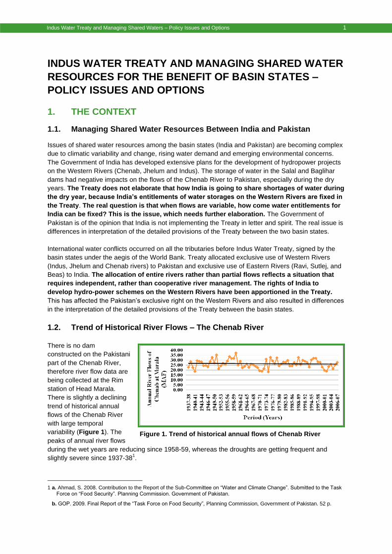
1.2. Trend of Historical River Flows – The Chenab River
There is no dam
constructed on the Pakistani
part of the Chenab River,
therefore river flow data are
being collected at the Rim
station of Head Marala.
There is slightly a declining
trend of historical annual
flows of the Chenab River
with large temporal
variability (Figure 1). The
peaks of annual river flows
during the wet years are reducing since 1958-59, whereas the droughts are getting frequent and
slightly severe since 1937-381.
1 a. Ahmad, S. 2008. Contribution to the Report of the Sub-Committee on “Water and Climate Change”. Submitted to the Task
Force on “Food Security”. Planning Commission. Government of Pakistan.
b. GOP. 2009. Final Report of the “Task Force on Food Security”, Planning Commission, Government of Pakistan. 52 p.
Figure 1. Trend of historical annual flows of Chenab River
2 Indus Water Treaty and Managing Shared Waters – Policy Issues and Options
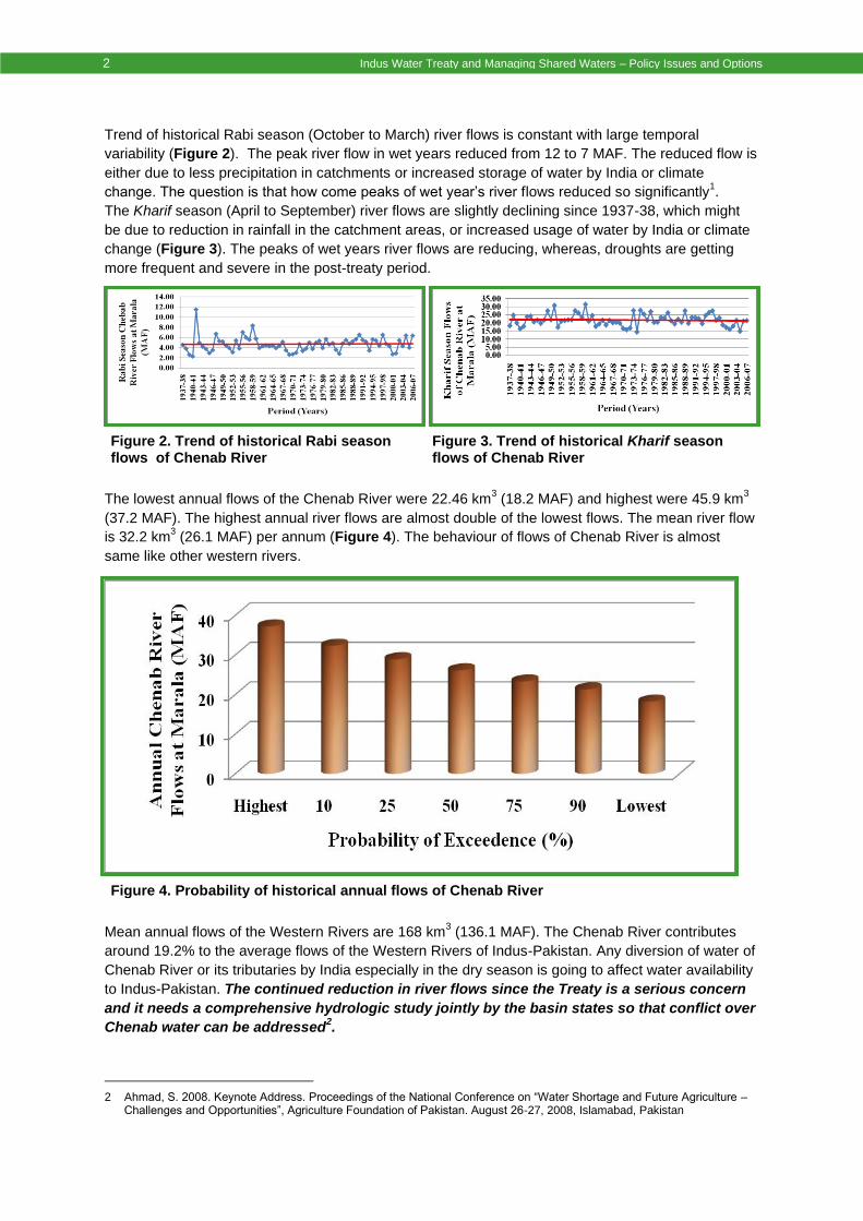
Trend of historical Rabi season (October to March) river flows is constant with large temporal
variability (Figure 2). The peak river flow in wet years reduced from 12 to 7 MAF. The reduced flow is
either due to less precipitation in catchments or increased storage of water by India or climate
change. The question is that how come peaks of wet year‟s river flows reduced so significantly1.
The Kharif season (April to September) river flows are slightly declining since 1937-38, which might
be due to reduction in rainfall in the catchment areas, or increased usage of water by India or climate
change (Figure 3). The peaks of wet years river flows are reducing, whereas, droughts are getting
more frequent and severe in the post-treaty period.
The lowest annual flows of the Chenab River were 22.46 km3 (18.2 MAF) and highest were 45.9 km
3
(37.2 MAF). The highest annual river flows are almost double of the lowest flows. The mean river flow
is 32.2 km3 (26.1 MAF) per annum (Figure 4). The behaviour of flows of Chenab River is almost
same like other western rivers.
Mean annual flows of the Western Rivers are 168 km3 (136.1 MAF). The Chenab River contributes
around 19.2% to the average flows of the Western Rivers of Indus-Pakistan. Any diversion of water of
Chenab River or its tributaries by India especially in the dry season is going to affect water availability
to Indus-Pakistan. The continued reduction in river flows since the Treaty is a serious concern
and it needs a comprehensive hydrologic study jointly by the basin states so that conflict over
Chenab water can be addressed2.
2 Ahmad, S. 2008. Keynote Address. Proceedings of the National Conference on “Water Shortage and Future Agriculture –
Challenges and Opportunities”, Agriculture Foundation of Pakistan. August 26-27, 2008, Islamabad, Pakistan
Figure 2. Trend of historical Rabi season flows of Chenab River
Figure 3. Trend of historical Kharif season flows of Chenab River
Figure 4. Probability of historical annual flows of Chenab River

Indus Water Treaty and Managing Shared Waters – Policy Issues and Options 3
2. CASE STUDIES OF INDIAN HYDRO-POWER PROJECTS ON
WESTERN RIVERS
Three Indian hydro-power projects on the western rivers were selected for case studies and for the
analysis of policy issues and options: a) Wular Barrage on the River Jhelum; b) Kishenganga River
and Gurez Dam Project; and c) Baglihar Dam Project on the Chenab Main.
2.1. Case Study of Wular Barrage on River Jhelum
Wular Lake is one of six Indian wetlands designated as Ramsar sites and it faces environmental
threats of converting large parts of catchment area into agricultural lands, pollution from heavy use of
chemical and animal wastes, hunting of birds and infestation of weeds. It is an important fish habitat,
as over 8,000 fishermen earn their livelihood. The catch comprises 60% of total production of fish in
the valley. Many locals are employed by cooperative societies that trade fish. Other families harvest
plants (grass and waterlily) from lake for feeding the livestock (Figures 5 to 8).
Tulbul Project is a "navigation structure" at the mouth of the Wular Lake. According to the original
Indian plan, the barrage was expected to be of 139 m long and 12 m wide, and maximum storage
capacity of 0.37 km3 (0.30 MAF). The purpose was to regulate lake water to maintain a minimum
draught of 1.37 m in the river up to Baramulla during the winter season. The project was conceived in
early 80s and work began in 1984. There has been an on-going dispute between the basin states
over the Tulbul Project since 1987, when Pakistan objected that it violated the Treaty. India stopped
work on the project, but has since pressed to restart construction. The Jhelum River through the
Kashmir valley below Wular Lake provides an important means of transport for goods and people.
Figures 5 to 8. Wular Lake and agriculture fields on the banks
4 Indus Water Treaty and Managing Shared Waters – Policy Issues and Options
To sustain navigation throughout the year a minimum depth of water is needed in the river. India
contends that this makes development of the Tulbul Project permissible under the Treaty, while
Pakistan maintains that project is a violation of the Treaty. India says suspension of work is harming
interests of people of Jammu and Kashmir (Indian held) and also depriving the people of Pakistan of
irrigation and power benefits that may accrue from regulated water releases. India further suggested
that Pakistan should bear greater share of constructing Barrage, as it would be more beneficial to
Pakistan.
Pakistan argued that India had violated Article I (11)3 of the Treaty, which prohibits both parties
from undertaking any „man-made obstruction‟ that may cause “change in the volume of daily flow of
waters”. Further that Article III (4)4 specifically barred India, from „storing any water of, or construct
any storage works on, Western Rivers‟. According to sub-paragraph 8(h)5 of the Treaty, India is
entitled to construct an „incidental storage‟ on Western Rivers on its side: a) only after the design has
been scrutinised and approved by Pakistan6; and b) its storage capacity should not exceed 10,000
AF, whereas the Wular Barrage‟s capacity is 0.37 km3 (0.30 MAF). As per Treaty, India is only
allowed to construct a small run-of-the-river plant with a maximum discharge of 300 ft3/sec through
turbines.
Bilateral Negotiations started when Pakistan referred Wular Barrage case to Indus Waters
Commission in 1986, which, in 1987, recorded its failure to resolve it. When India suspended
construction work, Pakistan did not take the case in the International Arbitral Court. To date, 8 rounds
of talks have been held. In 1989, Pakistan agreed for building the barrage conditional to Pakistani
inspection, which India rejected. The two sides almost reached an agreement in October 1991,
whereby India would keep 6.2 m of the barrage un-gated with a crest level of 1574.9 m, and would
forego the storage capacity of 0.37 km3. In return, the water level in the Barrage would be allowed to
attain the level of 1578.4 m. In February 1992, Pakistan added another condition that India should not
construct the Kishenganga (390 MW) hydropower plant. India refused to accept this condition.
According to Pakistan, Kishenganga project on River Neelam affected its own Neelam-Jhelum hydro-
power project. The issue of Wular Barrage was one of the disputes on the agenda highlighted for the
Indo-Pak talks, both at the Lahore meeting in February 1999, and at the Agra Summit of July 2001.
It is expected that there are implications of Wular Barrage and Tulbul Hydro-power Project on
Pakistan‟s water availability during the Rabi season, when river flows are reduced to almost one-fifth
of the Kharif flows. There are chances of serious threat to Pakistan, if India decides to withhold water
over an extended period during the dry season. It would also multiply and magnify the risks of floods
and droughts in Pakistan. Mangla Dam on River Jhelum is a source of irrigation and hydro-power for
Pakistan would be adversely affected. Pakistan also raised security-related concerns associated with
the operation of the Barrage. Technically, India might not hold water un-necessarily in the lake against
3 Article I(11) of the Indus Water Treaty illustrates that “The term Non-Consumptive Use” means any control or use of water
for navigation, floating of timber or other property, flood protection or flood control, fishing or fish culture, wild life or other like beneficial purposes, provided that, exclusive of seepage and evaporation of water incidental to the control or use, the water (undiminished in volume within the practical range of measurement) remains in, or is returned to, the same river or its Tributaries; but the term does not include Agricultural Use or use for the generation of hydro-electric power.
4 Article III(4) of the Indus Water Treaty illustrates that “Except as provided in Annexure D and E, India shall not store any water of, or construct any storage works on, the Western Rivers”.
5 Para 8(h) of Annexure E of the Indus Water Treaty illustrates that “Storage incidental to a barrage on the Jhelum Main or on the Chenab Main not exceeding 10,000 acre feet”.
6 Para 9 of Annexure D of the Indus Water Treaty illustrates that “To enable Pakistan to satisfy itself that the design of a Plant conforms to the criteria mentioned in Paragraph 8, India shall, at least six months in advance of the beginning of construction of river works connected with the Plant, communicate to Pakistan, in writing, the information specified in Appendix II to this Annexure. If any such information is not available or is not pertinent to the design of the Plant or to the conditions at the site, it will be so stated”. Para 10 further illustrates “Within three months of the receipts by Pakistan of the information specified in Paragraph 9, Pakistan shall communicate to India, in writing, any objection is not received by India from Pakistan within the specified period of three months, then Pakistan shall be deemed to have no objection”.

Indus Water Treaty and Managing Shared Waters – Policy Issues and Options 5
Pakistan as she has interest to maintain the level in River below the lake to support navigation in the
Jhelum River in the winter season but schedule of release of water from the Wular Lake might affect
the water availability to Pakistan especially in the Rabi season (dry season).
2.2. Case Study of Kishenganga River and Gurez Dam Project
India planned to construct Gurez dam on the Kishenganga River, named as "Neelum River" in
Pakistan (Figures 9 to 12). Its catchment in the north is delimited by Himalayan range as some of its
tributaries flow down the slopes of Nanga Parbat. Rising in the mountain complex to the west of Dras
and to the south of the Deosai plateau, it receives waters of minor tributaries. At Shardi, it makes a
sharp bend proceeding southwest until finally merging with Jhelum River at Muzafarabad.
India planned the project to construct a 103 m high dam on the Kishenganga River in the Gurez
Valley, which will inundate the valley, destroying its ecology and displace more than 25,000 people.
The project planned to create a large reservoir from which a channel and a 27 km tunnel dug south
through the North Kashmir mountain range, will re-direct the Kishenganga waters to the Wular Lake at
Bandipur. Total distance by which the river will be diverted is 100 km.
Figures 9 to 12. Views of Kishenganga River

6 Indus Water Treaty and Managing Shared Waters – Policy Issues and Options
In addition to destroying the entire Gurez Valley, such a project would reduce the flow of the
Kishenganga River below the dam to a mere trickle which will negatively impact environment of lush
green valley all the way to Muzafarabad. The Annexure „D‟ paras 15 and sub-para 15(iii) illustrate that
no storage and hydro-power work constructed by India on the tributaries of the Jhelum River shall not
affect the existing uses on the downstream. Thus, diversion of Kishenganga water to the Gurez
valley and then diversion of that water to Jhelum River would affect the right of the Neelum
River to flow and the natural habitat and ecology of the area will be adversely affected7.
Indus Water Commission held five meetings between 1994 and 2006 and the storage height of the
dam was ultimately reduced by 40 m. But by 2006, Kishenganga became a run-off project. Pakistan‟s
position was that this is a new project, the run-off was not in the 1994 project, and the 1994 project
should be considered abandoned. In June 2006, Pakistan raised objections.
Between 2006 and 2008 the Commission held three meetings. In 2008, Pakistan informed India that it
intends to seek the opinion of a neutral expert appointed by the World Bank. India said Pakistan has
no case and there is no controversy since the Kishenganga project does not harm Pakistan‟s usage.
India wanted to resolve the issue at the level of the Commission. So the government of Pakistan
agreed to meet representatives of the government of India, but the meeting proved inconclusive.
Later on, India and Pakistan agreed to negotiations, and in March 2009, Pakistan proposed two
names of negotiators. But the Indian stance remained the same. According to the Treaty, if
negotiations reach a deadlock than a court of arbitration can be constituted with seven experts: two
each from the governments of Pakistan and India and three jointly named umpires. If these names
are not jointly agreed upon, then the World Bank would help. Pakistan’s point of view is that the
direction of flow and environmental impact of the dam should be addressed by the court of
arbitration, while the matter of design would be decided by the neutral expert.
Indus Water Commission held its 104th meeting in Lahore during 29-31 March 2010 and at the end of
the meeting, no major breakthrough was achieved. The basin states decided to continue the talks at
the next meeting which held in New Delhi on May 29th 2010. At the Lahore meeting, Pakistan raised
the issue of the Kishenganga power project. Pakistan claims that this Project will divert waters of
Kishenganga, called Neelam in Pakistan. It will also interfere with Pakistan‟s proposed Neelum-
Jhelum hydropower project that has been designed to generate 969 MW of electricity.
According to the Indian stance, India is within its rights to construct the Kishenganga Project and has
been working on it since the 80s. According to the Treaty, the country that completes the project first
will have priority rights over the water use. Under this pressure, Pakistan has been experimenting with
various options to speed up the process, including tunnel boring machines that will reduce the
construction time of the Neelum-Jhelum Project by two years. According to officials, under the Treaty,
any basin state that starts a project on a shared River must ensure that “the then existing uses” of the
other state are protected. The Kishenganga Project was started by India in the 80s, and at that time
there was no use of the waters by Pakistan. If Pakistan had been using the waters at that time, it must
substantiate that with data, something that has not been provided so far, as per Indian stance.
7 The Annexure D paras 15 and 15(iii) illustrate that “Subject to the provisions of Paragraph 17, the works connected with a
Plant shall be so operated that (a) the volume of water received in the river upstream of the Plant, during any period of seven consecutive days, shall be delivered into the river below the Plant during the same seven-day period, the volume delivered into the river below the Plant during the same seven day period, and (b) in anyone period of 24 hours within that seven-day period, the volume delivered into the river below the Plant shall be not less than 30%, and not more than 130%, of the volume received in the river above the Plant during the same 24-hour period”: Provided however that: Para 15(ii) illustrates that “where a Plant is located on a Tributary of the Jhelum River on which Pakistan has any agricultural use or hydro-power use, the water released below the Plant may be delivered, if necessary, into another Tributary but only to the extent that the then existing Agricultural Use or Hydro-power Use by Pakistan on the former tributary would not be adversely affected”.

Indus Water Treaty and Managing Shared Waters – Policy Issues and Options 7
2.3. Case Study of Completed Baglihar Dam Project
Baglihar Dam Project is located at Chanderkot about 160 kms north of Jammu on Chenab River with
its origin in Indian state of Hamachil Paradesh and a course of 144 kms, runs through India before
flowing into Indian held part of Kashmir and then enters into Pakistan. In Pakistan‟s view, the hydro-
power plant on the Chenab River is a clear violation of the Treaty, a clear breach of the international
law. The surveys to assess the potential for generation of hydro-power were carried out in 1960 and
then in 1972. In 1999, the contract was
given and work was started. The Project
was planned in two phases and each phase
is designed to produce 450 MW. The first
phase was completed at the end of 2005
and the second phase was completed in
2008. As per design, the Baglihar Dam is
planned for 143.3 m in height, 317 m in
length with a designed storage capacity of
0.0375 km3 (0.030 MAF). According to the
Pakistani experts, design of Dam violates
the Treaty, as it will affect the flow of water
of the Chenab River and can cause
shortage of water to Pakistan (Figures 13
and 14).
During 1999-2004 India and Pakistan held several rounds of bilateral negotiations on the design of
the project, but could not resolve the issue. Pakistan suggested that both the countries might
approach the World Bank for technical expertise. India rejected this proposal expressing the view that
bilateral negotiation would be adequate. After failure of the talks on January 18, 2005 Pakistan raised
six objections to the World Bank. In April 2005, World Bank determined Pakistani claim as a
„Difference‟, a classification between less serious ‘Question’ and more serious ‘Dispute’, and in
May 2005 appointed neutral expert to adjudicate the difference.
Pakistani stance on the construction of the Baglihar Dam is reproduced as under:
Project would divert up to 28.34 m3/sec of water destined for Pakistan, whereas India is allowed to
build a dam only if it does not interrupt the flow of water to Pakistan8;
Design of Project violates terms of the Treaty as gated spillways will enhance India‟s storage
capacity far beyond what is allowed under the Treaty. Pakistan argued that India had violated
Article #I of the Treaty, which prohibits both parties from undertaking any obstruction that may
cause change in the volume of daily flow of water9;
8 The Annexure D Para(s) 15 and 15(iii) illustrate that “Subject to the provisions of Paragraph 17, the works connected with a
Plant shall be so operated that: a) the volume of water received in the river upstream of the Plant, during any period of seven consecutive days, shall be delivered into the river below the Plant during the same seven-day period, the volume delivered into the river below the Plant during the same seven day period: and (b) in anyone period of 24 hours within that seven-day period, the volume delivered into the river below the Plant shall be not less than 30%, and not more than 130%, of the volume received in the river above the Plant during the same 24-hour period”: Provided however that: “i) where a Plant is located at a site on the Chenab Main below Ramban, the volume of water received in the river upstream of the Plant in any one period of 24 hours shall be delivered into the river below the Plant within the same period of 24 hours; and ii) where a Plant is located at a site on the Chenab Main above Ramban, the volume of water delivered into the river below the Plant in anyone period of 24 hours shall not be less than 50% and not more than 130%, of the volume received above the Plant during the same 24-hour period”.
9 Article I Para (15) illustrates that The term “interference with the waters” means: a) Any act of withdrawal therefrom; or b) Any man-made obstruction to their flow which cause change in the volume (within the practical range of measurement) of the daily flow of the waters: provided however that an obstruction which involves only an insignificant and incidental change in the volume of the daily flow for example, fluctuations due to afflux caused by bridge piers of a temporary by-pass etc., shall not be deemed to be an interference with the waters.
Figures 13 and 14. Baglihar Hydropower Dam in India

8 Indus Water Treaty and Managing Shared Waters – Policy Issues and Options
India is only allowed to construct a small run-of-the-river hydro-power plants with a maximum
discharge of 8.5 m3/sec (300 ft
3/sec) through the turbines
10;
Dam‟s planned height is 143.3 m, which would interfere with the flow of water into Pakistan.
Dam‟s bondage capacity, 37.5 million m3 of water is twice the allowed bondage under the Treaty
and Pakistani engineers were of the opinion that free board of 4.5 m is excessive.
Indian stance regarding the construction of the Baglihar Dam is reproduced as under:
Baglihar Dam is the only project in the Indian held Kashmir where the Kashmiri people can get
cheap electricity at the rate of Rs. 3.67 per unit. If she accepted Pakistan‟s demand of reduction in
the height of the dam then the dam would be reduced to the capacity of generating only 50 MW of
electricity;
Technical deliberation to resolve differences should continue and reference to the World Bank was
not justified;
Since India has already paid £62.060 million to the World Bank for compensation to Pakistan
under the clause of Article V, therefore, the said Article is no more valid;
Project is strictly within the parameters of the Treaty, and the dam will not be used to store water or
disrupt flows to Pakistan.
World Bank Neutral Expert in his report highlighted the point of difference referred by Pakistan and
India‟s position. The three clauses of the Indus Water Treaty were referred to explain the stance of
the two countries. Pakistan is of the considered view that the design of the Baglihar dam on Chenab
Main does not confirm to the criteria (e)11
and (a)12
specified in Para 8 of Annexure D to the Treaty
and that the Plant design is not based on correct, rationale and realistic estimates of maximum
discharge. The Neutral Expert further illustrated that Pakistan is of the considered view that the
pondage of 37.722 million m3 exceeds twice the pondage required for Firm Power in contravention of
Para 8 (c)13
of Annexure D of the Treaty. The Neutral expert also indicated that Pakistan is of the
considered view that intake for turbines of the Plant is not located at the highest level consistent with
satisfactory and economical construction and operation of the plant as a run-of-the-river hydro-power
plant and is in contravention of Paragraph 8 (f)14
of Annexure D of the Treaty. World Bank‟s
independent expert submitted his report and given his verdict on February 12th 2007. The
independent expert partially upheld some of the objections of Pakistan declaring that:
India has a right to construct “gated spillways” under the Treaty;
Pondage of 32.58 million m3 (0.026 MAF) is allowed as against India's demand of 37.5 million m
3
(0.030 MAF). Thus, reducing pondage capacity by 13.5%;
10 Under the provisions of article III (2) (d) and Para (18) of Annexure D of the Indus Water Treaty illustrates that “The
provisions of Paragraphs 8,9,10,11,12 and 13 shall not apply to a new run-of-the river Plant which is located on a tributary and which confirms to the following criteria (hereinafter referred to as Small Plant): a) the aggregate designed maximum discharge through the turbines does not exceed 300 cusecs; b) no storage is involved in connection with the Small Plant, except the pondage and the storage incidental to the diversion structure; and c) the crest of the diversion structure across the tributary, or the top level of the gates, if any, shall not be higher than 20 feet above the mean bed of the tributary at the site of the structure.
11 Para 8 (e) of Annexure D of the Indus Water Treaty illustrates that “If the condition at the site of a Plant make a gated spillway necessary, the bottom level of the gates in normal closed position shall be located at the highest level consistent with sound and economical design and satisfactory construction and operation of the works”.
12 Para 8 (a) of Annexure D of the Indus Water Treaty illustrates that “The works themselves shall not be capable of raising artificially the water level in the Operating Pool above the Full Pondage Level specified in the design”.
13 Para 8 (c) of Annexure D of the Indus Water Treaty illustrates that “The maximum pondage in the Operating Pool shall not exceeds twice the Pondage required for Firm Power”.
14 Para 8 (f) of Annexure D of the Indus Water Treaty illustrates that “The intakes for the turbines shall be located at the highest level consistent with the satisfactory and economic construction and operation of the Plant as run-of-the-river hydro-power plant and with customary and accepted practice of design for the designated range of the Plant‟s operation”.

Indus Water Treaty and Managing Shared Waters – Policy Issues and Options 9
Reduce the height of freeboard from 4.5 to 3.0 m thus reducing height of the dam by 1.5 m;
Power intake tunnels can be raised by 3 m thereby limiting some flow control capabilities of the
earlier design.
2.4. Other Developments on the Chenab River
If Salal and Baglihar were the only two dams built by India on the Chenab, there would be a limited
impact on flows of water to Pakistan. But India has developed an extensive plan for the construction
of hydro-power projects – Kishenganga, Sawalkot, Pakuldul, Bursar, Dal Husti, Gyspa, etc. (Figure
15). The cumulative live storage will be large, giving India an unquestioned capacity to have major
impact on the timing of flows into Pakistan, especially during the dry periods – the Rabi season.
Dr. Jhon Brisco15
in an article published in
Daily International The News of Pakistan
on April 3rd
2010 indicated that “using
Baglihar as a reference, simple back-of-
the-envelope calculations, suggest that
once it has constructed all of the planned
hydropower plants on the Chenab, India
will have an ability to effect major damage
on Pakistan. First, there is the one-time
effect of filling the new dams. If done
during the wet season this would have
little effect on Pakistan. But if done during
the critical low-flow period, there would be
a large one-time effect (as was the case
when India filled Baglihar). Second, there
is the permanent threat which would be a consequence of substantial cumulative live storage which
could store about one month's worth of low-season flow on the Chenab. If, God forbid, India so chose,
it could use this cumulative live storage to impose major reductions on water availability in Pakistan
during the critical planting season”.
Dul-Hasti Hydro-power project
comprises a diversion dam at „Dul‟
across the River Chenab and a power
house at „Hasti‟. Concrete gravity dam
of 185 m length and 65 m height has
an un-gated spillway of 40 m and a
gated spillway of 64 m with 4 radial
gates. Dam has 4 orifices for 8,000
m3/sec of discharge. Two intake
tunnels originate from the intake tower
150 m upstream of the dam, and lead
to desilting basins. A 10.6 km long
headrace tunnel with a drop of 235 m
carries water to power house, which
accommodates 3 turbine sets, each
coupled to 130 MW generators.
15 Gordon McKay Professor of Environmental Engineering, Harvard University. Email: [email protected].
Figure 15. Indian hydro-power projects on Chenab
River
Figure 16. Dul Hasti hydro-power project on Chenab

10 Indus Water Treaty and Managing Shared Waters – Policy Issues and Options
Review of the Indian documents
revealed that the Sawalkot Dam
project on the Chenab River is 197 m
high, which is more than Tarbela (148
m) and Mangla (138 m). The project is
also higher than the Baglihar Dam and
has 13 times more water storage
capacity. The cost of the project is US$
2 billion and construction is in full
swing and is monitored by the Indian
Home Ministry, because of law and
order situation. About 10.74 kms
access road had been opened.
The review of Indian literature further revealed that the dam would inundate an area of more than 12
km2. It would be highly vulnerable to earthquakes being in the seismic zone. The site is close to the
Himalayan Boundary Thrust zone where a number of earthquakes have been recorded. The nearest
epi-centre was just 50 kms from the project site and the Bhadarwa earthquake of 6 degrees
magnitude (on Richter scale) had been recorded in 1947. The Badgam earthquake of magnitude 5.5
in 1967 had its epi-centre 70 kms from the site, while the strongest earthquake recorded in 1905 was
of magnitude 8.0 and had its epi-centre in Kangra, about 160 kms away. Three fault-lines near the
place were believed to have serious seismic potential – the Panjal Murree fault close to Damkund, the
Sawalkot fault just upstream of the site and the Chakka fault less than 2 kms downstream. The dam
site had some geological and environmental trans-boundary concerns that ought to be addressed,
otherwise, it could be an environmental disaster for the lower riparian – Pakistan.
3. KEY POLICY ISSUES
Five key policy issues have been identified, which have affected the development of water resources
in both the basin states and created a situation where there are growing physical and psychological
hostilities in the basin states. These key policy issues are presented in detail in the following.
3.1. Indus Water Treaty under Strain
For over 40 years, the Treaty has proved to be an outstanding example of conflict resolution. Due to
increase in water stress in the basin states since early 90s, the Treaty has come under strain. It may
find it difficult to survive in the next decade, even though there is no exit clause in the Treaty. The real
issue is that Treaty is silent that how India is going to share the shortages in the dry years,
when flows are almost half of the wet years. Furthermore, storing water during the Rabi season is
critical as flows are almost one-fifth of the flows of the Kharif season. India therefore may address the
issues of water shortage in the dry years and in the winter season and develop a strategy where
shortages of water are shared equitably by the basin states.
Pakistan has gone as far as calling the Treaty an inefficient forum for resolving water issues; elevating
the water issue to a “core issue”; and including it in the composite dialogue, but India has refused to
discard the Treaty. In March 2010 meeting of Indus Water Commission in Lahore, Pakistan
threatened to take these issues before an external arbitration panel, a provision given under Article IX
of the Treaty, but something that has never been used before.
Figure 17. Sawalkot hydro-power project on Chenab
Indus Water Treaty and Managing Shared Waters – Policy Issues and Options 11
3.2. Water Entitlements of India on Western Rivers and Interpretation of
the Treaty
Indus Water Treaty permitted India for creating storages on the Western Rivers of 1.54, 1.98 and 0.93
km3 for general, power and flood storages, respectively, amounting to total permissible storage of
4.45 km3 (3.6 MAF). In the Treaty, conditions have been illustrated in Annexure D and E regarding
utilization of waters of Western Rivers by India, while designing new schemes to ensure agreement of
Pakistan. This is the point where conflict arises between the basin states on the interpretation or
violation of the detailed provisions of the Treaty. There is another dimension of water entitlements of
India on the Western Rivers that how she is going to share the shortages in relation to storage of
water in the storage projects. This will be the most serious issue to be addressed in future by the
basin states.
3.3. Water Scarcity and Emerging Conflicts on Shared Water Resources
The climate change is expected to shrink glaciers and changing precipitation patterns. There is a
need to address issues of water scarcity and environmental degradation as Treaty does not clearly
articulate these aspects. Issues of water resources between the basin states are becoming complex
due to climatic variability and change, rising water demand and environmental concerns.
3.4. Impacts of Water Development by India on Flows of Western Rivers
to Pakistan
The Government of India has developed extensive plans for the development of hydro-power with
enhanced water storage on the Western Rivers. India is already in control of the Chenab River
through Salal dam constructed in 1976. Many Pakistanis criticise the conceding of the Salal Dam to
India. Furthermore, the recent storage of water in the Baglihar dam had further reduced the flows of
Chenab River to Pakistan. There is a decline in the flows of Chenab River based on the historical data
with large temporal variability. Annual flows during wet years are continuously reducing since 1958-
59. Droughts are also getting frequent and slightly severe since 1937-38.
Similarly, control of River Jhelum by India through storage dams would mean a serious threat to
Pakistan in terms of enhanced risks of droughts. Mangla Dam on River Jhelum is a source of irrigation
and hydro-power for Pakistan and closing Barrage gates by India would affect flows to Mangla dam
and ultimately to canals.
3.5. Reactive Stance of Pakistan
Case studies of hydro-power projects in India indicated that Pakistan has been reactive rather than
proactive in handling issues of trans-boundary waters. Pakistan has handled the case of trans-
boundary waters in a casual way and adequate efforts were not made to present the case on detailed
facts. Pakistan most of the time was late in presenting the case to the Indus Water Commission or to
the World Bank or to the court of arbitration. One of the reasons was that hardly any systematic
analysis was made for the trans-boundary water issues by the Pakistani experts in a scientific
manner. Awareness regarding trans-boundary water issues is a recent phenomenon in Pakistan and
systematic studies are needed on this subject at various levels.

12 Indus Water Treaty and Managing Shared Waters – Policy Issues and Options
4. POTENTIAL OPTIONS
4.1. Building Areas of Cooperation between the Basin States
The Indus Water Treaty was signed at a time when water was available in abundance and when
climate change was not affecting the water supplies from the Western Rivers. Being a water
apportionment and not a water sharing Treaty, it includes very limited areas of cooperation between
the basin states. Instead of abandoning the Treaty that has managed extremely well despite three
wars between the basin states; new and innovative areas of cooperation, within and outside the
Treaty should be envisaged. Some of the potential areas of cooperation between the basin states are:
Pakistan has suggested joint watershed management and joint commissioning of studies that
would address emerging concerns arising from reduced flows. India and Pakistan initiate a joint
study of flow patterns of Chenab River in all the tributaries in upstream area so that conflict over
Chenab waters between India and Pakistan can be resolved. A joint hydrologic study will help to
assess impacts of water developments in India on flows of the Chenab River on Pakistan side.
Envisage comprehensive development and planning of water resources to optimize use of
water in the basin states. A holistic approach to water resources recognizing linkages between
water, land, users, environment and infrastructure is necessary to evade crisis of water scarcity in
the basin states. The basin states could also look into joint electrical projects and energy
swaps. The notion of the Second Treaty obviously builds on the foundation of First Treaty and
does not discard it.
Resolve conflicts through cooperative programmes for optimum utilization of river system
by the basin states. Article #7 of the Treaty envisages future cooperation and points to the
"common interest in the optimum development of the rivers" and calls upon both sides "to
cooperate, by mutual consent, to the fullest extent in undertaking engineering works in the rivers".
Joint harnessing of water should be a part of the peace process.
Manage water as a shared resource and as well as a shared commodity, as it is essential to
jointly set up an organisation with representatives from the basin states, whose functions would
entail identifying short- and long-term supply capacity of the basin and its integrated development,
setting up of infrastructure and coordinating activities of different agencies within the respective
states.
4.2. Support Paradigm Shift in the Mindset of the People of Basin States
There is an urgent need to support paradigm shift in the mindset of the people of both the basin states
and it would require a complete end to hostilities, both physical and psychological, from both sides. It
will have to be a part of the final settlement in letter and spirit. The integrated development approach
is beyond consideration in the current context of relations between the two basin states, but all other
options will lead to destruction sooner or later. India being a larger and upstream state have to
demonstrate the congenial relations and posture towards a smaller state and a lower riparian.
4.3. Restructure and Strengthen Pakistan’s Chapter of Indus Water
Commission
Restructure and strengthen the Indus Water Commission, the Pakistan Chapter by developing
capacity in water treaty, water diplomacy, water conflict resolution, water entitlements, legal and
technical issues so that Pakistan can plead its case on facts and figures. This institution needs to be
restructured to meet the requirement of the 21st century. The current institutional structure is now
obsolete.

Indus Water Treaty and Managing Shared Waters – Policy Issues and Options 13
4.4. Establish Tri-partite Water Forum
Establish a Tri-partite Water Forum including both the basin states and a developed country having
strength in water (i.e. Netherlands) so that river basin management and development issues can be
addressed without water politics between experts of the two traditional rival states. This Forum must
be designed specifically to provide knowledge and technical backstop support on the issues related to
water conflicts between the basin states. This forum later on can be extended to include other
countries of the region to address the regional water issues i.e. Afghanistan, Bangladesh and Nepal.
5. WAY FORWARD
Jhon Briscoe15
a Professor at the University of Harvard in a paper recently published in Daily
International The News of Pakistan on April 3rd
2010 suggested a way forward and indicated that the
“current situation is a very uneven playing field. The regional hegemon is the upper riparian
and has all the cards in its hands. This asymmetry means that it is India that is driving the
train, and that change must start in India. In his view, four things need to be done”: “a) firstly,
there must be some courageous and open-minded Indians – in government or out – who will stand up
and explain to the public why it is an existential issue for Pakistan; b) secondly, there must be
leadership from the Government of India, who should show the generosity of spirit which is an integral
part of being a truly great power and a good neighbour; c) thirdly, this should translate into an
invitation to Pakistan to explore ways in which the principles of the Indus Waters Treaty could be
respected, while providing a win for Pakistan (assurance on their flows) and a win for India (reducing
the chronic legal uncertainty which vexes every Indian project on the Chenab or Jhelum). With good
will there are multiple ways in which the Treaty could be maintained but re-interpreted so that the
basin states could win; and d) fourthly, discussions on the Indus waters should be de-linked from both
historic grievances and from the other Kashmir-related issues. Again, it is a sign of statesmanship, not
weakness, to acknowledge the past and then move beyond it”.
Who will be the Champions of building a booming future for the indigent population of the
basin states and make it happen for the benefit of Pakistanis and Indians – on the Indus?
INTERNATIONAL UNION FOR
CONSERVATION OF NATURE
Balochistan Programme Office
Marker Cottage
Zarghoon Road, Quetta
Pakistan
Tel +92 (81) 2840450/51/52
Fax +92 (81) 2820706
www.iucn.org/pakistan