draft mount victoria-matairangi master plan february 2015/media/have-your-say/public-input/... ·...
TRANSCRIPT

MOUNT V ICTORIA -MATAIRANGI MASTER PLAN
FEBRUARY 2015
DRAFT
W r a i g h t + A s s o c i a t e s L i m i t e d
i n c o l l a b o r a t i o n w i t h P e o p l e + P l a c e s & R o b G r e e n a w a y + A s s o c i a t e s
P r e p a r e d f o r :W e l l i n g t o n C i t y C o u n c i l
by:WA: wraight + associates ltd
contactDirector: Megan Wraight
lvl 2, 282 Wakefield Street Wellington ph +64 4 381 3355 fx +64 4 381 3366
2 W R A I G H T + A S S O C I A T E S L T D , M O U N T V I C T O R I A - M A T A I R A N G I M A S T E R P L A N - : 1 6 / 0 2 / 1 5 - D R A F T
Client:
Wellington City Council
PO Box 2199
Wellington
The following report has been prepared on behalf, and for the exclusive use of Wellington City Council. It is subject to and issued in connection with the provisions of the agreement between Wraight + Associates Limited (WA) and Wellington City Council. The consultant accepts no liability or responsibility whatsoever for or in respect of any use or reliance upon this document by any third party.
Consultant:
Wraight + Associates Limited
PO Box 19212
Wellington
The Master Plan is a visual plan for tree management and replanting, and for the management of the track network. It will help guide the Council’s existing programmes and resources for Mt Victoria over the next 10 years. The Master Plan looks at landscape, future plantings, and management of pines, as well as recreation development and ways to reduce user conflict.
Key Recommendations
It is important to consider the landscape values and character of Mt Victoria/Matairangi within the context of the whole Wellington Town Belt, local parks, and the Outer Green Belt. Ecologically, it provides valuable connections for native flora and fauna across the wider city.
This Master Plan proposes to create an ecological identity for the gullies through the vegetation and by establishing a hierarchy of paths to assist with overall wayfinding. Signage will then support this place-making system, rather than drive wayfinding.
Track Strategy
Developing a track hierarchy – A three-tier track structure is proposed, with all tracks to be considered shared walking and cycling tracks, with the exception of downhill “black diamond” standard mountain bike tracks.
First tier – Commuter and tourist routes to be developed (where practically achievable) to NZ Standard Walking Track and Short Walk Standards, and have easy wayfinding via the track quality, construction and signage.
Second tier – Park walks at a variety of standards, but leading to key areas of open space and views. These will largely be differentiated by signs.
Third tier – All other tracks in the park. These would have no signage for walking, but have low-profile mountain bike grade signs where required (as currently used), and be for use by those seeking a walking adventure as well as orienteering, mountain biking and running.
Minimising Potential User Conflict
To reduce the risk of collisions between different user groups, the Mt Victoria/Matairangi Master Plan proposes to create intersections with oblique angles and to use “slow-down” formations before intersections. “Black diamond” standard mountain bike tracks will not intersect with the main commuter and tourist tracks within the park.
Signage Strategy
A renewed signage system is proposed to align with the three-tier track strategy, and to include te reo Māori and English where practical.
Open Space Development
Open spaces are generally lawn areas. These are highly valued as places to interact socially or to stop and take in the view. There is scope to develop these to include more diverse activities, such as play and – where close to residential areas – community gardening.
Vegetation Strategy
Mt Victoria/Matairangi plays an important role in linking ecosystems through the Town Belt, and is part of a critical ecological path that links the planted ridges across Wellington. The exotic vegetation on Mount Victoria/Matairangi requires a long-term succession plan. There is significant support in the community to re-establish native vegetation but it is also recognised that careful management is necessary in the meantime to maintain the existing exotic vegetation through to the end of its useful life.
It is proposed that the exotic vegetation is managed and retained on the ridge areas of Mt Victoria, with replanting of natives occurring in areas of wind fall, weed control, and in the gullies. This approach of retaining the exotic vegetation while the native gullies establish will provide much-needed shelter, and the ability to phase out the exotics over a long period of time (0–50 years).
Gullies “Tracing the Streams”
The streams associated with Mt Victoria/Matairangi now flow in the piped stormwater network. These were once renowned by Māori for their good quality water, and supported the growing of kumara on terraces across the west-facing slopes of Mt Victoria/Matairangi that now hold houses. Tracing these streams up the valleys to their catchments reveals moisture-rich gullies.
The Mt Victoria/Matairangi Master Plan proposes to replant these using plant mixes that include a dominant tree species. The gullies will provide a positive on-going focus for revegetation groups and, once established, will assist wayfinding through identity and narrative within Mt Victoria/Matairangi.
Pine/Exotic Tree Management
The revegetation management strategy proposes to:
• use risk management to guide the priorities for removal of exotic vegetation
• manage existing vegetation to maintain key views.
Draft 1 20-11-14
Draft 2 21-11-14
Draft 3 01-12-14
Draft 4 11-02-15
Draft 5 16-02-15
E X E C U T I V E S U M M A R Y
DOCUMENT DISCLOSURE
ISSUE STATUS

3W R A I G H T + A S S O C I A T E S L T D , M O U N T V I C T O R I A - M A T A I R A N G I M A S T E R P L A N - : 1 6 / 0 2 / 1 5 - D R A F T
D O C U M E N T C O N T E N T S
INTRODUCTION
SECTION 1 EXISTING SITE - KEY ISSUES + OPPORTUNITIES
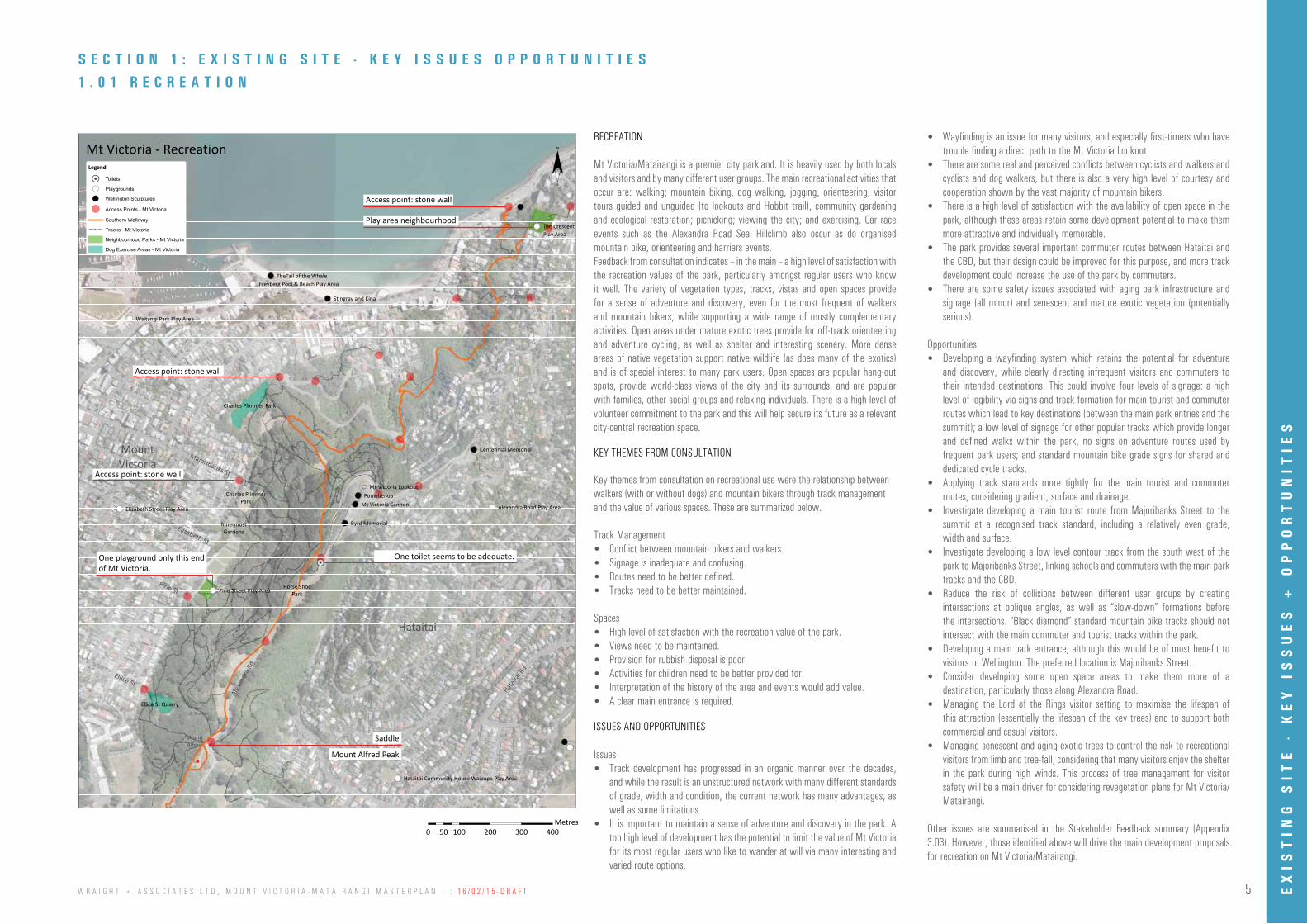
1.01 RECREATION
1.02 VIEWS
1.03 TRACKS + WALKWAYS
1.04 TRACK + WALKWAY + MINOR SAFETY ISSUES
1.05 ACCESSIBILITY
1.06 WAYFINDING + SIGNAGE
1.07 OPEN SPACES
1.08 HISTORICAL MAP OVERLAYS
1.09 CULTURAL SIGNIFICANCE
1.10 VEGETATION TYPES
1.11 VEGETATION RISK LEVELS
1.12 VEGETATION TYPES, RISK LEVELS + TRACKS
1.13 REVEGETATION AREAS
1.14 REVEGETATION AREAS + VEGETATION TYPES
1.15 TOPOGRAPHY + HISTORICAL STREAMS
5
6
7
8
9
10
11
12
13
14
15
16
16
17
18
4
36
21-23
19
37
38
24
20
25
26
27
28
29-30
30
31
32
34-35
SECTION 3.0 APPENDIX
3.01 APPENDIX 1 - BACKGROUND REPORT LIST
3.02 APPENDIX 3 - STAKEHOLDER ENGAGEMENT REPORT
3.03 APPENDIX 5 - VEGETATION RISK METHODOLOGY
SECTION 2.0 CONCEPT DESIGN + MASTER PLAN
2.01 SITE CONTEXT + KEY CONNECTIONS
2.02 COLLECTIVE IDENTITY + WAYFINDING STRATEGY
RECREATION
2.03 TRACK STRATEGY
2.03 TRACK STRATEGY + DRIVING IN THE PARK
2.04 SIGNAGE + INTERPRETATION STRATEGY
2.05 OPEN SPACE DEVELOPMENT
VEGETATION
2.06 BROAD SCALE CONTEXT OR VEGETATION STRATEGY
2.07 VEGETATION DEVELOPMENT STRATEGY - GULLIES “TRACING THE STREAMS”
2.07 VEGETATION DEVELOPMENT STRATEGY - RIDGES
2.08 VEGETATION MANAGEMENT STRATEGY - EXOTIC TREE MANAGEMENT
2.08 VEGETATION MANAGEMENT STRATEGY - VIEWS
2.08 VEGETATION MANAGEMENT STRATEGY - COMMUNITY PLANTING
IMPLEMENTATION
2.09 TEN YEAR IMPLEMENTATION PLAN (PRIORITIES TABLE)

4 W R A I G H T + A S S O C I A T E S L T D , M O U N T V I C T O R I A - M A T A I R A N G I M A S T E R P L A N - : 1 6 / 0 2 / 1 5 - D R A F T
I N T R O D U C T I O N
This Master Plan for Mt Victoria/Matairangi provides a 10 year direction for redevelopment or upgrade of this important city park that is consistent with user need and open space values. This project is in response to policy 8.9.3.1 of the Wellington Town Belt Management Plan-June 2013 (WTBMP 13); ‘Develop a master plan for Mt Victoria/Matairangi that looks at landscape, future plantings and rate of removal of pines, as well as recreation development and ways to reduce user conflict.’
The master plan will help guide the Council’s existing programmes and resources over the next 10 years. This will include existing operational and capital work budgets for track renewals and upgrades, hazardous tree management, pest control and restoration planting. Some new developments and ideas are also proposed which are currently unfunded, Council could consider these as future projects subject to funding decisions through future Long Term Plan and Annual Planning processes.
PROJECT SCOPE AREA
Mount Victoria/Matairangi comprises sector 9 of the Wellington Town Belt (Town Belt), and extends from Mt Alfred north to Oriental Bay. (Refer to map on page 179 in the Wellington Town Belt Management Plan 2013). It forms the eastern arm of the Town Belt and is characterised by the ridge and north-western facing slopes above the suburbs of Mt Victoria and Oriental Bay.
Mount Victoria/ Matairangi (Mt Vic.) is the most popular forested area of the Town Belt. Informal recreation activities on Mt Vic. are dramatically increasing with the most popular activities being mountain biking (both cross country and downhill), walking, dog walking, jogging, orienteering and sightseeing. As these activities become more popular, the likelihood of conflicts increase, user/visitor experiences change and greater demand is placed on the track network and other infrastructure.
Alongside the increase in recreation activity is the need to manage the vegetation and long term landscape change, particularly with the aging conifer and pine plantations. Given Mt Vic’s landscape significance, vegetation management needs to be well planned and gradual in order to protect and enhance visual unity and ecological connections.
A copy of the Town Belt Management Plan 2013 can be found on Wellington City Council’s website:www.wellington.govt.nz
PROJECT PURPOSE
A Master Plan for Mount Victoria that; • Complements existing legislative and management structures including the Wellington Town Belt Management Plan 2013 and Draft
Wellington Town Belt Bill 2014), supports the aspirations and inspirations of various stakeholders and guides future management and development in a consistent and affordable manner.
• Provides a visual plan for hazardous tree management, and replanting, taking into account landscape, heritage and ecological values. • Provides guidance for visitor use, and management of the track network, including identifying areas where recreation conflict occurs
(or potentially could occur) and recommend options for managing these conflicts, and identify options for improving/enhancing user experience.
• Identifies any opportunities/areas for site specific redevelopment or upgrade that is consistent with user needs and open space values.Identifies appropriate management of key cultural sites which are identified in the WTBMP 13.
• Provides a detailed 10 year implementation plan including, identifying and prioritising projects and resourcing requirements and methods.Meets the aspirations of Mana Whenua who have an on-going partnership role in the management of the Town Belt.
Victoria Bowling Club
Pirie Street Playground
Ellice Street Quarry
Mt Alfred
Charles Plimmer Park
Oriental Bay
Site Boundary
Alexa
ndra
Road
Hataitai
Road
Lookout Road
Majoribanks Street
Elizabeth Street
Pirie Street
Ellice Street
Mt Victoria Lookout
Centennial Memorial
Charles Plimmer Park
0 300 600 900 1,200150Meters
0 310 620 930 1,240155Metres
PROJECT PROCESS
The project follows four main stages including; Information collection, research and site analysis (including engagement with stakeholders and user groups), concept design and master planning, public consultation, and preparation of final plans.
Stakeholder consultation has provided a picture of how Mt Victoria/Matairangi is used and valued. The feedback from consultation has informed the direction for vegetation and landscape management to achieve positive ecological, recreation and visitor experience proposals.
INT
RO
DU
CT
ION
5W R A I G H T + A S S O C I A T E S L T D , M O U N T V I C T O R I A - M A T A I R A N G I M A S T E R P L A N - : 1 6 / 0 2 / 1 5 - D R A F T
Pirie Street Play Area
Waitangi Park Play Area
Alexandra Road Play AreaElizabeth Street Play Area
Freyberg Pool & Beach Play Area
Hataitai Community House Waipapa Play Area
Pouwhenua
Byrd Memorial
Stingray and Kina
Mt Victoria Cannon
Centennial Memorial
TheTail of the Whale
Charles Plimmer Park
Ellice St Quarry
The Crescent Play Area
Treasure Island/Kainui Reserve Play Area
0 100 200 300 40050Meters
¨Legend
!H Toilets
!( Playgrounds
! Wellington Sculptures
! Access Points - Mt Victoria
Southern Walkway! ! ! ! Tracks - Mt Victoria
Neighbourhood Parks - Mt Victoria
Dog Exercise Areas - Mt Victoria
Hataitai
MountVictoria
Play Area
Majoribanks St
Pirie St
Elizabeth St
Ellice St
Hatait
ai Rd
Alex
andr
a Rd
MountAlfred
Mt Victoria - Recreation
Mt Victoria Lookout
Horse ShoePark
Charles PlimmerPark
InnermostGardens
0 100 200 300 40050Meters
¨Legend
Hataitai
MountVictoria
Majoribanks St
Pirie St
Elizabeth St
Ellice StHata
itai R
d
Alex
andr
a Rd
Mt Victoria - Vegetation Risk Levels
0 100 200 300 40050Metres
1 . 0 1 R E C R E A T I O N S E C T I O N 1 : E X I S T I N G S I T E - K E Y I S S U E S O P P O R T U N I T I E S
RECREATION
Mt Victoria/Matairangi is a premier city parkland. It is heavily used by both locals and visitors and by many different user groups. The main recreational activities that occur are: walking; mountain biking, dog walking, jogging, orienteering, visitor tours guided and unguided (to lookouts and Hobbit trail), community gardening and ecological restoration; picnicking; viewing the city; and exercising. Car race events such as the Alexandra Road Seal Hillclimb also occur as do organised mountain bike, orienteering and harriers events.Feedback from consultation indicates – in the main – a high level of satisfaction with the recreation values of the park, particularly amongst regular users who know it well. The variety of vegetation types, tracks, vistas and open spaces provide for a sense of adventure and discovery, even for the most frequent of walkers and mountain bikers, while supporting a wide range of mostly complementary activities. Open areas under mature exotic trees provide for off-track orienteering and adventure cycling, as well as shelter and interesting scenery. More dense areas of native vegetation support native wildlife (as does many of the exotics) and is of special interest to many park users. Open spaces are popular hang-out spots, provide world-class views of the city and its surrounds, and are popular with families, other social groups and relaxing individuals. There is a high level of volunteer commitment to the park and this will help secure its future as a relevant city-central recreation space.
One playground only this end of Mt Victoria.
Access point: stone wall
Access point: stone wall
Access point: stone wall
Play area neighbourhood
One toilet seems to be adequate.
Saddle
Mount Alfred Peak
ISSUES AND OPPORTUNITIES
Key themes from consultation on recreational use were the relationship between walkers (with or without dogs) and mountain bikers through track management and the value of various spaces. These are summarized below.
Track Management • Conflict between mountain bikers and walkers. • Signage is inadequate and confusing. • Routes need to be better defined. • Tracks need to be better maintained.
Spaces• High level of satisfaction with the recreation value of the park.• Views need to be maintained.• Provision for rubbish disposal is poor.• Activities for children need to be better provided for.• Interpretation of the history of the area and events would add value.• A clear main entrance is required.
KEY THEMES FROM CONSULTATION
Issues • Track development has progressed in an organic manner over the decades,
and while the result is an unstructured network with many different standards of grade, width and condition, the current network has many advantages, as well as some limitations.
• It is important to maintain a sense of adventure and discovery in the park. A too high level of development has the potential to limit the value of Mt Victoria for its most regular users who like to wander at will via many interesting and varied route options.
• Wayfinding is an issue for many visitors, and especially first-timers who have trouble finding a direct path to the Mt Victoria Lookout.
• There are some real and perceived conflicts between cyclists and walkers and cyclists and dog walkers, but there is also a very high level of courtesy and cooperation shown by the vast majority of mountain bikers.
• There is a high level of satisfaction with the availability of open space in the park, although these areas retain some development potential to make them more attractive and individually memorable.
• The park provides several important commuter routes between Hataitai and the CBD, but their design could be improved for this purpose, and more track development could increase the use of the park by commuters.
• There are some safety issues associated with aging park infrastructure and signage (all minor) and senescent and mature exotic vegetation (potentially serious).
Opportunities • Developing a wayfinding system which retains the potential for adventure
and discovery, while clearly directing infrequent visitors and commuters to their intended destinations. This could involve four levels of signage: a high level of legibility via signs and track formation for main tourist and commuter routes which lead to key destinations (between the main park entries and the summit); a low level of signage for other popular tracks which provide longer and defined walks within the park, no signs on adventure routes used by frequent park users; and standard mountain bike grade signs for shared and dedicated cycle tracks.
• Applying track standards more tightly for the main tourist and commuter routes, considering gradient, surface and drainage.
• Investigate developing a main tourist route from Majoribanks Street to the summit at a recognised track standard, including a relatively even grade, width and surface.
• Investigate developing a low level contour track from the south west of the park to Majoribanks Street, linking schools and commuters with the main park tracks and the CBD.
• Reduce the risk of collisions between different user groups by creating intersections at oblique angles, as well as “slow-down” formations before the intersections. “Black diamond” standard mountain bike tracks should not intersect with the main commuter and tourist tracks within the park.
• Developing a main park entrance, although this would be of most benefit to visitors to Wellington. The preferred location is Majoribanks Street.
• Consider developing some open space areas to make them more of a destination, particularly those along Alexandra Road.
• Managing the Lord of the Rings visitor setting to maximise the lifespan of this attraction (essentially the lifespan of the key trees) and to support both commercial and casual visitors.
• Managing senescent and aging exotic trees to control the risk to recreational visitors from limb and tree-fall, considering that many visitors enjoy the shelter in the park during high winds. This process of tree management for visitor safety will be a main driver for considering revegetation plans for Mt Victoria/Matairangi.
Other issues are summarised in the Stakeholder Feedback summary (Appendix 3.03). However, those identified above will drive the main development proposals for recreation on Mt Victoria/Matairangi.
EX
IST
ING
SIT
E -
KE
Y I
SS
UE
S +
OP
PO
RT
UN
ITIE
S

6 W R A I G H T + A S S O C I A T E S L T D , M O U N T V I C T O R I A - M A T A I R A N G I M A S T E R P L A N - : 1 6 / 0 2 / 1 5 - D R A F T
0 100 200 300 40050Meters
¨Legend
Southern Walkway
Lookout Walkway! ! ! ! Tracks - Mt Victoria
Contours 5m
Kerbs
Hataitai
MountVictoria
Majoribanks St
Pirie St
Elizabeth St
Ellice St
Hatait
ai Rd
Alex
andr
a Rd
Mt Victoria
Mt Victoria Lookout
Centennial Memorial
Mt Victoria/Matairangi provides excellent views of the city and surrounding environs. These can be categorised as:
1. Significant Views
These views have open direct visual links to areas of the surrounding environments and are expansive.
• Mount Victoria Lookout - Significant 360 Views.
• Mount Alfred Peak - Good views to Evans Bay and to the Orongorongos.
• Centennial Memorial - The lookout provides an expansive view of Wellington with overhead shade and rain shelter. This is one of the few accessible lookouts (on top of the reservoir) within the precinct.
2. Broad Views (of the surrounding environment)
• Horse Shoe Park - Engaging views to Cook Strait and is open with a sense of sheltered informal amphitheatre in the foreground.
• Ridgeline Views - Alexandra Road’s openness and ridgeline location affords many broad, framed and glimpse views of the city and harbour, Evans Bay to the Orongorongos and out to Cook Strait.
• Views west to the city are obscured by existing vegetation in many places from the open spaces.
3. Framed Views
• Gunners Seat is a memorial seat placed to provide views of the city commemorating those who looked over the city in times of war. The view to the city is obscured by eucalyptus trees.
• The next seat to the south of Gunners Seat has good framed view of Evans Bay.
• Paddy Darrock memorial seat has a good framed view to Evans Bay.
4. Glimpse Views
• Views through or framed by vegetation provide glimpses of the surrounding environments.
• Saddle - Glimpses of the city through the trees and views to Evans Bay framed by trees.
• Gunners Seat Hill on the Southern Walkway looking south has good glimpse views East through trees to Evans Bay and Hataitai and west to city backgrounded by the greenbelt and ridges.
0 100 200 300 40050Meters
¨Legend
Hataitai
MountVictoria
Majoribanks St
Pirie St
Elizabeth St
Ellice StHata
itai R
d
Alex
andr
a Rd
Mt Victoria - Vegetation Risk Levels
0 100 200 300 40050Metres
Significant Views
Potential View Glimpse Views
Broad Views
Framed Views
1 . 0 2 V I E W S
Gunners Seat Hill
Horse Shoe Park
Mount Alfred Peak
Framed + glimpse views occur through the trees to the city accross the slopes of MT Vic/Matairangi
Framed + glimpse views through trees to the harbour
SUMMARY NOTES ISSUES AND OPPORTUNITIES
Issues
• Mt Alfred Peak views to Lyall Bay and Cook Strait are obscured by vegetation.
• Poor pedestrian interface at Centennial Memorial entry point, lack of signage.
• Many existing views are effectively framed by existing vegetation. As this vegetation matures and grows it will be important to manage vegetation with regard to obstructing Significant, Broad and Framed views.
• Views from Gunners Seat are obscured by existing eucalypts
• Views from Gunners seat Hill on the Southern Walkway to the city are obscured by planting.
• Existing Glimpse Views will evolve and change over time in line with vegetation growth, this evolution is considered to positively contribute to visitor’s engagement with the park and the views it affords.
• Views from the Byrd Memorial and adjacent areas are becoming obscured by existing pines and pohutukawas.
Opportunities
• Consider selective pruning of vegetation to afford better views from Mt Alfred Peak
• Consider improvements to the Centennial Memorial pedestrian interfaces and signage.
• Open up views from Gunners Seat by removal of 3no. eucalypts and 1no.pine
• Explore the opportunity to put 1-2no. more seats along from Gunners Seat with slightly better orientation to see the city.
• Open views from Gunners Seat Hill to the city by judicious pruning of existing planting
• Allow Glimpse Views to change over time as the park’s vegetation evolves, to add variety of visitor experience and engagement.
EX
IST
ING
SIT
E -
KE
Y I
SS
UE
S +
OP
PO
RT
UN
ITIE
S

7W R A I G H T + A S S O C I A T E S L T D , M O U N T V I C T O R I A - M A T A I R A N G I M A S T E R P L A N - : 1 6 / 0 2 / 1 5 - D R A F T
0 100 200 300 40050Meters
¨Legend
Southern Walkway
Lookout Walkway
Summit Walkway
Hataitai to City Walkway
Hataitai Zigzag
Newtown to Mt Victoria Walkway
Old Mac Track
The Dipper
Hobbit's Hideaway Walkway
Rosamund's Track
Old Lookout Walkway
Mt Alfred Twister
Bombhole Track
Hay Street Extension
Grom Track
Damiens Track
Hippies Track
V Trail
TTS
Super D
Park Bench! ! ! ! Tracks - Mt Victoria
Hataitai
MountVictoria
Majoribanks St
Pirie St
Elizabeth St
Ellice St
Hatait
ai Rd
Alex
andr
a Rd
MountAlfred
Mt Victoria - Tracks + Walkways
Mt Victoria Lookout
Centennial Memorial
0 100 200 300 40050Meters
¨Legend
Hataitai
MountVictoria
Majoribanks St
Pirie St
Elizabeth St
Ellice StHata
itai R
d
Alex
andr
a Rd
Mt Victoria - Vegetation Risk Levels
0 100 200 300 40050Metres
1 . 0 3 T R A C K S + W A L K W A Y S
Tracks are well mapped and marked on plans but are often difficult to differentiate on the ground. There is currently no co-ordination between the colored maps and wayfinding signage.
Issues • Tracks are not easily legible and there is some conflict between users. • Track surfaces are generally good, but some work is required to contain creep
and widening. Steps are problematic as they get filled with gravel and the edges get eroded by runners and bikers.
• There is no hard data to indicate the scale of conflict. The conflicts are potentially the result of only a few poorly designed track intersections, although shared use will always create some perceptions of general conflict. We are not able to rely on any metric or to create a baseline from which to measure change.
• Some basic safety issues need addressing – hazards other than trees include: Steepness of tracks, poor surfacing and lack of footpaths adjacent to Lookout Road.
Opportunities• Investigate a hierarchy of tracks and use of a range of techniques to signal the
status of tracks. Tracks could be colour themed to be legible for wayfinding, and the use of different surface standards could also indicate main routes.
• There are three main tracks that should be treated as key routes – the commuter route (Hataitai to City), the route to the Mt Victoria Lookout from (most likely) Majoribanks Street, and the Southern Walkway.
• Create a loop walk (meeting NZ Track Standards) from Courtenay Place via Majoribanks Street up to Mt Victoria Lookout then down to Oriental Bay and back into town. This will require the creation of an obvious gateway to the park and signage from the city (as below).
• Decide on one or more of a range of options for management of conflict between mountain biking (primarily downhill biking). Many are available, ranging from full separation to management and design of track intersections.
• Consider the closure of the upper steep portion of the Lookout Walkway or re-design this portion.
• Review design of all timber steps as the y wear and fill up with gravel and dirt (many are at this stage now). Test alternative methods to hold the slope of the track.
• Check water management on key routes. • Investigate potential to improve main tracks to meet New Zealand Track
Standards.• Retain the number of tracks as this provides variety.• Investigate a grade 3 cycle and commuter track on the western boundary
linking schools and residences to the south.• Develop the pedestrian journey to the Mt Victoria Lookout, as well as
connections across Alexandra Road from the car park to the path that connects you to the Mt Victoria Lookout.
Issues• While directional signs are in place on the main roads leading to the summit,
they are of low visibility and do not create the sense of driving within a park. Rather, the road formation and signage creates a sense of driving though a park.
• There are areas where pedestrians wander across the road with no indication of crossings to traffic, such as around the Summit and at the Lookout. Joggers also use Alexandra Road as a running track.
• The current form of Alexandra Road is important to support the Alexandra Road Seal Hill Climb event and to allow for buses.
Opportunities• Consider new large-scale park entry signs or other entry structures on
Alexandra and Lookout Roads to welcome drivers to the park and to encourage greater recognition of the open space and recreation values of the setting.
• Investigate road markings and signage at important pedestrian crossing areas (but not pedestrian crossings).
• Review the ability to slow traffic along Alexandra Road in places, while allowing for buses and the Alexandra Road Seal Hill Climb.
• Develop a running track parallel to Alexandra Road and develop the roadside track from the Summit to the Lookout.
ISSUES AND OPPORTUNITIES: TRACKS AND CONFLICT
SUMMARY NOTES ISSUES AND OPPORTUNITIES: DRIVING TO THE SUMMIT
EX
IST
ING
SIT
E -
KE
Y I
SS
UE
S +
OP
PO
RT
UN
ITIE
S

8 W R A I G H T + A S S O C I A T E S L T D , M O U N T V I C T O R I A - M A T A I R A N G I M A S T E R P L A N - : 1 6 / 0 2 / 1 5 - D R A F T
0 100 200 300 40050Meters
¨Legend
Southern Walkway
Lookout Walkway
Summit Walkway
Hataitai to City Walkway
Hataitai Zigzag
Newtown to Mt Victoria Walkway
Old Mac Track
The Dipper
Hobbit's Hideaway Walkway
Rosamund's Track
Old Lookout Walkway
Mt Alfred Twister Track
Bombhole Track
Hay Street Extension
Grom Track
Damiens Track
Hippies Track
V Trail
TTS
Super D
Park Bench! ! ! ! Tracks - Mt Victoria
Hataitai
MountVictoria
Majoribanks St
Pirie St
Elizabeth St
Ellice St
Hatait
ai Rd
Alex
andr
a Rd
MountAlfred
Mt Victoria - Tracks + Walkways + Potential Safety Issues
Mt Victoria Lookout
Centennial Memorial
7. Damiens Track Intersections [ marked on map]
Track Conflicts
Steps needed
1 . 0 4 T R A C K + W A L K W A Y + M I N O R S A F E T Y I S S U E S
0 100 200 300 40050Meters
¨Legend
Hataitai
MountVictoria
Majoribanks St
Pirie St
Elizabeth St
Ellice StHata
itai R
d
Alex
andr
a Rd
Mt Victoria - Vegetation Risk Levels
0 100 200 300 40050Metres
There is no road crossing at the Centennial Memorial and no footpath along the road. There is also no clear signage.
1. Centennial Memorial Road Crossing
Potential conflict between speeding mountain bikers on steep slopes and pedestrian users on gently graded paths.
Lack of pedestrian warning signs on Alexandra Road - Entire road needs to be managed better for recreational park use.
4. Alexandra Road
Narrow route very close to the road – forces walkers in groups onto the road, and especially anyone with a buggy or running. Many runners use the roads due to a lack of appropriate surfacing or space.
3. No Walkway
Hataitai zig zag – minor but indicates a need to review track design. The tracks timber edge restraints are rotting, posing a potential trip/fall hazard for walkers and riders.
6. Track Design
3
7
4
2
6
5
1
2. Track Grade
Lookout Walkway: The upper portion of this track (installed for an international running event) is a slip/skid hazard and its slope/grade does not meet NZ Track Standards, therefore it is not suitable for a main access route.
South of the lookout – uncovered stormwater service and unprotected/unmarked edge presents potential fall from height (over 1.0m) hazard.
5. Trip and Fall Hazards
Damiens Track
Damiens Track
Pedestrian crossing + wayfinding issues
Track improvements needed along edge
EX
IST
ING
SIT
E -
KE
Y I
SS
UE
S +
OP
PO
RT
UN
ITIE
S
9W R A I G H T + A S S O C I A T E S L T D , M O U N T V I C T O R I A - M A T A I R A N G I M A S T E R P L A N - : 1 6 / 0 2 / 1 5 - D R A F T
0 100 200 300 40050Meters
¨Legend
Southern Walkway
Lookout Walkway! ! ! ! Tracks - Mt Victoria
Contours 5m
Kerbs
Hataitai
MountVictoria
Majoribanks St
Pirie St
Elizabeth St
Ellice St
Hatait
ai Rd
Alex
andr
a Rd
Mt Victoria
Mt Victoria Lookout
Centennial Memorial
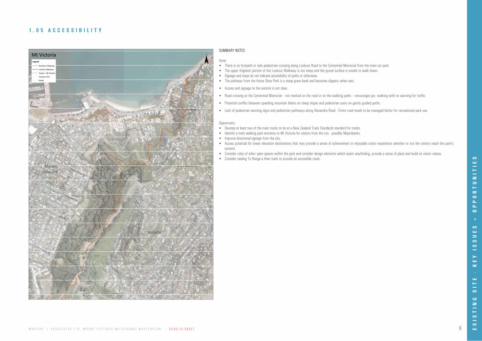
Issue • There is no footpath or safe pedestrian crossing along Lookout Road to the Centennial Memorial from the main car park. • The upper (highest) portion of the Lookout Walkway is too steep and the gravel surface is unsafe to walk down.
• Signage and maps do not indicate accessibility of paths or otherwise.• The pathway from the Horse Shoe Park is a steep grass bank and becomes slippery when wet.
• Access and signage to the summit is not clear.
• Road crossing at the Centennial Memorial – not marked on the road or on the walking paths – encourages jay- walking with no warning for traffic.
• Potential conflict between speeding mountain bikers on steep slopes and pedestrian users on gently graded paths.
• Lack of pedestrian warning signs and pedestrian pathways along Alexandra Road - Entire road needs to be managed better for recreational park use.
Opportunity• Develop at least two of the main tracks to be at a New Zealand Track Standards standard for tracks.• Identify a main walking park entrance to Mt Victoria for visitors from the city - possibly Majoribanks.• Improve directional signage from the city. • Access potential for lower elevation destinations that may provide a sense of achievement or enjoyable visitor experience whether or not the visitors reach the park’s
summit.• Consider roles of other open spaces within the park and consider design elements which assist wayfinding, provide a sense of place and build on visitor values.• Consider sealing Te Ranga a Hiwi track to provide an accessible route.
1 . 0 5 A C C E S S I B I L I T Y
SUMMARY NOTES
EX
IST
ING
SIT
E -
KE
Y I
SS
UE
S +
OP
PO
RT
UN
ITIE
S
10 W R A I G H T + A S S O C I A T E S L T D , M O U N T V I C T O R I A - M A T A I R A N G I M A S T E R P L A N - : 1 6 / 0 2 / 1 5 - D R A F T
!e
!e!e!e
!e
!e
!e
!e
!e
!e
!e
!e!e !e!e!e
!e
!e
!e
!e!e
!e
!e
!e
!e
!e
!e
!e
!e!e
!e
!e
!e
!e!e
!e
!e
!e!e
!e
!e
!e
!e
!e
!e
!e
!e!e!e
!e!e!e!e!e!e!e
!e
!e
!e
!e
!e
!e
!e
!e
!e
!e
!e!e
!e
!e
!e!e
!e
!e
!e!e
!e
!e!e
!e
!e!e
!e
!e
!e!e
!e
!e
!e!e!e
!e
!e!e
!e
!e
!e
!e
0 100 200 300 40050Meters
¨Legend
!e Signage
Southern Walkway! ! ! ! Tracks - Mt Victoria
Hataitai
MountVictoria
Majoribanks St
Pirie St
Elizabeth St
Ellice St
Hatait
ai Rd
Alex
andr
a Rd
MountAlfred
Mt Victoria - Wayfinding + Signage
Mt Victoria Lookout
Centennial Memorial
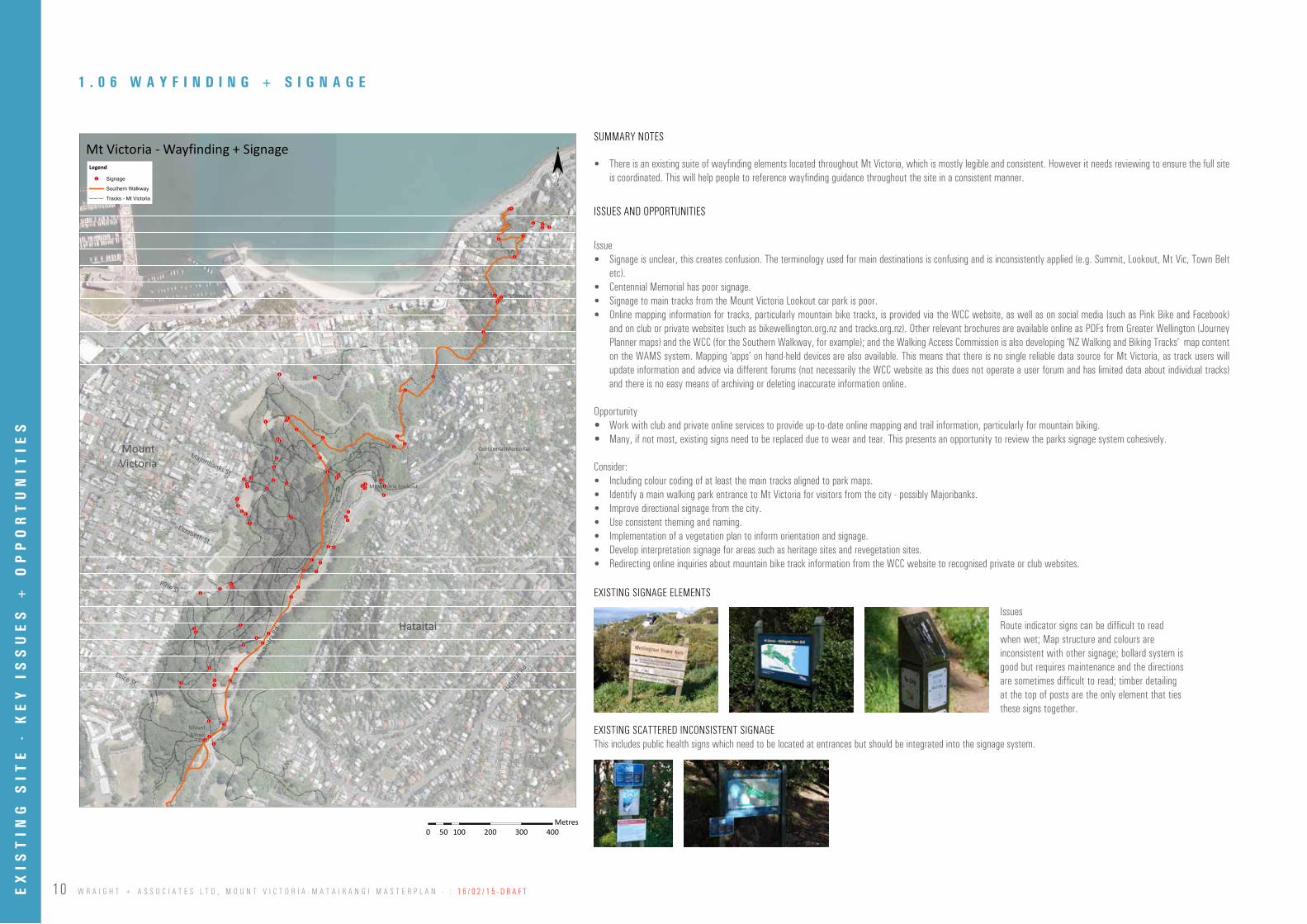
SUMMARY NOTES
• There is an existing suite of wayfinding elements located throughout Mt Victoria, which is mostly legible and consistent. However it needs reviewing to ensure the full site is coordinated. This will help people to reference wayfinding guidance throughout the site in a consistent manner.
ISSUES AND OPPORTUNITIES
Issue• Signage is unclear, this creates confusion. The terminology used for main destinations is confusing and is inconsistently applied (e.g. Summit, Lookout, Mt Vic, Town Belt
etc).• Centennial Memorial has poor signage.• Signage to main tracks from the Mount Victoria Lookout car park is poor.• Online mapping information for tracks, particularly mountain bike tracks, is provided via the WCC website, as well as on social media (such as Pink Bike and Facebook)
and on club or private websites (such as bikewellington.org.nz and tracks.org.nz). Other relevant brochures are available online as PDFs from Greater Wellington (Journey Planner maps) and the WCC (for the Southern Walkway, for example); and the Walking Access Commission is also developing ‘NZ Walking and Biking Tracks’ map content on the WAMS system. Mapping ‘apps’ on hand-held devices are also available. This means that there is no single reliable data source for Mt Victoria, as track users will update information and advice via different forums (not necessarily the WCC website as this does not operate a user forum and has limited data about individual tracks) and there is no easy means of archiving or deleting inaccurate information online.
Opportunity • Work with club and private online services to provide up-to-date online mapping and trail information, particularly for mountain biking. • Many, if not most, existing signs need to be replaced due to wear and tear. This presents an opportunity to review the parks signage system cohesively.
Consider:• Including colour coding of at least the main tracks aligned to park maps.• Identify a main walking park entrance to Mt Victoria for visitors from the city - possibly Majoribanks.• Improve directional signage from the city. • Use consistent theming and naming. • Implementation of a vegetation plan to inform orientation and signage.• Develop interpretation signage for areas such as heritage sites and revegetation sites.• Redirecting online inquiries about mountain bike track information from the WCC website to recognised private or club websites.
EXISTING SIGNAGE ELEMENTS
EXISTING SCATTERED INCONSISTENT SIGNAGEThis includes public health signs which need to be located at entrances but should be integrated into the signage system.
1 . 0 6 W A Y F I N D I N G + S I G N A G E
0 100 200 300 40050Meters
¨Legend
Hataitai
MountVictoria
Majoribanks St
Pirie St
Elizabeth St
Ellice StHata
itai R
d
Alex
andr
a Rd
Mt Victoria - Vegetation Risk Levels
0 100 200 300 40050Metres
IssuesRoute indicator signs can be difficult to read when wet; Map structure and colours are inconsistent with other signage; bollard system is good but requires maintenance and the directions are sometimes difficult to read; timber detailing at the top of posts are the only element that ties these signs together.
EX
IST
ING
SIT
E -
KE
Y I
SS
UE
S +
OP
PO
RT
UN
ITIE
S
11W R A I G H T + A S S O C I A T E S L T D , M O U N T V I C T O R I A - M A T A I R A N G I M A S T E R P L A N - : 1 6 / 0 2 / 1 5 - D R A F T
0 100 200 300 40050Meters
¨Legend
Te Ranga a Hiwi
Southern Walkway
Lookout Walkway! ! ! ! Tracks - Mt Victoria
Contours 5m
Kerbs
Hataitai
MountVictoria
Majoribanks St
Pirie St
Elizabeth St
Ellice St
Hatait
ai Rd
Alex
andr
a Rd
Mt Victoria
Mt Victoria Lookout
Centennial Memorial
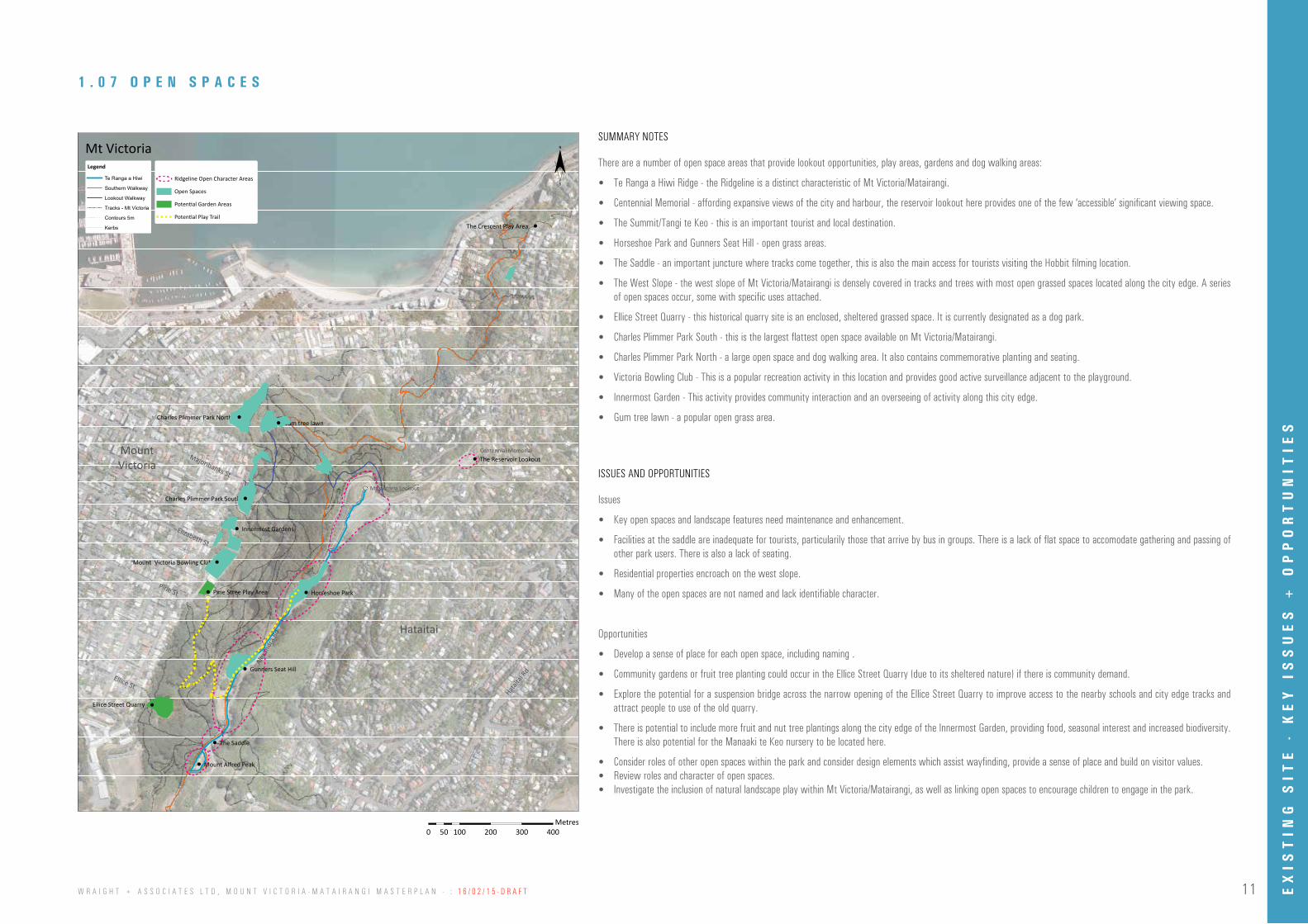
There are a number of open space areas that provide lookout opportunities, play areas, gardens and dog walking areas:
• Te Ranga a Hiwi Ridge - the Ridgeline is a distinct characteristic of Mt Victoria/Matairangi.
• Centennial Memorial - affording expansive views of the city and harbour, the reservoir lookout here provides one of the few ‘accessible’ significant viewing space.
• The Summit/Tangi te Keo - this is an important tourist and local destination.
• Horseshoe Park and Gunners Seat Hill - open grass areas.
• The Saddle - an important juncture where tracks come together, this is also the main access for tourists visiting the Hobbit filming location.
• The West Slope - the west slope of Mt Victoria/Matairangi is densely covered in tracks and trees with most open grassed spaces located along the city edge. A series of open spaces occur, some with specific uses attached.
• Ellice Street Quarry - this historical quarry site is an enclosed, sheltered grassed space. It is currently designated as a dog park.
• Charles Plimmer Park South - this is the largest flattest open space available on Mt Victoria/Matairangi.
• Charles Plimmer Park North - a large open space and dog walking area. It also contains commemorative planting and seating.
• Victoria Bowling Club - This is a popular recreation activity in this location and provides good active surveillance adjacent to the playground.
• Innermost Garden - This activity provides community interaction and an overseeing of activity along this city edge.
• Gum tree lawn - a popular open grass area.
Issues
• Key open spaces and landscape features need maintenance and enhancement.
• Facilities at the saddle are inadequate for tourists, particularily those that arrive by bus in groups. There is a lack of flat space to accomodate gathering and passing of other park users. There is also a lack of seating.
• Residential properties encroach on the west slope.
• Many of the open spaces are not named and lack identifiable character.
Opportunities
• Develop a sense of place for each open space, including naming .
• Community gardens or fruit tree planting could occur in the Ellice Street Quarry (due to its sheltered nature) if there is community demand.
• Explore the potential for a suspension bridge across the narrow opening of the Ellice Street Quarry to improve access to the nearby schools and city edge tracks and attract people to use of the old quarry.
• There is potential to include more fruit and nut tree plantings along the city edge of the Innermost Garden, providing food, seasonal interest and increased biodiversity. There is also potential for the Manaaki te Keo nursery to be located here.
• Consider roles of other open spaces within the park and consider design elements which assist wayfinding, provide a sense of place and build on visitor values.• Review roles and character of open spaces.• Investigate the inclusion of natural landscape play within Mt Victoria/Matairangi, as well as linking open spaces to encourage children to engage in the park.
Gunners Seat Hill
Horseshoe Park
Gum tree lawn
The Reservoir Lookout
Charles Plimmer Park South
Mount Victoria Bowling Club
Ellice Street Quarry
Innermost Gardens
Charles Plimmer Park North
The Crescent Play Area
The Saddle
Mount Alfred Peak
0 100 200 300 40050Meters
¨Legend
Hataitai
MountVictoria
Majoribanks St
Pirie St
Elizabeth St
Ellice StHata
itai R
d
Alex
andr
a Rd
Mt Victoria - Vegetation Risk Levels
0 100 200 300 40050Metres
1 . 0 7 O P E N S P A C E S
SUMMARY NOTES
ISSUES AND OPPORTUNITIES
Ridgeline Open Character Areas
Open Spaces
Potential Garden Areas
Potential Play Trail
Pirie Stree Play Area
EX
IST
ING
SIT
E -
KE
Y I
SS
UE
S +
OP
PO
RT
UN
ITIE
S

12 W R A I G H T + A S S O C I A T E S L T D , M O U N T V I C T O R I A - M A T A I R A N G I M A S T E R P L A N - : 1 6 / 0 2 / 1 5 - D R A F T
0 100 200 300 40050Meters
¨Legend
Hataitai
MountVictoria
Majoribanks St
Pirie St
Elizabeth St
Ellice St
Hataita
i Rd
Alex
andr
a Rd
Mt Victoria - Vegetation Risk Levels
0 100 200 300 40050Metres
0 100 200 300 40050Meters
¨Legend
Hataitai
MountVictoria
Majoribanks St
Pirie St
Elizabeth St
Ellice StHata
itai R
d
Alex
andr
a Rd
Mt Victoria - Vegetation Risk Levels
0 100 200 300 40050Metres
1 . 0 8 H I S T O R I C A L M A P O V E R L A Y S
Quarry
Historical Track
Historical Pine Plantation
EX
IST
ING
SIT
E -
KE
Y I
SS
UE
S +
OP
PO
RT
UN
ITIE
S

13W R A I G H T + A S S O C I A T E S L T D , M O U N T V I C T O R I A - M A T A I R A N G I M A S T E R P L A N - : 1 6 / 0 2 / 1 5 - D R A F T
1 . 0 9 C U L T U R A L S I G N I F I C A N C E
0 100 200 300 40050Meters
¨Legend
Te Ranga a Hiwi! ! ! ! Tracks - Mt Victoria
Hataitai
MountVictoria
Majoribanks St
Pirie St
Elizabeth St
Ellice St
Hatait
ai Rd
Alex
andr
a Rd
MountAlfred
Mt Victoria - Cultural Tracks + Walkways
Mt Victoria Lookout
Centennial Memorial
0 100 200 300 40050Meters
¨Legend
Hataitai
MountVictoria
Majoribanks St
Pirie St
Elizabeth St
Ellice StHata
itai R
d
Alex
andr
a Rd
Mt Victoria - Vegetation Risk Levels
0 100 200 300 40050Metres
MT ALFRED TE AKATAREWA PA Te Akatarewa Pa, the hill ridge of Hiwi and Mount Alfred
This site was part of, or close to Te Akatarewa Pa, an old
stockaded village inhabited by Ngai Tara. The pa was
built here because it is one of the higher points of this
ridgeline, which was known in pre-European times as
Te Ranga a Hiwi – the hill ridge of Hiwi. Hiwi, who lived
in the Akatarewa Pa, was the son of Hine-Kiri, a famous
chieftainess of Ngati-Hinewai, hapu of Ngai–Tara.
The ridgeline, Te Ranga a Hiwi, comprised a series of
significant sites and was seen as a defensive line through
the area particularly to Ngai Tara. A series of pa or forts
extended from Point Jerningham near the site of Waihirere
Pa through Te Akatarewa Pa and out to Uruhau Pa
(Island Bay) and Haewai (Houghton Bay).
Te Akatarewa Pa and Mt Alfred
ORIENTAL BAY
MATAIRANGI/MT VICTORIA
TE R
ANGI
A H
IWI–
SOUT
HER
N W
ALKW
AY
HMS Galatea in Wellington Harbour1869 or 1870Photographer: William James Harding Alexander Turnbull Library W J Harding Collection
YOU ARE HERE
This peak was later named
Mount Alfred after Prince
Alfred, the second son of Queen
Victoria and Prince Albert.
Prince Alfred pursued a military
career and became captain of
the frigate HMS Galatea in 1866.
He was also created Duke of
Edinburgh in the same year.
He became the first member
of the Royal Family to visit
New Zealand, arriving in 1869
on HMS Galatea.
EXISTING TE AKATAREWA PA - MT ALFRED TABLE INFOGRAPHIC
SUMMARY NOTES
There are three inter-related cultural concepts associated with Mt Victoria/Matairangi:
Te Upoku o te Ika a Maui• Means the head of the fish of Maui (associated with the legend of ‘The Fish of Maui’) and the pulling up of the North Island of New Zealand from the Pacific Ocean.
Tangi te Keo - Ngake/Whaitaitai• Maori tradition has it that Wellington Harbour was occupied by two taniwha, Ngake and Whataitai. In their time the harbour was a lake blocked from the ocean and Ngake
wanted to escape to the open ocean. He crashed out to form the channel known as Te Au a Tane, the present channel into Wellington harbour. When Whataitai tried to follow suit through the area where Kilbirnie now is, he failed and became stranded and instead the area uplifted leaving Whataitai high and dry. He then transformed into a manuwairua called Te Keo or a spirit bird. Te Keo alighted on the lesser peak next to Matairangi/Mt Victoria. The other peak became known Tangi Te Keo or the cry of Keo (WTBMP2013).
Te Ranga a Hiwi Ridge• Within the precinct are two outstanding sites - Tangi Te Keo (or Matairangi) and Te Akatarewa Pa (MVRDC-2004).
Note:Matairangi means ‘to examine the sky’Te Akatarewa Pa - was formerly home of Ngai Tara.
ISSUES AND OPPORTUNITIES
Issue• Te Ranga a Hiwi pathway is not clearly identified for walkers
Opportunity • Improve Mt Alfred to Mt Victoria Lookout journey to reflect the Te Ranga a Hiwi walkway.• Retain infographic on Mt Alfred and incorporate one at the Mt Victoria Lookout (if there is not one already) in order to connect the two locations.• Develop relevant sections of the Summit Walkway and the Southern Walkway to a higher standard recognising the value of Te Ranga a Hiwi.
Te Akatarewa Pa / Mount Alfred
Matairangi / Tangi te Keo
EX
IST
ING
SIT
E -
KE
Y I
SS
UE
S +
OP
PO
RT
UN
ITIE
S

14 W R A I G H T + A S S O C I A T E S L T D , M O U N T V I C T O R I A - M A T A I R A N G I M A S T E R P L A N - : 1 6 / 0 2 / 1 5 - D R A F T
0 100 200 300 40050Meters
¨Legend
Other
Native and Exotic Scrubland
Managed Grassland
Logged
Conifer Pinus Radiata Dominant
Eucalyptus Stands
Eucalyptus Stands/Advanced Regenerated Native Forest
Pohutukawa Stands
Revegetation
Conifer Mixed Species
Conifer Macrocarpa Dominant
Natives Planted After Logging
Advanced Regenerated Native Forest
Advanced Regenerated Native Forest/Pohutukawa Stands
Contours 5m
Hataitai
MountVictoria
Majoribanks St
Pirie St
Elizabeth St
Ellice St
Hatait
ai Rd
Alex
andr
a Rd
Mt Victoria - Vegetation Types
Mt Victoria Lookout
Centennial Memorial
0 100 200 300 40050Meters
¨Legend
Hataitai
MountVictoria
Majoribanks St
Pirie St
Elizabeth St
Ellice StHata
itai R
d
Alex
andr
a Rd
Mt Victoria - Vegetation Risk Levels
0 100 200 300 40050Metres
1 . 1 0 V E G E T A T I O N T Y P E S
The green hill of Mt Victoria/Matairangi is a significant landscape feature in Wellington. Looking east from the city, the tree covered hill forms an important backdrop to the residential neighbourhoods of Mt Victoria and Oriental Bay with Wellington’s waterfront and/or city in the foreground. The hill provides context and character for the neighbourhoods and suburbs that surround it. Many local streets terminate at the park’s edges, providing a visually captivating green focal point within a suburban context.
This view of Mt Victoria is highly valued, presenting a green backdrop to the city’s built urban and suburban fabric. The current vegetation is dominated by pines and macrocarpa planted in the “plantation years” from late 1800s to early 1900s. The first stand of pines were planted between Ellice Steet and Pirie street as shown in the historical map overlays on page 10 of this document.
Themes relating to pine retention or removal and native regeneration.
• Pines enhance recreational opportunities such as orienteering, as they have clear spaces underneath allowing access and views.
• The pines should be removed and replaced with native regeneration.
• Better co-ordination between the various individuals and groups who undertake revegetation is required.
• Better weed control is required particularly removal of Tradescantia.
• Revegetation programmes should aim to make Mt Victoria part of the regional ecological corridor.
• Create small spaces of seating and tables protected from the wind using native planting.
• Gentle terracing and leaving broken branches to rot naturally improves soil system and encourages biodiversity.
• Create bee corridors.
Wellington Town Belt Management Plan-June 2013. pg 232
1880 Mount Victoria cleared of vegetation (NATLIB authorisation TBC)ca1843 Mount Victoria cleared of vegetation (NATLIB authorisation TBC)
SUMMARY NOTES
KEY THEMES FROM CONSULTATION
EX
IST
ING
SIT
E -
KE
Y I
SS
UE
S +
OP
PO
RT
UN
ITIE
S
15W R A I G H T + A S S O C I A T E S L T D , M O U N T V I C T O R I A - M A T A I R A N G I M A S T E R P L A N - : 1 6 / 0 2 / 1 5 - D R A F T
0 100 200 300 40050Meters
¨Legend
Vegetation - Other
Vegetation - Null
High_Risk_and_High_Likelihood_of_failure_2014_update
Vegetation - High Risk and Low Likelihood of Failure
Vegetation - Low Risk and High Likelihood of Failure
Vegetation - Low Risk and Low Likelihood of Failure (2014 update)
Hataitai
MountVictoria
Majoribanks St
Pirie St
Elizabeth St
Ellice St
Hatait
ai Rd
Alex
andr
a Rd
Mt Victoria - Vegetation Risk Levels
Mt Victoria Lookout
Centennial Memorial
1 . 1 1 V E G E T A T I O N R I S K L E V E L S
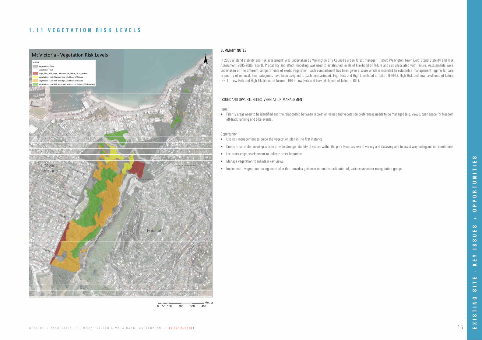
In 2005 a ‘stand stability and risk assessment’ was undertaken by Wellington City Council’s urban forest manager. (Refer: Wellington Town Belt: Stand Stability and Risk Assessment 2005-2006 report). Probability and effect modelling was used to established levels of likelihood of failure and risk associated with failure. Assessments were undertaken on the different compartments of exotic vegetation. Each compartment has been given a score which is intended to establish a management regime for care or priority of removal. Four categories have been assigned to each compartment: High Risk and High Likelihood of failure (HRHL), High Risk and Low Likelihood of failure (HRLL), Low Risk and High Likelihood of failure (LRHL), Low Risk and Low Likelihood of failure (LRLL).
Issue• Priority areas need to be identified and the relationship between recreation values and vegetation preferences needs to be managed (e.g. views, open space for freedom
off-track running and bike events).
Opportunity• Use risk management to guide the vegetation plan in the first instance.
• Create areas of dominant species to provide stronger identity of spaces within the park (keep a sense of variety and discovery and to assist wayfinding and interpretation).
• Use track edge development to indicate track hierarchy.
• Manage vegetation to maintain key views.
• Implement a vegetation management plan that provides guidance to, and co-ordination of, various volunteer revegetation groups.
SUMMARY NOTES
0 100 200 300 40050Meters
¨Legend
Hataitai
MountVictoria
Majoribanks St
Pirie St
Elizabeth St
Ellice StHata
itai R
d
Alex
andr
a Rd
Mt Victoria - Vegetation Risk Levels
0 100 200 300 40050Metres
ISSUES AND OPPORTUNITIES: VEGETATION MANAGEMENT
EX
IST
ING
SIT
E -
KE
Y I
SS
UE
S +
OP
PO
RT
UN
ITIE
S

16 W R A I G H T + A S S O C I A T E S L T D , M O U N T V I C T O R I A - M A T A I R A N G I M A S T E R P L A N - : 1 6 / 0 2 / 1 5 - D R A F T
0 100 200 300 40050Meters
¨
Hataitai
MountVictoria
Pirie St
Elizabeth St
Ellice St
Hatait
ai Rd
Alex
andr
a Rd
Mt Victoria - Vegetation Risks & Types + TracksTracks Legend
Southern Walkway
Lookout Walkway
Summit Walkway
Haitaitai to City Walkway
Haitaitai Zigzag Track
Newtown to Mt Victoria Walkway
Old Mac Track
The Dipper Track
Hobbits Hideaway Walkway
Rosamund's Track
Old Lookout Walkway
Mt Alfred Twister Track
Bombhole Track
Hay Street Extension Track
Grom Track
Damiens Track
Vegetation Risks + Types Legend
Vegetation - High Risk and High Likelihood of Failure (2014 update)
Vegetation - High Risk and Low Likelihood of Failure
Vegetation - Low Risk and High Likelihood of Failure
Vegetation - Low Risk and Low Likelihood of Failure (2014 update)
Other
Native and Exotic Scrubland
Managed Grassland
Logged
Conifer Pinus Radiata Dominant
Eucalyptus Stands
Eucalyptus Stands/Advanced Regenerated Native Forest
Pohutukawa Stands
Revegetation
Conifer Mixed Species
Conifer Macrocarpa Dominant
Natives Planted After Logging
Advanced Regenerated Native Forest
Advanced Regenerated Native Forest/Pohutukawa Stands
Tracks + General Legend
Hippies Track
V
TTS
Super D
Park Bench! ! ! ! Tracks - Mt Victoria
Contours 5m
Mt Victoria Lookout
Centennial Memorial
1 . 1 2 V E G E T A T I O N T Y P E S , R I S K L E V E L S + T R A C K S
Issue• There may be risk of injury from tree fall, unsafe branches and from dead limbs perched in trees overhanging some of the most well-used tracks. Consultation indicates
some park visitors deliberately visit Mt Victoria during high winds for shelter amongst the trees.• The current tree risk management plan does not identify hazards to visitors to Mt Victoria and therefore does not guide park managers well. For example, ‘low risk and high
likelihood of failure’ zones have, in some instances not taken into account the presence of high use tracks (and therefore an increased level of risk to park users).• Consultation does not indicate a clear preference for removing or retaining pines and macrocarpa – there are strong preferences both ways.• The park trees adjacent to the houses between Pirie and Ellis St that are identified as high risk/high likelihood of failure, are to be treated in an arboricultural way. That
is, they won’t be removed as an entire stand, but will be inspected and maintained for as long as possible. This is as a result of their identification as having heritage importance.
Opportunity• Significant dead wood and damaged branches over hanging tracks and near information signs should be removed. This work will drive the vegetation management plan. If
trees are removed, a detailed vegetation replacement plan must be in place where appropriate. • Programme regular visits by an arborist to identify risks and remedies, focusing on high use tracks.
Methodology for Physical Tree Removal
Issue• Disposal of trimmed material should be considered (options to remove or leave in habitat piles).• Temporary track closures and detours required.
Opportunity• Use felled trees to create areas for revegetation and habitats for wildlife. The rotting trees will assist the soil system (need to be felled so they are safe from rolling or
slipping onto people).• Consider using an on-site wood chipper in order to create mulch for revegetation areas where access permits.• Consider use of timber for other purposes (e.g. signage or furniture).
ISSUES AND OPPORTUNITIES
SITE PHOTOS
0 100 200 300 40050Meters
¨Legend
Hataitai
MountVictoria
Majoribanks St
Pirie St
Elizabeth St
Ellice StHata
itai R
d
Alex
andr
a Rd
Mt Victoria - Vegetation Risk Levels
0 100 200 300 40050Metres
EX
IST
ING
SIT
E -
KE
Y I
SS
UE
S +
OP
PO
RT
UN
ITIE
S
17W R A I G H T + A S S O C I A T E S L T D , M O U N T V I C T O R I A - M A T A I R A N G I M A S T E R P L A N - : 1 6 / 0 2 / 1 5 - D R A F T
1 . 1 3 R E V E G E T A T I O N A R E A S
SUMMARY NOTES
HISTORICAL STREAMS (refer to map on the following page)
TOPOGRAPHY (refer to map on the following page)
Revegetation of areas in native species is currently occurring in a number of ways by a number of different groups. This includes: WCC planned revegetation of areas where weed or trees are being removed; community groups including the Rotary Club (City to Summit plan) and Manaaki Te Keo (a community based project to realise Wellington Rotary Club’s ‘City to Summit plan); and individuals. These community groups and individuals have the shared objectives of improving ecological values and scenic quality whilst fostering a sense of community. WCC support these ‘Re-vegers’ through supply of plant material, weed clearance/control and co-ordination of planting days by the Park Rangers. This community resource is invaluable. The vegetation management plan will provide guidance to and co-ordination of various revegetation groups and individuals. The Wellington Town Belt Management Plan has established the following guiding principles for community participation:
“The Council will encourage and support community participation in the management of the Town Belt. This recognises that Wellingtonians will have an ongoing role in the management of the Town Belt. The Council values community input and acknowledges the work of individuals and groups to protect, enhance and use the Town Belt. The Council will support and encourage community participation, which underpins long-term sustainability.”
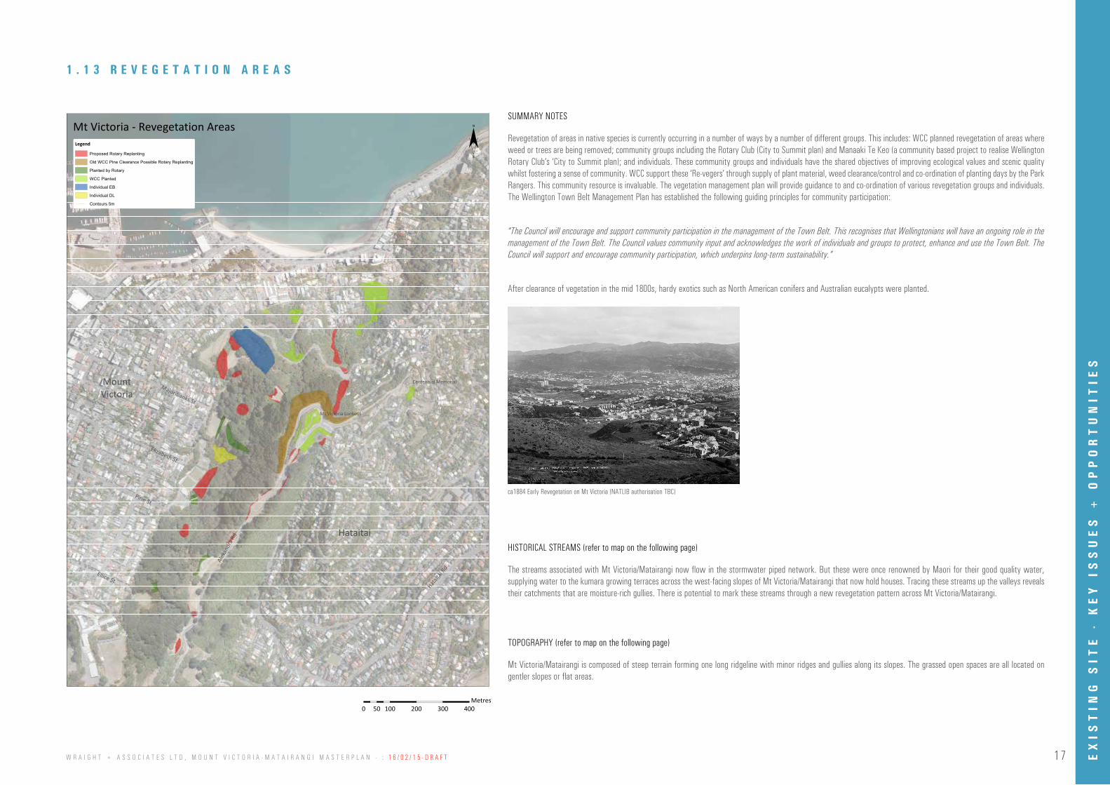
After clearance of vegetation in the mid 1800s, hardy exotics such as North American conifers and Australian eucalypts were planted.
The streams associated with Mt Victoria/Matairangi now flow in the stormwater piped network. But these were once renowned by Maori for their good quality water, supplying water to the kumara growing terraces across the west-facing slopes of Mt Victoria/Matairangi that now hold houses. Tracing these streams up the valleys reveals their catchments that are moisture-rich gullies. There is potential to mark these streams through a new revegetation pattern across Mt Victoria/Matairangi.
Mt Victoria/Matairangi is composed of steep terrain forming one long ridgeline with minor ridges and gullies along its slopes. The grassed open spaces are all located on gentler slopes or flat areas.
0 100 200 300 40050Meters
¨Legend
Proposed Rotary Replanting
Old WCC Pine Clearance Possible Rotary Replanting
Planted by Rotary
WCC Planted
Individual EB
Individual DL
Contours 5m
Hataitai
MountVictoria
Majoribanks St
Pirie St
Elizabeth St
Ellice St
Hatait
ai Rd
Alex
andr
a Rd
Mt Victoria - Revegetation Areas
Mt Victoria Lookout
Centennial Memorial
0 100 200 300 40050Meters
¨Legend
Hataitai
MountVictoria
Majoribanks St
Pirie St
Elizabeth St
Ellice StHata
itai R
d
Alex
andr
a Rd
Mt Victoria - Vegetation Risk Levels
0 100 200 300 40050Metres
ca1884 Early Revegetation on Mt Victoria (NATLIB authorisation TBC)
EX
IST
ING
SIT
E -
KE
Y I
SS
UE
S +
OP
PO
RT
UN
ITIE
S

18 W R A I G H T + A S S O C I A T E S L T D , M O U N T V I C T O R I A - M A T A I R A N G I M A S T E R P L A N - : 1 6 / 0 2 / 1 5 - D R A F T
0 100 200 300 40050Meters
¨Legend
Historical Streams
Contours 5m
Hataitai
MountVictoria
Majoribanks St
Pirie St
Elizabeth St
Ellice St
Hatait
ai Rd
Alex
andr
a Rd
Mt Victoria - Topography + Historical Streams
Mt Victoria Lookout
Centennial Memorial
0 100 200 300 40050Meters
¨Legend
Hataitai
MountVictoria
Majoribanks St
Pirie St
Elizabeth St
Ellice St
Hataita
i Rd
Alex
andr
a Rd
Mt Victoria - Vegetation Risk Levels
0 100 200 300 40050Metres
1 . 1 5 T O P O G R A P H Y + H I S T O R I C A L S T R E A M S
0 100 200 300 40050Meters
¨Legend
Managed Horticultural Planting
Revegetation Areas (Current + Proposed)
Other
Native and Exotic Scrubland
Managed Grassland
Logged
Conifer Pinus Radiata Dominant
Eucalyptus Stands
Eucalyptus Stands/Advanced Regenerated Native Forest
Pohutukawa Stands
Revegetation
Conifer Mixed Species
Conifer Macrocarpa Dominant
Natives Planted After Logging
Advanced Regenerated Native Forest
Advanced Regenerated Native Forest/Pohutukawa Stands
Contours 5m
Hataitai
MountVictoria
Majoribanks St
Pirie St
Elizabeth St
Ellice St
Hatait
ai Rd
Alex
andr
a Rd
Mt Victoria - Revegetation Areas + Vegetation Types
Mt Victoria Lookout
Centennial Memorial
0 100 200 300 40050Meters
¨Legend
Hataitai
MountVictoria
Majoribanks St
Pirie St
Elizabeth St
Ellice StHata
itai R
d
Alex
andr
a Rd
Mt Victoria - Vegetation Risk Levels
0 100 200 300 40050Metres
1 . 1 4 R E V E G E T A T I O N A R E A S + V E G E T A T I O N T Y P E S
EX
IST
ING
SIT
E -
KE
Y I
SS
UE
S +
OP
PO
RT
UN
ITIE
S