draft revised land and resource management plan
TRANSCRIPT
United States Department of Agriculture
Lincoln National Forest Land and Resource Management Plan Preliminary Draft Chaves, Eddy, Lincoln, and Otero Counties, New Mexico
Forest Service Lincoln National Forest May, 2019

In accordance with Federal civil rights law and U.S. Department of Agriculture (USDA) civil rights regulations and policies, the USDA, its Agencies, offices, and employees, and institutions participating in or administering USDA programs are prohibited from discriminating based on race, color, national origin, religion, sex, gender identity (including gender expression), sexual orientation, disability, age, marital status, family/parental status, income derived from a public assistance program, political beliefs, or reprisal or retaliation for prior civil rights activity, in any program or activity conducted or funded by USDA (not all bases apply to all programs). Remedies and complaint filing deadlines vary by program or incident.
Persons with disabilities who require alternative means of communication for program information (e.g., Braille, large print, audiotape, American Sign Language, etc.) should contact the responsible Agency or USDA’s TARGET Center at (202) 720-2600 (voice and TTY) or contact USDA through the Federal Relay Service at (800) 877-8339. Additionally, program information may be made available in languages other than English.
To file a program discrimination complaint, complete the USDA Program Discrimination Complaint Form, AD-3027, found online at http://www.ascr.usda.gov/complaint_filing_cust.html and at any USDA office or write a letter addressed to USDA and provide in the letter all of the information requested in the form. To request a copy of the complaint form, call (866) 632-9992. Submit your completed form or letter to USDA by: (1) mail: U.S. Department of Agriculture, Office of the Assistant Secretary for Civil Rights, 1400 Independence Avenue, SW, Washington, D.C. 20250-9410; (2) fax: (202) 690-7442; or (3) email: [email protected].
USDA is an equal opportunity provider, employer and lender.
Lincoln National Forest Land and Resource Management Plan
Preliminary Draft
Chaves, Eddy, Lincoln and Otero Counties, New Mexico
Responsible Official: Travis Moseley, Forest Supervisor Lincoln National Forest 3463 Las Palomas Road Alamogordo, NM 88310
For Additional Information: Diane Prather, Forest Planner Lincoln National Forest 3463 Las Palomas Road Alamogordo, NM 88310 575-434-7237
Land and Resource Management Plan – Preliminary Draft
Lincoln National Forest i
Acronyms AML appropriate management level AOI annual operating instructions APHIS Animal and Plant Health Inspection
Service BLM Bureau of Land Management BMP best management practice CEQ Council on Environmental Quality CFR Code of Federal Regulations CFRP Collaborative Forest Restoration
Program CRMP Comprehensive river management plan CPLC Court of Private Land Claims CSU controlled surface use CWD coarse woody debris CWPP County Wildfire Protection Plan dbh diameter at breast height DOI Department of Interior EPA Environmental Protection Agency ERU ecological response unit ESA Endangered Species Act FSH Forest Service Handbook HFRA Healthy Forest Restoration Act HUC Hydrologic Unit Code IPM integrated pest management MDP master development plan (ski areas) MIST minimum impact suppression
techniques ML maintenance level MMCF million cubic feet MOU memorandum of understanding MVUM motor vehicle use map NAAQS national ambient air quality standards NAGPRA Native American Graves Protection and
Repatriation Act NEPA National Environmental Policy Act NF National Forest NFMA National Forest Management Act
NFS National Forest System NHL National Historic Landmark NHPA National Historic Preservation Act NM New Mexico NMAAQS New Mexico ambient air quality
standards NMDA New Mexico Department of
Agriculture NMDGF New Mexico Department of Game and
Fish NMED New Mexico Environment Department NMED-AQB New Mexico Environment
Department, Air Quality Bureau NPS National Park Service NRHP National Register of Historic Places NRV natural range of variation NSO no surface occupancy OHV off-highway vehicle PM particulate matter RAM rapid assessment methodology RD Ranger District RGCT Rio Grande cutthroat trout RMZ Riparian Management Zone ROS recreation opportunity spectrum SCC species of conservation concern SMS Scenic Management System TCP traditional cultural properties TES Terrestrial Ecosystem Survey TEU terrestrial ecosystem unit TMDL total maximum daily load USDA United States Department of
Agriculture USDI United States Department of Interior USFWS United States Fish and Wildlife Service WCF Watershed Condition Framework WNS white-nose syndrome WUI wildland-urban interface

Land and Resource Management Plan – Preliminary Draft
Lincoln National Forest iii
Table of Contents Acronyms ......................................................................................................................................... i
Forest Plan Organization .............................................................................................................. 5 Chapter 1: Introduction ........................................................................................................... 6
Forest Plan Components ......................................................................................................... 15 Other Required Forest Plan Content ....................................................................................... 17 Best Available Scientific Information Applied in Developing the Forest Plan ......................... 17 Public Participation in the Forest Plan .................................................................................... 17 Forest Plan Implementation .................................................................................................... 17 Interrelationships of Forest Plan Content ................................................................................ 18 Consistency of Projects with the Forest Plan ........................................................................... 18 Adaptive Planning and Monitoring ......................................................................................... 20 Transition in the Implementation of the Revised Forest Plan ................................................... 21
Chapter 2: Forest-wide Plan Components ............................................................................. 22 Introduction ........................................................................................................................... 22 Collaboration, Partnerships, and Relationships ....................................................................... 22 Vegetation – Ecological Response Units (ERUs) .................................................................... 23 Riparian Areas ....................................................................................................................... 50 Soils ....................................................................................................................................... 54 Water Resources .................................................................................................................... 57 Wildlife, Fish and Plants ........................................................................................................ 60 Air ......................................................................................................................................... 69 Fire/Fuels ............................................................................................................................... 72 Cultural and Historic Resources and Tribal Uses .................................................................... 74 Forest Products and Timber Suitability ................................................................................... 77 Range ..................................................................................................................................... 80 Recreation .............................................................................................................................. 83 Developed Recreation ............................................................................................................ 85 Dispersed Recreation .............................................................................................................. 86 Recreation Special Uses ......................................................................................................... 88 Roads ..................................................................................................................................... 89 Facilities ................................................................................................................................ 91 Lands ..................................................................................................................................... 93 Lands Special Uses ................................................................................................................ 94 Minerals and Mining .............................................................................................................. 96 Leasable Mineral Resources ................................................................................................ 97 Saleable Mineral Resources ................................................................................................. 97 Non-Commercial Mineral Collection Activity ..................................................................... 98 Transmission Corridors ....................................................................................................... 98 Scenery .................................................................................................................................. 99
Chapter 3: Management Area and Designated Area Plan Direction .................................. 103 Management Areas............................................................................................................... 103 Recommend Wilderness Management Area .......................................................................... 103 Eligible Wild and Scenic Rivers Management Area .............................................................. 105 Designated Areas ................................................................................................................. 107 Wilderness and Wilderness Study Areas ............................................................................... 107 Inventoried Roadless Areas (IRAs) ....................................................................................... 110 Research Natural Areas ........................................................................................................ 111 National Recreation Trails .................................................................................................... 115 Scenic Byways ..................................................................................................................... 118
Land and Resource Management Plan – Preliminary Draft
Lincoln National Forest iv
Significant Caves ................................................................................................................. 120 Chapter 4: Lincoln National Forest Plan Monitoring Plan ............................................................ 122 Glossary ...................................................................................................................................... 123 References ................................................................................................................................... 145 Appendix XX: Proposed Probable and Possible Future Actions .................................................... 146 Appendix XX: Relevant Laws, Regulations, and Policy ............................................................... 146
Federal and State Statutes ........................................................................................................ 146 Executive Orders ..................................................................................................................... 160 Forest Service Directives ......................................................................................................... 163 State and Local Laws and Regulations ..................................................................................... 166 Code of Federal Regulations (CFR) ......................................................................................... 166 Programmatic Agreements ....................................................................................................... 170
List of Tables (In Progress)
List of Figures (In Progress)
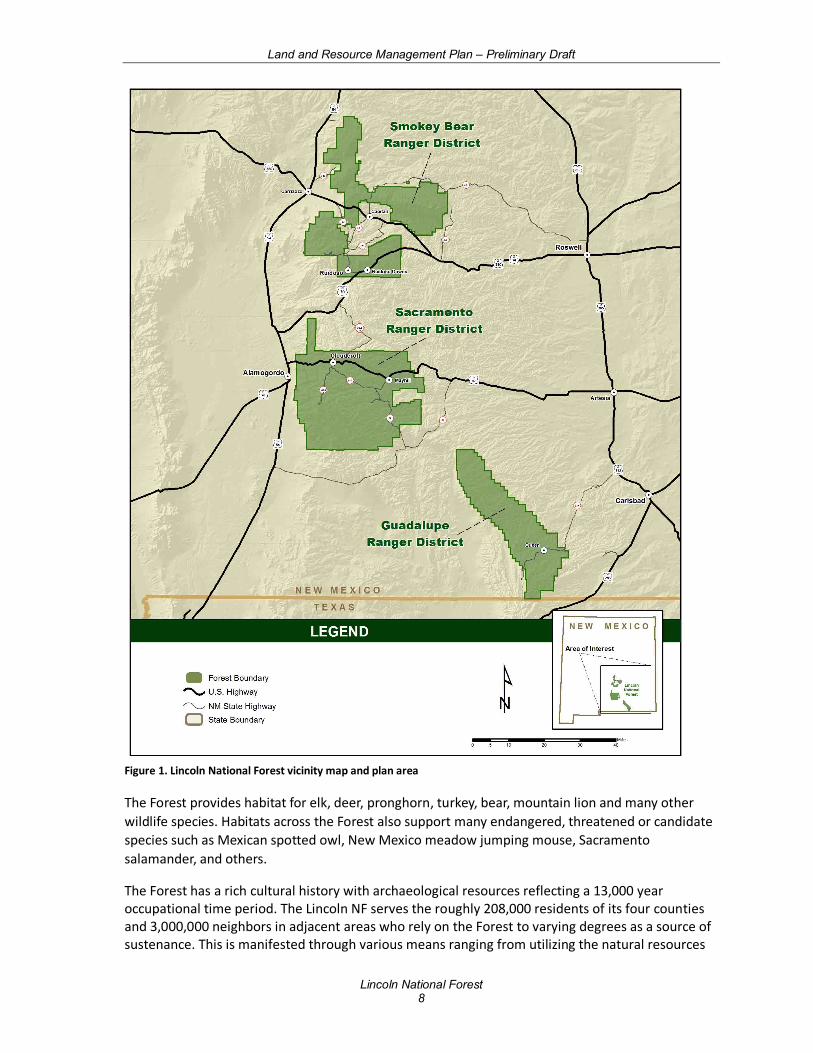
Figure 1. Lincoln National Forest vicinity map and plan area ........................................................... 8
Land and Resource Management Plan – Preliminary Draft
Lincoln National Forest 5
Forest Plan Organization Chapter 1. Introduction describes the purpose of the forest plan, introduces the plan area and its context, describes the need for changing the forest plan and the themes of the new forest plan, explains the contents and concepts of the forest plan, and describes how the forest plan is implemented. Chapter 2. Forest-wide Plan Components includes forest-wide desired conditions, objectives, standards, and guidelines and is presented all as one unified approach with ecological resources and socioeconomic resources. Standards and guidelines are typically located in the relevant activity section of the plan, but when standards or guidelines pertain to multiple activities, they may be located in only one of the applicable resource sections. Chapter 3. Designated Areas and Management Areas contains the plan components applicable to specific areas that call for site-specific management. This chapter is divided into two sections: “Designated Areas” (DAs) and “Management Areas” (MAs). Designated areas are mostly designated by statute, but some categories may be established administratively through the Federal executive branch. Plan components for a designated area may differ from forest-wide guidance and must provide for appropriate management of the designated area, based on the applicable authorities and the specific purposes for which the area was designated or recommended for designation. Management areas are used to describe how plan components apply to specific parcels of NFS land. A management area represents a management emphasis for an area or several similar areas on the landscape. Plan components for a management area may differ from forest-wide guidance by: Constraining an activity where forest-wide direction does not;
1. Constraining an activity to a greater degree than forest-wide direction; or
2. Providing for an exception to forest-wide direction, when forest-wide direction is in conflict with the management emphasis of the management area.
Forest-wide plan components are applied, unless there is management direction for a designated area or management area.
Chapter 4. Geographic Areas Geographic areas help define nuances in forest-wide desired conditions that may differ slightly across the geographic areas of the Lincoln NF or be similar among two or more geographic areas. These desired conditions can also reflect more localized priorities within these smaller scale areas.
Chapter 5. Forest Plan Monitoring Program outlines the monitoring and evaluation of plan implementation that is used to determine progress toward achieving desired conditions and objectives and how well management requirements, such as standards and guidelines, are being applied. The monitoring strategy provides a framework for subsequent monitoring and evaluation designed to inform adaptive management.
Several appendices provide additional information: In Progress
• Appendix A: Maps
• Appendix B: XXX
Land and Resource Management Plan – Preliminary Draft
Lincoln National Forest 6
Chapter 1: Introduction Purpose of the Forest Plan Every national forest managed by the Forest Service is required to have a forest plan that is consistent with the National Forest Management Act (NFMA)1 of 1976 and other laws. The NFMA directs that forest plans be revised on a 10- to 15-year cycle. Thirty years have passed since the Regional Forester approved the original Lincoln National Forest Plan in September 1986 (USDA 1986). In that time, the forest plan was amended 16 times. Scientific information, circumstances, agency and public understanding, as well as economic, social, and ecological conditions, have changed or evolved over the past 30 years and, as a result, management emphasis has shifted from outputs to outcomes. Forest plans are one of three levels of planning and decision-making that guide how NFS lands are managed.
The first and broadest level of planning occurs at the national level through the United States Department of Agriculture Forest Service Strategic Plan, a 5-year plan that allows public transparency of the agencies goals, objectives, and accomplishments. The second level of planning occurs at the level of National Forest System administrative units through forest plans. The third level of planning includes development of on-the-ground projects and activities, which are designed to make progress toward the desired conditions and objectives of the forest plan. Projects and activities must be consistent with the forest plan.
The forest plan guides the Lincoln NF in fulfilling its stewardship responsibilities to best meet the current and future needs of the American people. This plan provides forest-specific guidance and information for project and activity decision-making over the plan period, generally considered to be 10-15 years. It provides the vision, strategy, and constraints that guide integrated resource management, provide for ecological sustainability, and contribute to social and economic sustainability on the Lincoln NF and the broader landscape.
The forest plan does not compel any Agency action or guarantee specific outcomes. It does not prioritize projects or activities. Forest priorities fit within the framework set forth in the forest plan, but evolve and are reassessed continually by Forest leadership, in collaboration with the public. Within the constraints of this forest plan, management adapts to better achieve the vision the forest plan lays out. Decision-making is informed by feedback from monitoring that actively tests assumptions, tracks relevant conditions over time, and measures management effectiveness.
A forest plan guides and constrains Forest Service personnel, not the public. Any constraint on the public needs to be imposed by law, regulation, or through the issuance of an order by the Responsible Official under 36 CFR part 261, Subpart B. In addition to forest plans, management of NFS lands is also guided and constrained by laws, regulations, policies, practices, and procedures that are in the Forest Service Directive System. These are generally not repeated in forest plans. This forest plan is the result of a revision process conducted in accordance with the 2012 Land and Resource Management Planning Rule (36 CFR § 219) and its 2015 planning directives (FSH 1909.12).
1 See 16 U.S.C. 1604 - National Forest System Land and Resource Management Plans
Land and Resource Management Plan – Preliminary Draft
Lincoln National Forest 7
Description of the Plan Area The Lincoln National Forest (Figure 1) is a recreation destination for New Mexico residents and visitors from neighboring states, especially west Texas, and northern Mexico. The 1.1 million acre forest is located in Chaves, Eddy, Lincoln, and Otero counties in south central New Mexico. It is comprised of four major mountain ranges: Sacramento, Guadalupe, Capitan and Jicarilla Mountains, and ranges from about 4,000 to 12,000 feet. These mountain ranges provide a visual backdrop to cities and roads in the surrounding deserts and include five different life zones from Chihuahuan desert to sub-alpine forest. The Forest includes the White Mountain and Capitan Mountain Wildernesses.
People are drawn to the area for its open spaces, outdoor recreation activities, cool climate, beautiful scenery, stunning views, and spirit of the west. Known as the birthplace of Smokey Bear and backdrop to the historic Lincoln County War, the scenery is diverse including mountains with snow-capped peaks, desert canyons and mesas, pin͂on-juniper woodlands and subalpine forests, high mountain meadows, rugged canyons and escarpments, world class caves, and water play areas including Bonito Lake and Sitting Bull Falls. This spectrum of contrasts provides for sweeping, expansive views and uncrowded spaces. The variety of historic elements are rich in character and culture. Excellent wildlife viewing and hunting opportunities are found throughout the landscape. The Lincoln NF is predominately a naturally appearing landscape with vegetation shaped by recent and historic fires. Winding through various parts of the Forest, travelers enjoy viewing scenery and reliving history on scenic byways and auto tours including the Billy the Kid Scenic Byway, the road to Ski Apache, Sunspot Scenic Byway, and the Rim Road on the Guadalupe Ranger District.. These routes and several National Recreation Trails offer stunning views of the Forest and surrounding lands.
Land and Resource Management Plan – Preliminary Draft
Lincoln National Forest 8
Figure 1. Lincoln National Forest vicinity map and plan area
The Forest provides habitat for elk, deer, pronghorn, turkey, bear, mountain lion and many other wildlife species. Habitats across the Forest also support many endangered, threatened or candidate species such as Mexican spotted owl, New Mexico meadow jumping mouse, Sacramento salamander, and others.
The Forest has a rich cultural history with archaeological resources reflecting a 13,000 year occupational time period. The Lincoln NF serves the roughly 208,000 residents of its four counties and 3,000,000 neighbors in adjacent areas who rely on the Forest to varying degrees as a source of sustenance. This is manifested through various means ranging from utilizing the natural resources
Land and Resource Management Plan – Preliminary Draft
Lincoln National Forest 9
on the Forest for livelihood; creating community synergy around issues and events; offering a place for groups to commune, work, and recreate together; to providing solitude, peace, and relaxation for individuals who want to get away from the social pressures and pace of their everyday world. While ways and means may have changed over time, people enjoy all manners of activities on the Forest. Firewood gathering is an important traditional activity as many local residents still rely on wood to heat their homes during the cold winter months. Permitted livestock grazing, hunting and outfitting and guiding are also long-standing traditions. The Forest also provides outdoor recreational activities for both area residents and tourists. Forest management continues to bring communities together over issues that affect them or to foster involvement through volunteer work on their favorite part of the Forest. All of these uses help maintain social cultures and longstanding traditions. Distinctive Roles and Contributions of the Lincoln National Forest In Progress. Need for Changing the 1986 Forest Plan In Progress The Lincoln National Forest has identified 21 focus areas that need to be considered and addressed through the plan revision process in order to provide sustainable resources, goods, and services. Overall, there is a need for plan direction that is strategic and identifies desired conditions with objectives for how resources should be managed; eliminates redundancies with existing laws, regulations and policy; removes requirements to prepare additional resource plans; and that incorporates the best available scientific information (BASI) into all plan components. The following are the 21 focus areas that will be the focus of the needs for change during plan revision.
Monitoring. The purpose of monitoring and evaluation is to determine if forest management is meeting conditions and objectives laid out by the forest plan. However, the type and scale of monitoring in the current plan does not always answer those questions. Monitoring is a critical element of adaptive management. Monitoring questions need to be relevant to plan components including desired conditions, standards, guidelines, suitability and other strategic goals of the revised forest plan. In addition, monitoring at appropriate scales is needed, including using available information from beyond the Lincoln National Forest boundary to compare resource on the Forest with their status on a larger context scale.
•There is a need for monitoring plans that track progress toward desired conditions and allows for responsive adaptive management with available resources.
•There is a need for monitoring questions and associated indicators that look at the status of resources at appropriate scales.
Collaboration, Partnerships, and Relationships. Relationships are a key factor that can impact the success of how the forest plan is implemented. Relationships and effective partnerships are key to the successful implementation of the forest plan that will protect the land and serve the people.
•There is a need to include management approaches will strengthen existing relationships, promote new relationships, and incorporate strategies that prioritize partnerships (e.g. local, state, and federal agencies, tribal governments, law enforcement, permittees,
Land and Resource Management Plan – Preliminary Draft
Lincoln National Forest 10
recreation and forest user groups, environmental groups, users with historic ties to the forest, and youth groups).
•There is a need for management approaches that promote seeking outside assistance in addition to working with partners and volunteers to manage resources and monitor activities.
Terrestrial Ecosystems. Fire exclusion and past management activities have led to higher stand densities (trees and shrubs per acre), these stands are more prone to atypical wildfires, there is a loss of grass and forb diversity, and an overall reduction in herbaceous cover. Insects and diseases are another factor affecting terrestrial ecosystems on the forest. Mistletoes, both true and dwarf, are common, to the extent that the Forest has the highest level of infestation of all forests in the region. The loss of native grasses can result in decreased soil productivity. Increases in bare soil can lead to the increased chance of noxious weed and other non-native invasive plant infestations.
•There is a need to develop plan components that emphasize landscape-scale ecosystem restoration and resiliency through adaptive management strategies to changing environmental conditions and stressors.
•There is a need to include plan components that focus on addressing the impacts of nonnative invasive species on terrestrial and aquatic ecosystems.
•There is a need for plan components, including desired conditions and objectives, that recognize fire-adapted ecosystems, the role of fire on the landscape (including wilderness), and its use as a management tool, including planned and unplanned ignitions.
•There is need for plan direction that allows managers the flexibility to manage naturally ignited fires to meet resource objectives based on weather and site-specific conditions (for example, fuel conditions, topography, safety concerns, and values). These actions may include the use of fires, improving wildlife and range habitat, encouraging aspen regeneration, and improving watershed and overall forest health.
•There is a need to develop desired conditions (at multiple scales) for vegetation structure and composition to promote a characteristic diversity of seral states and species composition as well as meet management considerations for wildlife such as northern goshawk and Mexican spotted owl. This includes a suite of desired conditions for patch size, ecological status (composition), ground cover, coarse woody debris, and snags that characterize different ecological response units.
•There is a need to develop management objectives to meet desired conditions, and monitoring criteria to measure effectiveness of management toward meeting desired conditions.
Riparian Ecosystems. Riparian areas are where ecosystems develop from the influence of water, along streams, lakes, springs and other waterbodies. Riparian systems have been degraded and are at risk on the Forest. The loss of riparian vegetation leads to higher water temperatures, increased erosion and sedimentation, and an overall decrease in water quality which negatively affects aquatic biota and wildlife.
Land and Resource Management Plan – Preliminary Draft
Lincoln National Forest 11
•There is a need for plan components that identify appropriate riparian characteristics (e.g., biodiversity, connectivity, water availability) that promote functionality and resiliency while taking into account multiple stressors.
•There is a need to develop desired conditions for riparian areas including vegetation structure, ecological status (composition), ground cover, coarse woody debris and snags that characterize different riparian Ecological Response Units.
•There is a need for plan components that minimize ecological impacts of multiple uses in riparian areas.
•There is a need to develop more effective riparian plan monitoring criteria in order to better assess riparian conditions and trends.
Soil Resources. Satisfactory soil condition (soil quality) is important in maintaining long-term soil productivity and is key to sustaining ecological diversity. Approximately 33 percent of the Lincoln National Forest is currently in unsatisfactory and impaired soil condition. In areas with moderate and severe erosion, there is a high probability that accelerated erosion will occur if erosion control measures are not addressed when disturbances occur.
•There is a need for plan components that promote the maintenance and restoration of soil condition and function (e.g., hydrology, stability, and nutrient cycling) by limiting the amount of exposed bare soil and by restoring and maintaining sufficient vegetative cover, including downed woody material.
Watershed and Water Resources. Watershed and water resources are important to terrestrial and aquatic habitat, aquatic biota, and vegetation, along with soil condition and watershed conditions. Both natural and human caused disturbances impact the condition of water resources across the Forest. Wildfires from both natural and human-caused ignitions lead to increased rates of erosion and sedimentation, negatively impacting water quality. Drought also impacts water resources through reduced flow in streams and springs. Roads in close proximity to stream channels increase delivery of sediment to streams on and off the Forest. Likewise, grazing, recreation, and other multiple uses continue to impact water resources into the future.
•There is a need to include plan components to maintain or restore the integrity of aquatic ecosystems and watersheds.
•There is a need for plan components that improve hydrological function and condition of water-dependent system by maintaining and restoring upland and riparian vegetative cover and reducing erosion and sedimentation from disturbed sites (e.g., reclaim head cuts) where feasible.
•There is a need to develop plan components to ensure stream channels and floodplains are dynamic and resilient to disturbance.
•There is a there is a need to develop more effective aquatic biotic monitoring items in order to better assess biological condition and trends.
At-Risk Species. The Lincoln National Forest identified at-risk species that occur on the forest. There are two categories of at risk species, which include those recognized under the Endangered
Land and Resource Management Plan – Preliminary Draft
Lincoln National Forest 12
Species Act (ESA) as endangered, threatened, proposed, or candidate; and species of conservation concern. Species of conservation concern are those that are native to and known to occur in the plan area. Threats most frequently associated with at-risk species were related to fire regime, climate change, disturbance, and invasive species.
•There is a need for plan components that support ecological conditions that contribute to the recovery and conservation of federally listed species (threatened and endangered), maintaining stable to increasing populations of the species of conservation concern, and maintaining common and abundant species.
•There is a need for plan components that will support documentation and establishment of baseline conditions for terrestrial and aquatic habitat linkages and connectivity for species migration and movement across the landscape.
Climate Change. Warming could have significant ecological, economic, and social impacts at regional and global scales. There is general agreement among climate modelers that the southwestern United States is experiencing a warming and drying trend that will continue well into the latter part of 21st century.
•There is a need to include plan components that consider potential climate change impacts or stressors (e.g., increases in storm events, uncharacteristic wildfire, drought, flooding, and other extreme weather) to ecosystems and natural resources.
Carbon Stock. The emission of greenhouse gases by human activities and natural processes contribute to the warming of the Earth’s climate. The overarching pattern of biomass carbon stock projections on the Forest indicates an increase in total carbon storage above current conditions. This translates to an increase beyond reference condition levels across the Forest.
•There is a need to describe desired conditions for carbon storage and emissions, particularly as they relate to historic and current vegetation structure, including the potential for emissions from biomass removal, and prescribed and wild fires.
Air. The Lincoln National Forest airshed covers most of New Mexico, plus all, or portions of 36 counties in southwest Texas and part of the State of Chihuahua in Mexico.
•There is a need to describe desired conditions and objectives for air quality, incorporated by reference from applicable Federal and State Regulations (i.e. Clean Air Act) without duplicating or conflicting with those regulations.
Social and Economic Conditions, and Multiple Uses. For over a century, communities surrounding the Forest have relied on it as a source of sustenance and income.
•There is a need for plan components that recognize the Lincoln National Forest’s role in contributing to local economies (e.g., timber, grazing, and other multiple-use activities and products, etc.).
•There is a need for plan components that build stronger relationships with the public, including but not limited to state and federal agencies, cities and counties, tribal governments, recreational and forest user groups, environmental groups, local
Land and Resource Management Plan – Preliminary Draft
Lincoln National Forest 13
communities, youth, vendors, and other users with cultural and historic ties to the forest for the management of resources such as water, timber and other forest products.
Rangeland Resources. Livestock grazing has important economic and cultural value to communities surrounding the Forest. Factors affecting current grazing management and resource condition include concerns for the management of endangered species along with the spread of invasive species, encroachment of woody vegetation, and drought. These factors all lead to reduced forage availability either in the short or long term.
•There is a need to add plan components for rangeland management that maintain or restore ecological integrity and productivity of rangelands.
Timber and Forest Products. Historically, timber products have been an important economic component of communities surrounding the Forest. Current stand conditions on the Forest are generally overly crowded with young and mid-aged trees, often with moderate to high levels of dwarf mistletoe and root rot that create conditions more prone to insect outbreaks and greater susceptibility fire.
•There is a need for plan components to ensure the sustainability and availability of forest products such as timber, firewood, and other special forest products for economic uses.
Water Resources. Watershed and water resources provide for recreation, are a substantial benefit as drinking water, as well as for agricultural and industrial uses in the area on and off the Forest. Water resources on the Lincoln National Forest include streams, springs, wetlands, riparian corridors, and the underlying groundwater that support these features. Most of these water resources are used for consumptive purposes such as drinking water, livestock watering, and agricultural irrigation, as well as oil and gas exploration and development.
•There is a need for updating and developing plan components that provide for the management of sustainable water supply for multiple uses.
Fish, Wildlife, and Plant Resources. Wildlife, fish, and plants on the Lincoln National Forest contribute to social wellbeing and quality of life by promoting recreational and educational opportunities. The Forest Service maintains a stewardship responsibility for the habitat. Culturally, hunting and fishing is an important activity for the people of New Mexico. Early inhabitants hunted and lived off the land.
•There is a need for plan components to meet desired ecological conditions that allow a wide range of management practices to promote forest health, resiliency, and sustainability.
•There is a need to develop plan components that support ecological conditions of the various habitat types that contribute to the conservation of native plant and animal species for hunting, fishing, and wildlife viewing.
Cultural and Historic Resources. Human occupation of the areas in and around the Forest has spanned thousands of years. There is a substantial concern for the effect of erosion on archaeological sites. Many tribes also rely on the Lincoln National Forest for products for personal, commercial and ceremonial use.
Land and Resource Management Plan – Preliminary Draft
Lincoln National Forest 14
•There is a need for plan components to evaluate, stabilize, preserve, interpret, and protect historic and sensitive properties (e.g. archeological sites, historic structures, and traditional properties).
•There is a need for plan components to ensure the sustainability and availability of forest products such as timber, firewood, medicinal and ceremonial plants, edible plants and other special forest products for economic and cultural uses.
Recreation and Scenic Character. Outstanding recreational opportunities from the most primitive and wild to the highly developed are available on the Lincoln National Forest throughout the year. Visitors participate in a variety of activities, with the most popular being viewing natural features, hiking and walking, relaxing, and driving for pleasure.
•There is a need for plan components to address changing trends in services, activities, and types of facilities desired by the public, while balancing those trends with other resource management such as soils and vegetation.
•There is a need for plan components to address illegal use and compliance to prevent resource damage.
•There is a need for management approaches to better address those areas of public concern with law enforcement to address user conflicts and resource damage.
•There is a need for plan components to reduce user conflicts (e.g. recreational shooting and hikers, equestrians, hikers, and bicyclists, and motorized and non-motorized users).
•There is a need for plan components to better integrate scenery management within all forest management (e.g. restoration, habitat diversity, timber management) to further positive outcomes for all resources.
Designated Areas. A designated area is an area or feature identified and managed to maintain its unique special character or purpose. Currently designated or eligible areas on the Forest include: Wilderness Areas (2), Wilderness Study Area (1), Eligible Wild and Scenic Rivers (17), National Recreation Trails (2), Inventoried Roadless Areas (12), Significant Caves (246), Proposed Research Natural Areas (3), National Forest Scenic Byway and National Scenic Byway (2), and Critical Habitat Areas under the Endangered Species Act (2).
•There is a need to re-evaluate designated and proposed special areas (i.e., research natural areas, botanical areas, etc.), excluding Congressionally-designated areas as considerable time has passed and conditions may have changed.
•There is a need to conduct wilderness evaluations for the revised plan while taking into account existing uses of the areas being evaluated/recommended?
Infrastructure. The Lincoln National Forest’s ability to maintain its current infrastructure of trails, campgrounds, roads, and administrative facilities is threatened. For example, only about 29 percent of trails on the Lincoln NF are maintained to standard.

Land and Resource Management Plan – Preliminary Draft
Lincoln National Forest 15
•There is a need for plan components to address the long-term sustainability of infrastructure (e.g., trails, administrative and recreation facilities, range improvements, roads, etc.), maintenance, design, and improvement.
Land Ownership, Status, Use, and Access. The Forest boundary encompasses 1,095,470 acres that include 166,425 acres of other ownership. Many land and recreation uses on the Forest are covered by special use authorizations, which include permits, leases, and easements. There are a number of acquired rights-of-way in place but more could be acquired for access.
•There is a need to develop plan components to manage special uses for the purpose of resource protection and public needs.
•There is a need to develop plan components related to the Forest Service land uses and adjustment program to provide access, resolve boundary inconsistency, create connectivity for wildlife, and facilitate management.
•There is a need for plan components that encourage the acquisition of public access and protection of existing public access.
•There is a need for plan components related to military uses of the Forest.
Energy Resources, Mineral Resources, and Geologic Hazards. There is important economic value to communities surrounding the Forest based on energy and mineral resources. The National Renewable Energy Laboratory has identified the Lincoln National Forest as a National Forest Unit with a high potential for the development of two or more solar and wind energy sources. Small diameter wood products produced by the forest could potentially creating another local economy. The Forest has a long history of mining. Interest in exploration and development of oil and gas may occur in the future.
•There is a need for plan components that address transmission corridors, non-renewable and renewable energy generation, including wind, solar, biomass, and geothermal, in order to protect natural resources, heritage and sacred sites, traditional tribal activities, caves and scenery.
•There is a need for plan components regarding the use of common variety salable mineral materials, such as commercial contracts, personal use, and free use permits, while protecting natural resources, heritage and sacred sites, traditional tribal activities, and scenery.
•There is need for plan components regarding locatable minerals such as commercial leasing, while protecting natural resources, heritage and sacred sites, traditional tribal activities, and scenery.
Forest Plan Components Plan components guide future project and activity decision-making, are required in the forest plan, and are the main substance of the document. They include: desired conditions, objectives, standards, guidelines, suitability of lands, and goals. Plan components should (1) provide a strategic and practical framework for managing the Lincoln NF; (2) should be applicable to the resources and issues of the forest; and (3) should reflect the forest’s distinctive roles and contributions. As a
Land and Resource Management Plan – Preliminary Draft
Lincoln National Forest 16
whole, the set of plan components must provide for social, economic, and ecological sustainability and multiple uses. Plan components were developed collaboratively with input from a variety of external and internal stakeholders, with broad interdisciplinary representation. Plan components do not need to reiterate existing law, regulation, or policy, although some is repeated here to emphasize it. Except for desired conditions, other plan components are not necessarily in every resource section. An interdisciplinary team refined the final form and organization of the forest plan to be as understandable, useable, and integrated. The five plan components are described as:
Desired Conditions describe the vision for the Lincoln NF. They are the ecological, cultural, and socioeconomic aspirations toward that management of the land and resources of the plan area is directed. They are not commitments or final decisions approving specific projects or activities; rather, they guide the development of projects and activities. Projects are designed to maintain or move toward desired conditions and to be consistent with the plan over the long term. The desired conditions in this forest plan have been written to contain enough specificity so that progress toward their achievement may be determined. In some cases, desired conditions may already be achieved while in other cases they may only be achievable over hundreds of years.
Objectives describe how the Lincoln NF intends to move toward the desired conditions. Objectives are concise projections of measurable, time specific, and fiscally achievable intended outcomes. Objectives have been established for the work considered most important to address the needs for change and make progress toward desired conditions. They also provide metrics for evaluating accomplishments.
Standards are technical design constraints that must be followed when an action is being taken to make progress toward desired conditions. Along with guidelines, standards make-up the “rules” that the Lincoln NF must follow. Standards differ from guidelines in that standards do not allow for any deviation without a plan amendment.
Guidelines are required technical design criteria or constraints on project and activity decision making that help make progress toward desired conditions. Along with standards, guidelines make-up the “rules” that we must follow. However, different from standards, guidelines allows for departure from their terms, so long as the intent of the guideline is met. Deviation from a guideline must be specified in the site-specific National Environmental Policy Act (NEPA) decision document with the supporting rationale. When deviation from a guideline does not meet the original intent, a plan amendment is required.
Suitability of lands means specific NFS lands within the plan area are identified as suitable for various multiple uses or activities based on the desired conditions applicable to those lands. The plan will also identify lands within the plan area as not suitable for uses that are not compatible with desired conditions for those lands. The suitability of lands need not be identified for every use or activity.
Every plan must identify those NFS lands that are not suitable for timber production.
Goals are broad statements of intent, other than desired conditions, usually related to process or interaction with the public. Goals are expressed in broad, general terms, but do not include completion dates like an objective. Plans are not required to include goals, and none have been created here.
Land and Resource Management Plan – Preliminary Draft
Lincoln National Forest 17
Other Required Forest Plan Content • Distinctive Roles and Contributions of the Lincoln National Forest
• Priority Watersheds
• Forest Plan Monitoring
• Proposed and Possible Actions
A forest plan may also include “optional content,” such as background information, explanatory narrative, general management principles, potential management approaches, management challenges, performance history, performance risks, contextual information, or referenced material. Optional content is not labeled or worded in a way that suggests it is a plan component and does not imply or constitute a decision, but it may help clarify plan direction and how it may be applied.
A change to “other required plan content” or “optional content” does not require a plan amendment; instead such changes may be made using an administrative correction process.
Best Available Scientific Information Applied in Developing the Forest Plan The best available scientific information has been used to inform the planning process. The planning record documents how the information was determined to be accurate, reliable, and relevant to issues being considered. Best available scientific information includes relevant ecological, social, and economic scientific information. The Forest Plan Revision Team documented (https://www.fs.usda.gov/detail/lincoln/landmanagement/planning/?cid=STELPRD3814307) the use of best available scientific information for the assessment, the plan decision, and the monitoring program. The 2012 Planning Rule does not require that planning develop additional scientific information, but that planning should be based on scientific information that is already available. New studies or the development of new information is not required for planning unless required by other laws or regulation. In the context of the best available scientific information, “available” means that the information currently exists in a form useful for the planning process, without further data collection, modification, or validation. Analysis or interpretation of the best available scientific information may be needed to place it in the appropriate context for planning.
Development of this revised plan was an interactive process utilizing best available scientific information, regional guidance, internal feedback, and collaboration with a wide variety of government agencies, federally recognized tribes, non-governmental organizations, and the public.
Public Participation in the Forest Plan In Progress
Forest Plan Implementation
Project-level planning is the mechanism for plan implementation. Project planning translates the desired conditions and objectives in the plan into proposals that identify specific actions, design features, and project-level monitoring. Projects address site-specific needs developed locally with input from experts and stakeholders and consideration of the most current and relevant information. Project decisions are made following public involvement and analysis. Important considerations in project development include consistency with the plan, consistency with higher-level direction, project potential effects on moving toward desired conditions at multiple scales, and
Land and Resource Management Plan – Preliminary Draft
Lincoln National Forest 18
feedback from project- and plan-level monitoring regarding the effectiveness of management strategies.
Forest projects and activities are to be consistent with the direction in this plan and compliant with current law, regulation, and policy. This plan does not reiterate higher-level direction; instead, it includes a partial list of applicable laws, regulations, executive orders, and policy for reference in appendix C.
To ensure a project is consistent with the plan, its design and implementation should consider its setting; any designated, management, or geographic areas it overlaps; and plan guidance related to any resources or conditions that may be present in the area (e.g., cultural resources, nonnative species, geologic formations, wildlife, etc.). Additionally, they should consider any potential conflicts with other authorized projects and activities. Project design should be consistent with forest-wide plan direction except where superseded by designated or management area direction, which takes precedence.
Plan- and project-level monitoring and evaluation are the tools for gathering information on progress toward desired conditions, the effectiveness of plan implementation, and the appropriateness of plan direction. This information is subsequently used to determine management needs and adjust management strategies, which, in part, determine the form of future projects and activities. As such, monitoring and evaluation are key elements of plan implementation, as they guide future management occurring under the plan. The monitoring plan contained in chapter 4 of this document, in conjunction with project-level monitoring, will provide the framework to support adaptive management on the Lincoln NF.
Interrelationships of Forest Plan Content This forest plan is not an assemblage of program plans that have unique plan components for every resource. What is important is that resource plan components are looked at as a whole and combined to meet the requirements for ecological integrity, diversity of plant and animal communities, multiple-use management, ecologically sustainable production of goods and services, and that they contribute to economic and social sustainability. All of these requirements go hand-in-hand.
To effectively manage to the desired conditions of a forest resource, project planners and decision makers must ensure they use the entire plan and not just the plan components listed for a single resource. Effective integrated resource management recognizes the interdependency of ecological, social, cultural, and economic resources and how management of one resource can influence the management or condition of other resources.
Consistency of Projects with the Forest Plan As required by the NFMA, all projects and activities authorized by the Forest Service, after record of the decision for the revised plan, must be consistent with the forest plan (16 U.S.C. 1604(i) as described at 36 CFR 219.15). This is accomplished by a project or activity being consistent with applicable plan components. If a proposed project or activity is not consistent with the applicable plan components, the Responsible Official has the following options (subject to valid existing rights):
Land and Resource Management Plan – Preliminary Draft
Lincoln National Forest 19
• Modify the proposed project or activity to make it consistent with the applicable plan components;
• Reject the proposal or terminate the project or activity;
• Amend the plan so that the project or activity will be consistent with the plan as amended; or
• Amend the plan contemporaneously with the approval of the project or activity so that the project or activity will be consistent with the plan as amended. This amendment may be limited to apply only to the project or activity. (36 CFR 219.15(c))
The following criteria should be used in determining if a project or activity is consistent with the forest plan (36 CFR 219.15(d)):
1. Desired conditions and objectives. A project is consistent with plan desired conditions and objectives when it:
a) Maintains or makes progress toward attaining one or more plan desired condition or objective applicable to the project;
b) Has no effect or only a negligible adverse effect on the maintenance or attainment of applicable desired conditions or objectives;
c) Does not foreclose the opportunity to maintain or achieve any of the applicable desired conditions or objectives over the long term, even if the project (or an activity authorized by the project) would have an adverse short-term effect on one or more desired conditions or objectives; or
d) Maintains or makes progress toward attaining one or more of the plan's desired conditions, or objectives, even if the project or activity would have an adverse but negligible effect on other desired conditions or objectives.
Many types of projects and activities can occur over the life of the plan and it is, therefore, not likely that a project or activity can maintain or contribute to the attainment of all desired conditions. In addition, not all desired conditions would be relevant to every activity. Most projects or activities are developed specifically to maintain or move conditions toward one or more of the desired conditions in the plan. The project decision document should include an explicit finding that the project is consistent with the plan's desired conditions or objectives and briefly explain the basis for that finding. In providing this brief explanation, the project decision document does not need to explicitly address every desired condition or objective set forth in the plan. Rather, a general explanation is all that is needed, so long as the consistency finding is made based on a consideration of one of the four factors noted above. When a categorical exclusion from environmental analysis and documentation applies and there is no project decision document, the finding and explanation should be in the project record.
2. Standards. A project or activity is consistent with a standard if the project or activity is designed in exact accord with the standard.
The project documentation should confirm that the project or activity is designed in exact accord with all applicable plan standards. The Responsible Official can make a single finding of consistency with all applicable standards, rather than there needing to be individual findings.
Land and Resource Management Plan – Preliminary Draft
Lincoln National Forest 20
3. Guidelines. A project or activity must be consistent with all guidelines applicable to the type of project or activity and its location in the plan area. A project or activity can be consistent with a guideline in either of two ways:
a) The project or activity is designed exactly in accord with the guideline, or
b) A project or activity design varies from the exact words of the guideline but is as effective in meeting the purpose of the guideline to contribute to the maintenance or attainment of relevant desired conditions and objectives.
The project documentation should briefly explain how the project is consistent with the applicable plan guidelines. When the project is designed in exact accord with all applicable guidelines, the project documentation should simply confirm that fact in a single finding of consistency with all applicable guidelines. When the project varies from the exact guidance of one or more applicable guidelines, the project documentation should explain how the project design is as effective in meeting the purpose of the guideline(s) as the exact guidance in the guideline(s).
4. Suitability. A project with the purpose of timber production may only occur in an area identified as suitable for timber production (16 U.S.C. 1604(k)). Except for projects with a purpose of timber production, a project or activity can be consistent with plan suitability determinations in either of two ways:
a) The project or activity is a use for which the area is specifically identified in the plan as suitable, or
b) The project or activity is not a use for which the area is specifically identified in the plan as suitable, but is not a use precluded by a “not suitable” determination.
The project documentation should confirm that the project or activity conforms to items 1 or 2 above.
Any substantive changes to plan components require a plan amendment, with appropriate analysis as required under the NEPA. Administrative changes can be used to make changes, such as updates to data and maps, management approaches, and relevant background information; to fix typographical errors; or to update other required content of a plan (content that are not plan components). The public will need to be notified of all administrative changes to the forest plan.
Plans may have other content, such as, background, collaboration strategies, context, existing conditions, glossary, introduction, monitoring questions, other referenced information or guidance, performance history, performance measures, performance risks, program emphasis, program guidance, program priorities, possible actions, roles and contributions, management challenges, or strategies, but such other content are not matters to which project consistency is required.
Adaptive Planning and Monitoring Forest planning is a continuous process that includes: (1) assessment; (2) plan development, amendment, and revision; and (3) monitoring. The intent of this forest planning framework is to create an integrated approach to the management of resources and uses, incorporate the landscape-scale context for management, allow the Forest Service to adapt to changing conditions, and improve management based on monitoring and new information.
Land and Resource Management Plan – Preliminary Draft
Lincoln National Forest 21
An adaptive forest plan recognizes that there is always uncertainty about the future of natural systems and the timing and type of disturbances. Social conditions and human values regarding the management of national forests are also likely to change. Given that the setting for forest plan implementation will be changing over time, the forest plan incorporates an effective monitoring program that is capable of detecting change, with an adaptive flexibility to respond to those detected changes. The forest plan monitoring program recognizes key management questions and identifies measurable indicators that can inform the questions. When conditions change beyond what was anticipated in the forest plan, a responsive process using narrow amendments can be used to adjust plans between revisions.
The planning framework creates a structure within which land managers and partners work together to understand what is happening on the land. It is intended to establish a flexible forest plan that allows the forest to adapt management to changing conditions and improve management based on new information and monitoring.
The forest plan monitoring phase comes after the forest plan has been revised. The monitoring phase includes:
a. Designing management activities proposed to implement the plan in a way that will yield specific information and support learning.
b. Analyzing monitoring results using scientific methods that reduce uncertainty and improve understanding of system behavior. Well-designed monitoring programs and management activities contribute to better scientific analysis of these results. Monitoring and analysis also evaluate progress to achieving desired conditions and objectives of the plan and the assumptions used in developing the plan.
c. Learning from the results of the analysis and share how the results either confirm or modify the existing assumptions or provide feedback on management effectiveness. Learning is proactively shared with land managers and the public.
d. Adapting planning and management activities based on learning from the results of the analysis. This adaptation takes the form of modifying assumptions, models, data, and understanding of the system. This knowledge is then used to inform the planning process that leads to adjustment of plans and projects.
Transition in the Implementation of the Revised Forest Plan The forest plan is used as a direction source for future projects, plans, and assessments. It is not expected that this new direction be used to reevaluate or change decisions that have been made under the previous forest plan. A smooth and gradual transition to the new forest plan is anticipated, rather than one that forces an immediate reexamination or modification of all contracts, projects, permits, or other activities that are already in progress and were enacted under the previous forest plan. As new project decision, contracts, permits, renewals, and other activities are considered, conformance to the new plan direction as described in the previous section is expected.
Land and Resource Management Plan – Preliminary Draft
Lincoln National Forest 22
Chapter 2: Forest-wide Plan Components
Introduction Management of the Lincoln NF involves many distinct resources that are also integrated with each other. In this chapter each resource is presented in an individual section with management direction (plan decisions) and associated plan content (narratives and management approaches). Ecological resources such as vegetation, soil, water, air, and wildlife are presented first. Socioeconomic resources; timber (forest products), grazing, cultural resources and traditions, and recreation; are presented in the second half of this chapter. Despite this resource by resource structure, it is important to recognize that resources impact each other and forest uses in a complex and integrated way. Therefore, it is crucial that the plan be considered as a whole and not as a set of individual resource guidance.
Collaboration, Partnerships, and Relationships Relationships are a key factor that can impact the success of how the forest plan is implemented. With the challenges faced by the Lincoln National Forest today, strong relationships are not a convenience, but a requirement in order to protect the land and serve the people. Lincoln National Forest staff struggle to reach all stakeholders, which include both rural and urban communities and customers, and relationships are weak because of this. Poor relationships are costly because they can cause increased time and energy through the planning process, misperceptions and miscommunications regarding the Lincoln’s intentions and actions, and ultimately negatively impact resource management. While the forest plan cannot provide direction beyond the scope of managing resources on the Lincoln National Forest, better relationships may be part of strategies that help to achieve resource desired conditions.
Collaboration, Partnerships, and Relationships Desired Condition
1. Management approaches strengthen existing relationships, promote new relationships, and incorporate strategies that prioritize partnerships (for example, local, state, and federal agencies, tribal governments, law enforcement, permittees, recreation and forest user groups, environmental groups, users with historical ties to the national forest, and youth groups).
2. Management approaches that promote seeking outside assistance in addition to working with partners and volunteers to manage resources and monitor activities.
3. The Forest continues to work with partners and stakeholders involved in Community Wildfire Protection Plans to meet the broad intent and goals of those plans.
Collaboration, Partnerships, and Relationships Goals
1. The Forest and the diverse communities and partners it serves are engaged and able to create the shared understanding of issues, successfully implementing programs and projects, and promote the social, economic and ecological benefits that the Forest provides
2. The uniqueness and values of communities and the traditional uses important for maintaining cultures are recognized and valued as important.
Land and Resource Management Plan – Preliminary Draft
Lincoln National Forest 23
3. Forest manages utilize collaboration, partnerships, youth, diverse communities, volunteerism, citizen science and conservation education to support work across program areas, connect people with public lands and foster a sense of stewardship.
Vegetation – Ecological Response Units (ERUs) The Lincoln NF encompasses a broad range of ecosystems, including a diversity of vegetative ecosystems, ranging along elevational gradients from deserts to sub-alpine forests. These ecosystem types are mapped on the Lincoln using the ecological response unit (ERU) framework. (ERUs are mapped ecosystem types based on biophysical themes that represent the range of conditions (e.g., dominant species, vegetation associations, soils, landscape features, or climate) that prevail under natural disturbance regimes (e.g., fire, insects and disease). Each ERU has specific seral stages that describe smaller units of vegetation conditions and succession (e.g., dominance of post-disturbance species, closed-canopy conditions) that is influenced by both natural processes and management. The seral state proportions given within the desired conditions described for each ERU individually are single values reflecting the seral proportions indicative of reference conditions.
Fire exclusion and past management activities have led to the greatest departure from historical conditions for ERUs on the Lincoln NF. Historical selective logging, overgrazing, fragmentation (roads, trails, railroad systems), and fire suppression and exclusion have contributed to the highly departed conditions for most ERUs on the Forest. These past activities have produced highly stressed ecosystems, higher densities of small-diameter trees, increased closed-canopy conditions, increased fuel loadings, altered species composition, and have reduced site productivity. These conditions have lowered the resilience of these ecosystems, making them more at risk from stressors (e.g., prolonged drought, non-native invasive species, climate fluctuations) and disturbance (e.g., more large catastrophic fires, increased incidence of insects and disease outbreaks).
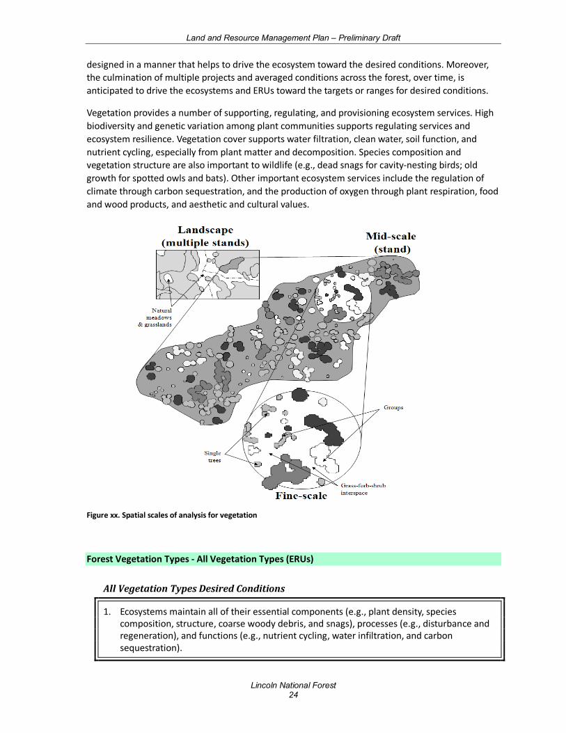
Management direction is described for individual ERUs. Desired conditions for most ERUs are presented at three spatial scales: the landscape scale, mid-scale, and fine-scale (Figure xx). Descriptions begin with the landscape scale to provide a “big picture” of the desired conditions across the larger land area (typically composed of variable elevations, slopes, aspects, soils, plant associations, and disturbance processes). Ten or more mid-scale units comprise a landscape area. Descriptions at the mid- and fine-scales provide additional detail necessary for guiding future projects and activities. The mid-scale is composed of assemblages of fine-scale units, which have similar biophysical conditions. The fine-scale is an area in which the species composition, age, structure, and distribution of plants (single, grouped, or aggregates of groups) are described. Vegetation descriptions at these scales provide adequate detail and guidance for designing projects and activities that will help achieve the desired conditions over time. In some cases, not enough science is available to provide descriptions at multiple scales.
Each ERU describes a range of conditions (e.g., grass and forb cover ranges from 10 to 25 percent, on average, for a specific seral state) for desired conditions. No one individual project is anticipated to reach these targets (conditions vary based on site potential), but individual projects should be
Land and Resource Management Plan – Preliminary Draft
Lincoln National Forest 24
designed in a manner that helps to drive the ecosystem toward the desired conditions. Moreover, the culmination of multiple projects and averaged conditions across the forest, over time, is anticipated to drive the ecosystems and ERUs toward the targets or ranges for desired conditions.
Vegetation provides a number of supporting, regulating, and provisioning ecosystem services. High biodiversity and genetic variation among plant communities supports regulating services and ecosystem resilience. Vegetation cover supports water filtration, clean water, soil function, and nutrient cycling, especially from plant matter and decomposition. Species composition and vegetation structure are also important to wildlife (e.g., dead snags for cavity-nesting birds; old growth for spotted owls and bats). Other important ecosystem services include the regulation of climate through carbon sequestration, and the production of oxygen through plant respiration, food and wood products, and aesthetic and cultural values.
Figure xx. Spatial scales of analysis for vegetation
Forest Vegetation Types - All Vegetation Types (ERUs)
All Vegetation Types Desired Conditions
1. Ecosystems maintain all of their essential components (e.g., plant density, species composition, structure, coarse woody debris, and snags), processes (e.g., disturbance and regeneration), and functions (e.g., nutrient cycling, water infiltration, and carbon sequestration).
Land and Resource Management Plan – Preliminary Draft
Lincoln National Forest 25
a. Ecosystems contain a mosaic of diverse native plants (e.g., composition and genetic diversity) with vegetative structural diversity that encourages vigor, connectivity and persistence at a variety of scales across the landscape, reflecting their natural disturbance regimes.
b. Native plant communities dominate the landscape, while invasive species are nonexistent or low in abundance and do not disrupt ecological functioning.
c. Natural ecological cycles (e.g., hydrologic, energy, nutrient) facilitate the shifting of plant communities, structure, and ages over time due to natural ecological processes affecting site conditions (e.g., fire, climate fluctuations).
d. Vegetation structural diversity and forest floor fuel loadings support native insect and disease populations within their range of natural variability.
e. Vegetative cover and litter are distributed across the soil surface in adequate amounts to limit erosion and contribute to soil deposition and development. Soil cover and herbaceous vegetation protect soil, facilitate moisture infiltration, and contribute to plant and animal diversity and ecosystem function.
2. Ecosystems are resilient or adaptive to the frequency, extent, and severity of disturbances, such as fire in fire-adapted systems, flooding in riparian systems, insects, pathogens, and climate variability.
a. The composition, structure, and function of vegetative conditions are resilient to the frequency, extent, severity of disturbances, and to climate variability.
b. Vegetative communities reflect their natural physical, chemical, and biophysical processes with carefully managed human influence.
c. Non-climate ecosystem stressors (e.g., high road densities, water depletions, air and water pollution) do not significantly impact the resilience and resistance of an ecosystem’s ability to adapt to a changing climate.
d. Natural disturbance regimes, including fire, are allowed to function in their natural ecological role. Uncharacteristic fire (frequency and severity outside historical range for associated vegetation type) is minimal or absent on the landscape.
e. Landscape vegetation structure and patterns create a mosaic that disrupts large continuous areas of uncharacteristic high-severity fire effects.
f. Healthy, resilient vegetation contribute to the forest’s ability to store carbon and function as a sustainable carbon sink.
3. The ecological attributes and processes that provide habitat for native biota and/or historic and cultural values are maintained.
Land and Resource Management Plan – Preliminary Draft
Lincoln National Forest 26
a. A diversity of vegetation exists with a mosaic of cover types and stand structures forming a healthy, resilient landscape that provide for genetic exchange, daily and seasonal movements of animals, including inter-specific interaction at all trophic levels, (e.g., producer-consumer and predator-prey interactions) across multiple spatial scales, consistent with existing landforms and topography.
b. Vegetation provides a sustainable supply of forest products, such as firewood, piñon nuts, vigas and latillas, and forage, consistent with desired conditions for other resources.
All Vegetation Types Guidelines
1. Management activities should favor the retention of species that naturally occurred in those ecosystems.
Spruce-Fir Forest (SFF) Also known as sub-alpine conifer forests, the Spruce-Fir Forest (SFF) ERU ranges in elevation from 9,000 to 10,500 ft. along a variety of gradients including gentle to very steep mountain slopes. Late successional forests at the lower elevations of this ERU are usually dominated by Engelmann spruce, white fir and occasionally blue spruce. Corkbark fir is a subdominant late successional species with quaking aspen, Douglas-fir, white fir and Southwestern white pine occurring as common early to mid-seral tree species. At the upper elevations, dominant tree species are Engelmann spruce and corkbark fir, with aspen typically being incidental, but may occasionally be co-dominant as an early to mid-seral species. Rocky Mountain maple, currants, whortleberry, snowberry, ferns, sedges and a variety of other native perennial shrubs, and forbs are commonly found in the understory. Lichens and non-vascular plants such as mosses and liverworts, are also important components. Natural system drivers and stressors in this ERU include blow-down, insect outbreaks, climate change, and stand replacing fires. The Lincoln NF contains just over 11,000 acres of SFF, with over 6,700 acres in wilderness, with all occurring only on the Smokey Bear Ranger District. This comprises only 1 percent of the Forest. In the broader landscape, there is even less SFF (~0.05%). Thus, the Lincoln NF has 65 percent of the SFF within the broader landscape, and a substantial contribution to the ecological integrity of the ERU.
Spruce- Fir Forest Desired Conditions
Landscape Scale (1,000 to 10,000+ acres)
1. The spruce-fir forest vegetation community is a mosaic of structural and seral stages ranging from young trees to old and is composed of multiple species. The landscape arrangement is an assemblage of variably sized and aged groups and patches of trees and other vegetation similar to historic patterns. Tree canopies are generally more closed than in mixed conifer. An understory consisting of native grass, forbs, or shrubs is present.
Land and Resource Management Plan – Preliminary Draft
Lincoln National Forest 27
2. Old growth generally occurs over large areas as stands or forests where old growth is concentrated. Old growth includes old trees, dead trees (snags), downed wood (coarse woody debris), and structural diversity. The location of old growth shifts on the landscape over time as a result of succession and disturbance (tree growth and mortality).
3. The spruce-fir forest vegetation community is composed predominantly of vigorous trees, but older declining trees are a component and provide snags, top-killed trees, lightning- and firescarred trees, and coarse woody debris, all well distributed throughout the landscape. The number of snags and amount of downed logs (greater than 12 inches diameter at mid-point, greater than 8 feet long) and coarse woody debris (greater than 3 inches diameter) vary by seral stage. Snags, 18 inches or greater at DBH, range from 5 to greater than 30 snags per acre, with lower range of snags associated with early seral stages and the upper range associated with late seral stages. Snag density in general (> 8” DBH) averages 20 per acre with a range of 13 to 30. Coarse woody debris, including downed logs, averages vary by seral stage, ranging from 5 to 30 tons per acre for early-seral stages; 30 to 40 tons per acre for mid-seral stages; and 40 tons per acre or greater for late-seral stages.
4. Vegetative conditions (composition, structure, and function) are broadly resilient to disturbances of varying frequency, extent, and severity. The forest landscape is a functioning ecosystem that contains all its components, processes, and conditions that result from endemic levels of disturbances (e.g. insects, diseases, fire, and wind), including old trees, downed logs, and snags. Organic ground cover and herbaceous vegetation provide protection of soil, moisture infiltration, and contribute to plant and animal diversity and to ecosystem function. In the lower spruce-fir type, mixed-severity fires (Fire Regime III) infrequently occur. Shrub cover is variable and depends on the TEUI unit. At the scale of the Plan unit, overall plant composition similarity to site potential (FSH 2090.11) averages greater than 66%, but can vary considerably at the mid- and fine- scales owing to a diversity of seral conditions. In the upper spruce-fir type, high severity fires (Fire Regime IV and V) occur very infrequently. Natural and anthropogenic disturbances are sufficient to maintain desired overall tree density, age, spatial structure, species composition, coarse woody debris, and nutrient cycling.
Mid-Scale (10 to 1,000 acres)
1. The size and number of tree groups and patches vary depending on disturbance, elevation, soil type, aspect, and site productivity. There may also be small disturbances resulting in groups and patches of tens of acres or less. Grass, forb, shrub interspaces created by disturbance may involve single trees or comprise up to 100 percent of the mid-scale area following major disturbances. Aspen is occasionally present in large patches.
2. Density ranges from 20 to 250 or greater square foot basal area per acre based upon age and site productivity, and depending upon disturbance and seral stages of the groups and patches.
3. Mixed (Fire Regime III) and high (Fire Regime IV and V) severity fires and other disturbances maintain desired overall tree density, structure, species composition, coarse woody debris, and nutrient cycling. Ground cover consists of shrubs, perennial grasses, and forbs with basal vegetation values ranging between about 5 and 20% depending on the TEUI unit.
Land and Resource Management Plan – Preliminary Draft
Lincoln National Forest 28
4. Forest conditions in goshawk post-fledging family areas (PFAs) are similar to general forest conditions except these forests typically contain 10 percent or greater tree density (basal area) than goshawk foraging areas and the general forest. Nest areas have forest conditions that are multi-aged but are dominated by large trees with relatively denser canopies than other areas in the spruce-fir type.
Fine-Scale (<10 acres)
1. Mid-aged to old trees grow tightly together with interlocking crowns. Trees are generally of the same height and age in early group/patch development but may be multilayered in late development. Small openings (gaps) are present as a result of disturbances.
Spruce- Fir Forest Guidelines
4. Vegetation treatments should reflect the characteristic structure stage proportions in order to provide continuous representation of old growth and all structure stages on the landscape.
5. Slash from firewood harvest should be managed to a level compatible with the Forest Service’s ability to protect the remaining resources.
6. Surveys for reforestation needs should be completed within 2 years following a wildfire or other natural disturbance greater than 200 acres.
7. Natural regeneration of disturbed areas should be allowed unless the following circumstances exist: (1) endangered species habitat needs to be restored, (2) the time period of recovery is deemed excessive due to the large size of deforested area and/or lack of nearby seed sources, or (3) there is concern for loss of site capacity from soils loss or extreme competition with early-seral species.
Land and Resource Management Plan – Preliminary Draft
Lincoln National Forest 29
Wet Mixed Conifer Forest (Mixed Conifer with Aspen Forest) (MCW) Wet Mixed Conifer Forest (MCW) hosts a variety of dominant and co-dominant species spanning mesic environments in the Rocky Mountain and Madrean Provinces. Wet Mixed Conifer forests range in elevation from approximately 9,000 to 10,500 feet along a variety of gradients including gentle to very steep mountain slopes, situated between ponderosa pine and mixed conifer/frequent fire below and Spruce-Fir Forest ERU above. Dominant and co-dominant vegetation varies in elevation and moisture availability. Ponderosa pine occurs incidentally or is absent, while Douglas-fir, southwestern white pine, white fir, and Colorado blue spruce occur as dominant and or codominant conifer species. Other species that may be present in sub-dominant proportions include limber pine. Understory vegetation is comprised of a wide variety of shrubs, graminoids, and forbs depending on soil type, aspect, elevation, disturbance history, and other factors. Aspen stands are a component of the Wet Mixed Conifer Forest ERU. This component is dominated by quaking aspen and may or may not have a significant conifer component, depending upon successional status. The understory structure may have shrubs and an herbaceous layer, or just an herbaceous layer. Common shrubs include oceanspray, thimbleberry, fivepetal cliffbush and mountain ninebark. The herbaceous layer may be dense or sparse, dominated by graminoids or forbs. Some of the species typically found associated with aspen include Nevada peavine, Fendler’s meadow-rue, elkweed, common yarrow, Canadian white violet, Indian paintbrush, and several grasses and sedges. Distribution of aspen within this ERU is limited by several factors including adequate soil moisture required to meet its high evapotranspiration demand, the length of the growing season or low temperatures, and major disturbances that clear areas of vegetation and stimulate root sprouting and colonization. The impacts from elk are also considered because if elk are present, they may browse aspen until it does not produce ramets within 2 to 5 years. Wet Mixed Conifer Forest makes up 3.3 percent of the Lincoln NF at 35,568 acres, and only 0.23 percent in the broader landscape. The Lincoln NF contains 46 percent of the MCW in the broader landscape, which implies a substantial contribution to the ecological integrity of the ERU. MCW is located entirely on the Sacramento Ranger District, and nearly entirely on the Rio Pen͂asco local unit.
Mixed Conifer with Aspen Forest Desired Conditions
Landscape Scale (1,000 to 10,000+ acres)
1. The wet mixed conifer forest vegetation community is a mosaic of structural and seral stages ranging from young trees through old. The landscape arrangement is an assemblage of variably sized and aged patches of trees and other vegetation associations similar to historic patterns. Tree patches are comprised of variable species composition depending on forest seral stages. Patch sizes vary but are frequently in the hundreds of acres, with rare disturbances in the thousands of acres. Seral state proportions are applied at the landscape scale, where low overall departure from reference proportions is a positive indicator of ecosystem condition. Canopies are generally more closed than in dry mixed conifer. An understory consisting of native grass, forbs, and/or shrubs is present. The amount of shrub cover depends on the TEUI unit. At the Plan unit scale, overall plant composition similarity to site potential averages greater than 66%, but can vary considerably at fine- and mid- scales owing to a diversity of seral conditions.

Land and Resource Management Plan – Preliminary Draft
Lincoln National Forest 30
2. Old growth generally occurs over large areas as stands or forests where old growth is concentrated. Old growth includes old trees, dead trees (snags), downed wood (coarse woody debris), and structural diversity. The location of old growth shifts on the landscape over time as a result of succession and disturbance (tree growth and mortality).
3. Snags 18 inches or greater at DBH range from 1 to 5 snags per acre, with the lower range of snags of this size associated with early seral stages and the upper range associated with late seral stages. Snag density in general (>8 inches DBH) averages 20 per acre. Coarse woody debris, including downed logs, vary by seral stage, with averages ranging from 5 to 20 tons per acre for early-seral stages; 20 to 40 tons per acre for mid-seral stages; and 35 tons per acre or greater for late-seral stages.
4. The wet mixed conifer forest vegetation community is composed predominantly of vigorous trees, but older declining trees are a component and provide for snags, top-killed, lightning- and fire-scarred trees, and coarse woody debris, all well-distributed throughout the landscape. Number of snags and the amount of downed logs (>12 inch diameter at mid-point, >8 feet long) and coarse woody debris (>3 inch diameter) vary by seral stage.
5. Vegetative conditions (composition, structure, and function) are broadly resilient to disturbances of varying frequency, extent, and severity. The forest landscape is a functioning ecosystem that contains all its components, processes, and conditions that result from endemic levels of disturbances (e.g. insects, diseases, wind, and fire), including snags, downed logs, and old trees. Organic ground cover and herbaceous vegetation provide protection of soil, moisture infiltration, and contribute to plant and animal diversity and ecosystem function. Mixed-severity fire (Fire Regime III) is characteristic, especially at lower elevations of this type. High severity fires (Fire Regime IV & V) rarely occur and are typically at higher elevations of this type. Natural and anthropogenic disturbances are sufficient to maintain desired overall tree density, structure, species composition, coarse woody debris, and nutrient cycling.
Mid-Scale (10 to 1,000 acres)
1. The size and number of groups and patches vary depending on disturbance, elevation, soil type, aspect, and site productivity. Groups and patches of tens of acres or less are relatively common. A mosaic of groups and patches of trees, primarily even-aged, and variable in size, species composition, and age is present. Openness and prevalence of some species (e.g. aspen) is dependent on seral stages. Grass, forb, shrub openings created by disturbance, may comprise 10 to 100 percent of the mid-scale area depending on the disturbances and on time since disturbance. Aspen is occasionally present in large patches. Density ranges from 20 to 180 or greater square foot basal area per acre based upon age and site productivity, and depending upon time since disturbance and seral stages of groups and patches.
2. Fire severity is mixed or high, with a fire return interval of 35 to 200 or more years (Fire Regimes III, IV, and V). Fires and other disturbances maintain desired overall tree density, structure, species composition, coarse woody debris, and nutrient cycling. During moister conditions, fires exhibit smoldering low-intensity surface behavior with single tree and isolated group torching. Under drier conditions, fires exhibit passive to active crown fire behavior with conifer tree mortality up to 100 percent across mid-scale patches. High severity fires generally do not exceed 1,000 acre patches of mortality. Other smaller
Land and Resource Management Plan – Preliminary Draft
Lincoln National Forest 31
disturbances occur more frequently. Ground cover consists of shrubs, perennial grasses, and forbs with basal vegetation values ranging between about 5 and 20% depending on the TEUI unit.
3. Forest conditions in goshawk post-fledging family areas (PFAs) are similar to general forest conditions except these forests typically contain 10 percent or greater tree density (basal area) relative to PFAs than goshawk foraging areas and the general forest. Nest areas have forest conditions that are multi-aged but are dominated by large trees with relatively denser canopies than other areas in the wet mixed conifer type.
Fine-Scale (<10 acres)
1. In mid-aged and older forests, trees are typically variably spaced with crowns interlocking (grouped and clumped trees) or nearly interlocking. Trees within groups can be of similar or variable species and ages. Small openings (gaps) are present as a result of disturbances.
2. Organic ground cover and herbaceous vegetation provide protection for soil and moisture infiltration, and contribute to plant diversity and ecosystem function. Due to presence of ladder fuels, fires usually burn either with low intensity, smoldering combustion, or transition rapidly in the canopy as passive or active crown fire.
Mixed Conifer with Aspen Forest Guidelines
1. Vegetation treatments should reflect the characteristic structure stage proportions in order to provide continuous representation of old growth and all structure stages on the landscape.
2. Slash piles should be burned in locations and at times that will minimize scorching of adjacent trees and soils.
3. Fuel reduction or fuelwood gathering projects should retain some large diameter trees, snags and shrubs, and these should be protected well enough from scorching to survive subsequent burn treatments.
4. Surveys for reforestation needs should be completed within 2 years following a wildfire or other natural disturbance greater than 1,000 acres.
5. Natural regeneration of disturbed areas should be allowed unless the following circumstances exist: (1) endangered species habitat needs to be restored, (2) the time period of recovery is deemed excessive due to the large size of deforested area and/or lack or nearby seed sources, or (3) there is concern for loss of site capacity from soils loss or extreme competition with early-seral species.
Land and Resource Management Plan – Preliminary Draft
Lincoln National Forest 32
Dry Mixed Conifer (Mixed Conifer – Frequent Fire) (MCD) The Dry Mixed Conifer (MCD) ERU may be found at elevations between 6,000 and 10,000 ft., situated between ponderosa pine, pine-oak, or piñon-juniper woodlands below and spruce-fir forests above. Typically these types were dominated by ponderosa pine in an open forest structure (< 30 percent tree canopy cover), with minor occurrence of aspen, Rocky Mountain Douglas-fir, white fir, and southwestern white pine. On contemporary landscapes, more shade tolerant conifers, such as Douglas-fir, white fir, and blue spruce, tend to increase in cover in late succession, contrary to conditions under the characteristic fire regime. However, historically, these species could have achieved dominance in localized settings where aspect, soils, and other factors limited the spread of surface fire. Currently, much of this type is dominated by closed structure (greater than 30 percent tree canopy cover) and climax species as a result of fire suppression. The Dry Mixed Conifer ERU at 163,674 acres makes up nearly 15 percent of the Lincoln NF, compared to just under 1 percent in the broader landscape (328,640 acres). All six local units (and three Ranger Districts) have some MCD. Most occurs on the Sacramento RD (nearly 115,000 acres) in the Rio Peñasco, Salt Basin and Tularosa local units, while just over 36,000 acres occurs in the Rio Hondo, Arroyo del Macho and Tularosa units of the Smokey Bear RD. Of those 36,000 acres, 27,000 are located in wilderness. Only 1,700 acres of MCD occurs in the Upper Pecos unit of the Guadalupe RD at the extreme south of the district. The Lincoln NF contains nearly 50 percent of the MCD occurring in the broader landscape, so has a large contribution to the ecological sustainability of the ERU.
Mixed Conifer/Frequent Fire Forest Desired Conditions
Landscape Scale (1,000 to 10,000+ acres)
1. The dry mixed conifer vegetation community is a mosaic of forest conditions composed of structural stages ranging from young to old trees. Forest appearance is variable but generally uneven-aged and open; occasional patches of even-aged structure are present. The forest arrangement is in small clumps and groups of trees interspersed within variably-sized openings of grass/forb/shrub vegetation associations similar to historic patterns. Size, shape, number of trees per group, and number of groups per area are variable across the landscape. Where they naturally occur, groups of aspen and all structural stages of oak are present. Denser tree conditions exist in some locations such as north facing slopes and canyon bottoms. Seral state proportions, per the R3 Seral State Proportions Supplement, are applied at the landscape scale, where low overall departure from reference proportions is a positive indicator of ecosystem condition.
2. Old growth occurs throughout the landscape, generally in small areas as individual old growth components, or as clumps of old growth. Old growth components include old trees, dead trees (snags), downed wood (coarse woody debris) and structural diversity. The location of old growth shifts on the landscape over time as a result of succession and disturbance (tree growth and mortality).
3. The dry mixed conifer forest vegetation community is composed predominantly of vigorous trees, but declining trees are a component and provide for snags, top-killed, lightning- and fire-scarred trees, and coarse woody debris (>3 inch diameter), all well-distributed throughout the landscape.
Land and Resource Management Plan – Preliminary Draft
Lincoln National Forest 33
4. The composition, structure, and function of vegetative conditions are resilient to the frequency, extent, severity of disturbances, and to climate variability. The landscape is a functioning ecosystem that contains all its components, processes, and conditions that result from endemic levels of disturbances (e.g. insects, diseases, fire, and wind), including snags, downed logs, and old trees. Dwarf-mistletoe occurs in less than 15 percent of host trees in uneven-aged forest structures and less than 25 percent in even-aged forest structures. Grasses, forbs, shrubs, needle cast (fine fuels), and small trees maintain the natural fire regime. Organic ground cover (leaf litter/needle cast, etc.) and herbaceous vegetation provide protection of soil, moisture infiltration, and contribute to plant and animal diversity and to ecosystem function. The amount of shrub cover depends on the TEUI unit (USDA Forest Service 1986, 2006). At the Plan unit scale, overall plant composition similarity to site potential (FSH 2090.11) averages greater than 66%, but can vary considerably at fine- and mid- scales owing to a diversity of seral conditions. Frequent, low severity fires (Fire Regime I) are characteristic, including throughout goshawk home ranges. Natural and anthropogenic disturbances are sufficient to maintain desired overall tree density, structure, species composition, coarse woody debris, and nutrient cycling.
Mid-Scale (10 to 1,000 acres)
1. The dry mixed conifer forest vegetation community is characterized by variation in the size and number of tree groups depending on elevation, soil type, aspect, and site productivity. The more biologically productive sites contain more trees per group and more groups per area. Openness typically ranges from 50 percent in more productive sites to 90 percent in the less productive sites. Tree density within forested areas generally ranges from 30 to 125 square foot basal area per acre.
2. The mosaic of tree groups generally comprises an uneven-aged forest with all age classes and structural stages. Occasionally small patches (generally less than 60 acres) of even-aged forest structure are present, based upon disturbance events and regeneration establishment. A small percentage of the landscape may be predisposed to larger even-aged patches, based on physical site conditions that favor mixed-severity and stand replacement fire and other disturbances. Disturbances sustain the overall age and structural distribution. Snags are typically 18 inches or greater at DBH and average 3 per acre. Smaller snags, 8 inches and above at DBH, average 8 snags per acre. Downed logs (>12 inch diameter at mid-point, >8 feet long) average 3 per acre within forested areas. Coarse woody debris, including downed logs, ranges from 5 to 15 tons per acre.
3. Ground cover consists primarily of perennial grasses and forbs capable of carrying surface fire, with basal vegetation values ranging between about 5 and 20% depending on the TEUI unit. Fires burn primarily on the forest floor and do not spread between tree groups as crown fire.
4. Forest conditions in goshawk post-fledging family areas (PFAs) are similar to general forest conditions except these forests contain 10 to 20 percent higher basal area in mid- to old-age tree groups than in goshawk foraging areas and in the general forest. Goshawk nest areas have forest conditions that are multi-aged but are dominated by large trees with relatively denser canopies than other areas in the dry mixed conifer type.
Land and Resource Management Plan – Preliminary Draft
Lincoln National Forest 34
Fine-Scale (<10 acres)
1. Trees typically occur in irregularly shaped groups and are variably spaced with some tight clumps. Crowns of trees within the mid-aged to old groups are interlocking or nearly interlocking. Openings surrounding tree groups are variably shaped and composed of a grass, forb, and shrub mix. Some openings contain individual trees or snags. Trees within groups are of similar or variable ages and represent one or more species. Tree groups typically are less than 1 acre in size. Groups at the mid-age to old stages consist of 2 to approximately 50 trees per group.
Mixed Conifer/Frequent Fire Forest Guidelines
1. Vegetation treatments should reflect the characteristic structure stage proportions in order to provide continuous representation of old growth and all structure stages on the landscape.
2. Slash piles should be burned in locations and at times that will minimize scorching of adjacent trees and shrubs.
3. Fuel reduction or firewood gathering projects should retain some large diameter trees, snags and shrubs, and these should be protected well enough from scorching to survive subsequent burn treatments.
4. Surveys for reforestation needs should be completed within 2 years following a wildfire or other natural disturbance greater than 2,000 acres.
5. Natural regeneration of disturbed areas should be allowed unless the following circumstances exist: (1) endangered species habitat needs to be restored, (2) the time period of recovery is deemed excessive due to the large size of deforested area and/or lack or nearby seed sources, or (3) there is concern for loss of site capacity from soils loss or extreme competition with early-seral species.
Land and Resource Management Plan – Preliminary Draft
Lincoln National Forest 35
Ponderosa Pine Forest (PPF) The Ponderosa pine forest (PPF) ERU generally occurs on loose, well-drained soils derived from igneous, metamorphic, and sedimentary parent material at elevation ranging from 6,000 to 10,000 feet. Ponderosa pine forest is typically bounded at the upper elevation by mixed conifer forest, and at the lower elevation by grasslands or piñon-juniper woodlands, although extensive intergrading of species may occur at ecotone boundaries along gradients of slope, elevation, aspect, and moisture. The dominant species in this system is ponderosa pine. Other trees, such as Gambel oak, Rocky Mountain Douglas-fir, twoneedle piñon pine and junipers may be present. There is typically a shrubby understory; such as currants/gooseberries, and buckbrush, mixed with a variety of grasses and forbs, such as Arizona fescue, mountain muhly, pine dropseed, blue grama, fleabanes, pussytoes, and others. This ERU sometimes occurs as savannah with extensive grasslands interspersed between widely spaced clumps or individual trees. This system is adapted to drought during the growing season, and has evolved several mechanisms to tolerate frequent, low intensity surface fires. The Lincoln NF is made up of approximately 11.3 percent of PPF (123,156 acres), while the broader landscape contains approximately 1.8 percent. The Lincoln NF contains about 21 percent of the PPF in the broader landscape, and so makes a fairly substantial contribution to ecological sustainability.
Ponderosa Pine Forest Desired Conditions
Landscape Scale (1,000 to 10,000+ acres)
1. The ponderosa pine forest vegetation community is composed of trees from structural stages ranging from young to old. Forest appearance is variable but generally uneven-aged and open; occasional areas of even-aged structure are present. The forest arrangement is in individual trees, small clumps, and groups of trees interspersed within variably-sized openings of grass/forbs/shrubs vegetation associations similar to historic patterns. Size, shape, number of trees per group, and number of groups per area are variable across the landscape. Seral state proportions, per the R3 Seral State Proportions Supplement, are applied at the landscape scale, where low overall departure from reference proportions is a positive indicator of ecosystem condition. In the Gambel oak sub-type, all sizes and ages of oak trees are present. Denser tree conditions exist in some locations such as north facing slopes and canyon bottoms.
2. Old growth occurs throughout the landscape, generally in small areas as individual old growth components, or as clumps of old growth. Old growth components include old trees, dead trees (snags), downed wood (coarse woody debris) and structural diversity. The location of old growth shifts on the landscape over time as a result of succession and disturbance (tree growth and mortality).
3. The ponderosa pine forest vegetation community is composed predominantly of vigorous trees, but declining trees are a component and provide for snags, top-killed, lightning- and fire-scarred trees, and coarse woody debris (>3 inch diameter), all well-distributed throughout the landscape.
4. The composition, structure, and function of vegetative conditions are resilient to the frequency, extent and severity of disturbances and climate variability. The landscape is a functioning ecosystem that contains all its components, processes, and conditions that
Land and Resource Management Plan – Preliminary Draft
Lincoln National Forest 36
result from endemic levels of disturbances (e.g. insects, diseases, fire, and wind), including snags, downed logs, and old trees. Dwarf-mistletoe occurs in less than 15 percent of host trees in uneven-aged forest structures and less than 25 percent in even-aged forest structures. Grasses, forbs, shrubs, and needle cast (fine fuels), and small trees maintain the natural fire regime. Organic ground cover and herbaceous vegetation provide protection of soil, moisture infiltration, and contribute to plant and animal diversity and to ecosystem function. The amount of shrub cover depends on the TEUI unit. Overall plant composition similarity to site potential averages greater than 66%, but can vary considerably at fine- and mid- scales owing to a diversity of seral conditions. Frequent, low severity fires (Fire Regime I) are characteristic in this type, including throughout goshawk home ranges. Natural and anthropogenic disturbances are sufficient to maintain desired overall tree density, structure, species composition, coarse woody debris, and nutrient cycling.
Mid-Scale (10 to 1,000 acres)
1. The ponderosa pine forest vegetation community is characterized by variation in the size and number of tree groups depending on elevation, soil type, aspect, and site productivity. The more biologically productive sites contain more trees per group and more groups per area, resulting in less space between groups. Openness typically ranges from 52 percent in more productive sites to 90 percent in less productive sites. In areas with high fine-scale aggregation of trees into groups, mid-scale openness ranges between 78-90%. Tree density within forested areas generally ranges from 22 to 89 square foot basal area per acre. Ground cover consists primarily of perennial grasses and forbs capable of carrying surface fire, with basal vegetation values ranging between about 5 and 20% depending on the TEUI unit.
2. The mosaic of tree groups generally comprises an uneven-aged forest with all age classes present. Occasionally patches of even-aged forest structure are present, based upon disturbance events and regeneration establishment. A small percentage of the landscape may be predisposed to larger even-aged patches, based on physical site conditions that favor mixed-severity and stand replacement fire and other disturbances. Disturbances sustain the overall age and structural distribution.
3. Ponderosa pine snags are typically 18 inches or greater at DBH and average 1 to 2 snags per acre. In the Gambel oak subtype, large oak snags (>10 inches) are a well-distributed component. Downed logs (>12 inch diameter at mid-point, >8 feet long) average 3 logs per acre. Coarse woody debris, including downed logs, ranges from 3 to 10 tons per acre.
4. Fires burn primarily on the forest floor and do not spread between tree groups as crown fire.
5. Forest conditions in goshawk post-fledging family areas (PFAs) are similar to general forest conditions except these forests contain 10 to 20 percent higher basal area in mid- to old-age tree groups than in goshawk foraging areas and the general forest. Goshawk nest areas have forest conditions that are multi-aged but are dominated by large trees with relatively denser canopies than other areas in the ponderosa pine type.
Fine-Scale (<10 acres)
Land and Resource Management Plan – Preliminary Draft
Lincoln National Forest 37
1. Trees typically occur in irregularly shaped groups and are variably-spaced with some tight clumps. Crowns of trees within the mid- to old-age groups are interlocking or nearly interlocking. Interspaces surrounding tree groups are variably-shaped and comprised of a grass/forb/shrub mix. Some natural openings contain individual trees. Trees within groups are of similar or variable ages and may contain species other than ponderosa pine. Size of tree groups typically is less than 1 acre, but averages 0.5 acres. Groups at the mid- to old-age stages consist of 2 to approximately 40 trees per group.
Ponderosa Pine – Evergreen Oak Forest (PPE) Ponderosa Pine-Evergreen Oak is a transition zone between the Ponderosa Pine Forest and Mixed Conifer-Frequent Fire and the woodland ERUs. This ecological type occurs at elevations ranging from 5,500 to 7,200 feet, on sites slightly cooler-moister than the Madrean Piñon-Oak ERU, and with a much greater plurality of ponderosa pine. This system is dominated by ponderosa pine and can be distinguished from the PPF ERU by well-represented evergreen oaks (e.g., Emory oak, Arizona white oak, silverleaf oak, gray oak), alligator juniper, and piñon pine. Though not an indicator in the ponderosa pine life zone, border piñon, along oneseed juniper can occur as a dominant or codominant component of the PPE ERU. In terms of disturbance, the PPE averaged greater fire severity than the PPF, and greater patchiness with less horizontal uniformity and more even-aged conditions. Site potential, fire history, and the importance of perennial grasses versus shrubs in the understory vary on a gradient between two provisional subclasses. Understory shrubs include manzanita, Sonoran scrub oak, skunkbush sumac, and mountain mahogany. PPE, with 8,661 acres, occupies less than 1 percent of the Lincoln NF and only 0.12 percent of the broader landscape. PPE on the Lincoln is 21 percent of the broader landscape. This ERU occurs in only 3 of 6 local units: four acres in Rio Peñasco on the Sacramento RD, and the remainder in the Salt Basin (412 acres) and Upper Pecos (8245 acres) local units on the Guadalupe RD. On the Guadalupe District, the ERU is limited to the steep canyons south of Queen Highway. While the PPE type is a low percentage of both the Lincoln NF and the broader landscape, the Lincoln NF contains 21 percent of the ERU in the broader landscape, and thus has a role in maintaining the ecological integrity of the type.
Ponderosa Pine – Evergreen Oak Forest Desired Conditions
Landscape Scale (1,000 to 10,000+ acres)
1. The ponderosa pine-evergreen oak perennial grasses sub-type is composed of trees from structural stages ranging from young to old. Forest appearance is variable but generally uneven-aged and open at landscape scales (though can appear even-aged within tree groups); occasional larger areas of even-aged structure are present. The forest arrangement is in individual trees, small clumps and groups of trees interspersed within variably-sized openings of grass/forbs/shrub vegetation associations similar to historic patterns. Shrubs occur in low densities which do not inhibit ponderosa pine regeneration. Size, shape, number of trees per group, and number of groups per area are variable across the landscape. All structural stages of oak are present, with old trees occurring as dominant individuals, and small groups occurring typically within openings. Denser overall tree conditions exist in some locations such as north facing slopes and canyon bottoms.
Land and Resource Management Plan – Preliminary Draft
Lincoln National Forest 38
Seral state proportions are applied at the landscape scale, where low overall departure from reference proportions is a positive indicator of ecosystem condition.
2. Old growth occurs throughout the landscape, generally in small areas as individual old growth components, or as clumps of old growth. Old growth components include old trees, dead trees (snags), downed wood (coarse woody debris) and structural diversity. The location of old growth shifts on the landscape over time as a result of succession and disturbance (tree growth and mortality).
3. The ponderosa pine –evergreen oak perennial grasses sub-type is composed predominantly of vigorous trees, but declining trees are a component and provide for snags, top-killed, lightning- and fire-scarred trees, and coarse woody debris (>3 inch diameter), all well-distributed throughout the landscape.
4. The composition, structure, and function of vegetative conditions are resilient to the frequency, extent and severity of disturbances, and climate variability. The landscape is a functioning ecosystem that contains all its components, processes, and conditions that result from natural disturbances (e.g. insects, diseases, fire, and wind), including old growth. Dwarf-mistletoe occurs in less than 15 percent of host trees in uneven-aged forest structures and less than 25 percent in even-aged forest structures. Grasses, forbs, shrubs, and needle cast (fine fuels), and small trees maintain the natural fire regime. Organic ground cover and herbaceous vegetation provide protection of soil, moisture infiltration, and contribute to plant and animal diversity and to ecosystem function. Shrubs average less than 30% cover. Overall plant composition similarity to site potential averages greater than 66%, but can vary considerably at fine- and mid- scales owing to a diversity of seral conditions. Frequent, primarily low severity fires (Fire Regime I) are characteristic including throughout goshawk home ranges. Natural and anthropogenic disturbances are sufficient to maintain desired overall tree density, structure, species composition, coarse woody debris, and nutrient cycling.
Mid-Scale (10 to 1,000 acres)
1. The ponderosa pine-evergreen oak perennial grasses sub-type is characterized by variation in the size and number of tree groups depending on elevation, soil type, aspect, and site productivity. The more biologically productive sites contain more trees per group and more groups per area. Openness typically ranges from 10 percent in more productive sites to 70 percent in the less productive sites. Tree density within forested areas generally ranges from 20 to 80 square foot basal area per acre.
2. The mosaic of tree groups generally comprises an uneven-aged forest with all age classes and structural stages present, though tree groups and patches may be relatively even-aged. Occasionally patches of even-aged forest structure are present, based upon disturbance events and regeneration establishment. A small percentage of the landscape may be predisposed to larger even-aged patches, based on physical site conditions that favor mixed-severity and stand replacement fire and other disturbances. The mix of natural disturbances sustains the overall age and structural distribution. Patch sizes range from less than 1 acre to 10s of acres.
3. Ponderosa pine snags are typically 18 inches or greater at DBH and average 1 to 2 snags per acre, while snags greater than 8 inches average 5 snags per acre (Weisz et al. 2011). Large oak snags (>10 inches) are a well-distributed component. Downed logs (>12 inch
Land and Resource Management Plan – Preliminary Draft
Lincoln National Forest 39
diameter at mid-point, >8 feet long) average 3 logs per acre. Coarse woody debris, including downed logs, ranges from 3 to 10 tons per acre.
4. Ground cover consists of shrubs, perennial grasses, and forbs with basal vegetation values ranging between about 5 and 15% depending on the TEUI unit (USDA Forest Service 1986). Fires burn primarily on the forest floor and do not typically spread between tree groups as crown fire. Mixed-severity fires occur at less frequency and over smaller spatial extents than low severity fires occur.
5. Forest conditions in goshawk post-fledging family areas (PFAs) are similar to general forest conditions except these forests contain 10 to 20 percent higher basal area in the mid- to old-age tree groups than goshawk foraging areas and the general forest. Goshawk nest areas have forest conditions that are multi-aged but are dominated by large trees with relatively denser canopies than other areas in the ponderosa pine-evergreen oak type.
Fine-Scale (<10 acres)
1. At the fine-scale, trees typically occur in small groups in which they are variably-spaced with some tight clumps. Crowns of trees within the mid- to old-age groups are interlocking or nearly interlocking. Interspaces between tree groups are variably-shaped and comprised of a grass/forb/shrub mix. Some natural openings contain individual trees, including large open-grown oaks. Trees within groups are of similar or variable ages and may contain species other than ponderosa pine. Size of tree groups typically is less than 1 acre. Groups at the mid-to old-age stages consist of 2 to approximately 40 trees.
Woodland Vegetation Types Pinon Juniper/Evergreen Shrub Woodland (PJC) The piñon-juniper/evergreen shrub woodland (PJC) ERU is typically found on lower slopes in transition zones, often between interior chaparral and montane forests, and is most extensive in geographic areas dominated by mild climate gradients and bi-modal precipitation regimes. The PJC ERU is a broad grouping of different plant associations for descriptive purposes, with variable species composition. Historically this ERU had greater than 10 percent tree canopy cover in later successional stages, expressed by twoneedle piñon, single leaf piñon, Utah juniper, oneseed juniper, or alligator juniper. Piñon is occasionally absent, but one or more juniper species are always present. Oak trees (i.e., Arizona white oak, gray oak, Emory oak) are subordinate, but have high constancy in mild climate zones between central Arizona and southwestern New Mexico. Trees occur as individuals or in smaller groups and range from young to old, but typically small stands or clumps are even-aged in structure as a consequence of mixed severity fire (at least historically). The understory is dominated by low to moderate density shrubs, with herbaceous plants in the interspaces. Shrub species include species of manzanita, mountain mahogany, antelope bitterbrush, silktassles, Stansbury cliffrose, Sonoran scrub oak, and sumacs. The Lincoln NF contains just under 5 percent PJC (53,976 acres), compared to the broader landscape’s 0.26 percent. However, this represents 63 percent of the PJC in the broader landscape, so the Lincoln NF has a large contribution to the ecological sustainability of the PJC ERU.
Land and Resource Management Plan – Preliminary Draft
Lincoln National Forest 40
Pinon Juniper/Evergreen Shrub Woodland Desired Conditions
Landscape Scale (1,000 to 10,000+ acres)
1. The composition, structure, and function of vegetative conditions are resilient to the frequency, extent and severity of disturbances (e.g. insects, diseases, and fire) and climate variability. Fires are typically frequent and low-severity (Fire Regime I). Seral state proportions are applied at the landscape scale where low overall departure from reference proportions is a positive indicator of ecosystem condition.
2. Old growth occurs throughout the landscape, generally in small areas as individual old growth components, or as clumps of old growth. Old growth components include old trees, dead trees (snags), downed wood (coarse woody debris) and structural diversity. The location of old growth shifts on the landscape over time as a result of succession and disturbance (tree growth and mortality). Overall plant composition similarity to site potential averages greater than 66%, but can vary considerably at the fine- and mid- scales owing to a diversity of seral conditions.
Mid-Scale (10 to 1,000 acres)
1. Snags are scattered, with snags 8 inches and above at DRC averaging 5 snags per acre, while snags 18 inches and above average 1 snag per acre. Coarse woody debris increases with succession and averages 1-3 tons per acre.
2. Scattered shrubs and a dense herbaceous understory including native grasses, forbs and annuals are present to support frequent surface fires. Ground cover consists primarily of perennial grasses and forbs capable of carrying surface fire, with basal vegetation values averaging between about 10 and 30% depending on the TEUI unit. Shrubs average less than 30% canopy cover.
Fine-Scale (<10 acres)
1. Pinyon-juniper grass and juniper grass are generally uneven aged and open in appearance. Trees occur as individuals, but occasionally in smaller groups, and range from young to old. Patch sizes of woodlands range from individual trees and clumps that are less than one-tenth acre, to tree groups of approximately an acre. Occasionally patches of even-aged woodland structure are present, based upon disturbance events and regeneration establishment. A small percentage may be predisposed to larger even-aged patches, based on physical site conditions that favor mixed-severity and stand replacement fire and other disturbances.
Land and Resource Management Plan – Preliminary Draft
Lincoln National Forest 41
Pinyon Juniper Woodland (PJO) Also called the “piñon-juniper persistent woodland,” the PJO ERU serves as a broad grouping of different plant associations for descriptive purposes. Trees may occur as individuals or in smaller groups and range from young to old, but more typically as large even-aged structured patches. The site is characteristically dominated by moderate to high density tree canopy, and understory herbaceous plants/shrubs are limited or scarce. It is mostly found on lower slopes of mountains and in upland rolling hills at approximately 4,500 to 7,500 feet in elevation. Woodland development occurs in distinctive phases; ranging from open grass-forbs, to mid-aged open canopy to mature closed canopy woodland. Where fire is very infrequent, the fire regime is usually attributed to local edaphically-influenced fire affects such as rocky scarps, etc. On these sites, factors such as insect and disease may be the only disturbance agents that affect woodland development. Tree and shrub species composition varies throughout the Southwest and common trees include twoneedle piñon, singleleaf piñon, Utah juniper, oneseed juniper, and alligator juniper. Typically, sparse native understory grasses are perennial species, such as several species of grama, common wolftail, and threeawns, while forbs consist of both annuals and perennials. Shrubs are characteristically sparse to moderately distributed. This type is typically found on sites with rocky soil characteristics. The PJO ERU makes up nearly 30 percent of the Lincoln NF at 319,105 acres, comprising just over 3 percent of the total broader landscape. Departure is higher for the Lincoln NF than the broader landscape, and the Lincoln PJO is 30 percent of all the PJO in in the broader landscape, making the Lincoln NF a substantial contributor to the ecological sustainability of this ERU.
Pinyon Juniper Woodland Desired Conditions
Landscape Scale (1,000 to 10,000+ acres)
1. Pinyon-juniper woodland (persistent) is characterized by even-aged patches of pinyons and junipers that at the landscape level form multi-aged woodlands. The composition, structure, and function of vegetative conditions are resilient to the frequency, extent and severity of disturbances (e.g. insects, diseases, and fire), and climate variability. Insects and disease occur at endemic levels. Fire as a disturbance is less frequent and variable due to differences in ground cover, though some sites are capable of carrying surface fire. The fires that do occur are mixed to high severity (Fire Regime III, IV, & V). Seral state proportions, per the R3 Seral State Proportions Supplement, are applied at the landscape scale, where low overall departure from reference proportions is a positive indicator of ecosystem condition.
2. Old growth includes old trees, dead trees (snags), downed wood (coarse woody debris) and structural diversity, and is often concentrated in mid- and fine-scale units as patches of old growth. The location of old growth shifts on the landscape over time as a result of succession and disturbance (tree growth and mortality). Very old trees (>300 years old) are present, while snags and older trees with dead limbs and/or tops are scattered across the landscape. Snags 8 inches and above at DRC average 5 snags per acre, while snags 18 inches and above average 1 snag per acre. Coarse woody debris increases with succession and averages 2-5 tons per acre. Overall plant composition similarity to site potential
Land and Resource Management Plan – Preliminary Draft
Lincoln National Forest 42
averages greater than 66%, but can vary considerably at fine- and mid- scales owing to a diversity of seral conditions.
Mid-Scale (10 to 1,000 acres)
1. Tree density and canopy cover are high, shrubs are sparse to moderate, and herbaceous cover is low and discontinuous. The amount of shrub cover depends on the TEUI unit. Ground cover consists of shrubs, perennial grasses, and forbs with basal vegetation values ranging between about 5 and 15% depending on the TEUI unit. Trees occur in even-aged patches ranging from young to old, where patch size of these woodlands ranges from 10s to 100s of acres.
Pinyon Juniper Woodland Guidelines
1. Large accumulations of green material (such as slash, wind-thrown trees) should be managed to reduce the risk of uncharacteristic bark beetle outbreaks.
2. To increase small mammal occupancy in areas where coarse woody debris is deficient and to provide nesting habitat and cover for turkeys, birds, small mammals, reptiles, and invertebrates, slash piles should be retained across the landscape for several years, rather than immediately being burned. The number and distribution of retained slash piles should be balanced with potential threats from bark beetles and fire/fuels concerns.
Land and Resource Management Plan – Preliminary Draft
Lincoln National Forest 43
Pinyon Juniper Grassland (PJG) and Juniper Grassland (JUG) The Pinyon-Juniper Grass (PJG) ecological response unit occurs in what were historically more open woodlands with grassy understories. The PJ Grass type is typically found on sites with well-developed, loamy soil characteristics, including gentle upland and transitional valley locations where soil conditions favor grasses (or other grass-like plants) but can support at least some tree cover. Tree species include one seed juniper, Utah juniper, Rocky Mountain juniper, alligator juniper and twoneedle pinyon. Native understories were made up of perennial grasses, with both annual and perennial forbs, and shrubs that were absent or scattered. Historically, herbaceous understories of native grasses and forbs provided fine fuel sources for fire, aiding in the maintenance of an uneven-aged open canopy condition. Juniper Grass (JUG) is typically on warmer and drier settings beyond the environmental limits of pinyon pine, and just below, and often intergrading with, the pinyon-juniper zone. However Juniper Grass tends to be restricted to warmer and drier settings that limit pinyon. This type is typically found on sites with well-developed, loamy soil characteristics, generally at the drier edge of the woodland climatic zone. Mollisol soils are common for this ecological response unit and support a dense herbaceous matrix of native grasses (mostly perennials) and forbs. Typical disturbances (fire, insects, and disease) are of low severity and high frequency with a historic average fire return interval of 0 to 35 years from low to moderate severity fires. These disturbance patterns create and maintain the uneven- aged, open-canopy nature of this type. Typically, native understory grasses are perennial species, while forbs consist of both annuals and perennials. Shrubs are characteristically absent or scattered. Generally these types are most extensive in geographic areas dominated by warm (summer) season or bi-modal precipitation regimes. Overall these sites are less productive for tree growth than the Pinyon-Juniper Woodland type. The PJG ERU makes up less than 2 percent of the broader landscape, but more than 15 percent of the Lincoln NF at 165,432 acres. It represents nearly 30 percent of PJG in the broader landscape. This ERU occurs in all six local units. Thus, Pinyon-Juniper Grassland is relatively common on the Forest, but is rare within the broader landscape making Forest management of this ERU important to ecological integrity and sustainability. The JUG ERU represents 8.5 percent of the broader landscape but less than 1 percent of the Lincoln NF. The Lincoln’s 9,755 acres in JUG are only 0.35 percent of JUG in the broader landscape. The Lincoln NF has a relatively low contribution to ecological sustainability for this ERU. Thus, while structural state of the Lincoln NF is moderately departed at 64 percent, it has little effect on the broader landscape, which has low departure of 16 percent.
Pinyon Juniper Grassland and Juniper Grassland Desired Conditions
Landscape Scale (1,000 to 10,000+ acres)
1. Pinyon Juniper Grass and Juniper Grass are generally uneven-aged and open in appearance. They are dominated by one or more species of juniper and/or pinyon pine and occur with a grass/forb dominated understory. At the landscape scale the majority of ERU (50 %+) is dominated by trees over 10.0” in diameter. Trees 0.0” to 9.9” in diameter occur as individuals or small groups scattered throughout the landscape, intermixed with the larger trees and occupy 12 to 30 % of the landscape.
Land and Resource Management Plan – Preliminary Draft
Lincoln National Forest 44
2. Old growth occurs throughout the landscape, generally in small areas as individual old growth components, or as clumps of old growth. Old growth components include old trees, dead trees (snags), downed wood (coarse woody debris) – all of which have high structural diversity (presence of various age groups/size classes and canopy layers). The location of old growth shifts on the landscape over time as a result of succession and disturbance (tree growth and mortality).
3. In Pinyon Juniper Grass and Juniper Grass, snags and older trees with dead limbs are scattered across the landscape. At the landscape scale, snags 8 inches and above at diameter at root collar average 5 snags per acre, while snags 18 inches and above average 1 snag per acre. Coarse woody debris increases with succession and averages 1 to 3 tons per acre.
4. The composition, structure, and function of vegetative conditions are resilient to the frequency, extent and severity of disturbances (e.g., insects, diseases, and fire) and climate variability. Fires are typically frequent and low-severity (Fire Regime I). Isolated insect and disease infestations (e.g., Ips Beetle) occur at endemic levels and do not affect the ecological function or sustainability.
5. Ground cover consists primarily of perennial grasses and forbs capable of carrying surface fire, and averages between 10 and 30 percent. Shrubs average less than 30 percent canopy cover.
6. Seral state proportions are applied at the landscape scale, where low overall departure from reference proportions is a positive indicator of ecosystem condition.
7. Overall plant composition similarity to site potential averages greater than 66%, but can vary considerably at the fine- and mid- scales owing to a diversity of seral conditions.
Mid-Scale (10 to 1,000 acres)
1. Seral state proportions are applied at the landscape scale, where low overall departure from reference proportions is a positive indicator of ecosystem condition.
2. Overall plant composition similarity to site potential averages greater than 66%, but can vary considerably at the fine- and mid- scales owing to a diversity of seral conditions.
Fine-Scale (<10 acres)
1. Pinyon-juniper grass and juniper grass are generally uneven aged and open in appearance. Trees occur as individuals, but occasionally in smaller groups, and range from young to old. Patch sizes of woodlands range from individual trees and clumps that are less than one-tenth acre, to tree groups of approximately an acre.
Land and Resource Management Plan – Preliminary Draft
Lincoln National Forest 45
Shrubland Vegetation Types Gambel Oak Shrubland (GAMB) Gambel Oak Shrubland is dominated by long-lived Gambel oak clones that form largely mono-typic overstories. It occurs between 6,500-9,500 ft. on all aspects, and at higher elevations occurs more predominantly on southern exposures. Gambel oak occurs as the dominant species ranging from dense thickets to clumps associated with other shrub species such as serviceberry or sagebrush. Older, more developed Gambel oak can have a well-developed understory comprised of snowberry, elk sedge, letterman's needlegrass, Poa ampla, yarrow, lupine, and goldenrod. Depending on site potential, ponderosa pine, juniper, and pinyon can encroach older plant communities. The primary disturbance mechanism is mixed-severity to stand replacement fire resulting in top-kill and rare mortality. Gambel oak responds to fire with vigorous sprouting from the root crown. Larger forms may survive low- intensity surface fire. A first look at much of the Lincoln NF’s landscape, particularly in burned areas on the Smokey Bear and Sacramento districts, would lead one to think there is a great deal of the GAMB ERU on the Lincoln NF, but much of that is really a persistent shrub phase of the Mixed Conifer/Frequent Fire (MCD) or Ponderosa Pine (PPF) ERUS. The GAMB ERU makes up only 0.33 percent of the Lincoln NF, occurring in only two local units. The GAMB ERU occurring on the Lincoln makes up only 0.067 percent of the broader landscape, but is 16 percent of all that occurs in the broader landscape, so the Lincoln has a small role in the sustainability of the ERU.
Gambel Oak Shrubland Desired Conditions
1. The system is dominated by native tall shrubs and hardwood trees. Some areas contain many trees with relatively large hollow boles or limbs. Coniferous trees are widely scattered and are frequently mature or old. Young Gambel oak thickets and sometimes other species comprise a patchy shrub layer.
2. Ground cover is mostly comprised of oak litter, with grasses and forbs present.
3. Low-intensity fire occurs regularly in intervals of less than 25 years.
4. Old stands contain habitat for birds and arboreal nesting or roosting mammals. A variety of oak growth forms, sizes, and densities that benefit wildlife species can be found across the landscape.
Land and Resource Management Plan – Preliminary Draft
Lincoln National Forest 46
Mountain Mahogany Mixed Shrubland (MMS) The Mountain Mahogany Mixed Shrubland ERU (MMS) occurs in the foothills, canyon slopes, and lower slopes of the Rocky Mountains and on outcrops and canyon slopes in the western Great Plains. It ranges from southern New Mexico extending north into Colorado. These shrublands are often associated with exposed sites, rocky substrates, dry conditions, and recurrent historic fire that limited tree growth. Scattered trees or inclusions of grassland patches or steppe may be present, but the vegetation is typically dominated by a variety of shrubs including mountain mahogany and skunkbush sumac. Historically this ERU had less than 30 percent tree canopy cover. The MMS ERU makes up only 0.52 percent of the broader landscape, but five percent of the Lincoln NF (52,528 acres). The MMS ERU on the Lincoln NF contains 30 percent of the ERU occurring in the broader landscape, and thus contributes substantially to the ecological sustainability to the ERU.
Mountain Mahogany Mixed Shrubland Desired Conditions
Landscape Scale (1,000 to 10,000+ acres)
1. The Mountain Mahogany Mixed Shrubland vegetation community is a mosaic of structural and seral states ranging from young trees through old and is composed of multiple species.
2. Tree cover is less than 10%, except in dissimilar inclusions driven by local topography, microclimate and soil properties.
3. Infrequent, stand replacement fire (Fire Regime Group IV) is characteristic of this vegetation type.
Mid-Scale (10 to 1,000 acres)
1. Shrub cover is greater than 10% and may exceed 30% in late seral states depending on disturbance history, elevation, aspect, topography and soil properties. Shrub basal area values typically range from between 5 to 15% or more.
Land and Resource Management Plan – Preliminary Draft
Lincoln National Forest 47
Chihuahuan Desert Scrub (CDS) The Chihuahuan Desert Scrub ERU ranges from the edges of basin floors, up alluvial fan piedmonts to foothills of desert, mountains and mesas. The major dominant is creosote bush, often mixed with tarbush. Other sites may be dominated by whitethorn acacia, viscid acacia, Rio Grande saddlebush, and ocotillo. Sub-shrubs are also abundant and often codominants. These include lechugiulla, cactus apple, Wright’s beebrush, and mariola. Other typical sub-shrub associates are broom snakeweed, pricklyleaf dogweed, plumed crinklemat, and mat rockspirea. Herbaceous cover can by sparse or grassy with fluffgrass, and bush muhly key indicators. Black grama, tobosagrass, and burrograss may also occur. There are 19,256 (<2 percent) acres of CDS on the Lincoln NF, while that ERU makes up 19 percent of the broader landscape. This ERU is found at the lower elevations of the western scarp of the Sacramento Mountains on the Sacramento Ranger District, and around the base of the Guadalupe Mountains on the Guadalupe Ranger District.
Chihuahuan Desert Scrub Desired Conditions
Mid-Scale (10 to 1,000 acres)
1. Average ground cover of bare soil is 60 percent and average ground cover of plant basal area (where plant comes out of the ground) is 5 percent.
2. Coarse woody debris varies by seral stage, ranging from 0.03 tons per acre for early-seral stages, 1.1 tons per acre for mid- and late-seral stages.
3. The Chihuahuan desert scrub vegetation type is characterized by fire regime group III, with an average fire-return interval of 200 plus years from mixed-severity fire. The sparse nature of this vegetation type indicates that fires likely would have been limited in size to small areas of continuous fuels.
Land and Resource Management Plan – Preliminary Draft
Lincoln National Forest 48
Grassland Vegetation Types Montane Subalpine Grassland (MSG) Also referred to as montane grasslands, this system occurs at elevations ranging from 8,000 to 10,900 feet. Size of montane/subalpine grasslands range from small park-like openings to extensive landscapes covering several thousand acres. This ERU contains a mix of dominant and co-dominant species in both dry and moister environments and often harbors several plant associations with varying prominent grasses and herbaceous species. Such dominant species may include Parry’s oatgrass, Arizona fescue, Thurber’s fescue, pine dropseed, non-native bluegrasses, mountain muhly, various sedges, shooting star, fowl mannagrass, Sierra rush, Rocky Mountain iris, Parry’s bellflower, California false hellebore, and species of bulrush. Historically this ERU had less than 10 percent tree canopy cover and less than 10 percent shrub cover. However, tree encroachment may occur along the periphery of the grasslands, trees may include Engelmann and blue spruce, Rocky Mountain Douglas-fir, white and subalpine fir, ponderosa and limber pine, depending on elevation and adjacent forest ERUs. Some shrubs may also be present. The LNF contains 11,230 acres of the MSG ERU, for 1% of the forest, while it makes up just 0.12% of the broader landscape. This means the LNF has a higher relative proportion of this ERU than the broader landscape. LNF contains 27 percent of the MSG in the broader landscape, thus the LNF has a substantial role in the ecological sustainability of this ERU. Semi-Desert Grassland (SDG) The semi-desert grassland (SDG) ERU occurs at elevations ranging from 3,000 to 4,500 feet. These grasslands are bounded by Sonoran or Chihuahuan desert at the lowest elevations and woodlands or chaparral at the higher elevations. Species composition and dominance varies across the broad range of soils and topography that occur within the two states. Dominant grassland associations/types are black grama grassland, blue grama grassland, curly mesquite grassland, tobosagrass grassland, big sacaton grassland, mixed native perennial grassland, and non-native perennial grassland. Shrubs, catclaw acacia, catclaw mimosa also occupy these grasslands and their abundance and species composition also varies. As described, this ERU may have had over 10 percent shrub cover historically, but had less than 10 percent tree cover. The Lincoln NF contains about 65,888 acres of SDG, comprising 6 percent of the Forest, mostly around the edges of the Forest, while SDG makes up 45 percent of the broader landscape. Thus the Lincoln NF has a relatively smaller proportion of SDG, and a relatively smaller role in the ecological sustainability of the ERU.
Desired Conditions for All Grasslands
Landscape Scale (1,000 to 10,000+ acres)
1. Vegetation is dominated by native herbaceous plants. Tree and shrub cover are each less than 10 percent, except in the Colorado Plateau-Great Basin Grassland and Semidesert Grassland where shrub cover, but not tree cover, may occasionally exceed 10%. There are inclusions of tree and/or shrub cover and variability within the landscape as well as ecotones on the fringes.
Land and Resource Management Plan – Preliminary Draft
Lincoln National Forest 49
2. Old growth components may exist but are limited to some savanna settings with sparse tree cover, where there are scattered large trees and occasional snags. The location of these components shifts over time as a result of natural growth/mortality, drought and fire.
3. Fire plays its natural role on the landscape. Vegetation height and density carry frequent, low severity fire, thereby limiting conifer encroachment.
4. There is regeneration, seed head production, and balance of native perennial grasses and forb species, including warm and cool season species in most years, reflecting the capability of soils, weather patterns, and the range of natural variability.
Mid-Scale (10 to 1,000 acres)
1. The composition, structure, and distribution of native vegetation reflect a mix of early, middle and late seral states. Early seral states will typically contain more forbs, with older states being dominated by native perennial grasses and fewer forbs. Native plant species are present in all age classes and are healthy, vigorous and reproducing.
2. Biological diversity is high. In mid- to late seral states, species composition is at least 66% similar to site potential.
3. Vegetation conditions provide hiding, nesting and thermal cover in contiguous blocks for wildlife, including small mammals and songbird nesting.
Fine-Scale (<10 acres)
1. Biological diversity is high. Within site capability, a mosaic of vegetation density exists across the landscape, ranging from densely vegetated areas to small bare areas that result from natural processes, such as freeze-thaw action or burrowing by small mammals.
Land and Resource Management Plan – Preliminary Draft
Lincoln National Forest 50
Riparian Areas Riparian areas are where ecosystems develop from the influence of water, along streams, lakes, springs and other waterbodies. Riparian ecosystems are transitional between aquatic and adjacent upland ecosystems. These riparian ecosystems also vary depending on the geology, topography, climate and weather patterns, and level of disturbance. Riparian areas offer their own ecosystem services distinct from the adjacent upland ecosystems, as well as serve as indicators of overall ecosystem health. Riparian areas are plant communities contiguous to and affected by surface and subsurface hydrologic features of perennial or intermittent lotic and lentic water bodies. Riparian areas have distinctively different vegetative species than adjacent areas. Where indicator plants may not be present, riparian areas are identified by signs of fluvial processes and/or fluvial features created under the current flow and climatic regimes.
Riparian ecosystems and their associated vegetation contribute to water quality and storage, wildlife habitat, and recreational opportunities. Riparian ecosystems can have a disproportionate influence on perspective of overall ecosystem sustainability because of their small size relative to the more broadly distributed upland ecosystems. Human habitation, roads and use are often centered around or along riparian areas, and riparian ecosystems can be dramatically affected in a short time by human activity as well as natural disturbances. On the Lincoln NF, riparian areas are generally very small with little transition to upland ecosystems. Disturbance or use, such as flooding, fire or grazing can appear to have different effects for adjacent upland and riparian areas. However, while changes in condition may be a function of normal processes following disturbance, such as seasonal flooding, other changes leading to vegetation type conversion may indicate management concerns or shifting climate, and thus a threat to the sustainability of the riparian ecosystem, as well as to the sustainability of the ecological structure of the Lincoln NF as a whole.
Much of the riparian vegetation within the Lincoln NF boundary is in headwater systems and many of the main watercourses are on private land. Primary ecosystem services of riparian vegetation include riparian habitat for aquatic and terrestrial wildlife, groundwater storage and filtration for local water use and municipal watersheds, surface water for livestock use, and aesthetic values for outdoor recreationalists. To protect the functions and values of riparian areas, riparian guidelines recommend specific riparian management zones (RMZs) for streams, lakes and open water wetlands. These RMZs are applied in the portion of the riparian area where site conditions are use The Lincoln NF contains 15 riparian ERUs in five groups that make up approximately 0.3 percent of the Forest.
Riparian Area Desired Conditions
1. Riparian ecosystems are intact and properly functioning. Within their type and capability, riparian ecosystems have vegetation, landform, coarse woody debris, litter, and root masses to filter and capture sediment, filter contaminants, and dissipate stream energy from stream flows and from overland flow from uplands, to protect and enrich soils, stabilize banks and shorelines, and improve water quality. The associated water table supports riparian vegetation.
Land and Resource Management Plan – Preliminary Draft
Lincoln National Forest 51
2. Water table elevations are maintained at levels that sustain native riparian and aquatic vegetation, high productivity, and soil moisture characteristics.
3. Periodic flooding and scouring are the primary natural disturbances and promote a diverse plant structure consisting of emergent, herbaceous, shrub, and tree species of all ages and size classes, and provide conditions necessary for the recruitment and succession of riparian dependent species. The ecological function of riparian areas is resilient to disturbance, including animal and human uses, drought, fire, and climate variability
4. Sedimentation and soil compaction from forest activities (e.g., vehicle use, recreation, ungulate grazing) do not negatively impact riparian areas by not significantly increasing soil bulk density between years; change the structure of the plant community; or impede geomorphological development of streambank-channel geometry.
5. Riparian forests provide the composition and structure to filter sediments, ash, and contaminants; build and stabilize banks; reduce the effects of flooding; store and release water; and recharge aquifers. Riparian forests provide habitat and help maintain temperatures necessary for maintaining populations of native aquatic and riparian- dependent species and for their dispersal.
6. Riparian vegetation consists mostly of native species that support a wide range of vertebrate and invertebrate species and are free of invasive plant and animal species.
7. In aquatic and riparian systems that evolved with wood near the streams, large woody material is present and continues to be recruited into the system at near natural rates.
8. Riparian ecosystems exhibit connectivity between and within aquatic, riparian, and upland components that reflect their natural linkages and range of variability. Stream courses and links between riparian and upland components provide habitat and movement that maintain and disperse populations of riparian-dependent species (e.g. beaver).
9. Compared to surrounding uplands, riparian corridors have conditions (e.g., surface water, saturated soils) that reduce the frequency and severity of fire. Infrequent fires of high severity and occasionally mixed severity are characteristic of this ecosystem.
10. Wetlands, seeps, springs, wet meadows, fens, and associated wetlands or riparian systems develop and support stable herbaceous and woody vegetative communities with root masses that stabilize streambanks, flood plains, shorelines, and soil surfaces.
11. Riparian plant communities are intact and support healthy riparian ecosystems.
12. Grasses, forbs, shrubs and trees are well distributed based on site potential.
13. Protective litter and plant cover is similar to site potential which allows higher stream terraces and floodplains to recycle nutrients, and resist erosion and compaction.
14. Water diversions from intermittent and perennial stream systems and groundwater pumping should avoid lowering the water table in riparian areas to prevent loss of or undesired changes to composition, structure, or function to riparian plant communities and aquatic ecosystems.
Land and Resource Management Plan – Preliminary Draft
Lincoln National Forest 52
Riparian Area Standards
1. For all management activities applicable best management practices (BMPs) shall be identified and implemented, in order to maintain water quality, water quantity, and timing of flows, and prevent or reduce accelerated erosion.
2. To protect water quality and aquatic species, refueling, maintaining equipment, and storing fuels or other toxicants shall not occur in riparian areas.
Riparian Area Guidelines
1. Vegetation management within riparian areas should not result in long-term degradation to riparian and aquatic conditions.
2. Management activities, permitted uses, and structural developments (e.g., livestock water gaps, pipelines, or other infrastructure) should occur at levels or scales that move towards desired conditions for water quality, soils, and vegetation.
3. The use of motorized equipment should be limited to designated routes in riparian areas, except when there is an established stream crossing or when short-term uses are required to improve resource conditions or maintain infrastructure.
4. Riparian areas should be managed to promote natural movement of water and sediment, and to maintain ecological functions, habitat and movement corridors for species.
5. Herbivory of riparian plants should not impact the long-term health of riparian plants.
6. Livestock and wildlife management practices should allow riparian vegetation to recover.
7. Firewood cutting or wood removal should be managed to improve habitat for understory species, tree density, tree growth, and to avoid channel downcutting and erosion.
8. Large mature late seral trees should be protected from management activities that could degrade them as suitable habitat for at-risk species. Projects occurring in these areas should incorporate restoration objectives to ensure persistence of large mature late seral trees, communities/forests.
9. The exact width of the riparian management zones (RMZ) may vary, but the following should be considered in developing the appropriate RMZ:
a. Ecological or geomorphic factors or water body type, but includes those areas which provide riparian and aquatic ecosystem functions and connectivity.
b. Width and slope of the riparian zone, soil type, or hydrologic soil group.

Land and Resource Management Plan – Preliminary Draft
Lincoln National Forest 53
c. Special attention should be given to the first 100 feet from the edges of all perennial streams, and other bodies of permanent surface water supporting substantial riparian vegetation and or aquatic flora and fauna.
d. Presence of threatened or endangered species.
e. Condition of the riparian area, adjacent land use, and threat of contamination from pollutants or chemicals.
f. Significant topographic changes, such as abrupt canyon edges may be used as boundaries as long as activities beyond the canyon walls do not negatively influence the functioning of the riparian management zone.
Land and Resource Management Plan – Preliminary Draft
Lincoln National Forest 54
Soils Soil is a critical watershed and ecosystem component, as well as being a complex and dynamic ecosystem in and of itself. It consists of a mineral component, organic matter, air, water and living soil organisms. It is formed over time by interactions between climate, parent material, topography, and organisms, both above and below ground. It provides air, water, nutrients and physical support to plants, and is where many plant seeds accumulate and are stored until conditions are right for their germination and establishment. The topsoil layer is of crucial importance as this is where the majority of plant and animal organic matter accumulate, decompose and eventually become soil nutrients. It is the zone of maximum biological activity and nutrient release. A shovel-full of topsoil contains more biodiversity than an entire forest. Soil yields supporting ecosystem services by providing a substrate and nutrients for plants. Soil provides regulating ecosystem services through thermoregulation (daytime heat absorption, nighttime heat release), nutrient cycling, and water purification and storage. Soil contributes to provisioning ecosystem services by providing wildlife habitat (burrows, dens), plant-growth media (nurseries), and fill (construction). Especially important to humans are the cultural ecosystem services that soil provides to society (recreation, relaxation). Due to the slow rate of formation in the arid Southwestern climate, soils are essentially a non-renewable resource. Within the 14 upland and 15 riparian ERUs present on the Lincoln National Forest, 5 of the 12 soil orders are represented; Alfisols, Aridisols, Entisols, Inceptisols, and Mollisols. Alfisols are inherently fertile with soil horizon development and are normally formed under forested vegetation. These soils form in a wide range of parent materials and occur under a large range of environmental conditions. In general, Alfisols are productive soils high in native fertility. They occur in ERUs of MCW, MCD, PPF, PPE, SDG, and MMS. They account for 12 percent of the Lincoln NF. Aridisols are characterized by an ochric epipedon that is generally light in color and low in organic matter. Water deficiency is a major limiting characteristic of these soils. The soil moisture level is sufficiently high enough to support plant growth for no longer than 90 consecutive days. These soils mainly consist of scattered desert shrubs and short bunchgrasses. They occur in ERUs of PJG, and SDG areas. They account for 6 percent of the Lincoln NF. Entisols are very young soils with little to no subsurface soil development. These soils formed in landscape positions where the soil material has not been in place long enough for soil-forming processes to create distinctive soil horizons; areas with recent deposition such as floodplains, alluvial fans, or stream terraces are examples. In general, these soils exist in settings where erosion or deposition is happening at rates faster than those needed for soil formation. Soil productivity ranges from very high for certain Entisols formed in recent alluvium (where topography is nearly level, close proximity to water, and periodic nutrient replenishment occurs from floodwater sediments) to very low for those forming in shifting sand or on steep rocky slopes. Entisols on the Lincoln NF mostly occur on active steep scarp, mountain, and hill slopes although some of these soils occur on flat valley plains formed in alluvium. They occur in ERUs of MCD, SDG, and CDS. They account for 2 percent of the Lincoln NF. Inceptisols have moderate degrees of soil weathering and soil horizon development, but typically lack significant clay accumulation in the subsoil. These soils generally occur on relatively young
Land and Resource Management Plan – Preliminary Draft
Lincoln National Forest 55
geomorphic surfaces (landforms) that are stable enough to allow some profile development. The natural productivity of Inceptisols varies widely and is dependent upon clay and organic matter content, and other plant-related factors. They occur in ERUs of JUG, PJO, PJG and SDG, CDS They account for 2 percent of the Lincoln NF. Mollisols have a dark-colored surface horizon, are relatively high in organic matter, and are highly fertile. These soils formed as a result of deep inputs of organic matter and nutrients from decaying roots and litter. Microbes, earthworms, ants and other organisms contributed to the inputs and nutrient cycling of these soils. Mollisols are among the world’s most productive soils because of high native fertility. This soil order is probably the most economically important soil order because of its high use in agriculture. Mollisols are the dominate soils found on the Lincoln NF accounting for approximately 78 percent. These soils are distributed widely, mostly occurring on relatively flat to moderately sloping landform and can be found in all 14 ERUs on the Lincoln NF. Soils on the Lincoln NF have predominantly dry moisture regimes and mild temperature regimes at the lower elevations and humid to sub-humid moisture regimes and cold temperature regimes at the higher elevations. Soils range from fine (< 35 percent clay) to loamy, and skeletal (>35 percent rock fragments) to non-skeletal in nature. They occur on slopes ranging from 0-80 percent, with flat and vertical rock outcrops present in some areas. Soil texture varies with parent material.
Soils Desired Conditions
1. The ability of the soil to perform essential functions, and sustain biological productivity, overall ecosystem and watershed health and contributes to resilience. The ability of the soil to sustain ecosystem services within its natural capability is high.
2. Soil functions are broadly resilient to the impacts of human activities and natural disturbances, including long-term climatic variability and extreme weather events, where resilience is measured by the area where soil condition is restored to, or maintained in satisfactory or equivalent condition class. Naturally unstable and other high risk soils are influenced primarily by natural processes.
3. Overstory and understory plant species composition support soil functions and are each at least 66% similar to site potential, but can vary considerably at fine- and mid-scales owing to a diversity of seral conditions.
4. Organic ground cover (leaf litter, needle cast, coarse woody debris, nonvascular plants and biological crusts, and basal area) and vegetative canopy cover contribute to soil functions and maintain soil loss rates at near natural rates, thereby contributing to high water quality, watershed and ecosystem function.
5. No new gullies or headcuts are forming and existing ones are stabilizing or have stabilized.
6. Soil organic carbon represents reference conditions for a given ERU, but are transitory and adaptive with site potential, characteristic disturbances and long-term trends in climate.
Land and Resource Management Plan – Preliminary Draft
Lincoln National Forest 56
Soils Standards
1. Activities impacting vegetative canopy cover, groundcover and soil stability (i.e. fire activities and vegetation treatments) will be minimized on high-risk soils.
2. Best management practices (BMPs) will be followed to limit soil loss and compaction (see Appendix xx: Potential Best Management Practices).
Soils Guidelines
1. Projects and activities should incorporate the applicable management capabilities, limitations and/or relevant interpretations for each TEU into design and implementation.
2. New activities that encourage concentrated use (for example, recreation sites, landings, construction, stock tanks, mineral supplements, and corrals) on poorly drained or saturated, unsatisfactory or high-risk soils, or those with severe erosion hazards should be avoided.

Land and Resource Management Plan – Preliminary Draft
Lincoln National Forest 57
Water Resources Water Resources of the Lincoln National Forest include miles of streams, large areas of groundwater dependent ecosystems, and hundreds of acres of non-flowing waterbodies. Stream ecosystems have flowing water and include creeks and rivers, along with their associated riparian vegetation zones and flood plains. Stream types differ in the timing and duration of surface flow and corresponding vegetation. Ephemeral streams flow for short duration in response to storm events. Intermittent streams flow seasonally, usually in response to snowmelt, and may contain perennially wet areas. Groundwater and Groundwater Dependent Ecosystems (GDE) include springs, seeps, wetlands, fens, riparian areas, groundwater-fed streams and lakes, and aquifers. These are present throughout the Forest and vary in size and timing of flow and connections to surface waters. Waterbodies serves as a catchall term for lentic systems, which are non-flowing water features. Past management activities and resource use caused degradation of water resources in many parts of the Forest. Demand for the waters of the Lincoln NF will continue to increase in the coming decades, challenging the Forest to protect existing high-quality water resources and restore degraded areas. Metrics of impairment used to evaluate current condition and trends of water resources vary, but in general, the Lincoln NF assesses impacts to water resources in three categories: water quality, water yield, and watershed condition. Water Quality: Surface water quality reflects the surrounding natural physical, biological, and chemical variables, such as elements present in soils and rock substrates, and concentrations of biological and chemical contaminants that originate either from a point (single) source (a discharge pipe) or from runoff that carries contaminants that accumulate over a landscape (nonpoint sources; for example, storm water). New Mexico state through the New Mexico Environment Department (NMED) designates uses for water bodies and establishes quantifiable standards to ensure that water quality supports these established uses (categories include supporting aquatic life, municipal use, recreation, etc.). Approximately 61% percent of the Forest’s streams are listed as impaired by NMED. Common sources of water quality impairment is high water temperature as a result of reduced shading or reduced stream flows from drought or water diversion. High turbidity and sedimentation are also common sources of impairment on the forest. Additional water quality protection has been applied to some waters on the Lincoln NF by the State through designation as Outstanding National Resource Waters (ONRW). ONRW designations include all named waters in wilderness areas. ONRWs receive the highest level of protection under the New Mexico's Water Quality Standards. Water Yield: Natural and human disturbances have altered and will continue to alter the quantity and timing for the streamflow on the Lincoln NF. General trends for the region show an increase of drought and drier winters coupled with a trend toward warmer winter temperatures. The earlier runoff season combined with drought means less water will be available during the late summer and fall. Decreased stream flow will have cascading impacts for both the natural systems and humans that rely on the Forest’s water. Functioning watersheds show increased resilience to drought and changing precipitation regimes and may replenish streamflow. Watershed Condition: As watersheds integrate all ecosystem components, assessing watershed condition requires evaluating a suite of metrics. The Lincoln National Forest follows the United States Forest Service’s Watershed Condition Framework (WCF) to assess watershed condition and identify priority watersheds. The WCF classifies watersheds using a comprehensive set of twelve
Land and Resource Management Plan – Preliminary Draft
Lincoln National Forest 58
watershed condition indicators chosen to represent ecological, hydrological, and geomorphic functions and processes affecting watershed condition. These features help identify priority watersheds based on (1) broad scale restoration strategies; (2) the importance of water and watersheds; (3) the urgency and ability of management action to address threats; (4) alignment with other objectives and priorities of the Forest Service and other agencies and organizations; (5) ecological values; and (6) impaired ecosystems including those where improvement or restoration are necessary to meet regulatory requirements. Condition assessments include three categories: Properly Functioning, Functioning at Risk, and Impaired. Projects within priority watersheds are designed, implemented, and monitored for restoration and maintenance of watershed conditions. Every five years a re-evaluation will take place in order to be consistent with the forest plan objectives and the current watershed conditions. Current watersheds and conditions can be found at the WCF map viewer website https://apps.fs.usda.gov/wcatt/. Water from the Lincoln NF supports many uses, and provides ecosystem services to the people and animals that inhabit and use these lands. Areas with water are centers of high biological diversity in arid landscapes, and their ecological health is important for forest ecosystem sustainability. Collectively, surface waters contribute to connectivity for fish and wildlife across the landscape, local and urban potable water supplies, agricultural uses such as livestock watering and irrigation, and recreation providing support services, provisions, and cultural benefits. Water in arid New Mexico has important traditional cultural significance which will only become more vital in the future with additional pressures from predicted climate change and continually increasing demands from growing urban populations. Plan and management direction for water resources is integrated throughout many of the different resource areas.
Water Resources Desired Conditions
1. Watersheds are functioning properly and:
a. Provide for high biotic integrity (habitats that support adaptive plant and animal communities);
b. Are resilient to natural and human-caused disturbances such as fire and climate fluctuations;
c. Exhibit a high degree of connectivity;
d. Maintain long-term soil productivity; and
e. Provide a wide range of sustainable ecosystem services.
2. Most watersheds support multiple uses (e.g., timber, recreation, grazing) with no long-term decline in ecological conditions, although some watersheds are set aside to preserve ecological function and may support more limited uses (e.g., municipal watersheds).
3. Water quality across the Forest meets or exceeds the State’s water quality standards and provides for the attainment of designated uses.
Land and Resource Management Plan – Preliminary Draft
Lincoln National Forest 59
4. Streams and riparian management zones are connected laterally and longitudinally and capable of filtering, transporting, and storing sediment and wood; aiding floodplain development; improving floodwater retention; withstanding high flow events; and increasing groundwater recharge.
5. The flow regime (magnitude, timing, duration, frequency, and rate of change) of streams is sustained at levels that maintain or enhance essential ecological functions; including channel and floodplain morphology, groundwater recharge, water quality, nutrient cycling, and stream temperature regulation.
6. Channel type (width/depth ratio, sinuosity, gradient, etc.) is appropriate for the landscape setting (e.g., landform, geology, bioclimatic region). Stream channels are vertically and laterally stable.
Water Resources Standards
1. Best management practices (e.g., National Core Technical Guide for BMPs (FS-990A), FSH 2509.22 - Soil and Water Conservation Practices Handbook) must be used to minimize management impacts to maintain water quality.
Water Resources Guidelines
1. New and reauthorized (e.g., permits, environmental analyses including Sec. 18 reviews) management activities should not negatively impact groundwater quality or quantity to the extent that GDEs are adversely affected.
2. Stream channels should not be altered by new management actions unless necessary for resource protection or ecological restoration purposes.
3. To maintain bank stability on perennial and intermittent streams, new or redesigned stream crossings (e.g., bridges and culverts) should be wide enough to successfully pass water, sediment, wood, and aquatic organisms.
4. Measures should be taken to eliminate the risk of introducing new or spreading existing invasive species and pathogens to streams, riparian areas, or wetland ecosystem.
5. Where known, GDE recharge areas (including those for thermal springs), should be protected or restored to maintain water quality and quantity (discharge).
Land and Resource Management Plan – Preliminary Draft
Lincoln National Forest 60
Wildlife, Fish and Plants Plant and animal species are highly dependent on the function of ecosystems with specific conditions, which create areas favorable for particular species. Important drivers of biodiversity loss and ecosystem service changes are habitat change, long-term trends in climate, invasive species, overexploitation, and pollution. This plan addresses species viability and persistence by providing guidance to maintain and/or enhance habitat elements that are important for species found on the Forest, in addition to addressing threats specific to habitat and providing guidance for species-specific threats. This will be done by adopting a complementary ecosystem and species- specific approach to maintaining species diversity, also known as coarse-filter/fine-filter. The premise behind this approach is that native species evolved and adapted within limits established by natural landforms, vegetation, and disturbance patterns prior to human alterations. Therefore, maintaining or restoring ecological conditions and functions similar to those under which native species evolved (that is, coarse filter approach), offers the best assurance against losses of biological diversity and maintains habitats for the majority of species in an area. However, for some species, the coarse-filter approach may not be adequate, and a fine-filter approach may be necessary. The fine-filter approach recognizes that for some species, ecological condition or additional specific habitat features (key ecosystem characteristics) may be required, the reference condition is not achievable, or there are non-habitat risks to species viability, and these factors may not be addressed by the coarse-filter approach. Species of conservation concern are species native to, and known to occur in, the plan area; and for which there is substantial concern about the species ability to persist in the plan area. The Lincoln NF has identified federally listed threatened, endangered, proposed, and candidate species and developed a list of potential species of conservation that may need the fine-filter approach. Maintaining species that are vulnerable to decline within the Lincoln NF will maintain diversity on the Forest and thus, comply with the National Forest Management Act diversity requirement. The Forest Service has the ultimate responsibility for managing habitat within National Forest System lands, but the New Mexico Department of Game and Fish (NMDGF) and the U.S. Fish and Wildlife Service (USFWS) are the lead agencies responsible for managing wildlife populations in New Mexico. The USFWS is responsible for managing federally endangered and threatened species, as well as migratory birds, while the NMDGF is responsible for managing all other wildlife species. Species and habitats are managed in conjunction with other resources according to the Multiple Use Sustained Yield Act of 1960 (Public Law 86-517). For federally endangered and threatened species on the Lincoln NF, habitat management and compatible multiple uses are determined in accordance with Section 7 of the Endangered Species Act as amended (Public Law 93-205). For species of conservation concern, habitat management and compatible multiple uses will be accomplished in such a way that ensures those species’ persistence on the Forest, per the 2012 Planning Rule. Wildlife, fish, and plants on the Lincoln National Forest contribute to social wellbeing and quality of life by promoting recreational and educational opportunities. The opportunity to hunt, fish, or just commune with nature is an important tradition for families and communities living around the forest. Many families have been here for generations and these activities have become part of the social fabric upon which family and community relationships are built. Local tribes also rely on resources within the plan area for cultural and traditional uses.
Land and Resource Management Plan – Preliminary Draft
Lincoln National Forest 61
This section is grouped into four main categories: Terrestrial, Aquatic, At-Risk, and Invasive Species. The first three groupings (Terrestrial, Aquatic, and At-Risk) are managed for their persistence on the forest while the last grouping (Invasive) is managed for their eradication or control since they are not native flora and fauna of the forest.
Terrestrial Species and Habitats Terrestrial plant and animal species include commonly-found species that spend all or the majority of their time on dry land and are usually represented by mammals (e.g. deer, rabbits, etc.), birds (e.g. eagles, jays, etc.), reptiles (e.g. snakes, lizards, etc.), and land-based plants (e.g. trees, grasses, etc.) and macro-invertebrates (e.g. beetles, snails, etc.). These animals are native to the forest and are not considered invasive nor is their persistence on the forest of concern.
Terrestrial Species and Habitats Desired Conditions
1. Terrestrial ecosystems are composed of appropriate assemblages of sustainable populations of plant and animal species that are supported by healthy ecosystems.
2. A diversity of habitat components, including biotic and abiotic features, are available at the appropriate spatial, temporal, compositional, and structural levels to provide adequate opportunity for breeding, feeding, nesting, and other critical life history needs of wildlife.
3. Undesired non-native and invasive terrestrial species as well as introduced pathogens are rare or absent.
4. Terrestrial habitats allow for the maintenance and promotion of interspecific relationships at all trophic levels (e.g., producer-consumer and predator-prey relationships) across multiple scales, consistent with existing landforms and topography.
5. Habitat configuration, connectivity, and availability allow wildlife populations to adjust their movements in response to major disturbances (e.g., climate change, uncharacteristic fire) and promote genetic flow between wildlife populations.
6. Wildlife populations are free from harassment and human disturbance at a scale that impacts vital functions (e.g., breeding, feeding, and rearing young) that affects persistence of the species.
7. The Lincoln NF works with the New Mexico Department of Game and Fish to develop projects that improve aquatic and terrestrial habitat conditions and enhance hunting, fishing and wildlife viewing opportunities
Terrestrial Species and Habitats Standards
1. Constructed water features (e.g., water tanks, cattle guards) must provide safe access and escape for wildlife, such as ramps or other climbing features.
Terrestrial Species and Habitats Guidelines
Land and Resource Management Plan – Preliminary Draft
Lincoln National Forest 62
1. Human-made structures (e.g., fences, steel posts, vent pipes) should be constructed and maintained to minimize wildlife mortality (e.g., capped fence posts) and removed when no longer needed.
2. Infrastructure (e.g., fences, roads) should be designed, modified, or removed to minimize impacts on wildlife movement and improve habitat connectivity.
3. Activities negatively impacting wildlife reproduction or other vital functions should be minimized (e.g., closures during elk calving).
4. Management activities that inhibit the reproduction of an individual raptor (disturbing same nest site) should be avoided in successive years.
5. Geologic and physical features (e.g., talus slopes, cliffs, canyon slopes, caves) should be protected from damage or loss in order to retain their importance for wildlife habitat and ecological functions.
Aquatic Species and Habitats Aquatic plant and animal species include commonly found species that spend all or the majority of their lives in water features in the forest (e.g., streams, springs, and pools) and are usually represented by fish (e.g., trout, chubs, etc.), amphibians (e.g., frogs, salamanders, etc.), and water-dependent plants (e.g., cattails, lily-pads, etc.) and macro-invertebrates (e.g., aquatic insects, clams, etc.). These animals are native to the Lincoln NF and are not considered invasive nor is their persistence in the forest of concern.
Aquatic Species and Habitats Desired Conditions
1. Aquatic habitats are distributed across the Forest in sufficient quantity (redundancy and size) and with appropriate habitat components to support self-sustaining populations of native fish and other aquatic species. Non-native sportfish are supported in stream reaches where there is strong recreational interest and do not conflict with native species repatriation efforts. High-quality habitat that consists of:
a. Pool-to-riffle ratio of at least 30 percent of the stream reach.
b. Pool quality with average residual pool depth greater than or equal to 12 inches.
c. Less than 20 percent fines (sand, silt, clay) in riffle habitat.
d. Appropriate width-to-depth ratios for the stream channel type.
e. Stream bank condition is less than 10 percent unstable banks (lineal stream bank distance).
f. At least 60 percent of woody riparian cover consists of at least three native plant species or where soil characteristics do not support woody vegetation, native obligate wetland species dominate herbaceous bank cover.
g. In forested streams, large woody debris consists of greater than 30 pieces per mile and greater than 12 inches in diameter and greater than 35 feet in length.
Land and Resource Management Plan – Preliminary Draft
Lincoln National Forest 63
h. Large-diameter trees and snags near stream channels and riparian areas exist in a quantity that provide for recruitment of large woody material to stream channels.
2. Aquatic habitats and water bodies (e.g., lakes, ponds, reservoirs) support a complete assemblage of native aquatic species and are resilient to natural and human disturbances including projected warmer and drier climatic conditions.
3. Undesired and invasive aquatic species as well as introduced pathogens are rare or absent.
4. Desirable non-native fish exist in less than 50 percent of aquatic habitats across the forest and provide for a broad range of sport fishing opportunities.
5. Aquatic habitats are spatially distributed across the forest to support genetically diverse populations of native species and long-term viability.
6. Aquatic species habitat conditions provide redundancy necessary to maintain species biodiversity and functioning metapopulations (an interconnected group of subpopulations separated by space but consisting of the same species).
7. Aquatic habitats are connected and free from alterations (e.g., temperature regime changes, lack of adequate streamflow, barriers to aquatic organism passage) to allow for species migration, connectivity of fragmented populations and genetic exchange. Barriers to movement are located where necessary to protect native fish from non-native species.
Aquatic Species and Habitats Standards
1. Equipment must not be refueled within or adjacent to the stream channel.
Aquatic Species and Habitats Guidelines
1. Except where barriers are beneficial and necessary to achieve conservation goals for aquatic species, fragmentation of aquatic habitats and isolation of aquatic species should be avoided and passage for aquatic organisms should be maintained.
2. Human-made structures (e.g., instream structures, fencing) should be maintained to support the purposes for which they were built or removed when no longer needed.
3. Projects and management activities within aquatic and riparian systems should be designed or managed to maintain high quality aquatic habitats.
4. Management of cold water streams should include adequate vegetation cover and width-to-depth ratio to move toward State of New Mexico standards for stream water temperatures for “High Quality Coldwater” systems.
5. Management activities negatively impacting vital functions of native or sport fish species, as well as amphibians (e.g., reproduction, migration), should be avoided except when short-term impacts are required to improve resource conditions and maintain infrastructure.

Land and Resource Management Plan – Preliminary Draft
Lincoln National Forest 64
Land and Resource Management Plan – Preliminary Draft
Lincoln National Forest 65
At-Risk Species The Lincoln National Forest provides for ecological conditions necessary to maintain the persistence or contribute to the recovery of native species within the plan area, including at-risk species. Ecological conditions consist of the biological and physical environment that can affect the diversity of plant and animal communities, the persistence of native species, and the productive capacity of ecological systems. Ecological conditions include habitat and other influences on species and the environment. Examples of ecological conditions include the abundance and distribution of aquatic and terrestrial habitats, connectivity, roads and other structural developments, human uses, and invasive species.
At-risk species consist of 1) federally recognized threatened, endangered, proposed, and candidate species, as well as 2) species of conservation concern (SCC). Federal listing under the Endangered Species Act of 1973 falls under the purview of the U.S. Fish and Wildlife Service. Section 7 of the act requires Federal agencies to use their authorities to carry out programs for the conservation of endangered and threatened species and to insure that any action authorized, funded, or carried out by them is not likely to jeopardize the continued existence of listed species or modify their critical habitat. Species of conservation concern are species native to, and known to occur in, the plan area; and for which there is substantial concern about the species ability to persist in the plan area.
At present, a total of 79 at-risk species have been identified, 20 federally recognized and 59 SCC; however, if any employee receives new, scientific information that indicates that a species should be added or removed to the list of SCC, the information should be sent to the Forest Supervisor to be evaluated and documented, and any subsequent recommendation for change should be sent to the Regional Forester for consideration.
The forest is also required to provide ecological conditions for other native species, including rare and narrow endemics. Rare species are those that are very uncommon, scarce, or infrequently encountered even though they may not be endangered, threatened, or species of conservation concern. Endemic species are only found in a given region or location and nowhere else in the world.
At-Risk Species Desired Conditions
1. Ecological conditions (physical and biotic) contribute to the survival and recovery of federally listed, proposed, and candidate species; preclude the need for listing new species; and allow for the recovery and persistence of Species of Conservation Concern (SCC).
2. At-risk species, including rare and endemic, populations and habitats are known (locations), intact, functioning, and sufficient for species persistence.
At-Risk Species Guidelines
1. All authorized activities should be designed and implemented to address threats to at-risk species and their habitats, including, but not limited to:
Land and Resource Management Plan – Preliminary Draft
Lincoln National Forest 66
a. Timing restrictions to encourage reproductive success;
b. Prevention of introduction of invasive, competing, or predatory species (these are species directly and negatively impacting at-risk species populations);
c. Prevention or introduction of pathogens leading to population impacts; and
d. Creation or removal of obstructions that may alter natural migration or directly cause mortality to wildlife.
e. Avoiding or protecting small or isolated populations.
2. Project activities and special uses occurring within federally designated critical habitat should integrate habitat management objectives and species protection measures from the most recent approved U.S. Fish and Wildlife Service (USFWS) recovery plan.
3. Within critical habitat for threatened and endangered species, footprints of ground-disturbing fire suppression activities should be as small as possible or located where ground disturbance has previously occurred.
4. Where the Forest Service has entered into signed Conservation Agreements that provide guidance on activities or actions to be carried out by the Forest, those activities or actions should be undertaken consistent with the guidance found within those Conservation Agreements.
5. The Forest should use the most current ecological guidelines to improve nesting conditions for goshawk (Accipiter gentilis):
a. A minimum of 6 nest areas (known and replacement) should be located per territory. Goshawk nest and replacement nest areas should generally be located in drainages, at the base of slopes, and on northerly (NW to NE) aspects. Nest areas should generally be 25 to 30 acres in size.
b. Goshawk post-fledging areas of approximately 420 acres in size should be designated surrounding nest sites.
c. In occupied goshawk nest areas, human presence should be minimized between March 1 and September 30.
6. Management activities along cliff faces, rock features, and other known nesting sites should avoid impacts during nesting season (March 1 through August 15 as per Guideline 1a in this section) to the same nesting site in consecutive years for at-risk bird species.
7. As part of project implementation, new populations of at-risk, as well as rare and endemic species, found within the project area should be reported and recorded.
8. Heavy equipment should be kept out of streams during spawning, incubation, and emergence periods (e.g., spring to early summer for fish species) of aquatic at-risk species (per Guideline 1a in this section) except when short-term uses are required to improve resource conditions and maintain infrastructure.
Land and Resource Management Plan – Preliminary Draft
Lincoln National Forest 67
9. Management of cold water streams with populations of at-risk species should include adequate vegetation cover and width-to-depth ratio to move toward a seven-day average maximum water temperature of less than 17.8 degrees Celsius.
10. In areas that produce piñon seeds, mitigation measures for the collection of forest products (e.g., collection of dead or down; tree diameter restrictions, restrict size of fuelwood area) should be used to reduce impacts to piñon-producing trees and benefit at-risk species.
11. Even-aged management treatments in piñon-juniper habitat should avoid creating a sharp, well-defined edge between dense woodlands and recovered shrublands for foraging habitat of at-risk species.
12. Large mature late seral trees should be retained as habitat for at-risk species unless necessary to meet management objectives or ensure public safety.
13. Closures or other means to reduce the threat to at-risk species should be implemented in areas where recreational shooting may cause harm.
14. Management actions that may reduce long-term nesting success or directly harm populations of at-risk bird species in alpine and tundra habitats should be avoided or mitigated.
Nonnative Invasive Species A species is considered invasive if it is 1) non-native to the ecosystem under consideration and 2) its introduction causes or is likely to cause economic or environmental harm or harm to human health (Executive Order 13112). Across the nation’s forests, invasive species have cause massive disruptions in ecosystem function, reducing biodiversity, and degrading ecosystem health. Historically, the Lincoln National Forest has suffered from a number of introduced, non-native species that have threatened native communities through direct competition and predation, or by altering the frequency and intensity of fire regimes and other ecosystem functions. Riparian and aquatic communities have been especially impacted over time, and many other ecosystems and native species remain at risk of further invasion of harmful non-native species. Another category of undesirable species includes noxious weeds, which is defined as any species of plant that is detrimental, destructive, or difficult to control or eradicate. This includes plants found injurious to any domesticated, cultivated, native or wild plant. Most weeds are pioneer plant species that have evolved various traits that adapt them to thrive and reproduce successfully in different habitats. While eradicating noxious weeds is not always possible or needed, aggressive control of existing populations may be important to ensure that native ecosystems are protected. Invasive species are frequently adapted to a wide range of climates and tend to thrive as early colonizers after disturbances. Changing conditions due to climate change and increased human impacts on many systems may favor the spread and establishment of invasive species on the forest. In recent decades, invasive plant species progressively increased in abundance on the Lincoln NF and adjacent lands, which led to increased public concern about the effects of invasive plants (principally musk thistle and teasel) and greater demand for treatment. The Forest initiated two extensive invasive plant surveys in the early 1990s, to help assess the extent of the infestation.
Land and Resource Management Plan – Preliminary Draft
Lincoln National Forest 68
These surveys revealed the presence of 11 invasive plant species across 4,200 acres. However, most of the surveys were conducted along roads and trails on the Smokey Bear and Sacramento Ranger Districts. They reflect only major infestations, and only the observed portions of infestations. Exotic terrestrial animals of prominent concern on the Lincoln NF are the feral hoofed mammals: pig (Sus scrofa), horse (Equus asinus), and Barbary sheep (Ammotragus lervia).
Nonnative Invasive Species Desired Conditions
1. Plant and animal communities are dominated by native species. Nonnative invasive and noxious species are absent or exist at levels that do not cause economic harm or negatively impact human health, disrupt ecological processes, alter hydrologic or sediment regimes, reduce biodiversity or affect the sustainability of native and desirable non-native species.
2. Collaborative information and education programs build awareness of nonnative invasive and noxious species and the threats they pose at all levels and across all jurisdictions.
Nonnative Invasive Species Standards
1. Forest projects, authorized activities and special uses permits must include appropriate decontamination procedures to prevent the spread of invasive species.
2. Projects and special uses must use certified noxious weed-free products for all products where there is a certification process in place. Fill and rock material, and source areas will be visually inspected for invasive and noxious weeds prior to transport and use elsewhere.
3. The Forest’s livestock program and special uses must use certified weed-free hay or pelletized feed. Pastures utilized by Forest stock will be surveyed for noxious weed species annually.
4. Projects and special uses will use native plant species, preferring local sources where the quantities required are available within project timelines. Exceptions apply to the use of non-native annual cereal grains for emergency watershed stabilization.
5. Domestic goats and sheep will not be used to control invasive plants in bighorn sheep occupied range.
6. If chemical application is necessary near sensitive habitat (for example, at-risk plants or riparian areas) or developed sites, techniques (for example, buffers, type of chemical, type of application, application rate or frequency) must be applied to minimize effects.
7. Treatment of invasive plant species will be prioritized according to the NMDA noxious weed classification.
8. If feral hogs are found on the Forest, efforts to eradicate them will be made in coordination and cooperation with the NMDA consistent with the National Feral Swine Damage Management Program.
9. Non-native, invasive species shall be treated using methods and in a manner consistent with wilderness character in order to allow natural processes to predominate in designated wilderness.
Land and Resource Management Plan – Preliminary Draft
Lincoln National Forest 69
Nonnative Invasive Species Guidelines
1. Integrated pest management (IPM) should be used to prevent, control, contain, or eradicate noxious species to maintain or improve ecosystem and watershed function while minimizing treatment impacts on native species and human health. Chemical and biological methods of pest control should be used only when physical or cultural methods are unlikely to be successful.
2. Ground-disturbing activities should be assessed for risk of noxious weed invasion or establishment (for example, latent seed in the seed bank) and incorporate measures that minimize the potential for the spread of noxious and invasive species.
3. Burned Area Emergency Response recommendations should include early detection rapid response actions (EDDR).
4. Desirable nonnative fish species should be managed in such a way that they do not conflict with the recovery of native species or existing multiple uses.
5. When drafting water from streams or other water bodies, measures should be taken to prevent entrapment of fish and aquatic organisms and the spread of parasites or disease (for example, chytrid fungus, Didymo, and whirling disease).
6. Measures should be incorporated into authorized activities, project planning, and implementation to prevent, control, contain, and/or eradicate priority infestations or populations of invasive species to ensure the integrity of native species populations and their habitats is maintained.
7. Habitat improvement and aquatic restoration projects should include provisions to remove nonnative invasive animals.
Air Air resources on national forests are an important resource to be protected. Not only does the public value the fresh air and sweeping views that national forests can provide, but forest health, water quality, and fisheries can also be affected by poor air quality. The goal of air quality management is to meet regulatory standards that protect both human health, the environment and visibility, as well as addressing and responding to other air quality concerns, such as atmospheric deposition of pollutants on the forest. Human health and environmental standards are defined in the National Ambient Air Quality Standards (NAAQS) set by the Environmental Protection Agency (EPA) for seven pollutants considered harmful to public health and the environment: carbon monoxide, lead, nitrogen dioxide, particulate matter 10 microns in size or smaller (PM10), particulate matter 2.5 microns in size or smaller (PM2.5), ozone, and sulfur dioxide. To protect visibility in the national parks and wilderness areas, Congress designated all wilderness areas over 5,000 acres and all national parks over 6,000 acres as mandatory Federal Class I areas in 1977, subject to the visibility protection requirements in the Clean Air Act. The White Mountain Wilderness (47,219 ac) on the Lincoln NF is a Class I area. Class II areas are also designated by the
Land and Resource Management Plan – Preliminary Draft
Lincoln National Forest 70
Clean Air Act but are not as restrictive related to air quality protection. The Capitan Mountain Wilderness (36,034 ac) is a Class II area. Air quality and the values dependent on air quality on the Lincoln NF are generally in good condition or are improving as most pollutants are decreasing; however, visibility and ambient air quality conditions associated with particulate matter are expected to continue to have episodic periods of very high levels —as a result of wildfires and increases in fugitive dust due to the effects of climate change. Also, impacts from emissions along the US-Mexico border are a significant concern and also an area of significant uncertainty in terms of the magnitude and subsequent impacts. Air provides a wide variety of ecosystem services across the entire Lincoln NF. This includes regulating services such as air quality, respiration in plants, exchange of biological byproducts, climate control, and carbon and nitrogen cycling. Supporting services include protection of wilderness and greater biodiversity throughout. Managing for quality air across the Forest also facilitates cultural services like recreation and scenery. When air quality is higher overall, visitors are drawn to a broader range of services and features the Lincoln NF provides.
Air Desired Conditions
1. Air quality meets or surpasses New Mexico and Federal ambient air quality standards.
2. Visibility in designated wilderness areas (Class I and sensitive Class II areas) is free of anthropogenic (human-caused) impacts.
3. Good air quality contributes to visibility, human health, quality of life, economic opportunities, quality recreation, and wilderness values.
4. Water chemistry and biotic components are not impacted by atmospheric deposition of pollutants.
Air Guidelines
1. Dust abatement should occur during construction and road projects where dust is a potential effect.
2. During wildfire incidents, techniques to minimize smoke impacts (e.g., public notification, timing of ignitions, mass ignitions, limiting fire spread, etc.) should be considered, including the identification of smoke management objectives in the wildfire decision document.
3. Project design for prescribed burns and strategies for wildfires should incorporate emission reduction techniques, such as those listed in New Mexico Administrative Code Title 20, Chapter 2, Part 65 to reduce negative impacts to air quality, subject to economic constraints, technical feasibility, safety criteria, and land management objectives.
4. Provide relevant and timely information is provided to the public whenever an air quality hazard is known or predicted.

Land and Resource Management Plan – Preliminary Draft
Lincoln National Forest 71
Land and Resource Management Plan – Preliminary Draft
Lincoln National Forest 72
Fire/Fuels Wildland fire includes both wildfire (unplanned ignitions) and prescribed fire (planned ignitions). Fire management includes the strategies and actions used both before and during wildland fire. Management of wildland fire influences whether fire effects create beneficial or negative impacts to values such as water quality, air quality, habitat, recreation areas, or communities. Wildfire management includes a spectrum of responses, from protection objectives (suppression) to resource objectives (letting fire play a natural role on the landscape). Suppression refers to management strategies used to extinguish or confine wildfires for the protection of values. Manipulation of vegetation for the purpose of changing the fire characteristics when it burns is called fuels management. Fuels reduction treatments result in a change in the amount, configuration, and spacing of live and dead vegetation, with the purpose of creating conditions that result in more manageable and characteristic fire behavior during wildfires.
Fire/Fuels Desired Conditions
1. Fire Management activities minimize the risk of loss of life, damage to property or ecosystem function. Firefighter and public safety is the first priority in every fire management activity.
2. Fire behaves similar to reference conditions (historic fire regime) in areas where wildfires on National Forest System lands pose a threat to communities and community assets within the wildland-urban interface (e.g., power lines, communication towers, developed recreation sites, adjacent private land, and structures).
3. A full range of fire management activities, including wildland fires (planned and un-planned events), achieve ecosystem sustainability, including interrelated ecological, economic, and social components (e.g., improved ecosystem resilience and wildlife habitat, protection of property, and public safety).
4. Wildland fire maintains and enhance resources and functions in its natural ecological role and is considered in ecosystem management because of its profound influence on composition, structure, and function of forest, brush, and grassland ecosystems.
5. Fuel reduction activities (mechanical thinning and wildland fire) protect social, economic, and ecological values at risk from high-severity disturbance effects.
6. Wildfire severity and frequency are within the natural range of variability. Uncharacteristic high-severity fires occur less frequently and do not burn on a landscape scale.
7. Wildland fire is recognized and understood, both internally and externally, as a necessary disturbance process integral to the sustainability of the Lincoln National Forest’s fire-adapted vegetation types.
8. Wildland fire is allowed to play a natural ecological role in designated wilderness areas.
9. Fuels management by treatment (such as mechanical treatment and/or wildland fire) of forest vegetation utilizing all available management opportunities with an emphasis on areas that provide reduced fire impacts to values at risk.
Land and Resource Management Plan – Preliminary Draft
Lincoln National Forest 73
Fire/Fuels Standards
1. Wildfire risk assessments will be used to provide a means to assess the potential risk posed by wildfire to specific highly valued resources and assets across large landscapes.
2. Response to wildfire that occurs in non-fire adapted ecosystems (e.g., Chihuahuan desert) will be commensurate with desired conditions described for these ecosystems.
3. Use wildfires to meet multiple resource management objectives where and when conditions permit and risk is within acceptable limits.
Fire/Fuels Guidelines
1. Unplanned fires should be managed safely by employing tactics that are cost effective and commensurate with values to be protected or benefits to be accrued.
2. When wildland fires occur, appropriate response strategies should be developed based on the risk considerations of life, safety and potential resource impacts and with the participation of other responsible agencies, authorities, and jurisdictions as appropriate.
3. Response to unplanned ignitions that cross jurisdictional boundaries should be coordinated and managed to meet agency(s) objectives.
4. Wildland fire activities should be used to move ecosystems towards more natural fire regimes.
5. Fire suppression activities should be conducted in a manner that avoids disturbance to at-risk species, cultural resources, and other highly valued or at-risk resources, while keeping safety and risk management as a priority.
6. Aerial retardant drops should avoid at-risk species habitat, waterways, riparian areas, and wetlands per the Nationwide Aerial Application for Fire Retardant on National Forest System Lands.
7. In designated and recommended wilderness areas, prescribed fire should be considered to reduce the risks and consequences of uncharacteristic wildfire if necessary to meet fire management objectives. Naturally occurring fires should be allowed to perform, as much as possible, their natural ecological role.
Land and Resource Management Plan – Preliminary Draft
Lincoln National Forest 74
Cultural and Historic Resources and Tribal Uses The ecosystem services provided by cultural and historic resources and traditional uses of the plan area are by definition cultural services, in that these resources and uses provide social, psychological, spiritual, and emotional connections between people and the land. However, many of these cultural services are derived from provisioning services, regulating services, and supporting services. For example, fuelwood gathering is a provisioning service, but for many members of traditional communities within and adjacent to the plan area, both the act of gathering and the wood itself provides emotional and spiritual experiences that are cultural services. Likewise, the belief systems of many of those in traditional communities that utilize ecosystem services do not allow for the distinction between cultural services and other types of services. For example, in the view of the Native American groups affiliated with the plan area, primary services such as water quality and quantity are by definition cultural services, as in this view these two are intrinsically linked. Therefore, effects to the environment, both beneficial and adverse, are concurrently considered effects to the ability of the environment to deliver cultural services. The importance of historic and cultural places and characteristics of the plan area for maintaining the identity of traditional communities is well documented. For their importance to Native American traditional communities, see assessment for areas of tribal importance. While there has been little written research, district personnel report that access to resources and characteristics are also important to the maintenance of traditional Anglo-American communities, in particular access to land for grazing, hunting, and recreation. Cultural and historic resources and their use serve as a driver of economic sustainability in the vicinity of the plan area by fueling cultural tourism. Historic properties are a major attraction for cultural tourism. In the plan area, there are a few historic properties that are interpreted and readily available for visitation by the public. There are interpretive displays in the supervisors’ and district offices and at Sacramento Peak Observatory. Historic properties open to the public include the Mexican Canyon Trestle, associated with 19th and 20th century railroads and logging in the Sacramento Mountains, Monjeau Fire Lookout on Smokey Bear Ranger District, and Sitting Bull Falls built by the Civilian Conservation Corps on the Guadalupe Ranger District. Although not offered for interpretation by the Forest Service, the thousands of historic properties in the back country are also an attraction for visitors, as has been observed by district personnel and cooperating volunteer groups. Tourists are also attracted to the traditional communities that rely on the resources and uses of the plan area to maintain their traditional identity. Fine art, handicrafts, foods, religious events, festivals and other cultural events, and other products and activities that attract tourists to these communities all rely on cultural resources and uses within the within the plan area. Scientific information generated from the study of historic properties has generated a wealth of information germane to the ecological sustainability of the plan area. Places of past human settlement and use contain faunal remains, macro-botanical materials, soils, pollen, and other remains relevant to the reconstruction of patterns of ecological and ecological change over the past 12,000 years, and have been vital for reconstructing patterns of environmental change within the plan area and the region. Scientific investigation of historic properties can also provide an understanding of how humans have successfully adapted to a changing environment, or when they have failed to do so. Understanding past patterns of human land use also informs on the forces that have contributed to current ecological conditions, as practices such as farming and logging can affect the subsequent health of ecosystems for hundreds of years. As such, information about past environmental change and human land use is critical for making decisions about maintaining
Land and Resource Management Plan – Preliminary Draft
Lincoln National Forest 75
ecological sustainability in future land management. The interpretation of historic properties also creates opportunities to educate the public about environmental change and human adaptation in the past, and ecological sustainability in the future. In addition to specific noted locations, entire mountain ranges are commonly regarded as sacred and viewed as an integral part of a tribe’s cultural landscape. Sierra Blanca, the Guadalupe Mountains, Three Sisters Mountain, and Oscura Mountain Peak represent the direction of everyday life for Apache people. The Capitan Mountains also have associated stories important to Apache culture. For more distant tribes—such as the Hopi and Zuni that are currently based in Arizona and western New Mexico—some of these mountain ranges served as a distinctive landmark or waypoint to aid in travel. Many tribes also rely on the Lincoln National Forest for products for personal, commercial and ceremonial use. Plants are used for food, medicine, and items like cradle boards or brush structures. Piñon nuts are one example of a forest product commonly gathered for both personal and commercial use. The collection and sale of piñon nuts is important because tribal members may partially rely on the nuts for income. Firewood is another forest product that is widely collected by tribal members for personal and ceremonial use. This includes juniper, piñon, oak, and ponderosa pine. There is also a heavy reliance on forest products for traditional and cultural purposes.
Cultural Resources and Tribal Uses Desired Conditions
1. Cultural resources (buildings, sites, districts, structures and objects) having scientific, cultural, or social values are preserved and protected. Site integrity and stability are protected and maintained on sites that are susceptible to imminent risks or threats, or where the values are rare or unique.
2. Cultural resources are not degraded from vandalism, looting, and other human impacts.
3. The public has opportunities for learning about, appreciating, and understanding cultural resources, as well as resources significant to traditional communities.
4. Tribal cultures’ uniqueness and values and the traditional uses important for maintaining these cultures in the Lincoln are recognized and valued.
5. Forest resources that are important for cultural and traditional needs, as well as for subsistence practices and economic support of tribal communities, are available and sustainable.
6. Traditional cultural properties, sacred sites and other identified locations of importance for traditional and cultural uses are unimpaired and accessible to tribes.
7. Federally authorized or advocated programs are used to develop collaborative proposals and partnerships with Native American tribes to implement projects of mutual benefit and economic development.
Cultural Resources Standards

Land and Resource Management Plan – Preliminary Draft
Lincoln National Forest 76
1. Buildings and infrastructure listed or eligible on the National Register of Historic Places shall be maintained to preserve their historic integrity, while also fulfilling their roles as administrative and recreational facilities, and other infrastructure functions.
2. Cultural artifacts shall be preserved in situ, except when endangered then they shall be curated following current standards.
Cultural Resources Guidelines
1. When adverse effects to cultural resources occur, known communities to whom the resources are important should be involved in the resolution of the adverse effects.
2. Historic documents (e.g., photographs, maps) should be properly preserved, and made available for research and interpretation by Forest Service, contractors, other agencies, universities, federally recognized tribes, historic Spanish and Mexican rural communities, and the public.
3. Cultural resources maybe closed for safety concerns, if resource damage is causing an adverse effect
4. Facilitate tribal gathering of forest products commonly gathered for both personal and commercial uses.
Land and Resource Management Plan – Preliminary Draft
Lincoln National Forest 77
Forest Products and Timber Suitability Timber provides many ecosystem services on which humans and other life forms depend. At the most basic level, timber tree species convert sunlight and carbon dioxide into oxygen and carbohydrates. Timber tree species are also partially responsible for the formation of soils and soil stability, thermoregulation through shading and evaporative cooling, the cycling of nutrients and carbon, hydrologic cycling, and energy flow. Timbered areas provide wildlife habitat, food, and browse for a variety of animal species and humans, and fiber in the form of lumber, paper, fuelwood, and biomass. Especially important to humans are the social and cultural ecosystem services that timber provides to society: Christmas trees, botanical remedies, and aesthetics.
The ability to gather firewood for heating and cooking is important for many of the families and communities around the Lincoln NF. Firewood gathering is often a family social event, but more importantly, firewood from the Lincoln is how many people heat their homes at a large economic savings over propane, natural gas, and electricity. Other wood products that come off the Lincoln NF, such as Christmas trees, transplants, nuts, and plant materials, are also important cultural and social products gathered from the forest.
On the Forest, as elsewhere across the West, timber harvest volumes declined drastically since the late 1970s, and the mix of wood products sold and removed from the Lincoln NF has also changed. During the late 1970s and 1980s, the majority removed was saw logs. Private lands in neighboring counties too were cut over during that time period, transport costs increased, and mills closed. Today, fuelwood forms the backbone of the existing markets for the Lincoln NF. Wood-product harvesting for ecological restoration purposes from fire mitigation to carbon sequestration can also have measurable economic value. Off-forest influences affecting harvesting include population growth along forest boundaries, coupled with changed expectations from those new residents; deteriorating road conditions; lack of industry processing facilities; and transportation costs. These economic factors have created high per-acre costs for wood product removal relative to potential income. As noted in Volume I, climate change and wildfires have affected underlying ecosystem functions that support the growth of wood products as well.
Nonetheless, a backlog of supply, especially for emerging higher economic potential markets, presently exceeds demand. While Forest Service planning capacity remains limited, many watershed and habitat restoration projects across the forest will be based on controlling the density of small diameter woody growth. Fire suppression costs can also be reduced at the same time, and smoke emissions from any on forest fires would decrease with less woody fuel. Recreation opportunities would be more sustainable, with less fire-caused interruptions and facility destruction. By releasing remaining vegetation, carbon sequestration could increase as larger trees store more than dense stands of small trees. A greater variety of habitats are also provided when the forest is able to stage different vegetation treatments across the landscape. Timber Suitability in progress.
Forest Products Desired Conditions
1. Forest products (e.g., fuelwood, teepee poles, Christmas trees, herbs, medicinal plants, and piñon nuts) are available to businesses and individuals in a sustainable manner (e.g., forest products recover between collections) that also effectively contributes to watershed health and the restoration and maintenance of desired vegetation conditions.
Land and Resource Management Plan – Preliminary Draft
Lincoln National Forest 78
2. Forest products are available and contribute to the long-term socioeconomic diversity and stability of local communities.
3. Forest products that are a byproduct of management activities are available for personal use (e.g., fuelwood) by the public.
4. Private and commercial timber harvest supplements other restoration and maintenance treatments at a scale that moves toward landscape desired conditions and contributes to watershed restoration, function, and resilience; enhances wildlife habitat; creates opportunities for small and large businesses and employment; and provides wood products.
5. Harvest of dead and dying trees for economic value is consistent with the desired conditions of wildlife habitat, soil productivity, and ecosystem functions.
6. Theft of permitted forest products is rare.
7. Native seed stock is available to supply reforestation needs.
Forest Products Standards
1. Regulated timber harvest (tree harvest for the purpose of timber production) shall occur only on lands classified as suitable for timber production.2
2. Timber harvest shall only occur where soil, slope, and watersheds will not be irreversibly damaged, and protection must be provided for streams, streambanks, shorelines, lakes, wetlands, other waterbodies, fish, wildlife, recreation (including trails), and aesthetic resources.
3. Regeneration timber harvest shall only occur where there is reasonable assurance of adequate restocking within 5 years of harvest.
4. Even-aged timber harvest methods shall be used only where a completed interdisciplinary team review determines them to be appropriate, and clearcutting will only be used where it is determined to be the optimum method.
5. Even-aged regeneration cuts will be shaped and blended with the natural terrain.
6. Except for harvests that are the result of a large scale disturbance event (e.g., stand replacing fire, wind storm, or insect or disease outbreak), any even-aged regeneration timber harvest unit (e.g., clearcutting, seed tree cutting, shelterwood cutting) will not exceed 40 acres without 60 days public notice and review by the Regional Forester.
2 Management activities to meet resource objectives other than timber production (e.g., fuelwood harvest, thinning, habitat enhancement) are permitted on all lands, “suitable” and “not suitable”. For example, timber harvest for purposes other than timber production may be necessary to enhance habitat for threatened and endangered species or to improve conditions within a wildland-urban interface (WUI) or in recreation sites.
Land and Resource Management Plan – Preliminary Draft
Lincoln National Forest 79
7. The annual, forest-wide sale of timber shall not exceed the quantity which can be removed annually in perpetuity on a sustained-yield basis (sustained yield limit), except as defined in the 1976 National Forest Management Act.3
8. Harvesting systems shall primarily be selected for their ability to move toward ecological desired conditions for the site and not for their ability to provide the greatest dollar return or unit output of timber.
Forest Products Guidelines
1. On lands classified as suitable for timber production, even-aged stands should have reached or surpassed 95% of the culmination of mean annual increment prior to having a regeneration harvest, unless it is needed to (1) contribute toward achieving the desired uneven-aged vegetation conditions over the long term; or (3) treat unsustainable stand conditions resulting from insects, disease, or other damage agents.
3 16 U.S. Code § 1611(a)(b)
Land and Resource Management Plan – Preliminary Draft
Lincoln National Forest 80
Range Grazing of the rangelands are an economic driver for local communities in the four counties that encompass the Lincoln. The grazing program on the Lincoln contributes jobs, labor income, and economic outputs to the four county area. Indirect economic impacts include businesses that support the logistical needs of ranching operations. Most ranching operations in New Mexico are family owned businesses. Livestock are a very important part of the culture of the small communities surrounding the forest. Historically, livestock grazing has been the primary economic driver for settlement of the west and still is the primary industry in some rural communities. Many of the Forest’s permittees and their families have grazed these lands for generations and for many permittees, grazing on national forest lands is important not only as a source of income, but as a part of their cultural identity and family history.
The land that comprises the Lincoln NF has been grazed by domestic livestock much longer than the Forest, as an administrative entity, has existed. The Lincoln NF and surrounding lands have been grazed by domestic livestock since the Spanish first settled the area around 1700. Initially, cattle, sheep, swine, horses, and goats grazed indiscriminately across the landscape. The amounts and types of livestock grazing on federally administered lands has dramatically decreased since the establishment of the grazing permit system. Currently the Lincoln NF is grazed primarily by domestic cattle, with limited grazing by horses and sheep.
As part of the agency’s mission, the Lincoln National Forest (Lincoln NF) authorizes domestic livestock grazing under a permit system. The permit system administers livestock grazing to be compatible with other multiple-use objectives and provides desired economic and cultural benefits to communities.
The types of livestock operations permitted on the forest are primarily cow-calf ranches, operations where a permanent herd of mother cows and bulls are kept by a rancher to produce weaned calves for later sale. Some permits have yearling carryover (meaning additional forage is authorized once a calf has reached 6 months old but has not been sold yet) and/or yearling stocker options (when additional forage is available, the rancher may purchase additional young cattle to graze and fatten). Some permits also include small numbers of ranch horses or mules used for the management operations of the allotment. All grazing permits are tied to privately-owned “base property” which the Lincoln NF has defined as a minimum 80 acres of fenced land with livestock handling facilities and available water.
Livestock grazing is permitted on all vegetation types found on the Lincoln NF. About 65 percent of the forest is classified as capable to sustain livestock grazing activities, with the remaining 35 percent being classified as incapable for grazing activities due to steep slopes exceeding 40 percent or because the herbaceous vegetation produced is insufficient to sustain livestock grazing. For areas with grazing concerns, rangeland managers and grazing permittees work cooperatively to resolve management issues. This usually involves a combination of structural and non-structural range improvements and adjustment in grazing season and pasture rotations. These determinations are made through the allotment management planning process.
Range Desired Conditions
1. Sustainable rangelands provide forage for livestock grazing opportunities that contribute to agricultural businesses, local employment, livelihoods, as well as generational ties to the
Land and Resource Management Plan – Preliminary Draft
Lincoln National Forest 81
land. Livestock grazing contributes to the long-term socioeconomic diversity and stability and the cultural identity of local communities.
2. Rangelands are resilient to disturbances and variations in the natural environment (e.g., fire, flood, climate variability).
3. Livestock grazing is compatible with ecological functions and processes (e.g., water infiltration, wildlife habitat, soil stability, and natural fire regimes).
4. Native plant communities support diverse age classes of shrubs, and vigorous, diverse, self-sustaining understories of grasses and forbs relative to site potential, while providing forage for livestock.
5. Wetland and riparian areas consist of native obligate wetland species and a diversity of riparian plant communities consistent with site potential and relative to Wetland Riparian and Forest, Shrub, and Scrub Riparian desired conditions. (This refers to another resource section – make sure this is appropriate as you further develop the draft plan)
6. Range infrastructure functions to maintain or improve livestock grazing and the condition of forest ecological and cultural resources.
7. Vacant or understocked allotments should be made available to permitted livestock, if suitable, to provide pasture during times or events when other active allotments are unavailable and require ecosystem recovery as a result of natural disturbances (e.g., wildfire) or management activities (e.g., vegetation restoration treatments).
Range Standards
1. Livestock management shall be compatible with capacity and address ecological resources (e.g., forage, invasive plants, at-risk species, soils, riparian health, and water quality) that are departed from desired conditions, as determined by temporally and spatially appropriate data.4
2. New or reconstructed fencing shall allow for wildlife passage, except where specifically intended to exclude wildlife (e.g., elk exclosure fence), to protect human health and safety.
3. New and reconstructed range improvements must be designed to prevent wildlife entrapment and provide safe egress for wildlife (e.g., escape ramps in water troughs and cattleguards).
4. Domestic sheep allotments shall be managed (e.g., fencing, increased herding, herding dogs, potential vaccine) to mitigate the potential transfer of disease from domestic sheep to bighorn sheep, wherever bighorn sheep occur.
Range Guidelines
4 Guidance can be found in the most current Grazing Permit Administration Handbook and Regional Supplements or best available scientific information.
Land and Resource Management Plan – Preliminary Draft
Lincoln National Forest 82
1. Forage use should be based on current and desired ecological conditions as determined by temporally and spatially scientific data during planning cycles (e.g., annual operating instructions, permit renewal), to sustain livestock grazing and maintain ecological function and processes.20
2. Livestock grazing within riparian management zones (e.g., along streams, around seeps, springs, lakes, and wetlands) should be managed to sustain proper5 stream channel morphology, floodplain function, and riparian vegetation desired conditions.
3. New livestock troughs, tanks, and holding facilities should be located out of riparian management zones (e.g., along streams, around seeps, springs, lakes, and wetlands), to protect riparian ecological resources, unless necessary for resource enhancement or protection.
4. New range infrastructure (e.g., troughs, tanks) should be designed to avoid long-term negative impacts to soil resources (e.g., soil compaction and soil loss), to maintain hydrological function outside the structures’ footprint.
5. Salting or mineral supplementation should not occur on or adjacent to areas (e.g., known at-risk plant species habitat, riparian areas, wetlands, or archeological sites) that are especially sensitive to salt and to increased traffic from ungulates, to protect these sites.
6. Restocking and management of grazing allotments following a major disturbance (e.g., fire, flood) should occur on a case-by-case basis after consideration of site-specific resource conditions, to sustain livestock grazing.
7. Permit conversions to domestic sheep or goats should not be allowed wherever bighorn sheep occur, to mitigate the potential transfer of disease from domestic sheep to bighorn sheep.
5 Proper stream channel morphology and floodplain function as defined by BLM’s properly functioning condition protocol, or a similar metric.
Land and Resource Management Plan – Preliminary Draft
Lincoln National Forest 83
Recreation The Lincoln NF provides a diverse range of recreation settings, across nearly 1.2 million acres ranging from the Chihuahuan Desert to subalpine forested mountains. Outstanding recreational opportunities from the most primitive and wild to the highly developed and are available throughout the year. During hot summer months, visitors enjoy the cooler temperatures in higher elevation forested areas; during winter, they seek both the lower elevation desert activities in the multi-hued canyons and Chihuahuan Desert environments and higher elevation snow activities in the peaks and valleys of the Sacramento Mountains (USDA Forest Service 2014a). The Lincoln NF consists of “sky islands,” isolated mountain ranges surrounded by desert. One of the smaller forests in the west, the Lincoln NF has three distinct districts, each with its own personality and constituents.
Around the tourist town of Ruidoso, the Smokey Bear District consists of the White, Capitan, Jicarilla, and Carrizo Mountains, and the hills above Highway 70 east of Ruidoso Downs. Both of the Lincoln NF’s Wilderness areas, comprising about 82,924 acres, are located within this district and a large amount of equestrian use and outfitter/guiding for hunting occurs here. Mountain biking is popular and walking and biking trails close to town have been developed in partnership with local agencies and organizations. The southern-most major ski area in the United States sits on both the District and the Mescalero Apache Reservation offering snow-based activities in the winter, zip lining in the summer.
The Sacramento District has the majority of developed campgrounds on the forest and is a destination for motorized trail riders. Encompassing about one-half of the forest, this district is the largest contiguous area of forest and is also provides special use permits to outfitter/guides for hunting in this area. Locals are proud of their railroad logging history, which they highlight with their rail trails. The clear skies of the Sacramento Mountains make this area popular for astronomers, both professional and amateur. The western boundary of the Sacramento District abuts the eastern edge of Alamogordo.
Adjacent to Carlsbad Caverns, the Guadalupe District draws cavers from all over the world to explore undeveloped caves. Fall brings hunters to the steep ridges and canyons of this district and it’s oasis in the desert, Sitting Bull Falls can be busy year-round.
The Lincoln NF offers interpretive information at the District offices and at sites throughout the forest including popular recreation sites such as Sitting Bull Falls and the Mexican Canyon Trestle Vista, at overlooks such as Five Points Vista, Haynes Canyon Vista, and the West Capitan Vista, and at more remote sites like Nelson Canyon and sites along various rail trails. Visitors appreciate having information available; therefore, the Lincoln NF has the opportunity to improve visitor satisfaction by making more information available whether on signs at the site, through guided hikes or through electronic means. Signs have high upfront costs, lower ongoing costs, and may be damaged inadvertently or by vandals. Guided hikes and electronic means have ongoing costs as they require employees, partners or volunteers for implementation
In 2008, the Lincoln NF developed a recreation niche statement and setting map through the recreation facility analysis process. The niche statement describes the unique characteristics, opportunities, settings, and activities of the Lincoln’s recreation program. The recreation niche settings (LNF 2019) are spatial representations of the potential opportunities and activities available across the Lincoln. It should be noted that an effort to redefine the ‘niche’ areas would be advantageous to overall management. In 2008, data that is now readily available such as ERUs, was
Land and Resource Management Plan – Preliminary Draft
Lincoln National Forest 84
not available and mapping methodologies were done based upon standards of the day. This data, with the same guidelines, could much more precisely map a more accurate geospatial distribution.
The four principle settings, special places, and values from the 2008 Recreation Facility Analysis are detailed in Error! Reference source not found., which include climatic relief zones, dispersed use, scenic corridors and recreational site nodes. Visitors experience a diversity of life zones, from desert canyons and mesas to pinion-juniper woodlands and subalpine forests. Sitting Bull Falls presents a unique opportunity for water play during the spring and summer months and the Permian Reef entices visitors nationally and from abroad to explore the geology and biology of this Karst topography. Steep and narrow canyons and other lower elevation areas offer warmth during colder months. Heritage attractions such as CCC sites, the Trestle and lookout towers showcase the history of the forest. Partnerships like the Sunspot observatory and the rails-to-trails program have enhanced the forest’s recreation offerings. Families and retirees appreciate the diversity of day use recreation opportunities.
General Recreation Desired Conditions
1. The unique cultural, historical, and ecological resources of the Forest are featured through recreation opportunities, education, and interpretation. Visitors have opportunities to connect to the importance of the past, present, and future of the Forest.
2. Recreation opportunities are commensurate with the recreation setting per the ROS, enhance the economic, cultural, and social vitality and well-being of surrounding communities.
3. The Forest is engaged with local communities, stakeholders, and volunteers to foster partnerships and facilitate the management of sustainable recreation.
4. Potential user conflicts are infrequent.
5. Recreation experiences are not diminished by human disturbances (e.g., vandalism, theft, and overuse).
6. Sustainable recreation opportunities are variable (e.g., recreation settings, activities, and seasonality), adaptable to changing uses and trends, available commensurate with public interest, resource capacity, and other natural and cultural resource values.
General Recreation Guidelines
1. All project-level decisions and implementation activities should be moving toward desired ROS mapped classes and setting descriptions to sustain recreation settings and opportunities.
2. Disruptive projects activities should not be scheduled on weekends or holidays during the major recreation season (e.g., between Memorial Day and Labor Day) so to not affect recreation experiences including the scenic setting, except in cases of wildland fire management or when doing so would otherwise not achieve project goals.
Land and Resource Management Plan – Preliminary Draft
Lincoln National Forest 85
Developed Recreation
Developed Recreation Desired Conditions
1. Developed recreation sites meet the expectations of the public, and are sustainable.
2. Recreation facilities are safe, well maintained, and function as intended. New facilities are appropriate within the recreation opportunity spectrum setting.
3. Developed recreation sites complement the forest’s scenery resources and scenic character.
Developed Recreation Guidelines
1. Recreation developments and improvements should be planned, designed, and managed for activities and capacities that allow for sustainable use while minimizing long-term resource damage.
2. Design, construction, and maintenance of signage (e.g., trail markings, kiosks, and interpretive signs) and facilities should be consistent with the scenic and cultural character of the surrounding landscape and the development scale appropriate to the recreation opportunity spectrum class.
3. Recreation facilities and improvements should be designed to prevent human and wildlife conflicts. For example, improvements should use animal-resistant trash cans and cap or screen pipes on gates, vault toilets vents, and interpretive sign bases.
4. Constructed features should be maintained to support the function(s) for which they were built. When no longer utilized as intended, they should be repurposed to accommodate the new use or decommissioned in order to minimize maintenance backlog and infrastructure deterioration and to protect public safety and health.
5. Managing recreational trends and uses (e.g., drones, satellite dishes, slack-lining) at developed recreation sites should be considered on a case-by-case basis for protection of public safety, other resource, and quality recreation opportunities.
Land and Resource Management Plan – Preliminary Draft
Lincoln National Forest 86
Dispersed Recreation
Dispersed Recreation Desired Conditions
1. Dispersed recreation opportunities range from remote backcountry solitude to roadside sites along popular corridors. Dispersed recreation is consistent with management tools (e.g., MVUM, ROS classes) and does not adversely affect ecological resources.
2. The design, construction, and maintenance of trails creates a sustainable trail system is sustainable and is consistent with user desires, enhances the recreation experience, diminishes user conflicts, and minimizes damage to other resources.
3. Unauthorized access (e.g., roads and trails) and non-system routes are not present on the landscape.
Dispersed Recreation Standards
1. Motorized uses are prohibited in Primitive ROS settings and in Semi-primitive Non-motorized ROS settings, except for necessary administrative activities, permitted activities, and emergency access.
2. In Semi-primitive Non-motorized ROS settings, no new permanent motorized routes or areas shall be constructed or designated. Temporary motorized routes or road construction in Semi-primitive Non-motorized settings must be rehabilitated within two years of project completion.
3. Impacts to recreation opportunities resulting from the construction of temporary roads, facilities, and structures needed for management activities must be mitigated upon completion of the project.
Dispersed Recreation Guidelines
1. Trails should be sustainably designed, constructed, rerouted, or maintained using current best practices.
2. National Forest System trails should not be used for management activities that negatively impact trail conditions or the user experience unless alternatives entail greater resource damage. Adverse impacts to system trails should be mitigated upon project completion.
3. All trails (motorized and non-motorized) that adversely impact cultural resources or At-risk Species should be mitigated, closed, or alternative travel routes should be developed. New trails should avoid the riparian management zone and have limited stream crossings.
4. Designated access points to natural waters should be developed within vulnerable recreation areas to protect riparian areas from widespread erosion, trampling, and the introduction of undesirable species.
5. When closing or mitigating adverse effects of dispersed recreation areas, native vegetation and natural materials should be used.
Land and Resource Management Plan – Preliminary Draft
Lincoln National Forest 87
6. Dispersed camping sites should be closed, rehabilitated, or otherwise mitigated when:
a. site conditions are no longer consistent with the area’s scenic integrity objective,
b. there are persistent user conflicts, or
c. unacceptable environmental damage is occurring (e.g., large areas of denuded vegetation, eroded streambanks, piles of campfire ash, human waste impacting natural water features).
d. when cultural or tribal resource are being damaged.
Land and Resource Management Plan – Preliminary Draft
Lincoln National Forest 88
Recreation Special Uses
Recreation Special Uses Desired Conditions
1. Recreation special use authorizations (e.g., outfitters and guides, competitive races, family reunions, special events, and recreation residences) provide unique opportunities, services, and experiences for the recreating public and address a demonstrated demand for a specific recreation opportunity.
2. Recreation special use authorizations are timely, efficient, user-friendly, and consistent across similar locations and uses.
3. Recreation special use authorizations balance public demand with desired conditions for ecological resources and multiple uses.
4. Services provided by recreation special use authorization holders enhance the recreation experiences of Forest visitors, ensure public health and safety, and protect natural resources and unique features. Recreation special uses contribute to the local economy by providing small business opportunities.
Recreation Special Uses Guidelines
1. Special use authorizations for recreation events and outfitting and guiding services should be analyzed relevant to any available capacity studies.
Land and Resource Management Plan – Preliminary Draft
Lincoln National Forest 89
Roads National Forest System roads are used for management and commercial uses by various entities and as such have substantial social and economic impacts to the Lincoln NF and areas surrounding the forest. Forest Service staff use National Forest System roads for a variety of administrative purposes; including fire management, law enforcement, and resource and facilities management. Ranching, utility, telecommunication, and mining permittees and operators depend on National Forest System roads to maintain their permitted operations. Many National Forest System roads are also used by permittees as part of special use authorizations for activities such as hunting guide access, outfitter provided off-highway vehicle opportunities, and special use recreation events such as bicycle races.
National Forest System roads are vital to the public as they are the primary means for access to the national forest. The public uses National Forest System roads to access recreation interests such as camping, fishing, hunting, hiking, backpacking, mountain biking, rock climbing, sightseeing, driving off highway with off-highway vehicles, and visiting historic and natural interest areas. National Forest System roads are also used by the public for personal and commercial fuel wood gathering, mining, pine nut gathering, and traditional Native American uses.
There are approximately 2,686 miles of currently existing National Forest System roads under Forest Service jurisdiction on the Lincoln NF. The roads are managed and maintained to various road standards, or maintenance levels, depending on management objectives. The roads range from paved roads regularly maintained to rough high-clearance roads with little to no regular maintenance, depending on the type of access necessary.
In addition to National Forest System roads, many unauthorized routes exist that are not part of the Lincoln NF transportation system but the Lincoln NF has not done an inventory and compilation of this data. Some roads were constructed for the purpose of permitted resource extraction, such as mining or timber roads and were considered temporary roads that would be no longer be needed after the permitted use ceased. Many remain on the landscape and offer a tempting opportunity for unauthorized use of motorized vehicles such as ATVs and motorcycles. These roads are not part of the transportation system and are not analyzed in the infrastructure assessment.
Roads Desired Conditions
1. A safe transportation system and infrastructure accommodate needs for public access, land and resource management, and permitted activities while contributing to social and economic sustainability.
2. Unauthorized access and non-system routes are not causing adverse impacts to environmental or cultural resources.
3. Roads do not adversely affect watercourses or sensitive riparian areas.
4. Forest roads, bridges, and trails provide safe, legal, and reasonable access for a wide variety of uses.
5. Use of NFS roads does not hinder wildlife movement or interrupt critical life-cycle needs (e.g., calving, nesting, and mating).
6. NFS roads are well-marked and provide for traveler safety and information
Land and Resource Management Plan – Preliminary Draft
Lincoln National Forest 90
Roads Standards
1. Motor vehicle use must be managed to occur as depicted on the most recently updated motor vehicle use map (MVUM), except as authorized (e.g., by law, permit, valid right, or order).
2. New motorized routes or areas must not be constructed in areas designated as Primitive in the Recreation Opportunity Spectrum (ROS).
Roads Guidelines
1. Road construction and maintenance should incorporate best management practices.
2. Bridges and transportation infrastructure found to serve as important habitat for at-risk wildlife should not be demolished unless demolition is necessary for safety along the travel route.
3. New forest roads should be designed and constructed to limit the delivery of sediment and pollutants to water bodies.
4. When a practical alternative does not exist, the footprint of new roads constructed in the riparian management zone should be designed to mitigate or eliminate resource damage to ecological resources. The number of designated stream crossings and the footprint of new roads constructed should avoid impacts to these features.
5. Decommissioning of roads at the project level should be based on resource needs.
6. After management activities occur in areas with high potential for unauthorized motorized vehicle use, methods (e.g., barriers, signs, law enforcement) should be used to prevent unauthorized motor vehicle use.
7. Reconstruction and rehabilitation of existing roads should be emphasized over new road construction.
8. Temporary roads that support ecosystem restoration activities, fuels management, or other short-term projects should be closed and rehabilitated (restored to more natural vegetative conditions) upon project completion to protect watershed condition, minimize wildlife disturbance, and prevent illegal motorized use.
9. Construction of new roads and trails or reconstruction and maintenance of existing roads intersecting fish-bearing streams should accommodate aquatic organism passage.
10. Road maintenance activities should avoid or minimize noise and habitat disturbance where at-risk species are present.
Land and Resource Management Plan – Preliminary Draft
Lincoln National Forest 91
Facilities The total number of administrative building facilities across the Lincoln NF is 129. Approximately 42 percent of the facilities are greater than 45 years old. These buildings are in various stages of repair and some need to be replaced. Existing buildings were constructed and located based on past needs. With workforce declining, some buildings are no longer needed or being used; however, since almost half of the buildings were built previous to 1971, their potential to be listed on the National Register of Historic Places complicates the decommissioning process. Also, some of these buildings contain lead-based paint or asbestos, which must be removed or mitigated. The combined effects of increased maintenance requirements as facilities become older, plus deferred maintenance and increasing costs have caused a backlog of maintenance deficiencies. The Natural Resource Management (NRM) database currently shows deferred maintenance of administrative buildings on the Lincoln NF at approximately $4.2 million.
The total number of recreation buildings or related structures across the Lincoln is 95. Approximately 73 percent of the facilities are less than 20 years old. Funding is not adequate to maintain all structures to standard, resulting in increased deferred maintenance costs and more facilities failing into disrepair. The current deferred maintenance backlog for recreation buildings as reported in the NRM database is approximately $825,000. Additionally, this figure does not include deferred maintenance of recreational water systems or wastewater systems.
Portions of two developed recreation sites (one campground and one day-use area) have been rebuilt in the six years prior to 2019, due to wildfire and flood damage. Another campground is in the process of being rebuilt at the time of the resource assessment. Funding for these projects have come from various sources including allocated budgets, Recreation Enhancement Act funds, and Burned Area Emergency Response funds.
Approximately 13 recreation and/or administrative sites are served by Forest Service-owned waste-water systems and approximately 8 sites are served by Forest Service-owned water systems.
Facilities Desired Conditions
1. Infrastructure is safe and functions as intended or is adapted to accommodate the current and/or anticipated demands; the facilities provide an environment free from recognized hazards for people, while avoiding or minimizing negative impacts to natural, cultural, and social resources.
2. Surrounding vegetative conditions and building materials aid in the protection of infrastructure from wildfire and do not consist of invasive vegetation.
3. Facilities are energy-efficient, promote resource sustainability, and effectively serve their intended purpose.
4. Facilities are broadly accessible to Forest users, including persons with disabilities.
Land and Resource Management Plan – Preliminary Draft
Lincoln National Forest 92
Facilities Guidelines
1. New structures (e.g., buildings, campgrounds, and water systems) or other above-ground facilities should adhere to scenic integrity objectives and should not be located in areas of Very High and High scenic integrity unless they are designed to blend in with the general landscape.
2. Construction of new facilities in floodplains, wetlands, and other environmentally sensitive areas should be avoided. When a practical alternative does not exist, the amount and area of disturbance should be the smallest size possible to protect these sensitive areas.
3. Infrastructure design, construction, reconstruction, and maintenance should prevent or mitigate impacts to terrestrial and aquatic species (e.g., no reflective surfaces that would cause confusion and collision by birds; accommodate appropriate movement for fish and other aquatic organisms), and decrease species mortality.
4. Facilities should utilize native plants in the design of landscape features.
5. Exterior lighting for new and reconstructed facilities should be designed to reduce light pollution to the greatest extent while still providing for public safety and accessibility.
Land and Resource Management Plan – Preliminary Draft
Lincoln National Forest 93
Lands There are just under 14 million acres of land in the four counties (Otero, Lincoln, Eddy, and Chaves) that encompass the Lincoln NF. Within this expanse, there are distinct patterns of land ownership and use, each of which carries important implications for current and future forest management. The total forest acreage of the Lincoln NF, the plan area, is 1,095,470 National Forest System acres (USDA Forest Service 2015), with 166,425 acres in other ownership within the boundaries. The planning area consists primarily of large tracts of National Forest System land inter-dispersed with private land, State land, and Bureau of Land Management (BLM) land. The Lincoln’s three ranger districts are not contiguous with each other, with more than 30 miles separating the districts. The Smokey Bear Ranger District is bound to the north, west, and east primarily by private land with some State and BLM lands. To the south the district is bound by the Mescalero Apache Indian Reservation and the Village of Ruidoso. The Sacramento Ranger District is bound to the north by the Mescalero Apache Indian Reservation, to the south by the Fort Bliss Military Reservation, and to the west by the City of Alamogordo. In addition, the district is bound to the west, south and east by private land, State land, and BLM land. The Guadalupe Ranger District is bound predominately by BLM land on all sides with some State and private land inter-dispersed. To the south, the district is additionally bound by National Park Service land.
In addition, private inholdings of various sizes are scattered throughout the planning area. For the most part, these private inholdings were created when homestead entries were patented to private individuals. These scattered private inholdings create additional miles of irregular property boundary.
Lands Desired Conditions
1. NFS lands exist as a mostly contiguous land base that best provides for and contributes to long-term socioeconomic diversity and stability of local communities, management of vegetation and watershed health, wildlife habitat and diversity, and recreation and scenic opportunity.
2. Rights-of-way provide access to private property inholdings.
3. Forest boundaries are identified and correctly marked.
4. Right of way access to forest lands exist where required through other lands.
Lands Guidelines
1. Rights-of-way for roads, utilities, and communications sites should maximize use of existing infrastructure before new uses are authorized, to minimize natural resource impacts.
2. Only one access route should be authorized to each private property inholding, regardless of the number of property owners. No new access points to private property should be authorized if a parcel is subdivided, to minimize natural resource impacts on National Forest System lands.
3. Rights-of-way easements should be granted only when no other reasonable access alternatives exist, to minimize road impacts.
Land and Resource Management Plan – Preliminary Draft
Lincoln National Forest 94
Lands Special Uses Occupancy and use of NFS lands for public and private purposes, where the use is consistent with natural resource management goals, occur through the issuance of special use authorizations and easements. A wide range of uses may be permitted including, but not limited to, water storage and transmission, electric transmission and distribution lines, communications sites, alternative and renewable energy generating facilities, research permits, resorts, organization camps, outfitters and guides, recreational events, and large group gatherings. Authorizations also facilitate partnerships between the Forest Service and private businesses, academia, non-governmental organizations, and individuals.
Lands special use authorizations provide for provisioning ecosystem services through infrastructure related uses such as communication sites, electrical utilities, and pipelines (e.g., natural gas and water). Commercial filming and academic research authorizations support cultural ecosystem services.
Desired Conditions for Lands Special Uses
1. Special use authorizations maintain a balance between the demand for commercial use of NFS lands and the need to protect sensitive ecological resources and maintain multiple uses.
2. The special use authorization process is timely, efficient, user-friendly, and consistent across similar landscapes and uses.
3. Authorized roads, utilities, and communications sites are an integrated part of the landscape with little to no effect on natural resources.
4. Vegetation does not interfere with energy rights-of-way (e.g., powerline corridors) and associated infrastructure and retains the natural ecological characteristics to sustain wildlife and their habitats.
5. Environmental, visual, and sound impacts of emerging technology, communication sites, utility corridors, and other authorized infrastructure are non-intrusive as a result of coordination and co-location, and are in harmony with the surrounding landscape.
6. Research authorized on the Forest results in improved understanding of the science of natural and social resources and uses without negatively impacting long-term ecological conditions.
Standards for Lands Special Uses
1. New power distribution or communication lines must not be authorized to parcels of private land located more than one-half mile from the nearest existing power or communication line, unless buried within an existing road or utility right-of-way.
2. Permits for utilities which require use of roads not listed on the MVUM must incorporate requirements for road construction, reconstruction, or maintenance.
Land and Resource Management Plan – Preliminary Draft
Lincoln National Forest 95
Guidelines for Lands Special Uses
1. New authorized power or other utility distribution or service lines should be buried if site conditions permit to reduce fire hazard and minimize impacts to other Forest resources.
2. Special use authorizations for roads, utilities, and communications sites should maximize use of existing infrastructure and utility corridors before new uses are authorized, with the intent to reduce ground disturbance.
3. To reduce disturbance to other Forest resources, special-use authorizations for communication sites should be authorized only at suitable locations. All other recommendations on new communication site classifications will be made to the Regional Forester by the Forest Supervisor. These recommendations will be made after a comprehensive environmental analysis indicates such occupancy will not compromise other national forest management objectives, that a valid demand exists for the requested use, and that the demand cannot be met outside of National Forest System lands.
Land and Resource Management Plan – Preliminary Draft
Lincoln National Forest 96
Minerals and Mining Renewable energy are resources that are naturally replenishing but flow-limited. They are virtually inexhaustible in duration but limited in the amount of energy that is available per unit of time. Renewable energy may include wind, hydropower, solar, biomass, and geothermal resources. (USDOE Energy Information Administration 2016a) Solar and Wind The U.S. Department of Energy and the National Renewable Energy Laboratory (NREL) have published wind and solar resource maps for New Mexico, depicting wind resources for potential future industry development. NREL identified the Lincoln NF as a National Forest Unit with a high potential for the development of two or more solar and wind energy sources. Potential for wind energy is highest on the Guadalupe Ranger District and fair-to-moderate on the rest of the forest (USDOE National Renewable Energy Laboratory 2005).
Potential for solar power and wind development in all four counties and on the Lincoln NF is moderate to high, which shows a trend to potential future development. Hydroelectric and Geothermal There are currently no hydroelectric or geothermal facilities on the Lincoln NF or within the four county area of interest with none predicted in the near future. Potential for hydroelectric development within the plan area is extremely low due to the lack of water resources on the Forest. Potential for geothermal development on the Forest is unknown at this time due to lack of exploration. Biomass There are currently no biomass facilities on the Lincoln NF. Since 1986, interest has grown and technology has improved related to developing this renewable resource as part of removing timber off the forest. In the past ten years, Otero and Lincoln Counties have investigated the feasibility of woody biomass facilities but as of 2016, there are still no active projects.
Forest Potential Small diameter wood products produced by the Lincoln NF could potentially have great social value by creating another local economy while meeting and enhancing restoration efforts. The Lincoln NF currently has a strong local infrastructure that is vital to meeting the needs of these potential markets. Potential markets may include biochar and pellets products. Nonrenewable Mineral Resources Locatable Mineral Resources The Lincoln National Forest has a long history of mining. The following sections describe the mineral activity of each ranger district and the potential for future activity.
Current Type, Extent, and General Location of Mineral Activity Smokey Bear Ranger District There were selected areas within the Smokey Bear Ranger District that were historically mined, including in the White Oaks, Nogal, and Gallinas Districts, which produced significant amounts of precious and heavy metals (i.e., gold, silver, lead and copper) in the early 1900s. Lesser districts such as Oscuro, Jicarilla, and Schelerville produced metals intermittently in the late 1800s to early
Land and Resource Management Plan – Preliminary Draft
Lincoln National Forest 97
1900s. World War II caused a revival of mining for a limited time in these districts but economic conditions limited production following the war. The known deposits of the area do not favor economic exploitation and the sporadic production and irregular prospecting history likely preclude the development of major mines in the area. Mineral activity now consists of individual prospecting by claimants, primarily in the Jicarilla district.
Sacramento Ranger District Copper and lead mining near High Rolls on the Sacramento Ranger District, historically contributed to the economy. This largely occurred from 1900 through 1945 and has declined since World War II. There are currently no active mines on the Sacramento or Guadalupe Ranger Districts.
Leasable Mineral Resources Leasable minerals are subdivided into two classes: fluid and solid. The most common fluid leasable minerals include oil and gas resources, geothermal resources, oil shale, and tar sands. Solid leasable minerals include coal, sodium, potassium, and phosphate.
As of 2016, there are no oil or gas leases within the plan area and there are no leases for solid resources, including on acquired land. Smokey Bear Ranger District Coal mining was once a prosperous industry in Lincoln County, NM, being mined in the White Oaks area and with extensive coal deposits found near Capitan, NM in the late 1800s. From the late 1800s to the early 1900s Lincoln County was the third-ranking producer of coal in New Mexico. Coal beds were found to be interrupted by numerous faults and dikes, making them difficult to mine and that led to closing of the majority of the coal mines in the early 1900s. The White Oaks District continued to produce coal for local use, including generating electric power for the town of Carrizozo, NM until 1939. It is unlikely any future coal mining will occur due to economic costs and value of the resource. Sacramento Ranger District There currently are no leases for fluid or solid leasable minerals of the Sacramento Ranger District and the potential for future leases is unlikely, as there are presently no known deposits.
Guadalupe Ranger District Although there is oil and gas exploration adjacent to the Guadalupe Ranger District, there are no known economically recoverable oil and gas deposits below lands managed by the Lincoln NF.
Saleable Mineral Resources Mineral materials, such as sand, gravel, and other common variety materials, fall under the category of “saleable” mineral resources. Forest Service policy is to make mineral materials on National Forest lands available to the public and to local, State, and Federal government agencies where reasonable mitigation of effects on other resources is assured and where disposal of these commodities is allowed by forest plans. In general, mineral materials are disposed through a sales contract, personal use permit, or a free use permit. Unlike locatable minerals, disposal of mineral materials on National Forest System lands is discretionary. Smokey Bear Ranger District Interest from the public regarding mineral material sales contracts on the Smokey Bear Ranger District is limited to small personal use permits issued for minimal tonnage, generally less than ½ ton or what could fit in a pickup bed. Although the reasons for the lack of interest in larger volumes
Land and Resource Management Plan – Preliminary Draft
Lincoln National Forest 98
of material disposal is unknown, speculation points to the abundance of these types of minerals found on adjacent Federal and State lands where topography is more conducive to larger scale developments and located in more accessible areas. Sacramento Ranger District There is one active commercial salable minerals pit on the Lincoln NF and it is located on the Sacramento Ranger District. The Apache Pit gravel site covers approximately 18 acres and has operated for more than 20 years. In 2011, a pit expansion plan was developed for future use based on the available material (approximately 1.5 million cubic yards) for an estimated 30 years of additional operation (USDA Forest Service 2011b).
This commercial pit is easily accessible and provides a commodity that is beneficial to the local economy. This allows the operator to keep costs down by reducing the distance it takes to transport the material from pit site to destination site. It is anticipated that this pit will remain open for the additional operating period, but that no new mineral material pits will be opened. This is based on the location of the current pit and the ability of the operator to provide materials at a lower cost than operators from lower elevations. Guadalupe Ranger District Interest from the public regarding mineral material sales contracts on the Guadalupe Ranger District is limited to small personal use permits issued for 8 tons but actual collection is for minimal tonnage, generally less than ½ ton or what could fit in a pickup bed. The reasons for the lack of interest in larger volumes of material is the abundance of these types of minerals found on adjacent Federal and State lands where topography is more conducive to larger scale developments and located in more accessible areas.
Non-Commercial Mineral Collection Activity The Lincoln NF has multiple non-commercial mineral collecting activities. They are as follows: Panning for gold in most streambeds is allowed on the Lincoln NF. To protect surface resources such as scenic values, riparian vegetation and recreational opportunities, the use of hand tools is recommended and work must remain in the streambed. If there is no likelihood of significant surface disturbance then notice is not required.
Metal detecting, recreational prospecting, and geocaching are allowed, without permits, unless they are a commercial (business) venture. Commercial activities require a permit. Reclamation is required of all activities and should leave the area in the condition it was found.
Insignificant amounts of rock collecting does not required a permit or fee collected from the Lincoln NF as long as the specimens are for personal use, non-commercial gain, and significant surface disturbance does not occur. In addition, no mechanical equipment may be used and any collection must not conflict with existing mineral permits, leases, claims or sales. The collection and removal of quartz crystals from the White Mountain Wilderness area of the Lincoln NF is strictly prohibited. A closure order is in effect for this activity (USDA Forest Service Southwest Region).
Transmission Corridors There are numerous sub-transmission, distribution, and unground transmission lines across the Lincoln NF serving local communities and neighboring counties. There are currently no high voltage transmission lines (greater than 229 kilovolts) crossing the Forest. Within Lincoln County, the SunZia Southwest Transmission Line, two 500 kilovolt overhead parallel lines and substations serve
Land and Resource Management Plan – Preliminary Draft
Lincoln National Forest 99
southwest New Mexico and southern Arizona. Another major transmission line, a 345 kilovolt line, crosses Otero, Chaves, and Eddy Counties serving western Texas and southern New Mexico. Forest Potential Since the 1986 Lincoln NF Plan there has been a push towards renewable energy development on public lands. The State of New Mexico requires investor-owned electric utilities and rural electric cooperatives to acquire percentages of power from renewable energy sources. Additional development of renewable energy risks exceeding the capacity of existing transmission corridors and any additional development in the next twenty years might prompt a need for new transmission lines over Forest Service lands.
Minerals and Mining Desired Conditions
1. Energy, mineral, and mining activities meet the legal mandates to facilitate the development of minerals in a manner that minimizes adverse impacts to surface and groundwater resources, watershed and forest ecosystem health, wildlife and wildlife habitat, scenic character, and other desired conditions applicable to the area.
2. Reclamation of energy, mining, and mineral activity sites provides for public safety and the protection of forest resources, and are in a natural condition.
3. Mining activities are not visually evident along major highways.
4. Information on Forest Service operating requirements and opportunities for recreational gold prospecting, gold panning, and related activities are available.
5. Common variety mineral materials are available for personal and commercial use consistent with other resource desired conditions.
Minerals and Mining Standards
1. Structures or occupancy for mining purposes shall be limited to only those that are necessary to approved mining operations.
Minerals and Mining Guidelines
1. To reduce erosion, restoration and reclamation of surface disturbance associated with mineral activities should be implemented to achieve 70% of groundcover (as compared to nearby undisturbed areas) with permanent native vegetation within 3 growing seasons.
2. To reduce ecological impacts, reclamation should be carried out concurrently with mining. Restoration of the environment takes place at the earliest opportunity for each area on a mine site.
Scenery The Lincoln National Forest offers a wide diversity of settings, from conifer covered mountains and pinyon-juniper woodlands rising from high desert plains to spectacular canyons. People are drawn
Land and Resource Management Plan – Preliminary Draft
Lincoln National Forest 100
to the Lincoln area for its stunning views, cool mountain escape from desert climates and outstanding recreation opportunities. The Forest offers dark night skies and provides the backdrop to many communities and homes. The Lincoln National Forest area has a variety of scenic settings with mesas, canyons, and peaks rising from deserts, meadows, and grasslands. The Forest also has many prehistoric and historic sites adding richness of character and culture. The natural and natural-appearing scenic character of the Forest stands out, making it a major local, regional, and national recreation and living destination. A natural scenic character has only minimal human influences, and a natural-appearing scenic character has some human influence present, but that influence is primarily not evident. The mountain landscapes are a focal point viewed from Alamogordo, New Mexico, and the backdrop to communities in the area. When managing for scenic resources, concern levels are used to measure the public importance placed on landscapes viewed from travel ways and use areas. Roads off-forest as well as most Forest roads, trails, and recreation sites have high public concern for viewing scenery, especially those along the Sunspot and Billy the Kid Scenic Byways, designated wilderness areas and the wilderness study area. A high concern for viewing scenery means that users expect to see a natural-appearing landscape. Perennial streams and cold and hot springs throughout the landscape, unique waterfalls, diverse vegetation, higher elevation tree-covered mountains, and steep, vibrant colored cliffs and canyons combine to provide for distinctive landscapes over much of the Forest. The water, landform, and vegetation attributes provide for unique and outstanding scenic quality with a variety, unity, vividness, intactness, order, uniqueness, pattern, and balance.
Scenery Desired Conditions
1. The Forest contains a variety of ecologically sound, resilient, and visually appealing landscapes that sustain scenic character in ways that contribute to visitors’ sense of place and connection with nature.
2. Naturally appearing landscapes are interconnected throughout the Forest and connected to natural landscapes outside the national forest boundary.
3. Landscapes possess vegetation patterns and compositions that are naturally variable in appearance and contribute to scenic values. The natural and cultural features that provide a “sense of place” are intact.
4. Visitors have opportunities to experience important scenic elements (e.g. fall colors, rolling grasslands, picturesque vistas, and green riparian corridors).
5. The Forest appears predominantly natural and human activities do not dominate the landscape.
6. High quality scenery dominates the landscape in areas the public values highly for scenery (e.g., scenic byways, major roads and trails, developed recreation sites) and high scenic integrity areas (e.g., wilderness areas, wild and scenic rivers (wild classification only), inventoried roadless areas).
Land and Resource Management Plan – Preliminary Draft
Lincoln National Forest 101
7. Scenery reflects ecosystem diversity, enhances recreation settings, and contributes to the quality of life for local residents and communities, as well as forest users from outside the area.
Scenery Guidelines
1. Constructed features, facilities, and other infrastructure activities should blend with the natural appearing landscape and compliment the natural setting.
2. Management activities should minimize visual disturbances and be consistent with or move the area toward achieving scenic integrity objectives:
a. In areas with very high scenic integrity objectives, the scenic character should have only minor, if any, deviations.6 The areas should appear unaltered, with the majority of the area dominated by ecological processes. Range facilities are allowed, but mitigation measures should be used to minimize impacts to scenic quality.
b. In areas with high scenic integrity objectives, the scenic character should appear intact but may include deviations that are not evident (e.g., completely repeat the scenic attributes of size, shape, form, line, color, texture, or patterns common to the scenic character).
c. In areas with moderate scenic integrity objectives, the scenic character may appear slightly altered. Management activities, manmade structures and facilities should not dominate the scenic character (e.g., repeat the scenic attributes of size, shape, form, line, color, texture, or patterns common to the scenic character).
d. In areas with low scenic integrity objectives, the scenic character may appear moderately altered. Management activities including manmade structures and facilities may begin to dominate the scenic character but use scenic attributes to blend into the landscape (e.g., repeat the scenic attributes of size, shape, form, line, color, texture, or patterns common to the scenic character).
3. Management activities that result in short-term impacts inconsistent with scenic integrity objectives should achieve the scenic integrity objectives over the long term. Short-term and long-term timeframes should be defined during site-specific project planning.
4. Effects to scenery from prescribed fire should be considered during project planning and implementation. Efforts should be made to minimize high intensity fire along areas valued highly by the public for scenery (as defined in the Scenery Management System), unless necessary to meet management objectives or ensure public safety.
6 Deviations as defined by Agricultural Handbook 701 (USDA FS 1995) are departures from scenic character and can be positive, negative, or have no effect.

Land and Resource Management Plan – Preliminary Draft
Lincoln National Forest 103
Chapter 3: Management Area and Designated Area Plan Direction
Management Areas plan direction contains the plan components applicable to specific areas that call for management that is in addition to or different than forest-wide management. A management area represents a management emphasis for an area or several similar areas on the landscape. Plan components for a management area may differ from forest-wide guidance by:
• Constraining an activity where forest-wide direction does not;
• Constraining an activity to a greater degree than forest-wide direction; or
• Providing for an exception to forest-wide direction, when forest-wide direction is in conflict with the management emphasis of the management area.
Forest-wide plan components are applied, unless there is management direction specific to the management area. All management area plan components are based on applicable authorities and the specific purposes for which the area was created, recommended, or designated.
Designated areas are a specific type of management area that are either statutorily or administratively designated. In progress
This chapter also includes plan components for management areas created and recommended including: In progress
Maps for the management and Designated areas are located in Appendix A. Associated Forest Plan Maps. In progress
Management Areas Specific management areas maybe identified and added by the forest
Recommend Wilderness Management Area In progress
Recommended Wilderness Desired Conditions
1. Recommended wilderness management areas maintain the wilderness characteristics they were evaluated to possess at the time of recommendation until their designation as wilderness or other use is determined by Congress.
2. Recommended wilderness management areas represent environments that are essentially unmodified and natural landscapes. Constructed features exist only when they reflect the historic and cultural landscape, when they are the minimum necessary for administration of the area as a recommended wilderness management area, or for the protection of resources.
3. Natural processes (insects, disease, blowdown, fires) function within their natural ecological role or are mimicked (using prescribed fire). Human-caused fires are suppressed.
Land and Resource Management Plan – Preliminary Draft
Lincoln National Forest 104
4. Recommended wilderness management areas provide recreation opportunities where social encounters are infrequent and occur only with individuals or small groups so that there are opportunities for solitude. Visitors experience self-reliance, challenge, and risk while enjoying freedom to pursue nonmotorized and nonmechanized activities with only the regulation necessary to protect wilderness characteristics in the recommended wilderness management areas.
5. Livestock grazing management continue to contribute to the long-term socioeconomic diversity and stability of local communities and cultural identity tied to a recommended wilderness management area.
6. Recommended wilderness management areas are valued by the public for the ecosystem services they provide, including contributing to clean air and water, enhancing wildlife habitat, providing primitive recreation and solitude opportunities, and other wilderness characteristics.
Recommended Wilderness Standards
1. Natural processes shall be maintained within recommended wilderness management areas.
2. Fires shall function in their natural ecological role.
3. Insect and disease infestations shall be allowed to run their natural course except where they unacceptably threaten wilderness characteristics.
4. Nonnative invasive species shall be treated using methods and in a manner consistent with wilderness characteristics, or in order to allow natural processes to occur in a recommended wilderness management area, except where they unacceptably threaten wilderness characteristics.
5. The following activities are not allowed in recommended wilderness management areas:
6. No new permanent or temporary roads, motorized trails, or mechanized (mountain bike) trails for public access shall be constructed in or designated in recommended wilderness management areas.
7. Timber harvest is prohibited in recommended wilderness management areas.
8. New energy developments or leases shall not be permitted.
9. Development of mining claims (hard rock mining) within a recommended wilderness area shall be subject to valid existing rights.
10. Sales or extraction of common variety minerals shall not be permitted in recommended wilderness.
Recommended Wilderness Guidelines

Land and Resource Management Plan – Preliminary Draft
Lincoln National Forest 105
1. Activities in recommended wilderness management areas should maintain the wilderness characteristics until Congress acts on the recommended area, either designating it as wilderness or releasing it for other management.
2. Intervention in natural processes through management activities should only occur where this would move the area towards desired conditions, enhance or preserve wilderness characteristics, protect public health and safety within and adjacent to the recommended wilderness management area, or uphold other Federal laws and regulations.
3. Unplanned and planned ignitions should be allowed to reduce the risks and consequences of uncharacteristic wildfire to increase apparent naturalness, or to enhance ecosystem function.
4. Mechanized uses for management activities (e.g., chainsaws, wheelbarrows) should be allowed in recommended wilderness areas if they preserve or enhance wilderness characteristics of the area.
5. Recommended wilderness areas should be managed to preserve a very high scenic integrity objective as defined in the Scenery Management System.
6. Recommended wilderness areas should be managed for primitive recreation opportunity spectrum classes.
7. Existing structures necessary for administration of the area should be maintained but not expanded to protect the area’s wilderness characteristics. Maintenance of existing structures should be carried out in a manner that does not expand the evidence of installations, motor vehicle, and mechanized equipment use beyond current conditions within the recommended wilderness management area.
8. Competitive events should not be permitted in recommended wilderness areas to maintain wilderness characteristics of solitude and primitive and unconfined recreation.
9. Prescribed fire should be considered to reduce the risks and consequences of uncharacteristic wildfire if necessary to meet fire management objectives, to increase apparent naturalness, or to enhance ecosystem function.in recommended wilderness areas.
10. Motorized access maybe allowed for administrative purposes on existing roads.
Eligible Wild and Scenic Rivers Management Area In progress
Eligible Wild and Scenic River Desired Conditions
1. The existing outstandingly remarkable values, free-flowing condition, and classifications of eligible wild and scenic river corridors are protected or enhanced until rivers are designated or released from consideration.
Eligible Wild and Scenic River Standards
Land and Resource Management Plan – Preliminary Draft
Lincoln National Forest 106
1. The free flowing condition, classification, and outstandingly remarkable values for eligible wild and scenic river corridors shall be maintained when implementing projects.
2. Activities in eligible wild and scenic river corridors shall comply with interim protective measures outlined in Forest Service Handbook 1909.12, 84.3, or the most current version.
3. When management activities are proposed that may compromise the outstandingly remarkable values, potential classification, or free-flowing character of an eligible wild and scenic river segment or corridor, a suitability study shall be completed for that eligible river segment prior to initiating activities.
4. Rivers found unsuitable for inclusion in the National Wild and Scenic River System shall be released from further consideration and restrictions of this section.
5. Where eligible wild and scenic river corridors occur within other management areas, the most restrictive management direction shall apply.
6. Valid existing rights shall continue to be exercised.
Eligible Wild and Scenic River Guidelines
1. New roads or motorized trails should not be constructed within one-quarter mile of a wild eligible river segment.
2. Management activities should be consistent with the scenic integrity objectives as found in the Scenery Management System:
a. Very high: within eligible river corridors classified as wild
b. High: within eligible river corridors classified as scenic
c. Moderate to high: within eligible river corridors classified as recreational
3. Management activities should be consistent with the recreation opportunity spectrum classes:
a. Semi-primitive, nonmotorized: within eligible river corridors classified as wild
b. Semi-primitive, nonmotorized to semi-primitive motorized: within eligible river corridors classified as scenic
c. Semi-primitive to roaded natural, motorized: within eligible river corridors classified as recreational.
Land and Resource Management Plan – Preliminary Draft
Lincoln National Forest 107
Designated Areas
Wilderness and Wilderness Study Areas There are two congressionally designated wilderness areas totaling approximately 83,252 acres (8 percent of the Lincoln NF), including the White Mountain and Capitan Mountains. Most of the White Mountain was designated under the 1964 Wilderness Act, with additional acres and the Capitan Mountains designated under the 1980 New Mexico Wilderness Act (USDA Forest Service 2014b). The 1986 Lincoln NF Plan includes the complete acreage of each designated wilderness, including the additional acreage designated by the 1980 New Mexico Wilderness Act. Of the approximately 767,000 visitors to the Lincoln NF, over 21,000 enjoy visiting wilderness. There are also two congressionally designated National Park Service wilderness areas adjacent to the south end of Lincoln NF, Carlsbad Caverns and Guadalupe Mountains.
The White Mountain Wilderness was designated by Congress as part of the Wilderness Act of 1964. Originally it was made up of 30,359 acres and in 1980 the New Mexico Wilderness Act added an additional 16,860 acres bringing its total acreage to 47,219. The White Mountain Wilderness is located on the Smokey Bear RD near the Village of Ruidoso. Sierra Blanca, the highest peak in the White Mountains, is visible for many miles, and is one of the most widely recognized landmarks in southern New Mexico. Elevations range from 6,000 feet near Three Rivers Campground to 11,580 feet on Lookout Mountain, resulting in diverse plant and animal communities.
Capitan Mountains Wilderness
Capitan Mountains Wilderness was designated in 1980 and contains 36,034 acres on the Smokey Bear RD. It is the birthplace of the world famous Smokey Bear, having been found as a cub in a tree near Capitan Pass by local fire fighters in 1950.
The Wilderness straddles much of the Capitan Mountains, which have a unique geologic structure. Most basin and range type of mountains orient themselves north to south but the Capitan Mountains are oriented perfectly east to west. Numerous canyons cut into the north side of the rocky range, while rocky outcroppings distinguish the region to the south. The Wilderness measures approximately 12 miles wide (east to west) and 2 to 6 miles high (north to south), with elevations varying from about 5,500 feet near the eastern boundary to 10,083 feet on Capitan Peak
Guadalupe Escarpment Wilderness Study Area (WSA)
The 20,913 acre Guadalupe Escarpment Wilderness Study Area was reviewed by Congress as part of the New Mexico Wilderness Act of 1980 (Error! Reference source not found.). The New Mexico Wilderness Act of 1980 stated “the Secretary of Agriculture shall review the Guadalupe Escarpment Wilderness Study Area as to its suitability or non-suitability for preservation as wilderness, and report the findings to Congress. Subject to valid existing rights, the Guadalupe Escarpment Wilderness Study Area designated by this section shall, until Congress determines otherwise, be administered by the Secretary of Agriculture so as to maintain its presently existing wilderness character and potential for inclusion in the National Wilderness Preservation System: provided, that within the area, current levels of motorized and other uses and improvements shall be permitted to continue subject to such reasonable rules and regulations as the Secretary of Agriculture shall prescribe”.
The primary reason Congress gave for designating the Guadalupe Escarpment as a Wilderness Study Area was the question of oil and gas reserves. The following reason is quoted from the legislative history as found in the Congressional Record:
Land and Resource Management Plan – Preliminary Draft
Lincoln National Forest 108
“On the Texas-New Mexico border, the substitute designates a 21,000 acre Guadalupe Escarpment Wilderness Study Area. Although this area, which links Carlsbad Caverns and Guadalupe Mountains National Parks, was recommended for wilderness by the Forest Service, it was agreed that further study is a preferable designation at this time. Wilderness study will allow time to determine whether the area has a high potential for oil and gas.” (EIS for the 1986 LNF Plan)
In 2001, approximately 27,300 acres of National Forest System lands were withdrawn from location and entry under the Unites States mining and mineral leasing laws for a period of 20 years, in order to protect the Guadalupe Cave Resource Protection Area. The withdrawal area includes the Guadalupe Escarpment Wilderness Study Area’s 20,913 acres along with 6,387 acres adjacent, to the north.
Wilderness and Wilderness Study Areas Desired Conditions
1. Wilderness character and values are enhanced and maintained.
2. Wilderness provides opportunities in accordance with the Wilderness Act. Social encounters are infrequent and occur only with individuals or small groups in order to provide opportunities for solitude and primitive, unconfined recreation. Self-reliance is required.
3. Wilderness is valued by the public for the variety of ecosystems services and values it provides, including clean air and water, enhancing wildlife habitat, primitive recreation opportunities, and other values of wilderness character.
4. Wilderness represents an environment that is essentially an unmodified and natural landscape. Constructed features are rare and provided primarily for resource protection. When present, they reflect the historic and cultural landscape and utilize natural or complementary materials.
5. Natural processes are maintained within wilderness. Fires function in their natural ecological role within wilderness. Wilderness areas have minimal to no nonnative invasive species.
6. Wilderness managers seek out opportunities to collaborate with stakeholders for wilderness stewardship including trail maintenance and construction.
Wilderness and Wilderness Study Areas Standards
1. Group size limit shall be 15 persons and 15 livestock per group, except as determined under special use permit, emergency services, formal agreements, and management activities for maintaining wilderness character.
2. Outfitter-guide activities shall include appropriate wilderness practices, such as “leave no trace” principles, and incorporate awareness for wilderness values in their interaction with clients and others.
3. A minimum requirements analysis must be used when considering nonconforming uses in designated wilderness.
Land and Resource Management Plan – Preliminary Draft
Lincoln National Forest 109
Wilderness and Wilderness Study Areas Guidelines
1. Management activities should use methods consistent with maintaining or improving wilderness character in designated wilderness.
2. Management activities for intervention in natural processes (such as fire, insects, and disease) should only occur where this would move the area towards desired conditions, improve, preserve or maintain wilderness character, protect public health and safety within and adjacent to wilderness, or uphold other Federal laws and regulations.
3. Management activities should be consistent with the scenic integrity objective of very high as defined in the Scenery management System in designated wilderness.
4. Trails in wilderness or leading into wilderness areas should be designed, constructed or reconstructed to control or limit resource degradation in a sustainable manner (trail class 1 or 2).
5. Signage should be limited to those essential for resource protection and user safety, to retain the wilderness character of self-reliance and challenging recreation opportunities.
6. Naturally occurring fires should be allowed to perform their natural ecological role.
7. Fire operations and associated activities within designated wilderness areas should minimize effects to wilderness character (using minimum impact suppression techniques, and locating fire camps, helispots, and temporary facilities outside the area). Nonnative species should not be introduced into any designated wilderness area unless authorized for safety purposes.
8. Nonnative, invasive species should be treated using methods and in a manner consistent with wilderness character in order to allow natural processes to predominate in designated wilderness, except where they unacceptably threaten wilderness characteristics.
Land and Resource Management Plan – Preliminary Draft
Lincoln National Forest 110
Inventoried Roadless Areas (IRAs)
The roadless areas on the Lincoln NF are located in places that generally do not receive a high amount of use by the visiting public and with regard to public lands management. All but one of these inventoried roadless areas allow for road maintenance. Some of the roadless areas contain minor infrastructure such as trick tanks and drinkers and have had some minor vegetation treatments. It is likely that visitor use in these roadless areas will remain low and hunting in these areas will remain at steady levels in the future. Hunting use is not likely to exponentially increase in these areas.
Inventoried Roadless Areas Desired Conditions
1. The roadless character of inventoried roadless areas is protected and conserved.
2. Inventoried roadless areas encompass large, relatively undisturbed landscapes that are important to biological diversity and the long-term survival of at-risk species. They serve as safeguards against the spread of invasive plant species and provide reference areas for study and research.
3. In inventoried roadless areas, ecosystems are intact and function to provide a full range of ecosystem services.
4. Inventoried roadless areas appear natural, have high scenic quality, and provide opportunities for dispersed recreation.
Inventoried Roadless Areas Guidelines
1. Management activities should maintain the roadless character of the inventoried roadless area.
2. Inventoried roadless areas should be managed for semi-primitive nonmotorized and semi-primitive motorized recreation settings as defined in the Recreation Opportunity Spectrum (ROS).
3. Management activities should be consistent with the scenic integrity objective of high in inventoried roadless areas as defined in the Scenery management System.

Land and Resource Management Plan – Preliminary Draft
Lincoln National Forest 111
Research Natural Areas Research natural areas are part of a national network of ecological areas designated in perpetuity for research and education and to maintain biological diversity on NF System lands. Research natural areas are principally for non-manipulative research, observation, and study (Forest Service Manual 4063). The 1986 Lincoln NF Plan includes the following definition for research natural areas: An area set aside by the Forest Service to preserve a representative sample of an ecological community; primarily for scientific and educational purposes (USDA Forest Service 1986). Research natural areas contribute to ecological sustainability by providing minimally disturbed areas for study, an ecological baseline, and comparison for forest management techniques on adjacent lands. Currently, there are three proposed Research Natural Areas on the Lincoln National Forest. They include: William G. Telfer (Buck Mountain) Proposed Research Natural Area
This area contains spruce-fir forests on sites and exposures mostly between 10,000 and 10,600 feet elevation. This boreal forest environment is insular in nature and contains examples of spruce-fir and associated plant communities at their southernmost geographical limits in the United States, including the most extensive stand of the corkbark fir/cardamine groundsel plant community. Old-growth stands contain massive specimens of the largest corkbark fir in the United States. In addition to old-growth, other spruce-fir stands exist in intermediate and late seral stages. Other vegetation within this Research Natural Area (RNA) includes meadows dominated by Thurber fescue or bluegrass and small groves of aspen. An open forest of Douglas-fir and Thurber fescue occurs as forest border along the upper slopes of Buck Mountain. A small, semi-permanent stream within the RNA is one of the headwater tributaries of North Fork Ruidoso Creek. The RNA was proposed to represent the Spruce-Fir Forest type (now Ecological Response Units or ERUs) through all stages of succession, including unique stands of over 300 year old corkbark fir. The Spruce-Fir ERU makes up 68 percent of the RNA. The original conditions were within the historic range of variation (USDA FS 2014), with predominately mature and old growth forest. Also represented is the Montane-Subalpine Grassland ERU (22 percent). The grasslands were in moderate condition when proposed as tree encroachment into the meadow had already been documented (Dyer and Moffett, 1999) and the introduced Kentucky bluegrass was present on site though not dominant. There is a small amount of the Mixed Conifer-Frequent Fire ERU in the RNA (10 percent). It consisted primarily of mid to late successional forest when proposed. Fire history suggests that fire suppression had not been a factor in forest dynamics, at least through 1999 (Dyer and Moffett 1999).
In 2012, the entire RNA was burned to varying degrees of severity in the Little Bear Fire. (LNF 2019a)Error! Reference source not found. The amount burned was 52 percent and 31 percent being burned severely and moderately, respectively. The entire boreal forest environment, including the majority of the old-growth stands of corkbark fir has been altered by high severity fire. This stand-replacing fire has altered the entire RNA to a condition where natural, un-modified late successional forest is no longer available. The current condition was determined by re-evaluating mid-scale vegetation mapping after the Little Bear Fire. Approximately 40 percent of the Spruce-Fir area is in early or mid-successional states, which is more than what might be expected historically (see Volume I, Terrestrial Vegetation chapter). The Montane-Subalpine grassland likely improved in
Land and Resource Management Plan – Preliminary Draft
Lincoln National Forest 112
condition, as fire would have periodically removed encroaching woody vegetation. The Mixed Conifer- Frequent Fire forest still shows 90 percent in late successional closed forest of even age, although typically there would only be about 5 percent on the landscape. Currently there is no grazing activity on the RNA, and motorized access by road is limited to agencies that operate an adjacent telecommunications site, including road maintenance (hikers can walk up the road). Two hiking trails cross the RNA and allow non-motorized access, but otherwise have a limited impact on the RNA. The RNA may not meet the needs for which it was created as a study site for old growth Spruce-Fir forest. This proposed research natural area will be reevaluated during the plan revision to determine whether it should be carried forward in the planning process and formally designated as a Research Natural Area.
Upper McKittrick Proposed Research Natural Area
The Upper McKittrick Research Natural Area comprises approximately 787 acres in the Guadalupe Mountains at the southern border of New Mexico, adjacent to Texas. It encompasses an extensive stand of mountain mahogany and associated chaparral shrubs, which are yet to be represented in the Southwestern Region Research Natural Area system. Many areas in the Forest Service Southwestern Region have mountain mahogany cover, but most have been heavily grazed in the past and are currently grazed. However, Upper McKittrick is far enough from water that it does not receive livestock use. The high floral abundance and diversity, together with geographic position and considerable variability in topographic relief and aspect, provide a rich array of factors for study.
Upper McKittrick is surrounded by steep, shrub covered limestone cliffs. Most of the area is dominated by mountain mahogany together with wavy leaf oak and other associated chaparral shrubs, grasses and a variety of forbs. Pinyon-juniper woodland is found above the Research Natural Area to the northeast, and pockets of ponderosa pine on occur on north-facing slopes in the canyon. Vegetation along the narrow canyon bottoms includes large trees and abundant and varied herbs and grasses.
The Upper McKittrick Research Natural Area falls within the Guadalupe Escarpment Wilderness Study Area. It was proposed as an example of relatively untouched chaparral (currently mapped as Mountain Mahogany ERU) as influenced by the adjacent Chihuahuan desert. Mountain mahogany makes up about 91 percent of the RNA. Additional ERUs include the Mixed Conifer-Frequent Fire ERU and the Little Walnut-Ponderosa Pine riparian ERU (5 and 3 percent, respectively). Topography and lack of water have limited historic grazing, and none is permitted there now. The condition of this area at its initial proposal date was within the historic range of variation for the ecosystems in the RNA (U.S. Department of Agriculture, Forest Service. 2014b). Current conditions have changed little since proposal with no history of wildfire or insect and disease disturbance. The ERUs are currently within the historic range of variation and could function as reference sites for those ERUs. This proposed research natural area will be reevaluated during the plan revision to determine whether it should be carried forward in the planning process and formally designated as a research natural area.
Haynes Canyon Proposed Research Natural Area
This area is a portion of the former Cloudcroft Experimental Forest originally withdrawn for research purposes in the 1970s. Tall, open old growth stands of the white fir/Rocky Mountain maple
Land and Resource Management Plan – Preliminary Draft
Lincoln National Forest 113
habitat type alternate with younger seral stages in a patchwork mosaic suggesting erratic patterns of past wildfires. This forest offers a variety of opportunities for the study of successional patterns and fire effects. Successional trends strongly suggest a nearly pure forest of white fir to be developing within the older stands.
This area contains mixes of white fir habitat types on mostly steep mountain topography with elevations between 7,900 and 9,500 feet. Forests of white fir/Rocky Mountain maple habitat type occur generally on the north-facing slopes. South-facing slopes are populated mostly by Gambel oak stages of white fir/Gambel oak communities. The lower slopes and forested ravines contain stands of the white fir/bigtooth maple communities. In the narrow canyon bottoms, bluegrass sod extends between stringers of Douglas-fir, occasional ponderosa pine, and white fir.
The RNA was proposed to represent mixed conifer forest as an outstanding example of the white fir/ Rocky Mountain maple habitat type. The condition of the RNA when proposed was within the historic range of variation for the Ecological Response Units (ERUs) represented in the RNA (USDA FS 2014). The ERUs in the Haynes Canyon are Mixed Conifer-Frequent Fire (87 percent) and Mixed Conifer with Aspen (13 percent), in mostly late seral condition, with early and mid-seral stages in a mosaic pattern as a result of past wildfires. The condition of this area remains generally unchanged except for natural succession since its initial proposal date acquiring further old growth characteristics with no history of wildfire or insect and disease disturbances. There is no grazing in the RNA and there have been no vegetation management activities since proposal. There is a recreational trail through the RNA and its adjacency to a major local highway and private land makes it easily accessible to recreationists, but the steepness of the canyon and density of the forest restrict off road or trail impacts. Barring a large disturbance such as a severe wildfire, windthrow or flooding, the RNA should retain the late and old growth characteristics it represents. This proposed research natural area will be reevaluated during the plan revision to determine whether it should be carried forward in the planning process and formally designated as a research natural area.
Research Natural Areas Desired Conditions
1. RNAs are natural-appearing and ecological processes (e.g., plant succession, fire, and insects and disease) function with limited human interference.
2. RNAs are areas for the study of ecosystems and ecological processes, including succession, and serve as baseline areas for measuring ecological change from disturbances or stressors like climate change.
Research Natural Areas Standards
1. Surface occupancy for minerals, geothermal, or oil and gas development must not be allowed.
2. Vegetation manipulation or removal of forest products for commercial purposes and personal use (including firewood) must not be permitted or authorized, unless it is necessary to maintain the ecological process or the natural characteristics for which the RNA was designated.
Land and Resource Management Plan – Preliminary Draft
Lincoln National Forest 114
3. New trail construction must not be permitted.
4. Special-use permits must not be issued, except for research that would not lead to long-term effects on the characteristics specific to the RNA.
5. Only non-motorized, day use recreational activities are allowed.
6. New roads must not be constructed and closed roads must not be opened.
7. Campfires must not be allowed.
8. New utility corridors must not be permitted or authorized.
Research Natural Areas Guidelines 1. Management activities should be consistent with the scenic integrity objective of the RNA.
Land and Resource Management Plan – Preliminary Draft
Lincoln National Forest 115
National Recreation Trails
National recreation trails are existing regional and local trails designated by the Regional Forester under Forest Service Manual 2353.04g which comes from the National Trails System Act established by Congress in 1968. The act authorizes the creation/designation of national, historic, and recreation trails. National scenic and historic trails can only be designated by Congress, but the Regional Forester can designate national recreation trails to recognize exemplary trails of local and regional significance.
Dog Canyon Recreation Trail
The Dog Canyon National Recreation Trail has been used for thousands of years by Native Americans as an access route from the desert environment of the Tularosa Basin to the Sacramento Mountains. It even served as an Apache stronghold during the Indian War period. The trail was designated as a national recreation trail in 1981. The Dog Canyon Trail is a steep trail that passes through multiple vegetation zones as it rises some 3,000 feet in 5.2 miles. It provides views of Alamogordo and the Tularosa Basin. The lower trailhead is located at Oliver Lee Memorial State Park. The trailhead at the top is on Joplin Ridge.
The Dog Canyon National Recreation Trail is a popular trail primarily in the spring and fall months when temperatures are cooler. The trail is open to hikers and equestrian users, but equestrian use is low due to the steepness and narrowness of the trail and the lack of water within the canyon. Hikers generally enjoy the trail for day trips only.
Maintenance, when possible, is done by youth crews from various conservation corps, volunteer groups like the New Mexico Rails-to-Trails Association, and Forest Service personnel. The Sacramento RD applies for grant funding to support maintenance and improvement work when possible. Condition of this trail is considered to be good. It has no impacts from wild fires, insect and disease or flooding.
Rim National Recreation Trail
The Rim National Recreation Trail, designated in 1978, was the first Forest Service trail in New Mexico to be designated as a National Recreation Trail under the National Trail System Act of 1968. The trail itself is a combination of old Indian paths, railroad grades, and homestead trails all linked together by new sections of trails built from the 1960s to 1980s. The trail passes through mixed conifer (Douglas-fir, white fir, southwestern white pine), quaking aspen and meadows. It runs north to south along the top of the Sacramento Mountains offering beautiful glimpses of the Tularosa Basin. Currently, the Rim Trail is 31.2 miles long. Sections have been added to the trail over the years, the latest addition being in 2000. Originally 14 miles of the trail was designated as a National Recreation Trail. When a new addition was added to the beginning of the trail in 2000, the designated section became mile marker 1.1 – 15.1. Except for the first 1.1 miles, this trail is designated for hikers, horses, mountain bikes, and motorcycles.
Rim Trail 105 is very popular, and its use is increasing. It has been highlighted in numerous trail websites, and is popular with hikers, equestrian users, mountain bikers, motorcyclists, and skiers. Use is heaviest in the summer months, but it is also popular in the fall when tree colors change. Skiers and snowshoers enjoy the trail in the winter months for quiet adventures in the forest.
Land and Resource Management Plan – Preliminary Draft
Lincoln National Forest 116
Annual maintenance is done by Forest Service personnel, boy scouts, military volunteer groups, youth conservation corps, and others on a regular basis. Maintenance is also performed by annual recreation event permit holders. Condition of this trail is considered fair and has dropped from good to recent and large outbreaks of insects and diseases affecting the visual characteristic in moderate proportions along the trail.
Guadalupe Ridge National Recreation Trail
The Guadalupe Ridge National Recreation Trail, designated in 2018, is an interagency national recreation trail. Winding through two national parks – Guadalupe Mountain and Carlsbad Caverns; Lincoln National Forest and the desert landscape of Bureau of Land Management, the trail encompasses over 100 miles of hiking and camping scenic wonders. Travel on the Guadalupe Ridge Trail (GRT) can include equestrian and stock, motorized vehicles, and bikes based on agency jurisdiction. The trail traverses the rocky peaks of the highest point in Texas, Guadalupe Peak (8,751’), to the challenging mountainous landscape of the New Mexico Chihuahuan Desert.
The trail starts in Guadalupe Mountains National Park, at the highest point in Texas which is Guadalupe Peak (8751 feet). Some sections of the trail in the Guadalupe Mountains climb and dip over a 60% solid rock grade and are very rugged terrain. Almost 40% of the main trail is double track; 60% is single track when including the Sitting Bull Falls segment of the trail. The trail travels through Chihuahuan desert, mixed coniferous forest, and riparian woodlands before exiting the national park to the Lincoln National Forest. The national forest has mixed coniferous forest along with spectacular rocky canyons. An optional loop will take trekkers through Last Chance Canyon and Sitting Bull Falls, a desert oasis with a series of small waterfalls and pools. The trail continues through Carlsbad Caverns National Park and Bureau of Land Management property with stunning views of the rugged and unforgiving Guadalupe Ridge.
National Recreation Trails Desired Conditions
1. National recreation trails provide a variety of opportunities for non-motorized recreation and locations as well as a diversity of experiences with different components of solitude, remoteness, and development.
2. Conflicts among trail users are rare and easily resolved
National Recreation Trails Guidelines
1. Management activities within foreground views (up to 0.5 mile) from the trail should meet a scenic integrity objective of at least High.
2. Management activities in the middleground (up to 4 miles) and background (from middleground to horizon) should meet or exceed a scenic integrity objective of at least Moderate.
3. Special-use permits that affect national recreation trails should include scenery management considerations.
4. Management activities should maintain safe public access to national recreation trails.

Land and Resource Management Plan – Preliminary Draft
Lincoln National Forest 117
5. National recreation trails should be consistent with management direction in the trail establishment reports as well as the maintenance standards for trail class and use.
Land and Resource Management Plan – Preliminary Draft
Lincoln National Forest 118
Scenic Byways The National Scenic Byways Program is administered by the U.S. Department of Transportation (USDOT), Federal Highway Administration. It was established to help recognize, preserve and enhance selected roads throughout the nation. The U.S. Secretary of Transportation recognizes these designated roads based on one or more intrinsic qualities — archaeological, cultural, historic, natural, recreational, or scenic. Complementing the USDOT program is the USDA Forest Service National Forest Scenic Byways Program that was established in 1988 to showcase driving routes located on National Forest lands that provide access to outstanding scenic corridors and important natural, recreational and historic features.
There is one National Scenic Byway and one National Forest Scenic Byway associated with Lincoln NF. Billy the Kid National Scenic Byway The Billy the Kid Trail National Scenic Byway, designated in 1998, is an 84.0 mile long loop in the heart of Lincoln County. The Wild West lore of gunfights, horses, outlaws, Buffalo Soldiers and Smokey Bear comes to life along the Billy the Kid Byway, where legends play against a spectacular backdrop of snowy peaks, rolling rivers, orchards and ranchlands. From Lincoln, one of the best-preserved Old West towns in the country, to the bustling ski-town of Ruidoso and the rich history at Ft. Stanton, the byway offers a view of the legendary West, both past and present. (www.newmexico.org) Visitors can start their tour of the byway at the Billy the Kid National Scenic Byway Visitors Center located in Ruidoso Downs.
A Corridor Management Plan for the Billy the Kid Byway was developed in 1997 in partnership with the byway communities. The Plan covered every aspect of the scenic byway providing management direction and projects for a 5 year period. In 2000, the Billy the Kid Byway received a grant to revise its management plan. The Corridor Management Plan Phase II was completed in 2001, highlighting new projects to work on and additional needs for the scenic byway over the following 5 years. No additional management plans have been prepared for the scenic byway since 2001.
Only a small portion of this byway falls on Lincoln NF lands along New Mexico State Highway 48. Continued collaboration and management of this small area needs to be done in partnership the local communities to ensure that the essence of this area is maintained. Visual conditions were affected along this route by both the Little Bear Fire in 2012 (NM48) and the White Fire in (2011) along U.S. Highway 82 but are on the upswing since these fires.
Portions of the Billy the Kid Scenic Byway’s outstanding scenery opportunities were affected by the Little Bear Fire in 2012. Sunspot Highway National Forest Scenic Byway The first ten national forest scenic byways were designated in 1989. New Mexico State Highway 6563, known as Sunspot Highway, was one of these first of these ten. Sunspot Highway is a 13.6 mile long two-lane highway traversing the front rim of the majestic Sacramento Mountains providing travelers with a variety of scenic opportunities and panoramic views. With their beauty, history, and cool climate, the Sacramento Mountains provide a variety of opportunities for the visitor such as camping, hiking, wildlife viewing, motorized use, and winter recreation. At the end of the scenic byway, travelers will find the Sunspot Observatory, the Apache Point Observatory, and
Land and Resource Management Plan – Preliminary Draft
Lincoln National Forest 119
the Sunspot Visitor Center and Museum. A management plan has never been created for this national forest scenic byway.
The draw of this byway is dominated by visual qualities both in views of the Tularosa Basin as well as for viewing the aspen colors in the autumn of each year. These aspens have grown in old fire scars and many are beginning to reach older ages and will eventually die. Some areas are showing signs of mixed conifers growing into the aspen stands, a perfectly normal transition but detrimental to the scenic quality of this byway.
Scenic Byways Desired Conditions
1. Viewsheds from scenic byways are consistent with desired conditions for scenery. The immediate foreground (300 feet on either side) of these travelways is natural appearing, and generally appears unaltered by human activities.
Scenic Byways Guidelines
1. Visual impacts from vegetation treatments, recreation uses, range developments, and other structures should meet scenery objectives as identified on the Scenic Integrity Objective Map.
2. To maintain and protect the scenic quality of scenic byways, management activities planned and implemented within the foreground (up to 0.5 mile on either side) should be consistent with the scenic integrity objective of high as defined in the Scenery Management System.
Land and Resource Management Plan – Preliminary Draft
Lincoln National Forest 120
Significant Caves The limestone karst regions west and southwest of the city of Carlsbad including the Guadalupe Ranger District, are known worldwide for their cave resources. Once a living reef on the edge of an inland sea, the Guadalupe Mountains are home to over five hundred known limestone caves ranging from a few feet long to one hundred and thirty miles of surveyed passage in length and up to sixteen hundred feet in depth. More than 120 significant limestone caves are found within lands managed by the Guadalupe Ranger District. Many of these caves occur in in the rough canyons flanking the North and South sides of the Guadalupe Ridge Anticline on the South end of the Guadalupe District. Caves on the southern end of the Guadalupe District range from very large, simple chambers to complex mazes of interconnecting passages. Several caves have been mapped to lengths of over 3 miles with a few approaching 10 miles. Some caves inventoried are relatively level while others plunge downward to maximums of 600 feet below the entrance via technical vertical shafts and steep inner slopes. Due to their unique sulfuric acid speleogenesis, the limestone caves of the Guadalupe Mountains have been and continue to be intensely studied by speleologists, hydrologists, and geologists. Being free of the erosional affects often associated with caves formed by flowing water, the caves offer scientists the opportunity to clearly study the Capitan Reef from the inside out. The Lincoln National Forest began taking an active role in the protection and management of caves on the Guadalupe Ranger District in the early 1970s. Prior to that, many of the caves were discovered, explored, surveyed, and studied by various caving enthusiasts belonging to a variety of Grottos, or caving clubs, organized under the National Speleological Society. Several caves have been visited by Euro-Americans since the late 1800s and a few were utilized for commercial tours during a dude ranch operation in the early 1900s. Due to these activities, several major caves had sustained minor vandalism prior to the creation of what was initially the Guadalupe National Forest, and certainly before the Lincoln National Forest’s recognition of the need for protection of cave resources.
Significant Caves Desired Conditions
1. Current status of features, characteristics, values, or opportunities for which caves have been designated or nominated as “significant” are maintained.
2. The significant features of caves designated under the Federal Cave Resources Protection Act are protected and maintained.
Significant Caves Standards
1. Management of significant caves on the forest shall comply with the most recent version of the Forest’s Cave Management Plan. Best available science can be used in lieu of the management plan if the plan is out of date with science.
2. Specific information concerning significant caves on the Forest will not be made available to the public. This information will be treated as confidential and secured in such a manner as to prevent access by non-authorized individuals.

Land and Resource Management Plan – Preliminary Draft
Lincoln National Forest 121

Land and Resource Management Plan – Preliminary Draft
Lincoln National Forest 122
Chapter 4: Lincoln National Forest Plan Monitoring Plan
In progress
Draft Revised Land and Resource Management Plan
Lincoln National Forest 123
Glossary Acequia or community ditch. A historical community ditch in New Mexico that carries snow runoff, spring flows, or river water to irrigate fields and is administered by a governing board.
Adaptation. Adjustment in natural or human systems to a new or changing environment. Adaptation includes, but is not limited to, maintaining primary productivity and basic ecological functions, such as energy flow; nutrient cycling and retention; soil development and retention; predation and herbivory; and natural disturbances. Adaptation occurs primarily by organisms altering their interactions with the physical environment and other organisms.
Adaptive capacity. The ability of ecosystems to respond, cope, or adapt to disturbances and stressors, including environmental change, to maintain options for future generations. As applied to ecological systems, adaptive capacity is determined by:
1. Genetic diversity within species in ecosystems, allowing for selection of individuals with traits adapted to changing environmental conditions.
2. Biodiversity within the ecosystem, both in terms of species richness and relative abundance, which contributes to functional redundancies.
3. The heterogeneity and integrity of ecosystems occurring as mosaics within broader-scaled landscapes or biomes, making it more likely that some areas will escape disturbance and serve as source areas for re-colonization.
Adaptive management. Adaptive management is the general framework encompassing the three phases of planning: assessment, plan development, and monitoring (36 CFR 219.5). This framework supports decision-making that meets management objectives while simultaneously accruing information to improve future management by adjusting the plan or plan implementation. Adaptive management is a structured, cyclical process for planning and decision-making in the face of uncertainty and changing conditions with feedback from monitoring, which includes using the planning process to actively test assumptions, track relevant conditions over time, and measure management effectiveness.
All lands is the concept that ecosystems transcend land ownership boundaries, thus, effective land and resource management requires cooperation and collaboration among the Forest Service, other land managing agencies, federally recognized tribes, and private landowners. This plan was developed using an approach that considers the greater landscape and the Lincoln NF’s ecological, social, and economic role in that landscape.
Airshed. A geographic area that, because of topography, meteorology, and/or climate is frequently affected by the same air mass.
Assessment. For the purposes of the land management planning regulation at 36 CFR part 219 and this Handbook, an assessment is the identification and evaluation of existing information to support land management planning. Assessments are not decision-making documents, but provide current information on select topics relevant to the plan area, in the context of the broader landscape (36 CFR 219.19).
At-risk species are federally recognized as endangered, threatened, proposed, and candidate species, or species of conservation concern (SCC). SCCs are species other than federally recognized threatened, endangered, proposed, or candidate species known to occur on the Lincoln NF and for which the Regional Forester has determined that the best available scientific
Land and Resource Management Plan – Preliminary Draft
Lincoln National Forest 124
information indicates substantial concern about the species’ capability to persist over the long term on the forest. For SCC, habitat management and compatible multiple uses will be accomplished in a way that ensures species’ persistence on the Lincoln NF, in accordance with the 2012 Planning Rule (36 CFR § 219.9(b)). For many at-risk species, essential ecological conditions can be provided through “coarse filter” plan components, such as desired conditions and standards and guidelines, for specific vegetation communities (e.g., ALP, MCD, PJO). These may be adequate to ensure persistence of at-risk species and maintain viable populations on the Lincoln NF. For other at-risk species, fine-filter plan components that are species-specific (timing restrictions, etc.) may be required to ensure persistence. In this forest plan, at-risk species associated with a vegetation community (see ERUs) are listed after plan components, but are not in a text box, since their identification is not a forest plan decision, as are plan components. At-risk species can be changed based on new scientific information throughout the life of the forest plan, without an amendment (FSH 1909.12, 21.22b).
Authorized livestock numbers. Year to year actual stocking of livestock on a grazing allotment, based on forage and water availability, condition of range improvements, climatic conditions, personal convenience for the permittee, or resource protection. Authorized numbers are not necessarily the number on the permit.
Basal area. The cross-sectional area at breast height (4.5 feet above the ground) of trees measured in square feet. Basal area is a way to measure how much of a site is occupied by trees.
Best management practices (BMPs). Methods, measures, or practices selected by an agency to meet its nonpoint source control needs. BMPs include but are not limited to structural and nonstructural controls and operation and maintenance procedures. BMPs can be applied before, during, and after pollution-producing activities to reduce or eliminate the introduction of pollutants into receiving waters (36 CFR 219.19).
Biological soil crusts. Crusts of soil particles formed by living organisms (such as algae, mosses, lichens) in arid areas. They hold soil in place, help retain moisture, and improve soil nutrients by fixing atmospheric nitrogen.
Broader landscape. For land management planning pursuant to 36 CFR 219, the plan area and the lands surrounding the plan area. The spatial scale of the broader landscape varies depending upon the social, economic, and ecological issues under consideration.
Candidate species (36 CFR 219.19).
1. For species under the purview of the U.S. Fish and Wildlife Service (USFWS), a species for which the USFWS possesses sufficient information on vulnerability and threats to support a proposal to list as endangered or threatened, but for which no proposed rule has yet been published by the USFWS.
2. For species under the purview of the National Marine Fisheries Service (NMFS), a species that is:
a. The subject of a petition to list as a threatened or endangered species and for which the (NMFS) has determined that listing may be warranted, pursuant to section 4(b)(3)(A) of the Endangered Species Act (16 U.S.C. 1533(b)(3)(A)), or
Land and Resource Management Plan – Preliminary Draft
Lincoln National Forest 125
a. Not the subject of a petition but for which the (NMFS) has announced in the Federal Register the initiation of a status review.
Climate change. A change in global or regional climate patterns, in particular a change apparent from the mid to late 20th century onward and attributed largely to the increased levels of atmospheric carbon dioxide produced by the use of fossil fuels. Climate change is addressed throughout this plan, indirectly through desired conditions in the form of functional ecosystems and resilient landscapes, and directly through management approaches and the monitoring plan where appropriate. This plan is designed around strategies that are responsive to an uncertain and changing climate, including maintaining and restoring resilient native ecosystems; adaptive management; anticipating increased disturbance; increasing water conservation and planning for reduced supply; and anticipating increased recreational use (increased number of summer visitors and extended summer season of use).
Coarse woody debris (CWD). Fallen dead trees and the remains of large branches on the ground in forests and in rivers or wetlands.
Collaboration or collaborative process. A structured manner in which a collection of people with diverse interests share knowledge, ideas, and resources, while working together in an inclusive and cooperative manner toward a common purpose. Collaboration, in the context of the land management planning regulation at 36 CFR part 219 and this Handbook, falls within the full spectrum of public engagement described in the Council on Environmental Quality’s publication of October, 2007: Collaboration in NEPA— A Handbook for NEPA Practitioners (36 CFR 219.19).
Community Wildfire Protection Plan (CWPP). A comprehensive community based planning and prioritization approach for protection of life, property, and critical infrastructure in the wildland-urban interface. Protection plans may take a variety of forms based on the needs of the community, but must be collaboratively developed, identify and prioritize areas for hazardous fuel reduction treatments, recommend treatment types and methods, and recommend measures that homeowners and communities can take to reduce the ignitability of structures. The planning process may also identify management options and implications in the surrounding landscape. The Healthy Forests Restoration Act (HFRA) of 2003 instructed the US Forest Service to give consideration of community priorities as outlined in a CWPP during planning and implementation of hazardous fuel reduction projects.
Connectivity. Ecological conditions that exist at several spatial and temporal scales that provide landscape linkages that permit the exchange of flow, sediments, and nutrients; the daily and seasonal movements of animals within home ranges; the dispersal and genetic interchange between populations; and the long distance range shifts of species, such as in response to climate change (36 CFR 219.19).
Conservation. The protection, preservation, management, or restoration of natural environments, ecological communities, and species (36 CFR 219.19).
Conserve. For the purpose of meeting the requirements of 36 CFR 219.9, to protect, preserve, manage, or restore natural environments and ecological communities to potentially avoid federally listing of proposed and candidate species (36 CFR 219.19).
Critical habitat. For a threatened or endangered species, (1) the specific areas within the geographical area occupied by the species, at the time it is listed in accordance with the
Land and Resource Management Plan – Preliminary Draft
Lincoln National Forest 126
provisions of section 4 of the Endangered Species Act (ESA) (16 U.S.C. 1533), on which are found those physical or biological features (a) essential to the conservation of the species, and (b) which may require special management considerations or protection; and (2) specific areas outside the geographical area occupied by the species at the time it is listed in accordance with the provisions of section 4 of the ESA (16 U.S.C. 1533), upon a determination by the Secretary that such areas are essential for the conservation of the species. ESA, sec. 3 (5)(A), (16 U.S.C. 1532 (3)(5)(A)). Critical habitat is designated through rulemaking by the Secretary of the Interior or Commerce. ESA, sec. 4 (a)(3) and (b)(2) (16 U.S.C. 1533 (a)(3) and (b)(2)).
Cumulative effects or impacts. The impact on the environment that results from the incremental impact of the action when added to other past, present, and reasonable foreseeable future actions, regardless of what agency (Federal or non-Federal) or person undertakes such actions. Cumulative impacts can result from individually minor, but collectively significant actions, taken place over a period of time.
Decommission. Treated in such a manner so as to no longer function as intended. Usually in reference to decommissioning of a road so that it no longer is apparent on the landscape.
Defensible space. An area either natural or manmade where material capable of allowing a fire to spread has been treated, cleared, reduced, or changed to act as a barrier between an advancing wildland fire and property or resources. In practice, “defensible space” is defined as an area a minimum of 30 feet around a structure that is cleared of flammable brush or vegetation.
Departure. The degree to which the current condition of a key ecosystem characteristic is unlike the reference condition.
Designated area. An area or feature identified and managed to maintain its unique special character or purpose. Some categories of designated areas may be designated only by statute and some categories may be established administratively in the land management planning process or by other administrative processes of the Federal executive branch. Examples of statutorily designated areas are national heritage areas, national recreational areas, national scenic trails, wild and scenic rivers, wilderness areas, and wilderness study areas. Examples of administratively designated areas are experimental forests, research natural areas, scenic byways, botanical areas, and significant caves (36 CFR 219.19).
Decision document. A record of decision, decision notice, or decision memo (36 CFR 220.3).
Designated road, trail, or area. A National Forest System road, a National Forest System trail, or an area on National Forest System lands that is designated for motor vehicle use pursuant to 36 CFR 212.51 on a motor vehicle use map (36 CFR 212.1).
Desirable nonnative. Nonnative species that were intentionally released into the wild to establish self-sustaining populations of wildlife that meet public demands for recreation or other purposes (e.g., sport fishes). These desirable nonnative species are not likely to cause ecosystem disruption.
Desired conditions reflect either natural or desired variation in the composition and structure within a community or resource area. Desired conditions may or may not be the same as historic conditions and may have wide ranges of values due to spatial variability in soils, elevation,
Land and Resource Management Plan – Preliminary Draft
Lincoln National Forest 127
aspect, or social values. For the purposes of the land management planning regulation at 36 CFR 219, desired conditions give a description of specific social, economic, and/or ecological characteristics of the plan area (or a portion of the plan area) toward which management of the land and resources should be directed. Desired conditions must be described in terms that are specific enough to allow progress toward their achievement to be quantified, but do not include completion dates (36 CFR 219.7(e)(1)(i)). Desired conditions are achievable, and may reflect social, economic, or ecological attributes, including ecosystem processes and functions.
Disturbance. Any relatively discrete event in time that disrupts ecosystem, watershed, community, or species population structure and/or function and changes resources, substrate availability, or the physical environment (36 CFR 219.19).
Disturbance regime. A description of the characteristic types of disturbance on a given landscape; the frequency, severity, and size distribution of these characteristic disturbance types; and their interactions (36 CFR 219.19).
Diversity. An expression of community structure; high if there are many equally abundant species; low if there are only a few equally abundant species. The distribution and abundance of different plant and animal communities and species within the area covered by a land and resource management plan.
Easement. A type of special use authorization (usually granted for linear rights-of-way) that is utilized in those situations where a conveyance of a limited and transferable interest in National Forest System land is necessary or desirable to serve or facilitate authorized long-term uses, and that may be compensable according to its terms (36 CFR 251.51).
Ecological conditions. The biological and physical environment that can affect the diversity of plant and animal communities, the persistence of native species, and the productive capacity of ecological systems. Ecological conditions include habitat and other influences on species and the environment. Examples of ecological conditions include the abundance and distribution of aquatic and terrestrial habitats, connectivity, roads and other structural developments, human uses, and invasive species (36 CFR 219.19).
Ecological integrity. The quality or condition of an ecosystem when its dominant ecological characteristics (e.g., composition, structure, function, connectivity, and species composition and diversity) occur within the natural range of variation and can withstand and recover from most perturbations imposed by natural environmental dynamics or human influence (36 CFR 219.19).
Ecological process. The physical, chemical, and biological actions or events that link organisms and their environment including decomposition, production (of plant matter), nutrient cycling, and fluxes of nutrients and energy.
Ecological response unit (ERU). A classification of a unit of land that groups sites by similar plant species composition, succession patterns, and disturbance regimes, such that similar units will respond in a similar way to disturbance, biological processes, or manipulation. Each ERU characterizes sites with similar composition, structure, function, and connectivity, and defines their spatial distribution on the landscape.
Ecological sustainability. See sustainability.
Land and Resource Management Plan – Preliminary Draft
Lincoln National Forest 128
Ecological system. See ecosystem.
Economic sustainability. See sustainability.
Ecosystem. (36 CFR 219.19) A spatially explicit, relatively homogeneous unit of the Earth that includes all interacting organisms and elements of the abiotic environment within its boundaries. An ecosystem is commonly described in terms of its:
Composition. The biological elements within the different levels of biological organization, from genes and species to communities and ecosystems.
Structure. The organization and physical arrangement of biological elements, such as, snags and down woody debris, vertical and horizontal distribution of vegetation, stream habitat complexity, landscape pattern, and connectivity.
Function. Ecological processes that sustain composition and structure, such as energy flow, nutrient cycling and retention, soil development and retention, predation and herbivory, and natural disturbances, such as wind, fire, and floods.
Connectivity. See connectivity above.
Ecosystem diversity. The variety and relative extent of ecosystems (36 CFR 219.19).
Ecosystem integrity. See ecological integrity.
Ecosystem Services are those products and processes in functional ecosystems that people enjoy or from which they benefit. The description of each resource in the plan includes a discussion of the ecosystem services that it provides. Benefits that people obtain from ecosystems may be grouped into four broad categories:
1. Supporting ecosystem services are those that are necessary for the production of other ecosystem services, such as pollination, seed dispersal, soil formation, and nutrient cycling.
2. Regulating ecosystem services are the benefits people obtain from the regulation of ecosystem processes, such as long term storage of carbon; climate regulation; water filtration, purification, and storage; soil stabilization; flood and drought control; and disease regulation.
3. Provisioning ecosystem services are the products people obtain from ecosystems, such as clean air and fresh water, energy, food, fuel, forage, wood products or fiber, and minerals.
4. Cultural ecosystem services are the nonmaterial benefits people obtain from ecosystems such as educational, aesthetic, spiritual, and cultural heritage values, recreational experiences, and tourism opportunities (36 CFR 219.19).
Ecotone. The transition zone between two adjoining ecological communities.
Encroachment. An increase in the density and cover of trees or shrubs in grasslands that reduces grass biomass, density, and cover.
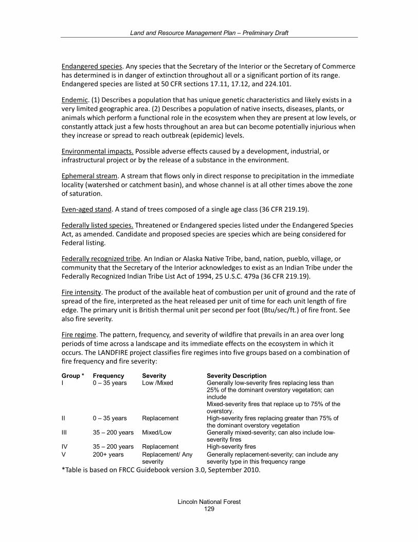
Land and Resource Management Plan – Preliminary Draft
Lincoln National Forest 129
Endangered species. Any species that the Secretary of the Interior or the Secretary of Commerce has determined is in danger of extinction throughout all or a significant portion of its range. Endangered species are listed at 50 CFR sections 17.11, 17.12, and 224.101.
Endemic. (1) Describes a population that has unique genetic characteristics and likely exists in a very limited geographic area. (2) Describes a population of native insects, diseases, plants, or animals which perform a functional role in the ecosystem when they are present at low levels, or constantly attack just a few hosts throughout an area but can become potentially injurious when they increase or spread to reach outbreak (epidemic) levels.
Environmental impacts. Possible adverse effects caused by a development, industrial, or infrastructural project or by the release of a substance in the environment.
Ephemeral stream. A stream that flows only in direct response to precipitation in the immediate locality (watershed or catchment basin), and whose channel is at all other times above the zone of saturation.
Even-aged stand. A stand of trees composed of a single age class (36 CFR 219.19).
Federally listed species. Threatened or Endangered species listed under the Endangered Species Act, as amended. Candidate and proposed species are species which are being considered for Federal listing.
Federally recognized tribe. An Indian or Alaska Native Tribe, band, nation, pueblo, village, or community that the Secretary of the Interior acknowledges to exist as an Indian Tribe under the Federally Recognized Indian Tribe List Act of 1994, 25 U.S.C. 479a (36 CFR 219.19).
Fire intensity. The product of the available heat of combustion per unit of ground and the rate of spread of the fire, interpreted as the heat released per unit of time for each unit length of fire edge. The primary unit is British thermal unit per second per foot (Btu/sec/ft.) of fire front. See also fire severity.
Fire regime. The pattern, frequency, and severity of wildfire that prevails in an area over long periods of time across a landscape and its immediate effects on the ecosystem in which it occurs. The LANDFIRE project classifies fire regimes into five groups based on a combination of fire frequency and fire severity:
Group * Frequency Severity Severity Description I 0 – 35 years Low /Mixed Generally low-severity fires replacing less than
25% of the dominant overstory vegetation; can include Mixed-severity fires that replace up to 75% of the overstory.
II 0 – 35 years Replacement High-severity fires replacing greater than 75% of the dominant overstory vegetation
III 35 – 200 years Mixed/Low Generally mixed-severity; can also include low-severity fires
IV 35 – 200 years Replacement High-severity fires V 200+ years Replacement/ Any
severity Generally replacement-severity; can include any severity type in this frequency range
*Table is based on FRCC Guidebook version 3.0, September 2010.
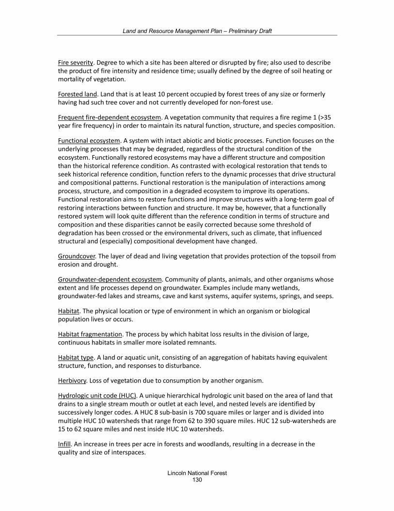
Land and Resource Management Plan – Preliminary Draft
Lincoln National Forest 130
Fire severity. Degree to which a site has been altered or disrupted by fire; also used to describe the product of fire intensity and residence time; usually defined by the degree of soil heating or mortality of vegetation.
Forested land. Land that is at least 10 percent occupied by forest trees of any size or formerly having had such tree cover and not currently developed for non-forest use.
Frequent fire-dependent ecosystem. A vegetation community that requires a fire regime 1 (>35 year fire frequency) in order to maintain its natural function, structure, and species composition.
Functional ecosystem. A system with intact abiotic and biotic processes. Function focuses on the underlying processes that may be degraded, regardless of the structural condition of the ecosystem. Functionally restored ecosystems may have a different structure and composition than the historical reference condition. As contrasted with ecological restoration that tends to seek historical reference condition, function refers to the dynamic processes that drive structural and compositional patterns. Functional restoration is the manipulation of interactions among process, structure, and composition in a degraded ecosystem to improve its operations. Functional restoration aims to restore functions and improve structures with a long-term goal of restoring interactions between function and structure. It may be, however, that a functionally restored system will look quite different than the reference condition in terms of structure and composition and these disparities cannot be easily corrected because some threshold of degradation has been crossed or the environmental drivers, such as climate, that influenced structural and (especially) compositional development have changed.
Groundcover. The layer of dead and living vegetation that provides protection of the topsoil from erosion and drought.
Groundwater-dependent ecosystem. Community of plants, animals, and other organisms whose extent and life processes depend on groundwater. Examples include many wetlands, groundwater-fed lakes and streams, cave and karst systems, aquifer systems, springs, and seeps.
Habitat. The physical location or type of environment in which an organism or biological population lives or occurs.
Habitat fragmentation. The process by which habitat loss results in the division of large, continuous habitats in smaller more isolated remnants.
Habitat type. A land or aquatic unit, consisting of an aggregation of habitats having equivalent structure, function, and responses to disturbance.
Herbivory. Loss of vegetation due to consumption by another organism.
Hydrologic unit code (HUC). A unique hierarchical hydrologic unit based on the area of land that drains to a single stream mouth or outlet at each level, and nested levels are identified by successively longer codes. A HUC 8 sub-basin is 700 square miles or larger and is divided into multiple HUC 10 watersheds that range from 62 to 390 square miles. HUC 12 sub-watersheds are 15 to 62 square miles and nest inside HUC 10 watersheds.
Infill. An increase in trees per acre in forests and woodlands, resulting in a decrease in the quality and size of interspaces.
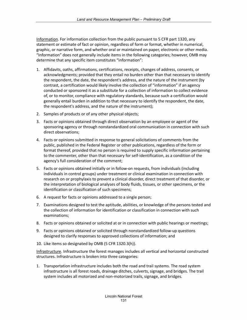
Land and Resource Management Plan – Preliminary Draft
Lincoln National Forest 131
Information. For information collection from the public pursuant to 5 CFR part 1320, any statement or estimate of fact or opinion, regardless of form or format, whether in numerical, graphic, or narrative form, and whether oral or maintained on paper, electronic or other media. “Information” does not generally include items in the following categories; however, OMB may determine that any specific item constitutes “information”:
1. Affidavits, oaths, affirmations, certifications, receipts, changes of address, consents, or acknowledgments; provided that they entail no burden other than that necessary to identify the respondent, the date, the respondent's address, and the nature of the instrument (by contrast, a certification would likely involve the collection of “information” if an agency conducted or sponsored it as a substitute for a collection of information to collect evidence of, or to monitor, compliance with regulatory standards, because such a certification would generally entail burden in addition to that necessary to identify the respondent, the date, the respondent's address, and the nature of the instrument);
2. Samples of products or of any other physical objects;
3. Facts or opinions obtained through direct observation by an employee or agent of the sponsoring agency or through nonstandardized oral communication in connection with such direct observations;
4. Facts or opinions submitted in response to general solicitations of comments from the public, published in the Federal Register or other publications, regardless of the form or format thereof, provided that no person is required to supply specific information pertaining to the commenter, other than that necessary for self-identification, as a condition of the agency's full consideration of the comment;
5. Facts or opinions obtained initially or in follow-on requests, from individuals (including individuals in control groups) under treatment or clinical examination in connection with research on or prophylaxis to prevent a clinical disorder, direct treatment of that disorder, or the interpretation of biological analyses of body fluids, tissues, or other specimens, or the identification or classification of such specimens;
6. A request for facts or opinions addressed to a single person;
7. Examinations designed to test the aptitude, abilities, or knowledge of the persons tested and the collection of information for identification or classification in connection with such examinations;
8. Facts or opinions obtained or solicited at or in connection with public hearings or meetings;
9. Facts or opinions obtained or solicited through nonstandardized follow-up questions designed to clarify responses to approved collections of information; and
10. Like items so designated by OMB (5 CFR 1320.3(h)).
Infrastructure. Infrastructure the forest manages includes all vertical and horizontal constructed structures. Infrastructure is broken into three categories:
1. Transportation infrastructure includes both the road and trail systems. The road system infrastructure is all forest roads, drainage ditches, culverts, signage, and bridges. The trail system includes all motorized and non-motorized trails, signage, and bridges.
Land and Resource Management Plan – Preliminary Draft
Lincoln National Forest 132
2. Facilities infrastructure includes administrative and recreation building and sites (e.g., driveways, parking, landscaping); support utilities (e.g., electrical, water, wastewater); dams, and other support buildings.
3. Other infrastructure directly supports natural resources, which includes fish barriers, wildlife drinkers, and range infrastructure (e.g., fencing, trick tanks, water gaps, cattleguards).
Inherent capability of the forest. The ecological capacity or ecological potential of an area characterized by the interrelationship of its physical elements, its climatic regime, and natural disturbances (36 CFR 219.19).
Integrated resource management. Multiple use management that recognizes the interdependence of ecological resources and is based on the need for integrated consideration of ecological, social, and economic factors (36 CFR 219.19).
Integration recognizes and identifies key relationships between various plan resources and activities. Plan components are integrated to address a variety of ecological and human needs. For example, desired conditions for ponderosa pine incorporate habitat needs for a variety of species, as well as the scenic components that recreationist’s desire. Interrelationships between parts of the plan are identified with crosswalks to show their systematic nature. In electronic versions of the plan, these crosswalks are hyperlinked (indicated by italicized text) to allow users to be easily redirected to the other relevant sections of the plan.
Intermittent stream. A stream or reach of stream channel that flows, in its natural condition, only during certain times of the year or in several years, and is characterized by interspersed, permanent surface water areas containing aquatic flora and fauna adapted to the relatively harsh environmental conditions found in these types of environments. Intermittent streams are identified as dashed blue lines on USGS 7 1/2-inch quadrangle maps.
Invasive species. An alien species whose introduction does or is likely to cause economic or environmental harm or harm to human health. A species that causes, or is likely to cause, harm and that is exotic to the ecosystem it has infested. Invasive species infest both aquatic and terrestrial areas and can be identified within any of the following four taxonomic categories: Plants, Vertebrates, Invertebrates, and Pathogens (Executive Order 13112). Sometimes referred to as non-native invasives or exotic species.
Land grant-merced. A grant of land made by the Government of Spain or of Mexico to a community, town, colony, pueblo, or person for the purpose of founding or establishing a community, town, colony, or pueblo.
Land grant-merced governing body. A community land grant-merced recognized under a State of New Mexico law, statute, or code, with a duly elected or appointed governance body charged with management, care and protection of land grant-merced common lands.
Landscape. A defined area irrespective of ownership or other artificial boundaries, such as a spatial mosaic of terrestrial and aquatic ecosystems, landforms, and plant communities, repeated in similar form throughout such a defined area (36 CFR 219.19).
Leave No Trace. Guidelines that help protect the land and lessen the sights and sounds of forest visitors. http://www.lnt.org/
Land and Resource Management Plan – Preliminary Draft
Lincoln National Forest 133
Line officer. A Forest Service official who serves in a direct line of command from the Chief (36 CFR 219.62).
Litter. Litter consists of dead, unattached organic material on the soil surface that is effective in protecting the soil surface from raindrop splash, sheet, and rill erosion and is at least ½ inch thick. Litter is composed of leaves, needles, cones, and woody vegetative debris including twigs, branches, and trunks.
Maintain. In reference to an ecological condition: To keep in existence or continuance of the desired ecological condition in terms of its desired composition, structure, and processes. Depending upon the circumstance, ecological conditions may be maintained by active or passive management or both (36 CFR 219.19).
Management actions. Any alterations to ecosystems or activities that the Forest Service conducts or authorizes on NFS lands. These may include mechanical thinning, prescribed burning, permitted grazing, permitted fuelwood gathering, vehicular access, stream restoration treatments, seeding, trail construction, fencing, among others.
Management area. A land area identified within the planning area that has the same set of applicable plan components. A management area does not have to be spatially contiguous (36 CFR 219.19).
Mechanical treatment. For the purposes of this plan, mechanical treatments include most vegetation treatments except fire. They may include mechanized cutting, hand thinning, and other silvicultural treatments.
Memorandum of understanding (MOU). Describes a bilateral or multilateral agreement between two or more parties. It expresses a convergence of will between the parties, indicating an intended common line of action. It is often used in cases where parties either do not imply a legal commitment or in situations where the parties cannot create a legally enforceable agreement. It is a more formal alternative to a handshake agreement.
Minimum requirements analysis. Required by law whenever land managers are considering a use prohibited by Section 4(c) of the Wilderness Act of 1964, and is a process that was developed by the Arthur Carhart National Wilderness Training Center to help land managers make informed, defensible decisions that comply with the Wilderness Act.
Mitigate. To avoid, minimize, rectify, reduce, or compensate the adverse environmental impacts associated with an action.
Monitoring. A systematic process of collecting information to evaluate effects of actions or changes in conditions or relationships (36 CFR 219.19).
Mosaic. Mix of recurring patterns of forested and non-forested areas at the identified scale (e.g., landscape, watershed, mid-scale). Patterns are variable and may change over time.
Land and Resource Management Plan – Preliminary Draft
Lincoln National Forest 134
Motor Vehicle. Any vehicle that is self-propelled, other than:
1. A vehicle operated on rails; and
2. Any wheelchair or mobility device, including one that is battery-powered, that is designed solely for use by a mobility-impaired person for locomotion, and that is suitable for use in an indoor pedestrian area (36 CFR 212.1, 36 CFR 261.2).
Motor Vehicle Use Map (MVUM). A map reflecting designated roads, trails, and areas on an administrative unit or a ranger district of the National Forest System (36 CFR 212.1).
Multiple use. The management of all the various renewable surface resources of the National Forest System so that they are utilized in the combination that will best meet the needs of the American people; making the most judicious use of the land for some or all of these resources or related services over areas large enough to provide sufficient latitude for periodic adjustments in use to conform to changing needs and conditions; that some land will be used for less than all of the resources; and harmonious and coordinated management of the various resources, each with the other, without impairment of the productivity of the land, with consideration being given to the relative values of the various resources, and not necessarily the combination of uses that will give the greatest dollar return or the greatest unit output, consistent with the Multiple-Use Sustained-Yield Act of 1960 (16 U.S.C. 528–531) (36 CFR 219.19).
National Environmental Policy Act (NEPA). A United States environmental law (42 U.S.C. 4321 et seq.), enacted January 1, 1970 that established a U.S. national policy promoting the enhancement of the environment. Additionally, it established the President's Council on Environmental Quality (CEQ).
National Forest System. Includes National Forests, National Grasslands, and the National Tallgrass Prairie (36 CFR 219.62).
National Forest System Road. A forest road other than a road which has been authorized by a legally documented right-of-way held by a State, county or other local public road authority (36 CFR 212.1, 36 CFR 251.51, 36 CFR 261.2).
National Forest System Trail. A forest trail other than a trail which has been authorized by a legally documented right-of-way held by a State, county or other local public road authority (36 CFR 212.1).
Native species. An organism that was historically or is present in a particular ecosystem as a result of natural migratory or evolutionary processes and not as a result of an accidental or deliberate introduction into that ecosystem. An organism’s presence and evolution (adaptation) in an area are determined by climate, soil, and other biotic and abiotic factors (36 CFR 219.19).
Natural variability. Is a reference to past conditions and processes that provide important context and guidance relevant to the environments and habitats in which native species evolved. Disturbance driven spatial and temporal variability is vital to ecological systems. Biologically appropriate disturbances provide for heterogeneous conditions and subsequent diversity. Conversely, “uncharacteristic disturbance”, such as high-intensity fire in plant communities that historically had a frequent low intensity fire regime can have the effect of reducing diversity, increasing homogeneity, and may result in permanently altered conditions.
Land and Resource Management Plan – Preliminary Draft
Lincoln National Forest 135
Objective. A concise, measurable, and time-specific statement of a desired rate of progress toward a desired condition or conditions. Objectives should be based on reasonably foreseeable budgets.
Off-highway vehicle (OHV). Any motorized vehicle designed for or capable of cross county travel on or immediately over land, water, sand, snow, ice, marsh, swampland, or other natural terrain; except that term excludes (A) any registered motorboat, (B) any fire, military, emergency or law enforcement vehicle when used for emergency purposes, and any combat or combat support vehicle when used for national defense purposes, and (C) any vehicle whose use is expressly authorized by the respective agency head under a permit, lease, license, or contract (EO 11644 as amended by EO 11989). See also FSM 2355. 01 - Exhibit 01.
Old growth characteristics. Old-growth forests are forests that have accumulated specific characteristics related to tree size, canopy structure, snags and woody debris and plant associations. Ecological characteristics of old-growth forests emerge through the processes of succession. Certain features - presence of large, old trees, multilayered canopies, forest gaps, snags, woody debris, and a particular set of species that occur primarily in old-growth forests - do not appear simultaneously, nor at a fixed time in stand development. Old-growth forests support assemblages of plants and animals, environmental conditions, and ecological processes that are not found in younger forests (younger than 150-250 years) or in small patches of large, old trees. Specific attributes of old-growth forests develop through forest succession until the collective properties of an older forest are evident.
Online. Refers to the appropriate Forest Service Website or future electronic equivalent (36 CFR 219.62).
Openings. Generally persistent treeless areas having a fairly distinct shape or size, occurring naturally due to differences in soil types as compared to sites that support forests or woodlands. Openings include meadows, grasslands, rock outcroppings, and wetlands. In contrast, created openings result from disturbances like severe fire or windthrow, or management activities to intentionally create space for new tree regeneration. Natural and created openings are not the same as interspaces found in the frequent-fire forests or woodlands. See interspaces.
Outstanding natural resource water (ONRW). Streams, lakes and wetlands that receive special protection against degradation under New Mexico’s water quality standards and the Federal Clean Water Act. They are designated by the Water Quality Control Commission. Waters eligible for ONRW designation include waters that are part of a national or state park, wildlife refuge or wilderness areas, special trout waters, waters with exceptional recreational or ecological significance, and high quality waters that have not been significantly modified by human activities (NMED 2015).
Participation. Activities that include a wide range of public involvement tools and processes, such as collaboration, public meetings, open houses, workshops, and comment periods (36 CFR 219.19).
Perennial stream. A stream or reach of a channel that flows continuously or nearly so throughout the year and whose upper surface is generally lower than the top of the zone of saturation in areas adjacent to the stream. These streams are identified as solid blue on the USGS 7 1/2-inch quadrangle maps.
Land and Resource Management Plan – Preliminary Draft
Lincoln National Forest 136
Permit area. Area in which an activity is authorized through a special use permit.
Persistence. Continued existence (36 CFR 219.19).
Plan or land management plan. A document or set of documents that provide management direction for an administrative unit of the NFS developed under the requirements of the land management planning regulation at 36 CFR part 219 or a prior planning rule (36 CFR 219.19).
Plan area. The NFS lands covered by a plan (36 CFR 219.19), specifically lands managed by the Forest Service as the Lincoln NF.
Plan components. The parts of a land management plan that guide future project and activity decision-making. Specific plan components may apply to the entire plan area, to specific management areas or geographic areas, or to other areas as identified in the plan. Every plan must include the following plan components: Desired conditions; Objectives; Standards; Guidelines; Suitability of Lands. A plan may also include Goals as an optional component.
Plan development. The second phase in the forest plan revision process. Plan development follows the NEPA process and plan revision requires preparation of an environmental impact statement (EIS). It is grounded in the information developed during the assessment phase and other information relevant to the plan area, it addresses needs for change, and it involves the public. Every plan must have management areas or geographic areas or both and may identify designated or recommended designated areas (36 CFR 219.7).
Plan monitoring program. An essential part of the land management plan that sets out the plan monitoring questions and associated indicators, based on plan components. The plan monitoring program informs management of resources on the plan area and enables the Responsible Official to determine if a change in plan components or other plan content that guide management of resources on the plan area may be needed.
Planned ignition. The intentional initiation of a wildland fire by hand-held, mechanical, or aerial device where the distance and timing between ignition lines or points and the sequence of igniting them is determined by environmental conditions (e.g., weather, fuel, topography), firing technique, and other factors which influence fire behavior and fire effects. See prescribed fire.
Plant and animal community. A naturally occurring assemblage of plant and animal species living within a defined area or habitat (36 CFR 219.19).
Prescribed fire. A wildland fire originating from a planned ignition to meet specific objectives identified in a written, approved, prescribed fire plan for which NEPA requirements have been met prior to ignition.
Productivity. The capacity of NFS lands and their ecological systems to provide the various renewable resources in certain amounts in perpetuity. For the purposes of the land management planning regulation at 36 CFR part 219 and this Handbook, productivity is an ecological term, not an economic term (36 CFR 219.19).
Project. An organized effort to achieve an outcome on NFS lands identified by location, tasks, outputs, effects, times, and responsibilities for execution (36 CFR 219.19).
Land and Resource Management Plan – Preliminary Draft
Lincoln National Forest 137
Proper functioning condition (PFC). PFC is a methodology for assessing the physical functioning of riparian and wetland areas. The term PFC is used to describe both the assessment process, and a defined, on-the-ground condition of a riparian-wetland area. In either case, PFC defines a minimum or starting point.
Proposed species. Any species of fish, wildlife, or plant that is proposed by the U. S. Fish and Wildlife Service or the National Marine Fisheries Service in the Federal Register to be listed under Section 4 of the Endangered Species Act. (36 CFR 219.19)
Rangelands. Forage-producing forested and non-forested lands.
Recovery. For the purposes of the land management planning regulation at 36 CFR part 219 and with respect to threatened or endangered species: The improvement in the status of a listed species to the point at which listing as federally endangered or threatened is no longer appropriate (36 CFR 219.19).
Recreation opportunity. An opportunity to participate in a specific recreation activity in a particular recreation setting to enjoy desired recreation experiences and other benefits that accrue. Recreation opportunities include non-motorized, motorized, developed, and dispersed recreation on land, water, and in the air (36 CFR 219.19).
Recreation setting. The social, managerial, and physical attributes of a place that, when combined, provides a distinct set of recreation opportunities. The Forest Service uses the recreation opportunity spectrum to define recreation settings and categorize them into six distinct classes: primitive, semi-primitive non-motorized, semi-primitive motorized, roaded natural, rural, and urban (36 CFR 219.19).
Redundancy. The presence of multiple occurrences of ecological conditions such that not all occurrences may be eliminated by a catastrophic event.
Reference conditions. Environmental conditions that infer ecological sustainability. When available, reference conditions are represented by the characteristic natural range of variation (NRV) (not the total range of variation), prior to European settlement and under the current climatic period. For many ecosystems, NRV also reflects human-caused disturbance and effects prior to settlement. It may also be necessary to refine reference conditions according to contemporary factors (e.g., invasive species) or projected conditions (e.g., climate change). Reference conditions are most useful as an inference of sustainability when they have been quantified by amount, condition, spatial distribution, and temporal variation.
Regulated timber harvest. Tree harvest for the purposes of timber production, as opposed to tree harvest for other purposes, such as habitat and watershed improvement or fuelwood.
Representativeness. The presence of a full array of ecosystem types and successional states, based on the physical environment and characteristic disturbance processes.
Resilience. The ability of an ecosystem and its component parts to absorb, or recover from the effects of disturbances through preservation, restoration, or improvement of its essential structures and functions and redundancy of ecological patterns across the landscape (FSM 2020.5).
Land and Resource Management Plan – Preliminary Draft
Lincoln National Forest 138
Responsible official. The official with the authority and responsibility to oversee the planning process and to approve a plan, plan amendment, and plan revision (36 CFR 219.62).
Restoration, ecological. The process of assisting the recovery of an ecosystem that has been degraded, damaged, or destroyed. Ecological restoration focuses on reestablishing the composition, structure, pattern, and ecological processes necessary to facilitate terrestrial and aquatic ecosystems sustainability, resilience, and health under current and future conditions (36 CFR 219.19).
Restore. To renew by the process of restoration. See restoration (36 CFR 219.19).
Riparian areas. Three-dimensional ecotones [the transition zone between two adjoining communities] of interaction that include terrestrial and aquatic ecosystems that extend down into the groundwater, up above the canopy, outward across the floodplain, up the near-slopes that drain to the water, laterally into the terrestrial ecosystem, and along the water course at variable widths (36 CFR 219.19).
Riparian management zone. The interface between land and a river or stream. Plant habitats and communities along the river margins and banks are called riparian vegetation, characterized by hydrophilic plants.
Risk. A combination of the likelihood that a negative outcome will occur and the severity of the subsequent negative consequences (36 CFR 219.19).
Road. A motor vehicle route over 50 inches wide, unless identified and managed as a trail (36 CFR 212.1).
Road Maintenance Levels (ML):
ML1. Roads that are closed to vehicular traffic intermittently for periods that exceed 1 year. Can be operated at any other maintenance level during periods of use.
ML2. Roads that are open and maintained for use by high-clearance vehicles; surface smoothness is not a consideration. Most have native material surface (not paved and no aggregate surface).
ML3. Roads that are open and maintained for use by standard passenger cars. Most have gravel surface.
ML4. Roads that are open and maintained for use by standard passenger cars and to provide a moderate degree of user comfort and convenience at moderate travel speeds. Most are paved or have an aggregate surface.
ML5. Roads that are open and maintained for use by standard passenger cars
Routine maintenance. Work that is planned to be accomplished on a continuing basis, generally annually or more frequently (FSH 7709.58, 13.41).
Scenery Management System. A classification system that recognizes scenery as the visible expression of dynamic ecosystems functioning within “places”, which have unique aesthetic and social values. It recognizes that in addition to naturally occurring features, positive scenery attributes associated with social, cultural, historical, and spiritual values, including human presence and the built environment, can also be valued elements of the scenery. The SMS also
Land and Resource Management Plan – Preliminary Draft
Lincoln National Forest 139
allows for “seamless” analysis and conservation beyond National Forest System lands into adjacent communities and other jurisdictions, through the application of varying scenery “themes” within a single analysis. It is structured to emphasize "natural appearing” scenery.
Scenic character. A combination of the physical, biological, and cultural images that gives an area its scenic identity and contributes to its sense of place. Scenic character provides a frame of reference from which to determine scenic attractiveness and to measure scenic integrity (36 CFR 219.19).
Scenic integrity objective. A desired level of excellence based on physical and sociological characteristics of an area. Refers to the degree of acceptable alterations to the valued attributes of the characteristic landscape. Objectives include Very High, High, Moderate, and Low.
Seral stage (seral state). One of a series of transitional plant communities that develop during gradual successive change following disturbance.
Snags are standing dead or partially dead trees (snag topped), often missing many or all limbs. They provide essential wildlife habitat for many species and are important for forest ecosystem function.
Soil condition rating. A qualitative rating developed within the Southwestern Region of the Forest Service that provides an overall picture of soil condition vital in sustaining ecosystems. It is based on three soil functions: the ability of soil to resist erosion, infiltrate water, and recycle nutrients. There are four soil condition ratings:
• Satisfactory. Soil function is being sustained and soil is functioning properly and normally.
• Impaired. The ability of the soil to function properly and normally has been reduced or there exists an increased vulnerability to degradation.
• Unsatisfactory. Degradation of vital soil functions result in the inability of the soil to maintain resource values, sustain outputs or recover from impacts.
• Inherently unstable. These soils are eroding faster than they are renewing themselves.
Species of conservation concern. A species, other than federally recognized threatened, endangered, proposed, or candidate species, that is known to occur in the plan area and for which the Regional Forester has determined that the best available scientific information indicates substantial concern about the species' capability to persist over the long-term in the plan area (36 CFR 219.9(c)).
Stand. A contiguous group of trees generally uniform in age class distribution, composition, condition, and structure, and growing on a site of generally uniform quality, to be a distinguishable unit, such as mixed, pure, even-aged, and uneven-aged stands. A stand is the fundamental unit of silviculture reporting and record keeping.
Standard. A mandatory constraint on project and activity decision-making, established to help achieve or maintain the desired condition or conditions, to avoid or mitigate undesirable effects, or to meet applicable legal requirements.
Stressors. For the purposes of the land management planning regulation at 36 CFR part 219, factors that may directly or indirectly degrade or impair ecosystem composition, structure, or
Land and Resource Management Plan – Preliminary Draft
Lincoln National Forest 140
ecological process in a manner that may impair its ecological integrity, such as an invasive species, loss of connectivity, or the disruption of a natural disturbance regime (36 CFR 219.19).
Sustainable Operations is the commitment by the Forest Service to use energy efficiently and reduce consumption of resources in daily operations. By doing work differently in six Footprint Focus Areas, the Lincoln NF is reducing its environmental impact.
1. Energy - Improve energy efficiency and reduce greenhouse gas emissions, through the reduction of energy. Shift toward renewable energy, such as solar power and biomass.
2. Water - Reduce water consumption in Forest Service buildings, grounds, and related facilities.
3. Green Purchasing - Increase the sustainability performance of purchased goods and services, and the performance of suppliers, contractors, and partners. Increase the number of Forest Service buildings that are Leadership in Energy and Environmental Design (LEED) certified.
4. Fleet and Transportation - Improve our transportation and travel practices, which in turn will reduce harmful emissions, increase operational and fuel efficiency, and reduce the use of non-renewable fuel.
5. Waste Prevention and Recycling - Minimize waste generation and reduce landfill use. Reduce, reuse and recycle materials.
6. Sustainability Leadership - Make strong efforts to meet or exceed the requirements of Executive Orders and policies related to sustainable operations. Leadership and management have a commitment to communicate the agency’s vision for sustainable operations.
Sustainability. The capability to meet the needs of the present generation without compromising the ability of future generations to meet their needs. For the purposes of the land management planning regulation at 36 CFR part 219 and this Handbook ‘‘ecological sustainability’’ refers to the capability of ecosystems to maintain ecological integrity; ‘‘economic sustainability’’ refers to the capability of society to produce and consume or otherwise benefit from goods and services including contributions to jobs and market and nonmarket benefits; and ‘‘social sustainability’’ refers to the capability of society to support the network of relationships, traditions, culture, and activities that connect people to the land and to one another, and support vibrant communities (36 CFR 219.19).
Sustainable recreation. The set of recreation settings and opportunities on the National Forest System that is ecologically, economically, and socially sustainable for present and future generations (36 CFR 219.19).
Sustainable Yield Limit (SYL). The sustained yield limit is an estimate of the amount of commercial wood products that may be sustainably harvested over a long period of time.
Sub-watershed. A HUC 12 hydrologic unit, the smallest subdivision considered in this assessment.
Terrestrial ecosystem. All interacting organisms and elements of the abiotic environment in those vegetation and soil types, which are neither aquatic nor riparian.
Land and Resource Management Plan – Preliminary Draft
Lincoln National Forest 141
Terrestrial ecosystem survey (TES). An inventory of soil types or terrestrial ecosystem units (TEUs) on the Lincoln NF. It contains predictions and limitations of soil and vegetation behavior for selected land uses. This survey also highlights hazards or capabilities inherent in the soil and the impact of selected uses on the environment. At the context scale, upland ecological response units are derived from the Lincoln NF Terrestrial Ecosystem Survey (USDA FS Lincoln date?).
Terrestrial ecosystem unit (TEU). The classification unit used in the Terrestrial Ecosystem Survey (TES). A spatially explicit area with a similar combination of soils, land types, and vegetation c Threatened species. Any species that the Secretary of the Interior or the Secretary of Commerce has determined is likely to become an endangered species within the foreseeable future throughout all or a significant portion of its range. Threatened species are listed at 50 CFR sections 17.11, 17.12, and 223.102.
Timber harvest. The removal of trees for wood fiber use and other multiple use purposes (36 CFR 219.19).
Timber production. The purposeful growing, tending, harvesting, and regeneration of regulated crops of trees to be cut into logs, bolts, or other round sections for industrial or consumer use (36 CFR 219.19).
Traditional community. A land-based rural community that has a long-standing history in and around the lands managed by the Forest Service.
Traditional cultural property (TCP). A property that is eligible for inclusion in the National Register of Historic Places (NRHP) based on its associations with the cultural practices, traditions, beliefs, lifeways, arts, crafts, or social institutions of a living community.
Tribal consultation. The timely, meaningful, and substantive dialogue between Forest Service officials who have delegated authority to consult, and the official leadership of federally recognized Indian Tribes, or their designated representatives, pertaining to USDA Forest Service policies that may have tribal implications.
Tree Size. The diameter of the bole of a tree measured at breast height (DBH).
• Seedling/Sapling: 0.0 - 4.9” diameter
• Small tree: 5.0 – 9.9” diameter
• Medium tree: 10 – 19.9” diameter
• Large tree: ≥ 20.0” diameter
Uncharacteristic wildfire. An increase in wildfire size, severity, and resistance to control compared to reference conditions which occurred historically. These fires result as a consequence of more continuous canopy cover, ladder fuels, and accumulated live and dead woody material. Uncharacteristic wildfires burn with more intensity; cause higher tree mortality; degrade watersheds; sterilize soils; and threaten adjacent communities, forest infrastructure, and wildlife habitat. See reference conditions.
Ungulate. A hooved animal, which includes wildlife (e.g., pronghorn, deer, and elk) and domestic livestock (e. g., sheep, cattle, and horses).
Land and Resource Management Plan – Preliminary Draft
Lincoln National Forest 142
Unplanned ignition. The initiation of a wildland fire by lightning or unauthorized and accidental human-caused fires. See wildfire.
Upland. May refer to areas, species, systems, or conditions that are characteristic of terrestrial ecosystems, as opposed to riparian or aquatic ecosystems.
Vegetation community is a group of sites that have similar plant species composition, successional patterns, and disturbance regimes, such that similar sites will respond in similar ways to disturbance, biological, and physical processes. In some areas there is a difference between the existing vegetation on a site and the vegetation community it belongs to, such as where historic grasslands are currently invaded by trees. The desired vegetation community, not the existing vegetation, determines which desired conditions apply. Most vegetation communities correspond to a mapped Ecological Response Unit (ERU), though it is appropriate to base management for a particular vegetation community on local conditions, including soils and other site-specific indicators.
Vegetation structure. Both vertical and horizontal arrangement of vegetation. Horizontal structure may refer tree size, tree density, and to patterns of trees or groups of trees and their adjoining openings. Vertical structure may refer to the layers, appearance, and composition of vegetation between the ground and the top of the vegetation canopy and includes any grasses, forbs, shrubs, and trees.
Watershed. A region or land area drained by a single stream, river, or drainage network; a drainage basin (36 CFR 219.19). Specifically, a HUC 10 hydrologic unit, larger than a sub-watershed, and nested in a sub-basin.
Watershed condition. The state of a watershed based on physical and biogeochemical characteristics and processes (36 CFR 219.19).
Wetlands. A specific subtype within the Wetland Riparian group of vegetation communities. In wetlands saturation with water is the dominant factor determining the nature of soil development and plant and animal communities. “For regulatory purposes under the Clean Water Act, the term wetlands means ‘those areas that are inundated or saturated by surface or groundwater at a frequency and duration sufficient to support, and that under normal circumstances do support, a prevalence of vegetation typically adapted for life in saturated soil conditions. Wetlands generally include swamps, marshes, bogs and similar areas.’ [taken from the EPA Regulations listed at 40 CFR 230.3(t)].” (USEPA 2015) The Wetland Riparian vegetation community as defined in this plan is slightly more inclusive and includes open water wetlands and cienegas that may not be considered wetlands for regulatory purposes.
Wild and Scenic River. A river designated by Congress as part of the National Wild and Scenic Rivers System that was established in the Wild and Scenic Rivers Act of 1968 (16 U.S.C. 1271 (note), 1271–1287) (36 CFR 219.19).
Wilderness. Any area of land designated by Congress as part of the National Wilderness Preservation System that was established in the Wilderness Act of 1964 (16 U.S.C. 1131–1136) (36 CFR 219.19).
Wildfire. Unplanned ignition of a wildland fire (e.g., fires caused by lightning or unauthorized and accidental human-caused fires) and escaped prescribed fires. See unplanned ignition.

Land and Resource Management Plan – Preliminary Draft
Lincoln National Forest 143
Wildfire hazard. A fuel complex, defined by volume, type condition, arrangement, and location, that determines the degree or ease of ignition and of resistance to control.
Wildland. An area in which development is essentially nonexistent, except for roads, railroads, power lines, and similar transportation facilities. Structures, if any, are widely scattered.
Wildland-Urban Interface (WUI). That area where human development adjoins public or private natural areas, or an intermix of rural and urban land uses. From a natural resource perspective the wildland-urban interface is an area where increased human influence and land-use conversion are changing natural resource goods, services, and management techniques (Hermansen-Baez et al. 2009).
Woodland. Lands with over 10 percent tree canopy cover where the majority of the trees are non-timber species (e.g., piñon pine and juniper) not traditionally used for industrial wood products.

Land and Resource Management Plan – Preliminary Draft
Lincoln National Forest 145
References Agricultural Handbook 701 (USDA FS 1995) Landscape aesthetics: a handbook for scenery
management.
Lincoln NF Terrestrial Ecosystem Survey
National Parks and Recreation Act (NPRA) 1978 - Public Law 95-625 (11/10/1978). Guadalupe Escarpment Wilderness Study Area
Recreation Act of 1978
USDA Forest Service Lincoln National Forest (LNF) 2019a. Forest Plan Final Assessment Report Lincoln National Forest Volume I: Ecological Resources.
2019b. Lincoln National Forest Plan Final Assessment Report Volume II: Socioeconomic Resources
Land and Resource Management Plan – Preliminary Draft
Lincoln National Forest 146
Appendix XX: Proposed Probable and Possible Future Actions
Appendix XX: Relevant Laws, Regulations, and Policy In progress
Federal and State Statutes The following is a partial list of relevant laws which have been enacted by Congress. A Federal statute, or law, is an act or bill which has become part of the legal code through passage by Congress and approval by the President (or via congressional override). Although not always specified below, many of these laws have been amended. American Indian Religious Freedom Act (AIRFA) as amended (42 U.S.C. 1996) Protects and preserves for American Indians their inherent right of freedom to believe, express, and exercise the traditional religions of the American Indian, Eskimo, Aleut, and Native Hawaiians, including but not limited to access to sites, use, and possession of sacred objects and the freedom to worship through ceremonial and traditional rites. Americans with Disabilities Act of 1990 Americans with Disabilities Act of 1990 Provides a clear and comprehensive national mandate for the elimination of discrimination against individuals with disabilities; for clear, strong, consistent, and enforceable standards addressing discrimination against individuals with disabilities; to ensure that the Federal Government plays a central role in enforcing the standards established in this act on behalf of individuals with disabilities; and to invoke the sweep of congressional authority, including the power to enforce the fourteenth amendment and to regulate commerce, in order to address the major areas of discrimination faced by people with disabilities. Anderson-Mansfield Reforestation and Revegetation Act of October 11, 1949 Provides for the reforestation and revegetation of National Forest System lands and other lands under the administration or control of the Forest Service. Antiquities Act of 1906 (16 U.S.C. 431-433) Prevents the appropriation, excavation, injury, or destruction of any historic or prehistoric ruin or monument, or any object of antiquity, situated on lands owned or controlled by the United States, without permission. Provides for permits, for misdemeanor-level penalties for unauthorized use, and authorizes the President to declare by public proclamation historic landmarks, historic and prehistoric structures, and other objects of historic or scientific interest that are situated upon lands owned or controlled by the United States to be national monuments, and to reserve as a part thereof parcels of land needed for the proper care and

Land and Resource Management Plan – Preliminary Draft
Lincoln National Forest 147
management of the objects to be protected. The Archaeological Resources Protection Act has replaced the Antiquities Act as the authority for special use permits if the resource involved is 100-years old or greater. Archaeological and Historic Preservation Act of 1974 (AHPA) (16 U.S.C. 469) This act is also known as the Archaeological Recovery Act. AHPA amended and expanded the Reservoir Salvage Act of 1960 and was enacted to complement the Historic Sites Act of 1935 by providing for the preservation of significant scientific, historical, and archaeological data which might be lost or destroyed as the result of the construction of a federally authorized dam or other construction activity. AHPA also allows for any Federal agency responsible for a construction project to appropriate a portion of project funds for archaeological survey, recovery, analysis, and publication of results. Archaeological Resources Protection Act of 1979 as amended (ARPA) (16 U.S.C. 470 aa et seq.) The act establishes permit requirements for removal or excavation of archaeological resources from Federal and Indian lands. Provides criminal and civil penalties for the unauthorized excavation, removal, damage, alteration, defacement, or the attempted unauthorized removal, damage, alteration, or defacement of any archaeological resource more than 100 years of age found on Federal or Indian lands. Prohibits the sale, purchase, exchange, transportation, receipt, or offering of any archaeological resource obtained from public lands or Indian lands. The act further directs Federal land managers to survey land under their control for archaeological resources and create public awareness programs concerning archaeological resources. Section 470ii (c): States that “each federal land manager shall establish a program to increase public awareness of the significance of the archaeological resources located on public lands and Indian lands and the need to protect such resources.” It further directs that an annual report of such progress will be submitted to Congress. Section 470mm: Directs Federal agencies to “develop plans for surveying lands under their control to determine the nature and extent of archaeological resources on those lands; prepare a schedule for surveying lands that are likely to contain the most scientifically valuable archaeological resources; and develop documents for the report of suspected violations of this act and establish when and how those documents are to be completed by officers, employees, and agents of their respective agencies.” Bald and Golden Eagle Protection Act of 1940, as amended The act prohibits anyone, without a permit issued by the Secretary of the Interior, from “taking” bald and golden eagles, including their parts, nests, or eggs. The act defines “take” as “pursue, shoot, shoot at, poison, wound, kill, capture, trap, collect, molest or disturb.” Disturbance includes impacts that result from human-induced alterations in the nesting area even when eagles are not present. Sections 22.26—28 allow take of bald and golden eagles or their nests where it is unavoidable and where it is compatible with the continued preservation of the eagle. Permits for take are issued based on certain criteria such as, but not limited to, certifications, reporting, and monitoring. Bankhead-Jones Farm Tenant Act of July 22, 1937, as amended
Land and Resource Management Plan – Preliminary Draft
Lincoln National Forest 148
Authorized federal government to purchase invaluable land and rehabilitate to the forest needs. It also helped tenant farms take care of their land. Clarke-McNary Act of 1924 Allowed for easier purchase of land intended for Forest Service use, and gave a strong action for state offices to open to represent the Forest Service. Clean Air Act of August 7, 1977, as amended (1977 and 1990) 42 U.S.C. §7401 et seq. (1970) Enacted to protect and enhance the quality of the Nation’s air resources; to initiate and accelerate a national research and development program to achieve the prevention and control of air pollution; to provide technical and financial assistance to state and local governments in connection with the development and execution of their air pollution prevention and control programs; and to encourage and assist the development and operation of regional air pollution prevention and control programs. Clean Water Act (see Federal Water Pollution Control Act) Clean Water Restoration Act of 1966 Authorizes the Secretary of Interior to conduct a comprehensive study of the effects of pollution, including sedimentation, sport and commercial fishing, recreation, water supply and power, and other specified uses Common Varieties of Mineral Materials Act of July 31, 1947 Authorizes the Secretaries of the Interior and Agriculture, under such rules and regulations as they may prescribe, to dispose of common variety mineral materials (including but not limited to sand, stone, gravel, pumice, pumicite, cinders, and clay) and vegetative materials (including but not limited to yucca, manzanita, mesquite, cactus, and timber or other forest products) on public lands of the United States, if the disposal of such materials is not otherwise expressly authorized by law, is not expressly prohibited by laws of the United States, and would not be detrimental to the public interest. Cooperative Forestry Assistance Act of July 1, 1978 Authorizes the Secretary of Agriculture to assist in the establishment of a coordinated and cooperative Federal, state, and local forest stewardship program for the management of non-Federal forest lands and forest lands in foreign countries. Emergency Flood Prevention Act (Agricultural Credit Act) of August 4, 1978 Authorizes the Secretary of Agriculture to undertake emergency measures for runoff retardation and soil erosion prevention, in cooperation with landowners and users, as the Secretary deems necessary to safeguard lives and property from floods, drought, and the products of erosion on any watershed whenever fire, flood, or other natural occurrence is causing or has caused a sudden impairment of that watershed. Endangered American Wilderness Act of 1978 Designated 50,000 acres as the Chama River Canyon Wilderness in the SF and Carson National Forest which was part of a bigger concern for preservation of wildlife and quality of habitats.
Land and Resource Management Plan – Preliminary Draft
Lincoln National Forest 149
Endangered Species Act of 1973, as amended Authorizes the determination and listing of species as endangered and threatened; prohibits unauthorized taking, possession, sale, and transport of endangered species; authorizes the assessment of civil and criminal penalties for violating the act or regulations; and, authorizes the payment of rewards to anyone furnishing information leading to arrest and conviction for any violation of the act or any regulation issued thereunder. Section 7 of the act requires Federal agencies to use their authorities to carry out programs for the conservation of endangered and threatened species and to insure that any action authorized, funded, or carried out by them is not likely to jeopardize the continued existence of listed species or adversely modify their critical habitat. Section 4 of the act directs the development and implementation of recovery plans for threatened and endangered species and the designation of critical habitat. Several species listed under the act are found on the Lincoln NF, some with recovery plans and some with designated critical habitat. Those with a recovery plan and/or a critical habitat designation are listed below: Mexican Spotted Owl Recovery Plan Endangered and Threatened Wildlife and Plants; Final Designation of Critical Habitat for the Mexican Spotted Owl; Final Rule Final Recovery Plan Southwestern Willow Flycatcher Endangered and Threatened Wildlife and Plants; Designation of Critical Habitat for Southwestern Willow Flycatcher; Final Rule Energy Independence and Security Act of December 19, 2007 Reinforces the energy reduction goals for federal agencies put forth in Executive Order 13423, as well as introduces more aggressive requirements. The three key provisions enacted are the Corporate Average Fuel Economy Standards, the Renewable Fuel Standard, and the appliance/lighting efficiency standards. Energy Policy Act of 2005 Requires the Secretary of Agriculture to ensure timely action on oil and gas permits, improve collection and retrieval of oil and gas information, and improve inspection and enforcement of permit terms (Section 362). Energy Security Act of June 30, 1980 Authorizes the Secretary of Agriculture to make available timber resources of the National Forest System, in accordance with appropriate timber appraisal and sale procedures, for use by biomass energy projects. Environmental Quality Act (1970) This act sets forth a national policy for the environment which provides for the enhancement of environmental quality. Congress recognizes there has been changes to the environment and sets out to improve quality and quantity of healthy environments across the U.S. Federal Advisory Committee Act of October 6, 1972 Sets standards and uniform procedures to govern the establishment, operation, administration, and duration of advisory committees.
Land and Resource Management Plan – Preliminary Draft
Lincoln National Forest 150
Federal Cave Resources Protection Act of November 18, 1988 Established requirements for the management and protection of caves and their resources on Federal lands, including allowing land managing agencies to withhold the location of caves from the public, and requiring permits for any removal or collecting activities in caves on Federal Lands. Federal Insecticide, Rodenticide, and Fungicide Act of October 21, 1972 Requires the administrator of the Environmental Protection Agency to prescribe standards for the certification of individuals authorized to use or supervise the use of any pesticide that is classified for restricted use; regulates the sale of restricted use pesticides; and provides penalties for the unauthorized use or sale of restricted use pesticides. Federal Land Policy and Management Act of October 21, 1976 Requires that public lands be managed in a manner that will protect the quality of scientific, scenic, historical, ecological, environmental, air and atmospheric, water resource, and archaeological values; that, where appropriate, will preserve and protect certain public lands in their natural condition; that will provide food and habitat for fish and wildlife and domestic animals; and that will provide for outdoor recreation and human occupancy and use. Also states that the United States shall receive fair market value of the use of the public lands and their resources unless otherwise provided for by law. Federal Noxious Weed Act, 1974, as amended Authorizes the Secretary of Agriculture to designate plants as noxious weeds by regulation; to prohibit the movement of all such weeds in interstate or foreign commerce except under permit; to inspect, seize and destroy products, and to quarantine areas, if necessary to prevent the spread of such weeds; and to cooperate with other Federal, state and local agencies, farmers associations, and private individuals in measures to control, eradicate, prevent, or retard the spread of such weeds. Federal Power Act of June 10, 1920 Created federal regulations concerning hydroelectric projects and the Federal Energy Regulatory Committee (FERC) was deemed as the licensing authority of future plants. Federal-State Cooperation for Soil Conservation Act of December 22, 1944 Authorized the adoption of eleven watershed improvement programs in various states for the improvement of water runoff, water flow retardation, and soil erosion prevention. Federal Water Pollution Control Act and Amendments of 1972 (Clean Water Act) Public Law 92-500, as amended in 1977 (Public Law 95-217) and 1987 (Public Law 100-4) Enacted to restore and maintain the chemical, physical, and ecological integrity of the Nation’s waters. Provides for measures to prevent, reduce, and eliminate water pollution; recognizes, preserves, and protects the responsibilities and rights of States to prevent, reduce, and eliminate pollution, and to plan the development and use (including restoration, preservation, and enhancement) of land and water resources; and provides for Federal support and aid of research relating to the prevention, reduction, and elimination of pollution, and Federal technical services and financial aid to state and interstate agencies and municipalities for the prevention, reduction, and elimination of pollution.
Land and Resource Management Plan – Preliminary Draft
Lincoln National Forest 151
Established goals for the elimination of water pollution; required all municipal and industrial wastewater to be treated before being discharged into waterways; increased Federal assistance for municipal treatment plant construction; strengthened and streamlined enforcement policies; and expanded the Federal role while retaining the responsibility of states for day-to-day implementation of the law. In New Mexico, the designated agency for enforcement of the Clean Water Act is the New Mexico Environmental Department (NMED). Relevant sections of the Clean Water Act: CWA Sections 208 and 319: recognizes the need for control strategies for non-point source pollution. CWA Section 303(d): requires waterbodies with water quality determined to be either impaired (not fully meeting water quality standards for designated uses) or threatened (likely to violate standards in the near future) to be compiled by NMED in a separate list, which must be submitted to EPA every 2 years. These waters are targeted and scheduled for development of water quality improvement strategies on a priority basis. CWA Section 305(b): requires that states assess the condition of their waters and produce a biennial report summarizing the findings. Federal Water Project Recreation Act of July 9, 1965 Requires that recreation and fish and wildlife enhancement opportunities be considered in the planning and development of Federal water development. Fish and Wildlife Conservation Act of September 15, 1960 Requires the Secretaries of the Interior and Agriculture, in cooperation with state agencies, to plan, develop, maintain, and coordinate programs for the conservation and rehabilitation of wildlife, fish, and game on public lands under their jurisdiction. Fish and Wildlife Coordination Act of March 10, 1934 Authorizes the Secretaries of Agriculture and Commerce to provide assistance to and cooperate with other Federal and state agencies to protect, rear, stock, and increase the supply of game and fur-bearing animals, as well as to study the effects of domestic sewage, trade wastes, and other polluting substances on wildlife. The Act also authorizes the preparation of plans to protect wildlife resources, the completion of wildlife surveys on public lands, and the acceptance by Federal agencies of funds or lands for related purposes provided that land donations receive the consent of the state in which they are located. Food, Conservation & Energy Act of 2008 (2008 Farm Bill) Public Law 110-246 Title VIII –Forestry, Subtitle A, B, and C. Subtitle A: Amendment to the Cooperative Forestry Assistance Act of 1978. Establishes national priorities for private forest conservation, a community forest and open space conservation program, and a Secretary level forest resources coordinating committee. Subtitle B: Cultural and Heritage Cooperation Authority. Authorizes the Secretary of Agriculture to provide forest products to Indian tribes for traditional and cultural purposes; to protect the confidentiality of certain information, including information that is culturally sensitive to Indian
Land and Resource Management Plan – Preliminary Draft
Lincoln National Forest 152
tribes; to utilize National Forest System land for the reburial of human remains and cultural items, including human remains and cultural items repatriated under the Native American Graves Protection and Repatriation Act; prevent the unauthorized disclosure of information regarding human remains or cultural items reburied on National Forest System land; to ensure access to National Forest System land, to the maximum extent practicable, by Indians and Indian tribes for traditional and cultural purposes; to increase the availability of Forest Service programs and resources to Indian tribes in support of the policy of the United States to promote tribal sovereignty and self-determination; and to strengthen support for the policy of the United States of protecting and preserving the traditional, cultural, and ceremonial rites and practices of Indian tribes, in accordance with the American Indian Religious Freedom Act (42 U.S.C. 1996). Subtitle C: Amendments to Other Forestry Related Laws. Amends the Lacey Act to include the illegal taking of plants, establishes an Emergency Forest Restoration Program, and renews authority and funding for the Healthy Forest Reserve Program. Forest Highways Act of August 27, 1958 Requires that funds available for forest development roads and trails be used by the Secretary of Agriculture to pay for the costs of construction and maintenance thereof, including roads and Appendix D. Relevant Laws, Regulations, and Policies, and Other Sources of Information trails on experimental and other areas under Forest Service administration, or for adjacent vehicular parking areas and sanitary, water, and fire control facilities. Authorizes the Secretary of Agriculture to enter into contracts with a state or civil subdivision thereof, and issue such regulations, as he deems desirable. See also Highways (23 USC Chapter 205 Forest development roads and trails). Forest and Rangeland Renewable Resources Planning Act of August 17, 1974 as amended by National Forest Management Act (NFMA) of 1976 (16 U.S.C. 1600-1614, 472a) Directs the Secretary of Agriculture to prepare a renewable resource assessment every 10 years; to transmit a recommended renewable resources program to the President every 5 years; to develop, maintain, and, as appropriate, revise land and resource management plans for units of the National Forest System; and to ensure that the development and administration of the resources of the National Forest System are in full accord with the concepts of multiple use and sustained yield. Freedom of Information Act of November 21, 1974 Governs which government records are released to the public either automatically or upon Request. Healthy Forests Restoration Act of 2003 (H.R. 1904) Purposes are to reduce wildfire risk to communities and municipal water supplies through collaborative hazardous fuels reduction projects; to assess and reduce the risk of catastrophic fire or insect or disease infestation; to enhance efforts to protect watersheds and address threats to forest and rangeland health (including wildfire) across the landscape; to protect, restore, and enhance forest ecosystem components such as biological diversity, threatened/endangered species habitats, and enhanced productivity.
Land and Resource Management Plan – Preliminary Draft
Lincoln National Forest 153
Granger-Thye Act of 1950 Authorizes range improvements from appropriated funds and allows the Forest Service to authorize grazing advisory boards and to issue grazing permits for periods not exceeding ten years. Highway Safety Act of 1966 (S. 3052) The Department of Transportation was introduced for each regulatory state, which implemented driver education, license regulations, vehicle registration, and roadway and highway maintenance. Historic Sites Act of 1935 (16 U.S.C. 461) Establishes a policy to preserve for public use historic sites, buildings, and objects of national significance for the benefit of the people. Authorizes the National Park Service’s National Historic Landmarks Program. Intergovernmental Cooperation Act of October 16, 1968 (31 USC 6505) The act permits Federal agencies to provide specialized or technical services to state and local units of government. Joint Surveys of Watershed Areas Act of September 5, 1962 Authorizes the Army and the Secretary of Agriculture to jointly investigate watershed areas for flood prevention, conservation, development and utilization. Knutson-Vandenberg Act of June 9, 1930 Allowed the forest to hold timer companies accountable for the reforestation of heavily timber used forested areas. Land Acquisition Act of March 3, 1925 Authorizes the Secretary of Agriculture to purchase land for national forest headquarters, ranger stations, dwellings, or other sites required for the effective performance of the authorized activities of the Forest Service. Land and Water Conservation Fund Act of September 3, 1964 Authorizes the appropriation of funds for Federal assistance to states in planning, acquisition, and development of needed land and water areas and facilities and for the Federal acquisition and development of certain lands and other areas for the purposes of preserving, developing, and assuring accessibility to outdoor recreation resources. Migratory Bird Treaty Act of 1918 Makes it unlawful to “take” migratory birds, their eggs, feathers, or nests. A migratory bird is any species or family of birds that live, reproduce, or migrate within or across international borders at some point during their annual life cycle. Presidential executive order number 13186 additionally directs Federal agencies to integrate bird conservation into agency activities and to design migratory bird habitat and conservation principles and practices into agency environmental planning. Mineral Leasing Act of February 25, 1920
Land and Resource Management Plan – Preliminary Draft
Lincoln National Forest 154
Provides that the deposits of certain minerals on land owned by the United States shall be subject to lease to citizens of the United States, provided royalties on such deposits are paid to the United States. Mining Claims Rights Restoration Act of August 11, 1955 States that all public lands belonging to the United States which have been withdrawn or reserved for power development or power sites shall be open to entry for location and patent of mining claims and mineral development, subject to certain conditions. Mining and Minerals Policy Act of December 31, 1970 States that it is the policy of the Federal Government to foster and encourage the development of economically sound and stable domestic mining, minerals, metal, and mineral reclamation industries; the orderly and economic development of domestic mineral resources, reserves, and reclamation of metals and minerals to help assure satisfaction of industrial, security, and environmental needs; mining, mineral, and metallurgical research to promote the wise and efficient use of our natural and reclaimable mineral resources; and the study and development of methods for the disposal, control, and reclamation of mineral waste products and the reclamation of mined land. Multiple-Use Sustained-Yield Act of June 12, 1960 (16 U.S.C. 528-531) States that it is the policy of Congress that the national forests are established and shall be administered for outdoor recreation, range, timber, watershed, and wildlife and fish purposes, and authorizes and directs the Secretary of Agriculture to develop and administer the renewable surface resources of the national forests for the multiple use and sustained yield of products and Services. National Environmental Policy Act of January 1, 1970 Directs all Federal agencies to consider and report the potential environmental impacts of proposed Federal actions and established the Council on Environmental Quality. National 1990 Farm Bill (Title XII – Forest Stewardship Act) Act of November 28, 1990 Directs the Secretary of Agriculture to establish a competitive forestry, natural resources, and environmental grants program, and provides for other research programs. National Forest Management Act of October 22, 1976 The National Forest Management Act reorganized, expanded, and otherwise amended the Forest and Rangeland Renewable Resources Planning Act of 1974, which called for the management of renewable resources on National Forest System lands. The National Forest Management Act requires the Secretary of Agriculture, public agencies, or a combination of these methods. The act also authorizes the secretary to grant rights-of-way and easements over National Forest System lands. National Forest Roads and Trails Act of October 13, 1964 Authorizes the Secretary of Agriculture to provide for the acquisition, construction, and maintenance of forest development roads within and near the national forests through the use of appropriated funds, deposits from timber sale purchasers, cooperative financing with other public agencies, or a combination of these methods. The act also authorizes the secretary to grant rights-of-way and easements over National Forest System lands.
Land and Resource Management Plan – Preliminary Draft
Lincoln National Forest 155
National Historic Preservation Act of 1966 as amended (NHPA) (16 U.S.C. 470) Sets forth the Federal Government’s policy to preserve and protect historical and cultural resources. This act states that the historical and cultural foundations of the Nation should be preserved as a living part of the Nation’s community life and development in order to give a sense of orientation to the American people. Directs all Federal agencies to take into account the effects of their undertakings (actions, financial support, and authorizations) on properties included in or eligible for the National Register. Establishes inventory, nomination, protection, and preservation responsibilities for federally owned historic properties. As amended extends the policy in the Historic Sites Act to State and local historical sites as well as those of national significance, expands the National Register of Historic Places, establishes the Advisory Council on Historic Preservation and the State Historic Preservation Officers, and requires agencies to designate Federal preservation officers. Establishes criteria for designating tribal historic preservation officers to assume the functions of a state historic preservation officer on tribal Lands. Section 101(a) (8): Gives the Secretary of the Interior the responsibility and authority to assess “significant threats” to properties included in, or eligible for inclusion in, the National Register in order to determine the kinds of properties that may be threatened; ascertain the causes of the threats; and develop and submit to the President and Congress recommendations for appropriate action. Section 106: Requires each agency to take into account the effects of its actions on historic properties prior to approving expenditure of Federal funds on an undertaking or prior to issuing any license. Furthermore, an agency must afford the State Historic Preservation Office, the Tribal Historic Preservation Office, and the Advisory Council on Historic Preservation (an independent Federal agency created by the National Historic Preservation Act) an opportunity to comment on any of the agency’s undertakings that could affect historic properties. Section 110 (a)(2)(A): Directs Federal agencies to establish “a preservation program for the identification, evaluation, and nomination to the National Register of Historic Places, and protection of historic properties” to “ensure that such properties under the jurisdiction or control of the agency are identified, evaluated, and nominated to the National Register.” This would require development of a schedule for the identification, evaluation, and nomination of unrecorded sites. National Trails System Act of October 2, 1968 (16 U.S.C.1241-1251) Created a series of National trails “to promote the preservation of, public access to, travel within, and enjoyment and appreciation of the open-air, outdoor areas and historic resources of the Nation.” The Act and its subsequent amendments authorized a national system of trails and defined four categories of national trails. National Scenic Trails (NST) provide outdoor recreation and the conservation and enjoyment of significant scenic, historic, natural, or cultural qualities; National Historic Trails (NHT) follow travel routes of national historic significance; National Recreation Trails (NRT) are in, or reasonably accessible to, urban areas on federal, state, or private lands; and Connecting or Side Trails provide access to or among the other classes of Trails.
Land and Resource Management Plan – Preliminary Draft
Lincoln National Forest 156
Native American Graves Protection and Repatriation Act of 1990 (NAGPRA) (25 USC 3001) Provides a process for Federal agencies to return Native American human remains, funerary objects, and sacred objects to the ancestors and appropriate Native American tribe. Includes provisions for the intentional excavation and unanticipated discovery of Native American cultural items on Federal and tribal lands, and penalties for noncompliance and illegal trafficking. The act requires agencies to identify holdings of such remains and objects and to work with appropriate Native American groups toward their repatriation. New Mexico Wilderness Act of 1980 (Act, 16 U.S.C. §1132 et seq) Authorized the designation of a few wilderness areas in New Mexico following the wilderness act of 1964. Additional land was also added to existing wilderness areas. North American Wetlands Conservation Act of December 13, 1989 Authorizes a wetlands habitat program that provides grants to protect and manage habitats for migratory birds and other wetland wildlife in the United States, Mexico, and Canada. Oil and Gas Leasing Reform Act of 1987 Amended the Mineral Lands Leasing Act of 1920 regarding competitive leasing of oil and gas for onshore Federal lands. Sets forth guidelines for the promulgation of regulations regarding lease sales, and prohibits the issuance of oil or gas leases upon certain lands allocated or designated as wilderness areas. Organic Administration Act of June 4, 1897 Authorizes the President to modify or revoke any instrument creating a national forest; states that no national forest may be established except to improve and protect the forest within its boundaries, for the purpose of securing favorable conditions of water flows, and to furnish a continuous supply of timber for the use and necessities of citizens of the United States. Authorizes the Secretary of Agriculture to promulgate rules and regulations to regulate the use and occupancy of the national forests. Pipelines Act of February 25, 1920 Authorizes the Secretary of the Interior or appropriate agency head to grant rights-of-way through any Federal lands for pipeline purposes for the transportation of oil, natural gas, synthetic liquid or gaseous fuels, or any refined product produced therefrom to any applicant possessing the qualifications provided in the act. Public Buildings Cooperative Use Act of 1976 Authorizes the Federal government to acquire and utilize space in suitable buildings of historic, architectural, or cultural significance, unless use of such space would not prove feasible and prudent compared with available alternatives; to encourage the location of commercial, cultural, educational, and recreational facilities and activities within public buildings; to provide and maintain space, facilities, and activities, to the extent practicable, which encourages public access to and stimulates public pedestrian traffic around, into, and through public buildings, permitting cooperative improvements to and uses of the area between the building and the street, so that such activities complement and supplement commercial, cultural, educational, and recreational resources in the neighborhood of public buildings; and to encourage the public use of public buildings for cultural, educational, and recreational activities.
Land and Resource Management Plan – Preliminary Draft
Lincoln National Forest 157
Public Rangelands Improvement Act of October 25, 1978 Establishes and reaffirms the national policy and commitment to inventory and identify current public rangeland conditions and trends; manage, maintain and improve the condition of public rangelands so that they become as productive as feasible for all rangeland values in accordance with management objectives and the land use planning process; charge a fee for public grazing use which is equitable; continue the policy of protecting wild free roaming horses and burros from capture, branding, harassment, or death, while at the same time facilitating the removal and disposal of excess wild free roaming horses and burros which pose a threat to themselves, their habitat, and to other rangeland values. Rehabilitation Act of 1973, as amended States that it is national policy that the Federal government plays a leadership role in promoting the employment of individuals with disabilities, and in assisting states and providers of services in fulfilling the aspirations of such individuals with disabilities for meaningful and gainful employment and independent living. Religious Freedom Restoration Act (RFRA) (42 U.S.C. § 2000bb) Government shall not substantially burden a person’s exercise of religion even if the burden results from a rule of general applicability, except when the government demonstrates that application of the burden to the person is in furtherance of a compelling governmental interest; and is the least restrictive means of furthering that compelling governmental interest. Rescission Act of 1995 Directs the Forest Service to establish and adhere to a schedule for analysis and decisions on all grazing allotments where National Environmental Policy Act of 1969 (NEPA) compliance is required. Notwithstanding any other law, term grazing permits which expire or are waived before the NEPA analysis and decision pursuant to the schedule developed by individual Forest Service System units, shall be issued on the same terms and conditions and for the full term of the expired or waived permit. Upon completion of the scheduled NEPA analysis and decision for the allotment, the terms and conditions of existing grazing permits may be modified, if necessary to conform to such NEPA analysis and subsequent decision. Safe Drinking Water Amendments of November 18, 1977 Authorizes appropriations for research conducted by the EPA relating to safe drinking water; Federal grants to states for public water system supervision programs and underground water resource protection programs; and grants to assist special studies relating to the provision of a safe supply of drinking water. Secure Rural Schools and Community Self-Determination Act of 2000 Through this law the Forest Service gives rural communities the means to build and improve schools, and provide road maintenance, emergency services, and conservation programs for their citizens. Thus, communities are no longer dependent on Federal timber sales from national forests to improve local schools and roads. Sikes Act of October 18, 1974, as amended Authorizes the Secretary of the Interior and the Secretary of the Agriculture, in cooperation with the State agencies, to develop, maintain, and coordinate programs on public lands under their
Land and Resource Management Plan – Preliminary Draft
Lincoln National Forest 158
jurisdiction for the conservation and rehabilitation of wildlife, fish, and game. Provides that no individual will be permitted to hunt, trap, or fish on any public land within the State which is subject to a conservation and rehabilitation program under this section unless he/she has a valid public land management stamp. Makes provisions for the issuance and sale of such stamps. Small Tracts Act of January 22, 1983 Authorizes the Secretary of Agriculture to sell, exchange, or interchange by quitclaim deed all right, title and interest, including the mineral estate, of the United States in and to certain lands within the national forest when he/she determines it to be in the public interest. Soil and Water Resources Conservation Act of November 18, 1977 Provides for a continuing appraisal of the United States’ soil, water and related resources, including fish and wildlife habitats, and a soil and water conservation program to assist landowners and land users in furthering soil and water conservation. Surface Mining Control and Reclamation Act of August 3, 1977 Authorizes the Secretary of Agriculture to enter into agreements with landowners, providing for land stabilization, erosion, and sediment control, and reclamation through conservation treatment, including measures for the conservation and development of soil, water, woodland, wildlife, and recreation resources, and agricultural productivity of such lands. Timber Exportation Act of April 12, 1926 Authorizes the exportation of lawfully cut timber from the state or territory where grown if the supply of timber for local use will not be endangered, and authorizes the Secretary to issue rules and regulations to carry out the provisions of the act. Transfer Act of February 1, 1905 Transferred the management and control of the Forest Reserves from the General Land Office (GLO) in the Department of the Interior to the Bureau of Forestry in the Department of Agriculture. Tribal Forest Protection Act of 2004 (Public Law 108-278) Authorizes the Secretary of Agriculture and the Secretary of the Interior to enter into an agreement or contract with Indian tribes meeting certain criteria to carry out projects to protect Indian forest land. U.S. Mining Laws (Public Domain Lands) Act of May 10, 1872 Provides that all valuable mineral deposits in lands belonging to the United States, both surveyed and unsurveyed, are free and open to exploration and purchase, and the lands in which they are found to occupation and purchase by citizens of the United States and those who have declared their intention to become such, under regulations prescribed by law, and according to the local customs or rules of miners, so far as the same are applicable and not inconsistent with the laws of the United States. There are a number of acts which modify the mining laws as applied to local areas by prohibiting entry altogether or by limiting or restricting the use which may be made of the surface and the right, title, or interest which may pass through patent Water Quality Improvement Act of April 3, 1965
Land and Resource Management Plan – Preliminary Draft
Lincoln National Forest 159
Authorizes greater water quality standards to be implemented and regulations that reduce water pollutants. Water Resources Planning Act of July 22, 1965 Encourages the conservation, development, and utilization of water and related land resources of the United States on a comprehensive and coordinated basis by the Federal government, states, localities, and private enterprises. Watershed Protection and Flood Prevention Act of August 4, 1954 Establishes policy that the Federal government should cooperate with states and their political subdivisions, soil or water conservation districts, flood prevention or control districts, and other local public agencies for the purposes of preventing erosion, floodwater, and sediment damages in the watersheds of the rivers and streams of the United States; furthering the conservation, development, utilization, and disposal of water, and the conservation and utilization of land; and thereby preserving, protecting, and improving the Nation's land and water resources and the quality of the environment. Weeks Law of 1911 as amended (at 16 U.S.C. 515, 552) Authorizes the Secretary of Agriculture to enter into agreements with States for the purpose of conserving forests and water supply, and, to acquire forested, cutover, or denuded lands within the watersheds of navigable streams to protect the flow of these streams or for the production of timber, with the consent of the State in which the land lies. Wild Free-Roaming Horses and Burros Act of December 15, 1971, as amended by Federal Protects wild free roaming horses and burros from capture, branding, harassment, or death; and states they are to be considered in the area where presently found an integral part of the natural system of the public lands. Wild and Scenic Rivers Act of October 2, 1968 Instituted a National Wild and Scenic Rivers System by designating the initial components of that system, and by prescribing the methods by which and standards according to which additional components may be added to the system from time to time. Wilderness Act of September 3, 1964 Established a National Wilderness Preservation System to be composed of federally owned areas designated by Congress as “wilderness areas” and administered for the use and enjoyment of the American people in such manner as will leave them unimpaired for future use and enjoyment as wilderness. Provides for the protection of these areas, the preservation of their wilderness character, and for the gathering and dissemination of information regarding their use and enjoyment as wilderness. States that no Federal lands shall be designated as “wilderness areas” except as provided for in the act or by a subsequent act. Lincoln NF wilderness areas are designated under the following authorities:
• The United States Congress designated the White Mountain Wilderness in 1964 (The Wilderness Act - Public law 88-577). The Wilderness Act of 1964 (Public law 88-577).
Land and Resource Management Plan – Preliminary Draft
Lincoln National Forest 160
• The United States Congress designated the Capitan Mountains Wilderness in 1980 and it now has a total of 35,091 acres. New Mexico Wilderness Act - Public law 96-550
Youth Conservation Corps Act of August 13, 1970 Establishes a Youth Conservation Corps whom the Secretaries of the Interior or Agriculture may employ without regard to the civil service or classification laws, rules, or regulations for the purpose of developing, preserving, or maintaining the lands and waters of the United States.
Executive Orders Below is a partial listing of relevant executive orders. Executive orders are official mandates presented by the President and go through judicial review. An executive order may be used to reassign functions among executive branch agencies. It may adopt guidelines, rules of conduct, or rules of procedure for government employees or units of government. EO 11514 issued March 5, 1970, as amended by E.O. 11991 issued May 24, 1977. Protection and enhancement of environmental quality (35 FR 4247, March 7, 1970) This order states that the Federal Government shall provide leadership in protecting and enhancing the quality of the nation's environment to sustain and enrich human life. This order provides for monitoring, evaluation, and control on a continuing basis of the activities of each Federal agency so as to protect and enhance the quality of the environment. EO 11593 Protection and Enhancement of the Cultural Environment, 1973 Mandates that the Federal government shall provide leadership in preserving, restoring, and maintaining the historic and cultural environment of the Nation, and that Federal agencies shall administer the cultural properties under their control in a spirit of stewardship and trusteeship for future generations; initiate measures necessary to direct their policies, plans, and programs in such a way that federally-owned sites, structures, and objects of historical, architectural, or archaeological significance are preserved, restored, and maintained for the inspiration and benefit of the people; and, in consultation with the Advisory Council on Historic Preservation, institute procedures to assure that Federal plans and programs contribute to the preservation and enhancement of non-federally owned sites, structures, and objects of historical, architectural, or archaeological significance. Executive Order 11644 issued February 8, 1972. Use of off-road vehicles on the public lands. (37 FR 2877, February 9, 1972). Amended by E.O. 11989 issued May 24, 1977 and E.O. 12608 issued September 9, 1987 This order requires federal agencies to develop and implement procedures that will ensure that the use of off-road vehicles on public lands will be controlled and directed so as to protect the resources of those lands, to promote the safety of all users of those lands, and to minimize conflicts among the various uses of those lands. EO 11988 (Floodplain Management (42 CFR 26951, May 25, 1977) The purpose of this Order is “…to avoid to the extent possible the long and short term impacts associated with the occupancy and modification of floodplains and to avoid direct and indirect support of floodplain development wherever there is a practicable alternative.” Section 1 states: “Each agency shall provide leadership and shall take action to reduce the risk of flood loss, to minimize the impact of floods on human safety, health and welfare, and to restore and preserve
Land and Resource Management Plan – Preliminary Draft
Lincoln National Forest 161
the natural and beneficial values served by floodplains in carrying out its responsibilities for (1) acquiring, managing, and disposing of Federal lands, and facilities; (2) Providing federally undertaken, financed, or assisted construction and improvements; and (3) Conducting Federal activities and programs affecting land use, including but not limited to water and related land resources planning, regulating, and licensing activities.” EO 11990 Protection of Wetlands, 1977 Requires each Federal agency to provide leadership and to take action to minimize the destruction, loss or degradation of wetlands, and to preserve and enhance the natural and beneficial values of wetlands in carrying out the agency’s responsibilities for acquiring, managing, and disposing of Federal lands and facilities; providing federally undertaken, financed, or assisted construction and improvements; and conducting Federal activities and programs affecting land use, including but not limited to water and related land resources planning, regulating, and licensing activities. EO 12862 Setting Customer Service Standards, 1993 Requires all executive departments and agencies that provide significant services directly to the public to provide those services in a manner that seeks to meet the customer service standard established in the order, and requires agencies to identify customers, survey customers and front-line employees to determine the kind and quality of services needed and barriers to those services, benchmark customer service performance against the best in the business, make information, services, and complaint systems easily accessible, and provide a means to address customer complaints. EO 12898 Federal Actions to Address Environmental Justice in Minority and Low-Income Populations Addresses environmental justice in minority and low-income populations and is designed to focus Federal attention on the environmental and human health conditions in minority communities and low-income communities with the goal of achieving environmental justice. The order is also intended to promote nondiscrimination in Federal programs substantially affecting human health and the environment, and to provide minority communities and low-income communities’ access to public information on, and an opportunity for public participation in, matters relating to human health or the environment. EO 13007 Indian Sacred Sites, 1996 Requires each executive branch agency with statutory or administrative responsibility for the management of Federal lands, to the extent practicable, permitted by law, and not clearly inconsistent with essential agency functions, to accommodate access to and ceremonial use of Indian sacred sites by Indian religious practitioners and to avoid adversely affecting the physical integrity of such sacred sites. Where appropriate, agencies shall maintain the confidentiality of sacred sites. EO 13112 Invasive Species, 1999 Ensures that Federal programs and activities to control and prevent invasive species are coordinated, effective, and efficient. It defines invasive species as “…an alien (or nonnative) whose introduction does or is likely to cause economic or environmental harm or harm to human health.”
Land and Resource Management Plan – Preliminary Draft
Lincoln National Forest 162
EO 13175 Consultation and Coordination with Indian Tribal Governments Promotes regular and meaningful consultation and collaboration with tribal officials in the development of Federal policies that have tribal implications, strengthens the United States government-to-government relationships with Indian tribes, and reduces the imposition of unfunded mandates upon Indian tribes. EO 13186 Responsibility of Federal Agencies to Protect Migratory Birds Directs Federal agencies, as practicable, to support the conservation of migratory birds, restore and enhance the habitat of migratory birds, prevent or abate pollution or detrimental alteration of the environment for the benefit of migratory birds, ensure agency plans and actions promote programs and recommendations of comprehensive migratory bird planning efforts such as Partners-in-Flight, ensure that environmental analyses of Federal actions required by NEPA evaluate effect on migratory birds, and promote research, education, and training related to conservation of migratory birds. EO 13195 Trails for America in the 21st Century “Federal agencies will… protect, connect, promote, and assist trails of all types… This will be accomplished by… protecting the trail corridors associated with National Scenic Trails… to the degree necessary to ensure that the values for which [the] trail was established remain intact.” EO 13287 Preserve America, 2003 Advances the protection, enhancement, and contemporary use of the historic properties owned by the Federal government, and promotes intergovernmental cooperation and partnerships for the preservation and use of historic properties. Directs Federal agencies to increase their knowledge of historic resources in their care and to enhance the management of these assets. Encourages agencies to seek partnerships with state, tribal, and local governments and the private sector to make more efficient and informed use of their resources for economic development and other recognized public benefits. Better combines historic preservation and nature tourism by directing agencies to assist in the development of local and regional nature tourism programs using the historic resources that are a significant feature of many state and local economies. EO 13352 Facilitation of Cooperative Conservation, 2004 Ensures that the Departments of the Interior, Agriculture, Commerce, and Defense and the Environmental Protection Agency implement laws relating to the environment and natural resources in a manner that promotes cooperative conservation, with an emphasis on appropriate inclusion of local participation in Federal decision-making, in accordance with their respective agency missions, policies, and regulations. EO 13423 Strengthening Federal Environmental, Energy, and Transportation Management Directs Federal agencies to conduct their environmental, transportation, and energy-related activities in support of their respective missions in an environmentally, economically and fiscally sound, integrated, continuously improving, efficient, and sustainable manner. EO 13433 Facilitation of Hunting Heritage and Wildlife Conservation, 2007 Directs Federal agencies with programs and activities that have a measurable effect on public management, outdoor recreation, and wildlife management, to facilitate the expansion and enhancement of hunting opportunities and the management of game species and their habitat.
Land and Resource Management Plan – Preliminary Draft
Lincoln National Forest 163
EO 13514 Federal Leadership in Environmental, Energy, and Economic Performance Expands on the energy reduction and environmental performance requirements for Federal agencies identified in EO 13423. The goal is to establish an integrated strategy towards sustainability in the Federal Government and to make reduction of greenhouse gas emissions (GHG) a priority for Federal agencies. Lays out numerical targets for agencies, sets non-numerical targets that agencies must reach, and calls for specific management strategies to improve sustainability. EO 13604 Improving Performance of Federal Permitting and Review of Infrastructure Projects An initiative to modernize decision-making processes throughout the federal government through improved efficiency and transparency. On May 17, 2013, in following up on the Executive Order, President Obama issued a Presidential Memorandum—“Modernizing Federal Infrastructure Review and Permitting Regulations, Policies, and Procedures” (The White House, 2013). the memorandum highlighted the need for improved mitigation policies that provide project developers with greater predictability, facilitate landscape-scale mitigation and interagency mitigation plans (where appropriate), and enhance accountability, transparency, and effectiveness. The administration has charged the Forest Service with participating in this modernization effort.
Forest Service Directives The following is a partial listing of Forest Service policies relevant to the Forest Plan. A complete listing can be found in the Forest Service Manual and the Forest Service Handbook. Together, these are known as the Forest Service Directives System. The Forest Service Manuals contain legal authorities, goals, objectives, policies, responsibilities, instructions and guidance needed on a continuing basis by Forest Service line officers and primary staff, in more than one unit, to plan and execute assigned programs and activities. Forest Service Handbooks (FSH) are directives that provide instructions and guidance on how to proceed with a specialized phase of a program or activity. Handbooks either are based on a part of the FSM or they incorporate external directives. Forest Service Manuals and applicable Forest Service Handbooks provide guidance only and do not provide required direction. FSM 1000 Organization and Management FSM 1010 Laws, Regulations, and Orders FSM 1020 Forest Service Mission FSM 1400 Controls FSM 1410 Management Reviews FSM 1500 External Relations FSM 1560 State, Tribal, County, and Local Agencies, Public and Private Organizations FSM 1563 American Indian and Alaskan Native Relations FSM 1600 Information Resources FSM 1900 Planning
Land and Resource Management Plan – Preliminary Draft
Lincoln National Forest 164
FSH 1909.12 Chapter 10 - Assessments Chapter 20 - Land Management Plan Chapter 30 - Monitoring Chapter 40 - Public Participation Chapter 50 - Objection Process Chapter 60 - Forest Vegetation Resource Management Chapter 70 - Wilderness Recommendation Chapter 80 - Wild and Scenic River Evaluation FSM 1900 - Zero Code FSM 1910 - National Resource Planning FSM 1920 - Land and Resource Management Planning FSM 1930 - Program Development and Budgeting FSM 1950 - Environmental Policy and Procedures FSM 1960 - Policy Analysis FSM 1970 - Economic and Social Analysis FSM 1990 - Special Plans and Studies
FSM 2000 National Forest Resource Management FSM 2020 Ecological Restoration and Resilience FSM 2030 Large Scale Event Recovery FSM 2060 Ecosystem Classification, Interpretation, and Application FSM 2070 Biological Diversity ⠂FSM 2070.3 Vegetation Ecology (use of native plants in revegetation, rehabilitation, and restoration) FSM 2080 Noxious Weed Management, Southwestern Region supplement (weed free policy) FSH 2090.11 Ecological Classification and Inventory Handbook FSM 2200 Range Management Chapter 2090 FSM 2260 Wild Free-Roaming Horses and Burros FSM 2300 Recreation, Wilderness, and Related Resource Management
FSH 2309.18 Trails Management Handbook FSH 2309.24 Cultural Resources Handbook, Southwestern Region Supplement,
Chapter 10 – Survey Standards FSH 2309.24 Cultural Resources Handbook, Southwestern Region Supplement,
Chapter 40 – Damage Assessment FSM 2320 Wilderness Management
FSM 2323.22-Exhibit 01, Congressional Grazing Guidelines FSM 2330 Publicly Managed Recreation Opportunities
FSM 2332.11 Hazard Trees FSM 2350 Trail, River, and Similar Recreation Opportunities
FSM 2353.4 Administration of National Scenic and National Historic Trails FSM 2360 Heritage Program Management
FSM 2360 Special Interest Areas, Southwestern Region Supplement 2300-99-3 FSM 2380 Landscape Management

Land and Resource Management Plan – Preliminary Draft
Lincoln National Forest 165
FSM 2300-99-3 Southwest Region Supplement FSM 2400 Timber Management, Southwestern Region FSM 2430 Commercial Timber Sales, Southwestern Region, Small Sales and Commercial/Personal Use Permits of Timber, Fuelwood, and other forest products FSM 2470 Silvicultural Practices FSM 2500 Watershed and Air Management
FSH 2509.13 – Burned-Area Emergency Rehabilitation Handbook FSH 2509.16 Water Resource Inventory Handbook FSH 2509.21 National Forest System Water Rights Handbook FSH 2509.22 Soil and Water Conservation Handbook FSH 2509.23 Riparian Area Handbook FSH 2509.24 National Forest System Watershed Codes Handbook FSH 2509.25 Watershed Conservation Practices Handbook
FSM 2510 Watershed Planning FSM 2520 Watershed Protection and Management FSM 2526 Riparian Area Management FSM 2527 Floodplain Management and Wetland Protection FSM 2530 Water Resource Management FSM 2532 Water Quality Management FSM 2540 Water Uses and Development, Southwestern Region supplement
FSH 2509.25 Watershed Conservation Practices Handbook FSM 2560 Groundwater Resource Management FSM 2580 – Air Resource Management FSM 2600 Wildlife, Fish, and Sensitive Plant Habitat Management FSM 2610 Cooperative Relations FSM 2630 Management of Wildlife and Fish Habitat FSM 2670 Threatened, Endangered and Sensitive Plants and Animals FSM 2700 Special Uses Management FSM 2726 Energy Generation and Transmission FSM 2728 Communications
FSH 2709.11 Special Uses Handbook FSH 2709.14 Recreation Special Uses Handbook
FSM 2800 Minerals and Geology FSM 2810 Mining Claims FSM 2820 Mineral Leases, Permits, Licenses FSM 2850 Mineral Materials
FSH 2809.15 Minerals and Geology Handbook FSM 2880 Geologic Resources, Hazards, and Services FSM 3100 Cooperative Fire Protection FSM 3400 Forest Pest Management FSM 3400 Forest Health Protection and Southwestern Region Supplement 3400-91-1
Land and Resource Management Plan – Preliminary Draft
Lincoln National Forest 166
FSM 5100 Fire Management FSM 5400 Land Ownership FSM 5410 Appraisals FSM 5420 Land Purchases and Donations
FSH 5409.13 Land Acquisition Handbook FSM 5430 Exchanges FSM 5460 Right-of-Way Acquisition
FSH 5409.17 Rights-of-Way Acquisition Handbook FSM 5500 Land Ownership Title Management FSM 7300 Buildings and Other Structures
FSM 7310 Buildings and Related Facilities FSH 7309.11 Buildings and Related Facilities Handbook
FSM 7400 Public Health and Pollution Control Facilities FSM 7420 Drinking Water FSM 7500 Water Storage and Transportation FSM 7700 Transportation System FSM 7710 Travel Planning
FSH 7709.55 Travel Analysis FSH 7709.56 Pre-construction Handbook FSH 7709.57 Road Construction Handbook FSH 7709.59 Road Operations
FSM 7720 Development (Policy on Transportation) FSM 7730 Operation and Maintenance
State and Local Laws and Regulations 20.6.1-4,6,11 NMAC - Environmental Protection Regional Haze Rule to meet PM 2.5 and ozone standards Conservation Agreement for Rio Grande Cutthroat Trout in the States of Colorado and New Mexico (2013)
Code of Federal Regulations (CFR) 33 CFR 323 Permits for Discharges of Dredged or Fill Material into Waters of the United States Authorize the discharge of dredged or fill material into waters of the United States. Certain discharges of dredged or fill material into waters of the United States are also regulated under other authorities of the Department of the Army. These include dams and dikes in navigable waters of the United States 36 CFR 60 National Register of Historic Places, Criteria for Evaluation Sets forth the procedural requirements for listing properties on the National Register.
Land and Resource Management Plan – Preliminary Draft
Lincoln National Forest 167
36 CFR 62 National Natural Landmarks Program The procedures in this part set forth the processes and criteria for the identification, evaluation, designation, and monitoring of national natural landmarks. 36 CFR 63 Determinations of Eligibility for Inclusion in the National Register of Historic Places Developed to assist agencies in identifying and evaluating the eligibility of properties for inclusion in the National Register, and to explain how to request determinations of eligibility 36 CFR 65 National Historic Landmarks Program Sets forth the criteria for establishing national significance and the procedures used by the Department of the Interior for conducting the National Historic Landmarks Program. 36 CFR 79 Curation of Federally-Owned and Administered Archaeological Collections Establishes standards, procedures, and guidelines to be followed by Federal agencies to preserve collections of prehistoric and historic material remains and associated records that are recovered in conjunction with Federal projects and programs under certain Federal statutes. This action should ensure that federally owned and administered collections of prehistoric and historic materials remains and associated records are deposited in repositories that have the capability to provide adequate long-term curatorial services. 36 CFR 212 Travel Management Sets forth the requirements for the development and administration of the forest development transportation system. 36 CFR 215.5 Road System Management Traffic on roads is subject to State traffic laws where applicable. For each national forest or national grassland, the responsible official must identify the minimum road system needed for safe and efficient travel and for administration, utilization, and protection of National Forest System lands. 36 CFR 219 Planning Sets forth a process for developing, adopting, and revising land and resource management plans for the National Forest System. 36 CFR 219.24 Cultural and Historical Resources Provides guidance for addressing cultural resources in forest plans. Forest planning shall provide for the identification, protection, interpretation, and management of significant cultural resources on NFS lands. 36 CFR 221 Timber Management Planning Sets forth the requirements for management plans for national forest timber resources. 36 CFR 222 Range Management Sets forth the requirements for range management on the national forests, and for the administration of wild and free roaming horses and burros and their environment. See Subpart B (Management of Wild Free-Roaming Horses and Burros).

Land and Resource Management Plan – Preliminary Draft
Lincoln National Forest 168
36 CFR 223.1 Authority to Sell Timber Sets forth the requirements relating to the sale and disposal of National Forest System timber. 36 CFR 223.5 through 36 CFR 223.10 Parks, Forests, and Public Property, Scope of Free-Use Granted to Individuals, Cutting and Removal of Timber in Free-Use Areas, Permission for Free-Use of Timber Outside Free-Use Areas, Delegations of Authority to Approve Free Use by Individuals, Free-Use to Owners of Certain Mining Claims, Free-Use to Alaskan Settlers, Miners, Residents, and Prospectors 36 CFR 223.12 Permission to Cut, Damage, or Destroy Trees without Advertisement 36 CFR 223.261 Sale and Disposal of National Forest System Timber; Special Forest Products and Forest Botanical Products 36 CFR 228 Minerals Sets forth the rules and procedures through which use of the surface of National Forest System lands, in connection with mining and mineral operations, shall be conducted so as to minimize adverse environmental impacts on National Forest System surface resources. 36 CFR 228.42 Plan of Operations - Notice of Intent- Requirements A notice of intent to operate is required from any person proposing to conduct operations which might cause significant disturbance of surface resources. 36 CFR 228.57 Plan of Operations - Approval A proposed plan of operation shall be submitted to the District Ranger, who will promptly acknowledge the operator. The authorized officer shall analyze the proposal, considering the economics of the operation along with the other factors in determining the reasonableness of the requirements for surface resource protection. 36 CFR 228, Subpart A – Locatable Minerals 36 CFR 228 Subpart E, Oil and Gas Resources; 36 CFR 241.2 Fish and Wildlife Sets forth the rules and procedures relating to the management, conservation, and protection of fish and wildlife resources on National Forest System lands. 36 CFR 251 Land Uses Sets forth the rules and procedures relating to the use and occupancy of National Forest System Lands. 36 CFR 251.9 Management of Municipal Watersheds The Forest Service will observe National Forest watersheds that supply local watersheds under multiple use prescriptions in forest plans. 36 CFR 254 Land ownership Adjustments Sets forth the rules and procedures relating to exchange and conveyance of National Forest System lands.
Land and Resource Management Plan – Preliminary Draft
Lincoln National Forest 169
36 CFR 261 Prohibitions in Areas Sets forth the general prohibitions relating to the use and occupancy of National Forest System lands. 36 CFR 800 Protection of Historic Properties Provides explicit direction for the identification of sites, the determination of project effects on sites, and requirements for consultation with the appropriate State Historic Preservation Office, any relevant Tribal Historic Preservation Office, and the Advisory Council on Historic Preservation, as well as how to develop agreements. 36 CFR 291.19 Suspension and Revocation of Permits Authorizes appointed officer to revoke permit when resource management is violated. 36 CFR 293 Wilderness-Primitive Areas Sets forth the requirements for the administration of wilderness and primitive areas. 36 CFR 294 Special Areas Sets forth the requirements for designation of special recreation areas. 36 CFR 295 Use of Motor Vehicles off Forest Development Road Sets forth the rules and procedures relating to the administrative designation and location of specific areas and trails of National Forest System lands on which the use of motor vehicles traveling off of national forest development roads is allowed. 36 CFR 296 Protection of Archaeological Resources: Uniform Regulations Implements the Archaeological Resources Protection Act by establishing the uniform definitions, standards, and procedures for Federal land managers to follow in providing protection for archaeological resources located on public lands and Indian lands, including definitions of prohibited acts and penalties. The regulations also provide requirements for issuing permits under the authority of the Archaeological Resources Protection Act to any person proposing to excavate and/or remove archaeological resources from public lands or Indian lands. 36 CFR 297 Wild and Scenic Rivers Sets forth the rules and procedures relating to Federal assistance in the construction of water resources projects affecting wild and scenic rivers or study rivers on lands administered by the Secretary of Agriculture. 36 CFR 800 Protection of historic Properties Sets forth the provisions for the administration of the National Historic Preservation Act 40 CFR 51.300-309 Regional Haze Rule The primary purposes of this subpart are to require states to develop programs to assure reasonable progress toward meeting the national goal of preventing any future, and remedying any existing, impairment of visibility in mandatory Class I Federal areas which impairment results from manmade air pollution; and to establish necessary additional procedures for new source permit applicants, states and Federal land managers to use in conducting the visibility
Land and Resource Management Plan – Preliminary Draft
Lincoln National Forest 170
impact analysis required for new sources under §51.166. This subpart sets forth requirements addressing visibility impairment in its two principal forms: “reasonably attributable” impairment (i.e., impairment attributable to a single source/small group of sources) and regional haze (i.e., widespread haze from a multitude of sources which impairs visibility in every direction over a large area). 40 CFR 121-135 Water Programs Sets forth the provisions for the administration of water programs including state certification of activities requiring a Federal license or permit, EPA administered permit programs, state program requirements, procedures for decision making, criteria and standards for the National Pollutant Discharge Elimination System, toxic pollutant effluent standards, water quality planning and management, water quality standards, water quality guidance for the Great Lakes System, secondary treatment regulation, and, prior notice of citizen suits. See Title 40 (Protection of Environment), Chapter 1 (Environmental Protection Agency), subchapter D (Water Programs). 40 CFR 1502.12 Environmental Impact Statement Carefully considers alternatives to a proposed action as well as providing probable mitigation procedures if needed. 43 CFR 3 Preservation of American Antiquities Implements the provisions of the Antiquities Act of 1906. 43 CFR 10 Native American Graves Protection and Repatriation Act Regulations Implements the provisions of the Native American Graves Protection and Repatriation Act of 1990. 49 CFR 24.102, 103, 104 Basic Acquisition Policies, Criteria for Appraisals, Review of Appraisals Real property acquisition through negotiation, follows criteria for appraisals, and continues with review.
Programmatic Agreements Memorandum of Agreement on Fostering Collaboration and Efficiencies to Address Water Quality Impairments on National Forest System Lands Agreement between U.S. Forest Service and the U.S. Environmental Protection Agency signed in 2007: The purpose is to coordinate between agencies and address issues of water quality impairment regarding the 303 d list, as well as TMDLs. The leading cause of water quality impairments on National Forest lands includes temperature, excess sediment, and habitat modification. These issues are to be addressed via BMPs to the greatest extent possible. In terms of this project analysis area, BMPs can be applied to soil and watershed condition and are applicable everywhere on the SFNF. Memorandum of Understanding. USFS MOU 17-MU-11031600-049/NMED MOU 18-667-2060-0003 6-27-17 NM Water Quality Protection Agreement. Agreement between the U.S. Forest

Land and Resource Management Plan – Preliminary Draft
Lincoln National Forest 171
Service Southwestern Region and the State of New Mexico Environment Department. Cooperation between the parties with the common objective of improving and protecting the quality of New Mexico’s waters by implementing progressive watershed-based restoration protection programs to meet applicable water quality standards. Memorandum of Understanding between Forest Service Southwestern Region and the State of New Mexico Environment Department Memorandum of Understanding Regarding Interagency Coordination for Protection of Indian Sacred Sites Memorandum of Understanding among the U.S. Department of Defense, U.S. Department of the Interior, U.S. Department of Agriculture, U.S. Department of Energy, and the Advisory Council on Historic Preservation Regarding Interagency Coordination and Collaboration for the Protection of Indian Sacred Sites