drill reenter deepen - utah. unit or ca agreement name: o oc> /.túc we name ndnumbe adr rator...
TRANSCRIPT

9 STATE OF UTAH FORM 3DEPARTMENT OF NATURAL RESOURCES
- DIVISION OF OIL, GAS AND MINING AMENDED REPORT(highlight changes)
5. MINERA LEASE NO: 6. SURFACE:APPLICATION FOR PERMIT TO DRILL ç¶gg
1A. TYPE OF WORK: DRILL REENTER DEEPEN7. DIAN, ALLOTTEE OR TRIBE NAME:
B. TYPE OF WELL: OIL GAS OTHER SINGLE ZONE MULTIPLE ZONE8. UNIT or CA AGREEMENT NAME:
o oc> / .TúCWE NAME ndNUMBE
ADR RATOR NUMB 10 ELD O , O I CAT
4. LOCATION OF WELL (FOOTAGES) 11.MER :SECTION, TOWNSHIP, RANGE,
AT SURFACE: AI €.C ZAT PROPOSED PRODUCINGZONE: TZl S R23£, GL 64 Mr4/7/C.
14. DISTANCE IN MILES D DIRECTION OM NEAREST T WN OR C 12 UNTY 13. STATEÙTAH
15. DISTANCE TO NEAREST PROPERTY OR LEASE LINE (FEET) 16. NUMBER OF ES N LEASE: 17. N JMBER OF ACRES ASSIGNED TO THISWELL:
3 7/' O18. STANDCETO NURHESTLWESL LLING,COMPLETED, OR 19. PROP E EPT 20. BOND R N:
21. ELEVATIONS (SHOW WHETHER DF, RT, GR, ETC.): PROXIMATEDATE WORK WILL START: 23. ESTIMATED DURATION:
24. PROPO CA G AND CEMENTING PROGRAMSIZE OF HOLE CASING SIZE, GRADE, AND WEIGHT PER FOOT SETTING DEP CEMENT TYPE,QUANTITY, YIELD, AND SLURRY WEIGHT
25. ATTACHMENTS
VERIFY THE FOLLOWING ARE ATTACHED IN ACCORDANCE WITH THE UTAH OIL AND GAS CONSERVATION GENERAL RULES:
WELL PLAT OR MAP PREPARED BY LICENSED SURVEYOR OR ENGINEER COMPLETE DRILLING PLAN[¯¯]
EVIDENCE OF DIVISION OF WATER RIGHTS APPROVAL FOR USE OF WATER FORM 5, IF OPERATOR IS PERSON OR COMPANY OTHER THAN THE LEASE OWNER
NAME (PLEASE PRIN.- TITLE VES ¡ Þ k
SIGNATURE DATE -O
(This space for State use only)RECEIVED
API NUMBER ASSIGNED: APPROVAL:NOYO8 2005
DIV.0FOIL,GAS&MINING(11/2001) (See instructions on Reverse
9 9(Basis of Bearings)
N. 89° 45' 45" W. 2643.06' BLMl964BLMl964
o • \
37 LITTLE BOY NO. LElev.l4334
SWNWNW
oo
SEC. 24BLMl964 --- -
T21S R23ESM
sooo o sooo
SCALE: I e 8000
LITTLE BOY NO. 1
Located 945 feet FNL and 371 feet FWL in Section 24, T21S, R23E, SLM.
Grand County, Utah
.• •g.,,, UDELLS.WILUAMS.•••...4',,, SURVEYOR'S CERTIFICATE
•.g, WE.SceracDr. '•, GrandJunclion.CO81:ilB-1569
.
:* No. 2573 • mserocamFY MT RDBOUE IUT msPREPARED PLAT OF•C (n• FROM FIRONOTES OFACIIMLSURtfETS IMDEBY IÆ OR PROPOSED LOCATION:o a: UNDERW Arm HT TME SMÆ ARE TRUE LITTLE BOY NO. 1•. ,.• ANDCORRECTTO TMEBEst OF W NNOWŒDGEAIO BRIEF.
.•°
j SWNWNW SEC.24"r, ' l' . T21S, R23E, SLM
quaveveo sv: USW oare: 10/14/2005oaAwN 87: USW gare-
WORKSHEETPPLICATION FOR PERMIT TO DRILL
APD RECEIVED: 11/08/2005 API NO. AßSIGNED: 43-019-31459
WELL NAME: LITTLE BOY 1
OPERATOR : COLORADO -UTAH NATURAL ( N2 7 6 5 )CONTACT: DEAN CHRISTENSEN PHONE NUMBER: 775-240-0769
PROPOSED LOCATION:
NWNW 24 210S 230E INSPECT LOCATN BY: / /SURFACE: 0460 FNL OGý FWL
Tech Review Initials DateBOTTOM: OLà0 FNL OLŸØFWL
GIM Engineering
GREATER CISCO ( 205 ) Geology
LEASE TYPE: 3 - State SurfaceLEASE NUMBER: ML-48933
SURFACE OWNER: 3 - StateLATITUDE: 38.91057]
PROPOSED FORMATION: FRSD
COALBED METHANE WELL? NO LONGITUDE:-109.3¿cuegg
RECEIVED AND/OR REVIEWED: LOCATION AND SITING:
y/' Plat R649-2-3.
v/ Bond:Fed[] Ind[] Sta[] Fee[]Unit
(No•
Potash (Y/N) y/ R649-3-2. General
Oil Shale 190-5 (B) or 190-3 or 190-13 Siting:460 From Qtr/Qtr & 920' Between Wells
ater Permit R649-3-3.
(No.Drilling Unit
RDCC Review (Y/N)(Date: ) Board Cause No:
Eff Date:Fee Surf Agreement (Y/N) Siting:
LL Intent to Commingle (Y/N).R649-3-11. Directional Drill
COMMENTS:
STIPULATIONS: ' 7g Hy
CISCOOU.GDIDEN FEEi DEVELCO 1 I
+ + CISCO011.REIENINGCD i
GASROILCD2
T215 R23E T21S R24E
WHTIE- POOR MIRRAY3 RiiRtRYJEna V4NOVER I
PAUI < N HKIE I EØY I e ggs
4441El ARI7*KENMORE2
i:I Iiniwr i KENMORESWIEililARI 5A MMTI H Am
GIBRAlfl:KI COOKi
AIEREY I4 KENMORE VANC¥ER VANO¥ER2
GERAEIER3 2+105 mig 4%ANutiRIIIZ
WHTIESFATE5 HANION
EEEGACMCDOILRR1NING i
CUNG2+21-ZF4A
e =*
STATE1R- 2
WIIYll: GSCDOILSIAIE2 RIHNINGOD3
GREATER CISCO FIELDCAUSE:102e16B I1M5·1979
WESIERNGRIDECILCO1
MEEDSTA1E3
]DSFA1E1WESIERN * OHil&WIIYll.CRUDECILCD 2 SI KI F 2 SMrfli WHyll
SMTH ×
PME.SDN 251
IOPERATOR: COLORADO-UTAH (N2765)
SEC: 24 T. 21S R. 23E
FIELD:GREATER CISCO (205)
COUNTY: GRAND
isigGOEN Utah OilGas and MiningLOCATION ABANDONEDNEW LOCATION
Field Status Unit Status PLUGGED &cABANDONEDABANDONED EXPLORATORY PRODUCING GASACflVE GAS STORAGE e PRODUCING OILNF PP OIL g SHUT-IN GASCOMBINED NF SECONDARY -.- SHITF-IN OIL W EINACTIVE ING
)s( TEMP. ABANDONEDPROPOSEDPP GAS o TEST WELLST
M TED PP GEOTHERML & WATER INJECTIONPF OIL g WATER SUPPLY PREPARED BY:DIANA WHITNEYSECONDARY WATER DISPOSAL DATE: 1 NOVEMBER-2005]TERMINATED
1-06 Colorado-Utah Little 1Casing Schematic
Surface o,þt 0 C aOC@
I
I
i
4-1/2" I I SurfaceMW 8.4 120. MDFrac 19.3
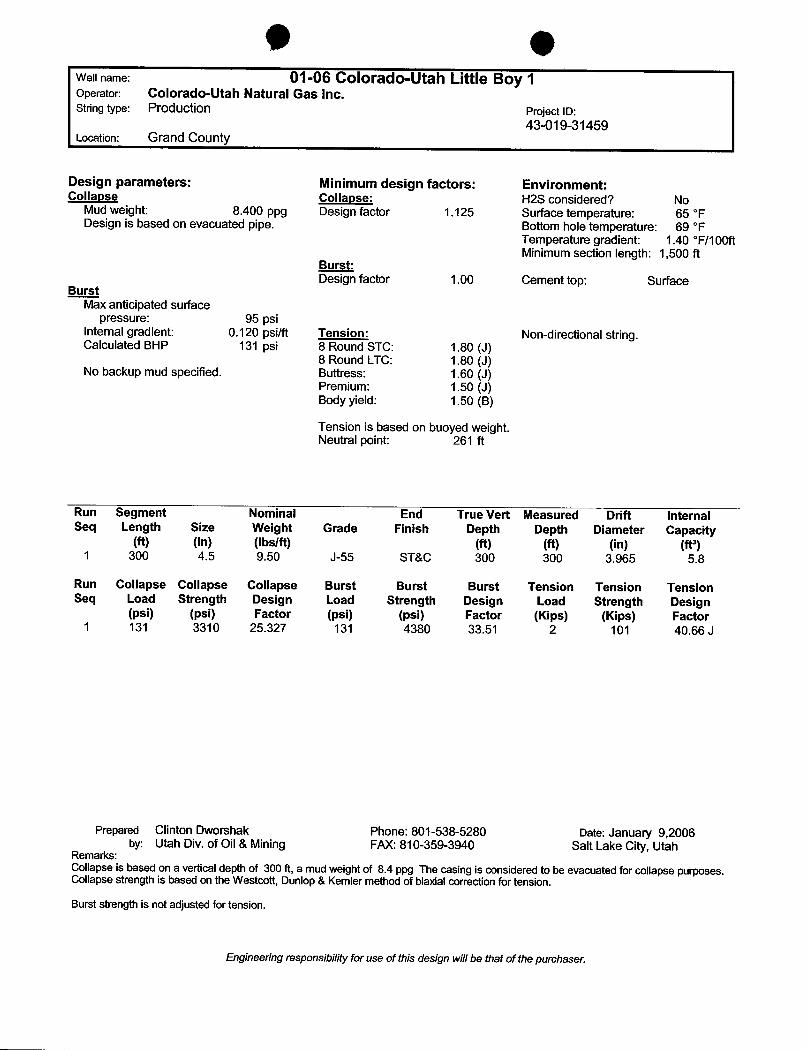
9 OWell name: 01-06 Colorado-Utah Little Boy 1Operator: Colorado-Utah Natural Gas Inc.String type: Production Project ID:
43-019-31459Location: Grand County
Design parameters: Minimum design factors: Environment:Collapse Collapse: H2S considered? No
Mud weight: 8.400 ppg Design factor 1.125 Surface temperature: 65 °FDesign is based on evacuated pipe. Bottom hole temperature: 69 °F
Temperature gradient: 1.40 °F/100ftMinimum section length: 1,500 ft
Burst:Design factor 1.00 Cement top: Surface
BurstMax anticipated surface
pressure: 95 psiInternal gradient: 0.120 psilft Tension: Non-directional string.Calculated BHP 131 psi 8 Round STC: 1.80 (J)
8 Round LTC: 1.80 (J)No backup mud specified. Buttress: 1.60 (J)
Premium: 1.50 (J)Body yield: 1.50 (B)
Tension is based on buoyed weight.Neutral point: 261 ft
Run Segment Nominal End True Vert Measured Drift InternalSeq Length Size Weight Grade Finish Depth Depth Diameter Capacity
(ft) (in) (Ibs/ft) (ft) (ft) (in) (ft')1 300 4.5 9.50 J-55 ST&C 300 300 3.965 5.8
Run Collapse Collapse Collapse Burst Burst Burst Tension Tension TensionSeq Load Strength Design Load Strength Design Load Strength Design
(psi) (psi) Factor (psi) (psi) Factor (Kips) (Kips) Factor1 131 3310 25.327 131 4380 33.51 2 101 40.66 J
Prepared Clinton Dworshak Phone: 801-538-5280 Date: January 9,2006by: Utah Div. of Oil & Mining FAX: 810-359-3940 Salt Lake City,Utah
Remarks:Collapse is based on a vertical depth of 300 ft, a mud weight of 8.4 ppg The casing is considered to be evacuated for collapse purposes.Collapse strength is based on the Westcott, Dunlop & Kemler method of biaxial correction for tension.Burst strength is not adjusted for tension.
Engineering responsibility for use of this design wi/Ibe thatof the
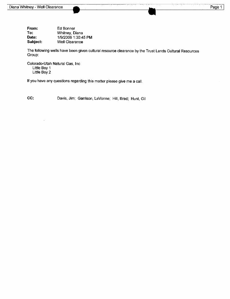
From: Ed BonnerTo: Whitney, DianaDate: 1/9/2006 1:30:45 PMSubject: Well Clearance
The following wells have been given cultural resource clearance by the Trust Lands Cultural ResourcesGroup:
Colorado-Utah Natural Gas, IncLittle Boy 1Little Boy 2
If you have any questions regarding this matter please give me a call.
CC: Davis, Jim; Garrison, LaVonne; Hill,Brad; Hunt,
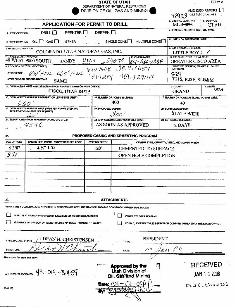
STATE OF UTAH FORM 3DEPARTMENT OF NATURAL RESOURCES
DIVISION OF OIL, GAS AND MINING AMENDED REPORT(highlight changes)
5. MINERAL LEASE NO: 6. SURFACE:
APPLICATIONFOR PERMIT TO DRILL MLA9993 UTAH.. ... 7. IF INDIAN,ALLOTTEE OR TRIBENAME:1A.TYPE OF WORK DRILL REENTER DEEPEN
B. TYPEOF WELL: OIL GAS O OTHER SINGLE ZONE MULTIPLE ZONE8. UNITor CA AGREEMENT NAME:
2. NAMEOF OPERATOR: 9. WELL NAME and NUMBER:
COLORADO TAH NATURAL GAS, INC· LITTLE BOY # /noen GF OPERATOR; PHONE NUMBER 10. FIELD AND POOL OR WiiBCAT:
40 WEST 9000 SOUTH , SANDY UTAH 2,,VÑ¿P7 f QL /kg GRËATER CISCO AREA
4. LOCATION OF WELL (FOOTAGES) 11.OTR/QTR; SECTIORTOWNSHIP, RANGE,90 y Of 97 0 la37 MERIDWl:
ATSURFACE:
AT PROPOSED PRODUCINGZONE SAME 3 O I Ñ ¯T21S,R23E, SLB&M
14. DISTANCE IN MILESAND DIRECTION FROMNEAREST TOWN OR POsiO 12. COUNTY: 13. STATE'
CISCO, ÚTAH 84515 GRAM ŒAH
16. DISTANCETO NEAREST PROPERTYOR LEASELINE(FEET) 16. NUMBER OF ACRES IN LEASE- 17. N IMBEROF ACRESASSIGNED TOTHISWELL:
400 4018. DISTANCE TO NEAREST WELL(DRILUNG,COMPLETED,OR 19. PROPOSED DEFN: 20. BOND DESCRIPTION:
APPLIED FOR) ON THIS- (FEET) STAO ' Â / TE WIDE21. ELEVATIONS(SHOW WHETHER OF, RT.GR, ETC.): 22. APPROXIMATE IMTEWORKWILLSTART• 23. ESTIMATED DURATION
93 BC AS SOON AS APPROVED 2 DAYS
24. PROPOSED CASING AND CEMENTINGPROGRAMSIZE OF HOLE CASING $12E, GRADE. AND WEIGHT PER FOØT SETTINGDEPTH CEMENT TYPE, QUANTRY, YlELO, ANDSLURRY WEIGHT
6 3/8" 4 ½" J-55 120' CEMENTED TO SURFACE$ Ÿ2. OPEN HÒIZCOMPLETION
25. ATTACHMENTS
VERIFY THE FOLLOWING ARE ATTACHED IN ACCORDANCE WITH THE UTAH OIL AND GAS CONSERVATION GENERAL RULES:
O WELL PLAT OR MAP PREPARED BY UCENSED SURVEYOR OR WGINER COMPI.ETE DRILUNGPiki
O EVIDENCE OF DIVISION OF WATER RIGHTSAPPROVALFORUSEOF WATER FORM 5, IF OPERATORIS PERSON OR COMPANY OTHER THAN THELEASE OWNER
NAME (PLEASE PRINT)DEAN
. C STþNSEN PRESIDENT
SIGNATURE DATE C/Ñ
This space for State use only)
Appmved by me ' RECEIVEDAPI NUMBER ASSIGNED
Utah Division ofOil,SW'änd Mining JAN1 -
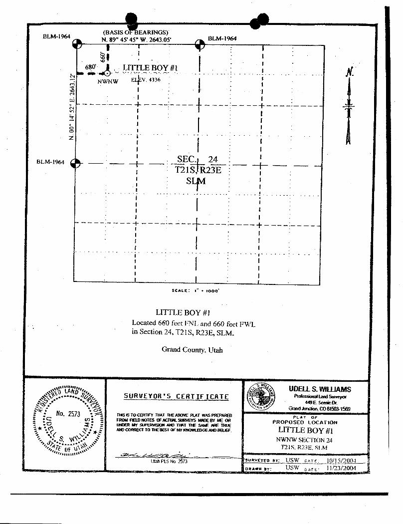
BLM-1964N. 89 45' 45" W. 2643.05 BLM-1964
680 LITTLE BOY #l AfNWNW E V. 4336
SEC. 24BLM-1964
T21S, R23Es
$CALE: i •8000°
LITTLE BOY #1Located 6€0 feet FNL and 660 feet FWLin Section 24, T21S, R23E, SLM.
Grand County, Utah
"J'g'g UDELLS. WILUAMS...••... SURVEYOR'S CERTIFICATE IMSaverer
. E. ScenieOrj , °•, : GmndJunction. COBMW: • fio. 2573 •
. nas as vo comFY RAT RE ABOVEINT WAS PROMRS) PL A T OFI :c <n. : FROM FIRD610TES OFACHRSumSS IMDEBY ME OR PROPOSED LOCATION-.a 2 • : WDER W SWERWSION W HET RE SW ARE muE
MO CORREci TO RE BEST OF W MOWLEDGE MBau LITTLE BOY #1NWWW SECTION 24
T21S. R23E, SLM
Uah PLS No 2573 suaverso sv: USW or te 10/15/2004oman ey: USW oare
O OLITTLE BOY No. l
Exhibit "D"MULTI-POINT REQUIREMENTSTO APD
1. EXISTING ROADS:
A. EXHIBIT "A" IS THE PROPOSED WELL SITE AS STAKED BY UDELL WILLIAMS, AREGISTERED SURVEYOR. THE GROUND ELEVATIONIs 4334 GR, SHOWN ON THE WELL PLAT.
B. EXHIBIT "E" IS THE ROUTE AND DISTANCE ROAD MAP. THE LOCATION IS ONE MILEFROM THE CISCO POST OFFICE (84515). THE ROUTE TO THE WELL IS SHOWN IN GREEN ON THEATTACHED MAP.
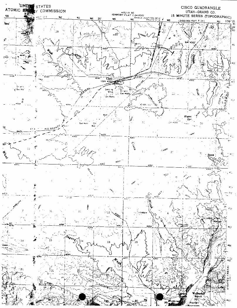
C. Exhibit "f" is a copy of the Cisco Quadand shows the access road to the location.D. All existing roads appear on the attached exhibits.E. This is considered to be a development well.F. All roads from Cisco to this location are in good condition and allow for heavy
trucking on a regular basis. The roads to this well site were improved when the freeway wasconstructed is constructed with crushed asphalt that has been rolled into road base. The operatorintends to install a buried low pressure plastic gathering system (300 psi - schedule 40). Thewells in this project have common ownership and royalty owners.
2. PLANNED ACCESS ROADS:
The access road to this location has been built and is used for access to the 5a well. Thisroad will be bladed and maintained as necessary.
A. The typical section of the access road will be 16' in width.B. No grade exists or will be more than 2-4%C. No turn-out will be necessary.D. No culverts are necessary or will be required.E. No fill or other surface materials willbe necessary.F. No gates or cattle guards are required.G. The proposed access route will be flaggedH. A rights of way for this location are granted via the Warranty Deed issued by the
Federal Government via the exchange of acreage.
. 3. LOCATION OF EXISTING WELLS:
All existing wells within a one-mile radius of this development well are shown on exhibit"F".
A. There are no water wells.B. Numerous abandoned wells exist and are located on Exhibit "F".C. No temporarily abandoned wells exist.D. There are no disposal wellsE. Another well is being proposed 400' to the
O OPage 2Exhibit "D"
F. Existing wells and proposed locations are on Exhibit "F".G. Shut-in locations are shown on Exhibit "F".H. There are no injection wells at this time.I. No monitoring or observation wells exist..
4. LOCATION OF EXISTlNG AND/OR PROPOSED FACILITIES:
A. Within one-mile radius of this location are existing facilities owned and controlled bythe lesseeloperator as shown on Exhibit "F". The facilities consist of currently operated wells .
with their surface equipment and access roads.B. The Cisco Gathering System, a 3 ½" installed pipeline, owned by the operator, with a
terminus into the Northwest Pipeline.C. Exhibit "I" shows the anticipated production facilities.D. The dimensions of the production facilities Are shown on Exhibit "I" and is drawn
to a scale of 1" to 50'.E. No outside construction material will be needed except for gravel to be placed under
the Pump-jack and other production equipment, including storage tanks.F. A water disposal pit will be constructed on each site and will be flagged.G. A buried schedule 40 - 300 psi plastic gathering system will gather the low pressure
wells in this project. The low pressure gas will be compressed at a central point and thengathered into the existing Cisco Gathering System.
5. LOCATION AND TYPE OF WATER SUPPLY:
Water and Salt Brine will be hauled from Moab or Thompson for use on this location.No water well or other source of water is planned.
6. SOURCE OF CONSTRUCTION MATERIALS:
Any and all construction materials (gravel)necessary will be purchased and transportedfrom Green River, Utah,
7. METHODS FOR HANDLING WASTE DISPOSAL:
A. Drill cuttings will be buried in the reserve pit.B. Drilling fluids will be contained in steel mud pits and/or the reserve pit. These fluids,if reusable,will be transported to the next drilling location. Eventually any remaining fluids will
be disposed of in an approved disposal site in Green River, Utah.C. Any hydrocarbon liquids produced while drilling or initial production testing will be
collected in a tank and sold, Any spill or other adverse substances will be removed from the siteupon the completion of the drilling operations and transported to an approved disposal facility ineither Moab or Green River,
O OPage 3Exhibit "D"
D. A commercial "Chemical outhouse facility" will be rented and installed on the siteand utilized to receive human waste.
E. Garbage and other trash will be collected in a trash container and hauled. To thenearest designated landfilÏeither in Moab or Green River, Utah.
F. The entire site will be cleaned up and restored to a smooth contour when the rigmoves off location. Only that part of the location required for production will be used. Anappropriate seed mixture native to the site will be planted on the disturbed unused portions of thesite during the fall months to insure maximum available moisture.
8. ANCILLARY FACILITIES:
No airstrips, camps, or other living facilities will be built for this location.
9. WELL SITE LAYOUT:
A. Exhibit "G" is the Drill pad layout. Any topsoil moved will be stockpiled and reusedupon the completion of this project.
B. The mud tanks, reserve pit, trash cage, pipe racks and any stored soil, rig set up,parking facilities and access roads are all shown on Exhibit "H".
C. The reserve pits will not be lined. Steel mud tanks will be used and are shown onExhibit "H". If water is produced during production a disposal study will be completed.
10. PLANS FOR RESTORATION:
A. Back filling, leveling, and re-contouring will be accomplished as soon as possibleafter the completion of drilling, completion and testing operations. If the well is plugged, anappropriate plugging program will be submitted for approval. If the well is a commercial well,the production facilities, to include the installation of undei·groundpiping to the central tankbattery will be completed and the unused and/or other disturbed areas will be replanted andleveled.
B. Rehabilitation of the surface will be accomplished by re-contouring as practical backto blend with the original contours. Any stockpiled top soils will be spread along with ripping ofthe pad. Re-vegetation will be accomplished with native grasses or other seeds designated by theappropriate surface control agency (State of Utah or BLM).
C. Three sides of the reserve pit will be fenced prior to drilling operations. Upon the rigbeing released, the reserve pit will be fenced on all sides and will remain until abandonment ofthe site at which time it will be re-contoured and filled.D. Any spills will be immediately reported and cleaned up.E. Rehabilitation operations will commence as soon as possible and practical after the
rigs have been moved off of the location. Seeding will be completed during the fall period toinsure the best growth
O OPage 4Exhibit "D"
11. OTHER INFORMATION:
A. As indicated on Exhibit "F", the topography of the location has very little relief. Thelocation is a gentle sloping area which will necessitate very little construction. This location islocated in the middle of an operating Oil Field. and is surrounded by numerous operating wells.
B. The soil is light gray typical of Mancos.C. The vegetation in the immediate area surrounding this location is Gardner Salt Bush,
Shadscale, greasewood, cheatgrass, and prickly pear catus. None of these species is endangeredor of any economic value other than for soil stabilization, which is not a factor, as the area isalmost level with little or no soil erosion.
D. The fauna of the area consists of stray cattle, an occasionally lost sheep, antelope,rabbits, lizards, snakes, ravens, kit foxes and coyotes.
E. The surface is owned by the State of UtahF. The nearest live water is found in the wash area approximately ½/ to one mile to the
west in the area known as Cisco Wash.G. The nearest occupied dwelling is owned bjr a principal of Colorado-Utah Natural Gas,
Inc., and has been owned for approximately twenty (20) plus years. This facility will be occupiedduring the drilling operations for sleeping, cooking, etc.
H. There is no known visible archeological, historical or cultural site withing areasonable proximity to the drilling location.
I. There are no restrictions noted on the Oil and Gas Lease.
12. Lessee's or operators representatives:
Tariq Ahmad Dean H. Christensen137 Vassar, #5 4880 So Three Fountains Dr., Unit 139Reno, Nv 81502 Murray, Ut 84107775-240-0769 801-554-2021775-333-6626 801-262-1420
Terry R. Spencer, ESQ801-244-7778
O OPage 5Exhibit "D"
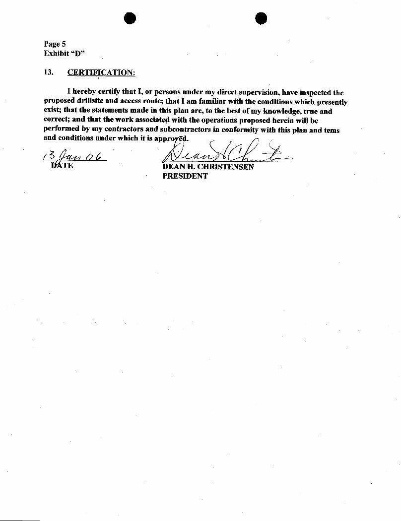
13. CERTIFICATION:
I hereby certify that I, or persons under my direct supervision, have inspected theproposed drillsite and access route; that I am familiar with the conditions which presentlyexist; that the statements made in this plan are, to the best of my knowledge, true andcorrect; and that the work associated with the operations proposed herein will beperformed by my contractors and subcontractors in conformity with this plan and temsand conditions under which it is app .
DATE DEAN H. CHRISTENSEN
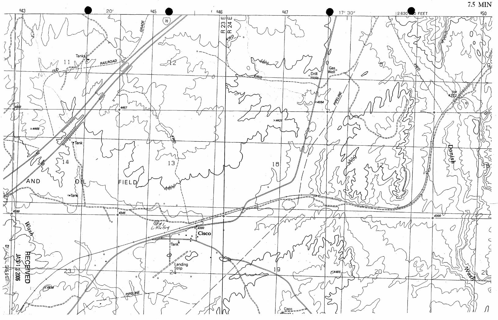
U STATES CISCO QUADRANGLEATOMIC y COMMISSlON 4162 /l/ SE UTAH-ORAND CO.toAMan m.m i:24 ooo 15 MINUTE SERIES (TOPOORAPHIC39 43 se s.o nwenow ow
C sco
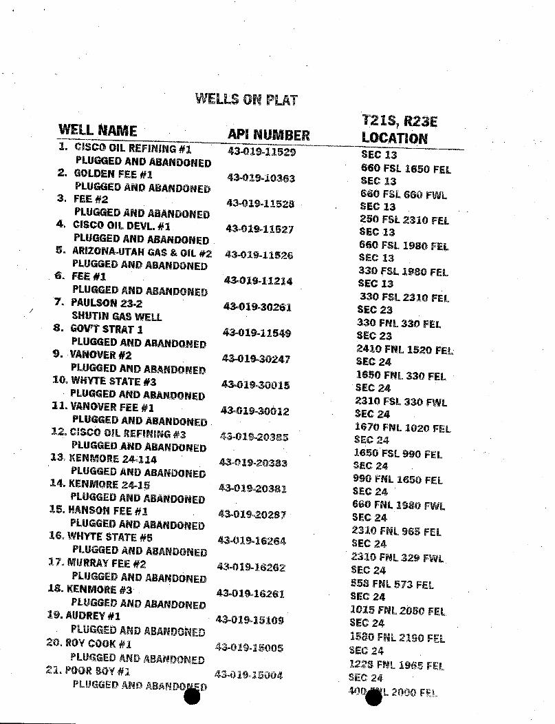
WELLSON PLATT218, R23EWELLNAME API NUMBER LOCATION1. CISCO OIL REFINING#1 43-019-11529 SEC 13PLUGGED ANDABANDONED 660 FSL 1650 FEL2. GOLDENFEE #1 43-019-10363 SEC 13PLUGGEDANDABANDONED 660 FSL 660 FWL3. FEE #2 43-019-11528 SEC 13PLUGGEDANDABANDONED 250 FSL 2310 FEL4. CISCO DIL DEVL#1 43-019-11527 SEC 13PLUGGEDAND ABANDONED 660 FSL 1980 FEL5. ARI2ONA-UTAHGAS & OIL #2 43-019-11526 SEC 13PLUGGEDAND ABANDONED 330 FSL 1980 FEL6. FEE #1 43-019-11214 SEC 13PLUGGED ANDABANDONED 330 FSL 2310 FEL7. PAULSON23-2 43-019-30261 SEC 23SHUTINGASWELL 330 FNL330 FEL8. GOVTSTRAT1 . 43-019-11549 SEC 23PLUGGEDANDABANDONED 2410 FNL 1520 FEL9. VANOVER#2 43-019-30247 SEC 24PLUGGEDAND ABANDONED 1650 FNL 330 FEL10. WHYTE STATE #3 43-019-30015 SEC 24PLUGGED AND ABANDONED 2310 FSL 330 FWL11. VANOVERFEE #1 43-019-30012 SEC 24PLUGGED AND ABANDONED 1670 FNL 1020 FEL12. CISCO DIL REFINING #3 43-019-20385 SEC 24PLUGGEDAND ABANDONED 1650 FSL 990 FEL11 KENMORE 24-114 43-019-20383 SEC 24PLUGGED AND ABANDONED 990 FNL 1650 FEL14. KENMORE 24-15 43-019-20381 SEC 24PLUGGED ANDABANDONED 660 FNL 1980 FWL15. HANSON.FEE#1 - 43-019-20287 SEC 24PLUGGEDAND ABANDONED 2310 FNLS65 FEL16. WHYTESTATE#5 43-019-16264 SEC 24PLUGGEDAND ABANDONED 2310 FNL329 FWL17. MURRAYFEE #2 43-019-16262 SEC 24PLUGGi!DANDABANDONED 558 FNL 573 FEL18. KENMORE#3 43-019-16261 SEC 24PLUGGEDAND ABANDONED 1015 FNL2050 FEL19. AUDREY#1 43-019-15109 SEC 24PLUGGEDANDABANDONED 1580 FNL2190 FEL20. ROYCOOK#1 43-01945005 SEC 24
PLUGGEDANDABANDONED 1228FNL1965FEL2L POORßOY#1 43-019-15004 SEC 24PLUGGED AND ABANDO D 400 L 2000
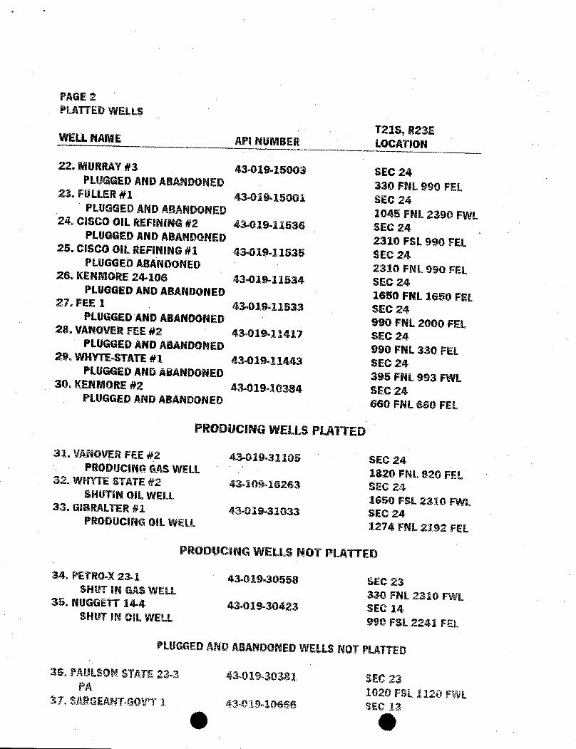
PAGE 2PLATTEDWELLS
T218, R23EWELLNAME API NUMBER LOCATION
22. MURRAY#3 43-019-15003 SEC 24PLUGGEDANDABANDONED 330 FNL 990 FEL23. FULLER#1 43-019-15001 SEC 24PLUGGEDANDABANDONED 1045 FNL 2390 FWL24. CiSCO OIL REFINING#2 43-019-11536 SEC 24PLUGGEDANDABANDONED 2310 FSL 990 FEL25. CISCO OIL REFINING#1 43-019-11535 SEC 24PLUGGEDABANDONED 2310 FNL 990 FEL26. KENMORE24-106 43-019-11534 SEC 24PLUGGED AND ABANDONED 1650 FNL 1650 FEL27. FEE 1 43.019-11533 SEC 24PLUGGED ANDABANDONED 990 FNL 2000 FEL28. VANOVERFEE #2 43-019-11417 SEC 24PLUGGEDANDABANDONED 990 FNL 330 FEL29. WHYTE-STATE#1 43-019-11443 SEC 24PLUGGED AND ABANDONED 395 FNL 993 FWL30. KENMORE#2 43-019-10384 SEC 24PLUGGED AND ABANDONED 660 FNL 660 FEL
PRODUCING WELLS PLATTED
31. VANOVERFEE #2 43-019-31105 SEC 24PRODUCINGGASWELL 1820 FNL820 FEL32..WHYTE STATE #2 43-109-16263 SEG 24SHUTIN OIL WELL 1650 FSL 2310 FWL33. GIBRALTER#1 43-019-31033 SEC 24PRODUCING GILWELL 1274 FNL 2192 FEL
PRODUCING WELLS NOT PLATTED
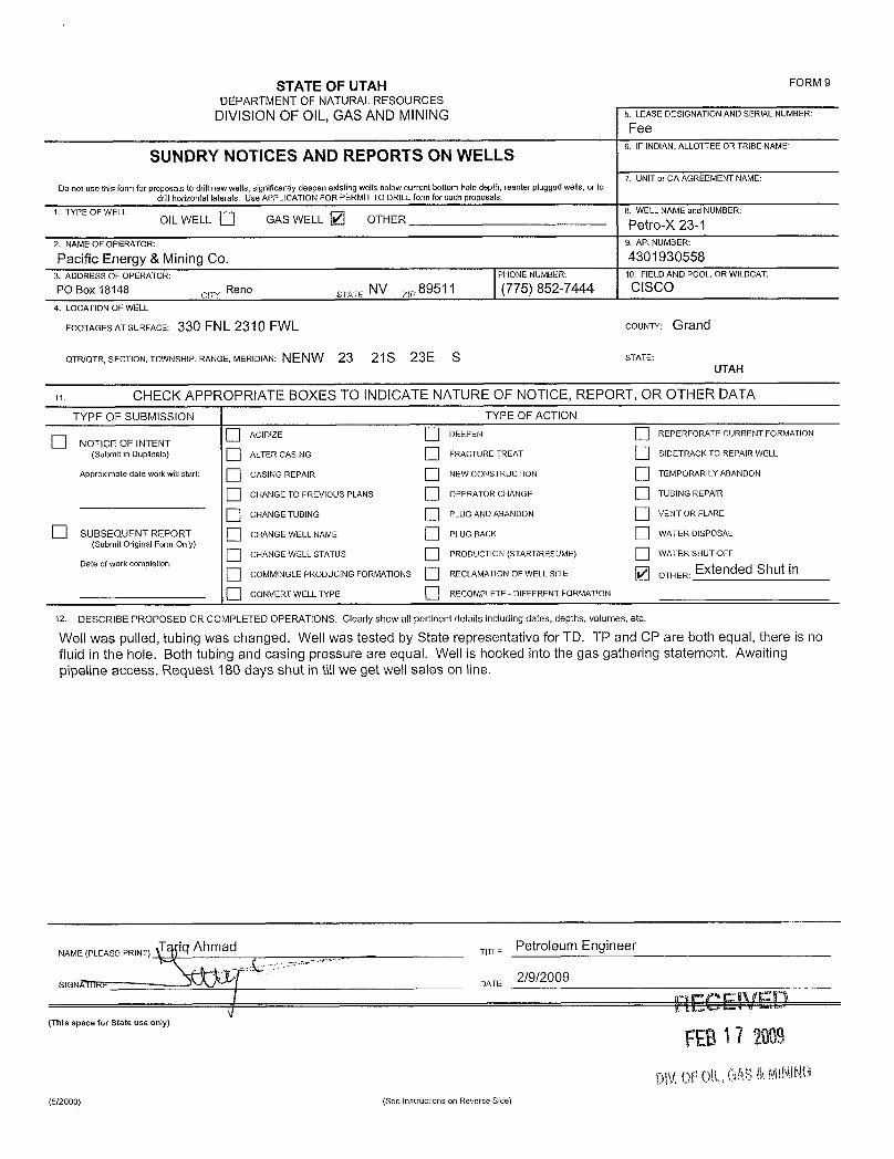
34. PETRO-X23-1 43-019-30558 SEC 23SHUT IN GAS WELL 330 FNL 2310 FWL35. NUGGETT 14-4 43-019-30423 SEC 14SHUT IN OIL WELL 990 FSL 2241 FEL
PLUGGEDANDABANDONEDWELLSNOTPLATTED
36. PAULSONSTATE23-3 43-019-30381 SEC 23PA 1020 FSL 1120 FWL37. SARGEANT-GOV'T1 43-019,10666 SEC 13
O
7.5 MIN
"
645 4 47 17' 30"
O ')
rk
Gas
×446
ok
AND L FIELD
6

O OJON M. HUNTSMAN, JR.
Governor
GARY R. HERBERTLieutenant Governor
State of Utah January 17, 2006Department of
Natural ResourcesMICHAEL R. STYLER
ExecutiveDirector Colorado-Utah Natural Gas, Inc.Division of 40 West 9000 South
Oil, Gas & Mining Sandy. UT 84070
JOHN R. BAZADivision Director
Re: Little Boy 1 Well, 660' FNL, 680' FWL, NW NW, Sec. 24, T. 21 South,R. 23 East, Grand County, Utah
Gentlemen:
Pursuant to the provisions and requirements of Utah Code Ann.§ 40-6-1 etseq., Utah Administrative Code R649-3-1 et seq., and the attached Conditions ofApproval, approval to drill the referenced well is granted.
This approval shall expire one year from the above date unless substantial andcontinuous operation is underway, or a request for extension is made prior to theexpiration date. The API identification number assigned to this well is 43-019-31459.
Sincerely,
Gil HuntAssociate Director
pabEnclosures
cc: Grand County AssessorSITLA
1594 West North Temple, Suite 1210, PO Box 145801, Salt Lake City, UT 84114-5801telephone(801) 538-5340 • facsimile (801)359-3940 • TTY (801) 538-7458 •
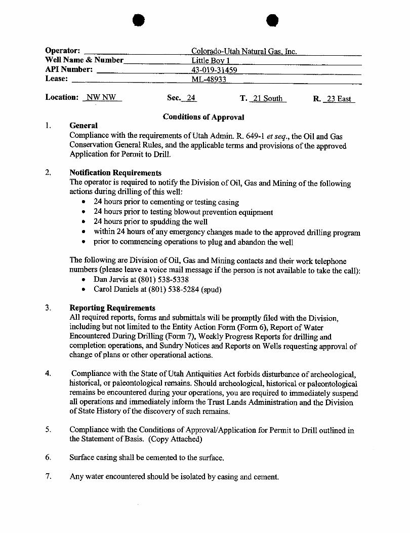
O OOperator: Colorado-Utah Natural Gas, Inc.Well Name & Number Little Boy 1API Number: 43-019-31459Lease: ML-48933
Location: NW NW Sec. 24 T. 21 South R. 23 East
Conditions of Approval1. General
Compliance with the requirements of Utah Admin. R. 649-1 et seq., the Oil and GasConservation General Rules, and the applicable terms and provisions of the approvedApplication for Permit to Drill.
2. Notification RequirementsThe operator is required to notify the Division of Oil, Gas and Mining of the followingactions during drilling of this well:
• 24 hours prior to cementing or testing casing• 24 hours prior to testing blowout prevention equipment• 24 hours prior to spudding the well• within 24 hours of any emergency changes made to the approved drilling program• prior to commencing operations to plug and abandon the well
The following are Division of Oil, Gas and Mining contacts and their work telephonenumbers (please leave a voice mail message if the person is not available to take the call):
• Dan Jarvis at (801) 538-5338• Carol Daniels at (801) 538-5284 (spud)
3. Reporting RequirementsAll required reports, forms and submittals will be promptly filed with the Division,including but not limited to the Entity Action Form (Form 6), Report of WaterEncountered During Drilling (Form 7), Weekly Progress Reports for drilling andcompletion operations, and Sundry Notices and Reports on Wells requesting approval ofchange of plans or other operational actions.
4. Compliance with the State of Utah Antiquities Act forbids disturbance of archeological,historical, or paleontological remains. Should archeological, historical or paleontologicalremains be encountered during your operations, you are required to immediately suspendall operations and immediately inform the Trust Lands Administration and the Divisionof State History of the discovery of such remains.
5. Compliance with the Conditions of Approval/Application for Permit to Drill outlined inthe Statement of Basis. (Copy Attached)
6. Surface casing shall be cemented to the surface.
7. Any water encountered should be isolated by casing and

O OPage 243-019-31459January 17, 2006
8. This proposed well is located in an area for which drilling units (well spacing patterns)have not been established through an order of the Board of Oil, Gas and Mining (the"Board"). In order to avoid the possibility of waste or injury to correlative rights, theoperator is requested, once the well has been drilled, completed, and has produced, toanalyze geological and engineering data generated therefrom, as well as any similar datafrom surrounding areas if available. As soon as is practicable after completion of itsanalysis, and if the analysis suggests an area larger than the quarter-quarter section uponwhich the well is located is being drained, the operator is requested to seek an appropriateorder from the Board establishing drilling and spacing units in conformance with suchanalysis by filing a Request for Agency Action with the
O O
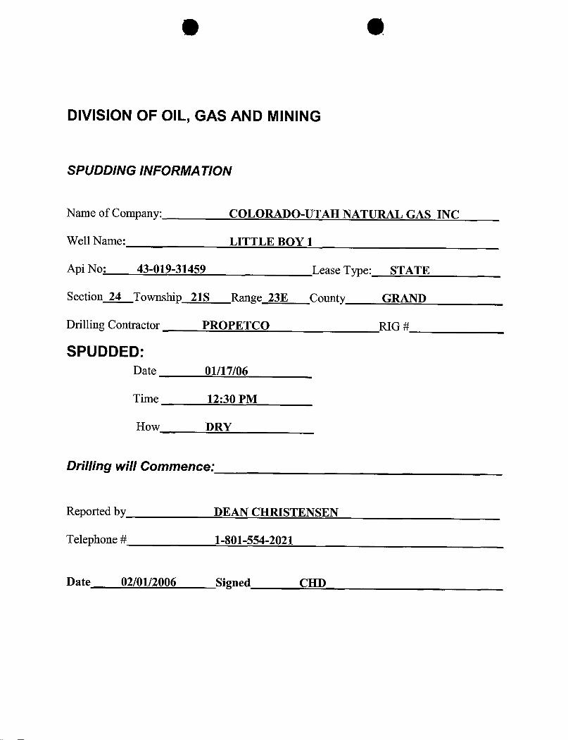
DIVISION OF OIL, GAS AND MINING
SPUDDING INFORMATION
Name of Company: COLORADO-UTAH NATURAL GAS INC
Well Name: LITTLE BOY 1
Api No: 43-019-31459 Lease Type: STATE
Section 24 Township 21S Range 23E County GRAND
Drilling Contractor PROPETCO RIG #
SPUDDED:Date 01/17/06
Time 12:30 PM
How DRY
Drilling will Commence:
Reported by DEAN CHRISTENSEN
Telephone# 1-801-554-2021
Date 02/01/2006 Signed
03/23/2006 89:18 7753330225 SATVIEW BROADBAND PAGE 01/01
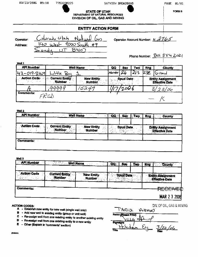
4 0STATEOF UTAN FORM 6DEPARTMENTOF NATt)RALREBouRCES
DIVISIONOF OIL,GASAND MINING
ENTITYACTIONFORM
Operator: OperatorAccount Number: N /FNAddress: 000 i
Phone Number: O & 24 2 2-
Welt iAPI kumber WellName QQ sgo Tw¢ : Rng Comity
43-019 3tW1 LMk o nwo 24 .215 Z32- Gr JAction God Ce n tity N ud Dat Ed ent
Comments: sh
i Number W411Na e 04 † Rdg ; onntÿ
ActiënCode, Odrr nt.Ehtit New Entity Date ÉiÀitý idhmentInú¾a r NUMbo Ëifni Date
I i !
Comments:
Þl gùrnbii fot!E a .
CM tocÌë C MáW Ënt ignaiëntthBer Numb¾r ate
comments: DECO VEDMAR2 3 2OOf
DNOFOlL,GAS&MININGAC Cnew endtyfor newwell (single well only)
B - Add new we!I to existingentity (grouporunitwell) Name ease Print)C - Re-assign wellfrom one existingentity to another exisgngentityD . Ro.assign well fromoneexistingentityto a newentity SIE - Other (Explainin 'comments'section) ç_ aúTitle Kulte '
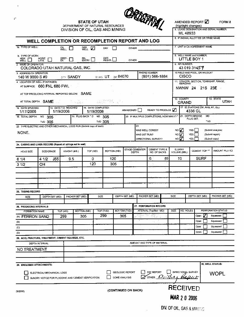
STATE OF UTAH AMENDEDREPORT FORM 8DEPARTMENT OF NATURALRESOURCES (highlight changes)
DIVISIONOF OlL, GAS AND MINING 5. LEASEDESIGNATIONANDSERIALNUMBER:
ML 48933
WELL COMPLETION OR RECOMPLETION REPORT AND LOG6. IFINDIAN,ALLOTTEEORTRIBENAME
1a. TYPE OF WELL: OWELLL WGL DRY OTHER 7. UNITor CA AGREEMENT NAME
b. TYPE OF WORK: 8. WELL NAMEand NUMBER:wEEW HL
TNEEP- NETRY DREFSFVR.
OTHER LITTLE BOY 12. NAMEOF OPERATOR: 9. API NUMBER:
COLORADOUTAHNATURAL GAS, INC. 43 019 314373. ADDRESSOF OPERATOR: PHONE NUMBER: 10 FIELDAND POOL, OR WILDCAT
140 W 9000 S #9 env SANDY svare UT zie 84070 (801) 566-1884 CISCO4. LOCATIONOF WELL(FOOTAGES) 11. QTR/QTR, SECTION, TOWNSHIP, RANGE,
MERlDIANATSURFACE: 660 FNL 680 FWL NWNW 24 21S 23EAT TOP PRODUCING INTERVAL REPORTED BELOW: SAME
ATTOTALDEPTH: SAME2
GR D13. STATE
UTAH
14. DATE SPUDDED: 15. DATET.D REACHED: 16. DATE COMPLETED: 17 ELEVATIONS(DF, RKB, RT. GL):
1/17/2006 1/19/2006 1/19/200 ABANDONED READYTOPRODUCE 2 4336 GL18. TOTALDEPTH: Mo 305 in. PLUG BACKT.D.: MD 20. IF MULTIPLECOMPLETIONS, HOW MANY7* 21 DEPTH BRIDGE MD
PLUG SET:TVD 305 TVD 305 TVD
22. TYPE ELECTRICAND OTHER MECHANICALLOGS RUN (Submit copy ofeach) 23,
WAS WELL CORED7 NO YES (Submit analysis)NONE. WASDSTRUN7 NO YES (Submikepod)
DIRECTIONALSURVEY7 NO YES (Submit copy)
24. CASING AND LINER RECORD (Report all strings set in well)
HOLE SIZE SiZE/GRADE WEIGHT (#/ft.) TOP (MD) BOTTOM(MD) STAGEDŒMHENTER CNEMENFMCKESVO
MREBL) CEMENT TOP ** AMOUNT PULLED
6 1/4 4 1/2 J55 9.5 0 120 G 50 10 SURF
3 1/2 OH 120 305
25. TUBINGRECORD
DEPTH SET (MD) PACKER SET (MD) SIZE DEPTH SET (MD) PACKER SET (MD) SIZE DEPTH SET (MD) PACKER SET (MD)
26. PRODUCING INTERVALS 27. PERFORATION RECORD
FORMATIONNAME TOP (MD) BOTTOM(MD) TOP (TVD) BOTTOM(TVD) 1NTERVAL(Top/Bot - MD) SIZE NO HOLES PERFORATION STATUS
(A) FERRON SAND 299 305 299 305 OPen Squeezed
(B) Open Squeezed
(C) Open Squeezed
(D) Open Squeezed
28. ACID, FRACTURE, TREATMENT,CEMENT SQUEEZE, ETC.
DEPTH INTERVAL AMOUNTANDTYPE OF MATERIAL
NO TREATMENT
29. ENCLOSED ATTACHMENTS: 30. WELL STATUS:
ELECTR!CAL/MECHANICALLOGS GEOLOGIC REPORT REPORT DIRECT L SURVEY WOPLSUNDRY NOTICE FOR PLUGGING ANDCEMENTVERIFICATION CORE ANALYSIS OTHER: fÅfr / A fr k
(5/2000) (CONTINUED ON BACK) RECE IVEDMAR28 2006
DIV.0FOIL,GAS&
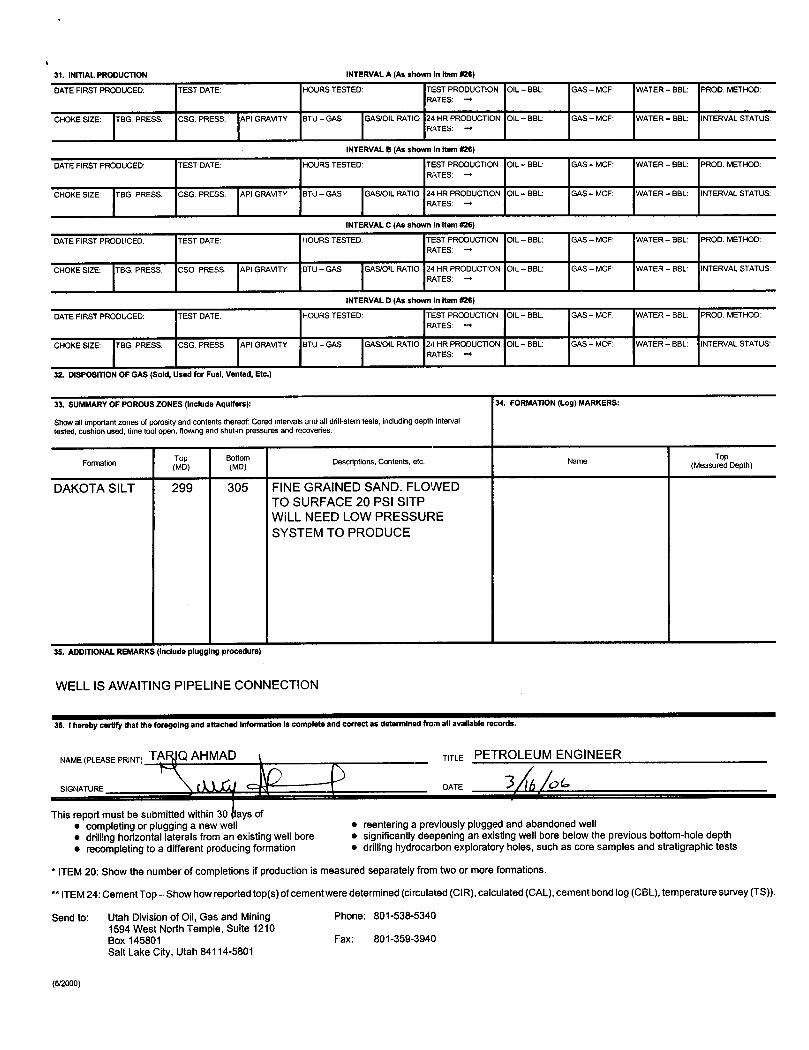
31. INITIAL.PRODUCTION INTERVALA (As shown in Item #26)
DATEFIRST PRODUCED: TEST DATE: HOURS TESTED: TEST PRODUCTION OIL - BBL: GAS- MCF: WATER - BBL: PROD. METHOD:RATES:
CHOKESIZE: TBG. PRESS. CSG. PRESS. Pi GRAVITY BTU - GAS GAS/OILRATIO 24 HR PRODUCTION OIL - BBL: GAS- MCF: WATER - BBL: INTERVALSTATUSRATES: -+
INTERVALB (As shown in item#26)
DATEFIRST PRODUCED: TEST DATE: HOURS TESTED: TEST PRODUCTION OIL - BBL: GAS - MCF: WATER - BBL: PROD. METHOD:RATES: ->
CHOKE SIZE: TBG. PRESS. CSG. PRESS. PI GRAVITY BTU - GAS GAS/OILRATIO 24 HR PRODUCTION OIL - BBL: GAS- MCF: WATER - BBL: INTERVALSTATUSRATES: -*
INTERVALC (As shown In item #26)
DATEFIRST PRODLICED: TEST DATE: HOURS TESTED: TEST PRODUCTION OIL - BBL: GAS - MCF: WATER - BBL: PROD. METHOD:RATES: ->
CHOKESIZE: TBG. PRESS. CSG. PRESS. PI GRAVITY BTU - GAS GAS/OIL RATIO 24 HR PRODUCTION OIL - BBL: GAS - MCF: WATER - BBL: INTERVALSTATUSRATES: ->
INTERVALD (As shown in item #26)
DATEFIRST PRODUCED: TEST DATE: HOURS TESTED: TEST PRODUCTION OIL - BBL: GAS - MCF: WATER - BBL: PROD. METHOD:RATES: -+
CHOKE SIZE: TBG. PRESS. CSG. PRESS. PI GRAVITY BTU - GAS GAS/OILRATIO 24 HR PRODUCTION OIL - BBL: GAS- MCF: WATER - BBL: INTERVALSTATUS:RATES: -+
32. DISPOSITIONOF GAS (Sold, Used for Fuel, Vented, Etc.)
33. SUMMARYOF POROUS ZONES (Include Aquifers): 34. FORMATION(Log) MARKERS:
Show allimportant zones of porosity and contents thereof: Cored intervals and all drill-stem tests, including depth intervaltested,cushion used, time tool open,flowingand shut-in pressures and recoveries.
Formation Descriptions, Contents, etc. Name (MeasumodpDepth)
DAKOTA SILT 299 305 FINE GRAINED SAND. FLOWEDTO SURFACE 20 PSI SITPWILL NEED LOW PRESSURESYSTEM TO PRODUCE
35. ADDITIONALREMARK: (include plugg ng procedure)
WELLIS AWAITING PIPELINE CONNECTION
36. I hereby certlfy that the foregoing and attached Information is completeand correct as determined from allavailable records.
NAME(PLEASEPRINT) TA Q AHMAD TITLE PETROLEUM ENGINEER
SIGNATURE DATE
This report must be submitted within 30 ays ofe completing or plugging a new well • reentering a previously plugged and abandoned well• drillinghorizontal laterals from an existing well bore e significantlydeepening an existing well bore below the previous bottom-hole depthe recompleting to a different producing formation • drillinghydrocarbon exploratory holes, such as core samples and stratigraphic tests
* ITEM20: Show the number of completions if production is measured separately from twoor more formations.
** ITEM 24: Cement Top-Show how reported top(s)of cement were determined (circulated (C1R),calculated (CAL), cement bond log (CBL), temperature survey (TS)).
Send to: Utah Divisionof Oil, Gas and Mining Phone: 801-538-53401594 West North Temple, Suite 1210Box 145801 Fax: 801-359-3940Salt Lake City, Utah 84114-5801

DAILY DRILLING REPORT
LITTLE BOY NO. 1API 43-019-31459SECTION 24 21S 23EGRAND COUNTY, UTAH
1/17/06 SPUD WELL. DRILL SURFACE HOLE TOTAL DEPTH 120 FEET.DRILLED THROUGH MANCOS SHALE. DRILL WITH 6 1/2 DRILLBIT WITH AIR.
1/18/06 RIH WITH 4 ½ J-55 CASING SET AT 120 FEET. CEMENT WITHCLASS G CEMENT TO SURFACE.
1/19/06 DRILLED THROUGH MANCOS SHALE. HIT DRILLING BREAKAT 299 FEET, GAS TO SURFACE. 5 FOOT FLARE WHILEDRILLING THROUGH SAND. FINE GRAINED CLEAN SAND LOWPRESSURE. DRILLED WITH AIR.
1/20/06 RIG DOWN MOVE OFF

Little Boy 1Colorado Utah Natural Gas, IncOpen Hole CompletionGas WellFerron Gas WellKB 4334open hole completion Ferron Sand 299 -305 feet
4.500 in Csg11.60 lbm/ft120 ft
6.250 in0% Excess120 ft
3.500 in0% Excess305 ft
Pe rforation299 ft
i- Handbook*-
*a mark of
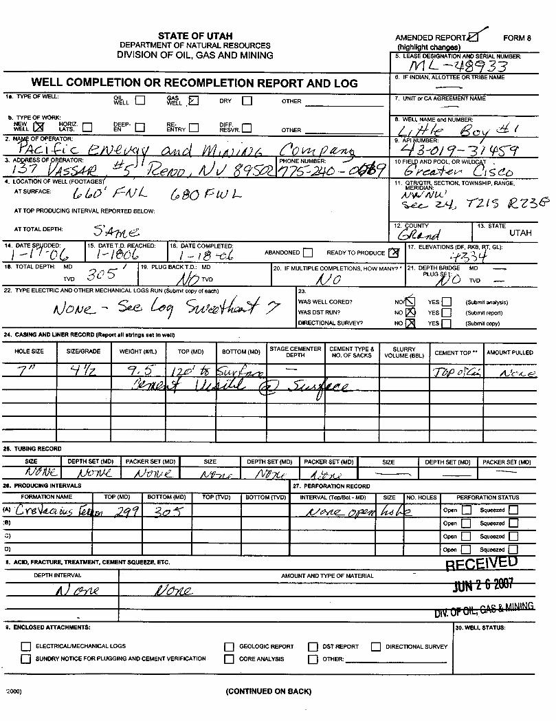
STATE OF UTAH AMENDED REPORT FORM 8DEPARTMENTOF NATURALRESOURCES (highlight changes)
DIVISION OF OIL, GAS AND MINING 5. LEASEDESIGNATIONANDSERIALNUMBER:
/VIL99933WELL COMPLETIONOR RECOMPLETION REPORT AND LOG
6. IFINDIAN,ALLOTTEEORTRIBENAME
1a. TYPE OF WELL: OWLL
SLL DRY OTHER 7. UNIT or CA AGREEMENT NAME
b. TYPE OF WORK: 8. WELL NAME and NUMBER:W HOR Z. NEP-
RYSFVR.
OTHER2. NA O PE TOR 9. MBE /
3. ADDRESS OF RERATOR: PHONE NUMBER: A 10 FIE AND POOL, OR WILDC T .
4. LOCATION OF WELL (FOOTAGES) 11. QTR/QTR, SECTION, TOWNSHIP, RANGE,MERIDIAN
AT SURFACE:
AT TOP PRODUCINGINTERVAL REPORTED BELOW:
AT TOTAL DEPTH: 5, 12 TY 13. STATEUTAH
14. DATE ßP DDED: 15. DATE T.D. REACHED: 16. DATE COMPLETED 17. ELEVATIONS (DF, RKB, T, GL):ABANDONED READY TO PRODUCE
18. TOTAL DEPTH: MD / 19. PLUG BACK T D.: MD 20. IF MULTIPLE COMPLETIONS, HOW MANY? * 21. DEPTH BRIDGE MD -
TVD TVDPLUG :
TVD -
22. TYPE ELECTRIC AND OTHER MECHANICAL LOGS RUN (Submitcopy of each) 23.
WAS WELL CORED? NO YES (Submit analysis)WAS DST RUNT NO YES (Submit report)
DIRECTIONAL SURVEY7 NO YES (Submit copy)
24. CASINGAND LINER RECORD (Report all strings set in well)
HOLE SIZE SIZE/GRADE WEIGHT (#/ft.) TOP (MD) BOTTOM (MD) STAGEDCEMENTER CNEMEONFS
KES VOLSUMBL) CEMENT TOP ** AMOUNT PULLED
25. TUBINGRECORD
SIZE DEPTH SET (MD) PACKER SET (MD) SIZE DEPTH SET (MD) PACKERSET (MD) SIZE DEPTH SET (MD) PACKER SET (MD)
26. PRODUCINGINTERVALS 27. PERFORATION RECORD
FORMATION NAME TOP (MD) BOTTOM (MD) TOP (TVD) BOTTOM (TVD) INTERVAL (Top/Bot - MD) SIZE NO. HOLES PERFORATION STATUS
(A) Open Sqwd
(B) Open Sqwd
3) Open Sqwd
D) Open Sqwd
6. ACID, FRACTURE, TREATMENT, CEMENT SOUEEZE, ETC.
DEPTH INTEIW AMOUNT AND TYPE OF MATERIAL
UN.0FOIL St MINING9. ENCLOSED ATTACHMENTS: 30. WELL STATUS:
O ELECTRICAUMECHANICAL LOGS GEOLOGIC REPORT DST REPORT DIRECTIONAL SURVEY
O SUNDRYNOTICE FOR PLUGGINGAND CEMENT VERIFICATION O COREANALYSIS OTHER:
2000) (CONTINUED ON
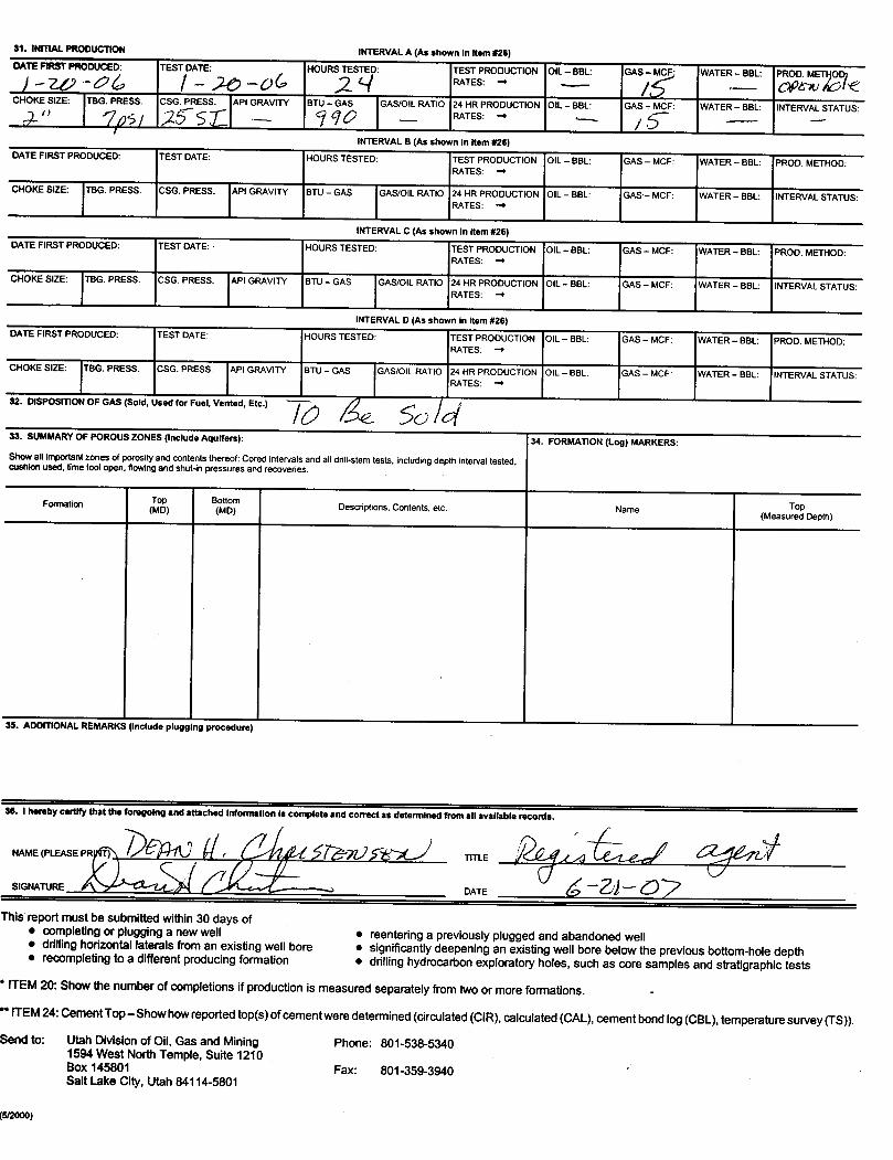
31. INITIAL PRODUCTION INTERVAL A (As shown in item #26)DATEFIRSTPRODUCED: TEST DATE: HOURSTESTED: TEST PRODUCTION OIL- BBL: GAS- MCF: WATER - BBL: PROD. MET OD)
CHOKE SIZE: TBG RESS CSG RESS API GRAVITY BT - GA GAS/OIL RATIO 24 HR PRODUCTION OIL- BBL GAS- MCF: WATER - BBL: INTERVAL STATUS:
INTERVAL B (As shown in Item #26)DATE FIRST PRODUCED: TEST DATE: HOURS TESTED: TEST PRODUCTION OIL - BBL: GAS - MCF: WATER - BBL: PROD. METHOD:
RATES:
CHOKE SIZE: G. PRESS CSG. PRESS. PI GRAVITY BTU - GAS GAS/OIL RATIO 24 HR PRODUCTION OIL - BBL: GAS - MCF: WATER - BBL: INTERVAL STATUS:RATES:
INTERVAL C (As shown In item #26)DATE FIRST PRODUCED: TEST DATE: HOURS TESTED: TEST PRODUCTION OIL - BBL: GAS - MCF: WATER - BBL: PROD. METHOD:
RATES: -+
CHOKE SIZE: BG. PRESS CSG. PRESS. PI GRAVITY BTU - GAS GAS/OIL RATIO 24 HR PRODUCTION OIL - BBL: GAS - MCF: WATER - BBL: INTERVAL STATUS:RATES:
INTERVAL D (As shown in item #26)DATE FIRST PRODUCED: TEST DATE: HOURS TESTED: TEST PRODUCTION OIL - BBL: GAS - MCF: WATER - BBL: PROD. METHOD:
RATES:
CHOKE SIZE: TBG. PRESS. CSG. PRESS. API GRAVITY BTU - GAS GAS/OlL RATIO 24 HR PRODUCTION OIL - BBL: GAS - MCF: WATER - BBL: INTERVAL STATUS:RATES:
32. DISPOSITION OF GAS (Sold, Used for Fuel, Vented, Etc.)
33. SUMMARY OF POROUSZONES(Include Aqulfers): 34. FORMATION (Log) MARKERS:Show all important zones of porosity and contents thereof:Cored intervals and alldrill-stem tests, including depth interval tested,cushion used, timetoolopen, flowing and shut-inpressures and recoveries.
Formation Descriptions, Contents, etc Name(Measu Depth)
35. ADDITIONAL REMARK: (Include plugg ng procedure)
36. I hereby certify that the foregoing and attached information is complete and correct as determined from att available records.
NAME (PLEASE P TITLEE
This report must be submitted within 30 days of• completingor plugging a new well e reentering a previously plugged and abandoned well• drilling horizontal laterals from an existing well bore e significantly deepening an existing well bore below the previous bottom-hole depth• recompleting to a different producing formation e drilling hydrocarbon exploratory holes, such as core samples and stratigraphic tests
* ITEM 20: Show the number of completions if production is measured separately from twoor more formations. -
** ITEM24: Cement Top-Show how reported top(s)ofcement were determined (circulated(CIR),calculated (CAL), cement bond log (CBL), temperaturesurvey (TS))Send to: Utah Division of Oil, Gas and Mining Phone: 801-538-5340
1594 West NorthTemple, Suite 1210Box 145801 Fax: 801-359-3940Salt Lake City,Utah 84114-5801

Division of Oil, Gas and Mining ROUTINGOPERATOR CHANGE WORKSHEET 1. DKD
X - Change of Operator (Well Sold) Operator Name Change/MergerThe operator of the well(s) listed below has changed, effective: 2/26/2007
FROM: (Old Operator): TO: ( New Operator):N2765-Colorado-Utah Natural Gas Inc N7655-Pacific Energy & Mining
9000 S, Suite 137 Vassar St, Suite 5Sandy, UT 84070 Reno, NV 89502
Phone: 1 (801) 554-2021 Phone: 1 (775) 852-7444
CA No. Unit:WELL NAME SEC TWN RNG API NO ENTITY LEASE TYPE WELL WELL
NO TYPE STATUSSEE ATTACHED LIST
OPERATOR CHANGES DOCUMENTATIONEnter date after each listed item is completed1. (R649-8-10) Sundry or legal documentation was received from the FORMER operator on: 3/9/20072. (R649-8-10) Sundry or legal documentation was received from the NEW operator on: 3/9/2007
3. The new company was checked on the Department of Commerce, Division of Corporations Database on: 3/12/20074a. Is the new operator registered in the State of Utah: Business Number: 5977241-0143
4b. If NO, the operator was contacted contacted on:5a. (R649-9-2)Waste Management Plan has been received on: IN PLACE
5b. Inspections of LA PA state/fee well sites complete on: n/a5c. Reports current for Production/Disposition & Sundries on: ok
6. Federal and Indian Lease Wells: The BLM and or the BIA has approved the merger, name change,
or operator change for all wells listed on Federal or Indian leases on: BLM BIA7. Federal and Indian Units:
The BLM or BIA has approved the successor of unit operator for wells listed on:8. Federal and Indian Communization Agreements ("CA"):
The BLM or BIA has approved the operator for all wells listed within a CA on:9. Underground Injection Control ("UIC") The Division has approved UIC Form 5, Transfer of Authority to
Inject, for the enhanced/secondary recovery unit/project for the water disposal well(s) listed on:DATA ENTRY:1. Changes entered in the Oil and Gas Database on: 9/27/20072. Changes have been entered on the Monthly Operator Change Spread Sheet on: 9/27/20073. Bond information entered in RBDMS on: 9/27/20074. Fee/State wells attached to bond in RBDMS on: 9/27/20075. Injection Projects to new operator in RBDMS on:6. Receipt of Acceptance of Drilling Procedures for APD/New on: 9/27/2007
BOND VERIFICATION:1. Federal well(s) covered by Bond Number:2. Indian well(s) covered by Bond Number:3a. (R649-3-1) The NEW operator of any fee well(s) listed covered by Bond Number 763751318
and 33443413b. The FORMER operator has requested a release of liability from their bond on: *
The Division sent response by letter on:
LEASE INTEREST OWNER NOTIFICATION:4. (R649-2-10) The NEW operator of the fee wells has been contacted and informed by a letter from the Division
of their responsibility to notify all interest owners of this change on: 2/20/2008COMMENTS: *Colorado-Utah's CDs were rolled by the bank to Pacific Energy's CDs
Pacific Energy (CUNG) FORM A.xls

STATE OF UTAH FORM 9DEPARTMENTOF NATURALRESOURCES
DJVISIONOF OIL, GAS AND MINING 5. LEASEDESIGNATIONANDSERIALNUMBER:
6. IF INDIAN,ALLOTTEEOR TRIBE NAMESUNDRY NOTICES AND REPORTS ON WELLS7. UNITor CA AGREEMENT NAME:
Do not use this form for proposals to drillnew wells, significantly deepen existing wells below current bottorn-hole depth, reenter plugged wells, or todrillhorizontal laterals. Use APPLICATIONFOR PERMITTO DRILLform for suchproposals.
1. TYPE OF WELL 8. WELL NAMEand NUMBER:OIL WELL GAS WELL OTHER See below
2. NAMEOF OPERATOR: 9. API NUMBER:
Pacific Energy & MiningCompany †/'/¢53. ADDRESS OF OPERATOR: PHONE NUMBER: 10. FIELDAND POOL, OR WILDCAT:
137 Vassar Street #5 c:Ty Reno symys NV z 89502 (775) 852-74444 LOCATIONOF WELL
FOOTAGESATSURFACE: COUNTY: Grand
QTR/QTR, SECTION, TOWNSHIP, RANGE, MERIDIAN: STATE:UTAH
CHECK APPROPRIATE BOXES TO INDICATE NATURE OF NOTICE, REPORT, OR OTHER DATATYPE OF SUBMISSION TYPE OF ACTION
AÒIDIZE DEEPEN REPERFORATE CURRENT FORMATIONNOTICE OF INTENT
(Submit in Duplicate) ALTER CASING FRACTURETREAT SIDETRACKTO REPAIR WELL
Approximate date workwillstart: CASING REPAIR NEWCONSTRUCTION TEMPORARILYABANDON
O CHANGETO PREVIOUS PLANS OPERATOR CHANGE TUBINGREPAIR
O CHANGETUBING PLUG ANDABANDON VENT OR FLARE
SUBSEQUENT REPORT CHANGEWELLNAME PLUG BACK WATER DISPOSAL(Submit Original Form Only)
CHANGEWELLSTATUS PRODUCTION(STARTIRESUME) WATER SHUT-OFFDate ofwork completion:
COMMINGLEPRODUC1NGFORMATIONS RECLAMATIONOF WELLSITE OTHER:
CONVERT WELLTYPE RECOMPLETE - DIFFERENT FORMATION
1
ha
gce fEOpReOPOS OR MP ETE OPIEReA NS Clearl show all pertinent details inclu d es, depths, volumes, etc.
I ~ Nugget 14-4 API No.43019/m
Section 14 21S 23E Grand County, Utah F.-- B¿M/Òg,98 S' 002- Whyte Stae 2 API No 4301916263 Section 24 21S 23E Grand County, UtahSweetheart 5A API No 4301931417 Section 24 21S 23E Grand County, Utah /Sweetheart 2A API No 4301931418 Section 24 21S 23E Grand County, UtahSweetheart 7 API No 4310931420 Section 24 21S 23E Grand County, UtahSweetheart 14-02 API No 4301931451 Section 14 21S 23E Grand County, Utah
'| -C-4¾eM4tb2 1 API No 4301931450 Section 14 21S 23E Grand County, Utah ÑѾ6 Ê_5 /ÊÛ/g -LITTLE BOY 2 API No48-149844GG Section 24 21S 23E Grand County, Utah p()
(†)authorized 9/27/07 by DHC and TA
LITTLE BOY 1 API ËO 43-019-31459 SECTION 24 21 S 23E GRAND COUNTY, UTAH(*)
SNAMNE(PLEASEPRINT)Tariq ad TT E Vice President
(This space for State use only)
APPROVED laî_1./ RECEIVED
(5/2000) DÎVISion of Oil, Gas and Mining (seeinstructionsonReverseSide)
Earlene Russell, Engirieering TechnicianDIV.0F0lL,GAS&
State of UtahDEPARTMENT OF NATURAL RESOURCES
MICHAEL R. STYLER-" Executive Director
JON M. HUNTSMAN, JR.Division of Oil, Gas and Mining
Governor JOHN R. BAZADivision DirectorGARY R. HERBERT
Lieutenant Governor
September 3, 2008
CERTIFIED MAIL NO.: 7004 2510 0004 1824 6190
Mr. Tariq AhmadPacific Energy & Mining Company LÏ137 Vassar St. Suite #5Reno, NV 89502
Re: Extended Shut-in and Temporarily Abandoned Well Requirements for Wells on Fee or State Leases
Dear Mr. Ahmad:
As of July 2008, Pacific Energy & Mining Company has Five (5) State Mineral LeaseWells and three (3) Fee Lease Wells (see attachment A) in non-compliance with the requirementsfor extended shut-in or temporarily abandoned (SI/TA) status. Wells SI/TA beyond twelve (12)consecutive months require the filing of a Sundry Notice in accordance with R649-3-36-1 forUtah Division of Oil, Gas & Mining ("Division") approval. Wells with five (5) years non-activity or non-productivity shall be plugged, unless the Division grants approval for extendedshut-in time upon a showing of good cause by the operator (R649-3-36-1.3.3).
With the exception of the Sweetheart 14-02 (API # 43-019-31451), the Sweetheart 2A(API # 43-019-31418) and the Little Boy 1 (API # 43-019-31459), a Notice of Violation (NOV)was issued for the wells listed on Attachment A. That NOV dated December 14, 2007 requiredthe wells to be put into production, or plugged or get approval with good cause for extendedSI/TA. The latter required an MIT and full cost bonding. To date, nothing has been done tobring these wells into full compliance. This is a reminder for these wells that a response is farpast due and immediate action is necessary. Also the three wells not currently under the NOVrequire plans to produce or plug submitted immediately or further actions will be initiated.
UTAH
DNR
1594 West North Temple, Suite 1210, PO Box 145801, Salt Lake City, UT 84114-5801telephone (801) 538-5340• facsimile (801) 359-3940 •TTY (801) 538-7458 • wwwogm.utah.gov OIL, GAS &

Page 2September 3, 2008Mr. Ahmad
For extended SI/TA consideration the operator shall provide the Division with the following:
1. Reasons for SI/TA of the well (R649-3-36-1.1).2. The length of time the well is expected to be SI/TA (R649-3-36-1.2), and3. An explanation and supporting data if necessary, for showing the well has
integrity, meaning that the casing, cement, equipment condition, static fluid level,pressure, existence or absence of Underground Sources of Drinking Water andother factors do not make the well a risk to public health and safety or theenvironment (R649-3-36-1.3).
Submitting the information suggested below may help show well integrity and may helpqualify your well for extended SI/TA. Note: As of July 1, 2003, wells in violation of the SIITArule R649-3-36 may be subject to full cost bonding (R649-3-1-4.2, 4.3).
1. Wellbore diagram, and
2. Copy of recent casing pressure test, and
3. Current pressures on the wellbore (tubing pressure, casing pressure, andcasing/casing annuli pressure) showing wellbore has integrity, and
4. Fluid level in the wellbore, and
5. An explanation of how the submitted information proves integrity.
If the required information is not received within 30 days of the date of this notice, furtheractions will be initiated. If you have any questions concerning this matter, please contact me at(801) 538-5281.
Dustin K. DoucetPetroleum Engineer
JP/jsEnclosure
cc: Jim Davis, SITLAWells FileCompliance
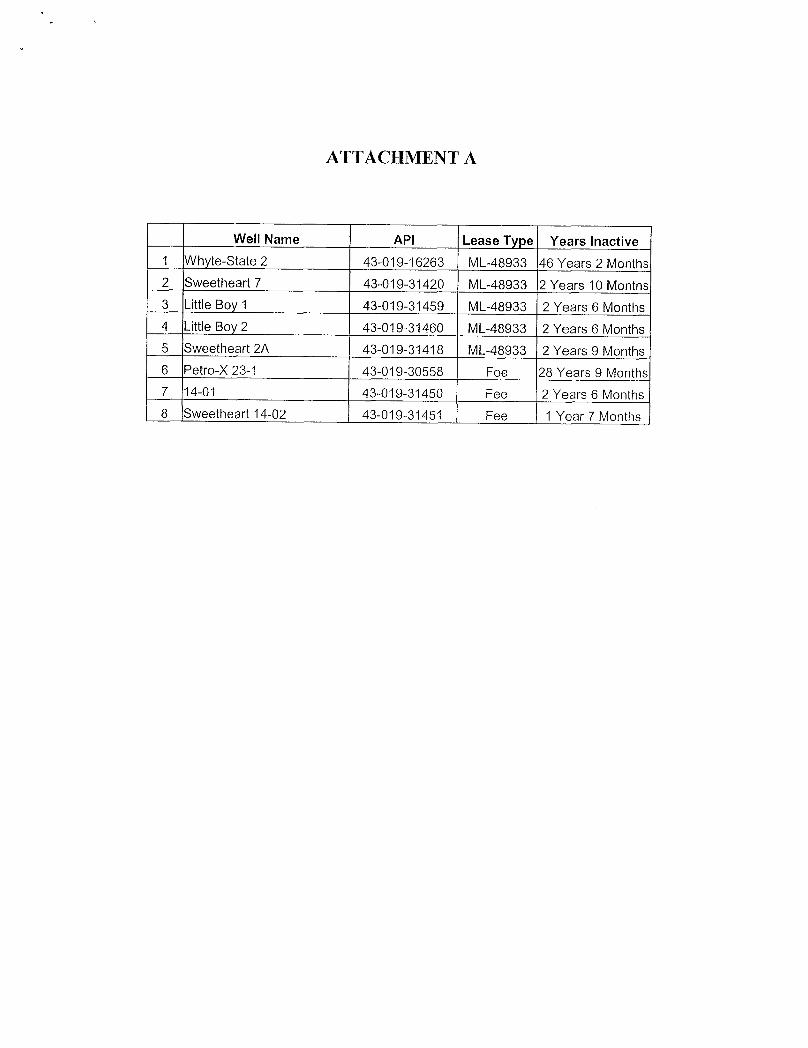
ATTACHMENT A
Well Name API Lease Type Years Inactive1 Whyte-State 2 43-019-16263 ML-48933 46 Years 2 Months2 Sweetheart 7 43-019-31420 ML-48933 2 Years 10 Months3 Little Boy 1 43-019-31459 ML-48933 2 Years 6 Months4 Little Boy 2 43-019-31460 ML-48933 2 Years 6 Months5 Sweetheart 2A 43-019-31418 ML-48933 2 Years 9 Months6 Petro-X 23-1 43-019-30558 Fee 28 Years 9 Months7 14-01 43-019-31450 Fee 2 Years 6 Months8 Sweetheart 14-02 43-019-31451 Fee 1 Year 7
STATE OF UTAH FORM 9DEPARTMENTOF NATURALRESOURCES
DIVISIONOF OIL, GAS AND MINING 5. LEASEDESIGNATIONANDSERIALNUMBER:
ML 48933
SUNDRY NOTICES AND REPORTS ON WELLS 6. IFINDIAN,ALLOTTEEORTRIBENAME:
7. UNITor CA AGREEMENTNAME:Do not use thisform for poposals to drillnew wells, significantly deepen existing wells below current bottom-hole depth, reenter plugged wells, or to
drillhorizontal laterals. Use APPLICATIONFOR PERMITTO DRILLform for such proposals.8. WELLNAMEand NUMBER:1. TYPE OF WELL
OIL WELL GAS WELL O OTHER LittleBoy i2. NAMEOF OPERATOR: 9. API NUMBER:
Pacific Energy & MiningCompany 43019314593. ADDRESS OF OPERATOR: PHONE NUMBER: 10. FIELDAND POOL, OR WILDCAT:P O. Box 18148 CDY Reno STATE NV ,,,89511 (775) 852-7444 Greater Cisco
4. LOCATIONOF WELL
FOOTAGESATSURFACE: 660' FNL, 680' FWL COUNTY: Grand
QTR/QTR, SECTION, TOWNSHIP, RANGE, MERIDIAN: NWNW 24 21S 23E S STATE:UTAH
11. CHECK APPROPRIATE BOXES TO INDICATENATURE OF NOTICE, REPORT, OR OTHER DATATYPE OF SUBMISSION TYPE OF ACTION
ACIDIZE DEEPEN REPERFORATE CURRENT FORMATIONO NOTICE OF INTENT(Submit in Duplicate) ALTERCASING FRACTURETREAT SIDETRACKTO REPAIRWELL
Approximate date work willstart: CASING REPAIR NEWCONSTRUCTION TEMPORARILYABANDON
O CHANGETO PREVIOUS PLANS OPERATOR CHANGE TUBINGREPAIR
O CHANGETUBING PLUGANDABANDON VENTOR FLARE
SUBSEQUENT REPORT CHANGEWELL NAME PLUG BACK WATERDISPOSAL(Submit Original Form Only)
CHANGE WELLSTATUS PRODUCTION(START/RESUME) WATERSHUT-OFFDate of work completion:
O COMMINGLEPRODUCING FORMATIONS RECLAMATIONOF WELLSITE OTHER: On Production.
O CONVERT WELLTYPE RECOMPLETE - DIFFERENT FORMATION
12. DESCRIBE PROPOSED OR COMPLETED OPERATIONS. Clearly show all pertinent details including dates, depths, volumes, etc.
Well to be placed in production in next 14 days; was shut-in because Elk Resource's pipeline has been shut-in.
COPYSENTTOOPERATOR
NAME(PLEASEPRI TIATE Petroleum Engineer
(ThisspaceforStateuseonly)AP ROVED BY THE S E
FLUTA RECEIVED

WELL: Little Boy 1, Greater CiscoLocation: 660' FNL, 680' FWL, NWNW, Sec. 24, T21S, R23E, SLM
WELLBORE DIAGRAM
new
Created on 9/22/2008 2:24:50 PM
4.500 in Csg9.50 lbm/ft120 ft
6.250 in0% Excess120 ft
3.500 in0% Excess305ft
299 ft -305
i-Handbook*-
*a mark of
STATE OF UTAH FORM 9DEPARTMENTOF NATURALRESOURCES
DIVISIONOF OIL,GAS AND MINING S. LEASE DESIGNATIONANDSERIALNUMBER:
SEE BELOW6. IF INDIAN,ALLOTTEEOR TRlBE NAMESUNDRY NOTICES AND REPORTS ON WELLS7. UNITor CAAGREEMENTNAME:Do not use this form for proposals todrillnew wells, slgnificantlydeepen existing wells below current bottom-hole depth, reenter plugged wells, or to
drillhorizontal laterals. Use APPLICATIONFOR PERMITTO DRILLform for such proposals.1. TYPE OF WELL 8. WELLNAMEandNUMBER:OIL WELL GAS WELL OTHER
2. NAMEOF OPERATOR; 9. API NUMBER:Pacific Energy & Mining Company SW
3. ADDRESS OF OPERATOR: PHONE NUMBER: 10. FIELDANDPOOL, OR WILDCAT:P.O. Box 18148 , Reno svxre NV ,,,89511 (775) 852-7444 Greater Cisco
4. LOCATIONOF WELL
FOOTAGES AT SURFACE: COUNTY: Grand
QTR/QTR, SECTION, TOWNSHIP, RANGE, MERIDlAN: STATE:
S g Πg UTAH
CHECK APPROPRIATE BOXES TO INDICATENATURE OF NOTICE, REPORT, OR OTHER DATATYPE OF SUBMISSION TYPE OF ACTION
ACIDIZE DEEPEN REPERFORATE CURRENTFORMATIONNOTICE OF INTENT(Submit in Duplicate) ALTERCASING FRACTURETREAT SIDETRACKTO REPAIRWELL
Approximate date work willstart: CASINGREPAIR NEW CONSTRUCTION TEMPORARILYABANDON
CHANGETO PREVIOUS PLANS OPERATOR CHANGE TUBINGREPAIR
CHANGETUBING PLUGAND ABANDON VENTOR FLARE
SUBSEQUENT REPORT CHANGEWELLNAME PLUG BACK WATERDISPOSAL(Submit Original Form Only)
CHANGEWELLSTATUS PRODUCTION(START/RESUME) WATERSHUT-OFFDate of work completion:
COMMINGLEPRODUCINGFORMATIONS RECLAMATIONOF WELL SITE OTHER: Information onCONVERT WELLTYPE RECOMPLETE - DIFFERENT FORMATION Shipping gas.
12 DESCRIBE PROPOSED OR COMPLETED OPERATIONS. Clearly show all pertinent details including dates, depths, volumes, etc.The following is a listing of the concerned wells:S.N. WELL NAME API Lease Type1 Whyte-State 2 43-019-16263 ML-489332 Sweetheart 7 43-019-31420 ML-489333 Little Boy 1 43-019-31459 ML-489334 Llttle Boy 2 43-019-31460 ML-489335 Sweetheart 2A 43-019-31418 ML-489336 Petro-X-23-1 43-019-30558 Fee7 14-01 43-019-31450 Fee8 Sweetheart 14-02 43-019-31451 FeeAt present, Pride Ventures has refused access for shipping our produced natural gas to Elk Resources; thus we can't ship thesaid gas until the matter is resolved. We will pursue and tryto resolve this matter expeditiously. In the interim, we are tryingtosell our produced gas locally.
***Please see attached email from Elk Resources, Inc.
NAME(PLEASEPRINT) Tari AhmadTITLE Petroleum Engineer
SIGNATURE ,. . DATE 9/23/2008
(ThisspaceforStateuseonly) RECEIVEDSEP2 5 2008
(5/2000) (See Instructions on Reverse Side)DIVOFOIL,MS &

RE: Cisco Meter - Yahoo! Mail Page 1 of 2
RE: Cisco Meter Tuesday, September 23, 20From: "Tom Young" <[email protected]>
Tariq,
Since your gas is transportedinto and thruWoosley's line and compressor, I visited withJim yesterday and he withat he is unwillingto continue to allowyou to do this. Apparently for the last few years he has allowed this but itto problems such as high nitrogen, probably air, in your gas shutting down his compressor to mention one. He almentioned volumes were very small and flow seldom lasted more than a week or so. The only option that I can syou to get a ROW and lay a line to connect directly into us.
Tom C. YoungVP Southern Operations & MidstreamElk Resources, Inc.1401 17th Street, Suite 700Denver, CO 80202(303) 296-4505 - Main(303) 339-1917 - Faxtyoung elkresources.net
From: taroil [mailto:[email protected]]Sent: Monday, September 22, 2008 3:49 PMTo: Tom YoungSubject: Cisco Meter
Dear Tom:
Were you able to get the charts changed
Tariq I. Ahmad PEPO Box 18148Reno, Nevada 89511
775 333-6626 office775 333-0225 fax775 240-0769 celltaroilþyahoo.com
E-MAILCONFIDENTIALITY NOTICE:
The contents of thise-rnail message andany attachments are intended solely for theaddressee(s) and may contain confidential Ñgand/or legally privileged information. Ifyouare not the intended recipient of this message Sgg
DIVOPOIL,GASANININGhttp://us.mc515.mail.yahoo.com/mc/showMessage?fid=cioso&sort=date&order=down&st...
PacificEnegy &MiningCompany
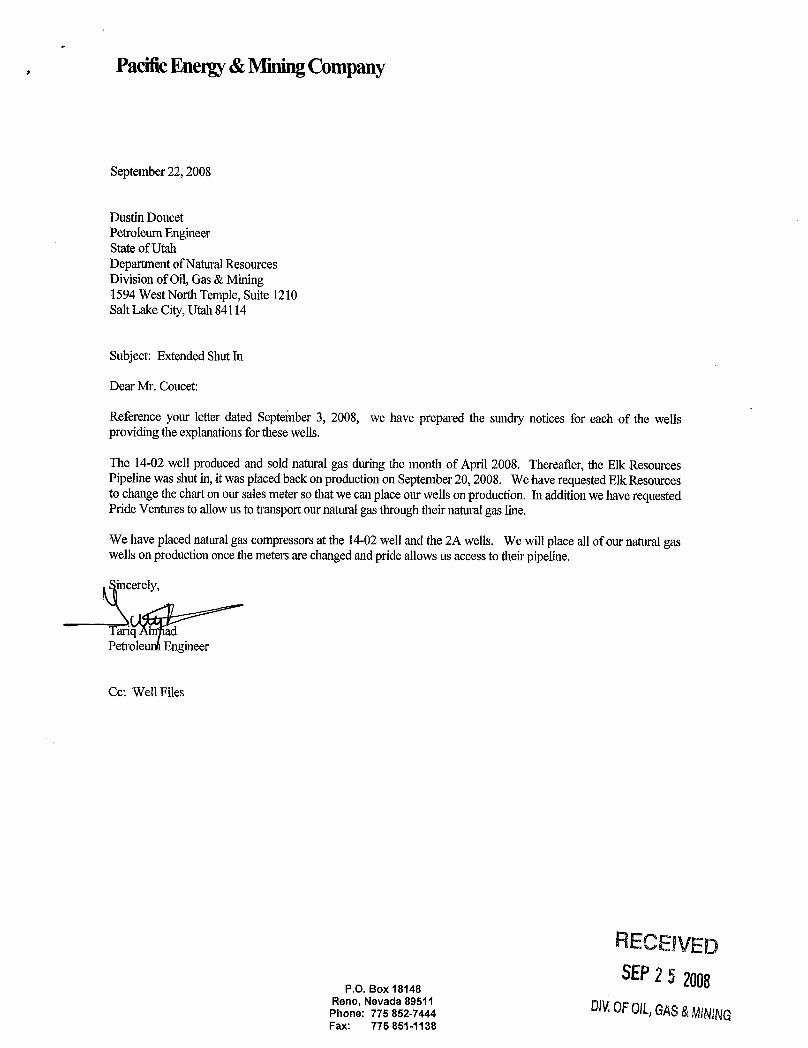
September22, 2008
DustinDoucetPetroleumEngineerStateof UtahDepartmentofNaturalResourcesDivisionof Oil,Gas& Mining1594WestNorth Temple, Suite 1210SaltLake City,Utah84114
Subject: Extended Shut In
Dear Mr. Coucet:
Reference your letter dated September3, 2008, we have prepared the sundry notices for each of the wellsprovidingthe explanations for thesewells.
The 14-02well produced and sold natural gas during the month of April 2008. Thereafter, the Elk ResourcesPipelinewas shut in, it was placedbackon productionon September 20, 2008. We have requested ElkResourcesto change the chart on our sales meter so that we can place our wells on production. In addition we have requestedPride Ventures to allowus to transportour natural gas throughtheir natural gas line.
We have placednatural gas compressors at the 14-02 well and the 2A wells. We will place all of our naturalgaswells on productiononce the meters are changed and prideallowsus access to theirpipeline.
incerely,
Tariq adPetroleunaEngineer
Cc: Well Files
RECEIVEDSEP25 2008P.O. Box 18148
Reno, Nevada 895¾ pg gPhone: 775 852-7444 EOft,GAS&MINfNGFax: 775
State of UtahDEPARTMENT OF NATURAL RESOURCES
MICHAEL R. STYLER,,w' Executive Director
JON M. HUNTSMAN, JR.Division of Oil Gas and Mining
Governor JOHN R. BAZADivision Director
GARY R. HERBERTLieutenant Governor
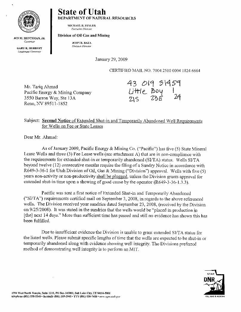
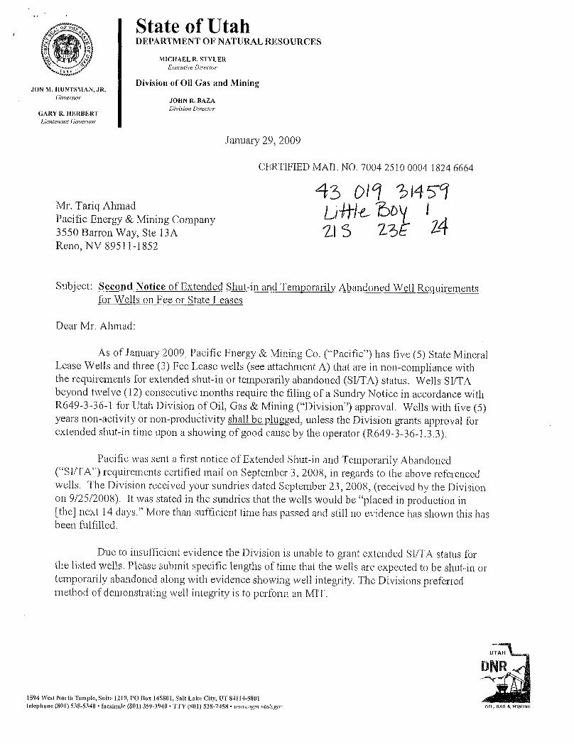
January 29, 2009
CERTIFIED MAIL NO. 7004 2510 0004 1824 6664
Mr. Tariq AhmadPacific Energy & Mining Company3550 Barron Way, Ste 13A 2.\s 'BEReno, NV 89511-1852
Subject: Second Notice of Extended Shut-in and Temporarily Abandoned Well Requiremeinsfor Wells on Fee or State Leases
Dear Mr. Ahmad:
As of January 2009, Pacific Energy & Mining Co. ("Pacific") has five (5) State MineralLease Wells and three (3) Fee Lease wells (see attachment A) that are in non-compliance withthe requirements for extended shut-in or temporarily abandoned (SI/TA) status. Wells SI/TAbeyond twelve (12) consecutive months require the filing of a Sundry Notice in accordance withR649-3-36-1 for Utah Division of Oil, Gas & Mining ("Division") approval. Wells with five (5)years non-activity or non-productivity shall be plugged, unless the Division grants approval forextended shut-in time upon a showing of good cause by the operator (R649-3-36-1.3.3).
Pacific was sent a first notice of Extended Shut-in and Temporarily Abandoned("SI/TA") requirements certified mail on September 3, 2008, in regards to the above referencedwells. The Division received your sundries dated September 23, 2008, (received by the Divisionon 9/25/2008). It was stated in the sundries that the wells would be "placed in production in[the] next 14 days." More than sufficient time has passed and still no evidence has shown this hasbeen fulfilled.
Due to insufficient evidence the Division is unable to grant extended SI/TA status forthe listed wells. Please submit specific lengths of time that the wells are expected to be shut-in ortemporarily abandoned along with evidence showing well integrity. The Divisions preferredmethod of demonstrating well integrity is to perform an MIT.
UTAH
DNR
1594 West North Temple, Suite 1210, PO Box 145801, Salt Lake City, UT 84114-5801telephone (801) 538-5340 • facsimile (801) 359-3940 • TTY (801) 538-7458 • www.ogm.utah.gov OIL, GAS &

Page 2Mr. Tariq AhmadJanuary 29, 2009
For extended SI/TA consideration the operator shall provide the Division with the following:
1. Reasons for SI/TA of the well (R649-3-36-1.1).2. The length of time the well is expected to be SI/TA (R649-3-36-1.2), and3. An explanation and supporting data if necessary, for showing the well has
integrity, meaning that the casing, cement, equipment condition, static fluidlevel, pressure, existence or absence of Underground Sources of DrinkingWater and other factors do not make the well a risk to public health and safetyor the environment (R649-3-36-1.3).
Submitting the information suggested below may help show well integrity and may helpqualify your well for extended SI/TA. Note: As of July 1, 2003, wells in violation of the SI/TArule R649-3-36 may be subject to full cost bonding (R649-3-1-4.2, 4.3).
1. Wellbore diagram, and
2. Copy of recent casing pressure test, and
3. Current pressures on the wellbore (tubing pressure, casing pressure, andcasing/casing annuli pressure) showing wellbore has integrity, and
4. Fluid level in the wellbore, and
5. An explanation of how the submitted information proves integrity.
If the required information is not received within 30 days of the date of this notice, aNotice of Violation will be issued and further actions may be initiated. If you have any questionsconcerning this matter, please contact me at (801) 538-5281.
cerely,
Dustin K. DoucetPetroleum Engineer
DKD/JP:jsEnclosurecc: Jim Davis, SITLA
Compliance FileWell Files
N:\O&G Reviewed
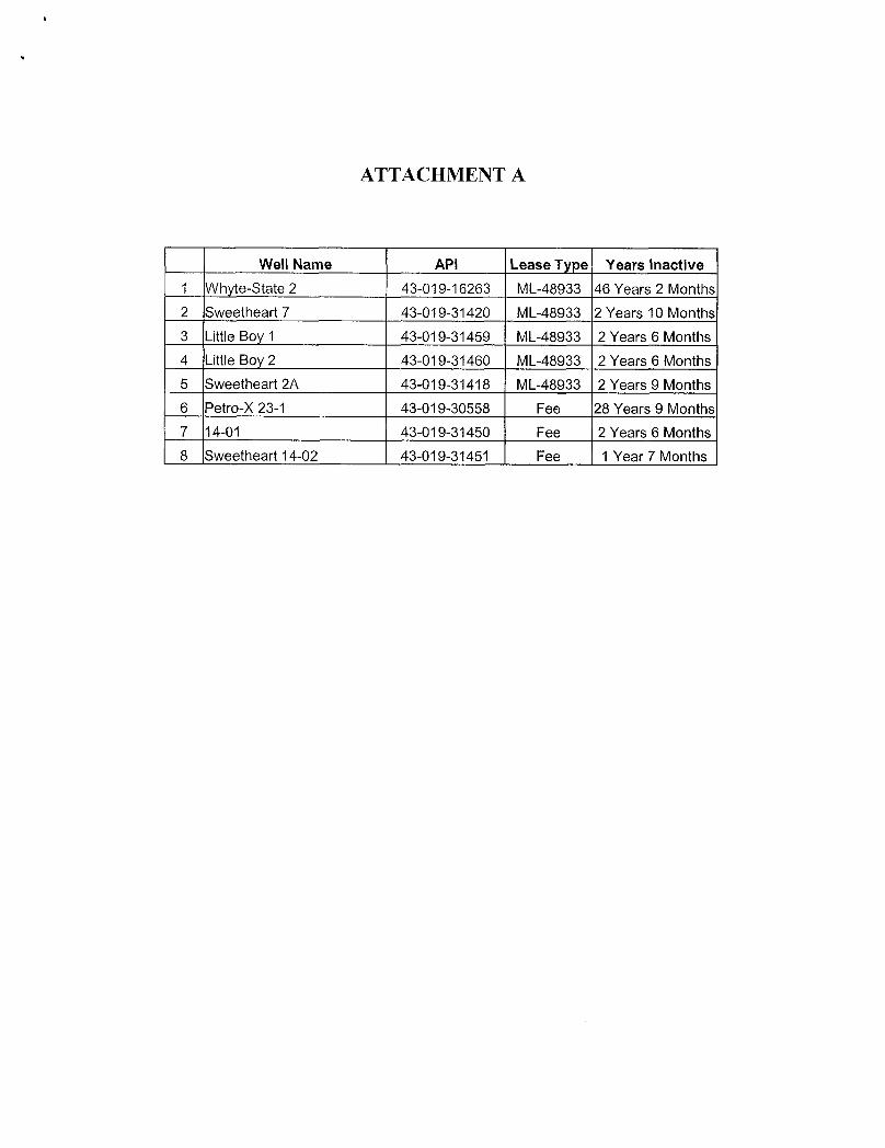
ATTACHMENT A
Well Name API Lease Type Years inactive1 Whyte-State 2 43-019-16263 ML-48933 46 Years 2 Months2 Sweetheart 7 43-019-31420 ML-48933 2 Years 10 Months3 Little Boy 1 43-019-31459 ML-48933 2 Years 6 Months4 Little Boy 2 43-019-31460 ML-48933 2 Years 6 Months5 Sweetheart 2A 43-019-31418 ML-48933 2 Years 9 Months6 Petro-X 23-1 43-019-30558 Fee 28 Years 9 Months7 14-01 43-019-31450 Fee 2 Years 6 Months8 Sweetheart 14-02 43-019-31451 Fee 1 Year 7
State of UtahDEPARTMENT OF NATURAL RESOURCES
MICHAEL R. STYLER' Executive Director
JON M. HUNTSMAN, JR.ÛÎVÍSÍOIl Of Oil Gas and Mining
Governor JOHN R. BAZ.ADivision Director
GARY R. HERBERTLieutenant Governor
January 29, 2009
CERTIFIED MAIL NO. 7004 2510 0004 1824 6664
Mr. Tariq AhmadPacific Energy & Mining Company3550 Barron Way, Ste 13AReno, NV 89511-1852
Subject: Second Notice of Extended Shut-in and Temporarily Abandoned Well Requirementsfor Wells on Fee or State Leases
Dear Mr. Ahmad:
As of January 2009, Pacific Energy & Mining Co. ("Pacific") has five (5) State MineralLease Wells and three (3) Fee Lease wells (see attachment A) that are in non-compliance withthe requirements for extended shut-in or temporarily abandoned (SI/TA) status. Wells SI/TAbeyond twelve (12) consecutive months require the filing of a Sundry Notice in accordance withR649-3-36-1 for Utah Division of Oil, Gas & Mining ("Division") approval. Wells with five (5)years non-activity or non-productivity shall be plugged, unless the Division grants approval forextended shut-in time upon a showing of good cause by the operator (R649-3-36-1.3.3).
Pacific was sent a first notice of Extended Shut-in and Temporarily Abandoned("SI/TA") requirements certified mail on September 3, 2008, in regards to the above referencedwells. The Division received your sundries dated September 23, 2008, (received by the Divisionon 9/25/2008). It was stated in the sundries that the wells would be "placed in production in[the] next 14 days." More than sufficient time has passed and still no evidence has shown this hasbeen fulfilled.
Due to insufficient evidence the Division is unable to grant extended SI/TA status forthe listed wells. Please submit specific lengths of time that the wells are expected to be shut-in ortemporarily abandoned along with evidence showing well integrity. The Divisions preferredmethod of demonstrating well integrity is to perform an MIT.
UTAH
DNR
1594 West North Temple, Suite 1210, PO Box 145801, Salt Lake City, UT 84114-5801telephone (801) 538-5340 • facsimile (801) 359-3940 • TTY (801) 538-7458 • wwwogm.utah.gov OIL, GAS &

Page 2Mr. Tariq AhmadJanuary 29, 2009
For extended SI/TA consideration the operator shall provide the Division with the following:
1. Reasons for SI/TA of the well (R649-3-36-1.1).2. The length of time the well is expected to be SI/TA (R649-3-36-1.2), and3. An explanation and supporting data if necessary, for showing the well has
integrity, meaning that the casing, cement, equipment condition, static fluidlevel, pressure, existence or absence of Underground Sources of DrinkingWater and other factors do not make the well a risk to public health and safetyor the environment (R649-3-36-1.3).
Submitting the information suggested below may help show well integrity and may helpqualify your well for extended SI/TA. Note: As of July 1, 2003, wells in violation of the SI/TArule R649-3-36 may be subject to full cost bonding (R649-3-1-4.2, 4.3).
1. Wellbore diagram, and
2. Copy of recent casing pressure test, and
3. Current pressures on the wellbore (tubing pressure, casing pressure, andcasing/casing annuli pressure) showing wellbore has integrity, and
4. Fluid level in the wellbore, and
5. An explanation of how the submitted information proves integrity.
If the required information is not received within 30 days of the date of this notice, aNotice of Violation will be issued and further actions may be initiated. If you have any questionsconcerning this matter, please contact me at (801) 538-5281.
acere
Dustin K. DoucetPetroleum Engineer
DKD/JP:jsEnclosurecc: Jim Davis, SITLA
Compliance FileWell Files
N:\O&G Reviewed
ATTACHMENT A
Well Name API Lease Type Years inactive1 Whyte-State 2 43-019-16263 ML-48933 46 Years 2 Months2 Sweetheart 7 43-019-31420 ML-48933 2 Years 10 Months3 Little Boy 1 43-019-31459 ML-48933 2 Years 6 Months4 Little Boy 2 43-019-31460 ML-48933 2 Years 6 Months5 Sweetheart 2A 43-019-31418 ML-48933 2 Years 9 Months6 Petro-X 23-1 43-019-30558 Fee 28 Years 9 Mo7 14-01 43-019-31450 Fee 2 Years 6 Months8 Sweetheart 14-02 43-019-31451 Fee 1 Year 7

U.S. Postal Servicem-r CERTIFIED MAIL RECEIPT
Domestic Mali Ò;ly; No insuiènäe Coverage Provided)
\ OFF'ICIAL USE \Postage O
CertifiedFee
PostmarkReturnReceiptFee Here(Endorsement Required)
RestrictedDeliveryFee(Endorsement Requlred)
°tamosta
MR TARIQAHMADa sen ° PACIFIC ENERGYr- Niii 3550 BARRON WAY STE 13A
RENO NV 89511-1852
a Complete items 1, 2, and 3. Also complete re ;item 4 if Restricted Delivery is desired.O Agent
- Print your name and address on the reverse f.ÁA O Addresseeso that we can return the card to you.
C. Date of DeliveryM Attach this card to theback of the mailpiece,or on the front if space permits.
. Is delivery a ress diffemrd fmm Item 17 O Yes1. Article Addressed to:
if YES, enter delivery address below: O NoMR TARIQAHMADPACIFIC ENERGY3550 BAPeRON WAY STE 13A
3. Se e TypeRENO NV 89511-1852 mrCertified Mall O Express MailO Registered O ReturnReceipt for MerchandiseO InsuredMail O C.O.D,4. Restricted Delivery? (mmPae) O Yes2. ArticleNumber
70 0 4 2 510 0 0 0 4 18 2 4 6 6 6 4(11ansfer from service label)
PS Form 3811, February 2004 Domestic ReturnReceipt
PacificEnergy& MiningCompany
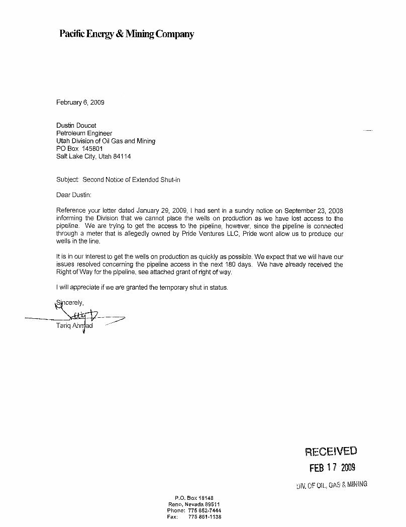
February 6, 2009
Dustin DoucetPetroleum EngineerUtah Divisionof OilGas and MiningPO Box 145801Salt Lake City, Utah 84114
Subject: Second Notice of Extended Shut-in
Dear Dustin:
Reference your letter dated January 29, 2009, I had sent in a sundry notice on September 23, 2008informing the Division that we cannot place the wells on production as we have lost access to thepipeline. We are tryingto get the access to the pipeline, however, since the pipeline is connectedthrougha meter that is allegedly owned by Pride Ventures LLC, Pride wont allow us to produce ourwells in the line.
It is in our interest to get thewells on production as quickly as possible. We expect thatwe willhave ourissues resolved concerning the pipeline access in the next 180 days. We have already received theRight of Way for thepipeline, see attached grant of rightof way.
Iwillappreciate ifwe are granted the temporaryshut in status.
S cerely,
Tariq Ah ad
RECEIVEDFEB17 2009
Div.0FOIL,GAS&MININGP.O. Box 18148
Reno, Nevada 89511Phone: 775 852-7444Fax: 775
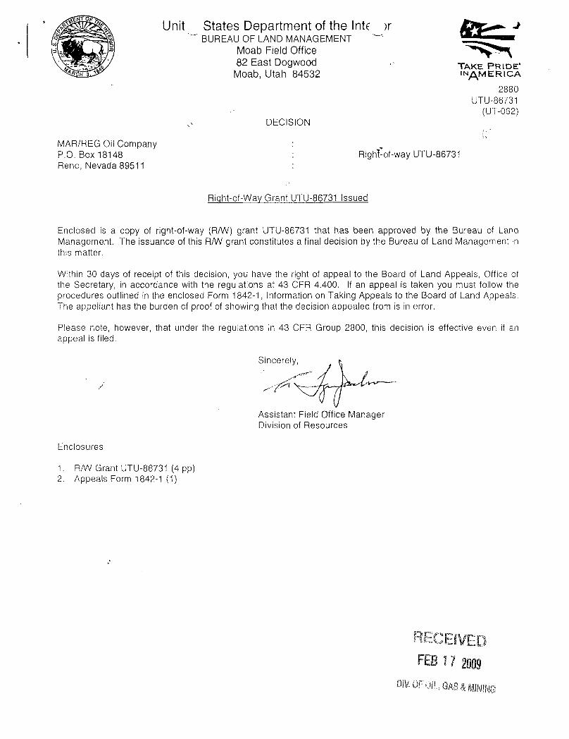
Unit States Department of the Inte >rBUREAU OF LAND MANAGEMENT
Moab Field Office82 East Dogwood TAKE PRIDE'
H ' Moab, Utah 84532 INAMERICA
2880UTU-86731
(UT-062)DECISION
MAR/REG Oil Company :
P.O. Box 18148 : Righl-of-way UTU-86731Reno, Nevada 89511
Right-of-Way Grant UTU-86731 Issued
Enclosed is a copy of right-of-way (R/W) grant UTU-86731 that has been approved by the Bureau of LandManagement. The issuance of this R/W grant constitutes a final decision by the Bureau of Land Management inthis matter.
Within 30 days of receipt of this decision, you have the right of appeal to the Board of Land Appeals, Office ofthe Secretary, in accordance with the regulations at 43 CFR 4.400. If an appeal is taken you must follow theprocedures outlined in the enclosed Form 1842-1, Information on Taking Appeals to the Board of Land Appeals.The appellant has the burden of proof of showing that the decision appealed from is in error.
Please note, however, that under the regulations in 43 CFR Group 2800, this decision is effective even if anappeal is filed.
Assistant Field Office ManagerDivision of Resources
Enclosures
1. R/W Grant UTU-86731 (4 pp)2. Appeals Form 1842-1 (1)
RECEIVEDFEBi 7 2009
DWOFOlt, GAS

FORM 2800-14 Issuing Office(August 1985) Moab Field Office
UNITED STATESDEPARTMENT OF THE INTERIORBUREAU OF LAND MANAGEMENT
e RIGHT-OF-WAY GRANTSERIAL NUMBER UTU-86731
1. A right-of-wayis hereby granted pursuant to Section 28 of the MineralLeasing Act of 1920, as amended(30 U.S.C. 185).
2. Nature of Interest:
a. By this instrument, the holder:
MAR/REGOilCompanyP.O. Box 18148Reno, Nevada 89511
receives a right to operate, maintain, and terminate a surface-laid steel pipeline gatheringsystem (2" and 3" pipeline segments servicing Vukasovich wells), across the following publiclands:
T. 20 S., R. 23 E.,sec. 31, E½SW¼SE¼,
T. 21 S., R. 23 E.,sec. 4, SW¼NE¼, S½NW¼, N½SE¼, SE¼SE¼;sec. 5, lots 1-4, and SE¼NE¼;sec. 6, lots 1 and 2;sec. 9, NE¼NE¼;sec. 10, N½NVi, SE¼NE¼;sec. 11, S½NW¼,NE¼SW¼, NŸV¼SE¼.
b. The right-of-way granted herein is 10 feet wide, 4.73 miles long, and contains 5.74 acres, moreor less,
c. This instrument shall terminate on December 31, 2027 unless, prior thereto, it is relinquished,abandoned, terminated, or modified pursuant to the terms and conditions of this instrument or ofany applicable Federal law or regulation.
d. This instrument may be renewed. If renewed, the right-of-way shall be subject to theregulations existing at the time of renewal and any other terms and conditions that theauthorized officer deems necessary to protect the public interest.
e. Notw/ithstanding the expiration of this instrument or any renewal thereof, early relinquishment,abandonment, or termination, the provisions of this instrument, to the extent applicable, shallcontinue in effect and shall be binding on the holder, its successors, or assigns, until they havefully satisfied the obligations and/or liabilities accruing herein before or on account of theexpiration, or prior termination, of the
-2-
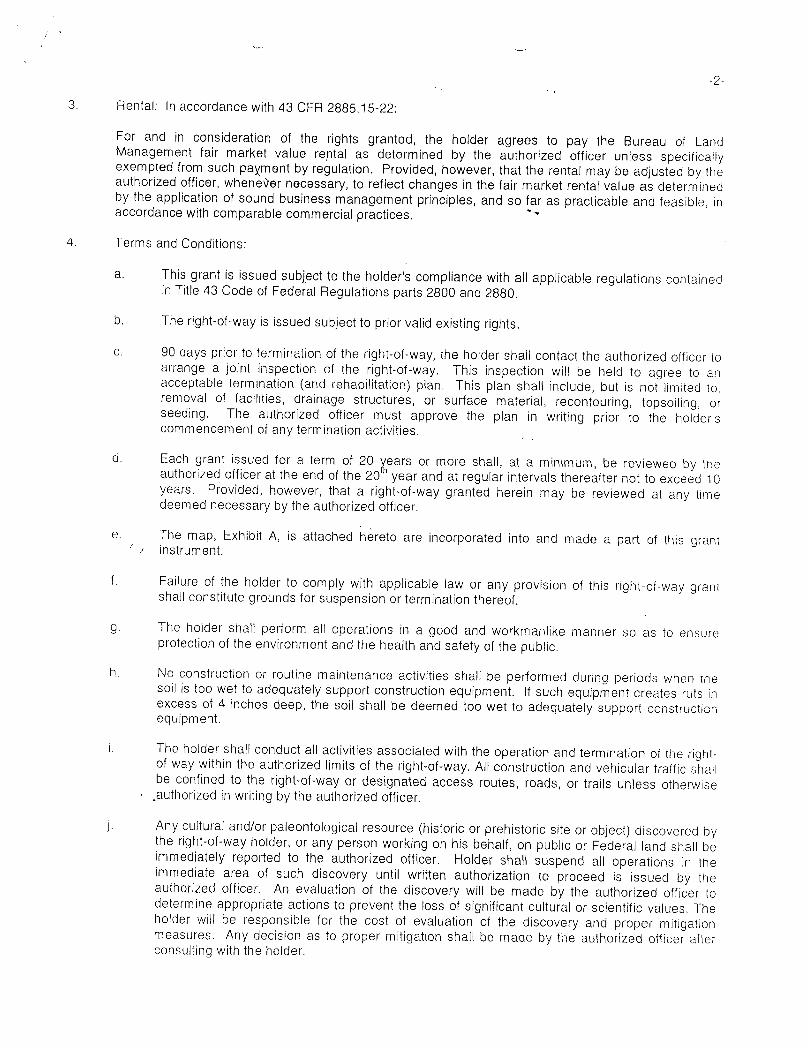
3. Rental: In accordance with 43 CFR 2885.15-22:
For and in consideration of the rights granted, the holder agrees to pay the Bureau of LandManagement fair market value rental as determined by the authorized officer unless specificallyexempted from such paXmentby regulation. Provided, however, that the rental may be adjusted by theauthorized officer, whene9er necessary, to reflect changes in the fair market rental value as determinedby the application of sound business management principles, and so far as practicable and feasible, inaccordance withcomparable commercial practices. "
4. Terms and Conditions:
a. This grant is issued subject to the holder's compliance with all applicable regulations containedin Title 43 Code of Federal Regulations parts 2800 and 2880.
b. The right-of-way is issued subject to prior valid existing rights.
c. 90 days prior to termination of the right-of-way, the holder shall contact the authorized officer toarrange a joint inspection of the right-of-way. This inspection will be held to agree to anacceptable termination (and rehabilitation) plan. This p\an shall include, but is not limited to.removal of facilities, drainage structures, or surface material, recontouring, topsolling, orseeding. The authorized officer must approve the plan in writing prior to the holder'scommencement of any terminationactivities.
d. Each grant issued for a term of 20 ears or more shall, at a minimum, be reviewed by theauthorized officer at the end of the 20 year and at regular intervals thereafter not to exceed 10years. Provided, however, that a right-of-way granted herein may be reviewed at any timedeemed necessary by the authorized officer.
e. The map, Exhibit A, is attached hereto are incorporated into and made a part of this grantinstrument.
f. Failure of the holder to comply with applicable law or any provision of this right-of-way grantshall constitute grounds for suspension or terminationthereof.
g. The holder shall perform all operations in a good and workmanlike manner so as to ensureprotection of the environment and the health and safety of the public.
h. No construction or routine maintenance activities shall be performed during periods when thesoil is too wet to adequately support construction equipment. If such equipment creates ruts inexcess of 4 inches deep, the soil shall be deemed too wet to adequately support constructionequipment.
i. The holder shall conduct all activities associated with the operation and termination of the right-of-way within the authorized limits of the right-of-way. All construction and vehicular trafficshallbe confined to the right-of-way or designated access routes, roads, or trails unless otherwise
-
.authorized in writingby the authorized officer.
j. Any cultural and/or paleontological resource (historic or prehistoric site or object) discovered bythe right-of-way holder, or any person working on his behalf, on public or Federal land shall beimmediately reported to the authorized officer. Holder shal\ suspend all operations in theimmediate area of such discovery until written authorization to proceed is issued by theauthorized officer. An evaluation of the discovery will be made by the authorized officer todetermine appropriate actions to prevent the loss of significant cultural or scientific values. Theholder will be responsible for the cost of evaluation of the discovery and proper mitigationmeasures. Any decision as to proper mitigation shall be made by the authorized officer afterconsulting with the
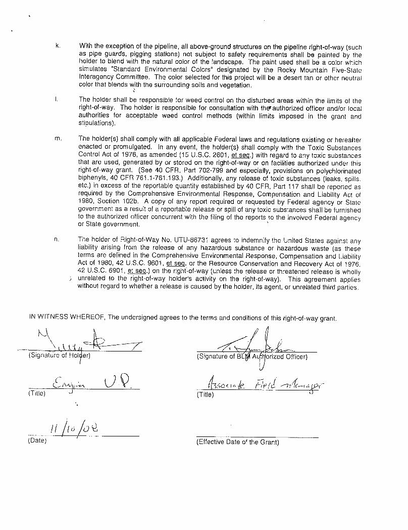
k. With the exception of the pipeline, all above-ground structures on the pipeline right-of-way (suchas pipe guards, pigging stations) not subject to safety requirements shall be painted by theholder to blend with the natural color of the landscape. The paint used shall be a color whichsimulates "Standard Environmental Colors" designated by the Rocky Mountain Five-StateInteragency Committee. The color selected for this project will be a desert tan or other neutralcolor that blends with the surrounding soils and vegetation.
I. The holder shall be responsible for weed control on the disturbed areas within the limits of theright-of-way. The holder is responsible for consultation with thevauthorized officer and/or localauthorities for acceptable weed control methods (within limits imposed in the grant andstipulations).
m. The holder(s) shall complywith all applicable Federal laws and regulations existing or hereafterenacted or promulgated. In any event, the holder(s) shall comply with the Toxic SubstancesControl Act of 1976, as amended (15 U.S.C. 2601, et seq.) with regard to any toxic substancesthat are used, generated by or stored on the right-of-way or on facilities authorized under thisright-of-way grant. (See 40 CFR, Part 702-799 and especially, provisions on polychlorinatedbiphenyls, 40 CFR 761.1-761.193.) Additionally, any release of toxicsubstances (leaks, spills.etc.) in excess of the reportable quantity established by 40 CFR, Part 117 shall be reported asrequired by the Comprehensive Environmental Response, Compensation and Liability Act of1980, Section 102b. A copy of any report required or requested by Federal agency or Stategovernment as a result of a reportable release or spill of any toxic substances shall be furnishedto the authorized officer concurrent with the filing of the reports to the involved Federal agencyor State government.
n. The holder of Right-of-Way No. UTU-86731 agrees to indemnify the United States against anyliability arising from the release of any hazardous substance or hazardous waste (as theseterms are defined in the Comprehensive Environmental Response, Compensation and LiabilityAct of 1980, 42 U.S.C. 9601, et sea. or the Resource Conservation and Recovery Act of 1976,42 U.S.C. 6901, et seq.) on the right-of-way (unless the release or threatened release is whollyunrelated to the right-of-way holder's activity on the right-of-way). This agreement applieswithout regard to whether a release is caused by the holder, its agent, or unrelated thirdparties.
IN WITNESS WHEREOF, The undersigned agrees to the terms and conditions of this right-of-way grant.
(Signature of Ho er) (Signature of B Ai.Aorized Officer)
(Title) (Title)
(Date) (Effective Date of the

Isto a.r Right -of- ay UTU-86731
surface gas pipeline gatherin8 system.... T. 20 S., R. 23 E., within sec. 31.
. . 1.....J.
T. 21 S., R. 23 E., within secs. 4-6,9-11.
Cisco Springs,Danish Flat,Cisco 7)'topo hic maps
STATE OF UTAH FORM9DEPARTMENT OF NATURAL RESOURCES
DIVISIONOF OIL, GAS AND MINING 5. LEASE DESIGNATIONANDSERIAL NUMBER:
Fee6. [F INDIAN,ALLOTTEE OR TRIBE NAME
SUNDRY NOTICES AND REPORTS ON WELLS7. UNITor CA AGREEMENTNAME:
Do not use this form for proposals to drillnew wells, significantly deepen existing wells below current bottom-hole depth, reenter plugged wells, or todrillhorizontal laterais. Use APPLICATIONFOR PERMIT TO DRILL form for such proposals.
1. TYPE OF WELL 8. WELLNAME and NUMBER:OIL WELL GAS WELL OTHER Petro-X 23-1
2. NAMEOF OPERATOR: 9. API NUMBER:
Pacific Energy & Mining Co. 43019305583. ADDRESS OF OPERATOR: PHONE NUMBER: 10. FIELDAND POOL, OR WILDCAT:
PO Box 18148 Reno sTATE NV a,89511 (775) 852-7444 CISCO4. LOCATIONOF WELL
FOOTAGESATSURFACE: 330 FNL 2310 FWL COUNTY: Grand
QTR/QTR, SECTION, TOWNSHIP, RANGE, MERIDIAN: NENW 23 21S 23E S STATE:UTAH
CHECK APPROPRIATE BOXES TO INDICATE NATURE OF NOTICE, REPORT, OR OTHER DATATYPE OF SUBMISSION TYPE OF ACTION
ACIDIZE DEEPEN REPERFORATE CURRENT FORMAT10NNOTICE OF INTENT
(Submit in Duplicate) ALTER CASlNG FRACTURE TREAT SIDETRACKTO REPAIR WELL
Approximate date workwill start: CASING REPAIR NEW CONSTRUCT10N TEMPORARILY ABANDON
CHANGETO PREV10US PLANS OPERATOR CHANGE TUBING REPAIR
CHANGE TUBING PLUG AND ABANDON VENT OR FLARE
SUBSEQUENT REPORT CHANGE WELL NAME PLUG BACK WATER DISPOSAL(Submit Original Form Only)
CHANGE WELL STATUS PRODUCTION (START/RESUME) WATER SHUT-OFF
Date of work completion:COMMINGLEPRODUCINGFORMATIONS RECLAMATIONOF WELL SITE OTHER: Extended Shut in
CONVERT WELL TYPE RECOMPLETE -DIFFERENTFORMATlON
12. DESCRIBE PROPOSED OR COMPLETED OPERATIONS. Clearly show all pertinent details including dates, depths, volumes, etc.
Well was pulled, tubing was changed. Well was tested by State representative for TD. TP and CP are both equal, there is nofluid in the hole. Both tubing and casing pressure are equal. Well is hooked into the gas gathering statement. Awaitingpipeline access. Request 180 days shut in tillwe get well sales on \\ne.
NAME(PLEASE PRINT) iq Ahmad TITLE Petroleum Engineer
SIGN DATE 2/9/2009
(This space for State use only)
FEBi 7 2009
DIV,OF0 8 &MINING
(5/2000) (See Instructions on Reverse
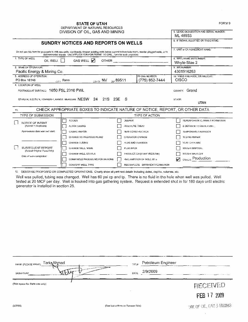
STATE OF UTAH FORM 9DEPARTMENTOF NATURAL RESOURCES
DIVISION OF OIL, GAS AND MINING 5. LEASEDESIGNATIONANDSERIALNUMBER:
ML 48933
SUNDRY NOTICES AND REPORTS ON WELLS6. IFINDIAN.ALLOTTEEORTRIBENAME:
7. UNITor CAAGREEMENTNAME:Do not use this form for proposals to drillnew wells, significantlydeepen existing wells below current bottom-hole depth, reenter plugged wells, or to
drill horizontal laterais. Use APPLICATIONFOR PERMITTO DRILLform for such proposals.1. TYPE OF WELL 8. WELLNAMEand NUMBER:
olL WELL GAS WELL OTHER Whyte-Stae 22.NAMEOFOPERATOR: 9.APINUMBER:
Pacific Energy & Mining Co. 43019162633. ADDRESS OF OPERATOR: PHONE NUMBER: 10. FIELDAND POOL, OR WILDCAT:PO Box 18148 Reno sTATE NV ,,,89511 (775) 852-7444 CISCO
4. LOCATIONOF WELL
FOOTAGESATSURFACE: 1650 FSL 2310 FWL COUNTY: Grand
QTR/QTR, SECTION, TOWNSHIP, RANGE, MERIDIAN: NESW 24 21S 23E S STATE:UTAH
11. CHECK APPROPRIATE BOXES TO INDICATE NATURE OF NOTICE, REPORT, OR OTHER DATATYPE OF SUBMISSION TYPE OF ACTION
ACIDIZE DEEPEN REPERFORATE CURRENT FORMAT10NNOTICE OF INTENT
(Submit in Duplicate) ALTERCASING FRACTURE TREAT SIDETRACK TO REPA1R WELL
Approximate date work will start: CASINGREPAIR NEW CONSTRUCTION TEMPORARILY ABANDON
CHANGETO PREVIOUS PLANS OPERATOR CHANGE TUBINGREPAIR
CHANGE TUBING PLUG ANDABANDON VENT OR FLARE
O SUBSEQUENT REPORT CHANGEWELL NAME PLUG BACK WATER DISPOSAL(Submit Original Form Only)
CHANGE WELLSTATUS PRODUCTION(START/RESUME) WATERSHUT-OFFDate of work completion:
O COMMINGLEPRODUCING FORMATIONS RECLAMATIONOF WELLSITE OTHER: PfOduction
O CONVERTWELL TYPE RECOMPLETE - DIFFERENT FORMATION
12. DESCRIBE PROPOSED OR COMPLETED OPERATIONS. Clearly show all pertinent details including dates, depths, volumes, etc.
Well was pulled, tubing was changed. Well has 60 psi cp and tp. There is no fluid in the hole when well was pulled. Welltested at 20 MCF per day. Well is hooked into gas gathering system. Request a extended shut in for 180 days until electricgenerator is installed in section 25.
NAME(PLEASEPRINT) Tari ad TITLE Petroleum Engineer
SIGNATURE DATE 2/9/2009
(ThisspaceforStateuseonly) RECEIVEDFEB17 2009
(5/2000) (See Instructions on Reverse
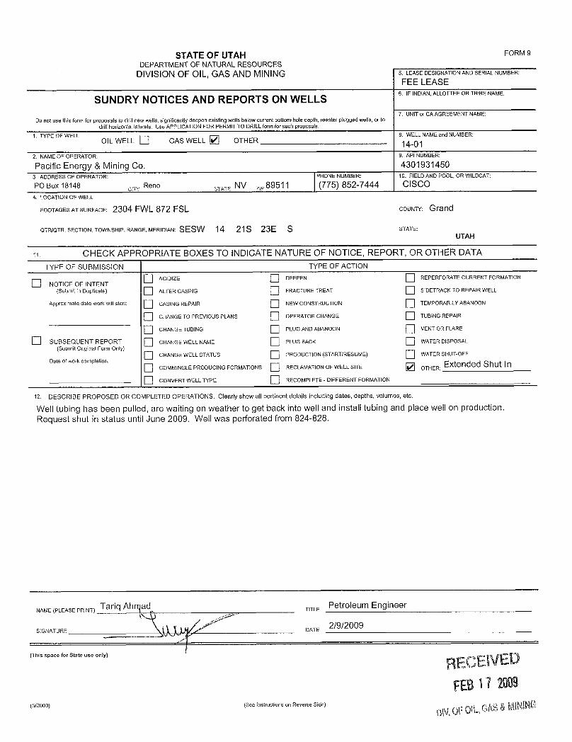
STATE OF UTAH FORM 9DEPARTMENTOF NATURALRESOURCES
DIVISIONOF OIL, GAS ANDMINING 5. LEASE DESIGNATIONANDSERIALNUMBER:
FEE LEASE6. IF INDIAN,ALLOTTEE OR TRIBE NAME
SUNDRY NOTICES AND REPORTS ON WELLS7. UNITor CAAGREEMENTNAME:
Do not use this form for proposals to drillnew wells, significantlydeepen existing wells below current bottom-hole depth, reenter plugged wells, or todril1horizontal laterals. Use APPUCATION FOR PERMIT TO DRILLform for such proposals.
1.TYPEOF\NELL 8.WELLNAMEandNUMBER:OIL WELL GAS WELL OTHER 14-01
2. NAMEOF OPERATOR: 9. API NUMBER:
Pacific Energy & Mining Co. 43019314503. ADDRESS OF OPERATOR: PHONE NUMBER: 10. FIELDANDPOOL, OR WILDCAT:
PO Box 18148 , Reno sy,,, NV ,,,89511 (775) 852-7444 CISCO4. LOCATIONOF WELL
FOOTAGESATSURFACE: 2304 FWL 872 FSL COUNTY: Grand
QTR/QTR, SECTION, TOWNSHIP, RANGE,MERIDIAN: SESW 14 21S 23E S STATE:UTAH
o. CHECK APPROPRIATE BOXES TO INDICATE NATURE OF NOTICE, REPORT, OR OTHER DATATYPE OF SUBMISSION TYPE OF ACTION
ACIDIZE DEEPEN REPERFORATE CURRENT FORMAT10NNOT1CE OF INTENT
(Submit in Duplicate) ALTERCASlNG FRACTURE TREAT SIDETRACKTO REPAIR WELL
Approximate date work will start: CASING REPAIR NEW CONSTRUCTION TEMPORARlLY ABANDON
CHANGE TO PREVIOUS PLANS DPERATOR CHANGE TUBINGREPAlR
CHANGE TUBING PLUG AND ABANDON VENTOR FLARE
SUBSEQUENT REPORT CHANGEWELLNAME PLUG BACK WATER DISPOSAL(Submit Original Form Only)
CHANGE WELL STATUS PRODUCTION(START/RESUME) WATERSHUT-OFFDate of work completion:
COMMINGLEPRODUC1NG FORMATIONS RECLAMATION OF WELL SITE OTHER: Extended Shut In
coNVERT WELLTYPE RECOMPLETE - DIFFERENT FORMATlON
12 DESCRIBE PROPOSED OR COMPLETED OPERATIONS. Clearly show all pertinent details including dates, depths, volumes, etc.
Well tubing has been pulled, are waiting on weather to get back into well and install tubing and place well on production.Request shut in status until June 2009. Well was perforated from 824-828.
NAME (PLREEASEPRINT) TDATE /2oleumEngineer
(This space for State use only) . . aRECEIVEDFEBi 7 2003
(5/2000) (See Instructions on Reverse
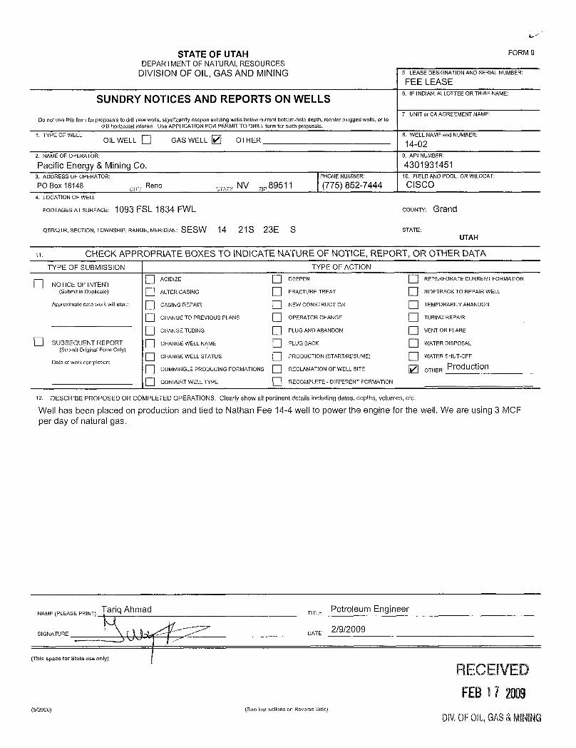
STATEOFUTAH FORM9DEPARTMENT OF NATURALRESOURCES
DIVISION OF OIL, GAS AND MINING 5. LEASEDESIGNATIONANDSERIALNUMBER:
FEE LEASE6. IF INDlAN,ALLOTTEEOR TRIBE NAME
SUNDRY NOTICES AND REPORTS ON WELLS7. UNIT or CA AGREEMENTNAME:
Do not use this form for proposals to drillnew wells, significantly deepen existing wells below current bottom-hole depth, reenter plugged wells, or todrillhorizontalaterais. Use APPUCATION FOR PERMITTO DRILL form for such proposals.
1. TYPE OF WELL 8. WELL NAMEand NUMBER:OlL WELL O GAS WELL OTHER 14-02
2. NAMEOF OPERATOR: 9. API NUMBER:
Pacific Energy & Mining Co. 43019314513. ADDRESS OF OPERATOR: PHONE NUMBER: 10. FIELDANDPOOL, OR WILDCAT:
PO Box 18148 , Reno sTATE NV ,,,89511 (775) 852-7444 CISCO4. LOCATIONOF WELL
FOOTAGESATSURFACE: 1093 FSL 1834 FWL COUNTY: Grand
QTR/QTR, SECTION, TOWNSHIP, RANGE, MERIDIAN: SESW 14 21S 23E S STATE:UTAH
n. CHECK APPROPRIATE BOXES TO INDICATE NATURE OF NOTICE, REPORT, OR OTHER DATATYPE OF SUBMISSION TYPE OF ACTION
ACIDIZE DEEPEN REPERFORATE CURRENT FORMATIONNOTICE OF INTENT
(Submit in Duplicate) ALTERCASING FRACTURETREAT SIDETRACKTO REPAIR WELL
Approximate date work will start: CASING REPA1R NEW CONSTRUCTION TEMPORARILY ABANDON
CHANGETO PREVIOUS PLANS OPERATOR CHANGE TUBINGREPAIR
CHANGETUB1NG PLUG ANDABANDON VENTOR FLARE
SUBSEQUENT REPORT CHANGEWELL NAME PLUG BACK WATER DlSPOSAL(Submit Original Form Only)
CHANGEWELL STATUS PRODUCTION (START/RESUME) WATERSHUT-OFFDate of work completion:
COMMINGLE PRODUClNG FORMATIONS RECLAMATION OF WELL SITE OTHER: PfOduction
CONVERTWELL TYPE RECOMPLETE - DíFFERENT FORMATION
12 DESCRIBE PROPOSED OR COMPLETED OPERAT10NS. Clearly show all pertinent details including dates, depths, volumes, etc.
Well has been placed on production and tied to Nathan Fee 14-4 well to power the engine for the well. We are using 3 MCFper day of natural gas.
NAME (PLEASE PRINT) Tariq Ahmad TITLE POÍTOleum Engineer
SIGNATURE DATE 2/9/2009
(This space for State use only)
RECEIVEDFEB17 2009
(5/2000) (See instructions on Reverse Side)
DE OFOIL,GAS&
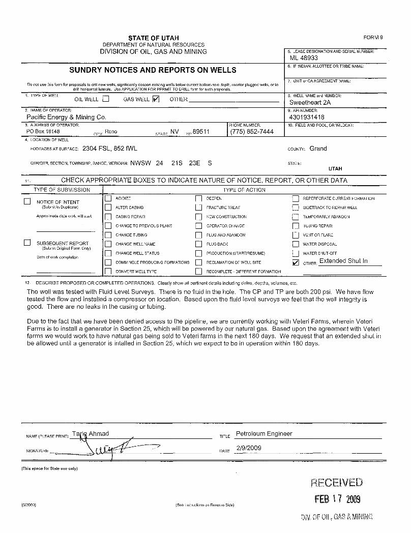
STATE OF UTAH FORM 9DEPARTMENTOF NATURAL RESOURCES
DIVISION OF OlL, GAS AND MINING 5. LEASEDESIGNATIONANDSERIALNUMBER:
ML 48933
SUNDRY NOTICES AND REPORTS ON WELLS6. IFINDIAN,ALLOTTEEORTRIBENAME;
7. UNITor CA AGREEMENT NAME:Do not use thisform for proposals to drillnew wells, significantlydeepen existing wells below current bottom-hole depth, reenter plugged wells, or to
drill horizontal laterals. Use APPLICATIONFOR PERM1T TO DRILLform for such proposals.1. TYPE OF WELL 8. WELLNAME and NUMBER:
OIL WELL O GAS WELL OTHER Sweetheart 2A2. NAMEOF OPERATOR: 9.- API NUMBER:
Pacific Energy & Mining Co. 43019314183. ADDRESS OF OPERATOR: PHONE NUMBER: 10. FIELDAND POOL, OR WILDCAT:PO Box 18148 Reno STATE NV , 89511 (775) 852-7444
4. LOCATIONOF WELL
FOOTAGESATSURFACE: 2304 FSL, 852 fWL COUNTY: Grand
QTRIQTR, SECTION, TOWNSHIP, RANGE, MERIDIAN: NWSW 24 21S 23E S STATE:UTAH
. CHECK APPROPRIATE BOXES TO INDICATE NATURE OF NOTICE, REPORT, OR OTHER DATATYPE OF SUBMISSION TYPE OF ACTION
ACIDIZE DEEPEN REPERFORATE CURRENT FORMATIONNOTICE OF [NTENT
(Submit in Duplicate) ALTER CASING FRACTURETREAT SIDETRACK TO REPAIR WELL
Approximate date work will start: CASING REPAlR NEW CONSTRUCTION TEMPORARILY ABANDON
CHANGE TO PREViOUS PLANS OPERATOR CHANGE TUBING REPAlR
CHANGE TUBING PLUG ANDABANDON VENT OR FLARE
SUBSEQUENT REPORT CHANGE WELLNAME PLUG BACK WATER DISPOSAL(Submit Original Form Only)
CHANGEWELL STATUS PRODUCTION (START/RESUME) WATER SHUT-OFFDate of work completion:
COMMINGLE PRODUCING FORMATIONS RECLAMATIONOF WELL SITE OTHER: Extended Shut lnCONVERTWELLTYPE RECOMPLETE -DIFFERENT FORMATION
12. DESCRIBE PROPOSED OR COMPLETED OPERATIONS. Clearly show all pettinent details including dates, depths, volumes, etc.
The well was tested with Fluid Level Surveys. There is no fluid in the hole. The CP and TP are both 200 psi. We have flowtested the flow and installed a compressor on location. Based upon the fluid level surveys we feel that the well integrity isgood. There are no leaks in the casing or tubing.
Due to the fact that we have been denied access to the pipeline, we are currently working with Veteri Farms, wherein VeteriFarms is to install a generator in Section 25, which will be powered by our natural gas. Based upon the agreement with Veterifarms we would work to have natural gas being sold to Veteri farms in the next 180 days. We request that an extended shut inbe allowed until a generator is intalled in Section 25, which we expect to be in operation within 180 days.
NAME (PLEASE PRINT) Ta Ahmad- TlTLE
POÍfOleum Engineer
SIGNATURE (1 2/9/2009L ,
DATE
(This space for State use only)
RECEIVEDFEB17 2003
(5/2000) (See instructions on Reverse Side)
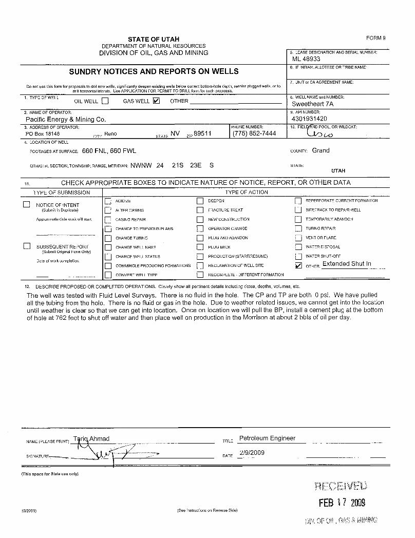
STATE OF UTAH FORM 9
DEPARTMENTOF NATURALRESOURCESDIVISION OF OIL, GAS AND MINING 5. LEASEDESIGNATIONANDSERIALNUMBER:
ML 48933
SUNDRY NOTICES AND REPORTS ON WELLS6. IFINDIAN.ALLOTTEEORTRIBENAME:
7. UNITor CA AGREEMENT NAME:Do not use this form for proposaÍsto drillnew wells, signincantly deepen existing wells below current bottom-hole depth, reenter plugged wells, or to
drillhorizontal laterals. Use APPLICATIONFOR PERMITTO DRILL form for such proposals.1. TYPE OF WELL 8. WELLNAME and NUMBER:
OILWELL D GAS WELL D OTHER Sweetheart 7A2. NAMEOF OPERATOR: 9. API NUMBER:
Pacific Energy & MiningCo. 43019314203. ADDRESS OF OPERATOR: PHONE NUMBER: 10. FIEL ÑIDPOOL, OR WILDCAT:
PO Box 18148elTy
Reno STATE NV s, 89511 (775) 852-74444. LOCATIONOF WELL
FOOTAGESATSURFACE: 660 FNL, 660 FWL COUNTY: Grand
QTRIQTR, SECTION, TOWNSHIP, RANGE, MERIDIAN: NWNW 24 21S 23E S STATE:
UTAH
CHECK APPROPRIATE BOXES TO INDICATE NATURE OF NOTICE, REPORT, OR OTHER DATATYPE OF SUBMISSION TYPE OF ACTION
ACIDIZE DEEPEN REPERFORATE CURRENT FORMATIONNOTICE OF INTENT
(Submit in Duplicate) ALTER CASING FRACTURE TREAT SIDETRACKTO REPAIR WELL
Approximate date work will start: CASING REPAIR NEW CONSTRUCTION TEMPORARILY ABANDON
CHANGE TO PREVlOUS PLANS OPERATOR CHANGE TUBING REPAIR
CHANGETUBING PLUG AND ABANDON VENT OR FLARE
SUBSEQUENT REPORT CHANGE WELL NAME PLUG BACK WATER DiŠPOSAL(Submit Original Form Only)
CHANGE WELLSTATUS PRODUCTlON (START/RESUME) WATER SHUT-OFFDate of work completion:
COMMINGLEPRODUCING FORMATIONS RECLAMATIONOF WELLSITE OTHER: Extended Shut In
coNVERT WELL TYPE RECOMPLETE - DIFFERENT FORMATION
12. DESCRIBE PROPOSED OR COMPLETED OPERATIONS. Clearly show all pertinent details including dates, depths, volumes, etc.
The well was tested with Fluid Level Surveys. There is no fluid in the hole. The CP and TP are both 0 psi. We have pulledall the tubing from the hole. There is no fluid or gas in the hole. Due to weather related issues, we cannot get into the locationuntil weather is clear so that we can get into location. Once on location we will pull the BP, install a cement plug at the bottomof hole at 762 feet to shut off water and then place well on production in the Morrison at about 2 bbis of oil per day.
NAME(PLEASEPRINT) T Ahmad TITLE POÍfOÌ8Um Engineer
2/9/2009SIGNATURE DATE
(This space for State use only)
RECEIVEDFEB17 2009
(5/2000) (See instructions on Reverse Side)
Oli OFDIL,GM å
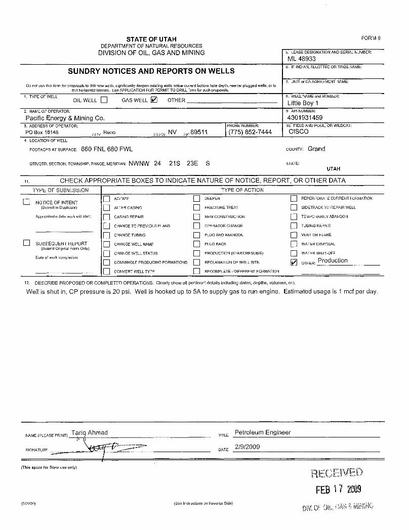
STATE OF UTAH FORM 9DEPARTMENTOF NATURALRESOURCES
DIVISION OF OIL,GAS AND MINING 5. LEASEDESIGNATIONANDSERIALNUMBER:
ML 489336. IF 1NDIAN,ALLOTTEEOR TRIBE NAME
7. UNITor CA AGREEMENTNAME:Do not use this form for proposals to drillnew wells, significantly deepen existing wells below current bottom-hole depth, reenter plugged wells, or to
drill horizontal laterals. Use APPLICATIONFOR PERMITTO DRILLform for such proposals.1. TYPE OF WELL
OIL WELL GAS WELL OTHER8 LeLNAME and NUMBER:
2,NAMEOFOPERATOR: 9.APINUMBER:
Pacific Energy & Mining Co. 43019314593. ADDRESS OF OPERATOR: PHONE NUMBER: 10. FIELDAND POOL, OR WILDCAT:
PO Box 18148 cro Reno STATE NV ,89511 (775) 852-7444 CISCO4. LOCATIONOF WELL
FOOTAGESATSURFACE: 660 FNL 680 FWL COUNTY: Grand
QTR/QTR, SECTION, TOWNSHIP, RANGE, MERIDIAN: NWNW 24 21S 23E S STATE:UTAH
CHECK APPROPRIATE BOXES TO INDICATE NATURE OF NOTICE, REPORT, OR OTHER DATATYPE OF SUBMISSION TYPE OF ACTION
ACIDiZE DEEPEN REPERFORATE CURRENT FORMATIONO NOTICE OF INTENT(Submit in Duplicate) ALTER CASING FRACTURE TREAT SIDETRACK TO REPAIR WELL
Approximate date work will start: CASING REPAIR NEW CONSTRUCTlON TEMPORARILY ABANDON
CHANGETO PREV1OUS PLANS OPERATOR CHANGE TUBINGREPAIR
CHANGE TUBING PLUGANDABANDON VENT OR FLARE
SUBSEQUENT REPORT CHANGEWELL NAME PLUG BACK WATER DISPOSAL(Submit Original Form Only)
CHANGE WELL STATUS PRODUCTION(START/RESUME) WATER SHUT-OFFDate of work completion:
O COMMINGLE PRODUCING FORMATIONS RECLAMATION OF WELLSITE OTHER: Production
CONVERT WELL TYPE RECOMPLETE - DIFFERENT FORMATION
12- DESCRIBE PROPOSED OR COMPLETED OPERATIONS. Clearly show all pertinent details including dates, depths, volumes, etc.
Well is shut in, CP pressure is 20 psi. Well is hooked up to 5A to supply gas to run engine. Estimated usage is 1 mcf per day.
NAME(PLEEAS TT P6ÍTOleum Engineer
(This space for State use only) RECEIVEDFEB17 2005
(5/2000) (See Instructions on Reverse

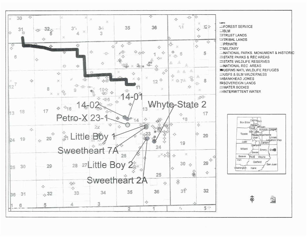
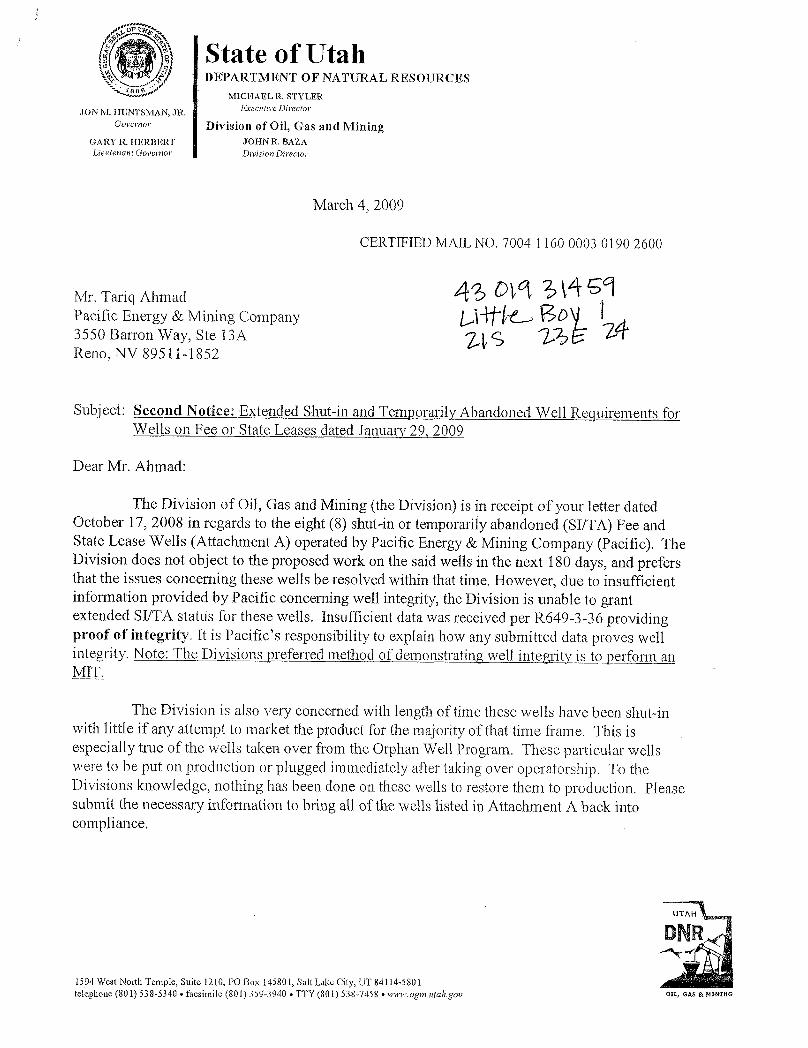
State of UtahDEPARTMENT OF NATURAL RESOURCES
MICHAELR, STYLER
JON M. HUNTSMAN, J R. Erecutive Director
Governor Division of Oil, G-as and MiningGARY R. HERBERT JOHN R. BAZALieutenant Govemor Division Director
March 4, 2009
CERTIFIED MAIL NO. 7004 1160 0003 0190 2600
Mr. Tariq AhmadPacific Energy & Mining Company3550 Barron Way, Ste 13AReno, NV 895.11-1852
Subject: Second Notice: Extended Shut-in and Temporarily Abandoned Well Requirements forWells on Fee or State Leases dated January 29, 2009
Dear Mr. Ahmad:
The Division of Oil, Gas and Mining (the Division) is in receipt of your letter datedOctober 17, 2008 in regards to the eight (8) shut-in or temporarily abandoned (SI/TA) Fee andState Lease Wells (Attachment A) operated by Pacific Energy & Mining Company (Pacific). TheDivision does not object to the proposed work on the said wells in the next 180 days, and prefersthat the issues concerning these wells be resolved within that time. However, due to insufficientinformation provided by Pacific concerning well integrity, the Division is unable to grantextended SI/TA status for these wells. Insufficient data was received per R649-3-36 providingproof of integrity. It is Pacific's responsibility to explain how any submitted data proves wellintegrity. Note: The Divisions preferred method of demonstrating well integrity is to perform anMIT.
The Division is also very concerned with length of time these wells have been shut-inwith little if any attempt to market the product for the majority of that time frame. This isespecially true of the wells taken over from the Orphan Well Program. These particular wellswere to be put on production or plugged immediately after takingover operatorship. To theDivisions knowledge, nothing has been done on these wells to restore them to production. Pleasesubmit the necessary information to bring all of the wells listed in Attachment A back intocompliance.
1594 West North Temple, Suite 1210, PO Box 145801, Salt Lake City, UT 84114-5801telephone (801) 538-5340 •facsimile (801) 359-3940 • TTY (801) 538-7458 •www.ogm.utah.gov OIL, GAS &
Page 2Pacific Energy & Mining CompanyMarch 4, 2009
For extended SI/TA consideration the operator shall provide the Division withthe following:
1. Reasons for SI/TA of the well (R649-3-36-l.1).2. The length of time the wel is expected to be SVTA (R649-3-36-1.2), and3. An explanation and supporting data if necessary, for showing the well has
integrity, meaning that the casing, cement, equipment condition, static fluidlevel pressure, existence or absence of Underground Sources of Drinking Waterand other factors do not make the well a risk to public health and safety or theenvironment (R649-3-36-1.3).
Submitting the information suggested below may help show well integrity and may helpqualify your well for extended SI/TA. Note: As of July 1, 2003, wells in violation of the SI/TArule R649-3-36 may be subject to full cost bonding (R649-3-1-4.2, 4.3).
1. Wellbore diagram, and2. Copy of recent casing pressure test, and3. Current pressures on the wellbore (tubing pressure, casing pressure, and
casing/casing annuli pressure) showing wellbore has integrity, and4. Fluid level in the wellbore, and5. An explanation of how the submitted information proves integrity.
If the required information is not received within 30 days of the date of this notice, aNotice of Violation will be issued and further actions may be initiated. If you have any questionsconcerning this matter, please contact me at (801) 538-5281.
Dustin K. DoucetPetroleum Engineer
DKD/JP/jsEnclosureec: Jim Davis, SITLA
Compliance FileWell Files
N:\O&G Reviewed
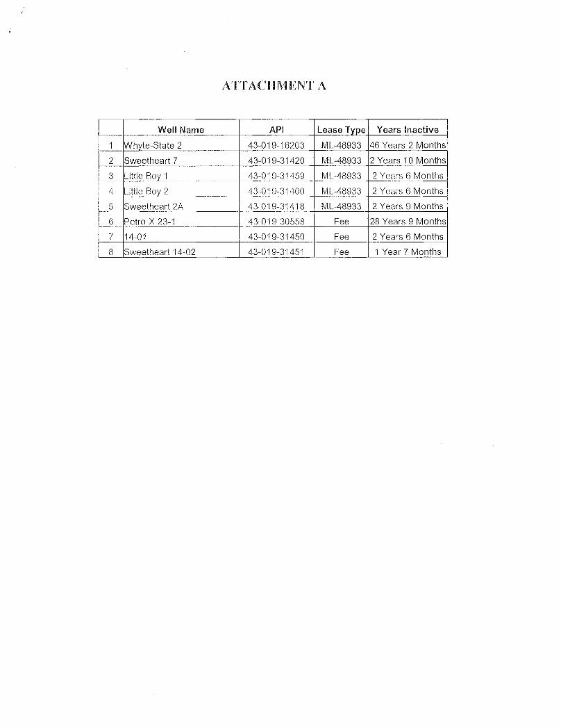
ATTACHMENT A
Well Name API Lease Type Years Inactive
1 Whyte-State 2 43-019-16263 ML-48933 46 Years 2 Months
2 Sweetheart 7 43-019-31420 ML-48933 2 Years 10 Months
3 Little Boy 1 43-019-31459 ML-48933 2 Years 6 Months
4 Little Boy 2 43-019-31460 ML-48933 2 Years 6 Months
5 Sweetheart 2A 43-019-31418 ML-48933 2 Years 9 Months
6 Petro-X 23-1 43-019-30558 Fee 28 Years 9 Months
7 14-01 43-019-31450 Fee 2 Years 6 Months
8 Sweetheart 14-02 43-019-31451 Fee 1 Year 7

RECEIVED
March 17, 2009
Dustin Doucet1594 West North Temple, Suite 1210PO Box 145801Salt Lake City, UT 84114
Subject: Extended Shut-in Notice
Dear Doucet:
I am in receipt of your letter dated March 4, 2009. Our response is as follows:
1. As discussed we are in the process of getting the casing integrity tests2. The ROW that we have received is to connect our existing line in Section 11 to the Petro X
meter which ends at the new ROW from the BLM. Once we have installed the lines we willcommence sales of natural gas.
3. The Little Boy #1 and Little Boy #2 are only about 300 feet in depth. The surface casing forboth wells was installed and cemented to the surface with a TD of about 120 feet. Thewellbore diagrams were submitted to you earlier. The surface pressure on both of the wells isapproximately 30 psi and it has stayed constant since we drilled these wells. The wells arecompleted openhole. Based upon the constant pressure we believe that the casing integrity isgood, otherwise we would have observed a decrease in surface pressure over time if naturalgas has seeped into a hole in the casing.
4. None of the wells in the list have any fluid in the hole.5. We expect to have the wells on production by June of this year once we have built the
requisite pipeline.As stated earlier we had requested the temporary shut in status due to the fact that we cannot transport the naturalgas through the pipeline allegedly owned by Pride Ventures. Because of this reason we had applied and recentlyreceived the requisite ROW, a copy of which was sent to you earlier.
Once we receive the casing pressure tests we will submit the same to your office.
cerely,
Ìanq aPetroleum E ineer
3550 Barron Way #13a, PO BOX 18148, RENO, NEVADA 89511 PH 775 852 7444 FAX 775 333 0225
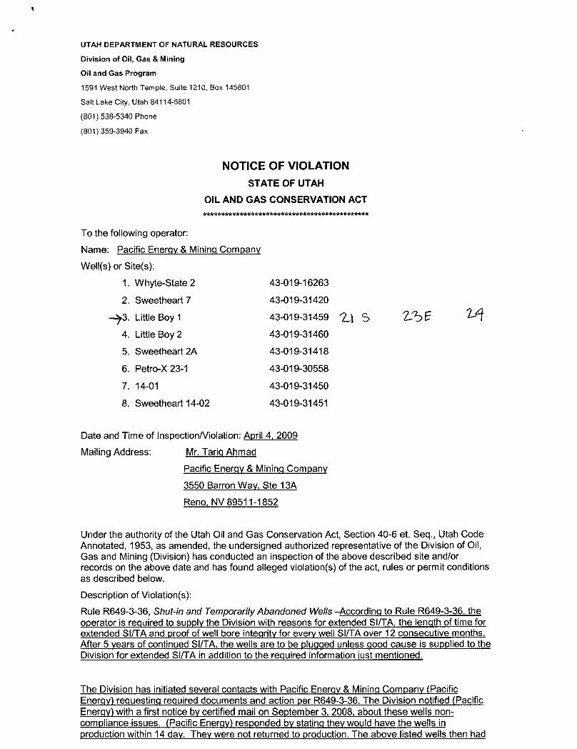
UTAH DEPARTMENT OF NATURAL RESOURCES
Division of Oil, Gas & Mining
Oil and Gas Program
1594 West North Temple, Suite 1210, Box 145801
Salt Lake City, Utah 84114-5801
(801) 538-5340 Phone
(801) 359-3940 Fax
NOTICE OF VIOLATIONSTATE OF UTAH
OIL AND GAS CONSERVATION ACT***************kkkkkkkkkkkkkkkkk**********kkk
To the following operator:Name: Pacific Energy & Mining Company
Well(s) or Site(s):
1. Whyte-State 2 43-019-16263
2. Sweetheart 7 43-019-31420
3. Little Boy 1 43-019-31459 S 2..S64. Little Boy 2 43-019-31460
5. Sweetheart 2A 43-019-31418
6. Petro-X 23-1 43-019-30558
7. 14-01 43-019-31450
8. Sweetheart 14-02 43-019-31451
Date and Time of Inspection/Violation: April 4, 2009
Mailing Address: Mr. Tariq Ahmad
Pacific Energy & Mining Company
3550 Barron Way, Ste 13A
Reno, NV 89511-1852
Under the authority of the Utah Oil and Gas Conservation Act, Section 40-6 et. Seq., Utah CodeAnnotated, 1953, as amended, the undersigned authorized representative of the Division of Oil,Gas and Mining (Division) has conducted an inspection of the above described site and/orrecords on the above date and has found alleged violation(s) of the act, rules or permit conditionsas described below.
Description of Violation(s):
Rule R649-3-36, Shut-in and Ternporarily Abandoned Wells --According to Rule R649-3-36, theoperator is required to supply the Division with reasons for extended SI/TA, the length of timeforextended SIITA and proof of well bore integrity for every well SI/TA over 12 consecutive months.After 5 years of continued Sl/TA, the wells are to be pluqqed unless good cause is supplied to theDivision for extended SIITA in addition to the required information |ustmentioned.
The Division has initiated several contacts with Pacific Enerqy &Mininq Company (PacificEnergy) requesting required documents and action per R649-3-36. The Division notified(PacificEnergy) witha first notice by certified mail on September 3, 2008, about these wells non-compliance issues. (Pacific Energy) responded by statinq theywould have the wells inproduction within 14 day. They were not returned to production. The above listed wells then
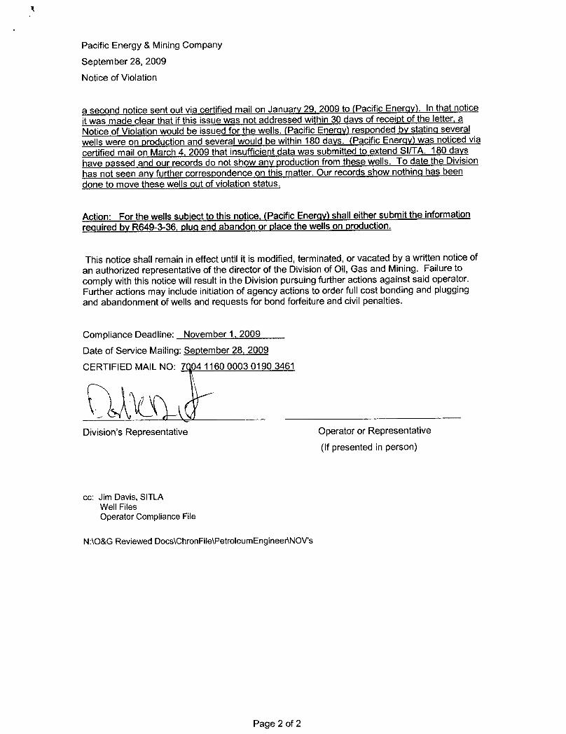
Pacific Energy & Mining Company
September 28, 2009
Notice of Violation
a second notice sent out via certified mail on January 29, 2009 to (Pacific Energy). In that noticeit was made clear that if this issue was not addressed within 30 days of receipt of the letter, aNotice of Violation would be issued for the wells. (Pacific Energy) responded by statinq severalwells were on production and several would be within 180 days. (Pacific Enerqy) was noticed viacertified mailon March4, 2009 that insufficient data was submitted to extend SI/TA. 180 dayshave passed and our records do not show any production from these wells. To date the Divisionhas not seen any further correspondence on this matter. Our records show nothinq has beendone to move these wells out of violation status.
Action: For the wells subject to thisnotice, (Pacific Energy) shall either submit the informationrequired by R649-3-36, pluq and abandon or place the wells on production.
This notice shall remain in effect until it is modified,terminated,or vacated by a written notice ofan authorized representative of the director of the Division of Oil, Gas and Mining. Failure tocomply with this notice will result in the Division pursuing further actions against said operator.Further actions may include initiation of agency actions to order full cost bonding and pluggingand abandonment of wells and requests for bond forfeiture and civil penalties.
Compliance Deadline: November 1, 2009
Date of Service Mailing: September 28, 2009
CERTIFIED MAIL NO: 7 04 1160 0003 0190 3461
Division's Representative Operator or Representative
(If presented in person)
cc: Jim Davis, SITLAWell FilesOperator Compliance File
N:\O&G Reviewed Docs\ChronFile\PetroleumEngineer\NOV's
Page 2 of
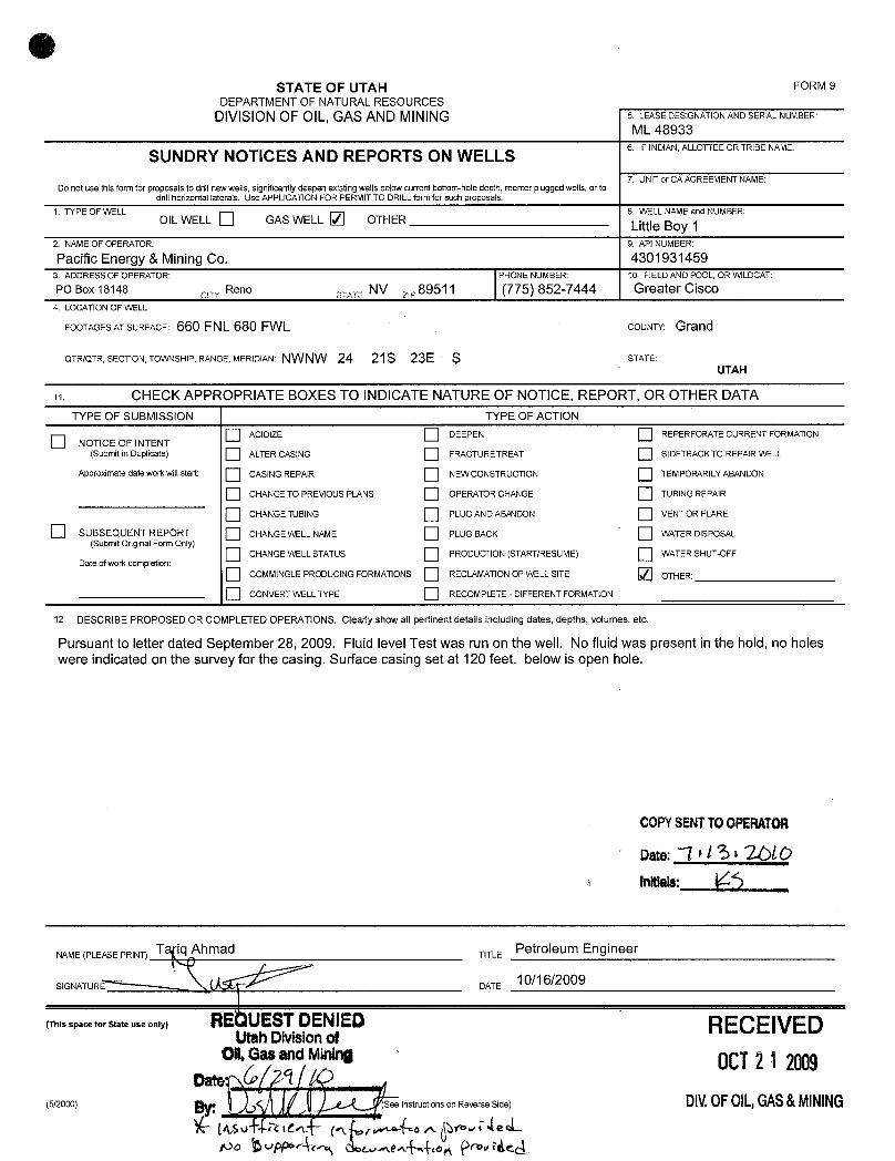
OSTATEOFUTAH FORM9
DEPARTMENTOF NATURALRESOURCESDIVISIONOF OIL, GAS AND MINING 5. LEASEDES1GNATIONANDSERALNUMBER:
ML 48933
SUNDRY NOTICES AND REPORTS ON WELLS 6. IFINDIAN,ALLOTTEEORTRlBENAME:
7. UNlTor CA AGREEMENTNAME:Do not use thisform for proposals todrillnew wells, significantly deepen existing wells below currentbottom-hole depth, reenter plugged wells, or to
drillhorizontal 1aterals. Use APPLICATIONFOR PERMITTO DRILLform for such proposals.1. TYPE OF WELL
OILWELL GAS WELL OTHER8 WELL NMyE and NUMBER:
2. NAMEOF OPERATOR: 9. API NUMBER:
Pacific Energy & Mining Co. 43019314593. ADDRESSOF OPERATOR: PHONE NUMBER: 10. FlELD AND POOL, OR WlLDCAT:
PO Box 18148 Reno y, NV y 89511 (775) 852-7444 Greater Cisco4. LOCATIONOF WELL
FOOTAGESATSURFACE: 660 FNL 680 FWL COUNTY: Grand
QTR/QTR, SECT10N, TOWNSHIP, RANGE, MERIDIAN: NWNW 24 21S 23E S STATE:UTAH
CHECK APPROPRIATE BOXES TO INDICATENATURE OF NOTICE, REPORT, OR OTHER DATATYPE OF SUBMISSION TYPE OF ACTION
ACIDIZE DEEPEN REPERFORATE CURRENT FORMAT10NNOTICE OF INTENT
(Submit in Duplicate) ALTER CASING FRACTURETREAT SIDETRACKTO REPAIR WELL
Appro>dmatedate work willstart: CASING REPA1R NEW CONSTRUCTION TEMPORARILYABANDON
CHANGETO PREMOUS PLANS OPERATOR CHANGE TUBINGREPAIR
CHANGE TUBING PLUG AND ABANDON VENT OR FLARE
SUBSEQUENT REPORT CHANGE WELL NAME PLUG BACK WATER DISPOSAL(Submit Original Form Only)
CHANGEWELLSTATUS PRODUCTION (START/RESUME) WATER SHUT-OFFDate of work completion:
COMMlNGLEPRODUClNG FORMATIONS RECLAMATIONOF WELLSITE OTHER:
O CONVERT WELLTYPE RECOMPLETE - DIFFERENT FORMATION
12. DESCRIBE PROPOSED OR COMPLETED OPERATIONS. Clearly show all pertinent details including dates, depths, volumes, etc.
Pursuant to letter dated September 28, 2009. Fluid level Test was run on the well. No fluid was present in the hold, no holeswere indicated on the survey for the casing. Surface casing set at 120 feet. below is open hole.
COPYSENTTOOPERATOR
oste:-~l
*/ St 2OLOInitlais:
SG A R
ATLEE Oe/6/e20 9Engineer
(ThisspaceforStateuseonly) RE UESTDENIED RECEIVEDUtahDMslonofOll,Gas andMi 0CT2 1 2009
(5/2000) e Instructions on Reverse Side) DIV.OFOIL,GAS&
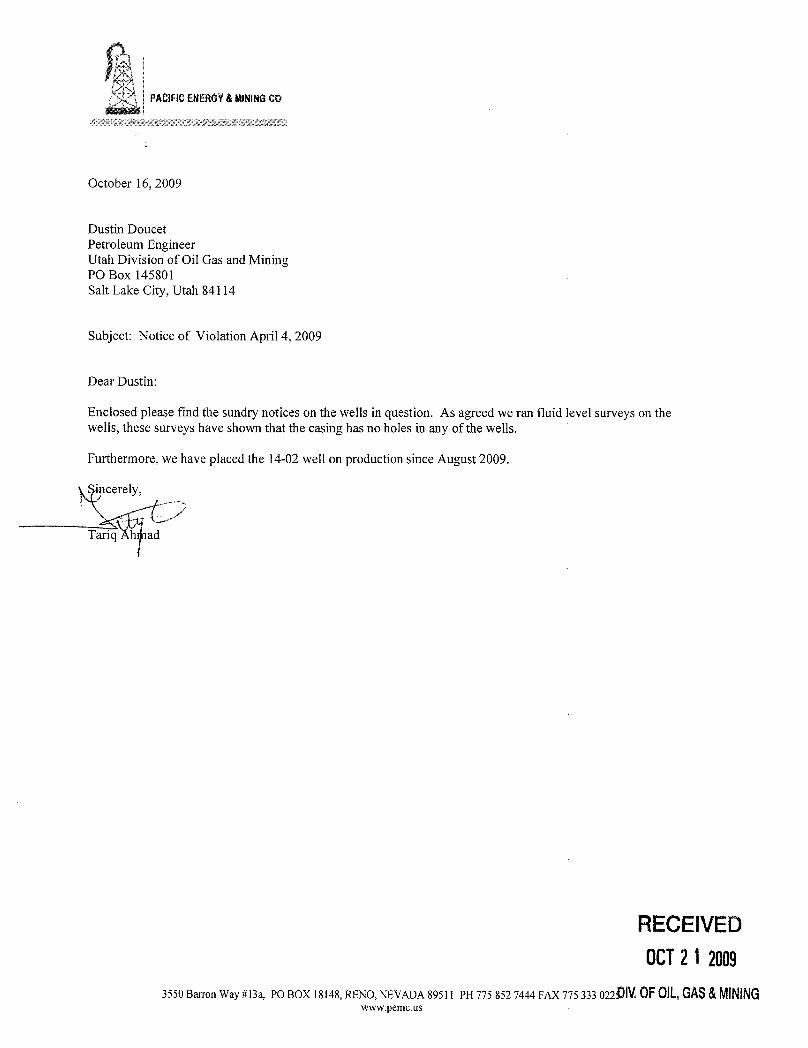

Mar/Reg OilCompany
April 28, 2010
Tamir AbudiPresidentD k eStryee
Suite 700Denver, Colorado 80202
Subject: Pipeline AccessCisco, Utah
Dear Mr. Abudi:
We had requested during 2008 and again during2009 that Elk allow us access to its gas gathering system. Basedupon our request , we were advised by Anna Ilhan, OperationsEngineer, to do the following:
1. Obtain a ROW from the BLM to the your pipeline;2. Obtain natural gas analysis for the wells.
After we did both, Ms. Ilhan, informedus by telephoneand email, that Elk is not willing to purchase or transportour gas into the system. Thus our gas has been stranded for over 24 months due to the actions of your company.
During the week of April 19 we met with the Bureau of Land Management and they informedus that the publicROW for a natural gas or oil pipeline contains the stipulation that the pipelinesare common carriers, and thusmustallow natural gas into the pipelines. (See 43 CR 2885.11 (16) that a ROW holders must grant access to thepipeline.)
Your ROW contains this specific stipulation as all pipelineROW have this governmental stipulation. A copy ofthe regulation is attached herewith for your review. As you know due to the actions of Elk, we have lostproduction for over 24 months, we continue to suffer losses due to the refusal of Elk to allow us access to thepipeline.
We will appreciate if you would provide us access to the gathering system so that we can start sales of our naturalgas. Delek Energy/Elk have until May 56 2010 to respond to this request, failing we will take up this matter withthe BLM and the State Board of Oil Gas and Mining.
Sincerely,
Tariq Ahmad
Cc: Bureauof Land Management, Moab, UtahUtah Division of Oil Gas and Mining
RECEIVEDP.O. Box 18148
Reno, Nevada 89511Phone: 775 852-7444 DIV.OF01L,GAS&MININGOv 775

Bureau of Land Management, Interior §2885.11related facility siting standards con- (15) As BLM directs. provide dia-tained in applicable Federal or state grams or maps showing the location oflaw or regulations; any constructed facility;
(iii) Control or prevent damage to (16) Construct, operate, and maintainscenic, aesthetic, cultural, and envi- the pipeline as a common carrier. Thisronmental values, including fish and means that the pipeline owners and op-wildlife habitat, and to public and pri- erators must accept, convey, transport,vate property and public health and or purchase without discrimination allsafety; oil or gas delivered to the pipeline
(iv) Protect the interests of individ without regard to where the oil and gasuals living in the general area who rely was produced (i.e., whether on Federalon the area for subsistence uses as that or non-federal lands). Where natural
term is used in Title VIII of ANILCA gas not subject to state regulatory orconservation laws governing its pur-
(16 U.S.C. 3111 et seq.): and chase by pipeline companies is offered(v) Ensure that you construct, oper- for sale, each pipeline company must
ate, maintain, and terminate the facili- purchase, without discrimination, anyties on the lands in the right-of-way or such natural gas produced in the vicin-TUP area in a manner consistent with ity of the pipeline. Common carrierthe grant or TUP: provisions of this paragraph do not
(10) Immediately notify all Federat apply to natural gas pipelines operatedstate, tribal, and local agencies of any by a:release or discharge of hazardous mate- (i) Person subject to regulation underrial reportable to such entity under ap- the Natural Cas Act (15 U.S.C. 717 etplicable law. You must also notify seq.); orBLM at the same time, and send BLM (ii) Public utility subject to regula-a copy of any written notification you tion by state or municipal agenciesprepared; ,
with the authority to set rates and(11) Not dispose of or store hazardous charges for the sale of natural gas to
material on your right-of-way or TUP consumers within the state or munici-area, except as provided by the terms, pality.conditions, and stipulation of your (17) Within 30 calendar days aftergrant or TUP; BLM requests it, file rate schedules
(12) Certify that your compliance and tariffs for oil and gas, or derivativewith all requirements of the Emer products, transported by the pipelinegency Planning and Community Right- as a common carries with the agencyto-Know Act of 1986, 42 U.S.C. 11001 et BLM prescribes, and provide BLM proofseq., when you receive, assign, renew, that you made the required filing;
amend. or terminate your grant or (18) With certain exceptions (listed inTUP. the statute). not export domestically' produced crude oil by pipeline without(13) Control and remove any release Presidential approval (see 30 U.S.C.or discharge of hazardous material on 185(u) and (s) and 50 U.S.C. App. 2401);or near the right-of-way or TUP area (19) Not exceed the right-of-wayarising in connection with your use width that is specified in the grantand.occupancy of the right-of-way or without BLM s prior written authoriza-TUP area, whether or not the release tion. If you need a right-of-way wideror discharge is authorized under the than 50 feet plus the ground occupiedgrant or TUP. You must also remediate by the pipeline and related facilities,and restore lands and resources af- sec§2885.14ofthissubpart;fected by the release or discharge to (20) Not use the right-of-way or TUPBLM's satisfaction and to the satisfac- area for any use other than that au-tion of any other Federal, state, tribal. thorized by the grant or TUP. If you re-or local agency having jurisdiction quire other pipelines, looping lines, orover the land, resource, or hazardous other improvements not authorized bymaterial; the grant or TUP, you must first so-
(14) Comply with all liability and in- cure BLM's written authorization;demnification provisions and stipula- (21) Not use or construct on the landtions in the grant or TUP; in the right-of-way or TUP area until:
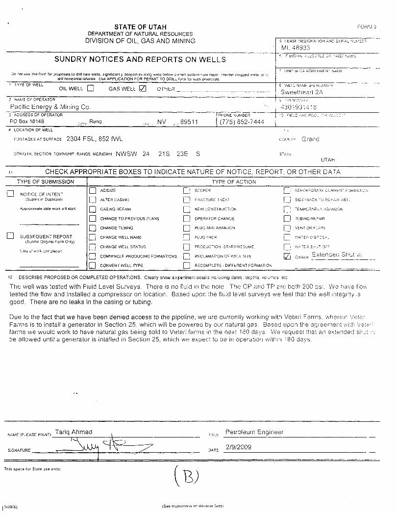
STATE OF UTAH "°*DEPARTMENT OF NATURAL RESOURCES
DIVISION OF OIL, GAS AND MINING 5 LEASE DESIGNATioN AND SËRiAL NUMBËR
ML 48933
SUNDRY NOTICES AND REPORTS ON WELLS6 IFiNDIAN ALLOFTEËOR TRIBËNAME
7 UNIT or CA AGREEMENT NAMËDo not use this form for proposals to drill new wells, significantly deepen existing wells below current bottom-hole depth reenter plugged welis. or 10
drill horizontal laterals. Use APPLICATION FOR PERMIT TO DRlLL form for such proposals
1 TYPE OF WELL 8 WELL NAME ana NUMBEROIL WELL GAS WELE OTHER Sweetheart 2A
2 NAME OF OPERATOR S AP' NUUDER
Pacific Enengy & Mining Co. 43019314183 ADDRESS OF OPERATOR PHONE NUMBER =0 FIELD AND POOL M
PO Box 18148 Reno NV .89511 (775) 852-74444 LOCATION OF WELL
FOOTAGESATSURFACE 2304 FSL, 852 fWL couerv Grand
OTRIQTR. SECTION, TOWNSHIP. RANGE. MERIO!AN NWSW 24 21S 23E S s1^TEUTAH
u CHECK APPROPRIATE BOXES TO INDICATE NATURE OF NOTICE, REPORT OR OTHER DATATYPE OF SUBMISSION TYPE OF ACTION
ACJDIZE DEEPEN REPERFORATE CURRËNT FORMAT NNOTlCE OF INTENT
(Suomit in Duplicate) ALTER CASlNG FRACTURE TREAT SlDETRACK TO REPAIR WEL
Approximate date work willstart: CASING REPAlR NEW CONSTRUCTION TEMPORARILY ASANDON
O CHANGE TO PREVIOUS PLANS OPERATOR CHANGE TUBING REPAlR
O CHANGE TUBlNG PLUG AND ABANDON VENT OR FLARE
O SUBSEQUENT REPORT CHANGE WELL NAME PLUG BACK WAMS°CSE(Suomit Originat Form Only)
CHANGE WELL STATUS PROOUCTION START/RESUME WATER SHUT-OU
Dale of work completion
O COMMINGLE PRODUCING FORMATIONS RECLAMATION OF WELL SITE OTHER Extendea Shut in
CONVERT WELL TYPE RECOMPLETE - DIFFERENT FORMATION
12 DESCRIBE PROPOSED OR COMPLETED OPERATIONS. Clearly show all pertinent details including dates. depths. volumes, etc
The well was tested with Fluid Level Surveys. There is no fluid in the hole. The CP and TP are both 200 psi. We have flowtested the flow and installed a compressor on location. Based upon the fluid level surveys we feel that the well integrity isgood. There are no leaks in the casing or tubing.
Due to the fact that we have been denied access to the pipeline, we are currently working with Veteri Farms. wherein veteriFarms is to install a generator in Section 25, which will be powered by our natural gas. Based upon the agreement with Veterifarms we would work to have natural gas being sold to Veteri farms in the next 180 days. We request that an extended shut in
be allowed until a generator is intalled in Section 25, which we expect to be in operation within 180 days.
NAME PLEEASEPRINT) Tariq ad Petroleurn Engineer
This space for State use only)
5/2000) (See instructions on Reverse
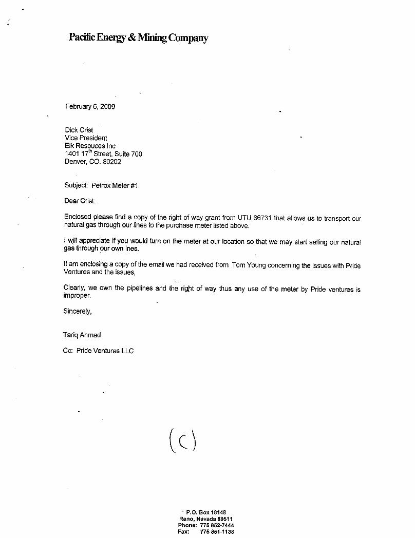
PacificEnergy &MiningCompany
February 6, 2009
Dick CristVice PresidentElk Resouces Inc1401 17 Street, Suite 700Denver, CO. 80202
Subject: Petrox Meter #1
Dear Crist:
Enclosed please find a copy of the rightof way grant from UTU 86731 that allows us to transpodournaturalgas throughour lines tothepurchase meter listed above.
I willappreciate if you would tumon the meter at our location so thatwe may start selling our naturalgas throughour own ines.
Il am enclosinga copy of theemailwe had receivedfrom Tom Young concerning the issues withPrideVentures and the issues,
Clearly, we own the pipelines and the rigþt of way thus any use of the meter by Pride ventures isimproper.
Sincerely,
Tariq Ahmad
Cc: Pride Ventures LLC
P.O. Box 18148Reno, Nevada 89511Phone: 775 852-7444Fax: 775
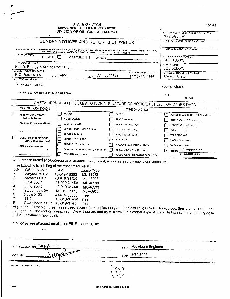
STATEOFUTAH FORMSDEPARTMENTOF NATURALRESOURCES
DIVISIONOF OIL, GAS AND MINING 5. LEASE DESIGNATION AND SERIAL NUMSËR
SEE BELOWSUNDRYNOTICES AND REPORTS ON WELLS 6 WINOlAN.ALLOTTEEORTRIBENAMË
7 UNIT Os CA AGREEMENT NAMECo not use this form for proposals to Ofili new wells, significantly deepen existing wells below current bottorn note depth. reenter plugged wells, or todrill norizontallaterais. Use APPLICATION FOR PERMIT TO DRILL form for such proposals.1. TYPE OF WELL
8 W€LL NAMEand NUMBER.OIL WELL Q GAS WELL 2 OTHERSEE BELOW
2. NAMEOF OPERATOR:9. API NUMBER:Pacificl¯nergy & MiningCompany SEE BELOW
3. ADDRESS OF OPERATOR: PHONE NUMBER: 10. FIELDAND POOL, OR WILDCATP.O. Box 18148 cin Reno stave NV ,,89511 - (775) 852-7444 Greater Cisco4 LOCATION OF WELL
FOOTAGES AT SURFACE:COUNW Grand
OTR/QTR. SECTION, TOWNSHIP. RANGE, MERIDIAN: STATE:UTAH
n. CHECKAPPROPRlATE BOXESTOlNDICATE NATUREOF NOTICE, REPORT, OR OTHER DATATYPE OF SUBMISSION TYPE OF ACTION
O ACIDIZE DEEPEN REPERFORATE CURRENT FORMATIOP,O NOTICE OF INTENT(Suomit in Duplicate) O ALTER CASING FRACTURE TREAT SIDETRACK TO REPAIR WELL
Approx male Gate work willstart: O CASING REPAIR NEW CONSTRUCTION TEMPORARJLY ABANDON
O CHANGE TO PREVIOUS PLANS OPERATOR CHANGE TU81NG REPAlR
O CHANGE TUBING PLUG AND ABANDON VENT OR FLAR6O SUBSEQUENT REPORT CHANGE WELLNAME PLUG BACK WATER DISPOSAL(Submit OriginalForm Only)O CHANGE WELLSTATUS PRODUCTION (START/RESUME) WATER SHUT-OFFDate ofwork completion:O COMMINGLEPRODUCING FORMATIONS RECLAMATION OF WELL SITE OTHER:
O CONVERT WELLTYPE RECOMPLETE - DIFFERENT FORMATION Shipping gas.
OESCRIBE PROPOSEDORCOMPLETEDOPERATIONS.Clearlyshowaltpertinent details including dates, depths, volumes, etc.The following is a listing of theconcerned wells;.S.N. WELL NAME API Lease Type1 Whyte-State 2 43-019-16263 ML-489332 Sweetheart 7 43-019-31420 ML-489333 Little Boy 1 43-019-31459 ML-489334 Little Boy 2 43-019-31460 ML-489335 Sweetheart 2A 43-019-31418 ML-489336 Petro-X-23-1 43-019-30558 Fee7 14-01 43-019-31450 Fee8 Sweetheart 14-01 43-019-31451 FeeAt present, Pride Ventures has refused access for shipping our produced natural gas to Elk Resources; thus we can't ship thesaid gas until the matter is resolved. We will pursue and try to resolve this matter expeditiously. In the interim, we are trying tosell our produced gas locally.
""Please see attached emailfrom Elk Resources, Inc.
NAME(PLEASE PRINT) Tariq hmad Petroleum Engineer
SIGNATURE \ OATE 9/23/2008
(This space for State use only)
52000; (See Instructions on Reverse
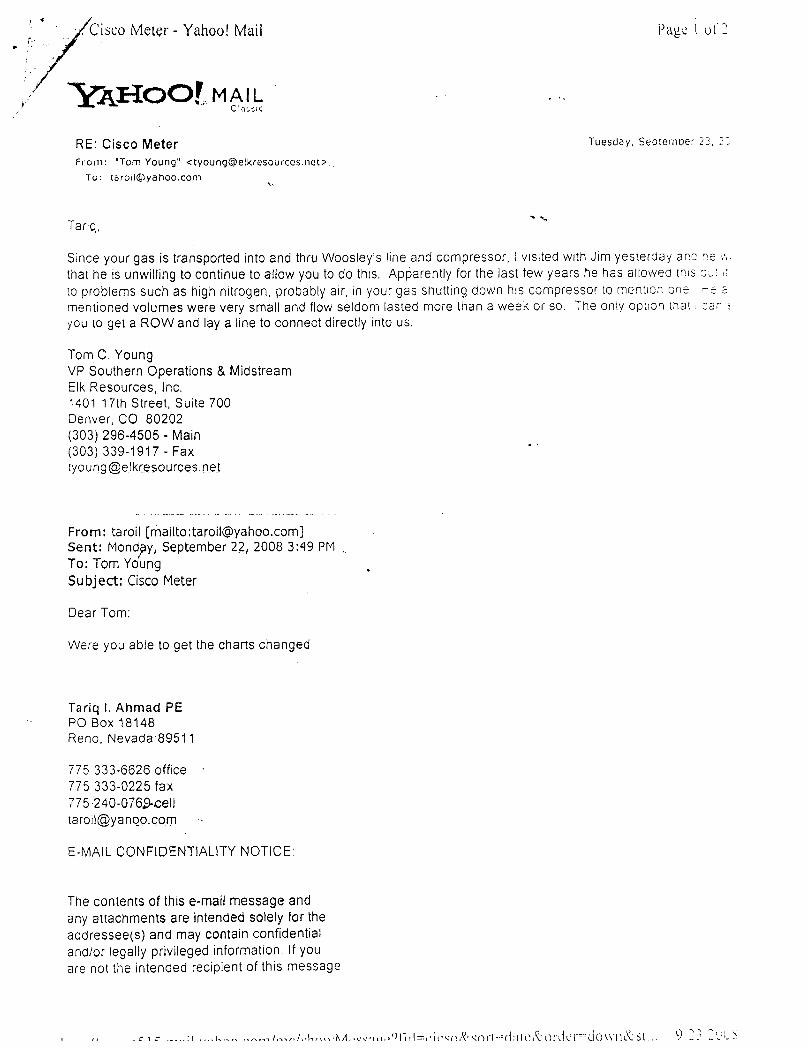
. CiscoMeter - Yahoo! Mail Page l ot 2
AI-IOOLMAIL
RE: Cisco Meter Tuesday, Septemoer 23, 22
From: "Tom Young" <[email protected]>.
Tanq,"
Since your gas is transported into and thru Woosley's line and compressor, i visited with Jim yesterday ano ne e,
that he is unwillingto continue to allow you to do this. Apparently for the last few years he has allowea inis olo problems such as high nitrogen, probably air, in your gas shutting down his compressor to mennon one ,e amentioned volumes were very small and flow seldom lasted more than a week or so. The only opuon mai: car i
you to get a ROW and lay a line to connect directly into us.
Tom C. YoungVP Southern Operations & MidstreamElk Resources, Inc.1401 17th Street, Suite 700Denver, CO 80202(303) 296-4505 - Main(303) 339-1917 - [email protected]
From: taroll [mailto:[email protected]]Sent: Mondpy, September 2.2, 2008 3:49 PM
.
To: Tom YoungSubject: Cisco Meter
Dear Tom:
Were you able to get the charts changed
Tariq l. Ahmad PEPO Box 18148Reno. Nevada 89511
775 333-6626 office ·
775 333-0225 fax775 240-076>[email protected]
E-MAILCONFIDENTIALITY NOTICE:
The contents of thise-mail message andany attachments are intended solely for theaddressee(s) and may contain confidentialand/or legally privileged information. If youare not the intended recipient of this

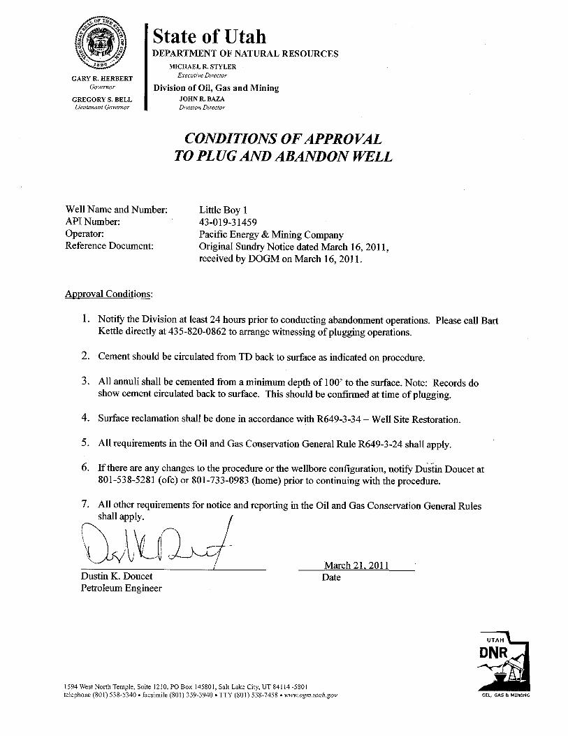
(i State of Utah/2/ DEPARTMENT OF NATURAL RESOURCES
,.' MICHAEL R. STYLER
GARY R.HERBERT Executive Director
covernor Division of Oil, Gas and MiningGREGORY S. BELL JOHN R. BAZALieutenant Governor Division Director
CONDITIONS OF APPROVALTO PLUG AND ABANDON WELL
Well Name and Number: Little Boy 1API Number: 43-019-31459Operator: Pacific Energy & Mining CompanyReference Document: Original Sundry Notice dated March 16, 2011,
received by DOGM on March 16, 2011.
Approval Conditions:
1. Notify the Division at least 24 hours prior to conducting abandonment operations. Please call BartKettle directly at 435-820-0862 to arrange witnessing of plugging operations.
2. Cement should be circulated from TD back to surface as indicated on procedure.
3. All annuli shall be cemented from a minimum depth of 100' to the surface. Note: Records doshow cement circulated back to surface. This should be confirmed at time of plugging.
4. Surface reclamation shall be done in accordance with R649-3-34 - Well Site Restoration.
5. All requirements in the Oil and Gas Conservation General Rule R649-3-24 shall apply.
6. If there are any changes to the procedure or the wellbore configuration, notify DuÃinDoucet at801-538-5281 (ofc) or 801-733-0983 (home) prior to continuing with the procedure.
7. All other requirements for notice and reporting in the Oil and Gas Conservation General Rules
March 21, 2011Dustin K. Doucet DatePetroleum Engineer
UTAH
DNR
1594 West North Temple, Suite 1210, PO Box 145801, Salt Lake City, UT 84114 -5801
telephone (801) 538-5340•facsimile (801) 359-3940 •TTY (801) 538-7458 • www.ogm.utah.gov OIL, GAS &
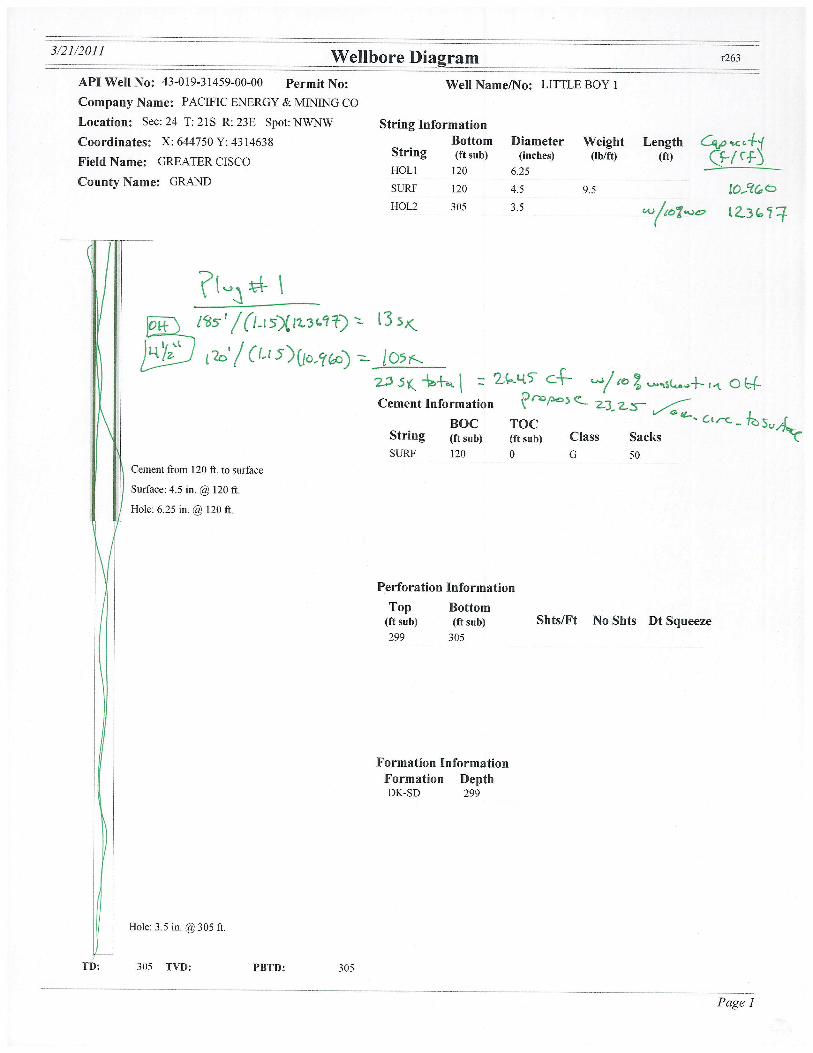
API Well No: 43-019-31459-00-00 Permit No: Well Name/No: LITTLE BOY lCompany Name: PACIFIC ENERGY & MINING COLocation: See: 24 T: 21S R: 23E Spot: NWNW String InformationCoordinates: X: 644750 Y: 4314638 Bottom Diameter Weight Length p re
Field Name: GREATER CISCOStrmg (ft sub) (inches) (Ib/ft) (ft) fy
HOLl 120 6.25County Name: GRAND
SURF 120 4.5 9.5HOL2 305 3.5
Cement Information \ P L
BOC TOC C rt
String (ft sub) (ft sub) Class Sacks T\ SURF 120 0 G 50
Cement from 120 ft to surface
Surface: 4.5 in. @120 ft
Hole: 6.25 in. @120 ft.
Perforation InformationTop Bottom
(ft sub) (ft sub) Shts/Ft No Shts Dt Squeeze299 305
Formation InformationFormation DepthDK-SD 299
Hole: 3.5 in. @305 ft
TD: 305 TVD: PBTD: 305
Page
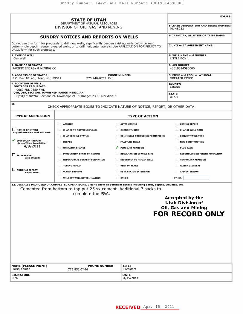
STATE OF UTAHDEPARTMENT OF NATURAL RESOURCES
DIVISION OF OIL, GAS, AND MINING
FORM 9
5.LEASE DESIGNATION AND SERIAL NUMBER: ML-48933
SUNDRY NOTICES AND REPORTS ON WELLSDo not use this form for proposals to drill new wells, significantly deepen existing wells below currentbottom-hole depth, reenter plugged wells, or to drill horizontal laterals. Use APPLICATION FOR PERMIT TODRILL form for such proposals.
6. IF INDIAN, ALLOTTEE OR TRIBE NAME:
7.UNIT or CA AGREEMENT NAME:
1. TYPE OF WELL Gas Well
8. WELL NAME and NUMBER: LITTLE BOY 1
2. NAME OF OPERATOR: PACIFIC ENERGY & MINING CO
9. API NUMBER: 43019314590000
3. ADDRESS OF OPERATOR: PHONE NUMBER: P.O. Box 18148 , Reno, NV, 89511 775 240-0769 Ext
9. FIELD and POOL or WILDCAT: GREATER CISCO
4. LOCATION OF WELL FOOTAGES AT SURFACE: 0660 FNL 0680 FWL QTR/QTR, SECTION, TOWNSHIP, RANGE, MERIDIAN: Qtr/Qtr: NWNW Section: 24 Township: 21.0S Range: 23.0E Meridian: S
COUNTY: GRAND
STATE: UTAH
11.
CHECK APPROPRIATE BOXES TO INDICATE NATURE OF NOTICE, REPORT, OR OTHER DATA
TYPE OF SUBMISSION TYPE OF ACTION
NOTICE OF INTENTApproximate date work will start:
SUBSEQUENT REPORTDate of Work Completion:
4/9/2011
SPUD REPORTDate of Spud:
DRILLING REPORTReport Date:
ACIDIZE ALTER CASING CASING REPAIR
CHANGE TO PREVIOUS PLANS CHANGE TUBING CHANGE WELL NAME
CHANGE WELL STATUS COMMINGLE PRODUCING FORMATIONS CONVERT WELL TYPE
DEEPEN FRACTURE TREAT NEW CONSTRUCTION
OPERATOR CHANGE PLUG AND ABANDON PLUG BACK
PRODUCTION START OR RESUME RECLAMATION OF WELL SITE RECOMPLETE DIFFERENT FORMATION
REPERFORATE CURRENT FORMATION SIDETRACK TO REPAIR WELL TEMPORARY ABANDON
TUBING REPAIR VENT OR FLARE WATER DISPOSAL
WATER SHUTOFF SI TA STATUS EXTENSION APD EXTENSION
WILDCAT WELL DETERMINATION OTHER OTHER:
12. DESCRIBE PROPOSED OR COMPLETED OPERATIONS. Clearly show all pertinent details including dates, depths, volumes, etc.
Cemented from bottom to top put 25 sx cement. Additional 7 sacks tocomplete the P&A.
NAME (PLEASE PRINT) PHONE NUMBER Tariq Ahmad 775 852-7444
TITLE President
SIGNATURE N/A
DATE 4/15/2011
04/19/2011
Apr. 15, 2011
Sundry Number: 14425 API Well Number: 43019314590000
FORM 9STATE OF UTAH
DEPARTMENT OF NATURAL RESOURCESDIVISION OF OIL, GAS, AND MINING "QLLEA48EDESIGNATION AND SERIAL NUMBER:
SUNDRY NOTICES AND REPORTS ON WELLS 6. IF INDIAN, ALLOTTEE OR TRIBE NAME:
Do not use this form for proposals to drill new wells, significantly deepen existing wells below currentbottom-hole depth, reenter plugged wells, or to drill horizontal laterals. Use APPLICATION FOR PERMIT TO 7.UNIT or CA AGREEMENT NAME:
DRILL form for such proposals.
1. TYPE OF WELL 8. WELL NAME and NUMBER:Gas Well LITTLE BOY 1
2. NAME OF OPERATOR: 9. API NUMBER:PACIFIC ENERGY & MINING CO 43019314590000
3. ADDRESS OF OPERATOR: PHONE NUMBER: 9. FIELD and POOL or WILDCAT:P.O. Box 18148 , Reno, NV, 89511 775 240-0769 E×t GREATER CISCO
4.LOCATIONOFVVELL COUNTY:FOOTAGES AT SURFACE: GRAND
0660 FNL 0680 FWLQTR/QTR, SECTION, TOWNSHIP, RANGE, MERIDIAN: STATE:
Qtr/Qtr: NWNW Section: 24 Township: 21.05 Range: 23.0E Meridian: S UTAH
11.CHECK APPROPRIATE BOXES TO INDICATE NATURE OF NOTICE, REPORT, OR OTHER DATA
TYPE OF SUBMISSION TYPE OF ACTION
ACIDIZE ALTER CASING CASING REPAIR
NOTICE OF INTENT CHANGE TO PREVIOUS PLANS CHANGE TUBING CHANGE WELL NAMEApproximate date work will start:
CHANGE WELL STATUS COMMINGLE PRODUCING FORMATIONS CONVERT WELL TYPE
SDUat ofUWENrkRCEPmOption: DEEPEN FRACTURE TREAT NEW CONSTRUCTION
4/9/2011 OPERATOR CHANGE PLUG AND ABANDON PLUG BACK
SPUD REPORTPRODUCTION START OR RESUME RECLAMATION OF WELL SITE RECOMPLETE DIFFERENT FORMATION
Date of Spud:REPERFORATE CURRENT FORMATION SIDETRACK TO REPAIR WELL TEMPORARY ABANDON
TUBING REPAIR VENT OR FLARE WATER DISPOSAL
DRILLINR RErtD e. WATER SHUTOFF SI TA STATUS EXTENSION APD EXTENSION
WILDCAT WELL DETERMINATION OTHER OTHER:
12. DESCRIBE PROPOSED OR C( MPLETED OPERATIONS. Clearly show all pertinent details including dates, depths, volumes, etc.
Cemented from bottom to top put 25 sx cement. Additional 7 sacks tocomplete the P&A.
Accepted by theUtah Division of
Oil, Gas and Mining
FOR RECORD ONLY
NAME (PLEASE PRINT) PHONE NUMBER TITLETariq Ahmad 775 852-7444 President
SIGNATURE DATEN/A
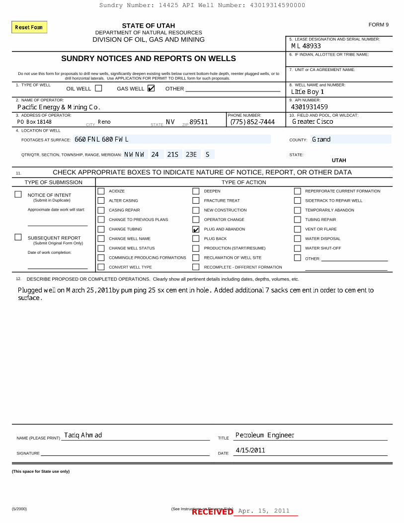
STATE OF UTAHDEPARTMENT OF NATURAL RESOURCES
DIVISION OF OIL, GAS AND MINING
FORM 9
5. LEASE DESIGNATION AND SERIAL NUMBER:
SUNDRY NOTICES AND REPORTS ON WELLS6. IF INDIAN, ALLOTTEE OR TRIBE NAME:
Do not use this form for proposals to drill new wells, significantly deepen existing wells below current bottom-hole depth, reenter plugged wells, or todrill horizontal laterals. Use APPLICATION FOR PERMIT TO DRILL form for such proposals.
7. UNIT or CA AGREEMENT NAME:
1. TYPE OF WELLOIL WELL GAS WELL OTHER
8. WELL NAME and NUMBER:
2. NAME OF OPERATOR: 9. API NUMBER:
3. ADDRESS OF OPERATOR:
CITY STATE ZIP
PHONE NUMBER: 10. FIELD AND POOL, OR WILDCAT:
4. LOCATION OF WELL
FOOTAGES AT SURFACE: COUNTY:
QTR/QTR, SECTION, TOWNSHIP, RANGE, MERIDIAN: STATE:
UTAH
11. CHECK APPROPRIATE BOXES TO INDICATE NATURE OF NOTICE, REPORT, OR OTHER DATA
TYPE OF SUBMISSION TYPE OF ACTION
NOTICE OF INTENT (Submit in Duplicate)
Approximate date work will start:
ACIDIZE DEEPEN REPERFORATE CURRENT FORMATION
ALTER CASING FRACTURE TREAT SIDETRACK TO REPAIR WELL
CASING REPAIR NEW CONSTRUCTION TEMPORARILY ABANDON
CHANGE TO PREVIOUS PLANS OPERATOR CHANGE TUBING REPAIR
CHANGE TUBING PLUG AND ABANDON VENT OR FLARE
SUBSEQUENT REPORT (Submit Original Form Only)
Date of work completion:
CHANGE WELL NAME PLUG BACK WATER DISPOSAL
CHANGE WELL STATUS PRODUCTION (START/RESUME) WATER SHUT-OFF
COMMINGLE PRODUCING FORMATIONS RECLAMATION OF WELL SITE OTHER:
CONVERT WELL TYPE RECOMPLETE - DIFFERENT FORMATION
12. DESCRIBE PROPOSED OR COMPLETED OPERATIONS. Clearly show all pertinent details including dates, depths, volumes, etc.
NAME (PLEASE PRINT) TITLE
SIGNATURE DATE
(This space for State use only)
(5/2000) (See Instructions on Reverse Side) Apr. 15, 2011
Sundry Number: 14425 API Well Number: 43019314590000
STATE OF UTAH FORM 9DEPARTMENT OF NATURAL RESOURCES
DIVISION OF OIL, GAS AND MINING 5. LEASE DESIGNATION AND SERIAL NUMBER:
ML489336. IF INDIAN,ALLOTTEE OR TRIBE NAME
7. UNIT or CA AGREEMENT NAME:Do not use this form for proposals to drill new wells, significantly deepen existing wells below current bottom-hole depth, reenter plugged wells, or to
drill horizontal laterals. Use APPLICATION FOR PERMIT TO DRILL form for such proposals.1. TYPE OF WELL 8. WELL NAME and NUMBER:
OIL WELL GAS WELL OTHER Llttle Boy 12. NAME OF OPERATOR: 9. API NUMBER:
Pacific Energy & Mining Co. 43019314593. ADDRESSOF OPERATOR: PHONE NUMBER: 10. FIELD AND POOL, OR V\nLDCAT:
PO Box 18148 Reno STATE NV ZIP 89511 (775) 852-7444 Greater Cisco4. LOCATION OF WELL
FOOTAGESATSURFACE: 660 FNL 680 FWL COUNTY: Grand
QTR/QTR, SECTION, TOWNSHIP, RANGE, MERIDIAN: NWNW 24 21S 23E S STATE:UTAH
11. CHECK APPROPRIATE BOXES TO INDICATE NATURE OF NOTICE, REPORT, OR OTHER DATATYPE OF SUBMISSION TYPE OF ACTION
ACIDIZE DEEPEN REPERFORATE CURRENT FORMATIONNOTICE OF INTENT
(Submit in Duplicate) ALTER CASING FRACTURE TREAT SIDETRACK TO REPAIR WELL
Approximate date work will start: CASING REPAIR NEW CONSTRUCTION TEMPORARILY ABANDON
CHANGE TO PREVIOUS PLANS OPERATOR CHANGE TUBING REPAIR
CHANGE TUBING PLUG AND ABANDON VENT OR FLARE
SUBSEQUENT REPORT CHANGE WELL NAME PLUG BACK WATER DISPOSAL(Submit Original Form Only)
CHANGE WELL STATUS PRODUCTION (START/RESUME) WATER SHUT-OFFDate of work completion:
COMMINGLE PRODUCING FORMATIONS RECLAMATION OF WELL SITE OTHER:
CONVERT WELL TYPE RECOMPLETE -DIFFERENT FORMATION
12. DESCRIBE PROPOSED OR COMPLETED OPERATIONS. Clearly show all pertinent details including dates, depths, volumes, etc.
Plugged well on March 25, 2011by pumping 25 sx cement in hole. Added additional 7 sacks cement in order to cement tosurface.
NAME (PLEASE PRINT) Tariq Ahmad TITLE Petroleum Engineer
SIGNATURE DATE 4/15/2011
(This space for State use only)
(5/2000) (See Instructions on Reverse
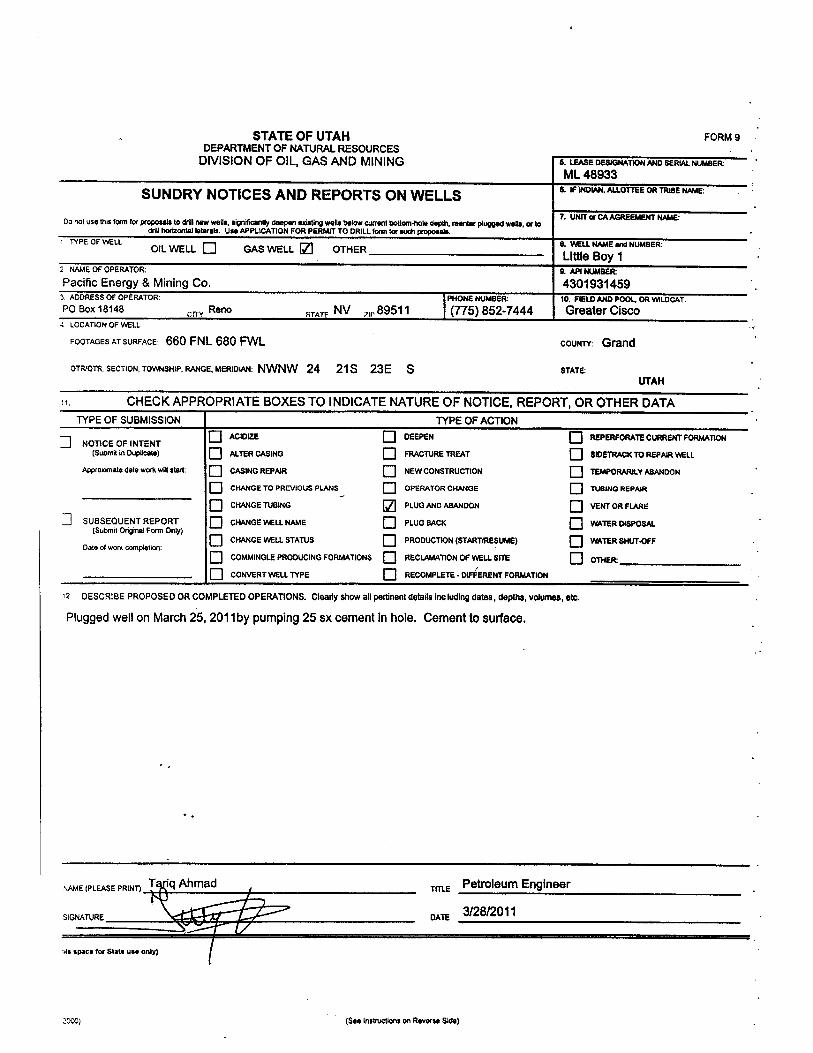
STATE OF UTAH FORM9DEPARTMENTOF NATURALRESOURCES
DIVISION OF OIL, GAS AND MINING & LEASEDESIGNATIONANDSERIALNUMBERML48933
SUNDRY NOTICES AND REPORTS ON WELLS & IFINDIAN,ALLOTTEEORTRIBENAME:
7. UNITar CAAGREEMENTNAME:Do not use tNs form for proposals todrillnewwells, significantlydeepen existing wella below current bottom4tolo clepth,reenior plugged wells, ortodrill horizontallaterals. Use APPLICATIONFOR PERMITTO DRILLform for auch proposals.
1 TYPEOF WELL --- 0. WEt.LNAMEand NUMBER:OIL WELL L_] GAS WELL OTHER Little Boy 12 NAMEOF OPERATOR: 9. API NUMBERPacific Energy & Mining Co. 4301931459
3. ADDRESSOF OPÈRATOR: PHONE NUMBER 10. FIELDANDPOOL, OR WILDCAY:PO Box 18148 Reno save NV ,89511 (775) 852-7444 Greater Cisco
4 LOCATION OF WELL
FOOTAGESATSURFACE: 660 FNL 680 FWL COUNTY: Grand
QTRIOTR,SECTION, TOWNSHIP.RANGE,MERIDIAN:NWNW 24 21S 23E S STATE:UTAH
CHECKAPPROPRIATE BOXESTO INDICATENATUREOF NOTICE,REPORT, OR OTHER DATATYPEOF SUBMISSION TYPE OF ACTION
O ^CIDE DEEPEN O REPERFORATECURRENTFORMATION] NOTICEOF INTENT(Submit in Duplicate) ALTERCASING FRACTURETREAT SIDETRACKTO REPAIRWELL
Approximate date wos wma at CASINGREPAIR NEWCONSTRUCTION TEMPORARILYABANDON
O CHANGE TO PREVIOUSPLANS, O OPERATOR CHANGE TUBING REPAIR
O CHANGETUBING PLUGAND ABANDON VENTOR FLARE
] SUSSEQUENTREPORT CHANGEWELLNAME O PLUG BACK O WATERDISPOSAL(Submit OriginalForm Only)
O CHANGEWELLSTATUS O PRODUCTION(STARTIRESUMS) O WATERSHUT-OFFDate of work completion:
O COMMINGLEPRODUCINGFORMATIONS O RECLAMATIONOF WELLSITE OTHER
O CONVERTWELLTYPE RECOMPLETE- DIFFERENTFORMATION
12 DESCRIBEPROPOSED OR COMPLETEDOPERATIONS.Clearlyshowallpertinent details including dates, depttis, volumes, etc.
Plugged well on March 25, 2011by pumping 25 sx cementin hole. Cement tosurface.
NAME(PLEASEPRINT) T Iq Ahmad TITLE POffOleum Engineer
SIGNATURE DATE
als space for State use only)
2000) (See instructions onRoverse
