dynamic integrated geo-environmental services …...as a crm specialist, munyadziwa has completed...
TRANSCRIPT
Dynamic Integrated Geo-Environmental Services
PHASE 1 ARCHAEOLOGICAL IMPACT ASSESSMENT SPECIALIST STUDY
REPORT FOR THE PROPOSED RUSTENBURG STRENGTHENING PROJECT
WITHIN RUSTENBURG LOCAL MUNICIPALITY OF BOJANALA
MUNICIPALITY. NORTH WEST PROVINCE.
January, 2016
Vhubvo Archaeo-Heritage Consultants
83 Eden Village
746 Ciliaris Road
Dorandia
Pretoria North
0182
Tel: 012 771 3488
Fax: 086 566 8079
Dynamic Integrated Geo-Environmental Services
Midrand Suite No. 2
546 16th Road
1685
Tel: 011 312 2878
Fax: 011 312 7824
©COPYRIGHT
RUSTENBURG STRENGTHENING PROJECT
ARCHAEOLOGICAL ASSESSMENT SPECIALIST STUDY
ii
This Phase 1 Archaeological Report contains intellectual
information that is protected by copyright in favour of Vhubvo
Archaeo-Heritage Consultant Cc. Thus, it may not be reproduced
or edited without prior written consent of Vhubvo Archaeo-
Heritage Consultant Cc; it has been exclusively prepared for
Dynamic Integrated Geo-Environmental Services on behalf of
Eskom.

RUSTENBURG STRENGTHENING PROJECT
ARCHAEOLOGICAL ASSESSMENT SPECIALIST STUDY
iii
DECLARATION
ABILITY TO CONDUCT THE PROJECT
MunyadziwaMagoma is a professional archaeologist, having obtained his BA degree in Archaeology
and Anthropology at University of South Africa (UNISA), an Honours degree at the University of
Venda (UNIVEN), and currently completing his MA at the University of Pretoria (UP). He is an
accredited Cultural Resource Management (CRM) member of the Association for southern African
Professional Archaeologists (ASAPA) and Amafa aKwaZulu-Natali. Munyadziwa is further
affiliated to the South African Archaeological Society (SAAS), the Society of Africanist
Archaeologists (SAfA), and the International Council of Archaeozoology (ICAZ). He has more than
seven years’ experience in heritage management, having worked for different CRM organisations
and government heritage authorities. As a CRM specialist, Munyadziwa has completed well over
hundred Archaeological Impact Assessments (AIAs) for developmental projects situated in several
provinces of the Republic of South Africa. The AIAs projects he has been involved with are diverse,
and include the establishment of major substation, upgrade and establishment of roads, establishment
and extension of mines. In addition, he has also conducted Heritage Impact Assessments (HIAs) for
the alteration to heritage buildings and the relocation of graves. His detailed CV is available on
request.
INDEPENDENCE
I, Munyadziwa Magoma, declare that this report has been prepared independently of any influence
as may be specified by all relevant department, institution and organisation.
AUTHOR AND CONTACT DETAILS:
Munyadziwa Magoma,
Cell: 082 535 6855
Tel: 012 771 3488
Fax: 086 566 8079
E-mail: [email protected]
CLIENT CONTACT DETAILS:
Dynamic Integrated Geo-Environmental Services
Ms. Brenda Makanza,
Cell: 082 075 6685
Fax: 011 312 7824
Tel: 011 312 2878
E-mail: [email protected]
RUSTENBURG STRENGTHENING PROJECT
ARCHAEOLOGICAL ASSESSMENT SPECIALIST STUDY
iv
EXECUTIVE SUMMARY
Background and Methodology
Vhubvo Archaeo-Heritage Consultant Cc has been requested by Dynamic Integrated Geo-Environmental
Services to conduct an Archaeological Impact Assessment (AIA) for the proposed Rustenburg
Strengthening Project on Farm Klipgat 281 JQ and Portion 2 of the Farm Elandsheuvel 282 JQ. The main
aim of the survey was to identify and document archaeological sites, cultural resources, sites associated
with oral histories, graves, cultural landscapes, and any structures of historical significance that may be
affected by the proposed substation and loop in loop out lines. The Marang 400/88kV substation is one of
the four Main Transmission Substations (MTS), currently supplying Rustenburg’s platinum mining
operations. The substation is supplied via the 3 x 400kV power lines, i.e., Matimba-Marang, Bighorn-
Marang and Midas-Marang and comprises of 4 x 315 MVA, 400/88kV transformers and has a capacity of
945 MVA. The recorded peak load was 776MVA in the years 2010/11 and 694MVA in years 2011/12.
The Marang 400/88kV will exceed the 400/88kV firm capacity limit by 2015/16. To address these
transformation capacity constraints and to align with the 20 year load forecast, Eskom will strengthen the
network by either extending the existing Marang substation or construct and operate a new substation,
Marang B 400/132kV and ± 2 km ,400kV power line from the existing Bighorn-Marang or Medupi-
Marang 400 kV power line.
The town of Rustenburg which is about 30km from the proposed area was first established as an
administrative centre in 1851. Rustenburg was also the home of Paul Kruger, former president of the
Republic of South African, Paul bought a farm in 1863. The homestead on his farm, Boekenhoutfontein,
is now the Paul Kruger Country Museum. Mzilikazi, Andries Hendrik Potgieter and David Livingstone
have all had a spell in the area of Rustenburg. Platinum mining in Rustenburg began in 1929, after it was
first discovered by Hans Merensky, later named the Merensky Reef, the area significantly transforms, and
with the implementation of apartheid in the late 1940s, life became difficult for African people of South
Africa. However, this was welcomed by the mining industry as it gave them a tighter grip on the migrant
labour. As a result, African people and other groups were forcibly moved from the area to other places
such as Boitekong, Zinniaville, Karlien Park. The region around the proposed area had seen several war
battles, including, the Boer and the British, the Tswana and Matebele. Recently, the South African police
shot approximately 34 miners and wounded about 78 more during an industrial dispute, Marikana strike.
This was considered by many as the most lethal use of force by South African Police since the end of the
apartheid regime. There are several archaeological and heritage sites of significance in and around the
Rustenburg District dating from the Stone Age, up to recent historic.

RUSTENBURG STRENGTHENING PROJECT
ARCHAEOLOGICAL ASSESSMENT SPECIALIST STUDY
v
The findings of this AIA have been informed by a desktop study and field survey. The desktop study was
undertaken through SAHRIS for previous Heritage Impact Assessments and Archaeological Impact
Assessments conducted in the region, these include work by Pistorius 1999, 2007; Vollenhoven and Pelser
2008; Udo 2001. Also examined through engine search are reviews of relevant publications, these included
publications by Huffman 2011, Pistorius 1992, 1994, 1995, 1996 and 1997. The University of Pretoria’s
Library was also perused. From the collection at the University, it became clear that intensive
archaeological work has been done in the region by Revil Mason (Mason 1962), other archaeologist who
have also researched the area includes Maggs 1976, Evens 1984. This background studies legitimate for a
proper field survey, which was conducted over two days of the 20th of November 2013 and the 28th of
January 2014. One archaeologist from Vhubvo accompanied by an environmentalist practitioner from
DIGES conducted the survey.
Analysis of the archaeological, cultural heritage, environmental and historic contexts of the study area
predicted that archaeological sites, cultural heritage sites, historic structures, (isolated) artefacts, historical
mining and burial grounds (especially dating to the historical era) were likely to be present on the affected
landscape. The field survey was conducted to test this hypothesis and verify this forecast within the
proposed development area. The proposed site is located in the Magisterial District of Rustenburg. The
survey concentrated on the area proposed for development, these constitute the area proposed for a 2km
loop in loop out lines and respective corridors, three sites proposed for the new substation and the site for
the extension of the existing substation. During survey it was clear that the area proposed for development
possesses a cultural landscape dotted with pre-historical materials. Some section of the proposed area
appears disturbed by activities related to cultivation, this activities appears to have impacted the
archaeology of the area. For the purpose of this project, a broader area which is approximately 30km was
surveyed. Four potential sites were then identified within this broader study area as being technically
feasible for the strengthening project. These are referred to as Sites 1, 2, 3 and substation extension site.
From the four identified sites, only one will be utilised for the proposed substation.
Restrictions and Assumptions
As with any survey, archaeological materials may be under the surface and therefore unidentifiable to the
surveyor until they are exposed once development resume. In addition, although serious care was
undertaken to attempt to cover the line corridors and respective sites, other section within the proposed
area could not be surveyed adequately because of grass cover (see figure 16). On that note, it is
recommended that this study should be followed by a pedestrian survey of the preferred sites for this
proposed development.

RUSTENBURG STRENGTHENING PROJECT
ARCHAEOLOGICAL ASSESSMENT SPECIALIST STUDY
vi
Description, Findings and Recommendations
The proposed sites are located around the existing 400/88kV Marang Main Transmission substation on
Farm Klipgat 281 JQ and Portion 2 of the Farm Elandsheuvel 282 JQ in the District of Rustenburg. The
proposed area of development is general flat, although some section possesses rock outcrop and well
defined hill. Later Iron Age group inhabited the area proposed for deevelopment from around A.D 1600.
Their presence in the area is marked by stone walled villages with animal pens. Most of these villages are
mainly situated at the foot of the granite hills which are concentrated in the area. However, settlement by
later Tswana people in the area from the mid-1900 damaged several stonewalls which were built from
A.D 1600. This new settlers reused some of the sites. Furthermore, disturbances were also caused by the
area being used for cultivation of maize, sorghum, millet and other crops. These people were however
resettled around the 1960. As a consequence of settlement, potsherds are found in abundant throughout
the proposed area. These undecorated weathered potsherds are found on a disturbed landscape and are thus
of low significance.
Stone walled sites are concentrated on Site and Corridors 2 and 3. These stone wall sites date to the Late
Iron Age. They are mostly associated with small mountains, where dolerites were used in their construction
and are usually clustered along the lower foot slopes. These were probably grouped together to form
villages which covered large areas. According to Morton and Hitchcock (2013), some of the piles of stones
were probably used by Tswana to impact information to initiates about hunting and the importance of
animals as partners.
Site and Corridor 1
Similarly to other sites, access roads, village streets, path ways and main road, coupled by power lines cut
across this area proposed for development. In fact, section of this area is utilised by locals as a dumping
place. However, several thick undecorated potsherds related to the 16th century Sotho-Tswana settlements
were noted in this area. These cannot however be characterised as a site since they are found in a disturbed
area and in low density. Nevertheless, this study recommend that the area be monitoring by a qualified
archaeologist during earthworks as there is a possibility that the density could change once the
digging takes place. No other sites of heritage significance were identified on the footprint during the
survey.
Site and Corridor 2
This proposed area is fairly flat, vehemently disturbed and has a small hill on the tip of the south-eastern
section. The hill is concentrated of Late Iron Age stone walled sites, some of these walling are still intact.
Also noted are Late Stone Age tools, historical terracing and undecorated potsherds which are scattered
across the proposed area. These sites and tools are protected by the National Heritage Resources Act (No
25 of 1999). If this site is going to be preferred, three recommendations are made: (1) Detailed mapping,

RUSTENBURG STRENGTHENING PROJECT
ARCHAEOLOGICAL ASSESSMENT SPECIALIST STUDY
vii
(2) extensive recording of the structures, and (3) destruction permit. It should be noted that these
recommendations are, if approved by SAHRA, going to be subject to a permit application.
Site and Corridor 3
This section is heavily disturbed by activities related to agriculture. Despite these disturbances, stone
walled sites and weathered potsherds are common across the area. These sites date to the Late Iron Age,
and are the results of the Iron Age people. Consequently, these sites and clusters of sites have medium
significance and are protected by Section 35 of the National Heritage Resources Act (No 25 of 1999).
Three recommendations are made if this site is going to be utilised: (1) Detailed mapping, (2) extensive
recording of the structures, and (3) destruction permit. It should be noted that these recommendations
are, if approved by SAHRA, going to be subject to a permit application. The permit would authorise the
destruction of these remnants.
Substation extension
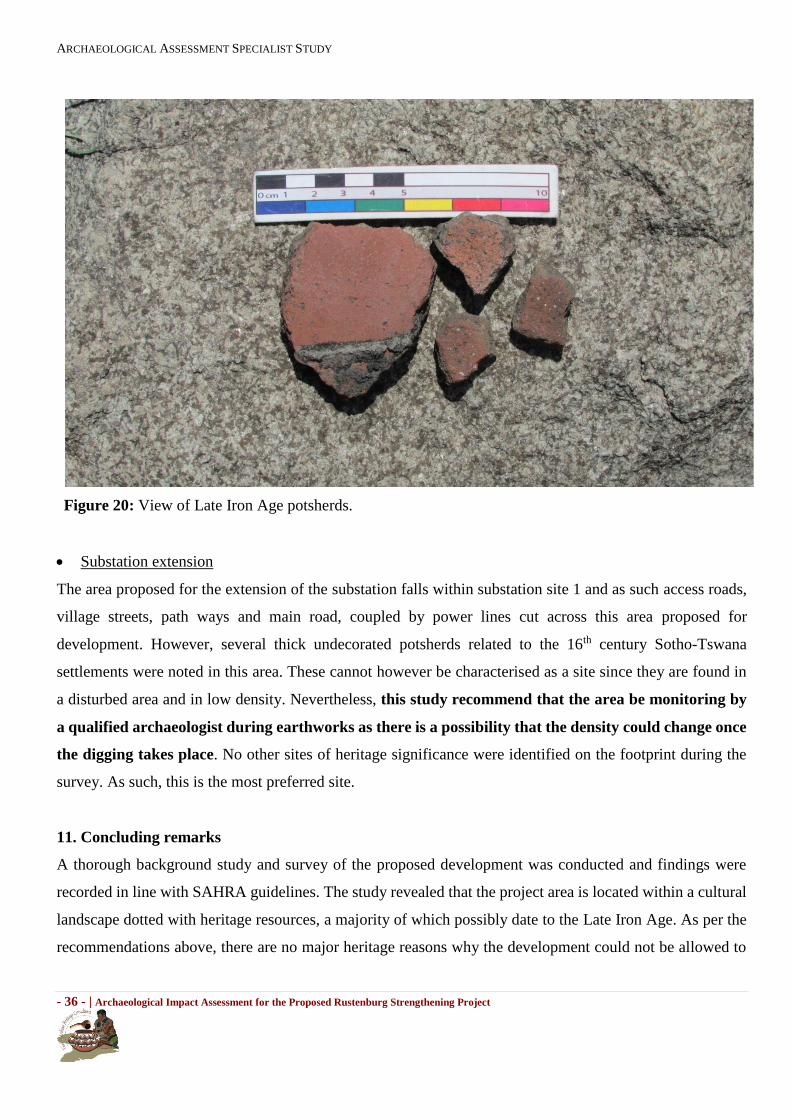
The area proposed for the extension of the substation falls within substation site 1 and as such access
roads, village streets, path ways and main road, coupled by power lines cut across this area proposed for
development. However, several thick undecorated potsherds related to the 16th century Sotho-Tswana
settlements were noted in this area. These cannot however be characterised as a site since they are found
in a disturbed area and in low density. Nevertheless, this study recommend that the area be
monitoring by a qualified archaeologist during earthworks as there is a possibility that the density
could change once the digging takes place. No other sites of heritage significance were identified on
the footprint during the survey. As such, this is the most preferred site.
Conclusions
A thorough background study and survey of the proposed development was conducted and findings were
recorded in line with SAHRA guidelines. The study revealed that the project area is located within a
cultural landscape dotted with heritage resources, a majority of which possibly date to the Late Iron Age.
As per the recommendations above, there are no major heritage reasons why the proposed development
could not be allowed to proceed. As aforementioned, Substation Extension is the most preferred since the
proposed development covers a smaller area and the materials noted are of low heritage significance, and
the area is highly disturbed.

RUSTENBURG STRENGTHENING PROJECT
ARCHAEOLOGICAL ASSESSMENT SPECIALIST STUDY
viii
TABLE OF CONTENTS
EXECUTIVE SUMMARY ........................................................................................... iv
ACRONYMS AND ABBREVIATIONS .................................................................. - 9 -
GLOSSARY OF TERMS ...................................................................................... - 10 -
1. Introduction ........................................................................................... - 14 -
2. Sites location and description ............................................................. - 14 -
3. Nature of the proposed project ........................................................... - 17 -
4. Purpose of the AIA study ...................................................................... - 17 -
5. Methodology ......................................................................................... - 18 -
6. Applicable heritage legislation ........................................................... - 19 -
7. Degree of significance ......................................................................... - 21 -
8. Discussion of (Pre-) History around the development site ................ - 22 -
9. Discussion and recommendations ...................................................... - 26 -
10. Concluding remarks ............................................................................. - 36 -
APPENDIX 1: SITE SIGNIFICANCE ................................................................... - 40 -
APPENDIX 2: GRAVE ....................................................................................... - 42 -

ARCHAEOLOGICAL ASSESSMENT SPECIALIST STUDY
- 9 - | Archaeological Impact Assessment for the Proposed Rustenburg Strengthening Project
ACRONYMS AND ABBREVIATIONS
AIA
EMP
HIA
LIA
MIA
EIA
HMP
LSA
MSA
ESA
NASA
NHRA
PHRA
SAHRA
Archaeological Impact Assessment
Environmental Management Plan
Heritage Impact Assessment
Late Iron Age
Middle Iron Age
Early Iron Age
Heritage Management Plan
Late Stone Age
Middle Stone Age
Early Stone Age
National Archives of South Africa
National Heritage Resources Act
Provincial Heritage Resources Authority
South African Heritage Resources Agency

ARCHAEOLOGICAL ASSESSMENT SPECIALIST STUDY
- 10 - | Archaeological Impact Assessment for the Proposed Rustenburg Strengthening Project
GLOSSARY OF TERMS
The following terms used in this Archaeology are defined in the National Heritage Resources Act [NHRA],
Act Nr. 25 of 1999, South African Heritage Resources Agency [SAHRA] Policies as well as the Australia
ICOMOS Charter (Burra Charter):
Archaeological Material: remains resulting from human activities, which are in a state of disuse and are in,
or on, land and which are older than 100 years, including artifacts, human and hominid remains, and artificial
features and structures.
Chance Finds: means Archaeological artefacts, features, structures or historical cultural remains such as
human burials that are found accidentally in context previously not identified during cultural heritage
scoping, screening and assessment studies. Such finds are usually found during earth moving activities such
as water pipeline trench excavations.
Compatible use: means a use, which respects the cultural significance of a place. Such a use involves no, or
minimal, impact on cultural significance.
Conservation means all the processes of looking after a place so as to retain its cultural significance.
Cultural Heritage Resources (Same as Heritage Resources as defined and used in the National Heritage
Resources Act,Act No. 25 of 1999): Refer to physical cultural properties such as archaeological and
palaeolontological sites; historic and prehistoric places, buildings, structures and material remains; cultural
sites such as places of ritual or religious importance and their associated materials; burial sites or graves and
their associated materials; geological or natural features of cultural importance or scientific significance.
Cultural Heritage Resources also include intangible resources such as religion practices, ritual
ceremonies, oral histories, memories and indigenous knowledge.
Cultural significance: means aesthetic, historic, scientific, social or spiritual value for past, present or future
generations.
Cultural Significance: also encompasses the complexities of what makes a place, materials or intangible
resources of value to society or part of, customarily assessed in terms of aesthetic, historical,
scientific/research and social values.
ARCHAEOLOGICAL ASSESSMENT SPECIALIST STUDY
- 11 - | Archaeological Impact Assessment for the Proposed Rustenburg Strengthening Project
Environment: The surroundings within which humans exist and that are made up of: i. the land, water and
atmosphere of the earth;
ii. micro-organisms, plant and animal life;
iii. any part or combination of (i) and (ii) and the interrelationships among and between them; and,
iv. the physical, chemical, aesthetic and cultural properties and conditions of the foregoing that influence
human health and well-being. This includes the economic, social, cultural, historical and political
circumstances, conditions and objects that affect the existence and development of an individual, organism
or group.
Environmental impact assessment: An Environmental Impact Assessment (EIA) refers to the process of
identifying, predicting and assessing the potential positive and negative social, economic and biophysical
impacts of any proposed project, plan, programme or policy which requires authorisation of permission by
law and which may significantly affect the environment. The EIA includes an evaluation of alternatives. As
well as recommendations for appropriate mitigation measures for minimising or avoiding negative impacts,
measures enhancing the positive aspects of the proposal and environmental management and monitoring
measures.
Expansion: means the modification, extension, alteration or upgrading of a facility, structure or infrastructure
at which an activity takes place in such a manner that the capacity of the facility or the footprint of the activity
is increased.
Fabric: means all the physical material of the place including components, fixtures, contents and objects.
Grave: A place of interment (variably referred to as burial), including the contents, headstone or other marker
of such a place, and any other structure on or associated with such place. A grave may occur in isolation or
in association with others where upon it is referred to as being situated in a cemetery (contemporary) or
Burial Ground(historic).
Heritage impact assessment (HIA): refers to the process of identifying, predicting and assessing the
potential positive and negative cultural, social, economic and biophysical impacts of any proposed project,
plan, programme or policy which requires authorisation of permission by law and which may significantly
affect the cultural and natural heritage resources. The HIA includes recommendations for appropriate

ARCHAEOLOGICAL ASSESSMENT SPECIALIST STUDY
- 12 - | Archaeological Impact Assessment for the Proposed Rustenburg Strengthening Project
mitigation measures for minimising or avoiding negative impacts, measures enhancing the positive aspects
of the proposal and heritage management and monitoring measures.
Historic Material: remains resulting from human activities, which are younger than 100 years, but no longer
in use, including artifacts, human remains and artificial features and structures.
Impact: the positive or negative effects on human well-being and / or on the environment.
In situ material culture and surrounding deposits in their original location and context, for example an
archaeological site that has not been disturbed by farming.
Interested and affected parties Individuals: communities or groups, other than the proponent or the
authorities, whose interests may be positively or negatively affected by the proposal or activity and/ or who
are concerned with a proposal or activity and its consequences.
Interpretation: means all the ways of presenting the cultural significance of a place.
Late Iron Age: this period is associated with the development of complex societies and state systems in
southern Africa.
Material culture means buildings, structure, features, tools and other artefacts that constitute the remains
from past societies.
Mitigate: The implementation of practical measures to reduce adverse impacts or enhance beneficial impacts
of an action.
Place: means site, area, land, landscape, building or other work, group of buildings or other works, and may
include components, contents, spaces and views.
Protected area: means those protected areas contemplated in section 9 of the NEMPAA and the core area
of a biosphere reserve and shall include their buffers.

ARCHAEOLOGICAL ASSESSMENT SPECIALIST STUDY
- 13 - | Archaeological Impact Assessment for the Proposed Rustenburg Strengthening Project
Public participation process: A process of involving the public in order to identify issues and concerns, and
obtain feedback on options and impacts associated with a proposed project, programme or development.
Public Participation Process in terms of NEMA refers to: a process in which potential interested and affected
parties are given an opportunity to comment on, or raise issues relevant to specific matters.
Setting: means the area around a place, which may include the visual catchment.
Significance: can be differentiated into impact magnitude and impact significance. Impact magnitude is the
measurable change (i.e. intensity, duration and likelihood). Impact significance is the value placed on the
change by different affected parties (i.e. level of significance and acceptability). It is an anthropocentric
concept, which makes use of value judgments and science-based criteria (i.e. biophysical, physical cultural,
social and economic).
Site: a distinct spatial cluster of artefacts, structures, organic and environmental remains, as residues of past
human activity.
Use: means the functions of a place, as well as the activities and practices that may occur at the place.

ARCHAEOLOGICAL ASSESSMENT SPECIALIST STUDY
- 14 - | Archaeological Impact Assessment for the Proposed Rustenburg Strengthening Project
1. Introduction
At the request of Dynamic Integrated Geo-Environmental Services, Vhubvo Archaeo-Heritage Consultant
Cc conducted an Archaeological Impact Assessment (AIA) for the proposed Rustenburg Strengthening
Project on Farm Klipgat 281 JQ and Portion 2 of the Farm Elandsheuvel 282 JQ within Rustenburg Local
Municipality of Bojanala District of North West Province. The survey was conducted in accordance with the
SAHRA Minimum Standards for the Archaeology and Palaeontology. The Minimum Standards clearly
specify the required contents of the report of this nature.
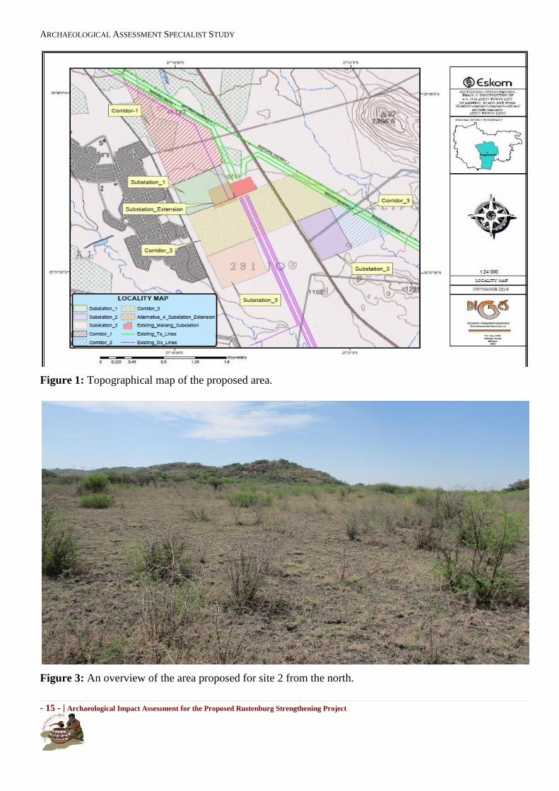
2. Sites location and description
The proposed project will be in close proximity to the existing 400/88kV Marang Main Transmission
substation on Farm Klipgat 281 JQ and Portion 2 of the Farm Elandsheuvel 282 JQ, and is located
approximately 30 km South West of Rustenburg and about 35 km west of Brits. Below are the co-ordinates
of the proposed areas.
Site 1 S25 ̊ 37' 24.08” E27 ̊ 20' 01,39”
Site 2 S25 ̊ 37' 09.79” E27 ̊ 20' 47.56”
Site 3 S25 ̊ 36' 46.95” E27 ̊ 19' 46.38”
Substation Extension S25 ̊ 36' 50.68” E27 ̊ 19' 54.85”
Summary of Project Location Details
Province: North West
Local Municipality: Rustenburg
District Municipality: Bojanala
Extent: ±30Ha
Farm Names: Klipgat 281 JQ and Portion 2 of the Farm Elandsheuvel
282 JQ
Description of proposed development: Strengthening the Rustenburg network by either
constructing a substation and power line or extending
the existing substation.
ARCHAEOLOGICAL ASSESSMENT SPECIALIST STUDY
- 15 - | Archaeological Impact Assessment for the Proposed Rustenburg Strengthening Project
Figure 1: Topographical map of the proposed area.
Figure 3: An overview of the area proposed for site 2 from the north.

ARCHAEOLOGICAL ASSESSMENT SPECIALIST STUDY
- 16 - | Archaeological Impact Assessment for the Proposed Rustenburg Strengthening Project
Figure 4: View of the area proposed for Site 3.
Figure 5: View of the area proposed for Site 1. Note the disturbance and access roads.

ARCHAEOLOGICAL ASSESSMENT SPECIALIST STUDY
- 17 - | Archaeological Impact Assessment for the Proposed Rustenburg Strengthening Project
Figure 6: View of some of the area proposed for corridor 1.
3. Nature of the proposed project
Marang 400/88kV substation is one of the four Main Transmission Substations (MTS), which are currently
supplying Rustenburg’s platinum mining, smelting operations and commercial operations. The substation is
supplied via the 3x 400kV power lines, i.e., Matimba-Marang, Bighorn-Marang and Midas-Marang. It
comprises of 4 x 315 MVA, 400/88kV transformers and has a capacity of 945 MVA. The recorded peak load
was 776MVA in years 2010/11 and 694MVA in years 2011/12. As a result, the Marang 400/88kV will exceed
the 400/88kV firm capacity limit by 2015/16. To address these transformation capacity constraints and to
align with the 20 year load forecast, Eskom will need to strengthen the Rustenburg network. Eskom therefore
intends to either construct a new substation, Marang B 400/132kV and ± 2 km, 400kV power line or extend
the new substation by making a provision for new 3x 500MVA 400/132kV transformers.
4. Purpose of the AIA study
The purpose of this Archaeological Impact Assessment (AIA) study was to conduct a heritage survey,
enabling us to have an understanding of the archaeological, cultural, and general heritage sensitivity of the
area proposed for the development. Impact assessments highlight many issues facing sites in terms of their

ARCHAEOLOGICAL ASSESSMENT SPECIALIST STUDY
- 18 - | Archaeological Impact Assessment for the Proposed Rustenburg Strengthening Project
management, conservation, monitoring and maintenance, and the environment in and around the site.
Therefore, this AIA involves the following:
Identification and recording of heritage resources that maybe affected by the proposed development,
Providing recommendations on how best to appropriately safeguard identified heritage sites.
Mitigation is an important aspect of any development on areas where heritage sites have been
identified.
5. Methodology
Background study introduction
The methodological approach is informed by the 2012 SAHRA Policy Guidelines for impact assessment. As
part of this AIA, the following tasks were conducted: 1) general review of archives (National Archives of
South Africa, NASA), 2) literature review, 3), consultations with the developer and appointed consultants,
4) completion of a field survey and 5) analysis of the acquired data, leading to the production of this report.
To understand the archaeology of the proposed area, a background study was undertaken and relevant
institutions were consulted. These studies entailed the review of archaeological and heritage impact
assessment studies that have been conducted around the proposed area thorough SAHRIS. In addition, other
knowledge distributors were considered, for example, published research articles, etc. These investigations
were fundamental in shading light about the archaeology of the proposed area.
Physical survey
The field survey was conducted on the 20th of November 2013 and the 28th of January 2014. A systemic
survey of the area as indicated by Burke and Smith (2004) resulted in the maximum coverage of the area.
This survey was conducted by one Vhubvo archaeologist. The survey of the area proposed for the four site
alternatives was conducted on foot, while the power line corridors were surveyed on foot and also by car
were situation permits. The field survey did not include any form of subsurface inspection beyond the
inspection of burrows, road cut sections, and the stream banks exposed by natural erosion forces. This is
because a permit from the relevant heritage authority is required to disturb any heritage resources. In the
same vein, no materials were collected.
Documentation
The general project area was documented. This documentation included taking photographs using cameras a
10.1 mega-pixel Sony Cybershort Digital Camera. Plotting of finds was done by a Garmin etrex Venture HC.
Oral interview

ARCHAEOLOGICAL ASSESSMENT SPECIALIST STUDY
- 19 - | Archaeological Impact Assessment for the Proposed Rustenburg Strengthening Project
Oral interview was conducted with some of the Boitekong community members. The information provided
was significance in detailing the history of the proposed area and subsequently compilation of this report.
Restrictions and assumptions
As with any survey, archaeological materials may be under the surface and therefore unidentifiable to the
surveyor until they are exposed once development resume. In addition, although serious care was undertaken
to attempt to cover the line corridors and respective sites, other section within the proposed area could not be
surveyed adequately because of grass cover (see figure 16), as well as the lengthwise of the proposed project.
On that note, it is recommended that this study should be followed by a pedestrian survey of the preferred
site for this proposed development.
6. Applicable heritage legislation
Several legislations provide the legal basis for the protection and preservation of both cultural and natural
resources. These include the National Environment Management Act (No. 107 of 1998); Mineral Amendment
Act (No 103 of 1993); Tourism Act (No. 72 of 1993); Cultural Institution Act (No. 119 of 1998), and the
National Heritage Resources Act (Act 25 of 1999). Section 38 (1) of the National Heritage Resources Act
requires that where relevant, an Impact Assessment is undertaken in case where a listed activity is triggered.
Such activities include:
(a) the construction of a road, wall, powerline, pipeline, canal or other similar form of linear development or barrier exceeding 300m in length; (b) the construction of a bridge or similar structure exceeding 50 m in length; and (c) any development or other activity which will change the character of an area of land, or water -
(i) exceeding 5 000 m² in extent; (ii) involving three or more existing erven or subdivisions thereof; or (iii) involving three or more erven or divisions thereof which have been consolidated within the past five years; or (iv) the costs of which will exceed a sum set in terms of regulations by SAHRA or a Provincial Heritage Resources Authority;
(d) the re-zoning of a site exceeding 10 000 m2 in extent; or (e) any other category of development provided for in regulations by SAHRA or a Provincial Heritage Resources Authority, must at the very earliest stages of initiating such a development, notify the responsible heritage resources authority and furnish it with details regarding the location, nature and extent of the proposed development.
Section 3 of the National Heritage Resources Act (25 of 1999) lists a wide range of national resources
protected under the act as they are deemed to be national estate. When conducting a Heritage Impact
Assessment (HIA) the following heritage resources have to be identified:
(a) Places, buildings structures and equipment of cultural significance
(b) Places to which oral traditions are attached or which are associated with living heritage
(c) Historical settlements and townscapes
(d) Landscapes and natural features of cultural significance
(e) Geological sites of scientific or cultural importance
(f) Archaeological and paleontological sites

ARCHAEOLOGICAL ASSESSMENT SPECIALIST STUDY
- 20 - | Archaeological Impact Assessment for the Proposed Rustenburg Strengthening Project
(g) Graves and burial grounds including-
(i) ancestral graves
(ii) royal graves and graves of traditional leaders
(iii) graves of victims of conflict
(iv) graves of individuals designated by the Minister by notice in the Gazette
(v) historical graves and cemeteries; and
(vi) other human remains which are not covered by in terms of the Human Tissue Act,1983 (Act No.
65 of 1983)
(h) Sites of significance relating to the history of slavery in South Africa
(i) moveable objects, including -
(i) objects recovered from the soil or waters of South Africa, including archaeological and
paleontological objects and material, meteorites and rare geological specimens
(ii) objects to which oral traditions are attached or which are associated with living heritage
(iii) ethnographic art and objects
(iv) military objects
(v) objects of decorative or fine art
(vi) objects of scientific or technological interest; and
(vii) books, records, documents, photographic positives and negatives, graphic, film or video material
or sound recordings, excluding those that are public records as defined in section 1 of the National
Archives of South Africa Act, 1996 (Act No. 43 of 1996).
Section 3 of the National Heritage Resources Act (No. 25 of 1999) also distinguishes nine criteria for places
and objects to qualify as ‘part of the national estate if they have cultural significance or other special value
…’ These criteria are the following:
(a) Its importance in the community, or pattern of South Africa’s history
(b) Its possession of uncommon, rare or endangered aspects of South Africa’s natural or cultural heritage
(c) Its potential to yield information that will contribute to an understanding of South Africa’s natural or
cultural heritage
(d) Its importance in demonstrating the principal characteristics of a particular class of South Africa’s
natural or cultural places or objects
(e) Its importance in exhibiting particular aesthetic characteristics valued by a community or cultural group
(f) Its importance in demonstrating a high degree of creative or technical achievement at particular period
(g) Its strong or special association with a particular community or cultural group for social, cultural or
spiritual reasons
(h) Its strong or special association with the life or work of a person, group or organisation of importance
in the history of South Africa; and
(i) Sites of significance relating to the history of slavery in South Africa.
Other sections of the Act with a direct relevance to the AIA are the following:
Section 34(1) No person may alter or demolish any structure or part of a structure, which is older than 60
years without a permit issued by the relevant provincial heritage resources authority.
Section 35(4) No person may, without a permit issued by the responsible heritage resources
authority:
destroy, damage, excavate, alter, deface or otherwise disturb any archaeological or palaeontological
site or any meteorite
ARCHAEOLOGICAL ASSESSMENT SPECIALIST STUDY
- 21 - | Archaeological Impact Assessment for the Proposed Rustenburg Strengthening Project
Section 36 (3) No person may, without a permit issued by SAHRA or a provincial heritage
resources authority:
destroy, damage, alter, exhume, remove from its original position or otherwise disturb any grave
or burial ground older than 60 years which is situated outside formal cemetery administered by
a local authority; or
bring onto or use at a burial ground or grave any excavation equipment, or any equipment which
assists in detection or recovery of metals.
7. Degree of significance
This category requires a broad, but detailed knowledge of the various disciplines that might be involved.
Large sites, for example, may not be very important, but a small site, on the other hand, may have great
significance as it is unique for the region.
Significance rating of sites
(i) High (ii) Medium (iii) Low
This category relates to the actual artefact or site in terms of its actual value as it is found today, and refers
more specifically to the condition that the item is in. For example, an archaeological site may be the only one
of its kind in the region, thus its regional significance is high, but there is heavy erosion of the greater part of
the site, therefore its significance rating would be medium to low. Generally speaking, the following are
guidelines for the nature of the mitigation that must take place as Phase 2 of the project.
High
This is a ‘do not touch’ situation, alternative must be sought for the project, examples would be natural
and cultural landscapes like the Mapungubwe Cultural Landscape World Heritage Site, or the house
in which John Langalibalele resided.
Certain sites, or features may be exceptionally important, but do not warrant leaving entirely alone.
In such cases, detailed mapping of the site and all its features is imperative, as is the collection of
diagnostic artefactual material on the surface of the site. Extensive excavations must be done to
retrieve as much information as possible before destruction. Such excavations might cover more than
half the site and would be mandatory; it would also be advisable to negotiate with the client to see
what mutual agreement in writing could be reached, whereby part of the site is left for future research.
Medium
Sites of medium significance require detailed mapping of all the features and the collection of
diagnostic artefactual material from the surface of the site. A series of test trenches and test pits should
be excavated to retrieve basic information before destruction.
Low

ARCHAEOLOGICAL ASSESSMENT SPECIALIST STUDY
- 22 - | Archaeological Impact Assessment for the Proposed Rustenburg Strengthening Project
These sites require minimum or no mitigation. Minimum mitigation recommended could be a
collection of all surface materials and/ or detailed site mapping and documentation. No excavations
would be considered to be necessary.
In all the above scenarios, permits will be required from the South African Heritage Resources Agency
(SAHRA) or the appropriate PHRA as per the legislation (the National Heritage Resources Act, no. 25 of
1999). Destruction of any heritage site may only take place when a permit has been issued by the appropriate
heritage authority. The following table is used to grade heritage resources.
Level Significance Possible action
National (Grade I)
Site of National
Value Nominated to be declared by SAHRA
Provincial (Grade II)
Site of Provincial
Value Nominated to be declared by PHRA
Local Grade (IIIA)
Site of High Value
Locally Retained as heritage
Local Grade (IIIB)
Site of High Value
Locally Mitigated and part retained as heritage
General Protected Area A
Site of High to
Medium Mitigation necessary before
destruction
General Protected Area B
Medium Value
Recording before destruction
General Protected Area C
Low Value
No action required before destruction
Table 1: Grading systems for identified heritage resources in terms of National Heritage Resources Act (Act
25 of 1999).
8. Discussion of (Pre-) History of South Africa and areas around the development site
Introduction
South Africa has one of the longest sequences of human development in the world. The prehistory and history
of South Africa span the entire known life span of human on earth. It is thus difficult to determine exactly
where to begin, a possible choice could be the development of genus Homo millions of years ago. South
African scientists have been actively involved in the study of human origins since 1925 when Raymond Dart
identified the Taung child as an infant halfway between apes and humans. Dart called the remains
Australopithecus africanus, southern ape-man, and his work ultimately changed the focus of human evolution
from Europe and Asia to Africa, and it is now widely accepted that humankind originated in Africa (Robbins
et al. 1998). In many ways this discovery marked the birth of palaeoanthropology as a discipline. Nonetheless,
the earliest form of culture known in South Africa is the Stone Age. These prehistoric period during which
humans widely used stone for tool-making, stone tools were made from a variety of different sorts of stone.
ARCHAEOLOGICAL ASSESSMENT SPECIALIST STUDY
- 23 - | Archaeological Impact Assessment for the Proposed Rustenburg Strengthening Project
For example, flint and chert were shaped for use as cutting tools and weapons, while basalt and sandstone
were used for ground stone. Stone Age can be divided into Early, Middle and Late, it is argued that there are
two transitional period. Noteworthy that the time frame used for Stone Age period is an approximate and
differ from researcher to researcher (see Korsman and Meyer 1999, Mitchell 2002, Robbins et al. 1998).
Stone Age
Although a long history of research on the Early Stone Age period of southern Africa has been conducted
(Mason 1962, Sampson 1974, Klein 2000, Chazan 2003), it still remains a period were little is known about.
These may be due to many factors which includes, though not limited to retrieval techniques used, reliance
on secondary, at times unknown sources, and the fact that few fauna from this period has been analysed
(Chazan 2003). According to Robbins et al. (1998) the Stone Age is the period in human history when stone
was mainly used to produce tools. This period began approximately 2.5 million years ago and ended around
200 000 years ago. During this period human beings became the creators of culture and was basically hunters
and gatherers, this era is identified by large stone artefacts.
The Middle Stone Age overlap with the EIA and possibly began around 100 000 to about 200 000 years ago
and extends up to around 35 000 years ago. This period is marked by smaller tools than in ESA. MSA people
made a wide range of stone tools from both coarse – and fine-grained rock types. Sometimes the rocks used
for tools were transported considerable distances, presumably in bags or other containers; as such tool
assemblages from some MSA sites tend to lack some of the preliminary cores and contain predominantly
finished products like flakes and retouched pieces.
Microlithic Later Stone Age period began around 35 000 and extend to the later 1800 AD. According to
Deacon (1984), LSA is a period when human being refined small blade tools, conversely abandoning the
prepared-core technique. Thus, refined artefacts such as convex-edge scrapers, borers and segments are
associated with this period. Moreover, large quantity of art and ornaments were made during this period.
Very few Stone Age sites are known to exist in the area. This might have been as a result of few researches
that have been done on the larger region. As such, few published papers and studies are available. Most of
the Stone Age sites known in the area dates to the Late Iron Age and vary from cave sites to open sites. An
example will be rock painting which are located on the shelter of the hill in the region of the town of Warden.
Scatters of Late Iron Age tools have also been noted by other AIA studies.
Iron Age

ARCHAEOLOGICAL ASSESSMENT SPECIALIST STUDY
- 24 - | Archaeological Impact Assessment for the Proposed Rustenburg Strengthening Project
The Iron Age is the name given to the period of human history when metal was mainly used to produce
artefacts. Recently, they have been a debate about the use of the name. Other archaeologist have argued that
the word “Iron Age” is problematic and does not precisely explain the event of what happen in southern
Africa, as such, the word farming communities has been proposed (Segobye 1998). Nonetheless, in South
Africa this period can be divided into two phases. Early (200 - 1000 A.D) and Late Iron Age (1000 - 1850
A.D). Huffman (2007) has indicated that a Middle Iron Age (900 - 1300 A.D) should be included. According
to Huffman (2007:361), until the 1960s and 1970s most archaeologists had not yet recognised a Middle Iron
age. Instead they began the Late Iron Age at AD 1000. The Middle Iron Age (AD 900–1300) is characterised
by extensive trade between the Limpopo Confluence and the East Coast of Africa. This has been debated,
with other researchers, arguing that the period should be restricted to Shashe-Limpopo Confluence.
Before the arrival of Europeans, the area was the home to Bantu-speaking peoples such as the Sotho-Tswana.
During the Late Iron Age, farming was of significance in the region. These farming communities built
numerous stone walled settlements throughout the Free State from the 17th century onwards. These sites are
associated with the predecessors of the Sotho-Tswana, and are linked with the so-called N-, V-, R- and Z-
Type of settlements which are respectively associated with Fokeng, Kwena, Kgatla and Rolong clans.
Historical Period
Since the arrival of the white settlers - c. AD 1840 - in this part of the country. These settlers were largely
self-sufficient, relying on cattle/sheep farming and also hunting. Few towns were established and farming
remains the most dominant economy.
9. Pre-History of the area around the proposed site
The North West region possesses a heritage dating to the dawn of humankind, sites such as the Cradle of
Humankind World Heritage site signify the depth of the history represented in the North West and Gauteng
Province. The Magaliesberg area, like most of North West region has a culture history that goes back to Stone
Age periods (also see Deacon and Deacon, 1997). The San left behind a large amount of archaeological
evidence including hunting camps marked with stone tools and rock art (Deacon and Deacon 1999). These
date to Earlier Stone Age and may date between 1, 5 million to 250 000 years ago. A good case study ESA
sites is the Taung and Sterkfontein World Heritage site shared between the North West and Gauteng Province.
The sites yielded evidence of earliest human evolution dating to between 1.5 million years and 250 000 years
old. As such the sites are referred to as the cradle of humankind. In line with cultural history chronology the
large hand axes and cleavers were replaced by smaller stone tools of the Middle Stone Age (MSA) which
consists of flake and blade industries.

ARCHAEOLOGICAL ASSESSMENT SPECIALIST STUDY
- 25 - | Archaeological Impact Assessment for the Proposed Rustenburg Strengthening Project
The Later Stone Age is characterised by sites of San hunter-gatherers and Khoi pastoralists. Despite their
estimated ubiquitous, LSA sites pose bigger challenge to identify in situ because they are spread on open
lands most of which are concealed by vegetation and buried underground. Most LSA sites are represented by
few stone tools and few fragments of bone (Deacon and Deacon 1999). However the most notable LSA sites
that yielded most evidence are those that survived in rock shelters and caves associated with mountain ranges.
Magaliesburg Mountains have yielded large collections of LSA sites. The caves and rock shelters exhibit
occupational deposits left behind by generations of LSA hunters. The deposits are well preserved consisting
of living deposits and rock art paintings along the walls (Deacon and Deacon 1999). About 2000 years ago,
evidence of pastoralism started emerging in LSA sites associated with the Khoi pastoralists. The Khoikhoi
pastoralists predate the Bantu farmers by centuries. They introduced food production in Southern Africa.
They are credited for introducing the first domesticated animals (sheep, goats and cattle and the use of
ceramics vessels in Southern Africa (Deacon and Deacon 1999).
The Iron Age of the North West region dates back to the 4th century AD when the Early Iron Age proto-
Bantu-speaking farming communities began arriving in this region, which was then occupied by hunter-
gatherers. These EIA communities are archaeologically referred to as the Olifantspoort, Buispoort, Thabeng
and Uitkomstfacies of the Urewe EIA Tradition (Huffman 2007). The Iron Age communities occupied the
foot-hills and valley lands introducing settled life, domesticated livestock, crop production and the use of
iron (Huffman 2007).
The area around North West is well known for its vast treasure of archaeological Iron Age settlement that
that are scattered between Brits and Rustenburg and to the Pilanesberg in the North. Bokfontein closer to
Wolhuterskop yielded Uitkomst pottery from a stone walled site (Huffman 2007). By 1050 AD Sotho-
Tswana Bantu-speaking groups associated with the Late Iron Age called the Blackburn sub-branch of the
Urewe Tradition had arrived in the western regions of South Africa, including modern day North West,
migrating from the central African region of the Lakes Tanganyika and Victoria (Huffman 2007). According
to archaeological data available, the Blackburn facies ranged from AD 1050 to 1500 (ibid. p.155). The North
West regions saw the development of the LIA Ntsuanatsatsi, Uitkomst and Rooibergfacies between AD 1350
and 1750. This Iron Age archaeological facies represent North West migration by LIA Tswana speaking
groups (Huffman 2007).
The Late Iron Age Tswana communities indirectly engaged in the Indian Ocean Trade exporting ivory and
importing consumables such as cloth and glass beads. The exporting point was Delagoa. This brought the

ARCHAEOLOGICAL ASSESSMENT SPECIALIST STUDY
- 26 - | Archaeological Impact Assessment for the Proposed Rustenburg Strengthening Project
Tswana speaking community in touch with the Indo-Asian and first Europeans (Portuguese). It was the arrival
of the Dutch and the English traders that opened up Delagoa Bay to more trade with the international traders
(Huffman 2007).
10. Findings, Discussion and Recommendations
As indicated earlier, the intention is to either construct a new Marang substation and approximately 2km loop
in loop out line or extent the existing Marang MTS on Farm Klipgat 281 JQ and Portion 2 of the Farm
Elandsheuvel 282 JQ is within Rustenburg Local Municipality of Bojanala District in North West Province.
The proposed development may significantly and permanently alter the landscape. Hence this study was
aimed at ensuring that no archaeological and or other heritage resources are negatively affected. Furthermore,
the development area is marked by access roads, power lines, existing substation, and associated
infrastructure. This has caused disturbance to some extent. Several sites and scatters of archaeological
materials have been recorded during the fieldwork and are discussed below in relation to where they were
documented.
Figure 7: Map detailing some of the findings.
ARCHAEOLOGICAL ASSESSMENT SPECIALIST STUDY
- 27 - | Archaeological Impact Assessment for the Proposed Rustenburg Strengthening Project
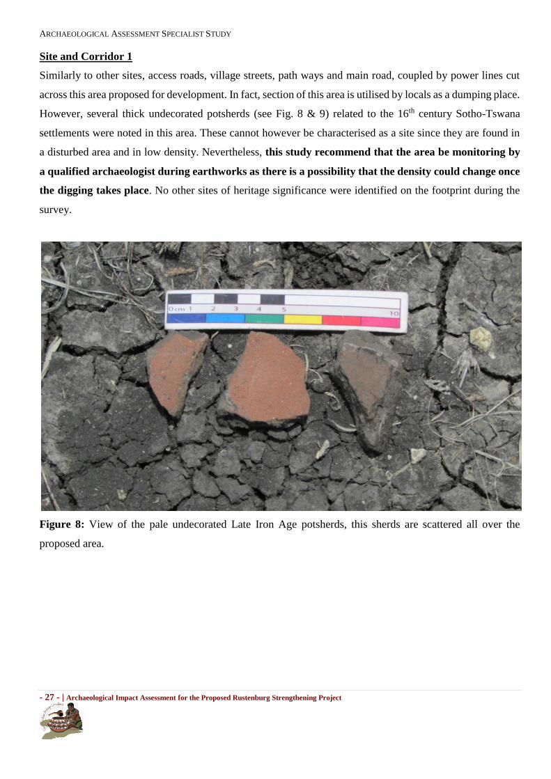
Site and Corridor 1
Similarly to other sites, access roads, village streets, path ways and main road, coupled by power lines cut
across this area proposed for development. In fact, section of this area is utilised by locals as a dumping place.
However, several thick undecorated potsherds (see Fig. 8 & 9) related to the 16th century Sotho-Tswana
settlements were noted in this area. These cannot however be characterised as a site since they are found in
a disturbed area and in low density. Nevertheless, this study recommend that the area be monitoring by
a qualified archaeologist during earthworks as there is a possibility that the density could change once
the digging takes place. No other sites of heritage significance were identified on the footprint during the
survey.
Figure 8: View of the pale undecorated Late Iron Age potsherds, this sherds are scattered all over the
proposed area.

ARCHAEOLOGICAL ASSESSMENT SPECIALIST STUDY
- 28 - | Archaeological Impact Assessment for the Proposed Rustenburg Strengthening Project
Figure 9: View of Late Iron Age potsherds.
Site and Corridor 2
This proposed area is fairly flat, vehemently disturbed and has a small hill on the tip of the south-eastern
section. The hill is concentrated of Late Iron Age stone walled sites, some of these walling are still intact.
Also noted are Late Stone Age tools, historical terracing and undecorated potsherds which are scattered
throughout the proposed area. These sites and tools are protected by the National Heritage Resources Act
(No 25 of 1999). If this site is going to be preferred, three recommendations are made: (1) Detailed mapping,
(2) extensive recording of the structures, and (3) destruction permit. It should be noted that these recommendations
are, if approved by SAHRA, going to be subject to a permit application.
Table 2: Stone Walling.
Site Name: Marang 0001
Coordinates S25°37'16.8"; E27°21'07.1"
Description A stone wall which extends along the edge of the hill was not noted. This
appears to be Later Iron Age type-sites in the area. On top of this hill, there
are several sites marked by fine collection of stones.
Significance Medium (B)

ARCHAEOLOGICAL ASSESSMENT SPECIALIST STUDY
- 29 - | Archaeological Impact Assessment for the Proposed Rustenburg Strengthening Project
Figure 10: View of stone walling located on the edge of the hill.
Figure 11: View of stone assembled as an oval, it was noted on top of the hill.

ARCHAEOLOGICAL ASSESSMENT SPECIALIST STUDY
- 30 - | Archaeological Impact Assessment for the Proposed Rustenburg Strengthening Project
Figure 12: View of Late Iron Age potsherds noted in the proposed area.
Table 3: Three piles of stones.
Site Name: Marang 0002
Coordinates A: S 25°37'13.91"; E 27°21'7.30" B: S 25°37'12.72"; E 27°21'5.75"
C: S 25°37'14.33"; E 27°21'3.92"
Description Three assemblages of stones forming three separate piles were noted. These piles
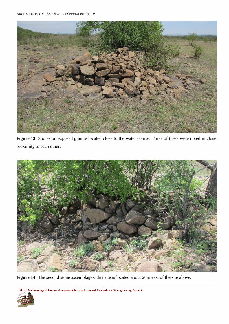
which are located close to the water course and are in close proximity to each
other, appears to dates to the historical era. These assemblages are bigger than
that which may be associated with a grave. Interestingly, all the three piles are
exposed on granite. It is possible that these might have been terracing to make
way for agriculture.
Significance Medium (B)
Recommended
mitigation measures
Two recommendations are made here: (1) Detailed mapping, and (2) extensive
recording of the piles.
ARCHAEOLOGICAL ASSESSMENT SPECIALIST STUDY
- 31 - | Archaeological Impact Assessment for the Proposed Rustenburg Strengthening Project
Figure 13: Stones on exposed granite located close to the water course. Three of these were noted in close
proximity to each other.
Figure 14: The second stone assemblages, this site is located about 20m east of the site above.

ARCHAEOLOGICAL ASSESSMENT SPECIALIST STUDY
- 32 - | Archaeological Impact Assessment for the Proposed Rustenburg Strengthening Project
Figure 15: View of the third assemblage of stones located close to the other two above.
Table 4: Pile of stones.
Site Name: Marang 0003
Coordinates S 25°36'56.2"; E 27°20'42.7"
Description View of pile of stones on an exposed granite. The nature of this site is similar to
the other depicted above, except that this is located further inland, and away
from the water course.
Significance Medium (B)
Recommended
mitigation measures
Two recommendations are made here: (1) Detailed mapping, and (2) extensive
recording of the structure.

ARCHAEOLOGICAL ASSESSMENT SPECIALIST STUDY
- 33 - | Archaeological Impact Assessment for the Proposed Rustenburg Strengthening Project
Figure 16: View of stone piles.
Table 5: Stone tools.
Site Name: Marang 0004
Coordinates Scatter: S25°36'49.8"; E 27°20'30.9"
Description Scatters of Late Stone Age (LSA) material were noted. These occurred in low
densities of 0 to 1 per square meter and on a disturbed landscape, also noted, are
potsherds. These scatters, along with potsherds are viewed to be of low
significance. No manufacturing camp or stratified sites were identified
anywhere within the property that has been identified for the proposed
development.
Significance Medium (B)

ARCHAEOLOGICAL ASSESSMENT SPECIALIST STUDY
- 34 - | Archaeological Impact Assessment for the Proposed Rustenburg Strengthening Project
Figure 17: View of the Late Stone Age tools and Late Iron Age potsherds noted in the proposed area.
Site and Corridor 3
This section is heavily disturbed by activities related to agriculture. Despite these disturbances, stone
walled sites and weathered potsherds are common across the area. These sites date to the Late Iron Age,
and are the results of the Iron Age people. Consequently, these sites and clusters of sites have medium
significance and are protected by Section 35 of the National Heritage Resources Act (No 25 of 1999). Three
recommendations are made if this site is going to be utilised: (1) Detailed mapping, (2) extensive recording of
the structures, and (3) destruction permit. It should be noted that these recommendations are, if approved by
SAHRA, going to be subject to a permit application. The permit would authorise the destruction of these
remnants.
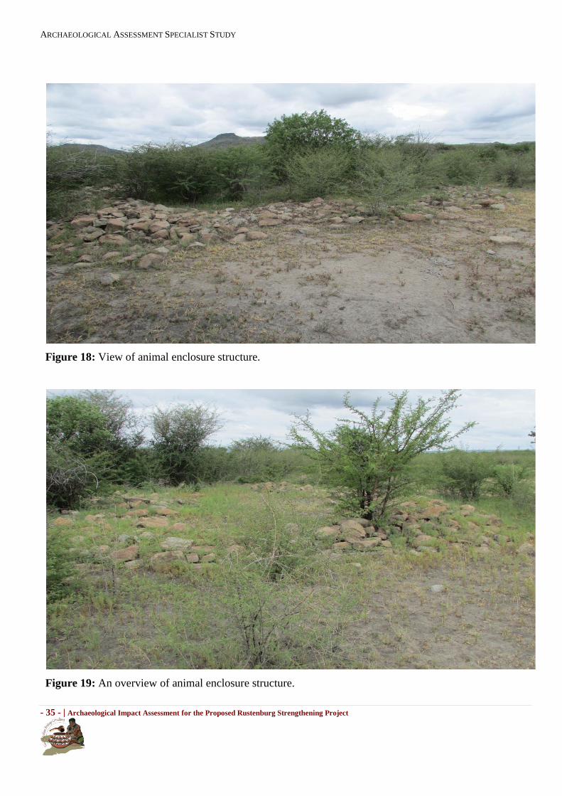
Table 6: Animal Enclosure.
Site Name: Marang 0005
Coordinates A: S25°37'12.4"; E27°20'05.6"; B: S25°37'11.3"; E27°20'05.3";
Description Cattle kraal deposit of a Later Iron Age site was noted in the section proposed for
substation B. This kraal is associated with an animal enclosure. It is difficult to
evaluate these enclosures as the vegetation cover inhibits proper investigation.
However, they appear to cover a wide area. Scatters of potsherds were also noted
in this proposed area.
Significance Medium (B)
ARCHAEOLOGICAL ASSESSMENT SPECIALIST STUDY
- 35 - | Archaeological Impact Assessment for the Proposed Rustenburg Strengthening Project
Figure 18: View of animal enclosure structure.
Figure 19: An overview of animal enclosure structure.
ARCHAEOLOGICAL ASSESSMENT SPECIALIST STUDY
- 36 - | Archaeological Impact Assessment for the Proposed Rustenburg Strengthening Project
Figure 20: View of Late Iron Age potsherds.
Substation extension
The area proposed for the extension of the substation falls within substation site 1 and as such access roads,
village streets, path ways and main road, coupled by power lines cut across this area proposed for
development. However, several thick undecorated potsherds related to the 16th century Sotho-Tswana
settlements were noted in this area. These cannot however be characterised as a site since they are found in
a disturbed area and in low density. Nevertheless, this study recommend that the area be monitoring by
a qualified archaeologist during earthworks as there is a possibility that the density could change once
the digging takes place. No other sites of heritage significance were identified on the footprint during the
survey. As such, this is the most preferred site.
11. Concluding remarks
A thorough background study and survey of the proposed development was conducted and findings were
recorded in line with SAHRA guidelines. The study revealed that the project area is located within a cultural
landscape dotted with heritage resources, a majority of which possibly date to the Late Iron Age. As per the
recommendations above, there are no major heritage reasons why the development could not be allowed to
ARCHAEOLOGICAL ASSESSMENT SPECIALIST STUDY
- 37 - | Archaeological Impact Assessment for the Proposed Rustenburg Strengthening Project
proceed. Therefore, the proposed development can proceed on condition that the recommendation stated
above are adhered to.
Acknowledgements
The author and the team of Vhubvo would like to acknowledge DIGES personnel for their assistance in
relation to survey and compilation of this report, also local community members.

ARCHAEOLOGICAL ASSESSMENT SPECIALIST STUDY
- 38 - | Archaeological Impact Assessment for the Proposed Rustenburg Strengthening Project
References
Bergh, J.S. 1999. Geskiedenis atlas van Suid Afrika. Die vier Noordelike Provinsies. J.L. van Schaik
Burke, H., and Smith, C. 2004. The archaeologist field handbook. Allen and Unwin: Singapore
Campbell, J. 1822. Travels in South Africa. Vol I and II. London: Francis Westley.
Connah, G. 2004. An Introduction to its Archaeology. Routledge: USA and Canada.
Deacon, J. 1997. Report: Workshop on Standards for the Assessment of Significance and Research Priorities
for Contract Archaeology. In: Newsletter No. 49, Sept.1998. South African Association of Archaeology.
Dunn, E. J. 1931. The Bushman. London: Griffin
Ehret, C. 2002. The Civilization of Africa: A History to 1800. London: Currey
Hall, M. 1987. The Changing Past: farmers, kings and traders in southern Africa. 200-1860. Cape Town:
David Phillip.
Huffman, T. N. 2007. A handbook to the Iron Age: The archaeology of Pre colonial Farming societies in
southern Africa. University of KwaZulu-Natal Press: Pietermaritzburg.
King, T. F. 1978. The Archaeological Survey: Methods and Uses. U.S. Department of the Interior:
Washington
Maggs, T.M. OC. 1976 Iron Age Communities of the Southern Highveld. Natal Museum, Pietermaritzburg.
Magoma. M. 2013. Archaeological Impact Assessment (AIA) Study for the proposed low-income housing
development in the Ekhuruleni Metropolitan Municipality within Gauteng Province. Vhubvo Archaeo-
Heritage Consultant: Pretoria.
Mitchell, P. J. 2002. The archaeology of Southern Africa.Cambridge: Cambridge University.

ARCHAEOLOGICAL ASSESSMENT SPECIALIST STUDY
- 39 - | Archaeological Impact Assessment for the Proposed Rustenburg Strengthening Project
Segoboye A. 1998. Early Farming Communities. InLane, P, Reid, A and Segoboye A. 1998. (ed), Pula Press
and Botswana Society, pp 101-114.
Van der Walt, J. 2010. Archaeological Impact Assessment for the proposed upgrade of the Simmerpan
powerlines referred to as the Simmerpan strengthening project and new substation. Wits Heritage Contracts
Unit: Johannesburg.
National Heritage Resources Act (Act No 25 of 1999).
Line Engineering Services. 2013. Refurbishment of the Jupiter Simmerpan 275kv line. Draft Final Design
Report.
Presented by Rowan Beukes and Team. 2013. Power Point Presentation. Simmerpan Strengthening (Phase
1A, Stage 1). Eskom.
http://sagns.dac.gov.za/local_authorities.asp
http://www.voortrekkermon.org.za/
ARCHAEOLOGICAL ASSESSMENT SPECIALIST STUDY
- 40 - | Archaeological Impact Assessment for the Proposed Rustenburg Strengthening Project
APPENDIX 1: SITE SIGNIFICANCE
The following guidelines for determining site significance were developed by SAHRA in 2003. It must be
kept in mind that the various aspects are not mutually exclusive, and that the evaluation of any site is done
with reference to any number of these.
(a) Historic value
Is it important in the community, or pattern of history?
Does it have strong or special association with the life or work of a person, group or
organization of
importance in history?
Does it have significance relating to the history of slavery?
(b) Aesthetic value
Is it important in exhibiting particular aesthetic characteristics valued by a community or
cultural group?
(c) Scientific value
Does it have potential to yield information that will contribute to an understanding of natural or
cultural heritage?
Is it important in demonstrating a high degree of creative or technical achievement at a
particular period?
(d) Social value
Does it have strong or special association with a particular community or cultural group for
social, cultural or spiritual reasons?
(e) Rarity
Does it possess uncommon, rare or endangered aspects of natural or cultural heritage?
(f) Representivity
Is it important in demonstrating the principal characteristics of a particular class of natural or
cultural places or objects?
What is the importance in demonstrating the principal characteristics of a range of
landscapes or environments, the attributes of which identify it as being characteristic of its
class?
Is it important in demonstrating the principal characteristics of human activities (including
way of life, philosophy, custom, process, land-use, function, design or technique) in the

ARCHAEOLOGICAL ASSESSMENT SPECIALIST STUDY
- 41 - | Archaeological Impact Assessment for the Proposed Rustenburg Strengthening Project
environment of the nation, province, region or locality?

ARCHAEOLOGICAL ASSESSMENT SPECIALIST STUDY
- 42 - | Archaeological Impact Assessment for the Proposed Rustenburg Strengthening Project
APPENDIX 2: GRAVE
A grave is a place of interment and includes all that is associated with such a place, and should be avoided
by all means possible unless when totally impossible. If accidental found during construction, the constructor
should immediately halt construction and notify SAHRA, the nearest Police Station and a Museum
(preferably where there is an Archaeologist), or an independent Archaeologist, so that the discovery can be
speedily investigated and facilitated. In the meantime a buffer of about ten meters from the grave should be
maintained, and if the grave is to be relocated, the correct procedure which involve, notification, consultation
and permit application should be followed. If the grave is less than 60 years of age, it is subject to provision
of the Human Tissue Act (Act 65 of 1983) and to local regulations. Exhumation of graves must conform to
the standards set out in the ordinance on excavations (ordinance no. 12 of 1980) (replacing the old Transvaal
Ordinance no. 7 of 1925). Permission must also be sought from the descendent (where known), the national
department of health, provincial department of health, premier of the province and local police. Furthermore
permission must also be sought from the landowners before exhumation can take place. Human remains can
only be handled by a registered undertaker or an institution declared under the human tissues act (Act 65 of
1983 as amended). This act states that a survey and an evaluation of cultural resources should be undertaken
in areas where development, which will change the face of the environment, is to be made.