earth radiation budget science 1978
TRANSCRIPT

1
NASA Conference Publication 2 100
Earth Radiation Budget Science 1978
Proceedings of a workshop held at Williamsburg, Virginia March 28-30, 1978
LOAN AWL KIRTL
NASA CP 2100 c. 1
https://ntrs.nasa.gov/search.jsp?R=19790024626 2020-03-21T21:02:08+00:00Z

TECH LIBRARY KAFB, NM
NASA Conference Publication 2100
Earth Radiation Budget Science 1978
Proceedings of a workshop sponsored by NASA Langley Research Center, in cooperation with Colorado State University, and held at Williamsburg, Virginia March 28-30, 1978
National Aeronautics and Space Administration
Scientific and Technical Information Branch
1979


PREFACE
This volume contains the technical proceedings, including the recommendations, of the NASA-sponsored Workshop on Earth Radiation Budget Science, held in Williamsburg, Virginia, March 28-30, 1978. Eighty invited scientists from universities, non-profit institutions, research laboratories, and U. S. Govern- ment agencies participated in the workshop. The purpose of the workshop was to draw upon the combined expertise of scientists concerned with the use and production of satellite measurements of various components of the Earth's Radiation Budget (ERB), in order to assess the present state of the knowledge in this field, acquire better understanding of and definition of the needs and requirements of the ERB data user community, and identify and recommend future research activity in this area. The objectives of the workshop were to incorporate the needs and requirements of the ERB data users into the planning of an Earth Radiation Budget Satellite System (ERBSS)* which received a "new start" in fiscal year 1979 and in the formulation of NASA's long-range plans for a radiation budget program.
The format of the workshop included a brief plenary session on each of the three days--the remainder of the time being devoted to deliberations by six working groups into which the workshop participants were divided. Each of the working groups focused their deliberations on one of the following aspects of the Earth's Radiation Budget Science: climate model- ing, climate diagnostics, radiation modeling, radiation vari- ability and correlation studies, cloudiness and the radiation budget, and radiation budget and related measurements in 1985 and beyond. The chairmen and technical assistants of the six working groups are listed as follows:
Technical Working Group Chairman Assistant
Climate Modeling Dr. C. Leith Dr. W. Grose Climate Diagnostics Dr. J. Winston Dr. E. Remsberg Radiation Modeling Dr. K. Coulson J. Suttles Radiation Variability Dr. H. Jacobowitz Dr. J. Campbell
and Correlation Studies Cloudiness and the Dr. s. cox Dr. B. Barkstrom
Radiation Budget Radiation Budget and Drs. V. Suomi and G. Sweet
Related Measurements T. Vonder Haar (deceased) in 1985 and Beyond
* The official project name has been changed to the Earth Radiation Budget Experiment (EPBE)
iii

The emphasis of the deliberations of the working groups was on the uses, methodology, accuracy and resolution require- ments and on future efforts needed in these different aspects. The discussions and the recommendations of each working group were summarized by the working group chairman with the assis- tance of the technical assistant. In compiling this volume the workshop Co-chairmen have included each of these summaries in a separate section. In addition, supporting papers by individual experts are included as appendices.
Dr. Adarsh Deepak, Institute for Atmospheric Optics and Remote Sensing (IFAORS), undertook the assignment of editing the workshop proceedings. In editing these reports, he has attempted to make them more cogent and lucid, without changing the content, by keeping the alterations to a minimum and to highlight the major recommendations of the working groups.
The Co-chairmen wish to acknowledge the active support and cooperation of the participants, working group chairmen, and speakers in the plenary sessions in making the workshop a stimulating and beneficial experience for everyone. Special thanks are due the workshop working group chairmen for success- fully leading the discussions to a fruitful conclusion. Special commendations are due Jean Cridlin, who with the assitance of Karen Greiner, Doris Forrest, and Alberta Reid did an excellent job of overseeing the arrangements and the smooth running of the workshop.
We hope this volume will be a useful contribution to the research and development in the field of Earth Radiation Budget.
Thomas H. Vonder Haar G. Louis Smith
Workshop Co-Chairmen
iv
CONTENTS
PREFACE................ . . . . . . . . . . . iii
1. INTRODUCTION . . . . ..I............... 1
2. CLIMATE MODELING .................... 4 2.1 INTRODUCTION ................... 4 2.2 AREASOFEMPHASIS ................ 4 2.3 REFERENCES. ................... 6
3. CLIMATE DIAGNOSTICS ................... 7 3.1 INTRODUCTION ................... 7 3.2 DIAGNOSTIC STUDIES ................ 8 3.3 RECOMMENDATIONS ................. 13 3.4 REFERENCES. ................... 14
4. RADIATION MODELING . . . . . . . . . . . . . . . . . . . 15 4.1 INTRODUCTION . . . . . . . . . - . . . . . . . . . 15 4.2 MODELING OF ATMOSPHERIC EFFECTS . . . . . . . . . 16 4.3 MODELING OF SURFACE EFFECTS . - . . . . . . . . . 19 4.4 DATA VALIDATION REQUIREMENTS FOR THE ERBSS . . . . 20 4.5 ADDITIONAL FINDINGS IN RADIATION MODELING . . . . 22
5. RADIATION VARIABILITY AND CORRELATION STUDIES ..... 23 5.1 INTRODUCTION ................... 23 5.2 PROBLEMS CONSIDERED ............... 24 5.3 REFERENCES. ................... 28
6. CLOUDINESS AND THE RADIATION BUDGET . . . . . . . . . . . 29 6.1 OBSERVED CLOUD CHARACTERISTICS . . . . . . . . . . 29 6.2 EXTENDED CLOUDINESS AND RADIATION EXPERIMENT . . . 30 6.3 EARTH RADIATION BUDGET CONCERNS . . . . . . . . . 31 6.4 ARCHIVAL AND AVAILABILITY OF METEOROLOGICAL
SATELLITE DATA . . . . . . . . . . . . . . . . . 32
7. RADIATION BUDGET AND RELATED MEASUREMENTS IN 1985 ANDBEYOND ...................... 34 7.1 INTRODUCTION ................... 34 7.2 RELATED MEASUREMENTS ............... 35 7.3 PROGRAM IMPLEMENTATION .............. 40
8. SUMMARY......................... 47

APPENDIX A - DESCRIPTION OF THE EARTH RADIATION BUDGET SATELLITE SYSTEM . . . . . . . . . . . . . . . . . . . . . 49
C. V. Woerner
APPENDIX B - THE ROLE OF EARTH RADIATION BUDGET STUDIES INCLIMATERESEARCH.................... 57
C. E. Leith
APPENDIX C - SATELLITE RADIATION BUDGET MEASUREMENTS IN SPECTRALBANDS . . . . . . . . . . . . . . . . . . . . . . 66
V. Ramanathan
APPENDIX D - WORKSHOP PARTICIPANTS . . . . . . . . . . . . . 69
vi

1. INTRODUCTION
In view of the importance of Earth's radiation budget measurements in trying to understand climate on various temporal and spatial scales, NASA, in close collaboration with NOAA and university scientists, planned and proposed an Earth Radiation Budget Satellite System (ERBSS) as a "new start" in fiscal year 1979. This system, described in Appendix A, consists of three satellites and is designed to obtain radiation budget data from the early 1980s through the mid-1980s and will thus provide better coverage than any previous system, and, at the same time, extend the time span of radiation budget measurements. Several univer- sity and government scientists participated in the ERBSS new start planning. However, in order to involve the widest possible segment of the scientific community in the planning for the ERBSS data use, NASA sponsored a Workshop on Earth Radiation Budget Science at Williamsburg, Virginia, March 28-30, 1978. The pur- pose of the Workshop was to draw upon the combined expertise of scientists concerned with the use and production of satellite measurements of various components of the Earth's Radiation Budget (Em), in order to assess the present state of the knowledge in this field, acquire better understanding of and definition of the needs and requirements of the ERB data user community, and iden- tify and recommend future research activity in this area.
There were two specific objectives for these discussions. The first objective was to address the ERBSS data uses, so that the needs and requirements of the data users could be incorpora- ted in ERBSS planning and the scientists could begin their planning for use of the data. The second objective was to acquire information regarding the scientists' needs and require.- ments for use in formulating NASA's long range plans for a Radiation Budget Program.
The format of the Workshop included a brief plenary session on each of the three days--the remainder of the time being devoted to deliberations by six working groups into which the Workshop participants were divided. The first half-day of the Workshop was devoted to presentation and plenary discussion of papers which provided general background information regarding the accomplishments to date in the field of Earth Radiation Budget. In his opening remarks, Dr. L. R. Greenwood, Jr., NASA Headquarters, discussed the opportunities to participate in Science Planning and Analysis of the ERBSS project. Dr. T. Vonder Haar, Colorado State University (CSU), discussed the plan for the format of the Workshop. Dr. R. Curran, Goddard Space Flight Center, gave an overview of Science Requirements for ERBSS Measurements. Other
1

presentations included discussion of recent results from the ERJ3 instrument on the NIMBUS-6 spacecraft and plans for the ERB instru- ment on the NIMBUS-G (NIMBUS-71 spacecraft by Dr. H. Jacobowitz, NOAA/National Environmental Satellite Service (NESS); and a des- cription of the proposed ERBSS system by C. V. Woerner, NASA- Langley Research Center. On the second day, Dr. P. K. Rao, NOAA/NESS, presented an overview of the TIROS-N Program and the correlative data; and Dr. E. Bierly, National Science Foundation, gave an overview of the U.S. Climate Program and Related International Activities. The remaining time was devoted to working group discussions of six specific topics and to plenary discussions of the outcome of the working group deliberations.
The central themes of the working group discussions were arrived at on the basis of the following considerations. It was realized that the two major users of the Earth radiation budget data are the scientists who work either with climate models or in climate diagnostic studies to unravel the processes of weather and climate. Working groups on climate modeling and climate diagnostics were, therefore, set up to address these two cate- gories of ERB data uses. A third working group was formed to focus on the applications of radiation modeling to ERBSS. Modeling of the radiation field is needed in ERB experiments as well as ground truth measurements. An example is the determina- tion of the flux of radiation energy at the top of the atmosphere from measurements of radiant intensity obtained by scanning and wide angle radiometers mounted aboard a spacecraft. In conduct- ing climate studies based on radiation data, correlation studies are an important tool for establishing and quantifying relation- ships between radiation budgets and other climate variables. The variability of the radiation field also is of importance in the design of the observation system. Accordingly, one working group considered radiation variability and correlation studies. Since on the average about one-half of the Earth is covered with high albedo clouds, they have a strong influence on the radiation budget and atmospheric circulation; therefore, another working group dealt with cloudiness and the radiation budget. Since the planning and implementation of a satellite project requires a long lead time, it was felt that although ERBSS had only recently been approved, it was an appropriate time to begin deliberations on the future requirements for radiation budget measurements. Thus, a working group was formed to consider ERB measurements for the late 1980s. The chairmen and topics for the six working groups were: Dr. C. E. Leith, National Center for Atmospheric Research (NCAR)--Climate Modeling; Dr. J. Winston, NOAA/NESS--Climate Diagnostics; Dr. K. Coulson, University of California at Davis--Radiation Modeling; Dr. H. Jacobowitz-- Radiation Variability and Correlation Studies; Dr. S. Cox, CSU-- Cloudiness and the Radiation Budget; Drs. V. Suomi, University of
2

Wisconsin, and T. Vonder Haar, CSU--Radiation Budget and Related Measurements in 1985 and Beyond.
The deliberations and recommendations of the working groups were summarized into reports by the working group chairmen. Each of these reports is included in a separate section (Sections 2 to 7) in this volume. In this task, the chairmen were ably assisted by the working group participants and the working group technical assistants, who acted as rapporteurs. The technical assistants for the six working groups are listed in the preface to this volume. Three papers, separately authored by C. V. Woerner, Dr. C. E. Leith, and Dr. V. Ramanathan, in support of some of the deliberations of the Workshop, are given in Appendices A, B, and C, respectively, and a list of partici- pants is given in Appendix D. The first paper was presented at the Workshop plenary session and the last two were discussed during the deliberations of the working group on Climate Modeling. Other aforementioned papers at the plenary sessions were not included as they were not available for inclusion in the Workshop proceedings.
3

2. CLIMATE MODELING
2.1 INTRODUCTION
The Climate Modeling Working Group considered the require- ments for radiation measurements suitable for the understanding, improvement, and verification of models used in performing climate research. Both zonal energy balance models and 3-dimensional general circulation models were considered, and certain problems were identified as common to all models. A summary of the use- fulness of Earth radiation budget measurements to climate modelers is included in Appendices B and C, prepared by C. E. Leith and V. Ramanathan, National Center for Atmospheric Research, respectively. Several key areas, however, deserve special emphasis and are identified.
2.2 AREAS OF EMPHASIS
2.2.1 Regional Energy Balance Observations
Climate studies, based on models, can benefit from regional radiation budget measurements performed on scales of about 1000 km or less. By computing the energy balance over con- tinental regions, it will be possible to remove, or at least minimize, the uncertainties arising from ocean transport effects, which, at present, can neither be described by models, nor directly measured by oceanographic observations. Such studies, therefore, would be of invaluable aid in assessing the ability of a model to simulate present climate.
2.2.2 Spectral Band Observations
Observations of selected spectral bands in both the infra- red and visible spectrum would allow modelers to assess, at least under cloud-free conditions, the fidelity of calculated radiative contributions of constituents, such as H20, C02, 03, and aerosols separately. Such spectral band observations would provide far more valuable information than those of the total integrated radiation. Details of specific spectral intervals and a rationale for their selection are provided in Appendix C.
2.2.3 Clouds and Radiation
Although cloud-radiation interaction has long been con- sidered to be the most important source of uncertainty in all climate models, recent results indicate that the net radiation is less sensitive to clouds than was believed earlier (Cess, 1976, and Ellis, 1977). Nevertheless, considerable uncertainty, remains concerning the details of how individual clouds and cloud
4

systems might influence the radiation budget. Such details may become important as feedback loops incorporating clouds are added to the models. Since the models will not attempt to produce the detailed structures and physical properties of clouds and cloud fields, it appears that only the statistical features, such as the probability distribution of reflectivities for a given type of cloud system, are-called for in the model. However, when the spatial dimensions of clouds are considered, high resolution observations will be required, at least, to characterize the cloud fields even though the energy budget on a much larger scale is desired.
2.2.4 Radiative Properties of the Surface
Determination of the radiative balance at the Earth's surface is essential to atmospheric modeling and prediction from the climatic time scales down to those scales for which radiative heating is significant. Since this balance depends directly on surface albedo and emissivity, some well-defined characteristics of albedos and emissivities must be properly and carefully deter- mined. This determination may require statistical knowledge based on observations. Since quantities may vary with temperature and surface moisture, such changes must be computed in the models. The dependence of surface albedo and emissivity on the soil characteristics, vegetation, solar zenith angle, and cloudiness must be determined. Once such multi-parameter functions have been established on the basis of large observational samples, they may be incorporated into climate models (or other models), together with the relevant time variation of parameters in order to enhance the prediction capability of the models.
2.2.5 Accuracy of Observations
At present, it appears that for validation of the relation between radiation and other model dynamics and physics, the models would benefit from an accuracy of about 5 percent for the 1000 km spatial scale and a monthly mean time scale. For checking the overall accuracy of the model simulation results for the annual energy balance cycle, however, it must be recognized that interannual variability imposes a serious limit on the accuracy of, the estimation of long-term climate averages which can be improved only by longer records (Leith, 1973). It should also be recognized that to develop proper parameterization for models, one requires observations in broad-band spectral regions for cloud and surface radiative properties.
5

2.3 REFERENCES
Cess, R. D.: Climate Change: An Appraisal of Atmospheric Feedback Mechanisms Employing Zonal Climatology. J. Atmos. Sci., 22 (1976), 1831-1843.
Ellis, James S.: Cloudiness: The Planetary Radiation Budget and Climate. Ph.D. Thesis, Department of Atmospheric Sciences, Colorado State University, Fort Collins, Colorado, 1977.
Leith, C. E.: The Standard Error of Time-Average Estimates of Climatic Means. J. Appl. Meteor., 12 (19731, 1066-1069.
6

3. CLIMATE DIAGNOSTICS
3.1 INTRODUCTION
Many of the large-scale and long-term processes associated with climate fluctuations are only poorly understood. In part, this situation exists because general circulation and climate models do not as yet account fully, or properly, for all the physical processes that may be of importance for fluctuations in the climate. This inadequacy of the models stems largely from insufficient knowledge of the various dynamic and thermodynamic processes operating in the Earth-atmosphere system to produce climate fluctuations. In turn, much of this insufficient knowl- edge is related to incomplete or inaccurate observations of cli- mate parameters over the globe.
There exist long records for measurements of surface (air) temperature, surface winds, surface pressure, precipitation, and other weather elements over well-populated land areas, but very meager records exist for such measurements over sparsely popu- lated land regions and over vast areas of the oceans, particularly in the tropics and the Southern Hemisphere. When records of other quantities are considered, the situation is worse. Relatively good records of tropospheric and stratospheric temper- ature, pressure, and wind have been built up over the past 30 to 35 years, but, again, these have been deficient in measure- ments over large portions of the globe. The worst situation arises with regard to those processes that essentially drive the atmospheric and oceanic circulations, namely, the energy sources and transformations. Condensation and evaporation, sensible heat transfer between the surface and the atmosphere, radiation, heat storage in the oceans, transports of heat and momentum in the atmosphere and oceans have all been difficult to measure or derive from existing data networks.
As satellite observations fill in the data voids with global coverage of cloudiness, ice and snow cover, temperatures, winds, radiation budget, precipitation, etc., some substantial advances can be made in monitoring and understanding climate fluctuations. To obtain this understanding, the observations cannot be utilized solely to feed into general circulation and climate models. There must be an accompanying strong program in diagnosing climate fluctuations. This program means detailed studies of climate events, the main emphasis being the assemblage of a host of observations, to develop a clearer physical picture of the nature and causal interrelationships of the climate events. AS various types of climate events are studied, physical under- standing of the events will be clarified. This information will then lead to well directed efforts in developing better
7

statistical methods for making predictions of climate fluctu- ations (i.e., long-range weather forecasts) and improving numerical climate prediction models.
There is a wide variety of climate phenomena to which this enhanced diagnostic effort can be profitably applied. Some of the more important phenomena and recommendations for under- standing them, using EPBSS data, are given in the following section.
3.2 DIAGNOSTIC STUDIES
3.2.1 Middle and High Latitude Planetary Scale Atmospheric Processes
It is useful to describe the system of meandering jets and vortices that one observes on a weather map in midlatitudes in terms of an average westerly flow upon which are superimposed disturbances of various zonal and meridional scales. The largest spatial scale disturbances, which may be identified as planetary waves, also have long temporal scales of the order of weeks to months. These planetary scale disturbances to the westerly flow are the principal phenomena 'associated with interannual variations in regional climate (e.g., the unusual weather of 1977). They are believed to be forced by thermal and orographic con- trasts between ocean and land surfaces. Their characteristically long time scales and relatively large temperature perturbations subject them to strong influences from radiative processes. Suitable diagnostic studies of the radiative energy budget of the zonal-mean westerlies and the planetary waves may then play an important role in improving one's understanding of regional climate variability.
An example of a phenomenon that has a particularly extreme and persistent effect on regional climate is the inter- ruption of the normal westerly flow in a region by a strong (blocking) anticyclone. Blocking is associated with significant deviations from normal temperature and cloudiness and, thus, may be studied profitably with EFBSS data. For this purpose, the recommended horizontal resolution of 250 km for each day should be adequate, although 10 or more years of such data may be required to obtain enough cases since the time scale is long and the variability, large.
3.2.2 Major Circulation Systems in the Tropics
The major atmospheric systems in the tropics include the intertropical convergence zones, mainly in the Atlantic and central eastern Pacific at about 5o to loo N; the equatorial cloud-free zones in the Atlantic and central and eastern Pacific;

the three "continental" regions of major convective cloudiness and rainfall over Indonesia, South America, and Africa; and the oceanic, subtropical anticyclones. These tropical systems, which are closely associated with the principal atmospheric and oceanic heat sources, are related to the behavior of such circulation features as the Pacific Walker circulation, the Hadley circulation, and the associated subtropical jet streams in both the Northern and Southern Hemispheres. Yet, until the availability of satellite radiation data, it was virtually impossible to study their behavior.
Satellite radiation data, including ERBSS, vertical sounders, and microwave sounders, are essential for monitoring cloudiness in these regions, including both its temporal and geographical variations, and for estimating the vertical struc- ture of clouds. The latter is of paramount importance in deter- mining whether feedbacks between clouds and the oceanic and atmospheric circulations are positive or negative.
Measurements of rainfall, sea surface temperature, and surface albedo must also be obtained in order to define the heat and energy exchange between sea and atmosphere. The primary short-term usefulness of such diagnoses would be in verifying the accuracy of and in providing input data to global cir- culation models. For this purpose, radiation components would have to be observed with high accuracy, with a resolution of at least 200 to 250 km, and in time intervals measured in hours or, at most, a few days.
The long-term utility of radiation data includes climatic monitoring of clouds in the major tropical atmospheric systems mentioned previously. Indices of tropical atmospheric cir- culation can be developed either locally in any one of these systems, or by use of the principal components of orthogonal functions. Time series of these indices will be useful in sta- tistical prediction of short-term climate changes in various parts of the Earth. These longer-term data will also be useful in constructing meaningful climate models and as initial input data for these models. Spatial resolution of about 200 to 250 km seems adequate for these long-term studies. However, errors must be treated in a fashion different than those for short-term studies. Thus, fairly large random errors can be tolerated because these can be smoothed out by space and time averaging. It is more important to minimize absolute errors (bias or frac- tional errors) or else to make them uniform from one satellite system to the next. Perhaps the best way of achieving this goal is to compare the results of different satellite systems wherever they overlap.
9

The tropics, which constitute roughly half of the sur- face area of the Earth and account for more than half of the radiative interaction with space, exhibit some fairly regular variations in temperature and cloudiness over a diurnal cycle. Studies of the diurnal cycle using geostationary satellite data are essential to test the reliability of approximations using polar measurements.
3.2.3 Global Scale Energy Cycle
To diagnose key elements of the energy cycle (in particular, generation of available potential energy, heat, and momentum transport in the atmosphere and oceans), a time scale on the order of a week or two and spatial scales on the order of 5O to loo latitude may be appropriate. ERBSS data will pro- vide the critical energy balance at the top of the atmosphere. Use of these data in the estimation of the generation of available potential energy, for example, will require knowledge of the divergence of the radiative flux over the atmospheric column. In other words, the radiation balance at the surface, as well as that at the upper boundary, is required for this determination. Observations and theoretical-empirical studies suggest that the surface radiation budget can be inferred from the ERBSS data in conjunction with some supplementary information. The atmospheric radiative divergence, in conjunction with atmospheric thermal structure information available from conventional or sounder data, will allow for estimation of the radiative generation of available potential energy.
Heat and momentum transports by the oceans and atmosphere are essential parts of climate dynamics. Global meridional- annual distributions of ERBSS data will define the corresponding ocean-atmospheric transport. Finer scale structure over shorter time periods can be derived after specification of latent and sensible heat exchanges at the surface and across lateral atmospheric boundaries. ERBSS data and the derived surface radiation balance will provide the radiative boundary conditions for the atmospheric column.
3.2.4 Synoptic Scale Systems
With regard to time scales larger than two weeks, the transient synoptic scales are primarily identified with extra- tropical cyclones and anticyclones, tropical cyclones, cloud clusters, and traveling waves in the westerlies and easterlies. These phenomena play a primary role in the horizontal and vertical transport and conversion of energy within the atmosphere. Their intensity and frequency of occurrence with respect to fixed geographical locations determine, to a large extent, the pre- vailing circulation and temperature of the larger time scales.
10

In order to determine the influence of these features in climatic trends, it is important that the long-wave and shortwave energy balance of such systems be evaluated over their life cycle in con- junction with the latent and sensible heat components.
Diagnostic studies of radiation quantities related to synoptic scale long waves are needed. In particular, budget studies related to location and behavior of the long wave and to variation in radiational responses of continents compared with oceans are of interest for climate and predictability studies. Of special interest are satellite-based studies of the horizontal and vertical distribution of clouds over oceans as compared with land in the various seasons.
3.2.5 Surface Processes
Radiation budget components, particularly the reflected or absorbed solar radiation values, are of great utility for monitoring the variations in radiative heating at the surface over all portions of the globe. Although combined physical- statistical relationships will need development to attain good quantitative estimates of surface radiative components, the satellite data provide most of the needed information. It is quite likely that direct usage of values of albedo or absorbed solar radiation can provide much quantitative information on sur- face energetics, particularly in terms of temporal changes or anomalies. Four basic areas of study of surface processes with radiation budget data are indicated.
Oceanic heating. Temporal and spatial fluctuations in albedo, or absorbed radiation, are related to fluctuations in solar heating received at the ocean surface. Where solar radi- ation is a primary factor (i.e., in the tropics and in the summer half-year elsewhere), these fluctuations are important in the rate of sea surface temperature change. Examination of absorbed solar radiation in conjunction with conventional and experimental surface measurements should provide better insight into the development and maintenance of some of the large-scale sea surface temperature anomalies of both temperate and tropical regions.
Ocean heat transports. When integrated over latitude circles, and utilized in conjunction with estimates of atmospheric heat transport and ocean heat storage obtained from other obser- vations, Earth radiation budget data can be used to estimate meridional heat transports by the oceans (as Oort and Vonder Haar 1976, have shown with earlier data). Further estimates of this oceanic transport with forthcoming sets of radiation budget data, particularly with the First GARP Global Experiment (FGGE) and post-FGGE data sets, should be made and analyzed.
11

Variations in snow and ice. Temporal and spatial fluc- tuations in snow and ice cover have substantial influences on the surface and atmospheric heat budgets. Albedo, or absorbed solar radiation, and outgoing longwave radiation over regions of variable snow and ice cover should be excellent indicators of this principal heating influence on climate. Energy budget studies of large snow and ice regions can be carried on with the use of these and other available data, and the influences of these variations in snow and ice on the atmospheric temperature field can be better determined.
Variations in surface albedo associated with changes in vegetative cover and wetness. Values of albedo, or absorbed -~ solar radiation, in the absence of clouds can be used to monitor various spatial and temporal variations in the surface energy budget over land areas. This monitoring can contribute to a better understanding of such problems as the advancement or retreat of grassland at the edge of deserts, and the consequent effects on changing the amount of solar heating made available to the atmosphere in such regions.
3.2.6 Influence of Aerosols and Trace Gases on Earth Radiation Budget Data
A considerable number of sensitivity studies dealing with effects of particulate aerosols on the radiation balance indicate that, in most cases, small, but significant, changes are likely. If these changes are wide enough on a spatial scale and persist long enough in time, then the Earth-atmosphere system will be affected by variations in aerosols. Stratospheric aerosols originating from volcanic activity may be prevalent for several years or longer; the well-documented eruption of Agung, in recent time, produced changes in the Earth's albedo estimated to be on the order of a few percent. Tropospheric aerosols in large con- centrations, such as are seen streaming from the Sahara in satel- lite imagery, produce changes in the radiation balance that should easily be detected by ERBSS. The spatial scales of these aerosol systems range from regional to synoptic, and events are variable in intensity. Nevertheless, long-term trends in intensity have been documented and, therefore, a resulting change in regional climate is conceivable. The time scale of these trends is on the order of five years.
Aerosols over land surfaces are less conspicuous to satellite observations, but significant changes in the radiation balance have been theoretically estimated and, in some cases, determined experimentally from aircraft platforms. These aerosols could produce changes in the radiation balance that might be
12

erroneously attributed to changes in cloudiness or surface cover; therefore, some supportive measurements should be made to clearly separate such possible ambiguities.
Changes in global CO2 (increases), N20 (increases), and 03 (decreases) that may result from anthropogenic activities, i.e., increased coal burning as a source of CO2 and increased usage of agricultural fertilizer as a source of N20 and NO,, should affect the radiation budget by means of surface temperature changes. However, the ability to sense surface temperature changes on the order of about 1°K (corresponding to about 4 W/m2) would be needed from future instrumentation in order to see these trace gas effects.
3.3 RECOMMENDATIONS
Following are two lists containing the Working Group's recommendations for (A) performing diagnostic studies using ERBSS data, and (B) making measurements of radiation budget and auxiliary data sets needed for these studies.
A. Recommended Diagnostic Studies Using ERBSS Data
(1) Space and time variations in radiative heating components at Earth's surface (principally solar component)
(a) Heating of ocean surface
(b) Deducing oceanic heat transport
(c) Snow and ice and their effects on atmospheric heating
(d) Heating of land surfaces and effects on atmospheric heating, including cloud influences and surface albedo changes
(e) Solar energy available at surface for crop growth and solar energy utilization
(2) Space and time variations in radiative heating components over tropical regions
(a) Intertropical convergence zone
(b) Continental compared with oceanic convection
(c) Monsoon circulations
(d) Equatorial dry zone and subtropical anti- cyclones
13

(3) Space and time variations in radiative heating components over extratropical regions in relation to the circulation and land-sea distributions (both surface and cloud influences)
(a) Long waves and transient waves
(b) Jet stream
(c) Blocking anticyclones
(4) Atmospheric energy cycle variations
(a) Hemispheric and global energetics
(b) Regional energetics (e.g., Sahara)
(5) Diurnal variations in radiation-cloudiness using geostationary information
(6) Aerosol influences on radiation budget
(a) Cognizance of volcanic eruptions
(b) Studies of influence of dust in radiation budget
B. Recommendations for Radiation Budget Data Sets and Auxiliary Data
(1) Homogeneous radiative data set to continue for 20 years.
(2) Need for resolution as high as 200 to 250 km for studies 1 to 5 in List A.
(3) Maximum utilization of data from other sensors aboard TIROS-N in conjunction with studies using ERBSS data. In general, in all radiation budget studies, other pertinent data sets must be readily available.
(4) Need for estimating vertical cloud structure and radiative heating within the atmosphere in connection with most studies in List A.
3.4 REFERENCES
Oort, A., and T. Vonder Haar: On the Observed Annual Cycle in the Ocean-Atmosphere Heat Balance over the Northern Hemisphere. J. Phys. Oceanogr. 6, (1976), 781-800.
14

4. RADIATION MODELING
4.1 INTRODUCTION
In guiding the discussions of the Working Group on Radiation Modeling, it was recognized that the possibilities and existing activity in the field of radiation modeling are extremely broad and that it would not be feasible to include them all for discussion in a brief period. Thus, it was decided that the scope of the discussions should be limited to those applications of radiation modeling that are directly pertinent to the ERRSS. It was noted also that because of the low resolu- tion nature of the ERBSS measurements, both spectrally and spatially, there would be relatively limited utility of the ERBSS data for radiation modeling, but that, on the other hand, radiation modeling could be very useful in the analysis and interpretation of the ERRSS data. Thus, radiation modeling activities would play mainly a supporting role for the ERBSS. There will, of course, be aspects of EREKSS investigations which will be useful for radiation modeling studies (e.g., measurements of atmospheric or surface properties), but these are auxiliary to the main ERBSS mission.
The discussions in the working sessions were further concentrated mainly on the determination of fluxes of radiant energy at the "top of the atmosphere" from measurements of intensity in a given direction to be obtained from the scanning channels of the ERRSS radiometers. The radiation budgets on regional or planetary scales are determined by total radiant fluxes, and measurements of directional intensities are most useful for climatological studies as indicators of the total fluxes. In order to derive fluxes from individual intensity measurements, it is necessary to utilize an angular model of the hemispheric intensity distribution for the flux computations. Considerations of the effect of various surface and atmospheric parameters on the indicatrix describing the radiation field under different conditions constituted the core of the discussions of the Working Group.
Another major problem discussed by the Working Group concerned the requirements for data validation in the ERBSS. Experience on previous systems has shown that in spite of some progress in data validation efforts, serious problems persist in fulfilling the requirements of assuring that a given output from the measurement system can be interpreted to yield a unique and accurate representation of the radiation stream to which the
15

sensor was subjected. The obvious utility of radiation modeling in the data validation problem accounts for the inclusion of the subject in the agenda for this Working Group.
In summary, the discussions of the Radiation Modeling Working Group were concentrated on modeling of atmospheric effects in solar and terrestrial radiation regimes, radiative effects of surfaces, and the problem of data validation. In addition, a small amount of attention was given to the effects of clouds, but it was agreed that a more thorough treatment of the cloud problem would be on the agenda of the Cloudiness and the Radiation Budget Working Group. The main points developed in the discussions of the Radiation Modeling Working Group are given here.
4.2 MODELING OF ATMOSPHERIC EFFECTS
As mentioned previously, the most important task of radiation modeling in conjunction with the ERBSS is that of con- verting satellite-observed intensity (or radiance) to the flux density (or irradiance), from which reflected and emitted radi- ant energy components can be defined. This conversion involves the development of theoretical or empirical angular models of the radiation field. The development of these indicatrices is a particularly difficult problem for the solar radiation regime.
4.2.1 Modeling in the Solar Radiation Regime
In modeling of atmospheric effects in the solar wave- length regime, the most important atmospheric constituents are aerosols, water vapor, carbon dioxide, and ozone. While it was recognized that cloud effects are dominant in many atmospheri'c radiation fields, the subject of clouds was left to be discussed in another working group. Carbon dioxide and ozone are most significant in the stratosphere, whereas water vapor effects are more nearly confined to the troposphere. Aerosol parameters of most importance for the modeling of aerosol effects are the size-frequency distribution, number concentration, and complex refractive index of the aerosol particles.
It is known that atmospheric aerosols have significant effects on the angular distribution of the intensity of solar radiation in the atmosphere, and are, therefore, of direct importance for the ERBSS. Unfortunately, data on aerosol characteristics in the atmosphere are still relatively sparse. Thus a comprehensive program of aerosol measurements should be initiated, the measurements to be concentrated on determinations of the large-scale variability of the aforementioned aerosol
16

characteristics. These measurements should be accompanied by simultaneous measurements of the radiation indicatrices result- ing from aerosol scattering.
It is not necessary to await improved data on aerosols and gaseous constituents of the atmosphere for the performance of a sensitivity analysis of atmospheric effects on intensity indicatrices at satellite altitude. Atmospheric models of assumed properties could suffice very well for the purpose. Such a sensitivity analysis is of particular importance in the case of the ERBSS, as it is thought likely that the indicatrices in the broad spectral ranges encompassed by radiometers on the ERBSS will be less sensitive to atmospheric effects than those in more restricted spectral ranges. This is not a certainty, however, and should be verified or refuted by model calculations. If such a simplification is found to be real, it will have obvious effects on the data analysis procedures of the ERBSS. If, on the other hand, such a simplification does not appear realistic, a recommendation for increased efforts in atmospheric modeling and measurements would be justified. In any case, the spectral sensitivity characteristics of the ERBSS instruments should be of prime consideration in these activities.
It is a fortunate circumstance that radiative transfer models adequate for determining intensity distributions for the ERBSS are well in hand. Computer programs based on different approaches to the radiative transfer problem have been developed by several research groups around the country, and the scientists involved with the research are certainly capable of performing the sensitivity analyses outlined above. The main requirement remaining for the task is that of providing improved data on the constituents of the real atmosphere. In this regard, the members of the Radiation Modeling Working Group unanimously endorsed present and proposed efforts by NASA and other agencies in determinations of atmospheric properties, and particularly aerosol properties, of most value in radiation modeling.
In many atmospheric modeling problems, the limitations inherent in the plane-parallel atmospheric assumption cause serious deficiencies in the final results. This, however, does not appear to be the case for the ERBSS. Only for the very low sun elevation situation existing in high latitude regions does the sphericity of the atmosphere assume significance in modeling calculations for the ERBSS, and for those cases a simple correction to the plane-parallel geometry should be sufficient.
Finally, a sustained effort should be made for deducing intensity indicatrices from satellite data before the launch of the ERBSS. Of particular importance for this purpose are the
17

measurements from the ERB experiments on NIMBUS-6 and NIMBUS-7, but other types of satellite data should be included where applicable.
4.2.2 Modeling in the Terrestrial Radiation Regime
The angular distributions of long-wave radiation are probably simpler than those of solar radiation and, therefore, easier to model. Because of the lack of essential azimuthal dependence in emitted radiation, the only significant angular dependence is that with respect to zenith or nadir angle. In addition, the effects of atmospheric aerosols are much less important at the longer wavelengths, and for many purposes may be neglected. Clouds, of course, are of dominating importance in both wavelength ranges, but their effects on intensity angular distribution appear to be less important in the longwave regime than at shorter wavelengths. Absorbing gases, principally water vapor, carbon dioxide, and ozone, play a very important role in the terrestrial radiation regime and probably have significant effects on the angular distribution of longwave radiant inten- sities. However, their overall effects on intensity indica- trices, particularly the effects of changing vertical profiles and the overlapping of bands, are not well determined and a sensitivity analysis applicable to the ERBSS should be performed.
One problem which was emphasized in discussions of this Working Group is that of the radiative properties of cirrus clouds. As an outcome of those discussions, the recommendations made were that: (1) distributions of intensities over cirrus clouds in different wavelengths be measured by aircraft, (2) radiative transfer models for cirrus clouds be developed to supplement the aircraft measurements, and (3) a sensitivity analysis of the effects of the variability of cirrus clouds and uncertainties of their radiation indicatrices on final flux determinations be performed by the ERBSS configurations.
4.2.3 Effects of Polarization for the ERBSS
The effects of polarization were discussed only in private meetings, so no consensus of the members of this Working Group on the problem was possible. However, all available evidence indicates that the effects of polarization on the indicatrices of both shortwave and long-wave radiation in spectral bands of interest in the ERBSS are of minor signifi- cance, if not completely negligible. There probably are, how- ever, polarization effects in the instrument systems of the ERBSS which have to be accounted for, but this subject was not germane to discussions of this Working Group.
18

4.3 MODELING OF SURFACE EFFECTS
In this case also, as in atmospheric effects, the important feature of the radiation field to be considered by modeling of surface effects is the intensity indicatrix at the top of the atmosphere. Surface reflection of solar radiation in cloud-free areas is probably more important for the ERBSS than for most other satellite sensors because of the great width of the spectral bands to which the EBBSS instruments are sensi- tive. The atmosphere is more transparent at some wavelengths than others, and the EBBSS responds to essentially all wave- lengths.
As pointed out above, the inclusion of surface effects in radiation models can be handled well by existing methods if the surface properties are known. Unfortunately, this is not generally the case, particularly for the large areas encompassed by the field of view of the EPBSS instruments. There is com- paratively little information on the reflection and emission properties of natural surfaces, including angular dependence, spectral dependence, and even total albedo for most surfaces. Even less information on the radiative properties of clouds is available.
The first recommendation developed in the discussions of surface effects is that an analysis for determining the sensi- tivity of the intensity indicatrix at the top of the atmosphere to surface properties should be conducted. Perhaps the effects are sufficiently minor that relatively gross characteristics of surface properties will suffice for purposes of the ERBSS. However, this is probably not the case in general. In theabsence of definite information on the subject, the analysis should be used to evaluate the magnitude of the problem and should include all surfaces which are of climatological significance. The most important of these are bare sands and soils, vegetated areas, wind-roughened sea surface, snow and ice, and, of course, the different categories of clouds. It is thought likely that contours of terrain features may have significant effects which should be included.
The analysis will probably require an integrated theoretical study and measurement program. The data from the EPB experiments of NIMBUS-6 and NIMBUS-7 will be especially valuable for model verification, but measurements of surface properties at surface level or from low altitude aircraft would be very valuable in establishing a reasonable confidence level in the modeling results and improving the algorithms for flux calculations.
19

A second type of analysis will be required to establish the magnitude of surface effects in integrations over large areas of varying surface properties and time scales of weeks, months, or seasons. In this case, both atmospheric and cloud
- properties would have to be considered. Present models are not adequate to handle this larger problem and the required data are not available for it. Thus, the climatic scale analysis will demand a large and continuing effort encompassing both experimental and theoretical components. It was considered by this Working Group to be an extremely important activity for
4.4 DATA VALIDATION REQUIREMENTS
There are two aspects to the First, it is necessary to obtain per tion of the ERHSS shortwave scanning
the ERBSS to pursue.
FOR THE ERHSS
data validation problem. iodic checks of the calibra-
radiometer while the instrument is in orbit. It is assumed that a complete calibra- tion will be obtained before launch, in which case checks of the calibrationarethe only requirement during the postlaunch period. The method of checking against an on-board diffuser plate is not considered sufficient for the purpose of data validation. The second task in data validation is that of assuring the validity of flux density determinations at the top of the atmosphere from intensity measurements at the satellite. This latter aspect, in- volving the validation of indicatrix algorithms, was considered to be beyond the scope of the charge of this Working Group.
There are at least six different methods of checking the response of the shortwave scanning channels while in orbit which will now be discussed.
1. Transfer of calibration constants from other satel- lite instruments, for which the response is known, to the ERHSS instrument, by comparisons of system output while the instruments are viewing the same scene from orbit. There are likely to be problems of spectral response and field of view matching between the instruments by this method.
2. Checking system output at the time the instrument is viewing a uniform area on the surface, for which reflective properties and illumination are known and atmospheric transfer functions can be computed. This method would probably require a ground station in a uniform desert area (such as in Australia or the Middle East) for providing radiative data at ground level.
3. Underflight measurements by properly instrumented aircraft. This is likely to be the most cost effective method if proper instrumentation is available.
20

4. Measurements from the shuttle. The highest accuracy of calibration checks could be obtained by this method, but scheduling and other operational problems tend to decrease its attractiveness for practical purposes.
5. Direct viewing of the Sun. Although the possibility of viewing the Sun directly by the scanning channels is not presently in the operational scheme, it should be considered for calibration checks on an infrequent basis. Obviously, some method of attenuating the beam or changing the gain of the channels would be required for accommodating the high intensities of the solar beam, but this should not present an insolvable problem. The necessary maneuvers of the spacecraft might be difficult but, because of the high accuracy attainable by the method, it should at least be considered.
6. Combinations of the above, or other methods not yet thought of.
At the present time, there is not enough information to make a final choice among the various methods. In order to re- solve the problem, the Radiation Modeling Working Group made the following recommendations:
1. An error analysis of the accuracies attainable, as well as the operational constraints, in each of the methods should be performed. Parameters to be considered are relative spectral responses, fields of view, and simultaneity of measure- ments for interinstrument transfers, surface reflection and atmospheric corrections, effects of inhomogeneities of the radiation field for aircraft measurements, and any sources of error in measurements from the shuttle.
2. A cost analysis of each of the methods, or combina- tions of methods, should be performed. Tight budgets will undoubtedly demand that the methods finally selected should be cost effective.
3. The spare instrument system as nearly a duplicate of flight systems as possible should be made available on a continuing basis after launch for performing calibration checks of the instruments in orbit. Only by such a spare instrument can sufficient commonality of spectral and angular responses between calibration and operational instruments be ensured.
A final recommendation from this Working Group is that a method should be developed for validating the data products which the ERBSS will yield. Such products are expected to be in the form of maps, tables, tapes, etc. Past experience indicates
21

the need for a comprehensive data validation scheme to become operable as soon after launch as possible. The development of an adequate method should be considered early in the program.
4.5 ADDITIONAL FINDINGS IN RADIATION MODELING
The following additional points were developed in the discussions of the Working Group on Radiation Modeling:
The data from a large number of experiments, both satellite and other types, are available now. Although certain of the data are not in a form conducive to modeling activities, many would be useful for development and verification of radi- ation models. Every effort should be made to ensure the fullest utilization of data now existing, as well as those to be taken before launch of the ERBSS, for radiation modeling necessary to support the ERBSS program.
In order to promote radiation modeling in support of the ERECSS, teams of scientists interested in the subject should be established and properly supported for carrying out the necessary modeling research projects. It is likely that the value of such modeling projects would be maximized by scheduling them early in the ERBSS program.
Data packages from various combinations of satellite (and perhaps other) experiments should be made available at moderate cost for use in modeling activities. Of particular value will be data taken simultaneously from instruments on a single spacecraft, but other types of data packages should be developed for special purposes as well. Information on the availability of such packages should be disseminated widely through the scientific community to ensure their maximum utili- zation.
22

5. RADIATION VARIABILITY AND CORRELATION STUDIES
5.1 INTRODUCTION
The deliberations of this Working Group centered around two very broad areas. The first was concerned with the varia- bility of the emitted and reflected components of the outgoing radiation from the Earth-atmosphere system. Variability in this regard refers to the amount of variation that occurs on various time scales from diurnal changes to interannual differen- ces as well as on various spatial scales from regions of the order of 250 km to the global scale. The second major area was concerned with the influence of the variability on climate and weather and with what meteorological and climate variables should the radiation budget measurements be correlated.
It became quite clear from the discussions that very little is known about the variability of the radiation budget except in qualitative terms. Professor Fred House of Drexel University presented some results of recent time-series analyses that he performed on ESSA-7 globally averaged data. He showed that application of different time filters to the time series resulted in generation of series that displayed some pseudo- regular behavior which possibly was indicative of actual rela- tionships between the global budget components. Dr. Arnold Gruber of NOAA-National Environmental Satellite Service (NESS) displayed results of his analysis of the brightness variations in the ESSA data. Wave-number/frequency spectra of the bright- ness were generated for the period of February 1, 1967, through February 29, 1968, for the latitudes of 20° N, loo N, the equa- tor, and loo S. These spectra showed the importance of quasi- stationary waves and when the propagating wave activity was best developed.
The group clearly saw the necessity for an expanded program on time series and spatial analysis of radiation budget data to study variability of the components. It was considered essential that we learn what periods are dominant in the range from two weeks to 5 to 10 years to better understand the mechan- isms of climate change. Studies of shorter time periods down to studies of hourly variations and small spatial scales below 100 km are important for the development of the observation sys- tem such as ERBSS and for the data interpretation.
23

Following is a review of some of these problems along with recommendations of the Working Group for approaches to their solution. Data sets for performing required studies were identi- fied, some of which already exist in some form or another and some which will be forthcoming from satellites soon to be launched.
5.2 PROBLEMS CONSIDERED
5.2.1 Determination of the Variability of the Radiation Budget Parameters
A prerequisite for the determination of the variability in the radiation budget is the assemblage of a data base of radiation budget data that is properly checked out, synthesized, and made easily accessible to the researchers. Powerful statis- tical tools can then be employed. Time series analyses (both unidimensional and multidimensional) can be used as well as principal component analyses and parameter estimation theory in determining the variability.
As mentioned earlier, a number of studies have already been conducted so that some knowledge of the variability of the radiation is available. Analyses of the spatial and temporal scales of the radiation budget parameters are possible utilizing NOAA scanning radiometer data sets as described by Gruber (1978). These data provide the inputs necessary for analyzing the dominant spatial and temporal variations in the outgoing longwave flux, absorbed solar energy, and net radiation. It should be anticipated that each of these parameters will have different spatial and temporal scales, especially in the tropics (30° N to 300 S) where large departures from zonally oriented patterns are to be found, at least on the mean monthly basis.
Reasons for the different spatial scales can be found in the latitude belts between 30° N and 30° S where the albedo is highly influenced by the deserts and the extensive areas of stratocumulus clouds found off the west coast of Africa and North and South America. These areas do not show minima in the outgoing longwave radiation corresponding to the albedo maxima as are typically found over cloudy regions composed of middle and high clouds. As a consequence, the spatial structure of the albedo is to a large extent determined by the distribution of cloud-free oceans and cloudy and desert areas found in this latitude belt whereas the emitted longwave radiation spatial structure is determined by cloud-free areas (including low cloud) and the highly convective cloud zones found in this zone.
24

The temporal scales are also different since enormous amounts of energy are absorbed in the oceans which have large storage capacity, whereas energy absorbed over land areas, with their limited storage capacity, can be delivered to the atmos- phere quite readily.
5.2.2 Adequate Assessment of the Effects of Radiation Variability on the Climate
In assessing the influence of the radiation budget upon climate, one must smooth out the high frequency variations that occur naturally in space and time. The real noise of weather events has significant correlation out to one week so that the period over which one should average for climate analysis should exceed this period. Since there is a significant, but yet unknown and unpredictable, diurnal variation in the emitted and reflected components of the radiation budget, many local times must be sampled during the averaging period to avoid systematic errors. Studies of the diurnal oscillation might yield suffi- ciently accurate models for estimating the daily averages from measurements made at a single local time. Utilizing measure- ments at only a single time without models will bring in sys- tematic biases.
Spatial averaging on the scale of 250 km or greater is appropriate since weather shows correlations to these levels. It is expected that each time scale (weekly, monthly, seasonally, and annually) will have associated with it a minimally useful spatial scale which will become evident as a consequence of analyzing the data on different time scales.
To study the influence of radiation on the climate, various radiation budget parameters must be correlated with climate variables that are suggested by physical theory. There are just too many combinations of variables that could be correlated so that it is necessary to limit the possibilities. After'all, physical understanding of the influence of radiation on climate change should result from the analysis.
5.2.3 Determination of the Influence of Variability on the Design of Future Radiation Sensors
As mentioned earlier, time scales of the order of days and spatial scales of the order of tens of kilometers become important in designing radiation sensors. Proper sampling is essential if the systematic biases are to be removed. It is important, therefore, that data sets be made available for
25
I I I I I I I I II II I I lllllllllllllllllllll Ill1

studying variations in the outgoing radiation for periods of much less than a day if one is to properly assess the diurnal variability. Only then can an observing system be designed that properly samples in time. Data from geostationary satellites willbe extremely valuable toward this end.
The manner in which the outgoing radiation is sampled spatially is also important as it influences the choice of the size of the field-of-view and the manner in which narrow-angle radiometers should scan the Earth's surface. The design of the instrument must be guided by the accuracy required and the natural variability of the radiation.
High resolution radiometric observations should be utilized as a basis for testing various candidate radiometric systems. Simulations of radiometers flying over such high resolution fields could aid the design greatly. Analyses of spatial autocorrelation functions determined for various scales from the data could also play an important part in selecting the size of the field-of-view.
5.2.4 Accuracy of Radiation Budget Required for Use in Climate Studies
The response of simple atmospheric/hydrospheric models to radiation forcing on various space and time scales should be studied. Changes in the response due to changes in the radia- tion forcing will yield a measure of the accuracies required of the observations. On the basis of the results of the simpler models, the response of more complex models to radiation forcing should be studied. Sensitivity studies should permit inference of the amount of error that can be tolerated.
5.2.5 Meteorological and Climate Parameters That Might be Correlated with Radiation Budget Parameters
The basic driving mechanisms for the global atmospheric and oceanic circulation is the pole-to-equator gradient of incoming solar insolation and the Earth's rotation. The monthly and zonal mean pole-to-equator gradient of net radiation demon- strates an annual variation of the same characteristic shape as the mean pole-to-equator gradient of insolation. However, the net radiation gradient demonstrates an interannual variability, as determined from satellite measurements of the planetary radia- tion budget, which is not seen in the pole-to-equator gradient of insolation.
26

Correlative studies to date, such as those by J. Ellis (1972) indicate that interannual variations in the net radiation gradient are related in a statistical sense to interannual vari- ations in atmospheric energetics parameters computed for the northern hemisphere.
Positive and negative peak correlations are observed at a two-month positive lag between the interannual variations of pole-to-equator net radiation gradient and the zonal and eddy available potential energies, respectively. A positive lag is defined such that features of the net radiation gradient precede in time features of the energetics parameters.
That a relationship should exist between the pole-to- equator gradient of net radiation and zonal and eddy available potential energy on the time scale of synoptic events at zero lag is plausible. The lag correlation results at a monthly time scale, and its implication for predictability, requires further investigation. Time series composed of radiation budget data from EBB and EBBSS and atmospheric parameters will permit in-depth investigation required to validate the results derived from pre-EBB satellite radiation budget data sets.
Other parameters that have been recommended for correlation with the radiation budget parameters besides the atmospheric energetics parameters are surface variability (ice, snow, sea surface temperature, vegetation, soil moisture, etc.), cloudiness, and appropriate atmospheric temperatures. Exceptional events such as volcanic eruptions should be studied to see whether any causal relationships can be shown to exist between the exceptional event and the radiation budget parameters.
5.2.6 Evaluation of Existing Data Sets
Many data sets exist today which are probably adequate for assessing the principal features of the variability of the radiation budget. NOAA scanning radiometer data have been archived without interruption for a period of nearly four years. Analysis of this data should permit one to gain some insight into the variability for at least the monthly mean values for regions with linear dimensions of the order of 200 - 250 km (Gruber, 1978). GOES data on geostationary satellites should
yield information on the diurnal variability of the radiation as well as providing additional information on spatial varia- bility.
NIMBUS-6 EBB low resolution data exist for nearly three years with short breaks occurring during the first (Jacobowitz, et al., 1978). The launch of NIMBUS-7 in 1978 should extend
27
I I I llllIllIll Ill Illllll
28
this data record a number of years as well as provide good narrow-angle scanning radiometer data. These data are already starting to give us insight into the zonal and global variations of the radiation budget.
To make these data more useful for studies, the existing radiation data sets should be assembled into an atlas which should include information such as the type of orbit, instrument, data quality, the type of corrections that have gone into the final product, and an estimate of its accuracy and precision. Data sets of this nature have been produced in the past, but they need to be updated and should include and standardize past work so as to provide as thorough and uniform a record as possible.
5.3 REFERENCES
Ellis, James S.: Interannual Variations in the Earth's Radiation Budget and the General Circulation. MS Thesis, Colorado State University, 1972.
Gruber, A.: Determination of the Earth-Atmosphere Radiation Budget from NOAA Satellite Data. NOAA Technical Report, NESS 76, U.S. Department of Commerce, National Oceanic and Atmospheric Administration, Washington, D-C., 1978.
Jacobowitz, H., W. L. Smith, H. B. Howell, F. W. Nagle, and J. R. Hickey: The First Eighteen Months of Planetary Radiation Budget Measurements from the NIMBUS-6 ERB Experiment. J. Atmos. Sci., 1978.
28

6. CLOUDINESS AND THE RADIATION BUDGET
6.1 OBSERVED CLOUD CHARACTERISTICS
At present, the interrelationships between clouds and the ERBSS radiation budget measurements are only qualitatively known. In order to quantify these relationships, independent concurrent data of physical cloud characteristics are required. These data include, but-are not necessarily limited to, the characteristics listed below.
Cloud Field Descriptors:
(a) cloud amount
(b) cloud height
(c) cloud-top texture
(d) height-width ratios
(e) microphysical properties
(f) total water content
(9) liquid/ice water content
(h) radiative characteristics
(i) cloud base altitude
Items (a) to (c) may be determined from satellite instru- mentation although different techniques may yield different results. Currently there is insufficient knowledge about which definition of a specific variable or which technique is best for the study of cloud-radiation budget interrelationships. Items (d) to (h) have rigorous definitions and may be observed directly or inferred from measurements from satellites, aircraft, or the surface. Except for relatively thin clouds, item (i) probably cannot be measured from satellites. In order to obtain large statistical samples of cloud base height data, some continuously operating surface lidar instal- lations should be established.
6.1.1 Findings
At the present time definitions of cloud amount, cloud height, cloud emissivity and cloud reflectivity deduced from sat- ellite data are so interrelated that it is difficult to select a "best" definition for consistent use in relating observed cloud characteristics to model-predicted cloud characteristics. Cloud base information is conspicuously absent from present data archives but is critical to simulation of accurate radiative flux divergence
29

estimates. ERBSS data, because of the large field of view of the scanning radiometer, may not be useful for inference of cloud characteristics.
6.1.2 Recommendations
It is recommended that a contingent of climate modelers and satellite meteorologists define specifically a set of cloud fi,eld variables which will be both observable and satisfy model verification requirements. It is also recommended that consider- ation be given to establishment of several continuous operating vertical pointing surface lidars to specifically gather cloud base data statistics.
6.2 EXTENDED CLOUDINESS AND RADIATION EXPERIMENT
In several recent forums (Joint Organizing Committee WMO, United States Climate Dynamics Plan, NASA 1978 Program Plans) the need for a comprehensive program to investigate the role that clouds play in modulating the Earth's radiation budget has been stated.
Climate has been targeted as the principal meteorological area of application of this knowledge by these forums. Although climate connotes a certain macroscale perspective, the basic building blocks of our understanding about how, when, where and why clouds interact with the radiation field will be deduced from researches dealing with specific physical-dynamic problems. The Extended Cloudiness and Radiation Experiment (ECARE) is an excellent example of an attempt to assemble many of the pieces of information which will ultimately be applied to the climate cloud-radiation problem.
The principal goals of the ECARE are threefold. The first goal is to establish an understanding of the physical processes both responsible for and associated with the formation, persistence, and dissipation of extended fields of cloudiness. This physical understanding is critical to an adequate implementation of extended cloud field radiative effects in climate models. The second goal of the experiment is to observe the variability of cloud field properties on both small and large time and space scales. The cloud field properties essential to this component. include micro- physical characteristics, temporal and spatial extents, height- width ratios, cloud-top heights, and base heights and radiative characteristics, to name a few. The third goal of ECARE is to relate average cloud characteristics and their variability to both independent and model predictive variables. This final step will provide the tools with which to assess the role of clouds and radiation in climate.
30

The ECARE is a very ambitious program requiring participa- tion of both small-scale and large-scale modelers and observations of dynamic, thermodynamic, microphysical and radiative character- istics associated with extended cloudiness fields. These observa- tions will be collected from a diverse array of platforms including satellites, aircraft, rawinsonde balloons and surface installations.
Because of the extensive set of observational data required by ECARE and since ECARE is so closely linked to an adequate under- standing of the Earth's radiation budget and its variability on various time and space scales, it is recommended that the appro- priate Federal agencies (National Oceanic and Atmospheric Administration (NOAA), National Aeronautics and Space Administration (NASA) , and the National Science Foundation (NSF)) fully support ECARE.
6.3 EARTH RADIATION BUDGET CONCERNS
The ERBSS scanning radiometer is the only component of the ERBSS system lending itself to regional radiation budget observa- tions. In order to convert an observed radiance value into an irradiance estimate, one must assume an angular distribution function of the radiance field. The multiplicity of angular dis- tribution functions from both fields of small clouds and extended horizontal clouds makes selection of an appropriate distribution function exceedingly difficult.
6.3.1 Findings
The relationship between the angular distribution function of both reflected solar power and emitted infrared power from broken cloud fields is inadequately known to confidently use scan- ning radiometer type data for regional energy budget studies.
Broken cloud field reflectance properties are dependent upon solar zenith angle; however, the variability of this depen- dence from one cloud population to another is not adequately known. This suggests that regional radiation budgets over areas of broken clouds may suffer from a lack of understanding of the diurnal variation of the reflected solar irradiance.
The single non-Sunsynchronous satellite does not eliminate completely the diurnal ambiguity created by the two Sun-synchronous TIROS N orbits. This affects both the scanning radiometer and wide field of view radiometer. A study of optimal local times for the Sun-synchronous polar orbiters making radiation budget observations is called for in an attempt to minimize diurnal biases.
6.3.2 Recommendations
In order to reduce the uncertainty of the appropriate angular distribution function to use in the scanning radiometer
31

radiance to irradiancezconversion, &t is recorranended that serious consideration be given to either modifying the cross track scan mode or introducing a second scanner so that regional elements could be observed on the same orbit from more than a one angle perspective.
In order to.-facilitate physical interpretation of changes in regional radiation budgets and to better match climate model calculations, it is recommended that a second scanning radiometer short wave channel with a limited spectral bandpass for the interval x < 0.7 urn be considered.
6.4 ARCHIVAL AND AVAILABILITY OF METEOROLOGICAL SATELLITE DATA
Satellite radiation budget data and complementary satellite spectral radiance and image data will be essential to understanding cloud-radiation-climate interactions. Massive amounts of this quantitative information are to be collected by ERBSS and other meteorological satellites. Critical questions which arise concern how much and what data should be archived.
Besides the archive question the massive amounts of data dictate a realistic approach for making data accessible to the scientific community.
6.4.1 Findings
Since staggering amounts of meteorological satellite data will be acquired during the next decade, an archival plan must be formulated so that critical ERBSS complementary data are not lost. Two tactics seem plausible in the 1980 - 1990 time frame. One, rely on state-of-the-art mass storage devices and record virtually all data transmitted by the meteorological satellite systems. During the coming decade this may be feasible for the first time. A second tactic is to a priori define the required archival data sets based upon defined needs, thereby reducing the archive to a subset(s) of the totalpossibledata base.
User access to the satellite data archive or subsets thereof is as important as the existence of the archive itself. This access must not just exist but be made as easy as possible.
6.4.2 Recommendations
It is recommended that criteria for selecting basic data sets of meteorological satellite data for archival must be estab- lished. These criteria with the use of new mass storage devices must provide assurances that data required to understand the cloud-radiation-climate interactions are not being lost from neglecting to archive the data.
32

In order to insure user access to ERBSS and complementary meteorological satellite data, it is also recommended that criteria be developed to define secondary data sets which will be more manageable for the scientific user. These data sets may be sta- tistical summaries over given geographical or temporal regimes, or a collation of multiple sensor/satellite information over common geographical, time, or phenomenological elements.
33

7. RADIATION BUDGET AND RELATED MEASUREMENTS IN 1985 AND BEYOND
7.1 INTRODUCTION
Recognizing the need to begin conceptual design of the follow-on programs to ERBSS, a group representing various science, engineering and government planning segments considered the next steps in radiation budget and cloud measurements. The results of their deliberations, targeted toward satellite "System 85" now being formulated by NASA and NOAA, are summarized in this section.
The Working Group chose terms of reference from the recent U.S. GARP report "Elements of Research Strategy for the U.S.Climate Plan" (1978). They included a focus on study of the annual cycle of radiation and cloudiness as well as its variability. The observing system plan in the referenced document provides back- ground for the following discussion.
The highlights of this Working Group's discussions and recommendations are summarized as follows:
(a) Identification of users of radiation budget and cloud data should be continued with greater effort and the broad base of user interest, as evidenced by the present workshop, should be actively maintained.
(b) Data from past, present, and future systems must be made readily accessible to users by using more efficient methods.
(c) Future radiation budget and cloud measurements should be obtained by the use of composite measuring systems. ERBSS is a good example in this regard. Future systems will include use of multiple orbits, Spacelab flights, and ground truth measurements.
(d) Temporal and spatial sampling is the major cause of uncertainties in present radiation budget systems. To reduce these uncertainties, multiple satellites in different orbits are required. Final combinationsof orbit inclinations can be computed depending on the user emphasis. A system of 1 or 2 Sun-synchronous satellites is inadequate to determine the Earth's radiation budget in view of the science requirements. The optimum set of 2, 3 and 4 satellites for the radiation budget system beyond 1985 is yet to be determined. ERBSS is a key experiment leading to the specification of future systems.
34
fd Instrumentation needed for radiation budget and cloud measurements, which will be needed in 1985 and beyond, is presently available, with small improvements in its reliability, stability, and lifetime expected in the next few years. A special study of such instruments is warranted.
(f) Measurements needed in the post-1985 period include estimates of the radiation budget at the surface, estimates of the net heating profiles in the atmosphere, and measurements of solar spectral radiance.
The Working Group was appreciative of NASA and NOAA co- operation to forma Radiation Budget Program. The group drafted a letter in this regard to be sent to those presently studying System 85. The group favored the idea of experiment teams, and recommended continuation of scientific and engineering competition to maintain a healthy diversity of effort focused toward future radiation budget and cloud measurements.
The following sections provide more details of the discus- sion and opinions which led to the summary statements above.
7.2 RELATED MEASUREMENTS
In addition to the need for broadband radiation measurements of the type to be provided by ERBSS, the need also exists for measurements of radiation budget in various spectral bands, surface radiation budget, and cloud heights and properties, and for solar monitoring, both of the total power output and in various spectral ranges. The next few sections discuss these needs.
7.2.1 Spectral Measurements of Radiation Budget
Lack of spectral uniqueness of reflected solar radiation by satellite-based instruments poses the question of an appropriate measuring device for inferring the Earth radiation balance. Portions of the reflected solar spectrum are dominated by varying degrees of particulate scattering, by the absorption bands of the near-infrared, and by the absorption properties of the reflected solar radiation as measured by a broad-barrel radiometer. Measure- ments are needed in narrower spectral intervals. This may be done in either the primary radiometer used to determine the Earth radiation balance, or in a separate instrument on the same satellite.
Similarly, measurements of Earth emitted radiation in selected spectral bands are needed. Climate modelers wish to check their model radiation calculations in key C02, H20, chlorofluoro- methane (CFM) bands, etc., to insure that their radiation models are adequate. For monitoring, a Co2 doubling would decrease 12 to 18 urn radiance, but increase 4 to 12 pm! In addition, it may be possible to determine the flux divergence of infrared and solar
35

energy in the atmosphere by use of spectral data. Additional discussion of these points is given in Appendix C entitled, "Satellite Radiation Budget Measurements in Spectral Bands," by V. Ramanathan.
It is recommended that instrument concept studies be initiated for measurements of the spectral distribution of reflected solar radiation and of broadband Earth thermal radiation. Consideration should be given to inclusion of these measurements in the design of future systems for determining the Earth radiation balance.
7.2.2 Solar Monitoring
The generally accepted theory in the evolution of stars, such as our Sun, predicts that the solar luminosity should change only on a time scale of billions of years and requires an increase of only 30 percent from the time of formation of the Sun to the present. This theoretical stability is based on the assumption that the nuclear reactions ultimately responsible for producing the energy emitted from the solar surface proceed at a steady state.
This classical theory has come under severe strain in the last few years following the surprising discovery that the Sun is apparently emitting only a very small fraction of the flux of neutrino particles that theory predicts. One way out of this dilemma is to suppose that, for some reason, the Sun is not now in a steady-state condition, but rather is in the midst of some dis- turbance. Such an assumption would also allow the conclusion that for the same, or another unknown reason, the irradiance may also vary with the state of perturbation. As yet, a satisfactory theory does not exist that can account for such fundamental solar phenomena as the ll-year sunspot cycle or the 22-year magnetic cycle, nor for most of the highly complex solar features that can be observed on the Sun. Yet, some of these features are known to have casual connection with changing conditions in the Earth's magnetic field and the state of the upper atmosphere and it does not seem possible to rule out solar variability on a theoretical basis.
Evidence of variability. Differential photoelectric mea- surements of sunlight reflected from Uranus and Neptune can be made that are accurate to a small fraction of 1 percent by comparing their magnitudes with stars of similar brightness and color located nearby in the sky. Two sets of such data spanning 25 years were reported on by Lockwood who concluded that a brightening trend has been in progress for Titan, Uranus, and Neptune since at least 1972. He further states that ". . . no reasonable explanation for the cause of the brightness variation is evident that does not involve the Sun, directly or indirectly, as the causitive factor."
36
The rate of carbon 14 production also indicates that variations in total solar irradiance have occurred in the past. Radioactive carbon dating, when applied to samples of known age, such as wood samples of well-known chronology, results in errors of the order of decades because the rate of production of Cl4 in the atmosphere has apparently not been constant. For example, between 1300 and 1800 A.D., there is evidence that the proportion of Cl4 in the atmosphere was between l- and 3-percent more than at present.
If variations over long periods of time have occurred in the past, then the possibility of variations over shorter periods, such as 10 to 30 years must be considered. In this connection, it is noted that the sunspot activity of the ll- and 80-year cycles tends toward rapid onsets followed by slow dropoffs in activity, and light curves of pulsating variable stars also exhibit this characteristic.
Climate sensitivity. Budyko estimates that a 1 percent change in solar radiation could result in a change of 1.2OC to 1.5OC in the mean temperature of Earth's surface. The Study of Man's Impact on Climate (SMIC) report states ". . . a change of solar radiation of 1 percent, with cloudiness equal to 0.5 and present global albedo, changes the mean temperature of the Earth by 1.5Oc." Similar estimates for a change in the mean temperature of the Earth as a result of solar radiation have been given by Sellers, Manabe, and Wetherald.
Several scientific bodies have recommended a long-term program aimed at monitoring the total solar flux to an accuracy of a fraction of 1 percent. The recommendation of the National Academy of Science/Committee on Atmospheric Sciences Ad Hoc Panel to review the NASA Earth Energy Budget Program follows. "Monitor solar output, integrated over wavelength with long-term precision of 0.2 percent or better and absolute accuracy of 0.5 percent or better."
Present absolute radiometers. Present technology in radi- ometers for measuring the total solar flux is adequate to meet these requirements and several different designs currently exist. These radiometers are primary standards in themselves in that more accurate reference instruments for calibration purposes do not exist. Yet small, but significant, differences between these instruments do exist.
For example, the Nimbus 6, launched in June 1975 carried a solar flux radiometer that produced measurements approximately l-1/2 percent higher than expected based on measurements made by other absolute radiometers. Because of this disparity, two absolute radiometers, each of different design, were flown into space aboard a single rocket in June 1976 and their measurements
37

were compared with those of Nimbus 6. The difference between the lowest and highest values from this flight was 5 Wmm2, and the capability of present instruments to meet the ERBS requirements was demonstrated. However, the Nimbus 6 instrument measurements were found to be too high and the need for direct intercomparisons between absolute radiometers was finally established.
Solar spectral determinations. Although it is well estab- lished that large and climatically significant variations occur in the solar ultraviolet (UV), the magnitude and periodicity are not well defined. The predominant effects of uv changes are a varia- tion of upper atmospheric heating, which may affect atmospheric circulations, and an alteration to ozone budgets which, in turn, affect stratospheric chemistry. Whether significant variations occur at longer wavelengths is not as well established. Changes in the long wavelength spectrum, if they occur, would impact lower atmospheric heating in the water vapor bands.
Infrequent spectral observations through an atmosphere with variable attenuation with instruments having differing spec- tral resolutions and measuring concepts leave the magnitude and periodicity of all spectral variations uncertain. Clearly, observations from space are essential and the development of standard calibration procedures and reference standards a must.
The following recommendations are made:
1. Immediately initiate a rocket/shuttle/spacecraft program to establish solar baseline UV levels during solar maximum (1979-81).
2. Develop instruments to determine the magnitude of solar variability in the water vapor absorption bands and perform periodic measurements over one solar cycle.
3. Establish a national laboratory, building on NBS expertise, to calibrate instruments measuring solar wavelengths.
7.2.3 Measurements of Cloud Heights/Cloud Properties
Clouds are good absorbers of infrared (IR) terrestrial radiation and reflectors of solar radiation. They are a major factor in determining the Earth's radiation balance. The lower temperature cloud tops replace the higher temperatures of the Earth's surface as emitters of IR radiation to space and thus reduce the outgoing radiation. Also, the amount of cloud cover determines the total solar radiation reflected from the cloud tops. For example, a globally averaged model showed that global changes in the cloud amount of a few percent or in the cloud top height of a few hundred meters could cause a variation in the
38

global mean surface temperature by about lo C. This change is also dependent upon cloud type. A clear definition of cloudiness (height, amount, properties) consistent with observations and suitable for models is required.
The satellites expected in the System 85 group should be designed to provide the necessary information on clouds. Improved sounders and scanners can provide the required observations. It is possible to devise cloud heights and properties by applying physical-statistical methods to measurements made in different spectral intervals. Some techniques are already available at the present time to extract such information and improvements to these methods are needed.
Another method of obtaining cloud height information is by utilizing the measurements from two geosynchronous satellites over the overlap regions. Images of cloud elements observed from the two geosynchronous satellites could be subjected to stereoscopic techniques to obtain cloud heights. This technique is limited only to overlap areas.
In order to obtain more meaningful information on the cloud properties, it is essential to supplement the satellite measure- ments with adequate surface observations. Lidar and other sounders located on the ground should be used in conjunction with the sat- ellite information to obtain more information on the cloud structure.
It is recommended that techniques should be developed to extract cloud height, amount, and properties information from the current satellite sensor systems and after examining the results, if necessary, suggest the appropriate recommendations for the group (System 85) charged with the development of a new system.
7.2.4 Measurements of Surface Albedo and Surface Radiation
Rationale. The scientific community has emphasized the importance of surface radiation and surface albedo (including solar insolation and infrared) to climate studies. (See Climate Modeling chapter.)
Recommendation. It is recommended that a special study be conducted leading to the capability to measure surface radiation budget from satellites by 1985. Two tasks are proposed:
Task 1. Assess the ability to determine from satellites:
(a) The solar energy reaching the ground.
(b) The solar energy reflected from the ground.
(c) The infrared emission from thesground.
(d) The infrared sky radiation.
(d The net surface radiation budget.
39

Task 2. Suggest instrument modification and/or development to improve the determination of (a) to (e) of Task 1. Develop and validate instruments, if required.
Implementation plan. The implementation of Task 1 would require the coordinated efforts of many organizations and university groups. The following case studies could be performed:
(a) Selected locations in tropics, mid-latitudes, and near polar.
(b) Winter and summer.
(c) Land and water.
(d) Top-of-the-atmosphere radiation from NOAA, GOES.
(e) Surface radiation from aircraft flights and NOAA network for solar energy.
(f) Radiative transfer modeling.
(53) Surface truth sites or ships.
Use the results of Task 1 to begin work on instrument modification and/or development. A special study should be planned in the 1978-1979 time period with the aid of an announce- ment of opportunity. The studies should be completed by late 1980.
7.3 PROGRAM IMPLEMENTATION
The recently approved National Climate Program provides the opportunity and impetus for a coherent program for development of measurement concepts, instruments, and systems for climate obser- vations and for use of these systems so as to insure adequate or optimum observations. It is recommended that the following policies be actively included in planning implementation of the climate program.
1. Define the climate measurement requirements well in advance as an integral part of a climate program.
2. Develop a program to design, test, implement, and maintain the required measurement concepts, instruments and systems.
3. Establish a competitive selection procedure that will encourage the infusion of new ideas and technology into the obser- vation program.
Before the science requirements for Earth radiation budget beyond 1985 can be established,. it is necessary to identify the users. The next section discusses the continuing problem of user identification. Because of the wide range of radiation budget data users and the mass of data being gathered, data access is then considered.
40

The major facets of the program are instrument development; sampling studies to define the requirements for adequate observa- tions; and system studies to determine the combination of balloons, aircraft, ground-based and satellite measurements needed to meet the science requirements. These facets are discussed in the final sections.
7.3.1 User Identification
To define the radiation budget measurement system for 1985 and beyond requires some knowledge of user community requirements for the same time frame. Unfortunately, little has been said about these future needs. It is apparent, however, that the comprehen- sive climate program plans being developed in national and inter- national fora will require more accurate, better conceived, and more extensive observations of the radiation budget than are now being received or even proposed.
At present, there are several foci for users of Earth radiation budget data to be identified. These foci include the developing World Climate Program under the World Meteorological Organization (WMO), the Global Environmental Monitoring System being developed by the United Nations Environment Program (UNEP), activities by International Council of Scientific Unions (ICSU) and the United States Climate Program now being considered for endorsement and support by the Congress of the United States.
These major programs cover a wide range of potential users for Earth radiation budget data. There are applications in climate research, impact assessment, and forecast preparation. It is hoped, for example, that statistical models now being used for preparing monthly and seasonal climate outlooks by the National Weather Service may improve these and longer term projections by incorporating Earth radiation budget data supplied in "real time." By 1985, Earth radiation budget data will be incorporated in a comprehensive "current awareness" of the global climate state, to be made available to a large user community through the U.S.Climate Program's proposed Climate Analysis (sic Diagnostics) Center.
The U.S. Climate Program Plan encourages assessment of climate impacts on food production, energy and water resource development, distribution, and use, among a host of other possible affected socioeconomic systems. Thus, it is anticipated that further demands for radiation data will be made, but they have not yet been articulated. Similar requests may come from related international programs of Food and Agricultural Organization (FAO) and UNEP.
By far the user group which has given the most thought to what radiation budget data may be needed in 1985 and beyond is the research community--those who seek to understand complex climate
41

processes and the physical mechanisms for effecting climate variations. This user group has stated its requirements in pre- vious documents such as the WMO/ICSU report, The Physical Basis of Climate and Climate Modeling, and more recently in a NASA report, Elements of the Research Strategy for the United States Climate Program.
There are many uses to which Earth radiation budget data may be applied in climate research. Long-term field research programs aimed at understanding specific climate processes, such as ocean-atmosphere energy exchange, have a certain set of Earth radiation budget data requirements; yet, a hierarchy of climate models now being developed may have somewhat different sets of requirements for Earth radiation budget data. Those researchers working on parameterization of radiation budget components for climate models, and those comparing the real world with model climate simulations are part of the ERB data user community. Modelers involved in sensitivity experiments and experiments to gain insight into possible inadvertent, anthropogenic modification of climate will require better knowledge of radiation budget components.
It is clear that the user community has not made an adequate statement of requirements for Earth radiation budget data beyond 1985. This is, in part, due to the very recent emphasis on con- necting such a comprehensive list of potential users as indicated in the aforementioned climate programs. It is also true that as research progresses (in understanding the physical basis for climate, in improving forecast techniques, and in expanding utili- zation of climate information for assessing climate impacts on social, economic and environmental systems), requirements and the user community will change. It is recommended that efforts be continued to identify present and potential users of ERBSS data and their requirements.
7.3.2 Data Access
Earth radiation balance values are inferred from satellite measurements rather than being direct measurements in themselves. There are, therefore, two levels of research associated with these data: that involving the process of deducing the individual radi- ation balance values; and that which applies the values as clima- tological means. The former is complicated by models which trans- form rudiments to fluxes. These must account for inferences of the bi-directional distribution employed in the transformations. Cloud heights, amounts, and vertical and horizontal distributions; diurnal variations of surface temperatures and clouds; and the adequacy of atmospheric sampling typify possible errors which may be propagated into the climatological means. To overcome or to minimize these sources of error, continuing research will be needed.
42

As supplements to the EPBSS-type measurements, data from other spacecraft instruments will, to varying degrees, be needed for studies of appropriate models and for direct application of the models in the process of deducing the radiation balance data. These studies will require ready access to a body of Level 0 and Level I data as defined in Table 14 of the NOAA Climate Program (December 1977). Inasmuch as the volume of these data can quickly reach unmanageable proportions, a program of systematic collection of suitable samples must be defined, and the data sets should be placed in the archive in a form which will provide ready access to the research group.
The NOAA Climate Program, in its portion on Data Management, has recognized the scope of data access. With the steadily increasing magnitude of data sets, the possibility exists that a gap will arise in the communication by the research com- munity with needed archived data to meet special requirements.
In recognition of the rapidly changing technology of data storage, and in recognition of the role of research activities in support of an operational climate program, it is recommended that special consideration be given to the needs for rapid access of Level 0 and Level I data sets from satellite instruments measuring radiation balance and related parameters.
7.3.3 Instrument Development
The basic instruments of Earth radiation budget observing systems measure (1) total solar irradiance, (2) reflected solar flux, and (3) total infrared flux. The latter (Earth flux) mea- surements require wide and medium field of view (FOV) radiometers and narrow FOV scanners to aid in deconvolution of flux data to fluxes at the 30-km reference altitude.
Present technology of the type used on the NIMBUS-6 and NIMBUS 7 EPB experiment and planned for ERBSS appears to provide useful accuracy for climate studies up to the mid-1980s. In fact, as noted elsewhere, the accuracy limitation up to that point in time will be due to inadequate diurnal sampling, not instrumental errors. Beyond 1985, it is anticipated that, with the reduction of sampling errors and improvements of climate models, instrumental limitations will become relatively more significant. Development of improved instrumentation to meet the more stringent requirements of the mid-1980s should begin immediately.
Determination of net radiation budgets over a range of space and time scales with long-term continuity requires consis- tency between solar and longwave measurements, among narrow, medium and wide FOV measurements, between solar irradiance and Earth flux measurements, between different or replacement satellite
43

systems, and between in-orbit remote measurements and‘surface based or in situ measurements. This consistency will not be achieved without careful planning and considerable effort. Thus, develop- ment of a comprehensive system for ca.libration, intercomparison and standardization of all energy budget radiometers should be given highest priority. Special attention should be directed to the calibration of shortwave wide and medium FOV radiometers and shortwave narrow FOV scanning radiometers. The system must also be prepared to deal with problems presented by special instruments designed to measure in split spectral bands or other auxiliary instruments to insure their consistency with the basic instruments.
Also, high priority should be given to development of improved wide and medium FOV radiometers to provide:
(a) long-term in-orbit stability
(b) reliable in-flight calibration
(c) accurate separation of shortwave and longwave flux components.
(d) spectrally flat response within each spectral band
(e) ideal/well-defined angular response
Adaptation of electrical compensation cavity detectors to wide and medium FOV radiometers should be supported as a primary means to achieve these objectives.
Development of improved instrumentation for in-flight calibration of shortwave scanning radiometers is needed. Study is also needed for defining a ground truthing program, which might include in-flight comparisons including shuttle underflights, and shuttle return flights.
7.3.4 Sampling Problem
Earth albedo and longwave emitted radiation vary signifi- cantly with time and geographical location. Obtaining accurate measurements of Earth radiation budget requires spatial and temporal sampling that accounts for variations in solar zenith angle, cloud conditions, and surface features. Multiple satellites in different orbits are required to obtain adequate temporal sam- pling of regions at various latitudes and longitudes. Two satel- lites in Sun-synchronous orbits provide coverage only at two and four local hours for shortwave and longwave, respectively. How- ever, satellites in mid and low inclined orbits could be combined with Sun-synchronous satellites that are flown with a near noon equatorial crossing time, when the radiation energy level is high, rather than with early morning or late afternoon crossing times as is done with weather operational satellites. Other combina- tions of inclinations should be fully studied to determine the optimum system of satellites. Both low and geo-synchronous alti-
44

tude satellites should be included in this analysis. Final recom- mended combinations of orbit inclinations would depend upon the "user" emphasis. Emphasis of tropical regions would indicate a low inclination orbit. Emphasis of equal areas globally or land masses would indicate a mid inclination orbit. Both options would include a high inclination orbit to cover the high and polar lati- tudes. Extremely high accuracy or shorter time averages (less than monthly) will probably require at least three satellites (for example, high-, mid-, and low-inclination orbits). Dramatically improved diurnal models for several latitudes might allow one to use only Sun-synchronous orbits. However, because of cloud varia- bility and its effect on diurnal models, it is doubtful that this will be realized.
Other quantities which are strongly related to Earth radiation budget and for which sampling problems must be considered are surface radiation, clouds, solar spectral distribution of radiation and total solar radiation. The sampling requirements of surface radiation appear comparable with those for Earth- emitted longwave and reflected shortwave radiation. Studies which relate surface radiation budget to that of the top of the atmo- sphere should be considered. Also, the technology should be developed to measure surface radiation budget from spacecraft. Work is needed to define the observational requirements regarding clouds, so that the sampling problem for clouds can be treated. A major consideration here is to keep the data handling and processing requirements within reasonable bounds. The sampling problem for solar spectral distribution and total solar radiation appears to be an order of magnitude simpler than that for the previous parameters, because a geographic distribution is not required, and also because the changes with time are not nearly so rapid.
7.3.5 Composite System
To observe the Earth's radiation budget parameters after 1985 will require a composite system made up of some combination of balloons, aircraft, ground-based and satellite-based measure- ments. For instance, some parameters can and should be measured globally, over long periods of time. Examples of these parameters are total solar flux and ultraviolet radiation, net radiation budget at the top of the atmosphere, and cloud cover. Other parameters such as surface radiation budget and cloud properties are more easily observed by in situ or near in situ means. System 85 should be planned and implemented in conjunction with evolving science and operational requirements. The preparatory phase shpuld
1. Foster further instrument development including cavity radiometers.
45

2. Study sampling problem in considerable detail to:
(a)
(b)
(cl
(d)
Select a system (satellites, balloons, or ground- based or combinations)
Develop best possible fields (longwave and short- wave) from NIMBUS 6 and 7 to use for sampling studies (including field coherences)
If a satellite system is required, develop optimum orbits or combination of orbits:
Sun-synchronous high inclination medium inclination low inclination Earth synchronous
Study Synchronous Meteorological Satellites (SMS) and other systems to determine how they can be used in conjunction with System 85.
3. Develop calibration/ground truth strategies including shuttle underflights and shuttle return flights.
4. Include periodic shuttle flights to validate instru- ment, calibration, data reduction, data analysis, and data utilization concepts.
5. Develop model/data interaction schemes to utilize past data and aid in planning System 85.
46

8. SUMMARY
The workshop provided an invaluable forum in which more than 80 scientists, working in various aspects of Earth's radi- ation budget, were able to interact. There was a strong con- sensus supportive of the proposed Earth Radiation Budget Satellite System and also the ERB instrument aboard Nimbus-.7. The two needs which were most emphasized throughout the workshop were that long- term data sets are needed and that data sets should be easily accessible to researchers in a readily usable form. These needs apply not only to Earth radiation budget data, but also to other climate parameters. Similarly, the sampling problem which pushes the ERBSS to a multiple satellite system was well recognized, and it was felt that an observational system for climate may likewise require multiple satellites. The major findings of each working group are summarized.
1. Climate Modeling
The present goal in climate modeling is to understand the mechanisms of climate. Regional scale radiation data are needed now, for monthly means over 1000 km regions to 5 percent accuracy. Following zonal average studies, the modelers next wish to isolate oceanic from land areas. Several years of data are needed to get a climatological data set. Also, broad band spectral data for Earth-emitted and solar-reflected radiation are needed for checking of the radiation models used, and surface albedo and emission are needed for specification of the lower boundary conditions.
2. Climate Diagnostics
A stable, homogeneous radiative data set needs to be established immediately which would continue at least 20 years. For some climatological studies, other pertinent data sets must be readily available. Phenomena which should be studied include space and time variations in radiative heating components at the top of the atmosphere and at the Earth's surface in connection with circulation features, such as long waves and transient waves, blocking anticyclones, monsoons, and the jet stream. Interannual variations are the center of much attention.
3. Radiation Modeling
The focus of discussion was what radiation modelers can do to aid integration of the satellite data. Data validation methods which were discussed included inter-instrument compari- sons, and ground target and aircraft measurements with atmo- spheric corrections and shuttle flights. A major recommendation
47

was to provide an instrument set dedicated for data validation purposes only. Also, it was recommended that 'error and cost analyses for the various validation techniques be performed.
4. Radiation Variability and Correlation Studies
Radiation data from various sources should be analyzed using a number of statistical techniques to assess the varia- bility of radiation at various space and time scales. Correlations of these variations with other climate parameters can then be sought and quantified.
5. Cloudiness and the Radiation Budget
This working group strongly recommended the establishment of an experimental and theoretical program to investigate extended cloudiness and the radiation budget. The primary objec- tives of the program would be to understand the processes for formation, persistence, and dissipation of extended clouds, to describe spatial and temporal distribution of cloud fields, and to describe the relation of radiation to the model variables.
6. Radiation Budget and Related Measurements in 1985 and Beyond
For radiation budget monitoring, a composite system using satellite instruments in multiple orbits, the space shuttle, and ground-based experiments is needed. ERBSS is viewed as a key experiment toward this system, yet, still not the optimum system. It is very desirable to maintain the basic instrument, with periodic improvements in order to have a consistent long-term data record. Related quantities of interest which should be con- sidered for future measurement programs are surface radiation budget, vertical distribution of radiation flux divergence, and solar spectral output.
48

APPENDIX A
DESCRIPTION OF THE EARTH RADIATION BUDGET SATELLITE SYSTEM
Charles V. Woerner NASA-Langley Research Center
OBJECTIVES
The Earth Radiation Budget Satellite System (ERBSSjl‘has been developed to provide the required radiation budget data. Therefore, the current ERBSS studies have focused on a multiple satellite/multiple sensor system approach for determining Earth radiation budget parameters at the top of the atmosphere on monthly and longer time scales for the following area resolu- tions: (1) 250 by 250 km regions; (2) 1000 by 1000 km regions in the tropics; (3) loo latitudinal zones; (4) equator to pole gradient (net); and (5) global (net).
Individual values of Earth albedo (shortwave reflected radiation) and Earth emitted (longwave) radiation will be determined as well as net radiation budget for the regional and zonal spatial scales. A secondary mission objective is to examine the measured data to ensure the integrity of the instruments, calibration procedures (pre-flight and in-flight), sampling effectiveness, and the analytical procedures used to obtain the top of the atmosphere average radiation fluxes from the measurements at satellite altitude.
In order to assess how accurately one can provide the desired Earth radiation budget data, the following effects were investigated:
1. Data Int=retation and Analysis Methods, or the capability to analyze and interpret Earth radiation budget data both at satellite altitude and the "top-of-the-atmosphere."
2. Orbit Coverage (Sampling), or the capability to sufficiently sample the Earth's radiation budget on all space and time scales.
3. Instrument Definition, or the design of an instrument complement and maintenance of its in-orbit integrity.
These three effects will be summarized in the following sections.
t The official project name has been changed to the Earth Radiation Budget Experiment (ERBE).
49

DATA INTERPRETATION AND ANALYSIS METHODS
The essence of data analysis is depicted in Fig-Al which shows schematically a satellite sensor over a region on the Earth's surface. The quantity desired is the total energy leaving the surface; however, only the components directed at the satellite will be measured, and the components directed out the sides will be missed and, thus, must be accounted for by using directional models. Regardless of whether the sensor is wide field-of-view, medium field-of-view, or a scanner, directional models must be used in analyzing the measurements. The analysis is further compounded since directional models are not simple, particularly for shortwave or solar reflected energy (Raschke, et al., 1973; Ruff, et al., 1968; and Suttles, et al., 1978).
,-SATELLITE SENSOR
FIGURE Al. Data analysis schematic.
Improved directional models from NIMBUS-6 and NIMBUS-7 Earth Radiation Budget Experiment (ERBE) should provide improved results for inferring the radiation budget of the Earth at resolution scales of loo ECA or larger. However, a narrow field-of-view (NFOV) scanning sensor must be used together with directional models to provide data for 250 by 250 km regions.
50

SAMPLING ANALYSIS
Various numbers of satellites and orbit inclinations have been analyzed to define the satellite combination that provides sufficient coverage of the Earth for spatial and temporal radi- ation sampling. Illustrations of latitude coverage or sampling as a function of local time are presented in Fig.A%. These results are for a typical 30-day period, which is consistent with the ERBSS requirements. For a detailed discussion, see Harrison and Gibson (1977).
OPPORTUNITIES
- 1-25 0 25-100 +3> 100
LOCAL TIME, HR
FIGURE A2. Temporal-latitude zonal coverage for three satellites. TIROS (08001, TIROS (1500) and ERBS(i=56O); t = 30 days; ECA = loo.
A figure-of-merit parameter which is based on a product of geographical area (not just latitude) and local time coverage was used to compare the various satellite orbit capabilities. Included in this comparison was the effect on coverage of natural orbit variations. The results are shown in Fig. A3. As can be seen, the most effective coverage can be obtained by o combining the two Sun-synchronous satellites with one 46O to 56 inclined satellite.
Harrison and Gibson (1977) further evaluated the coverage provided by a NFOV crosstrack scanner and the regional coverage capability including studying the variability of the scene using cloud-cover statistics (Harrison, et al., 1978).
Based on the results of the sampling studies, a minimum of two and preferably three or more satellites are needed. One satellite in a46to 56 degree inclined 600 km altitude orbit is required to adequately sample regional diurnal variations on a monthly basis at middle and low latitudes, while one or
51

preferably two high inclination satellites are required to complement the measurements at middle and low latitudes, but primarily to adequately sample the high latitudes.
100
80
AREA- 6c LOCAL TIME COVERAGE 4c
20
0
I-
l-
I-
/-
9zza NATURAL ORBIT VARIATIONS
II-- i,DEG= 98
- ~8
-
98 98 28.5
NUMBER OF SATELLITES =
98 98 98 98 56 80
FIGURE A3. Comparison of sampling capability of various satellite combinations.
INSTRUMENT DEFINITION
The ERBSS instrument consists of eight channels distributed within two instrument packages. One package is referred to as the Wide and Medium Field-of-View (W/MF'OV) instrument and the other package is referred to as the Scanner instrument. The characteristics of the 8 channels are shown in Table I.
A conceptual design of the ERBSS W/MFOV instrument is shown in Fig. A4. Five channels are included in this instrument. Four of these channels are primarily Earth viewing nadir pointing channels; however, they are mounted on a single axis gimbal which, upon command, when coupled with orbital motions or a second gimbal provides the net motions necessary for observing the Sun for periodic calibration. The fifth channel is not gimballed and provides a reference observation of the Sun and measurement of the solar constant periodically throughout the mission.
52

I -
TABLE I. ERBSS MEASUREMENT CHANNELS
WFOV/MFOV INSTRUMENT
INSTRUMENT GROUND COVERAGE
WIDE FIELD OF VIEW LIMB TO LIMB
l SHORTWAVE CHANNEL (0.2 to 5 ?lItd l TOTAL CHANNEL (0.2 to 50+ urn)
MEDIUM FIELD OF VIEW 100 EARTH CENTRAL ANGLE
9 SHORTWAVE CHANNEL (0.2 to 5 l.Im) l TOTAL CHANNEL (0.2 to 50+ Pm)
l SOLAR MEASUREMENT (TOTAL SPECTRUM) SOLAR CONSTANT & INSTRUMENT IN-FLIGHT CALIBRATIONS
SCANNER INSTRUMENT
l SHORTWAVE CHANNEL (0.2 to 5 w-d CROSS-TRACK . LONGWAVE CHANNEL (5 to 50+ Pm) 44 KM AT NADIR l TOTAL CHANNEL (-2 to 50+ urn)
FIGURE A4. ERBSS W/MFOV instrument concept.
53
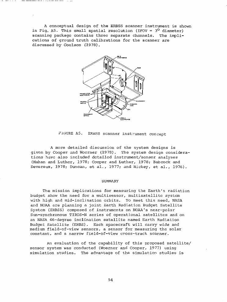
A conceptual design of the ERBSS scanner instrument is shown in Fig. A5. This small spatial resolution (IFOV = 3O diameter) scanning package contains three separate channels. The impli- cations of ground truth calibrations for the scanner are discussed by Coulson (1978).
FIGURE A5. ERBSS scanner instrument concept
A more detailed discussion of the system designs is given by Cooper and Woerner (1978). The system design considera- tions have also included detailed instrument/sensor analyses (Mahan and Luther, 1978; Cooper and Luther, 1978; Babcock and Devereux, 1978; Duncan, et al., 1977; and Hickey, et al., 1976).
SUMMARY
The mission implications for measuring the Earth's radiation budget show the need for a multisensor, multisatellite system with high and mid-inclination orbits. To meet this need, NASA and NOAA are planning a joint Earth Radiation Budget Satellite System (ERBSS) composed of instruments on NOAA's near-polar Sun-synchronous TIROS-N series of operational satellites and on an NASA 46-degree inclination satellite named Earth Radiation Budget Satellite (ERBS). Each spacecraft will carry wide and medium field-of-view sensors, a sensor for measuring the solar constant, and a narrow field-of-view cross-track scanner.
An evaluation of the capability of this proposed satellite/ sensor system was conducted (Woerner and Cooper, 1977) using simulation studies. The advantage of the simulation studies is
54

that major parameters contributing to the overall capability of ERBSS, that is, directional modeling accuracy, instrument accuracy, and sampling coverage strategies, can be investigated.
Results of the overall evaluation indicate the following expected accuracies of ERBSS for monthly averages at the top of the atmosphere.
Area Resolution
250 by 250 km Regions 1000 by 1000 km Regions
in Tropics loo Latitudinal Zones Equator-to-Pole-Gradient Global
Capability (W/m21 LW SW 9.4 10.3
9.4 10.3 5.2 5.3
2 (Net) 1.3(Net)
REFERENCES
Babcock, R. A. and W. Devereux, 1978: Aperture and Detector Cavity Considerations for Wide and Medium Field-of-View Radiometers. Paper presented at the Third Conference on Atmospheric Radiation, Davis, CA, 28-30 June.
Cooper, J. E. and M. R. Luther, 1978: Performance Analysis of a Filtered Wide Field-of-View Radiometer for Earth Radiation Budget Measurements. Third Conference on Atmospheric Radiation, Davis, CA, 28-30 June.
Cooper, J. E. and C. V. Woerner, 1978: System Implementation for Earth Radiation Budget Satellite System. Third Conference on Atmospheric Radiation, Davis, CA, 28-30 June.
Coulson, K. L., 1978: Ground/Air Truth Calibration Techniques for the Earth Radiation Budget Satellite System Scanner. Third Conference, CA, 28-30 June.
Duncan, C. H., R. G. Harrison, J. R. Hickey, J. M. Kendall, M. P. Thekaekara, and R. C. Wilson, 1977: Rocket Calibra- tion of the NIMBUS-6 Solar Constant Measurements. APP~. Optics, Oct. 1977.
Harrison, E. F. and G. G. Gibson, 1977: Sampling Analysis for the Earth Radiation Budget Satellite System Mission. Proc. of Third NASA Weather and Climate Science Review, Green- belt, MD, 29-30 Nov.
55
Harrison, E. F., G. G. Gibson, and P. Minnis, 1978: Sampling Analysis for the Earth Radiation Budget Satellite System Mission Based on Orbital Coverage and Cloud Variability. Third Conference on Atmospheric Radiation, Davis, CA, 28-30 June.
Hickey, J. R., F. J. Griffin, D. T. Hilleary, and H. B. Howell, 1976: Extraterrestrial Solar Irradiance Measurements from the NIMBUS-6 Satellite. Proc. of Joint Conf. "Sharing the Sun," Winnepeg, Canada, 5-20 Aug.
Mahan, J. R. and Mr. R. Luther, 1978: Thermal Model of a Filtered Radiometer. Third Conference on Atmospheric Radiation, Davis, CA, 28-30 June.
Raschke, E., T. H. Vonder Haar, M. Pasternak, and W. R. Bandeen, 1973: The Radiation Balance of the Earth-Atmosphere System from NIMBUS-3 Radiation Measurements, NASA TN D-7249.
Ruff, I. K., R. Koffler, S. Fritz, J. S. Winston, and P. K. Rao, 1968: Angular Distribution of Solar Radiation Reflected from Clouds as Determined from TIROS-IV Radiometer Measurements. J. Atmos. Sci. 25, 323-332.
Suttles, J. T., L. M. Avis, and P. G. Renfroe, 1978: Directional Models for Analysis of Earth Radiation Budget Measurements. Third Conference on Atmopsheric Radiation, Davis, CA, 28-30 June.
Woerner, C. V. and J. E. Cooper, 1977: Earth Radiation Budget Satellite System Studies. NASA TMX-72776.
56

I -
APPENDIX .B
THE ROLE OF EARTH RADIATION BUDGET STUDIES IN CLIMATE RESEARCH
C. E. Leith National Center for Atmospheric Research
INTRODUCTION
Satellites provide a unique capability for measuring the various components of the Earth's radiation budget. This note summarizes some current views on the way in which such measure- ments may contribute to a clearer understanding of the basic properties of the climate system. Emphasis is placed on theoret- ical needs rather than on observational possibilities.
Research on the physics and dynamics of climate is largely based on the construction of models ranging in complexity from zonal energy balance models to complete numerical three- dimensional general circulation models. It has not proved pos- sible to derive all the equations of these models from first principles owing to the uncertain random influence of processes of a scale too small to be explicitly resolved. For this reason, it is essential that the models be checked against as many observed properties of the real climate system as possible. Since radiative transfer is an important part of the physics of all climate models, satellite-based observations of components of the radiation budget serve to test the validity of key model physics. Such tests are more fundamental than those based on a comparison of deduced temperature fields for which there are many ways of arriving at the right answer for the wrong reasons.
The primary determinant of Earth's climate is, of course, the incoming solar radiation, and one of the most basic of cli- mate problems is to estimate the sensitivity of the mean temper- ature of the Earth to small changes in solar flux. The nature of this sensitivity will be reviewed in the next section, along with a discussion of the uncertainties of its estimation. This sensi- tivity has, of course, a direct bearing on the accuracy with which it is desirable to measure possible variations in incoming solar radiation. The uncertainty in the determination of the climate sensitivity also shows how imperfect are the present climate models.
The greatest source of uncertainty in climate models is thought to come from the treatment of clouds and their effects on both solar visible and terrestrial infrared radiation. Here,
57

then, is the component of climate models most in need of verifi- cation information of the sort that can be provided by satellite- based sensors. The clouds and radiation prescriptions in various models are discussed in the section entitled "Model Treatment of Clouds and Radiation" in order to show the quantities that the modelers would like to have measured.
Net radiation measurements provide the values of differential heating between the equator and the poles which must be balanced by the poleward heat transport in the atmosphere and oceans. Estimates of the heat transport in the atmosphere are available from observations of temperature and velocity fields and their correlations. The heat transport in the oceans is of comparable magnitude but must be treated as a residual. Thus, the net radiation measurements serve to define an important dynamical property of the oceans. The present state of knowledge of the zonally averaged annual cycle of heating and heat transport in the atmosphere and oceans is summarized in the section entitled "Annual Cycle of the Heat Balance."
Although the analysis of the heat budget in zonally averaged terms is convenient and customary, such an analysis is not par- ticularly natural for the observed climate which deviates markedly from zonal symmetry. Even the simplest practical description of climate recognizes the great differences imposed by continentality. It would seem then that continental boundaries are as useful as are latitude circles in defining climate regions. Studies of the energy balance of a continental region require appropriate resolution and sampling in net radiation measurements and some consideration of more complex surface processes. There exists now, however, a possibility of being able to close the balance without the large residual transport found in the oceans.
An important component of the net radiation balance is pro- vided by the determination of the planetary albedo which provides a measure of the total reflected solar radiation. From the point of view of climate models, however, it is also important to have a separate measure of the surface albedo. The modeling of land surface albedo depends on surface hydrological features, such as soil moisture, vegetation, and snow cover. Sea surface albedo is, by contrast, rather simple in its specification except for the influence of floating sea ice. Planetary albedo involves, in addition to surface albedo, the complex influence of cloud cover, and for modeling purposes, it is important to distinguish these cloud effects.
58

TEMPERATURE SENSITIVITY TO INCOMING SOLAR RADIATION
If the Earth were a highly conducting gray sphere in space with mean albedo a and infrared emissivity E, simple energy balance would require that
(1 - ci) Q = 4E0T4
where
cl--mean albedo of Earth
e--i.r. emissivity of Earth
Q --incoming solar flux
T--temperature
0T4 --outgoing i.r. blackbody flux
Logarithmic differentiation shows that
-=U256Q 6T T - Q
In general, the coefficient X, here equal to 0.25, is a climate sensitivity coefficient whose determination for the real Earth is an outstanding challenge to climate modelers. For a perfectly insulated Earth, Q and, therefore, T can be treated as functions of latitude for which the local sensitivity coef- ficient ~(8) remains 0.25.
It is the existence of heat transfer between latitudes and the dependence of c1 and E on Q or T that complicates the problem for the real Earth-atmosphere system. The energy balance models of the sort devised by Budyko (1969) and Sellers (1969) try to take into account these complications. Of principal concern in these studies is the influence of lower temperatures on the extensions of polar ice and snow cover with its associated increased albedo. Early estimates,based on this temperature-ice- albedo feedback effect,gave up to a tenfold increase in X, but more recent estimates, based on more careful accounting of cloud- albedo effects, reduces x to the range 0.35 to 0.70. The remaining uncertainty arises primarily from uncertainties in the response to changing surface temperatures of cloud cover, and cloud height, influencing c1 and E, respectively. Complete gen- eral circulation models give values of x in the same range as do the energy balance models. Here, the same uncertainties arise from the same physical processes. Present estimates lead, therefore, to a mean temperature response of from 1 to 2 degrees
59
Ill II Ill1

Kelvin for a 1 percent change in the incoming solar xadiation. The local response is greater in the polar 'regions than in the tropics owing to the ice-albedo effect.
MODEL TREATMENT OF CLOUDS AND RADIATION
The horizontal spacing of grid points in a general cir- culation model is far greater than the typical dimension of cloud elements, and it is therefore necessary to treat clouds in a statistical sense within each grid element. Typically, this is done by specifying a fractional cloud amount at each vertical grid level and horizontal grid point. Liquid water is not nor- mally a prognostic variable in models so that cloud amount must be specified in terms of relative humidity, vertical velocity, and stability. The specification may be a component of an elaborate vertical convection scheme or simply a prescription depending only on relative humidity. Few efforts have been made to generate model information on cloud top and bottom tempera- tures or physical parameters determining cloud optical properties.
The calculation of solar and terrestrial radiation in a model for a clear atmosphere is fairly straightforward, but for a cloudy atmosphere it is not. Model clouds can interact through scattering and reflection of solar radiation and through absorption and emission of infrared radiation. Some assumption is required about the degree of vertical correlation of cloud cover; and owing to crude assumptions about cloud optical properties, multiple scattering, emissivity and the like, the whole procedure is of dubious accuracy. It is the vertical flux divergence leading to net heating or cooling that finally provides the only radiative influence on the rest of the model dynamics.
The most satisfactory test of model cloud-radiation pre- scriptions would require separate measurements of cloud amounts and of solar and infrared fluxes at all levels in the atmosphere. Less satisfactory (but still useful) as an integral test would be radiative fluxes measured at the surface and the top of the atmosphere. This latter measurement is feasible with satellite- based methods.
More detailed broad-band radiation measurements in several spectral regions for both infrared and solar radiation provide many of the benefits of vertically resolved observations. Bands can be chosen which respond to different physical processes with different vertical sensitivities. For example, radiation in the 4 to 8 ?Jrn spectral range is mostly responsive to the 6.3 j.lm Hz0 band and comes from the lower and middle troposphere, whereas the 9 to 10 Pm range is influenced primarily by radiation in the
60

9.6 pm O3 band coming from the lower and middle stratosphere. These different physical processes are treated separately in the models and thus can be checked separately by such measurements made with an accuracy of about 5 percent. A more complete des- cription of these possibilities is given in AppendixC. by V. Ramanathan.
ANNUAL CYCLE OF THE HEAT BALANCE
The annual cycle of the heat balance in the Northern Hemisphere has been analyzed by Oort and Vonder Haar (1976). FigureBlis a composite of their results for the atmospheric and oceanic branch of the cycle. The various fluxes, storage rates, etc., are of order 100 watt rne2, whereas typical standard errors are of order 10 watt mm2 or 10 percent. Northward heat transport is about 5 X 10¹⁵ watts in mid-latitudes with a standard error of about 0.5 x 10¹⁵ watts or 10 percent. This transport is par- titioned between the ocean and the atmosphere with the oceanic transport dominant at 20 o N and the atmospheric transport domi- nant at 60° N. Uncertainties in the partitioning lead to much larger fractional errors in ocean transport alone.
The standard errors given are sampling errors based on the observed interannual fluctuations in the sample of a few years. They represent, therefore, errors of estimation of long-time climate mean values. The systematic errors in estimation of single year values arising from various instrumental and diurnal sampling problems are believed to be smaller. It follows that longer data sets are presently more useful than an improved observing system for increasing the accuracy of the mean heat balance components. Random sampling errors decrease inversely with N1i2 where N is the length of the sample in years. planning if
For the future heat balance observations, it would be valu-
able to have an estimate of the number of years needed for the sampling errors to be about the same as the present single-year systematic errors.
Zonally symmetric energy balance models do not usually dis- tinguish between the atmospheric and oceanic transport branches, but are nonetheless able to fit the observed total transport cycle reasonably well. This fit is achieved by modified treat- ments of cloud albedo effects, and here there is considerable freedom to adjust. For such models, increased accuracy of measured fluxes and transports is not as important as simultaneous information on radiative fluxes, cloud amount, and cloud top temperatures.
61
II II I I II Ill I- II Ill Ill II IIU’I III
Likewise, for general circulation models, the fitting of the annual cycle is less of a challenge than the testing against the observations of clouds and radiation components which were discussed in the previous section.
SUMMARY
Earth radiation budget data will contribute to:
(a)
lb)
(c)
(d)
(e)
The understanding of atmospheric energetics on both global and regional scales
The study of heat transport by the oceans
The assessment of the importance of possible changes in the solar constant
The validation of the treatment of radiative processes in models and
The assessment of the cloud-radiation feedback effect on climate sensitivity.
Although efforts should be made to design a measurement system with an accuracy of 1 percent, the present climate models would benefit from measurements of 5 percent accuracy. Spatial averages over horizontal domains with dimensions of order 1000 km provide a good compromise between sampling considerations and the resolution useful for regional energy budget studies. Time resolution should be such as to average properly over the diurnal cycle and over the characteristic time of a few days for internal atmospheric fluctuations.
An observational system for climate research purposes should provide:
(a) Separate measurements of solar and terrestrial radiation components of the radiation budget
(b) A further decomposition into spectral bands for both components of the radiation budget and
(c) Associated measurements of surface albedo, cloudiness, and aerosols in order to permit correlations to be established.
62

NET RADIATIONAL HEATlNG AT TOP OF ATMOSPHERE Iwon 6’)
FIG. 2. Net incoming radiation flux at the top of the atmosphere (/+A) based on satellite data as a function of latitude and month of the year. Annual mean 957” confidence limits are shown on the right hand side of the diagram (see Appendix for further information.) Units are in W m*.
(a)
DIVERGENCE OF ATMOSPHERIC ENERGY FiUX (watl m-‘1 90,
FIG. 4. Divergence of the energy transport due to atmospheric motions (div T.J based on radiosonde data as a function of latitude and month of the year. Units are fnWm-‘.
(cl
RbTE OF HEAT STORAGE IN ATMOSPHERE
Frd. 3. Rate of heat storage in the atmosphere (SA) based on radiosonde data as a function of latitude and month of the year. Units are in W m*.
(b)
RATE OF ENERGY FLOW FROM ATMOSPHERE TO EARTH
FIG. 5. Rate of energy flow from the atmosphere into the earth’s surface (&+A) computed as a residual term in the atmospheric branch of the heat balance as a func- tion of latitude and month of the year. Units are in W m*.
(4
FIGURE Bl. Heat balance over the northern hemisphere (Reprinted from A. H. Oort and T. H. Vonder Haar, J. Phys. Oceangr. 6, no. 11, Nov. 1976). (continued)

RATE OF HEAT STORAGE IN OCEANS irdl of31 00, 1 I I.1 I I I I I I I I
FIG. 8. Rate of heat storage in the oceans (So) based on hydrographic stations, MBT and XBT data as a function of latitude and month of the year. Units are in \I’ me. To obtain t!-pical oceanic values divide by the percentage of the horizontal area covered by oceans (factor=0.61 for the Northern Hemisphere as a whole).
(e)
90 NORTHWARD RIJX OF ENERGY IN ATMOSFHERE ~IO”raNl
I I I I I I I I I I I 1 w- ----__
--I--C
,*I4 ,I, ha*. MI IIAV ,“N NL AUG SW ocr NOV OK
FIG. 12. Northward transport of energy duk to atmospheric motions (TA) based on radiosonde data. Units are in 1Or‘ W.
(9)
FIGURE Bl
b-0, DPrGIGBKE OF OCEANIC ENERGY RUX [wm m-‘)
I I 1 I I I I 8 I I
IAN FL. **I AH MA” 1”” I”, A”G SIP OCT HO” OK
FIG. 9. Divergence of the energy transport due to oceanic moions (div To) com- puted as a residual term in the terrestrial branch of the heat balance as a function of latitude and month of the year. Units are in W m*. To obtain typical oceanic values divide by the percentage of the horizontal area covered by oceans.
(f)
NORTHWARD FLUX OF HEAT IN OCEANS ilO”won) PO, I I I I I I I I I I I 1
IA” Ft. MA. A,. YA’l NH IUL AUG 5EP ocr HOV OK
FIG. 13. Northward transport of heat due to oceanic motions (To) computed as a
residual term in the earth’s heat balance. Units are in 10” W.
(h)
Concluded

REFERENCES
Budyko, M. I.: The Effect of Solar Radiation Variations on the Climate of the Earth. Tellus, 21 (19691, 611-619.
Oort, A., and T. Vonder Haar: On the Observed Annual Cycle in the Ocean-Atmosphere Heat Balance over the Northern
, Hemisphere. J. Phys. Oceanog. 6, (19761, 781-800.
Sellers, W. D.: A. Global Climatic Model Based on the Energy Balance of the Earth-Atmosphere System. J. Appl. Meteorol. 8, (19691, 392-400.
65

APPENDIX C
SATELLITE RADIATION BUDGET MEASURBMENTS IN SPECTRAL BANDS
V. Ramanathan National Center for Atmospheric Research
Presented here are some suggestions for future satellite radiation budget measurements. In giving these suggestions, it is presumed that the measurements would attempt to accomplish the following threefold objectives:
(1) Provide a better quantitative understanding of the radiation processes within the climate system
(2) Improve the treatment of these processes in climate models
(3) Monitor the climate --with particular emphasis on the effects of radiatively active pollutants.
In order to accomplish these objectives quantitatively, it is necessary to make four or five broad band measurements in both the longwave and the solar radiation regimes, with the spec- tral breakdown given as follows.
Longwave spectral regions
(a) 4 to 8 l.Jm
(b) 8to12lJm
(c) 9 to 10 urn
(d) 12 to 18 pm
(e) 18 to co urn
Solar radiation regions
(a) 0 to 0.35 pm
(b) 0.35 to 0.5 urn
(c) 0.5 to 0.7 urn
(d) 0.7 to 4 urn
The accuracy (including the instrument and spatial and time average accuracies) of the measurements should preferably be within 5 percent. Whenever possible, clear and cloudy sky
66

estimates of the measurements should be provided. The reasons for the necessity of making such measurements follows.
First, consider the longwave region for clear sky con- ditions. The outgoing flux is due to the combined effects of surface and atmospheric emission. The important atmospheric effects in the various spectral bands are the 6.3 pm H20 band in the 4 to 8 Urn region; the H20 continuum bands, N20, chloro- fluoromethanes and aerosols in the 8 to 12 llm region; 03 9.6 Urn band in 9 to 10 Urn region-- in which region a separate measurement will enable the separation of 03 effects from the continuum region; CO2 + H20 (but mostly CO21 in 12 to 18 urn region; and lastly the H20 pure rotation bands in 18 to 03 urn region. From integrated measurements of the outgoing flux, it will be virtually impossible to tune or even judge the performance of the model. For example, if there is agreement between the model and measure- ments, it is difficult to rule out the likely possibility of can- cellation of errors in the various aforementioned effects leading to the "correct" results; or, in case of disagreement, the modeler will not know which of the effects, among those due to H20, C02, 03, etc., need to be tuned. Comparison with measured integrated flux is also difficult because of differences between the model and observations in the vertical profiles of temperature and humidity.
Some of these difficulties can be overcome with broad-band measurements since the atmospheric contributions to the outgoing flux in the different broad-band intervals come from different regions in the atmosphere. For example, the atmospheric con- tribution in the 4 to 8 pm region comes primarily from the lower and middle troposphere; the H20 contribution in the 8 to 12 urn region comes from the first 1 to 3 km above the surface; whereas the 9 to 10 urn 03 contribution comes from the lower and middle stratosphere; the 12 to 18 urn CO2 contribution comes from the upper troposphere, and the lower and middle stratosphere; and the 18 to m urn H20 contribution comes from the entire troposphere. These features would aid the modeler to isolate, and then possi- bly correct, the various deficiencies in the computed tempera- tures, humidity, and treatment of radiative transfer processes.
With respect to the first objective mentioned earlier, the seasonal variations of the clear and cloudy sky broad-band fluxes would indicate the relative importance of variations in humidity, temperature, and clouds in maintaining the observed energy budget. The atmospheric effects above the clouds are small in the 4 to 12 pm region. This feature can enable one to analyze the feed- back between the radiation effects of clouds, surface, and the atmosphere.
67

Next, the third objective deali,ng with climate monitoring will be discussed. To illustrate the usefulness of broad-band measurements, consider the C02-climate problem and examine how an increase in CO2 influences the outgoing flux. Model cal- culations indicate that a doubling of CO2 would decrease the 12 to 8 pm region outgoing flux by 4 Wm-2, which is about 7 to 10 percent of the outgoing energy in this spectral region, and, hence, this decrease could be detected with a broad-band measurement. The climate models predict that this decrease is balanced by an increase in the outgoing flux due to the "green- house" warming of the surface and the troposphere, in the 4 to 8 pm, 8 to 12 pm, and 18 to 03 urn regions. Roughly 40 percent of the increase would be in the 8 to 12 I.lm region. Thus, if the models are correct, the net change in the outgoing flux would be zero, since a decrease of 4 WmB2 in the 12 to 18 urn region will be compensated by an increase of equal amount in some other spectral region(s). Several similar examples, such as the increase in chlorofluoromethanes, N20, etc., can be given to illustrate that broad-band measurements are necessary for monitoring the climate and for identification of the cause and effect relationships from such measurements.
Arguments similar to those given for longwave measurements are applicable to the suggested solar radiation measurements. For example, 03 absorption is important in the 0 to 0.35 urn and 0.5 to 0.7 pm regions, and, hence, changes in planetary albedo due to O3 variations or perturbations will be indicated in these spectral regions. Changes in the surface reflectivity, clear sky, and cloudy sky albedo can be detected in the 0.35 to 0.5 llm region. Solar radiation absorption by H20 and CO2 occurs in the 0.7 to 4 llrn region.
68

APPENDIX D
WORKSHOP PARTICIPANTS
P. Abel, NOAA/National Environmental Satellite Service, 1035 Federal Building #4, Washington, D.C. 20233
P. Arkin, Center for Experimental Design and Data Analysis, 3300 Whitehaven St., N.W., Washington, D.C. 20235
A. Arking, NASA-Goddard Space Flight Center, Greenbelt, Maryland 20771
F. Baer, University of Maryland, Department of Meteorology, College Park, Maryland 20742
B. Barkstrom, NASA-Langley Research Center, Mail Stop 423, Hampton, Virginia 23665
F. Bartman, University of Michigan, Department of Atmospheric and Oceanic Science, Ann Arbor, Michigan 48104
E. W. Bierly, National Science Foundation, Office of Climate Dynamics, Room 1207, 1800 G. St., N-W., Washington, D.C. 20550
J.J. Cahir, Pennsylvania State University, 620 Walker Blvd., University Park, Pennsylvania 16802
G. Campbell, Colorado State University, Atmospheric Science Department, Ft. Collins, Colorado 80523
J. Campbell, NASA-Langley Research Center, Mail Stop 271, Hampton, Virginia 23665
S-S. Chow, NASA-Goddard Space Flight Center, Greenbelt, Maryland 20771
P. Cl am, NOAA/Met. Sat. Lab., Washington, D.C. 20233 J. Coakley, National Center for Atmospheric Research, P. 0.
Box 3000, Boulder, Colorado 80303 J. Cooper, NASA-Langley Research Center, Hampton, Virginia 23665 R. Costen, NASA-Langley Research Center, Hampton, Virginia 23665 K. Coulson, University of California, Department of Land, Air
and Water Resources, Davis, California 95616 s. cox, Colorado State University, Atmospheric Science Depart-
ment, Ft. Collins, Colorado 80523 R. Curran, NASA-Goddard Space Flight Center, Meteorology Branch,
Code 650, Greenbelt, Maryland 20771 P. Davis, SRI International, Menlo Park, California 94025 A. Deepak, Institute for Atmospheric Optics and Remote Sensing
(IFAORS), P. 0. Box P, Hampton, Virginia 23666 J. J. DeLuisi, NOAA/Environmental Research Laboratory, 325
Broadway, Boulder, Colorado 80303 J. Ellis, Lawrence Livermore Laboratory, Atmospheric and Geo-
physical Sciences Division, P. 0. Box 808, Livermore, California 94550
R. Giannola, Drexel University, Department of Physics and Atmospheric Science, Philadelphia, Pennsylvania 19104
69

G. Grams, Georgia Technical Institute, Geophysical Sciences, 225 North Avenue, N.W., Atlanta, Georgia 30332
L. R. Greenwood, Jr., NASA Headquarters, 600 Independence Avenue, S-W., Washington, DC 20233
W. L. Grose, NASA-Langley Research Center, Hampton, Virginia 23665
A. Gruber, NOAA/National Environmental Satellite Service, World Weather Building, Washington, DC 20233
S. Gupta, NASA-Langley Research Center, Mail Stop 423, Hampton, Virginia 23665
K. Hadeen, NOAA/CEDDA, Environmental Data Service, 3300 Whitehaven Street, Washington, DC 20235
E. Harrison, NASA-Langley Research Center, Hampton, Virginia 23665
D. Hartmann, University of Washington, Department of Atmospheric Science, Mail Stop AK40, Seattle, Washington 98195
J. Hickey, Eppley Laboratories, 12 Sheffield Ave., Newport, Rhode Island 02840
P. Holloway, NASA-Langley Research Center, Directorate for Space Research, Mail Stop 107, Hampton, Virginia 23665
F. House, Drexel University, Department of Physics and Atmos- pheric Science, 32nd and Chestnut Sts., Philadelphia, Pennsylvania 19104
H. Jacobowi.tz, NOAA/National Environmental Satellite Service, World Weather Building, Suite 701, 5200 Auth Rd., Camp Springs, Maryland 20023
J. C. Jafolla, Drexel University, Department of Physics and Atmospheric Science, Philadelphia, Pennsylvania 19104
R. Jenne, National Center for Atmospheric Research, P. 0. Box 3000, Boulder, Colorado 80303
D. Johnson, University of Wisconsin, Space Science and Engineering Center, Madison, Wisconsin 53706
M. D. King, NASA-Goddard Space Flight Center, Greenbelt, Maryland 20771
W. Kuhn, University of Michigan, Department of Atmospheric and Oceanic Sciences, Ann Arbor, Michigan 48109
L. Kyle, NASA-Goddard Space Flight Center, Greenbelt, Maryland 20771
A. A. Lacis, Goddard Institute for Space Studies, 2880 Broadway, New York, New York 10025
C. Laughlin, Code 901, Goddard Space Flight Center, Greenbelt, Maryland 20771
J. D. Lawrence, NASA-Langley Research Center, Hampton, Virginia 23665
C. E. Leith. National Center for Atmospheric Research, Post Office Box 3000, Boulder, Colorado 80303
J. S. Levine, NASA-Langley Research Center, Hampton, Virginia 23665
K.-N. Liou, Department of Meteorology, University of Utah, Salt Lake City, Utah 84112
70

C. Liu, National Center for Atmospheric Research, P. 0. Box 3000, Boulder, Colorado 80307
P. McCormick, NASA-Langley Research Center, Hampton, Virginia 23665
T. McKee, Atmospheric Science Department, Colorado State University, Fort Collins, Colorado 80523
F. R. Mosher, Space Science and Engineering Center, University of Wisconsin, Madison, Wisconsin 53706
M. L. Nack, Computer Sciences Corporation, Systems Scientific Division, 8728 Colesville Road, Silver Springs, Maryland 20910
B. Pritchard, NASA-Langley Research Center, Hampton, Virginia 23665
S. R. Rangaswamy, Systems and Applied Services Corporation, 2811 Kenilworth Avenue, Riverdale, Maryland 20840
P. K. Rao, NOAA/NESS, World Weather Building, 5200 Auth Road, Camp Springs, Maryland 20023
E. E. Remsberg, NASA-Langley Research Center, Hampton, Virginia 23665
R. A. Schiffer, NASA Headquarters, 600 Independence Avenue, s. w., Washington, D. C. 20233
F. Smith, NASA-Langley Research Center, Hampton, Virginia 23665 G. L. Smith, NASA-Langley Research Center, Hampton, Virginia
23665 G. Soffen, NASA Headquarters, Code SB-3, 600 Independence Avenue,
s-w., Washington, DC 20546 W. Sprigg, National Oceanic and Atmospheric Administration,
Rockville, Maryland 20852 L. Sromovsky, Space Science and Engineering Center, Madison,
Wisconsin 53706 L. L. Stowe, NOAA/NESS, World Weather Building, 5200 Auth Road,
Camp Springs, Maryland 20023 V. Suomi, University of Wisconsin, Space Science and Engineering
Center, Madison, Wisconsin 53706 J. Susskin, Goddard Space Flight Center, Greenbelt, Maryland
20771 J. Suttles, NASA-Langley Research Center, Hampton, Virginia
23665 R. Swain, NASA-Langley Research Center, Hampton, Virginia 23665 G. Sweet, NASA-Langley Research Center, Hampton, Virginia 23665 M. Tepper, NASA Headquarters, 600 Independence Avenue, S. W.,
Washington, D. C. 20233 S. Thompson, NCAR, P. 0. Box 3000, Boulder, Colorado 80303 S. Tiwari, Old Dominion University, Mechanical Engineering
Department, Norfolk, Virginia 23508 0. Toon, NASA-Ames Research Center, Mail Stop 245-3, Moffett
Field, California 94087 N. Untersteiner, Office of Naval Research, 800 North Quincy
Street, Arlington, Virginia 22217
71

S. K. Vemury, Goddard Institute for Space Studies, 2880 Broadway, New York, New York 10025
T. Vonder Haar, Atmospheric Science Department, Colorado State University, Fort Collins, Colorado 80523
W.-C. Wang, Goddard Institute for Space Studies, 2800 Broadway, New York, New York 10025
D. Q. Wark, National Environmental Satellite Service, Office of Research, Washington, D. C. 20233
J. Wenig, John Hopkins University, Applied Physics Lab, John Hopkins Road, Laurel, Maryland 20810
R. C. Willson, Jet Propulsion Lab, 4800 Oak Grove Drive, Mail Stop 171-400, Pasadena, California 91103
J. Winston, National Environmental Satellite Service, NOAA, World Weather Building, R-701, Washington, D. C. 20233
C. Woerner, NASA-Langley Research Center, Hampton, Virginia 23665
M.-L. C. Wu, Global Laboratory for Atmospheric Sciences, Goddard Space Flight Center, Greenbelt, Maryland 20771
G. R. Young, NASA-Langley Research Center, Hampton, Virginia 23665
72
‘I

1. Report No.
NASA CP-2100 4. Title and Subtitle
2. Government Accession No.
EARTH RADIATION BUDGET SCIENCE 1978
7. Author(s)
9. Performing Organization Name and Address
NASA Langley Research Center Hampton, VA 23665
2. Sponsoring Agency Name and Address
National Aeronautics and Space Administration Washington, DC 20546
5. Supplementary Notes
3. Recipient’s Catalog No.
8. Performing Organization Report No.
11. Contract or Grant No.
13. Type of Report and Period Covered
Conference Publication
14. Sponsoring Agency Code
6. Abstract
This volume contains the technical proceedings, including the recommendations, of the NASA-sponsored Workshop on Earth Radiation Budget Science, held in Williamsburg, Virginia, March 28-30, 1978. Eighty invited scientists from universities, non-profit institutions, research laboratories, and U.S. Govern- ment agencies participated in the workshop. The purpose of the workshop was to draw upon the combined expertise of scientists concerned with the use and production of satellite measurements of various components of the Earth's Radiation Budget (ERB), in order to assess the present state of the knowledge in this field, acquire better understanding of and definition of the needs and requirements of the ERB data user community, and identify and recommend future research activity in this area. Six broad aspects of the Earth's Radiation Budget Science were discussed: climate modeling, climate diagnostics, radia- tion modeling, radiation variability and correlation studies, cloudiness and the radiation budget, and radiation budget and related measurements in 1985 and beyond.
. Key Words (Suggested by Author(s)) 18. Distribution Statement
Earth radiation budget--remote sensing Unclassified - Unlimited Climate modeling Climate diagnostics Radiation modeling Radiation variability Cloudiness and radiation budget Satellite measurements
1 3. Security Classif. (of this report) 20. Security Classif. (of this page) 21. No. of Pages 22. Price‘
Unclassified Unclassified 72 $5.25
I Subject Category 47
* For sale by the National Technical Information Service, Springfield, Virginia 22161 NASA-Langley, 1979