ection 3.4 biological resources - california … · for the purposes of discussion of biological...
TRANSCRIPT

SECTION 3.4 BIOLOGICAL RESOURCES

3.4- BIOLOGICAL RESOURCES
SF BAY AREA WATER TRAIL PLAN 3.4-1 COASTAL CONSERVANCY DRAFT EIR JUNE 2008
3.4 BIOLOGICAL RESOURCES This section discusses the existing sensitive biological resources of the San Francisco Bay Estuary (the Estuary) that could be affected by project-related construction and locally increased levels of boating use, identifies potential impacts to those resources, and recommends mitigation strategies to reduce or eliminate those impacts. The Initial Study for this project identified potentially significant impacts on shorebirds and rafting waterbirds, marine mammals (harbor seals), and wetlands habitats and species. The potential for spread of invasive species also was identified as a possible impact.
3.4.1 BIOLOGICAL RESOURCES SETTING
HABITATS WITHIN AND AROUND SAN FRANCISCO ESTUARY The vegetation and wildlife of bayland environments varies among geographic subregions in the bay (Figure 3.4-1), and also with the predominant land uses: urban (commercial, residential, industrial/port), urban/wildland interface, rural, and agricultural. For the purposes of discussion of biological resources, the Estuary is divided into Suisun Bay, San Pablo Bay, Central San Francisco Bay, and South San Francisco Bay (See Figure 3.4-2). The general landscape structure of the Estuary’s vegetation and habitats within the geographic scope of the WT is described below.
URBAN SHORELINES Urban shorelines in the San Francisco Estuary are generally formed by artificial fill and structures armored with revetments, seawalls, rip-rap, pilings, and other structures. Waterways and embayments adjacent to urban shores are often dredged. With some important exceptions, tidal wetland vegetation and habitats adjacent to urban shores are often formed on steep slopes, and are relatively recently formed (historic infilled sediment) in narrow strips. They are usually dominated by relatively few widespread and common marsh species, with a high proportion of non-native marsh species. Special-status plant species, with a few important exceptions, are usually absent in urban shores. On the terrestrial side of urban shorelines, natural or native vegetation is generally lacking or minimal. Non-native terrestrial vegetation (especially annual grasses, broadleaf weeds, and escaped or planted non-native ornamental trees and shrubs) is prevalent along most urban shores of commercial developments, ports, frontage roads, former military bases, and industrial sites. The matrix of intensive urban land use and infrastructure in much of Central San Francisco Bay tends to override natural or potential geographic variation in vegetation and habitats of adjacent baylands and shore vegetation. Exceptions occur where significant erratic patches of natural or restored native shore vegetation are included within entirely urbanized landscapes, such as Arrowhead Marsh in San Leandro Bay, Crown Beach/Elsie Roemer Marsh in Alameda, or Crissy Field in San Francisco. In the northern Estuary (San Pablo Bay and eastward), the relation between intensive urban land use and open space is usually reversed: intensive urban land uses more often occur within a matrix of open space and wildland vegetation, where more sensitive native vegetation and habitats co-occur with urban development. The density of Backbone Sites is relatively high in the urban landscape setting.


3.4- BIOLOGICAL RESOURCES
SF BAY AREA WATER TRAIL PLAN 3.4-4 COASTAL CONSERVANCY DRAFT EIR JUNE 2008
URBAN/WILDLAND INTERFACES Urban (or suburban) development along the shores of the Estuary is extensive, and often occurs adjacent to large blocks of wetland habitats within regional parks, wildlife refuges, ecological reserves owned and managed by state or municipal agencies. This matrix of urban/wildland interface prevails in shorelines of South San Francisco Bay, most of Marin County along Central San Francisco Bay and San Pablo Bay, around expanding cities in San Pablo Bay along the northern Contra Costa shoreline, and northern Suisun Marsh. Large, continuous blocks of native vegetation and habitats, often including old and species-rich remnants, are close to urban shorelines in these conditions. This proximity increases the potential exposure of sensitive tidal wetland habitats to non-motorized recreational boating, or other impacts emanating from trailheads. The proximity of source populations of sensitive species to urban areas also increases the potential for sensitive species to establish opportunistically in urban shorelines. For example, some sensitive plant populations occur adjacent to residential, commercial, and industrial or military port/marina developments along shorelines in Vallejo, Fairfield, Concord, San Rafael, and Richardson Bay. The density of Backbone Sites is relatively high in the urban/wildland setting. If urban land uses continue to spread into former agricultural or rural areas, the urban/wildland interface is expected to increase in the Bay Area.
RURAL AND AGRICULTURAL HABITATS Large blocks of ecologically important wetland and adjacent upland habitats are most likely to occur in rural and agricultural settings of the San Francisco Estuary, where travel distances to major urban populations are longest. True undeveloped open spaces (i.e., original soils intact) along the bay edge are largely confined to San Pablo Bay and the vicinity of Suisun Marsh. The entire matrix of the landscape is likely to support at least remnants of the original pre-reclamation biological diversity of native habitats. The density of Backbone Sites is relatively low in the rural and agricultural landscape setting of San Pablo Bay and Suisun Marsh.
OPEN WATER HABITATS Open water habitats within San Francisco Estuary are classified by the Goals Project into two categories: shallow bay (subtidal areas above 18 foot depth below Mean Lower Low Water or MLLW1), and deep bay (subtidal channels deeper than 18 feet below MLLW). The Estuary currently contains almost 172,000 acres of shallow bay/channel habitat, and more than 82,000 acres of deep bay/channel habitat (Goals Project 1999). Primarily unvegetated soft bottom sediments (bay muds and sand deposits) lie underneath most shallow and deep-water habitats, but some shallow bay habitats contain stands of eelgrass (Zostera marina), which serve as valuable habitat for a wide range of fish and invertebrates. Eelgrass beds are also associated with uncommon nearshore areas with 1 Lower low water is the lower of the two low waters of any tidal day. Mean lower low water is the average height of the lower low waters over a 19-year period. For shorter periods of observation, corrections are applied to eliminate known variations and reduce the result to the equivalent of a mean 19-year value.

3.4- BIOLOGICAL RESOURCES
SF BAY AREA WATER TRAIL PLAN 3.4-5 COASTAL CONSERVANCY DRAFT EIR JUNE 2008
coarser sediment, or rocky substrates infilled with mud or sand. The restoration of eelgrass habitats is currently the focus of multiple research and implementation efforts throughout the Bay. Other shallow bay areas, such as locations near Point San Quentin, are similar focal areas for the restoration of native oyster bed, which have largely disappeared from the Estuary.
BIOLOGICAL RESOURCES IN SAN FRANCISCO ESTUARY
VEGETATION Vegetation refers to the overall plant cover of a habitat, including its structural and other physical features, in addition to the species composition. Vegetation provides value for wildlife habitat (cover, food resources), physical ecological functions (sediment trapping, erosion buffering), chemical ecological functions (biogeochemical soil processes: sequestering or cycling carbon, mineral nutrients, contaminants), or inherent biological diversity (rare plant species or biologically important genetic variation among populations). Important biological diversity of plants may occur at the level of population (genetic variation), species (rare plant conservation), and community (e.g., relatively intact or natural vegetation stands). Some plants can also have negative public resource values, particularly invasive non-native noxious weeds of wetlands and terrestrial habitats. There is substantial regional variation in the vegetation of tidal and non-tidal baylands in the San Francisco Estuary (Baye et al. 2000). WT sites may be located near areas ranging from only sparse or weedy non-native vegetation with limited habitat function, to extensive marshes with well-developed, mature native marsh vegetation. In addition, different types of marshes and shoreline vegetation in different parts of the Estuary support different plant and wildlife species (including special-status species). Geographic variation in vegetation and habitats provides an important context for evaluating potential WT impacts to special-status plant and wildlife species, and wetlands. Major bayland vegetation communities and habitats are summarized below. Bayland habitats are indicated on Figure 3.4-1.
Tidal Salt Marsh Tidal salt marshes are jurisdictional (state- and federally regulated) wetlands (see Section 3.4.2). They are distributed primarily around San Francisco Bay and the inner margins of San Pablo Bay. They are characterized by prevalence of native marsh plants that can tolerate wetland soil salinity that frequently approaches marine salinity (34 parts per thousand salt) during the growing season. Most modern salt marshes in the Estuary are generally dominated by relatively few native plant species, such as pickleweed (Sarcocornia pacifica), saltgrass (Distichlis spicata), fleshy jaumea (Jaumea carnosa), and sometimes large summer “blooms” of parasitic salt marsh dodder mats (Cuscuta salina). Marsh gumplant (Grindelia hirsutula; syn. G. stricta var. angustifolia, G. x paludosa) vegetation is widespread along marsh banks of tidal sloughs, where they provide important high tide cover for wildlife. Until the 1990s, Pacific cordgrass (Spartina foliosa) generally composed the low salt marsh vegetation throughout salt marshes of the San Francisco Estuary, but cordgrass marshes in San Francisco Bay have recently been widely dominated by an invasive non-native hybrid cordgrass, Spartina alterniflora x foliosa (currently reduced by a program of regional eradication;

3.4- BIOLOGICAL RESOURCES
SF BAY AREA WATER TRAIL PLAN 3.4-6 COASTAL CONSERVANCY DRAFT EIR JUNE 2008
www.spartina.org). Marshes in San Pablo and Suisun Bays have remained relatively free of hybrid cordgrass, although small populations have been discovered (and targeted for extirpation) in tidal marshes near Petaluma. A suite of non-native plant species, many of which are highly invasive, has established abundantly in salt marsh vegetation, including hybrid cordgrass and Mediterranean saltwort (Salsola soda). More recently, Mediterranean sea-lavender (Limonium ramosissimum) and European goosegrass (Puccinellia maritima) have invaded the bayshore marshes of the San Francisco Peninsula (see “Invasive Species of Tidal Marshes and Adjacent Baylands” below). Invasive non-native salt marsh plants sometimes displace native salt marsh vegetation or other tidal habitats, such as estuarine beaches or mudflats. Salt marsh vegetation types affect the potential for landings and marsh access by small craft. Slough banks in salt marshes are usually lined with either moderate to gently sloped mud beds with cordgrass vegetation, or steep near vertical, erosional banks (slumps and scarps). Cordgrass vegetation is sensitive to trampling, and crushes easily. Pacific cordgrass roots and rhizomes (horizontal below-ground stems) only loosely bind soft mud. Pacific cordgrass roots and rhizome meshes are usually not strong enough to resist the shear forces of human trampling, which tends to gouge into underlying mud under Pacific cordgrass. In contrast, non-native hybrid cordgrass vegetation is usually dense and very tall (resisting visual access or boat landings), but it also provides better footing by binding salt marsh soil more strongly. Mature pickleweed marsh also forms firm ground and solid footing, and also maintains short vegetation. Steep slumped banks restrict landings by small boats at lower tidal stages, but allow potential landings on firm pickleweed marsh at high tide.
Tidal Brackish Marsh Tidal brackish marshes are jurisdictional (state- and federally regulated) wetlands. Tidal brackish marshes are characterized by an assemblage of plants associated with bay water that is diluted enough by fresh water during the growing season to support a prevalence of tall, emergent sedge family plants, such as tule, bulrush (Schoenoplectus spp.), and alkali-bulrush (Bolboschoenus spp.) species. Brackish tidal marshes are prevalent in Suisun Marsh, along the northern Contra Costa shoreline, northern San Pablo Bay, and the Alviso/San Jose area of San Francisco Bay. Brackish tidal marshes exist in gradients with salt marshes in San Pablo Bay, and these gradients fluctuate dramatically from drought and high rainfall years. Tidal brackish marshes in San Pablo Bay and Suisun Marsh are associated with relatively high native plant species and vegetation diversity. Historically, many landward edges of salt marshes in San Francisco Bay supported brackish marsh gradients related to contact with freshwater stream or groundwater discharges. Tidal brackish marsh gradients of San Francisco Bay salt marshes have been mostly eliminated by agriculture, drainage, flood control infrastructure, and urban development. Modern tidal brackish marshes in San Francisco Bay are young and associated instead with artificial year-round wastewater discharges. They support relatively low native marsh species diversity compared with their North Bay and Suisun counterparts. Tidal brackish marshes typically support gradients or sharp zones of vegetation between slough banks and marsh plains. Brackish marshes fringing sloughs are typically

3.4- BIOLOGICAL RESOURCES
SF BAY AREA WATER TRAIL PLAN 3.4-7 COASTAL CONSERVANCY DRAFT EIR JUNE 2008
dominated by tall, emergent marsh vegetation that includes tules (Schoenoplectus californicus, S. acutus), alkali-bulrush (Bolboschoenus maritimus; mostly west of Suisun Bay) and sometimes cattails (Typha latifolia, T. x glauca, T. angustifolia). Brackish marsh plains usually support patchy mixtures of salt marsh plants like saltgrass and pickleweed, with other brackish marsh plants such as rushes (Juncus arcticus; syn. J. balticus), and many other tidal marsh broadleaf plants. Invasive non-native broadleaf pepperweed (Lepidium latifolium), or invasive non-native populations of common reed (Phragmites australis) are widespread and often dominant over extensive areas in brackish tidal marshes. Wetland weeds in brackish marshes are often associated with physically disturbed soils, such as areas along artificial levees, and natural or artificial disturbances within the marsh plain. Tidal brackish marshes border navigable sloughs in the Alviso/San Jose area, Palo Alto, and nearly all of northern San Pablo Bay, Suisun Marsh, and the northern Contra Costa shoreline. Because tule and bulrush marsh vegetation along sloughs of tidal brackish marshes is very tall and dense, it makes views of adjacent marsh plains and access to them from small craft (landings) difficult. Tidal brackish marsh vegetation often occurs near proposed WT trailhead locations in South San Francisco Bay, northern San Pablo Bay, Suisun Marsh, and the northern Contra Costa shoreline.
Diked Non-tidal Salt Marsh Diked, non-tidal salt marshes adjacent to tidal waters (separated by dikes) are generally jurisdictional (state- and federally regulated) wetlands. Diked non-tidal salt marshes ordinarily support simple vegetation with low plant species diversity. They are usually dominated by pickleweed, or simple mixtures of pickleweed and saltgrass. Such diked non-tidal salt marshes often decline in salinity over time, and admit various non-native weeds such as broadleaf pepperweed. Some diked salt marshes with heavy clay soils develop barrens or flats similar to tidal salt marsh pans (seasonal shallow ponds) or alkali/subsaline vernal pool beds. These diked seasonal saline to brackish or alkali flats and their edges may be largely unvegetated, but they may sometimes support uncommon, rare, or regionally rare (in the context of Bay Area tidelands) sensitive species, such as Lasthenia conjugens (Contra Costa goldfields), bush seepweed (Suaeda moquinii), alkali milk-vetch (Astragalus tener var. tener) and other associated species known to occur in alkali/saline vernal pools in Fremont. Diked non-tidal salt marshes are highly visible from adjacent levees, and are often mostly drained and physically accessible to foot traffic from spring to fall. Internal perimeter ditches with deep, soft mud often limit access by foot to the interiors of many diked baylands, but high marsh areas serving as crossings also occur. Diked non-tidal salt marsh and other seasonal wetlands sometimes border navigable sloughs. They occur throughout San Francisco Bay and San Pablo Bay, but their variations including subsaline/alkaline vernal pool habitats occur mostly near Fremont (Warm Springs vicinity), Napa, and Fairfield.
Diked Non-tidal Fresh to Brackish Marsh Non-tidal, diked fresh-brackish marshes adjacent to tidal waters (separated by dikes) are generally jurisdictional (state- and federally regulated) wetlands. They support

3.4- BIOLOGICAL RESOURCES
SF BAY AREA WATER TRAIL PLAN 3.4-8 COASTAL CONSERVANCY DRAFT EIR JUNE 2008
predominantly freshwater perennial marsh vegetation (tules, cattails, common reed) or sedge family plants that tolerate higher peak soil salinity, such as alkali-bulrush. Some diked baylands, particularly in the North Bay, also support variable fresh-influence brackish marsh vegetation in seasonal shallow ponds, including native and non-native plants such as cocklebur (Xanthium strumarium), rabbit’s-foot grass (Polypogon monspeliensis), brass-buttons (Cotula coronopifolia), spearscale (Atriplex prostrata) water plaintains (Alisma spp.), manna-grass (Glyceria spp.), semaphore-grass (Pleuropogon californicus), and even some vernal pool-associated plants such as false quillwort (Lilaea scilloides), popcornflower (Plagiobothrys stipitatus) and downingia (Downingia pulchella). Diked non-tidal fresh to brackish marshes are widespread in northern San Pablo Bay, Suisun Marsh, and the Contra Costa shoreline, and they also occur locally in diked baylands near points of nonsaline wastewater discharges near San Jose, Mountain View, Sunnyvale, and Palo Alto.
Estuarine Beach Vegetation Beaches composed of sand, shell fragments, gravel, or artificially placed sediments occur mostly in San Francisco and San Pablo Bays. Beaches support a mix of native estuarine beach and dune plants that are uncommon within San Francisco Estuary (beach-bur, Ambrosia chamissonis; western ragweed, A. psilostachya; seabeach sandwort, Atriplex leucophylla; poverty-weed, Iva axillaris) and common non-native plants (sea-rocket, Cakile maritima; broadleaf pepperweed, Lepidium latifolium; iceplant, Carpobrotus edulis and its hybrids; saltwort species, Salsola spp.). Beaches also stabilize and become part of the high tidal marsh vegetation gradient. One rare and endangered plant, California sea-blite (Suaeda californica) is native to estuarine beaches bordering San Francisco Bay marshes. Beaches near public access are often attractive and heavily used for recreation, but inaccessible bay beaches are often protected as sensitive shorebird, tern, or marine mammal habitats (e.g. sand spits of Brooks Island, Richmond; Roberts Landing in San Leandro) and support native beach vegetation in the absence of intensive human trampling. Bay beaches are also highly attractive, accessible and efficient for use as landings by small craft.
Other Terrestrial Vegetation Bordering Estuary Shorelines Other terrestrial vegetation types in natural or artificial soils occur adjacent to the Estuary’s shorelines (Holstein 2000), but most terrestrial vegetation near potential WT trailheads would occur in bay fill or levee soils in diked baylands. This is because most true natural terrestrial soils and general vegetation types (such as coastal bluff scrub, oak woodland, riparian woodland) are associated with steeper hillslope soils or valleys that seldom contact the modern Estuary, as a result of historic diking. Most grassland vegetation that occurs adjacent to the Estuary is dominated by non-native annual grasses. Most grassland stands in baylands have long histories of agricultural reclamation, although a few stands of native perennial grasslands border tidal marshes at scattered locations throughout the Estuary. Ruderal (weedy) terrestrial vegetation, dominated by broadleaf forbs and grasses tolerant of disturbed soils, is prevalent on levees and well-drained bayland fill soils. These seldom support sensitive plant populations, with a few exceptions (e.g. Centromadia parryi var. congdonii).

3.4- BIOLOGICAL RESOURCES
SF BAY AREA WATER TRAIL PLAN 3.4-9 COASTAL CONSERVANCY DRAFT EIR JUNE 2008
SENSITIVE AND SPECIAL-STATUS PLANTS A number of special status plant species occur around wetlands of the Estuary but they are very unevenly distributed in the region. These are listed in Table 3.4-1 and summarized by Bay region in the text below. With a few important exceptions, sensitive plant species are either absent or very rare along intensively urbanized shorelines close to the largest populations of recreational NMSB users. In contrast, along shorelines of semi-urban, agricultural, or rural settings, shoreline and marsh habitats are more likely to support sensitive plant habitats and populations. The distribution of sensitive plant species is highly variable around the San Francisco Estuary, and each sub-region within the Estuary supports a distinct regional suite of sensitive species. To aid assessment of potential impacts, these are summarized below.
Central San Francisco Bay With the exception of Richardson Bay and portions of San Rafael Bay (Marin County), Central San Francisco Bay has retained almost no populations of sensitive plant species that historically occurred there. The Central Bay also has retained no prehistoric (“old growth”) tidal marsh remnants. Richardson Bay supports numerous populations of northern or Point Reyes bird’s-beak (Cordylanthus maritimus ssp. palustris), which sometimes occurs in high salt marsh edges near public trails and potential boat launch sites near roads and other public access facilities (Table 3.4-1). In San Rafael Bay, Marin knotweed (Polygonum marinense) occurs in tidal salt marshes, but this species has become relatively widespread since it was first identified as a rare and sensitive plant. It also may not be a native plant at all, so its status as a sensitive species is uncertain (Table 3.4-1). One federally endangered plant, California sea-blite (Suaeda californica), has been reintroduced to the Central Bay, after its original San Francisco Bay populations became regionally extinct. It has not spread from points of reintroduction in sandy high salt marsh and beach habitats, and none of its reintroduced localities are located at feasible trailheads: they are generally within inaccessible, isolated, and protected marsh and beach habitats. Pacific cordgrass (Spartina foliosa), a common species threatened only by hybridization with an introduced non-native cordgrass species, occurs in the Central Bay, but its hybrids (which are the object of a rapid regional eradication program; www.spartina.org) are currently more common. Thus, with the exception of northern bird’s-beak, the Central Bay generally has low potential for significant impacts to sensitive plant species.
South San Francisco Bay South San Francisco Bay has also lost most of its sensitive plant species in tidal marshes and adjacent bayland habitats, but a few sensitive plant species have either persisted or regenerated in diked baylands and adjacent lowlands. No sensitive tidal marsh or estuarine beach plants (other than Pacific cordgrass, which is not rare) are known to persist in contemporary South San Francisco Bay. Only a few large and important early historic or prehistoric (“old growth”) tidal marsh remnant vegetation stands persist in the South Bay, at upper Newark Slough and outer Dumbarton Marsh (Newark), and the Laumeister Tract (Palo Alto).

3.4- BIOLOGICAL RESOURCES
SF BAY AREA WATER TRAIL PLAN 3.4-10 COASTAL CONSERVANCY DRAFT EIR JUNE 2008
Some sensitive plant species associated with alkali clay soils or vernal pools (and similar seasonal wetlands) do occur in the South Bay, but with one exception, these are highly unlikely to occur outside of areas with distinctive and localized soil conditions, such as the vernal pools in and near the Warm Springs Unit of the Don Edwards San Francisco Bay National Wildlife Refuge. Congdon’s tarplant (Centromadia parryi ssp. congdonii), in contrast, is a rare plant with weedy habits (abundant seed, rapid dispersal, unstable populations capable of rapid increase or decrease, and affinity for sparse or disturbed vegetation). It may occur infrequently but unpredictably in disturbed clay soils, such as levees, some seasonal wetlands and weedy diked baylands. The federally endangered Contra Costa goldfields (Lasthenia conjugens), formerly reported from a San Francisco Bay shoreline locality, is now restricted to vernal pools in Fremont, remote from bay shorelines.
San Pablo Bay San Pablo Bay is richer in sensitive plant species in shoreline, marsh or bay-edge habitats relative to modern San Francisco Bay. It also has retained more early historic and prehistoric remnant tidal marshes than any other region of the Estuary, including China Camp (San Rafael), Heerdt Marsh (Corte Madera), most of Petaluma Marsh, Whittell Marsh (Point Pinole) and Fagan Slough and other old marsh fragments in the Napa Marsh. Intact terrestrial soils and stream deltas also contact estuarine marshes in San Pablo Bay at multiple locations. These “old growth” and tidal marshes and their edges conserve important “hot spots” of high native plant diversity. Two rare species of bird’s-beak, northern salt marsh bird’s-beak (Cordylanthus maritimus ssp. palustris) and soft bird’s-beak (C. mollis ssp. mollis; federally endangered; Table 3.4-1) occur in San Pablo Bay in addition to similar salt marsh ecotypes of owl’s-clover (Castilleja ambigua, subspecies undetermined). San Pablo Bay also supports sensitive but non-endangered plants of tidal marsh habitats such as San Joachin spearscale (Atriplex joaquiniana), delta tule pea (Lathyrus jepsonii var. jepsonii), and Mason’s lilaeopsis (Lilaeopsis masonii). Suisun Marsh aster (Symphyotrichum lentum) was historically widely distributed in the Napa-Sonoma marshes. It is reported from the vicinity of Fagan Slough, and it is likely to persist at other localities, where its detection may be masked by the related common aster (Symphyotrichum chilense). Some special-status plants, like Mason’s lilaeopsis, may be locally common in San Pablo Bay, but are difficult to detect without careful surveys. The locations of some rare plants, like San Joaquin spearscale and Mason’s lilaeopsis, are likely to change from year to year.
Suisun Marsh and Northern Contra Costa Shoreline The brackish marshes of the eastern reaches of the Estuary (Suisun Marsh, and the marsh and bay edge habitats along the northern Contra Costa shoreline, Martinez and east), support most of the rare plants found in San Pablo Bay, as well as additional special-status plants. Suisun Marsh retains a large fragment of relatively intact prehistoric tidal marsh around Rush Ranch and upper Hill Slough. The prehistoric tidal marshes around Rush Ranch support a high concentration of native plant species diversity, but substantial native plant species diversity is also widely distributed in the brackish tidal marshes of the eastern reaches of the Estuary. Suisun thistle (Cirsium hydrophilum var. hydrophilum, federally endangered) is locally present in a few localities around Rush Ranch tidal marshes in Suisun Marsh, south of

3.4- BIOLOGICAL RESOURCES
SF BAY AREA WATER TRAIL PLAN 3.4-11 COASTAL CONSERVANCY DRAFT EIR JUNE 2008
Fairfield. Bolander’s water-hemlock (Cicuta maculata var. bolanderi), historically abundant and associated with suisun marsh thistle, has not been accurately reported from Suisun Marsh in many years; it may be extirpated. Contra Costa goldfields also occurs near Suisun Marsh in alkali vernal pools, but is not known to occur adjacent to navigable sloughs or bay edges. Compared with Central and South San Francisco Bay, the eastern brackish reaches of the Estuary are richer in rare plant populations. Mason’s lilaeopsis and Suisun Marsh aster, among other special-status tidal marsh plants (Table 3.4-1), are widely distributed in Suisun Marsh to the delta.
Other Special-status Plant Species Special status species other than those summarized above have been recorded in the region, but are either extinct or are in habitats that would not be affected by the project, and therefore are not discussed further in this section. For example, smooth popcornflower and soft popcornflower (Plagiobothrys glaber, Plagiobothrys mollis) are both presumed extinct in the San Francisco Bay area, and have not been reported from the vicinity of lowlands bordering the Estuary, or baylands, in over a century. Many other special-status plant species occur around the Bay Area (appearing in special-status species lists based on location within U.S. Geological Survey quadrangle sheets), but are too remotely located to be relevant to impacts emanating from WT activities, which would be concentrated in shoreline or marsh vegetation, or on open water.
INVASIVE PLANTS OF TIDAL MARSHES AND ADJACENT BAYLANDS Invasive non-native plants of San Francisco Estuary wetlands, and their adjacent terrestrial habitats, are among the most important influences on habitat quality and conservation of native plant species diversity. Many non-native species have established in the Bay Area, but some spread rapidly into natural vegetation and become either excessively abundant, or dominate whole plant communities – sometimes displacing them entirely. It is this subset of highly invasive non-native plants, or wildland weeds, that are the principal concern for conservation of plant resources. Invasive non-native plants of tidal marshes and estuarine shorelines are dispersed by different processes, and at variable rates. Most long-distance dispersal of seeds is relatively infrequent: most studies of seed dispersal in tidal marshes and shoreline habitats show that most seeds disperse close to the “parent” or source plants, decreasing exponentially with distance. This pattern tends to remain true even for wind-dispersed or water-dispersed seed. Most tidal marsh plants are dispersed naturally by wind and water, but some may be dispersed by ingestion and excretion by wildlife, attachment to wildlife fur or feathers, attachment to people (footwear, clothing with mud, sand, or seed adhering), vehicles (equipment or tires), or watercraft. Some patterns of shoreline or marsh weed spread are consistent with natural diffusive patterns of spread, rare long-distance natural dispersal and colonization (successful establishment events), but some patterns of estuary weed spread appear to track human activity, such as levee maintenance, localized dredging and grading, or shoreline access

3.4- BIOLOGICAL RESOURCES
SF BAY AREA WATER TRAIL PLAN 3.4-12 COASTAL CONSERVANCY DRAFT EIR JUNE 2008
TABLE 3.4-1: SPECIAL-STATUS PLANT SPECIES POTENTIALLY AFFECTED BY WT PLAN Name Status Ecology and Bay Area Distribution Potential occurrence or
impact
Arthrocnemum subterminale Alkali pickleweed
SoC - regional
Perennial subshrub, similar to common pickleweed, but regionally rare in San Francisco Estuary; not rare statewide. Typically occurs near alkali clay soils. Recent populations are known from Fremont and Suisun Marsh.
Low potential. Seldom occurs near tidal slough banks, shorelines near open water access mostly near Suisun Marsh.
Atriplex joaquiniana San Joaquin saltbush
CNPS 1B, SoC
Annual forb occurs primarily in interior alkali soils, seasonal wetlands, but also rarely in tidal marsh edges. Seeds are dispersed by floating fruits. Populations may be transient at specific locations. Recent populations are reported from Fremont (S. Bay), Napa River, and Suisun Bay area. Not easily identified or detected.
Low potential. May opportunistically colonize high tide shorelines in NE San Pablo Bay, Suisun Marsh, Contra Costa shoreline. May occur in seasonal saline/alkaline wetlands, SE SF Bay.
Astragalus tener var. tener Alkali-milkvetch
CNPS 1B, SoC
Small low-growing annual forb of alkali seasonal wetlands, vernal pools. Limited seed dispersal, but likely able to persist as dormant seed. Recent populations are known to occur in Fremont (S Bay). Not easily identified or detected.
Very low potential. Historic localities in Solano, Alameda counties.
Castilleja ambigua (ssp. undetermined; salt marsh ecotypes) Salt marsh owl’s-clover
SoC (CNPS 1B?)
Small erect or spreading annual forb, hemiparasitic, like bird’s-beak. Distinct regional ecotypes are rare in high tidal marsh edges (salt or brackish). One population (Benicia) may be rare subspecies humboldtiensis. (CNPS 1B). Extirpated in San Francisco Bay, where formerly widespread. Apparently limited seed dispersal, but likely able to persist as dormant seed. Not easily identified or detected.
Low potential to occur near along marsh shoreline of Point Pinole, Southhampton Bay, Suisun Marsh, Contra Costa shoreline. Potential significant adverse or beneficial impacts.
Centromadia parryi ssp. congdonii Congdon’s tarplant
CNPS 1B
Erect annual resinous forb of seasonal wetlands or alkaline clay soils. Population locations and sizes are likely to fluctuate. Recent populations have been reported from south San Francisco Bay localities in or in the vicinity of diked baylands (Newark to Sunnyvale). May potentially occur along high tidal marsh edges. Detection difficult because of similarity to common tarweeds species.
Low potential for occurrence on levees, diked baylands, or high tidal marsh edges.
Cicuta maculata var. bolanderi Bolander’s water-hemlock
SoC Tall perennial forb, possibly extirpated in San Francisco Estuary. Formerly endemic and abundant in Suisun Marsh. No recent reports known.
Very low potential to occur along brackish tidal marsh slough banks, Suisun Marsh and Contra Costa shoreline.
Cirsium hydrophilum var. hydrophilum Suisun thistle
CNPS 1B, FE, SE
Short-lived coarse perennial forb, endemic to high tidal brackish marsh plains of Suisun Marsh; most populations fluctuate among years. Known locations near Rush Ranch and Hill Slough. Apparently limited dispersal, confined to vicinity of known
Very low potential to occur near tidal brackish tidal marsh banks or on marsh plains, western Suisun Marsh.

3.4- BIOLOGICAL RESOURCES
SF BAY AREA WATER TRAIL PLAN 3.4-13 COASTAL CONSERVANCY DRAFT EIR JUNE 2008
TABLE 3.4-1: SPECIAL-STATUS PLANT SPECIES POTENTIALLY AFFECTED BY WT PLAN Name Status Ecology and Bay Area Distribution Potential occurrence or
impact populations in recent decades.
Cordylanthus maritimus ssp. palustris Northern salt marsh bird’s-beak
CNPS 1B, SoC
Annual forb, hemiparasitic; restricted to high tidal salt marsh. Populations usually in colonies that often persist but fluctuate significantly among years. Apparently limited seed dispersal, but likely able to persist as dormant seed. Recent populations are known from Richardson Bay, Corte Madera, Novato, and Petaluma Marsh. Extirpated in the rest of Central Bay, South Bay. Difficult to detect except in early summer (flowering) during years of abundance. Known recent populations occur near or along shoreline trails in Richardson Bay.
Variable: negligible chance of occurrence in SF Bay area outside of Marin County shorelines, but moderate to low chance of occurrence in Marin County. Potential significant adverse or beneficial impacts.
Cordylanthus mollis ssp. mollis Soft bird’s-beak
CNPS 1B, FE, SE
Annual forb, hemiparasitic. Restricted to high brackish tidal marsh. Populations usually occur in colonies that often persist but fluctuate significantly among years. Recent populations are known from Napa Marsh, Southampton Marsh, east of Point Pinole, Contra Costa shoreline, Suisun Marsh. Difficult to detect except in summer (flowering) during years of years of abundance.
Low potential to occur along brackish marsh edges of NE San Pablo Bay, Suisun Marsh, Contra Costa shoreline. Potential significant adverse or beneficial impacts.
Lasthenia conjugens Contra Costa goldfields
CNPS 1B, FE
Small annual forb, usually colonial in alkali vernal pools and similar seasonal wetland habitats; historically also rare along bayshore. Known recent locations near Fremont, Napa River, and Fairfield (north of Suisun Marsh). Apparently limited dispersal, confined to vicinity of known populations in recent decades. Difficult to detect except in spring (flowering) during years of years of abundance.
Very low potential to occur along contemporary bay shorelines or adjacent diked baylands supporting seasonal wetlands.
Lasthenia glabrata (tidal marsh populations only)
SoC Small annual forb associated statewide with vernal pools and seasonal wetlands, but local Estuary populations in salt pans edges, high salt marsh and brackish marsh have become rare and local: Petaluma Marsh, Point Pinole, Suisun Marsh.
Low potential to occur near trailheads or landings bordering sloughs or bay.
Lathyrus jepsonii var. jepsonii Delta tule pea
CNPS 1B, SoC
Tall climbing perennial forb, occurring along tidal marsh banks of sloughs: Napa-Sonoma Marsh and Suisun Marsh. Conspicuous when in bloom (summer), but may be difficult to detect during droughts (saline years) in Napa Marsh.
Variable potential to occur along contemporary bay shores, mostly along fringing tidal marshes of Napa River and its sloughs, and Suisun Marsh. Negligible potential to occur elsewhere in San Pablo or San Francisco Bays. Potential significant adverse impacts.
Lepidium oxycarpum Small-fruited peppercress
SoC - regional
Tiny annual forb associated with dry edges of alkali vernal pools and (historically) salt marsh edges of San Francisco Bay. Difficult
Low potential. Similar and related species occur in Newark, near existing boat launches.

3.4- BIOLOGICAL RESOURCES
SF BAY AREA WATER TRAIL PLAN 3.4-14 COASTAL CONSERVANCY DRAFT EIR JUNE 2008
TABLE 3.4-1: SPECIAL-STATUS PLANT SPECIES POTENTIALLY AFFECTED BY WT PLAN Name Status Ecology and Bay Area Distribution Potential occurrence or
impact to detect. Likely extirpated in most baylands. Not rare globally or statewide.
Lilaeopsis masonii Mason’s lilaeopsis
CNPS 1B, SR
Creeping grass-like and diminutive perennial forb, typically restricted to brackish tidal marsh banks subject to slumping or wave erosion, or nearby tidal marsh; also occurs in mud on rip-rap or concrete. Known populations occur from northern San Pablo Bay (Tolay Creek mouth) east through Suisun Marsh and Contra Costa shoreline. Difficult to detect.
Moderate to low potential to occur along bay shores of contemporary northeastern San Pablo Bay, Suisun Marsh, or Contra Costa shorelines. Potential significant adverse or beneficial impacts.
Navarretia prostrata Prostrate navarretia
CNPS 1B, SoC
Annual low-growing forb, restricted to vernal pools and similar seasonal wetlands. In SF Bay, known only from Fremont, but not near bay shore.
Very low potential to occur in diked baylands adjacent to San Francisco Bay. No potential to occur in tidelands.
Polygonum marinense Marin knotweed
CNPS 3 Formerly restricted in SF Bay to tidal marshes near Larkspur (Marin County), but this species has spread widely across the North Bay and western Suisun Bay area, sometimes locally common. It may be a misidentified non-native (invasive) species.
Moderate potential to occur in tidal marshes of the North Bay, western Suisun Marsh, and Contra Costa shoreline.
Symphyotrichum lentum (syn. Aster lentus) Suisun Marsh aster, Marsh aster (This species includes the plant formerly treated as Aster chilensis var. sonomensis of northern San Pablo Bay)
CNPS 1B, SoC
Tall perennial forb, typically forming colonies along brackish or freshwater marsh banks or upland edges tidal marshes in northern San Pablo Bay eastward to Suisun Marsh and Contra Costa shoreline. Presumed extirpated in San Francisco Bay. Conspicuous in flower, but difficult to distinguish from common aster except in flower (fall).
Moderate to low potential to occur in tidal marshes of Napa Marshes east to Suisun Marsh and Contra Costa shoreline. Negligible potential to occur in San Francisco Bay.
Suaeda californica California sea-blite
CNPS 1B, FE
Conspicuous spreading subshrub of sandy salt marshes and estuarine beaches. Original SF Bay population was extirpated, but reintroduced populations have been established since 2000 at four Central Bay localities: Crissy Marsh (Presidio), two San Francisco bayshore sites, and Emeryville. No spread from sites of reintroduction has been detected.
Very low potential to occur except at known sites of reintroduction.
Suaeda moquinii Bush seepweed
SoC - regional
Subshrub associated with alkali or subsaline clay soils in baylands locally in Fremont/Warm Springs. Not rare statewide.
Low potential. In SF Bay, known populations are restricted to Fremont/Warm Springs area, but have spread locally in diked baylands.
Spartina foliosa Pacific cordgrass, California cordgrass
SoC - regional
Tall emergent perennial grass restricted to mid-intertidal marshes and mudflats (low marsh). San Francisco Bay, San Pablo Bay, western Suisun Marsh (rarely to eastern Suisun Marsh). In SF Bay, rapidly replaced by invasive hybrids between this species
Very high potential to occur along San Francisco Bay and San Pablo Bay marshes and tidal shores. The only potentially significant impacts would be indirectly related to spread of

3.4- BIOLOGICAL RESOURCES
SF BAY AREA WATER TRAIL PLAN 3.4-15 COASTAL CONSERVANCY DRAFT EIR JUNE 2008
TABLE 3.4-1: SPECIAL-STATUS PLANT SPECIES POTENTIALLY AFFECTED BY WT PLAN Name Status Ecology and Bay Area Distribution Potential occurrence or
impact and S. alterniflora since mid-1990s. Intact populations are abundant in San Pablo Bay.
hybrid cordgrass.
Trifolium depauperatum var. hydrophilum Saline clover
CNPS 1B, SoC
Small low-growing annual herb of seasonal wetlands, vernal pools, or brackish tidal marsh. Recently reported populations occur in northern San Pablo Bay between Sears Point and Sonoma Creek in diked baylands and adjacent lowlands. Difficult to detect and distinguish from common subspecies.
Very low potential to occur in diked or tidal marsh habitats of northern San Pablo Bay and Suisun Marsh.
CNPS List 1B - rare, threatened, or endangered in CA and elsewhere CNPS List 4 – plants of limited distribution; watch list FE – Federally listed endangered SE – California state listed endangered species SR - California state rare species SoC – species of concern (no legal protection, conservation concern at local, regional, or state level based on either valid and substantial scientific evidence, scientific publications, or resource agency policy) Data sources: Baye et al. 2000, CNPS 2001, Hickman 1993, www.efloras.org, and P. Baye, unpublished data
points with high traffic (marinas, boat launches, trail entrances, parking lot edges, etc.). Long-distance dispersal events, however, are especially significant for weeds in early stages of regional spread. New “outposts”, or weed founder populations, can create new centers of spread remote from core populations or points of origin. These are particularly important for invasive plant species in early stages of spread around the estuary. Table 3.4-2 presents a selected list of non-native plants that have either proven to be highly invasive, or threaten to become so, in bayland habitats near potential WT Backbone trailheads. A complete list of invasive non-native species that often become dominant in bayland habitats (particularly levees) would include widespread and long-established terrestrial weeds found throughout central California, such as fennel (Foeniculum vulgare), radish (Raphanus sativa), oats (Avena sativa), poison-hemlock (Conium maculatum), star-thistles (Centaurea spp.) and a large number of annual Mediterannean grasses (Bromus spp., Hordeum spp., Phalaris aquatica). Generally, widespread wetland and terrestrial weeds have already “saturated” the Estuary as mature invasions. Low levels of additional seed dispersal would normally have little effect on invasion rates of common, widespread weeds in sensitive bayland vegetation. In contrast, the selected invasive species listed in Table 3.4-2 are in various stages of invasion in bayland habitats, and their regional invasions are likely to be limited by seed dispersal in many parts of the bay. Thus, low levels of additional seed dispersal across geographic or ecological barriers may have significant effects on the geographic range (expansion), location, or rate of weed invasion of these species. This is the basis for focusing on these selected invasive species in the context of the WT which is by definition a network of trail connections along the shores of the Estuary.

3.4- BIOLOGICAL RESOURCES
SF BAY AREA WATER TRAIL PLAN 3.4-16 COASTAL CONSERVANCY DRAFT EIR JUNE 2008
TABLE 3.4-2: SELECTED INVASIVE PLANTS OF TIDAL MARSHES AND ADJACENT BAYLANDS
Species Regional Invasive Status
Ecology and Regional Distribution
Potential for Impacts due to Water Trail
Agrostis avenacea Australian bentgrass
Highly invasive; early rapid stages, recent surge of old introduction
High tidal marsh edges, nontidal seasonal brackish pools and wetlands of San Pablo Bay, northwestern San Francisco Bay, Suisun Marsh
High
Carpobrotus edulis x chilensis Iceplant
Highly invasive; late stages, very old introduction
Disturbed edges of levees, beaches, high tidal marsh; throughout region, but mostly western Estuary
Low or moderate
Dittrichia graveolens Mediterranean tarweed
Highly invasive, early stages, recent introduction
High tidal marsh edges, levee trail edges, roadsides, nontidal ruderal diked baylands and seasonal brackish wetlands of San Pablo Bay, San Francisco Bay; extremely rapid invasion northward and eastward in progress
Very high
Ehrharta erecta Tall veldtgrass
Highly invasive, early stages, recent surge of older introduction
Levee trail edges, roadsides, riparian woodland, upland borders of tidal marshes; San Rafael Bay to San Francisco Peninsula, Berkeley-Albany; spreading.
High
Elytrigia pontica Russian wheatgrass
Moderately to highly invasive, early stages, old introduction
Levees, high tidal marsh edges, sporadic throughout Estuary: Palo Alto, Newark, Mare Island are known centers of abundance.
Moderate
Juncus gerardi Black rush
Locally highly invasive; early stages, old introduction
Brackish high marsh, Southampton Marsh only Benicia and north Richmond
Low
Limonium ramosissimum Mediterranean sea-lavender (two subspecies)
Highly invasive, very early stage of invasion, likely recent introduction
High tidal marsh edges, adjacent beaches, San Francisco to Foster City; local Richardson Bay
High
Lepidium latifolium Broadleaf pepperweed
Highly invasive, late stage, recent surge of older introduction
Brackish high tidal or nontidal marshes, levees, high tidal marsh edges. Entire range of Estuary.
High
Piptatherum mileaceum Smilo grass
Moderately to highly invasive, early stages, old introduction
Levees, high tidal marsh edges, brackish high marsh, beaches, riparian woodland edges, San
High

3.4- BIOLOGICAL RESOURCES
SF BAY AREA WATER TRAIL PLAN 3.4-17 COASTAL CONSERVANCY DRAFT EIR JUNE 2008
TABLE 3.4-2: SELECTED INVASIVE PLANTS OF TIDAL MARSHES AND ADJACENT BAYLANDS
Species Regional Invasive Status
Ecology and Regional Distribution
Potential for Impacts due to Water Trail
Francisco Bay
Puccinellia maritima European goosegrass
Moderately (to highly?) invasive, early stages, unknown date of introduction
High tidal marsh edges, high salt or brackish tidal marsh plains. Burlingame to Foster City (possibly Bair Island?)
Moderate to low (?)
Salsola soda Mediterranean saltwort
Highly invasive, late stage, recent surge of older introduction
High tide zone of beaches and tidal marsh plains, Entire range of Estuary; concentrated in western Estuary
Moderate to low
Spartina alterniflora x foliosa Hybrid cordgrass
Highly invasive, recent surge of older introduction; eradication program in progress
Tidal salt or brackish marsh, low to high zones, San Francisco Bay and upper Petaluma Marsh
High to moderate
Spartina densiflora Chilean cordgrass
Highly invasive, recent surge of older introduction; eradication program in progress
High tidal salt or brackish marsh, San Rafael Bay (residual at Point Pinole)
High to moderate
Spartina patens Salt meadow cordgrass
Highly invasive (local), older introduction; eradication program in progress
High tidal brackish (or salt?) marsh, Southampton Marsh only (Benicia)
Low
Data sources: Invasive Spartina Project (www.spartina.org), P. Baye, unpublished data.
Other non-native plant species have “naturalized” in the Estuary without dominating wetland zones or whole plant communities. These long-established naturalized non-native species include some that have in the past been assumed to be native (e.g. spearscale or fat-hen, Atriplex prostrata), or have been selected for management to benefit certain wildlife species (e.g. brass-buttons, Cotula coronopifolia, and spearscale). While these weeds may locally erupt in abundance in response to localized disturbances, and may circumstantially cause adverse impacts to native plants, they are generally a less significant risk to biological diversity than recent, early-stage, aggressive invasions. These “naturalized” non-native species have been considered in terms of WT activities or projects and their potential influence on weed invasions, but are not emphasized in discussion of impacts.
WATERBIRDS The term waterbirds refers to avian species that are primarily dependent upon aquatic or wetland habitats for their survival. Waterbirds can be further broken down into different categories based on habitat preferences and use patterns. These categories are often referred to as guilds. The following guilds are discussed in this EIR:

3.4- BIOLOGICAL RESOURCES
SF BAY AREA WATER TRAIL PLAN 3.4-18 COASTAL CONSERVANCY DRAFT EIR JUNE 2008
• Waterfowl. This term is used to describe ducks (dabbling and diving), geese, grebes, and their allies, which primarily depend on open water habitats for foraging and roosting and wetland/upland habitats for breeding.
• Shorebirds. This guild includes sandpipers, plovers, and allies that primarily utilize beach, mudflat, salt pond, or shallow open-water habitats for foraging and roosting. This guild generally nests on beaches and upland areas.
• Wading Birds. Also referred to as “ardeiids”, this guild includes egrets, herons, and night-herons that utilize emergent marsh, marsh edge, and shallow open water habitats. These birds generally do not breed inside marshes, instead forming nesting colonies in trees.
• Marsh birds. For purposes of this EIR, this guild includes species in a wide range of genera that are dependent upon emergent marshes for most or all of their life stages, such as rails and certain passerines. 4-2: Selected Invasive Plants of Tida
The San Francisco Estuary (Estuary) is an important local, national, and international resource to waterbirds. Ongoing surveys have shown that the bay provides wintering habitat for more than 50 percent of the diving ducks on the Pacific Flyway (Accurso 1992, Goals Project 2000, USFWS unpubl. data), and received the highest ranking (“hemispheric importance”) as shorebird habitat because it supports more than 500,000 individuals annually (Bildstein et al. 1991, Page et al. 1999). San Francisco Bay was recognized as one of 34 waterfowl areas of major importance in North America (USFWS 1989) and as a Western Hemisphere Shorebird Reserve Network site of international importance (Bildstein et al. 1991, Harrington and Perry 1995). Open water, tidal marsh, tidal flats/mudflats, salt evaporation ponds, and diked wetlands are all habitat types that are important for waterbirds (Bollman et al. 1970, Takekawa et al. 2001). All of these habitats can be presently found within the Estuary, although the modification of the estuary’s ecological conditions since European settlement has been extensive. Ongoing urbanization has substantially diminished the extent and character of the Estuary’s wetland habitats, turning formerly extensive tidal marshes into filled areas, diked baylands, or salt ponds with little fringing tidal marsh. Concurrently, the deposition of hydraulic mining sediment washed into the Estuary from the Sierra Nevada has created extensive mudflats throughout the Estuary, notably in the South Bay and San Pablo Bay. (See Goals Report 2000 for a thorough discussion of these habitat changes.) Despite these changes, the Estuary still provides the most important complex of wetland habitat for migratory and wintering waterbirds on the Pacific Coast. The decline in abundance of some populations of waterbirds (discussed below) is the cumulative result of myriad influences—local, regional, continental, and even global. Many stressors on bird populations operate at these different scales simultaneously. Some of the primary stressors on waterbird populations within the San Francisco Estuary are described below:
• Habitat loss. The quantity and quality of habitat in San Francisco Bay has an influence on the fitness and survival of the species that migrate through, spend the winter, and nest in the Estuary. As previously described, anthropogenic changes to the Estuary have drastically changed the extent and nature of its open water and wetland habitats, reducing the amount of available habitat for both resident and migratory waterbirds. Habitat loss is hardly limited to the San Francisco Estuary,

3.4- BIOLOGICAL RESOURCES
SF BAY AREA WATER TRAIL PLAN 3.4-19 COASTAL CONSERVANCY DRAFT EIR JUNE 2008
so for many migratory waterbirds, habitat loss in both breeding and wintering areas produces cumulative adverse impacts. While most habitat loss in the Estuary has been a direct result of human activitites such as diking and filling, habitat loss via global warming mechanisms (e.g. sea level rise, constriction of intertidal habitat, changes in local vegetation communities) may be an indirect yet significant means by which additional waterbird habitat is lost (Galbraith et al. 2005).
• Pollution. Pollution within and around the Estuary impairs ecosystem health and productivity, limiting the size of waterbird populations that the Estuary is capable of supporting. Acute pollution events such as oil spills are capable of killing large quantities of waterbirds in a short period of time; for example, the November 2007 Cosco Busan spill is thought to have killed over 20,000 waterbirds, many of them rafting waterfowl such as scoters and grebes (IBRRC 2008).
• Invasive and non-native species. As described above in Invasive Plants of Tidal Marshes and Adjacent Baylands, invasive plants are changing the structure of many ecoystems around the Estuary, which can potentially reduce the ability of these systems to support native waterbirds. For example, invasive Spartina alterniflora chokes tidal channels and rapidly colonizes mudlfats, reducing foraging habitat for rails and shorebirds, respectively (ISP 2001). Invasive wildlife such as clams, snails, crabs, and fish may also adversely impact waterbirds by changing food web dynamics throughout the Estuary. Non-native species such as feral cats adversely impact certain waterbird communities (especially marsh birds such as rails) by directly predating upon individuals (Avocet 2008).
• Watercraft traffic. As a major port center on the west Coast of the U.S., San Francisco Bay has long experienced heavy ship traffic since the earliest days of European settlement. This traffic increased progressively through the 20th C. as the Bay Area developed into a commercial hub.Undoubtedly, this activity has caused ongoing and increasing disturbance to waterbirds, but the extent of these impacts is unknown. Commercial and military traffic was and is largely confined to the deep-water channels and the vicinity of ports in the Central Bay. Public transportation (e.g. the Golden Gate ferry system) also follows relatively deep water channels and prescribed shipping lanes. Recreational watercraft, both motorized and non-motorized, has also had an abiding presence in the bay, and likely has exacted energetic costs on waterbirds, especially in the vicinity of numerous marinas and yacht clubs, and public launches that serve boating interests. Recreational use by NMSB, especially kayaks, increased substantially beginning in the 1970s as described in Section 3.1. This use has spawned various rental companies, ecotourism businesses, and outing clubs. The shallow draft of these watercraft allow people to enter shallower water, including tidal sloughs and channels, and certainly increases the incidences of disturbance to waterbirds in shallow bay and tidal marsh habitats. In addition, sailboarders and windsurfers, biological research vessels, military training exercises, canoeists and small fishing vessels have used every navigable waterway in the Bay for many decades. There are few studies that quantify the effects of these ongoing disturbances on

3.4- BIOLOGICAL RESOURCES
SF BAY AREA WATER TRAIL PLAN 3.4-20 COASTAL CONSERVANCY DRAFT EIR JUNE 2008
waterbird populations in the Estuary, and those that have been conducted are site specific (e.g., North Basin, Avocet 2007).
Waterbird Use of San Francisco Estuary: Seasonality and Abundance The season of peak use for all waterbirds combined is November through mid-March (Accurso 1992, Takekawa et al. 2000, Avocet 2007); however, timing is highly variable year-to-year and some species may peak in abundance in early-October or late-March (Accurso 1992). The vast majority of rafting waterbirds occur in the Estuary during their non-breeding season, arriving to spend the winter in mid-October and departing by the end of April. Small, long-distance migrant shorebirds (e.g Western sandpipers) tend to reach peak numbers during migratory pulses in late-April (Stenzel et al. 2002). The distribution of waterbirds within the Estuary’s waters is well documented for most species that over-winter and for all local colonial nesters (e.g. cormorants, egrets and herons) or special-status species (e.g. snowy plover).
Dabblers (Surface-feeding Waterfowl) Dabblers accounted for less than four percent of open water birds on USFWS aerial surveys over 17 years (1990-2007, USFWS unpublished data). Most dabblers are found on salt ponds (Accurso 1992, Takekawa et al. 2001, USFWS unpubl. data). Dabblers on open bay waters were observed in water less than one meter (“m”) deep and on tidal flats (Accurso 1992). Because they are sensitive to salinity values and water depth, large flocks of dabblers move onto the open bay sporadically (e.g., when runoff from winter storms freshens the system). The most common dabblers in the Estuary are Northern pintail (Anas acuta), Northern shoveler (Anas clypeata), and American wigeon (Anas americana).
Divers (Diving Waterfowl) Diving ducks are the most common of 20 species of open bay waterbirds, comprising 78 percent of all waterfowl (USFWS unpubl. data). The open waters of San Francisco and San Pablo Bays are especially important to the most common waterfowl species groups—scaup (Aythya marila and A. affinis) and surf scoter (Melanitta perspicillata). Over 17 years of aerial bird surveys within San Francisco and San Pablo Bays performed by USFWS, scaup comprised 58.9 percent (range 45.8-69.9%) and scoter comprised 28.2% (range 17.7-37.7%) of all ducks. On average, scaups and scoters combined comprised 87.1% of waterfowl on open water (calculated from USFWS unpubl. data). Significant proportions of wintering populations of canvasback (Anas valisinera), ruddy duck (Oxyura jamaicensis), and bufflehead (Bucephala albeola) are also supported by bay waters. San Francisco Bay is one of the three largest wintering habitats for canvasback in North America with San Pablo and Suisun bays providing especially important sub-regions for this species (Takekawa and Marn 2000). On average over a 45-year period (1955-1999), San Francisco and San Pablo Bays supported 46 percent of scaup, 44 percent of canvasback, and 24 percent of scoters on the Pacific Flyway (Kessel et al. 2002, Mowbray 2002, Savard et al. 1998, USFWS unpubl. data). In 2001 (year 11) numbers were exceptionally high and 63.8% of all waterfowl on open bay waters were scaup and scoter.

3.4- BIOLOGICAL RESOURCES
SF BAY AREA WATER TRAIL PLAN 3.4-21 COASTAL CONSERVANCY DRAFT EIR JUNE 2008
Divers tend to gather in rather large flocks (rafts) and concentrate at the mouths of larger tributaries and in leeward bays and coves, especially during stormy conditions. Under calmer conditions, rafts may move out into deeper bay waters. The common divers are distributed according to water depths, although because species often occur in mixed flocks, there is substantial overlap. Based on the USFWS aerial surveys, overall, 55 percent (33-72%) of waterfowl were on open water, and 45 percent were on salt ponds. Subregions supported the following proportions: North Bay 31% (range 4-61%); Central Bay 39% (range 15-82%) and South Bay 33% (range 14-57%). By subregion, the absolute numbers of water birds were very similar (Table 3.4-3). Scaup are most abundant in depths of 0.1 to 6 m, scoter are evenly distributed across water depths, including deeper waters (more than 10 m), whereas canvasback and ruddy duck preferentially selected shallower waters less than two meters deep (Accurso 1992). Canvasback, ruddy duck, and bufflehead occur in much higher densities in diked baylands and salt ponds than on open bay in winter and spring (Takekawa et al. 2001). Although winter is the period of maximum abundance, open-water diving birds occur in the bay in the summer months as well. Double-crested cormorant (Phalacrocorax auritus) nests in San Francisco and San Pablo bays and is a year-round resident. Cormorants gather in large flocks on the water to forage and also roost on off-shore rocks, jetties, and pilings. Large flocks of cormorants also feed on the mid-winter herring spawn in eelgrass beds (Zostera marina). California brown pelicans also occur in summer, arriving here most commonly in April and May and remaining through fall, with most departing for the breeding grounds to the south by late December. Traditional roosting sites have important habitat value to both pelicans and cormorants, and are prone to disturbance. Based on estimates of the annual midwinter population, a 5-yr moving average (1955–1999) shows a significant declining trend in U.S. midwinter scaup populations over 45 years (1955–1999) (Kessel et al. 2002). Likewise, the long-term trend indicates a declining population in the West for Surf Scoter (Goudie et al. 1994). Canvasback numbers also decreased substantially from 1980 through 2000 to about 20,000 birds (Takekawa and Marn 2000). (Table 3.4-4) The apparent decrease in numbers of waterbirds in San Francisco Bay may be due to declines on the breeding grounds, local environmental variables, or both.
Shorebirds (Tidal-flat Specialists) In all seasons, San Francisco Estuary holds more total shorebirds than any other wetland in the conterminous U.S. Pacific coast (Harrington and Parry 1995, Stenzel et al. 2002). Shorebirds forage primarily on tidal flats and roost in adjacent diked wetlands, tidal marshes, and on unvegetated levees and islands during periods of tidal flooding. Most species groups tend to concentrate in greater proportion, relative to the extent of tidal flat, either in the geographic center of the Estuary or in the southern regions of the Estuary (Stenzel et al. 2002). Of 38 species recorded in Stenzel et al. (2002), 23 species occurred in fall, winter, and spring surveys and 8 species were considered abundant (10,000- 500,000+ individuals). Numbers reach their peak during the migratory period, which is protracted in the fall (August-October), but rather abrupt in the spring (April). Locally abundant nesting shorebirds—American Avocet (Recurvirostra americana) and Black-necked Stilt (Himanotopus mexicanus)—are primarily associated with salt ponds rather than tidal flats (Takekawa et al. 2001)

3.4- BIOLOGICAL RESOURCES
SF BAY AREA WATER TRAIL PLAN 3.4-22 COASTAL CONSERVANCY DRAFT EIR JUNE 2008
TABLE 3.4-3: RESULTS OF USFWS AERIAL BIRD SURVEYS, 1990-2007 (EXCLUDING 1996)
Year Total Number
Percentage on open bay
Percentage North Bay
Percentage South Bay
Percentage Central Bay
1990 252276 0.72 0.55 0.16 0.29
1991 264155 0.63 0.61 0.14 0.25
1992 229907 0.75 0.34 0.26 0.40
1993 117947 0.55 0.14 0.57 0.29
1994 191887 0.62 0.11 0.40 0.49
1995 89863 0.34 0.04 0.14 0.82
1997 114335 0.73 0.59 0.26 0.15
1998 207884 0.60 0.24 0.47 0.29
1999 262170 0.74 0.38 0.14 0.49
2000 169950 0.64 0.38 0.36 0.26
2001 347889 0.75 0.20 0.46 0.34
2002 175292 0.33 0.27 0.30 0.44
2003 143600 0.28 0.25 0.33 0.42
2004 176428 0.47 0.30 0.33 0.37
2005 189168 0.42 0.17 0.30 0.54
2006 132529 0.36 0.19 0.40 0.41
2007 193422 0.33 0.52 0.16 0.32
All yrs 3,258,702 0.55 0.31 0.31 0.39
Nesting Waterbirds Although winter is the season of maximum waterbird abundance, the Estuary also provides habitat in spring and summer for breeding populations of herons and egrets (Kelly et al. 2006), gulls and terns (Goals Project 2000), cormorants (Ainley 2000, Stenzel et al. 1995), waterfowl (especially in managed wetlands of Suisun marsh) (Goals Project 2000), as well as several threatened and endangered waterbird species: the federally endangered California clapper rail and California least tern, federally threatened Western snowy plover, and the state threatened California black rail. San Francisco Estuary is the singular refuge of the California clapper rail (Albertson and Evens 2000) and supports an estimated 90 percent of the black rail population (Trulio and Evens 2000).

3.4- BIOLOGICAL RESOURCES
SF BAY AREA WATER TRAIL PLAN 3.4-23 COASTAL CONSERVANCY DRAFT EIR JUNE 2008
TABLE 3.4-4. WATERFOWL NUMBERS ON SAN FRANCISCO BAY: MID-WINTER AERIAL SURVEYS, 1990-2007
Table 3.4-4. Total numbers of waterfowl counted on the open bay during January aerial surveys, 1990-2007 (excluding 1996) by USFWS. Although the apparent downward trend over this time period does not cross the significance threshold, it mirrors continent-wide declining mid-winter populations in the most common waterfowl species, scaup (Kessel et al. 2002) and surf scoter (Goudie et al. 1994). The winter of 2001 (year 11) was an anomaly, with numbers of waterfowl approaching historic (pre-1990) population levels. The most valuable marshlands to rails are fully-tidal and encompass dendritic networks of sloughs and channels. These natural drainage systems provide core habitat for nesting and foraging and therefore are of critical importance to rails. The Estuary also contains an estimated 5-10 percent of the nesting western snowy plovers in California (Page et al. 2000, USFWS 2007) (Figure 3.4-4). The most valuable habitats for western snowy plovers in San Francisco Bay are undisturbed levees and flats of emergent beds. San Francisco Bay is also the northernmost breeding location for the California least tern, with the nearest colony 330 km to the south (at Pismo dunes); the Alameda colony was the State’s fourth largest producer of fledglings (Feeney 2000) (Figure 3.4-4).

3.4- BIOLOGICAL RESOURCES
SF BAY AREA WATER TRAIL PLAN 3.4-25 COASTAL CONSERVANCY DRAFT EIR JUNE 2008
Sensitive and Special-status Birds California brown pelican The California brown pelican (Pelecanus occidentalis californicus) is a federal endangered species. The species’ federal endangered status is under review based on a petition for delisting (Federal Register 71, No. 100, p. 29908, May 26, 2006); however, the elevated status remains intact. Brown pelicans visit San Francisco Bay in large numbers during the non-breeding season, from May through November. They usually forage in shallow nearshore waters, rarely wandering far offshore. Offshore foraging range is limited by their need for undisturbed, dry nocturnal roosting sites. Pelicans are unable to remain on water for more than an hour without becoming waterlogged; they return to shore to roost each night and loaf during the day after foraging (Shields 2002). The Estuary affords the shallow foraging sites and available roosting sites that this species requires. Sandbars, pilings, jetties, breakwaters, and offshore rocks and islands are important roosting and loafing sites. Flocks move throughout the more marine portions of the Estuary system as the availability of prey shifts; however, there are some traditional roost sites, at Bird Rock off Rodeo Beach, the vicinity of Fisherman’s Wharf, Alcatraz Island, and Fort Cronkite, Sausalito. Birds tend to congregate adjacent to open bay waters, rarely traveling up smaller sloughs and watercourses.
California black rail The California black rail (Laterallus jamaicensis coturniculus) is state-threatened under the California Endangered Species Act (CDF&G 1989) and was formerly classified as a Category 1 taxon by USFWS, a candidate for federal listing as threatened (USFWS 1989b). The bulk of the western population (>90%) is confined to the remnant emergent tidal marshlands of the Estuary (Evens et al. 1991, Evens and Nur 2002). The black rail is resident in the Estuary, occupying the high marsh plain (Sarcocornia zone and higher) of fully tidal marshes. Vegetation at and above mean higher high water (MHHW) is a necessary habitat feature, providing refuge from predation for the birds during periods of extremely high tides (Evens and Page 1986, Trulio and Evens 2000). The breeding population in the Estuary is confined almost entirely to San Pablo and Suisun bays (Figure 3.4-5). Black rail populations are highly dynamic, and abundance estimates are somewhat theoretical. The most recent estimate is of a population size range from 4000-7200 individuals in each of the two subregions (Evens and Nur 2002). Black Rail habitat shares many features with salt-marsh harvest mouse (Reithrodontomys raviventris) habitat, although the rail occupies a narrower band within the marsh, favoring higher marsh elevations (Trulio and Evens 2000). Habitat protections aimed at the black rail also provide substantial protection for the much rarer winter resident of the same habitat type, the yellow rail (Coturnicops noveboracensis).

3.4- BIOLOGICAL RESOURCES
SF BAY AREA WATER TRAIL PLAN 3.4-27 COASTAL CONSERVANCY DRAFT EIR JUNE 2008
California clapper rail The California clapper rail (Rallus longirostris obsoletus) is a federally and California-listed endangered species. Although more widely distributed along the central California Coast historically, this species is now wholly confined to Estuary marshes. Numbers of clapper rails were estimated at 4,000–6,000 birds in the mid-1970s, 1,000 in the mid-1980s, <700 by 1988, <500 by 1991, and by 1996 <300 (U.S. Dept. of the Interior 1991). More recent population estimates place the baywide population at about 1500 individuals evenly distributed between north and south bay marshes (Albertson and Evens 2000, Avocet Research, CDF&G, PRBO, and USFWS, unpubl. data). The increase and stabilization of the population is attributed, in part, to control of non-native predators such as red fox (Vulpes vulpes) and Norway rat (Rattus norvegicus) (Albertson and Evens 2000). The clapper rail occurs primarily in emergent salt and brackish tidal marshlands, subject to direct tidal circulation and with a predominant cover of pickleweed (Sarcocornia pacifica), extensive stands of cordgrass (Spartina spp.), and abundant high tide cover (Figure 3.4-5). Many of the tidal marsh restoration projects underway and proposed in San Francisco Bay have a primary goal of increasing clapper rail habitat and serving the recovery goals of this species. The revised Recovery Plan for the rail is in draft form (V. Bloom, USFWS, pers. com, 1/30/08). It identifies Recovery Units for core populations around San Francisco and San Pablo Bays that should be flagged for disturbance avoidance, as follows:
Central/Southern San Francisco Bay Recovery Unit • Corte Madera marsh • Bair-Greco-Ravenswood • East Palo Alto-Guadalupe Slough • Guadalupe Slough-Warm Springs • Mowry-Dumbarton, • Hwy 84 to Hwy 92 (Coyote Hills/Baumberg) • Cogswell-Hayward Shoreline/Ora Loma/Robert’s Landing
San Pablo Bay Recovery Unit • China Camp to Petaluma River • Petaluma River marshes • Petaluma River to Sonoma Creek • Napa marshes (Sonoma Creek to southern tip of Mare Island) • Point Pinole marsh
Suisun Bay Area Recovery Unit • Western Grizzly and Suisun Bays and marshes of Suisun, Hill and Cutoff Sloughs.
Strategies to protect clapper rail will also serve to protect other tidal marsh-dependent species.


3.4- BIOLOGICAL RESOURCES
SF BAY AREA WATER TRAIL PLAN 3.4-29 COASTAL CONSERVANCY DRAFT EIR JUNE 2008
California least tern The California least tern (Sterna antillarum browni) is federally and state-listed as endangered. Active nesting sites are located at Alameda Naval Air Station, Montezuma Slough (Solano County), and Pittsburg power plant (Contra Costa Co.); historically, terns also nested at Oakland Airport and Bair Island (Feeney 2000, Keane 1998). For nesting, least terns require sparsely vegetated tracts of open sand or gravel nearshore. They feed regularly during the breeding season (April through August) over shallow open, nearshore waters of the Estuary, especially along the east shore of the central bay (e.g. Alameda shoreline) and the south shore of Suisun Bay (Pittsburg shoreline). The species responds favorably (increased number of pairs, improved productivity) to management and protection of nesting areas (Britton 1982).
Western snowy plover The Pacific coastal population of Western snowy plover (Charadrius alexandrinus nivosus) is federally threatened (03/05/1993), a State Species of Special Concern (CDF&G 2007), and a Federal Bird of Conservation Concern (U.S.FWS 2002). Critical habitat was designated on September 29, 2005; a recovery plan was published on 09/24/2007. The number of adult plovers in San Francisco Bay declined from a high of 351 in 1977/80 to 99 in 2006, approximately seven percent of the species’ California population. The goal of recovery is 150 breeding adults in San Francisco Bay (Recovery Plan 2007). Recent surveys locate the largest breeding populations in the Estuary at Eden Landing Ecological Reserve/Baumberg North, managed by CDFG. Other population centers are located in salt ponds at Oliver Salt Ponds, Dumbarton, Warm Springs, Alviso, and Ravenswood. In the North Bay, the only known locations are in Napa County at Ponds 7 and 7A (USFWS 2007), and recently (2006/7) at the Montezuma Slough Wetland Restoration site (R. Leong, pers. comm.). Snowy plovers make their cryptic nests (“scrapes”) on barren flats or beaches, such as sand spits and beaches, barren levee crests, and bare, dry salt pans. Most nesting in San Francisco Bay is associated with emergent or dry salt pond beds, or sometimes levee roads (ref). Chicks are precocious, leaving the nest within hours after hatching to search for food, but are not able to fly for about a month. The distribution of nesting sites around the Estuary is depicted in Figure 3.4-4.
Cackling goose (formerly “Aleutian” Canada goose) The cackling goose (Branta hutchinsii) was federally endangered (10/13/70), federally threatened (12/12/90), and has Natural Heritage status “2” (imperiled). It was delisted on 3/20/01. In 2004 the multiple “races” or forms of Canada goose species were split into two separate species, creating the cackling goose (Banks et al. 2004). Flocks of cackling geese move through the Bay Area as transients, often in mid-winter. Occurrence is sporadic and unpredictable, though certain sites seem to attract the species (e.g., Cesar Chavez Park along the Alameda shoreline) on an annual basis.
Double-crested cormorant The California Department of Fish and Game (CDFG) has listed the double-crested cormorant (Phalacrocorax auritus) as a California Special Concern Species (rookery sites). The species has been protected under federal law in the U.S. since 1972. Since the

3.4- BIOLOGICAL RESOURCES
SF BAY AREA WATER TRAIL PLAN 3.4-30 COASTAL CONSERVANCY DRAFT EIR JUNE 2008
1970s, this cormorant has nested in small numbers around the Estuary, especially on transmission towers, bridges, snags and occasionally trees. It is a colonial nesting waterbird, now common in the Estuary, and major colonies are located at North Bay salt evaporators near Napa, in the Central Bay on the Richmond and Oakland-Bay bridges, and in the South Bay on the Dumbarton Bridge (Ainley 2000). The double-crested cormorant forages in flocks on open water and is regularly in the Estuary year-round. However, it is more common in winter.
Colonial-nesting waders/ardeiids (egrets, herons, and night-herons) Four species of colonial waders, known collectively as “ardeiids,” nest in or around the Estuary shoreline: snowy egret (Egretta thula), great egret (Ardea alba), great blue heron (Ardea herodius), and black-crowned night heron (Nycticorax nycticorax). The colonies may consist of several hundred, just a few, or even a single nest (Kelly et al. 2006) (Figure 3.4-6). Nesting sites are generally located in groves of trees or dense stands of shrubbery close to the bayshore. On islands or other inaccessible sites, nests of night-herons, in particular, may be on the ground. The nesting sites tend to be used traditionally, year-after-year, but occasionally one site will be abandoned and another occupied. Colony location provides efficient access to foraging habitat and prey availability (Kelly et al. 2006). Despite their colonial nesting habits, ardeiids are solitary foragers, and feed in a wide variety of wetland habitats ranging from tidal flats, to salt ponds, to densely vegetated tidal marsh and seasonal wetlands. Heron and egret colonies may be mixed, and composed of more than one species. Timing of nesting is an important management criterion. The early portion of the nesting cycle is when ardeiids are most prone to disturbance (abandonment, lowered reproductive success) (Carney and Sydeman 1999, Kelly et al. 2006). Colonies may be occupied as early as late December by great blue herons with first eggs laid usually in mid-to-late February (Kelly et al. 2006). Great egrets typically arrive later, between mid-February and April with early egg laying in mid-March and the two other species’ arrival dates are more variable, ranging from March to late April (Kelly et al. 2006). Any of these species may remain at the colony through mid-August and late nests of any may remain active into mid-September (Hotham and Hatch 2004, Kelly et al. 2006). Therefore, the only time period when colonies are not likely to be active is mid-September into mid December. Ardeiids choose nesting sites for their isolation from intruders and their proximity to wetland feeding areas. The availability of appropriate nest sites is a limiting factor on population size. Islands, remote stands of trees, bridges, and levees that are not connected to terrestrial corridors, and portions of man-made structures (e.g. bridges) that are not accessible to mammalian predators, are necessary substrates for colonial nesting waterbirds. Nesting ardeiids usually feed within several kilometers of their nesting sites, primarily in wetlands, and access to these wetlands is an important component of nesting success and colony vigor (Kelly et al. 2005, Kushlan and Hancock 2005, McCrimmon et al. 2001). Distribution of nesting sites around the Estuary has been thoroughly documented in Kelly et al. 2006. (Figure 3.4-6) The following numbers of nest sites have been identified within the four subregions: Suisun Bay (14), San Pablo Bay (30), Central Bay (8), South Bay (28). The protection of these nesting sites from human intrusion is a necessary component of population viability.
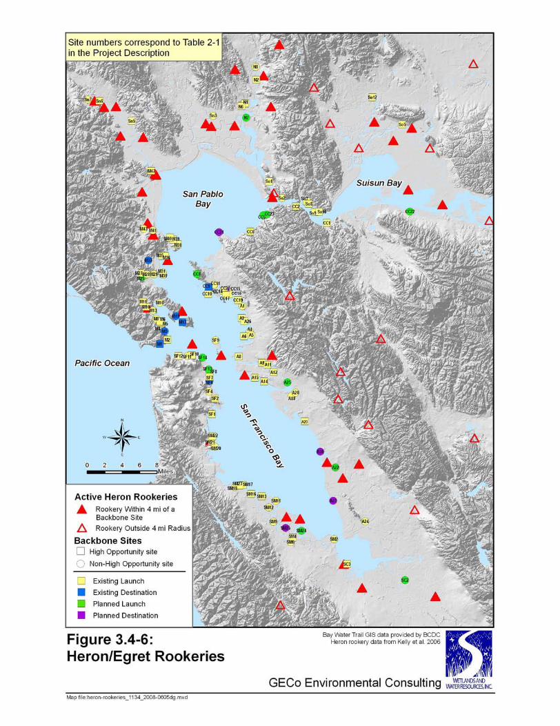

3.4- BIOLOGICAL RESOURCES
SF BAY AREA WATER TRAIL PLAN 3.4-32 COASTAL CONSERVANCY DRAFT EIR JUNE 2008
American bittern and least bittern The American bittern (Botaurus lentiginosus) and least bittern (Ixobrychus exilis) are included in the CDFG list of Special Animals (2007) for protection of nesting habitat. Both are rare inhabitants of San Francisco Bay marshes and occur in brackish to freshwater environments with dense growth of relatively tall tule and cattail marsh vegetation (Schoenoplectus and Typha) characteristic of the inner reaches of Suisun Bay and, to a lesser extent, innermost San Pablo Bay. The use of the inner core of heavily vegetated marsh by these species, their secretive and largely solitary nature, and their rarity lessens the likelihood that they will encounter recreational boaters or that WT users will intrude into their nesting areas.
Osprey and American peregrine falcon Both the osprey (Pandion haliaetus) and American peregrine falcon (Falco peregrinus anatum) are included on the CDFG list of Special Animals (2007) to protect nesting sites and are USFWS birds of conservation concern. Populations of both species are increasing in the Bay Area. The peregrine has recently been “delisted” from endangered status in part because of the strength of the population and increased reproductive success. Ospreys are semi-colonial, nesting locally away from the Estuary shoreline, most notably at Kent Lake and Inverness Ridge, in Marin County, where approximately 50 nests have been active since the mid-1990s (J. Evens, pers. obs.) Peregrines nest solitarily in the Bay Area on the larger bridges (e.g. Bay Bridge), PG&E power towers along the shoreline (e.g. Napa River), and occasionally on skyscrapers. The high elevation location of nests and the adaptability of these species to the urbanized estuary suggest that they are unaffected by NMSB on bay waters.
California gull The California gull (Larus californicus) is a California Special Concern Species (nesting colonies). Nesting by this species was recorded in the Estuary for the first time in 1980. Colonies are concentrated in the South Bay salt ponds and at the former Alameda Naval Air Station (NAS). There are no known colonies in the North Bay (Ryan 2000a). With a population of approximately 10,000 pairs nesting in the South Bay, they are the most abundant colonial nesting waterbird in the Estuary. Nests are clustered on salt pond levees and artificial islands in or near salt ponds and are vulnerable to mammalian predators in years when water levels recede before nesting is completed (Ryan 2000a). The nesting season is spring, with hatches in late May or early June (Jones 1986). Roosting occurs on salt pond levees, on salt ponds, and in open fields (e.g. school yards). Large daily movements commonly occur between garbage dumps and roosting areas on levees and salt ponds.
Black oystercatcher The black oystercatcher (Haematopus bachmani) is on the CDFG list of Special Animals (2007) to protect nesting sites and is a USFWS bird of conservation concern. This highly territorial bird is present in small numbers in San Francisco Bay year-round, and nests in small numbers on rocky outcrops, abandoned wharfs and barges, and jetties, usually in inaccessible locations. Diets of adults and chicks consist mainly of mollusks; principally mussels and limpets. Oystercatchers are extremely vigilant and scold intruders at a

3.4- BIOLOGICAL RESOURCES
SF BAY AREA WATER TRAIL PLAN 3.4-33 COASTAL CONSERVANCY DRAFT EIR JUNE 2008
distance. Known nesting locations in the Estuary include Red Rock in the Central Bay and Oyster Cove Pier in the South Bay.
Caspian tern, elegant tern, and Forster’s tern The Caspian tern (Hydroprogne caspia), elegant tern (Thalasseus elegans), and Forster’s tern (Sterna forsteri) are all USFWS birds of conservation concern; the elegant tern is also classified as California Special Concern Species (nesting colonies) by CDFG. These terns nest in many of the same locations and situations as California least tern, snowy plover, and California gull. Terns often roost on undisturbed bay beaches. Various species are often intermingled within a colony or roosting flock. Elegant tern does not yet nest in the Estuary (but its distribution is expanding northward), but Forster’s and Caspian nest on dredge spoil islands and degraded, insular levees. In the North Bay, Forster’s tern nesting sites are associated with the Napa River salt ponds, notably at Russ Island, Knight Island, and White Slough. Numbers are higher in the South Bay where several dozen sites are associated with the Dumbarton, Baumberg, Coyote Hills, Hayward Shoreline, and Turk Island ponds (Ryan 2000b). Little is know concerning the reproductive success of these colonies. Caspian tern chicks hatch in May and June and are present through August. Active colonies of Caspian tern are located at Knight Island, Brooks Island, Coyote Hills, Alviso Hayward Shoreline, former Alameda NAS, and Ravenswood Open Space Reserve. Human disturbance is a potential threat at Brooks Island (Ryan 2000c).
Western borrowing owl The Western borrowing owl (Athene cunicularia hypugaea) is a California Special Concern Species (burrows and some wintering sites) and a USFWS bird of conservation concern. While not a wetland species, per se, burrowing owls do occur in lowlands and at the edge of tidal wetlands, especially in the non-breeding season. Typical nesting habitat in the Estuary is associated with sparsely vegetated levees, especially where cavities in rubble, debris, rip-rap, or mammal burrows occur. This species is largely extirpated from former breeding sites around the Estuary. Nearly all of the remaining nesting burrowing owls in the Estuary area are between Palo Alto and the Fremont-Newark area of the South Bay (Trulio 2000). The only sites that support viable breeding populations are the NASA Ames Research Center and the San Jose Airport (Townsend and Lenihan 2007).
MARINE MAMMALS Pacific harbor seals (Phoca vitulina) are the only marine mammal resident in the San Francisco Bay year-round. California sea lions (Zalophus californianus) also use the bay seasonally for foraging, and some individuals (primarily males) use one haul-out site located on floating docks at Pier 39 on the San Francisco city shoreline. This haul-out site is currently located in a busy, urban area, surrounded by active boat docks and high levels of tourist activity, and thus is unlikely to experience significant disturbance due to Bay WT users. The site is monitored by staff and volunteers of The Marine Mammal Center (Sausalito, CA). Other marine mammals are occasionally and briefly seen in San Francisco Bay waters, including harbor porpoise (Phocoena phocoena), gray whales (Eschrichtius robustus), humpback whales (Megaptera novaeangliae), northern elephant seals (Mirounga angustirostris), and sea otters (Enhydra lutris). These individuals do not

3.4- BIOLOGICAL RESOURCES
SF BAY AREA WATER TRAIL PLAN 3.4-34 COASTAL CONSERVANCY DRAFT EIR JUNE 2008
reside in the bay and thus are unlikely to experience significant added disturbance due to normal levels of use by WT users.
Harbor Seals Harbor seals are federally protected under the Marine Mammal Protection Act and are present throughout San Francisco Bay. Harbor seals are not listed as endangered, threatened or of special concern by the California Department of Fish and Game (CDFG). Based on bone evidence from archaeological sites along the Estuary shoreline (Nelson 1909), harbor seals have been using the Estuary for thousands of years, and it still supports a year-round population of more than 600 harbor seals2 (Green et al. 2006). Periodically, harbor seals move onto offshore or intertidal rocks, sand bars, sandy beaches, or tidal mudflats, in order to rest between foraging trips, molt, thermoregulate or nurse their young. Seals tend to congregate on the same sites, called ”haul-out sites,” year after year. Harbor seals consistently use 16 haul-out sites distributed throughout the Bay, and use an additional 11 sites with some consistency. Although some haul-out sites are used year-round by seals, others are used seasonally, for pupping, molting, or because of proximity to a seasonally abundant prey resource. Estuarine sites such as those in San Francisco Bay may be particularly important to seals during the pupping and molting seasons, as such areas provide sites protected from disturbance and sheltered from storms. Depending on season, harbor seals typically spend up to 60% of their time on the haul-out site. Factors involved in selection of a suitable haul-out site by seals include ease of access to the water, proximity to food resources, and minimal disturbance levels. Harbor seals exhibit strong site fidelity within-season and across-years, and are essentially central-place foragers, usually foraging close to haul-out sites and repeatedly visiting specific foraging areas (Thompson et al. 1998). Based on radiotelemetry studies, seals in San Francisco Bay forage mainly within 1-5 km of a haul-out site (Torok 1994, Nickel 2003; Grigg 2008), suggesting that San Francisco Bay seals feed on local prey. Disturbance by humans, both inadvertent and deliberate, has been shown to cause declines in numbers of seals using terrestrial haul-out sites (Orr 1965, Terhune and Almon 1983, Allen et al. 1984, Hanan 1996). If sufficiently disruptive, disturbance may cause seals to abandon traditional haul-out sites (Newby 1973, Paulbitski 1975, Allen 1991), and in populated areas, such disturbance can reduce the number of suitable haul-out sites in an area to a few, relatively remote sites (Terhune and Almon 1983). Harbor seals consistently use 16 haul-out sites in the Bay (Kopec and Harvey 1995, Green et al. 2006). There are indications, based on anecdotal reports, documentation of radio-tracked animals, and aerial surveys (Torok 1994, Kopec and Harvey 1995, Nickel 2003, Green et al. 2006) that seals use an additional 11 sites in San Francisco Bay with some consistency. Locations of the 16 known terrestrial haul-out sites (hereafter referred to as “primary” sites), and the 11 additional potential sites (hereafter referred to as “secondary” sites) are organized geographically using the Habitat Goals Project
2 This incorporates Green et al.’s (2006) uncorrected figure of >500 seals, multiplied by a standard correction factor for California harbor seal counts of 1.3 (Hanan 1996, Forney et al. 2001).
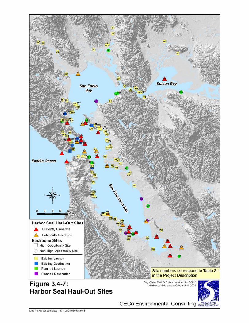

3.4- BIOLOGICAL RESOURCES
SF BAY AREA WATER TRAIL PLAN 3.4-36 COASTAL CONSERVANCY DRAFT EIR JUNE 2008
TABLE 3.4-5: HARBOR SEAL HAUL-OUT SITES BY SAN FRANCISCO BAY SUBREGION
AND SEGMENT Goals Project Subregion*
Goals Project
Segment*
Primary Haul-Out Sites
Secondary Haul-Out Sites
Known Pupping Sites
A Ryer Island (RI) -- --
B -- -- -- Suisun
C -- -- --
D -- -- --
E -- Tubbs Island (TI) --
F -- -- --
G -- -- --
North Bay
H -- -- --
I
Corte Madera (CM) Bluff Point (BP) Point Ione (PI)
Point Blunt (PBL) Sausalito Boatworks (SB)
Peninsula Point (PP)
Corte Madera (CM)
J -- Alcatraz (AL) --
K -- Alameda Breakwater (AB)
--
Central Bay
L Castro Rocks (CR)
Yerba Buena Island (YBI) Brook’s Island (BI)
Red Rock (RR) Treasure Island
(TR)
Castro Rocks (CR)
M -- Coyote Point (CO)
Belmont Slough (BS)
--
N Bair Island (BA)
Corkscrew Slough (CS) Greco Island (GI)
-- Bair Island (BA) Corkscrew Slough (CS)
Greco Island (GI)
O Guadalupe Slough (GS) -- --
P Drawbridge (DR) --
Q
Newark Slough (NS) Mowry Slough (MS) Coyote Creek (CC)
Calaveras Point (CP)
Newark Slough (NS) Mowry Slough (MS)
R -- Union City Shoreline (UC)
--
S -- -- --
South Bay
T -- -- --
*Subregions and segments as in the Habitat Goals Report, Bay Area EcoAtlas 1999, San Francisco Estuary Institute

3.4- BIOLOGICAL RESOURCES
SF BAY AREA WATER TRAIL PLAN 3.4-37 COASTAL CONSERVANCY DRAFT EIR JUNE 2008
subregions and segments in Table 3.4-5 and displayed in Figure 3.4-7. Most haul-out sites are in the Central and South Bay subregions. Of the 16 primary sites, three (Castro Rocks, Yerba Buena Island, and Mowry Slough) support the highest consistent numbers of seals, often exceeding 100 seals on site (Kopec and Harvey 1995, Green et al. 2006) (Table 3.4-6). Although most haul-out sites in San Francisco Bay are used to some degree year-round, numbers of seals at some sites are highest during the pupping (March – May) and molting (June-July) seasons (Kopec and Harvey 1995, Green et al. 2006). Sites used by seals for pupping are also identified in Table 3.4-5. Two of these sites, Castro Rocks and Mowry Slough, are the primary pupping sites in San Francisco Bay. Small numbers of pups are born each year at Yerba Buena Island, but at this time it is not considered a primary pupping site (Green et al. 2006).
OTHER SENSITIVE AND SPECIAL-STATUS WILDLIFE SPECIES Vernal pool tadpole shrimp The vernal pool tadpole shrimp (Lepidurus packardi) is a federally listed endangered species that inhabits vernal pools and similar isolated seasonal pools that support prolonged submerged bare, muddy substrate during months of winter rainfall months. It occurs in seasonal wetlands near the Bay near Warm Springs, Fremont. It has not been detected in seasonal wetland pools within diked baylands in San Francisco Bay.
California red-legged frog The California red-legged frog (Rana aurora draytonii) is not known to inhabit fresh-brackish tidal marshes or adjacent diked wetlands bordering navigable sloughs of the San Francisco Estuary. It typically inhabits freshwater marshes or ponds (including artificial irrigation or stock ponds) with perennial standing water or seasonal drawdown to moist soil. During dry summer months, it may inhabit burrows of small mammals (Jennings 2000). It is very unlikely that any WT trailheads would be located near populations or suitable habitats of the California red-legged frog. No trailheads are likely to occur within expected overland dispersal distances of this species.
Northwestern pond turtle Northwestern pond turtles (Clemmys marmorata marmorata) are a species of concern for state and federal resource agencies because of widespread population declines and habitat losses, but they are not listed as threatened or endangered, and lack special legal protective status. They inhabit freshwater to fresh-brackish marshes, ponds, and tidal sloughs in the San Francisco Estuary and adjacent wetlands. Northwestern pond turtles occur rarely in the South Bay (at least one population is known from a portion of South Bay Salt Ponds pond A3W; EDAW and others 2007), but none has been reported from brackish tidal sloughs (potentially suitable habitat). Northwestern pond turtles are widespread in the fresh to brackish tidal sloughs and non-tidal ponds (seasonally and annually variable salinity) in Suisun Marsh. They may potentially occur in the fresher reaches of the Napa-Sonoma Marshes, but no information is available on their distribution there. In Suisun Marsh, northwestern pond turtles bask

3.4- BIOLOGICAL RESOURCES
SF BAY AREA WATER TRAIL PLAN 3.4-38 COASTAL CONSERVANCY DRAFT EIR JUNE 2008
on cohesive peat or mud banks of tidal creeks and sloughs, large debris along banks, such as driftwood. It is possible that some populations or suitable habitats of the western pond turtle could occur near WT Backbone trailheads in Suisun Marsh or the northern Contra Costa shoreline.
TERRESTRIAL MAMMALS Salt marsh harvest mouse The salt marsh harvest mouse (Reithrodontomys raviventris) is endemic to the Bay Area, where its two subspecies inhabit the southern and northern reaches of the San Francisco Estuary (R. r. raviventris – San Francisco Bay; R. r. halicoetes – San Pablo Bay and Suisun Marsh, Contra Costa shoreline marshes; Shellhammer 2000a). It is federally- and state-listed as endangered. The salt marsh harvest mouse is narrowly adapted to salt-influenced emergent marsh vegetation that is infrequently flooded. It has high affinity for pickleweed and associated vegetation, but it also occurs in adjacent grasslands, particularly in spring. Survival of its populations often depends on adequate cover (dense, tall vegetation or debris along terrestrial edges or levees of salt marshes, or along high tidal creek banks) when primary marsh habitats are flooded by extreme high tides. The salt marsh harvest mouse is also found in diked salt or brackish marshes, where it is often more abundant than in adjacent tidal marshes. The distribution or abundance of the salt marsh harvest mouse in any particular marsh location is subject to annual and seasonal variation. FWS ordinarily presumes it may be present if suitable habitat is present near locations of known past populations within its geographic range. It is likely that suitable habitats or populations of the salt marsh harvest mouse would occur near some WT Backbone trailheads.
Salt marsh wandering shrew The salt marsh wandering shrew (Sorex vagrans halicoetes) is a species of concern to federal and state resource agencies, but it has no special legal protective status. There is very little known about its contemporary distribution or abundance in its geographic range in San Francisco Bay, but in the mid-20th century, shrews may have represented about 10% of small mammals occupying San Francisco Bay tidal marshes (Shellhammer 2000b). The salt marsh wandering shrew inhabits moist high or middle marsh plains with ample invertebrate prey, and ample cover provided by driftwood, litter, and debris. It is also probably dependent on flood refuge cover near or within marsh habitats in occupies, like the salt marsh harvest mouse. It is likely that suitable habitats or populations of the salt marsh wandering shrew would occur near some WT Backbone trailheads.
Suisun shrew Like the salt marsh wandering shrew, the Suisun shrew (Suisun ornate shrew; Sorex ornatus sinuosus) is also a species of concern to federal and state resource agencies, and it also it has no special legal protective status. The Suisun shrew probably occurs in scattered populations in tidal brackish or salt marshes between the Petaluma River mouth and eastern Montezuma Slough, where it was formerly documented, but recent

3.4- BIOLOGICAL RESOURCES
SF BAY AREA WATER TRAIL PLAN 3.4-39 COASTAL CONSERVANCY DRAFT EIR JUNE 2008
populations have been confirmed at few locations (MacKay 2000). Its habitat requirements appear to be similar to those of the salt marsh wandering shrew. It is likely that some, but relatively few, suitable habitats or populations of the Suisun shrew would occur near potential WT trailheads.
3.4.2 REGULATORY SETTING
FEDERAL REGULATIONS, POLICIES, AND PROGRAMS
FEDERAL ENDANGERED SPECIES ACT (ESA) At least three Sections of the Federal Endangered Species Act of 1973, as amended (16 USC 1531; ESA) may be pertinent to the WT Plan. Section 7 of the ESA requires that federal agencies consult with the U.S. Fish and Wildlife Service (FWS) (for ESA-listed plants, non-marine wildlife, and non-anadromous fish species) or the National Marine Fisheries Service (for ESA-listed marine wildlife and anadromous fish species) if a federal action, such as a permit, license, or federal funding, may affect an ESA-listed threatened or endangered species. Federal agencies are prohibited from taking actions that would be likely to jeopardize a federally listed endangered or threatened species. The Services conclude consultations with either a formal biological opinion or a written determination that a federal action that may affect a listed species would not be likely to adversely affect it. For actions around the San Francisco Estuary’s wetlands, Section 7 is often provided through the U.S. Army Corps of Engineers permit process (see Federal Clean Water Act) or through the Don Edwards San Francisco Bay National Wildlife Refuge (FWS) for actions within its jurisdiction. Section 9 of the ESA concerns prohibited actions. For federally listed plants, Section 9 has limited prohibitions concerning malicious damage to listed plants under federal jurisdiction, or removal or damage of listed plants outside of federal jurisdiction when state laws regarding criminal trespass or plant protection are knowingly violated. Section 9 prohibitions are seldom triggered for plants, but Section 9 also prohibits unauthorized “take” of federally listed wildlife and fish species. “Take” refers to any action that would harm, harass, injure, kill, capture, collect, or otherwise “take” any individual of a listed species. Section 10 of the ESA provides for authorization of some “take” incidental to other actions. “Take” authorization may be provided in the form of a Habitat Conservation Plan (HCP), permits for research on recovery actions to benefit listed species, or “incidental take statements” that are included in many biological opinions prepared under Section 7.
FEDERAL CLEAN WATER ACT (CWA) SECTION 404 Discharges of dredged or fill material in “waters of the United States,” including jurisdictional wetlands and all tidal waters around San Francisco Estuary, are regulated by the U.S. Army Corps of Engineers with oversight of the U.S. Environmental Protection Agency. The Corps has jurisdiction over tidal wetlands, navigable waterways, and most wetlands and other waters adjacent to them (i.e., jurisdictional wetlands and other waters of diked baylands) under Section 404 of the Federal Clean Water Act. The Corps has Section 404 jurisdiction over tidal wetlands up to the “High Tide Line”, and
3.4- BIOLOGICAL RESOURCES
SF BAY AREA WATER TRAIL PLAN 3.4-40 COASTAL CONSERVANCY DRAFT EIR JUNE 2008
broader jurisdiction under Section 10 of the Rivers and Harbors Act of 1899 up to the Mean High Water line. The Corps may authorize fill in jurisdictional wetlands and other waters by issuance of standard individual permits (with public notice and interagency coordination), general permits for authorized categories of regulated activities, including Nationwide Permits (no public notice; interagency coordination may be required), or letters of permission for certain categories of activity (no public notice). Corps and EPA regulations pertaining to Section 404 jurisdiction generally discourage or prohibit discharges of fill that would degrade or destroy the quality of wetlands or other waters. Corps permits are subject to the policies of Executive Order 11990 – Protection of Wetlands (issued 1977), which applies to federal projects or actions such as leases affecting wetlands. Corps permits may trigger Section 7 ESA consultation if the Corps determines that a permit action “may affect” a federally listed species. Corps permits in the baylands of the San Francisco Estuary generally require some state authorizations or certifications, including Section 401 water quality certification from the Regional Water Quality Control Board – San Francisco Bay Area, and Bay Conservation and Development Commission authorization for activities within their jurisdiction. Some Corps permit actions may also require compliance with the National Environmental Policy Act (NEPA) and the National Historic Preservation Act (NHPA).
MARINE MAMMAL PROTECTION ACT (MMPA) Like other marine mammals in the U.S., harbor seals are protected under the Marine Mammal Protection Act (MMPA), originally passed in 1972 and amended in 1994. The MMPA prohibits the take of marine mammals in U.S. waters and the importation of marine mammals and marine mammal products into the U.S. The term “take” is defined as harassing, hunting, capturing, killing, or attempting to harass, hunt, capture, or kill any marine mammal. The term “harassment” is defined as any act of pursuit, torment, or annoyance which has the potential to injure a marine mammal in the wild; or the potential to disturb a marine mammal in the wild by causing disruption of behavioral patterns, including, but not limited to, migration, breathing, nursing, breeding, feeding, or sheltering. National Oceanic and Atmospheric Administration (NOAA) Fisheries administers the MMPA in the estuary. The NOAA Fisheries policy on human interactions with wild marine mammals notes that “the MMPA does not provide for a permit or other authorization to view or interact with wild marine mammals, except for specific purposes such as scientific research. Therefore, interacting with wild marine mammals should not be attempted and viewing marine mammals must be conducted in a manner that does not harass the animals. NOAA Fisheries does not support, condone, approve, or authorize activities that involve closely approaching, interacting, or attempting to interact with whales, dolphins, porpoises, seals, or sea lions in the wild. This includes attempting to swim with, pet, touch, or elicit a reaction from the animals.” (http://www.nmfs.noaa.gov/ pr/education/viewing.htm; accessed 1/22/08). “Harassment” would be any action by a NMSB that causes a change in the behavior of harbor seals on the haul-out site (e.g., causing seals to “flush” off the haul-out site into the water). Harbor seals are not listed as endangered or threatened under the Federal Endangered Species Act.

3.4- BIOLOGICAL RESOURCES
SF BAY AREA WATER TRAIL PLAN 3.4-41 COASTAL CONSERVANCY DRAFT EIR JUNE 2008
STATE REGULATIONS, POLICIES, AND PROGRAMS
CALIFORNIA ENDANGERED SPECIES ACT (CESA) (FISH AND GAME CODE SECTION 2050 ET SEQ.) The state equivalent of the Federal Endangered Species Act, CESA, has similar, but distinct requirements and goals. CESA requires state agencies to coordinate with the CDFG to ensure that state-authorized or state-funded actions do not jeopardize a state-listed species. The state list of species classified as rare, threatened, or endangered does not correspond identically with the federal list of threatened and endangered species. CESA prohibits unauthorized “take” of a state-listed species. The Fish and Game Code also includes a less familiar special legal status for some species as “fully protected”, which is a category developed before CESA was authorized. Most “fully protected” species have been placed on the state list of rare, threatened, or endangered species, but some have not. Prohibitions against take of older “fully protected” species are more stringent and inflexible than those of CESA, generally prohibiting nearly all “take,” and provide no instrument to authorize “take” except for recovery and research actions. Fully protected species regulations in the Fish and Game Code are found at §3511 for birds, mammals at §4700, reptiles and amphibians at §5050, and fish at §5515 and California Code of Regulations, Title 14, Division 1, Subdivision 1, Chapter 2, Article 4,§5.93. The category of Protected Amphibians and Reptiles in Title 14 has been repealed.
CALIFORNIA NATIVE PLANT PROTECTION ACT (NPPA) (FISH AND GAME CODE SECTION 1900 ET SEQ.) In addition to the California Endangered Species Act, the Native Plant Protection Act (NPPA) protects endangered and “rare” species, subspecies, and varieties of native California plants. The species listed under this law, which preceded CESA, now overlap with those of CESA. NPPA contains many exemptions for agriculture and forestry, and many exceptions, but it otherwise generally prohibits unauthorized “take” of listed plants. NPPA contains “notice and salvage” provisions that require landowners to notify CDFG to “salvage” (rescue by transplanting – a technique no longer generally scientifically supported) listed plants in the path of land-clearing or development activities.
PORTER-COLOGNE WATER QUALITY CONTROL ACT (CALIFORNIA WATER CODE SECTION 13000 ET SEQ.; C.C.R. TITLE 23, CHAPTER 3, CHAPTER 15) The Porter-Cologne Water Quality Act provides the state with broad jurisdiction over water quality and waste discharge, and also provides the state the authority to prepare regional Basin Plans that identify “beneficial uses” of state waters that expressly include biological resources such as wetlands, fish, and wildlife conservation. Biological “beneficial uses” of state waters are subject to regulation through various means, including mandatory conditions attached to state water quality certification of Federal Clean Water Act (Sections 401, 404) authorizations. The Regional Water Quality Control Boards frequently provide Porter Cologne compliance with wetland beneficial use policies by attaching mandatory conditions to Section 401 certification for U.S. Army Corps of Engineers permits for fill discharges in federal jurisdictional wetlands.
3.4- BIOLOGICAL RESOURCES
SF BAY AREA WATER TRAIL PLAN 3.4-42 COASTAL CONSERVANCY DRAFT EIR JUNE 2008
EXECUTIVE ORDER W-59-93, CALIFORNIA WETLANDS CONSERVATION POLICY This state policy established by the Governor of California in 1993 provides substantive environmental goals to ensure no overall net loss of wetlands, to achieve a long-term net gain in the quantity, quality, and permanence of wetlands in California, with due concern for private property and stewardship.
FISH AND GAME CODE SECTION 1600 ET SEQ. (STREAMBED ALTERATION AGREEMENTS) The California Legislature repealed and re-enacted with modification this section of the Fish and Game Code in 2003. It has as its primary purpose the protection of the state’s fish and wildlife resources from harmful impacts of activities that occur near any rivers, streams, lakes and other water bodies in the state, regardless of the amount or duration of flow. “Fish” are broadly defined in the Fish and Game Code (Section 45) as aquatic organisms, including mollusks, crustaceans, invertebrates, or amphibians. Prior to undertaking stream-altering activities that may adversely affect fish or wildlife, applicants must notify the CDFG, pay fees, and enter into an agreement with the Department for authorization. The Department may authorize (for up to 5 years) alteration of streams with scientifically sound, reasonable conditions to avoid or minimize harm (substantial adverse effects) and protect fish and wildlife resources. The Department has discretionary authority to modify the conditions of a Section 1600 Stream Alteration Agreement.
CALFED BAY-DELTA PROGRAM (CALFED) This is a state and federal joint program covering the entire San Francisco Estuary and Sacramento-San Joaquin Delta, including its watershed, and integrates the resource policies of many participating government agencies with jurisdiction and expertise in biological resources, including FWS, CDFG, and the California Department of Water Resources (DWR). Many community and species objectives for ecosystem restoration are established in a large regional program established by the Ecosystem Restoration Program Plan – Final Programmatic EIS/EIR (http://calwater.ca.gov/CALFEDDocuments/Final_EIS_EIR.shtml).
3.4.3 PROGRAM IMPACTS AND MITIGATION MEASURES
SIGNIFICANCE CRITERIA The significance of biological impacts to terrestrial and wetland biological resources depends partly on the regulatory setting (policy, regulation, statute; see Regulatory Setting), and partly on the context of the scientific literature on ecology, conservation biology, and related environmental sciences. The following criteria are proposed as thresholds of significance for adverse environmental impacts in the context of CEQA:
• Extirpation (local extinction) of a population of a rare, threatened, or endangered species, or substantial contribution to the reduction of its natural geographic range (contraction of its distribution, or elimination of disjunct [outlier] populations) population viability, or population size
• Degradation of habitat occupied by a rare, threatened, or endangered species, to the point at which its population declines or becomes unstable
3.4- BIOLOGICAL RESOURCES
SF BAY AREA WATER TRAIL PLAN 3.4-43 COASTAL CONSERVANCY DRAFT EIR JUNE 2008
• Artificial introduction or range extension of a species to plant communities or floristic provinces in which it did not occur historically
• Substantial reduction in distribution or abundance of a species of concern, relative to its regional and local distribution
• Loss or substantial reduction in area or distribution of a unique or rare plant or animal community
• Major incremental loss of a widespread plant or animal community that is undergoing very rapid decline at a regional or subregional scale
• Substantial loss of composition or structure in a plant or animal community that is very old or mature, and very slow or uncertain to regenerate over many human generations
• Major increase in the distribution, rate of spread, abundance, or impact of an invasive non-native species
• Major, long-term change in biogeochemical processes or productivity • Major, long-term reduction in diversity of native species and communities
DISCUSSION OF SIGNIFICANCE CRITERIA This programmatic EIR is focused on the general, systematic impacts of the WT network and its foreseeable use over its entire geographic area, rather than narrow site-specific impacts of potential future trailhead projects. The following significance criteria apply to potential biological impacts that derive from the general system-wide operation, public use, management, maintenance and foreseeable modification of the WT program. Significance criteria for impacts to special-status species consider potential impacts to existing populations (direct and indirect impacts); impacts to suitable but unoccupied habitat of special-status species with narrow habitat requirements or geographic distribution; and impacts to areas that may be important to future recovery (cumulative impacts). Impacts that are certain or likely to cause local population extinction of special-status plant or animal species, or major long-term declines in their population size or stability, also would be considered significant. Impacts that cause substantial harmful changes to habitat quality, or the ability to manage for favorable wetland habitat conditions, are considered significant (e.g. introduction or facilitation of spread of harmful invasive species propagules, changes in habitat favoring weed spread, etc.). The threshold for significant impacts to special-status plant species would apply to actions that:
• Cause or contribute to a substantial increase in the “invasion pressure” of suitable habitat of a sensitive plant species by invasive non-native plants;
• Cause or contribute to a substantial decrease in the distribution or abundance of a sensitive plant species
• Substantially reduce the ability of a sensitive plant species to reproduce or regenerate within existing populations, or to re-occupy suitable habitat of the species within its natural geographic range.

3.4- BIOLOGICAL RESOURCES
SF BAY AREA WATER TRAIL PLAN 3.4-44 COASTAL CONSERVANCY DRAFT EIR JUNE 2008
For each waterbird species or species group, impacts are considered significant if activities associated with the WT may cause a substantial decrease in habitat use, optimal foraging, or reproductive success. The thresholds for “significance” of impacts to harbor seals are based on the definition of “take” according to the MMPA (described above), and on standard CEQA Criteria of Significance, listed above. In most cases, impacts to biological resources were evaluated based on a number of factors: potential proximity of a WT trailhead or WT users to a resource, the sensitivity of that resource to disturbance, and temporal/spatial patterns of both disturbance and resource sensitivity. The significance of impacts to sensitive populations of rafting waterbirds was generally evaluated at a distance of less than or equal to 2 kilometers. The significance of impacts to harbor seals was evaluated at distances of 4 and 8 miles.
IMPACTS AND MITIGATION MEASURES
WETLAND HABITATS AND DEPENDENT WILDLIFE Impact 3.4-1. Wetland Habitat Impacts due to Construction, Repair, Rehabilitation, or Maintenance of Trailheads
WT activities may include construction, repair, rehabilitation, or maintenance of facilities in or adjacent to wetland habitats, including boat ramps (which often require locations in wetland habitats), restrooms, parking areas, installation of signage, barriers or fencing, walkways, wheelchair ramps, storage facilities, or other WT improvement infrastructure (which do not always require locations in wetland habitats). For HOS sites, these activities would be minimal (i.e., signage only). WT development and management policies would generally guide such WT improvements away from sensitive wetland habitats to the greatest extent feasible, consistent with Federal Clean Water Act Section 404 permit evaluation guidelines. If site-specific constraints make wetland avoidance infeasible at a trailhead with high priority for use, trailhead improvements, rehabilitation, repair, or maintenance may result in unavoidable fill in wetland habitats. Indirect wetland impacts of construction or repair/rehabilitation activities in wetlands may result from spills of solvents, fuels, temporary stockpiles of construction materials, and temporary access paths. Ordinarily, small wetland fills or other wetland impacts associated with boat ramps and small trailhead facilities would not be expected to have significant impacts in most urban wetland settings. In addition, signage or other minor improvements to HOS sites are unlikely to adversely affect wetlands. But in some potential trailhead locations, depending on the environmental sensitivity of the wetland areas affected, and the environmental sensitivity of special-status wildlife and plants in the vicinity, small wetland fills could result in significant direct, indirect or cumulative impacts to wetlands. This impact is considered potentially significant but mitigable.
Mitigation Measure 3.4-1. Conduct surveys, adopt avoidance measures, and instigate compensatory mitigation
a) CEQA reviews of the Trailhead Plans for non-HOS WT sites shall consider the potential for wetlands to occur on the terrestrial portions of site. If potential for wetlands is present, owners/managers shall complete pre-construction surveys by
3.4- BIOLOGICAL RESOURCES
SF BAY AREA WATER TRAIL PLAN 3.4-45 COASTAL CONSERVANCY DRAFT EIR JUNE 2008
qualified biologists to determine the distribution of wetlands and characterize the vegetation present within the vicinity of potential construction, repair, or maintenance footprints (effect areas). Biological surveys shall include special-status plant species surveys that comply with California Native Plant Society and CDFG guidelines or protocols for rare plant survey methodology. Pre-project surveys shall be reviewed with resource agencies providing guidance on biological impact avoidance and minimization.
b) If surveys determine the potential for wetlands habitat to occur at or near a trailhead site, project plans for construction, repair, or rehabilitation of trailhead facilities, including local configuration of facilities, shall be designed to minimize or avoid impacts to wetlands of marshes, beaches, or diked baylands to the extent feasible.
c) If wetland impact avoidance is not feasible, WT site owners/managers shall prepare and implement plans to compensate for unavoidable wetland impacts, consistent with regulatory requirements and technical advice from state and federal resource agencies.
Impact 3.4-2. Wetland Habitat Impacts due to Increased Trampling of Wetland Shoreline Vegetation and Soil
Although most WT trailheads would be located in urbanized areas and in marinas or other developed facilities, some trailheads would be in relatively undeveloped open space areas in or adjacent to wetland shoreline vegetation. If implementation of trailhead improvements, designation of destination sites in areas of wetland shoreline vegetation, or outreach contributes to or causes incremental increases in the intensity or frequency of use at a particular trailhead in or adjacent to wetland shoreline vegetation, trampling of vegetation around trailheads may increase locally. Over time, this may degrade or gradually eliminate native estuarine beach or wetland vegetation, increase substrate exposure to erosional forces, or create disturbances (vegetation gaps) that facilitate invasion by non-native species (Impact 3.4-3), any of which would cause degradation of wetlands and other shoreline vegetation. If existing formal pathways to trailheads and adjacent locations of interest around them are inefficient, “social trails” (unplanned self-perpetuating paths through wetland or shoreline vegetation, created by repeated trampling) may develop. In addition, boaters experiencing distress during trips (disorientation in sloughs with marsh-obstructed views; inclement weather; unexpected emergence of non-navigable mud shoals during ebb tide), or boaters seeking views from levees may make unplanned or unauthorized landings outside of Plan-designated trailheads or destination sites. Trampling impacts of landings along wetland banks may depend on wetland bank shear strength, steepness, and water level (tide height) at the time of landing. Trampled, matted vegetation, if visible, may be attractive for subsequent landings by other boaters. Although this type of impact may be associated with existing conditions, it may increase in the vicinity of some trailhead locations. Trampling effects on vegetation may in some cases be neutral or benign. At intermediate levels of trampling intensity, trampling may create small vegetation gaps that may provide habitat for seedlings of native marsh or beach plants, including some special-status plant species that specialize in colonizing gaps or sparse vegetation (see
3.4- BIOLOGICAL RESOURCES
SF BAY AREA WATER TRAIL PLAN 3.4-46 COASTAL CONSERVANCY DRAFT EIR JUNE 2008
Impact 3.4-2). The same vegetation gaps, however, are more likely to be colonized by invasive disturbance-adapted non-native plants if seed sources are present. Trampling disturbances could facilitate non-native plant invasions (Impact 3.4-3). Depending on the geographic context and intensity of trampling impacts, trampling impacts associated with new or increased trailhead use at some trailheads may potentially be significant but mitigable. Most trampling impacts in vegetation around intensive urban shorelines would ordinarily be less than significant. Similarly, at most HOS sites, which include already developed facilities and where the project is not expected to generate substantial new use, this impact would be less than significant. However, in areas with sensitive shoreline wetlands, this impact would be potentially significant but mitigable.
Mitigation Measure 3.4-2. Establish trailhead restrictions, public education, surveys, and signage As described in Mitigation Measure 3.4-1, CEQA reviews of the Trailhead Plans for non-HOS WT sites shall consider the potential for wetlands to occur on the site. If sensitive wetland vegetation occurs at or adjacent to proposed trailheads the following mitigation measures shall be incorporated into the Trailhead Plan and/or the CEQA review of that Plan:
a) Trailhead owners/managers shall annually inspect for the development of new social trail networks emanating from trailheads. If new social trails branch or expand into wetlands or other native shoreline vegetation, they shall be closed by placement of symbolic fencing and signage restricting access across vegetation. Foot traffic and boat contact with wetland weeds or native wetland vegetation shall be minimized at trailheads.
b) Trailhead project managers shall prepare and effectively publicize guidance to discourage landings along vegetated wetland banks of sloughs that are vulnerable to trampling or establishment of unauthorized landings.
c) Trailhead managers shall conduct periodic (annual or biennial) boat surveys to detect and locate trampling impacts in native or non-native wetland vegetation along sloughs or shoreline vegetation in the vicinity of trailheads.
d) If trampling impacts (incipient unauthorized landings) are detected in wetland vegetation along sloughs or shoreline vegetation in the vicinity of trailheads, trailhead managers shall take actions to effectively close the incipient landings by placing signage discouraging or prohibiting landings at trampling-impacted slough bank or shoreline locations.
Impact 3.4-3. Impacts to Special-status Wetland Plant Species A large proportion of WT Plan Backbone trailheads would be located in urbanized settings such as waterfront parks, marinas, and developed access areas that are distant from locations of special status plant populations, particularly in South San Francisco Bay and most of the Central Bay outside of Marin County. The likelihood of significant impacts to sensitive plant species is expected to be low for the majority of urban-edge trailheads where armored, engineered shorelines with narrow, young, fringing marshes or no fringing vegetation are prevalent.

3.4- BIOLOGICAL RESOURCES
SF BAY AREA WATER TRAIL PLAN 3.4-47 COASTAL CONSERVANCY DRAFT EIR JUNE 2008
Most NMSB trips from such sites would also be unlikely to contact sensitive plant populations or habitats. At trailhead locations in Richardson Bay, San Rafael Bay, San Pablo Bay, Suisun Marsh, and the northern Contra Costa shoreline, impacts to special-status plant species (described below) could occur. Potentially significant impacts to special status plant species at sites in these locations could occur through increased use (intensity, frequency) of trailheads, or through construction or maintenance of WT trailhead facilities. Activities that may directly or indirectly impact special-status plant species may include:
• Trampling of sensitive plant populations, or the habitats in which they regenerate (such as seedling habitats), as described in Impact 3.4-2 above
• Competition or other interference effects of non-native invasive plants may adversely impact special-status plants. To the extent that trailhead use or construction, repair, or maintenance (Impact 3.4-1) may facilitate the spread of non-native invasive species (Impact 3.4-4), this would indirectly impact special-status plant species in the vicinity of trailheads or areas of NMSB use.
• Erosion control activities, including placement of fill or structures along wave-impacted shorelines around trailheads, may adversely affect special-status tidal plant species that may occur near trailheads, mainly in the northern reaches of the San Francisco Estuary and Marin County bayshores. Erosion control impacts may occur to sensitive plant species that typically occur in erosional sub-habitats (e.g., Mason’s lilaeopsis).
• Placement of fill for construction of trailhead facilities in diked bayland vegetation where special-status plant species may occur (Table 3.4-1; see also Impact 3.4-1).
• Management of nuisance vegetation, such as brush removal, mowing, weed control, or vegetation clearing for improved public access, could potentially damage or destroy sensitive plant populations in some parts of the Estuary.
WT management strategies include design guidelines, trailhead locations, monitoring of impacts, outreach, and education that would programmatically discourage potential impacts of WT activities that could affect sensitive plant species, depending on whether they are implemented with effective and enforceable mechanisms. At most sites, including all sites meeting HOS criteria, application of WT management strategies would be expected to avoid or minimize potential impacts to special-status plant species. However, at sites at or near occurrences of special status plant species, this impact would be potentially significant but mitigable.
Mitigation Measure 3.4-3. Conduct Surveys, adopt avoidance measures, and instigate compensatory mitigation CEQA reviews of the Trailhead Plans for non-HOS WT sites shall consider the potential for special status plant species to occur on or near the site. If special status plant species potentially occur at or adjacent to proposed trailheads the following mitigation measures shall be incorporated into the Trailhead Plan and/or the CEQA review of that Plan: a) In preparing the Trailhead Plans for WT sites located in Richardson Bay, San
Rafael Bay, northern San Pablo Bay, Suisun Marsh, and northern Contra Costa

3.4- BIOLOGICAL RESOURCES
SF BAY AREA WATER TRAIL PLAN 3.4-48 COASTAL CONSERVANCY DRAFT EIR JUNE 2008
shoreline, trailhead owners/managers shall complete pre-construction surveys by qualified biologists to determine if any special-status plant species are present within the vicinity of potential construction, repair, or maintenance footprints (effect areas). Biological surveys shall include special-status plant species surveys that comply with California Native Plant Society and CDFG guidelines or protocols for rare plant survey methodology. Surveys shall be reviewed by project sponsors and be made available to biological consultants and resource agencies providing guidance on biological impact avoidance and minimization.
b) Project plans for construction, repair, or rehabilitation of trailhead facilities, including local configuration of facilities, shall minimize or avoid impacts to special status plant species to the extent feasible.
c) If special status plant species impact avoidance is not feasible, trailhead owners/managers shall prepare and implement plans to compensate for unavoidable wetland impacts, consistent with regulatory requirements and technical advice from state and federal resource agencies as appropriate.
Mitigation Measure 3.4-2, above, and 3.4-4, below, also would apply to this impact.
Impact 3.4-4. Spread of Non-native Invasive Plants WT activities could potentially facilitate non-native plant invasions in several ways, primarily through facilitating weed seed dispersal and creating disturbances that would favor the establishment of new “outlier” populations of weeds. Project-related spread of invasive plant species with limited or expanding distribution (Table 3.4-2) would create the greatest potential for significant impacts. Any appreciable increase in the public use of multiple WT sites (increased joint probability of users visiting multiple individual sites because of the regional network of shoreline access within the WT system) would cause potential significant cumulative impacts due to the spread of invasive marsh or shoreline weeds. WT users visiting multiple WT sites, regardless of whether they are Backbone or HOS, could become significant vectors for long-distance colonization by invasive plants in early stages of regional spread. This would be a potential significant cumulative impact if successful colonization by wetland and shoreline weeds occurs through long-term public use of the regional WT network. Patterns suggestive of large “leaps” in the range of some wetland weeds associated with motorized vessels have recently been observed near marinas and offloading facilities where disturbed substrates are present. For example, hybrid cordgrass (Spartina alterniflora x foliosa) recently extended its northern limit from the Central Bay to a large infestation in the vicinity of the Petaluma Marina and a nearby sand processing plant, with no colonies in between. Similarly, the center of abundance of Mediterranean tarweed (Dittrichia graveolens) in the North Bay in 2006 was the immediate vicinity of Port Sonoma. That species had previously been concentrated in South San Francisco Bay. The intensive recent invasion of high tide shorelines (high marsh, sand, rubble) by Mediterannean sea-lavender (Limonium ramosissimum) in western San Francisco Bay is closely associated with public access points, including main infestations at Coyote Point Marina’s shoreline, Burlingame Lagoon trail edges and adjacent marsh, and tidal marsh trail edges in Richardson Bay.
3.4- BIOLOGICAL RESOURCES
SF BAY AREA WATER TRAIL PLAN 3.4-49 COASTAL CONSERVANCY DRAFT EIR JUNE 2008
Weed seed dispersal associated with use of NMSB may occur through mud or sand attached to footwear, boating equipment, or fabric (clothing or packs). NMSB may come into frequent contact with sediment (mud, sand) that may contain seeds of wetland weeds. They can also navigate shallow sloughs in remote, inaccessible, sensitive tidal wetlands and therefore facilitate the spread of invasive species to and from these areas. Seeds can also be transported in soils on tires or car bodies, and may colonize disturbed roadside substrate (weed seedling habitat) in or around parking lots. The risk of significantly elevated impacts of weed seed dispersal and weed spread would likely depend on the frequency of trail use, trailhead location, and the regional setting. The potential impact of the WT on spread of invasive plants would likely be less than significant for most trailheads in urbanized sites in the Central Bay (outside of Marin County). In addition, this impact would be less than significant at all sites that meet HOS criteria because the project is unlikely to increase use and development of new facilities. This impact may be potentially significant but mitigable in less urbanized parts of the Estuary. Impact 3.4-4 can be reduced to a less than significant level by implementation of the following measures at all non-HOS sites that are not within highly urbanized areas in the Central Bay.
Mitigation Measure 3.4-4. Conduct education and spread-reduction efforts CEQA reviews of the Trailhead Plans for non-HOS WT sites in areas near existing populations of invasive species shall consider the potential for these populations to be spread by WT activities. If such potential exists, the following mitigation measures shall be incorporated into the Trailhead Plan and/or the CEQA review of that Plan: a) Educational materials shall be provided to educate WT users about the potential
for spread of invasive plant species through WT activities, and methods that WT users can employ to minimize this potential, such as cleaning non-motorized watercraft and associated equipment/clothing prior to leaving trailheads (weed sanitation: removal of sediment or adhering debris potentially containing weed seeds), or, if not practical at the site, prior to using the equipment and other items at another location.
b) Minimize boat and foot traffic contact with local weed populations at trailheads as described in Mitigation 3.4-2.
Impact 3.4-5. Impacts on Special-status Animals of Bayland Marshes Trampling of sensitive wetland vegetation (Impact 3.4-2) and facilitation of the spread of invasive plant species in wetland environments (Impact 3.4-4) may degrade salt marsh and brackish marsh habitats occupied by the salt marsh harvest mouse, Suisun shrew, or salt marsh wandering shrew. This indirect impact would apply only to trailheads in the vicinity of habitats potentially occupied by these species. Where trampling impacts may occur in potentially occupied habitats, they could result in significant adverse effects to these species. This could be a potentially significant but mitigable impact. Food waste associated with increased WT-related use of trailheads could attract and sustain local populations of non-native terrestrial predators such as feral cats, red fox, or Norway rats. At trailheads in the vicinity of marsh habitats occupied by special-

3.4- BIOLOGICAL RESOURCES
SF BAY AREA WATER TRAIL PLAN 3.4-50 COASTAL CONSERVANCY DRAFT EIR JUNE 2008
status small mammals, these predators may contribute to population declines of special-status small mammals. This could be a potentially significant but mitigable impact. In Suisun Marsh, boating at mid- to low tide along tidal sloughs may disturb northwestern pond turtles, causing them to leave basking sites. If increased boating disturbances occur frequently enough to cause northwest pond turtles to abandon scarce basking sites, it could be a potentially significant but mitigable impact. Because use levels and development of new facilities at HOS sites are not expected to increase substantially, this impact would be less than significant at those sites.
Mitigation Measure 3.4-5. Undertake water management, predator control, and basking impact minimization CEQA reviews of the Trailhead Plans for non-HOS WT sites shall consider the potential for special status animal species to occur on or near the site. If special status animal species potentially occur at or adjacent to proposed trailheads and the Trailhead Plan involves facility development or other WT activities that may substantially increase site use, the following mitigation measures shall be incorporated into the Trailhead Plan and/or the CEQA review of that Plan:
a) Trailhead owners/managers shall ensure that waste disposal containers are inaccessible to non-native predators (Norway rats, feral cats, red fox) to the greatest extent feasible.
b) State and federal wildlife agencies shall be consulted during the preparation of the Trailhead Plan to determine the need for predator control measures. Trailhead sponsors shall implement non-native predator control if state or federal wildlife agencies conclude that it is warranted to protect special-status mammal populations in local marshes.
c) For trailheads within Suisun Marsh, state and federal wildlife agencies will be consulted during the preparation of the Trailhead Plan to determine whether significant basking sites for northwest pond turtles occur along sloughs in the vicinity of trailheads. If significant basking sites occur where NMSB use frequent increases, trailhead owners/managers shall consult with state and federal wildlife agencies to prepare and implement feasible plans to avoid or minimize boater disturbance of northwest pond turtle basking sites. Mitigation measures may include seasonal closures, signage to discourage boater approach of basking sites, or placement of alternative basking structures (large woody debris) in reaches of sloughs that are subject to less frequent disturbance by boaters.
d) Mitigations 3.4-1 and 3.4-2 also would apply to this impact.
IMPACTS TO WATERBIRDS Disturbance to Waterbirds
Most populations of most of the common waterbirds within San Francisco Bay are experiencing downward trends. As described above in Section 3.4.1, stressors to waterbird populations exist at local, regional, continental, and global scales. At the local and regional scales, the energetic costs to waterbirds from disturbance by watercraft (both motorized and non-motorized) are likely contributing to decreases in

3.4- BIOLOGICAL RESOURCES
SF BAY AREA WATER TRAIL PLAN 3.4-51 COASTAL CONSERVANCY DRAFT EIR JUNE 2008
waterbird populations within the Bay. In the context of waterbirds, “disturbance” includes any human activity that is an intrusion or interruption in the natural, daily activity of an animal (i.e. “normal behaviors”) or that disrupts the abundance, distribution, and function of a waterbird community. Normal behaviors primarily involve foraging or roosting, although social interaction and community dynamics may be affected as well. As described in Section 3.1, development of the WT is not expected to substantially increase overall use of NMSB on the Bay, but could potentially locally increase boating in sensitive areas of the Bay. Increases in NMSB use in sensitive areas of the Bay could increase the energetic costs to waterbirds. Therefore, a cautionary approach is used in this EIR to minimize the WT’s contribution to stressors to waterbirds in sensitive areas of the Bay.
Disturbance Response The effects of human disturbance on waterbirds can range from insignificant to lethal for different species and different individuals (Boyle, and Sampson 1985, Riffell et al. 1996). Human disturbance may have cumulative impacts that reach population levels, affecting habitat use, reproduction, and survival (Burger 1983, Harris 1988, Riffell et al. 1996, Spaling and Smit 1993), and may reduce species diversity and abundance at both the landscape and regional level (Rodgers and Smith 1997). Increasing human use of natural areas increases the incidence of disturbance and tends to disrupt foraging and social behavior of waterbirds (Burger 1981, 1986, Klein 1993). For purposes of impact analysis in this EIR, waterbird response to intrusion is analogous to anti-predator behavior (after Frid and Dill 2002):
Non-lethal disturbance stimuli caused by humans are analogous to predation risk, that is, responses both to predation risk (Lima and Dill 1990, Lima 1998) and to disturbance stimuli (e.g., Gutzwiller et al. 1994, Steidl and Anthony 2000) divert time and energy from other fitness-enhancing activities such as feeding, parental care, or mating displays.
The most observable response of waterbirds to disturbance (Ydenberg and Dill 1986, Blumstein 2003) is “flushing,” in which the bird or a group of birds moves away from or flees from an approaching threat. In waterbirds, flushing responses include swimming, diving, or flying and are usually preceded by an alert response (e.g. “head alert”). Various studies have demonstrated that birds concentrate where there is the best opportunity to maximize energy gain (Davidson & Rothwell 1993). Flushing may reduce the time waterbirds spend feeding or resting and cause them to be displaced to less-than-optimal feeding and resting areas (Knapton et al. 2000) or, under increased levels of disturbance, cause complete abandonment of foraging habitat (Tuite et al. 1983). Repeated flushing increases energy costs to waterbirds, and may have cumulative effects on migratory energy budget and, ultimately, reproductive success (Riffel et al. 1996, Galicia and Baldassarre 1997, Cywinski 2004). It is important to note that there are likely subtle behavioral or physiological responses to disturbance that precede flushing and go undetected by observers. Responses of waterbirds to human intrusion can be extremely nuanced. For example, one study found a “chromotropic response” (color-sensitive reaction) to observer clothing: birds flushed more readily, or were harder for the observer to detect, when orange vests were

3.4- BIOLOGICAL RESOURCES
SF BAY AREA WATER TRAIL PLAN 3.4-52 COASTAL CONSERVANCY DRAFT EIR JUNE 2008
worn by observers (Gutzwiller and Macum 1993). Therefore, brightly colored watercraft, lifejackets, or clothing may perpetrate greater disturbance levels than intruders of more muted colors. The following factors contribute to disturbance response:
• The size of the area available to the species. The larger the habitat “patch,” the more refugia available, and the shorter the disturbance distance that triggers flight response, the lower the impact of disturbance events.
• Flock size and diversity. Mori et al. (2001) found that flight distances (as a measure of disturbance response) increase with flock size and species diversity.
• The “shyness” factor of the species. Some species are more nervous than others and different species respond differently to disturbances (Burger 1991, Fitzpatrick and Bouchez 1998). Scaup, scoters and canvasback, respectively the most abundant waterfowl in the Estuary, are also among the most sensitive (Korshchgen and Dalhgren 1992).
• Size of the species: Larger animals tend to have greater response distances than smaller animals (Marzluff et al. 2001).
• Habitat structure. Mori et al. (2001) found thatflight distances tended to be longer for waterfowl that used open water for feeding than those that used it primarily for resting.
• Season: Animals behave differently in the breeding season than in the non-breeding season. Annual periods of high-energy cost (e.g. molting, nesting) put animals at greater risk and may elicit more expensive responses.
• Daily disturbance patterns: In a study of shorebirds on Southern California beaches, Lafferty (2001) found that “The average distance that birds reacted to humans increased with the proportion of birds that were disturbed on a particular day, suggesting disturbance sensitized birds.”
• The proximity of refuges (undisturbed or protected areas). Distance of flight (“Flight initiation distance”) increases as distance to a refuge becomes greater because risk of capture increases (Bonenfant and Kramer 1996).
• Direction of approach. Animals tend to react sooner when the “predator” is approaching directly rather than tangentially (Kramer and Bonenfant 1997).
This EIR evaluated WT Plan Backbone Site locations for potential bird disturbance impacts. If the WT site improvements, outreach, or educational activities are likely to result in increased use of a site within or near (within 300 meters) sensitive waterbird habitats, that increased use could result in potentially significant impacts to those species. The significance of these impacts is dependent on the combination of resource sensitivity at or near the site and intensity of increased boating use resulting from the WT. The potential for impacts to waterbirds from WT use decreases with distance from a WT site because boat traffic becomes more diffuse with distance. The EIR’s technical experts assumed that boat traffic would become sufficiently diffuse at a distance of 2 km from a WT site to reduce the potential for repeated disruption of flocks from any site or combination of sites to near-background levels that would not have the potential to significantly adversely affect the wintering life stage of these birds. This EIR

3.4- BIOLOGICAL RESOURCES
SF BAY AREA WATER TRAIL PLAN 3.4-53 COASTAL CONSERVANCY DRAFT EIR JUNE 2008
therefore used this distance to evaluate impact ratings. Descriptions of these ratings are summarized below and listed in Table 3.4-6. • Low = Low density of rafting birds, high volume of boat traffic, high land-use
activity, low biological resource values. Increased NMSB use of these sites would result in a less than significant impact (LS).
• Medium = Episodic high use by water birds, relatively open habitat, a distance > 2 km from critical resources; moderate land-use impacts. Increased NMSB use of these sites would result in a potentially significant but mitigable impact (SM).
• High = Proximity (≤ 2 km) to high-value habitat/species, limited availability of alternative habitat, relatively low existing boat traffic; relatively low impact existing land use. WT use of these sites would result in a potentially significant but mitigable impact (SM) provided use levels do not increase; if use levels increase, this impact would be significant and unavoidable (SU). 3
TABLE 3.4-6: IMPACTS TO WATERBIRDS BY LOCATION Location Impacts and Mitigations
Goals Project
Subregion1
Goals Project
Segment1
Site ID2
Water Trail Site Name2 Site Sensitivity -
Impact Significance
Applicable Impacts
Applicable Mitigations
So1 Brinkman's Marina low/medium 3.4.6 3.4.8
3.4-6 3.4-8
So2 California Maritime Academy
Low
So5 Beldon's Landing medium 3.4.8 3.4.9
3.4-8 3.4-9
So7 Matthew Turner Park low So8 West 9th Street Launching
Facility low
So9 Benicia Point Pier low 3.4.6 3.4-6 So10 Benicia Marina low 3.4.6 3.4-6
B
So12 Suisun City Marina medium 3.4.9 3.4-9 CC1 Martinez Marina medium 3.4.8
3.4.9 3.4.8 3.4.9
CC2 Carquinez Strait Reg. Shoreline (Eckley Pier)
low
Suisun
C
CC22 Bay Point Regional Shoreline
medium 3.4.8 3.4.9
3.4-8 3.3-9
3 300 meters is based on a conservative buffer zone, a distance at which rafting birds, in particular, can be approached without the likelihood of disturbance (flushing). This is based on the flight response of the most sensitive species (scaup). The formula for determining buffer zones is complicated, but it uses the mean observed flush distance, then adds the standard deviation of that distance (to account for 95% of all observations) and adds 40-meters to account for unmeasured responses that are not observable in the field (e.g increased heart rate). The primary reference for this approach is Rodgers and Schwikert (2003).

3.4- BIOLOGICAL RESOURCES
SF BAY AREA WATER TRAIL PLAN 3.4-54 COASTAL CONSERVANCY DRAFT EIR JUNE 2008
TABLE 3.4-6: IMPACTS TO WATERBIRDS BY LOCATION Location Impacts and Mitigations
Goals Project
Subregion1
Goals Project
Segment1
Site ID2
Water Trail Site Name2 Site Sensitivity -
Impact Significance
Applicable Impacts
Applicable Mitigations
N1 Cutting's Wharf medium 3.4.8 3.4.9
3.4-8 3.3-9
N2 JFK Memorial Park low N6 Napa Valley Marina medium 3.4.8 3.4-8 N7 Green Island Boat Launch
Ramp medium/high 3.4.6
3.4.8 3.4.9
3.4-6 3.4-8 3.4-9
D
N8 Riverside Drive Launch Ramp
low
E Sn3 Hudeman Slough medium/high 3.4.8 3.4.9
3.4-8 3.3-9
Sn5 Papa's Taverna/ Lakeville Marina
medium/high 3.4.8 3.4.9
3.4-8 3.4-9
Sn6 Petaluma Marina low 3.4.8 3.4.9
3.4-8 3.4-9
F
Sn7 Petaluma River Turning Basin
low
M38 McNear's Beach medium 3.4.6 3.4-6 M39 China Camp State Park high 3.4.6
3.4.8 3.4.9
3.4-6 3.4-8 3.4-9
M40 Bull Head Flat medium 3.4.8 3.4.9
3.4-8 3.4-9
M41 Buck's Landing high 3.4.6 3.4.8 3.4.9
3.4-6 3.4-8 3.4-9
M43 John F. McInnis Park high 3.4.6 3.4.8 3.4.9
3.4-6 3.4-8 3.4-9
G
M47 Black Point Boat Launch medium 3.4.6 3.4.8 3.4.9
3.4-6 3.4-8 3.4-9
CC5 Rodeo Marina low CC6 Pinole Bay Front Park high 3.4.9 3.4-9 CC21 Point Pinole low
North Bay
H
CC23 Rodeo Beach low M1 Kirby Cove low 3.4.6 3.4-6 M2 Horseshoe Cove low 3.4.6 3.4-6 M3 Swede's Beach low 3.4.6 3.4-6 M4 Turney Street Public Boat
Ramp low 3.4.6 3.4-6
M5 Dunphy Park low 3.4.6 3.4-6 M6 Schoonmaker Point low 3.4.6 3.4-6
Central Bay I
M8 Clipper Yacht Harbor low 3.4.6 3.4-6

3.4- BIOLOGICAL RESOURCES
SF BAY AREA WATER TRAIL PLAN 3.4-55 COASTAL CONSERVANCY DRAFT EIR JUNE 2008
TABLE 3.4-6: IMPACTS TO WATERBIRDS BY LOCATION Location Impacts and Mitigations
Goals Project
Subregion1
Goals Project
Segment1
Site ID2
Water Trail Site Name2 Site Sensitivity -
Impact Significance
Applicable Impacts
Applicable Mitigations
M10 Shelter Point Business Park
medium 3.4.6 3.4.7 3.4.9
3.4-6 3.4-7 3.4-9
M11 Bayfront Park medium 3.4.6 3.4.7 3.4.9
3.4-6 3.4-7 3.4-9
M13 Brickyard Park low M16 Richardson Bay
Park/Blackies Pasture medium/high 3.4.6
3.4.7
M17 Angel Island State Park medium 3.4.6 3.4-6 M19 Sam's Anchor Caf‚ low M25 Higgins Dock medium 3.4.6
3.4.8 3.4.9
3.4-6 3.4-8 3.4-9
M27 Bon Aire Landing high 3.4.6 3.4.8 3.4.9
3.4-6 3.4-8 3.4-9
M28 Marin Rowing Association Boathouse
medium 3.4.6 3.4.8 3.4.9
3.4-6 3.4-8 3.4-9
M29 Ramillard Park medium/high 3.4.6 3.4.8 3.4.9 3.4.10
3.4-6 3.4-8 3.4-9 3.4-10
M30 San Quentin medium 3.4.6 3.4-6 M31 Jean & John Starkweather
Shoreline Park medium 3.4.6 3.4-6
M33 Harbor 15 Restaurant low M35 Loch Lomond Marina:
Ramp low
M36 Loch Lomond Marina: Beach
low
SM18 Old Bayshore Highway low SM20 Colma Creek/ Genentech medium/high 3.4.6
3.4.7 3.4.9
3.4-6 3.4-7 3.4-9
SM21 Oyster Point Marina medium/high 3.4.8 3.4.9
3.4-8, 3.4-9
SM22 Brisbane Marina medium 3.4.6 3.4.7
3.4-6, 3.4-7
SF1 Candlestick Point State Recreation Area
medium 3.4.6 3.4-6
SF2 India Basin Shoreline Park medium 3.4.6 3.4-6
J
SF4 Islais Creek low/medium 3.4.6, 3.4.10
3.4-6 3.4-10

3.4- BIOLOGICAL RESOURCES
SF BAY AREA WATER TRAIL PLAN 3.4-56 COASTAL CONSERVANCY DRAFT EIR JUNE 2008
TABLE 3.4-6: IMPACTS TO WATERBIRDS BY LOCATION Location Impacts and Mitigations
Goals Project
Subregion1
Goals Project
Segment1
Site ID2
Water Trail Site Name2 Site Sensitivity -
Impact Significance
Applicable Impacts
Applicable Mitigations
SF6 The Ramp low/medium 3.4.6 3.4.10
3.4-6 3.4-10
SF7 Pier 52 Boat Launch low SF8 South Beach Harbor (AKA
Pier 40) low
SF10 Aquatic Park high 3.4.6 3.4-6 SF11 Gas House Cove (aka
Marina Green) low
SF12 Crissy Field medium/high 3.4.6 3.4.7
3.4-6 3.4-7
SF13 Brannan St Wharf low
SF14 Northeast Wharf Park low A6 Emeryville City Marina medium 3.4.7
3.4.9 3.4-7 3.4-9
A8 Middle Harbor Park high 3.4.6 3.4.7 3.4.8
3.4-6 3.4-7 3.4-8
A9 Jack London Square/CCK medium 3.4.6 3.4.7 3.4.8
3.4-6 3.4-7 3.4-8
A11 Estuary Park/ Jack London Aquatic Center
medium 3.4.6 3.4.7 3.4.8
3.4-6 3.4-7 3.4-8
A12 Grand Avenue Boat Ramp medium 3.4.6 3.4.7 3.4.8
3.4-6 3.4-7 3.4-8
A14 Robert Crown Memorial State Beach
medium 3.4.6 3.4.7 3.4.8
3.4-6 3.4-7 3.4-8
A15 Encinal Launching and Fishing Facility
medium 3.4.6 3.4.7 3.4.8
3.4-6 3.4-7 3.4-8
A18 Doolittle Drive; Airport Channel
medium 3.4.6 3.4.7 3.4.8
3.4-6 3.4-7 3.4-8
A25 Tidewater Boathouse high 3.4.6 3.4.7 3.4.8
3.4-6 3.4-7 3.4-8
K
A28 Elmhurst Creek medium 3.4.6 3.4.7 3.4.8
3.4-6 3.4-7 3.4-8
CC8 Point Molate Beach Park medium 3.4.6 3.4-6 CC9 Keller Beach medium 3.4.6 3.4-6 CC10 Ferry Point low/medium 3.4.6 3.4-6
L
CC11 Boat Ramp Street Launch Area
low

3.4- BIOLOGICAL RESOURCES
SF BAY AREA WATER TRAIL PLAN 3.4-57 COASTAL CONSERVANCY DRAFT EIR JUNE 2008
TABLE 3.4-6: IMPACTS TO WATERBIRDS BY LOCATION Location Impacts and Mitigations
Goals Project
Subregion1
Goals Project
Segment1
Site ID2
Water Trail Site Name2 Site Sensitivity -
Impact Significance
Applicable Impacts
Applicable Mitigations
CC14 Richmond Municipal Marina
low
CC15 Marina Bay Park & Rosie the Riveter Memorial
medium 3.4.6 3.4.7 3.4.9
3.4-6 3.4-7 3.4-9
CC16 Shimada Friendship Park medium 3.4.6 3.4.7 3.4.9
3.4-6 3.4-7 3.4-9
CC17 Barbara & Jay Vincent Park
medium 3.4.6 3.4.7 3.4.9
3.4-6 3.4-7 3.4-9
CC19 Point Isabel Regional Shoreline
high 3.4.6 3.4.7 3.4.9
3.4-6 3.4-7 3.4-9
CC20 SS Red Oak Victory low A1 Albany Beach high 3.4.6
3.4.7 3.4.9 3.4.10
3.4-6 3.4-7 3.4-9 3.4-10
A2 Berkeley Marina, Ramp medium 3.4.6 3.4-6 A4 Point Emery medium 3.4.7
3.4.9 3.4-7 3.4-9
A5 Shorebird Park medium 3.4.7 3.4.9
3.4-7 3.4-9
A26 Berkeley Marina, Small Boat Launch
medium 3.4.6 3.4-6
SF9 Treasure Island low 3.4.6 3.4-6 SM9 Redwood Shores Lagoon medium 3.4.6
3.4.9 3.4-6 3.4-9
SM11 Beaches on the Bay medium 3.4.6 3.4.7 3.4.9
3.4-6 3.4-9
SM12 Foster City Lagoon Boat Park
high 3.4.6 3.4.7 3.4.9
3.4-6 3.4-9
SM13 East 3rd Ave high? 3.4.6 3.4.7 3.4.9 3.4.10
3.4-6 3.4-9 3.4-10
SM16 Seal Point Park high 3.4.6 3.4.7 3.4.9 3.4.10
3.4-6, 3.4-9 3.4-10
South Bay M
SM17 Coyote Point, Marina medium 3.4.6 3.4.7
3.4-6 3.4-7

3.4- BIOLOGICAL RESOURCES
SF BAY AREA WATER TRAIL PLAN 3.4-58 COASTAL CONSERVANCY DRAFT EIR JUNE 2008
TABLE 3.4-6: IMPACTS TO WATERBIRDS BY LOCATION Location Impacts and Mitigations
Goals Project
Subregion1
Goals Project
Segment1
Site ID2
Water Trail Site Name2 Site Sensitivity -
Impact Significance
Applicable Impacts
Applicable Mitigations
SM23 Coyote Point, Beach medium 3.4.6 3.4.7
3.4-6 3.4-7
SM2 Ravenswood Open Space Preserve
medium 3.4.7 3.4.8 3.4.9
3.4-7 3.4-8 3.4-9
SM4 Redwood City Municipal Marina
medium/high 3.4.6 3.4.8 3.4.9
3.4-6 3.4-8 3.4-9
SM6 Docktown Marina medium/high 3.4.6 3.4.8 3.4.9
3.4-6 3.4-8 3.4-9
SM24 Westpoint Marina medium/high 3.4.6 3.4.8 3.4.9
3.4-6 3.4-8 3.4-9
N
SM25 Corkscrew Slough Viewing Platform
high 3.4.6 3.4.8 3.4.9
3.4-6 3.4-8 3.4-9
O SC3 Palo Alto Baylands
Launching Dock medium 3.4.6
3.4.7 3.4.9
3.4-6 3.4-7 3.4-9
P SC2 Alviso Marina medium 3.4.6
3.4.7 3.4.9
3.4-6 3.4-7 3.4-9
R A24 Jarvis Landing medium 3.4.8 3.4.9
3.4-8 3.4-9
A22 Eden Landing Ecological Reserve
high 3.4.8 3.4.9
3.4-8 3.4-9
S A27 Coyote Hills medium 3.4.6 3.4.7 3.4.8
3.4-8
A20 San Leandro Marina low 3.4.6 3.4.7
3.4-6
T A30 Hayward's Landing medium 3.4.6 3.4.7 3.4.8
3.4-6 3.4-8
1Subregions and segments as in the Habitat Goals Report, Bay Area EcoAtlas 1999, San Francisco Estuary Institute. 2High Opportunity Sites (HOS) are shown in bold.
Impact 3.4-6 Disturbance of Rafting Waterfowl from Roosting and Foraging Habitat
Of the diverse waterbird community that depends on San Francisco Bay, rafting waterfowl are most likely to be disturbed by watercraft. Movement patterns and foraging behavior of waterfowl represent a balance between costs and benefits of wintering in a human-influenced environment (Reed and Flint 2007). Rafting in dense

3.4- BIOLOGICAL RESOURCES
SF BAY AREA WATER TRAIL PLAN 3.4-59 COASTAL CONSERVANCY DRAFT EIR JUNE 2008
flocks serves an anti-predator function, a “safety in numbers” strategy for waterfowl and the energetic costs of such disturbance are equivalent whether flocks are flushed by predators or boats. A study of diving ducks (eiders) found flush responses cost waterfowl a loss of access to favored feeding areas, loss of feeding time, and additional energetic cost of flight (Fox and Mitchell 1997). Several studies have documented loss of feeding time due to disturbance by motorized watercraft (Kaiser and Fritzell 1984, Korschgen et al. 1985, Kahl 1991, Galicia and Baldasserre 1997) or experimentally examined flush distances of waterbirds by watercraft (Rodgers and Smith 1995, 1997). The literature contains fewer studies of disturbance response of waterbirds to non-motorized vessels, however there are a few from which generalizations can be drawn (e.g. Rodgers and Schwikert 2003). Table 3.4-7 summarizes waterbird disturbance distances from Evens (2007). In general, approaches from the water seem to disturb birds more than from the land (Smit and Visser 1993 in Rothwell and Davidson 1993). Hume (1976) reported a similar finding in confrontations between walkers, boaters and diving ducks. Kramer (1984) found that recreational boating activity (sailing and sail-boarding) displaced nearly all waterfowl from a lake, but that they returned later in the season and tolerated the activity. Kaiser and Fritzell (1984) found that a high density of canoeists correlated with reduced use of the river edge by green herons (small ardeiids) in the Missouri Ozarks. A study of the impacts of sailboats on waterfowl measured distances at which flocks of ducks moved from an oncoming dinghy, 275 meters by tufted duck (Aythya fulgula), a congener and useful surrogate for scaup (Batten 1977). Another study reported abandonment of an area by black scoters (Melanitta nigra) disturbed by wind-sailors, although common eiders (Somateria mollisima) returned after being flushed (Fraser 1987). Mathews (1982) studied water-based recreation in Britain and ranked “sailing, wind-surfing, rowing, and canoeing” as the second greatest cause of disturbance, after power-boating, to wintering waterfowl. The cumulative impacts of numerous or serial disturbances have deleterious effects on waterbird populations (Cronan 1957). Disturbance frequency, time-of-year, weather conditions, individual species sensitivity, age and/or condition of the affected individuals, and habitat size and availability are some of the factors that determine whether disturbance would have a cumulative impact (Sousa 1984, Rapport et al. 1985, Petraitis et al. 1989). Cumulative impacts may result when the periods between successive intrusions are too short for wildlife to recover and return to its pre-disturbance behavior (Spaling and Smit 1993). Such an event should be anticipated on a calm, sunny weekend day in mid-winter. Repeated disturbance causes a proportion of waterbirds to abandon areas previously occupied (Burger 1991, Klein 1993) and abundance of sensitive species may be reduced by 50 percent at high disturbance levels (Pfister et al. 1992). Numerous small disturbances can be more damaging than fewer, larger disturbances (West et al. 2002). Two factors may help reduce impacts of watercraft to rafting birds: (1) waterbird flocks tend to coalesce (raft) and hug the shore in leeward bays when weather conditions are most severe (high winds, choppy water, winter storm surges); these are the periods least likely to be favored by recreational watercraft users; and, (2) the seasons of least
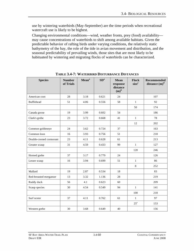
3.4- BIOLOGICAL RESOURCES
SF BAY AREA WATER TRAIL PLAN 3.4-60 COASTAL CONSERVANCY DRAFT EIR JUNE 2008
use by wintering waterbirds (May-September) are the time periods when recreational watercraft use is likely to be highest. Changing environmental conditions—wind, weather fronts, prey (food) availability—may cause concentrations of waterbirds to shift among available habitats. Given the predictable behavior of rafting birds under varying conditions, the relatively static bathymetry of the bay, the role of the tide in avian movement and distribution, and the seasonal predictability of prevailing winds, those sites that are most likely to be habituated by wintering and migrating flocks of waterbirds can be characterized.
TABLE 3.4-7: WATERBIRD DISTURBANCE DISTANCES Species Number
of Trials Meana SDa Mean
response distance
(m)b
Flock sizec
Recommended distance (m)d
American coot 28 3.18 0.621 24 107
Bufflehead 51 4.06 0.556 58 1 92
50 174
Canada goose 19 3.99 0.602 54 186
Clark's grebe 23 3.72 0.668 41 1 78
12 202
Common goldeneye 24 3.62 0.724 37 163
Common loon 16 3.93 0.756 51 218
Double-crested cormorant 23 4.11 0.628 61 213
Greater scaup 31 4.59 0.433 99 1 127
120 246
Horned grebe 37 3.17 0.779 24 126
Lesser scaup 16 3.94 0.699 51 1 86
8 252
Mallard 19 2.87 0.534 18 83
Red-breasted merganser 13 3.32 1.136 28 219
Ruddy duck 56 4.1 0.623 60 209
Scaup species 30 4.54 0.549 94 1 141
100 218
Surf scoter 37 4.11 0.762 61 1 97
25e 153
Western grebe 30 3.68 0.649 40 156

3.4- BIOLOGICAL RESOURCES
SF BAY AREA WATER TRAIL PLAN 3.4-61 COASTAL CONSERVANCY DRAFT EIR JUNE 2008
TABLE 3.4-7: WATERBIRD DISTURBANCE DISTANCES Species Number
of Trials Meana SDa Mean
response distance
(m)b
Flock sizec
Recommended distance (m)d
Table 3.4-6 displays mean and standard deviation (SD) of ln-transformed disturbance response distances, back-transformed mean response distance, and recommended distances (m) to avoid disturbance of waterbirds, based on species behavioral responses to 1 or 2 approaching kayaks. aMean and standard deviation of log-transformed data: yi = ln(xi) bBack-transformed mean: ?^ = exp(y¯ ) cIf the linear effect of species flock size on disturbance response was significant (P < 0.05), the regression equation was used to calculate recommended distance for solitary individuals (Flock size = 1) and maximum observed flock size (Flock size > 1): Bufflehead: y = 3.81 + 0.017*(Flock size) - 0.0012*(Intraseasonal day) Clark's grebe: y = 3.08 + 0.110*(Flock size) + 0.002*(Intraseasonal day) Greater scaup: y = 4.16 + 0.007*(Flock size) + 0.002*(Intraseasonal day) Lesser scaup: y = 3.17 + 0.194*(Flock size) + 0.001*(Intraseasonal day) Scaup species: y = 4.16 + 0.004*(Flock size) + 0.003*(Intraseasonal day) Surf scoter: y = 3.64 + 0.024*(Flock size) + 0.003*(Intraseasonal day) dRecommended distance = exp (?^ + 1.6495 * ?^) + 40 m. eOutlier observations for surf scoters flocks of 70 and 35 occurred but the remainder of the surf scoter flocks observed during trials were less than 25 individuals. Data Source: Avocet Research Associates. 2007. North Basin Waterbird Study, Eastshore State Park, Alameda, California: 2004-2007. Draft Final Report to State of California, Department of Parks and Recreation, Eastshore State Park. 1 November 2007. 40 pgs plus appendices.
Two waterfowl species are not anticipated to be disturbed from their roosting and foraging habitat due to WT use: cackling goose and double-crested cormorant. Because cackling goose flocks are transient and areas of occurrence difficult to predict, and because flocks are apparently adept at using human modified environments, disturbance is not considered a critical factor. Nesting double-crested cormorant colonies located on the bay bridges and transmission towers are situated high above the water or in sites already buffered from boat traffic, so disturbance is not considered a critical factor.
Mitigation 3.4-6 Avoid disturbance of rafting waterbirds from roosting or foraging habitat
Discussion The guiding principle of managing for human activities in areas that support important waterfowl populations is to avoid or limit overlap of human activity with waterfowl populations (Davidson and Rothwell 1993). Avoidance can be accomplished by implementing buffers, screening, or restricting access (closure). Because most WT sites are existing public sites, and because the WT has no land use jurisdiction, the WT has no authority to close sites or restrict access. The WT can, however, choose not to fund improvements that may increase use of a sensitive site or may choose not to designate a sensitive site as aprt of the WT. In addition, Section 31663(d) (6) of the Water Trail Act states “the Conservancy shall not award a grant or undertake a project for the San

3.4- BIOLOGICAL RESOURCES
SF BAY AREA WATER TRAIL PLAN 3.4-62 COASTAL CONSERVANCY DRAFT EIR JUNE 2008
Francisco Bay Area Water Trail that would have a significant adverse impact on a sensitive wildlife area.” Each method would have application to different classes of waterbirds. Two classes of waterbirds should be considered: those loafing and foraging in groups, and those nesting. Rodgers and Smith (1997) found that a buffer zone of 100 meters is adequate to avoid disturbing foraging and loafing sites for waterbird populations studied in Florida. However, disturbance response distances (the measures used to establish buffer zones) are site-specific. This limitation, in concert with the prescription that the most sensitive species be used to gauge disturbance, requires that disturbance trials from the Estuary be used to define buffer zone distances. As discussed above, scaup species are the most sensitive rafting waterbird (Avocet 2007) and also the most abundant in winter on San Francisco and San Pablo Bays (USFWS unpubl. data). The best way to protect waterbirds varies by site, species, and time of year (Korschgen and Dahlgren 1992, Rodgers and Smith, 1995). However, Mori et al. (2001) found species composition, activity, and flock size also to be significant factors in the amount of disturbance to certain species. According to Rodgers and Schwikert (2003), when dealing with mixed species, buffer zones should be based on the largest flush distance or the species most sensitive to human disturbance. It would be ideal to conduct studies on individual water bodies to establish management needs. This approach would be costly; therefore, managers should take a precautionary approach and select large buffer zones which are most likely to reduce the impact of watercraft on waterfowl (Cywinski 2004). Measures aimed at protection of the two most common open bay waterfowl groups - scaup (Aythya spp.) and scoter (Melenitta spp.) - from disturbance by watercraft will serve to protect other open water birds. Protection of those species groups provide an umbrella for other rafting waterfowl because grouped together: (1) they tend to occur most abundantly on open bay waters; (2) each subregion is important to each species; (3) they are distributed across both shallow bay (scaup) and deeper bay habitat (scoter); (4) they are among the most sensitive species to disturbance (Miles 2000, Kessel et al. 2002, Avocet 2007); (5) their seasonality in San Francisco and San Pablo Bays encompasses that of all other winter rafting waterbirds, and (6) in disturbance trials at North Basin, Alameda shoreline, greater scaup showed the greatest mean response distance of 16 waterbird species flushed by kayaks and scoters tied with cormorants as the second most sensitive species (Table 3.4-7). Therefore, this group of divers covers all habitats used by rafting birds. Following the example provided by other studies, most notably Rodgers and Schwikert (2003), the North Basin study developed species-specific buffer zones based on flush distances observed in disturbance trials (Table 3.4-7). The addition of 40-m to the calculation of buffer distances is “a conservative strategy to minimize agnostic responses by birds prior to their flushing and to take into consideration the possibility that mixed species assemblages (Thompson and Thompson 1985) and conspecific flocks (Gutzwiller et al. 1998) are more vigilant and sensitive than single-species groups or individuals” (Rodgers and Schwikert 2003).

3.4- BIOLOGICAL RESOURCES
SF BAY AREA WATER TRAIL PLAN 3.4-63 COASTAL CONSERVANCY DRAFT EIR JUNE 2008
Mitigation Approaches The following mitigation measures shall be applied to WT Backbone Sites with low/medium, medium, medium/high, and high sensitivities as indicated on Table 3.4-6, to avoid or minimize the increased disturbance that could result from increased NMSB use resulting from WT implementation:
Mitigation 3.4-6a. Signage and educational materials Prior to designation as a WT site, each Trailhead Plan or, in the case of HOS sites, Signage Plan, shall include signage and educational material (i.e. brochures) that inform users to avoid approaching rafting waterbirds and respect a non-disturbance zone around the congregation of waterbirds. Training sessions provided by kayak rental companies and other recreational watercraft outfitters working in association with designated trailheads shall include an educational component developed by the WT informing WT users of the sensitivity of waterbirds (and other wildlife) to disturbance, and the cumulative impacts of repeated disturbances, as well as appropriate buffer (avoidance) distances. Impacts at those sites ranked as Low, Low/Medium, Medium, and Medium/High would be mitigated by Mitigation 3.4-6A, above. For sites ranked as High on Table 3.4-6, the following additional measure shall be applied:
Mitigation 3.4-6b. Evaluate additional site use and limit facilities for sites with medium, medium/high, and high sensitivities
For non-HOS sites, during preparation of the Trailhead Plan and CEQA review of that plan, the likelihood of trailhead improvements to result in additional use of a site with for sites with medium, medium/high, and high sensitivities shall be evaluated. If that evaluation determines that the proposed improvements could substantially increase use of the site, facilities at those sensitive sites shall be shall be limited so as not to facilitate increased NMSB use. Those sites may still be designated at part of the WT Plan because they would benefit from the educational components of the Plan. In addition, site SF12 (Crissy Field), identified in the WT Plan as an HOS site, has been determined in the Avocet assessment as sensitive with respect to rafting waterbirds, and therefore shall be reclassified as non-HOS and shall be subject to this mitigation.
Impact 3.4-7 Disturbance of Ardeiid, Shorebird, and Pelican Roosting and Foraging Habitat
This impact applies to the following communities and special-status species: • Ardeiids, including egrets, herons, and night-herons • Shorebirds, including California least tern, elegant tern, Caspian tern, Forster’s
tern, California gull, Western snowy plover, and black oystercatcher. • California brown pelicans. As shown in Table 3.4-6, the project may result in increased boating activity at Backbone Sites that would result in disturbance to ardeiid, shorebird, and pelican roosting and foraging activities. Direct flushing responses to disturbance may affect over-wintering fitness by altering site use. A study in South Carolina found that boat intrusion caused approximately one-half of individuals of all shorebirds and waders (i.e. ardeiids) except snowy egrets (Egretta thula), to immediately abandon a tidal

3.4- BIOLOGICAL RESOURCES
SF BAY AREA WATER TRAIL PLAN 3.4-64 COASTAL CONSERVANCY DRAFT EIR JUNE 2008
creek, but suggests that flush rates should be used in conjunction with other indices such as spatial distribution as management guidelines (Peters and Otis 2006). For the most part, ardeiids and shorebirds would be protected from watercraft disturbance because of their habitat preference for tidal flats or very shallow (less than 10 cm) water, which are undesireable use areas for NMSB. However, high tide roosts may be susceptible to undue disturbance during periods of high water. Small numbers of long-legged waders (e.g. egrets and herons) that forage in shallow water may be flushed by shallow-draft watercraft, but this is likely to be a limited occurrence. In addition, Plan education and public outreach strategies are expected to sensitize users to disturbance issues and further buffer flocks from close approach by watercraft. Therefore, this impact would be less than significant for shorebirds and ardeiids and no mitigation is required. During the non-breeding season, pelicans can flush at significantly greater disturbance distances than during the breeding season; these distances have been measured to be over 27 m for approaching walking humans and over 34 m for approaching motor boats (Rodgers and Smith 1997). Birds roosting in shallow inland ponds at Elkhorn Slough flushed at a mean distance of 220 m when approached by humans on foot; approaches within 50 m were tolerated at island roosts surrounded by deep water (Jaques 1994). Roosting birds flushed by gunshots or humans on foot usually relocate to different roosting areas. As an example, a once-important roost site at Elkhorn Slough was abandoned in 1989 after increased human/terrestrial predator access (Jaques et al. 1996). The energetic costs of flushing and its impact on survival and fecundity are unknown (Sheilds 2002). This impact is potentially significant but mitigable.
Mitigation 3.4-7. Avoid disturbance of California brown pelicans from roosting and foraging habitat
WT sponsors shall identify high-use pelican roosting areas, and implement signage and 100-meter buffer zones around these areas. Educational materials at launch sites shall alert WT users to the sensitivity of roosting pelicans and the presence of buffer zones.
Impact 3.4-8 Disturbance of Ardeiids and Shorebird Nesting Habitat This impact applies to the following communities and special-status species: • Ardeiids, including egrets, herons, and night-herons • Shorebirds, including California least tern, elegant tern, Caspian tern, Forster’s
tern, California gull, Western snowy plover, and black oystercatcher. Increased watercraft traffic along the margins of the Estuary may impact ardeiids and shorebirds by disturbing or displacing individuals or groups from nesting habitat. Nesting birds, especially those in colonies, are more sensitive than resting and foraging birds. There is considerable variation in the response to disturbance among colonies depending on site characteristics, colony size, species composition and time of year. Inadvertent disturbance of shorebird nest sites could occur if recreationists landed onshore and disembarked on a levee, salt flat, or island that supported nest sites. For example, a single person disembarking in summer on an island where night-herons were nesting (e.g. Red Rock) could flush incubating adults and subject the colony to predation of eggs by attendant gulls. Likewise, a kayaker disembarking on a levee may

3.4- BIOLOGICAL RESOURCES
SF BAY AREA WATER TRAIL PLAN 3.4-65 COASTAL CONSERVANCY DRAFT EIR JUNE 2008
inadvertently step on the cryptic nest (“scrape”) and eggs of an incubating snowy plover. Various studies have recommended buffer zones around colonies ranging from 100-m (Rodgers and Smith 1995), to 200-m (Erwin 1989), to 300-m from a great blue heron colony (Butler 1992). Kelly et al. (2006) recommend buffer zones of 100 to 200-m based on responses of nestling birds to a single person approaching on foot, but with a caveat that larger groups of people (or boats) are likely to disturb heronries at greater distances. Therefore, this impact is potentially significant but mitigable.
Mitigation 3.4-8. Avoid disturbance of ardeiids and shorebirds nesting habitat
Ardeiids. During development of the Trailhead Plans and/or CEQA review of those plans for non-HOS sites, site managers shall establish buffer zones of 300 m from occupied colonies identified in Figure 3.4-6 from mid-January through mid-September. Exceptions to these buffer zones shall be considered in cases where NMSB may be directed into shipping channels or other navigational hazards. In addition, Trailhead and Signage Plans shall include educational components, postings at the launch site, and appropriate signage or strategically placed buoys to inform boaters of the buffer zones around the following nesting colonies: West Marin Island, Red Rock, and any colonies to be established or recolonized (e.g Bair Island) in the future. In addition, HOS sites SF12, SN21 and SM5 appear to be near these sensitive resources and shall be redesignated as non-HOS sites requiring Trailhead Plans and CEQA review. Shorebirds. Trailhead Plans and Signage Plans shall include provision of information at launch sites proximate to known nest sites to sensitize trail users to the possibility that nests will be located on levees or in salt pans, cautioning users to avoid those habitat features.
Impact 3.4-9 Disturbance of Rails and Other Marsh Bird Nesting Habitat This impact applies to California clapper rail, black rail, American bittern, least bittern and other marsh birds. Because the clapper rail is the largest of the special-status marsh birds, the most endangered, and the most sensitive to disturbance, its sensitivity to disturbance should be used as a guideline for determining impacts and mitigation for sensitive marsh birds. Small watercraft entering a channel system are likely to flush or otherwise disturb marsh birds and adversely affect nesting success. Rails flushed from vegetative cover are susceptible to increased exposure and predation (Evens and Page 1986, Albertson and Evens 2000). Clapper rails, the most sensitive marsh-nesting birds in the Estuary, have territories that encompass the dendritic channel systems that develop in a large marsh. The intertidal portions of the channels provide foraging opportunities, but the nest sites are located at or above mean high tide elevations, often at the headward extent of the channel system, or on the upper marsh plain, under dense vegetation (e.g. Grindelia spp. bushes). These nest sites are most often immediately adjacent to a channel, many of which are navigable by shallow-draft watercraft. Human intrusion into tidal marsh habitat where clapper rails occur would likely disturb incubating or brooding birds, potentially reducing reproductive success. The nesting season of the clapper rail has highly restricted periodicity because of susceptibility to tidal flooding and other constraints. A lost nesting effort, even by a single pair, may have population-level implications for

3.4- BIOLOGICAL RESOURCES
SF BAY AREA WATER TRAIL PLAN 3.4-66 COASTAL CONSERVANCY DRAFT EIR JUNE 2008
this critically-endangered species. Therefore, this impact is potentially significant but mitigable.
Mitigation 3.4-9 Avoid disturbance of rails and other marsh bird nesting habitat
Fourteen sites in Table 3.4-6 are ranked as “high” sensitivity sites, primarily because of their importance to rafting birds or their proximity to core populations of California clapper rails (Sites: M39, M41, M43, CC6, M27, SF10, A8, A25, CC19, A1, SM12, SM16, SM25, A22). Of these sites, five are HOS sites: CC6, SF10, A8, CC19, and SM16. Trailhead Plans and/or CEQA reviews for these sites shall evaluate proposed site improvements with respect to special-status marsh birds. If site improvements could foster increased levels of NMSB use, Trailhead and Signage Plans for these sites shall include educational components (signage and brochures) designed to sensitize watercraft users and minimize WT NMSB impacts to rails and other marsh birds. Federal laws prohibiting “take” also shall be posted at launch sites and incorporated into educational/outreach programs. In cases of anticipated increased use during the prescribed nesting season, which is January through August (USFWS 2000), feasible methods by which watercraft traffic shall avoid channel systems of core population areas (as defined by the Draft Recovery Plan (USFWS, in prep.)) (see Figure 3.4-5) shall be specifically identified in the Trailhead Plan and/or CEQA review for each site.
Impact 3.4-10 Disturbance of Rails and Other Marsh Birds from Roosting, Foraging, and Nesting Habitat due to Construction Activities at Launch Sites
This impact applies to California clapper rail, black rail, American bittern, least bittern and other special-status marsh birds. As prescribed by USFWS, construction activities that occur from February 1st through August 31st within 700 feet of the center of a clapper rail territory may have adverse impacts on nesting success (USFWS Office of Endangered Species, pers. comm. 5-27-08). Percussive noise, night lighting, physical alteration of tidal marsh or adjacent upland habitats have the potential to disrupt nesting behavior. This impact is potentially significant but mitigable. This impact applies to non-HOS sites; HOS site construction would be minimal and not anticipated to have significant construction-related impacts to these species.
Mitigation 3.4-10 Avoid disturbance of rails and other marsh birds from roosting, foraging, and nesting habitat due to construction activities at launch sites
Trailhead Plans and/or CEQA review of those Plans shall evaluate the potential for construction to adversely affect sensitive marsh bird habitat. If rail presence is possible, either protocol-level surveys shall be conducted between January 15 and April 15 (USFWS 2000) or it may be assumed that rails are present. If rail presence is determined or assumed within the construction impact zone, construction shall be scheduled to occur only from September 1st through January 31st to avoid the nesting season. Proposed launch or destination sites that may be located near occupied rail habitat include: A25, A22, A30, SM24, SM25, N7, CC22. Mitigation 3.4-9 also applies to this impact.

3.4- BIOLOGICAL RESOURCES
SF BAY AREA WATER TRAIL PLAN 3.4-67 COASTAL CONSERVANCY DRAFT EIR JUNE 2008
Impact 3.4-11. Disturbance of Western Burrowing Owls from Nesting Habitat due to Increased Watercraft Traffic and Facility Construction
Small watercraft traveling along the shoreline and the construction of improved WT facilities in shoreline areas can flush or otherwise disturb Western burrowing owls from nesting areas, adversely affecting reproductive success and the establishment of new nesting locations. As discussed earlier, known nesting locations within the Estuary are few and localized, and are primarily in South San Francisco Bay. Improvements at HOS sites would have minimal impacts to burrowing owls because construction would be minimal. For non-HOS sites, this impact is potentially significant but mitigable.
Mitigation 3.4-11. Avoid disturbance of Western burrowing owls from nesting habitat due to increased watercraft traffic and facility construction
WT sponsors shall compile a database of known and potential burrowing owl nesting locations within the Estuary. For non-HOS sites, Trailhead Plans and/or CEQA review of those plans shall locate new facilities in a way that avoids sites with known burrowing owl habitats.
IMPACTS TO HARBOR SEALS Introduction
Not enough is known about the effects of non-powered watercraft on foraging seals to make predictions about potential impacts of increased use of seal foraging areas by WT users. Marine mammals have been shown to avoid areas of increased noise from ships, etc. (e.g, Richardson et al. 1995). However, under the assumption that use levels would increase at a rate in sync with population growth, or ~0.09%/year, and given the quiet nature of non-powered watercraft, it is likely that impacts of WT users to seal foraging areas would be minimal. The level of consistent use of the secondary haul out sites is not known, as these sites have not been consistently surveyed. For this reason, the impacts discussion will focus on possible effects to primary haul-out sites. Secondary haul-out sites are identified when a potential impact may necessitate the collection of additional data on that haul-out site (e.g., number of seals using the site, timing and seasonality of use). It should be noted that while significant impacts to waterbirds are generally due to repeated, cumulative impacts (see previous discussion), a single disturbance to hauled-out harbor seal during pupping/nursing could have significant impacts to those seals.
Impact 3.4-12. Disturbance to Harbor Seals due to Construction/ Improvements at WT Sites
Short-term impacts to harbor seals such as those due to construction noise at WT sites as well as due to disturbances caused by WT users in close proximity to haul-out sites (Impact 3.4-13), are generally assessed using haul-out site surveys (e.g., Suryan and Harvey 1999, Lelli and Harris 2001, Green et al. 2006). These surveys are generally conducted at tide heights/time of day when the maximum number of seals are expected to be on-site. These optimal survey conditions vary based on the nature of the site; in San Francisco Bay, rocky outcroppings and beaches such as Castro Rocks and Yerba Buena Island are generally surveyed around the low-tide, whereas tidal salt-marsh sites such as Mowry and Newark Sloughs are generally surveyed on a falling tide, approximately two to four hours after the high tide (Kopec and Harvey 1995, Green et

3.4- BIOLOGICAL RESOURCES
SF BAY AREA WATER TRAIL PLAN 3.4-68 COASTAL CONSERVANCY DRAFT EIR JUNE 2008
al. 2006). Other sites, such as Corte Madera Marsh, are only available to seals at high tide, when sufficient water surrounds the sites to allow the seals access. Over a period of days or weeks, observers record the number of seals present, all potential disturbance events (e.g., loud construction noises, or approaches by watercraft, including distance of approach), reaction of the seals, and number of seals to re-haul following a flush off the haul-out site. Quantitative baseline information on current levels of disturbance is available for only four haul-out sites: Castro Rocks, Yerba Buena Island, Mowry Slough and Newark Slough. These primary haul-out sites were part of recent (1998 – 2005) monitoring by San Francisco State University and Caltrans (Green et al. 2006). Mean numbers of disturbances and flushes per hour of field time (1998 – 2005) from all disturbance sources were as follows:
• Castro Rocks (daytime)4: 3.22 disturbances/hr, 0.44 flushes/hr • Yerba Buena Island: 6.21 disturbances/hr, 0.38 flushes/hr • Mowry Slough (includes disturbances at Newark Slough): 0.33 disturbances/hr,
0.10 flushes/hr As can be seen in the rates of disturbance at these three index sites, average rates of disturbance could be expected to be higher in areas nearest urban centers (such as Castro Rocks and Yerba Buena Island), and markedly lower in remote sites such as Mowry and Newark Sloughs, which are located on wildlife refuge land. In some populated areas, harbor seals may habituate to consistent levels and types of disturbance in the area (Bonner et al. 1973, Osborn 1985, Barad et al. 1998). As a result, seals at more remote sites will be less tolerant of disturbance than at sites in more heavily populated areas. Short-term disturbances to seals due to construction work and improvements (signage, etc.) at new or existing WT sites would most likely only impact seals on haul-out sites located within 500 m of the WT site, based on the range of distances at which disturbance sources caused seals to flush off a haul-out site as reported elsewhere (Green et al. 2006). In addition, such disturbances would be more likely at non-HOS sites, as HOS sites would require only minimal improvements for inclusion in the WT. Only two WT sites are located within 500 m of a known primary haul-out site: site M17 (Angel Island State Park) is located approximately 150 m from the Pt. Ione haul-out site, and site M8 (Clipper Yacht Harbor) is located approximately 280 m from the Sausalito Boatworks haul-out site (Figure 3.4-7). Both of these haul-out sites are located in populated areas currently exposed to high levels of use by boaters, etc., meaning that seals may already be habituated to relatively high levels of activity near the site. This is particularly true of the Sausalito Boatworks haul-out site. In addition, WT site M17 is an HOS, meaning that construction work there would be minimal. The impact on site M8 is considered potentially significant but mitigable.
4 Note that the Castro Rocks figure includes rate of disturbance during seismic retrofit construction work on the Richmond-San Rafael Bridge, adjacent to the haul-out site. Average rates of disturbance after the end of construction (i.e., after 2005) are probably lower than those cited.

3.4- BIOLOGICAL RESOURCES
SF BAY AREA WATER TRAIL PLAN 3.4-69 COASTAL CONSERVANCY DRAFT EIR JUNE 2008
Mitigation Measure 3.4-12. Provide mitigation for disturbance to harbor seals due to construction/improvements at WT sites
As part of preparing Trailhead Plan and/or CEQA review of the Plan for site M8, ground-based haul-out site surveys shall be conducted for the site by qualified seal biologists retained by the site managers for a complete tidal cycle (i.e., encompassing both the low and high tides) for 1-3 days prior to construction work to provide information on the tide and timing of site use by seals. Construction and improvements to this WT site shall then be conducted at a time/tidal height that seals are not likely to be present on the site, thereby avoiding potential disturbance to resting seals.
Impact 3.4-13. Disturbance to Harbor Seals due to Increased Use of Waters Near New or Existing WT sites
Although implementation of the WT Plan is not expected to substantially increase Bay-wide NMSB use, localized increases in boating may result. Increased open water travel by watercraft near known harbor seal haul-out sites could potentially impact populations of harbor seals by increasing their alertness/vigilance or causing them to move away from resting spots towards or into the water. Repeated disturbance from locally increased use could cause stress and health impacts to harbor seals unable to rest and eventually could cause seals to abandon haul-out sites altogether (Calambokidis et al. 1991). Seals on a haul-out site may be particularly sensitive to disturbance from paddled boats, and frequencies of flushing and disturbance distances from seal haul-out sites for kayaks and canoes are comparable to or even greater than those observed for powered vessels (Suryan and Harvey 1999, Henry and Hammill 2001, Green et al. 2006). For example, in one study, 55% of paddled boats near a harbor seal haul-out site caused seals to flush, vs. 11% of motorboats (Lelli and Harris 2001); similarly, another study recorded that 55% of kayakers (n=11) within 1 km of the haul-out site caused seals to flush, compared to 9% of motorized watercraft (n=436) (Suryan and Harvey 1999). Paddle boats tend to travel closer to shore, potentially increasing the likelihood of disturbances (Suryan and Harvey 1999, Green et al. 2006). The behavior of paddled boats vs. motorboats is also a factor in seals’ increased sensitivity; motorboats tend to maintain a constant heading and speed when moving past the haul-out site, whereas paddled boats often approach the site directly, changing speed and direction frequently (Kopec and Harvey 1995, Green et al. 2006). Furthermore, the ability to approach very quietly allows kayakers to get quite close to a haul-out site before detection, increasing the “surprise factor” and possibly eliciting a higher “startle response” in the seals (Borhorquez et al. 2000, Henry and Hammill 2001). Henry and Hammill (2001) suggest that the approach of paddled boats (slow, quiet and low to the water) may appear more like a predator than other types of watercraft. A recently completed monitoring study of the three largest San Francisco Bay haul-outs supports these findings; at two of the sites, kayaks within 200 m of the seals caused a higher proportion of flushes than other types of watercraft (Bohorquez et al. 2000), caused 15% and 20% of all watercraft-related disturbances and usually approached closer to the haul-outs (Green et al. 2006). In addition, seals may be less likely to re-haul after a flush by kayaks and canoes, as these paddled boats tend to stay in the area longer than motorized watercraft (Henry and Hammill 2001). Seals are more sensitive to

3.4- BIOLOGICAL RESOURCES
SF BAY AREA WATER TRAIL PLAN 3.4-70 COASTAL CONSERVANCY DRAFT EIR JUNE 2008
disturbance during pupping and molting seasons (mid-March through July) (Green et al. 2006), and boating activities near haul-out sites during those months could affect reproductive activities. Seals are particularly sensitive at pupping sites during the breeding season, when pups are present on the haul-out site (Suryan and Harvey 1999). Disturbance-related mortality to pups can result from the stampeding nature of flushes, and the separation of mother-pup pairs during the early bonding period that can occur during these events (Johnson 1977, Calambokidis et al. 1991). Backbone WT trailheads would not be located near known or suspected harbor seal haul-out sites, but WT users could potentially travel near these sites. The Central Bay is currently subject to relatively high levels of use, primarily by kayakers, with additional moderate use of some areas by canoes, dragon boats, sculls, windsurfers, and kiteboarders. The South Bay is currently subject to relatively moderate use by non-powered watercraft, primarily by kayaks and canoes. Existing levels of use of each of these subregions and segments by non-powered boating are discussed in Section 3.1, Recreation. Although increases due to implementation and promotion of the WT are unlikely to be dramatic, any increase in use of waters near haul-out sites by non-powered boats, particularly if use by new user categories such as groups/tours increases, could result in disturbances to seals on the haul-out site. Increased levels of disturbance by non-powered watercraft near haul-out sites could cause seals to flush off of the haul-out site, resulting in “take” due to disruption of normal behavioral and reproductive patterns. The physical characteristics of some San Francisco Bay haul-out sites (gently sloping, unvegetated beaches, such as at Yerba Buena Island, or firm marsh peat shelves, such as at Mowry Slough) could actually attract boat landings by small, non-motorized watercraft. Human-powered watercraft, such as kayaks have been seen landing on the Yerba Buena Island and Castro Rocks haul-out sites (E. Grigg, personal observation). If sufficiently disruptive, disturbance may cause seals to abandon traditional haul-out sites (Newby 1973, Paulbitski 1975, Allen 1991). In populated areas such as San Francisco Bay, such disturbance can reduce the number of suitable haul-out sites in an area to a few, relatively remote sites (Terhune and Almon 1983), effectively reducing available terrestrial habitat for seals in the project area. A sudden decrease in use by seals (outside of normal seasonal patterns of site use) or the abandonment of any primary haul-out site would represent a significant disruption of seal behavioral patterns. An increase in disturbance may be a particularly serious problem for pupping sites, which tend to be located in less disturbed areas; harbor seals may be slow to colonize new rookery sites (BCDC 2001). Long-term impacts to harbor seals, including decreased numbers of seals using traditional sites, or abandonment of these sites, are generally monitored using site surveys, as described above, and/or aerial surveys of haul-out sites such as those conducted by the CDFG and NOAA Fisheries (e.g., Grigg et al. 2004, Green et al. 2006). Count surveys such as these are often conducted at times of year when the number of seals is expected to be at a maximum; in San Francisco Bay, this is generally during the pupping (March – May) or molting (June – July) seasons. The San Francisco Bay harbor seal population is currently considered stable (in contrast to increasing seal populations along the outer California coast) at >600 seals, although increases have been seen at some sites (e.g., Castro Rocks, Yerba Buena Island, and

3.4- BIOLOGICAL RESOURCES
SF BAY AREA WATER TRAIL PLAN 3.4-71 COASTAL CONSERVANCY DRAFT EIR JUNE 2008
Ryer Island in Suisun Bay) and decreases at others (e.g., Strawberry Spit in Richardson Bay, now abandoned by seals; Allen 1991, Green et al. 2006). Recent (2001 – 2005) seasonal maximum counts at four important harbor seal haul-out and pupping sites are shown in Table 3.4-8 (data from Green et al. 2006). Disturbance to haul-out sites is often cited as one potential reason for the lack of overall population increase in San Francisco Bay, in contrast with the increases seen on the outer coast (Allen 1991, Kopec and Harvey 1995, Lidicker and Ainley 2000, Grigg et al. 2004, Green et al. 2006).
TABLE 3.4-8: RECENT MAXIMUM COUNTS AT FOUR PRIMARY SAN FRANCISCO BAY HAUL-OUT SITES, BY SEASON
Haul-Out Site Season 2001 2002 2003 2004 2005
Pupping 172 166 248 271 268
Molting 172 187 248 238 219
Fall 205 180 213 336 n/a1
Castro Rocks
Winter 225 296 388 594 n/a1
Pupping 156 163 180 129 172
Molting 184 226 214 177 194
Fall 135 98 208 164 n/a1
Yerba Buena Island
Winter 238 206 343 217 n/a1
Pupping 270 367 295 290 212
Molting 213 221 257 236 210
Fall 53 60 49 55 n/a1
Mowry Slough
Winter 112 106 90 139 n/a1
Pupping 59 77 29 23 20
Molting 34 26 28 24 10
Fall 31 14 20 16 n/a1
Newark Slough
Winter 22 22 30 13 n/a1
Source: Green, D.E., Grigg, E.K., Allen, S.G. and Markowitz, H. (2006) Monitoring the potential impact of the seismic retrofit construction activities at the Richmond San Rafael Bridge on harbor seals (Phoca vitulina): May 1, 1998 – September 15, 2005. Final Report to the California Department of Transportation, Contract 04A0628. 100 p. 1This season was after the study ended; no data available.
Haul-out sites within four miles and eight miles of a WT site are shown in Table 3.4-9. Based on the information cited above, kayaks and canoes present a particular risk for disturbance to seals. The months of highest use by kayaks and canoes, May – October, overlap with the most sensitive seasons for San Francisco Bay seals: pupping (March – May) and molting (June-July). Given project use levels identified in Section 3.1, Recreation, it appears unlikely that the WT would result in increased disturbances to seals from other types of non-powered watercraft (dragonboats, windsurfing, etc.). This impact is considered potentially significant but mitigable.

3.4- BIOLOGICAL RESOURCES
SF BAY AREA WATER TRAIL PLAN 3.4-72 COASTAL CONSERVANCY DRAFT EIR JUNE 2008
TABLE 3.4-9: HARBOR SEAL HAUL-OUT SITES WITHIN 4 MILES AND 8 MILES OF WATER TRAIL SITES
Site ID1
Water Trail Site Name1
Primary Haul-Out
Sites within 4 miles2
Secondary Haul-Out
Sites within 4 miles2
Primary Haul-Out
Sites within 8 miles2
Secondary Haul-Out
Sites within 8 miles2
M1 Kirby Cove PBO, SB PP, AL PBL, BP, YBI, CM
TR, RR
M2 Horseshoe Cove SB, PI, PBO, PBL, BP
PP, AL YBI, CM, CR, BI
TR, RR
M3 Swede's Beach SB, PI, BP, PBL, PBO
PP, AL CM, CR, YBI, BI
RR, TR
M4 Turney Street Public Boat Ramp
SB, PI, BP, PBL, PBO
PP CM, CR, BI, YBI
AL, RR, TR
M5 Dunphy Park SB, PI, BP, PBO, PBL
PP CM, CR, BI, YBI
AL, RR, TR
M6 Schoonmaker Point SB, PI, BP, PBO, PBL
PP CM, CR, BI AL, RR, TR
M8 Clipper Yacht Harbor SB, PI, BP, PBO PP CM, PBL, CR, BI
AL, RR, TR
M10 Shelter Point Business Park
SB, CM PP BP, PI, PBL, CR RR, AL
M11 Bayfront Park SB, CM BP, PI, CR, PBL PP, RR, AL
M13 Brickyard Park SB, CM, BP, PI PP PBL, CR RR, AL
M16 Richardson Bay Park/Blackies Pasture
SB, CM, BP, PI PP, RR CR, PBL, BI AL
M17 Angel Island State Park PI, BP, PBL, SB PP, AL CR, BI, CM, YBI
RR, TR
M19 Sam's Anchor Cafe‚ PI, BP, SB, PBL PP, AL, RR CR, CM, BI, YBI
TR
M25 Higgins Dock CM SB, CR, BP, PI RR, PP
M27 Bon Aire Landing CM SB, CR, BP, PI RR, PP
M28 Marin Rowing Association Boathouse
CM SB, CR, BP, PI RR, PP
M29 Ramillard Park CM CR, SB, BP, PI, PBL
RR, PP
M30 San Quentin CM, CR RR BP, SB, PI, PBL, BI
PP
M31 Jean & John Starkweather Shoreline Park
CM, CR RR BP, SB, PI, PBL, BI
PP
M33 Harbor 15 Restaurant CM CR, SB, BP, PI RR, PP
M35 Loch Lomond Marina: Ramp
CM CR, BP, SB, PI RR, PP
M36 Loch Lomond Marina: CM CR, BP, SB, PI RR, PP

3.4- BIOLOGICAL RESOURCES
SF BAY AREA WATER TRAIL PLAN 3.4-73 COASTAL CONSERVANCY DRAFT EIR JUNE 2008
TABLE 3.4-9: HARBOR SEAL HAUL-OUT SITES WITHIN 4 MILES AND 8 MILES OF WATER TRAIL SITES
Site ID1
Water Trail Site Name1
Primary Haul-Out
Sites within 4 miles2
Secondary Haul-Out
Sites within 4 miles2
Primary Haul-Out
Sites within 8 miles2
Secondary Haul-Out
Sites within 8 miles2
Beach
M38 McNear's Beach CR, CM, BP RR
M39 China Camp State Park CM, CR RR, TI
M40 Bull Head Flat CM, CR RR, TI
M41 Buck's Landing CM, CR RR, TI
M43 John F. McInnis Park CM TI
M47 Black Point Boat Launch
Sn3 Hudeman Slough TI
Sn5 Papa's Taverna/ Lakeville Marina
TI
Sn6 Petaluma Marina
Sn7 Petaluma River Turning Basin
N1 Cutting's Wharf
N2 JFK Memorial Park
N6 Napa Valley Marina
N7 Green Island Boat Launch Ramp
N8 Riverside Drive Launch Ramp
So1 Brinkman's Marina
So2 California Maritime Academy
So5 Beldon's Landing RI
So7 Matthew Turner Park RI
So8 West 9th Street Launching Facility
RI
So9 Benicia Point Pier RI
So10 Benicia Marina RI
So12 Suisun City Marina
CC1 Martinez Marina RI
CC2 Carquinez Strait Reg. Shoreline (Eckley Pier)
CC5 Rodeo Marina
CC6 Pinole Bay Front Park
CC8 Point Molate Beach Park CR RR BI, BP, CM, PI, PP
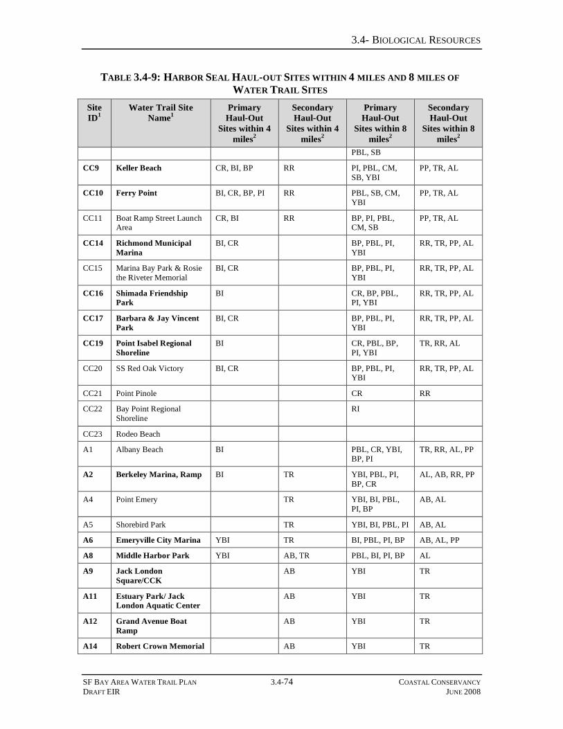
3.4- BIOLOGICAL RESOURCES
SF BAY AREA WATER TRAIL PLAN 3.4-74 COASTAL CONSERVANCY DRAFT EIR JUNE 2008
TABLE 3.4-9: HARBOR SEAL HAUL-OUT SITES WITHIN 4 MILES AND 8 MILES OF WATER TRAIL SITES
Site ID1
Water Trail Site Name1
Primary Haul-Out
Sites within 4 miles2
Secondary Haul-Out
Sites within 4 miles2
Primary Haul-Out
Sites within 8 miles2
Secondary Haul-Out
Sites within 8 miles2
PBL, SB
CC9 Keller Beach CR, BI, BP RR PI, PBL, CM, SB, YBI
PP, TR, AL
CC10 Ferry Point BI, CR, BP, PI RR PBL, SB, CM, YBI
PP, TR, AL
CC11 Boat Ramp Street Launch Area
CR, BI RR BP, PI, PBL, CM, SB
PP, TR, AL
CC14 Richmond Municipal Marina
BI, CR BP, PBL, PI, YBI
RR, TR, PP, AL
CC15 Marina Bay Park & Rosie the Riveter Memorial
BI, CR BP, PBL, PI, YBI
RR, TR, PP, AL
CC16 Shimada Friendship Park
BI CR, BP, PBL, PI, YBI
RR, TR, PP, AL
CC17 Barbara & Jay Vincent Park
BI, CR BP, PBL, PI, YBI
RR, TR, PP, AL
CC19 Point Isabel Regional Shoreline
BI CR, PBL, BP, PI, YBI
TR, RR, AL
CC20 SS Red Oak Victory BI, CR BP, PBL, PI, YBI
RR, TR, PP, AL
CC21 Point Pinole CR RR
CC22 Bay Point Regional Shoreline
RI
CC23 Rodeo Beach
A1 Albany Beach BI PBL, CR, YBI, BP, PI
TR, RR, AL, PP
A2 Berkeley Marina, Ramp BI TR YBI, PBL, PI, BP, CR
AL, AB, RR, PP
A4 Point Emery TR YBI, BI, PBL, PI, BP
AB, AL
A5 Shorebird Park TR YBI, BI, PBL, PI AB, AL
A6 Emeryville City Marina YBI TR BI, PBL, PI, BP AB, AL, PP
A8 Middle Harbor Park YBI AB, TR PBL, BI, PI, BP AL
A9 Jack London Square/CCK
AB YBI TR
A11 Estuary Park/ Jack London Aquatic Center
AB YBI TR
A12 Grand Avenue Boat Ramp
AB YBI TR
A14 Robert Crown Memorial AB YBI TR

3.4- BIOLOGICAL RESOURCES
SF BAY AREA WATER TRAIL PLAN 3.4-75 COASTAL CONSERVANCY DRAFT EIR JUNE 2008
TABLE 3.4-9: HARBOR SEAL HAUL-OUT SITES WITHIN 4 MILES AND 8 MILES OF WATER TRAIL SITES
Site ID1
Water Trail Site Name1
Primary Haul-Out
Sites within 4 miles2
Secondary Haul-Out
Sites within 4 miles2
Primary Haul-Out
Sites within 8 miles2
Secondary Haul-Out
Sites within 8 miles2
State Beach
A15 Encinal Launching and Fishing Facility
AB, YBI TR, AL
A18 Doolittle Drive; Airport Channel
ABL
A20 San Leandro Marina
A22 Eden Landing Ecological Reserve
BA, GI
A24 Jarvis Landing NS, MS CC, GI, GS CP, UC, DR
A25 Tidewater Boathouse AB
A26 Berkeley Marina, Small Boat Launch
BI TR YBI, PBL, PI, BP, CR
AB, AL, RR, PP
A27 Coyote Hills UC GI, BA, NS, CS, MS
BS, CP
A28 Elmhurst Creek AB
A30 Hayward's Landing BA UC
SC2 Alviso Marina GS, CC DR MS, NS CP
SC3 Palo Alto Baylands Launching Dock
NS CP MS, CC, GS, GI, CS
DR, UC
SM2 Ravenswood Open Space Preserve
NS, GI CS, MS, BA, CC, GS
UC, CP, BS
SM4 Redwood City Municipal Marina
CS, GI, BA BS NS UC, CP
SM6 Docktown Marina CS, GI, BA BS NS UC
SM9 Redwood Shores Lagoon CS, BA, GI BS CP, UC
SM11 Beaches on the Bay BA, CS BS, CO GI UC
SM12 Foster City Lagoon Boat Park
BA, CS BS, CO GI UC
SM13 East 3rd Ave CO, BS BA, CS, GI UC
SM16 Seal Point Park CO, BS BA, CS, GI
SM17 Coyote Point, Marina CO BA, CS BS
SM18 Old Bayshore Highway CO BA, CS BS
SM20 Colma Creek/ Genentech CP
SM21 Oyster Point Marina CP
SM22 Brisbane Marina CP, AB
SM23 Coyote Point, Beach CO BA, CS BS

3.4- BIOLOGICAL RESOURCES
SF BAY AREA WATER TRAIL PLAN 3.4-76 COASTAL CONSERVANCY DRAFT EIR JUNE 2008
TABLE 3.4-9: HARBOR SEAL HAUL-OUT SITES WITHIN 4 MILES AND 8 MILES OF WATER TRAIL SITES
Site ID1
Water Trail Site Name1
Primary Haul-Out
Sites within 4 miles2
Secondary Haul-Out
Sites within 4 miles2
Primary Haul-Out
Sites within 8 miles2
Secondary Haul-Out
Sites within 8 miles2
SM24 Westpoint Marina GI, CS, BA BS NS UC
SM25 Corkscrew Slough Viewing Platform
CS, BA, GI BS NS UC, CP
SF1 Candlestick Point State Recreation Area
YBI AB
SF2 India Basin Shoreline Park
AB YBI TR, AL
SF4 Islais Creek YBI, PBL AB, TR, AL
SF6 The Ramp YBI AB PBL, PI TR, AL, PP
SF7 Pier 52 Boat Launch YBI AB, TR PBL, PI, BP AL, PP
SF8 South Beach Harbor (AKA Pier 40)
YBI TR, AL, AB PBL, PI, BP, BI PP
SF9 Treasure Island YBI, PBL TR, AL PI, BI, BP, SB, CR
PP, AB, RR
SF10 Aquatic Park PBL, YBI AL, TR PI, BP, SB, BI PP, AB
SF11 Gas House Cove (aka Marina Green)
PBL, YBI AL, TR, PP PI, BP, SB, BI AB
SF12 Crissy Field PBL AL, PP PI, YBI, SB, BP, BI
TR, AB
SF13 Brannan St Wharf YBI TR, AL PBL, PI, BP, BI AB, PP
SF14 Northeast Wharf Park YBI, PBL AL, TR PI, BP, BI, SB PP, AB 1High Opportunity Sites (HOS) are shown in bold
2Haul-out sites are listed in order of increasing distance from the Bay Water Trail site; abbreviations are as follows: Alameda Breakwater (AB), Alcatraz (AL), Bair Island (BA), Belmont Slough (BS), Bluff Point (BP), Brook’s Island (BI), Calaveras Point (CP), Castro Rocks (CR), Corkscrew Slough (CS), Corte Madera (CM), Coyote Creek (CC), Coyote Point (CO), Drawbridge (DR), Greco Island (GI), Guadalupe Slough (GS), Mowry Slough (MS), Newark Slough (NS), Peninsula Point (PP), Point Blunt (PBL), Point Ione (PI), Red Rock (RR), Ryer Island (RI), Sausalito Boatworks (SB), , Treasure Island (TR), Tubbs Island (TI), Union City Shoreline (UC), Yerba Buena Island (YBI)

3.4- BIOLOGICAL RESOURCES
SF BAY AREA WATER TRAIL PLAN 3.4-77 COASTAL CONSERVANCY DRAFT EIR JUNE 2008
Table 3.4-10 presents a list of WT sites with the potential to significantly impact harbor seal populations due to their proximity to haul-out and pupping sites.
TABLE 3.4-10: WATER TRAIL SITES WITH POTENTIAL TO SIGNIFICANTLY IMPACT HARBOR SEALS
Water Trail Site HOS? Reason for Proposed Closure
CC8 Point Molate Beach Pk No
CC9 Keller Beach Yes
CC10 Ferry Point Yes
Movement between these WT sites, or between CC8 and the Richmond Marina sites (CC14-17, CC20), could increase disturbance to the Castro Rocks haul-out and pupping site during the pupping and molting seasons
SM24 Westpoint Marina No
SM25 Corkscrew Slough1 No
These WT sites are located in close proximity to harbor seal haul-out and pupping sites Corkscrew Slough, Bair Island and Greco Island, and could increase disturbance to these sites during the pupping and molting seasons
A24 Jarvis Landing No
SC2 Alviso Marina No
These WT sites are in close proximity to the haul-out and pupping sites Mowry Slough2 and Newark Slough, and could increase disturbance to these sites during the pupping and molting seasons
1FWS is considering seasonal closure to boaters for Corkscrew Slough 2Mowry Slough (from the mouth of the slough inwards) is already closed to boaters during the harbor seal pupping season
Mitigation Measure 3.4-13: Implement education and outreach and modify/eliminate improvements at certain sites
Protecting haul-out sites is an essential part of protecting harbor seal populations. Implementation of the following mitigation measures would reduce project-related disturbance to a less than significant level. Mitigation 3.4-13A: The following measures apply to all WT site Trailhead and Signage Plans:
1) Signage shall also be used to notify boaters not to land their watercraft on seal haul-out sites that appear suitable for landing, such as Yerba Buena Island. Although the practical size of an exclusion zone will vary based on the nature of the haul-out site, exclusion zones shall aim to keep boaters at least 91 m (100 yards) from the haul-out site, and preferably at least 150 m from the site when feasible, based on distances at which watercraft such as kayaks caused seals to flush reported elsewhere (Calambokidis et al. 1991, Green et al. 2006, Johnson and Acevedo-Gutierrez 2007).
2) Information on ways for WT users to view seals without causing disturbance shall be included in WT promotional materials, signage, training, on the website, and onsite educational and interpretive panels. This mitigation measure is consistent with WT Plan Strategy 17 (Outreach, Educational and Interpretive Signage). In addition, this information is crucial to providing WT users the opportunity to view seals without causing disturbances to resting seals. Recommendations on ways to view seals resting on land without causing disturbance shall be included in the Trailhead Plan. Information to be provided shall include:
3.4- BIOLOGICAL RESOURCES
SF BAY AREA WATER TRAIL PLAN 3.4-78 COASTAL CONSERVANCY DRAFT EIR JUNE 2008
• Maintaining a minimum distance (approximately 80 meters) from the haul-out site at all times
• Maintaining a constant heading and speed while passing a haul-out site; avoid stopping or sudden changes in heading or speed
• If seals show signs of disturbance (e.g., all seals on the haul-out are watching the watercraft, or seals begin to approach the water), watercraft shall move further away from the haul-out site
• Further information on responsible wildlife viewing practices is available through a number of organizations, including the NOAA Fisheries Office of Protected Resources (online at http://www.nmfs.noaa.gov/pr/education/viewing.htm).
Educational materials, outreach and signage shall include information on what boaters shall do in the event that they see an injured, sick, or dead seal, or an (apparently) abandoned seal pup (e.g., recommendations to not approach wildlife, contact information for the local marine mammal stranding and rehabilitation organization5). Complete recommendations for what to do in these circumstances are available from The Marine Mammal Center6.
Mitigation 3.4-13B: As part of preparing Trailhead Plans and/or CEQA review of those Plans, proposed improvements for non-HOS WT sites that are in close proximity to a harbor seal pupping site (see Table 3.4-10) shall be reviewed for their potential to increase NMSB use. If such a potential is found to exist and the CEQA review determines that the proposed increased use could adversely affect the pupping site, the Trailhead Plan shall be revised to modify or eliminate proposed site improvements that do not comply with Section 31663(d) (6) of the Water Trail Act, which states that “the conservancy shall not award a grant or undertake a project for the San Francisco Bay Area Water Trail that would have a significant adverse impact on a sensitive wildlife area.”
Impact 3.4-14. Avoidance or Abandonment of Traditional Harbor Seal Haul-out Sites, due to Cumulative Impacts of Increased Use of San Francisco Bay Waters by Non-powered Watercraft
Cumulative development of the various access sites and use of the WT could result in potentially significant adverse impacts to harbor seals, due to increased bay-wide presence of NMSB, or presence of such watercraft in ‘new’ areas promoted by the WT. Such long-term impacts could include avoidance or abandonment by seals of traditional haul-out sites. Based on the levels of WT use described in Section 3.1, increases in disturbances to haul-out sites due to implementation and promotion of the WT are unlikely to be dramatic. However, any increase in levels of disturbance to haul-out sites by non-powered boats, particularly during sensitive seasons such as pupping, has the potential to result in a reduction in numbers of seals using that site. In populated areas such as the San Francisco Estuary, where availability of alternate haul-
5 For the San Francisco Bay area, this is The Marine Mammal Center, Sausalito, 415.289.SEAL (7325). 6 Available online at http://www.marinemammalcenter.org/what_we_do/rescue/whattodo.asp

3.4- BIOLOGICAL RESOURCES
SF BAY AREA WATER TRAIL PLAN 3.4-79 COASTAL CONSERVANCY DRAFT EIR JUNE 2008
out sites is limited, this could reduce available suitable terrestrial habitat for seals. This impact is considered potentially significant but mitigable.
Mitigation Measure 3.4-14: Provide monitoring and adaptive management Information provided by resource agencies about the numbers of seals using haul-out sites in the project area shall be maintained, to ensure that use of these sites is not declining. This is particularly important for the listed primary haul-out sites (Table 3.4-5). This monitoring is consistent with WT Plan Strategy 16 (Monitoring Impacts). Survey data can be obtained from ongoing monitoring projects, such as the seal surveys conducted by the Don Edwards San Francisco Bay National Wildlife Refuge, which encompasses Mowry and Newark Sloughs. Data from disturbance monitoring projects shall be included when assessing whether numbers of seals using a site are declining. In other cases, monitoring projects may need to be initiated, in which counts are collected for one week per season per year, following methods described above for monitoring long-term impacts. Maximum counts collected during these surveys shall be compared to available counts data for these sites for previous years (e.g. Kopec and Harvey 1995, Green et al. 2006). In the absence of available baseline counts data for a given haul-out site, aerial survey data collected by the CDFG and NOAA Fisheries shall be examined for declining numbers. In the event that numbers at a given haul-out or pupping site are found to be declining, the WT shall consult with the resource agencies and implement the agencies’ recommendations in any future Trailhead Plans or revised Trailhead Plans for sites that may be contributing to this decline.
3.4.4 CUMULATIVE IMPACTS With increased human presence in and around wetland areas, the impacts to the habitats and their dependent wildlife would increase. The ABAG Bay Trail also brings increased numbers of visitors into wetland areas, although it encourages (in many cases through fencing) them to stay restricted to the trail. Invasive Spartina removal temporarily reduces the amount of tidal marsh and tidal flat habitat available and, on a local scale, would have far more impact upon wildlife presence than will the WT through its increase in human presence in wild areas. A few WT sites will be affected by the salt pond restoration to be undertaken as part of the South Bay Salt Pond Restoration project. These are: A22, Eden Landing Ecological Reserve; A27, Coyote Hills; SM2, Ravenswood Open Space Preserve; and SC3, Alviso Marina. Wildlife habitats would be primarily altered by the salt pond restoration and the WT impact would not be significant in comparison. The wetland goals project aims to increase habitat available. It is conceivable that there could be conflict with the WT if the WT brings increased human presence into areas undergoing restoration. None of the projects mentioned above would significantly increase impacts to seals.