emodnet thematic lot n° 2 geology · 2016-07-12 · geo-seas – pan-european ... the addition of...
TRANSCRIPT

EMODnet Thematic Lot n° 2
Geology
EMODnet Phase 2 – Final Report
Reporting Period: 16/10/2013 – 14/10/2016
Date: 07/12/2016
Final Report – EMODnet Geology
2
Table of Contents
List of abbreviations and acronyms ............................................................................................................ 3
Executive summary ..................................................................................................................................... 4
1. Introduction ....................................................................................................................................... 21
2. Highlights of the project .................................................................................................................... 23
3. Description of the work done ............................................................................................................ 25
4. Challenges encountered during the project ...................................................................................... 66
5. Analysis of performance and lessons learned ................................................................................... 69
6. Analysis of sustainability .................................................................................................................... 76
7. User Feedback .................................................................................................................................... 79
8. Allocation of project resources .......................................................................................................... 84
9. Outreach and communication activities ............................................................................................ 86
10. Evolution of Progress Indicators ...................................................................................................... 107
Final Report – EMODnet Geology
3
List of abbreviations and acronyms
ATLAS – A Trans-Atlantic Assessment and deep-water ecosystem-based spatial management plan for Europe CGMW – Commission for the Geological Map of the World ECORD – European Consortium for Ocean Research Drilling EEA – European Environment Agency EEZ – European Economic Zone EGDI – European Geological Data Infrastructure EMSC – European-Mediterranean Seismological Centre EPOS – European Plate Observing System EUMARSIN – European Marine Sediment and Information Network EuroGeoSurveys – The Geological Surveys of Europe EUNIS – European Nature Information System EUROSEISMIC – European Seismic Metadata and Information Centre EUROSION – Project to provide the European Commission with recommendations for policy-making and information management practices to address coastal erosion in Europe, after thorough assessment of knowledge gained from past experiences and of the current status and trends of European coasts. Geo-Seas – Pan-European Infrastructure for Management of Marine and Ocean Data IBCM – International Bathymetric Chart of the Mediterranean INQUA – International Union for Quaternary Science IQUAME – International Quaternary Map of Europe INSPIRE – Infrastructure for Spatial Information in Europe IODP – International Ocean Discovery Program MESH – Mapping European Seabed Habitats MODEG – Marine Observation and Data Expert Group MeshAtlantic – Mapping European Seabed Habitats of the Atlantic Ocean MSFD – Marine Strategy Framework Directive NAGTEC – North Atlantic Geoscience Tectonostratigraphic Atlas OGC – Open Geospatial Consortium ProMine – Nano-particle products from new Mineral Resources in Europe urEMODnet – the preparatory phase of the European Marine Observation and Data Network WMS – Web Map Services

Final Report – EMODnet Geology
4
Executive summary
1. Introduction The EMODnet-Geology Project involved 36 organisations, principally the geological survey organisations of 30 countries surrounding the regional seas and sub-seas of Europe as defined in the Marine Strategy Framework Directive (Figure 1). As such, the partnership included the principal national organisations with responsibility for coastal and marine geological mapping in their respective countries. Most of these organisations are members of an existing network (EuroGeoSurveys – the Geological Surveys of Europe) that aims to deliver marine geological information solutions to decision makers in European government and industry, as well as providing baseline information for academic research. The consortium consisting of geoscience organisations from the UK, Ireland, Iceland, France, Belgium, The Netherlands, Germany, Denmark, Norway, Sweden, Finland, Estonia, Latvia, Lithuania, Poland, Russia, Ukraine, Romania, Bulgaria, Turkey, Greece, Cyprus, Albania, Montenegro, Croatia, Slovenia, Italy, Malta, Spain, Portugal and the Faroes have worked together to deliver the requirements of the geology lot of the European Marine Observation and Data Network (EMODnet).
Figure 1. The regional seas and sub-seas of Europe according to the Marine Strategy Framework Directive.
The EMODnet-Geology Project ran for 3 years from October 2013 to October 2016 and built on the procedures developed during the urEMODnet-Geology Project carried out between July 2009 and July 2012, which involved geological survey organisations from 14 countries in northern Europe working in the Baltic Sea, Greater North Sea and the Celtic Seas. The addition of 16 other countries expanded the geographical scope of the work programme to include the White Sea, Barents Sea, the seas around Iceland and the Faroes, the Bay of Biscay and the Iberian Coast, the Western Mediterranean Sea (within waters of EU countries), the Adriatic Sea, the

Final Report – EMODnet Geology
5
Ionian Sea and the Central Mediterranean Sea (within waters of EU countries), the Aegean-Levantine Sea (within waters of EU countries – including the Turkish sector) and the Black Sea (Turkey, Romania, Bulgaria and Ukraine). This executive summary describes the objectives and outputs that were delivered during the 3-year project.
2. Objectives The project objective was to compile fragmented marine geoscience data products and make them available through a web portal that is linked to the other EMODnet lots through the programme Central Portal. The data and map products include information on the seabed substrate and rate of accumulation of recent sediments; the sea-floor geology (bedrock and Quaternary geology – Quaternary sediments are those deposited principally by ice during the last 1.86 million years) and all boundaries and faults that can be represented at the 1:250,000 compilation scale with information on the lithology and age of each geological unit at the seabed; geological events and probabilities and minerals. For the coast, information on coastal type and behaviour has been supplemented by information on coastal erosion or sedimentation and the rate at which it occurs. The maps are based primarily on information held by the project partners, but in many cases these have been supplemented by information either in the public domain, or made available through data-sharing agreements. In some cases, for example in the delivery of information on European earthquake activity, where the most up-to-date geological information is held on third-party websites, access through the EMODnet-Geology portal has been established through web-mapping services to external organisations/projects. The EMODnet-Geology Project not only addressed the requirement to extend the coverage of geological information, it also improved the flexibility in presentation of substrate data at different scales (1:250,000 where possible), but with a broadscale 1:1 million maps in areas where data are not suitable for higher resolution interpretation. The project also made use of open source software to allow map information to be derived from different sources using Web Map Services (WMS). Both these approaches have established a basis for future development of EMODnet-Geology to provide map information at multi-resolution scale, and also to derive further information from organisations that hold marine geoscience data and information. Noting that the improvements to the urEMODnet portals requested in the tender documents for the 2013-2016 phase of EMODnet were non-exclusive, the project partners also included information on Quaternary geology, which was not included in the urEMODnet phase or the current call. Quaternary geology is an important part of the seabed substrate and can be included as baseline products. Work to harmonise all boundaries between national datasets would be a major scientific endeavour that is beyond the scope of this project, however the establishment of a baseline Quaternary map for the European seas is a major contribution to defining areas where further research is required and will be of direct relevance to users of seabed information (e.g. the renewable energy sector). The project team also established working groups to address issues according to scientific science topics (e.g. a geomorphology group to classify seabed features according to the processes by which they were formed) or to consider issues of cross-border collaboration in specific regions (e.g. an Adriatic Sea Working Group). The sustainability of the proposed EMODnet-Geology portal is of prime importance to the proposers. To achieve this aim, efforts have been directed towards strengthening links with other marine geoscience programmes and initiatives during the last 3 years. For example, as a result of participation in a Working Group that prepared a position paper on the submerged landscapes of Europe in the context of our cultural heritage, the next phase of

Final Report – EMODnet Geology
6
the EMODnet-Geology Project will include scientists working on this topic with a shared interest in mapping the sea floor. Project participants have also taken part in (and Chaired) an Atlantic Seabed Mapping International Working Group established as part of the Galway Statement on Atlantic Ocean Co-operation between the European Union and the Governments of the USA and Canada. The EMODnet-Geology group will develop its next phase with input from the European Geological Data Infrastructure (EGDI), an initiative of EuroGeoSurveys to provide access to Pan-European and national geological datasets and services from the Geological Survey Organisations of Europe. Members of the EMODnet-Geology group also participate in major long-term marine geoscience programmes such as the International Ocean Discovery Program (IODP) and the European Consortium for Ocean Research Drilling (ECORD – the European contribution to IODP). 3. Workplan
The project was implemented in three 12-month phases. The initial phase from October 2013 to October 2014 focussed on the construction of the products and the portal. The second year to October 2015 was a period during which all data products were further developed as information became available. The final 12 months of the project was the ‘convergence phase’, during which the EMODnet-Geology portal was fine-tuned to ensure convergence with the other EMODnet portals. The work was divided into 11 workpackages, each of which had a leader appointed from the group, and a defined set of deliverables. The results of each workpackage are described in the following sections. 3.1. Workpackage 1. Project Management (British Geological Survey)
A Project Co-ordinator was appointed to lead the submission of the EMODnet-Geology and subsequently manage the overall project to ensure delivery of the outputs and outcomes as agreed with the European Commission, and to assess and evaluate the project and its results. Bi-monthly reports were provided to the EC throughout the 3-year duration, and annual reports were submitted at the end of 2014 and 2015. The Project Co-ordinator represented the group in all communications with the EMODnet Secretariat, attended the bi-annual EMODnet Steering Group Meetings, presented progress to the Marine Observation and Data Expert Group, as well as presenting the project at the EMODnet Open Conference held in Ostend, Belgium in October 2015.
Project and Steering Group Meetings
The project partners held the EMODnet-Geology Kick-off Meeting in Lisbon, Portugal on 21-22 January 2014. Further project meetings took place in Valletta, Malta from 30 September to 1 October 2014, Madrid, Spain, from 10-11 March 2015, Ostend, Belgium from 21-22 October 2015, Split, Croatia from 22-23 March 2016 and the final meeting was held in Edinburgh, UK on 27-28 September 2016. These meetings were planned twice yearly to coincide with major project milestones, and in the case of the Ostend meeting, to coincide with the EMODnet Open Conference held on 20 October 2015, which also gave the opportunity to have joint meetings with the other EMODnet lots. During the EMODnet ‘Jamboree’, the EMODnet-Geology project partners held joint meetings with the Bathymetry, Coastal Mapping and Seabed Habitats lots. The Project Co-ordinator attended the launch of the EMODnet Secretariat office in Ostend, Belgium in February 2014, when a presentation was also made to the Marine Observation and Data Expert Group (MODEG). A further update was made to MODEG during the EMODnet ‘Jamboree’ on 19th October 2016. The Project Co-ordinator and Technical Co-ordinator also participated in EMODnet Steering Committee meetings on 4th June

Final Report – EMODnet Geology
7
2014 (Rome), 10th December 2014 (Brussels), 1st/2nd July 2015 (Ispra, Italy) and the 21st June 2016 (Brussels). Both also took part in the EMODnet-INSPIRE Workshop (30th June 2015) and the EMODnet Open Seminar for Joint Research Centre staff (2nd July 2015) held in ISPRA. 3.2. Workpackage 2. Geological data specification and sourcing (British Geological Survey) The objective of Workpackage 2 was to prepare and provide access to the information required to deliver 1:250,000 maps of seabed substrate, sea-floor geology, coastal behaviour, geological events and event probabilities and minerals. The data products used the standards developed in the urEMODnet-Geology Project and during the early months of the project each partner was tasked with making a comprehensive audit and evaluation of national geological spatial datasets. Where external data were used, these were made available on the basis of free access to information that is in the public domain. In some cases, formal data sharing agreements were used, some of which were pre-existing and some of which were developed as a result of the EMODnet-Geology Project. However, the project partners themselves are the custodians of a vast resource of marine information, which is under their management and ownership, therefore extensive information was made available to the project. 3.3. Workpackage 3. Seabed substrate (Geological Survey of Finland) Workpackage 3 of the EMODnet-Geology Project has produced seabed-substrate datasets on a scale of 1:250,000 and 1:1 million from the European Seas. Figure 2 shows the areas that have been included in the maps available on the project portal, showing that information has been provided in areas beyond those required by the contract, for example around Iceland and the Faroes and to the north of Scandinavia and Russia. The seabed-substrate datasets are accompanied by an assessment of the confidence in the interpretations, which is based on the amount of information such as seabed samples, cores, boreholes and multibeam echosounder data that exist for the European seabed. This approach effectively identifies data gaps, which are the areas where the geologists have less confidence in their interpretations as they have had to extrapolate from areas where data exist. The workpackage outputs also include data showing sedimentation rates (cm/year) at the seabed. Although the main objective of Workpackage 3 was to provide substrate information at a scale of 1:250,000, the maps show that only about 20% of the European sea areas have data that allows mapping at this scale. It was therefore decided to produce a seabed-substrate data layer at a broader scale, i.e. 1:1 million to provide as complete maps as possible; about 60% of the study area can be mapped at this scale. The first version of the 1:250,000 dataset was drafted in June 2014 and the 1:1 million scale map in June 2015. Both datasets were updated throughout the project and the final versions were completed in June 2016. The coastline adopted by the EMODnet Programme is that used by the European Environment Agency (EEA) at the scale of 1:100 000. In places, the coastline is not detailed enough to display the geological information produced by the project, and so it has been modified with a more detailed coastline for Russia, Malta and the Canary Islands. The issue of a new/revised coastline has been identified by other workpackage leaders. If a new EEA map were to include more detailed information from three specific areas, i.e. Malta, the Canary Islands and northern Russia, it would be considered adequate for the EMODnet-Geology partners needs and the EMODnet programme as a whole. Contact with the EMODnet Coastal Mapping Project Co-ordinator confirmed that, within

Final Report – EMODnet Geology
8
the current scope of the project, there would be recommendations and propositions for survey acquisition in the coastal zone, but no coastline product that would supersede the EEA coastline. The general process for compiling the seabed-substrate maps involved six steps. First, the information was sourced (see Workpackage 2) then harmonised according to a classification system based on the analysis of the particles that make up the sediments (a combination sandy, mud and gravel). The classification system chosen by the group (known as the ‘Folk classification’) is one that each partner agreed they could deliver their data
Figure 2. The European regional seas included in the EMODnet-Geology Project.
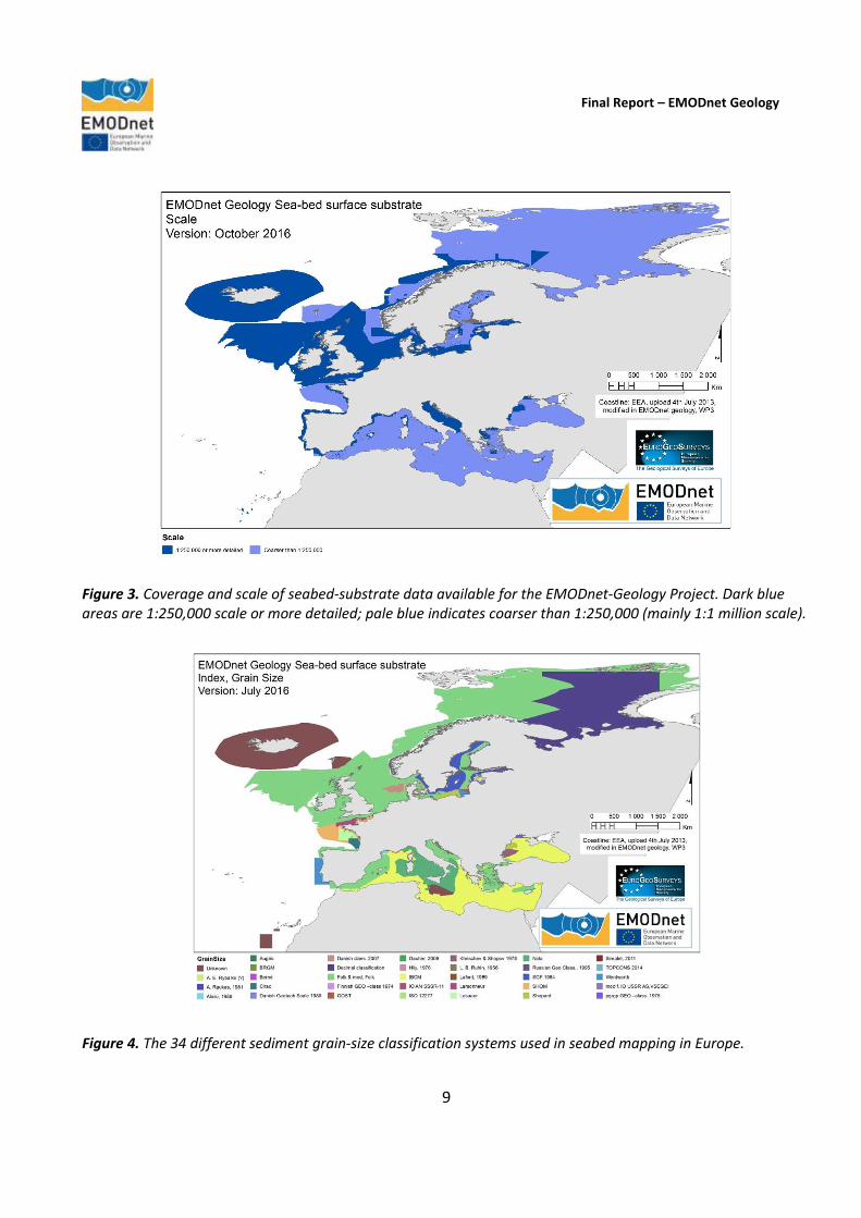
to allow the harmonisation process across national borders. The system was also selected in discussion with the EMODnet Seabed Habitats mapping group, as the geology outputs were required by them to carry out their work. The maps were then generalised to the target scale and compiled at pan-European level, following which the confidence analysis described above was carried out. Index map The EMODnet-Geology partners have provided information on where and what kind of seabed-substrate data/maps they have available for the project from their national waters including their Exclusive Economic Zones (EEZs) (Figure 3). The map includes data from more than 50 organizations and there are more than 400 different map types. The individual patches describe areas that are congruent by scale and mapping technology. Seabed-substrate classification schema The index dataset also shows the large number of sediment classification systems that are used in seabed mapping in Europe (Figure 4). Traditionally, European countries have conducted their marine geological surveys
Final Report – EMODnet Geology
9
Figure 3. Coverage and scale of seabed-substrate data available for the EMODnet-Geology Project. Dark blue areas are 1:250,000 scale or more detailed; pale blue indicates coarser than 1:250,000 (mainly 1:1 million scale).
Figure 4. The 34 different sediment grain-size classification systems used in seabed mapping in Europe.
Final Report – EMODnet Geology
10
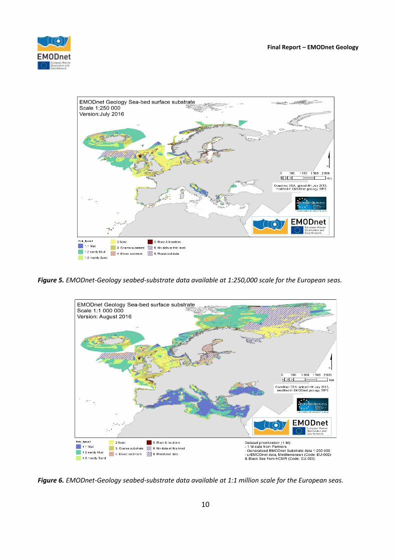
Figure 5. EMODnet-Geology seabed-substrate data available at 1:250,000 scale for the European seas.
Figure 6. EMODnet-Geology seabed-substrate data available at 1:1 million scale for the European seas.

Final Report – EMODnet Geology
11
according to their own national standards and classified substrates on the grounds of their national classification schemes. These national classifications have now been harmonised into a shared EMODnet scheme. Seabed-substrate data (1:250,000 scale) The 1:250,000 seabed-substrate dataset produced has been continually updated throughout the 3-year project as either new data from the partners became available (e.g. from recent surveys) or with older data held on paper/analog records that had since been digitized during the EMODnet-Geology Project (Figure 5). Seabed-substrate data (1:1 million scale) The 1:1 million seabed-substrate data is an additional output of Workpackage 3, which the project team decided was necessary to provide a complete map of the European seas in areas where 1:250,000 information is not available (Figure 6). The work to compile the 1 million data followed the guidelines used during the preparatory phase of EMODnet from 2009-2012. The 1:1 million map includes those areas mapped at 1:250,000, but have been generalised to provide a harmonised map at a common scale. Confidence The British Geological Survey (BGS) led the work to produce a confidence analysis on the seabed-substrate data. Each area is assigned a confidence score from 0 (lowest confidence) to 4 (highest confidence). The method was developed jointly with partners from the EMODnet Seabed Habitats Project (Figure 7).
Figure 7. The confidence scores for the European seabed-substrate data/maps. Darker areas indicate higher confidence.

Final Report – EMODnet Geology
12
Figure 8. Sediment accumulation rates (cm/year) in the European seas. The data have been compiled from published information of rates measured at specific sites.
Sediment accumulation Workpackage 3 also includes information on the rate of accumulation and sedimentation, primarily compiled as point-source information (Figure 8). The maps show that the density of available information is variable, with concentrations of information in shallow seas such as the Baltic, but with data gaps over much of the area. The low density of information does not allow sediment accumulation rates to be compiled as contoured maps. Case study Workpackage 3 included a module that models substrate and other terrain derivatives, such as morphology and seabed dynamics from acoustic data layers, to serve as case studies on deriving biologically relevant datasets, which are also compatible with the European Nature Information System (EUNIS Classification). EUNIS brings together European data from several databases and organisations into three interlinked modules on sites, species and habitat types. The case study “Quantitative spatial prediction of seabed sediment composition” was performed and reported by Cefas (Diesing, 2015).
3.4. Workpackage 4. Sea-floor geology (Federal Institute for Geosciences and Natural Resources (BGR, Germany))
Workpackage 4 has compiled interpreted information on the sea-floor geology (bedrock geology) including the lithology (Figure 9a) and stratigraphy (Figure 9b) of the geology of the European regional seas. The maps also show all major geological boundaries and faults that can be shown at the compilation scale of 1:250,000.

Final Report – EMODnet Geology
13
Figure 9a. The lithology (rock type) of the pre-Quaternary geological units (rocks more than ~1.86 million years old).
Figure 9b. The stratigraphy (age) of the pre-Quaternary geological units.

Final Report – EMODnet Geology
14
Figures 10a and 10b. Data depicting the genesis as a) “event process” and b) “event environment” of the pre-Quaternary geological units.
Final Report – EMODnet Geology
15
The workpackage leader provided a Guidance document to each partner, which contained a procedure to transform their national data according to the INSPIRE Directive standards. The INSPIRE Directive established an infrastructure for spatial information in Europe to support Community environmental policies, and policies or activities which may have an impact on the environment. The Directive addresses 34 spatial data themes needed for environmental applications, with key components specified through technical implementing rules. This makes INSPIRE a unique example of a legislative “regional” approach.
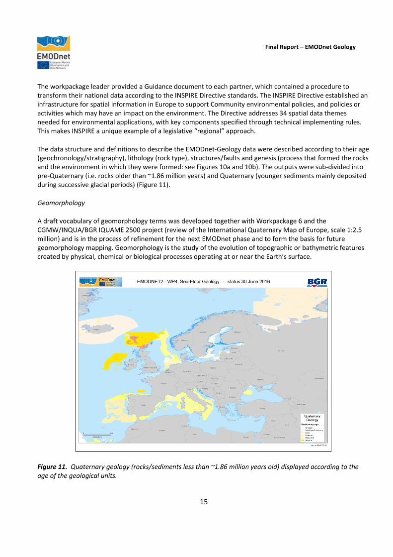
The data structure and definitions to describe the EMODnet-Geology data were described according to their age (geochronology/stratigraphy), lithology (rock type), structures/faults and genesis (process that formed the rocks and the environment in which they were formed: see Figures 10a and 10b). The outputs were sub-divided into pre-Quaternary (i.e. rocks older than ~1.86 million years) and Quaternary (younger sediments mainly deposited during successive glacial periods) (Figure 11).
Geomorphology
A draft vocabulary of geomorphology terms was developed together with Workpackage 6 and the CGMW/INQUA/BGR IQUAME 2500 project (review of the International Quaternary Map of Europe, scale 1:2.5 million) and is in the process of refinement for the next EMODnet phase and to form the basis for future geomorphology mapping. Geomorphology is the study of the evolution of topographic or bathymetric features created by physical, chemical or biological processes operating at or near the Earth’s surface.
Figure 11. Quaternary geology (rocks/sediments less than ~1.86 million years old) displayed according to the age of the geological units.

Final Report – EMODnet Geology
16
3.5. Workpackage 5. Coastal behaviour (TNO-Geological Survey of the Netherlands)
The objective of Workpackage 5 was to classify the coastal behaviour and typology of each country represented in the project partnership. The process involved using the EUROSION project data (http://www.eurosion.org/) as a baseline for pan-European coastal information and to update the data with information from the EMODnet-Geology partners. It is estimated that about 50% of the EUROSION information has been updated by the EMODnet-Geology partners (Figure 12).
The principle of coastal behaviour is to describe the movement of the coastline in a landward (erosion) or seaward (accretion) direction. Two behaviour-related output parameters are defined: migration (subdivided into direction, rate and associated volume) and resilience. Migration is a prime indicator of behaviour, as it describes coastline changes caused by erosion and accretion. Resilience is the ability of a coastline to absorb and recover from erosion before a critical state is reached. Along with resistance and the ability to stop or resist change, resilience is a measure of vulnerability and provides a potential link to the risk faced by the coastal-zone population. The term resilience is most commonly used for coastlines formed by unconsolidated sediment. It is also applied to coastal cliffs and bluffs, though most of the literature that relates to, or includes, rock coasts refers to resistance, sensitivity and vulnerability rather than to resilience per se. The key difference between rock coasts composed of consolidated sediment or lithified rock, and soft coasts, composed of unconsolidated sediment, is that there is no way to restore a rock coast once it has been eroded.
Figure 12. Areas of the European coastline showing coastal behaviour. Green = coastal accretion; Red = coastal erosion; Yellow = stable coastline; Black = no information.
Final Report – EMODnet Geology
17
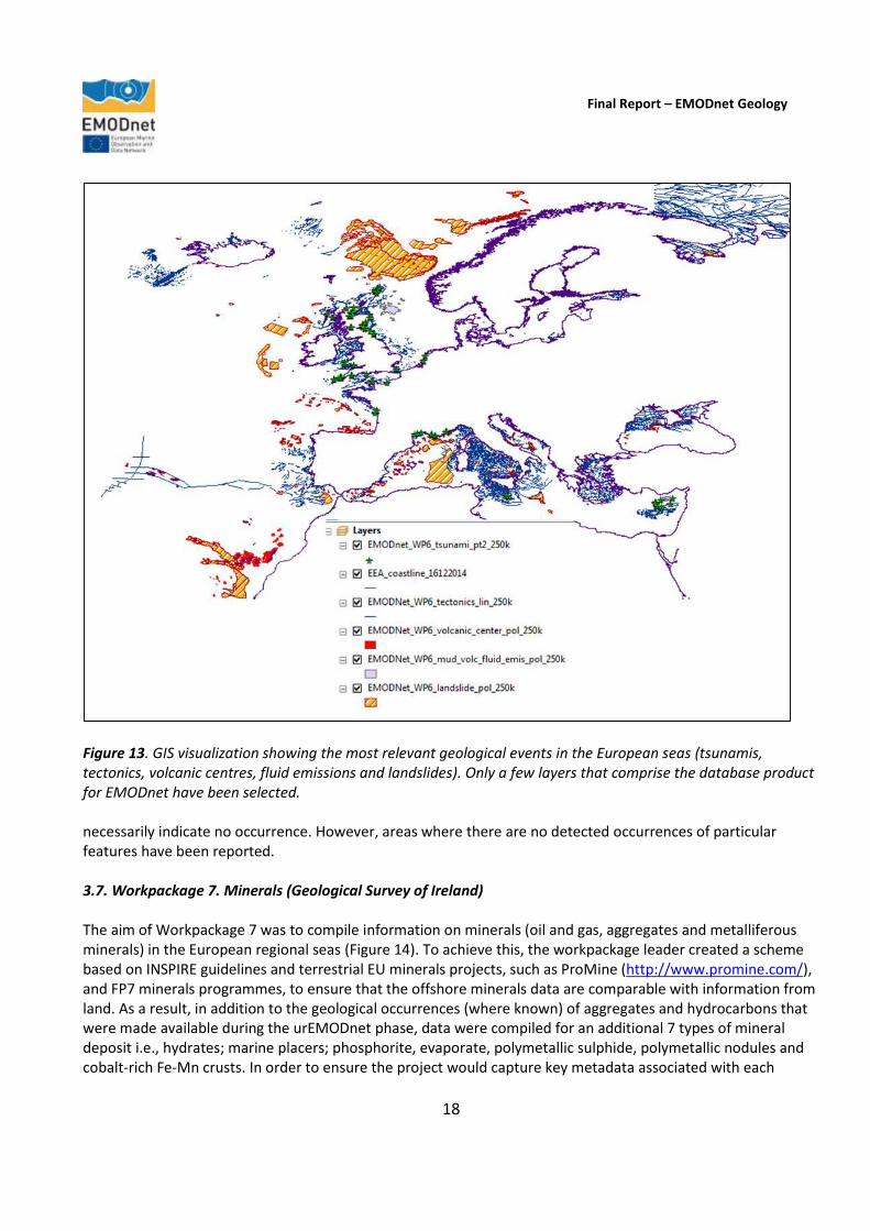
The episodic nature of cliff and bluff recession is a key attribute when it comes to assessing vulnerability and risk. Resilience is particularly relevant in densely populated or economically valuable areas. Here, a critical state would result not just in significant coastline reorganization but also in major socio-economic impact. Migration direction, distilled for the most part from EUROSION, was the only mandatory parameter provided by the EMODnet-Geology partners. Rate and associated volume of coastline migration, as well as resilience, were compiled if available. Although harmonised and standardized layers for publication were delivered using map web services, experience shows that the underlying data have been collected using different methods that generate output characterised by a multitude of specifications. The pluriformity of the data reflects a range of reference planes, coastline indicators, and time periods of monitoring. Unlike the other workpackages, the provided and collated data concern only the EMODnet participant states’ coastlines and not their offshore territories. Various coastlines have been used as a frame of reference in different European projects. In this light, partners were encouraged to use the original coastline linked to the delivered data, and not to project these data onto the coastline presently used by other EMODnet-Geology workpackages. This approach resulted in mis-matches between datasets, which emphasizes that there is much work to be done in the next EMODnet phase. 3.6. Workpackage 6. Geological events and probabilities (Geological Survey of Italy) Workpackage 6 includes a wide range of features such as submarine landslides, earthquakes and volcanic centres in the European regional seas, mapped by various national and regional mapping projects and also extracted from the literature. Since, compared to the urEMODnet-Geology phase, the current project has included areas that are geologically very active (such as the Atlantic Ocean and the Mediterranean Sea), it was necessary to elaborate a wider and more detailed Attribute Table for the GIS shapefiles relative to the different features in order to represent the diverse characteristics of each occurrence. Furthermore, based also on the feedback from EMODnet-Geology partners, it was agreed that each partner would compile information for features such as active faults, areas where tsunamis have originated in waters of European countries and the areas of coastline that have been impacted by tsunamis as well as fluid emissions of non-volcanic origin, because they are often closely related to the incidence of the examined events. Shapefiles representing each event at 1:250,000 scale have been compiled and are being delivered to the EMODnet-Geology portal. (Figure 13) For some features, such as earthquakes, there are external organisations/groups that compile information from data supplied by national and international networks. As there is no need to duplicate the effort required to assemble this information, the group has contacted and linked to third-party websites, for example the European-Mediterranean Seismological Centre (EMSC) to provide up-to-date earthquake information to the EMODnet-Geology Project. Particular attention has been devoted to the definition of the Attribute Table in order to achieve the best degree of harmonisation and INSPIRE compliance. A few cases of overlap of different deliveries have been overcome, after validation by Partners, in order to deliver the most comprehensive information. Regarding data gaps, as representation is based on available information and features considered within WP6 have a scattered distribution, not all events have been identified. Blank areas on maps therefore do not
Final Report – EMODnet Geology
18
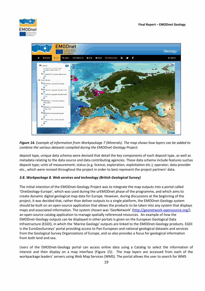
Figure 13. GIS visualization showing the most relevant geological events in the European seas (tsunamis, tectonics, volcanic centres, fluid emissions and landslides). Only a few layers that comprise the database product for EMODnet have been selected. necessarily indicate no occurrence. However, areas where there are no detected occurrences of particular features have been reported. 3.7. Workpackage 7. Minerals (Geological Survey of Ireland) The aim of Workpackage 7 was to compile information on minerals (oil and gas, aggregates and metalliferous minerals) in the European regional seas (Figure 14). To achieve this, the workpackage leader created a scheme based on INSPIRE guidelines and terrestrial EU minerals projects, such as ProMine (http://www.promine.com/), and FP7 minerals programmes, to ensure that the offshore minerals data are comparable with information from land. As a result, in addition to the geological occurrences (where known) of aggregates and hydrocarbons that were made available during the urEMODnet phase, data were compiled for an additional 7 types of mineral deposit i.e., hydrates; marine placers; phosphorite, evaporate, polymetallic sulphide, polymetallic nodules and cobalt-rich Fe-Mn crusts. In order to ensure the project would capture key metadata associated with each
Final Report – EMODnet Geology
19
Figure 14. Example of information from Workpackage 7 (Minerals). The map shows how layers can be added to combine the various datasets compiled during the EMODnet-Geology Project.
deposit type, unique data schema were devised that detail the key components of each deposit type, as well as metadata relating to the data source and data contributing agencies. These data schema include features suchas deposit type; units of measurement; status (e.g. licence, exploration, exploitation etc.); operator; data provider etc., which were revised throughout the project in order to best represent the project partners’ data.
3.8. Workpackage 8. Web services and technology (British Geological Survey) The initial intention of the EMODnet-Geology Project was to integrate the map outputs into a portal called ‘OneGeology-Europe’, which was used during the urEMODnet phase of the programme, and which aims to create dynamic digital geological map data for Europe. However, during discussions at the beginning of the project, it was decided that, rather than deliver outputs to a single platform, the EMODnet-Geology system should be built on an open-source application that allows the products to be taken into any system that displays maps and associated information. The system chosen was ‘GeoNetwork’ (http://geonetwork-opensource.org/), an open-source catalog application to manage spatially referenced resources. An example of how the EMODnet-Geology outputs can be displayed in other portals is given on the European Geological Data Infrastructure (EGDI), in which the ‘Marine Geology’ outputs are linked to the EMODnet-Geology products. EGDI is the EuroGeoSurveys’ portal providing access to Pan-European and national geological datasets and services from the Geological Survey Organizations of Europe, and so also provides a focus for geological information from both land and sea. Users of the EMODnet-Geology portal can access online data using a Catalog to select the information of interest and then display on a map interface (Figure 15). The map layers are accessed from each of the workpackage leaders’ servers using Web Map Services (WMS). The portal allows the user to search for WMS

Final Report – EMODnet Geology
20
Figure 15. EMODnet-Geology portal Home page. Map information can be selected from the list of datasets listed in the menu on the right or by using the search function. services of interest; view information on the service; view and interact with the service via a map interface; and obtain a link to the service to incorporate into a desktop GIS or other mapping application. Links to the WMS, which can be used to incorporate into a desktop GIS or other mapping application, can be found on the Metadata information page and the Map page. The search bar allows you to enter a free text term and also offers a list of options depending on the text entered. An 'advanced search' allows additional search options such as searches based on data content, spatial extent and temporal extent. 3.9. Workpackage 9. Dissemination (British Geological Survey) Throughout the project duration, the EMODnet-Geology partners have taken part in a large number of dissemination activities, both in their own countries and at international events. They have also published papers that have referenced EMODnet, and written articles for a range of media including science magazines, annual reports and websites. Radio and/or TV appearances to coincide with the project meetings that have been held, have also been made. As the project involves organisations from 30 countries, this has led to widespread outreach for the EMODnet-Geology Project, and a raised awareness of the programme in industry, academia plus Government and other public-sector organisations. 3.10. Workpackage 10. Liaison with EMODnet lots (British Geological Survey) The current phase of EMODnet has seen a significant increase in the contact and communication between the Co-ordinators of each thematic lot and the projects designed to check the suitability of the project outputs to inform various scenarios (e.g. an oil spill) in the regional seas, known as the ‘checkpoint’ projects. The Co-

Final Report – EMODnet Geology
21
ordinators have met twice a year at the EMODnet Steering Group meetings as well as major EMODnet events such as the Open Conference held in Ostend, Belgium in October 2015. This level of contact has been important in ensuring that topics of cross-thematic interest have been considered, such as the links between the EMODnet Bathymetry Project’s input to the work of the Geomorphology and Landforms Working Group, and the Seabed Habitats group’s input to the selection of a classification and confidence assessment of the EMODnet-Geology seabed-substrates deliverable. 3.11 Workpackage 11. Project analysis and sustainability (British Geological Survey) At the end of the EMODnet-Geology Project, the Project Co-ordinator and partners have assessed the overall project aims and analysed specific issues such as the main barriers to the provision of data by data holders including any scientific, institutional, legal, commercial, information technology, and financial barriers. The portal technology has been reviewed and improvements have been suggested, and an analysis has been made of the use of the portal as well as feedback from organisations that have made use of the data. Given the significant investment in EMODnet over the last 6 years, the sustainability of the EMODnet-Geology Project outputs is a significant consideration for the project partners. The long-term maintenance of the system requires a commitment from the partner organisations to establish a system for the regular updating and dissemination of the marine geology information that EMODnet has assembled. At the centre of the future sustainability are the EuroGeoSurveys’ network and the European Geological Data Infrastructure (EGDI), which the EMODnet-Geology group will integrate into their activities in the next phase of the project. As the EuroGeoSurveys’ members have committed to maintaining EGDI as their infrastructure for providing access to Pan-European and national geological datasets and services from the Geological Survey Organizations of Europe, the future of the collaboration between large numbers of marine geoscience groups is assured.
1. Introduction
This report presents the activities and outputs of the EMODnet-Geology Project from October 2013 to October 2016. The report presents the project highlights, a summary of the work done, the challenges encountered during the reporting period, the allocation of project resources, workpackage updates, user feedback, outreach and communication activities and updates on progress indicators. A summary aimed at the non-specialist is included in the Executive Summary. During the project, the EMODnet-Geology partners have made suggestions for new information that could form part of the next phase of the EMODnet Programme, some of which have been included in the recent call for EMODnet lots from 2016-2018. The EMODnet-Geology Project is one of seven that brings together information on the Geology, Chemistry, Biology, Physics, Bathymetry, Seabed Habitats, and Human Activities in the European marine environment. During the preparatory phase of EMODnet (2009-2012), 14 organisations from 14 countries demonstrated that geological information could be compiled and harmonised at 1:1,000,000 scale to provide map information and supporting data for parts of the regional seas of Europe. In 2013, an expanded group of mainly geological survey organisations from 30 countries was successful in being awarded the contract to deliver similar information for the entire European seas. In the current phase of EMODnet, the group of 36 partners have compiled geological information from all of the European seas shown in Figure 1. By including organisations from Iceland, Norway and Russia, the group were

Final Report – EMODnet Geology
22
able to expand the information coverage in areas beyond those requested in the initial Call for Tender to include the North Atlantic Ocean and the margins of the Arctic (Barents Sea and White Sea). The information that has been included in the project is principally that held by the project partners, although other organisations have contributed to the geological mapping objectives in many of the participating countries (see Section 10, Indicator 2). The geology data that were compiled in both the preparatory phase and in the current project includes:
Seabed substrate;
Sediment accumulation rate;
Sea-floor (bedrock) lithology;
Sea-floor (bedrock) stratigraphy;
Coastal behaviour;
Geological events and probabilities (e.g. earthquakes, submarine landslides, volcanic centres);
Mineral occurrences (e.g. oil and gas, aggregates, metallic minerals). The consortium includes the following organisations 1. Natural Environment Research Council – British Geological Survey (NERC-BGS); 2. Geological Survey of Finland (GTK); 3. Geological Survey of Sweden (SGU); 4. Geological Survey of Norway (NGU); 5. Geological Survey of Denmark and Greenland (GEUS); 6. Jardfeingi (Faroe Islands); 7. Iceland GeoSurvey (ISOR); 8. A.P Karpinsky Russian Geological Institute (VSEGEI); 9. Geological Survey of Estonia (GSE); 10. Latvijas Vidas Geologijas un Meteorologijas Centr (LEGMC; Latvia); 11. Lithuanian Geological Survey (LGT); 12. Polish Geological Institute (PGI); 13. Federal Institute for Geosciences and Natural Resources (BGR, Germany); 14. TNO –Geological Survey of the Netherlands; 15. Royal Belgian Institute of Natural Sciences (RBINS); 16. Bureau de Recherches Géologiques et Minieres (BRGM, France); 17. IFREMER (France); 18. Geological Survey of Ireland (GSI); 19. Geological Survey of Spain (IGME); 20. Instituto Português do Mar e da Atmosfera (IPMA, Portugal); 21. Istitituto Superiore per la Protezione e la Ricerca Ambientale. Servizio Geologico d'Italia (ISPRA); 22. Geological Survey of Slovenia (GeoZs); 23. Croatian Geological Survey (HGI); 24. Geological Survey of Montenegro (GEOZAVOD); 25. Geological Survey of Albania; 26. EKBAA- National Center for Sustainable Development (Greece); 27. Hellenic Center for Marine Research, Greece (HCMR); 28. Institute of Oceanology – Bulgarian Academy of Science (IO-BAS); 29. National Research and Development Institute for Marine Geology and Geoecology (GeoEcoMar, Romania); 30. Geological Institute of Romania (GIR); 31. Prychornomorsrge (Ukraine); 32. Dokuz Eylul University (Turkey); 33. Geological Survey of Cyprus; 34. Continental Shelf Department of the Ministry of Transport and Infrastructure (Malta); 35 Centre for Environment, Fisheries and Aquaculture Science (CEFAS, United Kingdom); 36. University of Sussex (United Kingdom).
The partnership consists of the geological survey organisations of all of the maritime countries of the European Union. Twenty-four of the project partners are also members of the Geological Surveys of Europe (EuroGeoSurveys), which exists to promote the work of the geological surveys and therefore provides a long-term association under which the project partners collaborate. The project has built on information primarily held by the project partners, but has also linked to other owners of information using Web Map Services (WMS), for example, the European-Mediterranean Seismological Centre (EMSC), which compiles information on earthquake activities. By doing so, the project will not recreate information that is held elsewhere. The development of a web-delivery mechanism using open-source standards also aims to ensure the long-term sustainability of the project by delivering the best available and up-to-date marine geological information held by the project partners.

Final Report – EMODnet Geology
23
Figure 1. The European regional seas included in the EMODnet-Geology Project. A characteristic of the EMODnet-Geology Project is that the main focus is on harmonised interpreted map information, as requested in the call for tenders, rather than the underlying data that have been used to create the interpreted geological outputs. In addition, Pan-European geological can be accessed through single
common data centres, for example the Geo-Seas portal (www.geo-seas.eu). However, the web-delivery system is designed to be able to access data catalogs of information held by each partner organisation and therefore has the potential to access more detailed information (maps and data) at national level. This aspect of the system is considered important to the long-term sustainability of the EMODnet-Geology outputs as it will provide access to the national sources of information where the organisations maintain their information resources.
2. Highlights of the project
The EMODnet-Geology Project has resulted in the compilation of a series of map outputs for each of the topics requested in the call for tenders. The maps are available on the EMODnet-Geology portal for viewing and can be integrated with users’ GIS systems based on Web Map Services and map downloads. The production of the maps has been based on national data-sharing agreements that were either previously in place, or have been initiated as a result of the EMODnet-Geology Project (see Section 10, Indicator 2). The project has also identified the data gaps in geological information from the European regional seas, and where data exists in cross-

Final Report – EMODnet Geology
24
boundary mismatches between sets of similar information. The data gaps are identified in each of the Workpackage deliverables where possible, for example by indicating where the absence of information is the due to lack of data rather than the absence of a particular feature. In cases where the geological outputs are harmonised maps based on existing information, and therefore include interpretations by extrapolation between point sources of information (i.e. samples analysed for sediment type), these data gaps are addressed through confidence assessments to demonstrate the underpinning data. Example of such information are demonstrated by, for example, the maps of sea-bed substrate and bedrock geology, which show a continuous layer of information even though they are based on variable density of data. To address these and other issues, working groups have been established that either address a specific subject, such as geomorphology, or regional integration of data, such as the Adriatic Sea Working Group. As information has become available, and through the communication activities of the project partners (see Section 9), there has been an increase in awareness and use of the EMODnet-Geology outputs, and strong evidence that the EMODnet-Geology outputs are being identified as an important source of information for a wide-range of government, industry and research users (see Section 10, Indicator 7).
The main highlights of the EMODnet-Geology Project are:
Assessment of all seabed-substrate information available at 1:250,000 scale and the compilation of information at 1:1 million scale where the higher resolution information is not available;
Assessment of pre-Quaternary geology and the start of compilations of Quaternary information, and agreement on geomorphological information that should be included in the EMODnet-Geology outputs;
The development of guidelines for coastal behaviour information and the update of the EUROSION information for about 50% of the European coast;
New maps for geological events and probabilities including earthquakes, underwater volcanic centres, tectonics (active faults), tsunamis (origin and coastal areas affected);
Maps for 9 different mineral types including aggregates, hydrocarbons, gas hydrates, marine placers, phosphorite, evaporite, polymetallic sulphides, polymetallic nodules and cobalt-rich Fe-Mn crusts;
The establishment of a project portal based on new software developments that continue to be based on the principles of free and open-source software;
Dissemination at national and international level and input to government planning processes;
The establishment of a number of national and regional networks based on the need for better co-ordination of information, for example in Iceland (see Section 8), Italy and in the Adriatic and North Sea regions;
Use of feedback from the users of the EMODnet-Geology outputs to provide recommendations for new or more detailed work in the next phase of EMODnet.

Final Report – EMODnet Geology
25
3. Description of the work done
1. Summary
The EMODNET-Geology Project has compiled marine geological information held by the project partners and additional datasets that are publicly available. The principal outputs are harmonised maps that are made are available through the project portal using a system called GeoNetwork, an open-source catalog application for management of spatially referenced resources, which allows the user to search for Web Map Services (WMS) of interest; view information on the service; view and interact with the service via a map interface; obtain a link to the service to incorporate into a desktop GIS or other mapping application.
Metadata for the information that is used to create the interpreted products (samples, cores, sub-seabed profiles) is available through the Geo-Seas portal (http://www.geo-seas.eu/). The consortium has compiled datasets according to the Open Call for Tenders No MARE/2012/10 ‘Knowledge base for growth and innovation in ocean economy: assembly and dissemination of marine data for seabed mapping’. The information requested in the call include, for the seabed, all available substrate information, improving where possible the resolution of classes and data compiled during the urEMODnet-Geology Project, rates of sediment accumulation or sedimentation; sea-floor geology (including age, lithology and origin); geological boundaries and faults; rate of coastal erosion and sedimentation; geological events and event probabilities (to include information on submarine landslides, volcanic activity, earthquake epicentres) and minerals (including aggregates, oil and gas). For the coast, information was requested for rates of sedimentation and erosion and coastal typology or behavioural descriptions such as cliffy coasts, sand dunes, estuaries, etc. The outputs were requested at 1:250,000 scale using the standards developed during the urEMODnet-Geology Project.
The areas covered are shown in Figure 1 (page 23). As the principal holders of marine geological information, the partnership ensures that data from the entire Baltic, Greater North Sea, Celtic Seas, Bay of Biscay and the Iberian Coast, Macaronesia and the Adriatic Sea, and parts of the Western Mediterranean, Ionian Sea and Central Mediterranean, Aegean-Levantine Sea and the Black Sea, are included in the project outputs.
2. Workplan and workpackages
The project was implemented in three phases: Phase 1. The construction of the products and the portal (months 0-12); Phase 2. The consolidation of all data products (months 13-24); Phase 3. The convergence phase during which the EMODnet-Geology portal was fine-tuned to ensure convergence with the other EMODnet portals. (months 25-36). The project is organised according to 11 workpackages, each led by organisations with experience in the specific fields. These are: WP1. Project Management. NERC-British Geological Survey (BGS). WP2. Geological data specification and sourcing. NERC-British Geological Survey (BGS). WP3. Seabed substrate. The Geological Survey of Finland (GTK).

Final Report – EMODnet Geology
26
WP4. Sea-floor geology. Bundesanstalt für Geowissenschaften und Rohstoffe – the Federal Institute for Geosciences and Natural Resources, Germany (BGR). WP5. Coastal behaviour. TNO-Geological Survey of the Netherlands. WP6. Geological events and probabilities. Institituto Superiore per la Protezione e la Ricerca Ambientale: (ISPRA – Italy). WP7. Minerals. The Geological Survey of Ireland (GSI). WP8. Web services and technology. NERC-British Geological Survey (BGS). WP9. Dissemination. NERC-British Geological Survey (BGS). WP10. EMODnet collaboration. NERC-British Geological Survey (BGS). WP11. Project analysis and sustainability. NERC-British Geological Survey (BGS). 3. Workpackage results The objectives and description/deliverables as set out in the original tender are given followed by progress made in each workpackage. 3.1. Workpackage 1. Project Management (British Geological Survey)
Objective
To manage the overall project, ensure delivery of the outputs and outcomes as agreed with the European Commission. To assess and evaluate the project and its results.
Outcome The project partners held the EMODnet-Geology Kick-off Meeting in Lisbon, Portugal on 21-22 January 2014. Further project meetings took place in Valletta, Malta from 30 September to 1 October 2014; Madrid, Spain, from 10-11 March 2015; Ostend, Belgium from 21-22 October 2015; Split, Croatia from 22-23 March 2016 and the final meeting was held in Edinburgh, UK on 27-28 September 2016. These meetings were planned twice yearly to coincide with major project milestones and, in the case of the Ostend meeting, to coincide with the EMODnet Open Conference held on 20 October 2015, which also gave the opportunity to have joint meetings with the other EMODnet lots. During the EMODnet ‘Jamboree’, the EMODnet-Geology project partners held joint meetings with the Bathymetry, Coastal Mapping and Seabed Habitats lots. The Project Co-ordinator attended the launch of the EMODnet Secretariat office in Ostend, Belgium in February 2014, when a presentation was also made to the Marine Observation and Data Expert Group (MODEG). A further update was made to MODEG during the EMODnet ‘Jamboree’ on 19th October 2016. The Project Co-ordinator and Technical Co-ordinator also participated in EMODnet Steering Committee meetings on 4th June 2014 (Rome), 10th December 2014 (Brussels), 1st/2nd July 2015 (Ispra, Italy) and the 21st June 2016 (Brussels). Both also took part in the EMODnet-INSPIRE Workshop (30th June 2015) and the EMODnet Open Seminar for Joint Research Centre staff (2nd July 2015) held in ISPRA. Bi-monthly and interim annual reports were submitted to the Secretariat according to the schedule in the Contract. 3.2. Workpackage 2. Geological data specification and sourcing (British Geological Survey) Objective

Final Report – EMODnet Geology
27
To prepare and provide access to the information required to deliver 1:250,000 maps of the seabed substrate (improving where possible the current resolution of the classes and data); the rate of accumulation and/or sedimentation on the sea floor; geological boundaries and faults; geological events and event probabilities and minerals. For the coast, information will be provided on rate of sedimentation and erosion, and the coastal typology and/or behavioural description. The access to partners’ data will use the standards developed in the Geo-Seas Project. The data products (maps) will use the standards developed in the urEMODnet-Geology Project. Outcome The process of identifying data sources had started for the northern European countries during the urEMODnet-Geology Project from 2009-2012. From the start of the current phase of the project in October 2013 through to the Kick-off Meeting in January 2014, all partners assessed the information available in each country and presented their findings in Lisbon at the end of the third full month of the project. These assessments allowed all workpackage leaders to make progress in issuing Guidelines for compilation and harmonisation of the datasets and interpreted products. The process of identifying information that is relevant to EMODnet-Geology is considered to be an on-going process and several sets of information have been integrated into the project throughout the duration. Access to the data used to create the EMODnet-Geology products continued to rely on the Geo-Seas portal during three current phase of the project. However, it is acknowledged that the links between the EMODnet-Geology and Geo-Seas portals has not been satisfactorily integrated, partly due to the interface with Geo-Seas being controlled by a Request Status Manager service that communicates with the data centres that requires log-in to submit and download datasets. Future development of the EMODnet-Geology portal based on the European Geological Data Infrastructure (EGDI), will improve this interface between the interpreted and harmonised EMODnet-Geology information layers and the underlying datasets (see Section 5.1.7). 3.3. Workpackage 3. Seabed substrate (Geological Survey of Finland) Objective
To compile and harmonise all available seabed-substrate information at a scale of 1:250,000 to deliver the seabed-substrate component of Section 2.4 of the tender documents and all available information on the rate of accumulation and sedimentation on the sea floor.
Outcome
Workpackage 3 has produced seabed-substrate datasets at the scale of 1:250,000 and 1:1 million from the European Seas including the Baltic Sea, the North Sea, the Celtic Seas, the White Sea, the Barents Sea, the seas around Iceland and the Faroe islands, the Bay of Biscay and the Iberian Coast, the Western Mediterranean Sea (within waters of EU countries), the Adriatic Sea, the Ionian Sea and the Central Mediterranean Sea (within waters of EU countries), the Aegean-Levantine Sea (within waters of EU countries – including the Turkish sector) and the Black Sea (Turkey, Romania, Bulgaria and Ukraine) as defined in the Marine Strategy Framework Directive. The seabed-substrate datasets include a confidence analysis, as well as data showing sedimentation rates (cm/year) at the seabed. In addition to seabed-substrate data products, the workpackage has compiled a list of geological features that are not included in the current seabed-substrate schema.

Final Report – EMODnet Geology
28
The data products have been delivered to the data portal of the EMODnet Geology portal as well as to GTK’s HAKKU service (http://hakku.gtk.fi/en/), where they are available for download. The HAKKU service is the central distribution channel for spatial data products or publications, reports, map drawings and photos produced by the Geological Survey of Finland (GTK), who led Workpackage 3. The service lets users search for and start using a range of geological information products. The HAKKU service includes mainly Finnish geological information, documents and metadata from the 19th century to the present day. Most of the products are also available for further use as downloads or through an interface.he principle of making the EMODnet-Geology outputs available to view or download through various outlets is an important aspect of EMODnet-Geology. The main objective of Workpackage 3 was to provide substrate information from the study area at a scale of 1:250,000. However, as only about 20% of the European sea areas have been mapped at this scale (or more detailed) (see Figure 3), it was decided to produce a seabed-substrate data layer at the broader scale of 1:1 million to improve the coverage (coverage about 60%) and deliver a harmonised map that avoids showing information gaps. The first version of the 1:250,000 datasets was drafted in June 2014 and the 1:1 million map in June 2015. Both datasets were updated throughout the project and the final versions were completed in June 2016. Both datasets include a confidence assessment that was finalised in the summer of 2016 (see Figure 10). Workpackage 3 also compiled as much information as possible on the rate of accumulation and sedimentation (see Figure 11). Data format requirements and data transfer Format: Data were required to be submitted to the workpackage leader as ESRI shapefiles (polygon features). Scale: The EMODnet-Geology Project’s aim was to deliver GIS layers of information compiled at 1: 250,000 scale wherever possible. The smallest cartographic unit that can be represented at this scale is 0.3 km2; no areas smaller than this should be present in the final map. Coordinate system: The georeferenced data is provided in the WGS84 geographical coordinate system (Latitude/Longitude). Coastline: The EMODnet-Geology Project has used a coastline adopted by the European Environment Agency (EEA) at 1:100 000 scale (last uploaded on 4th July 2013), which was expected to be the standard coastline adopted by all of the EMODnet projects. Within the project, the EEA coastline was later modified with more detailed coastal information from Russia, Malta and the Canary Islands (Spain). The modified coastline was also delivered to the other workpackage leaders in February 2015 and made available for all partners on the GTK's ftp-site (see comment on coastline in Section 3.3). Methods The work to compile seabed-substrate datasets followed the Guidelines used during the urEMODnet-Geology Project. The work included several phases (Figure 2):
1. Index map (data sourcing). 2. Harmonisation. The national seabed-substrate data were translated into the EMODnet-Geology
substrate classification system.
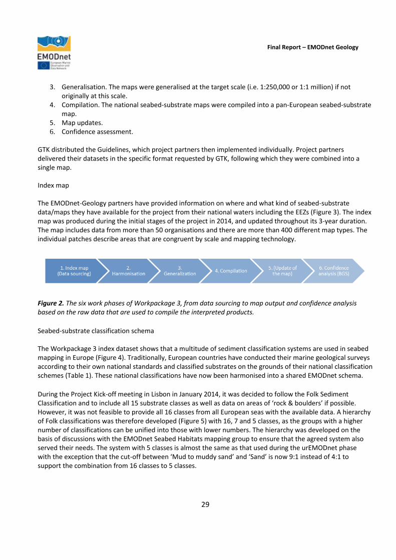
Final Report – EMODnet Geology
29
3. Generalisation. The maps were generalised at the target scale (i.e. 1:250,000 or 1:1 million) if not originally at this scale.
4. Compilation. The national seabed-substrate maps were compiled into a pan-European seabed-substrate map.
5. Map updates. 6. Confidence assessment.
GTK distributed the Guidelines, which project partners then implemented individually. Project partners delivered their datasets in the specific format requested by GTK, following which they were combined into a single map. Index map The EMODnet-Geology partners have provided information on where and what kind of seabed-substrate data/maps they have available for the project from their national waters including the EEZs (Figure 3). The index map was produced during the initial stages of the project in 2014, and updated throughout its 3-year duration. The map includes data from more than 50 organisations and there are more than 400 different map types. The individual patches describe areas that are congruent by scale and mapping technology.
Figure 2. The six work phases of Workpackage 3, from data sourcing to map output and confidence analysis based on the raw data that are used to compile the interpreted products.
Seabed-substrate classification schema The Workpackage 3 index dataset shows that a multitude of sediment classification systems are used in seabed mapping in Europe (Figure 4). Traditionally, European countries have conducted their marine geological surveys according to their own national standards and classified substrates on the grounds of their national classification schemes (Table 1). These national classifications have now been harmonised into a shared EMODnet schema.
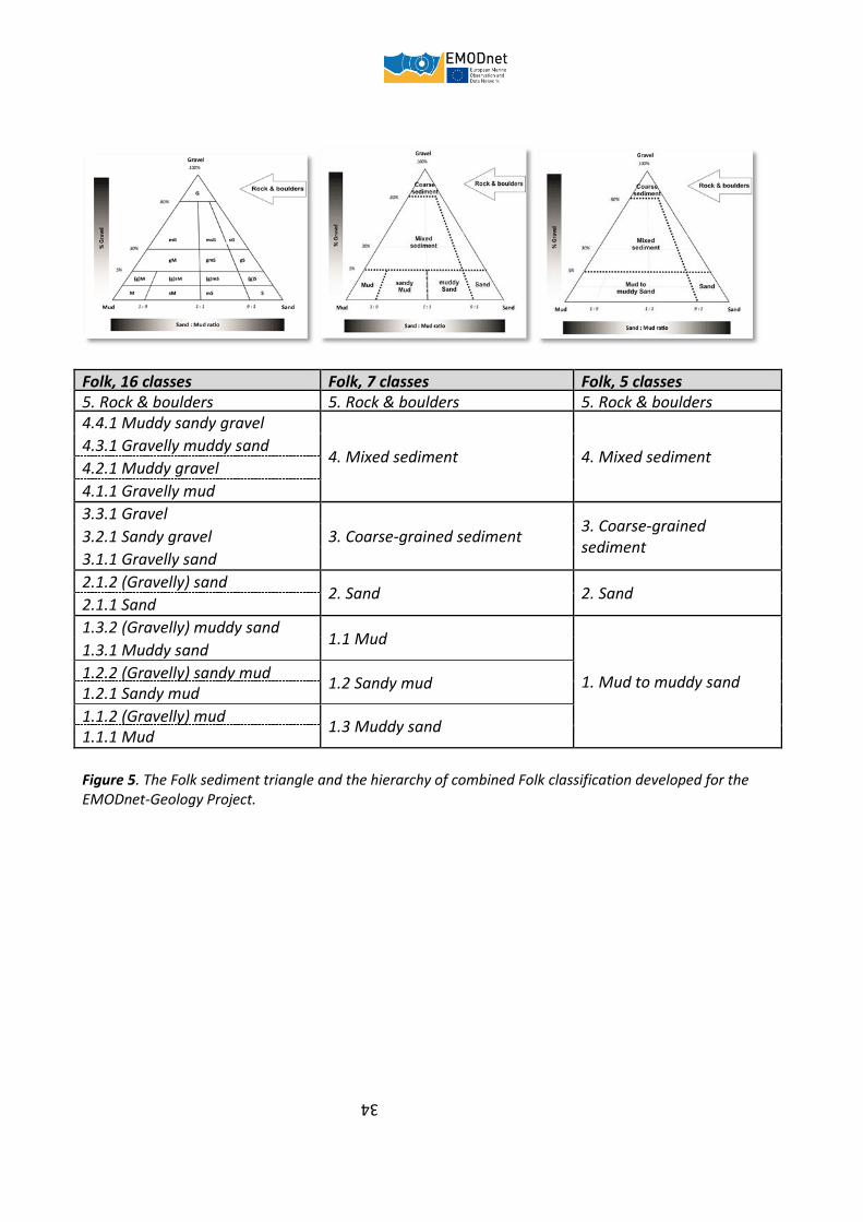
During the Project Kick-off meeting in Lisbon in January 2014, it was decided to follow the Folk Sediment Classification and to include all 15 substrate classes as well as data on areas of ‘rock & boulders’ if possible. However, it was not feasible to provide all 16 classes from all European seas with the available data. A hierarchy of Folk classifications was therefore developed (Figure 5) with 16, 7 and 5 classes, as the groups with a higher number of classifications can be unified into those with lower numbers. The hierarchy was developed on the basis of discussions with the EMODnet Seabed Habitats mapping group to ensure that the agreed system also served their needs. The system with 5 classes is almost the same as that used during the urEMODnet phase with the exception that the cut-off between ‘Mud to muddy sand’ and ‘Sand’ is now 9:1 instead of 4:1 to support the combination from 16 classes to 5 classes.

Final Report – EMODnet Geology
30
Figure 3. The coverage and the scale of the seabed-substrate data that has been made available for the EMODnet-Geology Project. The highest resolution information is mainly from the coastal zones of most European countries, where much of the national mapping effort has been focussed. Countries such as Belgium, Denmark, Germany, Ireland, the Netherlands and the United Kingdom have conducted national mapping programmes specifically aimed at delivering outputs at 1:250,000 or more detailed scale.
If national datasets were not originally classified according to the Folk system, they were reclassified on the basis of assessment of sample information and/or expert-based prediction. Due to the challenging timeline and diversity of national datasets (Figure 3, Figure 4 and Table 1), the substrate reclassification scheme is designed to be as simple as possible, but as a consequence, in some cases, provides only an approximate estimate of the substrate material from the uppermost 30 cm of the sediment column. Although it was recommended that each partner should use the most detailed Folk classification (16-7-5 Folk classes) wherever possible, due to fundamental differences in data (e.g. grain-size limits) the one-to-one translation of the national substrate category into the Folk category was not always feasible. The resulting classes might therefore be more of "compromise" that includes the majority of the substrate variation in that class.

Final Report – EMODnet Geology
31
Figure 4. The 34 different sediment grain-size classification systems used in seabed mapping in Europe indicate the complexity of harmonising seabed substrate information.
Seabed-substrate data (1:250,000 scale) The 1:250,000 scale seabed-substrate dataset produced during the first year of the project continued to be updated with data from the partners throughout the project duration. The updates were either from new data from the project partners (e.g. from recent surveys) or with older data that had been digitized during the EMODnet-Geology Project. The GIS applicability of the seabed-substrate data products varied between partners; some partners’ data already existed in GIS format and some only as paper sheets. Many partners only started to collect spatial data from existing archives and/or to digitize seabed-substrate datasets within the EMODnet-Geology Project. In addition, the EMODnet-Geology Project provided the opportunity for a few partners to complete their first ever national seabed-substrate maps by gathering data from different sources, compiling them and producing an interpretation of the substrate distribution.
The major challenge in Workpackage 3 has been the very tight time schedule, as the EMODnet Seabed Habitats Lot had requested a preliminary seabed-substrate map by June 2014, within 9 months of the start of the EMODnet-Geology Project. However, the project was able to distribute the first version of the 1:250,000 scale

Final Report – EMODnet Geology
32
map by the deadline. This version was continuously updated throughout the project as information became available and the final dataset was delivered to the habitat mappers in June 2016 (Figure 6). Topological correction of the data is also time-consuming. There are often mis-matches between the national datasets, which have to be corrected, but with the tight timescale for data delivery/production this was very challenging. Data restrictions due to national security issues or data-use policies have also been problematic. The solution to these problems has been to include the boundaries of the restricted datasets in the seabed-substrate dataset in order to show that there is data, but it is not available for distribution. The data restrictions are related to Finland and France and only to 250 k dataset. In Finland the restrictions arise from the national security policy as the distribution of high-resolution data from the some areas is forbidden by the National Defence Office (Figure 7). In France the restrictions derive from the data policy. Part of the French substrate data is the property of the National Hydrographic and Oceanic Service of France (SHOM), who have restricted the use of their data (Figure 8). The French Geological Survey (BRGM), Ifremer and SHOM have opened discussions about whether the SHOM data could be included in EMODnet-Geology maps in the future. Seabed-substrate data (1:1 million scale) The 1:1 million seabed-substrate data is an additional output of the Workpackage 3 that was initially discussed at the EMODnet-Geology Project meeting in Malta (October 2014) when the project partners agreed to produce a broadscale seabed-substrate dataset for the European seas to extend the coverage of the 1:250,000 data. The workpackage therefore focused on producing the 1:1 million seabed-substrate data during the second year of the EMODnet-Geology Project. Compilation of the data followed the Guidelines used to compile information at the same scale during the previous urEMODnet phase, and the first version of the dataset was produced in June 2015 and the final version a year later in summer 2016 (Figure 9). The 1:1 million dataset mainly includes three different datasets that were combined according to the following priorities:
• Broadscale data from partners; • Generalised 1:250,000 scale data. The generalisation of 250k data to 1:1 million scale
followed the principles adopted during urEMODnet (with the exception of the 250m cell size);
• urEMODnet data and Unconsolidated Bottom Surface Sediments of the Mediterranean and Black Seas (IBCM-Sed) (Emelyanov, E.M., Shimkus, K.M, Kuprin, P.N., 1996. Intergovernmental Oceanographic Commission (UNESCO)).
The workpackage leader then classified the urEMODnet data and IBCM-Sed data into the Folk Classification System on the basis of tables 2 and 3.
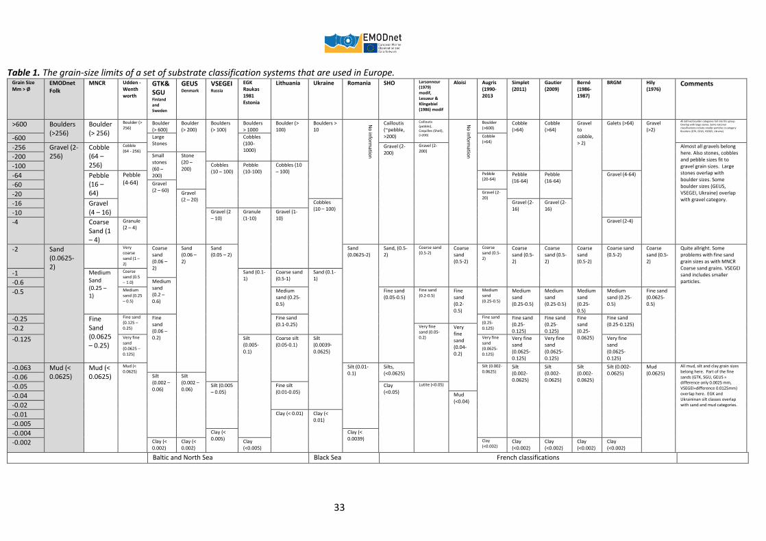
Table 1. The grain-size limits of a set of substrate classification systems that are used in Europe. Grain Size Mm > Ø
EMODnet Folk
MNCR Udden -Wenthworth
GTK&SGU Finland and Sweden
GEUS Denmark
VSEGEI Russia
EGK Raukas 1981 Estonia
Lithuania Ukraine Romania SHO Larsonneur (1979) modif, Lesueur & Klingebiel (1986) modif
Aloisi Augris (1990-2013
Simplet (2011)
Gautier (2009)
Berné (1986-1987)
BRGM
Hily (1976)
Comments
>600 Boulders (>256)
Boulder (> 256)
Boulder (> 256)
Boulder (> 600)
Boulder (> 200)
Boulders (> 100)
Boulders > 1000
Boulder (> 100)
Boulders > 10
No
info
rmatio
n
Cailloutis (~pebble, >200)
Cailloutis (pebble), Coquilles (Shell), (>200)
No
info
rmatio
n
Boulder (>600)
Cobble (>64)
Cobble (>64)
Gravel to cobble, > 2)
Galets (>64) Gravel (>2)
All defined boulder categories fall into this group. Overlap with large stones. Some national classifications include smaller particles in category Boulders (GTK, GEUS, VSEGEI, Ukraine)
-600 Large Stones
Cobbles (100-1000)
Cobble (>64)
-256 Gravel (2-256)
Cobble (64 – 256)
Cobble (64 - 256)
Gravel (2-200)
Gravel (2-200)
Almost all gravels belong here. Also stones, cobbles and pebble sizes fit to gravel grain sizes. Large stones overlap with boulder sizes. Some boulder sizes (GEUS, VSEGEI, Ukraine) overlap with gravel category.
-200 Small stones (60 – 200)
Stone (20 – 200) -100 Cobbles
(10 – 100) Pebble (10-100)
Cobbles (10 – 100)
-64 Pebble (16 – 64)
Pebble (4-64)
Pebble (20-64)
Pebble (16-64)
Pebble (16-64)
Gravel (4-64)
-60 Gravel (2 – 60)
-20 Gravel (2 – 20)
Gravel (2-20)
-16 Gravel (4 – 16)
Cobbles (10 – 100)
Gravel (2-16)
Gravel (2-16)
-10 Gravel (2 – 10)
Granule (1-10)
Gravel (1-10)
-4 Coarse Sand (1 – 4)
Granule (2 – 4)
Gravel (2-4)
-2 Sand (0.0625-2)
Very coarse sand (1 – 2)
Coarse sand (0.06 – 2)
Sand (0.06 – 2)
Sand (0.05 – 2)
Sand (0.0625-2)
Sand, (0.5-2)
Coarse sand (0.5-2)
Coarse sand (0.5-2)
Coarse sand (0.5-2)
Coarse sand (0.5-2)
Coarse sand (0.5-2)
Coarse sand (0.5-2)
Coarse sand (0.5-2)
Coarse sand (0.5-2)
Quite allright. Some problems with fine sand grain sizes as with MNCR Coarse sand grains. VSEGEI sand includes smaller particles.
-1 Medium Sand (0.25 – 1)
Coarse sand (0.5 – 1.0)
Sand (0.1-1)
Coarse sand (0.5-1)
Sand (0.1-1)
-0.6 Medium sand (0.2 – 0.6)
-0.5 Medium sand (0.25 – 0.5)
Medium sand (0.25-0.5)
Fine sand (0.05-0.5)
Fine sand (0.2-0.5)
Fine sand (0.2-0.5)
Medium sand (0.25-0.5)
Medium sand (0.25-0.5)
Medium sand (0.25-0.5)
Medium sand (0.25-0.5)
Medium sand (0.25-0.5)
Fine sand (0.0625-0.5)
-0.25 Fine Sand (0.0625 – 0.25)
Fine sand (0.125 – 0.25)
Fine sand (0.06 – 0.2)
Fine sand (0.1-0.25)
Fine sand (0.25-0.125)
Fine sand (0.25-0.125)
Fine sand (0.25-0.125)
Fine sand (0.25-0.0625)
Fine sand (0.25-0.125)
-0.2 Very fine sand (0.05-0.2)
Very fine sand (0.04-0.2)
-0.125 Very fine sand (0.0625 – 0.125)
Silt (0.005-0.1)
Coarse silt (0.05-0.1)
Silt (0.0039-0.0625)
Very fine sand (0.0625-0.125)
Very fine sand (0.0625-0.125)
Very fine sand (0.0625-0.125)
Very fine sand (0.0625-0.125)
-0.063 Mud (< 0.0625)
Mud (< 0.0625)
Mud (< 0.0625)
Silt (0.01-0.1)
Silts, (<0.0625)
Silt (0.002-0.0625)
Silt (0.002-0.0625)
Silt (0.002-0.0625)
Silt (0.002-0.0625)
Silt (0.002-0.0625)
Mud (0.0625)
All mud, silt and clay grain sizes belong here. Part of the fine sands (GTK, SGU, GEUS = difference only 0.0025 mm, VSEGEI=difference 0.0125mm) overlap here. EGK and Ukraininan silt classes overlap with sand and mud categories.
-0.06 Silt (0.002 – 0.06)
Silt (0.002 – 0.06) -0.05 Silt (0.005
– 0.05) Fine silt (0.01-0.05)
Clay (<0.05)
Lutite (<0.05)
-0.04 Mud (<0.04)
-0.02
-0.01 Clay (< 0.01) Clay (< 0.01)
-0.005
-0.004 Clay (< 0.005)
Clay (< 0.0039)
-0.002 Clay (< 0.002)
Clay (< 0.002)
Clay (<0.005)
Clay (<0.002)
Clay (<0.002)
Clay (<0.002)
Clay (<0.002)
Clay (<0.002)
Baltic and North Sea Black Sea French classifications
33
Folk, 16 classes Folk, 7 classes Folk, 5 classes 5. Rock & boulders 5. Rock & boulders 5. Rock & boulders 4.4.1 Muddy sandy gravel
4. Mixed sediment 4. Mixed sediment 4.3.1 Gravelly muddy sand
4.2.1 Muddy gravel
4.1.1 Gravelly mud
3.3.1 Gravel
3. Coarse-grained sediment 3. Coarse-grained sediment
3.2.1 Sandy gravel
3.1.1 Gravelly sand
2.1.2 (Gravelly) sand 2. Sand 2. Sand
2.1.1 Sand
1.3.2 (Gravelly) muddy sand 1.1 Mud
1. Mud to muddy sand
1.3.1 Muddy sand
1.2.2 (Gravelly) sandy mud 1.2 Sandy mud
1.2.1 Sandy mud
1.1.2 (Gravelly) mud 1.3 Muddy sand
1.1.1 Mud
Figure 5. The Folk sediment triangle and the hierarchy of combined Folk classification developed for the EMODnet-Geology Project.
34

Final Report – EMODnet Geology
35
Figure 6. The EMODnet-Geology seabed-substrate data at 1:250,000 for the European seas, according to the hierarchy of 7 classes (see Figure 5).
Figure 7. Detail from the Baltic Sea showing areas where the Finnish National Defence Office restricts publication of marine geological data.
Final Report – EMODnet Geology
36
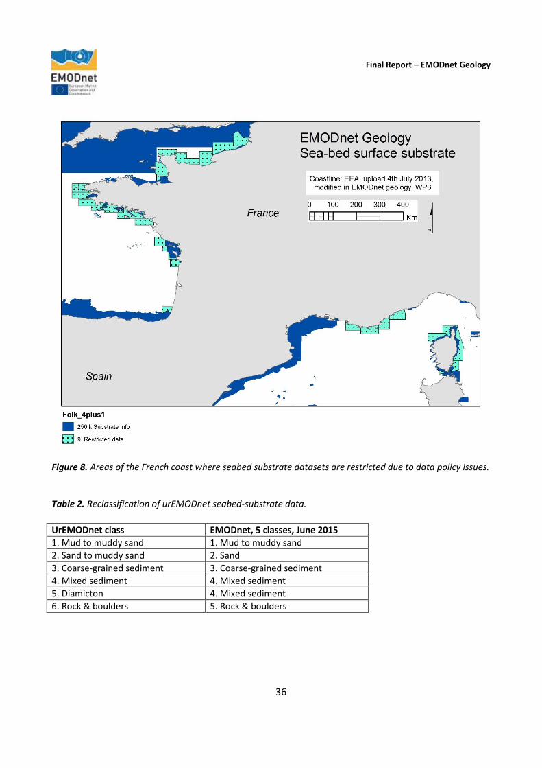
Figure 8. Areas of the French coast where seabed substrate datasets are restricted due to data policy issues. Table 2. Reclassification of urEMODnet seabed-substrate data.
UrEMODnet class EMODnet, 5 classes, June 2015
1. Mud to muddy sand 1. Mud to muddy sand
2. Sand to muddy sand 2. Sand
3. Coarse-grained sediment 3. Coarse-grained sediment
4. Mixed sediment 4. Mixed sediment
5. Diamicton 4. Mixed sediment
6. Rock & boulders 5. Rock & boulders

Final Report – EMODnet Geology
37
Table 3. Reclassification of IBCM-Sed data.
IBCM-Sed class EMODnet, 7 classes, June 2015
Mud, Clay, Silt 1.1 Mud
Sandy mud, Sandy clay, Sandy silt 1.2 Sandy mud
Muddy sand, Clayey sand, Silty sand 1.3 Muddy sand
Sand 2. Sand
3. Coarse-grained sediment
4. Mixed sediment
Volcanic 5. Rock & boulders
The 1:1 million dataset is an additional output of the workpackage. Due to the tight data delivery and production schedule, the information has not been checked and corrected for topological errors and consequently there may be mis-matches between the national datasets. The updated 1:1 million dataset is different to that which was delivered during the urEMODnet phase in that it covers a larger area, and includes more data than the previous dataset. UrEMODnet data focused on the North Sea, Celtic Seas and Baltic Sea whereas the new 1:1 million dataset includes all European Seas, including the Mediterranean Sea, Bay of Biscay and Arctic Sea among others. In addition, some new substrate data were included from the urEMODnet areas (mainly on the basis of higher resolution data). As the EMODnet-Geology project partners are national geological survey organisations, the outputs represent the best available information within the scope of the EMODnet programme. As described under Indicator 1 in Section 10 of this report, to provide an indication of the amount of new data that was used to compile the products delivered in the current phase of EMODnet, an example of the number of datasets used to compile the 1:1 million Seabed Substrate map (see Figure 9) shows that more than 400 original maps have been used compared to 200 included in urEMODnet. Seabed substrate 1:1 million coverage has also extended from about 2 000 000 km2 in urEMODnet to coverage of about 8 000 000km2 in the current phase. Users of the EMODnet-Geology portal are made aware of the limitations of the 1:1 million dataset in the metadata of the Seabed Substrate layer, which states that, ‘The data may include some errors e.g. overlays, topological gaps and data discontinuities.” Attribute tables Both seabed-substrate datasets include attribute data that contain metadata of the national datasets. The attribute table contains 14 columns, which describes the data and how the (re)classification was carried out. Confidence The British Geological Survey (BGS) led the work to produce a confidence analysis on the seabed-substrate data. The BGS distributed the Guidelines on the methodology to partners in August 2015. The confidence analysis is based on the index map (or code field in the attribute table) that is used to assign a confidence score (0-4) using the “3 step confidence method” developed by the Joint Nature Conservation Council (Three-step confidence assessment framework for classified seabed maps, H. Elwood, JNCC). Figure 10 shows the results of the
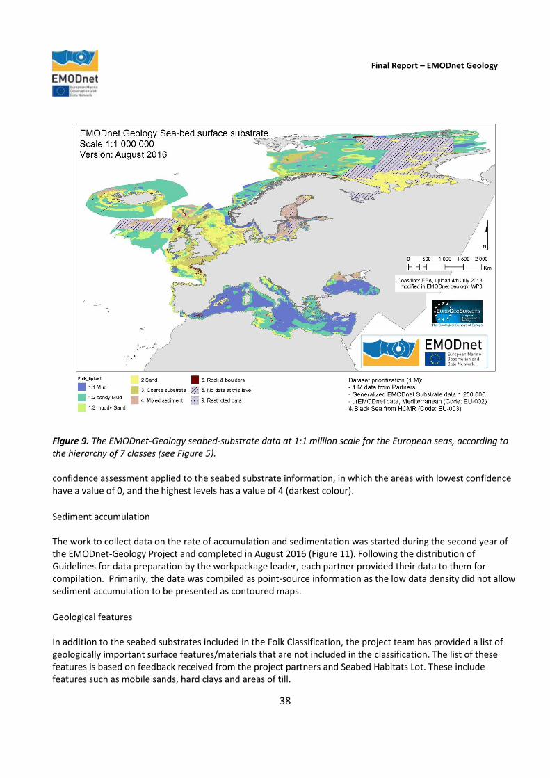
Final Report – EMODnet Geology
38
Figure 9. The EMODnet-Geology seabed-substrate data at 1:1 million scale for the European seas, according to the hierarchy of 7 classes (see Figure 5). confidence assessment applied to the seabed substrate information, in which the areas with lowest confidence have a value of 0, and the highest levels has a value of 4 (darkest colour).
Sediment accumulation The work to collect data on the rate of accumulation and sedimentation was started during the second year of the EMODnet-Geology Project and completed in August 2016 (Figure 11). Following the distribution of Guidelines for data preparation by the workpackage leader, each partner provided their data to them for compilation. Primarily, the data was compiled as point-source information as the low data density did not allow sediment accumulation to be presented as contoured maps.
Geological features In addition to the seabed substrates included in the Folk Classification, the project team has provided a list of geologically important surface features/materials that are not included in the classification. The list of these features is based on feedback received from the project partners and Seabed Habitats Lot. These include features such as mobile sands, hard clays and areas of till.

Final Report – EMODnet Geology
39
Figure 10. The confidence scores for the European seabed-substrate data/maps. Darker areas indicate higher confidence. Case study Workpackage 3 included a module that models substrate and other terrain derivatives (e.g. morphology and seabed dynamics) from acoustic data layers to serve as a case study on deriving biologically relevant (and EUNIS compatible) datasets. The case study “Quantitative spatial prediction of seabed sediment composition” was performed and reported by CEFAS (Diesing, 2015) and included in the second interim project Annual Report (2015). 3.4. Workpackage 4. Sea-floor geology (Federal Institute for Geosciences and Natural Resources (BGR, Germany))
Objective
To compile and harmonise all available seabed geology (outcrop and sub-Quaternary) information at a scale of 1:250,000.
Outcome
The workpackage leader (BGR) initially made an inventory of available datasets of the pre-Quaternary geology at the partner institutions, which had been identified during Workpackage 2 and the scales at which the maps were compiled (Figure 12). For this purpose, a questionnaire was prepared and distributed to all partner
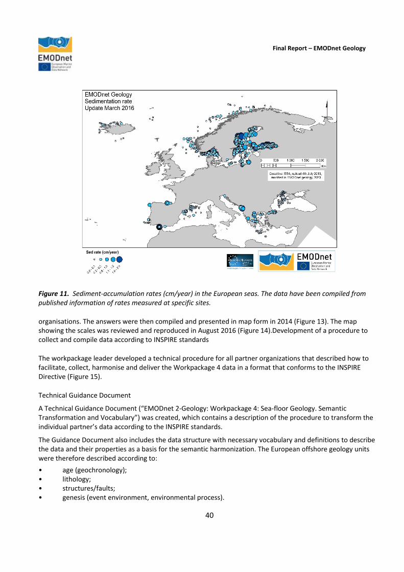
Final Report – EMODnet Geology
40
Figure 11. Sediment-accumulation rates (cm/year) in the European seas. The data have been compiled from published information of rates measured at specific sites.
organisations. The answers were then compiled and presented in map form in 2014 (Figure 13). The map showing the scales was reviewed and reproduced in August 2016 (Figure 14).Development of a procedure to collect and compile data according to INSPIRE standards
The workpackage leader developed a technical procedure for all partner organizations that described how to facilitate, collect, harmonise and deliver the Workpackage 4 data in a format that conforms to the INSPIRE Directive (Figure 15).
Technical Guidance Document
A Technical Guidance Document (“EMODnet 2-Geology: Workpackage 4: Sea-floor Geology. Semantic Transformation and Vocabulary”) was created, which contains a description of the procedure to transform the individual partner’s data according to the INSPIRE standards.
The Guidance Document also includes the data structure with necessary vocabulary and definitions to describe the data and their properties as a basis for the semantic harmonization. The European offshore geology units were therefore described according to:
• age (geochronology); • lithology; • structures/faults; • genesis (event environment, environmental process).

Final Report – EMODnet Geology
41
Figure 12. Scales of available sea-floor geology data in September 2014.
Figure 13. Availability of pre-Quaternary geology data in September 2014.

Final Report – EMODnet Geology
42
Figure 14. Scales of available sea-floor geology data in September 2016.
Figure 15. EMODnet-Geology , Workpackage 4: Schema of the data organisation and of the link between the spatial and semantic datasets.
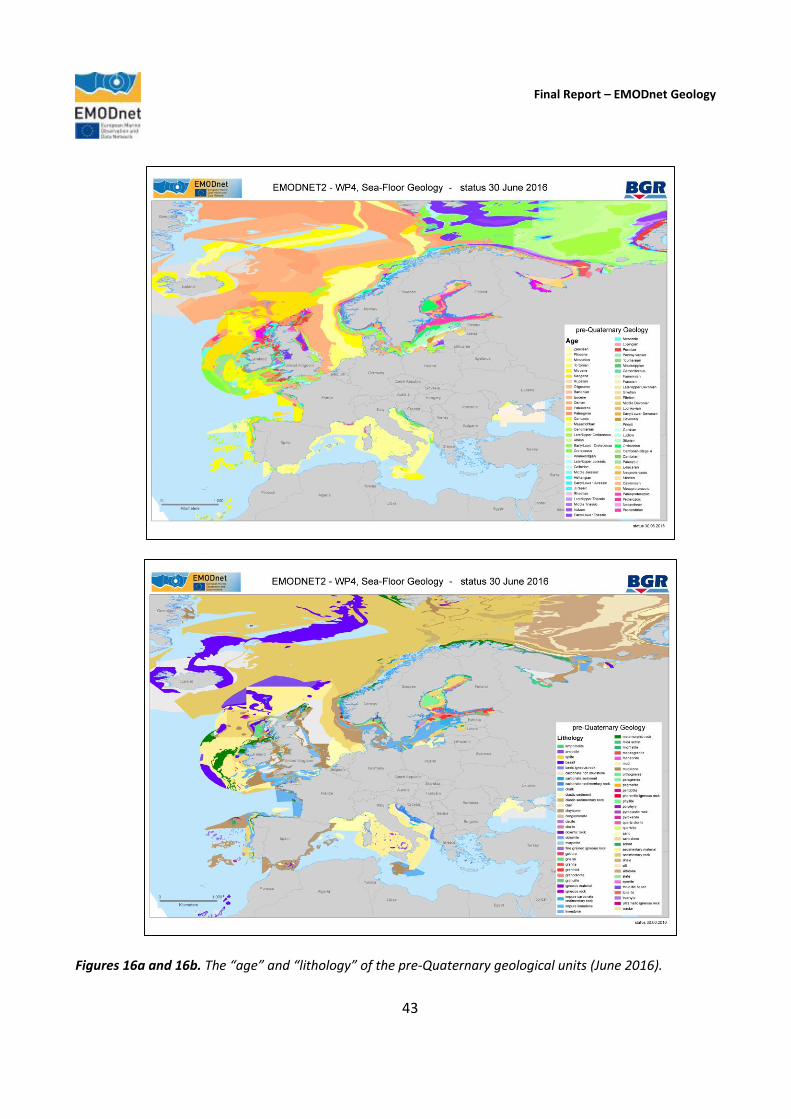
Final Report – EMODnet Geology
43
Figures 16a and 16b. The “age” and “lithology” of the pre-Quaternary geological units (June 2016).

Final Report – EMODnet Geology
44
Figures 17a and 17b. Data depicting bedrock genesis as a) “event process” and b) “event environment” of the pre-Quaternary geological units (status June 2016).

Final Report – EMODnet Geology
45
Figure 18. Data depicting the structure elements and faults compiled during the assessment of the sea-floor geology (June 2016).
Bedrock (pre-Quaternary geology): age, lithology, genesis and faults The available pre-Quaternary geology data from 29 of the project participants were collected and integrated into the GIS and continuously updated during the project. Figures 16a and b show the status of the data compilation according to age and lithology, whereas Figures 17a and b show the status of data compilation according to genesis of the bedrock according to the environment or process. Considerable effort has been spent in compiling the information on offshore faults and structures (Figure 18).
Due to the use of the common vocabulary described in the Technical Guidance Document, the collected datasets have been - for the most part - transformed accordingly and have been semantically harmonised as far as possible.
Quaternary geology As described above, in their response to the Call for Tenders, the project partners proposed that, as well as compiling the pre-Quaternary geology, initial steps could be taken towards preparing an inventory of the Quaternary geological information available within the project partner organisations. Quaternary geology is an important part of the seabed substrate and can only be included on this basis as work to harmonise all
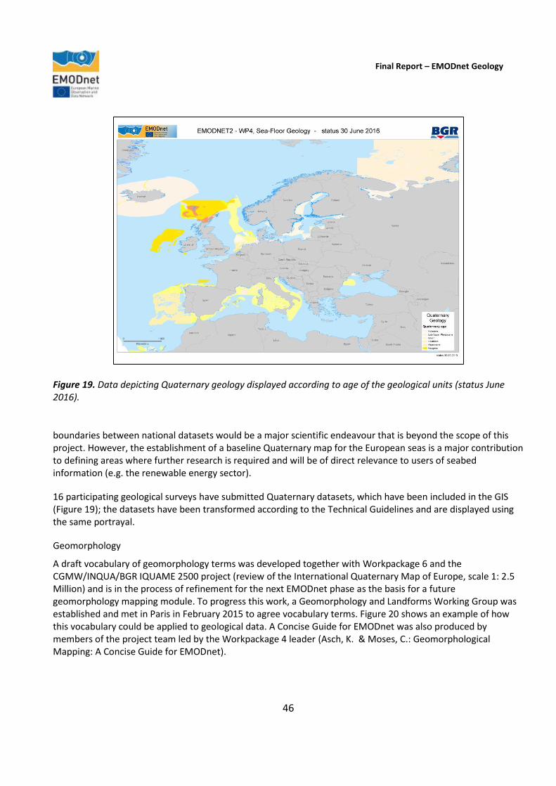
Final Report – EMODnet Geology
46
Figure 19. Data depicting Quaternary geology displayed according to age of the geological units (status June 2016).
boundaries between national datasets would be a major scientific endeavour that is beyond the scope of this project. However, the establishment of a baseline Quaternary map for the European seas is a major contribution to defining areas where further research is required and will be of direct relevance to users of seabed information (e.g. the renewable energy sector).
16 participating geological surveys have submitted Quaternary datasets, which have been included in the GIS (Figure 19); the datasets have been transformed according to the Technical Guidelines and are displayed using the same portrayal.
Geomorphology
A draft vocabulary of geomorphology terms was developed together with Workpackage 6 and the CGMW/INQUA/BGR IQUAME 2500 project (review of the International Quaternary Map of Europe, scale 1: 2.5 Million) and is in the process of refinement for the next EMODnet phase as the basis for a future geomorphology mapping module. To progress this work, a Geomorphology and Landforms Working Group was established and met in Paris in February 2015 to agree vocabulary terms. Figure 20 shows an example of how this vocabulary could be applied to geological data. A Concise Guide for EMODnet was also produced by members of the project team led by the Workpackage 4 leader (Asch, K. & Moses, C.: Geomorphological Mapping: A Concise Guide for EMODnet).

Final Report – EMODnet Geology
47
Figure 20. Example of an offshore geomorphological map showing features such as canyons, troughs, ridges, abyssal plains (Instituto Português do Mar e da Atmosfera, IPMA) produced according to the EMODnet geomorphology vocabulary.
3.5. Workpackage 5. Coastal behaviour (TNO - Geological Survey of the Netherlands)
Objective
To classify the coastal behaviour and typology of each country represented in the project partnership. A classification system for coastal types will be applied and areas of erosion and sedimentation in the coastal zone of each participating country will be shown on the resulting map layer.
The purpose of Workpackage 5 is the compilation and merger of all coastline-behaviour databases held by, or available to, the project partners, and the visualization of these databases in an ArcGIS viewer. The central parameter in the final product will be (rate of) shore-normal coastline migration. To eliminate the impacts of short-lived and/or local events, average values over a period of 10 years are preferred. Outcome Workpackage 5 was carried out in four phases: 1) compilation of data on coastline migration in the appropriate format, 2) creation of a GIS file visualizing these data, 3) compilation of data on rates of coastline migration in the appropriate format, and 4) creation of a GIS file visualizing these rate data. Workpackage 5 was delayed due to staff availability, but at the end of 2014 progress started by allocating responsibilities to members of the group. The project partner from the University of Sussex was allocated

Final Report – EMODnet Geology
48
Figure 21. Areas of the European coastline where the EUROSION map has been updated or its coverage extended (areas updated during the current EMODnet phase shown in pale blue).
responsibility for working on coastal cliff vulnerability, sensitivity and an erosion index for the project. A matrix of features to be mapped was prepared and included in Guidelines that were then distributed to the project team. Since then, progress has focused on the compilation of coastal migration information. The process involves using the EUROSION project data (http://www.eurosion.org/) as a baseline for pan-European coastal information and updating the data with information from the EMODnet-Geology partners. About 25% of the EUROSION information has been updated by the EMODnet-Geology partners, and the total coastline for which migration data are available is more than 50% higher than the EUROSION coverage (Figure 21). The resulting map of coastline migration is shown in Figure 22. The Guidelines aim at easy and uniform delivery of partner contributions to coastal behaviour, where ‘behaviour’ refers to the movement of the coastline in a landward (erosion) or seaward (accretion) direction. Two behaviour-related output parameters are defined: migration (subdivided into direction, rate and associated volume) and resilience. Migration is a prime indicator of behaviour, as it describes coastline changes caused by erosion and accretion. Resilience is the ability of a coastline to absorb and recover from erosion before a critical state is reached. Along with resistance and the ability to stop or resist change, resilience is a measure of vulnerability and provides a potential link to the risk faced by the coastal-zone population. The term resilience is

Final Report – EMODnet Geology
49
most commonly used for coastlines formed by unconsolidated sediment. It is also applied to coastal cliffs and bluffs, though most of the literature that relates to, or includes, rock coasts refers to resistance, sensitivity and vulnerability rather than to resilience per se. The key difference between rock coasts composed of consolidated sediment or lithified rock, and soft coasts, composed of unconsolidated sediment, is that there is no way to restore a rock coast once it has been eroded. The episodic nature of cliff and bluff recession is a key attribute when it comes to assessing vulnerability and risk. Resilience is particularly relevant in densely populated or economically valuable areas. Here, a critical state would result not just in significant coastline reorganization, but also in major socio-economic impact. In the Workpackage 5 Guidelines, the parameters used to describe coastal behaviour are defined and discussed. The structure of the attribute tables providing the metadata needed for harmonised data delivery to the EMODnet-Geology portal was also presented, along with the data-delivery methods necessary to allow seamless visualization of all coastline data supplied by the project partners, including easily accessible data available from non-partner institutes. Finally, a pilot study on coastal resilience was proposed, in which metadata and data on this parameter are requested on a voluntary basis. The GIS output has been published as OGC and INSPIRE compliant Web Map Services (WMS), including data provider and contact, description of morpho-sedimentary entity originated from EUROSION, indicator(s) for which data are available, indication of accuracy (measured/estimated/no data), time period, and marker used as reference for coastline migration (e.g. dune foot or cliff top).
Figure 22. Areas of the European coastline classified according to coastal behaviour. Green = coastal accretion; Red = coastal erosion; Yellow = stable coastline; Black = no information.
Final Report – EMODnet Geology
50
The Workpackage 5 leader has compiled, collated and presented each partner’s information on coastal behaviour using a standardised INSPIRE-compliant format. Migration direction, distilled for the most part from EUROSION is the only mandatory parameter. Rate and associated volume of coastline migration, as well as resilience, are solicited on a voluntary basis. Although harmonised and standardised layers for publication have been delivered using Web Map Services, experience shows that the underlying data have been collected using different methods that generate outputs characterised by a multitude of specifications. The pluriformity of the data reflects a range of reference planes, coastline indicators, and time periods of monitoring. Unlike the other workpackages, the provided and collated data concern only the EMODnet participant states’ continuously changing coastlines and not their offshore territories. Coastal migration has been determined from mapable features as diverse as low-tide line, dune foot, cliff top and bluff base. In this light, partners have been encouraged to use the original coastline linked to the delivered data and not to project these data onto the coastline presently used by other EMODnet-Geology workpackages. The latter could put the migration measurements and estimates in the wrong cross-shore position, and suggest to the casual observer of small-scale areas that all figures refer to the present-day situation. The resulting mis-match is a key element in the visualization, rather than a problem. Visualisation of mis-matches emphasises the continuous and sometimes complex coastline changes that take place, with single locations marked simultaneously by both erosion (receding dune base or cliff top) and accretion (seaward-migrating adjacent low-tide line or cliff base). In this light, it is clear that there is much work to be done in the next EMODnet phase. Typical visualisations of coastline behavior around the world show data and map coverages and gaps, but mask the inherent pluriformity of data and the limited applicability of measured migration figures. Translating these figures to their effect on society and the environment requires a strong focus on coastal resilience. Resilience incorporates the potential of recovery from a disturbance in coastline position (particularly erosion following an extreme event), and the direct impact of land loss and flooding risk on valuable assets and infrastructure. Its quantification will add much-needed expert geological knowledge to the present one-dimensional EMODnet product. In order to identify and map areas of erosion, deposition and different degrees of vulnerability, each partner has been asked to provide all publicly available information on the following indicators:
direction of coastline migration (mandatory) i.e. landward, seaward or stable (imperceptible change, taken in practice as <0.5 m/yr mean change)
rate of coastline migration (voluntary) m/yr (mean landward or seaward change over period of monitoring);
volume of coastal erosion/accretion (voluntary) m3/m/yr (mean sediment gain or loss per metre of coastline over period of monitoring, as measured between a lower and an upper reference level);
coastal vulnerability (voluntary) (measure of risk of and resilience against erosion and flooding); many different indices are used in Europe, assessed on the basis of parameters such as wave height, coastal slope, river discharge, geomorphology, coastline behaviour. There is no single standard.
The workpackage leader has also produced a document on coastal vulnerability. It shows that there is no single way to portray coastal vulnerability for all of Europe in a meaningful way, especially for soft-sediment coasts. A case in point is a recent study outlining the different approaches for the US Pacific and Atlantic coasts, following years of study. Even in a single nation (USA) where the same parameters could easily be used, the classes used in the vulnerability assessment ended up having different boundaries. Otherwise, one would have ended up with a product that would work well for the Pacific but deem almost the entire Atlantic highly vulnerable, or

Final Report – EMODnet Geology
51
work well for the Atlantic but deem almost the entire Pacific invulnerable. For management purposes, such uniform products are not helpful. 3.6. Workpackage 6. Geological events and probabilities (Geological Survey of Italy). Objective
To identify and map the locations of all significant geological events and provide information on probabilities of occurrence where available. These will include sites of submarine landslides, earthquake epicentres and volcanic centres located in the offshore study areas as specified in Section 2.4 of the tender documents.
Outcome The first stage in Workpackage 6 activity was addressed at identifying parameters that should be used to characterise the events and relevant information that should be listed in the attribute table of each GIS layer. Furthermore, the extension (compared to the urEMODnet-Geology) of the European Seas to the Mediterranean and the North Atlantic, which are tectonically active areas and geologically young structures, has drawn attention to other geological events related to the mandatory features. Consequently, a questionnaire was sent to all project partners to enquire about which events are considered to be relevant to each country. On the basis of the responses, it was proposed to include additional information on active tectonics, tsunamis and fluid emissions of non-volcanic origin. A data format with a list of possible characteristics to be included was circulated amongst the partners and all of the features that were defined during the current phase of the project are based on their feedback. The GIS layers architecture was then elaborated in order to provide the guidelines for compilation of Workpackage 6. The first Workpackage 6 shapefiles were received by the workpackage leader at the end of April 2015, when the process of harmonisation was then able to commence; additional terms have subsequently been proposed to describe landslides, which were approved after verifying their compliance with INSPIRE. Information sources include detailed information held by the project partners plus any further publicly available third-party data. The data format includes polygons, lines and points features shapefiles. Each shapefile is complemented by an Attribute Table that, in addition to the location and type of geological event, provides, where available, further information for each occurrence in order to establish a start point for the development of a more comprehensive database. Instructions on the compilation of each field of the Attribute Tables have been provided together with the guidelines in a separate excel file. (Table 4). For Type definitions, terms listed within the INSPIRE glossary were applied wherever possible. However, the INSPIRE glossary was not completely consistent, for instance regarding volcanic activity types (the glossary includes effusive eruption, but not explosive eruption, whereas different types of explosive eruption are listed as hawaiian, plinian and vulcanian). Consequently, explosive eruption was added to the list of Types, subdivided into hawaiian, plinian, sub-plinian, strombolian and vulcanian. Furthermore, information contained in this workpackage is diverse in relation to scale and detail of occurrences. In order to preserve as much information as possible and to provide more details, where available, a few terms were added and a few others, mentioned in INSPIRE descriptions, were also adopted. For example, several landslides Types were derived from the description of slope-gravitational in INSPIRE, referring to Varnes
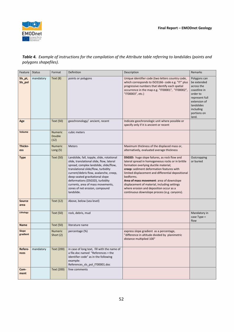
Final Report – EMODnet Geology
52
Table 4. Example of instructions for the compilation of the Attribute table referring to landslides (points and polygons shapefiles).
Feature Status Format Definition Description Remarks
Sls_pt, Sls_pol
mandatory Text (8) points or polygons Unique identifier code (two letters country code, which corresponds to ISO3166- code e.g. "IT" plus progressive numbers that identify each spatial occurrence in the map e.g. "IT00001", "IT00002", "IT00003", etc.)
Polygons can be extended across the coastline in order to represent full extension of landslides including portions on land.
Age Text (50) geochronology/ ancient, recent Indicate geochronologic unit where possible or specify only if it is ancient or recent
Volume Numeric Double (12)
cubic meters
Thickn-ess
Numeric Long (5)
Meters Maximum thickness of the displaced mass or, alternatively, evaluated average thickness
Type Text (50) Landslide, fall, topple, slide, rotational slide, translational slide, flow, lateral spread, complex landslide, slide/flow, translational slide/flow, turbidity current/debris flow, avalanche, creep, deep-seated gravitational slope deformations (DSGSD), turbidity currents, area of mass movements, zones of net erosion, compound landslide.
DSGSD: huge slope failures, as rock flow and lateral spread in homogeneous rocks or in brittle formation overlying ductile material; creep: sediment deformation features with limited displacement and differential depositional bedforms. Area of mass movement: area of downslope displacement of material, including settings where erosion and deposition occur as a continuous downslope process (e.g. canyons).
Outcropping or buried
Source area
Text (12) Above, below (sea level)
Lithology Text (50) rock, debris, mud Mandatory in case Type = flow
Name Text (50) literature name
Slope gradient
Numeric Short (2)
percentage (%) express slope gradient as a percentage, "difference in altitude divided by planimetric distance multiplied 100"
Refere-nces
mandatory Text (200) in case of long text, fill with the name of a file.doc named "References + the identifier code" as in the following example: References_sls_pol_IT00001.doc
Com-ment
Text (200) free comments

Final Report – EMODnet Geology
53
Figure 23. Varnes, DJ. 1978. Slope movement types and processes. In Special report 176: Landslides: Analysis and Control, Transportation Research Board, Washington, D.C.
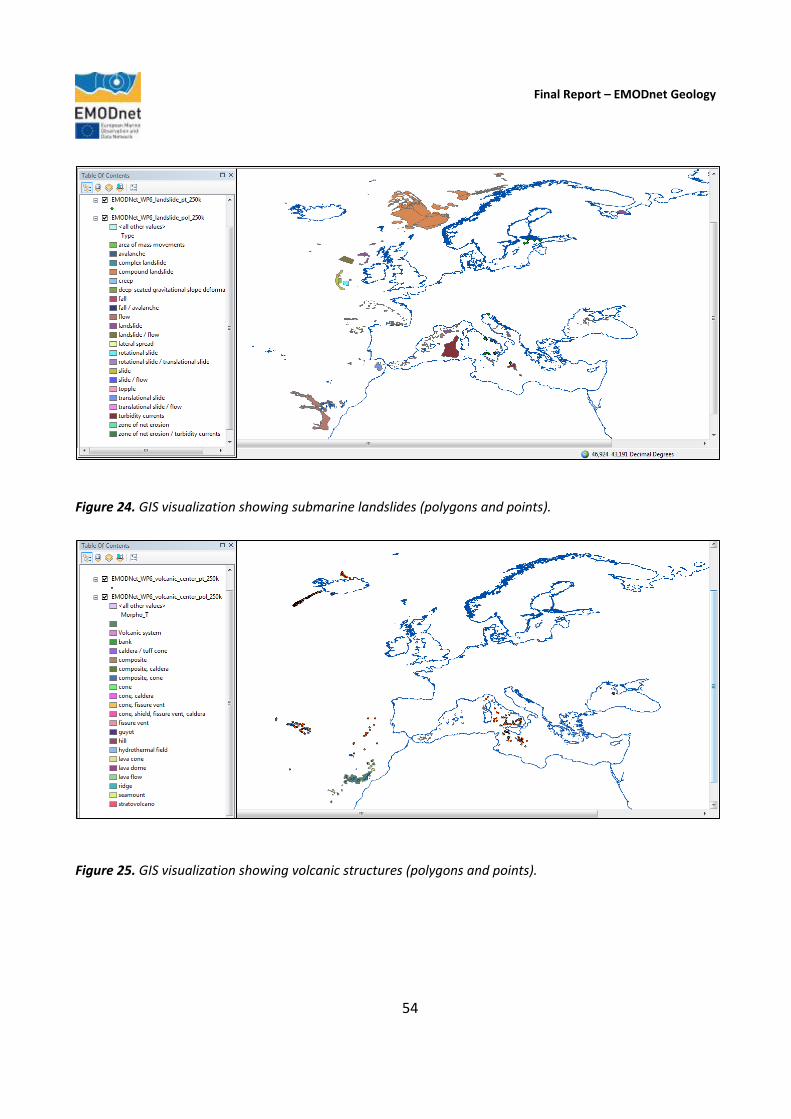
Final Report – EMODnet Geology
54
Figure 24. GIS visualization showing submarine landslides (polygons and points).
Figure 25. GIS visualization showing volcanic structures (polygons and points).
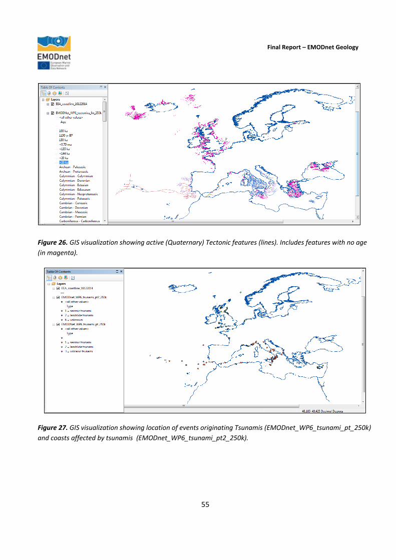
Final Report – EMODnet Geology
55
Figure 26. GIS visualization showing active (Quaternary) Tectonic features (lines). Includes features with no age
(in magenta).
Figure 27. GIS visualization showing location of events originating Tsunamis (EMODnet_WP6_tsunami_pt_250k)
and coasts affected by tsunamis (EMODnet_WP6_tsunami_pt2_250k).

Final Report – EMODnet Geology
56
Figure 28. GIS visualization showing fluid emissions of non-volcanic origin (polygons and points).
Figure 29. GIS visualization of index map showing areas of occurrence, no occurrence and no data for submerged
landslides.
Final Report – EMODnet Geology
57
classification (1978) (Figure 23) and DoE. (1990), whereas “deep-seated gravitational slope deformations” was added since no further details are available for a few occurrences. As included in the EMODnet-Geology workplan, we will continue to rely on the catalogue of the European-Mediterranean Seismological Centre (EMSC) to provide up-to-date earthquake information to the project. However, the attributes that better characterise earthquakes have been identified as a data format for future development. Regarding landslides and volcanic centres, a shapefile for each geometric feature (polygons, lines, and points) represents the occurrence of each geological event. The use of different geometric features is related to the peculiar characteristics of each occurrence, as well as to the scale of representation (Figures 24-28). For example, concerning volcanoes, polygons might represent the entire structure while points may indicate single craters, cones or eruptive openings; concerning presentation at 1:250,000 scale, a landslide area larger than 60 hectares (about 600 km2) can be represented by a polygon; a landslide area smaller than 60 hectares can be represented by a point. All products delivered by the project partners have been checked in order to achieve the best degree of harmonisation. A few cases of overlap of different deliveries have been overcome, after validation by project partners, in order to collect as much information as possible. Regarding the confidence assessment, as individual geological events are scattered, it is difficult to produce maps. It can be assumed that all features reported have a 100% confidence degree, whereas blank areas do not necessarily correspond to no occurrence since not all events might have been identified depending on the available information. On the other hand, blank areas cannot be considered to be areas with no data. Locally there might be 100% confidence othat there are no occurrences of a particular event/feature, but it is not possible to elaborate polygons defining homogeneous areas of confidence. However, a few partners have notified the workpackage leader that there are no occurrences of the selected WP6 features in their EEZs. Therefore in order to provide the basic information underlying each layer, and to distinguish areas of no occurrences, a complementary shapefile representing an index map of all European EEZs has been compiled together with the geological events layers (Figure 29). The Attribute Table of this shapefile reports areas of occurrence, no occurrence and no data for each kind of event and for each EEZ. 3.7. Workpackage 7. Minerals (Geological Survey of Ireland) Objective
To identify and map areas of minerals (including aggregates, oil and gas and metalliferous minerals) in each of the participating countries based on information available to the project partners, including publicly-available information (published scientific papers etc.). To arrange Web Map Services with holders of mineral resource data. Outcome
The initial Task Guide for Workpackage 7 was issued by the workpackage leader on the 3rd November 2014. The Workpackage 7 metadata schema is based on INSPIRE guidelines and terrestrial EU minerals projects, such as

Final Report – EMODnet Geology
58
ProMine (http://www.promine.com/), and FP7 minerals programmes, to ensure that the offshore minerals data are comparable. Data were compiled for 9 mineral types including aggregates, hydrocarbons, gas hydrates, marine placers, phosphorite, evaporite, polymetallic sulphides, polymetallic nodules and cobalt-rich Fe-Mn crusts. All minerals information received were standardised, merged and modelled to produce a series of maps showing different mineral types and a compiled version of all mineral occurrences. In March 2015, following the process of merging data received from project partners, and as a result of feedback, it was decided to reformat Table 5. Summary of minerals data delivered by country and deposit type.
the deposit type schemas. A number of adjustments were made to the original Workpackage 7 data specifications including:
Data schemes were altered, to reflect common methods of reporting metadata;
Reference fields were added to all nine data schemes;
Style files were created, to synchronise with INSPIRE guidelines and projects that detail onshore metal occurrences (e.g. the ProMine project and portal);
The Workpackage 7 Task Guide was reproduced to reflect all changes to the data schemes, additions of style files and added to the File Sharing System (FSS) via the EMODnet Central Portal;
Empty shapefiles, with all attribute fields set up as directed in the Task Guide, were created and made available to all partners via the FSS for any further submission or data updates;
Data were submitted for all 9 mineral deposit types. An example of a mineral deposit layers within the WMS service is shown in Figure 30. The final assessments of mineral occurrences by country and deposit type are shown in Table 4. The assessment of the information provided indicates that the geographical distribution of
AGGREGATES HYDROCARBON GAS
HYDRATES
MARINE
PLACER
PHOSPHORITE EVAPORITE POLYMETALLIC
SULPHIDE
POLYMETALLIC
NODULSE
Co RICH Fe-Mn
CRUST
NO DATA
Albania Denmark Portugal Latvia Portugal Spain Iceland Estonia Portugal Slovenia
Belgium France Russia Poland Spain Portugal Latvia Spain
Denmark Ireland Ukraine Spain Spain Russia
Estonia Italy Spain
Finland Lithuania
France Malta
Germany Neatherlands
Ireland Norway
Latvia Poland
Neatherlands Romania
Norway Russia
Poland Spain
Portugal Sweeden
Russia U.K.
Spain Ukraine
Sweeden
U.K.
Ukraine

Final Report – EMODnet Geology
59
mineral deposits should be considered in the context of how much work has been carried out in each country to assess their mineral resources. For example, Spain has reported occurrences of all mineral deposit types with the exception of hydrates, which shows that there have been extensive assessments within their national waters. This does not necessarily mean that resources do not exist in other countries, but records may be poor due a lack of data, restricted data, or where there is no proven record in the data that exist. At the time of writing the Final Report, all but 4 partner countries/regions had yet to deliver information about their offshore mineral occurrences. In three cases (Faroes, Montenegro and Slovenia) this is due to their being no data with which to assess mineral occurrences. In the 4th case (Greece) the reason is that large areas of their waters are special areas of conservation and therefore have restrictions on sharing economic data. To clarify the information provided to the users, the workpackage leader proposes to add text to the portal to explain the distribution of mineral occurrences, and to investigate embedding a table that shows what data have been submitted and the reasons that data have not been made available (for example in the three categories mentioned above; lack of data, restricted data, no proven record in existing data). Such information would explain how ‘complete’ each national area is on a percentage basis to show which countries are well covered and those that are not. A complete up-to-date Workpackage 7 Marine Minerals dataset is presented as the workpackage WMS, available via the EMODnet-Geology portal. In order to ensure the project would capture key metadata associated with each deposit type; unique data schemes have been devised, that detail key components of each deposit type as well as metadata relating to the
Figure 30. Example of information from Workpackage 7 (Minerals). The map shows how layers can be added to combine the various datasets compiled during the EMODnet-Geology Project.

Final Report – EMODnet Geology
60
data source and data contributing agencies. These data schema include features such as deposit type; units of measurement; status (e.g. licence, exploration, exploitation etc.); operator; data provider etc. 3.3.8. Workpackage 8. Web services and technology (British Geological Survey) Objective
To further develop the web portal providing access to the existing maps available in the OneGeology-Europe portal, as developed during the urEMODnet-Geology Project. The Geo-Seas data discovery and access system will also be integrated into the OneGeology-Europe portal to provide access to geological and geophysical data and metadata. The EMODnet-Geology portal will therefore provide access to data, metadata and data products that include both marine and terrestrial geological information for the whole of Europe. Outcome The initial intention of the EMODnet-Geology Project was to integrate the map outputs into a portal called ‘OneGeology-Europe’, which was used during the urEMODnet phase of the programme, and which aims to create dynamic digital geological map data for Europe. However, during discussions at the beginning of the project, it was decided that, rather than deliver outputs to a single platform, the EMODnet-Geology system should be built on an open-source application that allows the products to be take into any system that displays maps and associated information. The system chosen was ‘GeoNetwork’ (http://geonetwork-opensource.org/),
Figure 31. EMODnet-Geology portal Home page. Map information can be selected from the list of datasets from the menu on the right, or through the search function (see Figure 33).
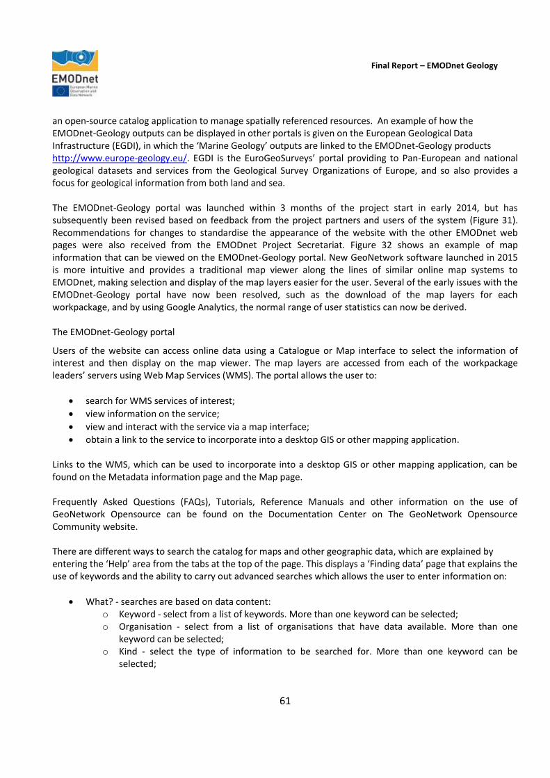
Final Report – EMODnet Geology
61
an open-source catalog application to manage spatially referenced resources. An example of how the EMODnet-Geology outputs can be displayed in other portals is given on the European Geological Data Infrastructure (EGDI), in which the ‘Marine Geology’ outputs are linked to the EMODnet-Geology products http://www.europe-geology.eu/. EGDI is the EuroGeoSurveys’ portal providing to Pan-European and national geological datasets and services from the Geological Survey Organizations of Europe, and so also provides a focus for geological information from both land and sea. The EMODnet-Geology portal was launched within 3 months of the project start in early 2014, but has subsequently been revised based on feedback from the project partners and users of the system (Figure 31). Recommendations for changes to standardise the appearance of the website with the other EMODnet web pages were also received from the EMODnet Project Secretariat. Figure 32 shows an example of map information that can be viewed on the EMODnet-Geology portal. New GeoNetwork software launched in 2015 is more intuitive and provides a traditional map viewer along the lines of similar online map systems to EMODnet, making selection and display of the map layers easier for the user. Several of the early issues with the EMODnet-Geology portal have now been resolved, such as the download of the map layers for each workpackage, and by using Google Analytics, the normal range of user statistics can now be derived. The EMODnet-Geology portal
Users of the website can access online data using a Catalogue or Map interface to select the information of interest and then display on the map viewer. The map layers are accessed from each of the workpackage leaders’ servers using Web Map Services (WMS). The portal allows the user to:
search for WMS services of interest;
view information on the service;
view and interact with the service via a map interface;
obtain a link to the service to incorporate into a desktop GIS or other mapping application. Links to the WMS, which can be used to incorporate into a desktop GIS or other mapping application, can be found on the Metadata information page and the Map page. Frequently Asked Questions (FAQs), Tutorials, Reference Manuals and other information on the use of GeoNetwork Opensource can be found on the Documentation Center on The GeoNetwork Opensource Community website. There are different ways to search the catalog for maps and other geographic data, which are explained by entering the ‘Help’ area from the tabs at the top of the page. This displays a ‘Finding data’ page that explains the use of keywords and the ability to carry out advanced searches which allows the user to enter information on:
What? - searches are based on data content: o Keyword - select from a list of keywords. More than one keyword can be selected; o Organisation - select from a list of organisations that have data available. More than one
keyword can be selected; o Kind - select the type of information to be searched for. More than one keyword can be
selected;
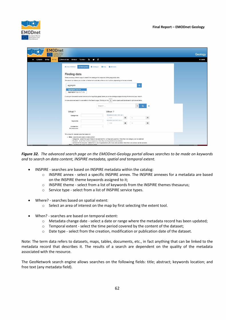
Final Report – EMODnet Geology
62
Figure 32. The advanced search page on the EMODnet-Geology portal allows searches to be made on keywords and to search on data content, INSPIRE metadata, spatial and temporal extent.
INSPIRE - searches are based on INSPIRE metadata within the catalog: o INSPIRE annex - select a specific INSPIRE annex. The INSPIRE annexes for a metadata are based
on the INSPIRE theme keywords assigned to it; o INSPIRE theme - select from a list of keywords from the INSPIRE themes thesaurus; o Service type - select from a list of INSPIRE service types.
Where? - searches based on spatial extent: o Select an area of interest on the map by first selecting the extent tool.
When? - searches are based on temporal extent: o Metadata change date - select a date or range where the metadata record has been updated; o Temporal extent - select the time period covered by the content of the dataset; o Date type - select from the creation, modification or publication date of the dataset.
Note: The term data refers to datasets, maps, tables, documents, etc., in fact anything that can be linked to the metadata record that describes it. The results of a search are dependent on the quality of the metadata associated with the resource. The GeoNetwork search engine allows searches on the following fields: title; abstract; keywords location; and free text (any metadata field).
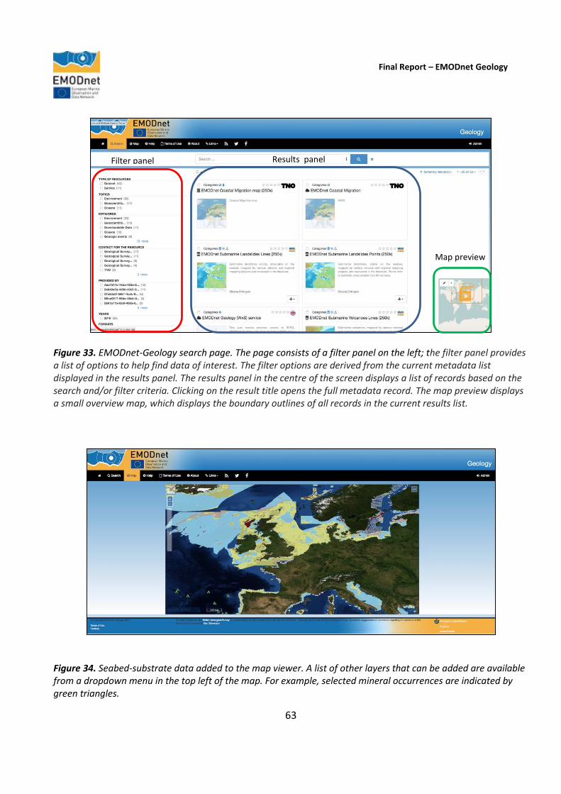
Final Report – EMODnet Geology
63
Figure 33. EMODnet-Geology search page. The page consists of a filter panel on the left; the filter panel provides a list of options to help find data of interest. The filter options are derived from the current metadata list displayed in the results panel. The results panel in the centre of the screen displays a list of records based on the search and/or filter criteria. Clicking on the result title opens the full metadata record. The map preview displays a small overview map, which displays the boundary outlines of all records in the current results list.
Figure 34. Seabed-substrate data added to the map viewer. A list of other layers that can be added are available from a dropdown menu in the top left of the map. For example, selected mineral occurrences are indicated by green triangles.
Filter panel Results panel
Map preview

Final Report – EMODnet Geology
64
The ‘Search’ page on the menu tabs opens an area where data can be filtered according to the types of resource, topic, keywords etc. The central results panel displays the list of records selected by applying the filter, and there is a small preview map showing the boundaries of all records displayed in the results panel. Selecting any of the results in the central panel opens a page that provides a link to add the information to the map viewer, an overview map, technical information and metadata. If available, the map can be downloaded as an ESRI shapefile – all of the data layers will be eventually be available to download. Figure 33 shows the summary information for the seabed substrate map at 1:250,000 scale and Figure 34 shows the information displayed in the map viewer. The map displays any WMS services that have been added to the map. The metadata screen displays a full metadata record for the selected result. The contents of this screen are dependent on the level of metadata associated with the selected result and can vary from record to record. Commonly included are: a description of the record; links to associated resources; information on the dataset; and contact information. 3.3.9. Workpackage 9. Dissemination (British Geological Survey) Objective
To ensure widespread dissemination of the EMODnet-Geology products, through targeted contact with stakeholders and other users of marine geological information.
Outcome Throughout the project duration, the EMODnet-Geology partners have taken part in a large number of dissemination activities, both in their own countries and at international events. They have also published papers that have referenced EMODnet, and written articles for a range of media including science magazines, annual reports and websites, and have also made radio and/or TV appearances to coincide with the project meetings that have been held. As the project involves organisations from 30 countries, this has led to widespread outreach for the EMODnet-Geology Project, and a raised awareness of the programme in industry, academia plus Government and other public-sector organisations. The full list of dissemination activities during the project is given in Section 9 of this report ‘Outreach and Communication’. 3.3.10. Workpackage 10. Liaison with EMODnet lots (British Geological Survey) Objective
To ensure that the EMODnet-Geology Project is fully aware and complementary to the objectives of other marine science initiatives within European waters. To prepare for better and linked marine data that will have an immediate impact on the planning of environmental policy and mitigation measures within the European Union and to facilitate impact assessments and scientific work. Outcome
The current phase of EMODnet has seen a significant increase in the contact and communication between the Co-ordinators of each thematic lot and the projects designed to check the suitability of the project outputs to inform various scenarios (e.g. an oil spill) in the regional seas, known as the ‘checkpoint’ projects. The Co-ordinators have met twice a year at the EMODnet Steering Group meetings as well as major EMODnet events
Final Report – EMODnet Geology
65
such as the open Conference held in Ostend, Belgium in October 2015. This level of contact has been important in ensuring that topics of cross-thematic interest have been considered, such as the links between the EMODnet Bathymetry Project’s input to the work of the Geomorphology and Landforms Working Group, and the Seabed Habitats group’s input to the selection of a classification and confidence assessment of the EMODnet-Geology seabed-substrates deliverable. Project participants have also taken part in (and Chaired) an Atlantic Seabed Mapping International Working Group established as part of the Galway Statement on Atlantic Ocean Co-operation between the European Union and the Governments of the USA and Canada. The EMODnet-Geology group will develop its next phase with input from the European Geological Data Infrastructure (EGDI), an initiative of EuroGeoSurveys to provide access to Pan-European and national geological datasets and services from the Geological Survey Organisations of Europe. Members of the EMODnet-Geology group also participate in major long-term marine geoscience programmes such as the International Ocean Discovery Program (IODP) and the European Consortium for Ocean Research Drilling (ECORD – the European contribution to IODP). 3.3.11. Workpackage 11. Project analysis and sustainability (British Geological Survey) Objective To analyse each phase of the project and to provide a report on the lessons learned. Outcome At the end of the EMODnet-Geology Project, the Project Co-ordinator and partners have assessed the overall project aims and analysed specific issues such as the main barriers to the provision of data by data holders including any scientific, institutional, legal, commercial, information technology, and financial barriers. The portal technology has been reviewed and improvements have been suggested, and an analysis has been made of the use of the portal as well as feedback from organisations that have made use of the data. The results of the analyses of the project are presented in Sections 4 to 10 of this report. Given the significant investment in EMODnet over the last 6 years, the sustainability of the EMODnet-Geology Project outputs is a significant consideration for the project partners. The long-term maintenance of the system requires a commitment from the partner organisations to establish a system for the regular updating and dissemination of the marine geology information that EMODnet has assembled. At the centre of the future sustainability are the EuroGeoSurveys’ network and the European Geological Data Infrastructure (EGDI), which the EMODnet-Geology group will integrate into their activities in the next phase of the project. As the EuroGeoSurveys’ members have committed to maintaining EGDI as their infrastructure for providing access to Pan-European and national geological datasets and services from the Geological Survey Organizations of Europe, the future of the collaboration between large numbers of marine geoscience groups is assured.
Final Report – EMODnet Geology
66
4. Challenges encountered during the project
The main challenges encountered during the project can be summarised into 14 categories as noted in the table below. For some organisations, the challenges were fundamental, such as for those participating in an EC-funded project for the first time, and for whom there were very limited marine data available offshore at a national level as there were no systematic marine survey activities at a national level. These challenges will continue into the next phase, although participation in EMODnet has provided a valuable starting point for assessing the information needs, and how to plan surveys, collect, store and manage information using internationally adopted standards, and deliver outputs that are of relevance to organisations (Government, industry and academic) working in the marine environment. Even for the organisations with a long history of marine surveying and production of marine geoscience outputs (data, maps, scientific research papers), the EMODnet-Geology Project has presented challenges in retrieving archived information held on paper and turning them into digital outputs that can be used to harmonise data both at a national level and across national boundaries. However, in most cases these challenges have been overcome by co-operating on establishing guidelines that describe standard approaches to converting information to agreed standard classification schemes.
Main challenge Measures taken
Compilation and standardisation of lithological and sediment data derived from highly variable sources and covering a wide time span (more than 100 years in some cases) with unclear metadata, various investigation/sampling tools, mapping methods (date of production, classification, methodology, sample and/or line density).
A large amount of effort was dedicated to the compilation of data and data/metadata quality (see Section 8), which was considered necessary for future seabed change analyses and uncertainty assessments. The EMODnet-Geology Project has been important in gathering knowledge about the offshore geology of several countries (e.g. Iceland, Albania) and has produced offshore maps for the first time. The project has also established steps for building new databases of national information to improve data identification in the future.
The scales of the information compilation in both the urEMODnet (1:1 million) and the current EMODnet phase (1:250,000) have presented challenges due to variability in the information available. While the pan-European compilation presents a useful overview, they may also give the impression that these are the best available sources of information in all areas, whereas in some regions much more detailed information exists.
In the current phase of the project the sources of high-resolution information are identified in index maps showing the resolution of available map information. The challenge will be addressed in future by multi-resolution approach of the next phase of EMODnet, as well as the development of a system that is built upon regular updates of national information held by the geological surveys of Europe (European Geological Data Infrastructure) to provide, digital geomodeling, which makes it feasible to generate updates as new data become available, and to improve maps by using proxy data such as bathymetry. Predictor variables, such as bathymetry (e.g. EMODnet bathymetry) would be required at approximately 20m resolution – currently, the resolution of suitable predictor variables is at least

Final Report – EMODnet Geology
67
one order of magnitude lower than required.
Delivery of information in the format requested by the workpackage leaders due to the many different formats and media in which information was held.
Gain the required skills to manage information through collaboration with other national organisations; regular contact with the workpackage leaders, and the issue of guidelines for data standardisation.
Harmonization of data across borders is not straightforward for some of the information. For example, in the bedrock geology maps the harmonisation often identifies issues that are complex and require a complete review of available data (e.g. along the Belgium/Netherlands and the UK/Ireland borders).
Maps can be compiled using information from adjacent areas onshore as a guideline; however, careful revision of the uncertainties in interpretations is required.
Extrapolation of interpretations has been necessary in places where there are large data gaps. As an example, offshore Malta covers nearly 75,500 km2, but has information from only 11 offshore wells and a few cable/pipeline route surveys. Although seismic-reflection data coverage is dense in parts of the offshore areas, the resolution of this data does not allow for the classification of the various types of sediments, nevertheless the data was useful to identify areas deprived of sediments and locations where bedrock is exposed.
Confidence maps have been constructed to show the underlying data sources that have been used in the interpretations. These give the users information that allows them to assess the size of the data gaps and the amount of interpolation that has been carried out. The data gaps are significant for guiding future survey plans.
The timescale for deliverables was a challenge, especially the early delivery of the seabed-substrate information for the Seabed Habitats Lot to allow them to make progress.
A provisional map was delivered to the Seabed Habitats group in June 2014; however, this was regularly updated as the project progressed.
Restrictions on use of data from some countries due to the national security issues or data use policies was problematic. Agreements were reached in most cases (see Section 10, Indicator 2), but not all. Where information has been made available by third parties, in some cases the supporting information required to make best use of the data were lacking.
We have included the boundaries of the restricted datasets into the seabed-substrate dataset in order to show that there is data, but it is not available for free distribution. In some cases, for example in the assessment of mineral occurrences, countries with large areas of marine protection have restrictions on providing information of economic value that may affect the marine environment (see Section 3.7).
Communication between large numbers of participating organisations and individuals.
In addition to the twice-yearly project meetings, partners maintained regular contact with the workpackage leaders in particular, each of whom issued guidelines for all partners to follow. The establishment of working groups, such as the Geomorphology and Landforms Working Group, and regional groups, such as the Adriatic Sea Working Group, helped to address issues that were specific to a topic or region.
The INSPIRE Glossary represented a challenge, since it does not match, in terms of vocabulary and hierarchical organization, the needs of the EMODnet

Final Report – EMODnet Geology
68
harmonisation processes. For example, the vocabulary and styling relevant to marine minerals were not always available in all cases or directly transferable from the INSPIRE Data Specifications on Mineral Resources – Technical Guidelines (D2.8.111.21) & Data Specification on Energy Resources – Technical Guidelines (D2.8.111.20).
Several organisations found it challenging to meet the project deadlines within the funding model, in which less than half of the project funds are made available in the first year.
Most partners found that there was an absence of information on sedimentation rates in national waters, and where it exists the period over which the rates are measured varied considerably although very little information is available for recent rates of sedimentation (i.e. last hundred years).
For the future, it is recommended that these data be acquired at multi-scale.
The EMODnet-Geology Project has made use of external information sources where large amounts of data have already been collated, for example in Workpackage 6, earthquake information has been sourced from the European – Mediterranean Seismological Centre (EMSC). However, it was found that not all national information is submitted to the EMSC.
Project partners have created a Web Map Service (WMS) containing all national data to be included in the EMODnet-Geology portal.
The Geomorphology and Landforms Working Group identified that much work has yet to be done in feature identification, especially in deeper waters. Such information is useful to marine spatial planning.
Work commenced within the Working Group, which will be further developed in the next EMODnet phase. Independent of EMODnet, but due to the recognition of this issue, a group from the geological surveys of Norway, the UK and Ireland have also started to work on a system for classifying geomorphological features offshore.
A major work overload was caused by the adoption of the EEA as the standard coastline used by the EMODnet lots, which is far less accurate than the one adopted for geological mapping in many countries. The problem was especially apparent in complex areas and around islands, such as the Spanish Canary Islands.
A national database was selected in some countries (such as Spain) and replaced the EEA coastline in a merged shapefile that was supplied to all workpackage leaders. It is strongly recommended that a more detailed coastline is used in future EMODnet projects. See comment on coastline in Section 3.3.
Final Report – EMODnet Geology
69
5. Analysis of performance and lessons learned
5.1. Performance analysis
5.1.1. EMODnet-Geology specific objectives (point 2.2 of the tender specifications)
Objectives The specific objectives of each lot are to: (1) assemble existing data from public and private organisations relating to the state of sea basins; processing them into interoperable formats which includes agreed standards, common baselines or reference conditions; assessments of their accuracy and precision and creating data products as defined in this tender; (2) develop, test, operate and maintain a portal allowing public access and viewing of data, metadata and data products; (3) monitor and report on the effectiveness of the system in meeting the needs of users in terms of ease and speed of use, quality of information and fitness for purpose of the data and products delivered; (4) analyse what further steps need to be taken to improve the accuracy, precision, coverage and ease of use of the data; (5) keep the portal operational and be prepared to transfer to the Commission or to a party designated by the Commission.
Assessment The EMODnet-Geology Project has assembled interpreted outputs (map layers) based on a vast amount of marine geoscience data held at national level in 30 countries. The information is principally that which is held by the project partnership, most of whom are the national geological surveys of Europe, with a remit to survey their national waters and carry out scientific research and produce geological maps. They are therefore best placed to deliver the most comprehensive assessment of the European sea basins and have access to the information requested for each of the categories of information requested by the EC (seabed-substrates, bedrock geology, coastal behaviour, geological events and minerals). Several of the maps delivered during the project include information provided to the geological surveys by private organisations, which has been integrated into the map products. In cases where information is not routinely collated by the geological survey organisations, arrangements have been made to connect with other sources of information, such as the earthquake data held by the European-Mediterranean Seismological Centre. Although much of the information collected at national level has been acquired for many different purposes based on the needs of each country, the discussion and agreement on principles and guidelines for standards, common baselines and the assessment of the accuracy and precision of the information through confidence assessments, has allowed the EMODnet-Geology group to deliver outputs for each of the required categories.
Final Report – EMODnet Geology
70
The initial intention of the EMODnet-Geology Project was to integrate the map outputs into a portal called ‘OneGeology-Europe’, which was used during the urEMODnet phase of the programme, and which aims to create dynamic digital geological map data for Europe. However, during discussions at the beginning of the project, it was decided that rather than deliver outputs to a single platform, the EMODnet-Geology system should be built on an open-source application that allows the products to be taken into any system that displays maps and associated information. The system chosen was ‘GeoNetwork’ (http://geonetwork-opensource.org/), an open-source catalog application to manage spatially referenced resources. An example of how the EMODnet-Geology outputs can be displayed in other portals is given on the European Geological Data Infrastructure (EGDI), in which the ‘Marine Geology’ outputs are linked to the EMODnet-Geology products. EGDI is the EuroGeoSurveys’ portal providing to Pan-European and national geological datasets and services from the Geological Survey Organizations of Europe, and so also provides a focus for geological information from both land and sea. Users of the EMODnet-Geology portal can access online data using a Catalog to select the information of interest and then display on a map interface. The map layers are accessed from each of the workpackage leaders’ servers using Web Map Services (WMS). The portal allows the user to search for WMS services of interest; view information on the service; view and interact with the service via a map interface; and obtain a link to the service to incorporate into a desktop GIS or other mapping application. Links to the WMS, which can be used to incorporate into a desktop GIS or other mapping application, can be found on the Metadata information page and the Map page. The search bar allows you to enter a free text term and also offers a list of options depending on the text entered. An 'advanced search' allows additional search options such as searches based on data content, spatial extent and temporal extent. Feedback has been provided to the portal developer (Workpackage 8 leader) throughout the project, from the project partners, the EMODnet Secretariat and from users of the system. The problems that have been identified have been resolved as much as possible within the scope of adopting a system that was not designed by the project partners. Although there have been limitations to the approach adopted, the EMODnet-Geology group supports the use of open-source applications to avoid spending funds on developing software, and to maintain as much flexibility in delivering the outputs to a wide range of data portals. Through the development of the next phase of the portal based on the European Geological Data Infrastructure (EGDI), a system to which the EuroGeoSurveys has committed to maintain as their system for accessing pan-European and national datasets and services, the future operation of the EMODnet-Geology outputs is assured. Further steps to improve the accuracy, precision, coverage and ease of use of marine geoscience information is entirely dependent on organisation at national level of integrated approaches to the planning, collection, archiving, sharing and interpretation of data. In many countries steps have been taken to achieve this, and in others there are now well-funded national mapping programmes involving many organisations and disciplines in delivering stakeholder and policy-driven outputs. The promotion of these approaches can help to improve harmonisation of information across borders to achieve pan-European assessments of the marine environment. The agreements reached on trans-national collaboration during the EMODnet-Geology Project are an important contribution to the improvement of national/international datasets and their ease of use.

Final Report – EMODnet Geology
71
5.1.2. EMODnet-Geology specific outputs (point 2.4 of the tender specifications)
Objectives Within three months of starting the project, the portal should provide access to the data, metadata and data products already offered by the urEMODnet portals prepared under integrated maritime policy preparatory actions 14. In addition, the following must be offered. The portal should provide access to geological surveys using standards developed in the Geo-Seas project. In addition, it should deliver the following data products at a scale of one to two hundred and fifty thousand (1:250,000) using the standards developed in the urEMODnet-Geology Project. (1) On the seabed: (a) substrate, improving where possible the current resolution of the classes and data; (b) rate of accumulation or sedimentation; (c) sea-floor geology (age, lithology, origin); (d) boundaries and faults; (e) geological events and event probabilities (landslides, volcanic, earthquake epicentres); (f) minerals (including aggregates, oil and gas). (2) For the coast: (a) Rate of sedimentation and erosion; (b) Coastal typology or behavioural description - cliffy coasts, sand dunes, estuaries, etc. Assessment The EMODnet-Geology portal was established within three months of the start of the project and provided access to the information related to the standards developed in the urEMODnet-Geology Project. Throughout its 3-year duration, map outputs have been gradually collated and harmonised for each of the categories described in the tender specifications as shown in Section 3 of this report. For some categories, for example coastal information, the current phase of EMODnet has shown that there are significant data gaps and that there is a need for further collection and/or compilation of data to provide a high-resolution assessment of the European coastal zone. 5.1.3. The main barriers to the provision of data by data holders In most countries, the main geological datasets are held by the national geological survey organisations that make up the majority of the EMODnet-Geology consortium members. The group has therefore provided information that is owned by the partnership, and has not relied on other data holders. However, it is recognised that there are important datasets held by commercial companies (oil and gas, marine aggregates, renewable energy), universities and other public sector organisations, including Government defence departments. In the case of universities and most public sector organisations, agreements have been made to access information and to use it in the interpreted products compiled within the current phase of EMODnet. Where barriers exist, they are mainly due to the commercial sensitivity of information, or where access to information is considered to be a threat to national security. In some cases, the cost of retrieving information

Final Report – EMODnet Geology
72
and providing the necessary supporting information (such as metadata) is time consuming and therefore costly, which creates barriers to further use.
The challenges to rendering data interoperable including different measurement techniques, different baselines,
different standards, different nomenclature, etc.
The challenges of data interoperability are variable according to the information outputs (seabed substrate, bedrock geology, coastal behaviour, minerals etc.). The large amounts of data held by the EMODnet-Geology partners are held in a wide range of formats, from paper records/analog information acquired during early surveys, to the digital information available today. To bring the analog records into use has required significant effort for many of the EMODnet-Geology partners. In addition, the issue of classification of seabed-substrate information to a common system for harmonisation (the Folk Classification) has been difficult for many organisations, who have had to go back to original datasets and completely re-classify and re-interpret information according to the agrees system. Nevertheless, the production of harmonised information at the European regional seas scale was the main objective of EMODnet-Geology, therefore this exercise has proven to be useful for many organisations that are now able to identify and plan to resolve cross-border discrepancies in their geological maps.
The adoption of an agreed classification system was less difficult for information related to other categories of information as most information was acquired using internationally recognised terminology. However, there has still been a need to discuss definitions and their common understanding for information such as Quaternary geology/geomorphology, structural geology and coastal behaviour, which has been addressed in the guidelines issued by the workpackage leaders and through the establishment of working groups (such as the Geomorphology and Landforms Working Group). Some standardisation, such as the stratigraphic terms used to describe the Quaternary geology, is beyond the scope of the current project.
5.1.4. The challenges to produce contiguous data over a maritime basin from fragmented inhomogeneous
data.
The main challenge has been the lack of information at the density required to produce contiguous maritime basin data. However, as the maps in Sections 3 show, pan-European maps have been compiled showing all information that was available to the EMODnet-Geology partners during the current 3-year project and the earlier urEMODnet phase.
5.1.5. The fitness of purpose of the data for measuring ecosystem health of the maritime basin.
As the information compiled during the EMODnet-Geology is the product of many years of geological mapping at national scale driven by policy and industry requirements, the types of data are considered to be fit-for-purpose in assessing the health of maritime basins from the geoscience perspective. In most countries, there is a recognition that to improve on the outputs from the geological community, there is a need for systematic national mapping programmes based on high-resolution multibeam and associated data (such as acoustic backscatter) accompanied by ground-truthing information from sampling campaigns and the acquisition of video wherever possible. There are several examples of successful mapping programmes that have achieved the target of providing high-quality geological information to a wide range of end-users, with input from stakeholders to define the strategies and outputs. These include the Norwegian MAREANO Programme and the Irish INFOMAR Programme, but several countries have promoted this approach for many years and are starting to show signs of progress in demonstrating the need for national mapping programmes based on the acquisition

Final Report – EMODnet Geology
73
of bathymetric, geological, biological, chemical, oceanographic and habitat (biotope) data, which, if successful, will directly feed into the overarching objectives of EMODnet.
5.1.6. The priorities and effort required for improving the accuracy, precision and coverage of the data
collated.
Seabed mapping remains a very challenging exercise. A lot of progress has been made, though when it comes to the reliability of the maps, confidence is still very low, especially in areas farther from the coast. This hampers the detection and monitoring of seabed/habitat change, being the prerequisite of adaptive seabed management. For seamless mapping, a continuous investment in better and more accurate maps is hence needed. Another lesson learned is that only by harmonization of data across borders, misinterpretations become clear and new data hiatuses are identified as well as the need for better scientific insights. This even holds true for data/maps that were considered ‘dealt with’.
5.1.7. The performance of the chosen portal technology in terms of speed, response and user-friendliness.
The general response to the portal technology has been favourable, other than the delay in making download services available until the third year of the project. The project recognises that, despite using a system widely used for managing spatial information, the users have indicated that it is not as intuitive as they would like. As many changes have been made as possible to address these concerns during the current project, but the different approach that will be applied in the third phase of EMODnet will take into account all feedback and will aim to resolve the problems encountered. Specifically, the proposed web portal will build on the portal developed in the current phase of the EMODnet-Geology Project, but several additions and improvements will be implemented. The interactive map will be improved to integrate useful functionalities from the EGDI portal (www.europe-geology.eu) and add support for interactive data search and visualisation. Through ISO19115/19 compliant metadata catalogues and data entity indices, the web service will allow access to original data and user support with links to the original data providers. The service will build on products of the EMODnet-Geology Lot and be interoperable with services developed by other thematic groups, and with the INSPIRE Directive. The system will be open to receive data provided through the EMODnet Data Ingestion facility and other future data providers. Synergy with other large European geoscience initiatives such as EGDI (European Geological Data Infrastructure) and EPOS (European Plate Observing System) will be achievable by the fact that several EMODnet-Geology partners play active roles in these projects also. It is the ambition that the adoption of common standards and exchange of best practices across systems will ensure progressive convergence of the big geoscience data infrastructures in Europe to facilitate long-term sustainability and for the benefit of the end users. The proposed EMODnet-Geology web portal within the EGDI will comprise
A summary of all data and data products available;
An interactive, digital map with standard Web-GIS facilities (pan and zoom) on which all data and data products can be displayed; click-info will provide metadata for each feature, as well as links to download of data or information. Data and data products will be made available for visualisation in the web-GIS application by OGC web services established by the providers of the individual data products and on top of the central data entity Indices;
A metadata search facility to query the content of the underlying metadata catalogue using alphanumeric search criteria;

Final Report – EMODnet Geology
74
Facilities to find, visualise and download data products as well as individual data entities such as boreholes, seismic lines, multibeam datasets;
Usage tracking and functionality to extract periodic reports on the use;
Instructions for reaching a help desk;
Possibilities that allow users to provide feedback. Metadata catalogue and data entity indices A central component of the system will be an ISO 19115/19 compliant metadata catalogue describing and registering all the data products and data sets. As the ISO standards are mainly designed to hold general information about spatial datasets and services, individual seismic lines and boreholes will not be discoverable through such a catalogue. Therefore a number of “data entity indices” will be developed as simple, searchable tables at central level. These tables will contain basic information on individual boreholes and seismic lines allowing users in the web portal to search for e.g. seismic reflection lines, less than 10 years old and in digital format. The usability of EMODnet-Geology portal will be greatly increased by the establishment of such indices, but will require that simple web services be set up by each data provider, allowing the necessary attributes to be harvested into the central data entity indices. User-friendliness It is considered essential to make the web portal attractive and easy to use. The evolution of the portal will take into account good solutions and lessons learned from earlier EMODnet projects as well as the development of other portals such as the portal for the European Geological Data Infrastructure (EGDI). User needs and use cases will be mapped during the initial stage of the project and will guide the further development of the web portal. The development process will be iterative and representatives of different end user categories will be invited to test the portal functionality against the use cases and provide feed-back to progressively drive the portal towards higher and higher degree of usability. Use of standards Interoperability and machine-to-machine connectivity will be ensured by the extensive use of OGC- and other standards. Many of the consortium partners have worked together for many years within the scope of CGI, ISO, OGC, INSPIRE, W3C and a number of European projects to develop and implement standards, controlled vocabularies, ontologies and metadata profiles and the best practices and state-of-the-art from these initiatives will be taken into account in the future EMODnet developments. Interoperability with data distributed with non-EU organisations The WP 9 leader will contact data managers involved in seabed mapping aspects of the Galway Statement process and consortia and organisations involved in marine geoscience programmes at national and international level to initiate the analysis of standards and protocols. For example, IODP, ODIP and COOPEUS will be considered in this regard.

Final Report – EMODnet Geology
75
5.2. Lessons learned
By bringing together the marine departments of the geological surveys of Europe and associated partners to address the issue of data collation, standardization and harmonization over a 3-year period, the main lesson learned is that significant progress can be made in identifying and solving the problems that lead to barriers in providing information at the European regional sea scale. Communication between organisations with similar objectives leads to the development of standardized approaches to data collection and data archiving that lead to improved data sharing (through interoperable methods) and most importantly to improved outputs that deliver information required by users of marine information in industry, academia and the Government and public sectors.
Bringing together groups of geoscientists has also led to the development of new ideas for programmes that address knowledge gaps. For example, during the project the establishment of a Geomorphology and Landforms Working Group has provided the basis not only for future collaboration on combining existing datasets and maps, but also for scientific research. The EMODnet-Geology Project promoted cooperation among countries in various regions, for example the countries surrounding the Adriatic Sea (Italy, Slovenia, Croatia, Montenegro, Albania and Greece) formed a working group aimed at the best harmonization of inhomogeneous data in contiguous areas. Two meetings of the Adriatic Sea Working Group were held to coordinate contributions by partners (Rome, May 25-26 2015; Ostend, October 19 2015). A meeting of the North Atlantic Group of the geological surveys of Europe was also held during an EMODnet-Geology Project meeting to discuss shared coastal issues, which will benefit the entire group.
The challenge of gathering data will most likely continue. Large amounts of data are still held in formats that are not easily accessible, such as paper maps and records and other information held in analog format. EMODnet-Geology has made significant progress in making this information available digitally, but the work is considered to be a long-term activity for most geological survey organisations. It is also clear that information is held at a wide range of resolution and scale, and while harmonised maps of the European seas at selected scales are useful (such as the 1:250,000 and 1:1 million maps delivered during the current phase), the requirements of most users are to access the best and most detailed available information at multi-resolution and scale. This issue will be addressed in the next phase of EMODnet, and the long-term development of a system that provides access to both national information, combined with the benefits of harmonised cross-border information must be a priority objective.
The formal and informal data access arrangements in several countries have been important to the project, but have also helped to improve collaboration and communication of the aims of the geological survey organisations and the benefits of using the information that they hold. Many of the organisations are not only marine information providers, but also users of such data therefore the flow of information between the organisations has increased understanding of how information can be used. However, there is still a challenge in many countries to access relevant information that is restricted in use due to a range of reasons (national security, commercial sensitivity etc.).
Communication is essential to not only convey the information and value of the EMODnet programme, but also to gain feedback from organisations that use the outputs. The EMODnet Open Conference was seen as a success by the EMODnet-Geology group who strongly support such activities at both national and international levels. Some countries have held ‘EMODnet days’ at organisations who participate in several of the EMODnet Lots and we endorse this approach to include as many European countries as possible.

Final Report – EMODnet Geology
76
6. Analysis of sustainability
6.1. Availability of standard procedures facilitating data flow.
Standard procedures were provided for each of the EMODnet-Geology information workpackages (3-7), in which all procedures for gathering, standardising (e.g. using agreed classification systems), formatting, harmonising and in some cases, re-interpreting data were described. These procedures greatly facilitated the flow of information and it is recommended that in any situation where a barrier to information sharing and sustainability is found, Guidelines to address the problems should be agreed and delivered to all project partners.
6.2. Maintenance.
The maintenance of access to geological data and interpretations is dependent on the use of a system that is dependent on each member organisation committing itself long-term on a corporate basis and not just within a project that is defined by time and budget constraints. For the geological surveys of Europe, the way to achieve this is to build on the network of organisations that are members of EuroGeoSurveys, the Geological Surveys of Europe (see Section 6.1). In particular, the establishment of a European Geological Data Infrastructure (EGDI) in which EMODnet-Geology provides the basis of the marine information module, will ensure that this long-term commitment exists as long as the geological survey organisations of Europe continue to collaborate. A description of how EMODnet-Geology can act together to provide governance for a sustainable system is highlighted in the following section.
6.3. The model for governance by actors in the system.
The European Geological Data Infrastructure (EGDI) initiated by the geological survey organisations (GSO’s) of EuroGeoSurveys (EGS) is a pan-European Geological Data Infrastructure, which provides an appropriate platform for developing a long-term infrastructure. A governance structure for the EGDI is currently being outlined by the EGS community and synergy between EMODnet-Geology and EGDI will be an important factor in securing the sustainability of the distributed data and data product services hosted by the EGS members of the consortium. Specific actions will furthermore be undertaken during the next phase of the EMODnet-Geology Project to contribute to a common EMODnet governance model taking both EGS and non-EGS members of the consortium (and other providers of data such as SeaDataNet and the EMODnet data ingestion portal) into account and in close cooperation with the other EMODnet lots. The current EMODnet-Geology web portal will be extended to act as a hub to all data and data products. The development will utilise experiences from the EGDI implementation project regarding integration of data, data products and metadata. Furthermore, synergy will be sought with the geological part of the current European Plate Observing System (EPOS- IP) Project, in which borehole and seismic data are also considered to be a high priority. This coordination will lead to a more mature system and a higher degree of homogeneity across Europe as well as between land and sea. The development of the EMODnet-Geology web portal will improve the integration of useful functionalities from the EGDI portal and add support for interactive data search and visualisation. Through ISO19115/19 compliant metadata catalogues and data entity indices, the web service will allow access to original data and
Final Report – EMODnet Geology
77
user support with links to the original data providers. The service will build on products of the EMODnet-Geology Lot and be interoperable with services developed by other thematic groups, and with the INSPIRE Directive. The system will be open to receive data provided through the EMODnet Data Ingestion facility and other future data providers. It is the ambition that the adoption of common standards and exchange of best practices across systems will ensure progressive convergence of the big geoscience data infrastructures in Europe to facilitate long-term sustainability and for the benefit of the end users. 6.4. The institutional setting.
EuroGeoSurveys (EGS), The Geological Surveys of Europe, is a not-for-profit organisation representing 37 National Geological Surveys and some regional Surveys in Europe, an overall workforce of several thousand experts. The National Geological Surveys are public sector institutions carrying out operations and research in the field of geosciences. These organisations have a long tradition, in many cases more than 100 years, in collecting data, preparing information and conducting research focused on their national subsurface.
EuroGeoSurveys provides the European Institutions with expert, neutral, balanced and practical pan-European advice and information as an aid to problem-solving, policy, regulatory and programme formulation in areas such as:
The use and the management of on- and off-shore natural resources related to the subsurface of the Earth, (energy, including the renewable geothermal energy; minerals and water, soils, underground space and land);
The identification of natural hazards of geological origin, their monitoring and the mitigation of their impacts (deficit or excess of trace elements in soils and waters, earthquakes, natural emissions of hazardous gases, landslides and rockfalls, land heave and subsidence, shrinking and swelling clays);
Environmental management, waste management and disposal; land-use planning;
Sustainable urban development and safe construction;
E-government and the access to geoscientific metadata and data;
The development of interoperable and harmonised geoscientific data at the European scale.
The portal of EuroGeoSurveys (www.eurogeosurveys.org) provides (an access to geoscientific metadata, information and knowledge at European and national scales, following the links in the thematic pages. It also presents information on EuroGeoSurveys, its activities and the Member Organizations. Through its Member Organizations, EuroGeoSurveys has provided support and information to the following projects:
MICA – Minerals Intelligence Capacity Analysis;
GEMAS – Geochemical Mapping of Agriculture and Grazing Land Soil;
PanGeo – access to geohazard information in support of COPERNICUS;
EuroGeoSource – policy support for sustainable supply of energy and mineral resources;
SARMA – Sustainable Aggregates Resource Management.
6.5. Required resources including cost.
If the current EMODnet-Geology partners (plus additional organisations) are successful in retaining the project into the next phase, the resources required to maintain the system will be taken from the project budget.
Final Report – EMODnet Geology
78
Should the geological surveys be unsuccessful, a means to link the EGDI system would have to be costed with the input from the EuroGeoSurveys members. At this stage, the required resources cannot be estimated.
Final Report – EMODnet Geology
79
7. User Feedback
A wide range of feedback has been received both formally and informally during the project. Section 10 (indicator 7) demonstrates the varied use and impact that the EMODnet-Geology Project and the EMODnet Programme in general has achieved, which culminated in the interest shown at the EMODnet Open Conference in October 2015.
The only formal feedback reported to the Project Co-ordinator is that from the North Sea Checkpoint. In general, the EMODnet-Geology partners have reported strong interest in the project, with various Government, commercial and research organisations expressing their interest in the use of the EMODnet-Geology outputs. Based on this feedback, the project partners identified new types of geological information that were included in recommendations in the EMODnet-Geology Annual Reports, some of which have been included in the most recent Call for Tenders for the next phase of EMODnet. These generally fall under the headings of new information on sediment dynamics, geomorphology, structural geology, geochemistry and improved capture of a wider range of information in the coastal zone.
In discussions with the European paleolandscapes research community (specifically the group responsible for preparing the European Marine Board’s Position Paper on ‘Land Beneath the Waves; submerged landscapes and sea level change – a joint geoscience humanities strategy for European Continental Shelf Prehistoric Research’ Position Paper 21 (see http://www.marineboard.eu/publications-full-list), it was recognised that there is a need for improved information as described below, which fits well with the development of the geomorphological information that has progressed under Workpackage 4. The topic of submerged paleolandscapes was subsequently included in the recent EMODnet Call for Tenders as part of the Geology Lot.
Other specific examples of feedback have come from industry groups, such as the European Marine Sand and Gravel Group (EMSAGG) who, following a presentation at their conference in Delft, the Netherlands in June 2015 by Maria Judge (Geological Survey of Ireland), expressed interest in accessing the minerals information held in the EMODnet-Geology system. Likewise universities (such as University College Dublin and University College Cork in Ireland) have asked for information that can inform their course work or to help in other European projects such as MINATURA 2020 (see http://minatura2020.eu/).
A link with EMODnet was part of a bid led by Heriot-Watt University (UK) named ATLAS. The ATLAS project has now been funded and a Kick-off meeting was held in Edinburgh, UK in June 2016, which the EMODnet-Geology Project Co-ordinator and a member of the Co-ordination team attended. Links to EMODnet through participation of the British Geological Survey and the EMODnet Secretariat will ensure close collaboration between the two projects/programmes. The objective of ATLAS is to create a dynamic new partnership between multinational industries, SMEs, Governments and academia to assess the Atlantic’s deep-sea ecosystems and Marine Genetic Resources and create the integrated and adaptive planning products needed for sustainable Blue Growth. ATLAS will gather and compile diverse information on sensitive Atlantic ecosystems (including vulnerable marine ecosystems (VMEs) and ecologically or biologically significant marine areas (EBSAs)) to produce a step-change in our understanding of their connectivity, functioning and responses to future changes in human use and ocean climate. This is possible because ATLAS takes innovative approaches to its work and interweaves its objectives by placing business, policy, and socioeconomic development at the forefront with science. ATLAS not only uses trans-Atlantic oceanographic arrays to understand and predict future change in living marine resources, but also enhances their capacity with new sensors to make measurements directly relevant to ecosystem function.
Final Report – EMODnet Geology
80
An example of the innovative approach taken by the ATLAS partners is the development of a new class of predictive modelling tools that integrate food supply and biogeochemical cycling for mapping species and ecosystems at management relevant spatial scales. Adaptive ecosystem-based management approaches require such novel approaches to understanding of ecosystem function, distribution and connections and how these may be altered by changes in food supply, climate and resource exploitation.
Recommendation from the paleolandscape community for information in EMODnet-Geology
During the last one million years the land area of Europe was at times 40% larger than at present, and was usually 10-20% larger because of the global volumes of water locked up in ice-caps several kilometres thick on land and the resulted lowering of the global sea-level by up to 120-130 meters. The presently submerged, prehistoric terrestrial landscape of the European continental shelf is of great value because (i) it hosts evidence for the early migration and settlement of prehistoric humans, (ii) can provide significant knowledge on the past sea-level changes and (iii) bears geological deposits, e.g. marine aggregates and rear-earth deposits, of high economic interest.
The EMODNET-Geology Lot should seek to provide access to geological surveys with the aim to harmonize maps and provide reconstructions of the submerged landscapes of the European continental shelf at various time-frames (e.g. Last Glacial Maximum (LGM) and older low sea-level stages), with particular focus on:
1. Shorelines and coastal environments and deposits (lagoons, dunes, estuaries etc., marine terraces, beach rocks); 2. Valleys and riverbeds, terraces and associated deposits; 3. River-deltas and delta-clinoforms; 4. Submerged water points, e.g. Submarine Groundwater Discharges (=submerged springs), and freshwater lakes; 5. Thickness of Holocene deposits above LGM landscape; 6. Flora and fauna on the submerged landscapes. North Sea Checkpoint Report The North Sea Check Point project (Growth and Innovation in the Ocean Economy - Gaps and Priorities in sea basin and observation data MARE/2012/11: North Sea) has produced reports on findings to date on Data Adequacy for the ‘Wind farm Challenge’ and the ‘Marine Protected Areas (МРА) Challenge’ by identifying data needed to undertake the work, finding it, assessing it for its relevance, and making an initial assessment of its usefulness and gaining access to the data. The Wind Farm Challenge report used sea-floor geology as one of the environmental parameters to assess the suitability of an area of seabed for the construction and running of a wind farm and its likely energy, noting that such data would only be expected to provide an initial impression of a site’s suitability and that more accurate data would be gathered from potential sites following the initial site selection process. The report states that ‘the geology data available from the EMODnet OneGeology portal provided only a rough indication of the character of superficial sediments in the area (North Sea). Although a higher resolution of data would have been available from the British Geological Survey (BGS) for UK waters, this would have provided partial coverage of the study area. Focused geotechnical sampling would be expected to be undertaken in advance of any licence application being pursued. The data shows that the majority of the North Sea is characterized by fine grained sediments with banks of coarser gravel beds running out towards the Dogger Bank.’ The report also states that
Final Report – EMODnet Geology
81
only a rough indication of superficial sediments is present in the area with no indication of sediment depth. Under the question of ‘Are the Commercial Terms Acceptable?’ the report said that ‘commercial seabed geology products produced by the BGS for the North Sea………would be necessary and expected in the context of a real marine licence application.’ In the discussion and conclusions, the report noted that the EMODnet-Geology data was not provided in a format that allowed it to be integrated into GIS for analysis alongside other data, but was available as a kml. file, which had to be viewed alongside the outputs of the Wind Farm Challenge after the analysis of core data. The North Sea Checkpoint Synopsis Report commented that it was not clear how the full dataset of sediment data could be access via the data holders (the British Geological Survey). The Checkpoint reports are available at: https://webgate.ec.europa.eu/maritimeforum/en/node/3723 Comment from EMODnet-Geology Project The scale of data compilation in the EMODnet-Geology Project is 1:250,000 wherever possible and 1:1 million in other areas (see Workpackage 3 report). The question raised about access to higher resolution information at organisation level (in this case British Geological Survey data) is one that the partners are aware of and propose is addressed in a future phase of EMODnet by improved links to sources of information or the use of WMS. The closer linkages between information at national level and the harmonised information provided by EMODnet are key to delivering the best available geological information available through the network of national geological survey organisations and their collaborators. In the meantime, the project will investigate ways to help users of the EMODnet-Geology portal to navigate to information currently held only on individual organisations’ websites and the conditions that apply to access.
Selected feedback from national partner organisations In Belgium, users were generally pleased with the EMODnet-Geology products, especially as they are providing information over large areas and across national boundaries. The feedback is that this is especially fruitful for modelling studies. From stakeholder meetings in Belgium, it was clear that the demand for data products is highly user-dependent. There was a plea for high-quality data at high resolution, underpinned by an estimate of the confidence in the data. For example, for the aggregate industry, even the smallest layer that could potentially affect aggregate quality should ideally be mapped.
In Finland, feedback from national users of the EMODnet-Geology data have also expressed an interest in having more detailed information than 1:250,000 scale maps wherever possible. There have been several suggestions for future products of EMODnet including; geodiversity hotspots, case studies that show information on heterogeneous sea-floor areas; seabed dynamics; harmful substances in the seabed sediments; and information on seabed geomorphology.
Users of the EMODnet-Geology outputs in France have also provided feedback about the benefits of having cross-border, harmonised information, but also would like to have improved resolution.
Feedback from Ireland also supports the ethos of pan-European marine data collation made possible by EMODnet. Data queries from an Irish company, Greenlight Surveys Ltd (GLS), who are a consultancy specialising in marine data acquisition and analysis tailored for Mapping, Maritime Spatial Planning (MSP) and Coastal Risk Management applications, resulted in them being directed to the EMODnet portal. They have found EMODnet a
Final Report – EMODnet Geology
82
useful resource and responded that ‘The EMODnet Geology portal provides a valuable point of reference and source of data for marine and coastal geology. These datasets are particularly useful for MSP which is now being implemented in Ireland and across the EU in accordance with Directive 2014/89, due to their ease of access via an online data portal, their supporting metadata and harmonised nature, which makes adherence to the stipulations of the Directive more straightforward, especially for areas where Member States share common maritime boundaries.’
In Malta, the publication of seabed data from offshore Malta has, in general been welcome, although existing data gaps at appropriate scales may be an issue that users of information supplied through EMODnet can raise.
In general, therefore, most of the feedback from the users of the EMODnet-Geology outputs has been positive, but with requests that the data gaps are addressed to provide higher-resolution than is currently available in most countries. The negative comments have mostly been related to the accessibility and download of information from the portal, an issue that the Workpackage 8 leader has been aware of and has addressed in recent versions of the portal. Should the current group of EMODnet-Geology partners be successful in being contracted to deliver the third phase of the programme, the problems experienced with the portal will be resolved by using the system that has been developed for the European Geological Data Infrastructure (EGDI) (see Section 6).
Case studies Tectonic elements While collecting and harmonising data for Workpackage 6 the project partners have found that a few features can be evidenced in different ways. For instance, it is sometimes easier to identify an area of continuous mass transport by drawing the boundaries of a canyon where such process occurs. However, the canyon itself is a geomorphological feature rather than an event. It would therefore be useful to represent separately processes (as events, e.g. occurrence of a landslide or a volcanic eruption), deposits (as seabed substrate, e.g. mixed sediments derived from a landslide or volcanic deposit derived by an eruption) and landforms (as geomorphology, e.g. mound constituted by the accumulation of material transported by a landslide or a seamount of volcanic origin). Collecting information regarding tectonic elements was necessary during the compilation of Workpackage 6 since many events (earthquakes, landslides and volcanic eruptions) are caused by, or connected to, fault activity. Faults were also included in Workpackage 4 in the tender and have also been considered as potential additional information within Workpackage 3, however in each case, the tectonic elements to be included would be chosen according to different characteristics (age, activity, etc.). Furthermore, faults might have been active for very long time intervals spanning across deposits of different age, or might have been re-activated in recent times affecting Quaternary deposits and coastal areas, despite their original range of activity being much older. In order to complement comprehensive information, it would be useful to consider tectonic elements as a separate layer, collecting all types of elements, which can then be selected by attributes according to each specific need. Features to be considered might include faults, folds, antiforms, synforms, morphological and volcanic lineaments under the definition “Structural geology”. Knowledge provided by structural geology would be of value for planners and managers for the protection of coastal areas, considering the connection between

Final Report – EMODnet Geology
83
tectonics and volcanic activity and earthquakes as well as tsunami hazards. Indeed, this layer would complement information concerning probabilities of events, which is otherwise difficult to assess. These aspects are particularly relevant in tectonically active areas characterized by volcanic activity and frequent earthquakes. Detailed data might not be available everywhere, however, information could be also derived from high-resolution morpho-bathymetries and seismic data. Sediment dynamics and seabed sediment geochemistry Sediment dynamics are an important driver of many physical, chemical and biological processes, and the distributing agent of chemical substances and biological organisms. Key to understanding the associated environmental effects is to understand sediment sources, transfer and storage. Pan-European mapping of large-scale sediment transport pathways and regional sediment fluxes requires the combination of geological, sediment and geomorphological data with hydrodynamics and hydrology. Data products from EMODnet-Geology, EMODnet-Bathymetry and EMODnet-Physics, produced in the current phase, are highly useful to map source and sink areas. Seabed-sediment patterns and gradients (Geology) reflect the major erosional and depositional sedimentary systems resulting from the current-derived (Physics) regional sediment transport pathways. Where quantitative grain-size data are available they can be combined with current data to provide estimates of seabed mobility. In areas with abundant sand, net sand transport can also be derived from the asymmetries of bedforms (Bathymetry). Finally, sediment fluxes and budgets are available from the literature. A pan-European source-to-sink approach is important to understand the sediment budgets in a supraregional framework, and thus to predict transnational sedimentation and erosion patterns affecting habitats and food chains. The EMODnet-Geology partners have for several decades gathered a considerable amount of sea-floor sediment chemistry data. For example, in the UK more than 9,000 seabed samples have been analysed for up to 38 metals and have been published on the BGS website (see http://www.bgs.ac.uk/discoverymetadata/13605645.html). Although the EMODnet-Chemistry Lot has been made aware of the data, there is a need to provide sea-floor sediment geochemistry interpreted information to the EMODnet portal. The EMODnet-Geology consortium proposes that such data and interpretations could be the subject of a joint Case Study between the Geology and Chemistry lots. This data has traditionally been produced by geologists and the EMODnet-Geology partners therefore have a good understanding of what is required to prepare this data for EMODnet. Such data is of high value in many marine activities and in marine spatial planning, which is also important when considering implementation of the Maritime Spatial Planning Directive (2014/89/EU).
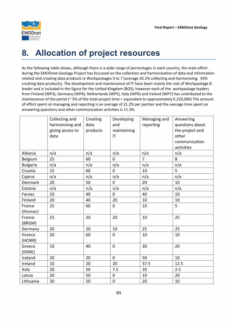
Final Report – EMODnet Geology
84
8. Allocation of project resources
As the following table shows, although there is a wide range of percentages in each country, the main effort during the EMODnet-Geology Project has focussed on the collection and harmonisation of data and information related and creating data products in Workpackages 3 to 7 (average 20.2% collecting and harmonising; 45% creating data products). The development and maintenance of IT have been mainly the role of Workpackage 8 leader and is included in the figure for the United Kingdom (BGS); however each of the workpackage leaders from Finland (WP3), Germany (WP4), Netherlands (WP5), Italy (WP6) and Ireland (WP7) has contributed to the maintenance of the portal (~ 5% of the total project time = equivalent to approximately €.210,000) The amount of effort spent on managing and reporting is an average of 21.2% per partner and the average time spent on answering questions and other communication activities is 11.3%.
Collecting and harmonising and giving access to data
Creating data products
Developing and maintaining IT
Managing and reporting
Answering questions about the project and other communication activities
Albania n/a n/a n/a n/a n/a
Belgium 25 60 0 7 8
Bulgaria n/a n/a n/a n/a n/a
Croatia 25 60 0 10 5
Cyprus n/a n/a n/a n/a n/a
Denmark 20 50 0 20 10
Estonia n/a n/a n/a n/a n/a
Faroes 10 40 0 40 10
Finland 20 40 20 10 10
France (Ifremer)
25 60 0 10 5
France (BRGM)
25 20 20 10 25
Germany 20 20 10 25 25
Greece (HCMR)
20 60 0 10 10
Greece (IGME)
10 40 0 30 20
Iceland 20 20 0 50 10
Ireland 10 20 20 37.5 12.5
Italy 20 50 7.5 20 2.5
Latvia 20 50 0 10 20
Lithuania 20 50 0 20 10

Final Report – EMODnet Geology
85
Malta 20 35 0 40 5
Montenegro n/a n/a n/a n/a n/a
Netherlands 20 35 15 20 10
Norway 20 50 0 20 10
Poland 20 50 0 10 20
Portugal 30 60 0 5 5
Romania n/a n/a n/a n/a n/a
Russia n/a n/a n/a n/a n/a
Slovenia 20 40 0 30 10
Spain 20 65 0 10 5
Sweden 20 60 0 10 10
Turkey n/a n/a n/a n/a n/a
Ukraine 10 30 0 50 10
United Kingdom (BGS)
15 15 30 25 15

Final Report – EMODnet Geology
86
9. Outreach and communication activities
Outreach has taken place both through the work of national partners to promote the programme in their own countries and at international events. The full list of outreach activities is presented on the activities at the national level. The five most important communication activities are considered to be the presentations made at the end of the project as they included the complete project results (indicated by an asterisk and in bold type). Presentation at large international events have also been selected due to their broad reach.
Date Media Title Short description and/or link to the activity
September 2013 Keynote lecture
Integrating marine information from Europe’s seas – the European Marine Observation and Data Network.
Just before the start of the current phase of the EMODnet-Geology Project, the Co-ordinator was invited to give a keynote lecture at the Final Mesh Atlantic Conference in Aveiro, Portugal. The Conference theme was ‘Mapping Atlantic Area Seabed Habitats for Better Marine Management’ and the session in which the lecture was presented was titled ‘Marine Habitat Mapping: Historical Perspectives and Present Status. See http://www.meshatlantic.eu/assets/files/MeshAtlantic_Newsletter05.pdf
October 2013 Meeting The EMODnet-Geology Project was referenced in a presentation to the Ministry of Enterprise and Innovation, Ministry of Environment and Energy, Ministry of Foreign Affairs, Sweden.
December 2013 Article European Geological Project. Article on the website of the Ministry of Environment of Lithuania.
2013 Annual Report HGI-CGS annual report. The EMODnet-Geology project was presented in the HGI-CGS annual report for 2013.
2013 Publication Strike slip tectonics and transtensional deformation in the Aegean Region and the Hellenic Arc: preliminary results.
The EMODnet-Geology Project was referenced in a publication: Sakellariou D., Mascle, J., and Lykousis, V., 2013. Bul. Geol. Soc. Greece, vol. XLVII/2, p. 647-656.
January 2014 Information European Geological Project. Information about EMODnet-Geology in ‘Ecology’ news portal.
March 2014 Conference (poster)
EMODnet Geology - A sea-bed substrate map for European marine areas.
Ulla Alanen, Anu Kaskela, Aarno Kotilainen, Alan Stevenson, and EMODNET-Geology partners. Finnish National Colloquium of Geosciences 19.-20.3.2014, GTK, Espoo.
March 2014 Conference (poster)
Exploring our marine geological resources in the fifth dimension: About 3D voxels, 4D impact models and uncertainty.
The EMODnet-Geology Project was referenced in poster and abstract by Van Lancker, V., De Mol, L., De Tré, G., Maljers, D., Missiaen, T., Stafleu, J., Van den Eynde, D., and van Heteren, S. (2014). In: Mees, J. et al. (Ed.). Book of abstracts – VLIZ Young Scientists’ Day. Brugge, Belgium, 7 March 2014. VLIZ Special Publication 67, 111.
March 2014 Colloquium EMODnet-Geology: A seabed The EMODnet-Geology Project was referenced in
Final Report – EMODnet Geology
87
substrate map for European marine areas.
a presentation by (Alanen et al. 2014a) at the ‘1st Finnish National Colloquium of Geosciences’ Conference, 19-20 March 2014, Espoo, Finland. Alanen, U., Kaskela, A., Kotilainen, A., Stevenson, A., and EMODnet-Geology partners, 2014a. In Virtasalo, J. & Tuusjärvi, M. (eds).: 1st Finnish National Colloquium of Geosciences, Abstract Book, Espoo 19-20 March 2014. Geological Survey of Finland, Guide 58, 32.
March 2014 Conference (poster)
Exploring our marine geological resources in the fifth dimension: About 3D voxels, 4D impact models and uncertainty.
The EMODnet-Geology Project was referenced in poster and abstract by Van Lancker, V., Van den Eynde, D., De Mol, L., De Tré, G., Maljers, D., Stafleu, J., and van Heteren, S., and Missiaen, T. (2014). In: M. Shahrizal Ab Razak, L., Sembiring, and van der Wegen, M. (eds.). NCK-days 2014 Preparedness, 27-28/3/2014. Delft (NL) UNESCO-IHE.
March 2014 Meeting The EMODnet-Geology Project was referenced in a presentation to the Ministry of Enterprise and Innovation, Ministry of Environment and Energy, Sweden.
April 2014 Conference The Italian Geological Mapping Project (CARG): from data acquisition to cartographic representation in submerged areas and its contribution to the European Marine Observation Data Network – Geology 2 Project.
The EMODnet-Geology Project was referenced in a presentation at the Geomaritime conference, London 7-8 April 2014.
April 2014 Article EMODNet-Geology Project Meeting.
“EMODnet-Geology Project Meeting in Lisbon, Portugal” in EuroGeoSurveys NEWS, Issue 14, April 2014, p. 11.
April 2014 Article Zweite Phase des EMODnet-Projektes gestartet.
The EMODnet-Geology Project was referenced in a contribution to: BGR Newsletter 2014. Asch. K and Gdaniec, P. April 2014.
April 2014 Workshop EMODnet WP7 European Marine Minerals.
The EMODnet-Geology Project was referenced in a contribution by Judge, M.at the international workshop on Deep Sea Mineral resources and discussion forum, Trondheim, Norway. April 2014.
April 2014 Meeting Presentation of EMODnet Project.
Presentation of EMODnet Project at the Marine Geology and Georesources Unit-IPMA and distribution of EMODnet leaflet.
April/May 2014 Conference (poster)
European Marine Observation and Data Network (EMODnet) for Geology – A sea-bed substrate map for European marine areas.
The EMODnet-Geology Project was referenced in a poster presentation by (Alanen et al. 2014) at the European Geosciences Union (EGU) 2014 conference, 28 April to 2 May 2014, Vienna, Austria. Alanen, U., Kaskela, A., Kotilainen, A., Stevenson, A., and EMODnet-Geology 2 Partners, 2014b. Geophysical Research

Final Report – EMODnet Geology
88
Abstracts, Vol. 16, EGU2014-1415, EGU General Assembly 2014.
April 2014 Article News from the Marine Geology Expert Group. EMODnet-Geology Project Meeting in Lisbon, Portugal. Inauguration of the EMODnet Secretariat in Ostend, Belgium.
Article by Alan Stevenson in the EuroGeoSurveys Newsletter.
May 2014 Conference (poster)
Exploring our marine geological resources in the fifth dimension: About 3D voxels, 4D impact models and uncertainty.
The EMODnet-Geology Project was referenced in poster and abstract by Van Lancker, V., De Mol, L., De Tré, G., Maljers, D., Missiaen, T., Stafleu, J., Van den Eynde, D., and van Heteren, S. (2014). GeoHab Conference (Marine Geological and Biological Habitat Mapping). Lorne (Australia), 5-9/5/2014.
May 2014 Workshop VELMU (The Finnish Inventory Programme for the Underwater Marine Environment) Project group workshop.
Presentation on the EMODnet-Geology Project at the VELMU (The Finnish Inventory Programme for the Underwater Marine Environment) Project group workshop (Henry Vallius), 21 May 2014, Helsinki, Finland.
May 2014 Working Group Report
Short description of the status of EMODnet -Geology in the report from the meeting.
ICES Working Group on Marine Habitat Mapping (WGMHM). The meeting was held this year in San Sebastian, Spain 19-23 May.
June 2014 Letter sent to Portuguese Institutions and colleagues introducing the EMODnet-Geology Project and requesting (third-party) data for WP-7 Minerals. Also sent as an example, attached to the letter, figures of visualization form of WP7 (map and attribute table) as well as a table form for data.
July 2014 Article An interview with Anu Kaskela (GTK, Finland) about current topics in marine geology by Essi Keskinen for the Series "Veneenalainen maailma" (in English "The World under Boat) in magazine Kippari 7/2014.
September 2014 Conference (poster)
Geological resource management of the future: Drilling down the possibilities.
The EMODnet-Geology Project was referenced in poster and abstract by Van Lancker, V., Van den Eynde, D., De Mol, L., De Tré, G., Van Britsom, D., De Mol, R., Missiaen, T., Hademenos, V., Maljers, D., Stafleu, J. and van Heteren, S. (2014). Abstract 2nd Deep Water Circulation Congress: The Contourite Log-book. VLIZ Special Publications (ISSN 1377-0950). Gent (BE), 10-12/9/2014.
September 2014 Colloqium Sediment and Habitat mapping of the Baltic Sea.
Vallius, H. 2014. Keynote lecture at the 12th Colloquium on Baltic Sea Marine Geology September 8 – 12, 2014, Warnemünde, Germany.
September 2014 Colloquium The sea-bed substrate data of the European seas as part of
The EMODnet-Geology Project was referenced in a presentation by (Kaskela et al. 2014) at the

Final Report – EMODnet Geology
89
the European marine observation and data network (EMODnet) for geology –project.
12th Colloquium on Baltic Sea Marine Geology, 8. - 12 September 2014), Warnemünde, Germany. Kaskela, A., Alanen, U., Kotilainen, A., and Stevenson, A., 2014.
September 2014 Congress Marine geology challenges: integration and harmonization of data.
The EMODnet-Geology Project was referenced in a presentation at the 87th Congress of the Italian Geological Society, Milan 10-12 September 2014.
September 2014 Paper Harmonisierung Geologischer Karten und Daten Europas.
The EMODnet-Geology Project was referenced in a paper in: Geowissenschaftliche Mitteilungen (GMIT) of the German Society of Geosciences, GMIT Nr. 57, P 6 – 15. Asch. K and Gdaniec, P. September 2014
September 2014 Meeting (poster)
Ferromanganese crusts in the NE Atlantic Ocean: occurrences, composition and resource considerations.
The EMODnet-Geology Project was referenced in a poster presentation by S.B. Muiños et al : Muiños, S.B.; Hein, J.R.; Frank, M; Monteiro, J.H.; Gaspar, L.; Conrad, T.; Garcia Pereira, H. and F. Abrantes (2014). In Harvesting Seabed Minerals Resources in Harmony with Nature UMI 2014; 43rd Underwater Mining Institute · 21-28 September 2014, Lisbon, Portugal.
October 2014 Position paper EMODnet referenced in ‘Land Beneath the Waves. Submerged landscapes and sea level change’. A joint geoscience-humanities strategy for European Continental Shelf Prehistoric Research. Fleming, N.C., Cagatay, M.N., Chiocci, F.L., Galanidou, N., Jons, H., Lericolais, G., Missiaen, T., Moore, F., Rosentau, A., Sakellariou, D., Skar, B., Stevenson, A., Weerts, H. 2014. Chu, N.C. and McDonough, N. (Eds) Position Paper 21 of the European Marine Board, Ostend, Belgium. 171 pp. ISBN 978-94-920430-3-0. European Marine Board Position Paper on submerged landscapes. http://www.marineboard.eu/images/publications/Land%20Beneath%20the%20Waves-244.pdf
October 2014 Science event (poster)
Exploring our marine geological resources in the fifth dimension: about 3D voxels, 4D impact models and uncertainty.
EMODnet-Geology referenced in poster and abstract by Van Lancker, V.; De Mol, L.; De Tré, G.; Maljers, D.; Stafleu, J.; Van den Eynde, D.; Van Heteren, S. (2014). In: Mees, J. et al. (Ed.) (2014). Book of abstracts – VLIZ Young Scientists’ Day. Brugge, Belgium, 7 March 2014. VLIZ Special Publication, 67: pp. 111. (poster).
October 2014 Study day Interactive management of marine resources in the southern North Sea, a long-term perspective.
The EMODnet-Geology Project was referenced in presentation by Van Lancker, V.; Francken, F.; Terseleer, N.; Van den Eynde, D.; De Mol, L.; De Tré, G.; De Mol, R.; Missiaen, T.; Hademenos, V.; Maljers, D.; Stafleu, J.; Van Heteren, S. (2014). In: De Mol, L. et al. (Ed.) (2014). 'Which future for the sand extraction in the Belgian part of the North Sea?'. Study day, 20 October 2014,
Final Report – EMODnet Geology
90
Belgium Pier - Blankenberge. pp. 89-94.
October 2014 Seminar (poster)
European Marine Observation & Data Network - Geology.
The EMODnet-Geology Project was referenced in a poster presentation by Judge, M. Guinan, J. McKeon, C. O’Shea, G. at the INFOMAR Seminar, Ireland’s annual marine seminar, Waterford.
October 2014 Expert Group meeting
Verbruggen, K., Judge, M. INFOMAR and EMODnet. EuroGeoSurveys, Marine Expert Group, October 2014, Malta.
November 2014 Conference (poster)
European Marine Observation & Data Network – Geology.
The EMODnet-Geology Project was referenced in a poster presentation by Judge, M. Guinan, J. McKeon, C. O’Shea, G. Geoscience 2014, 5th November, Dublin.
November 2014 Conference (poster)
European Marine Observation & Data Network-Geology.
The EMODnet-Geology Project was referenced in a poster presentation by Judge, M. Guinan, J. McKeon, C. O’Shea, G. Atlantic Ireland 2014, Ireland’s annual petroleum seminar, 20th November, Dublin.
December 2014 Conference Presentation including EMODnet-Geology in session on ‘Progress on Large Scale Seabed Mapping Data Integration & Exchange Initiatives Overcoming data integration challenges, making data relevant, and accessible’
Workshop to develop the seabed mapping aspects of the Galway Statement on Atlantic Research Co-operation. Dublin, Ireland.
2014 Book series Collaborative seabed-habitat mapping: uncertainty in sediment data as an obstacle in harmonization, in Collaborative knowledge in scientific research networks.
The EMODnet-Geology Project was referenced by S. van Heteren, V. Van Lancker (2014). (P. Diviacco, P. Fox, C. Pshenichny, A. Leadbetter, eds.), Advances in Knowledge Acquisition, Transfer, and Management (AKATM) Book Series, IGI Global, p. 154-176.
2014 Book Workpackage 5 results are presented in a section on coastal erosion, sedimentation and morphology (Sytze van Heteren and John Huthnance) in the North Sea Region Climate Change Assessment.
International initiative to compile a comprehensive interdisciplinary and transdisciplinary assessment of the present scientific knowledge about all aspects of past, ongoing and future climate change in the greater North Sea region. The revised MS has been accepted for publication in a Springer book (2015).
2014 Brochure Geological information for Europe :Towards a pan-European Geological Data Infrastructure
Brochure of the European Geological Data Infrastructure Scoping Project (EGDI-Scope). http://www.egdi-scope.eu/wp-content/uploads/2014/05/Brochure-250x180-2014_1.pdf
January 2015 Conference EMODnet-Geology was referenced at the European Innovation Partnership on Raw Materials Annual Conference and Horizon 2020 Brokerage Event on Raw Materials, Brussels, Belgium.
Final Report – EMODnet Geology
91
January 2015 Conference (poster)
Using Sediment data to create series of surrogate-based habitat suitability maps for the southernmost North Sea.
The EMODnet-Geology Project was referenced in poster presentation at the Quaternary Research Association meeting in Edinburgh, UK. Vera Van Lancker and Sytze van Heteren.
January 2015 Conference EMODnet: The European Marine Observation and Data Network.
The EMODnet-Geology Project was referenced in presentation by J.O. Leth at the 18th Marine Science Meeting in Copenhagen January 2015.
January 2015 Conference European Marine Observation and Data Network (EMODnet) for Geology – A sea-bed substrate map for European marine areas.
The EMODnet-Geology Project was referenced in poster at the 18th Marine Science Meeting in Copenhagen January 2015. (Ulla Alanen1, Anu Kaskela1, Aarno Kotilainen1, Alan Stevenson2, Jørgen O. Leth3 and EMODnet - Geology partners).
January 2015 Lecture event EMODnet 2 - Die Geologie des Meeresbodens europaweit: BGR-Beteiligung und erste Ergebnisse.
The EMODnet-Geology Project was referenced in a presentation at the regular BGR lecture event “Hauskolloquium”. Asch, K., Gdaniec, P and Müller, A. January 2015.
February 2015 Meeting EMODnet-Geology referenced at the Atlantic Research Alliance stakeholders meeting in Brussels on 23-24 February.
February 2015 Training Event Geomorfologie van Kust en Zee. Zeebad voor Leerkrachten 2015.
The EMODNet-Geology Project was referenced in presentation by Van Lancker, V. in Gent (BE), 25/2/2015. Initiatief VLIZ, in samenwerking met de Vereniging Leraars Aardrijkskunde VLA - werkgroep Oost-Vlaanderen. (http://www.vliz.be/nl/Zeebad-voor-leerkrachten-2015)
February 2015 Conference INFOMAR and Ireland’s contribution to European collaborative marine geological mapping projects.
Maria Judge, Geological Survey of Ireland (GSI) presented the EMODnet-Geology project at the Irish Geological Research Meeting (IGRM), Cork, Ireland (Ireland’s annual geological research meeting).
February 2015 Meeting INFOMAR and Europe: Collaborative Marine Geology.
The EMODnet-Geology Project was referenced in a presentation by Judge, M. at the Irish Geology Research Meeting, February 20-22, Belfast, Ireland.
March 2015 Press Release EMODNet meeting. A press release was issued to promote the third EMODnet meeting held in Madrid in March
2015.
March 2015 “Ferrromanganese crusts from the seamounts north of the Madeira Island: composition, origin and paleoceanographic conditions”
Presentation and public disputation of Susana Muiños Doctorate thesis at Kiel University (Public Disputation: 18th March, 2015). The thesis deals with the study of the Fe-Mn deposits from the NE Atlantic seamounts, and in particular those within the Portuguese EEZ, in an integrated way, considering them both as paleoceanographic indicators and as potential resources for metals
Final Report – EMODnet Geology
92
of economic interest (e.g. Co, REE’s, PGE’s, etc). The data related to their distribution and composition in elements of economic interest was introduced in the EMODnet database.
April 2015 Conference Seabed substrates and sedimentation rates of the European Seas - EMODnet-Geology2.
The EMODnet-Geology Project was referenced in a poster presentation by (Kaskela et al. 2015) at the European Geosciences Union (EGU) 2015 conference, 13-17 April 2015, Vienna, Austria. Kaskela, A., Kotilainen, A., Alanen, U., Stevenson, A., and EMODnet-Geology 2 Partners, 2015c.. Geophysical Research Abstracts, Vol. 17, EGU2015-13410-1, EGU General Assembly 2015.
April 2015 Meeting EMODnet referenced at ‘The Atlantic – our Shared Resource: making the vision reality’ meeting held in Brussels on 16-17 April.
April 2015 Working Group
TILES project on Transnational and Integrated Long-term Marine Exploitation Strategies) and the estimation of far field effects of marine aggregate extraction in an offshore sandbank environment.
The EMODnet-Geology Project was referenced in presentation by Van Lancker, V. (2015). pp. 75-76. In: ICES (2015). Interim Report of the Working Group on the Effects of Extraction of Marine Sediments on the Marine Ecosystem (WGEXT), 20–23 April 2015. Ostend, Belgium. ICES CM 2015/SSGEPI:06, 102 pp.
April 2015 Meeting Presentation of EMODnet Project at the Marine Geology and Georesources Unit-IPMA, Portugal and distribution of EMODnet leaflet.
May 2015 Conference Habitat change assessment in dynamic shallow water systems – Lessons learned and way forward.
The EMODnet-Geology Project was referenced in presentation at GeoHab Conference (Marine Geological and Biological Habitat Mapping). Salvador de Bahia (Brazil), 3-8/5/2015 (oral).
May 2015 Conference Assembling data on sea-bed substrates of the European Seas.
The EMODnet-Geology Project was referenced in a presentation (Kaskela et al. 2015) at the GeoHab 2015 Conference, 3-8 May 2015, Salvador, Brazil. Kaskela, A., Alanen, U., Kotilainen, A., Stevenson, A., EMODnet – Geology2 partners, 2015: The GeoHab 2015 Conference: marine geological and biological habitat mapping, 3-8 May, 2015, Salvador, Bahia, Brazil: abstract volume, 95
May 2015 Meeting The EMODnet-Geology Project was referenced in a presentation to the Swedish Maritime Administration, Swedish Armed Forces, Stockholm University, County Administration Boards, Swedish Agency for Marine and Water Management.
May 2015 Conference EMODnet-Geology referenced at the Irish Association of Economic Geology Conference, 16-17th May, Limerick, Ireland.
May 2015 Workshop EMODnet referenced at the European Ocean Observing System meeting organised by the

Final Report – EMODnet Geology
93
European Marine Board and EuroGOOS in Brussels on 12-13 May 2015.
June 2015 Science Event Geological resource management of the future: Drilling down the possibilities.
The EMODnet-Geology Project was referenced in poster by Van Lancker, V., Van den Eynde, D., De Mol, L., De Tré, G., Van Britsom, D., De Mol, R., Missiaen, T., Hademenos, V., Maljers, D., Stafleu, J. and van Heteren, S. (2014). NATO Science Day. Oostende (BE), 1/6/2015.
June 2015 Conference Geological Knowledge Base, a digital platform for sharing and quantifying resource information.
The EMODNet-Geology Project was referenced in presentation by Van Lancker, V, Francken, F., Terseleer, N. , Van den Eynde, D., De Mol, L., De Tré, G., De Mol, R., Missiaen, T., Hademenos, V., Bakker, M., Maljers, D., Stafleu, J. & van Heteren, S. (2015). pp. 1-2. 5th EMSAGG conference: Marine sand & gravel - Finding common ground. Delft (NL), 4-5/6/2015.
June 2015 Meeting Ireland’s national seabed mapping programme and EMODnet.
The EMODnet-Geology Project was referenced in a presentation and a poster presentation by Judge, M. at the European Marine Sand and Gravel Group (EMSAGG), 4-5th June, Delft, Netherlands
June 2015 Conference (poster)
Geological resource management of the future: Drilling down the possibilities.
EMODNet-Geology referenced in poster by Van Lancker, V., Van den Eynde, D., De Mol, L., De Tré, G., Van Britsom, D., De Mol, R., Missiaen, T., Hademenos, V., Maljers, D., Stafleu, J. and van Heteren, S. (2014). World Ocean Day. Brussels (BE), 7/6/2015.
June 2015 Congress EMODnet-Geology - seabed substrates and sedimentation rates of the European Seas.
The EMODnet-Geology Project was referenced in a presentation (Kaskela et al. 2015) at the Baltic Sea Science Congress 2015 (BSSC 2015), 15-18 June 2015, Riga, Latvia. Kaskela, A.M., Kotilainen, A.T., Alanen, U., Stevenson, A., and EMODnet-Geology Partners, 2015d. In: 10th Baltic Sea Science Congress, 15-19, June 2015, Riga, Latvia: Abstract Book. 42.
June 2015 Congress Geology data from Latvian offshore area – European marine observation and data network (EMODNET) Geology project.
The EMODnet-Geology Project was referenced in a poster presentation at the 10th Baltic Sea Science Congress in Riga, Latvia (15 – 19 June 2015).
June 2015 Conference European Marine Observation and Data Network, Phase 2: Sea-floor geology, compilation and harmonization.
The EMODnet-Geology Project was referenced in a presentation at: 30th Annual Conference of the Geoscience Information Consortium (GIC). Asch, K., Gdaniec, P and Müller, A. June 2015.
June 2015 Conference EMODnet-Geology referenced at the 8th EuroGeo Conference, Barcelona, Spain.
June 2015 Meeting TILES project on Transnational and Integrated Long-term Marine Exploitation Strategies)
EMODnet-Geology referenced in presentation by Van Lancker, V. (2015). pp. 75-76. In: ICES (2015). Interim Report of the Working Group on

Final Report – EMODnet Geology
94
and the estimation of far field effects of marine aggregate extraction in an offshore sandbank environment.
the Effects of Extraction of Marine Sediments on the Marine Ecosystem (WGEXT), 20–23 April 2015. Ostend, Belgium. ICES CM 2015/SSGEPI:06, 102 pp.
June/July 2015 Meeting 3-4D Geological & Sediment Mapping. Data, concepts and first results.
The EMODnet-Geology Project was referenced in a presentation by Van Lancker, V, Francken, F., Terseleer, N. , Van den Eynde, D., Hademenos, V., Missiaen, T., De Mol, R. De Tré, G., van Heteren, S., Bakker, M., Maljers, D., Stafleu, J., Busschers, F. & De Mol, L. (2015). ANR SunRISE Network meeting. Barcelona (ESP), 30/6-1/7/2015.
July 2015 Colloquium EMODnet 2 - Geologie des Meeresbodens europaweit: BGR-Beteiligung und erste Ergebnisse
Presentation at the BGR internal colloquium, Hannover, Germany. Asch, K. and Müller, A.M.
July 2015 Meeting European Marine Observation and Data Network Phase 2. Workpackage 4 - Sea-floor geology: Compilation and harmonization.
Presentation at International Geoscience Information consortium meeting in Hannover, Germany. Asch, K., Gdaniec, P. and Müller, A.M.
August 2015 Article EMODnet-Geology kokoaa tiedon Euroopan merialueiden geologiasta (in Finnish). Summary in English.
Kotilainen, A.T., Kaskela, A.M., Alanen, U., Stevenson, A., 2015. Geologi, 3, 80-87. Article in Geologi magazine. http://www.geologinenseura.fi/geologi-lehti/3-2015/Geologi_3_2015_04emodnet.pdf
September 2015 Seminar ”Geologia ei tunne rajoja - merigeologista yhteistyötä jo yli 50 vuotta”.
The EMODnet-Geology Project was referenced in a presentation by Aarno Kotilainen (in Finnish) at the Finnish-Russian co-operation in marine geoscience (including EMODnet Geology) in Rajallinen ympäristö – seminar, 2 September 2015, Helsinki, Finland.
September 2015 Meeting Activities of the ECODAM group (ECOsystem Data Analysis and Modelling).
The EMODnet-Geology Project was referenced in presentation by Baetens, K., Baeye, M., Barbut, L., Desmit, X., Dulière, V., Fettweis, M., Francken, F., Kint, L., Lacroix, G., Legrand, S., Luyten, P., Nechad, B., Ozer, J., Ponsar, S., Pringle, N., Ruddick, K., Terseleer, N., Van den Eynde, D., Van der Zande, D., Vanhellemont, Q. & Van Lancker, V. (2015). Science Day RBINS OD Nature. Temse (BE), 11/9/2015.
September 2015 Workshop TILES Workshop 2: Discussie resultaten grondstofmodellering met eindgebruikers.
The EMODnet-Geology Project was referenced in presentation by Van Lancker, V., Kint, L, Montereale-Gavazzi, G., Terseleer, Nathan, Van den Eynde, D., Missiaen, T., Hademenos, V., De Tré, G., De Mol, R., van Heteren, S., Cox, D., De Mol, L., Roche, M., Van Gaever, S., Van Quickelborne, E., De Nil, K., Matton, C., Stolk, A. & VandenEede, S. (2015). Belspo Brain-be project TILES (BR/121/A2/TILES). Gent (BE),
Final Report – EMODnet Geology
95
Universiteit Gent 23/9/2015, 8 pp + Annexes.
September 2015 Congress LoADRIA project. The EMODnet-Geology Project was presented within the frame of the LoADRIA project at the 5th Croatian Geological Congress.
September 2015 Data publication
Finnish national EMODnet substrate data at a scale of 1:250 000 in the GTK’s web portal.
Data publication: Publication of the Finnish national EMODnet substrate data at a scale of 1:250 000 in the GTK’s web portal, 28.9.2015.
September 2015 Press release “GTK toi tarkat merenpohjan karttatiedot kaikkien saataville”.
The EMODnet-Geology Project was referenced in a press release about the publication of the Finnish national EMODnet substrate data at a scale of 1:250 000 in the GTK’s web portal, 28.9.2015.
September 2015 Symposium The EMODnet project: A European initiative for the development of the geological knowledge in the European marine environment.
The EMODnet-Geology Project was referenced in a presentation by T. Medialdea, J. Giménez‐Moreno, L. Somoza, R. León & F.J. González. 2015 at the Abstracts VIII Symposium on the Iberia Atlantic Margin, MIA15, Málaga,449‐451.
September 2015 Symposium First catalogue of submarine mineral deposits from Spain: EMODnet‐Geology Project.
The EMODnet-Geology Project was referenced in a presentation by F.J. González, T. Medialdea, G. Gómez‐Ramos, L. Somoza, E. Marino & R. León. 2015 at the Abstracts VIII Symposium on the Iberia Atlantic Margin MIA15, Málaga, 695‐698.
September 2015 Symposium Potential and difficulties in the susceptibility assessment of submarine landslides in the MIA from an event catalogue.
The EMODnet-Geology Project was referenced in a presentation by R. León, T. Medialdea, L. Somoza, J. Giménez‐Moreno & F.J. González. 2015 at the Abstracts VIII Symposium on the Iberia Atlantic Margin MIA15, Málaga, 169‐172.
September 2015 Forum "Problems and prospects of development of Geology: science and production".
IGS, Ukraine provided the forum with an informational report on participation of PrichornomorSRGP in the international project EMODnet. The report contained information on the project tasks and a link to the EMODnet Central Portal. International Geological Forum in Odessa
September 2015 Meeting The Workpackage 5 leader attended the Darmstadt Copernicus Users Information Day on Sep 11 to see what data will become available for the monitoring of coastal change.
September 2015 Geological Forum
International Geological Forum in Odessa called "Problems and prospects of development of Geology: science and production". PrichornomorSRGE provided to the forum an informational report on their participation in the EMODnet-Geology Project, containing the project tasks and a link to the EMODnet Central Portal.
September 2015 Paper The EMODnet project: a Presentation by T. Medialdea, J. Giménez-

Final Report – EMODnet Geology
96
European initiative for the development of the geological knowledge in the European marine environment. In Spanish (abstract in English).
Moreno, L. Somoza, R. León & F.J. González of the Instituto Geológico y Minero de España at the Resúmenes sobre el VIII Simposio MIA15, Málaga. EMODnet was also referenced at the same meeting in papers on ‘Potential and difficulties in the susceptibility assessment of submarine landslides in the MIA from an event catalogue’ by R. León, T. Medialdea, L. Somoza, J. Giménez-Moreno & F.J. González and ‘First catalogue of submarine mineral deposits from Spain: EMODnet-Geology Project’ by F.J. González, T. Medialdea, G. Gómez-Ramos, L. Somoza, E. Marino & R. León.
Autumn 2015 Conference Glaciation of the Icelandic Insular Shelf.
The EMODnet-Geology Project was referenced in a presentation by Árni Hjartarson & Ögmundur Erlendsson 2015. Geological Society of Iceland, Autumn Conference 2015.
Autumn 2015 Conference Seabed substrate and unconsolidated sediments around Iceland.
The EMODnet-Geology Project was referenced in a presentation by Ögmundur Erlendsson et al. 2015. Geological Society of Iceland, Autumn Conference 2015.
October 2015 Conference (poster)
Seabed substrates of the European Seas – EMODnet Geology.
The EMODnet-Geology Project was referenced in a poster presentation by (Kaskela et al. 2015) at the EMODnet Open Conference, 20-22 October 2015, Ostend, Belgium. Kaskela, A.M., Kotilainen, A.T., Alanen, U., Stevenson, A., and EMODnet-Geology Partners, 2015.
*October 2015 Conference EMODnet-Geology presentation.
A Stevenson presented the EMODnet-Geology Project at the EMODnet Open Conference in Ostend, Belgium, October 2015.
October 2015 Conference Coastal erosion and accretion: translating incomplete data and information into vulnerability assessments.
The EMODnet-Geology Project was referenced in a presentation by S. van Heteren, C. Moses, T. van de Ven (2015) at the EMODnet Open Conference, Oostende, Belgium, October 20, 2015.
October 2015 Conference (poster)
EMODnet marine geology data and its compilation: Harmonisation challenges of an off-shore jigsaw puzzle.
The EMODnet-Geology Project was referenced in a poster: at EMODNnet Open Conference. Asch, K. and Müller, A. October 2015.
October 2015 Conference (poster)
EMODnet Geology WP7 Marine Minerals.
The EMODnet-Geology Project was referenced in a poster presentation by Judge, M.T., McKeon, C., O’Shea at the EMODnet Open Conference, October 20-22nd,Oostende, Belgium.
October 2015 Conference (poster)
EMODnet Geology; Mapping Marine Minerals in Europe.
The EMODnet-Geology Project was referenced in a poster presentation by Judge, M.T., McKeon, C., O’Shea, G. at Atlantic Ireland, 27th October, Dublin, Ireland.
October 2015 Publication European Marine Observation and Data Network EMODnet, Making Fragmented Marine
The EMODnet-Geology Project was referenced in a publication by Judge, M. Earthzine, IEEE Publication. http://bit.ly/297VGv4.
Final Report – EMODnet Geology
97
Data Relevant and Accessible.
October 2015 Seminar Ferromanganese crusts in the NE Atlantic Ocean: occurrences, composition and resource considerations.
The EMODnet-Geology Project was referenced in a presentation at the Seminar on Sustainable Exploitation of Marine Mineral Resources (October, 28th) organized by the Royal Embassy of Norway and IPMA.
October 2015 Paper Offshore faulting in the Aegean Sea; a Synthesis based on bathymetric and seismic profiling data.
Paper by Sakellariou D and Tsampouraki-Kraounaki K. EMODnet bathymetry and geology referenced in the paper from the Proceedings of the 14th International Conference, Thessaloniki, May 2015. Bulletin of the Geological Society of Greece. Volume XLVIII.
October 2015 Conference EMODnet-Geology referenced in a talk by Alan Stevenson on ‘European Initiatives and Potential Links with ECORD’ at the 2nd Coastal and Marine Geology Symposium’ in Istanbul, Turkey. 15th October.
October 2015 Book launch EMODnet-Geology referenced at the launch of Minerals Yearbook, at “Raw Materials Diplomacy Dialogue between the EU and the advanced mining countries” event. Brussels, Belgium.
October 2015 Webzine article
European Marine Observation and Data Network (EMODnet): Making Fragmented Marine Data Relevant and Accessible.
An article on EMODNET, EMODnet-Geology and the GSI work as WP7 Marine Minerals leader has been generated and will be published on the webzine Earthzine: http://earthzine.org/.
November 2015 Web Dissemination of EMODnet Project at IPMA’s webpage.
November 2015 Congress Joint Presentation on activities of the geology and bathymetry lots
The EMODnet-Geology Project was referenced in a joint presentation with colleagues at Ifremer involved in the EMODNet Bathymetry lot, was given at a national congress, MerIgéo (http://www.merigeo.fr/), held in Brest in November 2015. The activities of the geology and bathymetry lots were described as well as the connections between them.
November 2015 Seminar INFOMAR data visibility in Europe's largest marine data network – EMODnet-Geology.
The EMODnet-Geology Project was referenced in a presentation by Guinan, J. INFOMAR Annual Seminar, 3rd November, Dublin, Ireland.
November 2015 Conference (poster)
EMODnet Geology; Mapping Marine Minerals in Europe.
The EMODnet-Geology Project was referenced in a poster presentation by Judge, M.T., McKeon, C., O’Shea, G. at the GeoScience Annual Conference, 4th November, Dublin, Ireland.
November 2015 Seminar (poster)
EMODnet: Your gateway to marine data in Europe.
The EMODnet-Geology Project was referenced in a poster presentation at the INFOMAR Seminar 2015.
November 2015 Info Day EMODnet lots and the Mediterranean check-point project.
Presentation at the EMODnet infoday at the Italian Ministry of Environment in November 2015, including a contribution by Iain Shepherd.
November 2015 Meeting The EMODnet-Geology Project was referenced in
Final Report – EMODnet Geology
98
a presentation to the Swedish Agency for Marine and Water Management.
November 2015 Meeting The EMODnet-Geology Project was referenced in a presentation to the Ministry of Enterprise and Innovation, Ministry of Environment and Energy, Sweden.
November/December 2015
Workshop Biotope mapping in Belgium and the Netherlands.
The EMODnet-Geology Project was referenced in presentation by Van Lancker, V. & van Heteren, S. (2015). Workshop on marine biotope mapping for conservation purposes. Isle of Vilm (GER), International Academy for Nature Conservation, 30/11-2/12 2015. Organisation by the German Federal Agency for Nature Conservation (BfN).
December 2015 Workshop (poster)
Building a transnationally harmonised marine geological database.
The EMODnet-Geology Project was referenced in a poster presentation by L. Kint, S. van Heteren, R. Lagring, V. Van Lancker (2015) at the BEDIC Data Matters workshop, Brussels (BE), RBINS, 7/12/2015.
2015 Annual report Ifremer Marine Geosciences Unit Research 2015 Annual Report.
The EMODnet-Geology Project was presented in the Ifremer Marine Geosciences Unit Research 2015 Annual Report.
2015 Article EMODnet-Geology kokoaa tiedon Euroopan merialueiden geologiasta.
The EMODnet-Geology Project was referenced in an article: Kotilainen, A.T., Kaskela, A.M., Alanen, U., Stevenson, A., 2015. Summary in English. Geologi, 3, 80-87.
2015 Article The EMODnet-Geology Project was referenced in an article in Lithuanian Geological survey Annual Report 2015.
2015 Background paper (unpublished)
Geomorphology & Geomorphological Mapping: A Concise Guide for EMODnet.
The EMODnet-Geology Project was referenced in a Background paper (unpublished). Asch, K. and Moses, C. 2015.
2015 Book Collaborative seabed-habitat mapping: uncertainty in sediment data as an obstacle in harmonization.
The EMODnet-Geology project was referenced by Van Lancker, V. and van Heteren, S. in chapter 8 pp. 154-176. In: Diviacco, P., Fox, P., Pshenichny, C. & Leadbetter, A. (eds.). Collaborative Knowledge in Scientific Research Networks. IGI Global. doi:10.4018/978-1-4666-6567-5.
2015 Book Building a 4D Voxel-Based Decision Support System for a Sustainable Management of Marine Geological Resources.
The EMODnet-Geology Project was referenced in a chapter by Van Lancker, V., Francken, F., Kint, L., Terseleer, N., Van den Eynde, D., De Mol, L., De Tré, G., De Mol, R., Missiaen, T., Chademenos, V., Bakker, M., Maljers, D., Stafleu, J., van Heteren, S. (in press) in Diviacco, P., Leadbetter, A. & Glaves, H. (eds.). Oceanographic and Marine Cross-Domain Data Management for Sustainable Development. IGI Global.
2015 Promotion Promotion of EMODnet at the annual public

Final Report – EMODnet Geology
99
science evening (Vísindavøkan), have posted on the Jardfeingi webpages, and have had one-on-one communication (email, oral) with the public and scientific people about EMODnet.
2015 Promotion Ifremer Day. The EMODnet-Geology Project was referenced in a presentation during the EMODNET Ifremer day held in January 2015.
2015 Lectures Raising awareness of EMODnet-Geology products to students during courses in the framework of the Master programme Oceans and Lakes (Free University Brussels, Ghent University and Antwerp University), as well as Master in Geology, Ghent University.
January 2016 Article ”Tehtävä Itämerellä”. The EMODnet-Geology Project was referenced in an article: Paula Böhling, 2016. ”Tehtävä Itämerellä”. Geofoorumi 1/2016.
January 2016 Conference (poster)
Seabed substrates and sedimentation rates of the European Seas – EMODnet Geology.
The EMODNet-Geology Project was referenced in a poster presentation (Kotilainen et al. 2016) at the “32nd Nordic Geological Winter Meeting”, 13-15 January 2016, Helsinki, Finland. Kotilainen, A.T., Kaskela, A.M., Alanen, U., Stevenson, A., and EMODnet Geology Partners, 2016. In: Bulletin of the Geological Society of Finland, Special Volume, Abstracts of the 32nd Nordic Geological Winter Meeting, 13th – 15th January 2016, Helsinki, Finland. 179
January 2016 Meeting Building a transnationally harmonised marine geological database.
The EMODnet-Geology Project was referenced in a meeting by Kint, L., van Heteren, S., Lagring, R. & Van Lancker, V. (2016). 5th International Geologica Belgica Meeting (GB2016). University of Mons, Mons (BE), 26-29/01/2016.
January 2016 Study Group (poster)
Mapping Marine Minerals in Europe.
The EMODnet-Geology Project was referenced in a poster presentation by Judge, M.T., McKeon, C., O’Shea, G. at the Geology meeting of the Minerals Deposit Study Group, University College Dublin, Ireland.
January 2016 Meeting (poster)
Building a transnationally harmonised marine geological database.
The EMODnet-Geology Project was referenced in a poster presentation by L. Kint, S. van Heteren, R. Lagring, V. Van Lancker (2016) at the Fifth International Geologica Belgica Meeting, Mons, Belgium, January 26-29, 2016.
January 2016 Meeting Coastal erosion and accretion: translating incomplete data and information into vulnerability assessments.
The EMODnet-Geology Project was referenced in a presentation by S. van Heteren, C. Moses, T. van de Ven (2016) at the Fifth International Geologica Belgica Meeting, Mons, Belgium, January 26-29, 2016.
February 2016 Special Publication
Building a transnationally harmonised marine geological database.
The EMODnet-Geology Project was referenced in publication by Kint, L., Van Heteren, S.v.H., Lagring, R. & Van Lancker, V. (2016). In: Mees, J.

Final Report – EMODnet Geology
100
et al. (Ed.) Book of abstracts – VLIZ Marine Scientist Day. Brugge, Belgium, 12 February 2016. VLIZ Special Publication, 75: pp. 67.
February 2016 Conference Multi-criteria Resource Mapping and its Relevance in the Assessment of Habitat Changes.
The EMODnet-Geology Project was referenced in Conference session by Van Lancker, V., Kint, L. & van Heteren, S. (2016). Ocean Sciences 2016. Session: MG002: Mapping the oceans: co-ordinating seabed and habitat mapping for maritime spatial planning. New Orleans, USA. 22-26/2/2016.
February 2016 Conference Developing INFOMAR’s Seabed Mapping Data, To Support A Sustainable Marine Economy.
The EMODnet-Geology Project was referenced in a presentation by Judge, M.T., Guinan, J. at the AGU Ocean Science Meeting, New Orleans.
*February 2016 Conference Mapping the UK and European Seabed: Sharing Information to Deliver New Marine Geological Products
A. A. Stevenson presentation at a session which he co-convened with Tommy Furey of the Irish Marine Institute and Marco Weydert of the European Commission on ‘Mapping the Oceans: Coordinating Seabed and Habitat Mapping for Maritime Spatial Planning’ at the AGU Ocean Sciences Meeting in New Orleans, 21-26 February 2016. The session was organized to raise awareness of the Atlantic Ocean Research Alliance, whose Atlantic Seabed Mapping International Working Group met on 24th February during the Ocean Sciences Conference.
February 2016 Meeting EMODnet - Resilience Mapping of Irish Coast.
The EMODnet-Geology Project was referenced in a presentation by Jordan, C. at the Irish Geological Research Meeting, National University of Ireland Galway, Ireland.
February 2016 Meeting (poster)
Mapping Marine Minerals in Europe.
The EMODnet-Geology Project was referenced in a poster presentation by Judge, M.T., McKeon, C., O’Shea, G. at the Irish Geological Research Meeting.
February 2016 Meeting (poster)
Results of the case study presented by The Centre for Environment, Fisheries and Aquaculture Science (Cefas)
Results of the case study presented by The Centre for Environment, Fisheries and Aquaculture Science (Cefas) were incorporated into a poster presentation given at the Ocean Science Meeting in February 2016 in New Orleans.
February 2016 Meeting (poster)
Minerals Deposit Study Group at University College Dublin, Ireland: Judge, M.T., McKeon, C., O’Shea, G. (2016) Mapping Marine Minerals in Europe.
March 2016 Media Promotion
EMODNet project. Slobodan Miko gave a five minute report on the EMODnet project on 22nd March 2016 on the national television (HRT) programme Dobro jutro, Hrvatska (Good morning, Croatia) to coincide with the EMODnet-Geology Project meeting held in Split on 22-23 March.

Final Report – EMODnet Geology
101
Spring 2016 Conference Hazard map of Iceland’s Insular Shelf.
The EMODnet-Geology Project was referenced in a presentation by Ögmundur Erlendsson & Árni Hjartarson 2016. Geological Society of Iceland, Spring Conference 2016.
Spring 2016 Conference Geological map of Iceland’s Economic Zone.
The EMODnet-Geology Project was referenced in a presentation by Árni Hjartarson & Ögmundur Erlendsson 2016. Geological Society of Iceland, Spring conference 2016.
May 2016 Conference (Poster)
Compiling data on seabed substrates and sedimentation rates from Europe - EMODnet Geology.
The EMODnet-Geology Project was referenced in a poster presentation (Kaskela et al. 2016) at the GeoHab 2016 Conference, 2-6 May 2016, Winchester, England, UK. Kaskela, A., Kotilainen, A., Alanen,U., Stevenson, A., EMODnet Geology partners, 2016.. In: The GeoHab 2016 Conference: marine geological and biological habitat mapping, 2-6 May, 2016, Winchester, England: abstract volume.
May 2016 Conference Relationships between geological events and submarine habitats.
The EMODnet-Geology Project was referenced in a presentation at the GeoHab 2016, Winchester, UK 2-6 May 2016.
May 2016 Article Das Europa-Puzzle – Geologen harmonisieren Off-shore-Daten/ The Europe Puzzle – geologists harmonize offshore data.
The EMODnet-Geology Project was referenced in an article in: BGR Report 2016: Asch, K. and Müller, A. May 2016 (German version) (English version).
May 2016 Conference Offshore faulting in the Aegean Sea: A synthesis based on bathymetric and seismic profiling data.
The EMODnet-Geology Project was referenced in a presentation by Sakellariou D. & Tsampouraki-Kraounaki K., 2016. Bulletin of the Geological Society of Greece, vol. XLVΙII,2016, Proceedings of the 14th Intern. Conference, Thessaloniki, May 2016.
May 2016 Conference (poster)
Resilience Mapping of Irish Coast – Pilot.
The EMODnet-Geology Project was referenced in a poster presentation by Jordan, C. at the ‘Conference of Irish Geographers’ Coastal and Marine Systems Session Dublin, Ireland (poster).
May 2016 Student visit EMODnet - Geology portal. Latvian Maritime Academy student visit to the LEGMC from 20 to 27 May 2016. Short presentation and demonstration of the EMODnet - Geology portal.
May 2016 Meeting The EMODnet-Geology Project was referenced in a presentation to the Ministry of Enterprise and Innovation, Sweden.
May 2016 Meeting The EMODnet-Geology Project was referenced in a presentation to the Swedish Armed Forces, Swedish Defence Research Agency, Lantmäteriet.
July 2016 Article Situation Plan of maritime spatial planning.
The EMODnet-Geology Project was referenced in IPMA’s contribution text submitted to DGRM-PSOEM to the held by the Directorate General of
Final Report – EMODnet Geology
102
Natural Resources, Security and Maritime Services in what respects the marine mineral occurrences (WP7).
July 2016 Promotion EMODnet Secretariat banners, brochures and videos were on view at the INFOMAR stand with GSI staff present. Seafest. July 1-3rd. Galway, Ireland.
August/September 2016
Conference Seabed substrate and sedimentation rate data from Europe’s Seas, EMODnet Geology.
The EMODnet-Geology Project was referenced in a presentation: (Kaskela et al. 2016) for the 35th International Geological Congress, 27 August to 4 September 2016, Cape Town, South Africa. Kaskela, A., Kotilainen, A., Alanen,U., Stevenson, A., EMODnet Geology partners, 2016.
August/September 2016
Conference Discrepancies under Water: Marine Geological Information and Semantic Harmonisation for the EMODnet II Project
The EMODnet-Geology Project was referenced in a paper at: 35th International Geological Congress. Asch, K. and Müller, A. 29 August - 2 September 2016
August/September 2016
Conference (poster)
Seabed mapping of a deep-water basin; towards completing a broad-scale seabed substrate map of Ireland’s offshore. (‘Uncovering the great unknown – mapping the Earth’s ocean floor’.)
The EMODnet-Geology Project was referenced in a poster presentation by Guinan, J., Monteys, X, Thébaudeau, B., Sacchetti, F., Szpak, M.T. at the 35th International Geological congress, Cape Town.
August/September 2016
Conference Mapping Marine Minerals in Europe. (‘Uncovering the great unknown – mapping the Earth’s ocean floor’.)
The EMODnet-Geology Project was referenced in a presentation by Judge, M. and Verbruggen, K. at the 35th International Geological congress, August, Cape Town.
August/September 2016
Conference Map of submerged volcanic structures in Italy.
The EMODnet-Geology Project was referenced in a presentation at the 35th IGC, Cape Town, 27 August-4 September 2016.
August/September 2016
Conference Mapping tectonics: a key element in submarine geological events and probabilities assessment.
The EMODnet-Geology Project was referenced in a presentation at the 35th IGC, Cape Town, 27 August-4 September 2016.
*August/September 2016
Conference Various EMODnet presentations
‘Uncovering the great unknown – mapping the Earth’s ocean floor’. Co-convened by Alan Stevenson (BGS), Koen Verbruggen (GSI), Aarno Kotilainen (GTK) and Vlad Kostylev (GSC). Internaional Geological Congress, Cape Town, South Africa. 30 August 2016.
September 2016 Congress EMODnet Geology: a European Project of harmonised digital cartography of submerged areas.
The EMODnet-Geology Project was referenced in a presentation at the 88th Congress of the Italian Geological Society, Naples 7-9 September 2016.
September 2016 Congress A comprehensive morphotectonic image of the Tyrrhenian Back-Arc Basin.
The EMODnet-Geology Project was referenced in a presentation at the 88th Congress of the Italian Geological Society, Naples 7-9 September 2016.
Final Report – EMODnet Geology
103
*September 2016 Congress Toward an update of the structural model in Italian submerged areas: contributions from the EMODnet Geology Project.
The EMODnet-Geology Project was referenced in a presentation at the 88th Congress of the Italian Geological Society, Naples 7-9 September 2016.
September 2016 Colloquium EMODnet Geology - Seabed substrate and sedimentation rate data from Europe’s Seas.
The EMODnet-Geology Project was referenced in a poster presentation (Kotilainen et al. 2016) for the 13th Colloquium on Baltic Sea Marine Geology (The Baltic 2016), 12.-16.9.2016, Gdańsk, Poland. Kotilainen, A.T., Kaskela, A.M., Alanen, U., Stevenson, A., EMODnet Geology Partners, 2016.
September 2016 Conference (poster)
MSFD-compliant investigative monitoring of the effects of intensive aggregate extraction on a far offshore sandbank, Belgian part of the North Sea.
The EMODnet-Geology Project was referenced in poster by Van Lancker, V.R.M., Baeye, M., Evangelinos, D., Montereale-Gavazzi, G., Terseleer, N. & Van den Eynde, D. (2016). ICES Annual Science Meeting, Riga (Latvia), 19-23/9/2016.
September 2016 Meeting Illustration of the outcomes of the activities carried on within the EMODnet Geology Project on submarine volcanoes.
Participation in the European Researchers Night 2016, to illustrate outcomes of the activities carried on within the EMODnet Geology Project on submarine volcanoes, Rome 30 September 2016.
October 2016 Info Day Communication of the scientific results of the Project to the Italian marine geologists community.
An EMODnet-Geology infoday was organised in October 2016 to communicate the scientific results of the Project to the Italian marine geologists community.
October 2016 Meeting Coastal erosion and accretion: translating incomplete data and information into vulnerability assessments.
The EMODnet-Geology Project will be referenced in a presentation by S. van Heteren, C. Moses, T. van de Ven (2016) at Littoral 2016, Biarritz, France, October 25-29, 2016.
November 2016 Conference (poster)
Versatility of marine geological databases in view of MSFD related assessments.
The EMODnet-Geology Project will be referenced in poster by Kint, L., van Heteren, S., Lagring, R. & Van Lancker, V. (2016). North Sea Open Science Conference, Ostend (BE), 7-10/11/2016.
November 2016 Conference (poster)
MSFD-compliant investigative monitoring of the effects of intensive aggregate extraction on a far offshore sandbank, Belgian part of the North Sea.
The EMODnet-Geology Project will be referenced in poster by Van Lancker, V.R.M., Baeye, M., Evangelinos, D., Montereale-Gavazzi, G., Terseleer, N. & Van den Eynde, D. (2016). North Sea Open Science Conference, Ostend (BE), 7-10/11/2016.
November 2016 Conference (poster)
Building a 4D Voxel-Based Decision Support System for a Sustainable Management of Marine Geological Resources.
The EMODnet-Geology Project will be referenced in poster by Van Lancker, V., Francken, F., Kint, L., Terseleer, N., Van den Eynde, D., De Mol, L., De Tré, G., De Mol, R., Missiaen, T., Chademenos, V., Bakker, M., Maljers, D., Stafleu, J. & van Heteren, S. (2016). North Sea Open Science Conference, Ostend (BE), 7-10/11/2016.

Final Report – EMODnet Geology
104
November 2016 Conference The EMODnet-Geology Project will be referenced in a submitted presentation: (Heteren et al. 2016) for North Sea Open Science Conference, November 7-10, 2016, Ostend, Belgium.
*November 2016 Conference Seabed sediment: a geological surrogate for North Sea benthic ecosystems.
The EMODnet-Geology Project will be referenced in a presentation by S. van Heteren, V. Van Lancker, F. Paquet, L. Simplet, R. Cooper, S. Green, M. Diesing, K. Asch, J. Leth, O.H. Selboskar, R. Bøe, A. Kaskela, U. Alanen, A. Kotilainen, A. Stevenson (2016) at the North Sea Open Science Conference, Oostende, Belgium, November 7-10, 2016.
November 2016 Presentation An update on progress within the EMODnet-Geology Project was given at a meeting of the Atlantic Seabed Mapping International Working Group by the Project Co-ordinator. Rostock, Germany.
November 2016 Presentation EMODnet-Geology was included in a presentation by Sophie Green (BGS) at a meeting of the European Marine Sand and Gravel Group Meeting in Edinburgh, UK.
November 2016 Presentation Marine Geoscience at the British Geological Survey.
The EMODnet Programme was included in a presentation to the marine and energy departments of Geoscience Australia during a visit by the Project Co-ordinator
2016 Congress EMODNet-Geology project. The EMODnet-Geology Project was presented at the Slovenian Geological Congress in 2016.
2016 Promotion EMODNet promotional video. The EMODnet promotional video was made available through the Ifremer facebook page and twitter account.
2016 Promotion INFOMAR promotional video. EMODnet features in the latest INFOMAR promotional video.
2016 Publication Geology and Geodiversity. The EMODnet-Geology Project was referenced in a publication: Kotilainen, A., Kaskela, A., Korneev, O., Ryabchuk, D., Rybalko, A., Suuroja, S., Vallius, H., Myrberg, K., Alenius, P., 2016. In: Myrberg et al (Eds.). Gulf of Finland Assessment report. In press.
2016 Publication Recent Change – North Sea (Coastal Erosion, Sedimentation and Morphology), in North Sea Region Climate Change Assessment.
The EMODnet-Geology Project was referenced in a publication by J. Huthnance, R. Weisse, T. Wahl, H. Thomas, J. Pietrzak, A. Souza, S. van Heteren, N. Schmelzer, J. van Beusekom (in press). (M. Quante, F. Colijn, eds). Regional Climate Studies, Springer Verlag, Cham, Heidelberg, New York, Dordrecht, London.
2016 Web Interface Ifremer Marine Geoscience Unit research web GIS.
A web GIS for the Ifremer Marine Geosciences Unit research has been created, in which the EMODnet-Geology Project is presented with a

Final Report – EMODnet Geology
105
link to the EMODnet-Geology web portal and the EMODnet video. The EMODnet-Geology products created by Ifremer within Workpackages 3, 5 and 7 will be accessible through the GIS, which will be operational by the end of 2016.
2016 EMODnet Geology: Europees met elkaar in zee (EMODnet Geology: Europeans teaming up).
The EMODnet-Geology Project was referenced in an article by S. van Heteren (2016). GeoBrief 6.
Promotion Courses in the framework of the Master programme Oceans and Lakes and Masters in Geology.
On a yearly basis, raising awareness of EMODnet-Geology products to students (Free University Brussels, Ghent University and Antwerp University).
Promotion Fish larvae distribution modelling, habitat suitability modelling, sediment transport modelling, modelling of suspended matter, oil pollution dispersion modelling.
Promotion of EMODnet-Geology products to colleagues.
Promotion Industry stakeholders (windmill farms, electricity cable routing) and governmental institutions.
Promotion of EMODnet-Geology products.
Promotion Information about EMODnet-Geology project and LEGMC participation in project: • LEGMC homepage (Latvian) • LEGMC Facebook page (Latvian).
Promotion Specialists of the companies with whom IGS, Ukraine work are informed about the EMODnet project, the First EMODnet Open Conference, and to the promotional video. These companies are: Institute of Geological Sciences, Geophysical Institute, Ukrainian State Geological Research Institute, Department of Marine Geology and Sedimentary Ore Formation, Odessa University.
Social Media Over the course of the project, EMODnet Geology events, milestones and achievements have been featured and disseminated through: The Geological Survey of Ireland’s national mapping programme INFOMAR’s social media pages INFOMAR Facebook page : https://www.facebook.com/INFOMAR-595185173894900/ INFOMAR twitter : https://twitter.com/followtheboats/ The GSI’s director’s twitter feed and the GSI’s EMODnet participant’s twitter feeds.
Web Mapping GSI have published an EMODnet Geology and Bathymetry Data Viewer, on which EMODnet REST services can be viewed and their metadata

Final Report – EMODnet Geology
106
interrogated: http://arcg.is/293zzGN.
Promotion Verbal communication with colleagues from the broader geoscientific community, government authorities and public in Greece, informing them about the project and the portal.
Promotion Letter to the Ministry of Environment & Energy with information about the project and the possibility of a MoU for the Adriatic region.
Annual Report Internal yearly reports on the material and financial aspects of the project.
Paper (in press)
Peer-reviewed paper on Greek review/conference proceedings (in English) for the Hellenic participation in EMODnet-Geology 2 (in writing).
Promotion/Annual Reports
In Iceland, the mapping procedures have in many cases been pioneering work and have been presented as such on many occasions. The EMODnet-Geology project was presented to the Ministry and the Minister of Environment. The project has also been mentioned and described in the annual reports of Iceland GeoSurvey.
Web interface EMODnet updates are regularly reported on the Geological Survey of Ireland’s website and through the GSI’s joint marine mapping programme INFOMAR.
Web interface The participation of the Continental Shelf Department of the Maltese Ministry for Transport and Infrastructure in EMODnet has been communicated through the website of the Department which includes a link with the EMODnet geology portal.
Promotion The Continental Shelf Department of the Maltese Ministry for Transport and Infrastructure has promoted the project and its deliverables with the Department of Geosciences at the University of Malta and with other government entities particularly with the Malta Environment and Planning Authority (MEPA) in relation to the implementation of the Marine Strategy Framework Directive (MSFD) in Malta.

Final Report – EMODnet Geology
107
10. Evolution of Progress Indicators
Indicator 1. Volume of data made available through the portal. Unlike many of the EMODnet Lots, the Geology project has focussed on compiling interpreted map information, which is then standardised to selected classification systems and harmonised wherever possible. The measure of volumes of information made available through the portal are therefore difficult to assess. However, the data that has been used in the compilations is extensive, as shown by the confidence assessment for Workpackage 3 shown in Figure 10 (page 36). The volume of information used to make the interpretations is also reflected by the number of organisations who have contributed data under formal data-sharing agreements (see Indicator 2). To provide an indication of the amount of new data that was used to compile the products delivered in the current phase of EMODnet, an example of the number of datasets used to compile the 1:1 million Seabed Substrate map (Figure 34) shows that more than 400 original maps have been used compared to 200 included in urEMODnet. Seabed substrate 1:1 million coverage has also extended from about 2 000 000 km2 in urEMODnet to coverage of about 8 000 000km2 in the current phase. The areas with new data include e.g. the Mediterranean Sea, Barents Sea, White Sea, Icelandic Sea, Bay of Biscay, Iberian coast and Macaronesia.
Figure 34. EMODnet seabed substrate 1:1 million has a much larger data coverage than seabed substrate dataset produced in urEMODnet.

Final Report – EMODnet Geology
108
a.
b.
Figure 35a and b. A comparison of minerals ifnormation at the end of the urEMODnet phase(a) and the current phase of the project (b), show not only the geographical expansion of teh data provided, but also the identification of new information in areas that were included in urEMODnet
Final Report – EMODnet Geology
109
Sedimentation rate data has been delivered by 15 countries as in urEMODnet data was provided by 5 countries. Altogether the latest dataset includes about 1700 datapoints, whereas urEMODnet included more than 600 points. Further examples of the amount of datasets/surveys used to compile the EMODnet-Geology information/products is demonstrated in Figure 35 provided by the Workpackage 7 (Minerals) leader. However, in most cases, the number of datasets used to compile information is nto available as the products are based on large numbers of datasets that are available at national level, from which the geological survey organisations derive their interpreted information.
Indicator 2. Organisations (external to the project) supplying each type of data based on (formal) sharing agreements and broken down into country and organisation type (e.g. government, industry, science).
Albania. None.
Belgium. Seabed-substrate mapping benefitted from the compilation of many sources, and includes data from academic, government and industry partners. Ghent University, Department of Geology, provided access to Pre-Quaternary data, and in joint projects we are working together on geological resource quantifications. The Federal Public Service Economy is our main partner in the supply of multibeam bathymetry and backscatter to improve on our future mapping that will incorporate acoustics. We have initial partnerships with the windmill farm industry, as well as ELIA, the operator responsible for electricity cables on the Belgian part of the North Sea. Flemish Authorities, Maritime Services and Coast, Coastal Division granted the use of public data on coastal evolution.
Bulgaria. None.
Croatia. Croatian Hydrographic Institute http://hhi.hr/ Croatian Hydrocarbon Agency http://www.azu.hr/en-us/ Ministry of Economy (Mining Directorate) http://www.mingo.hr/en
Cyprus. None.
Denmark The Danish Coastal Authority, Ministry of the Environment (Government). Danish Nature Agency, Ministry of the Environment (Government). Danish Energy Agency, Danish Ministry of Energy, Utilities and Climate (Government). University of Copenhagen (Academic).
Estonia. None.
Faroes. None.
Finland. None.

Final Report – EMODnet Geology
110
France. SHOM, French Naval Hydrographic and Oceanographic Service (Public). MEEM, French Ministry of Environment, Energy and the Sea (Government). University of Bordeaux, UMR 5805 EPOC (Academic). University of Perpignan Via Domitia (Academic). University of Brest – IUEM (Academic). University of Nice, UMR 7329 Géoazur (Academic). Regional councils provide information through the BRGM (Public).
Germany. Data for Workpackage 3 were provided by the Bundesamt für Seeschiffahrt und Hydrography (BSH), Hamburg, a German federal governmental institution similar to BGR, in co-operation with the Institute of Baltic Sea Research (IOW).
Greece. None.
Iceland. Iceland Marine Research Institute (Public). Icelandic Coastguard (Hydrographic Department) (Public). Westfjords Natural History Institute (Public). University of Iceland (Academic). National Energy Authority (Government). Iceland Geosurvey (Public).
Ireland. Petroleum Affairs Division (Government). Office of Public Works (Government). Ordnances Survey Ireland (Government). Dublin Institute of Advanced Studies (Academic). School of Earth Sciences, University College Dublin (Academic). Coastal and Marine Research Centre (Academic). University College Cork (Academic).
Italy. A Memorandum of Understanding (MoU) was signed between the Geological Survey of Italy and several governmental and academic Institutions which could contribute relevant data: Ministry of Economic Development for Mineral Resources (Government). ENEA (Italian National Agency for New Technologies, Energy and Sustainable Economic Development) (Public). OGS (Istituto Nazionale di Oceanografia e Geofisica Sperimentale) (Public). CNR (National Research Council) – ISMAR (Institute of Marine Sciences) (Public). Earth and Sea Sciences Department of the Palermo University (Academic). Sciences Department of Rome University “RomaTRE” (Academic).
Latvia. None.

Final Report – EMODnet Geology
111
Lithuania. None.
Malta. A Memorandum of Understanding was signed with the University of Malta for the provision and interpretation of data in relation to Workpackages 3, 4, 6 and 7. Collaboration with the Malta Environment and Planning Authority (MEPA) was also undertaken in relation to Workpackage 5.
Montenegro. Agency for Hydrocarbons in the Government of Montenegro.
Netherlands. Rijkswaterstaat. Deltares.
Norway. Norwegian Petroleum Directorate (Government).
Poland. Maritime Office (Government): aerial photos, orthophotomaps, LIDAR data. Head Office of Geodesy and Cartography GUGiK (Government): cartographic data.
Portugal. Pangaea database (data publisher for earth and environmental science). General Direction of Geology and Energy (Government). University of Lisbon (Academic). Faculty of Sciences, University of Lisbon and Don Luiz Institute-PMS (Academic). Ana Filipa Marques (formerly at University of Lisbon, now at the Centre for Geobiology, University of Bergen, Norway) –PMS (Academic). Direção Regional dos Assuntos do Mar (DRAM), Azores- Aggregates (Government).
Romania. None.
Russia. None.
Slovenia. Harpha Sea, d.o.o. Koper (Slovenia) (private research company). CNR - Istituto di Scienze Marine Bologna (Italy) (public research organization). OGS, Istituto Nazionale di Oceanografia e Geofisica Sperimentale (Italy) (public research organization).
Spain. Ministerio de Agricultura, Alimentación y Medio Ambiente (Government) Ministerio de Industria, Energía y Turismo (Government) Instituto Español de Oceanografía (IEO) (Public) Facultad de Ciencias del Mar, Universidad de Vigo (Academic). AZTI‐Tecnalia (Private) Instituto Geográfico Nacional (IGN) (Government)
Final Report – EMODnet Geology
112
Sweden. None.
Turkey. None.
Ukraine. National Academy of Sciences of Ukraine (Public) Institute of Geological Sciences, Department of Marine Geology and Sedimentary Ore (Academic).
United Kingdom. In the UK, a Memorandum of Understanding (MoU) was established in 2009 with the overarching aim of the “Exchange of Multi-beam Bathymetric survey data and planning of future surveys”. The MoU is to avoid duplication of survey effort by the participating organisations and establish a procedure for exchanging existing and future multibeam echosounder (MBES) data and backscatter data between participating organisations at no cost.
Under this agreement, the British Geological Survey is able to gain access to information that has been used to update the interpreted maps that have been contributed to the EMODnet-Geology Project. As signatories to the data-sharing agreement, the following organisations have contributed information to the project. United Kingdom Hydrographic Office - UKHO (Government). Joint Nature Conservation Committee - JNCC (Government). Agri-Food and Biosciences Institute – AFBI (Government). Natural Resources Wales – NRW (Government). Centre for Environment Fisheries and Aquaculture Science – Cefas (Government). Department for Environment, Food and Rural Affairs – DEFRA (Government). Marine Scotland (Government). Maritime and Coastguard Agency – MCA (Government). Ministry of Defence – MOD (Government). Natural England – NE (Government). Scottish Natural Heritage – SNH (Government). The Crown Estate (Public). The British Geological Survey, National Oceanography Centre (NOC) and Scottish Association for Marine Science (SAMS) also contribute data to joint products that are included in EMODnet under the UK Marine Environment Mapping Programme (MAREMAP), an initiative of the Marine Geoscience departments of these three organisations who receive funding from the UK Natural Environment Research Council (NERC). Other UK organisations who have contributed data to the EMODnet-Geology Project: dbSEABED (Academic). Deakin University (Academic).
Indicator 3. Organisations (external to the project) that have been approached to supply data with no result, including type of data sought and reason why it has not been supplied.
Final Report – EMODnet Geology
113
Each project partner was asked to provide a response to data requested and reasons for not supplying, although as has been stated throughout the report, the Geology Lot is based principally on harmonised products rather than data gathering as this was previously carried out under EC-funded projects such as EUMARSIN, EUROSEISMIC and Geo-Seas. The comments provided by each partner who has experienced difficulties in accessing data that they have requested are given below. For the geological outputs, the data required to improve on existing interpretations, which is not held by the geological surveys themselves, is commonly bathymetric data that allows the morphology of the seabed to be defined to provide a better context for seabed-substrate and bedrock-geology mapping. Information for the coastal behaviour, geological events and probabilities and minerals workpackages has relied more on third-party information, most of which has been willingly contributed to the national partners to integrate into the EMODnet-Geology outputs.
Faroes. Approached the NAGTEC-Project for data, but because of confidentiallity clauses, the project has not been able to release the requested material. It is expected that this will be resolved in the future. NAGTEC (the Northeast Atlantic Geoscience Tectonostratigraphic Atlas) is part of the Northeast Atlantic Group of the Geological Surveys of Europe. The Atlas was a collaboration between geological surveys and industry sponsors to provide a tectonostratigraphic compilation for the NE Atlantic Margin. As such, the outputs can contribute to the understanding of the geology of parts of the regional seas included in the EMODnet Programme.
France (BRGM). As the French Geological Survey, BRGM is legislated to collect marine geological data through local regional councils and stores them in a national database. Recently, the development of offshore windfarms has resulted in a large amount of cores and data that are still under confidential terms. These data are progressively transferred to the BRGM national database and made accessible to the public after a moratorium period; however, some windfarm consortium data are not transferred to BRGM. The reason appears to be due to changes within regional authorities that have reduced the efficiency of data transfer.
The French Naval Hydrographic and Oceanographic Service (SHOM) was approached to request access to its sediment maps at 1:50 000 scale. No agreement was found during the current phase of EMODnet, but discussions are ongoing and the outcome is expected to be favourable during the third phase.
Ireland. Coastal migration data for the Republic of Ireland is held by the Office of Public Works (OPW). At present, the OPW are unwilling to have this data shared on a public facing web service. Efforts are ongoing to obtain access to the data.
Netherlands. National Oceanographic Data Committee of the Netherlands were asked to provide seabed-sediment data, but these were not available in their digital database.
Portugal. The Task Group for the Extension of the Continental Shelf (EMEPC) were asked for information on mineral information and the Direção Regional do Ordenamento do Território e Ambiente (DROTA), Madeira- were asked for aggregate. Neither were able to provide information as they did not have coordinates for the information.
Indicator 4. Volume of each type of data and of each data product downloaded from the portal

Final Report – EMODnet Geology
114
Due to the delay in implementing the data download function on the Emodnet-Geology portal, there are no statistics available for the types of data that have been downloaded. However, feedback from the workpackage leaders continue to reflect a high-level of interest in the project outputs. In particular there have been regular requests for the seabed-substrate maps, which the workpackage leader has been able to provide directly. Indicator 5. Organisations that have downloaded each data type
As information has not been available to download, there are no statistic available in this category. Indicator 7 shows the types of enquiries that have been received by national partners who have used EMODnet-Geology information, which shows that they cover a wide range of organisations from both the public and private sectors.
Indicator 6. Using user statistics to determine the main pages utilised and to identify preferred user navigations routes.
Statistics have been gathered using Google Analytics to analyse the use of the website. Table 56shows the general statistics related to numbers of visitors. Figures are only available from the start of 2016 (Tables 7 and 8), but as such they give a more meaningful analysis of the use of the EMODnet-Geology portal as during the early years the map information was unavailable or incomplete. A ‘hit’ as defined by Google Analytics is an interaction that results in data being sent to Google. Common hit types include page tracking and event tracking – in this case the majority are expected to indicate the number of times that a page on the portal has been viewed. It is not possible to seperate the number of visitors to the site who are EMODnet members and those that are external users, however the number of unique IPs, which generally does not include repeat visitors, suggests that there is a relatively strong interest from external users. The period for which statistics are available (2016) is likely to indicate the highest number recorded during any of the 3 years, as more map layers were available to view in the final year of the project.
Table 6. General statistics for EMODnet-Geology web portal for the period 1 January 2016 to 11 August 2016.
Hits
Total hits 595,735
Visitor hits 529,267
Spider hits (computers that examine the content of the website rather than human viewers)
66,468
Average hits per day 2,669
Average hits per visitor 21.72
Page views
Total page views 159,277
Average page views per day 711
Average page views per visitor 6.54
Visitors
Total visitors 24,364
Average visitors per day 108
Tota unique IPs 9739
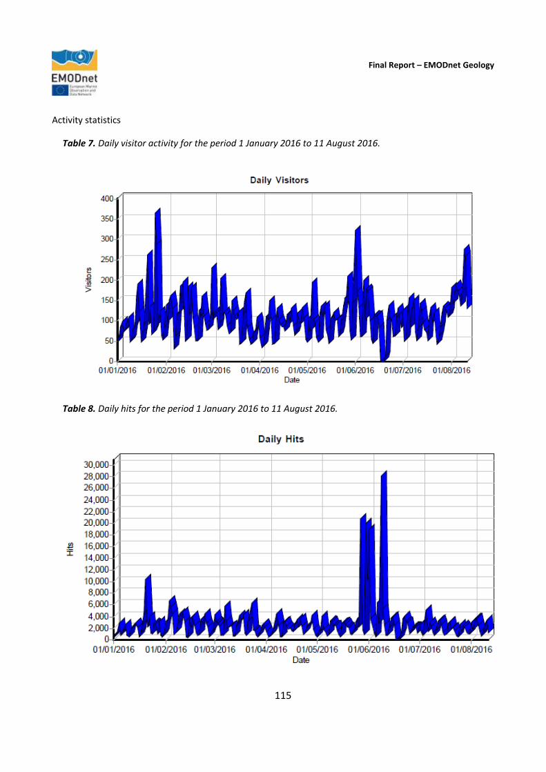
Final Report – EMODnet Geology
115
Activity statistics
Table 7. Daily visitor activity for the period 1 January 2016 to 11 August 2016.
Table 8. Daily hits for the period 1 January 2016 to 11 August 2016.
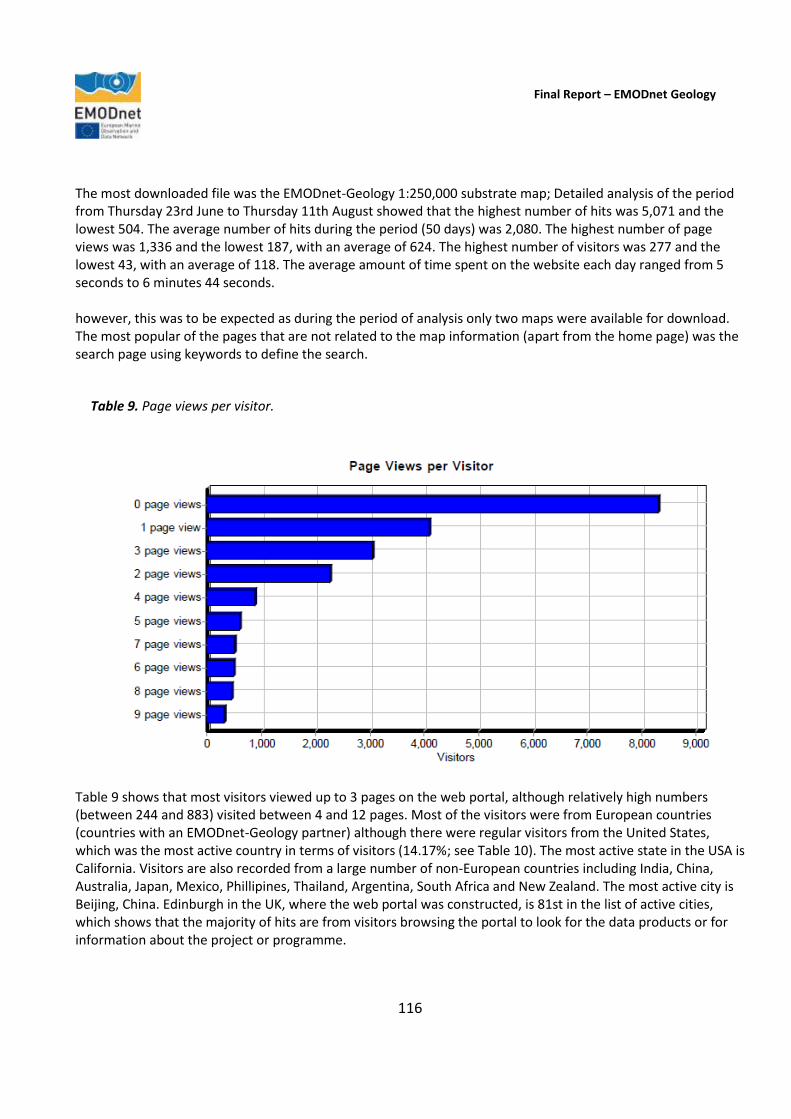
Final Report – EMODnet Geology
116
The most downloaded file was the EMODnet-Geology 1:250,000 substrate map; Detailed analysis of the period from Thursday 23rd June to Thursday 11th August showed that the highest number of hits was 5,071 and the lowest 504. The average number of hits during the period (50 days) was 2,080. The highest number of page views was 1,336 and the lowest 187, with an average of 624. The highest number of visitors was 277 and the lowest 43, with an average of 118. The average amount of time spent on the website each day ranged from 5 seconds to 6 minutes 44 seconds. however, this was to be expected as during the period of analysis only two maps were available for download. The most popular of the pages that are not related to the map information (apart from the home page) was the search page using keywords to define the search.
Table 9. Page views per visitor.
Table 9 shows that most visitors viewed up to 3 pages on the web portal, although relatively high numbers (between 244 and 883) visited between 4 and 12 pages. Most of the visitors were from European countries (countries with an EMODnet-Geology partner) although there were regular visitors from the United States, which was the most active country in terms of visitors (14.17%; see Table 10). The most active state in the USA is California. Visitors are also recorded from a large number of non-European countries including India, China, Australia, Japan, Mexico, Phillipines, Thailand, Argentina, South Africa and New Zealand. The most active city is Beijing, China. Edinburgh in the UK, where the web portal was constructed, is 81st in the list of active cities, which shows that the majority of hits are from visitors browsing the portal to look for the data products or for information about the project or programme.

Final Report – EMODnet Geology
117
Table 10. Most active countries visiting the EMODnet-Geology portal. USA (14.17%), United Kingdom (10.45%), China (9.05%), France (8.10%), Ukraine (8.08%).
Table 11. Top-level domains accessing the EMODnet-Geology portal.
Final Report – EMODnet Geology
118
Table 11 shows that a signicant number of the visitors to the portal were from the commercial (.com) sector
(20.99%).
Indicator 7. List of what the downloaded data has been used for (divided into categories e.g. Government planning, pollution assessment and (commercial) environmental assessment, etc.)
Belgium. Use of EMODnet-Geology products was promoted to colleagues working on fish larvae distribution modelling, habitat suitability modelling, sediment transport modelling, modelling of suspended matter, oil pollution dispersion modelling, as well as on geo-archaeology. Most examples are related to academic research.
Faroes. There are, at present, no national examples of use of EMODnet information, but because of the activities of EMODnet such activity is expected. A new governmental research vessel is being prepared for the Faroe Islands, and during the planning the EMODnet-Geology Project is used as a source of inspiration with regards to what equipment the ship will have. Just as EMODnet has been instrumental with regards to planning of the equipment on the ship, these new facilities will bring new data and maps of huge relevance to EMODnet.
Finland. In the Gulf of Finland, the Baltic Sea, the Regional Council of Kymenlaakso has made the regional plan for the trade and sea area of the region for the first time in Finland. Marine geologists at GTK interacted with planners in order to evaluate, what kind of environmental data is of practical relevance for spatial planning, what data is available and what data is missing. EMODnet-Geology seabed-substrate data is one of the datasets that GTK provided for the planners. The plan includes e.g. information on: “Valuable submarine geological features” and “Very important areas of bio-and geodiversity”. Cooperation is essential to make scientific data on sea areas more easily available and understandable to spatial (and other) planners and managers, and improve the interplay between science and planning officials. EMODnet-Geology seabed-substrate data forms also a solid base for the new Gulf of Finland Assessment Report that is in press. EMODnet-Geology Project has improved and deepened trilateral marine geological co-op with institutes in countries around the Gulf of Finland (GoF), VSEGEI at Russia, Geological Survey of Estonia and Geological Survey of Finland. In addition to the EMODnet seabed-substrate data, they have provided state-of-the-art information e.g., on sediment geochemistry and geological processes in the GoF for the Assessment Report. Seabed-substrate data produced by the EMODnet-Geology Project is the most detailed extensive dataset from the Finnish marine areas that is open for the public use. The seabed-substrate data from the Finnish waters in included in GTK’s data portal HAKKU (see Section 3.3) as well as in the data portal of the Finnish Inventory programme of the Underwater Diversity, the so-called VELMU portal.
France. In a constant effort to update geological knowledge of its continental shelf, BRGM is currently using data from EMODnet lots as broad scale information layers. EMODnet bathymetry and geology data are currently used in a collaborative project with University of Lille to produce new maps and models over the French waters of the English Channel. Seabed-substrate maps and bathymetry are used to develop models and maps for sea-floor shear stress by a consortium of research institute including Ifremer and BRGM.

Final Report – EMODnet Geology
119
Greece. The EMODnet-Geology 2 Guidelines have been used and incorporated in the design of our internal Marine Geology database. Consequently, we as a public institute, make use of the EMODnet structure in order to manage our data according to EU standards and be partly INSPIRE-compliant. Moreover, we have used the products of EMODnet-Bathymetry (mainly for marine survey planning) which provide a valuable tool for marine geology studies. Iceland. The Iceland Marine Research Institute has been using the EMODnet seabed-substrate map for their own seabed habitat mapping.
The EMODnet-Geology maps, data collections and data harmonization is of no doubt an important step forward in understanding the geology of the country and its surroundings and will be of use for both the scientific community, the authorities and the industry of Iceland.
No marine department operates inside Iceland GeoSurvey, although the institute has through the years, been working on several marine projects. These projects are related to the Law of the Sea and the NAGTEC Project. The databases that have been constructed, and international relations that have been established through the EMODnet-Geology Project, might be a good foundation for such a marine department.
Ireland. Government: EMODnet-Geology Workpackage 3 substrate information has been used by Fisheries staff within the Marine Institute for planning sampling campaigns (semi-state government agency). The EMODnet-Geology, pre-Quaternary geology of offshore Ireland was incorporated into the National Bedrock Geology Map of Ireland. This map has been published by the Department of Communications, Energy and Natural Resources; it is used in a new school curriculum and has been distributed to Irish schools and libraries and is distributed at outreach events. EMODnet has been recommended to oil companies and renewable energy companies by the Petroleum and Carbonisation Divisions at the Department of Communications, Energy and Natural Resources.
Industry: n/a
Academia: Irish researchers based at University College Cork, have requested aggregates data, updated for EMODnet-Geology Workpackage 7, to inform an up to date appraisal of mapped aggregates offshore Ireland for further study, Marine Spatial Planning and Industry applications. Minerals specialists at University College Dublin have requested information and demonstration of the EMODnet portal, specifically the minerals dataset, in order to create a learning tool for students. EMODnet has been reviewed for a MSc thesis to be gained through Cranfield University entitled: “Utilisation of Open Source Marine Data and GIS Tools in Addressing the Requirements of Directive 2014/89 EU on Maritime
Final Report – EMODnet Geology
120
Spatial Planning”. The study looks at the availability of freely available data from sources such as EMODnet and how this can be analysed using a suite of open source geo-spatial tools in the context of Maritime Spatial Planning, particularly in terms of facilitating stakeholder engagement with the MSP process, a key requirement of the MSP Directive (2014/89EU). The study has reviewed the functionality and applicability of the EMODnet resource in this regard, particularly the Marine Geology, Bathymetry and Human Activities data portals which will undoubtedly become the first port of call for stakeholders in MSP. Latvia. The Latvian Institute of Aquatic Ecology (Latvian Hydroecology Institute) was interested in the substrate data to use it for scientific purposes. The Latvian Institute of Aquatic Ecology is a scientific institution dedicated to basic and applied research of ecology and environmental problems in the Baltic Sea, and is also responsible for marine environmental monitoring. The Institute takes part in the EMODnet-Chemistry thematic lot. Malta. The publication of seabed data from offshore Malta has, in general, been welcome although existing data gaps at appropriate scales may be an issue that users of information supplied through EMODnet can raise. The deliverables for EMODnet will be beneficial to a number of government entities, academic entities and research institutions. Government bodies that stand to benefit include entities responsible for the environment particularly in relation to the implementation of the Marine Strategy Framework Directive and the Marine Habitants Directive. The information submitted will also be useful for the purpose of marine spatial planning, integrated maritime policy and blue growth. The information will also be useful within academic circles particularly institutions interested in conducting marine scientific research offshore Malta. Montenegro. In regard to end-users of deliverables created by Geological Survey of Montenegro, and supplied to the EMODnet-Geology Project, two governmental organisations in Montenegro make use of obtained results.
Deliverables of Workpackage 4 – pre-Quaternary and Quaternary geological maps, that are created for offshore Montenegro, have been provided to the Agency for Hydrocarbons and the results are now part of the National Database for oil and gas exploration. Also, the Montenegro Seismological Observatory has made great use of mapped faults offshore Montenegro, which are part of the Workpackage 6 deliverable. Portugal. Contribution to PSOEM in respect of the marine mineral occurrences (Workpackage 7). PSOEM is the Situation Plan of maritime spatial planning held by the Directorate General of Natural Resources, Security and Maritime Services (DGRM-PSOEM; http://www.dgrm.mam.gov.pt/; http://www.psoem.pt/)
Indicator 8. List of web-services made available and user organisations connected through these web-services
The web services made available in the EMODnet-Geology Project are described in detail in Section 3.8 of this report. Users of the EMODnet-Geology portal can access online data using a Catalog to select the information of interest and then display on a map interface. The map layers are accessed from each of the workpackage leaders’ servers using Web Map Services (WMS). The portal allows the user to search for WMS services of

Final Report – EMODnet Geology
121
interest; view information on the service; view and interact with the service via a map interface; and obtain a link to the service to incorporate into a desktop GIS or other mapping application. Links to the WMS, which can be used to incorporate into a desktop GIS or other mapping application, can be found on the Metadata information page and the Map page. The search bar allows you to enter a free text term and also offers a list of options depending on the text entered. An ‘advanced search’ allows additional search options such as searches based on data content, spatial extent and temporal extent. Minerals datasets are all available as WMS and are included in the Minerals 4EU Project (www.minerals4eu.eu).