enduring legacy of a toxic fan via episodic redistribution of … singer... · 2013-11-02 ·...
TRANSCRIPT

Enduring legacy of a toxic fan via episodicredistribution of California gold mining debrisMichael Bliss Singera,b,1, Rolf Aaltoc, L. Allan Jamesd, Nina E. Kilhame, John L. Higsona, and Subhajit Ghoshalf
aDepartment of Earth and Environmental Sciences, University of St. Andrews, St. Andrews KY16 9AL, United Kingdom; bEarth Research Institute, University ofCalifornia, Santa Barbara, CA 93106; cDepartment of Geography, College of Life and Environmental Sciences, University of Exeter, Exeter EX4 4RJ, UnitedKingdom; dDepartment of Geography, University of South Carolina, Columbia, SC 29208; eDepartment of Geography and Global Studies, Sonoma StateUniversity, Rohnert Park, CA 94928; and fComputational Modeling Center, Air Products and Chemicals, Inc., Allentown, PA 18195
Edited by Robert E. Dickinson, The University of Texas at Austin, Austin, TX, and approved September 30, 2013 (received for review February 6, 2013)
The interrelationships between hydrologically driven evolution oflegacy landscapes downstream of major mining districts and thecontamination of lowland ecosystems are poorly understood overcentennial time scales. Here, we demonstrate within piedmontvalleys of California’s Sierra Nevada, through new and historicaldata supported by modeling, that anthropogenic fans producedby 19th century gold mining comprise an episodically persistentsource of sediment-adsorbed Hg to lowlands. Within the enor-mous, iconic Yuba Fan, we highlight (i) an apparent shift in therelative processes of fan evolution from gradual vertical channelentrenchment to punctuated lateral erosion of fan terraces, thusenabling entrainment of large volumes of Hg-laden sediment dur-ing individual floods, and (ii) systematic intrafan redistributionand downstream progradation of fan sediment into the CentralValley, triggered by terrace erosion during increasingly long, 10-yflood events. Each major flood apparently erodes stored sedimentand delivers to sensitive lowlands the equivalent of ∼10–30% ofthe entire postmining Sierran Hg mass so far conveyed to the SanFrancisco Bay-Delta (SFBD). This process of protracted but episodicerosion of legacy sediment and associated Hg is likely to persistfor >104 y. It creates, within an immense swath of river corridorwell upstream of the SFBD, new contaminated floodplain surfacesprimed for Hg methylation and augments/replenishes potentialHg sources to the SFBD. Anticipation, prediction, and managementof toxic sediment delivery, and corresponding risks to lowlandecology and human society globally, depend on the morphody-namic stage of anthropogenic fan evolution, synergistically cou-pled to changing frequency of and duration extreme floods.
mercury | lowland contamination | flood frequency | climate change |morphodynamics
Hg poses contamination risks to food webs globally (1, 2),particularly where sediment-bound Hg is delivered to to-
pographically low, depositional environments with high methyl-ation potential. Sediment is the vehicle for ∼97% of transitionmetal mass loading to oceans (3), and the geomorphic configu-ration of stored contaminated sediment on land has importantimplications for its subsequent remobilization (4) and delivery tothe base of food webs. Sediment displaced by industrial mines istypically contaminated by toxic metals such as Hg (5–7), whichthreaten lowland ecosystems downstream of mining sites aroundthe world (e.g., refs. 6–9). This contaminated sediment ofteninfills confined river valleys (10) as massive anthropogenic fans,similar to natural alluvial fans, which undergo subsequent in-cision once the supply of mining sediment is stopped. Such fansare likely to increase in ubiquity and scale across the globe asdemand increases for mined metals and rare earth elements.Nineteenth century hydraulic gold mining in California’s Si-
erra Nevada foothills (1853–1884) contemporaneously delivered∼1.1 km3 of Hg-contaminated sediment (10, 11) to downstreamvalleys at concentrations >10-fold higher than geographical “hotspots” of atmospheric Hg deposition (12). These immense min-ing sediment slugs choked Sierra rivers, which aggraded tens ofmeters in confined piedmont valleys, and formed anthropogenic
fans grading to the margins of the Central Valley, including the∼252 × 106-m3 Yuba Fan (10) (Fig. 1 A and B). Since that time,sediment-bound Hg has contaminated fish and waterfowl of theSan Francisco Bay-Delta (SFBD) (13, 14). However, the domi-nant modern geographical sources of Hg, as well as the pro-cesses, patterns, and time scale of its delivery to this downstreamecosystem, are debated (15–17), partly due to the lack of a ge-neric understanding of postmining fan evolution. It is unclearwhether there are modern sources of Hg to this system andby what set of physical and biogeochemical processes Hg maypenetrate these sensitive ecosystems. The legacy impacts of his-torical mining are therefore not fully comprehended, in part, be-cause of incomplete knowledge of the magnitude and frequency ofprocesses contributing to fan evolution and sediment exhaustion.Following cessation of hydraulic mining, Sierra valley aggra-
dation was succeeded by vertical channel incision into piedmontfans, producing historical terraces along channels (10). James(18) demonstrated that ∼90% of the original sediment depositdelivered to the Bear River valley (Fig. 1A) remained in terracestorage >100 y after mining and hypothesized that modern floodsare capable of transporting it downstream. Apart from Gilbert’sclassic work on bed-level change (10), generalizable theory forflood-based evolution of anthropogenic fans is absent, especiallyover the critical management time scale of decades to centuriesin this and other fluvial systems (5, 6). This precludes predictionsof mining sediment exhaustion time scales and the downstreamrisks of heavy metal contamination to food webs.To fill this research gap, we analyzed high-resolution historical
topographical and bathymetric data collected in 1906 and 1999,and interpreted them here within the context of: historical USGeological Survey (USGS) streamflow (Q) measurements and
Significance
This paper is of fundamental interest to the millions of resi-dents living at the downstream end of this and other globalriver basins beset by industrial metals mining. Sediment-boundHg has contaminated food webs of the San Francisco Bay-Delta, but the dominant geographical sources of Hg to down-stream ecosystems in this and similar river basins are debated.Likewise, the processes by which Hg is delivered to lowlandsand the patterns of its floodplain deposition are poorly un-derstood. This research addresses a gap in generic theory ofpostmining fan evolution that enables anticipation, prediction,and management of contamination risk to food webs.
Author contributions: M.B.S. designed research; M.B.S., R.A., L.A.J., N.E.K., J.L.H., and S.G.performed research; M.B.S. contributed new reagents/analytic tools; M.B.S., R.A., and L.A.J.analyzed data; and M.B.S., R.A., and L.A.J. wrote the paper.
The authors declare no conflict of interest.
This article is a PNAS Direct Submission.
Freely available online through the PNAS open access option.1To whom correspondence should be addressed. E-mail: [email protected].
This article contains supporting information online at www.pnas.org/lookup/suppl/doi:10.1073/pnas.1302295110/-/DCSupplemental.
www.pnas.org/cgi/doi/10.1073/pnas.1302295110 PNAS Early Edition | 1 of 6
ENVIRONMEN
TAL
SCIENCE
S

flood frequency; National Aeronautics and Space Administrationflood imagery; and our newly developed geochemical dataset thatincludes total Hg concentration (HgT), Zr/Ni, and 137Cs, sup-ported by physically based mathematical modeling of terrace ero-sion and flux of mining sediment during large floods (SI Methods).
Results and DiscussionTerrestrial/bathymetric topographical data, collected in 1906 and1999, reveal that the Yuba River longitudinal profile has incisedsystematically over the entire fan in the past century, manifestingas substantial valley-floor lowering (i.e., erosion of the channeland adjacent floodplains) and terrace erosion in the upper fan
and as vertical channel incision with modest (<1 m) floodplainaggradation in the lower fan (Fig. 1C). The riverbed level of themiddle fan (“Yuba Gold Fields”) has been affected by thepresence of Daguerre Point and Barrier Dams, built to trapmining sediment. Barrier Dam was destroyed by a large flood in1907 (10), resulting in a marked adjustment of the thalweg longprofile (Fig. 1C). The reservoir behind Daguerre Point Dam(built in 1910) remains completely full of Hg-laden sediment(19), so it suppresses vertical incision within the Yuba GoldFields and has negligible sediment trap efficiency during floods.Nevertheless, the overall centennial pattern of change appears
to be systematic incision and redistribution of sediment from the
Yuba Gold Fields
0 11 22 33 44 Kilometers
N
40N
35N
120W 115WYuba R.
Englebright Reservoir
Sierra Nevada
Coast Ranges
BD
CA
E
F
B
A
B
A
C
Bear R.
E
Sacramento R.Feather R.
Sutter Bypass
Yolo Bypass
SFBD head
Sacramento R.
19991906
Bar r
i er D
a m (c
a.19
04)
Dag
uer r
ePo
intD
am (c
a.19
10)
0
10
20
30
40
50
60
70
80
90
0 5 10 15 20 25 30 35
Elev
ati o
n A
SL(m
)
Distance from fan apex (km)
Floodplain deposition
Vertical incision
Lower Fan Incision* 8 cm y-1 (1906-1999)15 cm y-1 (1906-1913) 4 cm y-1 (1988-2010)
16
18
20
22
24
26
28
1400 1500 1600 1700 1800 1900
Elev
ati o
nA
SL( m
)
Horizontal Distance (m)1300
Terraceerosion
Upper Fan Incision*16 cm y-1 (1906-1999)29 cm y-1 (1903-1913) 5 cm y-1 (1987-2010)
70
75
80
85
90
95
0 50 100 150 200
Elev
atio
nA
SL(m
)
Horizontal Distance (m)
Redistribution
Export
Site A
Site B
Fig. 1. Yuba Fan. (A) HgT sediment sampling locations (red circles). The longitudinal transect along which mining sediment travels from the Sierra to theSFBD is shown in yellow. Sample sites A–F are described in the main text. Base: Shuttle Radar Topography Mission (SRTM) 1 arc-second. Yuba Fan delineationand hypothesized patterns of sediment redistribution and export (B) and longitudinal elevation profiles of the Yuba River channel bed, 1906 and 1999 (C).(Insets) Plots show cross-sectional change at sites A and B. *Fan incision rates for the early (10) and late 20th century are based on trends in water surfaceelevation. Supporting methodological description and data on slowing incision are provided in SI Methods and Table S1. ASL, above sea level.
2 of 6 | www.pnas.org/cgi/doi/10.1073/pnas.1302295110 Singer et al.
narrow upper Yuba Fan to the relatively wide lower Yuba Fan(note floodplain deposition in the lower fan, Fig. 1C) and net fanexport (Fig. 1B). Streamflow measurements at USGS gauges (SIMethods), corroborated by repeat cross-section surveys (20) andour own field observations of bed grain size, indicate that theaverage incision rate has slowed considerably in recent decades(Fig. 1C and Table S1), as coarse-grained premining riverbedswere reexposed in the upper fan and a single-thread channel wasreestablished in the lower fan (21). We hypothesize that oncevertical incision retards, fan evacuation proceeds predomi-nantly as lateral erosion of historical terraces by competent highflows (22).Longitudinal patterns of sediment redistribution by floods are
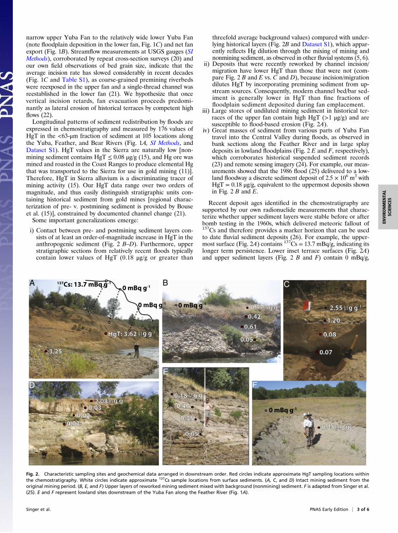
expressed in chemostratigraphy and measured by 176 values ofHgT in the <63-μm fraction of sediment at 105 locations alongthe Yuba, Feather, and Bear Rivers (Fig. 1A, SI Methods, andDataset S1). HgT values in the Sierra are naturally low [non-mining sediment contains HgT ≤ 0.08 μg/g (15), and Hg ore wasmined and roasted in the Coast Ranges to produce elemental Hgthat was transported to the Sierra for use in gold mining (11)].Therefore, HgT in Sierra alluvium is a discriminating tracer ofmining activity (15). Our HgT data range over two orders ofmagnitude, and thus easily distinguish stratigraphic units con-taining historical sediment from gold mines [regional charac-terization of pre- v. postmining sediment is provided by Bouseet al. (15)], constrained by documented channel change (21).Some important generalizations emerge:
i) Contact between pre- and postmining sediment layers con-sists of at least an order-of-magnitude increase in HgT in theanthropogenic sediment (Fig. 2 B–D). Furthermore, upperstratigraphic sections from relatively recent floods typicallycontain lower values of HgT (0.18 μg/g or greater than
threefold average background values) compared with under-lying historical layers (Fig. 2B and Dataset S1), which appar-ently reflects Hg dilution through the mixing of mining andnonmining sediment, as observed in other fluvial systems (5, 6).
ii) Deposits that were recently reworked by channel incision/migration have lower HgT than those that were not (com-pare Fig. 2 B and E vs. C and D), because incision/migrationdilutes HgT by incorporating premining sediment from up-stream sources. Consequently, modern channel bed/bar sed-iment is generally lower in HgT than fine fractions offloodplain sediment deposited during fan emplacement.
iii) Large stores of undiluted mining sediment in historical ter-races of the upper fan contain high HgT (>1 μg/g) and aresusceptible to flood-based erosion (Fig. 2A).
iv) Great masses of sediment from various parts of Yuba Fantravel into the Central Valley during floods, as observed inbank sections along the Feather River and in large splaydeposits in lowland floodplains (Fig. 2 E and F, respectively),which corroborates historical suspended sediment records(23) and remote sensing imagery (24). For example, our meas-urements showed that the 1986 flood (25) delivered to a low-land floodway a discrete sediment deposit of 2.5 × 10⁶ m3 withHgT = 0.18 μg/g, equivalent to the uppermost deposits shownin Fig. 2 B and E.
Recent deposit ages identified in the chemostratigraphy aresupported by our own radionuclide measurements that charac-terize whether upper sediment layers were stable before or afterbomb testing in the 1960s, which delivered meteoric fallout of137Cs and therefore provides a marker horizon that can be usedto date fluvial sediment deposits (26). For example, the upper-most surface (Fig. 2A) contains 137Cs = 13.7 mBq/g, indicating itslonger term persistence. Lower inset terrace surfaces (Fig. 2A)and upper sediment layers (Fig. 2 B and F) contain 0 mBq/g,
2.080.03
0.02
0.03
g g-1
D
0.17
0.42
0.61
0.05
B
g g-10 mBq g-1
3.25
A
g g-1HgT: 3.62
137Cs: 13.7 mBq g-1
0 mBq g-1
0.18
0.47
0.35
0.05
E
g g-1
0 mBq g-1
2.55 g g-1
1.20
0.08
0.07
C
F
0.18 g g-1
0 mBq g-1
Fig. 2. Characteristic sampling sites and geochemical data arranged in downstream order. Red circles indicate approximate HgT sampling locations withinthe chemostratigraphy. White circles indicate approximate 137Cs sample locations from surface sediments. (A, C, and D) Intact mining sediment from theoriginal mining period. (B, E, and F) Upper layers of reworked mining sediment mixed with background (nonmining) sediment. F is adapted from Singer et al.(25). E and F represent lowland sites downstream of the Yuba Fan along the Feather River (Fig. 1A).
Singer et al. PNAS Early Edition | 3 of 6
ENVIRONMEN
TAL
SCIENCE
S
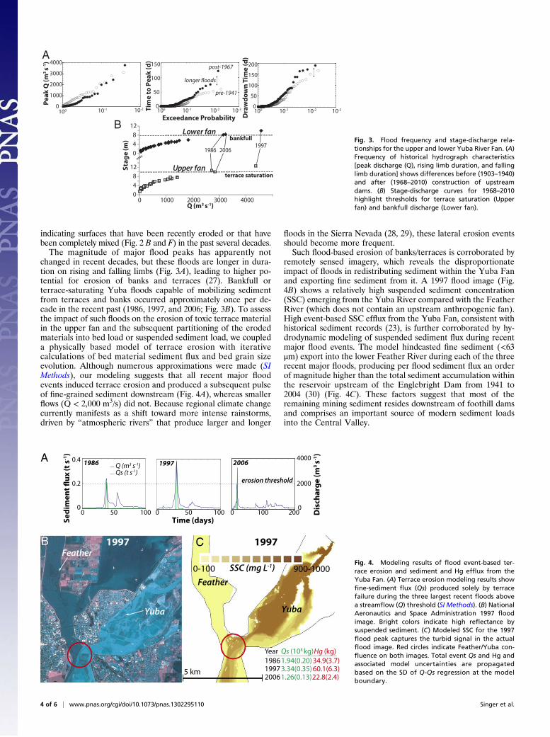
indicating surfaces that have been recently eroded or that havebeen completely mixed (Fig. 2 B and F) in the past several decades.The magnitude of major flood peaks has apparently not
changed in recent decades, but these floods are longer in dura-tion on rising and falling limbs (Fig. 3A), leading to higher po-tential for erosion of banks and terraces (27). Bankfull orterrace-saturating Yuba floods capable of mobilizing sedimentfrom terraces and banks occurred approximately once per de-cade in the recent past (1986, 1997, and 2006; Fig. 3B). To assessthe impact of such floods on the erosion of toxic terrace materialin the upper fan and the subsequent partitioning of the erodedmaterials into bed load or suspended sediment load, we coupleda physically based model of terrace erosion with iterativecalculations of bed material sediment flux and bed grain sizeevolution. Although numerous approximations were made (SIMethods), our modeling suggests that all recent major floodevents induced terrace erosion and produced a subsequent pulseof fine-grained sediment downstream (Fig. 4A), whereas smallerflows (Q < 2,000 m3/s) did not. Because regional climate changecurrently manifests as a shift toward more intense rainstorms,driven by “atmospheric rivers” that produce larger and longer
floods in the Sierra Nevada (28, 29), these lateral erosion eventsshould become more frequent.Such flood-based erosion of banks/terraces is corroborated by
remotely sensed imagery, which reveals the disproportionateimpact of floods in redistributing sediment within the Yuba Fanand exporting fine sediment from it. A 1997 flood image (Fig.4B) shows a relatively high suspended sediment concentration(SSC) emerging from the Yuba River compared with the FeatherRiver (which does not contain an upstream anthropogenic fan).High event-based SSC efflux from the Yuba Fan, consistent withhistorical sediment records (23), is further corroborated by hy-drodynamic modeling of suspended sediment flux during recentmajor flood events. The model hindcasted fine sediment (<63μm) export into the lower Feather River during each of the threerecent major floods, producing per flood sediment flux an orderof magnitude higher than the total sediment accumulation withinthe reservoir upstream of the Englebright Dam from 1941 to2004 (30) (Fig. 4C). These factors suggest that most of theremaining mining sediment resides downstream of foothill damsand comprises an important source of modern sediment loadsinto the Central Valley.
Exceedance Probability
Pe
ak
Q (
m3
s-1)
0
50
100
150
Tim
e t
o P
ea
k (
d)
0
50
100
150
200
Dra
wd
ow
n T
ime
(d
)A
10-210-1100 10-3 10-210-1100 10-3
048
12
0 4 812
0 1000 2000 3000 4000
Sta
ge
(m
)
Q (m3 s-1)
Upper fan
Lower fan
199720061986
terrace saturation
bankfull
B
0
1000
2000
3000
4000
10-210-1100
pre-1941
post-1967
longer floods
Fig. 3. Flood frequency and stage-discharge rela-tionships for the upper and lower Yuba River Fan. (A)Frequency of historical hydrograph characteristics[peak discharge (Q), rising limb duration, and fallinglimb duration] shows differences before (1903–1940)and after (1968–2010) construction of upstreamdams. (B) Stage-discharge curves for 1968–2010highlight thresholds for terrace saturation (Upperfan) and bankfull discharge (Lower fan).
A
Se
dim
en
t fl
ux
(t
s-1)
1997
0 10050
1986
0
0.2
0.4
0 10050Time (days)
Qs (t s-1)Q (m3 s-1)
0
2000
40002006
erosion threshold
BFeather
Yuba
1997 C
0-100 900-1000SSC (mg L-1)
1997
5 km
Feather
Yuba
3.34(0.35) 60.1(6.3)
Qs (108 kg) Hg (kg) 198619972006
1.94(0.20) 34.9(3.7)
1.26(0.13) 22.8(2.4)
Year
Dis
cha
rge
(m
3 s-1
)
0 200100
Fig. 4. Modeling results of flood event-based ter-race erosion and sediment and Hg efflux from theYuba Fan. (A) Terrace erosion modeling results showfine-sediment flux (Qs) produced solely by terracefailure during the three largest recent floods abovea streamflow (Q) threshold (SI Methods). (B) NationalAeronautics and Space Administration 1997 floodimage. Bright colors indicate high reflectance bysuspended sediment. (C) Modeled SSC for the 1997flood peak captures the turbid signal in the actualflood image. Red circles indicate Feather/Yuba con-fluence on both images. Total event Qs and Hg andassociated model uncertainties are propagatedbased on the SD of Q-Qs regression at the modelboundary.
4 of 6 | www.pnas.org/cgi/doi/10.1073/pnas.1302295110 Singer et al.
Our analyses highlight the importance of anthropogenic fansin the apparent lateral-expansion stage of morphodynamic evo-lution as primary stores, sources, and downstream exporters ofmining sediment and associated contaminants. Assuming that90% of the Yuba Fan remains in storage [equivalent to estimatesfor the Bear River (18)], ∼0.1% of mining sediment (both fineand coarse) is evacuated per decade by a single large flood eventsuch as those outlined here, implying a source of contaminatedsediments to lowlands that will last for >104 y (SI Methods). This isconsistent with a right-skewed model of sediment exhaustion (31)punctuated by increasingly heavy-tailed flood frequency (28, 29),which could slightly shorten mining sediment exhaustion times.Based on modeled fluxes for flood events and assuming (SI
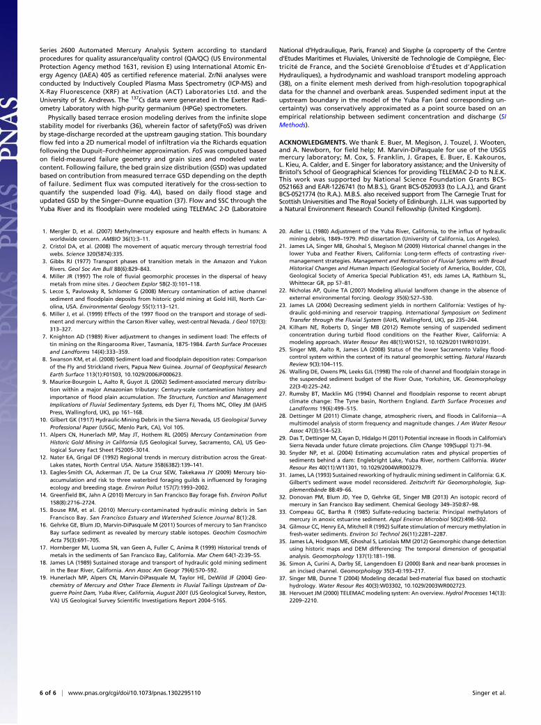
Methods) conservatively low HgT, equivalent to concentrations inrecent lowland flood deposits (Fig. 2F), the recent major floodsexported large masses of Hg from the Yuba Fan into the CentralValley (Fig. 4 B and C). Such per flood event-based contaminantflux, predominantly derived from historical terraces relative tochannel/bar sediments (Fig. 5A), represents a substantial fractionof the cumulative Hg mass (∼200 kg) that is estimated to havereached the SFBD since mining began (15). Therefore, most Hgexported from anthropogenic fans is apparently still stored inlowland floodplains and floodways upstream of the SFBD. Itmanifests as an ∼70-km long swath of Hg contamination fromthe Yuba Fan into the Central Valley (Fig. 5A).This interpretation is corroborated by an independent geo-
chemical proxy for mine-derived sediments, Zr/Ni (15). Hy-draulic mining sediments in the Sierra largely derive from highlyweathered Eocene sediments from which gold was extracted, andthus have high Zr/Ni ratios due to the selective removal of Niand relative immobility of Zr (15). We analyzed our samples forthese elements and found a clear down-valley trend in Zr/Ni(Fig. 5B). The HgT data show much higher variability, primarilyas a consequence of sampling at various topographical positions(Fig. 2), but roughly follow a similar trend. Each elemental sig-nature of hydraulic mining is apparently diluted downstreamthrough the Yuba Fan, the scatter in HgT notwithstanding, and isrelatively concentrated in floodplain deposits near the fan margin(Fig. 5). These data support the redistribution of mining sedimentfrom the upper to lower Yuba Fan and its punctuated export fromthe entire fan into the Central Valley (Fig. 1B). They are alsoconsistent with Hg isotope ratios in shallow SFBD sediments,which suggest a persistent upstream (Sierran) Hg source (16, 32).Lowland floodplains are potential hotspots for Hg methylation
of mining debris. Fine-grained Hg from hydraulic mining is as-
sociated with sulfide minerals (19), which are prone to oxidation(to mercury sulfate) during transport. Once delivered to low-lands, these sediments are redeposited, producing contaminatedfloodplain surfaces that undergo frequent wetting/drying cycles.These cycles may stimulate resident sulfate-reducing bacteria tomethylate the newly arrived Hg near the sediment–water in-terface at very high rates (33, 34), posing risks to food webs inthis and other ecosystems beset by mining-induced displacementof contaminated sediment.The enduring legacy of mining on a grand landscape scale
entails persistent lateral erosion of anthropogenic fans that con-tinues well after the slowing of initial vertical incision and returnof the channel to its original bed level. This process stage of fanevolution apparently sustains the evacuation of legacy sediment,triggered by increasingly potent floods that effectively deliver toxicsediment slugs downstream into sensitive lowlands, thus aug-menting a major potential source of food web contamination intidal wetlands of the SFBD.These links between upland legacy mining sediment and low-
land contamination, which are germane to issues of river man-agement such as licensing for mining or dams in this and otherbasins around the world, are enabled by the topographical positionof stored sediment and the frequency/magnitude of flood eventscapable of transporting contaminated sediment over tens of kilo-meters. Our findings suggest dangerous synergies between themorphodynamic stage of fan evolution, regional shifts in cli-mate, and contamination risks to lowland ecosystems andhuman populations.
MethodsThis paper presents the culmination of a multipronged approach, includingassessment of historical topographical datasets, investigation of historicalstreamflow measurements at USGS gauging stations to determine rates of in-cision, flood frequency analysis, interpretation of HgT chemostratigraphy, Zr/Nigeochemistry as an independent proxy for mining sediment, and use of 137Cs toestablish age control for younger deposits. These approaches were combinedwith terrace erosion modeling based on slope stability tied to hyporheic in-filtration, partitioning of failed material into suspended sediment load, andnumerical modeling suspended flux through the fan (SI Methods).
Topographical longitudinal and cross-section profiles were extracted fromhistorical maps and recent LiDAR tied to photogrammetry and sonar data(35). Stratified sediment samples for HgT (n =176) were extracted fromchannel bars and bank exposures at field-identified sedimentary units (n =105) typically in vertical sections. Samples were sieved through <63-μmstainless-steel sieves to compare a common sediment population across allsites. The resulting material was digested at a USGS Hg laboratory in MenloPark, California. Digested samples were harvested and analyzed on a Tekran
A Yuba Gold Fields Lower Yuba Fan Lower Feather River
HgT
(μg
g-1)
Upper Yuba Fan
10-2
10-1
100
101
Fan Central Valley
Dag
uerr
e Pt
. Dam
Background HgT
historical terrace
channel/bar
channel/barhistorical terrace
Distance from fan apex (km)0 10 20 30 40 50 60 70
Zr/Ni
historical terrace
Mining
Non-Mining1
3
5B Fig. 5. Downstream patterns of geochemistry within andbeyond the Yuba Fan. Measured HgT (A) and Zr/Ni (B) insediments (Dataset S1). Power relationships fit to all HgT (in-cluding all stratigraphic positions from each historical terrace)and Zr/Ni data within the Yuba Fan are given in Fig. S1. Colorsin A refer to geographical domains listed at the top of thefigure. Shaded ovals indicate elevated geochemical concen-trations downstream of the margins of anthropogenic fans.
Singer et al. PNAS Early Edition | 5 of 6
ENVIRONMEN
TAL
SCIENCE
S
Series 2600 Automated Mercury Analysis System according to standardprocedures for quality assurance/quality control (QA/QC) (US EnvironmentalProtection Agency method 1631, revision E) using International Atomic En-ergy Agency (IAEA) 405 as certified reference material. Zr/Ni analyses wereconducted by Inductively Coupled Plasma Mass Spectrometry (ICP-MS) andX-Ray Fluorescence (XRF) at Activation (ACT) Laboratories Ltd. and theUniversity of St. Andrews. The 137Cs data were generated in the Exeter Radi-ometry Laboratory with high-purity germanium (HPGe) spectrometers.
Physically based terrace erosion modeling derives from the infinite slopestability model for riverbanks (36), wherein factor of safety(FoS) was drivenby stage-discharge recorded at the upstream gauging station. This boundaryflow fed into a 2D numerical model of infiltration via the Richards equationfollowing the Dupuit–Forchheimer approximation. FoS was computed basedon field-measured failure geometry and grain sizes and modeled watercontent. Following failure, the bed grain size distribution (GSD) was updatedbased on contribution from measured terrace GSD depending on the depthof failure. Sediment flux was computed iteratively for the cross-section toquantify the suspended load (Fig. 4A), based on daily flood stage andupdated GSD by the Singer–Dunne equation (37). Flow and SSC through theYuba River and its floodplain were modeled using TELEMAC 2-D (Laboratoire
National d’Hydraulique, Paris, France) and Sisyphe (a coproperty of the Centred’Etudes Maritimes et Fluviales, Université de Technologie de Compiègne, Élec-tricité de France, and the Société Grenobloise d’Études et d’ApplicationHydrauliques), a hydrodynamic and washload transport modeling approach(38), on a finite element mesh derived from high-resolution topographicaldata for the channel and overbank areas. Suspended sediment input at theupstream boundary in the model of the Yuba Fan (and corresponding un-certainty) was conservatively approximated as a point source based on anempirical relationship between sediment concentration and discharge (SIMethods).
ACKNOWLEDGMENTS. We thank E. Buer, M. Megison, J. Touzel, J. Wooten,and A. Newborn, for field help; M. Marvin-DiPasquale for use of the USGSmercury laboratory; M. Cox, S. Franklin, J. Grapes, E. Buer, E. Kakouros,L. Kieu, A. Calder, and E. Singer for laboratory assistance; and the University ofBristol’s School of Geographical Sciences for providing TELEMAC 2-D to N.E.K.This work was supported by National Science Foundation Grants BCS-0521663 and EAR-1226741 (to M.B.S.), Grant BCS-0520933 (to L.A.J.), and GrantBCS-0521774 (to R.A.). M.B.S. also received support from The Carnegie Trust forScottish Universities and The Royal Society of Edinburgh. J.L.H. was supported bya Natural Environment Research Council Fellowship (United Kingdom).
1. Mergler D, et al. (2007) Methylmercury exposure and health effects in humans: Aworldwide concern. AMBIO 36(1):3–11.
2. Cristol DA, et al. (2008) The movement of aquatic mercury through terrestrial foodwebs. Science 320(5874):335.
3. Gibbs RJ (1977) Transport phases of transition metals in the Amazon and YukonRivers. Geol Soc Am Bull 88(6):829–843.
4. Miller JR (1997) The role of fluvial geomorphic processes in the dispersal of heavymetals from mine sites. J Geochem Explor 58(2-3):101–118.
5. Lecce S, Pavlowsky R, Schlomer G (2008) Mercury contamination of active channelsediment and floodplain deposits from historic gold mining at Gold Hill, North Car-olina, USA. Environmental Geology 55(1):113–121.
6. Miller J, et al. (1999) Effects of the 1997 flood on the transport and storage of sedi-ment and mercury within the Carson River valley, west-central Nevada. J Geol 107(3):313–327.
7. Knighton AD (1989) River adjustment to changes in sediment load: The effects oftin mining on the Ringarooma River, Tasmania, 1875-1984. Earth Surface Processesand Landforms 14(4):333–359.
8. Swanson KM, et al. (2008) Sediment load and floodplain deposition rates: Comparisonof the Fly and Strickland rivers, Papua New Guinea. Journal of Geophysical ResearchEarth Surface 113(1):F01S03, 10.1029/2006JF000623.
9. Maurice-Bourgoin L, Aalto R, Guyot JL (2002) Sediment-associated mercury distribu-tion within a major Amazonian tributary: Century-scale contamination history andimportance of flood plain accumulation. The Structure, Function and ManagementImplications of Fluvial Sedimentary Systems, eds Dyer FJ, Thoms MC, Olley JM (IAHSPress, Wallingford, UK), pp 161–168.
10. Gilbert GK (1917) Hydraulic-Mining Debris in the Sierra Nevada, US Geological SurveyProfessional Paper (USGC, Menlo Park, CA), Vol 105.
11. Alpers CN, Hunerlach MP, May JT, Hothem RL (2005) Mercury Contamination fromHistoric Gold Mining in California (US Geological Survey, Sacramento, CA), US Geo-logical Survey Fact Sheet FS2005–3014.
12. Nater EA, Grigal DF (1992) Regional trends in mercury distribution across the Great-Lakes states, North Central USA. Nature 358(6382):139–141.
13. Eagles-Smith CA, Ackerman JT, De La Cruz SEW, Takekawa JY (2009) Mercury bio-accumulation and risk to three waterbird foraging guilds is influenced by foragingecology and breeding stage. Environ Pollut 157(7):1993–2002.
14. Greenfield BK, Jahn A (2010) Mercury in San Francisco Bay forage fish. Environ Pollut158(8):2716–2724.
15. Bouse RM, et al. (2010) Mercury-contaminated hydraulic mining debris in SanFrancisco Bay. San Francisco Estuary and Watershed Science Journal 8(1):28.
16. Gehrke GE, Blum JD, Marvin-DiPasquale M (2011) Sources of mercury to San FranciscoBay surface sediment as revealed by mercury stable isotopes. Geochim CosmochimActa 75(3):691–705.
17. Hornberger MI, Luoma SN, van Geen A, Fuller C, Anima R (1999) Historical trends ofmetals in the sediments of San Francisco Bay, California. Mar Chem 64(1-2):39–55.
18. James LA (1989) Sustained storage and transport of hydraulic gold mining sedimentin the Bear River, California. Ann Assoc Am Geogr 79(4):570–592.
19. Hunerlach MP, Alpers CN, Marvin-DiPasquale M, Taylor HE, DeWild JF (2004) Geo-chemistry of Mercury and Other Trace Elements in Fluvial Tailings Upstream of Da-guerre Point Dam, Yuba River, California, August 2001 (US Geological Survey, Reston,VA) US Geological Survey Scientific Investigations Report 2004–5165.
20. Adler LL (1980) Adjustment of the Yuba River, California, to the influx of hydraulicmining debris, 1849–1979. PhD dissertation (University of California, Los Angeles).
21. James LA, Singer MB, Ghoshal S, Megison M (2009) Historical channel changes in thelower Yuba and Feather Rivers, California: Long-term effects of contrasting river-management strategies. Management and Restoration of Fluvial Systems with BroadHistorical Changes and Human Impacts (Geological Society of America, Boulder, CO),Geological Society of America Special Publication 451, eds James LA, Rathburn SL,Whittecar GR, pp 57–81.
22. Nicholas AP, Quine TA (2007) Modeling alluvial landform change in the absence ofexternal environmental forcing. Geology 35(6):527–530.
23. James LA (2004) Decreasing sediment yields in northern California: Vestiges of hy-draulic gold-mining and reservoir trapping. International Symposium on SedimentTransfer through the Fluvial System (IAHS, Wallingford, UK), pp 235–244.
24. Kilham NE, Roberts D, Singer MB (2012) Remote sensing of suspended sedimentconcentration during turbid flood conditions on the Feather River, California: Amodeling approach. Water Resour Res 48(1):W01521, 10.1029/2011WR010391.
25. Singer MB, Aalto R, James LA (2008) Status of the lower Sacramento Valley flood-control system within the context of its natural geomorphic setting. Natural HazardsReview 9(3):104–115.
26. Walling DE, Owens PN, Leeks GJL (1998) The role of channel and floodplain storage inthe suspended sediment budget of the River Ouse, Yorkshire, UK. Geomorphology22(3-4):225–242.
27. Rumsby BT, Macklin MG (1994) Channel and floodplain response to recent abruptclimate change: The Tyne basin, Northern England. Earth Surface Processes andLandforms 19(6):499–515.
28. Dettinger M (2011) Climate change, atmospheric rivers, and floods in California—Amultimodel analysis of storm frequency and magnitude changes. J Am Water ResourAssoc 47(3):514–523.
29. Das T, Dettinger M, Cayan D, Hidalgo H (2011) Potential increase in floods in California’sSierra Nevada under future climate projections. Clim Change 109(Suppl 1):71–94.
30. Snyder NP, et al. (2004) Estimating accumulation rates and physical properties ofsediments behind a dam: Englebright Lake, Yuba River, northern California. WaterResour Res 40(11):W11301, 10.1029/2004WR003279.
31. James, LA (1993) Sustained reworking of hydraulic mining sediment in California: G.K.Gilbert’s sediment wave model reconsidered. Zeitschrift für Geomorphologie, Sup-plementbände 88:49–66.
32. Donovan PM, Blum JD, Yee D, Gehrke GE, Singer MB (2013) An isotopic record ofmercury in San Francisco Bay sediment. Chemical Geology 349–350:87–98.
33. Compeau GC, Bartha R (1985) Sulfate-reducing bacteria: Principal methylators ofmercury in anoxic estuarine sediment. Appl Environ Microbiol 50(2):498–502.
34. Gilmour CC, Henry EA, Mitchell R (1992) Sulfate stimulation of mercury methylation infresh-water sediments. Environ Sci Technol 26(11):2281–2287.
35. James LA, Hodgson ME, Ghoshal S, Latiolais MM (2012) Geomorphic change detectionusing historic maps and DEM differencing: The temporal dimension of geospatialanalysis. Geomorphology 137(1):181–198.
36. Simon A, Curini A, Darby SE, Langendoen EJ (2000) Bank and near-bank processes inan incised channel. Geomorphology 35(3-4):193–217.
37. Singer MB, Dunne T (2004) Modeling decadal bed-material flux based on stochastichydrology. Water Resour Res 40(3):W03302, 10.1029/2003WR002723.
38. Hervouet JM (2000) TELEMACmodeling system: An overview. Hydrol Processes 14(13):2209–2210.
6 of 6 | www.pnas.org/cgi/doi/10.1073/pnas.1302295110 Singer et al.