european community directive on the conservation...
TRANSCRIPT

European Community Directive
on the Conservation of Natural Habitats
and of Wild Fauna and Flora
(92/43/EEC)
Third Report by the United Kingdom under Article 17
on the implementation of the Directive from January 2007 to December 2012 Conservation status assessment for
Species:
S1377 - Maerl (Phymatolithon calcareum)

Maerl (Phymatolithon calcareum) United Kingdom
Third Report by the United Kingdom under Article 17 on the implementation of the Directive
from January 2007 to December 2012
Produced on 09/10/2013 11:34 Page 2
Reporting format on the 'main results of the surveillance under Article 11‟ for Annex II, IV & V species
Field name Brief explanations
0.2 Species
0.2.1 Species code S1377
0.2.2 Species scientific
name Phymatolithon calcareum
0.2.3 Alternative species
scientific name
Optional
0.2.4 Common name
Optional
1.1 Maps
1.1.1 Distribution map
Sensitive False
The distribution map is based on species and maerl bed records which are
considered to be representative of the distribution within the current reporting period. Note that maerl bed records will contain a mix of maerl species, including
Phymatolithon calcareum, Lithothamnion glaciale and Lithothamnion corallioides. It was not possible to distinguish the species within each bed. For further details
see the 2013 Article 17 UK Approach document.
Maerl (Phymatolithon calcareum) United Kingdom
Third Report by the United Kingdom under Article 17 on the implementation of the Directive
from January 2007 to December 2012
Produced on 09/10/2013 11:34 Page 3
1.1.2 Method used - map Estimate based on partial data with some extrapolation and/or
modelling
For further details see the 2013 Article 17 UK Approach document and
relevant country-level reporting information.
1.1.3 Year or period 1980-2012
For further details see the 2013 Article 17 UK Approach document and
relevant country-level reporting information.
1.1.4 Additional distribution map
Optional
False
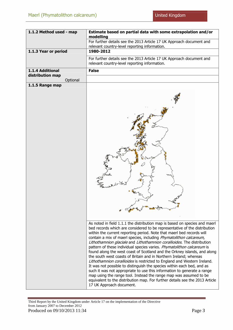
1.1.5 Range map
As noted in field 1.1.1 the distribution map is based on species and maerl
bed records which are considered to be representative of the distribution within the current reporting period. Note that maerl bed records will
contain a mix of maerl species, including Phymatolithon calcareum, Lithothamnion glaciale and Lithothamnion corallioides. The distribution
pattern of these individual species varies. Phymatolithon calcareum is found along the west coast of Scotland and the Orkney islands, and along
the south west coasts of Britain and in Northern Ireland; whereas
Lithothamnion corallioides is restricted to England and Western Ireland. It was not possible to distinguish the species within each bed, and as
such it was not appropriate to use this information to generate a range map using the range tool. Instead the range map was assumed to be
equivalent to the distribution map. For further details see the 2013 Article
17 UK Approach document.

Maerl (Phymatolithon calcareum) United Kingdom
Third Report by the United Kingdom under Article 17 on the implementation of the Directive
from January 2007 to December 2012
Produced on 09/10/2013 11:34 Page 4
2.1 Biogeographical region & marine regions
MATL
2.2 Published sources Information sources as supplied by Natural Resources Wales
Barbera, C., Bordehore, C., Borg, J.A., Glémarec, M., Grall, J.,
Hall-Spencer, J. M., De La Huz, Ch., Lanfranco, E., Lastra, M., Mooree, P.G., Mora, J., Pita, M.E., Ramos-Esplá, A.A., Rizzo, M.,
Sánchez-Mata, A., Seva, A., Schembri, P.J., and Valle, C. 2003.
Conservation and management of northeast Atlantic and Mediterranean maerl beds. Aquatic Conserv: Mar. Freshw.
Ecosyst. 13: S65–S76
Bunker, F. StP. D. & Camplin, M. D. 2007. A study of the Milford Haven maerl bed in 2005 using drop down video and diving. A
report to the Countryside Council for Wales by MarineSeen.
CCW Contract Science Report No. 769. Countryside Council for Wales, Bangor. 174pp + iii.
Bunker, F. StP. D. 2011. Monitoring of a maerl bed in the
Milford Haven Waterway, Pembrokeshire, 2010. A report to the
Countryside Council for Wales by MarineSeen. CCW Contract Science Report No. 979. 145pp + iii
Hebog. 2005. Milford Haven Maintenance Dredging
Assessment: Biological & Sediment Characterisation. Report to
Milford Haven Port Authority. Project No. HE1632.
RPS. 2006. Maerl Monitoring – Winter 2005 to Winter 2006. South Hook Jetty, Milford Haven. A report by RPS Planning &
Development to South Hook LNG Terminal Company Ltd
RPS PTE. 2006. ROV Maerl Survey. South Hook. For Besixkier
J.V. JER2580R200905JEv1.1. 20th September 2005.
RPS. 2008. Maerl Monitoring – Winter 2005 to Summer 2008. South Hook Jetty, Milford Haven. A report by RPS Planning &
Development to South Hook LNG Terminal Company Ltd.
Wilson, S., Blake, C., Berges, J. A. and Maggs, C.A. 2004.
Environmental tolerances of free-living coralline algae (maerl): implications for European marine conservation. Biological
Conservation 120. 283–293.
Other sources
2004-10 Maerl summary data.xls Maerl Article17 GIS processing notes.doc
CCW sidescan 2009 RPS South Hook maerl monitoring data & PRIMER analyses
CCW maerl monitoring data & PRIMER analyses
Information sources as supplied by Natural England
Allen, J.H. and Proctor, N.V. 2003 Monitoring Subtidal
sandbanks of the Isles of Scilly and the Fal and Helford Special Areas of Conservation. Report to English Nature, Institute of

Maerl (Phymatolithon calcareum) United Kingdom
Third Report by the United Kingdom under Article 17 on the implementation of the Directive
from January 2007 to December 2012
Produced on 09/10/2013 11:34 Page 5
Estuarine and Coastal Studies, University of Hull.
Axelsson, M., Bamber, R., Dewey S., Duke, S. and Hollies, R.
2008 Falmouth Cruise Project EIA - Marine Ecological Survey. SeaStar Survey J/06/126/
Birkett, D.A. and Dring, M.J. 1998. Maerl: An overview of
dynamics and sensitivity characteristics for conservation
management of marine SACs. Prepared by Scottish Association of Marine Science (SAMS) for the UK Marine SACs Project, Task
Manager, A.M.W. Wilson, SAMS.
Bowden, D.A., Rowden, A.A. and Attrill, M.J. 2001 Effect of
patch size and in patch location on the infaunal macroinvertebrate assemblages of Zostera marina seagrass
beds. Journal of Experimental Marine Biology and Ecology 259. pp. 133-154.
Bunker, F. 1992 Survey and Monitoring in the Roseland
Voluntary Marine Conservation Area in 1992. A Report to the
National Rivers Authority (South West Region).
Cook, K. and Foden, J.M. 2005. Report on 2005 Isles of Scilly Zostera marina survey. Coral Cay.
Cook, K., Enderson, A. and Reid, T. 1998. Coral Cay Conservation Sub-Aqua Club; Isles of Scilly 1998 Expedition
Report.
Cook, K.J. 2000. Report of the Coral Cay Conservation Sub-
Aqua Club survey of the Fal estuary, August 1999. Coral Cay Conservation, London.
Cook, K.J. 2002. Report on 2002 Isles of Scilly Zostera marina
survey.
Cook, K.J." 2004. Report on 2003 Isles of Scilly Zostera marina
survey.
Cook, K.J. 2004 Report on 2004 Isles of Scilly Zostera marina survey.
Cook, K.J. 2006. Report on 2006 Isles of Scilly Zostera marina survey.
Cook, K.J. 2010. Report on 2009 Isles of Scilly Zostera marina
survey.
Cook, K.J. 2011. Report on 2011 Isles of Scilly Zostera marina
survey NE
Cook, K.J. 2000. Report on the Coral Cay Conservation Sub-Aqua Club 1999 Expedition to the Isles of Scilly.
Cook, K.J. and Paver, L.F.C. 2007. Report on 2007 Isles of Scilly Zostera marina survey.

Maerl (Phymatolithon calcareum) United Kingdom
Third Report by the United Kingdom under Article 17 on the implementation of the Directive
from January 2007 to December 2012
Produced on 09/10/2013 11:34 Page 6
Cook, K.J., Hinton, C. and Reid, T. 2001. Report on the Coral Cay Conservation Sub-Aqua Club 2000 Expedition to the Isles
of Scilly.
Davies, J. and Sotheran, I. 1995. Mapping the distribution of benthic biotopes in Falmouth Bay and the lower Fal Ruan
Estuary English Nature Research Reports No. 119a.
Davis, C.E. 2006. Master's thesis University of Plymouth.
Dipper, F. 1981. Sublittoral Survey of the Scilly Isles and South
Cornwall Underwater Conservation Society. A report to the
Nature Conservancy Council.
Dyer, M. and Worsfold, T. 1998. Comparative Maerl Surveys in Falmouth Bay. English Nature. Report FAL97.
Environment Agency. 2011. Fal WFD 2011 Seagrass Surveys.
Environment Agency. 2009. Scilly Isles Habitats Directive Benthic NE April 2009 Environment Agency
ERCCIS. 2012. Biotope mapping of Helford using Remote
Operated Vehicle (ROV)
Farnham, W.F. and Bishop, G.M. 1984. Survey of the Fal
Estuary, Cornwall. Progress in Underwater Science, volume 10. Report of the 18th Symposium of the Underwater Association
at the British Museum (Natural History) pp53-63.
Fowler, S.L. 1992. Marine Monitoring in the Isles of Scilly 1991
Report to English Nature by the Nature Conservation Bureau Ltd.
Fowler, S.L. 1990. Sublittoral Monitoring in the Isles of Scilly
1987 & 1988. Unpublished report to the Nature Conservancy
Council from the Nature Conservation Bureau Ltd.
Gall, A. 2011. Marine BAP Habitats and Species of the Isles of Scilly - an update to the Isles of Scilly Environmental Audit
2008. Report resulting from the Isles of Scilly Marine
Biodiversity Project by the Isles of Scilly Wildlife Trust. Funded by Natural England‟s Countdown 2010 Biodiversity Action Fund
and The Crown Estate‟s Marine Communities Fund between 2008 and 2011.
Hiscock, K. 1985. Littoral and Sublittoral Monitoring in the
Isles of Scilly, September 22nd and 29th, 1984. A report to the
Nature Conservancy Council from the Field Studies Pollution Research Unit.
Hocking, S. and Tompsett, P. 2002. The Location &
Conservation of Eelgrass Beds in Cornwall and the Isles of
Scilly. Volume I - Report. Environmental Records Centre for Cornwall and the Isles of Scilly. Project Series No. 5.

Maerl (Phymatolithon calcareum) United Kingdom
Third Report by the United Kingdom under Article 17 on the implementation of the Directive
from January 2007 to December 2012
Produced on 09/10/2013 11:34 Page 7
Howell, B.R. 1968. Survey of the St. Mawes (Vilt) Bank of the Fal Estuary Surveys and Reports by Staff No. 124. Fisheries
Laboratory.
Howson, C., Bunker, F., and Mercer, T. 2004. Fal and Helford European Marine Site Sublittoral Monitoring 2002. Report to
English Nature, Contract No. FST20-46-16. Aquatic Survey &
Monitoring Ltd., Durham.
Irving, R. 1987. Sublittoral monitoring in the Isles of Scilly 1985 and 1986. Report to the Nature Conservancy Council.
Jackson, E.L., Higgs, S., Allsop, T., Cathray, A., Evans, J. and Langmead, O. 2010. Isles of Scilly seagrass mapping MBA 2010
NECR087.
Metocean Consultancy Ltd. 1990. Fal and Helford Environmental Overview Report to South West Water Services
Ltd.
Moore, J.J., Smith, J. and Northen, K.O. 1999. Inlets in the
western English Channel: area summaries - Helford River. Marine Nature Conservation Review Sector 8. JNCC.
Moore, J.J., Smith, J., Dalkin, M., Hill, T. and Northen, K. 1999. Inlets in the western English Channel: area summaries -
Carrick Roads and the River Fal. Marine Nature Conservation Review Sector 8. JNCC.
Munro, C. and Nunny, R. 1998. Isles of Scilly habitat and biotope mapping survey. ISSN 0967-876X No. 276 - English
Nature Research Reports
Nichols, D. and Harris, T. 1982. A survey of the low-tide flats of the Isles of Scilly. Report to the Nature Conservancy Council.
No author 2009 2008-2009 Seagrass Surveys
Perrins, J., Bunker, F. and Bishop, G. 1995. A comparison of the maerl beds of the Fal estuary between 1982 and 1992. A
Joint Report to the National Rivers Authority and English
Nature.
Rostron, D. 1985. Surveys of Harbours, Rias and Estuaries in Southern Britain, Falmouth. Volume 1. A report to the Nature
Conservancy Council from the Field Studies Council Oil Pollution Research Unit. Report No. FSC/OPRU/49/85
Rostron, D. 1987. Surveys of Harbours, Rias and Estuaries in Southern Britain, The Helford River. Volume 1. A report to the
Nature Conservancy Council from the Field Studies Council Oil Pollution Research Unit. Report No. FSC/OPRU/17/87
Rostron, D.M. 1988. Animal Communities from Sublittoral Sediments in the Isles of Scilly. Volume 1. Survey report. A

Maerl (Phymatolithon calcareum) United Kingdom
Third Report by the United Kingdom under Article 17 on the implementation of the Directive
from January 2007 to December 2012
Produced on 09/10/2013 11:34 Page 8
report to the Nature Conservancy Council from D. Rostron,
Fowey Cottage, Pembroke, DYFED, SA71 4AG. NCC. CSD Report No. 918.
Royal Haskoning 2004 Marine Ecological Survey of the Fal
Estuary: Effects of Maerl Extraction. Report to the Falmouth Harbour Commission.
Royal Haskoning 2004 Monitoring survey of the Fal estuary: Effects of maerl extraction. Report to the Falmouth Harbour
Commission.
Ruiz-Frau, A., Rees, E.I.S., Hinz, H. and Kaiser, M.J." 2007
Falmouth Bay Maerl community benthic survey Cornwall Sea Fisheries Committee.
Seasearch. 2005. Isles of Scilly Survey May 2005 Summary
Report Seasearch.
Seasearch. 2007. Isles of Scilly Survey May 2007 Summary
Report Seasearch.
Seasearch. 2008. Isles of Scilly Survey May 2008 Summary Report Seasearch.
Seasearch. 2010. Isles of Scilly Survey May 2010 Summary Report Seasearch.
Sheehan, E.V., Cousens, S. and Attrill, M.J. 2012. The location
and extent of live and dead maerl beds in Falmouth Harbour,
Southwest UK. Marine Institute - Plymouth University.
Solly, N.S. & Knowles, H. 2009 Maerl surface area coverage in Fal & Helford SAC Maerl surface area coverage in Fal & Helford
SAC.
Sutton, A. and Tompsett, P.E. 2000 Helford River Survey:
Eelgrass (Zostera spp.) Project 1995-1998 A Report to the Helford Voluntary Marine Conservation Area Group.
Thompson, S.L. and Rowden, A.A. 1999. Mapping of seagrass
beds around the Isles of Scilly & Yealm estuary using aerial
photographs.
Tompsett, P.E. 1997. Helford River Survey: Monitoring Report No. 5 for 1996. A Report to the Helford Voluntary Marine
Conservation Area Group.
Unknown 2006 Drop-Down Camera Survey Fal Estuary 18th
September 2006 Unknown.
Young, B. 1998. Mapping Zostera Beds in Special Areas of Conservation by Aerial Photography. A Report to English
Nature by BKS Surveys Ltd.

Maerl (Phymatolithon calcareum) United Kingdom
Third Report by the United Kingdom under Article 17 on the implementation of the Directive
from January 2007 to December 2012
Produced on 09/10/2013 11:34 Page 9
Information sources as supplied by Northern Ireland
Environment Agency
ADEY, W.H. & MCKIBBEN, D.L. 1970. Studies on maerl species Phymatolithon calcareum (pallas) nov. comb. and
Lithothamnium corallioides Crouan in Ria de Vigo. Bot. Mar., 13, 100-106.
BARBERA, C. et al 2003. Conservation and management of northeast Atlantic and Mediterranean maerl beds. Aquatic
Conservation: Marine and Freshwater Ecosystems, 13, S65-S76.
BIOMAERL team, 2003. Conservation and management of N.E Atlantic and Mediterranean maerl beds. Aquatic Conservation:
Marine and Freshwater Ecosystems, 13 (S1): 65-76.
BIRKETT, D.A. MAGGS, C.A. & DRING, M.J. 1998. Maerl (volume V). An overview of dynamic and sensitivity characteristics for
conservation management of marine SACs. Scottish
Association for Marine Science (UK Marine SACs Project). 116 pp.
BLAKE, C. & MAGGS, C. 2003. Comparative growth rates and
internal banding periodicity of maerl species (Corallinales,
Rhodophyta) from northern Europe. Phycologia, 42 (6), 606-612.
BLAKE, C., REIMER, P. & MAGGS, C. 2005. Radiocarbon dating
of maerl beds in the British Isles. The 10th International
Conference on Accelerator Mass Spectrometry, Berkeley, CA.. BOSENCE, D. & WILSON, J. 2003. Maerl growth, carbonate
production and accumulation rates in the northeastern Atlantic. Aquatic Conservation: Marine and Freshwater
Ecosystems, 13, S21- S31.
BROWN, R.A. CURRY, R., DONAGHY, A., HUGHES, D., KITCHEN,
J.,MELLON, C. & NELSON, B. 1997. Biodiversity in Northern Ireland. Priorities for wildlife Conservation: A Discussion
Document. RSPB, Belfast.
CANALS, M. & BALLESTEROS, E. 1997. Production of carbonate
particles by phytobenthic communities on the Mallorca-Menorca shelf,northwestern Meditterean Sea. Deep-sea Res II,
44, 611-629.
COSTELLO, M.J. TIERNEY, P. & EMBLOW, C. 1997. Observations on maerl records made during the biomar survey. Abstracts,
Irish Maerl Workshop, Martin Ryan Institute / University
College Galway, 30 May 1997.
DAVIS, J. & HALL-SPENCER, J.M. 1996. Mapping of the benthic biotopes in the proposed Sound of Arisaig Special Area of
Conservation. Scottish Natural Heritage / Biomar Research
Survey and Monitoring Report no.83
Maerl (Phymatolithon calcareum) United Kingdom
Third Report by the United Kingdom under Article 17 on the implementation of the Directive
from January 2007 to December 2012
Produced on 09/10/2013 11:34 Page 10
DE GRAVE, S., FAZAKERLEY, X., KELLY, L., GUIRY, M., RYAN, M.
& WALSHE, J. 2000 . A study of selected maerl beds in Irish waters and their potential for sustainable extraction. Marine
Resource Series, No. 10. Marine Institute, Dublin.
FRIEWALD, A., HENRICH R., SCHAFER P. & WILKKOMM, H. 1991. The significance of big boreal to subartic maerl deposits
in northern Norway to reconstruct Holocene climatic changes
and sea level oscillations. Facies, 25, 315-340.
FRIEWALD, A. 1995. Sedimentological and biological aspects in the formation of branched rhodoliths in northern Norway.
Beiitrage, 41, 963- 984.
FRANTZ, B.R. KASHGARIAN, M., COALE, K.H. & FOSTER, M.S.
2000. Growth rate and potential climate record from a rhodolith using 14C accelerator mass spectrometery.
Limnology and Oceanology, 45, 1773- 1777.
GRALL, J. & HALL-SPENCER, J.M. 2003. Problems facing maerl
conservation in Brittany. Aquatic Conservation: Marine and Freshwater Ecosystems, 13, S55-S64.
GRALL, J. & GLÉMAREC, M. 1997. Biodiversity of maerl beds in
Brittany: Functional approach and anthropogenic impact. Vie
Milieu, 47(4), 339-349.
HALL-SPENCER, J.M. 1994. Biological studies on nongeniculate Corallinaceae. PhD thesis, University of London.
HALL-SPENCER, J.M. 1995. The effects of scallop dredging on
maerl beds in the Fifth of Clyde. Porcupine Newsletter, 6 (1): 16-27.
HALL-SPENCER J.M. 1998. Conservation issues concerning the
molluscan fauna of maerl beds. J Conchol Spec Publ, 2, 271-286.
HALL-SPENCER, J.M. & MOORE, P.G. 2000. Scallop dredging has profound, long-term impacts on maerl habitats. ICES
Journal of Marine Science, 57, 1407–1415.
HALL-SPENCER, J.M. GRALL, J., MOORE, P.G. & ATKINSON,
R.J.A. 2003. Bivalve fishing and maerl-bed conservation in France and the UK – retrospect and prospect. Aquatic
Conservation: Marine and Freshwater Ecosystems, 13, S33-S41.
HALL-SPENCER, J.M., WHITE, N., GILLESPIE, E., GILLHAM K. &
FOGGO, A. 2006. Impact on fish frams on maerl beds in
strongly tidal areas. Mar. Ecol. Progr. Ser, 326, 1-9.
HAUTON C. HALL-SPENCER J.M. & MOORE P.G. 2003. An experimental study of the ecological impacts of hydraulic
bivalve dredging on maerl. ICES Journal of Marine Science, 60,
381-392.

Maerl (Phymatolithon calcareum) United Kingdom
Third Report by the United Kingdom under Article 17 on the implementation of the Directive
from January 2007 to December 2012
Produced on 09/10/2013 11:34 Page 11
HILY, C. & LE FOL, D. 1990. Distribution des supports coquilles
sur le fonds meubles infralittoraux: role des perturbations physiques et consequences sur l‟abundance et la distribution
d‟une population de Chlamys varia. C.r. Acad Sci. Paris, ser.3, 187-192.
HILY, C., POTIN, P. & FLOC‟H, J.Y. 1992. Structure of subtidal
algal assemblages on soft-bottom sediments: fauna/flora
interactions of role of disturbances in the Bay of Brest, France. Mar. Ecol. Progr. Ser 85, 115- 130.
IRVINE, L.M. & CHAMBERLAIN, Y.M. 1994. Seaweeds of the
British Isles. Volume 1, part 2B. British Museum (Natural
History), London. 276 pp.
JONES, L.A., HISCOCK, K., & CONNOR, D.W. 2000. Marine habitat reviews. A summary of ecological requirements and
sensitivity characteristics for the conservation and management of marine SACs. Joint Nature Conservation
Committee, Peterborough. (UK Marine SACs Project report).
KAMENOS, N.A., MOORE, P.G. & HALL-SPENCER, J.M. 2003.
Substratum heterogeneity of dredged vs un-dredged maerl grounds. J.Mar.Biol.Ass.UK, 83, 411-413.
KAMENOS, N.A. MOORE, P.G. & HALL-SPENCER, J.M. 2004. Small–scale distribution of of juvenile gadoids in shallow
water; what role does maerl play? ICES Journal of Marine Science, 61(3), 422-429.
KAMENOS, N.A, MOORE, P.G. & HALL-SPENCER, J.M. 2005. Nurseryarea function and other invertebrates. Marine Ecology
Progress Series, 274, 183-189
MAGGS, C.A. 1983. A phonological study of two maerl beds in Galway Ireland. PhD thesis, National University of Ireland,
Galway.
MAGGS, C.A.& GUIRY, M.D. 1987. Gellida calcicola sp. Nov
(Rhodophyta) from the Bristish isles and northern France. Br. Phycol. J., 22, 417-434.
MYERS, A.A. & MCGRATH, D. 1980. A new species of Stenothoe dana (Amphipoda, Gammeridae) from maerl deposits in
Kilkieran Bay. J. Life Sci., R.Dublin Soc., 2, 15-18.
NIEA, 2009. Red Bay Inshore SAC, Selection Assessment. Online NIEA website.
NUNN, J. 1992. The molluscan fauna associated with maerl. Conchologist‟s Newsletter, 125, 161-167.
POTIN, P. FLOC‟H J.-Y., AUGRIS C., & CABIOCH J. 1990. Annual
growth rate of the calcareous red alga Lithothamnion
corallioides (Corallinales, Rhodophyta) in the Bay of Brest, France. Hydrobiologia, 204, 263-267.

Maerl (Phymatolithon calcareum) United Kingdom
Third Report by the United Kingdom under Article 17 on the implementation of the Directive
from January 2007 to December 2012
Produced on 09/10/2013 11:34 Page 12
RICO, J.M. & GUIRY, M.D. 1997. Life history and reproduction
of Gelidium maggsiae sp. Nov. (Rhodophyta, gelidiales) from Ireland. Eur. J. Phycol., 32, 267-277.
ROSTRON, D. 1988. Surveys of harbours, rias and estuaries in
southern Britain. Falmouth. Volume 1. Report No. FSC/OPRU/49/85
RUIZ-FRAU, A, IVOR, E. REES,S. HINZ,H. KAISER, M.J. 2007. Falmouth Bay maerl community benthic survey. Unpublished
report.
STELLER D.L. RIOSMENA – RODRIGUEZ R., FOSTER M.S.,
ROBERTS C.A. 2003. Rhodolith bed diversity in the Gulf of California: the importance of rhodolith structure and
consequences of disturbance. Aquatic Conservation: Marine and Freshwater Ecosystems, 13, S5-S20. UKBAP. 2000. UK
Biodiversity Group Tranche 2 Action Plans. Volume V – maritime species and habitats. English Nature, Peterborough.
242 pp.
WILSON, S BLAKE C, BERGES JA, MAGGS CA 2004
Environmental tolerances of free-living coralline algae (maerl): implications for European maerl conservation. Biological
Conservation, 120, 283-293
Information sources as supplied by Scottish Natural Heritage
Bates, C. R., Moore, C. G., Harries,D. B., Austin, W. and Lyndon,
A.R. (2004). Broad scale mapping of sublittoral habitats in Loch
Sunart, Scotland. Scottish Natural Heritage Commissioned Report No. 006 (ROAME No. F01AA401C)
www.snh.gov.uk/publications-data-and-research/publications/search-the-catalogue/publication-
detail/?id=422
Birkett, D.A., Maggs, C.A. & Dring, M.J. (1998). Maerl (Volume
V). An overview of dynamic and sensitivity characteristics for conservation management of marine SACs. Scottish
Association for Marine Science (UK Marine SAC Project) www.ukmarinesac.org.uk/pdfs/maerl.pdf
Davies, J. and Hall-Spencer, J.M. (1996). Mapping of the benthic biotopes in the proposed Sound of Arisaig Special Area
of Conservation. Scottish Natural Heritage / Biomar Research Survey and Monitoring Report no. 83.
Howson, C.M. and Donnan, D.W. (2000) Trials of monitoring
techniques for biotopes in the Sound of Arisaig cSAC. Scottish
Natural Heritage Commissioned Report F98PAO9 Kamenos, N.A., Moore, P.G. & Hall-Spencer, J.M. (2003).
Substratum heterogeneity of dredged vs un-dredged maerl grounds. J.Mar.Biol.Ass.UK, 83, 411-413
Mercer, T., Howson, C. M., and Moore, J. J. (2007). Site Condition Monitoring: Loch Sunart marine SAC and SSSI.

Maerl (Phymatolithon calcareum) United Kingdom
Third Report by the United Kingdom under Article 17 on the implementation of the Directive
from January 2007 to December 2012
Produced on 09/10/2013 11:34 Page 13
Scottish Natural Heritage Commissioned Report No. 286
(ROAME No. R06AC701) www.snh.gov.uk/publications-data-and-research/publications/search-the-catalogue/publication-
detail/?id=1332
Moore, C.G., Lyndon, A.R. and Mair, J.M. (2004). The establishment of site condition monitoring of marine
sedimentary habitats in the Sound of Arisaig cSAC. Scottish
Natural Heritage Commissioned Report No. 071 (ROAME No. F02AA409) www.snh.gov.uk/publications-data-and-
research/publications/search-the-catalogue/publication-detail/?id=488
Moore, C.G., Saunders, G., Mair, J.M. and Lyndon, A.R. (2006). The inauguration of site condition monitoring of marine
features of Loch Maddy Special Area of Conservation. Scottish Natural Heritage Commissioned Report No. 152 (ROAME No.
F02AA409) www.snh.gov.uk/publications-data-and-research/publications/search-the-catalogue/publication-
detail/?id=576
2.3 Range
2.3.1 Surface area
Range
18100
The surface area of the range was calculated from the map presented in 1.1.5. For further details see the 2013 Article 17 UK Approach
document.
2.3.2 Method used Surface area of Range
Estimate based on partial data with some extrapolation and/or modelling
For further details see the 2013 Article 17 UK Approach document and
relevant country-level reporting information.
2.3.3 Short-term trend
Period
2001-2012
For further details see the 2013 Article 17 UK Approach document and relevant country-level reporting information.
2.3.4 Short term trend
Trend direction
unknown
For further details see the 2013 Article 17 UK Approach document and
relevant country-level reporting information. However, because the short term trend direction for over 50% of the resource is unknown, the
overall UK short term trend direction is considered to be unknown.
2.3.5 Short-term trend Magnitude
Optional
a) Minimum
b) Maximum
2.3.6 Long-term trend
Period Optional
1989-2012
For further details see the 2013 Article 17 UK Approach document and
Maerl (Phymatolithon calcareum) United Kingdom
Third Report by the United Kingdom under Article 17 on the implementation of the Directive
from January 2007 to December 2012
Produced on 09/10/2013 11:34 Page 14
relevant country-level reporting information.
2.3.7 Long-term trend
Trend direction
Optional
unknown
For further details see the 2013 Article 17 UK Approach document and
relevant country-level reporting information. However, because the long term trend direction for over 50% of the resource is unknown, the
overall UK long term trend direction is considered to be unknown.
2.3.8 Long-term trend Magnitude
Optional
a) Minimum
b) Maximum
2.3.9 Favourable reference range
a) Value in km²
b) Operator for FRR
c) FRR is unknown (indicated by “true”)
True
A quantitative area estimate for range cannot be provided, and based on current understanding it is not possible to indicate a favourable
reference range.
d) Method used to set FRR
2.3.10 Reason for change
Is the difference between the reported value in 2.3.1 and the
previous reporting round
mainly due to…
a) Genuine
change?
False
Surface area of range was reported as unknown in 2007 so no comparison is possible. For further details see the 2013 Article 17 UK
Approach document and relevant country-level reporting information.
b) Improved knowledge/more
accurate data?
False
Surface area of range was reported as unknown in 2007 so no comparison is possible. For further details see the 2013 Article 17 UK
Approach document and relevant country-level reporting information.
c) Use of different
method (e.g.
“Range tool”)?
False
Surface area of range was reported as unknown in 2007 so no
comparison is possible. For further details see the 2013 Article 17 UK
Approach document and relevant country-level reporting information.
Maerl (Phymatolithon calcareum) United Kingdom
Third Report by the United Kingdom under Article 17 on the implementation of the Directive
from January 2007 to December 2012
Produced on 09/10/2013 11:34 Page 15
2.4 Population
2.4.1 Population size estimation
(using individuals or agreed exceptions where possible)
a) Unit area covered by population in m2
This is the recommended population unit for Phymatolithon calcarerum
in the EC guidance. For further details see the 2013 Article 17 UK
Approach document.
b) Minimum 25534455
For further details see the 2013 Article 17 UK Approach document and
relevant country-level reporting information.
c) Maximum 25534455
For further details see the 2013 Article 17 UK Approach document and
relevant country-level reporting information.
2.4.2 Population size estimation (using population
unit other than individuals) Optional (if 2.4.1 filled in)
a) Unit number of localities
For further details see the 2013 Article 17 UK Approach document and
relevant country-level reporting information.
b) Minimum 19
For further details see the 2013 Article 17 UK Approach document and
relevant country-level reporting information.
c) Maximum 19
For further details see the 2013 Article 17 UK Approach document and
relevant country-level reporting information.
2.4.3 Additional information on population
estimates / conversion
Optional
a) Definition of "locality"
Locality is defined as the number of maerl beds in Welsh and Northern Irish inshore
waters, plus the number of Special Areas
of Conservation in Scottish inshore waters and English inshore waters where maerl
beds are known to occur.
For further details see the 2013 Article 17 UK Approach document and relevant country-level reporting information.
b) Method to convert data
For further details see the 2013 Article 17 UK Approach document and relevant country-level reporting information.
c) Problems
encountered to provide population
size estimation
Whilst the unit for reporting population
size (square metres) is appropriate, it is not possible to determine between maerl
species within mixed species maerl beds. The proportions in which each maerl
species is present in any given maerl bed
may vary widely between adjacent sites. See also relevant country-level reporting
information.
For further details see the 2013 Article 17 UK Approach document and relevant country-level reporting information.
2.4.4 Year or period 2005-2012
For further details see the 2013 Article 17 UK Approach document and relevant country-level reporting information.
2.4.5 Method used
Population size
Estimate based on partial data with some extrapolation and/or
modelling
For further details see the 2013 Article 17 UK Approach document and

Maerl (Phymatolithon calcareum) United Kingdom
Third Report by the United Kingdom under Article 17 on the implementation of the Directive
from January 2007 to December 2012
Produced on 09/10/2013 11:34 Page 16
relevant country-level reporting information.
2.4.6 Short-term trend Period
2001-2012
For further details see the 2013 Article 17 UK Approach document and
relevant country-level reporting information.
2.4.7 Short-term trend Trend direction
unknown
For further details see the 2013 Article 17 UK Approach document and relevant country-level reporting information. However, because the
short term trend direction for over 50% of the resource is unknown, the overall UK short term trend direction is considered to be unknown.
2.4.8 Short-term trend
Magnitude Optional
a) Minimum
b) Maximum
c) Confidence
interval
2.4.9 Short-term trend
Method used
Estimate based on expert opinion with no or minimal sampling
For further details see the 2013 Article 17 UK Approach document and relevant country-level reporting information.
2.4.10 Long-term trend – Period
Optional
1989-2012
For further details see the 2013 Article 17 UK Approach document and relevant country-level reporting information.
2.4.11 Long-term trend Trend direction
Optional
unknown
For further details see the 2013 Article 17 UK Approach document and
relevant country-level reporting information. However, because the long term trend direction for over 50% of the resource is unknown, the
overall UK long term trend direction is considered to be unknown.
2.4.12 Long-term trend Magnitude
Optional
a) Minimum
b) Maximum
c) Confidence interval
Maerl (Phymatolithon calcareum) United Kingdom
Third Report by the United Kingdom under Article 17 on the implementation of the Directive
from January 2007 to December 2012
Produced on 09/10/2013 11:34 Page 17
2.4.13 Long term trend
Method used Optional
Estimate based on expert opinion with no or minimal sampling
For further details see the 2013 Article 17 UK Approach document and
relevant country-level reporting information.
2.4.14 Favourable reference population
a) Number of individuals/agreed
exceptions/other units
b) Operator
c) FRP is unknown (indicated by “true”)
True
It is not known whether the population size of Phymatolithon calcarerum has decreased or remained stable since the Habitats
Directive came into force. However, there is evidence that maerl derived gravel has undergone some decline, at least within sites.
Furthermore, live maerl has been left vulnerable by pressures listed
under section 2.6.
Based on this and expert opinion, it is possible that the current population may not be viable. In the absence of more comprehensive
information, the favourable reference population has been reported as
Unknown for this reporting round.
d) Method used to
set FRP
2.4.15 Reason for change
Is the difference between the value reported at 2.4.1 or
2.4.2 and the previous
reporting round mainly due to:
a) Genuine
change?
False
The population unit reported has changed since the 2007 report so this question is not applicable. For further details see the 2013 Article 17 UK
Approach document and relevant country-level reporting information.
b) Improved knowledge/more
accurate data?
False
The population unit reported has changed since the 2007 report so this
question is not applicable. For further details see the 2013 Article 17 UK
Approach document and relevant country-level reporting information.
c) Use of different
method (e.g.
“Range tool”)?
False
The population unit reported has changed since the 2007 report so this
question is not applicable. For further details see the 2013 Article 17 UK Approach document and relevant country-level reporting information.
Maerl (Phymatolithon calcareum) United Kingdom
Third Report by the United Kingdom under Article 17 on the implementation of the Directive
from January 2007 to December 2012
Produced on 09/10/2013 11:34 Page 18
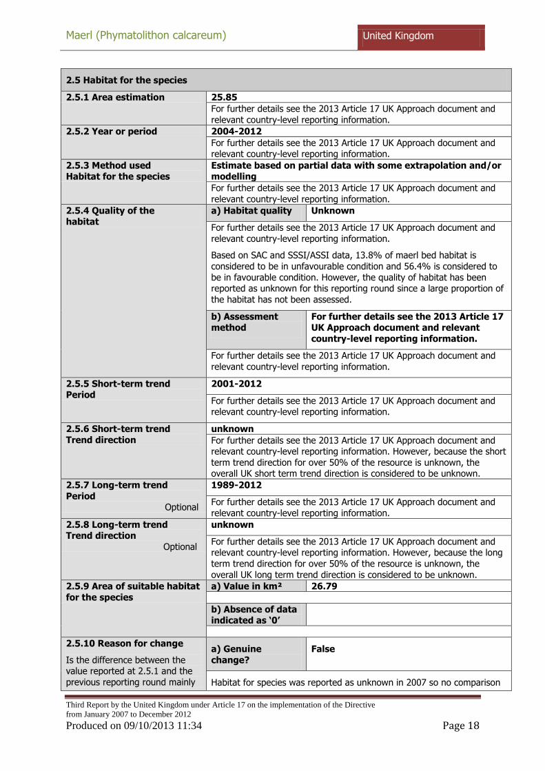
2.5 Habitat for the species
2.5.1 Area estimation 25.85
For further details see the 2013 Article 17 UK Approach document and
relevant country-level reporting information.
2.5.2 Year or period 2004-2012
For further details see the 2013 Article 17 UK Approach document and relevant country-level reporting information.
2.5.3 Method used Habitat for the species
Estimate based on partial data with some extrapolation and/or modelling
For further details see the 2013 Article 17 UK Approach document and
relevant country-level reporting information.
2.5.4 Quality of the habitat
a) Habitat quality Unknown
For further details see the 2013 Article 17 UK Approach document and
relevant country-level reporting information.
Based on SAC and SSSI/ASSI data, 13.8% of maerl bed habitat is
considered to be in unfavourable condition and 56.4% is considered to
be in favourable condition. However, the quality of habitat has been reported as unknown for this reporting round since a large proportion of
the habitat has not been assessed.
b) Assessment method
For further details see the 2013 Article 17 UK Approach document and relevant
country-level reporting information.
For further details see the 2013 Article 17 UK Approach document and
relevant country-level reporting information.
2.5.5 Short-term trend Period
2001-2012
For further details see the 2013 Article 17 UK Approach document and relevant country-level reporting information.
2.5.6 Short-term trend
Trend direction
unknown
For further details see the 2013 Article 17 UK Approach document and relevant country-level reporting information. However, because the short
term trend direction for over 50% of the resource is unknown, the overall UK short term trend direction is considered to be unknown.
2.5.7 Long-term trend
Period Optional
1989-2012
For further details see the 2013 Article 17 UK Approach document and
relevant country-level reporting information.
2.5.8 Long-term trend Trend direction
Optional
unknown
For further details see the 2013 Article 17 UK Approach document and relevant country-level reporting information. However, because the long
term trend direction for over 50% of the resource is unknown, the
overall UK long term trend direction is considered to be unknown.
2.5.9 Area of suitable habitat
for the species
a) Value in km² 26.79
b) Absence of data indicated as „0‟
2.5.10 Reason for change
Is the difference between the value reported at 2.5.1 and the
previous reporting round mainly
a) Genuine
change?
False
Habitat for species was reported as unknown in 2007 so no comparison

Maerl (Phymatolithon calcareum) United Kingdom
Third Report by the United Kingdom under Article 17 on the implementation of the Directive
from January 2007 to December 2012
Produced on 09/10/2013 11:34 Page 19
due to is possible. For further details see the 2013 Article 17 UK Approach
document and relevant country-level reporting information.
b) Improved
knowledge/more accurate data?
False
Habitat for species was reported as unknown in 2007 so no comparison
is possible. For further details see the 2013 Article 17 UK Approach document and relevant country-level reporting information.
c) Use of different
method (e.g. “Range tool”)?
False
Habitat for species was reported as unknown in 2007 so no comparison
is possible. For further details see the 2013 Article 17 UK Approach document and relevant country-level reporting information.
2.6 Main pressures
a) Pressure b) Ranking c) Pollution qualifier
H = high importance (max 5 entries)
M = medium importance L = low importance
C01: Mining and quarrying M
F01: Marine and Freshwater Aquaculture
M
F06: Hunting, fishing or collecting
activities not referred to above
M
G05: Other human intrusions and disturbances
M P
J02: human induced changes in hydraulic conditions
M O
K02: Biocenotic evolution,
succession
M
A08: Fertilisation L
D03: shipping lanes, ports, marine
constructions
L O
E03: Discharges L X
F02: Fishing and harvesting
aquatic resources
L O
H01: Pollution to surface waters (limnic & terrestrial, marine &
brackish)
L X
H02: Pollution to groundwater (point sources and diffuse
sources)
L X
H03: Marine water pollution L X
H04: Air pollution, air-borne
pollutants
L
H06: excess energy L T

Maerl (Phymatolithon calcareum) United Kingdom
Third Report by the United Kingdom under Article 17 on the implementation of the Directive
from January 2007 to December 2012
Produced on 09/10/2013 11:34 Page 20
I01: invasive non-native species L N
M01: Changes in abiotic conditions
L P
M02: Changes in biotic conditions L T
Where more than 20 pressures were reported at a UK level the pressures of lowest importance were removed, as required by the EC reporting format.
For further details see the 2013 Article 17 UK Approach document and relevant country-level reporting
information.
2.6.1 Method used – Pressures
mainly based on expert judgement and other data
For further details see the 2013 Article 17 UK Approach document and relevant country-level reporting information.
2.7 Threats
a) Threat b) Ranking c) Pollution qualifier
H = high importance (max 5 entries)
M = medium importance
L = low importance
C01: Mining and quarrying M
F01: Marine and Freshwater Aquaculture
M
F06: Hunting, fishing or collecting
activities not referred to above M
G05: Other human intrusions and
disturbances M
P
J02: human induced changes in hydraulic conditions
M T
K02: Biocenotic evolution,
succession M
A08: Fertilisation L
C02: Exploration and extraction of
oil or gas L
C03: Renewable abiotic energy use
L
D03: shipping lanes, ports, marine constructions
L X
E03: Discharges L X

Maerl (Phymatolithon calcareum) United Kingdom
Third Report by the United Kingdom under Article 17 on the implementation of the Directive
from January 2007 to December 2012
Produced on 09/10/2013 11:34 Page 21
F02: Fishing and harvesting
aquatic resources L
O
H01: Pollution to surface waters
(limnic & terrestrial, marine & brackish)
L
X
H02: Pollution to groundwater
(point sources and diffuse sources)
L
X
H03: Marine water pollution L X
H04: Air pollution, air-borne pollutants
L
H06: excess energy L O
I01: invasive non-native species L O
M01: Changes in abiotic conditions
L
M02: Changes in biotic conditions L
Where more than 20 threats were reported at a UK level the threats of lowest importance were removed, as required by the EC reporting format.
For further details see the 2013 Article 17 UK Approach document and relevant country-level reporting
information.
2.7.1 Method used – Threats expert opinion
For further details see the 2013 Article 17 UK Approach document and relevant country-level reporting information.
2.8 Complementary information
2.8.1 Justification of % thresholds for trends
2.8.2 Other relevant
information For further details see the 2013 Article 17 UK Approach
document and relevant country-level reporting information.
2.8.3 Trans-boundary
assessment
2.9 Conclusions (assessment of conservation status at end of reporting period)
2.9.1 Range a) Conclusion Unknown

Maerl (Phymatolithon calcareum) United Kingdom
Third Report by the United Kingdom under Article 17 on the implementation of the Directive
from January 2007 to December 2012
Produced on 09/10/2013 11:34 Page 22
Range has been assessed as unknown because
(i) 2.3.4 Range short-term trend direction is unknown; and
(ii) 2.3.9.a Favourable Reference Range is unknown
For further details see the 2013 Article 17 UK Approach document
b) Qualifier
2.9.2 Population a) Conclusion Unknown
Population has been assessed as unknown because
(i) 2.4.7 Population short-term trend direction is unknown; and
(ii) 2.4.14 Favourable Reference Population is unknown.
For further details see the 2013 Article 17 UK Approach document
b) Qualifier
2.9.3 Habitat for the species a) Conclusion Unknown
Habitat for species has been assessed as unknown because
(i) it is unknown if there is sufficient habitat to support a viable
population;
(ii) 2.5.4a the quality of the habitat is unknown; and
(iii) 2.9.1 and 2.9.2 the range and population status are unknown.
For further details see the 2013 Article 17 UK Approach document
b) Qualifier
2.9.4 Future prospects a) Conclusion Unknown
Conclusion reached because prospects for all parameters are unknown.
(i) 2.3.4 Range short-term trend direction is unknown and the
relationship of 2.3.1 Range surface area to 2.3.9a Favourable reference
range in c. 2025 is unknown (Unknown prospects);
(ii) 2.4.5 Population size short-term trend direction is unknown and the
relationship of 2.4.1 Population size to 2.4.14 Favourable reference population in c. 2025 is unknown (Unknown prospects); and
(iii) 2.5.6 Habitat for species short-term trend direction is unknown and the true relationship of 2.5.1 Habitat for species to 2.5.9 Area of suitable
habitat is unknown (Unknown prospects). Various threats (see 2.6.) are
expected to impact on the future status of the habitat for species, and it is unknown whether the future area of habitat will be sufficiently large
for the long-term survival of the species.

Maerl (Phymatolithon calcareum) United Kingdom
Third Report by the United Kingdom under Article 17 on the implementation of the Directive
from January 2007 to December 2012
Produced on 09/10/2013 11:34 Page 23
For further details see the 2013 Article 17 UK Approach document.
b) Qualifier
2.9.5 Overall assessment of Conservation Status Unknown
An overall conclusion of unknown is given based on the individual
parameter conclusions - for further details see the 2013 Article 17 UK Approach document
2.9.6 Overall trend in
Conservation Status
3 Natura 2000 coverage & conservation measures - Annex II species (only applies to species listed under Annex II of the Directive)
3.1 Population
3.1.1 Population size
Estimation of population size included in the SAC network
a) Unit
b) Minimum
c) Maximum
3.1.2 Method used
3.1.3 Trend of population size within the network
(short-term trend) Optional

3.2 Conservation measures
Conservation measures taken (i.e. already being implemented) within the reporting period and provided information about their importance, location and evaluation.
3.2.1
Measure
3.2.2
Type
3.2.3
Ranking
H = high
importance
M =
medium
importance
L = low
importance
3.2.4
Location
where the measure is PRIMARILY applied
3.2.5
Broad evaluation of the
measure
a)
Le
ga
l/sta
tuto
ry
b)
Ad
min
istr
ati
ve
c)
Co
ntr
actu
al
d)
Re
cu
rre
nt
e)
On
e-o
ff
a)
Insid
e
b)
Ou
tsid
e
c)
Bo
th i
nsid
e &
ou
tsid
e
a)
Ma
inta
in
b)
En
ha
nce
c)
Lo
ng
te
rm
d)
No
eff
ect
e)
Un
kn
ow
n
f) N
ot
eva
lua
ted