evaluating buried placer deposits in the … · by v. m. levson, b ... l an investigation of gold...
TRANSCRIPT
EVALUATING BURIED PLACER DEPOSITS IN THE CARIBOO REGION OF CENTRAL BRITISH COLUMBIA
(93A, B, G, HI By V. M. Levson, B.C. Geological Survey Branch R. Clarkson, New Era Engineering Corporation
and M. Douma, Geological Survey of Canada --.-.
KEYWORDS: Economic geology, Carihoo, placer gold. stratigraphy, reverse,-circulatic,n drilling. ganma logs, seis- mic, ground-penetrating radar, conductivity.
INTRODUCTION This paper is a report on the field activities and prelimin-
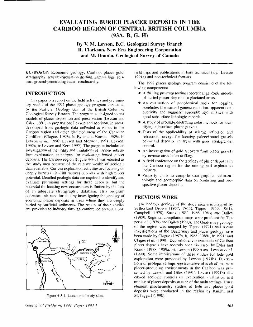
ary results of the 1992 placer geology program conducted by the Surficial Geology Unit of the British Columbia Geological Survey Branch. The program is designed to test models of placer deposition and preservation (Levson and Giles, 1991. in preparation; Levson ;md Morison, in press) developed from geologic data collected at mines in the Carihoo region and other glaciated areus of the Canadian Cordillera (Clague, 1989x b; Eyles and Kocsis, 19X9a. h: Levson (‘f rrl., 1990; Levson and Morison, lY9l: Levson, 1992~1, h: Levson and Kerr, 1992). The program includes an investigation of the Iutility and limitations of various suhsur- face exploration techniques for evaluating buried placer deposits. The Carihoo region (Figure J-8-I) was selected as the study area hecause of the relative wealth of geologic date available. Current exploration activities are focusing on deeply buried (-~ 20..100 mares) deposits with high placer potential. Detailed geologic date are required to identify and evaluate promising settings for these deposits, hut the potential for locating new occurrences is limited by the lack of an adequate stratigraphic database. This program addresses this need f(w data by investigating the geology of economic placer deposits in areas where they are deeply buried by surficial sediments. The results of these studies are provided to indlustry through conference presentations,
field trips and publications in both technical (e.g., Levz~or~ I99 la) and non-technical formats.
The I992 placer geology pl-o;+n consist :d of the fol. lowing components:
0 A drilling program testing theoretical ge llo&ic model!; of buried placer deposits in glaciated ar :as.
0 An evaluation of geoph:ysical tools for logging. boreholes (for natural gamma radiation. lpperent ‘on. ductivity and magnetic susceptibility) at sites nith good subsurface lithologic records.
0 A study of ground-penetmting radar met lads for icll:n~ tifying subsurface placer gravels.
l Tests of the applicahilit,y of seismic I etlection and refraction surveys for loc;itiog paleoct- anneI gravel:; below till deposits, in awxs with go”’ stratigraphic control.
l An investigation of gold recovery from placer gravel; by reverse-circulation drilling.
l A field conference on the geology of pla, :er depos,il!; in the Cariboo region for the mining ar .! exploration industry.
l Property visits to compile stratigrapl,ic, sedimzn- tologic and geomorphic data on prod” :ing and xo- spective placer deposits.
PREVIOUS WORK The bedrock geology of the study ared u as mappal by
Sutherland Brown (1957. 19631, Tipper 1959, I9til,, Camphell (IY78). Struik t 1982, 19x6, I98 1) and Bailey (I 989). Regional compilation maps were prc duced by Tip- per zr <I/. (I 979) and Bailey (1990). The Quao :mnry geolsgy of the region was mapped by Tipper (19; I) and recent investigations of the Quaternary and placer geology lace been made by Cla&ue (I 987a. h; 1988: 1989; ., b; 199 I: and Clague rf (11. (1990). Depositi,xnl environmc nts of Carihco placer deposits have recently been discussa by Eylt:s and Kocsis (198X: I989a. b), Levson (1990) an< Levson 6’: al. (1990). Some implications of I.hese studies for lode: gold cnploration were presented by L.evson (I9 II h). Desxip- tions of geologic settings reprj:sentative of e: ch of the main placer-producing environment!; rn the Car boo was lprt:- sented by Levson and Giles ( I99 I ). Levso 1 ( I99 I b) di,;- cussed geologic controls on exploration, G valuation ard mining of placer deposits in each of the main settings. l;we element geochemistry studi’z!, of lode ani placer god deposits were conducted in the region ty Knight arid McTaggart (IWO).

Drill Log - Hole Number VL92-1
Location: Gallery Resources Ltd. mine. Hannador property, Lightning Creek NTS: 93 G/l Cottonwood Latitude and longitude: 53”01’25”N, 122”01’5O’W UTM: 5675200m N, 565200m E
Notes: The drill site is on the south side of Lightning Creek, approximately 1 kilometre downstream from its confluence with Moustique Creek; the hole is at the eastern end of the minesite at the top of a high terrace paralleling Lightning Creek. This hole is the same as Gallery Resources hole number 6. Exposures of massive. matrix-supported diamicton are present on the hill side about 10 metres above the drill collar. The presence of striated cl&s and the varied clast lithalagy (including quxtzite, phyllite, granite. basalt. dacite, andesite, gneiss. biotite schist. sandstone, cheri and pebble conglomerate) indicates a glacial derivation. The section measured in 1990 by Levson and Giles (in prep.) is located about 200 metres northeast (220°) of the drill site.
Unit Depth (metres)
0 - 3.0
3.0 - 6.7
6.7 - 9.1
9.1 12.2
12.2 -17.7
17.7 16.3
16.3 29.0
29.0 35.1
35.1 - 39.6
10 39.6 +
Descrlptlon:
Fine sand and sill: light olive-brown colour (Munsell code: 2.5Y 5/d); well sorted; no dasts; poor sample recovery; Sample 6-O-10.
Silt and clay: olive-brown colour (Munsell code: 2.5Y 4/4); no gravel clasts; very well sorted; Samples 6-10-15, 6-15-20.
Pebble gravel; sandy matrix; clast lithologies varied; approximate proportions: 40% quartzite. 20% phyllite. 20% vein quartz, 10% sandstone. 10% schist, etc. Samples 6-20-25. 6-25-30.
Pebble lo cobble gravel; sandy matrix: clast lithologies varied; similar lo unit 3 except for coarser beds at top and bottom of unit; Samples 6-30-35. 6-35-40.
Pebble gravel; minor, thin, sand lenses: gravels have a sandy matrix: clast lithologies varied: similar to unit 3; Samples 6-40-45, 6-45-50. 6-50-55.
Boulder gravel; little matrix; clast lithalogies varied: similar to unit 3 except coarser; Sample 6.55. 60.
Pebble gravel; similar to unit 5; minor, thin, sand lenses; cobble bed in lowest 0.5 metre at base of unit; gravels have a sandy matrix; clast lithologies varied: pebble-chip count results (n=g5): 54% quartzite (27% red micaceous quartzite, 27% other quartzite), 32% vein quartz, 7% black argillite/phyllite. 3% metasiltstone, minor (cl%) schist. minor sandstone, minor hornblende da&e; Samples 6-60-65, 6-65-70, 6-70-75, 6-75-80, 6-80-85, 6-85-90, 6-90-95, VL-92001 (at 23 metres depth), VL-92002 (at 29 metres depth).
Pebble lo cobble gravel; similar to unit 7 but with cobble beds at 30.5 - 32 metres and 33 -34 metres; matrix is clay rich from about 29 32 metres, otherwise is sandy; iron oxide (red) staining present in some gravels; sand beds rare; clast lithologies varied; Pebble-chip count results (“~100): 57% quartzite (34% red micaceous quartzite, 23% other quarizite), 26% vein quartz, 10% black argillite/phyllite, 2% meiasiltstone, 2% schist, 1% metavolcanics. 1% cheri, 1% hornblende dacite; Samples 6-95-100. 6-100-105. 6-105-I IO. 6-l 10-115. VL-92003 (at 31 metres depth), VL-92004 (at 35 metres depth).
Cobble lo boulder gravel; unit appears to coarsen with depth: minor pebble beds at 35.7 - 36.3 metres and 37.5 .37.8 metres; sandy matrix; clast lithologies varied; large clasts are mainly quartzites; pebble-chip count results (11~50): 57% quarizite (28% red micaceous quart&, 22% other quartzile). 24% vein quartz, 24% black argillitelphyllite. 2% hornblende dacite; Samples 6. 115.120, 6-120-125, 6-125-130, VL-92005 (at 36 metres depth). VL-92006 (at 39.5 metres depth).
Bedrock: very dark gray (Munsell code: 5Y 311) to black (Munsell code: 5Y 2.511); litholcgy mainly argillite; Samples 6-130-135. 6-135-140, 6-140-145.
464

METHODS Sites with stratigraphic control and geologic evidence for
buried placer potential were selected for field investigation by nirphoto study and office review of existing data. Geologic data collected during previous studies in the Cnri- boo were used to help identify areas with high buried-placer potential. Fieldwork included a reverse-circulation drilling program to collect subsurface data needed to test strat- igraphic correlations and depositional models. The effi- ciency of the drilling method for recovering gold was tested by New Era Engineering Corporation using radiotracers. Geophysical methods for evaluating buried placers (includ- ing borehole geophysics, seismic reflection and refraction techniques and ground-penetrating radar) were also investi- gated in conjunction with the Geological Survey of Canada. Shallow refraction hemmer-seismic data were collected by Howard Myers. The effectiveness of these exploration tech- niques for evaluating buried deposits will be discussed elsewhere. Detailed descriptions of the procedures for each subsurface technique and preliminary results are described here.
DRILLING PROGRAM A number of drill sites were selected in different geologic
settings in order to test depositionel models for placer deposits in British Columbia. Emphasis was placed on bur- ied placer deposits in both trunk and tributary paleovalleys and two holes (VL92.5 and VL92-6) were drilled in B terrace-placer setting. The type of data collected during the drilling program is exemplified by the log of drill hole VL92.I from Lightning Creek (Table 4-X-I).
The Mobile 880 drill used in this study (Plate 4-X-l) was fitted with a I IS-millimetre (4.5.inch) diameter. skirted
rotary tri-cone bit and 89.millimetre (3.5.ir:h) diameter drill rods. The rods consisted Iof an inner I ube to urry sample from the bottom of the: Ihole to the SI rface and an outer annulus to carry the comprased air use I to flush the drill cuttings from the hole. Approximately X60 litre!; per second (540 cubic feet per mitwte) of air c 1mpresse:d to 2.4 megepascals (350 pounds per square incl ) was fcr:ed down the outer ilnnulus of the rods, Water will added to the compressed air stream to lubri<:ate the drill r( ds. Drill cut- tings were forced up the inner tubing through the rotar) head and hoses into a sampling: cyclone and vere collectec in buckets. Holes remaining open after drilli ~g was c<un pleted were cased with 5.centirnctre @inch) ( iameter pl,rs- tic (PVC) pipe to as great a depth ias possible to accomnto- date the geophysical logging tools.
LIGHTNING CREEK AREA Drill holes VL92-I and VL’32-2 were I xated in the
Lightning Creek valley at the Hannador property of Gall,zr~t Resources Limited. An active exploration program at thir site has targeted a buried depwit of probah e interg~lacial age that is believed to lie pwallel tc~ and south 3f the modzrtt Lightning Creek channel (L:vson, IYYIa) Prelimirw:~ results of the drilling program I:Table .1-8-l indicate that auriferous paleochannel gravels extend undr .neath a thick (30 m) sequence of glaciofluvial and flLvial drpcliiti exposed on the south side of the valley.
AIKECREEKARKA Drill holes VL92-3 and VL,Y:!-4 were dril ed to in~vcsti-
gate buried river channel depcwits in the Ali:e Creek 1x1 believed to be Tertiary in age (Rouse er nl.. 1’190). Deposit< mined at Alice Creek are believed to be ct txlative ,witN1
4ts
those at the nearby Mary Creek mine (Levson and Giles, 1991) but the extent and orientation of the paleochannel system is not known. Holes VL92-3 and VL92-4 were ‘wildcat’ holes drilled in an attempt to constrain the pal- eogeography of the buried channel. The location of hole VL92-3 (Plate 4-8-l), due west of the Alice Creek mine, was chosen on the basis of industry drill records (Ed Kruchkowski and Jack Wyder, personal communication, 1992). These data defined a deep channel in the Alice Creek valley with a cross-sectional geometry suggestive of a west- trending paleochannel. Bedrock was intersected in hole VL92.3 under till at a depth of about IO metres, well above base level in the Alice Creek paleochannel. These data, together with the known distribution of bedrock outcrops in the area, provide a new constraint on the orientation “f the paleochannel system. These results lead to the hypothesis that placer gravels mined on the east side of Alice Creek must have been deposited in a paleochannel system that either extends to the north or swings sharply t” the south. To test this, hole VL92-4 was drilled about I kilometre north of the Alice Creek mine. Several metres of gold-bearing gravels were encountered in this deep hole with bedrock occurring at 36 m&es depth. These gravels are believed to be the deposits of a northerly extension, possibly a tributary channel, of the main paleochannel system.
Holes VL92.5 and VL92-6 were drilled along the Cotton- wood River to investigate Holocene terrace gravels and possible older paleochannel deposits in that area. The holes were collared on opposite sides of a broad, low terrace on the south side of the Cottonwood River. The terrace is a few metres higher than the present channel and directly upstream from a bedrock-floored canyon into which the Cottonwood River valley narrows. High ridges on both sides of the canyon are comprised mainly of bedrock to the north of the river and unconsolidated Quaternary sediments to the south. Small bedrock knolls are also exposed at low water levels along the present course of the river upstream from the canyon. Gravels occur throughout the entire drilled sequence above bedrock which was intersected at a depth of about 20 metres in both holes. The gravels are gold bearing with the highest gold recovery occurring in c”arse gravel beds at the bottom of the holes; the latter are interpreted t” be erosional lag gravels.
Bedrock exposures in the modem channel of the Cotton- wood River, panicularly those along the canyon directly below the drill sites, constrain the depth of Holocene inci- sion of the river to that of the present-day channel. Conse- quently, as bedrock is nearly 20 metres below the present channel base at the drill sites, the gravels in the lower part of the sequence must predate the Holocene. They are believed to be interglacial or preglacial gravels deposited in a pal- eochannel that presumably lies south of the present river and may extend under the thick Quaternary deposits south of the canyon. Deep-channel gravels on the southwest side of the terrace have been previously mined at one site near the valley side. Mining was stopped when the gravels could no longer be removed because they were covered by, and apparently extended underneath, a thick clay (glaciolacus-
trine:‘) sequence. The placer operation at this site is cur- rently evaluating the potential for mining these paleochan- nel gravels in areas where they may be preserved below Holocene terrace gravels.
SOVEREIGN CREEK AREA Holes VL92-7 and VL92-8 were drilled in the Sovereign
Creek region in an area with excellent potential for a large- volume buried paleochannel placer deposit of interglacial or preglacial age. This deposit occurs in a recently discovered buried valley that apparently trends northwesterly parallel t” Sovereign Creek. The paleochannel gravels were inter- sected in drill hole VL92-7 at depths from 8 to 27 metres. They overlie bedrock and are overlain by diamicton units with interbedded silty clays interpreted, respectively, as till and glaciolacustrine sediments.
The paleovalley containing the auriferous deposits is sep- arated from the modern Sovereign Creek valley by a bed- rock high which has been exposed by recent mini”& and forms the northeast wall of the buried valley. Hole VL92-8 was drilled to help define the southern extent of the pal- eovalley and its general orientation. Drilling results indicate that the channel gravels thin substantially to the south. Bednrk was encountered at shallow depths (16.5 m), sug- gesting that the drill site is located near the southwest margin of the paleochannel.
REDDISH CREEK AREA Holes VL92-9 and VL92-IO were drilled between Fon-
taine Creek and the Little Swift River to test the potential of a large buried “trunk” valley trending northwesterly paral- lel to the Reddish Creek valley. Previous stratigraphic stud- ies in the Little Swift River area (Levson and Giles, 1991; Levson, 199la; Levson and Giles, in preparation) suggested that a large paleovalley placer deposit may occur in the region. Past mining strategies have targeted southwesterly flowing streams such as the Little Swift River and Fontaine Creek, but little attention has been paid to the possibility of a northwesterly trending paleochannel, possibly following the strike of the Eureka thrust. This fault separates the Barkerville and Quesnel terranes (Struik, 1988) and may have provided a major structural control on preglacial drai- nage patterns in the area. Drill hole VL92-9 was drilled southeast of the Fontaine Creek valley and intersected gold- bearing gravels of similar thickness and type to those cur- rently being mined along it. Hole VL92-IO was a ‘wildcat’ hole drilled part way between the Little Swift River and Fontaine Creek. The occurrence of auriferous gravels at the bottom of this hole provides new evidence that strongly supports the hypothesis that a large northwesterly trending paleovalley exists in this area.
GOLD RECOVERY TESTS The reverse-circulation drill used in this study was tested
at four sites using gold radiotracers as part of a broader research program on drilling methods conducted by R. Clarkson of New Era Engineering Corporation. Infonna- tion on radiotracers (very low level radioactive gold part- cles) and their use in gold recovery research has been

provided by Clarkson (1991). The results and preliminary concIusions presented here apply only to the four sites tested durine this study.
For each test, four sizes of radiotracers were used: 0. IX millimetre c-65+ 1011 mesh), 0.36 millimetrr (-3514X mesh), 0.72 millimelwe (-20+2X mesh) and I .44 milli- metres (-IO+ 14 mesh). The radiotrace!-s were placed in the middle of barren compacted gravels and frozen into a solid cylindrical shape. The lest gravel cylinders were 300 milli- metres (I2 inches) long and 90 to IO0 millimetres (3.5 to 4 inches) in diameter. The test procedure involved drilling to the desired depth (IO to 35 m) and pulling the drill rods out of the hole. The open hole depth was then Inea\ured and caved portions were redrilled until the desired depth was reached (where practical). The radioactive test cylinder was then dropped down the hole and the depth of penetration was drtcrmined and increased if necessary hy pushing with the drill stem. Gravel srrmminf was then dumped into the hole and compacted hefore redrilling. The collar of the hole, drill cuttings, drill equipment. sample collection equipment and personnel were checked for radioactive gold during and after completion of the drilling (Pla@z 4-X-2). Radioactive particles were detected using a scintillometer. Their low tions were recorded and all detected particles were co- &ted. Drill samples Icontaining tracers were processed in a small sluice and hy hand panning until each radioaclive particle present in the concentrate was recovered.
Most of the recovcrcd radiotracers were out of the holes by Ihe time the bit had reached 3 lmetres beyond Ihr depth where the tesl cylinders were originally placed. The addi- tion of w~tcr 10 the compressed air stream increased segre- gation and entrapment of gold tracers. Water addition also increased spillage losses and made it difficult to collect and
contain the samples. Although surges of high ~pressure air were used to flush the system, many tracers we, e caught and remained in the hose fittings and sampling cyclone. To ~‘emwc them, the cyclone and ho5r fittings ‘vere diwm nrced and cltxmed out after the hole was comf leted. AI, lhe collars of the h&x were not waled a high pror ortion ofihe cuttings and trwers was forced up outside the d-ill rods oleo the ground near the collars (blc\v-by).
Between 2 and 98 per cent 01 tl~e tracers wt re recovut:d from the four holes tested. In the hole with the drcps:st sample depth (35 m) only 2 psr cent of the tracers vi,:re recovered. one was on the ground next to the c ,Ilar and lhe other was trapped in the cyclor~e. E:ven in shallower ho 1:s (IO m) with relatively high recoveries, many ( f the traxrs were to\1 due to spillage and fo bll-#w-by around the collar (of the hole. Some of the tracers wwe trapped it the sam~,le cyclone and its plumbing.
Natural gamma logs (.SPP b~:low) were ot tained from three of the four holes tested. In all three log!, anomelcus peaks in the gamma radiation, irldicating the presence Iof trxws. were observed at the approximate penetratix depths that the tesf cylinders initially reacha after being dropped down the holes. No anomalous pe;ks occurred mol-e than I to 2 mefrrs above these depths. 1 his suggeas that artenrpts to push the radioactive tesl cyli Idus to the bottom of the holes with the drill rods cause, part of the samples to be lodged in the yid: of the bole a or near the depth of initial penetration. In this regard, it is interesting ,,o note that the test with the highrsl initial penet aion of the sample cylinder relative to the h:,le depth (IO II in a IO.5 in hole) yielded the best tracer rec~wrry (98%;). Similarly, the hole with the lowest initial pewration (4 m m a KS 111 hole) yielded the lowest recovery (2%). In thi latter G:;~:,
467

numerous anomalous gamma peaks were detected between the initial penetration depth and the base of the log (15 m) suggesting that the test cylinder was pushed at last part way down the hole. These rqdts indicate that caving of open holes in wet, unfrozen materials presents a major difficulty in testing gold recovery in this method of rwrrse- circulation drilling.
Material derived from caving along the walls of the drill hole may also result in the introduction of significant amounts of sediment (and gold) into the sample over any one sample interval. Caving may occur when boulders are encountered or when saturated gravels arr drilled. Gold values may be overestimated as a result of caving if all of the recovered gold is assumed to have come from a volume of sediment calculated on the basis of hole diameter. This problem can be avoided if the actual volume or weight of the recovered sample is used to determine gold concentra- tions. Up-h& contamination can also introducr errors in determining gold values for any one sampled interval. Up- hole contamination occurs, for example, when the blow-by is lost.
Although results of the four radiotracer tests suggest that unsealed, uncased reverse-circulation drilling is not a reli- able method of determining gold wdues in unfrorrn placer gravels, this method does provide samples which are suita- ble for determining the lithology and stratigraphy of the surficial deposits. Depth to bedrock is also readily deter- mined as bedrock cuttings are generally easy to recognize. Losses due to blow-by can be reduced by drilling a short length (3 to 6 m) of casing (Odex) into the hole and sealing off the drill rods with a packing case. Losses in the drill hole may also be reduced if casing is used for the total length of the hole (especially if the casing is driven ahead of thr bit). Losses and carry-over from the sampling hose, fittings and cyclone can be reduced with designs that eliminate gold traps and with frequent thorough cleaning. Other methods of reverse-circulation drilling should be tested at several locations to determine which drilling equipmrnt and pro- cedures maximize gold recovery on a consistent and pre- dicteble basis.
GEOPHYSICAL PROGRAM
Seven cased drill holes (VL92.I, VL92.4, VL92-7, VL92-IO, DH-14, DH-17, and TH-9) were logged by the Geological Survey of Canada using the Geonics EM-39 logging system (Plate 4-8-3). Apparent conductivity, natu- rally occurring gamma radiation and magnetic susceptihilit) were recorded in six of the seven holes. Only natural gamma radiation was measured in one of the holes at Sovrreign Creek (DH-14) due to the presence of steel cas- ing in the hole.
The radius of penetration for the conductivity probe is estimated to be I to I .5 metres and, as the tool is claimed by the manufacturrr to be unaffected by fluids in the plastic casing, the conductivity measured is taken to be that of the surrounding formation and associated groundwater. The results of a conductivity log of drill hole VL92-I at the
Gallery Rssources mine at Lightning Ctwk are given in Figure 4-X-2. High conductivity in the upper several metres of the hole corresponds well with lithologic data (Table 4-8-l) showing high silt and clay contents in Units I and 2. Lou, conductivity in the gravelly deposits underlying Unit 2 contrasts sharply with the high conductivity in ths overlying finr~grained sediments.
The gamma tool detects the decay of uranium, thorium and potassium, although for practical purposes the tool measures, quantitatively, the abundance of clay in the strata surrounding the borehole. Low gamma readings are an indication of coarse-grainrd srdimrnts, and high gamma readings arr attributable to fine-greined materials. A natural gamma log for drill hole VL92-I is provided in Figure 4-X-3. The natural gamma peak at 5 metrrs depth cow- sponds well with a similar peak in the conductivity log at the same depth. The natural gamma log shows more vari- ability and fluctuations than the conductivity log, possibly reflecting a greater sensitivity to textural changes such as sand and silt content in the gravelly units at this site.
Thr magnetic susceptibility probe measures how strongly the material adjacent to the borehole is affected by a mng- netic field, in this case the earth‘s field. It is accrpted that the overall susceptibility of a lithology is dependent only on the amount of fsnimagnetic minerals present such as mag- netite. pyrrhotite and ilmenite. Data collected with the mag- netic suscrptibility tool are currently being processed.
SEISMIC SuwE~s Expending-spread seismic refraction and/or common off-
set seismic reflection surveys were conducted by the Geological Survey ofCanada at the following sites: Ballarat mine near Barkerville. Alice Creek property, Sovereign Creek area. Fontaine Creek mine, Reddish Creek area, Golden Bench mine on the Cottonwood River and Corless Tertiary mine on the Quesnel River. The surveys can be efficiently conducted with a two-person line crew and one person operating thr seismograph (Plate 4-X-4). A portable, gas-powered auger drill was used to drill shot holes to a depth of about a metre and shotgun explosives were used as the signal source (Plate 4-X-4). For comparison purposes, shallow hammer-seismic refraction surveys were also con- ducted at two sites (Gallery Resources and Golden Bench mines) using hammer blows on a steel plate as the signal source. All refraction and retlection surveys were located near holes drilled during this program (VL92-4, VL92-6, VL92-7, VL92-9 and VL92- IO) or near industry drill holes at the Gallery Resources Ltd., Ballarat, Corless Tertiary and Sovereign Creek mines. The drill-hole results will provide stratigraphic control and reference data for evaluation of the seismic results.
The purpose of the seismic surveys was to map the subsurface stratigraphy, in particular the thickness and lat- eral extent of gravel horizons that are known or believed to contain placer gold, and to evaluate the applicability of the various methods in different geologic conditions. Many buried auriferous gravel units pose a problem for interpreta- tion because their acoustic velocity is lower than that of till unit,s which they commonly underlie. These deposits con- stitutr what is known as a ‘hidden’ layer. The preliminal-y

NATURAL GAMMA (cps)
CONDUCTIVITY (mS/m) 0 1p 20 l-3p0
-3,; i
LIGHTNING CREEK DRILL HOLE VL H92-1
+ -402 CONDUCTIVITY LOG
-54
LIGHTNING CRI:EK DRILL HOL-E VL 1192-l
-40 NATUF!P,L GAMM 4 LOG

470

seismic surveys conducted during this study will attempt to determine the potential of these techniques for locating these hidden layers. The seismic data are currently being processed and analyzed. The results of these analyses will indicate the potential for future studies.
GROUND-PENETRATING RADAR STUDY Ground-penetrating radar surveys were conducted by
Jean Pilon of the Geological Survey of Canada at six dif- ferent mine sites (Gallery Resources Limited, Ballarat, Golden Bench, Pawnee, Tregillus Lake and Corless Tertiary mines). The survey equipment consists of two hand-carried antennas, one for transmitting and one for receiving the radar signals, connected to the data collection and process- ing equipment by fibre-optic cables (Plate 4-S-5). Data were collected from a total of 25 lines up to several 100 metres in length. The results of drilling data from these sites, collected during the 1992 propram and by industry. were compiled in order to test the accuracy of the ground-penetrating radar data. Preliminary results indicate that the method is an excellent tool for determining depth to bedrock, water table level and major stratigraphic breaks and for investigating channel geometry in gravelly placer deposits. The main limitation of the method appears to be caused by the pres- ence of clay-rich sediments that may overlie or be interbed- ded with auriferous gravel units.
FIELD CONFERENCE A field conferewe on the geology of placer deposits in
the Cariboo region was held for the mining and exploration industry as part of ihis program. The following topics were discussed: the bedrock geology of the C&boo and relation- ships of lode gold and placer deposits (Chris Ash. B.C.
Geological Survey), the geology of the Al ce and fvlar:i Creek placer deposits (Jack Wyder), the camp )sition of lode and placer gold in the Cariboo (John Kn ght and k:en McTaggart, The University of 13ritish Columb a), the forma- tion of placers, depositional processes, paystr :aks and si:di- mentary traps (Ted Faulkner, 13.1~. Geologica I Survey), the geology of buried placer deposits, field criteri; for recognir- ing different types of placers and ways of ider tifying poten- tial geologic settings conduci,vc to placer deposition !‘Vi<: Levson, B.C. Geological Survey), placer t,old recowr:, technologies, ways of reducing gold losses and samplio;; methods (Randy Clarkson. New Ezra Engineeri~lg), geophysical and other methods of locating am investigating buried placer deposits (Marten Douma, Sus in Pullan and Jim Hunter, Geological Survey of Canada). T me conferr:no: included a field trip to study the geology cf local pl,xer operations (Plate 4-S-6). Burled Quaternar) and Tertiar:i placers were examined at three sites: the Ba larat, Galler:i Resources and Alice Creek mines. High atttndance at th,: conference (100 people) indicates that this i ; an excellent format for the exchange of geoscientific informa:ion between researchers and induwy.
SUMMARY Subsurface placer deposit!; ‘were investi :ated usirl,g a
number of techniques including reverse-circu ation dril in& ground-penetrating radar, bort:holt: geophysil s and sei!anic studies. The utility and limitations of these techniques in different geologic settings were also evaluat :d. The ime- tigations were conducted in wnjunction witl I industry and the Geological Survey of Canada at the Gall :ry Resources Limited property, the Ballarat mine, the t iolden E3ench mine, in the Alice Creek area, south of SOI ereign Crsel.. near Fontaine Creek, in the Reddish Creek region, in the
Plate 4-8-h. Some of the field conference participants examining the geology of a buried placer deposit at the Ballarat mine.
Grolqical Fieldwork 1992. Paper 1993-l

Quernel Canyon area and near the Tregillus Lake mine. The eniez, may be an economic way of obtaining useful strat- main results of this program include: igraphic information. Other methods of determining suhsur-
0 The intersection of auriferous pnleochannel gravels in face stretigraphy such as refraction and reflection seismic eight of the ten reverse-circulation holes drilled. surveys and ground-penetrating radar surveys may also be
. The discovery of previously unknown gold-bearing paleochannel &ravels at two sites (near Alice and Red- dish creeks).
l Completion of the first phase of a program to invcsti- gate the applicability of ground-penetrating radar. borehole logging and geophysical studies to determin- ing the subsurface stratigraphy and geometry of buried olacers in a number of different settina.
useful for locating buried placer deposits. Preliminary results indicate that ground-penetrating radar is a par- titularly good method for investigating buried channel gravels provided that they are not overlain by clay-rich sediments.
ACKNOWLEDGMENTS The authors would like to thank all the miners whose
. Completion of a preliminary evaluation of gold recov- ery in reverse-circulation drilling.
At most of the drill locations. the presence of subsurface paleochannels was not indicated by surface geomorphologic features. In addition. the auriferous deposits war buried by a thick glacial overburden sequence at all sites (except at the two drill holes along the Cottonwood River). The identifica- tion of buried chnnnel deposits must therefore rely on the interpretation of existing geologic data from the area of interest and extrapolation of information from adjacent areas. The most critical data for successful results include information on the paleogeomorphic setting, depositional environment, source proximity and paleoilow direction. Useful subsurface data, such as paleollow records and inlbr- mation on stratigraphy and depth to bedrock, can be obtained from natural and manmade exposures and from drilling programs. In addition, bedrock geology controls such as the locations of potetential source rocks and fuour- able geologic structures need to be considered. The results of the drilling program conducted during this study indicate that these sources of information can be successfully used to identify new paleochannel deposits. Targets for drilling should he based on correlations of stratigraphic data and paleogeographic reconstructions of the buried channel systems.
Reverse-circulation drilling can provide valuable geo- logic data, such as lithologic composition of gravel units, stratigraphy and depth to bedrock, but the method is not recommended for accurate determinations of cold content. Potential errors may be reduced by determini& gold con- tent on the basis of the actual amount of sediment recovered (rather than on theoretical calculations of sediment volume based on the drill bit diameter and sample interval). Modi- fications to the drilling techniaues and eauioment used may
properties are discussed in this paper for providing informa- tion and access to their properties. Special thanks are extended to Stan Bergunder and Norm Olausen (Golden Bench mine), Bert Ball (Wilderness Resources), Debbie Corless and Lrr Frank (Corless Tertiary mine), Bruce Cos- terd (Gallery Resources Ltd.), Don Kirkham and Stuart Spiers (Dragon Mountain Placers Ltd.), Ed Kruchkowski and Jack Wyder (Alice Creek mine), Dale Pauls (Beaver Pass Exploration and Development), Dan Romanow (Fon- taine Creek mine) and Gunner Slack and Chris Armstrong (Tercon Contractors Ltd.). James and Greg Devins of Dateline Contracting Ltd. are especially thanked for provid- ing efficient and excellent quality drilling services. Howard Myers provided information on shallow refraction seismic surveys. The support of the Geological Survey of Canada is acknowledged, particularly the efforts of Jim Hunter and Susan Pullan for assisting with the geophysical component of the program, Jean Pilon for conducting the ground- penetrating radar study and Jean-Serge Vincent for coordi- nating this collaborative research project. We acknowledge the support of the of Cariboo Mining Association. Other information and assistance were provided by Fred Andrusko (Yanks Peak Resources), Brian McClay (Mosquito Consoli- dated Gold Mines Ltd.), Marlene Van Halderen and numerous other members of the Cariboo placer mining community. Excellent field assistance was provided by Col- leen Bauer. The manuscript was reviewed by John Newell and Peter Bobrowsky. Figure 4-8-l was drafted by Scott Henthom.
REFERENCES Bailey, D.G. (1989): Geology of the Swift River Map area, NTS
Y3A/l2, NTS 93A/13, 93B/l6, 93Gll; B.C. Minisrry ,,f Enugy. Mims rind Perr&um Resources, Open File 1989-20.
- . . . also help eliminate potential sources of error. Results are apparently more reliable in compact gravels not subject to caving. However, determinations of gold values from drill- ing data, regardless of the method used, must be interpreted with caution due to the typically small sample size and other factors. Qualitative records of gold content, such as notes on presence or absence of gold and relative abundance, are considered to be more reliable than quantitative determina- tions based on small samples.
The preliminary results of the borehole logging compo- nent of this study indicate that subsurface gravel units can readily be distinguished from units with hGh silt and clay contents. Geophysical logging of abandoned holes from previous drilling programs. common on many placer prop-
472
15” utl”. Bailey, D.G. (1990): Geology of the Central Quesnel Belt, British
Columbia: B.C. Ministry of Enrr~~, Minrs and Permleum Rr.roura~, Open File 1990.3 I, I : IO0 000.
Campbell, R.B. (1978): Quesnel Lake 93A Map Area; Geolqiral Survey of Cunada. Open File 1574.
Clague, J.J. (IYX7a): Quaternary History and Swatigraphy, Williams Lake, British Columbia: Canadian Joumul ofEm?h Srirnces Volume 24. pages 147-158.
Clagur. J.J. (1987h): A Placer Exploration Target in the Carihoo District, British Columbia: Grolo~icnl Sure? of Canada. Paoer X7-IA. oases 177-180.
Clague. J.J. (I9RRI: Quaternary Stratigraphy and History, Quesnel, British Columbia; GPqpphir Phwiyur P, Quarrmnirr, Vol- ume 42. Numbrr 3, pages 279.288.
British Columbia Geologid Survey Branch

Claguc, 1.1. (19X9a): Gold in the Carihoo District, British Colum- bia: Mining Rcljiew September/October, pages 26-32.
Clague, J.J. (1989b): Placer Gold in the Cariboo District, British Columbia; in Current Research, Part E, Gwlogicnl Survey of Cmrad~,, Paper 89~~ IE, pages 243-250.
Clague, J.J. (IOYI): Quaternary Straigraphy and History of Quesnel and Cxiboo River Valleys. British Columbia: Implications for Placer Gold Production; in Current Research, Pan A, Grologicni Surv~? oj Cana&, Paper 4 I-I A. pages l-5.
Clague, J.J., Hebda. R.J. and Mathews, R.W. (1990): Stratigraphy and Paleoecology of Pleistocene Interstadial Sediments, Cen- tral British Columbia: Quulrmu~ Resuorch. Volume 34, pages 208.228.
Clarkson, R. (1991): Placer Gold Recovery Research, Final Sum- mary; report prepared for the Klondikc Placer Miners Associ- ation, NPW Era Enfiinrerin~ Corpomrion. Whitehorse, Yukon, 49 pages.
Eylcs. N. and Kocsis. S.P (19xX): Gold Placers in Plcistocenc Glacial Deposits; Barkerville. British Columbia; Canadinn Insritutr, OfMinin~. Mrmllurg~, and P~w”ltwn, 13ulletin. Vol- ume Xl, peges 71~79.
Eyles, N. and Kocsin, S.P. (lY89a): Sedimentological Controls on Gold Distribution in Pleistocene Placer Deposits of the Cari- boo Mining District, British Columbia; in Geological Field- work IYXX, B.C. Minisfry of Energy, Mines and Perrolcwn RP.wIIrc~.r, Paper I YX9- I, page,? 377-3x5.
Eyles, N. and Kocsis, S.P. (lYX9b): Scdimentrrlogical Controls on Gold in a Late Pleistocene Glacial Placer Deposits, Carihoo Mining District, British Columbia, Canada; Sedimmrar? Grolop~. Volume 65, pages 45-68.
Knight J. and McTaggan K.C. (I 990): Lode and Placer Gold of the Coquihalla and Wells Areas. British Columbia (Y2H, 93H): in Geological Fieldwork 1989, B.C. Minirmp of Energy, Mines rind Pr~r&u,,, R<~.ww-ws. Paper I Y90,- I, pages I OS- , ,8.
Levson. V.M. (1990): Geologic Settings of Buried Placer Gold Deposits in Glaciated Regions of the Canadian Cordillera: Geolqical Asxxintion of Crmudo Minemlogicol Associo- rim qf Canada Program with Abstracts. Volume 15, page A-76.
Levson, V.M. (1991.x). The Bullion Mine; a Large Buried-valley Gold Placer: The Curiboo Miner, Volume 2. Number 5, pages 8-Y.
Levson, V.M. (199lb): Geologic Controls on Alluvial Gold Mining in the Cariboo District, British Columbia, Canada: in Alluvial Mining. Elsuiur Science Puhlisherr ,f”r In.stirure ff Mining and Mrrallur~y, London, England, pages 245-261.
Levson, V.M. (1992a). Quaternary Geology of the Atlin Area (104N/I I W, 10,4N/l2E); in Geological Fieldwork 1991, Grant, B. and Nrwell, J.M.. Editors. B.C Minislry of Energy, Miner and Prrwleum Rerource.s. Paper 1992-1, pages 375.390.
Lewon. VM. (I Y92bl: The Sedimentology of Pleistocene Deposits Associated with Placer Gold Bearing Gravels in the Livingstone Creek Area, Yukon Territory; in Yukon Geology
Volume 3, Bremner, T., Editor, Connda D~panmenr <$- Indian Aflidrs (2nd Nwthern Dewlopmun~ , Whitehorse. 2X pges.
Levson, V.M. and Giles, T.R. (199 I): Stratigraphy and Geologic Settings of Gold Placers in the Cariboo Mining District (Y3A.
B, G. H); ia Geological Fieldwork 19’10, B.1: Minirrq oj Enrrg,v Miw~ rind Prrroleum Rr.;ources, Paper 199 I-I, pqes 33 I-344.
Levson, V.M. and Giles, T.R. (in prqvxion): Geol( gy of Carituo Tertiary and Quaternary Gold-‘xxing Placers ( 13A, B, G, -I): B.C. Minisyv qf Energy .Mirw and Perrole) m Re.wurrw Paper.
Lemon, V.M. and Kerr, D.K. (1992): Surficial Ceol’~gy and Placer Gold Settings of the Atlin Surprise L:ake P rea. NTS 04 N/I I, 12; B.C. Minirm~ nj W,wr~y, Mines ( nd I’~m~lcwn Resourre.s, Open File 1992-7, I :5O 000.
Levson. V.M. and S. Morison. ( 1991:~. Quaternary ( iold Placr:r ; in the Canadian Cordillera; hrrernc~tbvml Union j :)I Quatrrmq Re.rerrrh. XIII International ICongress. Abstr; cfs, page I!)l.
Lrvson, V.M. and Morison, S.R. (in press): Gen ogy of Plxer Deposits in Glaciated Environments: in Glacia Environmcots
Processes. Sediments and Landforms. Men ,ies, J., E,Siror. Pergomon Prrrs, Oxford, U.I:.. 44 pages.
Levson. V.M., Giles, T.R., Bobnrusk~y, P.T. and Malysck. 1?F (1990): Geology of Placer Dqxxils in the C ariboo Milrng District, British Columbia; I nplications for %ploration; ir Geological Fieldwork 19R4, 5.C Mi,&ry of Energ?, M;,re:, and Prm,lrum Rrsourcr.s, Paper 1990. I, pa8 s 5 19-53:).
Rouse, GE., Lrsack, K.A. and Hu>:hcs. B.L. 11990 : Palynolrqicni Dating of Sediments Associated with Placer C :ald Depo!;i :; irl the Barkerville Quesnel Prince George <e&n, South. ccnbal British Columbia; in Geological Field5 ,ork 1989, .5.C Minis,ty of Energy, Mbm avd Prrmleutrr Rc .sourcw P qx 1990-1, pages 531-532.
Struik, L.C. (1982): Bedrock Geology of the Cariboo I,;Ikc (93A/l4), Spectacle Lake (91,H!3:1, Swift Riw r (Y3A/I!,) ;antl Wells (93H/J) Map Area:;, Central Brit sh Columbia: Gr”/o~icnl Suwry of Conadu, Open File X51.
Struik, L.C. (1986): lmbricated Tcrranes of the Ca iboo Gold Belt with Correlations and Jmplicalions f<w Tea ,nics in C;cuth~ easlern British Columbia: Conudiun Journu of Eurfk Sci- cwee~ , Volume 23, pages 104?-1161.
Struik, L.C. (1988): Structural Geology of the Car boo Gold f&n- ing District, East-central British Columbia: ;uologiu~l !;w vey of Cunndu, Memoir 42 I, IO0 pages an< four I :53 1100 maps
Sutherland Brown, A. (1963): Geology of the Cari loo River ~reil, British Columbia: B.C. Ministry <If Enrt :y, Miner and Prlroleum Re.wrrrws, Bulletin 4’?, 60 pages.
Tipper, H.W. (1959): Geology, Qui:snel, Cariboo Dirtrict, B -itirh Columhio: Gm/,~,q;u,/ S,,rir~:, > r,f Cmah. Map 12.195’). I:250 000.
Tipper, H.W. (1961): Geology, Prince George, B itish Cohnr,bi.l; Geo/ogicn/ Survey of Cnnadu. Map 49-l 960 I:250 00,.
Tipper, H.W. (197 I): Glacial Geomorphology and Pleistocene Hi;- tory of Central British Colu nbia: Genlqica Swvq of Curl- ado, Bulletin 196, 89 pages.
Tipper. H.W., Campbell, R.B., Ti,ylor, G.C. and S ott, D.F. (lY7< j: Parsnip River, British Columbia; Geologica Survey Gf Cou?- adu, Map 1424A, I:I 000 000.
Geolo@z/ Fieldwork 1992, Paper 3993-1 473

NOTES