evaluating the potential for constructing … · ranking of backwater sites as colorado pikeminnow...
TRANSCRIPT

EVALUATING THE POTENTIAL FOR CONSTRUCTING BACKWATERS
IN THE SAN JUAN RIVER FROM RM 158 TO RM 180
Final Report to the San Juan River Basin Recovery Implementation Program
Prepared by
Ron Bliesner Keller-Bliesner Engineering, LLC
Logan, Utah
Melissa Stamp Bio-West, Inc.
Logan, Utah
Jim Brooks U.S. Fish and Wildlife Service
Albuquerque, New Mexico
With input from
Brent Mefford U.S. Bureau of Reclamation
Denver, Colorado
and
Mark Wernke U.S. Bureau of Reclamation
Grand Junction, Colorado
June 18, 2007

Evaluating the Potential for Constructing Backwaters Page i in the San Juan River from RM 158 to RM 180 6/18/07
TABLE OF CONTENTS LIST OF TABLES ........................................................................................................... II LIST OF FIGURES.......................................................................................................... II 1.0 PURPOSE AND OBJECTIVES .............................................................................. 1 2.0 BACKGROUND...................................................................................................... 1
2.1 Channel Morphology ...................................................................................................1 2.2 Colorado Pikeminnow Augmentation Plan ..................................................................1 2.3 Suitable Habitat for Colorado Pikeminnow..................................................................3 2.4 Colorado Pikeminnow Stocking Procedures ...............................................................4
2.4.1 Stocking Densities ...........................................................................................4 2.4.2 Size and Number of Fish Stocked ...................................................................5 2.4.3 Stocking Site Selection....................................................................................5 2.4.4 Pre-Release Sampling at Release Site ...........................................................6 2.4.5 Release Protocol .............................................................................................6 2.4.6 Retention Time ................................................................................................6 2.4.7 Current Conditioning........................................................................................7
3.0 METHODS .............................................................................................................. 7 3.1 Initial Screening...........................................................................................................7 3.2 Field Investigation .......................................................................................................8 3.3 Site Evaluation ............................................................................................................8
4.0 RESULTS ............................................................................................................. 10 4.1 Sites Selected for Evaluation in Pre-screening .........................................................10 4.2 Sites Added During Field Inspection .........................................................................10 4.3 Field Inspection Results ...........................................................................................11
4.3.1 Sites Removed from Detailed Analysis .........................................................11 4.3.2 Field Evaluation Summary.............................................................................11
4.4 Site Ranking ..............................................................................................................14 5.0 CONCLUSIONS AND RECOMMENDATIONS..................................................... 19
5.1 Specific Recommendations.......................................................................................19 5.2 Additional Information Needs ....................................................................................20 5.3 Additional Opportunities for Backwater Habitat Creation by Augmenting Natural
Processes..................................................................................................................20 REFERENCES.............................................................................................................. 21 APPENDIX A ................................................................................................................ 23
Evaluation Sheets for Each Site Visited.............................................................................23 APPENDIX B ................................................................................................................ 33
Site Plans and Photographs...............................................................................................33
Evaluating the Potential for Constructing Backwaters Page ii in the San Juan River from RM 158 to RM 180 6/18/07
LIST OF TABLES Table 1. Recommended stocking densities for Colorado pikeminnow in the San Juan River ..5 Table 2. Preferred stocking site attributes for hatchery-reared Colorado pikeminnow..............6 Table 3. Final site evaluation criteria for constructed backwaters on the San Juan River. .......9 Table 4. Sites selected for field visits ......................................................................................11 Table 5. Summary of site evaluations for fish stocking locations and potential constructed
backwaters on the San Juan River............................................................................15 Table 6. Ranking of backwater sites as Colorado pikeminnow stocking locations in the San
Juan River .................................................................................................................18
LIST OF FIGURES Figure 1. Study Reach Location .................................................................................................2 Figure 2. Potential Colorado pikeminnow stocking sites in the San Juan River between RM
157 and 178 by type..................................................................................................17
Evaluating the Potential for Constructing Backwaters Page 1 in the San Juan River from RM 158 to RM 180 6/18/07
1.0 PURPOSE AND OBJECTIVES The primary objective of this effort was to investigate the feasibility of constructing 2-6 backwater habitats in the San Juan River between the Animas River confluence and the Hogback Diversion Dam for acclimating stocked young-of-year (YOY) and juvenile Colorado pikeminnow and subsequently increasing their survival and retention within the river. The goal was to identify at least 6 locations where suitable backwaters can be constructed with a total wetted surface area of 1,800 m2 or more (average of 300 m2 per backwater). If backwaters of this size could not be created, then smaller backwaters would be considered. The secondary objective was to increase the abundance of backwater habitat available for use by YOY endangered fishes in this reach of river if and when natural reproduction is established in this reach.
2.0 BACKGROUND
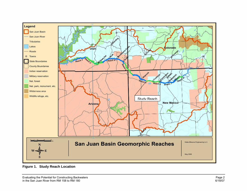
2.1 Channel Morphology Geomorphically distinct reaches of the San Juan River below Navajo Dam were identified by Bliesner and Lamarra (2000; Figure 1). The focus of this study was on geomorphic reach 6 above the Hogback Diversion. This reach has had a declining abundance of backwater habitat and high flows were not as effective at restoring them as in other reaches (Bliesner and Lamarra, 2006). Heavy non-native vegetation encroachment and bank stabilization in this reach have contributed to the loss of backwaters (Bliesner and Lamarra, 2006), making reversal by flow manipulation less effective. Backwaters in this reach typically form at the mouths of secondary channels that do not flow at reduced river flows. These locations are maintained during high flow events that activate the secondary channels. In years when flows are not high enough to flush the secondary channels, they can become heavily vegetated. In subsequent years when flows are sufficient to reactivate the channel, the newly-established vegetation reduces flow velocity and causes deposition in the channel until the channels become isolated, and eventually fill in. The loss of backwaters in this reach, along with the need for locations to acclimate stocked Colorado pikeminnow led to a study focused on identifying opportunities for creating backwater habitat, both for stocking and for enhanced backwater use by stocked and wild endangered fish (Stamp et al, 2006). The results of this report were used in the approach to the work reported here.
2.2 Colorado Pikeminnow Augmentation Plan Larval, sub-adult (ages 0-2), and adult Colorado pikeminnow have been stocked annually in San Juan River habitats since 1996. Experimental introductions were performed 1996-2001 with concomitant field sampling to evaluate survival, growth, and retention of stocked fish in the San Juan River upstream of Lake Powell. With those monitoring data, an augmentation plan for Colorado pikeminnow was finalized in 2003 and amended in 2005 to update numbers and size of fish stocked (Ryden 2003, 2005). The augmentation plan identified two general river reaches for augmentation efforts: river miles 180-170 (Animas River confluence downstream to PNM Weir) and 158.6-148 (Hogback Diversion downstream to Shiprock, NM). Selection of the upper reach addresses needs for range expansion upstream of movement barriers/impediments. Retention of young Colorado pikeminnow in upper portions of the San Juan River may contribute to species range expansion. The lower reach stockings provide for placement of
Evaluating the Potential for Constructing Backwaters Page 2 in the San Juan River from RM 158 to RM 180 6/18/07
Figure 1. Study Reach Location
Study Reach
Evaluating the Potential for Constructing Backwaters Page 3 in the San Juan River from RM 158 to RM 180 6/18/07
hatchery fish immediately downstream of diversion structures and closer to river reaches with a higher proportion of low velocity habitats suitable for young Colorado pikeminnow. The stocking plan primarily emphasizes the stocking of age 0 (50-55 mm TL) and secondarily age I (ca. 170-180 mm TL) fish in sufficient numbers to attain a target population goal of 800 adult Colorado pikeminnow after a 10-year stocking period (Ryden 2003). Genetic considerations for development and maintenance of the Colorado pikeminnow broodstock are addressed in the Genetics Management Plan (Crist and Ryden 2003) and generally follow the “next closest neighbor” strategy. Dexter National Fish Hatchery and Technology Center, Dexter, NM, is the source for both managed broodstock and production fish for stocking efforts. Expanding the occupied range of Colorado pikeminnow within the upper San Juan River has been a focus of SJRIP activities for the past 10 years. Masslich and Holden (1996) discussed the upstream expansion in the context of overall San Juan recovery Implementation Plan (SJRIP) goals, including provision of access to upstream migrating adult Colorado pikeminnow above existing barriers/impediments and species augmentation in upper San Juan River habitats. Since then fish passage has been provided at Cudei, Hogback and PNM diversion structures and engineering considerations are underway for providing passage at APS and Fruitland diversions. Augmentation of two sizes of pikeminnow (age 0, age I) is now conducted annually, with primary areas for augmentation located upstream of PNM diversion and downstream of Hogback diversion. During 2002-2006 studies specific to post-stocking performance of hatchery-reared Colorado pikeminnow were conducted to provide additional information for use in future augmentation efforts (Golden et al. 2006; Robertson and Holden 2007). These studies provided data regarding potential strategies for increasing survival and retention of stocked fish within the upper San Juan River habitats. General conclusions were that survival and retention of stocked fish could be increased by using methods of soft release and acclimation. Data regarding stocking larger-sized fish at age I were limited and initial results examining benefits of acclimation prior to release were inconclusive. Additional measures that were recommended and not attempted included exercising fish to increase swimming performance and survivability and holding fish in soft-release and/or acclimation pens for longer time periods, e.g. several days to weeks. The data reported by Golden et al. (2006) build upon previous efforts to monitor and evaluate post-stocking performance of a variety of hatchery-reared fish and provide additional guidance for stocking Colorado pikeminnow in the San Juan River. Stocking of fish reared at U.S. Fish and Wildlife Service (Service) hatcheries in the Southwest Region are subject to Regional Policy No. 03-06, “Stocking of fish and other aquatic species”. This policy applies to production, transport, and stocking for Service hatchery production and incorporates guidance and requirements from FWS Fish Health Policy (713 FWM 1-5), Policy for Controlled Propagation of Species Listed under the Endangered Species Act (Federal Register 65:183), and goals and objectives of the FWS Strategic Plan for the Fisheries Program. The FWS Fishery Resources Office is the primary conduit for compliance with policy relative to fish health, stocking requests and priorities, deviation from approved stocking requests, pre-stocking treatments (e.g. nonnative fish removal from stocking sites), and applicable environmental compliance. The New Mexico Fishery Resources Office is the pertinent field office for approving SJRIP stocking requests.
2.3 Suitable Habitat for Colorado Pikeminnow Successful augmentation of Colorado pikeminnow in the San Juan River upstream of Hogback diversion will depend upon a variety of considerations, including the type and amount of habitats

Evaluating the Potential for Constructing Backwaters Page 4 in the San Juan River from RM 158 to RM 180 6/18/07
available for early life stages (ages 0, I). Suitable habitat conditions for young, wild Colorado pikeminnow are generally described as low velocity habitats, particularly backwaters (Tyus and Haines 1991). Golden et al. (2006) and Robertson and Holden (2007) recaptured augmented Colorado pikeminnow primarily in main-channel backwater habitats and a variety of secondary channel habitats in the San Juan River for up to six months after they were stocked. Larger Colorado pikeminnow recaptured up to 10 months after stocking were collected less frequently in backwaters. Robertson and Holden reported that shoal habitat use was prevalent for stocked fish surviving into the next year. Generally, habitats from where Colorado pikeminnow > 150 mm TL are sampled during main channel electrofishing efforts are shoreline areas with low velocity in association with sand shoal/run and cobble shoal/run (Jason E. Davis, USFWS, personal communication). Seine samples taken by Paroz et al. (2006) suggest young Colorado pikeminnow use run and shoal habitats in both main and secondary channels. Thus, it appears that backwater habitats may be primarily relevant to younger life stages of Colorado pikeminnow, i.e. ≤ age I (ca. 180 mm TL).
2.4 Colorado Pikeminnow Stocking Procedures The stocking procedures outlined here are intended for use with existing habitats and proposed constructed habitats upstream of Shiprock, NM. Two sizes of Colorado pikeminnow are available for stocking efforts, age 0 (50-55 mm TL) and age I (170-180 mm TL). Age 0 fish are available for stocking during autumn of each year (October-November) and age I fish may be available during spring (April) and autumn. Fish transport is by conventional fish hauling truck and transport time, from loading to unloading, will vary by stocking site and run 8-10 hours. Hauling water will include NaCl, anti-fungal agents, and an anesthetic. Prior to loading fish in transport truck, expected water temperature at time of river stocking will be relayed from field crew to hatchery to minimize tempering time at stocking site. Standard procedures will be followed by Dexter personnel in collection, enumeration, preparation and hauling of hatchery-reared fish for stocking. Soft release and acclimation procedures are discussed below and will be consistently employed. Post-stocking dispersal of hatchery-reared Colorado pikeminnow to downstream reaches was reported by Golden et al. (2006) and is a common phenomenon for hatchery fish stocked in streams and rivers. This phenomenon is often reported as problematic from the standpoint of retaining hatchery fish in reaches stocked. Termed the “Pied Piper Effect” from salmon hatchery programs in the Columbia River Basin, premature or immediate dispersal of hatchery fish may result from release of hatchery fish directly to riverine environments. For the San Juan River, limited low velocity habitats in target stocking reaches upstream of Hogback diversion may exacerbate post-stocking movement patterns downstream. While conditioning has been shown to be effective in increasing retention (Robertson and Holden, 2007), stocking in reaches with a greater abundance of low velocity habitat may further improve retention. Particular attention should be given to the location of diversions downstream of stocking sites. A minimum distance upstream of diversion structures is recommended. Additionally, soft release and acclimation and stocking larger fish may mitigate immediate downstream dispersal and will be employed in San Juan River stockings of hatchery-reared Colorado pikeminnow.
2.4.1 Stocking Densities Initial stocking densities for selected sites will be based partially upon existing hatchery procedures. Age 0 fish are stocked in hatchery ponds at a rate of 70,000 to 85,000 per surface acre of wetted area. Age I fish stocking rates are 15,000 to 25,000 per surface acre. These densities provide for space considerations for longer-term hatchery holding. Increased density in temporary stocking and holding habitats for reduced time (days) may be appropriate. Golden
Evaluating the Potential for Constructing Backwaters Page 5 in the San Juan River from RM 158 to RM 180 6/18/07
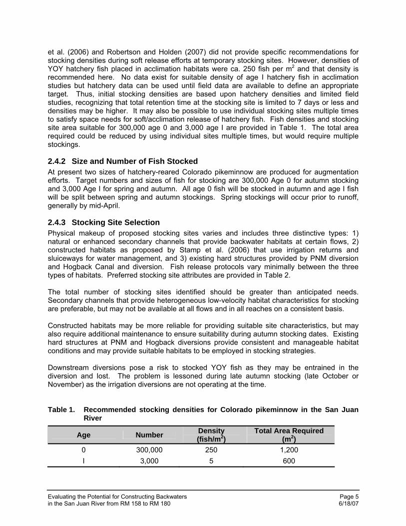
et al. (2006) and Robertson and Holden (2007) did not provide specific recommendations for stocking densities during soft release efforts at temporary stocking sites. However, densities of YOY hatchery fish placed in acclimation habitats were ca. 250 fish per m2 and that density is recommended here. No data exist for suitable density of age I hatchery fish in acclimation studies but hatchery data can be used until field data are available to define an appropriate target. Thus, initial stocking densities are based upon hatchery densities and limited field studies, recognizing that total retention time at the stocking site is limited to 7 days or less and densities may be higher. It may also be possible to use individual stocking sites multiple times to satisfy space needs for soft/acclimation release of hatchery fish. Fish densities and stocking site area suitable for 300,000 age 0 and 3,000 age I are provided in Table 1. The total area required could be reduced by using individual sites multiple times, but would require multiple stockings.
2.4.2 Size and Number of Fish Stocked At present two sizes of hatchery-reared Colorado pikeminnow are produced for augmentation efforts. Target numbers and sizes of fish for stocking are 300,000 Age 0 for autumn stocking and 3,000 Age I for spring and autumn. All age 0 fish will be stocked in autumn and age I fish will be split between spring and autumn stockings. Spring stockings will occur prior to runoff, generally by mid-April.
2.4.3 Stocking Site Selection Physical makeup of proposed stocking sites varies and includes three distinctive types: 1) natural or enhanced secondary channels that provide backwater habitats at certain flows, 2) constructed habitats as proposed by Stamp et al. (2006) that use irrigation returns and sluiceways for water management, and 3) existing hard structures provided by PNM diversion and Hogback Canal and diversion. Fish release protocols vary minimally between the three types of habitats. Preferred stocking site attributes are provided in Table 2. The total number of stocking sites identified should be greater than anticipated needs. Secondary channels that provide heterogeneous low-velocity habitat characteristics for stocking are preferable, but may not be available at all flows and in all reaches on a consistent basis. Constructed habitats may be more reliable for providing suitable site characteristics, but may also require additional maintenance to ensure suitability during autumn stocking dates. Existing hard structures at PNM and Hogback diversions provide consistent and manageable habitat conditions and may provide suitable habitats to be employed in stocking strategies. Downstream diversions pose a risk to stocked YOY fish as they may be entrained in the diversion and lost. The problem is lessoned during late autumn stocking (late October or November) as the irrigation diversions are not operating at the time. Table 1. Recommended stocking densities for Colorado pikeminnow in the San Juan
River
Age Number Density (fish/m2)
Total Area Required (m2)
0 300,000 250 1,200 I 3,000 5 600

Evaluating the Potential for Constructing Backwaters Page 6 in the San Juan River from RM 158 to RM 180 6/18/07
Table 2. Preferred stocking site attributes for hatchery-reared Colorado pikeminnow
Attribute Condition Water supply River or canal (no low-quality drain water)
Maximum water temperature 25 o C Maximum salinity 2 ppt
Site dimensions ≤ 15 m wide, ≤ 150 m long (to facilitate pre-stocking predator removal and channel blocking)
Depth 0.25 – 1.0 m Current velocity ≤ 0.1 m/s
Substrate silt, sand, gravel or cobble (variety best to support food base for retention > 2 days)
Cover Undercut bank, submerged woody debris or other suitable forms of constructed cover
Fish access to river Continual or with infrequent excavation Stocking access Direct by hatchery truck, indirect by raft
Public disturbance None to low Distance upstream of diversions Minimum 2 river miles
Multiple sites available in close proximity 2-3 alternative sites preferred or as required to meet the maximum stocking density
2.4.4 Pre-Release Sampling at Release Site Prior to release of hatchery fish, sampling at the release site will be conducted to characterize resident fishes and remove potential predators. Sampling will be by seine and/or backpack electrofisher. Nonnative species will be removed and sacrificed. Native species will be relocated to adjacent river habitat.
2.4.5 Release Protocol Access to stocking sites will be primarily by transport truck, but may also include use of rafts if suitable stocking sites are located in areas where there is no vehicle access. One day prior to transport and stocking, stocking site water temperature at estimated time of stocking will be recorded and relayed to the hatchery. The hatchery will ensure transport water, at time of arrival at stocking site, approximates receiving water temperature. If water temperature varies by 3°C or more, tempering will occur prior to release of fish and will allow adequate time for acclimatization. Fish will be netted from hauling tanks and transferred to stocking site via water-filled buckets. If rafts are used, live wells that are supplied with oxygen via diffuser stone will be available for fish transport. Care will be taken to avoid super-saturation of hauling water and target dissolved oxygen concentration of 6-8 mg/l will be maintained and not exceeded. Tempering of raft-mounted hauling tank water may be necessary and follow the same procedures as identified above.
2.4.6 Retention Time Various retention times have been discussed for use in Colorado pikeminnow hatchery stockings with a soft release component. Golden et al. (2006) and Robertson and Holden (2007) recommended acclimation for 7 days prior to release, although shorter times were not investigated. No data were reported for shorter duration acclimation periods. Length of retention time should be based upon recovery from stress related to handling and also on allowance for acclimation to the stocking environment. From a practical standpoint, shorter

Evaluating the Potential for Constructing Backwaters Page 7 in the San Juan River from RM 158 to RM 180 6/18/07
retention times allow for use of the same stocking site multiple times (if habitats are limited) and minimizes length of time fish are crowded together and susceptible to pathogens, predation and human disturbance or mischief. Longer retention time allows for additional acclimation of hatchery fish to the stocking site prior to immigration to main channel habitats. Important to maximizing survival of hatchery fish stressed by hauling and handling is stabilization of blood chemistry resulting from stress response, which generally occurs within 24 hours (Barton 2002, Barton et al. 2003). Future stockings of hatchery-reared Colorado pikeminnow should include evaluating a range of options for retention time, depending upon stocking site attributes. In general, sites either constructed for use as stocking sites, or potentially already available, e.g. sluiceway at RM 178 and PNM structures, may provide for controlled retention up to 7 days. Use of main and secondary channel habitats may require shortened acclimation periods to address increased risk relative to flow changes and associated loss of habitat. In all cases acclimation habitats will be monitored on a daily basis until fish are released to ensure quick response to potential loss of habitats. Recapture data for stocked Colorado pikeminnow will be used to assess post-stocking performance for varying acclimation periods and assist with refinement of stocking procedures.
2.4.7 Current Conditioning Golden et al. (2006) proposed use of exercise (i.e. current conditioning) as a means to improve survival and retention of stocked Colorado pikeminnow. Use of a short (< 150 m) reach of secondary channel that includes a variety of habitat conditions and flow velocities may be employed where low-velocity habitats provide for initial fish placement and resting habitats, and run and riffle habitats provide current conditioning. This method was used during 18-19 April 2007 to acclimate and successfully release 1,590 Age I Colorado pikeminnow at RM 134.9. Also, existing structures at PNM diversion may provide opportunities to acclimate hatchery fish to current. Identified sites will be evaluated for capability to provide current conditioning.
3.0 METHODS A three-step process was used to identify and evaluate potential sites for constructed backwaters. Restoration areas identified in 2005 (Stamp, et. al. 2006) and other sites were screened using aerial photography and preliminary field checks for accessibility. The sites selected from the screening were then evaluated in the field. Based on field data, the sites were evaluated against selection criteria to meet the goals of the study.
3.1 Initial Screening The 39 potential restoration sites identified in 2005 (Stamp, et. al. 2006) formed the foundation of the selection process. Of the four types of restoration, only those labeled as irrigation return enhancement were selected for further study. These were screened to meet the following criteria:
• Capable of providing a stable site over a range of flows from 500 to 1,500 cfs • Have an external, controllable water source for flushing to reduce the need for
mechanical cleaning • Be accessible to stocking trucks • Have reasonable probability of land-owner permission for construction
To these sites were added locations that had good water supply and locations where backwaters could be physically constructed with the main purpose of providing stocking locations.
Evaluating the Potential for Constructing Backwaters Page 8 in the San Juan River from RM 158 to RM 180 6/18/07
3.2 Field Investigation On March 26-27, 2007 the following team members visited each site:
• Melissa Stamp – Bio-West, Inc. • Ron Bliesner & Mike Isaacson – Keller-Bliesner Engineering, LLC • Mark McKinstry, USBR, Salt Lake City (second day only) • Brent Mefford, USBR, Denver • Mark Wernke, USBR, Grand Junction • Jim Brooks and Anne Davis, USFWS, Albuquerque
An initial evaluation was made as to the suitability of the site. If limitations were identified that would preclude use of the site, it was removed from further consideration. For each site that was not rejected, a location for backwater construction was selected, the water source and requirements to control it identified and the key elevations necessary to categorize construction cost were obtained. A field data sheet (See Appendix A) was completed for each site, detailing the key information needed at the site to complete its evaluation. While investigating the pre-identified sites, three other locations were found that could provide opportunity for fish stocking, but were not backwaters. These sites were the sluiceway for the PNM pump station, the PNM fish passage channel and the Hogback canal fish screen section above the main sluiceway. Field data sheets are also included for these locations.
3.3 Site Evaluation Using the data recorded on field sheets, photographs taken in the field, aerial photo interpretation, and fish stocking criteria, site suitability was assessed. While detailed cost estimates were not completed, sufficient information was developed to determine the practical size of backwater area and the cost-range (high, medium or low). Table 3 lists the criteria used for evaluation. Meeting the primary objective (provide stocking location) carried the greatest weight. The degree to which the secondary objective (provide backwater habitat) was met served as a tie-breaker for equally ranked sites. The rating criteria for most categories are qualitative. For example, actual construction costs were not estimated, but sites were evaluated on the basis of their relative expected cost. Some expected elements may not be included in the ranking if they are handled in the stocking plan. For example, one of the conditions for stocking is pre-sampling and removal of predators. Since the block nets prevent reintroduction during stocking, presence or absence of predators at a site was not an evaluation criterion. Following the completion of the criteria evaluation, the sites were ranked as recommended sites that best meet the criteria for the least cost. Some rank high, but still have unanswered questions for implementation. These concerns were noted in each case.

Evaluating the Potential for Constructing Backwaters Page 9 in the San Juan River from RM 158 to RM 180 6/18/07
Table 3. Final site evaluation criteria for constructed backwaters on the San Juan River.
Criteria Description
Suitability for conditioning stocked fish (excellent, good, fair, poor)
Summary criteria that integrates other categories to assess relative performance toward primary goal excluding cost. Must meet all the stocking criteria to rank “excellent”, including a range of conditioning habitats (with and w/o velocity). A rank of “good” meets all conditions except a range of conditioning habitats.
Suitability as backwater habitat(good, fair, poor, no)
Summary criteria that integrates other categories to assess relative performance toward secondary goal excluding cost. The ranking indicates increasing limitations.
Landowner permission: (yes, no, uncertain)
Permission indicator for both constructed site and access. Only establishes that land owner is willing to consider site on their property or allow access to the site. Terms to be determined later.
Distance above diversion - mi.
Used in conjunction with stocking criteria for evaluation. Not only is the distance critical but the type of diversion. Intermittent pumped diversions have less impact than continuous diversions. Those that cease operation prior to stocking have less impact than those operating year-round
Heavy equipment access: (good, moderate, poor, none) Has bearing on constructability and cost.
Irrigation return flow volume during spring snowmelt period: (high, moderate, low)
Indicates flow availability during spring runoff for prevention of sedimentation. “High” means adequate to maintain the site, “medium” - that it would be adequate for some flushing, “low” - it would just be adequate to maintain a connection to the river.
Irrigation return flow volume during fall pre-stocking period: (high, moderate, low)
Indicates flow availability prior to stocking for backwater flushing and introducing current in the reach for conditioning
Size of potential constructed backwater(s): (large, medium, small, with typical size – m2)
Category assigned in the field and refined in evaluation when typical size is computed
Cost/engineering to connect to the source of irrigation return flow (high, moderate, low)
General cost range based on complexity of plumbing and length of ditch or pipeline. Qualitative assessment without specific cost estimates completed.
Access for fish stocking, monitoring, maintenance: (very convenient, convenient, not convenient)
Ranking depending on the amount of effort needed to get a stocking truck to the site. If land-owner permission has been given, property ownership did not lower the rank, although it is noted that an access agreement would be required.
Risk of river deposits filling in mouth of constructed backwater: (high, moderate, low)
Indicates the hydraulics of the connection to the river as well as the ability to flush the backwater
Risk of water quality problems in backwater: (high, moderate, low, none)
A general assessment of the quality of water sources and the need for additional information
Relative initial excavation cost: (high, moderate, low) Based on excavation volume and tree removal requirement
Risk of natural arroyo deposits filling in constructed backwater: (high, moderate, low, none)
Assesses risk to backwater area loss from uncontrolled runoff from natural drainages entering the backwater
Anticipated need for physical maintenance / dredging of sedi-ment buildup (high, moderate, low)
An integrator of the several elements that contribute to sedimentation and/or lack of a flushing mechanism
Evaluating the Potential for Constructing Backwaters Page 10 in the San Juan River from RM 158 to RM 180 6/18/07
The final recommendations characterize the sites according to the following descriptions relative to the function they provide and the mechanism of their formation:
• Natural backwater or secondary channel sites, either previously used or that may have potential for use. For this category, not all sites will be available each year. Sites would be identified using recent habitat mapping, but prior to each stocking season, surveys would be likely be required to identify available sites since they are not permanent, but can be created or destroyed during intervening spring runoff. Ideally a list of potential sites that have been historically available at different flows could be generated to aid in the selection of suitable sites.
• Existing structural sites that may have an alternate use for fish stocking with only minor operational changes or maintenance requirements.
• Potential constructed sites with connections to canal water for flushing. • Sites that can be reactivated with vegetation removal or secondary channel modification.
4.0 RESULTS
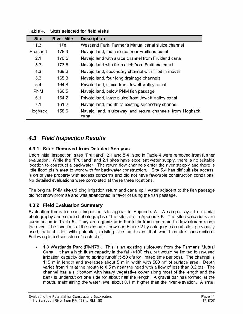
4.1 Sites Selected for Evaluation in Pre-screening The criteria discussed in Section 3.1 were applied in the initial screening with 11 locations selected for field visits as shown in Table 4. The site numbers correspond to the 2005 study (Stamp, et. al. 2006) or are unique identifiers for sites added that were not included in the 2005 study. Eight of the 11 sites were selected from the previously identified locations. The remaining three sites were added because of availability of a good water supply for flushing, recognizing that major construction may be required.
4.2 Sites Added During Field Inspection While visiting the PNM site it was noted that the existing fish passage could serve as an excellent acclimation site, providing both pool and riffle habitat. Since the stocking period is short, the passage could be netted off at the bottom and used for stocking, provided flow depth is adequate at sufficiently low velocities through the channel to accommodate stocking. Across the river from the fish passage, the sluiceway for the PNM pumping plant becomes a large backwater when the channel is not flushing. Access permission was obtained and that site was also evaluated as a stocking site. When inspecting the Hogback site for possible backwater construction or modification of existing sluiceways, it was noted that a fish screen is planned for installation between the canal inlet gate and the downstream control gate and sluiceway. During fall canal shutdown, this area could be used to stock fish, with the fish being returned to the river through the fish screen return channel. This would require only an operational change at the facility. While the fish screen and return channel will not be available until 2009 or 2010, the site could be used in its present configuration with just operational changes, allowing the fish to return through the existing sluice channel if it was opened widely to prevent high velocities through a small gate opening.
Evaluating the Potential for Constructing Backwaters Page 11 in the San Juan River from RM 158 to RM 180 6/18/07
Table 4. Sites selected for field visits
Site River Mile Description 1.3 178 Westland Park, Farmer’s Mutual canal sluice channel
Fruitland 176.9 Navajo land, main sluice from Fruitland canal 2.1 176.5 Navajo land with sluice channel from Fruitland canal 3.3 173.6 Navajo land with farm ditch from Fruitland canal 4.3 169.2 Navajo land, secondary channel with filled in mouth 5.3 165.3 Navajo land, four long drainage channels 5.4 164.8 Private land, sluice from Jewett Valley canal
PNM 166.5 Navajo land, below PNM fish passage 6.1 164.2 Private land, large sluice from Jewett Valley canal 7.1 161.2 Navajo land, mouth of existing secondary channel
Hogback 158.6 Navajo land, sluiceway and return channels from Hogback canal
4.3 Field Inspection Results
4.3.1 Sites Removed from Detailed Analysis Upon initial inspection, sites “Fruitland”, 2.1 and 5.4 listed in Table 4 were removed from further evaluation. While the “Fruitland” and 2.1 sites have excellent water supply, there is no suitable location to construct a backwater. The return flow channels enter the river steeply and there is little flood plain area to work with for backwater construction. Site 5.4 has difficult site access, is on private property with access concerns and did not have favorable construction conditions. No detailed evaluations were completed at these three locations. The original PNM site utilizing irrigation return and canal spill water adjacent to the fish passage did not show promise and was abandoned in favor of using the fish passage.
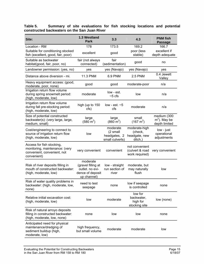
4.3.2 Field Evaluation Summary Evaluation forms for each inspected site appear in Appendix A. A sample layout on aerial photography and selected photographs of the sites are in Appendix B. The site evaluations are summarized in Table 5. They are organized in the table from upstream to downstream along the river. The locations of the sites are shown on Figure 2 by category (natural sites previously used, natural sites with potential, existing sites and sites that would require construction). Following is a discussion of each site:
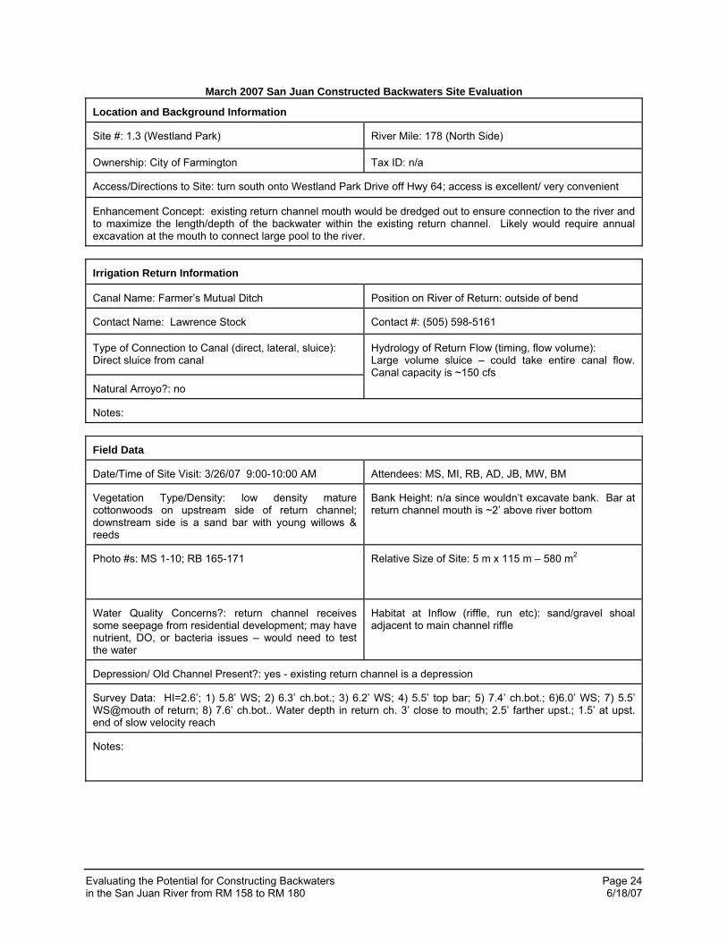
• 1.3 Westlands Park (RM178). This is an existing sluiceway from the Farmer’s Mutual Canal. It has a high flush capacity in the fall (>100 cfs), but would be limited to un-used irrigation capacity during spring runoff (5-50 cfs for limited time periods). The channel is 115 m in length and averages about 5 m in width with 580 m2 of surface area. Depth varies from 1 m at the mouth to 0.5 m near the head with a flow of less than 0.2 cfs. The channel has a silt bottom with heavy vegetative cover along most of the length and the bank is undercut on one side for about half the length. A gravel bar has formed at the mouth, maintaining the water level about 0.1 m higher than the river elevation. A small
Evaluating the Potential for Constructing Backwaters Page 12 in the San Juan River from RM 158 to RM 180 6/18/07
amount of excavation will be required to fully connect the sluiceway to the river, which will lower the water surface elevation in the sluiceway by about 0.1 m. The connection to the river may require maintenance annually, but it will be minor. The channel receives seepage water and should be checked for nutrients and bacteria. The site can be maintained with near zero velocity or with increased velocity with some release from the canal if desirable for conditioning. The site is located in a city park and near a housing subdivision, which could increase the potential for human disturbance during acclimation.
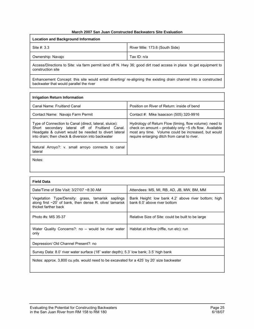
• 3.3 (RM 173.5). A lateral ditch from the Fruitland canal enters the river here. The ditch has a capacity of only about 5.0 cfs, limiting the flush volume. The backwater would be constructed downstream of the ditch, with a check in the ditch and headgate to the backwater for water control. The backwater would connect to the river along a straight run. Sand deposit on the river bank indicates the potential for deposition in the backwater mouth during high flow. Experience with similar return flow entrances indicates that the flush volume will be adequate to maintain a connection to the river, but will not prevent the development of a sand bar in the mouth of the backwater that may need periodic removal. The constructed backwater could be up to 130 m in length and 6.5 meters in width with a surface area of 860 m2. The bottom would initially be cobble, but would cover with silt in a short period of time. Access for heavy equipment is good. Stocking access is listed as convenient, although permission is required from local land-owner. Water quality is good.
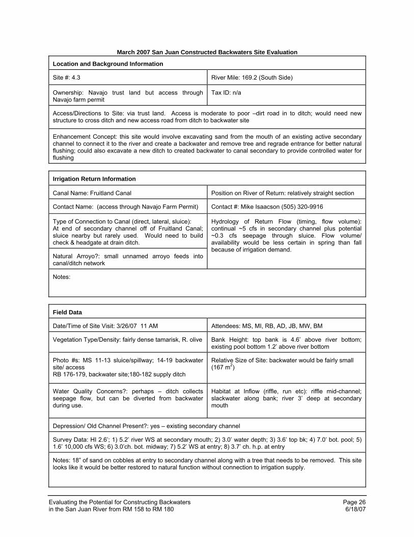
• 4.3 (RM 169.2). This is the mouth of an existing short secondary channel that fills with sand. There is a Russian olive tree lodged in the inlet to the secondary channel with about 18-inches of sand over cobble. The site has poor access across wet pasture, requiring road construction. A long ditch would be required to route flushing water from an existing ditch with capacity limited to less than 5 cfs. A preferred solution at this site would be to activate the secondary channel at lower flow by cleaning the inlet and allow the increased flow to scour the mouth. This would provide a more natural backwater, but would not meet the primary goal since it could be intermittent, depending on flushing flows in the river.
• PNM Fish Passage (RM 166.7). The PNM fish passage consists of a series pools and riffles of sufficiently low velocity to allow passage by native fish. The structure could be blocked with a net at the mouth and used as a stocking site by regulating flows to provide low velocity locations. The advantage of the site is that it could provide a range of habitats suitable for conditioning fish for river conditions. It is about 120 m long and 5 m wide. Only about ½ the gross area is pool area suitable for the stocking density target, therefore the net area is estimated to be 300 m2. While this site has good potential, some tests are recommended prior to stocking. A range of flows should be tested to characterize velocities and depths and potential operating scenarios. The flow rate will also be critical to the ability to maintain a block net at the mouth as debris accumulates in direct proportion to flow rate. Block net testing should accompany the flow rate testing. Bird predation could be a problem if depths are shallow. It is immediately upstream of the Jewett Valley canal diversion which is on the opposite site of the river. During autumn stocking, the canal will not be diverting water. However, if the intake gate is open, the canal could provide habitat for predators upstream of the sluice and impact survival if stocked fish that may enter the canal.
• PNM Pumping Plant Sluiceway (RM 166.6). The PNM pumping plant sluiceway connects to the river opposite the fish passage. It is flushed about every two weeks. When it is not being operated, a large backwater forms in the rectangular concrete flume. The flume is about 6 m wide and 46 m long for a surface area of 280 m2. At a
Evaluating the Potential for Constructing Backwaters Page 13 in the San Juan River from RM 158 to RM 180 6/18/07
river flow of 1,380 cfs it had a depth of about 0.6 m. It has near zero velocity normally, but conditioning velocity could be introduced by opening the sluiceway. The connection to the river is into a small slackwater and then a run. Concrete crossbeams at the top of the flume would discourage bird predation. PNM seems amenable to cooperating in using this site for fish stocking, but a more formal agreement would be required. The site is very secure. It is immediately upstream of the Jewett Valley canal diversion with the limitations noted for the PNM fish passage. It has the additional disadvantage of being on the same side of the river as the Jewett Valley canal. Stocking during non-irrigation times would limit the potential impact of the diversion.
• 5.3 (RM 165.1-165.4). There are four possible backwater sites at this location that could be constructed in old drainage channels. One of these channels (#3) has recently been cleaned, but the elevation of the lower end is too high to form a backwater. An interceptor ditch with checks and headgates would be required to control drain water and route flushing water to these sites. These locations could provide large constructed backwaters (up to 4,000 m2 for all four channels with channel lengths up to 160 m and widths of 6 m), but are limited in flush water capacity and would require periodic cleaning at the mouths. Channel #1 (furthest west) is readily accessible using existing roads, but road construction would be required for the others. These would be moderately high cost sites and would have moderate maintenance requirements. While there is adequate water to maintain an opening to the river, there is insufficient flush water capacity to prevent or flush deposition in the mouths. Such deposition will reduce capacity over time and reduce the effectiveness as functioning backwaters by limiting the size of the connection channel.
• 6.1 (RM 164.3). This site is located on the north side of the river near the Jewett Valley canal sluice channel on private property. The full flow of the Jewett Valley canal (32 cfs) could be diverted into the channel for flushing. This flow would be available just prior to stocking, but would be reduced by irrigation demand during spring runoff. An abandoned secondary channel could be excavated to form the backwater with connection to the sluiceway for flush water. Due to the steepness of the ditch and the location of the site on private property, this connection should be piped. A 5 m wide by 160 m long backwater would be possible at this site with good flushing flow capacity for reduced maintenance cost. The greatest limitation to this site is its proximity to the Arizona Public Service Company (APS) pumped diversion. However, this is an intermittently operated diversion. Less pumping is required in the late fall stocking time and it may be possible to coordinate operation with APS to limit impact to stocked fish. Access is through private land, requiring an agreement for long-term access.
• 7.1 (RM 171.2). This site is in the mouth of an active secondary channel. Presently the channel elevation is too high to form a backwater and has thin silt substrate over cobble. Both spring water and irrigation runoff enter the channel near the mouth. Flushing water could be controlled at this site, but it will not have adequate capacity to do more than maintain channel connection. Vegetation removal and lowering of the secondary channel inlet, along with deepening of the mouth could produce a large, naturally maintained backwater at this location. There is less certainty of availability at this site since it would be dependent upon flushing flows in the river. If restoration of natural function is desired, this site may have potential. A risk assessment would be required to assure that modification of the secondary channel would not increase the potential for damage to adjacent property. It’s proximity to the Hogback diversion should be considered. Activation and use as a stocking site prior to completion of the fish screen could lead to loss of stocked fish.
Evaluating the Potential for Constructing Backwaters Page 14 in the San Juan River from RM 158 to RM 180 6/18/07
• Hogback (RM 158.5). Use of the existing sluiceways and the area below the fish passage were examined and rejected for this site. However, a fish screen is presently being designed in the upper reach of the canal between the inlet gates and the first sluiceway. When completed, this site will have a controlled fish return channel. During late autumn stocking the area in the canal between the control gates and the fish screen could be isolated and used as a stocking site. The site is very large (>4,000 m2) and is located below the last diversion on the river. Because of its size and non-natural connection to the river, it may be necessary to “herd” the fish out of the stocking site to the river when acclimation is completed. Operationally, the autumn stocking typically falls after irrigation is completed, allowing control of the site for stocking. Coordination with the Hogback irrigators would be required, but should not be difficult. This site also has potential for stocking before the installation of the fish screen. Coordination with the San Juan Dineh Water users will be required and the operation of the sluice channel evaluated to assure the stocked fish can be returned to the channel safely.
• Natural backwater or secondary channel sites. Figure 2 shows the two sites that were used in 2005 for the conditioning tests. They are both in secondary channels that were just trickling at the time of stocking. At lower flow they could be dry and at higher flow they could have excessive velocities. The upper site (RM 175.8) is large (up to 3,000 m2 at ideal flows) while the lower site (RM 167.5) is small (<200 m2). There are at least three other possible sites, depending on flow as shown on Figure 2. Two additional secondary channel sites (RM 173.6 and RM 170.9) not shown on Figure 2 have potential under some flow conditions but are sensitive to loss with flow change and have limited pool areas. In any given year the availability of sites will depend on channel change from the spring runoff, siltation from storm events and flow at mapping. Two more sites are available between APS and Hogback diversions, but they are difficult to access and are not shown on Figure 2. Based on past conditions, it is unlikely that there would be more than 2 sites available in any given year.
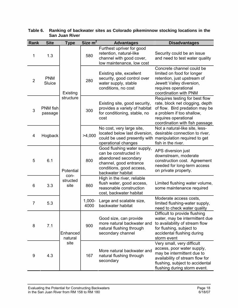
4.4 Site Ranking Table 6 ranks the sites for meeting the primary objective of providing Colorado pikeminnow stocking locations. The top four sites provide no additional backwater habitat toward the second objective of increasing the abundance of backwater habitats available for use by YOY endangered fish. The sites that provide the best backwater habitat potential are 6.1, 7.1 and 4.3. Sites 7.1 and 4.3 are not recommended permanent stocking sites, but would provide good tests for restoring natural river function to locations that could be naturally maintained and would be available in the category of “natural” stocking sites. Site 6.1 has the best possibility of meeting both goals.
Evaluating the Potential for Constructing Backwaters Page 15 in the San Juan River from RM 158 to RM 180 6/18/07
Table 5. Summary of site evaluations for fish stocking locations and potential constructed backwaters on the San Juan River
Site: 1.3 Westland Park 3.3 4.3 PNM fish
Passage Location - RM 178 173.5 169.2 166.7 Suitable for conditioning stocked fish (excellent, good, fair, poor) excellent good poor (less
stable) excellent if
depth adequate Suitable as backwater habitat(good, fair, poor, no)
fair (not always connected)
fair (sedimentation) good no
Landowner permission: (yes, no) yes yes (Navajo) yes (Navajo) yes
Distance above diversion - mi. 11.3 PNM 6.9 PNM 2.5 PNM 0.4 Jewett Valley
Heavy equipment access: (good, moderate, poor, none) good good moderate-poor n/a
Irrigation return flow volume during spring snowmelt period: (high, moderate, low)
moderate low - est. ~5 cfs low n/a
Irrigation return flow volume during fall pre-stocking period: (high, moderate, low)
high (up to 150 cfs)
low - est. ~5 cfs moderate n/a
Size of potential constructed backwater(s): (very large, large, medium, small)
large (580 m2)
large (860 m2)
small (167 m2)
medium (300 m2). May be depth limited
Cost/engineering to connect to source of irrigation return flow (high, moderate, low)
low
moderate (2 small
headgates, 2 small culverts)
moderate-high (check,
headgate, new ditch,)
low - just operational adjustments
Access for fish stocking, monitoring, maintenance: (very convenient, convenient, not convenient)
very convenient convenient not convenient (culvert & road work required)
very convenient
Risk of river deposits filling in mouth of constructed backwater: (high, moderate, low)
moderate (gravel filling at outlet. no evi-
dence of deposit up channel)
low - straight run section of
river
moderate, but may naturally
flush low
Risk of water quality problems in backwater: (high, moderate, low, none)
need to test seepage none low if seepage
is controlled none
Relative initial excavation cost: (high, moderate, low) low moderate
low for backwater,
high for stocking site
low (none)
Risk of natural arroyo deposits filling in constructed backwater: (high, moderate, low, none)
none low low none
Anticipated need for physical maintenance/dredging of sediment buildup (high, moderate, low)
high frequency, but small volume moderate moderate low
Evaluating the Potential for Constructing Backwaters Page 16 in the San Juan River from RM 158 to RM 180 6/18/07
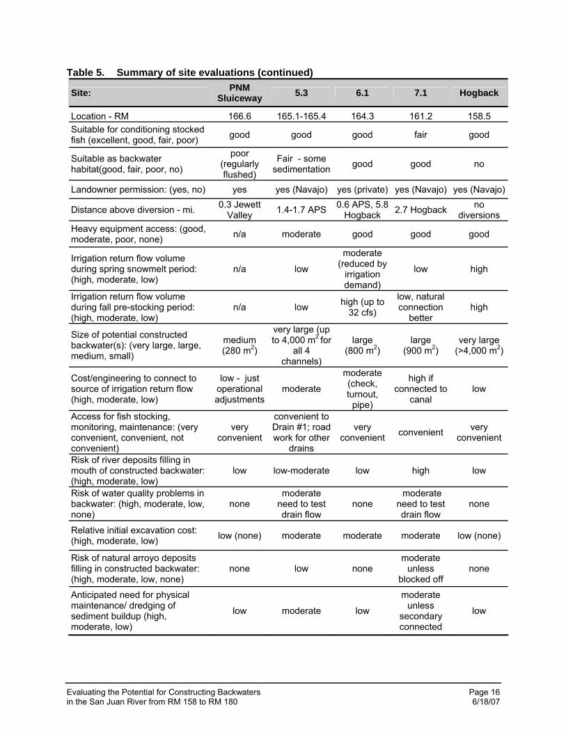
Table 5. Summary of site evaluations (continued)
Site: PNM Sluiceway 5.3 6.1 7.1 Hogback
Location - RM 166.6 165.1-165.4 164.3 161.2 158.5 Suitable for conditioning stocked fish (excellent, good, fair, poor) good good good fair good
Suitable as backwater habitat(good, fair, poor, no)
poor (regularly flushed)
Fair - some sedimentation good good no
Landowner permission: (yes, no) yes yes (Navajo) yes (private) yes (Navajo) yes (Navajo)
Distance above diversion - mi. 0.3 Jewett Valley 1.4-1.7 APS 0.6 APS, 5.8
Hogback 2.7 Hogback no diversions
Heavy equipment access: (good, moderate, poor, none) n/a moderate good good good
Irrigation return flow volume during spring snowmelt period: (high, moderate, low)
n/a low
moderate (reduced by
irrigation demand)
low high
Irrigation return flow volume during fall pre-stocking period: (high, moderate, low)
n/a low high (up to 32 cfs)
low, natural connection
better high
Size of potential constructed backwater(s): (very large, large, medium, small)
medium (280 m2)
very large (up to 4,000 m2 for
all 4 channels)
large (800 m2)
large (900 m2)
very large (>4,000 m2)
Cost/engineering to connect to source of irrigation return flow (high, moderate, low)
low - just operational adjustments
moderate
moderate (check, turnout,
pipe)
high if connected to
canal low
Access for fish stocking, monitoring, maintenance: (very convenient, convenient, not convenient)
very convenient
convenient to Drain #1; road work for other
drains
very convenient convenient very
convenient
Risk of river deposits filling in mouth of constructed backwater: (high, moderate, low)
low low-moderate low high low
Risk of water quality problems in backwater: (high, moderate, low, none)
none moderate
need to test drain flow
none moderate
need to test drain flow
none
Relative initial excavation cost: (high, moderate, low) low (none) moderate moderate moderate low (none)
Risk of natural arroyo deposits filling in constructed backwater: (high, moderate, low, none)
none low none moderate
unless blocked off
none
Anticipated need for physical maintenance/ dredging of sediment buildup (high, moderate, low)
low moderate low
moderate unless
secondary connected
low

Evaluating the Potential for Constructing Backwaters Page 17 in the San Juan River from RM 158 to RM 180 6/18/07
Figure 2. Potential Colorado pikeminnow stocking sites in the San Juan River between RM 157 and 178 by type
Evaluating the Potential for Constructing Backwaters Page 18 in the San Juan River from RM 158 to RM 180 6/18/07
Table 6. Ranking of backwater sites as Colorado pikeminnow stocking locations in the San Juan River
Rank Site Type Size m2 Advantages Disadvantages
1 1.3 580
Furthest upriver for good retention, natural-like channel with good cover, low maintenance, low cost
Security could be an issue and need to test water quality
2 PNM Sluice 280
Existing site, excellent security, good control over water supply, stable conditions, no cost
Concrete channel could be limited on food for longer retention, just upstream of Jewett Valley diversion, requires operational coordination with PNM
3 PNM fish passage 300
Existing site, good security, provides a variety of habitat for conditioning, stable, no cost
Requires testing for best flow rate, block net clogging, depth of flow. Bird predation may be a problem if too shallow, requires operational coordination with fish passage
4 Hogback
Existing structure
>4,000
No cost, very large site, located below last diversion, could be used presently with operational changes
Not a natural-like site, less-desirable connection to river, manipulation required to get fish in the river.
5 6.1 800
Good flushing water supply, can be constructed in abandoned secondary channel, good entrance conditions, good access, backwater habitat
APS diversion just downstream, moderate construction cost. Agreement needed for long-term access on private property.
6 3.3 860
High in the river, reliable flush water, good access, reasonable construction cost, backwater habitat
Limited flushing water volume, some maintenance required
7 5.3
Potential con-
structed site
1,000-4000
Large and scalable size, backwater habitat
Moderate access costs, limited flushing-water supply, need to check water quality
8 7.1 900
Good size, can provide more natural backwater and natural flushing through secondary channel
Difficult to provide flushing water, may be intermittent due to availability of stream flow for flushing, subject to accidental flushing during storm event
9 4.3
Enhanced natural
site
167 More natural backwater and natural flushing through secondary
Very small, very difficult access, poor water supply, may be intermittent due to availability of stream flow for flushing, subject to accidental flushing during storm event.

Evaluating the Potential for Constructing Backwaters Page 19 in the San Juan River from RM 158 to RM 180 6/18/07
5.0 CONCLUSIONS AND RECOMMENDATIONS Having reviewed the Colorado pikeminnow stocking recommendations and the site evaluations, we conclude that constructing backwaters to meet stocking requirements is feasible. However, there are a number of existing sites that will provide stocking sites at little or no cost, and they should have priority over newly constructed sites. The priority objective of this effort was to identify appropriate measures to ensure adequate habitat for soft release and acclimation of hatchery fish and such sites may satisfy that objective. The secondary objective of increasing low velocity habitats in the San Juan River upstream of Hogback diversion could be addressed through construction of backwaters at 6.1, 7.1, and 4.3. Constructing the site at 6.1 would meet both objectives.
5.1 Specific Recommendations Following are our specific recommendations:
1. It is recommended that stocking of Colorado Pikeminnow occur within natural habitats, if available. A list of sites available at a range of flows from 500 to 2,000 cfs should be developed and revised annually to guide such stockings. This would involve annual surveys of the reach from Fruitland diversion downstream to RM 134 to identify potential stocking sites. These surveys would be conducted by road access and raft. At least three locations, with a total surface area of 1,200 m2 or more should be identified as primary sites with at least 2 alternate sites that might be available if flows change. To support the present stocking plan, sufficient area (>600 m2) should be available both above and below the Hogback diversion to stock 150,000 YOY Colorado pikeminnow in each sub-reach for a total of 300,000. However, until the fish screen at Hogback is completed, consideration should be given to increasing stocking numbers below Hogback diversion and decreasing numbers above. For the 3,000 Age I fish, there is more flexibility in stocking site selection since spring and autumn stockings are feasible and habitat use is more dynamic. For Age I fish, equal numbers should be stocked up- and downstream of Hogback diversion. The habitats should meet the conditions listed in Table 2. If habitats cannot be found, are too small, or appear to be subject to disappearance with small change in flow, then the next highest priority sites identified in Recommendation 2 should be used.
2. Since natural habitats may not be available, up to 1,200 m2 of additional habitats should
be made available as a fallback. This area may be reduced if individual sites can be used multiple times. It is recommended that sites 1-5 in Table 6 be considered to meet this requirement. The total area is considerably greater than the minimum requirement, but some of these sites may not be suitable when evaluation is completed. Four of these recommended sites are existing sites with little or no construction requirement. Only site 6.1 is a constructed site and it alone will meet the second objective. It is recommended that site 6.1 be developed as it would be the only multiple-use site. However, it should only be considered if a long-term access agreement with the land owner can be obtained and the potential for loss of stocked fish from operation of the PNM pumped diversion is not found to be a significant deterrent.
3. If the second objective is considered important and there is a desire to increase natural
backwaters in this reach, it is recommended that site 7.1 be developed and then be included in the possible sites under Recommendation 1. Evaluation of its performance
Evaluating the Potential for Constructing Backwaters Page 20 in the San Juan River from RM 158 to RM 180 6/18/07
with time could provide valuable information on the viability of reactivating or modifying secondary channels to create backwater habitats throughout the river.
5.2 Additional Information Needs Implementation of the recommendations will require that the following information be gathered before final site selection can be made:
• Water quality sampling at Sites 1.3, 3.3 and 5.3 • Operational testing at the PNM fish passage to determine appropriate flow rate for
desired depth and velocity and to test the impact of flow on block netting • Review of Hogback screening design to assure adequate fish return facilities and
evaluation of the return channel gate control for use prior to completion of the screens • Detailed assessment of available natural sites relative to flow downstream of Fruitland
diversion
5.3 Additional Opportunities for Backwater Habitat Creation by Augmenting Natural Processes
While the recommendations include one site that incorporates enhancement of natural processes to create backwater habitat, the field analysis did not focus on this process. We primarily considered backwater creation or use of permanent sites. If backwater habitat creation for improved retention of YOY endangered fishes is important, a specific examination of Reach 5 with the objective of implementing the processes recommended in the 2005 report (Stamp, et. al. 2006) should be completed. This is particularly important if availability of backwater and other low velocity habitat is believed to be limiting recovery of endangered fish in the San Juan River. It appears that additional sites in Reach 6 will not be needed for stocking as development of the sites recommended will meet the need. Reach 5 conditions are different in that more secondary channel habitats are available, depending upon flow. Stockings for the portion of fish allocated to the reach downstream of Hogback should be considered downstream to RM 131, the lower boundary for Reach 5, with emphasis on stocking as high in the reach as possible. If fish are stocked in the lower portion of Reach 5, retention compared to that from stocking higher in Reach 5 should be assessed as this is a deviation from the present stocking plan. The potential use of upper Hogback Canal should not be the sole stocking location downstream of Hogback diversion. The April 2007 stocking trip indicated limited natural sites between Hogback and Shiprock, with stocking occurring at RM 134.9. Recommended efforts to thoroughly survey the availability of habitats downstream of Fruitland diversion in Reach 6 and throughout Reach 5 would ensure identification of adequate sites for stocking of Age 0 fish. Selected vegetation removal and secondary channel manipulation could increase the abundance of stocking site availability below Hogback and provide increased backwater habitat for naturally produced YOY endangered fish if the survey indicates limited site availability.
Evaluating the Potential for Constructing Backwaters Page 21 in the San Juan River from RM 158 to RM 180 6/18/07
REFERENCES Barton, B.A. 2002. Stress in fishes: a diversity of responses with particular reference to
changes in circulating corticosteroids. Integ. and Comp. Biol. 42:517-525.
Barton, B.A., A.H. Haukenes, B.G. Parsons, and J.R. Reed. 2003. Plasma cortisol and chloride stress responses in juvenile walleyes during capture, transport and stocking procedures. N. Amer. Journ. Fish. Mgt. 65:210-219.
Bliesner, R. and V. Lamarra. 2006. Hydrology, geomorphology and habitat studies, 2005 Final. Prepared by Keller-Bliesner Engineering, LLC, for the San Juan River Basin Recovery Implementation Program, U.S. Fish and Wildlife Service, Albuquerque, NM.
Bliesner, R. and V. Lamarra. 2000. Hydrology, Geomorphology and Habitat 1991-1998 Final
Report. Prepared by Keller-Bliesner Engineering, LLC, for the San Juan River Basin Recovery Implementation Program, U.S. Fish and Wildlife Service, Albuquerque
Christ, L. and D.W. Ryden. 2003. Genetics Management Plan for the Endangered Fishes of the
San Juan River. San Juan River Basin Recovery Implementation Program, U.S. Fish and Wildlife Service, Albuquerque, NM.
Golden, M. E., P.B. Holden, and B. Albrecht. 2006. Retention, growth, and habitat use of
Colorado pikeminnow stocked as age-0 fish in the San Juan River from 2002-2005: final summary report. Prepared by BIO-WEST, Inc., Logan, UT, for the San Juan River Basin Recovery Implementation Program, U.S. Fish and Wildlife Service, Albuquerque, NM.
Masslich, W. and P. Holden. 1996. Expanding Distribution of Colorado Squawfish in the San
Juan River. Prepared by BIO-WEST, Inc., Logan, UT for the San Juan River Basin Recovery Implementation Program, U.S. Fish and Wildlife Service, Albuquerque, NM.
Paroz, Y., D.L. Propst, S.M. Carman and N. Zymonas. 2006. Small-Bodied Fish Monitoring,
San Juan River 2005 Annual Report. Prepared by New Mexico Department of Game and Fish, Santa Fe, NM for the San Juan River Basin Recovery Implementation Program, U.S. Fish and Wildlife Service, Albuquerque, NM.
Robertson, M. and P. Holden. 2007. Draft Retention, Growth, and Habitat Use of Colorado
Pikeminnow Stocked as Age-0 Fish in the San Juan River 2005-2006 Draft Annual Report. Prepared by BIO-WEST, Inc., Logan, UT for the San Juan River Basin Recovery Implementation Program, U.S. Fish and Wildlife Service, Albuquerque, NM.
Ryden, D.W. 2005. An Augmentation Plan for Colorado Pikeminnow in the San Juan River,
Amended 2005. Prepared by Colorado River Fishery Project, Grand Junction, CO., for the San Juan River Basin Recovery Implementation Program, U.S. Fish and Wildlife Service, Albuquerque, NM.
Ryden, D.W. 2003. An Augmentation Plan for Colorado Pikeminnow in the San Juan River.
Prepared by Colorado River Fishery Project, Grand Junction, CO., for the San Juan River Basin Recovery Implementation Program, U.S. Fish and Wildlife Service, Albuquerque, NM.
Evaluating the Potential for Constructing Backwaters Page 22 in the San Juan River from RM 158 to RM 180 6/18/07
Stamp, M., J. Grams, M. Golden, D. Olsen, T. Allred 2006. Feasibility Evaluation of Restoration
Options to Improve Habitat for Young Colorado Pikeminnow on the San Juan River. Prepared by Bio-West, Logan, UT for the San Juan River Basin Recovery Implementation Plan, U.S. Fish and Wildlife Service, Albuquerque, NM.
Tyus, H.M. and G.B. Haines. 1991. Distribution, habitat use, and growth of age-0
Colorado squawfish in the Green River Basin, Colorado and Utah. Trans. Amer. Fish. Soc. 120:79-89.

Evaluating the Potential for Constructing Backwaters Page 23 in the San Juan River from RM 158 to RM 180 6/18/07
APPENDIX A Evaluation Sheets for Each Site Visited
Evaluating the Potential for Constructing Backwaters Page 24 in the San Juan River from RM 158 to RM 180 6/18/07
March 2007 San Juan Constructed Backwaters Site Evaluation
Location and Background Information
Site #: 1.3 (Westland Park) River Mile: 178 (North Side)
Ownership: City of Farmington Tax ID: n/a
Access/Directions to Site: turn south onto Westland Park Drive off Hwy 64; access is excellent/ very convenient
Enhancement Concept: existing return channel mouth would be dredged out to ensure connection to the river and to maximize the length/depth of the backwater within the existing return channel. Likely would require annual excavation at the mouth to connect large pool to the river.
Irrigation Return Information
Canal Name: Farmer’s Mutual Ditch Position on River of Return: outside of bend
Contact Name: Lawrence Stock Contact #: (505) 598-5161
Type of Connection to Canal (direct, lateral, sluice): Direct sluice from canal
Natural Arroyo?: no
Hydrology of Return Flow (timing, flow volume): Large volume sluice – could take entire canal flow. Canal capacity is ~150 cfs
Notes:
Field Data
Date/Time of Site Visit: 3/26/07 9:00-10:00 AM Attendees: MS, MI, RB, AD, JB, MW, BM
Vegetation Type/Density: low density mature cottonwoods on upstream side of return channel; downstream side is a sand bar with young willows & reeds
Bank Height: n/a since wouldn’t excavate bank. Bar at return channel mouth is ~2’ above river bottom
Photo #s: MS 1-10; RB 165-171
Relative Size of Site: 5 m x 115 m – 580 m2
Water Quality Concerns?: return channel receives some seepage from residential development; may have nutrient, DO, or bacteria issues – would need to test the water
Habitat at Inflow (riffle, run etc): sand/gravel shoal adjacent to main channel riffle
Depression/ Old Channel Present?: yes - existing return channel is a depression
Survey Data: HI=2.6’; 1) 5.8’ WS; 2) 6.3’ ch.bot.; 3) 6.2’ WS; 4) 5.5’ top bar; 5) 7.4’ ch.bot.; 6)6.0’ WS; 7) 5.5’ WS@mouth of return; 8) 7.6’ ch.bot.. Water depth in return ch. 3’ close to mouth; 2.5’ farther upst.; 1.5’ at upst. end of slow velocity reach
Notes:
Evaluating the Potential for Constructing Backwaters Page 25 in the San Juan River from RM 158 to RM 180 6/18/07
March 2007 San Juan Constructed Backwaters Site Evaluation
Location and Background Information
Site #: 3.3 River Mile: 173.6 (South Side)
Ownership: Navajo Tax ID: n/a
Access/Directions to Site: via farm permit land off N. Hwy 36; good dirt road access in place to get equipment to construction site
Enhancement Concept: this site would entail diverting/ re-aligning the existing drain channel into a constructed backwater that would parallel the river
Irrigation Return Information
Canal Name: Fruitland Canal Position on River of Return: inside of bend
Contact Name: Navajo Farm Permit Contact #: Mike Isaacson (505) 320-9916
Type of Connection to Canal (direct, lateral, sluice): Short secondary lateral off of Fruitland Canal. Headgate & culvert would be needed to divert lateral into drain; then check & diversion into backwater
Natural Arroyo?: v. small arroyo connects to canal lateral
Hydrology of Return Flow (timing, flow volume): need to check on amount – probably only ~5 cfs flow. Available most any time. Volume could be increased, but would require enlarging ditch from canal to river.
Notes:
Field Data
Date/Time of Site Visit: 3/27/07 ~8:30 AM Attendees: MS, MI, RB, AD, JB, MW, BM, MM
Vegetation Type/Density: grass, tamarisk saplings along first ~20’ of bank, then dense R. olive/ tamarisk thicket farther back
Bank Height: low bank 4.2’ above river bottom; high bank 6.0’ above river bottom
Photo #s: MS 35-37 Relative Size of Site: could be built to be large
Water Quality Concerns?: no – would be river water only
Habitat at Inflow (riffle, run etc): run
Depression/ Old Channel Present?: no
Survey Data: 8.0’ river water surface (18” water depth); 5.3’ low bank; 3.5’ high bank
Notes: approx. 3,800 cu.yds. would need to be excavated for a 425’ by 20’ size backwater
Evaluating the Potential for Constructing Backwaters Page 26 in the San Juan River from RM 158 to RM 180 6/18/07
March 2007 San Juan Constructed Backwaters Site Evaluation
Location and Background Information
Site #: 4.3 River Mile: 169.2 (South Side)
Ownership: Navajo trust land but access through Navajo farm permit
Tax ID: n/a
Access/Directions to Site: via trust land. Access is moderate to poor –dirt road in to ditch; would need new structure to cross ditch and new access road from ditch to backwater site
Enhancement Concept: this site would involve excavating sand from the mouth of an existing active secondary channel to connect it to the river and create a backwater and remove tree and regrade entrance for better natural flushing; could also excavate a new ditch to created backwater to canal secondary to provide controlled water for flushing
Irrigation Return Information
Canal Name: Fruitland Canal Position on River of Return: relatively straight section
Contact Name: (access through Navajo Farm Permit) Contact #: Mike Isaacson (505) 320-9916
Type of Connection to Canal (direct, lateral, sluice): At end of secondary channel off of Fruitland Canal; sluice nearby but rarely used. Would need to build check & headgate at drain ditch.
Natural Arroyo?: small unnamed arroyo feeds into canal/ditch network
Hydrology of Return Flow (timing, flow volume): continual ~5 cfs in secondary channel plus potential ~0.3 cfs seepage through sluice. Flow volume/ availability would be less certain in spring than fall because of irrigation demand.
Notes:
Field Data
Date/Time of Site Visit: 3/26/07 11 AM Attendees: MS, MI, RB, AD, JB, MW, BM
Vegetation Type/Density: fairly dense tamarisk, R. olive Bank Height: top bank is 4.6’ above river bottom; existing pool bottom 1.2’ above river bottom
Photo #s: MS 11-13 sluice/spillway; 14-19 backwater site/ access RB 176-179, backwater site;180-182 supply ditch
Relative Size of Site: backwater would be fairly small (167 m2)
Water Quality Concerns?: perhaps – ditch collects seepage flow, but can be diverted from backwater during use.
Habitat at Inflow (riffle, run etc): riffle mid-channel; slackwater along bank; river 3’ deep at secondary mouth
Depression/ Old Channel Present?: yes – existing secondary channel
Survey Data: HI 2.6’; 1) 5.2’ river WS at secondary mouth; 2) 3.0’ water depth; 3) 3.6’ top bk; 4) 7.0’ bot. pool; 5) 1.6’ 10,000 cfs WS; 6) 3.0’ch. bot. midway; 7) 5.2’ WS at entry; 8) 3.7’ ch. h.p. at entry
Notes: 18” of sand on cobbles at entry to secondary channel along with a tree that needs to be removed. This site looks like it would be better restored to natural function without connection to irrigation supply.
Evaluating the Potential for Constructing Backwaters Page 27 in the San Juan River from RM 158 to RM 180 6/18/07
March 2007 San Juan Constructed Backwaters Site Evaluation
Location and Background Information
PNM Fish Passage River Mile: 166.7 (South Side)
Ownership: Navajo Tax ID: n/a
Access/Directions to Site: excellent drive-up access from road to PNM Weir on south side of river; off Hwy 64 on north side
Enhancement Concept: this site would involve operational adjustments to allow the fishway to be used for stocking. No excavation or construction would be needed. Tests for trash accumulation on blocking net at flows necessary to maintain depth will be required.
Irrigation Return Information
Canal Name: n/a Position on River of Return: straight run below PNM diversion
Contact Name: Albert Lapahi , NN Fish and Wildlife for coordination
Contact #:
Type of Connection to Canal (direct, lateral, sluice): n/a
Natural Arroyo?: no
Hydrology of Return Flow (timing, flow volume): n/a
Notes: Flushing and operational water provided in the fishway. Operational changes necessary to balance flow depth with velocity.
Field Data
Date/Time of Site Visit: 3/26/07 5:30 PM (south side); Attendees: MS, MI, RB, AD, JB, MW, BM,
Vegetation Type/Density: n/a Bank Height: n/a
Photo #s: MS 31-33 & 41
Relative Size of Site: moderate but may have limited depth
Water Quality Concerns?: none (river water) Habitat at Inflow (riffle, run etc): Slackwater
Depression/ Old Channel Present?: n/a
Notes: Fishway would provide a mixed pool-riffle environment acclimation, but may be more difficult to net off due to elevated flows and trash accumulation, and may lack adequate depth.

Evaluating the Potential for Constructing Backwaters Page 28 in the San Juan River from RM 158 to RM 180 6/18/07
March 2007 San Juan Constructed Backwaters Site Evaluation
Location and Background Information
Site #: not numbered in report – below PNM Weir River Mile: 166.6 (North Side)
Ownership: Navajo Tax ID: n/a
Access/Directions to Site: excellent drive-up access from road to PNM Weir on south side of river; off Hwy 64 on north side
Enhancement Concept: this site would involve operational adjustments to allow the PNM sluiceway below the pumping plant to be used as a stocking site. No excavation or construction would be needed.
Irrigation Return Information
Canal Name: n/a Position on River of Return: north side of straight section below PNM diversion
Contact Name: Rob Ashman, PNM Contact #:
Type of Connection to Canal (direct, lateral, sluice): Pumping plant sluice
Natural Arroyo?: no
Hydrology of Return Flow (timing, flow volume): channel flushed every 2-3 weeks throughout the year.
Notes:
Field Data
Date/Time of Site Visit: 3/26/07 5:30 PM (south side); 3/27/07 10AM (north side sluiceway)
Attendees: MS, MI, RB, AD, JB, MW, BM, (MM 3/27/07 only)
Vegetation Type/Density: n/a Bank Height: n/a
Photo #s: sluiceway MS 34 & 38-40
Relative Size of Site: sluiceway very large (1.8’ deep near gate, 2.1’ deep by mouth, 150’ long by 20’ wide)
Water Quality Concerns?: none (river water) Habitat at Inflow (riffle, run etc): run; sand bar along bank just upstream of sluiceway mouth
Depression/ Old Channel Present?: n/a
Notes: Security excellent at sluiceway; sluiceway has concrete bars across the top which would reduce bird predation.
Evaluating the Potential for Constructing Backwaters Page 29 in the San Juan River from RM 158 to RM 180 6/18/07
March 2007 San Juan Constructed Backwaters Site Evaluation
Location and Background Information
Site #: 5.3 River Mile: 165.3 (South Side)
Ownership: Navajo Tax ID: n/a
Access/Directions to Site: access is fairly good: several of drain channels have clear access-ways paralleling them; drain #3 was recently dredged out with heavy equipment
Enhancement Concept: Site includes 4 drain channels and 1 inactive secondary channel mouth. Secondary channel is not viable for enhancement due to heavy vegetation and sand bar building at mouth. One or more of the drain channels could be excavated into a backwater.
Irrigation Return Information
Canal Name: Fruitland Canal/ Yellowman Lateral Position on River of Return: fairly straight section
Contact Name: Mel John (for driving to river) Contact #: (505) 516-2469
Type of Connection to Canal (direct, lateral, sluice): would need to connect to Yellowman lateral and block off storm flow and/or drain water
Natural Arroyo?: small unnamed arroyo connects to ditch/drain
Hydrology of Return Flow (timing, flow volume): need to check on availability; volume would likely not be more than 5 cfs and would be influenced by irrigation demand during the irrigation season.
Notes:
Field Data
Date/Time of Site Visit: 3/27/07 11 AM Attendees: MS RB MI BM MW AD JB MM
Vegetation Type/Density: patchy – some open areas, some tamarisk-R. olive thickets
Bank Height: Drain #2: 2.4’ to ch. bot., 4.3’ to WS, 5.8’ to river bot.; Drain #3: 6.1’ to ch. bot., 5.3’ to WS, 6.8’ to river bot.; Drain #4: 2.5’ to ch. bot., 6’ to WS, 8’ to river bot.
Photo #s: MS 27 & RB 201 (3/26/07; drain #1 from across river); MS 42-44 (drain #1); 45-47 (drain #2); 48-49 (drain #3); 50-52 (drain #4); 53-54 (#5 old secondary channel)
Relative Size of Site: large land area with potential for multiple excavated backwaters; individual sites could be excavated to large or small size
Water Quality Concerns?: perhaps – would need to test groundwater in drains
Habitat at Inflow (riffle, run etc): drains #1-4 enter into a run; old secondary channel enters at sand bar
Depression/ Old Channel Present?: yes- drain channels and old secondary are depressions; drain #3 deepest
Survey Data: Drain#1: 7.7’ WS, 7.0’ ch. bot. Drain #2: 6.6’ WS (1.5’ depth), 4.7’ bot. ch., 2.3’ top bk,; Drain #3: 5.8’ WS (1.5’ depth), 6.6’ ch. bot., 0.5’ top bk; Drain #4:7.0’ WS (2’ depth), 3.5’ ch. bot., 1.0’ top bk.
Notes: maintenance would be biggest concern at this site – plumbing adequate water for flushing and blocking seepage/storm flow would be challenging; periodic re-excavation of mouths may be more cost effective

Evaluating the Potential for Constructing Backwaters Page 30 in the San Juan River from RM 158 to RM 180 6/18/07
March 2007 San Juan Constructed Backwaters Site Evaluation
Location and Background Information
Site #: 6.1 River Mile: 164.3 (North Side)
Ownership: private - Don Chitty Tax ID: 4000104; 4001995
Access/Directions to Site: excellent access from road along Jewitt Valley Ditch; site is near gravel pit
Enhancement Concept: re-route or divert part of sluiceway channel into an existing inactive ditch to create a constructed backwater
Irrigation Return Information
Canal Name: Jewitt Valley Ditch Position on River of Return: straight section
Contact Name: Jim Rogers Contact #: (505) 598-6436
Type of Connection to Canal (direct, lateral, sluice): would need to connect to sluice with check/ turnout/ pipe
Natural Arroyo?: no
Hydrology of Return Flow (timing, flow volume): high flow volume – sluice capacity can take full 32 cfs water right; would need to check on late spring availability. It would be less than this due to irrigation demand. Fall flushing could use full flow.
Notes:
Field Data
Date/Time of Site Visit: 3/26/07 4:30PM Attendees: MS, MI, RB, AD, JB, MW, BM, Jim Rogers
Vegetation Type/Density: site is mostly open/ cleared of vegetation; some patches of mature tamarisk/ R. olive
Bank Height: 4.8’ to river WS; est. ~6-7’ to river bottom from top of bank, ~4-5’ from bottom of old ditch
Photo #s: MS 28-30 Relative Size of Site: could be built to be large (800 – 1,000 m2)
Water Quality Concerns?: no – direct sluice of river water from canal
Habitat at Inflow (riffle, run etc): run
Depression/ Old Channel Present?: yes – inactive ditch. Re-connection of abandoned secondary could be explored but may be risky for landowner from bank erosion standpoint
Survey Data: 1) 12.3’ river WS; 2) 9.0’ sluice WS; 3) 5.5’ sluice WS upst.; 4) 7.5’ top bk old ditch; 5) 9.4’ bottom old ditch
Notes:
Evaluating the Potential for Constructing Backwaters Page 31 in the San Juan River from RM 158 to RM 180 6/18/07
March 2007 San Juan Constructed Backwaters Site Evaluation
Location and Background Information
Site #: 7.1 River Mile: 161.2 (South Side)
Ownership: Navajo/ “Federal” Tax ID: n/a
Access/Directions to Site: access is good – can drive to within ~150’ of site; would need to clear some tamarisk/R. olive between access road & site for heavy equipment access
Enhancement Concept: this site would be difficult to “plumb” for adequate flushing w/ canal water. It is very good candidate for improved connection as secondary channel above about 1,200 cfs by cleaning the entrance and removing some vegetation. Alternatively, it may be more effective to mechanically clean out & maintain the side channel mouth as a backwater.
Irrigation Return Information
Canal Name: Fruitland Canal Position on River of Return: straight section
Contact Name: Willie Dickie Contact #: Knock on door. Mike Isaacson (505) 320-9916
Type of Connection to Canal (direct, lateral, sluice): Spill from Fruitland Canal; uncontrolled drain water also enters existing secondary channel mouth
Natural Arroyo?: unnamed arroyo appears to combine w/ ditch/drain that enters secondary channel
Hydrology of Return Flow (timing, flow volume): about 1 cfs from spring/drain flow on 3/20/07 & during visit; estimate capacity of spill channel from canal at 5 cfs
Notes:
Field Data
Date/Time of Site Visit: 3/27/07 1:00PM Attendees: MS, MI, RB, AD, JB, MW, BM, MM
Vegetation Type/Density: patchy – fairly narrow stand of dense tamarisk/R. olive between road access and secondary mouth
Bank Height: not measured
Photo #s: MS 55-56 Relative Size of Site: could initially be excavated to any size; most likely about 800 m2
Water Quality Concerns?: possibly; drain water would need to be tested
Habitat at Inflow (riffle, run etc): sand bar adjacent to riffle
Depression/ Old Channel Present?: yes – existing secondary channel
Notes:

Evaluating the Potential for Constructing Backwaters Page 32 in the San Juan River from RM 158 to RM 180 6/18/07
March 2007 San Juan Constructed Backwaters Site Evaluation
Location and Background Information
Site #: just below Hogback Diversion River Mile: 158.5 (North Side)
Ownership: Navajo Res. (Federal Trust) Tax ID: n/a
Access/Directions to Site: off Hwy 64 – excellent vehicle access
Enhancement Concept: various options are possible: Option 1 = net off mouth of existing fishway; Option 2 = use second sluice channel; Option 3 = use canal itself as a stocking site if it would be possible to safely release fish back to river. First sluiceway does not appear to be an option due to steep riffle at its mouth. Option 3 appears favorable as construction of fish screen will provide fish return channel and the ability to isolate the site during fall shut-down.
Irrigation Return Information
Canal Name: Hogback Canal Position on River of Return: fishway exits at inside of bend
Contact Name: Martin Duncan; Marlin Saggboy Contact #: (505) 368-1062
Type of Connection to Canal (direct, lateral, sluice): sluice
Natural Arroyo?: no
Hydrology of Return Flow (timing, flow volume): second sluice has very large capacity (> 100 cfs)
Notes:
Field Data
Date/Time of Site Visit:3/26/07 1:30 PM Attendees: MS, MI, RB, AD, JB, MW, BM, Martin Duncan
Vegetation Type/Density: access areas along fishway and second sluice are clear of vegetation; some young tamarisk/ willow along banks
Bank Height: not measured; scour hole at upper end of second sluice ~4’ deep
Photo #s: MS 20-21 fishway; 22-25 second sluice Relative Size of Site: any of options would be large backwaters
Water Quality Concerns?: no – backwaters would contain river water only
Habitat at Inflow (riffle, run etc): second sluiceway exits at a run/riffle
Depression/ Old Channel Present?: n/a
Notes:

Evaluating the Potential for Constructing Backwaters Page 33 in the San Juan River from RM 158 to RM 180 6/18/07
APPENDIX B Site Plans and Photographs

Evaluating the Potential for Constructing Backwaters Page 34 in the San Juan River from RM 158 to RM 180 6/18/07
Figure B.1. Site 1.3 aerial view
Figure B.2. Site 1.3 mouth looking upstream
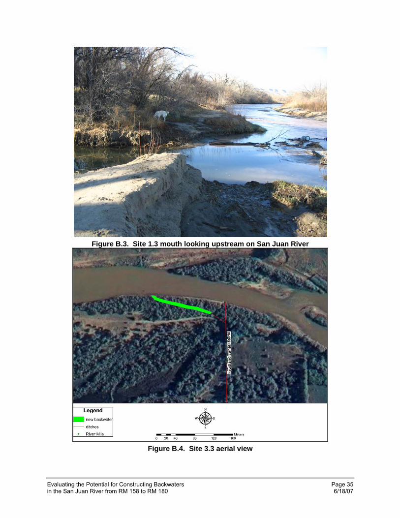
Evaluating the Potential for Constructing Backwaters Page 35 in the San Juan River from RM 158 to RM 180 6/18/07
Figure B.3. Site 1.3 mouth looking upstream on San Juan River
Figure B.4. Site 3.3 aerial view

Evaluating the Potential for Constructing Backwaters Page 36 in the San Juan River from RM 158 to RM 180 6/18/07
Figure B.5. Site 3.3 look up upstream San Juan River at backwater connection point
Figure B.6. Site 3.3 irrigation return channel at river discharge point
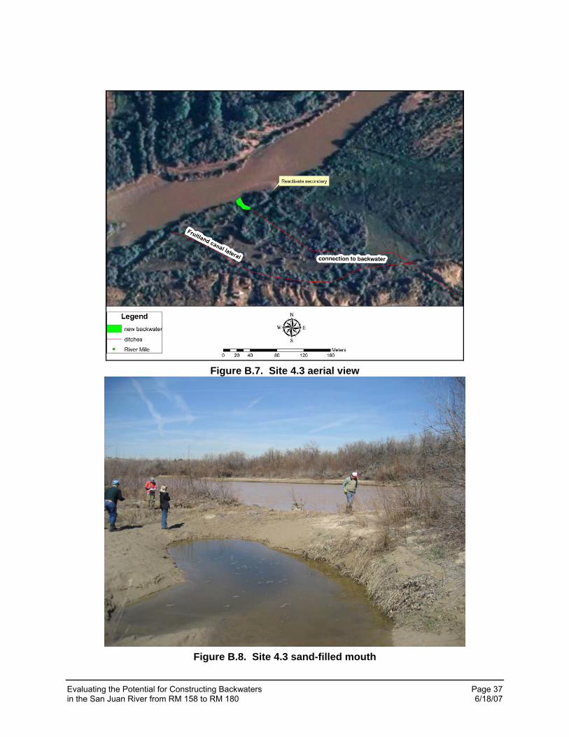
Evaluating the Potential for Constructing Backwaters Page 37 in the San Juan River from RM 158 to RM 180 6/18/07
Figure B.7. Site 4.3 aerial view
Figure B.8. Site 4.3 sand-filled mouth
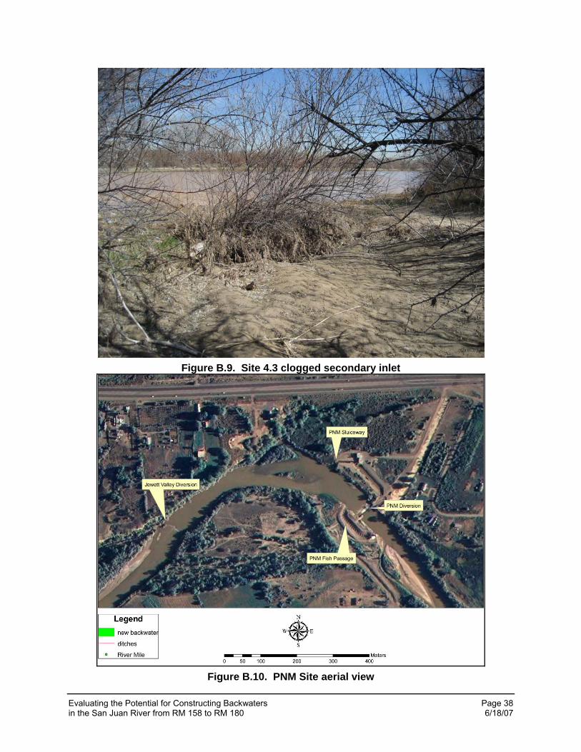
Evaluating the Potential for Constructing Backwaters Page 38 in the San Juan River from RM 158 to RM 180 6/18/07
Figure B.9. Site 4.3 clogged secondary inlet
Figure B.10. PNM Site aerial view
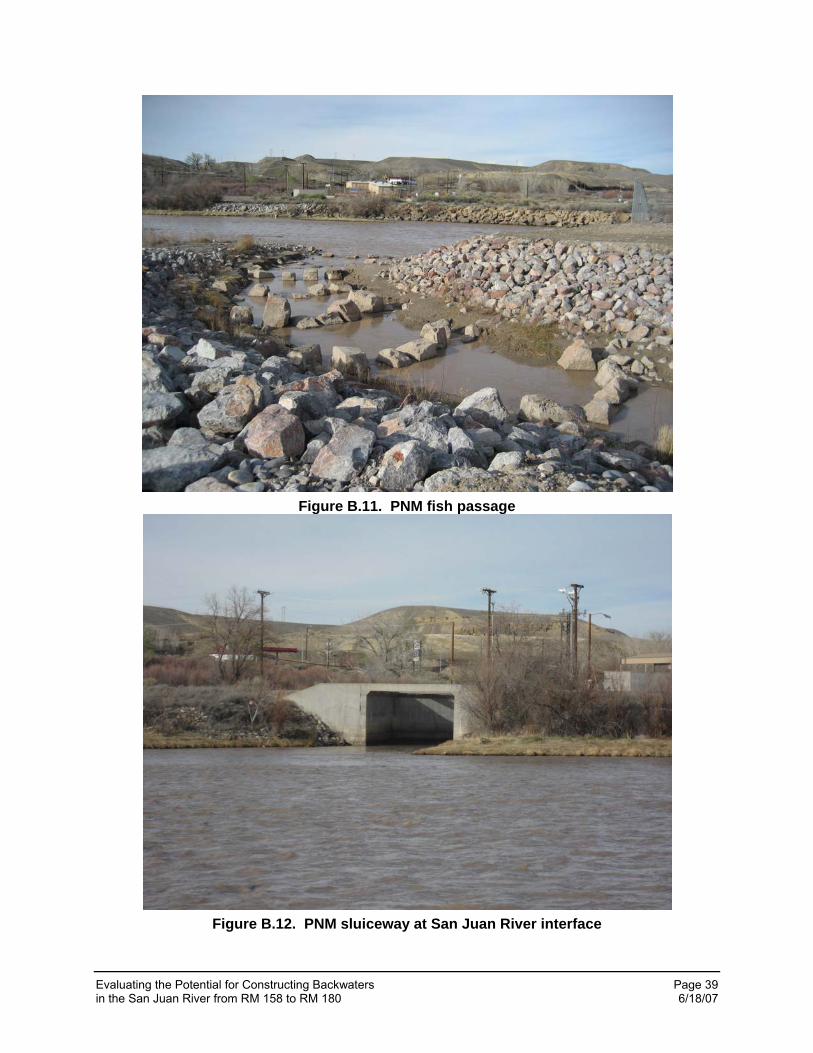
Evaluating the Potential for Constructing Backwaters Page 39 in the San Juan River from RM 158 to RM 180 6/18/07
Figure B.11. PNM fish passage
Figure B.12. PNM sluiceway at San Juan River interface
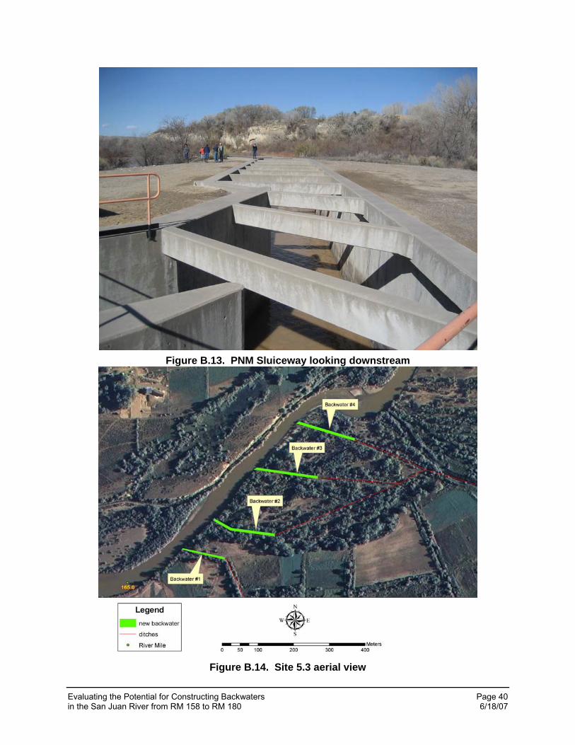
Evaluating the Potential for Constructing Backwaters Page 40 in the San Juan River from RM 158 to RM 180 6/18/07
Figure B.13. PNM Sluiceway looking downstream
Figure B.14. Site 5.3 aerial view
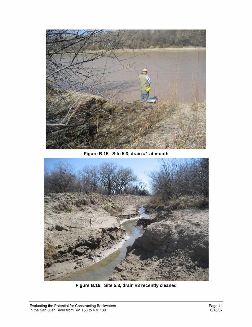
Evaluating the Potential for Constructing Backwaters Page 41 in the San Juan River from RM 158 to RM 180 6/18/07
Figure B.15. Site 5.3, drain #1 at mouth
Figure B.16. Site 5.3, drain #3 recently cleaned
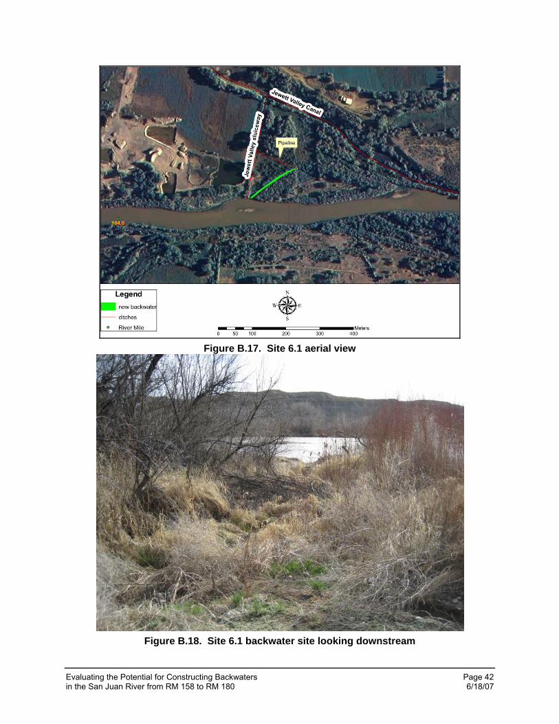
Evaluating the Potential for Constructing Backwaters Page 42 in the San Juan River from RM 158 to RM 180 6/18/07
Figure B.17. Site 6.1 aerial view
Figure B.18. Site 6.1 backwater site looking downstream
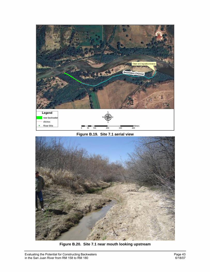
Evaluating the Potential for Constructing Backwaters Page 43 in the San Juan River from RM 158 to RM 180 6/18/07
Figure B.19. Site 7.1 aerial view
Figure B.20. Site 7.1 near mouth looking upstream
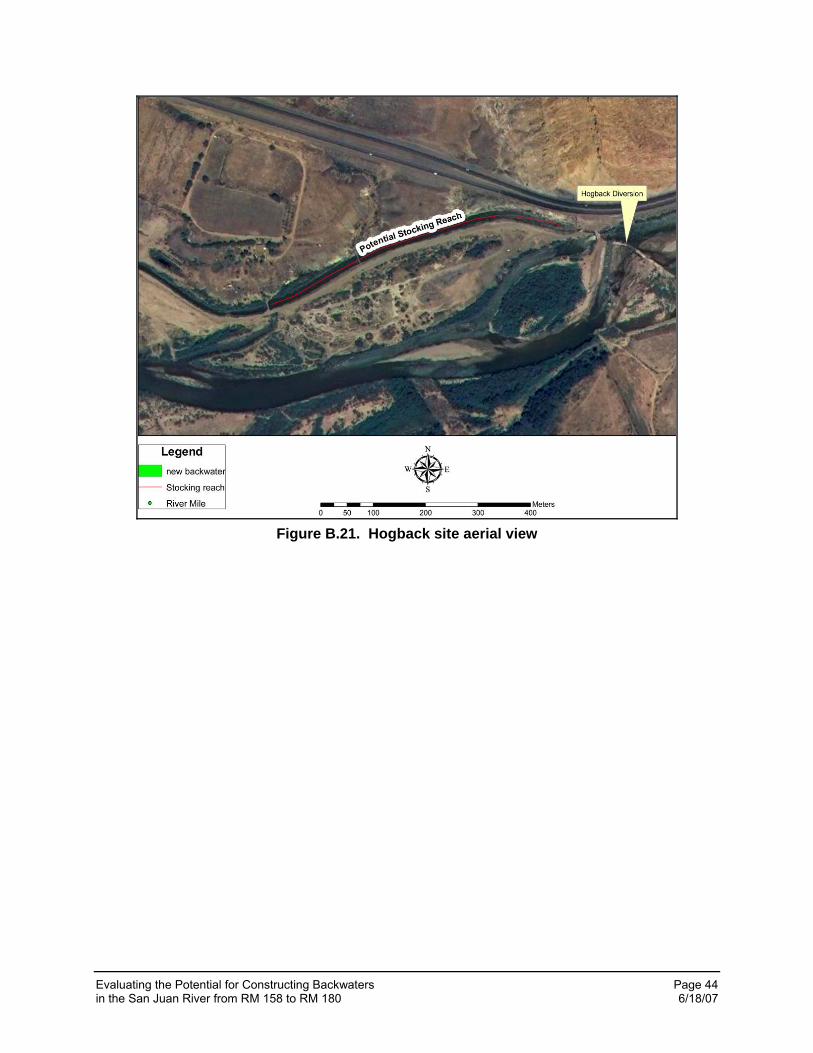
Evaluating the Potential for Constructing Backwaters Page 44 in the San Juan River from RM 158 to RM 180 6/18/07
Figure B.21. Hogback site aerial view