evaluation of tenement rate administration using the gis … · 2010-11-10 · ts24.5 evaluation of...
TRANSCRIPT

TS 24 – Valuations and Quantity Surveying Olubodun O. Ayeni and Oluwaseun S. Adewale TS24.5 Evaluation of Tenement Rate Administration Using the GIS Tools Promoting Land Administration and Good Governance 5th FIG Regional Conference Accra, Ghana, March 8-11, 2006
1/17
Evaluation of Tenement Rate Administration Using the GIS Tools
Olubodun O. AYENI and Oluwaseun S. ADEWALE, Nigeria Key words: Land, Tenement, Rate, Database, GIS. SUMMARY
Our various levels of government handle a colossal amount of data which are needed to perform critical tasks in state administration for equity and good governance in a most efficient manner. However this may not be realizable where available data cannot be matched with necessary management tools to create desired results. With the increasing functions of Local Government authorities for instance, it is required to operate with optimal efficiency to be able to satisfy the ever increasing needs of its residents. There is therefore need for a management system that will bring about desired effectiveness in the administration. The Geographical Information System (GIS) already provides the required data management capabilities for land administration. This paper looks into this System’s application to rent management, being one of the most critical revenue generating means for any county or local authority. It developed procedures and methods for its implementation vis-à-vis building required database, developing relevant users’ applications, and planning for the long-term maintenance of the System and its ancillary tools. For this study, a sample application was developed for the Lagos Mainland L/G Area in Nigeria. The paper notes the role of GIS as a veritable application tool in the administration of tenement rate in any geographical area.

TS 24 – Valuations and Quantity Surveying Olubodun O. Ayeni and Oluwaseun S. Adewale TS24.5 Evaluation of Tenement Rate Administration Using the GIS Tools Promoting Land Administration and Good Governance 5th FIG Regional Conference Accra, Ghana, March 8-11, 2006
2/17
Evaluation of Tenement Rate Administration Using the GIS Tools
Olubodun O. AYENI and Oluwaseun S. ADEWALE, Nigeria 1. INTRODUCTION To infer that the amount of data generated by the government in this modern age is phenomenal is a fact. Unfortunately, attempts to process the data and maximize its usability for decision making have not been adequately explored by the various governments. Hence contemporary decision-making process is complex as it involves a wide spectrum of information sourced from diverse fields. The impacts of a decision thus made over an even more complex social fabric necessitate the development and use of such tools as the Geographic Information System (GIS). The unique capability of a GIS is that not only it can act as a database but also as a powerful tool for performing diverse operations with greater ease and higher quality output. In the present system of administration, the administrator or decision maker really depends on hierarchy for relevant information, which results in delay and gives room for errors. In the conventional data retrieval system practices, because of near impossibility of data verification, likelihood of errors in decision making is high. Therefore, quicker and reliable data access and efficient processing tools are in demand. While attribute data computerization is an ongoing process, a GIS database that invokes both map and tabular data should follow logically to maximize benefits. A local government area council with many departments which render various functions and manage different revenues such as the tenement rate on properties within its geographical influence can develop a GIS for better efficiency and effectiveness of its operations. In developing such system, the data sharing aspect among its various departments is a virtual necessity for a successful long term GIS. As part of the overall process, several questions that must be considered during the planning of this GIS are considered: Examples;
− What will be the source for each data item? − How will sharing be arranged? …. Purchase? …. License? …. Other agreement? − Who will own the data? − How will new GIS data be integrated with existing data files (legacy systems)? − Who will be responsible for updates to the data? − How will the cost of the data (creation and maintenance) be allocated? − Who will provide public access to the data? − Who will be responsible for data archiving and retention of the original or copies? The present system of tenement rate administration in Nigeria is still largely based on old conventional method of manual data archiving and management. This is probably due to lack of awareness of benefits offered by GIS in tenement rate administration as well as a trenchant no-will situation of our administrators for various reasons, the financial outlay being a major factor.

TS 24 – Valuations and Quantity Surveying Olubodun O. Ayeni and Oluwaseun S. Adewale TS24.5 Evaluation of Tenement Rate Administration Using the GIS Tools Promoting Land Administration and Good Governance 5th FIG Regional Conference Accra, Ghana, March 8-11, 2006
3/17
2. OBJECTIVES OF THE STUDY − To create a set of guides describing procedure and methods for tenement rate
administration using the GIS as a decision support system. − To apply GIS as a spatial analytical tool for enhancement of revenue generation and
administration, in this case the administration of tenement rate within a choice local government area, using sample database that are real and reflective of real situation.
− To demonstrate the effectiveness of the system as a functional decision support system. 3. SCOPE OF THE STUDY − A local government area was chosen for the case study – Lagos Mainland LGA, Lagos
State, Nigeria; it is a geo-political area that is largely urbanized, lying in the heart of metropolitan Lagos and maintains its secretariat at 198, Herbert Macaulay Street, Adekunle - Yaba, Lagos.
− Involves a review of techniques in data acquisition and management and the various constraints involved in effective carrying out administrative work in local government.
− A creation of spatial and aspatial databases for the implementation and development of a GIS as an highly efficient decision making support tool in tenement rate management.
4. LOCAL GOVERNMENT (LG) ADMINISTRATION IN NIGERIA Our LG is the third tier level of government, and its administration is basically concerned with governance at the local level. The LGs depend on the central governments for their powers and functions. Its local prerogative is defined by the constitution and legislation and therefore has the responsibility to design its revenue generation, control and management methods within the law. Thus, a local government area refers to a political subdivision of a state constituted by law, and having substantial control of local affairs.
The LG do have some general characteristics, and must of necessity possess the following attributes; − A representative outlook: the wheel of the council must be kept going, controlled, and
supervised by people who are elected or appointed. − A definite geographical area: it must reconstruct its exercise of powers and functions − within a particular geographical jurisdiction which must be a well defined territorial area. − A clientele or population: local government administration has to do with services aimed
at improving the lots of the local people. − Viability: must be able to generate some funds internally for its services. − Active involvement in community matters: since the local government is partially
financed by the local people, their interests must also be protected by it. − Multipurpose attribute: no local government has a single purpose. This means that a local
government performs wide and varied functions which it must render if the people must support and sustain it.

TS 24 – Valuations and Quantity Surveying Olubodun O. Ayeni and Oluwaseun S. Adewale TS24.5 Evaluation of Tenement Rate Administration Using the GIS Tools Promoting Land Administration and Good Governance 5th FIG Regional Conference Accra, Ghana, March 8-11, 2006
4/17
4.1 Functions of Local Government These include, but not limited to the following; − Establishment and maintenance of markets. − Environmental sanitation: sanitary inspection, refuse disposal, Erection and maintenance
of public toilets and lavatories, − Registration of marriages, births and deaths. − Provision of recreation facilities; parks, gardens and public open spaces. − Licensing and supervision of the sale of liquor; licensing and regulations of bicycles,
handcarts and other types of vehicles. − Naming of roads and streets and numbering of plots/buildings; control and collection of
revenue from forestry reserves within its jurisdiction; collection of vehicle parking charges, collection of property and other rates.
− Establishment of Health centres, maternity homes, dispensaries and provision of ambulance services.
− Preventive health services, abattoirs and meat inspection. − Rural and semi-urban water supply. − Fire services. − Provision of roads and streets, their lighting, drainage control of water and atmospheric
pollution. − Provision of homes for destitute, the physically challenged and orphans. − Town and urban planning; Regulation and control of buildings.
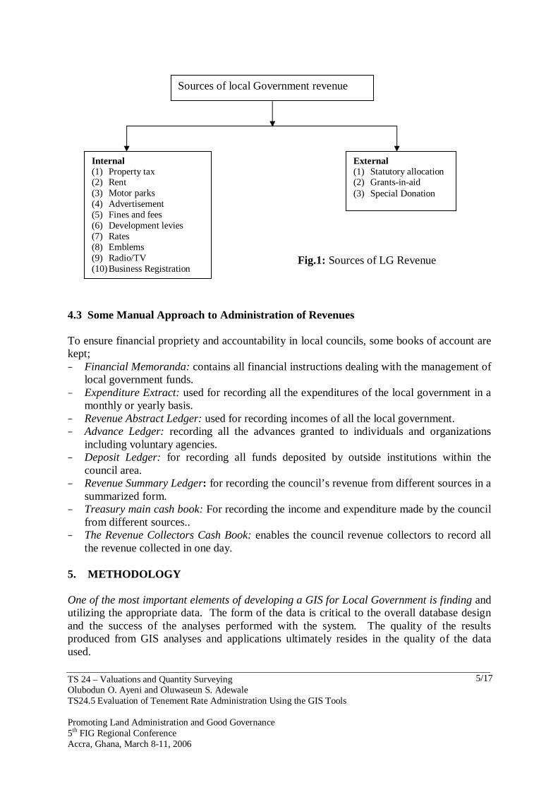
4.2 Local Government Sources of Revenue Tenement rate is potentially a large source of local authority revenue and positive steps are taken to ensure prompt and effective system of collection. In this study, GIS is used in the enhancement of tenement rate administration. Fig 1, illustrates the different sources of revenue available to a Council.
TS 24 – Valuations and Quantity Surveying Olubodun O. Ayeni and Oluwaseun S. Adewale TS24.5 Evaluation of Tenement Rate Administration Using the GIS Tools Promoting Land Administration and Good Governance 5th FIG Regional Conference Accra, Ghana, March 8-11, 2006
5/17
4.3 Some Manual Approach to Administration of Revenues To ensure financial propriety and accountability in local councils, some books of account are kept; − Financial Memoranda: contains all financial instructions dealing with the management of
local government funds. − Expenditure Extract: used for recording all the expenditures of the local government in a
monthly or yearly basis. − Revenue Abstract Ledger: used for recording incomes of all the local government. − Advance Ledger: recording all the advances granted to individuals and organizations
including voluntary agencies. − Deposit Ledger: for recording all funds deposited by outside institutions within the
council area. − Revenue Summary Ledger: for recording the council’s revenue from different sources in a
summarized form. − Treasury main cash book: For recording the income and expenditure made by the council
from different sources.. − The Revenue Collectors Cash Book: enables the council revenue collectors to record all
the revenue collected in one day. 5. METHODOLOGY One of the most important elements of developing a GIS for Local Government is finding and utilizing the appropriate data. The form of the data is critical to the overall database design and the success of the analyses performed with the system. The quality of the results produced from GIS analyses and applications ultimately resides in the quality of the data used.
External (1) Statutory allocation (2) Grants-in-aid (3) Special Donation
Internal (1) Property tax (2) Rent (3) Motor parks (4) Advertisement (5) Fines and fees (6) Development levies (7) Rates (8) Emblems (9) Radio/TV (10) Business Registration
Sources of local Government revenue
Fig.1: Sources of LG Revenue

TS 24 – Valuations and Quantity Surveying Olubodun O. Ayeni and Oluwaseun S. Adewale TS24.5 Evaluation of Tenement Rate Administration Using the GIS Tools Promoting Land Administration and Good Governance 5th FIG Regional Conference Accra, Ghana, March 8-11, 2006
6/17
This section reviews the data acquisition procedure, method of data input and the schedule involved in results presentation.
5.1 Date Acquisition and Recording Two main data needed in this study are valuation sheets containing such information as the address of tenancy, name of owner, name of occupier, gross value and rateable value. For the spatial data, a digitized street map of Lagos State was acquired, which contains all the streets in Lagos Mainland Local Government Area. Because of time & logistics constraints, the area was subdivided into eight segments/blocks (Fig 2); only one was chosen for the study and will serve as prototype for other segments' implementation at a later date.
Fig 2: The Lagos Mainland LGA in Segments. 5.2 Data Processing This describes the summary of all operations performed on the acquired data to render them useful for rent rate administration. 5.2.1 Creation of Attribute Data Though the data collected on tenement rate administration from the Council Office were in tables in paper format having field names such as property reference, Name of owner, address, search number, property analysis, valuation amount and the gross value. These data were later encoded on the computer using the relational database model of Microsoft Excel.
S t r e e t s o f L a g o s M a i n l a n d L G A D i v i d e d S e g me n t s
L e g e n d s
5 3 6 0 0 0
5 3 6 0 0 0
5 3 8 0 0 0
5 3 8 0 0 0
5 4 0 0 0 0
5 4 0 0 0 0
5 4 2 0 0 0
5 4 2 0 0 0
5 4 4 0 0 0
5 4 4 0 0 0
5 4 6 0 0 0
5 4 6 0 0 0
5 4 8 0 0 0
5 4 8 0 0 0 7 1 4 0 0 0 7 1 4 0 0 0
7 1 6 0 0 0 7 1 6 0 0 0
7 1 8 0 0 0 7 1 8 0 0 0
7 2 0 0 0 0 7
7 2 se gme n t 1
se g men t 2
s eg me nt 3 s e g me n t 4 s e g me nt5
se gme n t 6 s e gme n t 7
se g men t 8 S e gme n t 8 . sh p S e gme n t 1 S e gn en t 7S e gme n t 6 S e gme n t 8 S e gme n t 6 S e gme n t 5 S e gme n t 4 S t r r ets
o f l a g o s mai n l an d. sh p
3 0 3 6 K i lo m e t er s
N
E W
S
i n t o
2 0 0 0 0
2 0 0 0 7 2 2 0 0 0

TS 24 – Valuations and Quantity Surveying Olubodun O. Ayeni and Oluwaseun S. Adewale TS24.5 Evaluation of Tenement Rate Administration Using the GIS Tools Promoting Land Administration and Good Governance 5th FIG Regional Conference Accra, Ghana, March 8-11, 2006
7/17
Data were organized in a schedule of two-dimension tables, each of which contain records for one entity, and saved in dBase IV before exporting into the GIS environment (ArcView 3.1). 5.2.2 Creation of Spatial Data The digital street map of study area acquired was without property features representations, point features had to be created and encoded to represent each property within the chosen segment (Fig 3). By using the ArcView editing capability, a theme of point features representing properties was created and joined to the attributes tabular table of the property. This makes querying and analysis of properties based on their valuation amount and rateable values possible.
###
###
# ####
#
#
### #
# ##
##
##
##
##
##
##
##
##
##
###
##
##
##
##### #
###
##
#####
###
##
##
##
#####
##
##
##
##
## #
###
###
###
##
###
###
####
###
##
##
#
#### ## #
####
# ## #
# ## #
# ## #
#####
#
# ## #
# ##
## #
# ## #
# ## #
##
##
##
##
##
##
###
#
##
##
##
# ## ## ## ## ## ## ## ## ## ##
# ## ## ## ## ## ## ## ## ## ## ## # #
###
## #
#
# ## #### ## ##
#####
### ########## #
#
###
##
##
##
#
##### #
####
#
### #
# ###
###
#########
## #### ###### ##
######
####
###
##
###
#
####
### #
##
##
# ##
##
##
##
##
##
##
## #
# ##
## #
###
# #
# ##
##
##
#
##
##
##
###
##
##
###
# ## #
# ## ## ## ##
## #
# ## #
##
###
## #
# ## ## ## ## #
# ## #
# ##
## #
###
##
##
##
##
##
##
#
###
#
### #
### #
# ##
#
# ##
##
###
##
###
##
##
#
##
##
## ## ## ## ## ## ## ## #
# ## #
# ##
##
## ## ## #
# ## ## ## ## #
# ## ## ## ## ## #
# ## #
#
### #
##
##
# ## #
##
#### ## ## ## ## ## ## ## ## ## ## ## ## ## ## ## ## ## ## ## #
#
## #
#### #
# ## #
# ## #
#
###
####
## #
# ## #
##
# ## ## #
# ##
## #
# ## #
# ## #
###### ## ##
##
# ##
##
##
##
# ## ## ## ## ## ## ## ## ##
# ## ## ## ##
########
## #
#### ## #
# ## ## ###
####
##### #
# ## ## ## #
# ## ## #
###
##
###
#########
####
# ######
######
######
##
## #
# ##
##
##
##
##
##
## #
# ## #
# ##
## #
# ## ## #
# ## #
#
## # ## #
# ##
##
##
##
##
##
##### ## #
#####
### ## ## #
# ##
# ## #
# ## ##
######
###
## ## ## #
###
##
## #
##
# ## #
## #
# ## #
# ## #
### #
# ###
# ## #
##
###
### #
# ##
#
#######
# #### ## ## ##
###
# ##
#####
######
# ##
##
##
##
##
##
###
###
###
####
# ## ## ## #### ## #
###
#### #
# ###
# #######
###
###
##
# ## ## ## ##
###### ##
###
###
####
##
###
##
## #
# ## #
#
####
####
##
##
##
##
##
##
# ## ## ## #
# ## ## ## ## ## ## ## #
# ## #
#
#####
####
## ####
####
## ####
##
# ####
######
########## ##
## ## ##
# ## ##
###
Segment4Strrets of lagos mainland.shp
# Property
0.9 0 0.9 1.8 Kilometers
N
EW
S
Segment 4, Showing Properties as Point Features
Legend
541000
541000
542000
542000
543000
543000
719000 719000
720000 720000
Fig 3: Map Showing Segment 4, Showing Properties as Point Features
6. RESULT AND ANALYSIS Results of study can be presented using different methods or techniques, examples are; - Browse - Simple display (automated mapping) - Query and display - Map analysis - Spatial modeling

TS 24 – Valuations and Quantity Surveying Olubodun O. Ayeni and Oluwaseun S. Adewale TS24.5 Evaluation of Tenement Rate Administration Using the GIS Tools Promoting Land Administration and Good Governance 5th FIG Regional Conference Accra, Ghana, March 8-11, 2006
8/17
6.1 Browse: This is an equivalence of map reading to find peculiar features or patterns. Browsing usually leads to identification of items of interest and subsequent retrieval and manipulation by manual means. By browsing particular features and patterns such as property type, addresses, ownership, etc. can be easily identified (Fig 4). See Fig A3 & A4 in the Appendix for more results.
Fig 4: Identification of properties considered to be in “very good” state along Harvey Road, Yaba.
6.2 Simple Display This GIS function supports the generation of map or diagram by computer. Such maps and diagrams are often simple reproduction of the same maps used in previous manual oriented GIS environment.
Figures 5 and 6 display the identification of a property, the number flats or units it has and the total sum of rateable amount and gross value realize on the property. More results showing valuation statistics of some selected features are displayed in the Appendix (Fig A5 – A12)
Fig 5; shows the identification of a property (in yellow), the number of counts or flats, and the total valuation amount realized
TS 24 – Valuations and Quantity Surveying Olubodun O. Ayeni and Oluwaseun S. Adewale TS24.5 Evaluation of Tenement Rate Administration Using the GIS Tools Promoting Land Administration and Good Governance 5th FIG Regional Conference Accra, Ghana, March 8-11, 2006
9/17
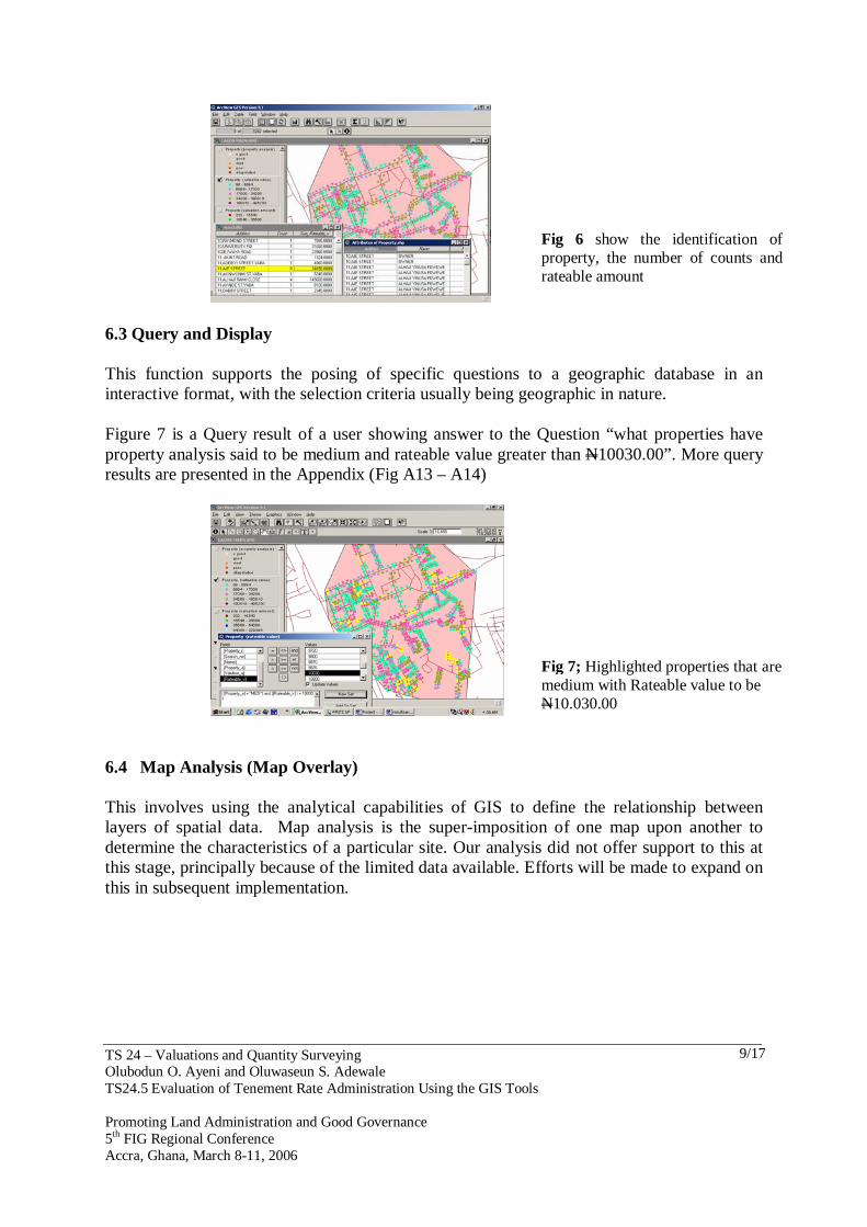
6.3 Query and Display This function supports the posing of specific questions to a geographic database in an interactive format, with the selection criteria usually being geographic in nature. Figure 7 is a Query result of a user showing answer to the Question “what properties have property analysis said to be medium and rateable value greater than N10030.00”. More query results are presented in the Appendix (Fig A13 – A14)
6.4 Map Analysis (Map Overlay) This involves using the analytical capabilities of GIS to define the relationship between layers of spatial data. Map analysis is the super-imposition of one map upon another to determine the characteristics of a particular site. Our analysis did not offer support to this at this stage, principally because of the limited data available. Efforts will be made to expand on this in subsequent implementation.
Fig 6 show the identification of property, the number of counts and rateable amount
Fig 7; Highlighted properties that are medium with Rateable value to be N10.030.00
TS 24 – Valuations and Quantity Surveying Olubodun O. Ayeni and Oluwaseun S. Adewale TS24.5 Evaluation of Tenement Rate Administration Using the GIS Tools Promoting Land Administration and Good Governance 5th FIG Regional Conference Accra, Ghana, March 8-11, 2006
10/17
7. SUMMARY AND CONCLUSIONS 7.1 Problem Encounter − One major problem encountered is the acquisition of the valuation sheets of the study
area. There was difficulty in obtaining the softcopy of the data from the authority in charge. The only thing allowed to do was to copy the data manually.
− Since properties are encoded by using ArcView editing capability to create point features, the positions of properties do no represent their real world position.
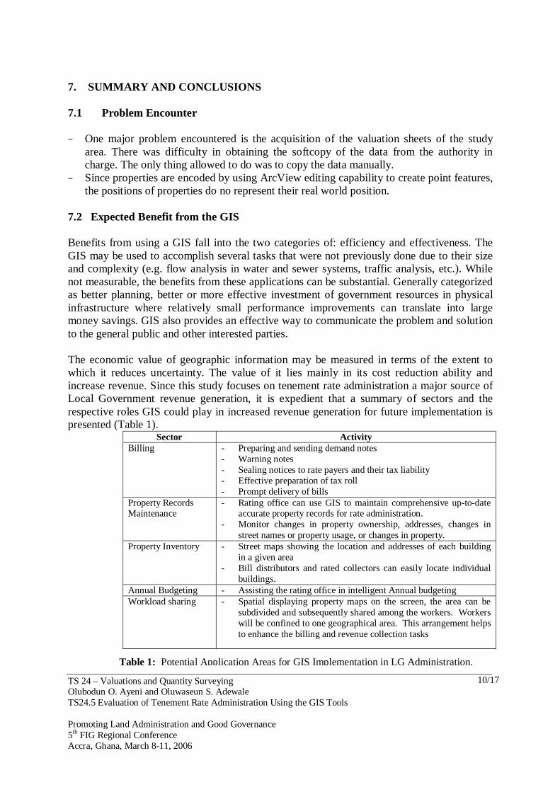
7.2 Expected Benefit from the GIS Benefits from using a GIS fall into the two categories of: efficiency and effectiveness. The GIS may be used to accomplish several tasks that were not previously done due to their size and complexity (e.g. flow analysis in water and sewer systems, traffic analysis, etc.). While not measurable, the benefits from these applications can be substantial. Generally categorized as better planning, better or more effective investment of government resources in physical infrastructure where relatively small performance improvements can translate into large money savings. GIS also provides an effective way to communicate the problem and solution to the general public and other interested parties. The economic value of geographic information may be measured in terms of the extent to which it reduces uncertainty. The value of it lies mainly in its cost reduction ability and increase revenue. Since this study focuses on tenement rate administration a major source of Local Government revenue generation, it is expedient that a summary of sectors and the respective roles GIS could play in increased revenue generation for future implementation is presented (Table 1).
Sector Activity Billing - Preparing and sending demand notes
- Warning notes - Sealing notices to rate payers and their tax liability - Effective preparation of tax roll - Prompt delivery of bills
Property Records Maintenance
- Rating office can use GIS to maintain comprehensive up-to-date accurate property records for rate administration.
- Monitor changes in property ownership, addresses, changes in street names or property usage, or changes in property.
Property Inventory - Street maps showing the location and addresses of each building in a given area
- Bill distributors and rated collectors can easily locate individual buildings.
Annual Budgeting - Assisting the rating office in intelligent Annual budgeting Workload sharing - Spatial displaying property maps on the screen, the area can be
subdivided and subsequently shared among the workers. Workers will be confined to one geographical area. This arrangement helps to enhance the billing and revenue collection tasks
Table 1: Potential Application Areas for GIS Implementation in LG Administration.
TS 24 – Valuations and Quantity Surveying Olubodun O. Ayeni and Oluwaseun S. Adewale TS24.5 Evaluation of Tenement Rate Administration Using the GIS Tools Promoting Land Administration and Good Governance 5th FIG Regional Conference Accra, Ghana, March 8-11, 2006
11/17
7.3 Conclusions The manual system of administration of revenue in Nigeria’s local governments has proved to be ineffective and inefficient and thus the yield from revenue is usually abysmally low. A lot of set backs are attached to the manual system of revenue administration, such as subjectivity, omissions, discrepancies, slowness and data redundancy. The manual system of handling data makes the processes of data up-dating and processing quite tasking, especially where the quantity of data to deal with is large and complex, as is often the case with revenue records.
It is impossible to intelligently administer rates without a rich reservoir of geographic information. The GIS as a tool is able to perform these tasks more efficiently. Some of the analytical tasks cannot be performed without a computer due to their size and complexity. The system improves local government effectiveness by providing better information to planners and decision-makers.
Procedures were discussed in displaying the result of a GIS work using real data collected from the Lagos Mainland Local Government. Queries were developed to generate required data for the administration of tenement rate in the LGA. From the analysis carried out, we are able to see that planning for revenue collection can best be carried out by a system that combines spatial and aspatial data management capabilities, like a GIS. 7.4 Recommendations Establishing a GIS in a local government, in this case the Lagos Mainland Local Government requires that a suitable environment be created to maintain such a system. Problems must be identified and solved. The following obstacles were identified, and the findings and recommendations arising are discussed: 7.4.1 Level of Awareness The level of awareness of GIS is poor and need to be enhanced. Government need to create a better awareness of this growing tool. This would help curb the present state of overdependence on such costly and isolated data sources for spatial information, e.g. foreign trade magazines and conference proceedings. 7.4.2 Training The Local Government should establish a programmatic regular training in GIS technology and procedures in order to assign new roles where necessary. 7.4.3 Computer Literacy The literacy levels of manpower in hardware and software usage should be critically enhanced. The present literacy level among the council personnel is abysmally low. Their effectiveness in the use of computer hardware and software will rub on the successful

TS 24 – Valuations and Quantity Surveying Olubodun O. Ayeni and Oluwaseun S. Adewale TS24.5 Evaluation of Tenement Rate Administration Using the GIS Tools Promoting Land Administration and Good Governance 5th FIG Regional Conference Accra, Ghana, March 8-11, 2006
12/17
implementation of any automation system being introduced. It is suggested that staff be provided with on-the-job training program on hardware installation and maintenance as well as software usage. 7.4.4 Institutional Framework Establishment of a GIS involves different services, since the system will be for multiple usages. It is recommended that specialist from various departments concerned should be trained in management areas, and that departments should just be custodians and not owners of any acquired data. 7.4.5 Political Climate There must be consistency in Programme implementation time schedule irrespective of changes in governance. The planning and execution of a GIS like any other project must not be subject to the lifespan of a political office holder. REFERENCES
Aronoff S. (1989): Geographical Information systems: A Management Perspective, WDL
Publications, Ottawa. Ayeni O.O. and O.S. Adewale (2005), GIS Application to Local Government Administration:
A case Study of Oyo East Local Government. Proceedings of the First National Seminar on Geographic Information Systems (GIS) Applications to Local Government Administration for Efficiency and Good Governance in Nigeria, Geoinformation Society of Nigeria, Abuja, Nigeria.
Burroughs P.A. (1986): Principles of Geographical Information Systems: Principles and Applications, Longman, London Vol.1 pp.427-43.
Environmental Systems Research Institute Inc.(ESRI): Arcview GIS 3.1 Versions Manual (1996)
ESRI White Paper (2001): Organizational Structure for Local Government GIS: A Survey: http:// www.esri.com
Federal Republic of Nigeria Implementation Guidelines on the Application of Civil Service Reforms in the Local Government Service, Federal Government Printers, Lagos p. 7-8.
Martin D. (1991): Geographical Information systems and their Socio-economic Applications, 2nd ed. Rutledge, London.
New York State Archives (December 21, 2000): Local Government GIS Development Guides: New York State Internet [email protected]
Orewa G. O. & Adewumi J. B.: Local Government in Nigeria; Publishing Corporation, Ring Road, Benin city 1983 pg. 139.
Osborrow E. P (1989): Databases and Databases systems: Concepts and Issues; second edition; Chartwell Bratt, Sweden.
Rhind D.W. (1989): Why GIS? - ARC News (summer) pp. 29-39 The GIS Primer : An Introduction to Geographical Information System :

TS 24 – Valuations and Quantity Surveying Olubodun O. Ayeni and Oluwaseun S. Adewale TS24.5 Evaluation of Tenement Rate Administration Using the GIS Tools Promoting Land Administration and Good Governance 5th FIG Regional Conference Accra, Ghana, March 8-11, 2006
13/17
The American Cartographer: Special issues – The Digital Revolution in Cartography; Vol.15 (3), 1988.
BIOGRAPHICAL NOTES Prof. Olubodun Ayeni (1941 - ): A Professor of Surveying, He was engaged as a Senior Lecturer in 1979 at the University of Lagos, Nigeria. He became a Professor in 1983. Between 1985 and 1991, he was the Director of RECTAS (Ile-Ife, Nigeria), and has since been back to the University where he lectures at the Department of Surveying and Geoinformatics. He has many published works in Remote Sensing, Photogrammetry, Geographic Information Systems, and Adjustment Computation & Statistical Analysis of Survey Data. He has also been involved in numerous international projects. Professor Ayeni is a Winner of International Prizes and Awards such as; Talbert Abraham Award (ASPRS, 1983), Instrumentation of America (1975), and Edward Dolezal Award (ISPRS, 1996). He is presently a Council member of the Surveyors’ Registration Council of Nigeria (SURCON), and the President of The Geoinformatics Society of Nigeria (GEOSON). Oluwaseun S. Adewale (1966 - ): Received his first degree in 1988 and in 1998, a Master’s degree in surveying both from the University of Lagos. He has over ten years of professional experience in engineering surveying, seismic survey data acquisition, GPS applications, Geographic Information Systems and Remote Sensing Data applications. He is presently a Lecturer at the Department of Surveying and Geoinformatics, University of Lagos, Nigeria where he is pursuing his PhD program. His research interest is in Geographic Information Science, Automated/Digital Image Mapping and Feature Extraction, Land Use/Land Cover mapping, Population Dynamics, Database Administration Remote Sensing & Photogrammetric applications. . Mr. Adewale has won many scholastic awards such as, The Best final Year Student in Additional Mathematics (MHSO, 1983), Best Graduating Student in Geodesy (UNILAG, 1988), Best Student in the field of Photogrammetry (UNILAG, 1988). He is a member of the Nigerian Institution of Surveyors (NIS), Geoinformation Society of Nigeria (GEOSON), and Nigerian Institute of Management (NIM). CONTACTS Prof. O. O. Ayeni Department of Surveying and Geoinformatics Faculty of Engineering University of Lagos Lagos NIGERIA. Tel. + 234 802 304 5582 Email: [email protected]

TS 24 – Valuations and Quantity Surveying Olubodun O. Ayeni and Oluwaseun S. Adewale TS24.5 Evaluation of Tenement Rate Administration Using the GIS Tools Promoting Land Administration and Good Governance 5th FIG Regional Conference Accra, Ghana, March 8-11, 2006
14/17
Mr. O. S. Adewale Department of Surveying and Geoinformatics Faculty of Engineering University of Lagos Lagos NIGERIA. Tel. + 234 804 544 7200 Email: [email protected]

TS 24 – Valuations and Quantity Surveying Olubodun O. Ayeni and Oluwaseun S. Adewale TS24.5 Evaluation of Tenement Rate Administration Using the GIS Tools Promoting Land Administration and Good Governance 5th FIG Regional Conference Accra, Ghana, March 8-11, 2006
15/17
Segment4Strrets of lagos mainland.shp
N
Street Map of Lagos Mainland L.G.A Showing Highlighted Streets Within Segment 4
Legend
542000
542000
544000
544000
718000 718000
720000 720000
Fig. A1: A Street Map of a Part of Lagos Mainland Local Government (Segment 4) with Highlighted Streets
Strrets of lagos mainland.shp
4 0 4 8 Kilometers
N
EW
S
Streets of Lagos Mainland Local Government Area
Legend
536000
536000
540000
540000
544000
544000
548000
548000
716000 716000
720000 720000
Fig A2: Map Showing Street Map of the Study Area
Fig A3: View showing the Attributes of the
Property
Fig A4: Showing the Location of Addresses by Picking from the Attribute Table of Properties
Fig A5: Showing Statistics of Valuation of properties Within Segment 4
THE APPENDIX

TS 24 – Valuations and Quantity Surveying Olubodun O. Ayeni and Oluwaseun S. Adewale TS24.5 Evaluation of Tenement Rate Administration Using the GIS Tools Promoting Land Administration and Good Governance 5th FIG Regional Conference Accra, Ghana, March 8-11, 2006
2/17
Fig A6: Showing Statistics of Gross Value of
Properties Within Segment 4
Fig A7: Showing Statistics of Valuation of
Properties of a Street (in This Case, Aje Street)
Fig A11: Sorting Properties by Highest Valuation Amount of Properties
Fig A12: Finding Features by Using a Chart
Fig A13: A Query of Properties with Property Analysis that is Poor and Valuation Amount Greater than or Equal to N10,000.00
Fig A8: Showing Statistics of Valuation of
Properties of a Street (in This Case Commercial Avenue)

TS 24 – Valuations and Quantity Surveying Olubodun O. Ayeni and Oluwaseun S. Adewale TS24.5 Evaluation of Tenement Rate Administration Using the GIS Tools Promoting Land Administration and Good Governance 5th FIG Regional Conference Accra, Ghana, March 8-11, 2006
3/17
Fig A9: Showing Statistics of Valuation of
Properties of a Street (in This Case Laggard Street)
Fig A10: Sorting Properties by Lowest Valuation Amount of Properties
Fig A14: A Query of Properties with Property Analysis that is Very good and Valuation Amount Greater than or Equal to N15,000.00