everglades restoration climate everglades restoration ... · everglades restoration climate change...
TRANSCRIPT
US Army Corps of EngineersBUILDING STRONG®
Everglades Restoration Climate Change Concerns and Draft Sea Level Rise Planning Guidance
Everglades Restoration Climate Change Concerns and Draft Sea Level Rise Planning Guidance
Sea Level Rise WorkshopFlorida Atlantic UniversityBoca Raton, FLFebruary 16, 2010
Presented by: Stu AppelbaumChief, Everglades DivisionU.S. Army Corps of Engineers Jacksonville District
Everglades Restoration ProgramApplication of USACE Guidanceon Sea Level Change
Everglades Restoration ProgramApplication of USACE Guidanceon Sea Level ChangeBiscayne Bay Regional Restoration Coordination TeamJune 2010
Presented by: Glenn LandersSenior Project ManagerClimate Change StudiesEverglades DivisionUSACE, Jacksonville District
Florida Bay
BiscayneBay
MIAMI
EVERGLADESNATIONAL
PARK
BUILDING STRONG® US ARMY CORPS OF ENGINEERS | Jacksonville District
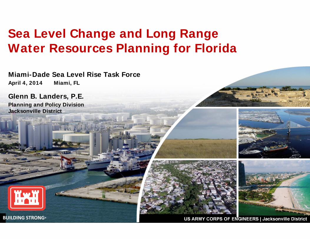
Miami-Dade Sea Level Rise Task ForceApril 4, 2014 Miami, FL
Glenn B. Landers, P.E.Planning and Policy Division Jacksonville District
Sea Level Change and Long Range Water Resources Planning for Florida
BUILDING STRONG®
BUILDING STRONG® US ARMY CORPS OF ENGINEERS | Jacksonville District
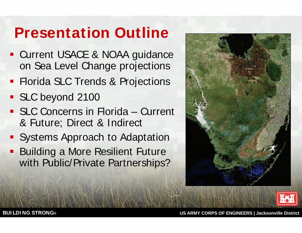
Current USACE & NOAA guidance on Sea Level Change projections Florida SLC Trends & ProjectionsSLC beyond 2100SLC Concerns in Florida – Current & Future; Direct & IndirectSystems Approach to AdaptationBuilding a More Resilient Future with Public/Private Partnerships?
Presentation Outline
BUILDING STRONG® US ARMY CORPS OF ENGINEERS | Jacksonville District
US Army Corps of Engineers Civil Works Mission Areas
Navigation• Breakwaters and Jetties• Harbors, Navigation Channels and Ocean Disposal Sites
HydropowerReservoir Regulation; Water SupplyCoastal Storm Damage Reduction• Beach fills and Shoreline protection structures
Flood Damage Reduction• Storm Drainage, Dams, levees, floodwalls
Ecosystem RestorationEmergency ResponseRecreationRegulatory
Climate change has the potential
to impact all USACE
mission areas

BUILDING STRONG® US ARMY CORPS OF ENGINEERS | Jacksonville District
BUILDING STRONG® US ARMY CORPS OF ENGINEERS | Jacksonville District
Climate Change Concerns for Florida
Sea Level Rise• Salinity changes in coastal bays, plus tidally influenced creeks and rivers • Shoreline retreat with natural habitat changes/losses• Increasing flood frequency and depth in coastal areas• Saltwater intrusion in water supply wells, OR higher canal stages and flood risks• Uncertainties and risks in rate and depth of sea level rise
Warmer Temperatures• Evaporation losses up; water supply down• Stresses on plant, animal, and marine ecosystems• Changes in growing season and migratory patterns• Changes in water quality
Hydrologic Pattern Changes• Potential for less frequent and more intense rain events• Potential increased tropical storm intensity or frequency
BUILDING STRONG® US ARMY CORPS OF ENGINEERS | Jacksonville District
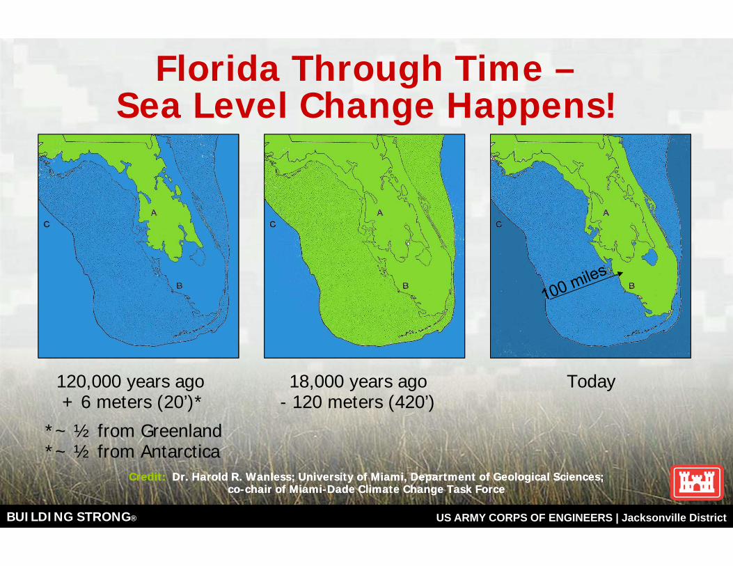
Florida Through Time –Sea Level Change Happens!
120,000 years ago 18,000 years ago Today+ 6 meters (20’)* - 120 meters (420’)
*~ ½ from Greenland*~ ½ from Antarctica
Credit: Dr. Harold R. Wanless; University of Miami, Department of Geological Sciences; co-chair of Miami-Dade Climate Change Task Force
Credit: Dr. Harold R. Wanless; University of Miami, Department of Geological Sciences; co-chair of Miami-Dade Climate Change Task Force

BUILDING STRONG® US ARMY CORPS OF ENGINEERS | Jacksonville District
Thousands of 14C years before present
Rat
e of
SLR
(m
m/y
r)
Global delta initiation(Stanley and Warne, 1994)
U.S. Atlantic, U.K. wetland initiation; barrier island stability(Shennan and Horton, 2002; Engelhart et al., 2009)
mwp-Ia
mwp-Ib
(SLR rate based on Fairbanks, 1989)
Rates of Sea-level rise since the Last Glacial Maximum
(Slide courtesy of Rob Thieler, USGS)
BUILDING STRONG® US ARMY CORPS OF ENGINEERS | Jacksonville District
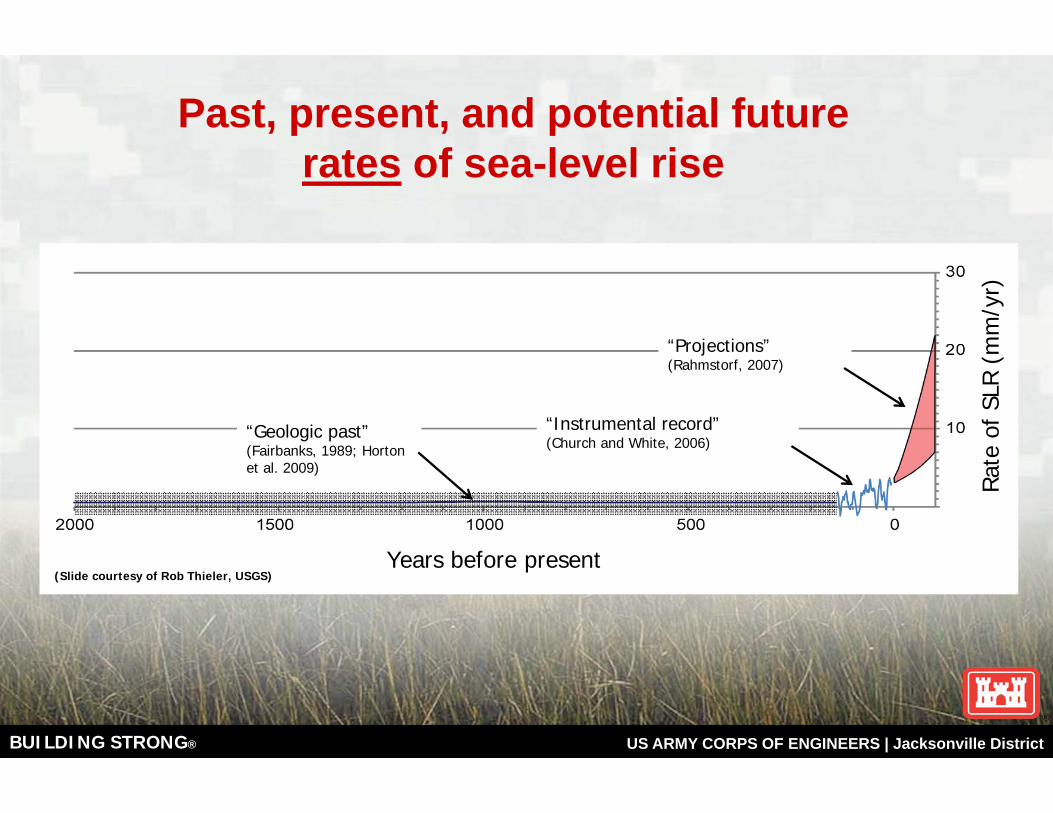
Years before present
Rat
e of
SLR
(m
m/y
r)
“Geologic past” (Fairbanks, 1989; Horton et al. 2009)
“Instrumental record”(Church and White, 2006)
“Projections”(Rahmstorf, 2007)
Past, present, and potential future rates of sea-level rise
(Slide courtesy of Rob Thieler, USGS)
BUILDING STRONG® US ARMY CORPS OF ENGINEERS | Jacksonville District
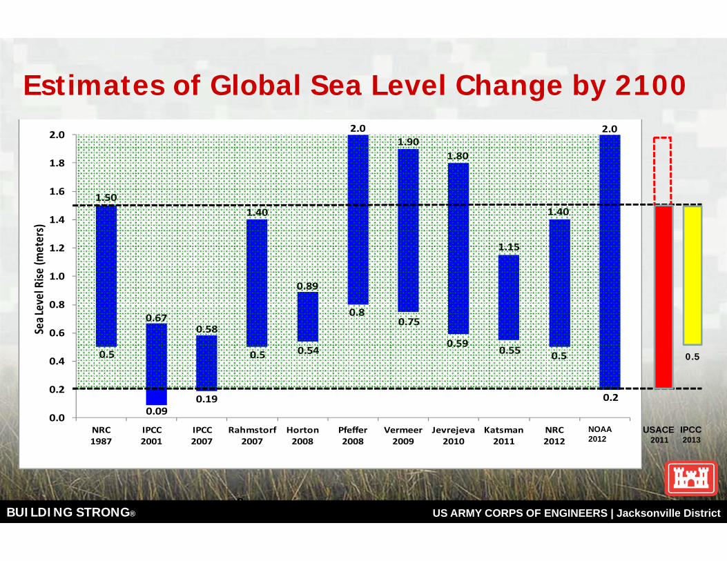
Estimates of Global Sea Level Change by 2100
9
1.50
0.670.58
1.40
0.89
2.01.90
1.80
1.15
1.40
2.0
0.0
0.2
0.4
0.6
0.8
1.0
1.2
1.4
1.6
1.8
2.0
NRC 1987
IPCC 2001
IPCC 2007
Rahmstorf 2007
Horton 2008
Pfeffer 2008
Vermeer 2009
Jevrejeva 2010
Katsman 2011
NRC 2012
NCA 2012
Sea L
evel Rise
(meters)
0.5
0.090.19
0.5 0.54
0.80.75
0.590.55 0.5
0.2
1.50
0.670.58
1.40
0.89
2.01.90
1.80
1.15
1.40
2.0
0.0
0.2
0.4
0.6
0.8
1.0
1.2
1.4
1.6
1.8
2.0
NRC 1987
IPCC 2001
IPCC 2007
Rahmstorf 2007
Horton 2008
Pfeffer 2008
Vermeer 2009
Jevrejeva 2010
Katsman 2011
NRC 2012
NCA 2012
Sea L
evel Rise
(meters)
0.5
0.090.19
0.5 0.54
0.80.75
0.590.55 0.5
0.2
USACE2011
NOAA 2012
IPCC2013
0.5
BUILDING STRONG® US ARMY CORPS OF ENGINEERS | Jacksonville District
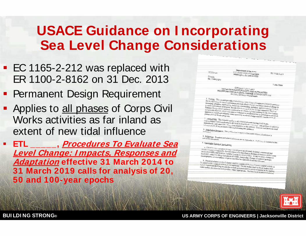
USACE Guidance on Incorporating Sea Level Change Considerations
EC 1165-2-212 was replaced with ER 1100-2-8162 on 31 Dec. 2013Permanent Design RequirementApplies to all phases of Corps Civil Works activities as far inland as extent of new tidal influence ETL _____, Procedures To Evaluate Sea Level Change: Impacts, Responses and Adaptation effective 31 March 2014 to 31 March 2019 calls for analysis of 20, 50 and 100-year epochs
BUILDING STRONG® US ARMY CORPS OF ENGINEERS | Jacksonville District
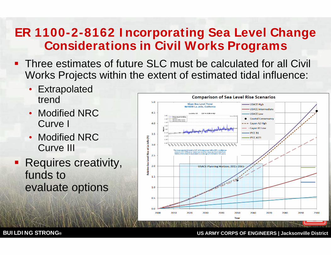
ER 1100-2-8162 Incorporating Sea Level Change Considerations in Civil Works Programs
Three estimates of future SLC must be calculated for all Civil Works Projects within the extent of estimated tidal influence:• Extrapolated
trend• Modified NRC
Curve I• Modified NRC
Curve IIIRequires creativity, skill, time, funds to evaluate options
BUILDING STRONG® US ARMY CORPS OF ENGINEERS | Jacksonville District
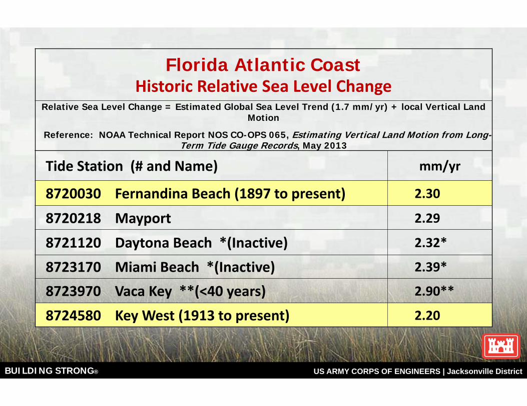
Florida Atlantic CoastHistoric Relative Sea Level Change
Relative Sea Level Change = Estimated Global Sea Level Trend (1.7 mm/yr) + local Vertical Land Motion
Reference: NOAA Technical Report NOS CO-OPS 065, Estimating Vertical Land Motion from Long-Term Tide Gauge Records, May 2013
Tide Station (# and Name) mm/yr
8720030 Fernandina Beach (1897 to present) 2.30
8720218 Mayport 2.29
8721120 Daytona Beach *(Inactive) 2.32*
8723170 Miami Beach *(Inactive) 2.39*
8723970 Vaca Key **(<40 years) 2.90**
8724580 Key West (1913 to present) 2.20
BUILDING STRONG® US ARMY CORPS OF ENGINEERS | Jacksonville District
9'
6'
3'
0
0.5
1
1.5
2
2.5
31
990
200
0
201
0
202
0
203
0
204
0
205
0
206
0
207
0
208
0
209
0
210
0
211
0
212
0
Rel
ativ
e Se
a Le
vel C
han
ge (
Met
ers)
Year
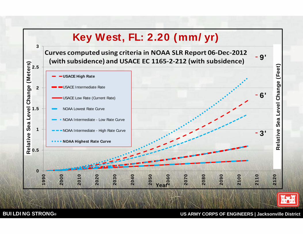
Key West, FL: 2.20 (mm/yr)
USACE High Rate
USACE Intermediate Rate
USACE Low Rate (Current Rate)
NOAA Lowest Rate Curve
NOAA Intermediate - Low Rate Curve
NOAA Intermediate - High Rate Curve
NOAA Highest Rate Curve
Rel
ativ
e Se
a Le
vel C
han
ge (
Feet
)
BUILDING STRONG® US ARMY CORPS OF ENGINEERS | Jacksonville District
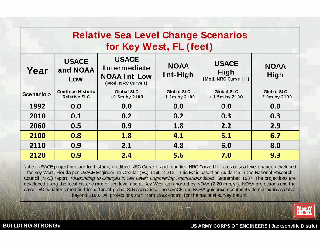
Relative Sea Level Change Scenariosfor Key West, FL (feet)
YearUSACE
and NOAA Low
USACEIntermediate
NOAA Int-Low(Mod. NRC Curve I)
NOAAInt-High
USACEHigh
(Mod. NRC Curve III)
NOAA High
Scenario > Continue HistoricRelative SLC
Global SLC+0.5m by 2100
Global SLC+1.2m by 2100
Global SLC+1.5m by 2100
Global SLC+2.0m by 2100
1992 0.0 0.0 0.0 0.0 0.02010 0.1 0.2 0.2 0.3 0.32060 0.5 0.9 1.8 2.2 2.92100 0.8 1.8 4.1 5.1 6.72110 0.9 2.1 4.8 6.0 8.02120 0.9 2.4 5.6 7.0 9.3
Notes: USACE projections are for historic, modified NRC Curve I and modified NRC Curve III rates of sea level change developed for Key West, Florida per USACE Engineering Circular (EC) 1165-2-212. This EC is based on guidance in the National Research
Council (NRC) report, Responding to Changes in Sea Level; Engineering Implications dated September, 1987. The projections are developed using the local historic rate of sea level rise at Key West as reported by NOAA (2.20 mm/yr). NOAA projections use thesame EC equations modified for different global SLR scenarios. The USACE and NOAA guidance documents do not address dates
beyond 2100. All projections start from 1992 control for the national survey datum.
BUILDING STRONG® US ARMY CORPS OF ENGINEERS | Jacksonville District
Sea Level Change Beyond 2100 Anticipate accelerating SLC continuing well beyond 2100Very long term SLC may total 2.3m (7.5ft) for each degree Celsius in global warming. In geologic history, this may have taken a total of 1000 years. Impacts of modern high greenhouse gas levels?Protect existing built environment as long as economically feasibleBuildings AND developed land will depreciate as SLR risks increaseDevelop “Exit strategies” to support timely voluntary actionsCoastal ecosystems need suitable space for SLC adaptation Prioritize long term risk reduction. Shift from projects “optimized” for static future conditions to “robust and adaptable systems”
BUILDING STRONG® US ARMY CORPS OF ENGINEERS | Jacksonville District
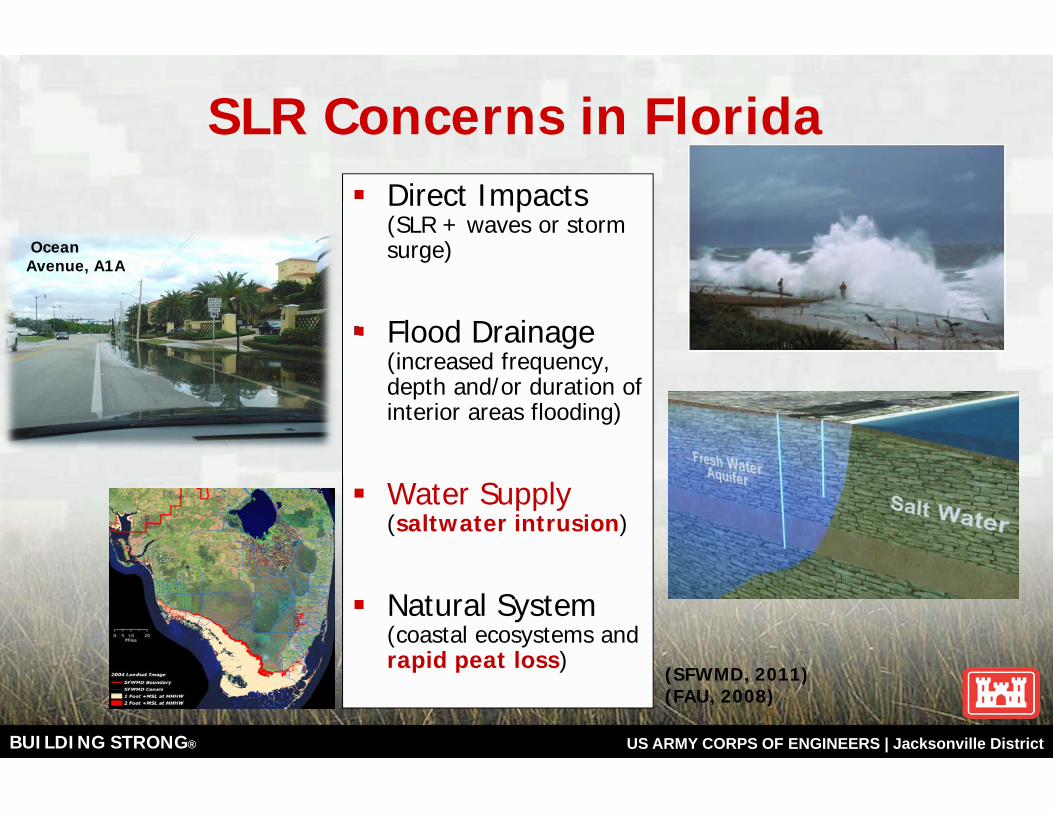
Direct Impacts (SLR + waves or storm surge)
Flood Drainage (increased frequency, depth and/or duration of interior areas flooding)
Water Supply (saltwater intrusion)
Natural System (coastal ecosystems and rapid peat loss)
SLR Concerns in Florida
Ocean Avenue, A1A
(SFWMD, 2011) (FAU, 2008)
BUILDING STRONG® US ARMY CORPS OF ENGINEERS | Jacksonville District
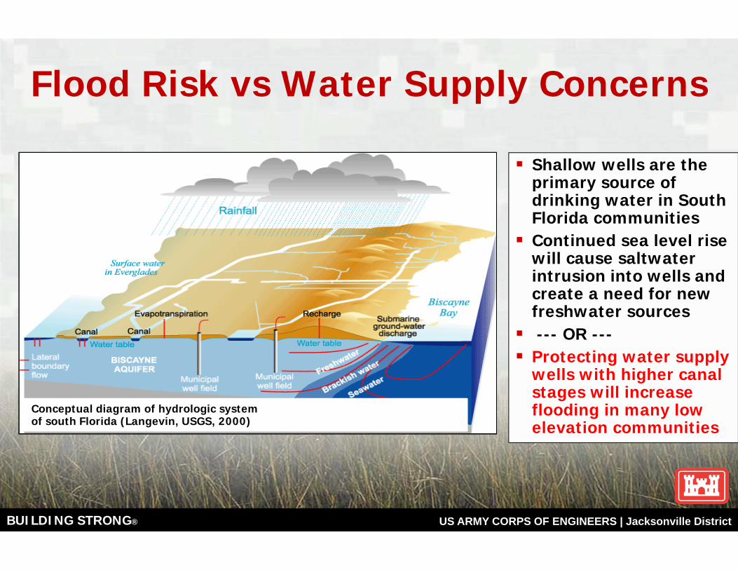
Shallow wells are the primary source of drinking water in South Florida communities Continued sea level rise will cause saltwater intrusion into wells and create a need for new freshwater sources--- OR ---
Protecting water supply wells with higher canal stages will increase flooding in many low elevation communities
Conceptual diagram of hydrologic systemof south Florida (Langevin, USGS, 2000)
Flood Risk vs Water Supply Concerns
BUILDING STRONG® US ARMY CORPS OF ENGINEERS | Jacksonville District
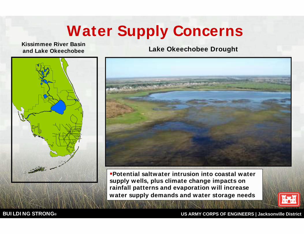
Water Supply ConcernsKissimmee River Basin and Lake Okeechobee Lake Okeechobee Drought
Potential saltwater intrusion into coastal water supply wells, plus climate change impacts on rainfall patterns and evaporation will increase water supply demands and water storage needs
BUILDING STRONG® US ARMY CORPS OF ENGINEERS | Jacksonville District
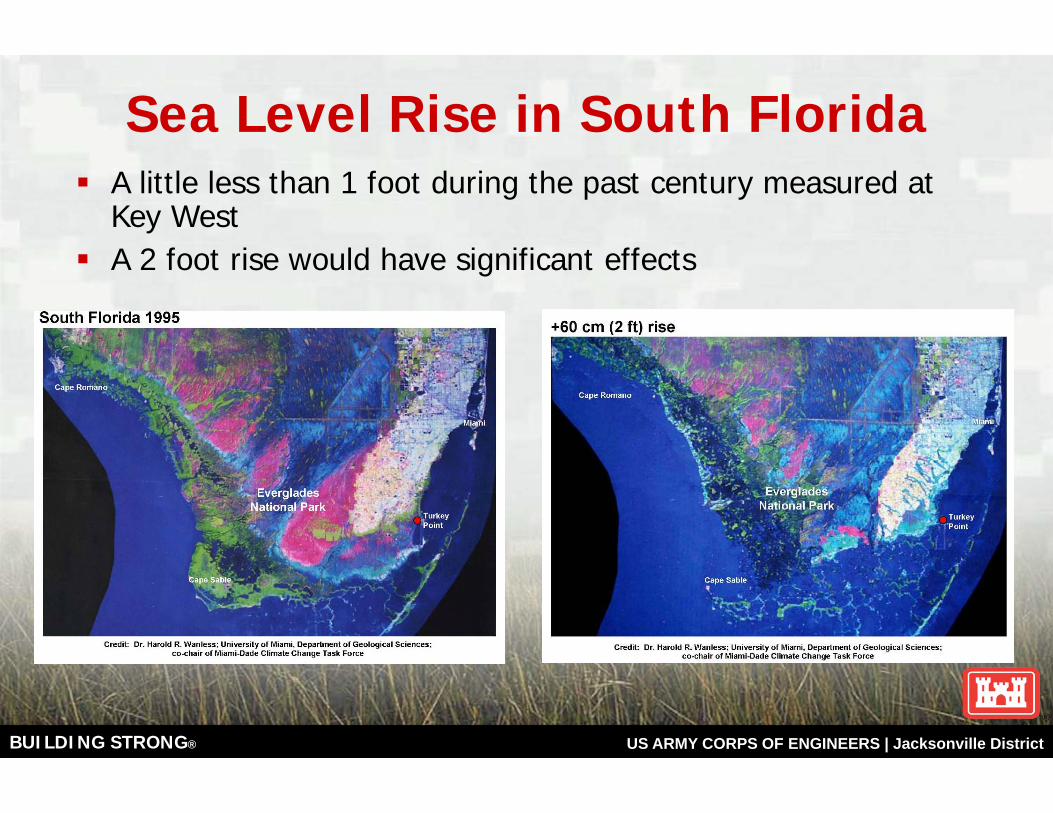
Sea Level Rise in South FloridaA little less than 1 foot during the past century measured at Key WestA 2 foot rise would have significant effects
BUILDING STRONG® US ARMY CORPS OF ENGINEERS | Jacksonville District
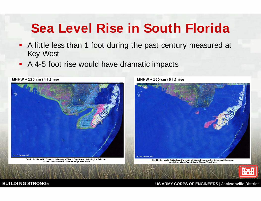
Sea Level Rise in South FloridaA little less than 1 foot during the past century measured at Key WestA 4-5 foot rise would have dramatic impacts
MHHW +120 cm (4 ft) rise MHHW +150 cm (5 ft) rise

BUILDING STRONG® US ARMY CORPS OF ENGINEERS | Jacksonville District
GIS projections of 2 ft of SLR over Everglades topography with / without Peat Soils
BUILDING STRONG® US ARMY CORPS OF ENGINEERS | Jacksonville District
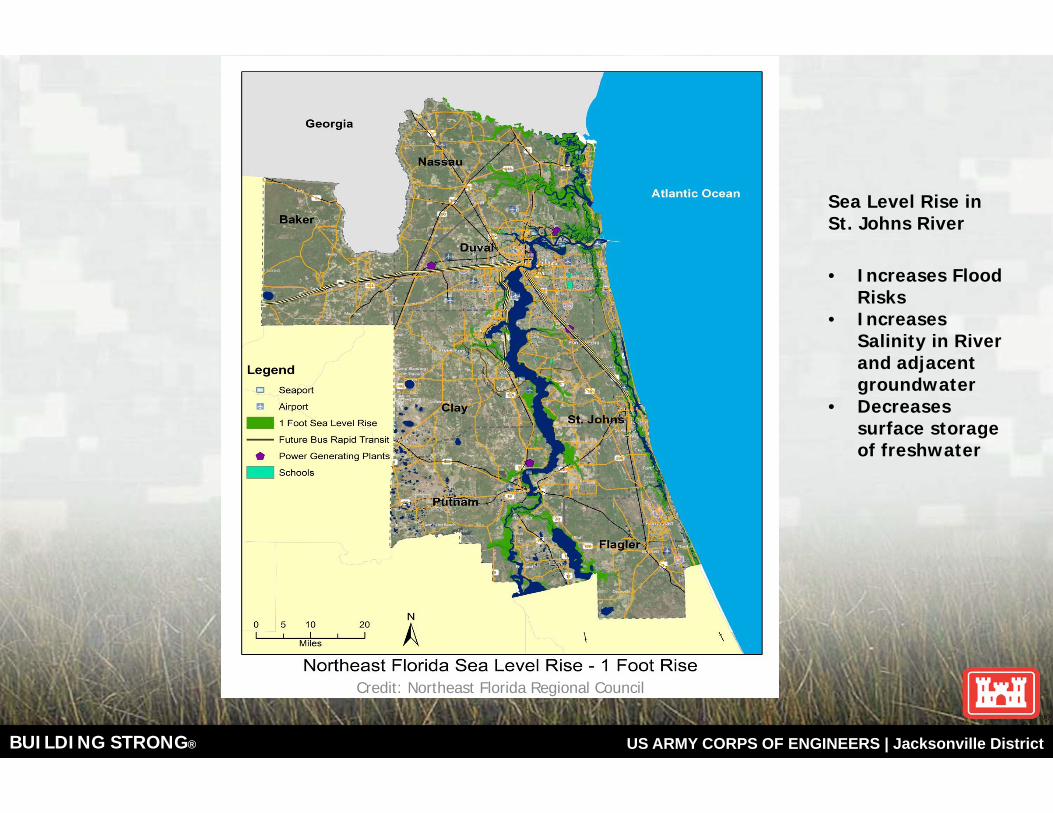
Credit: Northeast Florida Regional Council
Sea Level Rise in St. Johns River
• Increases Flood Risks
• Increases Salinity in River and adjacent groundwater
• Decreases surface storage of freshwater

BUILDING STRONG® US ARMY CORPS OF ENGINEERS | Jacksonville District
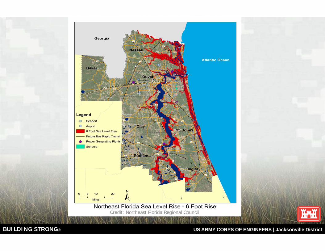
Credit: Northeast Florida Regional Council
BUILDING STRONG® US ARMY CORPS OF ENGINEERS | Jacksonville District
Credit: Northeast Florida Regional Council
BUILDING STRONG® US ARMY CORPS OF ENGINEERS | Jacksonville District
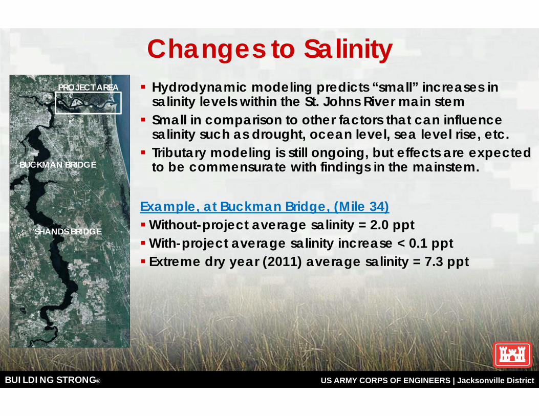
Changes to SalinityHydrodynamic modeling predicts “small” increases in salinity levels within the St. Johns River main stem Small in comparison to other factors that can influence salinity such as drought, ocean level, sea level rise, etc.Tributary modeling is still ongoing, but effects are expected to be commensurate with findings in the mainstem.
Example, at Buckman Bridge, (Mile 34)Without-project average salinity = 2.0 pptWith-project average salinity increase < 0.1 pptExtreme dry year (2011) average salinity = 7.3 ppt
BUCKMAN BRIDGE
PROJECT AREA
SHANDS BRIDGE
BUILDING STRONG® US ARMY CORPS OF ENGINEERS | Jacksonville District
26
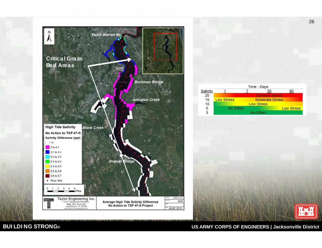
Critical Grass Bed Areas
BUILDING STRONG® US ARMY CORPS OF ENGINEERS | Jacksonville District
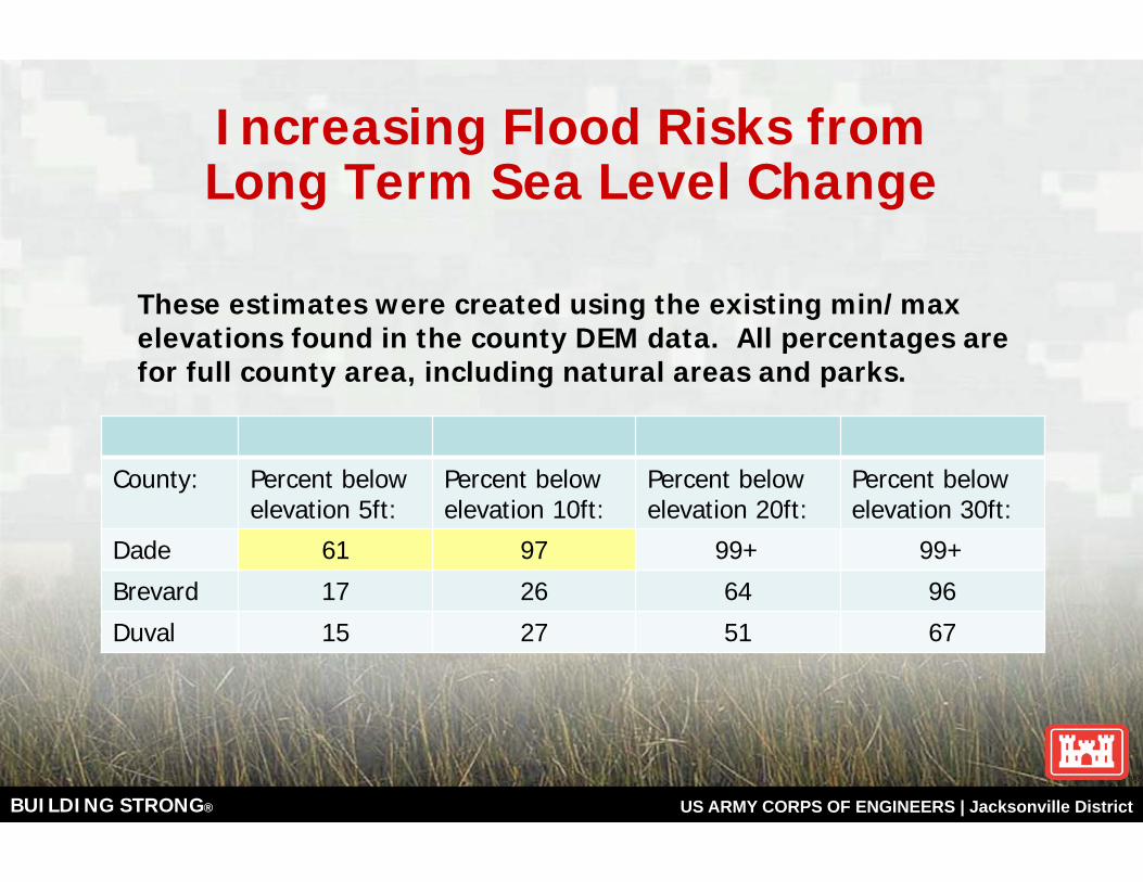
Increasing Flood Risks from Long Term Sea Level Change
These estimates were created using the existing min/maxelevations found in the county DEM data. All percentages are for full county area, including natural areas and parks.
County: Percent below elevation 5ft:
Percent below elevation 10ft:
Percent below elevation 20ft:
Percent below elevation 30ft:
Dade 61 97 99+ 99+
Brevard 17 26 64 96
Duval 15 27 51 67
BUILDING STRONG® US ARMY CORPS OF ENGINEERS | Jacksonville District
Risk
Risk is a measure of the probability and consequence of uncertain future eventsRisk includes • Potential for gain (opportunities) • Exposure to losses (hazards)
28
BUILDING STRONG® US ARMY CORPS OF ENGINEERS | Jacksonville District
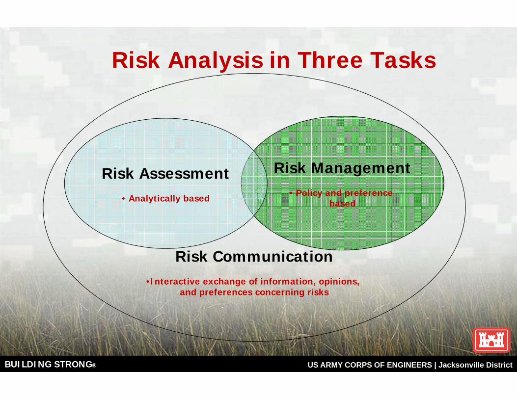
Risk Analysis in Three Tasks
Risk Management• Policy and preference
based
Risk Assessment• Analytically based
Risk Communication•Interactive exchange of information, opinions,
and preferences concerning risks
BUILDING STRONG® US ARMY CORPS OF ENGINEERS | Jacksonville District
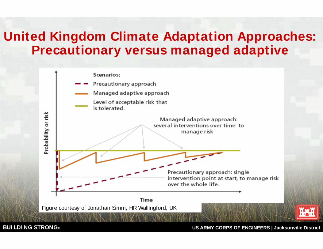
United Kingdom Climate Adaptation Approaches:Precautionary versus managed adaptive
Figure courtesy of Jonathan Simm, HR Wallingford, UK
BUILDING STRONG® US ARMY CORPS OF ENGINEERS | Jacksonville District
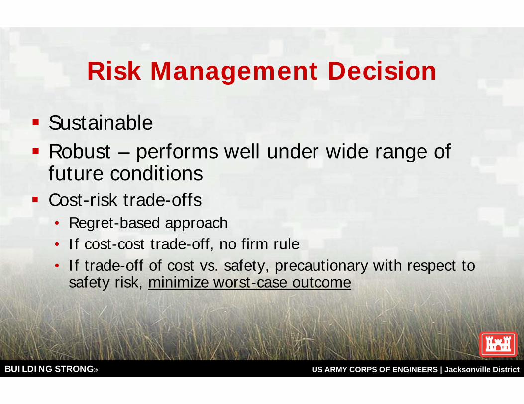
Risk Management Decision
SustainableRobust – performs well under wide range of future conditionsCost-risk trade-offs• Regret-based approach• If cost-cost trade-off, no firm rule• If trade-off of cost vs. safety, precautionary with respect to
safety risk, minimize worst-case outcome
BUILDING STRONG® US ARMY CORPS OF ENGINEERS | Jacksonville District
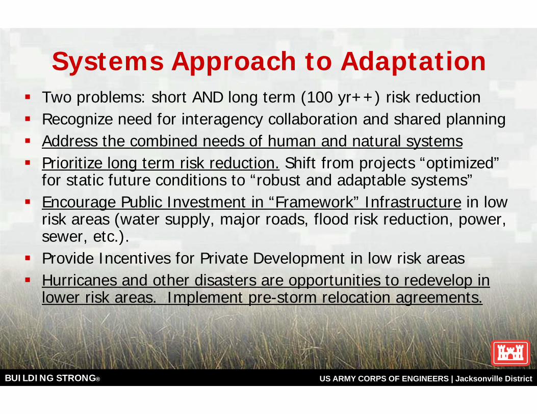
Systems Approach to Adaptation Two problems: short AND long term (100 yr++) risk reductionRecognize need for interagency collaboration and shared planning Address the combined needs of human and natural systemsPrioritize long term risk reduction. Shift from projects “optimized” for static future conditions to “robust and adaptable systems” Encourage Public Investment in “Framework” Infrastructure in low risk areas (water supply, major roads, flood risk reduction, power, sewer, etc.).Provide Incentives for Private Development in low risk areasHurricanes and other disasters are opportunities to redevelop in lower risk areas. Implement pre-storm relocation agreements.
BUILDING STRONG® US ARMY CORPS OF ENGINEERS | Jacksonville District
Florida Sea Level Rise ConcernsTake Away Points
USACE SLR projections are based on guidance from the National Research Council, are site specific and include local uplift or subsidence. Does not address wave and storm surge frequency.SLR PERMANENTLY increases coastal flood frequencyLeading Indicators of Sea Level Rise, such as the reduction in polar ice caps, and the recent rapid increases in the rate of glacier melting worldwide forecast significant SLR rate increasesLong Term Sea Level Rise Adaptation Strategies are needed at project, community, watershed, and national scalesUSACE Watershed Planning Authority – With local support, might be an option for coordinated interagency regional SLR adaptation planning. Cost share up to 75/25 federal/local.
BUILDING STRONG® US ARMY CORPS OF ENGINEERS | Jacksonville District
Ideas for Discussion Focus on short AND long term (100 yr+) risk reductionRecognize many buildings are remodeled or rebuilt after 50 yearsShift planning from projects “optimized” for static future conditions to “robust and adaptable systems” that support long term risk reduction plans Establish unified sea level rise scenarios for watersheds or other broad areas for coordinated planning purposes Remember how the Interstate Highway System changed city development patterns. Build “Framework” Infrastructure (major roads, power, water, sewer, etc.) in low risk areas and strongly encourage private development in these areas.Hurricanes and other disasters are opportunities to redevelop in low risk areas. Implement pre-storm relocation agreements.
BUILDING STRONG® US ARMY CORPS OF ENGINEERS | Jacksonville District
Thank you!
For additional information, contact:[email protected]