ex.3: wetland and watercourse report – loop of the ... mcf vol. 2/ex... · table 2.0–1...
TRANSCRIPT

Municipal Consultation Filing for the Interstate Reliability Project
EX.3: Wetland and Watercourse Report – Loop of the
Manchester to Millstone Line into Card Street Substation
– 2008

Wetland & Watercourse Report
Loop of the Manchester to Millstone Line into Card Street Substation Portion of
The Interstate Reliability Project
Connecticut
Prepared For:
The Connecticut Light & Power Company d/b/a Northeast Utilities System
107 Selden Street Berlin, Connecticut 06037
Prepared By:
ENSR 11 Phelps Way P.O. Box 506
Willington, Connecticut 06279
August 2008

TABLE OF CONTENTS
SECTION PAGE Section 1.0 Introduction and Methods…………………………………………………….1 Section 2.0 Wetland and Watercourse Descriptions…………………………………….3 TABLES: Table 2.0–1 Delineated Wetlands along the 310 Line Loop and in the Vicinity of the
Card Street Substation Table 2.0–2 Delineated Watercourses along the 310 Line Loop and in the Vicinity of
the Card Street Substation ATTACHMENTS: Attachment A Wetland Boundary Mapping Attachment B Wetland and Watercourse Representative Photographs Attachment C Wetland Data Forms Attachment D Hydric Soil and Wetland Mapping Resources

Connecticut Interstate Reliability Project Wetland & Watercourse Report 310 Line Loop
Page 1
Section 1.0 Introduction and Methods ENSR was retained by Burns & McDonnell Engineering Company, Inc. on behalf of
Northeast Utilities to perform wetland delineations on the subject right-of-way (ROW)
along the Loop of the Manchester to Millstone Line into the Card Street Substation (310
Line Loop), and in the vicinity of the Card Street Substation1 in the Town of Lebanon,
Connecticut, as shown on the Project Index Map in Attachment A.
The 310 Line Loop is the rearrangement of an existing Connecticut Light and Power
Company (CL&P) line from Manchester Substation to Millstone Substation to connect to
the Card Street Substation. This component of the Interstate Reliability Project (IRP or
the Project) includes adding two 345 kV line segments to “Loop” the 310 circuit through
the substation and extends approximately 1.7 miles west of the substation to the Village
Hill Road Junction. This component of the Project would be located almost entirely
within an existing 300 foot ROW in the Town of Lebanon, Connecticut. Some additional
ROW would also need to be acquired off of the northwest corner of CL&P’s existing
ROW at Card Street. Additional engineering and other studies will be required to
quantify any potential impacts associated with this component of the Project.
The field surveys were performed on the subject areas January 17 through January 23,
2008 and April 30, 2008. The purpose of the field surveys was to define the boundaries
of state and federal jurisdictional wetlands along the existing CL&P ROW. The wetlands
delineated during the field surveys are depicted on the Wetland Boundary Mapping
included in Attachment A.
The Inland Wetlands and Watercourses Act (The Act) (Sections 22a-36 through 22a-45a
of the Connecticut General Statutes) defines inland wetlands as “land including
submerged land…which consists of any soil types designated as poorly drained, very
poorly drained, alluvial, and floodplain”. Watercourses are defined in The Act as “rivers,
streams, brooks, waterways, lakes, ponds, marshes, swamps, bogs and all other bodies
of water, natural or artificial, vernal or intermittent, public or private, which are contained
within, flow through or border upon the state or any portion thereof.” The Act defines
1 Wetlands were delineated within 100 feet of the existing substation fence line.

Connecticut Interstate Reliability Project Wetland & Watercourse Report 310 Line Loop
Page 2
Intermittent Watercourses as having a defined permanent channel, bed, bank and the
occurrence of two of the following: A) evidence of scour or deposits of recent alluvium or
detritus, B) the presence of standing or flowing water for a duration longer than a
particular storm incident, and C) the presence of hydrophytic vegetation.
In accordance with the Army Corps of Engineers 1987 Wetlands Delineation Manual,
1987 (Manual), hydrophytic vegetation, hydric soils, and wetland hydrology must all be
present for a wetland to be subject to jurisdiction under Section 404 of the Clean Water
Act. While both state and federal methodologies were employed in the field during the
course of the delineations, state and federal wetland boundaries are concurrent
throughout the subject ROW.
ENSR personnel located and flagged wetland and watercourse boundaries in the field
while simultaneously using a Trimble Global Positioning System (GPS) unit, capable of
sub meter accuracy, to locate the boundaries, which are shown on the Wetland
Boundary Maps (Attachment A). Each wetland and watercourse was subsequently
assigned a unique identification number based on geographic location. During the
course of field surveys, representative photographs of the wetlands were taken
(Attachment B) and Wetland Summary Field Data Forms were completed (Attachment
C).
Database and mapping resources used prior to field activities included the use of
Geographic Information System (GIS), published wetland maps (e.g. National Wetland
Inventory (NWI) maps, Connecticut Department of Environmental Protection (DEP)
wetland mapping), soil surveys depicting hydric soil locations, and the examination of
recent aerial photographs of the Project ROW. Examples of these database and
mapping resources are provided in Figures 1 through 3 (Attachment D).
Concurrent with the delineations, wetland functions and values were also assessed
using the thirteen parameter U.S. Army Corps of Engineers Highway Methodology
Workbook and The Highway Methodology Workbook supplement. The thirteen functions
and values incorporated into this approach are: Groundwater Recharge/Discharge,
Floodflow Alteration, Fish and Shellfish Habitat, Sediment and Toxicant Retention,
Nutrient Removal, Production Export, Sediment/Shoreline Stabilization, Wildlife habitat,
Connecticut Interstate Reliability Project Wetland & Watercourse Report 310 Line Loop
Page 3
Recreation, Educational/Scientific Value, Uniqueness/Heritage, Visual Quality/Aesthetics
and Endangered Species Habitat. Functions and values form the basis from which
potential impacts to wetlands are assessed. Functions are defined as self sustaining
properties of a wetland system that exist in the absence of society while values are
benefits derived from either one or more functions and the physical characteristics of the
wetland itself. This approach is acceptable to the U.S. Army Corps New England District
Regulatory Program and may be used for any project where the characterization of
wetland resources is necessary for Section 404 permit requirements. This information is
included with each of the sixteen wetland descriptions included in this report.
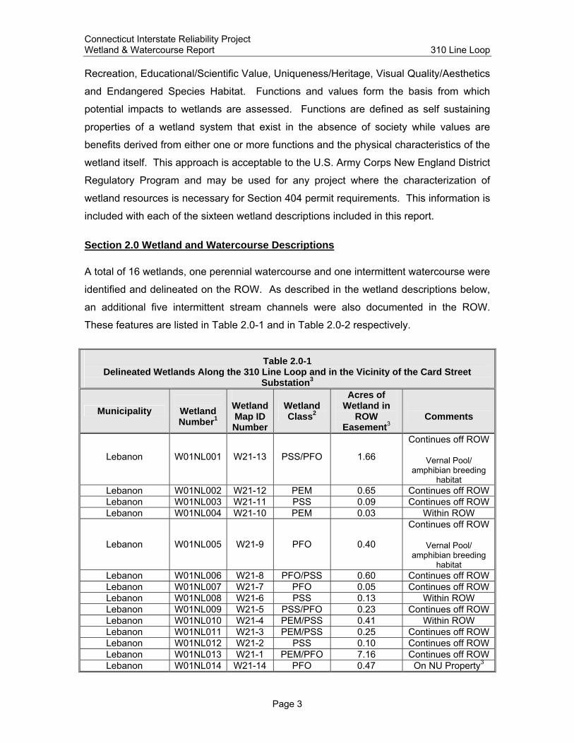
Section 2.0 Wetland and Watercourse Descriptions A total of 16 wetlands, one perennial watercourse and one intermittent watercourse were
identified and delineated on the ROW. As described in the wetland descriptions below,
an additional five intermittent stream channels were also documented in the ROW.
These features are listed in Table 2.0-1 and in Table 2.0-2 respectively.
Table 2.0-1 Delineated Wetlands Along the 310 Line Loop and in the Vicinity of the Card Street
Substation3
Municipality
Wetland Number1
Wetland Map ID Number
Wetland Class2
Acres of Wetland in
ROW Easement3
Comments
Lebanon W01NL001 W21-13 PSS/PFO 1.66
Continues off ROW
Vernal Pool/ amphibian breeding
habitat Lebanon W01NL002 W21-12 PEM 0.65 Continues off ROW Lebanon W01NL003 W21-11 PSS 0.09 Continues off ROW Lebanon W01NL004 W21-10 PEM 0.03 Within ROW
Lebanon W01NL005 W21-9 PFO 0.40
Continues off ROW
Vernal Pool/ amphibian breeding
habitat Lebanon W01NL006 W21-8 PFO/PSS 0.60 Continues off ROW Lebanon W01NL007 W21-7 PFO 0.05 Continues off ROW Lebanon W01NL008 W21-6 PSS 0.13 Within ROW Lebanon W01NL009 W21-5 PSS/PFO 0.23 Continues off ROW Lebanon W01NL010 W21-4 PEM/PSS 0.41 Within ROW Lebanon W01NL011 W21-3 PEM/PSS 0.25 Continues off ROW Lebanon W01NL012 W21-2 PSS 0.10 Continues off ROW Lebanon W01NL013 W21-1 PEM/PFO 7.16 Continues off ROW Lebanon W01NL014 W21-14 PFO 0.47 On NU Property3
Connecticut Interstate Reliability Project Wetland & Watercourse Report 310 Line Loop
Page 4
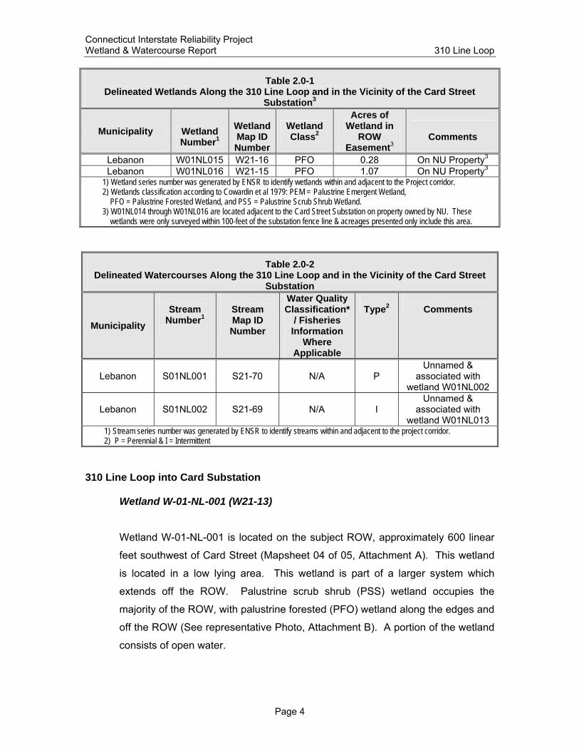
Table 2.0-1 Delineated Wetlands Along the 310 Line Loop and in the Vicinity of the Card Street
Substation3
Municipality
Wetland Number1
Wetland Map ID Number
Wetland Class2
Acres of Wetland in
ROW Easement3
Comments
Lebanon W01NL015 W21-16 PFO 0.28 On NU Property3 Lebanon W01NL016 W21-15 PFO 1.07 On NU Property3
1) Wetland series number was generated by ENSR to identify wetlands within and adjacent to the Project corridor. 2) Wetlands classification according to Cowardin et al 1979: PEM = Palustrine Emergent Wetland, PFO = Palustrine Forested Wetland, and PSS = Palustrine Scrub Shrub Wetland. 3) W01NL014 through W01NL016 are located adjacent to the Card Street Substation on property owned by NU. These wetlands were only surveyed within 100-feet of the substation fence line & acreages presented only include this area.
Table 2.0-2 Delineated Watercourses Along the 310 Line Loop and in the Vicinity of the Card Street
Substation
Municipality
Stream
Number1
Stream Map ID Number
Water Quality Classification*
/ Fisheries Information
Where Applicable
Type2
Comments
Lebanon S01NL001 S21-70 N/A P Unnamed &
associated with wetland W01NL002
Lebanon S01NL002 S21-69 N/A I Unnamed &
associated with wetland W01NL013
1) Stream series number was generated by ENSR to identify streams within and adjacent to the project corridor. 2) P = Perennial & I = Intermittent
310 Line Loop into Card Substation
Wetland W-01-NL-001 (W21-13)
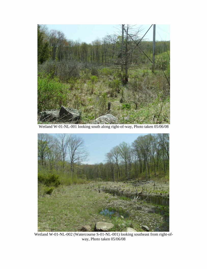
Wetland W-01-NL-001 is located on the subject ROW, approximately 600 linear
feet southwest of Card Street (Mapsheet 04 of 05, Attachment A). This wetland
is located in a low lying area. This wetland is part of a larger system which
extends off the ROW. Palustrine scrub shrub (PSS) wetland occupies the
majority of the ROW, with palustrine forested (PFO) wetland along the edges and
off the ROW (See representative Photo, Attachment B). A portion of the wetland
consists of open water.

Connecticut Interstate Reliability Project Wetland & Watercourse Report 310 Line Loop
Page 5
Vegetation in this wetland consisted of red maple (Acer rubrum), yellow birch
(Betula alleghaniensis), and white oak (Quercus alba) trees with understory
vegetation consisting of witch-hazel (Hamamelis virginiana), red cedar (Juniperus
virginiana), red-osier dogwood (Cornus stolonifera), maleberry (Lyonia ligustrina),
multiflora rose (Rosa multiflora), soft rush (Juncus effusus), sensitive fern
(Onoclea sensibilis), cinnamon fern (Osmunda cinnamomea), common reed
(Phragmites australis), reed canary grass (Phalaris arundinacea), wool-grass
(Scirpus cyperinus), goldenrods (Solidago spp.), meadowsweet (Spiraea
latifolia), and steeple bush (Spiraea tomentosa). Signs of beaver and fox were
noted in this area. Overland flow from adjacent uplands around this wetland
influence the hydrology of this area. Hydrologic indicators noted within this
wetland included standing water, water-stained leaves, water marks, and
inundated soils. Mineral and organic hydric soils were noted in this area (See
Wetland Summary Field Data Form, Attachment C).
Functions and values associated with this wetland include groundwater recharge/
discharge, floodflow alteration, sediment and toxicant retention, nutrient removal,
production export, sediment/shoreline stabilization, and wildlife habitat.
Wetland W-01-NL-002 (W21-12)
Wetland W-01-NL-002 is located in the subject ROW, approximately 1,000 linear
feet southwest of Card Street (Mapsheet 03 of 05, Attachment A). This wetland
is located in a low lying area which is part of a larger system extending off the
ROW (See representative Photo, Attachment B). Perennial stream (S-01-NL-
001) flows through the wetland, which influences the hydrology of this wetland. A
berm at the centerline of the ROW causes water to pond east of the ROW.
Vegetation in this palustrine emergent (PEM) wetland includes maleberry, soft
rush, sensitive fern, and wool-grass. This wetland extends west of the ROW as a
PFO wetland. Hydrologic indicators noted within this wetland included water-
stained leaves, drainage patterns, and inundated soils. Mineral hydric soils were
noted in this area (See Wetland Summary Field Data Form, Attachment C).

Connecticut Interstate Reliability Project Wetland & Watercourse Report 310 Line Loop
Page 6
Functions and values associated with this wetland include groundwater recharge/
discharge, floodflow alteration, sediment and toxicant retention, nutrient removal,
production export, sediment/shoreline stabilization, and wildlife habitat.
Watercourse S-01-NL-001 (S21-70)
Watercourse S-01-NL-001 is an unnamed perennial tributary which flows west
through Wetland W-01-NL-002 to its confluence with the Ten Mile River. This
watercourse is shown on Mapsheet 03 of 05 in Attachment A (See representative
Photo, Attachment B). This stream receives flow from an adjacent unnamed
pond to the southwest.
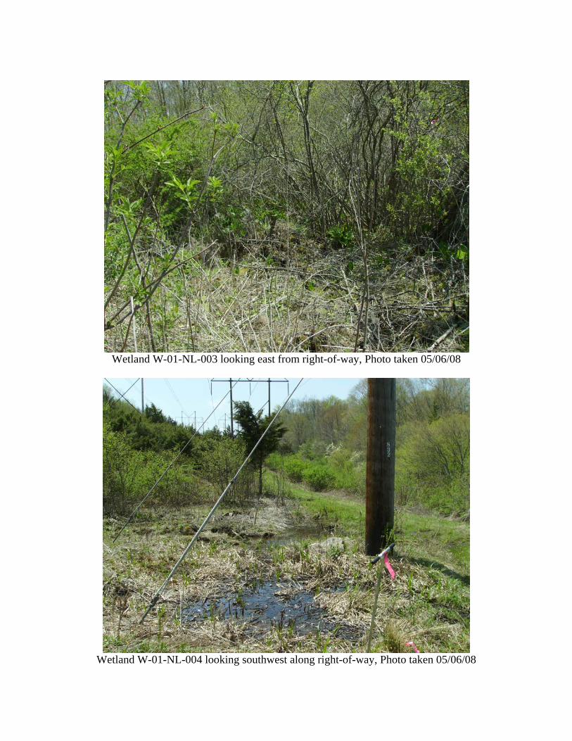
Wetland W-01-NL-003 (W21-11)
Wetland W-01-NL-003 is a PSS wetland located on the subject ROW
approximately 1,200 linear feet southwest of Card Street (Mapsheet 03 of 05,
Attachment A). Although part of a larger wetland complex, this PSS wetland has
been delineated as being isolated (See representative Photo, Attachment B).
Vegetation in this wetland included silky dogwood (Cornus amomum), witch-
hazel, sensitive fern, and reed canary grass. Overland flow from adjacent
uplands to the south and east influence the hydrology of this area. Hydrologic
indicators noted within this wetland included water-stained leaves and inundated
soils. Mineral hydric soils were noted in this area (See Wetland Summary Field
Data Form, Attachment C).
As a relatively small, isolated wetland, the functions and values associated with
Wetland W-01-NL-003 are limited amounts of groundwater recharge/discharge,
floodflow alteration, sediment and toxicant retention, nutrient removal and wildlife
habitat.

Connecticut Interstate Reliability Project Wetland & Watercourse Report 310 Line Loop
Page 7
Wetland W-01-NL-004 (W21-10)
Wetland W-01-NL-004 is located on the subject ROW approximately 1,200 linear
feet southwest of Card Street (Mapsheet 03 of 05, Attachment A). This PEM
wetland is adjacent to Wetland W-01-NL-003 (See representative Photo,
Attachment B).
Vegetation in this area included sensitive fern, reed canary grass, and steeple
bush. Overland flow from adjacent uplands to the south influence the hydrology
of this area. Hydrologic indicators noted within this wetland included standing
water and water-stained leaves. Mineral hydric soils were noted in this area (See
Wetland Summary Field Data Form, Attachment C).
As a relatively small, isolated wetland, the functions and values associated with
Wetland W-01-NL-004 are limited amounts of groundwater recharge/discharge,
floodflow alteration, sediment and toxicant retention, nutrient removal and wildlife
habitat.
Wetland W-01-NL-005 (W21-9)
Wetland W-01-NL-005 is located on the subject ROW approximately 1,200 linear
feet southwest of Card Street and adjacent to Wetland W-01-NL-004 (Mapsheet
03 of 05, Attachment A). This wetland is part of a larger system which extends
off the ROW and eventually connects to Wetland W-01-NL-002 (See
representative Photo, Attachment B).
Vegetation in this PFO wetland included red maple, yellow birch, and beech
(Fagus grandifolia) trees and understory vegetation consisting of American
hornbeam (Carpinus caroliniana), witch-hazel, red-osier dogwood, honeysuckle
(Lonicera sp.), multiflora rose, highbush blueberry (Vaccinium corymbosum),
sensitive fern, cinnamon fern, sphagnum moss (Sphagnum sp.), Japanese
barberry (Berberis thunbergii), and sedges (Carex spp.). Overland flow from
adjacent uplands to the south influence the hydrology of this area. Two
intermittent stream channels were noted in this wetland, which convey flows

Connecticut Interstate Reliability Project Wetland & Watercourse Report 310 Line Loop
Page 8
northward off of the ROW. Hydrologic indicators noted within this wetland
included pockets of standing water, surface scouring, drainage patterns, water-
stained leaves, and inundated soils. Mineral hydric soils were noted in this area
(See Wetland Summary Field Data Form, Attachment C).
Functions and values associated with this wetland include groundwater recharge/
discharge, floodflow alteration, sediment and toxicant retention, nutrient removal,
production export, sediment/shoreline stabilization, and wildlife habitat.
Wetland W-01-NL-006 (W21-8)
Wetland W-01-NL-006 is located on the subject ROW approximately 1,600 linear
feet southwest of Card Street and adjacent to Wetland W-01-NL-005 (Mapsheet
03 of 05, Attachment A). This PFO/PSS wetland is part of a larger system which
extends off the ROW and eventually connects to Wetland W-01-NL-002 (See
representative Photo, Attachment B).
Vegetation in this area included red maple, silky dogwood, sensitive fern,
cinnamon fern, and sphagnum moss. Hydrologic indicators noted in the wetland
included water-stained leaves and drainage patterns. Overland flow from
adjacent uplands to the south influence the hydrology of this area. An
intermittent stream channel was present within the wetland, which conveys flows
northward off of the ROW. Mineral hydric soils were noted in this area (See
Wetland Summary Field Data Form, Attachment C).
Functions and values associated with this wetland include groundwater recharge/
discharge, floodflow alteration, sediment and toxicant retention, nutrient removal,
production export, sediment/shoreline stabilization, and wildlife habitat.
Wetland W-01-NL-007 (W21-7)
Wetland W-01-NL-007 is located on the subject ROW approximately 2,000 linear
feet southwest of Card Street and south of Wetland W-01-NL-006 (Mapsheet 03

Connecticut Interstate Reliability Project Wetland & Watercourse Report 310 Line Loop
Page 9
of 05, Attachment A). This PFO wetland is part of a larger system which extends
off the ROW (See representative Photo, Attachment B).
Vegetation in this wetland included hemlock (Tsuga canadensis), silky dogwood,
witch-hazel, sensitive fern, cinnamon fern, and sphagnum moss. Overland flow
from adjacent uplands to the south influence the hydrology of this area. An
intermittent stream channel was present within the wetland, which conveys flows
northward across the ROW and is the main source of hydrology for this wetland.
Hydrologic indicators noted included water-stained leaves, surface scouring, and
drainage patterns within the wetland. Mineral hydric soils were noted in this area
(See Wetland Summary Field Data Form, Attachment C).
Functions and values associated with this wetland include groundwater recharge/
discharge, floodflow alteration, sediment and toxicant retention, nutrient removal,
production export, sediment/shoreline stabilization, and wildlife habitat.
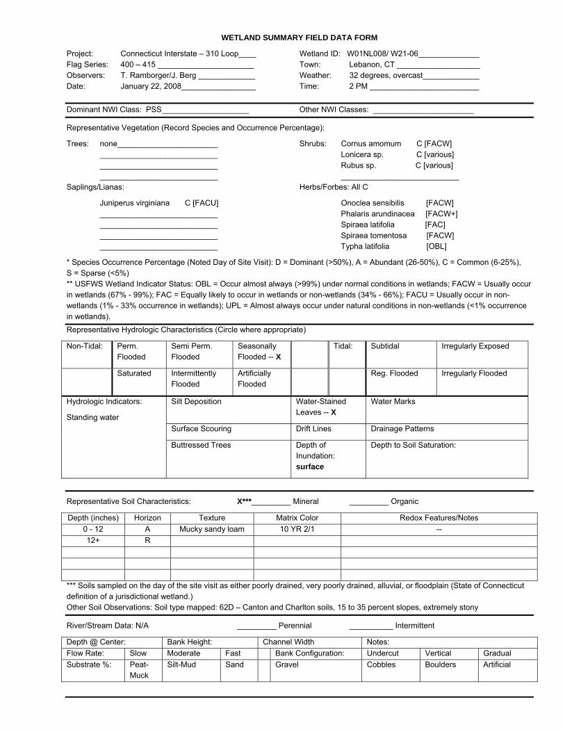
Wetland W-01-NL-008 (W21-6)
Wetland W-01-NL-008 is located on the subject ROW approximately 2,000 linear
feet southwest of Card Street and south of Wetland W-01-NL-006 (Mapsheet 03
of 05, Attachment A). This PSS wetland is adjacent to W-01-NL-009.
Vegetation in this area included red cedar, silky dogwood, honeysuckle,
blackberry (Rubus sp.), sensitive fern, reed canary grass, meadowsweet, steeple
bush, and broad-leaf cattail (Typha latifolia) (See representative Photo,
Attachment B). Hydrologic indicators noted within this wetland included standing
water, water-stained leaves, and inundated soils. Overland flow from adjacent
uplands to the south influence the hydrology in this wetland. Mineral hydric soils
were noted in this area (See Wetland Summary Field Data Form, Attachment C).
As a relatively small, isolated wetland, the functions and values associated with
Wetland W-01-NL-008 are limited amounts of groundwater recharge/discharge,
floodflow alteration, sediment and toxicant retention, nutrient removal and wildlife
habitat.
Connecticut Interstate Reliability Project Wetland & Watercourse Report 310 Line Loop
Page 10
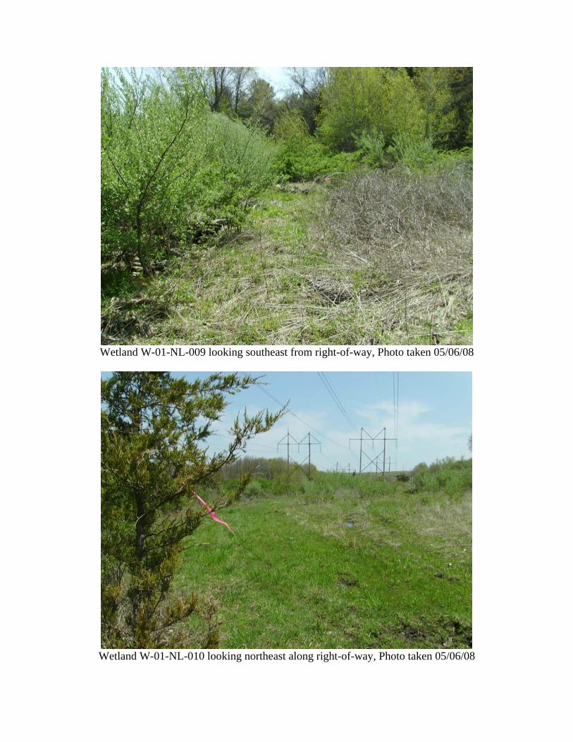
Wetland W-01-NL-009 (W21-5)
Wetland W-01-NL-009 is located on the subject ROW approximately 800 linear
feet northeast of Village Hill Road (Mapsheet 02 of 05, Attachment A). This PSS
wetland is part of a larger system which extends off the ROW as a PFO wetland
(See representative Photo, Attachment B).
Vegetation in this wetland included silky dogwood, honeysuckle, blackberry,
sensitive fern, cinnamon fern, and goldenrods. Overland flow from adjacent
uplands to the south influence the hydrology in this wetland. An intermittent
stream channel was present within the wetland, which conveys flows northward
across the ROW and is the main source of hydrology to this area. Hydrologic
indicators noted included water-stained leaves, surface scouring, and drainage
patterns within the wetland. Mineral hydric soils were noted in this area (See
Wetland Summary Field Data Form, Attachment C).
Functions and values associated with this wetland include groundwater recharge/
discharge, floodflow alteration, sediment and toxicant retention, nutrient removal,
production export, sediment/shoreline stabilization, and wildlife habitat.
Wetland W-01-NL-010 (W21-4)
Wetland W-01-NL-010 is located on the subject ROW approximately 800 linear
feet northeast of Village Hill Road (Mapsheet 02 of 05, Attachment A). This PEM
wetland is adjacent to Wetland W-01-NL-009, but is a PSS wetland at the edges
of the ROW (See representative Photo, Attachment B).
Vegetation in this wetland included silky dogwood, red cedar, multiflora rose,
sedges, rush (Juncus sp.), sensitive fern, goldenrods, and steeple bush.
Overland flow from adjacent uplands to the south influence the hydrology in this
wetland. Hydrologic indicators noted included standing water, water-stained
leaves, and drainage patterns within the wetland. Mineral hydric soils were noted
in this area (See Wetland Summary Field Data Form, Attachment C).

Connecticut Interstate Reliability Project Wetland & Watercourse Report 310 Line Loop
Page 11
As a relatively small, isolated wetland, the functions and values associated with
Wetland W-01-NL-008 are limited amounts of groundwater recharge/discharge,
floodflow alteration, sediment and toxicant retention, nutrient removal and wildlife
habitat.
Wetland W-01-NL-011 (W21-3)
Wetland W-01-NL-011 is located on the subject ROW approximately 600 linear
feet northeast of Village Hill Road (Mapsheet 02 of 05, Attachment A). This PEM
wetland is part of a larger system which extends off the ROW as a PSS wetland
(See representative Photo, Attachment B).
Vegetation in this wetland included sedges, rushes, sensitive fern and
goldenrods. Overland flow from adjacent uplands to the south influence the
hydrology in this wetland. Hydrologic indicators noted included standing water,
water-stained leaves and drainage patterns within the wetland. Mineral hydric
soils were noted in this area (See Wetland Summary Field Data Form,
Attachment C).
Functions and values associated with this wetland include groundwater recharge/
discharge, floodflow alteration, sediment and toxicant retention, nutrient removal,
production export, sediment/shoreline stabilization, and wildlife habitat.
Wetland W-01-NL-012 (W21-2)
Wetland W-01-NL-012 is located on the subject ROW adjacent to, and north of,
Village Hill Road (Mapsheet 02 of 05, Attachment A). This PSS wetland is
associated with a channelized area conveying runoff under Village Hill Road.
Vegetation in this wetland included speckled alder (Alnus rugosa), American
hornbeam, silky dogwood, sensitive fern, cinnamon fern, and common reed (See
representative Photo, Attachment B). Overland flow and side slope seepage
from adjacent uplands to the east influence the hydrology in this wetland.
Hydrologic indicators noted included water-stained leaves and drainage patterns
Connecticut Interstate Reliability Project Wetland & Watercourse Report 310 Line Loop
Page 12
within the wetland. A culvert under Village Hill Road carries flow from this
wetland to Wetland W-01-NL-013. Mineral hydric soils were noted in this area
(See Wetland Summary Field Data Form, Attachment C).
Functions and values associated with this wetland include groundwater recharge/
discharge, floodflow alteration, sediment and toxicant retention, nutrient removal,
production export, sediment/shoreline stabilization, and wildlife habitat.
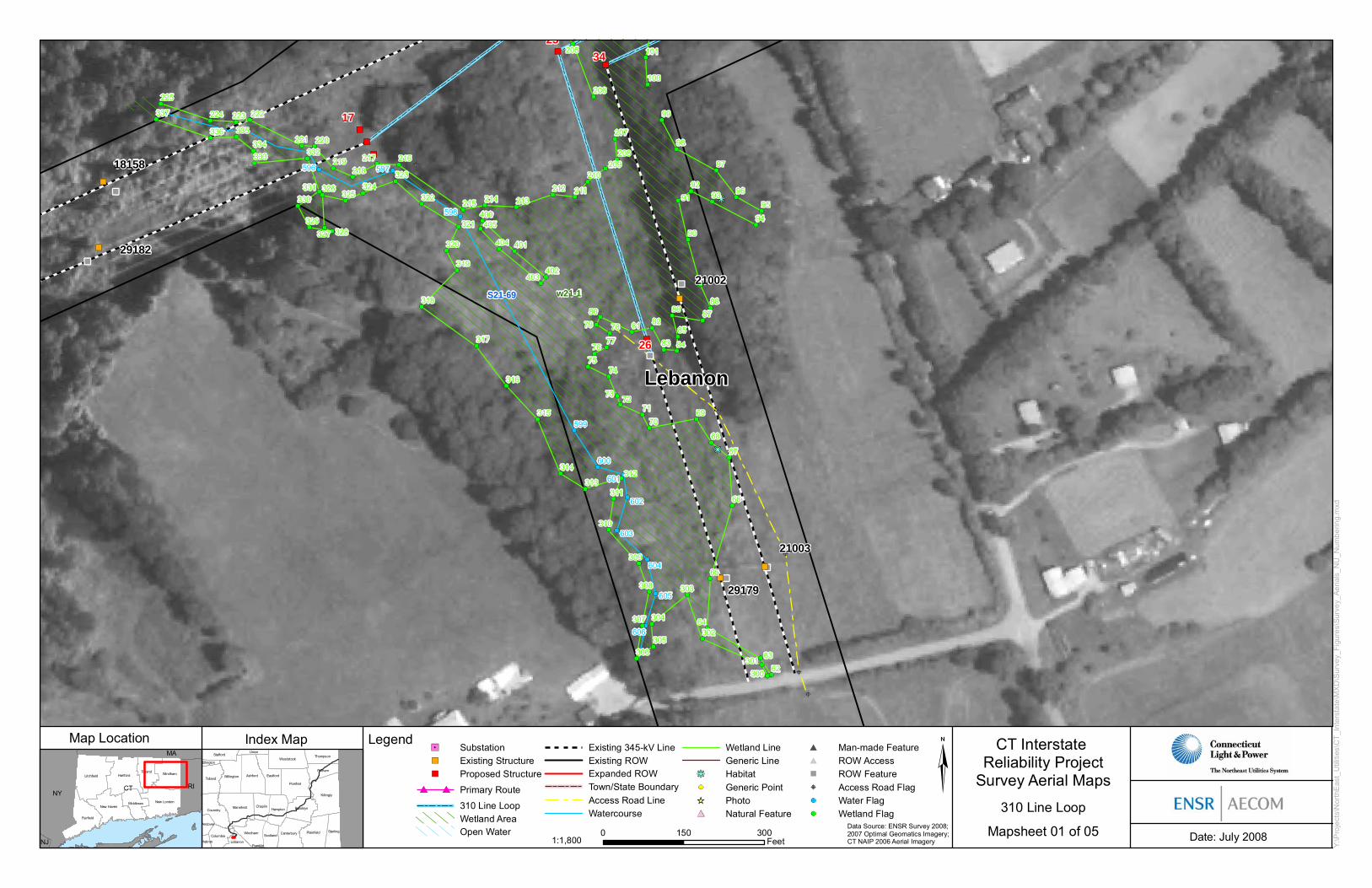
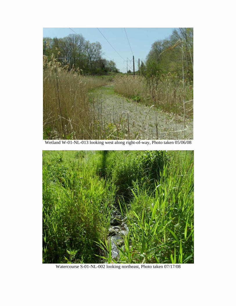
Wetland W-01-NL-013 (W21-1)
Wetland W-01-NL-013 is located on the subject ROW adjacent to, and south of,
Village Hill Road (Mapsheet 01 and 02 of 05, Attachment A). This PEM wetland
is part of a larger system which extends off the ROW as a PFO wetland.
Vegetation in this wetland consists primarily of common reed (See representative
Photo, Attachment B). Other species present included silky dogwood, spicebush
(Lindera benzoin), multiflora rose, and sensitive fern. Watercourse S-01-NL-002
flows across this area and is a source of hydrology to this wetland, along with
overland flow from adjacent uplands to the west and east of this wetland area.
Hydrologic indicators noted within this wetland included drainage patterns and
water-stained leaves. Mineral hydric soils were noted in this area (See Wetland
Summary Field Data Form, Attachment C).
Functions and values associated with this wetland include groundwater recharge/
discharge, floodflow alteration, sediment and toxicant retention, nutrient removal,
production export, sediment/shoreline stabilization, and wildlife habitat.
Watercourse S-01-NL-002 (S21-69)
Watercourse S-01-NL-002 is an unnamed intermittent tributary which flows
northwest through Wetland W-01-NL-013 to the Ten Mile River (Mapsheet 01 of
05, Attachment A). This stream receives flow from an adjacent unnamed pond to
the southwest (See representative Photo, Attachment B).

Connecticut Interstate Reliability Project Wetland & Watercourse Report 310 Line Loop
Page 13
Wetland W-01-NL-014 (W21-14)
Wetland W-01-NL-014 is located within 100 linear feet of the southeast corner of
the Card Street Substation (Mapsheet 05 of 05, Attachment A). This PFO
wetland area is part of a larger system which extends eastward.
Vegetation in this wetland included red maple and yellow birch trees and an
understory of American hornbeam, highbush blueberry, and sensitive fern (See
representative Photo, Attachment B). Overland flow from adjacent uplands
influence the hydrology in this wetland. Hydrologic indicators noted within this
wetland included standing water, water-stained leaves, drainage patterns, and
inundated soils. A culvert under the entrance way to the substation
hydrologically connects this wetland with Wetland W-01-NL-016. Mineral hydric
soils were noted in this area (See Wetland Summary Field Data Form,
Attachment C).
Functions and values associated with this wetland include groundwater recharge/
discharge, floodflow alteration, sediment and toxicant retention, nutrient removal,
production export, sediment/shoreline stabilization, and wildlife habitat.
Wetland W-01-NL-015 (W21-16)
Wetland W-01-NL-015 is located within 100 linear feet of the northeast corner of
the Card Street Substation (Mapsheet 05 of 05, Attachment A). This PFO
wetland is part of a larger system which extends northward and eastward.
Vegetation in this wetland included red maple and yellow birch trees and an
understory consisting of American hornbeam, spicebush, highbush blueberry,
and sensitive fern (See representative Photo, Attachment B). Overland flows
from adjacent uplands influence the hydrology in this wetland. Hydrologic
indicators noted within this wetland included water-stained leaves. Mineral hydric
soils were noted in this area (See Wetland Summary Field Data Form,
Attachment C).
Connecticut Interstate Reliability Project Wetland & Watercourse Report 310 Line Loop
Page 14
Functions and values associated with this wetland include groundwater recharge/
discharge, floodflow alteration, sediment and toxicant retention, nutrient removal,
production export, sediment/shoreline stabilization, and wildlife habitat.
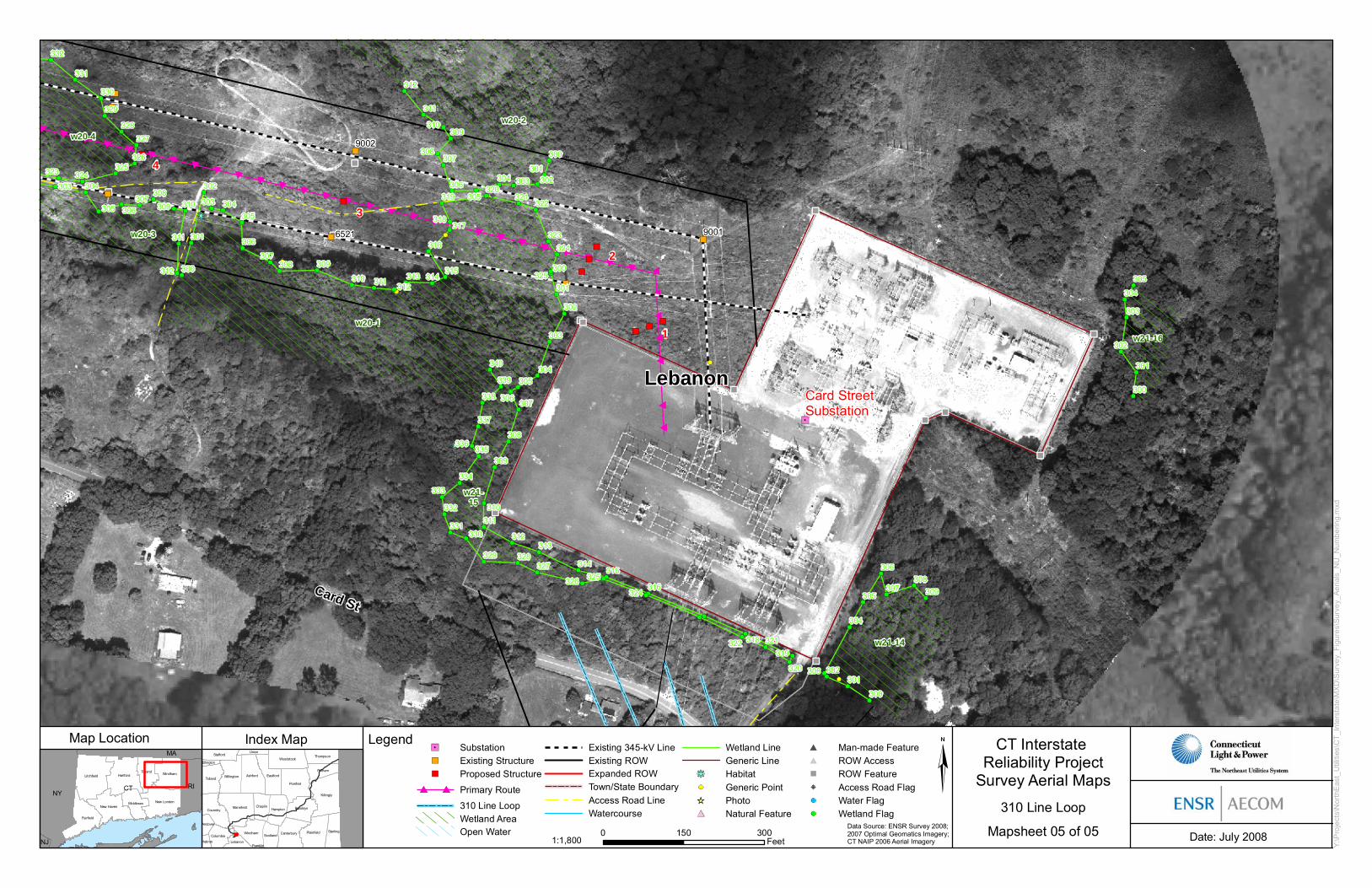
Wetland W-01-NL-016 (W21-15)
Wetland W-01-NL-016 is located along the western and southern edges of the
Card Street Substation (Mapsheet 05 of 05, Attachment A). This PFO wetland
consists of a narrow rock lined channel along the southern extent of the
substation, which carries runoff to the western side of the substation. This PFO
wetland area is part of a larger system which extends off the ROW to the west.
The vegetation in this wetland included red maple and yellow birch trees with an
understory consisting of witch-hazel, silky dogwood, spicebush, multiflora rose,
highbush blueberry, sensitive fern, cinnamon fern, sphagnum moss and skunk
cabbage (Symplocarpus foetidus) (See representative Photo, Attachment B).
Overland flows from adjacent uplands influence the hydrology in this wetland. A
culvert under the entrance way to the substation hydrologically connects this
wetland with Wetland W-01-NL-014, conveying flows from that area. Hydrologic
indicators noted within this wetland included standing water, drainage patterns,
and water-stained leaves. Mineral hydric soils were noted in this area (See
Wetland Summary Field Data Form, Attachment C).
Functions and values associated with this wetland include groundwater recharge/
discharge, floodflow alteration, sediment and toxicant retention, nutrient removal,
production export, sediment/shoreline stabilization, and wildlife habitat.

Attachment A
Wetland Boundary Mapping


ConnecticutRhode Island
Primary Route
310 Line Loop
Lake RoadSubstation
Card StreetSubstation
VillageHill Rd
Jct.
54
21
3
109108
107106105
104103
102
10110099
989796
9594
9392
919089
88
878685
8483
82818079
787776
7574
7372717069686766
6564
636261
6059
585756
5554
5352515049
48474645
44434241403938373635343332
3130292827
2625
2423
222120
1918
17161514
1312
1110
987
65
43 2
1
LebanonHebron
Columbia Scotland
Windham Canterbury
Andover
Plainfield Sterling
Bolton
Brooklyn
Hampton
ChaplinMansfield
Coventry
Killingly
Pomfret
Tolland
Putnam
Ellington
WillingtonAshford
Eastford
ThompsonWoodstock
UnionStafford
Somers
CT
MA
RI
NY
Map Location CT Interstate Reliability Project
Survey AerialsIndex Map
CT DEP GIS, Town Boundary, 2005.
0 2.5 5 7.5 10Miles
1:160,0001 inch equals 2.5 miles Date: July 2008
S:\C
T_In
ters
tate
\MX
D\S
urve
y_Fi
gure
s\S
urve
y_A
eria
ls_I
ndex
.mxd
Legend
SubstationJunctionPrimary Route310 Line Loop
Index Map
Primary Routeand 310 Line Loop
18158
29182
29179
21002
21003
17
25
26
34
S21-69
Lebanon
w21-1
596 597
598
599
606
605
604
603
602
601
600
207
208209
210
211212213214
405
404
403402
401
400215
216217218
219
220221
222223224
225
337
336 335
334333 332
331330
329328327
326325
324323
322
321
320
319
318
317
316
315
314
313312
311
310
309
308
307
306305
304
303
302
301300 62
63
64
65
66
67
68
6970
7172
73
7475
7677
787980
81 82
83 84
85
86 8788
90
91
9293
94
95
96
97
98
99
100
101
206
205
Index Map CT Interstate Reliability Project
Survey Aerial Maps
Date: July 2008
Y:\P
roje
cts\
Nor
thE
ast_
Util
ities
\CT_
Inte
rsta
te\M
XD
\Sur
vey_
Figu
res\
Surv
ey_A
eria
ls_N
U_N
umbe
ring.
mxd
Map Location
Data Source: ENSR Survey 2008;2007 Optimal Geomatics Imagery;CT NAIP 2006 Aerial Imagery
310 Line Loop
Mapsheet 01 of 05
SubstationExisting StructureProposed Structure
Primary Route
310 Line LoopWetland AreaOpen Water
Existing 345-kV LineExisting ROWExpanded ROWTown/State BoundaryAccess Road LineWatercourse
Wetland LineGeneric LineHabitatGeneric PointPhotoNatural Feature
Man-made FeatureROW AccessROW FeatureAccess Road FlagWater FlagWetland Flag
Killingly
Pomfret
Ashford
Mansfield
Plainfield
TollandEastford
Coventry
Willington
Brooklyn
Woodstock
Canterbury SterlingWindham
Hampton
Putnam
Chaplin
Stafford
Columbia
Thompson
Scotland
Lebanon
Union
Ellington
Andover
HebronFranklin
CTNY
RI
MA
NJ
Litchfield Hartford
Fairfield
Tolland Windham
New LondonNew Haven
Middlesex
Legend
0 150 300Feet1:1,800

5
6
7
8
13
14
15
16
17
22
23
24
25
31
32
33
34
Card St
Village Hill RdS21-69
Lebanon
w21-5
w21-3
w21-2
w21-4
w21-1VillageHill RdJct.
596 597
598
207
208209
210
211212213214
405400
215
216217218
219
220221
222
334333 332
331
330
329328327
326325 324
323
322
32190
9192
93
94
95
96
97
98
99
306
100
101
102
103
104
105
106107
108109
110
206
205
204
203
200
201
202
310 309 308
305
304
307
303
302301300
315
314313
312
311 310
309
308
307
306305
304
303302301
300
407
406
405404
402
401
400
207
206
205
204
203
202
201
200 111110
109108
107
106105
104
103
102101
100
Index Map CT Interstate Reliability Project
Survey Aerial Maps
Date: July 2008
Y:\P
roje
cts\
Nor
thE
ast_
Util
ities
\CT_
Inte
rsta
te\M
XD
\Sur
vey_
Figu
res\
Surv
ey_A
eria
ls_N
U_N
umbe
ring.
mxd
Map Location
Data Source: ENSR Survey 2008;2007 Optimal Geomatics Imagery;CT NAIP 2006 Aerial Imagery
310 Line Loop
Mapsheet 02 of 05
SubstationExisting StructureProposed Structure
Primary Route
310 Line LoopWetland AreaOpen Water
Existing 345-kV LineExisting ROWExpanded ROWTown/State BoundaryAccess Road LineWatercourse
Wetland LineGeneric LineHabitatGeneric PointPhotoNatural Feature
Man-made FeatureROW AccessROW FeatureAccess Road FlagWater FlagWetland Flag
Killingly
Pomfret
Ashford
Mansfield
Plainfield
TollandEastford
Coventry
Willington
Brooklyn
Woodstock
Canterbury SterlingWindham
Hampton
Putnam
Chaplin
Stafford
Columbia
Thompson
Scotland
Lebanon
Union
Ellington
Andover
HebronFranklin
CTNY
RI
MA
NJ
Litchfield Hartford
Fairfield
Tolland Windham
New LondonNew Haven
Middlesex
Legend
0 150 300Feet1:1,800

3
4
5
10
11
12
13
19
20
21
22
28
29
30
31
S21-70
Lebanon
w21-12
w21-13
w21-5
w21-11w21-10w21-9
w21-8
w21-7w21-6
w21-4
506
505
504 503
502501
500
407
406
405
206
205
204
203
202
111110
109108
107
106105
104
103
102101
415 414413 412
411
410 409
408
406405
404402
401
400
319318 317
316
315
314
312
311310
309308
307
304 303
302
301
307307
307307
307307307
307307
307
307
307
307
307307 307
307
307
307 307
313
312
311
310
309
308
307 306
305
304
303
302
301
300
333
332
331
330
329
328
327326
324323
325322
321320
319
318
317316
315
314
313 312
311
310 309308
307 306
305
304303
302301
300
404403
402
401410
409 408 407406
405404
403
402401
400212211210
209
208207206
205204
203202201
200108
107 106
105104 103
102
101100
204
203
202
201 200
Index Map CT Interstate Reliability Project
Survey Aerial Maps
Date: July 2008
Y:\P
roje
cts\
Nor
thE
ast_
Util
ities
\CT_
Inte
rsta
te\M
XD
\Sur
vey_
Figu
res\
Surv
ey_A
eria
ls_N
U_N
umbe
ring.
mxd
Map Location
Data Source: ENSR Survey 2008;2007 Optimal Geomatics Imagery;CT NAIP 2006 Aerial Imagery
310 Line Loop
Mapsheet 03 of 05
SubstationExisting StructureProposed Structure
Primary Route
310 Line LoopWetland AreaOpen Water
Existing 345-kV LineExisting ROWExpanded ROWTown/State BoundaryAccess Road LineWatercourse
Wetland LineGeneric LineHabitatGeneric PointPhotoNatural Feature
Man-made FeatureROW AccessROW FeatureAccess Road FlagWater FlagWetland Flag
Killingly
Pomfret
Ashford
Mansfield
Plainfield
TollandEastford
Coventry
Willington
Brooklyn
Woodstock
Canterbury SterlingWindham
Hampton
Putnam
Chaplin
Stafford
Columbia
Thompson
Scotland
Lebanon
Union
Ellington
Andover
HebronFranklin
CTNY
RI
MA
NJ
Litchfield Hartford
Fairfield
Tolland Windham
New LondonNew Haven
Middlesex
Legend
0 150 300Feet1:1,800

1
2
3
9
10
18
19
27
28
Card St
Card St
S21-70
Lebanon
w21-12
w21-15
w21-13
w21-14
w21-11w21-9
506
505
504 503
502501
500
327326
319
320
321322 318
324316
325 315
309308306
307305
304
303 302
300
301
313
333
332
331
330
329
328 305
304303
302301
300
401400
209
208207206
205204
203202201
200108
107 106
105104 103
102
101100
208207
206
205
204
203
202
201 200
107
106
105104
103102
101
100
Index Map CT Interstate Reliability Project
Survey Aerial Maps
Date: July 2008
Y:\P
roje
cts\
Nor
thE
ast_
Util
ities
\CT_
Inte
rsta
te\M
XD
\Sur
vey_
Figu
res\
Surv
ey_A
eria
ls_N
U_N
umbe
ring.
mxd
Map Location
Data Source: ENSR Survey 2008;2007 Optimal Geomatics Imagery;CT NAIP 2006 Aerial Imagery
310 Line Loop
Mapsheet 04 of 05
SubstationExisting StructureProposed Structure
Primary Route
310 Line LoopWetland AreaOpen Water
Existing 345-kV LineExisting ROWExpanded ROWTown/State BoundaryAccess Road LineWatercourse
Wetland LineGeneric LineHabitatGeneric PointPhotoNatural Feature
Man-made FeatureROW AccessROW FeatureAccess Road FlagWater FlagWetland Flag
Killingly
Pomfret
Ashford
Mansfield
Plainfield
TollandEastford
Coventry
Willington
Brooklyn
Woodstock
Canterbury SterlingWindham
Hampton
Putnam
Chaplin
Stafford
Columbia
Thompson
Scotland
Lebanon
Union
Ellington
Andover
HebronFranklin
CTNY
RI
MA
NJ
Litchfield Hartford
Fairfield
Tolland Windham
New LondonNew Haven
Middlesex
Legend
0 150 300Feet1:1,800
1
2
3
4
Card St
Lebanon
w21-16
w20-2
w20-3
w21-15
w20-4
w21-14
w20-1
340
339
338
337
300
301302303304
305306
307308
309310
311
312
332
331
330
329
328
327
326325
324323
303 304
305 306307
308
309 310
311
312 300
301
302
303 304305
306
307308 309
310 311 312313 314
315
316
317318
319320
321322
323
324
325
336335
334
333
332
330331
329 328327
326
319
320
321322 318
324316
325315
314
313312
311
310
309
308
307306
305304
303
302
301
300305
304
303
302
301
300
309308
306
307305
304
303 302
300
301
Card StreetSubstation
9001
9002
6521
Index Map CT Interstate Reliability Project
Survey Aerial Maps
Date: July 2008
Y:\P
roje
cts\
Nor
thE
ast_
Util
ities
\CT_
Inte
rsta
te\M
XD
\Sur
vey_
Figu
res\
Surv
ey_A
eria
ls_N
U_N
umbe
ring.
mxd
Map Location
Data Source: ENSR Survey 2008;2007 Optimal Geomatics Imagery;CT NAIP 2006 Aerial Imagery
310 Line Loop
Mapsheet 05 of 05
SubstationExisting StructureProposed Structure
Primary Route
310 Line LoopWetland AreaOpen Water
Existing 345-kV LineExisting ROWExpanded ROWTown/State BoundaryAccess Road LineWatercourse
Wetland LineGeneric LineHabitatGeneric PointPhotoNatural Feature
Man-made FeatureROW AccessROW FeatureAccess Road FlagWater FlagWetland Flag
Killingly
Pomfret
Ashford
Mansfield
Plainfield
TollandEastford
Coventry
Willington
Brooklyn
Woodstock
Canterbury SterlingWindham
Hampton
Putnam
Chaplin
Stafford
Columbia
Thompson
Scotland
Lebanon
Union
Ellington
Andover
HebronFranklin
CTNY
RI
MA
NJ
Litchfield Hartford
Fairfield
Tolland Windham
New LondonNew Haven
Middlesex
Legend
0 150 300Feet1:1,800

Attachment B
Wetland and Watercourse Representative Photographs

Wetland W-01-NL-001 looking south along right-of-way, Photo taken 05/06/08
Wetland W-01-NL-002 (Watercourse S-01-NL-001) looking southeast from right-of-
way, Photo taken 05/06/08
Wetland W-01-NL-003 looking east from right-of-way, Photo taken 05/06/08
Wetland W-01-NL-004 looking southwest along right-of-way, Photo taken 05/06/08

Wetland W-01-NL-005 looking southwest along right-of-way, Photo taken 05/06/08
Wetland W-01-NL-006 looking northeast along right-of-way, Photo taken 05/06/08

Wetland W-01-NL-007 looking north along right-of-way, Photo taken 05/06/08
Wetland W-01-NL-008 looking west on right-of-way, Photo taken 05/06/08
Wetland W-01-NL-009 looking southeast from right-of-way, Photo taken 05/06/08
Wetland W-01-NL-010 looking northeast along right-of-way, Photo taken 05/06/08

Wetland W-01-NL-011 looking northeast along right-of-way, Photo taken 05/06/08
Wetland W-01-NL-012 looking southeast along right-of-way, Photo taken 05/06/08
Wetland W-01-NL-013 looking west along right-of-way, Photo taken 05/06/08
Watercourse S-01-NL-002 looking northeast, Photo taken 07/17/08

Wetland W-01-NL-014 looking southeast from substation, Photo taken 05/06/08
Wetland W-01-NL-015 looking southeast from substation, Photo taken 05/06/08

Wetland W-01-NL-016 looking northwest across right-of-way, Photo taken 05/06/08


Attachment C
Wetland Data Forms

WETLAND SUMMARY FIELD DATA FORM
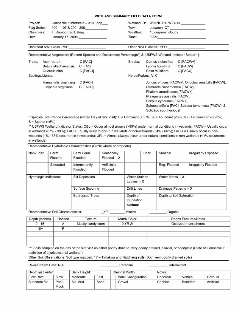
Project: Connecticut Interstate – 310 Loop___ Wetland ID: W01NL001/ W21-13 _____________ Flag Series: 100 – 107 & 200 - 208____________ Town: Lebanon, CT ___________________ Observers: T. Ramborger/J. Berg____________ Weather: 15 degrees, cloudy_______________ Date: January 17, 2008 _______________ Time: 9 AM__________________________
Dominant NWI Class: PSS____________________ Other NWI Classes: PFO ____________________
Representative Vegetation: (Record Species and Occurrence Percentage*) & [USFWS Wetland Indicator Status**]:
Trees: Acer rubrum C [FAC] Shrubs: Cornus stolonifera C [FACW+] Betula alleghaniensis C [FAC] Lyonia ligustrina C [FACW] Quercus alba C [FACU] Rosa multiflora C [FACU] Saplings/Lianas: Herbs/Forbes: All C
Hamamelis virginiana C [FAC-] Juncus effuses [FACW+], Onoclea sensibilis [FACW], Juniperus virginiana C [FACU] Osmunda cinnamomea [FACW], Phalaris arundinacea [FACW+], Phragmites australis [FACW], Scirpus cyperinus [FACW+], Spiraea latifolia [FAC], Spiraea tomentosa [FACW], & Solidago spp. [various]
* Species Occurrence Percentage (Noted Day of Site Visit): D = Dominant (>50%), A = Abundant (26-50%), C = Common (6-25%), S = Sparse (<5%) ** USFWS Wetland Indicator Status: OBL = Occur almost always (>99%) under normal conditions in wetlands; FACW = Usually occur in wetlands (67% - 99%); FAC = Equally likely to occur in wetlands or non-wetlands (34% - 66%); FACU = Usually occur in non-wetlands (1% - 33% occurrence in wetlands); UPL = Almost always occur under natural conditions in non-wetlands (<1% occurrence in wetlands). Representative Hydrologic Characteristics (Circle where appropriate)
Non-Tidal: Perm. Flooded
Semi Perm. Flooded
Seasonally Flooded -- X
Tidal: Subtidal Irregularly Exposed
Saturated Intermittently Flooded
Artificially Flooded
Reg. Flooded Irregularly Flooded
Silt Deposition Water-Stained Leaves -- X
Water Marks -- X
Surface Scouring Drift Lines Drainage Patterns -- X
Hydrologic Indicators:
Buttressed Trees Depth of Inundation: surface
Depth to Soil Saturation:
Representative Soil Characteristics: _X***________ Mineral _________ Organic
Depth (inches) Horizon Texture Matrix Color Redox Features/Notes 0 - 16 A Mucky sandy loam 10 YR 2/1 Oxidized rhizospheres 16+ R
*** Soils sampled on the day of the site visit as either poorly drained, very poorly drained, alluvial, or floodplain (State of Connecticut definition of a jurisdictional wetland.) Other Soil Observations: Soil type mapped: 17 – Timakwa and Natchaug soils (Both very poorly drained soils)
River/Stream Data: N/A _________ Perennial __________ Intermittent
Depth @ Center: Bank Height: Channel Width Notes: Flow Rate: Slow Moderate Fast Bank Configuration: Undercut Vertical Gradual Substrate %: Peat-
Muck Silt-Mud Sand Gravel Cobbles Boulders Artificial

WETLAND SUMMARY FIELD DATA FORM
Project: Connecticut interstate – 310 Loop___ Wetland ID: W01NL002/ W21-12 _____________ Flag Series: 100 – 108 & 200 - 211____________ Town: Lebanon, CT ___________________ Observers: T. Ramborger/J.Berg______________ Weather: 25 degrees, cloudy_______________ Date: January 17, 2008________________ Time: 11 AM_________________________
Dominant NWI Class: PEM____________________ Other NWI Classes: ____________________
Representative Vegetation (Record Species and Occurrence Percentage):
Trees: Quercus rubrum on upland banks Shrubs: Lyonia ligustrina C [FACW] ___________________________ ___________________________ ___________________________ ___________________________ ___________________________ ___________________________ ___________________________ ___________________________
Saplings/Lianas: Herbs/Forbes: All C
none_______________________ Juncus effuses [FACW+] ___________________________ Onoclea sensibilis [FACW] ___________________________ Scirpus cyperinus [FACW+] ___________________________ ___________________________ ___________________________ ___________________________
* Species Occurrence Percentage (Noted Day of Site Visit): D = Dominant (>50%), A = Abundant (26-50%), C = Common (6-25%), S = Sparse (<5%) ** USFWS Wetland Indicator Status: OBL = Occur almost always (>99%) under normal conditions in wetlands; FACW = Usually occur in wetlands (67% - 99%); FAC = Equally likely to occur in wetlands or non-wetlands (34% - 66%); FACU = Usually occur in non-wetlands (1% - 33% occurrence in wetlands); UPL = Almost always occur under natural conditions in non-wetlands (<1% occurrence in wetlands). Representative Hydrologic Characteristics (Circle where appropriate)
Non-Tidal: Perm. Flooded
Semi Perm. Flooded
Seasonally Flooded -- X
Tidal: Subtidal Irregularly Exposed
Saturated Intermittently Flooded
Artificially Flooded
Reg. Flooded Irregularly Flooded
Silt Deposition Water-Stained Leaves -- X
Water Marks -- X
Surface Scouring Drift Lines Drainage Patterns -- X
Hydrologic Indicators:
Buttressed Trees Depth of Inundation: 7”
Depth to Soil Saturation:
Representative Soil Characteristics: X***________ Mineral _________ Organic
Depth (inches) Horizon Texture Matrix Color Redox Features/Notes 0 - 7 A Mucky sandy loam 10 YR 2/1 Oxidized rhizospheres
7 – 20+ C Sand 10 YR 2/1 --
*** Soils sampled on the day of the site visit as either poorly drained, very poorly drained, alluvial, or floodplain (State of Connecticut definition of a jurisdictional wetland.) Other Soil Observations: Soil type mapped: 17 – Timakwa and Natchaug soils (Both very poorly drained soils)
River/Stream Data: ID# S01NL001 _X________ Perennial __________ Intermittent
Depth @ Center: 1-2’ Bank Height: Channel Width 4-6’ Notes: Flow Rate: Slow- X Moderate Fast Bank Configuration: Undercut Vertical Gradual X Substrate %: Peat-
Muck Silt-Mud Sand
70 Gravel Cobbles 30 Boulders Artificial

WETLAND SUMMARY FIELD DATA FORM
Project: Connecticut Interstate – 310 Loop ___ Wetland ID: W01NL003/ W21-11_______________ Flag Series: 400 – 410 ______________________ Town: Lebanon, CT____________________ Observers: T. Ramborger/J. Berg_____________ Weather: 30 degrees, cloudy_______________ Date: January 17, 2008 ________________ Time: 1 PM__________________________
Dominant NWI Class: PSS ____________________ Other NWI Classes: _______________________
Representative Vegetation (Record Species and Occurrence Percentage):
Trees: none_______________________ Shrubs: Cornus amomum C [FACW] ___________________________ Hamamelis virginiana C [FAC-] ___________________________ ___________________________ ___________________________ ___________________________ ___________________________ ___________________________
Saplings/Lianas: Herbs/Forbes:
none_______________________ Onoclea sensibilis C [FACW] ___________________________ Phalaris arundinacea C [FACW+] ___________________________ ___________________________ ___________________________ ___________________________ * Species Occurrence Percentage (Noted Day of Site Visit): D = Dominant (>50%), A = Abundant (26-50%), C = Common (6-25%), S = Sparse (<5%) ** USFWS Wetland Indicator Status: OBL = Occur almost always (>99%) under normal conditions in wetlands; FACW = Usually occur in wetlands (67% - 99%); FAC = Equally likely to occur in wetlands or non-wetlands (34% - 66%); FACU = Usually occur in non-wetlands (1% - 33% occurrence in wetlands); UPL = Almost always occur under natural conditions in non-wetlands (<1% occurrence in wetlands). Representative Hydrologic Characteristics (Circle where appropriate)
Non-Tidal: Perm. Flooded
Semi Perm. Flooded
Seasonally Flooded -- X
Tidal: Subtidal Irregularly Exposed
Saturated Intermittently Flooded
Artificially Flooded
Reg. Flooded Irregularly Flooded
Silt Deposition Water-Stained Leaves -- X
Water Marks
Surface Scouring Drift Lines Drainage Patterns
Hydrologic Indicators:
Buttressed Trees Depth of Inundation:
Depth to Soil Saturation:
Representative Soil Characteristics: _X***________ Mineral _________ Organic
Depth (inches) Horizon Texture Matrix Color Redox Features/Notes 0 - 14 A Mucky sandy loam 10 YR 2/1 --
14 – 20+ C Sandy loam 10 YR 5/2 Many fine 10 YR 5/6 redoximorphic features
*** Soils sampled on the day of the site visit as either poorly drained, very poorly drained, alluvial, or floodplain (State of Connecticut definition of a jurisdictional wetland.) Other Soil Observations: Soil type mapped: 61B – Canton and Charlton soils, 3 to 8 percent slopes, very stony
River/Stream Data: N/A _________ Perennial __________ Intermittent
Depth @ Center: Bank Height: Channel Width Notes: Flow Rate: Slow Moderate Fast Bank Configuration: Undercut Vertical Gradual Substrate %: Peat-
Muck Silt-Mud Sand Gravel Cobbles Boulders Artificial
WETLAND SUMMARY FIELD DATA FORM
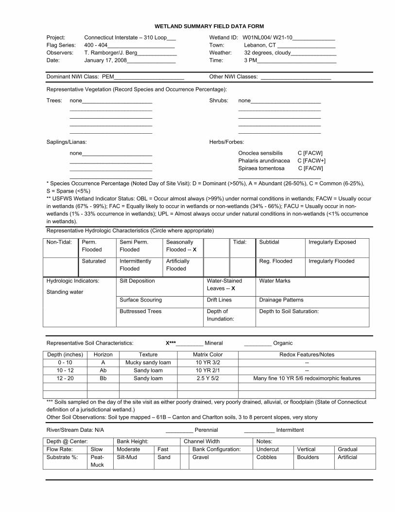
Project: Connecticut Interstate – 310 Loop___ Wetland ID: W01NL004/ W21-10______________ Flag Series: 400 - 404______________________ Town: Lebanon, CT ___________________ Observers: T. Ramborger/J. Berg_____________ Weather: 32 degrees, cloudy_______________ Date: January 17, 2008________________ Time: 3 PM__________________________
Dominant NWI Class: PEM_______________________ Other NWI Classes: _______________________
Representative Vegetation (Record Species and Occurrence Percentage):
Trees: none_______________________ Shrubs: none_______________________ ___________________________ ___________________________ ___________________________ ___________________________ ___________________________ ___________________________ ___________________________ ___________________________
Saplings/Lianas: Herbs/Forbes:
none_______________________ Onoclea sensibilis C [FACW] ___________________________ Phalaris arundinacea C [FACW+] ___________________________ Spiraea tomentosa C [FACW] ___________________________ ___________________________ * Species Occurrence Percentage (Noted Day of Site Visit): D = Dominant (>50%), A = Abundant (26-50%), C = Common (6-25%), S = Sparse (<5%) ** USFWS Wetland Indicator Status: OBL = Occur almost always (>99%) under normal conditions in wetlands; FACW = Usually occur in wetlands (67% - 99%); FAC = Equally likely to occur in wetlands or non-wetlands (34% - 66%); FACU = Usually occur in non-wetlands (1% - 33% occurrence in wetlands); UPL = Almost always occur under natural conditions in non-wetlands (<1% occurrence in wetlands). Representative Hydrologic Characteristics (Circle where appropriate)
Non-Tidal: Perm. Flooded
Semi Perm. Flooded
Seasonally Flooded -- X
Tidal: Subtidal Irregularly Exposed
Saturated Intermittently Flooded
Artificially Flooded
Reg. Flooded Irregularly Flooded
Silt Deposition Water-Stained Leaves -- X
Water Marks
Surface Scouring Drift Lines Drainage Patterns
Hydrologic Indicators:
Standing water
Buttressed Trees Depth of Inundation:
Depth to Soil Saturation:
Representative Soil Characteristics: X***_________ Mineral _________ Organic
Depth (inches) Horizon Texture Matrix Color Redox Features/Notes 0 - 10 A Mucky sandy loam 10 YR 3/2 --
10 - 12 Ab Sandy loam 10 YR 2/1 -- 12 - 20 Bb Sandy loam 2.5 Y 5/2 Many fine 10 YR 5/6 redoximorphic features
*** Soils sampled on the day of the site visit as either poorly drained, very poorly drained, alluvial, or floodplain (State of Connecticut definition of a jurisdictional wetland.) Other Soil Observations: Soil type mapped – 61B – Canton and Charlton soils, 3 to 8 percent slopes, very stony
River/Stream Data: N/A _________ Perennial __________ Intermittent
Depth @ Center: Bank Height: Channel Width Notes: Flow Rate: Slow Moderate Fast Bank Configuration: Undercut Vertical Gradual Substrate %: Peat-
Muck Silt-Mud Sand Gravel Cobbles Boulders Artificial

WETLAND SUMMARY FIELD DATA FORM
Project: Connecticut Interstate – 310 Loop___ Wetland ID: W01NL005/ W21-09_______________ Flag Series: 300 – 333 ______________________ Town: Lebanon, CT____________________ Observers: T. Ramborger/J. Berg_____________ Weather: 10 degrees, overcast _____________ Date: January 17, 2008 ________________ Time: 8 AM__________________________
Dominant NWI Class: PFO_____________________ Other NWI Classes: _______________________
Representative Vegetation (Record Species and Occurrence Percentage):
Trees: Acer rubrum A [FAC] Shrubs: Cornus stolonifera C [FACW+] Betula alleghaniensis C [FAC] Lonicera sp. C [various] Fagus grandifolia C [FACU] Rosa multiflora C [FACU] ___________________________ Vaccinium corymbosum C [FACW-] Saplings/Lianas: Herbs/Forbes: All C
Carpinus caroliniana C [FAC] Berberis thunbergii [FACU] Hamamelis virginiana C [FAC-] Carex spp. [various] ___________________________ Onoclea sensibilis [FACW] ___________________________ Osmunda cinnamomea [FACW] ___________________________ Sphagnum spp. [OBL]
* Species Occurrence Percentage (Noted Day of Site Visit): D = Dominant (>50%), A = Abundant (26-50%), C = Common (6-25%), S = Sparse (<5%) ** USFWS Wetland Indicator Status: OBL = Occur almost always (>99%) under normal conditions in wetlands; FACW = Usually occur in wetlands (67% - 99%); FAC = Equally likely to occur in wetlands or non-wetlands (34% - 66%); FACU = Usually occur in non-wetlands (1% - 33% occurrence in wetlands); UPL = Almost always occur under natural conditions in non-wetlands (<1% occurrence in wetlands). Representative Hydrologic Characteristics (Circle where appropriate)
Non-Tidal: Perm. Flooded
Semi Perm. Flooded
Seasonally Flooded -- X
Tidal: Subtidal Irregularly Exposed
Saturated Intermittently Flooded
Artificially Flooded
Reg. Flooded Irregularly Flooded
Silt Deposition Water-Stained Leaves -- X
Water Marks
Surface Scouring -- X Drift Lines Drainage Patterns -- X
Hydrologic Indicators:
Standing Water
Buttressed Trees Depth of Inundation: surface
Depth to Soil Saturation:
Representative Soil Characteristics: X***_________ Mineral _________ Organic
Depth (inches) Horizon Texture Matrix Color Redox Features/Notes 0 - 10 A Mucky sandy loam 10 YR 2/1 -- 10 + R
*** Soils sampled on the day of the site visit as either poorly drained, very poorly drained, alluvial, or floodplain (State of Connecticut definition of a jurisdictional wetland.) Other Soil Observations: Soil types mapped: 61B – Canton & Charlton soils, 3-8% slopes, very stony & 62D – Canton & Charlton soils, 15 – 35% slopes, extremely stony
River/Stream Data: _________ Perennial ____2______ Intermittent
Depth @ Center: 1-2” Bank Height: Channel Width 2-3’ Notes: Flow Rate: Slow-X Moderate Fast Bank Configuration: Undercut Vertical Gradual X Substrate %: Peat-
Muck Silt-Mud Sand
20 Gravel Cobbles 80 Boulders Artificial
WETLAND SUMMARY FIELD DATA FORM
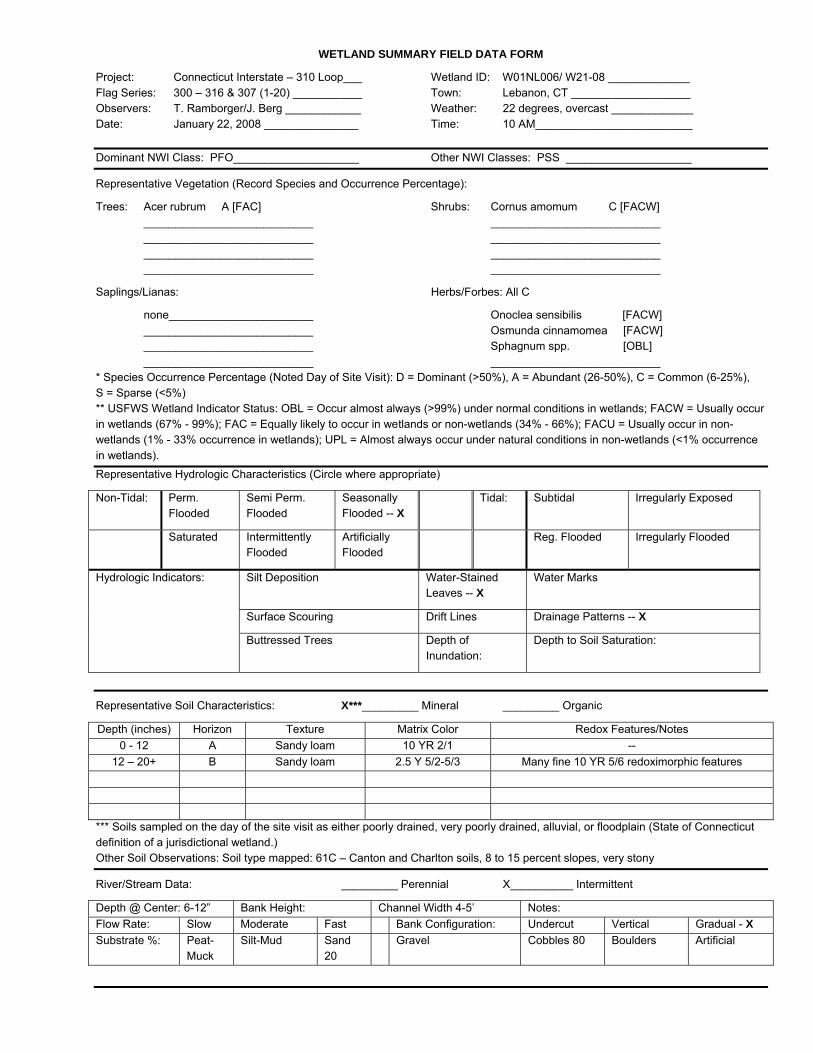
Project: Connecticut Interstate – 310 Loop___ Wetland ID: W01NL006/ W21-08 _____________ Flag Series: 300 – 316 & 307 (1-20) ___________ Town: Lebanon, CT ___________________ Observers: T. Ramborger/J. Berg ____________ Weather: 22 degrees, overcast _____________ Date: January 22, 2008 _______________ Time: 10 AM_________________________
Dominant NWI Class: PFO____________________ Other NWI Classes: PSS ____________________
Representative Vegetation (Record Species and Occurrence Percentage):
Trees: Acer rubrum A [FAC] Shrubs: Cornus amomum C [FACW] ___________________________ ___________________________ ___________________________ ___________________________ ___________________________ ___________________________ ___________________________ ___________________________
Saplings/Lianas: Herbs/Forbes: All C
none_______________________ Onoclea sensibilis [FACW] ___________________________ Osmunda cinnamomea [FACW] ___________________________ Sphagnum spp. [OBL] ___________________________ ___________________________ * Species Occurrence Percentage (Noted Day of Site Visit): D = Dominant (>50%), A = Abundant (26-50%), C = Common (6-25%), S = Sparse (<5%) ** USFWS Wetland Indicator Status: OBL = Occur almost always (>99%) under normal conditions in wetlands; FACW = Usually occur in wetlands (67% - 99%); FAC = Equally likely to occur in wetlands or non-wetlands (34% - 66%); FACU = Usually occur in non-wetlands (1% - 33% occurrence in wetlands); UPL = Almost always occur under natural conditions in non-wetlands (<1% occurrence in wetlands). Representative Hydrologic Characteristics (Circle where appropriate)
Non-Tidal: Perm. Flooded
Semi Perm. Flooded
Seasonally Flooded -- X
Tidal: Subtidal Irregularly Exposed
Saturated Intermittently Flooded
Artificially Flooded
Reg. Flooded Irregularly Flooded
Silt Deposition Water-Stained Leaves -- X
Water Marks
Surface Scouring Drift Lines Drainage Patterns -- X
Hydrologic Indicators:
Buttressed Trees Depth of Inundation:
Depth to Soil Saturation:
Representative Soil Characteristics: X***_________ Mineral _________ Organic
Depth (inches) Horizon Texture Matrix Color Redox Features/Notes 0 - 12 A Sandy loam 10 YR 2/1 --
12 – 20+ B Sandy loam 2.5 Y 5/2-5/3 Many fine 10 YR 5/6 redoximorphic features
*** Soils sampled on the day of the site visit as either poorly drained, very poorly drained, alluvial, or floodplain (State of Connecticut definition of a jurisdictional wetland.) Other Soil Observations: Soil type mapped: 61C – Canton and Charlton soils, 8 to 15 percent slopes, very stony
River/Stream Data: _________ Perennial X__________ Intermittent
Depth @ Center: 6-12” Bank Height: Channel Width 4-5’ Notes: Flow Rate: Slow Moderate Fast Bank Configuration: Undercut Vertical Gradual - X Substrate %: Peat-
Muck Silt-Mud Sand
20 Gravel Cobbles 80 Boulders Artificial
WETLAND SUMMARY FIELD DATA FORM
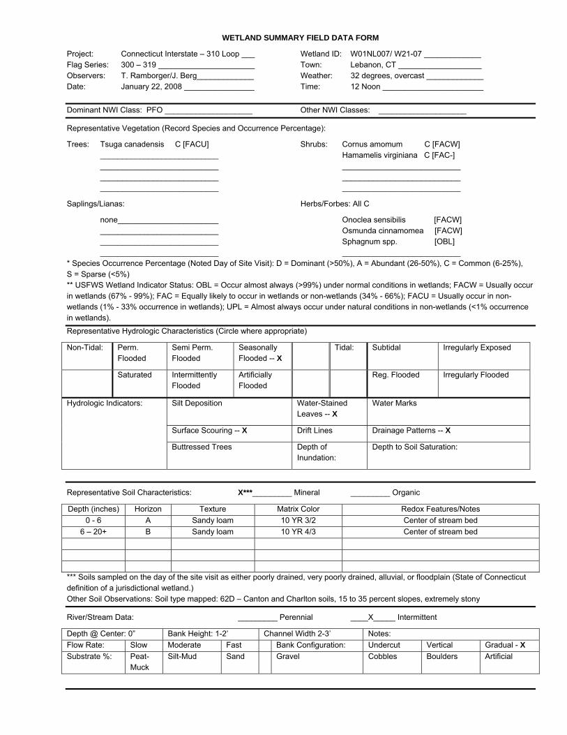
Project: Connecticut Interstate – 310 Loop ___ Wetland ID: W01NL007/ W21-07 _____________ Flag Series: 300 – 319 ______________________ Town: Lebanon, CT ___________________ Observers: T. Ramborger/J. Berg_____________ Weather: 32 degrees, overcast _____________ Date: January 22, 2008 ________________ Time: 12 Noon _______________________
Dominant NWI Class: PFO ____________________ Other NWI Classes: ____________________
Representative Vegetation (Record Species and Occurrence Percentage):
Trees: Tsuga canadensis C [FACU] Shrubs: Cornus amomum C [FACW] ___________________________ Hamamelis virginiana C [FAC-] ___________________________ ___________________________ ___________________________ ___________________________ ___________________________ ___________________________
Saplings/Lianas: Herbs/Forbes: All C
none_______________________ Onoclea sensibilis [FACW] ___________________________ Osmunda cinnamomea [FACW] ___________________________ Sphagnum spp. [OBL] ___________________________ ___________________________ * Species Occurrence Percentage (Noted Day of Site Visit): D = Dominant (>50%), A = Abundant (26-50%), C = Common (6-25%), S = Sparse (<5%) ** USFWS Wetland Indicator Status: OBL = Occur almost always (>99%) under normal conditions in wetlands; FACW = Usually occur in wetlands (67% - 99%); FAC = Equally likely to occur in wetlands or non-wetlands (34% - 66%); FACU = Usually occur in non-wetlands (1% - 33% occurrence in wetlands); UPL = Almost always occur under natural conditions in non-wetlands (<1% occurrence in wetlands).
Representative Hydrologic Characteristics (Circle where appropriate)
Non-Tidal: Perm. Flooded
Semi Perm. Flooded
Seasonally Flooded -- X
Tidal: Subtidal Irregularly Exposed
Saturated Intermittently Flooded
Artificially Flooded
Reg. Flooded Irregularly Flooded
Silt Deposition Water-Stained Leaves -- X
Water Marks
Surface Scouring -- X Drift Lines Drainage Patterns -- X
Hydrologic Indicators:
Buttressed Trees Depth of Inundation:
Depth to Soil Saturation:
Representative Soil Characteristics: X***_________ Mineral _________ Organic
Depth (inches) Horizon Texture Matrix Color Redox Features/Notes 0 - 6 A Sandy loam 10 YR 3/2 Center of stream bed
6 – 20+ B Sandy loam 10 YR 4/3 Center of stream bed
*** Soils sampled on the day of the site visit as either poorly drained, very poorly drained, alluvial, or floodplain (State of Connecticut definition of a jurisdictional wetland.) Other Soil Observations: Soil type mapped: 62D – Canton and Charlton soils, 15 to 35 percent slopes, extremely stony
River/Stream Data: _________ Perennial ____X_____ Intermittent
Depth @ Center: 0” Bank Height: 1-2’ Channel Width 2-3’ Notes: Flow Rate: Slow Moderate Fast Bank Configuration: Undercut Vertical Gradual - X Substrate %: Peat-
Muck Silt-Mud Sand Gravel Cobbles Boulders Artificial
WETLAND SUMMARY FIELD DATA FORM
Project: Connecticut Interstate – 310 Loop____ Wetland ID: W01NL008/ W21-06______________ Flag Series: 400 – 415 ______________________ Town: Lebanon, CT ___________________ Observers: T. Ramborger/J. Berg _____________ Weather: 32 degrees, overcast_____________ Date: January 22, 2008_________________ Time: 2 PM _________________________
Dominant NWI Class: PSS____________________ Other NWI Classes: _______________________
Representative Vegetation (Record Species and Occurrence Percentage):
Trees: none_______________________ Shrubs: Cornus amomum C [FACW] ___________________________ Lonicera sp. C [various] ___________________________ Rubus sp. C [various] ___________________________ ___________________________ Saplings/Lianas: Herbs/Forbes: All C
Juniperus virginiana C [FACU] Onoclea sensibilis [FACW] ___________________________ Phalaris arundinacea [FACW+] ___________________________ Spiraea latifolia [FAC] ___________________________ Spiraea tomentosa [FACW] ___________________________ Typha latifolia [OBL]
* Species Occurrence Percentage (Noted Day of Site Visit): D = Dominant (>50%), A = Abundant (26-50%), C = Common (6-25%), S = Sparse (<5%) ** USFWS Wetland Indicator Status: OBL = Occur almost always (>99%) under normal conditions in wetlands; FACW = Usually occur in wetlands (67% - 99%); FAC = Equally likely to occur in wetlands or non-wetlands (34% - 66%); FACU = Usually occur in non-wetlands (1% - 33% occurrence in wetlands); UPL = Almost always occur under natural conditions in non-wetlands (<1% occurrence in wetlands).
Representative Hydrologic Characteristics (Circle where appropriate)
Non-Tidal: Perm. Flooded
Semi Perm. Flooded
Seasonally Flooded -- X
Tidal: Subtidal Irregularly Exposed
Saturated Intermittently Flooded
Artificially Flooded
Reg. Flooded Irregularly Flooded
Silt Deposition Water-Stained Leaves -- X
Water Marks
Surface Scouring Drift Lines Drainage Patterns
Hydrologic Indicators:
Standing water
Buttressed Trees Depth of Inundation: surface
Depth to Soil Saturation:
Representative Soil Characteristics: X***_________ Mineral _________ Organic
Depth (inches) Horizon Texture Matrix Color Redox Features/Notes 0 - 12 A Mucky sandy loam 10 YR 2/1 -- 12+ R
*** Soils sampled on the day of the site visit as either poorly drained, very poorly drained, alluvial, or floodplain (State of Connecticut definition of a jurisdictional wetland.) Other Soil Observations: Soil type mapped: 62D – Canton and Charlton soils, 15 to 35 percent slopes, extremely stony
River/Stream Data: N/A _________ Perennial __________ Intermittent
Depth @ Center: Bank Height: Channel Width Notes: Flow Rate: Slow Moderate Fast Bank Configuration: Undercut Vertical Gradual Substrate %: Peat-
Muck Silt-Mud Sand Gravel Cobbles Boulders Artificial

WETLAND SUMMARY FIELD DATA FORM
Project: Connecticut Interstate – 310 Loop ___ Wetland ID: W01NL009// W21-05______________ Flag Series: 100 – 111 & 200 - 207____________ Town: Lebanon, CT ___________________ Observers: T. Ramborger/J. Berg ____________ Weather: 32 degrees, snowing______________ Date: January 22, 2008 ________________ Time: 3 PM __________________________
Dominant NWI Class: PSS____________________ Other NWI Classes: PFO____________________
Representative Vegetation (Record Species and Occurrence Percentage):
Trees: none_______________________ Shrubs: Cornus amomum A [FACW] ___________________________ Lonicera sp. C [various] ___________________________ Rubus sp. C [various] ___________________________ ___________________________ Saplings/Lianas: Herbs/Forbes: All C
none_______________________ Onoclea sensibilis [FACW] ___________________________ Osmunda cinnamomea [FACW] ___________________________ Solidago spp. [various] ___________________________ ___________________________ ___________________________ ___________________________
* Species Occurrence Percentage (Noted Day of Site Visit): D = Dominant (>50%), A = Abundant (26-50%), C = Common (6-25%), S = Sparse (<5%) ** USFWS Wetland Indicator Status: OBL = Occur almost always (>99%) under normal conditions in wetlands; FACW = Usually occur in wetlands (67% - 99%); FAC = Equally likely to occur in wetlands or non-wetlands (34% - 66%); FACU = Usually occur in non-wetlands (1% - 33% occurrence in wetlands); UPL = Almost always occur under natural conditions in non-wetlands (<1% occurrence in wetlands). Representative Hydrologic Characteristics (Circle where appropriate)
Non-Tidal: Perm. Flooded
Semi Perm. Flooded
Seasonally Flooded -- X
Tidal: Subtidal Irregularly Exposed
Saturated Intermittently Flooded
Artificially Flooded
Reg. Flooded Irregularly Flooded
Silt Deposition Water-Stained Leaves -- X
Water Marks
Surface Scouring -- X Drift Lines Drainage Patterns -- X
Hydrologic Indicators:
Buttressed Trees Depth of Inundation:
Depth to Soil Saturation:
Representative Soil Characteristics: X***_________ Mineral _________ Organic
Depth (inches) Horizon Texture Matrix Color Redox Features/Notes 0 - 14 A Sandy loam 10 YR 2/1 --
14 – 20+ B Sandy loam 2.5 Y 5/2-5/3 Many fine 10 YR 5/6 redoximorphic features
*** Soils sampled on the day of the site visit as either poorly drained, very poorly drained, alluvial, or floodplain (State of Connecticut definition of a jurisdictional wetland.) Other Soil Observations: Soil type mapped: 3 – Ridgebury, Leicester, and Whitman soils, extremely stony (Poorly drained, poorly drained, and very poorly drained soils, respectively)
River/Stream Data: ________ Perennial ____X______ Intermittent
Depth @ Center: 1-2” Bank Height: Channel Width 5-6’ Notes: Flow Rate: Slow-X Moderate Fast Bank Configuration: Undercut Vertical Gradual - X Substrate %: Peat-
Muck Silt-Mud Sand-
20 Gravel Cobbles 80 Boulders Artificial

WETLAND SUMMARY FIELD DATA FORM
Project: Connecticut Interstate – 310 Loop ___ Wetland ID: W01NL010/ W21-04______________ Flag Series: 400 – 407 ______________________ Town: Lebanon, CT ___________________ Observers: T. Ramborger/J. Berg ____________ Weather: 28 degrees, overcast_____________ Date: January 23, 2008 _______________ Time: 8 AM__________________________
Dominant NWI Class: PEM____________________ Other NWI Classes: PSS____________________
Representative Vegetation (Record Species and Occurrence Percentage):
Trees: none_______________________ Shrubs: Cornus amomum A [FACW] ___________________________ Juniperus virginiana C [FACU] ___________________________ Rosa multiflora C [FACU] ___________________________ ___________________________ Saplings/Lianas: Herbs/Forbes:
none_______________________ Carex spp. C [various] ___________________________ Juncus sp. C [various] ___________________________ Onoclea sensibilis A [FACW] ___________________________ Solidago spp. C [various] ___________________________ Spiraea tomentosa A [FACW]
* Species Occurrence Percentage (Noted Day of Site Visit): D = Dominant (>50%), A = Abundant (26-50%), C = Common (6-25%), S = Sparse (<5%) ** USFWS Wetland Indicator Status: OBL = Occur almost always (>99%) under normal conditions in wetlands; FACW = Usually occur in wetlands (67% - 99%); FAC = Equally likely to occur in wetlands or non-wetlands (34% - 66%); FACU = Usually occur in non-wetlands (1% - 33% occurrence in wetlands); UPL = Almost always occur under natural conditions in non-wetlands (<1% occurrence in wetlands). Representative Hydrologic Characteristics (Circle where appropriate)
Non-Tidal: Perm. Flooded
Semi Perm. Flooded
Seasonally Flooded
Tidal: Subtidal Irregularly Exposed
Saturated Intermittently Flooded
Artificially Flooded
Reg. Flooded Irregularly Flooded
Silt Deposition Water-Stained Leaves -- X
Water Marks
Surface Scouring Drift Lines Drainage Patterns -- X
Hydrologic Indicators:
Standing water
Buttressed Trees Depth of Inundation:
Depth to Soil Saturation:
Representative Soil Characteristics: X***________ Mineral _________ Organic
Depth (inches) Horizon Texture Matrix Color Redox Features/Notes 0 - 12 A Sandy loam 10 YR 2/1 --
12 – 20+ B Sandy loam 10 YR 4/2 Many 10 YR 5/6 redoximorphic features
*** Soils sampled on the day of the site visit as either poorly drained, very poorly drained, alluvial, or floodplain (State of Connecticut definition of a jurisdictional wetland.) Other Soil Observations: Soil type mapped: 3 – Ridgebury, Leicester, and Whitman soils, extremely stony (Poorly drained, poorly drained, and very poorly drained soils, respectively)
River/Stream Data: N/A _________ Perennial __________ Intermittent
Depth @ Center: Bank Height: Channel Width Notes: Flow Rate: Slow Moderate Fast Bank Configuration: Undercut Vertical Gradual Substrate %: Peat-
Muck Silt-Mud Sand Gravel Cobbles Boulders Artificial

WETLAND SUMMARY FIELD DATA FORM
Project: Connecticut Interstate – 310 Loop ___ Wetland ID: W01NL011/ W21-03______________ Flag Series: 300 – 315 ______________________ Town: Lebanon, CT ___________________ Observers: T. Ramborger/J. Berg_____________ Weather: 30 degrees, overcast_____________ Date: January 23, 2008 ________________ Time: 9 AM__________________________
Dominant NWI Class: PEM____________________ Other NWI Classes: PSS____________________
Representative Vegetation (Record Species and Occurrence Percentage):
Trees: none_______________________ Shrubs: Juniperus virginiana – off ROW __ ___________________________ Rosa multiflora – off ROW ______ ___________________________ ___________________________ ___________________________ ___________________________ Saplings/Lianas: Herbs/Forbes:
none_______________________ Osmunda cinnamomea – off ROW ___________________________ Onoclea sensibilis A [FACW] ___________________________ Carex spp. C [various] ___________________________ Juncus sp. C [various] ___________________________ Solidago spp. C [various]
* Species Occurrence Percentage (Noted Day of Site Visit): D = Dominant (>50%), A = Abundant (26-50%), C = Common (6-25%), S = Sparse (<5%) ** USFWS Wetland Indicator Status: OBL = Occur almost always (>99%) under normal conditions in wetlands; FACW = Usually occur in wetlands (67% - 99%); FAC = Equally likely to occur in wetlands or non-wetlands (34% - 66%); FACU = Usually occur in non-wetlands (1% - 33% occurrence in wetlands); UPL = Almost always occur under natural conditions in non-wetlands (<1% occurrence in wetlands). Representative Hydrologic Characteristics (Circle where appropriate)
Non-Tidal: Perm. Flooded
Semi Perm. Flooded
Seasonally Flooded -- X
Tidal: Subtidal Irregularly Exposed
Saturated Intermittently Flooded
Artificially Flooded
Reg. Flooded Irregularly Flooded
Silt Deposition Water-Stained Leaves -- X
Water Marks
Surface Scouring Drift Lines Drainage Patterns -- X
Hydrologic Indicators:
Standing water
Buttressed Trees Depth of Inundation:
Depth to Soil Saturation:
Representative Soil Characteristics: X***_________ Mineral _________ Organic
Depth (inches) Horizon Texture Matrix Color Redox Features/Notes 0 - 14 A Sandy loam 10 YR 2/1 --
14 – 20+ B Sandy loam 10 YR 4/2-3/2 --
*** Soils sampled on the day of the site visit as either poorly drained, very poorly drained, alluvial, or floodplain (State of Connecticut definition of a jurisdictional wetland.) Other Soil Observations: Soil type mapped: 3 – Ridgebury, Leicester, and Whitman soils, extremely stony (Poorly drained, poorly drained, and very poorly drained soils, respectively)
River/Stream Data: N/A _________ Perennial __________ Intermittent
Depth @ Center: Bank Height: Channel Width Notes: Flow Rate: Slow Moderate Fast Bank Configuration: Undercut Vertical Gradual Substrate %: Peat-
Muck Silt-Mud Sand Gravel Cobbles Boulders Artificial

WETLAND SUMMARY FIELD DATA FORM
Project: Connecticut Interstate – 310 Loop___ Wetland ID: W01NL012/ W21-02______________ Flag Series: 300 – 310 ______________________ Town: Lebanon, CT ___________________ Observers: T. Ramborger/J. Berg_____________ Weather: 30 degrees, overcast_____________ Date: January 23, 2008 ________________ Time: 10 AM ________________________
Dominant NWI Class: PSS_______________________ Other NWI Classes: _______________________
Representative Vegetation (Record Species and Occurrence Percentage):
Trees: none_______________________ Shrubs: Cornus amomum C [FACW] ___________________________ ___________________________ ___________________________ ___________________________ ___________________________ ___________________________ ___________________________ ___________________________
Saplings/Lianas: Herbs/Forbes: All C
Alnus rugosa C [FACW+] Onoclea sensibilis [FACW] Carpinus caroliniana C [FAC] Osmunda cinnamomea [FACW] ___________________________ Phragmites australis [FACW] ___________________________ ___________________________ ___________________________ ___________________________
* Species Occurrence Percentage (Noted Day of Site Visit): D = Dominant (>50%), A = Abundant (26-50%), C = Common (6-25%), S = Sparse (<5%) ** USFWS Wetland Indicator Status: OBL = Occur almost always (>99%) under normal conditions in wetlands; FACW = Usually occur in wetlands (67% - 99%); FAC = Equally likely to occur in wetlands or non-wetlands (34% - 66%); FACU = Usually occur in non-wetlands (1% - 33% occurrence in wetlands); UPL = Almost always occur under natural conditions in non-wetlands (<1% occurrence in wetlands). Representative Hydrologic Characteristics (Circle where appropriate)
Non-Tidal: Perm. Flooded
Semi Perm. Flooded
Seasonally Flooded -- X
Tidal: Subtidal Irregularly Exposed
Saturated Intermittently Flooded
Artificially Flooded
Reg. Flooded Irregularly Flooded
Silt Deposition Water-Stained Leaves -- X
Water Marks
Surface Scouring Drift Lines Drainage Patterns -- X
Hydrologic Indicators:
Buttressed Trees Depth of Inundation:
Depth to Soil Saturation:
Representative Soil Characteristics: ____X***_____ Mineral _________ Organic
Depth (inches) Horizon Texture Matrix Color Redox Features/Notes 0 - 8 A Sandy loam 10 YR 3/1 -- 8 - 18 B Sandy loam 10 YR 2/1 -- 18+ R
*** Soils sampled on the day of the site visit as either poorly drained, very poorly drained, alluvial, or floodplain (State of Connecticut definition of a jurisdictional wetland.) Other Soil Observations: Soil type mapped: 84D – Paxton and Montauk fine sandy loams, 15 to 25 percent slopes
River/Stream Data: N/A _________ Perennial __________ Intermittent
Depth @ Center: Bank Height: Channel Width Notes: Flow Rate: Slow Moderate Fast Bank Configuration: Undercut Vertical Gradual Substrate %: Peat-
Muck Silt-Mud Sand Gravel Cobbles Boulders Artificial
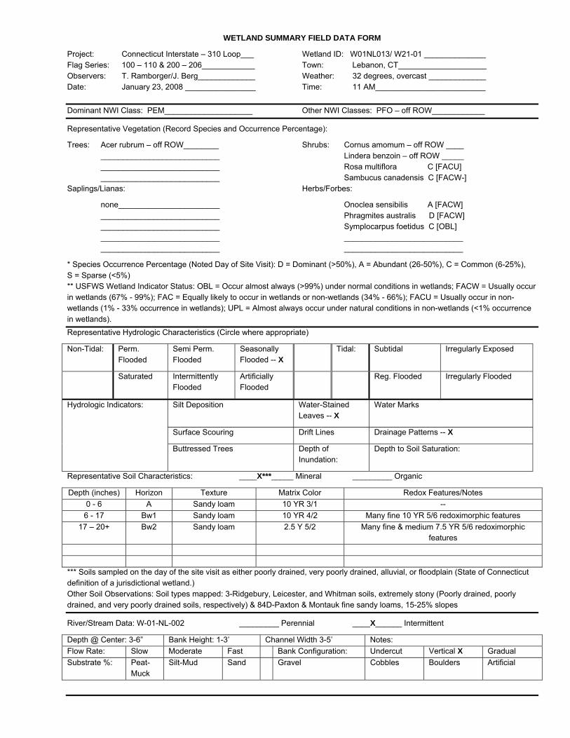
WETLAND SUMMARY FIELD DATA FORM
Project: Connecticut Interstate – 310 Loop___ Wetland ID: W01NL013/ W21-01 ______________ Flag Series: 100 – 110 & 200 – 206____________ Town: Lebanon, CT____________________ Observers: T. Ramborger/J. Berg_____________ Weather: 32 degrees, overcast _____________ Date: January 23, 2008 ________________ Time: 11 AM_________________________
Dominant NWI Class: PEM____________________ Other NWI Classes: PFO – off ROW____________
Representative Vegetation (Record Species and Occurrence Percentage):
Trees: Acer rubrum – off ROW________ Shrubs: Cornus amomum – off ROW ____ ___________________________ Lindera benzoin – off ROW _____ ___________________________ Rosa multiflora C [FACU] ___________________________ Sambucus canadensis C [FACW-] Saplings/Lianas: Herbs/Forbes:
none_______________________ Onoclea sensibilis A [FACW] ___________________________ Phragmites australis D [FACW] ___________________________ Symplocarpus foetidus C [OBL] ___________________________ ___________________________ ___________________________ ___________________________
* Species Occurrence Percentage (Noted Day of Site Visit): D = Dominant (>50%), A = Abundant (26-50%), C = Common (6-25%), S = Sparse (<5%) ** USFWS Wetland Indicator Status: OBL = Occur almost always (>99%) under normal conditions in wetlands; FACW = Usually occur in wetlands (67% - 99%); FAC = Equally likely to occur in wetlands or non-wetlands (34% - 66%); FACU = Usually occur in non-wetlands (1% - 33% occurrence in wetlands); UPL = Almost always occur under natural conditions in non-wetlands (<1% occurrence in wetlands). Representative Hydrologic Characteristics (Circle where appropriate)
Non-Tidal: Perm. Flooded
Semi Perm. Flooded
Seasonally Flooded -- X
Tidal: Subtidal Irregularly Exposed
Saturated Intermittently Flooded
Artificially Flooded
Reg. Flooded Irregularly Flooded
Silt Deposition Water-Stained Leaves -- X
Water Marks
Surface Scouring Drift Lines Drainage Patterns -- X
Hydrologic Indicators:
Buttressed Trees Depth of Inundation:
Depth to Soil Saturation:
Representative Soil Characteristics: ____X***_____ Mineral _________ Organic
Depth (inches) Horizon Texture Matrix Color Redox Features/Notes 0 - 6 A Sandy loam 10 YR 3/1 -- 6 - 17 Bw1 Sandy loam 10 YR 4/2 Many fine 10 YR 5/6 redoximorphic features
17 – 20+ Bw2 Sandy loam 2.5 Y 5/2 Many fine & medium 7.5 YR 5/6 redoximorphic features
*** Soils sampled on the day of the site visit as either poorly drained, very poorly drained, alluvial, or floodplain (State of Connecticut definition of a jurisdictional wetland.) Other Soil Observations: Soil types mapped: 3-Ridgebury, Leicester, and Whitman soils, extremely stony (Poorly drained, poorly drained, and very poorly drained soils, respectively) & 84D-Paxton & Montauk fine sandy loams, 15-25% slopes
River/Stream Data: W-01-NL-002 _________ Perennial ____X______ Intermittent
Depth @ Center: 3-6” Bank Height: 1-3’ Channel Width 3-5’ Notes: Flow Rate: Slow Moderate Fast Bank Configuration: Undercut Vertical X Gradual Substrate %: Peat-
Muck Silt-Mud Sand Gravel Cobbles Boulders Artificial

WETLAND SUMMARY FIELD DATA FORM
Project: Connecticut Interstate – 310 Loop ___ Wetland ID: W01Nl014/ W21-14_______________ Flag Series: 300 – 309 ______________________ Town: Lebanon, CT ___________________ Observers: T. Ramborger/J. Berg ____________ Weather: 32 degrees, overcast_____________ Date: January 23, 2008 ________________ Time: 12 noon _______________________
Dominant NWI Class: PFO ____________________ Other NWI Classes: _______________________
Representative Vegetation (Record Species and Occurrence Percentage):
Trees: Acer rubrum A [FAC] Shrubs: Vaccinium corymbosum C [FACW] Betula allighaniensis C [FAC] ___________________________ ___________________________ ___________________________ ___________________________ ___________________________ ___________________________ ___________________________
Saplings/Lianas: Herbs/Forbes:
Carpinus caroliniana C [FAC] Onoclea sensibilis C [FACW] ___________________________ Impatiens capensis C [FACW] ___________________________ Maianthemum canadense C [FAC-] ___________________________ ___________________________ ___________________________ ___________________________
* Species Occurrence Percentage (Noted Day of Site Visit): D = Dominant (>50%), A = Abundant (26-50%), C = Common (6-25%), S = Sparse (<5%) ** USFWS Wetland Indicator Status: OBL = Occur almost always (>99%) under normal conditions in wetlands; FACW = Usually occur in wetlands (67% - 99%); FAC = Equally likely to occur in wetlands or non-wetlands (34% - 66%); FACU = Usually occur in non-wetlands (1% - 33% occurrence in wetlands); UPL = Almost always occur under natural conditions in non-wetlands (<1% occurrence in wetlands). Representative Hydrologic Characteristics (Circle where appropriate)
Non-Tidal: Perm. Flooded
Semi Perm. Flooded
Seasonally Flooded -- X
Tidal: Subtidal Irregularly Exposed
Saturated Intermittently Flooded
Artificially Flooded
Reg. Flooded Irregularly Flooded
Silt Deposition Water-Stained Leaves -- X
Water Marks
Surface Scouring Drift Lines Drainage Patterns -- X
Hydrologic Indicators:
Standing water
Buttressed Trees Depth of Inundation: surface
Depth to Soil Saturation:
Representative Soil Characteristics: ____X***_____ Mineral _________ Organic
Depth (inches) Horizon Texture Matrix Color Redox Features/Notes 0 - 10 A Sandy loam 10 YR 2/1 --
10 – 20+ C Sand 10 YR 6/1 --
*** Soils sampled on the day of the site visit as either poorly drained, very poorly drained, alluvial, or floodplain (State of Connecticut definition of a jurisdictional wetland.) Other Soil Observations: Soil type mapped: 17 – Timakwa and Natchaug soils (Both very poorly drained soils)
River/Stream Data: N/A _________ Perennial __________ Intermittent
Depth @ Center: Bank Height: Channel Width Notes: Flow Rate: Slow Moderate Fast Bank Configuration: Undercut Vertical Gradual Substrate %: Peat-
Muck Silt-Mud Sand Gravel Cobbles Boulders Artificial

WETLAND SUMMARY FIELD DATA FORM
Project: Connecticut Interstate – 310 Loop___ Wetland ID: W01NL015/ W21-16_______________ Flag Series: 300 – 305 ______________________ Town: Lebanon, CT____________________ Observers: T. Ramborger/J. Berg_____________ Weather: 35 degrees, overcast______________ Date: January 23, 2008 ________________ Time: 1 PM___________________________
Dominant NWI Class: PFO____________________ Other NWI Classes: _______________________
Representative Vegetation (Record Species and Occurrence Percentage):
Trees: Acer rubrum A [FAC] Shrubs: Lindera benzoin C [FACW-] Betula alleghaniensis C [FAC] Vaccinium corymbosum C [FACW-] ___________________________ ___________________________ ___________________________ ___________________________ ___________________________ ___________________________
Saplings/Lianas: Herbs/Forbes:
Carpinus caroliniana C [FACU] Onoclea sensibilis C [FACW] ___________________________ Osmunda cinnamomea C [FACW] ___________________________ Parthenocissus quinquefolia A [FACU] ___________________________ Symplocarpus foetidus A [OBL] * Species Occurrence Percentage (Noted Day of Site Visit): D = Dominant (>50%), A = Abundant (26-50%), C = Common (6-25%), S = Sparse (<5%) ** USFWS Wetland Indicator Status: OBL = Occur almost always (>99%) under normal conditions in wetlands; FACW = Usually occur in wetlands (67% - 99%); FAC = Equally likely to occur in wetlands or non-wetlands (34% - 66%); FACU = Usually occur in non-wetlands (1% - 33% occurrence in wetlands); UPL = Almost always occur under natural conditions in non-wetlands (<1% occurrence in wetlands). Representative Hydrologic Characteristics (Circle where appropriate)
Non-Tidal: Perm. Flooded
Semi Perm. Flooded
Seasonally Flooded -- X
Tidal: Subtidal Irregularly Exposed
Saturated Intermittently Flooded
Artificially Flooded
Reg. Flooded Irregularly Flooded
Silt Deposition Water-Stained Leaves -- X
Water Marks
Surface Scouring Drift Lines Drainage Patterns
Hydrologic Indicators:
Buttressed Trees Depth of Inundation:
Depth to Soil Saturation:
Representative Soil Characteristics: ____X***_____ Mineral _________ Organic
Depth (inches) Horizon Texture Matrix Color Redox Features/Notes 0 - 8 A Sandy loam 10 YR 2/1 --
8 – 20+ B Sandy loam 7.5 YR 6/1 Many fine 10 YR 5/6 redoximorphic features
*** Soils sampled on the day of the site visit as either poorly drained, very poorly drained, alluvial, or floodplain (State of Connecticut definition of a jurisdictional wetland.) Other Soil Observations: Soil type mapped: 51B – Sutton fine sandy loam, 2 to 8 percent slopes, very stony
River/Stream Data: N/A _________ Perennial __________ Intermittent
Depth @ Center: Bank Height: Channel Width Notes: Flow Rate: Slow Moderate Fast Bank Configuration: Undercut Vertical Gradual Substrate %: Peat-
Muck Silt-Mud Sand Gravel Cobbles Boulders Artificial

WETLAND SUMMARY FIELD DATA FORM
Project: Connecticut Interstate – 310 Loop___ Wetland ID: W01NL016/ W21-15 ______________ Flag Series: 300 – 340 ______________________ Town: Lebanon, CT____________________ Observers: T. Ramborger/J. Berg_____________ Weather: 35 degrees, overcast______________ Date: January 23, 2008 ________________ Time: 2 PM __________________________
Dominant NWI Class: PFO____________________ Other NWI Classes: _______________________
Representative Vegetation (Record Species and Occurrence Percentage):
Trees: Acer rubrum A [FAC] Shrubs: Cornus amomum C [FACW] Betula alleghaniensis C[FAC] Lindera benzoin C [FACW-] ___________________________ Rosa multiflora C [FACU] ___________________________ Vaccinium corymbosum C [FACW-] Saplings/Lianas: Herbs/Forbes: All C
Hamamelis virginiana C [FAC-] Onoclea sensibilis [FACW] ___________________________ Osmunda cinnamomea [FACW] ___________________________ Sphagnum spp. [OBL] ___________________________ Symplocarpus foetidus [OBL] * Species Occurrence Percentage (Noted Day of Site Visit): D = Dominant (>50%), A = Abundant (26-50%), C = Common (6-25%), S = Sparse (<5%) ** USFWS Wetland Indicator Status: OBL = Occur almost always (>99%) under normal conditions in wetlands; FACW = Usually occur in wetlands (67% - 99%); FAC = Equally likely to occur in wetlands or non-wetlands (34% - 66%); FACU = Usually occur in non-wetlands (1% - 33% occurrence in wetlands); UPL = Almost always occur under natural conditions in non-wetlands (<1% occurrence in wetlands).
Representative Hydrologic Characteristics (Circle where appropriate)
Non-Tidal: Perm. Flooded
Semi Perm. Flooded
Seasonally Flooded -- X
Tidal: Subtidal Irregularly Exposed
Saturated Intermittently Flooded
Artificially Flooded
Reg. Flooded Irregularly Flooded
Silt Deposition Water-Stained Leaves -- X
Water Marks -- X
Surface Scouring Drift Lines Drainage Patterns -- X
Hydrologic Indicators:
Standing water
Buttressed Trees Depth of Inundation:
Depth to Soil Saturation:
Representative Soil Characteristics: ____X***____ Mineral _________ Organic
Depth (inches) Horizon Texture Matrix Color Redox Features/Notes 0 - 4 A Sandy loam 10 YR 2/1 -- 4 - 12 B Sandy loam 10 YR 5/1 Many fine 10 YR 5/6 redoximorphic features 12+ R
*** Soils sampled on the day of the site visit as either poorly drained, very poorly drained, alluvial, or floodplain (State of Connecticut definition of a jurisdictional wetland.) Other Soil Observations: Soil types mapped: 73C – Charlton-Chatfield complex, 3-15% slopes, very rocky & 307-Urban land
River/Stream Data: N/A _________ Perennial __________ Intermittent
Depth @ Center: Bank Height: Channel Width Notes: Flow Rate: Slow Moderate Fast Bank Configuration: Undercut Vertical Gradual Substrate %: Peat-
Muck Silt-Mud Sand Gravel Cobbles Boulders Artificial

Attachment D
Hydric Soil and Wetland Mapping Resources


Lege
ndFi
gure
1
Exa
mpl
e of
NW
I Inf
orm
atio
n
Sou
rce:
US
FWS
, Geo
corte
xIn
tern
et M
appi
ng
NW
I Wet
land
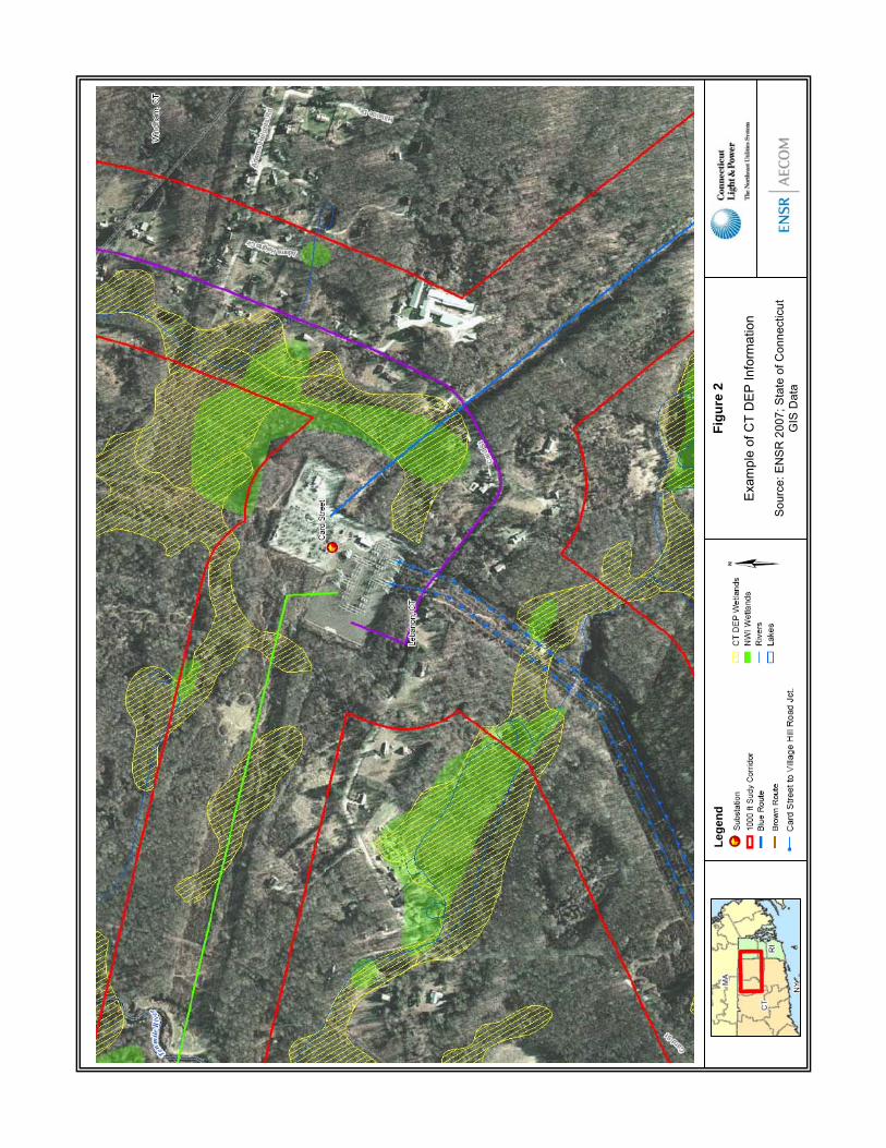
Lege
ndFi
gure
2
Exa
mpl
e of
CT
DE
P In
form
atio
n
Sou
rce:
EN
SR
200
7; S
tate
of C
onne
ctic
ut
GIS
Dat
a

Lege
ndFi
gure
3
Exa
mpl
e of
Soi
l Sur
vey
Info
rmat
ion
Sou
rce:
NR
CS
, Web
Soi
l Sur
vey
2.0
Map
Uni
t Sym
bol
17