excavation of an earthwork at townhead farm, raisbeck ... · the excavation took place over four...
TRANSCRIPT

Excavation of an earthwork at
Townhead Farm, Raisbeck
(NY644084)

LAS would like to thank Graham and Michelle Curtis for allowing us to survey and excavate on their
land. We would also like to thank the members of LAS who helped with the work, and advice both
during the dig and during the production of the report and Lanty Wharton and his earth-moving
machine for making backfilling in the rain so much easier.
Contents Page
Summary 1
1. Introduction 1
2. Methodology 2
2.1 Project design 2
3. Excavation 2
3.1 Trench 1 2
3.2 Trench 5
3.3 Finds 6
4. Interpretation 8
5. Discussion 8
6. References 9
Appendix 1. Context list 10
Appendix 2. Levels table 11
Appendix 3. Collage of Figures all oriented to the North 12


Summary
Lunesdale Archaeology Society (LAS) undertook a small excavation across a two-celled rectangular
enclosure measuring 51 x 14.5m, visible on the ground as a broad low bank and identifiable on
LiDAR. The trench was placed over the junction between one of the long sides of the feature and a
second bank which divides it in two. The excavation took place over four days, 5-8 August 2017. The
aim was to attempt to determine the structure of the banks, and the nature of any ground surface
within the enclosure on both sides of the dividing bank. Both banks proved to be of stone,
extensively robbed out and overlaid with soil, and the dividing bank was on top of, and therefore
later than, the bank forming the exterior of the feature. Finds included pottery from medieval
through to Victorian periods, along with both early and modern glass. Small amounts of coal and
coke, and items of casual loss, including clay pipe and a button, were recovered. The natural ground
surface was reached at a depth of 40 cm, and no evidence of a floor surface was seen on either side
of the dividing bank. The function of the enclosure could not be defined, but it is suggested that it is
an early croft.
1 Introduction
Jan Hicks, a member of LAS, has been investigating the history of Raisbeck from documentary
sources, in particular the enclosure act of 1777 (CRO Kendal) and upstanding features such as older
field patterns and earthworks. The first documentary mention of the village is in 1310 (Smith 1977).
The field behind the current 17th century house at Town Head contains many low banks and
earthworks, none of which have been investigated or properly surveyed. One earthwork of
particular interest is rectangular and apparently comprises two `cells’ . At 51 x 14.5 m it is far too
large to be a building (see LiDAR, Figure 1). Other earthworks at Town Head Farm include a deep
hollow running west. At enclosure (1777), a small tranche of land to the north of the existing road
and south of Townhead was allocated to landowners, suggesting that it was part of the commons at
this time, and the present road was laid out. It is possible that this hollow, which runs close to the
feature investigated, is the original line of the road between Raisbeck and Orton (Figure 1).
Figure 1. Lidar of Town Head and
surrounding area
1

It was decided to excavate across the external bank and the dividing bank in an attempt to
determine the age and function of the feature.
2 Methodology
2.1 Project Design
2.1.1 The excavation took place over four days. The initial plan was for a trench 10 x 2m to target
the long side of the feature on the west and also cover the dividing bank. However, the spread of the
bank was at least 2m, and in order to expose part of the interior of the enclosure on both sides of
the division the width of the trench was increased to 3m. The length of the trench was reduced to
4m, due to manpower, and a poor weather forecast. This size of trench could be fully excavated
within the timeframe available.
The aims were:
To determine the structure of the two banks, and their relationship
To expose any floor surface within the enclosure on both sides of the dividing bank
To obtain dating evidence for the enclosure
To suggest a function for the structure
2.2 Recording
2.2.1 A written record of archaeological features encountered was maintained. Archaeological
contexts identified were given unique numbers. Layers and other deposits were given a context
number in parenthesis whilst any cuts will be in square brackets.
2.2.2 A photographic record was maintained and measured drawings were made to illustrate
features that were not clear from the photographs. Metric spot heights for trenches and
archaeological features were recorded and related to the Ordnance datum. These are tabulated at
Appendix 2.
3. Excavation
3.1 Trench 1
3.1.1 A 4 x 3 m trench was opened over the extant low bank on the N W side of the enclosure, centred on its junction with the internal dividing bank (see Figure 1). All excavation work, including deturfing and cleaning back was undertaken by hand. A broad stone feature identified on the surface as the dividing bank was apparent beneath the turf (Context 3; Figure 2).
2

3.1.2 The top soil (1) was dark brown loamy soil, containing small amounts of pottery, coal and
charcoal, and modern glass. The subsoil (2) was very similar, containing a few small stones and
similar finds. The contexts on both sides of the stone feature were identical.
3.1.3 A small sondage was cut into the SE corner of trench 1 and showed that no built structure
extended into the far side of the trench (Figure 3).
3.1.4 The stones were cleaned back and appeared to be a wall running NW-SE, approx. 1m wide (3); the top of the stones was at an average depth of 12 cm beneath the present land surface. The stones were not coursed or bonded, and while the SW face was fairly straight, the NE face was spread and tumbled over another 1m. Finds similar to those in the subsoil were located round the stones. The wall ran beyond the W side of the trench (see Figures 2, 4a,b).
3.1.5 Part of the dividing wall (3) was removed and found to be only one layer of stone deep, situated on subsoil.
Figure 2. The dividing wall (Context 3) looking
southeast. The slight bank over the wall is
visible in the far section
N
N
Figure 4a. Plan of dividing wall (3);
drawn at 1:40
3

3.1.6 As the stones forming context (3) were removed stones forming part of the perimeter bank of the enclosure (5) were found running NE-SW and beneath the dividing wall (3). The top of the stones was at a depth of 20 cm beneath the present land surface (Figure 5).
3.1.7 The wall forming the west perimeter bank of the enclosure, was 1-1.5 m wide, with variable
amounts of spread and tumble on either side (Figure 5a). The extant bank appears to be subsoil over
a stone base but no distinct edges to the bank could be discerned.
Figure 5a. Part of the dividing wall (3)
removed to show the exterior wall (5)
beneath and at right angles to it
N (3)
(5)
Figure 5b. Lower stone feature (5)
beneath the dividing wall (3) and
sitting on subsoil (2), part of (3)
removed
(2)
Figure 4b. NW facing section in trench 1 showing the dividing wall.
(3)
4
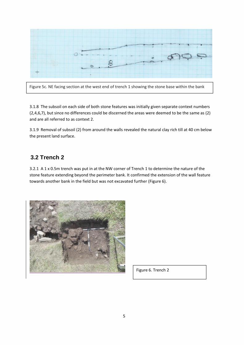
3.1.8 The subsoil on each side of both stone features was initially given separate context numbers
(2,4,6,7), but since no differences could be discerned the areas were deemed to be the same as (2)
and are all referred to as context 2.
3.1.9 Removal of subsoil (2) from around the walls revealed the natural clay rich till at 40 cm below
the present land surface.
3.2 Trench 2
3.2.1 A 1 x 0.5m trench was put in at the NW corner of Trench 1 to determine the nature of the
stone feature extending beyond the perimeter bank. It confirmed the extension of the wall feature
towards another bank in the field but was not excavated further (Figure 6).
Figure 5c. NE facing section at the west end of trench 1 showing the stone base within the bank
Figure 6. Trench 2
5

3.3 Finds
3.3.1 Finds are listed in the Table below.
3.3.2 Pottery has not been identified with respect to type, but was dated by comparison with an
assemblage from a previous small excavation at Ivy Hall, 500 m away, and characterised by Jeremy
Bradley from Oxford Archaeology North.
Finds context 1
Context 2
context 3
no. pcs wt
no. pcs wt no.pcs wt
modern green glass 4 old glass (greenish,
imperfections, curved) 2
iron nail 1
1 metal button 1
modern glass (flat) 1 chert (poss worked core) 1
1 Flint
1
burnt bone 1 4g 1 1g clay pipe stem (1 very narrow, 1
broad) 2 low fired coarse pot (12-14th C) 1 6g 6 17g 5 22g
white pot with gritty glaze 3 5g
2 5g
green glaze (14-16th C) 1 8g 1 46g post-med brown glaze 7 35g 2 4g post-med white glaze 3 7g 7 14g 2 8g
other mod glazed pot 3 4g 1 2g 2 2g
total med pot 5 19g 7 63g 7 27g
total post-med pot 13 46g 10 20g 4 10g
6

Samples of pottery from Trench 1, context 2
Two pieces of green glaze pottery
Low fired pottery, 12-14th century
Low fired pottery, 12-14th century
7

4 Interpretation
4.1 The banks were found to have a stone base, each of a single layer, suggesting that either they had been substantially robbed out, possibly for building and repairing of the more recent walls in the immediate area. Alternatively, they may be in their original form as foundations for a bank. However no signs of a ditch were seen in the trench. The outer edge of the perimeter bank was not completely uncovered, making it possible that a ditch lies outside the enclosure. 4.2 The stone was laid directly on the natural clay, and no floor surface was seen. It is unlikely that either of the compartments within the enclosure had been a building. It is possible that the stones in the perimeter bank may have been a natural deposit. This would become clearer if the outer edges of the perimeter bank were to be excavated. 4.3 There was no strict stratification of older and more recent finds, although generally there was a higher proportion of older material in the lower levels of the subsoil. This is attributed to agricultural activity on the site, ploughing and soil turnover resulting in the mixing of deposits. 4.4 The presence of small amounts of burnt limestone, coal and charcoal probably indicates soil improvement by liming. There are several lime kilns or sites of kilns within Raisbeck, and local production of lime for soil improvement was a common practice from the medieval period through to the nineteenth century (Johnson 2016). Lime is still applied on some local farms, although now bought in from commercial suppliers. 4.5 These initial excavations suggest that the perimeter feature represents an early field boundary or paddock which was later subdivided. While this may suggest a different function for the two enclosures so created, there is no evidence to suggest what this may have been.
5 Discussion
5.1 The absence of an altered ground surface or building materials suggests that this is a simple enclosure. The dividing wall has been added later, and interestingly it extends slightly beyond the perimeter wall on the NW side, meeting another bank which is probably an old wall line. 5.2 There are other earthworks in this field and in the immediate vicinity, including a ditch which is close to the south end of the excavated feature and which curves away towards Knott lane in the west. The 1779 Parliamentary enclosure award allocated the land to the south of this ditch and north of the present road to tenants, suggesting that was once common land. This hollow may mark the line of the old road between Orton and Raisbeck (the current line of the road having been laid out at enclosure). The feature described in this report would have been accessible from this road, and it is notable that all of the other earthworks are also to the north of the ditch. 5.3 Raisbeck is first mentioned in 1310 (Smith 1967); the finds support the existence of a settlement at that time. 5.4. Future work will include a full survey of the earthworks, and further excavation either at targeted sites or as a series of test pits in an attempt to locate the sites of any original houses and barns in the area.
8

6 References
CRO Kendal. WPR WPR 9/14/1/11
Smith AH 1967 The Place Names ofWestmorland, part two. Cambridge niversity Press. P.44
Johnson D. 2016 An Improving Prospect? A History of Agricultural Change in Cumbria. Amberley Publishing. Chapter 3
9

Appendix 1: Context Table
Context Form Description Thickness Comments
Trench 1
1 Deposit Dark brown compact loamy soil, few stones, lot of roots and corms 10 cm
Topsoil
2 Deposit Dark brown, quite compact loamy soil. 10% small stones
subsoil; area to N of stones appearing across trench in NE-SW direction (Context 3)
3 Structure
stones; placed but not coursed or bonded; running NE-SW 20 cm
part of wall dividing rectangular feature
4 Deposit Dark brown, quite compact loamy soil. 10% small stones
subsoil; area to S of stones appearing across trench in NE-SW direction (Context 3). Same as context 2
5 Structure
stones; placed but not coursed or bonded; running NW-SE and below context 3 20 cm
part of wall forming perimeter of rectangular feature
6 Deposit Dark brown, quite compact loamy soil. Few small stones
subsoil; area to SW of stones forming Context 5. Same as context 2
Trench 2
7 Deposit Dark brown, quite compact loamy soil. Few small stones
subsoil. Same as context 2
8 Structure stones; placed but not coursed or bonded
continuation of context 3 (Trench 1)
10

Appendix 2. Levels recordJob:
Raisbeck
Feature/Trench : Trench1
Operatives : JT, GH, JH Date: 05.08.2017
BM to
TBM
Backsite
(add)
Instrument
height
(above sea
level)
Foresight
(deduct)
Reduced
Level
Remarks
(Context No)
257.97 0.70 258.67 1.63 257.04 BM on S wall of barn
north of track
257.04 1.61 258.65 1.86 256.79
256.79 0.32 257.11 2.34 254.77
254.77 0.31 255.08 1.44 253.64 TBM on yellow stone at
wall corner east of
trench
NGR on 1:2500 OS
NY644084
Sheet No OL19
Level
No.
TBM
height
Backsite
(add)
Instrument
height
(above sea
level)
Foresight
(deduct)
AOD
(Above
OS Datum)
of Feature
Remarks
(Context No: C?)
1 253.64 1.44 255.08 1.03 254.05 Top of wall C2
2 1.44 255.08 1.03 254.05 Trench Corner A-NE
3 1.44 255.08 1.09 253.99 Trench Corner D-SE
4 1.44 255.08 0.98 254.1 Trench Corner E-SW
5 1.44 255.08 0.86 254.22 Trench Corner F-NW
6 1.44 255.08 0.81 254.27 West Bank Apex
7 1.44 255.08 0.99 254.09 East Bank Apex
11
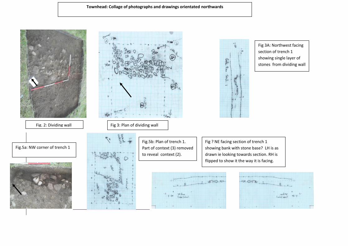
Fig. 2: Dividing wall Fig 3: Plan of dividing wall
Fig 3A: Northwest facing
section of trench 1
showing single layer of
stones from dividing wall
Fig.5a: NW corner of trench 1
Fig.5b: Plan of trench 1.
Part of context (3) removed
to reveal context (2).
Fig ? NE facing section of trench 1
showing bank with stone base? LH is as
drawn ie looking towards section. RH is
flipped to show it the way it is facing.
Townhead: Collage of photographs and drawings orientated northwards
