excavations at mote of urr, 1951 and 1953
TRANSCRIPT
Archaeology Reports Online, 52 Elderpark Workspace, 100 Elderpark Street, Glasgow, G51 3TR0141 445 8800 | [email protected] | www.archaeologyreportsonline.com
ARO31: Brian Hope-Taylor’s archaeological legacy:Excavations at Mote of Urr, 1951 and 1953By David Perry
with contributions by Simon Chenery, Derek Hall, Mhairi Hastie, Davie Mason, Richard D Oram, and Catherine Smith
Illustrations by Dave Munro, Christopher Fyles and Jennifer Simonson

ARO31: Brian Hope-Taylor’s archaeological legacy: Excavations at Mote of Urr, 1951 and 1953
Published by GUARD Archaeology Ltd, www.archaeologyreportsonline.com
Editor Beverley Ballin Smith
Design and desktop publishing Gillian Sneddon
Produced by GUARD Archaeology Ltd 2018.
ISBN: 978-1-9164509-0-5
ISSN: 2052-4064
Requests for permission to reproduce material from an ARO report should be sent to the Editor of ARO, as well as to the author, illustrator, photographer or other copyright holder. Copyright in any of the ARO Reports series rests with GUARD Archaeology Ltd and the individual authors.
The maps are reproduced by permission of Ordnance Survey on behalf of the Controller of Her Majesty’s Stationery Office. All rights reserved. GUARD Archaeology Licence number 100050699.
The consent does not extend to copying for general distribution, advertising or promotional purposes, the creation of new collective works or resale.
Alder Archaeology brought Brian Hope-Taylor’s excavation of Mote of Urr through post-excavation analysis and reporting to a publication manuscript. That research and this publication were funded by Historic Environment Scotland.

Contents
MOTIF 7Summary 7Foreword 7Introduction 8Historical account of the Mote of Urr 8 Introduction and historiographical background 8 The context of mid-twelfth century colonisation in Galloway 11 Walter de Berkeley and the Lordship of Urr 13 The heirs of de Berkeley 17 The Wars of Independence 20 Later medieval Urr 23 Mote of Urr in the sixteenth and seventeenth centuries 24 Conclusions 25The excavation 27 The archive 27 The excavation origins and organisation 28 The site location 29The results of the excavation 31 Phase I 31 Phase II 33 Phase III 36The environmental evidence 39 Environmental assessment 39 The animal bone 43The material cultural evidence 44 The pottery 44 Chemo-typing of pottery samples 51 The artefacts 57 Iron 57 Stone 57 Clay pipe 57 Burnt materials 57General discussion and conclusions 59Acknowledgements 62Bibliography 62
List of Figures
Figure 1: Location map of the Mote of Urr 6Figure 2: Lords of Galloway and Balliol family tree 12Figure 3: Detailed map of the Stewarty of Kirkbubright, highlighting parishes and places 13 mentioned in the textFigure 4: Map of Scotland and northern England with places and mottes mentioned in the text 15Figure 5: Berkeley, Balliol, Umfraville and Percy family tree 18Figure 6: Site plan, after contour plan by R J C Atkinson and P R Ritchie in 1951, with profile 30 across motteFigure 7: Plan of Phase I features with location of sections 32Figure 8: West section of Moat Cutting A, with section through part of the bailey 34Figure 9a and b: Composite cross-section of the top of the motte: east section of Octant A 34 (F-D), and east section (D-G) of Quadrant IFigure 10: Plan of Phase II features with location of sections 35

List of Figures (continued)
Figure 11: North section (A-B-C-D) of Quadrant I 36Figure 12: Plan of Phase III features with location of sections 37Figure 13: Intermediate section (E-C) of Quadrant I 38Figure 14: Pottery, Redware jugs, rims Cat Nos 1-10 46Figure 15: Pottery, Redware jugs, rims Cat Nos 11-20 47Figure 16: Pottery, Redware jugs, handles Cat Nos 21-26 48Figure 17: Pottery, Redware jugs, figurative and decorated sherds Cat Nos 27-37 49Figure 18: Pottery, Redware jugs, bases Cat Nos 38-47 50Figure 19: Pottery, unusual forms and Whiteware Cat Nos 48-50 51Figure 20: Na2O versus V concentration plot of Mote of Urr (MU) material compared to 51 redware database training setFigure 21: Dendrogram from cluster analysis comparing Mote of Urr (MU) with Caerlaverock 52 Castle (CC) materialFigure 22: Plot of PC1 versus PC2 from principal components analysis (PCA) comparing Mote 53 of Urr (MU) material to redware database regional training setFigure 23: Plot of PC1 versus PC3 from principal components analysis (PCA) comparing Mote 53 of Urr (MU) material to most relevant sites in redware database regional training setFigure 24: Plot of PC2 versus PC3 from focused site principal components analysis (PCA) 54Figure 25: Dendrogram from cluster analysis comparing Mote of Urr (MU) with local regional 55 material from Glenluce Abbey (GL) (tiles) and Hayknowes Farm (HF), Annan (early material)Figure 26: Dendrogram from cluster analysis comparing whiteware samples from Mote of Urr 55 (MU) with selected other white gritty ware materialFigure 27: Plot of PC1 versus PC2 from PCA analysis comparing ‘whiteware’ samples from Mote 56 of Urr (MU) with selected other white gritty ware materialFigure 28: Iron horseshoe nails, Cat Nos 2, 3; clay pipe, Cat No 10 59
List of Plates
Plate 1: Aerial photograph of Mote of Urr from the east. © Historic Environment Scotland, 9 D 66977 CNPlate 2: Photograph of excavation team (in 1951?). Brian Hope-Taylor is in the back row, 28 second from the left; his dog was called Simon. © Historic Environment Scotland (Brian Hope-Taylor Collection, SC 756923)Plate 3: Plan of Moat of Urr (with parish boundary added) by James O’Brien, Lance-Corporal, 29 Royal Engineers. Undated but probably about time of Ordnance Survey’s resurvey of Kirkcudbrightshire, 1893-4.© Historic Environment Scotland (Brian Hope-Taylor Collection, DP 054516)Plate 4: General view of Mote of Urr from the north. © Historic Environment Scotland (Brian 31 Hope-Taylor Collection, SC 937693)Plate 5: View of the Phase I motte surface in Quadrant I in 1953. Looking north-west; note 33 the bank visible at the base of the section A-B and Pit 6 on the edge of the motte. Scale in feet. © Historic Environment Scotland (Brian Hope-Taylor Collection, SC 938014)Plate 6: View of central pit in Quadrant I in 1953. Looking south. Large stones are on its 33 southern edge. Scale in feet. © Historic Environment Scotland (Brian Hope-Taylor Collection, SC 937972)Plate 7: The west section of the trench across the moat in 1951. Looking south-west. Scale 33 in feet. © Historic Environment Scotland (Brian Hope-Taylor Collection, SC 938020)

© Archaeology Reports Online, 2018. All rights reserved. 5
ARO31: Brian Hope-Taylor’s archaeological legacy: Excavations at Mote of Urr, 1951 and 1953
List of Plates (continued)
Plate 8: View of Posthole 2 (foreground) and Posthole 1 (middle distance) and Pit 1 36 (background) in Octant E in 1951. Looking north. Scale in feet. © Historic Environment Scotland (Brian Hope-Taylor Collection, SC 756775)Plate 9: Excavating the Phase III rubble layer (Layer II) in Octant A in 1951. Looking east. 38 Scale in feet. © Historic Environment Scotland (Brian Hope-Taylor Collection, SC 937839)
List of Tables
Table 1: Correlation of phasing between 1951 and 1953 excavations 27Table 2: Radiocarbon dates 31Table 3: Composition of soil samples 39Table 4: Catalogue of animal bone and molluscs 39-42Table 5: Medieval pottery catalogue 45-46Table 6: Catalogue of artefacts 58

© Archaeology Reports Online, 2018. All rights reserved.6
ARO31: Brian Hope-Taylor’s archaeological legacy: Excavations at Mote of Urr, 1951 and 1953
Site Location
2820
00
564000
2820
00
566000
N
0 1 km © Crown copyright. All rights reserved.Licence number AL 100049514
Mote of
EdinburghGlasgow
Stirling
Inverness
Elgin
Aberdeen
Perth
DumfriesUrrCastle
Douglas
Dundee
Dunfermline
Site Location
Figure 1: Location map of the Mote of Urr.

© Archaeology Reports Online, 2018. All rights reserved. 7
ARO31: Brian Hope-Taylor’s archaeological legacy: Excavations at Mote of Urr, 1951 and 1953
MOTIF
In days of old, when knights were colde,And spelling not so hotte,Fitzdouglas lived upon a Mote –Fitzpercy on a Motte.
Each spent his life in warlike strife,In plote and counter-plotte –Fitzdouglas far preferred a Mote,Fitzpercy yearned for Motte.
Although the feud is continued‘Twixt Englishman and Scot,Fitzdouglas now despises Mote –Fitzpercy sneers at Motte.
This little quarrel points the moral –History is tommy-rotte;Thank God you’ve got a Motte (or Mote),Don’t envy Mote (or Motte).
Source - Discovery and excavation in Scotland 1951. Copyright: Archaeology Scotland.
Summary
Excavations at Mote of Urr, near Dalbeattie, Stewartry of Kirkcudbright, in 1951 and 1953 produced evidence of three phases of occupation. The earliest phase (IA) comprised the construction of the motte-and-bailey castle and its apparent destruction by fire, after which a large central stone-lined pit for an oven, furnace, kiln or beacon was dug. The pit continued in use when the motte was heightened in Phase II and enclosed by a clay bank and palisade. In its final phase (III), when the motte was heightened yet again, evidence for a possible double palisade enclosing the summit of the motte was found. A trench across the moat around the motte revealed three phases of the ditch and evidence for a timber bridge across the moat. Pottery, animal bone and iron nails were recovered from all phases.
Foreword
Brian Hope-Taylor’s excavations at the Mote of Urr in Galloway are possibly the last of his excavations to be brought to full publication. It was at the time when he commenced excavating the Mote of Urr (1951) that he started the fieldwork and examination of aerial photography which was to lead to the ground-breaking work
on the site of Yeavering in Northumberland, which was eventually to lead to the identification of Yeavering as Bede’s Ad Gefrin (Murray 2005, 219). The rest, as they say, is history, and the remarkable discoveries at the site of Edwin’s palace and in particular Building E (the assembly grandstand) and associated structures have given the site of Yeavering a pre-eminent place in Anglo-Saxon archaeology which overshadows all other sites which Hope Taylor worked on. Understandably this iconic site dominated his life’s work from that year, although he excavated many more medieval sites in England in the decades following, until his death in 2001.
Like some other archaeologists Hope-Taylor did not find it easy to write up the results of his excavations for final publication. He apparently received a ‘severe dressing-down’ from Mortimer Wheeler for not writing up Yeavering in the expected time-scale (Taylor 2005, 204). However the list of sites which he did publish in one way or another is a wide-ranging roll-call of exceedingly significant places in the history of Anglo-Saxon England/Northumbria: Old Windsor, (1958), Preston Manor (1953), Lowe Hill in Wakefield (1958), Bamburgh (1960), Doon Hill in East Lothian (another Anglian hall, 1966), York Minster (1971), Devil’s Dyke in Cambridgeshire (1977) (Murray 2005, 219). Mote of Urr is one of the last which never reached full publication, and the present publication is a valuable addition to the list of Hope-Taylor’s archaeological achievements.
Brian Hope-Taylor was a charismatic and perspicacious scholar and artistic designer, illustrator and engraver. My memory of supervisions with him when studying archaeology at Cambridge in 1963 include a vivid recollection of the enlightened way in which he explained the importance of the excavated record and the need for accurate drawn illustrations. Sadly my own attempts to draw Viking brooches did not match up to his consummate artistic skills and were rather mildly condemned. But his encouragement to carry on with Viking studies in Scotland because there were ‘few people engaged in doing anything much up there in Viking research at the moment’ had a profound effect on my later career in the area of Viking studies in Scotland.
It is therefore with appreciation of Brian Hope-Taylor’s skills as a teacher and more particularly as an excavator of important medieval sites

© Archaeology Reports Online, 2018. All rights reserved.8
ARO31: Brian Hope-Taylor’s archaeological legacy: Excavations at Mote of Urr, 1951 and 1953
in northern England and southern Scotland that I welcome this publication compiled by Alder Archaeology of the site of Mote of Urr in Galloway. It will advance our understanding of these impressive mounds in the landscape and perpetuate Hope-Taylor’s legacy in exploring such lordship sites.
Barbara Crawford
University of St. Andrews and University of the Highlands and Islands.
Introduction
The late Brian Hope-Taylor (1923-2001) was an archaeologist who was especially noted for his work on Anglo-Saxon and early medieval sites in Scotland and England. While most of his work was in England, he excavated two important sites in Scotland, at Mote of Urr (Figure 1) in the Stewartry of Kirkcudbright in 1951 and 1953 and at Doon Hill, near Dunbar, East Lothian from 1962 to 1964. At the time of his death on 12 January 2001, no final publication report had been produced on Mote of Urr, or indeed, on most of his other excavations in England and Scotland. The records and finds of the Mote of Urr excavations and those of his other sites were salvaged from his house and garage in Cambridge and delivered to the then Royal Commission on the Ancient and Historical Monuments of Scotland (now Historic Environment Scotland), where, with funding provided by Historic Scotland (now Historic Environment Scotland) and English Heritage, the material was assessed, sorted and conserved. SUAT Ltd was commissioned in 2004 by Historic Scotland to first assess the records and finds of the Mote of Urr excavations, then to produce a report for publication. After SUAT Ltd was wound up in 2009, responsibility for finishing the project was passed on to Alder Archaeology Ltd. The report on the excavation is largely based on Hope-Taylor’s own accounts.
The only accounts of the excavations published by him are an interim report on the first season’s excavation (Hope-Taylor 1951) and a summary on the second season’s excavation (Hope-Taylor 1953). In addition, two newspaper articles on the excavations appeared in The Galloway News in 1951 and 1953, the latter certainly written by, or based on, an article provided by Hope-Taylor (NRHE, MS 1171/3); the 1951 article was also probably written by Hope-Taylor (referred to as
‘a correspondent’). There is also a short report on the 1953 excavation by Hope-Taylor on his students, which includes some details on the site, probably submitted to the Committee of the Scottish Field School of Archaeology; this report is contained in the site records now held by the Historic Environment Scotland’s National Record of the Historic Environment (NRHE, MS 1171/4).
Historical account of the Mote of UrrBy Richard D Oram
Introduction and historiographical background
Despite the scale of the earthwork at the Mote of Urr and the prominence of many of the owners of the fortification and the lordship of which it was once the caput, there has been surprisingly little research undertaken into the historical development of the motte, lands and lords of Urr. This position is, sadly, far from unique in respect of the lordly power centres of pre-1250s Scotland, let alone those in Galloway, with few motte and bailey castles having been the focus of modern and, perhaps even more importantly, large scale archaeological excavation (Oram 2008b). Although Galloway has long been identified as a region where, like the Welsh Marches or the Irish midlands, mottes have an especially dense distribution, few of them have been excavated and - until this present report - only one, Cruggleton, has been brought to full publication (Ewart 1985). Consequently, they are collectively one of the most poorly understood of Galloway’s major medieval structures, lacking a robust chronology for their periods of construction, development and abandonment.
Also lacking is any clarity in respect of their socio-economic roles and empirical evidence for their cultural context. That lack of a robust research-base founded on concrete evidence, however, has not prevented the construction of a complex narrative to explain their date, appearance, density, or demise (Oram 2000, 218-221). Due to the historical account preserved in the writings of two well-connected late twelfth-century English chroniclers, the northern English Augustinian canon, William of Newburgh, and the royal clerk/diplomat, Roger of Howden, a narrative of intrusive or imposed high-status Anglo-French settlement on a resentful and violently hostile native population, of destructive backlash and harsh re-imposition, has been developed and

© Archaeology Reports Online, 2018. All rights reserved. 9
ARO31: Brian Hope-Taylor’s archaeological legacy: Excavations at Mote of Urr, 1951 and 1953
refined since its widespread articulation in the later nineteenth century (ibid., 93-99).
That historical narrative emerged in tandem with a fresh wave of antiquarian theorising over the date and purpose of ‘motes’. Along with all other sites of this form in Galloway, recognition of Urr as a medieval lordly centre was only made from the 1890s after Frederick Coles published his detailed descriptions of the still as yet undated fortifications which dotted the landscape of Kirkcudbrightshire (Coles 1891; 1892; and 1893). Although Coles raised a brief question mark over the traditionally prehistoric date assigned to such earthworks, he offered no tighter or alternative date other than to point to the references to the Mote of Urr in fifteenth- and sixteenth-century record sources and noted local traditions of an early fourteenth-century connection with King Robert I (Coles 1892, 137-8). As with so many other aspects of the history of medieval Galloway, it was the redoubtable local antiquarian R C Reid who built on advances made in understanding of the chronology of mottes in the early 1900s in
England (e.g. Armitage 1912) to suggest in 1938 that there was a link between the Mote of Urr and the first recorded ‘Anglo-Norman’ lord of Urr, Walter de Berkeley (Reid 1938). The unforeseen consequence of the strong articulation of the historical narrative based on Howden’s late twelfth-century writings, coupled with Reid’s linkage of historical and archaeological evidence, was the entrenchment of its in-built chronology as an absolute of unimpeachable authority.
From 1938, it rapidly became accepted that Mote of Urr was of twelfth-century construction and a likely exemplar of the experience of such sites during the native revolt against the structures and symbols of foreign domination as recounted by Howden (Plate 1). It was this identification which led to its selection in 1950 by Brian Hope-Taylor as the target of what was intended to be the second motte excavation in a programme of research directed at broadening understanding of the date and constructional techniques of medieval earthwork defences in Britain (Hope-Taylor 1951). Sadly, despite a second season
Plate 1: Aerial photograph of Mote of Urr from the east. © Historic Environment Scotland, D 66977 CN.

© Archaeology Reports Online, 2018. All rights reserved.10
ARO31: Brian Hope-Taylor’s archaeological legacy: Excavations at Mote of Urr, 1951 and 1953
in 1953, the project ended without realising its objectives, no historical research was undertaken to provide context for evidence unearthed in the excavation, and no substantial report on the archaeological findings was produced. Nevertheless, the publication of the very brief interim report for 1951 established Mote of Urr as a probably twelfth-century construction with a major rebuilding having occurred at some point in the thirteenth century (ibid., 1951, 170). Although no mention is made in Hope-Taylor’s report of evidence for this rebuilding having followed destruction by fire of an earlier timber structure on the summit of the motte, a note in the 1953 Discovery and Excavation in Scotland newsletter reported the identification of such a stratum of destruction.
With publication of the possibility of a later-twelfth-century destruction layer in the site’s stratigraphy, the circularly reinforcing argument based upon Roger of Howden’s accounts of attacks on fortifications in Galloway in 1174 and that the archaeology confirmed that Urr had been burned in the course of these events quickly gained acceptance. In 1975, a fully-formed version of such a claim was advanced by Archie Duncan in The Making of the Kingdom and repeated in 1984 in a survey of ‘Norman’ fortifications in the Stewartry (Duncan 1975, 182; Tabraham 1984, 116). An extrapolated context for the motte’s construction, destruction and rebuilding was offered by subsequent commentators in the form of the settlement under royal direction in Galloway during the 1160s of a number of aristocratic colonists of English and Norman-French background, their violent expulsion in 1174 in a rebellion led by the Gaelic lords of Galloway, and their re-establishment in the 1180s by Roland, son of Uhtred, lord of Galloway (e.g. Tabraham 1984, 122). From the imprecisely dated ‘prehistoric’ fortification of Coles, the Mote of Urr had acquired in under a century a tightly defined chronology which fitted its construction into a 14-year window after 1160, its possible destruction in 1174, and reconstruction probably before c.1190. While questions have been raised as to whether the massive ovoid bank-and-ditch which encloses the motte is contemporary with it (Stell 1991, 146), this essentially twelfth-century excavation-based chronology for the motte at the Mote of Urr has remained unchallenged until this present assessment and analysis of
the archaeological evidence recovered in Hope-Taylor’s excavations.
While archaeological investigation of the site stalled in 1953, historical research into the origins and ownership of Urr continued. In his 1956 study of twelfth-century ‘feudal’ settlement in Scotland, Geoffrey Barrow pointed to the existence of a large lordship in eastern Galloway held by Walter de Berkeley, chamberlain of the king of Scots, and by 1960, R C Reid had firmly identified Walter de Berkeley as lord of Urr in the later twelfth century and attributed his presence there to his implantation by Uhtred, lord of Galloway (1160-74) (Figures 2 and 3, Barrow 2003, 263; Reid 1960, xxiii-xxiv;). Reid, however, raised the possibility that de Berkeley was not the original builder of the motte, suggesting that Uhtred himself may have been responsible. A link, however, had been established between Walter and Uhtred of Galloway. From this developed discussion of the nature of their relationship and the place of Walter in an apparently colonial settlement in the country west of the River Nith in the decade and a half after 1160.
In 1975, Archie Duncan identified Walter as a key figure in what he described as the beginnings of ‘the feudalization of Galloway’ under Uhtred. It was his view, however, that Uhtred had been forced by King William to infeft his chamberlain as part of a colonisation process imposed on the native rulers of Galloway following the Scottish invasion and conquest of the territory (Duncan 1975, 182). Native hostility to these colonists was well recorded in contemporary records of the 1174 rebellion by Uhtred and his brother, Gillebrigte, against Scottish overlordship (discussed below), and the chronicled destruction of their strongholds by the rebels. It was this documented violence which Duncan believed was attested at Urr by what he described as ‘a stratum of fire and destruction’ discovered in the 1953 excavation (ibid., 182).
Through the 1980s and 1990s, the ‘Anglo-Norman’ settlement of Galloway continued to be presented in terms of an enforced feudal settlement from 1160 to 1174, interrupted between 1174 and 1185 by a violent ‘anti-foreign’ reaction, and completed swiftly after 1185 (Barrow 1981, 49; Lynch 1992, 85-7; Ditchburn and MacDonald 2001, 163). Closer analysis in the 1990s of the

© Archaeology Reports Online, 2018. All rights reserved. 11
ARO31: Brian Hope-Taylor’s archaeological legacy: Excavations at Mote of Urr, 1951 and 1953
medieval record evidence for the relationship between the lords of Galloway, the Scottish crown and the colonial lords, however, indicated that this stark image was overly simplistic. New research suggested that the relationships between Uhtred and both the king of Scots and Walter de Berkeley were more complex and may have been founded on much closer and more cordial personal bonds (Brooke 1994, 100-104; Oram 1993; Oram 2000, 87-99, 191-213). This is the currently most favoured view of the political context for the creation of the lordship of Urr and the establishment of its caput, most probably at the Mote of Urr.
The context of mid-twelfth century colonis-ation in Galloway
At the beginning of the twelfth century, Galloway lay outwith the political spheres of the principal mainland British kingdoms of England and Scotland. Galloway’s closest bonds were with the maritime powers of the Irish Sea and Atlantic West (Oram 2000, chapters 1 and 2). Earlier Northumbrian influences over the region had seen strong links maintained through the Anglo-Scandinavian period, especially in respect of the ecclesiastical ties to York, but perhaps also during the maximum extent of the ‘imperium’ exercised by King Knútr within the British Isles in the 1020s and 1030s. English influence remained strong at the end of the eleventh century, but it has been argued that the direct implantation of colonists into the country along the northern shore of the Solway may have begun on the initiative of King Henry I of England (1100-1135). Henry, it is suggested, aimed to stabilise and secure the north-western frontier of his kingdom, balancing his parallel establishment of his brother-in-law, the future King David I, as ruler over the former kingdom of Cumbria (Scott 1997). Apart from the marriage of one of Henry’s illegitimate daughters to Fergus of Galloway before c. 1122 (Oram 2000, 61), however, there is no evidence that English settlement extended west of Annandale at so early a date.
English influence in the Southern Uplands of Scotland, however, grew through the 1110s following Henry I’s intervention in securing control of most of the region for his brother-in-law, David, the youngest son of King Malcolm III of Scotland (Oram 2008a, chapter 4; Oram 2011, 56-9). When David succeeded to the Scottish
throne in 1124, English influence was replaced by Scottish interests. David may already have begun to extend his influence westwards before 1124, there being a possibility that he had already given Annandale to his associate, Robert de Brus, by c.1120, but the 1120s witnessed the beginning of a rapid expansion of the new king’s power within the core of the former Cumbrian kingdom (Oram 2008a, 76-7). Rebellions against his kingship by supporters of his predecessor’s illegitimate son drew David’s power further into the west and by the late 1130s he had established a royal presence in the territories down the east coast of the Firth of Clyde (Oram 2008a, 86-7, 111-119; Oram 2011, 85-9). This extension of Scottish royal power brought with it an extended reach of influence and by the mid-1130s Fergus of Galloway had possibly been brought into a client relationship with David I. This trend towards clientship reached a climax in the major involvement of warriors from Galloway in David’s campaigns in northern England after 1136 (Oram 2000, 65-8).
External political and cultural influence had been growing in Galloway through the 1120s. The main manifestation of this was in ecclesiastical affairs, arising from the revival or reform of the bishopric based on Whithorn (ibid., 164-174). The bishopric fell under the metropolitan jurisdiction of the Archbishop of York, a link which exposed the Church in Galloway to strong northern English influences. These influences were reinforced in the 1140s when Fergus – possibly with the involvement of David I – established a colony of Cistercian monks from Rievaulx in Yorkshire at Dundrennan (Stringer 1979). These ecclesiastical ties, however, developed in parallel with secular links, the most important of which were the marriages of Fergus’s sons Uhtred and Gillebrigte to members of the Anglo-Scottish aristocratic elite (Oram 2000, 67-8, 89-90) (Figure 2). While the marriages may not have resulted immediately in an influx of colonists who came in the train of the brothers’ brides, it forged links with the wider aristocratic culture of southern Scotland and northern England. It was such bonds which ultimately drew Galloway into an increasingly close relationship with its northern neighbour and paved the way for its ultimate absorption into the Scottish kingdom (Oram 2011, 307).
Absorption lay almost a century into the future,

© Archaeology Reports Online, 2018. All rights reserved.12
ARO31: Brian Hope-Taylor’s archaeological legacy: Excavations at Mote of Urr, 1951 and 1953
however, the second half of the twelfth century saw a return to an older alignment; domination by the English crown. Indeed, there was a possibility in the later 1170s that Galloway might become altogether detached from the orbit of the king of Scots. Scottish domination of Galloway had been weakened significantly in the late 1150s through King Malcolm IV’s 1157 surrender of the northern English counties to Henry II of England. Galloway’s rulers, however, were in no position to capitalise immediately on this change in circumstances due to a collapse in the relationship between Fergus and his sons and descent into what appears to have been a tri-cornered civil war (Oram 2000, 74-82). Fergus’s possible support for rebels against Malcolm IV or efforts to bolster his diminished prestige by leading plundering raids into Scottish territory led to a Scottish invasion and conquest of Galloway in 1160, with Fergus being forced to ‘retire’ to become an Augustinian canon at Holyrood Abbey (Oram 2011, 122).
Malcolm IV’s conquest of Galloway profoundly altered the political landscape of the south west. Rather than rule the region directly, Malcolm opted to divide Galloway between Uhtred and Gillebrigte. Landholding patterns that can be
seen later in the twelfth and in the thirteenth century suggest that there might have been a clean subdivision of their father’s territory, with Uhtred receiving the lands east of the River Cree (Figure 3) and Gillebrigte those to the west (Oram 2000, 87-92). Although that neatness may be deceptive, there is no firm evidence to suggest a more fragmented or dispersed power-share of their joint inheritance, of the kind that occurred after the death of Uhtred’s grandson, Alan, in 1234 and partition of Galloway between the families of his three surviving daughters. Probably in the early 1160s, Malcolm may have given Uhtred control of what had formerly been a portion of the lordship of Nithsdale, the district known as Desnes Ioan which lies between the rivers Urr and Nith. There were, however, strings attached to the grant for it seems to have been given in distinctly ‘feudal’ terms, with Uhtred having a service obligation to provide to the Scottish crown. To meet that obligation, Uhtred was obliged to settle tenants on portions of his new territory. It is in this context that Walter de Berkeley may have acquired his lordship of Urr (Oram 1993, 119-123).
Walter de Berkeley and the Lordship of Urr
Lords of Galloway and Balliol
Henry I (England)
Fergus of Galloway = ? illegitimate daughter
d.1161
Gillebrigte = daughter of d.1185 Donnchad, earl of Fife
Gunnilda = Uhtred, Lord of Galloway b.c.1120 d.1174
Waltheof, Lord of Allerdale
Helen de Morville = Roland, Lord of Galloway d. 1200
Eve of Galloway = Walter de Berkeley
1. ? De Lacy = Alan of Galloway 2. Margaret of Huntingdon d.1234 3. Rose de Lacy
Dervorguilla = John Balliol b.c.1210 d.1290
b. before 1208 d.1269
John Balliol I (King of Scotland) b.c.1240 d.1314
Helen Christian
Three sons, all predeceasing John
Figure 2: Lords of Galloway and Balliol family tree.

© Archaeology Reports Online, 2018. All rights reserved. 13
ARO31: Brian Hope-Taylor’s archaeological legacy: Excavations at Mote of Urr, 1951 and 1953
Walter de Berkeley’s career can be traced from the early 1160s when he and his brother, Robert, witnessed a grant made to Melrose Abbey by Robert Avenel, lord of Eskdale in Dumfriesshire (RRS, i, 283 n.1). It is likely that the Berkeley brothers were attached to the royal court and Walter rose rapidly in the service of King William after 1165. By c.1171, Walter had been appointed as the king’s chamberlain and retained possession of that office until c.1193 (RRS, ii, 33). The rewards for his service were high: by about 1180 he had been granted the lands of Inverkeilor or Redcastle on the Angus coast and apparently also Ardoyne in the Garioch in central Aberdeenshire (RRS, ii, nos 185, 344; Stringer 1985, 66, 81). He also received land in Lessudden (modern St Boswells, Roxburghshire) and Plenmeller in Northumberland from Robert of London (Barrow 1980, 174). His largest acquisition, however, was the lordship of Urr in Galloway, a territory that lay on the margins of direct Scottish royal power in the later twelfth century.
Although the date at which Walter received Urr from Uhtred cannot be fixed precisely, it appears to have been before c.1170, i.e. before he became chamberlain to King William. It is probable, therefore, that Walter’s success in securing Urr
stemmed from a pre-existing personal connection with Uhtred. There is some evidence to suggest that he was Uhtred’s brother-in-law and that the substantial territorial lordship which he was given was intended to provide the heritage of a future cadet line of the ruling house of Galloway (Oram 2000, 198-9). Family connections certainly provided an opening in Galloway for many of the colonial families recorded later in the twelfth century and may also have accounted for the establishment in Galloway of the three other ‘Anglo-Norman’ knights whose presence can be attributed to grants from Uhtred. At Anwoth, west of Gatehouse of Fleet, David son of Terrus received a compact lordship whose parish church he granted to the canons of Holyrood before the end of the twelfth century (Holyrood Liber, no.49; Oram 2000, 198). Its caput was probably the motte and bailey fashioned from a headland on the gravel terrace on the western side of the Fleet estuary at Boreland or Greentower motte (Tabraham 1984, 91-92) or Kirkclaugh at the extreme south west of the parish (ibid., 92). Further to the east at Borgue, a major lordship was granted to Hugh de Morville the younger, son of David I’s constable and infamous as one of the assassins of Archbishop Thomas Becket of Canterbury in December 1170 (Oram 2000,
Figure 3: Detailed map of the Stewarty of Kirkbubright, highlighting parishes and places mentioned in the text.
Parish of Urr
Parish of
Parish of LochruttonRiver Cree
Solway
Heston/Hestan IslandAuchencairn Bay
Caerlaverock Castle
Fleet Estuary
Kirkgunzeon
Anwoth
Terregles
Urr
Wigtown
Mote
River Urr
River Nith
0 50 km
Scotland
England
Dumfries
Cruggleton Castle
Ingleston motte
KirkcudbrightCastle
Lochmaben Castle
Abbey
Threave
Annandale
New Abbey
Whithorn
River Ken
Burned Island
Buittle Castle Parish
Stewartryof Kirkcudbright
of Urr
DundrennanAbbey
Wigtown

© Archaeology Reports Online, 2018. All rights reserved.14
ARO31: Brian Hope-Taylor’s archaeological legacy: Excavations at Mote of Urr, 1951 and 1953
195-6; Barrow 1980, 31 n.3, 74-6, 81-2). Its caput was probably the fine motte at Boreland of Borgue (Tabraham 1984, 96). The third of the beneficiaries was Richard son of Truite, to whom Uhtred gave a lordship at Lochkindeloch, represented by the later parish of New Abbey (Oram 2000, 199-200; Stringer 2000a, no.9; CRO, D/Lons/L5/1/S1). Its caput was probably the suggestively-named Ingleston motte, south-west of New Abbey. All of these men already held property in Cumberland or Westmorland; had connections with the kin of Uhtred’s wife, Gunnilda, daughter of Waltheof, lord of Allerdale; were near neighbours of Uhtred’s Cumberland lordship of Torpenhow (Figure 4), which he had acquired through the marriage to Gunnilda (Holyrood Liber, no.24); and Hugh and Richard were closely associated with the administration of Cumberland and Westmorland under Uhtred’s kinsman, King Henry II of England (Oram 2000, 198).
No charter setting out the territorial limits of Walter’s lordship survives. Fourteenth-century accounts of the components of the properties held by the de Berkeleys’ successors indicate that it comprised of the whole of the parish of Urr, possibly including the parish of Blaiket to its north-east, plus detached portions of land further to the east in Desnes Ioan. Records of a dispute with the Cistercian abbey of Holmcultram in Cumberland (Figure 4) indicate that Uhtred had also given Walter a broad block of land extending down the south-western side of the lands of Kirkgunzeon, which Uhtred had earlier given to the monks (Holm Cultram Recs, no.120a). This dispossession was contested by Holmcultram, who appealed with the support of Bishop Christian of Whithorn to King William. Between 1165 and 1173, William ordered Uhtred, accompanied by Roger de Minto, to assemble ‘elderly men of the district who knew the right ancient bounds of Kirkgunzeon’ and make a perambulation of the property. Although the perambulation found that Uhtred had deprived the monks of a large piece of land, the monks were unable to regain possession for around a further decade (ibid., no.120a; Scott 1982, 90-91). In addition to these lands in Kirkgunzeon (Figure 3), Walter also received property to the east of the Holmcultram estate in Lochrutton parish. It is unclear – and, from landholding patterns in the parish, probably unlikely - that Walter’s lordship extended over the
whole of Lochrutton, but it appears in the 1180s that he possessed land around Corswadda at the extreme eastern end of the parish (Reid 1960, xxiv; Barrow 2003, 263). These lands conjointly formed the single largest landholding assigned to any of Uhtred’s tenants and marked Walter out as the leading figure in the colonial settlement.
Amongst the several oddities of the Mote of Urr is its marginal location in respect of the lordship granted to Walter: it sits on the floor of the Urr valley at the extreme western edge of Walter’s properties. Indeed, until the abolition of civil parishes in Scotland in the 1970s, the motte stood in a salient of Urr parish on the west side of the river, which comprised simply the site and no more. Since at least the 1890s it has been recognised that the river had originally flowed in a channel round the western side of the large gravel drumlin crowned by the motte and bailey (Coles 1893, 138), positioning it either within a loop of the channel or on an island between two courses. The western course, however, had already ceased to flow by the early fourteenth century when it was noted in a perambulation of the lordship of Buittle that its eastern boundary followed the river until ‘the old Urr’ and then went by it until ‘the old Urr crossed back into the water of Urr’ (RRS, v, no.267). Immediately to the west of the river otherwise lay the lordship of Buittle, which was a demesne property of the lords of Galloway, and the district of Desnes or Desnesmor which had probably formed the original core territory of Uhtred’s family.
Prima facie, this position quite literally on the frontier between Desnes and Desnes Ioan seems to support the idea that the settlement of Walter and his fellow foreign knights formed part of a supervisory system imposed on Galloway’s lords. A structure of ‘bailiffs and wardens’ based on ‘castles and fortifications’ is referred to in accounts of the 1174 rebellion against Scottish overlordship compiled by the English royal clerk, Roger of Howden. He described it explicitly as having been imposed on Galloway by King William (Chron. Peterborough, i, 67-8; Chron. Howden, ii, 63; Duncan 1975, 182). The imposition which is the primary message in Howden’s narrative led R C Reid to posit that the riverine and coastal distribution of the mottes like Urr, Green Tower and Kirkclaugh (Figure 4) reflected their builders’ insecurity and social isolation, preserving routes

© Archaeology Reports Online, 2018. All rights reserved. 15
ARO31: Brian Hope-Taylor’s archaeological legacy: Excavations at Mote of Urr, 1951 and 1953
Figure 4: Map of Scotland and northern England with places and mottes mentioned in the text
Mote of Urr
Ayr
Bannockburn
Bothwell CastleDoon
Dunbarton
Firth of Clyde
Holyrood Abbey
Holmcultram Abbey
Irish Sea
Atlantic
Melrose Abbey
Southern Uplands
Redcastle
Rievaulx Abbey
Roxburgh
Rutherglen
Torpenhow
Castle
Scotland
England
0 100 km
Cumbria
Northumbria
Castlehill of Strachan
Ingleston Motte
Montfode Mount
Peel of Lumphanan
Rattray
Roberton
Sorbie Old Tower
Barton Hill, Kinnaird
Kirkclaugh
Foulis, Ross-shire
Key:MottesPlaces
Green
Carrick
Tower
Tillydrone
Buittle
Hill

© Archaeology Reports Online, 2018. All rights reserved.16
ARO31: Brian Hope-Taylor’s archaeological legacy: Excavations at Mote of Urr, 1951 and 1953
for escape by water in the event of a rising against them, exactly such as occurred in 1174 (Reid 1960, xxii). A suggested role for Walter’s stronghold in some supervisory system intended to police the eastern borders of Galloway might gain support from its position at a key ford on the River Urr. Indeed, it lies at the point where the main medieval road running west from Dumfries descended from its route along the ridge which forms the boundary between Kirkgunzeon and Lochrutton parishes to cross the Urr valley. The road is mentioned twice in perambulations of Kirkgunzeon in the later twelfth century (Holm Cultram Recs, nos 121, 122; Reid 1928, 204) and was the route taken by Edward I in 1300 on his march from Dumfries to Kirkcudbright (McNeill and MacQueen 1996, 88).
A military interpretation of the positioning of the motte could indeed see it as placed to control the ford and the major east-west routeway through Galloway. But the ford at Mote of Urr is barely necessary for crossing a river which is generally shallow with a stony bed for most of its length upstream from the head of its tidal reach at Buittle and there are other early routes and crossing-points north and south of the motte which have no fortifications overlooking them; as a border-post, the Mote of Urr is relatively isolated and easily by-passed. Furthermore, given Uhtred’s personal relationship with Walter and the other knights settled on his lands, a supervisory function becomes less tenable as an explanation for its establishment.
If the Mote of Urr’s location was dictated less by an intended role in the Scottish military subjugation of Galloway than traditionally believed, what other factors may have contributed to the selection of its site? The nodal position of the motte on the communication network of eastern Galloway was certainly important but its marginality to the properties for which it served as estate centre negates that value. There are alternative sites more central to Walter’s lordship which could have been selected. That existence of alternative locations suggests that the governing influence was the site itself, perhaps because of some already established importance as a past or current lordly centre, or through the symbolism – and obvious economy of labour involved in adopting an older defensive site - offered by pre-existing and quite massive fortifications. If the
bailey defences do represent a re-use of a possibly Iron Age site, Walter’s decision to establish his caput within them may represent nothing more than the pragmatic action of a newcomer intent on making the maximum visual impact with the minimum of new expenditure.
Interpretation of the evidence for burning identified in the 1953 excavation has led to an assumption that the motte as we see it today represented the central component of Walter’s stronghold and was one of the ‘castles and fortifications’ recorded as being destroyed in the 1174 rebellion (Duncan 1975, 182). Re-dating of charcoal material recovered from the motte summit, however, suggests that there were several phases of construction which saw heightening of the motte on at least two occasions. The earliest charcoal layer has produced radiocarbon dates supportive of construction in the mid-twelfth century and burning possibly in the 1170s. This would tally with initial construction by Walter as part of Uhred’s settlement of the Desnes Ioan district and burning during the 1174 revolt. There are, however, indications that a phase of rebuilding followed swiftly after the devastation of the site by fire, but it was impossible to tell if there had been any appreciable period of abandonment between burning and redevelopment. These two episodes were sealed beneath a significant heightening of the motte, probably in the later twelfth or earlier thirteenth centuries. This sequence of construction, burning and redevelopment already hints at a more complex process than the traditional Howden-derived narrative implies.
Howden’s account of the rebellion and the formula followed in most modern narratives is of a joint rising by Uhtred and Gillebrigte which led to the initial over-running of the castles of the foreign settlers and the slaughter of all the ‘English and French’ who were within them. This phase, of indeterminate duration, was followed by a re-opening of the breach between the brothers and Uhtred’s death at the hands of Gillebrigte’s supporters. Thereafter, until his own death in 1185, Gillebrigte ruled all of Galloway to the exclusion of his brother’s heirs (e.g. Reid 1960, xxi). Restoration of the men driven out in 1174 and reconstruction of their castles, it was explained, were consequences of Roland son of Uhtred’s military recovery of his

© Archaeology Reports Online, 2018. All rights reserved. 17
ARO31: Brian Hope-Taylor’s archaeological legacy: Excavations at Mote of Urr, 1951 and 1953
heritage and conquest of his cousin’s lands in 1185. Reassessment of that narrative and the sources upon which it was constructed, however, coupled with the excavated evidence from Urr, have exposed problems of chronology in respect of actions by Uhtred’s son, Roland, within Desnes Ioan. Based on reanalysis of the evidence, a new thesis has been proposed which argues that Roland had succeeded in regaining possession of at least the district east of the Urr – and possibly much of the territory up to the Cree – in the years immediately after 1174 (Oram 2000, 95-6). Here might be the context for the phase of reconstruction that followed the first destruction of the site. How active Walter de Berkeley was in the defence of his own and his nephew’s heritage is, however, unknown for he was heavily involved in King William’s invasion of northern England in 1174 and had been selected as a hostage for the king by the terms of the settlement reached with Henry II at Falaise, Normandy (Chron. Fantosme, 103; RRS, ii, 33; Chron. Peterborough, i, 98). Walter was released from service as a hostage probably in late 1175 and may have been able then to participate in Roland’s efforts to secure some portion of his father’s lands. There is, however, no concrete evidence for his involvement.
It is from the post-1174 phase of his involvement with eastern Galloway that most evidence for Walter’s active role survives. The long dispute with monks of Holmcultram over the property that Uhtred had detached from Kirkgunzeon and granted to Walter was finally resolved by him making over the contested lands to the abbey (Holm Cultram Recs, no.123). The monks certainly had the support of King William in their efforts even before 1174, but it is possible that he was able to exert greater pressure on his chamberlain in the years after 1175 when William was developing a closer personal relationship with Roland of Galloway. Between about 1180 and 1190, Walter finally conceded the land to the monks, with confirmations being granted by both Roland and the king shortly thereafter (ibid., no.122; RRS, ii, no.256). While this may simply be read as a straightforward property transaction it also has the appearance of a man clearing the issues that may have jeopardised his mortal soul, a subject that lay behind a great many property transactions in this period (Stringer 2000b). It was not just provision for his spiritual needs, however, that occupied Walter in this later
period, for there is evidence to suggest that he was consolidating his lordship and introducing new settlers onto his lands. The evidence for this is frustratingly fragmentary but it appears that he was granting portions of his lands to colonists in a direct reflection of the policies of Uhtred of Galloway and his son, Roland. The one certain grant was made around 1190 to one William, son of Richard, who was awarded the lands of ‘Croswaldef’ (identified as Corswadda in the east of Lochrutton parish) for the service of half a knight (Reid 1960, xxiv-xxv; Barrow 2003, 263). This grant was quite substantial and can be seen as representative of the creation of a second tier of colonial landholding in eastern Galloway dependent on the lordship of Urr. By the 1190s, the shallow hold of the incoming aristocracy on their property had been replaced by a firmly bedded structure.
The heirs of de Berkeley
Although the colonial settlement in Galloway was to become a fixed component in the regional lordship pattern in the later twelfth century as Uhtred’s son, Roland, established a wider circle of family and supporters within his domain, a de Berkeley lordship was not to be a feature of that pattern. It is known that Walter had a son, John, who attested an undated charter of Alan son of Walter, the Steward, which was granted somewhere between 1189 and 1199 (Melrose Liber, no.97; Barrow 1980, 174) and probably towards the beginning of that date range. This John, however, may have predeceased his father - who appears to have died in the early 1190s - or died very shortly after Walter, leaving no legitimate direct heir to succeed him. Instead, the de Berkeley inheritance fell to Walter’s two daughters, the elder, whose name is not recorded in any surviving source, being the wife of Enguerrand Balliol, the younger, Agatha, being married to Humphrey son of Theobald de Addeville (Barrow 1980, 174-5). The heritage was split between both heiresses and their husbands but possession of the capita of the main lordships of Urr and Inverkeilor appears to have fallen to the elder heiress.
Enguerrand Balliol (Figure 5) was an influential figure in thirteenth-century Galloway and was well connected within the lordship and within Scotland and northern England generally (Stell 1985, Table 5 and p.154). He was the younger

© Archaeology Reports Online, 2018. All rights reserved.18
ARO31: Brian Hope-Taylor’s archaeological legacy: Excavations at Mote of Urr, 1951 and 1953
brother of Hugh I Balliol, lord of Barnard Castle in Co Durham, and elder brother of Henry Balliol of Cavers in Roxburghshire, who would become chamberlain of King Alexander II in the 1220s (Stringer 1993, 112). In addition to Urr and Inverkeilor, Enguerrand held the lordship of Dalton in Hartness and the lands of Bolam, both in Co Durham, and apparently also the lordship of Tours-en-Vimeu in Picardy, which formed part of the Balliol family’s heritage in northern France. Despite this wide spread of lands and interests he seems to have developed a close relationship with Galloway and with its lord, Alan son of Roland (Figure 2), present with Alan on ten occasions and witnessing four of Alan’s charters (Stringer 1993, 99 and nos 3, 4, 5, 7; Stringer 2000a, nos 53, 58, 59, 61). He was probably connected with Alan in his role in the Scottish embassy sent to negotiate with King John in July 1215 and served in Alan’s following during the Scottish occupation of Cumberland and Westmorland during the war of 1216-17, occurring first in the list of witnesses to a grant of property in Westmorland made by Alan (Stringer 1993, 89; Stringer 2000a, no.53), but is otherwise notable as an important adherent of King Alexander II and witness to 26 surviving royal charters in the period down to 1236. The fact that he was sheriff of Berwick by c.1226 indicates that despite his prominence in Galloway landholding his career was being forged largely
in royal service and administration elsewhere in Scotland (PKA, MS100/1/30). Nevertheless, there are a number of charters granted or confirmed by him which, along with his association with Alan of Galloway, indicate that he was at least on occasion resident in Galloway and took an active role in the administration of his inherited interests there.
Most evidence for his presence in a Galloway context relates to his charter attestations, all on occasions held probably outside of Galloway (one in Westmorland and three probably in Cunningham). He also made charter confirmations in respect of his lordship of Urr, both in connection with property transactions involving religious houses which his father-in-law had made. Thus, Enguerrand confirmed his father-in-law’s settlement of the dispute with Holmcultram, probably soon after 1200 (Holm Cultram Recs, no.124). Likewise, in the 1220s he confirmed a grant to Holyrood of the churches of Urr (Kirkconstantine) and Blaiket (Kirkbride), including a perambulation of the kirklands of Blaiket made in the company of ‘his knights and worthy men’ and the abbot and canons of the abbey to settle any lingering disputes over their extent (Holyrood Liber, no.70). It is this charter which confirms that Blaiket had fallen within the lordship of Urr as held by Walter de
Walter de Berkeley, Lord of Urr
(acquired Urr before c.1170 from
Uhtred)
Robert
Enguerrand Balliol of Urr = ? daughter
=
Agnes (Percy) = Eustace, Lord of Tours-en-Vimeu
(d.c.1276)
Ellen = William III de Percy
(d.1245)
(Ellen?) = Umfraville
daughter of
Enguerrand I?
Enguerrand II de Balliol, Lord of Tours-en-Vimeu
(d.1299)
Henry de Percy
(c.1235-72)
?Enguerrand de Umfraville
Berkeley, Balliol, Umfraville and Percy
Agatha = Humphrey de Berkeley
Enguerrand
Walter
William
Percy earls of
Northumberland
Henry
Eva of Galloway
Figure 5: Berkeley, Balliol, Umfraville and Percy family tree.

© Archaeology Reports Online, 2018. All rights reserved. 19
ARO31: Brian Hope-Taylor’s archaeological legacy: Excavations at Mote of Urr, 1951 and 1953
Berkeley. The witness list to this confirmation is quite informative, revealing the hybrid nature of his following from Galloway, for in addition to his social peers, the knights Fergus of Glencairn, Robert de Ros and Hugh Crawford, and three prominent tenants of Alan of Galloway’s from Lauderdale, the document was attested by Enguerrand’s chaplain, Walter, two other clerks, and two Gaelic dignitaries, the last being a judex or hereditary lawman. This kind of profile tallies well with the hybrid society which emerged in Galloway in the thirteenth century (Oram 1993) and indicates the success of the Balliols at Urr in integrating themselves into the local hierarchy of power.
It is probably to Enguerrand I’s period of tenure that the second heightening of the motte should be dated. Beyond the fact of the considerable investment in the site that this episode represented, little can be said of the factors which stimulated this development. What we might be witnessing is the consolidation of a major family in its lordship centre and the remodelling of that centre to meet its socially expressive needs.
Enguerrand is last recorded in August 1236 as a witness to a royal charter issued at Edinburgh (Holyrood Liber, no.59) and probably died shortly after that date. He was succeeded by his elder son, Eustace (Stringer 1985, 187). Although Eustace has left very little record of his activities, he is the first of the holders of the property who can be specifically located at Urr on a precise date. On 2 September 1262, he was present at Urr with a large assembly of regional dignitaries, including Henry, bishop of Whithorn. Amongst the witnesses were Adam Clerk and Hugh Sprot, described as ‘burgesses of Urr’. Doubts have been raised over the accuracy of the witness list to this charter and the fact that this one reference to burgesses of a putative burgh of Urr is the only surviving mention of such a community has added to the uncertainty over its existence. Nevertheless, the consensus is that the Balliols attempted to establish a market centre at or near Mote of Urr but that the community failed to develop into a fully functioning burgh (Pryde 1951, 85; Reid 1960, xxiv; Duncan 1975, 472). Such an initiative would be in keeping with the actions of ambitious nobles in the mid thirteenth century, who saw opportunities in the rapid expansion of population and booming trade-driven economy of the period to maximise
potential profits from their estates. Urr’s location at the point where one of the main east-west arterial routes through Galloway crossed one of the main river valleys of the region close to the administrative centre of one of the larger secular estates in the region is an obvious choice for a burgh site. Perhaps unfortunately for the Balliols at Urr, their more powerful cousins at Buittle lower down the valley (Figure 4) appear also to have attempted to develop a burgh adjacent to their castle there (Pryde 1951, 91-2), with both ventures suffering diminished impact accordingly. If a real rather than aspirational burgh did exist at Urr, where was it located? It has been suggested by Pryde (ibid., 85) that it was sited at ‘Town of Urr’, which he placed on the western side of the modern river channel. Blaeu’s 1654 Atlas (based on Timothy Pont’s now lost map of the area produced in the 1590s), General Roy’s 1747-55 Military Survey, and John Ainslie’s 1797 map, however, all show the main settlement at Urr to have been east of the river in the vicinity of the existing hamlet of Netheryett (NGR: NX 817 646), specifically named by Ainslie as ‘Town of Urr’ with ‘Townhead’ further to the east. It has also been suggested that the Mote of Urr itself may have housed the burgh in its bailey (G Stell, pers. comm.).
While a scheme for a burgh at Urr might point to ambitions on the part of Eustace Balliol (Figure 5) for the economic development of his lordship, there is otherwise little evidence for his active involvement in the affairs of the district. The fact that he is styled in his charter to Holyrood as ‘Eustace Balliol, lord of Tours’, a title derived from his family lands of Tours-en-Vimeu in Picardy, might offer an indication of where his personal interests were chiefly focussed and explain his relative invisibility in Scottish records. He is otherwise known in Galloway only from his confirmation of his father’s and Walter de Berkeley’s charters to the monks of Holmcultram (Holm Cultram Recs, no.125) and an agreement between Eustace and the monks that they would observe the terms of Walter’s original settlement, dated at Berwick-upon-Tweed, 25 July 1244 (ibid., no.147).
Eustace was succeeded by his son, Enguerrand II (Figure 5), who appears to have made his career chiefly in France as lord of Tours-en-Vimeu. On 28 May 1291, the king of France requested that Enguerrand be granted a respite for performance

© Archaeology Reports Online, 2018. All rights reserved.20
ARO31: Brian Hope-Taylor’s archaeological legacy: Excavations at Mote of Urr, 1951 and 1953
of homage for his English lands, a request which underscores his role as a French nobleman and his probably long-term absence from England (CDS, ii, no.479). Enguerrand was dead before 20 February 1299, when King Edward I of England granted all of his lands in England and Scotland to Henry Percy rather than to the legal heir, Enguerrand de Umfraville, who had been forfeited on account of his adherence to the Scots (ibid., nos 1060, 1102). As the record of Henry Percy’s homage for the Balliol of Tours-en-Vimeu lands in Leicestershire states, he was the cousin of Enguerrand II Balliol. The connection had been established through the marriage of Eustace Balliol to a daughter of William III de Percy’s first marriage, which had brought with it the Leicestershire lands of Foston as dowry (Stringer 1985, 187), and William’s own second marriage to Enguerrand II’s sister, Ellen (Lomas 1999, 31; Beam 2008, 17-18), whose grandson Henry was. The Umfraville connection with the Balliols has not been established with confidence but is likely to derive from the marriage of another - probably elder - daughter of Enguerrand I to Enguerrand de Umfraville’s father (Duncan 1992, 127; Beam 2008, 17-18 and note 35). Descent from sisters of Eustace Balliol appears to be confirmed by the fact that Umfraville and Percy should have been co-heirs but that Edward I had set aside the former’s right on account of his ‘treachery’ in supporting King John Balliol in 1296 and his part in the forging of the Franco-Scottish alliance and the outbreak of the Anglo-Scottish war (Duncan 1992, 128).
The Wars of Independence
Umfraville’s decision to abandon his family’s traditional bonds of allegiance to the English crown was to cost him dearly. While he had submitted to Edward I by 28 August 1296 in the wake of the crushing Scottish defeat at Dunbar (CDS, ii, 199) and had delivered Dumbarton Castle on behalf of the English king into the hands of James the Steward (ibid, no.853), he was restored only to his property in Ayrshire and denied his rightful inheritance in Urr (ibid., no.1060). Edward I’s allocation of the whole of the Balliol of Tours-en-Vimeu inheritance in Scotland to Henry Percy formed part of what was intended to be his post-conquest settlement of Scotland. Percy’s kinship with both the Balliols of Tours-en-Vimeu and King John Balliol, who had inherited half of the lordship of Galloway through
his mother, Dervorguilla, youngest daughter of Alan of Galloway, may have guided Edward I in his appointment of him in September 1296 as warden of Galloway and keeper of the castles of Ayr, Wigtown, Cruggleton and Buittle (ibid., 225, Figures 3 and 4). In the aftermath of the Scottish victory at Stirling Bridge on 11 September 1297, Enguerrand renounced his submission and joined the Scottish resistance to the English occupation. He emerged quickly as a leading figure amongst the Scottish nobility, representing a pro-Balliol interest in a group largely split along factional grounds between the Bruces and the pro-Balliol Comyns. In August 1299, he served prominently in a Scottish raid into the Forest of Selkirk, was appointed by the Scots as their sheriff of Roxburgh and given a large force of cavalry and infantry with which to make raids into the north of England (ibid., no.1978).
Umfraville’s prominent role in the Scottish resistance saw him being appointed joint-guardian with Sir John de Soules on behalf of the exiled King John Balliol in a parliament held at Rutherglen in May 1300 (Barrow 1988, 112). In July 1300, Umfraville had command of one of three cavalry units campaigning in Galloway to oppose King Edward’s advance through that district, but at the Fords of Cree all the Scots units fled in the face of an unexpected English advance across the tidal estuary of the river (Chron. Rishanger, 440-41). This appears to have been Enguerrand’s one foray into Galloway proper. It is possible that Urr at this date was not defensible or even occupied, for during Edward I’s advance into Galloway along the road from Dumfries to Kirkcudbright he halted overnight on 17 July at Lochrutton rather than at the two major thirteenth-century strongholds in the Urr valley, Mote of Urr and Buittle (Topham 1787, 41), and there is no record of the king being obliged to besiege fortifications or receive surrenders of garrisons as he advanced westwards. Possibly as a result of the feeble performance displayed at Cree in July, sometime between December 1300 and May 1301 Umfraville and his co-guardians resigned their posts and a single guardian, de Soules, confirmed in their place (Barrow 1988, 114). Umfraville, however, continued to play a prominent role in the Scottish leadership and in September 1301 accompanied de Soules in an unsuccessful attack on English-held Lochmaben Castle (CDS, ii, no.1220). It was as one of the most

© Archaeology Reports Online, 2018. All rights reserved. 21
ARO31: Brian Hope-Taylor’s archaeological legacy: Excavations at Mote of Urr, 1951 and 1953
influential political figures in Scotland that he travelled to France in 1302 as part of the embassy seeking to prevent the French from abandoning their support for the Scots in the aftermath of the crushing defeat inflicted on their army by the Flemings at Courtrai (ibid., no.1363; Barrow 1988, 124) but as it became clear that the Balliol cause was lost in the aftermath of that defeat and that Edward I was now free to turn his full might against the Scots, on 21 February 1304 he secured a safe conduct to come to Edward I to make his formal submission (ibid., no.1574).
Although Enguerrand de Umfraville had submitted to Edward I before September 1305 when the English king instituted his blueprint for the future government of Scotland, he was unable to recover his share of Urr and Inverkeilor from Percy. His position was very fragile and he was clearly still regarded with deep suspicion by the English king. It appears that shortly after his submission in February 1304 he had been given lands in Carrick but these had been taken back into royal hands before April 1305, when Robert Bruce, earl of Carrick, petitioned for possession to be granted to him (ibid., no.1657). On 10 October 1305, a month after the ratification of the Ordinance for the Government of Scotland, he was again unsuccessful in securing full restitution and Enguerrand Balliol’s lands were expressly excluded from the king’s instructions for restitution of Umfraville’s Scottish properties and confirmed in Percy’s hands, but Umfraville was given permission to pursue a legal action for their recovery (ibid., no.1696). Although Enguerrand remained in Edward I’s allegiance following Robert Bruce’s seizure of the throne in February 1306 and played a prominent part in putting down the Bruce rising in south-west Scotland (ibid., nos 1931, 1958, 1961), he clearly had still much to do to convince the English king to restore him to his heritage in Galloway: Urr, it appears, remained in the hands of Henry Percy.
How long Henry Percy retained effective possession of Urr is unknown. Although Enguerrand de Umfraville maintained his loyalty to the English crown down to 1314, when he was captured by the Scots at Bothwell Castle (Figure 4) following the battle of Bannockburn, there is no record that his service brought a restoration of his inheritance in Galloway (CDS, iii, nos 43, 47, 89, 95, 121, 192, 219, 373, 374) although a petition
referred to in a memorandum from Edward II to his chancellor instructing speedy investigation may have been in respect of his lands (ibid, no.90). Enguerrand, however, had been active in Galloway against the Bruce party as early as 1308, when he is recorded as one of the leaders of the English force sent to oppose Edward Bruce, the king’s younger brother (Barbour, The Bruce, 214-6; Barrow 1988, 171, 182) but he appears to have opposed the Bruces more out of adherence to his pro-Balliol sympathies than from loyalty to England. Whatever his personal view, however, he fought hard to prevent a Bruce takeover of south-west Scotland. The fall of Buittle Castle to King Robert I in February 1313, however, marked a decisive end to any notion of English control over eastern Galloway. It is unlikely that Percy had enjoyed real benefit from his Galloway lands since the start of the Bruce offensive in the region earlier in 1312 (Scotichronicon, vi, 349; Oram 1992, 40) and the widespread devastation of the region in the course of that campaign may have rendered it economically unproductive for several years subsequently. If it had not already been over-run and abandoned in the years after 1308 when Edward Bruce had started his offensive in Galloway, the destruction of Buittle and the remaining bases of English power in the region in 1312-1313 probably also saw the destruction of Urr.
While it was Robert I’s intention that his brother, Edward, should become Lord of Galloway and have possession of the former Balliol and Comyn lands there as the basis of that lordship, there appears to have been no wider redistribution of lands seized from the supporters of their defeated enemies. There is certainly no indication that Urr was granted to any pro-Bruce individual in the manner that most of the forfeited lands of the supporters of the Balliol and Comyn families throughout Scotland were being re-allocated. Umfraville may have benefited from this situation, for after his capture he was persuaded by King Robert to enter his peace and become a loyal Scotsman (Barrow 1988, 274). As reward, Bruce gave to him his long-coveted prize, the lands of Enguerrand Balliol, but with the addition of Henry Percy’s share of the inheritance (Barbour, The Bruce, 29). Percy himself had died in October 1314, leaving an underage heir, also named Henry, so the rival family was in little immediate

© Archaeology Reports Online, 2018. All rights reserved.22
ARO31: Brian Hope-Taylor’s archaeological legacy: Excavations at Mote of Urr, 1951 and 1953
position to challenge this settlement if they had been so inclined (Lomas 1999, 46). Although Umfraville had apparently gained possession of Inverkeilor and Urr, however, there is no sign of any active effort on his part to construct an effective powerbase in Galloway.
Enguerrand de Umfraville’s possession of his Scottish lands lasted barely six years. In 1320 he was deeply implicated in the conspiracy which revolved around William de Soules and a plot to kill Robert I and restore the Balliol line to the Scottish throne (Barrow 1988, 309-310; Barbour, The Bruce, 28-30; Penman 1999). Despite suggestions that it was his disgust at the treatment of one of the convicted conspirators that drove him to quit Scotland and return to English allegiance (Barrow 1988, 310), it is clear that he was already planning to leave Scotland before the conspiracy was unmasked. On 4 April 1320, well in advance of any possible connection with the despatch of the Declaration of Arbroath to Avignon, he had received a safe conduct from the English to pass overseas (CDS, iii, 694) and it is likely that he was intending to make contact with Edward Balliol, the heir to King John (Penman 1999, 50-51). Umfraville eventually escaped from Scotland late in 1320 and early 1321, having been able to demonstrate to Edward II that he had been a prisoner in Scotland and had never left his allegiance, some of his English lands were restored to his possession (CDS, iii, no.721). On 29 January 1321, he received a fresh safe conduct from Edward II to pass beyond the seas (ibid., 435), presumably to make contact with the man that he regarded as rightful king of Scots. In Scotland, however, there is no clear evidence for the fate of his now forfeited properties. Robert I had intended that his brother, Edward, should become the central figure around whom a new political establishment would be constructed in Galloway, but he had gone to Ireland in 1315 in pursuit of a kingdom of his own and had been killed in October 1318. His heir in Scotland was his illegitimate son, Alexander Bruce, earl of Carrick, but he was a mere infant and, while he and his mother, Isabella of Atholl, received substantial blocks of property in Galloway from forfeited Balliol supporters (RMS, i, Appendix II, nos 319, 320, 623, 624) in addition to the heritage of his father, it would be several years yet before he could offer strong personal leadership. In his place, interim leadership was afforded through
the grant in 1325 to Robert’s loyal servant, Sir James Douglas, of the former Balliol caput at Buittle (RRS, v, no.267). Neither Alexander Bruce nor James Douglas, however, appears to have received Urr and it is possible that it was retained in the king’s hands.
In the closing years of his reign, Robert I worked hard to secure a lasting peace with England. As part of that process, he indicated a willingness to restore some of the so-called ‘Disinherited’ lords, men whose families had opposed Robert before 1314, had refused to make their peace with him after Bannockburn and had lost their lands in Scotland as a result (Cameron and Ross 1999; Penman 2004, 29-32). Amongst the key figures in that group was Henry Percy, son of the former holder of Urr and Inverkeilor, who had emerged by the 1320s as an ambitious and aggressive young knight. On 28 July 1328, in accordance with the provision of the treaty for the restoration of the lands of the Disinherited, Percy received a charter of all the lands and possessions held by his father in Scotland followed by letters patent granting restoration (RRS, v, nos 353, 457). This was a real process of restitution and Percy was in possession before December 1330, when letters from King Edward III of England to the Scots reveal that he was the only one of the Disinherited to have received his rightful heritage (CDS, iii, no.1013). What plans he may have cherished for the redevelopment of his caput at Urr is unknown, for in August 1332 Edward Balliol, accompanied by those Disinherited lords who had failed to secure restoration to their lands or other compensation, invaded Scotland, defeated the army of Donald, earl of Mar, guardian for the child King David II, and was crowned king as successor to his father, John.
Documentation for the fate of Percy’s lordship of Urr in the ebb and flow of events after August 1332 is exceptionally sketchy. It seems that he may have surrendered Urr to Edward Balliol, who was seeking to reconstruct his ancestral lordship in Galloway and entrench his position there through wider territorial acquisitions, who gave him in return land in Annandale (Rotuli Scotiae, i, 264a). He was not, however, to enjoy possession of Annandale for long, however, for there were other powerful English lords who had a greater claim to them and in November 1333 he was ordered to surrender Lochmaben until

© Archaeology Reports Online, 2018. All rights reserved. 23
ARO31: Brian Hope-Taylor’s archaeological legacy: Excavations at Mote of Urr, 1951 and 1953
the dispute was resolved, finally surrendering the whole of Annandale to Edward III in September 1334 (CDS, iii, nos 1101, 1133). Within Galloway, from 1333 Edward Balliol had been consistently building up his position within the eastern portion of the lordship centred on the Urr and Ken valleys. By the 1340s, however, the Bruce party in Scotland was on the resurgent and the position constructed by Balliol was coming under sustained pressure (Oram 1992, 44-5), the Lanercost Chronicle recording the devastation of eastern Galloway in 1337 by both Scottish and English forces (Chron. Lanercost, 301, 305, 306). Down to 1345, the key stronghold in Balliol’s network in Galloway was Hestan Island in the Urr estuary and it is probable that positions like the motte at Urr were refortified to give defence in depth for this highly strategic powerbase. The defection of its keeper, Duncan MacDowall, and its subsequent burning by an English force (Rotuli Scotiae, i, 703b; CDS, iii, no.1462; Raleigh Radford 1957, 19) may have forced Balliol to find an alternative powerbase, for in 1346 he appears to have been mounting a defence of his Galloway interests from Burned Island in Loch Ken (Chron. Wyntoun, ii, 477; Oram 1992, 45). In 1347, in the aftermath of the catastrophic Scottish defeat at Neville’s Cross near Durham, Balliol was re-established on Hestan Island (Raleigh Radford 1957; Oram 1992, 45-6) and the years down to 1355 saw him mount a long, rearguard action in defence of his toehold in eastern Galloway. By 1352, he had reoccupied his ancestral stronghold at Buittle (ibid., 46) and there is the possibility that some level of occupation was established at Urr, perhaps as part of a network of watchposts around Balliol’s remaining redoubt. In January 1356, however, Balliol recognised the inevitable and travelled to Roxburgh to surrender his remaining lands and rights into the hands of Edward III. By that date, however, his rival for the lordship of Buittle, William, lord of Douglas, had over-run what had remained of Balliol’s lands in Galloway (Chron. Wyntoun, ii, 487) and it is likely that Urr, if still occupied, had been overwhelmed in that onslaught.
Later medieval Urr
A new regime in Galloway was slow to emerge from the wreckage of the Wars of Independence and Urr was not destined to play any prominent part as a centre of power in the new landscape of authority instituted by King David II. While David
may have favoured the idea of some restoration of disinherited lords as a way of securing concessions on his ransom terms, the implacable hostility of the Scottish nobility to that idea ensured that there was to be no reinstatement of a Percy lordship at Urr. Instead, it appears that Urr - or at least a portion of it - remained in royal hands until 1369 when the king granted all of the royal lands between the rivers Cree and Nith to his most loyal supporter, Archibald ‘the Grim’ Douglas, who was a bitter rival of William, 1st earl of Douglas, the possessor of Buittle, and his Stewart allies (RRS, vi, no.451). Although there may have been some attraction in terms of symbolic continuity of lordship in establishing the caput of what was the greatest territorial holding in Galloway at an ancient centre like Mote of Urr, and the added incentive to Archibald of building his base almost within eyesight of the traditional centre of lordly power in eastern Galloway at Buittle which his rival kinsmen held, he chose instead to develop a new castle at Threave.
For nearly ninety years after 1369, Urr is entirely invisible in the surviving historical record. This invisibility makes it very unlikely that there was any kind of high-status establishment at the Mote of Urr. It re-emerges in 1456 in the accounts of the Chamberlain of Galloway which list the components of the demesne estates of the lordship of Galloway which had been taken into royal hands on the forfeiture of Archibald the Grim’s descendants in 1455. In those accounts, ‘Mote de Urr’ appears as a single demesne property in the parish of Urr along with the lands of ‘Ovyrspottisgrang’ (Spottes Grange) to its north and ‘Fyrthe’, ‘Fyrthend’, and ‘Lytyl Richyrn’ (Meikle and Little Firth-head and Little Richorn) in Urr parish (ERS, vi, 193). With the rents of property valued at only 3 shillings in comparison to the £12 for Spottes Grange, £6 for the Firths or 40 shillings for Little Richorn, Mote of Urr was clearly not the jewel in the crown of the Douglas estate. In 1457, the fermes of the Galloway properties had lost a third of their value, Mote of Urr being set at 2 shillings, a level which they held until after 1469 before climbing back to 3s 4d in the 1470s (ERS, vi, 346, 453, 569, 643; ERS, vii, 606; ERS, viii, 340, 417). This consistency in value over nearly three decades indicates that Mote of Urr had not been a significant property which had been wasted during the crown’s takeover of the Douglas estates and slow to recover thereafter

© Archaeology Reports Online, 2018. All rights reserved.24
ARO31: Brian Hope-Taylor’s archaeological legacy: Excavations at Mote of Urr, 1951 and 1953
but had evidently been a minor element amongst larger and more valuable portions of demesne estate.
In January 1459, a royal charter granting the curatorship of the lands of the ‘natural idiot’ John Herries of Terregles to his younger brother, Herbert, referred to a moiety of the lordship of Urr as falling within the Terregles lands (RMS, ii, no.668). It is possible that this block represented the former Percy share of the lordship, possibly granted by David II to an earlier John Herries of Terregles, who had been a prominent supporter of the king and had acquired the lands of Kirkgunzeon in 1368 (RRS, vi, no.373 and p.425; RMS, i, Appendix II, no.1574). In 1529, however, it emerges that Richorn formed a portion of the Herries lordship, which makes the notion of a clear split into Umfraville/Douglas and Percy/Herries halves less clear-cut (RMS, iii, no.834).
From 1482, the names of the men who took the rental of the lands of Mote of Urr as crown tenants are recorded in the Chamberlain of Galloway’s accounts. The first named was one Andrew Lawe, who took a five-year lease of the lands (ERS, ix, 584), while in 1489 it was one Adam McGilmuk who took a three-year lease (ERS, x, 657). These men appear to be of fairly minor status, wealthy peasant farmers rather than minor lairds, and may have been simply prominent tenants in the large tounship which was located on the east bank of the Urr around Netheryett. A change, however, came in 1493, when William Gordon, a member of the Gordon of Lochinvar family, took the lease (ibid., 740). He had early stood as surety to McGilmuk and his acquisition of the lease appears to represent part of an aggressive expansion of Gordon power in Galloway in the later fifteenth and early sixteenth centuries. He was a man of lairdly rank but possessed more substantial properties elsewhere in Galloway and resided on them rather than at Mote of Urr.
Mote of Urr in the sixteenth and seventeenth centuries
The surviving records for the property after 1500 reveal a complex pattern of overlapping rights and interests in Mote of Urr. The Exchequer Rolls record rental income from it as part of the crown estate in Galloway down to 1538 (ERS, xi, 452; ERS, xii, 250, 651; ERS, xiii, 603; ERS, xiv, 482, 508; ERS, xv, 315; ERS, xvi, 503; ERS, xvii,
72). In 1535, however, King James V had feued the lands of the barony of Buittle, into which had been incorporated Mote of Urr, to Robert, Lord Maxwell, and his wife (RMS, iii, no.1475) and after the expiry of the existing crown lease on that land, held by Patrick Sinclair, the laird of Spott, the sub-tenancies would have been set up by Maxwell. The crown, in short, held the superiority, with Maxwell holding the tenancy and subletting it to lesser landholders, inserting a second tier of lordship into the landholding structure.
Mote of Urr remained as one of the minor components of the Maxwell-held barony of Urr for the rest of the sixteenth century. In 1609, however, John, Lord Maxwell, was forfeited for his murder in April 1608 of the Laird of Johnstone and, having fled into exile, returned to Scotland in 1612 where he was arrested and on 21 May 1613 executed for that crime (Scots Peerage, vi, 484-85). In the interim, on 15 January 1610, King James VI and I had granted the barony of Urr, including the Mote of Urr, to his favourite, Sir Robert Kerr (RMS, vii, no.217). In 1613, however, ‘motum lie Mot de Ur’ in the barony of Buittle was granted by him to Alexander Maxwell of Logan and incorporated into a new free-tenancy of Logan (ibid., no.939). In 1617, Robert Maxwell, son of the executed John, Lord Maxwell, was rehabilitated by Parliament but did not immediately receive back his family lands and titles, the act of rehabilitation expressly protecting the interests of those who had acquired components of the forfeited lands. In 1621, Robert, created 1st Earl of Nithsdale, succeeded in recovering the lost properties, including Mote of Urr (RMS, viii, no.228; Scots Peerage, vi, 485-486).
For Nithsdale, Mote of Urr was just a piece of real estate in his substantial portfolio, to be disposed of as necessary. Thus, in 1622-3 it was one of the portions of land assigned to John Murray, sheriff of Annandale, as security for the marriage contract drawn up between Nithsdale’s son, Robert, Master of Maxwell, and Murray’s infant daughter, Sophia (RMS, viii, no.425). As the marriage was never effected, Sophia retained the lands and appears to have used them as security for a loan from the wealthy Edinburgh financier, William Dick of Braid (RMS, ix, no.989; Scots Peerage, vi, 487). Dick of Braid received a crown charter

© Archaeology Reports Online, 2018. All rights reserved. 25
ARO31: Brian Hope-Taylor’s archaeological legacy: Excavations at Mote of Urr, 1951 and 1953
of the lands, including the Mote of Urr, in 1641, but in 1643 made them over as part of a financial settlement to Francis Scott, 1st earl of Buccleuch, who received a crown charter incorporating them into the barony of Langholm, with the proviso that Dick or Murray could redeem them (RMS, ix, no.1941). This pattern of possession being passed around as part of financial arrangements amongst the greater nobles of southern Scotland continued for the remainder of the seventeenth century, probably to no great inconvenience to the small farmers who occupied the land.
Conclusions
The history of the Mote of Urr can be reconstructed only as a fragmentary picture to which some greater detail can be added by the archaeological data from the 1951 and 1953 excavations. The traditional identification of the motte at the site as the work of the twelfth-century lord, Walter de Berkeley, has been called into question by analysis of ceramics recovered in the 1953 season which suggest a thirteenth- or early fourteenth-century date for at least the heightening of the mound, if not its actual construction. The radiocarbon dates from the burned material on the primary motte structure, however, support a later twelfth-century date for its development. While there appears to be an irreconcilable difference between these two datasets, it is clear from the documentary record that Walter did receive a substantial lordship of Urr from his brother-in-law, Uhtred, lord of Galloway. While we have no evidence to place Walter physically at the Mote of Urr site, it would be unnecessarily over-cautious to suggest anything other than this structure probably functioned as his caput locally. We also must recognise that he was possibly utilising the defences of what has been referred to as the bailey but which are possibly of late Iron Age date. Political disturbance in Galloway in 1174 may have resulted in the burning of Walter’s first castle, but there may have been a relatively short period of abandonment before its reconstruction. It is in the later 1170s and 1180s that we have the clearest documentary evidence for the development of the site as a seat of lordship by Walter, in parallel with his investment in his estates in eastern Scotland where he possessed a major residence at Redcastle in Inverkeilor in Angus. His status as chamberlain to King William perhaps precluded regular residence at his lordship of Urr but the surviving record evidence indicates that he took
a major interest in the security and development of his property in Galloway.
The failure of the male line of the Berkeleys of Inverkeilor and Urr before the end of the twelfth century saw the beginning of a process of partition of the inheritance between the heirs of the female lines. Urr, however, seems to have passed whole into the hands of Enguerrand I Balliol of Redcastle and Urr, whose heirs held the land until the 1290s. Again, however, although there is evidence for Enguerrand’s son, Eustace, having been present at Urr on at least one occasion in the 1260s, there is no indication from the site that the Balliol lords had any interest in developing it as one of their main residences. Eustace, importantly, was principally a French landowner and seems to have been resident mainly at Tours-en-Vimeu in Picardy.
The death of Eustace’s son, Enguerrand II Balliol, coincided with the outbreak of the Wars of Independence. Division between the children of Balliol’s collateral heiresses should have occurred smoothly, but the Umfraville line supported King John Balliol in Scotland and was forfeited in favour of sole succession by their Percy cousins, who supported Edward I of England. As neither line enjoyed undisturbed possession of Urr through the period down to the 1320s, it is unlikely that the Mote site was regularly visited by its nominal lords by this date. The possibility of a return to stability after 1328 under a restored Percy lordship, but within Scottish allegiance, was shattered by the fresh outbreak of war in 1332. In this second phase of the Wars, Galloway was a major theatre of military operations and it is possible that it was during the intensive fighting in the later 1330s and late 1340s and early 1350s that the motte was refortified and used as a component in the outer defensive perimeter of the core of Edward Balliol’s effective sphere of authority based on Buittle Castle and Hestan Island. It is probable that the effective functioning of the site as a fortification or as a lordship centre ended with the collapse of Edward Balliol’s position in 1355-6.
After a brief period in royal hands, Mote of Urr was part of a grant of royal property in eastern Galloway made to Archibald ‘the Grim’ Douglas in 1369. It evidently remained a component of the Douglas demesne estate in the area down to the forfeiture of the family in 1455. It was, however,

© Archaeology Reports Online, 2018. All rights reserved.26
ARO31: Brian Hope-Taylor’s archaeological legacy: Excavations at Mote of Urr, 1951 and 1953
merely a minor element in their personal landholding and was not reoccupied at any subsequent date as a significant lordly residence. Following the forfeiture of the Douglases in 1455, the property reverted to crown control and remained in direct royal management down to 1537. Throughout this period it was held by a succession of minor gentlemen and lairds, either indwellers of the fermtoun of Urr on the east bank opposite the Mote site or members of the wider local landholding community. In 1535, it passed out of direct royal management into the hands of the Maxwells of Caerlaverock, for whom it remained merely another piece of landed property peripheral to their core estates.
Fragmentary though this picture is it provides us with an important illustration of how a pseudo-history of a site can be built on the back of the marriage of incompatible data-sets. The chronicle accounts of destruction of fortifications in Galloway which had been constructed by ‘English and French’ lords as part of a supervisory system imposed by the king of Scots seemed to be borne out by the evidence for burning found on the motte. Given that mottes were generally accepted as being predominantly a twelfth- or earlier thirteenth-century phenomenon, it was assumed that the motte had to have been the work of Walter de Berkeley and its scale a reflection of his exalted social status. The evidence for a heightening of the motte after destruction by fire was, then, seen as evidence for his reoccupation and strengthening of his caput once Galloway had been brought back into the fold. Stretching the dates of the successive episodes of heightening of the motte across two twelfth-century phases, one in the earlier thirteenth and a possible fourteenth-century
episode, however, forces reconsideration of that traditional picture and also requires us to rethink the possible physical appearance of the lordly centre which Walter and his successors at Urr used as their base there.
More positively, the history of the Mote and lordship of Urr serves to highlight the ‘what if?’ nature of the socio-economic and political picture of medieval Scotland. It is one of several sites where what appears to have been major twelfth- and thirteenth-century lordly centres failed to establish themselves on the social landscape of fourteenth-century and later Scotland. Accident of genetics, political miscalculation and simple misfortune led to protracted decline in status and, when the political landscape of Galloway was being reconfigured in the later fourteenth century there was nothing at Urr that suited the new language of power. While Urr might have emerged as a major centre in later medieval Galloway had the fortification there been developed and the ill-starred economic experiment of the burgh survived, the absence of any obvious reason to redevelop what was probably a derelict earthwork meant that it was passed over in favour of an alternative site which lay in the heart of a complex of valuable demesne properties. Urr, by the same measure, was an outlier in a portion of the Douglas lordship where the family held only a thin scatter of properties. Even a role as a local estate-management centre was denied the Mote of Urr. Marginality in Douglas interests continued as marginality under crown control after 1455 and the site passed from memory as a seat of medieval lordship until the revival of antiquarian interest in such things in the twentieth century.

© Archaeology Reports Online, 2018. All rights reserved. 27
ARO31: Brian Hope-Taylor’s archaeological legacy: Excavations at Mote of Urr, 1951 and 1953
The excavation
The archive
As Graeme Young (n.d.) has remarked in his investigations into Hope-Taylor’s Bamburgh excavations, the excavator ‘was a hugely gifted archaeologist but excavated in a manner very different to that used today’. Understanding the Mote of Urr archive presented some challenges, possibly not dissimilar to those encountered at Bamburgh.
The site records comprise plans, sections and photographs for both the 1951 and 1953 excavations. There are some notes for the 1953 excavation (NRHE, Ms 1171/1) contained in the notebook for Hope-Taylor’s excavations of an Anglo-Saxon royal palace at Old Windsor, Berkshire, which also contains some notes and a plan of his excavation of a medieval manor at Preston Hawe, Surrey. No notes have been found for the 1951 excavation other than what is recorded on the drawings. Apart from some drawings in the 1953 notebook, there are no detailed plans of the 1953 excavation, only two general plans of the top of the motte. The drawings for the excavations comprise those made on site (NRHE, BD33/01/1-4 and 6, BD33/02/1-6), and those drawn as part of the post-excavation process, in pencil (NRHE, BD33/04/1-10) and in ink (NRHE, BD33/03/2-6); the drawing BD33/01/5, with references to ‘sub-Roman sherds’ and ‘Black building Area 1/55’, is not from Mote of Urr. It is possible that some of the ink drawings are pencil drawings inked over, as in the case of the contour survey plan of the motte (BD33/03/1). Neither a location plan nor a detailed plan of the trench across the ditch in 1951 has been found.
No context numbering system was employed during the excavations. Context descriptions were recorded on drawings or in the 1953 notebook. Only six postholes (Postholes 1-6) were numbered and located on plans in 1951. The 1953 postholes, although numbered (Postholes 1-4), were not located on the site drawings and cannot therefore be identified. Additional numbers for postholes have been added for this report beginning at Posthole 7, with a single numbering sequence for 1951 and 1953. The pits and hearths were not numbered during the excavation but have been assigned numbers in a single numbering sequence (Pit 1, etc. and Hearth
1 etc.) for this publication. Few descriptions of the features (pits, postholes and hearths) were recorded and only dimensions of a few postholes were noted. The finds were generally labelled with the context description, which in most cases can be matched to site descriptions. It only seems to have been during the post-excavation process that some finds were assigned layer numbers (I-IV on the top of the motte and V and VI in the trench across the ditch). These numbers have been retained for the motte. The layer numbers in the ditch cannot be identified with the layers drawn in the section (i.e. Figure 8), but they are assumed to belong to Phase III. Inconsistencies in the finds label descriptions for the same context, not just between the two seasons of excavation but within a single season, have been ignored in this text.
The phasing of the excavation is based on the excavator’s own identifications. In 1951 Levels A, B and C were identified, but these were not used in 1953 when Layers or Phases were identified, although, confusingly, Hope-Taylor also had a different sequence of Levels A-C as well. The correlation appears to be (Table 1):
The photographic record for the excavations comprises black and white negatives and some prints, as well as two photographs of the excavations by The Galloway News and two by a local photographer. No original photographic index has been found, but it has been possible to identify most of the photographs from the site drawings. Three of the photographs were published in Hope-Taylor’s (1951) interim report.
1951 1953 1953 Current Interpretation
Phase III (pits) Level C (pits) Phase III
Level A Phase III/Layer II (stone rubble)
Level B (rubble) Phase III
Level BPhase II/Layer III (upper or fallen
clay)
Level B (clay) Phase II
Level C
Phase II/Layer III (lower clay,
or ‘rammed clay surface’)
Level B (clay) Phase II
Phase I (central pit) Phase IB
Phase I/Layer IV (charcoal)
Level A (charcoal) Phase IA
Table 1: Correlation of phasing between 1951 and 1953 excavations.
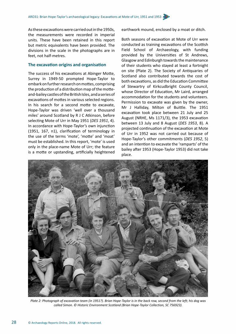
© Archaeology Reports Online, 2018. All rights reserved.28
ARO31: Brian Hope-Taylor’s archaeological legacy: Excavations at Mote of Urr, 1951 and 1953
As these excavations were carried out in the 1950s, the measurements were recorded in imperial units. These have been retained in this report but metric equivalents have been provided. The divisions in the scale in the photographs are in feet, not half-metres.
The excavation origins and organisation
The success of his excavations at Abinger Motte, Surrey in 1949-50 prompted Hope-Taylor to embark on further research on mottes, comprising the production of a distribution map of the motte-and-bailey castles of the British Isles, and a series of excavations of mottes in various selected regions. In his search for a second motte to excavate, Hope-Taylor was driven ‘well over a thousand miles’ around Scotland by R J C Atkinson, before selecting Mote of Urr in May 1951 (DES 1951, 4). In accordance with Hope-Taylor’s own injunction (1951, 167, n1), clarification of terminology in the use of the terms ‘mote’, ‘motte’ and ‘moat’ must be established. In this report, ‘mote’ is used only in the place-name Mote of Urr; the feature is a motte or upstanding, artificially heightened
earthwork mound, enclosed by a moat or ditch.
Both seasons of excavation at Mote of Urr were conducted as training excavations of the Scottish Field School of Archaeology, with funding provided by the Universities of St Andrews, Glasgow and Edinburgh towards the maintenance of their students who stayed at least a fortnight on site (Plate 2). The Society of Antiquaries of Scotland also contributed towards the cost of both excavations, as did the Education Committee of Stewartry of Kirkcudbright County Council, whose Director of Education, Mr Laird, arranged accommodation for the students and volunteers. Permission to excavate was given by the owner, Mr J Halliday, Milton of Buittle. The 1951 excavation took place between 21 July and 25 August (NRHE, Ms 1171/3), the 1953 excavation between 13 July and 8 August (DES 1953, 8). A projected continuation of the excavation at Mote of Urr in 1952 was not carried out because of Hope-Taylor’s other commitments (DES 1952, 5) and an intention to excavate the ‘ramparts’ of the bailey after 1953 (Hope-Taylor 1953) did not take place.
Plate 2: Photograph of excavation team (in 1951?). Brian Hope-Taylor is in the back row, second from the left; his dog was called Simon. © Historic Environment Scotland (Brian Hope-Taylor Collection, SC 756923).

© Archaeology Reports Online, 2018. All rights reserved. 29
ARO31: Brian Hope-Taylor’s archaeological legacy: Excavations at Mote of Urr, 1951 and 1953
In 1951, the top of the motte was divided into eight octants, of which two (Octants A and E) were excavated. In both cases only half of each octant seems to have been excavated below the rubble layer (Layer II), and the excavation only reached the ‘rammed clay surface’ (Layer III), which was thought to be the top of the motte. In 1951 a trench, Cutting A, also was excavated across the moat on the north side of the motte. No location plan of the trench across the moat survives but its location on the site plan (Figure 6) is based on a line across the moat continuing from the grid on the summit of the motte that is shown on the contour survey plan. In 1953, because of the poor weather conditions (Hope-Taylor 1953, 10), excavation was restricted to the top of the motte, which was divided into quadrants, although only Quadrant I was excavated. Only parts of the quadrant were excavated down below the rubble layer, with charcoal (Layer IV) only being exposed in a few trenches (ibid.).
The site location
Mote of Urr was chosen by Hope-Taylor as the site of the second excavation in his programme of
research excavations on medieval mottes (Figure 1). It is a spectacular earthwork positioned on the west side of the Water of Urr, although formerly the river also flowed down the west side of the motte, transforming the site into an island; its earlier course is possibly indicated by the former boundary between the parishes of Urr to the east and Buittle to the west (Plate 3).
The site comprises a flat raised platform (the bailey), 152.4 m (500 feet) long, 65.84 m (216 feet) wide and some 9.14 m (30 feet) high above the surrounding alluvial plain. The bailey is aligned NW/SE and is enclosed by a ditch, 2.44 m (8 feet) deep and 14.32 m (47 feet) wide (Figure 6 and Plate 4). At the SE end of the bailey a flat-topped conical mound (the motte) rises to a height of c.10 m (33 feet), with a diameter at the top of about 30.50 m (100 feet). The motte is separated from the bailey by a ditch, 2.44 m (8 feet) deep and c.7.60 m wide (25 feet). The original entrance to the castle was on the west side of the bailey, with another at the SE corner. The latter was probably modified when the site was under cultivation (RCAHMS 1914, 274–6).
Plate 3: Plan of Moat of Urr (with parish boundary added) by James O’Brien, Lance-Corporal, Royal Engineers. Undated but probably about time of Ordnance Survey’s resurvey of Kirkcudbrightshire, 1893-4.© Historic Environment Scotland (Brian
Hope-Taylor Collection, DP 054516).

© Archaeology Reports Online, 2018. All rights reserved.30
ARO31: Brian Hope-Taylor’s archaeological legacy: Excavations at Mote of Urr, 1951 and 1953
II
C
N
M
L
K
EEFF
I
Q
DE
F
S
G
H
B
J
172 17
0
816
168
172
176
180 18
4 188
192 19
6
200
198
194
186
182
178
174
172
172
176
184
020
916
192
188
4 18
176
172
172
176
176
174
174
200
198
194
190 1
68
128
178
174
170
107
172
120
Location of Trenchacross Moat (approx)
Inner edge of Bailey ditch
XX
Excavated areas
180
002
190
180
YY
CONTOURS AT 2’0’’ VERTICAL INTERVALS
Figu
re 6b
Figure 8
0 30m5 15
40 20 0 40 80 120FEET
CONTOURS AT 2’0’ ’ VERTICAL INTERVALS
T
R
U
V
W
X
Y
Z
AA
O
P
GG
HH
BB
CC
DD
WW
VVMOAT CUTTING
OCTANT A
OCTANT E
QUADRANT 1
Figure 6: Site plan, after contour plan by R J C Atkinson and P R Ritchie in 1951, with profile across motte.
200
XX YY190
180170
180
200
190
180
170
40 20 0 40 80 120FEET
CONTOURS AT 2’0’ ’ VERTICAL INTERVALS
0 30m5 15

© Archaeology Reports Online, 2018. All rights reserved. 31
ARO31: Brian Hope-Taylor’s archaeological legacy: Excavations at Mote of Urr, 1951 and 1953
The results of the excavation
Phase I (Figure 7)
In Phase IA the motte was constructed from the upcast material dug out of the ditches and the surrounding river terrace. The earliest excavated layer, covering much of the excavated area of Quadrant I, was a layer of charcoal (Layer IV), comprising wood fragments, hazel nutshells and possibly bracken (Figure 7). Radiocarbon dates (SUERC 24514) 1020-1170 cal AD, (SUERC 24515) 980-1160 cal AD, (SUERC 24520) 1040-1260 cal AD and (SUERC 24521) 1030-1220 cal AD (see Table 2), were obtained from charcoal samples from this layer. Also recovered from it were pottery sherds, animal bone and iron nails (see below). An area of heavily burnt clay, reddened to a depth of 70 mm (3 inches), formed Hearth 1 (Figure 7). The surface of the motte contained
many round stake-holes or animal holes (Plate 5). It is presumed that the perimeter of the top of the motte was defended in this phase, although no evidence of such defence was found, either because of the later, intrusive pits of Phase III or because much of the perimeter was unexcavated.
In Phase IB a stone-lined pit (Pit 1), filled with layers of burnt clay and charcoal, was dug into the centre of the motte (Plate 6). The lowest courses of its stone lining overlay the charcoal layer of Phase IA and closely positioned boulders set in pink clay lay at its base. The pit, which continued in use into Phase II, was some 1.07 m (3 feet 6 inches) deep and measured some 4.88 m (16 feet) N/S and at least 5.18 m (17 feet) E/W. The south and west sides of the stone lining were rectilinear in plan and the south-west corner was almost at 90o to the sides.
Plate 4: General view of Mote of Urr from the north. © Historic Environment Scotland (Brian Hope-Taylor Collection, SC 937693).
Lab Code Sample No. Material Context Phase Radiocarbon
age BP 95.4% probability
SUERC-24514 Charcoal: Quercus (oak) Layer IV Phase IA 935 ± 30 1020–1170 cal AD
SUERC-24515 Sample 73 Charcoal: Corylus (hazel) Layer IV Phase IA 935 ± 30 980–1160 cal AD
SUERC-24516 Sample 125
Charred barley
Quadrant I lower levels of large pit [Pit 7] on W
perimeter of topPhase III 770 ± 30 1215–1285 cal AD
SUERC-24520 Sample 183
Charcoal: Corylus (hazel)
Quadrant I Phase I Black level burnt and disturbed area
[Layer IV]Phase IA 865 ± 30 1040–1090 cal AD
1120–1260 cal AD
SUERC-24521 Sample 184
Charcoal: Corylus (hazel)
Quadrant I Phase I Black level burnt and disturbed area
[Layer IV]Phase IA 900 ± 30 1030–1220 cal AD
Table 2: Radiocarbon dates.

© Archaeology Reports Online, 2018. All rights reserved.32
ARO31: Brian Hope-Taylor’s archaeological legacy: Excavations at Mote of Urr, 1951 and 1953
Charcoal (Layer IV)
198’2 ’00
Octant A
Octant E
A
C
DB
E
G
F
E
G
F
Figu
re 9
a
Figu
re 9
b
Figure
13
Figure 11
HEARTH 1
PIT1
5 50 10 15 20 25 30 35 40 45 50FEET
0 1 2 3 4 5 10 15 20 25 metres
Quadrant I
Figure 7: Plan of Phase I features with location of sections.

© Archaeology Reports Online, 2018. All rights reserved. 33
ARO31: Brian Hope-Taylor’s archaeological legacy: Excavations at Mote of Urr, 1951 and 1953
The trench (Cutting A) positioned across the moat surrounding the motte revealed that it had been filled in by 2.36 m (7 feet 9 inches) of deposits (Figure 8 and Plate 7). It had been re-cut at least once, possibly twice, leaving only the deposits on the south side of the moat identified as Phase I. The flat base of the moat had been dug to a depth of 2.90 m (9 feet 6 inches) below the natural surface on which the bailey was constructed. A waterlogged deposit of blue clay with fragments of twigs, charcoal, leaves, and nuts was found at the base of the ditch. Above that was a layer of ‘dark occupation earth’ and one of loamy silt. On the north side of the moat three postholes were visible. These may have contained supports for a wooden bridge between the bailey and the motte. The southernmost of the postholes rested on a step on the edge of the moat (Figure 8) that may have held a horizontal brace for the bridge. It is not clear whether the bridge was a ‘flying’ bridge leading directly to the top of the motte or a flat bridge leading to steps cut into the side of the motte. The northernmost posthole was determined to belong to Phase II.
The bailey was composed of layers of gravel and silt under pink clay (Figure 8). These deposits were about 0.70 m (2 feet 3 inches) thick, and lay above natural compact sandy subsoil. At the NE corner of the cutting, a pit (Pit 2) had been dug into them. Its excavated dimensions were 1.60 m (3 feet 6 inches) E/W by c.0.60 m (2 feet) N/S
and c.0.60 m (2 feet) in depth; the fill was sandy silt with a lens of yellow gravel. The pit may have been a posthole associated with the bridge across the moat or with a palisade around the bailey.
Phase II (Figure 10)
The Phase I charcoal deposit was sealed beneath a thick layer of ‘variegated’ clay (Layer III). This comprised fragments of hard pink clay scattered within softer yellow clay with numerous grits and small stones, beneath which was hard pink clay with a lens of charcoal. The clay was irregularly mounded in a ring about half-way to two-thirds of
Plate 5: View of the Phase I motte surface in Quadrant I in 1953. Looking north-west; note the bank visible at the base of the section A-B and Pit 6 on the edge of the motte. Scale in feet. © Historic Environment Scotland (Brian Hope-Taylor
Collection, SC 938014).
Plate 7: The west section of the trench across the moat in 1951. Looking south-west. Scale in feet. © Historic
Environment Scotland (Brian Hope-Taylor Collection, SC 938020).
Plate 6: View of central pit in Quadrant I in 1953. Looking south. Large stones are on its southern edge. Scale in
feet. © Historic Environment Scotland (Brian Hope-Taylor Collection, SC 937972).

© Archaeology Reports Online, 2018. All rights reserved.34
ARO31: Brian Hope-Taylor’s archaeological legacy: Excavations at Mote of Urr, 1951 and 1953
the radius from the centre of the motte (Figures 9b and 11; see also Plate 5). This ‘rammed clay surface’ had the effect of raising the height of
the motte by c.0.76 m (2 feet 6 inches). Above the clay in Quadrant I was a thin layer of ‘humus’ (Layer IIA) (Figure 11).
Figure 8: West section of Moat Cutting A, with section through part of the bailey.
Figure 9a and b: Composite cross-section of the top of the motte: east section of Octant A (F-D), and east section (D-G) of Quadrant I.
WW
N W
VV
18
18
18
18
17
3
2
16
13
13
1313
11
15
7 4
12
10
16
Pinkclay
Brownsilt
Brownsilt
24
21
20 21
26
22
2525
23Sand& silt
Pit 2
9
Turf & topsoil
5
19
90º
Pinkclay
1 Blue clay with twigs, charcoal, leaves, nuts & grass2 Dark occupation earth3 Loamy silt
4 Pink clay5 No description
6 Yellow clay and rubble7 Pink clay8 Fine gravel and clay9 Pink clay
10 Fine clayey silt11 Grey gravelly silt12 No description13 Graded sand14 Loose rubble15 Dark occupation earth16 Rubble & brown silt17 Buff silt18 Buff silt
Phase I
Phase II
Phase III
MOAT
19 Sand & silt20 Gravelly rubble21 Pink clay22 Sand & silt
Phase I
Phase II
BAILEY
23 No description24 Brown silt25 Pink clay26 Yellow clay
KEY
Clay-linedstep
144
Turf & topsoil
Sand& silt
Goldengravel
Pit 4
Silt &fine gravel
22
Posthole
Posthole
S E
0 1 2 3 4 5 6 7 8 9 10 feet
0 1 2 3 4 5 metres
Reddishclay & ash
Redclay
Mortar& clayClay
Reddishbrown earth
WallTurf humus
Brown earth & small stones
Posthole22
Hearth 2Pit 5
Pit 1
Centre of motte
Layer II (rubble)
Layer II (rubble) Layer I (Turf & topsoil)FD
NE
0 1 2 3 4 5 6 7 8 9 10 11 12 13 14 15 16 17 18 19 20 feet
0 1 2 3 4 5 metres
Pit 1
1 Yellow clay2 Charcoal
KEY
Centre of motte
Layer II (rubble)
Layer III (Pink clay & gravel)1 211
Layer IV(Charcoal)
Pit 8
1
Layer I (Turf & topsoil)
Layer I (Topsoil)
2
Layer IV(Charcoal)2
D GSW
0 1 2 3 4 5 6 7 8 9 10 11 12 13 14 15 16 17 18 19 20 feet
0 1 2 3 4 5 metres

© Archaeology Reports Online, 2018. All rights reserved. 35
ARO31: Brian Hope-Taylor’s archaeological legacy: Excavations at Mote of Urr, 1951 and 1953
In Octant A, two stone-packed postholes (Postholes 5 and 6, depths not recorded), Hearth 2 and Pit 5 were cut into the upper part of this heightened motte surface (Figures 9a and 10). Hearth 2 contained red clay and ash and pieces of burnt daub. Around its inner edge were three
small stakeholes, possibly providing evidence for supports for a cooking pot. An alignment of small stones, to the north-east, interpreted by the excavator as a wall, may have been the foundation for a timber wall.
PH5
PH6
PIT 1
PH1
PH7PH8
PH9PH10
PH2
PH12
PH11
PH15
PH14 PH13
Quadrant I
’198200’
Octant E
Octant A
Figu
re 9
a
A
C
D
E
G
F
B
WALL
HEARTH 2
PIT 5
Figu
re 9
b
Figure
13
Figure 11
5 50 10 15 20 25 30 35 40 45 50FEET
0 1 2 3 4 5 10 15 20 25 metres
Figure 10: Plan of Phase II features with location of sections.

© Archaeology Reports Online, 2018. All rights reserved.36
ARO31: Brian Hope-Taylor’s archaeological legacy: Excavations at Mote of Urr, 1951 and 1953
In Octant E, Postholes 1 and 2, were both stone-packed and were dug into the upper clay surface (Figure 10 and Plate 8). Posthole 1 was recorded as 0.33 m (13 inches) deep. Two other postholes (7 and 8) were cut into the lower clay. Two smaller postholes or stakeholes, Postholes 9 and 10 were revealed beneath the stones of the lower surface; they were 50 mm and 100 mm (2 - 4 inches) in diameter respectively.
In Quadrant I Postholes 1 and 2 were recorded as cut into the upper clay surface, Postholes 3 and 4 (not illustrated) as cut into the lower clay surface. Posthole 2 was filled with dark earth containing charcoal fragments, pieces of daub, as well as packing stones. Four nails were found in its sides, and more daub was located around the edge of the top of the posthole. Postholes 11 to 15 (as numbered for this report but which may be any of Hope-Taylor’s postholes 1-4), were all packed with stone, and assigned to Phase II by the excavator.
In the centre of the motte Pit 1 continued in use, additional stones being placed around the sides of the pit when the motte was heightened (Plate 6). Postholes 1, 7, 11 and 12 were situated in a line along the south edge of the stone lining, with Posthole 6 in Octant A similarly situated on the N edge (Figure 10). They may have been part of a screen or other structure around the pit.
The moat was re-cut in this phase to almost the same depth as the earlier form, but only about 0.23 m (9 inches) shallower. Again, as in the earlier phase, only the fills on the south side of the moat survived a later re-cut. They comprised a clayey layer under an undescribed deposit (Figure 8).
The bailey was also raised in height by up to 0.76 m (2 feet 6 inches) by additional dumps of gravel and pink and yellow clay. Located directly above Pit 2 was another, Pit 4, which measured 1.38 m (4 feet 6 inches) E/W by c.0.80 m (2 feet 8 inches) N/S and was 0.76 m (2 feet 6 inches) deep. Its fills were sand and silt under gravel and silt. This pit could have served the same purpose as Pit 2, holding a support for the bridge across the moat or part of a renewed palisade around the bailey. The northernmost of the postholes for the bridge across the moat was cut through the heightening of the bailey.
Phase III
The motte was raised in height by up to 0.5 m (1 foot 8 inches) by a thick layer of stone rubble and gravel in brown earth (Layer II) (Plate 9). Granite slabs were noted among the stones, the nearest source for which is Craignair some 4 km to the south of Mote of Urr. Around the perimeter of the top of the motte were four pits (Pits 3, 6, 7 and 8) (Figure 12). A radiocarbon date of AD1215-1285 (SUERC-24516, Table 2) was obtained from
Plate 8: View of Posthole 2 (foreground) and Posthole 1 (middle distance and Pit 1 (background) in Octant E in
1951. Looking north. Scale in feet. © Historic Environment Scotland (Brian Hope-Taylor Collection, SC 756775).
Figure 11: North section (A-B-C-D) of Quadrant I.
Pit 6
Layer III(Pink clay)
Layer IIA(Humus & soil)
Charcoal
Layer I (Turf & topsoil)
Layer III (Clay & stones)
Layer IV(Charcoal)
Layer III(Pink clay)
Layer II(Rubble)
Layer III(Yellow-orange
clay)Layer III
(Yellow-orangeclay)
Gritty silted humus
Gritty silted humus Lightyellowclay
Yellow brown
clay
Pit 1
Charcoal
Pinkclay
B C DA
Layer IV(Charcoal)Unexcavated
Baulk
Layer I (Turf & topsoil)
NW SE
0 1 2 3 4 5 6 7 8 9 10 11 12 13 14 15 16 17 18 19 20 feet
0 1 2 3 4 5 metres

© Archaeology Reports Online, 2018. All rights reserved. 37
ARO31: Brian Hope-Taylor’s archaeological legacy: Excavations at Mote of Urr, 1951 and 1953
charred barley in the ‘lower levels’ of Pit 7. However, no differentiation of the fills of this pit was recorded (Figure 13). This pit also contained a stone with burnt residue including attached bone and charcoal fragments, but the stone itself was
not vitirified (Find No 139). Three of these pits contained postholes (Pit 3 had Posthole 16; Pit 7 included Posthole 17; and Pit 8 had Postholes 18 and 19).
PH20PH21PH24
PH22
PIT 3
PH4PH3PH16
Layer II(Rubble)
Layer II(Rubble)
PH23
PH19
PIT 8
PH18
PH25
PIT 7
PH17
PIT 6
Octant A
Quadrant I
Octant E
198’
200’
Fig
ure 9
a
Layer II(Rubble)
A
C
DB
E
G
F
Figu
re 9
b
Figure
13
Figure 11
5 50 10 15 20 25 30 35 40 45 50FEET
0 1 2 3 4 5 10 15 20 25 metres
Figure 12: Plan of Phase III features with location of sections.

© Archaeology Reports Online, 2018. All rights reserved.38
ARO31: Brian Hope-Taylor’s archaeological legacy: Excavations at Mote of Urr, 1951 and 1953
In Octant A, Postholes 3 and 4 (the latter was c.0.40 m/16 inches deep) were positioned on the south edge of Pit 3, with Postholes 20 and 21 on its northern edge. Posthole 16 was dug into the centre of Pit 3, and it and Posthole 4 had packing stones around their tops. Postholes 20 and 21 were separated by large boulders, and also had large boulders on either side of them on the edge of the pit. The groups of postholes on the edges of Pit 3, together with Posthole 22 at its SE corner and Postholes 23 and 24 on the N side (in alignment with Postholes 20 and 21), probably formed part of two parallel lines of posts 0.84 m (2 feet 9 inches) apart. The posts could have formed a structure over Pit 3 or possibly continued around the perimeter of the top of the motte.
In Octant E, Postholes 18 and 25, with Posthole 19 in Quadrant I, may have performed a similar
role, although here the posts were 0.53 m (1 foot 9 inches) apart. Although the evidence is slight there seemed to have been an outer ring of posts and possibly an inner ring. Whether there was enough excavated evidence to suggest a palisade ring, with an inner platform or walkway, similar to that found by Hope-Taylor at Abinger (Hope-Taylor 1956, 237, Fig 73) is open to doubt. Alternatively, a double fence may have held a packing of stones and clay, as suggested for Ingleston Motte, where a double ring of postholes, 0.30-0.45 m apart, was found (Penman and Penman 2002c, 25). Some of the bailey’s perimeter pits were probably formed by the robbing of timbers of an earlier palisade. Pit 7 which was much deeper at its eastern end (Figures 12 and 13), may have also been robbed of posts of a stair or tower attached to a palisade, if one had existed there.
The moat seems to have been re-cut in this phase. The only evidence for this is provided by a step on the south side of the moat, cutting the Phase II Layer 5 gravel fill (Figure 8). Presumably to stabilise the sides of the moat, a thin clay lining was added to the side and base of the step. The step would have held a renewed support for the bridge between the bailey and the top of the motte, corresponding to the step on the north side of the moat. The fills of the moat comprised bands of gravel, silt and clay, and a dump of large stones. These layers and the rubble were sealed beneath a ‘dark occupation earth’ (layer 15) and a layer of rubble and ‘mould’ (layer 16); the latter layer filled the step for a post on the south side of the moat. Above them were two further deposits of silt. Since the southernmost and middle ‘postholes’ on the north edge of the moat cut these upper fills, they were probably robbing pits for the timbers of the bridge.
Plate 9: Excavating the Phase III rubble layer (Layer II) in Octant A in 1951. Looking east. Scale in feet. © Historic Environment Scotland (Brian Hope-Taylor Collection, SC
937839).
Figure 13: Intermediate section (E-C) of Quadrant I.
Layer IV (Charcoal)
Dark earth
C E
Posthole 12
Layer III(Yellow clay)
Darkhumus
Pit 7
Posthole 17
Layer III (Pink clay)No descriptionLayer I (Turf & Topsoil)
Mixed clayand rubble No description
Layer II(Rubble)
(unexcavatedbaulk)
unexcavatedbaulk
Nodescription
Figure 11
NESW
0 1 2 3 4 5 6 7 8 9 10 11 12 13 14 15 16 17 18 19 20 feet
0 1 2 3 4 5 metres

© Archaeology Reports Online, 2018. All rights reserved. 39
ARO31: Brian Hope-Taylor’s archaeological legacy: Excavations at Mote of Urr, 1951 and 1953
The environmental evidence
Environmental assessmentBy Mhairi Hastie and Davie Mason
Introduction and methodology
Nineteen samples from the excavation of the site were submitted by SUAT Ltd to Headland Archaeology for processing and assessment.
Headland Archaeology received the following: six samples marked as stone; one sample marked as baked clay; one sample marked as animal teeth; five samples marked as wood charcoal; and six soil samples (less than 0.1 litres in size) for processing.
The six soil samples were washed through a 250 μm sieve and the material remaining was air-dried. This was then sorted and any material of archaeological significance removed. One sample had no provenance and produced no results. The results are summarised in Table 3.
The stone, animal teeth, wood charcoal and hazel nutshell samples were all examined. Comments
on the state of preservation and identification are summarised in Table 4.
Results
Low levels of domestic debris were recovered from the soil samples. Fragments of wood charcoal were recovered from Samples 73, 125 and 184. One carbonised barley grain and one oat grain were recovered from Sample 125. In addition, low concentrations of charred hazel nutshell were recovered from Sample 62. The charcoal samples (63, 93, 131, 183 and 192) were dominated by oak charcoal, only one sample (183) containing non-oak charcoal.
Small fragments of unburnt large mammal bone and teeth were recovered from Samples 40, 73 and 125. In most cases the bone/teeth fragments were poorly preserved. The teeth sample (72) consisted of a number of well-preserved large mammal teeth probably cow or horse. Of the other samples, the six stone samples (74, 79, 129, 139, 185 and 197) consisted of chips of natural stone, none of which were worked. The sample marked as baked clay (115) was identified as small fragments of non-ferrous metal slag.
NMS no Feature Context description Bone & teeth
fragments Charcoal Charred cereal grain
Hazel nutshell Comments
40 Pit 6, 7 or 8 Quadrant I, fill of pit ** -
62 Layer IV Quadrant I, black layer IV under loose clay at normal level of basal pink clay * -
73 Layer IV Quadrant I, Phase 1 black layer at edge of hollow ** *** -
125 Pit 7 Quadrant I, lower levels of large pit on west perimeter on top ** * * Barley indet x 1
Oat x 1
184 Layer IV Quadrant I, Phase 1 black level burnt and dist’d area, central in quadrant * -
189 u/s 1953, no location given -
NMS no Context description Condition Species Details1 1953 QI NW calcined IM 1 LBSF fragment4 1953 QI NW poor, abraded Cattle 1 upper molar tooth
10 1953 QI NW calcined IM 1 fragment20 1953 QI NW calcined IM 6 LBSF fragments
32 1953 QI NW Central pit (upper black layer) calcined Pig 1 fragment pig mandible (symphysis)
32 1953 QI NW Central pit (upper black layer) calcined IM 3 fragments
* = rare ** = occasional *** = common
AbbreviationsL leftR rightIM indeterminate mammalLBSF long bone shaft fragment
Table 3: Composition of soil samples.
Table 4: Catalogue of animal bone and molluscs.
For an explanation of the finds numbers (NMS no.), see introduction to The artefacts, below.

© Archaeology Reports Online, 2018. All rights reserved.40
ARO31: Brian Hope-Taylor’s archaeological legacy: Excavations at Mote of Urr, 1951 and 1953
AbbreviationsL leftR rightIM indeterminate mammalLBSF long bone shaft fragment
Table 4 (continued): Catalogue of animal bone and molluscs.
NMS no Context description Condition Species Details
38 1953 QI NW. Pit in W edge of Quadrant unburnt Cattle
1 upper molar tooth; in wear1 enamel fragment from premolar
1 pig canine tooth4 mammal fragments
38 1953 QI NW. Pit in W edge of Quadrant unburnt Pig 1 lower incisor; abraded
38 1953 QI NW. Pit in W edge of Quadrant unburnt (very poor) IM
1 large ungulate LBSF3 other fragments
40 1953 QI. Pit in W edge of Quadrant from sample retent IM small crumbs unburnt bone
451953 QI NW. Pit in W edge of Motte
on perimeter adjacent to large boulder
calcined IM 1 fragment
48 1953 QI NW. Post hole 1 calcined (very poor) IM 1 fragment
52 1953 QI NW. Phase 1. Black layer, centre of quadrant unburnt (very poor) Cattle
L scapula fragment; glenoid fusedL/R scapula: glenoid fragment
L/R scapula: neck fragmentprobably all part of same scapula
52 1953 QI NW. Phase 1. Black layer, centre of quadrant unburnt (very poor) IM
8 abraded fragments, probably part of cattle scapula
large ungulate shaft fragment56 1953 QI NW. Layer II calcined IM 1 fragment
61 1953 QI NW Layer III corrodedMollusc/iron/fired
clay
thin layer of mollusc shell or calcined bone encrusted with fired clay, associated with iron fragment
65 1953 QI NW Black layer IV calcined IM3 large ungulate shaft fragments
2 other mammal fragments
66 1953 QI NW Black layer IV very poor IM 4 unburnt mammal fragments, originally described as ‘wood’
67 1953 QI NW. Black layer in trial section along S edge of quadrant poor Pig
teeth:1 lower 3rd molar; unerupted
1 lower 1st/2nd molar; unerupted1 lower molar (3 fragments); in wear
mandible fragment; some tooth roots present;
if all part of same, Mandible Wear Stage (MWS) =19
Age probably between 8–13 months
67 1953 QI NW. Black layer in trial section along S edge of quadrant calcined IM 2 fragments
67 1953 QI NW. Black layer in trial section along S edge of quadrant poor, unburnt IM 22 fragments
681953 QI NW. Phase 1 black level underlying large boulder round
central pitpoor Pig Tooth: fragment of molar enamel
691953 QI NW. Phase 1 black level underlying large boulder round
central pitcalcined IM 12 small fragments
72 1953 QI NW. Phase 1 black layer sample and finds poor Cattle
1 lower 3rd molar (stage g)1 lower 2nd molar (stage k)
enamel fragments from lower premolar
root fragments from above

© Archaeology Reports Online, 2018. All rights reserved. 41
ARO31: Brian Hope-Taylor’s archaeological legacy: Excavations at Mote of Urr, 1951 and 1953
AbbreviationsL leftR rightIM indeterminate mammalLBSF long bone shaft fragment
Table 4 (continued): Catalogue of animal bone and molluscs.
NMS no Context description Condition Species Details
76 1953 QI Phase 1. Black layer of central pit at bottom poor, unburnt Large
ungulate rib shaft
76 1953 QI Phase 1. Black layer of central pit at bottom poor, unburnt Small
ungulate rib shaft
76 1953 QI Phase 1. Black layer of central pit at bottom poor IM
2 calcined fragments4 unburnt fragments
77 1953 QI Phase 1 (black layer hollow) unburnt; poor/very poor Cattle
R humerus; distal fragment; possibly chopped
R ulna fragment: chopped across olecranon
L astragalus; proximal and lateral fragments. Probably part of same
77 1953 QI Phase 1 (black layer hollow) unburnt; poor/very poor
Large ungulate
vertebra; centrum, chopped laterally x 2
vertebra; 2 conjoining dorsal fragments
77 1953 QI Phase 1 (black layer hollow) unburnt; poor/very poor IM 4 fragments
84 1953 Q1 Phase III, uppermost levels of large pit very poor Cattle metapodial; posterior shaft
fragment
84 1953 Q1 Phase IIIuppermost levels of large pit very poor Pig L mandible; with PM3 and 2
(premolars) in wear
84 1953 Q1 Phase IIIuppermost levels of large pit very poor IM
1 calcined fragment2 other fragments
96 1953 Q1 Layer 1 on W side of quadrant calcined IM 1 fragment
97 1953 Q1 Layer central pit (black earth) calcined IM 1 fragment
120 1953 QI Central pit. Dark layer above burned out clay lump calcined IM 1 ?rib shaft
120 1953 QI Central pit. Dark layer above burned out clay lump calcined IM 6 fragments
122 1953 QI. Bottom of black level of central pit 0’-2’ from centre unburnt, abraded ?Pig 3 fragments humerus, distal shaft –
do not conjoin
122 1953 QI. Bottom of black level of central pit 0’-2’ from centre poor IM
1 calcined fragment5 burnt fragments
9 unburnt fragments
123 1953 QI. Bottom of black level of central pit 0’-2’ centre
clay lump with embedded bone fragments. Possible thumb/finger
impressions on surface of clay, presenting as concave, smoothed
surface
1251953 QI.
Lower levels of large pit on W perimeter of top
from sample retent Ungulate ?cattle tooth enamel fragments
1251953 QI.
Lower levels of large pit on W perimeter of top
from sample retent IM unburnt mammal fragments
1261953 QI. Lower levels of large pit
on W perimeter of top (domestic?? litter)
unburnt, very poor Cattle
L mandible, with 3rd molar in situ (stage b)
tooth: lower 2nd molar (stage g)Combined MWS= 31–33
2 tooth enamel fragmentsL/R metacarpal shaft
R innominate; acetabulum/ischium

© Archaeology Reports Online, 2018. All rights reserved.42
ARO31: Brian Hope-Taylor’s archaeological legacy: Excavations at Mote of Urr, 1951 and 1953
AbbreviationsL leftR rightIM indeterminate mammalLBSF long bone shaft fragment
Table 4 (continued): Catalogue of animal bone and molluscs.
NMS no Context description Condition Species Details
1261953 QI. Lower levels of large pit
on W perimeter of top (domestic?? litter)
very poor IM1 unburnt LBSF
15 other unburnt fragments1 calcined shaft fragment
132 1953 QI. Deep pit near W perimeter calcined IM 2 fragments
137 1953 QI. Deep pit on perimeter fair, unburnt Cattle
tooth: lower 1st/2nd molar1 enamel fragment
L scapula: blade and spine only, chopped
L ulna: calfR tibia: distal and unfused epiphysis
from sameR astragalus: articulates with tibia
(GLl=61.8, Bd=39.9)carpal: L cuneiform (very abraded)
L tibia: shaft, chopped
137 1953 QI. Deep pit on perimeter fair, unburnt Pigskull: L half, including maxilla,
parietal, frontal, malar and petrous (loose); probably chopped sagittally
137 1953 QI. Deep pit on perimeter fair, unburnt Large ungulate
vertebrae: 4 entire centra and 5 epiphyses; cervical
1 neural spine, thoracicribs: 3 shafts
137 1953 QI. Deep pit on perimeter fair, unburnt Small ungulate ribs: 2 articulations and 1 shaft
137 1953 QI. Deep pit on perimeter fair, unburnt & calcined IM
1 calcined fragment1 very abraded fragment (?vertebra)
1 other fragment
137 1953 QI. Deep pit on perimeter fair, unburntFowl
(Gallus gallus)
L humerus, entire (Bd=13.5)
synsacrum
137 1953 QI. Deep pit on perimeter fair, unburntCrow sp (Corvus
sp)
L humerus, proximal; juvenile
R humerus, entire; juvenile
142 1953 QI. Deep pit adjacent to boulder calcined Sheep/goat mandible fragment, aboral
142 1953 QI. Deep pit adjacent to boulder calcined Large ungulate 2 rib shafts
142 1953 QI. Deep pit adjacent to boulder calcined IM 1 fragment
182 1953 From post hole on W periphery set in large pit very poor Sheep/
goat
tooth: lower 3rd molar (2 fragments), 1 lower 1st/2 molar,
1 other molar fragment
182 1953 From post hole on W periphery set in large pit very poor IM 1 fragment
190 1953 ‘no location given’ fair Cattle 1st phalange, proximal, BP=25.0
190 1953 ‘no location given’ calcined IM 1 fragment

© Archaeology Reports Online, 2018. All rights reserved. 43
ARO31: Brian Hope-Taylor’s archaeological legacy: Excavations at Mote of Urr, 1951 and 1953
The animal boneBy Catherine Smith
Introduction: bone survival and condition
Animal bones appear to have survived only from the 1953 season. Whether any were recovered during the 1951 season is not known, although as pottery and iron objects survive, it is suspected that bones too may have been found but not retained. Alternatively, since many of the fragments from the 1953 season were in poor condition, it is possible that survival in the part of the site dug in 1951 was also poor or non-existent.
The condition of the surviving animal bone fragments may be categorised as follows:
1. burnt or calcined; fragments generally small and unrecognisable
2. unburnt fragments; size of fragments small; abraded and poorly preserved
3. unburnt fragments; size of fragments larg-er than above; preservation poor to fair; recognisable as to bone and species
Most of the bones fell into the first two categories and could be described only as indeterminate mammal, although recognisable mammalian tooth fragments were present. Several bags did however contain fairly well-preserved bones of larger fragment size, attributable to species (assigned to category 3). NMS numbers 137 and 126 were good examples of the latter. The animal bones are catalogued in Table 4.
Species present
Bones and tooth fragments from cattle, sheep/goat and pigs were present. Other mammalian fragments were categorised only as large ungulate (vertebrae and ribs, probably from cattle), small ungulate (ribs, probably from sheep, goat or pig) and indeterminate mammal. A small group of bird bones consisting of one from domestic fowl (Gallus gallus) and two from a juvenile member of the crow family (Corvus sp) was present in NMS no. 137.
Evidence of age at death
Evidence of the age at which the animals died or were killed was scanty, but it seemed that at
least one adult and one juvenile cattle beast were present in NMS no. 137. The cattle mandibular teeth probably came from adults, based on their wear patterns. A mandibular wear stage of 31-33 was estimated for teeth in NMS no. 126 and was assumed to have come from a young adult (Grant 1982). A fragmentary pig mandible in NMS no. 67 was estimated to be at wear stage 19, with an estimated age of between 8 and 13 months at death (ibid., Bull and Payne 1982).
Evidence of butchery
Several of the better preserved fragments retained evidence of butchery, mainly in the form of chopped surfaces. These occurred in NMS nos. 137 and 77. Although the bones in NMS no. 77 were abraded, they consisted of larger recognisable fragments: a cattle humerus was probably chopped medio-laterally across the distal end and a cattle ulna from the same bag was chopped across the olecranon. In both instances this may have been done in order to produce pieces of meat which would fit in an appropriately sized cooking pot. Also present in NMS no. 77 was the centrum of a large ungulate vertebra which had been chopped twice along the lateral aspects. This action may have been performed during secondary butchery, when the carcass was divided into manageable portions.
Butchered cattle bone in NMS no. 137, the contents of a deep pit (Pit 7) on the SW perimeter of the motte, consisted of a chopped scapula blade and a chopped tibia shaft. In addition, a well preserved skull fragment of pig was chopped neatly in half in the sagittal plane. This action allows both extraction of the brain and easier cooking of the head. One dish which calls for splitting the skull in this way is brawn - once the head is boiled, the cooked meat is carefully picked clean and the resulting shredded meat set in the jelly formed from the cooking juices. Spices such as peppercorns were added, if available, although this adds only to the taste of the final dish, rather than its nutritional value.
Interpretation of the animal remains
Significantly, most of the animal bones appear to have been recovered from pits. Those from NMS nos. 45, 84, 125, 126, 132, 137 and 142 came from a large pit (Pit 7) on the SW edge of the motte top in Phase III. The central pit (Pit 1,

© Archaeology Reports Online, 2018. All rights reserved.44
ARO31: Brian Hope-Taylor’s archaeological legacy: Excavations at Mote of Urr, 1951 and 1953
Phase 1 and II) contained NMS nos. 32, 76, 97, 120, 122 and 123. A ‘pit on W edge’ of Quadrant I, unlocated, but from Pits 6, 7 or 8, contained NMS nos. 38 and 40. Bones were also recovered from post holes: NMS no. 48 from ‘Posthole 1’ in 1953 (unlocated) and NMS no. 182 from Posthole 17 in Pit 7 (Phase III). The bones incorporated into the pits may represent dumping of domestic rubbish in features, which had originally had some purpose other than disposal of waste.
Most of the remainder of the bones from known features somewhat surprisingly came from the Phase IA charcoal layer (Layer IV) - NMS nos. 52, 65, 66, 72 and 77 - with only one calcined fragment (NMS no. 56) from Layer II, the clay heightening of the motte, and one calcined fragment (NMS no. 96) from the turf and topsoil. Since not all of the fragments from the charcoal layer appeared to have been burnt, it could be assumed that they were incorporated after the charcoal had ceased burning. This layer is interpreted as the destruction of the earliest occupation and structure on the motte.
The Material Cultural Evidence
The potteryBy Derek Hall
Introduction
The two seasons of excavation at Mote of Urr produced a total of 695 sherds of medieval pottery. Of these, 282 are regarded as unstratified due to the difficulties of accurately locating the contexts from which they were derived, and 413 were examined from stratified contexts. The collection has been using a x10 hand lens. A total of 20 samples was extracted for ICPS analysis (chemical sourcing); see Chenery, below.
Results
The details of the diagnostic sherds are displayed in the catalogue (CAT no.) (Table 5).
Scottish Redware (Figures 14-18)
The assemblage is dominated (98%) by sherds in this oxidised fabric which often has a ‘purple’ heat skin visible on its surface. It shares many of the characteristics of locally manufactured Redware
pottery from other parts of Scotland (Haggarty et al. 2011). Splash glazed jugs are amongst the most common vessel types represented in this fabric (Figures 14 and 15), including jug handles (Figure 16). Phase III contains sherds from highly decorated figure jugs and a vessel with very distinctive incised decoration around its body (Figure 17, Cat 30 and 31). There is also a single example of a rim sherd (Cat. 33) in this fabric which may be from a jar used for cooking (Moat Cutting Layer V). Jugs from Phase III are distinguished by having thumbed bases (Figure 18, Cat 38-40), suggesting they are copied from imported German stoneware vessels which are common imports in Scotland from 1350 (Hurst et al. 1986, 176-92).
Unusual vessel forms and Whitewares (Figure 19)
Two unusual vessel forms include CAT 48, rim and body from green glazed open vessel, and CAT 49 a body sherd from a vessel with an applied lug.
There are also 12 small sherds from vessels in a whiteware fabric, seven of which are from securely sealed contexts. Two of these from Phase IB/II include what may be a bodysherd from a green glazed French imported jug of thirteenth/fourteenth century date (CAT 50). The other five sherds are all from Phase III and are difficult to accurately provenance due to their size. The Scottish Whiteware project found it difficult to locate any potentially locally manufactured whiteware fabrics from South Western Scotland and it seems likely that the sherds from Mote of Urr are all imports (Jones et al. 2003).
Conclusions
Apart from a single whiteware rim sherd, there is nothing present in this assemblage to suggest a date any earlier than the thirteenth or fourteenth centuries for any of the occupation encountered in Hope-Taylor’s two seasons of excavation. Redwares, of presumably local origin, are present from all the defined phases. The largest stratified group from Phase III includes fragments from vessels that suggest a date of the fourteenth or even fifteenth centuries. Aside from one single whiteware body sherd from Phase IB/II there are no other sherds of foreign imported pottery.

© Archaeology Reports Online, 2018. All rights reserved. 45
ARO31: Brian Hope-Taylor’s archaeological legacy: Excavations at Mote of Urr, 1951 and 1953
Scottish RedwaresCAT 1 Jug rim MOU51 Octant A, Pit 1 Phase IB/II NMS no 159a
2 Jug rim MOU51 Octant A, Pit 1 Phase IB/II NMS no 159b3 Jug rim MOU53 Quadrant I, Layer III Phase II NMS no 1074 Jug rim MOU53 Quadrant I, Layer III Phase II NMS no 1065 Jug rim MOU51 Moat Cutting A, Layer VI Phase III? NMS no 1516 Jug rim MOU51 Octant A, Pit 3 Phase III NMS no 1737 Jug rim with pulled spout MOU53 Quadrant I, Pit 7 Phase III NMS no 438 Jug rim MOU51 Octant A, Pit 3 Phase III NMS no 1739 Jug rim MOU53 Quadrant I, Pit 7 Phase III NMS no 81b
10 Splayed jug rim MOU53 Quadrant I, Pit 7 Phase III NMS no 12811 Jug rim and handle junction MOU51 Octant A, Pit 3 Phase III NMS no 16512 Splayed jug rim MOU53 Quadrant I Unstratified NMS no 1213 Jug rim MOU53 Quadrant I, Layer I Unstratified -14 Jug rim MOU51 Octant A Unstratified NMS no 153b
15 Jug rim with incised slashed decoration MOU51 - Unstratified -
16 Jug rim MOU51 Octant A Unstratified NMS no 153b17 Jug rim MOU53 Quadrant I Unstratified -18 Jug rim MOU53 Quadrant I Unstratified -19 Jug rim MOU53 Quadrant I Unstratified -20 Jug rim with pulled spout MOU53 Quadrant I NMS no 621 Rod handle MOU51 Octant A, Hearth 2 Phase III NMS no 155c22 Narrow strap handle MOU51 Moat Cutting A, Layer VI Phase III? NMS no 15223 Narrow strap handle MOU51 Octant A, Pit 3 Phase III NMS no 17324 Rod handle and junction MOU53 Quadrant I, Pit 7 Phase III NMS no 12825 Rod handle and junction MOU53 Quadrant I Unstratified26 Strap handle and junction MOU51 Octant A, Pit 3 Phase III NMS no 173
27 Decorative handle and junction from figure jug. MOU51 Octant A, Pit 3 Phase III NMS no 166
28 Face mask from figure jug MOU51 Octant A, Pit 3 Phase III NMS no 17329 Bottom of face from figure jug MOU51 Octant A, Pit 3 Phase III NMS no 166
30Bodysherd from green glazed jug decorated with incised horizontal
and wavy line decorationMOU51 Octant A, Pit 3 Phase III NMS no 167
31Bodysherd from green glazed jug decorated with incised horizontal
and wavy line decorationMOU51 - Unstratified -
32 Bodysherd from jug decorated with incised wavy line decoration MOU53 Posthole 17 Phase III? NMS no 180
33 Bodysherd from jug with notched decoration MOU51 Moat Cutting A, Layer V Phase III NMS no 144
34 Body sherd from jug with appled raised strip MOU53 Pit 1 Phase IB/II NMS no 35
35 Body sherd from jug with incised wavy line decoraton MOU53 Quadrant I Unstratified NMS no 9
36 Body sherd from jug with stabbed decoration MOU53 Quadrant I Unstratified NMS no 14
37 Body sherd from jug decorated with applied pads MOU53 Quadrant I Unstratified NMS no 9
38 Thumbed basal angle from jug MOU51 Moat Cutting A, Layer V Phase III? NMS no 14839 Thumbed basal angle from jug MOU51 Moat Cutting A, Layer V Phase III? NMS no 147
40 Slightly thumbed basal angle from jug MOU53 Quadrant I, ‘pit on W edge’
(unlocated, Pit 6, 7 or 8) Phase III NMS no 41
41 Basal angle from jug MOU51 Moat Cutting A, Layer V Phase III? NMS no 14742 Basal angle from jug MOU53 Quadrant I Unstratified -43 Basal angle from jug MOU53 Quadrant I, Layer I Unstratified NMS no 92
Table 5: Medieval pottery catalogue.

© Archaeology Reports Online, 2018. All rights reserved.46
ARO31: Brian Hope-Taylor’s archaeological legacy: Excavations at Mote of Urr, 1951 and 1953
Scottish Redwares44 Basal angle from jug MOU51 Octant A Unstratified NMS no 153a45 Basal angle from jug MOU53 Quadrant I, Layer I Unstratified NMS no 2346 Basal angle from jug MOU51 Octant A Unstratified NMS no 15447 Basal angle from jug MOU53 Quadrant I Unstratified -
Unusual vessel forms
48 Rim and body from green glazed open vessel MOU51 Moat Cutting A, Layer V Phase III? NMS no 143
49 Body sherd from vessel with applied lug MOU53 Moat Cutting A, Layer VI Phase III? NMS no 149
Whiteware50 Rim sherd from small jar MOU51 Octant A, Pit 3 Phase III NMS no 173
Table 5 (continued): Medieval pottery catalogue.
Figure 14: Pottery, Redware jugs, rims Cat Nos 1-10.
0 10 cm
4
5 6
7
1 2
3
8
9 10

© Archaeology Reports Online, 2018. All rights reserved. 47
ARO31: Brian Hope-Taylor’s archaeological legacy: Excavations at Mote of Urr, 1951 and 1953
Figure 15: Pottery, Redware jugs, rims Cat Nos 11-20.
16
1413
1718
15
12
1920
11
0 10 cm
Figure 20

© Archaeology Reports Online, 2018. All rights reserved.48
ARO31: Brian Hope-Taylor’s archaeological legacy: Excavations at Mote of Urr, 1951 and 1953
Figure 16: Pottery, Redware jugs, handles Cat Nos 21-26.
23
24
2122
25
26
0 10 cm
Figure 21

© Archaeology Reports Online, 2018. All rights reserved. 49
ARO31: Brian Hope-Taylor’s archaeological legacy: Excavations at Mote of Urr, 1951 and 1953
Figure 17: Pottery, Redware jugs, figurative and decorated sherds Cat Nos 27-37.
0 10 cm
30
3334
32
28
27
35
31
36 37
29
Figure 22

© Archaeology Reports Online, 2018. All rights reserved.50
ARO31: Brian Hope-Taylor’s archaeological legacy: Excavations at Mote of Urr, 1951 and 1953
Figure 18: Pottery, Redware jugs, bases Cat Nos 38-47.
41
38 39
42
43
44
45
47
46
40
0 10 cmFigure 23

© Archaeology Reports Online, 2018. All rights reserved. 51
ARO31: Brian Hope-Taylor’s archaeological legacy: Excavations at Mote of Urr, 1951 and 1953
Chemo-typing of pottery samplesBy Simon Chenery
Eighteen samples of pottery from the Mote of Urr were supplied for chemo-typing, primarily using the Scottish redware chemical analysis database (see Haggarty et al. 2011). Since sample number MU-11 (NW Quadrant I; NMS no. 19) was defined as a whiteware rim sherd from a jar used for cooking, this was not considered in the primary analysis but is discussed separately, below.
Initial exploratory analysis
Previous experience with chemo-typing with the Scottish redware database has shown that a simple bi-variate plot of Na2O (sodium oxide) versus V (vanadium) concentrations can discriminate groups on a broad basis. In Figure 20 the Mote of Urr data is plotted against 211 samples from the database; material from Caerlaverock Castle, also in Galloway, is specifically identified. This training subset of the full database has been chosen to represent potential regional signatures derived from well-constrained material and sites.
Figure 19: Pottery, unusual forms and Whiteware Cat Nos 48-50.
Figure 20: Na2O versus V concentration plot of Mote of Urr (MU) material compared to redware database training set.
50
4849
0 10 cm
Figure 24
0
20
40
60
80
100
120
140
160
180
200
0.0 0.5 1.0 1.5 2.0 2.5
V Co
ncen
tratio
n (m
g/kg
)
Na2O Concentration (%)
Other redware
Caerlaverock Castle
Mote of UrrMU12 and 19 MU13
0
20
40
60
80
100
120
140
160
180
200
0.0 0.5 1.0 1.5 2.0 2.5
V Co
ncen
tratio
n (m
g/kg
)
Na2O Concentration (%)
Other redware
Caerlaverock Castle
Mote of UrrMU12 and 19 MU13
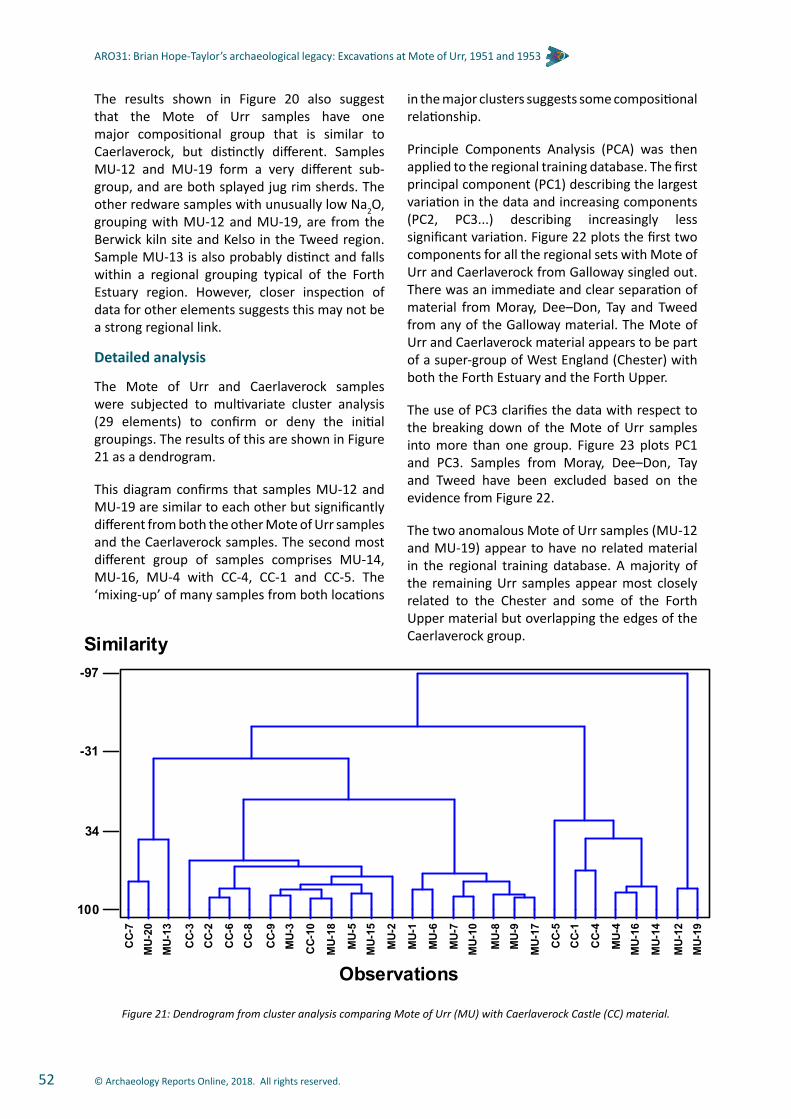
© Archaeology Reports Online, 2018. All rights reserved.52
ARO31: Brian Hope-Taylor’s archaeological legacy: Excavations at Mote of Urr, 1951 and 1953
The results shown in Figure 20 also suggest that the Mote of Urr samples have one major compositional group that is similar to Caerlaverock, but distinctly different. Samples MU-12 and MU-19 form a very different sub-group, and are both splayed jug rim sherds. The other redware samples with unusually low Na2O, grouping with MU-12 and MU-19, are from the Berwick kiln site and Kelso in the Tweed region. Sample MU-13 is also probably distinct and falls within a regional grouping typical of the Forth Estuary region. However, closer inspection of data for other elements suggests this may not be a strong regional link.
Detailed analysis
The Mote of Urr and Caerlaverock samples were subjected to multivariate cluster analysis (29 elements) to confirm or deny the initial groupings. The results of this are shown in Figure 21 as a dendrogram.
This diagram confirms that samples MU-12 and MU-19 are similar to each other but significantly different from both the other Mote of Urr samples and the Caerlaverock samples. The second most different group of samples comprises MU-14, MU-16, MU-4 with CC-4, CC-1 and CC-5. The ‘mixing-up’ of many samples from both locations
in the major clusters suggests some compositional relationship.
Principle Components Analysis (PCA) was then applied to the regional training database. The first principal component (PC1) describing the largest variation in the data and increasing components (PC2, PC3...) describing increasingly less significant variation. Figure 22 plots the first two components for all the regional sets with Mote of Urr and Caerlaverock from Galloway singled out. There was an immediate and clear separation of material from Moray, Dee–Don, Tay and Tweed from any of the Galloway material. The Mote of Urr and Caerlaverock material appears to be part of a super-group of West England (Chester) with both the Forth Estuary and the Forth Upper.
The use of PC3 clarifies the data with respect to the breaking down of the Mote of Urr samples into more than one group. Figure 23 plots PC1 and PC3. Samples from Moray, Dee–Don, Tay and Tweed have been excluded based on the evidence from Figure 22.
The two anomalous Mote of Urr samples (MU-12 and MU-19) appear to have no related material in the regional training database. A majority of the remaining Urr samples appear most closely related to the Chester and some of the Forth Upper material but overlapping the edges of the Caerlaverock group.
Figure 21: Dendrogram from cluster analysis comparing Mote of Urr (MU) with Caerlaverock Castle (CC) material.
100
34
-31
-97
Observations
Similarity
CC-
1
MU-
1
CC-
2C
C-3
CC-
4
CC-
5
CC-
6
CC-
7
CC-
8
CC-
9
CC-
10
MU-
2
MU-
3
MU-
4
MU-
5
MU-
6
MU-
7
MU-
8M
U-9
MU-
10
MU-
12
MU-
13
MU-
14
MU-
15
MU-
16
MU-
17
MU-
18
MU-
19
MU-
20

© Archaeology Reports Online, 2018. All rights reserved. 53
ARO31: Brian Hope-Taylor’s archaeological legacy: Excavations at Mote of Urr, 1951 and 1953
Figure 22: Plot of PC1 versus PC2 from principal components analysis (PCA) comparing Mote of Urr (MU) material to redware database regional training set.
Figure 23: Plot of PC1 versus PC3 from principal components analysis (PCA) comparing Mote of Urr (MU) material to most relevant sites in redware database regional training set.
-6
-4
-2
0
2
4
6
-10 -8 -6 -4 -2 0 2 4 6 8
PC2
PC1
Clyde
Dee-Don
W England
Forth Estuary
Forth Upper
Moray
Tay
Tweed
Galloway - Caerlaverock
Galloway - Mote of Urr
-3
-2
-1
0
1
2
3
4
5
6
7
8
-10 -8 -6 -4 -2 0 2 4 6 8
PC3
PC1
Clyde
W England
Forth Estuary
Forth Upper
Low Countries
Galloway - Caerlaverock
Galloway - Mote of Urr
MU-12 &19
CC-5
CC-4
-3
-2
-1
0
1
2
3
4
5
6
7
8
-10 -8 -6 -4 -2 0 2 4 6 8
PC3
PC1
Clyde
W England
Forth Estuary
Forth Upper
Low Countries
Galloway - Caerlaverock
Galloway - Mote of Urr
MU-12 &19
CC-5
CC-4

© Archaeology Reports Online, 2018. All rights reserved.54
ARO31: Brian Hope-Taylor’s archaeological legacy: Excavations at Mote of Urr, 1951 and 1953
The relationship between the Urr main group with Forth Upper and Caerlaverock was then investigated further using only these samples. New principal components analysis was performed and Figure 24 plots the PC2 versus PC3, material being sub-divided at site rather than region level. Sample MU-13 groups with the Chester material. As a whole both the Mote of Urr and Caerlaverock samples group with Stenhouse and Throsk kiln sites. Interestingly the core of the Mote of Urr material plots away from the other site, whereas the core of Caerlaverock most closely resembles the Stenhouse site.
Although material from Glenluce Abbey and Hayknowes Farm (Annan) are tile material and are from a significantly earlier period respectively, they were compared against the Mote of Urr material to determine if they are consistent with a regional signature. Figure 25 is the dendrogram from the results of the cluster analysis. Mote of Urr is the most different of the groups with only GA-10 falling within the Mote of Urr group. Glenluce Abbey and Hayknowes Farm (Annan) are more alike, but still only GA-1 falls within the Hayknowes Farm material.
Whiteware material
Sample MU-11 was removed at the beginning of the data analysis as a whiteware, rather than a redware sherd. MU-12 and MU-19 data were then compared to MU-11 and found to have significant similarities (Al2O3 = 24–25% and Na2O = 0.1–0.2%) strongly suggesting that samples MU-12 and MU-19 are better defined as whitewares.
In the light of this these three samples were compared against material from the white gritty ware pilot project (Jones et al 2003).
Initial inspection of the data, element–element or element ratio bi-variate plots and principal components analysis (PCA) all indicated that white gritty wares from Perth, Leith, Kelso and St. Andrews were not related to the Mote of Urr samples. Comparison was then focussed on material from Elgin (EL), Edinburgh Waxworks Museum (EWM), Ayr (AYR) and Colstoun (CO). Sample numbering from these sites is as the original white gritty ware project. An initial cluster analysis suggested that MU-12 and MU-19 were most closely related to EL-5 (Figure 26), whilst sample MU-11 related to CO-6. However, a further PCA (Figure 27) suggests that the Mote of Urr samples are a group of their own with the exception of CO-6 which shows some similarities.
Figure 24: Plot of PC2 versus PC3 from focused site principal components analysis (PCA).
-5
-4
-3
-2
-1
0
1
2
3
4
5
6
7
8
-7 -6 -5 -4 -3 -2 -1 0 1 2 3 4
PC3
PC2
Chester
Stirling Castle
Stenhouse
Throsk
Amsterdam
Dordorchet
Harlem
Utrecht
Caerlaverock Castle
Mote of Urr
MU-13
-5
-4
-3
-2
-1
0
1
2
3
4
5
6
7
8
-7 -6 -5 -4 -3 -2 -1 0 1 2 3 4
PC3
PC2
Chester
Stirling Castle
Stenhouse
Throsk
Amsterdam
Dordorchet
Harlem
Utrecht
Caerlaverock Castle
Mote of Urr
MU-13

© Archaeology Reports Online, 2018. All rights reserved. 55
ARO31: Brian Hope-Taylor’s archaeological legacy: Excavations at Mote of Urr, 1951 and 1953
Figure 25: Dendrogram from cluster analysis comparing Mote of Urr (MU) with local regional material from Glenluce Abbey (GL) (tiles) and Hayknowes Farm (HF), Annan (early material).
Figure 26: Dendrogram from cluster analysis comparing whiteware samples from Mote of Urr (MU) with selected other white gritty ware material.
-114
-43
29
100
Similarity
Observations
GA
-1
GA
-2
GA
-3G
A-4
GA
-5
GA
-6G
A-7
GA
-8
GA
-9
GA
-10
GA
-11
GA
-12
HF-
1
HF-
2
HF-
3
HF-
4H
F-5
HF-
6H
F-7
HF-
8
MU
-1
MU
-2
MU
-3
MU
-4
MU
-5
MU
-6
MU
-7
MU
-8
MU
-9
MU
-10
MU
-12
MU
-13
MU
-14
MU
-15
MU
-16
MU
-17
MU
-18
MU
-19
MU
-20
-114
-43
29
100
Similarity
Observations
GA
-1
GA
-2
GA
-3G
A-4
GA
-5
GA
-6G
A-7
GA
-8
GA
-9
GA
-10
GA
-11
GA
-12
HF-
1
HF-
2
HF-
3
HF-
4H
F-5
HF-
6H
F-7
HF-
8
MU
-1
MU
-2
MU
-3
MU
-4
MU
-5
MU
-6
MU
-7
MU
-8
MU
-9
MU
-10
MU
-12
MU
-13
MU
-14
MU
-15
MU
-16
MU
-17
MU
-18
MU
-19
MU
-20
-98
-32
34
100
Similarity
Observations
MU-12
MU-19
EL-5
EL-2
EL-6
EWM-5
MU-11
CO-6
AYR-1
EWM-3
EWM-6
EWM-4
AYR-2
AYR-4
AYR-3
AYR-5
EL-1
EL-3
AYR-6
CO-1
CO-8
CO-2
CO-4
CO-3
CO-5
CO-7
-98
-32
34
100
Similarity
Observations
MU-12
MU-19
EL-5
EL-2
EL-6
EWM-5
MU-11
CO-6
AYR-1
EWM-3
EWM-6
EWM-4
AYR-2
AYR-4
AYR-3
AYR-5
EL-1
EL-3
AYR-6
CO-1
CO-8
CO-2
CO-4
CO-3
CO-5
CO-7
Observations
Similarity

© Archaeology Reports Online, 2018. All rights reserved.56
ARO31: Brian Hope-Taylor’s archaeological legacy: Excavations at Mote of Urr, 1951 and 1953
Conclusions
Synthesising all the above information for the Mote of Urr samples, it was concluded:
• Samples MU-12 and MU-19 do not match any areas in our current regional training database of more than 200 redware sam-ples,
• Sample MU-13 most closely resembles samples from Chester, in NW England,
• Samples MU-1 to MU10, MU-14-18 and MU-20 are most similar to Caerlaverock Castle,
• Core samples from the group of MU-1 to MU10, MU-14-18 and MU-20 are similar to but probably distinct from the Stenhouse and Throsk kiln sites in the Forth Upper re-gion,
• Caerlaverock Castle material is more close-ly related to the Stenhouse and Throsk kiln sites than the Mote of Urr core material,
• Samples MU-12 and MU-19 have more similarity with whiteware sample MU-11 than the other defined redwares,
• When compared to the white gritty ware pilot project samples, MU-12, MU-19 and MU-11 were definitely not related to ma-terial from Perth, Leith, Kelso and St. An-drews,
• Closer inspection of more similar material from Elgin (EL), Edinburgh Waxworks Mu-seum (EWM), Ayr (AYR) and Colstoun (CO) suggested only one sample from Colstoun (CO-6) was related.
Figure 27: Plot of PC1 versus PC2 from PCA analysis comparing ‘whiteware’ samples from Mote of Urr (MU) with selected other white gritty ware material.
-6
-5
-4
-3
-2
-1
0
1
2
3
-6 -4 -2 0 2 4 6
PC2
PC1
Mote of UrrAyrElginEWMCoulston
CO-6
MU-11
MU-19MU-12

© Archaeology Reports Online, 2018. All rights reserved. 57
ARO31: Brian Hope-Taylor’s archaeological legacy: Excavations at Mote of Urr, 1951 and 1953
The artefacts
By Catherine Smith
Introduction
The artefact assemblage retrieved from the 1951 and 1953 excavations consisted mainly of iron objects, principally nails, a few fragments of stone tile and a large number of pieces of fired clay and burnt material. Of the iron objects, the majority seem to have been mostly structural in nature.
The arrow heads which were reportedly found during the 1951 season of excavation were not amongst the extant assemblage and it must be assumed that these have been lost (Hope-Taylor 1951, 172), along with a small piece of calcined flint recorded in 1953 in the site notebook as having been recovered from Quadrant I NW.
A selective catalogue (Table 6) is presented here by material type; a full list of the material is lodged in the site archive (Artefact.xls). Measurements are expressed to the nearest 1 mm and the reference numbers (NMS no.) are those written on the finds bags, presumed to have been recorded in accessioning the material at the National Museum of Scotland stores. Contexts for finds have been assigned in this report based on the context descriptions recorded on the finds bags.
Results of analysis
Iron (Table 6)
Approximately 130 nails or nail fragments were retrieved but far more nail shafts than nail heads were present. Surviving shaft lengths varied from approximately 22 mm to 85 mm. Nail heads, where they survived, were flat in profile and circular or oval in outline. All of the shafts appeared to be rectangular in cross-section, with the exception of no. 1, which tended to an oval cross-section, and no. 2 and no. 3, which were horseshoe nails (Figure 28). With reference to the nail typology of Ford and Walsh (1987a, 139; 1987b, 137) the majority of the nails with heads therefore fell into type A, defined as having a ‘circular, oval, square or rectangular flat head, with square or rectangular cross-sectioned shaft. Lengths 38-97 mm’ (ibid.). The nail with the oval cross-section was intermediate between type A and C, and the horseshoe nails were of type J2.
Horseshoe nails similar to those from Mote of Urr have been recovered from urban sites in Perth such as Canal Street II (Ford and Walsh 1987b, 137) and Horse Cross (Cox 2007, 164) and were used in conjunction with those horseshoes of medieval date which had smooth edges and rectangular nail holes (Clark 2004, 86-7). A further example is known from Urquhart Castle (Samson 1982, 466, Fig 1, no. 7).
The remainder of the iron finds are in a very corroded condition and are possibly all structural. no. 4 is a small U-shaped staple which may have been used to secure a fixing, such as a chain or padlock to a piece of wood. no. 5, a possible clench bolt, would have been used to secure larger pieces of structural timber, and no. 6 is a stapled hasp with a pinned hinge of a type similar to those illustrated by Goodall (2011, 215, 217, Nos H575-581), although the terminal is absent; it was probably used for a casket or chest.
Stone (Table 6)
No. 8 is a roughly cut stone counter. These objects are commonly recovered from sites of medieval date and are known from Linlithgow Palace (Caldwell 1996, 864, Illus 28, No 146), Murraygate, Dundee (Cox 2000, 57, No 15, Illus 15) and Horse Cross, Perth (Smith et al 2007, 167–9, Illus 57).
A fragment of mortared floor tile, no. 9, bearing a shallow, arcing groove was recovered from a pit. A similar worn threshold stone at St John’s Tower, Ayr was thought to have resulted from the continual scraping of an iron door bolt as a door was opened and closed (Perry 2012, 16).
Clay pipe (Table 6, Figure 28)
A single fragment of clay pipe was recovered from Quadrant 1, Layer I and is probably recent and therefore intrusive.
Burnt materials
As noted above, about half of the finds assemblage consisted of pieces of fired clay (daub), non-ferrous slag and possible ferrous slag. Most of the daub fragments had been subject to weathering and abrasion, but a few pieces retained the impressions of straw or grass as burned out voids, and one fragment appeared to have a smoothed surface (NMS no. 82). This

© Archaeology Reports Online, 2018. All rights reserved.58
ARO31: Brian Hope-Taylor’s archaeological legacy: Excavations at Mote of Urr, 1951 and 1953
may have been coincidental, but there remains a slight possibility that the clay had been used to seal a kiln structure. Other evidence of metal working came from the presence of two pieces of lead waste which had melted then solidified (NMS no. 109).
If however the burning of the clay and metals was accidental, then use of the site as a beacon stance may explain the evidence of firing to temperatures high enough to fuse the surrounding ground surface.
Catalogue No. Type NMS No Dimensions Description Context
Iron
1 Nail 196
Length 85 mm; width of shaft 11 mm; diameter of head 22 mm by 18
mm
In two conjoining fragments. Flat circular head. Shaft
varying along length between oval and rectangular in cross-
section. Bent at tip. (Not illustrated).
Unstratified; (no location given).
2 Horseshoe nail 119 Length 35 mm; width 11
mm; thickness 9.5 mm
Expanded flat, lobed, trapezoidal head. Width of head greater than width of
shaft. (Figure 28).
Phase II; unlocated; (1953 Quadrant I Posthole 1
near S side of quadrant at motte edge).
3 Horseshoe nail 188 Length 33 mm; width 14
mm; thickness 5 mm
Expanded flat, lobed, trapezoidal head. Width of head greater than width of
shaft. (Figure 33).
Unstratified; (no location given).
4 Staple 116 Length 33 mm; width 14 mm; thickness 3 mm
Small U-shaped staple in three fragments. One arm broken. Arms rectangular
in cross-section. (Not illustrated).
Unstratified; (1953 Quadrant I Layer).
5 Clench bolt? 46 Length 41 mm
Corroded nail and possible rove plate with degraded wood layer sandwiched
between. Structural use. (Not illustrated).
Phase III; Pit 7; (1953 Quadrant I NW. Pit on W edge of motte on
perimeter adjacent to large boulder).
6 Stapled hasp? 42 Length 51 mm, width 17
mm, thickness 3.5 mm
Flat plate with one end bent up to form loop. Small
square loop attached at right angles to main body. (Not
illustrated).
Phase III; unlocated (Pit 6, 7 or 8); (1953 Quadrant I
NW from pit on W edge of quadrant).
7 Strip 42 Length 60 mm, width 24 mm, thickness 7 mm
Corroded flat strip in two conjoining fragments, broken at both ends. (Not illustrated).
Phase III; unlocated (Pit 6, 7 or 8); (1953 Quadrant I
NW from pit on W edge of quadrant).
Stone
8 Counter 47
Maximum diameter 33.5 mm; minimum
diameter 29 mm; thickness 9 mm
Roughly circular stone disc, cut from heavy slate
or smooth basalt. Not illustrated.
Phase III; Pit 7; (1953 Quadrant I NW Pit on W edge of motte perimeter
adjacent to large boulder).
9 Floor tile 59 Length 86 mm; width 77 mm; thickness 13 mm
Of fine-grained sandstone/limestone. Mortar adhering
to one edge. Shallow groove, describing part of a shallow
arc, running across flat surface of tile. (width of
groove 16.0 mm; depth 4.7 mm). Not illustrated.
Phase II; Layer IIA; (1953 Quadrant I NW Layer
II from dark soil under rubble layer).
Clay tobacco pipe
10 Bowl, rest and stem 90
Length 35 mm; stem width 8 mm; bore
diameter 2 mm
Part of clay pipe bowl with rest in form of dog’s head
of long-eared, spaniel appearance. Recent. (Figure
33).
Unstratified; Layer I; (1953 Quadrant I Layer I).
Table 6: Catalogue of artefacts.

© Archaeology Reports Online, 2018. All rights reserved. 59
ARO31: Brian Hope-Taylor’s archaeological legacy: Excavations at Mote of Urr, 1951 and 1953
General discussion and conclusionsby David Perry
The excavations at Mote of Urr in 1951 and 1953 must have proved disappointing for Hope-Taylor after his successful pioneering excavation of the motte at Abinger in Surrey. There he had revealed the almost complete ground plan of a timber keep enclosed within two concentric rings of a palisade with raised walkway pierced by a gateway (Hope-Taylor 1956, 236). No such ground plan survived at Mote of Urr and the optimism at the end of the first season of excavation (Hope-Taylor 1951, 172) gave way to disappointment at the destruction of the features on the top of the motte by the perimeter pits (Hope-Taylor 1953). While the excavations at Mote of Urr cannot compare with the results at Abinger, they are, nevertheless, still an important contribution to the study of mottes in Scotland, given the paucity of excavated and published sites.
After Hope-Taylor’s excavations at Mote of Urr there was a hiatus in archaeological investigations at motte sites in Scotland, although historical research continued. Not until the 1970s did excavation of mottes resume, since when several have been excavated. Excavations have taken place at mottes at Barton Hill, Kinnaird,
Perthshire (1971) (Stewart and Tabraham 1974), Peel of Lumphanan, Aberdeenshire, (1975-79) (Newton and Talbot 1998), Roberton, Lanarkshire (1979) (Haggarty and Tabraham 1982), Castlehill of Strachan (1980-81) (Yeoman 1984) and Rattray, Aberdeenshire (Murray and Murray 1993). More recently the bailey of the motte at Buittle (Penman 1993-1996; Penman and Cochrane 1997a-2000; Penman and Penman 2001–2002b) and Ingleston Motte (Penman and Cochrane 1997b; Penman and Averill 1998-2000; Penman and Penman 2002-2003; Penman and McCubbin 2005; McCubbin and Penman 2006-2009; McCubbin et al. 2010), both in the Stewartry, have been excavated. In addition, an archaeological watching brief took place on the ditch of the motte at Sorbie Old Tower, also in the Stewartry (Harrington 1998). Investigations at supposed mottes at Tillydrone, Aberdeen (Cameron 2002), Montfode Mount, Ardrossan, Ayrshire (Stronach 2002) and Foulis, Ross-shire (Brown et al. 2012) have shown that these were prehistoric sites.
Mottes are generally considered to have been introduced in the twelfth and early thirteenth centuries by the Anglo-Norman landowners given lands by David I and his grandsons, Malcolm IV and William. Mote of Urr was probably the work of
Figure 28: Iron horseshoe nails, Cat Nos 2, 3; clay pipe, Cat No 10.
0 5 cm
10
2 3
Figure 33

© Archaeology Reports Online, 2018. All rights reserved.60
ARO31: Brian Hope-Taylor’s archaeological legacy: Excavations at Mote of Urr, 1951 and 1953
Walter de Berkeley, lord of Urr, who received the lands from Uhtred, Lord of Galloway, his possible brother-in-law (see historical account). Since the excavations were confined to the motte summit and ditch at its base, not the bailey, no evidence was recovered to suggest that Walter re-occupied an earlier, possibly Iron Age, fort (Stell 1996, 125). While the mottes at Rattray and Barton Hill were occupied from the late twelfth or early thirteenth century, at both Lumphanan and Castlehill of Strachan occupation was dated to after 1250; at the latter site a large round timber hall was enclosed by two successive palisades. However, Roberton was revealed as a late construction dating to the fourteenth century. Ingleston Motte was found to have had two successive timber towers on stone foundations, both burned down, within a double palisade 0.5 m apart (Penman and Penman 2003). The excavations of the bailey at Buittle produced evidence of timber buildings as well as a stone hall of Edward Balliol’s occupation in the fourteenth century built over an earlier stone building, which in turn was built over an earlier timber building; evidence for metalworking was also found.
The area of the summit of the Mote of Urr, with a diameter of about 30 m, is much smaller than either Rattray (60 m by 70 m) or Lumphanan (70 m by 40 m) but larger than Castlehill of Strachan (c.23 m by 12 m, but partially quarried on one side), Barton Hill (24.7 m by 18.4 m), Ingleston (21 m by 13 m, but reduced from 23 m by 16 m), Roberton (15 m diameter) or Abinger (10.67 m diameter). On all these other sites the perimeter of the summit of the motte was enclosed within a timber palisade or turf bank. Both Castlehill of Strachan and Abinger contained central buildings; at Barton Hill the building was set to one side. Ingleston produced the remains of two timber structures on stone foundations, both destroyed by fire. At Roberton, while a palisade was found, no central structure was located because the centre of the motte had been destroyed by a modern silage pit. At Rattray two successive structures in Phases 1 and 3 were found at one side of the summit of the motte, before the summit was occupied by three buildings in Phase 4, with which were associated a number of ovens. At Lumphanan the early layers on the summit were unexcavated, although a fifteenth-century manor occupied one end of the summit.
Hope-Taylor identified three phases of occupation at Mote of Urr (perhaps there should have been four or even five if the central pit (Pit 1) was set into the Phase I burned deposit before the laying down of Phase II’s lower ‘rammed clay surface’, which is distinct from the upper mixed clay of the same phase). Therein probably lay the problem: Abinger was relatively short-lived, although long enough to undergo a rebuild; constructed during the ‘Anarchy’ under Stephen (1135–53) and destroyed after Henry II’s accession in 1153. Mote of Urr was probably longer-lived, certainly long enough for the motte to be heightened twice and for at least some of the timbers in postholes of the palisade to have decayed and been replaced. The pits, which disappointed Hope-Taylor, should be seen not as a post-motte quarrying or rubbish disposal but rather as the start of what proved to be the final phase of the castle’s occupation.
The first phase (IA) was ended by a fire that would have consumed any timber structures on the top of the motte, though whether the fire was deliberate or accidental cannot be determined. Little can be said about it since it was only revealed in the second season of excavation, and even then only in a series of exploratory trenches in Quadrant I (Figure 7). It was only discovered during the excavation of Pit 1 at the centre of the motte, when the charcoal at the base of it was found extending beyond the stone lining of the pit and under the ‘rammed clay surface’ of Phase II. Although the pit continued in use into Phase II, when its lining was reinforced with additional stones after the raising of the height of the motte, it began in Phase IB after the fire at the end of Phase IA. The radiocarbon dates are not inconsistent with the hypothesis that they may give added weight to the hypothesis that the initial occupation of the motte, possibly begun by Walter of Berkeley, was terminated in the rebellion of 1174.
The presence of the Pit 1 in the centre of the site raises the question of the purpose of the motte. Although Hope-Taylor referred to it as a ‘pit’, it may have been a stone-lined structure that stood proud of the ground; he noted that its sides had been ‘carefully revetted with additional large stones when the later clay surfacing was laid around it’ (Hope-Taylor 1953). Its location excludes the possibility of a central keep or residence, unless the feature began as the stone

© Archaeology Reports Online, 2018. All rights reserved. 61
ARO31: Brian Hope-Taylor’s archaeological legacy: Excavations at Mote of Urr, 1951 and 1953
foundations of a timber structure, on whose destruction the site was re-used as the basis for the pit (this was not a claim made by the excavator). If the stones were the foundations of a timber building, its size of 4.88 m by at least 5.18 m compares favourably with Abinger (3.66 m), and Barton Hill (4.2 m by 4.2 m), although it is smaller than the structure at Castlehill of Strachan (14 m by 12 m) or of Phase 1 at Rattray (c.8 m by 10 m). Hope-Taylor himself recognised that mottes were not necessarily residences: Abinger was the site of a watch-tower or look-out post, which could provide refuge when necessary (Hope-Taylor 1956, 237).
The purpose of the ‘pit’ is unclear. Although the excavator referred to it as a ‘hearth’, its dimensions indicate that it had some other purpose: a kiln, oven, furnace or beacon. Non-ferrous slag was recovered from Quadrant I (NMS no. 115), but unfortunately it cannot be assigned to any recorded context or phase; in addition, two pieces of lead waste were recovered from Layer III (NMS no. 109). The many iron nails recovered from the site, presumably used in the construction of timber structures or the palisade, may have been manufactured on site, although no ferrous slag was recorded as recovered during the excavations. Although seven fragments of non-ferrous slag were recovered in the excavations, it hardly seems enough to postulate a furnace or smithy.
A kiln, oven or furnace would more likely be expected in the larger bailey not in the centre of the top of the smaller motte. The ovens or furnaces at Castlehill of Strachan and Rattray were on the edge of the summit of these mottes. The ‘pit’ may have served as a beacon to forewarn Buittle Castle (the residence of the lords of Galloway, later of John Balliol and Edward Balliol) some 3 km to the south, although the two sites are not visible from each other (another beacon would be required on the hill of Barsoles) and a beacon is more likely to have stood on a raised brazier than in a pit surrounded by a bank or fence.
Apart from some possible stake-holes, the only other feature that can be assigned to Phase IA is Hearth 1 and no buildings can be identified, but presumably the top of the motte was enclosed by a perimeter palisade. The base of the motte was
enclosed by a broad, deep moat, which would have been most likely crossed by a wooden bridge.
In Phase II the motte and bailey were both raised in height by about 0.75 m. On the top of the motte a clay surface sealed the burned deposit of Phase I. This phase may, in fact, comprise two events. The clay was noted as being ‘irregularly mounded’ especially in a ring half to two-thirds of the radius from the centre. This mounding was not recorded in plan but appears in the N section of Quadrant I (Plate 5, Figure 11). It seems to have formed a bank around the motte and the large stone-lined central pit (Pit 1) that continued in use from Phase IB. Around the central pit a number of postholes may have held posts of a screen or fence, although a timber fence so close to a fire must have been a fire hazard. The silted up moat of Phase I was re-cut almost to its earlier depth and in the bailey new deposits of gravel and clay were cut by Pit 4, possibly a robbing hole associated with the bridge across the moat or palisade around the bailey (Figure 8).
In Phase III the motte was heightened yet again by about 0.51 m with a layer of stones and soil. Around the perimeter of the top of the motte four pits were dug, three are irregular and suggest robbing holes, the fourth, Pit 3, may have been associated with a structure. to replace timbers of the palisade. Octant A certainly, Octant E possibly, indicate that the palisade consisted of two concentric rings of postholes. On comparison with Abinger, the outer ring of posts would have held taller posts than the inner ring. The palisade would have contained an internal platform or wall-walk behind a parapet. A similar double palisade is recorded at Ingleston (Penman and McCubbin 2009, 11). The silted up moat was again re-cut and a new bridge constructed or the previous one repaired. This is evident from the clay-lined step on the south side of the moat that would have held a support for the new or repaired bridge (Figure 8).
Whatever may have been the use of the central pit, the large quantity of nails found in the excavations were probably used in one or more timber structures. The stone tile (NMS no. 8) with a groove from a door-bolt may also confirm the presence of a structure, if the stone had not been brought onto the site. The mortar adhering to the

© Archaeology Reports Online, 2018. All rights reserved.62
ARO31: Brian Hope-Taylor’s archaeological legacy: Excavations at Mote of Urr, 1951 and 1953
stone does not imply a stone tower or structure on the motte. No stone foundations or stone buildings were found in the excavations, although mortar was noted; the latter may have been the remains of a surface or used in stone footings for a timber structure. The large amounts of fired clay from the excavations, some of it with impressions of grass or straw, may have been used as daub on the walls of a wattle panelling of such a timber structure, although there were no impressions of wattle on any of the daub. It is also possible, given the clay component in the make-up of the motte, that some of the clay may have been natural clay fired when the timber structure was burned down. A further possibility is that the burnt remains, including a piece of burnt daub with a smooth surface, may be the remains of a kiln or oven lining
The finding of two horseshoe nails confirms the ‘high status’ nature of the motte, horses being an attribute of the feudal knight. It is surprising that there is little or no evidence of imported pottery that might be expected at such a site, although a similar scarcity was noted at the excavations of the old castle at Caerlaverock, where it was suggested that distance from relevant trading routes may account for the absence of imported wares (Hall 2004, 47). Only one probable imported French whiteware sherd was identified, although the other 11 whiteware sherds may have been imports. This apparent lack of imports at Mote of Urr can be compared with Dundrennan Abbey, where pottery from France and Iberia was found (Radley and Will 2003) and Kirkcudbright Castle, where French pottery was recovered (Dunning et al. 1958). At Castlehill of Strachan the only imported ware was Yorkshire (Scarborough) ware (Murray 1984). Yorkshire (Scarborough) ware was also found at Peel of Lumphanan along with two French sherds (Murray 1998). Yorkshire, French and Low Countries sherds were found at Rattray (Murray 1993). The absence of imported (high status) wares at Mote of Urr probably reflects the fact that the lords of Urr may have resided elsewhere.
After Mote of Urr ceased to be occupied, it remained as a prominent feature in the landscape, apparent on the earliest map (based on Timothy Pont’s lost original manuscript) of the area in Blaeu’s Atlas (1654) as a hill labelled ‘Moat’. The motte may even have been under cultivation (RCAHMS 1914, 275-6), although,
given the quantity of stones in Layer II underneath the turf and topsoil, this is unlikely; no evidence of ploughing or cultivation was recorded by the excavator. Any cultivation may have taken place in the bailey and rig and furrow is evident in the field to the south of the motte. As a landmark the motte attracted visitors like Francis Grose in 1789, who recorded two views of it in his Antiquities of Scotland (1791, ii, 181-2).
Hope-Taylor dated the construction and earliest occupation at Mote of Urr to the late twelfth century, with continued occupation into the fourteenth century. Although Mote of Urr seems to have been the centre for Walter de Berkeley’s lordship of Urr in the second half of the twelfth century, nothing as early as this has been identified in the pottery and artefacts recovered from the excavations; only the two radiocarbon dates from the Phase I charcoal layer support the twelfth-century occupation at the motte, probably terminated in the rebellion in Galloway in 1174 or later. The radiocarbon date of AD1215-1285 obtained from Pit 7 in Phase III suggests that the heightening and strengthening of the motte took place in the thirteenth century. Pottery evidence suggests occupation in the thirteenth century, continuing into the second half of the fourteenth century, if not into the fifteenth century.
Richard Oram’s exhaustive historical investigation demonstrates how often the lands of Urr changed ownership between the presumed establishment of the motte in the twelfth century and its decline in the later post-medieval period. The identities of the owners of the site in the thirteenth and fourteenth centuries are only partly known historically. Urr was probably partly destroyed during the Wars of Independence in the early fourteenth century and there is a large gap in the documentary record for the latter part of the fourteenth and first half of the fifteenth centuries, by which time the estate was being rented out to tenant farmers at a relatively low value. The fourteenth/fifteenth-century redware pottery on which the dating hangs cannot therefore be linked to particular known historical figures or events but does concur with the documentary evidence of continued use of the site during this period.
Following his investigations of the motte in 1951 and 1953 Hope-Taylor had originally planned to return to Mote of Urr in order to excavate

© Archaeology Reports Online, 2018. All rights reserved. 63
ARO31: Brian Hope-Taylor’s archaeological legacy: Excavations at Mote of Urr, 1951 and 1953
its surrounding bailey. Had he been able to do so, some of the questions regarding the period during which the whole site was occupied and how the motte related to others in Scotland and the north of England might have been answered – or, as is so often the case in archaeology, yet more questions might have been raised.
Acknowledgements
The authors would like to thank the staff of National Museums Scotland, particularly Jackie Moran, for finding the artefacts and allowing us to assess them in advance of this project. We are also grateful to RCAHMS (as it was in 2009), for access to the site archive and to Historic Environment Scotland for their help in setting up and fully funding the project and its publication.
The illustrations are by Dave Munro and Chris Fyles (Figures 6-13); Dave Munro (Figures 14-19 and 28); Chris Fyles (Figure 1); and Jennifer Simonson (Figures 4 and 5).
Bibliography
Unpublished
CRO, Cumbria Record Office, Lowther Archive D/Lons/L5/1/S1.
NRHE, BD33 Historic Environment Scotland, National Record of the Historic Environment,
Mote of Urr excavation drawings, Brian Hope-Taylor Collection.
NRHE, MS 1171 Historic Environment Scotland, National Record of the Historic Environment, Mote of Urr archive, Brian Hope-Taylor Collection.
PKA, MS100/1/30 = Perth and Kinross Archive, A K Bell Library, Baron Kinnaird of Inchture, Rossie Priory Papers.
Cartographic
Ainslie, J 1797 The Stewartry of Kirkcudbright.
Blaeu, J 1654 Praefectura Kircubriensis quae Gallovidiae maxime orientalis pars est. The Stuartrie of Kircubright, the most easterlie part of Galloway, in Atlas Novus, vol 5. Amsterdam.
Roy, W 1747-55 Military Survey.
All available from https://maps.nls.uk/ [Accessed 06-11-2018].
Published
Armitage, E S 1912 The Early Norman Castles of the British Isles. New York: E P Dutton and Co.
Barbour, J 1997 The Bruce, Duncan, A A M (ed.). Edinburgh: Canongate Books Ltd.
Barrow, G W S 1980 The Anglo-Norman Era in Scottish History. Oxford: Clarendon Press.
Barrow, G W S 1981 Kingship and Unity: Scotland 1000-1306. London: Edward Arnold.
Barrow, G W S 1988 Robert Bruce and the Community of the Realm of Scotland. 3rd edition. Edinburgh: Edinburgh University Press.
Barrow, G W S 2003 The Kingdom of the Scots, 2nd edition. Edinburgh: Edinburgh University Press.
Beam, A 2008 The Balliol Dynasty 1210-1364. Edinburgh: John Donald.
Brooke, D 1994 Wild Men and Holy Places: St Ninian, Whithorn and the Medieval Realm of Galloway. Edinburgh: Birlinn Ltd.
Brown, L; McKeggie, L and McKeggie, L 2012 Delve into the Past, Discovery and Excavation in Scotland, New Series 13, 107.
Bull, G and Payne, S 1982 Tooth eruption and epiphysial fusion in pigs and wild boar, in Wilson, B, Grigson, C and Payne, S (eds.) Ageing and Sexing Animal Bones from Archaeological Sites Oxford: British Archaeological Reports British Series 109, 55-71.
Caldwell, D 1996 A note on finds from the palace, in Caldwell, D and Lewis, J H Linlithgow Palace: an excavation in the west range and a note on finds from the palace, Proceedings of the Society of Antiquaries of Scotland 126, 832-67.
Cameron, A 2002 Tillydrone Motte, Discovery and Excavation in Scotland, New Series 3, 7.
Cameron, S and Ross, A 1999 The Treaty of Edinburgh and the Disinherited (1328-1332), History 84, 237-56.

© Archaeology Reports Online, 2018. All rights reserved.64
ARO31: Brian Hope-Taylor’s archaeological legacy: Excavations at Mote of Urr, 1951 and 1953
CDS 1881-8 and 1986 Calendar of Documents Relating to Scotland, Bain, J et al. (eds.) Edinburgh: HM General Register House, 5 vols.
Chron. Fantosme 1981 Jordan Fantosme’s Chronicle, Johnston, R C (ed.) Oxford: Clarendon Press.
Chron. Howden 1868-71 Chronica Magistri Rogeri de Houedene, Stubbs, W (ed.) London: Rolls Series, 4 vols.
Chron. Lanercost 1839 Chronicon de Lanercost, Stevenson, J (ed.). Edinburgh: Bannatyne Club.
Chron. Peterborough 1867 Chronicle of Benedict of Peterborough, Stubbs, W (ed.) London: Rolls Series, 2 vols.
Chron. Rishanger 1865 William Rishanger, Chronica et Annales, Riley, H T (ed.) London: Rolls Series.
Chron. Wyntoun 1872-9 Androw of Wyntoun’s Orygynale Cronykil of Scotland, Laing, D (ed.) Edinburgh, 3 vols.
Clark, J (ed.) 2004 The Medieval Horse and Its Equipment c.1150-c.1450. 2nd edition. London: Boydell Press. (= Medieval finds from excavations in London: 5).
Coles, F R 1891 The Motes, Forts and Doons of the Stewartry of Kirkcudbright (Part 1), Proceedings of the Society of Antiquaries of Scotland 25, 352-96.
Coles, F R 1892 The Motes, Forts and Doons of the Stewartry of Kirkcudbright (Part 2), Proceedings of the Society of Antiquaries of Scotland 26, 117-70.
Coles, F R 1893 The Motes, Forts and Doons of the east and west divisions of the Stewartry of Kirkcudbright (Part 1), Proceedings of the Society of Antiquaries of Scotland 27, 92-182.
Cox, A 2000 The artefacts, in Brown, G and Roy, M Excavations at 23-35 Panmure Street/72-8 Murraygate, Dundee, Tayside and Fife Archaeological Journal 6, 53-8.
Cox, A 2007 Iron objects, in Excavations at the Horse Cross, Perth, Tayside and Fife Archaeological Journal 13, 161-4.
DES = Discovery and Excavation in Scotland (annual publication of the Scottish Regional Group, Council for British Archaeology; later CBA Scotland, later Council for Scottish Archaeology, now Archaeology Scotland).
Ditchburn, D and MacDonald, A J 2001 Medieval Scotland 1100-1560, in Houston, R A and Knox, W W (eds.) The New Penguin History of Scotland. London: The Penguin Press, 96-181.
Duncan A A M 1975 Scotland: the Making of the Kingdom. Edinburgh: Oliver and Boyd.
Duncan, A A M 1992 The War of the Scots, 1306–1323, Transactions of the Royal Historical Society, 6th series ii, 125-151.
Dunning, G C; Hodges, H W M and Jope, E M 1958 Kirkcudbright Castle, its pottery and ironwork, Proceedings of the Society of Antiquaries of Scotland 91, 117-39.
ERS 1878-1908 The Exchequer Rolls of Scotland, Stuart, J et al. (eds.) Edinburgh: HM General Register House, 23 vols.
Ewart, G 1985 Cruggleton Castle: Report of excavations 1978-1981. Dumfries: Dumfriesshire and Galloway Natural History and Antiquarian Society.
Ford, B and Walsh, A 1987a Iron nails, in Holdsworth, P (ed) Excavations in the medieval burgh of Perth 1979-81, 139. Edinburgh: Society of Antiquaries Monograph Series 5.
Ford, B and Walsh, A 1987b Horseshoe nails, in Holdsworth, P (ed.) Excavations in the medieval burgh of Perth 1979-81, 137. Edinburgh: Society of Antiquaries Monograph Series 5.
Goodall, I H 2011 Ironwork in Medieval Britain, An Archaeological Study. London: Society of Medieval Archaeological Monograph Series 31.
Grant, A 1982 The use of tooth wear as a guide to the age of domestic ungulates, in Wilson, B; Grigson, C and Payne, S (eds.) Ageing and Sexing Animal Bones from Archaeological Sites. Oxford: British Archaeological Reports, British Series 109, 91-107.
Grose, F 1791 The Antiquities of Scotland. London, 2 vols.

© Archaeology Reports Online, 2018. All rights reserved. 65
ARO31: Brian Hope-Taylor’s archaeological legacy: Excavations at Mote of Urr, 1951 and 1953
Haggarty, G, Hall, D and Chenery, S 2011 Sourcing Scottish Redwares. London: Medieval Pottery Research Group Occasional Paper 5.
Haggarty, G and Tabraham, C 1982 Excavation of a motte near Roberton, Clydesdale, 1979, Transactions of the Dumfriesshire Galloway Natural History and Antiquarian Society, 3rd Series 57, 51-64.
Hall, D W 2004 The pottery, in Brann, M Excavations at Caerlaverock Old Castle 1998-9. Transactions of the Dumfriesshire and Galloway Natural History and Antiquarian Society.
Harrington, P 1998 Sorbie Old Tower, Discovery and Excavation in Scotland, 26.
Holm Cultram Recs 1929 Register and Records of Holm Cultram. Grainger, F and Collingwood, W G (eds.) Cumberland and Westmorland Antiquarian and Archaeological Society: Record Series, vii.
Holyrood Liber 1840 Liber Cartarum Sancte Crucis. Innes, C (ed.) Edinburgh: Bannatyne Club.
Hope-Taylor, B 1951 Excavations at Mote of Urr: Interim Report 1951 Season, Transactions of the Dumfriesshire and Galloway Natural History and Antiquarian Society, 3rd series 29, 167-72.
Hope-Taylor, B 1953 Mote of Urr, Discovery and Excavation in Scotland, 10-11.
Hope-Taylor, B 1956 The Norman Motte at Abinger, Surrey, and its Wooden Castle, 223-49, in Bruce-Mitford, R L S (ed.) Recent Archaeological Excavations in Britain. London: Routledge and Kegan Paul,
Hurst, J; Neal, D S, Van Beuningen, H J E 1986 Pottery produced and traded in North-West Europe 1350-1650. Rotterdam: Rotterdam Papers VI.
Jones, R; Will, B, Haggarty, G and Hall, D 2003 Sourcing Scottish white gritty ware, Medieval Ceramics 26 and 27, 45-84.
Lomas, R 1999 A Power in the Land: the Percys. East Linton: Tuckwell Press.
Lynch, M 1992 Scotland: A New History. London: Pimlico, revised ed.
McCubbin, R, and Penman, A 2006 Ingleston Motte, Discovery and Excavation in Scotland, New Series 7, 50.
McCubbin, R, and Penman, A 2007 Ingleston Motte, Discovery and Excavation in Scotland, New Series 8, 62.
McCubbin, R, and Penman, A 2008 Ingleston Motte, Discovery and Excavation in Scotland, New Series 9, 52-3.
McCubbin, R, and Penman, A 2009 Ingleston Motte, Discovery and Excavation in Scotland, New Series 10, 57-8.
McCubbin, R, Penman, L and Penman, A 2010 Ingleston Motte, Discovery and Excavation in Scotland, New Series 11, 53-4.
McNeill, P G B and MacQueen, H L (eds.) 1996 Atlas of Scottish History to 1707. Edinburgh: The Scottish Medievalists and Department of Geography.
Melrose Liber 1837 Liber Sancte Marie de Melros, Innes, C (ed.) Edinburgh: Bannatyne Club, 2 vols.
Murray, D 2005 Brian Hope-Taylor: a personal reflection on his life and his archive, in Frodsham, P and O’Brien, C (eds.) Yeavering. People, Power and Place. Stroud: Tempus Publishing, 214-223.
Murray, H K and Murray, J C 1993 Excavations at Rattray, Aberdeenshire. A Scottish deserted burgh, Med Arch 37, 109-218.
Murray, J C 1984 The pottery in Yeoman, P Excavations at Castlehill of Strachan, 1980-81, Proceedings of the Society of Antiquaries of Scotland 114, 351-4.
Murray, J C 1993 Imported pottery, in Murray, H K and Murray, J C Excavations at Rattray, Aberdeenshire. A Scottish deserted burgh, Medieval Archaeology 38, 209-11.
Murray, J C 1998 Pottery, 665, in Newton, N S and Talbot, E 1998 Excavations at the Peel of Lumphanan, Aberdeenshire, 1975–9, Proceedings of the Society of Antiquaries of Scotland 128, 653-70.
Newton, N S and Talbot, E 1998 Excavations at the Peel of Lumphanan, Aberdeenshire, 1975-

© Archaeology Reports Online, 2018. All rights reserved.66
ARO31: Brian Hope-Taylor’s archaeological legacy: Excavations at Mote of Urr, 1951 and 1953
9, Proceedings of the Society of Antiquaries of Scotland 128, 653-70.
Oram, R D 1992 Bruce, Balliol and the Lordship of Galloway, Transactions of the Dumfriesshire and Galloway Natural History and Antiquarian Society, 3rd series 67, 29-47.
Oram, R D 1993 A family business? Colonisation and settlement in twelfth- and thirteenth-century Galloway, Scottish Historical Review 72, 111-45.
Oram, R D 2000 The Lordship of Galloway. Edinburgh: Birlinn Ltd.
Oram, R D 2008a David I: The King Who Made Scotland. 2nd edition, Stroud: The History Press.
Oram, R D 2008b Royal and Lordly Residence in Scotland c.1050 to c.1250, The Antiquaries Journal 88, 165-89.
Oram, R D 2011 Domination and Lordship: Scotland 1070-1230. Edinburgh: Edinburgh University Press.
Penman, A 1993 Buittle Castle Bailey, Discovery and Excavation in Scotland, 22.
Penman, A 1994 Buittle Castle Bailey, Discovery and Excavation in Scotland, 14.
Penman, A 1995 Buittle Castle Bailey, Discovery and Excavation in Scotland, 21.
Penman, A 1996 Botel Castle bailey (Buittle Castle), Discovery and Excavation in Scot, 28-9.
Penman, A and Averill, L 1998 Ingleston Motte, Discovery and Excavation in Scotland, 27-8.
Penman, A and Averill, L 1999 Ingleston Motte, Discovery and Excavation in Scotland, 23-4.
Penman, A and Averill, L 2000 Ingleston Motte, Discovery and Excavation in Scotland, New Series 1, 20.
Penman, A and Cochrane, E 1997a Botel Castle bailey (Buittle Castle), Discovery and Excavation in Scotland, 24.
Penman, A and Cochrane, E 1997b Ingleston Motte, Discovery and Excavation in Scotland, 24.
Penman, A and Cochrane, E 1998 Botel Castle bailey (Buittle Castle), Discovery and Excavation in Scotland, 25.
Penman, A and Cochrane, E 1999 Botel Castle bailey (Buittle Castle), Discovery and Excavation in Scotland, 21-3.
Penman, A and Cochrane, E 2000 Botel Bailey, Discovery and Excavation in Scotland, New Series 1, 19-20.
Penman, A and McCubbin, R 2005 Ingleston Motte, Discovery and Excavation in Scotland, New Series 6, 44.
Penman, A and McCubbin, R 2009 Ingleston Motte Excavation 2003-2008, Second Interim Report. Castle Douglas: Stewartry Archaeological Trust.
Penman, A and Penman, E J 2001 Botel Bailey and Fosse, Discovery and Excavation in Scotland, New Series 2, 26.
Penman, A and Penman, E J 2002a Ingleston Motte, Discovery and Excavation in Scotland, New Series 3, 29.
Penman, E J and Penman, A 2002b Bailey of Buittle Castle, Discovery and Excavation in Scotland, New Series 3, 27-8.
Penman, E J and Penman, A 2002c Interim report on the excavations on the summit of Ingleston Motte, Gelston, at the end of the season 2002 AD.
Penman, E J and Penman, A 2003 Ingleston Motte, Discovery and Excavation in Scotland, New Series 4, 45-6.
Penman, M A 1999 A fell coniuracioun again Robert ye douchty king: the Soules conspiracy of 1318-20, Innes Review 50, 25-57.
Penman, M A 2004 David II, 1329–1371. East Linton: Tuckwell Press Ltd.
Perry, D R 2012 Excavations in Ayr 1984-1987. Perth: Ayrshire Archaeological and Natural History Society, Monograph 37.
Pryde, G S 1951 The burghs of Dumfriesshire and Galloway: their origin and status, Transactions of

© Archaeology Reports Online, 2018. All rights reserved. 67
ARO31: Brian Hope-Taylor’s archaeological legacy: Excavations at Mote of Urr, 1951 and 1953
the Dumfriesshire and Galloway Natural History and Antiquarian Society, 3rd series, 81-131.
Radley, A and Will, B 2003 Ceramics, in Ewart, G Dundrennan Abbey: archaeologicali investigation within the south range of a Cistercian house in Kirkcudbrightshire (Dumfries and Galloway), Scotland, 39-41. Scottish Archaeological Internet Reports, 1. Available from http://archaeologydataservice.a c . u k / l i b r a r y / b r o w s e / s e r i e s .xhtml?recordId=144&recordType=Monograph [Accessed 06-11-2018].
Raleigh Radford, C A 1957 Balliol’s Manor House on Hestan Island, Transactions of the Dumfriesshire and Galloway Natural History and Antiquarian Society, 3rd series 35, 33-7.
RCAHMS 1914 The Royal Commission on the Ancient and Historical Monuments and Constructions of Scotland. Fifth report and inventory of monuments and constructions in Galloway, ii, County of the Stewartry of Kirkcudbright.
Reid, R C 1928 The Early Ecclesiastical History of Kirkgunzean, Transactions of the Dumfriesshire and Galloway Natural History and Antiquarian Society, 3rd series xiv, 201-18.
Reid, R C 1938 The motte of Urr, Transactions of the Dumfriesshire and Galloway Natural History and Antiquarian Society, 3rd series 21, 14-17.
Reid, R C 1960 Wigtownshire Charters. Edinburgh: Scottish History Society.
RMS 1882-1914 Registrum Magni Sigilli Regnum Scotorum, Maitland Thomson, J et al. (eds.) Edinburgh: HM General Register House, 12 vols.
Rotuli Scotiae 1814 Rotuli Scotiae in Turri Londiniensi et in Domo Capitulari Westmonasteriensi Asservati, Macpherson, D and others (eds.) London: House of Commons, 2 vols.
RRS 1960- Regesta Regum Scottorum, Barrow, G W S et al. (eds.) Edinburgh: Edinburgh University Press.
Samson, R 1982 Finds from Urquhart Castle in the National Museum, Edinburgh, Proceedings of the Society of Antiquaries of Scotland 112, 465-76.
Scotichronicon 1987-97 Walter Bower, Scotichronicon, Watt, D E R (ed.). Aberdeen: Aberdeen University Press, 9 vols.
Scots Peerage 1904-14 The Scots Peerage, Balfour Paul, J (ed.). Edinburgh: David Douglas, 9 vols.
Scott, J G 1982 An early sheriff of Dumfries? Transactions of the Dumfriesshire and Galloway Natural History and Antiquarian Society, 3rd series 57, 90-91.
Scott, J G 1997 The Partition of a Kingdom: Strathclyde 1092–1153, Transactions of the Dumfriesshire and Galloway Natural History and Antiquarian Society, 3rd series 72, 11-40.
Smith, C, Dixon, D and Cox, A 2007 Stone artefacts, in Cox, A Excavations at the Horse Cross, Perth, Tayside and Fife Archaeological Journal 13, 167-69.
Stell, G 1985 The Balliol Family and the Great cause of 1291–2, in Stringer, K J (ed.) Essays on the Nobility of Medieval Scotland. Edinburgh: John Donald Publishers, 150-65.
Stell, G 1991 Medieval buildings and secular lordship, in Oram, R D and Stell, G P (eds.) Galloway: Land and Lordship. Edinburgh: Scottish Society for Northern Studies, 145-59.
Stell, G 1996 Dumfries and Galloway. Edinburgh: The Stationery Office.
Stewart, M E C and Tabraham, C 1974 Excavations at Barton Hill, Kinnaird, Perthshire, Scottish Archaeological Forum 6, 58-65.
Stringer, K J 1979 Galloway and the abbeys of Rievaulx and Dundrennan, Transactions of the Dumfriesshire and Galloway Natural History and Antiquarian Society, 3rd series 54, 174-77.
Stringer, K J (ed.) 1985 Earl David of Huntingdon 1152-1219: A Study in Anglo-Scottish History. Edinburgh: Edinburgh University Press.
Stringer, K J 1993 Periphery and core in thirteenth-century Scotland: Alan son of Roland, Lord of Galloway and Constable of Scotland, in Grant, A and Stringer, K J (eds.) Medieval Scotland: Crown, Lordship and Community. Edinburgh: Edinburgh University Press, 82-113.

© Archaeology Reports Online, 2018. All rights reserved.68
ARO31: Brian Hope-Taylor’s archaeological legacy: Excavations at Mote of Urr, 1951 and 1953
Stringer, K J 2000a Acts of Lordship: the Records of the Lords of Galloway to 1234, in Brotherstone, T and Ditchburn, D (eds.) Freedom and Authority. Historical and Historiographical Essays Presented to Grant G Simpson. East Linton: Tuckwell Press Ltd, 2000, 203-34.
Stringer, K J 2000b Reform monasticism and Celtic Scotland: Galloway c.1140-c.1240, in Cowan, E J and Ditchburn, D (eds.), Alba: Celtic Scotland in the Medieval Era. East Linton: Tuckwell Press Ltd, 127-65.
Stronach, S 2002 Mountfode Mound, Ardrossan, Discovery and Excavation in Scotland, New Series 3, 84.
Tabraham, C J 1984 Norman Settlement in Galloway: Recent fieldwork in the Stewartry’, in Breeze, D (ed.) Studies in Scottish Antiquity Presented to Stewart Cruden. Edinburgh: John Donald Publishers, 87-124.
Taylor, F 2005 My Friendship with Brian Hope-Taylor, in Frodsham, P and O’Brien, C (eds.) Yeavering. People, Power and Place. Stroud: Tempus Publishing, 202-7.
The Galloway News, 1 September 1951.
The Galloway News, 29 August 1953.
Topham, J (ed.) Liber Quotidianus Contrarotulatoris Garderobiae, 1299-1300. London: Society of Antiquaries.
Yeoman, P 1984 Excavations at Castlehill of Strachan, 1980-81, Proceedings of the Society of Antiquaries of Scotland 114, 315-64, and fiche 4:C I-G3.
Young, G nd Excavating an archaeologist: Brian Hope-Taylor at Bamburgh, Antiquity. Available from: http://www.antiquity.ac.uk/projgall/youngg318/ [Accessed 06-11-2018].

Archaeology Reports Online52 Elderpark Workspace
100 Elderpark StreetGlasgowG51 3TR
Tel: 0141 445 8800Fax: 0141 445 3222
email: [email protected] www.archaeologyreportsonline.com