expanding tradable benefits of inland waterways wish to acknowledge and appreciate the information...
TRANSCRIPT

2
Expanding Tradable Benefits of Inland Waterways Case of India
Published By
D-217, Bhaskar Marg, Bani Park, Jaipur 302016, India Tel: +91.141.2282821, Fax: +91.141.2282485
Email: [email protected], Web site: www.cuts-international.org
With the support of
© CUTS International, 2017
First published: December 2017
This document has been produced by CUTS International
Printed in India by M S Printer, Jaipur
This document is the output of the study designed and implemented by CUTS International and its strategic partners – Royal Society for Protection of Nature (RSPN), South Asia Watch on Trade,
Economics and Environment (SAWTEE) and Unnayan Shamannay which contributes to the project ‘Expanding tradable benefits of trans-boundary water: Promoting navigational usage of inland
waterways in Ganga and Brahmaputra basins’. More details are available at: www.cuts-citee.org/IW/
This publication is made possible with the support of The Asia Foundation. The views and opinions expressed in this publication is that of CUTS International and partners and not of The
Asia Foundation.
#1715

3
Contents
Acknowledgement...................................................................................................... 5
Abbreviations ............................................................................................................ 6
Contributors .............................................................................................................. 7
Executive Summary.................................................................................................... 9
1. Introduction ......................................................................................................... 11
Background and Rationale ................................................................................ 11
Limitations of the Study .................................................................................... 12
Methodology ..................................................................................................... 13
Structure of the Study Report ............................................................................ 14
2. Institutions Governing Inland Waterways ............................................................ 15
Institutions for Governance of Inland Waterways in India ................................. 15
Policies, Acts, Rules and Regulations for Governance of Inland Waterways in
India .................................................................................................................. 17
Current Scenario of Inland Navigation in National Waterways 1 and 2 ............ 19
Jal Marg Vikas Project ...................................................................................... 21
Regional Framework and Cross-Border Protocols ............................................. 22
3. Trade and Transit on Inland Waterways .............................................................. 25
Categories of the Cargo ..................................................................................... 25
Location of Cargo Production and Consumption .............................................. 26
Impetus to Private Sector ................................................................................... 31
4. Stakeholders Perception ....................................................................................... 35
Navigation at the Cost of Environment? ............................................................ 35
Many Means of River-dependent Livelihoods .................................................... 37
Borderline Benefits for Gender........................................................................... 45
The Blue-Eyed Boy – Riverine Tourism ............................................................. 46
Enticing the Private Sector ................................................................................. 49
Engaging with Academia ................................................................................... 54
Rejuvenating Governance for Navigation .......................................................... 55
Enhancing People-to-People Connectivity .......................................................... 56

4
5. Challenges and Recommendations ....................................................................... 60
Challenges in Developing Waterways ................................................................ 60
Recommendations ............................................................................................. 61
Way Forward .................................................................................................... 64
Bibliography ............................................................................................................ 66
Annexure 1 Progress of projects on NW-1, NW-2 and north-eastern states of India 68
Annexure 2 Other Relevant Policies, Acts, Rules and Regulations ............................ 71
Lists of Boxes, Figures and Tables
Box 1: All Sewage Pipes lead to Ganga 37
Box 2: Solar Power or Muscle Power? 41
Box 3: Religious Trade 44
Box 4: Life in Char (Flood vs Erosion) 57
Box 5: Bridge vs. Waterways 58
Figure 1: Institutional and Policy Regime of IWAI 16
Figure 2: Governance of Inland Waterways in India (NW-1 and NW-2) 20
Figure 3: Route Map of National Waterway-1 21
Figure 4: Route map of National Waterway-2 22
Figure 5: Cargo Movement on NW-1 and NW-2 (in BTKM) 26
Figure 6: Projections for Quantity of Cargo on Selected Terminals (In MT) 27
Figure 7: State-wise Cargo and Passenger Movement 29
Figure 8: Selected State-wise Total Revenue Earned from NW in India (in '000
INR) 30
Figure 9: Cargo Transported under PIWTT (in Metric Tonne) 33
Table 1: Location and Participation in Field Consultations 14
Table 2: National Policies, Acts, Rules and Regulations 17
Table 3: Regional Treaties with Navigation as a Sub-component 23
Table 4: Projections for Type of Products on Selected Terminals 28
Table 5: Operations of Major Companies (2015-16) 31
Table 6: Transit Cargo Movement between India-Bangladesh (in MT) 34
Table 7: Taxes Paid for Boats Plying between Dhubri (Assam)
and Phulbari (Meghalaya) 40
Table 8: Cost Analysis of Sand Trade in Bihar 43

5
Acknowledgement
The study is part of a series of studies conducted across Bangladesh, Bhutan, India
and Nepal on ‘Expanding tradable benefits of trans-boundary water: Promoting
navigational usage of inland waterways in Ganga and Brahmaputra basins’ and
covers the findings from India. We express our deep gratitude to The Asia
Foundation for their generous support for the Civil Society Fund (CSF)
programme under which this project is undertaken.
We wish to acknowledge and appreciate the information received from
stakeholders who we interviewed and interacted during field work. We also thank
our local partners – Poorvanchal Grameen Vikas Sansthan (PGVS), Indian
Grameen Services (IGS BASIX) and Rashtriya Grameen Vikas Nidhi (RGVN) for
facilitating field level interactions in Uttar Pradesh, Bihar and Assam, respectively.
We would also like to acknowledge inputs received from the community
consultations in Dhubri, Assam jointly organised by CUTS International and
International Union for Conservation of Nature (IUCN) as well as the Bangladesh-
India Dialogues facilitated by IUCN under the project ‘Building River Dialogue
and Governance in Ganga, Brahmaputra and Meghna basins’ (BRIDGE GBM).

6
Abbreviations
ABN: Assam Bengal Navigation
BBIN: Bangladesh, Bhutan, India and Nepal
BMC: Bhartiya Micro Credit
CIWTC: Central Inland Water Corporation Limited
CNES: Centre of North East Studies & Policy Research
COFFED: Co-Operative Fisheries Federation
CSF: Civil Society Fund
CSOs: Civil Society Organisations
DCCAA: Delhi Customs Clearance Agents Association
DGPS: Differential Global Positioning System
DRDA: District Rural Development Agency
EBR: Extra Budgetary Resource
FDI: Foreign Direct Investment
FGDs: Focus Group Discussions
IBP: India-Bangladesh Protocol
IGS: Indian Grameen Services
IRS: Indian Register of Shipping
IUCN: International Union for Conservation of Nature
IW: Inland Waterways
IWAI: Inland Waterways Authority of India
JMVP: Jal Marg Vikas Project
KIIs: Key Informant Interviews
LAD: Least Available Depth
LCS: Land Customs Station
MGNREGA: Mahatma Gandhi National Rural Employment Guarantee Scheme
MMT: Multimodal Terminals
MT: Million Tonnes
MoEFCC: Ministry of Environment, Forests & Climate Change
MoS: Ministry of Shipping
NW: National Waterway
ODC: Over Dimensional Cargo
PGVS: Poorvanchal Grameen Vikas Sansthan
PIWTT: Protocol Inland Waterways Transit and Trade
PPPs: Public Private Partnerships
PSUs: Public Sector Undertakings
RFD: River Front Development
RGVN: Rashtriya Grameen Vikas Nidhi
SHGs: Self-Help Groups
SoPs: Standard Operating Procedures
STPs: Sewage Treatment Plants

7
Contributors
Akshat Mishra
Akshat is a Senior Research Associate at CUTS International. He holds a Master’s
degree in Economics from Symbiosis School of Economics with a further
specification in Environmental Law and Policy from NLU Delhi & WWF India.
He is also the founding editor of an e-magazine-Pathway to Development. Prior to
CUTS he was associated with Himachal Pradesh State Electricity Board Limited in
the capacity of a Project Coordinator. He is also a certified Level 1 Partnership
Broker and specialises in qualitative research in the areas of climate change,
sustainable development and food-water-energy security.
Bijaya Roy
Bijaya is a Research Assistant at CUTS International. She pursued her Graduation
in Economics from Gokhale Memorial Girls' College and post-graduation in
Economics from Banaras Hindu University with specialization in Econometrics.
Prior to CUTS, she was a Guest Lecturer at Gokhale Memorial Girls' College,
Kolkata.
Bipul Chatterjee
Bipul is Executive Director of CUTS International and heads CUTS Centre for
International Trade, Economics & Environment. Prior to joining CUTS
International, he worked at several economic policy think tanks in New Delhi,
such as National Council for Applied Economic Research, and Institute for
Economic Growth. He has more than 20 years of experience on issues related to
international trade and development, especially on political economy of trade and
economic policy reforms, particularly pro-poor aspects of reforms.
Kyle Cote
Kyle is a Policy Analyst at CUTS International. Prior to CUTS, Kyle has worked
with International Labour Organisation, Search for Common Ground and
German Institute for International and Security Affairs. He holds a Master’ s
degree in International Relations from the University of Kent, Brussels School of
International Studies with a specialisation in areas of human rights and
development. He has done extensive research and published on trade and labour
rights, including the European Union’s incorporation of labour standards in
Sustainable Impact Assessments of free trade agreements. His research profile
covers India’s trade and development relations at the regional and international
level.

8
Prashant Sharma
Prashant is a Senior Programme Officer at CUTS International. He holds Masters
in Diplomacy, Law and Business from Jindal School of International Affairs, O.P
Jindal Global University, India. Prior to CUTS, he was involved in short and long
term assignments with FICCI; National Tsing Hua University, Taiwan; Help Age
India and IBM Global.
Prithviraj Nath
Prithviraj is Associate Director, CUTS International. He has expertise on
participatory research in the areas of trade, sustainability and energy. His recent
and current research includes political economy of cross-border trade and its
impact on regional integration and local economic development, with particular
emphasis on Eastern South Asia. His other work spans energy governance,
renewable energy and sustainable development issues. Before joining CUTS, he
worked with the Department of Municipal Affairs, Government of West Bengal.
He did his master’s in Business Management after graduating in Economics from
University of Calcutta and has published several research papers and articles.
Saurabh Kumar
Saurabh is a Policy Analyst at CUTS International. He has a PhD in International
Relations from Jawaharlal Nehru University. He also worked at the London
School of Economics and Political Science. He has more than five years of research
experience on issues related to international trade, regional cooperation, and
international politics.
Susan Mathew
Susan is an Assistant Policy Analyst at CUTS International. She is a post graduate
in horticultural sciences and a graduate in agricultural sciences with field
experience engaging with communities in Brahmaputra, Ganga, Indus and Kosi
river basins. Prior to CUTS, she has been in various positions with Indian Institute
of Management Ahmedabad, Department of Agriculture (Gujarat and Kerala) and
Ministry of Agriculture and Farmers Welfare, Government of India.
Veena Vidyadharan
Veena is a Fellow at CUTS International. She holds a PhD in Agricultural Science
(Agronomy) from Rajasthan Agricultural University, Bikaner. Prior to joining
CUTS, she has worked with various institutions under diverse sectors viz.,
government, non- profit organisation and research institutions. She has done
extensive field work across India and has more than 11 years of experience in
conducting research and managing projects in the fields of agriculture, water
management, food security and climate change.

9
Executive Summary
With an estimated length of around 2500 km and 3800 km, Ganga and
Brahmaputra rivers form the backbone of waterway connectivity among the BBIN
countries. Historically these rivers played a major role in flourishing trade and
commerce in the sub region but over the time lost its significance owing to better
developed road and rail infrastructure. Of late there has been a renewed focus on
connectivity through waterways with several agreements signed between member
countries on trade and transit. However multiple governance and infrastructural
challenges have to be overcome before these Himalayan rivers are utilised for
inland waterway connectivity.
The project ‘Expanding tradable benefits of trans-boundary water: Promoting
navigational usage of inland waterways in Ganga and Brahmaputra basins’ was
envisaged as part of the Civil Society Fund (CSF) program of The Asia
Foundation. The Fund supports civil society and community engagement on trans-
boundary water issues in the South Asia region. The Fund seeks to improve the
lives of communities, especially of vulnerable groups, including women, affected
by decisions made regarding the governance and management of Himalayan
Rivers in order to deliver sustainable, fair, inclusive, and climate resilient
development of water resources.
Given this background, the project aims to contribute to improving institutions
(i.e. policies, laws, and regulations) for inland waterways governance with
particular emphasis on transport connectivity and livelihood in the BBIN region.
As part of this project, CUTS and its partners conducted a diagnostic study in
Bangladesh, Bhutan, India and Nepal to compile an institutional analysis
reviewing secondary and available evidences on inland waterways, its institutional
governance structures, existing laws and policies. This report presents the
information gathered from the diagnostic study in India. The study was also
successful in mapping the perceptions of various stakeholders like boat operators,
freight handlers, boatmen, sand traders, fishermen community, private tour
operators, logistics companies, academia and government officials to understand
the current state of policy discourse on inland waterways with respect to trade,
connectivity and livelihoods.
This report is divided into five parts – introduction to the study along with
methodology, institutional analysis of inland waterways in India, scope of trade
and transit on inland waterways, discussing stakeholder perceptions from the field
study and finally the challenges and recommendations that need to be dealt with.

10
The study has been helpful in identifying the key areas of interventions for
promoting waterways as a mode of regional transport and connectivity. However,
this recommendation comes with certain caveats which require minute and
judicious policy deliberations.
The major challenges in inland navigation are maintaining minimum depth for
year round navigation, high sedimentation rate, competition from other modes of
transport, less emphasis on storage structures, infrastructural challenges and lack
of night navigation facilities. Luke warm interest shown by private players owing
to infrastructural and regulatory challenges, poor coordination among various line
departments involved in transboundary water governance space and relatively
poor trade volume in Brahmaputra are also highlighted in the report.
Large-scale infrastructure development should also be smartly marketed to the
private sector so as to entice them towards long term cargo commitments for
scaling up cargo and transport movement on the waterways. Multimodal and
intermodal junctures in selected locations can assure year round navigation along
waterways and connect landlocked countries like Nepal and Bhutan to the Bay of
Bengal.
The study finds that instead of promoting large-scale infrastructural developments
for navigation in India, government has to critically analyse what are the
immediate gains for the local communities so that they can also benefit and be
part of the developmental paradigm. Boosting the unorganised sector by providing
adequate policy support will foster local trade across smaller stretches within and
between states as well as national borders would enhance the trade volume and
contribute to the local economy.
The study also identifies river tourism as another promising sector for establishing
local community benefits and generating revenue and employment opportunities.
While people to people connectivity remains the crux of all inland waterway
connectivity deliberation, it is worthwhile to note that governance of waterways
can improve the quality of navigation services for the riverine communities.
Development of waterways in India can be attained if state governments
(departments) and initiatives by the Central government are tied to each other for
a long-term sustainability. With proper environmental impact assessments, risk
management strategies and technological interventions, inland navigation can
definitely transform the transport narrative of the sub region bringing in better
integration and economic growth.

11
1. Introduction
Background and Rationale
Himalayan rivers of South Asia hold importance in the region’s geographical,
cultural, religious and economic development. The rivers Ganga and Brahmaputra
were used as a corridor for connectivity even prior to the colonial era. Historical
evidences support the use of waterways for riverine trade from middle and far
east. With the development of road and rail infrastructures, waterways got
neglected and lost its significance over time.
Of late there has been a renewed focus on the development of waterways
particularly in India with the declaration of 106 rivers as new National Waterways
in 2015. Trade and transportation via inland waterways is cost effective and
environmental-friendly alternative to land-based transportation systems that
grapple with congestion and capacity constraints and has the potential to enhance
trade competitiveness by reducing logistics cost. Waterways as part of multimodal
connectivity have also been shown as an emerging area of cooperation in the area
of trade and transit among the countries of Bangladesh, Bhutan, India and Nepal
(BBIN) (CUTS International 2016). With an estimated length of around 2500 km
and 3800 km, Ganga and Brahmaputra rivers form the backbone of waterway
connectivity among the BBIN countries.
In recent years, the importance of regional connectivity among the BBIN countries
has emerged as a model and champion of efficient policies with several
Memorandum of Understanding (MoUs) related to trade, transit and connectivity
being signed between countries. In this context, India and Bangladesh have
tremendous potential to connect the land-locked nations of Bhutan and Nepal to
sea and to the emerging markets in South East Asia. Equipped with this
knowledge, CUTS had established a possible area of intervention for connecting
waterways of Bangladesh and India and develop multi-modal connectivity
infrastructure for Nepal and Bhutan in which rivers formed an integral part.
However, there is also a concern that the developmental paradigm of inland
waterways is not inclusive owing to multiple environmental and social issues as
evident in print and electronic media. Keeping this view, a diagnostic study was
undertaken across the BBIN countries to absorb grassroot evidences from various
stakeholders and build an inclusive policy discourse on the development of inland
waterways.

12
This report captures findings of the diagnostic study from India and looks into the
existing policies, laws and regulations governing inland waterways in the country.
With special focus on national waterway 1 (NW-1) and national waterway 2
(NW-2) along Ganga and Brahmaputra respectively, the study further analyses the
perceptions of various stakeholders on the governance of inland waterways and
their impact on navigational usage and livelihoods of the communities, especially
those on women, residing in adjoining areas of these river basins.
Given the unique intersection for waterways where river water is a scarce trans-
boundary resource and inland navigation is an ecosystem service intersecting with
livelihoods of riverine people, it was a challenge to assimilate perceptions from a
wide range of stakeholders. Nevertheless, these grassroot evidences enabled CUTS
to identify the policy gaps, possible policy synergies and the expectations of
various stakeholders (from state and non-state actors) and underline possible ways
of expanding tradable benefits of waterways in India and the BBIN region.
The objectives of the study were to:
identify and analyse functions (what they do) and governance (why and
how they do) of existing laws, regulations and policies governing NW-1
and NW-2 in India; and
contribute to the evidence-backed inclusive policy discourse in the India.
Limitations of the Study
Due to the diverse and extensive nature of the study, following limitations were
encountered during its progress:
1) Since the duration of the project was for a short-term (14 months), the time
period available for conducting field studies across four states along two
major national waterways was considerably concise and the entire exercise
was logistically resource consuming.
2) The development of waterways in India is yet to scale-up at the commercial
and business level, hence establishing clear linkages between local benefit
through river-borne cargo movement was a challenge.
3) A key impediment to extracting information regarding cargo movement and
trade statistics through the waterways in India is the lack of state
wise/commodity wise cargo data and in public domain.
4) Since the study focussed on the governance aspects of waterways with
emphasis on trade and transit, the gender dimensions of economic benefits

13
through inland navigation was beyond the scope of study. However,
maximum attempt has been made to capture the social and economic aspects
of riverine livelihoods and its intersections with inland navigation on gender.
Methodology
The study was composed of two parts given the niche area of research on inland
waterways. The first part was composed of extensive literature review which
helped recognise and shortlist locations for the field study. The second part
consisted of field research comprising key informant interviews (KIIs), and focus
group discussions (FGDs) at identified locations followed by a series of
consultations and dialogues at subnational, national and basin levels to validate
these findings.
Based on a literature review, which included analyses of existing laws, policies and
regulations governing inland waterways at national and sub-national levels, KIIs
and FGDs were conducted in the four target states of Assam, Bihar, Uttar Pradesh
and West Bengal to cover NW-1 (Ganga) and NW-2 (Brahmaputra). KIIs were
conducted with officials of the Inland Waterways Authority of India (IWAI),
officials of various other state departments and ministries, such as tourism,
transport, agriculture, water resources, state inland water transport departments,
subject experts, private sector stakeholders and civil society organisations (CSOs).
Whereas FGDs were conducted with boatmen, fishermen, freight handlers, ferry
operators, boat builders, and women groups at homes, offices, ghats, and markets
along the river side. The field surveys aimed to capture the perception of various
stakeholders on pre-identified issues related to inland waterways governance and
development. After compiling grassroot insights, multiple stakeholder
consultations were conducted at various governance levels to validate the findings.
The locations within each of the four target states were chosen for their proximity
to the Ganga or Brahmaputra and/or their representation in each state’s
governance of NW-1 or NW-2.
14
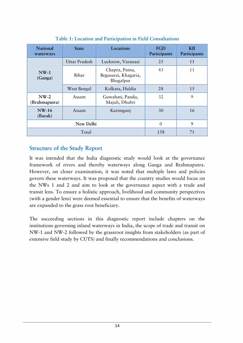
Table 1: Location and Participation in Field Consultations
National waterways
State Locations FGD Participants
KII Participants
NW-1 (Ganga)
Uttar Pradesh Lucknow, Varanasi 25 11
Bihar Chapra, Patna,
Begusarai, Khagaria, Bhagalpur
43 11
West Bengal Kolkata, Haldia 28 15
NW-2 (Brahmaputra)
Assam Guwahati, Pandu, Majuli, Dhubri
32 9
NW-16 (Barak)
Assam Karimganj 30 16
New Delhi 0 9
Total 158 71
Structure of the Study Report
It was intended that the India diagnostic study would look at the governance
framework of rivers and thereby waterways along Ganga and Brahmaputra.
However, on closer examination, it was noted that multiple laws and policies
govern these waterways. It was proposed that the country studies would focus on
the NWs 1 and 2 and aim to look at the governance aspect with a trade and
transit lens. To ensure a holistic approach, livelihood and community perspectives
(with a gender lens) were deemed essential to ensure that the benefits of waterways
are expanded to the grass root beneficiary.
The succeeding sections in this diagnostic report include chapters on the
institutions governing inland waterways in India, the scope of trade and transit on
NW-1 and NW-2 followed by the grassroot insights from stakeholders (as part of
extensive field study by CUTS) and finally recommendations and conclusions.

15
2. Institutions Governing Inland Waterways
Institutions for Governance of Inland Waterways in India
Institutional governance of Inland Waterways1 (IW) in India date backs to the
pre-independence year of 1942 converging into the genesis of Department of War.
Post-independence and over of years of political reshuffles, there have been
subsequent changes cum re-organisation in the name of the institutions governing
transportation with several bifurcations of transportation ministries and
departments like shipping, railways, aviation, road and highways handling
different modes of freight and passenger transportation.
Ministry of Surface Transport (covering shipping and road transportation under
its ambit) was bifurcated to two separate ministries in 2000, namely Ministry of
Shipping and Ministry of Road Transport & Highways. In 2004, these bifurcated
ministries were again re-organised and integrated as Ministry of Shipping, Road
Transport and Highways with two separate departments - viz. Department of
Shipping and Department of Road Transport & Highways.
Another remnant of the waterway governance from the colonial era was the
Central Inland Water Transport Corporation Limited (CIWTC). Incorporated on
February 22, 1967 under the Companies Act 1956 by the Government of India,
CIWTC was amalgamated when it took over assets and liabilities of the erstwhile
River Steam Navigation Company Limited. However, the union cabinet had
approved the dissolution of CIWTC in 2016 as part of initiatives to revitalise
Central Public Sector Undertaking and all assets have now been taken up by the
IWAI (PIB 2016).
Ministry/Department of Shipping (MoS)2 is the apex organisation that regulates
governance of declared National Waterways in India. Formed in 1986, IWAI is the
nodal executing/implementing agency, under the aegis of MoS that looks after the
development and regulation of inland waterways transport infrastructure on
national waterways3 for facilitating seamless shipping and navigation (Figure 1).
1 As per Inland Vessel Act, 1917, an inland waterway in India comprises of (i) any canal, river, lake or other navigable water within a State, (ii) any area of any tidal water deemed to be the inland water as defined by the Central Government under section 70,(iii) waters declared by the Central Government to be smooth and partially smooth waters under clause (41) Section 3 of the Merchant Shipping Act, 1958 (44 of 1958)
2 The Ministry of Shipping of Government of India covers shipping, ports sector including ship and vessel building, construction and maintenance of ports as well as inland water transport and national waterways. It formulates policies on these sectors and ensures implementation of those policies.
3 An inland waterway can be declared a national waterway only by an Act of Indian Parliament.

16
All policy matters related to the development of national waterways are decided
and implemented by the MoS under the advice of IWAI. IWAI is headquartered in
Noida (Uttar Pradesh) and has established operations in four regional offices
situated in Kolkata (West Bengal), Patna (Bihar), Guwahati (Assam) and Kochi
(Kerala).
The primary function of IWAI is to regulate and facilitate development of national
waterways by carrying out hydrographic surveys, fairway development for
navigation, maintenance of river’s least available depth (LAD) by carrying out
dredging and bandalling4, installation of day and night navigation aids and
construction of permanent and floating terminals/ports/jetties along national
waterways.
Apart from these, IWAI is responsible to coordinate with various other Central
and state ministries to facilitate research and development activities for
classification of new waterways and development of navigation on existing
waterways apart from taking care of overall standards of procedure with regards
to safety measures (IWAI 2017).
Figure 1: Institutional and Policy Regime of IWAI
Source: Compiled by authors
4 Bandalling is used to maintain required LAD in various river stretches for seamless vessel navigation. Under this processes river water is diverted from the secondary channel to the main channel by installing bamboo poles and bamboo mats at a length of 15 to 30 metres across the river. However, if the current is either less than 1 metre/second or shoal (sedimentary deposits at river’s mouth or it’s harbour) is large in length (greater than 150 metre) or depth to be improved is greater than 50 centimetre or when there is no scope for diversion of water from secondary channels, dredging through suction excavators and other machines is carried out to maintain the desired LAD.
Ministry of Shipping (MoS)
Inland Waterways Authority of India
(IWAI)
Noida (HQ)
RO Kolkata
RO Patna
RO Guwahati
RO Kochi
Apex Organisation
The National Waterways Act, 2016 The Inland Water Transport Policy, 2001
Funding through MoS; World Bank Loan; Multinational
Loans; PPP; Domestic Loans; Bonds Domestic Loans; PPP

17
Policies, Acts, Rules and Regulations for Governance of Inland
Waterways in India
With regards to principle governing legislations at the Centre, four main policy
and acts (IWAI Act, 1985; The National Waterways Act, 2016; The Inland Water
Transport Policy, 2001; and Inland Vessel Act, 1917) govern the overall
framework of inland waterways development at the Central level and the
definitive clauses have to be complied by the State government as per their
discretion or as mentioned in the policy and/or act. For information on other
relevant policies, acts, rules and regulations please refer to Annexure 2.
Table 2: National Policies, Acts, Rules and Regulations
Sr. No.
Law Provisions
1. The Inland Waterways Authority of India (IWAI) Act, 1985
The Act lays down provisions for constitution of an institutional authority for development and regulation of inland waterways for the purposes of shipping and navigation.
2. The National Waterways Act, 2016
The principle governing legislation for regulation, development and declaration of existing and new national waterways in India. Under this recently enacted legislation, apart from existing five national waterways, 106 additional waterways (divided into three categories) have been declared as national waterways.5 More details: http://iwai.nic.in/showfile.php?lid=882
3. The Inland Water Transport Policy, 2001
The objective of the policy is to develop the inland waterway transportation sector into an attractive alternative to road and railway transportation. A 100 per cent grant to North-eastern states and 90 percent grant to other states are also given to develop and maintain waterways. More details: http://iwai.nic.in/index1.php?lang=1&level=1&sublinkid=7&lid=27
4. Inland Vessel Act, 1917/Inland Vessels (Amendment) Act, 2007
It regulates the movement of inland vessels on waterways. It lays down detailed procedure for different kinds of vessels with regards to vessel survey, vessel registration, drivers of vessels, reporting casualties during an accident, safety measures for the passengers, penalties and other legal proceedings. In 2007, this Act underwent amendments in few of its original clauses, renaming it as the Inland Vessels (Amendment) Act, 2007. More details: http://iwai.nic.in/WriteReadData/l892s/act-18845788.pdf
5 The argument raised by the Ministry of Shipping for the enactment of the National Waterway Act, 2016 stresses that because of exhaustive and cumbersome legislative process, India was only able to declare and develop five waterways in the last 30 years and had deprived itself the benefits of promoting trade through development of IWT on several inland waterways.

18
Sr. No.
Law Provisions
5. Draft New Inland Vessel Act/Bill 2016
With the objective of replacing the existing Inland Vessels Act, 1917 (1 of 1917) with amendment as of 2007 dealing all matters connected with operation of Inland Vessels in Inland Waters, a new Inland Vessel Act have been drafted through Indian Register of Shipping. More details: http://iwai.nic.in/showfile.php?lid=860
Source: Compiled by authors
Institutional and regulatory governance of inland water transportation (IWT) is
taken care by both the Centre and respective State governments as per the
waterway category (Figure 2). At the central level, MoS and IWAI is specifically
responsible for undertaking navigational development and maintenance of IWT
infrastructure along protocol routes only for the declared national waterways as
per the recently enacted National Waterways Act, 2016. On the other hand, the
respective State governments are responsible for development and maintenance of
IWT on State specific waterways not categorized as national waterways.
The role of state governments in the development of NWs in tandem with IWAI
starts with land acquisition for fairway widening and development along with
road connectivity at terminals. IWAI coordinates with respective state
governments so that they can expedite the process of land acquisition as per the
State law and have to make sure there are no physical obstructions on the protocol
routes and if there are any (like fishing nets of local communities, modifications of
cross structures, etc.), the State has to resolve them (IWAI 2017).
Shipping and navigation of mechanically propelled vessels6 on declared national
waterways falls under the direct control of the Central government. Shipping and
navigation of mechanically propelled vessels on waterways other than national
waterways falls in Concurrent list of Indian Constitution and comes under the
jurisdiction of both Centre and the State. However, shipping and navigation of
non-mechanised vessels comes under the jurisdiction of the State. Since water is a
state subject in India, the role of the respective state government is indispensable in
the overall developmental framework of inland waterways.
State governments play a vital role with regards to cargo/passenger transportation,
traffic regulation and vessel registration as per various acts/policies/rules. Taking
the case of NW-1 and NW-2, IWAI is primarily responsible for construction of
permanent multimodal terminals (MMT) along with construction and/or
6 As per Inland Vessel Act 1917, mechanically propelled vessel means every description of vessel propelled wholly or in part by electricity, steam or other mechanical power including dumb vessel towed by the mechanically propelled vessel and vessel propelled by outboard motor.

19
maintenance of other floating and fixed terminals, jetties, pontoon barges,
pontoon gangway, vessel repair warehouses, navigation aid facilities and so on.
The state governments of Uttar Pradesh and Bihar undertake boat and waterway
vessel registration through dedicated desks at the department of transport while
states, such as West Bengal and Assam have separate department of inland
waterway transport or inland waterways directorate under the aegis of its
department of transport that undertakes regulatory activities of boat/ferries
operating on inland waterway routes of the respective states.
Current Scenario of Inland Navigation in National Waterways 1 and 2
Reasons for development of freight transportation through inland waterways were
first elaborated in India’s Ninth Fiver Year Plan (1997-2002). The primary reason
was India’s need to explore other means of cargo transportations, given limitation
on its overtly saturated road and rail infrastructure.
Moreover, government data shows that cargo diversion of around one billion
tonne km to inland water transportation (as an alternative to environment friendly
mode) will result in reduction of cost of freight transportation by 45 crores and
fuel cost by 25 crores (IWAI 2017). A policy impetus in this direction paved way
for the introduction of the National Waterway Bill, 2015 in Lok Sabha on May
05, 2015, which was ultimately passed by the Parliament and led the enacted of
the National Waterways Act, 2016.

20
Figure 2: Governance of Inland Waterways in India (NW-1 and NW-2)
Since the enactment of this Act, a renewed sense of direction to develop and accelerate commercial activities on several waterways, specifically NW-1 and NW-2, has been noticed in India. Furthermore, with an impetus to promote India’s trade competiveness in the global market and recognising the importance of strengthening trade connectivity in BBIN sub-regional grouping, India’s MoS is making efforts to align inland waterway development with multimodal connectivity, mainly focusing on developing road and railway infrastructure in cities where permanent inland waterway terminals are being constructed. This step flickers the importance of growing recognition of mutual cooperation and coordination between IWAI, along MoS, with various ministries, departments, corporations and private sector, namely Ministry of Railways, Dedicated Freight Corridor Corporation of India Limited, Ministry of Road Transport and Highways, and the Ministry of Commerce & Industry.

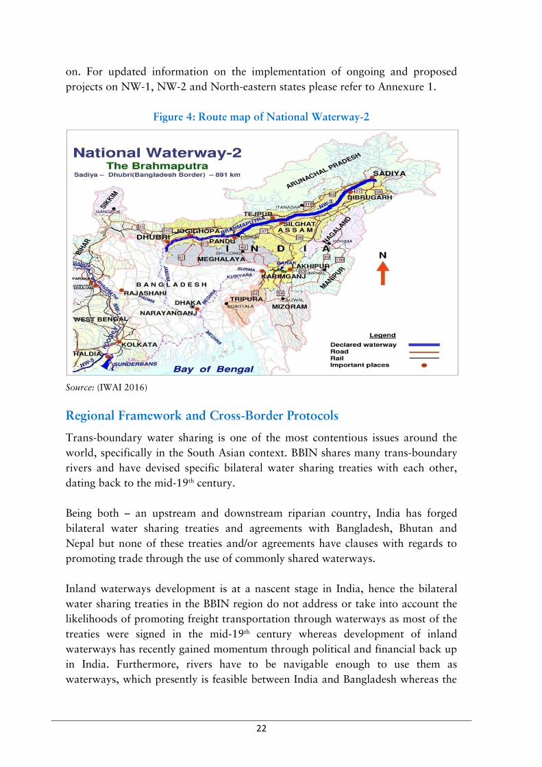
21
Figure 3: Route Map of National Waterway-1
Source: (IWAI 2016)
Jal Marg Vikas Project
The Government of India aims to increase the percentage share of cargo
transportation through waterways to 15 per cent in 2019 from present 3.5 per
cent coupled with creation of additional 1,60,000 jobs along NW-1. Hence, the Jal
Marg Vikas Project (JMVP) will entail development of fairway with 3 meters
depth between Varanasi and Haldia (Phase-I) covering a distance of 1380 km at
an estimated cost of INR 5369 crore with target for completion in six years (PIB
2017). JMVP will be implemented with the financial and technical support of the
World Bank. IWAI is also exploring additional funding opportunities through
issuance of government serviced bonds,7 getting private sector investments, and so
7 In order to raise funds for infrastructural development and maintenance of shortlisted national waterways, IWAI got approval from the Union Cabinet to raise government serviced bonds worth Rs 1000 crores in 2016, whereas IWAI was only successful in raising bonds worth Rs 340 crores during the same year. On July 20, 2017, the Union Cabinet reissued permission to IWAI to raise bonds in terms of Extra Budgetary Resource (EBR) worth Rs 660 crores in the year 2017-18.
22
on. For updated information on the implementation of ongoing and proposed
projects on NW-1, NW-2 and North-eastern states please refer to Annexure 1.
Figure 4: Route map of National Waterway-2
Source: (IWAI 2016)
Regional Framework and Cross-Border Protocols
Trans-boundary water sharing is one of the most contentious issues around the
world, specifically in the South Asian context. BBIN shares many trans-boundary
rivers and have devised specific bilateral water sharing treaties with each other,
dating back to the mid-19th century.
Being both – an upstream and downstream riparian country, India has forged
bilateral water sharing treaties and agreements with Bangladesh, Bhutan and
Nepal but none of these treaties and/or agreements have clauses with regards to
promoting trade through the use of commonly shared waterways.
Inland waterways development is at a nascent stage in India, hence the bilateral
water sharing treaties in the BBIN region do not address or take into account the
likelihoods of promoting freight transportation through waterways as most of the
treaties were signed in the mid-19th century whereas development of inland
waterways has recently gained momentum through political and financial back up
in India. Furthermore, rivers have to be navigable enough to use them as
waterways, which presently is feasible between India and Bangladesh whereas the

23
geographical terrains of Nepal and Bhutan make trans-boundary navigation
inaccessible or unexplored.
Table 3: Regional Treaties with Navigation as a Sub-component
Sr. No. Treaty Objectives
1. MoU on use of inland waterways for transportation of bilateral trade and transit cargoes between Bhutan and Bangladesh, 2017 (Link)
To allow export-import cargo of Bhutan to be handled at maritime ports of Chittagong and Mongla in Bangladesh and same will be transited to the identified destinations in Bhutan through the waterways in Bangladesh
2. MoU between India and Bangladesh concerning cooperation on aids to navigation, 2017 (Link)
To extend advice on lighthouses and beacons To extend advice on vessel traffic service and chain of AIS To impart training as per International Association of Marine Aids to Navigation and Lighthouse Authorities (IALA) training module to managers and technicians
3. MoU between India and Bangladesh on passenger and cruise services on the coastal and protocol routes, 2017 (Link)
To further develop the friendly relations and to strengthen cooperation in the field of passenger and tourist transportation in the Indo-Bangladesh Coastal and Protocol routes in accordance with principles of equality and mutual benefits.
4. MoU between India and Bangladesh on development of fairway from Sirajganj to Daikhowa and Ashuganj to Zakiganj on Indo-Bangladesh protocol route, 2017 (Link)
To develop the navigable fairway round the year (between the stretches of Sirajganj to Daikhowa and Ashuganj to Zakiganj) to enhance the trade and safe passage of goods between the two countries.
5. MoU between India and Bangladesh in the field of blue economy and maritime co-operation in the Bay of Bengal and The Indian Ocean region, 2015 (Link)
To ensure the systematic and balanced development of the national capacity in the field of maritime sector
6. Agreement on coastal shipping between India and Bangladesh, 2015 (Link)
To secure harmonious development of the maritime commercial navigation between India and Bangladesh To cooperate actively in the field of maritime commercial navigation
7. Protocol on inland water transit between India and Bangladesh, 2015 (Link)
To make mutually beneficial arrangements for the use of waterways for commerce and for passage of goods.
8. MoU between India and Bangladesh on cooperation in
To strengthen the existing friendly relations between the two countries through

24
Sr. No. Treaty Objectives
the field of fisheries, 2011 (Link)
development of co-operation in the fields of fisheries and aquaculture and allied activities.
9. Framework agreement between India and Myanmar for construction and operation of a multi modal transit transport facility on Kaladan river connecting the Sittwe port in Myanmar, 2008 (Link)
To explore the possibility of constructing a multi-modal transit transport facility connecting the Sittwe in Myanmar with the state of Mizoram in India combining a system of inland waterway and highways
10. Agreement between India and Bangladesh on sharing of the ganga waters in Farakka, 1977 (Link)
To make an interim arrangement for sharing of the Ganga waters at Farakka
11. Revised agreement between India and Nepal concerning the Kosi project, 1966 (Link)
Constructed for the purpose of flood control irrigation, generation of hydro-electric power and prevention of erosion of Nepal areas All navigation rights and related permits in the Kosi river in Nepal shall rest with Government of Nepal
Source: Compiled by authors
Thus, with regards to regional mechanisms, BBIN lacks a regional organisation and a regional treaty for linking waterways to promote trade facilitation. Hence, India and Bangladesh had to continue on a bilateral arrangement by signing a protocol on inland water trade and transit in 1972 (Table 3). Additionally with the recent political reinforcement to promote enhanced regional connectivity in BBIN and using waterways as a of the means to promote trade, the recent couple of years have witnessed a renewed direction of mutual cooperation between India and Bangladesh. This has also led to ratification of the Agreement on Coastal Shipping and its Standard Operating Procedures (SoPs) in 2015 and signing of several MoUs concerning trade and tourism development through inland waterways (Table 3).

25
3. Trade and Transit on Inland Waterways
Unlike other coast-bound countries (like Bangladesh), inland water transportation
in India has remained low in share of freight transportation (both goods and
passenger) among all modes of transport. Waterborne goods transportation,
particularly by inland waterways, has great promise as it is cheaper and
environment friendly mode of transport for bulky goods such as iron ore, steel,
timber, and coal. It also helps in reducing stress on the already congested railway
and road networks. Several studies have been conducted on the advantages (GoI
2014), cost estimation (World Bank 2017) and viability statistics (MoSPI 2014) of
inland water transportation in India. Studies also show that transport systems
through waterways is not only fuel efficient but also environmentally friendly in
comparison to transportation by road and railways (Nagabhatla and Jain 2013).
Moreover, cross-border transportation through waterways has the potential to
become a locus for expanding regional cooperation.
This chapter will aim to present the current status of goods and passenger
movement in NW-1 and NW-2 as well as on the India-Bangladesh Protocol (IBP)
route. The information in this chapter has been compiled from various
government and non-government sources.
Categories of the Cargo
The stark difference which sets apart trade and transit on NW-1 and NW-2 is the
quantum and type of trade. Overall, cargo movement on NW-1 and NW-2 is
limited to the state of West Bengal and for limited products.
States, such as Bihar and Assam have comparatively smaller share in total cargo
movement, and some of the states, such as Uttar Pradesh and Jharkhand have
minimal presence. As indicated in Figure 5 cargo movement on NW-1 has seen a
substantial rise over the past few years. Cargo movement has increased by a
proportion of 1:1.64 from 2009-10 to 2015-16. But cargo movement on NW-2
has remained stagnated in this duration even registering a decline in the past three
years.
Some of the major products transported through NW-1 are fly ash, iron ore, coal,
steel, building material, tyres, rock and stones, oil, sand, food items, timber and
aluminium. Interestingly, the major products transported through NW-2 are food
grains, electrical and transmission equipment’s, fertiliser, building material and
bamboo (IWAI 2017).

26
It has been estimated that coal and fertiliser movement on bulk scale will support
large-scale cargo transportation on NW-1. CUTS’ discussions with stakeholders
indicate that the coal transported along NW-1 is primarily to cater to the need of
power plants located on the river banks of Ganga. This is mainly because there is a
huge demand of coal for ten existing thermal power plants and eleven new power
stations which are under construction or being constructed in Bihar and Uttar
Pradesh in the next eight years on the banks of NW-1. Around 20 per cent of coal
requirement of these power plants will be completed by imported coal through
Haldia route. Hence, this will give a significant potential to NW-1.
Figure 5: Cargo Movement on NW-1 and NW-2 (in BTKM)
Source: (IWAI 2016)
Similarly, fertiliser plants, such as IFFCO Phulpur Plant in Varanasi, Indo Gulf
Fertilisers in Jagdishpur (near to Allahabad) and Tata Chemicals Limited in
Haldia, West Bengal will require multimodal transport infrastructure to cater to
the need of farmers in these states and for nation-wide coverage.
Location of Cargo Production and Consumption
A critical point of consideration for trade and transit, especially in India, is the
location of cargo production and consumption. CUTS’ consultations with
stakeholders show that private sector prefers to have minimal costs and

27
documentations for the processes related to offloading and loading of cargo.
Locations of bulk production and consumption eliminate such tertiary costs in the
logistic framework, especially for small and medium private players who depend
on cost-savings for turning annual profit.
As mentioned in the above section, coal and fertilisers, being bulky commodities
need to be transported from their point of bulk production to the point of bulk
consumption. In fertiliser, bulk consumption point cannot be comparable to that
of coal, yet can be estimated to be a location with substantial multi-modal
connectivity.
Figure 6: Projections for Quantity of Cargo on Selected Terminals (In MT)
Source: (IWAI 2014)
A joint study by IWAI and RITES (Table 4 and Figure 6) also estimated that by
the year 2031-32, there will be substantial movement of cargo on selected
terminals. For example, Joghighopa and Pandu in Assam, Patna in Bihar and
Haldia, Katwa and Hazardwari in West Bengal hold the potential for moving
cargo quantities higher than 10 MT.
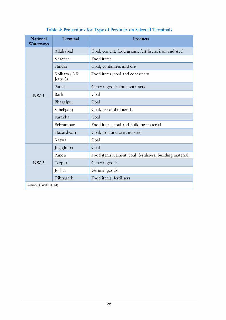
28
Table 4: Projections for Type of Products on Selected Terminals
National Waterways
Terminal Products
NW-1
Allahabad Coal, cement, food grains, fertilisers, iron and steel
Varanasi Food items
Haldia Coal, containers and ore
Kolkata (G.R. Jetty-2)
Food items, coal and containers
Patna General goods and containers
Barh Coal
Bhagalpur Coal
Sahebganj Coal, ore and minerals
Farakka Coal
Behrampur Food items, coal and building material
Hazardwari Coal, iron and ore and steel
Katwa Coal
NW-2
Jogighopa Coal
Pandu Food items, cement, coal, fertilizers, building material
Tezpur General goods
Jorhat General goods
Dibrugarh Food items, fertilisers
Source: (IWAI 2014)
29
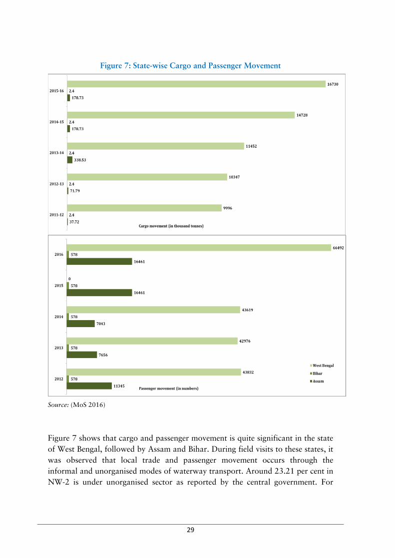
Figure 7: State-wise Cargo and Passenger Movement
Source: (MoS 2016)
Figure 7 shows that cargo and passenger movement is quite significant in the state
of West Bengal, followed by Assam and Bihar. During field visits to these states, it
was observed that local trade and passenger movement occurs through the
informal and unorganised modes of waterway transport. Around 23.21 per cent in
NW-2 is under unorganised sector as reported by the central government. For

30
instance, in Assam, residents of char8 area prefer using boats owned or leased by
them for local movement in the area. If such cargo and passenger movement are
also monitored and quantified, the above figures might tell a different picture.
Figure 8: Selected State-wise Total Revenue Earned from NW in India
(in '000 INR)
Source: (Lok Sabha 2015)
In the context of cargo and passenger movement, it is interesting to note that West
Bengal was generating significantly higher revenue consistently in the past few
years (Figure 8). This can be attributed to the increased transportation of inter
country and transit goods via IBP route and transportation of coal to the NTPC
plant at Farakka. The surge in revenue generated in Uttar Pradesh in the recent
years can be attributed to transportation of over dimensional cargo (ODC), coal
and cement.
8 The mid-channel bars (locally referred as char) are ‘almond’ shaped alluvial formations found in Brahmaputra and its tributaries

31
Impetus to Private Sector
As described in preceding sections, NW-1 has visible evidences for commercial
interventions within the country as well as cross-country transit. These
interventions have been possible due to public private partnerships (PPPs) and
investments. Table 5 shows some examples of companies (private and government
funded) who have a substantial turnover because they have high number of vessels
and bulk cargo movement.
Table 5: Operations of Major Companies (2015-16)
Company Name No. of Vessels Cargo Transported
(in ‘000 tonne)
No. of Passengers
Carried
Products Transported
Eastern Navigation Pvt. Ltd., Kolkata
11 79.28 -- ODC cargo, fly ash, boiler drum
Vivada Inland Waterways Ltd, Kolkata
14 582.80 116128 High Speed Diesel/Furnace Oil/Light Diesel Oil/Lube Oil
West Bengal Surface Transport Corporation
30 228.92 11139421 General goods
Hooghly Nadi Jalapath Paribahan Samabaya Samity, Kolkata
34 -- 8130429 --
Jindal ITF Limited, Uttar Pradesh
26 52.45 -- Coal
Source: (MoS 2016)
Although there are more than two dozen private companies and public sector
undertakings (PSUs) involved in transportation of passenger and goods on NW-1,
only four companies have significance presence. Rest of the companies, such as
Paradeep Boating Company (with 1 vessel and 780 tonnes cargo moved in 2015-
16), Indo Swiss Trading Company (with 2 vessels and movement of 231221
passengers) and West Bengal Tourism Development Corporation (with 3 vessels
and 11139 passengers moved) have minimal presence, currently.

32
Discussions with private sector stakeholders indicate that the interest of multi-
national logistic companies as well as cargo products has increased due to the
Protocol on Inland Waterways Transit and Trade (PIWTT) route between India
and Bangladesh. Despite multiple bottlenecks and reforms required for easing
cross-border business through this route, Figure 9 shows considerable quantum of
inter-country and transit cargo carried by Bangladeshi vessels. This was also
substantiated during field level interactions that Indian vessels are bigger in size
and hence the fuel cost is higher compared to Bangladeshi vessels.
Furthermore, the cost of ship building is much higher in India owing stringent
regulations and higher labour cost. Non availability of adequate number as well as
size of vessels and very few vessel operators in West Bengal have led to higher
freight rates which are uncompetitive. Hence the ratio of goods carried by
Bangladeshi and Indian vessels remains with an average variation of 99:01 from
2012-2013 to 2016-2017. The data also shows that during this period, the nature
of cargo transported through the PIWTT route is diverse consisting of general
cargo, coal, fly ash, steel coil, M. S. wire rod, iron ore, container cargo, ODC,
wheat and food grains, steel grader, steel plate and stone chips.

33
Figure 9: Cargo Transported under PIWTT (in Metric Tonne)
Source: (BIWTA 2017)
The data also shows that the inter-country cargo movement has increased
considerable in the recent years whereas there is year to year variation in transit
cargo. Higher values of 2014-15 can be attributed to the ODC transported to
Agartala via Ashuganj (T). Further bifurcation of the transit cargo data through
different routes is also shown in the table below.

34
Table 6: Transit Cargo Movement between India-Bangladesh (in Metric Tonne)
Route 2011-12 2012-13 2013-14 2014-15 2015-16
Kolkata-Dhubri 140 1118 2373 4322 2430
Kolkata-Karimganj 2555 17567 -- 12928 3495
Kolkata-Ashuganj -- -- -- 19537.29 1004
Source: (MoS 2016, BIWTA 2017, Ahmed 2017)
As indicated by Table 6, out of the prescribed eight routes, merely three protocol
routes are currently being used for cargo transportation between India and
Bangladesh under the PIWTT agreement. Out of these, regular movement of cargo
can be seen solely in Kolkata-Dhubri route, though the quantum of cargo is less
compared to other routes.
CUTS stakeholder interactions show that the recent surge in cargo movement
through the Kolkata-Ashuganj route is subsequent to the amendment of the
protocol in 2015 and primarily included ODC to the Palatana power project in
Tripura, comprising of steel, TMT bars in addition to the usual consignments of
food grains. Similarly, in terms of volume of cargo transported, Kolkata-
Karimganj is much ahead of Kolkata-Dhubri owing to the transport of fly ash and
food grains. However, poor navigability due to low water availability in the lean
season is the major constraint faced by this port.
As indicated by Table 6, fly ash, steel, food grains and iron-ore are major products
being traded through the use of PIWTT. The data reconfirms the contribution of
ODC in the total trade through the protocol route. This surge in ODC is mainly
attributed to the project cargo transported to north-east region of India for the
upcoming hydro and thermal power plants in the region.
It is evident from the analysis of this section that there is a huge potential for
goods and passenger movement between states and across India and Bangladesh.
The massive investments for infrastructure development under the Jal Marg Vikas
project with the support of World Bank is intended to attract traders and logistics
firms.
It is also anticipated that the developmental projects coming up in North Eastern
states of India will make use of waterways for the transportation of heavy
machinery and equipment. Further, the Government of India intends to transport
food grains to NE via waterways. Development of terminals, warehouses,
transhipment facilities at major ports, navigation aids, ship repairing facilities,
multi modal connectivity etc. are expected to boost inland navigation and make
this sector more competitive.

35
4. Stakeholders Perception
This chapter captures the perceptions of various stakeholders who were consulted
during the course of project. The evidences were gathered through Key Informant
Interviews and focus group discussions conducted with government officials,
academia, civil society, freight handlers, private sector, boat associations,
boatmen, tour operators, fishermen, sand traders etc. in the states of Uttar
Pradesh, Bihar, West Bengal and Assam. This information was further validated in
a series of consultations at sub-national, national and basin levels. This chapter
will aim to collate the evidences from the field study as well as juxtapose the
evidence on the current governance and policy scenario for inland waterways in
India.
Navigation at the Cost of Environment?
The perception study conducted in the states of Assam, Bihar, Uttar Pradesh and
West Bengal, exhibits an undisputed fact that inland navigation and environment
are interconnected by the common thread of community engagement. River
ecosystems thrive on the sustainable usage of its services by the communities
surrounding it. The floodplains of Ganga, Brahmaputra and Barak river basins are
important habitat resources for fish. Developmental interventions like dredging,
sand mining, construction of barrages and dams etc. for channellising Rivers for
navigation purposes will modify the riverine ecosystem and disturb the river
continuity. Hence, it was a challenge to disaggregate the intricate discussions
comprising of navigation and environment.

36
In the subnational consultation at Varanasi, the officials from the Fisheries
Department, Government of Uttar Pradesh shared their concerns with regards to
the impact of developmental activities for inland navigation on the aquatic fauna
in the Ganga river, specifically on their breeding grounds.
It was pointed out that native/inland fish varieties and other aquatic animals have
fixed breeding grounds in the Ganga river and every year they travel or migrate
from a very long distance (through a fixed pathway) to breed only in those
breeding grounds. The officials were concerned that continuous vessel movement
may affect fish breeding as high frequency sound waves from big ships can destroy
the fragile fish eggs and can also affect the migratory pattern of fish. This is
disruptive of ecological balance and needs to be taken into consideration.
Generally, in this area breeding season of most of the aquatic fauna starts from
June 15, and ends by retreating monsoons in September, so a workable solution
needs to be made if big vessel movement starts through the Varanasi river stretch
during this period.
Multiple studies by state and national organisations have also shown that
navigation and dredging activities to maintain the waterway stretch also disturbs
the aquatic ecosystem. However, recently the Ministry of Environment, Forests &
Climate Change (MoEFCC) has set up a committee to decide whether the
Varanasi Turtle Sanctuary should be de-notified and possibly shift to another
location which would eliminate the concerns surrounding ‘development activities’
along the ‘waterway’ stretch.9 A similar case for concern also exists at the
Vikramshila Dolphin Sanctuary at Bhagalpur. Government bodies, such as the
IWAI have mandates and practices to ensure minimal disturbance to aquatic life
during dredging activities, however environmental activists demand that all such
activities on the rivers and waterway stretches should be prohibited to ensure
minimal environmental impacts.
Moreover, in Brahmaputra, fish breeding/rearing is mostly done in secondary
channels to avoid direct water flow. The sand collected while dredging is usually
released in the secondary channels as the river is wide up to 15- 20 km at several
places. This could clog the mouth of secondary channels thus damaging the
breeding sites. The area identified for fish spawning should be marked so that it is
not disturbed. This demands more coordination between fisheries and water
resource department.
9 More details on the de-notification here: http://www.upenvis.nic.in/ViewGeneralLatestNews.aspx?Id=1559&Year=2017

37
Box 1: All Sewage Pipes lead to Ganga
The government officials admit that around 80 per cent of the sewage pipes in Patna
drain into Ganga. One key step to handle this issue is the establishment and
scheduled running of the Sewage Treatment Plants (STPs.) Ravindra Sinha10 (Patna
University) and Subrata Hait (IIT Patna) also corroborated this fact by quoting
multiple statistics from recent times. However, the municipality office in Patna and
the state government has been unsuccessful in even mapping the different sewage pipe
outlay and connections in Patna. They also opined that in addition to causing
multiple sanitary and health issues to residents on river banks, due to high level of
faecal coliform and other industry effluents the sewage also critically endangers
multiple fauna like the Ganga river dolphin.11 The impact of sewage in navigation
was not a direct hindrance, but it is worthwhile to note that if the Patna stretch of
Ganga is being opened for tourism, then sewage management has to take the priority.
Similarly, industrialisation at Haldia (West Bengal) triggered development of
facilities like roads, schools and hospitals, markets and creating decent livelihood
opportunities, but at the risk of huge environmental cost to the ecosystem,
including humans. Because of the environmental hazard, some years ago, Haldia
was declared a critically polluted (air) zone. However, due to incessant
government and industry efforts, a lot of environmental concerns have been
mitigated and Haldia is now out of the critical category.
Many Means of River-dependent Livelihoods
Inland navigation has cross connections with various means of livelihoods of
riverine community. Field level interactions with boatmen, fishermen, traders,
vendors, freight handlers, private sector and academia at multiple locations have
thrown light on how inland navigation influence their livelihoods in one way or
other.
Boatmen
The boatmen whom CUTS interviewed in Assam, Bihar and Uttar Pradesh were
mostly owners of small mechanised boats and country boats predominantly in the
unorganised sector. The livelihoods of these people are entirely dependent on
waterways and thus are anxious for how new developments may impact their
lives.
For instance, there are around 50,000 people associated with the boatman families
(Mallah/Navik/Nishad Samaj) with more than 150 people directly involved in
10 https://en.wikipedia.org/wiki/Ravindra_Kumar_Sinha
11 http://gangapedia.in/

38
boating related activities in the Varanasi district whose livelihood is directly
dependent on the Ganga. However, it was communicated that whenever the state
or central government decides on a plan or scheme for Ganga development, the
community is not consulted.
The community has been denied the renewal of the licences for small mechanised
boats since the enactment of Turtle Sanctuary Act12 in Varanasi. At present, they
are operating these boats without government licences as the local administration
(Municipal Corporation/Nagar Nigam) let them to operate after strong agitation.
The community questions that if the licences for their mechanised boats have not
been renewed because of Turtle Sanctuary, how can big ships/boats given license
and permission for operation in the zone or to pass through this route.13
They demand that the activities, such as driving boats, river training and
employment activities related to river should be given to local Mallah Samaj. The
Mallah Samaj is known as Ganga Putra (son of Ganga river) and members of the
community are well aware of the river system. But they have been ignored by both
Centre as well as state government. Jal Police was created to save people in case of
emergency but jobs of that department have been given to people who hail from
other districts and do not even have proper swimming skills. Even in the local
NDRF teams, local Mallah Samaj should be given a role. They expressed that
during every flood they work to save people and provide relief through their small
boats.
12Water area/stretch of seven kilometres (7 kms) between Rajghat/Malviya Rail/Road Bridge and Ramnagar Fort in Varanasi is a wildlife protected zone (Kachua Sanctuary/Turtle Wild Life Sanctuary) under the purview of Wild Life Protection Act 1972 and by a special order of UP State Government released on December 21, 1989. Since, 1989, more than 34000 turtles are being released by the Turtoise Breeding Centre in Sarnath under the Ganga Action Plan which was launched in 1986 to clean the biological pollution from river Ganga. It is believed that these turtles eat dead bodies thrown in river. See: http://upforestwildlife.org/turtle.htmandhttp://timesofindia.indiatimes.com/city/varanasi/34000-tortoises-released-into-Ganga/articleshow/8553068.cms
13Two cargo vessels which were supposed to be navigate on NW-1 were docked near Rajghat and waited for permission to reach to Ramnagar terminal but, forest officials of UP did not allowed them to go to Ramnagar even after wait of more than two months and ultimately Union Shipping Minister Nitin Gadkari had to give green signal to these vessels from Rajghat instead of proposed terminal of IWAI in Ramnagar. See:http://timesofindia.indiatimes.com/city/varanasi/Cargo-vessels-await-forest-department-nod/articleshow/53296506.cms?from=mdr

39
While environmental concerns shadow all livelihood activities related to the
waterway, structural and operational hindrances also inhibit boat owners in Uttar
Pradesh and Bihar. In Uttar Pradesh and Bihar, a common concern for small boat
owners was the monopoly of a few banks for boat insurance and financing
purposes. It was pointed out that the community has limited access to financial
services for construction and repairing of boats. There is an absence of subsidy
from government; bank does not provide loan to buy new boat or to repair old
boats.
Furthermore, insurance companies refuse to insure their vessels as they lack licence
as per government regulations. This forces the boat owners to resort to using the
financial services offered by the Sahukar (local money lenders) with less rigid
paperwork but harsher interest rates and punitive repaying methods. This financial
dependency on the Sahukar extends for the out-of-pocket maintenance expenses
for the boats too.
The members of Assam Meghalaya Country and Shallow Boats Association,
Dhubri, Assam shared that the association is mostly engaged in settling the dispute
and conflicts in deciding routes for ferrying passengers. Of the several ghats in
Dhubri, only five are operated by the state inland water transport department
others are operated by the unorganised sector.

40
Dhubri is a commercial hub due to its proximity to West Bengal and water
transport being the major mode of conveyance in the district which is marked with
several sapots and chars. Issues related to governance and administrative delay in
the registration of boats, were main concerns of the boatmen association. Multiple
taxes of state and local municipality consume a major share of their income. They
also demanded a sub divisional office of IWT in Dhubri as for all administrative
will have to go the state capital Guwahati which is quite far from Dhubri.
Table 7: Taxes Paid for Boats Plying
between Dhubri (Assam) and Phulbari (Meghalaya)
Passenger boats Commercial boat
INR 2 per passenger INR 150 Meghalaya tax
INR 20 per boat INR 200 Dhubri, IWT
INR 5 to state IWT department INR 10 for Municipality
INR 20 per boat to Municipality INR 10 per push cart
Source: Compiled from CUTS field work
Ferrying passengers is also an avenue for generating local livelihood, especially in
Bihar, Assam and West Bengal. An example is that at Kendyamari, Nandigram it
was observed that the passenger boats are used around the year to ferry people,
two-wheelers etc. for a minimal cost of INR 4 with an interval of 20 minutes with
a time gap of 20 minutes between each ferry.
At the same time, roadway connectivity to commute from Haldia from Nandigram
is both time-consuming and costly (at least INR 50). Similar case was observed in

41
Patna and Khagaria, where due to the road congestion, even ambulances cannot
detangle from the traffic jams. However, waterways for passenger transit can be
developed for movement between villages like Kaunhara (Sonepur), Kacchi dargah
(Patna), Bidupur (Hajipur) and cross-bank connectivity for Khagaria and
Kahalgaon.
Box 2: Solar Power or Muscle Power?
In May, 2016, the launch of solar powered e-boats at Assighat, Ganga as part of the
Pradhan Mantri Mudra Yojna attracted much fanfare due to the progressive
development claims of the government among dalits, tribals and backward classes.
Aimed at reducing drudgery of operators, reduced noise pollution and eco-friendly
transport mechanism, the e-boats are singing a different tune in 2017. Since the e-
boats are not equipped with in-built solar panels to charge the batteries (weighing
around 200 kg) operators have to incur an extra charging cost close to INR 200
which would last for four to five hours. In addition to the cost economics, the e-boats
have also been found to be unsuitable for the strong under currents of Ganga.
Bhartiya Micro Credit (BMC) in Lucknow, along with many other small and micro
enterprises and micro-credit companies have been working on technical and business
models to ensure that the solar powered boats do not go back to being ‘muscle’
powered boats.
Fishermen
Riverine fisheries are the backbone of communities settled along the banks of
Ganga and Brahmaputra. Innovative cooperative models of pond and river fishing
in Bihar and Assam which is the evidence for the small-scale local trade aspects
related to waterways.
For instance, cooperatives like the Matsya Swalambya Sahyog Samiti at Kamalpur,
also registered with Co-Operative Fisheries Federation, Bihar (COFFED), work
closely with the State Department of Fisheries for accessing the Purnea and
Bhagalpur fish market by undertaking fisheries in the floodplains and wetlands.
The leaders in such cooperatives have also gone for exposure visits to other states
like Andhra Pradesh for riverine fishery training. Though the cooperative members
want to scale up the fish production, cold storage and road transport for ease of
connectivity to the main markets remains the inhibiting factors. Fishing in river is
free for all in Bihar (open- access), whereas in Assam stretches of river are
identified and registered for fisheries (called mahals) by the state revenue
department. Fisheries department promotes culture fisheries in ponds, floodplains
and wetlands.

42
Local fishermen in Varanasi expressed concerns that the waves created by the
movement of big ships may harm their net and fishing gears. Some of the
fishermen also shared that the big vessels can blow the horn while passing so that
the fishermen can clear the route. In NW-2 such conflicts were not reported as big
vessel movement is negligible and also because fishing area is demarcated and lies
mostly in the secondary channels of the river. Another concern for fishermen in
NW-1 was that in the flood plains when the water level recedes, farmers forcefully
take away the area for farming.
Illegal barriers are set up by farmers when the fishermen have legally bought the
area and surrounding water from the government department for fishing as
reported by fishermen in Khagaria, Bihar.
Sand Traders
While fishing remains the largest employer for communities in Assam, Uttar
Pradesh and West Bengal, sand-mining in Chapra and Doriganj seems to stand out
as an immensely profitable yet unsustainable practice along the Ganga in Bihar.
Unchecked extraction of sand from the river has multiple environmental and
governance violations, however the small boat-building industry in the vicinity as
well as local employment are highlighted as the positives. It is interesting to note
that boat-building is also a key source of income for local communities at the ferry
ghat at Haldia (West Bengal), because port led industrialisation has necessitated
people to commute across the river for livelihoods and other services.

43
Currently parcels of the river bank and bed are being auctioned by the state
government for extraction of sand, however, this process is riddled with practice
inaccuracies and price lobbying to a large extent. In this context to convert
informal trade of sand to formal means of revenue would require coordination
among the state department’s handling revenue, environment and fisheries. The
sand trade at Chapra and Doriganj is also an excellent example of locally
produced good (sand) being produced at one river bank (Chapra) and being
consumed across the state (Patna, Bhagalpur, Ara etc.) and even to neighbouring
states (Jharkhand, Uttar Pradesh). Auctioning the river sand collected during
dredging is another means of formalising sand trade adding revenue to the state.
Table 8: Cost Analysis of Sand Trade in Bihar
Process Stakeholder Cost
1. Tender for sand ghats produced
Mines and Geology Department, GoB
INR 60000-300000 (depends on the sand price estimate submitted by the District Magistrate)
2. Bidding of the tender
Private contractor/company
On payment of tender amount
3. Auctioning of the sand ghats
Mines and Geology Department, GoB to bidder contractor/company
On payment of tender amount
4. Sand ghat is acquired
Private contractor/company
Tender amount + Bribe to the government officials who comes to measure and allot the ghat space as well as at the different departments involved (depends on the land acquired)

44
Process Stakeholder Cost
5. Sand is acquired by customers
Construction companies, Local people, GoB
A truck can hold 3 ft. of sand with tarpaulin cover which sells for around INR 2000-2500
Other livelihoods involved in this business chain:
Boat owner Monthly rent for boat is INR 500-600
Boat operator (if not owner) Monthly salary is INR 500-600
Sand extractor (if not owner/operator + family)
Each truckload is INR 500-600
Sand loader (from boat to truck) Each truckload is INR 500-600
Truck Driver Daily wage is INR 1000
Tea shops, rest stops etc. near the ghat Daily revenue is less than INR 700
Check posts/Inspection points Bribe varies with season and district (approx. INR 50-100 per checkpoint)
Overall expense Less than INR 3000 per truck load
Overall profit INR 600-700 per truck load
Source: Compiled from CUTS field work
Box 3: Religious Trade
Another livelihood option along NW-1 and NW-2 (unique to Indian rivers)
originates from the close inter-linking of religious rituals connected with the river.
For instance, CUTS observed that at the locations of Assi ghat at Varanasi and
Simariya ghat at Begusarai, the potential of livelihood opportunities transcends the
trade aspect of waterways. Multiple small shops and stalls along the ghat sell
products for religious functions like sacred red scarves, holy threads, coconut,
flowers, earthen pots, plastic containers to collect Ganga jal (water from Ganga is
believed to have religious significance) etc. Some of the local women manage these
make-shift stalls and earn around INR 700-1000 per day as profit which them
financial security. The boat operators on the river banks also carry passengers to the
middle of the river for dissolving pyre ashes in Ganga. They earn around INR 30-50
per trip. These wooden non-motorised boats are manually operated and easily last
for 7-8 years without major maintenance, thereby ensuring minimal out-of-pocket
maintenance expenses for the boat owners.
These interactions with local communities at field level at multiple locations on the
banks of Ganga and Brahmaputra have highlighted the need for a more inclusive
policy discourse. Developmental interventions for the sake of inland navigation
would definitely enhance the livelihood opportunities; but the unheard voices of

45
the community imply that a holistic and inclusive planning is essential to address
their concerns for the benefit of the local communities.
For instance, the forest department in Uttar Pradesh has given conditional
relaxation to the movement of big vessels in the turtle sanctuary in Assi ghat,
Varanasi but the concerns of small boatmen to cross the sanctuary remain
unaddressed. Unless efforts their concerns are not taken seriously, local
communities won’t connect to the larger developmental agenda of economic
growth and trade prospects rather their livelihood opportunities will be lost in the
whole new developmental paradigm.
Borderline Benefits for Gender
Initial scoping visits by CUTS showed that women are minimally involved in
activities related to NW-1 and NW-2, especially in the context of trade and
navigation. However, women are able to avail borderline benefits from the
livelihood options related to waterways like fishery, local foods, shops etc.
For instance, at Kamalbari, Majuli (Assam) women self-help groups (SHGs) under
the District Rural Development Agency (DRDA) project by Ministry of Rural
Development help women with alternate employment throughout the year, since
they are not directly involved in fishing activities.
The key income generating activities for the women in these SHGs are weaving
and preparation of sweets. Mainland traders come and collect the products from
the women for sale outside the Majuli island. Further, they sell handicrafts to the
tourists who visit the island for sight-seeing. The SHGs also get help from non-
governmental organisations and other bodies. For example, the Mising
Autonomous Council with the support of state government has provided loan for
Rangam Cooperative Society of Women.
Similarly, at Khagaria (Bihar) women are involved to a certain extent in the fish
value chain. They pick-up fish leftover from market sale from the ghat and sell it
to the houses in the nearby villages. They have also started cleaning and adding
value to the fish for immediate consumption at household levels. There are
multiple SHGs working in this area helping these women for saving money and
also for accessing many other women-oriented government schemes. Some other
women were also found to be selling homemade savoury and sweets at the
Khagaria ghat to passengers. They make a rough profit of INR 200-300 per day
from sale of these products.

46
In Srigouri village which falls under Karimganj district of Assam, the women
respondents shared that they generally do not travel much either for trade or
tourism. Peak season for commuting through Inland Waterway is from November-
March. They also had concerns about the safety of inland navigation; there are no
good vessels and it is more time consuming. Availability of road transport has also
led to reduction of movement through river ways. Navigation in IW has a
considerable impact on livelihood options mobility, access to health services and
food as well as social, cultural and religious networks.
While advantages from navigational usage of waterways for women might be
minimal however CUTS discussions in Brahmaputra did flag some concern that
might originate from seamless waterway connectivity. One such concern was that
many household activities like bathing, washing dishes, clothes etc. are carried out
by the river bank; hence entry of foreign boats or vessels could be a possible threat
for the privacy to women who perform these household activities.
Another concern as reported by civil society organisations in the region was that
trafficking of young girls and women is an increasing concern in the north-east
region of India. A sudden influx of people from outside the state and foreign
footfall via waterways might elevate trafficking activities. These concerns are also
closely inter-linked with the processes followed by governance structure to keep
track of boat movement in border areas on Barak and Brahmaputra.
The Blue-Eyed Boy – Riverine Tourism
River-based tourism is getting popular owing to its uniqueness and cultural
quotient. There are several places of interest with religious and cultural
significance within and along the banks of rivers Ganga and Brahmaputra. The
Ganga Aarti at Varanasi and Patna; the famous yearly cattle and elephant fair held
at Sonepur (on the Northern banks of Ganga), Chunar (a place of historical
importance) near Varanasi and the world heritage site of Sundarbans are some of
the tourist attractions in Ganga.

47
The Ganga River Front Development (RFD) projects have been sanctioned for the
cities of Begusarai, Buxar, Hajipur, Munger and Patna. Out of these five cities,
only Patna has on-going projects. Initially 32 towns along the river Ganga in Bihar
were selected for RFD, but was later cut down to 20 ghats for infrastructure
feasibility reasons. Out of the 20 ghats proposed almost 16 have been developed
and soon will be open to the public for religious and tourism purposes.
The famous cattle and elephant fair held at Sonepur around November every year
on the Northern banks of Ganga attracts lots of people who come to the fair to
buy and sell agricultural commodities. Similarly, Bateshwarsthan ghat, Bhagalpur
is located 4-5 km from the historical ruins of Vikramshila and the Vikramshila
Dolphin Sanctuary hence acts as a religious and tourist attraction.

48
Brahmaputra is known for its river islands, wild life sanctuaries, local handicrafts,
migratory birds and other places of religious significance. At present, Assam
Bengal Navigation (ABN) and Mahabaahu and Alfresco Grand organise river
cruises in Assam. Cruises are from Guwahati to Kaziranga (seven days) and from
there to Jorhat (seven days). ABN conducts cruise from Kolkata to Farakka (seven
days) and then Farakka to Patna (eight nights).
The inputs from private sector tourist company operators in Assam and West
Bengal highlighted some concerns for ease of business. For example, tax holidays
and subsidies are available for hotels but not for river cruises.
Another concern was maintaining navigability in Ganga and Brahmaputra for
cruise vessels. Shifting channels and siltation pose obstructions in uninterrupted
vessel movement. “For river cruises, the itinerary is very important; the clients can
sue the company if it is changed and it affects the business also. Last time we could
not reach Patna because the water level was low. Hence as a condition, it is
mentioned that the itinerary is subjected to river conditions. Later, it was
compensated by taking the tourists to the Sunderbans” said Managing Director of
ABN necessitating the maintenance of minimum depth for navigation. The peak
business season is from October-April; in Brahmaputra the required depth is
available even during winter months.
Another hindering factor for ease of transit for river cruises in Ganga is the
pontoon bridges built by villagers and local administration during summer season.
These structures have to be manually dismantled every time the vessels come in.
Further, when the water level goes up in the months of August and September, the
distance between water level and the bridge becomes less restricting the movement
of vessels under the bridge. This demands the designing of vessels which can lower
the roof for vertical clearance. Earlier cruises used to ply till Chunar which is a
historical place of tourist attraction located beyond Assi ghat in Varanasi. Right
now, the movement is restricted beyond Assi ghat on account of the turtle
sanctuary near the ghat.
Absence of subsidies for building vessels has been flagged as a problem for river
cruise vessels. To avail subsidy, vessels have to be registered with the Indian
Register of Shipping (IRS). However, this registration is improbable for cruise
owners because the definition of ‘vessels’ in IRS rules is that of a sea-plying vessel.
For example, a sea-plying vessel needs to have steel windows to combat
deterioration due to salt-dense environment of the sea. For the same reason, a river
vessel does not need steel windows and can make do with wooden windows. But
this eliminates the river vessel from the IRS definition and thereby unable to access
the 30 per cent subsidy rate for vessel building.

49
River tourism has to be promoted as an integral component of state tourism. The
state of Assam is a land with bountiful natural resources, replete with traditional
skills and knowledge. However, tourist inflow has improved to a considerable
extent as more and more people are coming for river cruises.
Similarly, multiple publications have also happened on the tourism front to create
awareness among the people on the natural horizon of the state. Furthermore,
domestic tourists need to be attracted to river tourism. The higher fares of long
trips are not affordable by the domestic tourists. The sector also provides
employment to both skilled and unskilled labour and even engages artists and
artisans to display the culture.
With the new political development between India and Bangladesh agreeing to the
cross border movement of passenger cruises tremendous opportunities are foreseen
in tourism sector in terms of revenue and livelihood generation. But the tour
operators have certain apprehensions regarding the customs and immigration
procedures, the routes to be followed, necessary infrastructure for berthing etc. It
is expected that the standard operating procedures for cross border movement of
cruise movement would address the above issues so as to make this sector more
appealing to tourists.
Enticing the Private Sector
One of the greatest challenges in the development of inland waterway navigation
in India is to make waterway transportation economically viable for large scale
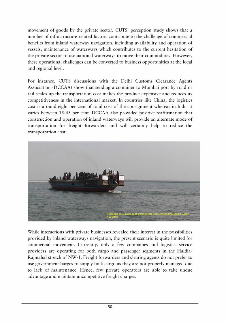
50
movement of goods by the private sector. CUTS’ perception study shows that a
number of infrastructure-related factors contribute to the challenge of commercial
benefits from inland waterway navigation, including availability and operation of
vessels, maintenance of waterways which contributes to the current hesitation of
the private sector to use national waterways to move their commodities. However,
these operational challenges can be converted to business opportunities at the local
and regional level.
For instance, CUTS discussions with the Delhi Customs Clearance Agents
Association (DCCAA) show that sending a container to Mumbai port by road or
rail scales up the transportation cost makes the product expensive and reduces its
competitiveness in the international market. In countries like China, the logistics
cost is around eight per cent of total cost of the consignment whereas in India it
varies between 15-45 per cent. DCCAA also provided positive reaffirmation that
construction and operation of inland waterways will provide an alternate mode of
transportation for freight forwarders and will certainly help to reduce the
transportation cost.
While interactions with private businesses revealed their interest in the possibilities
provided by inland waterways navigation, the present scenario is quite limited for
commercial movement. Currently, only a few companies and logistics service
providers are operating for both cargo and passenger segments in the Haldia-
Rajmahal stretch of NW-1. Freight forwarders and clearing agents do not prefer to
use government barges to supply bulk cargo as they are not properly managed due
to lack of maintenance. Hence, few private operators are able to take undue
advantage and maintain uncompetitive freight charges.

51
It was also noted by private sector actors that in order to create an efficient supply
chain eco-system in India, it is vital to identify and develop waterways linkages
with industrial development corridors, such as connecting NW-1 with the
Amritsar-Kolkata Industrial Corridor. For its part, the IWAI has identified six-
seven locations on the Ganga for Ro-Ro facilities. Connection with industrial
corridors coupled with appropriate transport facilities could help in creating ideal
national supply chain network through combination of inter-modal and multi-
modal junctures to reduce overall logistics cost.
The representative of B.V.C. Logistics (a leading company which provides logistics
services in India) shared that the clients from Northern India (Delhi, Haryana,
Rajasthan, Punjab, Uttar Pradesh, Himachal Pradesh etc.) are less interested in
sending cargo through eastern side of India; instead they prefer to send through
Mundra port in Gujarat mostly in containers via road. Also, they are not aware of
advantages and cost benefits of using waterways for transportation.
With regard to NW-2, there is no observable dedicated cargo that could be
transported through the Brahmaputra other than ODC. At present in Assam,

52
Pandu is the only port on NW-2 that has a cargo handling facility, multimodal
connectivity (rail, road and air connectivity), and storage capacity.
Another impediment to developing waterways on Brahmaputra is that, unlike on
the Ganga, there were no identifiable commercial industries along the
Brahmaputra. Absence of return cargo from the north east region, partly due to
low traffic of operators in states such as Assam, no cargo would move through
NW-2. Furthermore, conflicting interests and political turmoil were witnessed in
Assam with the trucking lobby that have also contributed to the negligence of
waterway development for transport.
Currently, the number of vessels plying through national waterways is limited,
resulting in low commercial activity in Ganga and Brahmaputra. Traders prefer
vessels built in Bangladesh as these vessels are of suitable size and the fuel cost is
lesser compared to big Indian vessels. Most of the vessels and machineries are
purchased from Europe and Calcutta and thus if a spare part breaks or
malfunctions, operators have difficulty in procuring the exact part from the
manufacturer. The end result is quite often that the vessels or machinery is kept
unused and eventually rots away.14
While the private sector has shown interest in using inland waterways for their
business, partly as a result of their inclusion in government consultations,
representatives have indicated the current situation has not enticed them to invest
yet and they prefer to wait to see how development of waterways is perused. This
is significant because of the enormous amount of investment required for
development of fairways, terminals, low draft vessels, loading -unloading facilities
and warehouses. For fairway development, IWAI has initiated an international
competitive bidding and there is a tender process for terminal development.
Foreign direct investment (FDI) may come at some point, as well, if there is
significant progress and scope in the development of inland water transport. IWAI
has also shown interest in PPP models to meet development needs, as well.
14 The current status of vessels at Patna is available at: http://iwai.nic.in/showfile.php?lid=982

53
It was also noted that the potential of goods transport by inland waterways at
local level, i.e. between states (Dhubri (Assam)-Phulbari (Meghalaya)) or within
state (for example: Hajipur-Patna) has to be exploited to its fullest. Small
mechanised commercial boats in Dhubri can carry about 18 tonnes and
transportation via waterways is much cheaper than roadways. As shared by the
boat association members at Dhubri, distance between Mankachar and Dhubri is
covered in 4 hours via waterways whereas by road it will take about 8 hours.
Boats can carry double the capacity of truck (18 tonnes for boat and 9 tonnes for
truck) with a cost of INR 97 per quintal. The cost of transportation by truck will
be as high as INR 165 per quintal.
This underlines the fact that local trade can boost the economic development of
local areas as well as add volume to the total trade occurring on the national
waterways. For this, commodities with trade potential have to be identified and
vessels have to be designed accordingly.

54
Engaging with Academia
The discussions with hydrologists, academia and subject experts have revealed that
main challenges in inland navigation are maintaining required depth for
navigation throughout the year owing to reduced water during lean season and
heavy sedimentation. A channel width of 45 metre and 2.5 metre depth needs to
be maintained for uninterrupted vessel movement through waterways; a depth of
2.5m can carry 1000 MT cargo. In NW-1, the desired of 2.5 metre is maintained
only between Farakka and Haldia (in this stretch the depth is 3 metre) resulting in
very little vessel movement at the upper end. With regard to NW-2, a depth of 2.5
metre is maintained from Bangladesh border to Nimati, 2 metre from Nimati to
Dibrugarh and 1.5 metre from Dibrugarh to Sadiya. The depth declines in the
upstream areas as the discharge decreases.
As of now, IWAI resorts to dredging and bandalling to maintain LAD for
navigation. Dredging is done only at those locations where the depth is very less
as well areas in those areas where bandalling is not effective. The interviews with
experts also revealed that dredging is not a feasible option in Brahmaputra owing
to the following reasons:
Dredging can be done only below water level, in Brahmaputra, the
sedimentation occurs even above water level where dredgers cannot operate
instead bulldozers are required to clear the sand.
Sediment rate is very high in Brahmaputra, the river changes its course too
often making it difficult to maintain a single channel for navigation through
dredging.
River has a natural gradient; dredging at the upper end would increase the
slope and velocity of water flow and the implications of such change in
gradient have not been studied as of now.

55
It is important to understand the nature of river before any interfering with its
natural course. Lack of long term hydro morphological data makes it difficult to
realise the behaviour of flow and sedimentation. Shifting channels and flash floods
have made construction of permanent terminal a challenge in NW-2. In Silghat,
Joghighopa, Hatsingimari (NW-2) the entire area identified for terminal was
engulfed and swept away by the water flow in the river. Need for proper disaster
management plan and mandatory GPS tracking system in all vessels were also
suggested by experts to address the safety and security concerns.
Rejuvenating Governance for Navigation
Navigation governance in India is a multi-spoked wheel which is yet to start
moving. While the concept of national waterways has been set in motion, the
various other spokes of infrastructure, terminal building, state governance bodies
etc. are yet to be implemented.
For instance, state governments in Uttar Pradesh and Bihar do not have separate
departments for waterway management. The post-colonial body of CIWTC had
offices at Varanasi, Bhagalpur and Patna. The CIWTC was disbanded and
replaced with the IWAI, but when responsibilities changed, so did mandates.
While IWAI’s functions are limited to terminal development, fairway development
and waterway maintenance, the primary functions of a state-level inland water
transport department are absent in Uttar Pradesh and Bihar. The end result is that
boats in these two states are still being registered with the respective department of
transport.
56
Other governance concerns have also cropped up given the trans-boundary aspect
of trade and connectivity through inland waterways. For example, at Dhubri,
Assam it was observed that the smuggling of diverse set of goods (like cloth
material, cumin (jeera), spade, wine etc.) was rampant on the waterways, near
borders. The Land Customs Station (LCS) at Dhubri steamer ghat has an efficient
system of seizing, valuating and cataloguing goods at the Dhubri go down. The
seized goods which are valued less than INR 50000 are auctioned at Dhubri LCS,
however goods above the value of INR 50000 have to be sent to the
Commissionerate of Customs (Preventive) for North Eastern Region at Shillong
for e-auctioning. But currently the Dhubri office is not equipped with enough HR
to handle both land and waterway customs, so if high-value seized goods from
waterways have to be auctioned, then a separate admin desk is required.
Enhancing People-to-People Connectivity
Inland waterways are an integral part of day-to-day life of people dependent on
rivers for their livelihood. This is particularly important in the case of those who
live in chars and sarpots where water transport is the cheapest and only means of
transportation. Ferry services across the river are offered by state water transport
departments in states of West Bengal and Assam while in Bihar it is done by
unorganised sector.
Other than basic transportation services, Assam state also sets an example for
offering health services via waterways. Emergency ambulances are 7provided in
some of the ghats under state government. Centre of North East Studies & Policy
Research (CNES) has been providing basic health care services to the flood
vulnerable population living on the Brahmaputra islands through specially
developed boats equipped with OPD, laboratories on board as well as pharmacies.
Similarly, owing to the traffic congestion in Patna, there is ample scope in Bihar
for ambulance services from Kaunhara (Sonepur), Doriganj (Chapra), Kacchi
Dargah (Patna) and Bidupur (Hajipur) areas to Patna. All these areas are
connected to Patna via road, but the traffic and dismal conditions turn a 45-
minute ride to more than three-hour ride. If inland waterways from these points to
Gaighat (Patna) were developed, then the same journey can be safely covered in 45
minutes. The state government has been scoping for such facilities for some time
now, but has not been able to attract investment.
Furthermore, across the Gandhi ghat in Patna is the Konhara ghat in Hajipur from
where many farmers and traders bring their agricultural produce daily to the Patna
markets. Most of them use their own dinghy or smaller boats to cross the river. If

57
a regular government ferry service could be arranged at an acceptable rate, then
the load on the roads would also be reduced. The small traders and farmers would
also get a respite from the cumbersome roadway transportation costs for their
daily products.
Box 4: Life in Char (Flood vs Erosion)
Chars in Brahmaputra are small islands formed by alluvial deposits in the mid
channel. In Dhubri district alone, which is lower Assam, there are a total of 480
small and big chars with human settlements. The char areas are highly prone to
erosion along the upstream side whereas there is sedimentation in the downstream
areas causing migration to downstream whenever land is eroded. Majority of the
people residing in char areas are Bengali speaking Muslims.
Birsingh Char Part III is one such chars in Dhubri district situated 1 km east of
Jogomaya ghat in Dhubri town. The day-to-day life and livelihood of the people
living here is linked with the small motorboats plying between the char and Dhubri
town. We interacted with few families in a new settlement. The men were mostly
engaged in wage labour (push cart/rickshaw puller/agricultural labour). The wage
rate is 250-300 per day. Though, each family had ration card and job card (under
MGNREGA) but they have never benefitted from the job card.
Agriculture, dairy, fisheries and poultry are other sources of livelihood of the people
in this Char. Rice, mustard and black gram are main crops grown whereas beel
(lake/wetlands) fisheries is the common type of fisheries found in chars. Water
transport is the only mode of conveyance for the inhabitants to take their produce to
market in Dhubri.
Women are busy with their caretaker role and household chores. School, local
market and government dispensary were found about 3 km away from their
settlement. Still, we found children using the ferry to go to school in Dhubri. They
say “the teacher of the school in char comes once in a week and does not provide
Mid-day Meal. Hence, we go to Dhubri”.
The normal ferry charge to Dhubri is INR 5, but at the time of medical emergencies
during night, the rate goes up to INR 700-800. Thanks to the mobile connectivity,
that they can give a call to the local cab driver during emergencies so that he will take
the diseased to the ferry in the ghat. The ghats in BirSingh char are under the purview
of village panchayat.
There is one tube well for every three households installed by inhabitants for the
purpose of drinking water. But iron toxicity is a problem as mentioned by
respondents.

58
The people in char have accustomed to annual floods. With practically no flood
warning system from the government, they shift their settlement judging the water
level. The relief package from the government is also nominal. They use boats
(country boats and rafts) for conveyance. Rather they find it is easier using boats
during floods than walking kilometres to the ghat to get ferry. They have to do extra
labour to fetch their source of living. But erosion is the bigger threat for them. Flood
water recedes after three-four days (sometimes it stays up to one month) whereas
erosion takes away the whole land.
Box 5: Bridge vs. Waterways
Waterway is the single mode of transport to connect Majuli, the largest river island in
Assam to the nearest district Jorhat. There are nine ghats in Majuli of which only two
(The Kamalbari and Aphalamukh ghats are under the jurisdiction of the Inland
Water Transport Department, the rest being under the purview of the local
panchayats. Till 2016, the island was part of Jorhat district and the local people had
to use ferry to reach Jorhat for administrative work. The island is constantly under
the threat of erosion; agriculture is the main occupation of the people living in the
island. The loss of agricultural land has forced people to look out for other livelihood
options. Women are mostly engaged in household work and in weaving. Men in the
family go for wage labour as alternate livelihood.
Fishing is another important source of income of the local people. The small ponds,
wetlands and depressions gets filled with water during floods and become the fish
rearing area. There is great demand for local fish within and outside Majuli.
Access to market is the key hindrance in the economic development of people in
Majuli. Whether it is fish or the traditional handloom products, the traders have to

59
come to the island to buy them. Sometimes women cooperatives set up stalls/small
counters in exhibitions/mela in Jorhat. Majuli is a culturally significant location
especially for the Vaishnava section of Hindu religion. The months of November-
February are the peak period of tourism which has also increased the business
opportunity of handloom products.
“If we have to buy something from Jorhat, the price is high on account of
transportation charges but we don’t get better price for our produce since there is no
direct access to market. The traders come here and fix the price” says Bibidas, 27-
year-old housewife in Kamalabari. Her family owns around four bigha land, wherein
they grow mustard and rice (bao-dhan- a traditional deep water paddy variety).
Other than agriculture, her husband is engaged in fishing in the wetlands and natural
ponds. He also does wage-labour(@INR 250/day). There is significant difference in
the wage rate for women (INR 50-100) and men and hence women prefer to work
under Mahatma Gandhi National Rural Employment Guarantee Scheme
(MGNREGA). “Better connectivity can improve our life,” she says. “Bridge
connectivity will be extremely helpful particularly during medical emergencies when
we have to pay high for the ferries.”
Thanu Krishna Dutta from Garmur, Majuli has a different perspective. Majuli’s
unique land feature and its rich culture and biodiversity have gained the attraction of
tourists. “To conserve and protect its unique identity, water transportation has to be
developed” he says. “Small boats or even water taxi should be there in every 15
minutes so that people need not have to wait for more than 30 minutes”. This is
contradictory to the point of view of youth and women who see bridge as the means
of economic and social development.
Majuli is connected to Lakhimpur via road. For those who travel to upper Assam, a
ferry to Majuli and then road transport saves much time rather than direct road
transport from Jorhat to Lakhimpur. This also has enhanced the number of
passengers availing ferry services from Nimati ghat to Majuli.

60
5. Challenges and Recommendations
The diagnostic study has enabled in identifying the key challenges and
recommendations in developing inland waterways with regards to NW-1 and NW-
2. This chapter presents challenges faced in developing waterways, opportunities
that lie ahead and also delineate some recommendations to change those
challenges into opportunities.
Challenges in Developing Waterways
One of the major challenges faced by the authority is to maintain the minimum
depth and permanent channel for navigation in both Ganga and Brahmaputra
rivers. Heavy siltation in rivers necessitates river training measures like dredging
and bandalling but do not offer a permanent solution despite adding costs. The
current discourse does not lay stress on storage structures without which it is
difficult to maintain LAD during lean season.
Water transport system faces competition from other modes of transport especially
by road and rail transport systems. Enhancing competitiveness of water transport
sector through infrastructure development and night navigation aids would make
this sector more attractive. In Brahmaputra, strong current of the river makes
installation of the night navigation system a difficult task. Right now, night
navigation facilities are there up to Silghat. On an average the boat sails for 14-15
hours per day. Considering the fact that the speed of vessels is not more than
30km/hour, night navigation is crucial to save time for transportation and make it
economically viable. Apart from this, there are issues of multiple bridges on the
river with low vertical clearance and thus creates obstruction in inland water
navigation of large vessels.
Lack of research data on sedimentation and discharge (hydrological data), waste
generation due to movement of vessels and its management, cost benefit analysis
of inland navigation on specified routes are all challenges that restrict the
development of a comprehensive plan for sustainable inland navigation.
Bulk movement of cargo in large scale would also raise security and safety
concerns. IWAI has initiated tracking of vessels using Differential Global
Positioning System (DGPS). The River Information System which is a kind of
modern tracking equipment to optimize traffic and transport processes in inland
navigation has been installed in Haldia-Farakka stretch. RIS aims to streamline the
exchange of information between waterway operators and users. The Phase II and

61
III will cover the stretch Farakka to Patna and Patna to Varanasi, respectively. All
information regarding the vessel and the is fed into RIS.
Low of volume of trade is a major challenge which also questions the scale the
investments for infrastructure developments. Lukewarm interest of private sector
shows that inland water transport is yet to entice the sector in terms of its
potential to enhance competitiveness of trade at reduced costs.
A further constraint involves the regulatory gap between the central government’s
national inland waterway acts and the administrative responsibilities of state
governments and their varied governing structures. In this context, uniform or
model rules for inland waterways navigation administration is the need of the
hour.
Issues related to governance are other hurdles in realising the prospect of inland
navigation. Though Ministry of Shipping is the apex ministry for inland
navigation, Ministry of Water Resources and Ganga Rejuvenation, Ministry of
Environment Forests and Climate Change, Ministry of External Affairs, Central
Board of Excise and Customs and Ministry of Tourism are involved in the whole
developmental paradigm of inland waterways in the context of meeting sectoral
demands of water, environmental clearance, cross border vessel movement and
river tourism respectively. However, there is a need for better coordination
between these ministries at the Central and state level.
Despite the potential of local transit and trade at various locations in the states of
Bihar and Uttar Pradesh there is no dedicated inland water transport department
in these states. Separate departments would have led to proper enforcement of
various functions like registration of boats, ferry services and tax collection adding
revenue to the state and benefit local people.
Discussion involving local riverine communities revealed that the current policy
discourse on inland waterways is not inclusive and local communities feel that
they are left behind the developmental process. It is important to engage local
communities in all interventions for developing inland waterways to make it a
people centric process.
Recommendations
Keeping in view of the diversity of the challenges related to inland navigation, it is
to be noted that the strategies for revamping inlands navigation in India have to be
multipronged so as to harness its potential for enhancing trade and connectivity to
the fullest. Given below are the recommendations under various heads

62
Governance and Institutional Strengthening
Better coordination among relevant ministries at the Central and state levels
as well as between IWAI and Bangladesh Inland Water Transport Authority
(with regards to the India Bangladesh Protocol Route) through formal
channels is imperative while envisaging sustainable development of inland
waterways.
Address the regulatory gap between the Central government’s National
Inland Waterways Act and the administrative responsibilities of state
governments and their varied governing structures. In this context, uniform
or model rules for inland waterways navigation administration is the need
of the hour especially for those states falling under national waterways.
With regard to IBP route between India and Bangladesh, the MoU on
protocol route is signed under the Trade Agreement and and hence it is
poses some restrictions for amendments for further inclusions of other
services like tourism, local trade etc. All relevant ministries of both
countries should have representation in the Standing Committee of
Protocols.15 The ambiguities around the management of waterways falling
under no man’s area near international borders have to be sorted out
through an open and transparent discourse between relevant authorities in
both countries.
Ensuring full-fledged customs and immigration facilities at entry and exit
points of India and Bangladesh would reduce the cumbersome regulations
involved in customs checking at multiple points in foreign country while
transit.
Adequate human resources at customs stations are essential in the context
of increased vessel movement and passenger cruises.
Assuring Commercial Viability
Identifying stretches and commodities (on demand-base) with trade
potential within and between states and designing vessels accordingly.
IWAI aims to maintain 2.5 metre as LAD throughout the year which is not
practical in many locations. A more realistic depth of 1.5 metre can be
maintained year round in NW-1, which demands barges of appropriate
sizes. This would also lead to rationalisation of costs, as for big barges
(2000 MT capacity), the investment costs are high while the operational
costs remain low which is contrary in case of barges of smaller capacity
(750 MT).
15Information gathered from 2nd Bangladesh-India Joint Consultation organised by IUCN, Kolkata May 30-31, 2017

63
Boosting the unorganised sector to conduct trade in smaller stretches cross
the immediate borders between states and national borders through
adequate policy support will substantially enhance the trade volume in NW
and IBP. For example, the stretch between Dhubri, Assam and Chilmari,
Bangladesh has lots of potential for cross border trade using small
mechanised boats as the depth of water during lean season will go down to
less than 1m which makes big vessel movement impossible. Subsidies for
country boats will also rejuvenate and promote local transport and trade
and benefit the unorganised sector.
Multimodal and intermodal linkages of waterways within India and
between India- Bhutan and India- Nepal will result in a more realistic and
economically viable approach to improve connectivity in the sub-region.
Enticing Private Sector
Enhancing competitiveness of water transport sector through infrastructure
development and night navigation aids will attract private sector.
Terminals, warehouses, loading and unloading facilities, cold storages and
advanced navigation aids would enable waterways for day and night
navigation aids would make this sector competitive with other modes of
transport.
IWAI has limited number of subsidies for private sector for vessel building
and upgradation of few inland vessels to river sea vessels would lead to the
integrating inland waterways and coastal shipping.
Mandatory GPS tracking for vessels for assuring safety and security,
Providing concrete data on cost benefit analysis of trade via waterways will
establish the credibility among private traders.
More flexibility for tour operators in terms of designated routes, jetties and
disembarkation points in case of cross border tourism between India and
Bangladesh along IBP route and providing necessary infrastructure of
berthing and emergency services.
Introduce mechanised/hydraulic dismantling and assembling system for
pontoon bridges for passage of vessels.
Ensuring Sustainability
Mandatory social and environmental impact assessment for activities
related to development of waterways including dredging and vessel
movement along the entire stretch of the waterways
Comprehensive disaster management plan and pollution control measures
in case of emergencies/accidents
Adoption of green standards by cruise operating tourism companies with
regards to waste management and pollution control
Embankment protection to reduce erosion threats due to vessel movement

64
Mapping of fish breeding sites for least disturbance due to developmental
activities for inland navigation
Knowledge Generation/Research
Data on flow and sedimentation; impact of vessel movement on aquatic
biodiversity, waste generation due to vessel movement are indispensable for
comprehensive planning for developing inland waterways. Equally important is
the economic and environmental modelling to understand the scenarios of trade
through waterways and its impact on environment over a period of time. Hence,
long term hydro-morphological studies and scenario building exercises are
absolutely necessary for prospective planning. Joint studies by the riparian
countries and data sharing will facilitate cooperation at sub regional level for the
development of inland waterways.
Engaging Local Communities
Engaging local people in river training, disaster management, freight
handling and other services will supplement their livelihoods.
Capacity building and skill development in hospitality will enhance
livelihood opportunities in the tourism sector.
Establishing crew training centres at state level will facilitate training of
local people to interpret sophisticated river information and GPS readings.
Way Forward
The yearlong project has been able to provide an overview of inland navigation
along NW-1 and NW-2 from the point of view of trade, connectivity, tourism and
livelihoods. The project was also successful to bring in the concerns of local
communities as a result of IWT development. Sub-national Dialogues in Varanasi,
Patna, Kolkata and Guwahati provided a platform to community representatives
to voice their livelihood related concerns directly in the presence of government
officials. The challenges and opportunities mentioned in the above section with
respect to trade, tourism, livelihoods and larger connectivity within the region also
throw light on the kind of strategies that have to be adopted to make inland
navigation economically viable.
In line of this, four potential areas of future interventions are given below:
Exploring prospects of local trade within shorter stretches within and
across national borders would definitely improve the local economy as well
as contribute the trade volume along national waterways and India
Bangladesh Protocol route

65
Assessing the needs of riverine communities through more inclusive
consultations at ground level would ensure their participation in the
development paradigm of inland navigation and contribute to their
livelihoods
Estimating economic prospects of river tourism is another promising area
as it generates revenue and provides livelihood for both skilled and
unskilled labour
Futuristic studies or scenario building exercises on economic viability and
sustainability of developing waterways would inform decision making,
considering the scale of investment required and the stiff competition from
other modes of transport

66
Bibliography
Ahmed, Mahboob. “A study on Indian participation in the Protocol of Inland Water Transit & Trade (PIWTT).” High Commission of India in Bangladesh. 2017. https://www.hcidhaka.gov.in/pdf/A%20study%20on%20Indian%20participation%20in%20the%20PIWTT.pdf.
BIWTA. “Cargo trade under PIWTT.” Bangladesh Inland Water Transport Authority. 2017. http://www.biwta.gov.bd/site/page/e9b3ec96-b908-402f-bec8-e7171d927a9d/Statistics.
CUTS International. “Development of inland waterways for trade and transit in BBIN.” April 2016. http://www.cuts-citee.org/SDIP/pdf/Advocacy-Development_of_Inland_Waterways_for_Trade_and_Transit_in_BBIN.pdf.
GoI. “India Transport Report: Moving India to 2032.” Planning Commission, Government of India. 17 June 2014. http://planningcommission.nic.in/sectors/index.php?sectors=National%20Transport%20Development%20Policy%20Committee%20%28NTDPC%29 (accessed April 25, 2017).
IWAI. “Annual Report of 2015-2016.” 2016. http://iwai.nic.in/showfile.php?lid=1042.
—. “Cargo movement for NW-1,2 & 3.” Inland Waterways Authority of India. March 2017. http://iwai.nic.in/showfile.php?lid=1039.
—. “Integrated national waterways transportation grid study.” Inland Waterways Authority of India. April 2014. http://iwai.nic.in/index1.php?lang=1&level=3&sublinkid=1006&lid=933.
—. “Jal Marg Vikas Project - FAQs.” 2017. http://iwai.nic.in/showfile.php?lid=864 (accessed January 25, 2017).
—. “National waterways.” Inland Waterways Authority of India. 2016. http://iwai.nic.in/index1.php?lang=1&level=1&sublinkid=124&lid=143 (accessed September 15, 2016).
Lok Sabha. “ Selected State-wise Total Revenue earned from national waterways in India (2012-2013 to 2015-2016).” Lok Sabha Unstarred Question No. 1837. 30 July 2015. https://www.indiastat.com/table/transport/30/financialprogressundershippingandports19512016/449992/941440/data.aspx.
MoS. “State-wise projection of cargo and passenger movement.” Ministry of Shipping Transport Research Wing, Government of India. (ON1363) & Past Issues. 2016. https://www.indiastat.com/transport/30/waterways/18157/stats.aspx.

67
MoS. Statistics of Inland Water Transport. New Delhi: Transport Research Wing, Ministry of Shipping, Government of India, 2016.
MoSPI. “Statistical Yearbook.” Ministry of Statistics and Programme Implementation. 2014. http://mospiold.nic.in/Mospi_New/upload/SYB2016/index1.html (accessed January 25, 2017).
Nagabhatla, N., and P. Jain. “Assessing the potential role of inland water navigation for green economy.” Journal of Environmental Professionals Sri Lanka 2, no. 1 (2013): 25-37.
PIB. “Cabinet approves dissolution of Central Inland Water Transport Corporation Limited.” Press Information Bureau, Government of India . 31 August 2016. http://pib.nic.in/newsite/PrintRelease.aspx?relid=149374 (accessed January 25, 2017).
—. “Jal Marg Vikas Project.” Press Information Bureau, Government of India . 16 March 2017. http://pib.nic.in/newsite/PrintRelease.aspx?relid=159372.
World Bank. “Developing India's first modern inland waterway.” The World Bank Brief. 12 April 2017. http://www.worldbank.org/en/country/india/brief/developing-india-first-modern-inland-waterway (accessed April 25, 2017).

68
Annexure 1 Progress of projects on NW-1, NW-2 and north-eastern states of India
Sr. No.
Projects in NW-1, NW-2 & Northeast States
Progress
1. MMT Varanasi under JMVP in NW-1
Land Acquisition for Phase 1 completed Phase II partial land acquired and rest under process Phase 1 construction under progress EIA, EMP, SIA, RAP completed jointly by consultancy companies- M/s. EQMS India Pvt. Ltd., M/s. Abnaki Infrastructure Application & Integrated Development Pvt. Ltd. and IRG Systems South Asia Pvt. Ltd. Completion Deadline: Phase 1 by August 2018 Project Cost: INR 169.7 crore Tender awardee: M/s AFCONS Infrastructure Ltd.
2. MMT Sahibganj under JMVP in NW-1
Land Acquisition completed Construction under progress EIA, EMP, SIA, RAP completed All environmental clearance obtained Completion Deadline: April 2019 Project Cost: INR 280.90 crore Tender awardee: M/s Larsen & Toubro Ltd.
3. MMT Haldia under JMVP in NW-1
Land Acquisition completed Construction not started EIA, EMP, SIA, RAP completed Awaiting MoEFCC’s decision on Costal Regulation Zone (CRZ) clearance Completion Deadline: June 2019 Project Cost: INR 517.36 crore Tender awardee: M/s ITD Cementation India Ltd.
4. Farakka Navigational Lock under JMVP in NW-1
Land Acquisition completed Construction under progress EIA, EMP, SIA, RAP completed All environmental clearances obtained Completion Deadline: May 2019 Project Cost: INR 359.19 crore Tender awardee: M/s Larsen & Toubro Ltd.
5. IMT Kalughat under JMVP in NW-1
Land Acquisition decision pending Detailed Project Report (DPR) under progress
6. IMT Ghazipur under JMVP in NW-1
Land Acquisition decision pending Geotechnical investigation under progress
7. Ro-Ro Terminals under JMVP in NW-1
DPRs of five pairs Ro-Ro terminals under progress

69
Sr. No.
Projects in NW-1, NW-2 & Northeast States
Progress
Feasibility studies for another five terminals under progress
8. Integrated Vessel Repair & Maintenance Complexes under JMVP in NW-1
Feasibility study under progress for Kolkata
9. Ferry Terminals in NW-1 18 ferry terminals planned to be constructed by IWAI in six cities DPRs under preparation Techno economic feasibility studies undertaken by MIT and Thomson Group
10. Dhubri Ro-Ro Floating Terminal in NW-2
Construction completed Project Cost: INR 46 crore Tender Awardee: M/s Tribeni Construction
11. Jogighopa Terminal in NW-2
Presently an operational floating terminal Requisition for conversion to permanent terminal under progress
12. Pandu Terminal in NW-2 Presently an operational floating terminal with a low level jetty and two godowns
13. Hatsinghimari Ro-Ro Terminal in NW-2
Land acquisition completed DPR under preparation Construction not started
14. Pandu Ship Repair Complex in NW-2
Repair complex under construction Project cost: INR 52.94 crore
15. LAD of 3m and bottom channel width of 45m on the Farakka-Kahalgaon stretch (146 Kms) in NW-1
Proposal Appraised by West Bengal State Finance Commission (SFC) Consultants: Joint venture of M/s Howe Engineering Projects (India) Pvt. Ltd., M/s HR Wallingford Ltd and M/s PMC Projects (India) Pvt. Ltd. Project Cost: 163.93 crore
16. LAD of 3 m and bottom channel width of 45m on the Sultanganj-Barh (145 kms) stretch in NW-1
Tender process in progress Project Cost: Not determined
17. LAD of 2.5 m and bottom channel width of 45m on the Barh-Doriganj stretch (109 kms) in NW-1
Tender process in progress Project Cost: Not determined
18. LAD of 2.5m and bottom channel width of 45m on the Doriganj- Ghazipur stretch (178 kms) in NW-1
Tender process in progress Project Cost: Not determined

70
Sr. No.
Projects in NW-1, NW-2 & Northeast States
Progress
19. LAD of 2.2m and bottom channel width of 45m on the Ghazipur- Varanasi stretch (133 kms) in NW-1
Tender process in progress Project Cost: Not determined
20. LAD of 2.5m depth in Dhubri – Neamati stretch in NW-2
Maintained by IWAI in regular intervals
21. LAD of 2m depth in Neamati –Dibrugarh stretch in NW-2
Maintained by IWAI in regular intervals
22. LAD of 1.5m depth in Dibrugarh - Sadiya stretch in NW-2
Maintained by IWAI in regular intervals
23. IWT in river Gumti/Gomati at Tripura under CSS
DPR completed Estimated Project Cost: INR 12.59 crore Construction in progress under full CSS subsidy
24. IWT in Loktak Lake at Manipur under CSS
DPR completed Estimated Project Cost: INR 7.88 crore Constructed completed in March 2014 under full CSS subsidy
25. 17-metre-long floating terminals at 20 places on the Brahmaputra river in Assam under CSS
Completed under full CSS subsidy
26. 17-metre-long floating terminal pontoons at 15 places on the Brahmaputra river in Assam under CSS
Completed under full CSS subsidy

71
Annexure 2 Other Relevant Policies, Acts, Rules and Regulations
Sr. No.
Act/Policy/Rule/Regulation Description Status
1. Bengal Ferries Act, 1885 This Act lays down rules and procedures of operating ferries/boats on inland waterways in the States of West Bengal, Bihar and Odisha. Under the power conferred to the state governments to amend the clauses of the Bengal Ferries Act, the State Government of Orissa in 2004 implemented the Orissa Boat Rules, 2004 while the Government of Bihar in 2011 implemented the Modal Rules, 2011 with lays down procedures for boats/ferries registration and licencing
Enacted
2. The Northern India Ferries Act, 1878
This act lays down rules and procedures of operating ferries/boats on inland waterways in Uttar Pradesh, Punjab, the Central Provinces, Assam, Delhi and Ajmer (regions before India’s independence)
Enacted
3. The Regulations on Cargo & Traffic in Inland Ports on National Waterways, 2012
The documents lays down several regulations on non-dangerous and dangerous cargo and traffic operating on inland ports of National Waterways
Enacted
4. Prevention of Collision on National Waterways Regulations, 2002
These regulations lays down several rules for prevention of collision of inland vessels in National Waterways
Enacted
5. National Waterways, Safety of Navigation and Shipping Regulations, 2002
These regulations lays down several rules with regards to the safety of vessels plying in National Waterways
Enacted
6. Major Port Authorities Act, 2016
Replacing the Major Port Trusts Act, 1963, this act lays provision to provide full flexibility and working autonomy for 12 major ports in India namely Chennai, Cochin, Jawaharlal Nehru Port, Kandla, Kolkata, Mumbai, New Mangalore, Mormugao, Paradip, Chidambaranar, and Vishakhapatnam. The Major Port Authorities Bill, 2016 was introduced in the Lok Sabha on December 16, 2016 with an aim to provide more autonomy and flexibility to the above mentioned 12 major ports
Pending

72
Sr. No.
Act/Policy/Rule/Regulation Description Status
with regard to power of boards, tariff collection and other financial power, penalties and so on.
7. The Merchant Shipping (Second Amendment Bill) 2013
This amendment adds new provisions to the Merchant Shipping Act, 1958 to comply with the International Convention for the Control of Harmful Anti-Fouling Systems on Ships, 2001. The Convention is aimed at protecting the marine environment and human health from adverse effects of anti-fouling paints used to coat the ships’ surfaces.
Passed
8. Central Road Fund (Amendment) Bill, 2017
This bill has been introduced in the monsoon session of Lok Shabha on July 24, 2017 and seeks some amendments in the Central Road Fund Act, 2000. The bill proposes to allocate 2.5 per cent of Central Round Fund (CRF) for the development and maintenance of national waterways
Pending
9. The Multimodal Transportation of Goods Act, 1993
This Act lays down regulation of the multimodal transportation of goods (through road, rail, air, inland waterway, sea) from any place in India to a place outside India, on the basis of a multimodal transport contract.
Enacted
10. NW-1 Allahabad to Haldia stretch of Ganga-Bhagirathi-Hooghly river Act 1982
Before the enactment of the National Waterway Act, 2016, this Act declared the stretch from Allahabad to Haldia as NW-1
Repealed and replaced by National Waterway Act, 2016
11. NW-2 Sadiya Dhubri stretch of river Brahmaputra Act 1988
Before the enactment of the National Waterway Act, 2016, this act declared the stretch from Sadiya to Dhubri in Assam as NW-2
Repealed and replaced by National Waterway Act, 2016
A compendium of relevant act, policies, rules and regulations prepared by IWAI
can be accessed by clicking at the following link: https://dtf.in/wp-
content/files/The_IWAI_Act_1985_As_on_IWAI_website-04.08.2014.pdf

73