exploratory drilling operation at cb-onn-2005/2 (part-a &...
TRANSCRIPT

FORM-I, PROPOSED TOR
& PRE-FEASIBILITY REPORT
Submitted to: Ministry of Environment and Forests
Submitted by: Indian Oil Corporation Limited
May 2010
Exploratory Drilling Operation
at
CB-ONN-2005/2 (Part-A & B)

Form 1 EIA Study for Drilling Operation of Onshore Oil Exploration at Cambay Basin, Gujarat
SENES/D-20308/May 2010 IOCL
FORM 1
(I) Basic Information
S.No. Item Details 1. Name of the Project Drilling operations for onshore oil
exploration at Cambay Basin, block:CB-ONN-2005/2
2. S.No. in the schedule 1 (b) 3. Proposed capacity/area/length/tonnage to be
handled/command area/lease area/number of wells to be drilled
As per the Production Sharing Contract (PSC) signed, the project shall involve drilling of 4 exploration wells of 3400m depth in Phase-1 & one exploration well of 3400m depth in Phase-2 within the licensed area of 77.68 sqm, allowed by the Government of Gujarat as per the Petroleum Exploration License (PEL) issued. Exact drilling site though not determined, will typically require a lease land of 120m X 100m area.
4. New/Expansion/Modernization New 5. Existing Capacity/Area etc. Not Applicable 6. Category of project i.e. ‘A’ or ‘B’ ‘A’ 7. Does it attract the general condition? If yes, please
specify. No
8. Does it attract the specific condition? If yes, please specify.
No
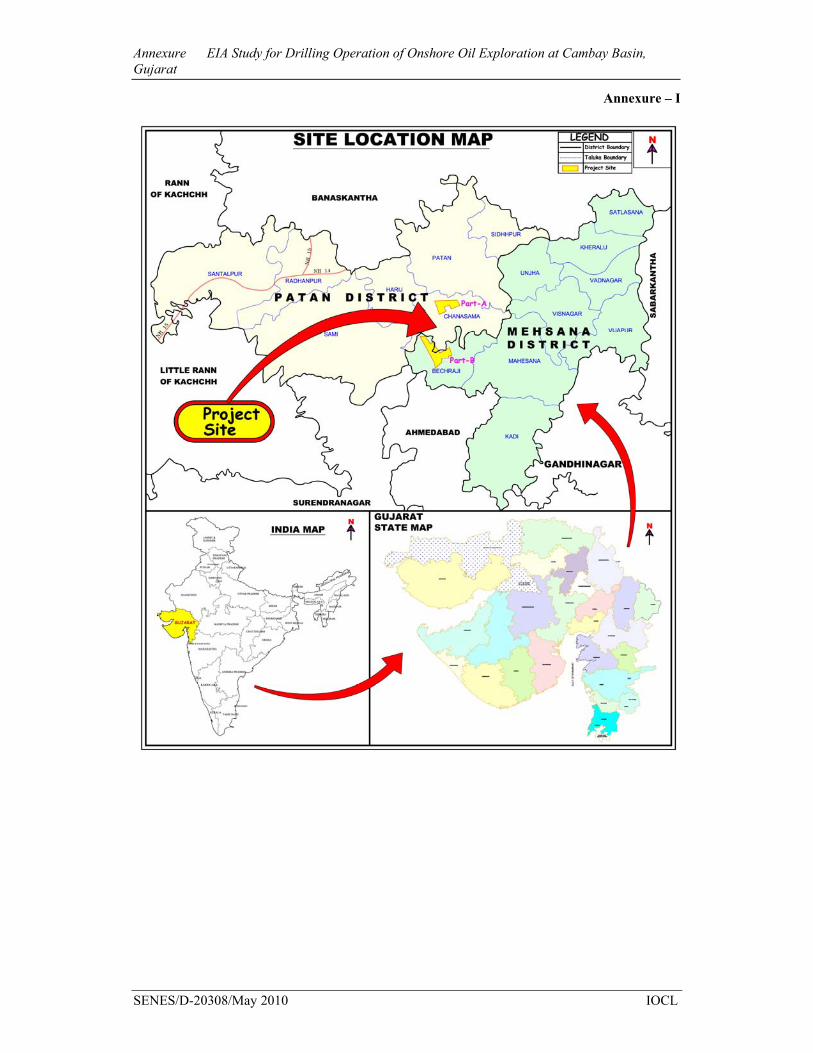
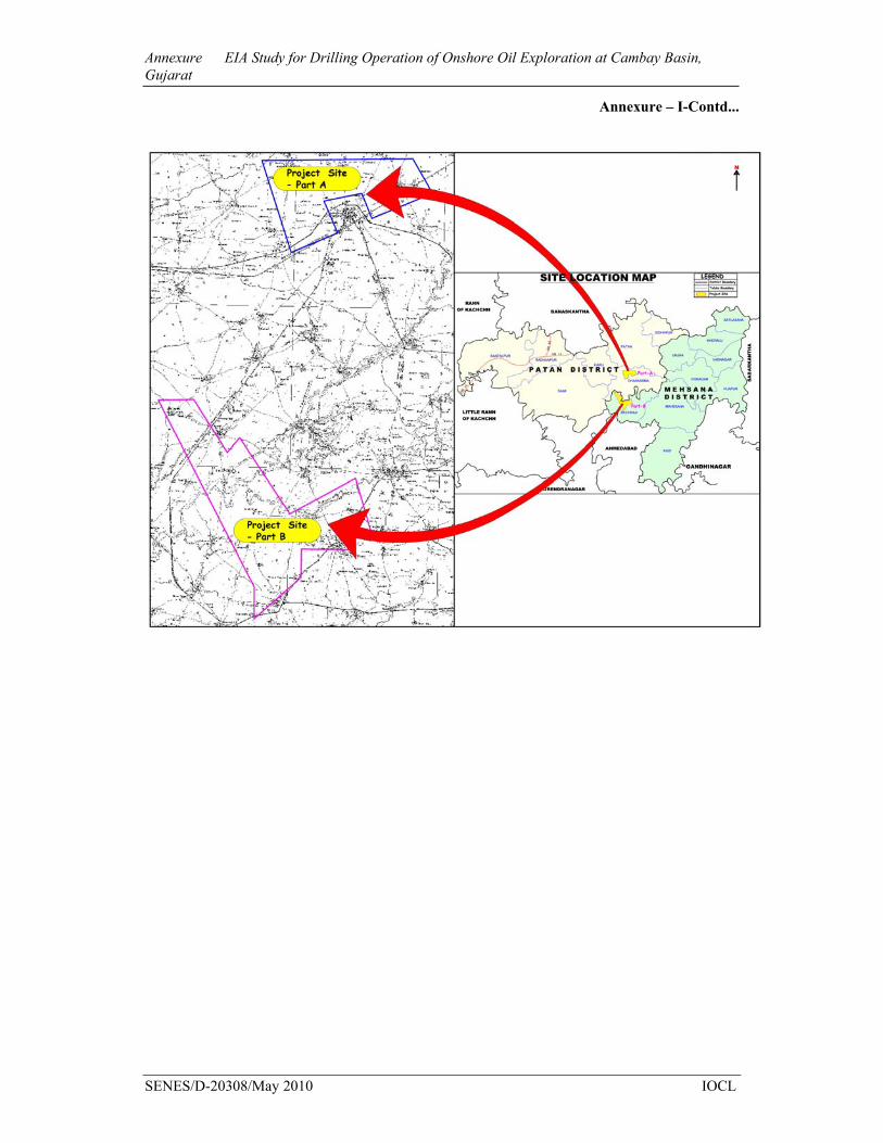
Location Since the exact drilling locations are yet to be determined, the details of the block location are provided herewith. The block is divided in two parts; namely Part-A & Part-B and fall under the districts of Mahesana & Patan respectively in the State of Gujarat. The location of the block is enclosed as Annexure-I
Plot/Survey/Khasra No. Not available, as the exact drilling locations have not been determined.
Village Part-A Block: Sevala, Sendha, Ruppur, Sardarpur, Jakhana, Jitoda, Dhanodarda, Jasalpur, Dharmoda, Sendhal Part B Block: Khambhel, Adivada, Delpura Khant, Mithi Dariyal, Mudhera, Poyda, Suanpur, Delwada, Dharpur Khant, Kalri, Ganeshpura, Sakhalpur, Endla, Dodiwada, Venpura, Ambala
9.
Tehsil Part-A: Chansama;
Form 1 EIA Study for Drilling Operation of Onshore Oil Exploration at Cambay Basin, Gujarat
SENES/D-20308/May 2010 IOCL
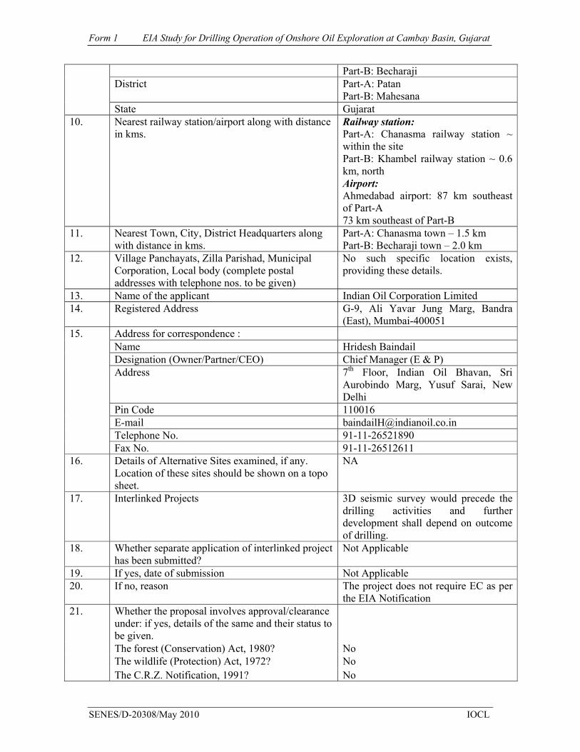
Part-B: Becharaji District Part-A: Patan
Part-B: Mahesana State Gujarat
10. Nearest railway station/airport along with distance in kms.
Railway station: Part-A: Chanasma railway station ~ within the site Part-B: Khambel railway station ~ 0.6 km, north Airport: Ahmedabad airport: 87 km southeast of Part-A 73 km southeast of Part-B
11. Nearest Town, City, District Headquarters along with distance in kms.
Part-A: Chanasma town – 1.5 km Part-B: Becharaji town – 2.0 km
12. Village Panchayats, Zilla Parishad, Municipal Corporation, Local body (complete postal addresses with telephone nos. to be given)
No such specific location exists, providing these details.
13. Name of the applicant Indian Oil Corporation Limited 14. Registered Address G-9, Ali Yavar Jung Marg, Bandra
(East), Mumbai-400051 Address for correspondence : Name Hridesh Baindail Designation (Owner/Partner/CEO) Chief Manager (E & P) Address 7th Floor, Indian Oil Bhavan, Sri
Aurobindo Marg, Yusuf Sarai, New Delhi
Pin Code 110016 E-mail [email protected] Telephone No. 91-11-26521890
15.
Fax No. 91-11-26512611 16. Details of Alternative Sites examined, if any.
Location of these sites should be shown on a topo sheet.
NA
17. Interlinked Projects 3D seismic survey would precede the drilling activities and further development shall depend on outcome of drilling.
18. Whether separate application of interlinked project has been submitted?
Not Applicable
19. If yes, date of submission Not Applicable 20. If no, reason The project does not require EC as per
the EIA Notification Whether the proposal involves approval/clearance under: if yes, details of the same and their status to be given.
The forest (Conservation) Act, 1980? No The wildlife (Protection) Act, 1972? No
21.
The C.R.Z. Notification, 1991? No

Form 1 EIA Study for Drilling Operation of Onshore Oil Exploration at Cambay Basin, Gujarat
SENES/D-20308/May 2010 IOCL
22. Whether there is any Government Order/Policy relevant/relating to the site?
No
23. Forest land involved (hectares) No 24. Whether there is any litigation pending against the
project and/or land in which the project is propose to be set up? Name of the Court Case No. Orders/directions of the Court, if any and its relevance with the proposed project.
No
(II) Activity 1. Construction, operation or decommissioning of the Project involving actions,
which will cause physical changes in the locality (topography, land use, changes in water bodies, etc.)
S.No.
Information/Checklist confirmation
Yes/No
Details thereof (with approximate quantities /rates, wherever possible) with source of information data
1.1 Permanent or temporary change in land use, land cover or topography including increase in intensity of land use (with respect to local land use plan)
Yes Temporary change in land use will take place due to development of preliminary site preparation, construction of various processing facilities, campsites etc. About 120m X 100m of land is likely tobe required for each exploration well, which will be taken on temporary lease from the concerned land owner/s. Constructions of drill sites will take approximately 80-100 days, where as drilling of each well require 90-120 days. The sites if abandoned will be restored in accordance with applicable national regulations following best management practices.
1.2 Clearance of existing land, vegetation and buildings?
Yes About 120m X 100m of land is likely tobe required for each exploration well, for which clearing of land will be needed. However, clearance of vegetation will be avoided to the extent possible.
1.3 Creation of new land uses?
Yes The drilling of exploration well may induce creation of new land use for a long period, if the drilled well is found to be economically viable for future production of oil and gas.
1.4 Pre-construction investigations e.g. bore houses, soil testing?
Yes
The detailed investigations will be carried out in terms of some initial soil testing & sub-surface profiling of soil, before commencing the actual drilling activities & related site preparation.

Form 1 EIA Study for Drilling Operation of Onshore Oil Exploration at Cambay Basin, Gujarat
SENES/D-20308/May 2010 IOCL
The investigation will entail the geological characteristics of the underground rock formation
1.5 Construction works?
Yes The major construction works for the proposed project involves the following:
• Site strengthening for positioning the drilling pad & associated drilling equipment
• Construction & preparation of exploration well to the depth of 3400m each
• Strengthening of approach roads to the site (if required) for transportation of drilling rigs & ancillary equipments
• Labour camp site 1.6 Demolition works?
No Only temporary structures viz. portable
cabins, solid control system, cementing equipments etc to be dismantled and decommissioned at the end of the drilling period.
1.7 Temporary sites used for construction works or housing of construction workers?
Yes Temporary camp site will be developed within the existing land with complete amenities and sanitation facilities for the labourers to be deployed in the site. Approximately 30-35 nos. of labour will be required for construction and will be either locally sourced or accommodated within the area taken on lease.
1.8 Above ground buildings, structures orearthworks including linear structures, cut andfill or excavations
Yes This will include: • Strengthening/construction of earthen access road wherever required. • Site strengthening for preparing the land and positioning the drilling pad. • Construction of cellar pit 1.5mX1.5mX1.5m for installation of well head and BOP • Construction of HDPE lined pit (20mX25mX1.5m) at each well site for temporary storage and disposal of drill cuttings. • Labour Camp
1.9 Underground works including mining or tunneling?
Yes Drilling of 4 explorations well to the depth of 3400m each. The well will be drilled in sections with the diameter of each section decreasing with increasing depth.
1.10 Reclamation works? Yes Once the drilling activities over, the

Form 1 EIA Study for Drilling Operation of Onshore Oil Exploration at Cambay Basin, Gujarat
SENES/D-20308/May 2010 IOCL
restoration will be carried out only for those well which would not be viable economically for production of oil & gas
1.11 Dredging?
No Not Applicable
1.12 Offshore structures? No Not Applicable
1.13 Production and manufacturing processes?
Yes
The drilling process may proved to be beneficial for production of oil & gas
1.14 Facilities for storage of goods or materials?
Yes
Temporary warehouse will be developed for storage of cementing materials, chemicals and HSD; Steel casing pipes and materials required for exploratory drilling activities; Tools and other equipments etc. The warehouse will be dismantled later on. The approximate dimension of the warehouse would be 500-800sqm, depending on the quantity of materials to be handled and stored.
1.15 Facilities for treatment or disposal of solid waste or liquid effluents?
Yes Solid Waste: Drilling mud, formation cuttings during drilling. Nearly 800MT waste drilling mud of drill cuttings is likely to be generated during each well drilling operation. In addition to this the domestic waste will be generated from the labour camp. The drilling mud cuttings and formation cuttings will be separated in the solid control system and conveyed to a specially designed pit (lined with HDPE) for temporary storage. The cuttings so stored will then be treated and disposed in accordance with CPCB regulations specified for onshore oil & gas industry. The domestic waste will be separated based on their types & will be sold through the contractors to approved municipal sites. The domestic sewage will be treated in a separate sewage treatment plant. Liquid effluent: Drilling wastewater of rig wash and produced water will generate from the

Form 1 EIA Study for Drilling Operation of Onshore Oil Exploration at Cambay Basin, Gujarat
SENES/D-20308/May 2010 IOCL
process of exploratory drilling. The domestic waste water and sewage from labour camp will also be generated. The domestic waste water from the labour camp will be treated in septic tanks & soak pits.
1.16 Facilities for long term housing of operational workers?
No Temporary labour camp or pota cabin will be used for the officials of the IOCL, where as the uneducated or semi-skilled labourers for the various activities within the camp sites will be hired from the local area.
1.17 New road, rail or sea traffic during construction or operation?
No The site is already well connected with the SH-55, SH-134 and SH-7. The internal village roads within each part of the block are also well developed, which can be used by IOCL for transportation of machineries, equipments and man power.Additionally strengthening of the existing road can be done if required for transportation of drilling rig & associated equipment.
1.18 New road, rail, air waterborne or other transport infrastructure including new or altered routes and stations, ports, airports etc?
No
1.19 Closure or diversion of existing transport routes or infrastructure leading to changes in traffic movements?
No Not required
1.20 New or diverted transmission lines or pipelines?
No Not Applicable
1.21 Impoundment, damming, culverting, realignment or other changes to the hydrology of watercourses or aquifers?
No Not Applicable
1.22 Stream crossings? No
1.23 Abstraction or transfers of water from ground or surface waters?
Yes Construction Phase: The water will be required for the
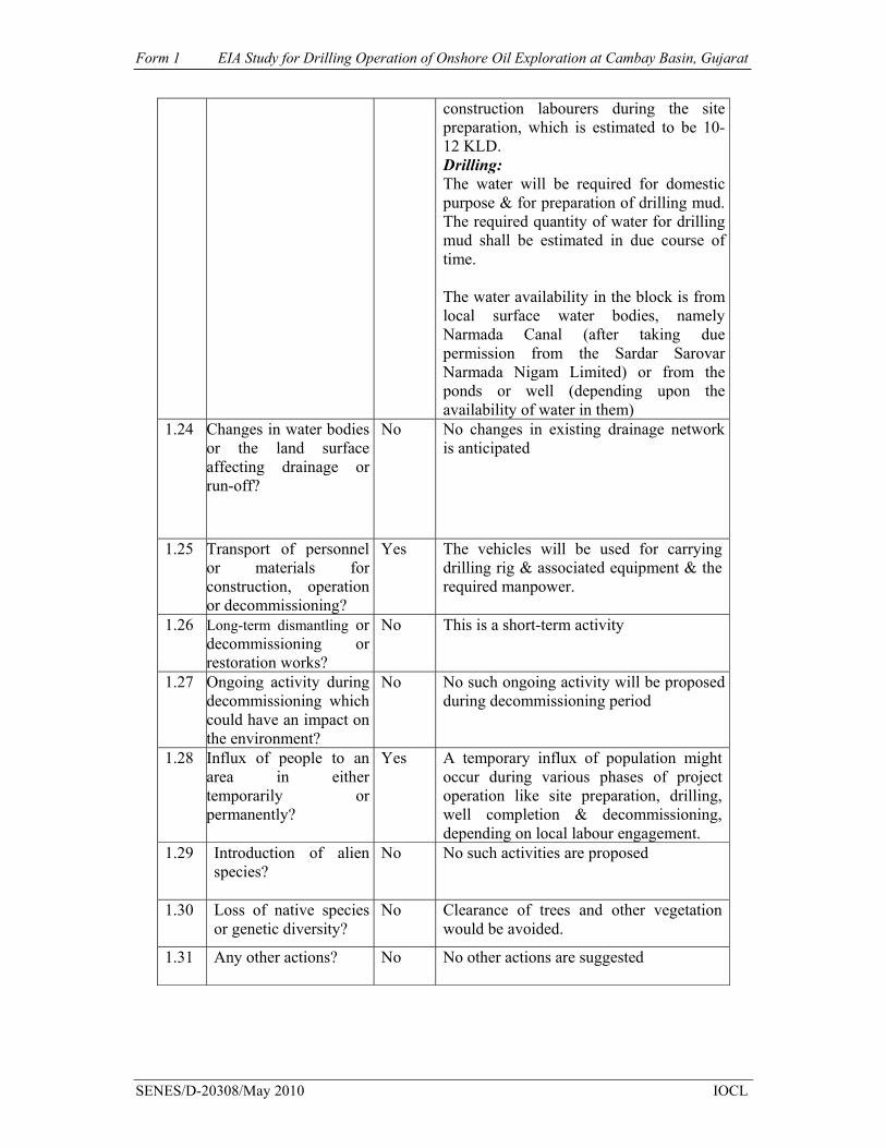
Form 1 EIA Study for Drilling Operation of Onshore Oil Exploration at Cambay Basin, Gujarat
SENES/D-20308/May 2010 IOCL
construction labourers during the site preparation, which is estimated to be 10-12 KLD. Drilling: The water will be required for domestic purpose & for preparation of drilling mud. The required quantity of water for drilling mud shall be estimated in due course of time. The water availability in the block is from local surface water bodies, namely Narmada Canal (after taking due permission from the Sardar Sarovar Narmada Nigam Limited) or from the ponds or well (depending upon the availability of water in them)
1.24
Changes in water bodies or the land surface affecting drainage or run-off?
No No changes in existing drainage network is anticipated
1.25 Transport of personnel or materials for construction, operation or decommissioning?
Yes The vehicles will be used for carrying drilling rig & associated equipment & the required manpower.
1.26 Long-term dismantling or decommissioning or restoration works?
No This is a short-term activity
1.27 Ongoing activity during decommissioning which could have an impact on the environment?
No No such ongoing activity will be proposed during decommissioning period
1.28 Influx of people to an area in either temporarily or permanently?
Yes A temporary influx of population might occur during various phases of project operation like site preparation, drilling, well completion & decommissioning, depending on local labour engagement.
1.29 Introduction of alien species?
No
No such activities are proposed
1.30 Loss of native species or genetic diversity?
No
Clearance of trees and other vegetation would be avoided.
1.31 Any other actions?
No No other actions are suggested
Form 1 EIA Study for Drilling Operation of Onshore Oil Exploration at Cambay Basin, Gujarat
SENES/D-20308/May 2010 IOCL
2. Use of Natural resources for construction or operation of the Project (such as
land, water, materials or energy, especially any resources which are non-renewable or in short supply):
S.No.
Information/checklist confirmation
Yes/No
Details thereof (with approximate quantities /rates, wherever possible) with source of information data
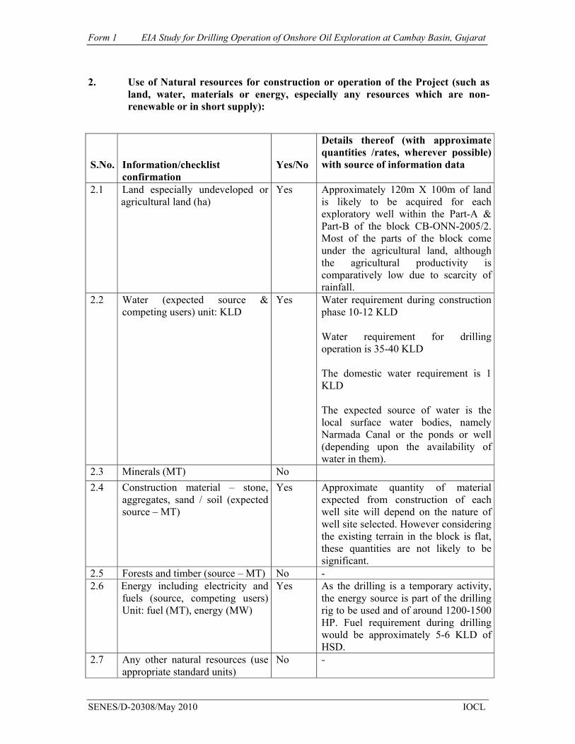
2.1 Land especially undeveloped or agricultural land (ha)
Yes Approximately 120m X 100m of land is likely to be acquired for each exploratory well within the Part-A & Part-B of the block CB-ONN-2005/2. Most of the parts of the block come under the agricultural land, although the agricultural productivity is comparatively low due to scarcity of rainfall.
2.2 Water (expected source & competing users) unit: KLD
Yes Water requirement during construction phase 10-12 KLD
Water requirement for drilling operation is 35-40 KLD
The domestic water requirement is 1 KLD
The expected source of water is the local surface water bodies, namely Narmada Canal or the ponds or well (depending upon the availability of water in them).
2.3 Minerals (MT) No 2.4 Construction material – stone,
aggregates, sand / soil (expected source – MT)
Yes Approximate quantity of material expected from construction of each well site will depend on the nature of well site selected. However considering the existing terrain in the block is flat, these quantities are not likely to be significant.
2.5 Forests and timber (source – MT) No - 2.6 Energy including electricity and
fuels (source, competing users) Unit: fuel (MT), energy (MW)
Yes As the drilling is a temporary activity, the energy source is part of the drilling rig to be used and of around 1200-1500 HP. Fuel requirement during drilling would be approximately 5-6 KLD of HSD.
2.7 Any other natural resources (use appropriate standard units)
No -
Form 1 EIA Study for Drilling Operation of Onshore Oil Exploration at Cambay Basin, Gujarat
SENES/D-20308/May 2010 IOCL
3. Use, storage, transport, handling or production of substances or materials,
which could be harmful to human health or the environment or raise concerns about actual or perceived risks to human health.
S.No Information/Checklist
confirmation Yes/No Details thereof (with approximate
quantities/rates, wherever possible) with source of information data
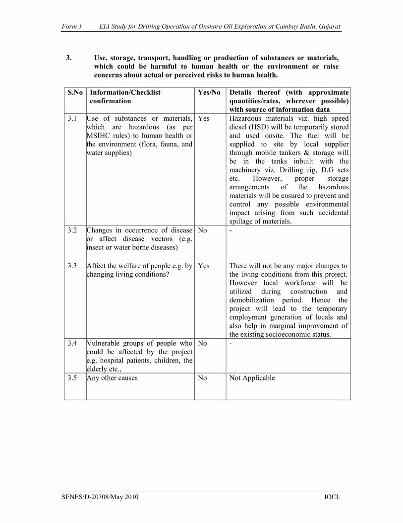
3.1 Use of substances or materials, which are hazardous (as per MSIHC rules) to human health or the environment (flora, fauna, and water supplies)
Yes Hazardous materials viz. high speed diesel (HSD) will be temporarily stored and used onsite. The fuel will be supplied to site by local supplier through mobile tankers & storage will be in the tanks inbuilt with the machinery viz. Drilling rig, D.G sets etc. However, proper storage arrangements of the hazardous materials will be ensured to prevent and control any possible environmental impact arising from such accidental spillage of materials.
3.2 Changes in occurrence of disease or affect disease vectors (e.g. insect or water borne diseases)
No -
3.3 Affect the welfare of people e.g. by changing living conditions?
Yes There will not be any major changes to the living conditions from this project. However local workforce will be utilized during construction and demobilization period. Hence the project will lead to the temporary employment generation of locals and also help in marginal improvement of the existing socioeconomic status.
3.4 Vulnerable groups of people who could be affected by the project e.g. hospital patients, children, the elderly etc.,
No -
3.5 Any other causes No Not Applicable

Form 1 EIA Study for Drilling Operation of Onshore Oil Exploration at Cambay Basin, Gujarat
SENES/D-20308/May 2010 IOCL
4. Production of solid wastes during construction or operation or decommissioning (MT/month)
S.No
Information/Checklist confirmation
Yes/No
Details thereof (with approximate quantities/rates, wherever possible) with source of information data
4.1 Spoil, overburden or mine wastes No -
4.2 Municipal waste (domestic and or commercial wastes)
Yes Domestic waste during construction & drilling operation will be limited to labour camps, which is approximately 10.5 kg/day. These wastes will be disposed off at approved municipal sites.
4.3 Hazardous wastes (as per Hazardous Waste Management Rules)
Yes Recyclable hazardous waste may be generated in the form of spent oil from DG sets, mud pumps etc. of drilling rig. waste drilling mud, drill cuttings would be around 800MT each well.
4.4 Other industrial process wastes No - 4.5 Surplus product No -
4.6 Sewage sludge or other sludge from effluent treatment
No The domestic sewage would be treated in septic tanks & soak pits.
4.7 Construction or demolition wastes No
4.8 Redundant machinery or equipment
Yes The site will be cleared of all the machineries & equipments at the end of the drilling process
4.9 Contaminated soils or other materials
No -
4.10 Agricultural wastes No -
4.11 Other solid wastes No -
5. Release of pollutants or any hazardous, toxic or noxious substances to air (Kg/hr)
S.No.
Information/Checklist confirmation
Yes/No
Details thereof (with approximate quantities/rates, wherever possible) with source of information data
5.1 Emissions from combustion of fossil fuels from stationary or mobile sources
Yes The DG sets, as part of the drilling rig will be primarily contributing to point source air pollutant emissions. Fugitive emissions sources include
Form 1 EIA Study for Drilling Operation of Onshore Oil Exploration at Cambay Basin, Gujarat
SENES/D-20308/May 2010 IOCL
moving vehicles & construction machineries /equipments.
5.2 Emissions from production processes
Yes
Gas flaring will be resorted if in casegas is generated during well testing phase of exploratory drilling.
5.3 Emissions from materials handling including storage or transport
Yes Fugitive emissions in the form of dust are likely to be generated during handling and transportation ofconstruction materials (sand, cement etc), drilling mud components. Fugitive emissions also anticipated during handling of volatile chemicals, though negligible.
5.4 Emissions from construction activities including plant and equipment
Yes Emissions are likely to occur during site preparation activities following operation of construction equipments & machineries.
5.5 Dust or odours from handling of materials including construction materials, sewage and waste
Yes Dust is likely to be generated from the handling of construction materials viz. cement, sand, aggregates etc with odour being generated during handling and disposal of food waste.
5.6 Emissions from incineration of waste
No -
5.7 Emissions from burning of waste in open air (e.g. slash materials, construction debris)
No -
5.8 Emissions from any other sources No -
6. Generation of Noise and Vibration, and Emissions of Light and Heat:
S.No.
Information/Checklist confirmation Yes/No
Details thereof (with approximate quantities/rates, wherever
possible) with source of information data
6.1 From operation of equipment e.g. engines, ventilation plant, crushers
Yes High level of noise is likely to be generated during operation of rig and related equipments (drilling phase). Probable noise sources include drilling rig, DG sets and pumps. However, considering the temporary nature of the activities involved (ex. Drilling) and control measures adopted viz. use of acoustic enclosures & mufflers, no significant impact to this regard is envisaged.
6.2 From industrial or similar processes
No -
Form 1 EIA Study for Drilling Operation of Onshore Oil Exploration at Cambay Basin, Gujarat
SENES/D-20308/May 2010 IOCL
6.3 From construction or demolition Yes Noise & vibration will be generated during operation of construction equipments during both site preparation and decommissioning. However these types of activities will be temporary in nature; hence it does not cause any long term impact.
6.4 From blasting or piling No -
6.5 From construction or operational traffic
Yes There will be increase in noise level during both construction and operation phases due to the movement of vehicular traffic on the site approach & access roads.
6.6 From lighting or cooling systems No -
6.7 From any other sources No - 7. Risks of contamination of land or water from releases of pollutants into the
ground or into sewers, surface waters, groundwater, coastal waters or the sea:
S.No.
Information/Checklist confirmation
Yes/No
Details thereof (with approximate quantities/rates, wherever possible) with source of information data
7.1 From handling, storage, use or spillage of hazardous materials
No From Accidental spillage of HSD if not handled properly. Otherwise no impact is anticipated
7.2 From discharge of sewage or other effluents to water or the land (expected mode and place ofdischarge)
No During mud recycling and rig washings, the waste generated, will be treated & recycled to comply with the regulatory requirements. The domestic sewage will be treated in septic tanks & soak pits.
7.3 By deposition of pollutants emitted to air into the land or into water
No The DG set will be provided with adequate stack height to disperse the pollutants effectively; hence any resultant contamination of land or water would be unlikely.
7.4 From any other sources No
-
7.5 Is there a risk of long term build up of pollutants in the environment from these sources?
No No long term cumulative impact is envisaged given the temporary nature of project activities.
Form 1 EIA Study for Drilling Operation of Onshore Oil Exploration at Cambay Basin, Gujarat
SENES/D-20308/May 2010 IOCL
8. Risk of accidents during construction or operation of the project, which could affect human health or the environment
S. No.
Information/Checklist confirmation
Yes/No
Details thereof (with approximate quantities/rates, wherever possible) with source of information data
8.1 From explosions, spillages, fires etc from storage, handling, use or production of hazardous substances
Yes
The proposed project will involve handling and storage of diesel fuel, from which a possibility of fire hazard is always there; however necessary mitigation measures will be adopted toovercome/reduce such risk.
8.2 From any other causes
Yes Well blowout risks and cold vents (in case of gas generation) are addressed as part of well design and planning of drilling process.
8.3 Could the project be affected by natural disasters causing environmental damage (e.g. floods, earthquakes, landslides, cloudburst etc)?
Yes
Natural disasters in form of earthquakescan be taken place as the site area falls under the moderate damage risk zone and is susceptible to earthquake occurrence. The drilling equipment is commissioned on site and secured, to avoid such risks. Apart from this the site does not have any past history of flood or any other natural disasters.
9. Factors which should be considered (such as consequential development)
which could lead to environmental effects or the potential for cumulative impacts with other existing or planned activities in the locality
S. No.
Information/Checklist confirmation
Yes/No
Details thereof (with approximate quantities/rates, wherever possible) with source of information data
9.1 Lead to development of supporting utilities, ancillary development or development stimulated by the project which could have impact on the environment e.g.: • Supporting infrastructure (roads, power supply, waste or waste water treatment, etc.)
• housing development • extractive industries
No No No
Drilling being a temporary activity will not be leading to any permanent development of any supporting infrastructure or facilities. However, existing village approach roads will be strengthened & developed

Form 1 EIA Study for Drilling Operation of Onshore Oil Exploration at Cambay Basin, Gujarat
SENES/D-20308/May 2010 IOCL
• supply industries • other
No NO
whenever required for plying vehicles and transporting rig & machineries.
9.2 Lead to after-use of the site, which could have an impact on the environment
No -
9.3 Set a precedent for later developments
Yes The drilling process may induce future development in the form of production of oil & gas, if it is proved to be economically viable.
9.4 Have cumulative effects due to proximity to other existing or planned projects with similar effects
No The block & its surrounding area do not have any significant industrial development except few; hence, considering the temporary nature of this exploratory drilling activity, no cumulative impacts are anticipated from this project.
(III) Environmental Sensitivity S.No.
Areas
Name/ Identity
Aerial distance (within 15 km.) Proposed project location boundary
1 Areas protected under international conventions, national or local legislation for their ecological, landscape, cultural or other related value
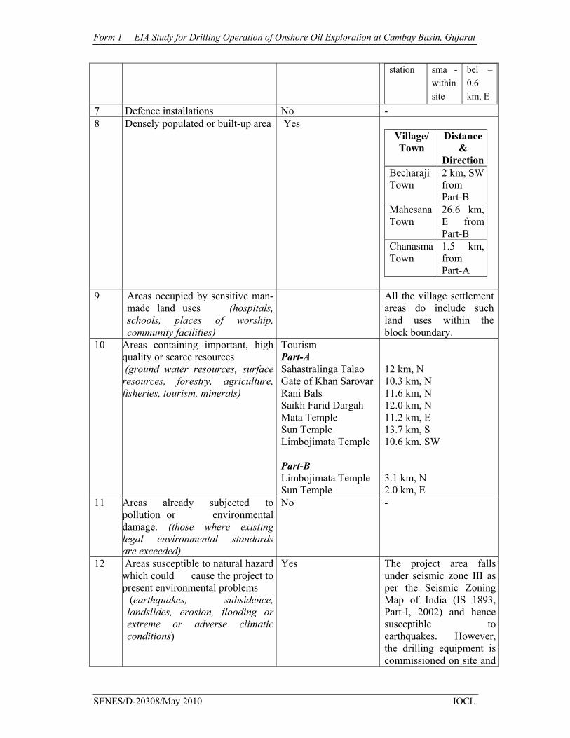
No Forest Report in Part-A & Part-B of the block Archaeological sites Part-A Sahastralinga Talao Gate of Khan Sarovar Rani Bals Saikh Farid Dargah Mata Temple Sun Temple Limbojimata Temple Part-B Limbojimata Temple Sun Temple
Distance* 12 km, N 10.3 km, N 11.6 km, N 12.0 km, N 11.2 km, E 13.7 km, S 10.6 km, SW 3.1 km, N 2.0 km, E
2 Areas which are important or sensitive for ecological reasons -Wetlands, watercourses or other water bodies, coastal zone, biospheres, mountains, forests
Part-A Wetland at village Maniary Sarswati River Khari Nadi Pushpawati Nadi Rupen Nadi
9.9 km, south 10.6 km, N 3.6 km, S 11.2 km,S 15.9 km,S

Form 1 EIA Study for Drilling Operation of Onshore Oil Exploration at Cambay Basin, Gujarat
SENES/D-20308/May 2010 IOCL
Part-B Wetland at village Maniary Wetland near Nayakpur village Sarswati River Khari Nadi Pushpawati Nadi Rupen Nadi
3.9 km, S 12.6 km, SW 22.5 km, N Within the block boundary Within the block boundary Within the block boundary
3 Areas used by protected, important or sensitive species of flora or fauna for breeding, nesting, foraging, resting, over wintering, migration
No -
4 Inland, coastal, marine or underground waters
Part-A Wetland at village Maniary Sarswati River Khari Nadi Pushpawati Nadi Rupen Nadi Part-B Wetland at village Maniary Wetland near Nayakpur village Sarswati River Khari Nadi Pushpawati Nadi Rupen Nadi
9.9 km, south 10.6 km, N 3.6 km, S 11.2 km,S 15.9 km,S 3.9 km, S 12.6 km, SW 22.5 km, N Within the block boundary Within the block boundary Within the block boundary
5 State, National boundaries No - 6 Routes or facilities used by the
public for access to recreation or other tourist, pilgrim areas
Yes Distance with direction
Routs Part-A Part-B SH-55 in site 7.7
km, N SH-7 in site In site SH-134 11.4
km, S 0.3 km, NE
Railway Chana Kham
Form 1 EIA Study for Drilling Operation of Onshore Oil Exploration at Cambay Basin, Gujarat
SENES/D-20308/May 2010 IOCL
station sma - within site
bel – 0.6 km, E
7 Defence installations No - 8 Densely populated or built-up area Yes
Village/ Town
Distance &
DirectionBecharaji Town
2 km, SWfrom Part-B
Mahesana Town
26.6 km, E from Part-B
Chanasma Town
1.5 km, from Part-A
9 Areas occupied by sensitive man-made land uses (hospitals, schools, places of worship, community facilities)
All the village settlement areas do include such land uses within the block boundary.
10 Areas containing important, high quality or scarce resources (ground water resources, surface resources, forestry, agriculture, fisheries, tourism, minerals)
Tourism Part-A Sahastralinga Talao Gate of Khan Sarovar Rani Bals Saikh Farid Dargah Mata Temple Sun Temple Limbojimata Temple Part-B Limbojimata Temple Sun Temple
12 km, N 10.3 km, N 11.6 km, N 12.0 km, N 11.2 km, E 13.7 km, S 10.6 km, SW 3.1 km, N 2.0 km, E
11 Areas already subjected to pollution or environmental damage. (those where existing legal environmental standards are exceeded)
No -
12 Areas susceptible to natural hazard which could cause the project to present environmental problems (earthquakes, subsidence, landslides, erosion, flooding or extreme or adverse climatic conditions)
Yes The project area falls under seismic zone III as per the Seismic Zoning Map of India (IS 1893, Part-I, 2002) and hence susceptible to earthquakes. However, the drilling equipment is commissioned on site and
Form 1 EIA Study for Drilling Operation of Onshore Oil Exploration at Cambay Basin, Gujarat
SENES/D-20308/May 2010 IOCL
secured to avoid such risks.
*All the distances have been taken from nearest site boundary
(IV) Proposed Terms of Reference for EIA studies
Enclosed separately as Annexure II “I hereby given undertaking that the data and information given in the application and enclosures are true to the best of my knowledge and belief and I am aware that if any part of the data and information submitted is found to be false or misleading at any stage, the project will be rejected and clearance give, if any to the project will be revoked at our risk and cost. Date: 12.05.10 Place: Delhi
Signature of the applicant Hridesh Baindail
(Chief Manager (E & P))
Indian Oil Corporation Limited IOCL-7th Floor, Indian Oil Bhawan
No. 1, Aurobindo Marg, Yusuf Sarai
With Name and Full Address (Project Proponent / Authorized
Signatory) NOTE: 1. The projects involving clearance under Coastal Regulation Zone Notification, l991 shall submit with the application a C.R.Z map duly demarcated by one of the authorized agencies, showing the project activities, w.r.t. C.R.Z (at the stage of TOR) and the recommendations of the State Coastal Zone Management Authority (at the stage of EC). Simultaneous action shall also be taken to obtain the requisite clearance under the provisions of the C.R.Z Notification, 1991 for the activities to be located in the CRZ. 2. The projects to be located within 10 km of the National Parks, Sanctuaries, Biosphere Reserves, Migratory Corridors of Wild Animals, the project proponent shall submit the map duly authenticated by Chief Wildlife Warden showing these features vis-a-vis the project location and the recommendations or comments of the Chief Wildlife Warden-thereon (at the Stage of EC). 3. All correspondence with the Ministry of Environment & Forests including submission of application for TOR/Environrnental Clearance, subsequent clarifications, as may be required from time to time, participation in the EAC Meeting on behalf of the project proponent shall be made by the autltorized signatory only. The authorized signatory should also submit a document in support of his claim of being an authorized signatory for the specific project.
Annexure EIA Study for Drilling Operation of Onshore Oil Exploration at Cambay Basin, Gujarat
SENES/D-20308/May 2010 IOCL
Annexure – I
Annexure EIA Study for Drilling Operation of Onshore Oil Exploration at Cambay Basin, Gujarat
SENES/D-20308/May 2010 IOCL
Annexure – I-Contd...

Prepared for Indian Oil Corporation Limited
Prepared by SENES Consultants India Pvt. Ltd.
May, 2010
Proposed Terms of Reference - Environmental Impact Assessment (EIA) Study for Exploration Drilling Operation
at Cambay Basin, Block: CB-ONN/2005/2

Drilling of Onshore Oil Exploration at Cambay Basin, CB-ONN-2005/2
SENES/D-20308/May, 2010 IOCL 2
1.0 Project Background
Indian Oil Corporation Limited (IOCL), a flagship national oil company and downstream petroleum major has been granted with an exploration block of 77.68 sqm.in Cambay Basin, CB-ONN-2005/2 by Government of India under the Production Sharing Contract (PSC) for exploration of hydrocarbon. In addition to this necessary regulatory approval has been taken for the exploration programme in the form of Petroleum Exploration License.
As per the provisions of the PSC, IOCL would carry out exploration in two phases, in which the first phase will comprise of a 3D seismic survey programme consisting of the data acquisition, processing and interpretation of the data for entire block of 77.68 sq.km. This will be further accompanied by drilling of four exploration wells to the depth of 3400m each, reprocessing of 570 LKM and magneto telluric of 250 stations during the Phase-I, where as the Phase-II will comprise of drilling of one exploration well to the depth of 3400m. The entire block is divided in two parts, Part A and Part B; the exact drilling site though not determined, will typically be confined within the block itself, which require a lease land of 120m X 100m area.
As per the EIA Notification 2006 and its subsequent amendments, oil and gas projects are listed as project/activity 1(b) under category ‘A’– “Offshore and onshore oil and gas exploration, development & production”. The proposed exploration drilling therefore demands prior environmental clearance (EC) from Ministry of Environment & Forests (MoEF) and requires an Environmental Impact Assessment (EIA) study to be undertaken.

Drilling of Onshore Oil Exploration at Cambay Basin, CB-ONN-2005/2
SENES/D-20308/May, 2010 IOCL 3
2.0 Terms of Reference – EIA Study
The Terms of Reference (ToR) for this EIA study to be undertaken for the proposed project has been prepared on the basis of initial reconnaissance surveys, client and stakeholder consultations, key issues identified in the PSC and PEL, applicable legislative and policy requirements and professional judgment. The key purpose of the ToR is to identify all major environmental and social concerns (including land related issues, if any) associated with pre-construction, construction and drilling operation phases and formulate specific management plans to effectively prevent and mitigate them in accordance with MoEF requirements and other standards/guidelines prevails.
The ToR for the EIA study has been structured as follows:
• Section 1 – Project Description • Section 2 – Policy, Legal & Institutional Framework • Section 3 – Description of the Environment • Section 4 – Environmental Impact Assessment • Section 5 – Environmental Management Plan • Section 6 – Post Project Environmental Monitoring Plan
2.1 Project Description
This section in the EIA report will provide a detailed description of proposed project encompassing location of project, project need and objectives, project benefits and ancillary facilities (if any), detail description of site preparation, road works (strengthening or construction of new road wherever required etc), details of pre-construction and drilling activities, detailed resource requirements (drilling rig and associated equipments, water, sand and clay materials, fuel, human labour as well as skilled professional etc) and their sources, features of environmental and social sensitivities identified within project study area and project implementation schedule. The project description section will be validated with relevant maps, satellite imagery on location, connectivity etc. as appropriate.
During the EIA study, a preliminary assessment of project feasibility report will help in describing the components and features of the proposed onshore oil exploration project. A clear idea about the activities to be carried out as a part of the proposed project will also be drawn from initial reconnaissance surveys and consultations.
2.2 Policy, Legal & Institutional Framework
This section will discuss, review and establish the existing institutional framework, prevailing rules and regulations related to oil & gas exploration, requirements of MoEF and State Pollution Control Department, State Forest Department etc and various legislations governing environmental quality, safety and health, protection and conservation of cultural & ecologically sensitive areas and handling and storage of hazardous substances for exploratory drilling projects at both National and State levels. Siting and permit conditions with respect to
Drilling of Onshore Oil Exploration at Cambay Basin, CB-ONN-2005/2
SENES/D-20308/May, 2010 IOCL 4
selection and sourcing of raw materials viz. earth fill, cement, etc and positioning and operation of drilling rig will also be studied and referred.
This section will also review and outline the relevant specifications and standards of Ministry of Petroleum and Natural Gas applicable with respect to the proposed project.
2.3 Description of the Environment
This chapter will establish the baseline environmental, cultural and socio-economic conditions of the project study area (both core and buffer zone) through primary monitoring surveys and collection, collation and authentication by veritable secondary data. The baseline data generated will also help in identifying any possible changes in existing environmental quality during project operation (drilling) phase thereby assisting in impact assessment and evaluation. The following features have been considered for study of various environmental and socio-cultural components within the project study area.
2.3.1 Physical Environment (i) Air & Noise Environment & Traffic Condition
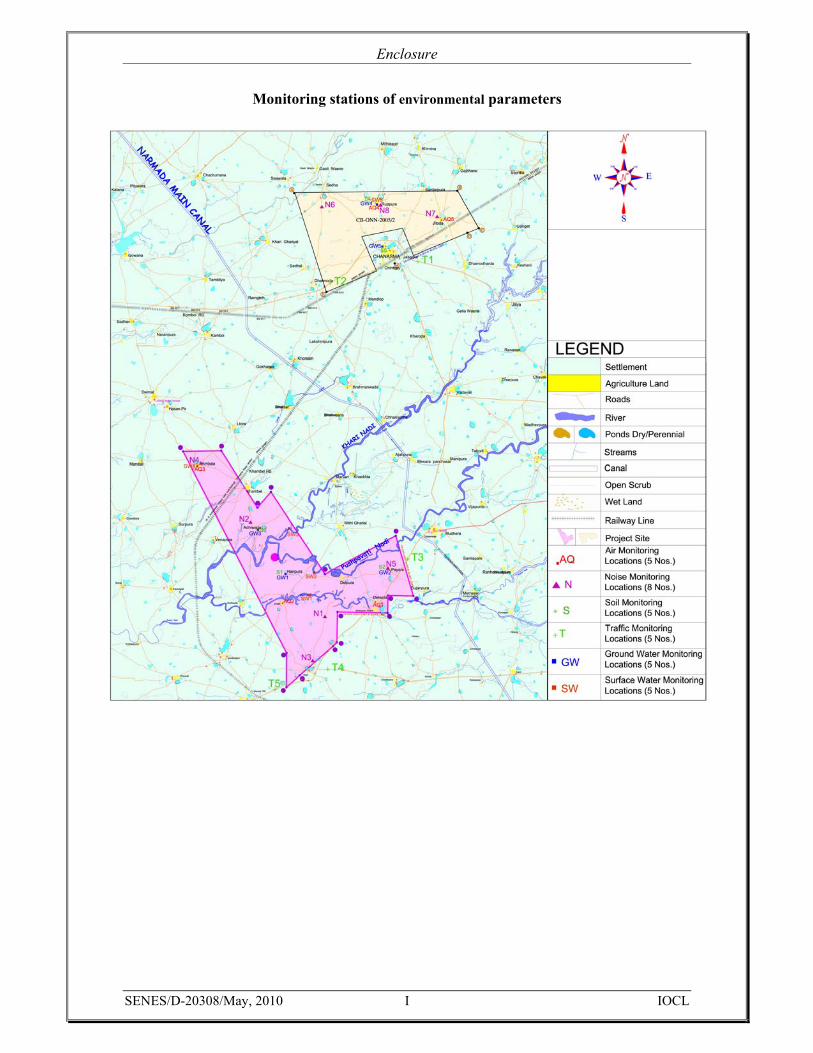
• 5 nos. of ambient air quality monitoring stations have been selected within the block itself on the basis of sensitive receptors, like human settlement, institutions & land use pattern etc. Out of these 5 locations, two stations (Ruppura & Jitoda village) have been selected from Part-A and three stations (Delwara, Endla & Ambala village) have been selected from Part-B. Ambient air quality will be monitored for a period of one month for PM10, SO2, NOx, CO & HC.
• In order to carry out existing noise level, 8 numbers of noise quality monitoring stations have been selected within the block boundary based on topography, land use pattern etc. Three stations (Jitoda, Ruppura & one in agricultural area) from Part-A and five stations from residential and agricultural (Adhiwada, Kalri, Ambala, Poyara village & one from agricultural area) land of Part-B have been selected. The equivalent noise (Leq) level for both day and night will be studied at each of the monitoring stations identified within the block boundary.
• The traffic volumes, composition and peak hour traffic estimation will be carried out at major traffic zones. Two points within the Part-A (one is at the entry to the block and another one is on the exit points of the block along the road) have been identified on SH-55 to find out the potential of the road in terms of carrying capacity. Three points have been identified for Part-B of the block, namely one at the entry point to Part-B along SH-134, one at the entry to Part-B along SH-19 and one at the junction of these two roads. The traffic volume will be studied through collection of data on heavy motor vehicles, light motor vehicles, cars and two-wheelers on hourly basis.

Drilling of Onshore Oil Exploration at Cambay Basin, CB-ONN-2005/2
SENES/D-20308/May, 2010 IOCL 5
• The micro-meteorological conditions viz. temperature, rainfall, humidity, wind speed and direction etc will be assessed through collection and collation of secondary data obtained from nearest IMD station at Ahmedabad.
(ii) Water Environment
• 5 nos. of ground water quality monitoring stations within the block boundary have been identified, which will be studied. The ground water monitoring stations have been identified in those areas, from where ground water is used to supply to the villagers and from where it is likely to be sourced to meet potable water requirements of labourers at construction camp and requirements for construction activities viz. preparation of drilling mud, rig-wash, road works etc. The ground water from Haripura, Poyara & Adhiwada of Part-B and Ruppura and Chanasma of Part-A will be monitored for the parameters as per IS: 10,500.
• 5 nos. of surface water quality monitoring stations from major water bodies located within the block boundary (pond at Ambala village of Part-B and pond at Ruppura village of Part-A), stream crossings (Khari Nadi, Rupen Nadi & Pushpawati Nadi) have been identified. The surface water will be studied as per the CPCB standards of Class-A to Class-E for the parameters of Total Coliforms Organism, pH, DO, BOD, Free Ammonia, Electrical conductivity, SAR and Boron.
• Identification of drainage pattern, hydro-geological conditions and potential ground water utilization in Mahesana and Patan districts has been identified through primary reconnaissance survey and has been authenticated by secondary database, available in various Governments and other websites.
(iii) Land Environment
• Land use classification viz. habitation, agricultural land, forest area, environmentally sensitive places, industrial areas, surface water bodies etc of the study area (the block and an area of 10 km radius) will be studied through interpretation of high resolution satellite imagery and ground validation in times of primary survey.
• Geology of the area, rock types, history of geological transformation of underlying rock through seismicity and associated hazards for the block and its surrounding stretch will be assessed through secondary database.
• The soil quality of the study area shall be analyzed to know the characteristics of the soil. 5 sites have been identified from agricultural land of the villages, which includes Ruppura and Chanasma village of Part-A and Haripura, Poyara & Adhiwada village of Part-B of the block. The soil sample will be analyzed for selected physico-chemical parameters as per the MoEF Manual. The parameters which will be analyzed are Particle size distribution, Texture, pH, Electrical conductivity, Cation exchange capacity, SAR, Permeability, Porosity, Water holding capacity, Nitrogen, Potassium, Phosphorous, organic content.
Drilling of Onshore Oil Exploration at Cambay Basin, CB-ONN-2005/2
SENES/D-20308/May, 2010 IOCL 6
2.3.2 Biological Environment
• This section will provide a listing of important floral species having significant timber value found within the block boundary as well as in the surrounding area of the proposed block. Information will be presented on existing vegetation type and species, details of vegetation removed (if any), any fragmentation of faunal habitat dependent on the tree species removed and if there is any wild life movement in the area. The information will primarily be obtained through discussion with forest department officials & locals and literature reviews.
2.3.3 Socioeconomic & Cultural Environment
• Details on demographic structure; educational and literacy profile; present and proposed land use, present land holding, planned development activities, issues related to temporary land lease, livelihood and employment opportunities, infrastructure facilities, public health and safety will be assessed for both urban and rural population of Sevala, Sendha, Ruppur, Sardarpur, Jakhana, Jitoda, Dhanodarda, Jasalpur, Dharmoda, Sendhal villages of Part-A and Khambhel, Adivada, Delpura Khant, Mithi Dariyal, Mudhera, Poyda, Suanpur, Delwada, Dharpur Khant, Kalri, Ganeshpura, Sakhalpur, Endla, Dodiwada, Venpura, Ambala villages of Part-B, which area likely to be affected by the proposed project activities during pre-construction and drilling phases. The profiling of the socio-economic environment will be based on focussed group discussion with target groups, questionnaire/checklist surveys, stakeholder interviews and 2001 census data review and analysis.
• The cultural environment of the study area viz. location of the site, details of historical significance of any place, near or within the block boundary etc will be assessed as part of the EIA study on the basis of reconnaissance surveys, relevant stakeholder consultations etc. and review of relevant publications/reports on archaeological discoveries made in Mahesana and Patan districts by Archaeological Survey of India.
The monitoring locations for all the environmental parameters are enclosed as Enclosure-I.
2.4 Environmental Impact Assessment Impact Assessment section of the report will help in the identification, analysis and evaluation of key environmental and social impacts that may arise during construction and drilling phases. This section will help to distinguish between significant positive and negative impacts, direct and indirect impacts and immediate and long term impacts associated with the proposed project and provide information on alternate design options. Avoidable as well as irreversible impacts will be identified and cumulative impacts of proposed project will also be explored, however, the drilling operation being a short-term activity would not impose any long term impact. Appropriate qualitative and quantitative prediction tools and socio-economic surveys will be utilized to analysis and evaluate significant impacts of the drilling

Drilling of Onshore Oil Exploration at Cambay Basin, CB-ONN-2005/2
SENES/D-20308/May, 2010 IOCL 7
operation. The potential significant impacts that may result from proposed project activities during aforesaid phases will be accordingly represented through an impact assessment matrix.
Potential environmental and social impacts that will be assessed as part of the proposed project includes:
• Air and noise emissions (both fugitive and point source) from operation of DG sets as part of the drilling rig, rig and associated equipment, construction machineries etc, sourcing and transportation of raw materials (earth fill, sand etc) and vehicular movement affecting nearby habitations and agricultural land.
• Increase in soil erosion due to vegetation removal and top soil stripping for well exploration. Surface run-off from these location including material storage areas, construction camps is likely to cause the pollution of nearby surface water bodies.
• Degradation of surface water and soil quality and community concerns due to indiscriminate storage, handling and disposal of debris and solid waste (food waste, packaging waste, paper etc) generated from site clearance activities and operation of construction camp respectively.
• Loss/damage to floral species, faunal habitat fragmentation etc., located within the block boundary.
• Community health and safety related issues resulting from traffic diversion, drilling rig and associated equipment operations and vehicular movement.
• Occupational health and safety of workers involved in construction and drilling activities.
• Increased utilization of surface water (with due permission from concerned Authority) to meet construction and domestic water requirements.
• Loss/damage to residential and commercial properties, religious and institutional establishments, common property resources (agricultural land, ponds, hand pumps etc) and livelihood of people due to temporary lease of land holdings.
• Influx of construction workforce and resultant resource conflicts with neighbouring communities.
The drilling phase of the project may induce future development if the exploratory wells proved to be economically viable for production of oil and gas.

Drilling of Onshore Oil Exploration at Cambay Basin, CB-ONN-2005/2
SENES/D-20308/May, 2010 IOCL 8
2.5 Environmental Management Plan An environmental management plan (EMP) will be prepared to prevent and mitigate any potential significant environmental, social and cultural impacts with respect to the proposed drilling process. The EMP will cover the following:
• Project organizational structure with specific roles and responsibilities of project personnel involved in environmental management.
• Summary of mitigation measures likely to adopted and implemented by the proponent as a part of specific management plans prepared, includes:
a. Control of soil erosion from well exploration, site preparation for positioning of the drilling rig, road maintenance works etc.
b. Air & noise quality management in sensitive areas, agricultural lands and habitations likely to be affected from the drilling operation and transportation of raw materials and vehicular movement.
c. Traffic management of existing state highway for properly controlling the vehicular movement carrying the crew members and machineries to address community health and safety issues.
d. Surface run-off management from wash wastewater and construction camp to prevent degradation of adjoining surface water and agricultural land soil quality.
e. Management of solid waste and debris generated from construction camp, drilling operation and site clearance activities respectively.
f. Storage and utilization of stripped top soil in future during the time of site restoration g. Restoration and reclamation of site at the end of the drilling operation, if it is not to be
proved as economically viable for production of oil and gas. h. Management measures to address any disturbance to animal movement and habitat
fragmentation of faunal species dependent on the tree species removed and water bodies affected within the block boundary.
i. Cost implications, organizational responsibilities and schedule for effective implementation of environmental measures proposed in the EMP.
2.6 Environmental Monitoring Plan
The Environmental Monitoring Plan will identify and describe the monitoring measures that will be carried out to track the existing baseline environmental condition of the area and ensure compliance with regulatory requirements during project operation phase (drilling). It will describe the environmental parameters to be monitored, monitoring methods, sampling locations, frequency, costs, detection limits and thresholds that would be monitored and evaluated to indicate corrective actions. It will also outline the monitoring & reporting procedures and define organizational responsibilities for implementation of this plan.

Drilling of Onshore Oil Exploration at Cambay Basin, CB-ONN-2005/2
SENES/D-20308/May, 2010 IOCL 9
The following performance indicators will be monitored during construction and drilling operational stages in accordance with the monitoring plan to determine the efficacy of environmental management measures and mitigation/enhancement designs proposed.
A. Baseline environmental quality of air, noise, surface and ground water and soil during construction phase, in areas viz. sensitive receptors like habitations, agricultural land, water bodies etc likely to be affected from operation of construction camps and drilling procedures, operation of DG sets etc, sourcing and transportation of raw materials, discharge of surface run-off and liquid effluent, storage and disposal of solid waste and material storages.
B. Implementation of management plans/measures have formulated with respect to a. Air & noise quality management b. Solid waste management c. Top soil utilization, d. Soil erosion control e. Traffic management f. Drilling site area restoration and reclamation
Environmental parameter/indicator indicative of the implementation status of aforesaid plans/measures will be selected and monitored.
Enclosure
SENES/D-20308/May, 2010 I IOCL
Monitoring stations of environmental parameters
PRE-FEASIBILITY REPORT
Submitted to: Ministry of Environment and Forests
Submitted by: Indian Oil Corporation Limited
May 2010
Exploratory Drilling Operation
at
CB-ONN-2005/2 (Part-A & B)
Location: CB-ONN-2005/2
SENES/D-20308/May 2010 IOCL ii
Table of Contents 1.0 Introduction....................................................................................................................5 2.0 IOCL Safety, Health & Environmental Performance ....................................................7 3.0 Potential of Oil & Gas Exploration in Gujarat...............................................................8 3.1 Cambay Basin: CB-ONN-2005/2 ..................................................................................8 4.0 The Project: Drilling of exploratory well.....................................................................11 4.1 Objectives of the drilling well .....................................................................................11 4.2 Well Construction ........................................................................................................12
4.2.1 The Drilling Rig:..............................................................................................12
4.2.2 Initial well to total depth ..................................................................................12
4.2.3 Drilling Fluids..................................................................................................12
4.3 Well Evaluation ...........................................................................................................13 4.3.1 Well Logging ...................................................................................................13
4.3.2 Well Testing.....................................................................................................13
4.4 Completion of Drilling.................................................................................................13 4.5 Rig Demobilization......................................................................................................13 4.6 Restoration and Rehabilitation.....................................................................................14 4.7 Staffing: .......................................................................................................................14 5.0 Project investments ......................................................................................................15 6.0 Commitment by IOCL .................................................................................................16

Pre-feasibility of Drilling Operation
SENES/D-20308/May 2010 IOCL iii
List of Tables Table No. Page No.
Table 3-1: Geographical Extent of Seismic Block of Cambay Basin (CB-ONN-2005/2) ........8
Table 4-1: Description of well .................................................................................................11

Location: CB-ONN-2005/2
SENES/D-20308/May 2010 IOCL iv
List of Figures Figure No. Page No.
Figure 1-1: Vision with Value ...................................................................................................6
Figure 3-1: Location Map of the block CB-ONN-2005/2 .......................................................10
Figure 3-1: Location Map of the block CB-ONN-2005/2 .......................................................10

Pre-feasibility of Drilling Operation
SENES/D-20308/May 2010 IOCL 5
1.0 Introduction
Energy, be it conventional or non-conventional is the basic requirement of the mankind. In present day’s scenario, the consumption of energy has been increased with the growth of population and their demand for improved amenities.
In recent days, natural gas has emerged as the most preferred fuel due to its inherent environmentally benign nature, greater efficiency and cost effectiveness. The demand of natural gas has sharply increased in the last two decades at the global level. In India also, the natural gas sector has gained importance, particularly over the last decade and is being termed as the Fuel of the 21st Century.
With the present consumption pattern of hydrocarbon energy, the available reservoirs in the country will be depleted to a larger extent by the next decade. It is hoped that increased hydrocarbon exploration and production operations can boost up the energy supply and help reduce the supply-demand gap. Keeping the required growth rate and rising energy demand for hydrocarbons in view, the Government of India has come out with plans to encourage national, private and foreign companies to explore and develop the hydrocarbon prospects. With this objective, Indian Oil Corporation Limited has been awarded a block in cambay Basin of India under Production Sharing Contract with the Govt. of India. The Production Sharing Contract (PSC) was signed between the Government of India (GoI) and Indian Oil Corporation Limited (IOCL) on 22nd December, 2008. In addition to this necessary regulatory approval has been taken for the exploration programme in the form of Petroleum Exploration License.
Indian Oil Corporation Limited (IOCL) is a flagship national oil company and downstream petroleum major with high level of expertise in the field of refineries, pipelines, natural gas, petrochemicals and marketing of end products.
The main objective of IOCL is to serve the national interests in oil and related sectors in accordance and consistent with Government policies; to enhance the country's self-sufficiency in crude oil refining and build expertise in lying of crude oil and petroleum product pipelines; to further enhance marketing infrastructure and reseller network for providing assured service to customers throughout the country; to create a strong research & development base in refinery processes, product formulations, pipeline transportation and alternative fuels with a view of minimizing/eliminating imports and to have next generation products. IOCL has worked in various Joint Venture partnerships for achieving these objectives.
At Indian Oil, Corporate Social Responsibility (CSR) has been the cornerstone of success right from inception in the year 1964. The Corporation’s objectives in this key performance area are enshrined in its Mission statement: "…to help enrich the quality of life of the community and preserve ecological balance and heritage through a strong environment conscience." The vision & the value of the Company are clearly depicted in the Figure 1-1.

Location: CB-ONN-2005/2
SENES/D-20308/May 2010 IOCL 6
FIGURE 1-1: VISION WITH VALUE

Pre-feasibility of Drilling Operation
SENES/D-20308/May 2010 IOCL 7
2.0 IOCL Safety, Health & Environmental Performance
Indian Oil Corporation is committed to conduct business with strong environment conscience ensuring sustainable development, safe workplaces and enrichment of quality of life of employees, customers and the community. Indian Oil believes that good Safety, Health and Environmental performance is an integral part of efficient and profitable business management; hence, they shall maintain the following practices:
• Establish and maintain good standards for safety of the people, the processes and the assets.
• Comply with all the Rules and Regulations on Safety, Occupational Health and Environmental Protection.
• Plan, design, operate and maintain all facilities, processes and procedures to secure sustained Safety, Health and Environmental Protection.
• Remain trained, equipped and ready for effective and prompt response to any sort of accidents and emergencies.
• IOCL would always welcome audit of their SH&E conduct by external body, so that stakeholder confidence is safeguarded.
• Adopt and promote industry best practices to avert accidents and improve Company’s S, H&E performance.
• Remain committed to be a leader in Safety, Occupational Health and Environmental Protection through continuing improvement.
• Make efforts to preserve ecological balance and heritage.
Location: CB-ONN-2005/2
SENES/D-20308/May 2010 IOCL 8
3.0 Potential of Oil & Gas Exploration in Gujarat
The Oil and Gas sector is one of Gujarat's most competitive and well established industries. Gujarat is known as the Oil and Gas capital of India as the State has the highest number of oil and gas fields (onshore and offshore) in India (31.3%). The State has the potential to become a national hub for gas due to its proximity to the Middle East gas sources and attractive northern market. The state with its potential for all aspects of oil & natural gas value chain products has the potential of investment opportunities in upstream (Acquisition of exploration blocks, Joint ventures for exploration of state, national and overseas blocks), midstream (Transportation of oil and gas) and downstream (Retailing of petroleum products, City gas distribution (PNG and CNG) and Gas based power plant/ captive plant) sectors.
3.1 CAMBAY BASIN: CB-ONN-2005/2
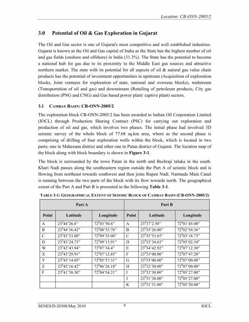
The exploration block CB-ONN-2005/2 has been awarded to Indian Oil Corporation Limited (IOCL) through Production Sharing Contract (PSC) for carrying out exploration and production of oil and gas, which involves two phases. The initial phase had involved 3D seismic survey of the whole block of 77.68 sq.km area, where as the second phase is comprising of drilling of four exploration wells within the block, which is located in two parts; one in Mahesana district and other one in Patan district of Gujarat. The location map of the block along with block boundary is shown in Figure 3-1.
The block is surrounded by the town Patan in the north and Bechraji taluka in the south. Khari Nadi passes along the southeastern region outside the Part A of seismic block and is flowing from northeast towards southwest and then joins Rupen Nadi. Narmada Main Canal is running between the two parts of the block with its flow towards north. The geographical extent of the Part A and Part B is presented in the following Table 3-1.
TABLE 3-1: GEOGRAPHICAL EXTENT OF SEISMIC BLOCK OF CAMBAY BASIN (CB-ONN-2005/2)
Part A Part B
Point Latitude Longitude Point Latitude Longitude
A 23044’26.6” 72003’50.6” A 23037’2.50” 72001’45.00” B 23044’36.42” 72008’53.76” B 23035’26.00” 72002’54.36” C 23043’33.00” 72009’35.00” C 23035’53.65” 72003’18.73” D 23043’24.73” 72009’13.91” D 23033’34.63” 72005’02.34” W 23042’43.94” 72007’34.4” E 23034’42.92” 72007’12.30” X 23043’29.91” 72007’12.85” F 23033’00.00” 72007’47.20” Y 23043’14.05” 72005’57.31” G 23033’00.00” 72007’00.00” Z 23042’16.42” 72006’26.18” H 23032’30.00” 72007’00.00” F 23041’38.30” 72004’54.21” I 23032’30.00” 72005’27.00” J 23031’38.00” 72005’27.00” K 23031’31.00” 72005’20.00”
Pre-feasibility of Drilling Operation
SENES/D-20308/May 2010 IOCL 9
L 23030’40.30” 72004’19.10” M 23030’20.00” 72003’55.00” N 23031’18.00” 72003’54.00” O 23037’00.00” 72000’34.00”
The block is easily accessible through the rail and road network. The nearest city from both the part (Part-A and Part-B) of the block is Mahesana, which is well connected through state highway. Part-A is well connected to Mahesana through the SH-55; where as Part-B is easily accessible from Mahesana city through the SH-134. The two parts of the block are well connected to each other through SH-7. The nearest railway station to Part-A is at Chanasma through which it is well connected to various intra-state regions by the meter gauge line of western railway. Part-B also has the same type of connectivity through meter gauge line with the nearest station being at Bechraji town.
Part- A of the block mainly comprises of agricultural land with bi-annual crops, few dense settlement areas and natural or man-made pond etc. There is no demarcated forest land within the Part-A, however, some scattered plantations are found through out area and along the periphery of the villages.
Part-B also has the same kind of land use pattern with agricultural land, few villages and settlement areas. The three rivers, namely Rupen Nadi, Pushpavati Nadi and Khari Nadi pass through this part of the block. This part is also devoid of any major demarcated forest land except for few tree plantations along the village roads and along the periphery of the pond.

Location: CB-ONN-2005/2
SENES/D-20308/May 2010 IOCL 10
FIGURE 3-1: LOCATION MAP OF THE BLOCK CB-ONN-2005/2
Pre-feasibility of Drilling Operation
SENES/D-20308/May 2010 IOCL 11
4.0 The Project: Drilling of exploratory well
On the basis of the interpretation of seismic data for the Block CB-ONN-2005/2, IOCL is planning to drill four exploration wells in first phase and one exploration well in the second phase. The wells will be drilled upto a depth of 3400 m to determine the presence of hydrocarbons in the geological formations. The exact drilling site though not determined, will typically require a lease land of approximately 120m X 100m area for each exploratory well.
Drilling is likely to commence in the month of September 2011 with an estimated drilling period of 90-120 days for each well, testing period of 20-25 days and a possible additional contingency period of 15 days per well. The exploration wells will be drilled using an Electric Land Rig of around 1200-1500 HP capacity, equipped with a Rotory/Top Drive System. IOCL will hire the services of a recognized drilling contractor to drill these wells.
4.1 OBJECTIVES OF THE DRILLING WELL
On the basis of the analysis of seismic survey data of the Block CB-ONN-2005/2, IOCL will plan to drill the exploration wells to determine the presence of hydrocarbons in the identified geological formations. The objectives of the exploration wells are:
• To drill and evaluate the hydrocarbons prospects in the area • To determine the commercial viability of the hydrocarbon potential of the designated
prospects
Before commencement of the actual drilling operations, the access roads to the drill site would be upgraded and strengthened, if needed. This will be followed by construction of a flat rectangular drilling site (pad) of approximately 120 m X 100 m area to facilitate drilling and testing of the well. A short description of the well is given in Table 4-1.
TABLE 4-1: DESCRIPTION OF WELL
Well characteristics Detailed information
Well Locations Yet to identify, however strictly confined within the Block CB-ONN-2005/2
Depth of well 3400 m Commencement of drilling September 2011 Total estimated drilling period 90-120 days/ well Total Estimated Testing Period 20 - 25 days/ well Proposed Drilling Fluid Water Based Mud
Location: CB-ONN-2005/2
SENES/D-20308/May 2010 IOCL 12
4.2 WELL CONSTRUCTION
4.2.1 The Drilling Rig:
The exploitation of hydrocarbons requires the construction of a conduit between the surface and the reservoir, which can be achieved by the drilling process. The exploration wells will be drilled using a conventional Land Rig (Electric) of 1200-1500 HP, equipped with a Rotory/Top Drive System. To support the drilling operation, the following systems and services are included at the rig package:
• Portable Living Quarters, provided with Bath/washroom to house essential personnel on site on a 24 hours basis.
• Crane-age required for loading/ offloading of equipment and supplies • Emergency Systems, which includes fire detection and protection equipment • Environmental Protection comprising of Blow Out Prevention (BOP) system, waste
water treatment unit, cuttings handling equipment etc.
4.2.2 Initial well to total depth
Wells are drilled in sections, with the diameter of each section decreasing with increasing depth. Before commencing the actual drilling, large diameter pipe (Conductor) is lowered into a hole and cemented/grouted. Conductor pipes provide a conduit for the return fluid during drilling next section and also prevent unconsolidated material falling into the hole and potential washout problems. The depths of such pipes are usually 6 m.
The lengths and diameters of each section of the well will be determined prior to drilling and are mainly dependant on the geological conditions through which the wells are likely to be drilled. Once each section of the well is completed, the drill string is lifted and protective steel pipe or casing lowered into the well and cemented into place. The casing helps to maintain the stability of the hole and also helps in reducing fluid losses from the well bore into surrounding rock formations.
4.2.3 Drilling Fluids
During drilling operations a fluid known as the drilling fluid (or ‘mud’) is pumped through the drill string down to the drilling bit and returns between the drill pipe – casing annulus upto surface back into the circulation system after separation of drill cuttings /solids through solids control equipment.
An environment-friendly water-based mud system will be used for drilling the wells. Unlike an oil-based mud system, the use of water-based mud will not pose any risk of contamination to subsurface formations and the disposal of the fluid and the cuttings will also be less problematic.
Pre-feasibility of Drilling Operation
SENES/D-20308/May 2010 IOCL 13
4.3 WELL EVALUATION
4.3.1 Well Logging
Between the drilling operations for different zones, logging operations are undertaken to provide information on the potential type and quantities of hydrocarbons present in the target formations. Technicians employed by a specialist logging Service Company do well logging. There are many different well logging techniques including electric, sonic and radioactive logging. Logging instruments (sensors) are attached to the bottom of a wire line and lowered to the bottom of the well and after that they are slowly brought back to the top. As the devices pass through different formation, the devices read different data and record it on graphs, which can be interpreted by the geologist, geophysicist and drilling engineer. There are no emissions to the environment associated with wire line logging operations. The radioactive source required for well logging operations will be kept in specially designed container.
4.3.2 Well Testing
Normally, in the event that hydrocarbons are encountered in sufficient quantities, as determined by electric wire line logs, a temporary drill stem test string may be run and the well fluids flowed to surface and processed using a surface well testing package, involving the oil being stored and trucked off site and associated gas being flared to atmosphere. IOCL is likely to carry out a series of MDT Test, which involves sampling of the reservoir formation and pressure points during logging operations and reduces the requirement to flow hydrocarbons to the surface, significantly reducing the atmospheric emissions associated with the testing operation.
4.4 COMPLETION OF DRILLING
On completion of activities, the well will be either plugged and suspended (if the well evaluations indicate commercial quantities of hydrocarbons) or will be killed and permanently abandoned. In the event of a decision to suspend the well, it will be filled with a brine solution containing very small quantities of inhibitors to protect the well. The well will be sealed with cement plugs and some of the wellhead equipment (Blind Flange) will be left on the surface (Cellar). If the well is abandoned, it will be sealed with a series of cement plugs, all the wellhead equipment will be removed, leaving the surface clear of any debris and the site will be restored to its original or near original state.
4.5 RIG DEMOBILIZATION
Demobilization will involve the dismantling of the rig and residential camp and transporting it out of the project area i.e. block boundary. It is expected that demobilization will take approximately 20-25 days.

Location: CB-ONN-2005/2
SENES/D-20308/May 2010 IOCL 14
4.6 RESTORATION AND REHABILITATION
If no indications of a commercial quantity of hydrocarbon are encountered either before or after testing, the well will be declared dry, accordingly plugged and abandoned, and the site will be restored in line with local regulations and good industry practice. As a minimum, the following steps will be undertaken to restore and rehabilitate the area:
• The wellhead and all casing string will be cut off to a minimum depth of 3 m (10 ft) below ground level.
• All concrete structures will be broken up and the debris disposed off as per the regulatory requirements.
• All other waste products, solid and liquid, will either be disposed of/ will be treated to render them harmless.
• All fencing and access gates will be removed. • All pits whose contents would show regulatory compliance for on-site disposal, at the
time of site closure, will be backfilled and closed out as per the legal requirements.
4.7 STAFFING:
Approximately 30-35 nos. of labour will be required for construction phase, which will be either locally sourced or accommodated within the area taken on lease. The total number of personnel involved in the drilling activities is expected to be about 40, thus a small portable accommodation area will be set up to provide boarding and lodging.
Pre-feasibility of Drilling Operation
SENES/D-20308/May 2010 IOCL 15
5.0 Project investments
The overall cost involved in the exploratory drilling campaign would be around 34 crores for each well; hence the total cost for five wells would be approximately 170 crores. In case of discovery of commercially viable hydrocarbon reserves, IOCL will propose further developmental strategies agreed by the Government under the PSC, considering the reservoir potential and market demand for hydrocarbons.
Location: CB-ONN-2005/2
SENES/D-20308/May 2010 IOCL 16
6.0 Commitment by IOCL
IOCL is committed to the prevention of pollution and protection of environment through a precautionary approach. In line with this objective, IOCL will embark on adherence to best industry practices in its operations and committed to use the state of art technologies for waste minimization. Careful consideration will be given to minimize the amount of waste generated and controlling its eventual disposal. All waste material will be segregated by type; as such garbage will be stored in a designated area and disposed as per norms. The waste will also be recycled and re-used, if possible. The environmental management measures will be implemented during the drilling operations.