exploring east end waters (sample) - mike bottinimikebottini.com/eastendwaters-sample.pdf · mike...
TRANSCRIPT
MikeBottiniExp
lorin
gEast
End
Waters
HEP1031
The most comprehensive guide to kayaking and canoeing on the East Endof Long Island, Mike Bottini’s long-awaited Exploring East End Waters is basedon his award-winning column in The Southampton Press. From the PeconicRiver to Block Island Sound Mike covers the extraordinary variety of East Endpaddling areas with a veteran’s eye for details and a professional sense ofthe natrual history of the area.
Consider the range of possibilities: fresh-water river and ponds, tidal creeks,salt-water ponds, bays, and estuaries, and — for the adventurous — soundand ocean. Where else will you find such a variety of paddling waters? Nowonder the East End has been cited as “one of the last great places” by TheNature Cionservancy.
As a leading ecologist for The Group for the South Fork, Bottini has come toknow these waters and their ecosystems intimately over the last seventeenyears. Now he shares his knowledge with the rest of us.
Author of the best-selling Trail Guide to the South Fork, Mike Bottini brings aunique natuiralist’s perspective to this task. Exploring East End Waters not onlyprovides the keys to an exhilarating set of more than 30 paddling trips — it isalso infused with a savvy knowledge of the natural history of the area. It willopen your eyes to the wonders of the complex ecology of the East End.
From the Introduction by Peconic Baykeeper Kevin McAllister:
“Mike Bottini will help you chart your course for secluded inlets, dramaticbluffs, and beaches seemingly from Eden itself. His nearly encyclopedicknowledge of estuarine flora and fauna will help you understand thenuances and subtleties inherent in an ecosystem that is as sensitive andcomplex as it is resilient and forgiving. Enjoy it and protect it.”
About the author:Mike Bottini is a veteran naturalist, writer, and environmental consultant. Aftercompleting graduate studies in wildlife ecology at the University of BritishColumbia, Mike worked for fourteen years at the Group for the South Fork, anon-profit environmental advocacy organization. He is anaward-winning columnist, a former adjunct professor at SouthamptonCollege, and continues to introduce people to the outdoors through his fieldnaturalist classes, nature walks, and paddling trips.
Harbor Electronic Publishing /Distributed by UNET 2 Corporation (800 269 6422)Visit us on the web at HEPdigital.comcover design by Dimitri Drjuchin, cover photograph by Neil Leifer © 2003
HEP 1024 US $24.95
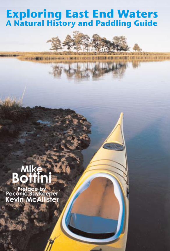
Exploring East End WatersA Natural History and Paddling Guide
Preface by Peconic BaykeeperKevin McAllister
AN
atural
Histo
ryan
dP
add
ling
Gu
ide
Mike
Bottini
1
1 |
H
ALLOCK
B
AY
Orient, Town of Southold
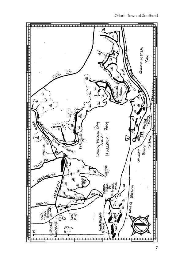
DISTANCE: The bay, including its many tidal creeks, smaller embayments anddredged channels, has over ten miles of shoreline to explore bycanoe and kayak.
ACCESS: 1) Orient Beach State Park: No permit needed (pay State parking feeat park entrance). From Greenport, travel 8 miles east on Rte. 25 tothe well-marked entrance of Orient Beach State Park and follow thepark causeway to where it ends at a circle. Look for a sign markingthe boat drop-off halfway around the circle. Park in the nearby lotand carry over the gravel road to the put-in (30 yards to Hallock Bayand 50 yards to Gardiners Bay).
2) Narrow River Road: Town of Southold parking permit is required.Eastbound on Rte. 25, travel 5.6 miles from the intersection of Rte. 25and Rte. 48 north of Greenport and turn right onto Narrow River Road.The access is just past the Narrow River Marina.
3) Orient Harbor: No permit needed for the NYSDEC-owned portion.Follow Narrow River Road (see directions above) to its southwesternend on Orient Harbor. Parking on the road requires a Southold Townpermit. The NYSDEC parking area is on the east side of the road.NOTE: This puts you in a fairly exposed part of Orient Harbor, with a0.75 mile-long paddle to the entrance of Hallock Bay.
TRIP NOTES: Orient Beach State Park naturalist Mary Laura Lamont hosts excellentnatural history programs at this outstanding park. Call the park (631-323-2440) for information and schedule.
December
The sun is as high as it gets in late December when Rob Battenfeld and I parkat Potato Beach on the west side of Narrow River. On the one hand, the sun hasdone its work, warming the frosty morning air to a delightful 50°F. On theother, considering December’s short days, we are getting a very late start for apaddle around Hallock Bay.
Hallock Bay is named for George W. Hallock, the Thomas Edison of agricul-ture. In 1870, Hallock took over a run-down farm bordering Orchard Streetand the west side of Narrow River. In those days farming practices oftendepleted the soil of minerals and nutrients and, according to a publication ofthe Oysterponds Historical Society entitled
Historic Orient Village
(1976), theOrient farms of the 18th and early 19th centuries never produced much above
1 |
Hallock Bay
2
subsistence level. Hallock, through careful management of the soil, increasedcrop yields tenfold and completely revolutionized farming.
Some maps and charts label this stretch of water Long Beach Bay, refering tothe four mile-long sliver of barrier beach that comprises Orient Beach StatePark. Long Beach forms the bay’s eastern and southern border, separating andprotecting it from Gardiner’s Bay. Gardiner’s Bay, having a long fetch to theeast here, can be a rough stretch of water. It is constantly rearranging the bar-rier beach’s shoreline and wreaking havoc on the paved causeway that pro-vides access to Orient Beach State Park.
Part of Hallock’s very successful operation included his own steamship toship produce to New England markets. Potato Beach was close to, if not theactual site of, Hallock’s wharf. While Rob and I begin unloading boats andgear, we strike up a conversation with a gentleman packing up after a success-ful morning of clamming. Hallock Bay is well known among baymen for itsshellfishing. At one time it was one of the most productive scallop areas on theeast end. “Any
Bay Scallops
show up in your clam rake?” I inquire. “Naw,just a few bugs,” a reference to small, one-year-old scallops.
A long discourse ensues on the various theories attributed to the mysteriousdecline of scallops. When we are ready to go, we wave to the clammer watch-ing us from his truck and set out across the mouth of Narrow River. We areplanning to do a clockwise paddle around Hallock Bay, and hope to haveenough time to explore some of its tidal creeks, man-made lagoons andditches, and a long, narrow appendage of Hallock Bay called Little Bay.
We are headed for a point of land labeled Barnfield Point on some maps,Eagle Point on others. This area has a long history of use by a Native Americangroup called the Corchaugs and English settlers, the latter dating back to 1661.As a result, many of its prominent geographical features have a number of dif-ferent names. For example, the whole area east of the Rte. 25 causeway andDam Pond was once known by its Indian name, Poquatuck. The early Englishsettlers called it Oysterponds. In 1836 its name was changed to Orient.
At Barnfield Point we pass by one of over a dozen
Osprey
nest poles foundin the Hallock Bay area. Paul Stoutenberg, a well-known naturalist residingon the North Fork, was involved in placing a number of these structures in themarshes along the Rte. 25 causeway, and may have had a hand in these aswell. Osprey are still rebounding from their pre-DDT numbers. If you are pad-dling during their nesting season, please keep your distance to avoid flushingincubating adults off their nests.
By December the Osprey are all far to the south, some as far as Brazil. Butanother magnificent piscivore, the Great Blue Heron, stalks for prey in ourwaterways all winter long. On our approach, one takes flight with a loud“Arawnk!” and disappears around the bend.
A large channel cuts into the salt marsh east of Barnfield Point, and we turnin to explore. My U.S.G.S. topographic map shows approximately ten of thesecurious channels along the north and west sides of the bay. Most parallel the
Orient, Town of Southold
3
bay’s shoreline and are located on the landward side of the salt marsh, adja-cent to farmland. They are clearly man-made features, but much wider thanthe ubiquitous, grid-like
mosquito control ditches
.We follow the channel for a third of a mile, where it dead-ends. It reminds
me of the lagoons adjacent to Moriches Bay that were created for raising ducks,but I can’t recall any reference to duck farms in Orient. Along its entire length,on our left, is a tall, steep-sided earthen berm, most likely the spoils from thedredged channel. Examining my map more carefully, I notice the symbol forlevee where the berm is located, and a series of these disconnected leveesextending along most of the bay’s northern shoreline.
A post-paddle call to local historian Elinor Williams solved this mystery.Storm surges periodically inundated low lying portions of farmland borderingthe bay. The salt water not only damaged crops but ruined the soil for the nextgrowing season. The Hurricane of 1938 did extensive damage. It took yearsbefore rainfall flushed the salt out of the soil and crops could be grown again.Sometime in the 1940s, to prevent that from happening again, the berms werebuilt. Instead of using valuable topsoil to construct them, farmers dug intowhat they considered at the time to be worthless salt marsh, creating lagoonsin the process.
Continuing east along the edge of the marsh, we pass a large area ofcordgrass (
Spartina alterniflora
) that has been heavily grazed, probably by geese.A large waterway on the west side of Eagle’s Neck leads into another dredgedchannel bordered by a steep-sided berm. Both Eagle’s Neck and BarnfieldPoint, as well as the west side of Narrow River, are depicted on an Oyster-ponds Historical Society map as sites of Poquatuck Indian camps. Roy Latham,in addition to being a great naturalist, was an amateur archeologist. Some ofthe Poquatuck artifacts he uncovered in this area can be viewed at theSouthold Indian Museum.
Despite the names of the neck and point, there are no records of eagles nest-ing in this area, at least as far back as the late 1800s. However, some readersmight be surprised to learn that Latham reported a pair of bald eagles nestingon Gardiner’s Island up until the 1930s. Wouldn’t it be something to see themreturn to nest some day!
Turning in my kayak to look for the source of an odd, soft grunting sounddrifting across the bay, I could barely make out the dark blotch on the waterthat marked a large raft of
Long-tailed Ducks
. Formerly known by the politi-cally incorrect name Oldsqaw, these striking sea ducks were making quite aracket.
Paddling through the narrows off Eagle’s Neck and entering Little Bay, wehead for its far end. There, alongside a rubble-strewn levee, both of us makean awkward exit to stretch cramped legs and have a bite to eat. Following oneof many deer paths through groundselbush that marks the upper edge of thesalt marsh, we make our way to the causeway where there is a great view overGardiner’s Bay. From north to south, Orient Point, Plum Island, the Ruins at
1 |
Hallock Bay
4
Osprey (
Pandion haliaetus
)
It is no surprise that the Osprey is one of the most popular wildlife species onthe East End. Its six-foot wingspan, habit of hunting in broad daylight over openwater, and large, highly-visible nest all combine to make it the most easily rec-ognized bird of prey in our area.
It is not uncommon, particularly among paddlers, to witness an Osprey circlehigh overhead, hover for a moment, and then tuck its wings as it dives headfirst towards the water. Adjusting itself at the last moment to hit the water feetfirst, its momentum sometimes carries it completely underwater. Back at thesurface, it unfolds its wings and struggles to get airborne again. More oftenthan not, it rises from the water empty-taloned.
A successful plunge is evident in the form of a wriggling fish in its talons. Onceairborn, the Osprey will reposition its feet such that the head of the fish facesforward while flying, apparently making its load more aerodynamic for the tripback to the nest or a favorite dining perch.
Fish are the main prey of the Osprey, so much so that it is also known as the FishHawk. Its arrival here in mid-March is closely synchronized with the movementof Alewives from their deep water overwintering sites to the shallows of baysand tidal creeks and the start of the spring spawning run.
The Osprey has a few unique adaptations for catching and hanging onto fish.It’s front talons are the most flexible of any raptor, and can turn completelybackwards. And the rough pads on the undersides of its feet and toes havespines for holding onto slippery fish. Despite its strong preference for fish, theOsprey is sometimes seen hunting over land, and will occasionally catch othertypes of prey.
On their Atkins-style diet, the fledglings grow quickly, reaching adult size bylate July or early August. At this point, it’s not easy to distinguish the adults fromthe young by size alone. With the aid of binoculars, look for a distinctiveflecked or dappled color on the topside of the wings, marking the young-of-the-year, as opposed to the uniform chocolate brown of the parents.
In August, Ospreys begin heading south to their overwintering areas in Florida,the Caribbean and as far as the Amazon basin. I’ve always wondered why thisfish-lover leaves so early, just before the big fall run of Bluefish, Striped Bass, her-ring, and Silversides on the East End. Must be better fishing in the south.
Orient, Town of Southold
5
Gardiner’s Point, Gardiner’s Island, Springs, and the sandy bluffs of HedgesBanks in East Hampton Town are visible on the horizon.
Long Beach, or what is now Orient Beach State Park, has never been pri-vately owned. Since the area was settled by the English in the 1600s until1929 when it was deeded over to New York State for a public park, LongBeach was held and managed as common lands belonging to all the maleinhabitants of the Orient area. Leases were drawn up for uses such as pastur-ing, beach rights and, from 1865 to 1895, a fish factory that processed menha-den into oil and fertilizer.
In addition to outstanding views over the surrounding bays, the park boastsa number of rare and unusual plants and is designated a National NaturalLandmark. This is the only place on the East End that I have seen the Black-jack Oak (
Quercus marilandica
). I was surprised to learn from the SuffolkCounty Soils Map that most of the park’s upland area, including the naturetrail through the Blackjack Oak forest, is classified as fill.
Back in Hallock Bay we hug the park’s shoreline, enjoying the late after-noon sunlight that illuminates the golden-browns of the marsh grasses andgreens of the eastern red cedars. Waterfront signage here reflects a tug-of-warbetween boaters coming ashore to picnic and park managers trying to avoiddisturbance to rare plants and nesting birds. Until 2004, canoes and kayakswere actually prohibited from the park.
Fortunately, this policy has been changed. With that change comes theresponsibility to practice good stewardship of which all paddlers should beaware. Steer clear of nesting birds, avoid trampling ssensitive beach and dunevegetation, and leave nothing behind but your wake.
At Jupiter Hole we follow the incoming tide into a small creek, bearingright at the first fork on the narrow waterway. Soon the creek opens up into asmall salt pond that appears to be a dead end. I became familiar with this arealast winter while on the Orient Christmas Bird Count, and knew that a shortnavigable section of mosquito ditch linked this with another, larger salt pondapproximately a half-mile in from the bay.
Soon Rob and I are standing next to an interpretive sign on an old roadway,enjoying some of the most beautiful scenery on Long Island. At our feet arehundreds of specimens of Long Island’s only native cactus, the Prickly PearCactus (
Opuntia humifusa
), and in the woods nearby were remnants of the fishfactory that operated and housed a small village of workers in the 1800s. ThePark Superintendent has some great photos of the fish factories, an interestingera of East End history. I would love to see these ruins made more accessibleand interpreted some day.
Paddling back to the bay, I try to photograph the oddly-shaped, multi-stemmed Eastern Red Cedars that border the marsh and salt ponds here. Thelow, late afternoon sunlight seems to illuminate my subject perfectly, but itjust doesn’t look quite the same in my view finder.
1 |
Hallock Bay
6
Back in the bay, we cross over to Peters Neck Point to explore the smallembayment formed by it and Brown’s Point. It is now getting late, and we arepushing our luck with getting back to the cars before dark, but neither one ofus has been in this section of the bay before. It turns out to be well worth thetime and effort. An island of oaks called Gid’s Island divides the embaymentin two, with the southern arm leading to a small but navigable tidal creek thatpasses under Peters Neck Road. A beautiful stretch of water, this creek hugsthe back edge of the bay dune and winds its way westward to Hog Pond, notfar from the site of the Old Slave Burial Ground on Narrow River Road.
The historic burial ground has an informative monument and is worth visit-ing. Unfortunately, the well-protected creek does not appear to be navigableall the way to Hog Pond; my guess is it’s 0.2 mile short of Narrow River Road.
The sun has now set but there is plenty of twilight to navigate by. Noticinga series of ditches running along the landward side of Gid’s Island andBrown’s Point, Rob and I hope our good luck will hold as we try to cut acrossthe marshland and avoid the longer paddle around the island and point.
The channel separating Gid’s Island is wide and a nice passage; the con-torted route across Brown’s Point is another story that ended with an awkwardcarry and wet feet. But we have managed to explore quite a few of the nooksand crannies in Hallock Bay, one of the East End’s outstanding waterways, andit has been an exceptional day on the water.
Orient, Town of Southold
7