exploring keno hill - yukon€¦ · exploring keno hill. stories about a silver deposit. yukon...
TRANSCRIPT

����������
Exploring Keno HillSTORIES OF A SILVER DEPOSIT

Signpost Road: 10.5-km steep drive to the top
Top of Keno Hill Butterfly trail: hike in a butterfly meadow
Silver Basin trail: hike with views over Keno-Ladue valley and down Silver Basin Gulch
Monument trail: hike on the summit overlooking old Keno 700 minesite
Lightning Creek trail: hike with long option to McMillan Gulch
Gambler Gulch trail: hike to Gambler claim and Wernecke townsite with full-day option to Faro Gulch
Keno 700 trail: hike to old minesite with views to Gustavus Range
Mount Hinton Sourdough Hill trail: hike with long option to south peak of Mount Hinton
Bunker Hill trail: hike from Keno City to north peak of Mount Hinton
CONTENTSWelcome to Keno Hill, p.1Getting here: The Silver Trail highway, p.2Keno City, then and now, p.4Beringia and glaciation, p.6Nacho Nyak Dun: “Big River People,” p.8Hiking on top of Keno Hill, p.10Placer mining: The search for gold!, p.14A world-class silver deposit, p.16Geology, p.22Mineralization, p.23
©2004, Yukon Development Corporation, (867) 393-5300
Production by: K-L Services, Whitehorse, Yukon
This guide is provided by Yukon Development as a community service. Every effort has been made to verify the information provided here. Any suggestions you have for inclusion in future printings are welcome. USE OF THIS AREA IS STRICTLY AT YOUR OWN RISK.
One in a series of local attraction guides. Also available: Enjoying Whitehorse Trails, Exploring the Whitehorse Fishway and Viewing Whitehorse from Above: A guide to Haeckel Hill.
To refer to this publication, please use the following:K-L Services, 2004. Exploring Keno Hill. Stories about a silver deposit. Yukon Development, 25 p.
All photos © by the photographers.
Cover photos: Insa Schultenkotter (dog on Keno 700 trail, cabins in Gambler Gulch), Bruce Bennett (Mourning Cloak butterfly), Peter Long (moose on Sourdough Hill, ore cart tracks at Keno 700 minesite, hikers on Silver Basin trail, Mountain Club-moss: Lycopodium selago).
Thanks to…Bruce Bennett, Barbara Bergmann, Jeff Bond, Steve Buyck, Marilyn Dobbin-White, Doug Eaton, Diane Emond, Libby Gunn, Lillian Loponen, Laurie MacFeeters, Mike Mancini, Mike Phillips, Sally Robinson, Charlie Roots, Nerissa Rosetti, Insa Schultenkotter, Sonia Stangee, Sam Wallingham
Publié aussi en français et en allemand.
Auch auf Französisch und Deutsch erhältlich.
For more information105M/14/quartz claims, Mayo Mining District, 2003. Energy, Mines and Resources, Yukon Government.
Gaffin, Jane, 1980. Cashing In. Word Pro, Whitehorse, Yukon.
Kindle, E.D., 1962. Geology, Keno Hill, Geological Survey of Canada, Map 1105A.
LeBarge, W., Bond, J.D. and Hein, F.J., 2002. Placer gold deposits of the Mayo area, central Yukon. Exploration and Geological Services Division, Yukon Region, Indian and Northern Affairs Canada, Bulletin 13.
Lipovsky, P., Bond, J. and LeBarge, W., 2001. Mayo area placer activity map. Exploration and Geological Services Division, Yukon Region, Indian and Northern Affairs Canada, Open File 2001-31.
Mayo Historical Society, 1990. Gold & Galena.
McTaggart, K.C., 1960. The geology of Keno and Galena hills, Yukon Territory. Geological Survey of Canada, Bulletin 58.
Pielou, E.C., 1991. After the Ice Age. University of Chicago Press.
Yukon Government, 2002. Yukon’s wildlife viewing guide.
Signpost Road, p.5Butterfly trail, p.11Silver Basin trail, p.12Monument trail, p.13
Lightning Creek trail, p.15Gambler Gulch trail, p.20Keno 700 trail, p.21Mount Hinton, p.25
Active living is a way of life in which physical activity is valued and incorporated into daily life! Recreation and Parks Association of the Yukon encourages
Yukoners to get active — your way — every day! For information and inspiration call 867-668-2328.
Trails described in this guide

Nestled in the mountains in central Yukon, the Keno Hill area was once host to one of the world’s richest
silver deposits. The many tracks and trails, no longer used for mining, are here now for experienced hikers, mountain bikers and winter sports enthusiasts.
High (1,848 m) and exposed, the top of Keno Hill stayed above the glaciers in the last ice age. Descendants of plants and insects (including butterflies) that were here during the ice ages remain in the meadows.
Visit in late spring or early summer and take advantage of the long hours of sunlight to hike late into the evening. Listen for the birds singing after the sun disappears.
RESPECT Alpine environment is very fragile and easily destroyed. Staying on the trails protects ground-nesting birds and flowers. Butterflies need flowers for food. Other people will want to enjoy them after you are gone. Keep your pets on a leash to avoid harassing wildlife—dogs are an unfamiliar enemy to slow-moving marmots.
While on the trails you will encounter old buildings and artifacts. Please leave them in place. Taking artifacts is against the law. They are part of Keno’s mining heritage and should be left for the enjoyment of others.
Keno City residents welcome visitors, but they ask that you pack out whatever you bring in.
SAFETY Please resist from exploring mine workings. Old shafts can be hidden and very deep, and may not be closed. Timbers may have rotted internally and can collapse without warning.
Approach cliff edges with respect; the rocks are loose and drop off constantly. Snow patches are icy and can be very steep and dangerous to walk on.
Please be cautious on mining roads. They are not maintained and have become overgrown. Some are hard to follow; several lead through thickets of willow and alders.
Watch for washouts, slides, overflows, ice, mud and rough conditions. There is no formal rescue capability in Keno City.
Use common sense. Tell someone where you are going and when you expect to return.
You are in wild country. Be aware, make noise and where possible, stay in open areas so as not to surprise a bear.
The Mayo Renewable Resources Council is interested in hearing of any wildlife sightings, particularly of caribou.
Welcome to Keno Hill
Built in the 1920s, this is the last building remaining at the Sheep Camp minesite. Insa Schultenkotter
1

The Silver Trail highway is 112 km from Stewart Crossing to Keno City at the base of Keno Hill. Highway 11,
called the Silver Trail, is within Nacho Nyak Dun First Nation traditional territory, an area with sensational scenery, hiking, fishing, berry picking and camping.
The Silver Trail starts at the north end of the Klondike Highway bridge over the Stewart River. This hard- surfaced road to Mayo has many glimpses of the Stewart River, several pullouts and views of glaciated terrain. The brochures, Yukon’s Wildlife Viewing Guide and It’s all on the Silver Trail, can be found at Yukon information centres.
•The Village of Mayo, at kilometre 50, has propane and gas, motels, restaurants, a post office, liquor store, grocery store, recycling station, swimming pool, nursing station, RCMP, airport and float plane services.
The Binet House Interpretive Centre (summer only) contains a collection of historic photos, interpretive information, a three-dimensional map of the region, and an extensive geology and mining display. Pick up a copy of the Mayo Historical Buildings Walking Tour.
Beyond Mayo, there are no gas stations or food stores. Make sure that you have all the supplies you will need.
Hard surfacing ends 5 km beyond Mayo, just after the turnoff to Yukon Energy’s five megawatt hydroelectric plant on the Mayo River. Built in 1952 to power the silver mines at Keno and Elsa, today, a transmission line connects the dam to Dawson City. (There is no room to turn around at the gate to the dam.)
The Five Mile Lake Campground, with a day use area, swimming, boating, and trail around the lake, is half a kilometre past the dam turnoff. From there, the highway continues as a maintained gravel road.
Near Halfway Lakes is a typical drunken forest — melting permafrost causes trees to lean in different directions, appearing
“drunk.” The luxurious moss, and shrubs like labrador tea and heather, insulate the frozen ground, which melts if the cover is damaged.
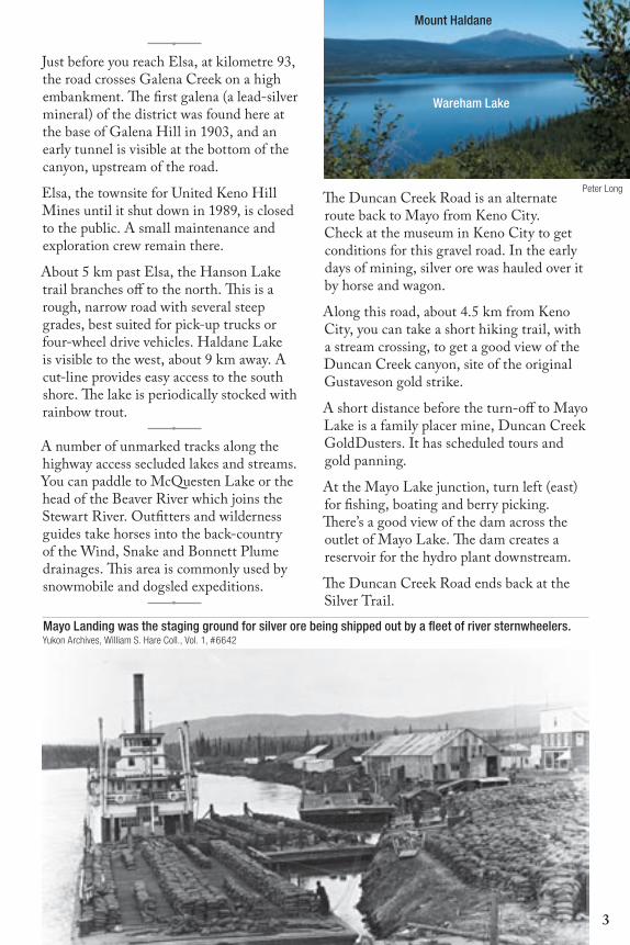
Mount Haldane, rising 1,200 metres to 1,839 metres, is an impressive peak. To hike on the hill, take the access road on the left (west), just before the inn at the lake. Follow this gravel road for 2 km to a parking lot. The trail goes in three zigs up the east side of the mountain to the ridge saddle south of the main peak. It is 7.5 km, following a track to the ridge crest, then 1 km along the rocky, exposed crest to the summit. There are picnic tables with good views that serve as objectives for shorter hikes. (See the brochure, Climb Mount Haldane.)
Getting here: The Silver Trail highway
Stewart River
McQ
ueste
n River
Mayo River
0 16 32
km
Keno Hill
Keno CityElsa
Keno Hill
Keno CityElsa
Mt.Haldane
Moose CalvingKey Habitat
Area
Stewart Crossing
Mayo
Stewart Crossing
MayotoDawsonCity
to Whitehorse
Silver Trail
KlondikeHighway
MayoLake
HalfwayLakes
Five MileLake
Hanson Lake trail
pavedgravel
Duncan Creek R
oad
N
S
EW
2
11
2
11
DawsonCity
Whitehorse
BeaverCreek
WatsonLake
DawsonCity
YUKON
Whitehorse
BeaverCreek
Keno City
OldCrow
MayoStewartCrossing
WatsonLake
2
•Just before you reach Elsa, at kilometre 93, the road crosses Galena Creek on a high embankment. The first galena (a lead-silver mineral) of the district was found here at the base of Galena Hill in 1903, and an early tunnel is visible at the bottom of the canyon, upstream of the road.
Elsa, the townsite for United Keno Hill Mines until it shut down in 1989, is closed to the public. A small maintenance and exploration crew remain there.
About 5 km past Elsa, the Hanson Lake trail branches off to the north. This is a rough, narrow road with several steep grades, best suited for pick-up trucks or four-wheel drive vehicles. Haldane Lake is visible to the west, about 9 km away. A cut-line provides easy access to the south shore. The lake is periodically stocked with rainbow trout.
•A number of unmarked tracks along the highway access secluded lakes and streams. You can paddle to McQuesten Lake or the head of the Beaver River which joins the Stewart River. Outfitters and wilderness guides take horses into the back-country of the Wind, Snake and Bonnett Plume drainages. This area is commonly used by snowmobile and dogsled expeditions.
•
The Duncan Creek Road is an alternate route back to Mayo from Keno City. Check at the museum in Keno City to get conditions for this gravel road. In the early days of mining, silver ore was hauled over it by horse and wagon.
Along this road, about 4.5 km from Keno City, you can take a short hiking trail, with a stream crossing, to get a good view of the Duncan Creek canyon, site of the original Gustaveson gold strike.
A short distance before the turn-off to Mayo Lake is a family placer mine, Duncan Creek GoldDusters. It has scheduled tours and gold panning.
At the Mayo Lake junction, turn left (east) for fishing, boating and berry picking. There’s a good view of the dam across the outlet of Mayo Lake. The dam creates a reservoir for the hydro plant downstream.
The Duncan Creek Road ends back at the Silver Trail.
Mayo Landing was the staging ground for silver ore being shipped out by a fleet of river sternwheelers. Yukon Archives, William S. Hare Coll., Vol. 1, #6642
Mount Haldane
Wareham Lake
Peter Long
3

Keno City, then and now
museum
From its beginnings in 1919 as a stopping point on a haul road, Keno City quickly grew into a centre for
supplies and recreation. A hotel and stables were built and even some abandoned placer miners’ cabins were retrieved from Duncan Creek. In 1922, it was officially established as a town, complete with a liquor store and post office.
Keno City served as a base for miners, trappers, hunters, prospectors and First Nation people. On weekends, the miners, who worked hard then played hard, came into town from the mining camps. Moonshine, gambling, prostitution and fights were common in the 1920s, 1930s and again after World War II in the 1950s.
The prosperity of Keno City rose and fell with the mines. Canadian silver prices
declined in 1940, and the death in a plane crash in 1941 of the brilliant geologist and mine manager, Livingstone Wernecke, led to the closing of the large Treadwell Yukon operations.
United Keno Hill Mines Ltd. opened in 1947. By the late 1950s, these mines had become the second largest silver producers in North America and the fourth largest in the world. They continued until 1989.
While the Keno and Elsa areas had over 600 residents in 1980, today Keno City has a population of about 20, mostly artists and outdoor enthusiasts. It continues to serve as a base for local exploration and recreation.
Pick up a copy of the brochure, Keno City Historical Buildings Walking Tour from the mining museum.
Housed in a 1920s dance hall, the Keno Mining Museum has a wealth of equipment used in the early days, as well as artifacts from everyday life in the mining communities. Yukon Archives, William S. Hare Coll.,#6838
4

A drive to the famous signpost at the top of Keno Hill will reward you with
a breathtaking panorama. You rise quite rapidly past changing views over the valleys. By kilometre seven, the road levels out and you are above treeline, passing alpine meadows overlooking the McQuesten Valley and the Ogilvie and Wernecke mountains.
This 10.5-km gravel road is not recom-mended for large motorhomes or trailer rigs. There are switchbacks and no pullouts although there is turnaround room on top. Inquire at the museum for road conditions.
At the top, overlooking Faro Gulch, sits the signpost. United Keno Hill Mines erected the original wooden signpost (right) in 1956, when the company hosted a group of visiting scientists during International Geophysical Year. Arrows point to the cities represented by delegates. The current steel signpost dates from 1989.
There’s a good chance you will see marmots in this area so be observant.
Signpost Road
Jose
ph M
ouch
a
LODGEPOLE PINE (Pinus contorta var. latifolia) can be distinguished from spruce by its needles, which appear in pairs, resembling tweezers. These pines in the subalpine have bark that is smooth instead of flakey and scaley like valley pines, and their needles are often found in groups of threes. Few lodgepole pines are found north of Wareham Lake, though they are continuing their slow march north. Only one pine (left) is known of on Keno Hill, at kilometre six of Signpost Road.
WILD RHUBARB (Polygonum alaskanum) This shrubby plant (right), with plumes of tiny greenish white flowers, is a pioneer of disturbed sites so it is often found on roadsides and riverbanks. Its succulent young stems and leaves are edible. Wild rhubarb is widespread in unglaciated areas of Alaska and the Yukon but has not spread much farther since the glaciers retreated. You can find it 5 km up Signpost Road.
two
phot
os b
y Pe
ter L
ong
5

2500
2000
3000
4500
3500
4000
5000
5500
6000
5000
3000
2500
3500
6000
4500
4000
4500
3500
6000
3000
3500
4500
3000
3500
3000
5000
2000
4000
3500
4500
3500 2000
5500
5500
4000
4500
5000
4500
2500
3500
4000
4500
3500
3000
3000
5000
3500
50005500
4500
5000
3500 4000
4500
5500
4500
4000
4500
4000
6000
3000
3000
4500
3000
3500 30004000
2500
6000
2000
4000
4000
6000
5500
4000
5000
4000
5500
3500
4500
2000
2500
5500
4500
5000
30003500
3000
3000
4500
4000
4000
3000
4000
4000
4000
5500
3500
4000
4000
4000
4500
5000
6000
5500
5000
4000
5000
6000
3500
2500
4500
3000
4000
4000
5500
4000
3000
5000
3000
3500
3500
4500
4500
5500
4500
3500
4000
2000
3500
5500
4000
5500
4500
4000
6000
3500
3000
4000
3500
2500
4000
3500
2500
3500
4500
4500
3500
3500
2500
4500
5000
5000
4000
4000
3500
3500
3500
4500 5000
4000
4500
4500
4000
3000
4000
4000
3000
4000
3500
4000
5000
5500
3000
3500
4000
3000
4500
4000
3500
3500
4500
3000
4500
5000
4000
3000
3000
4000
3500
3500
4500
4000
4500
5000
3500
5000
3500
4500
3500
4500
6000
4500
4500
4500
3000
5000
2500
5000
3500
3000
4000
6000
4500
3000
3000
4500
4000
4500
3500
3000
4000
2500
3000
2500
3500
2500
4000
3000
4000
4000
3500
3500
3000
3500
3500
4000
4500 3500
3500
3500
5000
4500
4500
2500
4000
3500
2000
4500
4000
Mount Hinton
Mount Albert
Van C
leave
sHill
C H A M B E R S H I L L
G U S T A V U S
R A N G E
P A T T E R S O N
R A N G E
D A V I D S O N
Keno Hill
Galena Hill
MountHaldane
MountCameron
MountPatterson
PotatoHills
R A N G E
K e n o
Lake
Christal
R i v
e r
M c Q u e s t e n
L a d u e
Faith
Ck
L A K E
M A Y O
C r e e k
D u n c a n
CkLightning
Mayo
M a
y o
R i v e
r
Janet Lake
Minto
R I V E RS T E W A R T
At the signpost on top of Keno Hill, you can look out over the McQuesten and Keno-Ladue valleys
and see the mountains of the Yukon Plateau in the background.
Keno Hill is in the Yukon Plateau-North ecoregion. This ecoregion is bounded to the south by the Tintina Trench, an ancient fault where deposits of at least seven glaciations are recognized by geologists. Large rivers, including the Pelly, Ross, Macmillan, Stewart, Hess, McQuesten and Klondike, drain the plateau, and most follow the trench for a short way before emptying into the Yukon River. Their glaciated valleys host numerous important wetlands.
Life on an islandWhen icesheets covered much of North America and Central Europe, huge amounts of water were locked up as ice. So much, that sea level was nearly 150 metres lower than today. Much of the Bering Sea became dry land. As the sea floor was exposed, a “bridge” of land up to 1,200 km wide
connected North America to Asia. Eastern Russia, Alaska, Yukon and the NWT’s Mackenzie Valley region became a new subcontinent known as Beringia.
The enormous continental ice sheets that covered much of the northern hemisphere isolated Beringia from the rest of North America and Asia.
Keno Hill was just on the edge of Beringia but at the height of glaciation, the higher mountain peaks were still exposed. In a sea
Green/white: Reid/McConnell glaciations; brown: unglaciated areas, generally mountain tops; grey lines and arrows show ice flow; black lines: limits of ice flow. Adapted from Lipovsky et al, 2001, OF 2001-31, Mayo area placer activity map
Beringia and glaciation
McConnell glaciation in Beringia. D. Hopkins et al (eds.) Paleoecology of Beringia, Academic Press, New York, 1982.
100 km
6
Beringian shoreline, exposed seabedLate Pleistocene glaciers
land exposed today
0 500 km
ARCTICOCEAN
PACIFIC OCEAN
Indigirka R.
Kolyma R.
Omolo
n R.
Anadyr R.
Yukon
R.
Bering Sea
Chukchi Sea
Berin
g St
rait
Siberia Alaska
Yukon
ARCTIC CIRCLE

of ice, these “nunataks” acted as islands of life.
Steppes The landscape of Beringia itself was different than today in the Yukon. Because the climate was drier, much of the tussock tundra of today was steppe — consisting of short grasses, sage and a lot of bare ground. This “Asian steppe” habitat can still be found in parts of Central Asia and Siberia. Artistic sketches of Beringian landscapes show groups of woolly mammoths or herds of steppe bison. Although these large mammals are now extinct, many of the plants that they ate still grow here.
Beringian flora During full glaciation many plant communities existed. Some were similar to what we see today and others were very different. Most noticeably, there is no evidence of any trees in this area, with the possible exception of paper birch (Betula neoalaskana), balsam poplar (Populus balsamifera) and some willows that reach tree size such as felt-leaf willow (Salix alaxensis). Many Beringian plants have spread far beyond the borders of Beringia while others are today only found on mountain tops growing in conditions likely very similar to those that they faced when mammoths roamed the land.
Local glaciers The Keno area was mostly overlain by Reid (around 300,000 years ago), and McConnell (25,000 to 12,000
years ago) glaciers. Traces of the ice ages are found on many area hillsides.
During the Reid glaciation, Keno Hill poked above the ice sheet. Ice surrounded Keno Hill, Galena Hill and the Gustavus Range, and was at least 760 metres thick in the Keno-Ladue valley.
During the McConnell glaciation, as the weather got colder, alpine glaciers developed in north-facing cirques at the headwaters of local drainages like McNeill and McMillan gulches. At the same time, large accumulations of ice in the Selwyn and Ogilvie mountains were advancing to this area. About 18,000 years ago, at the peak of the ice flow, valley glaciers wrapped around lower parts of mountains around Keno Hill.
It is thought that valley glaciers south of Keno Hill used to drain northward, via Christal Creek (named after Charles Christal, who found and staked the first gold here in 1902). During the McConnell glaciation, ice in the Keno-Ladue valley flowed south, up Christal Creek into the Duncan Creek drainage. The terminal moraine (rock debris deposited at the front of a glacier) from this lobe underlies Keno City. Lightning Creek was forced south into the Duncan Creek drainage by the lingering presence of this ice mass and the terminal moraine. The rock canyon in which Lightning Creek passes through Keno City is left over from this glacial diversion.
7
COLLARED PIKA or Rock Rabbit is genetically related to rabbits and hares. They spend all summer gathering food, forming hay piles, drying the hay and storing it in their rocky burrows for winter use. Unlike marmots they do not sleep the winter away, but remain active, feeding under the protective covering of snow.
These populations survived in Beringia. Today, the collared pika has expanded its range south and east but only as far as the northwestern corner of British Columbia. In the Yukon, the collared pika is found on most Yukon mountains except in the extreme north.
Fritz
Mue
ller

As you explore the trails in the Keno Hill area, you may wonder what it was like for the early people here.
When did people first start living here?
People likely lived in the area, depending on the ebb and flow of the ice, during the last glaciation. Life at the edge of the ice sheet would have given them access to different resources at different times.
First Nation people have a life based on the land. Their stories from the past describe a hard life, made possible in large part by sharing. Five to ten families, each including two to four children, travelled together. They likely ranged over an area about 1,000 square km.
Then, as today, mosquitoes and blackflies would have been intolerable at times. Crushed spruce beetles, juice from certain plants, smoke and windier camp sites were all used to deal with the insects.
Some valleys were rich in moose, beaver, marten and lynx. According to a government reconnaissance report in the early 1900s, meat-drying racks were everywhere along stream banks.
People were smart about their use of the land and its resources. They set fires both to clear land for easier travel and to create better moose habitat.
In winter, they snared sheep in the Ogilvie Mountains and around the Wind River or across the divide in the Mackenzie Mountains near the Arctic Red River. They built moose fences and caribou corrals in the mountains north of the Stewart River.
In summer, they caught and dried grayling and salmon, and fished for lingcod, whitefish, pike and inconnu. Nets were set across the narrows of creeks. Berries were plentiful, particularly blueberries.
The people didn’t stay in one place, but moved to where food would be best. After dense forests returned to the area, travel, where possible, would have been on the smooth ridges above treeline. To travel the bigger rivers they would build rafts, or sometimes, skin boats; this could take about a week.
They would also collect food as they moved. When they caught a large animal such as a moose, they would stay for days to dry the meat. Sometimes they took the meat with them. Other times it was buried in a pit, with a fire lit on top to stop the smell attracting animals.
Families in one area might be related to families living far away, based on contacts made during hunting and trading expeditions.
After the arrival of the first fur traders to the north, life changed. A trading post was built at Fort Selkirk and, in exchange for beaver pelts, First Nation people received guns, shells and clothing.
Fort Selkirk people also used the Stewart River area to hunt, and salmon fishing here was very good. People used to stay to dry meat and fish. About 75 people settled in
WILLOW (Salix pulchra) is one of many species that grows well on Keno Hill. Along Signpost Road, the nibbled tops of the branches indicate a lot of moose activity.
Nacho Nyak Dun: “Big River People” Pe
ter L
ong
8

WHITE MOUNTAIN HEATHER (Cassiope tetragona) is abundant on the summit of Keno Hill, especially near rock piles. Pikas eat almost all types of vegetation up to 10 metres away from the safety of their rock pile homes — except for heather. The large mats, festooned with white bells, bloom in July.
the newly established town of McQuesten, built as the result of a nearby post.
Other people from Fort Good Hope stayed at Lansing. It also was a place to trade fur. Lonny Johnny said his grandfather trapped
“all over,” at the Wind, Bonnet Plume, Snake, Little Arctic and Arctic Red rivers since there were a lot of moose to be found. First Nation people were hardy, often travelling and hunting for days in freezing weather.
At first, as miners arrived in the area, First Nation families provided fish and wild game to the camps.
However, as the newcomers arrived in larger numbers, game began to disappear from the area about Galena and Keno hills.
When Gene Binet built the store at Mayo Landing in 1903 and the road was put in to Duncan and Haggart creeks, people started to move from the McQuesten post to Mayo. The store in McQuesten closed down in 1904. The large Peters family and others moved to the mouth of the Mayo River.
Through the 1920s and 1930s, in addition to trapping, First Nation men worked as market hunters, selling meat and fish in Mayo, or cutting firewood for the steamboats. As well, they found work as camp hunters and guides, and in the silver mines at Keno Hill.
Mayo Elder Helen Buyck remembers seeing thousands of caribou at the mouth of the Mayo River, and crossing the ice of the Stewart River, as late as the 1930s.
The South McQuesten River valley lies immediately north of the Elsa townsite. A First Nation family, the Germaines, has trapped and hunted in this area for generations. The valley is rich with moose, beaver, martin and lynx. The McQuesten Lakes, further up the valley, have lingcod, whitefish, pike and inconnu. The family set nets in the narrows of an emptying creek, and Jenny Germaine reports “ lots of fish there. Keno, in summer time we stayed there, picked lots of blueberries. We also had a house in Keno. We hunted gophers and whistlers; we used to walk there. There was graylings in Christal Creek.” After the prospectors started settling here, the Germaines provided fish and wild game to the mining camps.
Today, their descendents are members of the Nacho Nyak Dun First Nation and many live in Mayo.
NW
T
YUKO
N
A R C T I C C I R C L E
DAWSONCITY
OLDCROW
FAIRBANKS
MAYO
KENOCITYMcQUESTEN
LANSING
FORTSELKIRK
FORTMcPHERSON
FORTGOOD HOPE
NORMAN WELLS
FORTNORMAN
AKLAVIK
HAINES
WATSON LAKE
HAINESJUNCTION
CASSIAR
SKAGWAY
DEASE LAKE
WHITEHORSE
Peel R. B
onnet Plum
e R.
Wind R
.
Mackenzie R.
Als
ek R
.Tat
shen
sh
ini R.
Liard R
.
South Nahanni R.
Yukon R.
Yukon R.
Pe
lly R.
Hess R.
Macmillan R.
Keele
R.
Lansing R.
Stewart R.
McQuesten R.
Beaufort
Sea
km
0 250
Pete
r Lon
g
9

Keno Hill is the name given to the mountain above Keno City. It actually
is five summits — each a hill in its own right (shown on the map below).
As you drive up Signpost Road, you will pass structures of two eras: the 1920s to 1960s, and the galvanized steel of the 1970s. Most of the big open pits were mined in the 1970s, along with some very selective remining in the early 1990s.
In the early days, Livingstone Wernecke noted the depth of permafrost intersected. These notes are very useful today in studies of climate change. Also, in the very stable air underground, gigantic hoar frost crystals grow, and some of these contain flakes of silver, precipitated from the cold, damp air.
The plateau west of the signpost has undergone more than 300,000 years of
freeze-thaw cycles, creating an undulating field of frost-fractured rock, called a cryoplanation terrace. This hill top was not scoured by ice during this period of time. In contrast, about 20,000 years ago, Faro and Silver Basin gulches were deepened by valley glaciers which plucked rocks from the base of the headwalls, creating cirques. Mounds of sand and boulders further down these valleys, and on the south slope of Keno Hill, are called moraine, and mark the limit of the glacial advances. The height of formerly glaciated parts of the mountain can be determined by noting boulders that differ in composition from their surroundings: these are erratics, transported by the moving ice.
Hiking on top of Keno Hill
Monument Hill
Adapted from J.D. Bond, Geoscience Map 1998-4, Surficial Geology of Keno Hill
Sheep Camp
Monumenttrai lButterf ly t rai l
Si lver Basin trai l
Sig
npos
t Road
Keno 700 trai l
5500 ft
5000 ft
6000 ft
5500 ft
5000 ft
4500 ft
Chari t
y G
u l ch
H o p e G u l c h
F a r o G u l c h
Looking eastward from the signpost, a winding track leads to Sheep Camp at the junction of the Monument and Silver Basin trails. Peter Long
There are three marked trails at the top of Keno Hill: Butterfly trail, Silver Basin trail and Monument trail. Trails are described on the following pages. The yellow area on the map at left is blown up below.
Yukon Environment Geomatics
vv
vv
vvvvvvv
V
V VVV
VVVVV
GulchBasin
Silver
McK
ay G
ulch
GulchFaroGulch
Gambler
Gulc
hHo
pe
Lightning Creek
Gulch
Gulch
Faith
Char
ity
McMillan
BEAUVETTEHILL
CARIBOUHILL6065
3000
4500
4500
5500
5000
4000
45003500
45004000
SUMMITKENO
MINTOHILL MONUMENT
HILL
VV
glacia l errat ics: Reid, ear l ier
cryoplanat ion terrace
bedrock
moraine r idge
cirque: McConnel l
g lac ia l l imi t : McConnel l , Reid
roads, t racks10
20 km
20 km

Insa
Sch
ulte
nkot
ter
Bruc
e Be
nnet
t
Rock Ptarmigan eggs. Peter Long
FEW-FLOWERED CORYDALIS (Corydalis pauciflora) are found in seepy areas usually fed by late snowmelt but they are easy to overlook. The Everman’s parnassia butterfly (below) needs to find this plant in order to lay its eggs and feed its young. Of the three species of Corydalis found in the Yukon, this is the only one that lived in the Yukon during full glaciation. It is now found throughout Alaska, Yukon, northern British Columbia and mountainous areas of Russia and eastern Asia.
Butterfly trail
This marked trail starts and ends at the signpost, taking between 45 minutes
and one hour to complete. You pass across the rocky alpine tundra through prime butterfly habitat. When you reach the top of the south-facing slope, follow the markers down to the right, staying on the trail to avoid disturbing any wildlife. Far below are the buildings from the Keno 700 mine. Please stay away from these old structures.
The Butterfly trail joins the Keno 700 trail, turns right, and brings you back to Signpost Road. From here, turn right to return uphill to the signpost.
Keno Hill’s butterflies have adapted to survive short summers and the rugged, often inhospitable, alpine climate. However, they are still sensitive to weather conditions, so timing your visit for a warm, sunny, July day will give you the best chance to see them. The butterflies are not active in strong winds or on cold, wet days. It is amazing to watch when the sun comes out — all of a sudden, the butterflies start flitting about.
Some butterfly species are synchronized with each other; they all hatch from eggs in the same year and take two years to mature, so there are only adults flying every second year. Other species have some adults flying each year, even though they take two years to mature.
Birds commonly seen in the tundra include Rock, Willow and White-tailed ptarmigan, American Golden Plover and American Pipit.
11

Ladue Lake
Gambler Lake
Davidson Range
Hanson Lakes
Yukon Plateau
Bruc
e Be
nnet
t
View northward from an old minesite on the Silver Basin trail. Insa Schultenkotter
YUKON RAGWORT (Senecio yukon-ensis) are mostly single stemmed and covered with woolly, curly hairs. This hardy member of the sunflower family usually grows tall compared to its neighbours, sometimes reaching 35 cm. Look for it in the dry, wind-swept heath tundra habitat of the alpine zones near the mountain summits. It is widespread in the mountains of the Yukon and Alaska, but not seen anywhere else in the world.
Silver Basin trail
The Silver Basin trail follows an old mining road to a spot with a view into
the Ladue valley. This is a nice place to watch for wildlife in the wetlands below, so bring binoculars and a camera.
As you leave the signpost area, take the gravel road towards an old cabin in the distance, staying left when the trail branches just before the cabin. The trail may be wet in places from runoff. The snow high up on your right is a permanent ice patch.
As you near Silver Basin Gulch, follow markers on your right that will take you to a lookout over the gulch. Notice the bare bedrock of the McConnell-age cirque at the head of the gulch. Watch for the steep dropoff.
The main trail ends at a cairn overlooking the gulch. Return from here to complete the 4-km, 1½ to 2-hour return trip.
You may notice a white object in the distance — it’s an old car, home to a couple of miners working in the area many years ago. The trail continues past this point for those who are really keen.
The rocky slopes along this trail provide some of the best opportunities in the area to view marmots and pikas.
A 1930 mining industry report noted that while a large amount of work was done on the properties in this area, it was difficult to keep entrances to the workings open due to loose rock and the steepness of slope.
Insa
Sch
ulte
nkot
ter
12

HOARY MARMOT are named from the whitish hairs on their backs resembling hoar frost. Unlike the collared pikas, marmots are
true hibernators. They go into hibernation in August, and don’t re-emerge until the following May or June. For up to nine months, marmots sleep in groups under the rock piles. The more marmots in the group, the better their chance of survival, perhaps by sharing body heat. The marmots’ motto could be
“sleep with your friends and survive.”
Follow the same mining road as the Silver Basin trail but veer off to the right just
before the old Sheep Camp mine cabin.
The trail is named after the rock formation at its height. From here you are looking south, towards Mount Hinton in the distance, with Bunker and Sourdough hills in the foreground. You can see old mine workings and seemingly endless roads.
When you look down the side of Keno Hill, you will see the remains of the Keno 700 mine. There are pieces of railway tracks, old boilers, remains of mining camps, cables, pipes and many other artifacts. Please stay clear of all of this equipment.
You can turn around at this point to return to the signpost (a 2-km return hike), or go down the slope and join the Keno 700 trail, returning to Signpost Road. Hiking on these rocky slopes calls for good footwear.
Monument trail
The billboard antennae on top of Galena Hill, a highly visible local landmark, were used for communications between the south and the defense systems based in the arctic. Below the towers, the slot-like hole of the Mackeno Mine is a late 1960s open pit along the vein. Peter Long
Monument rock with the cirque at the head of McNeill Gulch in the background. Peter Long
Insa
Sch
ulte
nkot
ter
Looking down on the Keno 700 mine. The rivers of rock in among the moss and lichen, called frost boils or frost polygons, result from permafrost and intense freeze-thaw cycles. Peter Long
13

In the 1890s, the first prospectors in the Keno Hill area panned the gravel bars on the Stewart and McQuesten rivers. As
they learned how to thaw the permanently frozen soil, the miners began to look for the coarser gold still buried in the ground. Gold in paying quantities was soon found on Haggart Creek and Dublin Gulch.
As more miners arrived, other sites were explored, with some success. Sometimes, the results of prospecting would be the equivalent of wages earned mining — usually just enough to continue the search.
In the summer of 1898, the Gustavesons, a father and two sons from Sweden, found gold on what would later be called Duncan Creek. They mined for two years, recovering a rumoured $30,000 of gold, but never staked a claim. In the fall of 1901, when they left to go to town for supplies, four prospectors back-tracked them and staked claims that included the ground already worked by the Gustavesons, as well as a fork called Lightning Creek. The Swedes never returned.
News of the rich gold strike spread and, in 1902, Duncan Creek was staked from its headwaters to the Mayo River. Initially, the area was linked to the Stewart River at Gordon’s Landing, but the paddlewheelers
couldn’t easily reach this point. So in 1903, Mayo Landing was established further downriver, at the mouth of the Mayo River.
In 1904, a 38-km wagon road was built from the Mayo River to the mines along Duncan Creek and several roadhouses were set up along the way. (The Duncan Creek Road is now the alternate route to Keno City from Mayo.)
The early miners used wooden sluice boxes, picks and shovels to sluice the shallow gravels. In the first year, the four original stakers took out about $45,000 of coarse gold from their Discovery Claim. The lower part of Duncan Creek may have been just as rich, but the gold lay under 30 metres of overburden and the shafts soon filled with water as the upper gravel layer was thawed.
By 1915, the entire mining district had produced a conservative $685,000, about $100,000 of which was from Duncan Creek alone. By then, there were only 11 miners left working on the creek.
Today, modern mining techniques have contributed to the success of recent gold mines along Duncan Creek.
Placer mining: The search for gold!
Green boxes indicate active placer mineral claims as of February 2003. Adapted from Energy, Mines and Resources, Yukon government, 105M14P
Lightning Creek
Thunder Gulch
McNeill Gulch
Upper Duncan Creek
PLACER GOLD in this area is concentrated in deep gravels overlying bedrock. Over millions of years, streams eroded V-shaped valleys between mountains, continuously concentrating any gold. Glaciation brought ice, scouring valley sides, burying, and in some cases, obliterating the old, deep stream channels, adding vast quantities of glacial debris to the valley floors. After the ice melted, the streams once again down-cut, eroding the glacial debris. Buried “pay gravels” were re-exposed, making placer mining feasible in these deep valleys. Most of the gold mined from Duncan Creek has a well-worn or beaten appearance. This is typical of placer gold from high-energy glaciated environments.
14

MOUNTAIN ALDER (Alnus crispa) is aptly named, often found growing in disturbed, rocky, nutrient-poor soils of the mountains. Alders add nitrogen to the soil, improving it for other species of plants. It has adapted to being buried under heavy snow, so it grows well in avalanche chutes. Even when its top is removed through fire or breakage, it will quickly resprout.
Lightning Creek is currently home to a few placer mining operations. The
original wagon trail up Keno Hill started along the bouldery creek bed.
Today, you can follow the old road, up the valley between Keno Hill and Sourdough Hill. It’s a quick way to get into the back country.
Because placer mining continues in the creek, look out for heavy equipment. From 1998 to 2002, Lightning Creek placer operations returned 2,604 ounces of gold (almost 81,000 grams).
When you reach the bridge, you can turn around and return by the same road. Or, alternately, if there is no activity at the mine across the creek, cross over and bear right. You will pass the minesite, returning to town along the upper road on the other side of the creek. This route has a few short hilly stretches, none very steep; alders overgrow the road in places.
From the bridge, the Lightning Creek Road continues 9.5 km up the valley to McMillan Gulch. There are beautiful alpine meadows at the headwaters of both McNeill and McMillan gulches.
Placer operation on Lightning Creek. Bill LeBarge
Pete
r Lon
g
Lightning Creek trail
Lightning Creek and road. Insa Schultenkotter
15

Looking around from the top of the Keno Hill today, it’s hard to picture the early days of mining. However,
names on the claim map below and the map on the back cover will give you a sense of the adventures and fortunes of the early miners.
In 1903, Jacob Davidson found galena, a lead-silver mineral, in the canyon of Galena Creek, and staked a claim. (The shaft opening is still visible at kilometre 93, just southwest of the Elsa townsite.)
Ten years later, two miners worked through the summer at Davidson’s old claim on Galena Hill, renaming it the Silver King mine. They packed high-grade ore into oat sacks and shipped it to San Francisco for smelting. It assayed at several hundred ounces of silver to the ton (over 6,000 grams/ton) and the miners made a $10,000 profit. However, within a few years, the visible high-grade ore was removed, and in spite of much searching, no more ore was found in the Galena Hill area.
Then, in 1918, Louis Bouvette found silver-rich galena in loose rock which he traced up the side of Sheep Mountain (later named Keno Hill). The following summer, he prospected further and staked a claim he
called Roulette. Assaying the ore showed a very rich 200 to 300 ounces of silver per ton.
The Guggenheims’ Yukon Gold Company assayer, Alfred K. Schellinger, sent to examine the find, immediately staked the adjacent Keno claim. In the ensuing rush of the next months, over 500 claims were staked on the hilltop. Within a few years, the Guggenheims’ Keno Hill Ltd. had either staked or optioned many claims, including the rich Sadie and the Friendship.
In 1919, John Kinman found a silver vein just above Lightning Creek. His cabin became a stopping point on the haul road, and the area grew to become Keno City.
The barren windswept top of Keno Hill became a very busy place as shafts were blasted to the rich veins of ore. Conditions were difficult. Wood for heat and mine timbers had to be hauled up the hill and water was scarce, being frozen much of the year. At the “Top of the Hill” tent camp, by the main shaft, company workers lived under abysmal conditions as lead-silica dust blew into their food, clothing and bedding. Finally, in 1921, a two-week strike by the miners led to improved conditions, shorter workdays and a framed wooden bunkhouse.
A world-class silver deposit
Keno Hill claim map. A full claim is 457 metres or 1,500 feet along each side. Claims in black are mentioned in the text. Adapted from 105M-14, Quartz
20 km
16

High-grade ore was hand selected, and then hauled down the hill to Keno City by a method called “rawhiding.” When snow was deep during the winter, a dozen heavy sacks of ore would be tied up in a cow hide, hairy side out. A horse would drag a few of these at a time down the mountainside to the road. From there, two sets of four-horse teams took 18-ton wagon loads in four stages to Mayo, where the ore was stacked on the riverbank to await steamers that would arrive when the ice went out. The winter freight rate to Mayo was $20 per ton, and from there to the smelter in San Francisco, about $22 per ton. The ore had to be very rich in silver to justify the cost of mining and freight.
Cordwood and mine timbers were carried on the back-haul from Mayo to the mines.
Wood had become scarce around Keno as it was being used for building, heating, shoring in the underground mines and, perhaps, to thaw the permafrost.
Mining engineer Livingstone Wernecke arrived in 1921 to investigate silver prospects in the
area. He liked the silver veins and invested almost $500,000 in properties, forming the Treadwell Yukon mining company to manage them.
Wernecke soon had 50 to 60 miners tunnelling to both ends of the Sadie-Ladue vein. It was 120 metres long and averaged 50 cm wide, assaying 295 ounces of silver per ton (over 10,000 grams/ton). With this mine a success, Wernecke bought a sawmill
Horse-drawn ore sleds at Keno City reloading point, 1922-1923. Yukon Archives, Schellinger Coll., #5830
High-grading the ore by hand on the summit. Yukon Archives, Canada Geology Survey, 90/36, #79322
1 m
1 m 35.7
cm
an average ton
of Keno rock
GALENA is a high density mineral containing lead and sulphur. In this area, the galena has a high silver content
— several thousand ounces per ton in some veins. Silver is locked in molecular form inside galena and is recovered by heating (smelting). Zinc, cadmium and sometimes gold are also present in Keno ore.
Now, consider a 1986 estimate of 1,621,234 m3 of ore mined in the area since the early 1900s
— the volume of Toronto’s Skydome with the roof closed. The silver in the ore would have filled a sphere 11.4 m in diameter — about the size of a hot air balloon. Spheres of lead and zinc in the ore would have been 36.4 m and 38 m in diameter, respectively.
Riverboats, trucks and trains were required to get the ore to Skagway for shipping to
southern smelters before any money was made. This effort opened up the central Yukon. From the late 1920s through the 1960s, ore was the most profitable regular cargo for sternwheelers, and resulted in the building of the Klondike Highway (Mayo Road) in the early 1950s. Upkeep of these transport links and trans-shipment points (Mayo and Whitehorse) sustained the Yukon economy after the Klondike gold slumped.
17

and set it up at Mayo Lake to provide lumber for the camp.
Both Keno Hill Ltd. and Treadwell Yukon invested in the sleigh trails down from Keno Hill. They also petitioned the government to improve the road to Mayo. As Keno City became the centre for recreation, there was a lot of traffic up and down the hill
— vehicles, horses and walkers. To reduce the number of brawls between miners, the camps gave alternate days off to their workers.
Mining was a tough business. Accidents resulted from blasting and falling rock, people falling down hillsides or into mining shafts, or freezing on the trail. Bear encounters were common, and though some were alarming, none were fatal.
The 1923 mining season was the first pinnacle of optimism in the mining camp. There was considerable speculation about the value of the various claims. People watched with great interest as exploration progressed from initial pits, to trenches and then shafts and adits, following the ore veins underground.
Most mines were small independent operations. Matt Butjer dug four tunnels to prove the worth of his claims. One tunnel, about 215 metres long, was dug through frozen ground at a rate of just under seven
metres a month. He was lucky, as the entire length of the tunnel was in ore. He dug by hand, with hand steel and a wooden-wheeled wheelbarrow.
Wernecke realized that to be successful, greater efficiencies were needed. He brought in two 10-ton Holt tractors to reduce the cost of hauling the ore to Mayo. No longer needing horses, stables and drivers, Keno City’s population declined — there was no need to stop along the route.
Believing that the Ladue, Sadie and Friendship claims had a lot of low-grade ore, Livingstone Wernecke established a 100-ton-a-day milling and concentrating plant at the minesite on the northwest flank of Keno Hill (#12, back cover map).
Wernecke encouraged movies, dances and any form of recreation other than drinking, gambling or prostitution. His camp had bunkhouses, a machine shop, framing shed, mill buildings, residences, a recreation hall with a poolroom, bowling alley, library and radio, and an outdoor skating and curling rink. It was a family community, and wives and children were welcomed. Over the next years, production boomed.
In 1924, Charlie Brefault staked the Elsa claim on Galena Hill (naming it after his sister, Elsa), and later, while grouse hunting, stumbled on his Lucky Strike claim with ore assaying 3,000 ounces of silver per ton (over 100,000 grams/ton).
Digging through overburden (surface gravel) to test a buried vein, above the future Elsa townsite. Yukon Archives, Schellinger Coll., #5896
Miners at work. Yukon Archives, CooperCarr Coll., 99/48, #2
18

By 1929, the Sadie and Friendship veins appeared exhausted so Wernecke optioned the Lucky Queen Vein (#16, back cover map). He transferred operations there, building a 1,327-metre-long aerial tramway to move the ore downhill to the mill.
The stock market crash of 1929 caused silver prices to drop. Wernecke worked hard to keep people employed through the depression, but by 1932, he had to shut down his mill. The only development work left was by independent prospectors, grubstaked by him and others.
In 1935, silver prices began to rise. Wernecke’s company restarted operations, moving the mill from Wernecke to Elsa, where it could process the ore from the Hector and Calumet mines. A 4,328-metre-long aerial tramway was built from the Calumet vein to move the ore downhill to the mill. The Silver King and Elsa mines were also reopened.
During World War II, the district was very quiet. The American government stopped buying any foreign silver, and Wernecke was instructed to sell all the properties. However, Wernecke was killed in a plane crash late in 1941 and the company dissolved in 1942.
Much of the physical equipment, such as the machine shop, diesel engines and corrugated sheeting from the buildings, was dismantled and sold, some to be used in the Alaska Highway construction.
In the mid-1940s, a new consortium, United Keno Hills Mines Limited (UKHM), was formed to take over the
Treadwell properties. By 1947, it was using the Elsa mill to process ore from the re-opened Hector and Calumet workings.
In the early 1950s, there was yet another boom. UKHM successes, and cheaper electricity from the new Mayo generation facility, inspired other companies to prospect and assess old workings once again. Also
at this time, a road was completed to Whitehorse, allowing year-round transport at less cost. This ended ore shipping by barge on the Stewart River and, indirectly, the use of paddlewheelers on the Yukon River.
By the mid-1950s, in spite of a lot of prospecting, the newly found veins and pockets of ore began to peter out, leaving UKHM as the only significant operator, and in control of even more of the mineral claims. In Elsa, UKHM’s exploration paid off when a new vein system produced almost 12 million ounces of silver (370 million grams). In his searching during the late 1930s, Wernecke had missed this by 21 metres.
In 1962, Falconbridge Nickel Mines assumed control of UKHM and hired Dutch Van Tassell as exploration geologist. In spite of more sophisticated search methods, an intensive survey found little that the early miners had not already discovered. Then, in 1964, with the ore shortage critical and Falconbridge about to shut down, Van Tassell discovered the Husky mine and saved the company.
The Elsa community continued to grow, reaching a population of about 700 people during the 1980s. However, in 1989, as a result of low silver prices, the mine closed. Today, a small maintenance crew remains to protect the otherwise abandoned town.
Since then, the assets of United Keno Hill Mines have passed through several owners. None have been able to resume mining, in part due to environmental liabilities from past operations.
Keno Hill Ltd., spring, 1920. Yukon Archives, Schellinger Coll., 5822
19

This hike is a steady uphill climb through the Lucky Queen mine from
the abandoned 1920s town of Wernecke on the Sadie claim. There are many scenic views over the Keno-Ladue valley, with several lakes and the Ogilvie and Patterson mountain ranges in the distance.
Leave Keno City going towards Signpost Road, but take the left-hand road where it forks. You will pass some houses and then be on an unserviced, rough road. Wernecke is situated down this road, on a bench created by the McConnell moraine. This is the farthest one can travel in a car with good ground clearance.
Alternatively, just past 5 km, turn right at the marked intersection where the “hike only” trail begins. The trail passes an old log cabin and quickly rises above tree-line, zig-zagging under the old tramline. It leads to a tall metal building that protects a 1980s shaft of the Lucky Queen mine. Exploration in the early 1990s by Archer Cathero & Associates was prompted by the belief that there was a missed second vein. This proved false, although rich pockets of
ore were uncovered. Crystals of silver were found in the ancient ice in the frozen rock.
From here, you can walk further, to an old mining camp in Faro Gulch, or you can explore any of the other numerous trails in this alpine region, including one that descends a few hundred metres to Wernecke. This is a particularly nice stretch, overlooking the valley below and the mountain ranges in the distance.
The elevation on this 16-km hike varies from 950 to 1,493 metres.
SUBALPINE FIR (Abies lasiocarpa) is the Yukon’s official tree, and its only fir. Reaching its northern range in this area, it can easily be identified by its bark: smooth, grayish and covered with resin blisters. Its needles are fragrant, flat (they don’t roll well between your fingers compared to spruce needles that are four-sided and roll easily) and make a refreshing tea. The cones grow erect on branches near the top and disintegrate when mature, leaving a spike-like axil.
Gambler Gulch trail
This 1,327-m tramway was built in 1928 from Lucky Queen to Wernecke. Trees are subalpine fir. Peter Long
Pete
r Lon
g
Monumenttrai lButterfly
trail
L i g h t n i n g
B u n k e r
Sourdough
Hi l lLig
htning Creek trai l
Gam
ble
r G
ulc
h t
rai l
Silver Basin trail
S ignpost Road
Sig
npos
t Road
S o u r d o u g hH i l l
Cre
ek
Ch r i s t a l C
r eek
Cre
ek
Ga
mb
l er
Gu
lch
trai l
700 trail
C r e e k
3000
ft
3000 ft
3500 ft 4000 ft
4500 ft
5000 ft
5000 ft
5500 ft
6000 ft
5500 ft
4500 ft
4000 ft
4500 ft
4000 ft
5000 ft
4500 ft
5500 ft
4000 ft
3500 ft
4500
ft
Ch
r i s t al
DUNCANCREEK
ROAD
H i l l
TRA
IL
SILV
ER
Keno 700
trail
Department of Environment Map ID: GIS2003 - 035 © 2003 Environment Yukon
Wernecke
KenoCity
Yukon Environment Geomatics
20 km
20

To reach the Keno 700 trail, go up Summit Road until you reach the point
where the road makes a sharp left and there is a sign indicating the direction to the signpost. Don’t follow that route. Instead, continue straight ahead for a very short way to the fork of the road. Take the left road going up. This road weaves its way up the south slope of the hill, joining the Butterfly trail close to the top. Along the way, you get wonderful views down Lightning Creek and over the spectacular Gustavus Range.
The remains of the Keno 700 mine are visible along the way. It was worked year-round until 1978. Because of temperature inversions, winter temperatures at the mine were considerably warmer than those in Keno City, 400 metres below, sometimes by as much as 10 to 15 degrees C.
If you have access to two vehicles and want to avoid having to walk all the way back to the start of the trail (22-km return), park one vehicle at the signpost to use when you reach the top.
ARCTIC PRIMROSE (Primula eximia) was first reported to modern science on an island in the Bering Sea. This very showy plant is not known south or east of the mountains around Keno. Its
nearest neighbours are found in the Ogilvie Mountains on the Dempster Highway. This plant can range between 2 and 40 cm in height, and its distribution seems to be highly dependant on the amount of nitrogen in the soil. It reaches its tallest form around seabird colonies of the Bering Sea islands where there are nitrogen-rich droppings. It evolved in Beringia to become a self-pollinator where the service of pollinating insects was unreliable.
Insa
Sch
ulte
nkot
ter
Monumenttrai lButterfly
trail
L i g h t n i n g
B u n k e r
Sourdough
Hi l lLig
htning Creek trai l
Gam
ble
r G
ulc
h t
rai l
Silver Basin trail
S ignpost Road
Sig
npos
t Road
S o u r d o u g hH i l l
Cre
ek
Ch r i s t a l C
r eek
Cre
ek
Ga
mb
l er
Gu
lch
trai l
700 trail
C r e e k
3000
ft
3000 ft
3500 ft 4000 ft
4500 ft
5000 ft
5000 ft
5500 ft
6000 ft
5500 ft
4500 ft
4000 ft
4500 ft
4000 ft
5000 ft
4500 ft
5500 ft
4000 ft
3500 ft
4500
ft
Ch
r i s t al
DUNCANCREEK
ROAD
H i l l
TRA
IL
SILV
ER
Keno 700
trail
Department of Environment Map ID: GIS2003 - 035 © 2003 Environment Yukon
Wernecke
KenoCity
Monumenttrai lButterf ly t rai l
L i g h t n i n gCha
rit y
Gu
lch
H ope
Gu
lch
Signpost Road
Keno 700 trai l
C r e e k
4500 ft
5000 ft
5000 ft
5500 ft
6000 ft
5500 ft
4500 ft
4000 ft
4500 ft
5000 ft
4000 ft
Keno 700 tr
ail
Keno 700 mine buildings (above) built on a terrace of waste rock extracted from underground tunnels. Ore car (below) seen from the trail. Insa Schultenkotter
Keno 700 trail
Yukon Environment Geomatics
20 km
21

While hiking on the Keno Hill summit, you will be struck by the profusion of rock. It forms small
hills, cliffs, loose slopes, and, in all direc-tions, mountains. To understand this rock, step back in time some 600 million years.
At that time, most of the earth’s dry land was a single, giant supercontinent, surrounded by ocean. Manipulated by unimaginably strong forces deep below the planet’s surface, this supercontinent began to break apart into big pieces of land called tectonic plates. These plates slowly drifted around the globe into their present locations. These supercontinent fragments are the core of many continents today.
The shoreline of ancient North America lay far to the east of today’s Pacific shoreline. The Tintina Fault, which cuts diagonally through the southern Yukon, has offset some of the ancient western coastline northwesterly into central Alaska.
Deep water just off the coast from 500 to 380 million years ago is called the Selwyn Basin. The Keno Hill area was near the north edge of it. Run-off from rivers dumped fine sand into the basin. This became Keno Hill Quartzite, the sandstone-like bedrock of the whole area. Explosive volcanism during its deposition spread a thin layer of crystal-rich ash; zircon crystals in the volcanic ash-rock (tuff) are 373 million years old.
These layers were buried beneath the accumulating sediment until about 180 million years ago, when the edge of ancient North America came into contact with land masses that were volcanic islands and fragments of continental crust. These were riding atop the oceanic crust that was slipping beneath the western edge of the continent. (The sea floor acts like a conveyor belt, new floor being made out at sea and old floor disappearing below continental edges.) This collision, over the next 70 million
years, raised the rocks of Selwyn Basin, and pushed them northward and eastward up over the rocks of the continental shelf. The crumpling also pushed up mountain ranges.
The Keno Hill Quartzite — a comparatively tough geological unit — remained intact but tightly folded between two major thrust faults: above the Tombstone Thrust (which lies in the valley north of Keno Hill), and below the Robert Service Thrust (which crosses Galena Hill and the valley of Duncan Creek). These thrusts brought rocks from the south over the Keno Hill area.
In the upturned boulders on Keno Hill, the tightly folded layering is seen in many places. The quartzite has been so strained that the original sandstone layering has been obliterated; the black, streaky layering reflects the carbon (graphite) and iron oxide strung out along the plane of flattening, called foliation. This rock is commonly covered by green and black lichen and moss.
GALENAHILL
KENOHILL
SOURDOUGH
HILL
KenoCity
TombstoneThrust
Wernecke(site)
Dunca
n Creek
GamblerLake
Tombstone Thrust
Robert Service Thrust
Robert Service
Thrust
Geology
This block
diagram shows
the thrust faults (black
lines with arrows showing relative
movement 140 million years ago) and the quartzite rock formation (stippled) beneath Keno and Galena hills. The view is northward and the front edges are 7 x 16 km but the scale decreases to the back. Charlie Roots
22
Monument Hill
0 1000
2000 m
1500 m
1000 m
surface
Hope Creek
m
Cross section of Monument Hill showing the geometry of quartzite layers (stippled) beneath the mountain, and projected above it. after McTaggart, 1960

“...tens of millions of years ago, these rocks were arched up causing fissures which penetrated tens of miles deep, tapping a hot subcrustal crucible from which sulphur, lead, zinc, silver, gold and other elements spread upward. In the softer rocks, the fissures remained tight and discontinuous, but in the harder rocks (quartzites and greenstones), they ground against other cross fractures and branched like forked lightning. As the rocks were strained again and again, these fissures dilated repeatedly while fabulous riches continued to pour into the openings and solidify as veins containing exotic silver minerals.”
Dr. Aaro Aho, unpublished manuscript
Why is it so difficult to find the silver in this area? Why are people still searching for silver in
the Keno area after almost a hundred years of mining? Many miners searched for years, finding nothing, yet others were lucky and found ore almost without trying.
Ore is in veins and pockets in the rock, mostly buried under gravel and large boulders of barren quartzite, greenstone and schist that jut from the ground.
Erosion and the continuous freeze-thaw cycles cause rock to break up and slide down the hills, covering many vein exposures. The broken-up rock is dulled by exposure to wind and rain, and covered by lichen and moss. Soon, ore and other rock chunks look alike.
Prospects are found by searching in rusty zones and tracking mineral-rich boulders. Where they disappeared into the overburden, digging could uncover the source, a pocket of ore or even a rich vein.
Sometimes a miner would clean out a pocket of ore, removing 70 to 80 tons of ore and, thinking there was no more ore, sell the claim. The buyer might dig a few
feet further, finding yet another pocket of fabulously wealthy ore.
There are about 70 major fracture veins containing silver in the district. Many of these veins are broken and offset, making predicting deposit locations an important skill.
Mines only last until the ore is exhausted. Exploration for more mineralization has always been important. UKHM operated for 40 years with rarely more than three years of known reserves. The search for the next ore body was a continuous effort.
Mineralization
transverse fault
North
vein faults
cross-faults
Diagramatic orientation of faults and vein structure in the Elsa-Keno Hill mining camp. Dark areas indicate mineralization.
23
Early mine excavations on Faro Gulch. Steep slopes and loose rock made work very dangerous. Charlie Roots

The ore veins varied from one-third of a metre to 30 metres wide with a steep 70° dip. UKHM used small electric locomotives and one-half to three-ton ore cars on miniature railway tracks in its underground mines. Most of the mining required extensive use of timber for ground support. Miners who had worked at Keno Hill were always employable elsewhere because of their experience in the rotten rock and wet, mostly frozen, underground workings.
Mineral claim holders have subsurface rights. They cannot refuse anyone access to the land unless they are actively working.
They will, however, have concerns for the security of equipment and structures, and your safety from unmarked hazards. It is a courtesy to ask permission if the owner can be found.
200 level portal of the Keno 700 mine. Peter Long
Bunker Hill
McNeill Gulch
24
If you are looking for relatively easy rock
samples, try Old Forno, Tyee Rocket,
across from Rio Plata, a quarry about 3 km
before Keno City on the road from Elsa; the
bulldozed area of Sadie-Ladue, Gambler
Gulch trail; or the rubble near the signpost on
Keno Hill (Keno #9 vein).
surface
1st level
2nd level
3rd level
4th level
5th level
McLeodshaft
quartzite
quartzite
shist
shist
shistquartzite
quartzite
Longitudinal section in the plane of the McLeod vein, Mackeno mine, Galena Hill. The grey areas indicate where silver ore was found in the layers of quartzite and greenstone. Adapted from R.W. Boyle, The geology and
geochemistry of the silver-lead-zinc deposits of Galena Hill. Geological Survey of Canada, Paper 57-1

Insa
Sch
ulte
nkot
ter
Sourdough Hill trail It is a fairly steep hike (over 6,700 m) to the top of Sourdough Hill which overlooks Keno City and the Ogilvie Mountains.
Turn right behind the Keno City Museum and proceed past the campground, across the bridge. You can drive the first 4 km though there are some rough and steep sections. After that, the trail follows a road for 2 km, then branches to the right through a mossy area to the hilltop. The trip is 14.4 km, return.
From the top of Sourdough Hill, there is the option of a day-long (11 hours return), 40-km trip to the south peak of Mount Hinton with views overlooking Mayo Lake and Mount Albert.
Sourdough Hill has seen many mining operations. In the 1950s, the Bellekeno mine began to make news. By the time the property had been acquired by United Keno in 1965, it had produced 608,000 ounces of silver (18.9 million grams). In 2003, the road back to Mount Hinton was used for gold exploration.
Bunker Hill trail This 24-km (round trip) trail from Keno City to the north peak of Mount Hinton is for advanced hikers who may wish to make an overnight trip.
Along the way, look back to Keno Hill and the Ogilvie and Bonnet Plume mountains and, to the west, Mount Haldane.
Follow the trail for Lightning Creek, crossing the bridge at the placer mine. Here, the road forks. Take the left fork up the trail that leads through Thunder Gulch. (The right fork will return you to Keno City.)
Mount Hinton may be the source for gold in Duncan Creek and Thunder Gulch; small gold-bearing quartz veins are found here.
Mining hazards are present on Mount Hinton so be cautious and stick to the trail.
Hiking to Mount Hinton
Mount Hinton
Sourdough Hill
Mount Hinton
AMERICAN FALSE HELLEBORE (Veratrum viride) is the largest plant in the lily family. In the Yukon, it usually grows to about one metre. Conspicuous, large, broad leaves have deep, parallel veins giving the appearance of pleats. Commonly found in subalpine-alpine areas, it is an indicator of an underground seep. It always likes to have its roots wet.
All parts of the plant are highly poisonous, and can cause paralysis of the heart. However, it has been used for generations to treat many ailments, including heart disease, and to purify clothing.
25
Trail going up Sourdough Hill; Keno City in foreground. Insa Schultenkotter

3500
3000
4000
4500
5000
5500
ChristalLake
Erickson Gulch
Faith Creek
Lightning Creek
Thunder Gulch Duncan Creek
Forty Pup
Char
ity
G
ulch
Hope
Gulc
h
Faro Gulch
Gambler Gulch
McK
ay G
ulch
Silv
er B
asin
Gul
ch
McNeill Gulch
Granite Gulch
McMillan Gulch
G
C
F
D
B
A
E11
K e n o H i l l
Ra
ng
e
Gu
st a
vu
s
KenoSummit
MonumentHill
CaribouHill
BeauvetteHill
BunkerHill
MountHinton
SourdoughHill
KenoCity Duncan
CreekRoad
16
15
14
1317 18
21
28
29
31
4
3
30
108
7
9
11
12
19
24
32
26
2725
2023 22
2
1
9
5
6
Keno Hill trails
A. Signpost Road
B. Top of Keno Hill trails
C. Lightning trail
D. Gambler Gulch trail
E. Keno 700 trail
F. Sourdough Hill trail
G. Bunker Hill trail
Mines and mineral deposits
trailroadcontour (100 feet)
1 Onek 2 Bellekeno 3 Ram 4 Homestake 5 Thunderbird-Greta 6 Vanguard 7 Dorothy 8 Croesus No. 1 9 Kijo10 Black Cap11 Blue Rock12 Sadie-Friendship 13 Ladue14 Lake15 Highlander-Bunny16 Lucky Queen17 Stone 18 Spot19 Shamrock20 Gambler21 Silver Basin22 Ladue Fraction23 Nabob24 Roulette (No. 9) 25 Keno (No. 6) 26 Porcupine 27 Minto28 Caribou29 Divide30 Helen Fraction31 Devon32 Keno 700
3 photos by Peter Long
20
km
LichensBistort Cirque on Mount Hinton
Adapted from E.D. Kindle, Map 1105A
26