fairfield city council planning proposal page 1 of 35 · fairfield city council planning proposal...
TRANSCRIPT

Fairfield City Council Planning Proposal
Page 1 of 35

Fairfield City Council Planning Proposal
Page 2 of 35
Table of Contents Background – Need for Planning Proposal
Part 1 – Objectives or Intended Outcomes Part 2 – Explanation of Provisions Part 3 - Justification Part 4 – Community Consultation Part 5 – Project Timeframe
Attachments A Proposed draft Amendment - Fairfield LEP 2013 Floodplain Risk Management
B Resolution of full Council Meeting – 23 June 2015 C Report to Outcomes Committee – 9 June 2015
Obj ID 14/20306
Fairfield City Council Planning Proposal
Page 3 of 35
Background - Need for Planning Proposal 1. Clause 6.4 – Floodplain Risk Management The above clause of the Fairfield LEP 2013 requires development between the flood planning level (FPL) of 1 in 100 year average recurrence interval (ARI) (plus 500mm freeboard) and the probable maximum flood (PMF) (referred to as the low flood risk precinct) to address safe occupation and evacuation criteria, with specific controls contained in the Fairfield City Wide DCP. The clause applies to a range of specific Standard LEP land uses and Group Terms including residential, commercial and industrial development. Under the making of the Fairfield LEP 2013, the Director General of NSW Planning and Infrastructure provided advice (attached) that Council “should map areas that are outside the flood planning area that are subject of a flood event that are subject to isolation in a flood event, as well as those areas susceptible to instances of flash flooding……as part of finalisation of Council’s City-Wide Development Control Plan” Pursuant to the above advice, recent investigations carried out by Council’s Catchment Branch has incorporated refinements to the flood mapping process that enables ‘isolated’ land affected by critical occupation and evacuation issues in the low flood risk precinct to be more clearly identified. As a result of this work there is now scope to include more detailed controls in the Fairfield City Wide DCP 2013 that relate to specific areas of the City where residential, commercial and industrial development needs to address the flood safety and evacuation criteria. Consequently, there is scope to remove these land use categories from the provisions of Clause 6.4 of Fairfield LEP 2013. It is proposed that more sensitive land use categories such as emergency service facilities and hospitals would continue to fall under the provisions of Clause 6.4 of the LEP primarily because the potential future locations of these uses is much more variable and unpredictable. To ensure consistency with this approach, it is proposed that ‘seniors housing’ would also be added to the list of sensitive land uses covered by the provisions of this clause. This step will provide greater certainty for development and facilitate better planning in terms of preparing development for the impacts of flooding in the low risk precinct. In addition this it will eventually mean that s.149 certificates issued for a large number of properties in the low risk precinct (that do not have flood safety or evacuation issues) will no longer indicate the properties are affected by flood related development controls.

Fairfield City Council Planning Proposal
Page 4 of 35
2. Proposed Changes to Fairfield City Wide DCP – Chp.11 Flood Risk Management
In parallel with the proposed changes to Clause 6.4 of the Fairfield LEP 2013, Council at its meeting of the 23 June 2013 also resolved to amend the provisions of the Fairfield City Wide DCP 2013 by;
Introducing a ‘very low flood risk precinct’ (see figure below) whereby development controls apply principally to sensitive land uses (i.e. uses listed under clause 6.4 of the Fairfield LEP 2013 that are required to address a range of planning controls including safe occupation and evacuation from buildings.
Remove flood related development controls applying to residential, commercial and industrial development, in that part of the low flood risk precinct located above the FPL up to and including the PMF.
Undertake a process of community awareness and education for landowners and occupants of residential commercial and industrial development where the expected flood risk may warrant evacuation for properties located above the FPL up to the PMF.
3. Case for Exceptional Circumstances Under the NSW Environmental Planning and Assessment Act (EP&A) Act (Section 117 Direction 4.3 – Flood Prone Land) any changes to the flooding controls contained in Fairfield LEP 2013 or City Wide DCP 2013 require Council to submit a ‘case’ (referred to as exceptional circumstances) to the NSW Department of Planning and Environment (DP&E) and Office of Environment and Heritage (OE&H) to support the scope and nature of proposed changes.

Fairfield City Council Planning Proposal
Page 5 of 35
In summary the key issues supporting Council’s case for exceptional circumstances for the proposed changes to the LEP and DCP controls are as follows;
The changes proposed by Council are based on detailed flood investigations and flood mapping. Recent flood investigations have clarified areas where evacuation from buildings need to be taken into account in the low and very low risk flood precincts (i.e. above the 1 in 100 year flood event) for different categories of development including residential accommodation, commercial and industrial development.
In relation to clause 6.4 – Floodplain Risk Management the changes proposed by Council are consistent with the following advice from the Director General of the NSW DP&E under implementation of the Fairfield LEP 2013:
“Council should map areas that are outside the flood planning area that are subject of a flood event that are subject to isolation in a flood event, as well as those areas susceptible to instances of flash flooding……as part of finalisation of Council’s City-Wide Development Control Plan”
Guidelines and an education process represents a more practical way of raising awareness of evacuation issues from residential, commercial and industrial buildings affected by flooding above the FPL up to the PMF level.
The amendments proposed by Council provide greater certainty for development affected by flooding.

Fairfield City Council Planning Proposal
Page 6 of 35
Part 1 – Objectives
The purpose of the planning proposal is to:
Remove residential accommodation, commercial premises and industries as types of development affected by the provisions of Clause 6.4 Floodplain Risk Management of Fairfield LEP 2013. Incorporate seniors housing as an additional form of development affected by the provisions of Clause 6.4.
The above changes are the result of flood studies undertaken by Council, whereby land affected by overland flooding the probable maximum flood is now more clearly identified and measures for consideration in the development assessment process of the less sensitive land uses will be identified and included under Council’s Citywide Development Control Plan rather than the more restrictive legal framework of the LEP.
In summary, the objective of the Planning Proposal is to amend the Fairfield Local Environmental Plan 2013 to:
1. Remove certain types of less sensitive land uses from the provisions of Clause 6.4 Floodplain Risk Management. The clause currently requires that development consent must not be granted for such development unless the consent authority is satisfied that the development will not affect the safe occupation of, and evacuation from, the land in the event of floods exceeding the flood planning level. Council is now in a position to be able to undertake this amendment
The planning proposal is in accordance with Council’s decision at its meeting of 23 June 2015 - see Attachment C for Council reports.

Fairfield City Council Planning Proposal
Page 7 of 35
Part 2 – Explanation of provisions To achieve the objectives mentioned above, the Planning Proposal will need to amend Fairfield Local Environmental Plan 2013 (FLEP 2013) as follows;
Clause 6.4 – Floodplain risk management Remove residential accommodation, commercial premises and industries from the provisions of Clause 6.4(3) as types of development requiring additional consideration by Council in relation to floodplain risk management. Include Seniors Housing as an additional form of development affected by the provisions of clause 6.4.
The existing Clause 6.4 Floodplain Risk Management is as follows:
6.4 Floodplain risk management 1. The objectives of this clause are as follows:
a) in relation to development with particular evacuation or emergency response issues, to enable evacuation of land subject to flooding in events exceeding the flood planning level,
b) to protect the operational capacity of emergency response facilities and critical infrastructure during extreme flood events.
2. This clause applies to land between the flood planning level and the level of a probable maximum flood, but does not apply to land subject to the discharge of a 1:100 ARI (average recurrent interval) flood event plus 0.5 metre freeboard.
3. Development consent must not be granted to development for the following purposes on land to which this clause applies unless the consent authority is satisfied that the development will not, in flood events exceeding the flood planning level, affect the safe occupation of, and evacuation from, the land:
a) caravan parks, b) commercial premises, c) correctional centres, d) emergency services facilities, e) group homes, f) hospitals, g) industries, h) residential accommodation, i) residential care facilities, j) tourist and visitor accommodation.
4. In this clause:
Flood planning level means the level of a 1:100 ARI (average recurrent interval) flood event plus metre freeboard.
Fairfield City Council Planning Proposal
Page 8 of 35
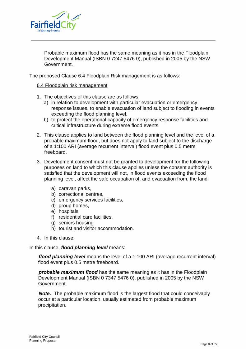
Probable maximum flood has the same meaning as it has in the Floodplain Development Manual (ISBN 0 7247 5476 0), published in 2005 by the NSW Government.
The proposed Clause 6.4 Floodplain Risk management is as follows:
6.4 Floodplain risk management
1. The objectives of this clause are as follows: a) in relation to development with particular evacuation or emergency
response issues, to enable evacuation of land subject to flooding in events exceeding the flood planning level,
b) to protect the operational capacity of emergency response facilities and critical infrastructure during extreme flood events.
2. This clause applies to land between the flood planning level and the level of a probable maximum flood, but does not apply to land subject to the discharge of a 1:100 ARI (average recurrent interval) flood event plus 0.5 metre freeboard.
3. Development consent must not be granted to development for the following purposes on land to which this clause applies unless the consent authority is satisfied that the development will not, in flood events exceeding the flood planning level, affect the safe occupation of, and evacuation from, the land:
a) caravan parks, b) correctional centres, c) emergency services facilities, d) group homes, e) hospitals, f) residential care facilities, g) seniors housing h) tourist and visitor accommodation.
4. In this clause:
In this clause, flood planning level means:
flood planning level means the level of a 1:100 ARI (average recurrent interval) flood event plus 0.5 metre freeboard.
probable maximum flood has the same meaning as it has in the Floodplain Development Manual (ISBN 0 7347 5476 0), published in 2005 by the NSW Government.
Note. The probable maximum flood is the largest flood that could conceivably occur at a particular location, usually estimated from probable maximum precipitation.
Fairfield City Council Planning Proposal
Page 9 of 35
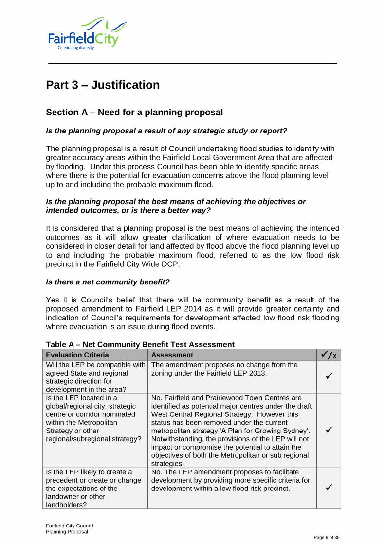
Part 3 – Justification
Section A – Need for a planning proposal Is the planning proposal a result of any strategic study or report? The planning proposal is a result of Council undertaking flood studies to identify with greater accuracy areas within the Fairfield Local Government Area that are affected by flooding. Under this process Council has been able to identify specific areas where there is the potential for evacuation concerns above the flood planning level up to and including the probable maximum flood.
Is the planning proposal the best means of achieving the objectives or intended outcomes, or is there a better way? It is considered that a planning proposal is the best means of achieving the intended outcomes as it will allow greater clarification of where evacuation needs to be considered in closer detail for land affected by flood above the flood planning level up to and including the probable maximum flood, referred to as the low flood risk precinct in the Fairfield City Wide DCP.
Is there a net community benefit? Yes it is Council’s belief that there will be community benefit as a result of the proposed amendment to Fairfield LEP 2014 as it will provide greater certainty and indication of Council’s requirements for development affected low flood risk flooding where evacuation is an issue during flood events. Table A – Net Community Benefit Test Assessment
Evaluation Criteria Assessment
Will the LEP be compatible with agreed State and regional strategic direction for development in the area?
The amendment proposes no change from the zoning under the Fairfield LEP 2013.
Is the LEP located in a global/regional city, strategic centre or corridor nominated within the Metropolitan Strategy or other regional/subregional strategy?
No. Fairfield and Prairiewood Town Centres are identified as potential major centres under the draft West Central Regional Strategy. However this status has been removed under the current metropolitan strategy ‘A Plan for Growing Sydney’. Notwithstanding, the provisions of the LEP will not impact or compromise the potential to attain the objectives of both the Metropolitan or sub regional strategies.
Is the LEP likely to create a precedent or create or change the expectations of the landowner or other landholders?
No. The LEP amendment proposes to facilitate development by providing more specific criteria for development within a low flood risk precinct.

Fairfield City Council Planning Proposal
Page 10 of 35
Evaluation Criteria Assessment
Have the cumulative effects of other spot rezoning proposals in the locality been considered? What was the outcome of these considerations?
N/A
Will the LEP facilitate a permanent employment generating activity or result in a loss of employment lands?
No.
Will the LEP impact upon the supply of residential land and therefore housing supply and affordability?
The proposal will provide greater certainty in relation to flood controls for residential development and will not impact on the supply of residential land and affordability.
Is the existing public infrastructure (roads, rail, and utilities) capable of servicing the proposed site? Is there good pedestrian and cycling access? Is public transport currently available or is there infrastructure capacity to support future public transport?
As the proposal seeks to change an additional local provision that will affect Fairfield Local Government area, this is not applicable. NA NA
Will the proposal result in changes to the car distances travelled by customers, employees and suppliers? If so, what are the likely impacts in terms of greenhouse gas emissions, operating costs and road safety?
No
Are there significant Government investments in infrastructure or services in the area whose patronage will be affected by the proposal? If so, what is the expected impact?
No.
Will the proposal impact on land that the Government has identified a need to protect (e.g. land with high biodiversity values) or have other environmental impacts?
No.

Fairfield City Council Planning Proposal
Page 11 of 35
Evaluation Criteria Assessment
Will the LEP be compatible or complementary with surrounding land uses? What is the impact on amenity in the location and wider community? Will the public domain improve?
The LEP is not seeking to change land zoning or uses. NA The proposal does not involve any changes to the public domain
Will the proposal increase choice and competition by increasing the number of retail and commercial premises operating in the area?
N/A
If a stand-alone proposal and not a centre, does the proposal have the potential to develop into a centre in the future?
N/A.
What are the public interest reasons for preparing the draft plan? What are the implications of not proceeding at that time?
The proposal addresses advice from the Director General under making of the Fairfield LEP 2013 that:- “Council should map areas that are outside the flood planning area subject of a flood event that are subject to isolation in a flood event as well as those areas susceptible to instances of flash flooding … as part of finalisation of Council’s City-Wide DCP” The implication of not proceeding at this time require more onerous requirements on certain forms of development in relation to flooding that exceed the actual level of flood risk.

Fairfield City Council Planning Proposal
Page 12 of 35
Section B – Relationship to strategic planning framework Is the planning proposal consistent with the objectives and actions contained within the applicable regional or sub-regional strategy (including the Sydney Metropolitan Strategy and exhibited draft strategies)? As discussed in Section A above, the Planning Proposal stems from recent flood studies undertaken by Council. The Planning Proposal is consistent with directions contained within the Sydney Metropolitan Strategy including:
to build a more sustainable, resilient city that responds to the potential threat of natural hazards such as flooding
consider natural hazards, such as the need to evacuate people from flood/bushfire prone areas; how flood-prone areas will be avoided and not increasing flood risks in new housing areas (through early planning for stormwater management)
Is the planning proposal consistent with the local Council’s community strategic plan, or other local strategic plan? Fairfield City Plan 2010-2020 Community Strategic Plan sets out goals and aspirations of Council and the Community in respect to what they want to see happen in Fairfield City in the next decade. The proposed amendment is considered to be consistent with directions and themes contained in the Fairfield City Plan 2010 – 2020: Under Theme 2 – Places and Infrastructure
Provide fit for purpose buildings, infrastructure and facilities that are designed to meet community needs
Implement comprehensive strategic land use planning and regulatory framework for new development
Under Theme Three – Environmental Sustainability
Manage stormwater and flooding
Take a catchment based approach to managing our natural resources
Plan controls and guidelines to protect environmentally sensitive land and waterways and promote sustainable practices
Fairfield City Council Planning Proposal
Page 13 of 35
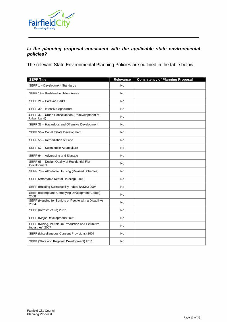
Is the planning proposal consistent with the applicable state environmental policies? The relevant State Environmental Planning Policies are outlined in the table below:
SEPP Title Relevance Consistency of Planning Proposal
SEPP 1 – Development Standards No
SEPP 19 – Bushland in Urban Areas No
SEPP 21 – Caravan Parks No
SEPP 30 – Intensive Agriculture No
SEPP 32 – Urban Consolidation (Redevelopment of Urban Land)
No
SEPP 33 – Hazardous and Offensive Development No
SEPP 50 – Canal Estate Development No
SEPP 55 – Remediation of Land No
SEPP 62 – Sustainable Aquaculture No
SEPP 64 – Advertising and Signage No
SEPP 65 – Design Quality of Residential Flat Development
No
SEPP 70 – Affordable Housing (Revised Schemes) No
SEPP (Affordable Rental Housing) 2009 No
SEPP (Building Sustainability Index: BASIX) 2004 No
SEEP (Exempt and Complying Development Codes) 2008
No
SEPP (Housing for Seniors or People with a Disability) 2004
No
SEPP (Infrastructure) 2007 No
SEPP (Major Development) 2005 No
SEPP (Mining, Petroleum Production and Extractive Industries) 2007
No
SEPP (Miscellaneous Consent Provisions) 2007 No
SEPP (State and Regional Development) 2011 No
Fairfield City Council Planning Proposal
Page 14 of 35
The relevant Sydney Regional Environmental Plans are outlined in the table below:
SREP Title Relevance Consistency of Planning Proposal
SREP 9 – Extractive Industry (No 2 – 1995) N/A
SREP 18 – Public Transport Corridors N/A
SREP 20 – Hawkesbury-Nepean River (No 2 – 1997) N/A
GMREP No.2 – Georges River Catchment N/A
Is the planning proposal consistent with applicable Ministerial Directions (s.117 directions)? The relevant Section 117 Directions contained within the Environmental Planning and Assessment Act 1979 are outlined in the table below:
Section 117 Direction No. and Title
Contents of Section 117 Direction
Planning Proposal Comply
1. Employment and Resources
1.1 Business and Industrial Zones
Encourage employment growth in suitable locations
Protect employment land in business and industrial zones
Support the viability of identified strategic centres.
N/A N/A
1.2 Rural Zones Protect agricultural
production value of rural land. N/A N/A
1.3 Mining, Petroleum Production and Extractive Industries
Ensure future extraction of State and regionally significant reserves of coal, other minerals, petroleum and extractive materials are not compromised by inappropriate development.
N/A N/A
1.4 Oyster Aquaculture Protect oyster aquaculture
areas. N/A N/A
1.5 Rural Lands Not applicable to Fairfield LGA Not applicable to Fairfield LGA N/A
2. Environment and Heritage
2.1 Environment Protection Zones
Protect and conserve environmentally sensitive areas.
N/A.
N/A
2.2 Coastal Protection Implement the principles in
the NSW Coastal Policy. N/A N/A
2.3 Heritage Conservation
Conserve items, areas, objects and places of environmental heritage significance and indigenous heritage significance.
N/A YES
2.4 Recreation Vehicle Areas
Protect sensitive land or land with significant conservation values from adverse impacts from recreation vehicles.
N/A N/A

Fairfield City Council Planning Proposal
Page 15 of 35
Section 117 Direction No. and Title
Contents of Section 117 Direction
Planning Proposal Comply
3. Housing, Infrastructure and Urban Development
3.1 Residential Zones
Encourage a variety and choice of housing types to provide for existing and future housing needs
Make efficient use of existing infrastructure and services and ensure that new housing has appropriate access to infrastructure and services
Minimise the impact of residential development on the environment and resource lands.
The proposed amendment to Fairfield LEP 2013 does not change the permissibility of existing residential development on land affected by this planning proposal.
YES
3.2 Caravan Parks and Manufactured Home Estates
Provide for a variety of housing types
Provide opportunities for caravan parks and manufactured home estates.
N/A N/A
3.3 Home Occupations Encourage the carrying out of
low-impact small businesses in dwelling houses.
N/A N/A
3.4 Integrating Land Use and Transport
Improve access to housing, jobs and services by walking, cycling and public transport.
Increase choice of available transport and reducing car dependency.
Reduce travel demand and distance (especially by car)
Support the efficient and viable operation of public transport services
Provide for the efficient movement of freight
N/A N/A
3.5 Development Near Licensed Aerodromes
Ensure effective and safe operation of aerodromes
Ensure aerodrome operation is not compromised by development
Ensure development for residential purposes or human occupation, if situated on land within the ANEF contours between 20 and 25, incorporate noise mitigation measures.
N/A N/A
3.6 Shooting Ranges
Maintain appropriate levels of public safety and amenity when rezoning land adjacent to an existing shooting range,
Reduce land use conflict arising between existing shooting ranges and rezoning of adjacent land
Identify issues that must be addressed when giving consideration to rezoning land adjacent to an existing shooting range.
N/A N/A

Fairfield City Council Planning Proposal
Page 16 of 35
Section 117 Direction No. and Title
Contents of Section 117 Direction
Planning Proposal Comply
4. Hazard and Risk
4.1 Acid Sulfate Soils
Avoid significant adverse environmental impacts from the use of land that has a probability of containing acid sulfate soils.
NA N/A
4.2 Mine Subsidence and Unstable Land
Prevent damage to life, property and the environment on land identified as unstable or potentially subject to mine subsidence.
N/A N/A
4.3 Flood Prone Land
Ensure that development of flood prone land is consistent with the NSW Government’s Flood Prone Land Policy and the principles of the Floodplain Development Manual 2005.
Ensure that the provisions of an LEP on flood prone land are commensurate with flood hazard and includes consideration of the potential flood impacts both on and off the subject land.
The PP aims to maintain the existing residential character of surrounding areas. The Proposal does not alter the zoning or permissibility of land uses over the subject land. Council has undertaken a number of Flood Studies which have identified areas within the City as having varying levels of flood risk. The recommendations of these studies are addressed under this planning proposal as a result of removal of “residential accommodation, commercial premise and industries’ from local
clause 6.4 as per this planning proposal. Future redevelopment of land in accordance with the proposed changes to Fairfield LEP 2013 will be required to meet the provisions of Chapter 11 Flood Risk Management of Councils City Wide DCP as well as the NSW Governments Flood Planning Development Manual 2005.
The objectives of the planning proposed are consistent with the key aspects of the NSW Floodplain Development Manual (FDM) including:
The provisions of the planning proposal are based on a merit approach and consistent with Council’s strategic approach for dealing with floodplain risk management
The approach is consistent with the policy provisions of the FDM of following a merit approach to dealing with development or redevelopment of flood prone land.
YES

Fairfield City Council Planning Proposal
Page 17 of 35
Section 117 Direction No. and Title
Contents of Section 117 Direction
Planning Proposal Comply
In accordance with the requirements of this Direction Council has also submitted a ‘case for exceptional circumstances’ justifying the proposed changes to the LEP and DCP flood controls.
4.4 Planning for Bushfire Protection
Protect life, property and the environment from bush fire hazards, by discouraging the establishment of incompatible land uses in bush fire prone areas.
Encourage sound management of bush fire prone areas.
N/A - N/A
5. Regional Planning
5.1 Implementation of Regional Strategies
To give legal effect to the vision, land use strategy, policies, outcomes and actions contained in regional strategies.
N/A N/A
5.2 Sydney Drinking Water Catchments
To protect water quality in the hydrological catchment.
N/A N/A
5.8 Second Sydney Airport: Badgerys Creek
Draft LEPs shall not contain provisions that enable the carrying out of development, either with or without development consent, which at the date of this direction, could hinder the potential for development of a Second Sydney Airport at Badgerys Creek
N/A N/A
6. Local Plan Making
6.1 Approval and Referral Requirements
Ensure LEP provisions encourage the efficient and appropriate assessment of development
The PP is consistent with this direction
YES
6.2 Reserving Land for Public Purposes
Planning proposal to facilitate the provision of public services and facilities by reserving land for public purposes
Facilitate the removal of reservations of land for public purposes where the land is no longer required for acquisition.
N/A. YES
6.3 Site Specific Provisions
Discourage unnecessarily restrictive site specific planning controls
NA YES

Fairfield City Council Planning Proposal
Page 18 of 35
Section 117 Direction No. and Title
Contents of Section 117 Direction
Planning Proposal Comply
7. Metropolitan Planning
7.1 Implementation of the Metropolitan Plan for Sydney 2036
Planning proposal shall give legal effect to the vision, land use strategy, policies, outcomes and actions contained in the Metro Strategy.
The planning proposal is consistent with this direction. Further details are provided earlier in this proposal under Section B – Relationship to Strategic Planning Framework
YES
Section C – Environmental, social and economic impact
Is there any likelihood that critical habitat or threatened species, populations or ecological communities, or their habitats, will be adversely affected as a result of the proposal? No, the land affected by this Planning Proposal does not contain any critical habitat or threatened species, communities etc. Are there any other likely environmental effects as a result of the planning proposal and how are they proposed to be managed? The planning proposal involves minimal adverse environmental effects. Any likely environmental effects will be controlled through the provisions of the Fairfield City Wide Development Control Plan 2013 including Chapter 3 – Environmental Site Analysis. How has the planning proposal adequately addressed any social and economic effects?
The Planning proposal is considered to have minor social impact. The Planning Proposal is considered to have minor economic impact.

Fairfield City Council Planning Proposal
Page 19 of 35
Section D – State and Commonwealth interests Is there adequate public infrastructure for the planning proposal? The proposal does not identify a change in zoning and seeks to remove ‘residential accommodation’ from local clause 6.4 Floodplain Risk Management in the Fairfield Local environmental Plan 2013. This legislative change will have no need for additional public infrastructure.
What are the views of State and Commonwealth public authorities consulted in accordance with the gateway determination? Section to be completed following Gateway Determination. (The Gateway Determination will determine consultation required. Insert this information after Gateway Determination - Delete before printing)
Part 4 – Community Consultation Section to be completed following Gateway Determination. (The Gateway Determination will determine consultation required. Insert this information after Gateway Determination - Delete before printing)
Fairfield City Council Planning Proposal
Page 20 of 35
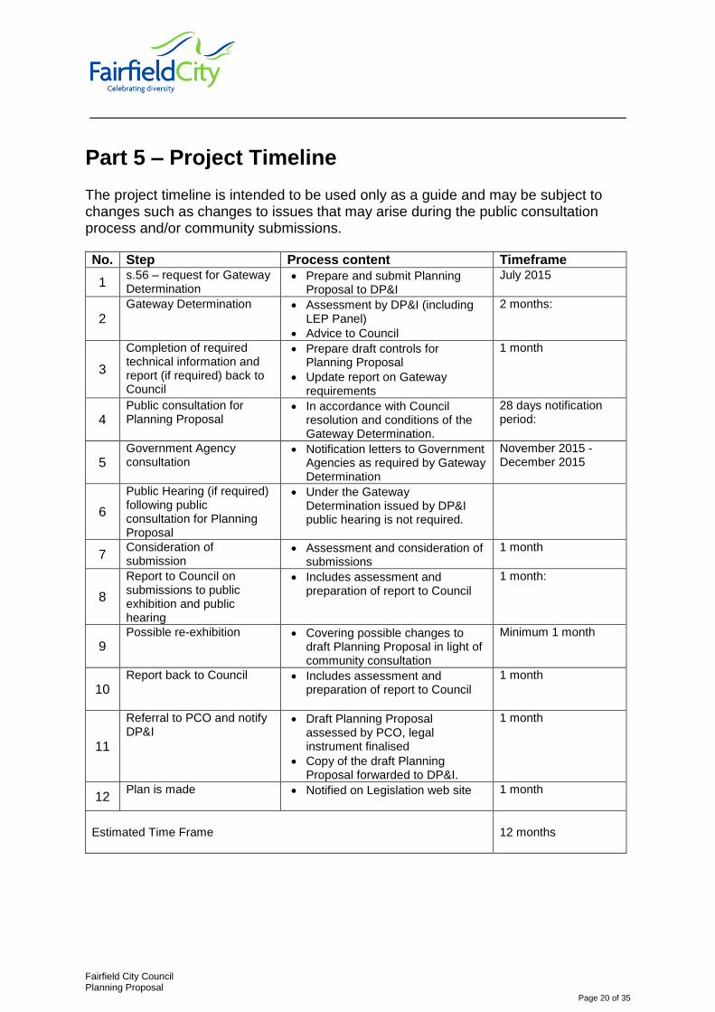
Part 5 – Project Timeline The project timeline is intended to be used only as a guide and may be subject to changes such as changes to issues that may arise during the public consultation process and/or community submissions.
No. Step Process content Timeframe
1 s.56 – request for Gateway Determination
Prepare and submit Planning Proposal to DP&I
July 2015
2 Gateway Determination Assessment by DP&I (including
LEP Panel)
Advice to Council
2 months:
3
Completion of required technical information and report (if required) back to Council
Prepare draft controls for Planning Proposal
Update report on Gateway requirements
1 month
4 Public consultation for Planning Proposal
In accordance with Council resolution and conditions of the Gateway Determination.
28 days notification period:
5 Government Agency consultation
Notification letters to Government Agencies as required by Gateway Determination
November 2015 - December 2015
6
Public Hearing (if required) following public consultation for Planning Proposal
Under the Gateway Determination issued by DP&I public hearing is not required.
7 Consideration of submission
Assessment and consideration of submissions
1 month
8
Report to Council on submissions to public exhibition and public hearing
Includes assessment and preparation of report to Council
1 month:
9 Possible re-exhibition Covering possible changes to
draft Planning Proposal in light of community consultation
Minimum 1 month
10 Report back to Council
Includes assessment and preparation of report to Council
1 month
11
Referral to PCO and notify DP&I
Draft Planning Proposal assessed by PCO, legal instrument finalised
Copy of the draft Planning Proposal forwarded to DP&I.
1 month
12 Plan is made Notified on Legislation web site
1 month
Estimated Time Frame
12 months
Attachment A – Proposed amended clause 6.4
Fairfield City Council Planning Proposal
Page 21 of 35
6.4 Floodplain risk management
The objectives of this clause are as follows: c) in relation to development with particular evacuation or emergency
response issues, to enable evacuation of land subject to flooding in events exceeding the flood planning level,
d) to protect the operational capacity of emergency response facilities and critical infrastructure during extreme flood events.
This clause applies to land between the flood planning level and the level of a probable maximum flood, but does not apply to land subject to the discharge of a 1:100 ARI (average recurrent interval) flood event plus 0.5 metre freeboard.
Development consent must not be granted to development for the following purposes on land to which this clause applies unless the consent authority is satisfied that the development will not, in flood events exceeding the flood planning level, affect the safe occupation of, and evacuation from, the land:
i) caravan parks, j) correctional centres, k) emergency services facilities, l) group homes, m) hospitals, n) residential care facilities, o) seniors housing p) tourist and visitor accommodation.
In this clause:
In this clause, flood planning level means:
flood planning level means the level of a 1:100 ARI (average recurrent interval) flood event plus 0.5 metre freeboard.
probable maximum flood has the same meaning as it has in the Floodplain Development Manual (ISBN 0 7347 5476 0), published in 2005 by the NSW Government.
Note. The probable maximum flood is the largest flood that could conceivably occur at a particular location, usually estimated from probable maximum precipitation.
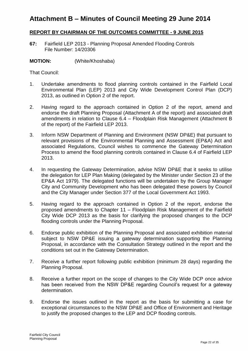
Attachment B – Minutes of Council Meeting 29 June 2014
Fairfield City Council Planning Proposal
Page 22 of 35
REPORT BY CHAIRMAN OF THE OUTCOMES COMMITTEE - 9 JUNE 2015
67: Fairfield LEP 2013 - Planning Proposal Amended Flooding Controls File Number: 14/20306
MOTION: (White/Khoshaba) That Council: 1. Undertake amendments to flood planning controls contained in the Fairfield Local
Environmental Plan (LEP) 2013 and City Wide Development Control Plan (DCP) 2013, as outlined in Option 2 of the report.
2. Having regard to the approach contained in Option 2 of the report, amend and
endorse the draft Planning Proposal (Attachment A of the report) and associated draft amendments in relation to Clause 6.4 – Floodplain Risk Management (Attachment B of the report) of the Fairfield LEP 2013.
3. Inform NSW Department of Planning and Environment (NSW DP&E) that pursuant to relevant provisions of the Environmental Planning and Assessment (EP&A) Act and associated Regulations, Council wishes to commence the Gateway Determination Process to amend the flood planning controls contained in Clause 6.4 of Fairfield LEP 2013.
4. In requesting the Gateway Determination, advise NSW DP&E that it seeks to utilise
the delegation for LEP Plan Making (delegated by the Minister under Section 23 of the EP&A Act 1979). The delegated functions will be undertaken by the Group Manager City and Community Development who has been delegated these powers by Council and the City Manager under Section 377 of the Local Government Act 1993.
5. Having regard to the approach contained in Option 2 of the report, endorse the
proposed amendments to Chapter 11 – Floodplain Risk Management of the Fairfield City Wide DCP 2013 as the basis for clarifying the proposed changes to the DCP flooding controls under the Planning Proposal.
6. Endorse public exhibition of the Planning Proposal and associated exhibition material
subject to NSW DP&E issuing a gateway determination supporting the Planning Proposal, in accordance with the Consultation Strategy outlined in the report and the conditions set out in the Gateway Determination.
7. Receive a further report following public exhibition (minimum 28 days) regarding the
Planning Proposal.
8. Receive a further report on the scope of changes to the City Wide DCP once advice has been received from the NSW DP&E regarding Council’s request for a gateway determination.
9. Endorse the issues outlined in the report as the basis for submitting a case for
exceptional circumstances to the NSW DP&E and Office of Environment and Heritage to justify the proposed changes to the LEP and DCP flooding controls.

Attachment B – Minutes of Council Meeting 29 June 2014
Fairfield City Council Planning Proposal
Page 23 of 35
A division was taken with the following results: Aye Nay Mayor Carbone Councillor Barcha Councillor Bennett Councillor Karajcic Councillor Khoshaba Councillor Ly Councillor Molluso Councillor Saliba Councillor Tran Councillor White Councillor Yeung Total=(11) Total=(0)
CARRIED UNANIMOUSLY
Attachment C REPORT TO OUTCOMES COMMITTEE
9 June 2015 Item Number.67
Fairfield City Council Planning Proposal
Page 24
SUBJECT: Fairfield LEP 2013 - Planning Proposal Amended Flooding Controls
FILE NUMBER: 14/20306
PREVIOUS ITEMS: 178 - Fairfield Local Environmental Plan 2013 and City Wide Development
Control Plan - Flooding Controls - Outcomes Committee - 2 December 2014 34 - Fairfield Local Environmental Plan 2013 - Planning Proposal on Flooding Controls - Outcomes Committee - 14 April 2015
REPORT BY: Andrew Mooney, Acting Manager Strategic Planning
RECOMMENDATION: That Council: 1. Select its preferred approach from the 2 options detailed in the report for undertaking
amendments to flood planning controls contained in the Fairfield Local Environmental Plan (LEP) 2013 and City Wide Development Control Plan (DCP) 2013.
2. Based on the preferred Option, amend and endorse the draft Planning Proposal (Attachment A of the report) and associated draft amendments in relation to Clause 6.4 – Floodplain Risk Management (Attachment B of the report) of the Fairfield LEP 2013.
3. Inform NSW Department of Planning and Environment (NSW DP&E) that pursuant to relevant provisions of the Environmental Planning and Assessment (EP&A) Act and associated Regulations, Council wishes to commence the Gateway Determination Process to amend the flood planning controls contained in Clause 6.4 of Fairfield LEP 2013.
4. In requesting the Gateway Determination, advise NSW DP&E that it seeks to utilise the delegation for LEP Plan Making (delegated by the Minister under Section 23 of the EP&A Act 1979). The delegated functions will be undertaken by the Group Manager City and Community Development who has been delegated these powers by Council and the City Manager under Section 377 of the Local Government Act 1993.
5. Based on the preferred Option, endorse the proposed amendments to Chapter 11 –
Floodplain Risk Management of the Fairfield City Wide DCP 2013 as the basis for clarifying the proposed changes to the DCP flooding controls under the Planning Proposal.

Attachment C REPORT TO OUTCOMES COMMITTEE
9 June 2015 Item Number.67
Fairfield City Council Planning Proposal
Page 25
6. Endorse public exhibition of the Planning Proposal and associated exhibition material subject to NSW DP&E issuing a gateway determination supporting the Planning Proposal, in accordance with the Consultation Strategy outlined in the report and the conditions set out in the Gateway Determination.
7. Receive a further report following public exhibition (minimum 28 days) regarding the Planning Proposal.
8. Receive a further report on the scope of changes to the City Wide DCP once advice has been received from the NSW DP&E regarding Council’s request for a gateway determination.
9. Endorse the issues outlined in the report as the basis for submitting a case for exceptional circumstances to the NSW DP&E and Office of Environment and Heritage to justify the proposed changes to the LEP and DCP flooding controls.
Note: This report deals with a planning decision made in the exercise of a function
of Council under the EP&A Act and a division needs to be called.
SUPPORTING DOCUMENTS: AT-A Draft Planning Proposal 19 Pages AT-B Draft LEP Amendment 1 Page AT-C DCP Flood Maps 1 Page AT-D DCP Risk Matrix 1 Page
CITY PLAN This report is linked to Theme 2 Places and Infrastructure in the Fairfield City Plan.
SUMMARY The April 2015 Council meeting deferred consideration of a report dealing with proposed amendments to the flood planning controls for low flood risk precincts contained in the Fairfield Local Environmental Plan (LEP) 2013 and City Wide Development Control Plan (DCP) 2013 until a briefing had been provided to Council in May. In light of the briefing, 2 options are now presented to Council that aim to clarify the extent of planning controls applying to residential, commercial and industrial development on land affected by low risk flooding events. These options are listed below. In these options the Flood Planning Level (FPL) is the 1 in 100 year flood plus freeboard.

Attachment C REPORT TO OUTCOMES COMMITTEE
9 June 2015 Item Number.67
Fairfield City Council Planning Proposal
Page 26
Option 1: Introduction of Very Low Flood Risk Precinct
Amend Cl.6.4 – Flood Risk Management of the Fairfield LEP 2013 by removing reference to Residential Accommodation, Commercial and Industrial Development such that no evacuation controls apply to these forms of development under the LEP above the FPL up to the Probable Maximum Flood (PMF).
Introducing the new category of ‘very low flood risk’ precinct in the City Wide DCP 2013 whereby there are no flood related development controls applying to residential, commercial and industrial development.
Development controls would still apply to properties located in the low risk precinct where there are issues with the depth and/or velocity of flood waters placing residents and properties at risk.
This is the option recommended by Council Officers and has been the subject of discussion with representatives of the NSW Department of Planning and Environment (DP&E) and Office of Environment and Heritage (OE&H) who have provided in principle support to considering a planning proposal that provides further justification for this proposal.
Option 2: Introduce Very Low Flood Risk Precinct and remove controls in the Low Risk
Precinct above the FPL for residential, commercial and industrial development.
Amend Cl.6.4 – Flood Risk Management of the Fairfield LEP 2013 by removing reference to Residential Accommodation, Commercial and Industrial Development such that no evacuation controls apply to these forms of development under the LEP above the FPL up to the PMF
As well as introducing the ‘very low flood risk precinct’, remove DCP planning controls for residential, commercial and industrial development in that part of the low flood risk precinct located above the FPL up to and including the PMF.
Undertake a process of community awareness for landowners where the expected flood risk may warrant evacuation for properties located above the FPL up to the PMF.
Under the NSW Environmental Planning and Assessment Act (EP&A) Act (Section 117 Directions) any proposed changes to the flooding controls contained in Fairfield LEP 2013 or City Wide DCP 2013 require Council to submit a ‘case’ (referred to as exceptional circumstances) in support of the scope of changes contained in both Options 1 and 2 (above). Having regard to the information contained in this report it is recommended that Council identify its preferred option for the scope of flood planning/building controls applying to future residential, commercial and industrial development located in low flood risk precincts of the City.
Attachment C REPORT TO OUTCOMES COMMITTEE
9 June 2015 Item Number.67
Fairfield City Council Planning Proposal
Page 27
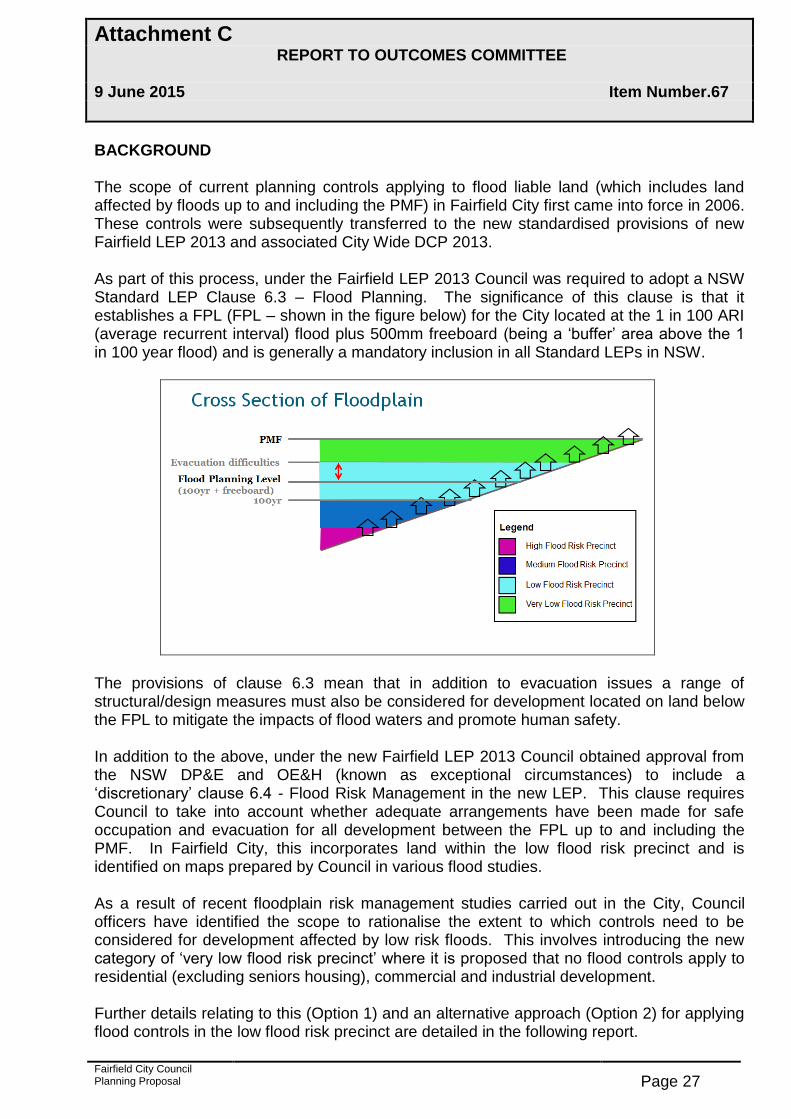
BACKGROUND The scope of current planning controls applying to flood liable land (which includes land affected by floods up to and including the PMF) in Fairfield City first came into force in 2006. These controls were subsequently transferred to the new standardised provisions of new Fairfield LEP 2013 and associated City Wide DCP 2013. As part of this process, under the Fairfield LEP 2013 Council was required to adopt a NSW Standard LEP Clause 6.3 – Flood Planning. The significance of this clause is that it establishes a FPL (FPL – shown in the figure below) for the City located at the 1 in 100 ARI (average recurrent interval) flood plus 500mm freeboard (being a ‘buffer’ area above the 1 in 100 year flood) and is generally a mandatory inclusion in all Standard LEPs in NSW.
The provisions of clause 6.3 mean that in addition to evacuation issues a range of structural/design measures must also be considered for development located on land below the FPL to mitigate the impacts of flood waters and promote human safety. In addition to the above, under the new Fairfield LEP 2013 Council obtained approval from the NSW DP&E and OE&H (known as exceptional circumstances) to include a ‘discretionary’ clause 6.4 - Flood Risk Management in the new LEP. This clause requires Council to take into account whether adequate arrangements have been made for safe occupation and evacuation for all development between the FPL up to and including the PMF. In Fairfield City, this incorporates land within the low flood risk precinct and is identified on maps prepared by Council in various flood studies. As a result of recent floodplain risk management studies carried out in the City, Council officers have identified the scope to rationalise the extent to which controls need to be considered for development affected by low risk floods. This involves introducing the new category of ‘very low flood risk precinct’ where it is proposed that no flood controls apply to residential (excluding seniors housing), commercial and industrial development. Further details relating to this (Option 1) and an alternative approach (Option 2) for applying flood controls in the low flood risk precinct are detailed in the following report.

Attachment C REPORT TO OUTCOMES COMMITTEE
9 June 2015 Item Number.67
Fairfield City Council Planning Proposal
Page 28
Option 1. Introduce Very Low Flood Risk Precinct Fairfield LEP 2013 – Cl.6.4 Floodplain Management Clause 6.4 currently applies to all land affected by low risk floods, i.e. floods above the FPL (1 in 100 year flood plus freeboard) up to and including the PMF. The key proposals are;
Deleting the generic reference to residential, commercial and industrial development from the clause (Attachment B) and relying on DCP provisions (see under next heading) to apply requirements to these forms of development where hazards in specific areas of the low flood risk precinct are an issue.
Retain other provisions that require consideration of evacuation measures for more sensitive land uses (e.g. seniors housing) regardless of the location in the low flood risk precinct.
Fairfield City Wide DCP 2013 - Under Chp.11 In light of the above changes to the LEP clause, the key proposals in relation to the Chp.11 of the City wide DCP are;
Include maps showing a ‘very low flood risk precinct’ (Attachment C) where no flooding controls apply to commercial, industrial and residential development.
For areas remaining in the ‘low flood risk precinct’ (i.e. above the FPL but below the very low risk precinct) development controls (Attachment D) will still apply to development (including commercial, industrial and residential).
This option is recommended by Council Officers as it;
Has regard to the specific nature and characteristics of flood behaviour associated with very large floods above the FPL
Has been developed as a result of detailed (evidence based) technical investigations carried out under recent flood risk management studies in the City.
Provides the highest level of safeguard in ensuring evacuation issues are considered at the DA stage for new development affected by floods above the FPL.
Is generally consistent with the advice provided to Council by the NSW DP&E and OE&H when it supported Council’s ‘case for exceptional circumstances’ for inclusion of clause 6.4 – Flood Risk Management in the Fairfield LEP 2013 and associated DCP controls.
Maintains the strongest level of protection in Council meeting its duty of care to the population at risk from flooding through the application of appropriate controls that apply to new development.
It is noted that this option is similar to current flood planning controls in place in Blacktown, Bankstown and Penrith City Councils.
Attachment C REPORT TO OUTCOMES COMMITTEE
9 June 2015 Item Number.67
Fairfield City Council Planning Proposal
Page 29
Option 2: Introduce Very Low Flood Risk Precinct and remove controls in the Low Risk Precinct above the FPL for residential, commercial and industrial development.
This option also involves the same amendments to clause 6.4 (above) of the Fairfield LEP 2013 involving;
Deleting the generic reference to residential, commercial and industrial development from clause 6.4 (Attachment B).
Retain other provisions that require consideration of evacuation measures for more sensitive land uses (e.g. seniors housing) regardless of the location in the low flood risk precinct.
However, in relation to DCP provisions, in addition to introducing the ‘very low flood risk precinct’ this option involves removing development controls (in practice principally relating to evacuation controls) applying to residential, commercial and industrial development in the low risk precinct above the FPL) and instead focus on an education program for landowners in this precinct to make them aware of evacuation issues in the event of a very large flood above the FPL. Although providing scope for Council to still address evacuation issues for floods above the FPL this option does not provide the same degree of protection or safeguards as Option 1 in ensuring evacuation issues are addressed at the DA stage. While evacuation issues may be assessed for a limited number of properties where DAs are submitted, it does result in evacuation information being provided to the other properties in the areas affected. It is considered that to address this issue, a better outcome would be to provide a broader education program to all those affected by flood events Under this option it is important for Council to be aware that under Clause 6.3 – Flood Planning evacuation and other controls would still apply to development located within the 500mm freeboard area above the 1 in 100 ARI flood event which is part of the FPL and also forms part of the low flood risk precinct. There is limited scope for Council to vary this arrangement as it the result of the requirements of the NSW Standard LEP provisions and sound floodplain management practice. The proposals contained in Option 2 are very similar to flood related planning controls currently in place in Liverpool City Council. Overland Flooding Issues The report to the April 2015 Council meeting flagged the option of Council seeking to lower the amount of freeboard required for development affected by overland flooding from 500mm to 300 mm. Again this option has been identified as a result of the recent floodplain risk management studies that found there is a case to lower the freeboard level to 300 mm due to the depth and velocity of flood waters in areas affected by overland flooding.
Attachment C REPORT TO OUTCOMES COMMITTEE
9 June 2015 Item Number.67
Fairfield City Council Planning Proposal
Page 30
After further consideration Council officers recommended that this step be deferred to a later stage as it involves an amendment to the NSW Standard LEP Clause 6.3 – flood planning that applies across NSW. The DP&E has provided verbal advice that this would trigger the need to consult with the majority of other Councils in NSW regarding this change. This is likely to be a prolonged process and result in a significant extension in the time required to implement the other changes being sought by Council to clause 6.4 Flood Risk Management which only applies to a small number of other Councils. In addition, Council officers understand that a number of other Councils in the State are in the early stages of considering a revision in the freeboard required for development affected by overland flooding. This has the potential to trigger a broader and more coordinated review of the issue by both the DP&E and OE&H. Feedback from DP&E and OE&H Although providing in principle support to considering a planning proposal (based around Option 1) from Council, at this stage neither the OE&H nor DP&E have provided any commitment to supporting the exact nature of changes to the flood controls detailed in this report. The main reason for this position that the LEP amendments proposed by Council relate to a model clause developed by the State Government under the NSW Standard LEP template. However, as referred to previously the clause only applies in a small number of other Councils. In Council’s favour the proposed amendments are based on detailed evidence-based investigations carried out by Council under recent flood investigations. The scope of the changes would not only provide greater certainty for the development community in relation to dealing with evacuation issues for very large floods above the FPL City. The following section of this report details other areas of justification that will be submitted to the DP&E and OE&H in relation to the proposed amendments. Section 117 Directions – Case for Exceptional Circumstances. When preparing LEP amendments Council must have regard to relevant Section 117 Directions of the NSW EP&A Act and address any criteria or requirements of the particular Direction. In regard to flooding matters, the Section 117 Direction (4.3) – Flood Planning requires specific justification (generally referred to as a case for exceptional circumstances) for changes to either LEP or DCP controls. The above Section 117 Direction does not include specific criteria or requirements that need to be addressed under ‘exceptional circumstances’. Rather the issue is dealt with on a case by case basis and places onus on Councils to provide sufficient justification (including technical reasons) for the nature of changes proposed.
Attachment C REPORT TO OUTCOMES COMMITTEE
9 June 2015 Item Number.67
Fairfield City Council Planning Proposal
Page 31
In this regard, the following points would represent the basis for Council’s case for ‘exceptional circumstances’ to amend the flood controls contained in the Fairfield LEP 2013 and City Wide DCP 2013;
The changes proposed by Council are based on detailed flood investigations and flood mapping. An example of a recent flood map that clarifies areas affected by evacuation in the ‘low risk flood precinct’ i.e. above the 1 in 100 year is included in Attachment C.
In relation to clause 6.4 – Floodplain Risk Management the changes proposed by Council are consistent with the following advice from the Director General of the NSW DP&E under implementation of the Fairfield LEP 2013:
“Council should map areas that are outside the flood planning area that are subject of a flood event that are subject to isolation in a flood event, as well as those areas susceptible to instances of flash flooding……as part of finalisation of Council’s City-Wide Development Control Plan”
The amendments proposed by Council provide greater certainty for development affected by flooding.
CONSULTATION STRATEGY In addition to requirements issued by NSW DP&E under the Planning Proposal covering consultation with State Government Agencies and utility providers, it is proposed that consultation and public exhibition of the Planning Proposal be undertaken for a minimum period of 28 days that will include:
- Notice in the local newspaper; and - Publication of all relevant information on Council’s website.
CHANGES TO SECTION 149 PLANNING CERTIFICATES The process of amending the LEP and DCP controls will ultimately impact on advice contained on Section 149 (2) & (5) planning certificates that clarifies which properties in the City are subject to flood related planning controls and is attached to property contracts of sale. It is important to be aware that the amendments contained in both Options 1 and 2 cannot be applied to the 149 certificates until such time the planning proposal to change clause 6.4 of the Fairfield LEP 2013 is gazetted. This is likely to take at least 12 months to occur.
CONCLUSION This report outlines 2 options for amending flooding controls for residential, commercial and industrial development located in the low flood risk precincts of the City.

Attachment C REPORT TO OUTCOMES COMMITTEE
9 June 2015 Item Number.67
Fairfield City Council Planning Proposal
Page 32
Option 1 (as recommended by Council Officers) proposes the introduction of a new ‘very low floor risk precinct’ where no flood related development controls would apply to residential, commercial or industrial development but would still be applicable to more ‘sensitive’ development (e.g. seniors housing). Option 2 involves as well as introducing the ‘very low flood precinct’ removing development controls (including flood evacuation criteria) for residential, commercial or industrial development in all of the low flood risk precincts above the FPL and instead relying on an flood awareness program for owners of properties in this precinct. Once Council has determined its preferred option for preparation of a planning proposal, it will need to be referred to DP&E and OE&H seeking their support for a gateway determination and implementation of the proposed amendments. This will also involve Council obtaining support to its case for exceptional circumstance to change the controls as outlined in this report.
Andrew Mooney Acting Manager Strategic Planning Authorisation: Group Manager City & Community Development Outcomes Committee - 9 June 2015

Fairfield City Council Planning Proposal
Page 33
Attachment A – Outcomes Committee 9 June 2015
6.4 Floodplain risk management
(1) The objectives of this clause are as follows: (a) in relation to development with particular evacuation or emergency response issues,
to enable evacuation of land subject to flooding in events exceeding the flood planning level,
(b) to protect the operational capacity of emergency response facilities and critical infrastructure during extreme flood events.
(2) This clause applies to land between the flood planning level and the level of a probable maximum flood, but does not apply to land subject to the discharge of a 1:100 ARI (average recurrent interval) flood event plus 0.5 metre freeboard. (3) Development consent must not be granted to development for the following purposes on land to which this clause applies unless the consent authority is satisfied that the development will not, in flood events exceeding the flood planning level, affect the safe occupation of, and evacuation from, the land:
(a) caravan parks, (b) commercial premises, (c) correctional centres, (d) emergency services facilities, (e) group homes, (f) hospitals, (g) industries, seniors housing (h) residential accommodation, (i) residential care facilities, (j) tourist and visitor accommodation.
(4) In this clause: flood planning level means the level of a 1:100 ARI (average recurrent interval) flood event plus 0.5 metre freeboard. probable maximum flood has the same meaning as it has in the Floodplain Development Manual (ISBN 0 7347 5476 0), published in 2005 by the NSW Government. Note. The probable maximum flood is the largest flood that could conceivably occur at a particular location, usually estimated from probable maximum precipitation.

Fairfield City Council Planning Proposal
Page 34
Attachment B – Outcomes Committee 9 June 2015

Fairfield City Council Planning Proposal
Page 35
Attachment C – Outcomes Committee - 9 June 2015