fairfield town centre master plans...fairfield town centre integrated master plans november 2006 c...
TRANSCRIPT
FAIRFIELD TOWN CENTRE INTEGRATED MASTER PLANS
NOVEMBER 2006C
HASSELL
1
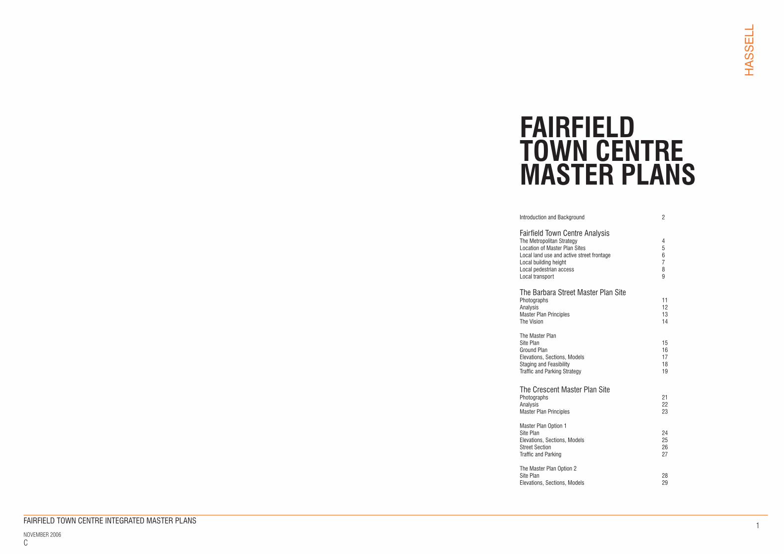
Introduction and Background 2
Fairfield Town Centre Analysis The Metropolitan Strategy 4 Location of Master Plan Sites 5Local land use and active street frontage 6Local building height 7Local pedestrian access 8Local transport 9
The Barbara Street Master Plan SitePhotographs 11Analysis 12Master Plan Principles 13The Vision 14
The Master Plan Site Plan 15Ground Plan 16Elevations, Sections, Models 17Staging and Feasibility 18 Traffic and Parking Strategy 19
The Crescent Master Plan SitePhotographs 21Analysis 22Master Plan Principles 23
Master Plan Option 1 Site Plan 24Elevations, Sections, Models 25Street Section 26Traffic and Parking 27
The Master Plan Option 2 Site Plan 28Elevations, Sections, Models 29
FAIRFIELD TOWN CENTREMASTER PLANS
FINAL DRAFT
FAIRFIELD TOWN CENTRE INTEGRATED MASTER PLANS
NOVEMBER 2006C
HASSELL
2
INTRODUCTION AND BACKGROUND
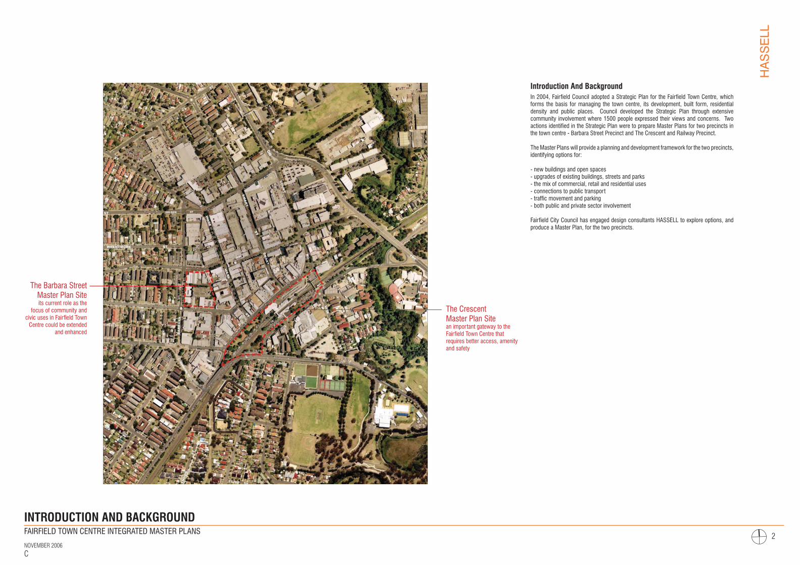
Introduction And BackgroundIn 2004, Fairfield Council adopted a Strategic Plan for the Fairfield Town Centre, which forms the basis for managing the town centre, its development, built form, residential density and public places. Council developed the Strategic Plan through extensive community involvement where 1500 people expressed their views and concerns. Two actions identified in the Strategic Plan were to prepare Master Plans for two precincts in the town centre - Barbara Street Precinct and The Crescent and Railway Precinct.
The Master Plans will provide a planning and development framework for the two precincts, identifying options for:
- new buildings and open spaces- upgrades of existing buildings, streets and parks- the mix of commercial, retail and residential uses- connections to public transport- traffic movement and parking- both public and private sector involvement
Fairfield City Council has engaged design consultants HASSELL to explore options, and produce a Master Plan, for the two precincts.
FINAL DRAFT
The Barbara Street Master Plan Site its current role as the
focus of community and civic uses in Fairfield Town
Centre could be extended and enhanced
The Crescent Master Plan Site an important gateway to the Fairfield Town Centre that requires better access, amenity and safety
FAIRFIELD TOWN CENTRE INTEGRATED MASTER PLANS
NOVEMBER 2006C
HASSELL
3
FAIRFIELD TOWN CENTREANALYSIS
FINAL DRAFT
FAIRFIELD TOWN CENTRE INTEGRATED MASTER PLANS
NOVEMBER 2006C
HASSELL
4
CBDCB
CABRAMATTA
PRAIRIEWOOD
FAIRFIELD
LIV
ERP
OO
L TO
PARRAMATTA
T-W
AY
CU
MB
ERL A
N
D H I GHWAY
HUME H I GH W AY
M5
M4
PROSPECT RESERVOIR
M4
PACIFIC HIGHWAY
M2
M5
WES
TLIN
K M
7
PARRAMATTA
SYDNEY CBD
LIVERPOOL
Y
TOP
ERV
8KM / 1 0 - 1 5 M I N D R I V E
KEY
Motorway
Rail line
T-way
Urban centre
Water
Fairfield town centre
Western Sydney regional parkland
Appro. 8km radius/ 10-15min drive
THE METROPOLITAN STRATEGY
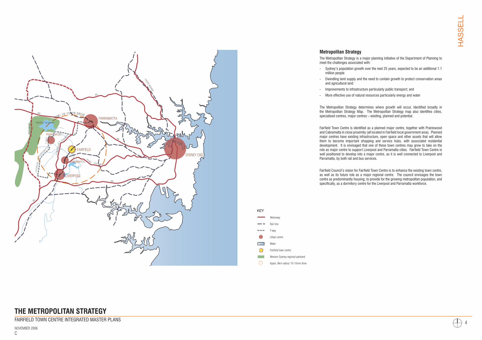
Metropolitan StrategyThe Metropolitan Strategy is a major planning initiative of the Department of Planning to meet the challenges associated with:
- Sydney’s population growth over the next 25 years, expected to be an additional 1.1 million people
- Dwindling land supply and the need to contain growth to protect conservation areas and agricultural land
- Improvements to infrastructure particularly public transport; and
- More effective use of natural resources particularly energy and water
The Metropolitan Strategy determines where growth will occur, identified broadly in the Metropolitan Strategy Map. The Metropolitan Strategy map also identifies cities, specialised centres, major centres – existing, planned and potential.
Fairfield Town Centre is identified as a planned major centre, together with Prairiewood and Cabramatta in close proximity (all located in Fairfield local government area). Planned major centres have existing infrastructure, open space and other assets that will allow them to become important shopping and service hubs, with associated residential development. It is envisaged that one of these town centres may grow to take on the role as major centre to support Liverpool and Parramatta cities. Fairfield Town Centre is well positioned to develop into a major centre, as it is well connected to Liverpool and Parramatta, by both rail and bus services.
Fairfield Council’s vision for Fairfield Town Centre is to enhance the existing town centre, as well as its future role as a major regional centre. The council envisages the town centre as predominantly housing, to provide for the growing metropolitan population, and specifically, as a dormitory centre for the Liverpool and Parramatta workforce.
FINAL DRAFT

FAIRFIELD TOWN CENTRE INTEGRATED MASTER PLANS
NOVEMBER 2006C
HASSELL
5
SPENCER ST
KENYON ST
HARRIS ST
HAMILTON ST
THE C
RESCEN
T
DALE ST
NELSON ST
SMART ST
WARE ST
COURT RD
THE HORSLEY DR
BERTHA ST
WESTON ST
FAIRFIELD ST
ALAN RD
FAIRFIELD PARK
THE C
RESCEN
T
PARK
THE FORUM
FAIRFIELD RSL
NEETA CITY
FAIRFIELD PARK
BERTHA ST
FAIRFIELD RSL
ALAN RD
WESTON ST
T
NELSON ST
SMART ST
WARE ST
THE FORUM
NEETA CITY
HAMILTON ST
HARRIS ST
FAIRFIELD PARK
BARBARASTREET
MASTER PLAN SITE
MID DENSITY RESIDENTIAL
PREDOMINANTLY RETAIL(large scale/shopping centres)
PREDOMINANTLY RETAIL(traditional shopfronts)
MIXED(commercial, retail, residential)
EDUCATIONLOWER DENSITY RESIDENTIAL
LOWER DENSITY RESIDENTIAL
GREEN SPACE
GREEN SPACE
GREEN SPACE
MIXED(community, retail)
MIXED(education, residential)
THE CRESCENTMASTER PLAN SITE
Fairfield Town Centre
Fairfield Town Centre is an established centre with several distinctive nodes of activity, and mix of retail, commercial and residential uses. The core of the Town Centre is predominantly retail with two large scale shopping centres and traditional street front shops. The core includes the Fairfield railway station to the south, an important gateway to the town centre.
To the east, there is a strip of low rise mixed use development, offering some retail, residential and commercial operations. To the southern side of the railway station there is both mixed use and low density residential, with significant parkland further south. There are also educational facilities to the north (Fairfield High School) and south (Patrician Brothers College) of the town centre.
The north and west of the town centre is predominantly medium-density residential development, with a relatively formal street pattern. There are some new residential developments although the majority are older style, established apartment buildings, semi-detached homes and single houses.
This study is of two sites in the Town Centre:
The Barbara Street Master Plan Site - bounded by Kenyon, Barbara and Harris Streets, and housing a number of civic/community functions, some retail functions and a multi-storey car park.
The Crescent Master Plan Site - the railway precinct of Fairfield, bounded by The Crescent to the north and Dale Street to the south, and primarily within the ownership of RailCorp. The site currently supports the railway station, bus interchange, retail complex and open space.
LOCATION OF MASTER PLAN SITES
FINAL DRAFT
FAIRFIELD TOWN CENTRE INTEGRATED MASTER PLANS
NOVEMBER 2006C
HASSELL
6
SPENCER ST
KENYON ST
HARRIS ST
BARB
ARA
ST
HAMILTON ST
THE C
RESCEN
T
DALE ST
WARE ST
BERTHA ST
WESTON ST
FAIRFIELD ST
ALAN RD
KEY
Residential
Retail/commercial
Mixed use- retail/commercial/residential
Community uses
1. Church
2. Fairfield library
3. Meals on wheel
4. Community service building
5. Fairfield community hall
6. Learning links and CoAslt
7. Fairfield school of art
8. Fairfield fire station
9. Western Sydney institute of Music
10. Fairfield police station
11. Fairfield court house
12. AIDCONS group
13. Fairfield youth education
14. Fairfield RSL
Carparking
Transport- train staion/bus interchange
Park/sport facility
Mixed use- retail/commercial/residential
(proposed)
Active frontage
Active frontage (limited contribution)
Inactive frontage
Master plan site boundary
1 7
8
23
4
5
6
9
10
11
12
13
14
LOCAL LAND USE AND ACTIVE STREET FRONTAGE
Land use and active street frontage
The traditional, older Fairfield town centre between Spencer Street and The Crescent now comprises a range of retail, commercial and residential uses, while the primary retail hubs are located in the newer shopping centres – The Forum and Neeta City.
As indicated, active frontages are focused along Ware Street, The Crescent and parts of Hamilton and Smart Streets. Limited contributions of active street frontages are identified on the more peripheral streets comprising the town centre. Car parking is generally restricted to rear lanes and in association with larger car parking stations.
The Barbara Street Master Plan site offers a mix of street frontage (both active and inactive), with a strong car parking focus. With limited built form, The Crescent Master Plan site offers only a small amount of active street frontage, along the existing retail development.
FINAL DRAFT

FAIRFIELD TOWN CENTRE INTEGRATED MASTER PLANS
NOVEMBER 2006C
HASSELL
7
SPENCER ST
KENYON ST
HARRIS ST
BARB
ARA
ST
HAMILTON ST
THE C
RESCEN
T
DALE ST
WARE ST
BERTHA ST
WESTON ST
FAIRFIELD ST
ALAN RD
KEY
1 storey
2 storey
3-4 storey
5-8 storey
9-10 storey
4 storey (proposed)
6-8 storey (proposed)
10-12 storey (proposed)
Master plan site boundary
LOCAL BUILDING HEIGHT
Local building height
Fairfield town centre has a range of building heights. The predominant building height in the town centre is 2 storeys, however there are an increasing number of taller buildings up to ten storeys in some locations. There are also a number of proposed buildings in the town centre up to twelve storeys in height.
There is no clear pattern of building height hierarchy identified in the current town centre form. However, it is evident that the block defined by Spencer and Smart Streets and Court Road, supports the highest concentration of taller buildings in the town centre.
The Barbara Street Master Plan site supports predominantly single storey built forms, with the car park, located centrally, the tallest building on the site at 5 storeys). Adjacent to this site is 9-10 storey mixed-use building, fronting Ware Street. The Crescent Street Master Plan site buildings are limited to single storey, with a range (1-4 storeys) of adjacent building heights.
FINAL DRAFT
FAIRFIELD TOWN CENTRE INTEGRATED MASTER PLANS
NOVEMBER 2006C
HASSELL
8
SPENCER ST
KENYON ST
HARRIS ST
BARB
ARA
ST
HAMILTON ST
THE C
RESCEN
T
DALE ST
WARE ST
BERTHA ST
WESTON ST
FAIRFIELD ST
ALAN RD
KEY
Train station
Train line
Bus interchage
Major pedestrian route
Minor pedestrian route
Pedestrian connection via arcade
Pedestrian connection (over train line)
Pedestrian connection (underpass)
Barrier
Master plan site boundary
LOCAL PEDESTRIAN ACCESS
Local pedestrian access
The pedestrian access network within the town centre is extensive. In addition to the use of the streets for pedestrian access and movement, there is a myriad of both covered and open-air laneways, malls and arcades that provide mid-block access within the town centre.
Much of the “city walking” in the Fairfield Town Centre is generated by the medium to high density residential precincts to the west of Barbara Street. The relatively high speeds and high volumes of traffic along Barbara Street effectively create a barrier for pedestrians to cross into the town centre. Changes to traffic conditions are required to improve the crossability of Barbara Street.
Strong pedestrian desire lines exist between the station and the retail precincts at Fairfield Chase, Ware Street, Smart Street and further afield. Crossing The Crescent can also be difficult and improvements are required to provide access to the station. Three key pedestrian connections are provided across the railway corridor, and these are of varied standard and use by the local community.
The two Master Plan sites are separated by the Harris Street / Ware Street retail precinct. The Master Plans anticipate some urban renewal in this precinct to enhance the pedestrian environment and strengthen desire lines.
FINAL DRAFT
FAIRFIELD TOWN CENTRE INTEGRATED MASTER PLANS
NOVEMBER 2006C
HASSELL
9
SPENCER ST
KENYON ST
HARRIS ST
BARB
ARA
ST
HAMILTON ST
THE C
RESCEN
T
DALE ST
WARE ST
BERTHA ST
WESTON ST
FAIRFIELD ST
ALAN RD
KEY
Arterial road
Primary vehicular circulation
Secondary vehicular circulation
Shared vehicular/pedestrian
Train station
Train line
Bus interchage
Bus routes
Taxi stand
Existing cycle route
Proposed cycle route
Car parking
Master plan site boundary
LOCAL TRANSPORT
Local transport
The Fairfield railway station provides a key transport gateway to the town centre. Buses enter the town centre predominantly by Court Road but also Hamilton Street to the Bus Interchange and leave the town centre via Smart Street. Buses are playing an increasingly important role in the Fairfield Town Centre with growing patronage levels and improving service levels. Buses serve a range of users, such as general commuters, town centre visitors and students. There is strong interaction between the trains and the buses.
The main access roads into the town centre are Barbara Street, Hamilton Street, Alan Road and Court Road. Existing parking utilisation is generally high throughout the study area and adjacent public streets, except the Downey Lane carpark. There is potential for this parking facility to be redeveloped, reduced in size, or to accommodate some of the parking requirements of new developments.
Barbara Street parking
Fairfield City Council owns a number of properties along the western side of Barbara Street which are currently used as on-grade car parking. These are well used by people accessing the town centre, and there is potential that they may be redeveloped for community uses.
Previous investigations by HASSELL recommended that:
- car-based activities and car parking are best located at the town centre periphery, to limit traffic movement through and within the town centre;
- while there was opportunity to redevelop the sites for community uses (such as library, hall and community services building), safety and amenity issues around Barbara Street could alienate these uses from the town centre;
- community uses should be focused on the Barbara Street Master Plan site, with direct and safe pedestrian access to the town centre; and
- in the short-term, the sites should be retained for parking, with future potential for medium-density residential redevelopment - a more compatible use with the surrounding area, as well as creating a defined ‘edge’ to the town centre
FINAL DRAFT
FAIRFIELD TOWN CENTRE INTEGRATED MASTER PLANS
NOVEMBER 2006C
HASSELL
10
THE BARBARA STREETMASTER PLAN SITE
FINAL DRAFT
FAIRFIELD TOWN CENTRE INTEGRATED MASTER PLANS
NOVEMBER 2006C
HASSELL
11
SPENCER ST
KENYON ST
KENY
ON L
A
BARB
ARA
ST
WAR
E ST
HARRIS ST
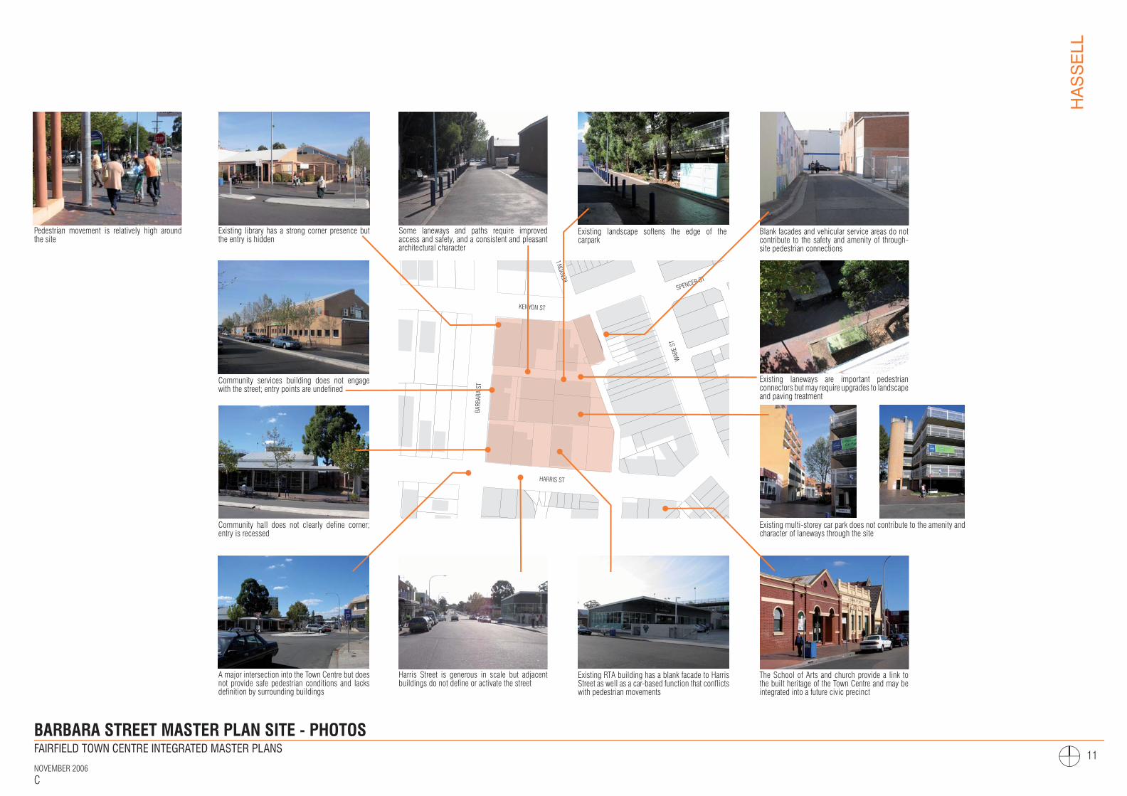
BARBARA STREET MASTER PLAN SITE - PHOTOS
Pedestrian movement is relatively high around the site
A major intersection into the Town Centre but does not provide safe pedestrian conditions and lacks definition by surrounding buildings
Existing RTA building has a blank facade to Harris Street as well as a car-based function that conflicts with pedestrian movements
Some laneways and paths require improved access and safety, and a consistent and pleasant architectural character
Existing library has a strong corner presence but the entry is hidden
Community services building does not engage with the street; entry points are undefined
Community hall does not clearly define corner; entry is recessed
Harris Street is generous in scale but adjacent buildings do not define or activate the street
The School of Arts and church provide a link to the built heritage of the Town Centre and may be integrated into a future civic precinct
Existing multi-storey car park does not contribute to the amenity and character of laneways through the site
Existing laneways are important pedestrian connectors but may require upgrades to landscape and paving treatment
Blank facades and vehicular service areas do not contribute to the safety and amenity of through-site pedestrian connections
Existing landscape softens the edge of the carpark
FINAL DRAFT

FAIRFIELD TOWN CENTRE INTEGRATED MASTER PLANS
NOVEMBER 2006C
HASSELL
12
BARBARA STREET MASTER PLAN SITE - ANALYSIS
SPENCER ST
KENYON ST
KENY
ON L
A
BARB
ARA
ST
WAR
E ST
SMAR
T ST
HARRIS ST
DALE ST
ANZAC AV
WIL
LIAM
ST
COMMUTER PARKING
COM
RAILWAY STATIO
N
BUS INTERCH
LIBRARY
COMMSERVICES
HALL RETAIL
RETAIL HEALTHCENTRE
VACANT MOTOR REGISTRY
SCHOOLOF ARTSCHURCH
CARPARK
CARPARK
CARPARK
MULTI-STOREY CARPARK
AGED CARE
KEY
Master Plan site boundary
Council-owned properties
Active Frontage
Active Frontage (Limited Contribution)
Inactive frontage / blank wall
Access to site
Strong pedestrian connections
Weaker pedestrian connections
Heavy vehicular traffic
Analysis And Opportunities
The analysis of the Barbara Street Master Plan site and its surrounding area identified the following key elements and characteristics, issues and opportunities:
- pedestrian movement through streets, laneways and arcades provides access and vitality;
- some pedestrian and vehicular conflicts occur, particularly along Downey Lane;
- current building forms along laneways (such as blank walls and offset pathways) do not contribute to the character and safety of the laneways;
- smaller laneways around the Barbara Street community buildings are not well used; a number of community facilities are located on the Master Plan site but lack a coherent identity;
- community buildings along Barbara Street (library, community services building and hall) lack clear entry points;
- heavy traffic flow and limited crossing opportunities along Barbara Street act as a barrier for pedestrians moving to and from the town centre;
- the position of the multi-storey car park at the centre of the site minimises its visual impact on the surrounding streets, but limits it visibility and access, and thus, its usage;
- inconsistent and inactive street frontages at the perimeter of the site (particularly along Barbara Street) should be replaced with uses that address and activate the street;
- the existing library is well used, but requires expanded floor area - a convenient and accessible location for a new library needs to be identified;
- there is an opportunity for a multi-function, flexible community building housing a new hall, library, creative industries facility and exhibition spaces;
- as well as residential, commercial and retail uses, the Master Plan site may also accommodate health and other specialist services; and
- new buildings, particularly community facilities, need to link to the established town centre.
FINAL DRAFT

FAIRFIELD TOWN CENTRE INTEGRATED MASTER PLANS
NOVEMBER 2006C
HASSELL
13
COMMUTER PARKING
RAILWAY STATIO
N
BUS
SCHOOLOF ARTS
CHURCH
EXISTINGCOUNCILCARPARK
EXISTINGCOUNCILCARPARK
EXISTINGCOUNCILCARPARK
SPENCER ST
KENYON ST
KENY
ON L
ANE
BARB
ARA
ST
WAR
E ST
SMAR
T ST
HARRIS ST
THE C
RESCEN
T
DALE S
ANZAC AV
WIL
LIAM
ST
Master Plan site boundary
Laneway upgraded as primary connection
Physical and visual connection to surrounding area
Through-site/arcade pedestrian connections
Potential connection to open space
Existing Vehicular entry/exit points
Proposed Vehicular entry/exit points
Building facades defining open space and laneway
Street edge buildings
Active building frontages at ground floor
Open space
Shared zone for pedestrian and delivery
Existing carpark- potential future open space
Improved pedestrian conditions
Development
Higher density development
“Civic Street” including streetscape upgrade
Existing heritage buildings
KEY
BARBARA STREET MASTER PLAN SITE - MASTER PLAN PRINCIPLES
Master Plan Principles
Following an analysis of the site, its opportunities and constraints, a number of Master Plan principles have been developed:
- retain existing laneways and pedestrian connections, and enhance pedestrian use through widened footpaths, landscaping, lighting and street furniture;
- provide smaller places for people to gather, such as pocket parks and seating areas;
- provide more direct visual and physical access along Downey Lane to enhance safety and reduce vehicular/pedestrian conflicts - new buildings are set back to provide a wider laneway;
- provide linkages across the site, connected to existing adjacent laneways and arcades;
- limit vehicular movements through the site by encouraging the use of Barbara Street to access parking and deliveries;
- existing car park to be retained and upgraded, with potential for redevelopment in future as an open space for the community/civic precinct;
- provide active street frontages at ground level to Harris, Barbara and Kenyon Streets, as well as Downey Lane and other laneways;
- allow for relocation and expansion of existing library, hall and community services building, as well as proposed creative industries facility;
- create an integrated, flexible multi-use community building that addresses Harris Street, with commercial and residential buildings facing Kenyon and Barbara Streets;
- Harris Street upgraded through footpath widening, consistent landscape strategy, furniture and lighting, to become a ‘civic’ street, linking community functions to the neighbouring heritage buildings and the town centre; and
- buildings define existing street patterns and proposed green ‘pockets’.
FINAL DRAFT
?
FAIRFIELD TOWN CENTRE INTEGRATED MASTER PLANS
NOVEMBER 2006C
HASSELL
14
HARRIS STREET
KENYON STREET
SPENCER STREET BA
RBAR
A ST
REET
WARE STREET
Master Plan Site Boundary Paved Area Landscaped Area
Shared Pedestrian/Vehicle Zone New/Existing Trees New/Refurbished Buildings
Height (In Storeys) Line Of Ground Floor Vehicular Entry/Exit
1
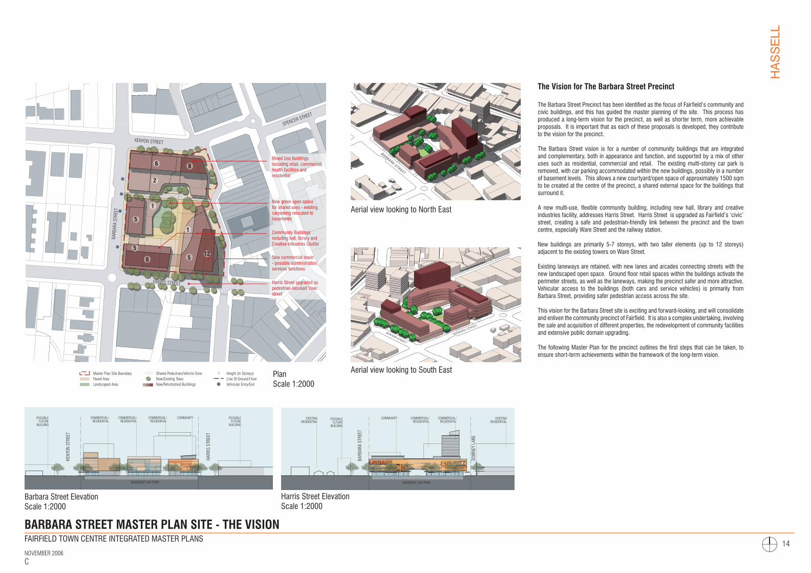
BARBARA STREET MASTER PLAN SITE - THE VISION
The Vision for The Barbara Street Precinct
The Barbara Street Precinct has been identified as the focus of Fairfield’s community and civic buildings, and this has guided the master planning of the site. This process has produced a long-term vision for the precinct, as well as shorter term, more achievable proposals. It is important that as each of these proposals is developed, they contribute to the vision for the precinct.
The Barbara Street vision is for a number of community buildings that are integrated and complementary, both in appearance and function, and supported by a mix of other uses such as residential, commercial and retail. The existing multi-storey car park is removed, with car parking accommodated within the new buildings, possibly in a number of basement levels. This allows a new courtyard/open space of approximately 1500 sqm to be created at the centre of the precinct, a shared external space for the buildings that surround it.
A new multi-use, flexible community building, including new hall, library and creative industries facility, addresses Harris Street. Harris Street is upgraded as Fairfield’s ‘civic’ street, creating a safe and pedestrian-friendly link between the precinct and the town centre, especially Ware Street and the railway station.
New buildings are primarily 5-7 storeys, with two taller elements (up to 12 storeys) adjacent to the existing towers on Ware Street.
Existing laneways are retained, with new lanes and arcades connecting streets with the new landscaped open space. Ground floor retail spaces within the buildings activate the perimeter streets, as well as the laneways, making the precinct safer and more attractive. Vehicular access to the buildings (both cars and service vehicles) is primarily from Barbara Street, providing safer pedestrian access across the site.
This vision for the Barbara Street site is exciting and forward-looking, and will consolidate and enliven the community precinct of Fairfield. It is also a complex undertaking, involving the sale and acquisition of different properties, the redevelopment of community facilities and extensive public domain upgrading.
The following Master Plan for the precinct outlines the first steps that can be taken, to ensure short-term achievements within the framework of the long-term vision.
CCCLIBRARY
CBRARBRAR
CC
HARR
IS S
TREE
T
KENY
ON S
TREE
T
BASEMENT CAR PARK
COMMERCIAL/RESIDENTIAL
COMMERCIAL/RESIDENTIAL
COMMERCIAL/RESIDENTIAL
COMMUNITY POSSIBLE FUTURE
BUILDING
POSSIBLE FUTURE
BUILDING
FAIRFIELDCIC
LIBRARY
BARB
ARA
STRE
ET
DOW
NEY
LANE
POSSIBLE FUTURE
BUILDING
BASEMENT CAR PARK
COMMERCIAL/RESIDENTIAL
COMMUNITY EXISTING RESIDENTIAL
EXISTING RESIDENTIAL
COMMERCIAL/RESIDENTIAL
BARBARA STREETH A R R I S S T R E E T
KENYON STREET
B A R B A R A S T R E E T
FINAL DRAFT
WARE STREET
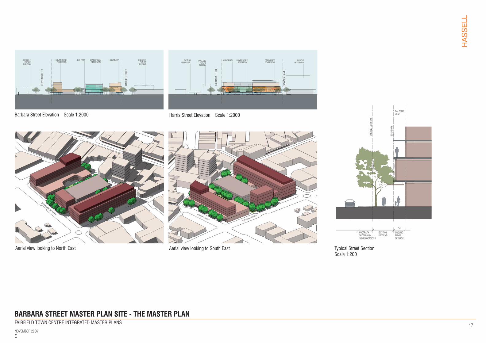
Barbara Street ElevationScale 1:2000
Harris Street ElevationScale 1:2000
PlanScale 1:2000
Aerial view looking to North East
Aerial view looking to South East
1
5
1
12
Mixed Use Buildingsincluding retail, commercial, health facilities and residential
New commercial tower - possible administration/services functions
Community Buildingsincluding hall, library and Creative Industries Cluster
Harris Street upgraded as pedestrian-focused ‘civic street’
New green open space for shared uses - existing carparking relocated to basements
6
2
5
8
5
6
FAIRFIELD TOWN CENTRE INTEGRATED MASTER PLANS
NOVEMBER 2006C
HASSELL
15
HARRIS STREET
KENYON STREET
SPENCER STREET
BARB
ARA
STRE
ET
WARE STREET
Master Plan Site Boundary Paved Area Landscaped Area
Shared Pedestrian/Vehicle Zone New/Existing Trees New/Refurbished Buildings
Height (In Storeys) Line Of Ground Floor Vehicular Entry/Exit
1
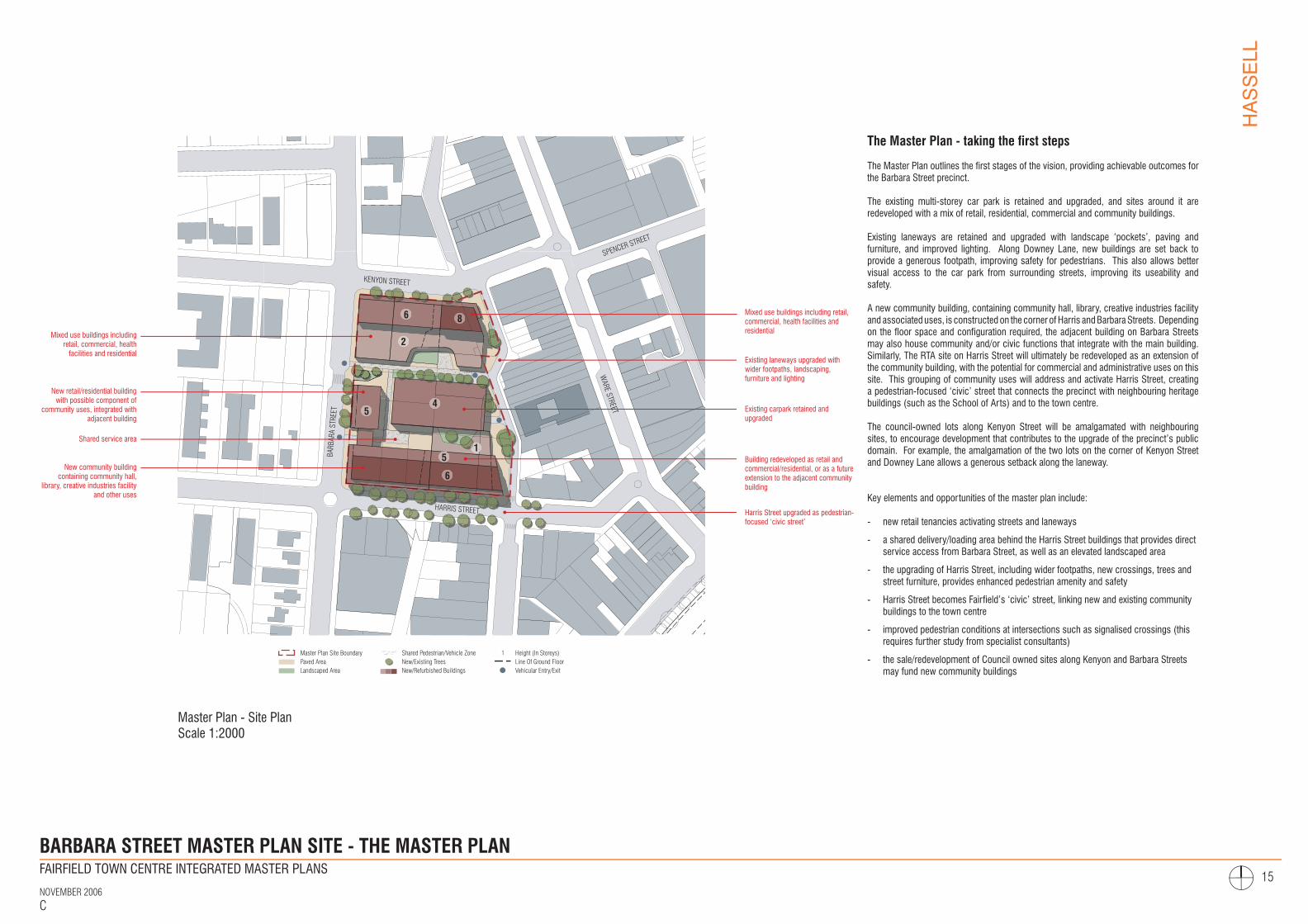
BARBARA STREET MASTER PLAN SITE - THE MASTER PLAN
The Master Plan - taking the first steps
The Master Plan outlines the first stages of the vision, providing achievable outcomes for the Barbara Street precinct.
The existing multi-storey car park is retained and upgraded, and sites around it are redeveloped with a mix of retail, residential, commercial and community buildings.
Existing laneways are retained and upgraded with landscape ‘pockets’, paving and furniture, and improved lighting. Along Downey Lane, new buildings are set back to provide a generous footpath, improving safety for pedestrians. This also allows better visual access to the car park from surrounding streets, improving its useability and safety.
A new community building, containing community hall, library, creative industries facility and associated uses, is constructed on the corner of Harris and Barbara Streets. Depending on the floor space and configuration required, the adjacent building on Barbara Streets may also house community and/or civic functions that integrate with the main building. Similarly, The RTA site on Harris Street will ultimately be redeveloped as an extension of the community building, with the potential for commercial and administrative uses on this site. This grouping of community uses will address and activate Harris Street, creating a pedestrian-focused ‘civic’ street that connects the precinct with neighbouring heritage buildings (such as the School of Arts) and to the town centre.
The council-owned lots along Kenyon Street will be amalgamated with neighbouring sites, to encourage development that contributes to the upgrade of the precinct’s public domain. For example, the amalgamation of the two lots on the corner of Kenyon Street and Downey Lane allows a generous setback along the laneway.
Key elements and opportunities of the master plan include:
- new retail tenancies activating streets and laneways
- a shared delivery/loading area behind the Harris Street buildings that provides direct service access from Barbara Street, as well as an elevated landscaped area
- the upgrading of Harris Street, including wider footpaths, new crossings, trees and street furniture, provides enhanced pedestrian amenity and safety
- Harris Street becomes Fairfield’s ‘civic’ street, linking new and existing community buildings to the town centre
- improved pedestrian conditions at intersections such as signalised crossings (this requires further study from specialist consultants)
- the sale/redevelopment of Council owned sites along Kenyon and Barbara Streets may fund new community buildings
FINAL DRAFT
Master Plan - Site PlanScale 1:2000
6
2
45
8
Building redeveloped as retail and commercial/residential, or as a future extension to the adjacent community building
Harris Street upgraded as pedestrian-focused ‘civic street’
Mixed use buildings including retail, commercial, health facilities and residential
Existing carpark retained and upgraded
6
Existing laneways upgraded with wider footpaths, landscaping, furniture and lighting
New community building containing community hall,
library, creative industries facility and other uses
Mixed use buildings including retail, commercial, health
facilities and residential
Shared service area
New retail/residential building with possible component of
community uses, integrated with adjacent building
15
FAIRFIELD TOWN CENTRE INTEGRATED MASTER PLANS
NOVEMBER 2006C
HASSELL
16
HARRIS STREET
KENYON STREET
SPENCER STREET
BARB
ARA
STRE
ET
WARE STREET
Master Plan Site Boundary Paved Area Landscaped Area
Shared Pedestrian/Vehicle Zone New/Existing Trees New/Refurbished Buildings
Height (In Storeys)Line Of Upper FloorVehicular Entry/Exit
1
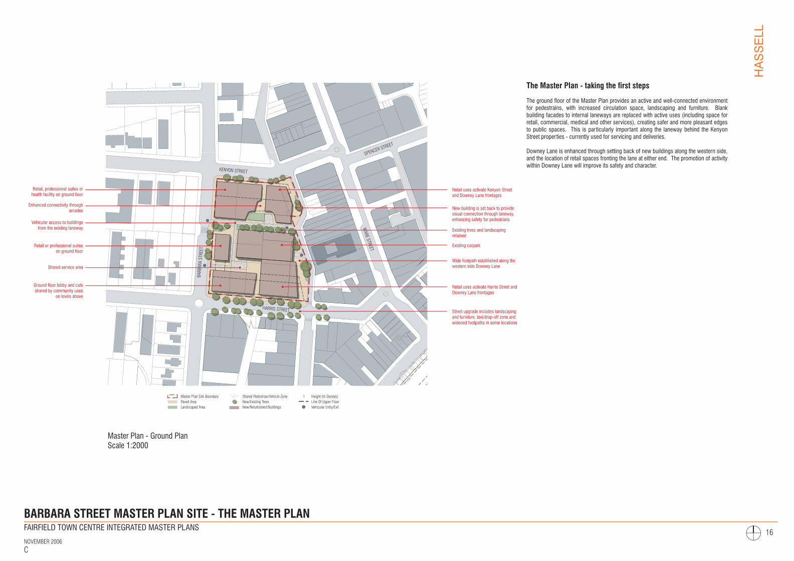
BARBARA STREET MASTER PLAN SITE - THE MASTER PLAN
The Master Plan - taking the first steps
The ground floor of the Master Plan provides an active and well-connected environment for pedestrains, with increased circulation space, landscaping and furniture. Blank building facades to internal laneways are replaced with active uses (including space for retail, commercial, medical and other services), creating safer and more pleasant edges to public spaces. This is particularly important along the laneway behind the Kenyon Street properties - currently used for servicing and deliveries.
Downey Lane is enhanced through setting back of new buildings along the western side, and the location of retail spaces fronting the lane at either end. The promotion of activity within Downey Lane will improve its safety and character.
FINAL DRAFT
Master Plan - Ground Plan Scale 1:2000
Retail uses activate Kenyon Street and Downey Lane frontages
Wide footpath established along the western side Downey Lane
New building is set back to provide visual connection through laneway, enhancing safety for pedestrians
Existing trees and landscaping retained
Ground floor lobby and cafe shared by community uses
on levels above
Retail, professional suites or health facility on ground floor
Shared service area
Vehicular access to buildings from the existing laneway
Retail uses activate Harris Street and Downey Lane frontages
Enhanced connectivity through arcades
Retail or professional suites on ground floor
Street upgrade includes landscaping and furniture, taxi/drop-off zone and widened footpaths in some locations
Existing carpark
FAIRFIELD TOWN CENTRE INTEGRATED MASTER PLANS
NOVEMBER 2006C
HASSELL
17
CICIP
HARR
IS S
TREE
T
KENY
ON S
TREE
T
COMMERCIAL/RESIDENTIAL
COMMERCIAL/RESIDENTIAL
CAR PARK COMMUNITY POSSIBLE FUTURE
BUILDING
POSSIBLE FUTURE
BUILDING
BARBARA STREET MASTER PLAN SITE - THE MASTER PLAN
FAIRFIELDCIC LIBRARY
BARB
ARA
STRE
ET
DOW
NEY
LANE
POSSIBLE FUTURE
BUILDING
COMMERCIAL/RESIDENTIAL
COMMUNITY EXISTING RESIDENTIAL
EXISTING RESIDENTIAL
COMMUNITY/COMMERCIAL
BARBARA STREET
H A R R I S S T R E E T KENYON STREET B A R B A R A S T R E E T
FOOTPATHWIDENING IN SOME LOCATIONS
EXISTINGFOOTPATH
GROUNDFLOOR SETBACK
BALCONYZONE
2M
EXIS
TING
CUR
B LI
NE
BOUN
DARY
FINAL DRAFT
Barbara Street Elevation Scale 1:2000 Harris Street Elevation Scale 1:2000
Aerial view looking to North East Aerial view looking to South East Typical Street Section Scale 1:200
FAIRFIELD TOWN CENTRE INTEGRATED MASTER PLANS
NOVEMBER 2006C
HASSELL
18
BARBARA STREET MASTER PLAN SITE - STAGING AND FEASIBILITY
FINAL DRAFT
Site A Site B Site C
Site D
Site E Site F
Site G
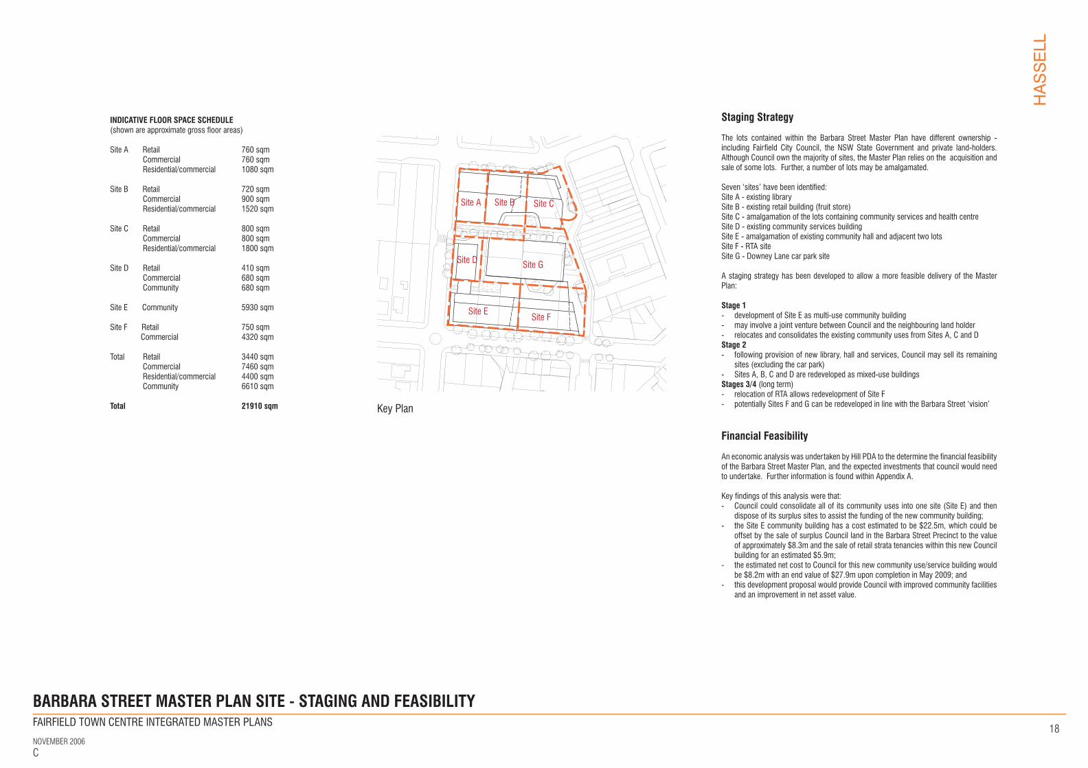
INDICATIVE FLOOR SPACE SCHEDULE(shown are approximate gross floor areas)
Site A Retail 760 sqm Commercial 760 sqm Residential/commercial 1080 sqm
Site B Retail 720 sqm Commercial 900 sqm Residential/commercial 1520 sqm
Site C Retail 800 sqm Commercial 800 sqm Residential/commercial 1800 sqm
Site D Retail 410 sqm Commercial 680 sqm Community 680 sqm
Site E Community 5930 sqm
Site F Retail 750 sqm Commercial 4320 sqm
Total Retail 3440 sqm Commercial 7460 sqm Residential/commercial 4400 sqm Community 6610 sqm Total 21910 sqm Key Plan
Staging Strategy
The lots contained within the Barbara Street Master Plan have different ownership - including Fairfield City Council, the NSW State Government and private land-holders. Although Council own the majority of sites, the Master Plan relies on the acquisition and sale of some lots. Further, a number of lots may be amalgamated.
Seven ‘sites’ have been identified:Site A - existing librarySite B - existing retail building (fruit store)Site C - amalgamation of the lots containing community services and health centreSite D - existing community services buildingSite E - amalgamation of existing community hall and adjacent two lotsSite F - RTA siteSite G - Downey Lane car park site
A staging strategy has been developed to allow a more feasible delivery of the Master Plan:
Stage 1 - development of Site E as multi-use community building- may involve a joint venture between Council and the neighbouring land holder- relocates and consolidates the existing community uses from Sites A, C and DStage 2- following provision of new library, hall and services, Council may sell its remaining
sites (excluding the car park)- Sites A, B, C and D are redeveloped as mixed-use buildingsStages 3/4 (long term)- relocation of RTA allows redevelopment of Site F- potentially Sites F and G can be redeveloped in line with the Barbara Street ‘vision’
Financial Feasibility
An economic analysis was undertaken by Hill PDA to the determine the financial feasibility of the Barbara Street Master Plan, and the expected investments that council would need to undertake. Further information is found within Appendix A.
Key findings of this analysis were that:- Council could consolidate all of its community uses into one site (Site E) and then
dispose of its surplus sites to assist the funding of the new community building;- the Site E community building has a cost estimated to be $22.5m, which could be
offset by the sale of surplus Council land in the Barbara Street Precinct to the value of approximately $8.3m and the sale of retail strata tenancies within this new Council building for an estimated $5.9m;
- the estimated net cost to Council for this new community use/service building would be $8.2m with an end value of $27.9m upon completion in May 2009; and
- this development proposal would provide Council with improved community facilities and an improvement in net asset value.
FAIRFIELD TOWN CENTRE INTEGRATED MASTER PLANS
NOVEMBER 2006C
HASSELL
19
COMMUTER PARKING
COMMUTER PARKING
RAILWAY STATIO
N
BUS INTEREXISTINGCARPARK
SPENCER ST
KENYON ST
KENY
ON L
ANE
BARB
ARA
ST
WAR
E ST
SMAR
T ST
HARRIS ST
HAMILTON ST
THE C
RESCEN
T
DALE ST
ANZAC AVE
WIL
LIAM
ST
Master Plan site boundary
Buildings
Vehicle entry/exits
Primary vehicle movement
Vehicle entry/exit to buildings
Loading areas
Improved pedestrian conditions
Area to be investigated
KEY
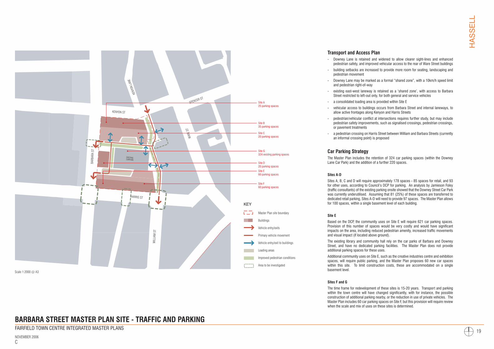
Scale 1:2000 @ A3
BARBARA STREET MASTER PLAN SITE - TRAFFIC AND PARKING
Transport and Access Plan- Downey Lane is retained and widened to allow clearer sight-lines and enhanced
pedestrian safety, and improved vehicular access to the rear of Ware Street buildings
- building setbacks are increased to provide more room for seating, landscaping and pedestrian movement
- Downey Lane may be marked as a formal “shared zone”, with a 10km/h speed limit and pedestrian right-of-way
- existing east-west laneway is retained as a ‘shared zone’, with access to Barbara Street restricted to left-out only, for both general and service vehicles
- a consolidated loading area is provided within Site E
- vehicular access to buildings occurs from Barbara Street and internal laneways, to allow active frontages along Kenyon and Harris Streets
- pedestrian/vehicular conflict at intersections requires further study, but may include pedestrian safety improvements, such as signalised crossings, pedestrian crossings, or pavement treatments
- a pedestrian crossing on Harris Street between William and Barbara Streets (currently an informal crossing point) is proposed
Car Parking StrategyThe Master Plan includes the retention of 324 car parking spaces (within the Downey Lane Car Park) and the addition of a further 220 spaces.
Sites A-D
Sites A, B, C and D will require approximately 178 spaces - 85 spaces for retail, and 93 for other uses, according to Council’s DCP for parking. An analysis by Jamieson Foley (traffic consultants) of the existing parking onsite showed that the Downey Street Car Park was currently underutilised. Assuming that 81 (25%) of these spaces are transferred to dedicated retail parking, Sites A-D will need to provide 97 spaces. The Master Plan allows for 100 spaces, within a single basement level of each building.
Site E
Based on the DCP, the community uses on Site E will require 621 car parking spaces. Provision of this number of spaces would be very costly and would have significant impacts on the area, including reduced pedestrian amenity, increased traffic movements and visual impact (if located above ground).
The existing library and community hall rely on the car parks of Barbara and Downey Street, and have no dedicated parking facilities. The Master Plan does not provide additional parking spaces for these uses.
Additional community uses on Site E, such as the creative industries centre and exhibition spaces, will require public parking, and the Master Plan proposes 60 new car spaces within this site. To limit construction costs, these are accommodated on a single basement level.
Sites F and G
The time frame for redevelopment of these sites is 15-20 years. Transport and parking within the town centre will have changed significantly, with for instance, the possible construction of additional parking nearby, or the reduction in use of private vehicles. The Master Plan includes 60 car parking spaces on Site F, but this provision will require review when the scale and mix of uses on these sites is determined.
Site A 25 parking spaces
Site B 35 parking spaces
Site C 20 parking spaces
Site D 20 parking spaces
Site E 60 parking spaces
Site F 60 parking spaces
Site G 324 existing parking spaces
FINAL DRAFT
FAIRFIELD TOWN CENTRE INTEGRATED MASTER PLANS
NOVEMBER 2006C
HASSELL
20
THE CRESCENT MASTER PLAN SITE
FINAL DRAFT
FAIRFIELD TOWN CENTRE INTEGRATED MASTER PLANS
NOVEMBER 2006C
HASSELL
21
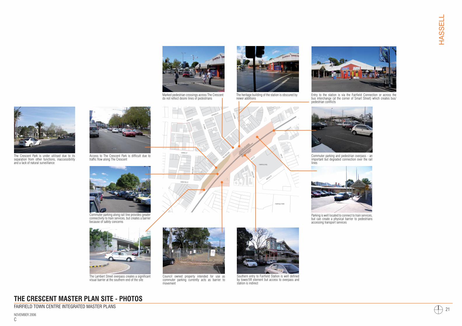
THE CRESCENT MASTER PLAN SITE - PHOTOS
SPENCER ST
KENYON ST
WAR
E ST
SMAR
T ST
HARRIS ST
HAMILTON ST
THE C
RESCEN
T
DALE ST
ANZAC AVE
VINE STBERTHA ST
FAIRFIELD ST
WIL
LIAM
ST
FAIRFIELD RSL
FAIRFIELD PARK
Council owned property intended for use as commuter parking currently acts as barrier to movement
Southern entry to Fairfield Station is well defined by tower/lift element but access to overpass and station is indirect
Commuter parking along rail line provides greater connectivity to train services, but creates a barrier because of safety concerns
Access to The Crescent Park is difficult due to traffic flow along The Crescent
The Lambert Street overpass creates a significant visual barrier at the southern end of the site
The heritage building of the station is obscured by newer additions
Marked pedestrian crossings across The Crescent do not reflect desire lines of pedestrians
Entry to the station is via the Fairfield Connection or across the bus interchange (at the corner of Smart Street) which creates bus/pedestrian conflicts
Parking is well located to connect to train services, but can create a physical barrier to pedestrians accessing transport services
Commuter parking and pedestrian overpass - an important but degraded connection over the rail lines
The Crescent Park is under utilised due to its separation from other functions, inaccessibility and a lack of natural surveillance
FINAL DRAFT
FAIRFIELD TOWN CENTRE INTEGRATED MASTER PLANS
NOVEMBER 2006C
HASSELL
22
SPENCER ST
KENYON ST
WAR
E ST
SMAR
T ST
HARRIS ST
HAMILTON ST
THE C
RESCEN
T
DALE ST
ANZAC AVE
VINE ST
BERTHA ST
FAIRFIELD ST
WIL
LIAM
ST
FAIRFIELD PARK
FAIRFIELD RSL
FAIRFIELD PARK
KEY
Master Plan site boundary
Open space / park
Commuter parking
Bus interchange
Active frontage
Active frontage (limited contribution)
Access to site
Access to site (via arcade)
Pedestrian connection (over train line)
Pedestrian connection (under train line / street)
Train line
Physical barrier (eg security fence)
Visual / perceptual barrier (eg change in level, inactive space)
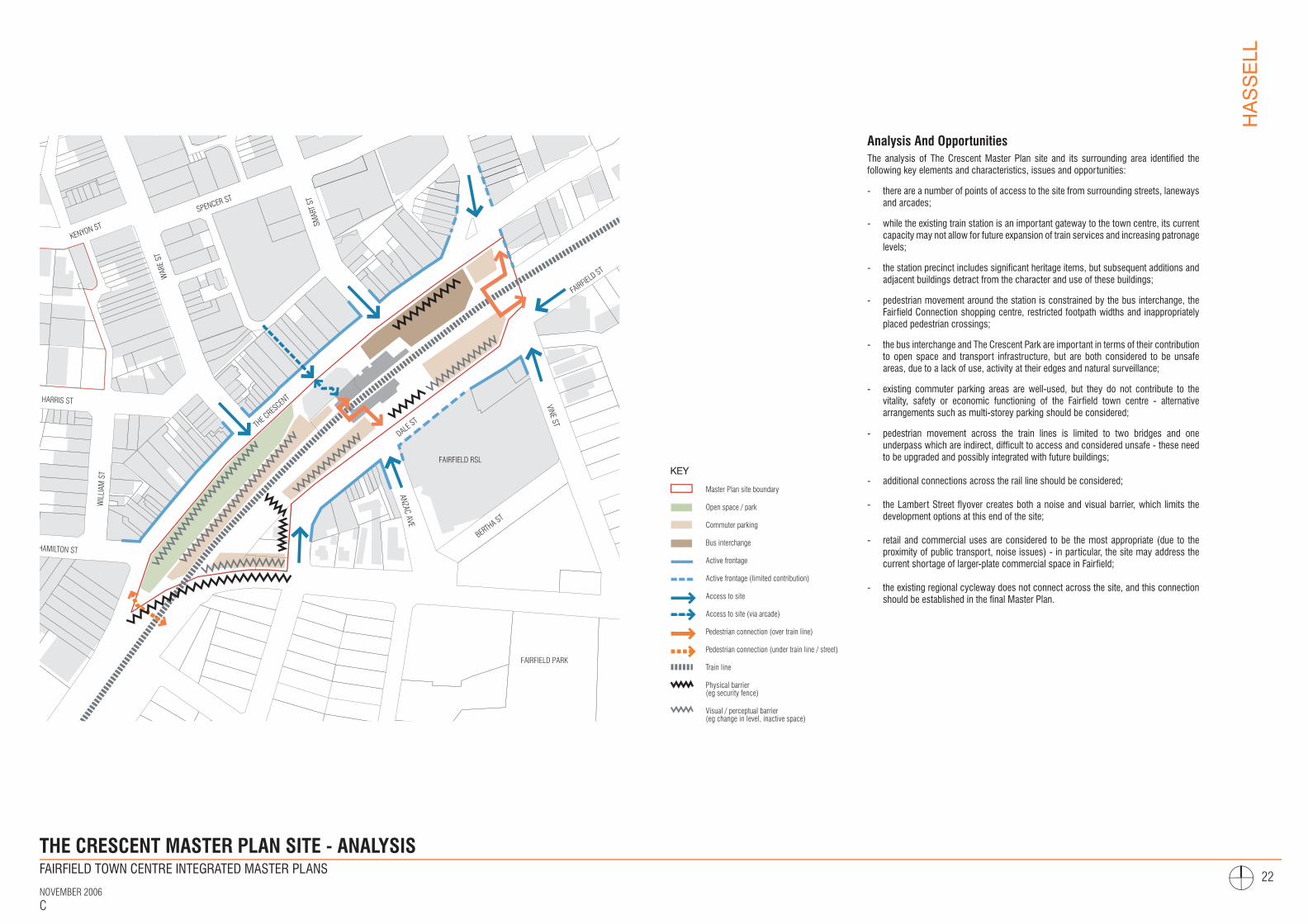
THE CRESCENT MASTER PLAN SITE - ANALYSIS
Analysis And OpportunitiesThe analysis of The Crescent Master Plan site and its surrounding area identified the following key elements and characteristics, issues and opportunities:
- there are a number of points of access to the site from surrounding streets, laneways and arcades;
- while the existing train station is an important gateway to the town centre, its current capacity may not allow for future expansion of train services and increasing patronage levels;
- the station precinct includes significant heritage items, but subsequent additions and adjacent buildings detract from the character and use of these buildings;
- pedestrian movement around the station is constrained by the bus interchange, the Fairfield Connection shopping centre, restricted footpath widths and inappropriately placed pedestrian crossings;
- the bus interchange and The Crescent Park are important in terms of their contribution to open space and transport infrastructure, but are both considered to be unsafe areas, due to a lack of use, activity at their edges and natural surveillance;
- existing commuter parking areas are well-used, but they do not contribute to the vitality, safety or economic functioning of the Fairfield town centre - alternative arrangements such as multi-storey parking should be considered;
- pedestrian movement across the train lines is limited to two bridges and one underpass which are indirect, difficult to access and considered unsafe - these need to be upgraded and possibly integrated with future buildings;
- additional connections across the rail line should be considered;
- the Lambert Street flyover creates both a noise and visual barrier, which limits the development options at this end of the site;
- retail and commercial uses are considered to be the most appropriate (due to the proximity of public transport, noise issues) - in particular, the site may address the current shortage of larger-plate commercial space in Fairfield;
- the existing regional cycleway does not connect across the site, and this connectionshould be established in the final Master Plan.
FINAL DRAFT
FAIRFIELD TOWN CENTRE INTEGRATED MASTER PLANS
NOVEMBER 2006C
HASSELL
23
SPENCER ST
KENYON ST
WAR
E ST
SMAR
T ST
HARRIS ST
HAMILTON ST
THE C
RESCEN
T
DALE ST
ANZAC AVE
VINE ST
BERTHA ST
FAIRFIELD ST
WIL
LIAM
ST FAIRFIELD RSL
FAIRFIELD PARK
COMMUTERPARKING
NEW RAILW
AY STA
TION
EXISTING RAILW
AY STA
TION
Master Plan site boundary
Existing railway station
New railway station
Proposed/upgraded cross-rail connection
Physical and visual connection to surrounding area
Widened footpath to accomodate bus stops, landscaping +street furniture
Proposed Vehicular entry/exit points
Building facades defining open space
Street edge buildings
Active building frontages at ground floor
Open space
Development
Higher density development
KEY
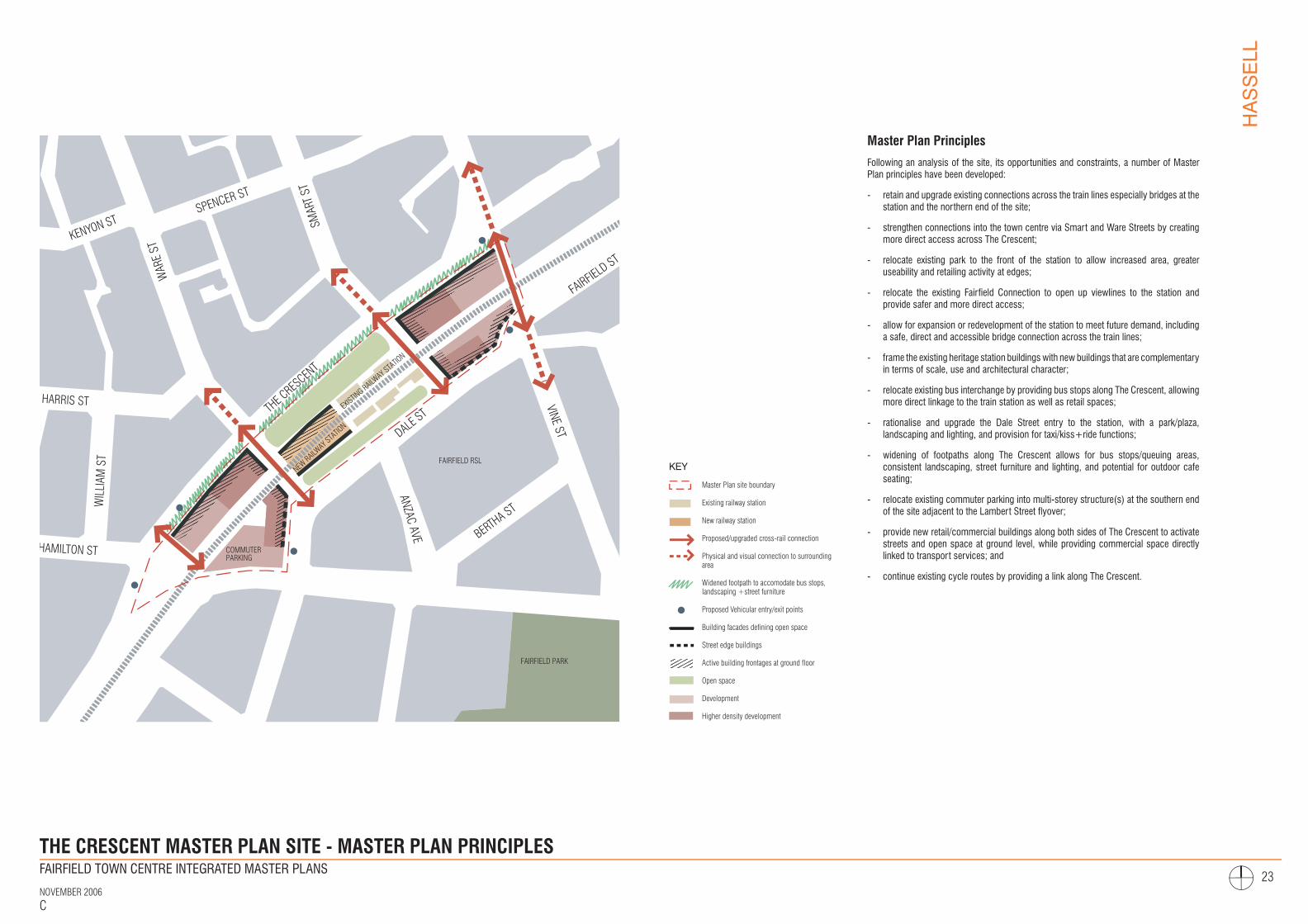
THE CRESCENT MASTER PLAN SITE - MASTER PLAN PRINCIPLES
Master Plan Principles
Following an analysis of the site, its opportunities and constraints, a number of Master Plan principles have been developed:
- retain and upgrade existing connections across the train lines especially bridges at the station and the northern end of the site;
- strengthen connections into the town centre via Smart and Ware Streets by creating more direct access across The Crescent;
- relocate existing park to the front of the station to allow increased area, greater useability and retailing activity at edges;
- relocate the existing Fairfield Connection to open up viewlines to the station and provide safer and more direct access;
- allow for expansion or redevelopment of the station to meet future demand, including a safe, direct and accessible bridge connection across the train lines;
- frame the existing heritage station buildings with new buildings that are complementary in terms of scale, use and architectural character;
- relocate existing bus interchange by providing bus stops along The Crescent, allowing more direct linkage to the train station as well as retail spaces;
- rationalise and upgrade the Dale Street entry to the station, with a park/plaza, landscaping and lighting, and provision for taxi/kiss+ride functions;
- widening of footpaths along The Crescent allows for bus stops/queuing areas, consistent landscaping, street furniture and lighting, and potential for outdoor cafe seating;
- relocate existing commuter parking into multi-storey structure(s) at the southern end of the site adjacent to the Lambert Street flyover;
- provide new retail/commercial buildings along both sides of The Crescent to activate streets and open space at ground level, while providing commercial space directly linked to transport services; and
- continue existing cycle routes by providing a link along The Crescent.
FINAL DRAFT
FAIRFIELD TOWN CENTRE INTEGRATED MASTER PLANS
NOVEMBER 2006C
HASSELL
24
THE C
RESCEN
T
SMAR
T ST
REET
WAR
E ST
REET
WIL
LIAM
STR
EET
ANA
AVE
VINE
STRE
ET
HARRIS STREET
HAMILTON STREET
DALE STREET
BERTHA STREET
Master Plan Site BoundaryPaved AreaLandscaped Area
New/Existing TreesNew/Refurbished BuildingsExisting Train Station Buildings
Height (In Storeys)Line Of Ground FloorVehicular Entry/Exit
Existing/New Connection1
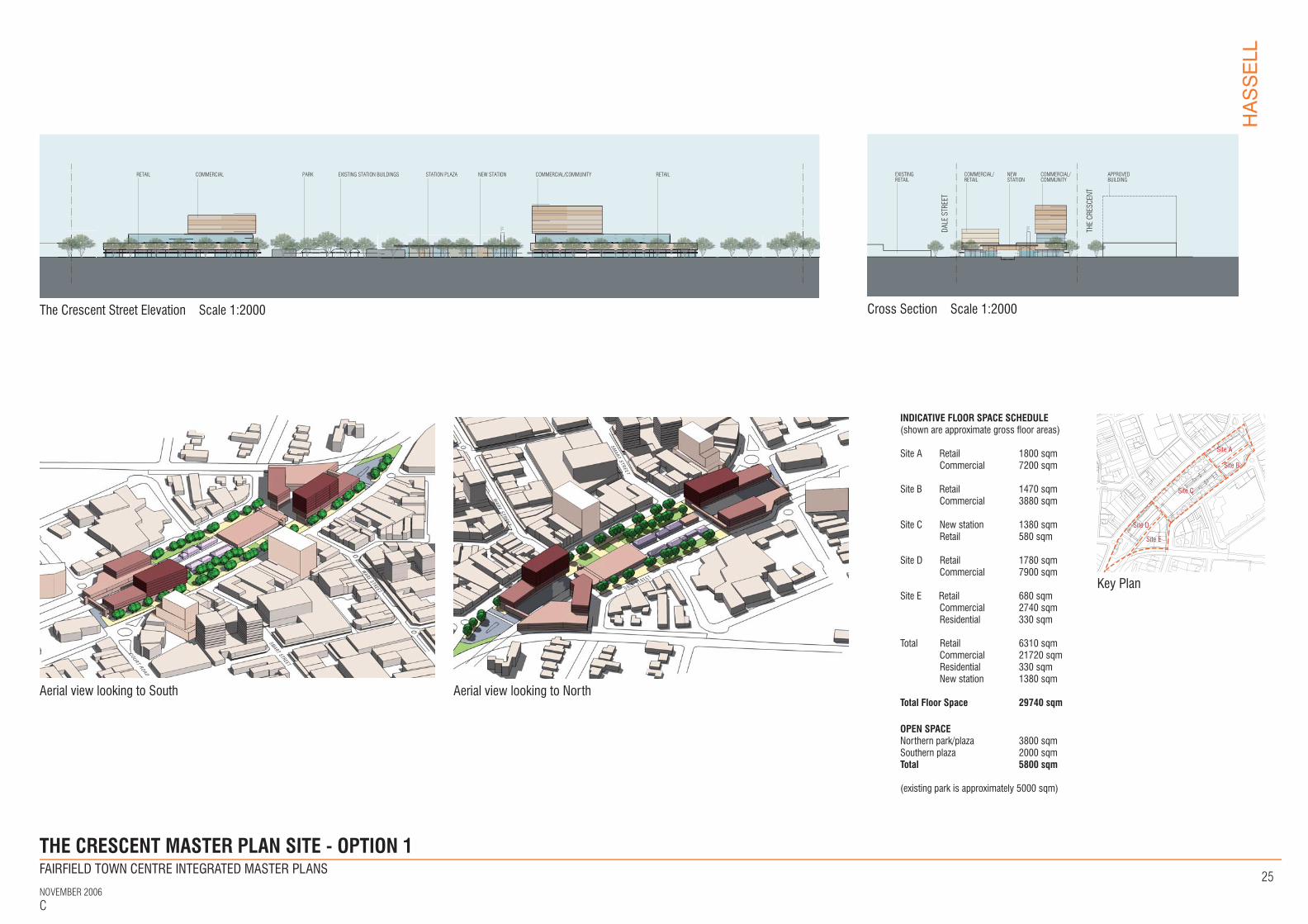
THE CRESCENT MASTER PLAN SITE - OPTION 1
Bus stops relocated to The Crescent
Existing station buildings refurbished for retail/community uses
New multi-storey parking station with bridge connection to new buildings
Retail/commercial buildings, potentially to accommodate community/council uses
New public plaza in front of station
New railway station including upgraded connection across rail lines
New connections integrated with buildings
Footpaths widened; new street trees and furniture
New public park
Retail/commercial buildings along Dale Street
Master Plan Option 1
All existing commuter parking is shifted to a new multi-storey structure, with some also integrated into new building developments. Existing bus stops, taxi rank and ‘kiss+ride’ are relocated to The Crescent, and a new train station is constructed adjacent to the existing station. New retail/commercial buildings are located on both sides of the train corridor.
A new park and landscaped plaza are located in front of the station. The footpath along The Crescent is widened to provide space for bus stops, as well as improved amenity through consistent street tree planting, new paving, lighting and street furniture.
The key opportunities of this Master Plan option include:
- new station provides a modern facility for current and future needs, as well as an enhanced ‘gateway’ to the town centre;
- existing station buildings refurbished as community/cultural buildings, or retail such as cafe and restaurants;
- existing retail spaces are relocated to be more visible, functional and attractive buildings;
- new park and plaza provide open space that is more accessible and safer than the existing park, and a direct connection to the town centre via Smart and Ware Streets;
- safety and convenience of bus passengers is improved by the location of bus stops adjacent to other uses, such as retail and commercial spaces, and the train station;
- streetscape improvements and improved station entry from Dale Street;
- new retail/commercial development along The Crescent creates activity and definition of the street edge;
- ‘large-plate’ commercial office space provides the opportunity for use as community facilities, council administration or government departments;
- existing bridges across the rail lines upgraded (possibly integrated with new buildings) for improved safety and access; and
- existing cycle routes can be linked along The Crescent within shared traffic lanes
Some challenges which require further investigation:
- bus movements/stopping arrangements need further study by a specialist consultant, as well as discussion with bus operators; and
- negotiation with Rail Corp and current leaseholders to provide integrated delivery of buildings and new public domain / infrastructure
Financial Feasibility
Hill PDA have completed a financial analysis of the two options for The Crescent precinct (see Appendix A) to determine their feasibility. The analysis found that:- Option 1 provides the highest land value return to RailCorp of $12m and a $30m
development profit to the developer;- it would generate significant job growth for Fairfield estimated to be 1,500 additional
jobs annually;- the total project cost will be in excess of $109m, and that staging will be required to
allow take up of market demand for office space; and- Option 1 would require substantial (>50%) pre-commitment of office space.
Possible bus lay-over area or turning bay
FINAL DRAFT
Master Plan Scale 1:2000
3
54
5
1
4
8
10
2
FAIRFIELD TOWN CENTRE INTEGRATED MASTER PLANS
NOVEMBER 2006C
HASSELL
25
F
COMMERCIAL/COMMUNITY
COMMERCIAL/RETAIL
EXISTINGRETAIL
APPROVEDBUILDING
THE
CRES
CENT
DALE
STR
EET
NEWSTATION
THE CRESCENT MASTER PLAN SITE - OPTION 1
F
COMMERCIAL/COMMUNITYCOMMERCIAL RETAILRETAIL NEW STATIONEXISTING STATION BUILDINGSPARK STATION PLAZA
INDICATIVE FLOOR SPACE SCHEDULE(shown are approximate gross floor areas)
Site A Retail 1800 sqm Commercial 7200 sqm
Site B Retail 1470 sqm Commercial 3880 sqm
Site C New station 1380 sqm Retail 580 sqm
Site D Retail 1780 sqm Commercial 7900 sqm
Site E Retail 680 sqm Commercial 2740 sqm Residential 330 sqm
Total Retail 6310 sqm Commercial 21720 sqm Residential 330 sqm New station 1380 sqm
Total Floor Space 29740 sqm
OPEN SPACENorthern park/plaza 3800 sqmSouthern plaza 2000 sqmTotal 5800 sqm
(existing park is approximately 5000 sqm)
FINAL DRAFT
Cross Section Scale 1:2000The Crescent Street Elevation Scale 1:2000
Aerial view looking to South Aerial view looking to North
COURT ROAD
WARE STREET
SMART STR
EET
WAR
E STREET
D A L E S T R E E T
SMART STREET
Key Plan
Site A
Site B
Site C
Site D Site E
FAIRFIELD TOWN CENTRE INTEGRATED MASTER PLANS
NOVEMBER 2006C
HASSELL
26
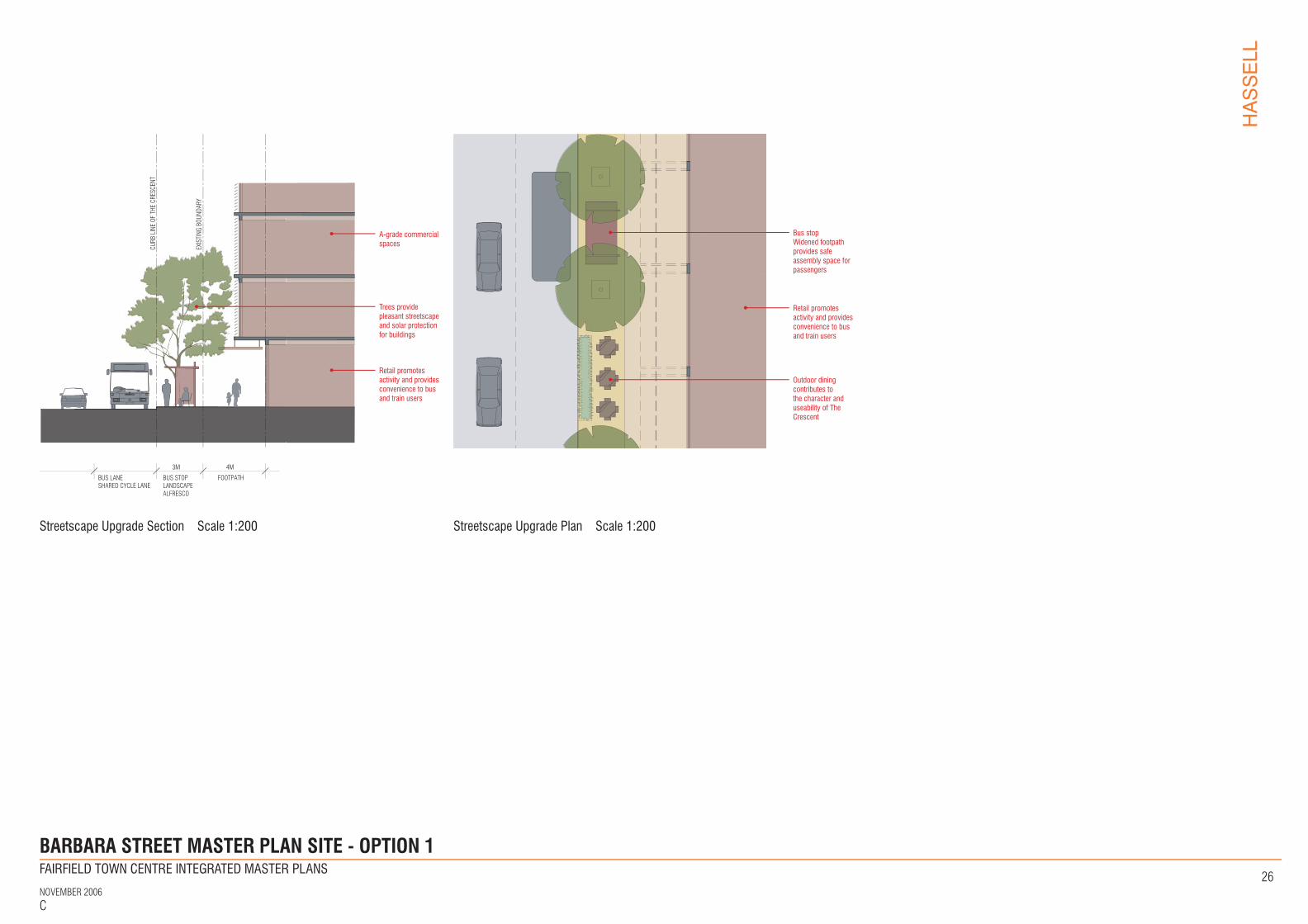
BARBARA STREET MASTER PLAN SITE - OPTION 1
BUS LANESHARED CYCLE LANE
BUS STOPLANDSCAPEALFRESCO
3M 4M
FOOTPATH
CURB
LIN
E OF
THE
CRE
SCEN
T
EXIS
TING
BOU
NDAR
Y
A-grade commercial spaces
Retail promotes activity and provides convenience to bus and train users
Trees provide pleasant streetscape and solar protection for buildings
Bus stopWidened footpath provides safe assembly space for passengers
Outdoor dining contributes to the character and useability of The Crescent
Retail promotes activity and provides convenience to bus and train users
FINAL DRAFT
Streetscape Upgrade Section Scale 1:200 Streetscape Upgrade Plan Scale 1:200

FAIRFIELD TOWN CENTRE INTEGRATED MASTER PLANS
NOVEMBER 2006C
HASSELL
27
FAIRFIELD RSL
FAIRFIELD PARK
SPENCER ST
KENYON ST
WAR
E ST
SMAR
T ST
HARRIS ST
HAMILTON ST
THE C
RESCEN
T
DALE ST
ANZAC AVE
VINE ST
BERTHA ST
FAIRFIELD ST
WIL
LIAM
ST
Master Plan site boundary
Buildings
Existing railway station
Vehicle entry/exits
Cycle routes to connect existing paths
Pedestrian connection over rail line
Commuter Parking
Pedestrian improvement, bus/taxi service and kiss+ride
Area to be investigated
KEY
THE CRESCENT MASTER PLAN SITE - TRAFFIC AND PARKING
Transport and Access Plan- the area around the station is pedestrian-focused, allowing enhanced access to the
station and safer crossing of The Crescent
- improved crossing conditions are provided at the corner of Smart and Ware Streets, with the mid-block crossing relocated to align with the existing shipping arcade
- the principal entry to the new station is located for more direct access to Ware Street
- new station and buildings allow for more direct, accessible and safer pedestrian connections across the rail lines - this creates better connectivity between the two sides of the town centre
- relocation of buses along The Crescent significantly improves interaction between bus passengers and new active frontages along The Crescent, with a wider traffic lane to avoid conflict between moving traffic and stationary buses
- the impact of vehicles entering and exiting buildings is reduced by locating access at the ends of the Master Plan site
- on-road cycle links are provided in a mixed traffic, slow speed environment (40km/h High Pedestrian Activity Area) on both sides of the railway line, connecting to the existing Parramatta to Liverpool Rail Trail on the northern and southern approaches to Fairfield Station - these require further study by a specialist consultant
Car Parking StrategyThe existing commuter parking spaces (295 in total) are retained, and relocated to a multi-storey structure at the southern end of the site. This minimises the impact of vehicle movements by providing a single point of access, and enhances pedestrian connection to the town centre by the provision of a bridge across the rail lines.
Under Council’s current DCP for parking, an additional 538 parking spaces would be required, including 195 spaces for retail uses. As the majority of retail uses will service commuters and other public transport users, the Master Plan assumes that this requirement will be satisfied by the existing commuter parking.
Car parking for commercial uses has been provided within the building envelopes, as shown below. This configuration allows for the parking space to be reallocated for future expansion of the rail corridor.
This Master Plan option proposes a total of 500 car parking spaces, but has potential to accommodate additional spaces. The total number of parking spaces depends upon the refinement of floor area and mix of uses.
Parking Concept
Existing railway lineParkingRetail+commercialFootpath+bus stop
Site A 130 parking spaces
Site B 10 parking spaces
Site C 10 parking spaces
Site D 130 parking spaces
Site E 220 parking spaces
Potential to expand rail corridor while retaining parking
FINAL DRAFT
FAIRFIELD TOWN CENTRE INTEGRATED MASTER PLANS
NOVEMBER 2006C
HASSELL
28
THE C
RESCEN
T
SMAR
T ST
REET
WAR
E ST
REET
WIL
LIAM
STR
EET
ANA
AVE
VINE
STRE
ET
HARRIS STREET
HAMILTON STREET
DALE STREET
BERTHA STREET
Master Plan Site Boundary Paved Area Landscaped Area
New/Existing Trees New/Refurbished Buildings Existing Train Station Buildings
Height (In Storeys) Line Of Ground Floor Vehicular Entry/Exit
Existing/New Connection 1
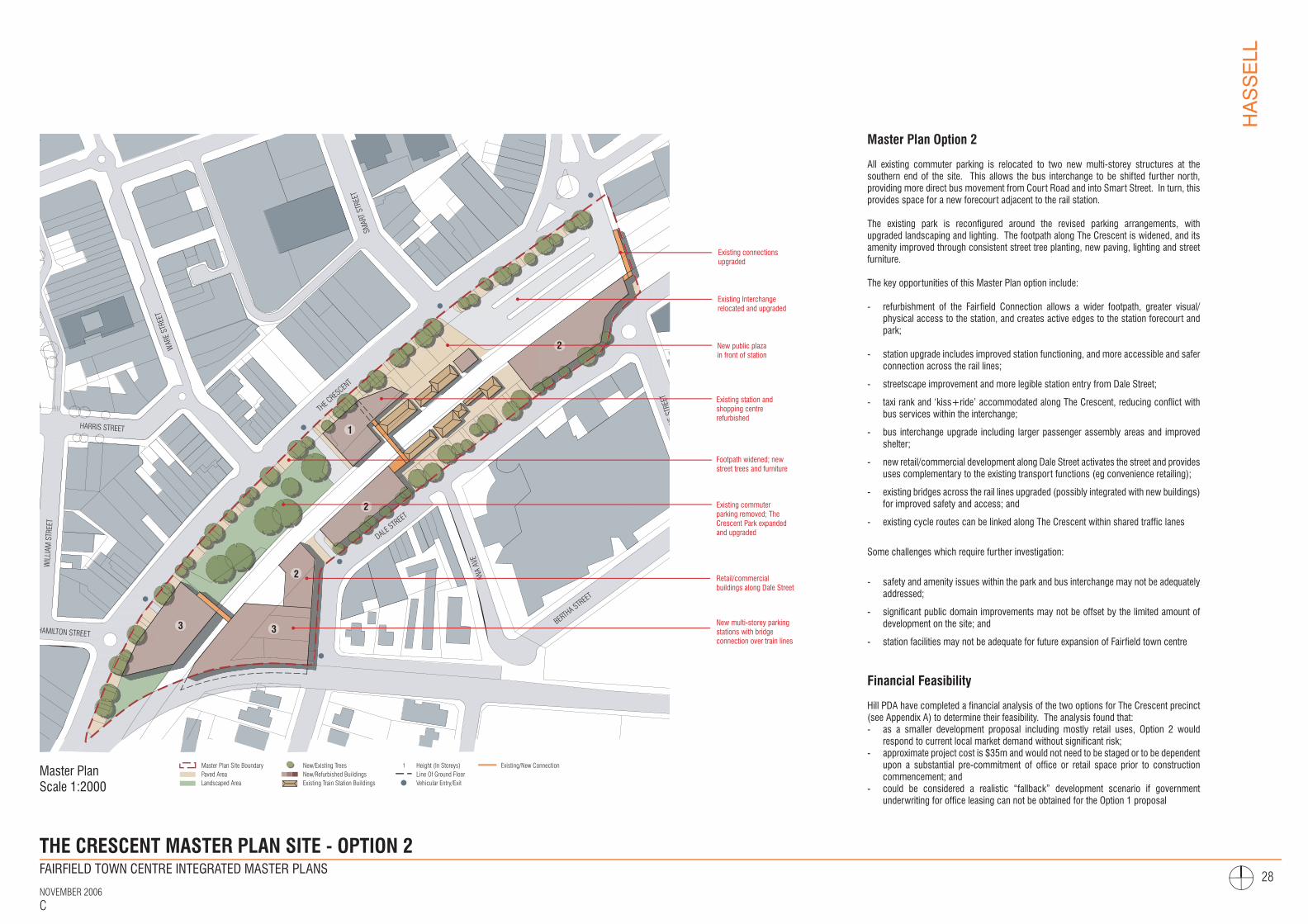
THE CRESCENT MASTER PLAN SITE - OPTION 2
3 3
2
2
2
1
Master Plan Option 2
All existing commuter parking is relocated to two new multi-storey structures at the southern end of the site. This allows the bus interchange to be shifted further north, providing more direct bus movement from Court Road and into Smart Street. In turn, this provides space for a new forecourt adjacent to the rail station.
The existing park is reconfigured around the revised parking arrangements, with upgraded landscaping and lighting. The footpath along The Crescent is widened, and its amenity improved through consistent street tree planting, new paving, lighting and street furniture.
The key opportunities of this Master Plan option include:
- refurbishment of the Fairfield Connection allows a wider footpath, greater visual/physical access to the station, and creates active edges to the station forecourt and park;
- station upgrade includes improved station functioning, and more accessible and safer connection across the rail lines;
- streetscape improvement and more legible station entry from Dale Street;
- taxi rank and ‘kiss+ride’ accommodated along The Crescent, reducing conflict with bus services within the interchange;
- bus interchange upgrade including larger passenger assembly areas and improved shelter;
- new retail/commercial development along Dale Street activates the street and provides uses complementary to the existing transport functions (eg convenience retailing);
- existing bridges across the rail lines upgraded (possibly integrated with new buildings) for improved safety and access; and
- existing cycle routes can be linked along The Crescent within shared traffic lanes
Some challenges which require further investigation:
- safety and amenity issues within the park and bus interchange may not be adequately addressed;
- significant public domain improvements may not be offset by the limited amount of development on the site; and
- station facilities may not be adequate for future expansion of Fairfield town centre
Financial Feasibility
Hill PDA have completed a financial analysis of the two options for The Crescent precinct (see Appendix A) to determine their feasibility. The analysis found that:- as a smaller development proposal including mostly retail uses, Option 2 would
respond to current local market demand without significant risk;- approximate project cost is $35m and would not need to be staged or to be dependent
upon a substantial pre-commitment of office or retail space prior to construction commencement; and
- could be considered a realistic “fallback” development scenario if government underwriting for office leasing can not be obtained for the Option 1 proposal
FINAL DRAFT
Master Plan Scale 1:2000
Existing Interchange relocated and upgraded
Existing station and shopping centre refurbished
New multi-storey parking stations with bridge connection over train lines
Existing commuter parking removed; The Crescent Park expanded and upgraded
New public plaza in front of station
Footpath widened; new street trees and furniture
Existing connections upgraded
Retail/commercial buildings along Dale Street
FAIRFIELD TOWN CENTRE INTEGRATED MASTER PLANS
NOVEMBER 2006C
HASSELL
29
F
REFURBSIHEDRETAIL
COMMERCIAL/RETAIL
EXISTINGRETAIL
APPROVEDBUILDING
THE
CRES
CENT
DALE
STR
EET
REFURBISHEDSTATION
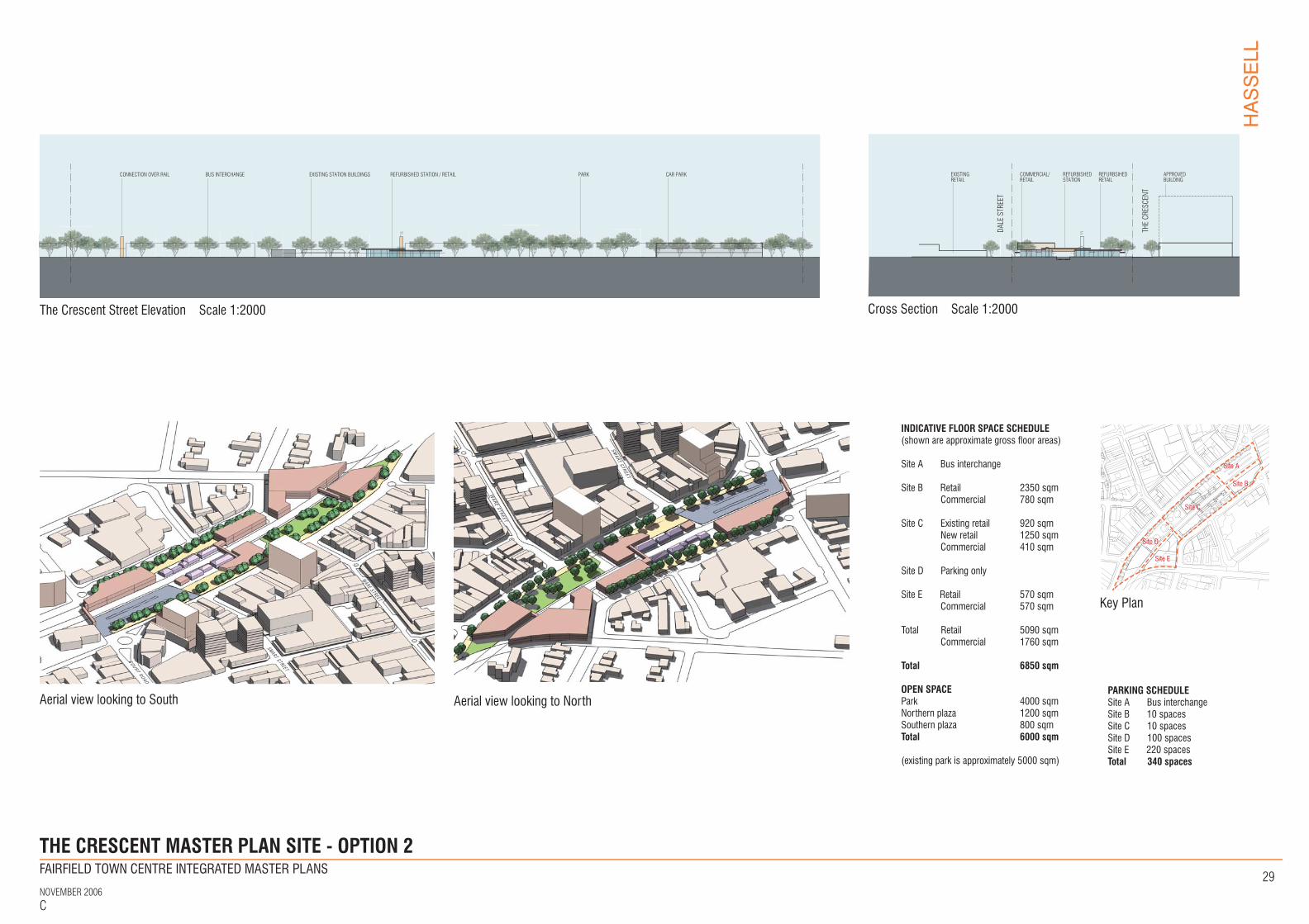
THE CRESCENT MASTER PLAN SITE - OPTION 2
F
CAR PARKEXISTING STATION BUILDINGSBUS INTERCHANGECONNECTION OVER RAIL PARKREFURBISHED STATION / RETAIL
Key Plan
Site A
Site B
Site C
Site D Site E
FINAL DRAFT
Cross Section Scale 1:2000The Crescent Street Elevation Scale 1:2000
Aerial view looking to South Aerial view looking to North
COURT ROAD
WARE STREET
SMART STR
EET
WAR
E STREET
D A L E S T R E E T
SMART STREET
INDICATIVE FLOOR SPACE SCHEDULE(shown are approximate gross floor areas)
Site A Bus interchange
Site B Retail 2350 sqm Commercial 780 sqm
Site C Existing retail 920 sqm New retail 1250 sqm Commercial 410 sqm
Site D Parking only
Site E Retail 570 sqm Commercial 570 sqm
Total Retail 5090 sqm Commercial 1760 sqm
Total 6850 sqm
OPEN SPACEPark 4000 sqmNorthern plaza 1200 sqmSouthern plaza 800 sqmTotal 6000 sqm
(existing park is approximately 5000 sqm)
PARKING SCHEDULESite A Bus interchange Site B 10 spacesSite C 10 spacesSite D 100 spacesSite E 220 spaces Total 340 spaces