falconbridge limited geological report on clergue 14
TRANSCRIPT

42AieNE0584 a.9644 CLERGUE 010
FALCONBRIDGE LIMITED
GEOLOGICAL REPORT ON CLERGUE 14
PROJECT #008125
N.T.S. 42-A-10
RECEIVED
MINING LANDS SECTION
December 1986 W. K. Smith

SUMMARY AND CONCLUSIONS
Iholeiitic rhyolite occurs near the core of an easterly
trending syncline whose axis passes through the central
Clergue 14 property. The rhyolite is underlain by altered
sulphidic pillowed tholeiitic andesite. Horizontal loop
electromagnetic anomalies C and F occur near the
rhyolitic-andesite contact. Two previous drill holes aimed
at anomaly C were stopped in strongly chloritized andesite
containing pyrrhotite-pyrite rich selvages. One previous
drill hole tested anomaly F at shallow depth (approx. 18
m). Anomaly F remains open at depth and anomaly G to the
south of F remains untested.

RECOMMENDATIONS
A total of 900 metres of drilling are recommended. (Two
holes) (Table 1).
Hole #1 (500 metres) will test EM anomaly F at 100
metres vertical depth and anomaly G at about 230 metres
vertical depth. The hole will test the upper and lower
contacts of the tholeiitic rhyolite (Figures 1,2).
Hole #2 (400 metres) will test EM anomaly C at about 120
metres vertical depth and will also test the upper and lower
contacts of the tholeiitic rhyolite 1.1 kilometres west of
proposed hole #1 (Figures 2,3).
DIAMOND DRILL DATA SHEET (Table 1)
Hole #
1
2
Azimuth
180 0
1800
Angle
-500
-500
Grid Coordinates
L1*OOE,H-OOS
LIO+OOVM+SOS
Length (metres)
500
400
Total 900

m
V)
(D
BOO m
LEGEND
(Iff GABBRO X PERIDOTITE X PYROXENITE
f B ] PCLSIC VOLCANIC
l 2 l MAFIC VOLCANIC
Figure l
(O
(M
/(-50 0 )
l-J
FALCONBRIDGE LTD.Explorotion Oivition Timmint,ONTARIO
CLERGUE 14CLERGUE Twp.
SECTION L l E
PROPOSED HOLE l
LOOK l NG WEST
SCALE: 1 '5,000
Drown -. O E L IProitCt No
DO(O) S mith
12/86

LEGENDi 9 j DiABASE DYKE
G "EEOLCXSlCAL INTERPRETATION
PILLOW TOPS V-"*HCM CONDUCTORS
-W* FAULT CVPROPOSED DRILL^f
RS ' i7r3*y;LL X ^\ N
0 \i ft 1 1 * A O \
ULTRAMAFIC INTRUSIVES ~f~-l- SYNFORM AXIS LL ANIFORM AX
* STRIKE AND O F R ROC K UN
THOLE UT 1C MAF 1C SUI TE
l l THOLE l l T 1C FE LSIC FLOWS
FALCONBRIDGE: LTD.
CLERGUE 14CLERGUE Twp
DRILL HOLES
COMPILATION
STOCK Tw'pDrown: DEL P rO|*Ct N" 81 2 5

VI
CO
CO
(OVI
- 50 0 )
LEGEND{|HJ GABBRO t P ERIDOTITE X PYROXENITE
f 8] FELSIC VOLCANIC
j X l MAFIC VOLCANIC
Figure 3
W)
M
FALCONBRIDGE LTD.Explorotion Division Timmins.ONTARIO
CLERGUE 14CLERGUE Twp.
SECTION L 10 W
PROPOSED HOLE 2
LOOKING W EST
SCALE; 5,000
Drown: D EL |Pro!*ct N o ' 81 25
Doto' Smith
Dotfl i II X l 2 X 86

TABLE OF C42A10NE0504 2 .9644 CLERGUE 010C
SUMMARY AND CONCLUSIONS
RECOMMENDATIONS 11
INTRODUCTION
LOCATION ACCESS TOPOGRAPHY
PREVIOUS WORK
REGIONAL GEOLOGY
PROPERTY GEOLOGY
ECONOMIC GEOLOGY ...................................... 9
ALTERATION ............................................ 9
REFERENCES ............................................ 12

LIST OF FIGURES
FIGURE l : Diamond drill section of proposed hole #1 iii
FIGURE 2 : Diamond drill plan of proposed drilling iv
FIGURE 3 : Diamond drill section of proposed hole #2 v
FIGURE 4 : Location map 2
FIGURE 5 : 1:5000 scale geology map of Clergue 14 (Back Pocket)
FIGURE 6 : 1:50,000 scale geology map of Clergue and 7 Dundonald Townships
FIGURE 7 : Si02 vs Na20 plot for tholeiitic rhyolite 11 on Clergue 14
LIST OF TABLES
TABLE l : Diamond Drill Data Sheet ii

INTRODUCTION
This is a geological report on 16 mining claims held by
Kidd Creek Mines in Clergue Township. The claims were mapped
at a scale of 1:5000 during the 1985 and 1986 field seasons.
The claims were recorded on January 9th 1984. The claim
numbers are as follows:
P - 731907
P - 731908
P - 731909
P - 731910
P - 741584
P - 749961
P - 749962
P - 749970
P - 749985
P - 783185
P - 783186
P - 783187
P - 783188
P - 783189
P - 783190
P - 789206
LOCATION ACCESS AND TOPOGRAPHY
The property is located in Clergue Township 50 km.
northeast of Timmins (Figure 4). The claims occur in W 1/2,
N 1/2 Lot 3 Con l, N 1/2 Lot 4 Con l, S 1/2 Lot 5 Con 2, N
1/2 Lot 6 Con l and W 1/2, S 1/2 Lot 6 Con 1.
Access is gained by travelling 50 km east on highway 101

IROQUOIS FALLS
NIGHT HAWK
South Porcupine 7 L AKE
Motheson
Figure 4FALCONBRIDGE LTD.
Explorotion Division____________Timmint.QNTARIO
CLERGUE and DUNDONALD TOWNSHIPS
LOCATl ON MAP
SCALE :
Drown: DEL [Project N0 '8I25
Ooto' W S
Dote Ml l \ 2 /86 ro

to Shillington, then north on highway 577 for 12 km to
highway 11. The Clergue Township Concession 1,2 road called
the Biglow Road occurs about l km northwest along highway 11
and leads into the central property area (Figure 4).
Topography over the property is generally flat to gently
rolling with greatest reliefs of 15-20 m at the edges of
outcrops. Outcrop areas have sparse jackpines while lower
areas are predominantly birch and poplar with minor balsam.
PREVIOUS WORK
The earliest recorded work included geological mapping
by J. Satterly (1953), D. P. Rogers (1957) and S. A.
Ferguson (1959) which was compiled at a scale of l inch to
1/4 mile and constitutes the Ontario Department of Mines
Clergue Township Map.
Texas Gulf Sulphur Co. conducted geological and
geophysical surveys over the property in 1960. Drill hole
C15-1 (64 m) intersected pillowed dacite from 22.5 to 50.3 m
with pyrrhotitic selvages which corresponds with EM
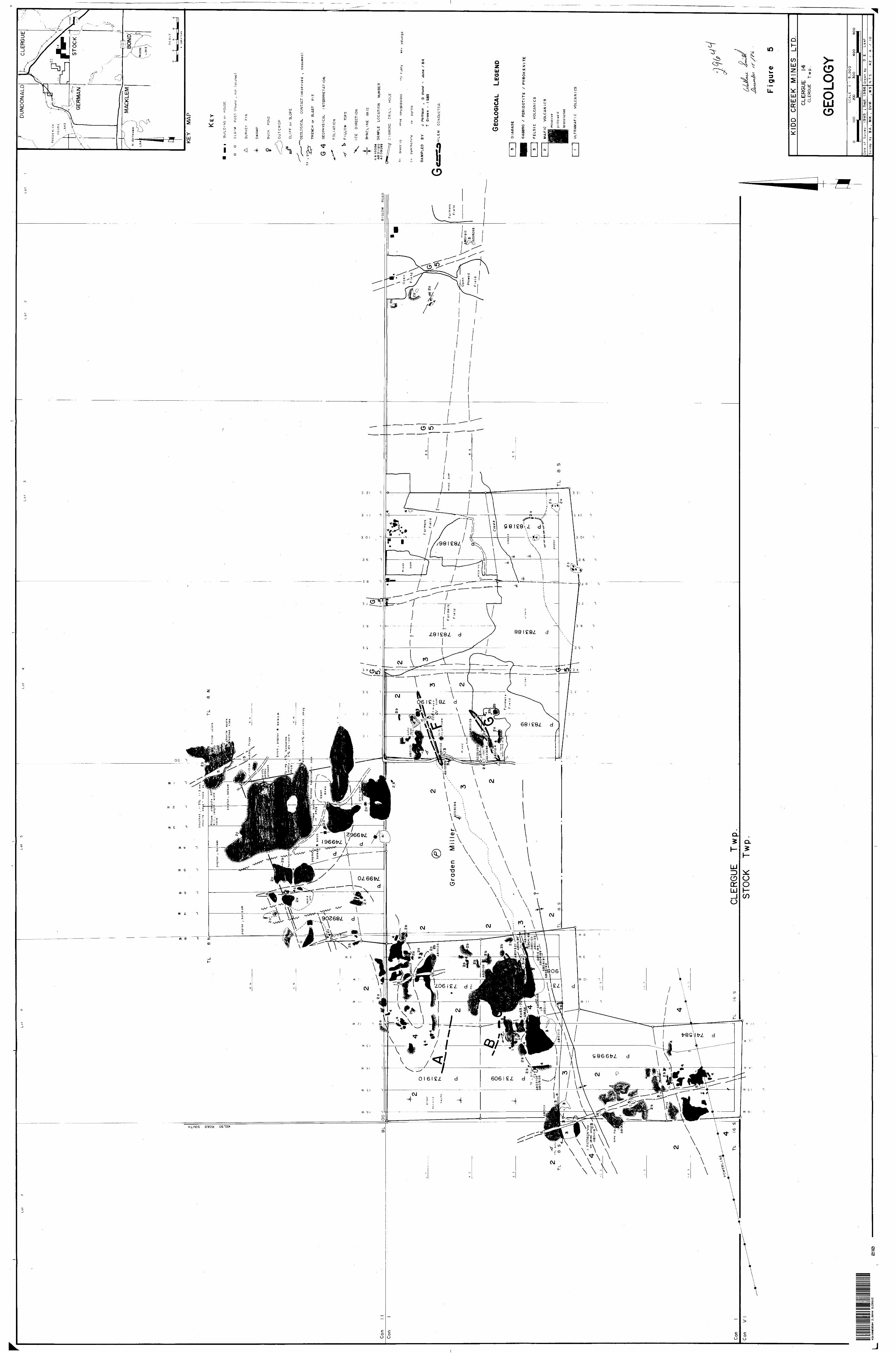
conductor F (Figure 5).
Canadian Aero Surveys carried out an airborne
geophysical survey for Alexo Extension Mines Ltd. in 1964
and suggested that further study of the property was
warranted.

David Weston drilled one hole of 43 m in 1968. It is
located at the northern edge of an outcrop of pillowed mafic
flows and massive flow banded rhyolite (Figure 5). The hole
intersected 37 m {true thickness) of chloritized andesite
with the intensity of chloritization increasing downhole.
Repeating veins of massive sulphides consisting of pyrite
and pyrrhotite with minor chalcopyrite on pyrite grain
borders were intersected from 37 to 43 m. This sulphide
section corresponds with EM anomaly C (Figure 5). Sulphides
comprised 301 of the core over the last 9 m of the hole.
A detailed ground geophysical study of the area was
conducted by Shield Geophysics for Amax Exploration Inc. in
1969. This work led to the drilling of hole KX-63-70 in
1970. This hole had a true depth of 79 m. It intersected
48 m (true thickness) of pillowed andesite containing S-95%
pyrite-pyrrhotite in pillow selvages. This hole appears to
have tested EM anomaly C. From 48 m to 79 m the andesites
became more intensely chloritized.
In 1984 Kidd Creek Mines Ltd. mapped the Clergue 14
property at a scale of l inch to 1/4 mile as part of a
regional study that included the south halves of Dundonald
and Clergue Townships.
In 1985/86 Kidd Creek Mines Ltd. conducted magnetometer,
horizontal loop electromagnetic (HLEM) and VLF surveys over
the property. Five weak to moderate HEM anomalies were

located (A,B,C,F,G). The property geology was mapped at a
scale of 1:5000.
REGIONAL GEOLOGY
The general geology of the area is shown at 1:50,000
(Figure 6). The area is underlain by Archean tholeiitic
mafic, felsic and komatiitic flows and intrusions with
primitive felsic tuffs and metasediment^. These rocks have
been folded into an anticline flanked by two east
northeasterly striking synclines which plunge to the west.
In western Clergue and southern Dundonald Townships these
rocks have been intruded by a differentiated sill of
ultramafic and gabbroic rocks called the Dundonald Sill.
North trending diabase dykes of the Matachewan Swarm are
common in eastern Clergue Township (Pattison 1984).
PROPERTY GEOLOGY
A synclinal axis passes through the central Clergue 14
claim block trending about 80 0 .
North limb stratigraphy commences with tholeiitic felsic
volcanics. This suite of rocks is uncommon but well
developed in the Abitibi Greenstone Belt. They have high
Y,Zr,Si02, total REE and low Sr and A12O3. They are host

X*LVERT G^OGRAPHIC(TOWNSIJHP . 4-^ McCART'GEOGRAPHIC T P fi •^,^^,^ i
lOONALD GEOGRAPHIC TOWNSHIP Swwjfd Lw-i.,^.^-., |,..-t- ~
V.^\-, ^ }'^- ^— -^
SE - •..'-- . . •^--..••-...-.-- ., f ;-'' }- ——* •t-;.-'.-- . t-.*.-'. iX-VHTl , 'gLj——v^^i^-^.1,/,.... -. t|;--;-J: v|. -L-y ^ rtjfci^g*^^],r;if;,j,, 2fe ;-^: ^'- l ''—'": -'t't v ;' :"- : ''''-"' I"' ;*^ ''-' - VihVI^ ^^^-^--^^T^^vC
,;..^.^,... f ..^,.,. f ,;,|y-jyrr^. jkj.g^.a'-I,—(—'•'•••jyv"l.——:——— '^^.'.•-'•'T - -*'-" " ; .•---.--K--"i^^TN* 7:': '-- ..-it -'; ' rvNf - ; .-- : -' - -*"v ' ^U^t-L:^-.^^..^ x r:' . ; KVMkMUE ^otovwe TP it ^-4 ^ *P* , r"^""
X DUNOONAID GEOGI "\ ^" --' 4 " : ;-'
LEGENDULTRAMAFIC
pyroxenite
peridotite
DIFFERENTIATED lNTRUSlVES
d ifferentiofed peridotite pyroxenite
P/nxenife
KOMATl IT l C SUITE
massive flows
pil lowed flows
spinifex texture flows
*
differentiated gabsro
SEDIMENTS , ARGILLITE
5 MAFIC INTERMEDIATE VOLCAN l CLAST l CS
[.'3 j PRIMITIVE FELSIC TUFF
Tl THOLEIITIC MAFIC SUITE
massive f lows
pill owed fi cws
gabbro Cintr usive )
NOTE : Diabase dykes have been omitted
CLERGUE 14 PROPERTY
G GEOPHYSICAL INTERPRETATION
THOLEIITIC FELSIC FLOWS Figure 6
FALCONER l DGE LTD.Exploration Division Timmins .ONTARIO
CLERGUE and DUNDONALD TOWNSH l PS
GEOLOGY
SCAL! ! , 5C-000
Drown ; DEL Project NO:8!25
DotG ; Smith
Do*e M2/I2 /66I

rocks of the Kidd Creek, Kamiskotia, Noranda, Mattagami, and
Uchi Lake massive sulphide deposits. On Clergue 14 they are
best exposed between lines 8 and 16 west at about 8 south
(Figure 5). They are truncated to the west by a mafic
intrusion but are continuous to the east across the
property. They have a total minimum thickness of about 90
metres. These rocks have variable colour from a pale grey
off-white where unaltered or silicified, to pale to medium
green where weakly to moderately chloritized. Flow banding
is well developed throughout. {For a more detailed
description of the rhyolite see unpublished University of
Western Ontario BSc thesis by M. Kirwin 1985). The rhyolite
is underlain by a conformable gabbroic sill. Contacts with
the volcanics are sharp. The gabbro, measuring 20-100 m
thick, is massive, medium grained and dips steeply north.
Weathered surfaces are rusty grey-brown while fresh
surfaces are uniform grey green with occasional 2 mm
chlorite clots. Trace disseminated pyrite and pyrrhotite
occur throughout.
Underlying the gabbro is about 250 m of pillowed
tholeiitic andesite. (For a detailed chemical description
of volcanic units see report by Pattison 1984). It is best
exposed between lines 8 and 16 west at 8+OOS. Rusty brown
iron staining occurs where the andesite is in contact with
the overlying rhyolite. South topping pillows are well

8 developed and are slightly elongated having a 3/2
length/width ratio. The rock is medium grey green when
fresh and weathers light grey. Chlorite-carbonate-sulphide
amygdules up to 15 cm across occur throughout the andesite
flows.
Underlying the tholeiitic andesite are normal
tholeiites. Large outcrops of massive pillowed and flow
brecciated tholeiites occur to the north east from lines O
to 8 west and O to 8 north. This south topping sequence is
intruded by a gabbro sill along baseline 0+00. Northerly
trending diabase dykes of the Matachewan Swarm intrude the
sequence. Thick massive flows ( 75 m) are fine to medium
grained. Pillowed flows are generally light to medium
grey-green and quartz carbonate amygdaloidal.
The south limb stratigraphy commences with massive and
pillowed high magnesium tholeiites which measure about 400
metres thick. These rocks are generally hard and have a
pale to medium green colour. North topping pillows average
60 cm long by 40 cm wide. A conformable gabbro sill
measuring about 150 metres thick underlies these high
magnesium tholeiites.

ECONOMIC GEOLOGY
Considerable ( 3(^) pyrrhotite-pyrite with traces of
chalcopyrite and sphalerite occurs in pillowed tholeiitic
andesite beneath tholeiitic felsic flows between lines 8 and
16 west at about 8+00 south. Extensively mineralized
samples from three pits along this horizon contained from 50
to 94 ppm copper and from 240 to 720 ppm zinc. A rusty
rhyolite flow top sample contained 1100 ppm zinc.
Mineralization encountered in previous drilling is discussed
under previous work.
ALTERATION
Sericitization, chloritization, silicification and
sodium depletion are weakly to moderately developed in the
tholeiitic rhyolite. Strong sericite and chlorite is patchy
and best developed in dark flow lobe-like features which run
subparallel to the strike of the rock (J. Pattison 1984).
Sodium values in the rhyolite are variable (Figure 7).
On a local scale Kirwin (1985) noted an increase in
alteration towards the west within the tholeiitic rhyolite.
He noted an enrichment of K, Mg, Fe and Pb/Sr and the
depletion of Na and Ca along strike which are typical
chemical trends surrounding an alteration pipe beneath a

————10
c
8
6
*7 5
~
0 4(M
OZ
3
Z
t
-
-
.
m
m
9
mm "
m
-m
SODIUM DEPLETION " "
m
———————— i ———————— \ —^^—^——,m
1
zo
ou. oJVI
Mm m
30 40 50 60 70 80 90sio2 (o/,) /? yX/^. . /^ . j
LEGEND -m T HOLE IT 1C FELSIC SAMPLES FROM LOT 6 ,
CONCESSION 1 ; CLERGUE TOWNSHIP E
*
| 7
Figure 7KIDD CREEK MINES LTD.
xplorotion Division Timmins,ONTARlO
CLERGUE 4SODIUM DEPLETIONand SILICIFICATION
IN THOLEIITICRHYOL ITE
SCALE :
lcown : DEL Project N 0 : 02
Ooto: J P
Dot*! 06/03/85

11massive sulphide deposit. This alteration is described as
being local and relatively mild so Kirwin attributed it to
the result of localized seawater convection through the
rhyolite fragmental rather than from a nearby hydrothermal
vent.
Wallace Smith

12REFERENCES
Kirwin J. M. 1985, Petrogensis of a Rhyolite Unit, Clergue
Township, Cochrane District, Northern Ontario.
University of Western Ontario B. Se. Thesis.
Pattison J. 1984, Geology of Dundonald and Clergue Townships.
Kidd Creek Mines Ltd. company report.

(^Oniai.
i^M.n.stryr.f Report of Work OQ 2 II 1 1 1 II |s-;ces ,ooop,vs,,,coo l o 3 ,c B, 5^3 l lil lil |i l|||
Geochemical and Expenditures 42Ai0Nees04 a. 9644 CLERGUE•U
900^R- 4. ^7 ^ ./S^ /" m t he "^ XDenri - Days Cr." columns. i* *v-} ^—--y O t? Mining Act - Do not use shaded areas below.
Type ot Surveylsfl y/
GeologicalITownsnip or
CleraijClaim Holder(s) J
Kidd Creek Mines Ltd.Acaress
571 Moneta Avenue, P.O. Box 1140, TimrtuSurvey Company
Kidd Creek Mines Ltd.
ins, Ontari
Name and Address of Author (of Geo-Techmca report)Wallace K. Smith, P.O. Box 1140, Tirrmins, Ontario
o,..P4N.JHSDate of Survey l
? Q fDay | MS. ?
Araa
ie .TownProspecto
ships Licence No.
lfrom Sj to
tflAv
, P4N 7H9
)
1J
jTotal Miles of lire Cu!
9 i #6 ;
Credits Requested per Each Claim in Columns at right Mining C aims Traversed (List in numerical sequence)Special Provisions . n i Geophysical
For first survey: r . - E lectrorEnter 40 days. (This includes line cutting) . Magneu
For each additional survey: ' R adlom using the same grid:
- Other Enter 20 days (for each)
Geological
i 1 Geochemica
Man Days Geophysical
Complete reverse side jnd enter total(s) here
Days ser
nagnetic
5meter
etric
: 20
Davs ner
ii i - Maqnotomotcr
' - R a d i o m
- Other
Geological
1 Geochemico
Airoorne Creaits
Note: Special provisions Electromagn credits do not apply to Airborne Surveys. M.iqnetomnt
[r^rflffl^rE X DerType
Pertor
•Wih^eHflulfc Uo-.UrI\VJk Pertormed
GtC 1 T ^ypnj[|i ^
^
etric j
j
Davs ^er Claim
etic
i er
CJIGU anon OT Expenditure Days Croons
Total Expenoitures
C •4- 15
Tom Davs Crec -s
=
nstf uctions Total Days Credits may be apportioned at the claim holder s cho iTO. Sruer Mumoer of ciays credits por rljim selectee* -r t O'umns .it f i qht.
Od 1 1? R^coDecember 15, 19 J 16 ,-
C,;rt:T
ir
nation Vrtnfvinn Reoort
mod Hoi tier
x^tV^cxf
or Atjont loHjfi.i: ,. r ei
Mining ClaimPreti x Number
P 731907731908
731909
731910
741584
749961
749962
749970
749985
783185
783186
783187
783188
783189
783190
.7
- —
89206
Expend. Days Cr.
\
For Office Use OnlyTotal Dtivs Cr..Oatc Recoraeo Rocorclcn i P\ /^ ,
3ao Da te^Ap proven as RpcorcK
Mining ClaimPrefix Number
; ' * s
'."'.;\.t •. ' .-.'. ..
,j.T..-..^'
•*.'.'s? .'.-.v-;
.•^— -j *-*i-3 •••"•.'..--•f-.n'•'"i* :T^"'
: s-.-?'!-'* . ; -
B' -
L ^
UTotal nur claims co report of
Mining R
__ Jjt"O tirnnorf ^
^ '~^
*
Expend. Days Cr.
^^ i
-^550 \ .o^^
0r\n*V- J
^*-^~^
\
— —4--
Tiber of mining - verea by this J-D work.
^^?j:o*o*r w *
^M^^^;Ot '.V()l K ' " f
erpDV certrJy that 1 hnv*? .s person;!! JMI witn.'ssiM! jJfTie tiurmq .me or .itt^r '!s L'
; WaJJace X . S/nifch, 571 Mane
mim.-ito kninvi.''.'.-e ot th" :.u- 's M) t rorth in the Report ot Work ,;nnoxi!(l hoK^fi^finvino performea '.ne work 3ir:)!piiijn .me v-;1 .mnnxfi! '''tiot: ; ;rut^.
ta Avenue, P.O. Box 1140, Tinroins, Ontario, P4N 7H9Conifiod bv 'Sianaturel

FALCONBRIDGE
Falconbridge Limited571 Monela Ave., Box 1140 Timmins, Ontario P4N 7H9 Telephone 705/267-1188 Rapifax 1-705-264-6080
December 17, 1986
Registered Mall
Mining and Lands SectionMinistry of Northern Development and MinesRoom 6610, Whitney BlockToronto, OntarioM7A 1W3
Dear Mr. Pichette;
Re: Claims P-731907 to P-731910. inclusive, P-741584, P-749961, T^7fr9962, P-749970, P-749985, P-783185 to P-783190 inclusive, and P-789206, Clergue TownshTpT
Please find enclosed two copies of a geological report outlining all information required.
I hope you will find everything to your satisfaction.
Yours truly,
xhritAXWall ace Snn tn
Enc.
WS/rm
RECEIVED[i F: C 2: ;- 1986
MINING LANDS SECTION

Calvert Twp.T±
236821 23*777
Q.5
o
V1 '
42A10NE0504 2.9644 CLERGUES00
THE TOWNSHIP.'. OF -
CLFRGUF\J l— L. r\ VJ \J i-.
DISTRICT OF COCHRANE l "K
PORCUPINE - .r ^MINING DIVISION ; y SCALE' I-INCH*40 CHAINS
LEGENDPATENTED. LAND CROWN LAND SAUE LEASESLOCATED LAND LICENSE OF OCCUPATION MINING RIGHTS ONLY SURFACE RIGHTS ONLY ROADS N x-
IMPROVED ROADS KING'S HIGHWAYS RAILWAYSPOWER: LINES v . MARSH OR MUSKEG MINESREGISTERED PLAN OF SUBDIVISION n
or CS.
t.R-0s *
NOTES4-OO* Surf ac
all' river*.
PLAN : NO.-M 337^ ONTARIO, -- '
MINISTRY OF NATURAL RESOURCES*SURVEYS ANU AAAPPING BRANCH
DU
ND
ON
ALD
CLE
RG
UE
GE
RM
AN
MA
CK
LEM
KE
Y
MA
P
ble
ach
er)
.
l- 3
V0
1-3
ch
lor
its
am*a
-
t roc*
Pill
ow
* elo
dgatc
6
0
4 -l
, l e
ng tp
.-
wid
t h
ratio
l B
UIL
DI
NG
or
HO
US
Ecm
or ir
e ip
oM
(le
ache
d ri
mi
EI
O
CLA
IM
PO
ST
{f
ound
, no
t lo
cate
d)
A
SURV
EY
PIN
ocoi
ty ^
-k.
eokl
y X
S
b ir
ch
,
popla
r a
bo
lt o
mO
UT
CR
OP
JU)S
CL
IFF
o
r S
LOP
E
GE
OLO
GIC
AL
CO
NTA
CT
(ob
se r
ved
. a
ssu
me
d)
ble
ach
ed
, 1
-3 "
/o qtz
-carb
am
y g
folia
ted
hyjlo
ca
itlic
zoi
eT
RE
NC
H
or
BLA
ST
P
IT
Q 4
GE
OP
HY
SIC
AL
INT
ER
PR
ET
AT
ION
FO
LIA
TIO
N
t*
PIL
LO
W
TOP
S
DIR
EC
TIO
N
SY
NC
LIN
E
AX
IS
A A
10
06
4A
BO
M2
0
SA
MP
LE
LO
CA
TIO
N
NU
MB
ER
A
C 0
30
93
C l A
MO
ND
P
R I
LL
HO
LE
bre
ccia
a m
yg
om
ygd
alo
ida
l rt
y r
ust y
te
i, se
lva
ge
pa
pyr
r ho
t i
te
PY
pyrite
SA
MP
LED
B
Y
J P
artis
an
, D
Hur
st
- T
Gre
en
- l 9
.83
H L
EM
C
ON
DU
CT
OR
Gra
den
Mill
er
GEOL
OGIC
AL
LEGE
ND
AB
OI3
2A
B04
IS7
-n
(b~
—
——
—AB
Ol
AB
O4I
6ae
o 112
1 ae
on 3
5A
BO
4 1
84
GA
BB
RO
/
PE
RID
OT
ITE
/
PY
RO
XE
NIT
E
FE
LS
IC
VO
LC
AN
ICS
MA
FIC
V
OL
CA
N I
CS
mass
ive
pi l
lo w
e d
bre
ccia
ted
UL
TR
AM
AF
l C
VO
LC
AN
l C
S
J P
AT
TIS
ON
'ocp
on
ph
oro
on
l A
BO
l 11
6
CLE
RG
UE
Tw
pST
OC
K T
wp.
Con
V
l
Figu
re
KID
D
CR
EE
K
MIN
ES
LT
DC
LER
GU
E
14C
LER
GU
E
Tw
p.
GEO
LOG
YS
CA
LE
l :
5,0
00
200
3OO
4
0O
Dat
e o
f S
urv
ey
19
85
i S
ept.
1986
Dro
wn
by
D.
E L
ast
Sur
vey
by
BA
, M
K
, D
V M
.W
S
N.T
.S.
: 4
2 -
A
/ \Q