fema risk map program - water.ca.gov€¦ · 28.04.2016 · political/admin. jurisdictions. 8. ......
TRANSCRIPT

FEMA Risk MAP ProgramWatershed UniversityEric SimmonsApril 28, 2016

1
Discussion Topics
Program BackgroundExisting Tools & Digital DataRisk MAP Program Overview
News and Upcoming HighlightsRecent Laws & TMACChanges in Risk MAP

2
Earliest Flood Maps (e.g., Sacramento)

3
Modernized Flood Hazard Mapping

4
National Flood Hazard Layer (NFHL)
▸ FEMA Map Service Center Website: http://msc.fema.gov/portal▸ GeoPlatform Map Viewer: http://fema.maps.arcgis.com/home/▸ Web Map Service (e.g., NFHL in Google Earth)▸ Your own GIS. For more information search: “data.gov nfhl”

5
NFIP Flood Map: Basic Components
Digital FIRM
=
Base Mapping Flood Hazard Data
+

6
Factors Impacting Riverine Flood Hazard Maps
Flood Map & Database
Digital Base Mapping
Flood DataHydraulic Modeling
Streamflow & Meterological
Data
Flood FlowsHydrologic Analysis
+ =
Field Data & Surveys
Topographic Data & Ground Elevations
→→→→→
-
→
→
-
←
Initial Data Initial Outputs
Input Analyses Final Products
→
→
Flood Zone Delineations
Floodway Stations
Water Surface
Elevations
↑
Levee Assessment

7
NFHL/FIRM Data and GIS Attributes
Flood zone boundaries & polygonsBFE lines and elevationsRegulatory floodwaysCross section locationsHydraulic baselines (streamlines)Hydrologic structures FIRM panel boundariesBase mapping (streets, etc.)Political/Admin. jurisdictions

8
New Format Flood Insurance Studies (FISs) & Flood Insurance Rate Maps (FIRMs)
Revised FIS Reports and digital FIRMs will continue to fulfill regulatory requirements and support the NFIP

9
What is Risk MAP?
Through collaboration with State, Local, and Tribal entities, Risk Mapping, Assessment, and Planning (Risk MAP) will deliver quality data that increases
public awareness and leads to action that reduces riskto life and property

10
Risk MAP Process

11
Risk MAP (Non-Regulatory) Products
Flood Risk Report
Depth Grids
Flood Risk Map
Velocity Grids
Flood Risk Database
Areas of Mitigation Interest
Discovery Report &
Maps
Risk Assessments
Change Since Last FIRM
Hazard Identification
12
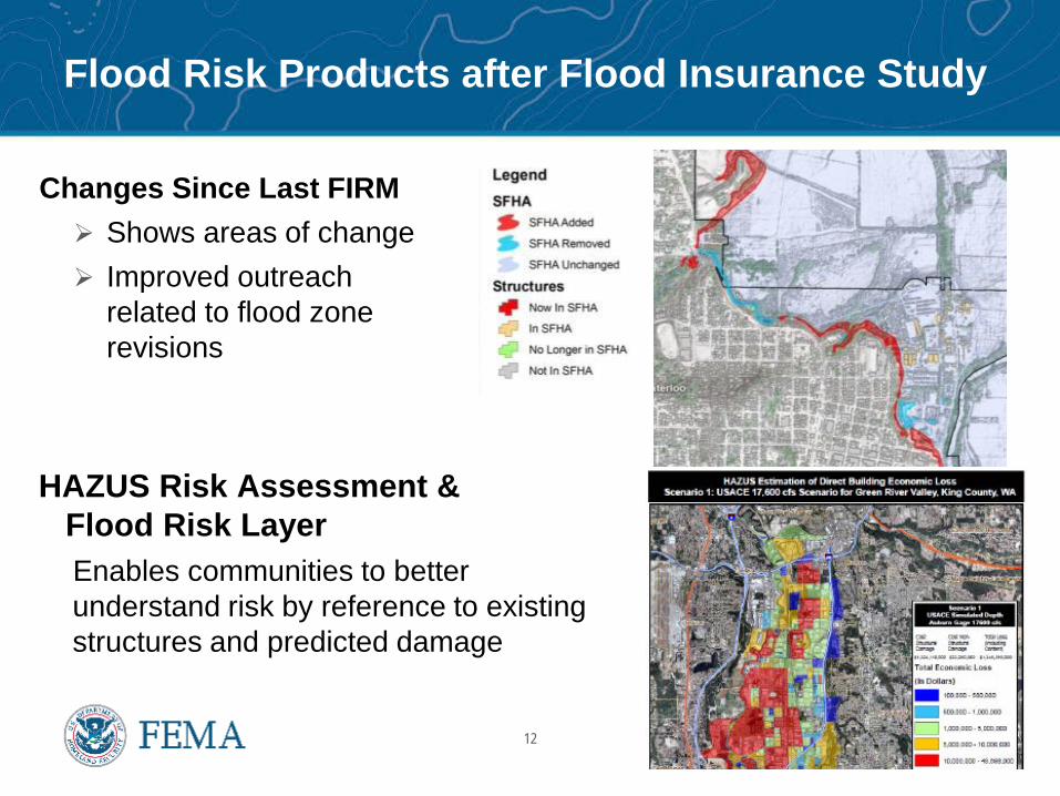
Flood Risk Products after Flood Insurance Study
Changes Since Last FIRM Shows areas of change Improved outreach
related to flood zone revisions
HAZUS Risk Assessment &Flood Risk LayerEnables communities to better understand risk by reference to existing structures and predicted damage

13
Risk MAP Flood Products
Flood Risk Report
Depth Grids
Flood Risk Map
Velocity Grids
Flood Risk Database
Areas of Mitigation Interest
Discovery Report &
Maps
Risk Assessments
Change Since Last FIRM
Hazard Identification·FIRM·FIS Report·Database

14
Updating Flood Insurance Rate Maps
FEMA Region IX has 93 active mapping projects in CaliforniaCTPs are a key component of the Risk MAP ProgramNearly 100 levee mapping projects initiated nationally since 2013;
200 additional studies need resources in 2016 and beyond FEMA’s hazard mapping focus past 5 years has been coastal

15
BW-12 and HFIAA
▸ July 2012 – Biggert Waters• Reauthorized the NFIP for additional 5+ years• New insurance policies reflect full risk rate (subsequently repealed);
25% increase yearly for existing, subsidized policies• Creation of Technical Mapping Advisory Council
▸ March 2014 – Homeowners Flood Insurance Affordability Act• Law repeals and modifies certain provisions of BW-12• Lowers the rate of increases on some insurance policies• Implements a surcharge on all policyholders• New Flood Insurance Advocate

16
Technical Mapping Advisory Council (TMAC)
TMAC provided recommendations on how to improve the flood mapping program, including the accuracy and quality of FIRMs
Two reports to FEMA in October 2015 Annual Report (29 recommendations) Future Conditions Report – best available
climate science to assess flood risk
“TMAC’s work is not done and they areactively working to set an agenda foranother year’s worth of effort…”

17
Revised Coastal Mapping: www.r9coastal.org
Restudy of Nation’s populated coastline initiatedRestudy of Hawaii has been completedSan Francisco Bay Preliminary maps for all nine counties have been issued Five out of nine counties have been finalized Alameda, San Mateo, Santa Clara & San Francisco not yet finalized
Open Pacific Coast Preliminaries issued Del Norte to San Luis Obispo (10 counties –
Phase 1) Santa Barbara to San Diego (5 counties) preliminary later this year
(Phase 2)

18
Increased FEMA Investment in LIDAR
FEMA is an investor in 3D Elevation Program (3DEP), a national program managed by the USGS to acquire high-resolution elevation data
Partnerships with funding from Federal agencies, States, local governments and other stakeholders
High resolution elevation data improves accuracy of flood mapping, enables risk reduction and provides numerous benefits

19
Risk MAP Discovery Process
Watershed Stakeholder Coordination
FEMA Data Analysis
Discovery Meeting and
follow up
Post Meeting Coordination –Report & Map
Scope Refinement
Discovery is FEMA’s process of data mining, listening, and documenting local needs with the goals of risk reduction, future studies, and continued coordination

20
Example: Tehama-Shasta Discovery
▸ 8 HUC-8 watersheds covering 14 communities in Northern California: Butte, Tehama, Shasta and Siskiyou Counties
▸ What do communities get out of Discovery?• FEMA and partner agency resources• Best practices, tools and lessons learned• Energized discussion to address needs
▸ Who: • Floodplain management officials• Emergency management staff• State agencies (OES, DWR, CalFire…)• Other Federal Agencies
Grants & Planning
Technical Assistance
Improved Maps
Public Outreach

21
Discovery in Risk MAP
When Before a Risk MAP study is scoped or funded
Why Promotes future loss reduction efforts Increases visibility of flood information Increases education and mitigation involvement Informs whether a Risk MAP study will occur
Next Steps Flood hazard study and/or risk assessment? Mitigation planning support or technical assistance? Grants? Floodplain management training?

22
Risk MAP Providers
▸ FEMA’s current procurement framework reflects a focus on technical credibility, engagement with local officials, and moving communities to take mitigation action
Production and Technical
Services
Community Engagement
& Risk Communication
Cooperating Technical Partners
Program Management
Customer and Data Services
LOMA & LOMR-F (MT-1)
Processing

23
Mapping Policy & Guidelines
▸ 2015 Updates• Key Decision Points• Zone AR/A99 eligibility• USGS elevation data standards• ESA requirements for CLOMRs
▸ 2016 and beyond• Reforms from BW12 and HFIAA• TMAC 1st year recommendations• Finish guidance transformation

24
Federal Flood Risk Management Standard
▸ President signed Executive Order 13690 on January 30, 2015▸ Briefings and comment period offered in 2015▸ WRC issued final FFRMS Guidelines▸ Federal agencies will update policies, procedures and/or
regulations to implement the Executive Order

25