field survey for carbonate, silica and quartzose sediment ... · pdf filefield survey for...
TRANSCRIPT

RESEARCH PUBLICATION No.22
Field Survey for Carbonate,Silica and Quartzose SedimentDeposits
M.C.G. Mabin
Department of Geography
James Cook University of North Queensland
October 1991
A REPORT TO THE GREAT BARRIER REEF MARINE PARK AUTHORITY

© Great Barrier Reef Marine Park Authoritv
155N 1037-1508
Published September 1994
by the Great Barrier Reef Marine Park Authority
The opinions expressed in this doaJmenI are noc necessarily those ofthe Great Barrier Reef Marine Parle Authority.
National Library of Australia Cataloguing-in-Publication data:
Mabin, M.C.G. (Mark Charles Grace), 1954-
Field survey for carbonate, silica and quartzose sediment deposits.
Bibliography
ISBN 0 &42 173974
1. Sand· Queensland - Great Barrier Reef Region. 2.Sand, Glass - Queensland· Great Barrier Reef Region.
3. Sand and gravel industry - Queensland - Great Barrier
Reef Region. l.James Cook University of North
Queensland. Dept. Of Geography. II.Titie (Series:
Research publication (Great Barrier Reef Marine Park
Authority (Australia)) ; no. 22).
553.62209943
Great Barrier ReefMarine ParkAuthorityPO Box 1379
Townsville Qld 4810
Telephone (077) 818811

CONTENTS
SUMMARy 1
1 INTRODUCTION 3
METHODOLOGy 4
3 SOURCE MATERIALS 5
4 STUDY AREAS 6
4.1 Areas excluded from GBRMP 6
4.2 Jurisdiction 6
4.3 Other sites investigated 7
5 CARBONATE SEDIMENTS 8
5.1 Definitions 8
5.2 Use of carbonate sediment in marine aquariums 8
5.3 Demand for carbonate sediments 9
5.4 Carbonate sediment deposits 9
6 POTENTIAL CARBONATE SEDIMENT SOURCES 12
6.1 Introduction 12
6.2 Primary sources of coral sands ,., 12
6,3 Secondary sources of coral sediments 15
6.4 Other sources of carbonate sand 18
III

7 SILICA AND QUARTZOSE SANDS 19
7.1 [)efinitions 19
7.2 Uses and demand for siJicaand quartzose sands 19
7.3 Beach renourishrnenl __.._ 20
7.4 Borrow-sand deposits 20
8 SILICA SAND SOURCES 23
9 POTENTIAL QUARTZOSE SAND SOURCES 24
9.1 Introduction 24
9.2 Onshore sources 24
9.3 Offshore sources 24
10 SUMMARy 27
11 REFERENCES 28
APPENDIX I 31
APPENDIX 2.. 33
APPENDIX 3 38
iv

EXECUTIVE SUMMARY
The Great Barrier Reef Marine Park Authority commissioned the Department ofGeography, James Cook University of North Queensland to conduct a field survey ofcarbonate, silica and quartzose sediment deposits that are located within or adjacent toareas of the Great Barrier Reef Region. but not within the Great Barrier Reef MarinePark.
2 Carbonate, silica and quartzose sands are sought for a variety of purposes:
i) Hobby aquarists in north Queensland have for many years collected smallquantities of coral sand from the Great Barrier Reef. Retailers also supply sand for
this market. and current demand is for about 5 m3 or 7.5 loones annually.
ii) There have been some requests for bigger volumes of coral sand (up to 300loones) by large commercial aquarium operators.
iii) Tourist operators have sought large volumes of coral sand to renourish or createresort beaches. They have also sought pure white silica sand as an alternative tocoral sand.The Queensland National Parks and Wildlife Services assesses this
demand at about 40,000 013.
iv) Quartzose sands are being sought to renourish numerous eroding beaches alongthe mainland coast. The Beach Protection Authority assesses current needs at
about 500,(X)() 013 with an annual maintenance of more than LO.(x)() 013.
3 Section 38 of the Great Barrier Reef Marine Park Act prohibits operations for therecovery of minerals within the Marine Park. except for approved research. Because oftheir composition, and the fact that they are collected in large quantities, andlor forcommercial purposes, these sediments are classed as minerals under the tenns of the Act,and collection is prohibited. Collection can only be allowed for small quantities,obtained by hand. for non-commercial purposes. Thus, this study was undertaken todetennine whether suitable sources of these sediments occurred outside the Great BarrierReef Marine Park.
4 During the course of this study, coastal and island sites outside the Great Barrier ReefMarine Park were visited between Mossman and Sarina and offshore in the Coral SeaIslands Territories. lnfonnation was also obtained from the literature on sites from CapeFlattery in the north to Moreton Bay in the south.
5 Primary sources of carbonate sands suitable for use in the marine aquaria trade onlyoccur well outside the Great Barrier Reef Region on coral cays on the Holmes andFlinders Reefs situated in the Coral Sea 330 and 240 km north-east of Townsville
respectively. Combined sustainable yield is estimated to be about 75 013 or lt5 tonnesannually. However, due to their distance offshore these sites are presently of marginalcommercial viability.
6 As approximately 50% of the mainland coast of the Great Barrier Reef Region lieswithin the Marine Park, potential sources of carbonate. silica, and quartzose sands in theGreat Barrier Reef Region are of very limited extent. Coral sands of suitablecharacteristics do not occur in commercial quantities. Available silica sands areunsuitable for beach renourishment purposes. Quartzose sands do occur in both onshore
1

and offshore environments, but detailed analysis is required to fully assess the suitabilityof these deposits.
7 Altemative sources of carbonate sediment for the marine aquaria trade include:
i) Coral sediment dredged from Moreton Bay fringing reefs. This would need to bewashed, crushed, graded and transported to the north Queensland demand areas.
ii) Shell-grit from the established Hervey Bay source area, or from potential sites inBroad Sound. This is considerably cheaper than coral sand, but is not the preferredmaterial of north Queensland aquarists.
2

1 INTRODUCTION
The Great Barrier Reef Marine Park Authority commissioned the Depanment of Geography.James Cook University of North Queensland to conduct a field survey of carbonate. silica andquartzose sediment deposits that are located within or adjacent to areas of the Great BarrierReef Region, but not within the Great Barrier Reef Marine Park (GBRMP).
The Great Barrier ReefMarine Park Act 1975, section 38. prohibits operations for therecovery of minerals from the Marine Park. except for the purposes of research. Theprohibition applies to carbonate sands (coral sand. star sand, shell-grit), coral limestone. silicaand quartzose sands. that are collected in large quantities or for commercial purposes. In recentyears the Great Barrier Reef Marine Park Authority (GBRMPA) has received numerousrequests for pennission 10 recover large quantities of these sediments for commercial purposesfrom within the Great Barrier Reef Marine Park (GBRMP). These include requests for, orenquires about:
i) carbonate sediments for use in the marine aquarium trade,ii) coral or silica sands to improve tourist resort beach amenity, andiii) quartzose sands for use in beach renourishment projects.
However, the requests have been denied as the Authority has no powers under the Act to grantsuch pennission. Therefore, there is a need for further infonnation on possible sources ofcarbonate. silica and quartzose sediments in the Great Barrier Reef Region, but outside theMarine Park boundaries. Thus, the objectives of this project were to identify possible sourcesof:
i) high carbonate sediment deposits suitable for collection and use by the marine aquariatrade, and
ii) silica and quartzose sand deposits for beach replenishment purposes,
that are located within or adjacent to areas of the Great Barrier Reef Region but not within theGreat Barrier Reef Marine Park. The scope of the study has not extended to providing the fullrange of infonnation that would be required in the event of any of these potential sites beingused as sediment sources.
3
2 METHODOWGY
The project was carried out in four phases:
I) literature survey. map and aerial photograph analysis, site selection,2) field data collection,3) laboratory analysis, and4) report preparation.
The preliminary phase of the project involved an extensive literature survey to determine thegeneral requirements for carbonate sediments in marine aquaria, and provide backgroundinformation on the theory and practice of artificial beach renourishment. Also sought weredescriptions of Queensland coastal areas and material examining process regimes in the GreatBarrier Reef Region. This enabled the full range of likely sediment sources to be determined.Initial site selection was carried out after detailed map and aerial photograph analysis. Possiblesites along the coastline were identified where likely sediment sources occurred. in areas thatwere not in the Great Barrier Reef Marine Park.
Field examination of the potential sites determined whether they met the detailed. criteria (see6.1) requested. by the Authority. and sediment sampling was then carried. out. Some sites aredescribed. in detail in the literature and these were not visited in the field.
Laboratory analysis of the sediments was carried out in the Geography Department. JamesCook University. Sediment size was determined using standard sieving techniques. andcalcium carbonate content determined by acid digestion.
4

3 SOURCE MATERIALS
Primary source materials were maps and aerial photographs.
Maps consulted include:topographical sheets at scales of 1: 100 ()()() and where available 1:50000cadastral mapsGreat Barrier Reef Index Series sheets (I :250 000 scale) and GazetteerGreat Ballier Reef Marine Park zoning mapsQueensland National Parks and Wildlife Service marine park zoning mapsQueensland Beach Protection Authority Coastal Management Control District andErosion Prone Area plansnauLical charts.
Aerial photographs consulted include:low altitude photographs at scale 1:12 000 flown for the Queensland Beach ProtectionAuthority (BPA)1:50000 scale photographs flown for the BPAhigher altitude photography at a scale of 1:80 000 flown for (he CommonwealthGovernment.
In addition to the above data. information was obtained from telephone interviews withrelevant companies and individuals involved in the collection, mining and retailing of coralsediment, and from correspondence with State Government DepartmenlS and Authorilies.
5

4 STUDY AREAS
4.1 Areas excluded from GBRMP
The project objective was to identify sources of carbonate sediments and deposits of silica andquartzose sands that are located within or adjacent to the Great Barrier Reef Region. but notwithin the GBRMP. Thus a preliminary step in the site selection procedure was to detenninethose areas of the Queensland coastline that have been excluded from the Marine Park.
When the Marine Park was estabHshed. a number of areas along the mainland coastline wereexcluded. Generally these extend to 5 Ian offshore and delimit areas considered to be of lesserenvironmental significance and/or potentially important development or harbour sites. The 26areas that have been excluded from tbe Park cover approximately 1400 km, which is 40% ofthe Great Barrier Reef Marine Park coastline. They are summarised in Table I.
GBRMPSection
Far NorthernCairnsCentralMackay/CapricornTOTALTOTAL (accessible)
Number ofareas excluded
II375
2613
Length ofcoastline
197km335 Ian328 Ian533 Ian
1386 km1189 km
%ofSectioncoastline excluded
23%62%36%46%40%) ofGBR Region51% ) coastline
Table I. Coastal areas excluded from GBRMP
The Far Northern Section areas and the two northernmost areas in the Cairns Section arelargely inaccessible and have not been investigated in the field. The 13 areas excluded from theCairns, Central, and Mackay/Capricorn sections of the Marine Park were the primary fieldareas assessed in this study.
4.2 Jurisdiction
The situation with respect to mining in the GBRMP is essentially quite simple as it cannot beallowed under the terms of the GBRMP Act. Outside the Park the situation is rather morecomplex. While mining is not specifically prohibited, many other organisations are able toexercise controls over the extraction of carbonate, silica and quartzose sediments from areas ofthe coastal zone within their jurisdiction.
Shire and City Councils have jurisdiction to high water mark, but not over the foreshore orintertidal lands. In areas gazetted as ports and harbours, Port Authorities or the HarboursCorporation have jurisdiction over tidal lands up to the level of the high water mark. Inaddition, recovery of sands from the seabed or tidal reaches of river channels is under thecontrol of the Department of Harbours and Marine. Non-tidal river channel areas are under thecontrol of the Water Resources Commission. Marine Parks, managed by the QueenslandNational Parks and Wildlife Service of the Department of Environment and Heritage. extendup to high water mark. Other intertidal lands are administered by the Premier's Department.The Queensland Beach Protection Authority has declared a number of Coastal ManagementControl Districts (CMCD) and has prepared Erosion Prone Area Plans for all the LocalAuthorities in the study area.
6

These jurisdictions arc summarised in Table 2.
GDRMP Shires Cilies PO" Harbours CMCD QldSeclion Autho- Corpo- Numberl Marine
rilies ration Length of ParkPons coaSlline Length of
coastline
Caims 3 I I 4 1147 km 170kmCentral 5 2 I 3 21110 km 35 kmMackay/Capricorn 1 2 3 3 71137 km 244 km
TOTAL 15 5 5 10 11/294 km 449km
Table 2. Summary of Local and Statutory Authorities and Queensland Marine Parks covering areasexcluded from GBRMP
In addition, the Queensland Department of Primary Industries licenses the taking of MarineProducts from Queensland waters (see below, Section 5.1).
4.3 Other sites investigated
Three sites well outside the GBR Region were also investigated. These were the coral sedimentdredging operations in Moreton Bay, a coral cay in Flinders Reefs 240 km nonh-east ofTownsville, and a coral cay on Holmes Reefs, 220 km east-nonh-easl of Cairns.
7

5 CARBONATE SEDIMENTS
5.1 Definitions
Coral sand is the most sought-after carbonate sediment for the marine aquarium tmde in northQueensland. It is derived from the break·down of the skeletons or hard corals and othercalcareous skeletons, and as such is a marine product. There are several carbonate sedimentmarine products described in section 6 of the Queensland Fisheries Act 1976-1989 as follows:
'coral' means coelenterate animals of the class Anthozoa: the term includes theuncompacted skeletons of those animals;
'corallimeslone' means a calcareous deposit derived from coral or other marine productbut does not include shell-grit or star sand;
'shell-grit' means the broken remnants of sea-shells;
'star sand' means a fonn of sand composed of the calcareous skeletons of the unicellularanimals known as foraminifera.
Collection of these marine products from Queensland waters is licensed under the terms ofsection 35 of the Act by the Division of Fisheries and Wetlands Management of theDepartment of Primary Industries (DPI).
5.2 Use or carbonate sediment in marine aquariums
Spotte (1973, 1979) describes the uses of, and requirements for, carbonate sediment in marineaquariums. The sediment is used as a substrate layer about 8 em thick, and it functions as abuffer to maintain both seawater alkalinity and a pH of about 8.3. The buffering properties ofthe sediment decline over time. and replacement is necessary within about 2 years.
The characteristics of suitable carbonate sediments listed by Spolte (1973) are:
i) calcium carbonate (CaC03) and magnesium carbonate (MgC03) content,
ii) grains 2-5 mm in diameter.iii) uniform sized grains ( graded, or well sorted) andIV) grains of a rough and angular shape.
Crushed coral is particularly good but crushed shell and dolomite rock are also suitable.Limestone rock contains little MgC03. and is less desirable. This report considers potential
sources of biogenic carbonate sediment, namely coral and shell materials.
8

5.3 Demand for carbonate sediments
Discussions with aquarium trade retailers indicate that there is a steady demand for carbonatesediment in north Queensland. although this appears to be mostly in the Townsville area.Retailers between Cairns and Mackay stock coral sand. but further soulh they deal mainly withshell-grit obtained from Hervey Bay. Costs of obtaining the material are high. and at $0.701kgcoral sand is considerably more expensive than the $O.201kg charged for shell-grit by retailersin southern Queensland.
Demand for coral sand comes mainly from hobby aquarists. The total amount of sand requiredby these hobbyists is not known. but the needs of a typical individual aquarist can be assessed.Assuming two large display tanks (2 m x 1 m basal area) with 10 cm of coral sand the total
volume of sediment required amounts to 2 x 1 x 0.1 x 2 =0.4 m3. Allowing for renewal every
two years this amounts to an annual requirement of 0.2 m3. Assuming a coral sand density of1.5. this represents an initial requirement of 600 kg and a further 300 kg of sediment per year.
There have been occasional demands for large volumes of coral sand by commercial aquariumoperators. For example, the Great Barrier Reef Aquarium used 300 tonnes of coral sand to
cover its 600 m2 to a depth of 0.4 m. Used in these large aquaria the coral sand does not needregular replacement.
Large volumes of coral sands have also been sought by tourist resort operators who wish tocreate or renourish resort beaches.
Some data is available on the amounts of carbonate sediments taken in Queensland waters.These come from the DPI, and are based on returns furnished by the licensed operators.Average yearly totals for 1985-1989 have been:
Coral sandCoral rubbleShell-gritStar sandLiving coral
6,510 kglyr940 kglyr
117,240 kglyr860 kglyr
16,100 kglyr
S.4 Carbonate sediment deposits
5.4.1 Introduction
There are numerous environments where suitable biogenic carbonate sediments may occur.These include:
1 reef flat sediment accumulations2 beaches and spits associated with fringing reefs3 shell beaches. chenier ridges. and shell banks4 fossil reefs5 coral cays and associated beaches6 sub-tidal leeward detrital reef slopes7 Halimeda banks.
Most of these environments are restricted to areas within the GBRMP and thus are notavailable as potential sediment sources. This section discusses only those environments thatoccur in the primary target areas outside the GBRMP but within the GBR Region. These arethe reef flat sediment accumulations. beaches and spits associated with fringing reefs. and shell
9
beaches, chenier ridges and shell banks. Information on the other environments (4w 7 above) ispresented in Appendix I.
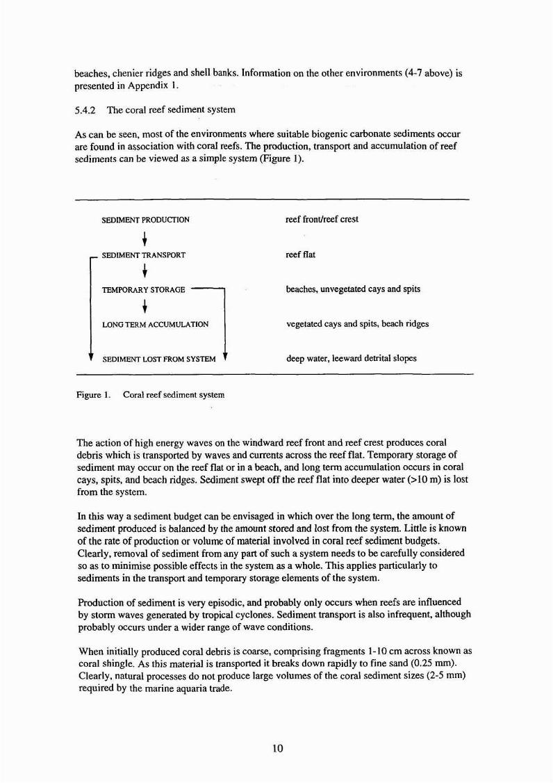
5.4.2 The coral reef sediment system
As can be seen. most of the environments where suitable biogenic carbonate sediments occurare found in association with coral reefs. The production, transport and accumulation of reefsediments can be viewed as a simple system (Figure I).
SEDIMENT PRODUCTION
SEDIMENT TRANSPORT
TEMPORARY STORAGE ---
LONG TERM ACCUMULATION
SEDIMENT LOST FROM SYSTEM
Figure 1. Coral reef sediment system
reef front/reef crest
reef flat
beaches, unvegetated cays and spits
vegetated cays and spits. beach ridges
deep water. leeward detrital slopes
The action of high energy waves on the windward reef front and reef crest produces coraldebris which is transported by waves and currents across the reef flat. Temporary ,storage ofsediment may occur on the reef flat or in a beach. and long tenn accumulation occurs in coralcays, spits, and beach ridges. Sediment swept off the reef flat into deeper water (>10 m) is lostfrom the system.
In this way a sediment budget can be envisaged in which over the long term, the amount ofsediment produced is balanced by the amount stored and lost from the system. Little is knownof the rate of production or volume of material involved in coral reef sediment budgets.Clearly, removal of sediment from any part of such a system needs to be carefully consideredso as to minimise possible effects in the system as a whole. This applies particularly tosediments in the transport and temporary storage elements of the system.
Production of sediment is very episodic. and probably only occurs when reefs are influencedby stonn waves generated by tropical cyclones. Sediment transport is also infrequent, althoughprobably occurs under a wider range of wave conditions.
When initially produced coral debris is coarse, comprising fragments 1-10 cm across known ascoral shingle. As this material is transported it breaks down rapidly to fine sand (0.25 mm).Clearly, natural processes do not produce large volumes of the coral sediment sizes (2-5 mm)required by the marine aquaria trade.
to

5.4.3 Fringing Reefs
Fringing reefs are the only reef type occurring in the primary study areas along the mainlandcoastline of the GBR Region. These include reefs attached to the mainland and offshore
islands. Thirty·nine fully developed fringing reefs covering a total area of nearly 51 km2 occur,and these are summarised in Table 3.
Fringing Reefs
Section
CaHnsCentralMackaylCapricom
TOTAL
NumberoutsideGBRMP
234
12
39
Totalarea
covered(Ian')
40.056.604.13
50.78
Averagesize
(Ian')
1.741.650.34
1.30
Numberlarger
than 0.5(Ian')
1522
19
Table 3. Fringing reefs in coastal areas excluded from GBRMP
It was considered likely that only the larger of these reefs, greater than 0.5 km2• would producesuitable quantities of carbonate sediment. These areas (see below, Section 6.1) were targetedfor field assessment.
5.4.4 Shell beaches, chenier ridges and shell banks
As noted above, shell-grit is a possible cheap alternative to coral sand suitable for use inmarine aquaria, and widely used in southern Queensland. Further descriptions of theseenvironments are given in Appendix 1. Two such sites are discussed below as potentialsecondary sources of carbonate sands (Section 6.6.2, 6.6.3).
5.4.5 Summary
Although a variety of environments where high carbonate sediments may occur are found inthe GBR Region, most occur only within the GBRMP and are thus not available as potentialsources.
The size. shape and sorting characteristics of the carbonate sediments that are available outsidethe GBRMP are generally not suitable for marine aquaria. In particular, the 2 mm • 5 mm sizerange required is quite rare in natural sediments. and most material would need crnshing andgrading for it to fit this criterion.
Most of the potential sources are associated with coral reef sediment syslems. No reef sedimentbudgets have yet been established, and thus it is not possible to accurately determine levels ofsustainable carbonate sediment yield from these systems.
Collectors of coral sand for the marine aquaria trade have in recent years operated mainly onreef flats. These sediments are the source materials that make up nearby beaches, cays andsome spits. Collection of these sediments will have an effect on the sediment budgets of anyassociated beaches and should therefore be carefully monitored.
II

6 POTENTIAL CARBONATE SEDIMENT SOURCES
6.1 Introduction
From the selection process detailed above (Section 5.4.3), 18 fringing reefs were targeted forfield assessment. These were:
Mossman-Trinity Bay (6 reefs: 16-007', 16-008, 16-009, 16-010, 16-039, 16045)Double Island (2 reefs 16-047, 16-048)Fitzroy Island (I reef: 16-054)Double Point (I reef: 17-039)Ganers Beach-Bingil Bay-Clump Point (3 reefs: 17-049, 17-050, 17-052)Stone Island-Adelaide Point (2 reefs: 20-004. 2Q...OO5)Hay Point·Flat Top Island-Victor Island (2 reefs: 21-007,21-013, 21-015).
• These are reef identification numbers as shown on the GBRMP zoning maps.
Additional sites were also identified offshore, outside the GBR Region, in the Coral SeaIslands Territorial waters. These were coral cays known to occur in the Holmes and FlindersReefs. Potential sources of carbonate sediments were then selected which met the followingcriteria:
i) carbonate content greater than 50%.ii) grain sizes of 2 mm - 6 mm, and of a rough angular shape,iii) deposits accessible for collection, andiv) deposit volumes sufficient to sustain small scale collection (5,000 - 10,000 kg/year).
Criteria 1-3 were easily measurable, or could be readily observed in me field. Criteria 4required assessment of the sediment budget for each site and this was beyond the scope of thepresent study. However, an estimate of the sustainability of small scale collection was made.Assuming bulk densities of 1.5 for wet coral sand and 1.1 for coral shingle, collection of 5,000
- IO,(X)() kg amounts to an annual removal of 3.5 - 6.5 m3 of coral sand and 4.5 - 9.0 m3 ofcoral shingle.
Two sites were found that met all the above criteria. These were coral cays in Flinders andHolmes Reefs, and they are described below as primary sources of coral sands.
Along the mainland coastline of GBR Region, no sites were found that met all the abovecriteria. Only three, Double Island, Fitzroy Island, and Stone Island, contained sediments withcarbonate content greater than 50%. However, none of these contained appreciable quantitiesof sands in the 2-6 mm size range. They are described below as secondary sources of coralsediment.
6.2 Primary sources of coral sands
Coral cays in the Holmes and Flinders Reefs have already proved suitable as sources of largevolumes of coral sand. They were investigated and found to be the only primary sources ofcoral sand identifiable in this study.
6.2.1 Holmes Reef cay
Holmes Reef lies 220 km east-north-east _of Cairns in the Coral Sea Islands Territories. Two
large reef complex.es. each covering about 125 km2.lie side by side some 7 km apart. The
12

western reef complex contains 5 small unvegetated cays. The potential source of coral sands isthe northernmost cay of this group.
Location:
Site description:
Accessibility:
EnvironmentaVaestheticimpact of sand removal:
Legal Status:
Volume available:
Sediment analysis:
General comments:
Other Holmes Reefs cays:
6.2.2 Flinders Reefs cay
16°28'45"SIl4T53'O"E. Shown as 'Sand Cay (about 6ft.high)' on Navigation Chart AUS864. A MeteorologicalBureau automatic weather station is situated on the cay.
The potential sediment source is a small unvegetated caycovering about 0.5 ha at high tide, and 1.2 at low tide. Itis a highly mobile feature, and when visited its highestparts rose some 1-1.5 m above the level of high tide. Thesand is derived from natural erosion and wave workingof coral sediment from the surrounding reef.
Access is by boat, Cairns being the nearest port.
Minimal.
Holmes Reefs and cays are under Commonwealthjurisdiction through the Coral Sea Islands Act /969 andthe Seas and Submerged Lands Act 1973. Administrationis through Norfolk Island.
Total volume of coral sand in the whole cay is estimated
to be 23,000 m3. Sustainable yield is estimated to be
23m3/year (34'sOOkg).
Mean particle size: beach samples 2.5 mm and 2.0 mm;middle of cay 1.4 mm. Of the 3 samples analysed 33%were sediments >2 mm, and 94% > I mm. Carbonatecontent: 100%Colour: white
This coral sand is very suitable for the marine aquariatrade. The cay is apparently a highly mobile feature andprobably varies considerably in area and volume aftereach major stann. Removal of sand would appear tohave very limited environmental consequences.
Four other small unvegetated intertidal cays occurbetween 1.8 and 5.0 km south-west of the main cay.These were not visited, but appear to be potential coralsand sources together totalling an estimated volume of
about 50,000 m3.
Flinders Reefs lie 240km north-east of Townsville in the Coral Sea Islands Territories. The
group consists of some 12 reefs scattered over an area of 1500 km2• and 4 of the southern reefscontain small unvegetated cays. The potential sources of coral sand is the eastern most cay ofthis group.
13

Location:
Site description:
Accessibility:
EnvironmentaVaestheticimpact of sand removal:
Legal status:
Volume available:
Sediment analysis:
General comments:
Other Flinders Reefs cays:
17°44'O"S/148°26'40"E Shown as 'Sand Cay about 10ft.high' on Navigation Chart AUS864. A MeteorologicalBureau automatic weather station is situated on the mainpart of the cay.
The potential sediment source is a 1.5 ha spit or 'tail'extending west from the main part (3.5 ha) of the cay.The spit is 250 m long and up to 60 m wide, rising toabout 2 m above the level of high water, and extending tojust below low water level. The sand is derived fromlongshore drift of material along the beaches from themain part of the cay.
Access to the site is by boat. Townsville being thenearest port.
MinimaL
Flinders Reefs and cays are under Commonwealthjurisdiction through the Coral Sea Islands Act 1969, andthe Seas and Submerged Lands Act 1973.Administration is through Norfolk Island.
Total volume of coral sand in the spit is estimated to be
55,000 013. Sustainable yield is estimated to be:
55m3ryear (82,500 kg).
Mean particle size: 0.85 mOl% of sample >10101:15%Carbonate content: 100%Colour: white
The sand in this part of the cay is generally somewhatfiner than is required for marine aquaria. Coarser sanddoes occur on the main part of the cay, immediately tothe east of the spit. However, mining of this part of thecay would have some environmental impact as over onethousand seabirds (common noddy, brown booby.masked booby, black naped tern) use the area for nestingsites.
Three other small, unvegetated intertidal cays occur 11.0and 5.8 km west, and 8.7 km south·south-west of themain cay. These were not visited, but appear to bepotential coral sand sources together totalling an
estimated volume of about 40,000 m3.
14

6.3 Secondary sources of coral sediments
6.3.1 Double Island
Double Island lies 1.3 km off Buchan Point, 23 km north of Cairns. The small island (21 ha) is
almost completely surrounded by a large reef flat covering 1.65 km2. The potential sedimentsource occurs on the western side of the reef flat.
Location:
Site description:
Accessibility:
Environmental/aestheticimpact of sand removal:
Legal status:
Volume available:
Sediment analysis:
General comments:
16°43'48"S 1145°40'42"E Grid reference: CB 592497 on1:50,000 topographical map 'Macalister Range', SeriesR733/Sheet 8064-4. Height: 1-2 m above chart datum(CD), or approximately between mean low water andmean high water marks. Shown as intertidal onNavigation Chart AUS830.
The potential sediment source is a 6 ha area of sandedreef flat containing a sand wave 300 m long, 7 m wideand about 0.8 m high. The sand wave is mobile, as the1979 aerial photograph shows it 85-90 m west of its1965 position.
Access to site is by boat. There is a public boat ramp onthe mainland 1.5 km south-west at Palm Beach.
Minor aesthetic impact.The sediment wave and sanded reef flat probablycontribute sediment to the small beach at the south·westend of the island. Some beach erosion is occurring hereand this may worsen if large quantities of sand are takenfrom the reef flat.
There appear to be no legal obstacles to sand removal.
Total volume of carbonate sediment is estimated to be:
Sanded reef flat: 6,000-10,000 m3
Sediment wave: <1,000 m3
Sustainable yield is estimated to be:
Sanded reef flat: 6-10 m3/year (9,000-15,000 kg)
Sediment wave: 1 m3/year (1,500 kg)
Mean particle size: 0.75 mm% of sample >2 mm: 27%Carbonate content: 92%Colour: grey
Sediment at this site is of limited value for marineaquaria. Its overall size is too fine and the colour isunsuitable due to apparent algal staining. Total volumeavailable could only sustain very small scale removal.
15

6.3.2 Fitzroy Island
Fitzroy Island is a popular tourist destination 22.5 km east of Cairns. The potential sourceoccurs at the south-western comer of the island on Nudey Beach.
Location:
Site description:
Accessibility:
EnvironmentaVaestheticimpact of sand removal:
Legal status:
Volume available:
Sediment analysis:
General comments:
16°56'10"5 1145°58'55"E Grid reference: CB 917273 onI :50,000 topographical map 'Cairns', Series R733/Sheet8064-2.Height: -I to 2.5 m above CD, or approximately fromjust below lowest astronomical tide to just above meanhigh water spring tide.
Site is a small beach 120 m long and up to 35 m across.lying between two small rocky headlands. The coralshingle beach is derived from nearby fringing reefmaterials.
Beach is easily accessible by boat from Cairns.Although not part of the resort lease on the island, thebeach is very popular with visitors, being accessible bywalking track from the main resort complex.
Probable low environmental impact, but due topopularity of beach there would be high aestheticimpact.
Site lies within the Mulgrave-Johnstone ManagementArea of the Cairns Marine Park. under the jurisdiction ofQNPWS. Current loning is Marine National Park 'A'Zone, and proposed zoning is Marine Park RecreationZone. Collecting of marine products is nol allowed inthese zones.
Total volume of the spit is estimated to be: 15.000 m3.The easily accessible portion above mean sea level is
estimated to be: 4.200 m3.
Sustainable yield is estimated to be: 4-5 m3/year, 50006000 kg/year.
Particle size: highly variable coral shingle - coarse sand.of 3 samples analysed 53% were sediments >2 mm.Carbonate content: 82%~95%Colour: white.
The material in Nudey Beach is suitable for marineaquaria, although some crushing and grading of lhesediment may be necessary. However, under currentQMP zoning collection of marine products is prohibited.
16

6.3.3 Stone Island
Stone Island lies 4 km south-east of Bowen. It is surrounded by 1.7 km2 of reef flat whichcontains a number of sanded reef flat areas. and coral shingle beaches constituting potentialsources of carbonate sediment.
Location:
Site description:
Accessibility:
EnvironmentaVaestheticimpact of sand removal:
Legal status:
Volume available:
Sediment analysis:
General comments:
200 12'20"S /148°16'43"E Grid Reference: 337835 onI: 100,000 topographical map 'Bowen', Sheet 8557.Height: reef flat is at about 1.6 m above CD. Highestactive beaches occur up to 3 m above CD. Reef flatshown as intertidal on Navigation chart AUS826.
Potential sediment sources occur as areas of sanded reefflat in Shoal Water Bay on the north side and near theintertidal spit on the west side of the island. An intertidalsand wave! spit complex extends for 335 m and there arealso some 4 km of coral sand and shingle beachesaround the island. These sediments may have beenfanned in 1918 when the reef was devastated by acyclone (Hedley, 1925).
Site is easily accessible by boat from Bowen.
Probably limited
No legal obstacles to removal of carbonate sedimentfrom intertidal zone.
Total volume of carbonate sediment is estimated to be:
Sanded reef flat: 16,000 m3
Sand wave/spit: 3,750 m3
Coral sediment beaches: 18.000 m3
Coral shingle beaches: 2,375 m3
Sustainable yield is estimated to be:
Sanded reef flat: 16 m3/year, 10,000 kg
Sand wave/spit: 3-4 m3/year, 2,000-2,500 kg
Coral sediment beaches: 18 m3/year, 12,000 kg
Coral shingle beaches: 2 m3/year, 1,800 kg
Particle size: most of the sediments are finer than 2 mm.Four samples had mean sizes of 0.56-0.95 mm.Only 6.5% of the sediments in the samples were >2mm.Some coral shingle beaches occur on the south and westsides of the island.Carbonate content:sands 75-90%.Colour: Cream
Sediment at this site is of limited value for marineaquaria due to the small volume of material larger than 2mm.
17

6.4 Other sources of carbonate sand
6.4.1 Introduction
A number of possible sources of carbonate sediment were identified from the literature.However, they were not considered to be 'liable options within the terms of reference of thisstudy. Brief descriptions of these sites are given below.
6.4.2 Moreton Bay corat sediment dredging
Coral sediments have been dredged from fringing reefs in Moreton Bay for many years by theQueensland Cement and Lime Company. Reefs occur around Mud, St Helena, Green, Peel,Coochiemudlo, Bird, Goat and Macleay islands, and along the mainland coast from Wellington
Point to Victoria Point (Flood 1978, Onne and Day 1978). The GSQ maps 18.5 km2 ofpotential source areas (O'Flynn et at 1983, Willmott et al. 1978), and mining leases arecurrently held for Mud Island (site exhausted), 5t Helena Island, Green Island, and WellingtonPoint to Cleveland Point. Up to 600,000 tonnes/year of coral reef debris is produced and usedeXclusively in cement manufacture. The material is approximately 75% CaC03 and consists of
coral rubble, shingle and sand, with terrigenous silt and mud. It is grey to reddish when mined,but bleaches to dull white colour when stockpiled.
These coral sediments constitute a possible source of carbonate material. They Wall Id need tobe washed, crushed and graded to fit the requirements for marine aquaria.
6.4.3 Maryborough sheU·grit
Shell-grit has been collected for some years from beaches around Point Vernon in Hervey Bay.The shell-grit accumulates as a thin ribbon of sediment on the rocky shore platfonns thatextend for about 6 km around the point (BPA,1989).lt is used in the poultry industry, and in1987 some 200 tonnes were collected.
Shell·grit is listed by Spotte (l973, 1979) as satisfactory for use in marine aquariums.Apparently most aquarists in southern Queensland use this material, and it is much cheaperthan coral sand. Thus it could be considered as an alternative source of carbonate sediment.
6.4.4 Broad Sound chenier ridges
Shell-rich chenier ridges occur extensively along the western shores of Broad Sound (Cook andPolach, 1973; Cook and Mayo, 1978) some 55 Ion of cheniers are mapped, and based on
descriptions in Cook and Mayo (1978), there are probably some 4,000,000 m3 of shell·richsediments. The ridges are mostly vegetated, and the shel1 material is probably somewhatcontaminated with soil matter. Two kilometres of active shell beaches also occur around Turtle
Island and Charon Point. Total clean shell resource is probably about 40,000 m3. Thesedeposits are another possible source of carbonate material suitable for use in the marine aquariatrade.
18

7 SILICA AND QUARTZOSE SANDS
7.1 Definitions
Silica sands are pure white sands containing in excess of 98% quartz, and are mainly used inglass manufacture and as foundry sand.
Quartzose sands are predominantly quartz. but also contain appreciable quantities of otherminerals. Colour is variable. with grey. brown and yellow being common.
The requirements of this study were to assess potential sources of silica sands. It is clear that inthis context 'silica sands' included both silica and quartzose materials. Accordingly. in thisreport. both silica and quartzose sands have been considered, and they are referred to in termsof the above definitions.
7.2 Uses and demand for silica and quartzose sand
Silica and quartzose sands are being sought by local authorities and tourist resort operators forbeach renourishment purposes to:
i) increase the volume of the buffer zone between the sea and land developments for safetyand erosion protection purposes and
ii) improve the visual qUality and beach amenity.
Silica sands are the preferred choice of tourist operators wishing to improve their beach·amenity and some has been used in pa'st for this purpose (Hopley, 1989). Current need assessedby the QNPWS (quoted in Holmes, 1987) is for about 40,000 cubic metres of material, torenourish resort beaches in the Whitsunday Islands. "
Quartzose sands are required for numerous renourishment projects recommended by the BPAfor beaches along the mainland coastline of the Great Barrier Reef Region. The BPA hasidentified at least to mainland beaches that require renourishment, needing a total of about
500,000 m3 of sand, and an annual maintenance of more than 10,000 m3.
Sites where beach erosion problems have been reported in the GBR Region include (from northto south):
Marlin Coast beaches (north from Cairns) (CMCD #10)Brampston beach (near Babinda) (CMCD #9)Flying Fish Point (near Innisfail)Mission Beach (near Tully)Cardwell beachLucinda (near Ingham) (CMCD #21)Halifax Bay beaches (Thuringowa City)Townsville beachesBowen beaches (CMCD #18)Airlie Beach (near Proserpine)Whitsunday islands beachesConway Beach, Midge Point (near Proserpine)Mackay beaches (CMCD # 5, 6, 7)Sarina Beach, Grasstree Beach (near Sarina)Capricorn Coast beaches (nearYeppoon) (CMCD #15)Gladstone beaches (CMCD # 12,24,25).
19

7.3 Beach renourishment
In recent years beach renourishment has become the preferred method of dealing with erosionproblems on sandy beaches. This is a flexible approach to coastal management that is more inharmony with the environment than the previously favoured rigid structures such as groynes.seawalls and coastal revetments. Generally, renourishments are cheaper, although maintenancecosts are higher due to their shorter lifetimes. However, costs of beach renourishment arespread over a longer period, allowing for simpler financial management of the project.
The characteristics of the sand required depends in each case on the nature of the beach tbat isto be replenished. Details of beach renourishment procedures are given by CERe (1984) andCUR (1987). In the context of the present study two aspects are important.
1) Assessment of the beach erosion problem in particular to detennine the sedimentbudget. From this can be calculated the characteristics and volume of sand required toredress the erosion problem.
2) Detennination of a suitable borrow area. Ideally the sand should have the samecomposition, size and sorting characteristics as the beach that needs renourishment. Inaddition, removal of sand should not result in the transference of the erosion problemfrom the beach to the borrow area.
Precise matching of the supply and demand sands is often not possible. In these cases thepreferred option is to obtain borrow sands coarser than -the eroding beach material. This sand isIike1y to remain on the foreshore for a longer period, although the renourished beach may havea steeper slope. Replenishing a beach with material finer than the natural sediments isgenerally to be avoided. These tend to be more rapidly eroded and lost from the foreshore, anda larger volume of finer sand is therefore required to produce the desired renourishment effect
7.4 Borrow-sand deposits
7.4.1 Introduction
There are numerous environments where sand deposits occur. They include a variety ofonshore and offshore environments in the coastal zone:
i) foredunes, dunes,ii) beach foreshores and beach ridges,iii) river channels and floodplains,iv) intertidal bars, and tidal deltas in estuaries, rivennouths, and lower foreshores,v) sub-tidal shoals and deltas in estuaries, river mouths and nearshore environments
(shallower than about 10 m water depth) andvi) shoals and sands in nearshore waters or on the continental shelf (deeper than 10 m).
All these are quite common along the mainland coast of the GBR Region, particularly in areaswhere rivers deliver large volumes of sand to the coastal zone. However, as outlined below(7.4.4) not all of these environments can be considered as potential borrow-sand deposits.
7.4.2 The coastal zone
The coastal zone covers several.onshore and offshore environments and may be defined inmany different ways. This study concentrates on sediment transport and deposition, and thusthe significant boundaries of the coastal zone are related to these processes. The inlandboundaries are taken as the inner edges of coastal dune complexes, and those lower reaches of
20
rivers actively delivering sediment to the marine environment. Offshore the coastal zoneboundary is somewhat arbitrarily placed at IO m water depth. Below this depth wave-inducedsediment movement is very limited, and there is no effective transfer of sediment towards thecoast, although movement offshore does occur.
7.4.3 Coastal zone processes and sediments
Process regimes operating in the coastal zone include rivers, wind, waves and tides. These havewidely varying characteristics, and combine in numerous ways to produce sediment bodies ofquite different type. For example, river sediments are commonly coarser and more poorlysorted than beach sands, while dune sands are generally finer than beach sands. Clearly,acceptable matching of supply and demand sand will require careful sediment sampling andanalysis.
7.4.4 Coastal zone sediment system
The environments listed above (Section 7.4.1) are parts of complex systems of sedimenttransfer and deposition. Figure 2 demonstrates the complexities of the coastal zone sedimentsystem. Removal of sediment from an environment will cause responses in other parts of thesystem and this usually takes the fonn oferosion. Foredunes, beach foreshores and someintertidal environments are the most sensitive elements of the system and removal of sand fromthem is inappropriate. The safest sources of borrow sand are those which contribute littlesediment to other parts of the coastal system. These include inner sand dunes and continentalshelf sands. Sand could also be taken from rivers that deliver large sediment volumes toactively prograding coastlines.
7.4.5 Continental shelf sands
Sand deposits on the inner continental shelfconstitute an important potential source of materialfor beach renourishment. Generally these sands occur in waters deeper than 10 m, althoughisolated banks and shoals may rise high enough to become dry during very low tides. Thesedeposits were formed by a variety of marine and fluvial processes prior to about 6000 yearsago when sea level was lower than its present height. As sea level rose. these deposits weresubmerged, and they are now no longer part of coastal zone sediment transfer system. Thesesediments are likely to have size characteristics suitable for beach renourishment purposes, andtheir removal from the continental shelf will have no effect on the coastal zone sedimentsystem. However, continental shelf sands are not available as they occur with the boundaries oftheGBRMP.
21

ONSHORE
ENVIRONMENTS.. .. OFFSHORE
ENVIRONMENTS
RIVER DUNE '-
FLOOD\PLAIN / FO~UNE
/
BEACH RIDGE
.... RIVER CHANNEL /
!~BEACH~ INTERTIDAL BAR
ESTUARY -------- " / t----... TIDAL DELTA '-......
SUB-TIDAL BAR
•NEARSHORE SHOAL,
CON11NENTALSHELFSHOAL
CONTIN6NTALSHELFSANDS
SEA
LEVEL
Figure 2 Coastal zone sediment transfer systems. Arrows indicate direction of potentialsediment transfer. Not all the listed dispositional environments occur in all coastalsettings.
22

8 SILICA SAND SOURCES
Pure white silica sands occur in dune systems. beach ridges, and tidal deltas along the coastlineof Cape York Peninsula, Cape Clinton (north of Rockhampton), and in southern Queenslandfrom the Gold Coast to Bundaberg (Sawers and Cooper, 1985). Several of these are mined, andthe total reserves of silica sand are described as extremely large.
The only large volume silica sand mining operation is at Cape Flattery where about 500,000lcnnes per year are produced. aU for export. This has been suggested as a potential source ofsand for the Whitsunday resort beaches. However, it is over 700 km north, and the fine dunesands (0.3 mm) would be unlikely to match the sediments of the beaches in need ofrenourishment. Smaller silica sand mining operations in southern Queensland are described byCooper (1982) and Sawers and Cooper (1985). About 150,000 (annes per year are produced foruse in glass manufacture, as foundry sand and in asbestos-cement products. These sands arealso fine (0.2-0.4 mm) and unlikely to be suitable for beach replenishment purposes.
Tourist resort operators in the Whitsunday region have on several occasions requestedpermission to dredge silica sand from Hill Inlet on the eastern side of Whitsunday Island. Aswith the above sources, this sand is significantly finer than the beaches to be nourished and isthus not suitable. In addition, removal of the sand is likely (0 pose a severe threat to thestability of the nearby Whitehaven Beach (Holmes, 1987).
Renourishment of the Whitsunday resort beaches with currently available silica sands may alsoproduce unacceptable environmental consequences in the systems to be replenished. Beacheson the resort islands are largely composed of carbonate sediments derived from fringing reefs(Valentine, 1985), and large volumes of silica sands are not a natural element of theseenvironments. Fine silica sands placed on the foreshore will be eroded by wave action and tidalcurrents, and this sediment may damage the nearby reef complexes. The same problems couldoccur with quartzose sands, in these carbonate sediment environments.
23
9 POTENTIAL QUARTZOSE SAND SOURCES
9.1 Introduction
Quartzose sand sources were sought in the areas where beach erosion problems have occurred(see above. Section 7.2). Selection of potential sites was based on the guidelines outlined inSections 7.3 and 7.4. Both onshore and offshore sites were identified, and these are discussedbelow.
Several areas have already been intensively studied. and results of these are contained in thefollowing reports:
Marlin Coast beaches: BPA (1984),Whitsunday islands: Holmes (1987),Mackay: Gourlay and Hacker (1986), Holmes (1987), Jones (1987) andCapricorn Coast beaches: BPA (1979).
9.2 Onshore sources
River channels, beach ridges and dunes constitute potential onshore sources of quartzose sandfor beach renourishment purposes. These have not been investigated in detail for this report, asa considerable body of information on them has been published by the Queensland GeologicalSurvey. This includes details of current and potential sand sources, sediment composition andsizes. site ownership, and licensing arrangements. The relevant papers covering each area are:
Mossman-Cairns: Willmott (1990), Willmott and Muller (1980),Innisfail-Tully-Ingham: Willmott (1980),Townsville: Martin (1978),Ayr-Bowen-Proserpine: Martin and Neville (1978), Holmes (l987),Mackay: Willmo!t and Neville (1979), Holmes (1987),Gladstone: Holmes (1980),Rockhampton: Willmott (1976), Trezise et al. (1983),Bundaberg: GSQ (1981).
9.3 Offshore sources
Intertidal and sub-tidal shoals, bars and deltas constitute potential offshore sources of sand forbeach renourishment purposes. From the selection process detailed above. II siles weretargeted for field work or further investigation. These were:
Mossman-Port Douglas intertidal shoals,Flying Fish Point-Johnstone River mouth (near Innisfail),Cowley Beach (near Tully),Lucinda shoals (near Ingham),Burdekin delta,Clark shoals (near Bowen),Don River delta,Proserpine River mouth,Sandringham Bay (south of Mackay),Yeppoon intertidal shoals,Gladstone harbour entrance.
24

Potential sources were then selected on the basis of the following criteria:
i) large volumes of suitable sediments are available,ii) the site is not actively supplying sediment to other parts of the coastal system andiii) there is no existing erosion problem.
Several of the sites were composed of sediments with particle sizes unsuitable for beachrenourishment (Mossman-Port Douglas, Cowley Beach, Sandringham Bay), while others hadpersistent coastal erosion problems (Aying Fish Point, Proserpine River mouth). The Yeppoonarea is dealt with in detail by the BPA (1979). The remaining sites, Lucinda shoals, BurdekinDelta. Clark shoals, Don River delta, Gladstone Harbour entrance, are discussed below. Fullanalysis of the suitability of these sites is beyond the scope of this report. The followingsection provides general infonnation on the location. characteristics and suitability of the sites.
9.3.1 Lucinda shoals
The sugar-loading port of Lucinda is 23 km north-east of Ingham. Extensive areas of intertidaland sub-tidal sands occur here in waters shallower than 10 m. These sands constitute themarine portion of the Herbert River delta that occupies the southern end of HinchinbrookChannel (Pringle. 1986). On Nautical chart AUS828. this marine portion of the delta covers
some 70 km2, with 24 km2 .shown as intertidal. Thus very large volumes of sediment occur inthis area.
The northern part of the delta lies within the GBRMP, so that the area potentially availableoccurs south of a line running approximately parallel to and 1200 m north of the sugar loadingpier. In addition, Coastal Management Control District 21 extends 1.6 km offshore presumablyfurther limiting the available area to sub-tidal waters.
Three sand samples taken from the intertidal part of the shoals had mean sizes of 0.35 mm,which would be appropriate for renourishing beaches. Removal of sand from the sub-tidal partsof the deposit should result in little aesthetic or environmental impact.
9.3.2 Burdekin delta
The Burdekin River delivers very large amounts of sediment to the coastal zone. Some 450,000tonnes/year of sand are deposited in the delta, although this amount will begin to decline nowthat the Burdekin Falls Dam has been commissioned. Patterns of sedimentation and coastalchange have been recently described by Pringle (1983, 1986).
The area excluded from the GBRMP extends for 33 Ian along the whole delta coastline. On
Nautical chart AUS826, 27 km2 is shown as intertidal, and sub-tidal waters to to m depth
cover a further 54 km2. Clearly there is an enormous volume of sand in this system.
Sand samples collected in this study, and by Pringle (1983) from beaches at the northern end ofthe delta have mean sizes ranging from 0.23 - 1.74 nun. Removal of sand from the deeper subtidal parts of the system should have limited environmental or aesthetic consequences.
9.3.3 Clark Shoal
Clark Shoal lS situated to the west of Abbot Point, 25 km north-west of Bowen. It lies in waterdepths of 1.8 - 3.7 m below CD and is shown on Nautical chart AUS826 as sand and covers
22 km2. It is probably the downdrift extension of the Don River longshore drift system, anddoes not appear to be contributing sediment to the nearby coastal zone. Thus it may be asuitable source of borrow sand.
25

9.3.4 Don River delta
The Don River delta is 10 km north·west of Bowen. The sub marine part of the delta covers
some 65 km2 measured down to 10m water depth, with about 27 km2 in the shallower subtidal parts between 0 - 5 m (chart AUS826). Very little of this part of the delta area is exposedat low tide. The river appears to be delivering large volumes of sand to the coastal zone.Samples collected near the mouth have mean sizes of 0.66 rom and 0.37 mm, and exhibit aconsiderable range of particle sizes. These sediments may be appropriate for renourishingnearby beaches.
The delta is situated in CMCD #18 which extends to 1.7 km off shore. Only the deeper subtidal parts of the delta lie outside this zone.
9.3.5 Gladstone Harbour entrance
A large shoal area known as East Banks lies at the entrance to Gladstone Harbour, and extends10 km south.east from southern end of Facing lsland. Three small sand banks covering a totalarea of about 70 ha dry at low tide. However the bulk of the shoal is sub tidal, covering some
20 km2 to a depth of 5 m below chart datum (nautical chart AUSSi9). This very large sandbody was probably deposited by the Calliope and Boyne riveTS during times of lower sea level.It appears to be largely unrelated to the present-day coastal zone sediment transfer system.
Conaghan (1966) maps the shoal as poorly sorted, fine·medium sand (0.13 - 0.5 rom). It ispotentially suitable for beach renourishment purposes, and removal would appear to haveminor environmental or aesthetic impacts.
26

10 SUMMARY
As approximately 50% of the mainland coastline of the GBR Region lies within the GBRMP.potential sources of carbonate, silica and quartzose sands are of very limited extent. Indeed, thelevel of protection afforded to the GBRMP under the teons of its Act, places considerablepressure on adjoining areas, panicularly as it is possible that the most environmentally soundsources of sand occur within the Park boundaries.
Coral sands of suitable characteristics do not occur in commercial quantities in the primaryfield survey areas along the GBR region coastline. However. alternative. but expensive,sources of supply may be obtainable from the coral dredging operations in Moreton Bay. or thecoral cays of Hinders and Holmes Reefs 250 - 350 km north-east of Townsville. In addition,shell-grit from Hervey Bay or Broad Sound may be considered as a cheap alternative to coralsand.
Available silica sands are of unsuitable composition and size particle for use in beachrenourishmeDt or to improve beach amenity on Whitsunday island resort beaches.
Quartzose sands are available in both onshore and offshore locations. There is now, and willcontinue to be a major demand for this material. However, more detailed analyses are requiredto fully assess both the suitability of the borrow-sands to renourish each particular beach. andthe ability of the source area to withstand the removal of the sand.
27

11 REFERENCES
Beach Protection Authority, 1979: Capricorn Coast beaches. Beach Protection Auth. Qld.
Beach Protection Authority, 1984: Mulgrave Shire northern beaches. Beach Protection Auth.Qld.
Beach Protection Authority, 1989: Hervey Bay beaches. Beach Protection Auth. Qld.
C.E,R,C., 1984: Shore Protection Manual, 4th ed. US Army Corps of Coastal EngineeringResearch Centre, Vicksburg. Mississippi.
C.U.R., 1987: Manual on Artificial Beach Nourishment. Centre for Civil EngineeringResearch, Codes and Specifications, Report 130. Gouda. The Netherlands.
Chappell, J. & Grindrod. 1., 1984: Chenier plain ronnalion in Northern Australia. pp 197-231in Thorn, B.G. (00.) Coastal Geomorphology in Australia. Academic Press. Australia.
Conaghan, P.J" 1966: Sediments and sedimentary processes in Gladstone Harbour,Queensland. University o/Queensland Papers Department o/Geology 6(1): 7-52.
Cook, P.J. & Mayo, W., 1978: Sedimentology and Holocene history of a tropical estuary(Broad Sound, Queensland). Bureau ofMineral Resources Geology and GeophysicsBulletin 170.
Cook, P.J. & Polach. A.A., 1973: AChenier sequence at Broad Sound, Queensland, andevidence against a Holocene high sea level. Marine Geology, 14: 253-268.
Cooper, W., 1982: Foundry sand in southern Queensland. GSQ Record, 1982/25.
Drew, E.A. & Abel, K.M., 1985: Biology, sedimentology and geography of the vast interreefal Halimeda meadows within the GBR province. Proc. 5th [ntnl. Coral ReefSymposium, 5:15-20.
Flood, P.G., 1978: The significance of two contrasting sedimentary environments (thefringing coral reef and the tidal mud flat) presently in juxtaposition along the southwestern shore of Moreton Bay, Queensland. University ofQueensland Papers Dept. ofGeology, 8(2): 44-63.
Geological Survey of Queensland, 1981: Mineral resources of the Wide Bay-Burnett region.Queensland Government Mining Journal, 82: 153- I78.
Gourlay, M.R. & Hacker, J.L.F., 1986: Pioneer River Estuary sedimentation studies. Dept. ofCivil Engineering, University of Queensland.
Hedley, c., 1925: The natural destruction of a coral reef. Reports of the G.B.R. Committee, 1:61-62.
Holmes, K.H., 1980: Construction materials in the Gladstone area. Qld. Govt. MiningJoumal, 81: 267-272.
Holmes, K.H., 1987: Sand resources for beach replenishment, Whitsunday Region. G.S.Q.Record, 1987/36.
28

Hopley, D., 1971: The origin and significance of North Queensland island spits. Zeitschriftfiir Geomorplwlogie N.F., 15: 371·389.
Hopley, D., 1975: Contrasting evidence for Holocene sea levels with special reference 10 theBowen-Whitsunday area of Queensland, pp 51-84 in Douglas, t.; Hobbs. J .E. & Pigram,lJ. Geographical Essays in honour of Gilben J. Butlatul. Dept. Geog., University ofNew England. Armidale.
Hopley, D., 1982: 'The geomorphology of the Great Barrier Reef. Wiley·lnterscience. NewYork.
Hopley, D., 1989: The Great Barrier Reef: Ecology and Management. Longman Cheshire,Melbourne.,
Jones, M.R., 1987: Nearshore sediments and distribution patterns, Mackay Coast. G.S.Q.Record, 1987/25.
Martin, J.E. & Neville, B.1., 1979: Workings of construction materials in the Ayr-ProserpineArea. Qld. Govt. Mining Journal, 80: 454-466.
Martin. J.E., 1978: Workings of extractive materials in the Townsville area. Qld. GoV!.Mining Journal, 79: 572-578.
O'Flynn, M.L.; Holmes. K.H. & Trezise, D.L., 1983: Industrial Rocks and Minerals of theBrisbane and Caboolture 1: 100,000 sheet areas. G.S.Q.. Publication 382, 50 pp.
Onne, G.R. & Day, R.W., 1978: Handbook of recent geological studies of Moreton Bay.Brisbane River and North Stradbroke Island. University ofQueensland Papers, Dept ofGeology, 8(2): 6·17.
Pringle, A.W.. 1983: Sand spit atul bar developmem along the east Burdekin delta,Queensland, Australia. Dept. of Geography, James Cook University Monograph 12.
Pringle. A.W., 1986: Causes and effects ofchanges influvial sediment yield to the Mnh-eastQueensland coast, Australia. Dept. of Geography James Cook University OccasionalPaper 4.
Sawers, J.D. & Cooper. W.• 1985: Some Queensland Industrial Minerals. Qld. Gow. MiningJournal, 86: 188-195.
Short, A.D.• 1989: Chenier research on the Australian coast. Marine Geology. 90: 345~351.
Spotte, S., 1979: Seawater aquariums, the captive environment. John Wiley & Sons. NewYork.
Spotte, S .• 1973: Marine aquarium keeping. John Wiley & Sons. New York.
Trezise. D.L.; O'Flynn. M.L. & Willmott, W.F., 1983: Industrial rocks and minerals of theRockhampton 1:100,000 sheet area. C.S.Q. Record, 1983/8.
Valentine, P.S., 1985: An investigation ofthe visitors' impact on the Whitsunday Islandnational parks. Dept. of Geography, James Cook University of North Queensland.
29
Willmott, W.F., 1976: Workings of extractive materials in the Rockhampton area. QUi. GOVl.Mining Journal, 77: 284-287..
Willmott, W.F., 1981: Workings of construction materials in the Ingham-Tully-Innisfail area.Qld. GOVl. Mining Journal, 81: 390-406.
Willmott, W.F., 1990: Revision of resources of construction materials in the Cairns district.Qid. Resource Induslries Record, 1990/3.
Willmott, W.F. & Muller, P.l., 1980; Workings of construction materials in the CairnsMossman area. Qld. Govl. Mining Journal, 81: 355-365.
Willmott, W.F. & Neville, B.1., 1979: Workings of construction materials in the Mackay area.Qld. GoV!. Mining Journal, 80: 209-221.
Willmott, W.F.; Martin, I.E.; O'Flynn, M.L. & Cooper, W., 1978: Industrial Rocks andmineral resources of the Beenleigh and Murwillumbah
30

APPENDIX 1
The full range of environments where suitable biogenic carbonate deposits may occur include:
I reef flat sediment accumulations2 beaches and spits associated with fringing reefs3 shell beaches, chenier ridges, and shell banks4 fossil reefs5 coral cays and associated beaches6 sub-tidal leeward detrital reef slopes7 Halimeda banks.
1 Reef flat sediment accumulations
Coral debris produced by high-energy wave action on the windward reef front and crestmay be transported onto the reef flat. Subsequent movement of the sediment is episodicand it may be temporarily stored in a variety of accumulations including rubble zones,sanded reef flats, shingle ramparts and unvegetated cays. A wide range of sedimentparticle sizes occurs, although wave action can selectively sort the material into wellsorted accumulations.
2 Beaches and spits associated with fringing reefs
Temporary storage of coral sediment can occur in beaches behind or downdrift offringing reefs. Sediments are commonly fine grained (0.25-1 mm), although somecoral shingle beaches occur, and may contain appreciable amounts of terrigenous (i.e.non-carbonate) materials. This is particularly true of beaches backed by largecatchment areas, from which considerable quantities of terrigenous sediment can bedelivered to the coastal zone. Thus, in mainland locations and on the larger highislands, beach sediments near fringing reefs are predominantly composed of noncarbonate materials.
Long term storage of carbonate sediment can occur in spits, beach ridges, and raisedbeaches. Such deposits are known from numerous islands between Cairns and theWhitsundays (Hopley 1971, 1975), and essentially represent fossil beach deposits thatnow occur above the level of high tide. Extraction of these deposits would amount tomining of a non-renewable resource. These sites have not been investigated in thisreport.
3 Shell banks, chenier ridges, and shell beaches
In some estuarine settings large populations of bivalves occur in the mud of theintertidal and shallow sub-tidal zones. Erosion of the mud by tidal currents exposes theshells to wave action which can Ihen sweep them up into shell banks or beaches. If theshoreline advances the beach becomes abandoned in the supra tidal flats and is called achenier ridge. Shell content in the cheniers is variable, and older ridges haveconsiderable vegelation and soil development. They represent a potential on-landsource of shell-grit but the material would require washing and crushing for use inmarine aquaria. Shell-rich chenier ridges are known from numerous parts of (heQueensland coastline (Short, 1990). However, only (hose in Broad Sound are easilyaccessible.
31

4 Fossil reefs
Fossil or dead reef complexes have not been investigated in the Great Barrier ReefRegion. However, such structures are known from around islands in central andsouthern Moreton Bay (Onne and Day, 1978), and have been dredged for many yearsto provide raw materials for the cement industry in Brisbane (Willmott et aI., 1978;O'Flynn et aI., 1983). Ten of these have been mapped as significant sources of coralsediment, and 6 are currently leased for dredging operations
5 Coral cays and beaches
Coral cays and their beaches are composed almost entirely of carbonate sediments,swept up from the reef flat by wave action. Two types are recognised, those composedof coral shingle, and those composed of fine coral sands (0.25-1 mm). Generally thesediment sizes are unsuitable for marine aquaria. All these cays are vegetated, althoughto greatly varying extents and their environmental sensitivity renders them unsuitableas carbonate sediment sources. None occur in the coastal areas excluded from theGBRMP. However, a number are known to occur in the Hinders and Holmes Reefs,some 250 km and 325 km NE of Townsville. Cays in the Flinders Reef have alreadybeen used as a bulk source of coral sand.
6 Sub-tidal leeward detrital reef slopes
A prominent feature on the lee sides of large crescentic. lagoonal, planar and ribbonreefs is a detrital slope of fine to mecHum coral sands (0.125-0.5 rom), that may extenddown into water 30 m deep. This material represents a loss of sediment from the reefflat, and as such would constirute an environmentally sound potential source ofcarbonate sediment. However, the sediment sizes are probably too fine for marineaquaria, and cost of extraclion would be prohibitive. None occur in areas excluded.from the GBRMP.
7 Halimeda Banks
Extensive banks of Halimeda derived carbonate sediments occur in some areas of theGreat Barrier Reef Region (Drew and Abel, 1985). The sediments are up to 75%carbonate and consist of 20-30% Halimeda fragments 2·5 mm in diameter. The hankslie in 20-50 m water depths and occur near the outermost barrier reefs. While they docontain sediments suitable for use in the marine aquaria trade, costs of recovery wouldbe prohibitive, and they only occur inside the GBRMP.
32

APPENDIX 2
Panicle size and composition analyses
1.
2.
3.
4.
Location:010)
Grid reference I :
Mean size:Sorting:Composition:
Location:Grid reference:
Mean size:Sorting:Carbonate%:
Location:Grid reference:
Mean Size:Sorting:Carbonate%:
Location:Grid reference:
Mean size:Sorting:Carbonale%:
Port Douglas, sand bar near Morey Reef
7965/347775
O.18mm (fine sand)0.47 (well sorted)non-carbonate
Double Island, upper foreshore8064/594501
1.73mm (granule)0.52 (moderately well sorted)86%
Double Island, sand spit, upper foreshore8064/592498
O.89mm (very coarse sand)0.53 (moderately well sorted)93%
Double Island. reef flat sand spit8064/592497
O.73mm (coarse sand)0.67 (moderately well sorted)92%
(16-
5.
6.
Location:Grid reference:
Mean size:
Sorting:Carbonate'1'o:
Localion:Grid reference:
Mean size:Sorting:Carbonate%:
Fitzroy Island, Nudey Beach, upper foreshore8064/919275
>4.00m (gravel)
n.d.2
95%
Fitzroy Island, Nudey Beach, back shore80641919275
O.62mm (coarse sand)L 18 (poorly sorted)82%
1: 100 000 scale sheet number and Australian Map Grid Reference2 n.d. = no data
33

1. Localion: Fitzroy Island. Nudcv Beach, inner back shoreGrid reference: 80641919215
Mean size: O.55mm (coarse sand)Sorting: 0.75 (moderately sorted)Carbonate%: 83%
8. Location: Fitzroy island, Resort Beach, upper foreshoreGrid reference: 8064/922278
Mean size: O.23mm (fine sand)Sorting: 0.45 (well soned)Carbonate%: 85%
9. Location: Aying Fish Point. mid foreshoreGrid reference: 81621019649
Mean size: 1.18mm (very coarse sand)Sorting: 0.49 (well soned)Composition: non-carbonate
10. Location: Johnstone River mouth. Coconut Point, midforeshore
Grid reference: 81621005638
Mean size: O.80mm (very coarse sand)Sorting: 0.83 (moderately sorted)Composition: non-carbonate
II. Location: Browns Beach, upper foreshoreGrid reference: 81621087497
Menn size: O.20mm (fine sand)Sorting: 0.42 (well sorted)Composition: non-carbonate
12. Location: Browns Beach, mid foreshoreGrid reference: 81621088491
Mean size: O.71mm (coarse sand)Sorting: 1.20 (poorly soned)Composition: non-carbonate
13. Location: Lindquist JslandGrid reference: 81621105479
Mean size: n.dSorting: n.dCarbonate%-: 92%
34

14. Location: North Cowley Beach. mid foreshoreGrid reference: 81621092481
Mean size:Sorting: 0.43 (well sorted)Composition: non-carbonate
15. Location: Garners Beach. mid foreshoreGrid reference: 81621045303
Mean size: 1.72mm (coarse sand)Sorting: 1.60 (poorly sorted)Carbonate%: 33%
16. Location: Garners Beach, upper foreshore cuspsGrid reference: 81621045303
Mean size: 3.9Omm (granule)Sorting: 0.98 (moderately sorted)Carbonate%: 19%
17. Location: Bingit Bay, mid foreshoreGrid reference: 81621045282
Mean size: 0.42mm (medium sand)Sorting: 0.58 (moderately sorted)Carbonate%: 6%
18. Location: Lucinda Point, intertidal barGrid reference: 81601309514
Mean size: 0.36mm (medium sand)Sorting: 0.42 (well sorted)Composition: non-carbonate
19. Location: Lucinda Point. intertidal zoneGrid reference: 81601305511
Mean size: 0.35mm (medium sand)Sorting: 0.67 (well sorted)Composition: non-earbonate
20. Location: Lucinda Point. crest of sand spitGrid reference: 81601301513
Mean size: O.35mm (medium sand)Sorting: 0.50 (well sorted)Composition: non-carbonate
21. Location: Alva. Lynchs Beach, intertidal barGrid reference: 8359/490504
Mean size: O.23mm (fine sand)Sorting: 0.48 (moderately well sorted)Composition: non-earbonate
35

22. Location: Don River mouth, mid foreshoreGrid reference: 85581280918
Mean size: O.66mm (coarse sand)Sorting: 1.07 (poody sorted)Composition: non-carbonate
23. Location: Don River mouth. upper foreshoreGrid reference: 81621087497
Mean size: O.37mm (medium sand)Sorting: 1.07 (poorly sorted)Composition: non·carbonate
24. Location: Stone Island. NW beach. mid foreshoreGrid reference: 8557/338847
Mean size: O.85mm (very coarse sand)Sorting: 0.53 (moderately well scrted)Carbonate%: 88%
25. Location: Stone Island, SE beach, mid foreshoreGrid reference: 85571350837
Mean size: O.69mm (coarse sand)Sorting: 0.52 (moderately well sorted)Carbonate%: 90%
26. Location: Stone Island, Shoalwater Bay beach, midforeshore
Grid reference: 8557/342842
Mean size: O.56mm (coarse sand)Sorting: 0.55 (moderately well sorted)Carbonate%: 87%
27. Location: Stone Island, sand spit upper foreshoreGrid reference: 8557/335837
Mean size: O.95mm (very coarse sand)Sorting: 1.17 (poody sorted)Carbonate%: 75%
28. Location: Conway Beach. upper foreshoreGrid reference: 8657/813342
Mean size: O.20mm (fme sand)Sorting: 0.42 (well sorted)Composition: non-carbonate
36

29. Location: Conway Beach, lower foreshoreGrid reference: 86571813341
Mean size: O. t Imm ( very fine sand)Sorting: 0.54 (moderately well soned)Composition: non-carbonale
30. Location: Flinders Reef. 'tail' of AWSI cay. upperforeshore
Grid reference: 170 44'0"S/148026'40"E
Mean size: O.85mm (very coarse sand)Sorting: 0.23 (very well sorted)Carbonale%: 100%
31. Location: Holmes Reef, AWS Cay, east end, upperforeshore
Grid reference: 16028'45"S/147053'0"E
Mean size: 2.52mm (granule)Soning: 1.25 (poorly soned)Carbonate%: 100%
32. Location: Holmes Reef, top of AWS cay
Grid reference: 16028'45"Sl147053 'O"E
Mean size: 1.38mm (granule)Sorting: 0.41 (well soned)Carbonate%: 100%
33. Location: Holmes Reef. AWS cay, westend upperforeshore
Grid reference: 16028'45"S/147053'O"E
Mean size: 2.00mm (granule)Sorting: 0.76 (moderately soned)Carbonale%: 100%
AWS =Automatic Weather Station
37
APPENDIX 3
Field Survey for Carbonate and Silica Sediment Deposits - Progress Report, November 1989.
INfRODUCTION
The Great Barrier Reef Marine Park Authority has commissioned the Department ofGeography, James Cook University of North Queensland to conduct a field survey forcarbonate and silica sediment deposits. Tbe purpose of this study is to identify possiblesources of:
I. high carbonate sediment deposits suitable for collection and use by the marine aquariatrade, and,
2. silica sediment deposits for beach replenishment purposes,
that are located within or adjacent to areas of the Great Barrier Reef Region, but n21..within theGreat Barrier Reef Marine Park.
Collecting or taking of calcium carbonate and silica sediments from within the Great BarrierReef Marine Park. in large quantities. or for commercial purposes is prohibited under Section38 (2) of the Gr~at Barrier ReefMarine Park Act /975. However. such activities may bepermitted in areas outside the Great Barrier Reef Marine Park where other statutory bodies areable to grant the necessary pennission. The study aims to identify potential sources in suchareas adjacent to the Great Barrier Reef Marine Park. The scope of the study does not extendto providing the full range of infonnation that would be required in the event of any of thesepotential sites being used as carbonate or silica sediment sources.
PROJECT TIMETABLE
The project is being carried out in four phases:
October·November 1989; literature survey, map and aerial phOlograph analysis, siteselection,
2 December 1989-January 1990; field work,3 February-March 1990; laboratory analysis,4 April 1990; Report preparation for submission by 30th April 1990.
Results of phase I are summarised in this report.
LITERATURE SURVEY
Literature consulted has included works on:
marine aquaria,beach replenishment.Queensland coastal environments,descriptions of local coastal environments.
Relevant information has been published by, or is available from numerous bodies, includingthe Queensland Beach Protection Authority, Geological Survey of Queensland, CSIRO, Bureauof Mineral Resources. Great Barrier Reef Marine Park Authority. Queensland Department ofEnvironment and Conservation (QNPWS), University of Queensland, James Cook University,and a wide range of academic journals and texts. There is little detailed infonnation on
39

potential carbonate sediment sources along the Queensland coastline. However, there is aconsiderable body of relevant literatUre on silica sediment sources. This published infonnationwill be reviewed in the final report.
MAP ANALYSIS
Maps consulted include:
topographical sheets (I:100 000 and 1:50000)
cadastral maps
hydrographic charts
Great Barrier Reef Marine Park zoning maps
Department of Environment and Conservation/Queensland National Parks and Wildlife
Service zoning plans
Great Barrier Reef Index Series sheets and Gazetteer.
AERIAL PHOTOGRAPH ANALYSIS
Aerial photographs in the collections of the Great Barrier Reef Marine Park Authority andJames Cook University Department of Geography have been examined. Most useful have beenthose flown at low levels for the Beach Protection Authority at a scale of 1: 12.000. Higheraltitude photographs obtained for the State and Commonwealth governments has also beenused. This work has allowed identification of potential sediment sources in both onshore, andshallow nearshore enVironments. The usefulness of Landsat satellite images is also beingassessed.
STUDY AREAS
The project objective is to identify sources of carbonate and silica sediment that are locatedwithin or adjacent to areas of the Great Barrier Reef Region, but IlQl within the Great BarrierReef Marine Park. The first step in the site selection procedure was 10 detennine Ihose areas ofthe Queensland coastline that have been excluded from the Great Barrier Reef Marine Park.
A total of 26 areas along the coastline have been excluded from the Park. They coverapproximately 1400 Ian. which is 40% of the Great Barrier Reef Marine Park coastline. Theseareas may be subdivided as follows:
GBRMP Number of Length of % of SectionSection areas excluded coastline coastline
fromGBRMP excluded
Far Northern I I 197 km 23%Cairns 4 367 km 70%Central 6 289 km 31%Mackay/Capricorn 5 533 km 46%TOTAL 26 1386 km 39.8 %) ofGBRMPATOTAL (excI. 15 1189 km 45% ) coastlineFar Northern)
40

The Far Northern Section areas are largely inaccessible and will not be investigated in thefield. The study will concentrate on the 15 areas excluded from the Cairns, Central, andMackay·Capricorn sections of the Park. While outside the jurisdiction of the GBRMPA, otherorganisations are concerned with coastal zone management in these areas. The QueenslandBeach Protection Authority has prepared Erosion Prone Area Plans for many coastal LocalAuthorities, as well as having declared a number of Coastal Management Control Districts.Also, the Queensland Department of Environment and Conservation has established a numberof Marine Parks that extend into these areas. Removal of carbonate or silica sediments fromthese areas may be unacceptable.
SITE SELECTION
Identification of potential sediment sources was based on the type of sediment sought,considerations of where these sediments generally occur. and the identification of such sites inthe study areas.
I Carbonate Sediment Sources
Carbonate sediments are required by the marine aquarium trade as a substrate and as afilter material. The requirements are:
i) high calcium carbonale contentii) grains 2-5 mm in diameteriii) unifonn sized grains (well sorted)iv) grains of a rough and angular shape.
Coral debris is particularly suitable. although shell grit, limestone and dolomite can beused.
The range of environments were suitable biogenic carbonate deposits may occurinclude:
beaches composed of sediment derived from nearby fringing reefscoral cayssub-tidal detrital slopes of crescentic, lagoonal or planar reefsHalimeda banksshell banks. shell beaches, chenier ridges.
While these areas may be expected to contain a high percentage of carbonatesediments, the size. sorting and shape characteristics may not be suitable. For example,the 2-5 mm size range is quite rare in natural sediments, and most material would needcrushing and grading for it to fit the above criteria. Most of the environments listedabove occur within the Great Barrier Reef Marine Park and thus cannot be investigated.However, some reefs occur along the mainland coast in areas excluded from the Parle
A total of 39 fully developed fringing reefs covering an area of approximately 51 km2
occur in coastal areas excluded from the park.
41

,1.74 km 15,1.65 km 2
0.34 km2 21.30 km2- 1,,9'--__
Section
Cairns
Central
Mackay/Capricorn
TOTAL
Number offringing
reefs outsideGBRMP
23
4
12
39
Totalarea
covered
40.05 kml
6.60kml
4.13 km2
50.78 km2
Averagereef
size
Nurnbersofreefs larger
than 0.5 km2
It is likely that only the larger of these fringing reefs, greater than 0.5 km2, wouldproduce suitable quantities ofcarbonate sediment. Accessible coastline associated withreefs in the following areas will be investigated:
Mossman - Port Douglas - Trinity Bay (7 reefs: 16-007, 16-008, 16-009, 16-010,16-045,16-047)Fitzroy Island (2 reefs: 16-054, 16-055)Double Point (near Innisfail) (1 reef: 17-039)Garners Beach - Bingil Bay - Clump Point (near Tully) (3 reefs: 17-049, 17-050,17-052)Stone Island - Adelaide Point (near Bowen (2 reefs: 20-004, 20-005)Flat Top Island, Victor Island, Hay Point (near Mackay) (3 reefs: 21-007, 20-013,20-015)
Suitable quantities of carbonate sediment in the form of shell material may be associatedwith shell banks, shell beaches and chenier ridges. These environments are known tooccur in the Broad Sound. area and they will also be assessed. Potential sources ofcarbonate sediment may also occur in reef areas to the east in the Coral Sea, and to tbenorth in Torres Strait. Flinders Reefs and Holmes Reefs, the two most accessible ofthese areas, wi11 be surveyed in tbis study.
2 Silica Sediment Sources
Silica sand is being sought by local authorities and tourist resort operators for beachreplenishment purposes to:
i) increase the volume of the buffer zone between the sea and land developments forsafety and erosion protection purposes, and,
ii) improve the visual quality and beach amenity.
The characteristics of the sand required will depend in each case on the nature of thebeach that is to be replenished. Ideally the borrow sand should have the samecomposition, size and sorting characteristics as the areas that needs renourishment.
Environments where silica sediments may occur include:
river channelsdune systemsbeachesintertidal shoals and barssubtidal shoals in water shallower than 10 m depthshoals in water deeper than 10 m.
42

Sediments in these environments have been deposited by a variety of processes regimesand the resulting deposits are usually of quite different characteristics. River sedimentsare commonly coarser and more poorly sorted than beach sands, while dune sands,intertidal shoals and sub-tidal shoals are generally finer than beach materials. Thus,acceptable matching of supply and demand sediments may be difficult to achieve.
Source areas also need to be carefully chosen, as along the coastline these environmentsform closely interrelated sediment transfer and depositional systems. Removal of sandfrom an environment may cause erosion in other parts of the system. This is particularlytrue of beaches, which are the most active components of those systems. Deeper watershoals and inland sand dunes are the most acceptable potential sources as thy contributelittle sediment to other parts of coastal systems.
Potential sites have been identified in areas where:
i) rivers deliver large volumes of sediment to the coastal zoneii) large volumes of sediment are availableiii) the site is not actively supplying sediment to other parts of the coastal system, andiv) there is no existing erosion problem.
Sites to be investigated are:
Cape Flattery dune fieldMossman-Port Douglas intertidal shoalsJohnstone River-Flying Fish PointCowley BeachLucinda shoalsBurdekin deltaClark shoalsDon R. deltaProserpine RiverSandringham BayYeppoon intertidal shoalsGladstone Harbour entrance.
SUMMARY
Areas of the Queensland coastline adjacent to, but outside the Great Barrier Reef Marinepark are being investigated for potential sources of carbonate and silica sediments.
2 Due to the lack of reefs in these areas, deposits of carbonate sediments, suitable for usein the marine aquaria trade. are likely to be of limited extent.
3 Possible aJternative sources may occur offshore on Flinders and Holmes r~fs in theCoral Sea.
4 Sources of silica sediments are likely to occur in association with a number of the largerriver sediment inputs to the coastal zone.
5 However. suitable matching of these source sediments with the beaches needingreplenishment may be difficult to achieve.
43