field techniques for forest and range road removal
TRANSCRIPT
A-1
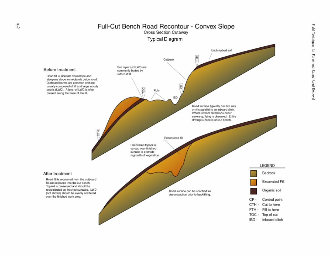
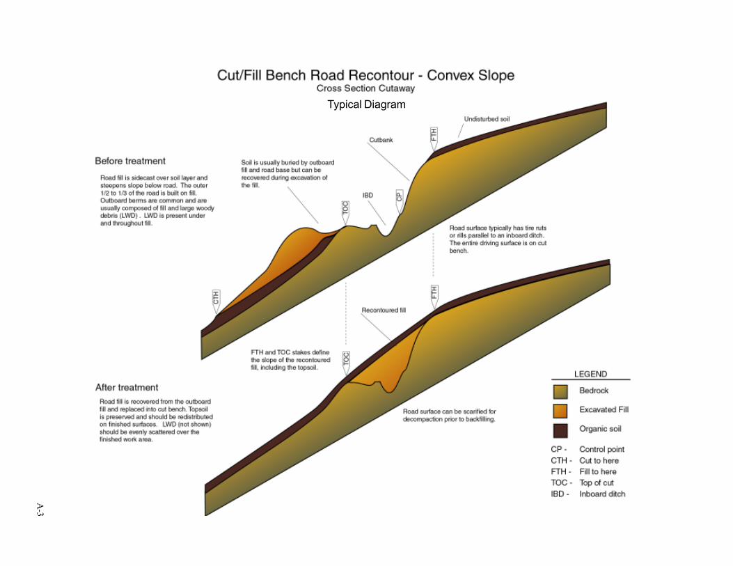
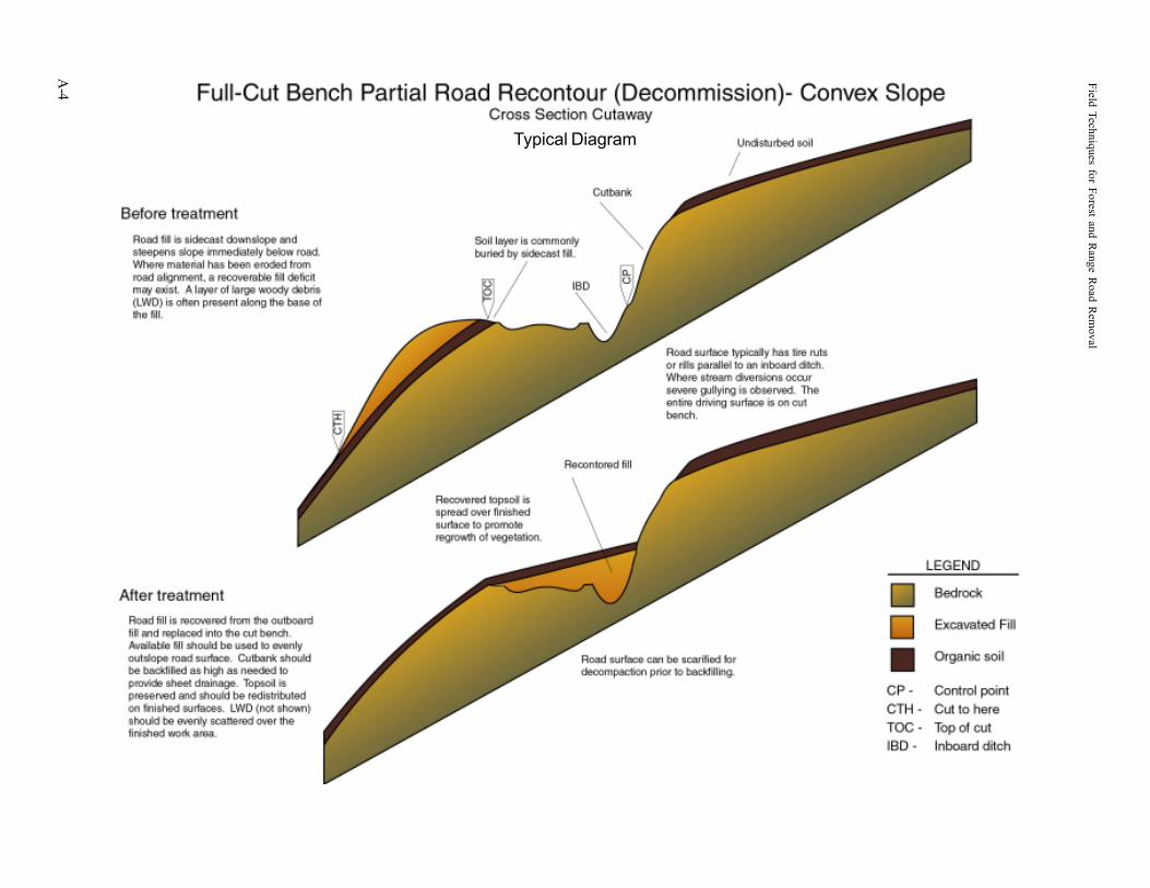
APPENDIX ATYPICAL DIAGRAMS FOR ROAD AND STREAM CROSSING REMOVAL
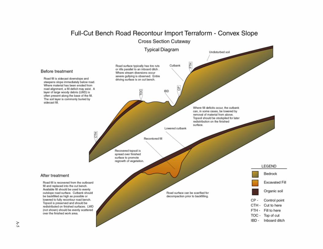
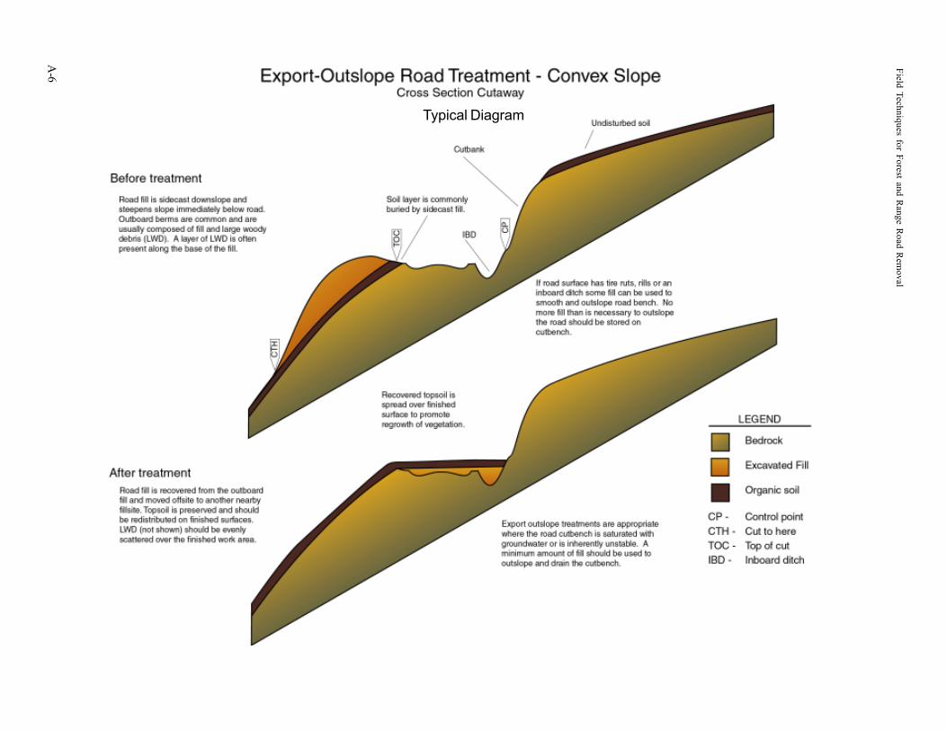
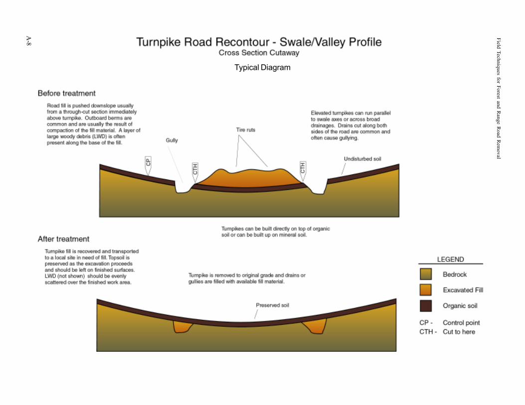
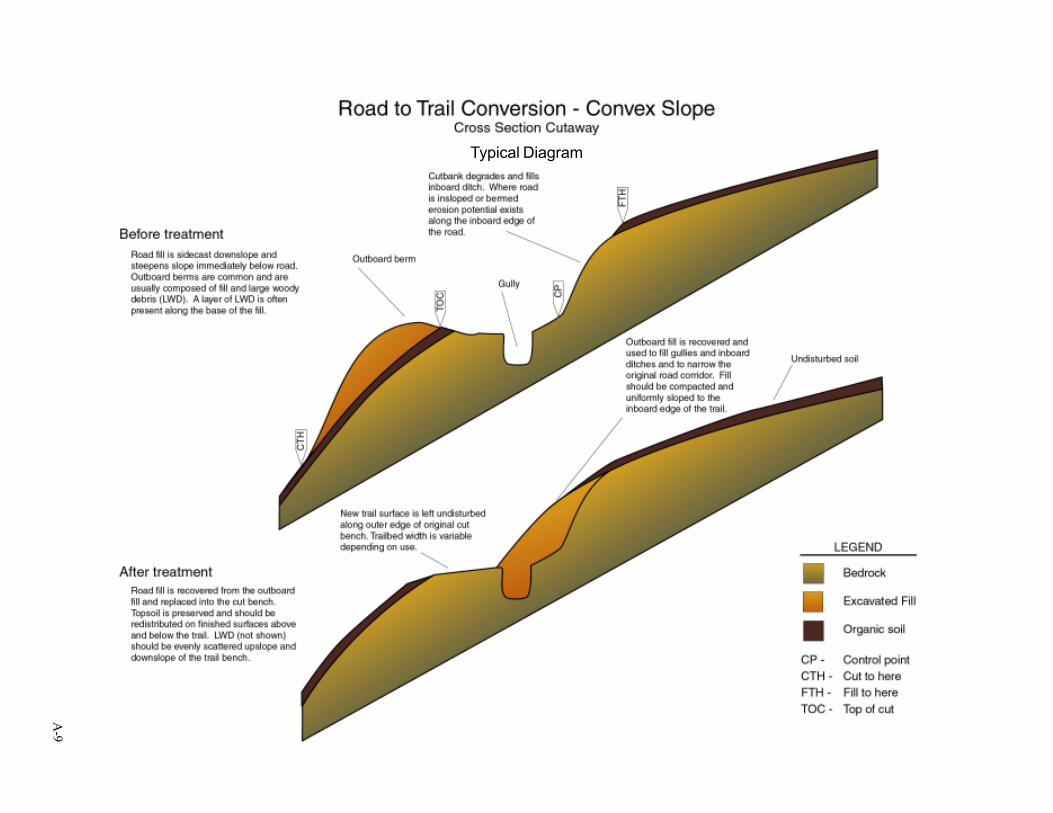
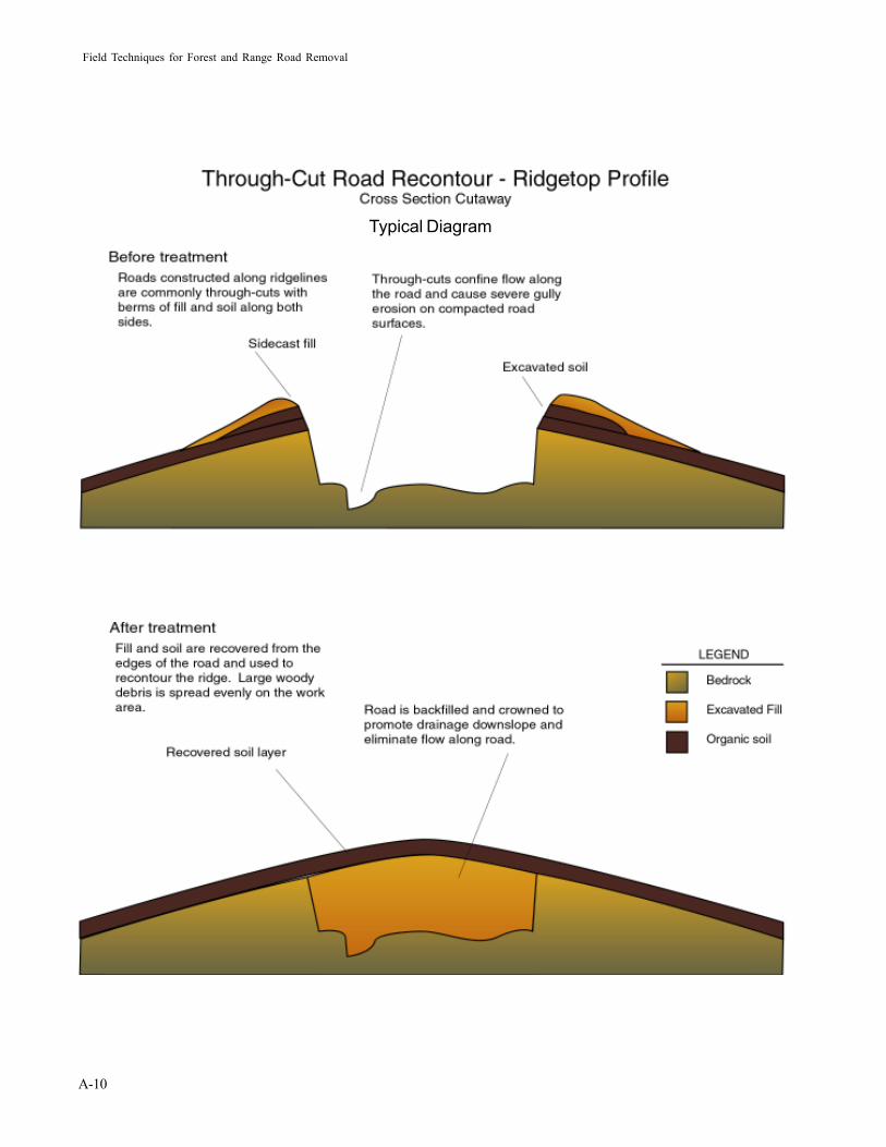
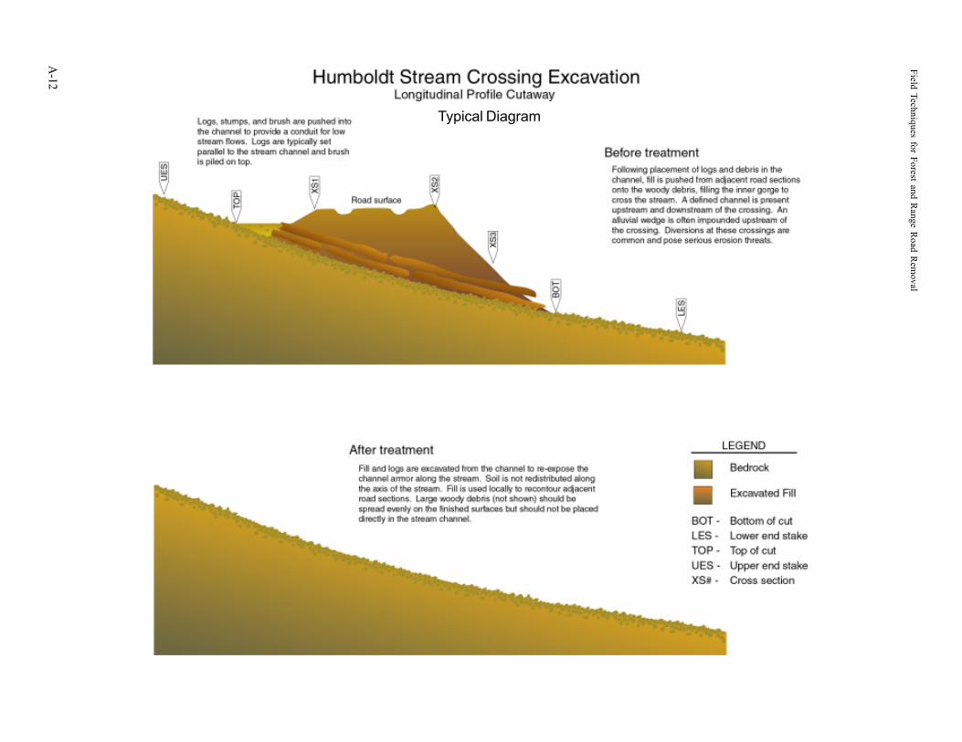
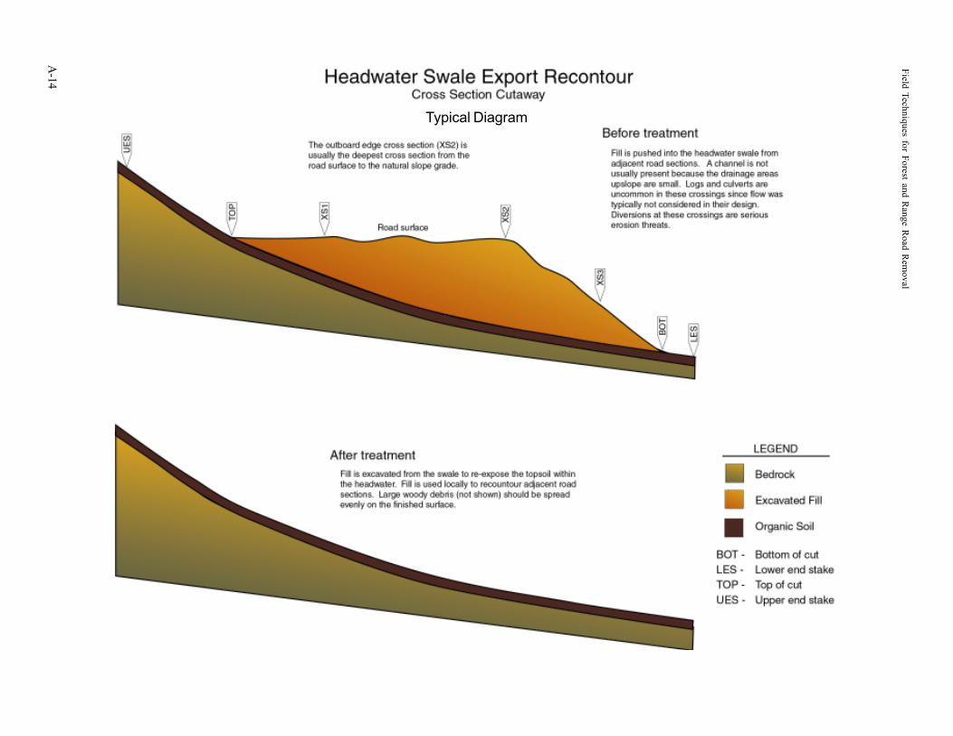
The following pages contain typical diagrams of a variety of prescriptions used to treat roadsand stream crossings. The illustrations are before-and-after representations of the earthmovingwork that is performed as part of road and stream crossing removal. For clarity, vegetationand mulch are not shown on the diagrams. Bedrock, as illustrated on the diagrams representsundisturbed material that may include solid rock, weathered rock, or undisturbed soil. Or-ganic soil as illustrated on the diagrams may or may not be present, depending on local condi-tions.
Field Techniques for Forest and Range R
oad Rem
oval
A-2
Typical Diagram
A-3
Typical Diagram
Field Techniques for Forest and Range R
oad Rem
oval
A-4
Typical Diagram
A-5
Typical Diagram
Field Techniques for Forest and Range R
oad Rem
oval
A-6
Typical Diagram

A-7
Typical Diagram
Field Techniques for Forest and Range R
oad Rem
oval
A-8
Typical Diagram
A-9
Typical Diagram
Field Techniques for Forest and Range Road Removal
A-10
Typical Diagram

A-11
Typical Diagram
Field Techniques for Forest and Range R
oad Rem
oval
A-12
Typical Diagram
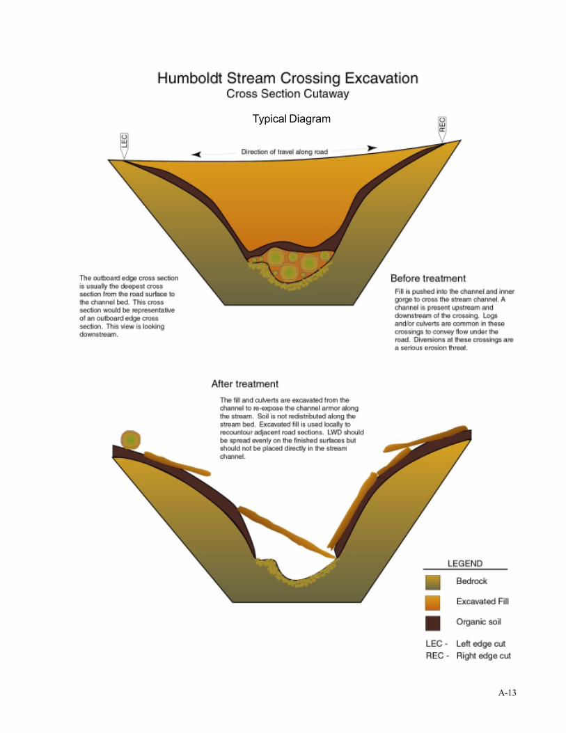
A-13
Typical Diagram
Field Techniques for Forest and Range R
oad Rem
oval
A-14
Typical Diagram

B-1
APPENDIX BGLOSSARY
Field Techniques for Forest and Range Road Removal
B-2
A blown-out culvert is a typical problem with road stream crossingswhere sediment, woody material, or very large flows have overwhelmedthe capacity of the pipe.
aggrade - the filling of a stream channel withsediment. This usually happens when the supplyof sediment is greater than the stream istransporting. Compare to “degrade” and“graded stream.”
alignment - the area affected by a road or trailincluding the fill slopes, road bench, and cutbank. Also a linear representation of featureson a map such as a stream channel.
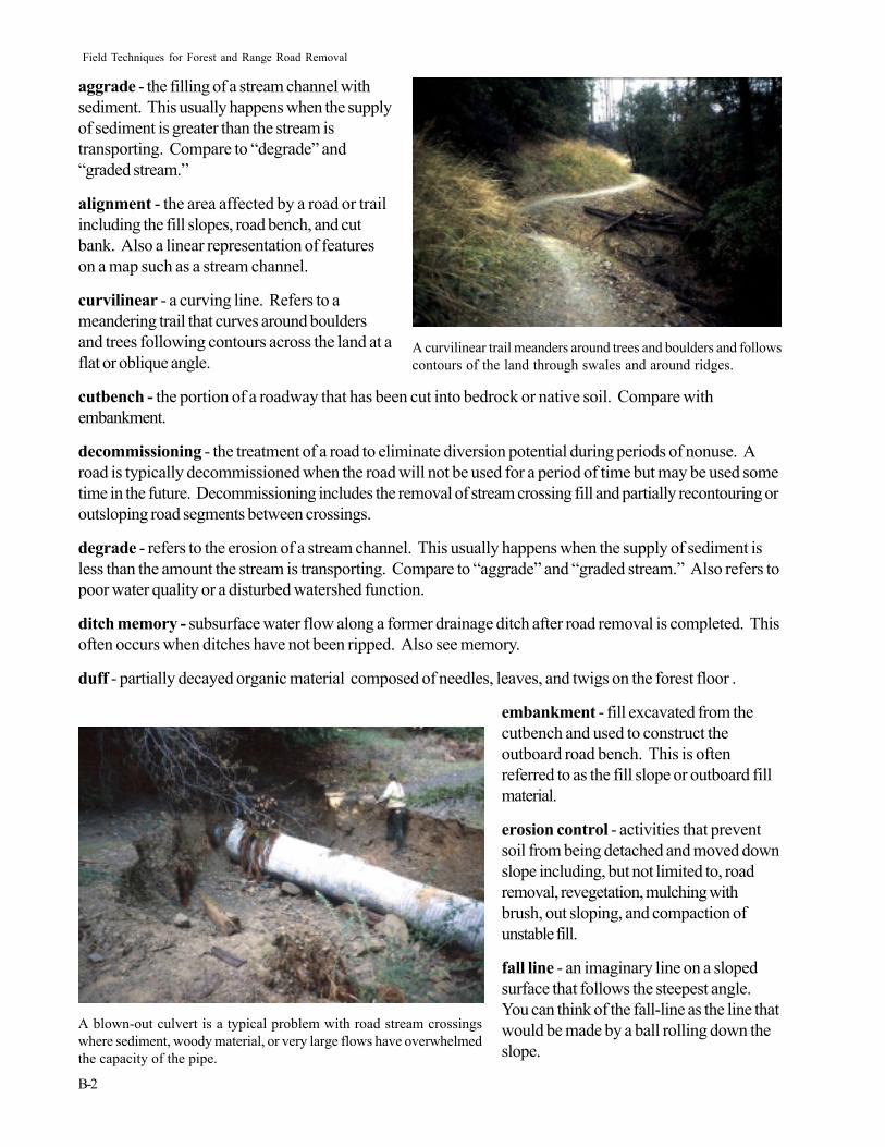
curvilinear - a curving line. Refers to ameandering trail that curves around bouldersand trees following contours across the land at aflat or oblique angle.
cutbench - the portion of a roadway that has been cut into bedrock or native soil. Compare withembankment.
decommissioning - the treatment of a road to eliminate diversion potential during periods of nonuse. Aroad is typically decommissioned when the road will not be used for a period of time but may be used sometime in the future. Decommissioning includes the removal of stream crossing fill and partially recontouring oroutsloping road segments between crossings.
degrade - refers to the erosion of a stream channel. This usually happens when the supply of sediment isless than the amount the stream is transporting. Compare to “aggrade” and “graded stream.” Also refers topoor water quality or a disturbed watershed function.
ditch memory - subsurface water flow along a former drainage ditch after road removal is completed. Thisoften occurs when ditches have not been ripped. Also see memory.
duff - partially decayed organic material composed of needles, leaves, and twigs on the forest floor .
embankment - fill excavated from thecutbench and used to construct theoutboard road bench. This is oftenreferred to as the fill slope or outboard fillmaterial.
erosion control - activities that preventsoil from being detached and moved downslope including, but not limited to, roadremoval, revegetation, mulching withbrush, out sloping, and compaction ofunstable fill.
fall line - an imaginary line on a slopedsurface that follows the steepest angle.You can think of the fall-line as the line thatwould be made by a ball rolling down theslope.
A curvilinear trail meanders around trees and boulders and followscontours of the land through swales and around ridges.
B-3
A road removal project with thick brush mulch under construction.
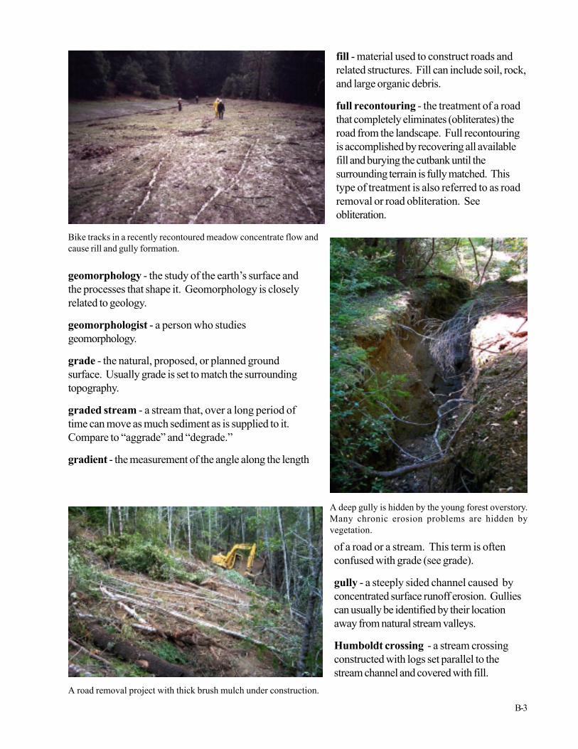
Bike tracks in a recently recontoured meadow concentrate flow andcause rill and gully formation.
fill - material used to construct roads andrelated structures. Fill can include soil, rock,and large organic debris.
full recontouring - the treatment of a roadthat completely eliminates (obliterates) theroad from the landscape. Full recontouringis accomplished by recovering all availablefill and burying the cutbank until thesurrounding terrain is fully matched. Thistype of treatment is also referred to as roadremoval or road obliteration. Seeobliteration.
A deep gully is hidden by the young forest overstory.Many chronic erosion problems are hidden byvegetation.
geomorphology - the study of the earth’s surface andthe processes that shape it. Geomorphology is closelyrelated to geology.
geomorphologist - a person who studiesgeomorphology.
grade - the natural, proposed, or planned groundsurface. Usually grade is set to match the surroundingtopography.
graded stream - a stream that, over a long period oftime can move as much sediment as is supplied to it.Compare to “aggrade” and “degrade.”
gradient - the measurement of the angle along the length
of a road or a stream. This term is oftenconfused with grade (see grade).
gully - a steeply sided channel caused byconcentrated surface runoff erosion. Gulliescan usually be identified by their locationaway from natural stream valleys.
Humboldt crossing - a stream crossingconstructed with logs set parallel to thestream channel and covered with fill.

Field Techniques for Forest and Range Road Removal
B-4
A dozer and excavator remove fill from a dry stream crossing.
Excavator operator removes an outside berm while dozer shapes the finalsurface in the background.
hydrology - the science dealing with theproperties, distribution, and circulation ofwater on the surface of the land, in thesoil and underlying rock, and in theatmosphere. This term is often confusedwith hydrogeology, which is the scienceof groundwater.
inboard - refers to the upslope side of aroad, trail or other feature.
inboard ditch - a drainage ditch cutalong the inboard side of the roadbed tointercept drainage from the slope aboveor small streams. Inboard ditches usuallydirect their water through a culvert thatcrosses under the road.
large woody debris (LWD) - alsoknown as large organic debris (LOD),refers to logs and stumps found in streamchannels, road fills, etc., having adiameter greater than 12 inches and alength greater than 6 feet.
legacy road - a road originallyconstructed for another purpose thatremains in use. Many of today’s parkroads were originally constructed aslogging roads but now serve asbackcountry access roads.
mass wasting - a general term thatincludes many types of massive earthmovements. These include rock slides,debris slides, debris flows, andearthflows, etc.
meander - a series of gentle curves in astream, road, or trail.
memory - a subsurface zone wherewater will preferentially flow due thepresence of a gully or inboard ditchburied in recontoured fill. Also see ditchmemory.
obliteration - to completely remove the
B-5
road feature from the landscape. This is accomplished by full recontouring. See full recontouring.
outboard - refers to the downslope side of a road, trail or other feature.
operator - the person operating heavy equipment or other machines.
outsloping - the treatment of a road to eliminate diversion potential along the roadbed during roadreengineering. Outsloping includes excavation of some of the road fill along the outboard edge of the roadand placing it against the cutbank to eliminate the inboard ditch and provide drainage toward the outside ofthe road. Outsloped roads are commonly graded and covered with compacted road base to harden thesurface.
partial recontouring - similar to outsloping, this term is reserved for roads that are to be removed ordecommissioned. The partial recontour often has a steeper cross slope on the former roadbed to ensureproper drainage. Partially recontoured roads are not matched at the top of the cutbank like fullyrecontoured roads.
permeability - a measure of the rate at which water can pass through soil.
ripping - decompaction of the soil by means of rippers mounted on the rear of a dozer.
roadbed - the surface of the road where driving takes place. The roadbed extends from the inboard ditchor cutbank to the outboard slope break or berm.
roadway - the corridor including the cutbank, the inboard ditch, the roadbed, and the embankment.
runoff - rainwater flowing on the surface of the ground. Runoff can be generated by rain falling onsaturated ground or from heavy rain that cannot soak in fast enough.
sediment - Silt, sand, clay, and gravel that is moved by water and deposited at some location.
sediment control - activities that filter dirt outof water, including silt fence and sedimentretention basins.
slope angle - the angle of the hill slopemeasured in percent along the fall line.
soil - clay, silt, sand, compost, air, water, andweathered rock mixed in various proportions.Soil consists of horizons or layers that displaydifferent amounts of weathering and fertility.
stream crossing - a constructed road sectionacross a natural stream. There are manytypes of crossings such as bridges, culverts,Humboldt (see definition), and fill crossings.
topography - the natural shape of the land’ssurface.
topsoil - the uppermost layer of decayedorganic matter, seeds, soil, andmicroorganisms.
After recovering culverts from the excavation the excavator bucketis used to crush them. Crushed culverts can be hauled off or buriedin the fill. If you bury them in the fill be sure to crush them completelyand avoid stringing them along the inboard ditch. This could form aconduit for subsurface flow. Instead, spread them out and seal theindividual pieces in well compacted fill.

C-1
APPENDIX CLITERATURE AND OTHER RESOURCES
Field Techniques for Forest and Range Road Removal
C-2
ADDITIONAL LITERATURE
California Department of Fish and Game. California Salmonid Stream Habitat Restoration Manual.CDFG Inland Fisheries Division, 1416 Ninth Street, Sacramento, CA 95814 or call (916) 654-5997.
California State Parks, 2000, Trails Handbook, North Coast Redwoods District, P.O. Box 2006,Eureka, CA 95502-2006 or call (707) 445-6547.
Moll, Jeffry. 1996. A Guide for Road Closure and Obliteration in the Forest Service, San DimasTechnology and Development Center. For copies write USDA Forest Service, Technology & Develop-ment Center, 444 East Bonita Ave., San Dimas, CA 91773 or call (909) 599-1267.
RCAA, Natural Resources Services Division, 1997, Stream Care Guide. Funded by California StateCoastal Conservancy and Patagonia. Copies available from Redwood Community Action Agency, 904 GStreet, Eureka, CA 95501 or call (707) 269-2059.
Spreiter, Terry. 1992. Redwood National Park Watershed Restoration Manual, National ParkService. For copies write to RNP, P.O. Box 7, Orick, CA 95555. Call (707) 464-6101.
Untied States Department of Agriculture, Forest Service, 1997, The Water/Road Interaction Technol-ogy Series, San Dimas Technology and Development Center, San Dimas, California.
Weaver, William, and Danny Hagans. 1994. Handbook for Forest and Ranch Roads. A guide forplanning, designing, constructing, reconstructing, maintaining, and closing wildland roads. TheMendocino Resource Conservation District. Copies available from MCRCD, 405 Orchard Ave., Ukiah,CA 95482.
INTERNET RESOURCES
For general information on State Parks or to obtain this document in PDF format, see http://www.parks.ca.gov.
For an annotated bibliography from the The Water/Road Interaction Technology Series, see http://fsweb.sdtdc.wo.fs.fed.us/programs/eng/w-r/w-r.html.
For information on the erosion and sediment control industry, see http://www.erosioncontrol.net.