final environmental assessment rapids dam priest …
TRANSCRIPT
FINAL ENVIRONMENTAL ASSESSMENT
AMENDING LICENSE TO MODIFY RIGHT EMBANKMENT OF THE PRIEST
RAPIDS DAM
Priest Rapids Hydroelectric Project—FERC Project No. 2114-303
Washington
Federal Energy Regulatory Commission
Office of Energy Projects
Division of Hydropower Administration and Compliance
888 First Street, NE
Washington, DC 20426
January 2021

1
TABLE OF CONTENTS
LIST OF ABBREVIATIONS ............................................................................................. 4
1.0 INTRODUCTION ....................................................................................................... 6
1.1 PROJECT DESCRIPTION ......................................................................................... 6
1.2 AMENDMENT REQUEST AND NEED FOR ACTION .......................................... 7
A. Amendment Request .................................................................................................. 7
B. Need for Action .......................................................................................................... 8
1.3 PRE-FILING CONSULTATION AND PUBLIC NOTICE ....................................... 8
1.4. STATUTORY AND REGULATORY REQUIREMENTS...................................... 10
1.4.1 Section 18 Fishway Prescription ...................................................................... 10
1.4.2 Endangered Species Act ................................................................................... 10
1.4.3 Magnuson-Stevens Fishery Conservation and Management Act .................... 11
1.4.4 National Historic Preservation Act .................................................................... 11
2.0 PROPOSED ACTION AND ALTERNATIVES ...................................................... 13
2.1 NO-ACTION ALTERNATIVE ................................................................................ 13
2.2 PROPOSED ACTION ............................................................................................... 13
2.2.1 Roller-Compacted Concrete Dam and Secant Pile Cutoff Wall ....................... 14
2.2.2 Access Route Alterations .................................................................................. 15
2.2.3 Vegetation Clearing and Grubbing .................................................................... 16
2.2.4 Construction Staging and Batch Plant Area ...................................................... 16
2.2.5 Quarry Development .......................................................................................... 17
2.2.6 Temporary Surface Water Pump and New Groundwater Well ....................... 17
2.2.7 Best Management Practice and Mitigation Measures ....................................... 18
3.0 ENVIRONMENTAL ANALYSIS ............................................................................ 19
3.1. General Description of the River Basin..................................................................... 19
3.2. Geographic Scope ...................................................................................................... 19

2
3.3. Geology and Soils ...................................................................................................... 20
3.3.1 Affected Environment ....................................................................................... 20
3.3.2 Environmental Effects ....................................................................................... 20
3.4 Water Resources ........................................................................................................ 23
3.4.1 Affected Environment ....................................................................................... 23
3.4.2 Environmental Effects ...................................................................................... 24
3.5. Air Quality ................................................................................................................. 26
3.5.1 Affected Environment ....................................................................................... 26
3.5.2 Environmental Effects ....................................................................................... 27
3.6 Aquatic Resources ..................................................................................................... 29
3.6.1 Affected Environment ....................................................................................... 29
3.6.2 Environmental Effects ...................................................................................... 30
3.7 Terrestrial Resources ................................................................................................. 31
3.7.1 Affected Environment – Vegetation and Wetlands ......................................... 31
3.7.2 Environmental Effects ‒ Vegetation and Wetlands .......................................... 32
3.7.3 Affected Environment ‒ Wildlife ...................................................................... 34
3.7.4 Environmental Effects ‒ Wildlife ...................................................................... 35
3.8 Threatened and Endangered Species ......................................................................... 38
3.8.1 Affected Environment ....................................................................................... 38
3.8.2 Environmental Effects ....................................................................................... 39
3.9 Construction Access .................................................................................................. 40
3.9.1 Affected Environment ....................................................................................... 40
3.9.2 Environmental Effects ....................................................................................... 43
3.10 Land Use, Recreation, and Aesthetics ....................................................................... 47
3.10.1 Affected Environment – Land Use .................................................................... 47
3.10.2 Environmental Effects – Land Use ................................................................... 48
3.10.3 Affected Environment – Recreation .................................................................. 49
3.10.4 Environmental Effects – Recreation .................................................................. 49
3.10.5 Affected Environment – Aesthetics................................................................... 50

3
3.10.6 Environmental Effects – Aesthetics .................................................................. 50
3.11 Cultural and Historic Resources ............................................................................... 52
3.11.1 Affected Environment ....................................................................................... 52
3.11.2 Environmental Effects ....................................................................................... 53
3.12 Noise and Vibration ................................................................................................... 55
3.12.1 Affected Environment ....................................................................................... 55
3.12.2 Environmental Effects ....................................................................................... 55
4.0 CUMULATIVE EFFECTS ....................................................................................... 57
5.0 LITERATURE CITED .............................................................................................. 58
6.0 LIST OF PREPARERS ............................................................................................. 62
APPENDIX A .................................................................................................................... 63
4
LIST OF ABBREVIATIONS
µg/m3 micrograms per cubic meter
APE Area of Potential Effects
AQI air quality index
Army U.S. Department of the Army
BMP best management practice
BOC Board of Consultants
BPA Bonneville Power Administration
CFR Code of Federal Regulations
Commission Federal Energy Regulatory Commission
D2SI Division of Dam Safety and Inspections
dB decibels
dBA A-weighted decibels
DOE U.S. Department of Energy
EA Environmental Assessment
EPA U.S. Environmental Protection Agency
ESA Endangered Species Act
FWS U.S. Fish and Wildlife Service
Grant PUD Public Utility District No. 2 of Grant County,
Washington
HPMP Historic Properties Management Plan
HPA Hydraulic Project Approval
IPAC Information for Planning and Consultation
NAVD88 North American Vertical Datum of 1988
NEPA National Environmental Policy Act
NHPA National Historic Preservation Act
NMFS National Marine Fisheries Service
NOAA National Oceanic and Atmospheric Administration
NWA Northwest Anthropology, LLC
PM2.5 particulate matter less than 2.5 micrometers in diameter;
PM10 particulate matter less than 10 micrometers in diameter;
Project Priest Rapids Hydroelectric Project No. 2114
PRREIP Priest Rapids Right Embankment Improvement Project
Reclamation U.S. Bureau of Reclamation
RCC roller-compacted concrete
RM river mile
Washington SHPO Washington State Historic Preservation Office
SPCCP Spill Prevention, Control, and Countermeasure Plan
SR State Route
TESCP Temporary Erosion and Sedimentation Control Plan
UCR Upper Columbia River
Wanapum Priest Rapids Band of the Wanapum

5
Washington DFW Washington Department of Fish and Wildlife
Washington Ecology Washington State Department of Ecology
WIV Wanapum Indian Village
WSDOT Washington State Department of Transportation
Yakama Nation Confederated Tribes and Bands of the Yakama Nation
YTC Yakima Training Center

6
FINAL ENVIRONMENTAL ASSESSMENT
Federal Energy Regulatory Commission
Office of Energy Projects
Division of Hydropower Administration and Compliance
Washington, DC
Priest Rapids Hydroelectric Project
FERC No. 2114-303
A. Application Type: Non-Capacity Amendment
B. Date Filed: May 17, 2019, supplemented on June 5, 2019 and June 26, 2020
C. Applicant’s Name: Public Utility District No. 2 of Grant County, Washington
D. Waterbody: Mid-Columbia River
E. County and State: Grant, Yakima, Kittitas, Douglas, Benton, and Chelan Counties,
Washington
F. Federal Lands: The project occupies lands managed by U.S. Bureau of Reclamation
(Reclamation), U.S. Bureau of Land Management (BLM), U.S. Department of Army
(Army), U.S. Fish and Wildlife Service (FWS), and U.S. Department of Energy (DOE).
1.0 INTRODUCTION
1.1 PROJECT DESCRIPTION
The Federal Energy Regulatory Commission (Commission or FERC) issued a
license for the Priest Rapids Project (FERC No. 2114) to the Public Utility District No. 2
of Grant County (Grant PUD or licensee) on April 17, 2008.1 The project is located on
the mid-Columbia River in Grant, Yakima, Kittitas, Douglas, Benton, and Chelan
Counties, Washington. The project includes two hydroelectric developments, Wanapum
and Priest Rapids. This final Environmental Assessment (EA) focuses on the license
amendment for the Priest Rapids development.
The Priest Rapids development consists of a 7,725-acre reservoir and a 10,103-
foot-long dam spanning the river. The Priest Rapids dam is located on the Columbia
River, at river mile (RM) 397, near the community of Mattawa, Washington. The dam
consists of left and right embankment sections; left and right concrete gravity dam
1 Public Utility District No. 2 of Grant County, Washington, 123 FERC ¶ 61,049
(2008).

7
sections; a left and right fish passage structure each with an upstream fish ladder; a gated
spillway section; and a powerhouse containing 10 vertical shaft integrated Kaplan
turbine/generator units with a total authorized capacity of 675 megawatts. The
development also includes a fish hatchery; the Priest Rapids Band of the Wanapum (the
Wanapum) Indian Village (WIV); and three 230-kilovolt, 6-mile-long transmission line.
The Priest Rapids boundary around the Priest Rapids dam, as described in the
Commission’s license, includes the Priest Rapids reservoir, the tailrace of the Priest
Rapids dam, and lands along the shoreline between 100 and 2,000 feet from the full pool
elevation of Priest Rapids reservoir and extending approximately one mile downstream of
the dam. Parcels within the project boundary in the vicinity of the Priest Rapids dam
include federal lands under the jurisdiction of the DOE, Army, and private lands owned
by Simon Martinez Livestock, Inc.
The Priest Rapids project boundary also includes the WIV immediately adjacent to
the existing right embankment. The Wanapum are descendants of the people who lived
up and down the Columbia River from Wenatchee to the Tri-Cities. Following
construction of the Priest Rapids dam, their village was relocated to a site on the right
bank at the base of the dam, where it exists to date.
1.2 AMENDMENT REQUEST AND NEED FOR ACTION
A. Amendment Request
On May 17, 2019, and supplemented on June 5, 2019 and June 26, 2020, Grant
PUD, filed a request to amend its license to construct a separate embankment
immediately downstream of the existing dam, and structurally connected to the existing
embankment to improve seismic stability. Grant PUD proposes to: construct a roller-
compacted concrete dam, approximately 2,200-foot-long and 25-foot-high; construct a
secant pile cutoff wall and a 150-foot-long and 25-foot-high embankment; and realign
section of an existing private roadway. The existing embankment would remain in place.
In addition, Grant PUD proposes to conduct the following actions: clearing and grubbing
of vegetation; establishing a temporary concrete batch plant and construction staging
areas; excavating aggregate source material from an existing quarry known as the Cow
Creek Quarry; and installing one permanent groundwater well and one temporary surface
water pump for construction water use. The existing embankment would remain in place.
The work would occur at the right embankment of the existing dam but would not affect
normal dam operations (including operation of the turbines, spillway, powerhouse, or fish
ladders), and reservoir levels and flows would remain within normal ranges throughout
the construction period. Grant PUD would also utilize best management practices
(BMP), and proposes to implement the following plans as mitigation measures for the
proposed amendment application: (1) Temporary Erosion and Sedimentation Control

8
Plan (TESCP); (2) Spill Prevention, Control, and Countermeasure Plan; (3) Dust Control
Plan; and (4) Traffic Control Plan.
B. Need for Action
In 2007, Grant PUD, the Public Utility District No. 1 of Chelan County,
Washington, and the Public Utility District No. 1 of Douglas County, Washington, in
coordination with the Commission, jointly conducted a Probabilistic Seismic Hazard
Assessment, to evaluate the ground-shaking hazards that could affect the dams owned
and operated by these three public utility districts in response to the updated Federal
Guidelines for Dam Safety by the Federal Emergency Management Agency. Five high-
priority hazards were identified in the hazard assessment, including the right embankment
of the Priest Rapids dam.
On May 5, 2015, the Commission directed Grant PUD to convene an independent
Board of Consultants (BOC) to assess the seismic performance and post-seismic stability
of the right embankment of the Priest Rapids dam. Grant PUD initiated a seismic risk
analysis and found that while the existing right embankment of the Priest Rapids dam met
stability guidelines for normal and flood loading conditions, soils beneath the foundation
of the embankment were potentially liquefiable in seismic conditions. Liquefaction of
the foundation soils can be triggered by a significant earthquake in the vicinity of the
Priest Rapids dam and could result in damage to or failure of the embankment.
Consequences of an embankment failure could include significant downstream damage.
In July 2017 and as part of the Commission-required seismic risk analysis process,
Grant PUD submitted preliminary design documents for the Priest Rapids Right
Embankment Improvement Project (PRREIP) and began the environmental permit
preparation and agency coordination. The final design and contract documents for the
PRREIP were submitted to the Commission’s Division of Dam Safety and Inspections –
Portland Regional Office (D2SI-PRO) and the BOC on November 15, 2018.
In accordance with the National Environmental Policy Act (NEPA) of 1969 and
the Commission’s regulations (18 CFR Part 380), this draft EA assesses the effects
associated with the proposed amendment of the project’s license, and whether or not to
approve the amendment, and if so, recommend terms and conditions to become part of
any amendment order issued. In this final EA, we assess the environmental effects of the
Proposed Action and the No-Action Alternative
1.3 PRE-FILING CONSULTATION AND PUBLIC NOTICE
As required by Commission’s regulations, the license amendment application for
the PRREIP was prepared using a three-stage consultation process with the appropriate
resource agencies and other stakeholders. Details of the proposed action, including the

9
opportunity to review and comment on an applicant-prepared draft EA (APEA) were
provided to the Priest Rapids Coordination Committee (PRCC).2 Supplemental versions
of the draft APEA was provided to the PRCC. The PRCC was established as required by
the project’s license to oversee the activities associated with anadromous fish for the
project. Grant PUD also provided the draft APEA and supplementals to the owners and
users of the upstream and downstream access routes, including: DOE, Simon Martinez
Livestock, Inc., Bonneville Power Administration (BPA), Pacific Power, U.S. Army, and
telecommunication companies. Comments on the APEA and the proposal to amend the
project’s license were received from DOE, Army, Washington DFW, Wanapum, and the
Yakama Nation.
On June 6, 2019, the Commission issued a public notice of the application for the
proposed amendment. This notice set a 30-day period during which interventions,
comments, and protests could be filed, ending on July 8, 2019. On June 27, 2019,
Reclamation – Pacific Northwest Region said it had no comments. The Washington
DFW filed a notice of intervention on June 21, 2019 and the Wanapum filed a motion to
intervene on July 8, 2019.
On September 24, 2020, Commission staff issued a draft EA for the proposed
amendment, evaluating the potential effects of the proposal and identifying the potential
environmental measures to mitigate or reduce potential impacts. Comments on the draft
EA were filed by FWS on October 22, 2020; DOE, Richland Operations Office on
October 23, 2020; NMFS on October 28, 2020; the U.S. Environmental Protection
Agency (EPA) on October 30, 2020; and Grant PUD on November 9 and 20, 2020. In
our analysis sections of this final EA and the attached Appendix A, we summarize and
address the comments received. This final EA satisfies the Commission’s responsibilities
under the National Environmental Policy Act (NEPA).3 As discussed below, the no-
action alternative is not a viable alternative given that the no-action alternative does not
meet current Commission dam safety requirements, and the on-going hazard to public
safety and property would remain unabated.
2 The PRCC compromises of representatives from: National Marine Fisheries
Service (NMFS), FWS, Washington Department of Fish and Wildlife (Washington
DFW), Colville Confederated Tribes, Confederated Tribes and Bands of the Yakama
Nation (Yakama Nation), Confederated Tribes of the Umatilla Indian Reservation, and
the Wanapum.
3 On July 16, 2020, the Council on Environmental Quality issued a final rule,
Update to the Regulations Implementing the Procedural Provisions of the National
Environmental Policy Act (Final Rule, 85 Fed. Reg. 43,304), which was effective as of
September 14, 2020; however, the NEPA review of this project was in process at that
time and prepared pursuant to the 1978 regulations.

10
In its October 30, 2020 filing, the EPA supports the overall purpose of the
proposed project to improve the Priest Rapids dam stability by addressing its seismic
risks. The EPA finds that most of the potential impacts, both temporary and permanent,
from the proposed project would be from project construction and maintenance activities.
While mitigation measures and best management practices could be applied to minimize
the impacts, the EPA recommends that the Commission coordinate with other federal,
state, and tribal entities throughout the implementation of the project to ensure activities.
As discussed below, our analysis sections and the attached Appendix A summarized and
addressed the comments received.
1.4. STATUTORY AND REGULATORY REQUIREMENTS
1.4.1 Section 18 Fishway Prescription
Section 18 of the Federal Power Act provides for the Commission to require the
construction maintenance and operation by a licensee of such fishways as may be
prescribed by the Secretary of the U.S. Department of Interior or the Secretary of
Commerce, as appropriate. No fishway prescriptions were filed by Interior or
Commerce for this amendment application.
1.4.2 Endangered Species Act
Section 7(a)(2) of the Endangered Species Act (ESA) 4 requires the Commission to
ensure that is actions are not likely to jeopardize the continued existence of federally
listed threatened or endangered species or result in the destruction or adverse
modification of critical habitat of those species.
The potential impact to threatened and endangered species, or their habitat, that
may occur within the vicinity of the project area are described and discussed further in
Section 3.8. These species include: Upper Columbia River (UCR) spring-run Chinook
salmon, UCR steelhead, bull trout, Ute ladies’ tresses (Spiranthes diluvialis), Umtanum
desert buckwheat, northern wormwood (Artemisia campestris var. wormskioldii),
Northern wormwood, the Columbia Basin pygmy rabbit, gray wolf, North American
Wolverine, and the yellow-billed cuckoo. Commission staff determined that the
proposed action would have no effect on the North American wolverine, Columbia basin
pygmy rabbit, gray wolf, yellow-billed cuckoo, Umtanum desert buckwheat, Ute ladies’
tresses, and northern wormwood. In it December 1, 2020 response, the FWS also
concurred with our no effect determination of other terrestrial species.
4 16 U.S.C. § 1536(a) (2018).

11
The proposed action is located within critical habitat for the UCR spring-run
chinook salmon, UCR steelhead, and bull trout. However, the Commission staff has
determined that the proposed action may affect, but is unlikely to adversely affect, UCR
spring-run Chinook salmon, UCR steelhead, and bull trout. The FWS also agreed that
implementation of the proposed action would result in insignificant or discountable
effects to bull trout and its designated critical habitat. NMFS concurred with
Commission staff determination that the proposed action may affect but is unlikely to
adversely affect UCR spring-run salmon, UCR steelhead, or designated critical habitat
for these species.
1.4.3 Magnuson-Stevens Fishery Conservation and Management Act
Section 305(b)(2) of the Magnuson-Stevens Fishery Conservation and
Management Act5 requires federal agencies to consult NMFS on all actions that may
adversely affect Essential Fish Habitat6 identified under the Act. In its October 28, 2020
filing, NMFS determined that the proposed action would not adversely affect Essential
Fish Habitat and that consultation under this Act was not required.
1.4.4 National Historic Preservation Act
Section 106 of the National Historic Preservation Act (NHPA)7 and its
implementing regulations8 requires that federal agencies “take into account” the effect of
any proposed undertaking could affect historic properties and afford the Advisory
Council on Historic Preservation (Advisory Council) a reasonable opportunity to
comment on the undertaking.9 Historic properties are districts, sites, buildings,
structures, traditional cultural properties, and objects significant in American history,
architecture, engineering, and culture that are eligible for inclusion in the National
5 16 U.S.C. 1801 (2018).
6 50 C.F.R. § 600 (2020).
7 54 U.S.C. §§ 306108 et seq. (2018). The National Historic Preservation Act was
recodified in Title 54 in December 2014.
8 36 C.F.R. 800.5(a)(2)(vii).
9 An undertaking means “a project, activity, or program funded in whole or in part
under the direct or indirect jurisdiction of a Federal agency, including those carried out
by or on behalf of a Federal agency; those carried out with Federal financial assistance;
and those requiring a Federal permit, license, or approval.” 36 C.F.R. § 800.16(y). Here,
the undertaking is the proposed amendment to the Priest Rapids Project license.

12
Register of Historic Places (National Register). In this document, we also use the term
“cultural resources” for properties that have not been evaluated for eligibility for the
National Register. Cultural resources represent things, structures, places, or
archaeological sites that can be either prehistoric or historic in origin. In most cases,
cultural resources less than 50 years old are not considered historic. Section 106 also
requires that the Commission seek concurrence with the state historic preservation office
(SHPO) on any finding involving effects or no effects on historic properties, and consult
with interested Indian tribes or Native Hawaiian organizations that attach religious or
cultural significance to historic properties that may be affected by an undertaking.
On April 12, 2007, the Commission, Washington SHPO, and Advisory Council
executed a Programmatic Agreement (PA) for the project and the PA was implemented in
Article 416 of the project’s license. The PA required Grant PUD to file for Commission
approval a final Historic Properties Management Plan (HPMP). Article 417 of the
project’s license requires Grant PUD to address in the final HPMP: the identification of
cultural resources within the project’s area of potential effect (APE); possible threats to
cultural resources; mitigation for unavoidable adverse effects; consultation with
Washington SHPO; unanticipated discoveries of human remains; public interpretation;
traditional cultural properties treatment plans; and coordination and implementation of
the HPMP with interested parties. On October 24, 2011, the Commission approved the
project’s HPMP.
To meet the requirements of section 106, Grant PUD consulted with the
Washington SHPO on the assessment of potential adverse effects on historic properties
within the project’s APE. As the Commission’s designated non-federal representative,
Grant PUD initiated the section 106 process and between federally recognized Tribes,
Washington SHPO, federal agencies, and the Grant PUD Cultural Resources Working
Group.10 A Memorandum of Agreement (MOA) between the Washington SHPO and the
Commission was created to address and mitigate for adverse effects to identified cultural
resources. The terms of the MOA would ensure that the licensee addresses and mitigates
adverse effects. Commission staff recommend incorporating any executed MOA into any
amendment order for the project.
Cultural resource protection is discussed further in Section 3.11, Cultural
Resources.
10 The Cultural Resources Working Group consists of DOE, Richland Operations;
Reclamation; BLM; FWS; the Commission; Army; Washington State Parks and
Recreation Commission; Washington SHPO; Washington DFW; Washington DNR;
Confederated Tribes of the Colville Reservation; the Yakama Nation; and the Wanapum.

13
2.0 PROPOSED ACTION AND ALTERNATIVES
2.1 NO-ACTION ALTERNATIVE
Under the No-Action Alternative, Grant PUD would not implement modifications
to the existing right embankment of the Priest Rapids dam and would continue to operate
the project in its current state. Although the no-action alternative would avoid immediate
effects to the environment, it would not address the high-priority seismic hazard
identified in the 2007 Probabilistic Seismic Hazard Assessment. The no-action
alternative does not meet current Commission dam safety requirements, and the on-going
hazard to public safety and property would remain unabated. We use this alternative as
the baseline environmental condition for comparison with the proposed alternative and
staff-recommended alternative.
2.2 PROPOSED ACTION
Grant PUD proposed the PRREIP including construction of a new, permanent
structure landward of the right embankment of Priest Rapids dam to improve seismic
stability. This work would occur at the right embankment of the existing dam but would
not affect normal dam operations (including turbines, spillway, powerhouse, or fish
ladders), and reservoir levels and flows would remain within normal ranges throughout
the project. The PRREIP includes: (1) constructing a 2,200-foot-long and 25-foot-high
roller-compacted concrete (RCC) dam wall; (2) constructing a secant pile cutoff wall
along with a 150-foot-long and 25-foot-high connecting embankment; (3) realigning a
0.5-mile section of existing private roadway; (4) vegetation clearing and grubbing; (5)
establishing a temporary concrete batch plant and construction staging areas
(approximately 5 acres); (6) excavating of aggregate source material from an existing
quarry known as the Cow Creek quarry (approximately 82,000 cubic yards); and (7)
installing a permanent groundwater well and a temporary surface water pump for
construction water-use. Grant PUD would also utilize described BMPs along with
implementation of the following plans as mitigation measures for the proposed
amendment application: (1) Temporary Erosion and Sedimentation Control Plan; (2)
Spill Prevention, Control, and Countermeasure Plan (SPCCP); (3) Dust Control Plan; and
(4) Traffic Control Plan.
Grant PUD expects to start construction as soon as practicable upon receipt of
federal, state, and local permitting and approvals. Work is anticipated to be completed
within 18 to 24 months, including construction, cleanup, and restoration.
The Proposed Action would occur across multiple parcels, the extent of which is
described as the Project Area. The Project Area includes the central construction zone at
the right bank landing for the RCC dam and secant pile cutoff wall; access routes on the
localized access road upstream to the quarry and downstream to the highway; a potential

14
barge route from the right bank landing to the left bank landing; the existing access road
across Priest Rapids dam; a water intake point at the existing boat basin adjacent to the
right bank landing; and the footprint of Cow Creek quarry. This combined footprint
encompasses approximately 130 acres, but the consideration of environmental effects
includes a buffer of approximately 0.75 miles around this Project Area to account for
noise effects.
2.2.1 Roller-Compacted Concrete Dam and Secant Pile Cutoff Wall
Construction of the new embankment involves soil excavation, concrete
construction, and secant-pile construction. Soil removal in the footprint of the RCC dam
would occur by excavators or large machinery to a depth of 20 to 30 feet below existing
grade so that the RCC dam can be built on a foundation of bedrock. Excavation also
includes the removal of the westernmost embankment ramp to accommodate the footprint
of the RCC dam. This ramp would not be reconstructed.
Ground-disturbing activities would be performed to ensure that they do not
indirectly compromise the stability of surrounding soils, such as the existing
embankment, ramps, and roads, or the side slopes of the excavation area. These effects
would be mitigated by implementing erosion and sediment control measures consistent
with the Washington State Department of Ecology’s (Washington Ecology) Stormwater
Management Manual for Eastern Washington (Ecology 2004).
The base of the RCC dam would be sealed to the bedrock foundation with grout to
ensure a strong, watertight connection. Excavation and foundation work are estimated to
take about 75 working days and batching and placement of concrete is expected to take
approximately 20 to 25 working days. This work is expected to require up to 300 truck
trips per day within the construction zone between the concrete batch plant, staging and
stockpiling areas, and the footprint of the RCC dam and secant pile cutoff wall.
As the RCC dam is constructed to its design elevation, the excavated area would
be backfilled with stockpiled soil to meet the existing grade level. Embankment
construction is expected to take approximately 50 working days, and secant pile
construction is anticipated to take 30 to 45 working days. Following installation of the
RCC dam and the cutoff wall, the backfilled areas around the base of the RCC dam and
embankment would be regraded as needed to meet existing grade.
Construction of the RCC dam would require the use of concrete mixers, truck-
mounted conveyors, and concrete compactors. Hand tools, either powered or manually
operated, may also be used in this phase. Construction of the earthen embankment and
secant pile wall would require use of haul trucks, bulldozers, a tractor disk, pad foot
and/or vibratory smooth-drum rollers, concrete pump trucks, and a track-mounted drill
with flight auger.

15
2.2.2 Access Route Alterations
Existing access routes would be used to deliver and transport heavy machinery,
materials, and project personnel. Due to access road limitations over Priest Rapids dam
(e.g., limited road width and tight turning radius), existing primitive roadways must be
improved in some areas to accommodate construction vehicles and material transport to
the Project Area. These improved access routes include the downstream access route,
which connects to the regional highway network, and the upstream access route, which
connects to the Cow Creek quarry. Ownership of these access routes varies and includes
the Army (Upstream route), and DOE and Simon Martinez Livestock, Inc. (downstream
route). Grant PUD is working with owners to obtain appropriate easements for use of the
access routes.
Vehicles using these routes would include dump trucks and/or semi-trailer trucks
hauling large equipment and materials. Per day, there may be 5 to 75 truck trips per
segment. The total number of truck trips on the access routes would be variable within
the construction timeline, and at certain times use of one access route may be
significantly higher than use of the other route—e.g., 5 trips on the downstream route and
70 on the upstream route, or vice versa. If Cow Creek quarry is not available as the
aggregate source, crushed aggregate material would be purchased from a commercial
source and the upstream access route would not be used.
A third access route may occur by barge across the Columbia River, if necessary.
The barge route, if used, would occur at a previously used launch point. No shoreline
alterations or other changes are anticipated to accommodate barge operations. The barge
may be used to transport materials from the left bank to the right bank for a total distance
of approximately 1.5 miles.
Secondary access to the Project Area would continue over the existing road that
crosses Priest Rapids dam, which is currently used by WIV residents and Grant PUD
personnel, accessible from State Route (SR) 243. The existing Priest Rapids dam route
would be used for pickup trucks to transport personnel and tools during construction in
addition to ongoing current uses associated with WIV access and Priest Rapids dam
maintenance and operations.
Both upstream and downstream access routes would require regrading and
placement of a surface layer of gravel to support the proposed construction traffic.
Grading would not exceed 3 inches of depth, and gravel placement would not exceed 1-
inch depth. Additional temporary gravel pads would be placed in up to five locations on
the upstream access route to provide passing zones for construction vehicles, where the
total width of road and passing zone would be less than 25 feet. These gravel passing
zones would be removed following construction and revegetated with a native seed mix.
No passing zones are proposed for the downstream access route. On both access routes,

16
soil and vegetation disturbance would be minimized with the use of construction BMPs
and vegetation restoration after construction.
Equipment to perform access route preparation would include one or more
bulldozers, haul trucks, front-loaders, graders, water trucks, and pad-foot and/or vibratory
smooth-drum rollers. Use of all access routes would be managed consistent with the
Traffic Control Plan, included in Appendix D of the amendment application.
In addition to access route alterations, a short segment of the downstream access
route would need to be completely reconstructed adjacent to the WIV where the footprint
of the RCC dam would interrupt its current path. Although this portion of the roadway is
within the project boundary, it is privately owned and as such Grant PUD is currently in
the process of purchasing, and issuing easements across, this segment of the roadway.
This would assure that Grant PUD has control of the segment of the road immediately
adjacent to the new RCC dam.
Realignment would include some additional grading to reconstruct the gravel road
around the flank of the new RCC dam, up to 0.5 mile in length to meet existing grades.
The road would be rebuilt with compacted gravel but would not be paved or otherwise
improved. The reconstruction of this segment of the downstream access route would
occur after all other RCC dam work is completed and is anticipated to take approximately
10 to 15 workdays.
2.2.3 Vegetation Clearing and Grubbing
Prior to construction, vegetation clearing, and grubbing are required to prepare
certain portions of the Project Area. This would include temporary and permanent
removal of non-native and native vegetation to accommodate project features, including
the access routes, construction staging and concrete batch plant areas, Cow Creek quarry,
the footprint of the RCC dam and secant pile cutoff-wall, and the restored segment of
Martinez Road.
2.2.4 Construction Staging and Batch Plant Area
Fences, erosion control features, and other security measures would be installed
around active construction areas and zones designated for staging and stockpiling. Final
placement and configuration of the temporary concrete batch plant and staging areas
would be determined by the contractor, but all construction staging, and batch plant areas
would be situated within the central construction zone of the Project Area.
Construction staging areas would be developed within the central construction
zone to accommodate a concrete batch plant, construction staging and stockpiling areas,
equipment refueling, and contractor operational areas. The concrete batch plant would be

17
established to mix concrete materials needed to construct the RCC dam. The batch plant
would include the plant, silos, aggregate stockpiles, mixing machinery, an office, a
generator and designated batch plant working areas. The total footprint of the concrete
batch plant is expected to be approximately 20,000 square feet.
2.2.5 Quarry Development
Crushed aggregate material for construction of the RCC dam and for surfacing of
the access routes would be sourced from the Cow Creek quarry within the U.S. Army
Yakima Training Center (YTC), approximately 7 miles upstream from the WIV. The
Cow Creek quarry would be expanded from its existing condition and rock would be
excavated or blasted from the quarry, crushed and sorted, and transported back to the
Project Area by 35-ton dump trucks for staging, stockpiling, and road resurfacing.
Blasting at Cow Creek quarry would not be conducted during nesting season between
March 1 and June 30 to minimize effects to migratory birds.
Since the Cow Creek quarry is owned and operated by the Army, Grant PUD is
currently working with the YTC staff to obtain a land use agreement for use of Cow
Creek quarry. The land use agreement may further detail mitigation requirements to
address potential unavoidable permanent impacts to native vegetation, rare plants, and
Washington DFW priority habitats and species.
The PREIP would require the use of excavators, bulldozers, blasting, and rock-
crushing equipment to retrieve approximately 82,000 cubic yards of aggregate material
for use in the RCC dam. Use of the upstream access route and quarry development would
require up to 75 truck trips. Excavated overburden material would be temporarily
stockpiled within the limit of disturbance at Cow Creek quarry and would be
redistributed evenly within the same limit of disturbance following all quarry excavation
activities. If Cow Creek quarry is not available as the aggregate source, crushed
aggregate material would be purchased from a commercial source and neither the
upstream access route nor the quarry would be used.
2.2.6 Temporary Surface Water Pump and New Groundwater Well
Water use for the Proposed Action would include a temporary surface water pump
and a new groundwater well. Pumped surface water would supply water trucks or a
temporary sprinkler system to manage fugitive dust and other general construction uses.
The groundwater well would supply water for concrete mixing within the concrete batch
plant.
A temporary surface water intake pump would be placed in the existing boat basin
adjacent to the right bank boat landing, to provide water for construction use. The small,
land-based pump would be hooked to a pipe or similar housing to draw water from the

18
boat basin at a maximum rate of 450 gallons per minute (1 cubic foot per second), to be
stored in water tanks for dust control and moisture-conditioning the fill materials. A
temporary water right for the intake would be arranged prior to placement, with the
assumption that water would need to be pumped for the duration of construction. No
changes to reservoir operating levels or flows at Priest Rapids are required to construct
the Proposed Action.
Groundwater would be supplied by a new well, to be installed, owned, and
operated by Grant PUD for use in concrete mixing for the RCC dam. The well is
anticipated to be 16 inches in diameter and would likely extend to a depth of
approximately 130 feet. The design and construction of the new well would be done in
accordance with Washington Ecology well construction standards and requirements, and
as such the installation or use of this well would not affect water quality. This new well
would not be connected to the existing water system (that supplies residential water to the
WIV). Water would be available to the contractor under existing seasonal and municipal
water rights that are subject to instantaneous withdrawal limits and timeframes, consistent
with contracting documents. Use of groundwater would not be permitted to exceed the
water right for that resource, such that its use would not affect water quantity.
2.2.7 Best Management Practice and Mitigation Measures
Grant PUD proposes to employ BMPs along with project-specific mitigation
measures during the construction phase to reduce the overall effects to the environment.
These mitigation measures are included, as part of the proposed amendment application,
and would be subject to Commission review, as follows:
• Temporary Erosion and Sedimentation Control Plan (TESCP)
• Spill Prevention, Control, and Countermeasure Plan (SPCCP)
• Dust Control Plan, submitted for approval to Yakima Regional Clean Air
Agency, emphasizing prevention and minimization
• Traffic Control Plan, to help manage safe usage of the upstream and
downstream access routes and the existing Priest Rapids dam road
• Inadvertent Discovery Plan to identify proper protocols regarding previously
unidentified cultural and historic resources, pursuant to Grant PUD’s approved
Historic Properties Management Plan (HPMP) (Grant PUD 2011).
Additional BMPs and mitigation measures are identified in subsequent sections
organized by environmental resource area.

19
3.0 ENVIRONMENTAL ANALYSIS
In this section, we describe the environmental setting, and present our analysis of
the environmental effects of the Proposed Action. Sections are organized by resource
area (water resources, recreation, etc.). Under each resource area, we first describe the
current conditions. The existing condition is the baseline against which the
environmental effects of the Proposed Action are compared, including an assessment of
the effects of proposed mitigation, protection, and enhancement measures, and any
potential cumulative effects.
3.1. General Description of the River Basin
The Priest Rapids Hydroelectric Project is located on the mid-Columbia River and
occupies federal land managed by Reclamation, Army, FWS, and DOE.
The Columbia River Basin is 1,210 miles long, of which 460 miles are in Canada
and 740 miles are in the United States. It drains an area of 259,000 square miles,
including a great part of Washington and Oregon, substantially all of Idaho, the western
portion of Montana, and smaller areas in Wyoming and Utah.
Proceeding downstream from the Canadian-U.S. border, the first two dams on the
Columbia River are Grand Coulee and Chief Joseph (at river miles [RM] 597 and 544,
respectively), both of which are federally owned and operated. The next five
developments are the mid-Columbia dams, all which are under Commission license: the
Wells Project No. 2149 (at RM 516); the Rocky Reach Project No. 2145 (at RM 474); the
Rock Island Project No. 943 (at RM 453); and the Priest Rapids Hydroelectric Project (at
RM 415 and 397, respectively).
Downstream of the mid-Columbia dams, the Columbia River is joined by the
Snake and Walla Walla rivers, and turns west toward the ocean. On this stretch of the
river, which is called the main stem, there are four federal dams (upstream to
downstream): McNary, John Day, The Dalles, and Bonneville.
Below the Priest Rapids Hydroelectric Project is the Hanford Reach, which is the
largest unimpounded section of the mainstem Columbia River that remains accessible to
salmon. The Vernita Bar is a gravel bar located downstream of Priest Rapids dam and is
one of the primary spawning areas for fall Chinook salmon within the Hanford Reach.
3.2. Geographic Scope
The geographic scope of this final EA is focused on project lands and waters
associated with the Proposed Action, including: the central construction zone at the right
bank landing for the RCC dam and secant pile cutoff wall; access routes on the localized
access road upstream to the quarry and downstream to the highway; a potential barge

20
route from the right bank landing to the left bank landing; the existing access road across
Priest Rapids Dam; a water intake point at the existing boat basin adjacent to the right
bank landing; and the footprint of Cow Creek quarry. This combined footprint
encompasses approximately 130 acres and includes a buffer of approximately 0.75 miles
around this Project Area to account for noise effects.
3.3. Geology and Soils
3.3.1 Affected Environment
Soils within the Project Area include a range of soil classifications dominated by
gravelly, cobbly, sandy loams of alluvial or colluvial origin. Anthropogenically
influenced soils in the Project Area include riprap and imported fill, both related to dam
construction. Riprap ranges in size from gravel to boulders 3 to 4 feet in diameter and
has been placed to protect the dam embankments. Fill soil is generally composed of
excavated deposits of local soils, including alluvium or other flood deposit soils typical of
this area (FERC 2006).
Within the footprint of the proposed RCC dam and secant pile cutoff wall, soils are
primarily composed of Scooteney silt loam. This soil is classified as deep, well-drained,
formed from alluvium, and which has soft crumbly texture characteristics and a neutral
pH. Gravel content ranges from 20 percent to 55 percent between 18 to 60 inches deep.
The foothills of Umtanum Ridge within the Project Area are composed of Kiona stony silt
loam, with slopes up to 45 percent. This soil is classified as a deep, well-drained soil
formed in colluvium from basalt and loess; it has a soft granular structure with
approximately 20 percent to 35 percent gravel and cobbles in the top 20 inches (NRCS
2018). Soil borings performed near the existing embankment in 2007 and 2017 produced
sand, silt, and gravel as deep as 19 to 30 feet, and basalt 25 to 100 feet deep (Ecology
2018a). The soils in this region are the result of catastrophic historical glacial flooding
and are resistant to erosion due to their granular composition (Grant PUD 2003).
The potential for contaminants or elevated concentrations of potentially hazardous
chemicals or metals in soils within the Project Area is low based on available data. Soils
on site were tested in July 2018 and the results were analyzed for EPA Residential
Regional Screening Levels. The analysis concluded that there are no detected
concentrations that exceed the Regional Screening Levels for soil for the eight heavy
metals monitored under the Resource Conservation and Recovery Act, which includes
arsenic, barium, cadmium, chromium, lead, mercury, selenium, and silver (Fuji 2018).
3.3.2 Environmental Effects
Effects to soils in the Project Area would result from construction activities, as
described in Section 2.1, including: excavation, grading, and fill activities, for access

21
routes; excavating the footprint of the RCC dam; and excavation of aggregate material
from Cow Creek quarry. Direct soil disturbance would occur in multiple sites within the
Project Area, with short- and long-term effects.
Over 120,000 square feet of soil, including 20 to 30-foot-deep excavations for
concrete placement and drilling for secant pile installation, would be removed within the
footprint of the RCC dam. Areas of direct soil removal within the footprint of the RCC
dam would be backfilled with native soils following construction, thereby having a short-
term effect to soils. Up to 4 acres of ground disturbance including soil removal (by
excavation and/or blasting) would occur at Cow Creek quarry. Gravel and rock
excavated from the Cow Creek quarry would not be replaced. However, since the quarry
is specifically designated for excavation, it has enough capacity to support the planned
level of rock and soil removal.
Grading and soil compaction would occur within the realigned segment of road
adjacent to the RCC dam, affecting approximately 32,000 square feet of soil. This
segment of road replaces a portion of existing road.
Grant PUD would perform minor regrading within upstream and downstream
access routes to address washouts and significant potholes, followed by placement of
gravel surfacing within the roadway where soils have been previously disturbed. Grading
activities along upstream and downstream access routes would predominantly balance cut
and fill., i.e. material removed from one area would be used to fill other areas, and there
would be little net gain or loss. Gravel would also be placed at up to five passing zones
totaling approximately 7,000 square feet. The establishment of these pullouts to
accommodate safe truck passing along the upstream access route would be removed
following construction and is considered a temporary effect to the soil.
Indirect effects to soils could result from construction activities in both the short
and long term. Disturbed or stockpiled soils (including areas of grading and temporary
vegetation removal) would be more susceptible to erosion or slope instability in heavy
winds or rain. This may occur within the excavated footprint of the RCC dam and in all
areas of soil stockpiling in the short term. Ground-disturbing activities, such as
excavation and grading, would be performed to ensure that they do not indirectly
compromise the stability of surrounding soils, such as the side slopes of the excavation
area, or the existing embankment, ramps, and roads. These effects will be mitigated by
implementing erosion and sediment control measures consistent with the Stormwater
Management Manual for Eastern Washington.
Short-term effects to soils could also occur as a result of spills related to use of
fuels, lubricants, or other mechanical fluids during construction. The potential for spills
would be minimized through BMPs in the SPCCP. Incidental spills could still occur but
would not be expected to significantly impact soils within the Project Area. Although

22
soils within the Project Area was previously affected by construction of the Priest Rapids
dam and development of land in the WIV, the movement of heavy construction
equipment throughout the Project Area may cause long-term indirect effects where the
silt loam soils become further compacted. Related long-term indirect effects could occur
where soil compaction inhibits vegetative re-establishment, which further increases the
risk of soil erosion. Compaction would be greatest in areas of concentrated activity, e.g.,
around the footprint of the RCC dam and batch plant, secant pile cutoff wall, at laydown
and staging areas, and along construction access routes. The implementation of BMPs
and soil protection mitigation measures within the Project Area would reduce the
magnitude of these indirect ground disturbance effects.
Long-term beneficial effects to soils and geology are expected as a result of the
seismic stabilization that the Proposed Action would provide. The RCC dam and secant
pile cutoff wall have been engineered to maintain structural stability of the Priest Rapids
dam in the event of an earthquake and this benefit would offset short-term adverse effects
to soils within the Project Area.
Any potential short-term impacts associated with the repair work along the DOE
road and maintenance and repair work along the Army YTC road are expected to be
minimal, given that they will occur within the existing disturbed footprint and shoulder
areas of the existing roadways, and planed implementation of the TESCP and SPCC Plan
that will minimize potential for erosion created by stormwater and impacts associated
with spills from equipment.
Our Analysis
BMPs and mitigation measures applicable to managing or mitigating effects
associated with geology and soils include:
• Limiting areas of ground disturbance to the minimum area necessary for effective
work.
• Prioritizing previously disturbed areas for construction staging and stockpiling to
limit disturbance to soils.
• Installing temporary staking and/or fencing to clearly delineate work areas.
• Educating workers about the importance of limiting ground disturbance.
• Installing temporary gravel pads or other appropriate ground covering to reduce
soil compaction along common routes within the Project Area.
• Minimizing ground disturbance and vegetation removal within 200 feet of the boat
basin to the extent practicable.
• Implementing erosion control and mitigation plan to prevent drainage to state
waters.

23
• Spreading, stabilizing, and reseeding any stockpiled soil and/or overburden
remaining from excavation activities to minimize habitat effects.
• Revegetating disturbed areas following construction to minimize future erosion.
These BMPs would be included in the TESCP and would limit effects to soil
resources during and after construction. With the implementation of these measures, the
proposed action would have a minimal and temporary impact on geology and soil
resources at the project.
3.4 Water Resources
3.4.1 Affected Environment
The Project Area is within an arid region that receives approximately 8 inches of
rain per year and approximately 23.5 inches of snowfall per year, but with 0 inches of
average annual snow depth (WRCC 2016). Most stormwater in the flattened plain of the
Project Area would infiltrate, whereas stormwater from major rain events on steeper
terrain would collect in washes before infiltrating.
There are no perennial streams located within the Project Area. The most
significant washes upstream are Sourdough Canyon, approximately 3.5 miles upstream
(RM 400.5), and Corral Canyon, approximately 6 miles upstream (RM 403). A limited
portion of the Columbia River is included in the Project Area, including a small portion
of the boat basin and the potential barge access route between left and right banks of the
existing dam.
Two groundwater sources exist in the Project Area, one of which provides water
for residential wells within the WIV. Deep groundwater flows through fractured volcanic
basalt formations of the Columbia River, to depths of 5,000 feet or more, and can create
artesian conditions. Groundwater also flows through the layers of unconsolidated sand
and gravel of alluvial and glacial deposits of the river valley in relatively shallow
groundwater conditions (Grant PUD 2003). Two residential domestic wells owned by
Grant PUD are installed at the WIV at depths of 116 and 145 feet, where groundwater
sits in broken basalt layers below solid lava and basalt (Ecology 2018a). Based on
review of groundwater wells and well data in the Project Area, groundwater levels within
the Project Area are understood to be relatively deep.
The ground within the central construction zone of the Project Area slopes away
from the Columbia River as a result of the height of the existing right embankment and a
secondary berm downstream of the Priest Rapids dam. As such, stormwater does not
directly flow to the Columbia River but primarily infiltrates into the well-drained soils.
Outside of the central construction zone, stormwater follows topography to seasonal
washes and may infiltrate or enter the Columbia River.

24
3.4.2 Environmental Effects
Construction of the Proposed Action would have minimal effects to water quality
or quantity with the Project Area. Water use for the PRREIP would include a temporary
surface water pump and a new groundwater well. Pumped surface water would supply
water trucks or a temporary sprinkler system to manage fugitive dust and other general
construction uses. The groundwater well would supply water for concrete mixing within
the concrete batch plant. In its November 9, 2020 filing, Grant PUD notes it has received
authorization, under a Nationwide Permit, from the Corps for the temporary surface water
pump.11 The temporary surface water pump to supply water for dust control and other
general uses would use approximately 1 cubic foot per second (cfs) while in operation.
The pump and generator would be located away from the water’s edge, such that only an
intake hose would enter surface waters. The pump housing and generator would be
placed in a location to minimize the possibility of leaks, or spills of fuels or lubricants
into surface water. This equipment would be managed under the SPCCP and include
secondary containment for the generator.
The use of groundwater during construction is not anticipated to affect
groundwater quantity or quality. Water would be available under existing seasonal and
municipal water rights that are subject to instantaneous withdrawal limits and timeframes,
consistent with contracting documents. In addition, Grant PUD also received a Hydraulic
Project Approval (HPA) from the Washington DFW associated with its temporary
surface water intake screen for the temporary surface water pump described above. The
HPA includes requirements associated with notifications to Washington DFW prior to the
start of work, along with other requirements to notify or amend the HPA should
conditions warrant.
Grading activities to the upstream access route would be performed to avoid
potential effect to ephemeral washes. Grading may be performed during the dry season,
or specific erosion control measures may be put in place to ensure that minor grading
activities would not affect stormwater quantity or quality. Potential spills in upland areas
of the Project Area have the potential to affect stormwater quality, but stormwater is not
anticipated to affect surface water or groundwater. Stormwater flows within the central
construction zone would be constrained by existing topography, due to the presence of
the Priest Rapids dam that rises 15 to 25 feet above the adjacent grade and secondary
berm downstream of the dam. Outside of the central construction zone, stormwater
would collect in seasonal washes. Low levels of average annual precipitation and soils
with high infiltration are expected to generate moderate quantities of stormwater.
Potential effects to stormwater would be mitigated by procedures and BMPs identified in
11 The Corps granted the Nationwide Permit through its authority under section
404 of the Clean Water Act; 33 U.S.C. § 1344.

25
the TESCP. While spills could occur within the Project Area, it is not expected that
infiltration would trigger an effect to stormwater or groundwater quality.
Any potential short-term impacts associated with the repair work along the DOE
road and maintenance and repair work along the Army YTC road are expected to be
minimal, given that they will occur within the existing disturbed footprint and shoulder
areas of the existing roadways, and planed implementation of the TESCP and SPCCP that
will minimize potential for erosion created by stormwater and impacts associated with
spills from equipment. Only minimal amounts of additional water will be needed for dust
control that may be needed for the work associated with repair work along the DOE and
YTC access roads.
Our Analysis
BMPs and mitigation measures in the TESCP and SPCCP applicable to managing
or mitigating effects associated with water resources include:
• Managing stormwater consistent with erosion and sediment control BMPs in the
Stormwater Management Manual for Eastern Washington, including minimizing the
extent of disturbed areas, washing construction vehicles prior to them leaving the
site, and covering or revegetating bare soils.
• Scheduling grading activities to upstream and downstream access routes during the
dry periods to avoid potential effects to seasonal streams.
• Modifying or curtailing operation of the new well should production from the WIV
water system wells decline to prevent negative impacts to the availability of water
for the WIV.
• Constructing the new groundwater well in accordance with applicable Washington
Ecology groundwater well construction standards and requirements to avoid
impacts to groundwater quality.
• Coordinating operation of the well to ensure total withdrawals remain within the
limits of the water rights.
Although the construction would take place near the Columbia River, the natural
topography would limit the likelihood of Grant PUD’s activities impairing water quality.
The proposed BMPs described above would further reduce the possibility of deleterious
materials, such as soils, fuel, or oils, travelling to surface waters. Through
implementation of its BMPs, Grant PUD would also decrease the probability of its
proposed action affecting the availability of water to residents of the WIV.

26
3.5. Air Quality
3.5.1 Affected Environment
Air quality in the Project Area is primarily affected by geography and emissions
linked to regional agricultural activities and home heating, but particulate matter may be
generated by industrial emissions, motor vehicles, wildfires, and dust from roadways or
unpaved surfaces. The Project Area is within the Mid-Columbia plateau in eastern
Washington, at the eastern edge of the foothills of the Cascade Mountains, which are a
significant climactic boundary for the Project Area and impacts air quality. Prevailing
winds in the Project Area are from the northwest.
Washington Ecology monitors fine particulate matter (including vehicle emissions
and wood ash) and ozone levels, which are the two pollutants of greatest concern for
threats to public health in Washington State (Ecology 2010). Fine particulate matter
levels are highest during home heating (wood-fired heating) season throughout the state,
but east of the Cascade Mountains wildfires and periods of agricultural field-stubble
burning also contribute to elevated levels of particulate matter with an aerodynamic
diameter of 2.5 microns or less (PM2.5) (Ecology 2010).12 The air monitoring station in
Yakima is typically used to issue curtailment calls during the home heating season for
wood-fired heating. In 2016, measurements taken at the air quality monitoring station in
Yakima, Washington exceeded the national air quality standards for PM2.5 twice
(Ecology 2017) and multiple exceedances occurred in 2017 and 2018 (EPA 2018;
Ecology 2018b) when wildfire smoke impacted air quality to hazardous levels. This
station has not recorded an exceedance of particulate matter less than 10 but greater than
2.5 micrometers in diameter (PM10) in more than 10 years (Ecology 2017).
The Yakima air quality monitoring station is approximately 26 miles west of the
Project Area, but the two locations are similarly situated near agricultural activities.
Activities in the Project Area that would contribute to emissions include: operation of
vehicles, operation of gas-powered machinery, operation of wood- fired heating stoves,
operation of wood or charcoal barbecues, and burning of brush or piles of debris and
wildfires. Activities outside of the Project Area that may still impact the Project Area
include agricultural burning, controlled burns, residential woodstoves, wildfires, and
emissions from vehicles or machinery. Children and elderly residents in the WIV are the
most sensitive receptors to air quality concerns, although all residents of the WIV and
Grant PUD workers on the site have the potential to be impacted.
12 PM2.5 is monitored as a pollutant as it is particularly injurious to human health,
being capable of travelling deep into the lungs and causing adverse reactions since it is
too small to be reliably intercepted by the body’s natural respiratory defense systems.

27
The closest air quality sampling station is in Mattawa, approximately 10 miles
southeast of Priest Rapids Dam, but this station is operated by DOE to collect samples of
alpha and beta emitting radionuclides. This station is downwind of the Project Area but
is not expected to have air quality measurements affected by Project activities. Upwind
of the Project Area, the YTC is registered with the Yakima Regional Clean Air Agency
as a complex minor source of air emissions. Standard annual emissions reporting is
performed at this facility; however, in the 2012 EA for a development project on the YTC
site, it was noted that insufficient air contaminants are generated to require an air quality
permit (Potomac-Hudson 2012). As such, it is unlikely that air quality in the Project
Area is measurably impacted by activities on the YTC site.
3.5.2 Environmental Effects
Short-term direct effects to air quality are related to dust and exhaust emissions
during construction activities; therefore, no long-term effects to air quality would occur
after construction. Heavy construction is a source of particulate matter and exhaust
emissions that can adversely affect local air quality. Air quality effects were assessed at
the basin level and currently meets air quality standards established by EPA, and the
Project is not expected to trigger air quality exceedances at the basin level. Grant PUD
proposes BMPs to preventatively address potential environmental effects to air quality.
These BMPs are commensurate with the level of construction activity proposed to occur
over the course of the construction period, which would vary. The primary effects to air
quality would result from increased dust during ground disturbance within the Project
Area, equipment emissions during transit of construction vehicles along unpaved roads
and surfaces and increased coarse and fine airborne particulates from operation of the
concrete batch plant.
Levels of dust would be highest during active construction from 6:00 a.m. to 4:30
p.m., although dust can be generated outside of construction hours when windy
conditions interact with disturbed soils. Work activities likely to create fugitive dust
include operation of vehicles and machinery outside of paved surfaces, clearing and
grubbing, earthwork (e.g. excavation), hauling, stockpiling dry materials, and operation
of concrete batch plant. Grant PUD proposes to implement a Dust Control Plan to
monitor and control levels of construction-related airborne dust. Airborne dust from
native soils may also be generated during the movement of large trucks and heavy
machinery, whether it is on any unpaved or unprotected surfaces within the Project Area,
or along access routes to transport materials to and from the construction site. Climactic
factors (e.g., wind, rain) affect the level of dust generated during construction as well as
characteristics of site soils. It is expected that high levels of dust would be generated
during construction, but BMPs and mitigation measures in the Dust Control Plan would
be applied to minimize the potential effect to air quality. Air quality thresholds for both
dust and emissions are incorporated into the Dust Control Plan. Operation of the

28
concrete batch plant would also generate airborne dust, as a result of the processing of
cement and fly ash.
Short-term effects also include emissions from construction equipment that would
temporarily change ambient air quality within the Project Area. Construction equipment
would consist of pickup trucks and/or vans in addition to heavy equipment including haul
trucks, excavators, bulldozers, graders, front loaders, vibratory drum rollers, tractor disc,
concrete trucks, track-mounted drill, augurs, and trenchers. Equipment is expected to be
used for approximately 5 to 75 trips per day on downstream and upstream access routes,
in addition to shorter trips within the central construction zone. This machinery generates
standard emissions related to diesel engines including carbon monoxide, nitrogen oxide,
sulfur oxide, and volatile organic hydrocarbons, some of which are recognized when
airborne as odors or fumes. The increase in emissions from construction equipment
would occur only during active work hours and localized to specific work areas, therefore
the overall effects to air quality from construction vehicle emissions are relatively low.
Our Analysis
BMPs and mitigation measures applicable to managing or mitigating effects
associated with air quality include:
• Implementing engineering or administrative controls to minimize engine idling,
which may include auto-shutoff timers, or policies to reduce idling time.
• Controlling fugitive dust during construction using water trucks or other
appropriate measures to minimize dust and reduce risk of fire.
• Limiting vehicle speeds within the central construction zone and access routes
consistent with Traffic Control Plan.
• Locating staging areas as close to construction sites as possible to minimize
driving distances.
• Applying temporary gravel surfacing to staging and laydown areas and travel
routes within the Project Area to minimize dust.
• Implementing air quality thresholds for dust-generating work and monitoring air
quality during construction with air quality monitoring stations.
• Limiting the production of fugitive dust to comply with Washington state law
requirements that emissions not result in an opacity that is greater than 20 percent
for more than 3 minutes per hour.
• Ceasing work activities creating fugitive dust if the combined PM 2.5 reading
exceeds 250.5 micrograms per cubic meter (µg/m3).
• Conducting preconstruction meetings with construction contractors to explain air-
quality related environmental and mitigation measures.
• Submitting dust control plan for approval to Yakima Regional Clean Air Agency.

29
• Ensuring all vehicles and construction equipment used during construction
activities are in good working condition.
All impacts to air quality as a result of the proposed activities would be temporary
and confined to the area near and downwind of the construction site. Furthermore, the
BMPs proposed by Grant PUD above should not only limit the affect its activities are
having on air quality, but to monitor the impact and provide a quantitative assessment of
its practices.
In addition to the aforementioned BMPs, dedicated dust control equipment for the
concrete batch plan would reduce dust emissions to the air, including: water spray-down
of aggregate stockpiles, use of vacuum conveyance of cement and fly ash between silos
and the batch plant, and use of cement dust collector (baghouse) to reduce emissions.
Construction emissions are generally exempt from emissions regulation due to the
temporary nature of effects, but regardless of exemption, the level of effect as a result of
construction of the proposed action construction is not anticipated to significantly affect
the broader air quality at the basin level.
3.6 Aquatic Resources
3.6.1 Affected Environment
As described in Section 2.2, a limited portion of the Columbia River will be
affected by the proposed action. The only in-water work is the potential barge route
between the left and right banks near the existing Priest Rapids dam and the small water
intake located in the boat basin.
The aquatic environment in the upper Columbia River is impacted by the presence
of multiple hydroelectric dams. Shorelines slope steeply into the water within the Project
Area, with near-shore bathymetry ranging from 10 percent to 28 percent slope. The
normal maximum water elevation of the reservoir is 488.0 feet, with a maximum water
depth of approximately 68 feet. Seasonal flows in this reach of the Columbia River are
regulated by this and other dams. The Columbia River within the forebay of the Priest
Rapids Dam is characterized by little thermal stratification, water quality levels are
within state standards for pH and alkalinity, and a benthic environment dominated by
sand and silt (Normandeau 2000). Specific data for the boat basin is not available, but
water temperatures may be slightly higher due to shallower water depth.
More than 40 species of freshwater fishes can be found in the Columbia River and
some of these species may be present at various times near the Project Area, including the
threatened and endangered species discussed further in Section 3.8. In a 2017 Biological
Status Report for the Priest Rapids Project, fish surveys found that species composition
was dominated by largescale sucker (Catostomus macrocheilus), redside

30
shiner (Richardsonius bateatus), and northern pikeminnow (Ptychocheilus oregonensis)
(WDFW 2017). Fall Chinook salmon are known to both spawn and rear within the Priest
Rapids and Wanapum reservoirs; while spring and summer Chinook, coho, sockeye, and
steelhead migrate through the reservoirs as adults on their way to upriver spawning areas.
Smolts of these species travel through the reservoirs during downstream migrations.
Additional migratory species known to pass through the reservoirs include Pacific
lamprey (Entosphenus tridentatus). Some of these species may be present at one time or
another within the boat basin during the construction period.
Additional aquatic species that may be present include multiple species of
waterfowl. The Project Area is part of the Pacific Flyway, a major migratory route for
birds including multiple species of waterfowl and wading birds such as the: Clark’s grebe
(Aechmophorus clarkia) and long-billed curlew (Numenius americanus).
3.6.2 Environmental Effects
Neither construction nor increased human activity associated with construction are
expected to significantly affect aquatic resources within the Project Area. The temporary
placement and operation of the surface water intake pipe and screen within the boat
basin, and the use of a barge would result in minimal disturbance to aquatic species.
These activities are consistent with existing human activities within the Project Area,
including operation of boats, caisson, and swimming. Salmonids are not likely to stay
near the barge route or intake structure for significant periods of time. A barge, if used,
would remain moored in place for extended periods of time and would only be moored in
deep water at the center of the channel.
Our Analysis
Based on the limited extent of in-water work, BMPs and mitigation measures
applicable to water resources including: managing stormwater as specified in the TESCP
to minimize impacts to vegetation and by using stormwater fencing, implementing the
SPCCP, and scheduling grading activities to upstream and downstream access routes
during the dry periods would sufficiently mitigate the minimal effects to fish species.
The use of the pump or barge is not expected to have significant effects to aquatic
species.
To protect waterfowl and migratory birds during construction, blasting would be
restricted at Cow Creek Quarry during the nesting season from March 1 to June 30. Any
impacts to avian species are expected to be temporary.
31
3.7 Terrestrial Resources
3.7.1 Affected Environment – Vegetation and Wetlands
Vegetation disturbance would be limited to the minimum work area necessary and
would occur in previously disturbed areas where possible. To further minimize the
disturbance to existing vegetative communities, Grant PUD proposes to install temporary
construction fencing at the central construction zone and Cow Creek quarry to delineate
work areas from areas not to be disturbed. Once construction is completed, areas of
temporary disturbance would be revegetated with native seed. The post-construction
revegetation may result in improved habitat conditions because the project area is
characterized by a high percentage of non-native plants, particularly cheatgrass (Bromus
tectorum). The approximately areas of vegetation disturbance for each component are
listed below.
Action
Approximate
Area of Impact
(square feet)
Duration Total (square
feet)
Cow Creek Quarry Development 175,000 Permanent
327,000 RCC Dam and Secant-Pile Cutoff Wall 120,000 Permanent
Martinez Road Realignment 32,000 Permanent
Access Route Passing Zones 7,000 Temporary
67,000–227,000 Concrete Batch Plant 20,000 Temporary
Construction Staging Areas 40,000–200,000 Temporary
Landscape vegetative communities within the Project Area are typical of the mid-
Columbia plateau arid environment. The predominant vegetative community throughout
the Project Area, including the areas in and around the WIV, along the upstream and
downstream access roads, and within Cow Creek Quarry; is disturbed shrub-steppe. The
vegetation within the WIV includes a mosaic of residential landscaping characterized by
mixed grasses and scattered trees, and previously disturbed shrub-steppe. The previously
impacted shrub-steppe includes habitat for state sensitive species although no federal
special status species are known to exist within the uplands within Project Area.
Side slopes of the existing embankment and the access to the boat basin have little
to no riparian vegetation. Cliff and talus habitat types border the south and southwest
edges of the Project Area along the Umtanum Ridge. These habitat types typically have
less than 10 percent vegetative cover but can provide habitat to niche plant species.
Plants in the Project Area include a mix of native and non-native species, some of
which have specific cultural importance. Native annual wildflowers and other
herbaceous perennials were not observed during a January 2018 site visit but are likely to

32
occur throughout the Project Area due to seasonal precipitation levels and other climactic
factors. Non-native species observed during a January 2018 site visit included teasel
(Dipsacus sylvestris), cheatgrass, common dandelion (Taraxacum officinale), spiny
cocklebur (Xanthium spinosum), bull thistle (Cirsium vulgare), and diffuse knapweed
(Centaurea diffusa).
Plant species observed following a site visit in June 2018 include: yarrow
(Achillea millefolium), saskatoon (Amelanchier alnifolia), Carey’s balsam root
(Balsamorhiza careyana), chokecherry (Prunus virginiana), antelope bitterbrush (Purshia
tridentata), wood’s rose (Rosa woodsia), sagebrush (Artemisia ssp.), wild buckwheat
(Eriogonum ssp.), rushes (Juncus ssp.), and lomatium (Lomatium ssp.) (NWA 2018). On
a site visit in September, milk-vetch (Astragalus ssp.) was observed in the Project Area.
The Army wildlife program manager indicated that Washington State sensitive plants
Columbia milk-vetch (Astragalus columbianus) and Hoover’s desert-parsley (Lomatium
tuberosum) are present in YTC lands within the Project Area and are likely to be disturbed
during construction of the passing zones within the upstream access route (Leingang
2019).
In its June 5, 2019 filing, Grant PUD provided the results of pre-construction
sensitive species survey work completed in May 2019. During the survey, one species of
sensitive plant was noted extensively within the Cow Creek Quarry: the Columbia
milkvetch. Columbia milkvetch is a local endemic with a state designation of sensitive
(WNHP 2018). Based upon the survey results, it is estimated that approximately 650
plants are located within the boundaries of the quarry polygon; however, the
concentration of plants varied. Several species of native plans are present, and although
not typically dominant, they were significant in portions of the landscape.
The Project Area includes a ponded area adjacent to the existing embankment that
has vegetation associated with a wetland community. However, after further review and
analysis (field conditions and data collection), Grant PUD determined that the areas
surveyed did not meet the criteria of a wetland system as defined by the Yakima County
Code Chapter 16C.07, Ecology, or the Corps.
3.7.2 Environmental Effects ‒ Vegetation and Wetlands
Construction would result in permanent effects to vegetation within the excavation
footprint of the new RCC dam, the expanded footprint of Cow Creek Quarry, and passing
zones upstream of the access routes. Effects to existing vegetation would result from
permanent removal of vegetation associated with ground disturbance, including native
and non-native species of woody shrubs, annuals, and herbaceous perennial. While these
actions would cause permanent impacts on about 327,000 square feet (7.5 acres) of
vegetated land; large areas of this land include a high proportion of non-native plants.
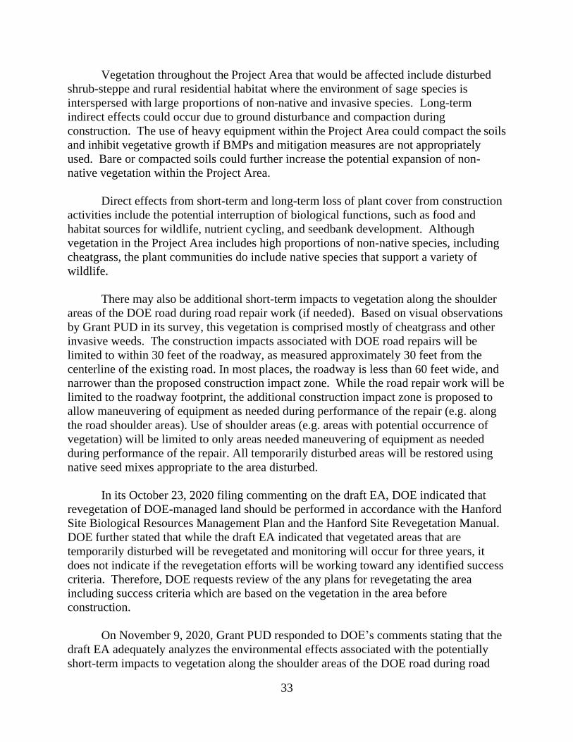
33
Vegetation throughout the Project Area that would be affected include disturbed
shrub-steppe and rural residential habitat where the environment of sage species is
interspersed with large proportions of non-native and invasive species. Long-term
indirect effects could occur due to ground disturbance and compaction during
construction. The use of heavy equipment within the Project Area could compact the soils
and inhibit vegetative growth if BMPs and mitigation measures are not appropriately
used. Bare or compacted soils could further increase the potential expansion of non-
native vegetation within the Project Area.
Direct effects from short-term and long-term loss of plant cover from construction
activities include the potential interruption of biological functions, such as food and
habitat sources for wildlife, nutrient cycling, and seedbank development. Although
vegetation in the Project Area includes high proportions of non-native species, including
cheatgrass, the plant communities do include native species that support a variety of
wildlife.
There may also be additional short-term impacts to vegetation along the shoulder
areas of the DOE road during road repair work (if needed). Based on visual observations
by Grant PUD in its survey, this vegetation is comprised mostly of cheatgrass and other
invasive weeds. The construction impacts associated with DOE road repairs will be
limited to within 30 feet of the roadway, as measured approximately 30 feet from the
centerline of the existing road. In most places, the roadway is less than 60 feet wide, and
narrower than the proposed construction impact zone. While the road repair work will be
limited to the roadway footprint, the additional construction impact zone is proposed to
allow maneuvering of equipment as needed during performance of the repair (e.g. along
the road shoulder areas). Use of shoulder areas (e.g. areas with potential occurrence of
vegetation) will be limited to only areas needed maneuvering of equipment as needed
during performance of the repair. All temporarily disturbed areas will be restored using
native seed mixes appropriate to the area disturbed.
In its October 23, 2020 filing commenting on the draft EA, DOE indicated that
revegetation of DOE-managed land should be performed in accordance with the Hanford
Site Biological Resources Management Plan and the Hanford Site Revegetation Manual.
DOE further stated that while the draft EA indicated that vegetated areas that are
temporarily disturbed will be revegetated and monitoring will occur for three years, it
does not indicate if the revegetation efforts will be working toward any identified success
criteria. Therefore, DOE requests review of the any plans for revegetating the area
including success criteria which are based on the vegetation in the area before
construction.
On November 9, 2020, Grant PUD responded to DOE’s comments stating that the
draft EA adequately analyzes the environmental effects associated with the potentially
short-term impacts to vegetation along the shoulder areas of the DOE road during road

34
repair work, if necessary. In addition, Grant PUD reiterated that the vegetation within
these shoulder areas is comprised mostly of cheatgrass and other invasive weeds, which
do not provide meaningful biological functions. Moreover, all temporarily disturbed
areas will be restored using native seed mixes appropriate to the area disturbed. Grant
PUD proposes to restore any temporarily disturbed areas along the DOE Midway
Substation Road shoulder areas in accordance with any applicable Hanford Site
management plans and manuals per any land use agreement it enters into with the DOE
for the use of the DOE Midway Substation Road.
3.7.3 Affected Environment ‒ Wildlife
Wildlife within the Project Area include a range of mammal and bird species
within the following habitat types: shrub-steppe, talus slopes, and rural-residential open
spaces. Wildlife associated with cliffs/bluffs and riparian zones may also be present in
the Project Area, although the Project Area does not include these habitat types. These
habitats, and the presence of wildlife species within them, have been influenced by
human development, particularly in the immediate vicinity of the Project Area in and
around the proposed dam location where there is increased human activity and
infrastructure development associated with the WIV and Priest Rapids Dam.
Additional wildlife species that may use upland habitats within the Project Area
for foraging, breeding/nesting, migration, or as permanent residents include: birds, such
as Swainson’s hawk (Buteo swainsonii), peregrine falcon (Falco peregrinus), golden
eagle (Aquila chrysaetos), bald eagle (Haliaeetus leucocephalus), lark sparrow
(Chondestes grammacus), vesper sparrow (Pooecetes gramineus), grasshopper sparrow
(Ammodramus savannarum), American goldfinch (Spinus tristus), California quail
(Callipepla californica), ring-necked pheasant (Phasianus colchicus), long-billed curlew
(Numenius americanus), mourning dove (Zenaida macroura), common nighthawk
(Chordeiles minor), western kingbird (Tyrannus verticalis), lazuli bunting (Passerina
amoena), and loggerhead shrike (Lanius ludovicianus); small mammals, such as shrews,
gophers, mice, and rabbits; larger mammals, such as badger (Taxidea taxus), coyote
(Canis latrans), bighorn sheep (Ovis canadensis), and mule deer; and multiple species of
snakes and lizards. State priority species that may occur within the Project Area include
ferruginous hawk (Buteo regalis), prairie falcon (Falco mexicanus), greater sage-grouse
(Centrocercus urophasianus), Chukar (Alectoris chukar), mule deer (Odocoileus
hemionus hemionus), and elk (Cervus elaphus).
In its May 17, 2019 filing, Grant PUD included documentation showing the U.S.
Army wildlife program manager for the YTC indicated that no sage grouse or raptors
(including burrowing owls) are nesting within 1.5 miles of the upstream access route.
There is one known nest of long-billed curlew in the vicinity of Cow Creek Quarry
(Leingang 2019). Cliff-nesting raptors such as peregrine falcons may be present in cliffs
near the downstream access route. The downstream access route does not provide

35
suitable habitat for burrowing owls or sage grouse, so they are unlikely to be present in
the Project Area.
Article 414 of the Priest Rapids Project license required development and
implementation of a Bald Eagle Perch/Roosting Protection Plan (Grant PUD 2009) which
includes annual monitoring and reporting measures to track bald and golden eagle
sightings, roosting areas and nesting sites within the Priest Rapids Project boundary.
During the 2019 winter surveys (January through March), there were 115 eagle
observations (112 bald and 3 golden) within the Priest Rapids Dam reservoir, the majority
of which were located on the eastern (left) shoreline areas (Grant PUD 2019). There is
also one documented bald eagle nest within the Priest Rapids Dam reservoir on Goose
Island (Grant PUD 2019). WIV residents have also observed that bald eagles typically
perch in trees just upstream from the boat basin.
Free-range horses live within the Project Area, and access fresh water at the area
of ponding near the upstream end of the existing right embankment. This group of
approximately seven to eight horses roam freely in the foothills of Umtanum Ridge and
forage in the shrub-steppe habitat. The horses sometimes use the existing corral adjacent
to the WIV.
3.7.4 Environmental Effects ‒ Wildlife
Effects to terrestrial wildlife from construction disturbance are expected in the
short-term for species occupying habitat within the Project Area as a result of direct
disturbance, increased levels of sound, and increased human presence. These
construction-related activities would cause short-term direct disturbance to habitat and
use of habitat throughout the Project Area. Affected species would be those that are
generally common within the Project Area. Wildlife such as deer, elk, coyotes, game
birds, and migratory birds may return to disturbed areas that would be revegetated once
construction is complete. Excavation for construction of the RCC dam and use of Cow
Creek Quarry would result in the permanent loss of approximately 7.7 acres of vegetated
area that may be used as habitat within the Project Area, albeit previously disturbed and
modified habitat. The ground disturbance actions would occur within shrub-steppe and
rural-residential habitat, where development of the Priest Rapids Dam, the WIV, and Cow
Creek Quarry have previously impacted the quality of habitat within the Project Area.
Permanent impacts to vegetation are expected to minimally affect wildlife species
due to the proximity of affected areas to human activities, degraded quality of areas to be
disturbed, and availability of other habitat resources in the area. As such, ground
disturbance activities within the Project Area are considered short term and are unlikely
to significantly reduce habitat quality or availability.

36
Short-term effects to the use of habitat by terrestrial wildlife and waterfowl would
also result from increased levels of sound and human activity during construction. The
higher levels of noise may disturb or displace resident or migratory wildlife. In most
cases, because construction noise would cease after 18 to 24 months, it is anticipated that
wildlife that may not have been habituated to the disturbance will eventually return. No
intentional harm, harassment, or take would occur to migratory birds such as long-billed
curlews, raptors, or burrowing owls.
Based on an eagle use surveys conducted in 2019 (Grant PUD 2019), there are
some bald eagle use areas within the anticipated noise attenuation area. Eagles using
these areas may relocate to areas outside the noise attenuation area, seeking other
available roosting/perching areas along the eastern (left) shoreline where the majority of
the 2019 observations occurred. The existing bald eagle nest on Goose Island is outside
of the anticipated noise attenuation area. Because there are other available roosting and
perching areas, and due to the short-term nature of the project’s construction, impacts to
eagles are expected to be minimal and temporary.
Mammals that may be found within the Project Area would most likely
temporarily avoid the Project Area or would adapt to construction noise and disturbance.
Habituation can occur more easily when noise is consistent; all vertebrates adapt
behaviorally and physiologically with repeated exposure and rest periods (such as
evenings and weekends) (Bowles 1995). If mammals are exposed repeatedly to the same
noisy stimulus without direct harassment, their alert and avoidance responses decline
rapidly, so that they do not unnecessarily burn energy (Bowles 1995). Elk and deer have
been found to avoid areas of construction or traffic noise when it is present, up to 0.75
miles, but return when the disturbance is absent (Bowles 1995). Some wildlife species
within the Project Area may have already become habituated to a baseline level of
disturbance, as a combination of noise and human activity within the Project Area, at
nearby agricultural sites, and as a result of military exercises at the YTC. For species that
are more mobile or have larger home ranges, it is expected that they will temporarily
avoid the Project Area.
Our Analysis
In its June 5, 2019 filing, Grant PUD provided the results of pre-construction
sensitive species survey work completed in May 2019 for previously unsurveyed sections
of the Project Area (e.g., the proposed upstream passing zones and Cow Creek Quarry).
Several species of native plans are present, and although not typically dominant, they
were significant in portions of the landscape. If any of sensitive or listed species are
identified within the work area, Grant PUD states additional avoidance measures may be
implemented. If avoidance is not possible, Grant PUD proposes to develop a project-
specific mitigation plan, consistent with land use agreements and habitat management
plans.

37
BMPs and mitigation measures applicable to managing or mitigating effects for
terrestrial resources include:
• Educating construction workers to avoid inadvertent harassment of any wildlife or
birds encountered during construction.
• Revegetating disturbed areas following construction which include restoring all
temporarily disturbed areas with native vegetation; mitigating for the permanent
loss of vegetation by enhancing areas currently void of vegetation and/or
dominated by non-native species; and periodic monitoring and maintenance of all
re-vegetated areas for a period of 3 years, which will include noxious weed
control and re-seeding as necessary to establish native species.
• Avoiding all blasting at Cow Creek Quarry during nesting season between March
1 and June 30.
• Loosening topsoil prior to revegetation and protect soil from erosion during seed
germination.
• Implementing measures to reduce risk of wildfire including use of approved spark
arresters on heavy power equipment and non-passenger vehicles traveling the
access routes and used within the construction area; use of protective ground
covers to reduce contact of hot construction equipment with dry vegetation;
removal of vegetation from active construction areas; and watering roads as
necessary to control dust .
• Equipping all vehicles with basic fire-suppression equipment including fire
extinguishers and/or shovels to reduce risk of wildfires.
In addition to the aforementioned BMPs, the short-term disturbance to vegetation
would be offset by re-seeding disturbed areas with a native seed mix upon completion of
the PRREIP, as well as implementation of mitigation measures. In general, temporarily
disturbed areas would be restored using native seed mixes appropriate to the area
disturbed. Reseeding with native plants would avoid permanent loss of vegetation and
may improve conditions because of the established presence of non-native plants.
Revegetation of disturbed areas following construction would re-establish suitable habitat
conditions for wildlife in the Project Area. We further recommend that Grant PUD
consider any applicable Hanford Site management plan, which include the Hanford Site
Revegetation Manual and the Hanford Site Biological Resources Management Plan and
comply with the terms of any land use agreement it enters into with DOE. Grant PUD
stated in its November 9, 2020 filing that it is willing to restore any temporarily disturbed
areas along the DOE Midway Substation Road shoulder areas in accordance with any
applicable Hanford Site management plans and man6-uals per any land use agreement it
enters into with the DOE for the use of the DOE Midway Substation Road. Grant PUD’s
proposed mitigation measures would address any temporary impacts to vegetation.

38
3.8 Threatened and Endangered Species
3.8.1 Affected Environment
The Project Area is within or near habitat of several threatened or endangered
species that are federally listed under the ESA. For upland project areas, Grant PUD
consulted FWS’s online Information for Planning and Consultation (IPAC) tool for a
listing of these species for environmental review which could potentially be affected by a
project. (USFWS 2018). In addition, Grant PUD consulted with NMFS on status for
West Coast Salmon (NOAA 2016) and the FWS Endangered Species database.
The PRREIP takes place within designated critical habitat for UCR spring-run
Chinook salmon, UCR steelhead, and bull trout. Critical Habitat for the UCR Chinook
salmon evolutionarily significant unit (ESU) was designated on September 2, 2005 (70
FR 52630) and became effective on January 2, 2006 and includes the active channel of
the mid-Columbia River. On September 30, 2010, FWS designated critical habitat for
bull trout throughout their United States range, which includes the main stem Columbia
River.
The small aquatic portion (water withdrawal point and potential barge haul route)
of the Project Area provides some, but very limited habitat features for rearing and
migration for UCR spring-run Chinook salmon and UCR steelhead, and maybe bull trout.
The area lacks aquatic vegetation, woody debris, and natural cover as it is used primarily
as a boat basin/moorage area/launch. The area where in-water work would occur is
characterized by armored embankment and the natural shoreline is adjacent to Priest
Rapids dam. The area does not provide substrates suitable for spawning. It is likely that
these fish travel through the project area during migration, but do not remain within the
Project Area for extended periods as rearing and forage opportunities are limited.
In the 2003 Priest Rapids Terrestrial Habitat Assessment (Framatome 2003) for
the Priest Rapids Project, the federally listed threatened plant species Ute ladies’ tresses
was identified as a species with a moderate likelihood to occur within the Project
boundary. However, its presence was not identified in a botanical survey conducted on
May 14, 2019. As we’ve said, the Project Area is characterized by dry shrub-steppe
habitat, and areas of disturbed vegetation associated with dam operations and access
roads have a low likelihood to provide suitable habitat for Ute ladies’ tresses. Suitable
habitat consists of various wetland habitats, or areas that are wet like margins of
reservoirs, irrigation ditches, irrigated meadows, or seasonal or perennial water sources
(natural or irrigated). Seasonal washes are present within the Project Area; however,
these locations are associated with existing access roads that were previously disturbed.
Further, construction will not encroach on these washes.

39
Critical habitat for the federally listed threatened species Umtanum desert
buckwheat was identified near the Project Area on the top of Umtanum Ridge. The
critical habitat designation was issued April 23, 2013 (78 Federal Register 24008) and
became effective on May 23, 2013. However, the potential for Umtanum desert
buckwheat to exist within the Priest Rapids Project boundary was previously determined
to be low due to a lack of suitable habitat, and no populations were found during the 2019
botanical survey (Salstrom and Easterly 2019).
The federally listed candidate species northern wormwood (Artemisia campestris
var. wormskioldii) has previously been located within the Priest Rapids Project boundary;
however, its presence is not confirmed within the Project Area for the PRREIP
(Framatome 2003) nor was it found during the 2019 Botanical Survey (Salstrom and
Easterly 2019). Northern wormwood habitat is restricted to basalt, cobble, and sand
within riparian areas of the Columbia River. However, there is a limited portion (within
the potential barge access route) of riparian habitat. Additional ESA-listed terrestrial
species were identified using the IPAC tool, including the Columbia Basin pygmy rabbit,
gray wolf, North American Wolverine, and the yellow-billed cuckoo. The Columbia
Basin pygmy rabbit and gray wolf are not known to exist within the Project Area.
3.8.2 Environmental Effects
The potential for effects on threatened and endangered species is likely limited to
the following ESA listed aquatic species: UCR spring-run Chinook salmon; UCR
steelhead; and bull trout and are very unlikely. Although the Project Area overlaps with
critical habitat of these three species, the proposed in-water work is minimal and is not
expected to adversely affect any of these three species. Neither UCR spring-run Chinook
salmon, UCR steelhead, nor bull trout are expected to be present for any significant
period within the boat basin due to the limited habitat resources of the existing condition.
The temporary surface water intake pump would not significantly affect water quality or
quantity, nor would it result in any change to other physical or biological features within
the boat basin.
The use of a barge to transport materials between the left and right banks of the
Columbia River could result in short-term disruption or disturbance to the migration
habitat within the Project Area. The limited duration and geographic extent of the
proposed barge access route would only result in minimal, short-term effects to migration
habitat, and no long-term effects to the species or their habitat are anticipated to occur.
Our Analysis
Mitigation measures and limiting the timing of blasting to avoid nesting season
would protect threatened and endangered species. Because of the lack of suitable habitat
and the 2019 botanical surveys which show that no threatened or endangered plant
40
species exist in the project area, Commission staff has determined there would be no
affect to Ute ladies’ tresses, Umtanum desert buckwheat, and northern wormwood. The
project would also have no effect on Columbia Basin pygmy rabbit, gray wolf, North
American wolverine, and yellow-billed cuckoo because of limited available habitat and
these species would easily avoid the area in response to human presence and noise during
construction.
Commission staff also conclude that the potential for the PRREIP to affect UCR
spring-run Chinook salmon, UCR steelhead, and bull trout is unlikely; however, because
this area is considered critical habitat, we have determined that the proposed action may
affect but is unlikely to adversely affect these species. We find that the limited duration
and small aquatic footprint of Grant PUD’s proposal would result in minimal, short-term
effects to migration habitat, and no long-term effects to species and their habitat are
anticipated to occur.
3.9 Construction Access
3.9.1 Affected Environment
The Project Area is accessed primarily by the single-lane road on top of Priest
Rapids dam, but existing primitive roads that extend downstream and upstream provide
access to a variety of users on the right bank within the Project Area. The condition,
ownership, access, and use of each of these routes varies.
The Priest Rapids Dam Road is a single lane road that runs along the top of the
existing Priest Rapids dam. This road is accessed from SR 243 on the left bank of the
Columbia River. This route is used predominantly by Grant PUD personnel and residents
of the WIV, and access is restricted and permitted by Grant PUD. This road connects to
paved ramps from the existing embankment down to the WIV, boat launch, and
surrounding areas; although locked gates restrict access to one of the ramps. The ramp
closest to the dam, the east ramp, connects directly to the paved roads within the WIV.
The west ramp continues as an unpaved, single-lane dirt road that extends downstream,
branching into two paths just beyond the developed portion of the WIV, continuing along
the Chicago, Milwaukee, St. Paul and Pacific Railroad grade. These facilities are
described as the downstream access route.
While the access across Priest Rapids dam is used frequently by the residents and
guests from the WIV for trips to and from work and school, community events, and
ceremonial activities; and by Grant PUD for operational work associated with the dam,
the approximate number of daily trips is unknown. A school bus uses this route daily to
pick up and drop off school children from the WIV. Grant PUD uses the road to access
the boat basin, fish ladder, and other monitoring equipment on the west side of the dam.

41
The downstream access route runs approximately 9 miles along existing semi-
primitive to primitive roadways between the central construction zone at Priest Rapids
dam and SR 24 near the Vernita Bridge. This access route includes portions of Priest
Rapids Road and the former Chicago, Milwaukee, St. Paul and Pacific Railroad grade,
which is eligible for listing on the National Register of Historic Places (NRHP). The
downstream access route passes through undeveloped lands, active agricultural lands
owned and operated by Simon Martinez Livestock, Inc., and is adjacent to the Midway
substation owned and operated by BPA. From SR 24, approximately the first 3.5 miles
of road are owned by DOE. The remainder of the downstream access route is owned by
Simon Martinez Livestock, Inc., which includes the portion from its orchards to the WIV
and beyond. This road is a paved two-lane road between SR 24 and the Simon Martinez
orchards, but is a single-lane primitive gravel and dirt road upstream of the orchards.
The downstream routes provide access to multiple users including: the Wanapum;
Yakama Nation; Grant PUD; Benton County Public Utility District; Benton County
Sheriff; FWS; Army; Simon Martinez Livestock, Inc.; BPA; Pacific Power and Light;
and other utility services. The DOE-owned portion of the access road is federal property
accessible to users authorized by DOE, and a gate is installed across the road to restrict
access. Other portions of the downstream access route have access restrictions (e.g.,
gates and/or access by permission or easement). Based on the configuration and width of
the downstream access route, specifically the DOE-owned portion of the road which is
paved, which is straight and generally wide enough for two-way traffic, and along with
the proposed traffic control strategy, no passing zones would be necessary to
accommodate hauling of commercially sourced aggregate. Section 3.6 of Grant PUD’s
Traffic Control Plan indicates that temporary traffic control signage will be used for
trucks entering and exiting the commercial quarry and the downstream access route.
Furthermore, as part of the local permitting process through Yakima County, the
Washington State Department of Transportation (WSDOT) was consulted and provided
comments related to requirements for all loads transported on WSDOT rights-of-way (SR
24). WSDOT also noted that Grant PUD would be responsible for keeping and
maintaining SR 24 free of any debris, and promptly cleaning up any spilled material.
Grant PUD, as part of its permit approvals via Yakima County for the PRREIP, will
adhere to these WSDOT recommendations.
The upstream access route runs approximately 7 miles between the central
construction zone at Priest Rapids dam and Cow Creek quarry along an unnamed road
located within the YTC. This section of the access route is an unimproved dirt and gravel
road that includes a portion of the Chicago, Milwaukee, St. Paul and Pacific Railroad
grade. Sections of this route are owned by Simon Martinez Livestock, Inc., and the
remainder of the route is on land owned by the Army. Generally, this segment only
supports one-way traffic and would require some minor modifications to accommodate
construction traffic and development of five passing zones to allow construction and haul
vehicles to pass along the route.

42
Access to lands around the central construction zone is generally restricted to the
Wanapum and Grant PUD staff. Use of the boat basin adjacent to the existing right
embankment upstream of Priest Rapids dam is intermittent, and is restricted to use by
Grant PUD staff, Grant PUD contractors, and residents of the WIV. A landing craft is
stored within the boat house to move a floating caisson but is used infrequently. Two
small boats are stored within the boat basin and are used occasionally. If a barge is
necessary for use in this project, Grant PUD would use barge access and landing on the
left and right banks of the Columbia River.
Grant PUD’s proposed Traffic Control Plan describes the different project access
routes and owners for various segments of these routes; identifies existing users and uses
of all proposed access routes; establishes a traffic operations plan for all access routes
during each phase of construction; and identifies a traffic control strategy to minimize
disruptions to access route owners and users. Construction for the project is expected to
last 18-24 months and occur during scheduled work hours. Work hours will occur
between 6:00 a.m. to 4:30 p.m., Monday through Saturday. Usage of access routes, SR
24, and SR 243 will vary throughout the project as different phases of construction will
require different types of transportation. Phases in construction can be broken down into:
mobilization (~3.5 months), excavation, RCC placement, secant pile wall construction,
and demobilization (~3.5 months).
In its June 26, 2020 supplemental filing, Grant PUD discusses the potential
additional post-construction repair work that could be necessary at the end of the PRREIP
to completely repair the downstream access road if the PRREIP causes damage that
cannot be remedied via the methods described in the Traffic Control Plan. Grant PUD
says that a complete repair of the DOE road would require: (1) asphalt patching of all
potholes and degrade pavement surface; (2) chip sealing of the entire roadway surface
after the asphalt repairs; and (3) seal coating of the entire roadway surface after the chip
seal has cured out (60 days or more). Construction impacts will be limited to within
approximately 30 feet from the centerline of the existing road. While the road repair
work will be limited to the roadway footprint, the additional construction impact zone is
proposed to allow maneuvering of equipment as needed during the performance of the
repair. If a complete road repair is needed after the PRREIP is constructed, this repair
work is expected to occur in two phases: patching and chip sealing occurring over
approximately seven workdays, during which access to the road may be restricted or
delayed for short periods via use of flaggers and one-way traffic and be allowed to cure
over 60 days (there will be no access restrictions during this time); and applying the seal
coat occurring over approximately seven workdays, during which access to the road may
be restricted or delayed for short periods via use of flaggers and one-way traffic
restrictions or delays for short periods via use of flaggers and one-way traffic. All phases
of work, including potential access restrictions and/or delays, will be communicated with
the roadway owners and all potentially impacted uses in accordance with the Traffic
Control Plan.

43
Any additional maintenance and repair for the Army YTC road, not already
addressed, would occur at 12 distinct sections, and includes re-grading, strengthening and
widening shoulders and corners, and excavation of material, placement of surface layers
of gravel to strengthen and/or widen shoulders and/or corners, and excavation of
sloughed material.
In its October 23, 2020 comments on the draft EA, DOE stated that the draft EA
did not analyze the use of DOE’s Midway Substation Road. DOE argued that such a
level of use would require graveled passing zones along the downstream access route,
which are not currently proposed. DOE also states that other traffic controls would be
needed when entering from State Highway 24. In addition, DOE believes that if crushed
aggregate are hauled along State Highway 24, adjacent to McGee Ranch and to the
Riverland area, which is very steep, the change in road grade could result in traffic
congestion and potential safety hazards, which may require mitigation measures that have
not been considered. Further, DOE states that the draft EA’s conclusion of minimal
impacts to the downstream access road and during road repair does not take into
consideration impacts if the downstream access route were to become the primary
route. DOE requests Commission staff revise the analysis to include these potential
impacts.
In Grant PUD’s November 9, 2020 response, it states that DOE incorrectly
assumes there would be 75 truck trips per day for the entire duration of the project. The
proposed Traffic Control Plan describes the different access routes and owners for the
various segments for the routes to be used during each phase of construction. Based on
information provided in the Traffic Control Plan, the estimated maximum number of trips
per day (up to 75) along the downstream access route would only occur during the
excavation and RCC placement phases of the PRREIP if the Cow quarry is not used for
the source of the aggregate material. Based on Table 2 in section 3.3.2 of the Traffic
Control Plan, for the remainder of the PRREIP, the anticipated trips per day ranges from
5 to 25, which is far less than the 75 trips per day or 32,000 to 43,000 total truck trips as
estimated by DOE.
3.9.2 Environmental Effects
Due to access road limitations over Priest Rapids Dam (e.g. limited road width and
tight turning radius), and concerns related to significant access impacts to the WIV, other
existing developed, semi-primitive, and primitive roadways must be used, and in some
areas improved, to accommodate construction vehicles and material transport to the
Project Area. Portions of these access routes are federally and privately owned. The
proposed Traffic Control Plan describes the different project access routes and owners for
various segments of these routes; identifies existing users and uses of all proposed access
routes; establishes a traffic operations plan for all access routes during each phase of

44
construction; and identifies a traffic control strategy to minimize disruptions to access
route owners and users.
Direct short-term effects due to construction within the Project Area would occur
as a result of construction vehicles moving to and from the Project Area, on the access
road across Priest Rapids dam, and both the upstream and downstream access routes.
Access to the boat basin would not be changed during construction; however, some
portions of the forebay may be more difficult to access if the barge is in use.
Periods of restricted access would occur at both upstream and downstream access
routes to accommodate road alterations (grading and gravel surfacing) and to
accommodate haul trucks and large construction machinery on flatbed trucks, and access
to Cow Creek quarry on YTC. Construction vehicle trips would vary depending on the
project phase but is estimated to be between 5 and 75 trips per day on the upstream and
downstream access routes, with additional short-distance trips within the central
construction zone. If Cow Creek quarry is not available as the aggregate source, crushed
aggregate material would be purchased from a commercial source and the upstream
access route would not be used. The downstream access route would serve as the
primary construction access route and would be closed to non-construction users
upstream of the Simon Martinez orchards, consistent with the Traffic Control Plan. The
duration of closures may last one or more months in duration.
If use of the upstream access route is needed, access for current users could last for
a period of several months due the hauling of material from Cow Creek quarry.
However, per the Traffic Control Plan, temporary access for hunting and root gathering
are approved since these actions are associated with currently approved existing uses of
the YTC land.
Effects to the access road across Priest Rapids dam would occur as a result of
increased traffic volumes. Traffic levels across Priest Rapids dam would increase due to
the higher number of vehicles that would require daily access to the construction site,
including construction workers, construction managers, Grant PUD staff, and vendors.
Because construction would occur during regularly scheduled work hours of 6:00 a.m. to
4:30 p.m., Monday through Saturday, effects to traffic volume are expected to be highest
around the beginning and end of the daily work period. Some staff or vendors would
require access to the construction site throughout the workday however, so a moderate
increase to traffic levels could occur at any time during work hours. Current traffic
across the dam occurs freely, without dedicated traffic control. Vehicles are occasionally
required to wait at pullouts while a vehicle passes from the opposite direction due to
limited road width. The increase in traffic volume associated with construction would
require traffic control measures and would increase waiting times to cross the dam for
both WIV residents and Grant PUD workers, particularly at the beginning and end of the
45
construction workday. No closures are proposed to the Priest Rapids Dam Road, as this
is the primary access route for the WIV.
Short-term direct effects to the upstream and downstream access routes would also
occur due to the transit of heavy construction vehicles along the upstream and
downstream access routes. Effects may include rutting, potholing, or wash boarding
across the entire length of the unpaved access routes. The thin gravel surface installed on
paved and unpaved portions of the access routes prior to construction would reduce the
effects, but the full extent of effects would depend on the frequency of travel by heavy
trucks. Mitigation measures would include post-construction restoration to assure safe
driving conditions, but the extent of restoration would be determined by the amount and
severity of impacts following construction. No new paving would occur to unpaved
sections of either upstream or downstream access routes; however, existing pavement on
the downstream access route would be restored following construction, as needed.
Short-term direct effects to access would occur during construction when a portion
of the downstream access road would be removed to accommodate RCC dam
construction. This section of road would be reconstructed around the RCC dam prior to
project closeout but would be inaccessible for the duration of the RCC dam construction
timeline. Long-term effects to access would occur due to the because Grant PUD
proposes to demolish the existing ramp that interconnect the west side of the WIV to the
existing embankment road. Grant PUD says while the ramp would not be reconstructed,
vehicles would still be able to access the WIV from the primary ramp on the northeast
side of the village and by the road atop the existing embankment where it connects to the
boat basin.
A barge route may be needed as an alternative route to transport materials to the
central construction zone. The use of a barge would not require new facilities and is not
anticipated to result in impacts to the project area.
Our Analysis
Traffic control measures such as flaggers, posted signs, and radio communication
would be provided for the upstream and downstream access routes for safety and
accessibility. Grant PUD would give advance notice of road closure dates at the
downstream access route from SR 24.
BMPs and mitigation measures applicable to managing or mitigating effects
associated with construction access include:
• Coordinating with the Wanapum on construction scheduling for the project to
ensure appropriate access is maintained to and from the WIV for the school bus
across Priest Rapids Dam, as well as for cultural and tribal events.

46
• Implementing the Traffic Control Plan with the following additional activities: (1)
maintaining regular (weekly, at a minimum) communication with all potential
users of the downstream and upstream access routes; (2) establishing construction
site access routes within the construction area such that they do not block access to
residential roads of the WIV; (3) not allowing construction traffic to enter WIV
roadways; (4) implementing speed restrictions on roads within the Project Area to
minimize wear and tear to existing roads and reduce fugitive dust emissions; and
(5) restoring any damaged road surfaces following construction.
The additional passenger car and truck traffic resulting from Grant PUD’s
proposed work would impact those who regularly use the roads near the construction
area. This primarily includes residents of the WIV and Grant PUD staff performing
routine tasks at the right side of the dam. However, Grant PUD’s proposed BMPs would
help to significantly reduce effects to other road users during construction and once the
proposed action is complete. In addition, the measures proposed in the Traffic Control
Plan would help mitigate and manage with construction access.
We also find that the environmental effects associated with repair of the DOE
roadway, minor modifications to the YTC Access Road, the addition of an alternate YTC
access route, and equipment and material storage at the Cow Creek quarry, as discussed
in Grant PUD’s June 26, 2020, supplemental filing, are expected to be minimal.
However, the Commission would require Grant PUD to file an Access Road and
Replacement Plan, if necessary, to repair and modify the DOE and Army YTC access
roads for Commission review and approval. In addition, the Commission would also
require Grant PUD to provide documentation of its consultation in the development of
the plan. This work would occur within the existing footprint of the roadway for the
DOE section of the road, up to the full depth of the roadway cross section. The existing
paved road surface will then be prepared, and chip-sealed (asphalt is applied, then coated
with gravel, before being rolled to combine the layers). Upon completion of the chip seal
coat, any loose asphalt will be swept off and after the appropriate cure time a seal coat
applied (asphalt sand mixture). Construction impacts will be limited to within 30 feet of
the roadway, and no excavation is proposed beyond the extent or depth of the existing
roadway cross section. Excavation within the roadway cross section will be limited to
one foot in depth. Construction impacts beyond the roadway footprint will be limited to
construction equipment access/staging along the shoulders of the existing road and will
not require any excavation.
Any additional maintenance and repair for the Army TTC road, not already
addressed, would occur at 12 distinct sections, and includes re-grading and placement of
surface layers of gravel to strengthen and/or widen shoulders and/or corners, excavation
of sloughed material, adding 1 to 1.5 foot diameter rock (1-man boulders) in one area
with a significant drop-off on an inside corner, and the removal of brush and vegetation
(200 square foot) along one area to allow for placement of gravel to widen an outside

47
corner. Equipment to be used for this proposed maintenance and repair work will likely
include road graders, excavators, backhoes, dump-trucks, water trucks, soil compactors,
and wheel loaders. Excavated material will be used as fill and redistributed within the
proposed maintenance and repair areas. Gravel and 1-man boulders needed for this work
will be sourced from the existing gravel and rock stockpiles at the Cow Creek quarry on
Army YTC land or via commercial source. Any additional Army YTC road maintenance
and repair work would begin as soon as practical after all necessary FERC and Army
YTC approvals are received and is expected to occur over the course of 25 working days.
Grant PUD would coordinate the schedule and traffic control consistent with Traffic
Control Plan and in close coordination with the Army YTC.
3.10 Land Use, Recreation, and Aesthetics
3.10.1 Affected Environment – Land Use
The most visible land uses within the Project Area are centered at the Priest
Rapids Dam, including Grant PUD operations and activities in and around the WIV.
Grant PUD utility operations occur at and around the dam, Priest Rapids reservoir, the
Columbia River, the boat basin, transmission lines, and other facilities and resources
necessary to support and maintain project operations.
The Wanapum use the lands immediately adjacent to Priest Rapids Dam for
residential and cultural purposes. The WIV is the residential center for the Wanapum
such that lands within and adjacent to the Project Area are used for cultural and
traditional purposes. Swimming, fishing, sledding, hiking, and hunting are central
components of Wanapum culture and are not considered recreational activities. While
precise metrics are not known, activities such as hunting, fishing, and gathering of plants
supports all residents (estimated to be approximately 40 people) of the WIV every year.
Other Native American peoples may also use the Project Area for cultural or traditional
uses.
In addition to these land uses, other users access the Project Area for a variety of
activities, as addressed in the table below. These activities occur primarily along the
downstream and upstream access routes. However, land use within the project’s
boundary is governed by a land use classification system, set forth in the project’s
approved Shoreline Management Plan (Grant PUD 2010a). The project area’s land use
classification is Project Facilities, which are primarily for purposes related to hydropower
generation, transmission, and associated project facilities.
Lands categorized in the proposed Project Facilities classification would not
exclude public use; however, public access to certain project related areas such as the
powerhouse, dam, and other project-related infrastructure would be controlled or
restricted to protect the safety of the public and to provide for project security. This

48
classification would also include education/interpretation facilities, public recreation
facilities located within or immediately adjacent to Project facilities.
Land Uses Within Project Area
Land Use Users Activities
Utility
Grant PUD, Benton County
PUD, BPA, Pacific Power and
Light
Operations and maintenance
activities
for Priest Rapids Hydroelectric
Dam, electric power lines, and
poles
Residential Wanapum Housing, Community
Gathering Spaces
Traditional/Cultural
Wanapum, Yakama Nation,
other Native American tribes
Hunting, Hiking, Walking,
Swimming, Sledding,
Plant/Root Gathering,
Ceremonial Activities
Agricultural Simon Martinez Livestock, Inc. Orchards, Livestock Grazing
Military U.S. Army Army Tactical Training
Other Operational
Uses
DOE and its contractors,
Benton County Sheriff,
USFWS
Periodic Access and Multiple
Uses in Fulfillment of
Departmental Mission
Regulations for land use within the Project Area are guided by county codes,
including zoning and the Shoreline Master Program for Yakima, Kittitas, and Benton
Counties.
Within the Project Area, there are multiple areas with restricted access. The road
across the Priest Rapids dam provides access to the right bank by permission of Grant
PUD, although residents and guests of the WIV can cross freely as the dam road is the
primary point of entry into the WIV. On the right bank of the dam, gates restrict access
at four locations within the Project Area. Two gates exist along the upper road that runs
along the existing embankment and are operated by Grant PUD personnel. A gate at the
base of the westernmost ramp limits access from the existing embankment into the WIV.
The Project Area, including the shoreline, is not accessible to the general public although
some public access may occur, including transient/day-use boating and fishing, and
potentially hiking and hunting along the mountain ridges and gullies.
3.10.2 Environmental Effects – Land Use
Short-term effects on land use would result from construction activities. Although
the project will not require any changes in land use classification or zoning, the

49
magnitude of construction issues would result in short-term disruption to existing land
uses. Noise and dust generated during construction may affect normal residential,
cultural, and agricultural land uses, either by disruption, annoyance, or other effects to the
quality of those uses.
Indirect effects to all land uses described could occur as a result of increased
traffic on existing access routes during construction. The land uses that rely on access
over the Priest Rapids Dam Road or the downstream access road would not be directly
affected but may experience delays. During construction of the PRREIP, access to these
resources would be significantly reduced along the upstream and downstream access
routes, and within the central construction zone around the RCC dam. The upstream
access route would have partial access during construction; however, access to the
downstream route would be further restricted.
While no long-term effects would occur to the land use zoning or classification,
long-term indirect effects to residential land uses could result from the construction of the
PRREIP because the footprint of the proposed RCC dam and cutoff wall would encroach
on open space on the upstream/northern edge of the WIV. Portions of finished RCC dam
and cutoff wall will be positioned approximately 300 feet from the northwest edge of the
existing homes, resulting in a reduced overall area for residential and cultural uses within
the WIV.
3.10.3 Affected Environment – Recreation
Although the Project Area does not contain official recreational uses, some
informal and unsanctioned recreational use occurs. The Project Area is bounded on the
east by SR 243 at the junction with the downstream access route. The Project Area is
bounded on the northwest, west, and south by the YTC, which is actively used for US
military training. Certain portions of the YTC are open to the public for hunting and
hiking and users must enter through the main YTC access gates, which are outside of the
Project Area. However, hikers may occasionally enter the Project Area from the
northwest. Because of the restricted access to the dam crossing road, public access and
therefore recreational use of the Project Area is limited. Further, it is Grant PUD’s policy
to permit public access, wherever possible, consistent with safety and security
considerations, to project lands adjacent project waters.
3.10.4 Environmental Effects – Recreation
Although formal, publicly authorized recreational resources do not exist within the
Project Area, lands within and adjacent to the Project Area are likely used for some
recreational activities including hiking, walking, and fishing. Indirect effects to any
recreation that occurs within the Project Area would experience the same effects to access
as other land uses, as a result of construction traffic.

50
3.10.5 Affected Environment – Aesthetics
The larger visual setting of the Project Area is the Columbia Plateau that includes
steep rocky ridges, dry rolling hills, broad agricultural fields, and the Columbia River.
There are sweeping high-quality views of this largely undeveloped landscape, including
the river and ridgelines that are mainly visible from the WIV and the dam. The only
publicly accessible viewpoints include the Wanapum Heritage Center located on the
opposite shoreline (left bank) of the Columbia River outside of the Project Area. Views
of the natural landscape from these locations are not completely intact and include views
of Priest Rapids Dam and the WIV in the foreground or middle ground.
The character of the Project Area is rural residential, contrasted with utility
infrastructure, within a natural setting. The rounded-rock armored slope of the existing
embankment is a significant visual feature within the WIV. The embankment rises 15 to
25 feet above grade and is within 300 to 500 feet away from five homes at the north edge
of the WIV. From the road on top of the west (right) embankment, views of the river and
the east bank are possible. From grade level in the WIV, views towards the northwest,
north, and northeast are impeded by the dam. Views from within WIV to the southwest
and southeast include close views of Umtanum Ridge, which are culturally significant for
the Wanapum.
Views to and from the Project Area from the left bank of the Columbia River are
partially to completely blocked by topography and by the presence of the dam. Views
towards the WIV from the dam embankment road are not blocked, but amplified, due to
the elevated position of the embankment road. Territorial views upstream and
downstream are possible due to the elevated position of the existing embankment, which
is accessible to vehicles and pedestrians that are authorized to use this road.
3.10.6 Environmental Effects – Aesthetics
Effects to aesthetic resources would occur as a result of dust, noise, active
construction activities, and the presence of large machinery throughout the Project Area.
Approximately 5 to 75 truck trips per day along both the upstream and downstream
access routes would occur during construction, in addition to short-distance trips within
the central construction zone. These effects would be visible to residents of the WIV.
Trips along the downstream access route would be visible to a lesser extent to casual
travelers where SR 24 meets the downstream access route.
Construction of the new RCC dam and secant pile cutoff wall would result in a
permanent change to the existing aesthetic resources. Views of the new RCC dam and
secant pile cutoff wall would be limited outside of the immediate project area and may
not be visible from publicly accessible areas of the left bank. For residents of the WIV,

51
the new RCC dam and secant pile cutoff wall would appear different from the existing
right embankment but are not anticipated to create a new source of light or glare.
Our Analysis
BMPs and mitigation measures applicable to managing or mitigating effects
associated with land use, recreation, and aesthetics include:
• Coordinating with potentially impacted users of the access routes in
development of Traffic Control Plan.
• Coordinating easements and other approvals required for access to and use of
lands within Project Area.
• Communicating with users of access routes on changes in accessibility for the
duration of construction, consistent with the Traffic Control Plan.
• Establishing construction site access routes within the project area such that
they do not block access to residential roads.
• Implementing the Traffic Control Plan.
• Scheduling all construction work during only daylight hours to the greatest
extent practicable to minimize effects to land use, recreation, and aesthetics.
• Sharing designs and plans with the Wanapum of the temporary walls and/or
screens that may be used to shield construction noise and activities from
residential homes.
• Sharing a schedule of construction activities with the residents of the WIV to
alert them to the types of construction activities that will be occurring adjacent
to the WIV, including details on the duration, potential impacts (e.g., noise,
dust, etc.), transportation/access restrictions, and safety considerations.
• Training workers regarding privacy and prohibiting worker entry to the WIV.
• Keeping construction areas free from debris as much as practicable.
• Working with the Wanapum to identify appropriate and aesthetically
acceptable designs to the RCC dam following completion. This could include
color stain applied to the surface of the concrete or vegetative screening to
reduce the visual contrast of the RCC dam compared to the surrounding
environment.
The short-term effects to recreation are expected to be minimal. No permanent
effects to recreation resources would result from the PRREIP. While no long-term
effects would occur to the land use zoning or classification, long-term indirect effects to
residential land uses could result from the construction of the PRREIP because the
footprint of the proposed RCC dam and cutoff wall would encroach on open space on the
upstream/northern edge of the WIV. As discussed above, construction of the new RCC
dam and secant pile cutoff wall would result in a permanent change to the existing
aesthetic resources. As for access, a Traffic Control Plan would be implemented for all

52
access routes within the Project Area and would help alleviate and mitigate effects. Site
protection fencing would also reduce access to areas of the central construction zone for
safety reasons but would be removed upon construction completion.
3.11 Cultural and Historic Resources
3.11.1 Affected Environment
The Commission, as the NEPA lead agency, must consider the effect of its federal
action on properties listed or eligible for listing in the NRHP under Section 106 of the
NHPA. Historic properties are defined as any district, site, building, structure, or object
that is included in, or eligible for inclusion in the National Register. Section 106 and the
implementing regulations under 36 CFR Part 800 also require the Commission to seek
concurrence with Washington SHPO on any finding involving effects or no effects on
historic properties. Section 106 and the implementing regulations under 36 CFR Part 800
also requires consultation with Native American tribes where Native American properties
and/or traditional cultural properties have been identified.
The Project Area is part of the traditional territory of several Native American
tribes. To account for concerns directly and indirectly related to cultural resources, Grant
PUD has been and is currently consulting with Washington SHPO, Native American
tribes, federal landowners within the Project Area, and members of the Priest Rapids
Project Cultural Resources Working Group.
Pursuant to Section 106 of the National Historic Preservation Act, as amended (54
U.S.C. 306108), and its implementing regulations at 36 C.F.R § 800.5(a)(2)(vii), we have
determined the licensee’s proposed amendment to create a separate embankment
immediately downstream of the existing Priest Rapids Dam would have an adverse effect
on historic properties. These properties are identified as the Hanford Branch Line of the
Chicago, Milwaukee, St. Paul, and Pacific Railroad; the Priest Rapids West
Embankment; and the Priest Rapids Hydroelectric Complex. In addition, the Undertaking
would impact eligible properties identified as 45BN00160, 45YA00151, 45YA00153,
45YA01720, and Wownisha, the Priest Rapids Indian Village/Wanapum community at
Priest Rapids, which is a Traditional Cultural Property.
To date, Grant PUD has consulted with Washington SHPO, Tribes, federal
landowners within the project area, and CRWG members on the Project Area, project
description, APE, cultural resources survey plan, cultural resources survey, NRHP
determination of eligibility report, and a determination of effects to cultural resources. In
addition, Grant PUD completed a technical report to facilitate section 106 consultation
regarding archaeological resources, which is discussed in the Cultural Resources
Survey and Testing for the Priest Rapids Dam Right Embankment Improvements
53
Project, Project Number 2, Grant County Public Utility District No. 2, Benton and
Yakima Counties, Washington (AHS 2019).
In coordination with the Commission, Grant PUD and the Washington SHPO have
consulted and developed a Memorandum of Agreement (MOA) to mitigate the adverse
impacts to historic properties. To satisfy these responsibilities, the Commission executed
the MOA with the Washington SHPO on January 24, 2020 and March 5, 2020,
respectively. The Wanapum signed the MOA on February 20, 2020 as an invited
signatory. The Army’s YTC, DOE’s Richland Operations Office and Grant PUD are
concurring parties to the MOA. On December 20, 2019, the Commission notified the
Advisory Council on Historic Preservation (Advisory Council) of the Undertaking and
asked the Advisory Council whether it intended to participate pursuant to 36 C.F.R.
Part 800.6. No comments were received.
3.11.2 Environmental Effects
Pursuant to Section 106 and the implementing regulation under 36 CFR Part 800,
the Commission must consider whether any historic property could be affected by the
Proposed Action within the project’s APE. The APE is defined as “the geographic area
or areas within which an undertaking may directly or indirectly cause alterations in the
character or use of historic properties, if any such properties exist” (36 CFR 800.16(d)).
The APE for the Project includes: (1) all lands within the Project Area for the
PRREIP; and (2) lands outside the project area where project construction or operation
may affect historic properties. Grant PUD has received Washington SHPO concurrence
on the determination of effects to historic properties for the PRREIP on
September 26, 2018. Washington SHPO concurs with Grant PUD’s determination of
adverse effect to the following National Register eligible historic properties: the Hanford
Branch Line of the Chicago, Milwaukee, St. Paul, and Pacific Railroad (45YA339);
Priest Rapids Dam West Embankment (HPI-666555); and Priest Rapids Hydroelectric
Complex (HPI-578097). Grant PUD’s determination of effect to historic properties are
identified in Appendix J of the amendment application and the proposed treatment for
cultural resources including National Register-eligible properties. There is a potential for
unanticipated discoveries of cultural resources and human remains during construction or
project-related activities. When this occurs, work will be halted immediately in the
vicinity of the find and sections of Grant PUD’s Historic Properties Management Plan
will be followed including 6.6.3.1 (Protocol for Unanticipated Discoveries) and 6.6.3.2
(Protocol for Discovery of Human Remains) (Grant PUD 2011).
The MOA states that the Commission would ensure the proposed mitigation is
carried out by the licensee and in consultation with the Washington SHPO. These
measures include: (1) providing monetary support for the Washington Information
System Architectural and Archaeological Records Data (WISSARD) historic district
54
enhancement interface and a paid internship; (2) restoring site within two years of
completion of construction for the PRREP; (3) monitoring and reporting on cultural
resources for unanticipated discoveries during project construction; (4) containing all
work to the identified project area boundaries to avoid effects to National Register
eligible properties identified as 45BB00160, 45YA00151, and 45YA00153, and fencing
to protect the National Register-eligible property 45YA01720; and (5) mitigating
traditional cultural properties identified by the Wanapum.
Our Analysis
When constructing the PRREIP, Grant PUD would avoid impacting known
historic properties and archaeological resources to the greatest extent possible.
Unavoidable impacts to historic properties will be mitigated for through the Section 106
process including consultation with affected agencies and tribes, as set forth in the MOA.
Along with the proposed management measures in Appendix J of the amendment
application for cultural resources, Grant PUD, in consultation with Washington SHPO,
Native American tribes, federal stakeholders and the Cultural Resources Working Group
Members, is proposing the following preventive and mitigation measures:
• Utilizing an archaeologist that meets the Secretary of the Interior’s Standards to
monitor all ground disturbing activities within the PRREIP project area
including the areas that were not previously sampled for buried cultural
deposits, such as areas of deep Holocene deposition and alluvial fans.
• Monitoring maintenance activities along the upstream and downstream access
routes by a professional archaeologist and/or cultural resource specialist.
Documenting monitoring activities in a report, submitting it for review to all
signatories and invited signatories of the MOA, and filing the final monitoring
report with Washington SHPO.
• In the event of an unanticipated discovery of cultural resources or human
remains during construction or project-related activities, halting all work
immediately in the vicinity of the find and following protocols for sections
6.6.3.1 (Protocol for Unanticipated Discoveries) and 6.6.3.2 (Protocol for
Discovery of Human Remains) of the Historic Properties Management Plan
(Grant PUD 2011).
• Conducting a landscape study to address the Yakama Nation concerns with the
cultural resources survey and NRHP eligibility report.
• Continue consulting with the Wanapum on concerns related to cultural
resources and mitigating adverse effects to cultural resources including
traditional cultural properties.

55
• Continue consulting with Cultural Resources Stakeholders (Wanapum,
Yakama Nation, Colville Confederated Tribes, and agencies) on impacts,
access, and construction schedules.
• Reviewing the Washington State Department of Archaeological and Historic
Properties Washington Information System for Architectural and
Archaeological Records Data for the PRREIP.
• Reviewing prior archaeological surveys, historic maps, and aerial photographs
In accordance with section 106 of the NHPA, Grant PUD has consulted with the
Washington SHPO and Native American tribes to determine the effects on cultural
resources due to the proposed amendment. Grant PUD’s proposal to amend its license
would adversely affect cultural resources and historic properties. Therefore, we
recommend the incorporating the MOA in any amendment order for the Priest Rapids
project to mitigate the adverse effects to historic properties. We also agreed with
utilizing the protocols in the project’s approved HPMP if there are any unanticipated
discoveries of cultural resources during project construction.
3.12 Noise and Vibration
3.12.1 Affected Environment
Noise in the Project Area includes constant ambient sound of the Columbia River
and water flowing through the turbines and spillway of the dam. Persistent noise from
regional wind patterns are also noticeable in the Project Area. Winds typically blow from
the northwest, around 8 to 10 miles per hour, with occasional strong gusts to 20 mph
(NRCS 2002). Intermittent noise in the Project Area may include project-based work at
Priest Rapids Dam (e.g., maintenance actions), vehicle sounds within the village, social
activity within the WIV, bird calls within the surrounding landscape, activities occurring at
the YTC, and airplanes overhead. The baseline noise level within the Project Area is
estimated to be approximately 50 A-weighted decibels (dBA), which is the approximate
equivalent of a quiet suburb, light automobile traffic at a distance of approximately 100
feet, or rainfall , and accounts for the combined effects of wind, river flow, airplanes
overhead, and intermittent noises from dam operations and maintenance. Noise levels
are periodically higher as a result of artillery blasts or other explosions associated with
military exercises at YTC.
3.12.2 Environmental Effects
Short-term effects to noise and vibration levels would occur as a direct result of
construction activities. Heavy construction equipment would be used in multiple
locations throughout the Project Area to perform excavation, stockpiling, fill, grading,

56
and concrete mixing. The short-term effect is an increase in the level of noise, which is
characterized by volume in dBA.
Elevated construction noise from equipment and traffic would be generated for the
duration of construction but would return to existing levels upon project completion.
Construction of the PRREIP would require sequential operations using different
combinations of equipment, each resulting in different levels of noise effects at each
phase.
The short-term noise levels are calculated to be between 85 and 91 dBA during
most of the construction phases. There are likely to be periods of more intense noise at
this range, but the noise level may not be consistent over the course of an entire workday.
Noise at levels of annoyance is anticipated to occur throughout construction. Effects of
noise would occur approximately during the work hours of 6:00 a.m. to 4:30 p.m. for the
duration of construction but may vary between these levels at different times. Work may
occur over 24-hour shifts for a limited duration. A noise reduction barrier would be
installed around the perimeter of WIV residences in the central construction zone to
reduce the effect of construction noise on the residential area. No noise abatement
measures would be implemented on the upstream or downstream access routes as these
are not adjacent to residential areas or other known sensitive receptors.
In addition to noise levels, construction equipment produces vibrations at a low
frequency, typically below 200 hertz. It is not expected that damaging vibrations would
occur as a result of construction or operations, and this effect would be short-term in
duration. Beyond this typical noise range anticipated for the PRREIP, rock blasting at
Cow Creek quarry would likely exceed the average noise level range of other
construction equipment but would occur for limited durations and on few occasions. The
frequency of occurrence and noise level is expected to be less than blasting that may be
heard from the YTC military exercises. Potential long-term effects to localized
experience of sound could occur as a result of the construction methods used for the
PRREIP. The RCC dam will include rock embankments like the existing condition, as
well as textured concrete. The different surface conditions and position of the RCC dam
may reflect sounds differently than the existing stone embankment once construction is
completed. While there is a possibility that the acoustics may be different at locations
adjacent to the completed PRREIP, the effects are expected to be similar to the existing
operating condition.
Our Analysis
BMPs and mitigation measures applicable to managing or mitigating effects
associated with noise and vibration include:
57
• Installing a temporary noise barrier, such as an echo barrier or similar, along
the limit of disturbance at the north edge of the WIV to reduce construction
noise levels within the WIV.
• Positioning stationary equipment as far from residential area the north edge of
the WIV as possible to reduce construction noise within the WIV
• Maintaining all construction equipment in good condition in order to minimize
noise generation.
• Implementing administrative controls to reduce the effect of noise, such as
setting construction work hours 6:00 a.m. to 4:30 p.m.
• Developing and distributing a schedule of construction activities to WIV area
residents.
These BMPs would limit effects associated with noise and vibration during and
after construction. With the implementation of these measures, the proposed action
would have a temporary impact on the area surrounding the project area. However, once
construction is completed, the effects of noise and vibration are expected to be like the
existing operating condition.
4.0 CUMULATIVE EFFECTS
The Council on Environmental Quality’s regulations for implementing NEPA at
40 CFR 1508.7 indicate that an action may cause cumulative impacts on the environment
if its effects overlap in space and time with the effects of other past, present, or
reasonably foreseeable future actions, regardless of the agency, company, or person
undertaking the action. Cumulative effects can result from individually minor, but
collectively significant, actions taking place over a period of time.
The scope of analysis for cumulative effects includes the past, present, and
reasonably foreseeable cumulative actions that may occur within the Project Area,
including federal and non-federal activities. The study area for cumulative effects
analysis is the same as the Project Area. The Project’s effects on most resources are
short-term, would occur on private or relatively remote lands, and are mitigated where
possible. Permanent changes will be mitigated at the project level and therefore would
not contribute to cumulative effects (e.g., effects to vegetation and wildlife will be
addressed through mitigation, and effects to cultural resources will be mitigated through
the Section 106 process).
The DOE will undertake a project between the Midway Substation and SR24
within the cumulative effects study area. This North Loop Electrical Transmission Line
Rebuild Project is planned to start at the end of 2021, and last through May 31, 2024.
Potential effects from construction of the PRREIP would be avoided and minimized
where possible. Effects would be compensated where deemed necessary for any
permanent loss; however, impacts will be mitigated at the project level (e.g., through

58
implementation of the traffic control plan) such that the PRREIP would not contribute to
cumulative loss. Indirect effects to traffic, air, and noise would occur, and based on the
potential for overlap in construction timing of separate projects, the PRREIP could
contribute to cumulative increase in traffic impacts. The Traffic Control Plan is being
coordinated with potentially affected parties and will be implemented to minimize the
project’s contribution to cumulative effects, although some incremental increase would
occur.
The greatest cumulative effect would occur as a result of construction-related
traffic; however, all construction impacts are temporary and will be minimized through
BMPs and mitigation measures. Operational maintenance projects would occur at the
Priest Rapids Dam. Activities or projects may be associated with regular maintenance or
may arise based on necessity. All activities associated with operations and maintenance
of the project are managed by Grant PUD to ensure consistency with terms and
conditions of the project’s license. Grant PUD must consult and coordinate with the
consulting parties and stakeholders regarding the construction of the PRREIP to be
consistent with Article 417, which requires that project effects to the Wanapum be
mitigated such that the cumulative impacts would not become significant.
5.0 LITERATURE CITED
AHS (Archaeological and Historical Services, Eastern Washington University), 2019,
Cultural Resources Survey and Testing for the Priest Rapids Dam Right Embankment
Improvements Project, Project Number 2, Grant County Public Utility District No. 2, Benton
and Yakima Counties, Washington. December 2018, Revised April 2019.
Bowles, 1995. “Response of Wildlife to Noise.” Wildlife and Recreationists:
Coexistence Through Management and Research. Knights, R.L. and K.J. Gutzwiller, eds.
Island Press: Washington, D.C., 1995.
Buck, Rex, Jr. (Wanapum Indian Tribe), 2003. Interview by Cynthia Kelly and
Tom Zannes (Atomic Heritage Foundation). “Voices of the Manhattan Project.”
Hanford. September 2003. Available at: https://www.manhattanprojectvoices.org/oral-
histories/rex-bucks-interview.
Ecology (Washington State Department of Ecology), 1994. Natural Background
Soil Metals Concentrations in Washington State. Toxics Cleanup Program. Publication
No. 94-115. October 1994.
Ecology, 2004. Stormwater Management Manual for Eastern Washington. Water
Quality Program. Publication No. 04-10-076. September 2004.

59
Ecology, 2010. 2010 Washington State Ambient Air Monitoring Network
Assessment. Air Quality Program. Publication No. 10-02-016. July 2010.
Ecology, 2017. 2017 Ambient Air Monitoring Network Report. Air Quality
Program. Publication No. 17-02-001. May 2017.
Ecology, 2018a. Well Reports. Last modified 2018; accessed March 22, 2018.
Ecology, 2018b. Washington State Department of Ecology Air Quality
Monitoring Website. Accessed: September 10, 2018. Available at:
https://fortress.wa.gov/ecy/enviwa/Graph.aspx.
EPA (U.S. Environmental Protection Agency), 2014. Air Quality Index: A Guide
to Air Quality and your Health. Access: December 17, 2018. Available at:
https://www3.epa.gov/airnow/airnow/aqi_brochure_02_14.pdf.
EPA, 208. U.S. EPA Air Data. Accessed: September 10, 2018. Available at:
https://www.epa.gov/outdoor-air-quality-air-data-multiyear-tile-plot
ESDWA (Employment Security Department of Washington State), 2017. Grant
County Profile. Accessed: February 23, 2018. Available at:
https://esd.wa.gov/labormarketinfo/county- profiles/grant.
FEMA (Federal Emergency Management Agency), 2005. Federal Guidelines for
Dam Safety: Earthquake Analyses and Design of Dams. May 1, 2005. Accessed: March
13, 2018. Available at: https://www.fema.gov/media-library/assets/documents/2482.
FERC (Federal Energy Regulatory Commission), 2006. Final Environmental
Impact Statement Priest Rapids Hydroelectric Project Washington. FERC Project No.
2114. FERC/FEIS-0190F. November 2006.
FERC, 2008. Public Utility District No. 2 of Grant County, Washington, Order
Issuing New License. Project No. 2114-116. April 17, 2008.
FERC, 2015. Letter to Grant PUD (Mr. Anthony Webb, General Manager)
regarding Board of Consultants for the Priest Rapids Project, FERC No. 2114. May 5,
2015.
Framatome (Framatome ANP), 2003. Terrestrial Habitat Assessment Priest
Rapids Project FERC No. 2114. Final Report. Prepared for: Public Utility District No. 2
of Grant County. January 2003.

60
Fuji, Taku, PhD, 2018. Regarding: Results. Email to: Valerie Oster (Anchor
QEA). July 26, 2018. Grant PUD (Public Utility District No. 2 of Grant County,
Washington), 2003. “Exhibit E9, Report on Geological and Soil Resources.” Final
License Application, Priest Rapids Hydroelectric Project FERC No. 2114. October
2003.
Grant PUD, 2009. Bald Eagle Perch/Roosting Protection Plan. April 2009. 130
FERC ¶ 62,054 (April 2010).
Grant PUD, 2010a. Priest Rapids Hydroelectric Project (P-2114) Shoreline
Management Plan, License Article 419. Prepared by Grant PUD and Alliance Consulting
Group. March 2010.
Grant PUD, 2010b. Priest Rapids Hydroelectric Project (P-2114) Memorandum of
Agreement between Public Utility District No.2 of Grant County and the Wanapum
Indians. October 13, 2010. 138 FERC ¶ 62,292 (March 23, 2012).
Grant PUD, 2011. Historic Properties Management Plan. Public Utility District
No. 2 of Grant County, Washington. April 17, 2011. 137 FERC ¶ 62,081.
Grant PUD (Public Utility District No. 2 of Grant County, Washington), 2019.
2019 Annual Report for the Bald Eagle Perch/Roost Protection Plan. April 2019.
Leingang, Colin (Yakima Training Center), 2019. Personal Communication with
Ross Hendrick (Grant PUD). May 10, 2019.
Ng, C.F., 2000. “Effects of Building Construction Noise on Residents: A Quasi-
Experiment.” Journal of Environmental Psychology 20: 375–385.
DOI:10.1006/jevp.2000.0177.
NOAA (National Oceanic and Atmospheric Administration), 2016. Status of ESA
Listings and Critical Habitat Designations for West Coast Salmon and Steelhead.
Accessed: September 27, 2018. Available at:
https://www.westcoast.fisheries.noaa.gov/publications/gis_maps/maps/salmon_steelhead/
crit ical_habitat/wcr_salmonid_ch_esa_july2016.pdf.
Normandeau (Normandeau Associates Inc.), 2000. An Evaluation of Water
Quality and Limnology for the Priest Rapids Project Area. Prepared for: Grant County
Public Utility District, Ephrata, Washington. Document Number R-18102.000. August
2000.
NRCS (Natural Resources Conservation Service), 2002. “Wind Rose Resources.
Weather Station: Yakima/Air Terminal.” National Weather and Climate Center.

61
Accessed: January 9, 2018. Available at:
https://www.wcc.nrcs.usda.gov/climate/windrose.html.
NRCS, 2018. Web Soil Survey. Accessed: February 15, 2018. Available at:
https://websoilsurvey.sc.egov.usda.gov/App/WebSoilSurvey.aspx.
NWA (Northwest Anthropology LLC), 2012. Wownisha Traditional Cultural
Property Site Form. On file with Wanapum Interface Office, Grant County Public Utility
District, Ephrata, Washington. 2012.
NWA, 2018. Identification of Wanapum Traditional Cultural Properties and
Determination of Adverse Effects Report for the Priest Rapids Dam Right Embankment
Improvement Project. Prepared for: Wanapum Interface Office and Grant County Public
Utility District. June 8, 2018.
Potomac-Hudson (Potomac-Hudson Engineering, Inc.), 2012. Convoy Live Fire
Range at Joint Base Lewis-McChord Yakima Training Center Environmental Assessment.
Prepared for Joint Base Lewis-McChord Yakima Training Center and U.S. Army
Environmental Command. December 2012.
Salstrom, Debora, and Easterly, Richard, 2019. Cow Creek Quarry Botanical
Plant Survey for Potential Use by Grant PUD. Prepared by Salstrom & Easterly Eco-
logic Botanical Consulting, LLC. May 14, 2019.
U.S. Fish and Wildlife Service, 2018. “Information for Planning and Consultation
(IPAC).” Environmental Conservation Online System. Accessed: September 27, 2018.
Available at: https://ecos.fws.gov/ipac/.
U.S. Geological Survey, 2017. Water-Year Summary for Site USGS 12472800.
Columbia River Below Priest Rapids Dam, Washington Year 2017. Accessed
July 31, 2018.
U.S. Geological Survey, 2017. Water-Year Summary for Site USGS 12472800.
Columbia River Below Priest Rapids Dam, Washington, Water Year 2017.
Accessed: July 31, 2018. Available at
https://waterdata.usgs.gov/nwis/wys_report?dv_ts_ids=149896&wys_water_yr=2017&sit
e_no=1247_cd=USGS&adr_water_years=2006%2C2007%2C2008%2C2009%2C2010%
2C2011%2C2012%2C2013%2C2014%2C2015%2C2016%2C2017&referred_module=
Washington Department of Fish and Wildlife, 2017. Native Resident Fish
Management Plan: Priest Rapids Project Survey and Biological Objectives Status
Report. Prepared for Public Utility District No. 2 of Grant County, Ephrata, Washington.
October 2017.

62
Washington State Department of Transportation, 2018. “Construction Noise
Impact Assessment,” Biological Assessment Preparation: Advanced Training Manual.
Version 1-2018
Western Regional Climate Center, 2016. Accessed: September 10, 2018.
Available at: https://wrcc.dri.edu/cgi-bin/cliMAIN.pl?wa9465.
6.0 LIST OF PREPARERS
Jennifer Polardino – Project Coordinator, Cultural and Historic Resources, Land Use,
Recreation and Aesthetics, and Construction Access (Historian)
Rebecca Martin – Aquatic Resources, Terrestrial Resources, and Threatened and
Endangered Species (Environmental Biologist)
Steven Sachs – Geology and Soils, Water Resources, Air Quality, Construction Access,
and Noise and Vibration (Civil Engineer)

63
APPENDIX A
Comments and responses to the Draft EA Raised by the Department of Energy and Grant PUD
Commenter Summary of Issue Response
DOE The EA proposes use of Cow Creek quarry as the
aggregate source for the project. Up to five graveled
passing zones, 25-feet wide would be placed along the
upstream access route totaling approximately 7,000
square feet. A downstream access route is also
proposed, which uses DOE’S Midway Substation
Road. Passing zones are not proposed for the
downstream access route.
• Page 13 Section 2.2.2, Second Paragraph, Last
sentence
• Page 16, Section 2.2.5, First Paragraph, Last
Sentence
• Page 40, Section 3.9.2 Third Paragraph: As
stated in these sections of the EA, if Cow Creek
quarry is not available as the aggregate source,
then crushed aggregate material would be
purchased from a commercial source and the
upstream access route would not be used.
See Section 3.9.1 of the Final EA for the
Commission’s response
DOE DOE raises concerns that the EA did not consider the
Hanford Site Biological Resource Management Plan
and the Hanford Site Revegetation Manual for the
vegetation of the distributed areas and requests to be
included in the review of the revegetation plan.
See Section 3.9.1 of the Final EA and Our
Analysis for the Commission’s response

64
DOE The Project boundary is defined as the area around the
dam; however, the proposed project includes impacts to
areas that include transportation routes. The study area,
or “region of effects,” for the EA should be more
completely identified. The only place a “study area” is
mentioned is in Section 4.0, the Cumulative Effects
section, which states it is the same as the project study
area, however, the project study area was not identified
in the EA. DOE respectfully recommends that “project
area” and “study area” be defined and used more
consistently.
Comment noted.
DOE Page 38, Second full paragraph, DOE respectfully
requests that the length of the Midway Substation Road
on DOE-managed land be corrected to “approximately
3.5 miles.”
Correction made.
DOE Page 39, Section 3.9.1 Last paragraph. DOE
commented on GCPUD’s analysis and noted that
because the period of construction is 18-24 months,
depending on the level of damage, complete repair or
replacement of the road might be necessary at any time,
not just at the end of PRREIP construction. This would
be even more likely should the downstream access route
become the primary route, if the upstream route is not
used, as stated several times in the EA and noted in the
first comment. DOE respectfully requests that FERC
make these revisions to the EA.
See Section 3.9.1 of the Final EA for the
Commission’s response.

65
DOE The conclusion in the EA is that road repair to DOE’s
road is expected to have minimal environmental effects.
Based on the previous comments, particularly with
regard to the possibility that DOE’s road may become
the primary access route if the Cow Creek Quarry is not
available, the conclusion is even less accurate. DOE
appreciates FERC adding the requirement that GCPUD
provide the Commission with a road work plan for
review and approval. DOE respectfully requests that
DOE will be included in that review and approval
process.
Comment noted.
DOE Page 49, Section 3.11.1, First full paragraph. We believe
“facilities” should be “facilitate”.
Correction made.
DOE Page 49, Section 3.11.1, Second full paragraph. There
appears to be a typo “The Army’s YTC Richland
Operations Office” among consulting parties on the
MOA. We believe it probably should read “The Army’s
YTC, and DOE’s Richland Operations Office”
Correction made.
DOE Page 54, Section 4.0 regarding the North Loop
Electrical Transmission Line Rebuild Project, please
revise the project schedule: Construction is expected to
begin toward the end of 2021. Construction will take
about two years, with an anticipated completion date of
May 2024. Road closures are expected along Midway
Substation Road when construction crews are installing
the new line and structures. SR24 is also expected to be
closed when the construction crew pulls wire across
SR24. This is a major electrical transmission line
rebuild project, and its schedule and the GCPUD’s
schedule has some overlap with potential conflict of
activities in the same area at the same time. Both
Correction made to the schedule based
upon the information filed by the DOE.
However, in our review, we find the
change in schedule would not change our
analysis or our findings.

66
projects include road and lane closures. We understand
that GCPUD intends to coordinate activities with all
parties who use the road but DOE’s North Loop
electrical transmission line rebuild project requires
particular attention because project schedules have the
potential for conflicts.
DOE General NEPA comment: DOE could adopt FERC’s
EA for DOE’s federal action of issuing a realty
instrument (a license) for use of Midway Substation
Road if the EA meets DOE’s NEPA implementing
regulations and addresses the concerns on DOE-
managed land. If, for example, the issue of DOE’s road
becoming the primary access for the project, with
attendant impacts, is not addressed in FERC’s EA, DOE
will conduct its own NEPA process. Potential damage
to the road is not just a road repair issue but would also
impact the many users of the road, including to operate
and maintain major electrical infrastructure (a major
substation and many electrical transmission lines).
Comment noted. However, the
Commission notes that as discussed in the
draft and final EAs, we will require Grant
PUD to file a plan for any additional work
for the access roads not considered in the
Traffic Control Plan. We will also require
Grant PUD to provide documentation of its
consultation with the resource agencies and
stakeholders in the development of this
plan.
Grant PUD Addressed DOE’s comments about the number of truck
trips in the draft EA.
Comments are noted and addressed in
Section 3.9.1 of the final EA.
Grant PUD Addressed DOE’s comments about passing zones.
Grant PUD DOE appears to be confused by the description of the
FERC Licensed Priest Rapids Project Boundary (as
correctly described in Section 1.1 of the draft EA) and
the description of the PRREIP Project Area in
Section 2.2 on page 12 of the draft EA, which fully
identifies all areas of the proposed PRREIP,
including the entire downstream access route.
Comment noted.

67
Grant PUD In response to the DOE’s Comment No. 4, Grant PUD
says it included this correction as part of its June 26,
2020 filing.
Correction made.
Grant PUD Grant PUD doesn’t believe additional environmental
analysis is necessary for the downstream access route.
As referenced in Section 3.9.2 (page 42) in the draft EA,
if additional road repairs are
needed that would be beyond the scale and scope of
what has been already been described and analyzed
in the draft EA, it would be required to file plan for
these additional repairs for FERC review and
approval, which would include required consultation
with DOE and other resource agencies and tribes.
Although all potential road repairs will be accomplished
as currently described and analyzed in the draft EA (and
as such would not require additional review), in the
unlikely scenario that repairs are needed
that would require methods and disturbances that are not
already described in the draft EA, it would
file for FERC review and approval its updated plan.
Comment noted and addressed in section
3.9.1 of the final EA.
Grant PUD Grant PUD concurs with the DOE-proposed
clarifications in these comments.
Correction made.
Grant PUD As described in the draft EA, Grant PUD developed a
Traffic Control Plan that includes a
communication plan (Section 3.7 of the Traffic Control
Plan) for all potentially impacted users of the
upstream and downstream access routes. This plan will
be utilized to coordinate any potential conflicts
associated with use of the Midway Substation Road. In
addition, Grant PUD understands that as the
Correction made to the schedule based
upon the information filed by the DOE.
However, in our review, we find the
change in schedule would not change our
analysis or our findings.

68
owner of the Midway Substation Road, DOE may
condition use of their road to reflect resolution of any
potential conflicts associated with use of the Midway
Substation Road. The draft EA accurately
describes the only proposed closures of the downstream
access route to be upstream, or to the north, of
the Simon Martinez Orchards, which would not include
any portion of the DOE-owned Midway
Substation Road. Furthermore, Grant PUD does not
propose to close any section of SR 24 at any time for
the PRREIP project. If the transmission line project
referenced by DOE requires closures of SR 24, Grant
PUD anticipates that the proponent of that project will
secure necessary approvals (and provide adequate
notices) consistent with applicable Washington State
Department of Transportation regulations and
guidelines. As such, and given the clarifications
provided above associated with the anticipated truck
traffic for Grant PUD’s proposal, Grant PUD does not
anticipate any significant impacts to the
implementation of the PRREIP associated with the
transmission line project referenced by DOE.