final report - hawaii
TRANSCRIPT
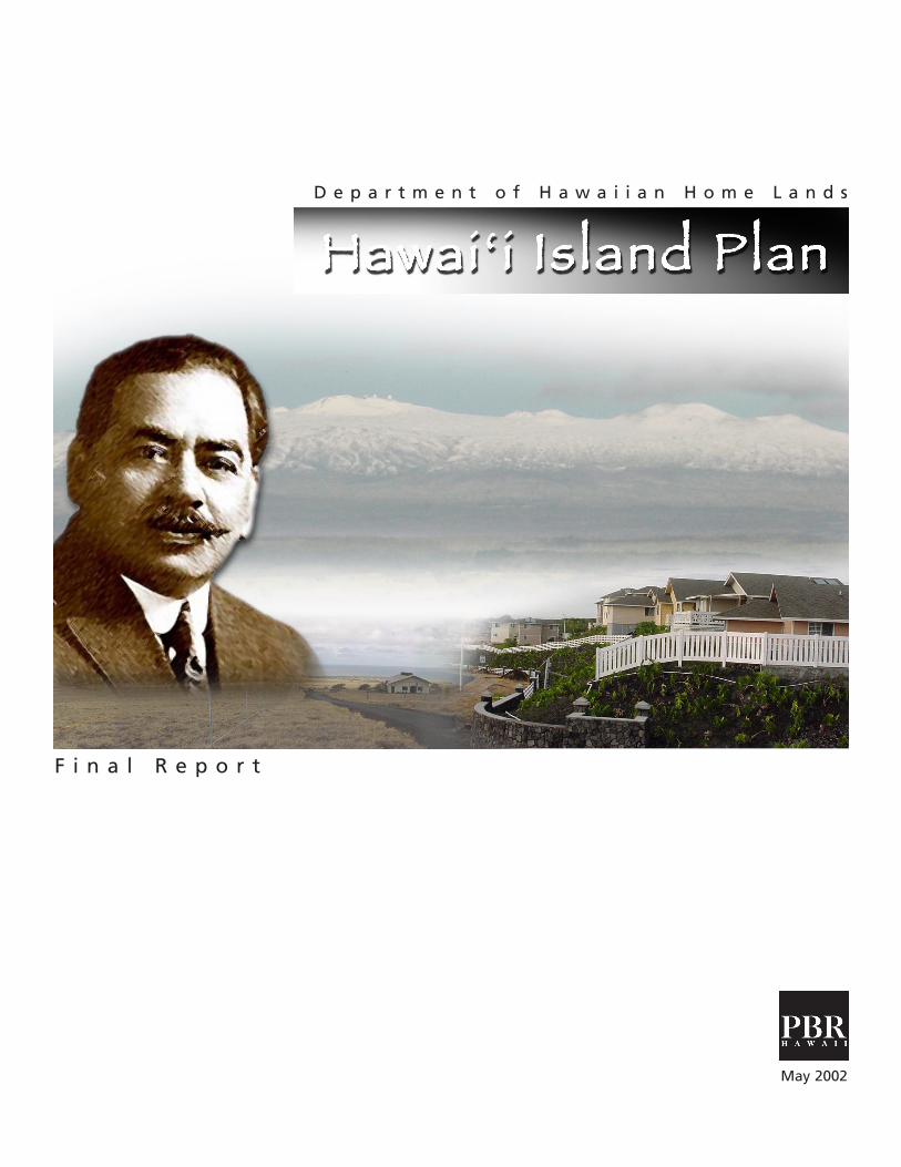
D e p a r t m e n t o f H a w a i i a n H o m e L a n d s
F i n a l R e p o r t
May 2002

The Department of Hawaiian Home Lands
HAWAI’I ISLAND PLAN
Final Report
Prepared by
PBR HAWAII Pacific Tower, Suite 650
1001 Bishop Street Honolulu, Hawai’i 96813
(808) 521-5631 [email protected]
May 2002

Table of Contents
CHAPTER 1.0 INTRODUCTION................................................................................ 1
1.1 BACKGROUND ..................................................................................................... 1 1.2 THE DEPARTMENT OF HAWAIIAN HOME LANDS ........................................................ 2 1.3 BENEFICIARIES ...................................................................................................... 4 1.4 THE ISLAND OF HAWAI’I: AN OVERVIEW................................................................. 4 1.5 THE HAWAI’I ISLAND PLAN .................................................................................... 6
CHAPTER 2.0 SUMMARY LAND USE ANALYSIS....................................................... 9
2.1 OVERVIEW OF THE LAND USE ASSESSMENT PROCESS .................................................. 9 2.2 SUMMARY DESCRIPTION AND ANALYSIS BY REGION ................................................ 11
North Region .......................................................................................................... 11 East Region ............................................................................................................. 16 South Region .......................................................................................................... 23 West Region ........................................................................................................... 25 Central Region ........................................................................................................ 27
CHAPTER 3.0 PRIORITY TRACT SUMMARY ANALYSIS .............................................. 29
3.1 NORTH REGION PRIORITY TRACTS......................................................................... 30 Lälämilo.................................................................................................................. 30 Honokaia................................................................................................................ 31 Honokaia................................................................................................................ 32 Honokaia................................................................................................................ 33
3.2 EAST REGION PRIORITY TRACTS ............................................................................. 34 Pana’ewa ................................................................................................................ 34 Lower Pi’honua....................................................................................................... 35 Lower Pi’ihonua...................................................................................................... 36
3.3 SOUTH REGION PRIORITY TRACT ........................................................................... 37 Wailau.................................................................................................................... 37
3.4 WEST REGION PRIORITY TRACTS ............................................................................ 37 Kealakehe ............................................................................................................... 37 Kalaoa .................................................................................................................... 38
3.5 CENTRAL REGION PRIORITY TRACT......................................................................... 39 Humu’ula-Upper Pi’ihonua..................................................................................... 39
CHAPTER 4.0 FINAL LAND USE RECOMMENDATIONS ........................................ 41
4.1 PHASE ONE RECOMMENDATIONS.......................................................................... 43 4.2 PHASE TWO RECOMMENDATIONS ......................................................................... 43 4.3 CONCLUSION..................................................................................................... 44

List of Figures
Figure Description Follows page
1 Hawai’i Island land Inventory...........................................................6 2 Area Preference for Residential Awards ............................................9 3 North Hawai’i Land Inventory ........................................................11 4 East Hawai’i Land Inventory ...........................................................16 5 East Hawai’i 2 Land Inventory ........................................................16 6 East Hawai’i 3 Land Inventory ........................................................16 7 South Hawai’i Land Inventory ........................................................23 8 West Hawai’i Land Inventory .........................................................25 9 Central Hawai’i Land Inventory ......................................................27 10 Lälämilo Tract ................................................................................30 11 Honokaia Tract ..............................................................................31 12 Pana’ewa Tract...............................................................................34 13 Lower Pi’ihonua Tract ....................................................................35 14 Wailau Tract ..................................................................................37 15 Kealakehe Tract..............................................................................37 16 Kalaoa Tract ...................................................................................38 17 Humu’ula Pi’ihonua Tract ..............................................................39
CHAPTER 1.0 INTRODUCTION This report provides summary description and evaluation of current Department of Hawaiian Home Lands (DHHL) holdings on Hawai’i Island,1 and presents land use plans developed to meet DHHL beneficiary needs. These are necessary components of the DHHL Hawai’i Island Plan, developed to guide award of lands to “native Hawaiian” 2 beneficiaries on the Big Island. The project was undertaken per Section 213(e) of the Hawaiian Homes Commission Act (HHCA), which authorizes planning studies to provide the basis for identifying preferred DHHL land uses and appropriate management strategies for those lands. This introductory chapter provides background information about DHHL, describes the scope of the Hawai’i Island Plan, and reviews the methods used to develop relevant plans and planning recommendations. 1.1 BACKGROUND By the early 1900s, Native Hawaiians had already endured some 125 years of social change following contact with European explorers, missionaries, and entrepreneurs. The changes were devastating for a society that emphasized a deep relationship with the land and sea rather than with the market economy that dominated life in Europe and the United States. Newly introduced disease had taken many thousands of lives, and many Hawaiians struggled for mere survival under the new economic order. Such was the state of affairs when in 1919 Prince Kuhio Kalaniana’ole encouraged the U.S. government to adopt a policy of ‘aina ho’opulapula or “restoration [of Native Hawaiians] through the land.” Prince Kuhio and Territorial Senators Wise and Shingleton eventually led the U.S. Congress in passing the Hawaiian Homes Commission Act (HHCA) in 1921, which provided a homesteading program for “native Hawaiians,” defined as “any descendant of not less than one-half part of the blood of the races inhabiting the Hawaiian islands previous to 1778.” The HHCA designated certain public lands on five major islands as “Hawaiian home lands” and placed them under the jurisdiction and control of the Hawaiian Homes Commission (HHC) with the intent of rehabilitating needy native Hawaiians. Unfortunately, a political compromise diminished native Hawaiian interests in favor of sugar interests. This led to prime agricultural lands in the Territory being excluded from the Home Lands designation. Originally, only certain lands on Hawaiÿi and Molokaÿi were opened for homesteaders. But as the program began to prove successful, lands on O’ahu, Maui, and Kaua’i were opened for use under the Act. As a federal condition allowing Hawaiÿi to become a state
1 The phrase “Hawai’i Island” is frequently used to describe the Island of Hawai’i. “The Big Island” is also commonly used. The terms are used synonymously and alternately throughout this report. 2 In this report, a lower case “n” is used in the phrase “native Hawaiian” when referring to Hawaiian Homes Commission Act beneficiaries, who by definition must be 50 percent Hawaiian ancestry in order to qualify. The upper case “N” is used when the phase more generally describes persons with any percentage of Hawaiian ancestry, as for federal programs regarding health and education.

in 1959, the HHCA was adopted as a provision of the Hawaiÿi State Constitution. The State Legislature created the Department of Hawaiian Home Lands (DHHL) in 1960 to manage the Hawaiian home lands and administer the provisions of the HHCA. Various lands were misused or withdrawn by the State of Hawai’i and the federal government during the course of the homestead program. In order to restore the original scope and intent of the HHCA, the State of Hawaii signed a Memorandum of Understanding (MOU) in 1994, specifying payment of $600 million at $30 million per year over a period of twenty years into the “Hawaiian Home Lands Trust Fund.”3 The MOU also specified transfer of 16,518 acres of public lands into the Hawaiian home lands trust. When the transfer is complete, the trust will contain total holdings of 203,500 acres, as originally specified by the HHCA. As of June 30, 2001, the statewide inventory exceeded 200,000 acres: Hawaii Island (116,963 acres), Kauai (20,211 acres), Maui (30,962 acres), Molokai (25,386 acres), Lanai (50 acres), and Oahu (7,014 acres). In 1995, President Clinton signed the Hawaiian Home Lands Recovery Act. This established a means through which the federal government is conveying surplus lands to DHHL that are equal in value to Hawaiian home lands previously improperly taken or used by the federal government (DHHL 1997). The HHC continues to establish and administer the policies of the Department of Hawaiian Home Lands (DHHL). As Trustee, it is charged with using reasonably prudent care and skill in overseeing the management of land and other assets to best serve the interests of native Hawaiians. 1.2 THE DEPARTMENT OF HAWAIIAN HOME LANDS The primary means by which DHHL promotes the well-being and economic self-sufficiency of its beneficiaries is the 99-year homestead lease. These are provided for residential, agricultural, or pastoral uses for an annual lease fee of one dollar. While about 7,000 native Hawaiian households occupy homestead lands, some 30,000 applications are on file for the full range of residential, agriculture, and pastoral awards. Given that a qualified applicant may apply for two award types, it is estimated that the total number of individual applicants is about 18,000. Awardees must make financial arrangements for home construction and/or agricultural and ranching activity on awarded lands. These arrangements may be made through DHHL since it offers direct loans or loan guarantees for home construction and renovation, and development of farms and ranches. The agency also offers technical assistance to farmers and ranchers, and assistance in the operation of water systems.
2
3 The Governor’s Task Force on DHHL Land and Related Claims involves the Department of the Attorney General, the Department of Hawaiian Home Lands, the Department of Land and Natural Resources, and the Office of State Planning.

In addition to administering the homesteading program, DHHL is authorized to lease land and issue revocable permits, licenses, and rights-of-entry for lands not in current homestead use. Revenues from lands used for commercial, industrial, and other income-producing purposes support administration of the homestead program. During the mid-1980s, DHHL established a program for accelerating lease awards regardless of applicants’ qualifications to finance home construction or agriculture uses. Subsequent evaluation of the program revealed that most accelerated award recipients sought land on the Big Island, reported slightly lower incomes than other applicants, and were three times less likely than other recipients to have started home construction or agricultural activities on awarded lands. Awardees typically reported financial reasons for not initiating home construction, and a lack of readiness to begin farming. DHHL continues to fulfill its mission to manage the Hawaiian Home Lands trust effectively, and to develop and deliver land to Native Hawaiians. In recent years it has also initiated new programs to serve beneficiaries, such as the “self-help” home project on the Big Island. This program enables awardees to work together to build homes themselves, in exchange for affordable mortgage rates. DHHL has also completed new projects on Oahu, including multi-family, kupuna, and rent-to-own projects. DHHL is hopeful addition of new lands to its inventory will lead to additional innovative projects in the future. In terms of its permanent work force of 118 allocated positions, DHHL is one of the smallest of the eighteen executive departments comprising State of Hawai’i government. Yet it is responsible for administering 200,000 acres of land on six islands, more than 7,000 homestead leases, and tens of thousands of lease applications. Despite a tremendous workload, DHHL has been able to lease for homesteading more than 27,000 acres of land on Hawai’i Island alone. DHHL uses a General Plan to help organize and streamline its efforts. A new General Plan has been formulated, with ten-year interim planning goals and objectives guiding DHHL efforts. With respect to Hawai’i Island, DHHL’s planning objectives for the next 20 years include the following:
• Designate all Hawaiian home lands within one of the land use categories specified under the General Plan;
• Deliver at least 2,920 Residential homestead opportunities, or an average of
146 per year;
• Plan for at least 1,300 Agricultural lots (average 65 per year) and 440 Pastoral lots (average 22 per year); and
• Use less than one percent of the land for income purposes.
3
1.3 BENEFICIARIES Beneficiaries of the Hawaiian Home Lands trust include only those “native Hawaiians” who can demonstrate at least 50 percent Hawaiian blood quantum. In 1984, the Office of Hawaiian Affairs enumerated 80,953 people statewide meeting this criterion. Of these, 8,784 were living on the Big Island. A study of beneficiary characteristics conducted in 1995 revealed that homestead applicants were in many ways unique relative to other sub-populations in Hawai’i. For example, applicants report relatively higher rates of marriage, higher likelihood of living with their children even at advanced age, and higher incidence of renting their homes. As of June 2001, about 42,040 of the approximately 200,000 total acres of Hawaiian home lands were in homestead use statewide. About 23 percent of DHHL holdings on Hawai’i Island were being homesteaded. Big Island lands were divided between 494 agricultural, 277 pastoral, and 1,277 residential leases. There were 5,588 applicants waiting for agricultural lands, 1,353 waiting for pastoral lands, and 4,864 waiting for residential lands on the Big Island. The fact that leases have been awarded does not mean those parcels are being used. In fact, analysis of land use patterns suggests a relatively large number of leases are not currently being used across the Islands. About 76 percent of DHHL residential lots are occupied statewide, and 53 percent of agricultural/pastoral lands are being used. The results of a phone survey conducted by DHHL in 1995 indicate that the primary reason lessees are not currently using the land relates to constraining financial situations. Numerous respondents reported that the land in question did not have sufficient infrastructure in place for them to use their leases. 1.4 THE ISLAND OF HAWAI’I: AN OVERVIEW The Hawaiian Islands are one of the most remote island chains on earth. Hawai’i Island is the largest in the chain. Compared to the other islands in the archipelago, Hawai’i was formed relatively recently. Kohala, its oldest mountain, was formed only 430,000 yeas ago. Hawai’i’s origins are volcanic and the landscape is dominated by five large volcanoes, the highest of which is Mauna Kea at 13,796 feet above sea level, followed by Mauna Loa at 13,677 feet, Hualälai at 8,271 feet, Kohala at 5,480, and Kïlauea at 4,093. Mauna Loa and Kïlauea are still active today. Mauna Kea and Mauna Loa are by far the tallest mountains in the world when measured from seafloor to summit. The “Big Island” is aptly named as it includes a land area of 4,028 square miles, twice the size of all the other Hawaiian Islands combined. Hawai’i is eastern-most in the archipelago and includes the southernmost point in the United States at Ka Lae or South Point in Ka’ü District. A variety of environmental and micro-climactic conditions characterize the Big Island. There are twelve climactic zones. Very wet rain forests are characteristic of the eastern
4
slopes, with very dry coastal lowlands along the western side of the island. The average daily temperature range is considerable, with 71.2 degrees Fahrenheit the average in Hilo, and about 37 degrees on the summit of Mauna Kea. Rainfall also varies considerably, with an average annual rainfall at Hilo airport of 131 inches, and 10 inches annually near Kawaihae. Resorts and most residential areas are scattered around the lower elevations of the island. Most of the interior and higher elevations remain untouched. Much of the land that is being used on the Big Island is ranch or farm land. The ranching tradition goes back more than 150 years when Parker Ranch was first established. This remains the largest privately-owned ranch in the United States. Hawaiÿi Island is contained by some 266 miles of coastline, much of it steep cliffs and lava outcroppings. The island continues to expand. The last eruption of Kilauea began in 1983 and continues today. This eruption has covered 38.5 square miles of land thus far. The last eruption of Mauna Loa began in 1984 and while lasting only 22 days, it covered around 11 square miles of land with new lava. Mauna Loa erupts an average of once every five years. The most densely populated of Hawai’i Island’s nine political districts is South Hilo, with 113.2 persons per square mile. Hilo is the seat of government, a gateway to the Hawaiÿi Volcanoes National Park, and home to the University of Hawaiÿi at Hilo. Other highly populated areas include Puna District, North Kona District, and North Kohala District. Population densities correlate with the three cities/towns on the island: Hilo, Kailua-Kona, and Waimea. Hawai’i Island is highly suitable for expansion of DHHL programs and projects. It has a strong county government that is caring and supportive of efforts to improve conditions for Native Hawaiians. Through aggressive diversification, the economy has recovered from the closing of sugar plantations. Growth has been slow but steady in most sectors. Most jobs are provided in the retail sector, followed closely by employment in government and tourism. The population of Hawai’i Island increased 23.6 percent between1990 and 2000, with 148,677 persons resident in 2000. This growth rate is expected to continue through 2010. The per capita personal income on the Big Island was $9,147 in 1997, lower than any of the other counties in the State. However, the cost of living is also less in most areas. For instance, the resale price for single-family homes in 1998 was $159,000 on Hawai’i Island, as compared to $265,000 statewide in 2000. The vastness of the Big Island lends to tremendous diversity in climate, opportunities for land use, and lifestyle preferences, among many other factors. Diversity undoubtedly lends to its attractions for homestead applicants. More than 11,000 (one of every three applications) is on the DHHL Hawai’i Island waiting list.
5

1.5 THE HAWAI’I ISLAND PLAN This Hawaiÿi Island Plan provides DHHL with a comprehensive assessment of its 116,963 acres on Hawaiÿi Island, including approximately 9,000 acres of lands acquired from the State as a result of the 1994 MOU. The Hawai’i Island holdings are depicted in Figure 1. DHHL records indicate that as of November 2000, a total of 11,755 applications were on file for homestead awards on the Big Island. An applicant survey completed in January 2001 for the purposes of the current project indicates demand may be as high as 13,264, including 5,114 residential, 6,018 agricultural, and 2,132 pastoral awards (Table 1.1 below). Table 1.1: Beneficiary Interest in Award Types, 2000
Type of Award Residential Agricultural Pastoral
Applicants Registered 4,916 5,520 1,319 No longer interested in this type of award* 143 348 69 Newly interested in this type of award** 341 846 882
Net change in award type + 198 + 498 + 813 Total awards sought, 2000 5,114 6,018 2,132
* Respondents on record as applicants for but no longer interested in specific award type. ** Respondents indicating interest in, but not on record as applicants for specific award type. Source: SMS Research The goal of the Hawai’i Island Plan is to assess and recommend future uses for Hawaiian home lands. A five-component planning design was used to meet this goal. These are: (1) baseline analysis of existing physical environmental conditions and beneficiary preferences, (2) preliminary identification of appropriate land use based on those conditions and preferences, (3) community input and participation on the draft land use plan, (4) pre-final land use evaluation, and public commentary on that evaluation by region, and (5) final land use analysis and recommendations. Assessment of environmental conditions on DHHL Big Island lands is based on review of existing technical and planning materials, site visits, and various geo-spatial analyses. Extensive field assessment and interaction with local government officials enabled assessment of existing service and physical infrastructures, and identification of new infrastructure needs for future development. Examination of existing social, economic, and demographic conditions was based on U.S. census data, the Native Hawaiian Data Book, and select variables collected through a survey of beneficiaries (SMS 2001). The beneficiary survey itself used a mail-back method to identify and analyze beneficiary preferences, leaseholder perspectives, and key socioeconomic characteristics of both applicants and current leaseholders.4 Initial land use recommendations were put before interested groups of beneficiaries and leaseholders for input, and revised appropriately. Pre-final land use plans were also presented for public commentary, and revised with due respect to various opportunities, constraints, and conditions unique to each tract. 4 The survey was mailed to 6,000 award applicants and 1,875 resident leaseholders on the Big Island, with a response rate of 19.4 and 21.7 percent, respectively.
6

���������� ��������
������������������������������������������������������������������������������������������
��������
���������������������������������������������������� � ��������������
�������������������� ���� ����
��������������������������
������������� ����
������������� � ����
����������������
����������������
������ ���������
�������� � ����
������� ����� ����
���������� ���������
���������� ����
������������ ����
�������� �������
�������� � ����
�������������� � ����
���������������������
�����������������������
�������� � ����
���������� � ����
������ ���������
����������������
�������������������
��������������� ��������
������������������������������������������������������������������������
���������� � �� �
�����������!����������
��������������
������������ �����
������������� �����
��������� ��� ����
���
����
�������
��"!������
��"!������
#��!������
#��!������
#��!��������
��"!��������
�����������
���������
�����������
���������
�����������

Baseline information was analyzed and summarized in a Preliminary Assessment Report. A Land Use Report examined homesteading and other potential land use options for each tract, with associated development costs and management considerations. A special Water Assessment provided water resource development options on a tract-by-tract or regional basis, as appropriate. The County of Hawai’i General Plan (CHGP) defines comprehensive long-range planning policy for future development on the Big Island. While the CHGP does not directly and legally relate to DHHL properties, it is highly valued as a policy document guiding development on those lands.5 The Hawai’i Island Plan is one component of a comprehensive, multi-tiered DHHL planning process. A statewide 20-year DHHL General Plan guides the entire program from the first tier. More specific statewide three to six year Strategic Program Plans work in conjunction with 20-year Island Plans to guide DHHL actions from the second tier. The third tier of planning is comprised of yet more specific ten-year Development Plans that guide activities in undeveloped areas, and Homestead Community Plans that guide planning in existing communities, also over ten-year periods. An Evaluation Program enables feedback assessment of the entire DHHL planning system. Land use category options are proscribed in the new DHHL planning system framework. These are as follow in Table 1.2 below. Table 1.2: Proposed Land Use Designations
Proposed Use Setting/Intent/Purpose Lot Size Minimum Infrastructure
Residential Residential subdivisions built to County standards in areas close to existing infrastructure. Residential waiting list.
< 1 ac. Potable water, all utilities, paved roads
Subsistence Agriculture
Small agriculture/aquaculture lots. Marginal to good lands. Lifestyle areas intended to allow for home consumption of agricultural products. Occupancy required. Agriculture waiting list. Close proximity to existing infrastructure.
< 5 ac. Water (catchment or surface) and Road access (unpaved)
Supplemental Agriculture
Large lot agriculture/aquaculture. Marginal to good lands. Location not dependent upon existing infrastructure. Commercial level agriculture activity allowed. Intended to provide opportunities for agricultural production for supplemental income and home use. Occupancy optional. Agriculture waiting list. Farm plan required - 2/3 cultivation.
< 40 ac. Water (catchment or surface) and Road access (unpaved)
7
5 Like the Hawai’i Island Plan, the County General Plan is currently in the process of being updated.
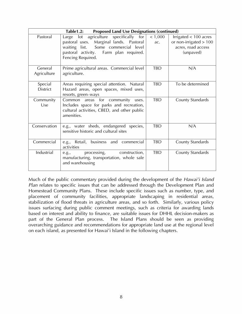
Table1.2: Proposed Land Use Designations (continued) Pastoral Large lot agriculture specifically for
pastoral uses. Marginal lands. Pastoral waiting list. Some commercial level pastoral activity. Farm plan required. Fencing Required.
< 1,000 ac.
Irrigated < 100 acres or non-irrigated > 100
acres, road access (unpaved)
General Agriculture
Prime agricultural areas. Commercial level agriculture.
TBD N/A
Special District
Areas requiring special attention. Natural Hazard areas, open spaces, mixed uses, resorts, green–ways
TBD To be determined
Community Use
Common areas for community uses. Includes space for parks and recreation, cultural activities, CBED, and other public amenities.
TBD County Standards
Conservation e.g., water sheds, endangered species, sensitive historic and cultural sites
TBD N/A
Commercial e.g., Retail, business and commercial activities
TBD County Standards
Industrial e.g., processing, construction, manufacturing, transportation, whole sale and warehousing
TBD County Standards
Much of the public commentary provided during the development of the Hawai’i Island Plan relates to specific issues that can be addressed through the Development Plan and Homestead Community Plans. These include specific issues such as number, type, and placement of community facilities, appropriate landscaping in residential areas, stabilization of flood threats in agriculture areas, and so forth. Similarly, various policy issues surfacing during public comment meetings, such as criteria for awarding lands based on interest and ability to finance, are suitable issues for DHHL decision-makers as part of the General Plan process. The Island Plans should be seen as providing overarching guidance and recommendations for appropriate land use at the regional level on each island, as presented for Hawai’i Island in the following chapters.
8

CHAPTER 2.0 SUMMARY LAND USE ANALYSIS The Hawai’i Island Plan and associated analyses are organized in terms of DHHL holdings in each of five regions identified for Hawai’i Island. These are termed the North, East, South, West, and Central regions, as previously depicted in Figure 1. The North Region includes parts of North and South Kohala, and Hamakua Districts. The East Region encompasses parts of both South Hilo and Puna Districts. The South Region contains parts of Ka’ü District. The West Region includes parts of North and South Kona Districts. Finally, the Central District encompasses parts of South Kohala, and South Hilo District, but is primarily comprised of land in Hamakua District. This chapter summarizes the findings and analyses that have contributed significantly to the land use plans developed for each of the five regions. 2.1 OVERVIEW OF THE LAND USE ASSESSMENT PROCESS The baseline analysis summarized in the following sections has multiple objectives. First, it identifies applicant preferences for most desirable area of homestead award. Second, it examines the critical constraints and opportunities for each of the DHHL land parcels on Hawai’i Island. Third, it identifies the most appropriate uses and configuration of uses for those lands given significant constraints and opportunities. Finally, it identifies tracts most suitable for priority development given environmental factors, appropriate uses, and the DHHL mission to address beneficiary needs as carefully and expeditiously as possible. This entire process constitutes the initial generalized phase of land assessment and planning for the DHHL holdings on the Big Island The Hawai’i Island Plan focuses primarily on four land use designations: (1) Residential, (2) Subsistence Agriculture, (3) Supplemental Agriculture, and (4) Pastoral. With respect to prospective lease holders, some 58 percent of all DHHL applicants seek pastoral or agricultural awards. Of these, 81 percent desire to work the land in a way that either supplements their income (supplemental agriculture), or provides additional food for the household (subsistence agriculture). Some 39 percent seek residential awards. The vast majority of applicants of all types plan to live on the land once awarded. With respect to region of preference for residential awards on Hawai’i Island, the East Region was most popular, with 33 percent of applicants preferring this region, followed closely by the North Region at 25 percent (see Figure 2 below). About 17 percent of applicants preferred the West Region, three percent chose the Central Region, and another three percent preferred the South Region. Based on these preferences, 964 residential lots were allocated in the East Region, 730 lots in the North Region, 496 lots in the West Region, and 88 lots in both the South and Central Regions. Once lots were allocated, various factors were assessed to identify the optimal tracts and geospatial plan for optimal use of tracts for potential residential, agricultural, and pastoral uses. Among the most critical factors indicative of tract-specific opportunities and constraints are: (1) slope of terrain, (2) local soil conditions, (3) annual rainfall and water availability, (4) access, (5) proximity to existing infrastructure, and (6) parcel size. 9


Slope is critical in the analysis given that steep slope and rough terrain are characteristic of many areas on the mountainous Big Island and can render construction and agricultural activities problematic. Minimal slope, on the other hand, is highly valued and suitable for all uses as long as the land in question is sufficiently drained. Soil conditions vary dramatically across the DHHL regions and tracts. Much of the Big Island and parts of DHHL holdings are very rocky, while other areas contain very fertile soil. Soil is highly significant in planning and design phases since suitable soil conditions can make infrastructure development and construction either very difficult or relatively easy, and agriculture either an appropriate and potentially successful endeavor, or one to be avoided. Hawai’i Island is unique in its unparalleled degree of ecological diversity. This is related in large part to variability in rainfall and associated factors such as altitude and disposition to trade wind flow. Water availability and rainfall are closely associated planning considerations for all potential land uses on DHHL parcels. The former is needed for all uses, and the latter is, of course, a key to successful agriculture. Access and proximity to existing physical and service infrastructure are also critical factors in land use planning, and particularly so given that many DHHL tracts are relatively difficult to access and remote from existing services. Development of new infrastructure is costly, and thus development of new homesteads of all types is more feasible where linkages can be made to existing roads, water, sewer service, electricity, and other services. Size of tracts and parcels as a criterion for development is directly related to access and infrastructure issues. This is because it is cost-effective to maximize the size and density of development since the cost of linking to existing access and infrastructure, or developing new access or infrastructure is high relative to the cost of on-site development itself. Thus, with regard to residential development, for instance, it makes more sense to initiate development on tracts of land with high potential for numerous households than on land that can support fewer homes. Proximity of tracts to urban and town centers is also an important consideration in the analysis since prospective residents inevitably require access to various amenities and services such as shopping, cultural venues, health care, and so forth. While some of the tracts are close to such areas, others are not. Again, because the costs of providing such amenities and services are significant and private sector provision of these in the future is uncertain, it is cost-effective to prioritize development where such services already exist, or where the potential for new amenities and service development is economically feasible. Soil productivity and foraging capacity of lands are important when considering farming or ranching operations. The “carrying capacity” of DHHL lands potentially used for pastoral purposes is defined here as the number of animal units an area can support over
10

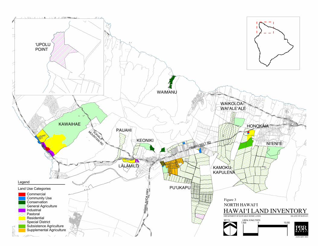
time without injury to local soils, forage resources, tree growth, watershed capacity, or other land use potential. The phrase “animal unit year” refers to the number of animal units that can graze for one full year on a given piece of land without causing such injury to the land. Thus, the index is expressed in number of acres per one animal unit year. 2.2 SUMMARY DESCRIPTION AND ANALYSIS BY REGION North Region A total of nine tracts of available land were examined for potential use in the North Region (Figure 3). The following summarizes each of these in terms of the most important opportunities and constraints on which decisions about potential land use recommendations are made. Based on objective assessment of land use potential, and subsequent public comments on the assessment, Lälämilo and Honokaia Tracts have been identified as most suitable for priority planning and development in the North Region. Description of Lälämilo and Honokaia is presented first, followed by the remaining seven non-priority tracts. The descriptions are brief, and intended to provide the reader with a general sense of the variable conditions across the region and tracts. Chapter Three provides more in-depth assessment of the priority tracts, including examination of development costs, review of relevant public commentary, and discussion of associated planning strategies. Lälämilo (Priority Tract)
• Recommended for Residential Use Lälämilo is a 232-acre parcel located in the Kamuela area of South Kohala District, historically used as pasture land. Northern portions of the parcel front Waimea-Kawaihae Road, and the Lälämilo House lot subdivision. The South Kohala Distribution Road delineates the eastern boundary of the parcel.
The terrain at Lälämilo is relatively flat and amenable to development. With elevation between 2,225 to 2,403 feet, the area is cool, with temperatures typically ranging from 55°F in the evenings to 80°F during the day. Annual average rainfall is 50 to 70 inches, and in recent years the area has been experiencing drought conditions. Thus, water availability is limited and a reliable water source is required prior to significant development. Soils are silt loam and very fine silt loam. 11
������������������
������
�������� ����
�������
�����������
�����
����
������
��������
�������
������
�����
����� �
��������
������
�������
�� ��� ����
������
������� ����������������������������� ����� ����������� ������ ���������� ����� ���������������������� ������� ������ ����� ���
������������������
����������������� ��
������������
���������� ������������ ������� ������ ���������
� �����������
����� � ������
��������
Lälämilo is situated between Waimea and Kawaihae, with public services such as schools, fire stations, medical care, and shopping readily available. Extensive lands are available for development on the tract, thereby justifying investment in requisite infrastructure and other costs. Further, the tract is easily accessible via Waimea-Kawaihae Road. Beneficiaries support residential use in the area. Because portions of the tract abut the South Kohala Distribution Road, which serves the Waimea transfer station, HELCO power plant, and the Waimea Baseyard, portions of the tract also have some potential for future commercial and industrial use.
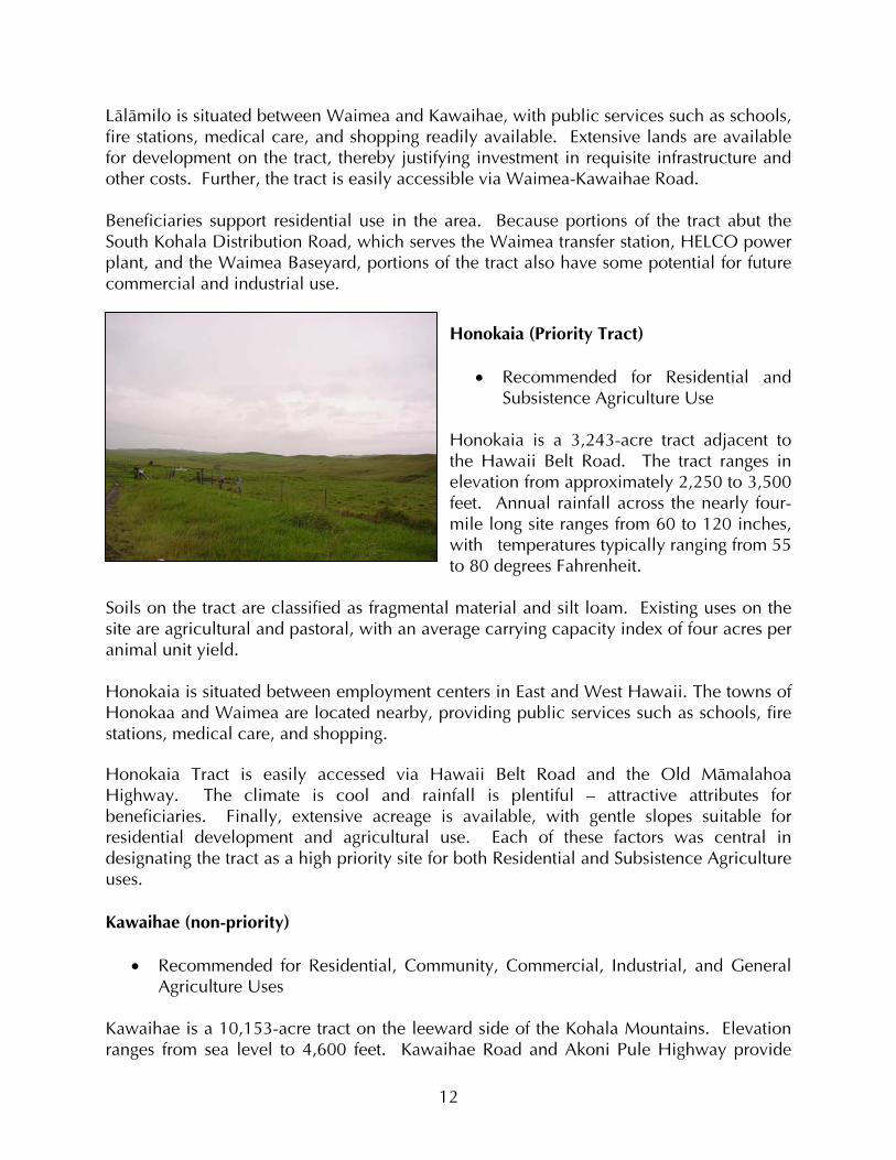
Honokaia (Priority Tract)
• Recommended for Residential and Subsistence Agriculture Use
Honokaia is a 3,243-acre tract adjacent to the Hawaii Belt Road. The tract ranges in elevation from approximately 2,250 to 3,500 feet. Annual rainfall across the nearly four-mile long site ranges from 60 to 120 inches, with temperatures typically ranging from 55 to 80 degrees Fahrenheit.
Soils on the tract are classified as fragmental material and silt loam. Existing uses on the site are agricultural and pastoral, with an average carrying capacity index of four acres per animal unit yield. Honokaia is situated between employment centers in East and West Hawaii. The towns of Honokaa and Waimea are located nearby, providing public services such as schools, fire stations, medical care, and shopping. Honokaia Tract is easily accessed via Hawaii Belt Road and the Old Mämalahoa Highway. The climate is cool and rainfall is plentiful – attractive attributes for beneficiaries. Finally, extensive acreage is available, with gentle slopes suitable for residential development and agricultural use. Each of these factors was central in designating the tract as a high priority site for both Residential and Subsistence Agriculture uses. Kawaihae (non-priority)
• Recommended for Residential, Community, Commercial, Industrial, and General Agriculture Uses
Kawaihae is a 10,153-acre tract on the leeward side of the Kohala Mountains. Elevation ranges from sea level to 4,600 feet. Kawaihae Road and Akoni Pule Highway provide
12
access to the makai portion of the site, and the Kohala Mountain Road enables access to the mauka portion. The climate is typically hot and dry along the coast, with cooler conditions in the upper portions of the tract. Temperatures in the lower elevations range between 55°F and 95°F, with higher elevations three to five degrees cooler. The lower third is dry, with average annual rainfall between 10 and 20 inches annually. Average annual rainfall in the middle third is between 20 and 40 inches, with 40-100 inches in the higher elevations of the upper third. Soil types are mixed throughout, and include unweathered bedrock, silt loam, extremely stony, and fine sandy loam areas. The carrying capacity index for the upper portion is 3.38 acres per animal yield, 6.5 acres for the middle portion, and 20 acres for the lower portion. Much of Kawaihae Tract is undeveloped and used for cattle and horse grazing. Other uses include a partially developed 90-acre industrial park, and subdivided homestead lots in the makai portion. The Honokoa Gulch and a number of other gulches, gullies and swales cross the parcel. Segments of Honokoa Gulch are over 450’ deep, presenting a significant constraint on development. Parts of the tract are steep, while others are not so. Slope on most of the property ranges between 10 and 15 percent. A number of archaeological sites have been identified on the site. Mixed uses are recommended for the tract, including Homestead Residential, General Agriculture/Pastoral, Commercial, Industrial, and Community uses. Constraints limiting immediate development include high costs associated with providing sufficient water to the site, and beneficiary preferences for the cooler Lälämilo and Honokaia tracts. The geo-physical conditions in the mauka portions also constrain development. Keoniki (non-priority)
• Recommended for Homestead Pastoral Use Keoniki is a 230-acre parcel located on the lower slopes of the North Kohala Mountains within a mile of Waimea town. DHHL’s Puÿukapu 3 is directly north of the parcel. About 105 acres are available for development. Elevation ranges from 2,500 to 3,600 feet. Keoniki is used as pasture land. The terrain is generally steep, with slopes ranging between 15 to 20 percent. The climate is typical of the area, with temperatures ranging between 55°F and 80°F. Keoniki typically receives 75 to 100 inches of rain annually. The predominate soil type is silt loam. The carrying capacity index is two acres per animal unit year. While the soil conditions, abundant rainfall, and cool climate make the parcel amenable for rural homesteading, site access is limited. Relatively steep slope also is a limiting factor.
13

Ni’eni’e (non-priority)
• Recommended for General Agriculture Available at Niÿeniÿe is a 612-acre parcel adjacent to DHHL’s existing Niÿeniÿe pastoral subdivision. It was set aside by Governor’s Proclamation as part of the Hamakua Forest Preserve in 1928 and was planted in eucalyptus trees during the 1930s. Portions of the site are accessible, but there is no existing access to the eastern and southern portions of the property. Given access limitations, infrastructure development would be costly. While the site altitude is fairly high, with elevations ranging from 2,250 to 2,900 feet, it also is relatively flat, with slope ranging from zero to five percent. Portions of the parcel are cleared and fenced, and used for grazing, while other portions remain heavily forested. The carrying capacity index is four acres per animal unit year. The climate at Ni’eni’e is cool, with temperatures typically ranging from 55°F in the evening and early mornings to 80°F during the day. The area receives approximately 60 to 80 inches of rain annually. Soils are classified as fragmental material. Potential uses include General Agriculture. The existing forests are now fully matured and cold be harvested for timber. Access remains a significant constraining factor for this tract, thus precluding priority development at this time. Relocation of the pastoral lessee on the adjacent parcel would allow direct access onto a larger consolidated lot with agroforestry potential. Pu’ukapu (non-priority)
• Recommended for Homestead Supplemental Agriculture, and General Agriculture Puÿukapu is comprised of two 100-acre lots and one 192-acre lot located in the saddle of the Mauna Kea and the Kohala Mountains at about 2,700 feet above sea level. The three parcels are located adjacent to DHHL’s Puÿukapu farmlot subdivision, with access from Pa`eli Alanui and Uakikoni Alanui Roads. No water or sewer services are currently available on the property, but its relatively close proximity to the existing subdivision would facilitate ease of connection. The terrain at Pu’ukapu is mostly flat, with gentle rolling hills and fenced enclosures. There is a history of pastoral use here. Given its elevation, the area is cool, with temperatures ranging between 55° F and 80°F. Pu’ukapu typically receives 20 to 50 inches of rain annually, though the area has experienced a drought in the last few years. Soils are very fine sandy loam, rate good for raising crops. The carrying capacity index is four acres per animal unit year. While surrounding uses are predominately pastoral, Agriculture Homesteading uses are recommended given its favorable climate, soil, and slope. The tract holds promise for
14
development, but is not considered an immediate priority given the uncertain availability of water to support homesteading uses. Pu’ukapu 3 (non-priority)
• Recommended for Homesteading Pastoral Puÿukapu 3 is a 378-acre tract of rolling hills located between 3,300 and 3,600 feet elevation on the upper slopes of Kamuela, adjacent to DHHL’s Keoniki parcel. The northern portion of the property is bounded by the Kohala forest and watershed boundary. The Hawaiÿi County Water Department has reservoirs abutting the property’s eastern boundary. Parker Ranch lands lay to the west and south. Access to the tract is through the Department of Water Supply’s access road to the reservoirs and well sites on Lindsey Road. Another road through the Keoniki parcel would need to be developed to gain access to the west end without crossing reservoir and well site areas. The terrain at Pu’ukapu is relatively steep in areas, though it averages between 10 to 15 percent. The steeper terrain is in and along the various gulches and pu`u that characterize the property. The average temperature range is between 55°F and 80°F, with 75 to 100 inches of rainfall each year. Kohäköhau Stream bisects the property. Soils include weathered bedrock and silt loam. The carrying capacity index is 1.5 acres per animal unit year. Parker Ranch has used the parcel for pasture under a general lease for many years, and under a revocable permit in recent years. Beneficiaries envision these lands as suitable for pastoral and agricultural uses. Immediate development is constrained by hilly terrain, variable slope, and access limitations. ‘Upolu Point (non-priority)
• Recommended for Special District
ÿUpolu Point is a 37-acre parcel between ÿUmiwai and Holana Bays near the northern tip of Hawaiÿi Island aquired from the federal government in 2000. This site contains remnant structures from former Naval operations. The Old Coast Guard Road provides access to the property, connecting it to Akoni Pule Highway through lands owned by Parker Ranch. Related access issues would need to be resolved prior to significant development or changes in land use. The terrain at ‘Upolu is flat, with slopes ranging between zero to five percent. The climate is very dry with annual rainfall between zero and ten inches. Temperatures typically range between 60°F and 82°F. Soils at the tract are stony silty clay.
15
Given that the parcel has limited electricity and water service, and a decommissioned wastewater treatment plant, there is potential for reuse of existing buildings. The DHHL has issued a revocable permit for use of portions of the property for community and cultural uses. This use and/or other uses are not considered long-term at this time given access issues and more pressing priorities in other DHHL regions. Given the historical importance of this region for Native Hawaiians, a complete archaeological survey is recommended prior to development on the property. Waimanu (non-priority)
• Recommended for Conservation Waimanu is a 200-acre tract of estuarine lands in the 3,600-acre Waimanu Valley, located on the northeast side of the Kohala Mountains. The tract is inaccessible by vehicle, but can be reached via a rigorous 7.5 mile hiking trail from Waipio Valley. While elevations at Waimanu range from approximately sea level to 2,000 feet, slopes in the valley floor DHHL portion averages between zero and five percent. The area is relatively wet and warm, with annual rainfall ranging from between 60 and 120 inches, and temperatures generally between 70 and 80 degrees Fahrenheit. Soils are classified as weathered bedrock, and vegetation is native forest and wetland. The 3,600-acre valley was proposed for designation as the Waimanu National Estuarine Research Reserve, one of 25 such reserves in the United States to be managed through a Federal and State (Natural Area Reserves System) partnership for research and education. Given access constraints, designated conservation uses on surrounding lands, and lack of infrastructure, the Tract is considered suitable for conservation use only. East Region A total of eleven tracts of available land were examined for potential use in the East Region (see Figure 4 through 6 below). The following briefly describes each tract and identifies the important opportunities and constraints on which decisions about potential land use recommendations were based. Pana’ewa and Lower Pi’ihonua were identified as priority tracts in this region and are presented first, followed by the remaining non-priority tracts.
16
�����������
������������
������
� ����
��
��� ���
���������������
����������������� ��
������������
���������� ������������ ������� ������ ���������
��������������
�����������
��������
������
������� ����������������������������� ����� ����������� ������ ���������� ����� ���������������������� ������� ������ ����� ���
������������������
������
���
����� �����������
����������
����������
� �� ��������
����������������� ��
������������
���������� ������������ ������� ������ ���������
��������������
����� � �����
��������
������
������� ����������������������������� ����� ����������� ������ ���������� ����� ���������������������� ������� ������ ����� ���
������������������

������������
�����
���������
��������
�
�������
�����
�� � ���
�����
��
����� ���
�����������
�����
����
��������������������� ��
������������
���������� ������������ ������� ������ ���������
��������������
����� � �����
��������
������
�������������� ��!"�#����#��$�!���%������������ �! ����� #!����&�#!������#����!����'��������#!���!� (#�#!���������� �! ��� ''�����!�������� �! ��
�����#����!������#
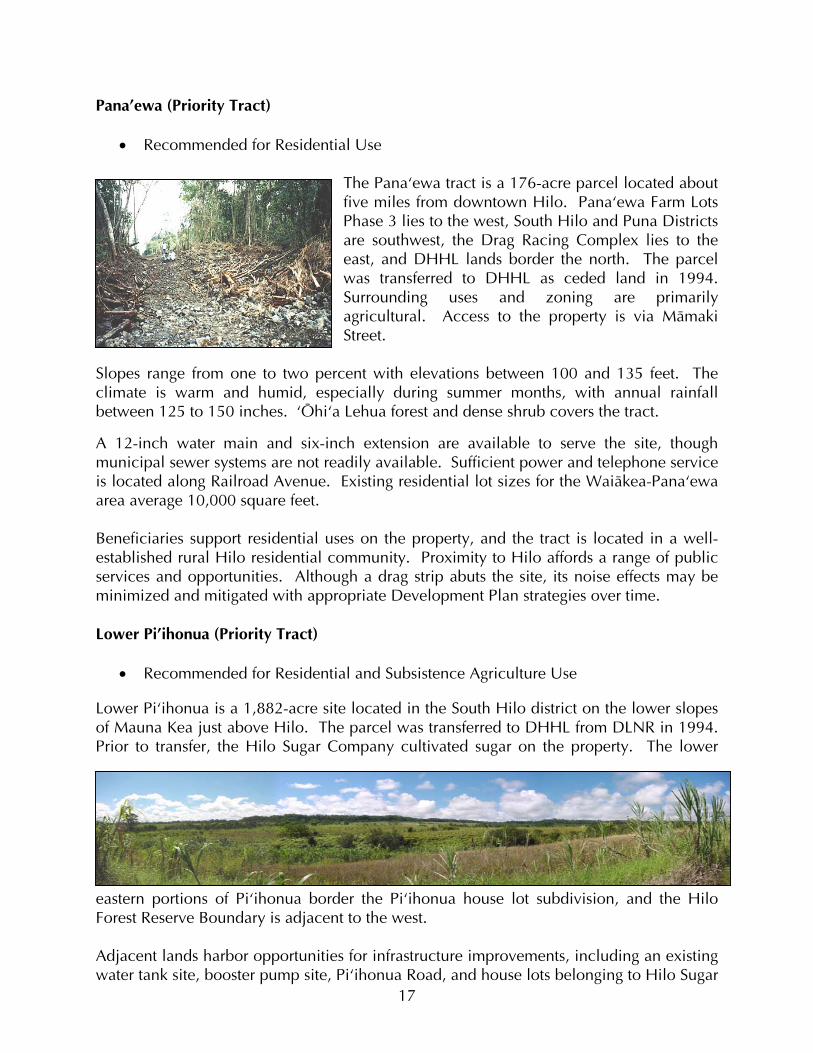
Pana’ewa (Priority Tract)
• Recommended for Residential Use
The Panaÿewa tract is a 176-acre parcel located about five miles from downtown Hilo. Panaÿewa Farm Lots Phase 3 lies to the west, South Hilo and Puna Districts are southwest, the Drag Racing Complex lies to the east, and DHHL lands border the north. The parcel was transferred to DHHL as ceded land in 1994. Surrounding uses and zoning are primarily agricultural. Access to the property is via Mämaki Street.
Slopes range from one to two percent with elevations between 100 and 135 feet. The climate is warm and humid, especially during summer months, with annual rainfall between 125 to 150 inches. ÿÖhiÿa Lehua forest and dense shrub covers the tract.
A 12-inch water main and six-inch extension are available to serve the site, though municipal sewer systems are not readily available. Sufficient power and telephone service is located along Railroad Avenue. Existing residential lot sizes for the Waiäkea-Panaÿewa area average 10,000 square feet. Beneficiaries support residential uses on the property, and the tract is located in a well-established rural Hilo residential community. Proximity to Hilo affords a range of public services and opportunities. Although a drag strip abuts the site, its noise effects may be minimized and mitigated with appropriate Development Plan strategies over time. Lower Pi’ihonua (Priority Tract)
• Recommended for Residential and Subsistence Agriculture Use Lower Piÿihonua is a 1,882-acre site located in the South Hilo district on the lower slopes of Mauna Kea just above Hilo. The parcel was transferred to DHHL from DLNR in 1994. Prior to transfer, the Hilo Sugar Company cultivated sugar on the property. The lower
eastern portions of Piÿihonua border the Piÿihonua house lot subdivision, and the Hilo Forest Reserve Boundary is adjacent to the west. Adjacent lands harbor opportunities for infrastructure improvements, including an existing water tank site, booster pump site, Piÿihonua Road, and house lots belonging to Hilo Sugar 17
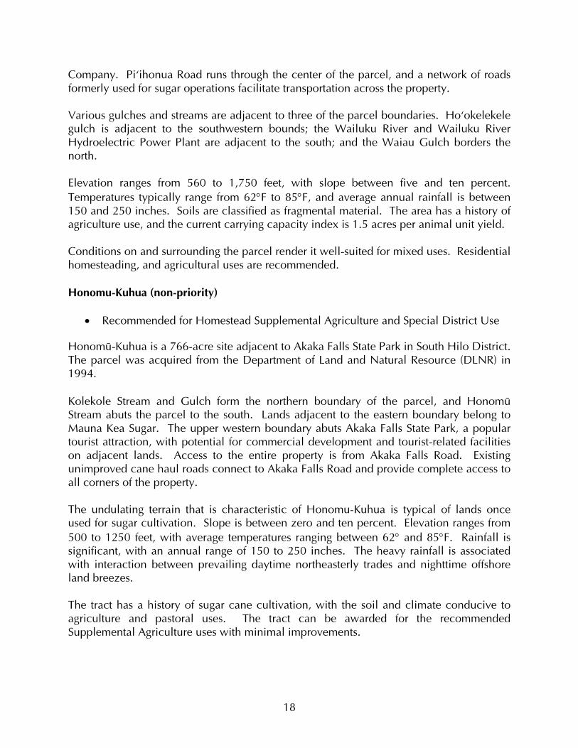
Company. Piÿihonua Road runs through the center of the parcel, and a network of roads formerly used for sugar operations facilitate transportation across the property. Various gulches and streams are adjacent to three of the parcel boundaries. Hoÿokelekele gulch is adjacent to the southwestern bounds; the Wailuku River and Wailuku River Hydroelectric Power Plant are adjacent to the south; and the Waiau Gulch borders the north. Elevation ranges from 560 to 1,750 feet, with slope between five and ten percent. Temperatures typically range from 62°F to 85°F, and average annual rainfall is between 150 and 250 inches. Soils are classified as fragmental material. The area has a history of agriculture use, and the current carrying capacity index is 1.5 acres per animal unit yield. Conditions on and surrounding the parcel render it well-suited for mixed uses. Residential homesteading, and agricultural uses are recommended. Honomu-Kuhua (non-priority)
• Recommended for Homestead Supplemental Agriculture and Special District Use Honomü-Kuhua is a 766-acre site adjacent to Akaka Falls State Park in South Hilo District. The parcel was acquired from the Department of Land and Natural Resource (DLNR) in 1994. Kolekole Stream and Gulch form the northern boundary of the parcel, and Honomü Stream abuts the parcel to the south. Lands adjacent to the eastern boundary belong to Mauna Kea Sugar. The upper western boundary abuts Akaka Falls State Park, a popular tourist attraction, with potential for commercial development and tourist-related facilities on adjacent lands. Access to the entire property is from Akaka Falls Road. Existing unimproved cane haul roads connect to Akaka Falls Road and provide complete access to all corners of the property. The undulating terrain that is characteristic of Honomu-Kuhua is typical of lands once used for sugar cultivation. Slope is between zero and ten percent. Elevation ranges from 500 to 1250 feet, with average temperatures ranging between 62° and 85°F. Rainfall is significant, with an annual range of 150 to 250 inches. The heavy rainfall is associated with interaction between prevailing daytime northeasterly trades and nighttime offshore land breezes. The tract has a history of sugar cane cultivation, with the soil and climate conducive to agriculture and pastoral uses. The tract can be awarded for the recommended Supplemental Agriculture uses with minimal improvements.
18
Kaumana (non-priority)
• Recommended for Homestead Residential Use This Tract consists of several scattered parcels off Kaumana Drive between Kaumana School and Kaumana Cemetery near Hilo. Acreage at the site is about 16 acres, of which just over 12 acres remains undeveloped. The parcels are readily accessed via Kaumana Drive. Elevation is about 1,100 feet, with slopes averaging about eight percent. Annual rainfall ranges from 120 to 160 inches, with temperatures ranging from 55 to 80 degrees F. Soils here are classified as unweathered bedrock. Existing lots are predominately open and vacant. Kaumana Tract is situated in a well-established residential community mauka of Hilo in a cool climate with plentiful rainfall. Hilo is the largest town on the island and provides a wide range of both public services and retail opportunities. The Tract is now being developed as part of a project of 76 lots scattered in the Hilo area, which should be available for residential awards in 2003. Keaukaha-2 (non-priority)
• Recommended for Special District Use DHHL holdings total approximately 1,670 acres in the Keaukaha area. Keaukaha Tract-1 is located along Hilo’s coastline adjacent to the Hilo Airport, and contains 457 residential homesteads. The area commonly known as King’s Landing is in Keaukaha Tract-2, along Hilo’s northeast shoreline. Portions of Tract-2 are occupied by seven native Hawaiian households under a right-of-entry permit. Access to the Keaukaha tracts is via Kalanianaÿole Avenue, which ends at Richardson Ocean Park. Kapoho Coast Road continues from the terminus of Kalanianaÿole Avenue into Keaukaha-2 and provides access to the interior of the property and the coastline. Slopes on the parcel range from zero to five percent, with elevation ranging from sea level at the coastline to approximately 30 feet at the southern portion of the property. The tsunami evacuation zone extends 1,000 to 2,000 feet inland from the shoreline. The climate is warm and humid, with annual rainfall ranging between 125 and 150 inches. The site currently is overgrown with dense ground cover, shrubs, and trees. Water, electric and sewer services are not readily available for the parcel. Beneficiaries recommend a Kuleana-type homestead award similar to Kahikinui on Maui. Access is limited and would have to be improved prior to development. Priority development is further constrained by Tsunami inundation potential, and noise from the Hilo Airport.
19
Keonepoko Nui (non-priority)
• Recommended for General Agriculture Use Keonepoko Nui is a 100-acre parcel in rural Puna District, East Hawaiÿi. The tract is located behind Keonepoko Homestead, approximately one mile southeast of the Pahoa landing strip, and just under a mile northwest of Main Street Pähoa. State lands border the east portion of the property, with Keonepoko Homestead to the west. Access is provided through a dedicated flag off Kea`au-Pähoa Road. ÿÖhiÿa Lehua trees, shrubs, and scrub grass cover the majority of the property. The property is relatively flat, with maximum slope approaching five percent. Elevation ranges from 540 to 600 feet. Soils are primarily volcanic material, with a local carrying capacity index of eight acres per animal unit yield. The climate is typically cool in the winter and warmer during the summer, with average temperatures between 59°F and 80°F. Annual rainfall in Puna District averages between 150 to 200 inches, enabling use of water catchment systems. Current surrounding uses are agricultural, and beneficiaries support this use on the property despite marginal soil quality. Access limitations and parcel size are primary constraints. Maku’u Makai (non-priority)
• Recommended for General Agriculture Use The Makuÿu area lands total approximately 2,000 acres, with 500 acres in the makai portion, and approximately 1,500 mauka. Most of the seaward parcel is mauka of the Beach Road extension. A portion of the property extends across the Ala Hele O Puna Road extension to the coastline. The western boundary is adjacent to Hawaiian Paradise Park subdivision and State lands lie to the south and east. The parcel is accessible via an extension of Ala Hele O Puna Road. Kaÿaahi Road is adjacent to the mauka boundary. Slopes in this area range from zero to five percent, with elevation ranging from sea level to 118 feet at the mauka boundary. Temperatures average between 59°F and 80°F, and average annual rainfall is between 100 and 150 inches. Soil is classified as lava and unweathered bedrock, with a carrying capacity index of ten acres per animal unit yield. The site is presently overgrown, with lowland shrubs and sparse tree cover predominating. Water and sewer service is currently not available for the parcel. Water and sewer system needs and associated costs constrain priority development at this time.
20
Maku’u Mauka (non-priority)
• Recommended for Homestead Residential, Subsistence Agriculture, Community, and Cultural Uses
Maku’u Mauka is an approximately 1,500 acre parcel located roughly three miles from old Pähoa Town, and 17 miles from Hilo. Tiki Gardens, Orchid Land Estates, and Paradise Park Subdivision are to the east, with State lands surrounding the northern, western, and southern boundaries. Keaÿau-Pähoa Road bisects the tract to form two separate parcels of 868 and 637 acres. The majority of the 868-acre parcel has been developed by DHHL into five-acre agriculture lots. Some 181 acres are designated for an FAA radio tower and support facilities. Some 100 acres of the 637-acre parcel have been developed into two-acre agriculture lots. Access to both parcels is from Keaÿau-Pähoa Road. Smaller arterial streets have been developed by DHHL to provide access to the developed agriculture lots. Slope ranges from zero to five percent, with elevations ranging from sea level to 118 feet. Average temperatures range between 59°F and 80°F, with annual rainfall between 150 and 200 inches. The soil is primarily volcanic material. A mix of Homestead Subsistence Agriculture, Homestead Residential, and Commercial uses are recommended for the tract, but significant infrastructure issues need to be addressed prior to development. Existing DHHL agriculture lots in the tract are currently using water catchment systems and sewer service is not readily available for residential use. Analysis of beneficiary preferences indicates more interest in homesteads closer to Hilo. ÿÖlaÿa (non-priority)
• Recommended for Homestead Pastoral Use ÿÖlaÿa is a 708-acre parcel located 16 miles from Hilo. Volcano National Park and the Puÿu Makaÿala Natural Area Reserve border the parcel’s western boundary, and the ÿÖlaÿa Forest Reserve abuts the southern boundary. Portions of the eastern boundary are adjacent to the Glenwood house lot subdivision. Access to the northeastern portion of the parcel is from North Glenwood Road, about two miles inland from Volcano Road. An unimproved access road would have to be improved in order to provide vehicular access from North Glenwood Road. Elevations range from 2,700 to 3,200 feet. The terrain is undulating, with rolling hills that slope up toward Mauna Loa. Slope averages zero to five percent, with portions up to ten percent. Soils are classified as extremely stony silty clay loam. The carrying capacity index is three acres per animal unit yield.
21
The climate is relatively cool at this elevation, with temperatures ranging from a low of 59°F during the winter months to 80°F during the summer. ÿÖlaÿa receives an average annual rainfall of 125 to 150 inches. Limited access, significant rainfall, and surrounding pastoral uses underlay recommendations for pastoral or agricultural use rather than residential use. Given the presence of extensive stands of native trees, an alternative use may involve sustainable forestry for the purpose of generating DHHL income. Pana’ewa 20 (non-priority)
• Recommended for General Agriculture Use This 20-acre parcel is located five miles south of Hilo along the Volcano Highway. Access is from Kealakaÿi Street. Various agricultural lots occupy adjacent lands. A dense overgrowth covers the entire property, including remnant macadamia, coffee and ÿÖhiÿa Lehua. Elevation is roughly 300 feet, with slopes averaging between zero to five percent. Average annual rainfall is between 150 and 200 inches, and temperatures range between 65°F and 89°F. Water and power is readily available to service the property. No sewer service is currently available. Beneficiaries suggest using the site for agriculture, and assessment of conditions indicates the suitability as an agriculture training site or for a general lease for a commercial agriculture venture or nursery. The parcel is considered too small to enable cost-effective residential development. Waiakea
• Recommended for Commercial Use This 12-acre parcel is located along Volcano Road, in the Old Airport area with Hilo airport to the east and Kanoelehua Avenue to the west. The property is surrounded by commercial and/or industrial use areas. Access is via the Old Airport Road from Kanoelehua Avenue. Airport service roads provide access to the eastern portion of the property. The parcel is relatively flat with slopes ranging from zero to five percent. Elevation ranges from 20 to 30 feet. The climate is warm and humid, especially during summer. Annual rainfall ranges between 125 to 150 inches per year. Soils are classified as unweathered bedrock.
22

Water, electric, and sewer service are available to serve the parcel, but the small size of the parcel and airport noise serve to constrain priority residential, pastoral, and agriculture development potential. Commercial and/or Industrial uses are recommended.
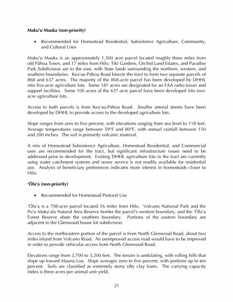
South Region Three tracts were examined for potential use in the South Region (see Figure 8 below). The following describes important opportunities and constraints for each. Wailau was identified as the priority tract in this region. Wailau (Priority Tract)
• Recommended for Residential Use Wailau Tract is a 65-acre parcel located above Mämalahoa Highway, mauka of the Sea Mountain Resort at Punalu’u in Kaÿü District. Access is from Mämalahoa Highway, and from Hïlea Road. The parcel slopes up toward Mauna Loa from Mämalahoa Highway. Elevation ranges from 250 to 400 feet, with slope ranging from 10 to 15 percent. Soils are classified as unweathered bedrock.
There is an existing residential subdivision adjacent to the southwest. Other surrounding uses are primarily pastoral. Large trees provide shade and the landscape is covered by grass and low shrubs. The climate is dry and windy, with temperatures ranging from lows around 58°F in winter, and highs of 89°F in summer. The area is arid, with annual rainfall ranging between 30 and 40 inches. Northeasterly trades consistently blow between 13 and 16 miles per hour across the parcel.
The Tract is close to amenities available at nearby Sea Mountain Resort, and services available at Naÿalehu and Waiÿöhinu. A water tank serving Sea Mountain Resort may have sufficient capacity for serving the proposed residential development at Wailau as well. Development of residential homesteads in Wailau would effectively satisfy the need for residential awards in the South Region.
23
����
�������
�
������ � ����������
���������
�� ������������
����������������� ��
������������
���������� ������������ ������� ������ ���������
� �����������
����� � ������
��������
������
������� ����������������������������� ����� ����������� ������ ���������� ����� ���������������������� ������� ������ ����� ���
������������������

Kama’oa-Pu’ueo (non-priority)
• Recommended for Homestead Pastoral, General Agriculture, and Special District This 11,031-acre tract is located on the southernmost point of the island and the United States. The area can be accessed from Mämalahoa Highway via either South Point Road or Kamaoa Road. The tract ranges in elevation from approximately sea level to 750 feet, with slopes averaging approximately two to three percent. The prevailing wind pattern is from the east-northeast and is very strong and consistent. The area also is very dry, with annual rainfall across the nearly 5.5 mile long site ranging from 20 to 30 inches. Annual temperatures range from 75 to 90 degrees Fahrenheit. The Tract is within Volcano Hazard Zones, but outside of the Tsunami Evacuation Zone. Soils are classified as Fragmental Material with some Unweathered Bedrock. Vegetation generally consists of low, dry grasses. Existing uses are pastoral and limited agriculture. The carrying capacity index is 12 acres per animal unit yield. The Tract is situated far from the employment centers of East and West Hawaii, in a hot climate with very low rainfall. Nearby Naalehu provides limited public services and shopping. Development at the tract is constrained primarily by its geographic isolation, and is deemed most suitable for pastoral use. Waiÿöhinu
• Recommended for Homestead Subsistence Agriculture Use Waiÿöhinu Tract encompasses 262 acres above Waiÿöhinu, adjacent to the Kiolakaÿa-Keaÿä Homesteads. Access is via an unimproved, four-wheel drive-only road that winds up through the property. The existing road would require improvement prior to development. Elevation ranges from between 1,200 and 2,100 feet. Steep slopes ranging between five and 25 percent constrain development. The climate is cool and humid in winter, and warm in summer. Rainfall is between 40 and 50 inches annually. Soils are classified as unweathered bedrock. Portions of the parcel are overgrown, but the balance has been cleared and fenced for grazing livestock. Views include South Point and its expansive coastline. Water service is readily available. Häÿao Springs is located above the property, and serves as the principal water source. Electric and sewer service would have to be developed prior to development. Public services and limited amenities are available at Naÿalehu and Waiÿöhinu. While slope and associated difficulties in providing infrastructure are the
24

primary constraining factors, rural homestead development remains a non-priority possibility, with a small commercial area along the highway. West Region Four tracts of available land were examined for potential use in the West Region (see Figure 7 below). Following are brief descriptions identifying important opportunities and constraints for each tract. Kealakehe and Kalaoa were identified as priority tracts in this region. Description of these is presented first, followed by Honokohau and Keahuola. Kealakehe (Priority Tract)
• Recommended for Homestead Residential Use Kealakehe is a 60-acre parcel within the DHHL residential development known as the Villages of Laÿi ÿÖpua. The site is located above the Kealakehe High School in Kailua-Kona District. Kealakehe Parkway connects the development to Queen Kaÿahumanu
Highway, with Keanalehu Drive serving as an arterial connector. There are plans to extend Keanalehu Drive to Palani Highway to provide alternate access to the parcel. Elevation is about 500 feet, with slopes ranging from five to ten percent. The annual average temperature for the parcel ranges from 60°F to 87°F, and average rainfall is between 10 and 20 inches. The soil is predominantly volcanic, providing a solid foundation for house lots. DHHL’s Laÿi ÿÖpua Village 3 is located on an
adjacent parcel, with planning underway for Village 4. A neighborhood park is planned, and all physical infrastructure is available for service to the area. Given close proximity to Kailua-Kona, public services also are readily available to serve residents. Kalaoa (Priority Tract)
• Recommended for Commercial, Industrial, and Homestead Residential Uses Kalaoa Tract is comprised of four discontinuous lots totaling approximately 483 acres. Lots One and Two are adjacent to State Agricultural lots and Queen Kaÿahumanu Highway at between 150 and 300 feet elevation. A utility road provides access to lots Two and Three. Lot Four is located above at between 550 and 800 feet. The Kona Palisades subdivision is adjacent to the southern portion of the upper lot. No vehicular access is provided to the parcel at this time. However, future access to the parcel could occur from Kona Palisades subdivision off Kakahiaka Street, Kapuahi Street, Koÿikoÿi Street, and ÿAmaÿama Street. 25

�����������������
� ����
���� �
��������
���� ��
���������
��
��
���
�
����������������� ��
������������
���������� ������������ ������� ������ ���������
������������
����� � �����
��������
������
������� ����������������������������� ����� ����������� ������ ���������� ����� ���������������������� ������� ������ ����� ���
������������������
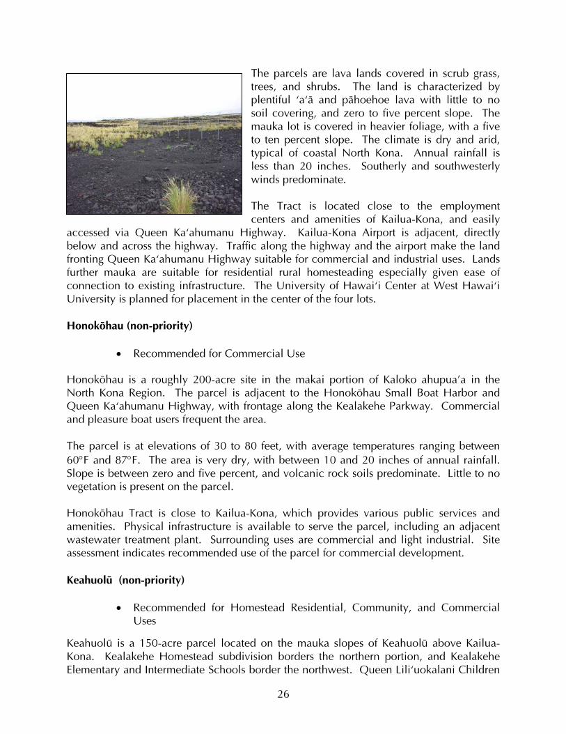
The parcels are lava lands covered in scrub grass, trees, and shrubs. The land is characterized by plentiful ÿaÿä and pähoehoe lava with little to no soil covering, and zero to five percent slope. The mauka lot is covered in heavier foliage, with a five to ten percent slope. The climate is dry and arid, typical of coastal North Kona. Annual rainfall is less than 20 inches. Southerly and southwesterly winds predominate. The Tract is located close to the employment centers and amenities of Kailua-Kona, and easily
accessed via Queen Kaÿahumanu Highway. Kailua-Kona Airport is adjacent, directly below and across the highway. Traffic along the highway and the airport make the land fronting Queen Kaÿahumanu Highway suitable for commercial and industrial uses. Lands further mauka are suitable for residential rural homesteading especially given ease of connection to existing infrastructure. The University of Hawaiÿi Center at West Hawaiÿi University is planned for placement in the center of the four lots. Honoköhau (non-priority)
• Recommended for Commercial Use Honoköhau is a roughly 200-acre site in the makai portion of Kaloko ahupua’a in the North Kona Region. The parcel is adjacent to the Honoköhau Small Boat Harbor and Queen Kaÿahumanu Highway, with frontage along the Kealakehe Parkway. Commercial and pleasure boat users frequent the area. The parcel is at elevations of 30 to 80 feet, with average temperatures ranging between 60°F and 87°F. The area is very dry, with between 10 and 20 inches of annual rainfall. Slope is between zero and five percent, and volcanic rock soils predominate. Little to no vegetation is present on the parcel. Honoköhau Tract is close to Kailua-Kona, which provides various public services and amenities. Physical infrastructure is available to serve the parcel, including an adjacent wastewater treatment plant. Surrounding uses are commercial and light industrial. Site assessment indicates recommended use of the parcel for commercial development. Keahuolü (non-priority)
• Recommended for Homestead Residential, Community, and Commercial
Uses
Keahuolü is a 150-acre parcel located on the mauka slopes of Keahuolü above Kailua-Kona. Kealakehe Homestead subdivision borders the northern portion, and Kealakehe Elementary and Intermediate Schools border the northwest. Queen Liliÿuokalani Children
26

Center has a Master Plan for adjacent lands to the south. Access is via Palani Highway and Kealakaÿa Street, with plans for future connections via Palani Highway. Elevations range from 400 to 800 feet, with slope between five and ten percent throughout the parcel. The annual average temperature range is between 60°F and 87°F. The climate is dry with about 10 to 20 inches of annual rainfall. The parcel is vacant at present, and overgrown with heavy foliage. The soil is the volcanic rock composition typical of the region. Keahuolü Tract is situated upslope of Kailua-Kona along Palani Highway, and close to the employment and public service opportunities available at Kailu-Kona. The site affords panoramic views of the Kona coastline. The tract is suitable for residential homestead development, but immediate priority development is constrained by limited access. Central Region Two tracts were examined for potential use in the South Region (see Figure 9 below). These are essentially contiguous and designated as high priority for Pastoral use. Humu’ula-Upper Pi’ihonua
• Recommended for Homestead Pastoral, General Agriculture/Pastoral, Commercial, Conservation, and Special District Uses
Humuÿula is a 32,475-acre parcel located on the southeastern slopes of Mauna Kea, adjacent to the west boundary of the Piÿihonua parcel. This area is currently leased to Parker Ranch and Nobriga Enterprises for cattle grazing. The property is surrounded by forest reserves and accessed from Saddle Road and Keanakolu/Mana Road. The Pi’ihonua parcel comprises some 7,078 acres adjacent to the eastern boundary of Humuÿula parcel, also on the southeastern
slopes of Mauna Kea. The property is currently under revocable permit for agricultural/pastoral use. Access is via the Humu’ula portion. This is high country, with elevations varying from approximately 5,800 feet at the southeast end of the property to 9,500 feet at the west boundary. Average low temperatures range from 58EF at 5,000 feet to 45EF at 9,000 feet. Average annual rainfall varies from 120 inches in the lower elevations to 40 inches in the upper elevations. The land above 7,000 feet elevations is very dry most of the year due to high evaporation rates. Slopes in both parcels range from 10 to15 percent. Soils are mixed. The carrying
27

��������
�����������
�������
����������������� ��
������������
���������� ������������ ������� ������ ���������
���������������
������ � ������
��������
������
������� ����������������������������� ����� ����������� ������ ���������� ����� ���������������������� ������� ������ ����� ���
������������������

capacity index in the Humu’ula portion is ten acres per animal unit yield, and three acres in the Upper Pi’ihonua portion. Vegetation in the area is mostly shrubs and gorse. If the gorse continues to grow and cover the land, it could disturb the ecological balance and the growth of other plants, resulting in loss of productive use of the area. The property harbors several rare and endangered species such as the Hawaiian Hawk (Iÿo), Hawaiian Duck (Koloa), Hawaiian Goose (Nënë), and native honeycreeper species (Mamane and Palila). Koa trees are also present. Water catchments provide the bulk of water in the area. Any wastewater generated on the parcel would require cesspools or septic tanks for treatment. Electrical service is limited. DHHL has already launched Humuÿula/Piÿihonua Master Plan in 1997 and pastoral and forestry use has been recommended for the property under the plan. Recommended land uses are Homestead Pastoral, General Agriculture/Pastoral, Community, and Special District.
28

CHAPTER 3.0 PRIORITY TRACT SUMMARY ANALYSIS As described in the previous chapters, a primary objective of the Hawai’i Island Plan is to identify tracts suitable for priority planning attention and accelerated development so as to meet the needs of prospective beneficiaries. In reiteration, the assessment process involved the following steps: (1) examination of beneficiary needs and preferences; (3) description and analysis of environmental opportunities, constraints, and surrounding uses; (4) assessment of infrastructure and associated needs; (5) community/beneficiary input on land use plans; and (5) order-of-magnitude cost assessment; and (6) final recommendations for use of DHHL lands on Hawai’i Island. Based on the results of the land use assessments described in Chapter Two, this chapter provides further summary analysis of tracts selected for priority action. The analysis focuses on costs associated with tract development in each region, and on the primary limiting conditions affecting those costs for each tract. Per-lot costs are also identified, based on total tract costs and the number of lots feasibly developed in each tract. Costs are presented as “hard costs” only. That is, they exclude design and other contingencies. Further, they include costs associated with preparation for and provision of infrastructure only, and exclude the cost of housing itself, which in the case of DHHL lands is the responsibility of the leaseholder. Limited discussion regarding planning responses to beneficiary comments on draft land use plans also is provided. Given that the Hawai’i Island Plan is intended to provide generalized planning and land use recommendations, it is noted from the outset that costs are presented here as order-of-magnitude projections rather than highly specific estimates. More specific costing will be generated through the various Development Plans required prior to actual development on the tracts in question. The following cost projections are based on a number of factors and conditions. For instance, site preparation costs are based on the gross acreage of the site, while all other on-site costs are based on the size and number lots. As noted in the previous chapter, the proximity of existing roadway and utilities to the proposed site is very important in off-site cost estimates. Isolated tracts with no existing infrastructure require extensive materials and labor for connections, while sites with easy access and close proximity to existing water, sewer, and electric services do not. Wastewater treatment plant costs have been included with the off-site costs for any residential site with more than 50 lots. Type of use also affects the cost estimates. For instance, while both Residential and Subsistence Agriculture tracts require all utilities and use county standard roadways, Supplemental Agriculture and Pastoral tracts require rural standard roadways. The difference in cost between these types is significant in that county standard road standards require sidewalks, curbs, and gutters, while rural standard roads are more suited to non-pedestrian use and hence less expensive.
29

3.1 NORTH REGION PRIORITY TRACTS Two tracts were identified as suitable for high priority planning attention and development in the North Region. Lälämilo Tract is particularly suitable for residential development given its location at the fringe of Waimea Town and adjacent to an existing residential development (Figure 8). Located between Honokaa and Waimea, with plenty of room for growth, Honokaia Tract is considered suitable for a range of potential uses, including Residential, Subsistence Agriculture, Pastoral, and Commercial (Figures 10 and 11). Lälämilo Residential Homestead Conditions at and surrounding Lälämilo indicate its suitability for Residential Homestead use. A total of 400 lots of 10,000 square feet each are feasible. Projected on-site and off-site costs are depicted in Table 3.1 below. Table 3.1 Projected Costs for Residential Lots at Lälämilo
Improvements Total Cost $ Cost Per Lot $ Off-Site 6,355,000 15,877 On-Site 21,890,000 54,725
Total 28,245,000 70,612 Cost Factors
• Off-site infrastructure needs at Lälämilo account for 22% of projected costs. The proposed development is in close proximity to existing infrastructure serving the neighboring subdivision.
• Off-site costs do include a wastewater treatment plant, and water system
improvements.
• County standard roads and full utilities are reflected in the relatively high on-site costs.
• Extensive site preparation requirements also increase on-site cost estimates
for Lälämilo. Public Input on the Land Use Plan
• The Residential Homestead designation was supported for Lälämilo, but at lesser density than recommended for planning purposes.
30

����������
���
������ �
���
�����
����������� ����������
������������ ������������
����������������
���������������
����������������� ��
������������
���������� ������������ ������� ������ ���������
������� ������
���������
���������
�����������������
������� � �����!�
���������������
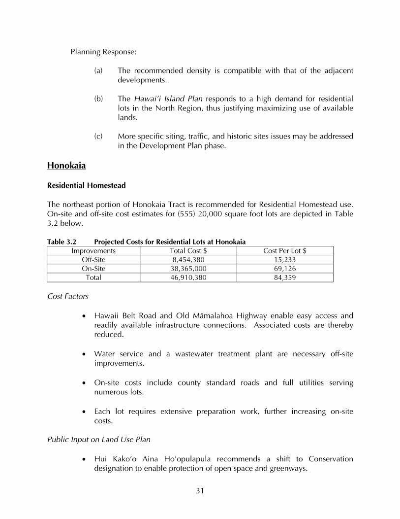
Planning Response:
(a) The recommended density is compatible with that of the adjacent developments.
(b) The Hawai’i Island Plan responds to a high demand for residential
lots in the North Region, thus justifying maximizing use of available lands.
(c) More specific siting, traffic, and historic sites issues may be addressed
in the Development Plan phase. Honokaia Residential Homestead The northeast portion of Honokaia Tract is recommended for Residential Homestead use. On-site and off-site cost estimates for (555) 20,000 square foot lots are depicted in Table 3.2 below. Table 3.2 Projected Costs for Residential Lots at Honokaia
Improvements Total Cost $ Cost Per Lot $ Off-Site 8,454,380 15,233 On-Site 38,365,000 69,126
Total 46,910,380 84,359 Cost Factors
• Hawaii Belt Road and Old Mämalahoa Highway enable easy access and readily available infrastructure connections. Associated costs are thereby reduced.
• Water service and a wastewater treatment plant are necessary off-site
improvements.
• On-site costs include county standard roads and full utilities serving numerous lots.
• Each lot requires extensive preparation work, further increasing on-site
costs. Public Input on Land Use Plan
• Hui Kako’o Aina Ho’opulapula recommends a shift to Conservation designation to enable protection of open space and greenways.
31
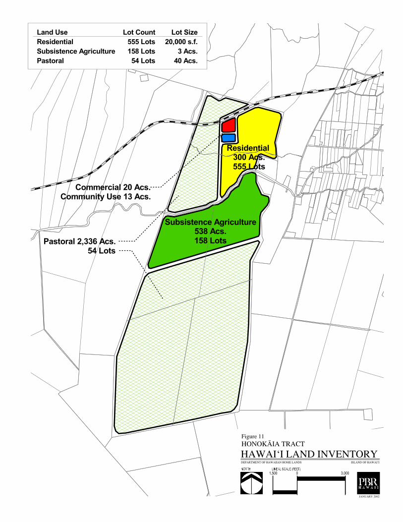
����������� ����������������� ���
������������� ����������
������������ ���������
�� �������� !����������" �����"����
����������������� ��
������������
���������� ������������ ������� ������ ���������
� � ����������
�����������
�������
������������������� �������� !���������������
�����#���������$�
� ����� ���
�����������������"����������

Planning Response:
(a) The revised Plan relocates the proposed Residential and Commercial uses to the mauka side of the highway and places the pastoral site component along the makai side of the highway to preserve open space and views.
(b) Appropriate greenway, open space, and various visual effect
mitigation strategies may be addressed in the Development Plan phase.
(c) Design guidelines should be instituted to address the overall
appearance of development in this and other tracts.
• Concern about the potential effects of tract development on local service infrastructure capacity was stated.
Planning Response: Infrastructure capacity is addressed in conjunction with proposed developments.
Honokaia Subsistence Agriculture Based on existing conditions and surrounding uses, central portions of Honokaia are considered suitable for Subsistence Agriculture Use. Cost estimates for 158 three-acre lots are provided in Table 3.3 below. Table 3.3 Projected Costs for Subsistence Agriculture Lots at Honokaia
Improvements Total Cost $ Cost Per Lot $ Off-Site 7,468,340 47,268 On-Site 25,650,000 162,342
Total 33,118,340 209,610 Cost Factors
• Lack of existing off-site infrastructure translates to high off-site costs for Subsistence Agriculture use. Water service is required, however, and included in the off-site projections.
• On-site costs are relatively high since the various cost categories are divided
among relatively few, large lots.
• Significantly, on-site costs also reflect county standard roads and full utilities
32

Public Input on Land Use Plan
• Hui Kako’o Aina Ho’opulapula recommends a shift to Conservation designation.
Planning Response:
(a) There is a high demand for Residential and Subsistence Agriculture
uses in the North Region. This is efficiently satisfied at Honokaia amidst a situation of limited land and land use options.
(b) Open space and conservation principles may be applied in the
Development Plan phase to guide the development process in a manner befitting the landscape and surrounding uses.
Honokaia Pastoral Large portions of the Honokaia Tract are recommended for Pastoral Use. These are in the northwest and southern components. Cost estimates for developing (54) 40-acre lots are provided in Table 3.4 below. Table 3.4 Projected Costs for Pastoral Lots at Honokaia
Improvements Total Cost $ Cost Per Lot $ Off-Site 2,337,280 43,283 On-Site 7,425,000 137,500
Total 9,762,280 180,783 Cost Factors
• Pastoral lots at Honokaia require water infrastructure only, but associated off-site and on-site costs are high since the improvements extend over great distances and the costs are distributed across few lots.
• On-site costs include rural standard roads.
• Total costs would be less if stockwater catchment systems are employed
rather than the DWS standard system used in these estimates. Public Input on Land Use Plan
• Hui Kako’o Aina Ho’opulapula recommends a shift in land use designation to Conservation.
33

Planning Response:
(a) Pastoral use along Hawai’i Belt Road will maintain open space and
the rural character of local lands. 3.2 EAST REGION PRIORITY TRACTS Two tracts are recommended for priority action in the East Hawai’i Region (Figures 12 and 13). Pana’ewa is considered particularly suitable for Residential use given its close proximity to an existing residential community, and potential for providing numerous homesites in a region of extensive Residential Homestead demand. Lower Pi’ihonua is also well-suited for Residential use, but local conditions and surrounding uses simultaneously present good potential for Subsistence Agriculture, General Agriculture, and Conservation uses. Pana’ewa Residential Assessment of conditions at and surrounding the Pana’ewa Tract indicate suitability for Residential Homestead use. A total of 1,107 lots of 10,000 square feet each are considered feasible, and assessed in the following cost analysis. Projected on-site and off-site costs are depicted in Table 3.5 below. Table 3.5 Projected Costs for Residential Lots at Pana’ewa
Improvements Total Cost $ Cost Per Lot $ Off-Site 11,923,900 10,771 On-Site 55,055,000 49,734
Total 66,978,900 60,505 Cost Factors
• Numerous lots require extensive site preparation and connections, thereby increasing overall on-site costs.
• Density at Pana’ewa is relatively high, thereby reducing individual lot costs.
• Costs are further reduced given the proximity of the tract to the existing
DHHL homestead community area and readily available infrastructure connections.
Public Input on Land Use Plan
• Public comments support the Residential and Subsistence Agriculture designations
34

������������ �������������
�����������������������
����������������� ��
������������
���������� ������������ ������� ������ ���������
��������������
���������
���������
�����������������
�����������������
�����������������

• Beneficiaries indicate a need for community input on the drag strip issue.
Planning Response:
(a) There will be additional opportunities for input with regard to the
Development Plan. (b) Potential mitigation measures could involve project phasing with
appropriate buffering strategies used during each phase. (c) DHHL will occupy the land in perpetuity. The racing strip is a
relatively temporary use.
• Beneficiaries indicate interest in community use areas.
Planning Response:
(a) The Hawai’i Island Plan has incorporated this concern with due regard to existing space limitations. The configuration of planned community use areas may be addressed in the Development Plan phase.
Lower Pi’honua Residential Conditions at and surrounding Lower Pi’ihonua Tract indicate suitability for a mix of uses, including Residential, Subsistence Agriculture, Conservation, and General Agriculture. A total of 115 Residential lots of 10,000 square feet each are considered feasible, and assessed in the cost analysis. Projected on-site and off-site costs are depicted in Table 3.6 below. Table 3.6 Projected Costs for Residential Lots at Lower Pi’ihonua
Improvements Total Cost $ Cost Per Lot $ Off-Site 1,856,002 16,139 On-Site 5,725,000 49,783
Total 7,581,002 65,922 Cost Factors
• Lower Pi’ihonua enjoys good central access and close proximity to existing residential infrastructure. These factors reduce both on-site and off-site costs.
35

����
�����
�
������������ �����
������������������� ��������������
����������������������������������
��!�������������������
����������������� ��
������������
���������� ������������ ������� ������ ���������
� ��������� ���������
�����������
���������
���!�"�� ��!�����������������������
����#�� � ���$�
������
���������������������

• There is good potential at Lower Pi’ihonua for extension of Residential use areas into General Agriculture use areas.
Public Input on Land Use Plan
• There was support for Residential Homestead designation for this Tract.
Lower Pi’ihonua Subsistence Agriculture A total of 235 Subsistence Agriculture lots of two acres each are recommended for Lower Pi’ihonua. Projected on-site and off-site costs are depicted in Table 3.7 below. Table 3.7 Projected Costs for Subsistence Agriculture Lots at Lower Pi’ihonua
Improvements Total Cost $ Cost Per Lot $ Off-Site 1,931,757 8,220 On-Site 30,170,000 128,383
Total 32,101,757 136,603 Cost Factors
• As for the Residential parcel, the Subsistence Agriculture parcel at Lower Pi’ihonua enjoys good central access.
• On-site infrastructure costs are more extensive for the Subsistence
Agriculture use areas given larger lot size.
• These costs include the full range of infrastructure development, site preparation costs, and county standard roads.
Public Input on Land Use plan
• Support was noted for agricultural homesteads.
36

3.3 SOUTH REGION PRIORITY TRACT One tract was selected for priority planning and development in the South Region (Figure 14). Wailau is a relatively small tract in rural Ka’ü District. Wailau Residential Conditions at and surrounding Wailau indicate suitability for Residential use. A total of 110 Residential lots of 20,000 square feet each are recommended, and assessed in the cost analysis. Projected on-site and off-site costs are depicted in Table 3.8 below. Table 3.8 Projected Costs for Residential Lots at Wailau
Improvements Total Cost $ Cost Per Lot $ Off-Site 1,850,000 16,818 On-Site 9,850,000 89,545
Total 11,700,000 106,363 Cost Factors
• Projected off-site development costs are relatively low given good existing access points and existing utilities, including water.
• Extensive on-site preparation is required, and all costs are distributed across a
relatively low-density parcel thereby increasing overall lot costs. Public Input on Land Use Plan
• Support was received for Residential Homestead designation to satisfy first-preference demand for South Region awards.
3.4 WEST REGION PRIORITY TRACTS Two tracts were selected for high priority attention in the West Hawai’i Region (Figures 15 and 16). Both Kealakehe and Kalaoa are located near existing residential areas in the North Kona District of the Big Island. Kealakehe Residential The location of Kealakehe adjacent to the DHHL residential development known as the Villages of Laÿi ÿÖpua will serve to reduce overall project costs. Infrastructure is readily
37

���������
�
���������� �������������
� �
����
�����
����
������
�����
�
�����
���
������������ ���
��������
����������������� ���
����������������� ��
������������
���������� ������������ ������� ������ ���������
������������
�������
���������
������������������
�������������������
�����������������

�����
��������
������
�����������
��������������������
������������
������������������
����������� ��������
����������� ����
�������
����������������� ��
������������
���������� ������������ ������� ������ ���������
���������������
�������
��������
�����������������
��������� ������
���������������

available and density is relatively high, with (200) 7,500-acre lots deemed feasible. This situation underlies the lowest costs among all DHHL tracts on the Big Island. Table 3.9 Projected Costs for Residential Lots at Kealakehe
Improvements Total Cost $ Cost Per Lot $ Off-Site 660,000 3,300 On-Site 9,090,000 45,450
Total 9,750,000 48,750 Cost Factors
• All utilities are readily available and density is high, thereby reducing costs.
Public Input on Land Use Plan
• Support for the Residential designation was expressed by the beneficiaries, but with concern for sufficient access to Kealakehe Intermediate School and the mauka neighborhoods.
Planning Response:
(a) Additional access is a policy level issue that may be addressed by
DHHL.
BENEFICIARIES HAVE MADE REQUESTS FOR INCREASED SQUARE FOOTAGE AT LAIOPUA.
Planning Response:
(a) Village 3 lot sizes were increased to 7,500 square feet in response to interest in larger lot sizes.
• There was request for parks that serve DHHL beneficiaries only.
Planning Response:
(a) A five-acre acre park is being provided; use limitation issues remain a
policy-level issue. Kalaoa Residential A total of 491 Residential lots of 20,000 square feet each are recommended for Kalaoa. Projected on-site and off-site costs are depicted in Table 3.10 below.
38

����
����
���
���
���
��� ��� ���
����
��
����
�����
��� �����
�������� ��������
����
���������� �����
��������������������������
������������������ ������������
���������� �����
����������������� ��
������������
���������� ������������ ������� ������ ���������
���� �������
���������
��������
����������������
���� �!�� " ���#�
�����������������

Table 3.10 Projected Costs for Residential Lots at Kalaoa Improvements Total Cost $ Cost Per Lot $
Off-Site 2,560,000 5,214 On-Site 33,800,000 68,839
Total 36,360,000 74,053 Cost Factors
• Off-site costs are relatively low given good access and close proximity to the existing residential area and associated infrastructure.
• On-site costs include site preparation in areas of extensive lava and slope
• Overall costs are distributed across numerous lots, thereby reducing overall costs.
Public Input on Land Use Plan
• Support was noted for all recommended uses, including housing opportunities for Native Hawaiian students attending UH-West Hawai’i.
3.5 CENTRAL REGION PRIORITY TRACT The sole tract in the Central Hawai’i Region is considered a high priority planning area (Figure 17). Humu’ula-Upper Pi’ihonua is a rural and isolated tract recommended for Pastoral use. Humu’ula-Upper Pi’ihonua Pastoral A total of 78 Pastoral lots of 100 acres each are recommended. Projected on-site and off-site costs are depicted in Table 3.10 below. Table 3.11 Projected Costs for Pastoral Lots at Humu’ula-Upper Pi’ihonua
Improvements Total Cost $ Cost Per Lot $ Off-Site 1,133,578 14,533 On-Site 15,900,000 203,846
Total 17,335,780 218,379
Cost Factors • Ease of access is associated with low off-site costs in the Humu’ula-Upper
Pi’ihonua Tract.
• On-site costs reflect extensive water connections for each lot.
39

���������
������������� ������������������� �
����������������
�������� �������������
��� ������������������� �
� �����!� �� ����������
����������������� ��
������������
���������� ������������ ������� ������ ���������
�������������� ���������
������������
��������
���"�#����� ����
�� ��$���������
�� ����� ����� �

• Costs are distributed across relatively few lots, thereby increasing overall per-lot
costs. Public Input on Land Use Issues
• Some beneficiaries requested larger allotments.
Planning Response:
(a) Increased land needs may be satisfied through “pods” of awards with central community pastures and huis.
• Beneficiaries suggested that interest and qualifications of prospective leaseholder
should be the primary determining factors for land awards.
Planning Response:
(a) This may be addressed by DHHL as a policy-level issue.
40

CHAPTER 4.0 FINAL LAND USE RECOMMENDATIONS This report concludes with summary tabulation of proposed uses for DHHL Hawai’i Island land holdings, and recommendations for priority action on those lands during Phase One (one to six years), and Phase Two (seven to 20 years). Previous chapters have reviewed findings from the various assessment processes, leading in sequence to final determination of priority tracts. These processes included beneficiary preferences for location and type of awards, various key environmental and geo-spatial considerations, and on-site and off-site cost factor analysis. Table 4.1 below summarizes the target demand and plan for the three primary land uses in terms of proposed number of lots and acreage. As noted in the table, the plan will effectively meet the demand for Residential Homestead use on Hawai’i Island, and the priority intent of DHHL to move beneficiaries onto the land. Table 4.1 Overall Land Use Summary in Lots and Acreage
Use Type Target Demand in Lots Proposed Lots Proposed Acres Residential 2,920 4,370 1,632 Agriculture 1,300 944 3,442
Pastoral 440 272 18,272 Table 4.2 depicts the full range of proposed land uses by acreage and percent of total use. As depicted in the table, the majority of acreage is dedicated to meeting the extensive land requirements for Pastoral uses. Table 4.2 Land Use Summary (proposed uses by acres and percent)
Use Type Gross Acreage Percentage of Use Residential 1,632 1.95
Subsistence Agriculture 2,486 2.98 Supplemental Agriculture 956 1.15
Pastoral 18,287 21.91 General Agriculture 3,294 3.95
General Pastoral 27,911 33.43 Commercial 381 .46
Industrial 793 .95 Conservation 21,440 25.68
Special District 6,187 7.41 Community Facility 118 .14
Total 83,485 100 A primary intent of this report has been to identify tracts of land suitable for priority planning and development. This has been done in systematic fashion with due regard to the many factors critical to effective land use planning. Cost is one of multiple elements considered in determining DHHL priority actions. Given the inevitability of fiscal constraints, however, it is an important one against which other factors also may be
41

justifiably considered. Summary depiction of on-site and off-site development costs are presented in Table 4.3 below. Cost rankings are also provided in the table as a means for comparing options for priority planning attention and funding. But as preceding description and analyses make clear, the rankings should not be considered absolute comparative measures of feasibility for development since each tract is unique in terms of size, density, ease of access, proximity to existing infrastructure, beneficiary preferences, and so forth. Rather, the rankings are intended as a means for conceptualizing relative costs given the known opportunities, constraints, and benefits inherent in developing each tract. Rank is based on relative cost of development per lot of any size, where 1 represents the least expensive total development cost, and 12 the most expensive. Table 4.3 Summary On-site and Off-site Development Costs and Ranks by Region and Tract Priority Tract
Use Acres/ Lots
On-site Cost/Lot
On-site $ Rank*
Off-site $/Lot
Off-site $ Rank
Total Cost Per Lot
Total $ Rank
Lälämilo (North)
Res. .23/400 54,725 4 15,887 7 70,612 4
Honokaia (North)
Res. .45/555 69,126 6 15,233 6 84,359 6
Honokaia Sub. Ag. 3/158 162,342 11 47,268 11 209,610 11
Honokaia Past. 40/54 137,500 10 43,283 10 180,783 9 Lower
Piihonua (East)
Res. .23/115 49,783 3 16,139 8 65,922 3
Lower Pi’ihonua
Sub. Ag.
2/235 128,383 8 8,220 3 136,603 8
Pana’ewa (East)
Res. .23/1107 49,734 2 10,771 4 60,505 2
Pana’ewa
Sub. Ag.
2/203 131,379 9 66,237 12 197,616 10
Wailau (South)
Res. .45/110 89,545 7 16,818 9 106,363 7
Kealakehe (West)
Res. .17/200 45,450 1 3,300 1 48,750 1
Kalaoa
Res. .45/491 68,839 5 5,214 2 74,053 5
Humu’ula (Central)
Past. 100/78 203,846 12 14,533 5 218,379 12
42

4.1 PHASE ONE RECOMMENDATIONS Phase One is the near-term, one to six year planning period addressed in the Hawai’i Island Plan. Based on the assessments described in earlier chapters, the North and East Regions of the Big Island are recommended for receiving priority attention during this period. One tract in the West Region is also prioritized. Lälämilo is recommended for high priority planning attention and accelerated award and development in Phase One. The tract is within North Region, an area of high beneficiary preference. It is easily accessed and is located in close proximity to an existing residential development and associated infrastructure. It is a relatively large tract with potential for accommodating numerous beneficiaries. Overall costs are relatively low. Finally, it is in a highly suitable climatic zone, and in close proximity to the amenities and services available in nearby Waimea. Lower Pi’ihonua is a Phase One priority because it presents an ideal opportunity for satisfying multiple use demands in the highly desired East Region of the Big Island. The tract enjoys excellent central access, and is located in close proximity to Hilo, thus offering prospective residents the full range of amenities and services available in the region. While Subsistence Agriculture costs are relatively high, these are offset by relatively low costs for Residential uses, and a significant number of prospective residents may be accommodated through both types of use. Kealakehe is the most cost-effective area for Residential development on DHHL Hawai’i Island holdings. It also enjoys ease of access and adjacent to the existing DHHL Kaniohale residential development and the full range of required infrastructure. Access potential is excellent, and the full range of amenities and services are available in nearby Kailua-Kona, making the tract readily amenable for development in the near term. 4.2 PHASE TWO RECOMMENDATIONS Phase Two is the longer-term seven to 20-year DHHL planning period for Hawai’i Island. Five tracts are recommended for priority attention within this time frame. All regions are represented. Honokaia is a logical candidate for Phase Two priority development. As a large North Region tract, it offers good potential for satisfying high demand for Residential use in a desirable area. Local conditions indicate good potential for multiple uses. Pana’ewa Tract is well-suited for development in Phase Two given its extensive acreage and close proximity to available infrastructure. Additionally, the tract is close to Hilo and the public services available there. Many beneficiaries prefer the East Region, and development at Pana’ewa would help satisfy this regional demand. Kalaoa is a good candidate for Phase Two priority development. It is proposed as a high-density project situated near an existing residential development and existing 43
infrastructure, making it a cost-effective project. It also is in close proximity to the proposed development of University of Hawai’i facilities, and to the amenities and services available in Kailua-Kona. Wailau will aid in satisfying demand for Residential use in the South Region. It enjoys close access to Mämalahoa Highway and nearby Pahala and Na’alehu. The location of the tract also enables expansive views of Ka’ü District. Humu’ula Pi’ihonua will provide numerous opportunities for Pastoral use on relatively large lots in the Central Region of Hawai’i Island. Potential exists for a variety of other uses in this upcountry area. 4.3 CONCLUSION This report has summarized the key findings and recommendations of the Hawai’i Island Plan developed under the DHHL comprehensive planning system. It has identified regions and tracts most suitable for priority planning and development in the near-term one to six-year period, and the longer-term seven to 20-year period. The findings and recommendations are based on a variety of important factors, including key environmental variables, infrastructure issues, cost, and the preferences and input of DHHL homestead applicants. It is hoped that this comprehensive process will serve as an effective template for future assessment and planning on the islands of Kauai, Oahu, Moloka’i, Lana’i and Maui. As such, the desired outcome of this report and Island Plan is the enhancement of the DHHL mission to best serve its beneficiaries and to advance the well-being of native Hawaiians into the 21st century.
44

DATA SOURCES AND REFERENCES State of Hawaiÿi Auditor, 1993. Management and Financial Audit of the Department of Hawaiian Home Lands: A Report to the Governor and the Legislature of the State of Hawaiÿi. Honolulu, HI. Department of Business, Economic Development, and Tourism, State of Hawaiÿi, 1999. 1999 State of Hawaiÿi Facts and Figures. Honolulu, HI. Department of Hawaiian Home Lands, State of Hawai’i 1995. Department of Hawaiian Home Lands: Beneficiary Needs Study, 1995. Honolulu, HI. Department of Business and Economic Development, Research and Economic Development Division, State of Hawai’i. Updated May, 2000. County of Hawaiÿi Data Book, Hawaiÿi County, HI. Hawaiÿi County, 1989 with September 2000 revisions. County of Hawaiÿi General Plan. Office of Hawaiian Affairs, State of Hawai’i, 1998. Native Hawaiian Data Book 1998. Honolulu, HI. Department of Hawaiian Home Lands, State of Hawai’i, May 1997. Department of Hawaiian Home Lands: An Overview. Honolulu, HI.
45